

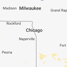
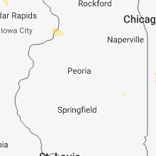
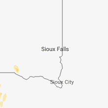
Hail Map for Thursday, June 7, 2018

Number of Impacted Households on 6/7/2018
0
Impacted by 1" or Larger Hail
0
Impacted by 1.75" or Larger Hail
0
Impacted by 2.5" or Larger Hail
Square Miles of Populated Area Impacted on 6/7/2018
0
Impacted by 1" or Larger Hail
0
Impacted by 1.75" or Larger Hail
0
Impacted by 2.5" or Larger Hail


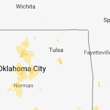


Cities Most Affected by Hail Storms of 6/7/2018
| Hail Size | Demographics of Zip Codes Affected | ||||||
|---|---|---|---|---|---|---|---|
| City | Count | Average | Largest | Pop Density | House Value | Income | Age |
| Terry, MT | 1 | 2.50 | 2.50 | 0 | $36k | $26.3k | 55.3 |
| Miles City, MT | 1 | 2.50 | 2.50 | 3 | $63k | $29.9k | 41.9 |
| Paducah, TX | 1 | 1.75 | 1.75 | 0 | $26k | $24.6k | 46.5 |
| Hardin, MT | 1 | 1.75 | 1.75 | 6 | $68k | $29.1k | 35.7 |
Hail and Wind Damage Spotted on 6/7/2018
Filter by Report Type:Hail ReportsWind Reports
States Impacted
Montana, Oklahoma, Texas, Florida, Wyoming, Indiana, South Dakota, New Mexico, NebraskaMontana
| Local Time | Report Details |
|---|---|
| 7:18 AM MDT | Storm damage reported in park county MT, 28.3 miles E of Bozeman, MT |
| 10:30 AM MDT | Quarter sized hail reported near Lewistown, MT, 88 miles ESE of Great Falls, MT, dime to quarter size hail... lasting for 20 minutes. 2.5 inches of rain with the storm. |
| 2:50 PM MDT | Quarter sized hail reported near Red Lodge, MT, 49.1 miles SW of Billings, MT |
| 4:55 PM MDT | Golf Ball sized hail reported near Hardin, MT, 45.3 miles ENE of Billings, MT, 20 ft tall aspen trees bending in half; pea to golf ball hail |
| 5:08 PM MDT | Quarter sized hail reported near Custer, MT, 51.9 miles ENE of Billings, MT |
| 5:10 PM MDT | Quarter sized hail reported near Saint Xavier, MT, 47.5 miles SE of Billings, MT |
| 5:10 PM MDT | Storm damage reported in big horn county MT, 53.7 miles ESE of Billings, MT |
| 5:35 PM MDT | Half Dollar sized hail reported near Hysham, MT, 66.8 miles E of Billings, MT |
| 6:19 PM MDT | Cottonwood tree down blocking south lane of hwy 447 south of rosebud. reported by storm chaser in rosebud county MT, 34 miles WSW of Miles City, MT |
| 6:25 PM MDT | Broken highway signs on i94 reported by storm chaser in rosebud county MT, 30.3 miles WSW of Miles City, MT |
| 6:30 PM MDT | From ems and fire - multiple large trees blown down or broken resulting in closed roads. power out; trees on power lines in rosebud county MT, 41 miles WSW of Miles City, MT |
| 6:30 PM MDT | Storm damage reported in rosebud county MT, 79.2 miles NNW of Gillette, WY |
| 6:30 PM MDT | Quarter sized hail reported near Kinsey, MT, 16.4 miles NE of Miles City, MT |
| 6:37 PM MDT | Power lines and trees down in rosebud county MT, 41.5 miles WSW of Miles City, MT |
| 6:37 PM MDT | Power lines and trees down in rosebud county MT, 41.5 miles WSW of Miles City, MT |
| 6:40 PM MDT | Storm damage reported in powder river county MT, 76.6 miles NNW of Gillette, WY |
| 7:02 PM MDT | Storm damage reported in custer county MT, 2.5 miles NW of Miles City, MT |
| 7:04 PM MDT | Quarter sized hail reported near Richey, MT, 79.6 miles SE of Glasgow, MT |
| 7:23 PM MDT | Tennis Ball sized hail reported near Terry, MT, 30.3 miles NE of Miles City, MT |
| 7:30 PM MDT | Half Dollar sized hail reported near Richey, MT, 78.6 miles ESE of Glasgow, MT |
| 7:30 PM MDT | Tennis Ball sized hail reported near Miles City, MT, 19.5 miles NE of Miles City, MT, rushing water over i-94 trapping some vehicles and pushing fences over at 740 pm. considerable hail on i-94 producing hazardous road conditions. |
| 7:30 PM MDT | Ping Pong Ball sized hail reported near Richey, MT, 78.4 miles SE of Glasgow, MT, report relayed through wife during phone call regarding flash flooding around their house. time based on radar. |
| 7:59 PM MDT | Half Dollar sized hail reported near Richey, MT, 64.5 miles WSW of Williston, ND |
| 8:05 PM MDT | Quarter sized hail reported near Alzada, MT, 89.3 miles NNE of Gillette, WY, strong winds heavy rainfall |
| 8:13 PM MDT | Storm damage reported in richland county MT, 62.6 miles WSW of Williston, ND |
| 8:13 PM MDT | Half Dollar sized hail reported near Poplar, MT, 62.6 miles WSW of Williston, ND |
| 8:21 PM MDT | Davis pro wx station measured 87 mph wind gust. barn on property was completely leveled from the wind. also had half dollar sized hai in richland county MT, 62.6 miles WSW of Williston, ND |
| 8:32 PM MDT | Storm damage reported in fallon county MT, 75.3 miles ESE of Miles City, MT |
| 8:34 PM MDT | Measured at charley creek in brockto in richland county MT, 59.1 miles W of Williston, ND |
| 8:45 PM MDT | Storm damage reported in fallon county MT, 71.2 miles ESE of Miles City, MT |
| 8:50 PM MDT | Quarter sized hail reported near Brockton, MT, 50.3 miles W of Williston, ND |
| 8:54 PM MDT | Half Dollar sized hail reported near Brockton, MT, 59.2 miles WNW of Williston, ND |
| 9:05 PM MDT | Quarter sized hail reported near Poplar, MT, 66.7 miles E of Glasgow, MT, reported via social media. |
| 9:07 PM MDT | Half Dollar sized hail reported near Froid, MT, 55.8 miles WNW of Williston, ND |
| 9:16 PM MDT | Storm damage reported in carter county MT, 91.9 miles ESE of Miles City, MT |
| 9:20 PM MDT | Quarter sized hail reported near Plentywood, MT, 58.5 miles NW of Williston, ND |
| 9:45 PM MDT | Ping Pong Ball sized hail reported near Antelope, MT, 56.1 miles NW of Williston, ND, hail still falling at time of report. |
| 9:52 PM MDT | Quarter sized hail reported near Plentywood, MT, 57.3 miles NW of Williston, ND |
Oklahoma
| Local Time | Report Details |
|---|---|
| 8:57 AM CDT | Quarter sized hail reported near Oklahoma City, OK, 10.4 miles NW of Oklahoma City, OK |
| 9:43 AM CDT | Quarter sized hail reported near Oklahoma City, OK, 10 miles WNW of Oklahoma City, OK |
| 10:40 AM CDT | Half Dollar sized hail reported near Oklahoma City, OK, 8.3 miles NNW of Oklahoma City, OK |
| 10:43 AM CDT | Mping report of 1" tree limbs down and shingles blown of in oklahoma county OK, 2.3 miles SE of Oklahoma City, OK |
| 10:54 AM CDT | Quarter sized hail reported near Oklahoma City, OK, 4.7 miles NE of Oklahoma City, OK, mping report. |
| 11:30 AM CDT | Tree branches up to 3 inches in diameter broke in pottawatomie county OK, 27.1 miles ESE of Oklahoma City, OK |
| 2:12 PM CDT | 58 mph gust measured at sulphur munincipal airpor in murray county OK, 50.1 miles W of Atoka, OK |
| 3:45 PM CDT | Power lines reported down. time estimated by rada in bryan county OK, 44.5 miles SSW of Atoka, OK |
Texas
| Local Time | Report Details |
|---|---|
| 11:50 AM CDT | 18-wheeler blown over south of snyder on hwy 208 in scurry county TX, 68.3 miles WNW of Abilene, TX |
| 3:25 PM CDT | Ping Pong Ball sized hail reported near Tell, TX, 12.4 miles WSW of Childress, TX, hail covering the ground - quarters to ping pong balls. |
| 3:53 PM CDT | West texas mesonet report in hall county TX, 37.4 miles WNW of Childress, TX |
| 4:21 PM CDT | Golf Ball sized hail reported near Paducah, TX, 18.6 miles SSW of Childress, TX, along hwy 83 |
| 4:23 PM CDT | Quarter sized hail reported near Paducah, TX, 19.9 miles SSW of Childress, TX, on hwy 83 |
| 5:00 PM CDT | Sheriff reports large tree limbs down on fm road 909 near scatter cree in red river county TX, 77.9 miles WSW of Nashville, AR |
| 5:13 PM CDT | 67 mph wind gust recorded at the denton enterprise airpor in denton county TX, 37.8 miles NW of Dallas, TX |
| 5:25 PM CDT | Storm damage reported in knox county TX, 45.9 miles SSE of Childress, TX |
| 6:00 PM CDT | Damage to barn roof and out-buildin in foard county TX, 47.2 miles SE of Childress, TX |
| 6:25 PM CDT | Quarter sized hail reported near Grapevine, TX, 20.4 miles WNW of Dallas, TX, quarter sized hail reported near grapevine. |
| 6:29 PM CDT | Storm damage reported in haskell county TX, 62.3 miles N of Abilene, TX |
| 6:43 PM CDT | Storm damage reported in knox county TX, 67.1 miles N of Abilene, TX |
| 6:45 PM CDT | Power poles down over highway 277 between munday and goree in knox county TX, 69.4 miles WSW of Wichita Falls, TX |
| 6:55 PM CDT | Storm damage reported in haskell county TX, 49.7 miles N of Abilene, TX |
| 7:00 PM CDT | Storm damage reported in haskell county TX, 62.3 miles N of Abilene, TX |
| 7:15 PM CDT | Storm damage reported in haskell county TX, 60.2 miles N of Abilene, TX |
| 7:24 PM CDT | Storm damage reported in jones county TX, 32.5 miles N of Abilene, TX |
| 8:15 PM CDT | Storm damage reported in jones county TX, 12.2 miles NNW of Abilene, TX |
| 8:20 PM CDT | Half Dollar sized hail reported near Stamford, TX, 34 miles N of Abilene, TX |
| 9:10 PM CDT | Quarter sized hail reported near Hawley, TX, 12.2 miles NNW of Abilene, TX |
| 9:10 PM CDT | Storm damage reported in jones county TX, 12.2 miles NNW of Abilene, TX |
| 9:43 PM CDT | Storm damage reported in taylor county TX, 6.4 miles WSW of Abilene, TX |
| 11:45 PM CDT | Measured on the west texas mesonet in scurry county TX, 71 miles WNW of Abilene, TX |
| 11:45 PM CDT | Mesured on the west texas mesonet in scurry county TX, 67.7 miles WNW of Abilene, TX |
| 12:27 AM CDT | Measured on the west texas mesonet in mitchell county TX, 68.9 miles W of Abilene, TX |
| 12:50 AM CDT | Measured on the west texas mesonet in mitchell county TX, 68.9 miles W of Abilene, TX |
Florida
| Local Time | Report Details |
|---|---|
| 2:20 PM EDT | North perry airport asos gusted to 69 mph at 220 p in broward county FL, 18.7 miles N of Miami, FL |
| 4:30 PM EDT | Us air force wind tower 1007 measured a peak wind gust of 55 knots / 63 mp in brevard county FL, 36.9 miles E of Orlando, FL |
| 5:45 PM EDT | Quarter sized hail reported near Oviedo, FL, 19.6 miles ENE of Orlando, FL, member of the public relayed video from chuluota showing mainly dime to nickel sized hail with a few quarter sized mixed in. another video relayed of strong winds rolli |
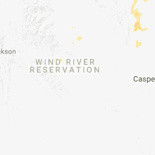
Wyoming
| Local Time | Report Details |
|---|---|
| 4:06 PM MDT | A 63 mph wind gust was reported at the greybull airpor in big horn county WY, 92 miles SSE of Billings, MT |
| 6:41 PM MDT | Half Dollar sized hail reported near Buffalo, WY, 53 miles W of Gillette, WY, the public reported half dollar size hail southeast of buffalo via facebook. |
| 6:42 PM MDT | The buffalo airport measured a wind gust of 58 mp in johnson county WY, 60.3 miles W of Gillette, WY |
| 7:05 PM MDT | 4 to 6 inch tree branches broken in campbell county WY, 49.1 miles N of Gillette, WY |
| 7:11 PM MDT | Ping Pong Ball sized hail reported near Lusk, WY, 67.2 miles NW of Scottsbluff, NE |
| 7:12 PM MDT | Storm damage reported in campbell county WY, 46.8 miles NNW of Gillette, WY |
Indiana
| Local Time | Report Details |
|---|---|
| 6:33 PM EDT | Quarter sized hail reported near Peru, IN, 55.6 miles WSW of Fort Wayne, IN |
| 8:23 PM EDT | A tree down with lightning strike reported. time estimated via rada in wayne county IN, 53.6 miles E of Indianapolis, IN |
| 9:00 PM EDT | Quarter sized hail reported near New Castle, IN, 43 miles ENE of Indianapolis, IN, reports of quarter size hail via twitter. time estimated from radar. |
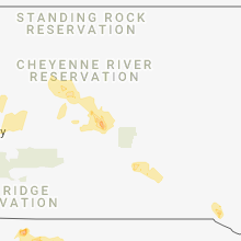
South Dakota
| Local Time | Report Details |
|---|---|
| 4:50 PM MDT | Ping Pong Ball sized hail reported near Lead, SD, 31.9 miles WNW of Rapid City, SD |
| 5:30 PM MDT | Half Dollar sized hail reported near Deadwood, SD, 26.8 miles WNW of Rapid City, SD |
| 5:42 PM MDT | Quarter sized hail reported near Nemo, SD, 18.9 miles NW of Rapid City, SD |
| 5:55 PM MDT | Quarter sized hail reported near Nemo, SD, 18.2 miles WNW of Rapid City, SD, 1.30 inch heay rainfall |
| 8:17 PM MDT | Half Dollar sized hail reported near Edgemont, SD, 80.5 miles N of Scottsbluff, NE, hail covering the ground |
| 9:14 PM MDT | Storm damage reported in harding county SD, 106 miles N of Rapid City, SD |
| 10:06 PM MDT | Storm damage reported in butte county SD, 43.6 miles NNW of Rapid City, SD |
New Mexico
| Local Time | Report Details |
|---|---|
| 6:51 PM MDT | Kcao asos. fire and rescue reported some damage to roofs on outbuildings in town. a large tree was toppled near 200 block of monro in union county NM, 94.3 miles NNE of Tucumcari, NM |
Nebraska
| Local Time | Report Details |
|---|---|
| 8:23 PM MDT | Storm damage reported in morrill county NE, 34.5 miles SE of Scottsbluff, NE |
| 8:30 PM MDT | Storm damage reported in cheyenne county NE, 49.1 miles SE of Scottsbluff, NE |
Connect with Interactive Hail Maps