

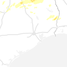
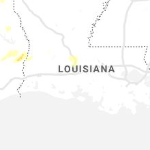
Hail Map for Saturday, May 18, 2019

Number of Impacted Households on 5/18/2019
0
Impacted by 1" or Larger Hail
0
Impacted by 1.75" or Larger Hail
0
Impacted by 2.5" or Larger Hail
Square Miles of Populated Area Impacted on 5/18/2019
0
Impacted by 1" or Larger Hail
0
Impacted by 1.75" or Larger Hail
0
Impacted by 2.5" or Larger Hail


Cities Most Affected by Hail Storms of 5/18/2019
| Hail Size | Demographics of Zip Codes Affected | ||||||
|---|---|---|---|---|---|---|---|
| City | Count | Average | Largest | Pop Density | House Value | Income | Age |
| Sabinal, TX | 2 | 1.88 | 2.00 | 1 | $37k | $27.4k | 40.8 |
| Utopia, TX | 1 | 2.50 | 2.50 | 1 | $91k | $34.4k | 53.8 |
| Meade, KS | 1 | 2.00 | 2.00 | 1 | $50k | $35.3k | 41.8 |
| Talpa, TX | 1 | 1.75 | 1.75 | 2 | $29k | $22.1k | 53.5 |
| Pond Creek, OK | 1 | 1.75 | 1.75 | 4 | $40k | $31.5k | 41.5 |
Hail and Wind Damage Spotted on 5/18/2019
Filter by Report Type:Hail ReportsWind Reports
States Impacted
Texas, Oklahoma, Kansas, Missouri, Arkansas, Maryland, Tennessee, Michigan, Kentucky, South Carolina, Virginia, Ohio, West Virginia, Pennsylvania, Louisiana, MississippiTexas
| Local Time | Report Details |
|---|---|
| 7:16 AM CDT | Tree branches down across areas of tow in mitchell county TX, 65.5 miles W of Abilene, TX |
| 8:06 AM CDT | Golf Ball sized hail reported near Talpa, TX, 38.6 miles S of Abilene, TX |
| 12:10 PM CDT | Quarter sized hail reported near Little Elm, TX, 27.6 miles NNW of Dallas, TX, reports of quarter size hail mixed with pea and dime size hail in little elm |
| 12:30 PM CDT | Kafw asos reports 50kt wind gust at 1230 pm in tarrant county TX, 34.3 miles WNW of Dallas, TX |
| 12:38 PM CDT | Quarter sized hail reported near Fort Worth, TX, 28.5 miles WNW of Dallas, TX, quarter size hail reported near alliance town center |
| 1:09 PM CDT | Dfw airport asos reports 62 mph wind gust in tarrant county TX, 17.3 miles NW of Dallas, TX |
| 1:14 PM CDT | Addison airport reports gust of 58 mph in dallas county TX, 12.7 miles N of Dallas, TX |
| 1:14 PM CDT | Large trees... about 12 inch in diameter snapped at base in alle in collin county TX, 23.2 miles NNE of Dallas, TX |
| 1:24 PM CDT | Quarter sized hail reported near Burleson, TX, 33.8 miles WSW of Dallas, TX, reports of quarter size hail in burleson in two locations (both johnson and tarrant co). i-35 and hidden creek and 157 and turney way |
| 1:29 PM CDT | Quarter sized hail reported near Plano, TX, 16.7 miles N of Dallas, TX, quarter size hail reported at preston and george bush |
| 1:50 PM CDT | Delayed report: social media carrolton pd reported power pole down in josey and frankfor in dallas county TX, 13.3 miles NNW of Dallas, TX |
| 2:01 PM CDT | Quarter sized hail reported near Richardson, TX, 12.6 miles NNE of Dallas, TX, report of nickel to quarter size hail at beltline/glenville rd in richardson |
| 2:15 PM CDT | Quarter sized hail reported near Killeen, TX, 0.9 miles N of Killeen, TX, quarter size hail reported in killeen |
| 3:00 PM CDT | Quarter sized hail reported near Balch Springs, TX, 10.4 miles ESE of Dallas, TX, delayed report: a mix of pea to quarter size hail near balch springs |
| 3:33 PM CDT | Sulphur springs airport gusted to 51 knot in hopkins county TX, 73.2 miles ENE of Dallas, TX |
| 3:44 PM CDT | Em reports downed trees on fm 1181 near cutoff r in ellis county TX, 32.4 miles SSE of Dallas, TX |
| 3:46 PM CDT | Em reports tree down and blocking the roadway just west of peerless near hwy 7 in hopkins county TX, 72.1 miles ENE of Dallas, TX |
| 3:47 PM CDT | Media reports large truck flipped into median in alma in ellis county TX, 37.2 miles SSE of Dallas, TX |
| 3:55 PM CDT | Mobile home destroyed by falling tree. multiple power poles down on cr 121. roofs taken off on cr 12 in kaufman county TX, 37.3 miles ESE of Dallas, TX |
| 3:58 PM CDT | Em reported trees down and house damaged by winds and trees at 13423 hiram rd. city of willis poin in kaufman county TX, 40.7 miles ESE of Dallas, TX |
| 4:01 PM CDT | Numerous trees down at fm 1129 and hwy 85 in ne navarro c in navarro county TX, 40 miles SE of Dallas, TX |
| 4:15 PM CDT | Social media and weather spotter estimated 60 mph wind gust in edgewood in van zandt county TX, 53.6 miles E of Dallas, TX |
| 4:21 PM CDT | Quarter sized hail reported near Utopia, TX, 65.4 miles WNW of San Antonio, TX |
| 4:28 PM CDT | Quarter sized hail reported near Utopia, TX, 63.4 miles W of San Antonio, TX |
| 4:30 PM CDT | Multiple trees down in the city of point and near emory on hwy 69 in rains county TX, 54.1 miles E of Dallas, TX |
| 4:32 PM CDT | Tennis Ball sized hail reported near Utopia, TX, 65.3 miles W of San Antonio, TX, trained spotter reported tennis ball sized hail. |
| 4:41 PM CDT | Residents reported a tree falled on a home on avenue c and 2nd street in point in rains county TX, 54.1 miles E of Dallas, TX |
| 5:00 PM CDT | 2 barns destroyed and one metal shop damage in wood county TX, 67.3 miles E of Dallas, TX |
| 5:30 PM CDT | Quarter sized hail reported near Teague, TX, 86.4 miles SSE of Dallas, TX, quarter size hail reported near teague. |
| 5:35 PM CDT | Golf Ball sized hail reported near Sabinal, TX, 59.2 miles W of San Antonio, TX |
| 5:36 PM CDT | Hen Egg sized hail reported near Sabinal, TX, 59.2 miles W of San Antonio, TX, 2 inch hailstone measured by coop observer. |
| 6:15 PM CDT | Several trees dow in smith county TX, 72.2 miles NNW of Lufkin, TX |
| 6:20 PM CDT | Quarter sized hail reported near ARP, TX, 64.4 miles NNW of Lufkin, TX |
| 6:35 PM CDT | Quarter sized hail reported near Overton, TX, 64.5 miles N of Lufkin, TX |
| 7:03 PM CDT | Several trees snapped of in rusk county TX, 46.6 miles WSW of Shreveport, LA |
| 8:39 PM CDT | Trees dow in nacogdoches county TX, 28.5 miles NNW of Lufkin, TX |
| 12:47 AM CDT | Trees down either side of recreation road 255 at state highway 6 in jasper county TX, 36.5 miles ESE of Lufkin, TX |
| 1:11 AM CDT | Lots of trees down and lots of debris just inside of jasper county. tree on a house. fire department...electric company...law enforcement at scen in jasper county TX, 50.6 miles SE of Lufkin, TX |
| 1:30 AM CDT | Tree down on a house and a car with additional trees down across fm 1 near hwy 96 with power outages reporte in sabine county TX, 44.2 miles E of Lufkin, TX |
| 1:44 AM CDT | Tree down in kirbyville in jasper county TX, 40.3 miles NNW of Beaumont, TX |
| 1:45 AM CDT | Quarter sized hail reported near Kirbyville, TX, 40.3 miles NNW of Beaumont, TX, broadcast media shared photo of quarter sized hail. |
Oklahoma
| Local Time | Report Details |
|---|---|
| 7:56 AM CDT | Instrument measure in caddo county OK, 66.2 miles WSW of Oklahoma City, OK |
| 8:05 AM CDT | Storm damage reported in caddo county OK, 58.1 miles WSW of Oklahoma City, OK |
| 8:15 AM CDT | Large tree blown down on to truck. twitter report with phot in grady county OK, 38.4 miles SW of Oklahoma City, OK |
| 8:31 AM CDT | Large tree branches dow in oklahoma county OK, 12.5 miles N of Oklahoma City, OK |
| 8:31 AM CDT | Large tree branch damage. social medi in oklahoma county OK, 14.5 miles N of Oklahoma City, OK |
| 8:44 AM CDT | Quarter sized hail reported near Spencer, OK, 8.6 miles ENE of Oklahoma City, OK, twitter report. |
| 9:24 AM CDT | Large tree blown over. twitter report with pictur in payne county OK, 51.6 miles NNE of Oklahoma City, OK |
| 10:10 AM CDT | Two downed power lines as well as numerous tree limbs. time estimted from rada in pontotoc county OK, 41.1 miles NW of Atoka, OK |
| 10:10 AM CDT | Two trees reported down w of latta. time estimated from rada in pontotoc county OK, 41.2 miles NW of Atoka, OK |
| 10:19 AM CDT | Tree uprooted at sw 119th and meridian in front of south lakes soccer fields. tree laying across the road and blocking meridia in cleveland county OK, 9.5 miles SSW of Oklahoma City, OK |
| 11:02 AM CDT | Damage to metal outbuilding... roof peeled back. social media report with picture... relayed by broadcast medi in tulsa county OK, 15.6 miles SSE of Tulsa, OK |
| 11:02 AM CDT | Thunderstorm wind damage vicinity of 161st and harvard... west of bixby. fenced damaged and part of outbuilding damaged. social media report with pictur in tulsa county OK, 16 miles S of Tulsa, OK |
| 11:13 AM CDT | Winds estimated 60 mph 1 mile southwest of lehigh. some damage to trees and vegetation. no structural damage at this tim in coal county OK, 7.8 miles NW of Atoka, OK |
| 11:14 AM CDT | Quarter sized hail reported near Mounds, OK, 21.6 miles S of Tulsa, OK |
| 11:20 AM CDT | Multiple trees dow in delaware county OK, 59.7 miles NNW of Fort Smith, AR |
| 11:58 AM CDT | Large tree downed onto home. significant roof damage and structural damage to side of home. social media report with pictur in pittsburg county OK, 42.7 miles NNE of Atoka, OK |
| 12:06 PM CDT | Mayes county reporting power lines down at or near intersection of county roads n430 and w44 in mayes county OK, 39.3 miles ENE of Tulsa, OK |
| 12:06 PM CDT | Grda police reporting power lines and trees down northwest of pryor... vicninity of 450e road and 428 rd... and 428 rd and 440 r in mayes county OK, 37.2 miles ENE of Tulsa, OK |
| 12:21 PM CDT | Tree downed and blocking roadway at 4210 road and half a mile north of 640 roa in rogers county OK, 27.3 miles E of Tulsa, OK |
| 12:54 PM CDT | Grda police report power lines down vicinity of highways 82 and 28 near langle in mayes county OK, 57.4 miles ENE of Tulsa, OK |
| 12:54 PM CDT | Storm chaser reports trees downed on power lines west of langley. much of town without powe in mayes county OK, 55.8 miles ENE of Tulsa, OK |
| 1:20 PM CDT | Trees down near pine creek lak in mccurtain county OK, 59.9 miles ESE of Atoka, OK |
| 1:30 PM CDT | Large barn destroyed. several trees uproote in adair county OK, 38.7 miles NNW of Fort Smith, AR |
| 1:35 PM CDT | Huge tree down on top of vehicle. picture received via social medi in le flore county OK, 25.7 miles SSW of Fort Smith, AR |
| 1:44 PM CDT | Tree dow in mccurtain county OK, 67.2 miles W of Nashville, AR |
| 1:47 PM CDT | Tree limbs to one inch in diameter broken... shingles blown off a roo in le flore county OK, 14.2 miles SW of Fort Smith, AR |
| 2:00 PM CDT | Emergency management reported 78 mph winds which were recorded at pocola race trac in le flore county OK, 11.2 miles SSW of Fort Smith, AR |
| 5:18 PM CDT | Half Dollar sized hail reported near Alva, OK, 38.3 miles NE of Woodward, OK, report via spotter network. |
| 6:12 PM CDT | Quarter sized hail reported near Waynoka, OK, 37.9 miles ENE of Woodward, OK, report via spotter network. |
| 6:34 PM CDT | Quarter sized hail reported near Alva, OK, 49.5 miles ENE of Woodward, OK |
| 6:35 PM CDT | Half Dollar sized hail reported near Okeene, OK, 60.3 miles ESE of Woodward, OK |
| 6:45 PM CDT | Quarter sized hail reported near Okeene, OK, 63.3 miles NW of Oklahoma City, OK |
| 7:04 PM CDT | Quarter sized hail reported near Carmen, OK, 50.5 miles ENE of Woodward, OK |
| 7:08 PM CDT | Half Dollar sized hail reported near Carmen, OK, 50.5 miles ENE of Woodward, OK |
| 7:20 PM CDT | Quarter sized hail reported near Carmen, OK, 53.2 miles E of Woodward, OK |
| 8:15 PM CDT | Quarter sized hail reported near Jet, OK, 69.2 miles ENE of Woodward, OK |
| 8:33 PM CDT | Ping Pong Ball sized hail reported near Pond Creek, OK, 78.3 miles E of Woodward, OK |
| 8:52 PM CDT | Golf Ball sized hail reported near Pond Creek, OK, 74.7 miles SSW of Wichita, KS |
| 9:00 PM CDT | Quarter sized hail reported near Medford, OK, 66.6 miles SSW of Wichita, KS |
Kansas
| Local Time | Report Details |
|---|---|
| 10:17 AM CDT | Storm damage reported in butler county KS, 21.3 miles ESE of Wichita, KS |
| 10:17 AM CDT | Storm damage reported in butler county KS, 22.8 miles E of Wichita, KS |
| 11:21 AM CDT | Some leaves stripped off trees. due to wind... not hail in butler county KS, 40.4 miles E of Wichita, KS |
| 11:30 AM CDT | Storm damage reported in greenwood county KS, 53.1 miles ENE of Wichita, KS |
| 11:30 AM CDT | *** 1 inj *** tractor trailer rolled over due to wind in butler county KS, 41.3 miles ENE of Wichita, KS |
| 11:30 AM CDT | Quarter sized hail reported near Longton, KS, 40.7 miles WSW of Chanute, KS |
| 11:30 AM CDT | Mesonet station k5eur us-54 - eurek in greenwood county KS, 50.9 miles E of Wichita, KS |
| 11:43 AM CDT | Storm damage reported in lyon county KS, 58.1 miles NW of Chanute, KS |
| 11:45 AM CDT | Garage door was blown apart and pushed down the roa in lyon county KS, 55.4 miles NW of Chanute, KS |
| 11:51 AM CDT | Asos measured 86 mph wind gus in lyon county KS, 56.9 miles SSE of Manhattan, KS |
| 12:09 PM CDT | Report and pictures sent of a metal roof peeled off on part of a house and an approximate six inch tree limb broken off. time is approximated from rada in montgomery county KS, 32.9 miles SSW of Chanute, KS |
| 1:15 PM CDT | 60 mph wind gusts and dime size hail 4 miles west of baxter springs... k in cherokee county KS, 57.7 miles SE of Chanute, KS |
| 1:22 PM CDT | A tree and powerline knocked down 1 mile east of riverto in cherokee county KS, 59 miles SE of Chanute, KS |
| 1:41 PM CDT | Power lines down 2 miles se of pittsburg... k in crawford county KS, 46.9 miles ESE of Chanute, KS |
| 4:55 PM CDT | Storm damage reported in haskell county KS, 33.8 miles S of Garden City, KS |
| 5:44 PM CDT | Hen Egg sized hail reported near Meade, KS, 58.2 miles SSE of Garden City, KS |
| 5:45 PM CDT | Winds gusts were estimated from 60 to 70 mp in finney county KS, 3.6 miles NNE of Garden City, KS |
| 6:42 PM CDT | Quarter sized hail reported near Pratt, KS, 79.1 miles W of Wichita, KS |
| 6:47 PM CDT | Quarter sized hail reported near Pratt, KS, 77 miles W of Wichita, KS |
| 7:16 PM CDT | Also experiencing rotating wall cloud overhea in rice county KS, 63.4 miles NW of Wichita, KS |
| 7:19 PM CDT | Storm damage reported in rice county KS, 67.3 miles ESE of Hays, KS |
| 7:49 PM CDT | Storm damage reported in rice county KS, 69 miles NW of Wichita, KS |
| 8:13 PM CDT | Three-inch diameter limb dow in mcpherson county KS, 63.5 miles NNW of Wichita, KS |
| 8:13 PM CDT | Storm damage reported in kingman county KS, 53.1 miles WSW of Wichita, KS |
| 8:16 PM CDT | Storm damage reported in mcpherson county KS, 64.7 miles NNW of Wichita, KS |
| 8:30 PM CDT | Storm damage reported in kingman county KS, 53.1 miles WSW of Wichita, KS |
| 8:30 PM CDT | Storm damage reported in kingman county KS, 54.6 miles WSW of Wichita, KS |
| 8:43 PM CDT | Storm damage reported in harper county KS, 54.1 miles WSW of Wichita, KS |
| 8:49 PM CDT | Storm damage reported in mcpherson county KS, 64.2 miles NNW of Wichita, KS |
| 8:57 PM CDT | Storm damage reported in kingman county KS, 43.6 miles W of Wichita, KS |
| 9:03 PM CDT | Kansas mesonet in saline county KS, 56.9 miles SW of Manhattan, KS |
| 9:33 PM CDT | Storm damage reported in dickinson county KS, 42.8 miles SW of Manhattan, KS |
| 9:34 PM CDT | Quarter sized hail reported near Abilene, KS, 46.7 miles SW of Manhattan, KS, 55 mph winds verified and nickel hail with a few quarter sized hail stones. |
| 10:03 PM CDT | Storm damage reported in geary county KS, 23.3 miles WSW of Manhattan, KS |
| 11:36 PM CDT | Storm damage reported in chautauqua county KS, 58.4 miles SW of Chanute, KS |
| 11:40 PM CDT | Delayed report received via mping. power poles broken and three-inch diameter tree limbs broken. time estimated from rada in chautauqua county KS, 52.2 miles SW of Chanute, KS |
| 12:04 AM CDT | Storm damage reported in montgomery county KS, 34.7 miles SSW of Chanute, KS |
| 12:11 AM CDT | Storm damage reported in montgomery county KS, 40.7 miles S of Chanute, KS |
| 12:43 AM CDT | The estimated gusts ranged from 55-60 mp in neosho county KS, 3.6 miles S of Chanute, KS |
| 12:50 AM CDT | Cherokee county emergency management director estimated 60 mph wind gusts in falkner and melros in cherokee county KS, 52.5 miles SSE of Chanute, KS |
Missouri
| Local Time | Report Details |
|---|---|
| 1:05 PM CDT | Power lines down in platte city and in the northern kansas city metro are in platte county MO, 21.2 miles NNW of Kansas City, MO |
| 2:34 PM CDT | Damage to roof of gas station near eggleston and hwy 3 in barry county MO, 59.4 miles SW of Springfield, MO |
| 2:38 PM CDT | Corrects previous tstm wnd dmg report from 2 w freistatt. report on social media of large tree uprooted in freistatt. corrected time from rada in lawrence county MO, 38.1 miles WSW of Springfield, MO |
| 2:45 PM CDT | Report on social media of large tree uprooted in freistatt. time estimated from rada in lawrence county MO, 38.1 miles WSW of Springfield, MO |
| 3:01 PM CDT | Report of a tree into a garage near table rock bridge in shell knob on highway 3 in barry county MO, 44.5 miles SSW of Springfield, MO |
| 3:01 PM CDT | Report in shell knob of trees down in subdivision on highway yy east of highway 3 in barry county MO, 44 miles SSW of Springfield, MO |
| 3:04 PM CDT | Report of a tree being topped on highway 248 approximately one mile west of highway in barry county MO, 31.6 miles SW of Springfield, MO |
| 3:15 PM CDT | Emergency manager reports that citizens report several trees down near the kings river bridge on hwy 8 in stone county MO, 50.6 miles SSW of Springfield, MO |
| 3:15 PM CDT | Report of trees down on powerlines in lampe near 5000 block of state highway 1 in stone county MO, 39.9 miles S of Springfield, MO |
| 3:15 PM CDT | Report of a 60 mph gust at branson west airpor in stone county MO, 35.6 miles S of Springfield, MO |
| 3:20 PM CDT | Report of roof damage to two houses on aunts creek road and roof damage to a business at 413 and aunts cree in stone county MO, 35.8 miles SSW of Springfield, MO |
| 3:30 PM CDT | Relayed reports of damage to power lines and commercial building. possible tornado damag in taney county MO, 40.8 miles S of Springfield, MO |
| 3:35 PM CDT | Fire department on the scene on kessler drive in walnut shade for a large tree on a mobile hom in taney county MO, 33.5 miles S of Springfield, MO |
| 3:35 PM CDT | Fire department on the scene on kessler drive in walnut shade for a large tree on a mobile hom in taney county MO, 33.5 miles S of Springfield, MO |
| 3:41 PM CDT | Report of trees down over the road and power lines down on highway w south of ozar in christian county MO, 18.9 miles SSE of Springfield, MO |
| 3:41 PM CDT | Report of tree limbs down in a neighborhood near battlefield mal in greene county MO, 3.8 miles SSE of Springfield, MO |
| 3:43 PM CDT | Report of power pole snapped in half in flemington at the cemeter in polk county MO, 43 miles NNW of Springfield, MO |
| 3:44 PM CDT | Report via social media of pieces of a metal roof peeled off and many trees down in ozar in christian county MO, 13.8 miles SSE of Springfield, MO |
| 3:44 PM CDT | Report of a barn destroyed and multiple trees down at 5642 highway ab in pleasant hop in polk county MO, 17.3 miles N of Springfield, MO |
| 3:46 PM CDT | Powerlines down in taneyvill in taney county MO, 35.4 miles SSE of Springfield, MO |
| 3:48 PM CDT | Report of a large tree... roughly 18-20 inches inches in diameter down over the road at farm road 205 and 13 in greene county MO, 6.7 miles E of Springfield, MO |
| 3:51 PM CDT | Delayed report of a collapsed shed in bradleyville. time estimated from rada in taney county MO, 36.3 miles SE of Springfield, MO |
| 3:55 PM CDT | Report relayed by broadcast media of 3 to 4 foot diameter oak trees uproote in taney county MO, 38.6 miles SE of Springfield, MO |
| 4:15 PM CDT | Report from sheriff department of a tree down on a home in av in douglas county MO, 39.2 miles ESE of Springfield, MO |
| 4:17 PM CDT | Report of a barn roof blown off on west highway 1 in douglas county MO, 35.8 miles ESE of Springfield, MO |
| 4:21 PM CDT | Report of multiple trees and powerlines down from dora to theodosi in ozark county MO, 59.2 miles SE of Springfield, MO |
| 4:21 PM CDT | Report of trees across highway 5 and highway in ozark county MO, 63.5 miles SE of Springfield, MO |
| 4:34 PM CDT | Report of trees down and power outages across lebano in laclede county MO, 47.2 miles NE of Springfield, MO |
| 4:41 PM CDT | Report of shingles blown off a house on highway ee in eastern douglas count in douglas county MO, 58.9 miles SW of Salem, MO |
| 4:45 PM CDT | Raws station reports 59 mph wind gust in mountain grove. time estimated from rada in wright county MO, 53 miles SW of Salem, MO |
| 4:50 PM CDT | Report of power pole down off highway 17 and highway t are in camden county MO, 56.9 miles WNW of Salem, MO |
| 4:54 PM CDT | Picture via social media of boat dock flipped over on the main channel of lake of the ozark in camden county MO, 63.8 miles SSW of Columbia, MO |
| 5:00 PM CDT | Half Dollar sized hail reported near Camdenton, MO, 64.5 miles NNE of Springfield, MO, report relayed by broadcast media of half dollar size hail north of camdenton. |
| 5:07 PM CDT | Pictures via social media of large trees uprooted and damage to a recreational vehicl in miller county MO, 51.9 miles SSW of Columbia, MO |
| 5:38 PM CDT | Report of tree limbs and a few trees down at montauk state park. time estimated from rada in dent county MO, 14.5 miles SSW of Salem, MO |
| 5:45 PM CDT | Large tree branches dow in cole county MO, 28.7 miles SSE of Columbia, MO |
| 5:45 PM CDT | Numerous trees down across the county... falling onto roads and into houses. 600 people in jefferson county without power from three rivers electri in cole county MO, 27.5 miles SSE of Columbia, MO |
| 5:47 PM CDT | Storm damage reported in cole county MO, 27.5 miles SSE of Columbia, MO |
| 5:50 PM CDT | Trees down in rich fountain. time estimated from rada in osage county MO, 45.3 miles SSE of Columbia, MO |
| 5:50 PM CDT | Tree down in roa in callaway county MO, 29.9 miles SSE of Columbia, MO |
| 6:00 PM CDT | Eight trees or large tree limbs down over roads across osage county... 1 tree limb into a car windshiel in osage county MO, 36.6 miles SSE of Columbia, MO |
| 6:19 PM CDT | Tree down in roa in callaway county MO, 21.9 miles ESE of Columbia, MO |
| 6:22 PM CDT | Semi blown over on the kingdom city overpass... i-70/highway 54 exit. time estimated from rada in callaway county MO, 21.2 miles E of Columbia, MO |
| 6:35 PM CDT | Several large limbs down in mexico. time estimated from rada in audrain county MO, 27.9 miles ENE of Columbia, MO |
| 1:22 AM CDT | Corrects previous tstm wnd gst report from 4 ene racine. corrects previous tstm wnd gst report from 4 ene racine. 60 mph wind gusts estimated by trained spotter. minor in newton county MO, 67.6 miles WSW of Springfield, MO |
| 1:52 AM CDT | 60 mph wind gusts estimated by trained spotter. minor tree damage near the intersection of iris road and highway n in newton county MO, 67.6 miles WSW of Springfield, MO |
| 2:26 AM CDT | Severe thunderstorm wind gusts downed a tree into some power lines causing power loss to approximately 80 homes in west springfiel in greene county MO, 5.6 miles WSW of Springfield, MO |
Arkansas
| Local Time | Report Details |
|---|---|
| 1:50 PM CDT | Arkansas state emergency management reports trees down west of greenwood between highway 10 and 25 in sebastian county AR, 14.6 miles SE of Fort Smith, AR |
| 2:00 PM CDT | 10-12 homes with roof damage in the area of phoenix avenue. possible tornad in sebastian county AR, 1.3 miles ENE of Fort Smith, AR |
| 2:00 PM CDT | Numerous roads blocked throughout franklin county due to downed trees and power lines. multiple homes throughout the county damaged by downed trees. approximately 2800 in franklin county AR, 34.1 miles ENE of Fort Smith, AR |
| 2:02 PM CDT | Trees and power lines dow in washington county AR, 41.4 miles N of Fort Smith, AR |
| 2:05 PM CDT | Power lines and transformer downed near barling. picture received via social medi in sebastian county AR, 7.8 miles ESE of Fort Smith, AR |
| 2:05 PM CDT | Power lines and transformer downed near barling. picture received via social medi in sebastian county AR, 7.8 miles ESE of Fort Smith, AR |
| 2:05 PM CDT | Interstate sign snapped and thrown into the middle of interstate 540 just south of the zero street exit in fort smit in sebastian county AR, 1.3 miles ENE of Fort Smith, AR |
| 2:10 PM CDT | Emergency management reported extensive damage to residence in lavaca on south river road and trees fallen in multiple direction in sebastian county AR, 14.5 miles ESE of Fort Smith, AR |
| 2:20 PM CDT | Tree and outbuilding damag in franklin county AR, 27.1 miles E of Fort Smith, AR |
| 2:20 PM CDT | Large trees down north of vesta on highway 21 in franklin county AR, 21.5 miles E of Fort Smith, AR |
| 2:25 PM CDT | Trees down across highway 96 in ford hill are in franklin county AR, 27.4 miles E of Fort Smith, AR |
| 2:30 PM CDT | Tree on a house. downed trees blocking highway 6 in crawford county AR, 22.4 miles ENE of Fort Smith, AR |
| 2:30 PM CDT | Tree down on a house and power lines down on north 2nd stree in franklin county AR, 34.1 miles ENE of Fort Smith, AR |
| 2:33 PM CDT | Numerous trees down in the town of pari in logan county AR, 40.1 miles E of Fort Smith, AR |
| 2:35 PM CDT | A large tree was uproote in logan county AR, 40.1 miles E of Fort Smith, AR |
| 2:35 PM CDT | Extensive tree damage atop st. marys mountain... around st. marys catholic churc in franklin county AR, 37.7 miles E of Fort Smith, AR |
| 2:40 PM CDT | Storm damage reported in logan county AR, 44.3 miles E of Fort Smith, AR |
| 2:41 PM CDT | Trees down along main street in coal hil in johnson county AR, 42.6 miles E of Fort Smith, AR |
| 2:41 PM CDT | Numerous trees down north of subiaco in the patterson bluff area. time est. from rada in logan county AR, 40.8 miles E of Fort Smith, AR |
| 2:45 PM CDT | Storm damage reported in logan county AR, 49.8 miles E of Fort Smith, AR |
| 2:50 PM CDT | Emergency management reported large trees down north of charleston in the highway 60 area. minor roof damage to some homes in charlesto in franklin county AR, 22.3 miles ESE of Fort Smith, AR |
| 2:52 PM CDT | The top half of a tree fell on a hous in johnson county AR, 53.9 miles E of Fort Smith, AR |
| 2:54 PM CDT | Limbs down in the city of clarksvill in johnson county AR, 53.9 miles E of Fort Smith, AR |
| 3:15 PM CDT | Trees dow in little river county AR, 24.4 miles SW of Nashville, AR |
| 3:36 PM CDT | Trees were blown down around harriso in boone county AR, 67.5 miles S of Springfield, MO |
| 3:55 PM CDT | Sheriff department reports large tree down across interstate 30 near mile marker 4 in nevada county AR, 27.9 miles ESE of Nashville, AR |
| 4:00 PM CDT | Sheriff department reports numerous trees down across the city of prescot in nevada county AR, 28.2 miles ESE of Nashville, AR |
| 4:06 PM CDT | Multiple trees down south of bismarc in hot spring county AR, 47.4 miles ENE of Nashville, AR |
| 4:12 PM CDT | Power lines were blown down across hwy 7 near bismarc in hot spring county AR, 46.5 miles NE of Nashville, AR |
| 5:06 PM CDT | The cimarron inn along frontage road sustained roof damag in pulaski county AR, 8.1 miles SW of Little Rock, AR |
| 5:10 PM CDT | A tree was blown down across baseline road. all lanes were temporarily blocke in pulaski county AR, 6.9 miles SW of Little Rock, AR |
| 5:30 PM CDT | Large tree blown over and blocking stewart roa in lonoke county AR, 14.7 miles ESE of Little Rock, AR |
| 5:34 PM CDT | Estimated 60 mph wind gust near the intersection of hwo 31 and simpson rd. in southern lonoke count in lonoke county AR, 22.3 miles ESE of Little Rock, AR |
| 5:36 PM CDT | Large tree down along hwy 31 at simpson roa in lonoke county AR, 22.3 miles ESE of Little Rock, AR |
| 5:36 PM CDT | Tree blown over on a house on bowen road near furlo in lonoke county AR, 16.3 miles ENE of Little Rock, AR |
| 5:37 PM CDT | A tree was blown down on a barn. trees were also uproote in independence county AR, 89.9 miles NNE of Little Rock, AR |
| 5:42 PM CDT | Minor structural damage at caney creek baptist church. along hwy 31 near laster r in lonoke county AR, 21.8 miles ESE of Little Rock, AR |
| 5:48 PM CDT | Powerlines down near the intersection of hwy 381 and hillman roa in lonoke county AR, 27 miles ESE of Little Rock, AR |
| 5:54 PM CDT | Limbs and trees down near blakemor in lonoke county AR, 24.7 miles ESE of Little Rock, AR |
| 6:13 PM CDT | Trees were blown down across hwy 7. all lanes were temporarily blocke in dallas county AR, 55.7 miles E of Nashville, AR |
| 6:24 PM CDT | Winds estimated near 70 mp in prairie county AR, 49.7 miles E of Little Rock, AR |
| 7:53 PM CDT | Power poles down along highway 14 in st. francis county AR, 27.6 miles WSW of Memphis, TN |
| 9:10 PM CDT | Tree across ar hwy 29 damaging a vehicl in lafayette county AR, 45.3 miles SSE of Nashville, AR |
Maryland
| Local Time | Report Details |
|---|---|
| 5:28 PM EDT | Three reports of trees and/or wires down in the clear spring area in washington county MD, 75.1 miles WNW of Baltimore, MD |
| 5:28 PM EDT | Quarter sized hail reported near Clear Spring, MD, 75.1 miles WNW of Baltimore, MD, hail ranging from pea to quarter size |
| 5:43 PM EDT | Quarter sized hail reported near Clear Spring, MD, 72.6 miles WNW of Baltimore, MD, tree branches down too |
| 5:45 PM EDT | Storage shed lifted and deposited in a swimming pool in washington county MD, 68.7 miles WNW of Baltimore, MD |
| 5:46 PM EDT | Numerous reports of trees and wires down in williamsport. most of the town without powe in washington county MD, 68.2 miles WNW of Baltimore, MD |
| 7:10 PM EDT | Tree down blocking reels mill road near intersection of reichs ford road in frederick county MD, 41.7 miles W of Baltimore, MD |
| 8:20 PM EDT | Tree down at the intersection of jennings chapel rd and howard chapel r in howard county MD, 24.3 miles W of Baltimore, MD |
Tennessee
| Local Time | Report Details |
|---|---|
| 5:44 PM EDT | Tree and power line down near buffalo mountain state par in washington county TN, 22.7 miles SSW of Bristol, TN |
| 5:45 PM EDT | Quarter sized hail reported near Johnson City, TN, 23.3 miles SSW of Bristol, TN |
| 6:01 PM EDT | Tree and power line down on college heights roa in washington county TN, 21.8 miles SSW of Bristol, TN |
| 6:06 PM EDT | Quarter sized hail reported near Maryville, TN, 14.9 miles SSW of Knoxville, TN |
| 6:13 PM EDT | Trees down near louisville point par in blount county TN, 12.1 miles SW of Knoxville, TN |
| 6:13 PM EDT | Measured 61 mph wind gust at mcghee tyson airpor in blount county TN, 11.1 miles SSW of Knoxville, TN |
| 6:25 PM EDT | Trees down on dripping spring roa in sevier county TN, 15.3 miles SE of Knoxville, TN |
| 6:31 PM EDT | Trees down at the corner of forest hill drive and gleason driv in knox county TN, 7.2 miles WSW of Knoxville, TN |
| 6:37 PM EDT | Trees down on sevierville pike roa in sevier county TN, 10.2 miles ESE of Knoxville, TN |
| 6:43 PM EDT | Tree across road at the 100 block of richmond avenu in knox county TN, 2.3 miles WNW of Knoxville, TN |
| 7:25 PM EDT | Tree down on mobile home along oakland r in washington county TN, 30.4 miles SW of Bristol, TN |
| 7:26 PM EDT | Tree across a house and 2 vehicle in hawkins county TN, 50.9 miles ENE of Knoxville, TN |
| 7:50 PM EDT | 10-15 trees down between bulls gap and rogersvill in hawkins county TN, 45.7 miles WSW of Bristol, TN |
| 7:50 PM EDT | 10-15 trees down between bulls gap and rogersvill in hawkins county TN, 45.7 miles WSW of Bristol, TN |
| 8:18 PM CDT | Peak wind gust 59 mph at tom lee park in memphis. measured by equipment 35 feet above ground. damage to tents and infrastructure at the par in shelby county TN, 1.4 miles S of Memphis, TN |
| 8:30 PM CDT | Several small trees uproote in shelby county TN, 5.8 miles ESE of Memphis, TN |
Michigan
| Local Time | Report Details |
|---|---|
| 6:00 PM EDT | Tree down... unknown size and condition. damage to hous in cass county MI, 72.9 miles NW of Fort Wayne, IN |
Kentucky
| Local Time | Report Details |
|---|---|
| 6:05 PM EDT | A large tree uprooted and another smaller one broken midway up its trunk. trampolines also blown around on regal driv in pulaski county KY, 55.3 miles SW of Irvine, KY |
South Carolina
| Local Time | Report Details |
|---|---|
| 6:30 PM EDT | Quarter sized hail reported near Easley, SC, 4.4 miles NW of Greenville, SC, at the intersection of jameson road and highway 183. hail the size of pennies with a few as large as quarters. |
Virginia
| Local Time | Report Details |
|---|---|
| 6:43 PM EDT | Numerous trees down along brent town road between courthouse road and mcb3 in fauquier county VA, 71.4 miles SW of Baltimore, MD |
| 8:45 PM EDT | Tree down at residence along hwy 7 in lee county VA, 47.4 miles W of Bristol, TN |
| 8:50 PM EDT | Tree down at papa bears marke in lee county VA, 49.8 miles W of Bristol, TN |
Ohio
| Local Time | Report Details |
|---|---|
| 6:44 PM EDT | Trees reported down at the intersection of sr 26 and cross creek roa in jefferson county OH, 37 miles W of Pittsburgh, PA |
| 6:51 PM EDT | Trees reported down along braybarton blvd in jefferson county OH, 34.7 miles W of Pittsburgh, PA |
| 7:51 PM EDT | Video shows snapped power poles along rathmell road. time estimated from rada in franklin county OH, 7.3 miles SSE of Columbus, OH |
| 8:01 PM EDT | Numerous reports of tree damage and power poles down in southeast franklin county. time estimated from rada in franklin county OH, 7.7 miles SE of Columbus, OH |
| 8:35 PM EDT | Tree down on cambria mill road. time estimated from rada in licking county OH, 28.6 miles ENE of Columbus, OH |
West Virginia
| Local Time | Report Details |
|---|---|
| 7:02 PM EDT | Tractor trailer turned over in weirton parking lo in brooke county WV, 29.3 miles W of Pittsburgh, PA |
| 7:05 PM EDT | 911 center reports several trees down blocking roadways in the weirton are in hancock county WV, 28.7 miles W of Pittsburgh, PA |
Pennsylvania
| Local Time | Report Details |
|---|---|
| 7:14 PM EDT | 911 center reported several trees down along roadways in the are in washington county PA, 22.8 miles W of Pittsburgh, PA |
Louisiana
| Local Time | Report Details |
|---|---|
| 8:05 PM CDT | Large oak tree across hwy 7 in caddo county LA, 17.1 miles NNW of Shreveport, LA |
| 1:30 AM CDT | Tree down on hwy 156 at the kyiaies creek bridg in winn county LA, 68.3 miles SE of Shreveport, LA |
| 2:15 AM CDT | Trees and power lines down on beulah church roa in winn county LA, 73.5 miles SSW of Bastrop, LA |
| 2:25 AM CDT | Numerous trees reported down along hwy 1 south of cloutierville with widespread power outage in natchitoches county LA, 86.1 miles SE of Shreveport, LA |
| 2:45 AM CDT | Tree down on rock hill road in bentle in grant county LA, 93.4 miles NNW of Lafayette, LA |
| 2:55 AM CDT | Tree down on hwy 84 north toward tullos with the northbound lane blocked by the fallen tre in la salle county LA, 76.3 miles SSW of Bastrop, LA |
| 3:00 AM CDT | Tree down on airport drive in front of the tractor supply stor in la salle county LA, 76.8 miles S of Bastrop, LA |
| 3:00 AM CDT | Trees downed... with one downing some powerlines in the winnsboro city limit in franklin county LA, 43.4 miles SSE of Bastrop, LA |
| 3:52 AM CDT | Tree downed on highway 6 in madison county LA, 51.1 miles SE of Bastrop, LA |
| 4:00 AM CDT | 2 trees downed in the city. one fell across hancock street... covering both lanes. another fell onto some powerlines at the intersection of plank road and 4th stree in tensas county LA, 67.4 miles WSW of Jackson, MS |
| 5:56 AM CDT | Oep reporting gas pumps demolished at the gas station located at the corner of whiteville rd. and tate cove rd. with numerous other damage reports around the city. torn in evangeline county LA, 36.1 miles NNW of Lafayette, LA |
Mississippi
| Local Time | Report Details |
|---|---|
| 4:13 AM CDT | Tree downed on oak street in the vicksburg city limit in warren county MS, 41.6 miles W of Jackson, MS |
| 4:15 AM CDT | Tree downed on halls ferry roa in warren county MS, 40.4 miles W of Jackson, MS |
| 9:20 AM UTC | Tree downed on tilton ranch roa in warren county MS, 35.7 miles W of Jackson, MS |
| 9:29 AM UTC | Tree downed at mile marker 15 on interstate 2 in warren county MS, 28.9 miles W of Jackson, MS |
Connect with Interactive Hail Maps