

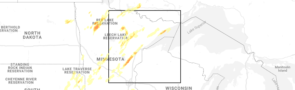
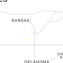
Hail Map for Sunday, May 29, 2022
Number of Impacted Households on 5/29/2022
0
Impacted by 1" or Larger Hail
0
Impacted by 1.75" or Larger Hail
0
Impacted by 2.5" or Larger Hail
Square Miles of Populated Area Impacted on 5/29/2022
0
Impacted by 1" or Larger Hail
0
Impacted by 1.75" or Larger Hail
0
Impacted by 2.5" or Larger Hail


Cities Most Affected by Hail Storms of 5/29/2022
| Hail Size | Demographics of Zip Codes Affected | ||||||
|---|---|---|---|---|---|---|---|
| City | Count | Average | Largest | Pop Density | House Value | Income | Age |
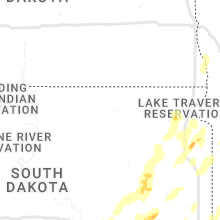
| Burwell, NE | 5 | 3.45 | 4.25 | 1 | $39k | $26.8k | 50.4 |
| Taylor, NE | 3 | 2.17 | 2.75 | 1 | $20k | $26.7k | 46.6 |
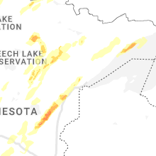
| Moose Lake, MN | 1 | 2.00 | 2.00 | 45 | $88k | $36.2k | 41.9 |
| Ansley, NE | 1 | 1.75 | 1.75 | 3 | $23k | $28.3k | 45.9 |
| Gully, MN | 1 | 1.75 | 1.75 | 4 | $21k | $22.5k | 46.2 |
Hail and Wind Damage Spotted on 5/29/2022
Filter by Report Type:Hail ReportsWind Reports
States Impacted
Minnesota, Florida, Wyoming, Nebraska, New Mexico, Nevada, Colorado, North Dakota, South DakotaMinnesota
| Local Time | Report Details |
|---|---|
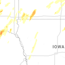
| 7:20 AM CDT | Quarter sized hail reported near Trail, MN, 43.8 miles WNW of Bemidji, MN, relayed via social media. |
| 7:20 AM CDT | Golf Ball sized hail reported near Gully, MN, 40.2 miles WNW of Bemidji, MN, relayed via social media. |
| 3:30 PM CDT | Quarter sized hail reported near Brooks, MN, 56.7 miles WNW of Bemidji, MN |
| 4:35 PM CDT | Quarter sized hail reported near Oklee, MN, 52.9 miles NW of Bemidji, MN, video of heavy rain and hail. |
| 3:15 AM CDT | Quarter sized hail reported near Carlos, MN, 72.7 miles NNE of Montevideo, MN |
| 3:20 AM CDT | Quarter sized hail reported near Ogilvie, MN, 65.8 miles N of Minneapolis, MN |
| 3:33 AM CDT | Storm damage reported in redwood county MN, 41.9 miles SE of Montevideo, MN |
| 3:34 AM CDT | Grain bin in road blocking highway 212. notified by em and saw photo on social media. time estimated based on rada in renville county MN, 21.6 miles ESE of Montevideo, MN |
| 3:55 AM CDT | Storm damage reported in renville county MN, 35.8 miles ESE of Montevideo, MN |
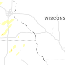
| 4:15 AM CDT | Hen Egg sized hail reported near Moose Lake, MN, 38.7 miles SW of Duluth, MN, picture of hen egg sized hail with ruler. |
| 4:16 AM CDT | Ping Pong Ball sized hail reported near Moose Lake, MN, 39.5 miles SW of Duluth, MN, photo sent in via social media with a ruler showing the size of the hailstone. |
| 4:19 AM CDT | Half Dollar sized hail reported near Moose Lake, MN, 39.5 miles SW of Duluth, MN, photo sent in via social media of 1.25 inch hail. |
| 4:19 AM CDT | Trees down and loss of power. time estimated based on rada in stearns county MN, 49.1 miles NE of Montevideo, MN |
| 4:23 AM CDT | Quarter sized hail reported near Moose Lake, MN, 38.7 miles SW of Duluth, MN |
| 4:24 AM CDT | Half Dollar sized hail reported near Barnum, MN, 35.6 miles SW of Duluth, MN, report from mping: half dollar (1.25 in.). |
| 4:30 AM CDT | Mndot sensor on i-9 in stearns county MN, 64.9 miles NE of Montevideo, MN |
| 4:40 AM CDT | Quarter sized hail reported near Carlton, MN, 24.8 miles WSW of Duluth, MN |
| 4:46 AM CDT | Quarter sized hail reported near Cloquet, MN, 17.7 miles WSW of Duluth, MN |
| 4:47 AM CDT | Quarter sized hail reported near Cloquet, MN, 17.5 miles WSW of Duluth, MN, report sent in via social media. |
| 4:50 AM CDT | Storm damage reported in benton county MN, 71.2 miles NW of Minneapolis, MN |
| 4:59 AM CDT | Quarter sized hail reported near Duluth, MN, 11.3 miles WNW of Duluth, MN |
| 5:00 AM CDT | Quarter sized hail reported near Duluth, MN, 10.3 miles WNW of Duluth, MN, report sent in via social media. |
| 5:05 AM CDT | Half Dollar sized hail reported near Duluth, MN, 10.4 miles WNW of Duluth, MN, photo sent in on social media of a ruler showing the size of the hailstone. |
| 5:15 AM CDT | Photo sent in via social media of an oak tree that was blown over near south long lak in crow wing county MN, 91.3 miles SSE of Bemidji, MN |
| 5:26 AM CDT | Photo sent in via social media showing a white pine tree snapped near the base of the trun in crow wing county MN, 82.4 miles SSE of Bemidji, MN |
Florida
| Local Time | Report Details |
|---|---|
| 3:08 PM EDT | Quarter sized hail reported near Hialeah, FL, 12.5 miles NW of Miami, FL, an off duty nws employee reported quarter size hail from a severe thunderstorm. |
| 4:09 PM EDT | Pws (kflloxah76) measured 58mph gust at 4:09pm... anemometer height of 43 f in palm beach county FL, 37.1 miles S of Port Saint Lucie, FL |
| 4:10 PM EDT | 50ft crank up radio tower wind down during the severe thunderstor in palm beach county FL, 36.9 miles S of Port Saint Lucie, FL |
| 4:10 PM EDT | Tree uprooted... with additional numerous 4-6 inch diameter branches down. time estimated from rada in palm beach county FL, 37.5 miles S of Port Saint Lucie, FL |
| 6:55 PM EDT | Quarter sized hail reported near Orlando, FL, 12.1 miles SW of Orlando, FL, trained spotter report up to quarter size hail on palm parkway. hail of various sizes lasted 10 min. |
| 6:55 PM EDT | Quarter sized hail reported near Orlando, FL, 12.9 miles SSW of Orlando, FL, viewer submission to spectrum news 13 of quarter size hail near the outlet mall at vineland ave. and interstate four. |
| 10:17 PM EDT | Asos station kgnv gainesville reported a peak wind gust of 59 mp in alachua county FL, 57.4 miles SW of Jacksonville, FL |
Wyoming
| Local Time | Report Details |
|---|---|
| 3:06 PM MDT | Storm damage reported in goshen county WY, 29 miles WNW of Scottsbluff, NE |
Nebraska
| Local Time | Report Details |
|---|---|
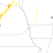
| 3:15 PM MDT | Storm damage reported in kimball county NE, 47.1 miles S of Scottsbluff, NE |
| 3:34 PM MDT | Scottsbluff raws sit in scotts bluff county NE, 3.3 miles SW of Scottsbluff, NE |
| 3:36 PM MDT | Male teenager at lake minatare hit in chest with falling tree branch. victim is in hospital in good condition as of 455p in scotts bluff county NE, 9.6 miles ENE of Scottsbluff, NE |
| 4:18 PM MDT | Asos station ksny sidney airpor in cheyenne county NE, 63.4 miles SE of Scottsbluff, NE |
| 4:28 PM MDT | Corrects previous tstm wnd gst report from 2 ssw sidney. asos station ksny sidney airpor in cheyenne county NE, 63.4 miles SE of Scottsbluff, NE |
| 4:31 PM MDT | Storm damage reported in cheyenne county NE, 63.1 miles SSE of Scottsbluff, NE |
| 5:01 PM MDT | Storm damage reported in sheridan county NE, 54.8 miles ENE of Scottsbluff, NE |
| 5:11 PM MDT | Storm damage reported in dawes county NE, 73.4 miles NNE of Scottsbluff, NE |
| 5:20 PM MDT | Quarter sized hail reported near Madrid, NE, 42.6 miles WSW of North Platte, NE, quarter size hail... 40 to 50 mph wind... and blowing dust. |
| 5:32 PM MDT | Storm damage reported in perkins county NE, 41.8 miles WSW of North Platte, NE |
| 5:32 PM MDT | Storm damage reported in perkins county NE, 42.6 miles WSW of North Platte, NE |
| 5:54 PM MDT | Half Dollar sized hail reported near Paxton, NE, 43.2 miles W of North Platte, NE |
| 6:43 PM MDT | Quarter sized hail reported near Arthur, NE, 50.3 miles NW of North Platte, NE |
| 7:23 PM MDT | Storm damage reported in hooker county NE, 62 miles NNW of North Platte, NE |
| 8:29 PM CDT | Baseball sized hail reported near Taylor, NE, 63 miles SW of Oneill, NE |
| 9:00 PM CDT | Hen Egg sized hail reported near Burwell, NE, 48.2 miles SW of Oneill, NE |
| 9:02 PM CDT | Baseball sized hail reported near Burwell, NE, 51.8 miles SW of Oneill, NE |
| 9:06 PM CDT | Hen Egg sized hail reported near Taylor, NE, 51.7 miles SW of Oneill, NE |
| 9:10 PM CDT | Grapefruit sized hail reported near Burwell, NE, 51.8 miles SW of Oneill, NE |
| 9:15 PM CDT | Grapefruit sized hail reported near Burwell, NE, 45.2 miles SW of Oneill, NE, measured up to 5 in. |
| 9:15 PM CDT | Grapefruit sized hail reported near Burwell, NE, 46.5 miles SW of Oneill, NE, measured up to 5 in. pictures provided on social media |
| 9:19 PM CDT | Quarter sized hail reported near Thedford, NE, 59.1 miles N of North Platte, NE |
| 9:25 PM CDT | Quarter sized hail reported near North Platte, NE, 6.5 miles N of North Platte, NE |
| 10:06 PM CDT | Quarter sized hail reported near Arnold, NE, 32.3 miles NE of North Platte, NE |
| 10:55 PM CDT | Golf Ball sized hail reported near Taylor, NE, 65.3 miles SW of Oneill, NE |
| 11:10 PM CDT | Quarter sized hail reported near Burwell, NE, 46.5 miles SW of Oneill, NE |
| 11:41 PM CDT | Quarter sized hail reported near Ord, NE, 49.9 miles NW of Grand Island, NE |
| 11:50 PM CDT | Golf Ball sized hail reported near Ansley, NE, 59.9 miles WNW of Grand Island, NE |
| 12:36 AM CDT | Ping Pong Ball sized hail reported near Neligh, NE, 34.5 miles ESE of Oneill, NE, report from mping: ping pong ball (1.50 in.). |
| 12:20 AM MDT | Quarter sized hail reported near Benkelman, NE, 53.7 miles NNW of Colby, KS |
| 1:20 AM CDT | Ping Pong Ball sized hail reported near Hartington, NE, 62.1 miles SSW of Sioux Falls, SD, corrects previous hail report from 4 w wynot. delayed report. power lines down. discovered by deputy after storms passed and relayed to emergency management. time estim |
New Mexico
| Local Time | Report Details |
|---|---|
| 5:27 PM MDT | Asos station kfmn farmington airport. visibility 3/4 mile in blowing dus in san juan county NM, 2 miles NW of Farmington, NM |
Nevada
| Local Time | Report Details |
|---|---|
| 4:32 PM PDT | 61 mph gusts measured by mesonet station rlkn2 ruby lake raw in elko county NV, 48.2 miles SSE of Elko, NV |
| 5:30 PM PDT | Downburst wind of 58 mph measured at mesonet station dnep8 4.3 e baker (dri in white pine county NV, 47.1 miles ESE of Ely, NV |
Colorado
| Local Time | Report Details |
|---|---|
| 6:52 PM MDT | Asos station kals alamosa airpor in alamosa county CO, 72.1 miles NNW of Taos, NM |
| 8:52 PM MDT | Storm damage reported in alamosa county CO, 72.1 miles NNW of Taos, NM |
North Dakota
| Local Time | Report Details |
|---|---|
| 8:40 PM CDT | Quarter sized hail reported near Inkster, ND, 54.1 miles E of Devils Lake, ND |
| 9:15 PM CDT | Quarter sized hail reported near Larimore, ND, 53.6 miles E of Devils Lake, ND |
| 10:05 PM CDT | Ping Pong Ball sized hail reported near Larimore, ND, 53.6 miles E of Devils Lake, ND |
South Dakota
| Local Time | Report Details |
|---|---|
| 1:43 AM CDT | Storm damage reported in clark county SD, 53.2 miles SE of Aberdeen, SD |
| 2:00 AM CDT | Mesonet station 200 wallace (sddot in clark county SD, 53.2 miles ESE of Aberdeen, SD |
| 3:05 AM CDT | Mesonet station 291 4n altamont (sddot in deuel county SD, 47.4 miles W of Montevideo, MN |
Connect with Interactive Hail Maps