

Hail Map for Monday, May 30, 2022

Number of Impacted Households on 5/30/2022
0
Impacted by 1" or Larger Hail
0
Impacted by 1.75" or Larger Hail
0
Impacted by 2.5" or Larger Hail
Square Miles of Populated Area Impacted on 5/30/2022
0
Impacted by 1" or Larger Hail
0
Impacted by 1.75" or Larger Hail
0
Impacted by 2.5" or Larger Hail

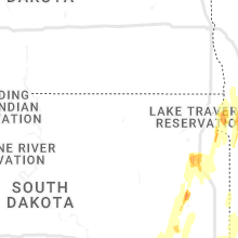


Cities Most Affected by Hail Storms of 5/30/2022
| Hail Size | Demographics of Zip Codes Affected | ||||||
|---|---|---|---|---|---|---|---|
| City | Count | Average | Largest | Pop Density | House Value | Income | Age |
| Brady, NE | 2 | 1.75 | 1.75 | 3 | $79k | $33.5k | 41.1 |
| Farwell, MN | 1 | 2.00 | 2.00 | 16 | $114k | $40.7k | 44.7 |
| Sioux Falls, SD | 1 | 2.00 | 2.00 | 1418 | $112k | $44.4k | 31.7 |
| Starbuck, MN | 1 | 1.75 | 1.75 | 12 | $78k | $35.5k | 48.0 |
| Lowry, MN | 1 | 1.75 | 1.75 | 13 | $73k | $36.4k | 39.1 |
| Buffalo, MN | 1 | 1.75 | 1.75 | 217 | $140k | $55.5k | 37.0 |
| Zimmerman, MN | 1 | 1.75 | 1.75 | 201 | $132k | $57.2k | 33.1 |
Hail and Wind Damage Spotted on 5/30/2022
Filter by Report Type:Hail ReportsWind Reports
States Impacted
Minnesota, Nebraska, Iowa, Florida, South Dakota, Kansas, Georgia, North Dakota, WisconsinMinnesota
| Local Time | Report Details |
|---|---|
| 7:30 AM CDT | Quarter sized hail reported near , , 125.6 miles NE of Duluth, MN |
| 1:45 PM CDT | Quarter sized hail reported near Ortonville, MN, 41.1 miles NW of Montevideo, MN |
| 2:05 PM CDT | Quarter sized hail reported near Herman, MN, 59.7 miles NNW of Montevideo, MN |
| 2:10 PM CDT | Quarter sized hail reported near Herman, MN, 62.9 miles NNW of Montevideo, MN |
| 2:58 PM CDT | Quarter sized hail reported near Ortonville, MN, 54.3 miles NW of Montevideo, MN |
| 3:20 PM CDT | Storm damage reported in big stone county MN, 56.4 miles NW of Montevideo, MN |
| 3:25 PM CDT | Storm damage reported in lincoln county MN, 54.1 miles NNE of Sioux Falls, SD |
| 3:25 PM CDT | Reported at madison airpor in lac qui parle county MN, 23.6 miles WNW of Montevideo, MN |
| 3:25 PM CDT | Storm damage reported in rock county MN, 23.1 miles ENE of Sioux Falls, SD |
| 3:30 PM CDT | Trees down. time estimated by rada in yellow medicine county MN, 12.6 miles SE of Montevideo, MN |
| 3:40 PM CDT | Reported at appleton airpor in swift county MN, 22.3 miles NW of Montevideo, MN |
| 3:45 PM CDT | Machine shed damaged 6 miles south of holloway. time estimated by rada in swift county MN, 17.8 miles NNW of Montevideo, MN |
| 3:46 PM CDT | Mndot weather sensor reported wind gust on hwy 1 in swift county MN, 24.5 miles NNW of Montevideo, MN |
| 3:55 PM CDT | Also noted multiple small tree branches down around the are in murray county MN, 44.1 miles NE of Sioux Falls, SD |
| 3:55 PM CDT | Cattle sheds damaged. possible tornado damage. time estimated by rada in swift county MN, 31 miles NNW of Montevideo, MN |
| 3:55 PM CDT | Several trees down. time estimated by rada in stevens county MN, 52.4 miles NNW of Montevideo, MN |
| 3:56 PM CDT | Reported at morris airpor in stevens county MN, 45.1 miles NNW of Montevideo, MN |
| 4:00 PM CDT | Spruce tree 28 inches in diameter down. reported via twitter. time estimated by rada in stevens county MN, 55.6 miles NNW of Montevideo, MN |
| 4:01 PM CDT | Shed rolled and destroyed. video on facebook. time estimated from rada in stevens county MN, 45.1 miles NNW of Montevideo, MN |
| 4:05 PM CDT | Reported at benson airpor in swift county MN, 26.1 miles NNE of Montevideo, MN |
| 4:07 PM CDT | Awos station kmml marshall municipal airpor in lyon county MN, 35 miles S of Montevideo, MN |
| 4:15 PM CDT | Camper damaged. report relayed via law enforcemen in pope county MN, 46.2 miles N of Montevideo, MN |
| 4:15 PM CDT | Golf Ball sized hail reported near Lowry, MN, 53.2 miles N of Montevideo, MN, golf ball sized hail reported. relayed via law enforcement. |
| 4:15 PM CDT | Golf Ball sized hail reported near Starbuck, MN, 46.2 miles N of Montevideo, MN, golf ball sized hail reported. relayed via law enforcement. |
| 4:15 PM CDT | Ping Pong Ball sized hail reported near Alexandria, MN, 62.8 miles N of Montevideo, MN, time estimated by radar. |
| 4:20 PM CDT | Hen Egg sized hail reported near Farwell, MN, 63.4 miles N of Montevideo, MN, time estimated by radar. |
| 4:20 PM CDT | Large trees blown down. shed destroye in grant county MN, 66.7 miles N of Montevideo, MN |
| 4:21 PM CDT | Report via social media of high voltage powerlines bent or snappe in lyon county MN, 49.3 miles S of Montevideo, MN |
| 4:25 PM CDT | Parts of grain bin down on railroad tracks. time estimated from rada in yellow medicine county MN, 18.7 miles SSE of Montevideo, MN |
| 4:27 PM CDT | Large trees blown down. time estimated based on rada in hubbard county MN, 44.2 miles S of Bemidji, MN |
| 4:28 PM CDT | Trees on power lines mile marker 41/42 on highway 212. time estimate in chippewa county MN, 4.5 miles SE of Montevideo, MN |
| 4:28 PM CDT | Large branches broken down and trees uprooted near downtown ashb in grant county MN, 71.1 miles SE of Fargo, ND |
| 4:29 PM CDT | Garage destroyed. house roofing torn off near ten mile lake. time estimated based on rada in otter tail county MN, 64.4 miles SE of Fargo, ND |
| 4:30 PM CDT | Large transmission lines dow in yellow medicine county MN, 17.4 miles S of Montevideo, MN |
| 4:30 PM CDT | Trees dow in yellow medicine county MN, 11.9 miles SE of Montevideo, MN |
| 4:32 PM CDT | A fifth wheel dual-axle camper was flipped over near stalker lake. time stimated based on rada in otter tail county MN, 63.8 miles SE of Fargo, ND |
| 4:32 PM CDT | Trees down on power lines. time estimated from rada in yellow medicine county MN, 13.3 miles SE of Montevideo, MN |
| 4:35 PM CDT | Large trees blown down around tow in otter tail county MN, 63.8 miles SE of Fargo, ND |
| 4:37 PM CDT | Corrects previous tstm wnd dmg report from 3 w urbank. large trees down near inspiration pea in otter tail county MN, 77.4 miles SE of Fargo, ND |
| 4:38 PM CDT | Trees blown down and a trailer crushed by falling trees on south turtle lake. time estimated based on rada in otter tail county MN, 62.4 miles SE of Fargo, ND |
| 4:39 PM CDT | Peak wind measured at a personal weather station near south turtle lake... before the station lost powe in otter tail county MN, 61.8 miles SE of Fargo, ND |
| 4:40 PM CDT | Large trees uproote in otter tail county MN, 66.1 miles SE of Fargo, ND |
| 4:40 PM CDT | Trees blown down... house and shed roofing torn off... and pontoon flipped near wall lake. time estimated based on rada in otter tail county MN, 56.8 miles SE of Fargo, ND |
| 4:45 PM CDT | Quarter sized hail reported near Lakefield, MN, 68.5 miles N of Storm Lake, IA, report via social media. |
| 4:45 PM CDT | Large trees dow in otter tail county MN, 63.8 miles SE of Fargo, ND |
| 4:49 PM CDT | Peak wind measured at a personal weather statio in otter tail county MN, 69.8 miles SSW of Bemidji, MN |
| 4:49 PM CDT | Peak wind measured at a personal weather station near main in otter tail county MN, 60.3 miles SE of Fargo, ND |
| 4:55 PM CDT | Trees blown down on a truck. time estimated based on rada in otter tail county MN, 43.6 miles ESE of Fargo, ND |
| 4:56 PM CDT | Back wall of a garage blown out by the win in otter tail county MN, 61.5 miles ESE of Fargo, ND |
| 4:57 PM CDT | Storm damage reported in cottonwood county MN, 69.9 miles SSE of Montevideo, MN |
| 5:02 PM CDT | Metal roofing peeled off of a garage. time estimated based on rada in becker county MN, 52.3 miles E of Fargo, ND |
| 5:03 PM CDT | Delayed report - damage reported in eagle bend mn... likely tornadi in todd county MN, 89.7 miles NNE of Montevideo, MN |
| 5:05 PM CDT | Quarter sized hail reported near Jackson, MN, 68 miles N of Storm Lake, IA, picture via social media. |
| 5:05 PM CDT | Multiple trees blown down. some have fallen on power lines. shingles lifted off roof of hous in becker county MN, 56.7 miles E of Fargo, ND |
| 5:05 PM CDT | Reported by mndot weather sensor at hwy 7 in redwood county MN, 57.1 miles SSE of Montevideo, MN |
| 5:10 PM CDT | Large limbs down. power lines down. piece of sheet metal hanging on power lines. time estimated from rada in kandiyohi county MN, 25.9 miles E of Montevideo, MN |
| 5:20 PM CDT | Ping Pong Ball sized hail reported near Verndale, MN, 74.4 miles S of Bemidji, MN |
| 5:21 PM CDT | Trees blown dow in becker county MN, 42.5 miles SW of Bemidji, MN |
| 5:21 PM CDT | Quarter sized hail and wind gusts at 60 to 70 mp in wadena county MN, 75.5 miles S of Bemidji, MN |
| 5:24 PM CDT | Quarter sized hail reported near Hackensack, MN, 38.6 miles SSE of Bemidji, MN, pea to quarter size hail covering about ten percent of the ground. |
| 5:25 PM CDT | Le reports trees down... one across road. time estimated from rada in brown county MN, 66.7 miles SE of Montevideo, MN |
| 5:25 PM CDT | Quarter sized hail reported near Aldrich, MN, 76.3 miles S of Bemidji, MN |
| 5:30 PM CDT | Ping Pong Ball sized hail reported near Verndale, MN, 74.4 miles S of Bemidji, MN |
| 5:35 PM CDT | Trees down and roof damage. time estimated from rada in watonwan county MN, 86 miles SE of Montevideo, MN |
| 5:35 PM CDT | Shingles lifted off roo in becker county MN, 56.7 miles E of Fargo, ND |
| 5:38 PM CDT | Trees down. time estimated from rada in renville county MN, 57.1 miles ESE of Montevideo, MN |
| 5:40 PM CDT | A few trees downed across mn 210. time estimated from rada in cass county MN, 80 miles SSE of Bemidji, MN |
| 5:44 PM CDT | Trees down on 2 houses. time estimated from rada in brown county MN, 74.9 miles SW of Minneapolis, MN |
| 5:45 PM CDT | Numerous trees down on the north side of town. time estimated from rada in brown county MN, 74.4 miles SW of Minneapolis, MN |
| 5:47 PM CDT | Reported at new ulm airpor in brown county MN, 74.4 miles SW of Minneapolis, MN |
| 5:50 PM CDT | Large trees down near inspiration pea in otter tail county MN, 77.4 miles SE of Fargo, ND |
| 5:54 PM CDT | Report of 8 inch diameter limb down in new ul in brown county MN, 74.9 miles SW of Minneapolis, MN |
| 6:00 PM CDT | Cluster of trees down on a powerline on county hwy 1 in crow wing county MN, 66.2 miles SSE of Bemidji, MN |
| 6:00 PM CDT | Trees report down in the pine river area. power is also out. report from social medi in cass county MN, 56.1 miles SSE of Bemidji, MN |
| 6:02 PM CDT | Tree down on vehicle. report relayed by social media via a law enforcement scanne in crow wing county MN, 75.9 miles SSE of Bemidji, MN |
| 6:02 PM CDT | Trees down and power ou in crow wing county MN, 66.8 miles SSE of Bemidji, MN |
| 6:02 PM CDT | A few trees knocked down with numerous branches downed. pea size hail also observe in crow wing county MN, 67.9 miles SSE of Bemidji, MN |
| 6:09 PM CDT | Several large trees broken dow in beltrami county MN, 9.8 miles NE of Bemidji, MN |
| 6:15 PM CDT | Several large branches down in town. photos via twitter. time estimate in mcleod county MN, 54.6 miles W of Minneapolis, MN |
| 6:17 PM CDT | Measured at glencoe airpor in mcleod county MN, 45.6 miles WSW of Minneapolis, MN |
| 6:17 PM CDT | Trees down onto houses on county road 9 north of town. time estimated from rada in mcleod county MN, 40.5 miles WSW of Minneapolis, MN |
| 6:17 PM CDT | A few large trees down in a few spots. time estimated from rada in cass county MN, 49.2 miles SE of Bemidji, MN |
| 6:20 PM CDT | Winds flipped over a dock on little boy lak in cass county MN, 48.3 miles SE of Bemidji, MN |
| 6:20 PM CDT | Shed damaged. tree on vehicle. reported near lamson via twitter. photo included. time estimate in meeker county MN, 49.3 miles W of Minneapolis, MN |
| 6:20 PM CDT | Roof of barn damaged. reported via twitter. photo included. time estimate in carver county MN, 35.1 miles W of Minneapolis, MN |
| 6:24 PM CDT | Estimated 10-12 inch diameter pine tree based on an image from social medi in cass county MN, 40.2 miles SE of Bemidji, MN |
| 6:25 PM CDT | Trained spotter measured a 62 mph gus in morrison county MN, 80.4 miles NNW of Minneapolis, MN |
| 6:27 PM CDT | Quarter sized hail reported near Winsted, MN, 38.5 miles W of Minneapolis, MN |
| 6:30 PM CDT | Trees down and snapped in town and south of town on hwy 27 and hwy 25. time estimated by rada in morrison county MN, 80.2 miles NNW of Minneapolis, MN |
| 6:30 PM CDT | Trees dow in wright county MN, 45.8 miles W of Minneapolis, MN |
| 6:30 PM CDT | Trees dow in wright county MN, 39.8 miles W of Minneapolis, MN |
| 6:30 PM CDT | Trees dow in wright county MN, 35.1 miles W of Minneapolis, MN |
| 6:30 PM CDT | Multiple trees down. one blocking road. time estimate in wright county MN, 25.9 miles W of Minneapolis, MN |
| 6:31 PM CDT | Numerous trees down. time estimated from rada in wright county MN, 31.1 miles WNW of Minneapolis, MN |
| 6:37 PM CDT | Golf Ball sized hail reported near Buffalo, MN, 32.9 miles WNW of Minneapolis, MN |
| 6:40 PM CDT | Storm damage reported in stearns county MN, 54.9 miles NW of Minneapolis, MN |
| 6:47 PM CDT | Garage completely collapsed with debris strewn in deer rive in itasca county MN, 51.9 miles E of Bemidji, MN |
| 6:50 PM CDT | Quarter sized hail reported near Big Lake, MN, 33.8 miles NW of Minneapolis, MN |
| 6:50 PM CDT | Storm damage reported in lincoln county MN, 49.2 miles SW of Montevideo, MN |
| 6:54 PM CDT | Storm damage reported in sherburne county MN, 27.6 miles NNW of Minneapolis, MN |
| 6:55 PM CDT | Storm damage reported in lincoln county MN, 46.6 miles SSW of Montevideo, MN |
| 6:55 PM CDT | Trees down near the elk river soni in sherburne county MN, 26.4 miles NNW of Minneapolis, MN |
| 6:57 PM CDT | Storm damage reported in sherburne county MN, 41 miles NW of Minneapolis, MN |
| 6:57 PM CDT | 18 inch diameter tree dow in sherburne county MN, 34.1 miles NW of Minneapolis, MN |
| 7:00 PM CDT | Large trees down along hwy 2 east of bemidj in beltrami county MN, 5.2 miles E of Bemidji, MN |
| 7:00 PM CDT | Golf Ball sized hail reported near Zimmerman, MN, 36.2 miles NNW of Minneapolis, MN |
| 7:00 PM CDT | A couple of trees down on the crown side of zimmerman. time and location estimate in sherburne county MN, 35.4 miles NNW of Minneapolis, MN |
| 7:00 PM CDT | Large trees down along hwy 2... east of bemidj in beltrami county MN, 4.9 miles ESE of Bemidji, MN |
| 7:01 PM CDT | Quarter sized hail reported near Anoka, MN, 26.2 miles NNW of Minneapolis, MN |
| 7:01 PM CDT | Quarter sized hail reported near Coleraine, MN, 69.2 miles E of Bemidji, MN, report from mping. |
| 7:02 PM CDT | Large tree branches down. picture on facebook. time estimate in wright county MN, 25.1 miles NW of Minneapolis, MN |
| 7:06 PM CDT | Mesonet station ap152 elk river 2wn in sherburne county MN, 30.1 miles NNW of Minneapolis, MN |
| 7:07 PM CDT | Large tree uprooted. time estimated from rada in anoka county MN, 12.5 miles N of Minneapolis, MN |
| 7:08 PM CDT | Large branch down near community center. reported via twitter. photo include in hennepin county MN, 12.3 miles NW of Minneapolis, MN |
| 7:10 PM CDT | Large branches down in bradford. reported via twitter. included photo. time estimate in isanti county MN, 38.5 miles N of Minneapolis, MN |
| 7:10 PM CDT | Tree down near independence ave. and 109th ave. time estimated by rada in hennepin county MN, 14.1 miles NNW of Minneapolis, MN |
| 7:10 PM CDT | Half Dollar sized hail reported near Isanti, MN, 34.2 miles N of Minneapolis, MN |
| 7:10 PM CDT | Storm damage reported in lyon county MN, 35 miles S of Montevideo, MN |
| 7:20 PM CDT | Measured at crystal airpor in hennepin county MN, 6.3 miles NW of Minneapolis, MN |
| 7:20 PM CDT | Time estimate in isanti county MN, 40.3 miles N of Minneapolis, MN |
| 7:21 PM CDT | Tops of pine/evergreen trees snapped off. estimated wind gusts 60-65mp in lac qui parle county MN, 11.8 miles WSW of Montevideo, MN |
| 7:22 PM CDT | Isa-d71 called to report 12 inch diameter tree knocked ove in isanti county MN, 40.3 miles N of Minneapolis, MN |
| 7:25 PM CDT | 100 year old pine tree down. time estimate in lac qui parle county MN, 8.2 miles WSW of Montevideo, MN |
| 7:25 PM CDT | 18 inch tree snapped off and large branch dow in isanti county MN, 40.2 miles N of Minneapolis, MN |
| 7:30 PM CDT | Mesonet station as738 coon rapid in anoka county MN, 13.2 miles N of Minneapolis, MN |
| 7:32 PM CDT | Trees down near us 71 and state highway 65. time estimated from rada in koochiching county MN, 15.9 miles SSW of International Falls, MN |
| 7:42 PM CDT | Multiple trees down highway 22 and 5. time estimated by rada in st. louis county MN, 59.5 miles SSE of International Falls, MN |
| 7:42 PM CDT | Trees dow in pine county MN, 60.5 miles NNE of Minneapolis, MN |
| 7:44 PM CDT | Trees dow in pine county MN, 66.1 miles NNE of Minneapolis, MN |
| 7:45 PM CDT | Large pine tree down. report from social media. time estimated by rada in koochiching county MN, 0.9 miles SSW of International Falls, MN |
| 7:50 PM CDT | Large boulevard tree on house. time estimated by rada in hennepin county MN, 2.1 miles SSW of Minneapolis, MN |
| 7:50 PM CDT | Wind damage and trees down at holiday station in hinckle in pine county MN, 66.8 miles SW of Duluth, MN |
| 7:50 PM CDT | Numerous trees and power lines down in hinckle in pine county MN, 66.2 miles SW of Duluth, MN |
| 7:52 PM CDT | Trees down just north of hinckley on i-35. report relayed by social media. time estimated by radar. location estimate in pine county MN, 65.4 miles SW of Duluth, MN |
| 8:09 PM CDT | Quarter sized hail reported near Orr, MN, 45.6 miles SE of International Falls, MN, report relayed by media. |
| 8:20 PM CDT | Large branch down. reported via twitter. photo include in ramsey county MN, 6.3 miles ENE of Minneapolis, MN |
| 8:29 PM CDT | Tree limbs broken. time estimated from rada in carlton county MN, 27.3 miles SW of Duluth, MN |
| 9:58 PM CDT | Storm damage reported in fillmore county MN, 32.4 miles W of La Crosse, WI |
| 12:31 AM CDT | Tree blown dow in fillmore county MN, 46.9 miles W of La Crosse, WI |
| 12:43 AM CDT | Asos station krst rochester international airpor in olmsted county MN, 62.6 miles W of La Crosse, WI |
| 12:50 AM CDT | Tree blown down in preston taking down power lines as wel in fillmore county MN, 42.6 miles WSW of La Crosse, WI |
| 12:54 AM CDT | Tree blown dow in winona county MN, 33 miles WNW of La Crosse, WI |
Nebraska
| Local Time | Report Details |
|---|---|
| 7:40 AM CDT | Ping Pong Ball sized hail reported near Brady, NE, 22 miles ESE of North Platte, NE |
| 7:40 AM CDT | Golf Ball sized hail reported near Brady, NE, 22 miles ESE of North Platte, NE, golf ball size hail... report via social media with pictures and video. |
| 7:50 AM CDT | Golf Ball sized hail reported near Brady, NE, 21.6 miles ESE of North Platte, NE |
| 8:17 AM CDT | Quarter sized hail reported near Callaway, NE, 38.3 miles ENE of North Platte, NE |
| 11:29 AM CDT | Quarter sized hail reported near Oneill, NE, 11.2 miles N of Oneill, NE |
| 12:12 PM CDT | Quarter sized hail reported near Niobrara, NE, 30.5 miles NE of Oneill, NE, a few hail stones up to quarter size. time estimated based on radar. |
| 3:21 PM CDT | Asos station kmck mccook airport. peak wind gust from decaying thunderstorm in red willow county NE, 60.7 miles NNE of Colby, KS |
| 3:48 PM CDT | Measured via pw in dawson county NE, 59.4 miles E of North Platte, NE |
| 4:04 PM CDT | Measured via pw in sherman county NE, 43 miles WNW of Grand Island, NE |
| 4:44 PM CDT | Delayed report. gust associated with decaying convection. measured via pw in greeley county NE, 39 miles N of Grand Island, NE |
| 4:56 PM CDT | Storm damage reported in boone county NE, 45.4 miles N of Grand Island, NE |
| 4:59 PM CDT | Storm damage reported in boone county NE, 48.4 miles NNE of Grand Island, NE |
| 5:00 PM CDT | Storm damage reported in boone county NE, 41 miles N of Grand Island, NE |
| 5:24 PM CDT | Large tree branch down. report received via social medi in madison county NE, 58 miles ESE of Oneill, NE |
| 5:35 PM CDT | Asos station kofk norfolk airpor in madison county NE, 70.7 miles ESE of Oneill, NE |
| 9:00 PM CDT | Quarter sized hail reported near Cook, NE, 53.1 miles SSW of Omaha, NE, quarter size hail. |
Iowa
| Local Time | Report Details |
|---|---|
| 7:55 AM CDT | Asos station kspw spencer municipal airpor in clay county IA, 36.1 miles N of Storm Lake, IA |
| 2:41 PM CDT | Large tree dow in woodbury county IA, 63.8 miles W of Storm Lake, IA |
| 4:15 PM CDT | Quarter sized hail reported near Hartley, IA, 39.4 miles NNW of Storm Lake, IA, reported quarter to half dollar hail... coincides with radar data. |
| 4:35 PM CDT | Half Dollar sized hail reported near Lake Park, IA, 55.7 miles N of Storm Lake, IA |
| 4:37 PM CDT | Reported wind popped open his locked machine shed doors. radar data supports strong wind in dickinson county IA, 57 miles N of Storm Lake, IA |
| 4:40 PM CDT | Reported estimated wind speeds of 60 mph and dime to nickel sized hai in dickinson county IA, 56.4 miles N of Storm Lake, IA |
| 4:56 PM CDT | Cattle barns complete loss. time estimated from rada in audubon county IA, 62.3 miles ENE of Omaha, NE |
| 5:57 PM CDT | Quarter sized hail reported near Livermore, IA, 53.1 miles WSW of Mason City, IA |
| 6:52 PM CDT | Storm damage reported in o'brien county IA, 49.1 miles NW of Storm Lake, IA |
| 6:52 PM CDT | Gust measured via unl mobile mesone in osceola county IA, 50.3 miles ESE of Sioux Falls, SD |
| 7:20 PM CDT | Widespread tree damage in town. few shingles blown off roofs. time estimated from rada in boone county IA, 47.5 miles NNW of Des Moines, IA |
| 7:54 PM CDT | Tree branch down over the roadway. time estimated from rada in hamilton county IA, 55.4 miles N of Des Moines, IA |
| 8:55 PM CDT | Rudd fire department reports numerous trees down across town. time estimated from rada in floyd county IA, 15.3 miles E of Mason City, IA |
| 8:56 PM CDT | Time estimated from rada in floyd county IA, 14.7 miles ESE of Mason City, IA |
| 9:05 PM CDT | Colwell fire dept estimates 60 to 70 mph gusts northeast of charles city. minor tree damag in floyd county IA, 29.2 miles E of Mason City, IA |
| 9:25 PM CDT | Power lines reported down between elma and ricevill in howard county IA, 39.1 miles E of Mason City, IA |
| 9:32 PM CDT | Mesonet station fw5287 saratog in howard county IA, 41.8 miles ENE of Mason City, IA |
| 11:45 PM CDT | Personal weather station measured 59 mph wind gus in worth county IA, 14.3 miles NNE of Mason City, IA |
| 12:21 AM CDT | Mesonet station ew4652 ricevill in howard county IA, 39.2 miles ENE of Mason City, IA |
| 12:25 AM CDT | Mesonet station fw5287 saratog in howard county IA, 41.8 miles ENE of Mason City, IA |
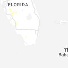
Florida
| Local Time | Report Details |
|---|---|
| 12:55 PM EDT | A few ficus trees knocked down in the vicinity of lake worth. time estimated from rada in palm beach county FL, 48.4 miles SSE of Port Saint Lucie, FL |
| 3:50 PM EDT | Fallen limbs/trees on wires along east ash street. time estimated from rada in taylor county FL, 40.4 miles SE of Tallahassee, FL |
| 4:14 PM EDT | Asos station krsw fort myer in lee county FL, 27.1 miles N of Naples, FL |
| 4:30 PM EDT | Tree down blocking thompson valley road between hwy 19 and curtis mills roa in jefferson county FL, 24.7 miles E of Tallahassee, FL |
| 4:40 PM EDT | Fallen trees or limbs resulted in a power outage off of waukeenah highwa in jefferson county FL, 24 miles ENE of Tallahassee, FL |
| 4:45 PM EDT | Tree down blocking the westbound lane of hwy 90 near rainey ru in jefferson county FL, 21.5 miles ENE of Tallahassee, FL |
| 4:48 PM EDT | Tree down near old lloyd road and gamble road. time estimated from rada in jefferson county FL, 15.2 miles E of Tallahassee, FL |
| 4:48 PM EDT | Fallen trees or limbs resulted in a power outage along willie roa in jefferson county FL, 16.1 miles ENE of Tallahassee, FL |
| 4:59 PM EDT | A home weather station on marina cir recorded a 78 mph thunderstorm wind gus in lee county FL, 34.5 miles NNW of Naples, FL |
| 6:41 PM EDT | Florida highway patrol reports tree across roadway on highway 129... near 254th terrac in suwannee county FL, 80 miles WSW of Jacksonville, FL |
| 6:46 PM EDT | Florida highway patrol reports tree in southbound lane on cr 137 near sr 24 in suwannee county FL, 71.9 miles WSW of Jacksonville, FL |
| 8:15 PM EDT | Public reports thunderstorm wind damage at 22nd st and corrine st in tampa. time estimated based on rada in hillsborough county FL, 32.6 miles NNE of Bradenton, FL |
| 10:00 PM EDT | Down tree was reported tamp in hillsborough county FL, 38.9 miles N of Bradenton, FL |
South Dakota
| Local Time | Report Details |
|---|---|
| 12:40 PM CDT | Quarter sized hail reported near Lake Norden, SD, 77.4 miles NNW of Sioux Falls, SD |
| 12:49 PM CDT | Trained spotter reported an estimated 60-70 mph wind in bon homme county SD, 59.7 miles NE of Oneill, NE |
| 12:50 PM CDT | Storm damage reported in bon homme county SD, 59.9 miles NE of Oneill, NE |
| 1:10 PM CDT | Storm damage reported in hanson county SD, 57.2 miles W of Sioux Falls, SD |
| 1:25 PM CDT | Quarter sized hail reported near Hazel, SD, 72.5 miles SE of Aberdeen, SD |
| 1:55 PM CDT | Mayor or salem reported that power is out throughout the tow in mccook county SD, 35.2 miles WNW of Sioux Falls, SD |
| 1:57 PM CDT | Quarter sized hail reported near Corona, SD, 57.7 miles WNW of Montevideo, MN, report from social media. |
| 2:12 PM CDT | Quarter sized hail reported near Watertown, SD, 68.4 miles W of Montevideo, MN, report from social media. |
| 2:42 PM CDT | Camper flipped on i-29 north of exit 12 in moody county SD, 43.2 miles N of Sioux Falls, SD |
| 2:45 PM CDT | Ping Pong Ball sized hail reported near Sioux Falls, SD, 5.1 miles SSW of Sioux Falls, SD, 1.0 to 1.5 inch diameter hail. |
| 2:45 PM CDT | Hen Egg sized hail reported near Sioux Falls, SD, 3.1 miles SW of Sioux Falls, SD, picture via social media. |
| 2:47 PM CDT | Quarter sized hail reported near Harrisburg, SD, 8 miles S of Sioux Falls, SD |
| 2:50 PM CDT | Quarter sized hail reported near Sioux Falls, SD, 3.5 miles SW of Sioux Falls, SD, reported quarter size hail. |
| 2:50 PM CDT | Mesonet station sfss2 sioux falls (sd mesonet in minnehaha county SD, 3.4 miles SSW of Sioux Falls, SD |
| 2:53 PM CDT | Quarter sized hail reported near Sioux Falls, SD, 3.1 miles N of Sioux Falls, SD |
| 2:55 PM CDT | Mesonet station oaks2 astoria 4 sse (sd mesonet in brookings county SD, 50.3 miles SW of Montevideo, MN |
| 3:05 PM CDT | Quarter sized hail reported near Sioux Falls, SD, 5.6 miles E of Sioux Falls, SD, corrects previous hail report from 4 wnw rowena. |
| 3:05 PM CDT | Storm damage reported in minnehaha county SD, 7.7 miles ENE of Sioux Falls, SD |
| 3:37 PM CDT | Mesonet station 292 7ne milbank (sddot in grant county SD, 44.6 miles WNW of Montevideo, MN |
| 5:46 PM CDT | Ping Pong Ball sized hail reported near Wakonda, SD, 41.6 miles SSW of Sioux Falls, SD, picture via social media. |
| 5:50 PM CDT | Half Dollar sized hail reported near Wakonda, SD, 39.1 miles SSW of Sioux Falls, SD |
| 6:05 PM CDT | Storm damage reported in minnehaha county SD, 18.1 miles NNW of Sioux Falls, SD |
| 6:13 PM CDT | Highway patrol reported a flipped semi 1 mile north of dell rapid in minnehaha county SD, 20.4 miles N of Sioux Falls, SD |
| 6:13 PM CDT | Storm damage reported in minnehaha county SD, 19.1 miles N of Sioux Falls, SD |
| 6:15 PM CDT | Storm damage reported in lake county SD, 37.4 miles NNW of Sioux Falls, SD |
| 6:32 PM CDT | Storm damage reported in moody county SD, 41.8 miles N of Sioux Falls, SD |
| 6:35 PM CDT | Storm damage reported in moody county SD, 32.2 miles NNE of Sioux Falls, SD |
| 6:54 PM CDT | Report via a personal weather statio in lincoln county SD, 10.2 miles S of Sioux Falls, SD |
Kansas
| Local Time | Report Details |
|---|---|
| 12:40 PM MDT | Asos station kgld goodlan in sherman county KS, 35.1 miles W of Colby, KS |
| 5:22 PM CDT | Storm damage reported in harvey county KS, 28.6 miles N of Wichita, KS |
| 5:40 PM CDT | Getting another bout of 60 mph winds 20 minutes later. some tree limbs being downe in harvey county KS, 28.6 miles N of Wichita, KS |
| 5:48 PM CDT | Tree limb downed. received via twitte in marion county KS, 35.5 miles NNE of Wichita, KS |
| 6:07 PM CDT | Half Dollar sized hail reported near Mayetta, KS, 46.5 miles ENE of Manhattan, KS, corrects previous hail report from mayetta. |
| 6:07 PM CDT | Quarter sized hail reported near Mayetta, KS, 46.5 miles ENE of Manhattan, KS |
| 6:16 PM CDT | Quarter sized hail reported near Holton, KS, 49.9 miles ENE of Manhattan, KS, report via mping. |
| 6:28 PM CDT | Ping Pong Ball sized hail reported near Muscotah, KS, 59.3 miles WNW of Kansas City, MO |
| 6:32 PM CDT | Storm damage reported in marion county KS, 44.1 miles NNE of Wichita, KS |
| 6:40 PM CDT | Quarter sized hail reported near Cottonwood Falls, KS, 55.8 miles S of Manhattan, KS, 60 to 70 mph winds occurred with the hail. tree limbs down. |
| 6:40 PM CDT | Quarter size hail occurred with the win in chase county KS, 55.8 miles S of Manhattan, KS |
| 6:41 PM CDT | Quarter sized hail reported near Strong City, KS, 54.4 miles S of Manhattan, KS, report from mping: quarter (1.00 in.). |
| 7:33 PM CDT | Quarter sized hail reported near Strong City, KS, 54.4 miles S of Manhattan, KS, report from mping: quarter (1.00 in.). |
| 7:53 PM CDT | Asos station kemp empori in lyon county KS, 60.5 miles NW of Chanute, KS |
| 7:55 PM CDT | Quarter sized hail reported near Emporia, KS, 57.8 miles NW of Chanute, KS |
| 7:57 PM CDT | Quarter sized hail reported near Emporia, KS, 57.3 miles SSE of Manhattan, KS, report via mping. |
| 8:05 PM CDT | Storm damage reported in lyon county KS, 59 miles NNW of Chanute, KS |
Georgia
| Local Time | Report Details |
|---|---|
| 7:30 PM EDT | Several trees and power lines down near hahir in lowndes county GA, 42.6 miles SW of Douglas, GA |
North Dakota
| Local Time | Report Details |
|---|---|
| 8:15 PM CDT | Ndawn station 329109 wahpeton nd 6 in richland county ND, 36.7 miles S of Fargo, ND |
| 8:15 PM CDT | Peak wind measured at an ndawn statio in richland county ND, 36.8 miles S of Fargo, ND |
Wisconsin
| Local Time | Report Details |
|---|---|
| 1:26 AM CDT | 5 inch branch down over vehicles/roadway. time estimated via rada in eau claire county WI, 69 miles N of La Crosse, WI |
| 1:32 AM CDT | 2 trees down. time estimated from rada in chippewa county WI, 78.1 miles N of La Crosse, WI |
| 1:39 AM CDT | Tree down in lake wissota state park. public wx sensor also measured 68 mp in chippewa county WI, 81.3 miles N of La Crosse, WI |
Connect with Interactive Hail Maps