

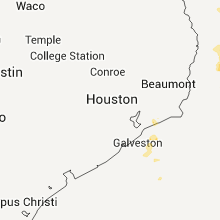
Hail Map for Wednesday, September 28, 2011

Number of Impacted Households on 9/28/2011
0
Impacted by 1" or Larger Hail
0
Impacted by 1.75" or Larger Hail
0
Impacted by 2.5" or Larger Hail
Square Miles of Populated Area Impacted on 9/28/2011
0
Impacted by 1" or Larger Hail
0
Impacted by 1.75" or Larger Hail
0
Impacted by 2.5" or Larger Hail


Cities Most Affected by Hail Storms of 9/28/2011
| Hail Size | Demographics of Zip Codes Affected | ||||||
|---|---|---|---|---|---|---|---|
| City | Count | Average | Largest | Pop Density | House Value | Income | Age |
| Suffolk, VA | 2 | 2.75 | 2.75 | 711 | $138k | $52.0k | 36.3 |
| Greenwell Springs, LA | 1 | 2.00 | 2.00 | 255 | $112k | $52.9k | 39.0 |
| Hammond, LA | 1 | 1.75 | 1.75 | 599 | $94k | $27.3k | 28.5 |
| Oberlin, LA | 1 | 1.75 | 1.75 | 4 | $54k | $27.2k | 40.8 |
| Tylertown, MS | 1 | 1.75 | 1.75 | 42 | $58k | $22.7k | 37.9 |
| Windsor, VA | 1 | 1.75 | 1.75 | 65 | $111k | $41.2k | 42.5 |
Hail and Wind Damage Spotted on 9/28/2011
Filter by Report Type:Hail ReportsWind Reports
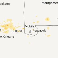
Mississippi
| Local Time | Report Details |
|---|---|
| 1:45 PM UTC | Limbs and power lines were reported down in sumral in lamar county MS, 71 miles SSE of Jackson, MS |
| 1:40 PM CDT | Quarter sized hail reported near Columbia, MS, 74.5 miles SSE of Jackson, MS, a few quarter size stones amongst lots of pea to nickel size hail |
| 6:45 PM UTC | Power lines downed. quarter size hail reported at the same locatio in marion county MS, 74.5 miles SSE of Jackson, MS |
| 1:46 PM CDT | Golf Ball sized hail reported near Tylertown, MS, 77.1 miles N of New Orleans, LA, klix max vil 62 kg/m2 at 1822utc this cell. |
| 7:28 PM UTC | Trees and power lines were blown down along crown zellerback road northwest of lumberto in lamar county MS, 82 miles NNE of New Orleans, LA |
| 1:45 AM UTC | Limbs and power lines were reported down in sumral in lamar county MS, 71 miles SSE of Jackson, MS |
Virginia
| Local Time | Report Details |
|---|---|
| 2:23 PM EDT | Baseball sized hail reported near Suffolk, VA, 22.6 miles WNW of Virginia Beach, VA |
| 2:28 PM EDT | Quarter sized hail reported near Windsor, VA, 38 miles W of Virginia Beach, VA |
| 2:52 PM EDT | Golf Ball sized hail reported near Windsor, VA, 32.5 miles WNW of Virginia Beach, VA |
| 3:23 PM EDT | Baseball sized hail reported near Suffolk, VA, 22.6 miles WNW of Virginia Beach, VA |
| 7:50 PM UTC | Large oak tree blown down near the intersection of newport avenue and oxford street...near grandby high school. the fallen tree also brought down power line in city of norfolk county VA, 16.2 miles NW of Virginia Beach, VA |
Pennsylvania
| Local Time | Report Details |
|---|---|
| 6:30 PM UTC | Numerous trees and wires down. one tree on a house in dauphin county PA, 58.6 miles ESE of State College, PA |
| 9:59 PM UTC | Trees and power lines down in lehigh county PA, 50.4 miles S of Scranton, PA |
| 1:10 AM UTC | About a half dozen trees dow in northumberland county PA, 56.3 miles E of State College, PA |
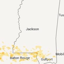
Louisiana
| Local Time | Report Details |
|---|---|
| 2:06 PM CDT | Quarter sized hail reported near Angie, LA, 68.2 miles NNE of New Orleans, LA, quarter size hail fell rayburn correctional institue along highway 21 north of varnado. nickel size hail was still falling. |
| 3:25 PM CDT | Quarter sized hail reported near Greenwell Springs, LA, 62.4 miles ENE of Lafayette, LA, in the town of central greenwell springs quarter sized hail was reported and hail was beginning to accumulate on the grass. |
| 3:27 PM CDT | Hen Egg sized hail reported near Greenwell Springs, LA, 62.4 miles ENE of Lafayette, LA, numerous golf ball and a few hail stones as large as 2 inches in diameter. estimated by video. |
| 3:30 PM CDT | Golf Ball sized hail reported near Hammond, LA, 44.6 miles NNW of New Orleans, LA, wind driven hail broke car windows |
| 8:35 PM UTC | Hammond awos recorded a wind gust of 67 mp in tangipahoa county LA, 44.6 miles NNW of New Orleans, LA |
| 6:00 PM CDT | Quarter sized hail reported near Natchitoches, LA, 71.1 miles SE of Shreveport, LA |
| 6:28 PM CDT | Quarter sized hail reported near Pineville, LA, 80.1 miles NNW of Lafayette, LA, nickel to marble-sized hail reported in pineville. |
| 6:40 PM CDT | Quarter sized hail reported near Pineville, LA, 80.1 miles NNW of Lafayette, LA, nickel to marble-sized hail reported in pineville. |
| 7:05 PM CDT | Quarter sized hail reported near Lecompte, LA, 69.3 miles NNW of Lafayette, LA, dime size hail grew to marble size. |
| 7:05 PM CDT | Quarter sized hail reported near Alexandria, LA, 71.7 miles NNW of Lafayette, LA, dime size hail grew to quarter size hail. |
| 7:45 PM CDT | Quarter sized hail reported near Deville, LA, 78.3 miles N of Lafayette, LA, dime to quarter-sized hail |
| 7:45 PM CDT | Quarter sized hail reported near Deville, LA, 81 miles N of Lafayette, LA, dime to quarter-sized hail |
| 12:38 AM CDT | Golf Ball sized hail reported near Oberlin, LA, 52.2 miles WNW of Lafayette, LA |
North Carolina
| Local Time | Report Details |
|---|---|
| 7:50 PM UTC | Wooden swing set blown down and trampoline damaged by thunderstorm winds in martin county NC, 85 miles E of Raleigh, NC |
| 7:56 PM UTC | Tree down on voa site b rd near sis mills rd in pitt county NC, 81 miles ESE of Raleigh, NC |
| 4:30 PM EDT | Quarter sized hail reported near Burgaw, NC, 22.5 miles N of Wilmington, NC, hail reported on hwy 53 and burgaw creek loop road. |
| 3:15 AM UTC | Several trees and power lines reported down. time estimated based on radar dat in columbus county NC, 32.7 miles W of Wilmington, NC |
| 6:35 AM UTC | Numerous trees down with minor damage to a barn in beaufort county NC, 88.9 miles ESE of Raleigh, NC |
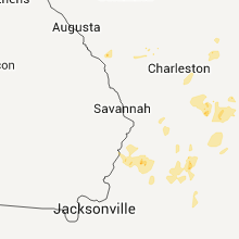
South Carolina
| Local Time | Report Details |
|---|---|
| 4:35 PM EDT | Quarter sized hail reported near Barnwell, SC, 44 miles ESE of Augusta, GA, strawberry rd about 4 miles nne of kline. |
| 10:02 PM UTC | Law enforcement reported powerlines down in saint georg in dorchester county SC, 32.9 miles W of Charleston, SC |
| 10:04 PM UTC | Law enforcement reported one tree down near the intersection of highway 178 and gavins roa in dorchester county SC, 27.8 miles W of Charleston, SC |
| 10:32 PM UTC | Law enforcement reported trees down on powerlines near the intersection of highway 311 and poplar hill driv in berkeley county SC, 15.4 miles WNW of Charleston, SC |
Connect with Interactive Hail Maps