

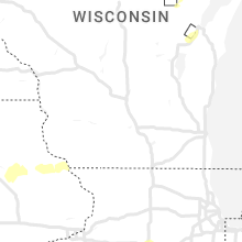
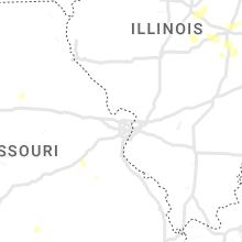
Hail Map for Tuesday, September 5, 2023

Number of Impacted Households on 9/5/2023
0
Impacted by 1" or Larger Hail
0
Impacted by 1.75" or Larger Hail
0
Impacted by 2.5" or Larger Hail
Square Miles of Populated Area Impacted on 9/5/2023
0
Impacted by 1" or Larger Hail
0
Impacted by 1.75" or Larger Hail
0
Impacted by 2.5" or Larger Hail


Cities Most Affected by Hail Storms of 9/5/2023
| Hail Size | Demographics of Zip Codes Affected | ||||||
|---|---|---|---|---|---|---|---|
| City | Count | Average | Largest | Pop Density | House Value | Income | Age |
| Mcgregor, MN | 2 | 2.38 | 2.75 | 8 | $98k | $28.5k | 52.0 |
| Fort Ripley, MN | 1 | 2.00 | 2.00 | 19 | $88k | $37.0k | 40.9 |
| Aitkin, MN | 1 | 2.00 | 2.00 | 24 | $96k | $33.4k | 52.3 |
Hail and Wind Damage Spotted on 9/5/2023
Filter by Report Type:Hail ReportsWind Reports
States Impacted
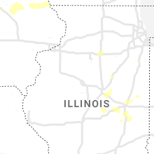
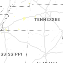
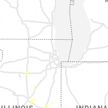
Minnesota, Tennessee, Oklahoma, Wisconsin, Missouri, Texas, Kentucky, Kansas, Arkansas, IllinoisMinnesota
| Local Time | Report Details |
|---|---|
| 2:56 PM CDT | Numerous trees were down onto power lines just off county road 7 near old mesaba and ramshaw roads and the railroad tracks. tree limbs ranged in diameter from 4 to 12 i in st. louis county MN, 50 miles NNW of Duluth, MN |
| 3:30 PM CDT | Report via social media with photos. several small to medium sized trees down and reported power lines down as well. time estimated from report and rada in st. louis county MN, 45.2 miles NNW of Duluth, MN |
| 3:40 PM CDT | Photos were received showing large tree limbs down in hoyt lakes. one limb looked to be at least 2 feet in diamete in st. louis county MN, 49.9 miles N of Duluth, MN |
| 3:50 PM CDT | Quarter sized hail reported near Hoyt Lakes, MN, 49.9 miles N of Duluth, MN |
| 4:11 PM CDT | Hen Egg sized hail reported near Fort Ripley, MN, 92.8 miles SSE of Bemidji, MN, photo was received showing hail with a quarter with the hail being about twice as large as the quarter in diameter. |
| 4:25 PM CDT | Half Dollar sized hail reported near Brainerd, MN, 85.9 miles SSE of Bemidji, MN |
| 4:38 PM CDT | Numerous trees were reported down on boga lake in the bwca. time estimated from rada in lake county MN, 81.1 miles NNE of Duluth, MN |
| 6:02 PM CDT | Ping Pong Ball sized hail reported near Aitkin, MN, 67.7 miles WSW of Duluth, MN |
| 6:05 PM CDT | Hen Egg sized hail reported near Aitkin, MN, 68.6 miles WSW of Duluth, MN, photo sent in via social media of egg sized hail measured next to a golf ball. |
| 6:15 PM CDT | 61 knot wind gust measured on the dirk s. vanenkevort with a sustained wind speed of 54 knot in lsz162 county MN, 94 miles ENE of Duluth, MN |
| 6:22 PM CDT | Hen Egg sized hail reported near Mcgregor, MN, 58.8 miles WSW of Duluth, MN, report via social media with photo. observer states they had hail of all sizes up to golf ball and egg size shown in photo. |
| 6:26 PM CDT | Baseball sized hail reported near Mcgregor, MN, 58.3 miles WSW of Duluth, MN |
| 6:35 PM CDT | Multiple large trees down and power out. time estimated from rada in cook county MN, 122.2 miles NE of Duluth, MN |
Tennessee
| Local Time | Report Details |
|---|---|
| 5:15 PM CDT | Ping Pong Ball sized hail reported near Memphis, TN, 11.8 miles ESE of Memphis, TN, caller reported large hail up to ping-pong size lasting approximately 5 minutes resulting in small dents on their car. |
| 6:06 PM CDT | Trees down at intersection of battleground dr. and wildersville road just south of i-40. time is radar estimate in henderson county TN, 24.9 miles SSE of Mc Kenzie, TN |
Oklahoma
| Local Time | Report Details |
|---|---|
| 5:45 PM CDT | Large tree split in half and power pole damage. time estimated via rada in lincoln county OK, 30 miles ENE of Oklahoma City, OK |
| 5:45 PM CDT | Powerlines reported down throughout the city of wellston. time estimated via rada in lincoln county OK, 29.5 miles ENE of Oklahoma City, OK |
| 6:25 PM CDT | Several power poles blown down. time estimated via rada in oklahoma county OK, 19.8 miles ENE of Oklahoma City, OK |
| 6:45 PM CDT | Power line down. time estimated via rada in oklahoma county OK, 18 miles ENE of Oklahoma City, OK |
| 6:50 PM CDT | Power pole snapped... leaning on a building. time estimated via rada in oklahoma county OK, 20.4 miles E of Oklahoma City, OK |
| 6:55 PM CDT | *** 1 inj *** travel trailer blown over... landing on a mobile home. time estimated via rada in lincoln county OK, 23.7 miles E of Oklahoma City, OK |
| 7:00 PM CDT | Small tree limbs also reported dow in mcclain county OK, 16 miles SSW of Oklahoma City, OK |
| 7:12 PM CDT | Half Dollar sized hail reported near Sand Springs, OK, 20.4 miles WSW of Tulsa, OK |
| 7:14 PM CDT | Quarter sized hail reported near Mannford, OK, 22 miles WSW of Tulsa, OK, report from mping: quarter (1.00 in.). |
| 7:30 PM CDT | Picture showing a portion of a roof removed from a mobile hom in pottawatomie county OK, 27.2 miles ESE of Oklahoma City, OK |
| 7:54 PM CDT | Quarter sized hail reported near Elgin, OK, 60.3 miles N of Wichita Falls, TX |
| 8:08 PM CDT | Storm damage reported in pottawatomie county OK, 35.9 miles ESE of Oklahoma City, OK |
| 9:15 PM CDT | Extensive damage to storage building. boat dock also damage in delaware county OK, 74.7 miles ENE of Tulsa, OK |
| 9:50 PM CDT | Trees down near harrah rd and e tecumseh rd. radar estimated tim in cleveland county OK, 25 miles SE of Oklahoma City, OK |
| 10:55 PM CDT | Storm damage reported in delaware county OK, 76.5 miles ENE of Tulsa, OK |
Wisconsin
| Local Time | Report Details |
|---|---|
| 6:10 PM CDT | Corrects previous non-tstm wnd gst report from 13 ne sand bay. mesonet station disw3 devils island. marine thunderstorm wind gust from peak gust measuremen in ashland county WI, 67.9 miles ENE of Duluth, MN |
| 6:03 AM CDT | Quarter sized hail reported near De Pere, WI, 7.5 miles SSW of Green Bay, WI |
Missouri
| Local Time | Report Details |
|---|---|
| 6:20 PM CDT | Ping Pong Ball sized hail reported near Centerview, MO, 38.8 miles ESE of Kansas City, MO |
| 6:33 PM CDT | Quarter sized hail reported near Kingsville, MO, 37.3 miles SE of Kansas City, MO |
| 6:35 PM CDT | Ping Pong Ball sized hail reported near Kingsville, MO, 37.3 miles SE of Kansas City, MO |
| 6:45 PM CDT | Quarter sized hail reported near Holden, MO, 41.9 miles SE of Kansas City, MO, report from mping: quarter (1.00 in.). |
| 7:25 PM CDT | Home weather station just east of whiteman af in johnson county MO, 62.5 miles ESE of Kansas City, MO |
| 7:51 PM CDT | Quarter sized hail reported near Windsor, MO, 69.9 miles WSW of Columbia, MO |
| 7:58 PM CDT | Quarter sized hail reported near Montrose, MO, 66.7 miles SSE of Kansas City, MO |
| 8:50 PM CDT | A tree was reported downed at highway 52 and highway 135. another tree was downed in versailles and the ivy bend area in morgan c in morgan county MO, 51.2 miles SW of Columbia, MO |
| 9:07 PM CDT | Reported damage to a metal buildin in jasper county MO, 65.8 miles W of Springfield, MO |
| 9:22 PM CDT | Reports of trees downed in eldon and tuscumbi in miller county MO, 43.6 miles SSW of Columbia, MO |
| 9:37 PM CDT | Delayed report 2 miles s of sarcoxie on racoon rd 4 inch limbs approximately 8 inches long dow in newton county MO, 47.2 miles WSW of Springfield, MO |
| 10:54 PM CDT | Delayed report. tree branches around 6 inches snapped... and power out through washburn and seligma in barry county MO, 56.5 miles SW of Springfield, MO |
| 12:05 AM CDT | Large limb downed on a home in av in douglas county MO, 38.9 miles ESE of Springfield, MO |
Texas
| Local Time | Report Details |
|---|---|
| 6:24 PM CDT | Mesonet station ur164 westbrook (upr in mitchell county TX, 75.1 miles W of Abilene, TX |
| 9:55 PM CDT | West texas mesonet site 2 e wall measured a 58 mph wind gus in tom green county TX, 80 miles SSW of Abilene, TX |
Kentucky
| Local Time | Report Details |
|---|---|
| 6:24 PM CDT | Corrects previous tstm wnd dmg report from 4 ssw hopkinsville. mostly tree damage reported near gary lane and hillwood circle. possible tornad in christian county KY, 60 miles NW of Nashville, TN |
Kansas
| Local Time | Report Details |
|---|---|
| 7:13 PM CDT | Quarter sized hail reported near Girard, KS, 35.6 miles ESE of Chanute, KS, social media picture of hail in girard. |
Arkansas
| Local Time | Report Details |
|---|---|
| 11:51 PM CDT | Storm damage reported in benton county AR, 67.4 miles N of Fort Smith, AR |
| 11:53 PM CDT | Large tree damage in benton county AR, 69.1 miles N of Fort Smith, AR |
Illinois
| Local Time | Report Details |
|---|---|
| 4:28 AM CDT | Report relayed via social media of small to medium size branches downed in naperville. time estimated by rada in dupage county IL, 26.4 miles WSW of Chicago, IL |
| 10:50 AM UTC | Storm damage reported in lmz741 county IL, 4.1 miles NE of Chicago, IL |
| 5:58 AM CDT | Storm damage reported in cook county IL, 21.3 miles SSW of Chicago, IL |
Connect with Interactive Hail Maps