

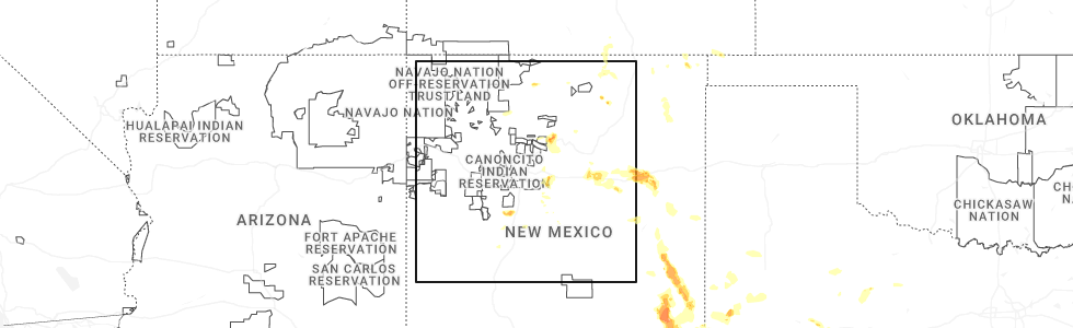
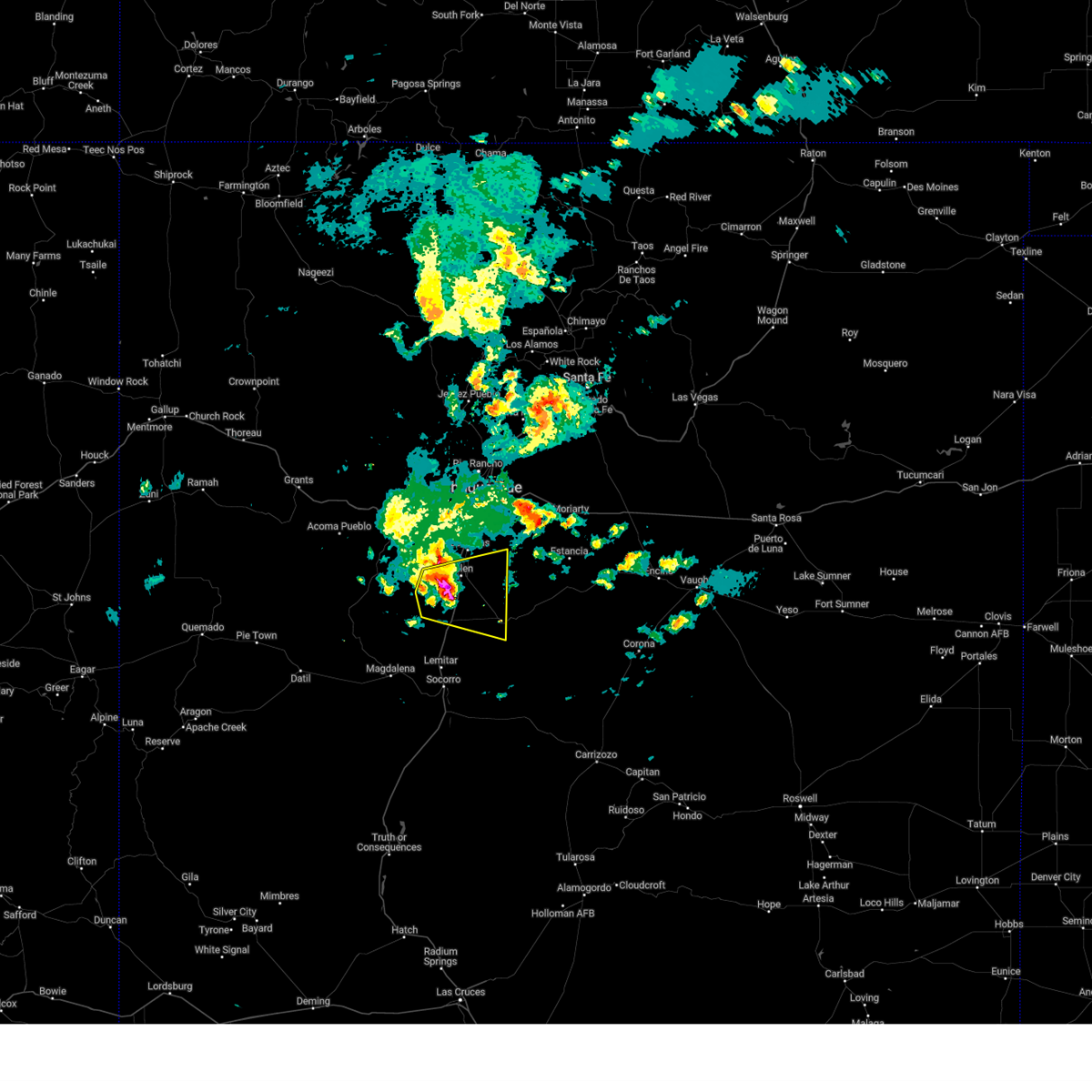
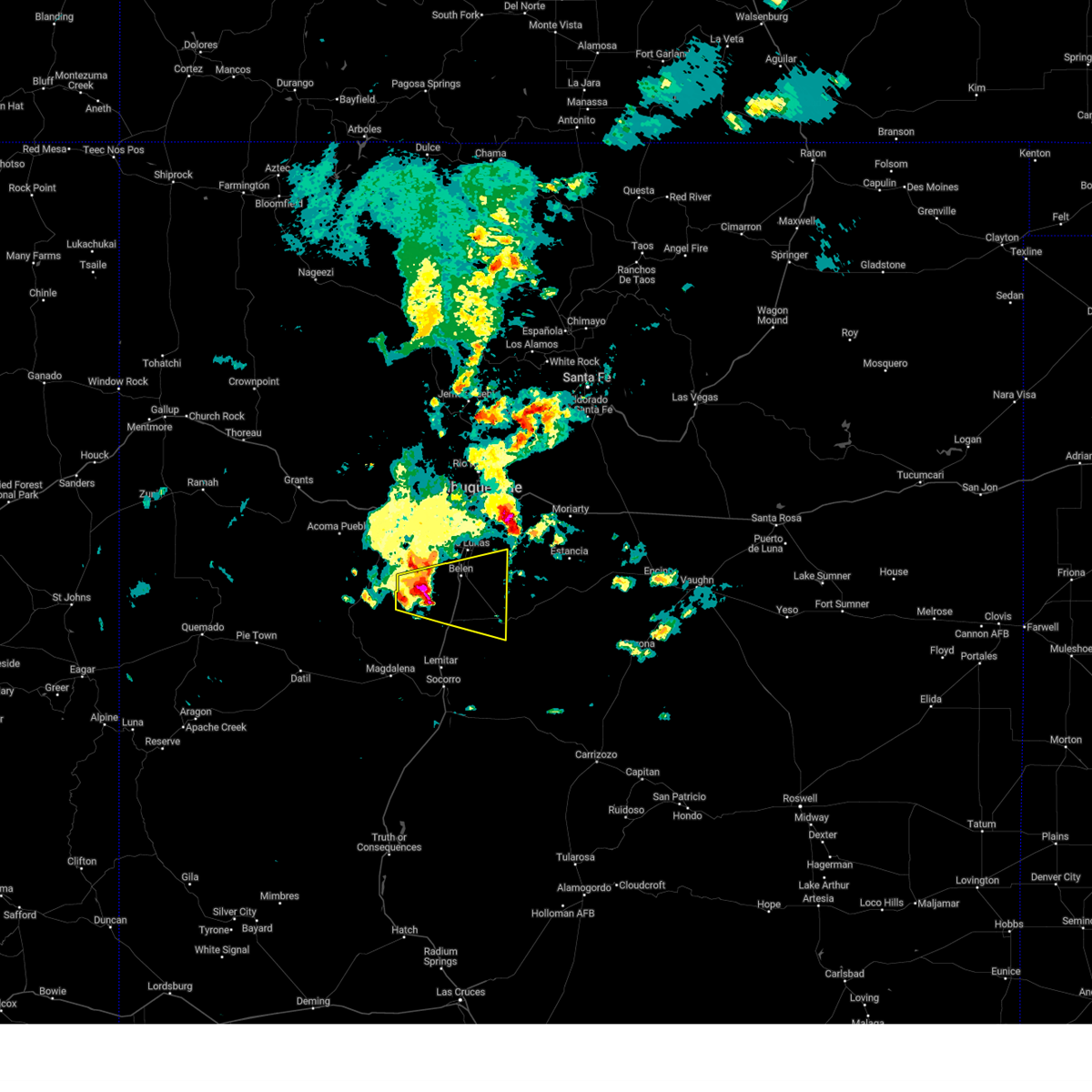
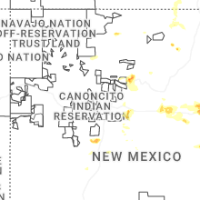
Hail Map for Abeytas, NM
The Abeytas, NM area has had 0 reports of on-the-ground hail by trained spotters, and has been under severe weather warnings 2 times during the past 12 months. Doppler radar has detected hail at or near Abeytas, NM on 20 occasions, including 3 occasions during the past year.
| Name: | Abeytas, NM |
| Where Located: | 43.6 miles SSW of Albuquerque, NM |
| Map: | Google Map for Abeytas, NM |
| Population: | 56 |
| Housing Units: | 28 |
| More Info: | Search Google for Abeytas, NM |
0
The Top Recent Hail Date for Abeytas, NM is Monday, June 9, 2025 (8th out of 20)
Hail and Wind Damage Spotted near Abeytas, NM
| Date / Time | Report Details |
|---|---|
| 6/4/2025 4:13 PM MDT |
 At 413 pm mdt, a severe thunderstorm was located over jarales, or near belen, moving east at 35 mph (radar indicated). Hazards include 60 mph wind gusts and quarter size hail. Hail damage to vehicles is expected. expect wind damage to roofs, siding, and trees. locations impacted include, belen, casa colorada, jarales, veguita, rio communities, los trujillos-gabaldon, los chaves, rio communities north, bernardo and tome. this includes the following highways, highway 60 between mile markers 166 and 187. Interstate 25 between mile markers 174 and 198. At 413 pm mdt, a severe thunderstorm was located over jarales, or near belen, moving east at 35 mph (radar indicated). Hazards include 60 mph wind gusts and quarter size hail. Hail damage to vehicles is expected. expect wind damage to roofs, siding, and trees. locations impacted include, belen, casa colorada, jarales, veguita, rio communities, los trujillos-gabaldon, los chaves, rio communities north, bernardo and tome. this includes the following highways, highway 60 between mile markers 166 and 187. Interstate 25 between mile markers 174 and 198.
|
| 6/4/2025 3:55 PM MDT |
 Svrabq the national weather service in albuquerque has issued a * severe thunderstorm warning for, north central socorro county in central new mexico, central valencia county in central new mexico, * until 500 pm mdt. * at 355 pm mdt, a severe thunderstorm was located 13 miles northwest of bernardo, or 12 miles southwest of belen, moving east at 30 mph (radar indicated). Hazards include 60 mph wind gusts and quarter size hail. Hail damage to vehicles is expected. Expect wind damage to roofs, siding, and trees. Svrabq the national weather service in albuquerque has issued a * severe thunderstorm warning for, north central socorro county in central new mexico, central valencia county in central new mexico, * until 500 pm mdt. * at 355 pm mdt, a severe thunderstorm was located 13 miles northwest of bernardo, or 12 miles southwest of belen, moving east at 30 mph (radar indicated). Hazards include 60 mph wind gusts and quarter size hail. Hail damage to vehicles is expected. Expect wind damage to roofs, siding, and trees.
|
| 6/9/2022 4:10 PM MDT |
 At 410 pm mdt, a severe thunderstorm was located 7 miles west of veguita, or 9 miles southwest of belen, moving east at 15 mph (radar indicated). Hazards include 60 mph wind gusts and penny size hail. Expect damage to roofs, siding, and trees. locations impacted include, belen, jarales, los trujillos-gabaldon, casa colorada, veguita, las nutrias, sabinal, abeytas, rio communities and los chaves. this includes interstate 25 between mile markers 177 and 195. hail threat, radar indicated max hail size, 0. 75 in wind threat, radar indicated max wind gust, 60 mph. At 410 pm mdt, a severe thunderstorm was located 7 miles west of veguita, or 9 miles southwest of belen, moving east at 15 mph (radar indicated). Hazards include 60 mph wind gusts and penny size hail. Expect damage to roofs, siding, and trees. locations impacted include, belen, jarales, los trujillos-gabaldon, casa colorada, veguita, las nutrias, sabinal, abeytas, rio communities and los chaves. this includes interstate 25 between mile markers 177 and 195. hail threat, radar indicated max hail size, 0. 75 in wind threat, radar indicated max wind gust, 60 mph.
|
| 6/9/2022 3:46 PM MDT |
 At 346 pm mdt, a severe thunderstorm was located 12 miles northwest of bernardo, or 15 miles southwest of belen, moving east at 20 mph (radar indicated). Hazards include 60 mph wind gusts and quarter size hail. Hail damage to vehicles is expected. Expect wind damage to roofs, siding, and trees. At 346 pm mdt, a severe thunderstorm was located 12 miles northwest of bernardo, or 15 miles southwest of belen, moving east at 20 mph (radar indicated). Hazards include 60 mph wind gusts and quarter size hail. Hail damage to vehicles is expected. Expect wind damage to roofs, siding, and trees.
|
| 7/10/2021 8:17 PM MDT |
 At 816 pm mdt, a severe thunderstorm was located 14 miles north of magdalena, or 25 miles northwest of socorro, moving south at 30 mph (radar indicated). Hazards include 70 mph wind gusts and quarter size hail. Hail damage to vehicles is expected. expect considerable tree damage. wind damage is also likely to mobile homes, roofs, and outbuildings. locations impacted include, magdalena, lemitar, bernardo, la joya, san acacia, chamizal and contreras. this includes the following highways, interstate 25 between mile markers 154 and 178. Highway 60 between mile markers 106 and 107, between mile markers 109 and 120, and between mile markers 166 and 167. At 816 pm mdt, a severe thunderstorm was located 14 miles north of magdalena, or 25 miles northwest of socorro, moving south at 30 mph (radar indicated). Hazards include 70 mph wind gusts and quarter size hail. Hail damage to vehicles is expected. expect considerable tree damage. wind damage is also likely to mobile homes, roofs, and outbuildings. locations impacted include, magdalena, lemitar, bernardo, la joya, san acacia, chamizal and contreras. this includes the following highways, interstate 25 between mile markers 154 and 178. Highway 60 between mile markers 106 and 107, between mile markers 109 and 120, and between mile markers 166 and 167.
|
| 7/10/2021 7:56 PM MDT |
 At 755 pm mdt, a severe thunderstorm was located 23 miles north of magdalena, or 29 miles southwest of belen, moving south at 30 mph (radar indicated). Hazards include 70 mph wind gusts and quarter size hail. Hail damage to vehicles is expected. expect considerable tree damage. Wind damage is also likely to mobile homes, roofs, and outbuildings. At 755 pm mdt, a severe thunderstorm was located 23 miles north of magdalena, or 29 miles southwest of belen, moving south at 30 mph (radar indicated). Hazards include 70 mph wind gusts and quarter size hail. Hail damage to vehicles is expected. expect considerable tree damage. Wind damage is also likely to mobile homes, roofs, and outbuildings.
|
| 7/31/2020 7:17 PM MDT |
 At 716 pm mdt, a severe thunderstorm was located over rio communities, or near belen, moving south at 30 mph (radar indicated). Hazards include 60 mph wind gusts. Expect damage to roofs, siding, and trees. locations impacted include, southern albuquerque, valencia, los lunas, belen, bosque farms, peralta, mountainair, rio communities north, abo and jarales. this includes the following highways, interstate 40 between mile markers 122 and 141, and near mile marker 170. interstate 25 between mile markers 164 and 222. Highway 60 between mile markers 166 and 198, and between mile markers 201 and 206. At 716 pm mdt, a severe thunderstorm was located over rio communities, or near belen, moving south at 30 mph (radar indicated). Hazards include 60 mph wind gusts. Expect damage to roofs, siding, and trees. locations impacted include, southern albuquerque, valencia, los lunas, belen, bosque farms, peralta, mountainair, rio communities north, abo and jarales. this includes the following highways, interstate 40 between mile markers 122 and 141, and near mile marker 170. interstate 25 between mile markers 164 and 222. Highway 60 between mile markers 166 and 198, and between mile markers 201 and 206.
|
| 7/31/2020 6:43 PM MDT |
 At 642 pm mdt, a severe thunderstorm was located over bosque farms, or near los lunas, moving south at 45 mph. a 64 mph wind gust has already been reported at the albuquerque sunport (radar indicated). Hazards include 70 mph wind gusts. Expect considerable tree damage. Damage is likely to mobile homes, roofs, and outbuildings. At 642 pm mdt, a severe thunderstorm was located over bosque farms, or near los lunas, moving south at 45 mph. a 64 mph wind gust has already been reported at the albuquerque sunport (radar indicated). Hazards include 70 mph wind gusts. Expect considerable tree damage. Damage is likely to mobile homes, roofs, and outbuildings.
|
| 6/1/2019 1:58 PM MDT |
 At 158 pm mdt, a severe thunderstorm was located over la joya, or 20 miles south of belen, moving north at 35 mph (radar indicated). Hazards include 70 mph wind gusts and quarter size hail. Hail damage to vehicles is expected. expect considerable tree damage. wind damage is also likely to mobile homes, roofs, and outbuildings. locations impacted include, veguita, bernardo, la joya, las nutrias, sabinal, abeytas and contreras. This includes interstate 25 between mile markers 166 and 183. At 158 pm mdt, a severe thunderstorm was located over la joya, or 20 miles south of belen, moving north at 35 mph (radar indicated). Hazards include 70 mph wind gusts and quarter size hail. Hail damage to vehicles is expected. expect considerable tree damage. wind damage is also likely to mobile homes, roofs, and outbuildings. locations impacted include, veguita, bernardo, la joya, las nutrias, sabinal, abeytas and contreras. This includes interstate 25 between mile markers 166 and 183.
|
| 6/1/2019 1:41 PM MDT |
 At 141 pm mdt, a severe thunderstorm was located near san acacia, or 10 miles north of socorro, moving north at 30 mph (radar indicated). Hazards include 60 mph wind gusts and quarter size hail. Hail damage to vehicles is expected. Expect wind damage to roofs, siding, and trees. At 141 pm mdt, a severe thunderstorm was located near san acacia, or 10 miles north of socorro, moving north at 30 mph (radar indicated). Hazards include 60 mph wind gusts and quarter size hail. Hail damage to vehicles is expected. Expect wind damage to roofs, siding, and trees.
|
| 6/3/2018 3:56 PM MDT |
 At 356 pm mdt, a severe thunderstorm was located near rio communities, or 9 miles southeast of belen, moving east at 25 mph (radar indicated). Hazards include ping pong ball size hail and 60 mph wind gusts. People and animals outdoors will be injured. expect hail damage to roofs, siding, windows, and vehicles. expect wind damage to roofs, siding, and trees. locations impacted include, valencia, los lunas, belen, peralta, rio communities north, veguita, el cerro mission, jarales, los trujillos-gabaldon and tome. This includes interstate 25 between mile markers 178 and 201. At 356 pm mdt, a severe thunderstorm was located near rio communities, or 9 miles southeast of belen, moving east at 25 mph (radar indicated). Hazards include ping pong ball size hail and 60 mph wind gusts. People and animals outdoors will be injured. expect hail damage to roofs, siding, windows, and vehicles. expect wind damage to roofs, siding, and trees. locations impacted include, valencia, los lunas, belen, peralta, rio communities north, veguita, el cerro mission, jarales, los trujillos-gabaldon and tome. This includes interstate 25 between mile markers 178 and 201.
|
| 6/3/2018 3:29 PM MDT |
 At 329 pm mdt, a severe thunderstorm was located over jarales, or near belen, moving east at 25 mph (radar indicated). Hazards include ping pong ball size hail and 60 mph wind gusts. People and animals outdoors will be injured. expect hail damage to roofs, siding, windows, and vehicles. Expect wind damage to roofs, siding, and trees. At 329 pm mdt, a severe thunderstorm was located over jarales, or near belen, moving east at 25 mph (radar indicated). Hazards include ping pong ball size hail and 60 mph wind gusts. People and animals outdoors will be injured. expect hail damage to roofs, siding, windows, and vehicles. Expect wind damage to roofs, siding, and trees.
|
| 6/3/2018 3:21 PM MDT |
 At 321 pm mdt, severe thunderstorms were located along a line extending from bosque farms to 10 miles west of bernardo, moving east at 25 mph (radar indicated). Hazards include 60 mph wind gusts and quarter size hail. Hail damage to vehicles is expected. expect wind damage to roofs, siding, and trees. locations impacted include, valencia, los lunas, belen, bosque farms, peralta, rio communities north, veguita, el cerro mission, jarales and los trujillos-gabaldon. This includes interstate 25 between mile markers 175 and 207. At 321 pm mdt, severe thunderstorms were located along a line extending from bosque farms to 10 miles west of bernardo, moving east at 25 mph (radar indicated). Hazards include 60 mph wind gusts and quarter size hail. Hail damage to vehicles is expected. expect wind damage to roofs, siding, and trees. locations impacted include, valencia, los lunas, belen, bosque farms, peralta, rio communities north, veguita, el cerro mission, jarales and los trujillos-gabaldon. This includes interstate 25 between mile markers 175 and 207.
|
| 6/3/2018 2:57 PM MDT |
 A severe thunderstorm warning remains in effect until 330 pm mdt for valencia. north central socorro and bernalillo counties. at 256 pm mdt, severe thunderstorms were located along a line extending from albuquerque to near los lunas to 20 miles northwest of bernardo, moving northeast at 30 mph. hazard. 60 mph wind gusts and quarter size hail. A severe thunderstorm warning remains in effect until 330 pm mdt for valencia. north central socorro and bernalillo counties. at 256 pm mdt, severe thunderstorms were located along a line extending from albuquerque to near los lunas to 20 miles northwest of bernardo, moving northeast at 30 mph. hazard. 60 mph wind gusts and quarter size hail.
|
| 6/3/2018 2:34 PM MDT |
 At 233 pm mdt, severe thunderstorms were located along a line extending from 17 miles southeast of marquez to 11 miles west of los chaves to 25 miles west of bernardo, moving northeast at 30 mph (radar indicated). Hazards include 60 mph wind gusts and quarter size hail. Hail damage to vehicles is expected. Expect wind damage to roofs, siding, and trees. At 233 pm mdt, severe thunderstorms were located along a line extending from 17 miles southeast of marquez to 11 miles west of los chaves to 25 miles west of bernardo, moving northeast at 30 mph (radar indicated). Hazards include 60 mph wind gusts and quarter size hail. Hail damage to vehicles is expected. Expect wind damage to roofs, siding, and trees.
|
| 5/21/2018 7:33 PM MDT |
 At 733 pm mdt, a severe thunderstorm was located over bernardo, or 14 miles south of belen, moving northeast at 25 mph (radar indicated). Hazards include 60 mph wind gusts and quarter size hail. Hail damage to vehicles is expected. Expect wind damage to roofs, siding, and trees. At 733 pm mdt, a severe thunderstorm was located over bernardo, or 14 miles south of belen, moving northeast at 25 mph (radar indicated). Hazards include 60 mph wind gusts and quarter size hail. Hail damage to vehicles is expected. Expect wind damage to roofs, siding, and trees.
|
| 9/29/2017 5:29 PM MDT |
 At 529 pm mdt, severe thunderstorms were located along a line extending from near rio communities to near veguita, moving east at 15 mph (radar indicated). Hazards include 60 mph wind gusts and quarter size hail. Hail damage to vehicles is expected. Expect wind damage to roofs, siding, and trees. At 529 pm mdt, severe thunderstorms were located along a line extending from near rio communities to near veguita, moving east at 15 mph (radar indicated). Hazards include 60 mph wind gusts and quarter size hail. Hail damage to vehicles is expected. Expect wind damage to roofs, siding, and trees.
|
| 9/29/2017 5:11 PM MDT |
 At 510 pm mdt, a severe thunderstorm was located near veguita, or 10 miles southwest of belen, moving east at 10 mph (radar indicated). Hazards include 60 mph wind gusts and half dollar size hail. Hail damage to vehicles is expected. expect wind damage to roofs, siding, and trees. locations impacted include, belen, jarales, casa colorada, veguita, las nutrias, sabinal, abeytas, rio communities and los trujillos-gabaldon. This includes interstate 25 between mile markers 178 and 191. At 510 pm mdt, a severe thunderstorm was located near veguita, or 10 miles southwest of belen, moving east at 10 mph (radar indicated). Hazards include 60 mph wind gusts and half dollar size hail. Hail damage to vehicles is expected. expect wind damage to roofs, siding, and trees. locations impacted include, belen, jarales, casa colorada, veguita, las nutrias, sabinal, abeytas, rio communities and los trujillos-gabaldon. This includes interstate 25 between mile markers 178 and 191.
|
| 9/29/2017 4:50 PM MDT |
 At 450 pm mdt, severe thunderstorms were located along a line extending from 8 miles west of veguita to 12 miles west of bernardo, moving east at 10 mph (radar indicated). Hazards include 60 mph wind gusts and half dollar size hail. Hail damage to vehicles is expected. Expect wind damage to roofs, siding, and trees. At 450 pm mdt, severe thunderstorms were located along a line extending from 8 miles west of veguita to 12 miles west of bernardo, moving east at 10 mph (radar indicated). Hazards include 60 mph wind gusts and half dollar size hail. Hail damage to vehicles is expected. Expect wind damage to roofs, siding, and trees.
|
| 6/7/2017 5:53 PM MDT |
 At 553 pm mdt, a severe thunderstorm was located over casa colorada, or 7 miles south of belen, moving southeast at 15 mph (radar indicated). Hazards include 60 mph wind gusts and penny size hail. Expect damage to roofs, siding, and trees. locations impacted include, belen, jarales, casa colorada, veguita, las nutrias, sabinal, abeytas, rio communities and los trujillos-gabaldon. This includes interstate 25 between mile markers 176 and 191. At 553 pm mdt, a severe thunderstorm was located over casa colorada, or 7 miles south of belen, moving southeast at 15 mph (radar indicated). Hazards include 60 mph wind gusts and penny size hail. Expect damage to roofs, siding, and trees. locations impacted include, belen, jarales, casa colorada, veguita, las nutrias, sabinal, abeytas, rio communities and los trujillos-gabaldon. This includes interstate 25 between mile markers 176 and 191.
|
| 6/7/2017 5:36 PM MDT |
 At 536 pm mdt, a severe thunderstorm was located 7 miles west of jarales, or 7 miles southwest of belen, moving southeast at 15 mph (radar indicated). Hazards include 60 mph wind gusts and quarter size hail. Hail damage to vehicles is expected. Expect wind damage to roofs, siding, and trees. At 536 pm mdt, a severe thunderstorm was located 7 miles west of jarales, or 7 miles southwest of belen, moving southeast at 15 mph (radar indicated). Hazards include 60 mph wind gusts and quarter size hail. Hail damage to vehicles is expected. Expect wind damage to roofs, siding, and trees.
|
| 5/9/2017 5:31 PM MDT |
 At 531 pm mdt, a severe thunderstorm was located near bernardo, or 13 miles south of belen, moving north at 55 mph (radar indicated). Hazards include 60 mph wind gusts. Expect damage to roofs, siding, and trees. locations impacted include, belen, jarales, casa colorada, rio communities, veguita, las nutrias, sabinal, abeytas and los trujillos-gabaldon. This includes interstate 25 between mile markers 176 and 191. At 531 pm mdt, a severe thunderstorm was located near bernardo, or 13 miles south of belen, moving north at 55 mph (radar indicated). Hazards include 60 mph wind gusts. Expect damage to roofs, siding, and trees. locations impacted include, belen, jarales, casa colorada, rio communities, veguita, las nutrias, sabinal, abeytas and los trujillos-gabaldon. This includes interstate 25 between mile markers 176 and 191.
|
| 5/9/2017 5:20 PM MDT |
 At 520 pm mdt, a severe thunderstorm was located over la joya, or 17 miles north of socorro, moving north at 50 mph (radar indicated). Hazards include 60 mph wind gusts. expect damage to roofs, siding, and trees At 520 pm mdt, a severe thunderstorm was located over la joya, or 17 miles north of socorro, moving north at 50 mph (radar indicated). Hazards include 60 mph wind gusts. expect damage to roofs, siding, and trees
|
| 9/15/2016 2:27 PM MDT |
 The severe thunderstorm warning for south central valencia and north central socorro counties will expire at 230 pm mdt, the storm which prompted the warning has weakened below severe limits, and have exited the warned area. therefore the warning will be allowed to expire. however small hail, gusty winds and heavy rain are still possible with this thunderstorm. The severe thunderstorm warning for south central valencia and north central socorro counties will expire at 230 pm mdt, the storm which prompted the warning has weakened below severe limits, and have exited the warned area. therefore the warning will be allowed to expire. however small hail, gusty winds and heavy rain are still possible with this thunderstorm.
|
| 9/15/2016 2:07 PM MDT |
 At 207 pm mdt, a severe thunderstorm was located near veguita, or 12 miles south of belen, moving east at 25 mph (radar indicated). Hazards include 60 mph wind gusts and half dollar size hail. Hail damage to vehicles is expected. expect wind damage to roofs, siding, and trees. locations impacted include, belen, veguita, jarales, los trujillos-gabaldon, casa colorada, rio communities, bernardo, las nutrias, sabinal and abeytas. This includes interstate 25 between mile markers 174 and 192. At 207 pm mdt, a severe thunderstorm was located near veguita, or 12 miles south of belen, moving east at 25 mph (radar indicated). Hazards include 60 mph wind gusts and half dollar size hail. Hail damage to vehicles is expected. expect wind damage to roofs, siding, and trees. locations impacted include, belen, veguita, jarales, los trujillos-gabaldon, casa colorada, rio communities, bernardo, las nutrias, sabinal and abeytas. This includes interstate 25 between mile markers 174 and 192.
|
| 9/15/2016 1:46 PM MDT |
 At 146 pm mdt, a severe thunderstorm was located 10 miles northwest of bernardo, or 16 miles southwest of belen, moving east at 25 mph (radar indicated). Hazards include 60 mph wind gusts and quarter size hail. Hail damage to vehicles is expected. Expect wind damage to roofs, siding, and trees. At 146 pm mdt, a severe thunderstorm was located 10 miles northwest of bernardo, or 16 miles southwest of belen, moving east at 25 mph (radar indicated). Hazards include 60 mph wind gusts and quarter size hail. Hail damage to vehicles is expected. Expect wind damage to roofs, siding, and trees.
|
| 10/21/2015 7:12 AM MDT | The severe thunderstorm warning for north central socorro county will expire at 715 am mdt, the storm which prompted the warning has weakened below severe limits, and no longer pose an immediate threat to life or property. therefore the warning will be allowed to expire. |
| 10/21/2015 6:54 AM MDT |
 At 654 am mdt, a severe thunderstorm was located near san acacia, or 12 miles north of socorro, moving northeast at 30 mph (radar indicated). Hazards include 60 mph wind gusts and quarter size hail. Hail damage to vehicles is expected. expect wind damage to roofs, siding and trees. locations impacted include, socorro, san acacia, escondida, la joya, lemitar, bernardo, chamizal, contreras and abeytas. This includes interstate 25 between mile markers 151 and 180. At 654 am mdt, a severe thunderstorm was located near san acacia, or 12 miles north of socorro, moving northeast at 30 mph (radar indicated). Hazards include 60 mph wind gusts and quarter size hail. Hail damage to vehicles is expected. expect wind damage to roofs, siding and trees. locations impacted include, socorro, san acacia, escondida, la joya, lemitar, bernardo, chamizal, contreras and abeytas. This includes interstate 25 between mile markers 151 and 180.
|
| 10/21/2015 6:33 AM MDT |
 At 633 am mdt, a severe thunderstorm was located over escondida, or over socorro, moving northeast at 30 mph (radar indicated). Hazards include quarter size hail and 60 mph wind gusts. Hail damage to vehicles is expected. Expect wind damage to roofs, siding and trees. At 633 am mdt, a severe thunderstorm was located over escondida, or over socorro, moving northeast at 30 mph (radar indicated). Hazards include quarter size hail and 60 mph wind gusts. Hail damage to vehicles is expected. Expect wind damage to roofs, siding and trees.
|
Hail Maps for Abeytas, NM


Connect with Interactive Hail Maps