

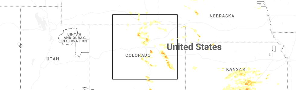
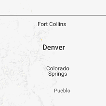
Hail Map for Allenspark, CO
The Allenspark, CO area has had 2 reports of on-the-ground hail by trained spotters, and has been under severe weather warnings 0 times during the past 12 months. Doppler radar has detected hail at or near Allenspark, CO on 25 occasions, including 1 occasion during the past year.
| Name: | Allenspark, CO |
| Where Located: | 42 miles NW of Denver, CO |
| Map: | Google Map for Allenspark, CO |
| Population: | 528 |
| Housing Units: | 892 |
| More Info: | Search Google for Allenspark, CO |
0
The Top Recent Hail Date for Allenspark, CO is Tuesday, June 17, 2025 (14th out of 25)
Hail and Wind Damage Spotted near Allenspark, CO
| Date / Time | Report Details |
|---|---|
| 7/13/2020 3:36 PM MDT |
 At 335 pm mdt, severe thunderstorms were located along a line extending from 11 miles south of hutton lake to 6 miles west of buckhorn mountain to near allenspark, or along a line extending from 22 miles south of laramie to 20 miles west of fort collins to 43 miles northwest of denver, moving east at 45 mph (radar indicated). Hazards include 60 mph wind gusts. expect damage to roofs, siding, and trees At 335 pm mdt, severe thunderstorms were located along a line extending from 11 miles south of hutton lake to 6 miles west of buckhorn mountain to near allenspark, or along a line extending from 22 miles south of laramie to 20 miles west of fort collins to 43 miles northwest of denver, moving east at 45 mph (radar indicated). Hazards include 60 mph wind gusts. expect damage to roofs, siding, and trees
|
| 7/13/2020 3:23 PM MDT |
 At 321 pm mdt, severe thunderstorms were located along a line extending from 5 miles east of boswell creek campground to 6 miles southeast of grand lake, or along a line extending from 30 miles southwest of laramie to 45 miles southwest of fort collins, moving northeast at 25 mph. a 63 mph wind gust as recorded at the airport in walden as this storm moved through (radar indicated). Hazards include 60 mph wind gusts. Expect damage to roofs, siding, and trees. Locations impacted include, estes park, trail ridge, bear lake, grand lake, raymond, allenspark, red feather lakes, rustic, longs peak, glendevey, pingree park, cameron pass, glen haven, four corners, meeker park, gould and cherokee park. At 321 pm mdt, severe thunderstorms were located along a line extending from 5 miles east of boswell creek campground to 6 miles southeast of grand lake, or along a line extending from 30 miles southwest of laramie to 45 miles southwest of fort collins, moving northeast at 25 mph. a 63 mph wind gust as recorded at the airport in walden as this storm moved through (radar indicated). Hazards include 60 mph wind gusts. Expect damage to roofs, siding, and trees. Locations impacted include, estes park, trail ridge, bear lake, grand lake, raymond, allenspark, red feather lakes, rustic, longs peak, glendevey, pingree park, cameron pass, glen haven, four corners, meeker park, gould and cherokee park.
|
| 7/13/2020 3:00 PM MDT |
 At 259 pm mdt, severe thunderstorms were located along a line extending from 3 miles southeast of six mile campground to 6 miles northwest of granby, or along a line extending from 45 miles southwest of laramie to 57 miles southwest of fort collins, moving east at 45 mph (radar indicated). Hazards include 60 mph wind gusts. expect damage to roofs, siding, and trees At 259 pm mdt, severe thunderstorms were located along a line extending from 3 miles southeast of six mile campground to 6 miles northwest of granby, or along a line extending from 45 miles southwest of laramie to 57 miles southwest of fort collins, moving east at 45 mph (radar indicated). Hazards include 60 mph wind gusts. expect damage to roofs, siding, and trees
|
| 6/6/2020 3:46 PM MDT |
 At 342 pm mdt, severe thunderstorms were located along a line extending from 3 miles north of drake to near aspen springs to 7 miles west of elevenmile canyon reservoir, or along a line extending from 15 miles west of fort collins to 28 miles west of denver to 39 miles north of hayden pass burn scar, the storms are moving northeast at 60 mph. these are very dangerous storms (an automated weather station in lakewood recorded a peak wind gust to 70 mph at bear creek golf club in southwest lakewood). Hazards include 75 mph wind gusts. Flying debris will be dangerous to those caught without shelter. mobile homes will be heavily damaged. expect considerable damage to roofs, windows, and vehicles. extensive tree damage and power outages are likely. Locations impacted include, denver, fort collins, greeley, aurora, lakewood, thornton, arvada, westminster, centennial, boulder, longmont, loveland, broomfield, highlands ranch, castle rock, commerce city, parker, littleton, northglenn and brighton. At 342 pm mdt, severe thunderstorms were located along a line extending from 3 miles north of drake to near aspen springs to 7 miles west of elevenmile canyon reservoir, or along a line extending from 15 miles west of fort collins to 28 miles west of denver to 39 miles north of hayden pass burn scar, the storms are moving northeast at 60 mph. these are very dangerous storms (an automated weather station in lakewood recorded a peak wind gust to 70 mph at bear creek golf club in southwest lakewood). Hazards include 75 mph wind gusts. Flying debris will be dangerous to those caught without shelter. mobile homes will be heavily damaged. expect considerable damage to roofs, windows, and vehicles. extensive tree damage and power outages are likely. Locations impacted include, denver, fort collins, greeley, aurora, lakewood, thornton, arvada, westminster, centennial, boulder, longmont, loveland, broomfield, highlands ranch, castle rock, commerce city, parker, littleton, northglenn and brighton.
|
| 6/6/2020 3:03 PM MDT |
 At 303 pm mdt, severe thunderstorms were located along a line extending from 3 miles north of drake to near aspen springs to 8 miles west of elevenmile canyon reservoir, or along a line extending from 15 miles west of fort collins to 28 miles west of denver to 39 miles north of hayden pass burn scar, moving northeast at 65 mph. these are very dangerous storms (radar indicated). Hazards include 80 mph wind gusts. Flying debris will be dangerous to those caught without shelter. mobile homes will be heavily damaged. expect considerable damage to roofs, windows, and vehicles. Extensive tree damage and power outages are likely. At 303 pm mdt, severe thunderstorms were located along a line extending from 3 miles north of drake to near aspen springs to 8 miles west of elevenmile canyon reservoir, or along a line extending from 15 miles west of fort collins to 28 miles west of denver to 39 miles north of hayden pass burn scar, moving northeast at 65 mph. these are very dangerous storms (radar indicated). Hazards include 80 mph wind gusts. Flying debris will be dangerous to those caught without shelter. mobile homes will be heavily damaged. expect considerable damage to roofs, windows, and vehicles. Extensive tree damage and power outages are likely.
|
| 6/6/2020 2:33 PM MDT |
 At 232 pm mdt, severe thunderstorms were located along a line extending from near cowdrey to near berthoud pass to 10 miles northwest of guffey, or along a line extending from 51 miles southwest of laramie to 43 miles west of denver to 36 miles north of hayden pass burn scar, moving northeast at 65 mph. these are very dangerous storms (radar indicated). Hazards include 80 mph wind gusts. Flying debris will be dangerous to those caught without shelter. mobile homes will be heavily damaged. expect considerable damage to roofs, windows, and vehicles. Extensive tree damage and power outages are likely. At 232 pm mdt, severe thunderstorms were located along a line extending from near cowdrey to near berthoud pass to 10 miles northwest of guffey, or along a line extending from 51 miles southwest of laramie to 43 miles west of denver to 36 miles north of hayden pass burn scar, moving northeast at 65 mph. these are very dangerous storms (radar indicated). Hazards include 80 mph wind gusts. Flying debris will be dangerous to those caught without shelter. mobile homes will be heavily damaged. expect considerable damage to roofs, windows, and vehicles. Extensive tree damage and power outages are likely.
|
| 8/16/2015 3:21 PM MDT |
 At 320 pm mdt, a severe thunderstorm was located over raymond, or 34 miles southwest of fort collins, moving south at 15 mph (radar indicated). Hazards include ping pong ball size hail. People and animals outdoors will be injured. Expect damage to roofs, siding, windows and vehicles. At 320 pm mdt, a severe thunderstorm was located over raymond, or 34 miles southwest of fort collins, moving south at 15 mph (radar indicated). Hazards include ping pong ball size hail. People and animals outdoors will be injured. Expect damage to roofs, siding, windows and vehicles.
|
| 8/16/2015 3:15 PM MDT |
 At 312 pm mdt, a severe thunderstorm was located 5 miles northeast of raymond, or 28 miles southwest of fort collins, moving southeast at 15 mph (radar indicated). Hazards include ping pong ball size hail was reported near allenspark in northwestern boulder county at 3:01 pm mdt. People and animals outdoors will be injured. expect damage to roofs, siding, windows and vehicles. Locations impacted include, estes park, lyons, allenspark, raymond and meeker park. At 312 pm mdt, a severe thunderstorm was located 5 miles northeast of raymond, or 28 miles southwest of fort collins, moving southeast at 15 mph (radar indicated). Hazards include ping pong ball size hail was reported near allenspark in northwestern boulder county at 3:01 pm mdt. People and animals outdoors will be injured. expect damage to roofs, siding, windows and vehicles. Locations impacted include, estes park, lyons, allenspark, raymond and meeker park.
|
| 8/16/2015 3:01 PM MDT | Ping Pong Ball sized hail reported 2.2 miles SSE of Allenspark, CO |
| 8/16/2015 2:50 PM MDT | Ping Pong Ball sized hail reported 2.4 miles SSE of Allenspark, CO, hailed for 5 minutes up to time of report. |
| 8/16/2015 2:40 PM MDT |
 At 240 pm mdt, a severe thunderstorm was located 4 miles north of meeker park, or 28 miles southwest of fort collins, moving southeast at 15 mph (radar indicated). Hazards include quarter size hail. damage to vehicles is expected At 240 pm mdt, a severe thunderstorm was located 4 miles north of meeker park, or 28 miles southwest of fort collins, moving southeast at 15 mph (radar indicated). Hazards include quarter size hail. damage to vehicles is expected
|
Hail Maps for Allenspark, CO


Connect with Interactive Hail Maps