

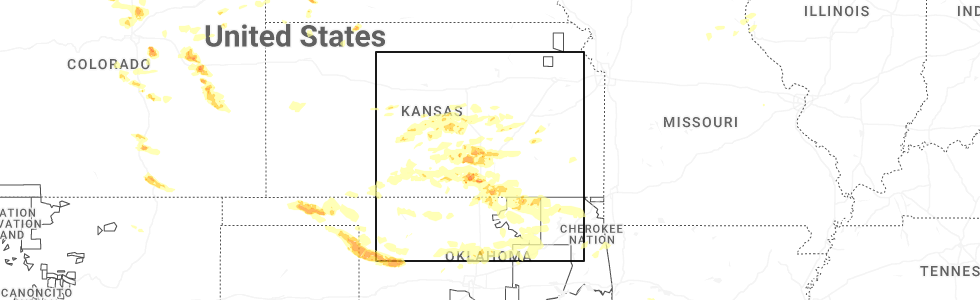
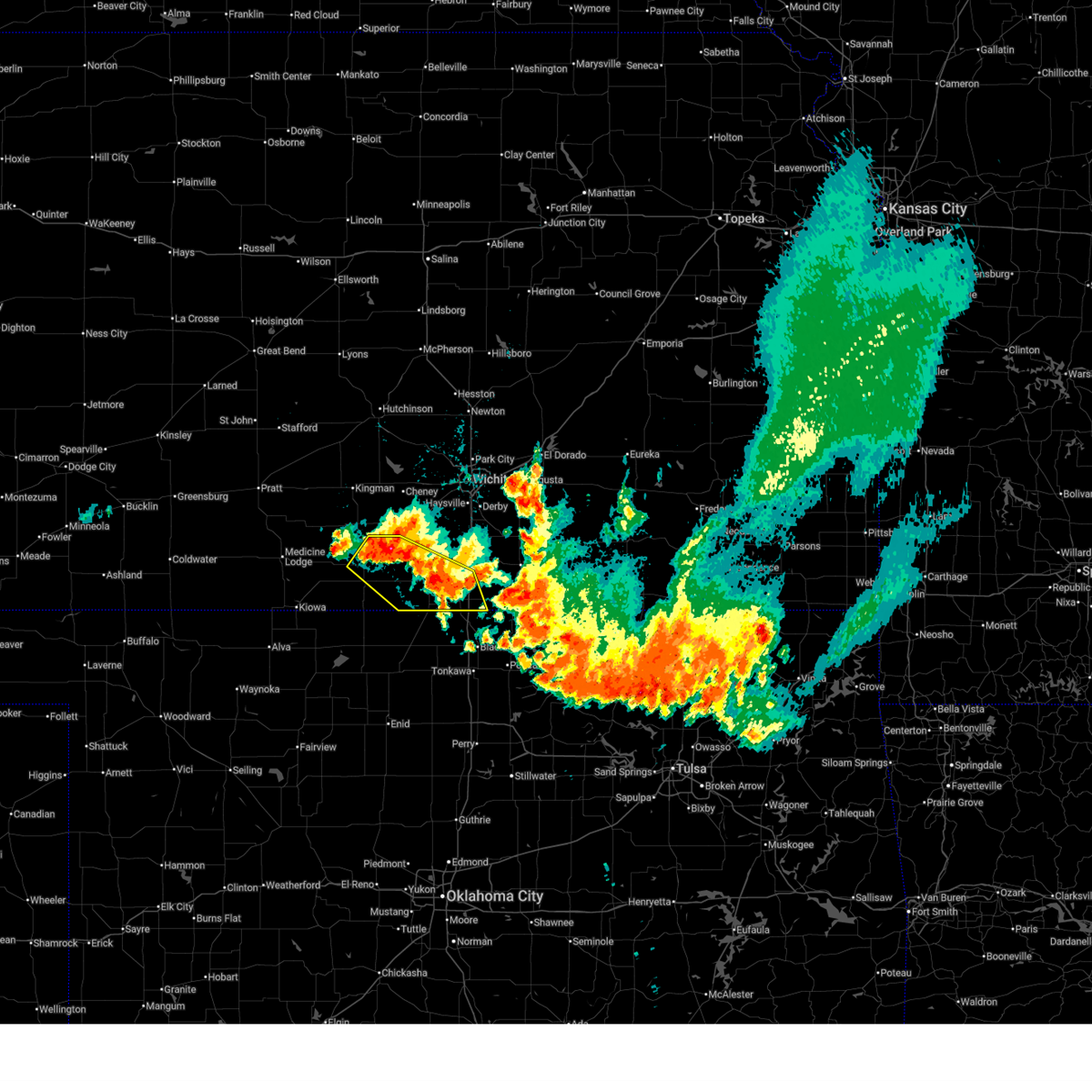
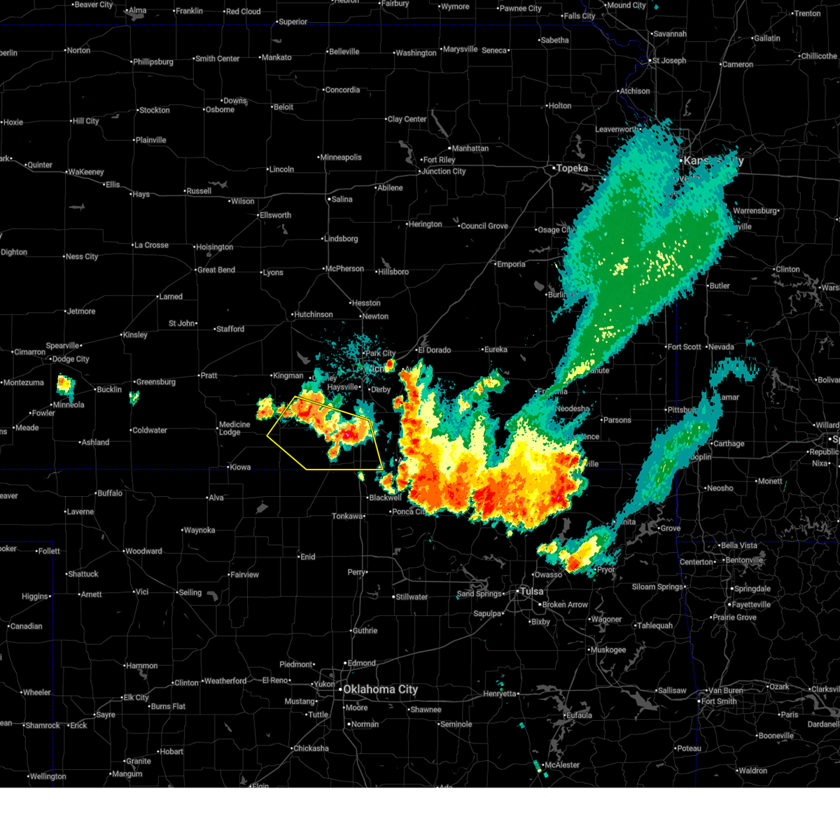
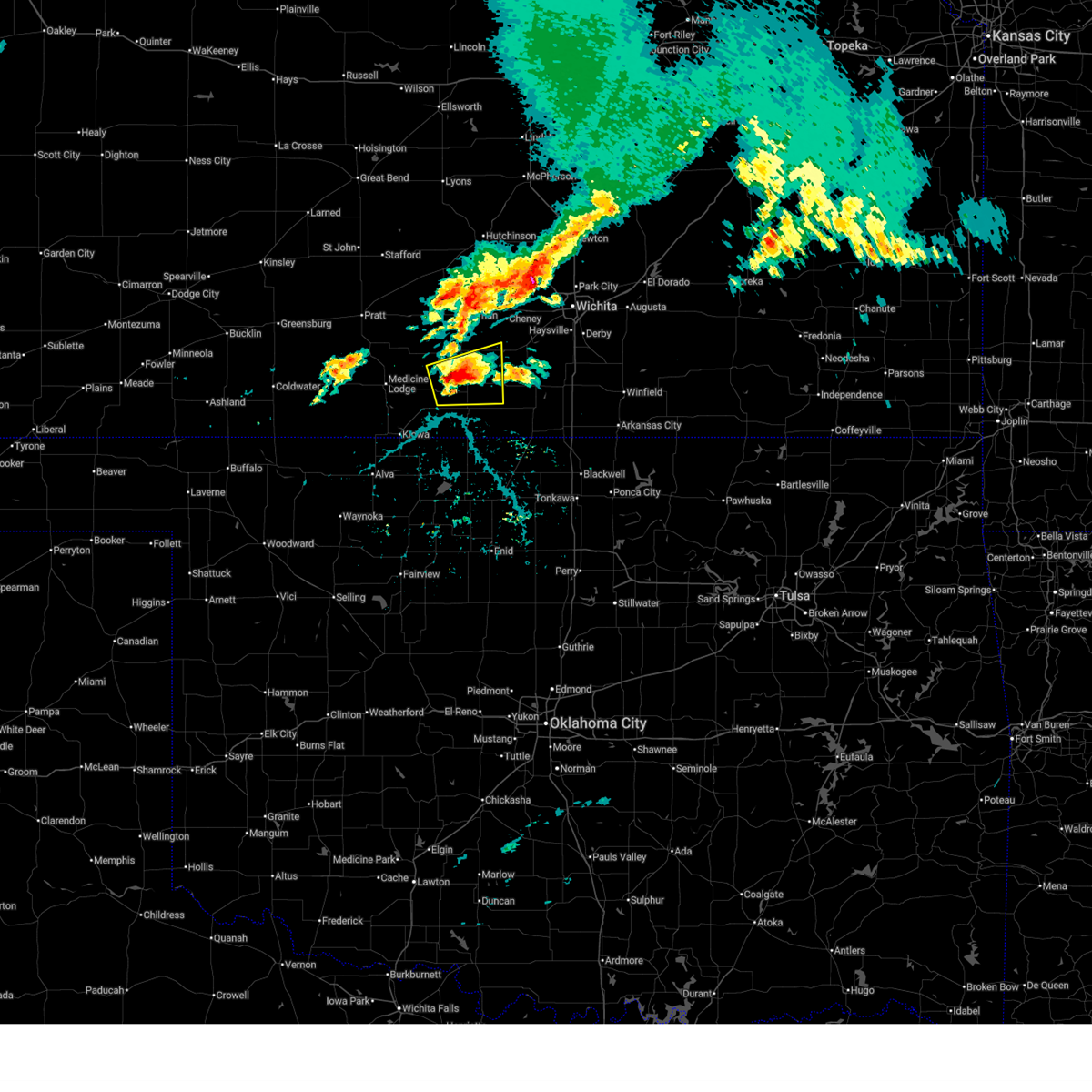
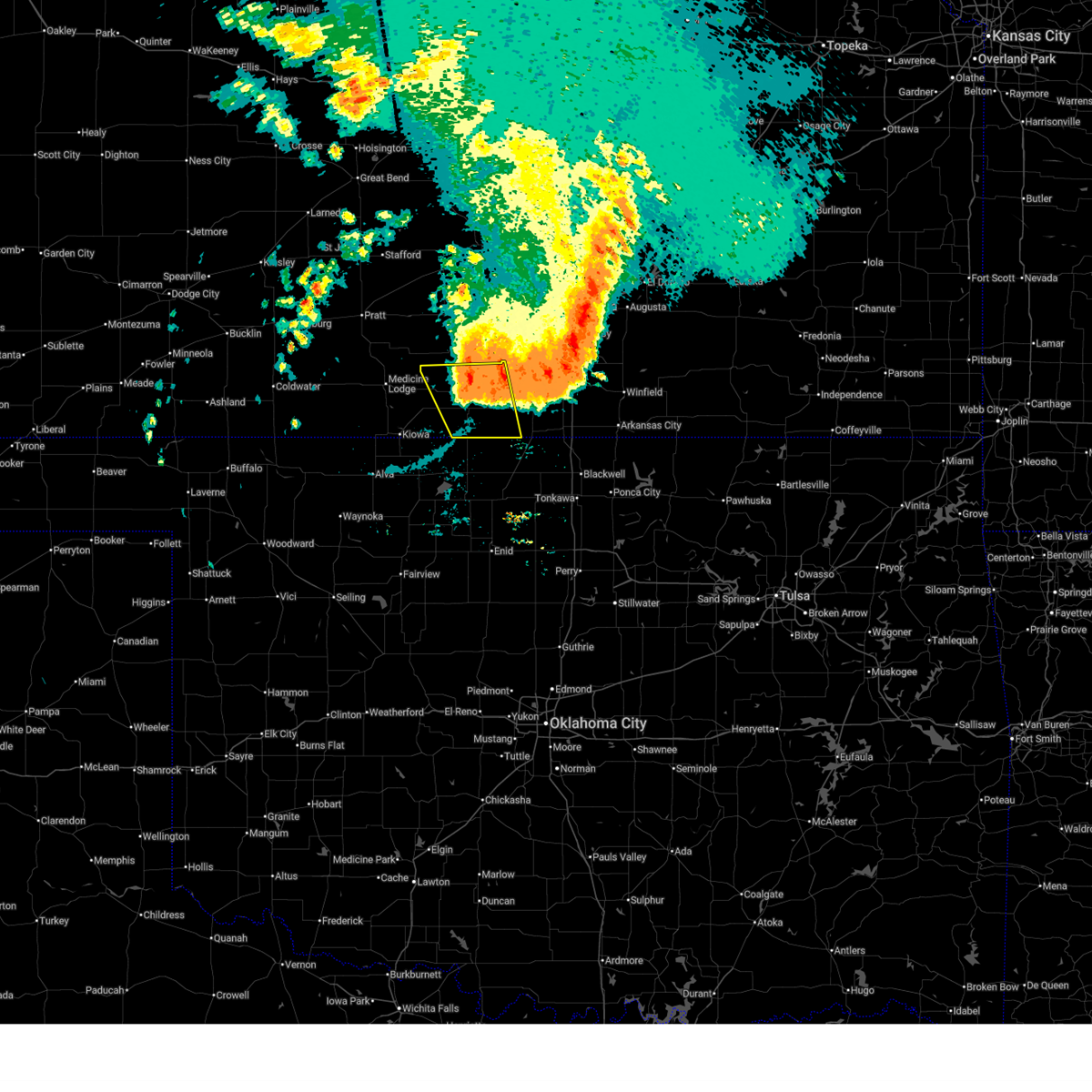
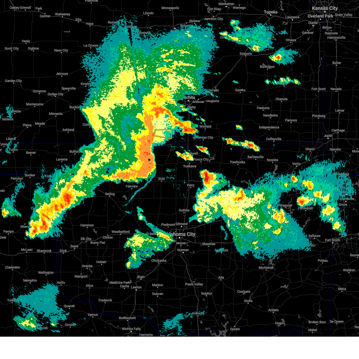
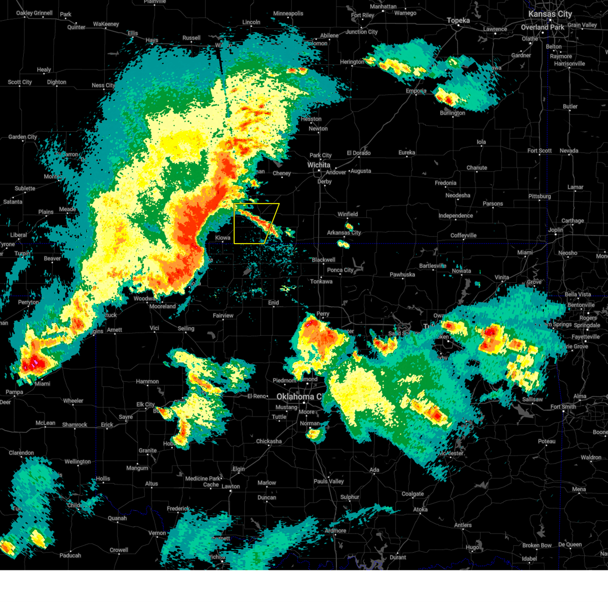
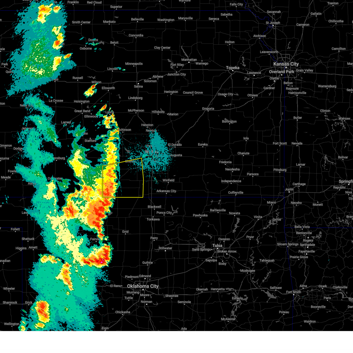
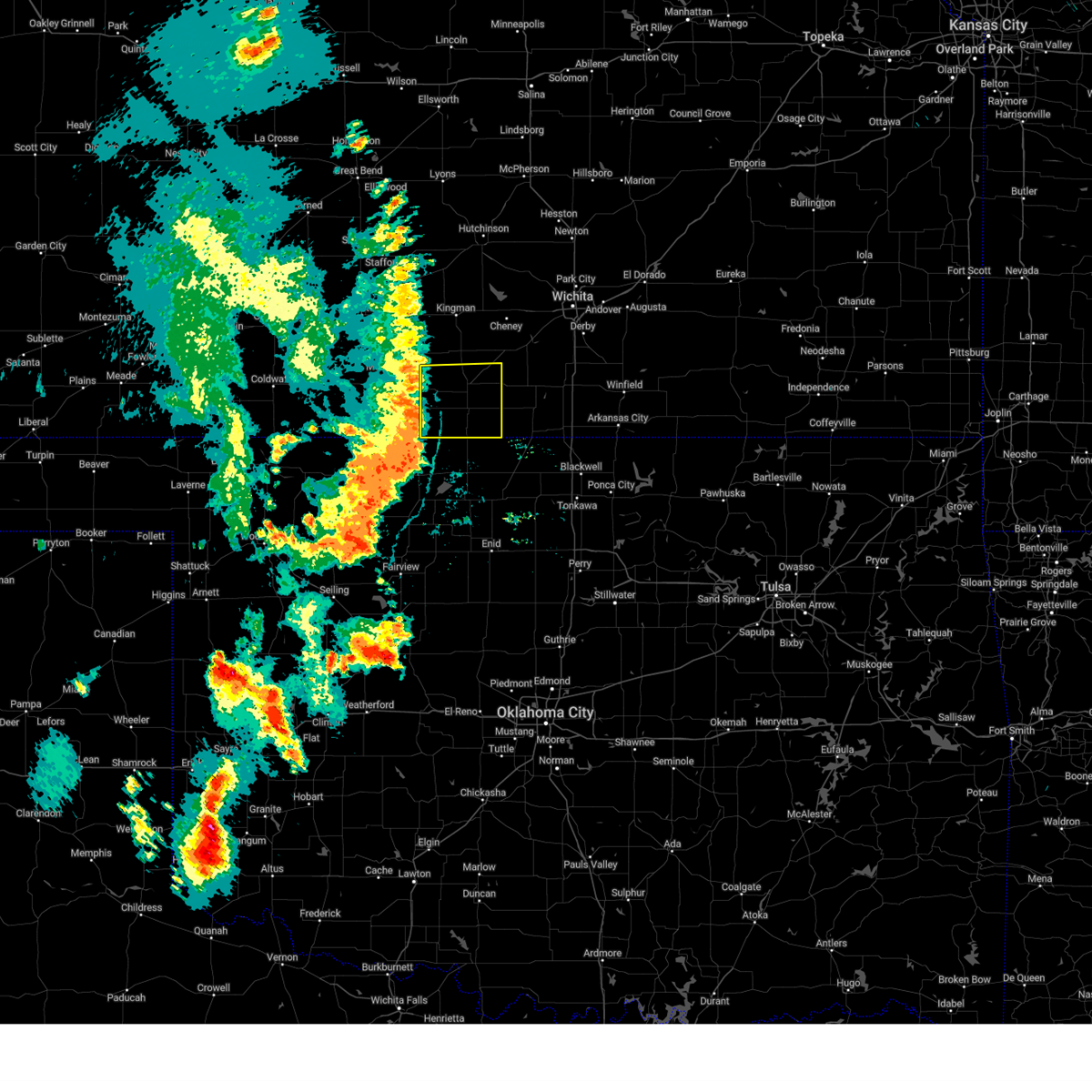
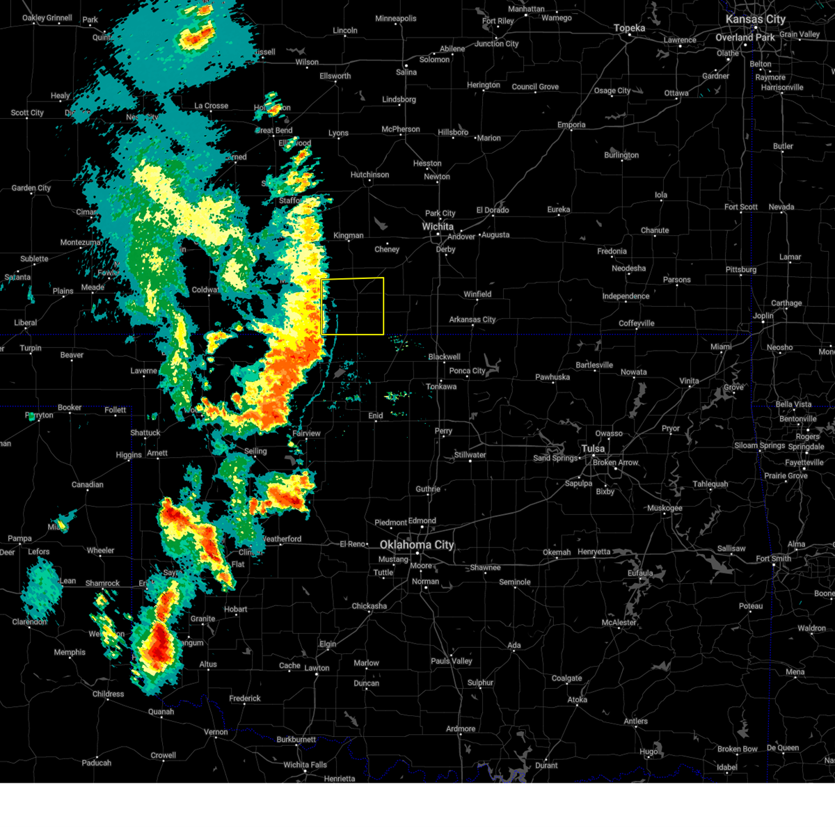
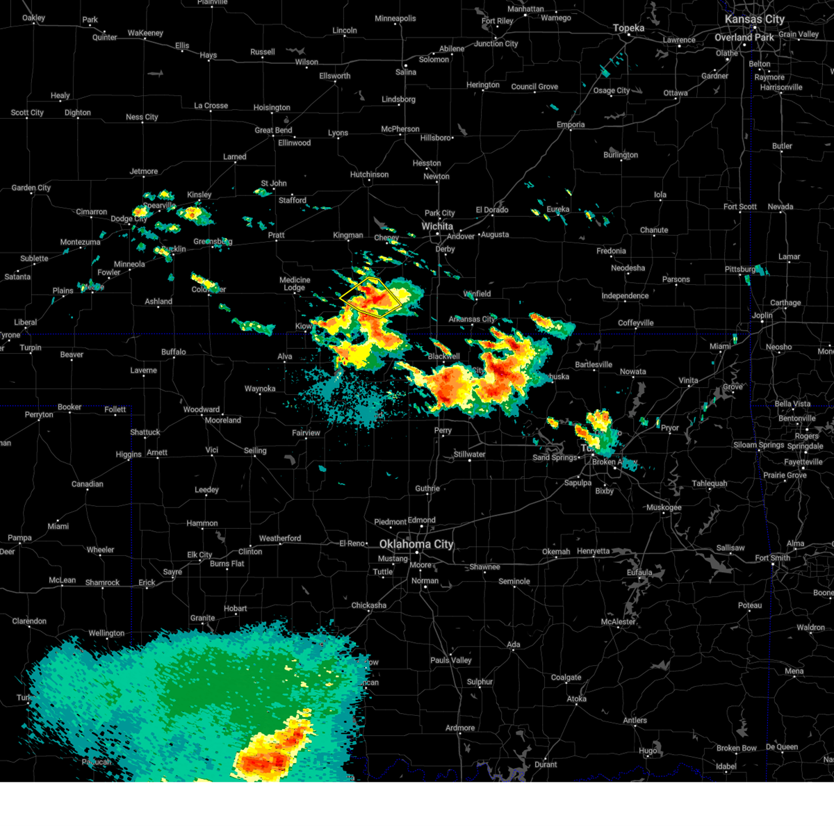
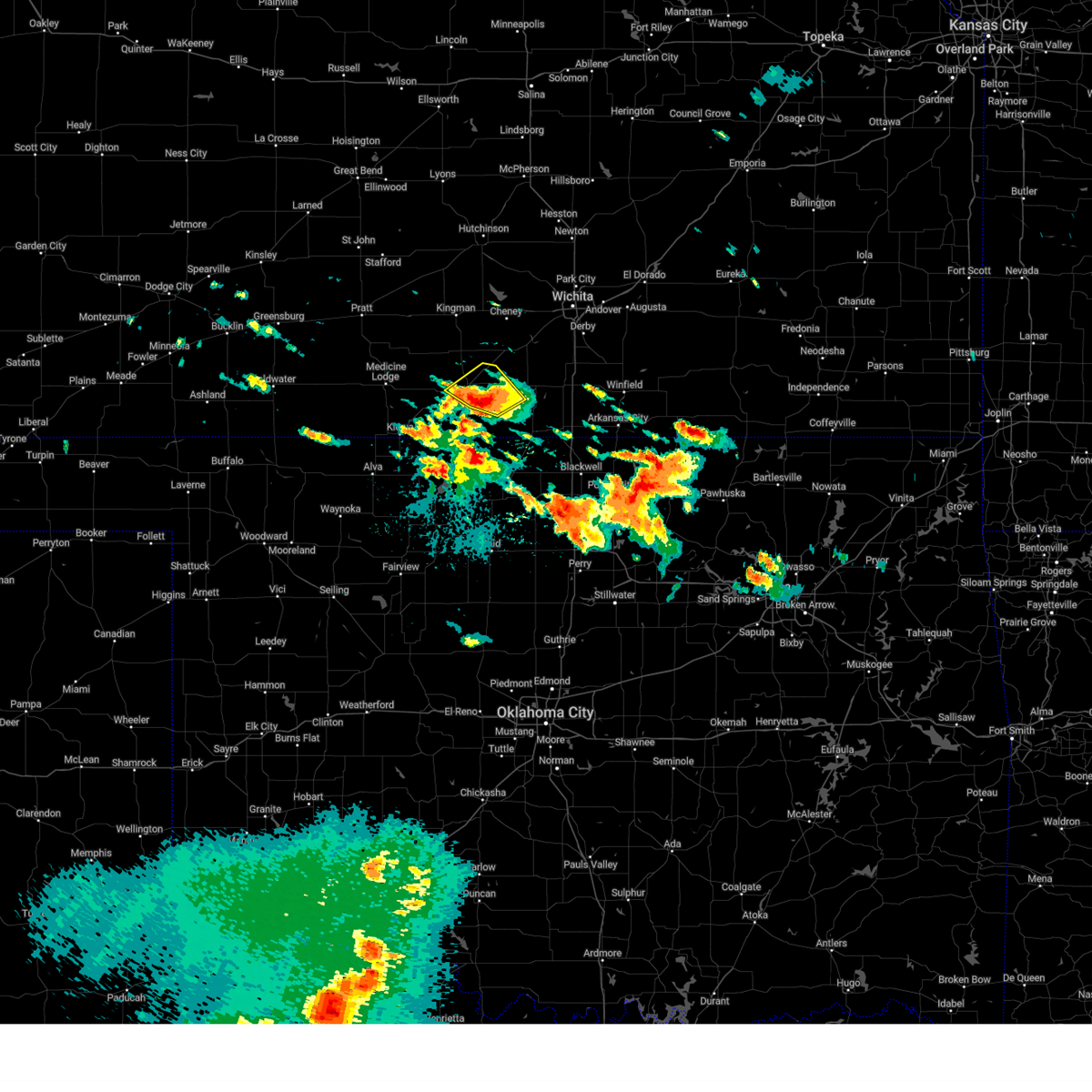
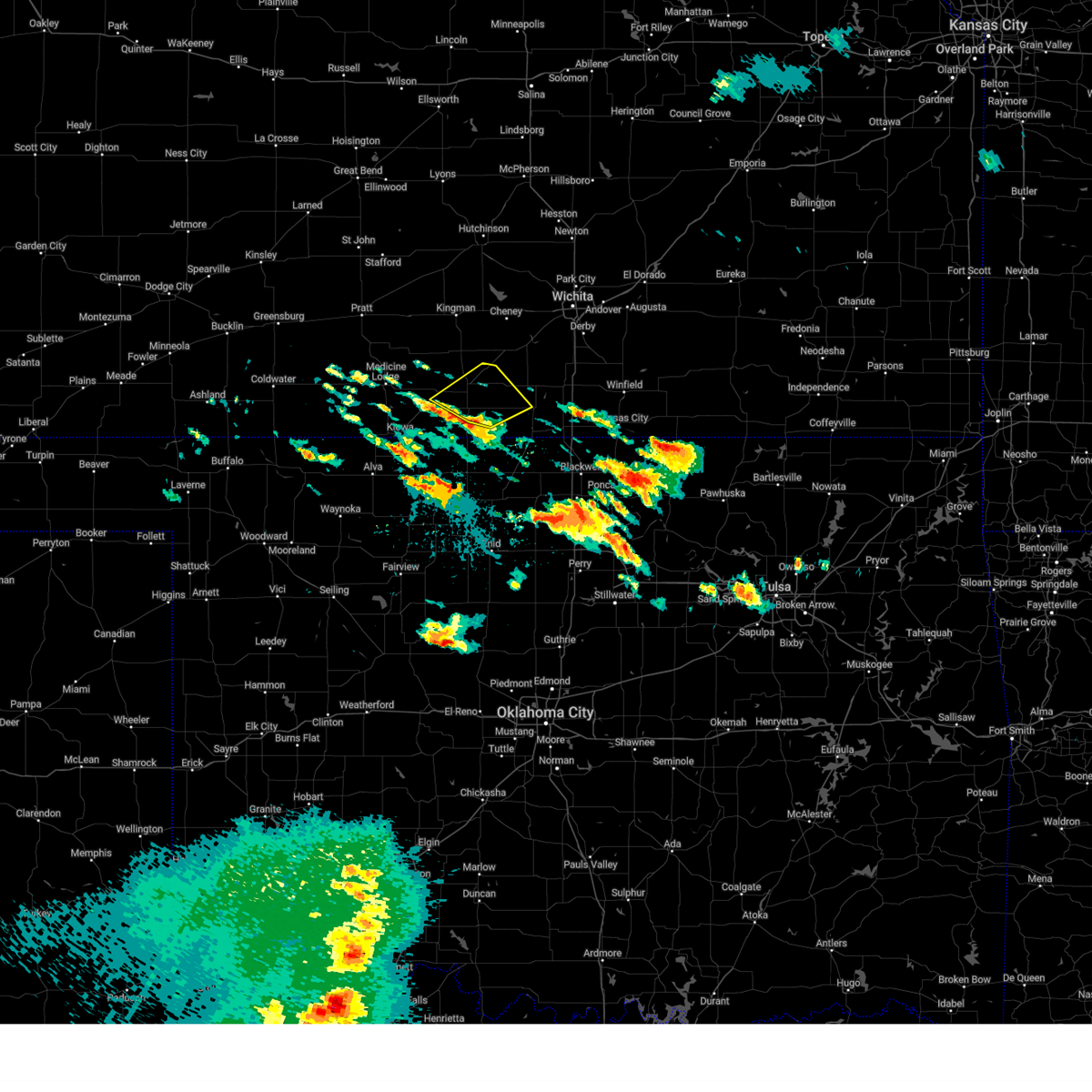
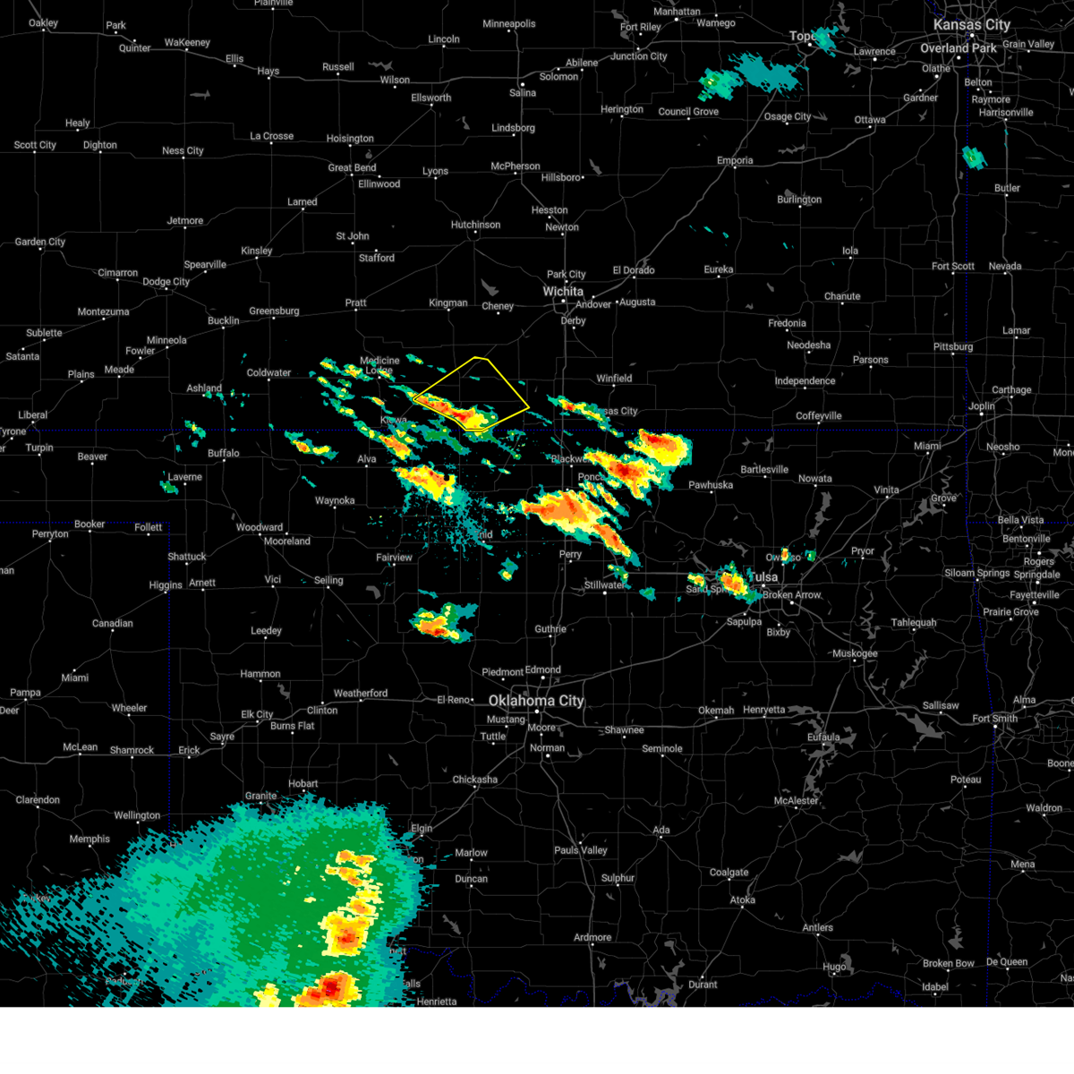
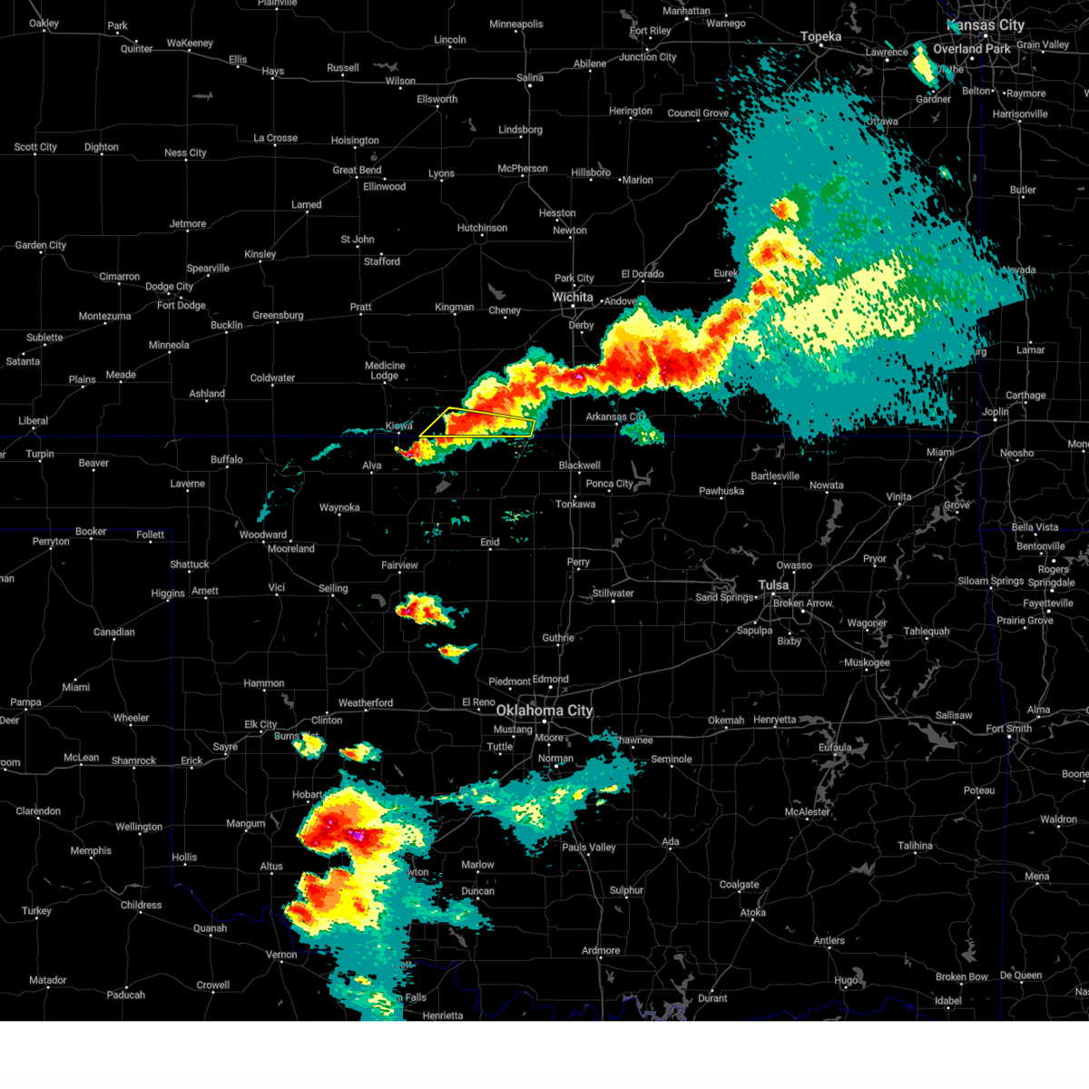
Hail Map for Anthony, KS
The Anthony, KS area has had 14 reports of on-the-ground hail by trained spotters, and has been under severe weather warnings 25 times during the past 12 months. Doppler radar has detected hail at or near Anthony, KS on 98 occasions, including 4 occasions during the past year.
| Name: | Anthony, KS |
| Where Located: | 53.2 miles SW of Wichita, KS |
| Map: | Google Map for Anthony, KS |
| Population: | 2269 |
| Housing Units: | 1217 |
| More Info: | Search Google for Anthony, KS |
1
The Top Recent Hail Date for Anthony, KS is Tuesday, June 17, 2025 (25th out of 98)
Hail and Wind Damage Spotted near Anthony, KS
| Date / Time | Report Details |
|---|---|
| 6/29/2025 11:26 PM CDT |
 The storm which prompted the warning has moved out of the area. therefore, the warning will be allowed to expire. however, gusty winds and heavy rain are still possible with this thunderstorm. The storm which prompted the warning has moved out of the area. therefore, the warning will be allowed to expire. however, gusty winds and heavy rain are still possible with this thunderstorm.
|
| 6/29/2025 10:56 PM CDT |
 At 1055 pm cdt, a severe thunderstorm was located 9 miles east of manchester, or 11 miles southeast of anthony, moving south at 35 mph (radar indicated). Hazards include 60 mph wind gusts and penny size hail. Expect damage to roofs, siding, and trees. Locations impacted include, anthony and bluff city. At 1055 pm cdt, a severe thunderstorm was located 9 miles east of manchester, or 11 miles southeast of anthony, moving south at 35 mph (radar indicated). Hazards include 60 mph wind gusts and penny size hail. Expect damage to roofs, siding, and trees. Locations impacted include, anthony and bluff city.
|
| 6/29/2025 10:38 PM CDT |
 Svrict the national weather service in wichita has issued a * severe thunderstorm warning for, southeastern harper county in south central kansas, * until 1130 pm cdt. * at 1037 pm cdt, a severe thunderstorm was located near anthony, moving southwest at 25 mph (radar indicated). Hazards include 60 mph wind gusts and penny size hail. expect damage to roofs, siding, and trees Svrict the national weather service in wichita has issued a * severe thunderstorm warning for, southeastern harper county in south central kansas, * until 1130 pm cdt. * at 1037 pm cdt, a severe thunderstorm was located near anthony, moving southwest at 25 mph (radar indicated). Hazards include 60 mph wind gusts and penny size hail. expect damage to roofs, siding, and trees
|
| 6/29/2025 10:28 PM CDT |
 At 1027 pm cdt, severe thunderstorms were located along a line extending from near harper to near south haven, moving south at 25 mph (radar indicated). Hazards include 60 mph wind gusts and quarter size hail. Hail damage to vehicles is expected. expect wind damage to roofs, siding, and trees. locations impacted include, anthony, harper, caldwell, argonia, south haven, mayfield, milan, hunnewell, bluff city, danville, freeport, perth, and runnymede. This includes interstate 35 between mile markers 1 and 15. At 1027 pm cdt, severe thunderstorms were located along a line extending from near harper to near south haven, moving south at 25 mph (radar indicated). Hazards include 60 mph wind gusts and quarter size hail. Hail damage to vehicles is expected. expect wind damage to roofs, siding, and trees. locations impacted include, anthony, harper, caldwell, argonia, south haven, mayfield, milan, hunnewell, bluff city, danville, freeport, perth, and runnymede. This includes interstate 35 between mile markers 1 and 15.
|
| 6/29/2025 10:28 PM CDT |
 the severe thunderstorm warning has been cancelled and is no longer in effect the severe thunderstorm warning has been cancelled and is no longer in effect
|
| 6/29/2025 10:02 PM CDT |
 Svrict the national weather service in wichita has issued a * severe thunderstorm warning for, eastern harper county in south central kansas, southeastern kingman county in south central kansas, sumner county in south central kansas, * until 1100 pm cdt. * at 1001 pm cdt, severe thunderstorms were located along a line extending from 5 miles southwest of norwich to 5 miles south of wellington, moving south at 15 mph (radar indicated). Hazards include 60 mph wind gusts and quarter size hail. Hail damage to vehicles is expected. Expect wind damage to roofs, siding, and trees. Svrict the national weather service in wichita has issued a * severe thunderstorm warning for, eastern harper county in south central kansas, southeastern kingman county in south central kansas, sumner county in south central kansas, * until 1100 pm cdt. * at 1001 pm cdt, severe thunderstorms were located along a line extending from 5 miles southwest of norwich to 5 miles south of wellington, moving south at 15 mph (radar indicated). Hazards include 60 mph wind gusts and quarter size hail. Hail damage to vehicles is expected. Expect wind damage to roofs, siding, and trees.
|
| 6/17/2025 4:20 PM CDT |
 At 420 pm cdt, a severe thunderstorm was located near harper, moving northeast at 20 mph (radar indicated). Hazards include golf ball size hail and 60 mph wind gusts. People and animals outdoors will be injured. expect hail damage to roofs, siding, windows, and vehicles. expect wind damage to roofs, siding, and trees. Locations impacted include, harper, attica, norwich, danville, freeport, runnymede, and crystal springs. At 420 pm cdt, a severe thunderstorm was located near harper, moving northeast at 20 mph (radar indicated). Hazards include golf ball size hail and 60 mph wind gusts. People and animals outdoors will be injured. expect hail damage to roofs, siding, windows, and vehicles. expect wind damage to roofs, siding, and trees. Locations impacted include, harper, attica, norwich, danville, freeport, runnymede, and crystal springs.
|
| 6/17/2025 4:04 PM CDT | Svrict the national weather service in wichita has issued a * severe thunderstorm warning for, northern harper county in south central kansas, southeastern kingman county in south central kansas, * until 500 pm cdt. * at 404 pm cdt, a severe thunderstorm was located near attica, moving east at 35 mph (radar indicated). Hazards include ping pong ball size hail and 60 mph wind gusts. People and animals outdoors will be injured. expect hail damage to roofs, siding, windows, and vehicles. Expect wind damage to roofs, siding, and trees. |
| 6/17/2025 5:04 AM CDT |
 Svrict the national weather service in wichita has issued a * severe thunderstorm warning for, harper county in south central kansas, southwestern sumner county in south central kansas, * until 530 am cdt. * at 504 am cdt, a severe thunderstorm was located 6 miles southwest of argonia, or 10 miles northeast of anthony, moving southeast at 45 mph (radar indicated). Hazards include 60 mph wind gusts. expect damage to roofs, siding, and trees Svrict the national weather service in wichita has issued a * severe thunderstorm warning for, harper county in south central kansas, southwestern sumner county in south central kansas, * until 530 am cdt. * at 504 am cdt, a severe thunderstorm was located 6 miles southwest of argonia, or 10 miles northeast of anthony, moving southeast at 45 mph (radar indicated). Hazards include 60 mph wind gusts. expect damage to roofs, siding, and trees
|
| 6/17/2025 3:34 AM CDT |
 Svrict the national weather service in wichita has issued a * severe thunderstorm warning for, southern mcpherson county in central kansas, southeastern reno county in south central kansas, sedgwick county in south central kansas, harvey county in south central kansas, harper county in south central kansas, kingman county in south central kansas, southwestern marion county in central kansas, northern sumner county in south central kansas, * until 430 am cdt. * at 333 am cdt, severe thunderstorms were located along a line extending from 6 miles north of mcpherson to 7 miles northeast of pretty prairie to 6 miles east of cunningham, moving southeast at 45 mph (trained weather spotters). Hazards include 70 mph wind gusts. Expect considerable tree damage. Damage is likely to mobile homes, roofs, and outbuildings. Svrict the national weather service in wichita has issued a * severe thunderstorm warning for, southern mcpherson county in central kansas, southeastern reno county in south central kansas, sedgwick county in south central kansas, harvey county in south central kansas, harper county in south central kansas, kingman county in south central kansas, southwestern marion county in central kansas, northern sumner county in south central kansas, * until 430 am cdt. * at 333 am cdt, severe thunderstorms were located along a line extending from 6 miles north of mcpherson to 7 miles northeast of pretty prairie to 6 miles east of cunningham, moving southeast at 45 mph (trained weather spotters). Hazards include 70 mph wind gusts. Expect considerable tree damage. Damage is likely to mobile homes, roofs, and outbuildings.
|
| 6/7/2025 1:49 AM CDT |
 Svrict the national weather service in wichita has issued a * severe thunderstorm warning for, east central harper county in south central kansas, southwestern sumner county in south central kansas, * until 215 am cdt. * at 149 am cdt, a severe thunderstorm was located 4 miles east of anthony, moving east at 55 mph. this is a destructive storm (radar indicated). Hazards include 80 mph wind gusts. Flying debris will be dangerous to those caught without shelter. mobile homes will be heavily damaged. expect considerable damage to roofs, windows, and vehicles. Extensive tree damage and power outages are likely. Svrict the national weather service in wichita has issued a * severe thunderstorm warning for, east central harper county in south central kansas, southwestern sumner county in south central kansas, * until 215 am cdt. * at 149 am cdt, a severe thunderstorm was located 4 miles east of anthony, moving east at 55 mph. this is a destructive storm (radar indicated). Hazards include 80 mph wind gusts. Flying debris will be dangerous to those caught without shelter. mobile homes will be heavily damaged. expect considerable damage to roofs, windows, and vehicles. Extensive tree damage and power outages are likely.
|
| 6/7/2025 1:43 AM CDT | Svrict the national weather service in wichita has issued a * severe thunderstorm warning for, eastern harper county in south central kansas, southwestern sumner county in south central kansas, * until 230 am cdt. * at 142 am cdt, severe thunderstorms were located along a line extending from 4 miles north of harper to near anthony to 4 miles west of manchester, moving east at 60 mph (radar indicated). Hazards include 60 mph wind gusts. expect damage to roofs, siding, and trees |
| 6/7/2025 1:42 AM CDT | Several tree limbs down blocking roadway in harper county KS, 0.6 miles NW of Anthony, KS |
| 6/7/2025 1:11 AM CDT |
 Svrict the national weather service in wichita has issued a * severe thunderstorm warning for, harper county in south central kansas, * until 145 am cdt. * at 111 am cdt, severe thunderstorms were located along a line extending from near nashville to 3 miles west of hardtner, moving east at 55 mph (radar indicated). Hazards include 70 mph wind gusts. Expect considerable tree damage. Damage is likely to mobile homes, roofs, and outbuildings. Svrict the national weather service in wichita has issued a * severe thunderstorm warning for, harper county in south central kansas, * until 145 am cdt. * at 111 am cdt, severe thunderstorms were located along a line extending from near nashville to 3 miles west of hardtner, moving east at 55 mph (radar indicated). Hazards include 70 mph wind gusts. Expect considerable tree damage. Damage is likely to mobile homes, roofs, and outbuildings.
|
| 6/2/2025 9:29 PM CDT |
 Svrict the national weather service in wichita has issued a * severe thunderstorm warning for, southwestern sedgwick county in south central kansas, harper county in south central kansas, southern kingman county in south central kansas, western sumner county in south central kansas, * until 1000 pm cdt. * at 929 pm cdt, severe thunderstorms were located along a line extending from 8 miles northwest of norwich to 5 miles southeast of harper to 5 miles northeast of nash, moving east at 50 mph (radar indicated). Hazards include 60 mph wind gusts and nickel size hail. expect damage to roofs, siding, and trees Svrict the national weather service in wichita has issued a * severe thunderstorm warning for, southwestern sedgwick county in south central kansas, harper county in south central kansas, southern kingman county in south central kansas, western sumner county in south central kansas, * until 1000 pm cdt. * at 929 pm cdt, severe thunderstorms were located along a line extending from 8 miles northwest of norwich to 5 miles southeast of harper to 5 miles northeast of nash, moving east at 50 mph (radar indicated). Hazards include 60 mph wind gusts and nickel size hail. expect damage to roofs, siding, and trees
|
| 6/2/2025 9:10 PM CDT |
 At 910 pm cdt, severe thunderstorms were located along a line extending from sharon to 3 miles south of hazelton to near ingersoll, moving east at 50 mph (radar indicated). Hazards include 60 mph wind gusts and quarter size hail. Hail damage to vehicles is expected. expect wind damage to roofs, siding, and trees. Locations impacted include, anthony, harper, and attica. At 910 pm cdt, severe thunderstorms were located along a line extending from sharon to 3 miles south of hazelton to near ingersoll, moving east at 50 mph (radar indicated). Hazards include 60 mph wind gusts and quarter size hail. Hail damage to vehicles is expected. expect wind damage to roofs, siding, and trees. Locations impacted include, anthony, harper, and attica.
|
| 6/2/2025 9:04 PM CDT |
 Svrict the national weather service in wichita has issued a * severe thunderstorm warning for, harper county in south central kansas, * until 930 pm cdt. * at 904 pm cdt, severe thunderstorms were located along a line extending from 3 miles southwest of sharon to near kiowa to 4 miles southwest of ingersoll, moving east at 50 mph (radar indicated). Hazards include 60 mph wind gusts and nickel size hail. expect damage to roofs, siding, and trees Svrict the national weather service in wichita has issued a * severe thunderstorm warning for, harper county in south central kansas, * until 930 pm cdt. * at 904 pm cdt, severe thunderstorms were located along a line extending from 3 miles southwest of sharon to near kiowa to 4 miles southwest of ingersoll, moving east at 50 mph (radar indicated). Hazards include 60 mph wind gusts and nickel size hail. expect damage to roofs, siding, and trees
|
| 5/25/2025 12:36 AM CDT |
 The storm which prompted the warning has weakened below severe limits, and no longer poses an immediate threat to life or property. therefore, the warning will be allowed to expire. however, small hail is still possible with this thunderstorm. a severe thunderstorm watch remains in effect until 700 am cdt for south central kansas. The storm which prompted the warning has weakened below severe limits, and no longer poses an immediate threat to life or property. therefore, the warning will be allowed to expire. however, small hail is still possible with this thunderstorm. a severe thunderstorm watch remains in effect until 700 am cdt for south central kansas.
|
| 5/25/2025 12:25 AM CDT |
 At 1223 am cdt, a severe thunderstorm was located 7 miles northeast of anthony, moving northeast at 25 mph (broadcast media. at 1209 am, quarter size hail was reported in anthony). Hazards include quarter size hail. Damage to vehicles is expected. Locations impacted include, anthony, harper, argonia, danville, freeport, and runnymede. At 1223 am cdt, a severe thunderstorm was located 7 miles northeast of anthony, moving northeast at 25 mph (broadcast media. at 1209 am, quarter size hail was reported in anthony). Hazards include quarter size hail. Damage to vehicles is expected. Locations impacted include, anthony, harper, argonia, danville, freeport, and runnymede.
|
| 5/25/2025 12:09 AM CDT | Quarter sized hail reported 0.6 miles NW of Anthony, KS |
| 5/25/2025 12:09 AM CDT |
 At 1209 am cdt, a severe thunderstorm was located near anthony, moving northeast at 25 mph (radar indicated). Hazards include ping pong ball size hail. People and animals outdoors will be injured. expect damage to roofs, siding, windows, and vehicles. Locations impacted include, anthony, harper, argonia, bluff city, danville, freeport, and runnymede. At 1209 am cdt, a severe thunderstorm was located near anthony, moving northeast at 25 mph (radar indicated). Hazards include ping pong ball size hail. People and animals outdoors will be injured. expect damage to roofs, siding, windows, and vehicles. Locations impacted include, anthony, harper, argonia, bluff city, danville, freeport, and runnymede.
|
| 5/24/2025 11:53 PM CDT |
 Svrict the national weather service in wichita has issued a * severe thunderstorm warning for, harper county in south central kansas, southwestern sumner county in south central kansas, * until 1245 am cdt. * at 1152 pm cdt, a severe thunderstorm was located near anthony, moving northeast at 30 mph (radar indicated). Hazards include quarter size hail. damage to vehicles is expected Svrict the national weather service in wichita has issued a * severe thunderstorm warning for, harper county in south central kansas, southwestern sumner county in south central kansas, * until 1245 am cdt. * at 1152 pm cdt, a severe thunderstorm was located near anthony, moving northeast at 30 mph (radar indicated). Hazards include quarter size hail. damage to vehicles is expected
|
| 5/24/2025 3:07 AM CDT |
 At 307 am cdt, severe thunderstorms were located along a line extending from near harper to 7 miles east of hazelton to near capron, moving southeast at 50 mph (radar indicated). Hazards include 60 mph wind gusts and penny size hail. Expect damage to roofs, siding, and trees. Locations impacted include, anthony, harper, bluff city, danville, waldron, freeport, corwin, crystal springs, and runnymede. At 307 am cdt, severe thunderstorms were located along a line extending from near harper to 7 miles east of hazelton to near capron, moving southeast at 50 mph (radar indicated). Hazards include 60 mph wind gusts and penny size hail. Expect damage to roofs, siding, and trees. Locations impacted include, anthony, harper, bluff city, danville, waldron, freeport, corwin, crystal springs, and runnymede.
|
| 5/24/2025 2:51 AM CDT |
 Svrict the national weather service in wichita has issued a * severe thunderstorm warning for, harper county in south central kansas, southeastern kingman county in south central kansas, * until 345 am cdt. * at 251 am cdt, severe thunderstorms were located along a line extending from 12 miles south of kingman to near sharon to hardtner, moving southeast at 45 mph (radar indicated). Hazards include 60 mph wind gusts and penny size hail. expect damage to roofs, siding, and trees Svrict the national weather service in wichita has issued a * severe thunderstorm warning for, harper county in south central kansas, southeastern kingman county in south central kansas, * until 345 am cdt. * at 251 am cdt, severe thunderstorms were located along a line extending from 12 miles south of kingman to near sharon to hardtner, moving southeast at 45 mph (radar indicated). Hazards include 60 mph wind gusts and penny size hail. expect damage to roofs, siding, and trees
|
| 7/17/2024 1:27 AM CDT |
 the severe thunderstorm warning has been cancelled and is no longer in effect the severe thunderstorm warning has been cancelled and is no longer in effect
|
| 7/17/2024 12:58 AM CDT |
 At 1258 am cdt, a severe thunderstorm was located 8 miles southeast of anthony, moving south at 10 mph (radar indicated). Hazards include 60 mph wind gusts and penny size hail. Expect damage to roofs, siding, and trees. Locations impacted include, anthony, bluff city, waldron, and freeport. At 1258 am cdt, a severe thunderstorm was located 8 miles southeast of anthony, moving south at 10 mph (radar indicated). Hazards include 60 mph wind gusts and penny size hail. Expect damage to roofs, siding, and trees. Locations impacted include, anthony, bluff city, waldron, and freeport.
|
| 7/17/2024 12:45 AM CDT |
 Svrict the national weather service in wichita has issued a * severe thunderstorm warning for, southern harper county in south central kansas, * until 145 am cdt. * at 1245 am cdt, a severe thunderstorm was located 6 miles east of anthony, moving south at 10 mph (radar indicated). Hazards include 70 mph wind gusts and quarter size hail. Hail damage to vehicles is expected. expect considerable tree damage. Wind damage is also likely to mobile homes, roofs, and outbuildings. Svrict the national weather service in wichita has issued a * severe thunderstorm warning for, southern harper county in south central kansas, * until 145 am cdt. * at 1245 am cdt, a severe thunderstorm was located 6 miles east of anthony, moving south at 10 mph (radar indicated). Hazards include 70 mph wind gusts and quarter size hail. Hail damage to vehicles is expected. expect considerable tree damage. Wind damage is also likely to mobile homes, roofs, and outbuildings.
|
| 7/2/2024 5:03 PM CDT |
 At 503 pm cdt, a severe thunderstorm was located 6 miles southwest of cheney, moving northeast at 45 mph (radar indicated). Hazards include 70 mph wind gusts. Expect considerable tree damage. damage is likely to mobile homes, roofs, and outbuildings. Locations impacted include, anthony, harper, norwich, murdock, bluff city, danville, waldron, freeport, and runnymede. At 503 pm cdt, a severe thunderstorm was located 6 miles southwest of cheney, moving northeast at 45 mph (radar indicated). Hazards include 70 mph wind gusts. Expect considerable tree damage. damage is likely to mobile homes, roofs, and outbuildings. Locations impacted include, anthony, harper, norwich, murdock, bluff city, danville, waldron, freeport, and runnymede.
|
| 7/2/2024 4:45 PM CDT |
 At 445 pm cdt, a severe thunderstorm was located 8 miles north of harper, moving northeast at 45 mph (radar indicated). Hazards include 70 mph wind gusts. Expect considerable tree damage. damage is likely to mobile homes, roofs, and outbuildings. Locations impacted include, anthony, harper, norwich, murdock, spivey, bluff city, cleveland, danville, waldron, freeport, rago, runnymede, and crystal springs. At 445 pm cdt, a severe thunderstorm was located 8 miles north of harper, moving northeast at 45 mph (radar indicated). Hazards include 70 mph wind gusts. Expect considerable tree damage. damage is likely to mobile homes, roofs, and outbuildings. Locations impacted include, anthony, harper, norwich, murdock, spivey, bluff city, cleveland, danville, waldron, freeport, rago, runnymede, and crystal springs.
|
| 7/2/2024 4:28 PM CDT |
 Svrict the national weather service in wichita has issued a * severe thunderstorm warning for, harper county in south central kansas, southern kingman county in south central kansas, * until 515 pm cdt. * at 428 pm cdt, a severe thunderstorm was located near attica, moving northeast at 45 mph (radar indicated). Hazards include 60 mph wind gusts. expect damage to roofs, siding, and trees Svrict the national weather service in wichita has issued a * severe thunderstorm warning for, harper county in south central kansas, southern kingman county in south central kansas, * until 515 pm cdt. * at 428 pm cdt, a severe thunderstorm was located near attica, moving northeast at 45 mph (radar indicated). Hazards include 60 mph wind gusts. expect damage to roofs, siding, and trees
|
| 6/13/2024 9:29 PM CDT |
 the severe thunderstorm warning has been cancelled and is no longer in effect the severe thunderstorm warning has been cancelled and is no longer in effect
|
| 6/13/2024 9:22 PM CDT |
 At 920 pm cdt, severe thunderstorms were located along a line extending from near cheney to near harper to kiowa, moving southeast at 30 mph (radar indicated). Hazards include 60 mph wind gusts. Expect damage to roofs, siding, and trees. Locations impacted include, kingman, anthony, harper, attica, murdock, waterloo, zenda, spivey, cleveland, waldron, mt vernon, kingman airport, corwin, rago, runnymede, crystal springs, and cheney state park. At 920 pm cdt, severe thunderstorms were located along a line extending from near cheney to near harper to kiowa, moving southeast at 30 mph (radar indicated). Hazards include 60 mph wind gusts. Expect damage to roofs, siding, and trees. Locations impacted include, kingman, anthony, harper, attica, murdock, waterloo, zenda, spivey, cleveland, waldron, mt vernon, kingman airport, corwin, rago, runnymede, crystal springs, and cheney state park.
|
| 6/13/2024 9:04 PM CDT |
 At 904 pm cdt, severe thunderstorms were located along a line extending from 9 miles west of cheney to 8 miles north of attica to 8 miles northeast of hardtner, moving southeast at 30 mph (radar indicated). Hazards include 70 mph wind gusts. Expect considerable tree damage. damage is likely to mobile homes, roofs, and outbuildings. Locations impacted include, kingman, anthony, harper, attica, nashville, murdock, waterloo, willowdale, zenda, spivey, cleveland, waldron, mt vernon, kingman airport, corwin, rago, runnymede, crystal springs, and cheney state park. At 904 pm cdt, severe thunderstorms were located along a line extending from 9 miles west of cheney to 8 miles north of attica to 8 miles northeast of hardtner, moving southeast at 30 mph (radar indicated). Hazards include 70 mph wind gusts. Expect considerable tree damage. damage is likely to mobile homes, roofs, and outbuildings. Locations impacted include, kingman, anthony, harper, attica, nashville, murdock, waterloo, willowdale, zenda, spivey, cleveland, waldron, mt vernon, kingman airport, corwin, rago, runnymede, crystal springs, and cheney state park.
|
| 6/13/2024 8:48 PM CDT |
 At 847 pm cdt, severe thunderstorms were located along a line extending from near pretty prairie to 7 miles east of nashville to 7 miles southwest of medicine lodge, moving southeast at 30 mph (trained weather spotters). Hazards include 70 mph wind gusts. Expect considerable tree damage. damage is likely to mobile homes, roofs, and outbuildings. Locations impacted include, kingman, anthony, harper, attica, cunningham, nashville, murdock, waterloo, willowdale, zenda, spivey, cleveland, penalosa, waldron, mt vernon, kingman airport, corwin, rago, runnymede, and crystal springs. At 847 pm cdt, severe thunderstorms were located along a line extending from near pretty prairie to 7 miles east of nashville to 7 miles southwest of medicine lodge, moving southeast at 30 mph (trained weather spotters). Hazards include 70 mph wind gusts. Expect considerable tree damage. damage is likely to mobile homes, roofs, and outbuildings. Locations impacted include, kingman, anthony, harper, attica, cunningham, nashville, murdock, waterloo, willowdale, zenda, spivey, cleveland, penalosa, waldron, mt vernon, kingman airport, corwin, rago, runnymede, and crystal springs.
|
| 6/13/2024 8:38 PM CDT |
 Svrict the national weather service in wichita has issued a * severe thunderstorm warning for, harper county in south central kansas, kingman county in south central kansas, * until 945 pm cdt. * at 838 pm cdt, severe thunderstorms were located along a line extending from near pretty prairie to 5 miles northeast of nashville to 7 miles southeast of lake city, moving southeast at 35 mph (public). Hazards include 60 mph wind gusts. expect damage to roofs, siding, and trees Svrict the national weather service in wichita has issued a * severe thunderstorm warning for, harper county in south central kansas, kingman county in south central kansas, * until 945 pm cdt. * at 838 pm cdt, severe thunderstorms were located along a line extending from near pretty prairie to 5 miles northeast of nashville to 7 miles southeast of lake city, moving southeast at 35 mph (public). Hazards include 60 mph wind gusts. expect damage to roofs, siding, and trees
|
| 6/9/2024 1:30 AM CDT |
 At 130 am cdt, severe thunderstorms were located along a line extending from 7 miles northeast of hudson to 5 miles north of cunningham to near sharon, moving east at 35 mph (radar indicated). Hazards include 60 mph wind gusts. Expect damage to roofs, siding, and trees. Locations impacted include, hutchinson, lyons, kingman, south hutchinson, sterling, anthony, harper, nickerson, pretty prairie, attica, little river, norwich, chase, arlington, cunningham, turon, bushton, geneseo, partridge, and sylvia. At 130 am cdt, severe thunderstorms were located along a line extending from 7 miles northeast of hudson to 5 miles north of cunningham to near sharon, moving east at 35 mph (radar indicated). Hazards include 60 mph wind gusts. Expect damage to roofs, siding, and trees. Locations impacted include, hutchinson, lyons, kingman, south hutchinson, sterling, anthony, harper, nickerson, pretty prairie, attica, little river, norwich, chase, arlington, cunningham, turon, bushton, geneseo, partridge, and sylvia.
|
| 6/9/2024 1:08 AM CDT |
 Svrict the national weather service in wichita has issued a * severe thunderstorm warning for, reno county in south central kansas, harper county in south central kansas, rice county in central kansas, kingman county in south central kansas, * until 215 am cdt. * at 108 am cdt, severe thunderstorms were located along a line extending from 5 miles east of great bend to preston to 6 miles northwest of medicine lodge, moving east at 45 mph (radar indicated). Hazards include 60 mph wind gusts and quarter size hail. Hail damage to vehicles is expected. Expect wind damage to roofs, siding, and trees. Svrict the national weather service in wichita has issued a * severe thunderstorm warning for, reno county in south central kansas, harper county in south central kansas, rice county in central kansas, kingman county in south central kansas, * until 215 am cdt. * at 108 am cdt, severe thunderstorms were located along a line extending from 5 miles east of great bend to preston to 6 miles northwest of medicine lodge, moving east at 45 mph (radar indicated). Hazards include 60 mph wind gusts and quarter size hail. Hail damage to vehicles is expected. Expect wind damage to roofs, siding, and trees.
|
| 6/3/2024 6:46 AM CDT |
 the severe thunderstorm warning has been cancelled and is no longer in effect the severe thunderstorm warning has been cancelled and is no longer in effect
|
| 6/3/2024 6:20 AM CDT |
 At 620 am cdt, severe thunderstorms were located along a line extending from 7 miles south of nashville to near sharon to near kiowa, moving east at 40 mph (radar indicated). Hazards include 60 to 70 mph wind gusts. Expect considerable tree damage. damage is likely to mobile homes, roofs, and outbuildings. Locations impacted include, anthony, harper, attica, bluff city, danville, waldron, freeport, corwin, runnymede, and crystal springs. At 620 am cdt, severe thunderstorms were located along a line extending from 7 miles south of nashville to near sharon to near kiowa, moving east at 40 mph (radar indicated). Hazards include 60 to 70 mph wind gusts. Expect considerable tree damage. damage is likely to mobile homes, roofs, and outbuildings. Locations impacted include, anthony, harper, attica, bluff city, danville, waldron, freeport, corwin, runnymede, and crystal springs.
|
| 6/3/2024 6:01 AM CDT |
 Svrict the national weather service in wichita has issued a * severe thunderstorm warning for, harper county in south central kansas, * until 715 am cdt. * at 600 am cdt, severe thunderstorms were located along a line extending from 8 miles southwest of isabel to 5 miles south of medicine lodge to 6 miles west of hardtner, moving east at 45 mph (radar indicated). Hazards include 60 to 70 mph wind gusts. Expect considerable tree damage. Damage is likely to mobile homes, roofs, and outbuildings. Svrict the national weather service in wichita has issued a * severe thunderstorm warning for, harper county in south central kansas, * until 715 am cdt. * at 600 am cdt, severe thunderstorms were located along a line extending from 8 miles southwest of isabel to 5 miles south of medicine lodge to 6 miles west of hardtner, moving east at 45 mph (radar indicated). Hazards include 60 to 70 mph wind gusts. Expect considerable tree damage. Damage is likely to mobile homes, roofs, and outbuildings.
|
| 5/25/2024 8:01 PM CDT |
 The tornado threat has diminished and the tornado warning has been cancelled. however, large hail and damaging winds remain likely and a severe thunderstorm warning remains in effect for eastern harper county. a tornado watch remains in effect until 1100 pm cdt for south central kansas. The tornado threat has diminished and the tornado warning has been cancelled. however, large hail and damaging winds remain likely and a severe thunderstorm warning remains in effect for eastern harper county. a tornado watch remains in effect until 1100 pm cdt for south central kansas.
|
| 5/25/2024 7:59 PM CDT |
 Svrict the national weather service in wichita has issued a * severe thunderstorm warning for, eastern harper county in south central kansas, southeastern kingman county in south central kansas, sumner county in south central kansas, * until 900 pm cdt. * at 758 pm cdt, a severe thunderstorm was located 7 miles northeast of anthony, moving east-northeast at 45 mph. this replaces and extends the previous severe thunderstorm warning for sumner county (radar indicated). Hazards include 70 mph wind gusts and half dollar size hail. Hail damage to vehicles is expected. expect considerable tree damage. Wind damage is also likely to mobile homes, roofs, and outbuildings. Svrict the national weather service in wichita has issued a * severe thunderstorm warning for, eastern harper county in south central kansas, southeastern kingman county in south central kansas, sumner county in south central kansas, * until 900 pm cdt. * at 758 pm cdt, a severe thunderstorm was located 7 miles northeast of anthony, moving east-northeast at 45 mph. this replaces and extends the previous severe thunderstorm warning for sumner county (radar indicated). Hazards include 70 mph wind gusts and half dollar size hail. Hail damage to vehicles is expected. expect considerable tree damage. Wind damage is also likely to mobile homes, roofs, and outbuildings.
|
| 5/25/2024 7:46 PM CDT |
 At 745 pm cdt, a severe thunderstorm capable of producing a tornado was located near anthony, moving east at 30 mph (radar indicated rotation). Hazards include tornado and two inch hail. Flying debris will be dangerous to those caught without shelter. mobile homes will be damaged or destroyed. damage to roofs, windows, and vehicles will occur. tree damage is likely. this dangerous storm will be near, anthony around 750 pm cdt. a brief tornado was observed around 730 pm 10 miles southwest of anthony. Other locations impacted by this tornadic thunderstorm include danville, freeport, bluff city, and crystal springs. At 745 pm cdt, a severe thunderstorm capable of producing a tornado was located near anthony, moving east at 30 mph (radar indicated rotation). Hazards include tornado and two inch hail. Flying debris will be dangerous to those caught without shelter. mobile homes will be damaged or destroyed. damage to roofs, windows, and vehicles will occur. tree damage is likely. this dangerous storm will be near, anthony around 750 pm cdt. a brief tornado was observed around 730 pm 10 miles southwest of anthony. Other locations impacted by this tornadic thunderstorm include danville, freeport, bluff city, and crystal springs.
|
| 5/25/2024 7:35 PM CDT |
 At 734 pm cdt, a severe thunderstorm capable of producing a tornado was located 9 miles south of attica or 5 miles east of corwin, moving east-northeast at 40 mph (radar indicated rotation). Hazards include tornado and two inch hail. Flying debris will be dangerous to those caught without shelter. mobile homes will be damaged or destroyed. damage to roofs, windows, and vehicles will occur. tree damage is likely. this dangerous storm will be near, anthony around 740 pm cdt. Other locations impacted by this tornadic thunderstorm include danville, corwin, freeport, bluff city, and crystal springs. At 734 pm cdt, a severe thunderstorm capable of producing a tornado was located 9 miles south of attica or 5 miles east of corwin, moving east-northeast at 40 mph (radar indicated rotation). Hazards include tornado and two inch hail. Flying debris will be dangerous to those caught without shelter. mobile homes will be damaged or destroyed. damage to roofs, windows, and vehicles will occur. tree damage is likely. this dangerous storm will be near, anthony around 740 pm cdt. Other locations impacted by this tornadic thunderstorm include danville, corwin, freeport, bluff city, and crystal springs.
|
| 5/25/2024 7:27 PM CDT | Half Dollar sized hail reported 9.5 miles E of Anthony, KS |
| 5/25/2024 7:26 PM CDT |
 At 725 pm cdt, a severe thunderstorm capable of producing a tornado was located near corwin, moving east at 35 mph (radar indicated rotation). Hazards include tornado and golf ball size hail. Flying debris will be dangerous to those caught without shelter. mobile homes will be damaged or destroyed. damage to roofs, windows, and vehicles will occur. tree damage is likely. this dangerous storm will be near, anthony around 750 pm cdt. Other locations impacted by this tornadic thunderstorm include danville, corwin, freeport, bluff city, and crystal springs. At 725 pm cdt, a severe thunderstorm capable of producing a tornado was located near corwin, moving east at 35 mph (radar indicated rotation). Hazards include tornado and golf ball size hail. Flying debris will be dangerous to those caught without shelter. mobile homes will be damaged or destroyed. damage to roofs, windows, and vehicles will occur. tree damage is likely. this dangerous storm will be near, anthony around 750 pm cdt. Other locations impacted by this tornadic thunderstorm include danville, corwin, freeport, bluff city, and crystal springs.
|
| 5/25/2024 7:15 PM CDT |
 Torict the national weather service in wichita has issued a * tornado warning for, harper county in south central kansas, * until 800 pm cdt. * at 715 pm cdt, a severe thunderstorm capable of producing a tornado was located near hazelton, moving east-northeast at 40 mph (radar indicated rotation). Hazards include tornado and golf ball size hail. Flying debris will be dangerous to those caught without shelter. mobile homes will be damaged or destroyed. damage to roofs, windows, and vehicles will occur. tree damage is likely. this dangerous storm will be near, anthony around 735 pm cdt. Other locations impacted by this tornadic thunderstorm include danville, corwin, freeport, bluff city, and crystal springs. Torict the national weather service in wichita has issued a * tornado warning for, harper county in south central kansas, * until 800 pm cdt. * at 715 pm cdt, a severe thunderstorm capable of producing a tornado was located near hazelton, moving east-northeast at 40 mph (radar indicated rotation). Hazards include tornado and golf ball size hail. Flying debris will be dangerous to those caught without shelter. mobile homes will be damaged or destroyed. damage to roofs, windows, and vehicles will occur. tree damage is likely. this dangerous storm will be near, anthony around 735 pm cdt. Other locations impacted by this tornadic thunderstorm include danville, corwin, freeport, bluff city, and crystal springs.
|
| 5/25/2024 7:06 PM CDT |
 At 705 pm cdt, a severe thunderstorm was located just northwest of hazelton, moving east-northeast at 40 mph (radar indicated). Hazards include golf ball size hail and 70 mph wind gusts. People and animals outdoors will be injured. expect hail damage to roofs, siding, windows, and vehicles. expect considerable tree damage. wind damage is also likely to mobile homes, roofs, and outbuildings. Locations impacted include, anthony, harper, attica, waldron, corwin, and crystal springs. At 705 pm cdt, a severe thunderstorm was located just northwest of hazelton, moving east-northeast at 40 mph (radar indicated). Hazards include golf ball size hail and 70 mph wind gusts. People and animals outdoors will be injured. expect hail damage to roofs, siding, windows, and vehicles. expect considerable tree damage. wind damage is also likely to mobile homes, roofs, and outbuildings. Locations impacted include, anthony, harper, attica, waldron, corwin, and crystal springs.
|
| 5/25/2024 6:49 PM CDT |
 Svrict the national weather service in wichita has issued a * severe thunderstorm warning for, harper county in south central kansas, * until 745 pm cdt. * at 648 pm cdt, a severe thunderstorm was located 6 miles north of hardtner, moving east-northeast at 45 mph (radar indicated). Hazards include golf ball size hail and 70 mph wind gusts. People and animals outdoors will be injured. expect hail damage to roofs, siding, windows, and vehicles. expect considerable tree damage. Wind damage is also likely to mobile homes, roofs, and outbuildings. Svrict the national weather service in wichita has issued a * severe thunderstorm warning for, harper county in south central kansas, * until 745 pm cdt. * at 648 pm cdt, a severe thunderstorm was located 6 miles north of hardtner, moving east-northeast at 45 mph (radar indicated). Hazards include golf ball size hail and 70 mph wind gusts. People and animals outdoors will be injured. expect hail damage to roofs, siding, windows, and vehicles. expect considerable tree damage. Wind damage is also likely to mobile homes, roofs, and outbuildings.
|
| 4/30/2024 7:48 PM CDT |
 the severe thunderstorm warning has been cancelled and is no longer in effect the severe thunderstorm warning has been cancelled and is no longer in effect
|
| 4/30/2024 7:45 PM CDT |
 Svrict the national weather service in wichita has issued a * severe thunderstorm warning for, southeastern harper county in south central kansas, southern sumner county in south central kansas, * until 845 pm cdt. * at 744 pm cdt, severe thunderstorms were located along a line extending from near argonia to 7 miles west of manchester, moving east at 20 mph (radar indicated). Hazards include 60 mph wind gusts and half dollar size hail. Hail damage to vehicles is expected. Expect wind damage to roofs, siding, and trees. Svrict the national weather service in wichita has issued a * severe thunderstorm warning for, southeastern harper county in south central kansas, southern sumner county in south central kansas, * until 845 pm cdt. * at 744 pm cdt, severe thunderstorms were located along a line extending from near argonia to 7 miles west of manchester, moving east at 20 mph (radar indicated). Hazards include 60 mph wind gusts and half dollar size hail. Hail damage to vehicles is expected. Expect wind damage to roofs, siding, and trees.
|
| 4/30/2024 7:29 PM CDT |
 At 729 pm cdt, severe thunderstorms were located along a line extending from near anthony to near amorita, moving east at 15 mph (radar indicated). Hazards include golf ball size hail and 60 mph wind gusts. People and animals outdoors will be injured. expect hail damage to roofs, siding, windows, and vehicles. expect wind damage to roofs, siding, and trees. Locations impacted include, caldwell, bluff city, and waldron. At 729 pm cdt, severe thunderstorms were located along a line extending from near anthony to near amorita, moving east at 15 mph (radar indicated). Hazards include golf ball size hail and 60 mph wind gusts. People and animals outdoors will be injured. expect hail damage to roofs, siding, windows, and vehicles. expect wind damage to roofs, siding, and trees. Locations impacted include, caldwell, bluff city, and waldron.
|
| 4/30/2024 7:28 PM CDT |
 At 727 pm cdt, severe thunderstorms were located along a line extending from near argonia to anthony, moving east at 20 mph (radar indicated). Hazards include two inch hail and 60 mph wind gusts. People and animals outdoors will be injured. expect hail damage to roofs, siding, windows, and vehicles. expect wind damage to roofs, siding, and trees. Locations impacted include, anthony, argonia, milan, danville, and freeport. At 727 pm cdt, severe thunderstorms were located along a line extending from near argonia to anthony, moving east at 20 mph (radar indicated). Hazards include two inch hail and 60 mph wind gusts. People and animals outdoors will be injured. expect hail damage to roofs, siding, windows, and vehicles. expect wind damage to roofs, siding, and trees. Locations impacted include, anthony, argonia, milan, danville, and freeport.
|
| 4/30/2024 7:25 PM CDT | Baseball sized hail reported 0.6 miles NW of Anthony, KS, video of up to baseball size hail in anthony. public call corroborates this video. most of the hail is golf ball size. |
| 4/30/2024 7:11 PM CDT |
 At 710 pm cdt, severe thunderstorms were located along a line extending from 5 miles northwest of argonia to near anthony, moving east at 20 mph (radar indicated). Hazards include ping pong ball size hail and 60 mph wind gusts. People and animals outdoors will be injured. expect hail damage to roofs, siding, windows, and vehicles. expect wind damage to roofs, siding, and trees. Locations impacted include, anthony, harper, argonia, milan, danville, and freeport. At 710 pm cdt, severe thunderstorms were located along a line extending from 5 miles northwest of argonia to near anthony, moving east at 20 mph (radar indicated). Hazards include ping pong ball size hail and 60 mph wind gusts. People and animals outdoors will be injured. expect hail damage to roofs, siding, windows, and vehicles. expect wind damage to roofs, siding, and trees. Locations impacted include, anthony, harper, argonia, milan, danville, and freeport.
|
| 4/30/2024 7:10 PM CDT | Ping Pong Ball sized hail reported 0.6 miles NW of Anthony, KS |
| 4/30/2024 7:06 PM CDT |
 Svrict the national weather service in wichita has issued a * severe thunderstorm warning for, southern harper county in south central kansas, southwestern sumner county in south central kansas, * until 800 pm cdt. * at 706 pm cdt, a severe thunderstorm was located 8 miles east of hazelton, moving east at 35 mph (radar indicated). Hazards include 60 mph wind gusts and half dollar size hail. Hail damage to vehicles is expected. Expect wind damage to roofs, siding, and trees. Svrict the national weather service in wichita has issued a * severe thunderstorm warning for, southern harper county in south central kansas, southwestern sumner county in south central kansas, * until 800 pm cdt. * at 706 pm cdt, a severe thunderstorm was located 8 miles east of hazelton, moving east at 35 mph (radar indicated). Hazards include 60 mph wind gusts and half dollar size hail. Hail damage to vehicles is expected. Expect wind damage to roofs, siding, and trees.
|
| 4/30/2024 6:52 PM CDT |
 Svrict the national weather service in wichita has issued a * severe thunderstorm warning for, northeastern harper county in south central kansas, southwestern sumner county in south central kansas, * until 745 pm cdt. * at 652 pm cdt, a severe thunderstorm was located near harper, moving east at 25 mph (radar indicated). Hazards include ping pong ball size hail and 60 mph wind gusts. People and animals outdoors will be injured. expect hail damage to roofs, siding, windows, and vehicles. Expect wind damage to roofs, siding, and trees. Svrict the national weather service in wichita has issued a * severe thunderstorm warning for, northeastern harper county in south central kansas, southwestern sumner county in south central kansas, * until 745 pm cdt. * at 652 pm cdt, a severe thunderstorm was located near harper, moving east at 25 mph (radar indicated). Hazards include ping pong ball size hail and 60 mph wind gusts. People and animals outdoors will be injured. expect hail damage to roofs, siding, windows, and vehicles. Expect wind damage to roofs, siding, and trees.
|
| 4/26/2024 3:34 AM CDT |
 Svrict the national weather service in wichita has issued a * severe thunderstorm warning for, eastern harper county in south central kansas, western sumner county in south central kansas, * until 415 am cdt. * at 334 am cdt, a severe thunderstorm was located 9 miles southeast of anthony, moving northeast at 40 mph (radar indicated). Hazards include 60 mph wind gusts and quarter size hail. Hail damage to vehicles is expected. Expect wind damage to roofs, siding, and trees. Svrict the national weather service in wichita has issued a * severe thunderstorm warning for, eastern harper county in south central kansas, western sumner county in south central kansas, * until 415 am cdt. * at 334 am cdt, a severe thunderstorm was located 9 miles southeast of anthony, moving northeast at 40 mph (radar indicated). Hazards include 60 mph wind gusts and quarter size hail. Hail damage to vehicles is expected. Expect wind damage to roofs, siding, and trees.
|
| 8/12/2023 4:21 PM CDT |
 The severe thunderstorm warning for central harper county will expire at 430 pm cdt, the storm which prompted the warning has weakened below severe limits. therefore, the warning will be allowed to expire. however gusty winds and heavy rain are still possible with this thunderstorm. The severe thunderstorm warning for central harper county will expire at 430 pm cdt, the storm which prompted the warning has weakened below severe limits. therefore, the warning will be allowed to expire. however gusty winds and heavy rain are still possible with this thunderstorm.
|
| 8/12/2023 4:15 PM CDT | Report from kdot mesonet sit in harper county KS, 0.4 miles NNE of Anthony, KS |
| 8/12/2023 4:13 PM CDT |
 At 412 pm cdt, a severe thunderstorm was located near anthony, moving northeast at 25 mph (radar indicated). Hazards include 60 mph wind gusts and nickel size hail. Expect damage to roofs, siding, and trees. locations impacted include, anthony, harper, attica, danville, corwin, runnymede, and crystal springs. hail threat, radar indicated max hail size, 0. 88 in wind threat, radar indicated max wind gust, 60 mph. At 412 pm cdt, a severe thunderstorm was located near anthony, moving northeast at 25 mph (radar indicated). Hazards include 60 mph wind gusts and nickel size hail. Expect damage to roofs, siding, and trees. locations impacted include, anthony, harper, attica, danville, corwin, runnymede, and crystal springs. hail threat, radar indicated max hail size, 0. 88 in wind threat, radar indicated max wind gust, 60 mph.
|
| 8/12/2023 4:07 PM CDT | Dispatch reported powerlines down north of anthony. time is estimated from rada in harper county KS, 3 miles S of Anthony, KS |
| 8/12/2023 3:58 PM CDT |
 At 358 pm cdt, a severe thunderstorm was located 5 miles southeast of attica, moving northeast at 25 mph (radar indicated). Hazards include 60 mph wind gusts and quarter size hail. Hail damage to vehicles is expected. expect wind damage to roofs, siding, and trees. locations impacted include, anthony, harper, attica, danville, corwin, runnymede, and crystal springs. hail threat, radar indicated max hail size, 1. 00 in wind threat, radar indicated max wind gust, 60 mph. At 358 pm cdt, a severe thunderstorm was located 5 miles southeast of attica, moving northeast at 25 mph (radar indicated). Hazards include 60 mph wind gusts and quarter size hail. Hail damage to vehicles is expected. expect wind damage to roofs, siding, and trees. locations impacted include, anthony, harper, attica, danville, corwin, runnymede, and crystal springs. hail threat, radar indicated max hail size, 1. 00 in wind threat, radar indicated max wind gust, 60 mph.
|
| 8/12/2023 3:43 PM CDT |
 At 342 pm cdt, a severe thunderstorm was located 7 miles south of attica, moving northeast at 25 mph (radar indicated). Hazards include 60 mph wind gusts and quarter size hail. Hail damage to vehicles is expected. Expect wind damage to roofs, siding, and trees. At 342 pm cdt, a severe thunderstorm was located 7 miles south of attica, moving northeast at 25 mph (radar indicated). Hazards include 60 mph wind gusts and quarter size hail. Hail damage to vehicles is expected. Expect wind damage to roofs, siding, and trees.
|
| 8/6/2023 12:38 AM CDT |
 At 1238 am cdt, severe thunderstorms were located scattered along a line extending from 6 miles south of nashville to 8 miles northeast of wakita, moving southeast at 35 mph (radar indicated). Hazards include 60 mph wind gusts and quarter size hail. Hail damage to vehicles is expected. Expect wind damage to roofs, siding, and trees. At 1238 am cdt, severe thunderstorms were located scattered along a line extending from 6 miles south of nashville to 8 miles northeast of wakita, moving southeast at 35 mph (radar indicated). Hazards include 60 mph wind gusts and quarter size hail. Hail damage to vehicles is expected. Expect wind damage to roofs, siding, and trees.
|
| 8/5/2023 5:35 AM CDT |
 The severe thunderstorm warning for harper, eastern kingman and western sumner counties will expire at 545 am cdt, the storms which prompted the warning have moved out of the area. therefore, the warning will be allowed to expire. however gusty winds are still possible with these thunderstorms. a severe thunderstorm watch remains in effect until 1000 am cdt for south central kansas. The severe thunderstorm warning for harper, eastern kingman and western sumner counties will expire at 545 am cdt, the storms which prompted the warning have moved out of the area. therefore, the warning will be allowed to expire. however gusty winds are still possible with these thunderstorms. a severe thunderstorm watch remains in effect until 1000 am cdt for south central kansas.
|
| 8/5/2023 5:30 AM CDT |
 At 530 am cdt, severe thunderstorms were located along a line extending from 6 miles northwest of cheney to 12 miles west of caldwell, moving east at 40 mph (radar indicated). Hazards include 60 mph wind gusts. Expect damage to roofs, siding, and trees. locations impacted include, kingman, anthony, harper, norwich, murdock, waterloo, spivey, bluff city, cleveland, danville, freeport, mt vernon, kingman airport, rago, runnymede, crystal springs, cheney state park and cheney lake. hail threat, radar indicated max hail size, <. 75 in wind threat, radar indicated max wind gust, 60 mph. At 530 am cdt, severe thunderstorms were located along a line extending from 6 miles northwest of cheney to 12 miles west of caldwell, moving east at 40 mph (radar indicated). Hazards include 60 mph wind gusts. Expect damage to roofs, siding, and trees. locations impacted include, kingman, anthony, harper, norwich, murdock, waterloo, spivey, bluff city, cleveland, danville, freeport, mt vernon, kingman airport, rago, runnymede, crystal springs, cheney state park and cheney lake. hail threat, radar indicated max hail size, <. 75 in wind threat, radar indicated max wind gust, 60 mph.
|
| 8/5/2023 5:02 AM CDT | Tree limbs down in town... low visibility due to blowing dir in harper county KS, 0.6 miles NW of Anthony, KS |
| 8/5/2023 4:50 AM CDT |
 At 449 am cdt, severe thunderstorms were located along a line extending from 5 miles northeast of cunningham to 6 miles east of hazelton, moving east at 40 mph (radar indicated). Hazards include 60 mph wind gusts. Expect damage to roofs, siding, and trees. locations impacted include, kingman, anthony, harper, attica, norwich, cunningham, nashville, murdock, waterloo, willowdale, zenda, spivey, bluff city, cleveland, danville, penalosa, waldron, freeport, mt vernon and corwin. hail threat, radar indicated max hail size, <. 75 in wind threat, radar indicated max wind gust, 60 mph. At 449 am cdt, severe thunderstorms were located along a line extending from 5 miles northeast of cunningham to 6 miles east of hazelton, moving east at 40 mph (radar indicated). Hazards include 60 mph wind gusts. Expect damage to roofs, siding, and trees. locations impacted include, kingman, anthony, harper, attica, norwich, cunningham, nashville, murdock, waterloo, willowdale, zenda, spivey, bluff city, cleveland, danville, penalosa, waldron, freeport, mt vernon and corwin. hail threat, radar indicated max hail size, <. 75 in wind threat, radar indicated max wind gust, 60 mph.
|
| 8/5/2023 4:25 AM CDT |
 At 424 am cdt, severe thunderstorms were located along a line extending from 5 miles west of cairo to near hardtner, moving east at 35 mph (radar indicated). Hazards include 60 mph wind gusts. expect damage to roofs, siding, and trees At 424 am cdt, severe thunderstorms were located along a line extending from 5 miles west of cairo to near hardtner, moving east at 35 mph (radar indicated). Hazards include 60 mph wind gusts. expect damage to roofs, siding, and trees
|
| 7/17/2023 5:41 PM CDT |
 At 541 pm cdt, a severe thunderstorm was located near anthony, moving southeast at 35 mph (radar indicated). Hazards include 60 mph wind gusts and quarter size hail. Hail damage to vehicles is expected. expect wind damage to roofs, siding, and trees. locations impacted include, anthony, harper, bluff city, freeport and crystal springs. hail threat, radar indicated max hail size, 1. 00 in wind threat, radar indicated max wind gust, 60 mph. At 541 pm cdt, a severe thunderstorm was located near anthony, moving southeast at 35 mph (radar indicated). Hazards include 60 mph wind gusts and quarter size hail. Hail damage to vehicles is expected. expect wind damage to roofs, siding, and trees. locations impacted include, anthony, harper, bluff city, freeport and crystal springs. hail threat, radar indicated max hail size, 1. 00 in wind threat, radar indicated max wind gust, 60 mph.
|
| 7/17/2023 5:26 PM CDT |
 At 525 pm cdt, a severe thunderstorm was located over attica, moving southeast at 35 mph (radar indicated). Hazards include 60 mph wind gusts and quarter size hail. Hail damage to vehicles is expected. Expect wind damage to roofs, siding, and trees. At 525 pm cdt, a severe thunderstorm was located over attica, moving southeast at 35 mph (radar indicated). Hazards include 60 mph wind gusts and quarter size hail. Hail damage to vehicles is expected. Expect wind damage to roofs, siding, and trees.
|
| 7/14/2023 5:40 PM CDT |
 The severe thunderstorm warning for elk, cowley, harper, sumner, northwestern chautauqua and southeastern greenwood counties will expire at 545 pm cdt, the storms which prompted the warning have weakened below severe limits, and have exited the warned area. therefore, the warning will be allowed to expire. however gusty winds and heavy rain are still possible with these thunderstorms. a severe thunderstorm watch remains in effect until 700 pm cdt for south central and southeastern kansas. The severe thunderstorm warning for elk, cowley, harper, sumner, northwestern chautauqua and southeastern greenwood counties will expire at 545 pm cdt, the storms which prompted the warning have weakened below severe limits, and have exited the warned area. therefore, the warning will be allowed to expire. however gusty winds and heavy rain are still possible with these thunderstorms. a severe thunderstorm watch remains in effect until 700 pm cdt for south central and southeastern kansas.
|
| 7/14/2023 5:28 PM CDT |
 At 528 pm cdt, severe thunderstorms were located along a line extending from 8 miles north of longton to 5 miles east of arkansas city to near amorita, moving south at 30 mph (radar indicated). Hazards include 60 mph wind gusts. Expect damage to roofs, siding, and trees. locations impacted include, arkansas city, winfield, wellington, anthony, belle plaine, harper, caldwell, oxford, udall, howard, attica, burden, argonia, moline, south haven, longton, dexter, severy, grenola and atlanta. hail threat, radar indicated max hail size, <. 75 in wind threat, radar indicated max wind gust, 60 mph. At 528 pm cdt, severe thunderstorms were located along a line extending from 8 miles north of longton to 5 miles east of arkansas city to near amorita, moving south at 30 mph (radar indicated). Hazards include 60 mph wind gusts. Expect damage to roofs, siding, and trees. locations impacted include, arkansas city, winfield, wellington, anthony, belle plaine, harper, caldwell, oxford, udall, howard, attica, burden, argonia, moline, south haven, longton, dexter, severy, grenola and atlanta. hail threat, radar indicated max hail size, <. 75 in wind threat, radar indicated max wind gust, 60 mph.
|
| 7/14/2023 5:12 PM CDT |
 At 512 pm cdt, severe thunderstorms were located along a line extending from near fall river to near winfield to 6 miles north of amorita, moving south at 30 mph (radar indicated). Hazards include 60 mph wind gusts. Expect damage to roofs, siding, and trees. locations impacted include, arkansas city, winfield, wellington, anthony, belle plaine, harper, caldwell, oxford, udall, howard, attica, burden, argonia, moline, south haven, longton, dexter, severy, grenola and atlanta. hail threat, radar indicated max hail size, <. 75 in wind threat, radar indicated max wind gust, 60 mph. At 512 pm cdt, severe thunderstorms were located along a line extending from near fall river to near winfield to 6 miles north of amorita, moving south at 30 mph (radar indicated). Hazards include 60 mph wind gusts. Expect damage to roofs, siding, and trees. locations impacted include, arkansas city, winfield, wellington, anthony, belle plaine, harper, caldwell, oxford, udall, howard, attica, burden, argonia, moline, south haven, longton, dexter, severy, grenola and atlanta. hail threat, radar indicated max hail size, <. 75 in wind threat, radar indicated max wind gust, 60 mph.
|
| 7/14/2023 4:52 PM CDT |
 At 452 pm cdt, severe thunderstorms were located along a line extending from 8 miles northeast of severy to 5 miles north of winfield to 6 miles east of hazelton, moving southeast at 70 mph (radar indicated). Hazards include 60 mph wind gusts. Expect damage to roofs, siding, and trees. locations impacted include, arkansas city, winfield, wellington, anthony, belle plaine, harper, caldwell, oxford, udall, howard, attica, burden, argonia, moline, south haven, longton, dexter, severy, grenola and atlanta. hail threat, radar indicated max hail size, <. 75 in wind threat, radar indicated max wind gust, 60 mph. At 452 pm cdt, severe thunderstorms were located along a line extending from 8 miles northeast of severy to 5 miles north of winfield to 6 miles east of hazelton, moving southeast at 70 mph (radar indicated). Hazards include 60 mph wind gusts. Expect damage to roofs, siding, and trees. locations impacted include, arkansas city, winfield, wellington, anthony, belle plaine, harper, caldwell, oxford, udall, howard, attica, burden, argonia, moline, south haven, longton, dexter, severy, grenola and atlanta. hail threat, radar indicated max hail size, <. 75 in wind threat, radar indicated max wind gust, 60 mph.
|
| 7/14/2023 4:38 PM CDT |
 At 438 pm cdt, severe thunderstorms were located along a line extending from near eureka to near belle plaine to 5 miles east of sharon, moving south at 30 mph (radar indicated). Hazards include 60 mph wind gusts. expect damage to roofs, siding, and trees At 438 pm cdt, severe thunderstorms were located along a line extending from near eureka to near belle plaine to 5 miles east of sharon, moving south at 30 mph (radar indicated). Hazards include 60 mph wind gusts. expect damage to roofs, siding, and trees
|
| 6/27/2023 11:13 PM CDT |
 At 1113 pm cdt, a severe thunderstorm was located over argonia, or 11 miles southwest of conway springs, moving east at 45 mph (radar indicated). Hazards include 60 mph wind gusts and penny size hail. Expect damage to roofs, siding, and trees. locations impacted include, anthony, harper, bluff city, danville, freeport and runnymede. hail threat, radar indicated max hail size, 0. 75 in wind threat, radar indicated max wind gust, 60 mph. At 1113 pm cdt, a severe thunderstorm was located over argonia, or 11 miles southwest of conway springs, moving east at 45 mph (radar indicated). Hazards include 60 mph wind gusts and penny size hail. Expect damage to roofs, siding, and trees. locations impacted include, anthony, harper, bluff city, danville, freeport and runnymede. hail threat, radar indicated max hail size, 0. 75 in wind threat, radar indicated max wind gust, 60 mph.
|
| 6/27/2023 10:54 PM CDT |
 At 1053 pm cdt, a severe thunderstorm was located over anthony, moving east at 45 mph (radar indicated). Hazards include 60 mph wind gusts and penny size hail. expect damage to roofs, siding, and trees At 1053 pm cdt, a severe thunderstorm was located over anthony, moving east at 45 mph (radar indicated). Hazards include 60 mph wind gusts and penny size hail. expect damage to roofs, siding, and trees
|
| 6/27/2023 10:40 PM CDT | Measured by kansas mesone in harper county KS, 7 miles NNE of Anthony, KS |
| 6/27/2023 10:35 PM CDT | Storm damage reported in harper county KS, 1.9 miles NNW of Anthony, KS |
| 6/27/2023 10:30 PM CDT | Storm damage reported in harper county KS, 1.9 miles NNW of Anthony, KS |
| 6/27/2023 10:21 PM CDT |
 At 1021 pm cdt, a severe thunderstorm was located over hazelton, moving east at 45 mph (radar indicated). Hazards include 60 mph wind gusts and quarter size hail. Hail damage to vehicles is expected. expect wind damage to roofs, siding, and trees. locations impacted include, anthony, harper, attica, bluff city, danville, waldron, freeport, corwin, runnymede and crystal springs. hail threat, radar indicated max hail size, 1. 00 in wind threat, radar indicated max wind gust, 60 mph. At 1021 pm cdt, a severe thunderstorm was located over hazelton, moving east at 45 mph (radar indicated). Hazards include 60 mph wind gusts and quarter size hail. Hail damage to vehicles is expected. expect wind damage to roofs, siding, and trees. locations impacted include, anthony, harper, attica, bluff city, danville, waldron, freeport, corwin, runnymede and crystal springs. hail threat, radar indicated max hail size, 1. 00 in wind threat, radar indicated max wind gust, 60 mph.
|
| 6/27/2023 10:08 PM CDT |
 At 1007 pm cdt, a severe thunderstorm was located over hardtner, moving east at 45 mph (radar indicated). Hazards include 60 mph wind gusts and nickel size hail. expect damage to roofs, siding, and trees At 1007 pm cdt, a severe thunderstorm was located over hardtner, moving east at 45 mph (radar indicated). Hazards include 60 mph wind gusts and nickel size hail. expect damage to roofs, siding, and trees
|
| 6/21/2023 7:51 AM CDT |
 The severe thunderstorm warning for southwestern reno, northern harper and kingman counties will expire at 800 am cdt, the storms which prompted the warning have weakened below severe limits, and no longer pose an immediate threat to life or property. therefore, the warning will be allowed to expire. however gusty winds up to 40 mph are still possible with these thunderstorms. a severe thunderstorm watch remains in effect until 1100 am cdt for south central kansas. The severe thunderstorm warning for southwestern reno, northern harper and kingman counties will expire at 800 am cdt, the storms which prompted the warning have weakened below severe limits, and no longer pose an immediate threat to life or property. therefore, the warning will be allowed to expire. however gusty winds up to 40 mph are still possible with these thunderstorms. a severe thunderstorm watch remains in effect until 1100 am cdt for south central kansas.
|
| 6/21/2023 7:11 AM CDT |
 At 711 am cdt, severe thunderstorms were located along a line extending from near kingman to 15 miles northwest of harper to 5 miles southeast of nashville, moving southeast at 45 mph (radar indicated). Hazards include 60 to 70 mph wind gusts. Expect considerable tree damage. damage is likely to mobile homes, roofs, and outbuildings. locations impacted include, kingman, anthony, harper, attica, norwich, cunningham, turon, nashville, murdock, willowdale, zenda, spivey, cleveland, danville, penalosa, freeport, kingman airport, rago, runnymede and crystal springs. thunderstorm damage threat, considerable hail threat, radar indicated max hail size, <. 75 in wind threat, radar indicated max wind gust, 70 mph. At 711 am cdt, severe thunderstorms were located along a line extending from near kingman to 15 miles northwest of harper to 5 miles southeast of nashville, moving southeast at 45 mph (radar indicated). Hazards include 60 to 70 mph wind gusts. Expect considerable tree damage. damage is likely to mobile homes, roofs, and outbuildings. locations impacted include, kingman, anthony, harper, attica, norwich, cunningham, turon, nashville, murdock, willowdale, zenda, spivey, cleveland, danville, penalosa, freeport, kingman airport, rago, runnymede and crystal springs. thunderstorm damage threat, considerable hail threat, radar indicated max hail size, <. 75 in wind threat, radar indicated max wind gust, 70 mph.
|
| 6/21/2023 6:55 AM CDT |
 At 653 am cdt, severe thunderstorms were located along a line extending from 9 miles east of turon to 6 miles southeast of cunningham to isabel, moving southeast at 40 mph (trained weather spotter reported 70 mph winds at penalosa). Hazards include 70 mph wind gusts. Expect considerable tree damage. damage is likely to mobile homes, roofs, and outbuildings. locations impacted include, kingman, anthony, harper, attica, norwich, cunningham, turon, nashville, murdock, willowdale, zenda, spivey, cleveland, danville, penalosa, freeport, kingman airport, rago, runnymede and crystal springs. thunderstorm damage threat, considerable hail threat, radar indicated max hail size, <. 75 in wind threat, radar indicated max wind gust, 70 mph. At 653 am cdt, severe thunderstorms were located along a line extending from 9 miles east of turon to 6 miles southeast of cunningham to isabel, moving southeast at 40 mph (trained weather spotter reported 70 mph winds at penalosa). Hazards include 70 mph wind gusts. Expect considerable tree damage. damage is likely to mobile homes, roofs, and outbuildings. locations impacted include, kingman, anthony, harper, attica, norwich, cunningham, turon, nashville, murdock, willowdale, zenda, spivey, cleveland, danville, penalosa, freeport, kingman airport, rago, runnymede and crystal springs. thunderstorm damage threat, considerable hail threat, radar indicated max hail size, <. 75 in wind threat, radar indicated max wind gust, 70 mph.
|
| 6/21/2023 6:41 AM CDT |
 At 641 am cdt, severe thunderstorms were located along a line extending from near turon to near cunningham to near isabel, moving southeast at 40 mph (radar indicated). Hazards include 60 mph wind gusts. expect damage to roofs, siding, and trees At 641 am cdt, severe thunderstorms were located along a line extending from near turon to near cunningham to near isabel, moving southeast at 40 mph (radar indicated). Hazards include 60 mph wind gusts. expect damage to roofs, siding, and trees
|
| 6/17/2023 9:53 PM CDT |
 At 953 pm cdt, a severe thunderstorm was located near anthony, moving east at 35 mph (radar indicated). Hazards include 70 mph wind gusts and ping pong ball size hail. People and animals outdoors will be injured. expect hail damage to roofs, siding, windows, and vehicles. expect considerable tree damage. wind damage is also likely to mobile homes, roofs, and outbuildings. locations impacted include, wellington, anthony, harper, conway springs, caldwell, attica, argonia, norwich, south haven, mayfield, zenda, milan, spivey, hunnewell, bluff city, danville, waldron, freeport, corwin and rago. thunderstorm damage threat, considerable hail threat, radar indicated max hail size, 1. 50 in wind threat, radar indicated max wind gust, 70 mph. At 953 pm cdt, a severe thunderstorm was located near anthony, moving east at 35 mph (radar indicated). Hazards include 70 mph wind gusts and ping pong ball size hail. People and animals outdoors will be injured. expect hail damage to roofs, siding, windows, and vehicles. expect considerable tree damage. wind damage is also likely to mobile homes, roofs, and outbuildings. locations impacted include, wellington, anthony, harper, conway springs, caldwell, attica, argonia, norwich, south haven, mayfield, zenda, milan, spivey, hunnewell, bluff city, danville, waldron, freeport, corwin and rago. thunderstorm damage threat, considerable hail threat, radar indicated max hail size, 1. 50 in wind threat, radar indicated max wind gust, 70 mph.
|
| 6/17/2023 9:40 PM CDT |
 At 940 pm cdt, a severe thunderstorm capable of producing a tornado was located 9 miles north of amorita, or 9 miles east of hazelton, moving northeast at 45 mph (radar indicated rotation). Hazards include tornado. Flying debris will be dangerous to those caught without shelter. mobile homes will be damaged or destroyed. damage to roofs, windows, and vehicles will occur. tree damage is likely. This dangerous storm will be near, anthony around 955 pm cdt. At 940 pm cdt, a severe thunderstorm capable of producing a tornado was located 9 miles north of amorita, or 9 miles east of hazelton, moving northeast at 45 mph (radar indicated rotation). Hazards include tornado. Flying debris will be dangerous to those caught without shelter. mobile homes will be damaged or destroyed. damage to roofs, windows, and vehicles will occur. tree damage is likely. This dangerous storm will be near, anthony around 955 pm cdt.
|
| 6/17/2023 9:29 PM CDT |
 At 929 pm cdt, a severe thunderstorm was located 7 miles north of amorita, or 7 miles southeast of hazelton, moving east at 30 mph (radar indicated). Hazards include 70 mph wind gusts and ping pong ball size hail. People and animals outdoors will be injured. expect hail damage to roofs, siding, windows, and vehicles. expect considerable tree damage. Wind damage is also likely to mobile homes, roofs, and outbuildings. At 929 pm cdt, a severe thunderstorm was located 7 miles north of amorita, or 7 miles southeast of hazelton, moving east at 30 mph (radar indicated). Hazards include 70 mph wind gusts and ping pong ball size hail. People and animals outdoors will be injured. expect hail damage to roofs, siding, windows, and vehicles. expect considerable tree damage. Wind damage is also likely to mobile homes, roofs, and outbuildings.
|
| 6/5/2023 3:57 PM CDT |
 The severe thunderstorm warning for eastern harper county will expire at 400 pm cdt, the storm which prompted the warning has weakened below severe limits, and no longer poses an immediate threat to life or property. therefore, the warning will be allowed to expire. however small hail, gusty winds and heavy rain are still possible with this thunderstorm. The severe thunderstorm warning for eastern harper county will expire at 400 pm cdt, the storm which prompted the warning has weakened below severe limits, and no longer poses an immediate threat to life or property. therefore, the warning will be allowed to expire. however small hail, gusty winds and heavy rain are still possible with this thunderstorm.
|
| 6/5/2023 3:41 PM CDT |
 At 341 pm cdt, a severe thunderstorm was located 6 miles east of anthony, moving west at 5 mph (radar indicated). Hazards include 60 mph wind gusts and nickel size hail. Expect damage to roofs, siding, and trees. locations impacted include, anthony, harper, bluff city, danville, freeport and runnymede. hail threat, radar indicated max hail size, 0. 88 in wind threat, radar indicated max wind gust, 60 mph. At 341 pm cdt, a severe thunderstorm was located 6 miles east of anthony, moving west at 5 mph (radar indicated). Hazards include 60 mph wind gusts and nickel size hail. Expect damage to roofs, siding, and trees. locations impacted include, anthony, harper, bluff city, danville, freeport and runnymede. hail threat, radar indicated max hail size, 0. 88 in wind threat, radar indicated max wind gust, 60 mph.
|
| 6/5/2023 3:07 PM CDT |
 At 307 pm cdt, a severe thunderstorm was located over argonia, or 11 miles southwest of conway springs, and is nearly stationary (radar indicated). Hazards include 60 mph wind gusts and quarter size hail. Hail damage to vehicles is expected. Expect wind damage to roofs, siding, and trees. At 307 pm cdt, a severe thunderstorm was located over argonia, or 11 miles southwest of conway springs, and is nearly stationary (radar indicated). Hazards include 60 mph wind gusts and quarter size hail. Hail damage to vehicles is expected. Expect wind damage to roofs, siding, and trees.
|
| 2/26/2023 8:58 PM CST |
 At 857 pm cst, a severe thunderstorm was located over anthony, moving northeast at 50 mph. a 70mph gust was recently reported 4n manchester oklahoma (trained weather spotters). Hazards include 70 mph wind gusts. Expect considerable tree damage. damage is likely to mobile homes, roofs, and outbuildings. Locations impacted include, anthony, harper, bluff city, danville, freeport, runnymede and crystal springs. At 857 pm cst, a severe thunderstorm was located over anthony, moving northeast at 50 mph. a 70mph gust was recently reported 4n manchester oklahoma (trained weather spotters). Hazards include 70 mph wind gusts. Expect considerable tree damage. damage is likely to mobile homes, roofs, and outbuildings. Locations impacted include, anthony, harper, bluff city, danville, freeport, runnymede and crystal springs.
|
| 2/26/2023 8:57 PM CST | 70 mph winds reported by a storm chaser as well as tree limbs down and debris across the roa in harper county KS, 7.3 miles N of Anthony, KS |
| 2/26/2023 8:51 PM CST |
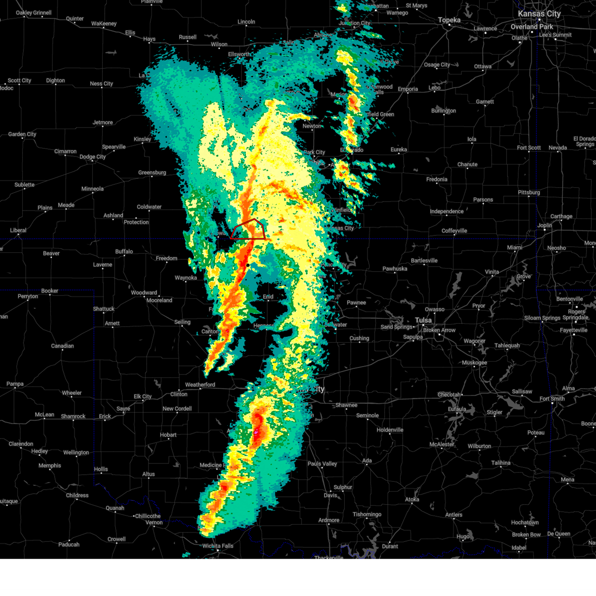 The tornado warning for southwestern harper county will expire at 900 pm cst, the tornado threat has diminished and the tornado warning has been cancelled. however, large hail and damaging winds remain likely and a severe thunderstorm warning remains in effect for the area. a severe thunderstorm watch remains in effect until 100 am cst for south central kansas. The tornado warning for southwestern harper county will expire at 900 pm cst, the tornado threat has diminished and the tornado warning has been cancelled. however, large hail and damaging winds remain likely and a severe thunderstorm warning remains in effect for the area. a severe thunderstorm watch remains in effect until 100 am cst for south central kansas.
|
| 2/26/2023 8:36 PM CST |
 At 836 pm cst, severe thunderstorms capable of producing both tornadoes and extensive straight line wind damage were located near amorita, or 11 miles southeast of hazelton, moving northeast at 45 mph (radar indicated rotation). Hazards include tornado. Flying debris will be dangerous to those caught without shelter. mobile homes will be damaged or destroyed. damage to roofs, windows, and vehicles will occur. tree damage is likely. these dangerous storms will be near, anthony around 900 pm cst. Other locations impacted by this tornadic thunderstorm include waldron. At 836 pm cst, severe thunderstorms capable of producing both tornadoes and extensive straight line wind damage were located near amorita, or 11 miles southeast of hazelton, moving northeast at 45 mph (radar indicated rotation). Hazards include tornado. Flying debris will be dangerous to those caught without shelter. mobile homes will be damaged or destroyed. damage to roofs, windows, and vehicles will occur. tree damage is likely. these dangerous storms will be near, anthony around 900 pm cst. Other locations impacted by this tornadic thunderstorm include waldron.
|
| 2/26/2023 8:30 PM CST |
 At 829 pm cst, a severe thunderstorm was located near hazelton, moving east at 40 mph (radar indicated). Hazards include 70 mph wind gusts. Expect considerable tree damage. Damage is likely to mobile homes, roofs, and outbuildings. At 829 pm cst, a severe thunderstorm was located near hazelton, moving east at 40 mph (radar indicated). Hazards include 70 mph wind gusts. Expect considerable tree damage. Damage is likely to mobile homes, roofs, and outbuildings.
|
| 5/31/2022 5:33 PM CDT |
 At 533 pm cdt, a severe thunderstorm was located 10 miles east of manchester, or 11 miles southeast of anthony, moving northeast at 35 mph (radar indicated). Hazards include 60 mph wind gusts and quarter size hail. Hail damage to vehicles is expected. Expect wind damage to roofs, siding, and trees. At 533 pm cdt, a severe thunderstorm was located 10 miles east of manchester, or 11 miles southeast of anthony, moving northeast at 35 mph (radar indicated). Hazards include 60 mph wind gusts and quarter size hail. Hail damage to vehicles is expected. Expect wind damage to roofs, siding, and trees.
|
| 5/30/2022 5:46 PM CDT |
 At 545 pm cdt, a severe thunderstorm was located over argonia, or 11 miles southwest of conway springs, moving northeast at 40 mph (radar indicated). Hazards include 60 mph wind gusts and half dollar size hail. Hail damage to vehicles is expected. Expect wind damage to roofs, siding, and trees. At 545 pm cdt, a severe thunderstorm was located over argonia, or 11 miles southwest of conway springs, moving northeast at 40 mph (radar indicated). Hazards include 60 mph wind gusts and half dollar size hail. Hail damage to vehicles is expected. Expect wind damage to roofs, siding, and trees.
|
| 5/18/2022 12:15 AM CDT |
 At 1215 am cdt, a severe thunderstorm was located over anthony, moving southeast at 20 mph. there will be little or no rain with this wind (radar indicated). Hazards include 60 mph wind gusts. expect damage to roofs, siding, and trees At 1215 am cdt, a severe thunderstorm was located over anthony, moving southeast at 20 mph. there will be little or no rain with this wind (radar indicated). Hazards include 60 mph wind gusts. expect damage to roofs, siding, and trees
|
| 5/17/2022 3:40 AM CDT |
 The severe thunderstorm warning for central harper county will expire at 345 am cdt, the storm which prompted the warning has weakened below severe limits, and no longer poses an immediate threat to life or property. therefore, the warning will be allowed to expire. however small hail is still possible with this thunderstorm. The severe thunderstorm warning for central harper county will expire at 345 am cdt, the storm which prompted the warning has weakened below severe limits, and no longer poses an immediate threat to life or property. therefore, the warning will be allowed to expire. however small hail is still possible with this thunderstorm.
|
| 5/17/2022 3:28 AM CDT |
 At 328 am cdt, a severe thunderstorm was located near anthony, moving northeast at 20 mph (radar indicated). Hazards include quarter size hail. Damage to vehicles is expected. locations impacted include, anthony, harper and danville. hail threat, radar indicated max hail size, 1. 00 in wind threat, radar indicated max wind gust, <50 mph. At 328 am cdt, a severe thunderstorm was located near anthony, moving northeast at 20 mph (radar indicated). Hazards include quarter size hail. Damage to vehicles is expected. locations impacted include, anthony, harper and danville. hail threat, radar indicated max hail size, 1. 00 in wind threat, radar indicated max wind gust, <50 mph.
|
| 5/17/2022 3:07 AM CDT |
 At 307 am cdt, a severe thunderstorm was located 7 miles northwest of manchester, or 9 miles southwest of anthony, moving northeast at 25 mph (radar indicated). Hazards include quarter size hail. Damage to vehicles is expected. locations impacted include, anthony, harper, danville, waldron and crystal springs. hail threat, radar indicated max hail size, 1. 00 in wind threat, radar indicated max wind gust, <50 mph. At 307 am cdt, a severe thunderstorm was located 7 miles northwest of manchester, or 9 miles southwest of anthony, moving northeast at 25 mph (radar indicated). Hazards include quarter size hail. Damage to vehicles is expected. locations impacted include, anthony, harper, danville, waldron and crystal springs. hail threat, radar indicated max hail size, 1. 00 in wind threat, radar indicated max wind gust, <50 mph.
|
| 5/17/2022 2:50 AM CDT |
 At 250 am cdt, a severe thunderstorm was located near amorita, or 13 miles southeast of hazelton, moving northeast at 25 mph (radar indicated). Hazards include quarter size hail. damage to vehicles is expected At 250 am cdt, a severe thunderstorm was located near amorita, or 13 miles southeast of hazelton, moving northeast at 25 mph (radar indicated). Hazards include quarter size hail. damage to vehicles is expected
|
| 5/13/2022 8:56 PM CDT |
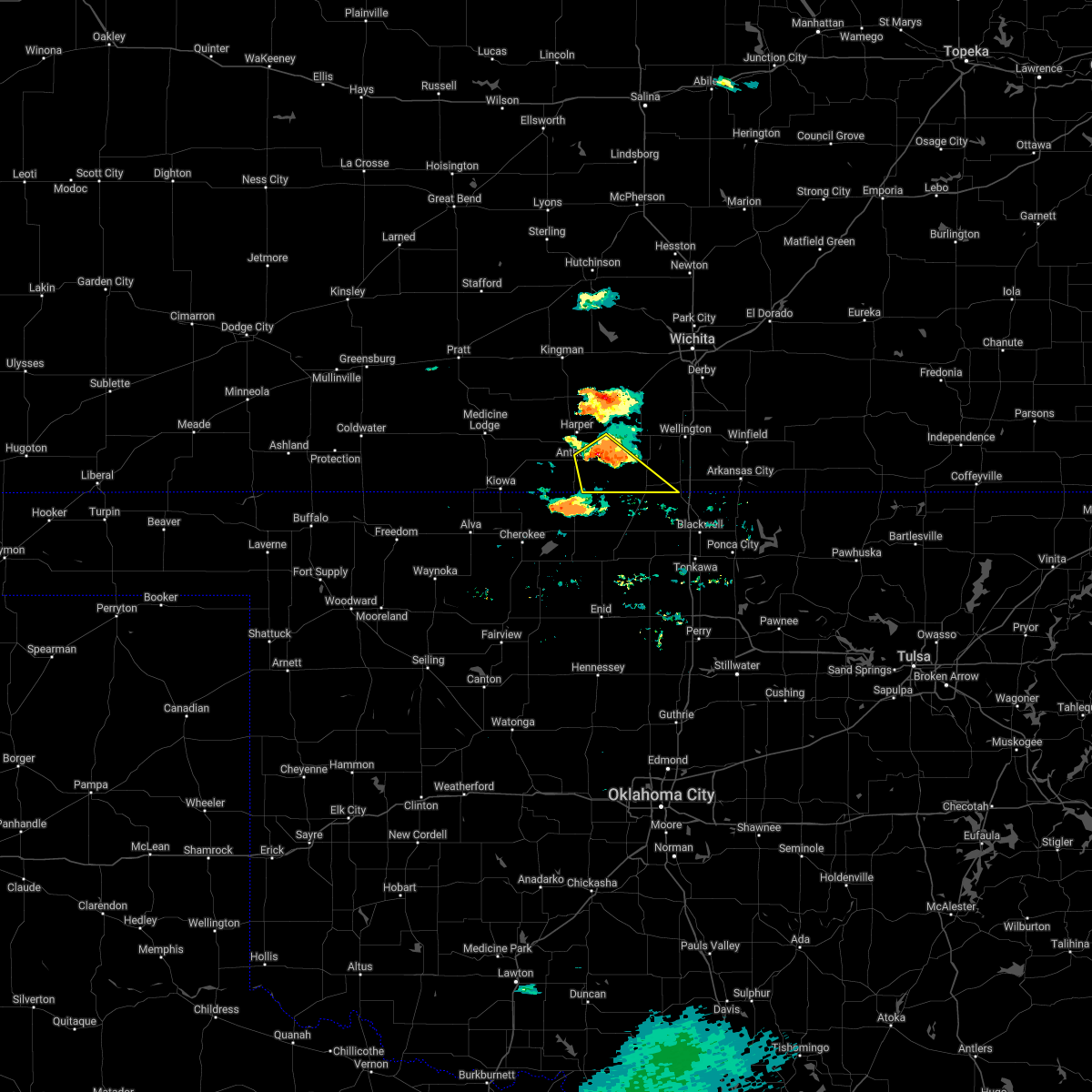 At 856 pm cdt, a severe thunderstorm was located near anthony, moving southeast at 10 mph (radar indicated). Hazards include golf ball size hail and 60 mph wind gusts. People and animals outdoors will be injured. expect hail damage to roofs, siding, windows, and vehicles. Expect wind damage to roofs, siding, and trees. At 856 pm cdt, a severe thunderstorm was located near anthony, moving southeast at 10 mph (radar indicated). Hazards include golf ball size hail and 60 mph wind gusts. People and animals outdoors will be injured. expect hail damage to roofs, siding, windows, and vehicles. Expect wind damage to roofs, siding, and trees.
|
| 5/13/2022 8:52 PM CDT |
 At 852 pm cdt, a severe thunderstorm was located near anthony, moving southeast at 15 mph (radar indicated). Hazards include ping pong ball size hail and 60 mph wind gusts. People and animals outdoors will be injured. expect hail damage to roofs, siding, windows, and vehicles. expect wind damage to roofs, siding, and trees. Locations impacted include, anthony, argonia, milan, bluff city and freeport. At 852 pm cdt, a severe thunderstorm was located near anthony, moving southeast at 15 mph (radar indicated). Hazards include ping pong ball size hail and 60 mph wind gusts. People and animals outdoors will be injured. expect hail damage to roofs, siding, windows, and vehicles. expect wind damage to roofs, siding, and trees. Locations impacted include, anthony, argonia, milan, bluff city and freeport.
|
| 5/13/2022 8:35 PM CDT |
 At 835 pm cdt, a severe thunderstorm was located 7 miles northeast of anthony, moving southeast at 15 mph (radar indicated). Hazards include ping pong ball size hail and 60 mph wind gusts. People and animals outdoors will be injured. expect hail damage to roofs, siding, windows, and vehicles. expect wind damage to roofs, siding, and trees. locations impacted include, anthony, argonia, milan, bluff city, danville and freeport. hail threat, radar indicated max hail size, 1. 50 in wind threat, radar indicated max wind gust, 60 mph. At 835 pm cdt, a severe thunderstorm was located 7 miles northeast of anthony, moving southeast at 15 mph (radar indicated). Hazards include ping pong ball size hail and 60 mph wind gusts. People and animals outdoors will be injured. expect hail damage to roofs, siding, windows, and vehicles. expect wind damage to roofs, siding, and trees. locations impacted include, anthony, argonia, milan, bluff city, danville and freeport. hail threat, radar indicated max hail size, 1. 50 in wind threat, radar indicated max wind gust, 60 mph.
|
| 5/13/2022 8:07 PM CDT |
 At 807 pm cdt, a severe thunderstorm was located over harper, moving southeast at 15 mph (radar indicated). Hazards include golf ball size hail and 60 mph wind gusts. People and animals outdoors will be injured. expect hail damage to roofs, siding, windows, and vehicles. Expect wind damage to roofs, siding, and trees. At 807 pm cdt, a severe thunderstorm was located over harper, moving southeast at 15 mph (radar indicated). Hazards include golf ball size hail and 60 mph wind gusts. People and animals outdoors will be injured. expect hail damage to roofs, siding, windows, and vehicles. Expect wind damage to roofs, siding, and trees.
|
| 5/13/2022 7:40 PM CDT |
 At 740 pm cdt, a severe thunderstorm was located 9 miles northwest of manchester, or 11 miles southwest of anthony, moving east at 10 mph (radar indicated). Hazards include ping pong ball size hail and 60 mph wind gusts. People and animals outdoors will be injured. expect hail damage to roofs, siding, windows, and vehicles. Expect wind damage to roofs, siding, and trees. At 740 pm cdt, a severe thunderstorm was located 9 miles northwest of manchester, or 11 miles southwest of anthony, moving east at 10 mph (radar indicated). Hazards include ping pong ball size hail and 60 mph wind gusts. People and animals outdoors will be injured. expect hail damage to roofs, siding, windows, and vehicles. Expect wind damage to roofs, siding, and trees.
|
| 5/2/2022 5:44 PM CDT |
 At 544 pm cdt, a severe thunderstorm was located 6 miles southeast of harper, moving east at 25 mph (radar indicated). Hazards include 60 mph wind gusts and quarter size hail. Hail damage to vehicles is expected. expect wind damage to roofs, siding, and trees. locations impacted include, anthony, conway springs, argonia, milan, danville, freeport and runnymede. hail threat, radar indicated max hail size, 1. 00 in wind threat, radar indicated max wind gust, 60 mph. At 544 pm cdt, a severe thunderstorm was located 6 miles southeast of harper, moving east at 25 mph (radar indicated). Hazards include 60 mph wind gusts and quarter size hail. Hail damage to vehicles is expected. expect wind damage to roofs, siding, and trees. locations impacted include, anthony, conway springs, argonia, milan, danville, freeport and runnymede. hail threat, radar indicated max hail size, 1. 00 in wind threat, radar indicated max wind gust, 60 mph.
|
| 5/2/2022 5:31 PM CDT |
 At 531 pm cdt, a severe thunderstorm was located near harper, moving east at 25 mph (radar indicated). Hazards include 60 mph wind gusts and quarter size hail. Hail damage to vehicles is expected. Expect wind damage to roofs, siding, and trees. At 531 pm cdt, a severe thunderstorm was located near harper, moving east at 25 mph (radar indicated). Hazards include 60 mph wind gusts and quarter size hail. Hail damage to vehicles is expected. Expect wind damage to roofs, siding, and trees.
|
| 3/29/2022 9:19 PM CDT |
 At 918 pm cdt, a severe thunderstorm was located 8 miles south of conway springs, moving northeast at 45 mph (trained weather spotters have reported one inch hail in argonia and 60 mph winds in freeport). Hazards include 60 mph wind gusts and quarter size hail. Hail damage to vehicles is expected. expect wind damage to roofs, siding, and trees. Locations impacted include, wellington, anthony, conway springs, caldwell, argonia, mayfield, milan, bluff city, danville, freeport, perth, riverdale, runnymede and wellington airport. At 918 pm cdt, a severe thunderstorm was located 8 miles south of conway springs, moving northeast at 45 mph (trained weather spotters have reported one inch hail in argonia and 60 mph winds in freeport). Hazards include 60 mph wind gusts and quarter size hail. Hail damage to vehicles is expected. expect wind damage to roofs, siding, and trees. Locations impacted include, wellington, anthony, conway springs, caldwell, argonia, mayfield, milan, bluff city, danville, freeport, perth, riverdale, runnymede and wellington airport.
|
| 3/29/2022 9:09 PM CDT |
 At 908 pm cdt, a severe thunderstorm was located over argonia, or 11 miles southwest of conway springs, moving northeast at 45 mph (trained weather spotters have reported 60 mph winds in freeport). Hazards include 60 mph wind gusts and nickel size hail. Expect damage to roofs, siding, and trees. Locations impacted include, wellington, anthony, conway springs, caldwell, argonia, mayfield, milan, bluff city, danville, freeport, perth, riverdale, runnymede and wellington airport. At 908 pm cdt, a severe thunderstorm was located over argonia, or 11 miles southwest of conway springs, moving northeast at 45 mph (trained weather spotters have reported 60 mph winds in freeport). Hazards include 60 mph wind gusts and nickel size hail. Expect damage to roofs, siding, and trees. Locations impacted include, wellington, anthony, conway springs, caldwell, argonia, mayfield, milan, bluff city, danville, freeport, perth, riverdale, runnymede and wellington airport.
|
| 3/29/2022 8:56 PM CDT |
 At 856 pm cdt, a severe thunderstorm was located near anthony, moving northeast at 45 mph (radar indicated). Hazards include 60 mph wind gusts and nickel size hail. expect damage to roofs, siding, and trees At 856 pm cdt, a severe thunderstorm was located near anthony, moving northeast at 45 mph (radar indicated). Hazards include 60 mph wind gusts and nickel size hail. expect damage to roofs, siding, and trees
|
| 3/29/2022 8:43 PM CDT |
 At 843 pm cdt, a severe thunderstorm was located 6 miles west of anthony, moving northeast at 60 mph (radar indicated). Hazards include 60 mph wind gusts and nickel size hail. Expect damage to roofs, siding, and trees. locations impacted include, anthony, harper, attica, norwich, murdock, spivey, danville, freeport, corwin, rago, runnymede and crystal springs. hail threat, radar indicated max hail size, 0. 88 in wind threat, radar indicated max wind gust, 60 mph. At 843 pm cdt, a severe thunderstorm was located 6 miles west of anthony, moving northeast at 60 mph (radar indicated). Hazards include 60 mph wind gusts and nickel size hail. Expect damage to roofs, siding, and trees. locations impacted include, anthony, harper, attica, norwich, murdock, spivey, danville, freeport, corwin, rago, runnymede and crystal springs. hail threat, radar indicated max hail size, 0. 88 in wind threat, radar indicated max wind gust, 60 mph.
|
| 3/29/2022 8:07 PM CDT |
 At 807 pm cdt, a severe thunderstorm was located near sharon, moving northeast at 35 mph (radar indicated). Hazards include 60 mph wind gusts and nickel size hail. expect damage to roofs, siding, and trees At 807 pm cdt, a severe thunderstorm was located near sharon, moving northeast at 35 mph (radar indicated). Hazards include 60 mph wind gusts and nickel size hail. expect damage to roofs, siding, and trees
|
| 3/29/2022 6:46 PM CDT |
 At 645 pm cdt, a severe thunderstorm was located 6 miles northeast of hazelton, moving northeast at 50 mph (radar indicated). Hazards include 60 mph wind gusts and penny size hail. expect damage to roofs, siding, and trees At 645 pm cdt, a severe thunderstorm was located 6 miles northeast of hazelton, moving northeast at 50 mph (radar indicated). Hazards include 60 mph wind gusts and penny size hail. expect damage to roofs, siding, and trees
|
| 9/3/2021 8:01 PM CDT |
 At 743 pm cdt, severe thunderstorms were located along a line extending from 5 miles northeast of harper to 8 miles northwest of renfrow, moving east at 25 mph (radar indicated). Hazards include 60 mph wind gusts and penny size hail. expect damage to roofs, siding, and trees At 743 pm cdt, severe thunderstorms were located along a line extending from 5 miles northeast of harper to 8 miles northwest of renfrow, moving east at 25 mph (radar indicated). Hazards include 60 mph wind gusts and penny size hail. expect damage to roofs, siding, and trees
|
| 9/3/2021 7:44 PM CDT |
 At 743 pm cdt, severe thunderstorms were located along a line extending from 5 miles northeast of harper to 8 miles northwest of renfrow, moving east at 25 mph (radar indicated). Hazards include 60 mph wind gusts and penny size hail. expect damage to roofs, siding, and trees At 743 pm cdt, severe thunderstorms were located along a line extending from 5 miles northeast of harper to 8 miles northwest of renfrow, moving east at 25 mph (radar indicated). Hazards include 60 mph wind gusts and penny size hail. expect damage to roofs, siding, and trees
|
| 3/12/2021 9:05 AM CST |
 At 905 am cst, a severe thunderstorm was located near manchester, or near anthony, moving east at 40 mph (radar indicated). Hazards include quarter size hail. Damage to vehicles is expected. Locations impacted include, anthony, bluff city and freeport. At 905 am cst, a severe thunderstorm was located near manchester, or near anthony, moving east at 40 mph (radar indicated). Hazards include quarter size hail. Damage to vehicles is expected. Locations impacted include, anthony, bluff city and freeport.
|
| 3/12/2021 8:43 AM CST |
 At 843 am cst, a severe thunderstorm was located near amorita, or 9 miles southeast of hazelton, moving northeast at 50 mph (radar indicated). Hazards include 60 mph wind gusts and quarter size hail. Hail damage to vehicles is expected. Expect wind damage to roofs, siding, and trees. At 843 am cst, a severe thunderstorm was located near amorita, or 9 miles southeast of hazelton, moving northeast at 50 mph (radar indicated). Hazards include 60 mph wind gusts and quarter size hail. Hail damage to vehicles is expected. Expect wind damage to roofs, siding, and trees.
|
| 11/24/2020 5:28 PM CST |
 The severe thunderstorm warning for harper and eastern kingman counties will expire at 530 pm cst, the storms which prompted the warning will be moving out of the area by around 530 pm. therefore, the warning will be allowed to expire. however gusty winds are still possible with these thunderstorms. The severe thunderstorm warning for harper and eastern kingman counties will expire at 530 pm cst, the storms which prompted the warning will be moving out of the area by around 530 pm. therefore, the warning will be allowed to expire. however gusty winds are still possible with these thunderstorms.
|
| 11/24/2020 5:17 PM CST |
 At 517 pm cst, severe thunderstorms were located along a line extending from 11 miles south of kingman to near harper to 5 miles northeast of manchester, moving east at 50 mph (radar indicated). Hazards include 60 mph wind gusts and nickel size hail. Expect damage to roofs, siding, and trees. Locations impacted include, kingman, anthony, harper, attica, norwich, murdock, waterloo, spivey, bluff city, cleveland, danville, freeport, mt vernon, kingman airport, rago, runnymede, crystal springs and cheney state park. At 517 pm cst, severe thunderstorms were located along a line extending from 11 miles south of kingman to near harper to 5 miles northeast of manchester, moving east at 50 mph (radar indicated). Hazards include 60 mph wind gusts and nickel size hail. Expect damage to roofs, siding, and trees. Locations impacted include, kingman, anthony, harper, attica, norwich, murdock, waterloo, spivey, bluff city, cleveland, danville, freeport, mt vernon, kingman airport, rago, runnymede, crystal springs and cheney state park.
|
| 11/24/2020 5:12 PM CST |
 At 511 pm cst, severe thunderstorms were located along a line extending from 10 miles southeast of cunningham to near harper to manchester, moving east at 50 mph (radar indicated). Hazards include 60 mph wind gusts and nickel size hail. Expect damage to roofs, siding, and trees. Locations impacted include, kingman, anthony, harper, attica, norwich, cunningham, murdock, waterloo, willowdale, zenda, spivey, bluff city, cleveland, danville, waldron, freeport, mt vernon, kingman airport, rago and runnymede. At 511 pm cst, severe thunderstorms were located along a line extending from 10 miles southeast of cunningham to near harper to manchester, moving east at 50 mph (radar indicated). Hazards include 60 mph wind gusts and nickel size hail. Expect damage to roofs, siding, and trees. Locations impacted include, kingman, anthony, harper, attica, norwich, cunningham, murdock, waterloo, willowdale, zenda, spivey, bluff city, cleveland, danville, waldron, freeport, mt vernon, kingman airport, rago and runnymede.
|
| 11/24/2020 5:04 PM CST |
 At 503 pm cst, severe thunderstorms were located along a line extending from 6 miles northeast of nashville to near attica to 6 miles northwest of manchester, moving east at 50 mph (radar indicated). Hazards include 60 mph wind gusts and nickel size hail. Expect damage to roofs, siding, and trees. Locations impacted include, kingman, anthony, harper, attica, norwich, cunningham, nashville, murdock, waterloo, willowdale, zenda, spivey, bluff city, cleveland, danville, waldron, freeport, mt vernon, kingman airport and corwin. At 503 pm cst, severe thunderstorms were located along a line extending from 6 miles northeast of nashville to near attica to 6 miles northwest of manchester, moving east at 50 mph (radar indicated). Hazards include 60 mph wind gusts and nickel size hail. Expect damage to roofs, siding, and trees. Locations impacted include, kingman, anthony, harper, attica, norwich, cunningham, nashville, murdock, waterloo, willowdale, zenda, spivey, bluff city, cleveland, danville, waldron, freeport, mt vernon, kingman airport and corwin.
|
| 11/24/2020 4:48 PM CST |
 At 447 pm cst, severe thunderstorms were located along a line extending from 6 miles northwest of nashville to 6 miles southeast of hazelton, moving east at 50 mph (radar indicated). Hazards include 60 mph wind gusts and nickel size hail. expect damage to roofs, siding, and trees At 447 pm cst, severe thunderstorms were located along a line extending from 6 miles northwest of nashville to 6 miles southeast of hazelton, moving east at 50 mph (radar indicated). Hazards include 60 mph wind gusts and nickel size hail. expect damage to roofs, siding, and trees
|
| 8/10/2020 4:47 PM CDT |
 At 447 pm cdt, a severe thunderstorm was located 8 miles east of hazelton, moving northeast at 15 mph (radar indicated). Hazards include 60 mph wind gusts and penny size hail. Expect damage to roofs, siding, and trees. Locations impacted include, anthony, harper, attica, danville, waldron, corwin and crystal springs. At 447 pm cdt, a severe thunderstorm was located 8 miles east of hazelton, moving northeast at 15 mph (radar indicated). Hazards include 60 mph wind gusts and penny size hail. Expect damage to roofs, siding, and trees. Locations impacted include, anthony, harper, attica, danville, waldron, corwin and crystal springs.
|
| 8/10/2020 4:26 PM CDT |
 At 426 pm cdt, a severe thunderstorm was located over hazelton, moving northeast at 15 mph (radar indicated). Hazards include ping pong ball size hail and 60 mph wind gusts. People and animals outdoors will be injured. expect hail damage to roofs, siding, windows, and vehicles. Expect wind damage to roofs, siding, and trees. At 426 pm cdt, a severe thunderstorm was located over hazelton, moving northeast at 15 mph (radar indicated). Hazards include ping pong ball size hail and 60 mph wind gusts. People and animals outdoors will be injured. expect hail damage to roofs, siding, windows, and vehicles. Expect wind damage to roofs, siding, and trees.
|
| 7/13/2020 2:09 AM CDT |
 At 208 am cdt, severe thunderstorms were located along a line extending from 6 miles west of kingman to near harper to 5 miles northeast of manchester, moving east at 40 mph (radar indicated). Hazards include 60 mph wind gusts. Expect damage to roofs, siding, and trees. Locations impacted include, kingman, anthony, harper, attica, norwich, cunningham, nashville, murdock, waterloo, willowdale, zenda, spivey, bluff city, cleveland, danville, penalosa, waldron, freeport, kingman airport and corwin. At 208 am cdt, severe thunderstorms were located along a line extending from 6 miles west of kingman to near harper to 5 miles northeast of manchester, moving east at 40 mph (radar indicated). Hazards include 60 mph wind gusts. Expect damage to roofs, siding, and trees. Locations impacted include, kingman, anthony, harper, attica, norwich, cunningham, nashville, murdock, waterloo, willowdale, zenda, spivey, bluff city, cleveland, danville, penalosa, waldron, freeport, kingman airport and corwin.
|
| 7/13/2020 1:56 AM CDT |
 At 156 am cdt, severe thunderstorms were located along a line extending from 5 miles north of cunningham to 8 miles north of attica to 6 miles northeast of amorita, moving east at 40 mph (radar indicated). Hazards include 60 mph wind gusts and penny size hail. Expect damage to roofs, siding, and trees. Locations impacted include, kingman, anthony, harper, attica, norwich, cunningham, nashville, murdock, waterloo, willowdale, zenda, spivey, bluff city, cleveland, danville, penalosa, waldron, freeport, kingman airport and corwin. At 156 am cdt, severe thunderstorms were located along a line extending from 5 miles north of cunningham to 8 miles north of attica to 6 miles northeast of amorita, moving east at 40 mph (radar indicated). Hazards include 60 mph wind gusts and penny size hail. Expect damage to roofs, siding, and trees. Locations impacted include, kingman, anthony, harper, attica, norwich, cunningham, nashville, murdock, waterloo, willowdale, zenda, spivey, bluff city, cleveland, danville, penalosa, waldron, freeport, kingman airport and corwin.
|
| 7/13/2020 1:42 AM CDT |
 At 142 am cdt, severe thunderstorms were located along a line extending from near preston to 5 miles southeast of nashville to 5 miles southeast of hazelton, moving east at 40 mph (radar indicated). Hazards include 60 mph wind gusts and penny size hail. expect damage to roofs, siding, and trees At 142 am cdt, severe thunderstorms were located along a line extending from near preston to 5 miles southeast of nashville to 5 miles southeast of hazelton, moving east at 40 mph (radar indicated). Hazards include 60 mph wind gusts and penny size hail. expect damage to roofs, siding, and trees
|
| 7/10/2020 6:26 AM CDT |
 At 626 am cdt, a severe thunderstorm was located near argonia, or 12 miles east of harper, moving south at 15 mph (radar indicated). Hazards include 60 mph wind gusts and penny size hail. expect damage to roofs, siding, and trees At 626 am cdt, a severe thunderstorm was located near argonia, or 12 miles east of harper, moving south at 15 mph (radar indicated). Hazards include 60 mph wind gusts and penny size hail. expect damage to roofs, siding, and trees
|
| 6/21/2020 8:35 PM CDT |
 At 835 pm cdt, severe thunderstorms were located along a line extending from 10 miles southeast of anthony to 6 miles southeast of hazelton, moving southwest at 30 mph (trained weather spotters). Hazards include 60 mph wind gusts and penny size hail. Expect damage to roofs, siding, and trees. Locations impacted include, anthony, harper, bluff city, danville, waldron, freeport and corwin. At 835 pm cdt, severe thunderstorms were located along a line extending from 10 miles southeast of anthony to 6 miles southeast of hazelton, moving southwest at 30 mph (trained weather spotters). Hazards include 60 mph wind gusts and penny size hail. Expect damage to roofs, siding, and trees. Locations impacted include, anthony, harper, bluff city, danville, waldron, freeport and corwin.
|
| 6/21/2020 7:38 PM CDT |
 At 738 pm cdt, severe thunderstorms were located along a line extending from near kingman to near nashville, moving east at 30 mph. these are very dangerous storms (trained weather spotters). Hazards include 80 mph wind gusts and penny size hail. Flying debris will be dangerous to those caught without shelter. mobile homes will be heavily damaged. expect considerable damage to roofs, windows, and vehicles. extensive tree damage and power outages are likely. Locations impacted include, anthony, harper, attica, norwich, nashville, murdock, willowdale, zenda, spivey, bluff city, cleveland, danville, waldron, freeport, corwin, rago, runnymede and crystal springs. At 738 pm cdt, severe thunderstorms were located along a line extending from near kingman to near nashville, moving east at 30 mph. these are very dangerous storms (trained weather spotters). Hazards include 80 mph wind gusts and penny size hail. Flying debris will be dangerous to those caught without shelter. mobile homes will be heavily damaged. expect considerable damage to roofs, windows, and vehicles. extensive tree damage and power outages are likely. Locations impacted include, anthony, harper, attica, norwich, nashville, murdock, willowdale, zenda, spivey, bluff city, cleveland, danville, waldron, freeport, corwin, rago, runnymede and crystal springs.
|
| 6/21/2020 7:17 PM CDT |
 At 716 pm cdt, severe thunderstorms were located along a line extending from near cunningham to near lake city, moving east at 40 mph (radar indicated). Hazards include 70 mph wind gusts and penny size hail. Expect considerable tree damage. Damage is likely to mobile homes, roofs, and outbuildings. At 716 pm cdt, severe thunderstorms were located along a line extending from near cunningham to near lake city, moving east at 40 mph (radar indicated). Hazards include 70 mph wind gusts and penny size hail. Expect considerable tree damage. Damage is likely to mobile homes, roofs, and outbuildings.
|
| 6/21/2020 3:06 AM CDT |
 The severe thunderstorm warning for harper and southern sumner counties will expire at 315 am cdt, the storms which prompted the warning have moved out of the area. therefore, the warning will be allowed to expire. however gusty winds are still possible with these thunderstorms. The severe thunderstorm warning for harper and southern sumner counties will expire at 315 am cdt, the storms which prompted the warning have moved out of the area. therefore, the warning will be allowed to expire. however gusty winds are still possible with these thunderstorms.
|
| 6/21/2020 2:25 AM CDT |
 At 225 am cdt, severe thunderstorms were located along a line extending from near harper to 5 miles southeast of anthony to 7 miles west of manchester, moving southeast at 40 mph (radar indicated). Hazards include 60 mph wind gusts and penny size hail. Expect damage to roofs, siding, and trees. Locations impacted include, anthony, harper, caldwell, attica, argonia, south haven, mayfield, milan, hunnewell, bluff city, danville, waldron, freeport, perth, corwin, runnymede and crystal springs. At 225 am cdt, severe thunderstorms were located along a line extending from near harper to 5 miles southeast of anthony to 7 miles west of manchester, moving southeast at 40 mph (radar indicated). Hazards include 60 mph wind gusts and penny size hail. Expect damage to roofs, siding, and trees. Locations impacted include, anthony, harper, caldwell, attica, argonia, south haven, mayfield, milan, hunnewell, bluff city, danville, waldron, freeport, perth, corwin, runnymede and crystal springs.
|
| 6/21/2020 2:11 AM CDT |
 At 210 am cdt, severe thunderstorms were located along a line extending from near harper to near anthony to 6 miles north of amorita, moving southeast at 40 mph (radar indicated). Hazards include 60 mph wind gusts and penny size hail. expect damage to roofs, siding, and trees At 210 am cdt, severe thunderstorms were located along a line extending from near harper to near anthony to 6 miles north of amorita, moving southeast at 40 mph (radar indicated). Hazards include 60 mph wind gusts and penny size hail. expect damage to roofs, siding, and trees
|
| 1/10/2020 10:25 AM CST |
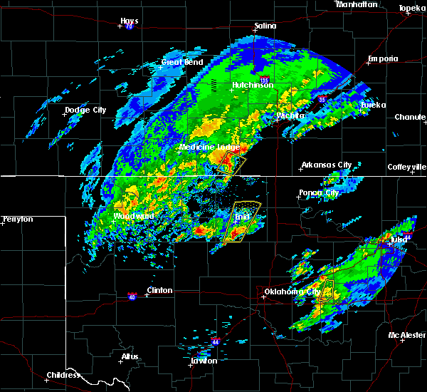 At 1024 am cst, a severe thunderstorm was located 6 miles east of anthony, moving northeast at 35 mph (radar indicated). Hazards include 60 mph wind gusts and quarter size hail. Hail damage to vehicles is expected. expect wind damage to roofs, siding, and trees. Locations impacted include, anthony, bluff city, danville and freeport. At 1024 am cst, a severe thunderstorm was located 6 miles east of anthony, moving northeast at 35 mph (radar indicated). Hazards include 60 mph wind gusts and quarter size hail. Hail damage to vehicles is expected. expect wind damage to roofs, siding, and trees. Locations impacted include, anthony, bluff city, danville and freeport.
|
| 1/10/2020 10:15 AM CST |
 At 1014 am cst, a severe thunderstorm was located 6 miles southeast of anthony, moving northeast at 45 mph (radar indicated). Hazards include half dollar size hail. damage to vehicles is expected At 1014 am cst, a severe thunderstorm was located 6 miles southeast of anthony, moving northeast at 45 mph (radar indicated). Hazards include half dollar size hail. damage to vehicles is expected
|
| 9/25/2019 9:45 PM CDT |
 At 944 pm cdt, severe thunderstorms were located along a line extending from 5 miles southeast of nashville to 10 miles west of norwich to 5 miles northwest of conway springs to near belle plaine to udall to 5 miles east of winfield to near cedar vale, moving southeast at 15 mph (radar indicated). Hazards include 60 mph wind gusts and quarter size hail. Hail damage to vehicles is expected. Expect wind damage to roofs, siding, and trees. At 944 pm cdt, severe thunderstorms were located along a line extending from 5 miles southeast of nashville to 10 miles west of norwich to 5 miles northwest of conway springs to near belle plaine to udall to 5 miles east of winfield to near cedar vale, moving southeast at 15 mph (radar indicated). Hazards include 60 mph wind gusts and quarter size hail. Hail damage to vehicles is expected. Expect wind damage to roofs, siding, and trees.
|
| 9/24/2019 7:46 PM CDT |
 At 745 pm cdt, a severe thunderstorm was located over nashville, or 8 miles southeast of isabel, moving east at 20 mph (radar indicated). Hazards include golf ball size hail and 60 mph wind gusts. People and animals outdoors will be injured. expect hail damage to roofs, siding, windows, and vehicles. Expect wind damage to roofs, siding, and trees. At 745 pm cdt, a severe thunderstorm was located over nashville, or 8 miles southeast of isabel, moving east at 20 mph (radar indicated). Hazards include golf ball size hail and 60 mph wind gusts. People and animals outdoors will be injured. expect hail damage to roofs, siding, windows, and vehicles. Expect wind damage to roofs, siding, and trees.
|
| 8/13/2019 11:33 PM CDT |
 At 1130 pm cdt, severe thunderstorms were located along a line extending from 5 miles southwest of burrton to viola to 8 miles northeast of manchester, moving east at 40 mph (radar indicated). Hazards include 60 mph wind gusts. Expect damage to roofs, siding, and trees. Locations impacted include, wichita, hutchinson, derby, newton, haysville, wellington, park city, valley center, bel aire, goddard, hesston, maize, clearwater, south hutchinson, anthony, cheney, halstead, north newton, sedgwick and harper. At 1130 pm cdt, severe thunderstorms were located along a line extending from 5 miles southwest of burrton to viola to 8 miles northeast of manchester, moving east at 40 mph (radar indicated). Hazards include 60 mph wind gusts. Expect damage to roofs, siding, and trees. Locations impacted include, wichita, hutchinson, derby, newton, haysville, wellington, park city, valley center, bel aire, goddard, hesston, maize, clearwater, south hutchinson, anthony, cheney, halstead, north newton, sedgwick and harper.
|
| 8/13/2019 11:10 PM CDT |
 At 1108 pm cdt, severe thunderstorms were located along a line extending from near haven to near norwich to 6 miles southwest of anthony, moving east at 35 mph (radar indicated). Hazards include 60 mph wind gusts. expect damage to roofs, siding, and trees At 1108 pm cdt, severe thunderstorms were located along a line extending from near haven to near norwich to 6 miles southwest of anthony, moving east at 35 mph (radar indicated). Hazards include 60 mph wind gusts. expect damage to roofs, siding, and trees
|
| 6/23/2019 3:39 AM CDT |
 At 339 am cdt, a confirmed tornado was located near harper, moving northeast at 25 mph (law enforcement confirmed tornado). Hazards include damaging tornado and quarter size hail. Flying debris will be dangerous to those caught without shelter. mobile homes will be damaged or destroyed. damage to roofs, windows, and vehicles will occur. Tree damage is likely. At 339 am cdt, a confirmed tornado was located near harper, moving northeast at 25 mph (law enforcement confirmed tornado). Hazards include damaging tornado and quarter size hail. Flying debris will be dangerous to those caught without shelter. mobile homes will be damaged or destroyed. damage to roofs, windows, and vehicles will occur. Tree damage is likely.
|
| 6/23/2019 3:26 AM CDT |
 At 325 am cdt, a severe thunderstorm capable of producing a tornado was located near attica, moving northeast at 25 mph (radar indicated rotation). Hazards include tornado and quarter size hail. Flying debris will be dangerous to those caught without shelter. mobile homes will be damaged or destroyed. damage to roofs, windows, and vehicles will occur. tree damage is likely. Locations impacted include, crystal springs. At 325 am cdt, a severe thunderstorm capable of producing a tornado was located near attica, moving northeast at 25 mph (radar indicated rotation). Hazards include tornado and quarter size hail. Flying debris will be dangerous to those caught without shelter. mobile homes will be damaged or destroyed. damage to roofs, windows, and vehicles will occur. tree damage is likely. Locations impacted include, crystal springs.
|
| 6/23/2019 3:17 AM CDT |
 At 317 am cdt, a severe thunderstorm capable of producing a tornado was located near attica, moving northeast at 25 mph (radar indicated rotation). Hazards include tornado and quarter size hail. Flying debris will be dangerous to those caught without shelter. mobile homes will be damaged or destroyed. damage to roofs, windows, and vehicles will occur. Tree damage is likely. At 317 am cdt, a severe thunderstorm capable of producing a tornado was located near attica, moving northeast at 25 mph (radar indicated rotation). Hazards include tornado and quarter size hail. Flying debris will be dangerous to those caught without shelter. mobile homes will be damaged or destroyed. damage to roofs, windows, and vehicles will occur. Tree damage is likely.
|
| 6/22/2019 8:32 PM CDT |
 At 831 pm cdt, a severe thunderstorm was located near argonia, or 7 miles southwest of conway springs, moving northeast at 35 mph. this storm has produced winds up to 60 mph (radar indicated). Hazards include 60 mph wind gusts and quarter size hail. Hail damage to vehicles is expected. expect wind damage to roofs, siding, and trees. Locations impacted include, derby, haysville, mulvane, clearwater, anthony, harper, conway springs, argonia, norwich, viola, mayfield, milan, danville, freeport, lake afton, riverdale and runnymede. At 831 pm cdt, a severe thunderstorm was located near argonia, or 7 miles southwest of conway springs, moving northeast at 35 mph. this storm has produced winds up to 60 mph (radar indicated). Hazards include 60 mph wind gusts and quarter size hail. Hail damage to vehicles is expected. expect wind damage to roofs, siding, and trees. Locations impacted include, derby, haysville, mulvane, clearwater, anthony, harper, conway springs, argonia, norwich, viola, mayfield, milan, danville, freeport, lake afton, riverdale and runnymede.
|
| 6/22/2019 7:40 PM CDT |
 The national weather service in wichita has issued a * severe thunderstorm warning for. southern sedgwick county in south central kansas. harper county in south central kansas. southeastern kingman county in south central kansas. Northwestern sumner county in south central kansas. The national weather service in wichita has issued a * severe thunderstorm warning for. southern sedgwick county in south central kansas. harper county in south central kansas. southeastern kingman county in south central kansas. Northwestern sumner county in south central kansas.
|
| 6/22/2019 5:25 PM CDT |
 At 525 pm cdt, severe thunderstorms were located along a line extending from near anthony to near harper to 8 miles west of norwich, moving northeast at 35 mph (trained weather spotters). Hazards include golf ball size hail and 60 mph wind gusts. People and animals outdoors will be injured. expect hail damage to roofs, siding, windows, and vehicles. expect wind damage to roofs, siding, and trees. Locations impacted include, anthony, harper, attica, norwich, spivey, danville, freeport, rago, runnymede and crystal springs. At 525 pm cdt, severe thunderstorms were located along a line extending from near anthony to near harper to 8 miles west of norwich, moving northeast at 35 mph (trained weather spotters). Hazards include golf ball size hail and 60 mph wind gusts. People and animals outdoors will be injured. expect hail damage to roofs, siding, windows, and vehicles. expect wind damage to roofs, siding, and trees. Locations impacted include, anthony, harper, attica, norwich, spivey, danville, freeport, rago, runnymede and crystal springs.
|
| 6/22/2019 5:12 PM CDT |
 At 511 pm cdt, severe thunderstorms were located along a line extending from 5 miles west of anthony to 5 miles east of attica to 5 miles north of harper, moving north at 30 mph (radar indicated). Hazards include golf ball size hail and 60 mph wind gusts. People and animals outdoors will be injured. expect hail damage to roofs, siding, windows, and vehicles. expect wind damage to roofs, siding, and trees. Locations impacted include, anthony, harper, attica, norwich, zenda, spivey, danville, freeport, rago, runnymede and crystal springs. At 511 pm cdt, severe thunderstorms were located along a line extending from 5 miles west of anthony to 5 miles east of attica to 5 miles north of harper, moving north at 30 mph (radar indicated). Hazards include golf ball size hail and 60 mph wind gusts. People and animals outdoors will be injured. expect hail damage to roofs, siding, windows, and vehicles. expect wind damage to roofs, siding, and trees. Locations impacted include, anthony, harper, attica, norwich, zenda, spivey, danville, freeport, rago, runnymede and crystal springs.
|
| 6/22/2019 4:55 PM CDT |
 At 455 pm cdt, a severe thunderstorm was located 6 miles west of anthony, moving northeast at 35 mph (radar indicated). Hazards include golf ball size hail and 60 mph wind gusts. People and animals outdoors will be injured. expect hail damage to roofs, siding, windows, and vehicles. Expect wind damage to roofs, siding, and trees. At 455 pm cdt, a severe thunderstorm was located 6 miles west of anthony, moving northeast at 35 mph (radar indicated). Hazards include golf ball size hail and 60 mph wind gusts. People and animals outdoors will be injured. expect hail damage to roofs, siding, windows, and vehicles. Expect wind damage to roofs, siding, and trees.
|
| 6/15/2019 11:12 PM CDT |
 The severe thunderstorm warning for southwestern harper county will expire at 1115 pm cdt, the storm which prompted the warning has weakened below severe limits, and no longer poses an immediate threat to life or property. therefore, the warning will be allowed to expire. however gusty winds and heavy rain are still possible with this thunderstorm. a severe thunderstorm watch remains in effect until 400 am cdt for south central kansas. The severe thunderstorm warning for southwestern harper county will expire at 1115 pm cdt, the storm which prompted the warning has weakened below severe limits, and no longer poses an immediate threat to life or property. therefore, the warning will be allowed to expire. however gusty winds and heavy rain are still possible with this thunderstorm. a severe thunderstorm watch remains in effect until 400 am cdt for south central kansas.
|
| 6/15/2019 10:56 PM CDT |
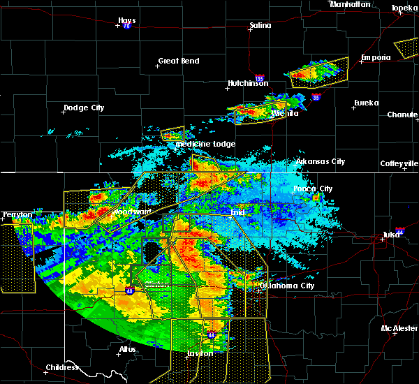 At 1055 pm cdt, a severe thunderstorm was located 6 miles east of hazelton, or near corwin, moving north at 5 mph (radar indicated). Hazards include 60 mph wind gusts and quarter size hail. Hail damage to vehicles is expected. expect wind damage to roofs, siding, and trees. Locations impacted include, waldron and corwin. At 1055 pm cdt, a severe thunderstorm was located 6 miles east of hazelton, or near corwin, moving north at 5 mph (radar indicated). Hazards include 60 mph wind gusts and quarter size hail. Hail damage to vehicles is expected. expect wind damage to roofs, siding, and trees. Locations impacted include, waldron and corwin.
|
| 6/15/2019 10:44 PM CDT |
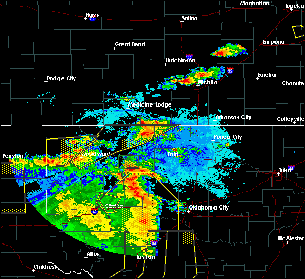 At 1044 pm cdt, a severe thunderstorm was located 6 miles southeast of hazelton, moving north at 5 mph (radar indicated). Hazards include 60 mph wind gusts and quarter size hail. Hail damage to vehicles is expected. Expect wind damage to roofs, siding, and trees. At 1044 pm cdt, a severe thunderstorm was located 6 miles southeast of hazelton, moving north at 5 mph (radar indicated). Hazards include 60 mph wind gusts and quarter size hail. Hail damage to vehicles is expected. Expect wind damage to roofs, siding, and trees.
|
| 6/15/2019 12:41 AM CDT |
 The severe thunderstorm warning for eastern reno, harper and eastern kingman counties will expire at 1245 am cdt, the storms which prompted the warning have moved out of the area. therefore, the warning will be allowed to expire. however gusty winds and heavy rain are still possible with these thunderstorms. a severe thunderstorm watch remains in effect until 500 am cdt for south central kansas. The severe thunderstorm warning for eastern reno, harper and eastern kingman counties will expire at 1245 am cdt, the storms which prompted the warning have moved out of the area. therefore, the warning will be allowed to expire. however gusty winds and heavy rain are still possible with these thunderstorms. a severe thunderstorm watch remains in effect until 500 am cdt for south central kansas.
|
| 6/15/2019 12:24 AM CDT |
 At 1224 am cdt, severe thunderstorms were located along a line extending from near haven to 5 miles northeast of norwich to 8 miles southeast of anthony, moving east at 60 mph (radar indicated). Hazards include 70 mph wind gusts and penny size hail. Expect considerable tree damage. damage is likely to mobile homes, roofs, and outbuildings. Locations impacted include, hutchinson, kingman, south hutchinson, anthony, harper, buhler, haven, pretty prairie, attica, norwich, partridge, yoder, murdock, waterloo, willowbrook, spivey, bluff city, cleveland, danville and waldron. At 1224 am cdt, severe thunderstorms were located along a line extending from near haven to 5 miles northeast of norwich to 8 miles southeast of anthony, moving east at 60 mph (radar indicated). Hazards include 70 mph wind gusts and penny size hail. Expect considerable tree damage. damage is likely to mobile homes, roofs, and outbuildings. Locations impacted include, hutchinson, kingman, south hutchinson, anthony, harper, buhler, haven, pretty prairie, attica, norwich, partridge, yoder, murdock, waterloo, willowbrook, spivey, bluff city, cleveland, danville and waldron.
|
| 6/14/2019 11:38 PM CDT |
 At 1138 pm cdt, severe thunderstorms were located along a line extending from near stafford to near isabel to 7 miles northeast of aetna, moving east at 55 mph (radar indicated). Hazards include 70 mph wind gusts and quarter size hail. Hail damage to vehicles is expected. expect considerable tree damage. Wind damage is also likely to mobile homes, roofs, and outbuildings. At 1138 pm cdt, severe thunderstorms were located along a line extending from near stafford to near isabel to 7 miles northeast of aetna, moving east at 55 mph (radar indicated). Hazards include 70 mph wind gusts and quarter size hail. Hail damage to vehicles is expected. expect considerable tree damage. Wind damage is also likely to mobile homes, roofs, and outbuildings.
|
| 5/27/2019 1:39 AM CDT |
 At 139 am cdt, severe thunderstorms were located along a line extending from near north newton to near haysville to near caldwell, moving east at 55 mph (trained weather spotters). Hazards include 70 mph wind gusts and nickel size hail. Expect considerable tree damage. damage is likely to mobile homes, roofs, and outbuildings. Locations impacted include, wichita, hutchinson, derby, newton, haysville, wellington, park city, valley center, bel aire, mulvane, goddard, hesston, maize, kingman, clearwater, south hutchinson, anthony, cheney, halstead and north newton. At 139 am cdt, severe thunderstorms were located along a line extending from near north newton to near haysville to near caldwell, moving east at 55 mph (trained weather spotters). Hazards include 70 mph wind gusts and nickel size hail. Expect considerable tree damage. damage is likely to mobile homes, roofs, and outbuildings. Locations impacted include, wichita, hutchinson, derby, newton, haysville, wellington, park city, valley center, bel aire, mulvane, goddard, hesston, maize, kingman, clearwater, south hutchinson, anthony, cheney, halstead and north newton.
|
| 5/27/2019 1:19 AM CDT |
 At 119 am cdt, severe thunderstorms were located along a line extending from near buhler to 5 miles northwest of viola to 8 miles southeast of anthony, moving east at 50 mph (radar indicated). Hazards include 70 mph wind gusts and nickel size hail. Expect considerable tree damage. damage is likely to mobile homes, roofs, and outbuildings. Locations impacted include, wichita, hutchinson, derby, newton, haysville, wellington, park city, valley center, bel aire, mulvane, goddard, hesston, maize, kingman, clearwater, south hutchinson, anthony, cheney, halstead and north newton. At 119 am cdt, severe thunderstorms were located along a line extending from near buhler to 5 miles northwest of viola to 8 miles southeast of anthony, moving east at 50 mph (radar indicated). Hazards include 70 mph wind gusts and nickel size hail. Expect considerable tree damage. damage is likely to mobile homes, roofs, and outbuildings. Locations impacted include, wichita, hutchinson, derby, newton, haysville, wellington, park city, valley center, bel aire, mulvane, goddard, hesston, maize, kingman, clearwater, south hutchinson, anthony, cheney, halstead and north newton.
|
| 5/27/2019 12:54 AM CDT |
 At 1253 am cdt, severe thunderstorms were located along a line extending from near nickerson to 8 miles south of kingman to 7 miles east of hazelton, moving east at 55 mph (radar indicated). Hazards include 70 mph wind gusts and nickel size hail. Expect considerable tree damage. Damage is likely to mobile homes, roofs, and outbuildings. At 1253 am cdt, severe thunderstorms were located along a line extending from near nickerson to 8 miles south of kingman to 7 miles east of hazelton, moving east at 55 mph (radar indicated). Hazards include 70 mph wind gusts and nickel size hail. Expect considerable tree damage. Damage is likely to mobile homes, roofs, and outbuildings.
|
| 5/26/2019 11:51 PM CDT |
 At 1150 pm cdt, severe thunderstorms were located along a line extending from hopewell to 11 miles south of aetna, moving east at 60 mph (radar indicated). Hazards include 70 mph wind gusts and quarter size hail. Hail damage to vehicles is expected. expect considerable tree damage. Wind damage is also likely to mobile homes, roofs, and outbuildings. At 1150 pm cdt, severe thunderstorms were located along a line extending from hopewell to 11 miles south of aetna, moving east at 60 mph (radar indicated). Hazards include 70 mph wind gusts and quarter size hail. Hail damage to vehicles is expected. expect considerable tree damage. Wind damage is also likely to mobile homes, roofs, and outbuildings.
|
| 5/25/2019 7:44 PM CDT |
 At 743 pm cdt, severe thunderstorms were located along a line extending from 11 miles northwest of harper to near attica to 5 miles west of anthony to 6 miles west of manchester, moving northeast at 45 mph (radar indicated). Hazards include 70 mph wind gusts and penny size hail. Expect tree damage. damage is likely to mobile homes, roofs, and outbuildings. Locations impacted include, anthony, harper, attica, bluff city, danville, waldron, freeport, corwin, runnymede and crystal springs. At 743 pm cdt, severe thunderstorms were located along a line extending from 11 miles northwest of harper to near attica to 5 miles west of anthony to 6 miles west of manchester, moving northeast at 45 mph (radar indicated). Hazards include 70 mph wind gusts and penny size hail. Expect tree damage. damage is likely to mobile homes, roofs, and outbuildings. Locations impacted include, anthony, harper, attica, bluff city, danville, waldron, freeport, corwin, runnymede and crystal springs.
|
| 5/25/2019 7:26 PM CDT |
 At 726 pm cdt, a severe thunderstorm was located near hazelton, moving northeast at 40 mph (radar indicated). Hazards include 60 mph wind gusts and penny size hail. Expect damage to roofs, siding, and trees. Locations impacted include, anthony, harper, attica, bluff city, danville, waldron, freeport, corwin, runnymede and crystal springs. At 726 pm cdt, a severe thunderstorm was located near hazelton, moving northeast at 40 mph (radar indicated). Hazards include 60 mph wind gusts and penny size hail. Expect damage to roofs, siding, and trees. Locations impacted include, anthony, harper, attica, bluff city, danville, waldron, freeport, corwin, runnymede and crystal springs.
|
| 5/25/2019 7:11 PM CDT |
 At 711 pm cdt, a severe thunderstorm was located near kiowa, moving northeast at 30 mph (radar indicated). Hazards include 60 mph wind gusts and penny size hail. expect damage to roofs, siding, and trees At 711 pm cdt, a severe thunderstorm was located near kiowa, moving northeast at 30 mph (radar indicated). Hazards include 60 mph wind gusts and penny size hail. expect damage to roofs, siding, and trees
|
| 1/1/0001 12:00 AM | Quarter sized hail reported 1 miles S of Anthony, KS |
| 5/24/2019 3:26 PM CDT |
 At 326 pm cdt, a severe thunderstorm was located 9 miles west of manchester, or 11 miles southwest of anthony, moving northeast at 35 mph (radar indicated). Hazards include 60 mph wind gusts and quarter size hail. Hail damage to vehicles is expected. Expect wind damage to roofs, siding, and trees. At 326 pm cdt, a severe thunderstorm was located 9 miles west of manchester, or 11 miles southwest of anthony, moving northeast at 35 mph (radar indicated). Hazards include 60 mph wind gusts and quarter size hail. Hail damage to vehicles is expected. Expect wind damage to roofs, siding, and trees.
|
| 5/18/2019 8:53 PM CDT |
 At 844 pm cdt, severe thunderstorms were located along a line extending from near kingman to 7 miles northeast of hazelton, moving east at 25 mph (radar indicated). Hazards include 60 mph wind gusts and quarter size hail. Hail damage to vehicles is expected. expect wind damage to roofs, siding, and trees. Locations impacted include, kingman, anthony, harper, attica, norwich, murdock, waterloo, willowdale, zenda, spivey, bluff city, cleveland, danville, penalosa, freeport, mt vernon, kingman airport, corwin, rago and runnymede. At 844 pm cdt, severe thunderstorms were located along a line extending from near kingman to 7 miles northeast of hazelton, moving east at 25 mph (radar indicated). Hazards include 60 mph wind gusts and quarter size hail. Hail damage to vehicles is expected. expect wind damage to roofs, siding, and trees. Locations impacted include, kingman, anthony, harper, attica, norwich, murdock, waterloo, willowdale, zenda, spivey, bluff city, cleveland, danville, penalosa, freeport, mt vernon, kingman airport, corwin, rago and runnymede.
|
| 5/18/2019 8:44 PM CDT |
 At 844 pm cdt, severe thunderstorms were located along a line extending from near kingman to 7 miles northeast of hazelton, moving east at 25 mph (radar indicated). Hazards include 60 mph wind gusts and quarter size hail. Hail damage to vehicles is expected. expect wind damage to roofs, siding, and trees. Locations impacted include, kingman, anthony, harper, attica, norwich, murdock, waterloo, willowdale, zenda, spivey, bluff city, cleveland, danville, penalosa, freeport, mt vernon, kingman airport, corwin, rago and runnymede. At 844 pm cdt, severe thunderstorms were located along a line extending from near kingman to 7 miles northeast of hazelton, moving east at 25 mph (radar indicated). Hazards include 60 mph wind gusts and quarter size hail. Hail damage to vehicles is expected. expect wind damage to roofs, siding, and trees. Locations impacted include, kingman, anthony, harper, attica, norwich, murdock, waterloo, willowdale, zenda, spivey, bluff city, cleveland, danville, penalosa, freeport, mt vernon, kingman airport, corwin, rago and runnymede.
|
| 5/18/2019 8:27 PM CDT |
 At 827 pm cdt, severe thunderstorms were located along a line extending from 8 miles east of cunningham to 5 miles south of sharon, moving east at 25 mph (radar indicated). Hazards include 70 mph wind gusts and half dollar size hail. Hail damage to vehicles is expected. expect considerable tree damage. Wind damage is also likely to mobile homes, roofs, and outbuildings. At 827 pm cdt, severe thunderstorms were located along a line extending from 8 miles east of cunningham to 5 miles south of sharon, moving east at 25 mph (radar indicated). Hazards include 70 mph wind gusts and half dollar size hail. Hail damage to vehicles is expected. expect considerable tree damage. Wind damage is also likely to mobile homes, roofs, and outbuildings.
|
| 4/17/2019 8:56 PM CDT |
 The severe thunderstorm warning for southeastern harper county will expire at 900 pm cdt, the storm which prompted the warning has weakened below severe limits, and no longer poses an immediate threat to life or property. therefore, the warning will be allowed to expire. a severe thunderstorm watch remains in effect until midnight cdt for south central kansas. The severe thunderstorm warning for southeastern harper county will expire at 900 pm cdt, the storm which prompted the warning has weakened below severe limits, and no longer poses an immediate threat to life or property. therefore, the warning will be allowed to expire. a severe thunderstorm watch remains in effect until midnight cdt for south central kansas.
|
| 4/17/2019 8:36 PM CDT |
 At 836 pm cdt, a severe thunderstorm was located 8 miles northeast of manchester, or 9 miles southeast of anthony, moving north at 15 mph (radar indicated). Hazards include 60 mph wind gusts and quarter size hail. Hail damage to vehicles is expected. expect wind damage to roofs, siding, and trees. Locations impacted include, anthony, bluff city and freeport. At 836 pm cdt, a severe thunderstorm was located 8 miles northeast of manchester, or 9 miles southeast of anthony, moving north at 15 mph (radar indicated). Hazards include 60 mph wind gusts and quarter size hail. Hail damage to vehicles is expected. expect wind damage to roofs, siding, and trees. Locations impacted include, anthony, bluff city and freeport.
|
| 4/17/2019 8:17 PM CDT |
 At 816 pm cdt, a severe thunderstorm was located 7 miles northeast of manchester, or 8 miles southeast of anthony, moving northeast at 25 mph (radar indicated). Hazards include 60 mph wind gusts and half dollar size hail. Hail damage to vehicles is expected. Expect wind damage to roofs, siding, and trees. At 816 pm cdt, a severe thunderstorm was located 7 miles northeast of manchester, or 8 miles southeast of anthony, moving northeast at 25 mph (radar indicated). Hazards include 60 mph wind gusts and half dollar size hail. Hail damage to vehicles is expected. Expect wind damage to roofs, siding, and trees.
|
| 4/17/2019 6:40 PM CDT |
 At 637 pm cdt, a line of severe thunderstorms was located near from 2 miles southwest of corwin to anthony, moving northeast at 25 mph. quarter sized hail has been reported near anthony with this storm (trained weather spotters). Hazards include 60 mph wind gusts and half dollar size hail. Hail damage to vehicles is expected. expect wind damage to roofs, siding, and trees. Locations impacted include, anthony, harper, bluff city, danville, waldron, freeport, corwin, runnymede and crystal springs. At 637 pm cdt, a line of severe thunderstorms was located near from 2 miles southwest of corwin to anthony, moving northeast at 25 mph. quarter sized hail has been reported near anthony with this storm (trained weather spotters). Hazards include 60 mph wind gusts and half dollar size hail. Hail damage to vehicles is expected. expect wind damage to roofs, siding, and trees. Locations impacted include, anthony, harper, bluff city, danville, waldron, freeport, corwin, runnymede and crystal springs.
|
| 4/17/2019 6:36 PM CDT | Quarter sized hail reported 0.6 miles NW of Anthony, KS |
| 4/17/2019 6:28 PM CDT | Quarter sized hail reported 0.6 miles NW of Anthony, KS |
| 4/17/2019 6:19 PM CDT |
 At 617 pm cdt, a line of severe thunderstorms was located near amorita, or 9 miles southeast of hazelton, moving north northeast at 15 mph (radar indicated). Hazards include 60 mph wind gusts and half dollar size hail. Hail damage to vehicles is expected. Expect wind damage to roofs, siding, and trees. At 617 pm cdt, a line of severe thunderstorms was located near amorita, or 9 miles southeast of hazelton, moving north northeast at 15 mph (radar indicated). Hazards include 60 mph wind gusts and half dollar size hail. Hail damage to vehicles is expected. Expect wind damage to roofs, siding, and trees.
|
| 6/30/2018 6:01 PM CDT |
 At 559 pm cdt, severe thunderstorms were located along a line extending from 5 miles south of attica to 7 miles southeast of argonia to near braman, moving north at 45 mph (radar indicated). Hazards include 70 mph wind gusts and penny size hail. Expect considerable tree damage. damage is likely to mobile homes, roofs, and outbuildings. Locations impacted include, wellington, anthony, harper, conway springs, caldwell, attica, argonia, south haven, mayfield, milan, hunnewell, bluff city, danville, freeport, perth, corwin, runnymede, crystal springs and wellington airport. At 559 pm cdt, severe thunderstorms were located along a line extending from 5 miles south of attica to 7 miles southeast of argonia to near braman, moving north at 45 mph (radar indicated). Hazards include 70 mph wind gusts and penny size hail. Expect considerable tree damage. damage is likely to mobile homes, roofs, and outbuildings. Locations impacted include, wellington, anthony, harper, conway springs, caldwell, attica, argonia, south haven, mayfield, milan, hunnewell, bluff city, danville, freeport, perth, corwin, runnymede, crystal springs and wellington airport.
|
| 6/30/2018 5:52 PM CDT |
 At 552 pm cdt, severe thunderstorms were located along a line extending from 6 miles southwest of attica to 8 miles northwest of caldwell to 5 miles east of renfrow, moving northeast at 45 mph (radar indicated). Hazards include 60 mph wind gusts and penny size hail. Expect damage to roofs, siding, and trees. Locations impacted include, wellington, anthony, harper, conway springs, caldwell, attica, argonia, south haven, mayfield, milan, hunnewell, bluff city, danville, freeport, perth, corwin, runnymede, crystal springs and wellington airport. At 552 pm cdt, severe thunderstorms were located along a line extending from 6 miles southwest of attica to 8 miles northwest of caldwell to 5 miles east of renfrow, moving northeast at 45 mph (radar indicated). Hazards include 60 mph wind gusts and penny size hail. Expect damage to roofs, siding, and trees. Locations impacted include, wellington, anthony, harper, conway springs, caldwell, attica, argonia, south haven, mayfield, milan, hunnewell, bluff city, danville, freeport, perth, corwin, runnymede, crystal springs and wellington airport.
|
| 6/30/2018 5:50 PM CDT | Power poles down at franklin street and hayes steet in town. road blocke in harper county KS, 0.6 miles NW of Anthony, KS |
| 6/30/2018 5:49 PM CDT | At 300 west and 10 road. via kake t in harper county KS, 1.8 miles ENE of Anthony, KS |
| 6/30/2018 5:42 PM CDT |
 The national weather service in wichita has issued a * severe thunderstorm warning for. harper county in south central kansas. southeastern kingman county in south central kansas. sumner county in south central kansas. Until 645 pm cdt. The national weather service in wichita has issued a * severe thunderstorm warning for. harper county in south central kansas. southeastern kingman county in south central kansas. sumner county in south central kansas. Until 645 pm cdt.
|
| 6/24/2018 2:14 AM CDT |
 At 214 am cdt, severe thunderstorms were located along a line extending from 6 miles northwest of harper to near manchester, moving east at 30 mph (radar indicated). Hazards include 60 mph wind gusts. Expect damage to roofs, siding, and trees. Locations impacted include, anthony, harper, attica, bluff city, waldron, freeport, corwin and crystal springs. At 214 am cdt, severe thunderstorms were located along a line extending from 6 miles northwest of harper to near manchester, moving east at 30 mph (radar indicated). Hazards include 60 mph wind gusts. Expect damage to roofs, siding, and trees. Locations impacted include, anthony, harper, attica, bluff city, waldron, freeport, corwin and crystal springs.
|
| 6/24/2018 1:37 AM CDT |
 At 136 am cdt, severe thunderstorms were located along a line extending from 6 miles southeast of nashville to near kiowa, moving southeast at 35 mph (radar indicated). Hazards include 60 mph wind gusts. expect damage to roofs, siding, and trees At 136 am cdt, severe thunderstorms were located along a line extending from 6 miles southeast of nashville to near kiowa, moving southeast at 35 mph (radar indicated). Hazards include 60 mph wind gusts. expect damage to roofs, siding, and trees
|
| 6/22/2018 9:23 PM CDT |
 The severe thunderstorm warning for harper county will expire at 930 pm cdt, the storms which prompted the warning have moved out of the area. therefore, the warning will be allowed to expire. however gusty winds are still possible with these thunderstorms. a severe thunderstorm watch remains in effect until 100 am cdt for south central kansas. The severe thunderstorm warning for harper county will expire at 930 pm cdt, the storms which prompted the warning have moved out of the area. therefore, the warning will be allowed to expire. however gusty winds are still possible with these thunderstorms. a severe thunderstorm watch remains in effect until 100 am cdt for south central kansas.
|
| 6/22/2018 9:14 PM CDT |
 At 913 pm cdt, severe thunderstorms were located along a line extending from near norwich to near anthony to 6 miles east of byron, moving east at 45 mph (radar indicated). Hazards include 60 mph wind gusts. Expect damage to roofs, siding, and trees. Locations impacted include, anthony, harper, attica, bluff city, danville, waldron, freeport, corwin, runnymede and crystal springs. At 913 pm cdt, severe thunderstorms were located along a line extending from near norwich to near anthony to 6 miles east of byron, moving east at 45 mph (radar indicated). Hazards include 60 mph wind gusts. Expect damage to roofs, siding, and trees. Locations impacted include, anthony, harper, attica, bluff city, danville, waldron, freeport, corwin, runnymede and crystal springs.
|
| 6/22/2018 8:47 PM CDT |
 At 846 pm cdt, severe thunderstorms were located along a line extending from 11 miles southwest of kingman to near sharon to near kiowa, moving east at 55 mph (radar indicated). Hazards include 60 mph wind gusts. Expect damage to roofs, siding, and trees. Locations impacted include, anthony, harper, attica, norwich, nashville, willowdale, zenda, spivey, bluff city, danville, waldron, freeport, corwin, rago, runnymede and crystal springs. At 846 pm cdt, severe thunderstorms were located along a line extending from 11 miles southwest of kingman to near sharon to near kiowa, moving east at 55 mph (radar indicated). Hazards include 60 mph wind gusts. Expect damage to roofs, siding, and trees. Locations impacted include, anthony, harper, attica, norwich, nashville, willowdale, zenda, spivey, bluff city, danville, waldron, freeport, corwin, rago, runnymede and crystal springs.
|
| 6/22/2018 8:33 PM CDT |
 At 833 pm cdt, severe thunderstorms were located along a line extending from cunningham to medicine lodge to 6 miles northwest of hardtner, moving east at 50 mph (radar indicated). Hazards include 60 mph wind gusts. Expect damage to roofs, siding, and trees. Locations impacted include, anthony, harper, attica, norwich, nashville, willowdale, zenda, spivey, bluff city, danville, waldron, freeport, corwin, rago, runnymede and crystal springs. At 833 pm cdt, severe thunderstorms were located along a line extending from cunningham to medicine lodge to 6 miles northwest of hardtner, moving east at 50 mph (radar indicated). Hazards include 60 mph wind gusts. Expect damage to roofs, siding, and trees. Locations impacted include, anthony, harper, attica, norwich, nashville, willowdale, zenda, spivey, bluff city, danville, waldron, freeport, corwin, rago, runnymede and crystal springs.
|
| 6/22/2018 8:21 PM CDT |
 At 820 pm cdt, severe thunderstorms were located along a line extending from 5 miles southwest of cairo to 5 miles southeast of lake city to aetna, moving east at 55 mph (radar indicated). Hazards include 70 mph wind gusts. Expect considerable tree damage. Damage is likely to mobile homes, roofs, and outbuildings. At 820 pm cdt, severe thunderstorms were located along a line extending from 5 miles southwest of cairo to 5 miles southeast of lake city to aetna, moving east at 55 mph (radar indicated). Hazards include 70 mph wind gusts. Expect considerable tree damage. Damage is likely to mobile homes, roofs, and outbuildings.
|
| 5/31/2018 1:10 AM CDT |
 The severe thunderstorm warning for harper, southeastern kingman and southwestern sumner counties will expire at 115 am cdt, the storm which prompted the warning has moved out of the area. therefore the warning will be allowed to expire. a severe thunderstorm watch remains in effect until 500 am cdt for south central kansas. The severe thunderstorm warning for harper, southeastern kingman and southwestern sumner counties will expire at 115 am cdt, the storm which prompted the warning has moved out of the area. therefore the warning will be allowed to expire. a severe thunderstorm watch remains in effect until 500 am cdt for south central kansas.
|
| 5/31/2018 12:53 AM CDT |
 At 1253 am cdt, a severe thunderstorm was located over argonia, or 12 miles southwest of conway springs, moving east at 40 mph. this is a very dangerous storm (radar indicated). Hazards include 80 mph wind gusts and nickel size hail. Flying debris will be dangerous to those caught without shelter. mobile homes will be heavily damaged. expect considerable damage to roofs, windows, and vehicles. extensive tree damage and power outages are likely. Locations impacted include, anthony, harper, attica, norwich, spivey, bluff city, danville, waldron, freeport, rago, runnymede and crystal springs. At 1253 am cdt, a severe thunderstorm was located over argonia, or 12 miles southwest of conway springs, moving east at 40 mph. this is a very dangerous storm (radar indicated). Hazards include 80 mph wind gusts and nickel size hail. Flying debris will be dangerous to those caught without shelter. mobile homes will be heavily damaged. expect considerable damage to roofs, windows, and vehicles. extensive tree damage and power outages are likely. Locations impacted include, anthony, harper, attica, norwich, spivey, bluff city, danville, waldron, freeport, rago, runnymede and crystal springs.
|
| 5/31/2018 12:40 AM CDT | Storm damage reported in harper county KS, 0.6 miles NW of Anthony, KS |
| 5/31/2018 12:38 AM CDT |
 At 1237 am cdt, a severe thunderstorm was located near argonia, or 11 miles east of anthony, moving east at 60 mph. this is a very dangerous storm (radar indicated). Hazards include 80 mph wind gusts and nickel size hail. Flying debris will be dangerous to those caught without shelter. mobile homes will be heavily damaged. expect considerable damage to roofs, windows, and vehicles. extensive tree damage and power outages are likely. Locations impacted include, anthony, harper, attica, norwich, nashville, willowdale, zenda, spivey, bluff city, danville, waldron, freeport, corwin, rago, runnymede and crystal springs. At 1237 am cdt, a severe thunderstorm was located near argonia, or 11 miles east of anthony, moving east at 60 mph. this is a very dangerous storm (radar indicated). Hazards include 80 mph wind gusts and nickel size hail. Flying debris will be dangerous to those caught without shelter. mobile homes will be heavily damaged. expect considerable damage to roofs, windows, and vehicles. extensive tree damage and power outages are likely. Locations impacted include, anthony, harper, attica, norwich, nashville, willowdale, zenda, spivey, bluff city, danville, waldron, freeport, corwin, rago, runnymede and crystal springs.
|
| 5/31/2018 12:24 AM CDT |
 At 1224 am cdt, a severe thunderstorm was located 7 miles southwest of attica, moving east at 35 mph (radar indicated). Hazards include 60 to 70 mph wind gusts and nickel size hail. Expect considerable tree damage. damage is likely to mobile homes, roofs, and outbuildings. Locations impacted include, anthony, harper, attica, norwich, nashville, willowdale, zenda, spivey, bluff city, danville, waldron, freeport, corwin, rago, runnymede and crystal springs. At 1224 am cdt, a severe thunderstorm was located 7 miles southwest of attica, moving east at 35 mph (radar indicated). Hazards include 60 to 70 mph wind gusts and nickel size hail. Expect considerable tree damage. damage is likely to mobile homes, roofs, and outbuildings. Locations impacted include, anthony, harper, attica, norwich, nashville, willowdale, zenda, spivey, bluff city, danville, waldron, freeport, corwin, rago, runnymede and crystal springs.
|
| 5/31/2018 12:08 AM CDT |
 At 1207 am cdt, severe thunderstorms were located along a line extending from near nashville to near helena, moving east at 50 mph. these are very dangerous storms (radar indicated). Hazards include 80 mph wind gusts and nickel size hail. Flying debris will be dangerous to those caught without shelter. mobile homes will be heavily damaged. expect considerable damage to roofs, windows, and vehicles. Extensive tree damage and power outages are likely. At 1207 am cdt, severe thunderstorms were located along a line extending from near nashville to near helena, moving east at 50 mph. these are very dangerous storms (radar indicated). Hazards include 80 mph wind gusts and nickel size hail. Flying debris will be dangerous to those caught without shelter. mobile homes will be heavily damaged. expect considerable damage to roofs, windows, and vehicles. Extensive tree damage and power outages are likely.
|
| 5/18/2018 10:36 PM CDT |
 The severe thunderstorm warning for reno, harper, rice and kingman counties will expire at 1045 pm cdt, the storms which prompted the warning have weakened below severe limits, and no longer pose an immediate threat to life or property. therefore the warning will be allowed to expire. however gusty winds of 40 to 50 mph are still possible with these thunderstorms. a severe thunderstorm watch remains in effect until 200 am cdt for south central and central kansas. The severe thunderstorm warning for reno, harper, rice and kingman counties will expire at 1045 pm cdt, the storms which prompted the warning have weakened below severe limits, and no longer pose an immediate threat to life or property. therefore the warning will be allowed to expire. however gusty winds of 40 to 50 mph are still possible with these thunderstorms. a severe thunderstorm watch remains in effect until 200 am cdt for south central and central kansas.
|
| 5/18/2018 10:09 PM CDT |
 At 1009 pm cdt, severe thunderstorms were located along a line extending from near alden to near anthony, moving east at 30 mph (radar indicated). Hazards include 60 to 70 mph wind gusts and penny size hail. Expect considerable tree damage. damage is likely to mobile homes, roofs, and outbuildings. Locations impacted include, hutchinson, lyons, kingman, south hutchinson, sterling, anthony, harper, nickerson, pretty prairie, attica, little river, norwich, chase, arlington, cunningham, turon, partridge, sylvia, alden and plevna. At 1009 pm cdt, severe thunderstorms were located along a line extending from near alden to near anthony, moving east at 30 mph (radar indicated). Hazards include 60 to 70 mph wind gusts and penny size hail. Expect considerable tree damage. damage is likely to mobile homes, roofs, and outbuildings. Locations impacted include, hutchinson, lyons, kingman, south hutchinson, sterling, anthony, harper, nickerson, pretty prairie, attica, little river, norwich, chase, arlington, cunningham, turon, partridge, sylvia, alden and plevna.
|
| 5/18/2018 9:48 PM CDT |
 At 947 pm cdt, severe thunderstorms were located along a line extending from 7 miles northeast of hudson to 9 miles east of hazelton, moving east at 30 mph (radar indicated). Hazards include 60 to 70 mph wind gusts and penny size hail. Expect considerable tree damage. damage is likely to mobile homes, roofs, and outbuildings. Locations impacted include, hutchinson, lyons, kingman, south hutchinson, sterling, anthony, harper, nickerson, pretty prairie, attica, little river, norwich, chase, arlington, cunningham, turon, partridge, sylvia, alden and plevna. At 947 pm cdt, severe thunderstorms were located along a line extending from 7 miles northeast of hudson to 9 miles east of hazelton, moving east at 30 mph (radar indicated). Hazards include 60 to 70 mph wind gusts and penny size hail. Expect considerable tree damage. damage is likely to mobile homes, roofs, and outbuildings. Locations impacted include, hutchinson, lyons, kingman, south hutchinson, sterling, anthony, harper, nickerson, pretty prairie, attica, little river, norwich, chase, arlington, cunningham, turon, partridge, sylvia, alden and plevna.
|
| 5/18/2018 9:18 PM CDT |
 At 918 pm cdt, severe thunderstorms were located along a line extending from near seward to kiowa, moving east at 30 mph (radar indicated). Hazards include 60 to 70 mph wind gusts and penny size hail. Expect considerable tree damage. Damage is likely to mobile homes, roofs, and outbuildings. At 918 pm cdt, severe thunderstorms were located along a line extending from near seward to kiowa, moving east at 30 mph (radar indicated). Hazards include 60 to 70 mph wind gusts and penny size hail. Expect considerable tree damage. Damage is likely to mobile homes, roofs, and outbuildings.
|
| 5/15/2018 12:47 AM CDT |
 At 1247 am cdt, a severe thunderstorm was located 7 miles southwest of norwich, or 8 miles northeast of harper, moving east at 35 mph (law enforcement has reported one inch hail in attica). Hazards include 60 mph wind gusts and quarter size hail. Hail damage to vehicles is expected. expect wind damage to roofs, siding, and trees. Locations impacted include, anthony, harper, bluff city, danville, freeport and runnymede. At 1247 am cdt, a severe thunderstorm was located 7 miles southwest of norwich, or 8 miles northeast of harper, moving east at 35 mph (law enforcement has reported one inch hail in attica). Hazards include 60 mph wind gusts and quarter size hail. Hail damage to vehicles is expected. expect wind damage to roofs, siding, and trees. Locations impacted include, anthony, harper, bluff city, danville, freeport and runnymede.
|
| 5/15/2018 12:36 AM CDT |
 At 1235 am cdt, a severe thunderstorm was located near attica, moving southeast at 40 mph (on inch hail has been reported by law enforcement in attica). Hazards include 60 mph wind gusts and quarter size hail. Hail damage to vehicles is expected. expect wind damage to roofs, siding, and trees. Locations impacted include, anthony, harper, attica, bluff city, danville, freeport, runnymede and crystal springs. At 1235 am cdt, a severe thunderstorm was located near attica, moving southeast at 40 mph (on inch hail has been reported by law enforcement in attica). Hazards include 60 mph wind gusts and quarter size hail. Hail damage to vehicles is expected. expect wind damage to roofs, siding, and trees. Locations impacted include, anthony, harper, attica, bluff city, danville, freeport, runnymede and crystal springs.
|
| 5/15/2018 12:22 AM CDT |
 At 1222 am cdt, a severe thunderstorm was located near attica, moving southeast at 40 mph (radar indicated). Hazards include 60 mph wind gusts and half dollar size hail. Hail damage to vehicles is expected. Expect wind damage to roofs, siding, and trees. At 1222 am cdt, a severe thunderstorm was located near attica, moving southeast at 40 mph (radar indicated). Hazards include 60 mph wind gusts and half dollar size hail. Hail damage to vehicles is expected. Expect wind damage to roofs, siding, and trees.
|
| 5/14/2018 9:26 PM CDT |
 At 925 pm cdt, severe thunderstorms were located along a line extending from near latham to 6 miles northwest of caldwell, moving east at 35 mph (radar indicated). Hazards include 70 mph wind gusts and ping pong ball size hail. People and animals outdoors will be injured. expect hail damage to roofs, siding, windows, and vehicles. expect considerable tree damage. Wind damage is also likely to mobile homes, roofs, and outbuildings. At 925 pm cdt, severe thunderstorms were located along a line extending from near latham to 6 miles northwest of caldwell, moving east at 35 mph (radar indicated). Hazards include 70 mph wind gusts and ping pong ball size hail. People and animals outdoors will be injured. expect hail damage to roofs, siding, windows, and vehicles. expect considerable tree damage. Wind damage is also likely to mobile homes, roofs, and outbuildings.
|
| 8/16/2017 5:51 PM CDT |
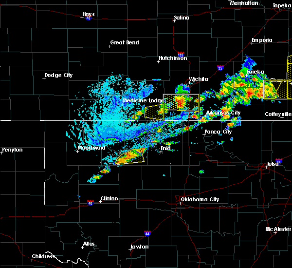 The severe thunderstorm warning for southeastern harper county will expire at 600 pm cdt, the storm which prompted the warning has weakened below severe limits, and no longer poses an immediate threat to life or property. therefore the warning will be allowed to expire. a severe thunderstorm watch remains in effect until 1000 pm cdt for south central kansas. The severe thunderstorm warning for southeastern harper county will expire at 600 pm cdt, the storm which prompted the warning has weakened below severe limits, and no longer poses an immediate threat to life or property. therefore the warning will be allowed to expire. a severe thunderstorm watch remains in effect until 1000 pm cdt for south central kansas.
|
| 8/16/2017 5:31 PM CDT | Quarter sized hail reported 0.8 miles ENE of Anthony, KS |
| 8/16/2017 5:28 PM CDT |
 At 528 pm cdt, a severe thunderstorm was located near anthony, moving east at 30 mph (radar indicated). Hazards include golf ball size hail and 60 mph wind gusts. People and animals outdoors will be injured. expect hail damage to roofs, siding, windows, and vehicles. expect wind damage to roofs, siding, and trees. Locations impacted include, anthony, bluff city and freeport. At 528 pm cdt, a severe thunderstorm was located near anthony, moving east at 30 mph (radar indicated). Hazards include golf ball size hail and 60 mph wind gusts. People and animals outdoors will be injured. expect hail damage to roofs, siding, windows, and vehicles. expect wind damage to roofs, siding, and trees. Locations impacted include, anthony, bluff city and freeport.
|
| 8/16/2017 4:58 PM CDT |
 At 458 pm cdt, a severe thunderstorm was located near hazelton, moving east at 30 mph (radar indicated). Hazards include two inch hail and 60 mph wind gusts. People and animals outdoors will be injured. expect hail damage to roofs, siding, windows, and vehicles. Expect wind damage to roofs, siding, and trees. At 458 pm cdt, a severe thunderstorm was located near hazelton, moving east at 30 mph (radar indicated). Hazards include two inch hail and 60 mph wind gusts. People and animals outdoors will be injured. expect hail damage to roofs, siding, windows, and vehicles. Expect wind damage to roofs, siding, and trees.
|
| 8/9/2017 7:56 PM CDT |
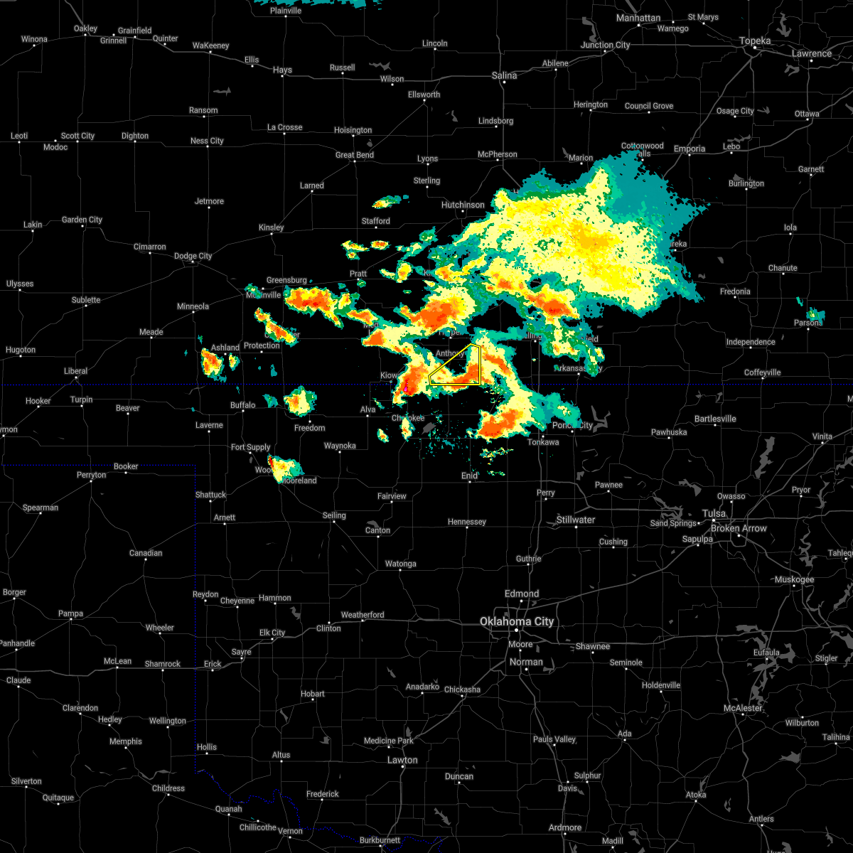 The severe thunderstorm warning for southeastern harper county will expire at 800 pm cdt, the storm which prompted the warning has moved out of the area. therefore the warning will be allowed to expire. The severe thunderstorm warning for southeastern harper county will expire at 800 pm cdt, the storm which prompted the warning has moved out of the area. therefore the warning will be allowed to expire.
|
| 8/9/2017 7:37 PM CDT |
 At 737 pm cdt, a severe thunderstorm was located 6 miles southeast of anthony, moving southeast at 20 mph (radar indicated). Hazards include 60 mph wind gusts and quarter size hail. Hail damage to vehicles is expected. expect wind damage to roofs, siding, and trees. Locations impacted include, anthony, bluff city and freeport. At 737 pm cdt, a severe thunderstorm was located 6 miles southeast of anthony, moving southeast at 20 mph (radar indicated). Hazards include 60 mph wind gusts and quarter size hail. Hail damage to vehicles is expected. expect wind damage to roofs, siding, and trees. Locations impacted include, anthony, bluff city and freeport.
|
| 8/9/2017 7:12 PM CDT |
 At 712 pm cdt, a severe thunderstorm was located over anthony, moving southeast at 20 mph (radar indicated). Hazards include 60 mph wind gusts and half dollar size hail. Hail damage to vehicles is expected. Expect wind damage to roofs, siding, and trees. At 712 pm cdt, a severe thunderstorm was located over anthony, moving southeast at 20 mph (radar indicated). Hazards include 60 mph wind gusts and half dollar size hail. Hail damage to vehicles is expected. Expect wind damage to roofs, siding, and trees.
|
| 8/9/2017 7:01 PM CDT |
 At 701 pm cdt, a severe thunderstorm was located near harper, moving southeast at 25 mph (radar indicated). Hazards include 60 mph wind gusts and quarter size hail. Hail damage to vehicles is expected. expect wind damage to roofs, siding, and trees. Locations impacted include, anthony, harper, attica and crystal springs. At 701 pm cdt, a severe thunderstorm was located near harper, moving southeast at 25 mph (radar indicated). Hazards include 60 mph wind gusts and quarter size hail. Hail damage to vehicles is expected. expect wind damage to roofs, siding, and trees. Locations impacted include, anthony, harper, attica and crystal springs.
|
| 8/9/2017 6:37 PM CDT |
 At 637 pm cdt, a severe thunderstorm was located 7 miles northeast of attica, moving southeast at 30 mph (radar indicated). Hazards include 60 mph wind gusts and quarter size hail. Hail damage to vehicles is expected. Expect wind damage to roofs, siding, and trees. At 637 pm cdt, a severe thunderstorm was located 7 miles northeast of attica, moving southeast at 30 mph (radar indicated). Hazards include 60 mph wind gusts and quarter size hail. Hail damage to vehicles is expected. Expect wind damage to roofs, siding, and trees.
|
| 7/8/2017 2:28 AM CDT |
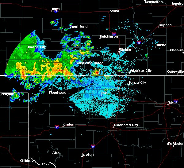 At 228 am cdt, a severe thunderstorm was located 6 miles northeast of manchester, or 6 miles southeast of anthony, moving southeast at 30 mph (radar indicated). Hazards include 60 mph wind gusts and half dollar size hail. Hail damage to vehicles is expected. Expect wind damage to roofs, siding, and trees. At 228 am cdt, a severe thunderstorm was located 6 miles northeast of manchester, or 6 miles southeast of anthony, moving southeast at 30 mph (radar indicated). Hazards include 60 mph wind gusts and half dollar size hail. Hail damage to vehicles is expected. Expect wind damage to roofs, siding, and trees.
|
| 6/29/2017 8:38 PM CDT |
 The severe thunderstorm warning for southwestern harper county will expire at 145 am cdt, the storm which prompted the warning has moved out of the area. therefore the warning will be allowed to expire. a severe thunderstorm watch remains in effect until 500 am cdt for south central kansas. The severe thunderstorm warning for southwestern harper county will expire at 145 am cdt, the storm which prompted the warning has moved out of the area. therefore the warning will be allowed to expire. a severe thunderstorm watch remains in effect until 500 am cdt for south central kansas.
|
| 6/29/2017 8:05 PM CDT |
 At 105 am cdt, a severe thunderstorm was located near hazelton, moving east at 45 mph (radar indicated). Hazards include 60 mph wind gusts and penny size hail. expect damage to roofs, siding, and trees At 105 am cdt, a severe thunderstorm was located near hazelton, moving east at 45 mph (radar indicated). Hazards include 60 mph wind gusts and penny size hail. expect damage to roofs, siding, and trees
|
| 6/15/2017 8:12 PM CDT |
 At 810 pm cdt, severe thunderstorms were located along a line extending from latham to near belle plaine to near norwich, moving southeast at 35 mph (trained weather spotters). Hazards include 70 mph wind gusts and quarter size hail. Hail damage to vehicles is expected. expect considerable tree damage. wind damage is also likely to mobile homes, roofs, and outbuildings. Locations impacted include, arkansas city, winfield, wellington, anthony, belle plaine, harper, conway springs, caldwell, oxford, udall, attica, burden, argonia, south haven, dexter, geuda springs, mayfield, cambridge, milan and hunnewell. At 810 pm cdt, severe thunderstorms were located along a line extending from latham to near belle plaine to near norwich, moving southeast at 35 mph (trained weather spotters). Hazards include 70 mph wind gusts and quarter size hail. Hail damage to vehicles is expected. expect considerable tree damage. wind damage is also likely to mobile homes, roofs, and outbuildings. Locations impacted include, arkansas city, winfield, wellington, anthony, belle plaine, harper, conway springs, caldwell, oxford, udall, attica, burden, argonia, south haven, dexter, geuda springs, mayfield, cambridge, milan and hunnewell.
|
| 6/15/2017 8:03 PM CDT |
 At 802 pm cdt, severe thunderstorms were located along a line extending from near latham to near belle plaine to near norwich, moving southeast at 35 mph (radar indicated). Hazards include 70 mph wind gusts and quarter size hail. Hail damage to vehicles is expected. expect considerable tree damage. wind damage is also likely to mobile homes, roofs, and outbuildings. This warning replaces the severe thunderstorm warning for harper county. At 802 pm cdt, severe thunderstorms were located along a line extending from near latham to near belle plaine to near norwich, moving southeast at 35 mph (radar indicated). Hazards include 70 mph wind gusts and quarter size hail. Hail damage to vehicles is expected. expect considerable tree damage. wind damage is also likely to mobile homes, roofs, and outbuildings. This warning replaces the severe thunderstorm warning for harper county.
|
| 6/15/2017 7:51 PM CDT |
 At 749 pm cdt, a severe thunderstorm was located near harper, moving northeast at 40 mph. this is a very dangerous storm (trained weather spotters). Hazards include 80 mph wind gusts and golf ball size hail. Flying debris will be dangerous to those caught without shelter. mobile homes will be heavily damaged. expect considerable damage to roofs, windows, and vehicles. extensive tree damage and power outages are likely. Locations impacted include, anthony, harper, attica, norwich, nashville, zenda, spivey, bluff city, danville, waldron, freeport, corwin, rago, runnymede and crystal springs. At 749 pm cdt, a severe thunderstorm was located near harper, moving northeast at 40 mph. this is a very dangerous storm (trained weather spotters). Hazards include 80 mph wind gusts and golf ball size hail. Flying debris will be dangerous to those caught without shelter. mobile homes will be heavily damaged. expect considerable damage to roofs, windows, and vehicles. extensive tree damage and power outages are likely. Locations impacted include, anthony, harper, attica, norwich, nashville, zenda, spivey, bluff city, danville, waldron, freeport, corwin, rago, runnymede and crystal springs.
|
| 6/15/2017 7:44 PM CDT | Baseball sized hail reported 7.3 miles E of Anthony, KS, golball hail upto baseball size hail. golfballs lasted 20 minutes. delayed report. |
| 6/15/2017 7:25 PM CDT |
 At 724 pm cdt, a severe thunderstorm was located near hazelton, moving northeast at 40 mph (radar indicated). Hazards include golf ball size hail and 70 mph wind gusts. People and animals outdoors will be injured. expect hail damage to roofs, siding, windows, and vehicles. expect considerable tree damage. wind damage is also likely to mobile homes, roofs, and outbuildings. Locations impacted include, anthony, harper, attica, norwich, nashville, zenda, spivey, bluff city, danville, waldron, freeport, corwin, rago, runnymede and crystal springs. At 724 pm cdt, a severe thunderstorm was located near hazelton, moving northeast at 40 mph (radar indicated). Hazards include golf ball size hail and 70 mph wind gusts. People and animals outdoors will be injured. expect hail damage to roofs, siding, windows, and vehicles. expect considerable tree damage. wind damage is also likely to mobile homes, roofs, and outbuildings. Locations impacted include, anthony, harper, attica, norwich, nashville, zenda, spivey, bluff city, danville, waldron, freeport, corwin, rago, runnymede and crystal springs.
|
| 6/15/2017 7:07 PM CDT |
 At 707 pm cdt, a severe thunderstorm was located near hazelton, moving east at 40 mph (radar indicated). Hazards include golf ball size hail and 70 mph wind gusts. People and animals outdoors will be injured. expect hail damage to roofs, siding, windows, and vehicles. expect considerable tree damage. Wind damage is also likely to mobile homes, roofs, and outbuildings. At 707 pm cdt, a severe thunderstorm was located near hazelton, moving east at 40 mph (radar indicated). Hazards include golf ball size hail and 70 mph wind gusts. People and animals outdoors will be injured. expect hail damage to roofs, siding, windows, and vehicles. expect considerable tree damage. Wind damage is also likely to mobile homes, roofs, and outbuildings.
|
| 6/14/2017 2:57 AM CDT |
 The severe thunderstorm warning for southeastern harper and sumner counties will expire at 300 am cdt, the storm which prompted the warning has weakened below severe limits, and no longer poses an immediate threat to life or property. therefore the warning will be allowed to expire. however gusty winds around 40 mph are still possible with this thunderstorm. to report severe weather, contact your nearest law enforcement agency. they will relay your report to the national weather service wichita. The severe thunderstorm warning for southeastern harper and sumner counties will expire at 300 am cdt, the storm which prompted the warning has weakened below severe limits, and no longer poses an immediate threat to life or property. therefore the warning will be allowed to expire. however gusty winds around 40 mph are still possible with this thunderstorm. to report severe weather, contact your nearest law enforcement agency. they will relay your report to the national weather service wichita.
|
| 6/14/2017 2:41 AM CDT |
 At 240 am cdt, a severe thunderstorm was located 9 miles northwest of caldwell, moving east at 50 mph (radar indicated). Hazards include 60 mph wind gusts and quarter size hail. Hail damage to vehicles is expected. expect wind damage to roofs, siding, and trees. Locations impacted include, wellington, anthony, caldwell, argonia, south haven, mayfield, milan, hunnewell, bluff city, freeport, perth, riverdale and wellington airport. At 240 am cdt, a severe thunderstorm was located 9 miles northwest of caldwell, moving east at 50 mph (radar indicated). Hazards include 60 mph wind gusts and quarter size hail. Hail damage to vehicles is expected. expect wind damage to roofs, siding, and trees. Locations impacted include, wellington, anthony, caldwell, argonia, south haven, mayfield, milan, hunnewell, bluff city, freeport, perth, riverdale and wellington airport.
|
| 6/14/2017 2:26 AM CDT |
 At 226 am cdt, a severe thunderstorm was located 7 miles northeast of manchester, or 8 miles southeast of anthony, moving east at 45 mph (radar indicated). Hazards include ping pong ball size hail and 60 mph wind gusts. People and animals outdoors will be injured. expect hail damage to roofs, siding, windows, and vehicles. expect wind damage to roofs, siding, and trees. Locations impacted include, wellington, anthony, caldwell, argonia, south haven, mayfield, milan, hunnewell, bluff city, freeport, perth, riverdale and wellington airport. At 226 am cdt, a severe thunderstorm was located 7 miles northeast of manchester, or 8 miles southeast of anthony, moving east at 45 mph (radar indicated). Hazards include ping pong ball size hail and 60 mph wind gusts. People and animals outdoors will be injured. expect hail damage to roofs, siding, windows, and vehicles. expect wind damage to roofs, siding, and trees. Locations impacted include, wellington, anthony, caldwell, argonia, south haven, mayfield, milan, hunnewell, bluff city, freeport, perth, riverdale and wellington airport.
|
| 6/14/2017 2:19 AM CDT |
 At 218 am cdt, a severe thunderstorm was located near manchester, or 7 miles south of anthony, moving east at 50 mph (radar indicated). Hazards include 60 mph wind gusts and half dollar size hail. Hail damage to vehicles is expected. Expect wind damage to roofs, siding, and trees. At 218 am cdt, a severe thunderstorm was located near manchester, or 7 miles south of anthony, moving east at 50 mph (radar indicated). Hazards include 60 mph wind gusts and half dollar size hail. Hail damage to vehicles is expected. Expect wind damage to roofs, siding, and trees.
|
| 5/11/2017 3:25 PM CDT |
 At 325 pm cdt, a severe thunderstorm was located near norwich, or 11 miles northeast of harper, moving east at 20 mph (radar indicated). Hazards include quarter size hail. Damage to vehicles is expected. Locations impacted include, anthony, harper, attica, norwich, murdock, spivey, danville, freeport, rago, runnymede and crystal springs. At 325 pm cdt, a severe thunderstorm was located near norwich, or 11 miles northeast of harper, moving east at 20 mph (radar indicated). Hazards include quarter size hail. Damage to vehicles is expected. Locations impacted include, anthony, harper, attica, norwich, murdock, spivey, danville, freeport, rago, runnymede and crystal springs.
|
| 5/11/2017 3:05 PM CDT |
 At 303 pm cdt, a severe thunderstorm was located 11 miles north of harper moving northeast at 15 mph (radar indicated). Hazards include ping pong ball size hail and 60 mph wind gusts. People and animals outdoors will be injured. expect hail damage to roofs, siding, windows, and vehicles. expect wind damage to roofs, siding, and trees. Locations impacted include, anthony, harper, attica, norwich, murdock, spivey, danville, freeport, rago, runnymede and crystal springs. At 303 pm cdt, a severe thunderstorm was located 11 miles north of harper moving northeast at 15 mph (radar indicated). Hazards include ping pong ball size hail and 60 mph wind gusts. People and animals outdoors will be injured. expect hail damage to roofs, siding, windows, and vehicles. expect wind damage to roofs, siding, and trees. Locations impacted include, anthony, harper, attica, norwich, murdock, spivey, danville, freeport, rago, runnymede and crystal springs.
|
| 5/11/2017 2:43 PM CDT |
 At 242 pm cdt, a severe thunderstorm was located near harper, moving northeast at 25 mph (radar indicated). Hazards include ping pong ball size hail and 60 mph wind gusts. People and animals outdoors will be injured. expect hail damage to roofs, siding, windows, and vehicles. Expect wind damage to roofs, siding, and trees. At 242 pm cdt, a severe thunderstorm was located near harper, moving northeast at 25 mph (radar indicated). Hazards include ping pong ball size hail and 60 mph wind gusts. People and animals outdoors will be injured. expect hail damage to roofs, siding, windows, and vehicles. Expect wind damage to roofs, siding, and trees.
|
| 3/26/2017 7:25 PM CDT |
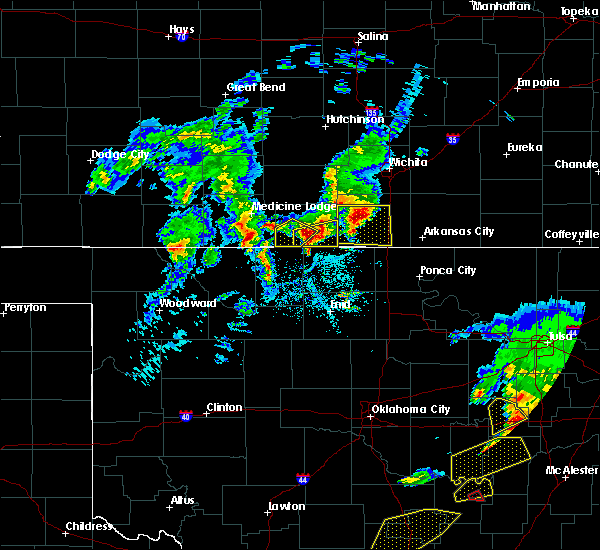 At 725 pm cdt, a severe thunderstorm was located near anthony, moving east at 30 mph (radar indicated). Hazards include ping pong ball size hail and 60 mph wind gusts. People and animals outdoors will be injured. expect hail damage to roofs, siding, windows, and vehicles. expect wind damage to roofs, siding, and trees. Locations impacted include, anthony, bluff city, waldron and freeport. At 725 pm cdt, a severe thunderstorm was located near anthony, moving east at 30 mph (radar indicated). Hazards include ping pong ball size hail and 60 mph wind gusts. People and animals outdoors will be injured. expect hail damage to roofs, siding, windows, and vehicles. expect wind damage to roofs, siding, and trees. Locations impacted include, anthony, bluff city, waldron and freeport.
|
| 3/26/2017 7:17 PM CDT | Quarter sized hail reported 8.2 miles NNE of Anthony, KS |
| 3/26/2017 7:14 PM CDT |
 At 714 pm cdt, a severe thunderstorm was located 6 miles northwest of manchester, or 7 miles southwest of anthony, moving east at 25 mph (radar indicated). Hazards include ping pong ball size hail and 60 mph wind gusts. People and animals outdoors will be injured. expect hail damage to roofs, siding, windows, and vehicles. Expect wind damage to roofs, siding, and trees. At 714 pm cdt, a severe thunderstorm was located 6 miles northwest of manchester, or 7 miles southwest of anthony, moving east at 25 mph (radar indicated). Hazards include ping pong ball size hail and 60 mph wind gusts. People and animals outdoors will be injured. expect hail damage to roofs, siding, windows, and vehicles. Expect wind damage to roofs, siding, and trees.
|
| 3/26/2017 7:09 PM CDT | Quarter sized hail reported 0.6 miles NW of Anthony, KS |
| 3/26/2017 6:56 PM CDT |
 The severe thunderstorm warning for central harper county will expire at 700 pm cdt, the storm which prompted the warning has weakened below severe limits, and no longer pose an immediate threat to life or property. therefore, the warning will be allowed to expire. a severe thunderstorm watch remains in effect until 1100 pm cdt for south central kansas. The severe thunderstorm warning for central harper county will expire at 700 pm cdt, the storm which prompted the warning has weakened below severe limits, and no longer pose an immediate threat to life or property. therefore, the warning will be allowed to expire. a severe thunderstorm watch remains in effect until 1100 pm cdt for south central kansas.
|
| 3/26/2017 6:53 PM CDT |
 At 653 pm cdt, a severe thunderstorm was located 8 miles southeast of hazelton, moving northeast at 20 mph (radar indicated). Hazards include 60 mph wind gusts and half dollar size hail. Hail damage to vehicles is expected. expect wind damage to roofs, siding, and trees. Locations impacted include, anthony, waldron and corwin. At 653 pm cdt, a severe thunderstorm was located 8 miles southeast of hazelton, moving northeast at 20 mph (radar indicated). Hazards include 60 mph wind gusts and half dollar size hail. Hail damage to vehicles is expected. expect wind damage to roofs, siding, and trees. Locations impacted include, anthony, waldron and corwin.
|
| 3/26/2017 6:40 PM CDT |
 At 640 pm cdt, a severe thunderstorm was located 6 miles southeast of hazelton, moving northeast at 20 mph (radar indicated). Hazards include ping pong ball size hail and 60 mph wind gusts. People and animals outdoors will be injured. expect hail damage to roofs, siding, windows, and vehicles. Expect wind damage to roofs, siding, and trees. At 640 pm cdt, a severe thunderstorm was located 6 miles southeast of hazelton, moving northeast at 20 mph (radar indicated). Hazards include ping pong ball size hail and 60 mph wind gusts. People and animals outdoors will be injured. expect hail damage to roofs, siding, windows, and vehicles. Expect wind damage to roofs, siding, and trees.
|
| 3/26/2017 6:35 PM CDT | Storm damage reported in harper county KS, 4.1 miles NNE of Anthony, KS |
| 3/26/2017 6:32 PM CDT |
 At 631 pm cdt, a severe thunderstorm was located near anthony, moving east at 25 mph (radar indicated). Hazards include 60 mph wind gusts and quarter size hail. Hail damage to vehicles is expected. expect wind damage to roofs, siding, and trees. Locations impacted include, anthony, harper, attica, danville, freeport, runnymede and crystal springs. At 631 pm cdt, a severe thunderstorm was located near anthony, moving east at 25 mph (radar indicated). Hazards include 60 mph wind gusts and quarter size hail. Hail damage to vehicles is expected. expect wind damage to roofs, siding, and trees. Locations impacted include, anthony, harper, attica, danville, freeport, runnymede and crystal springs.
|
| 3/26/2017 6:20 PM CDT |
 At 619 pm cdt, a severe thunderstorm was located 6 miles northwest of anthony, moving northeast at 25 mph (radar indicated). Hazards include 60 mph wind gusts and quarter size hail. Hail damage to vehicles is expected. Expect wind damage to roofs, siding, and trees. At 619 pm cdt, a severe thunderstorm was located 6 miles northwest of anthony, moving northeast at 25 mph (radar indicated). Hazards include 60 mph wind gusts and quarter size hail. Hail damage to vehicles is expected. Expect wind damage to roofs, siding, and trees.
|
| 10/6/2016 5:35 PM CDT |
 At 534 pm cdt, a severe thunderstorm was located 6 miles southeast of attica, moving northeast at 45 mph (radar indicated). Hazards include 60 mph wind gusts and quarter size hail. Hail damage to vehicles is expected. expect wind damage to roofs, siding, and trees. locations impacted include, anthony, harper, attica, bluff city, danville, waldron, freeport, crystal springs, runnymede and corwin. A tornado watch remains in effect until 900 pm cdt for south central kansas. At 534 pm cdt, a severe thunderstorm was located 6 miles southeast of attica, moving northeast at 45 mph (radar indicated). Hazards include 60 mph wind gusts and quarter size hail. Hail damage to vehicles is expected. expect wind damage to roofs, siding, and trees. locations impacted include, anthony, harper, attica, bluff city, danville, waldron, freeport, crystal springs, runnymede and corwin. A tornado watch remains in effect until 900 pm cdt for south central kansas.
|
| 10/6/2016 5:15 PM CDT |
 At 515 pm cdt, a severe thunderstorm was located near hazelton, moving northeast at 45 mph (radar indicated). Hazards include 60 mph wind gusts and half dollar size hail. Hail damage to vehicles is expected. Expect wind damage to roofs, siding, and trees. At 515 pm cdt, a severe thunderstorm was located near hazelton, moving northeast at 45 mph (radar indicated). Hazards include 60 mph wind gusts and half dollar size hail. Hail damage to vehicles is expected. Expect wind damage to roofs, siding, and trees.
|
| 9/9/2016 8:00 PM CDT | Numerous 4 inch limbs down in anthon in harper county KS, 0.4 miles NNE of Anthony, KS |
| 7/28/2016 9:25 PM CDT |
 The severe thunderstorm warning for southwestern butler, harper, western cowley, southeastern kingman and sumner counties will expire at 930 pm cdt, the storms which prompted the warning have weakened below severe limits, and no longer pose an immediate threat to life or property. therefore the warning will be allowed to expire. however gusty winds are still possible with these thunderstorms. a severe thunderstorm watch remains in effect until 1100 pm cdt for south central kansas. The severe thunderstorm warning for southwestern butler, harper, western cowley, southeastern kingman and sumner counties will expire at 930 pm cdt, the storms which prompted the warning have weakened below severe limits, and no longer pose an immediate threat to life or property. therefore the warning will be allowed to expire. however gusty winds are still possible with these thunderstorms. a severe thunderstorm watch remains in effect until 1100 pm cdt for south central kansas.
|
| 7/28/2016 9:07 PM CDT |
 At 907 pm cdt, severe thunderstorms were located along a line extending from 7 miles southwest of atlanta to geuda springs to anthony, moving southeast at 50 mph (radar indicated). Hazards include 60 mph wind gusts and nickel size hail. Expect damage to roofs. siding. and trees. Locations impacted include, arkansas city, winfield, wellington, mulvane, anthony, douglass, belle plaine, harper, conway springs, caldwell, oxford, udall, attica, argonia, south haven, geuda springs, rock, mayfield, milan and hunnewell. At 907 pm cdt, severe thunderstorms were located along a line extending from 7 miles southwest of atlanta to geuda springs to anthony, moving southeast at 50 mph (radar indicated). Hazards include 60 mph wind gusts and nickel size hail. Expect damage to roofs. siding. and trees. Locations impacted include, arkansas city, winfield, wellington, mulvane, anthony, douglass, belle plaine, harper, conway springs, caldwell, oxford, udall, attica, argonia, south haven, geuda springs, rock, mayfield, milan and hunnewell.
|
| 7/28/2016 8:42 PM CDT |
 At 841 pm cdt, severe thunderstorms were located along a line extending from near andover to near belle plaine to 6 miles north of attica, moving southeast at 55 mph. these are very dangerous storms (radar indicated). Hazards include 80 mph wind gusts and ping pong ball size hail. Flying debris will be dangerous to those caught without shelter. mobile homes will be heavily damaged. expect considerable damage to roofs, windows, and vehicles. Extensive tree damage and power outages are likely. At 841 pm cdt, severe thunderstorms were located along a line extending from near andover to near belle plaine to 6 miles north of attica, moving southeast at 55 mph. these are very dangerous storms (radar indicated). Hazards include 80 mph wind gusts and ping pong ball size hail. Flying debris will be dangerous to those caught without shelter. mobile homes will be heavily damaged. expect considerable damage to roofs, windows, and vehicles. Extensive tree damage and power outages are likely.
|
| 7/8/2016 5:14 AM CDT |
 At 514 am cdt, a severe thunderstorm was located 6 miles northwest of argonia, or 9 miles east of harper, moving east at 30 mph (radar indicated). Hazards include 60 mph wind gusts and nickel size hail. Expect damage to roofs. siding. And trees. At 514 am cdt, a severe thunderstorm was located 6 miles northwest of argonia, or 9 miles east of harper, moving east at 30 mph (radar indicated). Hazards include 60 mph wind gusts and nickel size hail. Expect damage to roofs. siding. And trees.
|
| 6/18/2016 2:05 AM CDT |
 The severe thunderstorm warning for southwestern butler, northeastern harper, northwestern cowley, sedgwick, kingman and northern sumner counties will expire at 215 am cdt, the storms which prompted the warning have weakened below severe limits, and no longer pose an immediate threat to life or property. therefore the warning will be allowed to expire. however gusty winds and heavy rain are still possible with these thunderstorms. The severe thunderstorm warning for southwestern butler, northeastern harper, northwestern cowley, sedgwick, kingman and northern sumner counties will expire at 215 am cdt, the storms which prompted the warning have weakened below severe limits, and no longer pose an immediate threat to life or property. therefore the warning will be allowed to expire. however gusty winds and heavy rain are still possible with these thunderstorms.
|
| 6/18/2016 1:52 AM CDT |
 At 151 am cdt, severe thunderstorms were located along a line extending from 5 miles northwest of benton to haysville to near norwich, moving southeast at 30 mph (radar indicated). Hazards include 60 mph wind gusts. Expect damage to roofs. siding. and trees. Locations impacted include, wichita, derby, el dorado, andover, haysville, augusta, wellington, park city, valley center, bel aire, mulvane, goddard, rose hill, maize, kingman, clearwater, cheney, douglass, belle plaine and harper. At 151 am cdt, severe thunderstorms were located along a line extending from 5 miles northwest of benton to haysville to near norwich, moving southeast at 30 mph (radar indicated). Hazards include 60 mph wind gusts. Expect damage to roofs. siding. and trees. Locations impacted include, wichita, derby, el dorado, andover, haysville, augusta, wellington, park city, valley center, bel aire, mulvane, goddard, rose hill, maize, kingman, clearwater, cheney, douglass, belle plaine and harper.
|
| 6/18/2016 1:36 AM CDT |
 At 135 am cdt, severe thunderstorms were located along a line extending from 6 miles south of newton to west wichita to 8 miles southeast of kingman, moving southeast at 25 mph (radar indicated). Hazards include 60 mph wind gusts. Expect damage to roofs. siding. and trees. Locations impacted include, wichita, derby, newton, el dorado, andover, haysville, augusta, wellington, park city, valley center, bel aire, mulvane, goddard, rose hill, hesston, maize, kingman, clearwater, cheney and halstead. At 135 am cdt, severe thunderstorms were located along a line extending from 6 miles south of newton to west wichita to 8 miles southeast of kingman, moving southeast at 25 mph (radar indicated). Hazards include 60 mph wind gusts. Expect damage to roofs. siding. and trees. Locations impacted include, wichita, derby, newton, el dorado, andover, haysville, augusta, wellington, park city, valley center, bel aire, mulvane, goddard, rose hill, hesston, maize, kingman, clearwater, cheney and halstead.
|
| 6/18/2016 1:22 AM CDT |
 At 121 am cdt, severe thunderstorms were located along a line extending from near newton to near goddard to near kingman, moving southeast at 25 mph (radar indicated). Hazards include 60 mph wind gusts. Expect damage to roofs. siding. and trees. This warning replaces the previous severe warning in effect for the warned area. At 121 am cdt, severe thunderstorms were located along a line extending from near newton to near goddard to near kingman, moving southeast at 25 mph (radar indicated). Hazards include 60 mph wind gusts. Expect damage to roofs. siding. and trees. This warning replaces the previous severe warning in effect for the warned area.
|
| 5/27/2016 4:28 PM CDT |
 At 427 pm cdt, a severe thunderstorm was located near anthony, moving north at 20 mph (radar indicated). Hazards include ping pong ball size hail and 60 mph wind gusts. People and animals outdoors will be injured. expect hail damage to roofs, siding, windows, and vehicles. Expect wind damage to roofs, siding, and trees. At 427 pm cdt, a severe thunderstorm was located near anthony, moving north at 20 mph (radar indicated). Hazards include ping pong ball size hail and 60 mph wind gusts. People and animals outdoors will be injured. expect hail damage to roofs, siding, windows, and vehicles. Expect wind damage to roofs, siding, and trees.
|
| 5/9/2016 5:29 PM CDT |
 At 529 pm cdt, a severe thunderstorm was located 9 miles east of anthony, moving northeast at 40 mph (radar indicated). Hazards include 70 mph wind gusts and quarter size hail. Hail damage to vehicles is expected. expect considerable tree damage. Wind damage is also likely to mobile homes, roofs, and outbuildings. At 529 pm cdt, a severe thunderstorm was located 9 miles east of anthony, moving northeast at 40 mph (radar indicated). Hazards include 70 mph wind gusts and quarter size hail. Hail damage to vehicles is expected. expect considerable tree damage. Wind damage is also likely to mobile homes, roofs, and outbuildings.
|
| 5/9/2016 4:43 PM CDT |
 At 443 pm cdt, a severe thunderstorm was located 6 miles east of harper, moving east at 35 mph (radar indicated). Hazards include 70 mph wind gusts and half dollar size hail. Hail damage to vehicles is expected. expect considerable tree damage. wind damage is also likely to mobile homes, roofs, and outbuildings. Locations impacted include, anthony, harper, attica, rago, spivey, danville, runnymede and crystal springs. At 443 pm cdt, a severe thunderstorm was located 6 miles east of harper, moving east at 35 mph (radar indicated). Hazards include 70 mph wind gusts and half dollar size hail. Hail damage to vehicles is expected. expect considerable tree damage. wind damage is also likely to mobile homes, roofs, and outbuildings. Locations impacted include, anthony, harper, attica, rago, spivey, danville, runnymede and crystal springs.
|
| 5/9/2016 4:28 PM CDT |
 At 428 pm cdt, a severe thunderstorm was located near attica, moving northeast at 35 mph (radar indicated). Hazards include 70 mph wind gusts and ping pong ball size hail. People and animals outdoors will be injured. expect hail damage to roofs, siding, windows, and vehicles. expect considerable tree damage. Wind damage is also likely to mobile homes, roofs, and outbuildings. At 428 pm cdt, a severe thunderstorm was located near attica, moving northeast at 35 mph (radar indicated). Hazards include 70 mph wind gusts and ping pong ball size hail. People and animals outdoors will be injured. expect hail damage to roofs, siding, windows, and vehicles. expect considerable tree damage. Wind damage is also likely to mobile homes, roofs, and outbuildings.
|
| 5/9/2016 2:37 PM CDT |
 At 235 pm cdt, a severe thunderstorm was located 7 miles southwest of nashville, or 17 miles northwest of attica, moving northeast at 30 mph (radar indicated). Hazards include ping pong ball size hail and 60 mph wind gusts. People and animals outdoors will be injured. expect hail damage to roofs, siding, windows, and vehicles. Expect wind damage to roofs, siding, and trees. At 235 pm cdt, a severe thunderstorm was located 7 miles southwest of nashville, or 17 miles northwest of attica, moving northeast at 30 mph (radar indicated). Hazards include ping pong ball size hail and 60 mph wind gusts. People and animals outdoors will be injured. expect hail damage to roofs, siding, windows, and vehicles. Expect wind damage to roofs, siding, and trees.
|
| 4/26/2016 8:07 PM CDT |
 The severe thunderstorm warning for central harper county will expire at 815 pm cdt, the storm which prompted the warning has weakened below severe limits, and no longer pose an immediate threat to life or property. therefore the warning will be allowed to expire. however gusty winds are still possible with this thunderstorm. a tornado watch remains in effect until 900 pm cdt for south central kansas. The severe thunderstorm warning for central harper county will expire at 815 pm cdt, the storm which prompted the warning has weakened below severe limits, and no longer pose an immediate threat to life or property. therefore the warning will be allowed to expire. however gusty winds are still possible with this thunderstorm. a tornado watch remains in effect until 900 pm cdt for south central kansas.
|
| 4/26/2016 8:02 PM CDT |
 At 802 pm cdt, a severe thunderstorm was located near anthony, moving northeast at 45 mph (radar indicated). Hazards include 60 mph wind gusts and quarter size hail. Hail damage to vehicles is expected. expect wind damage to roofs, siding, and trees. locations impacted include, anthony, harper, danville and runnymede. A tornado watch remains in effect until 900 pm cdt for south central kansas. At 802 pm cdt, a severe thunderstorm was located near anthony, moving northeast at 45 mph (radar indicated). Hazards include 60 mph wind gusts and quarter size hail. Hail damage to vehicles is expected. expect wind damage to roofs, siding, and trees. locations impacted include, anthony, harper, danville and runnymede. A tornado watch remains in effect until 900 pm cdt for south central kansas.
|
| 4/26/2016 7:46 PM CDT |
 At 745 pm cdt, a severe thunderstorm was located 6 miles southeast of attica, moving northeast at 25 mph (radar indicated). Hazards include 60 mph wind gusts and quarter size hail. Hail damage to vehicles is expected. expect wind damage to roofs, siding, and trees. locations impacted include, anthony, harper, attica, danville, waldron, runnymede, corwin and crystal springs. A tornado watch remains in effect until 900 pm cdt for south central kansas. At 745 pm cdt, a severe thunderstorm was located 6 miles southeast of attica, moving northeast at 25 mph (radar indicated). Hazards include 60 mph wind gusts and quarter size hail. Hail damage to vehicles is expected. expect wind damage to roofs, siding, and trees. locations impacted include, anthony, harper, attica, danville, waldron, runnymede, corwin and crystal springs. A tornado watch remains in effect until 900 pm cdt for south central kansas.
|
| 4/26/2016 7:17 PM CDT |
 At 717 pm cdt, a severe thunderstorm was located 12 miles southwest of attica, moving northeast at 45 mph (radar indicated). Hazards include 60 mph wind gusts and quarter size hail. Hail damage to vehicles is expected. Expect wind damage to roofs, siding, and trees. At 717 pm cdt, a severe thunderstorm was located 12 miles southwest of attica, moving northeast at 45 mph (radar indicated). Hazards include 60 mph wind gusts and quarter size hail. Hail damage to vehicles is expected. Expect wind damage to roofs, siding, and trees.
|
| 4/26/2016 4:55 PM CDT |
 At 455 pm cdt, a severe thunderstorm was located 8 miles southwest of argonia, or 8 miles east of anthony, moving northeast at 25 mph (radar indicated). Hazards include 60 mph wind gusts and quarter size hail. Hail damage to vehicles is expected. expect wind damage to roofs, siding, and trees. locations impacted include, argonia, danville, freeport and runnymede. A tornado watch remains in effect until 900 pm cdt for south central kansas. At 455 pm cdt, a severe thunderstorm was located 8 miles southwest of argonia, or 8 miles east of anthony, moving northeast at 25 mph (radar indicated). Hazards include 60 mph wind gusts and quarter size hail. Hail damage to vehicles is expected. expect wind damage to roofs, siding, and trees. locations impacted include, argonia, danville, freeport and runnymede. A tornado watch remains in effect until 900 pm cdt for south central kansas.
|
| 4/26/2016 4:50 PM CDT | Quarter sized hail reported 3.8 miles W of Anthony, KS |
| 4/26/2016 4:45 PM CDT |
 At 445 pm cdt, a severe thunderstorm was located near anthony, moving northeast at 25 mph (radar indicated). Hazards include 60 mph wind gusts and quarter size hail. Hail damage to vehicles is expected. Expect wind damage to roofs, siding, and trees. At 445 pm cdt, a severe thunderstorm was located near anthony, moving northeast at 25 mph (radar indicated). Hazards include 60 mph wind gusts and quarter size hail. Hail damage to vehicles is expected. Expect wind damage to roofs, siding, and trees.
|
| 4/26/2016 3:28 PM CDT |
 At 328 pm cdt, a severe thunderstorm was located 9 miles southeast of anthony, moving northeast at 30 mph (radar indicated). Hazards include 60 mph wind gusts and half dollar size hail. Hail damage to vehicles is expected. Expect wind damage to roofs, siding, and trees. At 328 pm cdt, a severe thunderstorm was located 9 miles southeast of anthony, moving northeast at 30 mph (radar indicated). Hazards include 60 mph wind gusts and half dollar size hail. Hail damage to vehicles is expected. Expect wind damage to roofs, siding, and trees.
|
| 4/26/2016 3:02 PM CDT |
 At 301 pm cdt, a severe thunderstorm was located 10 miles south of argonia, or 12 miles east of anthony, moving northeast at 40 mph. also, another severe storm was located 3 miles north of argonia (radar indicated). Hazards include golf ball size hail and 60 mph wind gusts. People and animals outdoors will be injured. expect hail damage to roofs, siding, windows, and vehicles. expect wind damage to roofs, siding, and trees. locations impacted include, anthony, conway springs, argonia, norwich, mayfield, milan, bluff city, danville, freeport and runnymede. A tornado watch remains in effect until 900 pm cdt for south central kansas. At 301 pm cdt, a severe thunderstorm was located 10 miles south of argonia, or 12 miles east of anthony, moving northeast at 40 mph. also, another severe storm was located 3 miles north of argonia (radar indicated). Hazards include golf ball size hail and 60 mph wind gusts. People and animals outdoors will be injured. expect hail damage to roofs, siding, windows, and vehicles. expect wind damage to roofs, siding, and trees. locations impacted include, anthony, conway springs, argonia, norwich, mayfield, milan, bluff city, danville, freeport and runnymede. A tornado watch remains in effect until 900 pm cdt for south central kansas.
|
| 4/26/2016 2:57 PM CDT |
 At 256 pm cdt, a severe thunderstorm was located 12 miles southeast of anthony, moving northeast at 20 mph (radar indicated). Hazards include golf ball size hail and 60 mph wind gusts. People and animals outdoors will be injured. expect hail damage to roofs, siding, windows, and vehicles. expect wind damage to roofs, siding, and trees. locations impacted include, anthony, conway springs, argonia, norwich, mayfield, milan, bluff city, danville, freeport and runnymede. A tornado watch remains in effect until 900 pm cdt for south central kansas. At 256 pm cdt, a severe thunderstorm was located 12 miles southeast of anthony, moving northeast at 20 mph (radar indicated). Hazards include golf ball size hail and 60 mph wind gusts. People and animals outdoors will be injured. expect hail damage to roofs, siding, windows, and vehicles. expect wind damage to roofs, siding, and trees. locations impacted include, anthony, conway springs, argonia, norwich, mayfield, milan, bluff city, danville, freeport and runnymede. A tornado watch remains in effect until 900 pm cdt for south central kansas.
|
| 4/26/2016 2:46 PM CDT |
 At 245 pm cdt, a severe thunderstorm was located 11 miles southeast of anthony, moving northeast at 40 mph (radar indicated). Hazards include golf ball size hail and 60 mph wind gusts. People and animals outdoors will be injured. expect hail damage to roofs, siding, windows, and vehicles. expect wind damage to roofs, siding, and trees. locations impacted include, anthony, conway springs, argonia, norwich, mayfield, milan, bluff city, danville, freeport and runnymede. A tornado watch remains in effect until 900 pm cdt for south central kansas. At 245 pm cdt, a severe thunderstorm was located 11 miles southeast of anthony, moving northeast at 40 mph (radar indicated). Hazards include golf ball size hail and 60 mph wind gusts. People and animals outdoors will be injured. expect hail damage to roofs, siding, windows, and vehicles. expect wind damage to roofs, siding, and trees. locations impacted include, anthony, conway springs, argonia, norwich, mayfield, milan, bluff city, danville, freeport and runnymede. A tornado watch remains in effect until 900 pm cdt for south central kansas.
|
| 4/26/2016 2:41 PM CDT |
 At 241 pm cdt, a severe thunderstorm was located 12 miles southeast of anthony, moving north at 30 mph (radar indicated). Hazards include 60 mph wind gusts and half dollar size hail. Hail damage to vehicles is expected. expect wind damage to roofs, siding, and trees. locations impacted include, anthony, conway springs, argonia, norwich, mayfield, milan, bluff city, danville, freeport and runnymede. A tornado watch remains in effect until 900 pm cdt for south central kansas. At 241 pm cdt, a severe thunderstorm was located 12 miles southeast of anthony, moving north at 30 mph (radar indicated). Hazards include 60 mph wind gusts and half dollar size hail. Hail damage to vehicles is expected. expect wind damage to roofs, siding, and trees. locations impacted include, anthony, conway springs, argonia, norwich, mayfield, milan, bluff city, danville, freeport and runnymede. A tornado watch remains in effect until 900 pm cdt for south central kansas.
|
| 4/26/2016 2:26 PM CDT |
 At 225 pm cdt, a severe thunderstorm was located 11 miles south of anthony, moving northeast at 40 mph (radar indicated). Hazards include 60 mph wind gusts and half dollar size hail. Hail damage to vehicles is expected. Expect wind damage to roofs, siding, and trees. At 225 pm cdt, a severe thunderstorm was located 11 miles south of anthony, moving northeast at 40 mph (radar indicated). Hazards include 60 mph wind gusts and half dollar size hail. Hail damage to vehicles is expected. Expect wind damage to roofs, siding, and trees.
|
| 11/17/2015 1:25 AM CST |
 The severe thunderstorm warning for harper and western sumner counties will expire at 130 am cst, the storm which prompted the warning has weakened below severe limits, and no longer pose an immediate threat to life or property. therefore the warning will be allowed to expire. however gusty winds are still possible with this thunderstorm. a tornado watch remains in effect until 300 am cst for south central kansas. The severe thunderstorm warning for harper and western sumner counties will expire at 130 am cst, the storm which prompted the warning has weakened below severe limits, and no longer pose an immediate threat to life or property. therefore the warning will be allowed to expire. however gusty winds are still possible with this thunderstorm. a tornado watch remains in effect until 300 am cst for south central kansas.
|
| 11/17/2015 1:02 AM CST |
 At 102 am cst, a severe thunderstorm was located near harper, moving north at 60 mph (radar indicated). Hazards include 60 mph wind gusts and penny size hail. Expect damage to roofs. siding and trees. locations impacted include, anthony, harper, attica, argonia, milan, bluff city, danville, waldron, freeport, runnymede, corwin and crystal springs. A tornado watch remains in effect until 300 am cst for south central kansas. At 102 am cst, a severe thunderstorm was located near harper, moving north at 60 mph (radar indicated). Hazards include 60 mph wind gusts and penny size hail. Expect damage to roofs. siding and trees. locations impacted include, anthony, harper, attica, argonia, milan, bluff city, danville, waldron, freeport, runnymede, corwin and crystal springs. A tornado watch remains in effect until 300 am cst for south central kansas.
|
| 11/17/2015 12:43 AM CST |
 At 1242 am cst, a severe thunderstorm was located 15 miles southwest of anthony, moving north at 60 mph (radar indicated). Hazards include 60 mph wind gusts and penny size hail. Expect damage to roofs. Siding and trees. At 1242 am cst, a severe thunderstorm was located 15 miles southwest of anthony, moving north at 60 mph (radar indicated). Hazards include 60 mph wind gusts and penny size hail. Expect damage to roofs. Siding and trees.
|
| 7/17/2015 8:21 PM CDT | Delayed report of damaging wind gusts from last evening storms in harper county KS, 0.6 miles NW of Anthony, KS |
| 7/16/2015 10:11 PM CDT |
 At 1010 pm cdt, a severe thunderstorm was located 7 miles east of anthony, moving east at 30 mph (radar indicated). Hazards include 60 mph wind gusts and penny size hail. Expect damage to roofs. Siding and trees. At 1010 pm cdt, a severe thunderstorm was located 7 miles east of anthony, moving east at 30 mph (radar indicated). Hazards include 60 mph wind gusts and penny size hail. Expect damage to roofs. Siding and trees.
|
| 7/16/2015 9:56 PM CDT |
 At 956 pm cdt, a severe thunderstorm was located over anthony, moving east at 30 mph (trained weather spotters). Hazards include 70 mph wind gusts and penny size hail. Expect considerable tree damage. damage is likely to mobile homes, roofs and outbuildings. Locations impacted include, anthony, harper, bluff city, danville, freeport and crystal springs. At 956 pm cdt, a severe thunderstorm was located over anthony, moving east at 30 mph (trained weather spotters). Hazards include 70 mph wind gusts and penny size hail. Expect considerable tree damage. damage is likely to mobile homes, roofs and outbuildings. Locations impacted include, anthony, harper, bluff city, danville, freeport and crystal springs.
|
| 7/16/2015 9:55 PM CDT | Trained spotter reports branches blocking or partially blocking the roads in anthony of 3 to 4 inche in harper county KS, 0.6 miles NW of Anthony, KS |
| 7/16/2015 9:53 PM CDT | Trained spotter estimates 70 mph winds and pea sized hai in harper county KS, 0.6 miles NW of Anthony, KS |
| 7/16/2015 9:50 PM CDT | Tree broken off at the trunk with an estiment of the truck being 10-12 inches in diamete in harper county KS, 0.6 miles NW of Anthony, KS |
| 7/16/2015 9:41 PM CDT |
 At 941 pm cdt, a severe thunderstorm was located near anthony, moving east at 35 mph (radar indicated). Hazards include 60 mph wind gusts and penny size hail. Expect damage to roofs. Siding and trees. At 941 pm cdt, a severe thunderstorm was located near anthony, moving east at 35 mph (radar indicated). Hazards include 60 mph wind gusts and penny size hail. Expect damage to roofs. Siding and trees.
|
| 5/16/2015 7:45 PM CDT | At 745 pm cdt, severe thunderstorms were located along a line extending from near argonia, to caldwell, to 5 miles west of deer creek, moving northeast at 60 mph (radar indicated). Hazards include 60 mph wind gusts. Expect damage to roofs. siding and trees. locations impacted include, wellington, mulvane, anthony, belle plaine, conway springs, caldwell, oxford, argonia, south haven, geuda springs, mayfield, milan, hunnewell, bluff city, danville, freeport, riverdale, perth and wellington airport. a tornado watch remains in effect until midnight cdt for south central kansas. 75in. |
| 5/16/2015 7:35 PM CDT | At 734 pm cdt, severe thunderstorms were located along a line extending from 5 miles southeast of harper, to 7 miles northeast of wakita, to near jefferson, moving northeast at 60 mph (radar indicated). Hazards include 60 mph wind gusts. Expect damage to roofs. Siding and trees. |
| 5/6/2015 7:56 PM CDT | At 756 pm cdt, a severe thunderstorm was located 7 miles northeast of anthony, moving northeast at 30 mph (radar indicated). Hazards include golf ball size hail and 60 mph wind gusts. People and animals outdoors will be injured. expect hail damage to roofs, siding, windows and vehicles. expect wind damage to roofs, siding and trees. locations impacted include, anthony, harper, danville, waldron, crystal springs and runnymede. a tornado watch remains in effect until 900 pm cdt for south central kansas. Possible. |
| 5/6/2015 7:30 PM CDT | At 729 pm cdt, a severe thunderstorm was located near manchester, or near anthony, moving northeast at 25 mph (radar indicated). Hazards include ping pong ball size hail and 60 mph wind gusts. People and animals outdoors will be injured. expect hail damage to roofs, siding, windows and vehicles. expect wind damage to roofs, siding and trees. locations impacted include, anthony, harper, danville, waldron, crystal springs and runnymede. a tornado watch remains in effect until 900 pm cdt for south central kansas. Possible. |
| 5/6/2015 7:21 PM CDT | At 720 pm cdt, a severe thunderstorm was located 6 miles west of manchester, or 10 miles southwest of anthony, moving northeast at 20 mph (radar indicated). Hazards include 60 mph wind gusts and half dollar size hail. Hail damage to vehicles is expected. Expect wind damage to roofs, siding and trees. |
| 5/6/2015 6:57 PM CDT | At 657 pm cdt, severe thunderstorms were located along a line extending from 6 miles east of hazelton to anthony, moving northeast at 35 mph (radar indicated). Hazards include quarter size hail. Damage to vehicles is expected. locations impacted include, anthony, harper, attica, danville, waldron and crystal springs. a tornado watch remains in effect until 900 pm cdt for south central kansas. 1. 00in. |
| 5/6/2015 6:47 PM CDT | At 647 pm cdt, a severe thunderstorm was located 7 miles northwest of manchester, or 8 miles southwest of anthony, moving northeast at 30 mph (radar indicated). Hazards include 60 mph wind gusts and half dollar size hail. Hail damage to vehicles is expected. expect wind damage to roofs, siding and trees. locations impacted include, anthony, harper, attica, danville, waldron and crystal springs. a tornado watch remains in effect until 900 pm cdt for south central kansas. Possible. |
| 5/6/2015 6:24 PM CDT | At 624 pm cdt, a severe thunderstorm was located 6 miles northeast of amorita, or 11 miles southeast of hazelton, moving north at 40 mph (radar indicated). Hazards include 60 mph wind gusts and half dollar size hail. Hail damage to vehicles is expected. Expect wind damage to roofs, siding and trees. |
| 4/18/2015 8:12 PM CDT | The severe thunderstorm warning for southeastern harper county will expire at 815 pm cdt, the storms which prompted the warning have weakened below severe limits, and exited the warned area. therefore the warning will be allowed to expire. however small hail, .gusty winds and heavy rain are still possible with these thunderstorms. a severe thunderstorm watch remains in effect until 900 pm cdt for south central kansas. |
| 4/18/2015 7:55 PM CDT | At 754 pm cdt, severe thunderstorms were located along a line extending from 9 miles southwest of argonia to 10 miles northeast of wakita, moving northeast at 25 mph (radar indicated). Hazards include half dollar size hail. Damage to vehicles is expected. locations impacted include, anthony, bluff city and freeport. 1. 25in. |
| 4/18/2015 7:40 PM CDT | At 739 pm cdt, a severe thunderstorm was located 6 miles southeast of anthony, moving northeast at 20 mph (radar indicated). Hazards include half dollar size hail. Damage to vehicles is expected. locations impacted include, anthony, bluff city and freeport. 1. 25in. |
| 4/18/2015 7:31 PM CDT | At 731 pm cdt, a severe thunderstorm was located near manchester, or 6 miles south of anthony, moving northeast at 20 mph (radar indicated). Hazards include half dollar size hail. damage to vehicles is expected |
| 4/18/2015 5:42 PM CDT | The severe thunderstorm warning for western harper county will expire at 545 pm cdt, the storm which prompted the warning has weakened below severe limits, and no longer pose an immediate threat to life or property. therefore the warning will be allowed to expire. however small. |
| 4/18/2015 5:28 PM CDT | At 528 pm cdt, a severe thunderstorm was located 7 miles southwest of attica, moving northeast at 25 mph (radar indicated). Hazards include 60 mph wind gusts and half dollar size hail. Hail damage to vehicles is expected. expect wind damage to roofs, siding and trees. locations impacted include, anthony, attica and corwin. 1. 25in. |
| 4/18/2015 5:15 PM CDT | At 514 pm cdt, a severe thunderstorm was located over hazelton, moving northeast at 30 mph (radar indicated). Hazards include ping pong ball size hail and 60 mph wind gusts. People and animals outdoors will be injured. expect hail damage to roofs, siding, windows and vehicles. Expect wind damage to roofs, siding and trees. |
| 4/12/2015 9:32 PM CDT | A severe thunderstorm warning remains in effect until 1000 pm cdt for northeastern harper and southeastern kingman counties. at 932 pm cdt. severe thunderstorms were located along a line extending from 6 miles north of norwich to 6 miles west of conway springs to 7 miles southwest of argonia. moving east at 30 mph. hazard. 60 mph wind gusts and nickel size hail. |
| 4/12/2015 9:14 PM CDT | A severe thunderstorm warning remains in effect until 1000 pm cdt for eastern harper and southeastern kingman counties. at 914 pm cdt. severe thunderstorms were located along a line extending from 10 miles southeast of kingman to near norwich to near anthony. moving east at 30 mph. hazard. 60 mph wind gusts and nickel size hail. |
| 4/12/2015 8:57 PM CDT | The national weather service in wichita has issued a * severe thunderstorm warning for. harper county in south central kansas. southeastern kingman county in south central kansas. until 1000 pm cdt * at 857 pm cdt. Severe thunderstorms were located along a line. |
| 7/13/2012 6:55 PM CDT | Barn at a residence was blown down along with some power lines northeast of anthon in harper county KS, 3.1 miles WSW of Anthony, KS |
| 1/1/0001 12:00 AM | Wind damage to a storage unit located at the intersection of steadman and pennsylvani in harper county KS, 0.6 miles NW of Anthony, KS |
| 1/1/0001 12:00 AM | Observed limbs blown down in neighbors yard with estimated 70 mph gus in harper county KS, 0.6 miles NW of Anthony, KS |
| 1/1/0001 12:00 AM | Storm damage reported in harper county KS, 1.7 miles SSW of Anthony, KS |
| 1/1/0001 12:00 AM | Baseball sized hail reported 0.6 miles NW of Anthony, KS |
| 1/1/0001 12:00 AM | Golf Ball sized hail reported 0.6 miles NW of Anthony, KS |
Hail Maps for Anthony, KS


Connect with Interactive Hail Maps