

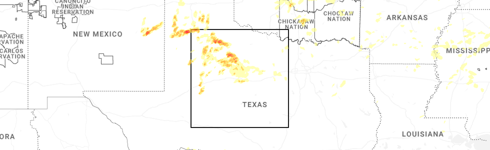
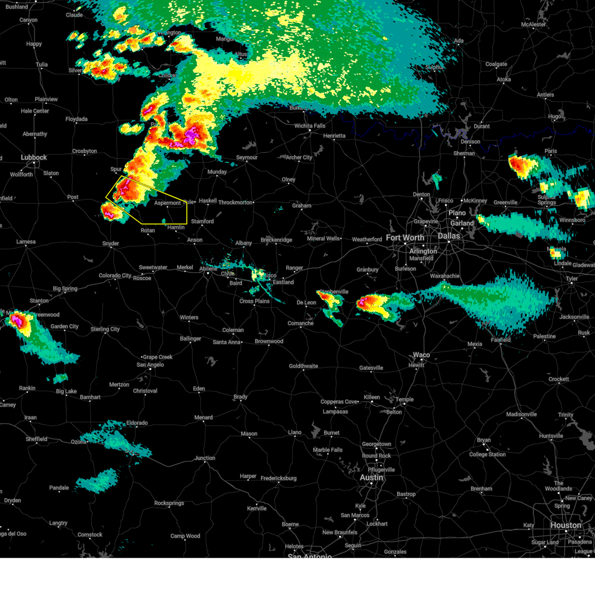
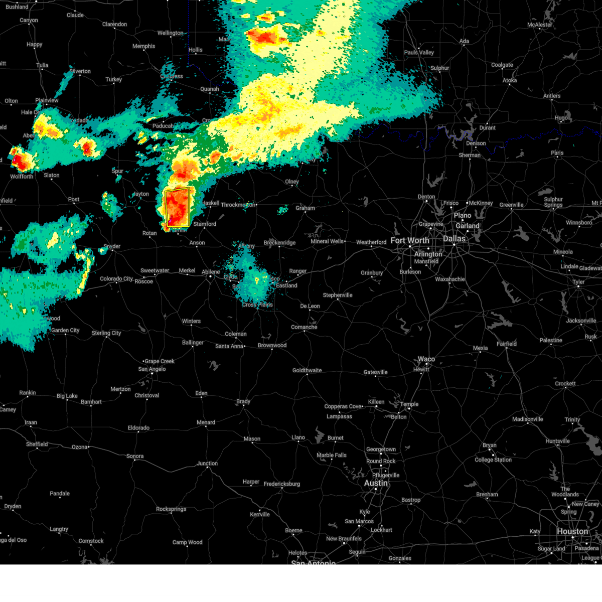
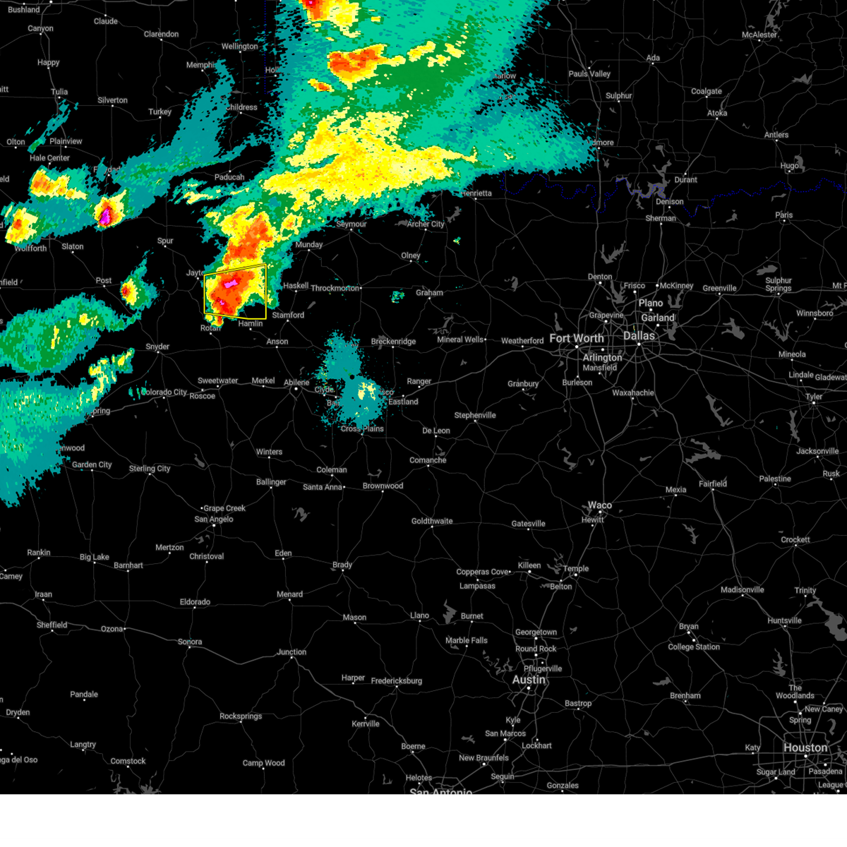
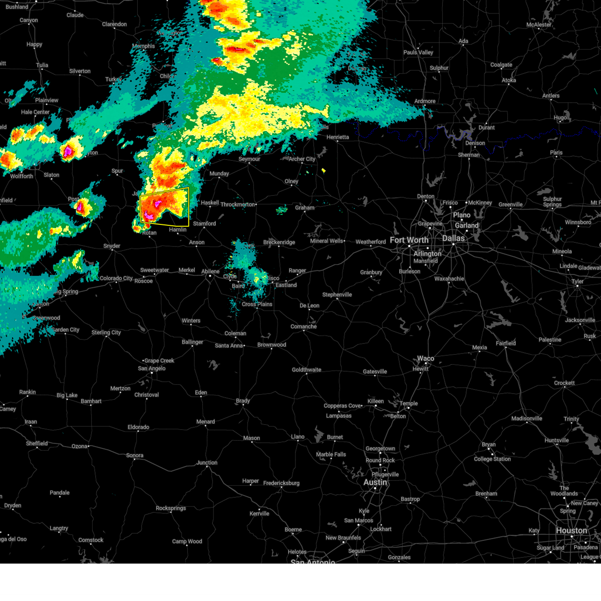
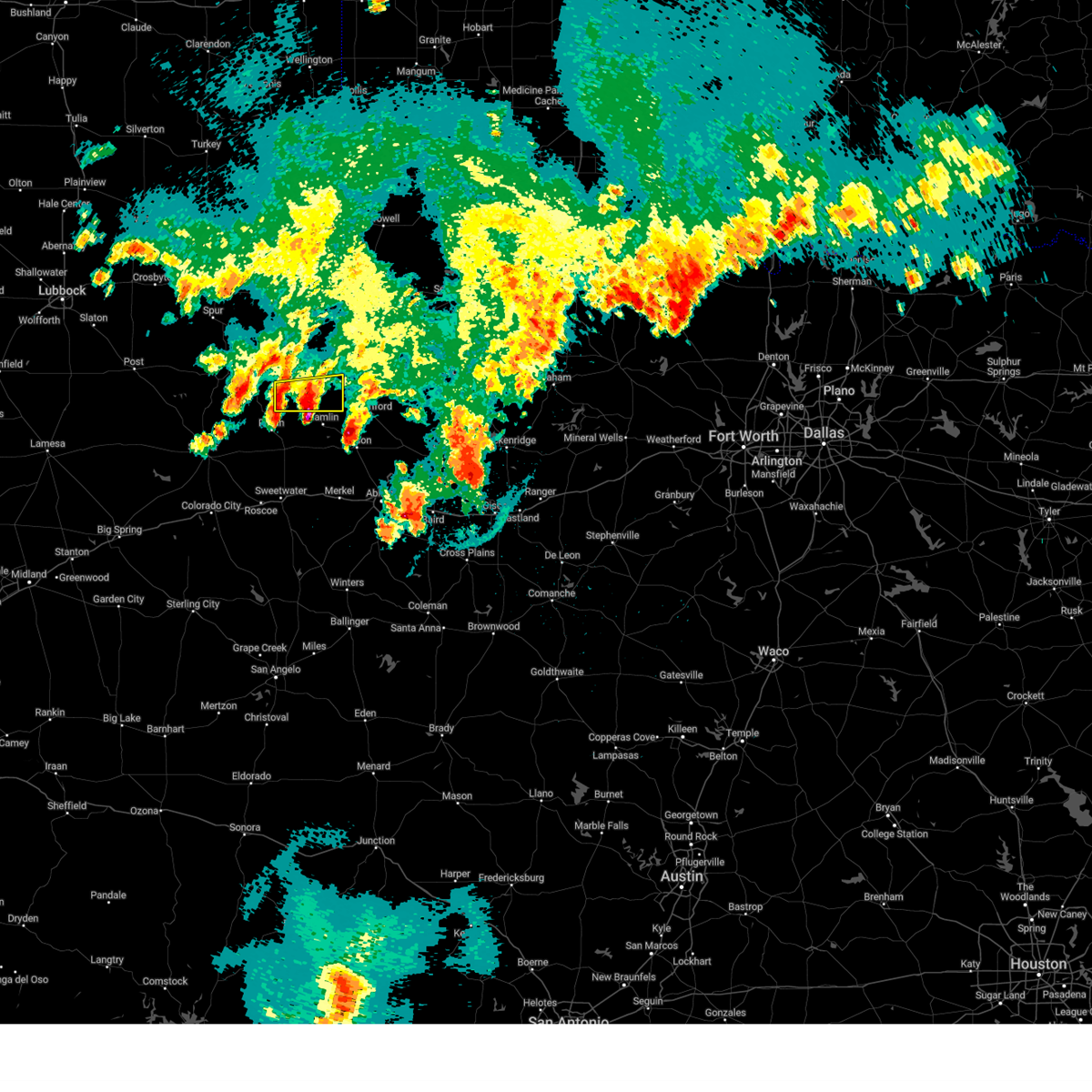
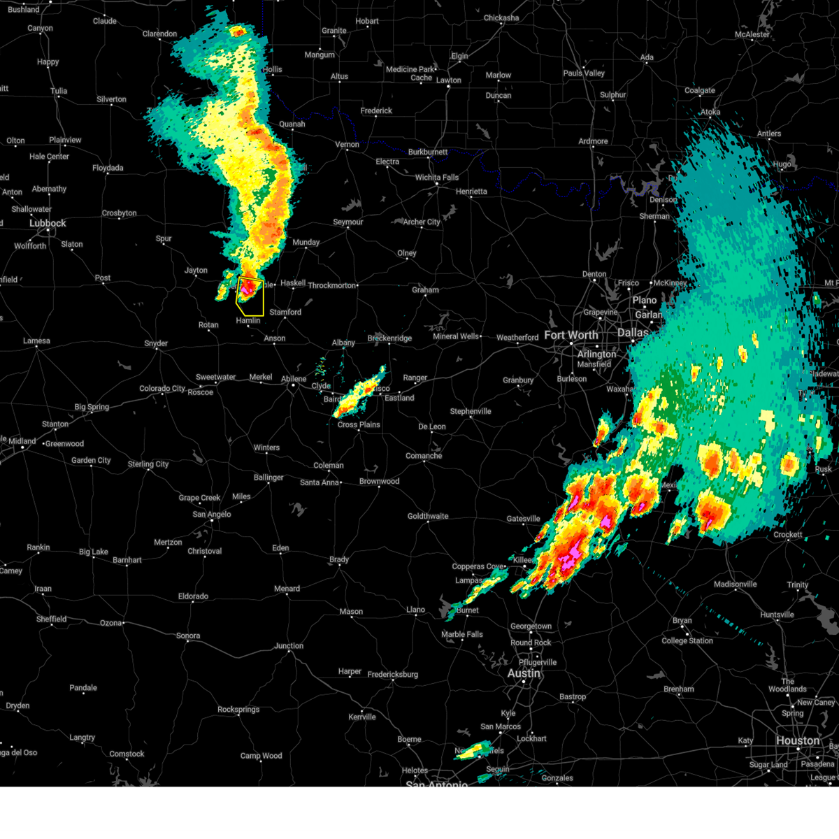
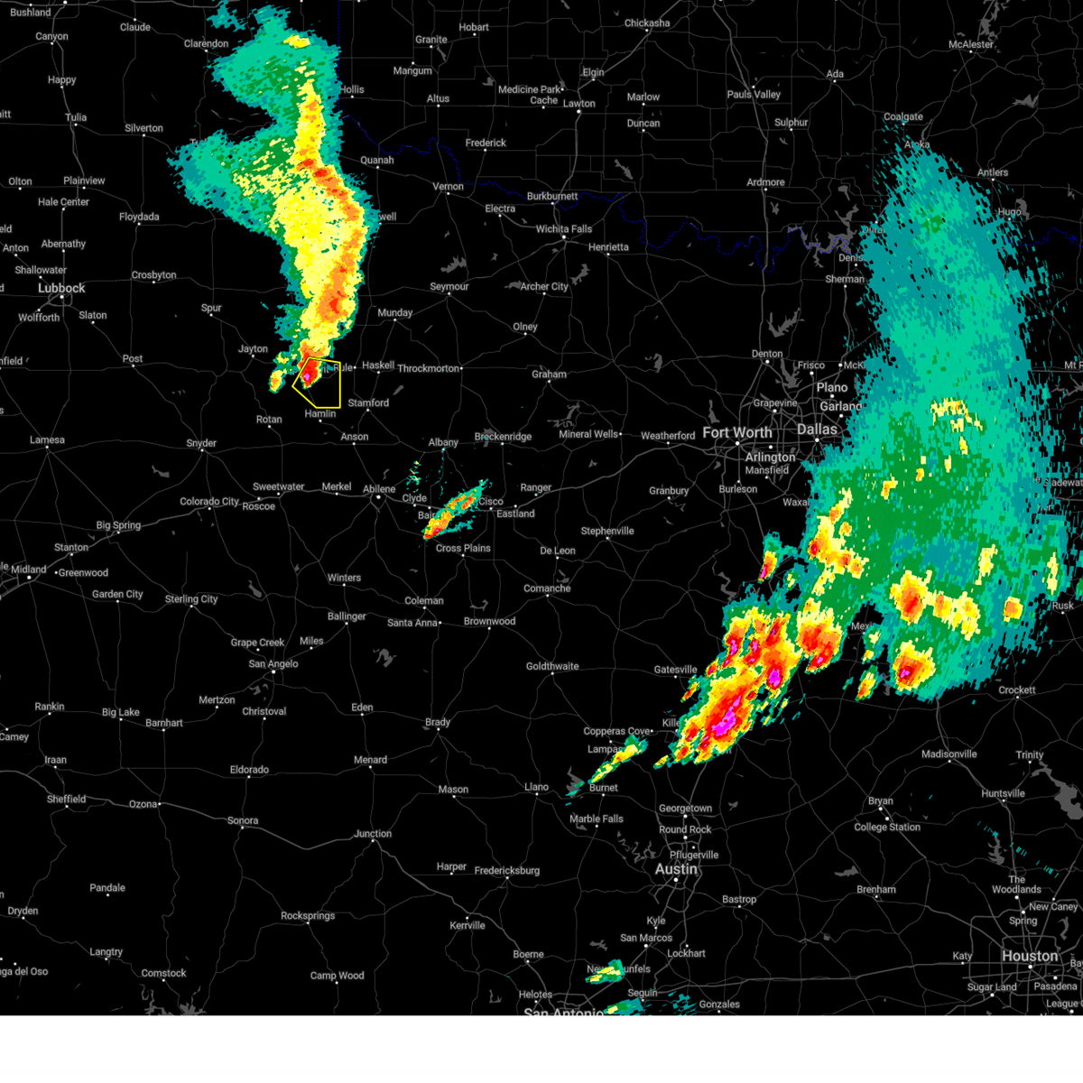
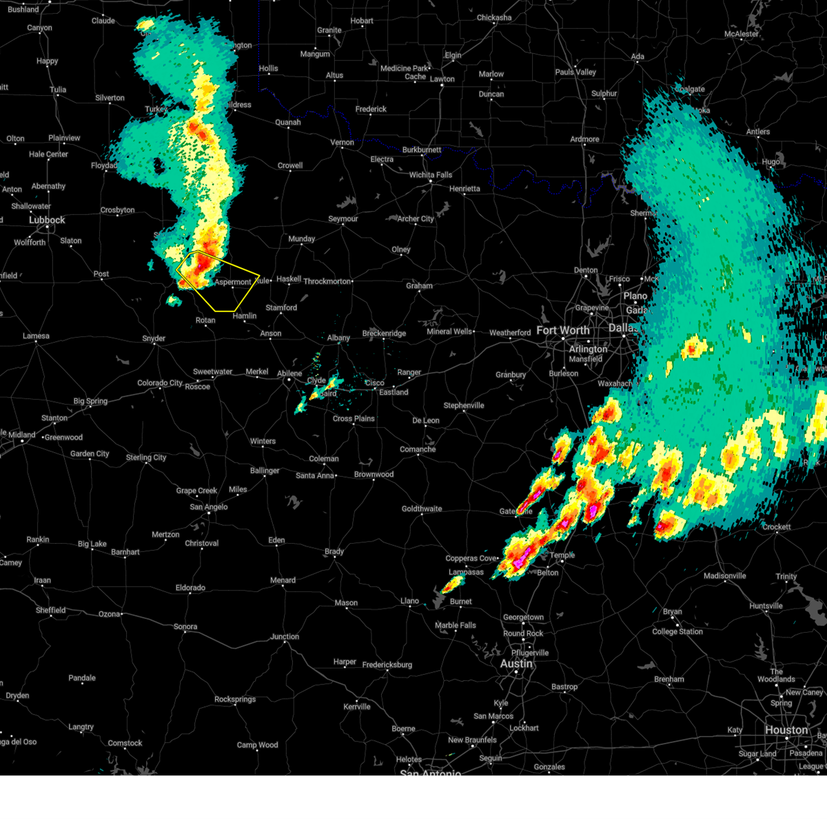
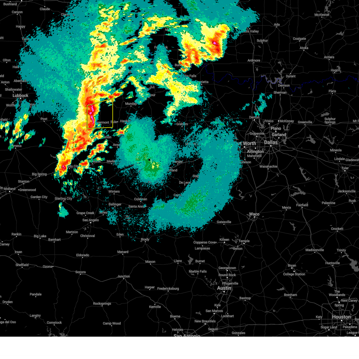
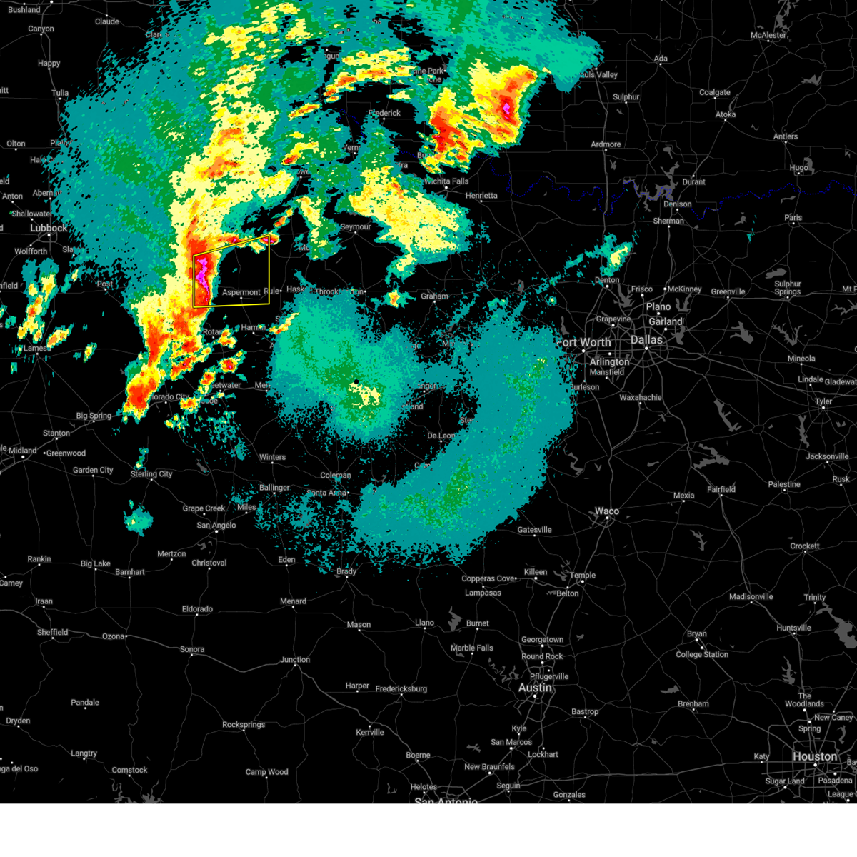
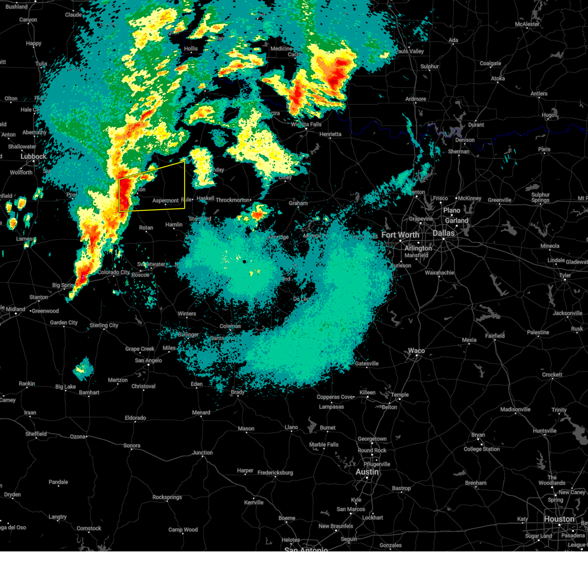
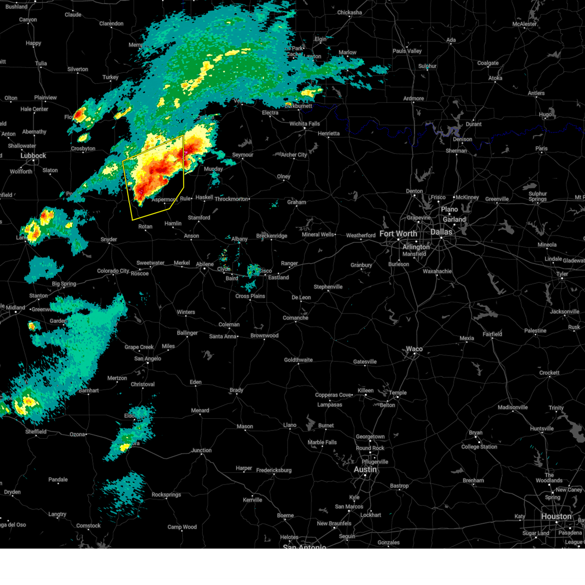
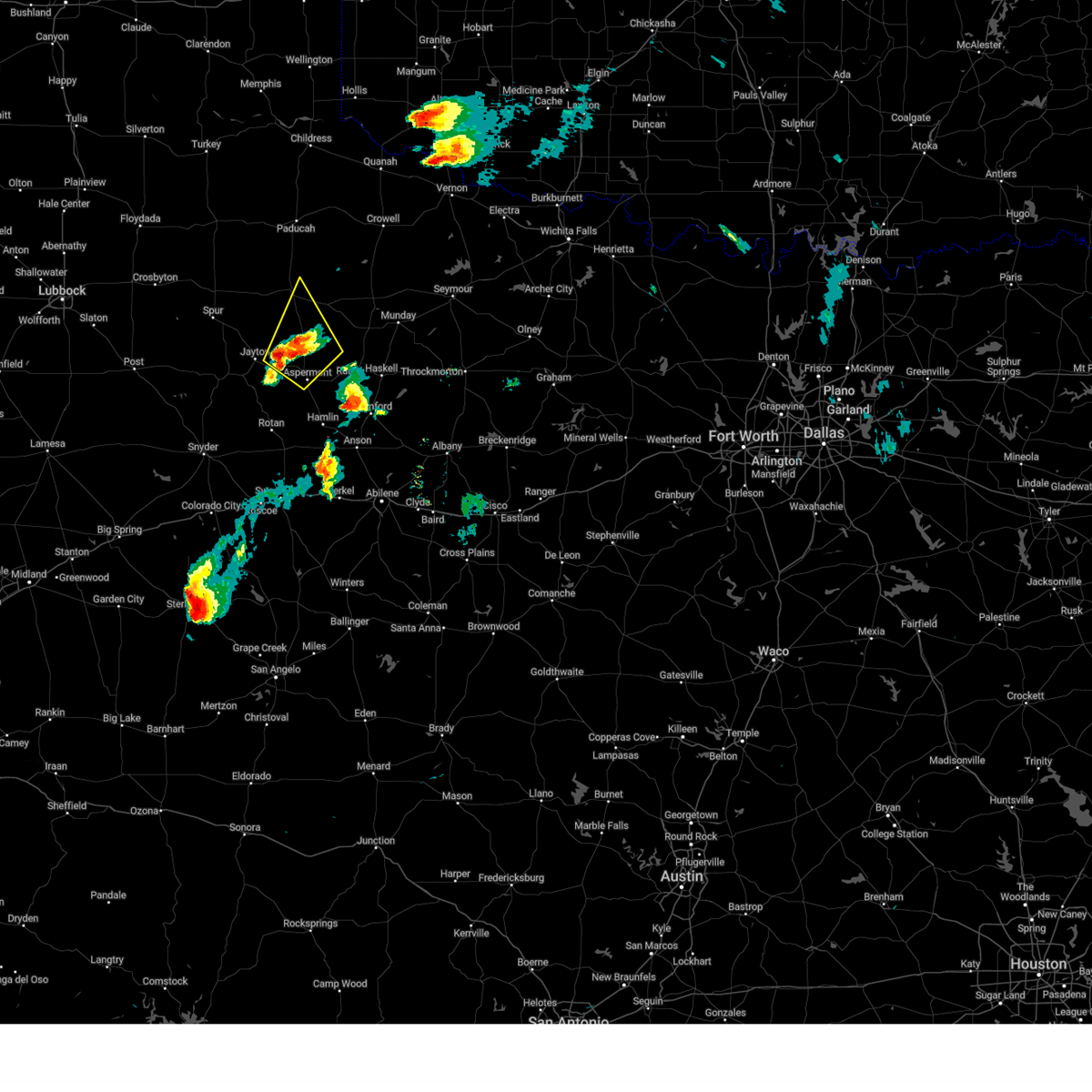
Hail Map for Aspermont, TX
The Aspermont, TX area has had 32 reports of on-the-ground hail by trained spotters, and has been under severe weather warnings 58 times during the past 12 months. Doppler radar has detected hail at or near Aspermont, TX on 119 occasions, including 9 occasions during the past year.
| Name: | Aspermont, TX |
| Where Located: | 55.2 miles NNW of Abilene, TX |
| Map: | Google Map for Aspermont, TX |
| Population: | 919 |
| Housing Units: | 489 |
| More Info: | Search Google for Aspermont, TX |
2
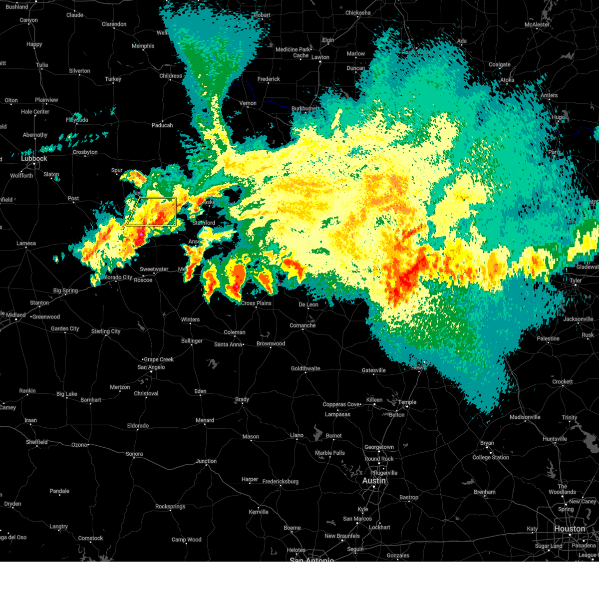
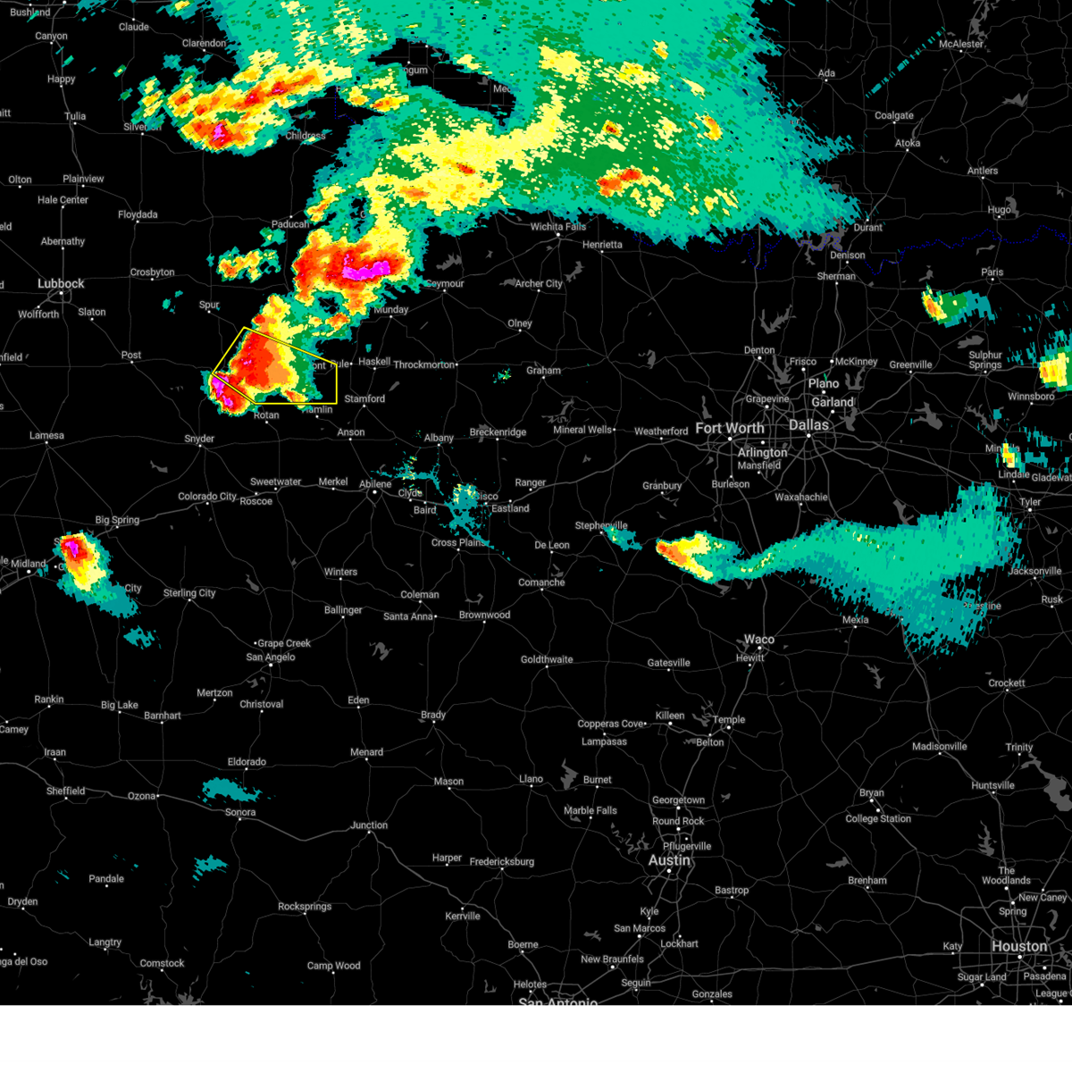
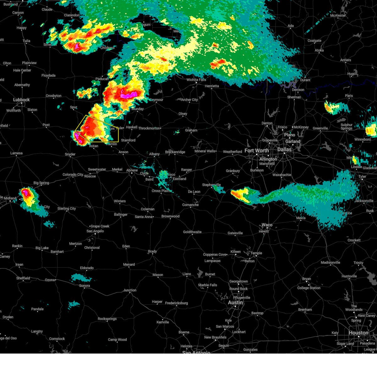
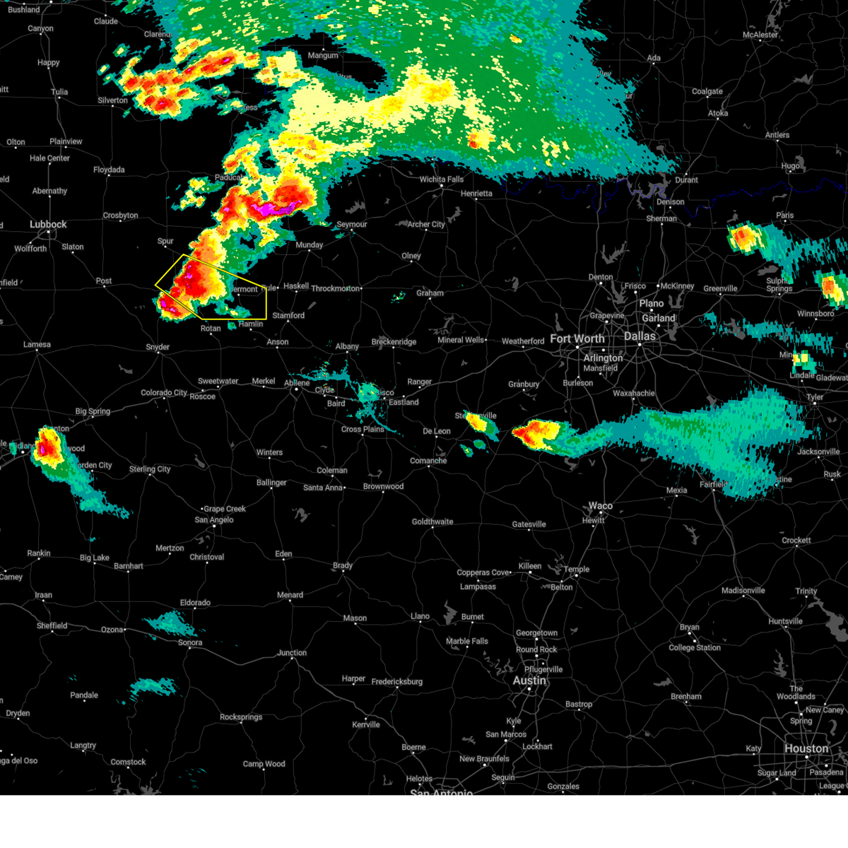
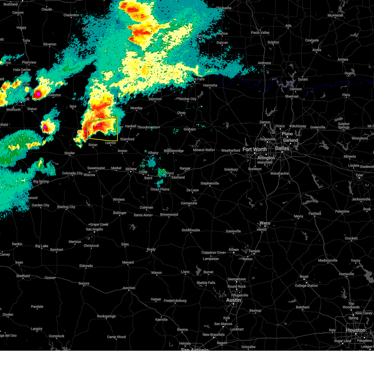
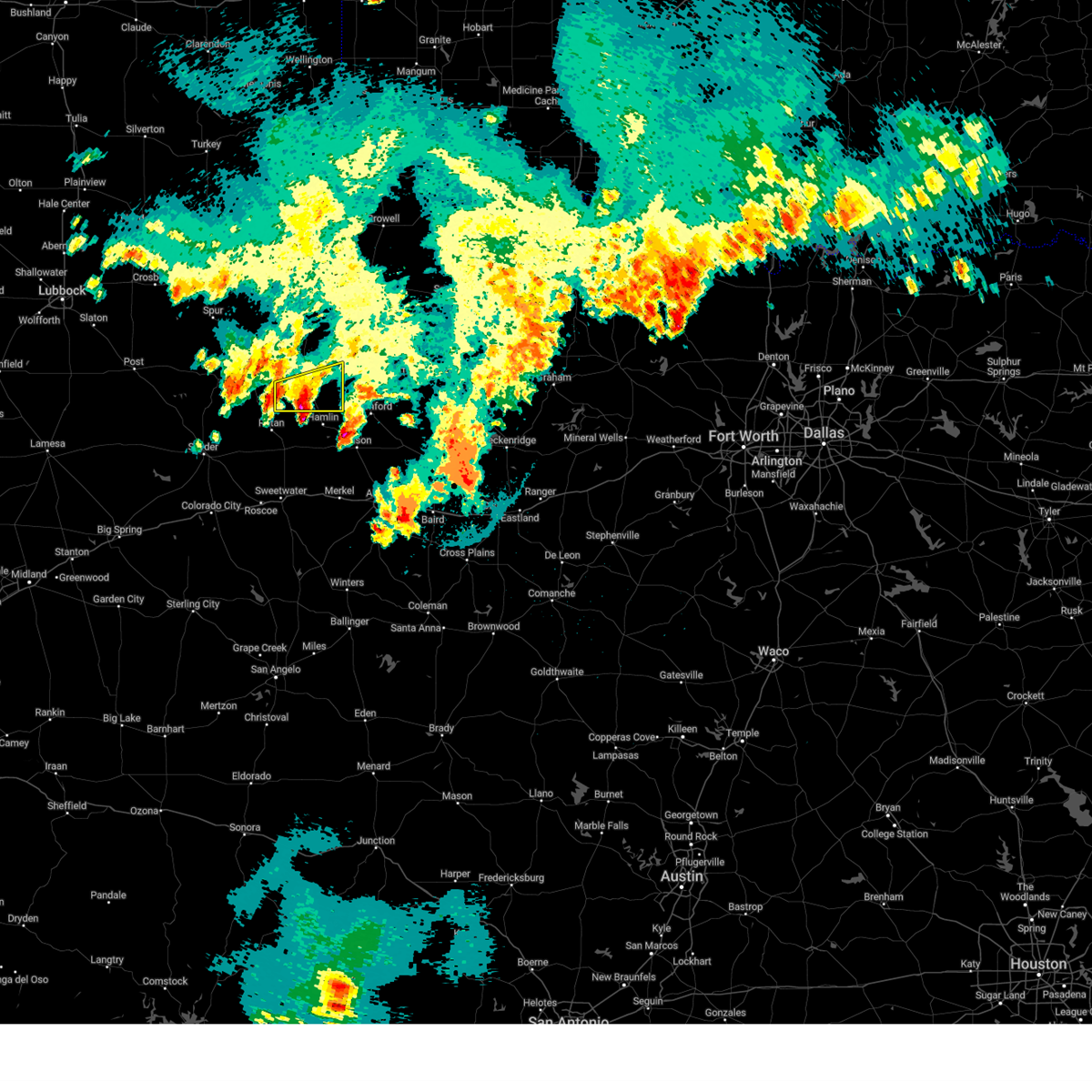
The Top Recent Hail Date for Aspermont, TX is Sunday, May 25, 2025 (9th out of 119)
Hail and Wind Damage Spotted near Aspermont, TX
| Date / Time | Report Details |
|---|---|
| 6/8/2025 11:54 PM CDT |
 the severe thunderstorm warning has been cancelled and is no longer in effect the severe thunderstorm warning has been cancelled and is no longer in effect
|
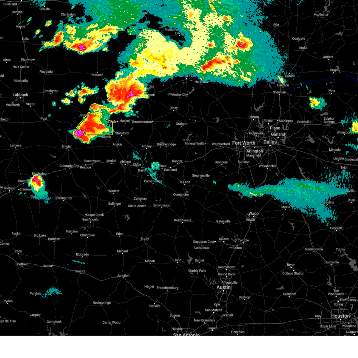
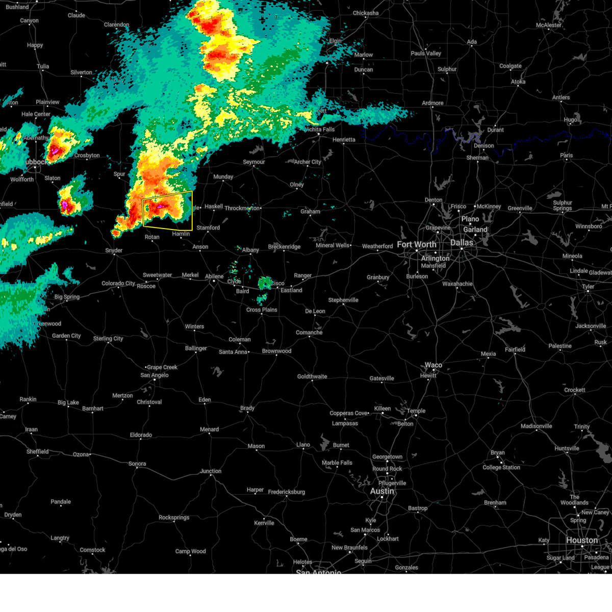
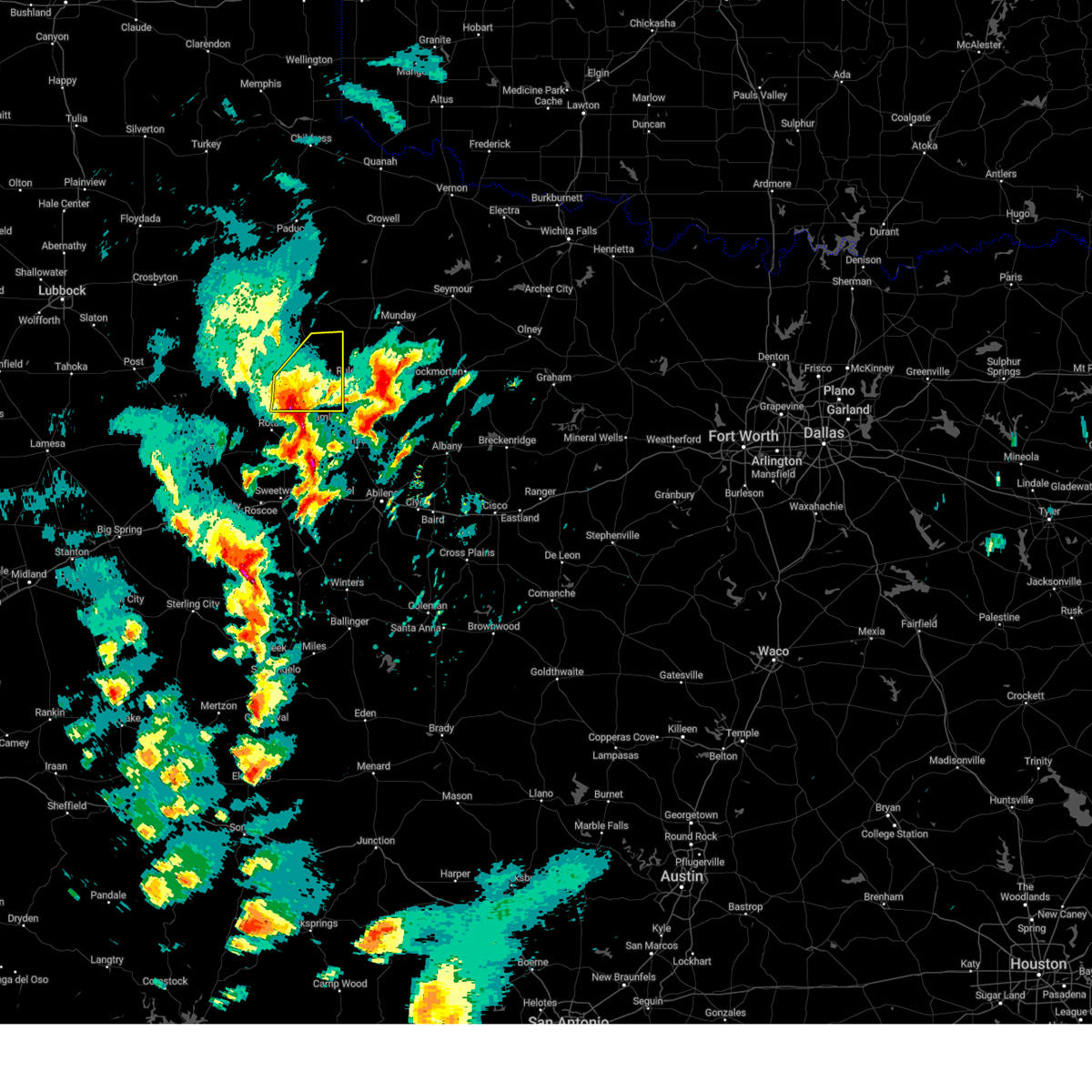
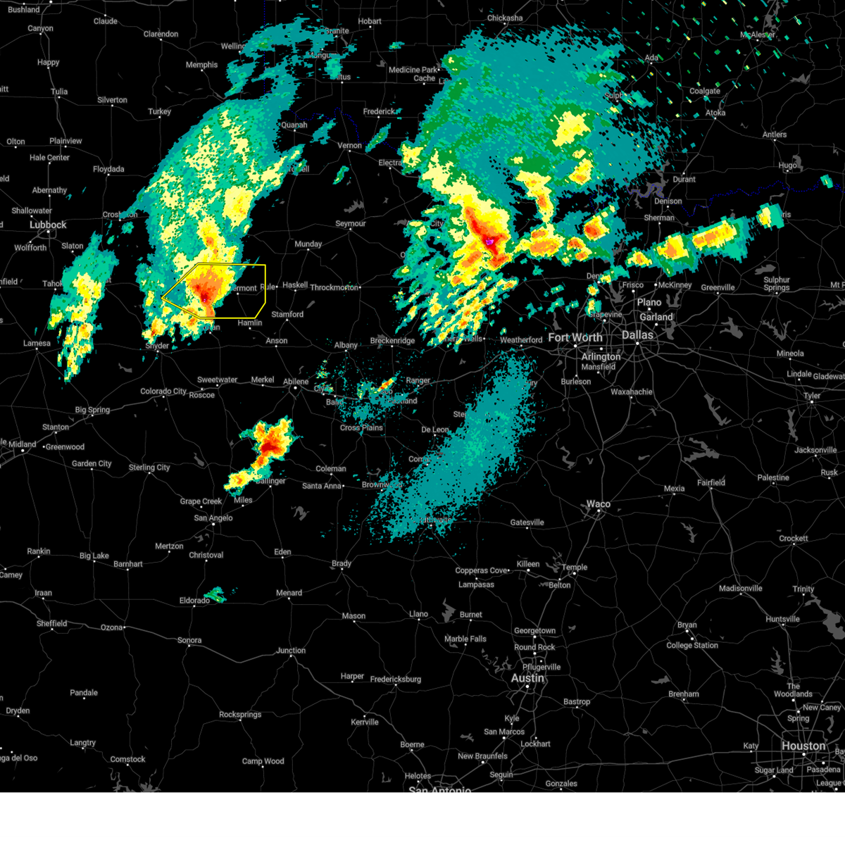
| 6/8/2025 11:46 PM CDT | At 1146 pm cdt, a severe thunderstorm was located 9 miles northwest of rotan, or 20 miles south of jayton, moving southeast at 40 mph (radar indicated). Hazards include 60 mph wind gusts and quarter size hail. Hail damage to vehicles is expected. expect wind damage to roofs, siding, and trees. Locations impacted include, aspermont, jayton, peacock, and swenson. |
| 6/8/2025 11:24 PM CDT | the severe thunderstorm warning has been cancelled and is no longer in effect |
| 6/8/2025 11:24 PM CDT | At 1124 pm cdt, a severe thunderstorm was located 4 miles east of clairemont, or 7 miles southwest of jayton, moving east at 45 mph (radar indicated). Hazards include 60 mph wind gusts and quarter size hail. Hail damage to vehicles is expected. expect wind damage to roofs, siding, and trees. Locations impacted include, aspermont, jayton, girard, peacock, old glory, swenson, clairemont, and us-380 near the haskell-stonewall county line. |
| 6/8/2025 11:14 PM CDT |
 Svrlub the national weather service in lubbock texas has issued a * severe thunderstorm warning for, kent county in northwestern texas, southeastern dickens county in northwestern texas, southeastern king county in northwestern texas, stonewall county in northwestern texas, * until 1215 am cdt. * at 1114 pm cdt, a severe thunderstorm was located 4 miles north of clairemont, or 11 miles west of jayton, moving east at 45 mph (radar indicated). Hazards include 60 mph wind gusts and quarter size hail. Hail damage to vehicles is expected. Expect wind damage to roofs, siding, and trees. Svrlub the national weather service in lubbock texas has issued a * severe thunderstorm warning for, kent county in northwestern texas, southeastern dickens county in northwestern texas, southeastern king county in northwestern texas, stonewall county in northwestern texas, * until 1215 am cdt. * at 1114 pm cdt, a severe thunderstorm was located 4 miles north of clairemont, or 11 miles west of jayton, moving east at 45 mph (radar indicated). Hazards include 60 mph wind gusts and quarter size hail. Hail damage to vehicles is expected. Expect wind damage to roofs, siding, and trees.
|
| 6/8/2025 8:08 PM CDT |
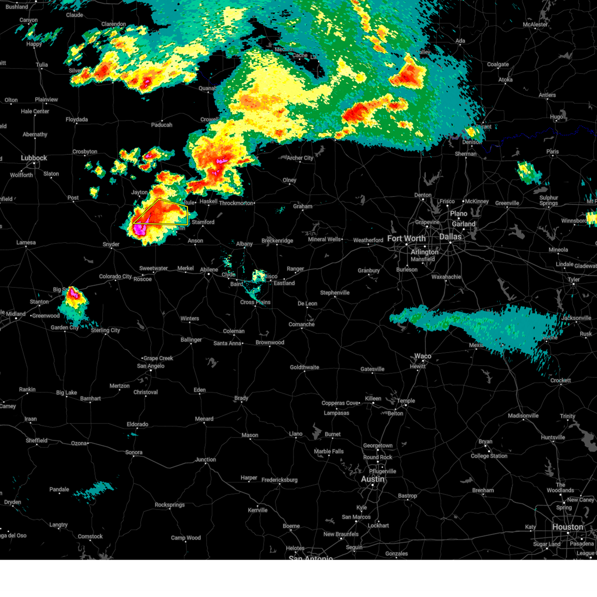 At 808 pm cdt, a severe thunderstorm was located 11 miles southwest of aspermont, moving east at 30 mph (radar indicated). Hazards include 70 mph wind gusts and half dollar size hail. Hail damage to vehicles is expected. expect considerable tree damage. wind damage is also likely to mobile homes, roofs, and outbuildings. Locations impacted include, aspermont, swenson, and old glory. At 808 pm cdt, a severe thunderstorm was located 11 miles southwest of aspermont, moving east at 30 mph (radar indicated). Hazards include 70 mph wind gusts and half dollar size hail. Hail damage to vehicles is expected. expect considerable tree damage. wind damage is also likely to mobile homes, roofs, and outbuildings. Locations impacted include, aspermont, swenson, and old glory.
|
| 6/8/2025 7:59 PM CDT |
 Svrlub the national weather service in lubbock texas has issued a * severe thunderstorm warning for, southeastern kent county in northwestern texas, southern stonewall county in northwestern texas, * until 830 pm cdt. * at 759 pm cdt, a severe thunderstorm was located 9 miles north of rotan, or 16 miles southwest of aspermont, moving southeast at 25 mph (radar indicated). Hazards include 70 mph wind gusts and ping pong ball size hail. People and animals outdoors will be injured. expect hail damage to roofs, siding, windows, and vehicles. expect considerable tree damage. Wind damage is also likely to mobile homes, roofs, and outbuildings. Svrlub the national weather service in lubbock texas has issued a * severe thunderstorm warning for, southeastern kent county in northwestern texas, southern stonewall county in northwestern texas, * until 830 pm cdt. * at 759 pm cdt, a severe thunderstorm was located 9 miles north of rotan, or 16 miles southwest of aspermont, moving southeast at 25 mph (radar indicated). Hazards include 70 mph wind gusts and ping pong ball size hail. People and animals outdoors will be injured. expect hail damage to roofs, siding, windows, and vehicles. expect considerable tree damage. Wind damage is also likely to mobile homes, roofs, and outbuildings.
|
| 6/8/2025 7:46 PM CDT |
 At 745 pm cdt, a severe thunderstorm was located 7 miles southwest of peacock, or 13 miles southeast of jayton, moving southeast at 35 mph (radar indicated). Hazards include golf ball size hail and 70 mph wind gusts. People and animals outdoors will be injured. expect hail damage to roofs, siding, windows, and vehicles. expect considerable tree damage. wind damage is also likely to mobile homes, roofs, and outbuildings. Locations impacted include, aspermont, jayton, peacock, old glory, swenson, and us- 380 near the haskell-stonewall county line. At 745 pm cdt, a severe thunderstorm was located 7 miles southwest of peacock, or 13 miles southeast of jayton, moving southeast at 35 mph (radar indicated). Hazards include golf ball size hail and 70 mph wind gusts. People and animals outdoors will be injured. expect hail damage to roofs, siding, windows, and vehicles. expect considerable tree damage. wind damage is also likely to mobile homes, roofs, and outbuildings. Locations impacted include, aspermont, jayton, peacock, old glory, swenson, and us- 380 near the haskell-stonewall county line.
|
| 6/8/2025 7:31 PM CDT |
 At 730 pm cdt, a severe thunderstorm was located near peacock, or 7 miles southeast of jayton, moving east at 60 mph (radar indicated). Hazards include golf ball size hail and 70 mph wind gusts. People and animals outdoors will be injured. expect hail damage to roofs, siding, windows, and vehicles. expect considerable tree damage. wind damage is also likely to mobile homes, roofs, and outbuildings. Locations impacted include, aspermont, jayton, peacock, old glory, swenson, clairemont, and us- 380 near the haskell-stonewall county line. At 730 pm cdt, a severe thunderstorm was located near peacock, or 7 miles southeast of jayton, moving east at 60 mph (radar indicated). Hazards include golf ball size hail and 70 mph wind gusts. People and animals outdoors will be injured. expect hail damage to roofs, siding, windows, and vehicles. expect considerable tree damage. wind damage is also likely to mobile homes, roofs, and outbuildings. Locations impacted include, aspermont, jayton, peacock, old glory, swenson, clairemont, and us- 380 near the haskell-stonewall county line.
|
| 6/8/2025 7:31 PM CDT |
 the severe thunderstorm warning has been cancelled and is no longer in effect the severe thunderstorm warning has been cancelled and is no longer in effect
|
| 6/8/2025 7:22 PM CDT |
 At 721 pm cdt, a severe thunderstorm was located over jayton, moving southeast at 40 mph (radar indicated). Hazards include tennis ball size hail and 70 mph wind gusts. People and animals outdoors will be injured. expect hail damage to roofs, siding, windows, and vehicles. expect considerable tree damage. wind damage is also likely to mobile homes, roofs, and outbuildings. Locations impacted include, aspermont, jayton, girard, peacock, old glory, swenson, clairemont, and us-380 near the haskell-stonewall county line. At 721 pm cdt, a severe thunderstorm was located over jayton, moving southeast at 40 mph (radar indicated). Hazards include tennis ball size hail and 70 mph wind gusts. People and animals outdoors will be injured. expect hail damage to roofs, siding, windows, and vehicles. expect considerable tree damage. wind damage is also likely to mobile homes, roofs, and outbuildings. Locations impacted include, aspermont, jayton, girard, peacock, old glory, swenson, clairemont, and us-380 near the haskell-stonewall county line.
|
| 6/8/2025 7:05 PM CDT |
 Svrlub the national weather service in lubbock texas has issued a * severe thunderstorm warning for, northeastern kent county in northwestern texas, south central dickens county in northwestern texas, stonewall county in northwestern texas, * until 800 pm cdt. * at 704 pm cdt, a severe thunderstorm was located 5 miles southwest of girard, or 7 miles west of jayton, moving east at 60 mph (radar indicated). Hazards include tennis ball size hail and 70 mph wind gusts. People and animals outdoors will be injured. expect hail damage to roofs, siding, windows, and vehicles. expect considerable tree damage. Wind damage is also likely to mobile homes, roofs, and outbuildings. Svrlub the national weather service in lubbock texas has issued a * severe thunderstorm warning for, northeastern kent county in northwestern texas, south central dickens county in northwestern texas, stonewall county in northwestern texas, * until 800 pm cdt. * at 704 pm cdt, a severe thunderstorm was located 5 miles southwest of girard, or 7 miles west of jayton, moving east at 60 mph (radar indicated). Hazards include tennis ball size hail and 70 mph wind gusts. People and animals outdoors will be injured. expect hail damage to roofs, siding, windows, and vehicles. expect considerable tree damage. Wind damage is also likely to mobile homes, roofs, and outbuildings.
|
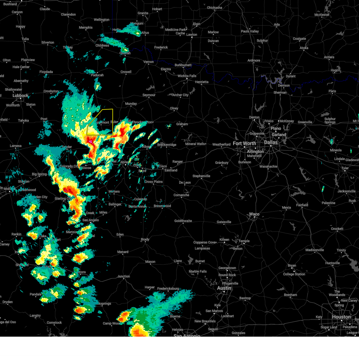
| 6/6/2025 9:59 PM CDT |
 Svrlub the national weather service in lubbock texas has issued a * severe thunderstorm warning for, eastern stonewall county in northwestern texas, * until 1030 pm cdt. * at 958 pm cdt, a severe thunderstorm was located 8 miles southeast of aspermont, moving east at 35 mph (radar indicated). Hazards include ping pong ball size hail and 60 mph wind gusts. People and animals outdoors will be injured. expect hail damage to roofs, siding, windows, and vehicles. Expect wind damage to roofs, siding, and trees. Svrlub the national weather service in lubbock texas has issued a * severe thunderstorm warning for, eastern stonewall county in northwestern texas, * until 1030 pm cdt. * at 958 pm cdt, a severe thunderstorm was located 8 miles southeast of aspermont, moving east at 35 mph (radar indicated). Hazards include ping pong ball size hail and 60 mph wind gusts. People and animals outdoors will be injured. expect hail damage to roofs, siding, windows, and vehicles. Expect wind damage to roofs, siding, and trees.
|
| 6/6/2025 9:38 PM CDT |
 At 938 pm cdt, a severe thunderstorm was located over swenson, or 4 miles northwest of aspermont, moving east at 25 mph (radar indicated). Hazards include 70 mph wind gusts and ping pong ball size hail. People and animals outdoors will be injured. expect hail damage to roofs, siding, windows, and vehicles. expect considerable tree damage. wind damage is also likely to mobile homes, roofs, and outbuildings. Locations impacted include, aspermont, peacock, old glory, swenson, and us-380 near the haskell- stonewall county line. At 938 pm cdt, a severe thunderstorm was located over swenson, or 4 miles northwest of aspermont, moving east at 25 mph (radar indicated). Hazards include 70 mph wind gusts and ping pong ball size hail. People and animals outdoors will be injured. expect hail damage to roofs, siding, windows, and vehicles. expect considerable tree damage. wind damage is also likely to mobile homes, roofs, and outbuildings. Locations impacted include, aspermont, peacock, old glory, swenson, and us-380 near the haskell- stonewall county line.
|
| 6/6/2025 9:38 PM CDT |
 the severe thunderstorm warning has been cancelled and is no longer in effect the severe thunderstorm warning has been cancelled and is no longer in effect
|
| 6/6/2025 9:37 PM CDT | Storm damage reported in stonewall county TX, 2.7 miles SW of Aspermont, TX |
| 6/6/2025 9:27 PM CDT |
 At 926 pm cdt, a severe thunderstorm was located near swenson, or near aspermont, moving east at 35 mph (radar indicated). Hazards include tennis ball size hail and 60 mph wind gusts. People and animals outdoors will be injured. expect hail damage to roofs, siding, windows, and vehicles. expect wind damage to roofs, siding, and trees. Locations impacted include, aspermont, jayton, peacock, old glory, swenson, and us- 380 near the haskell-stonewall county line. At 926 pm cdt, a severe thunderstorm was located near swenson, or near aspermont, moving east at 35 mph (radar indicated). Hazards include tennis ball size hail and 60 mph wind gusts. People and animals outdoors will be injured. expect hail damage to roofs, siding, windows, and vehicles. expect wind damage to roofs, siding, and trees. Locations impacted include, aspermont, jayton, peacock, old glory, swenson, and us- 380 near the haskell-stonewall county line.
|
| 6/6/2025 9:17 PM CDT |
 At 917 pm cdt, a severe thunderstorm was located over peacock, or 9 miles west of aspermont, moving east at 20 mph (radar indicated). Hazards include two inch hail and 60 mph wind gusts. People and animals outdoors will be injured. expect hail damage to roofs, siding, windows, and vehicles. expect wind damage to roofs, siding, and trees. Locations impacted include, aspermont, jayton, peacock, old glory, swenson, and us- 380 near the haskell-stonewall county line. At 917 pm cdt, a severe thunderstorm was located over peacock, or 9 miles west of aspermont, moving east at 20 mph (radar indicated). Hazards include two inch hail and 60 mph wind gusts. People and animals outdoors will be injured. expect hail damage to roofs, siding, windows, and vehicles. expect wind damage to roofs, siding, and trees. Locations impacted include, aspermont, jayton, peacock, old glory, swenson, and us- 380 near the haskell-stonewall county line.
|
| 6/6/2025 9:05 PM CDT |
 At 905 pm cdt, a severe thunderstorm was located over swenson, or 8 miles northwest of aspermont, moving east at 15 mph (radar indicated). Hazards include golf ball size hail and 60 mph wind gusts. People and animals outdoors will be injured. expect hail damage to roofs, siding, windows, and vehicles. expect wind damage to roofs, siding, and trees. Locations impacted include, aspermont, jayton, peacock, old glory, swenson, and us- 380 near the haskell-stonewall county line. At 905 pm cdt, a severe thunderstorm was located over swenson, or 8 miles northwest of aspermont, moving east at 15 mph (radar indicated). Hazards include golf ball size hail and 60 mph wind gusts. People and animals outdoors will be injured. expect hail damage to roofs, siding, windows, and vehicles. expect wind damage to roofs, siding, and trees. Locations impacted include, aspermont, jayton, peacock, old glory, swenson, and us- 380 near the haskell-stonewall county line.
|
| 6/6/2025 8:59 PM CDT | Svrlub the national weather service in lubbock texas has issued a * severe thunderstorm warning for, southeastern kent county in northwestern texas, stonewall county in northwestern texas, * until 1000 pm cdt. * at 859 pm cdt, a severe thunderstorm was located near peacock, or 9 miles southeast of jayton, moving east at 35 mph (radar indicated). Hazards include 60 mph wind gusts and quarter size hail. Hail damage to vehicles is expected. Expect wind damage to roofs, siding, and trees. |
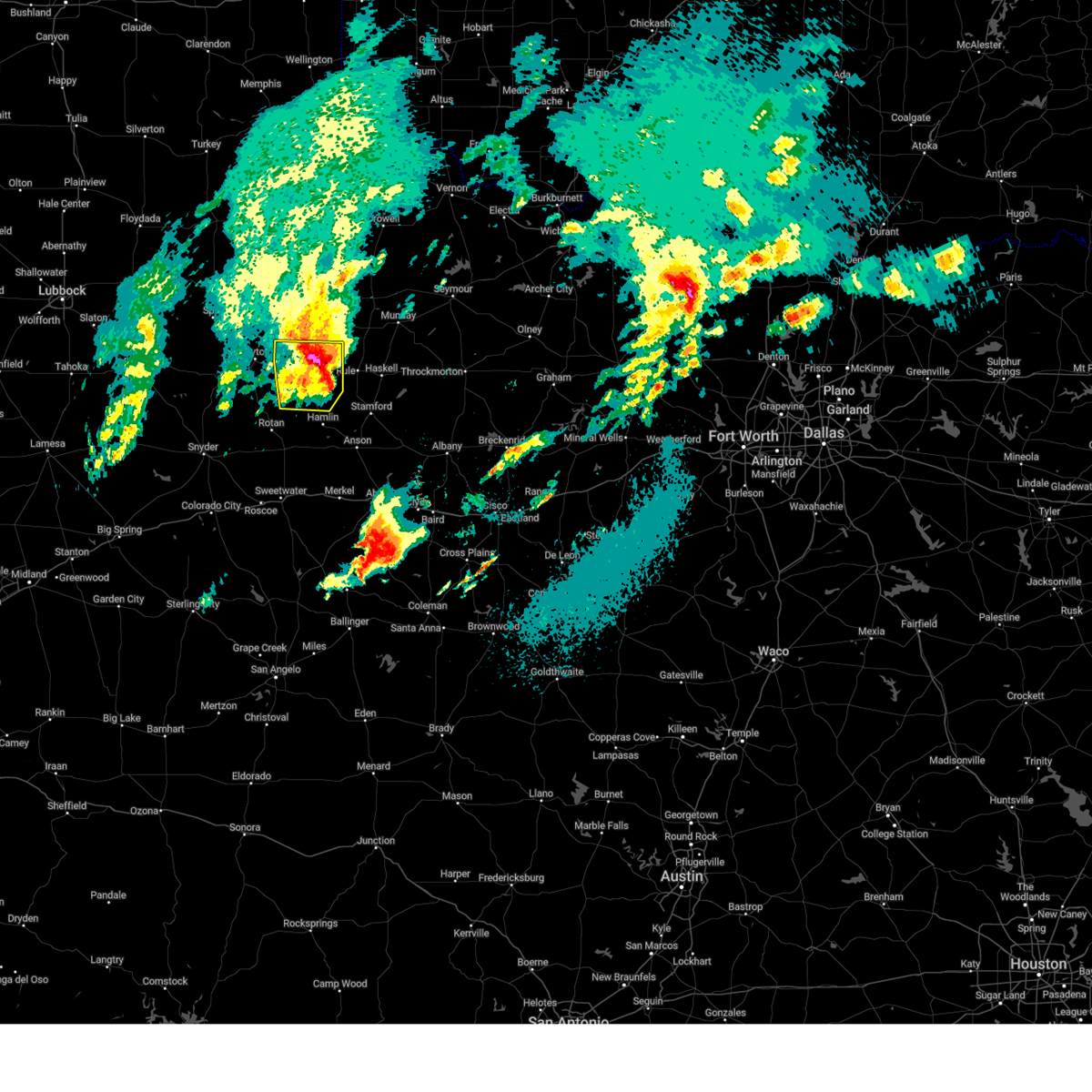
| 6/6/2025 8:42 PM CDT |
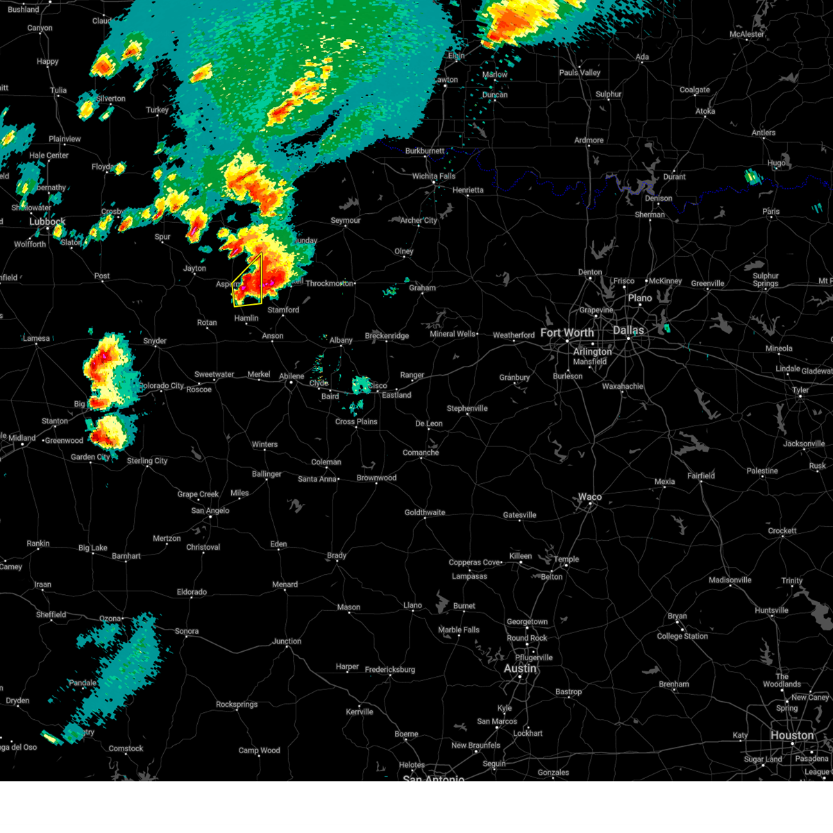
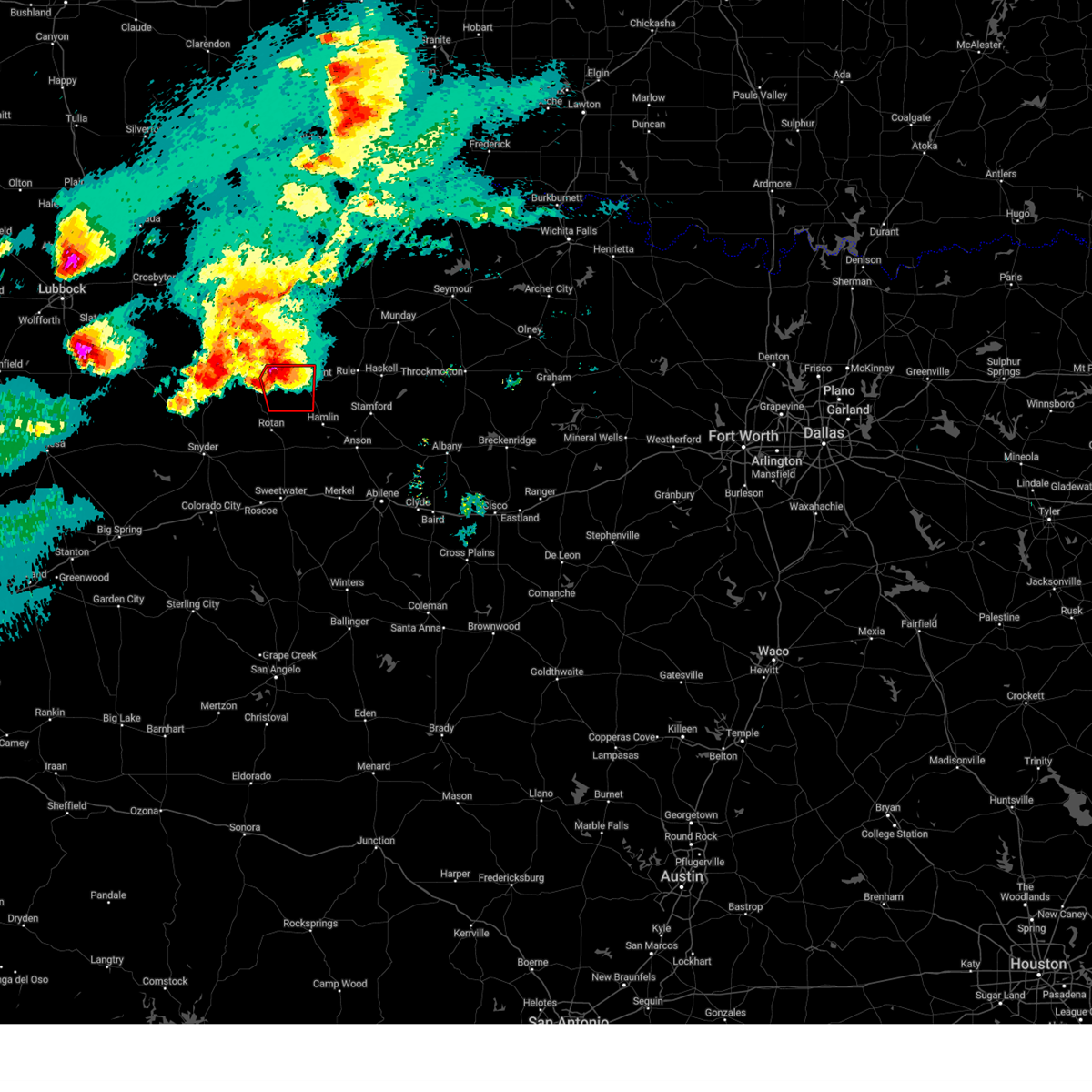 At 841 pm cdt, a severe thunderstorm capable of producing a tornado was located near peacock, or 11 miles west of aspermont, moving east at 30 mph (radar indicated rotation). Hazards include tornado and two inch hail. Flying debris will be dangerous to those caught without shelter. mobile homes will be damaged or destroyed. damage to roofs, windows, and vehicles will occur. tree damage is likely. Locations impacted include, aspermont, swenson, and peacock. At 841 pm cdt, a severe thunderstorm capable of producing a tornado was located near peacock, or 11 miles west of aspermont, moving east at 30 mph (radar indicated rotation). Hazards include tornado and two inch hail. Flying debris will be dangerous to those caught without shelter. mobile homes will be damaged or destroyed. damage to roofs, windows, and vehicles will occur. tree damage is likely. Locations impacted include, aspermont, swenson, and peacock.
|
| 6/6/2025 8:25 PM CDT |
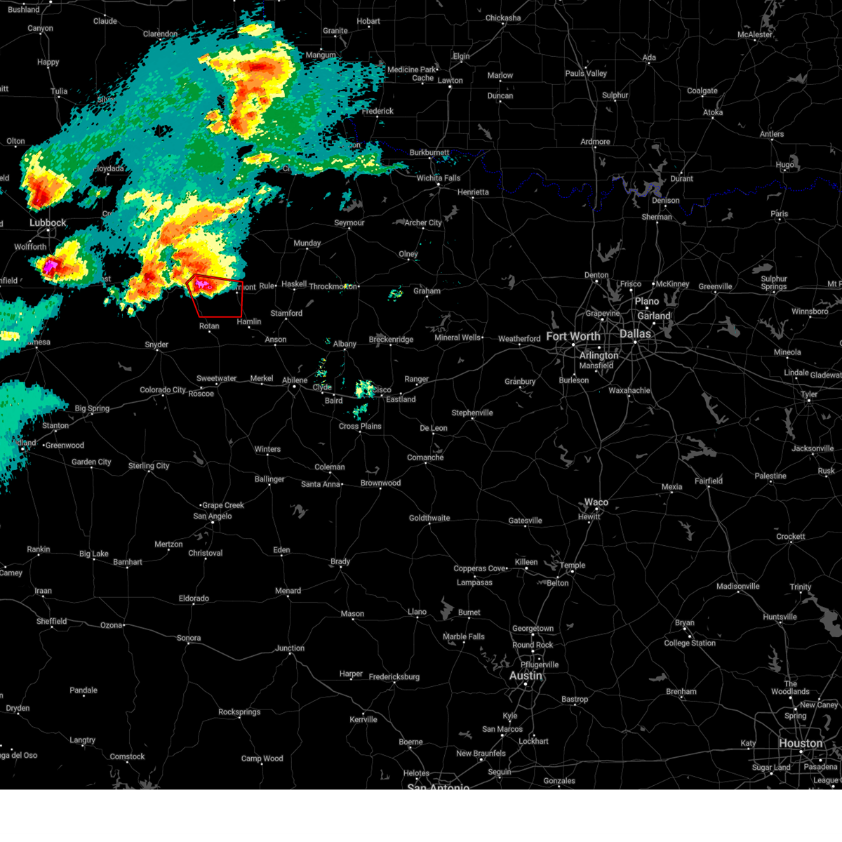 Torlub the national weather service in lubbock texas has issued a * tornado warning for, southeastern kent county in northwestern texas, southwestern stonewall county in northwestern texas, * until 900 pm cdt. * at 825 pm cdt, a severe thunderstorm capable of producing a tornado was located 6 miles southeast of jayton, moving southeast at 30 mph (radar indicated rotation). Hazards include tornado and hail up to two inches in diameter. Flying debris will be dangerous to those caught without shelter. mobile homes will be damaged or destroyed. damage to roofs, windows, and vehicles will occur. tree damage is likely. This tornadic thunderstorm will remain over mainly rural areas of southeastern kent and southwestern stonewall counties. Torlub the national weather service in lubbock texas has issued a * tornado warning for, southeastern kent county in northwestern texas, southwestern stonewall county in northwestern texas, * until 900 pm cdt. * at 825 pm cdt, a severe thunderstorm capable of producing a tornado was located 6 miles southeast of jayton, moving southeast at 30 mph (radar indicated rotation). Hazards include tornado and hail up to two inches in diameter. Flying debris will be dangerous to those caught without shelter. mobile homes will be damaged or destroyed. damage to roofs, windows, and vehicles will occur. tree damage is likely. This tornadic thunderstorm will remain over mainly rural areas of southeastern kent and southwestern stonewall counties.
|
| 5/25/2025 11:50 PM CDT |
 At 1150 pm cdt, a severe thunderstorm was located 8 miles north of hamlin, moving east at 25 mph (radar indicated). Hazards include 60 mph wind gusts and quarter size hail. Hail damage to vehicles is expected. expect wind damage to roofs, siding, and trees. Locations impacted include, aspermont and old glory. At 1150 pm cdt, a severe thunderstorm was located 8 miles north of hamlin, moving east at 25 mph (radar indicated). Hazards include 60 mph wind gusts and quarter size hail. Hail damage to vehicles is expected. expect wind damage to roofs, siding, and trees. Locations impacted include, aspermont and old glory.
|
| 5/25/2025 11:40 PM CDT |
 At 1140 pm cdt, a severe thunderstorm was located 9 miles south of aspermont, moving east at 20 mph (radar indicated). Hazards include 60 mph wind gusts and half dollar size hail. Hail damage to vehicles is expected. expect wind damage to roofs, siding, and trees. Locations impacted include, aspermont, old glory, and us-380 near the haskell- stonewall county line. At 1140 pm cdt, a severe thunderstorm was located 9 miles south of aspermont, moving east at 20 mph (radar indicated). Hazards include 60 mph wind gusts and half dollar size hail. Hail damage to vehicles is expected. expect wind damage to roofs, siding, and trees. Locations impacted include, aspermont, old glory, and us-380 near the haskell- stonewall county line.
|
| 5/25/2025 11:28 PM CDT |
 Svrlub the national weather service in lubbock texas has issued a * severe thunderstorm warning for, southern stonewall county in northwestern texas, * until 1215 am cdt. * at 1128 pm cdt, a severe thunderstorm was located 9 miles southwest of aspermont, moving east at 25 mph (radar indicated). Hazards include 60 mph wind gusts and quarter size hail. Hail damage to vehicles is expected. Expect wind damage to roofs, siding, and trees. Svrlub the national weather service in lubbock texas has issued a * severe thunderstorm warning for, southern stonewall county in northwestern texas, * until 1215 am cdt. * at 1128 pm cdt, a severe thunderstorm was located 9 miles southwest of aspermont, moving east at 25 mph (radar indicated). Hazards include 60 mph wind gusts and quarter size hail. Hail damage to vehicles is expected. Expect wind damage to roofs, siding, and trees.
|
| 5/25/2025 7:33 PM CDT | At 732 pm cdt, a severe thunderstorm was located near old glory, or 6 miles east of aspermont, moving northeast at 20 mph (radar indicated). Hazards include ping pong ball size hail and 60 mph wind gusts. People and animals outdoors will be injured. expect hail damage to roofs, siding, windows, and vehicles. expect wind damage to roofs, siding, and trees. Locations impacted include, aspermont, old glory, and us-380 near the haskell- stonewall county line. |
| 5/25/2025 7:18 PM CDT | Half Dollar sized hail reported 10.4 miles W of Aspermont, TX, report from mping: half dollar (1.25 in.). |
| 5/25/2025 7:08 PM CDT | At 708 pm cdt, a severe thunderstorm was located near old glory, or 7 miles southeast of aspermont, moving east at 10 mph (radar indicated). Hazards include ping pong ball size hail and 60 mph wind gusts. People and animals outdoors will be injured. expect hail damage to roofs, siding, windows, and vehicles. expect wind damage to roofs, siding, and trees. Locations impacted include, aspermont, old glory, and us-380 near the haskell- stonewall county line. |
| 5/25/2025 6:54 PM CDT |
 Svrlub the national weather service in lubbock texas has issued a * severe thunderstorm warning for, eastern stonewall county in northwestern texas, * until 745 pm cdt. * at 654 pm cdt, a severe thunderstorm was located 4 miles west of old glory, or 5 miles east of aspermont, moving northeast at 10 mph (radar indicated). Hazards include ping pong ball size hail and 60 mph wind gusts. People and animals outdoors will be injured. expect hail damage to roofs, siding, windows, and vehicles. Expect wind damage to roofs, siding, and trees. Svrlub the national weather service in lubbock texas has issued a * severe thunderstorm warning for, eastern stonewall county in northwestern texas, * until 745 pm cdt. * at 654 pm cdt, a severe thunderstorm was located 4 miles west of old glory, or 5 miles east of aspermont, moving northeast at 10 mph (radar indicated). Hazards include ping pong ball size hail and 60 mph wind gusts. People and animals outdoors will be injured. expect hail damage to roofs, siding, windows, and vehicles. Expect wind damage to roofs, siding, and trees.
|
| 5/25/2025 6:45 PM CDT | At 645 pm cdt, severe thunderstorms were located along a line extending from 13 miles west of o'brien to 4 miles southeast of aspermont, moving east at 10 mph (radar indicated). Hazards include golf ball size hail and 60 mph wind gusts. People and animals outdoors will be injured. expect hail damage to roofs, siding, windows, and vehicles. expect wind damage to roofs, siding, and trees. Locations impacted include, aspermont, old glory, and us-380 near the haskell- stonewall county line. |
| 5/25/2025 6:31 PM CDT | At 631 pm cdt, severe thunderstorms were located along a line extending from 8 miles west of rochester to 3 miles west of old glory, moving east at 15 mph (radar indicated). Hazards include golf ball size hail and 60 mph wind gusts. People and animals outdoors will be injured. expect hail damage to roofs, siding, windows, and vehicles. expect wind damage to roofs, siding, and trees. Locations impacted include, aspermont, old glory, and us-380 near the haskell- stonewall county line. |
| 5/25/2025 6:19 PM CDT | Golf Ball sized hail reported 1.7 miles WNW of Aspermont, TX, report from mping: golf ball (1.75 in.). |
| 5/25/2025 6:19 PM CDT | At 618 pm cdt, severe thunderstorms were located along a line extending from 7 miles west of rochester to 3 miles southeast of aspermont, moving east at 15 mph (radar indicated). Hazards include tennis ball size hail and 70 mph wind gusts. People and animals outdoors will be injured. expect hail damage to roofs, siding, windows, and vehicles. expect considerable tree damage. wind damage is also likely to mobile homes, roofs, and outbuildings. Locations impacted include, aspermont, old glory, and us-380 near the haskell- stonewall county line. |
| 5/25/2025 6:04 PM CDT | Storm damage reported in stonewall county TX, 2.7 miles SW of Aspermont, TX |
| 5/25/2025 6:03 PM CDT | Svrlub the national weather service in lubbock texas has issued a * severe thunderstorm warning for, southeastern king county in northwestern texas, eastern stonewall county in northwestern texas, * until 700 pm cdt. * at 603 pm cdt, severe thunderstorms were located along a line extending from 14 miles west of o'brien to 8 miles northwest of hamlin, moving east at 15 mph (radar indicated). Hazards include tennis ball size hail and 70 mph wind gusts. People and animals outdoors will be injured. expect hail damage to roofs, siding, windows, and vehicles. expect considerable tree damage. Wind damage is also likely to mobile homes, roofs, and outbuildings. |
| 5/25/2025 5:59 PM CDT | Storm damage reported in stonewall county TX, 2.7 miles SW of Aspermont, TX |
| 5/24/2025 10:02 PM CDT | Measured by ttu mesone in stonewall county TX, 2.7 miles SW of Aspermont, TX |
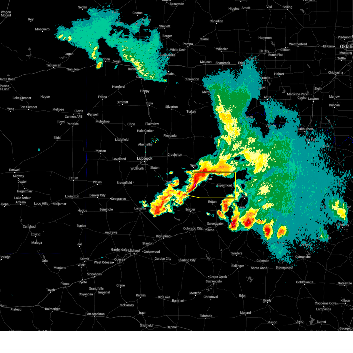
| 4/30/2025 6:51 PM CDT |
 At 650 pm cdt, a severe thunderstorm was located over old glory, or 8 miles east of aspermont, moving east at 35 mph (radar indicated). Hazards include 60 mph wind gusts and half dollar size hail. Hail damage to vehicles is expected. expect wind damage to roofs, siding, and trees. Locations impacted include, old glory, us-380 near the haskell- stonewall county line, and aspermont. At 650 pm cdt, a severe thunderstorm was located over old glory, or 8 miles east of aspermont, moving east at 35 mph (radar indicated). Hazards include 60 mph wind gusts and half dollar size hail. Hail damage to vehicles is expected. expect wind damage to roofs, siding, and trees. Locations impacted include, old glory, us-380 near the haskell- stonewall county line, and aspermont.
|
| 4/30/2025 6:49 PM CDT | Half Dollar sized hail reported 8.6 miles W of Aspermont, TX, report from mping: half dollar (1.25 in.). |
| 4/30/2025 6:44 PM CDT | Ping Pong Ball sized hail reported 2.8 miles W of Aspermont, TX, report from mping: ping pong ball (1.50 in.). |
| 4/30/2025 6:43 PM CDT |
 Svrlub the national weather service in lubbock texas has issued a * severe thunderstorm warning for, southeastern stonewall county in northwestern texas, * until 730 pm cdt. * at 643 pm cdt, a severe thunderstorm was located near aspermont, moving southeast at 40 mph (radar indicated). Hazards include 60 mph wind gusts and half dollar size hail. Hail damage to vehicles is expected. Expect wind damage to roofs, siding, and trees. Svrlub the national weather service in lubbock texas has issued a * severe thunderstorm warning for, southeastern stonewall county in northwestern texas, * until 730 pm cdt. * at 643 pm cdt, a severe thunderstorm was located near aspermont, moving southeast at 40 mph (radar indicated). Hazards include 60 mph wind gusts and half dollar size hail. Hail damage to vehicles is expected. Expect wind damage to roofs, siding, and trees.
|
| 4/30/2025 6:34 PM CDT | At 634 pm cdt, a severe thunderstorm was located near swenson, or near aspermont, moving east at 35 mph (radar indicated). Hazards include 60 mph wind gusts and quarter size hail. Hail damage to vehicles is expected. expect wind damage to roofs, siding, and trees. Locations impacted include, swenson and aspermont. |
| 4/30/2025 6:32 PM CDT | Quarter sized hail reported 4.4 miles SE of Aspermont, TX, report from mping: quarter (1.00 in.). |
| 4/30/2025 6:25 PM CDT | At 624 pm cdt, a severe thunderstorm was located 4 miles south of swenson, or 6 miles west of aspermont, moving east at 70 mph (radar indicated). Hazards include 60 mph wind gusts and quarter size hail. Hail damage to vehicles is expected. expect wind damage to roofs, siding, and trees. Locations impacted include, peacock, swenson, and aspermont. |
| 4/30/2025 6:25 PM CDT | the severe thunderstorm warning has been cancelled and is no longer in effect |
| 4/30/2025 6:09 PM CDT |
 At 609 pm cdt, a severe thunderstorm was located near jayton, moving southeast at 35 mph (radar indicated). Hazards include 60 mph wind gusts and quarter size hail. Hail damage to vehicles is expected. expect wind damage to roofs, siding, and trees. Locations impacted include, peacock, swenson, jayton, and aspermont. At 609 pm cdt, a severe thunderstorm was located near jayton, moving southeast at 35 mph (radar indicated). Hazards include 60 mph wind gusts and quarter size hail. Hail damage to vehicles is expected. expect wind damage to roofs, siding, and trees. Locations impacted include, peacock, swenson, jayton, and aspermont.
|
| 4/30/2025 5:55 PM CDT | Svrlub the national weather service in lubbock texas has issued a * severe thunderstorm warning for, northeastern kent county in northwestern texas, stonewall county in northwestern texas, * until 645 pm cdt. * at 555 pm cdt, a severe thunderstorm was located near girard, or 5 miles northwest of jayton, moving southeast at 40 mph (radar indicated). Hazards include 60 mph wind gusts and quarter size hail. Hail damage to vehicles is expected. Expect wind damage to roofs, siding, and trees. |
| 4/30/2025 3:41 AM CDT |
 At 340 am cdt, severe thunderstorms were located along a line extending from 12 miles southeast of guthrie to near aspermont, moving east at 45 mph (radar indicated). Hazards include 60 mph wind gusts and nickel size hail. Expect damage to roofs, siding, and trees. Locations impacted include, old glory, swenson, aspermont, and us-380 near the haskell- stonewall county line. At 340 am cdt, severe thunderstorms were located along a line extending from 12 miles southeast of guthrie to near aspermont, moving east at 45 mph (radar indicated). Hazards include 60 mph wind gusts and nickel size hail. Expect damage to roofs, siding, and trees. Locations impacted include, old glory, swenson, aspermont, and us-380 near the haskell- stonewall county line.
|
| 4/30/2025 3:26 AM CDT |
 the severe thunderstorm warning has been cancelled and is no longer in effect the severe thunderstorm warning has been cancelled and is no longer in effect
|
| 4/30/2025 3:26 AM CDT |
 At 326 am cdt, severe thunderstorms were located along a line extending from 12 miles south of guthrie to 6 miles southeast of peacock, moving east at 40 mph (radar indicated). Hazards include 60 mph wind gusts and quarter size hail. Hail damage to vehicles is expected. expect wind damage to roofs, siding, and trees. Locations impacted include, peacock, old glory, swenson, aspermont, and us-380 near the haskell- stonewall county line. At 326 am cdt, severe thunderstorms were located along a line extending from 12 miles south of guthrie to 6 miles southeast of peacock, moving east at 40 mph (radar indicated). Hazards include 60 mph wind gusts and quarter size hail. Hail damage to vehicles is expected. expect wind damage to roofs, siding, and trees. Locations impacted include, peacock, old glory, swenson, aspermont, and us-380 near the haskell- stonewall county line.
|
| 4/30/2025 3:15 AM CDT |
 At 315 am cdt, a severe thunderstorm was located 4 miles northeast of jayton, moving east at 40 mph (radar indicated). Hazards include 60 mph wind gusts and quarter size hail. Hail damage to vehicles is expected. expect wind damage to roofs, siding, and trees. Locations impacted include, peacock, old glory, swenson, jayton, aspermont, and us- 380 near the haskell-stonewall county line. At 315 am cdt, a severe thunderstorm was located 4 miles northeast of jayton, moving east at 40 mph (radar indicated). Hazards include 60 mph wind gusts and quarter size hail. Hail damage to vehicles is expected. expect wind damage to roofs, siding, and trees. Locations impacted include, peacock, old glory, swenson, jayton, aspermont, and us- 380 near the haskell-stonewall county line.
|
| 4/30/2025 2:55 AM CDT |
 Svrlub the national weather service in lubbock texas has issued a * severe thunderstorm warning for, eastern kent county in northwestern texas, southeastern dickens county in northwestern texas, southern king county in northwestern texas, stonewall county in northwestern texas, * until 400 am cdt. * at 254 am cdt, a severe thunderstorm was located 4 miles northeast of clairemont, or 7 miles southwest of jayton, moving northeast at 40 mph (radar indicated). Hazards include 60 mph wind gusts and quarter size hail. Hail damage to vehicles is expected. Expect wind damage to roofs, siding, and trees. Svrlub the national weather service in lubbock texas has issued a * severe thunderstorm warning for, eastern kent county in northwestern texas, southeastern dickens county in northwestern texas, southern king county in northwestern texas, stonewall county in northwestern texas, * until 400 am cdt. * at 254 am cdt, a severe thunderstorm was located 4 miles northeast of clairemont, or 7 miles southwest of jayton, moving northeast at 40 mph (radar indicated). Hazards include 60 mph wind gusts and quarter size hail. Hail damage to vehicles is expected. Expect wind damage to roofs, siding, and trees.
|
| 4/29/2025 5:54 PM CDT | At 553 pm cdt, a severe thunderstorm was located 14 miles northwest of o'brien, or 15 miles west of knox city, moving east at 30 mph. this is a destructive storm for rural areas (radar indicated). Hazards include softball size hail and 60 mph wind gusts. People and animals outdoors will be severely injured. expect shattered windows, extensive damage to roofs, siding, and vehicles. Locations impacted include, peacock, swenson, and aspermont. |
| 4/29/2025 5:54 PM CDT | the severe thunderstorm warning has been cancelled and is no longer in effect |
| 4/29/2025 5:52 PM CDT | Ping Pong Ball sized hail reported 8.2 miles SE of Aspermont, TX, report from mping: ping pong ball (1.50 in.). |
| 4/29/2025 5:42 PM CDT | At 541 pm cdt, a severe thunderstorm was located 13 miles southeast of guthrie, moving east at 30 mph. this is a destructive storm for rural areas (radar indicated). Hazards include softball size hail and 60 mph wind gusts. People and animals outdoors will be severely injured. expect shattered windows, extensive damage to roofs, siding, and vehicles. Locations impacted include, guthrie, peacock, swenson, and aspermont. |
| 4/29/2025 5:28 PM CDT |
 Svrlub the national weather service in lubbock texas has issued a * severe thunderstorm warning for, eastern kent county in northwestern texas, southeastern dickens county in northwestern texas, king county in northwestern texas, stonewall county in northwestern texas, * until 630 pm cdt. * at 526 pm cdt, a severe thunderstorm was located 11 miles south of guthrie, moving east at 30 mph. this is a destructive storm for jayton and peacock (radar indicated). Hazards include softball size hail and 60 mph wind gusts. People and animals outdoors will be severely injured. Expect shattered windows, extensive damage to roofs, siding, and vehicles. Svrlub the national weather service in lubbock texas has issued a * severe thunderstorm warning for, eastern kent county in northwestern texas, southeastern dickens county in northwestern texas, king county in northwestern texas, stonewall county in northwestern texas, * until 630 pm cdt. * at 526 pm cdt, a severe thunderstorm was located 11 miles south of guthrie, moving east at 30 mph. this is a destructive storm for jayton and peacock (radar indicated). Hazards include softball size hail and 60 mph wind gusts. People and animals outdoors will be severely injured. Expect shattered windows, extensive damage to roofs, siding, and vehicles.
|
| 4/28/2025 6:29 PM CDT |
 Svrlub the national weather service in lubbock texas has issued a * severe thunderstorm warning for, northeastern kent county in northwestern texas, south central king county in northwestern texas, northern stonewall county in northwestern texas, * until 730 pm cdt. * at 628 pm cdt, a severe thunderstorm was located 6 miles north of peacock, or 10 miles east of jayton, moving northeast at 45 mph (radar indicated). Hazards include 70 mph wind gusts and ping pong ball size hail. People and animals outdoors will be injured. expect hail damage to roofs, siding, windows, and vehicles. expect considerable tree damage. Wind damage is also likely to mobile homes, roofs, and outbuildings. Svrlub the national weather service in lubbock texas has issued a * severe thunderstorm warning for, northeastern kent county in northwestern texas, south central king county in northwestern texas, northern stonewall county in northwestern texas, * until 730 pm cdt. * at 628 pm cdt, a severe thunderstorm was located 6 miles north of peacock, or 10 miles east of jayton, moving northeast at 45 mph (radar indicated). Hazards include 70 mph wind gusts and ping pong ball size hail. People and animals outdoors will be injured. expect hail damage to roofs, siding, windows, and vehicles. expect considerable tree damage. Wind damage is also likely to mobile homes, roofs, and outbuildings.
|
| 4/5/2025 12:09 AM CDT |
 At 1209 am cdt, a severe thunderstorm was located 5 miles southeast of aspermont, moving northeast at 55 mph (radar indicated). Hazards include 60 mph wind gusts and quarter size hail. Hail damage to vehicles is expected. expect wind damage to roofs, siding, and trees. Locations impacted include, peacock, old glory, swenson, aspermont, and us-380 near the haskell- stonewall county line. At 1209 am cdt, a severe thunderstorm was located 5 miles southeast of aspermont, moving northeast at 55 mph (radar indicated). Hazards include 60 mph wind gusts and quarter size hail. Hail damage to vehicles is expected. expect wind damage to roofs, siding, and trees. Locations impacted include, peacock, old glory, swenson, aspermont, and us-380 near the haskell- stonewall county line.
|
| 4/5/2025 12:09 AM CDT |
 the severe thunderstorm warning has been cancelled and is no longer in effect the severe thunderstorm warning has been cancelled and is no longer in effect
|
| 4/4/2025 11:49 PM CDT |
 Svrlub the national weather service in lubbock texas has issued a * severe thunderstorm warning for, southeastern kent county in northwestern texas, stonewall county in northwestern texas, * until 1230 am cdt. * at 1149 pm cdt, a severe thunderstorm was located 7 miles northeast of rotan, or 13 miles west of hamlin, moving northeast at 55 mph (radar indicated). Hazards include 60 mph wind gusts and quarter size hail. Hail damage to vehicles is expected. Expect wind damage to roofs, siding, and trees. Svrlub the national weather service in lubbock texas has issued a * severe thunderstorm warning for, southeastern kent county in northwestern texas, stonewall county in northwestern texas, * until 1230 am cdt. * at 1149 pm cdt, a severe thunderstorm was located 7 miles northeast of rotan, or 13 miles west of hamlin, moving northeast at 55 mph (radar indicated). Hazards include 60 mph wind gusts and quarter size hail. Hail damage to vehicles is expected. Expect wind damage to roofs, siding, and trees.
|
| 4/3/2025 4:43 AM CDT |
 the severe thunderstorm warning has been cancelled and is no longer in effect the severe thunderstorm warning has been cancelled and is no longer in effect
|
| 4/3/2025 4:43 AM CDT |
 At 443 am cdt, a severe thunderstorm was located 7 miles northeast of aspermont, moving northeast at 40 mph (radar indicated). Hazards include 60 mph wind gusts and quarter size hail. Hail damage to vehicles is expected. expect wind damage to roofs, siding, and trees. Locations impacted include, peacock, old glory, swenson, aspermont, and us-380 near the haskell- stonewall county line. At 443 am cdt, a severe thunderstorm was located 7 miles northeast of aspermont, moving northeast at 40 mph (radar indicated). Hazards include 60 mph wind gusts and quarter size hail. Hail damage to vehicles is expected. expect wind damage to roofs, siding, and trees. Locations impacted include, peacock, old glory, swenson, aspermont, and us-380 near the haskell- stonewall county line.
|
| 4/3/2025 4:30 AM CDT | At 429 am cdt, a severe thunderstorm was located over peacock, or 10 miles northwest of aspermont, moving northeast at 45 mph (radar indicated). Hazards include 60 mph wind gusts and quarter size hail. Hail damage to vehicles is expected. expect wind damage to roofs, siding, and trees. Locations impacted include, peacock, old glory, swenson, aspermont, us-380 near the haskell- stonewall county line, and jayton. |
| 4/3/2025 4:20 AM CDT |
 Svrlub the national weather service in lubbock texas has issued a * severe thunderstorm warning for, southeastern kent county in northwestern texas, stonewall county in northwestern texas, * until 500 am cdt. * at 420 am cdt, a severe thunderstorm was located 9 miles southwest of peacock, or 11 miles south of jayton, moving northeast at 40 mph (radar indicated). Hazards include 70 mph wind gusts and quarter size hail. Hail damage to vehicles is expected. expect considerable tree damage. Wind damage is also likely to mobile homes, roofs, and outbuildings. Svrlub the national weather service in lubbock texas has issued a * severe thunderstorm warning for, southeastern kent county in northwestern texas, stonewall county in northwestern texas, * until 500 am cdt. * at 420 am cdt, a severe thunderstorm was located 9 miles southwest of peacock, or 11 miles south of jayton, moving northeast at 40 mph (radar indicated). Hazards include 70 mph wind gusts and quarter size hail. Hail damage to vehicles is expected. expect considerable tree damage. Wind damage is also likely to mobile homes, roofs, and outbuildings.
|
| 7/7/2024 8:40 PM CDT |
 At 837 pm cdt, severe thunderstorms were located along a line extending from near grow to 3 miles northwest of jayton, moving east at 25 mph (radar indicated). Hazards include 60 mph wind gusts and quarter size hail. Hail damage to vehicles is expected. expect wind damage to roofs, siding, and trees. Locations impacted include, aspermont, jayton, guthrie, girard, grow, peacock, finney, and swenson. At 837 pm cdt, severe thunderstorms were located along a line extending from near grow to 3 miles northwest of jayton, moving east at 25 mph (radar indicated). Hazards include 60 mph wind gusts and quarter size hail. Hail damage to vehicles is expected. expect wind damage to roofs, siding, and trees. Locations impacted include, aspermont, jayton, guthrie, girard, grow, peacock, finney, and swenson.
|
| 7/7/2024 8:40 PM CDT |
 the severe thunderstorm warning has been cancelled and is no longer in effect the severe thunderstorm warning has been cancelled and is no longer in effect
|
| 7/7/2024 8:12 PM CDT |
 Svrlub the national weather service in lubbock texas has issued a * severe thunderstorm warning for, northeastern kent county in northwestern texas, southern dickens county in northwestern texas, king county in northwestern texas, southwestern cottle county in northwestern texas, stonewall county in northwestern texas, * until 915 pm cdt. * at 812 pm cdt, severe thunderstorms were located along a line extending from near finney to 7 miles south of spur, moving southeast at 30 mph (radar indicated). Hazards include 60 mph wind gusts and quarter size hail. Hail damage to vehicles is expected. Expect wind damage to roofs, siding, and trees. Svrlub the national weather service in lubbock texas has issued a * severe thunderstorm warning for, northeastern kent county in northwestern texas, southern dickens county in northwestern texas, king county in northwestern texas, southwestern cottle county in northwestern texas, stonewall county in northwestern texas, * until 915 pm cdt. * at 812 pm cdt, severe thunderstorms were located along a line extending from near finney to 7 miles south of spur, moving southeast at 30 mph (radar indicated). Hazards include 60 mph wind gusts and quarter size hail. Hail damage to vehicles is expected. Expect wind damage to roofs, siding, and trees.
|
| 6/2/2024 2:45 PM CDT |
 the severe thunderstorm warning has been cancelled and is no longer in effect the severe thunderstorm warning has been cancelled and is no longer in effect
|
| 6/2/2024 2:30 PM CDT |
 At 230 pm cdt, a severe thunderstorm was located 6 miles northwest of rule, or 15 miles northeast of aspermont, moving east at 5 mph (radar indicated). Hazards include 60 mph wind gusts and quarter size hail. Hail damage to vehicles is expected. expect wind damage to roofs, siding, and trees. Locations impacted include, aspermont, old glory, and us-380 near the haskell- stonewall county line. At 230 pm cdt, a severe thunderstorm was located 6 miles northwest of rule, or 15 miles northeast of aspermont, moving east at 5 mph (radar indicated). Hazards include 60 mph wind gusts and quarter size hail. Hail damage to vehicles is expected. expect wind damage to roofs, siding, and trees. Locations impacted include, aspermont, old glory, and us-380 near the haskell- stonewall county line.
|
| 6/2/2024 2:14 PM CDT |
 the severe thunderstorm warning has been cancelled and is no longer in effect the severe thunderstorm warning has been cancelled and is no longer in effect
|
| 6/2/2024 2:14 PM CDT |
 At 214 pm cdt, a severe thunderstorm was located 8 miles west of rochester, or 12 miles southwest of knox city, moving southeast at 20 mph (radar indicated). Hazards include 60 mph wind gusts and quarter size hail. Hail damage to vehicles is expected. expect wind damage to roofs, siding, and trees. Locations impacted include, aspermont, old glory, and us-380 near the haskell- stonewall county line. At 214 pm cdt, a severe thunderstorm was located 8 miles west of rochester, or 12 miles southwest of knox city, moving southeast at 20 mph (radar indicated). Hazards include 60 mph wind gusts and quarter size hail. Hail damage to vehicles is expected. expect wind damage to roofs, siding, and trees. Locations impacted include, aspermont, old glory, and us-380 near the haskell- stonewall county line.
|
| 6/2/2024 2:01 PM CDT |
 Svrlub the national weather service in lubbock texas has issued a * severe thunderstorm warning for, southeastern king county in northwestern texas, eastern stonewall county in northwestern texas, * until 300 pm cdt. * at 201 pm cdt, a severe thunderstorm was located 12 miles west of o'brien, or 14 miles west of knox city, and is nearly stationary (radar indicated). Hazards include 60 mph wind gusts and quarter size hail. Hail damage to vehicles is expected. Expect wind damage to roofs, siding, and trees. Svrlub the national weather service in lubbock texas has issued a * severe thunderstorm warning for, southeastern king county in northwestern texas, eastern stonewall county in northwestern texas, * until 300 pm cdt. * at 201 pm cdt, a severe thunderstorm was located 12 miles west of o'brien, or 14 miles west of knox city, and is nearly stationary (radar indicated). Hazards include 60 mph wind gusts and quarter size hail. Hail damage to vehicles is expected. Expect wind damage to roofs, siding, and trees.
|
| 5/28/2024 7:50 PM CDT |
 At 749 pm cdt, a severe thunderstorm was located 5 miles southwest of old glory, or 6 miles southeast of aspermont, moving southeast at 20 mph (radar indicated). Hazards include 60 mph wind gusts and quarter size hail. Hail damage to vehicles is expected. expect wind damage to roofs, siding, and trees. Locations impacted include, aspermont, old glory, and us-380 near the haskell-stonewall county line. At 749 pm cdt, a severe thunderstorm was located 5 miles southwest of old glory, or 6 miles southeast of aspermont, moving southeast at 20 mph (radar indicated). Hazards include 60 mph wind gusts and quarter size hail. Hail damage to vehicles is expected. expect wind damage to roofs, siding, and trees. Locations impacted include, aspermont, old glory, and us-380 near the haskell-stonewall county line.
|
| 5/28/2024 7:39 PM CDT |
 At 738 pm cdt, a severe thunderstorm was located over aspermont, moving southeast at 25 mph (radar indicated). Hazards include 60 mph wind gusts and quarter size hail. Hail damage to vehicles is expected. expect wind damage to roofs, siding, and trees. Locations impacted include, aspermont, old glory, and us-380 near the haskell-stonewall county line. At 738 pm cdt, a severe thunderstorm was located over aspermont, moving southeast at 25 mph (radar indicated). Hazards include 60 mph wind gusts and quarter size hail. Hail damage to vehicles is expected. expect wind damage to roofs, siding, and trees. Locations impacted include, aspermont, old glory, and us-380 near the haskell-stonewall county line.
|
| 5/28/2024 7:23 PM CDT |
 Svrlub the national weather service in lubbock texas has issued a * severe thunderstorm warning for, stonewall county in northwestern texas, * until 830 pm cdt. * at 723 pm cdt, a severe thunderstorm was located over swenson, or 4 miles northwest of aspermont, moving southeast at 20 mph (radar indicated). Hazards include 60 mph wind gusts and quarter size hail. Hail damage to vehicles is expected. Expect wind damage to roofs, siding, and trees. Svrlub the national weather service in lubbock texas has issued a * severe thunderstorm warning for, stonewall county in northwestern texas, * until 830 pm cdt. * at 723 pm cdt, a severe thunderstorm was located over swenson, or 4 miles northwest of aspermont, moving southeast at 20 mph (radar indicated). Hazards include 60 mph wind gusts and quarter size hail. Hail damage to vehicles is expected. Expect wind damage to roofs, siding, and trees.
|
| 5/23/2024 4:54 PM CDT |
 At 454 pm cdt, a severe thunderstorm was located 10 miles northwest of hamlin, moving east at 30 mph (radar indicated). Hazards include ping pong ball size hail and 60 mph wind gusts. People and animals outdoors will be injured. expect hail damage to roofs, siding, windows, and vehicles. expect wind damage to roofs, siding, and trees. Locations impacted include, aspermont, old glory, and us-380 near the haskell- stonewall county line. At 454 pm cdt, a severe thunderstorm was located 10 miles northwest of hamlin, moving east at 30 mph (radar indicated). Hazards include ping pong ball size hail and 60 mph wind gusts. People and animals outdoors will be injured. expect hail damage to roofs, siding, windows, and vehicles. expect wind damage to roofs, siding, and trees. Locations impacted include, aspermont, old glory, and us-380 near the haskell- stonewall county line.
|
| 5/23/2024 4:42 PM CDT |
 At 442 pm cdt, a severe thunderstorm was located 7 miles northeast of rotan, or 16 miles west of hamlin, moving east at 25 mph (radar indicated). Hazards include 60 mph wind gusts and quarter size hail. Hail damage to vehicles is expected. expect wind damage to roofs, siding, and trees. Locations impacted include, aspermont, old glory, and us-380 near the haskell- stonewall county line. At 442 pm cdt, a severe thunderstorm was located 7 miles northeast of rotan, or 16 miles west of hamlin, moving east at 25 mph (radar indicated). Hazards include 60 mph wind gusts and quarter size hail. Hail damage to vehicles is expected. expect wind damage to roofs, siding, and trees. Locations impacted include, aspermont, old glory, and us-380 near the haskell- stonewall county line.
|
| 5/23/2024 4:28 PM CDT |
 Svrlub the national weather service in lubbock texas has issued a * severe thunderstorm warning for, southern stonewall county in northwestern texas, * until 530 pm cdt. * at 428 pm cdt, a severe thunderstorm was located 6 miles north of rotan, or 20 miles southwest of aspermont, moving east at 30 mph (radar indicated). Hazards include 60 mph wind gusts and quarter size hail. Hail damage to vehicles is expected. Expect wind damage to roofs, siding, and trees. Svrlub the national weather service in lubbock texas has issued a * severe thunderstorm warning for, southern stonewall county in northwestern texas, * until 530 pm cdt. * at 428 pm cdt, a severe thunderstorm was located 6 miles north of rotan, or 20 miles southwest of aspermont, moving east at 30 mph (radar indicated). Hazards include 60 mph wind gusts and quarter size hail. Hail damage to vehicles is expected. Expect wind damage to roofs, siding, and trees.
|
| 5/4/2024 7:41 PM CDT |
 the severe thunderstorm warning has been cancelled and is no longer in effect the severe thunderstorm warning has been cancelled and is no longer in effect
|
| 5/4/2024 7:41 PM CDT |
 At 741 pm cdt, a severe thunderstorm was located 7 miles northwest of rochester, or 10 miles southwest of knox city, moving northeast at 30 mph (radar indicated). Hazards include 60 mph wind gusts and quarter size hail. Hail damage to vehicles is expected. expect wind damage to roofs, siding, and trees. Locations impacted include, aspermont, swenson, and peacock. At 741 pm cdt, a severe thunderstorm was located 7 miles northwest of rochester, or 10 miles southwest of knox city, moving northeast at 30 mph (radar indicated). Hazards include 60 mph wind gusts and quarter size hail. Hail damage to vehicles is expected. expect wind damage to roofs, siding, and trees. Locations impacted include, aspermont, swenson, and peacock.
|
| 5/4/2024 7:17 PM CDT |
 the severe thunderstorm warning has been cancelled and is no longer in effect the severe thunderstorm warning has been cancelled and is no longer in effect
|
| 5/4/2024 7:17 PM CDT |
 At 716 pm cdt, a severe thunderstorm was located 8 miles northeast of aspermont, moving northeast at 30 mph (radar indicated). Hazards include 60 mph wind gusts and quarter size hail. Hail damage to vehicles is expected. expect wind damage to roofs, siding, and trees. Locations impacted include, aspermont, peacock, old glory, swenson, and us-380 near the haskell- stonewall county line. At 716 pm cdt, a severe thunderstorm was located 8 miles northeast of aspermont, moving northeast at 30 mph (radar indicated). Hazards include 60 mph wind gusts and quarter size hail. Hail damage to vehicles is expected. expect wind damage to roofs, siding, and trees. Locations impacted include, aspermont, peacock, old glory, swenson, and us-380 near the haskell- stonewall county line.
|
| 5/4/2024 6:53 PM CDT |
 Svrlub the national weather service in lubbock texas has issued a * severe thunderstorm warning for, east central kent county in northwestern texas, south central king county in northwestern texas, stonewall county in northwestern texas, * until 800 pm cdt. * at 653 pm cdt, a severe thunderstorm was located 4 miles west of aspermont, moving northeast at 30 mph (radar indicated). Hazards include 60 mph wind gusts and half dollar size hail. Hail damage to vehicles is expected. Expect wind damage to roofs, siding, and trees. Svrlub the national weather service in lubbock texas has issued a * severe thunderstorm warning for, east central kent county in northwestern texas, south central king county in northwestern texas, stonewall county in northwestern texas, * until 800 pm cdt. * at 653 pm cdt, a severe thunderstorm was located 4 miles west of aspermont, moving northeast at 30 mph (radar indicated). Hazards include 60 mph wind gusts and half dollar size hail. Hail damage to vehicles is expected. Expect wind damage to roofs, siding, and trees.
|
| 5/2/2024 8:16 PM CDT |
 At 816 pm cdt, a severe thunderstorm was located over old glory, or 9 miles east of aspermont, moving northeast at 35 mph (radar indicated). Hazards include 60 mph wind gusts and quarter size hail. Hail damage to vehicles is expected. expect wind damage to roofs, siding, and trees. Locations impacted include, aspermont, old glory, and us-380 near the haskell- stonewall county line. At 816 pm cdt, a severe thunderstorm was located over old glory, or 9 miles east of aspermont, moving northeast at 35 mph (radar indicated). Hazards include 60 mph wind gusts and quarter size hail. Hail damage to vehicles is expected. expect wind damage to roofs, siding, and trees. Locations impacted include, aspermont, old glory, and us-380 near the haskell- stonewall county line.
|
| 5/2/2024 8:01 PM CDT |
 Svrlub the national weather service in lubbock texas has issued a * severe thunderstorm warning for, southeastern stonewall county in northwestern texas, * until 845 pm cdt. * at 801 pm cdt, a severe thunderstorm was located 7 miles south of aspermont, moving northeast at 35 mph (radar indicated). Hazards include 60 mph wind gusts and quarter size hail. Hail damage to vehicles is expected. Expect wind damage to roofs, siding, and trees. Svrlub the national weather service in lubbock texas has issued a * severe thunderstorm warning for, southeastern stonewall county in northwestern texas, * until 845 pm cdt. * at 801 pm cdt, a severe thunderstorm was located 7 miles south of aspermont, moving northeast at 35 mph (radar indicated). Hazards include 60 mph wind gusts and quarter size hail. Hail damage to vehicles is expected. Expect wind damage to roofs, siding, and trees.
|
| 5/2/2024 7:25 PM CDT |
 At 725 pm cdt, a severe thunderstorm was located 5 miles southwest of sagerton, or 11 miles northeast of hamlin, moving southeast at 35 mph (radar indicated). Hazards include ping pong ball size hail and 60 mph wind gusts. People and animals outdoors will be injured. expect hail damage to roofs, siding, windows, and vehicles. expect wind damage to roofs, siding, and trees. Locations impacted include, aspermont, old glory, and us-380 near the haskell- stonewall county line. At 725 pm cdt, a severe thunderstorm was located 5 miles southwest of sagerton, or 11 miles northeast of hamlin, moving southeast at 35 mph (radar indicated). Hazards include ping pong ball size hail and 60 mph wind gusts. People and animals outdoors will be injured. expect hail damage to roofs, siding, windows, and vehicles. expect wind damage to roofs, siding, and trees. Locations impacted include, aspermont, old glory, and us-380 near the haskell- stonewall county line.
|
| 5/2/2024 7:16 PM CDT |
 Svrlub the national weather service in lubbock texas has issued a * severe thunderstorm warning for, southeastern stonewall county in northwestern texas, * until 800 pm cdt. * at 716 pm cdt, a severe thunderstorm was located 4 miles southwest of old glory, or 7 miles southeast of aspermont, moving southeast at 35 mph (radar indicated). Hazards include 60 mph wind gusts and quarter size hail. Hail damage to vehicles is expected. Expect wind damage to roofs, siding, and trees. Svrlub the national weather service in lubbock texas has issued a * severe thunderstorm warning for, southeastern stonewall county in northwestern texas, * until 800 pm cdt. * at 716 pm cdt, a severe thunderstorm was located 4 miles southwest of old glory, or 7 miles southeast of aspermont, moving southeast at 35 mph (radar indicated). Hazards include 60 mph wind gusts and quarter size hail. Hail damage to vehicles is expected. Expect wind damage to roofs, siding, and trees.
|
| 5/1/2024 9:34 PM CDT |
 At 934 pm cdt, a severe thunderstorm was located 5 miles southeast of aspermont, moving east at 40 mph (radar indicated). Hazards include 60 mph wind gusts and quarter size hail. Hail damage to vehicles is expected. expect wind damage to roofs, siding, and trees. Locations impacted include, aspermont, peacock, old glory, swenson, and us-380 near the haskell- stonewall county line. At 934 pm cdt, a severe thunderstorm was located 5 miles southeast of aspermont, moving east at 40 mph (radar indicated). Hazards include 60 mph wind gusts and quarter size hail. Hail damage to vehicles is expected. expect wind damage to roofs, siding, and trees. Locations impacted include, aspermont, peacock, old glory, swenson, and us-380 near the haskell- stonewall county line.
|
| 5/1/2024 9:24 PM CDT |
 At 922 pm cdt, a severe thunderstorm was located 6 miles southwest of aspermont, moving east at 40 mph. this is a destructive storm for stoneall county (radar indicated). Hazards include 80 mph wind gusts and quarter size hail. Flying debris will be dangerous to those caught without shelter. mobile homes will be heavily damaged. expect considerable damage to roofs, windows, and vehicles. extensive tree damage and power outages are likely. Locations impacted include, aspermont, peacock, old glory, swenson, and us-380 near the haskell- stonewall county line. At 922 pm cdt, a severe thunderstorm was located 6 miles southwest of aspermont, moving east at 40 mph. this is a destructive storm for stoneall county (radar indicated). Hazards include 80 mph wind gusts and quarter size hail. Flying debris will be dangerous to those caught without shelter. mobile homes will be heavily damaged. expect considerable damage to roofs, windows, and vehicles. extensive tree damage and power outages are likely. Locations impacted include, aspermont, peacock, old glory, swenson, and us-380 near the haskell- stonewall county line.
|
| 5/1/2024 9:15 PM CDT |
 the severe thunderstorm warning has been cancelled and is no longer in effect the severe thunderstorm warning has been cancelled and is no longer in effect
|
| 5/1/2024 9:15 PM CDT |
 At 913 pm cdt, a severe thunderstorm was located 7 miles south of peacock, or 12 miles southwest of aspermont, moving east at 30 mph. this is a destructive storm for southern stonewall county (radar indicated). Hazards include 80 mph wind gusts and quarter size hail. Flying debris will be dangerous to those caught without shelter. mobile homes will be heavily damaged. expect considerable damage to roofs, windows, and vehicles. extensive tree damage and power outages are likely. Locations impacted include, aspermont, peacock, old glory, swenson, and us-380 near the haskell- stonewall county line. At 913 pm cdt, a severe thunderstorm was located 7 miles south of peacock, or 12 miles southwest of aspermont, moving east at 30 mph. this is a destructive storm for southern stonewall county (radar indicated). Hazards include 80 mph wind gusts and quarter size hail. Flying debris will be dangerous to those caught without shelter. mobile homes will be heavily damaged. expect considerable damage to roofs, windows, and vehicles. extensive tree damage and power outages are likely. Locations impacted include, aspermont, peacock, old glory, swenson, and us-380 near the haskell- stonewall county line.
|
| 5/1/2024 9:03 PM CDT |
 At 903 pm cdt, a severe thunderstorm was located 11 miles southwest of peacock, or 12 miles south of jayton, moving east at 40 mph. this is a destructive storm for eastern kent and western stonewall counties (radar indicated). Hazards include 80 mph wind gusts and quarter size hail. Flying debris will be dangerous to those caught without shelter. mobile homes will be heavily damaged. expect considerable damage to roofs, windows, and vehicles. extensive tree damage and power outages are likely. Locations impacted include, aspermont, jayton, peacock, old glory, swenson, and us- 380 near the haskell-stonewall county line. At 903 pm cdt, a severe thunderstorm was located 11 miles southwest of peacock, or 12 miles south of jayton, moving east at 40 mph. this is a destructive storm for eastern kent and western stonewall counties (radar indicated). Hazards include 80 mph wind gusts and quarter size hail. Flying debris will be dangerous to those caught without shelter. mobile homes will be heavily damaged. expect considerable damage to roofs, windows, and vehicles. extensive tree damage and power outages are likely. Locations impacted include, aspermont, jayton, peacock, old glory, swenson, and us- 380 near the haskell-stonewall county line.
|
| 5/1/2024 8:59 PM CDT |
 Svrlub the national weather service in lubbock texas has issued a * severe thunderstorm warning for, southeastern kent county in northwestern texas, southern stonewall county in northwestern texas, * until 945 pm cdt. * at 859 pm cdt, a severe thunderstorm was located 11 miles southeast of clairemont, or 12 miles south of jayton, moving east at 40 mph (radar indicated). Hazards include 60 mph wind gusts and quarter size hail. Hail damage to vehicles is expected. Expect wind damage to roofs, siding, and trees. Svrlub the national weather service in lubbock texas has issued a * severe thunderstorm warning for, southeastern kent county in northwestern texas, southern stonewall county in northwestern texas, * until 945 pm cdt. * at 859 pm cdt, a severe thunderstorm was located 11 miles southeast of clairemont, or 12 miles south of jayton, moving east at 40 mph (radar indicated). Hazards include 60 mph wind gusts and quarter size hail. Hail damage to vehicles is expected. Expect wind damage to roofs, siding, and trees.
|
| 4/27/2024 10:43 PM CDT |
 The storm which prompted the warning has weakened below severe limits, and no longer poses an immediate threat to life or property. therefore, the warning will be allowed to expire. however, small hail, gusty winds and heavy rain are still possible with this thunderstorm. a tornado watch remains in effect until 300 am cdt for northwestern texas. The storm which prompted the warning has weakened below severe limits, and no longer poses an immediate threat to life or property. therefore, the warning will be allowed to expire. however, small hail, gusty winds and heavy rain are still possible with this thunderstorm. a tornado watch remains in effect until 300 am cdt for northwestern texas.
|
| 4/27/2024 10:34 PM CDT |
 At 1034 pm cdt, a severe thunderstorm was located 4 miles south of old glory, or 11 miles southeast of aspermont, moving northeast at 30 mph (radar indicated). Hazards include 60 mph wind gusts and quarter size hail. Hail damage to vehicles is expected. expect wind damage to roofs, siding, and trees. Locations impacted include, aspermont, old glory, and us-380 near the haskell- stonewall county line. At 1034 pm cdt, a severe thunderstorm was located 4 miles south of old glory, or 11 miles southeast of aspermont, moving northeast at 30 mph (radar indicated). Hazards include 60 mph wind gusts and quarter size hail. Hail damage to vehicles is expected. expect wind damage to roofs, siding, and trees. Locations impacted include, aspermont, old glory, and us-380 near the haskell- stonewall county line.
|
| 4/27/2024 10:25 PM CDT |
 At 1025 pm cdt, a severe thunderstorm was located over old glory, or 9 miles east of aspermont, moving northeast at 35 mph (radar indicated). Hazards include 60 mph wind gusts and quarter size hail. Hail damage to vehicles is expected. expect wind damage to roofs, siding, and trees. Locations impacted include, aspermont, old glory, and us-380 near the haskell- stonewall county line. At 1025 pm cdt, a severe thunderstorm was located over old glory, or 9 miles east of aspermont, moving northeast at 35 mph (radar indicated). Hazards include 60 mph wind gusts and quarter size hail. Hail damage to vehicles is expected. expect wind damage to roofs, siding, and trees. Locations impacted include, aspermont, old glory, and us-380 near the haskell- stonewall county line.
|
| 4/27/2024 10:15 PM CDT |
 At 1015 pm cdt, a severe thunderstorm was located 4 miles southwest of old glory, or 6 miles southeast of aspermont, moving northeast at 25 mph (radar indicated). Hazards include 60 mph wind gusts and quarter size hail. Hail damage to vehicles is expected. expect wind damage to roofs, siding, and trees. Locations impacted include, aspermont, old glory, and us-380 near the haskell- stonewall county line. At 1015 pm cdt, a severe thunderstorm was located 4 miles southwest of old glory, or 6 miles southeast of aspermont, moving northeast at 25 mph (radar indicated). Hazards include 60 mph wind gusts and quarter size hail. Hail damage to vehicles is expected. expect wind damage to roofs, siding, and trees. Locations impacted include, aspermont, old glory, and us-380 near the haskell- stonewall county line.
|
| 4/27/2024 10:02 PM CDT |
 At 1002 pm cdt, a severe thunderstorm was located near aspermont, moving northeast at 30 mph (radar indicated). Hazards include 60 mph wind gusts and quarter size hail. Hail damage to vehicles is expected. expect wind damage to roofs, siding, and trees. Locations impacted include, aspermont, old glory, swenson, and us-380 near the haskell- stonewall county line. At 1002 pm cdt, a severe thunderstorm was located near aspermont, moving northeast at 30 mph (radar indicated). Hazards include 60 mph wind gusts and quarter size hail. Hail damage to vehicles is expected. expect wind damage to roofs, siding, and trees. Locations impacted include, aspermont, old glory, swenson, and us-380 near the haskell- stonewall county line.
|
| 4/27/2024 9:48 PM CDT |
 Svrlub the national weather service in lubbock texas has issued a * severe thunderstorm warning for, stonewall county in northwestern texas, * until 1045 pm cdt. * at 947 pm cdt, a severe thunderstorm was located 6 miles south of aspermont, moving northeast at 35 mph (radar indicated). Hazards include 60 mph wind gusts and quarter size hail. Hail damage to vehicles is expected. Expect wind damage to roofs, siding, and trees. Svrlub the national weather service in lubbock texas has issued a * severe thunderstorm warning for, stonewall county in northwestern texas, * until 1045 pm cdt. * at 947 pm cdt, a severe thunderstorm was located 6 miles south of aspermont, moving northeast at 35 mph (radar indicated). Hazards include 60 mph wind gusts and quarter size hail. Hail damage to vehicles is expected. Expect wind damage to roofs, siding, and trees.
|
| 4/27/2024 9:29 PM CDT |
 The storm which prompted the warning has moved out of the area. therefore, the warning will be allowed to expire. however, small hail, gusty winds and heavy rain are still possible with this thunderstorm. a tornado watch remains in effect until 300 am cdt for northwestern texas. The storm which prompted the warning has moved out of the area. therefore, the warning will be allowed to expire. however, small hail, gusty winds and heavy rain are still possible with this thunderstorm. a tornado watch remains in effect until 300 am cdt for northwestern texas.
|
| 4/27/2024 9:21 PM CDT |
 At 921 pm cdt, a severe thunderstorm was located 6 miles southwest of old glory, or 9 miles southeast of aspermont, moving northeast at 35 mph (radar indicated). Hazards include ping pong ball size hail and 60 mph wind gusts. People and animals outdoors will be injured. expect hail damage to roofs, siding, windows, and vehicles. expect wind damage to roofs, siding, and trees. Locations impacted include, aspermont, old glory, and us-380 near the haskell- stonewall county line. At 921 pm cdt, a severe thunderstorm was located 6 miles southwest of old glory, or 9 miles southeast of aspermont, moving northeast at 35 mph (radar indicated). Hazards include ping pong ball size hail and 60 mph wind gusts. People and animals outdoors will be injured. expect hail damage to roofs, siding, windows, and vehicles. expect wind damage to roofs, siding, and trees. Locations impacted include, aspermont, old glory, and us-380 near the haskell- stonewall county line.
|
| 4/27/2024 9:10 PM CDT |
 At 910 pm cdt, a severe thunderstorm was located 8 miles northwest of hamlin, moving northeast at 35 mph (radar indicated). Hazards include ping pong ball size hail and 60 mph wind gusts. People and animals outdoors will be injured. expect hail damage to roofs, siding, windows, and vehicles. expect wind damage to roofs, siding, and trees. Locations impacted include, aspermont, old glory, and us-380 near the haskell- stonewall county line. At 910 pm cdt, a severe thunderstorm was located 8 miles northwest of hamlin, moving northeast at 35 mph (radar indicated). Hazards include ping pong ball size hail and 60 mph wind gusts. People and animals outdoors will be injured. expect hail damage to roofs, siding, windows, and vehicles. expect wind damage to roofs, siding, and trees. Locations impacted include, aspermont, old glory, and us-380 near the haskell- stonewall county line.
|
| 4/27/2024 9:03 PM CDT |
 At 903 pm cdt, a severe thunderstorm was located 7 miles south of aspermont, moving northeast at 30 mph (radar indicated). Hazards include 60 mph wind gusts and quarter size hail. Hail damage to vehicles is expected. expect wind damage to roofs, siding, and trees. Locations impacted include, aspermont, old glory, and us-380 near the haskell- stonewall county line. At 903 pm cdt, a severe thunderstorm was located 7 miles south of aspermont, moving northeast at 30 mph (radar indicated). Hazards include 60 mph wind gusts and quarter size hail. Hail damage to vehicles is expected. expect wind damage to roofs, siding, and trees. Locations impacted include, aspermont, old glory, and us-380 near the haskell- stonewall county line.
|
| 4/27/2024 8:57 PM CDT |
 At 857 pm cdt, a severe thunderstorm was located 9 miles south of aspermont, moving northeast at 30 mph (radar indicated). Hazards include 60 mph wind gusts and half dollar size hail. Hail damage to vehicles is expected. expect wind damage to roofs, siding, and trees. Locations impacted include, aspermont, old glory, and us-380 near the haskell- stonewall county line. At 857 pm cdt, a severe thunderstorm was located 9 miles south of aspermont, moving northeast at 30 mph (radar indicated). Hazards include 60 mph wind gusts and half dollar size hail. Hail damage to vehicles is expected. expect wind damage to roofs, siding, and trees. Locations impacted include, aspermont, old glory, and us-380 near the haskell- stonewall county line.
|
| 4/27/2024 8:49 PM CDT |
 At 848 pm cdt, a severe thunderstorm was located 8 miles south of aspermont, moving northeast at 35 mph (radar indicated). Hazards include ping pong ball size hail and 60 mph wind gusts. People and animals outdoors will be injured. expect hail damage to roofs, siding, windows, and vehicles. expect wind damage to roofs, siding, and trees. Locations impacted include, aspermont, old glory, swenson, and us-380 near the haskell- stonewall county line. At 848 pm cdt, a severe thunderstorm was located 8 miles south of aspermont, moving northeast at 35 mph (radar indicated). Hazards include ping pong ball size hail and 60 mph wind gusts. People and animals outdoors will be injured. expect hail damage to roofs, siding, windows, and vehicles. expect wind damage to roofs, siding, and trees. Locations impacted include, aspermont, old glory, swenson, and us-380 near the haskell- stonewall county line.
|
| 4/27/2024 8:41 PM CDT |
 At 840 pm cdt, a severe thunderstorm was located 4 miles northeast of old glory, or 13 miles east of aspermont, moving northeast at 25 mph. an additional severe thunderstorm was located near rotan and was moving north into stonewall county (radar indicated). Hazards include golf ball size hail and 60 mph wind gusts. People and animals outdoors will be injured. expect hail damage to roofs, siding, windows, and vehicles. expect wind damage to roofs, siding, and trees. Locations impacted include, aspermont, old glory, swenson, and us-380 near the haskell- stonewall county line. At 840 pm cdt, a severe thunderstorm was located 4 miles northeast of old glory, or 13 miles east of aspermont, moving northeast at 25 mph. an additional severe thunderstorm was located near rotan and was moving north into stonewall county (radar indicated). Hazards include golf ball size hail and 60 mph wind gusts. People and animals outdoors will be injured. expect hail damage to roofs, siding, windows, and vehicles. expect wind damage to roofs, siding, and trees. Locations impacted include, aspermont, old glory, swenson, and us-380 near the haskell- stonewall county line.
|
| 4/27/2024 8:28 PM CDT |
 Svrlub the national weather service in lubbock texas has issued a * severe thunderstorm warning for, stonewall county in northwestern texas, * until 930 pm cdt. * at 828 pm cdt, a severe thunderstorm was located near old glory, or 11 miles east of aspermont, moving northeast at 30 mph (radar indicated). Hazards include golf ball size hail and 60 mph wind gusts. People and animals outdoors will be injured. expect hail damage to roofs, siding, windows, and vehicles. Expect wind damage to roofs, siding, and trees. Svrlub the national weather service in lubbock texas has issued a * severe thunderstorm warning for, stonewall county in northwestern texas, * until 930 pm cdt. * at 828 pm cdt, a severe thunderstorm was located near old glory, or 11 miles east of aspermont, moving northeast at 30 mph (radar indicated). Hazards include golf ball size hail and 60 mph wind gusts. People and animals outdoors will be injured. expect hail damage to roofs, siding, windows, and vehicles. Expect wind damage to roofs, siding, and trees.
|
| 4/27/2024 8:23 PM CDT |
 At 823 pm cdt, a severe thunderstorm was located 6 miles north of old glory, or 11 miles northeast of aspermont, moving northeast at 35 mph (radar indicated). Hazards include golf ball size hail and 60 mph wind gusts. People and animals outdoors will be injured. expect hail damage to roofs, siding, windows, and vehicles. expect wind damage to roofs, siding, and trees. Locations impacted include, aspermont, old glory, and us-380 near the haskell- stonewall county line. At 823 pm cdt, a severe thunderstorm was located 6 miles north of old glory, or 11 miles northeast of aspermont, moving northeast at 35 mph (radar indicated). Hazards include golf ball size hail and 60 mph wind gusts. People and animals outdoors will be injured. expect hail damage to roofs, siding, windows, and vehicles. expect wind damage to roofs, siding, and trees. Locations impacted include, aspermont, old glory, and us-380 near the haskell- stonewall county line.
|
| 4/27/2024 8:20 PM CDT |
 At 820 pm cdt, a severe thunderstorm was located 6 miles north of old glory, or 9 miles northeast of aspermont, moving northeast at 35 mph (radar indicated). Hazards include ping pong ball size hail and 60 mph wind gusts. People and animals outdoors will be injured. expect hail damage to roofs, siding, windows, and vehicles. expect wind damage to roofs, siding, and trees. Locations impacted include, aspermont, old glory, and us-380 near the haskell- stonewall county line. At 820 pm cdt, a severe thunderstorm was located 6 miles north of old glory, or 9 miles northeast of aspermont, moving northeast at 35 mph (radar indicated). Hazards include ping pong ball size hail and 60 mph wind gusts. People and animals outdoors will be injured. expect hail damage to roofs, siding, windows, and vehicles. expect wind damage to roofs, siding, and trees. Locations impacted include, aspermont, old glory, and us-380 near the haskell- stonewall county line.
|
| 4/27/2024 8:20 PM CDT |
 the severe thunderstorm warning has been cancelled and is no longer in effect the severe thunderstorm warning has been cancelled and is no longer in effect
|
| 4/27/2024 8:05 PM CDT |
 At 804 pm cdt, a severe thunderstorm was located over aspermont, moving northeast at 35 mph (radar indicated). Hazards include 60 mph wind gusts and half dollar size hail. Hail damage to vehicles is expected. expect wind damage to roofs, siding, and trees. Locations impacted include, aspermont, old glory, and us-380 near the haskell- stonewall county line. At 804 pm cdt, a severe thunderstorm was located over aspermont, moving northeast at 35 mph (radar indicated). Hazards include 60 mph wind gusts and half dollar size hail. Hail damage to vehicles is expected. expect wind damage to roofs, siding, and trees. Locations impacted include, aspermont, old glory, and us-380 near the haskell- stonewall county line.
|
| 4/27/2024 7:53 PM CDT |
 At 752 pm cdt, a severe thunderstorm was located 8 miles southwest of aspermont, moving northeast at 35 mph (radar indicated). Hazards include 60 mph wind gusts and half dollar size hail. Hail damage to vehicles is expected. expect wind damage to roofs, siding, and trees. Locations impacted include, aspermont, old glory, swenson, and us-380 near the haskell- stonewall county line. At 752 pm cdt, a severe thunderstorm was located 8 miles southwest of aspermont, moving northeast at 35 mph (radar indicated). Hazards include 60 mph wind gusts and half dollar size hail. Hail damage to vehicles is expected. expect wind damage to roofs, siding, and trees. Locations impacted include, aspermont, old glory, swenson, and us-380 near the haskell- stonewall county line.
|
| 4/27/2024 7:41 PM CDT |
 Svrlub the national weather service in lubbock texas has issued a * severe thunderstorm warning for, southeastern kent county in northwestern texas, stonewall county in northwestern texas, * until 830 pm cdt. * at 740 pm cdt, a severe thunderstorm was located 4 miles northeast of old glory, or 13 miles east of aspermont, moving northeast at 35 mph (radar indicated). Hazards include golf ball size hail and 60 mph wind gusts. People and animals outdoors will be injured. expect hail damage to roofs, siding, windows, and vehicles. Expect wind damage to roofs, siding, and trees. Svrlub the national weather service in lubbock texas has issued a * severe thunderstorm warning for, southeastern kent county in northwestern texas, stonewall county in northwestern texas, * until 830 pm cdt. * at 740 pm cdt, a severe thunderstorm was located 4 miles northeast of old glory, or 13 miles east of aspermont, moving northeast at 35 mph (radar indicated). Hazards include golf ball size hail and 60 mph wind gusts. People and animals outdoors will be injured. expect hail damage to roofs, siding, windows, and vehicles. Expect wind damage to roofs, siding, and trees.
|
| 4/27/2024 7:10 PM CDT |
 At 709 pm cdt, a severe thunderstorm was located 1 mile northwest of aspermont, moving northeast at 35 mph (radar indicated). Hazards include 60 mph wind gusts and half dollar size hail. Hail damage to vehicles is expected. expect wind damage to roofs, siding, and trees. Locations impacted include, aspermont, peacock, swenson, and old glory. At 709 pm cdt, a severe thunderstorm was located 1 mile northwest of aspermont, moving northeast at 35 mph (radar indicated). Hazards include 60 mph wind gusts and half dollar size hail. Hail damage to vehicles is expected. expect wind damage to roofs, siding, and trees. Locations impacted include, aspermont, peacock, swenson, and old glory.
|
| 4/27/2024 6:53 PM CDT |
 Svrlub the national weather service in lubbock texas has issued a * severe thunderstorm warning for, stonewall county in northwestern texas, * until 745 pm cdt. * at 653 pm cdt, a severe thunderstorm was located 10 miles south of peacock, or 13 miles southwest of aspermont, moving northeast at 30 mph (radar indicated). Hazards include ping pong ball size hail and 60 mph wind gusts. People and animals outdoors will be injured. expect hail damage to roofs, siding, windows, and vehicles. Expect wind damage to roofs, siding, and trees. Svrlub the national weather service in lubbock texas has issued a * severe thunderstorm warning for, stonewall county in northwestern texas, * until 745 pm cdt. * at 653 pm cdt, a severe thunderstorm was located 10 miles south of peacock, or 13 miles southwest of aspermont, moving northeast at 30 mph (radar indicated). Hazards include ping pong ball size hail and 60 mph wind gusts. People and animals outdoors will be injured. expect hail damage to roofs, siding, windows, and vehicles. Expect wind damage to roofs, siding, and trees.
|
| 4/15/2024 6:35 PM CDT | Quarter sized hail reported 16.1 miles S of Aspermont, TX, report from mping: quarter (1.00 in.). |
| 4/15/2024 6:32 PM CDT |
 Svrlub the national weather service in lubbock texas has issued a * severe thunderstorm warning for, eastern king county in northwestern texas, northern stonewall county in northwestern texas, * until 715 pm cdt. * at 632 pm cdt, a severe thunderstorm was located 4 miles northeast of swenson, or 8 miles north of aspermont, moving northeast at 60 mph (radar indicated). Hazards include golf ball size hail and 70 mph wind gusts. People and animals outdoors will be injured. expect hail damage to roofs, siding, windows, and vehicles. expect considerable tree damage. Wind damage is also likely to mobile homes, roofs, and outbuildings. Svrlub the national weather service in lubbock texas has issued a * severe thunderstorm warning for, eastern king county in northwestern texas, northern stonewall county in northwestern texas, * until 715 pm cdt. * at 632 pm cdt, a severe thunderstorm was located 4 miles northeast of swenson, or 8 miles north of aspermont, moving northeast at 60 mph (radar indicated). Hazards include golf ball size hail and 70 mph wind gusts. People and animals outdoors will be injured. expect hail damage to roofs, siding, windows, and vehicles. expect considerable tree damage. Wind damage is also likely to mobile homes, roofs, and outbuildings.
|
| 4/8/2024 11:04 PM CDT |
 At 1104 pm cdt, a severe thunderstorm was located over aspermont, moving east at 30 mph (radar indicated). Hazards include ping pong ball size hail and 60 mph wind gusts. People and animals outdoors will be injured. expect hail damage to roofs, siding, windows, and vehicles. expect wind damage to roofs, siding, and trees. Locations impacted include, aspermont, old glory, swenson, and us-380 near the haskell- stonewall county line. At 1104 pm cdt, a severe thunderstorm was located over aspermont, moving east at 30 mph (radar indicated). Hazards include ping pong ball size hail and 60 mph wind gusts. People and animals outdoors will be injured. expect hail damage to roofs, siding, windows, and vehicles. expect wind damage to roofs, siding, and trees. Locations impacted include, aspermont, old glory, swenson, and us-380 near the haskell- stonewall county line.
|
| 4/8/2024 11:04 PM CDT |
 the severe thunderstorm warning has been cancelled and is no longer in effect the severe thunderstorm warning has been cancelled and is no longer in effect
|
| 4/8/2024 10:47 PM CDT |
 Svrlub the national weather service in lubbock texas has issued a * severe thunderstorm warning for, southeastern king county in northwestern texas, stonewall county in northwestern texas, * until 1145 pm cdt. * at 1047 pm cdt, a severe thunderstorm was located 5 miles south of peacock, or 9 miles west of aspermont, moving east at 30 mph (radar indicated). Hazards include ping pong ball size hail and 60 mph wind gusts. People and animals outdoors will be injured. expect hail damage to roofs, siding, windows, and vehicles. Expect wind damage to roofs, siding, and trees. Svrlub the national weather service in lubbock texas has issued a * severe thunderstorm warning for, southeastern king county in northwestern texas, stonewall county in northwestern texas, * until 1145 pm cdt. * at 1047 pm cdt, a severe thunderstorm was located 5 miles south of peacock, or 9 miles west of aspermont, moving east at 30 mph (radar indicated). Hazards include ping pong ball size hail and 60 mph wind gusts. People and animals outdoors will be injured. expect hail damage to roofs, siding, windows, and vehicles. Expect wind damage to roofs, siding, and trees.
|
| 4/8/2024 8:44 PM CDT |
 At 844 pm cdt, a severe thunderstorm was located over old glory, or 10 miles east of aspermont, moving east at 30 mph (radar indicated). Hazards include tennis ball size hail and 70 mph wind gusts. People and animals outdoors will be injured. expect hail damage to roofs, siding, windows, and vehicles. expect considerable tree damage. wind damage is also likely to mobile homes, roofs, and outbuildings. Locations impacted include, aspermont, old glory, swenson, and us-380 near the haskell- stonewall county line. At 844 pm cdt, a severe thunderstorm was located over old glory, or 10 miles east of aspermont, moving east at 30 mph (radar indicated). Hazards include tennis ball size hail and 70 mph wind gusts. People and animals outdoors will be injured. expect hail damage to roofs, siding, windows, and vehicles. expect considerable tree damage. wind damage is also likely to mobile homes, roofs, and outbuildings. Locations impacted include, aspermont, old glory, swenson, and us-380 near the haskell- stonewall county line.
|
| 4/8/2024 8:36 PM CDT | Quarter sized hail reported 0.9 miles S of Aspermont, TX |
| 4/8/2024 8:28 PM CDT |
 At 828 pm cdt, a severe thunderstorm was located near aspermont, moving east at 25 mph (radar indicated). Hazards include tennis ball size hail and 70 mph wind gusts. People and animals outdoors will be injured. expect hail damage to roofs, siding, windows, and vehicles. expect considerable tree damage. wind damage is also likely to mobile homes, roofs, and outbuildings. Locations impacted include, aspermont, peacock, old glory, swenson, and us-380 near the haskell- stonewall county line. At 828 pm cdt, a severe thunderstorm was located near aspermont, moving east at 25 mph (radar indicated). Hazards include tennis ball size hail and 70 mph wind gusts. People and animals outdoors will be injured. expect hail damage to roofs, siding, windows, and vehicles. expect considerable tree damage. wind damage is also likely to mobile homes, roofs, and outbuildings. Locations impacted include, aspermont, peacock, old glory, swenson, and us-380 near the haskell- stonewall county line.
|
| 4/8/2024 8:25 PM CDT |
 At 825 pm cdt, a severe thunderstorm was located 4 miles southwest of aspermont, moving east at 25 mph (radar indicated). Hazards include golf ball size hail and 70 mph wind gusts. People and animals outdoors will be injured. expect hail damage to roofs, siding, windows, and vehicles. expect considerable tree damage. wind damage is also likely to mobile homes, roofs, and outbuildings. Locations impacted include, aspermont, peacock, old glory, swenson, and us-380 near the haskell- stonewall county line. At 825 pm cdt, a severe thunderstorm was located 4 miles southwest of aspermont, moving east at 25 mph (radar indicated). Hazards include golf ball size hail and 70 mph wind gusts. People and animals outdoors will be injured. expect hail damage to roofs, siding, windows, and vehicles. expect considerable tree damage. wind damage is also likely to mobile homes, roofs, and outbuildings. Locations impacted include, aspermont, peacock, old glory, swenson, and us-380 near the haskell- stonewall county line.
|
| 4/8/2024 8:13 PM CDT |
 the severe thunderstorm warning has been cancelled and is no longer in effect the severe thunderstorm warning has been cancelled and is no longer in effect
|
| 4/8/2024 8:13 PM CDT |
 At 813 pm cdt, a severe thunderstorm was located 7 miles south of peacock, or 11 miles southwest of aspermont, moving east at 25 mph (radar indicated). Hazards include golf ball size hail and 70 mph wind gusts. People and animals outdoors will be injured. expect hail damage to roofs, siding, windows, and vehicles. expect considerable tree damage. wind damage is also likely to mobile homes, roofs, and outbuildings. Locations impacted include, aspermont, peacock, old glory, swenson, and us-380 near the haskell- stonewall county line. At 813 pm cdt, a severe thunderstorm was located 7 miles south of peacock, or 11 miles southwest of aspermont, moving east at 25 mph (radar indicated). Hazards include golf ball size hail and 70 mph wind gusts. People and animals outdoors will be injured. expect hail damage to roofs, siding, windows, and vehicles. expect considerable tree damage. wind damage is also likely to mobile homes, roofs, and outbuildings. Locations impacted include, aspermont, peacock, old glory, swenson, and us-380 near the haskell- stonewall county line.
|
| 4/8/2024 7:58 PM CDT |
 Svrlub the national weather service in lubbock texas has issued a * severe thunderstorm warning for, southeastern kent county in northwestern texas, stonewall county in northwestern texas, * until 915 pm cdt. * at 758 pm cdt, a severe thunderstorm was located 10 miles southwest of peacock, or 11 miles south of jayton, moving east at 20 mph (radar indicated). Hazards include ping pong ball size hail and 60 mph wind gusts. People and animals outdoors will be injured. expect hail damage to roofs, siding, windows, and vehicles. Expect wind damage to roofs, siding, and trees. Svrlub the national weather service in lubbock texas has issued a * severe thunderstorm warning for, southeastern kent county in northwestern texas, stonewall county in northwestern texas, * until 915 pm cdt. * at 758 pm cdt, a severe thunderstorm was located 10 miles southwest of peacock, or 11 miles south of jayton, moving east at 20 mph (radar indicated). Hazards include ping pong ball size hail and 60 mph wind gusts. People and animals outdoors will be injured. expect hail damage to roofs, siding, windows, and vehicles. Expect wind damage to roofs, siding, and trees.
|
| 2/2/2024 4:52 PM CST |
 At 451 pm cst, a severe thunderstorm was located 8 miles northeast of aspermont, moving north at 30 mph (radar indicated). Hazards include 60 mph wind gusts and half dollar size hail. Hail damage to vehicles is expected. Expect wind damage to roofs, siding, and trees. At 451 pm cst, a severe thunderstorm was located 8 miles northeast of aspermont, moving north at 30 mph (radar indicated). Hazards include 60 mph wind gusts and half dollar size hail. Hail damage to vehicles is expected. Expect wind damage to roofs, siding, and trees.
|
| 9/11/2023 6:32 PM CDT |
 At 631 pm cdt, severe thunderstorms were located along a line extending from o`brien to 3 miles northeast of sagerton to near aspermont, moving southeast at 40 mph (radar indicated). Hazards include 60 mph wind gusts and quarter size hail. Hail damage to vehicles is expected. expect wind damage to roofs, siding, and trees. locations impacted include, aspermont, old glory, and us-380 near the haskell-stonewall county line. hail threat, radar indicated max hail size, 1. 00 in wind threat, radar indicated max wind gust, 60 mph. At 631 pm cdt, severe thunderstorms were located along a line extending from o`brien to 3 miles northeast of sagerton to near aspermont, moving southeast at 40 mph (radar indicated). Hazards include 60 mph wind gusts and quarter size hail. Hail damage to vehicles is expected. expect wind damage to roofs, siding, and trees. locations impacted include, aspermont, old glory, and us-380 near the haskell-stonewall county line. hail threat, radar indicated max hail size, 1. 00 in wind threat, radar indicated max wind gust, 60 mph.
|
| 9/11/2023 6:22 PM CDT |
 At 622 pm cdt, severe thunderstorms were located along a line extending from 5 miles northwest of o`brien to 4 miles west of rule to swenson, moving southeast at 40 mph (radar indicated). Hazards include 60 mph wind gusts and quarter size hail. Hail damage to vehicles is expected. expect wind damage to roofs, siding, and trees. locations impacted include, aspermont, old glory, swenson, and us-380 near the haskell-stonewall county line. hail threat, radar indicated max hail size, 1. 00 in wind threat, radar indicated max wind gust, 60 mph. At 622 pm cdt, severe thunderstorms were located along a line extending from 5 miles northwest of o`brien to 4 miles west of rule to swenson, moving southeast at 40 mph (radar indicated). Hazards include 60 mph wind gusts and quarter size hail. Hail damage to vehicles is expected. expect wind damage to roofs, siding, and trees. locations impacted include, aspermont, old glory, swenson, and us-380 near the haskell-stonewall county line. hail threat, radar indicated max hail size, 1. 00 in wind threat, radar indicated max wind gust, 60 mph.
|
| 9/11/2023 6:12 PM CDT |
 At 611 pm cdt, severe thunderstorms were located along a line extending from 10 miles northwest of knox city to 8 miles north of old glory to 6 miles northwest of swenson, moving southeast at 40 mph (radar indicated). Hazards include 60 mph wind gusts and quarter size hail. Hail damage to vehicles is expected. Expect wind damage to roofs, siding, and trees. At 611 pm cdt, severe thunderstorms were located along a line extending from 10 miles northwest of knox city to 8 miles north of old glory to 6 miles northwest of swenson, moving southeast at 40 mph (radar indicated). Hazards include 60 mph wind gusts and quarter size hail. Hail damage to vehicles is expected. Expect wind damage to roofs, siding, and trees.
|
| 7/16/2023 4:59 AM CDT |
 The severe thunderstorm warning for eastern stonewall county will expire at 500 am cdt, the storm which prompted the warning has weakened below severe limits, and has exited the warned area. therefore, the warning will be allowed to expire. The severe thunderstorm warning for eastern stonewall county will expire at 500 am cdt, the storm which prompted the warning has weakened below severe limits, and has exited the warned area. therefore, the warning will be allowed to expire.
|
| 7/16/2023 4:52 AM CDT |
 At 451 am cdt, a severe thunderstorm was located over old glory, or 7 miles east of aspermont, moving east at 15 mph (radar indicated). Hazards include 60 mph wind gusts. Expect damage to roofs, siding, and trees. locations impacted include, aspermont, old glory and us-380 near the haskell-stonewall county line. hail threat, radar indicated max hail size, <. 75 in wind threat, radar indicated max wind gust, 60 mph. At 451 am cdt, a severe thunderstorm was located over old glory, or 7 miles east of aspermont, moving east at 15 mph (radar indicated). Hazards include 60 mph wind gusts. Expect damage to roofs, siding, and trees. locations impacted include, aspermont, old glory and us-380 near the haskell-stonewall county line. hail threat, radar indicated max hail size, <. 75 in wind threat, radar indicated max wind gust, 60 mph.
|
| 7/16/2023 4:33 AM CDT |
 At 433 am cdt, severe thunderstorms were located along a line extending from 10 miles northwest of o`brien to 3 miles east of aspermont to 8 miles northeast of rotan, moving east at 10 mph (radar indicated). Hazards include 60 mph wind gusts. Expect damage to roofs, siding, and trees. locations impacted include, aspermont, old glory, swenson and us-380 near the haskell- stonewall county line. hail threat, radar indicated max hail size, <. 75 in wind threat, radar indicated max wind gust, 60 mph. At 433 am cdt, severe thunderstorms were located along a line extending from 10 miles northwest of o`brien to 3 miles east of aspermont to 8 miles northeast of rotan, moving east at 10 mph (radar indicated). Hazards include 60 mph wind gusts. Expect damage to roofs, siding, and trees. locations impacted include, aspermont, old glory, swenson and us-380 near the haskell- stonewall county line. hail threat, radar indicated max hail size, <. 75 in wind threat, radar indicated max wind gust, 60 mph.
|
| 7/16/2023 4:07 AM CDT |
 At 407 am cdt, severe thunderstorms were located along a line extending from 13 miles southeast of guthrie to aspermont to 7 miles north of rotan, moving east at 40 mph (radar indicated). Hazards include 60 mph wind gusts. Expect damage to roofs, siding, and trees. locations impacted include, aspermont, jayton, peacock, old glory, swenson and us- 380 near the haskell-stonewall county line. hail threat, radar indicated max hail size, <. 75 in wind threat, radar indicated max wind gust, 60 mph. At 407 am cdt, severe thunderstorms were located along a line extending from 13 miles southeast of guthrie to aspermont to 7 miles north of rotan, moving east at 40 mph (radar indicated). Hazards include 60 mph wind gusts. Expect damage to roofs, siding, and trees. locations impacted include, aspermont, jayton, peacock, old glory, swenson and us- 380 near the haskell-stonewall county line. hail threat, radar indicated max hail size, <. 75 in wind threat, radar indicated max wind gust, 60 mph.
|
| 7/16/2023 3:31 AM CDT |
 At 331 am cdt, severe thunderstorms were located along a line extending from 7 miles south of guthrie to jayton to 5 miles northeast of fluvanna, moving east at 15 mph (radar indicated). Hazards include 60 mph wind gusts. expect damage to roofs, siding, and trees At 331 am cdt, severe thunderstorms were located along a line extending from 7 miles south of guthrie to jayton to 5 miles northeast of fluvanna, moving east at 15 mph (radar indicated). Hazards include 60 mph wind gusts. expect damage to roofs, siding, and trees
|
| 7/10/2023 8:28 PM CDT |
 The severe thunderstorm warning for southwestern stonewall county will expire at 830 pm cdt, the storm which prompted the warning has weakened below severe limits, and no longer poses an immediate threat to life or property. therefore, the warning will be allowed to expire. however small hail and gusty winds are still possible with this thunderstorm. The severe thunderstorm warning for southwestern stonewall county will expire at 830 pm cdt, the storm which prompted the warning has weakened below severe limits, and no longer poses an immediate threat to life or property. therefore, the warning will be allowed to expire. however small hail and gusty winds are still possible with this thunderstorm.
|
| 7/10/2023 8:21 PM CDT |
 At 820 pm cdt, a severe thunderstorm was located 8 miles south of aspermont, moving east at 20 mph (radar indicated). Hazards include 60 mph wind gusts and quarter size hail. Hail damage to vehicles is expected. expect wind damage to roofs, siding, and trees. locations impacted include, aspermont. hail threat, radar indicated max hail size, 1. 00 in wind threat, radar indicated max wind gust, 60 mph. At 820 pm cdt, a severe thunderstorm was located 8 miles south of aspermont, moving east at 20 mph (radar indicated). Hazards include 60 mph wind gusts and quarter size hail. Hail damage to vehicles is expected. expect wind damage to roofs, siding, and trees. locations impacted include, aspermont. hail threat, radar indicated max hail size, 1. 00 in wind threat, radar indicated max wind gust, 60 mph.
|
| 7/10/2023 8:08 PM CDT |
 At 807 pm cdt, a severe thunderstorm was located 9 miles southwest of aspermont, moving northeast at 20 mph (radar indicated). Hazards include 60 mph wind gusts and quarter size hail. Hail damage to vehicles is expected. expect wind damage to roofs, siding, and trees. locations impacted include, aspermont, peacock and swenson. hail threat, radar indicated max hail size, 1. 00 in wind threat, radar indicated max wind gust, 60 mph. At 807 pm cdt, a severe thunderstorm was located 9 miles southwest of aspermont, moving northeast at 20 mph (radar indicated). Hazards include 60 mph wind gusts and quarter size hail. Hail damage to vehicles is expected. expect wind damage to roofs, siding, and trees. locations impacted include, aspermont, peacock and swenson. hail threat, radar indicated max hail size, 1. 00 in wind threat, radar indicated max wind gust, 60 mph.
|
| 7/10/2023 7:58 PM CDT |
 At 758 pm cdt, a severe thunderstorm was located 11 miles south of peacock, or 13 miles southwest of aspermont, moving northeast at 20 mph (radar indicated). Hazards include 60 mph wind gusts and half dollar size hail. Hail damage to vehicles is expected. Expect wind damage to roofs, siding, and trees. At 758 pm cdt, a severe thunderstorm was located 11 miles south of peacock, or 13 miles southwest of aspermont, moving northeast at 20 mph (radar indicated). Hazards include 60 mph wind gusts and half dollar size hail. Hail damage to vehicles is expected. Expect wind damage to roofs, siding, and trees.
|
| 6/30/2023 8:41 PM CDT |
 The severe thunderstorm warning for eastern kent, southeastern dickens, southern king and stonewall counties will expire at 845 pm cdt, the storms which prompted the warning have weakened below severe limits, and no longer pose an immediate threat to life or property. therefore, the warning will be allowed to expire. however gusty winds and heavy rain are still possible with these thunderstorms. The severe thunderstorm warning for eastern kent, southeastern dickens, southern king and stonewall counties will expire at 845 pm cdt, the storms which prompted the warning have weakened below severe limits, and no longer pose an immediate threat to life or property. therefore, the warning will be allowed to expire. however gusty winds and heavy rain are still possible with these thunderstorms.
|
| 6/30/2023 8:30 PM CDT |
 At 830 pm cdt, severe thunderstorms were located along a line extending from 8 miles west of guthrie to 5 miles north of swenson to 12 miles northwest of rotan, moving east at 30 mph (radar indicated). Hazards include 60 mph wind gusts and penny size hail. Expect damage to roofs, siding, and trees. locations impacted include, aspermont, jayton, dickens, guthrie, girard, peacock and swenson. hail threat, radar indicated max hail size, 0. 75 in wind threat, radar indicated max wind gust, 60 mph. At 830 pm cdt, severe thunderstorms were located along a line extending from 8 miles west of guthrie to 5 miles north of swenson to 12 miles northwest of rotan, moving east at 30 mph (radar indicated). Hazards include 60 mph wind gusts and penny size hail. Expect damage to roofs, siding, and trees. locations impacted include, aspermont, jayton, dickens, guthrie, girard, peacock and swenson. hail threat, radar indicated max hail size, 0. 75 in wind threat, radar indicated max wind gust, 60 mph.
|
| 6/30/2023 8:04 PM CDT |
 At 803 pm cdt, severe thunderstorms were located along a line extending from 14 miles east of dickens to 3 miles northeast of jayton to 8 miles south of clairemont, moving east at 30 mph (radar indicated). Hazards include 60 mph wind gusts and penny size hail. Expect damage to roofs, siding, and trees. locations impacted include, spur, aspermont, jayton, dickens, guthrie, girard, peacock, swenson and clairemont. hail threat, radar indicated max hail size, 0. 75 in wind threat, radar indicated max wind gust, 60 mph. At 803 pm cdt, severe thunderstorms were located along a line extending from 14 miles east of dickens to 3 miles northeast of jayton to 8 miles south of clairemont, moving east at 30 mph (radar indicated). Hazards include 60 mph wind gusts and penny size hail. Expect damage to roofs, siding, and trees. locations impacted include, spur, aspermont, jayton, dickens, guthrie, girard, peacock, swenson and clairemont. hail threat, radar indicated max hail size, 0. 75 in wind threat, radar indicated max wind gust, 60 mph.
|
| 6/30/2023 7:40 PM CDT |
 At 739 pm cdt, severe thunderstorms were located along a line extending from 12 miles east of dickens to 6 miles east of lake alan henry, moving east at 30 mph (radar indicated). Hazards include 60 mph wind gusts and penny size hail. expect damage to roofs, siding, and trees At 739 pm cdt, severe thunderstorms were located along a line extending from 12 miles east of dickens to 6 miles east of lake alan henry, moving east at 30 mph (radar indicated). Hazards include 60 mph wind gusts and penny size hail. expect damage to roofs, siding, and trees
|
| 6/23/2023 9:42 PM CDT |
 At 942 pm cdt, a severe thunderstorm was located 7 miles northeast of swenson, or 7 miles north of aspermont, moving northeast at 20 mph (radar indicated). Hazards include 70 mph wind gusts and ping pong ball size hail. People and animals outdoors will be injured. expect hail damage to roofs, siding, windows, and vehicles. expect considerable tree damage. wind damage is also likely to mobile homes, roofs, and outbuildings. locations impacted include, aspermont and swenson. thunderstorm damage threat, considerable hail threat, radar indicated max hail size, 1. 50 in wind threat, radar indicated max wind gust, 70 mph. At 942 pm cdt, a severe thunderstorm was located 7 miles northeast of swenson, or 7 miles north of aspermont, moving northeast at 20 mph (radar indicated). Hazards include 70 mph wind gusts and ping pong ball size hail. People and animals outdoors will be injured. expect hail damage to roofs, siding, windows, and vehicles. expect considerable tree damage. wind damage is also likely to mobile homes, roofs, and outbuildings. locations impacted include, aspermont and swenson. thunderstorm damage threat, considerable hail threat, radar indicated max hail size, 1. 50 in wind threat, radar indicated max wind gust, 70 mph.
|
| 6/23/2023 9:32 PM CDT |
 At 931 pm cdt, a severe thunderstorm was located near swenson, or 6 miles north of aspermont, moving northeast at 20 mph. this storm may be entering the initial stages of collapsing thus increasing the potential for very strong downburst winds (radar indicated). Hazards include 70 mph wind gusts and ping pong ball size hail. People and animals outdoors will be injured. expect hail damage to roofs, siding, windows, and vehicles. expect considerable tree damage. wind damage is also likely to mobile homes, roofs, and outbuildings. locations impacted include, aspermont, peacock and swenson. thunderstorm damage threat, considerable hail threat, radar indicated max hail size, 1. 50 in wind threat, radar indicated max wind gust, 70 mph. At 931 pm cdt, a severe thunderstorm was located near swenson, or 6 miles north of aspermont, moving northeast at 20 mph. this storm may be entering the initial stages of collapsing thus increasing the potential for very strong downburst winds (radar indicated). Hazards include 70 mph wind gusts and ping pong ball size hail. People and animals outdoors will be injured. expect hail damage to roofs, siding, windows, and vehicles. expect considerable tree damage. wind damage is also likely to mobile homes, roofs, and outbuildings. locations impacted include, aspermont, peacock and swenson. thunderstorm damage threat, considerable hail threat, radar indicated max hail size, 1. 50 in wind threat, radar indicated max wind gust, 70 mph.
|
| 6/23/2023 9:18 PM CDT |
 At 917 pm cdt, a severe thunderstorm was located over peacock, or 9 miles west of aspermont, moving northeast at 20 mph. a second core was loccated south of jayton and the jayton mesonet gusted to 60 mph at 910pm (west texas mesonet). Hazards include golf ball size hail and 70 mph wind gusts. People and animals outdoors will be injured. expect hail damage to roofs, siding, windows, and vehicles. expect considerable tree damage. wind damage is also likely to mobile homes, roofs, and outbuildings. locations impacted include, aspermont, jayton, peacock and swenson. thunderstorm damage threat, considerable hail threat, radar indicated max hail size, 1. 75 in wind threat, radar indicated max wind gust, 70 mph. At 917 pm cdt, a severe thunderstorm was located over peacock, or 9 miles west of aspermont, moving northeast at 20 mph. a second core was loccated south of jayton and the jayton mesonet gusted to 60 mph at 910pm (west texas mesonet). Hazards include golf ball size hail and 70 mph wind gusts. People and animals outdoors will be injured. expect hail damage to roofs, siding, windows, and vehicles. expect considerable tree damage. wind damage is also likely to mobile homes, roofs, and outbuildings. locations impacted include, aspermont, jayton, peacock and swenson. thunderstorm damage threat, considerable hail threat, radar indicated max hail size, 1. 75 in wind threat, radar indicated max wind gust, 70 mph.
|
| 6/23/2023 9:08 PM CDT |
 At 907 pm cdt, a severe thunderstorm was located near peacock, or 9 miles southeast of jayton, moving east at 25 mph (radar indicated). Hazards include ping pong ball size hail and 60 mph wind gusts. People and animals outdoors will be injured. expect hail damage to roofs, siding, windows, and vehicles. expect wind damage to roofs, siding, and trees. locations impacted include, aspermont, jayton, peacock and swenson. hail threat, radar indicated max hail size, 1. 50 in wind threat, radar indicated max wind gust, 60 mph. At 907 pm cdt, a severe thunderstorm was located near peacock, or 9 miles southeast of jayton, moving east at 25 mph (radar indicated). Hazards include ping pong ball size hail and 60 mph wind gusts. People and animals outdoors will be injured. expect hail damage to roofs, siding, windows, and vehicles. expect wind damage to roofs, siding, and trees. locations impacted include, aspermont, jayton, peacock and swenson. hail threat, radar indicated max hail size, 1. 50 in wind threat, radar indicated max wind gust, 60 mph.
|
| 6/23/2023 8:56 PM CDT |
 At 856 pm cdt, a severe thunderstorm was located 6 miles south of jayton, moving east at 25 mph (radar indicated). Hazards include 60 mph wind gusts and half dollar size hail. Hail damage to vehicles is expected. Expect wind damage to roofs, siding, and trees. At 856 pm cdt, a severe thunderstorm was located 6 miles south of jayton, moving east at 25 mph (radar indicated). Hazards include 60 mph wind gusts and half dollar size hail. Hail damage to vehicles is expected. Expect wind damage to roofs, siding, and trees.
|
| 6/21/2023 10:04 PM CDT |
 At 1003 pm cdt, a severe thunderstorm capable of producing a tornado was located over jayton, moving south at 30 mph (radar indicated rotation). Hazards include tornado and softball size hail. Flying debris will be dangerous to those caught without shelter. mobile homes will be damaged or destroyed. damage to roofs, windows, and vehicles will occur. tree damage is likely. Locations impacted include, aspermont, jayton, girard, peacock and swenson. At 1003 pm cdt, a severe thunderstorm capable of producing a tornado was located over jayton, moving south at 30 mph (radar indicated rotation). Hazards include tornado and softball size hail. Flying debris will be dangerous to those caught without shelter. mobile homes will be damaged or destroyed. damage to roofs, windows, and vehicles will occur. tree damage is likely. Locations impacted include, aspermont, jayton, girard, peacock and swenson.
|
| 6/21/2023 9:57 PM CDT |
 At 955 pm cdt, a severe thunderstorm capable of producing a tornado was located 9 miles northeast of jayton, moving southeast at 25 mph. a second, possibly tornadic rotation, was located near jayton (radar indicated rotation). Hazards include tornado and two inch hail. Flying debris will be dangerous to those caught without shelter. mobile homes will be damaged or destroyed. damage to roofs, windows, and vehicles will occur. tree damage is likely. Locations impacted include, aspermont, jayton, girard, peacock and swenson. At 955 pm cdt, a severe thunderstorm capable of producing a tornado was located 9 miles northeast of jayton, moving southeast at 25 mph. a second, possibly tornadic rotation, was located near jayton (radar indicated rotation). Hazards include tornado and two inch hail. Flying debris will be dangerous to those caught without shelter. mobile homes will be damaged or destroyed. damage to roofs, windows, and vehicles will occur. tree damage is likely. Locations impacted include, aspermont, jayton, girard, peacock and swenson.
|
| 6/21/2023 9:51 PM CDT |
 At 949 pm cdt, a severe thunderstorm capable of producing a tornado was located 8 miles east of girard, or 10 miles north of jayton, moving southeast at 25 mph. in addition to the tornado threat near the four corners of kent, dickens, king, and stonewall counties, areas along highway 70 between spur and jayton will experience wind speeds likely in excess of 70 mph (radar indicated rotation). Hazards include tornado and two inch hail. Flying debris will be dangerous to those caught without shelter. mobile homes will be damaged or destroyed. damage to roofs, windows, and vehicles will occur. tree damage is likely. Locations impacted include, aspermont, jayton, girard, peacock and swenson. At 949 pm cdt, a severe thunderstorm capable of producing a tornado was located 8 miles east of girard, or 10 miles north of jayton, moving southeast at 25 mph. in addition to the tornado threat near the four corners of kent, dickens, king, and stonewall counties, areas along highway 70 between spur and jayton will experience wind speeds likely in excess of 70 mph (radar indicated rotation). Hazards include tornado and two inch hail. Flying debris will be dangerous to those caught without shelter. mobile homes will be damaged or destroyed. damage to roofs, windows, and vehicles will occur. tree damage is likely. Locations impacted include, aspermont, jayton, girard, peacock and swenson.
|
| 6/21/2023 9:41 PM CDT |
 At 940 pm cdt, a severe thunderstorm capable of producing a tornado was located 9 miles northeast of girard, or 14 miles north of jayton, moving southeast at 25 mph. this storm has a history of producing several confirmed tornadoes (radar indicated rotation). Hazards include tornado and ping pong ball size hail. Flying debris will be dangerous to those caught without shelter. mobile homes will be damaged or destroyed. damage to roofs, windows, and vehicles will occur. Tree damage is likely. At 940 pm cdt, a severe thunderstorm capable of producing a tornado was located 9 miles northeast of girard, or 14 miles north of jayton, moving southeast at 25 mph. this storm has a history of producing several confirmed tornadoes (radar indicated rotation). Hazards include tornado and ping pong ball size hail. Flying debris will be dangerous to those caught without shelter. mobile homes will be damaged or destroyed. damage to roofs, windows, and vehicles will occur. Tree damage is likely.
|
| 6/17/2023 6:29 PM CDT |
 At 629 pm cdt, a severe thunderstorm was located 6 miles south of aspermont, moving east at 25 mph. this is a destructive storm for rural areas of southern stonewall county (radar indicated). Hazards include baseball size hail and 60 mph wind gusts. People and animals outdoors will be severely injured. expect shattered windows, extensive damage to roofs, siding, and vehicles. locations impacted include, aspermont. thunderstorm damage threat, destructive hail threat, radar indicated max hail size, 2. 75 in wind threat, radar indicated max wind gust, 60 mph. At 629 pm cdt, a severe thunderstorm was located 6 miles south of aspermont, moving east at 25 mph. this is a destructive storm for rural areas of southern stonewall county (radar indicated). Hazards include baseball size hail and 60 mph wind gusts. People and animals outdoors will be severely injured. expect shattered windows, extensive damage to roofs, siding, and vehicles. locations impacted include, aspermont. thunderstorm damage threat, destructive hail threat, radar indicated max hail size, 2. 75 in wind threat, radar indicated max wind gust, 60 mph.
|
| 6/17/2023 6:24 PM CDT |
 At 623 pm cdt, a severe thunderstorm was located 6 miles southwest of aspermont, moving east at 25 mph. this is a destructive storm for rural areas of southern stonewall county (radar indicated). Hazards include baseball size hail and 60 mph wind gusts. People and animals outdoors will be severely injured. expect shattered windows, extensive damage to roofs, siding, and vehicles. locations impacted include, aspermont. thunderstorm damage threat, destructive hail threat, radar indicated max hail size, 2. 75 in wind threat, radar indicated max wind gust, 60 mph. At 623 pm cdt, a severe thunderstorm was located 6 miles southwest of aspermont, moving east at 25 mph. this is a destructive storm for rural areas of southern stonewall county (radar indicated). Hazards include baseball size hail and 60 mph wind gusts. People and animals outdoors will be severely injured. expect shattered windows, extensive damage to roofs, siding, and vehicles. locations impacted include, aspermont. thunderstorm damage threat, destructive hail threat, radar indicated max hail size, 2. 75 in wind threat, radar indicated max wind gust, 60 mph.
|
| 6/17/2023 6:19 PM CDT |
 At 618 pm cdt, a severe thunderstorm was located 8 miles southwest of aspermont, moving east at 25 mph. this is a destructive storm for rural areas of southern stonewall county (radar indicated). Hazards include baseball size hail and 60 mph wind gusts. People and animals outdoors will be severely injured. expect shattered windows, extensive damage to roofs, siding, and vehicles. locations impacted include, aspermont, peacock, old glory, swenson, and us-380 near the haskell-stonewall county line. thunderstorm damage threat, destructive hail threat, radar indicated max hail size, 2. 75 in wind threat, radar indicated max wind gust, 60 mph. At 618 pm cdt, a severe thunderstorm was located 8 miles southwest of aspermont, moving east at 25 mph. this is a destructive storm for rural areas of southern stonewall county (radar indicated). Hazards include baseball size hail and 60 mph wind gusts. People and animals outdoors will be severely injured. expect shattered windows, extensive damage to roofs, siding, and vehicles. locations impacted include, aspermont, peacock, old glory, swenson, and us-380 near the haskell-stonewall county line. thunderstorm damage threat, destructive hail threat, radar indicated max hail size, 2. 75 in wind threat, radar indicated max wind gust, 60 mph.
|
| 6/17/2023 6:10 PM CDT |
 At 609 pm cdt, a severe thunderstorm was located 6 miles south of peacock, or 10 miles west of aspermont, moving southeast at 30 mph (radar indicated). Hazards include golf ball size hail and 60 mph wind gusts. People and animals outdoors will be injured. expect hail damage to roofs, siding, windows, and vehicles. expect wind damage to roofs, siding, and trees. locations impacted include, aspermont, peacock, old glory, swenson, and us-380 near the haskell-stonewall county line. thunderstorm damage threat, considerable hail threat, radar indicated max hail size, 1. 75 in wind threat, radar indicated max wind gust, 60 mph. At 609 pm cdt, a severe thunderstorm was located 6 miles south of peacock, or 10 miles west of aspermont, moving southeast at 30 mph (radar indicated). Hazards include golf ball size hail and 60 mph wind gusts. People and animals outdoors will be injured. expect hail damage to roofs, siding, windows, and vehicles. expect wind damage to roofs, siding, and trees. locations impacted include, aspermont, peacock, old glory, swenson, and us-380 near the haskell-stonewall county line. thunderstorm damage threat, considerable hail threat, radar indicated max hail size, 1. 75 in wind threat, radar indicated max wind gust, 60 mph.
|
| 6/17/2023 6:05 PM CDT |
 At 604 pm cdt, a severe thunderstorm was located 5 miles southwest of peacock, or 11 miles southeast of jayton, moving southeast at 35 mph (radar indicated). Hazards include 60 mph wind gusts and quarter size hail. Hail damage to vehicles is expected. expect wind damage to roofs, siding, and trees. locations impacted include, aspermont, peacock, old glory, swenson, and us-380 near the haskell-stonewall county line. hail threat, radar indicated max hail size, 1. 00 in wind threat, radar indicated max wind gust, 60 mph. At 604 pm cdt, a severe thunderstorm was located 5 miles southwest of peacock, or 11 miles southeast of jayton, moving southeast at 35 mph (radar indicated). Hazards include 60 mph wind gusts and quarter size hail. Hail damage to vehicles is expected. expect wind damage to roofs, siding, and trees. locations impacted include, aspermont, peacock, old glory, swenson, and us-380 near the haskell-stonewall county line. hail threat, radar indicated max hail size, 1. 00 in wind threat, radar indicated max wind gust, 60 mph.
|
| 6/17/2023 5:55 PM CDT |
 At 554 pm cdt, a severe thunderstorm was located 6 miles south of jayton, moving east at 25 mph (radar indicated). Hazards include 60 mph wind gusts and quarter size hail. Hail damage to vehicles is expected. Expect wind damage to roofs, siding, and trees. At 554 pm cdt, a severe thunderstorm was located 6 miles south of jayton, moving east at 25 mph (radar indicated). Hazards include 60 mph wind gusts and quarter size hail. Hail damage to vehicles is expected. Expect wind damage to roofs, siding, and trees.
|
| 6/11/2023 11:44 PM CDT |
 At 1144 pm cdt, a severe thunderstorm was located 5 miles southeast of aspermont, moving east at 20 mph (radar indicated). Hazards include tennis ball size hail and 60 mph wind gusts. People and animals outdoors will be injured. expect hail damage to roofs, siding, windows, and vehicles. expect wind damage to roofs, siding, and trees. locations impacted include, aspermont, old glory and us-380 near the haskell- stonewall county line. thunderstorm damage threat, considerable hail threat, radar indicated max hail size, 2. 50 in wind threat, radar indicated max wind gust, 60 mph. At 1144 pm cdt, a severe thunderstorm was located 5 miles southeast of aspermont, moving east at 20 mph (radar indicated). Hazards include tennis ball size hail and 60 mph wind gusts. People and animals outdoors will be injured. expect hail damage to roofs, siding, windows, and vehicles. expect wind damage to roofs, siding, and trees. locations impacted include, aspermont, old glory and us-380 near the haskell- stonewall county line. thunderstorm damage threat, considerable hail threat, radar indicated max hail size, 2. 50 in wind threat, radar indicated max wind gust, 60 mph.
|
| 6/11/2023 11:26 PM CDT |
 At 1125 pm cdt, a severe thunderstorm was located near aspermont, moving east at 20 mph (radar indicated). Hazards include tennis ball size hail and 60 mph wind gusts. People and animals outdoors will be injured. expect hail damage to roofs, siding, windows, and vehicles. expect wind damage to roofs, siding, and trees. locations impacted include, aspermont, old glory, swenson and us-380 near the haskell- stonewall county line. thunderstorm damage threat, considerable hail threat, radar indicated max hail size, 2. 50 in wind threat, radar indicated max wind gust, 60 mph. At 1125 pm cdt, a severe thunderstorm was located near aspermont, moving east at 20 mph (radar indicated). Hazards include tennis ball size hail and 60 mph wind gusts. People and animals outdoors will be injured. expect hail damage to roofs, siding, windows, and vehicles. expect wind damage to roofs, siding, and trees. locations impacted include, aspermont, old glory, swenson and us-380 near the haskell- stonewall county line. thunderstorm damage threat, considerable hail threat, radar indicated max hail size, 2. 50 in wind threat, radar indicated max wind gust, 60 mph.
|
| 6/11/2023 11:14 PM CDT |
 At 1114 pm cdt, a severe thunderstorm was located 4 miles southeast of peacock, or 6 miles west of aspermont, moving east at 20 mph (radar indicated). Hazards include golf ball size hail and 60 mph wind gusts. People and animals outdoors will be injured. expect hail damage to roofs, siding, windows, and vehicles. Expect wind damage to roofs, siding, and trees. At 1114 pm cdt, a severe thunderstorm was located 4 miles southeast of peacock, or 6 miles west of aspermont, moving east at 20 mph (radar indicated). Hazards include golf ball size hail and 60 mph wind gusts. People and animals outdoors will be injured. expect hail damage to roofs, siding, windows, and vehicles. Expect wind damage to roofs, siding, and trees.
|
| 6/2/2023 8:08 PM CDT |
 The severe thunderstorm warning for eastern king and eastern stonewall counties will expire at 815 pm cdt, the storms which prompted the warning have moved out of the area. therefore, the warning will be allowed to expire. The severe thunderstorm warning for eastern king and eastern stonewall counties will expire at 815 pm cdt, the storms which prompted the warning have moved out of the area. therefore, the warning will be allowed to expire.
|
| 6/2/2023 7:54 PM CDT |
 At 754 pm cdt, severe thunderstorms were located along a line extending from 8 miles southwest of truscott to 7 miles northeast of hamlin, moving east at 25 mph (radar indicated). Hazards include 60 mph wind gusts and penny size hail. Expect damage to roofs, siding, and trees. locations impacted include, aspermont and old glory. hail threat, radar indicated max hail size, 0. 75 in wind threat, radar indicated max wind gust, 60 mph. At 754 pm cdt, severe thunderstorms were located along a line extending from 8 miles southwest of truscott to 7 miles northeast of hamlin, moving east at 25 mph (radar indicated). Hazards include 60 mph wind gusts and penny size hail. Expect damage to roofs, siding, and trees. locations impacted include, aspermont and old glory. hail threat, radar indicated max hail size, 0. 75 in wind threat, radar indicated max wind gust, 60 mph.
|
| 6/2/2023 7:39 PM CDT |
 At 739 pm cdt, severe thunderstorms were located along a line extending from 8 miles east of chalk to 14 miles west of rochester to 8 miles northwest of hamlin, moving east at 20 mph (radar indicated). Hazards include 60 mph wind gusts and penny size hail. Expect damage to roofs, siding, and trees. locations impacted include, aspermont, old glory and hackberry. hail threat, radar indicated max hail size, 0. 75 in wind threat, radar indicated max wind gust, 60 mph. At 739 pm cdt, severe thunderstorms were located along a line extending from 8 miles east of chalk to 14 miles west of rochester to 8 miles northwest of hamlin, moving east at 20 mph (radar indicated). Hazards include 60 mph wind gusts and penny size hail. Expect damage to roofs, siding, and trees. locations impacted include, aspermont, old glory and hackberry. hail threat, radar indicated max hail size, 0. 75 in wind threat, radar indicated max wind gust, 60 mph.
|
| 6/2/2023 7:08 PM CDT |
 At 707 pm cdt, severe thunderstorms were located along a line extending from 5 miles northeast of guthrie to 8 miles north of swenson to 11 miles north of rotan, moving east at 25 mph (radar indicated). Hazards include 70 mph wind gusts and penny size hail. Expect considerable tree damage. Damage is likely to mobile homes, roofs, and outbuildings. At 707 pm cdt, severe thunderstorms were located along a line extending from 5 miles northeast of guthrie to 8 miles north of swenson to 11 miles north of rotan, moving east at 25 mph (radar indicated). Hazards include 70 mph wind gusts and penny size hail. Expect considerable tree damage. Damage is likely to mobile homes, roofs, and outbuildings.
|
| 6/2/2023 7:04 PM CDT |
 At 704 pm cdt, severe thunderstorms were located along a line extending from 3 miles southeast of paducah to 8 miles north of swenson to 11 miles north of rotan, moving east at 25 mph (radar indicated). Hazards include 70 mph wind gusts and penny size hail. Expect considerable tree damage. damage is likely to mobile homes, roofs, and outbuildings. locations impacted include, aspermont, jayton, guthrie, grow, peacock, dumont, finney, delwin, chalk and swenson. thunderstorm damage threat, considerable hail threat, radar indicated max hail size, 0. 75 in wind threat, radar indicated max wind gust, 70 mph. At 704 pm cdt, severe thunderstorms were located along a line extending from 3 miles southeast of paducah to 8 miles north of swenson to 11 miles north of rotan, moving east at 25 mph (radar indicated). Hazards include 70 mph wind gusts and penny size hail. Expect considerable tree damage. damage is likely to mobile homes, roofs, and outbuildings. locations impacted include, aspermont, jayton, guthrie, grow, peacock, dumont, finney, delwin, chalk and swenson. thunderstorm damage threat, considerable hail threat, radar indicated max hail size, 0. 75 in wind threat, radar indicated max wind gust, 70 mph.
|
| 6/2/2023 6:51 PM CDT |
 At 650 pm cdt, severe thunderstorms were located along a line extending from 3 miles south of paducah to 11 miles northeast of jayton to 10 miles south of clairemont, moving east at 15 mph (west texas mesonet. the west texas mesonet station in jayton measured a wind gust to 64 mph). Hazards include 70 mph wind gusts and penny size hail. Expect considerable tree damage. damage is likely to mobile homes, roofs, and outbuildings. locations impacted include, aspermont, jayton, guthrie, girard, grow, peacock, dumont, finney, delwin, chalk, swenson and clairemont. thunderstorm damage threat, considerable hail threat, radar indicated max hail size, 0. 75 in wind threat, observed max wind gust, 70 mph. At 650 pm cdt, severe thunderstorms were located along a line extending from 3 miles south of paducah to 11 miles northeast of jayton to 10 miles south of clairemont, moving east at 15 mph (west texas mesonet. the west texas mesonet station in jayton measured a wind gust to 64 mph). Hazards include 70 mph wind gusts and penny size hail. Expect considerable tree damage. damage is likely to mobile homes, roofs, and outbuildings. locations impacted include, aspermont, jayton, guthrie, girard, grow, peacock, dumont, finney, delwin, chalk, swenson and clairemont. thunderstorm damage threat, considerable hail threat, radar indicated max hail size, 0. 75 in wind threat, observed max wind gust, 70 mph.
|
| 6/2/2023 6:45 PM CDT |
 At 645 pm cdt, severe thunderstorms were located along a line extending from 4 miles north of delwin to 10 miles northeast of jayton to 10 miles south of clairemont, moving east at 15 mph (radar indicated). Hazards include 60 mph wind gusts and penny size hail. Expect damage to roofs, siding, and trees. locations impacted include, aspermont, jayton, guthrie, girard, grow, peacock, dumont, finney, delwin, chalk, swenson and clairemont. hail threat, radar indicated max hail size, 0. 75 in wind threat, radar indicated max wind gust, 60 mph. At 645 pm cdt, severe thunderstorms were located along a line extending from 4 miles north of delwin to 10 miles northeast of jayton to 10 miles south of clairemont, moving east at 15 mph (radar indicated). Hazards include 60 mph wind gusts and penny size hail. Expect damage to roofs, siding, and trees. locations impacted include, aspermont, jayton, guthrie, girard, grow, peacock, dumont, finney, delwin, chalk, swenson and clairemont. hail threat, radar indicated max hail size, 0. 75 in wind threat, radar indicated max wind gust, 60 mph.
|
| 6/2/2023 6:29 PM CDT |
 At 629 pm cdt, severe thunderstorms were located along a line extending from 10 miles northeast of afton to 7 miles northeast of girard to 7 miles southeast of lake alan henry, moving east at 15 mph (radar indicated). Hazards include 60 mph wind gusts. expect damage to roofs, siding, and trees At 629 pm cdt, severe thunderstorms were located along a line extending from 10 miles northeast of afton to 7 miles northeast of girard to 7 miles southeast of lake alan henry, moving east at 15 mph (radar indicated). Hazards include 60 mph wind gusts. expect damage to roofs, siding, and trees
|
| 5/22/2023 8:24 PM CDT | West texas mesonet. severe wind gusts continued through 8:25 pm as well to 65 mph with an additional 60 mph gust at 8:27 p in stonewall county TX, 2.7 miles SW of Aspermont, TX |
| 5/12/2023 4:53 PM CDT |
 At 451 pm cdt, a severe thunderstorm was located 7 miles south of peacock, or 10 miles southwest of aspermont, and is nearly stationary (radar indicated). Hazards include ping pong ball size hail and 60 mph wind gusts. People and animals outdoors will be injured. expect hail damage to roofs, siding, windows, and vehicles. expect wind damage to roofs, siding, and trees. locations impacted include, aspermont and peacock. hail threat, radar indicated max hail size, 1. 50 in wind threat, radar indicated max wind gust, 60 mph. At 451 pm cdt, a severe thunderstorm was located 7 miles south of peacock, or 10 miles southwest of aspermont, and is nearly stationary (radar indicated). Hazards include ping pong ball size hail and 60 mph wind gusts. People and animals outdoors will be injured. expect hail damage to roofs, siding, windows, and vehicles. expect wind damage to roofs, siding, and trees. locations impacted include, aspermont and peacock. hail threat, radar indicated max hail size, 1. 50 in wind threat, radar indicated max wind gust, 60 mph.
|
| 5/12/2023 4:38 PM CDT |
 At 437 pm cdt, a severe thunderstorm was located 5 miles south of peacock, or 9 miles west of aspermont, and is nearly stationary (radar indicated). Hazards include ping pong ball size hail and 60 mph wind gusts. People and animals outdoors will be injured. expect hail damage to roofs, siding, windows, and vehicles. expect wind damage to roofs, siding, and trees. locations impacted include, aspermont, peacock and swenson. hail threat, radar indicated max hail size, 1. 50 in wind threat, radar indicated max wind gust, 60 mph. At 437 pm cdt, a severe thunderstorm was located 5 miles south of peacock, or 9 miles west of aspermont, and is nearly stationary (radar indicated). Hazards include ping pong ball size hail and 60 mph wind gusts. People and animals outdoors will be injured. expect hail damage to roofs, siding, windows, and vehicles. expect wind damage to roofs, siding, and trees. locations impacted include, aspermont, peacock and swenson. hail threat, radar indicated max hail size, 1. 50 in wind threat, radar indicated max wind gust, 60 mph.
|
| 5/12/2023 4:27 PM CDT |
 At 427 pm cdt, a severe thunderstorm was located 6 miles southwest of peacock, or 11 miles southeast of jayton, moving northeast at 10 mph (radar indicated). Hazards include 60 mph wind gusts and quarter size hail. Hail damage to vehicles is expected. Expect wind damage to roofs, siding, and trees. At 427 pm cdt, a severe thunderstorm was located 6 miles southwest of peacock, or 11 miles southeast of jayton, moving northeast at 10 mph (radar indicated). Hazards include 60 mph wind gusts and quarter size hail. Hail damage to vehicles is expected. Expect wind damage to roofs, siding, and trees.
|
| 5/12/2023 4:19 PM CDT |
 At 419 pm cdt, a severe thunderstorm was located over peacock, or 10 miles east of jayton, moving northeast at 20 mph (radar indicated). Hazards include 60 mph wind gusts and quarter size hail. Hail damage to vehicles is expected. expect wind damage to roofs, siding, and trees. locations impacted include, aspermont, peacock and swenson. hail threat, radar indicated max hail size, 1. 00 in wind threat, radar indicated max wind gust, 60 mph. At 419 pm cdt, a severe thunderstorm was located over peacock, or 10 miles east of jayton, moving northeast at 20 mph (radar indicated). Hazards include 60 mph wind gusts and quarter size hail. Hail damage to vehicles is expected. expect wind damage to roofs, siding, and trees. locations impacted include, aspermont, peacock and swenson. hail threat, radar indicated max hail size, 1. 00 in wind threat, radar indicated max wind gust, 60 mph.
|
| 5/12/2023 4:02 PM CDT |
 At 401 pm cdt, a severe thunderstorm was located 4 miles southwest of peacock, or 9 miles southeast of jayton, moving north at 10 mph (radar indicated). Hazards include 60 mph wind gusts and quarter size hail. Hail damage to vehicles is expected. expect wind damage to roofs, siding, and trees. locations impacted include, aspermont, peacock and swenson. hail threat, radar indicated max hail size, 1. 00 in wind threat, radar indicated max wind gust, 60 mph. At 401 pm cdt, a severe thunderstorm was located 4 miles southwest of peacock, or 9 miles southeast of jayton, moving north at 10 mph (radar indicated). Hazards include 60 mph wind gusts and quarter size hail. Hail damage to vehicles is expected. expect wind damage to roofs, siding, and trees. locations impacted include, aspermont, peacock and swenson. hail threat, radar indicated max hail size, 1. 00 in wind threat, radar indicated max wind gust, 60 mph.
|
| 5/12/2023 3:45 PM CDT |
 At 345 pm cdt, a severe thunderstorm was located 4 miles northwest of swenson, or 11 miles northwest of aspermont, moving northeast at 20 mph (radar indicated). Hazards include 60 mph wind gusts and quarter size hail. Hail damage to vehicles is expected. expect wind damage to roofs, siding, and trees. locations impacted include, aspermont, peacock and swenson. hail threat, radar indicated max hail size, 1. 00 in wind threat, radar indicated max wind gust, 60 mph. At 345 pm cdt, a severe thunderstorm was located 4 miles northwest of swenson, or 11 miles northwest of aspermont, moving northeast at 20 mph (radar indicated). Hazards include 60 mph wind gusts and quarter size hail. Hail damage to vehicles is expected. expect wind damage to roofs, siding, and trees. locations impacted include, aspermont, peacock and swenson. hail threat, radar indicated max hail size, 1. 00 in wind threat, radar indicated max wind gust, 60 mph.
|
| 5/12/2023 3:25 PM CDT |
 At 325 pm cdt, a severe thunderstorm was located over peacock, or 10 miles southeast of jayton, moving northeast at 20 mph (radar indicated). Hazards include 60 mph wind gusts and quarter size hail. Hail damage to vehicles is expected. Expect wind damage to roofs, siding, and trees. At 325 pm cdt, a severe thunderstorm was located over peacock, or 10 miles southeast of jayton, moving northeast at 20 mph (radar indicated). Hazards include 60 mph wind gusts and quarter size hail. Hail damage to vehicles is expected. Expect wind damage to roofs, siding, and trees.
|
| 5/7/2023 5:47 PM CDT |
 At 547 pm cdt, a severe thunderstorm was located 7 miles south of peacock, or 9 miles southwest of aspermont, moving northeast at 30 mph (radar indicated). Hazards include 60 mph wind gusts and quarter size hail. Hail damage to vehicles is expected. expect wind damage to roofs, siding, and trees. locations impacted include, aspermont, peacock, old glory, swenson and us-380 near the haskell- stonewall county line. hail threat, radar indicated max hail size, 1. 00 in wind threat, radar indicated max wind gust, 60 mph. At 547 pm cdt, a severe thunderstorm was located 7 miles south of peacock, or 9 miles southwest of aspermont, moving northeast at 30 mph (radar indicated). Hazards include 60 mph wind gusts and quarter size hail. Hail damage to vehicles is expected. expect wind damage to roofs, siding, and trees. locations impacted include, aspermont, peacock, old glory, swenson and us-380 near the haskell- stonewall county line. hail threat, radar indicated max hail size, 1. 00 in wind threat, radar indicated max wind gust, 60 mph.
|
| 5/7/2023 5:36 PM CDT |
 At 536 pm cdt, a severe thunderstorm was located 5 miles southwest of aspermont, moving northeast at 35 mph (radar indicated). Hazards include 60 mph wind gusts and quarter size hail. Hail damage to vehicles is expected. Expect wind damage to roofs, siding, and trees. At 536 pm cdt, a severe thunderstorm was located 5 miles southwest of aspermont, moving northeast at 35 mph (radar indicated). Hazards include 60 mph wind gusts and quarter size hail. Hail damage to vehicles is expected. Expect wind damage to roofs, siding, and trees.
|
| 5/7/2023 5:01 PM CDT |
 At 501 pm cdt, a severe thunderstorm was located near aspermont, moving north at 25 mph (radar indicated). Hazards include 60 mph wind gusts and quarter size hail. Hail damage to vehicles is expected. expect wind damage to roofs, siding, and trees. locations impacted include, aspermont and old glory. hail threat, radar indicated max hail size, 1. 00 in wind threat, radar indicated max wind gust, 60 mph. At 501 pm cdt, a severe thunderstorm was located near aspermont, moving north at 25 mph (radar indicated). Hazards include 60 mph wind gusts and quarter size hail. Hail damage to vehicles is expected. expect wind damage to roofs, siding, and trees. locations impacted include, aspermont and old glory. hail threat, radar indicated max hail size, 1. 00 in wind threat, radar indicated max wind gust, 60 mph.
|
| 5/7/2023 4:54 PM CDT |
 At 454 pm cdt, a severe thunderstorm was located 6 miles south of aspermont, moving northeast at 25 mph (radar indicated). Hazards include 60 mph wind gusts and half dollar size hail. Hail damage to vehicles is expected. expect wind damage to roofs, siding, and trees. locations impacted include, aspermont, peacock, old glory and swenson. hail threat, radar indicated max hail size, 1. 25 in wind threat, radar indicated max wind gust, 60 mph. At 454 pm cdt, a severe thunderstorm was located 6 miles south of aspermont, moving northeast at 25 mph (radar indicated). Hazards include 60 mph wind gusts and half dollar size hail. Hail damage to vehicles is expected. expect wind damage to roofs, siding, and trees. locations impacted include, aspermont, peacock, old glory and swenson. hail threat, radar indicated max hail size, 1. 25 in wind threat, radar indicated max wind gust, 60 mph.
|
| 5/7/2023 4:47 PM CDT |
 At 446 pm cdt, a severe thunderstorm was located 10 miles southwest of aspermont, moving north at 30 mph (radar indicated). Hazards include 60 mph wind gusts and half dollar size hail. Hail damage to vehicles is expected. expect wind damage to roofs, siding, and trees. locations impacted include, aspermont, peacock, old glory and swenson. hail threat, radar indicated max hail size, 1. 25 in wind threat, radar indicated max wind gust, 60 mph. At 446 pm cdt, a severe thunderstorm was located 10 miles southwest of aspermont, moving north at 30 mph (radar indicated). Hazards include 60 mph wind gusts and half dollar size hail. Hail damage to vehicles is expected. expect wind damage to roofs, siding, and trees. locations impacted include, aspermont, peacock, old glory and swenson. hail threat, radar indicated max hail size, 1. 25 in wind threat, radar indicated max wind gust, 60 mph.
|
| 5/7/2023 4:36 PM CDT |
 At 435 pm cdt, a severe thunderstorm was located 8 miles northeast of rotan, or 12 miles west of hamlin, moving north at 25 mph (radar indicated). Hazards include 60 mph wind gusts and half dollar size hail. Hail damage to vehicles is expected. Expect wind damage to roofs, siding, and trees. At 435 pm cdt, a severe thunderstorm was located 8 miles northeast of rotan, or 12 miles west of hamlin, moving north at 25 mph (radar indicated). Hazards include 60 mph wind gusts and half dollar size hail. Hail damage to vehicles is expected. Expect wind damage to roofs, siding, and trees.
|
| 2/26/2023 8:08 PM CST |
 The severe thunderstorm warning for southeastern king and eastern stonewall counties will expire at 815 pm cst, the storms which prompted the warning have moved out of the area. therefore, the warning will be allowed to expire. The severe thunderstorm warning for southeastern king and eastern stonewall counties will expire at 815 pm cst, the storms which prompted the warning have moved out of the area. therefore, the warning will be allowed to expire.
|
| 2/26/2023 7:58 PM CST |
 At 757 pm cst, severe thunderstorms were located along a line extending from 7 miles northwest of knox city to 4 miles northeast of old glory to 7 miles northwest of hamlin, moving east at 50 mph (radar indicated). Hazards include 70 mph wind gusts and quarter size hail. Hail damage to vehicles is expected. expect considerable tree damage. wind damage is also likely to mobile homes, roofs, and outbuildings. Locations impacted include, aspermont and old glory. At 757 pm cst, severe thunderstorms were located along a line extending from 7 miles northwest of knox city to 4 miles northeast of old glory to 7 miles northwest of hamlin, moving east at 50 mph (radar indicated). Hazards include 70 mph wind gusts and quarter size hail. Hail damage to vehicles is expected. expect considerable tree damage. wind damage is also likely to mobile homes, roofs, and outbuildings. Locations impacted include, aspermont and old glory.
|
| 2/26/2023 7:49 PM CST |
 At 749 pm cst, severe thunderstorms were located along a line extending from 4 miles northwest of crowell to o`brien to 3 miles northeast of rotan, moving east at 65 mph (radar indicated). Hazards include 70 mph wind gusts and quarter size hail. Hail damage to vehicles is expected. expect considerable tree damage. wind damage is also likely to mobile homes, roofs, and outbuildings. Locations impacted include, aspermont, swenson, and old glory. At 749 pm cst, severe thunderstorms were located along a line extending from 4 miles northwest of crowell to o`brien to 3 miles northeast of rotan, moving east at 65 mph (radar indicated). Hazards include 70 mph wind gusts and quarter size hail. Hail damage to vehicles is expected. expect considerable tree damage. wind damage is also likely to mobile homes, roofs, and outbuildings. Locations impacted include, aspermont, swenson, and old glory.
|
| 2/26/2023 7:46 PM CST |
 At 745 pm cst, severe thunderstorms were located along a line extending from 7 miles west of crowell to 5 miles west of o`brien to 3 miles northwest of rotan, moving east at 65 mph (radar indicated). Hazards include 70 mph wind gusts and quarter size hail. Hail damage to vehicles is expected. expect considerable tree damage. wind damage is also likely to mobile homes, roofs, and outbuildings. Locations impacted include, aspermont, swenson, and old glory. At 745 pm cst, severe thunderstorms were located along a line extending from 7 miles west of crowell to 5 miles west of o`brien to 3 miles northwest of rotan, moving east at 65 mph (radar indicated). Hazards include 70 mph wind gusts and quarter size hail. Hail damage to vehicles is expected. expect considerable tree damage. wind damage is also likely to mobile homes, roofs, and outbuildings. Locations impacted include, aspermont, swenson, and old glory.
|
| 2/26/2023 7:31 PM CST |
 At 730 pm cst, severe thunderstorms were located along a line extending from 9 miles south of swearingen to 14 miles northeast of swenson to 11 miles northwest of hobbs, moving east at 65 mph (radar indicated). Hazards include 70 mph wind gusts and quarter size hail. Hail damage to vehicles is expected. expect considerable tree damage. wind damage is also likely to mobile homes, roofs, and outbuildings. Locations impacted include, aspermont, jayton, guthrie, grow, peacock, old glory, and swenson. At 730 pm cst, severe thunderstorms were located along a line extending from 9 miles south of swearingen to 14 miles northeast of swenson to 11 miles northwest of hobbs, moving east at 65 mph (radar indicated). Hazards include 70 mph wind gusts and quarter size hail. Hail damage to vehicles is expected. expect considerable tree damage. wind damage is also likely to mobile homes, roofs, and outbuildings. Locations impacted include, aspermont, jayton, guthrie, grow, peacock, old glory, and swenson.
|
| 2/26/2023 7:19 PM CST |
 At 718 pm cst, severe thunderstorms were located along a line extending from paducah to 13 miles northeast of jayton to 10 miles east of fluvanna, moving east at 65 mph (radar indicated). Hazards include 70 mph wind gusts and quarter size hail. Hail damage to vehicles is expected. expect considerable tree damage. Wind damage is also likely to mobile homes, roofs, and outbuildings. At 718 pm cst, severe thunderstorms were located along a line extending from paducah to 13 miles northeast of jayton to 10 miles east of fluvanna, moving east at 65 mph (radar indicated). Hazards include 70 mph wind gusts and quarter size hail. Hail damage to vehicles is expected. expect considerable tree damage. Wind damage is also likely to mobile homes, roofs, and outbuildings.
|
| 6/8/2022 9:57 AM CDT |
 The severe thunderstorm warning for kent, garza and stonewall counties will expire at 1000 am cdt, the storms which prompted the warning have weakened below severe limits, and no longer pose an immediate threat to life or property. therefore, the warning will be allowed to expire. however gusty winds are still possible with these thunderstorms. a severe thunderstorm watch remains in effect until 100 pm cdt for northwestern texas. The severe thunderstorm warning for kent, garza and stonewall counties will expire at 1000 am cdt, the storms which prompted the warning have weakened below severe limits, and no longer pose an immediate threat to life or property. therefore, the warning will be allowed to expire. however gusty winds are still possible with these thunderstorms. a severe thunderstorm watch remains in effect until 100 pm cdt for northwestern texas.
|
| 6/8/2022 9:46 AM CDT |
 At 946 am cdt, severe thunderstorms were located along a line extending from 5 miles northwest of old glory to 3 miles east of post, moving south at 50 mph (radar indicated. at 940 am the west texas mesonet in jayton reported a wind gust of 62 mph ). Hazards include 60 mph wind gusts. Expect damage to roofs, siding, and trees. locations impacted include, post, aspermont, jayton, lake alan henry, girard, peacock, justiceburg, old glory, swenson, clairemont and us- 380 near the haskell-stonewall county line. hail threat, radar indicated max hail size, <. 75 in wind threat, radar indicated max wind gust, 60 mph. At 946 am cdt, severe thunderstorms were located along a line extending from 5 miles northwest of old glory to 3 miles east of post, moving south at 50 mph (radar indicated. at 940 am the west texas mesonet in jayton reported a wind gust of 62 mph ). Hazards include 60 mph wind gusts. Expect damage to roofs, siding, and trees. locations impacted include, post, aspermont, jayton, lake alan henry, girard, peacock, justiceburg, old glory, swenson, clairemont and us- 380 near the haskell-stonewall county line. hail threat, radar indicated max hail size, <. 75 in wind threat, radar indicated max wind gust, 60 mph.
|
| 6/8/2022 9:42 AM CDT |
 At 942 am cdt, severe thunderstorms were located along a line extending from 6 miles northwest of old glory to 3 miles northeast of post, moving south at 50 mph (radar indicated). Hazards include 60 mph wind gusts. Expect damage to roofs, siding, and trees. locations impacted include, post, aspermont, jayton, lake alan henry, girard, peacock, justiceburg, old glory, swenson, clairemont and us- 380 near the haskell-stonewall county line. hail threat, radar indicated max hail size, <. 75 in wind threat, radar indicated max wind gust, 60 mph. At 942 am cdt, severe thunderstorms were located along a line extending from 6 miles northwest of old glory to 3 miles northeast of post, moving south at 50 mph (radar indicated). Hazards include 60 mph wind gusts. Expect damage to roofs, siding, and trees. locations impacted include, post, aspermont, jayton, lake alan henry, girard, peacock, justiceburg, old glory, swenson, clairemont and us- 380 near the haskell-stonewall county line. hail threat, radar indicated max hail size, <. 75 in wind threat, radar indicated max wind gust, 60 mph.
|
| 6/8/2022 9:18 AM CDT |
 At 918 am cdt, severe thunderstorms were located along a line extending from 14 miles northwest of o`brien to 7 miles east of caprock, moving south at 50 mph (radar indicated). Hazards include 70 mph wind gusts. Expect considerable tree damage. Damage is likely to mobile homes, roofs, and outbuildings. At 918 am cdt, severe thunderstorms were located along a line extending from 14 miles northwest of o`brien to 7 miles east of caprock, moving south at 50 mph (radar indicated). Hazards include 70 mph wind gusts. Expect considerable tree damage. Damage is likely to mobile homes, roofs, and outbuildings.
|
| 5/4/2022 7:54 PM CDT |
 At 754 pm cdt, a severe thunderstorm was located 5 miles south of old glory, or 10 miles southeast of aspermont, moving north at 15 mph (radar indicated). Hazards include 60 mph wind gusts and half dollar size hail. Hail damage to vehicles is expected. expect wind damage to roofs, siding, and trees. locations impacted include, aspermont, old glory and us-380 near the haskell- stonewall county line. hail threat, radar indicated max hail size, 1. 25 in wind threat, radar indicated max wind gust, 60 mph. At 754 pm cdt, a severe thunderstorm was located 5 miles south of old glory, or 10 miles southeast of aspermont, moving north at 15 mph (radar indicated). Hazards include 60 mph wind gusts and half dollar size hail. Hail damage to vehicles is expected. expect wind damage to roofs, siding, and trees. locations impacted include, aspermont, old glory and us-380 near the haskell- stonewall county line. hail threat, radar indicated max hail size, 1. 25 in wind threat, radar indicated max wind gust, 60 mph.
|
| 5/4/2022 7:39 PM CDT |
 At 739 pm cdt, a severe thunderstorm was located 10 miles south of aspermont, moving northeast at 20 mph (radar indicated). Hazards include ping pong ball size hail and 60 mph wind gusts. People and animals outdoors will be injured. expect hail damage to roofs, siding, windows, and vehicles. Expect wind damage to roofs, siding, and trees. At 739 pm cdt, a severe thunderstorm was located 10 miles south of aspermont, moving northeast at 20 mph (radar indicated). Hazards include ping pong ball size hail and 60 mph wind gusts. People and animals outdoors will be injured. expect hail damage to roofs, siding, windows, and vehicles. Expect wind damage to roofs, siding, and trees.
|
| 5/4/2022 7:32 PM CDT |
 At 732 pm cdt, a severe thunderstorm was located 4 miles northwest of old glory, or 5 miles east of aspermont, moving northeast at 45 mph (radar indicated). Hazards include two inch hail and 60 mph wind gusts. People and animals outdoors will be injured. expect hail damage to roofs, siding, windows, and vehicles. expect wind damage to roofs, siding, and trees. locations impacted include, aspermont, old glory, swenson and us-380 near the haskell- stonewall county line. thunderstorm damage threat, considerable hail threat, radar indicated max hail size, 2. 00 in wind threat, radar indicated max wind gust, 60 mph. At 732 pm cdt, a severe thunderstorm was located 4 miles northwest of old glory, or 5 miles east of aspermont, moving northeast at 45 mph (radar indicated). Hazards include two inch hail and 60 mph wind gusts. People and animals outdoors will be injured. expect hail damage to roofs, siding, windows, and vehicles. expect wind damage to roofs, siding, and trees. locations impacted include, aspermont, old glory, swenson and us-380 near the haskell- stonewall county line. thunderstorm damage threat, considerable hail threat, radar indicated max hail size, 2. 00 in wind threat, radar indicated max wind gust, 60 mph.
|
| 5/4/2022 7:21 PM CDT |
 At 721 pm cdt, a severe thunderstorm was located 5 miles south of aspermont, moving northeast at 20 mph (radar indicated). Hazards include two inch hail and 60 mph wind gusts. People and animals outdoors will be injured. expect hail damage to roofs, siding, windows, and vehicles. expect wind damage to roofs, siding, and trees. locations impacted include, aspermont, old glory, swenson and us-380 near the haskell- stonewall county line. thunderstorm damage threat, considerable hail threat, radar indicated max hail size, 2. 00 in wind threat, radar indicated max wind gust, 60 mph. At 721 pm cdt, a severe thunderstorm was located 5 miles south of aspermont, moving northeast at 20 mph (radar indicated). Hazards include two inch hail and 60 mph wind gusts. People and animals outdoors will be injured. expect hail damage to roofs, siding, windows, and vehicles. expect wind damage to roofs, siding, and trees. locations impacted include, aspermont, old glory, swenson and us-380 near the haskell- stonewall county line. thunderstorm damage threat, considerable hail threat, radar indicated max hail size, 2. 00 in wind threat, radar indicated max wind gust, 60 mph.
|
| 5/4/2022 7:11 PM CDT |
 At 710 pm cdt, a severe thunderstorm was located 6 miles south of aspermont, moving northeast at 25 mph (radar indicated). Hazards include two inch hail and 60 mph wind gusts. People and animals outdoors will be injured. expect hail damage to roofs, siding, windows, and vehicles. expect wind damage to roofs, siding, and trees. locations impacted include, aspermont, old glory, swenson and us-380 near the haskell- stonewall county line. thunderstorm damage threat, considerable hail threat, radar indicated max hail size, 2. 00 in wind threat, radar indicated max wind gust, 60 mph. At 710 pm cdt, a severe thunderstorm was located 6 miles south of aspermont, moving northeast at 25 mph (radar indicated). Hazards include two inch hail and 60 mph wind gusts. People and animals outdoors will be injured. expect hail damage to roofs, siding, windows, and vehicles. expect wind damage to roofs, siding, and trees. locations impacted include, aspermont, old glory, swenson and us-380 near the haskell- stonewall county line. thunderstorm damage threat, considerable hail threat, radar indicated max hail size, 2. 00 in wind threat, radar indicated max wind gust, 60 mph.
|
| 5/4/2022 6:56 PM CDT |
 At 656 pm cdt, a severe thunderstorm was located 8 miles south of aspermont, moving northeast at 50 mph (radar indicated). Hazards include two inch hail and 60 mph wind gusts. People and animals outdoors will be injured. expect hail damage to roofs, siding, windows, and vehicles. expect wind damage to roofs, siding, and trees. locations impacted include, aspermont, peacock, old glory, swenson and us-380 near the haskell- stonewall county line. thunderstorm damage threat, considerable hail threat, radar indicated max hail size, 2. 00 in wind threat, radar indicated max wind gust, 60 mph. At 656 pm cdt, a severe thunderstorm was located 8 miles south of aspermont, moving northeast at 50 mph (radar indicated). Hazards include two inch hail and 60 mph wind gusts. People and animals outdoors will be injured. expect hail damage to roofs, siding, windows, and vehicles. expect wind damage to roofs, siding, and trees. locations impacted include, aspermont, peacock, old glory, swenson and us-380 near the haskell- stonewall county line. thunderstorm damage threat, considerable hail threat, radar indicated max hail size, 2. 00 in wind threat, radar indicated max wind gust, 60 mph.
|
| 5/4/2022 6:44 PM CDT |
 At 644 pm cdt, a severe thunderstorm was located 8 miles southwest of aspermont, moving northeast at 45 mph (radar indicated). Hazards include two inch hail and 60 mph wind gusts. People and animals outdoors will be injured. expect hail damage to roofs, siding, windows, and vehicles. Expect wind damage to roofs, siding, and trees. At 644 pm cdt, a severe thunderstorm was located 8 miles southwest of aspermont, moving northeast at 45 mph (radar indicated). Hazards include two inch hail and 60 mph wind gusts. People and animals outdoors will be injured. expect hail damage to roofs, siding, windows, and vehicles. Expect wind damage to roofs, siding, and trees.
|
| 4/4/2022 3:34 PM CDT |
 At 334 pm cdt, a severe thunderstorm was located 7 miles south of jayton, moving east at 45 mph (radar indicated). Hazards include 60 mph wind gusts and quarter size hail. Hail damage to vehicles is expected. Expect wind damage to roofs, siding, and trees. At 334 pm cdt, a severe thunderstorm was located 7 miles south of jayton, moving east at 45 mph (radar indicated). Hazards include 60 mph wind gusts and quarter size hail. Hail damage to vehicles is expected. Expect wind damage to roofs, siding, and trees.
|
| 5/31/2021 3:26 AM CDT |
 At 325 am cdt, a severe thunderstorm was located over aspermont, moving east at 25 mph (radar indicated). Hazards include 60 mph wind gusts and penny size hail. expect damage to roofs, siding, and trees At 325 am cdt, a severe thunderstorm was located over aspermont, moving east at 25 mph (radar indicated). Hazards include 60 mph wind gusts and penny size hail. expect damage to roofs, siding, and trees
|
| 5/31/2021 3:20 AM CDT |
 At 320 am cdt, a severe thunderstorm was located over aspermont, moving east at 25 mph (radar indicated). Hazards include 60 mph wind gusts and penny size hail. Expect damage to roofs, siding, and trees. Locations impacted include, aspermont, old glory, swenson and us-380 near the haskell- stonewall county line. At 320 am cdt, a severe thunderstorm was located over aspermont, moving east at 25 mph (radar indicated). Hazards include 60 mph wind gusts and penny size hail. Expect damage to roofs, siding, and trees. Locations impacted include, aspermont, old glory, swenson and us-380 near the haskell- stonewall county line.
|
| 5/31/2021 3:15 AM CDT |
 At 315 am cdt, a severe thunderstorm was located over old glory, or 10 miles east of aspermont, moving east at 35 mph (radar indicated). Hazards include 60 mph wind gusts and penny size hail. Expect damage to roofs, siding, and trees. Locations impacted include, aspermont, old glory, swenson and us-380 near the haskell- stonewall county line. At 315 am cdt, a severe thunderstorm was located over old glory, or 10 miles east of aspermont, moving east at 35 mph (radar indicated). Hazards include 60 mph wind gusts and penny size hail. Expect damage to roofs, siding, and trees. Locations impacted include, aspermont, old glory, swenson and us-380 near the haskell- stonewall county line.
|
| 5/31/2021 3:02 AM CDT |
 At 301 am cdt, a severe thunderstorm was located over aspermont, moving east at 35 mph (radar indicated). Hazards include 60 mph wind gusts and nickel size hail. Expect damage to roofs, siding, and trees. Locations impacted include, aspermont, peacock, old glory, swenson and us-380 near the haskell- stonewall county line. At 301 am cdt, a severe thunderstorm was located over aspermont, moving east at 35 mph (radar indicated). Hazards include 60 mph wind gusts and nickel size hail. Expect damage to roofs, siding, and trees. Locations impacted include, aspermont, peacock, old glory, swenson and us-380 near the haskell- stonewall county line.
|
| 5/31/2021 2:40 AM CDT |
 At 239 am cdt, a severe thunderstorm was located 4 miles south of peacock, or 11 miles west of aspermont, moving east at 35 mph (radar indicated). Hazards include 60 mph wind gusts and nickel size hail. Expect damage to roofs, siding, and trees. Locations impacted include, aspermont, peacock, old glory, swenson and us-380 near the haskell- stonewall county line. At 239 am cdt, a severe thunderstorm was located 4 miles south of peacock, or 11 miles west of aspermont, moving east at 35 mph (radar indicated). Hazards include 60 mph wind gusts and nickel size hail. Expect damage to roofs, siding, and trees. Locations impacted include, aspermont, peacock, old glory, swenson and us-380 near the haskell- stonewall county line.
|
| 5/31/2021 2:26 AM CDT |
 At 226 am cdt, a severe thunderstorm was located 9 miles south of jayton, moving east at 35 mph (radar indicated). Hazards include 60 mph wind gusts and nickel size hail. expect damage to roofs, siding, and trees At 226 am cdt, a severe thunderstorm was located 9 miles south of jayton, moving east at 35 mph (radar indicated). Hazards include 60 mph wind gusts and nickel size hail. expect damage to roofs, siding, and trees
|
| 5/25/2021 9:22 PM CDT |
 At 922 pm cdt, severe thunderstorms were located along a line extending from 12 miles northeast of jayton to near aspermont, moving east at 25 mph (radar indicated). Hazards include two inch hail and 70 mph wind gusts. People and animals outdoors will be injured. expect hail damage to roofs, siding, windows, and vehicles. expect considerable tree damage. wind damage is also likely to mobile homes, roofs, and outbuildings. Locations impacted include, aspermont, old glory and us-380 near the haskell- stonewall county line. At 922 pm cdt, severe thunderstorms were located along a line extending from 12 miles northeast of jayton to near aspermont, moving east at 25 mph (radar indicated). Hazards include two inch hail and 70 mph wind gusts. People and animals outdoors will be injured. expect hail damage to roofs, siding, windows, and vehicles. expect considerable tree damage. wind damage is also likely to mobile homes, roofs, and outbuildings. Locations impacted include, aspermont, old glory and us-380 near the haskell- stonewall county line.
|
| 5/25/2021 9:14 PM CDT |
 At 914 pm cdt, severe thunderstorms were located along a line extending from 9 miles northeast of jayton to 4 miles southwest of aspermont, moving east at 25 mph (radar indicated). Hazards include two inch hail and 70 mph wind gusts. People and animals outdoors will be injured. expect hail damage to roofs, siding, windows, and vehicles. expect considerable tree damage. wind damage is also likely to mobile homes, roofs, and outbuildings. Locations impacted include, aspermont, peacock, old glory, swenson and us-380 near the haskell- stonewall county line. At 914 pm cdt, severe thunderstorms were located along a line extending from 9 miles northeast of jayton to 4 miles southwest of aspermont, moving east at 25 mph (radar indicated). Hazards include two inch hail and 70 mph wind gusts. People and animals outdoors will be injured. expect hail damage to roofs, siding, windows, and vehicles. expect considerable tree damage. wind damage is also likely to mobile homes, roofs, and outbuildings. Locations impacted include, aspermont, peacock, old glory, swenson and us-380 near the haskell- stonewall county line.
|
| 5/25/2021 9:11 PM CDT |
 At 911 pm cdt, severe thunderstorms were located along a line extending from 8 miles northeast of jayton to 4 miles southwest of aspermont, moving east at 25 mph (radar indicated). Hazards include two inch hail and 70 mph wind gusts. People and animals outdoors will be injured. expect hail damage to roofs, siding, windows, and vehicles. expect considerable tree damage. wind damage is also likely to mobile homes, roofs, and outbuildings. Locations impacted include, aspermont, peacock, old glory, swenson and us-380 near the haskell- stonewall county line. At 911 pm cdt, severe thunderstorms were located along a line extending from 8 miles northeast of jayton to 4 miles southwest of aspermont, moving east at 25 mph (radar indicated). Hazards include two inch hail and 70 mph wind gusts. People and animals outdoors will be injured. expect hail damage to roofs, siding, windows, and vehicles. expect considerable tree damage. wind damage is also likely to mobile homes, roofs, and outbuildings. Locations impacted include, aspermont, peacock, old glory, swenson and us-380 near the haskell- stonewall county line.
|
| 5/25/2021 9:06 PM CDT |
 At 905 pm cdt, severe thunderstorms were located along a line extending from 7 miles north of jayton to 6 miles southwest of aspermont, moving east at 25 mph (radar indicated). Hazards include two inch hail and 70 mph wind gusts. People and animals outdoors will be injured. expect hail damage to roofs, siding, windows, and vehicles. expect considerable tree damage. wind damage is also likely to mobile homes, roofs, and outbuildings. Locations impacted include, aspermont, peacock, old glory, swenson and us-380 near the haskell- stonewall county line. At 905 pm cdt, severe thunderstorms were located along a line extending from 7 miles north of jayton to 6 miles southwest of aspermont, moving east at 25 mph (radar indicated). Hazards include two inch hail and 70 mph wind gusts. People and animals outdoors will be injured. expect hail damage to roofs, siding, windows, and vehicles. expect considerable tree damage. wind damage is also likely to mobile homes, roofs, and outbuildings. Locations impacted include, aspermont, peacock, old glory, swenson and us-380 near the haskell- stonewall county line.
|
| 5/25/2021 8:59 PM CDT |
 A severe thunderstorm warning remains in effect until 945 pm cdt for southwestern king and stonewall counties. at 859 pm cdt, severe thunderstorms were located along a line extending from 5 miles north of jayton to 8 miles southwest of aspermont, moving east at 25 mph. hazard. Two inch hail and 70 mph wind gusts. A severe thunderstorm warning remains in effect until 945 pm cdt for southwestern king and stonewall counties. at 859 pm cdt, severe thunderstorms were located along a line extending from 5 miles north of jayton to 8 miles southwest of aspermont, moving east at 25 mph. hazard. Two inch hail and 70 mph wind gusts.
|
| 5/25/2021 8:55 PM CDT |
 At 855 pm cdt, severe thunderstorms were located along a line extending from 4 miles southeast of girard to 9 miles south of peacock, moving east at 25 mph (radar indicated). Hazards include two inch hail and 70 mph wind gusts. People and animals outdoors will be injured. expect hail damage to roofs, siding, windows, and vehicles. expect considerable tree damage. wind damage is also likely to mobile homes, roofs, and outbuildings. Locations impacted include, aspermont, jayton, girard, peacock, old glory, swenson and us- 380 near the haskell-stonewall county line. At 855 pm cdt, severe thunderstorms were located along a line extending from 4 miles southeast of girard to 9 miles south of peacock, moving east at 25 mph (radar indicated). Hazards include two inch hail and 70 mph wind gusts. People and animals outdoors will be injured. expect hail damage to roofs, siding, windows, and vehicles. expect considerable tree damage. wind damage is also likely to mobile homes, roofs, and outbuildings. Locations impacted include, aspermont, jayton, girard, peacock, old glory, swenson and us- 380 near the haskell-stonewall county line.
|
| 5/25/2021 8:44 PM CDT |
 At 844 pm cdt, severe thunderstorms were located along a line extending from 3 miles south of girard to 10 miles south of peacock, moving east at 25 mph (radar indicated). Hazards include two inch hail and 70 mph wind gusts. People and animals outdoors will be injured. expect hail damage to roofs, siding, windows, and vehicles. expect considerable tree damage. Wind damage is also likely to mobile homes, roofs, and outbuildings. At 844 pm cdt, severe thunderstorms were located along a line extending from 3 miles south of girard to 10 miles south of peacock, moving east at 25 mph (radar indicated). Hazards include two inch hail and 70 mph wind gusts. People and animals outdoors will be injured. expect hail damage to roofs, siding, windows, and vehicles. expect considerable tree damage. Wind damage is also likely to mobile homes, roofs, and outbuildings.
|
| 5/17/2021 6:51 PM CDT |
 At 650 pm cdt, a severe thunderstorm was located 10 miles north of swenson, or 14 miles north of aspermont, moving east at 20 mph (law enforcement). Hazards include two inch hail and 60 mph wind gusts. People and animals outdoors will be injured. expect hail damage to roofs, siding, windows, and vehicles. expect wind damage to roofs, siding, and trees. Locations impacted include, aspermont, peacock, old glory, swenson and us-380 near the haskell- stonewall county line. At 650 pm cdt, a severe thunderstorm was located 10 miles north of swenson, or 14 miles north of aspermont, moving east at 20 mph (law enforcement). Hazards include two inch hail and 60 mph wind gusts. People and animals outdoors will be injured. expect hail damage to roofs, siding, windows, and vehicles. expect wind damage to roofs, siding, and trees. Locations impacted include, aspermont, peacock, old glory, swenson and us-380 near the haskell- stonewall county line.
|
| 5/17/2021 6:39 PM CDT |
 At 638 pm cdt, a severe thunderstorm was located 9 miles north of swenson, or 15 miles north of aspermont, moving east at 20 mph (law enforcement. ping pong ball to golf ball sized hail was reported in jayton). Hazards include two inch hail and 60 mph wind gusts. People and animals outdoors will be injured. expect hail damage to roofs, siding, windows, and vehicles. expect wind damage to roofs, siding, and trees. Locations impacted include, aspermont, jayton, peacock, old glory, swenson and us- 380 near the haskell-stonewall county line. At 638 pm cdt, a severe thunderstorm was located 9 miles north of swenson, or 15 miles north of aspermont, moving east at 20 mph (law enforcement. ping pong ball to golf ball sized hail was reported in jayton). Hazards include two inch hail and 60 mph wind gusts. People and animals outdoors will be injured. expect hail damage to roofs, siding, windows, and vehicles. expect wind damage to roofs, siding, and trees. Locations impacted include, aspermont, jayton, peacock, old glory, swenson and us- 380 near the haskell-stonewall county line.
|
| 5/17/2021 6:07 PM CDT |
 At 605 pm cdt, a severe thunderstorm was located 7 miles northeast of jayton, moving east at 20 mph. a severe thunderstorm was also located 16 miles north of aspermont, moving northeast at 25 mph (law enforcement. ping pong to golf ball size hail was reported in jayton). Hazards include two inch hail and 60 mph wind gusts. People and animals outdoors will be injured. expect hail damage to roofs, siding, windows, and vehicles. Expect wind damage to roofs, siding, and trees. At 605 pm cdt, a severe thunderstorm was located 7 miles northeast of jayton, moving east at 20 mph. a severe thunderstorm was also located 16 miles north of aspermont, moving northeast at 25 mph (law enforcement. ping pong to golf ball size hail was reported in jayton). Hazards include two inch hail and 60 mph wind gusts. People and animals outdoors will be injured. expect hail damage to roofs, siding, windows, and vehicles. Expect wind damage to roofs, siding, and trees.
|
| 5/17/2021 4:54 PM CDT |
 At 454 pm cdt, a severe thunderstorm was located 8 miles northeast of swenson, or 10 miles north of aspermont, moving northeast at 25 mph (radar indicated). Hazards include ping pong ball size hail and 60 mph wind gusts. People and animals outdoors will be injured. expect hail damage to roofs, siding, windows, and vehicles. expect wind damage to roofs, siding, and trees. Locations impacted include, aspermont, old glory, swenson and us-380 near the haskell- stonewall county line. At 454 pm cdt, a severe thunderstorm was located 8 miles northeast of swenson, or 10 miles north of aspermont, moving northeast at 25 mph (radar indicated). Hazards include ping pong ball size hail and 60 mph wind gusts. People and animals outdoors will be injured. expect hail damage to roofs, siding, windows, and vehicles. expect wind damage to roofs, siding, and trees. Locations impacted include, aspermont, old glory, swenson and us-380 near the haskell- stonewall county line.
|
| 5/17/2021 4:44 PM CDT |
 At 444 pm cdt, a severe thunderstorm was located 4 miles east of swenson, or 6 miles north of aspermont, moving northeast at 25 mph (radar indicated). Hazards include ping pong ball size hail and 60 mph wind gusts. People and animals outdoors will be injured. expect hail damage to roofs, siding, windows, and vehicles. expect wind damage to roofs, siding, and trees. Locations impacted include, aspermont, old glory, swenson and us-380 near the haskell- stonewall county line. At 444 pm cdt, a severe thunderstorm was located 4 miles east of swenson, or 6 miles north of aspermont, moving northeast at 25 mph (radar indicated). Hazards include ping pong ball size hail and 60 mph wind gusts. People and animals outdoors will be injured. expect hail damage to roofs, siding, windows, and vehicles. expect wind damage to roofs, siding, and trees. Locations impacted include, aspermont, old glory, swenson and us-380 near the haskell- stonewall county line.
|
| 5/17/2021 4:34 PM CDT |
 At 433 pm cdt, a severe thunderstorm was located over swenson, or 4 miles northwest of aspermont, moving northeast at 25 mph (radar indicated). Hazards include ping pong ball size hail and 60 mph wind gusts. People and animals outdoors will be injured. expect hail damage to roofs, siding, windows, and vehicles. Expect wind damage to roofs, siding, and trees. At 433 pm cdt, a severe thunderstorm was located over swenson, or 4 miles northwest of aspermont, moving northeast at 25 mph (radar indicated). Hazards include ping pong ball size hail and 60 mph wind gusts. People and animals outdoors will be injured. expect hail damage to roofs, siding, windows, and vehicles. Expect wind damage to roofs, siding, and trees.
|
| 5/17/2021 2:25 AM CDT |
 At 225 am cdt, a severe thunderstorm was located 12 miles southwest of aspermont, moving east at 25 mph (radar indicated). Hazards include 60 mph wind gusts and quarter size hail. Hail damage to vehicles is expected. expect wind damage to roofs, siding, and trees. Locations impacted include, aspermont and old glory. At 225 am cdt, a severe thunderstorm was located 12 miles southwest of aspermont, moving east at 25 mph (radar indicated). Hazards include 60 mph wind gusts and quarter size hail. Hail damage to vehicles is expected. expect wind damage to roofs, siding, and trees. Locations impacted include, aspermont and old glory.
|
| 5/17/2021 2:14 AM CDT |
 At 213 am cdt, a severe thunderstorm was located 10 miles north of rotan, or 16 miles southwest of aspermont, moving east at 25 mph (radar indicated). Hazards include 60 mph wind gusts and quarter size hail. Hail damage to vehicles is expected. Expect wind damage to roofs, siding, and trees. At 213 am cdt, a severe thunderstorm was located 10 miles north of rotan, or 16 miles southwest of aspermont, moving east at 25 mph (radar indicated). Hazards include 60 mph wind gusts and quarter size hail. Hail damage to vehicles is expected. Expect wind damage to roofs, siding, and trees.
|
| 5/16/2021 11:07 PM CDT |
 The severe thunderstorm warning for kent, southern king and stonewall counties will expire at 1115 pm cdt, the storms which prompted the warning have weakened below severe limits, and no longer pose an immediate threat to life or property. therefore, the warning will be allowed to expire. however small hail, gusty winds and heavy rain are still possible with these thunderstorms. a severe thunderstorm watch remains in effect until 100 am cdt for northwestern texas. The severe thunderstorm warning for kent, southern king and stonewall counties will expire at 1115 pm cdt, the storms which prompted the warning have weakened below severe limits, and no longer pose an immediate threat to life or property. therefore, the warning will be allowed to expire. however small hail, gusty winds and heavy rain are still possible with these thunderstorms. a severe thunderstorm watch remains in effect until 100 am cdt for northwestern texas.
|
| 5/16/2021 10:42 PM CDT |
 At 1041 pm cdt, severe thunderstorms were located along a line extending from girard to 4 miles west of irby, moving northeast at 35 mph (radar indicated). Hazards include 60 mph wind gusts and quarter size hail. Hail damage to vehicles is expected. expect wind damage to roofs, siding, and trees. Locations impacted include, aspermont, jayton, lake alan henry, girard, peacock, old glory, swenson, clairemont and us-380 near the haskell- stonewall county line. At 1041 pm cdt, severe thunderstorms were located along a line extending from girard to 4 miles west of irby, moving northeast at 35 mph (radar indicated). Hazards include 60 mph wind gusts and quarter size hail. Hail damage to vehicles is expected. expect wind damage to roofs, siding, and trees. Locations impacted include, aspermont, jayton, lake alan henry, girard, peacock, old glory, swenson, clairemont and us-380 near the haskell- stonewall county line.
|
| 5/16/2021 10:17 PM CDT |
 At 1017 pm cdt, severe thunderstorms were located along a line extending from 7 miles northwest of clairemont to 6 miles west of paint creek, moving northeast at 35 mph (radar indicated). Hazards include 60 mph wind gusts and quarter size hail. Hail damage to vehicles is expected. Expect wind damage to roofs, siding, and trees. At 1017 pm cdt, severe thunderstorms were located along a line extending from 7 miles northwest of clairemont to 6 miles west of paint creek, moving northeast at 35 mph (radar indicated). Hazards include 60 mph wind gusts and quarter size hail. Hail damage to vehicles is expected. Expect wind damage to roofs, siding, and trees.
|
| 4/28/2021 7:20 PM CDT | Baseball sized hail reported 1 miles SSW of Aspermont, TX |
| 4/28/2021 7:19 PM CDT | Ping Pong Ball sized hail reported 2.3 miles SSE of Aspermont, TX |
| 4/28/2021 7:19 PM CDT |
 At 719 pm cdt, a severe thunderstorm was located 5 miles east of swenson, or 5 miles north of aspermont, moving east at 45 mph (radar indicated). Hazards include 60 mph wind gusts and quarter size hail. Hail damage to vehicles is expected. Expect wind damage to roofs, siding, and trees. At 719 pm cdt, a severe thunderstorm was located 5 miles east of swenson, or 5 miles north of aspermont, moving east at 45 mph (radar indicated). Hazards include 60 mph wind gusts and quarter size hail. Hail damage to vehicles is expected. Expect wind damage to roofs, siding, and trees.
|
| 4/27/2021 7:42 PM CDT |
 At 742 pm cdt, a severe thunderstorm was located over old glory, or 11 miles east of aspermont, moving northeast at 35 mph (radar indicated). Hazards include 60 mph wind gusts and quarter size hail. Hail damage to vehicles is expected. expect wind damage to roofs, siding, and trees. Locations impacted include, aspermont and old glory. At 742 pm cdt, a severe thunderstorm was located over old glory, or 11 miles east of aspermont, moving northeast at 35 mph (radar indicated). Hazards include 60 mph wind gusts and quarter size hail. Hail damage to vehicles is expected. expect wind damage to roofs, siding, and trees. Locations impacted include, aspermont and old glory.
|
| 4/27/2021 7:29 PM CDT |
 At 729 pm cdt, a severe thunderstorm was located over old glory, or 10 miles east of aspermont, moving northeast at 35 mph (radar indicated). Hazards include 60 mph wind gusts and quarter size hail. Hail damage to vehicles is expected. expect wind damage to roofs, siding, and trees. Locations impacted include, aspermont, swenson and old glory. At 729 pm cdt, a severe thunderstorm was located over old glory, or 10 miles east of aspermont, moving northeast at 35 mph (radar indicated). Hazards include 60 mph wind gusts and quarter size hail. Hail damage to vehicles is expected. expect wind damage to roofs, siding, and trees. Locations impacted include, aspermont, swenson and old glory.
|
| 4/27/2021 7:20 PM CDT |
 At 720 pm cdt, a severe thunderstorm was located 5 miles northwest of old glory, or 5 miles east of aspermont, moving east at 30 mph (radar indicated). Hazards include 60 mph wind gusts and quarter size hail. Hail damage to vehicles is expected. expect wind damage to roofs, siding, and trees. Locations impacted include, aspermont, peacock, old glory, swenson and us-380 near the haskell- stonewall county line. At 720 pm cdt, a severe thunderstorm was located 5 miles northwest of old glory, or 5 miles east of aspermont, moving east at 30 mph (radar indicated). Hazards include 60 mph wind gusts and quarter size hail. Hail damage to vehicles is expected. expect wind damage to roofs, siding, and trees. Locations impacted include, aspermont, peacock, old glory, swenson and us-380 near the haskell- stonewall county line.
|
| 4/27/2021 7:00 PM CDT |
 At 700 pm cdt, a severe thunderstorm was located 4 miles west of aspermont, moving northeast at 40 mph (radar indicated). Hazards include 60 mph wind gusts and quarter size hail. Hail damage to vehicles is expected. Expect wind damage to roofs, siding, and trees. At 700 pm cdt, a severe thunderstorm was located 4 miles west of aspermont, moving northeast at 40 mph (radar indicated). Hazards include 60 mph wind gusts and quarter size hail. Hail damage to vehicles is expected. Expect wind damage to roofs, siding, and trees.
|
| 5/24/2020 9:10 PM CDT |
 At 910 pm cdt, a severe thunderstorm was located 5 miles northeast of aspermont, moving northeast at 25 mph (radar indicated). Hazards include 60 mph wind gusts and quarter size hail. Hail damage to vehicles is expected. Expect wind damage to roofs, siding, and trees. At 910 pm cdt, a severe thunderstorm was located 5 miles northeast of aspermont, moving northeast at 25 mph (radar indicated). Hazards include 60 mph wind gusts and quarter size hail. Hail damage to vehicles is expected. Expect wind damage to roofs, siding, and trees.
|
| 5/24/2020 8:07 PM CDT |
 At 807 pm cdt, severe thunderstorms were located along a line extending from girard to 5 miles northeast of jayton to 11 miles west of o`brien, moving north at 30 mph (radar indicated). Hazards include ping pong ball size hail and 60 mph wind gusts. People and animals outdoors will be injured. expect hail damage to roofs, siding, windows, and vehicles. expect wind damage to roofs, siding, and trees. Locations impacted include, aspermont, jayton, guthrie, girard, grow, peacock, dumont, finney and swenson. At 807 pm cdt, severe thunderstorms were located along a line extending from girard to 5 miles northeast of jayton to 11 miles west of o`brien, moving north at 30 mph (radar indicated). Hazards include ping pong ball size hail and 60 mph wind gusts. People and animals outdoors will be injured. expect hail damage to roofs, siding, windows, and vehicles. expect wind damage to roofs, siding, and trees. Locations impacted include, aspermont, jayton, guthrie, girard, grow, peacock, dumont, finney and swenson.
|
| 5/24/2020 7:49 PM CDT |
 At 749 pm cdt, severe thunderstorms were located along a line extending from 4 miles west of jayton to 6 miles west of peacock to 9 miles north of old glory, moving north at 30 mph. quarter size hail and wind gusts to 60 mph were reported in jayton at 740 pm (radar indicated). Hazards include 60 mph wind gusts and quarter size hail. Hail damage to vehicles is expected. Expect wind damage to roofs, siding, and trees. At 749 pm cdt, severe thunderstorms were located along a line extending from 4 miles west of jayton to 6 miles west of peacock to 9 miles north of old glory, moving north at 30 mph. quarter size hail and wind gusts to 60 mph were reported in jayton at 740 pm (radar indicated). Hazards include 60 mph wind gusts and quarter size hail. Hail damage to vehicles is expected. Expect wind damage to roofs, siding, and trees.
|
| 5/23/2020 9:53 PM CDT |
 The severe thunderstorm warning for southeastern kent and southeastern stonewall counties will expire at 1000 pm cdt, the storms which prompted the warning have moved out of the area. therefore, the warning will be allowed to expire. however small hail, gusty winds and heavy rain are still possible with these thunderstorms. The severe thunderstorm warning for southeastern kent and southeastern stonewall counties will expire at 1000 pm cdt, the storms which prompted the warning have moved out of the area. therefore, the warning will be allowed to expire. however small hail, gusty winds and heavy rain are still possible with these thunderstorms.
|
| 5/23/2020 9:35 PM CDT |
 At 934 pm cdt, severe thunderstorms were located along a line extending from near rochester to 6 miles north of roby, moving southeast at 30 mph (radar indicated). Hazards include 60 mph wind gusts and penny size hail. Expect damage to roofs, siding, and trees. Locations impacted include, aspermont and old glory. At 934 pm cdt, severe thunderstorms were located along a line extending from near rochester to 6 miles north of roby, moving southeast at 30 mph (radar indicated). Hazards include 60 mph wind gusts and penny size hail. Expect damage to roofs, siding, and trees. Locations impacted include, aspermont and old glory.
|
| 5/23/2020 8:59 PM CDT |
 At 859 pm cdt, severe thunderstorms were located along a line extending from 4 miles northwest of benjamin to 9 miles northwest of rotan, moving east at 35 mph (radar indicated). Hazards include 60 mph wind gusts and penny size hail. Expect damage to roofs, siding, and trees. Locations impacted include, aspermont, jayton, peacock, old glory and swenson. At 859 pm cdt, severe thunderstorms were located along a line extending from 4 miles northwest of benjamin to 9 miles northwest of rotan, moving east at 35 mph (radar indicated). Hazards include 60 mph wind gusts and penny size hail. Expect damage to roofs, siding, and trees. Locations impacted include, aspermont, jayton, peacock, old glory and swenson.
|
| 5/23/2020 8:47 PM CDT |
 At 846 pm cdt, severe thunderstorms were located along a line extending from 6 miles west of truscott to 7 miles southeast of clairemont, moving east at 15 mph (radar indicated). Hazards include 60 mph wind gusts and quarter size hail. Hail damage to vehicles is expected. expect wind damage to roofs, siding, and trees. Locations impacted include, aspermont, jayton, guthrie, lake alan henry, girard, peacock, old glory, swenson and clairemont. At 846 pm cdt, severe thunderstorms were located along a line extending from 6 miles west of truscott to 7 miles southeast of clairemont, moving east at 15 mph (radar indicated). Hazards include 60 mph wind gusts and quarter size hail. Hail damage to vehicles is expected. expect wind damage to roofs, siding, and trees. Locations impacted include, aspermont, jayton, guthrie, lake alan henry, girard, peacock, old glory, swenson and clairemont.
|
| 5/23/2020 8:30 PM CDT |
 At 830 pm cdt, severe thunderstorms were located along a line extending from 10 miles west of truscott to 4 miles southeast of clairemont, moving east at 20 mph (radar indicated). Hazards include ping pong ball size hail and 60 mph wind gusts. People and animals outdoors will be injured. expect hail damage to roofs, siding, windows, and vehicles. Expect wind damage to roofs, siding, and trees. At 830 pm cdt, severe thunderstorms were located along a line extending from 10 miles west of truscott to 4 miles southeast of clairemont, moving east at 20 mph (radar indicated). Hazards include ping pong ball size hail and 60 mph wind gusts. People and animals outdoors will be injured. expect hail damage to roofs, siding, windows, and vehicles. Expect wind damage to roofs, siding, and trees.
|
| 5/22/2020 8:35 PM CDT |
 At 835 pm cdt, a severe thunderstorm was located 4 miles west of old glory, or 6 miles east of aspermont, moving northeast at 20 mph (radar indicated). Hazards include golf ball size hail and 60 mph wind gusts. People and animals outdoors will be injured. expect hail damage to roofs, siding, windows, and vehicles. expect wind damage to roofs, siding, and trees. Locations impacted include, old glory and us-380 near the haskell-stonewall county line. At 835 pm cdt, a severe thunderstorm was located 4 miles west of old glory, or 6 miles east of aspermont, moving northeast at 20 mph (radar indicated). Hazards include golf ball size hail and 60 mph wind gusts. People and animals outdoors will be injured. expect hail damage to roofs, siding, windows, and vehicles. expect wind damage to roofs, siding, and trees. Locations impacted include, old glory and us-380 near the haskell-stonewall county line.
|
| 5/22/2020 8:21 PM CDT |
 At 820 pm cdt, a severe thunderstorm was located 5 miles southeast of aspermont, moving east at 25 mph (radar indicated). Hazards include 60 mph wind gusts and quarter size hail. Hail damage to vehicles is expected. Expect wind damage to roofs, siding, and trees. At 820 pm cdt, a severe thunderstorm was located 5 miles southeast of aspermont, moving east at 25 mph (radar indicated). Hazards include 60 mph wind gusts and quarter size hail. Hail damage to vehicles is expected. Expect wind damage to roofs, siding, and trees.
|
| 5/22/2020 7:11 PM CDT |
 At 707 pm cdt, a severe thunderstorm was located 4 miles northeast of aspermont, moving northeast at 20 mph (law enforcement reported up to ping pong ball sized hail in aspermont). Hazards include two inch hail and 60 mph wind gusts. People and animals outdoors will be injured. expect hail damage to roofs, siding, windows, and vehicles. expect wind damage to roofs, siding, and trees. Locations impacted include, old glory and us-380 near the haskell-stonewall county line. At 707 pm cdt, a severe thunderstorm was located 4 miles northeast of aspermont, moving northeast at 20 mph (law enforcement reported up to ping pong ball sized hail in aspermont). Hazards include two inch hail and 60 mph wind gusts. People and animals outdoors will be injured. expect hail damage to roofs, siding, windows, and vehicles. expect wind damage to roofs, siding, and trees. Locations impacted include, old glory and us-380 near the haskell-stonewall county line.
|
| 5/22/2020 7:00 PM CDT | Half Dollar sized hail reported 0.5 miles WSW of Aspermont, TX, estimated marble to ping pong ball size hail |
| 5/22/2020 6:44 PM CDT |
 At 643 pm cdt, a severe thunderstorm was located over aspermont, moving northeast at 15 mph (trained weather spotters reported up to ping pong ball sized hail in aspermont). Hazards include two inch hail and 60 mph wind gusts. People and animals outdoors will be injured. expect hail damage to roofs, siding, windows, and vehicles. Expect wind damage to roofs, siding, and trees. At 643 pm cdt, a severe thunderstorm was located over aspermont, moving northeast at 15 mph (trained weather spotters reported up to ping pong ball sized hail in aspermont). Hazards include two inch hail and 60 mph wind gusts. People and animals outdoors will be injured. expect hail damage to roofs, siding, windows, and vehicles. Expect wind damage to roofs, siding, and trees.
|
| 5/22/2020 6:43 PM CDT | Ping Pong Ball sized hail reported 0.5 miles WSW of Aspermont, TX |
| 5/21/2020 7:55 PM CDT |
 At 754 pm cdt, severe thunderstorms were located near aspermont, moving northeast at 30 mph (radar indicated). Hazards include ping pong ball size hail and 60 mph wind gusts. People and animals outdoors will be injured. expect hail damage to roofs, siding, windows, and vehicles. Expect wind damage to roofs, siding, and trees. At 754 pm cdt, severe thunderstorms were located near aspermont, moving northeast at 30 mph (radar indicated). Hazards include ping pong ball size hail and 60 mph wind gusts. People and animals outdoors will be injured. expect hail damage to roofs, siding, windows, and vehicles. Expect wind damage to roofs, siding, and trees.
|
| 5/21/2020 7:15 PM CDT |
 At 714 pm cdt, a severe thunderstorm was located 6 miles southeast of aspermont, moving northeast at 15 mph (radar indicated). Hazards include ping pong ball size hail and 60 mph wind gusts. People and animals outdoors will be injured. expect hail damage to roofs, siding, windows, and vehicles. Expect wind damage to roofs, siding, and trees. At 714 pm cdt, a severe thunderstorm was located 6 miles southeast of aspermont, moving northeast at 15 mph (radar indicated). Hazards include ping pong ball size hail and 60 mph wind gusts. People and animals outdoors will be injured. expect hail damage to roofs, siding, windows, and vehicles. Expect wind damage to roofs, siding, and trees.
|
| 5/20/2020 9:06 PM CDT |
 The severe thunderstorm warning for eastern stonewall county will expire at 915 pm cdt, the storm which prompted the warning has weakened below severe limits, and no longer poses an immediate threat to life or property. therefore, the warning will be allowed to expire. however gusty winds are still possible with this thunderstorm. a severe thunderstorm watch remains in effect until midnight cdt for northwestern texas. The severe thunderstorm warning for eastern stonewall county will expire at 915 pm cdt, the storm which prompted the warning has weakened below severe limits, and no longer poses an immediate threat to life or property. therefore, the warning will be allowed to expire. however gusty winds are still possible with this thunderstorm. a severe thunderstorm watch remains in effect until midnight cdt for northwestern texas.
|
| 5/20/2020 8:41 PM CDT |
 At 841 pm cdt, a severe thunderstorm was located 4 miles northwest of old glory, or 6 miles east of aspermont, moving northeast at 30 mph (radar indicated). Hazards include 60 mph wind gusts and nickel size hail. Expect damage to roofs, siding, and trees. Locations impacted include, aspermont, old glory, swenson and us-380 near the haskell- stonewall county line. At 841 pm cdt, a severe thunderstorm was located 4 miles northwest of old glory, or 6 miles east of aspermont, moving northeast at 30 mph (radar indicated). Hazards include 60 mph wind gusts and nickel size hail. Expect damage to roofs, siding, and trees. Locations impacted include, aspermont, old glory, swenson and us-380 near the haskell- stonewall county line.
|
| 5/20/2020 8:30 PM CDT |
 At 830 pm cdt, a severe thunderstorm was located near aspermont, moving northeast at 30 mph (radar indicated). Hazards include 60 mph wind gusts and quarter size hail. Hail damage to vehicles is expected. Expect wind damage to roofs, siding, and trees. At 830 pm cdt, a severe thunderstorm was located near aspermont, moving northeast at 30 mph (radar indicated). Hazards include 60 mph wind gusts and quarter size hail. Hail damage to vehicles is expected. Expect wind damage to roofs, siding, and trees.
|
| 5/20/2020 8:08 PM CDT |
 At 807 pm cdt, a severe thunderstorm was located over peacock, or 9 miles west of aspermont, moving northeast at 30 mph (radar indicated). Hazards include 60 mph wind gusts and half dollar size hail. Hail damage to vehicles is expected. expect wind damage to roofs, siding, and trees. Locations impacted include, aspermont, swenson and peacock. At 807 pm cdt, a severe thunderstorm was located over peacock, or 9 miles west of aspermont, moving northeast at 30 mph (radar indicated). Hazards include 60 mph wind gusts and half dollar size hail. Hail damage to vehicles is expected. expect wind damage to roofs, siding, and trees. Locations impacted include, aspermont, swenson and peacock.
|
| 5/20/2020 7:37 PM CDT |
 At 737 pm cdt, a severe thunderstorm was located 10 miles southeast of clairemont, or 13 miles south of jayton, moving northeast at 10 mph (radar indicated). Hazards include ping pong ball size hail and 60 mph wind gusts. People and animals outdoors will be injured. expect hail damage to roofs, siding, windows, and vehicles. Expect wind damage to roofs, siding, and trees. At 737 pm cdt, a severe thunderstorm was located 10 miles southeast of clairemont, or 13 miles south of jayton, moving northeast at 10 mph (radar indicated). Hazards include ping pong ball size hail and 60 mph wind gusts. People and animals outdoors will be injured. expect hail damage to roofs, siding, windows, and vehicles. Expect wind damage to roofs, siding, and trees.
|
| 5/15/2020 5:40 PM CDT |
 At 539 pm cdt, severe thunderstorms were located along a line extending from 14 miles south of guthrie to 13 miles southeast of clairemont, moving east at 35 mph (radar indicated). Hazards include 60 mph wind gusts and quarter size hail. Hail damage to vehicles is expected. expect wind damage to roofs, siding, and trees. Locations impacted include, aspermont, jayton, guthrie, girard, peacock, swenson and clairemont. At 539 pm cdt, severe thunderstorms were located along a line extending from 14 miles south of guthrie to 13 miles southeast of clairemont, moving east at 35 mph (radar indicated). Hazards include 60 mph wind gusts and quarter size hail. Hail damage to vehicles is expected. expect wind damage to roofs, siding, and trees. Locations impacted include, aspermont, jayton, guthrie, girard, peacock, swenson and clairemont.
|
| 5/15/2020 5:11 PM CDT |
 At 511 pm cdt, severe thunderstorms were located along a line extending from 9 miles east of girard to 11 miles southeast of lake alan henry, moving east at 35 mph (radar indicated). Hazards include 60 mph wind gusts and quarter size hail. Hail damage to vehicles is expected. expect wind damage to roofs, siding, and trees. Locations impacted include, aspermont, jayton, guthrie, girard, peacock, swenson and clairemont. At 511 pm cdt, severe thunderstorms were located along a line extending from 9 miles east of girard to 11 miles southeast of lake alan henry, moving east at 35 mph (radar indicated). Hazards include 60 mph wind gusts and quarter size hail. Hail damage to vehicles is expected. expect wind damage to roofs, siding, and trees. Locations impacted include, aspermont, jayton, guthrie, girard, peacock, swenson and clairemont.
|
| 5/15/2020 4:57 PM CDT |
 At 456 pm cdt, severe thunderstorms were located along a line extending from 3 miles northeast of girard to 6 miles southeast of lake alan henry, moving east at 35 mph (radar indicated). Hazards include 60 mph wind gusts and quarter size hail. Hail damage to vehicles is expected. Expect wind damage to roofs, siding, and trees. At 456 pm cdt, severe thunderstorms were located along a line extending from 3 miles northeast of girard to 6 miles southeast of lake alan henry, moving east at 35 mph (radar indicated). Hazards include 60 mph wind gusts and quarter size hail. Hail damage to vehicles is expected. Expect wind damage to roofs, siding, and trees.
|
| 4/11/2020 3:27 PM CDT |
 At 327 pm cdt, a severe thunderstorm was located 7 miles northwest of old glory, or 8 miles northeast of aspermont, moving northeast at 30 mph (trained weather spotters). Hazards include two inch hail and 60 mph wind gusts. People and animals outdoors will be injured. expect hail damage to roofs, siding, windows, and vehicles. expect wind damage to roofs, siding, and trees. Locations impacted include, aspermont, old glory and us-380 near the haskell- stonewall county line. At 327 pm cdt, a severe thunderstorm was located 7 miles northwest of old glory, or 8 miles northeast of aspermont, moving northeast at 30 mph (trained weather spotters). Hazards include two inch hail and 60 mph wind gusts. People and animals outdoors will be injured. expect hail damage to roofs, siding, windows, and vehicles. expect wind damage to roofs, siding, and trees. Locations impacted include, aspermont, old glory and us-380 near the haskell- stonewall county line.
|
| 4/11/2020 3:20 PM CDT |
 At 319 pm cdt, a severe thunderstorm was located 4 miles northeast of aspermont, moving northeast at 30 mph (trained weather spotters. at 315 pm cdt 1 1/2 inch hail was reported in aspermont). Hazards include two inch hail and 60 mph wind gusts. People and animals outdoors will be injured. expect hail damage to roofs, siding, windows, and vehicles. expect wind damage to roofs, siding, and trees. Locations impacted include, aspermont, old glory, swenson and us-380 near the haskell- stonewall county line. At 319 pm cdt, a severe thunderstorm was located 4 miles northeast of aspermont, moving northeast at 30 mph (trained weather spotters. at 315 pm cdt 1 1/2 inch hail was reported in aspermont). Hazards include two inch hail and 60 mph wind gusts. People and animals outdoors will be injured. expect hail damage to roofs, siding, windows, and vehicles. expect wind damage to roofs, siding, and trees. Locations impacted include, aspermont, old glory, swenson and us-380 near the haskell- stonewall county line.
|
| 4/11/2020 3:19 PM CDT | Golf Ball sized hail reported 0.5 miles WSW of Aspermont, TX |
| 4/11/2020 3:14 PM CDT |
 At 313 pm cdt, a severe thunderstorm was located over aspermont, moving northeast at 30 mph (radar indicated). Hazards include two inch hail and 60 mph wind gusts. People and animals outdoors will be injured. expect hail damage to roofs, siding, windows, and vehicles. Expect wind damage to roofs, siding, and trees. At 313 pm cdt, a severe thunderstorm was located over aspermont, moving northeast at 30 mph (radar indicated). Hazards include two inch hail and 60 mph wind gusts. People and animals outdoors will be injured. expect hail damage to roofs, siding, windows, and vehicles. Expect wind damage to roofs, siding, and trees.
|
| 4/11/2020 3:08 PM CDT |
 At 307 pm cdt, a severe thunderstorm was located near aspermont, moving northeast at 30 mph (radar indicated). Hazards include tennis ball size hail and 60 mph wind gusts. People and animals outdoors will be injured. expect hail damage to roofs, siding, windows, and vehicles. expect wind damage to roofs, siding, and trees. Locations impacted include, aspermont, peacock, old glory and swenson. At 307 pm cdt, a severe thunderstorm was located near aspermont, moving northeast at 30 mph (radar indicated). Hazards include tennis ball size hail and 60 mph wind gusts. People and animals outdoors will be injured. expect hail damage to roofs, siding, windows, and vehicles. expect wind damage to roofs, siding, and trees. Locations impacted include, aspermont, peacock, old glory and swenson.
|
| 4/11/2020 3:01 PM CDT | Half Dollar sized hail reported 10.2 miles E of Aspermont, TX |
| 4/11/2020 2:58 PM CDT |
 At 257 pm cdt, a severe thunderstorm was located near swenson, or 4 miles west of aspermont, moving northeast at 30 mph (radar indicated). Hazards include tennis ball size hail and 60 mph wind gusts. People and animals outdoors will be injured. expect hail damage to roofs, siding, windows, and vehicles. expect wind damage to roofs, siding, and trees. Locations impacted include, aspermont, peacock, old glory and swenson. At 257 pm cdt, a severe thunderstorm was located near swenson, or 4 miles west of aspermont, moving northeast at 30 mph (radar indicated). Hazards include tennis ball size hail and 60 mph wind gusts. People and animals outdoors will be injured. expect hail damage to roofs, siding, windows, and vehicles. expect wind damage to roofs, siding, and trees. Locations impacted include, aspermont, peacock, old glory and swenson.
|
| 4/11/2020 2:48 PM CDT |
 At 248 pm cdt, a severe thunderstorm was located 4 miles south of peacock, or 9 miles west of aspermont, moving northeast at 30 mph (radar indicated). Hazards include ping pong ball size hail and 60 mph wind gusts. People and animals outdoors will be injured. expect hail damage to roofs, siding, windows, and vehicles. expect wind damage to roofs, siding, and trees. Locations impacted include, aspermont, peacock, old glory and swenson. At 248 pm cdt, a severe thunderstorm was located 4 miles south of peacock, or 9 miles west of aspermont, moving northeast at 30 mph (radar indicated). Hazards include ping pong ball size hail and 60 mph wind gusts. People and animals outdoors will be injured. expect hail damage to roofs, siding, windows, and vehicles. expect wind damage to roofs, siding, and trees. Locations impacted include, aspermont, peacock, old glory and swenson.
|
| 4/11/2020 2:38 PM CDT |
 At 238 pm cdt, a severe thunderstorm was located 7 miles southwest of peacock, or 12 miles southeast of jayton, moving northeast at 30 mph (radar indicated). Hazards include ping pong ball size hail and 60 mph wind gusts. People and animals outdoors will be injured. expect hail damage to roofs, siding, windows, and vehicles. Expect wind damage to roofs, siding, and trees. At 238 pm cdt, a severe thunderstorm was located 7 miles southwest of peacock, or 12 miles southeast of jayton, moving northeast at 30 mph (radar indicated). Hazards include ping pong ball size hail and 60 mph wind gusts. People and animals outdoors will be injured. expect hail damage to roofs, siding, windows, and vehicles. Expect wind damage to roofs, siding, and trees.
|
| 8/29/2019 8:17 PM CDT |
 At 817 pm cdt, a severe thunderstorm was located near aspermont, moving south at 30 mph (radar indicated). Hazards include 60 mph wind gusts and quarter size hail. Hail damage to vehicles is expected. expect wind damage to roofs, siding, and trees. Locations impacted include, aspermont, swenson and peacock. At 817 pm cdt, a severe thunderstorm was located near aspermont, moving south at 30 mph (radar indicated). Hazards include 60 mph wind gusts and quarter size hail. Hail damage to vehicles is expected. expect wind damage to roofs, siding, and trees. Locations impacted include, aspermont, swenson and peacock.
|
| 8/29/2019 7:39 PM CDT |
 At 739 pm cdt, a severe thunderstorm was located 9 miles northeast of swenson, or 13 miles north of aspermont, moving south at 30 mph (radar indicated). Hazards include 70 mph wind gusts and quarter size hail. Hail damage to vehicles is expected. expect considerable tree damage. Wind damage is also likely to mobile homes, roofs, and outbuildings. At 739 pm cdt, a severe thunderstorm was located 9 miles northeast of swenson, or 13 miles north of aspermont, moving south at 30 mph (radar indicated). Hazards include 70 mph wind gusts and quarter size hail. Hail damage to vehicles is expected. expect considerable tree damage. Wind damage is also likely to mobile homes, roofs, and outbuildings.
|
| 6/21/2019 11:25 PM CDT | Storm damage reported in stonewall county TX, 2.7 miles SW of Aspermont, TX |
| 6/5/2019 9:20 PM CDT |
 At 920 pm cdt, severe thunderstorms were located along a line extending from 13 miles west of truscott to 15 miles west of rochester to 8 miles north of rotan, moving east at 65 mph (radar indicated). Hazards include 70 mph wind gusts. Expect considerable tree damage. damage is likely to mobile homes, roofs, and outbuildings. Locations impacted include, aspermont, jayton, peacock, old glory and swenson. At 920 pm cdt, severe thunderstorms were located along a line extending from 13 miles west of truscott to 15 miles west of rochester to 8 miles north of rotan, moving east at 65 mph (radar indicated). Hazards include 70 mph wind gusts. Expect considerable tree damage. damage is likely to mobile homes, roofs, and outbuildings. Locations impacted include, aspermont, jayton, peacock, old glory and swenson.
|
| 6/5/2019 9:09 PM CDT |
 A severe thunderstorm warning remains in effect until 945 pm cdt for southeastern kent. king and stonewall counties. at 908 pm cdt, severe thunderstorms were located along a line extending from 6 miles southeast of grow to jayton to 11 miles southeast of clairemont, moving east at 30 mph. hazard. 70 mph wind gusts. A severe thunderstorm warning remains in effect until 945 pm cdt for southeastern kent. king and stonewall counties. at 908 pm cdt, severe thunderstorms were located along a line extending from 6 miles southeast of grow to jayton to 11 miles southeast of clairemont, moving east at 30 mph. hazard. 70 mph wind gusts.
|
| 6/5/2019 8:52 PM CDT |
 At 852 pm cdt, severe thunderstorms were located along a line extending from finney to 3 miles west of jayton to 11 miles south of clairemont, moving east at 35 mph (radar indicated). Hazards include 70 mph wind gusts. Expect considerable tree damage. damage is likely to mobile homes, roofs, and outbuildings. Locations impacted include, aspermont, jayton, guthrie, girard, grow, peacock, dumont, finney, old glory, swenson and clairemont. At 852 pm cdt, severe thunderstorms were located along a line extending from finney to 3 miles west of jayton to 11 miles south of clairemont, moving east at 35 mph (radar indicated). Hazards include 70 mph wind gusts. Expect considerable tree damage. damage is likely to mobile homes, roofs, and outbuildings. Locations impacted include, aspermont, jayton, guthrie, girard, grow, peacock, dumont, finney, old glory, swenson and clairemont.
|
| 6/5/2019 8:42 PM CDT |
 At 841 pm cdt, severe thunderstorms were located along a line extending from 3 miles southeast of dumont to 7 miles north of clairemont to 8 miles southeast of lake alan henry, moving east at 35 mph (radar indicated). Hazards include 70 mph wind gusts. Expect considerable tree damage. Damage is likely to mobile homes, roofs, and outbuildings. At 841 pm cdt, severe thunderstorms were located along a line extending from 3 miles southeast of dumont to 7 miles north of clairemont to 8 miles southeast of lake alan henry, moving east at 35 mph (radar indicated). Hazards include 70 mph wind gusts. Expect considerable tree damage. Damage is likely to mobile homes, roofs, and outbuildings.
|
| 5/21/2019 12:28 AM CDT |
 The severe thunderstorm warning for southeastern king and eastern stonewall counties will expire at 1230 am cdt, the storms which prompted the warning have moved out of the area. therefore, the warning will be allowed to expire. however heavy rain is still possible with these thunderstorms. a tornado watch remains in effect until 400 am cdt for northwestern texas. The severe thunderstorm warning for southeastern king and eastern stonewall counties will expire at 1230 am cdt, the storms which prompted the warning have moved out of the area. therefore, the warning will be allowed to expire. however heavy rain is still possible with these thunderstorms. a tornado watch remains in effect until 400 am cdt for northwestern texas.
|
| 5/21/2019 12:11 AM CDT |
 At 1210 am cdt, severe thunderstorms were located along a line extending from 9 miles southeast of guthrie to 12 miles west of rochester to 5 miles southeast of aspermont, moving northeast at 65 mph (radar indicated). Hazards include 60 mph wind gusts and quarter size hail. Hail damage to vehicles is expected. expect wind damage to roofs, siding, and trees. Locations impacted include, aspermont and old glory. At 1210 am cdt, severe thunderstorms were located along a line extending from 9 miles southeast of guthrie to 12 miles west of rochester to 5 miles southeast of aspermont, moving northeast at 65 mph (radar indicated). Hazards include 60 mph wind gusts and quarter size hail. Hail damage to vehicles is expected. expect wind damage to roofs, siding, and trees. Locations impacted include, aspermont and old glory.
|
| 5/21/2019 12:01 AM CDT |
 At 1200 am cdt, severe thunderstorms were located along a line extending from 11 miles south of guthrie to 4 miles northeast of swenson to 11 miles southwest of aspermont, moving northeast at 70 mph. these are very dangerous storms (radar indicated). Hazards include 80 mph wind gusts and quarter size hail. Flying debris will be dangerous to those caught without shelter. mobile homes will be heavily damaged. expect considerable damage to roofs, windows, and vehicles. extensive tree damage and power outages are likely. Locations impacted include, aspermont, peacock, old glory and swenson. At 1200 am cdt, severe thunderstorms were located along a line extending from 11 miles south of guthrie to 4 miles northeast of swenson to 11 miles southwest of aspermont, moving northeast at 70 mph. these are very dangerous storms (radar indicated). Hazards include 80 mph wind gusts and quarter size hail. Flying debris will be dangerous to those caught without shelter. mobile homes will be heavily damaged. expect considerable damage to roofs, windows, and vehicles. extensive tree damage and power outages are likely. Locations impacted include, aspermont, peacock, old glory and swenson.
|
| 5/20/2019 11:53 PM CDT |
 At 1152 pm cdt, severe thunderstorms were located along a line extending from 7 miles east of girard to near peacock to 11 miles north of rotan, moving northeast at 55 mph. these are very dangerous storms (radar indicated). Hazards include 80 mph wind gusts and quarter size hail. Flying debris will be dangerous to those caught without shelter. mobile homes will be heavily damaged. expect considerable damage to roofs, windows, and vehicles. extensive tree damage and power outages are likely. Locations impacted include, aspermont, jayton, girard, peacock, old glory and swenson. At 1152 pm cdt, severe thunderstorms were located along a line extending from 7 miles east of girard to near peacock to 11 miles north of rotan, moving northeast at 55 mph. these are very dangerous storms (radar indicated). Hazards include 80 mph wind gusts and quarter size hail. Flying debris will be dangerous to those caught without shelter. mobile homes will be heavily damaged. expect considerable damage to roofs, windows, and vehicles. extensive tree damage and power outages are likely. Locations impacted include, aspermont, jayton, girard, peacock, old glory and swenson.
|
| 5/20/2019 11:40 PM CDT |
 At 1139 pm cdt, severe thunderstorms were located along a line extending from 6 miles west of jayton to 8 miles northwest of rotan, moving northeast at 55 mph. these are very dangerous storms (radar indicated). Hazards include 80 mph wind gusts and quarter size hail. Flying debris will be dangerous to those caught without shelter. mobile homes will be heavily damaged. expect considerable damage to roofs, windows, and vehicles. Extensive tree damage and power outages are likely. At 1139 pm cdt, severe thunderstorms were located along a line extending from 6 miles west of jayton to 8 miles northwest of rotan, moving northeast at 55 mph. these are very dangerous storms (radar indicated). Hazards include 80 mph wind gusts and quarter size hail. Flying debris will be dangerous to those caught without shelter. mobile homes will be heavily damaged. expect considerable damage to roofs, windows, and vehicles. Extensive tree damage and power outages are likely.
|
| 5/20/2019 9:36 PM CDT |
 At 935 pm cdt, a severe thunderstorm was located over aspermont, moving northeast at 40 mph (radar indicated). Hazards include 70 mph wind gusts and ping pong ball size hail. People and animals outdoors will be injured. expect hail damage to roofs, siding, windows, and vehicles. expect considerable tree damage. wind damage is also likely to mobile homes, roofs, and outbuildings. Locations impacted include, aspermont, old glory, swenson and us-380 near the haskell- stonewall county line. At 935 pm cdt, a severe thunderstorm was located over aspermont, moving northeast at 40 mph (radar indicated). Hazards include 70 mph wind gusts and ping pong ball size hail. People and animals outdoors will be injured. expect hail damage to roofs, siding, windows, and vehicles. expect considerable tree damage. wind damage is also likely to mobile homes, roofs, and outbuildings. Locations impacted include, aspermont, old glory, swenson and us-380 near the haskell- stonewall county line.
|
| 5/20/2019 9:23 PM CDT |
 At 923 pm cdt, a severe thunderstorm was located 9 miles southwest of aspermont, moving northeast at 50 mph (radar indicated). Hazards include 70 mph wind gusts and ping pong ball size hail. People and animals outdoors will be injured. expect hail damage to roofs, siding, windows, and vehicles. expect considerable tree damage. Wind damage is also likely to mobile homes, roofs, and outbuildings. At 923 pm cdt, a severe thunderstorm was located 9 miles southwest of aspermont, moving northeast at 50 mph (radar indicated). Hazards include 70 mph wind gusts and ping pong ball size hail. People and animals outdoors will be injured. expect hail damage to roofs, siding, windows, and vehicles. expect considerable tree damage. Wind damage is also likely to mobile homes, roofs, and outbuildings.
|
| 5/8/2019 4:27 AM CDT |
 At 401 am cdt, a severe thunderstorm was located 6 miles southeast of peacock, or 7 miles west of aspermont, moving northeast at 55 mph (radar indicated). Hazards include 60 mph wind gusts and quarter size hail. Hail damage to vehicles is expected. Expect wind damage to roofs, siding, and trees. At 401 am cdt, a severe thunderstorm was located 6 miles southeast of peacock, or 7 miles west of aspermont, moving northeast at 55 mph (radar indicated). Hazards include 60 mph wind gusts and quarter size hail. Hail damage to vehicles is expected. Expect wind damage to roofs, siding, and trees.
|
| 5/8/2019 4:01 AM CDT |
 At 401 am cdt, a severe thunderstorm was located 6 miles southeast of peacock, or 7 miles west of aspermont, moving northeast at 55 mph (radar indicated). Hazards include 60 mph wind gusts and quarter size hail. Hail damage to vehicles is expected. Expect wind damage to roofs, siding, and trees. At 401 am cdt, a severe thunderstorm was located 6 miles southeast of peacock, or 7 miles west of aspermont, moving northeast at 55 mph (radar indicated). Hazards include 60 mph wind gusts and quarter size hail. Hail damage to vehicles is expected. Expect wind damage to roofs, siding, and trees.
|
| 5/1/2019 7:30 PM CDT |
 At 729 pm cdt, a severe thunderstorm was located near rule, or 6 miles west of haskell, moving northeast at 25 mph (radar indicated). Hazards include golf ball size hail. People and animals outdoors will be injured. expect damage to roofs, siding, windows, and vehicles. Locations impacted include, aspermont, old glory and us-380 near the haskell-stonewall county line. At 729 pm cdt, a severe thunderstorm was located near rule, or 6 miles west of haskell, moving northeast at 25 mph (radar indicated). Hazards include golf ball size hail. People and animals outdoors will be injured. expect damage to roofs, siding, windows, and vehicles. Locations impacted include, aspermont, old glory and us-380 near the haskell-stonewall county line.
|
| 5/1/2019 7:28 PM CDT |
 At 728 pm cdt, a severe thunderstorm was located 8 miles north of hamlin, moving northeast at 25 mph (radar indicated). Hazards include golf ball size hail. People and animals outdoors will be injured. Expect damage to roofs, siding, windows, and vehicles. At 728 pm cdt, a severe thunderstorm was located 8 miles north of hamlin, moving northeast at 25 mph (radar indicated). Hazards include golf ball size hail. People and animals outdoors will be injured. Expect damage to roofs, siding, windows, and vehicles.
|
| 5/1/2019 6:53 PM CDT |
 At 652 pm cdt, a severe thunderstorm was located over old glory, or 9 miles east of aspermont, moving northeast at 25 mph (radar indicated). Hazards include ping pong ball size hail and 60 mph wind gusts. People and animals outdoors will be injured. expect hail damage to roofs, siding, windows, and vehicles. Expect wind damage to roofs, siding, and trees. At 652 pm cdt, a severe thunderstorm was located over old glory, or 9 miles east of aspermont, moving northeast at 25 mph (radar indicated). Hazards include ping pong ball size hail and 60 mph wind gusts. People and animals outdoors will be injured. expect hail damage to roofs, siding, windows, and vehicles. Expect wind damage to roofs, siding, and trees.
|
| 5/1/2019 6:47 PM CDT |
 At 647 pm cdt, a severe thunderstorm was located near rule, or 7 miles west of haskell, moving northeast at 15 mph (radar indicated). Hazards include golf ball size hail and 60 mph wind gusts. People and animals outdoors will be injured. expect hail damage to roofs, siding, windows, and vehicles. expect wind damage to roofs, siding, and trees. Locations impacted include, aspermont and old glory. At 647 pm cdt, a severe thunderstorm was located near rule, or 7 miles west of haskell, moving northeast at 15 mph (radar indicated). Hazards include golf ball size hail and 60 mph wind gusts. People and animals outdoors will be injured. expect hail damage to roofs, siding, windows, and vehicles. expect wind damage to roofs, siding, and trees. Locations impacted include, aspermont and old glory.
|
| 5/1/2019 6:26 PM CDT |
 At 625 pm cdt, a severe thunderstorm was located over sagerton, or 14 miles west of haskell, and is nearly stationary (radar indicated). Hazards include 60 mph wind gusts and half dollar size hail. Hail damage to vehicles is expected. expect wind damage to roofs, siding, and trees. Locations impacted include, aspermont and old glory. At 625 pm cdt, a severe thunderstorm was located over sagerton, or 14 miles west of haskell, and is nearly stationary (radar indicated). Hazards include 60 mph wind gusts and half dollar size hail. Hail damage to vehicles is expected. expect wind damage to roofs, siding, and trees. Locations impacted include, aspermont and old glory.
|
| 5/1/2019 6:03 PM CDT |
 At 602 pm cdt, a severe thunderstorm was located 5 miles south of old glory, or 11 miles southeast of aspermont, moving northeast at 15 mph (radar indicated). Hazards include ping pong ball size hail and 60 mph wind gusts. People and animals outdoors will be injured. expect hail damage to roofs, siding, windows, and vehicles. Expect wind damage to roofs, siding, and trees. At 602 pm cdt, a severe thunderstorm was located 5 miles south of old glory, or 11 miles southeast of aspermont, moving northeast at 15 mph (radar indicated). Hazards include ping pong ball size hail and 60 mph wind gusts. People and animals outdoors will be injured. expect hail damage to roofs, siding, windows, and vehicles. Expect wind damage to roofs, siding, and trees.
|
| 5/1/2019 4:42 PM CDT |
 At 442 pm cdt, a severe thunderstorm was located over old glory, or 8 miles east of aspermont, moving east at 15 mph (radar indicated). Hazards include 60 mph wind gusts and quarter size hail. Hail damage to vehicles is expected. expect wind damage to roofs, siding, and trees. Locations impacted include, aspermont, old glory and us-380 near the haskell- stonewall county line. At 442 pm cdt, a severe thunderstorm was located over old glory, or 8 miles east of aspermont, moving east at 15 mph (radar indicated). Hazards include 60 mph wind gusts and quarter size hail. Hail damage to vehicles is expected. expect wind damage to roofs, siding, and trees. Locations impacted include, aspermont, old glory and us-380 near the haskell- stonewall county line.
|
| 5/1/2019 4:36 PM CDT |
 At 436 pm cdt, a severe thunderstorm was located near old glory, or 6 miles east of aspermont, moving east at 15 mph (radar indicated). Hazards include ping pong ball size hail and 60 mph wind gusts. People and animals outdoors will be injured. expect hail damage to roofs, siding, windows, and vehicles. expect wind damage to roofs, siding, and trees. Locations impacted include, aspermont, old glory and us-380 near the haskell- stonewall county line. At 436 pm cdt, a severe thunderstorm was located near old glory, or 6 miles east of aspermont, moving east at 15 mph (radar indicated). Hazards include ping pong ball size hail and 60 mph wind gusts. People and animals outdoors will be injured. expect hail damage to roofs, siding, windows, and vehicles. expect wind damage to roofs, siding, and trees. Locations impacted include, aspermont, old glory and us-380 near the haskell- stonewall county line.
|
| 5/1/2019 4:29 PM CDT |
 At 429 pm cdt, a severe thunderstorm was located 4 miles east of aspermont, moving east at 15 mph (radar indicated). Hazards include ping pong ball size hail and 60 mph wind gusts. People and animals outdoors will be injured. expect hail damage to roofs, siding, windows, and vehicles. Expect wind damage to roofs, siding, and trees. At 429 pm cdt, a severe thunderstorm was located 4 miles east of aspermont, moving east at 15 mph (radar indicated). Hazards include ping pong ball size hail and 60 mph wind gusts. People and animals outdoors will be injured. expect hail damage to roofs, siding, windows, and vehicles. Expect wind damage to roofs, siding, and trees.
|
| 5/1/2019 4:16 PM CDT |
 At 415 pm cdt, a severe thunderstorm capable of producing a tornado was located near old glory, or 7 miles east of aspermont, moving northeast at 20 mph (radar indicated rotation). Hazards include tornado and two inch hail. Flying debris will be dangerous to those caught without shelter. mobile homes will be damaged or destroyed. damage to roofs, windows, and vehicles will occur. tree damage is likely. Locations impacted include, old glory and us-380 near the haskell-stonewall county line. At 415 pm cdt, a severe thunderstorm capable of producing a tornado was located near old glory, or 7 miles east of aspermont, moving northeast at 20 mph (radar indicated rotation). Hazards include tornado and two inch hail. Flying debris will be dangerous to those caught without shelter. mobile homes will be damaged or destroyed. damage to roofs, windows, and vehicles will occur. tree damage is likely. Locations impacted include, old glory and us-380 near the haskell-stonewall county line.
|
| 5/1/2019 4:09 PM CDT |
 At 409 pm cdt, a severe thunderstorm was located near old glory, or 11 miles east of aspermont, moving northeast at 20 mph (radar indicated). Hazards include two inch hail and 60 mph wind gusts. People and animals outdoors will be injured. expect hail damage to roofs, siding, windows, and vehicles. expect wind damage to roofs, siding, and trees. Locations impacted include, aspermont, old glory and us-380 near the haskell- stonewall county line. At 409 pm cdt, a severe thunderstorm was located near old glory, or 11 miles east of aspermont, moving northeast at 20 mph (radar indicated). Hazards include two inch hail and 60 mph wind gusts. People and animals outdoors will be injured. expect hail damage to roofs, siding, windows, and vehicles. expect wind damage to roofs, siding, and trees. Locations impacted include, aspermont, old glory and us-380 near the haskell- stonewall county line.
|
| 5/1/2019 4:08 PM CDT |
 At 408 pm cdt, a severe thunderstorm capable of producing a tornado was located 4 miles west of old glory, or 5 miles east of aspermont, moving northeast at 20 mph (weather spotters reported a funnel cloud). Hazards include tornado and two inch hail. Flying debris will be dangerous to those caught without shelter. mobile homes will be damaged or destroyed. damage to roofs, windows, and vehicles will occur. tree damage is likely. Locations impacted include, aspermont, old glory and us-380 near the haskell- stonewall county line. At 408 pm cdt, a severe thunderstorm capable of producing a tornado was located 4 miles west of old glory, or 5 miles east of aspermont, moving northeast at 20 mph (weather spotters reported a funnel cloud). Hazards include tornado and two inch hail. Flying debris will be dangerous to those caught without shelter. mobile homes will be damaged or destroyed. damage to roofs, windows, and vehicles will occur. tree damage is likely. Locations impacted include, aspermont, old glory and us-380 near the haskell- stonewall county line.
|
| 5/1/2019 4:02 PM CDT |
 At 402 pm cdt, a severe thunderstorm capable of producing a tornado was located 4 miles southeast of aspermont, moving northeast at 20 mph (radar indicated rotation). Hazards include tornado and hail up to two inches in diameter. Flying debris will be dangerous to those caught without shelter. mobile homes will be damaged or destroyed. damage to roofs, windows, and vehicles will occur. Tree damage is likely. At 402 pm cdt, a severe thunderstorm capable of producing a tornado was located 4 miles southeast of aspermont, moving northeast at 20 mph (radar indicated rotation). Hazards include tornado and hail up to two inches in diameter. Flying debris will be dangerous to those caught without shelter. mobile homes will be damaged or destroyed. damage to roofs, windows, and vehicles will occur. Tree damage is likely.
|
| 5/1/2019 4:00 PM CDT | Golf Ball sized hail reported 2.2 miles W of Aspermont, TX |
| 5/1/2019 3:54 PM CDT |
 At 354 pm cdt, a severe thunderstorm was located over old glory, or 7 miles east of aspermont, moving northeast at 20 mph (radar indicated). Hazards include two inch hail and 60 mph wind gusts. People and animals outdoors will be injured. expect hail damage to roofs, siding, windows, and vehicles. expect wind damage to roofs, siding, and trees. Locations impacted include, aspermont, old glory and us-380 near the haskell- stonewall county line. At 354 pm cdt, a severe thunderstorm was located over old glory, or 7 miles east of aspermont, moving northeast at 20 mph (radar indicated). Hazards include two inch hail and 60 mph wind gusts. People and animals outdoors will be injured. expect hail damage to roofs, siding, windows, and vehicles. expect wind damage to roofs, siding, and trees. Locations impacted include, aspermont, old glory and us-380 near the haskell- stonewall county line.
|
| 5/1/2019 3:45 PM CDT |
 At 345 pm cdt, a severe thunderstorm was located near old glory, or 6 miles east of aspermont, moving northeast at 15 mph (radar indicated). Hazards include ping pong ball size hail and 60 mph wind gusts. People and animals outdoors will be injured. expect hail damage to roofs, siding, windows, and vehicles. expect wind damage to roofs, siding, and trees. Locations impacted include, aspermont, old glory and us-380 near the haskell- stonewall county line. At 345 pm cdt, a severe thunderstorm was located near old glory, or 6 miles east of aspermont, moving northeast at 15 mph (radar indicated). Hazards include ping pong ball size hail and 60 mph wind gusts. People and animals outdoors will be injured. expect hail damage to roofs, siding, windows, and vehicles. expect wind damage to roofs, siding, and trees. Locations impacted include, aspermont, old glory and us-380 near the haskell- stonewall county line.
|
| 5/1/2019 3:36 PM CDT |
 At 336 pm cdt, a severe thunderstorm was located 5 miles southwest of old glory, or 6 miles southeast of aspermont, moving northeast at 20 mph (radar indicated). Hazards include 60 mph wind gusts and quarter size hail. Hail damage to vehicles is expected. Expect wind damage to roofs, siding, and trees. At 336 pm cdt, a severe thunderstorm was located 5 miles southwest of old glory, or 6 miles southeast of aspermont, moving northeast at 20 mph (radar indicated). Hazards include 60 mph wind gusts and quarter size hail. Hail damage to vehicles is expected. Expect wind damage to roofs, siding, and trees.
|
| 4/27/2019 7:25 PM CDT | Quarter sized hail reported 2.2 miles W of Aspermont, TX, falling now... wind driven hail |
| 4/27/2019 7:20 PM CDT |
 At 720 pm cdt, a severe thunderstorm was located near aspermont, moving east at 25 mph (trained weather spotters). Hazards include two inch hail and 60 mph wind gusts. People and animals outdoors will be injured. expect hail damage to roofs, siding, windows, and vehicles. Expect wind damage to roofs, siding, and trees. At 720 pm cdt, a severe thunderstorm was located near aspermont, moving east at 25 mph (trained weather spotters). Hazards include two inch hail and 60 mph wind gusts. People and animals outdoors will be injured. expect hail damage to roofs, siding, windows, and vehicles. Expect wind damage to roofs, siding, and trees.
|
| 4/27/2019 7:16 PM CDT |
 At 716 pm cdt, a confirmed tornado was located over aspermont, moving southeast at 30 mph (weather spotters confirmed tornado). Hazards include damaging tornado and two inch hail. Flying debris will be dangerous to those caught without shelter. mobile homes will be damaged or destroyed. damage to roofs, windows, and vehicles will occur. tree damage is likely. Locations impacted include, aspermont. At 716 pm cdt, a confirmed tornado was located over aspermont, moving southeast at 30 mph (weather spotters confirmed tornado). Hazards include damaging tornado and two inch hail. Flying debris will be dangerous to those caught without shelter. mobile homes will be damaged or destroyed. damage to roofs, windows, and vehicles will occur. tree damage is likely. Locations impacted include, aspermont.
|
| 4/27/2019 7:15 PM CDT | Ping Pong Ball sized hail reported 0.5 miles WSW of Aspermont, TX |
| 4/27/2019 7:11 PM CDT | Half Dollar sized hail reported 0.5 miles WSW of Aspermont, TX, hail was getting larger but observer needed to go take shelter from possible tornado |
| 4/27/2019 7:09 PM CDT | Hen Egg sized hail reported 10.9 miles ESE of Aspermont, TX |
| 4/27/2019 7:06 PM CDT |
 At 706 pm cdt, a confirmed tornado was located near swenson, or 6 miles west of aspermont, moving southeast at 20 mph (weather spotters confirmed tornado). Hazards include damaging tornado and two inch hail. Flying debris will be dangerous to those caught without shelter. mobile homes will be damaged or destroyed. damage to roofs, windows, and vehicles will occur. tree damage is likely. Locations impacted include, aspermont and swenson. At 706 pm cdt, a confirmed tornado was located near swenson, or 6 miles west of aspermont, moving southeast at 20 mph (weather spotters confirmed tornado). Hazards include damaging tornado and two inch hail. Flying debris will be dangerous to those caught without shelter. mobile homes will be damaged or destroyed. damage to roofs, windows, and vehicles will occur. tree damage is likely. Locations impacted include, aspermont and swenson.
|
| 4/27/2019 7:03 PM CDT | Baseball sized hail reported 11.2 miles ESE of Aspermont, TX, hail broke out windshield of sheriff car |
| 4/27/2019 7:02 PM CDT |
 At 702 pm cdt, a severe thunderstorm was located over swenson, or 7 miles northwest of aspermont, moving east at 20 mph (radar indicated). Hazards include two inch hail and 60 mph wind gusts. People and animals outdoors will be injured. expect hail damage to roofs, siding, windows, and vehicles. expect wind damage to roofs, siding, and trees. Locations impacted include, aspermont, swenson and peacock. At 702 pm cdt, a severe thunderstorm was located over swenson, or 7 miles northwest of aspermont, moving east at 20 mph (radar indicated). Hazards include two inch hail and 60 mph wind gusts. People and animals outdoors will be injured. expect hail damage to roofs, siding, windows, and vehicles. expect wind damage to roofs, siding, and trees. Locations impacted include, aspermont, swenson and peacock.
|
| 4/27/2019 6:57 PM CDT |
 At 656 pm cdt, a confirmed tornado was located over peacock, or 8 miles west of aspermont, moving southeast at 30 mph (weather spotters confirmed tornado). Hazards include damaging tornado and golf ball size hail. Flying debris will be dangerous to those caught without shelter. mobile homes will be damaged or destroyed. damage to roofs, windows, and vehicles will occur. Tree damage is likely. At 656 pm cdt, a confirmed tornado was located over peacock, or 8 miles west of aspermont, moving southeast at 30 mph (weather spotters confirmed tornado). Hazards include damaging tornado and golf ball size hail. Flying debris will be dangerous to those caught without shelter. mobile homes will be damaged or destroyed. damage to roofs, windows, and vehicles will occur. Tree damage is likely.
|
| 4/27/2019 6:54 PM CDT | Ping Pong Ball sized hail reported 11.2 miles ESE of Aspermont, TX, trained spotter found the hail on the ground after storm passed |
| 4/27/2019 6:51 PM CDT |
 At 651 pm cdt, a severe thunderstorm was located over peacock, or 10 miles east of jayton, moving southeast at 25 mph (radar indicated). Hazards include golf ball size hail and 60 mph wind gusts. People and animals outdoors will be injured. expect hail damage to roofs, siding, windows, and vehicles. expect wind damage to roofs, siding, and trees. Locations impacted include, aspermont, jayton, peacock and swenson. At 651 pm cdt, a severe thunderstorm was located over peacock, or 10 miles east of jayton, moving southeast at 25 mph (radar indicated). Hazards include golf ball size hail and 60 mph wind gusts. People and animals outdoors will be injured. expect hail damage to roofs, siding, windows, and vehicles. expect wind damage to roofs, siding, and trees. Locations impacted include, aspermont, jayton, peacock and swenson.
|
| 4/27/2019 6:33 PM CDT |
 At 633 pm cdt, a severe thunderstorm was located 7 miles northeast of jayton, moving east at 20 mph (radar indicated). Hazards include 60 mph wind gusts and quarter size hail. Hail damage to vehicles is expected. Expect wind damage to roofs, siding, and trees. At 633 pm cdt, a severe thunderstorm was located 7 miles northeast of jayton, moving east at 20 mph (radar indicated). Hazards include 60 mph wind gusts and quarter size hail. Hail damage to vehicles is expected. Expect wind damage to roofs, siding, and trees.
|
| 4/22/2019 8:25 PM CDT |
 The severe thunderstorm warning for eastern stonewall county will expire at 830 pm cdt, the storm which prompted the warning has weakened below severe limits, and no longer poses an immediate threat to life or property. therefore, the warning will be allowed to expire. however heavy rain is still possible with this thunderstorm. a severe thunderstorm watch remains in effect until 200 am cdt for northwestern texas. The severe thunderstorm warning for eastern stonewall county will expire at 830 pm cdt, the storm which prompted the warning has weakened below severe limits, and no longer poses an immediate threat to life or property. therefore, the warning will be allowed to expire. however heavy rain is still possible with this thunderstorm. a severe thunderstorm watch remains in effect until 200 am cdt for northwestern texas.
|
| 4/22/2019 8:15 PM CDT |
 At 815 pm cdt, a severe thunderstorm was located near aspermont, moving northeast at 25 mph (radar indicated). Hazards include 60 mph wind gusts and quarter size hail. Hail damage to vehicles is expected. expect wind damage to roofs, siding, and trees. Locations impacted include, aspermont and old glory. At 815 pm cdt, a severe thunderstorm was located near aspermont, moving northeast at 25 mph (radar indicated). Hazards include 60 mph wind gusts and quarter size hail. Hail damage to vehicles is expected. expect wind damage to roofs, siding, and trees. Locations impacted include, aspermont and old glory.
|
| 4/22/2019 8:04 PM CDT |
 At 804 pm cdt, a severe thunderstorm was located 4 miles southeast of aspermont, moving northeast at 25 mph (radar indicated). Hazards include 60 mph wind gusts and half dollar size hail. Hail damage to vehicles is expected. expect wind damage to roofs, siding, and trees. Locations impacted include, aspermont, old glory, and swenson. At 804 pm cdt, a severe thunderstorm was located 4 miles southeast of aspermont, moving northeast at 25 mph (radar indicated). Hazards include 60 mph wind gusts and half dollar size hail. Hail damage to vehicles is expected. expect wind damage to roofs, siding, and trees. Locations impacted include, aspermont, old glory, and swenson.
|
| 4/22/2019 7:57 PM CDT |
 The national weather service in lubbock texas has issued a * severe thunderstorm warning for. eastern stonewall county in northwestern texas. until 830 pm cdt. At 756 pm cdt, a severe thunderstorm was located 6 miles south of aspermont, moving northeast at 25 mph. The national weather service in lubbock texas has issued a * severe thunderstorm warning for. eastern stonewall county in northwestern texas. until 830 pm cdt. At 756 pm cdt, a severe thunderstorm was located 6 miles south of aspermont, moving northeast at 25 mph.
|
| 4/6/2019 1:57 AM CDT |
 At 156 am cdt, severe thunderstorms were located along a line extending from 4 miles south of aspermont to 18 miles northeast of aspermont, moving east at 35 mph (radar indicated). Hazards include 60 mph wind gusts and penny size hail. Expect damage to roofs. siding and trees. Locations impacted include, aspermont, old glory and us-380 near the haskell- stonewall county line. At 156 am cdt, severe thunderstorms were located along a line extending from 4 miles south of aspermont to 18 miles northeast of aspermont, moving east at 35 mph (radar indicated). Hazards include 60 mph wind gusts and penny size hail. Expect damage to roofs. siding and trees. Locations impacted include, aspermont, old glory and us-380 near the haskell- stonewall county line.
|
| 4/6/2019 1:30 AM CDT |
 At 129 am cdt, severe thunderstorms were located along a line extending from 18 miles north of aspermont to 10 miles west of aspermont, moving east at 35 mph (radar indicated). Hazards include 70 mph wind gusts and quarter size hail. Hail damage to vehicles is expected. expect considerable tree damage. Wind damage is likely to mobile homes, roofs and outbuildings. At 129 am cdt, severe thunderstorms were located along a line extending from 18 miles north of aspermont to 10 miles west of aspermont, moving east at 35 mph (radar indicated). Hazards include 70 mph wind gusts and quarter size hail. Hail damage to vehicles is expected. expect considerable tree damage. Wind damage is likely to mobile homes, roofs and outbuildings.
|
| 6/7/2018 9:40 PM CDT |
 At 920 pm cdt, a severe thunderstorm was located 11 miles northeast of rotan, or 13 miles southwest of aspermont, moving southeast at 15 mph (radar indicated). Hazards include 60 mph wind gusts and half dollar size hail. Hail damage to vehicles is expected. expect wind damage to roofs, siding, and trees. Locations impacted include, aspermont. At 920 pm cdt, a severe thunderstorm was located 11 miles northeast of rotan, or 13 miles southwest of aspermont, moving southeast at 15 mph (radar indicated). Hazards include 60 mph wind gusts and half dollar size hail. Hail damage to vehicles is expected. expect wind damage to roofs, siding, and trees. Locations impacted include, aspermont.
|
| 6/7/2018 9:21 PM CDT |
 A severe thunderstorm warning remains in effect until 945 pm cdt for southwestern stonewall county. at 920 pm cdt, a severe thunderstorm was located 11 miles northeast of rotan, or 13 miles southwest of aspermont, moving southeast at 15 mph. hazard. 60 mph wind gusts and half dollar size hail. A severe thunderstorm warning remains in effect until 945 pm cdt for southwestern stonewall county. at 920 pm cdt, a severe thunderstorm was located 11 miles northeast of rotan, or 13 miles southwest of aspermont, moving southeast at 15 mph. hazard. 60 mph wind gusts and half dollar size hail.
|
| 6/7/2018 9:04 PM CDT |
 At 903 pm cdt, a severe thunderstorm was located 10 miles south of peacock, or 14 miles southwest of aspermont, moving southeast at 15 mph (radar indicated). Hazards include ping pong ball size hail and 60 mph wind gusts. People and animals outdoors will be injured. expect hail damage to roofs, siding, windows, and vehicles. expect wind damage to roofs, siding, and trees. Locations impacted include, aspermont and peacock. At 903 pm cdt, a severe thunderstorm was located 10 miles south of peacock, or 14 miles southwest of aspermont, moving southeast at 15 mph (radar indicated). Hazards include ping pong ball size hail and 60 mph wind gusts. People and animals outdoors will be injured. expect hail damage to roofs, siding, windows, and vehicles. expect wind damage to roofs, siding, and trees. Locations impacted include, aspermont and peacock.
|
| 6/7/2018 8:44 PM CDT |
 At 844 pm cdt, a severe thunderstorm was located 11 miles southeast of clairemont, or 12 miles south of jayton, moving east at 10 mph (radar indicated). Hazards include ping pong ball size hail and 60 mph wind gusts. People and animals outdoors will be injured. expect hail damage to roofs, siding, windows, and vehicles. Expect wind damage to roofs, siding, and trees. At 844 pm cdt, a severe thunderstorm was located 11 miles southeast of clairemont, or 12 miles south of jayton, moving east at 10 mph (radar indicated). Hazards include ping pong ball size hail and 60 mph wind gusts. People and animals outdoors will be injured. expect hail damage to roofs, siding, windows, and vehicles. Expect wind damage to roofs, siding, and trees.
|
| 6/7/2018 8:32 PM CDT |
 At 828 pm cdt, a severe thunderstorm was located 10 miles southeast of clairemont, or 11 miles south of jayton, moving east at 10 mph. two additional strong to severe storms were located 10 miles southwest of aspermont and 10 miles south of old glory, moving east to northeast at 15 mph (radar indicated). Hazards include 60 mph wind gusts and half dollar size hail. Hail damage to vehicles is expected. expect wind damage to roofs, siding, and trees. Locations impacted include, aspermont, jayton, peacock, old glory, swenson and clairemont. At 828 pm cdt, a severe thunderstorm was located 10 miles southeast of clairemont, or 11 miles south of jayton, moving east at 10 mph. two additional strong to severe storms were located 10 miles southwest of aspermont and 10 miles south of old glory, moving east to northeast at 15 mph (radar indicated). Hazards include 60 mph wind gusts and half dollar size hail. Hail damage to vehicles is expected. expect wind damage to roofs, siding, and trees. Locations impacted include, aspermont, jayton, peacock, old glory, swenson and clairemont.
|
| 6/7/2018 8:07 PM CDT |
 At 804 pm cdt, a severe thunderstorm was located 8 miles north of aspermont, moving northeast at 15 mph. additional strong to severe storms were embedded in the larger cluster of storms. one more intense storm was located between jayton and clairemont and another was 10 miles southwest of guthrie (radar indicated). Hazards include 60 mph wind gusts and quarter size hail. Hail damage to vehicles is expected. expect wind damage to roofs, siding, and trees. Locations impacted include, aspermont, jayton, guthrie, girard, peacock, old glory, swenson and clairemont. At 804 pm cdt, a severe thunderstorm was located 8 miles north of aspermont, moving northeast at 15 mph. additional strong to severe storms were embedded in the larger cluster of storms. one more intense storm was located between jayton and clairemont and another was 10 miles southwest of guthrie (radar indicated). Hazards include 60 mph wind gusts and quarter size hail. Hail damage to vehicles is expected. expect wind damage to roofs, siding, and trees. Locations impacted include, aspermont, jayton, guthrie, girard, peacock, old glory, swenson and clairemont.
|
| 6/7/2018 7:43 PM CDT |
 At 742 pm cdt, a severe thunderstorm was located 7 miles southeast of clairemont, or 12 miles southwest of jayton, moving east at 30 mph. additional severe storms were located near swenson and 5 miles east of guthrie (radar indicated). Hazards include 60 mph wind gusts and quarter size hail. Hail damage to vehicles is expected. Expect wind damage to roofs, siding, and trees. At 742 pm cdt, a severe thunderstorm was located 7 miles southeast of clairemont, or 12 miles southwest of jayton, moving east at 30 mph. additional severe storms were located near swenson and 5 miles east of guthrie (radar indicated). Hazards include 60 mph wind gusts and quarter size hail. Hail damage to vehicles is expected. Expect wind damage to roofs, siding, and trees.
|
| 6/7/2018 7:37 PM CDT |
 At 737 pm cdt, a severe thunderstorm was located near old glory, or near aspermont, moving south at 15 mph (radar indicated). Hazards include 60 mph wind gusts and quarter size hail. Hail damage to vehicles is expected. expect wind damage to roofs, siding, and trees. Locations impacted include, aspermont, swenson and old glory. At 737 pm cdt, a severe thunderstorm was located near old glory, or near aspermont, moving south at 15 mph (radar indicated). Hazards include 60 mph wind gusts and quarter size hail. Hail damage to vehicles is expected. expect wind damage to roofs, siding, and trees. Locations impacted include, aspermont, swenson and old glory.
|
| 6/7/2018 7:18 PM CDT |
 At 718 pm cdt, a severe thunderstorm was located 9 miles north of old glory, or 13 miles northeast of aspermont, moving south at 15 mph (radar indicated). Hazards include 70 mph wind gusts and quarter size hail. Hail damage to vehicles is expected. expect considerable tree damage. wind damage is also likely to mobile homes, roofs, and outbuildings. Locations impacted include, aspermont, old glory, swenson and highway 380 near the haskell-stonewall county line. At 718 pm cdt, a severe thunderstorm was located 9 miles north of old glory, or 13 miles northeast of aspermont, moving south at 15 mph (radar indicated). Hazards include 70 mph wind gusts and quarter size hail. Hail damage to vehicles is expected. expect considerable tree damage. wind damage is also likely to mobile homes, roofs, and outbuildings. Locations impacted include, aspermont, old glory, swenson and highway 380 near the haskell-stonewall county line.
|
| 6/7/2018 7:06 PM CDT |
 At 705 pm cdt, a severe thunderstorm was located 11 miles west of rochester, or 15 miles southwest of knox city, moving south at 15 mph (radar indicated). Hazards include 70 mph wind gusts and quarter size hail. Hail damage to vehicles is expected. expect considerable tree damage. wind damage is also likely to mobile homes, roofs, and outbuildings. Locations impacted include, aspermont, old glory, swenson and highway 380 near the haskell-stonewall county line. At 705 pm cdt, a severe thunderstorm was located 11 miles west of rochester, or 15 miles southwest of knox city, moving south at 15 mph (radar indicated). Hazards include 70 mph wind gusts and quarter size hail. Hail damage to vehicles is expected. expect considerable tree damage. wind damage is also likely to mobile homes, roofs, and outbuildings. Locations impacted include, aspermont, old glory, swenson and highway 380 near the haskell-stonewall county line.
|
| 6/7/2018 6:46 PM CDT |
 At 645 pm cdt, a severe thunderstorm was located 11 miles west of o`brien, or 13 miles west of knox city, moving south at 15 mph (radar indicated). Hazards include 70 mph wind gusts and half dollar size hail. Hail damage to vehicles is expected. expect considerable tree damage. Wind damage is also likely to mobile homes, roofs, and outbuildings. At 645 pm cdt, a severe thunderstorm was located 11 miles west of o`brien, or 13 miles west of knox city, moving south at 15 mph (radar indicated). Hazards include 70 mph wind gusts and half dollar size hail. Hail damage to vehicles is expected. expect considerable tree damage. Wind damage is also likely to mobile homes, roofs, and outbuildings.
|
| 6/1/2018 9:32 PM CDT |
 At 931 pm cdt, a severe thunderstorm was located 12 miles southwest of peacock, or 15 miles south of jayton, moving east at 30 mph (radar indicated). Hazards include two inch hail and 70 mph wind gusts. People and animals outdoors will be injured. expect hail damage to roofs, siding, windows, and vehicles. expect considerable tree damage. wind damage is also likely to mobile homes, roofs, and outbuildings. Locations impacted include, aspermont, peacock and swenson. At 931 pm cdt, a severe thunderstorm was located 12 miles southwest of peacock, or 15 miles south of jayton, moving east at 30 mph (radar indicated). Hazards include two inch hail and 70 mph wind gusts. People and animals outdoors will be injured. expect hail damage to roofs, siding, windows, and vehicles. expect considerable tree damage. wind damage is also likely to mobile homes, roofs, and outbuildings. Locations impacted include, aspermont, peacock and swenson.
|
| 6/1/2018 8:52 PM CDT |
 At 852 pm cdt, a severe thunderstorm was located near peacock, or 8 miles southeast of jayton, moving southeast at 30 mph (radar indicated). Hazards include two inch hail and 70 mph wind gusts. People and animals outdoors will be injured. expect hail damage to roofs, siding, windows, and vehicles. expect considerable tree damage. Wind damage is also likely to mobile homes, roofs, and outbuildings. At 852 pm cdt, a severe thunderstorm was located near peacock, or 8 miles southeast of jayton, moving southeast at 30 mph (radar indicated). Hazards include two inch hail and 70 mph wind gusts. People and animals outdoors will be injured. expect hail damage to roofs, siding, windows, and vehicles. expect considerable tree damage. Wind damage is also likely to mobile homes, roofs, and outbuildings.
|
| 6/1/2018 8:41 PM CDT |
 At 841 pm cdt, a severe thunderstorm was located 7 miles south of jayton, moving southeast at 30 mph (radar indicated). Hazards include tennis ball size hail and 70 mph wind gusts. People and animals outdoors will be injured. expect hail damage to roofs, siding, windows, and vehicles. expect considerable tree damage. Wind damage is also likely to mobile homes, roofs, and outbuildings. At 841 pm cdt, a severe thunderstorm was located 7 miles south of jayton, moving southeast at 30 mph (radar indicated). Hazards include tennis ball size hail and 70 mph wind gusts. People and animals outdoors will be injured. expect hail damage to roofs, siding, windows, and vehicles. expect considerable tree damage. Wind damage is also likely to mobile homes, roofs, and outbuildings.
|
| 5/2/2018 5:05 PM CDT | Measured by the west texas mesone in stonewall county TX, 2.7 miles SW of Aspermont, TX |
| 7/29/2017 6:24 PM CDT |
 At 623 pm cdt, a severe thunderstorm was located 7 miles northeast of swenson, or 9 miles north of aspermont, moving northwest at 20 mph. the intensity of the storm has decreased somewhat in the past 10 minutes through there remains an increased risk of damaging downburst winds (radar indicated). Hazards include 60 mph wind gusts and quarter size hail. Hail damage to vehicles is expected. expect wind damage to roofs, siding, and trees. Locations impacted include, aspermont. At 623 pm cdt, a severe thunderstorm was located 7 miles northeast of swenson, or 9 miles north of aspermont, moving northwest at 20 mph. the intensity of the storm has decreased somewhat in the past 10 minutes through there remains an increased risk of damaging downburst winds (radar indicated). Hazards include 60 mph wind gusts and quarter size hail. Hail damage to vehicles is expected. expect wind damage to roofs, siding, and trees. Locations impacted include, aspermont.
|
| 7/29/2017 6:07 PM CDT |
 At 606 pm cdt, a severe thunderstorm was located 8 miles northeast of swenson, or 8 miles north of aspermont, moving northwest at 25 mph (radar indicated). Hazards include 60 mph wind gusts and half dollar size hail. Hail damage to vehicles is expected. Expect wind damage to roofs, siding, and trees. At 606 pm cdt, a severe thunderstorm was located 8 miles northeast of swenson, or 8 miles north of aspermont, moving northwest at 25 mph (radar indicated). Hazards include 60 mph wind gusts and half dollar size hail. Hail damage to vehicles is expected. Expect wind damage to roofs, siding, and trees.
|
| 6/30/2017 8:24 PM CDT | Stonewall s.o. reported estimated 60 to 65 mph winds causing unkown tree damage at the current time. also very intense rain and pea size hai in stonewall county TX, 0.5 miles WSW of Aspermont, TX |
| 6/30/2017 8:20 PM CDT |
 At 820 pm cdt, a severe thunderstorm was located over old glory, or 8 miles east of aspermont, moving east at 25 mph (radar indicated). Hazards include golf ball size hail and 60 mph wind gusts. People and animals outdoors will be injured. expect hail damage to roofs, siding, windows, and vehicles. expect wind damage to roofs, siding, and trees. Locations impacted include, aspermont, old glory, swenson and us-380 near the haskell- stonewall county line. At 820 pm cdt, a severe thunderstorm was located over old glory, or 8 miles east of aspermont, moving east at 25 mph (radar indicated). Hazards include golf ball size hail and 60 mph wind gusts. People and animals outdoors will be injured. expect hail damage to roofs, siding, windows, and vehicles. expect wind damage to roofs, siding, and trees. Locations impacted include, aspermont, old glory, swenson and us-380 near the haskell- stonewall county line.
|
| 6/30/2017 8:05 PM CDT | Report of roof damage on the high school gym in stonewall county TX, 0.5 miles WSW of Aspermont, TX |
| 6/30/2017 8:05 PM CDT |
 At 805 pm cdt, a severe thunderstorm was located over aspermont, moving east at 25 mph (radar indicated). Hazards include golf ball size hail and 60 mph wind gusts. People and animals outdoors will be injured. expect hail damage to roofs, siding, windows, and vehicles. Expect wind damage to roofs, siding, and trees. At 805 pm cdt, a severe thunderstorm was located over aspermont, moving east at 25 mph (radar indicated). Hazards include golf ball size hail and 60 mph wind gusts. People and animals outdoors will be injured. expect hail damage to roofs, siding, windows, and vehicles. Expect wind damage to roofs, siding, and trees.
|
| 6/23/2017 4:25 PM CDT | Power pole down and tree limbs in road on hwy 83 in stonewall county TX, 4.7 miles N of Aspermont, TX |
| 5/19/2017 7:06 PM CDT |
 At 706 pm cdt, a severe thunderstorm was located near old glory, or near aspermont, moving east at 25 mph (radar indicated). Hazards include 60 mph wind gusts and half dollar size hail. Hail damage to vehicles is expected. expect wind damage to roofs, siding, and trees. Locations impacted include, aspermont, old glory, swenson and us-380 near the haskell- stonewall county line. At 706 pm cdt, a severe thunderstorm was located near old glory, or near aspermont, moving east at 25 mph (radar indicated). Hazards include 60 mph wind gusts and half dollar size hail. Hail damage to vehicles is expected. expect wind damage to roofs, siding, and trees. Locations impacted include, aspermont, old glory, swenson and us-380 near the haskell- stonewall county line.
|
| 5/19/2017 6:56 PM CDT |
 At 654 pm cdt, a severe thunderstorm was located over aspermont, moving east at 25 mph (trained weather spotters. at 651 pm cdt golf ball size hail and 60 mph wind was reported in aspermont). Hazards include golf ball size hail and 60 mph wind gusts. People and animals outdoors will be injured. expect hail damage to roofs, siding, windows, and vehicles. expect wind damage to roofs, siding, and trees. Locations impacted include, aspermont, old glory, swenson and us-380 near the haskell- stonewall county line. At 654 pm cdt, a severe thunderstorm was located over aspermont, moving east at 25 mph (trained weather spotters. at 651 pm cdt golf ball size hail and 60 mph wind was reported in aspermont). Hazards include golf ball size hail and 60 mph wind gusts. People and animals outdoors will be injured. expect hail damage to roofs, siding, windows, and vehicles. expect wind damage to roofs, siding, and trees. Locations impacted include, aspermont, old glory, swenson and us-380 near the haskell- stonewall county line.
|
| 5/19/2017 6:55 PM CDT | Golf Ball sized hail reported 0.5 miles WSW of Aspermont, TX |
| 5/19/2017 6:49 PM CDT |
 At 648 pm cdt, a severe thunderstorm was located over aspermont, moving east at 25 mph. aspermont should begin to experience large hail within the next 5 minutes. in addition to this storm a second area of circulation was located 10 miles southwest of aspermont (radar indicated). Hazards include ping pong ball size hail and 60 mph wind gusts. People and animals outdoors will be injured. expect hail damage to roofs, siding, windows, and vehicles. expect wind damage to roofs, siding, and trees. Locations impacted include, aspermont, peacock, old glory, swenson and us-380 near the haskell- stonewall county line. At 648 pm cdt, a severe thunderstorm was located over aspermont, moving east at 25 mph. aspermont should begin to experience large hail within the next 5 minutes. in addition to this storm a second area of circulation was located 10 miles southwest of aspermont (radar indicated). Hazards include ping pong ball size hail and 60 mph wind gusts. People and animals outdoors will be injured. expect hail damage to roofs, siding, windows, and vehicles. expect wind damage to roofs, siding, and trees. Locations impacted include, aspermont, peacock, old glory, swenson and us-380 near the haskell- stonewall county line.
|
| 5/19/2017 6:40 PM CDT | Storm damage reported in stonewall county TX, 7.1 miles ESE of Aspermont, TX |
| 5/19/2017 6:38 PM CDT |
 At 638 pm cdt, a severe thunderstorm was located over swenson, or near aspermont, moving east at 15 mph (radar indicated). Hazards include 60 mph wind gusts and half dollar size hail. Hail damage to vehicles is expected. expect wind damage to roofs, siding, and trees. Locations impacted include, aspermont, peacock and swenson. At 638 pm cdt, a severe thunderstorm was located over swenson, or near aspermont, moving east at 15 mph (radar indicated). Hazards include 60 mph wind gusts and half dollar size hail. Hail damage to vehicles is expected. expect wind damage to roofs, siding, and trees. Locations impacted include, aspermont, peacock and swenson.
|
| 5/19/2017 6:30 PM CDT |
 At 630 pm cdt, a severe thunderstorm was located over swenson, or near aspermont, moving east at 15 mph (radar indicated). Hazards include 60 mph wind gusts and half dollar size hail. Hail damage to vehicles is expected. expect wind damage to roofs, siding, and trees. Locations impacted include, aspermont, peacock and swenson. At 630 pm cdt, a severe thunderstorm was located over swenson, or near aspermont, moving east at 15 mph (radar indicated). Hazards include 60 mph wind gusts and half dollar size hail. Hail damage to vehicles is expected. expect wind damage to roofs, siding, and trees. Locations impacted include, aspermont, peacock and swenson.
|
| 5/19/2017 6:22 PM CDT |
 At 622 pm cdt, a severe thunderstorm was located over peacock, or 8 miles northwest of aspermont, moving east at 15 mph (radar indicated). Hazards include 60 mph wind gusts and quarter size hail. Hail damage to vehicles is expected. expect wind damage to roofs, siding, and trees. Locations impacted include, aspermont, peacock and swenson. At 622 pm cdt, a severe thunderstorm was located over peacock, or 8 miles northwest of aspermont, moving east at 15 mph (radar indicated). Hazards include 60 mph wind gusts and quarter size hail. Hail damage to vehicles is expected. expect wind damage to roofs, siding, and trees. Locations impacted include, aspermont, peacock and swenson.
|
| 5/19/2017 6:14 PM CDT |
 At 613 pm cdt, a severe thunderstorm was located over peacock, or 10 miles east of jayton, moving east at 15 mph (radar indicated). Hazards include 60 mph wind gusts and half dollar size hail. Hail damage to vehicles is expected. Expect wind damage to roofs, siding, and trees. At 613 pm cdt, a severe thunderstorm was located over peacock, or 10 miles east of jayton, moving east at 15 mph (radar indicated). Hazards include 60 mph wind gusts and half dollar size hail. Hail damage to vehicles is expected. Expect wind damage to roofs, siding, and trees.
|
| 5/19/2017 6:05 PM CDT |
 At 604 pm cdt, a severe thunderstorm was located near peacock, or 9 miles east of jayton, moving east at 15 mph (radar indicated). Hazards include 60 mph wind gusts and half dollar size hail. Hail damage to vehicles is expected. expect wind damage to roofs, siding, and trees. Locations impacted include, peacock and swenson. At 604 pm cdt, a severe thunderstorm was located near peacock, or 9 miles east of jayton, moving east at 15 mph (radar indicated). Hazards include 60 mph wind gusts and half dollar size hail. Hail damage to vehicles is expected. expect wind damage to roofs, siding, and trees. Locations impacted include, peacock and swenson.
|
| 5/19/2017 5:52 PM CDT |
 At 552 pm cdt, a severe thunderstorm was located near jayton, moving east at 15 mph (radar indicated). Hazards include 60 mph wind gusts and half dollar size hail. Hail damage to vehicles is expected. Expect wind damage to roofs, siding, and trees. At 552 pm cdt, a severe thunderstorm was located near jayton, moving east at 15 mph (radar indicated). Hazards include 60 mph wind gusts and half dollar size hail. Hail damage to vehicles is expected. Expect wind damage to roofs, siding, and trees.
|
| 5/16/2017 7:48 PM CDT |
 At 748 pm cdt, a severe thunderstorm was located 8 miles northeast of swenson, or 10 miles north of aspermont, moving northeast at 50 mph (radar indicated). Hazards include tennis ball size hail and 60 mph wind gusts. People and animals outdoors will be injured. expect hail damage to roofs, siding, windows, and vehicles. expect wind damage to roofs, siding, and trees. locations impacted include, aspermont and swenson. A tornado watch remains in effect until 1000 pm cdt for northwestern texas. At 748 pm cdt, a severe thunderstorm was located 8 miles northeast of swenson, or 10 miles north of aspermont, moving northeast at 50 mph (radar indicated). Hazards include tennis ball size hail and 60 mph wind gusts. People and animals outdoors will be injured. expect hail damage to roofs, siding, windows, and vehicles. expect wind damage to roofs, siding, and trees. locations impacted include, aspermont and swenson. A tornado watch remains in effect until 1000 pm cdt for northwestern texas.
|
| 5/16/2017 7:40 PM CDT |
 At 740 pm cdt, a severe thunderstorm was located over swenson, or 7 miles northwest of aspermont, moving northeast at 50 mph (radar indicated). Hazards include tennis ball size hail and 60 mph wind gusts. People and animals outdoors will be injured. expect hail damage to roofs, siding, windows, and vehicles. Expect wind damage to roofs, siding, and trees. At 740 pm cdt, a severe thunderstorm was located over swenson, or 7 miles northwest of aspermont, moving northeast at 50 mph (radar indicated). Hazards include tennis ball size hail and 60 mph wind gusts. People and animals outdoors will be injured. expect hail damage to roofs, siding, windows, and vehicles. Expect wind damage to roofs, siding, and trees.
|
| 5/16/2017 7:35 PM CDT | Roof blown off unoccupied mobile hom in stonewall county TX, 10.4 miles ESE of Aspermont, TX |
| 5/16/2017 7:31 PM CDT |
 At 730 pm cdt, a severe thunderstorm was located over peacock, or 9 miles southeast of jayton, moving northeast at 50 mph (radar indicated). Hazards include tennis ball size hail and 60 mph wind gusts. People and animals outdoors will be injured. expect hail damage to roofs, siding, windows, and vehicles. expect wind damage to roofs, siding, and trees. Locations impacted include, aspermont, peacock and swenson. At 730 pm cdt, a severe thunderstorm was located over peacock, or 9 miles southeast of jayton, moving northeast at 50 mph (radar indicated). Hazards include tennis ball size hail and 60 mph wind gusts. People and animals outdoors will be injured. expect hail damage to roofs, siding, windows, and vehicles. expect wind damage to roofs, siding, and trees. Locations impacted include, aspermont, peacock and swenson.
|
| 5/16/2017 7:20 PM CDT |
 At 719 pm cdt, a severe thunderstorm was located 8 miles south of jayton, moving northeast at 45 mph (radar indicated). Hazards include tennis ball size hail and 60 mph wind gusts. People and animals outdoors will be injured. expect hail damage to roofs, siding, windows, and vehicles. expect wind damage to roofs, siding, and trees. Locations impacted include, aspermont, jayton, peacock and swenson. At 719 pm cdt, a severe thunderstorm was located 8 miles south of jayton, moving northeast at 45 mph (radar indicated). Hazards include tennis ball size hail and 60 mph wind gusts. People and animals outdoors will be injured. expect hail damage to roofs, siding, windows, and vehicles. expect wind damage to roofs, siding, and trees. Locations impacted include, aspermont, jayton, peacock and swenson.
|
| 5/16/2017 7:12 PM CDT |
 At 711 pm cdt, a severe thunderstorm was located 8 miles southeast of clairemont, or 13 miles southwest of jayton, moving northeast at 45 mph (radar indicated). Hazards include ping pong ball size hail and 60 mph wind gusts. People and animals outdoors will be injured. expect hail damage to roofs, siding, windows, and vehicles. Expect wind damage to roofs, siding, and trees. At 711 pm cdt, a severe thunderstorm was located 8 miles southeast of clairemont, or 13 miles southwest of jayton, moving northeast at 45 mph (radar indicated). Hazards include ping pong ball size hail and 60 mph wind gusts. People and animals outdoors will be injured. expect hail damage to roofs, siding, windows, and vehicles. Expect wind damage to roofs, siding, and trees.
|
| 3/28/2017 5:58 PM CDT |
 At 558 pm cdt, a severe thunderstorm was located 9 miles west of rochester, or 12 miles southwest of knox city, moving northeast at 40 mph (radar indicated). Hazards include 60 mph wind gusts and quarter size hail. Hail damage to vehicles is expected. expect wind damage to roofs, siding, and trees. locations impacted include, aspermont and old glory. A tornado watch remains in effect until 1100 pm cdt for northwestern texas. At 558 pm cdt, a severe thunderstorm was located 9 miles west of rochester, or 12 miles southwest of knox city, moving northeast at 40 mph (radar indicated). Hazards include 60 mph wind gusts and quarter size hail. Hail damage to vehicles is expected. expect wind damage to roofs, siding, and trees. locations impacted include, aspermont and old glory. A tornado watch remains in effect until 1100 pm cdt for northwestern texas.
|
| 3/28/2017 5:53 PM CDT |
 At 552 pm cdt, a severe thunderstorm was located 9 miles west of rochester, or 14 miles southwest of knox city, moving northeast at 40 mph. a second storm of interest with some indications of rotation is located 2 miles east of aspermont (radar indicated). Hazards include 60 mph wind gusts and quarter size hail. Hail damage to vehicles is expected. expect wind damage to roofs, siding, and trees. locations impacted include, aspermont and old glory. A tornado watch remains in effect until 1100 pm cdt for northwestern texas. At 552 pm cdt, a severe thunderstorm was located 9 miles west of rochester, or 14 miles southwest of knox city, moving northeast at 40 mph. a second storm of interest with some indications of rotation is located 2 miles east of aspermont (radar indicated). Hazards include 60 mph wind gusts and quarter size hail. Hail damage to vehicles is expected. expect wind damage to roofs, siding, and trees. locations impacted include, aspermont and old glory. A tornado watch remains in effect until 1100 pm cdt for northwestern texas.
|
| 3/28/2017 5:45 PM CDT |
 At 545 pm cdt, a severe thunderstorm was located 8 miles north of old glory, or 13 miles northeast of aspermont, moving northeast at 50 mph (radar indicated). Hazards include ping pong ball size hail and 60 mph wind gusts. People and animals outdoors will be injured. expect hail damage to roofs, siding, windows, and vehicles. Expect wind damage to roofs, siding, and trees. At 545 pm cdt, a severe thunderstorm was located 8 miles north of old glory, or 13 miles northeast of aspermont, moving northeast at 50 mph (radar indicated). Hazards include ping pong ball size hail and 60 mph wind gusts. People and animals outdoors will be injured. expect hail damage to roofs, siding, windows, and vehicles. Expect wind damage to roofs, siding, and trees.
|
| 3/28/2017 5:30 PM CDT |
 At 530 pm cdt, a severe thunderstorm was located 7 miles southwest of aspermont, moving northeast at 35 mph (radar indicated). Hazards include 60 mph wind gusts and half dollar size hail. Hail damage to vehicles is expected. expect wind damage to roofs, siding, and trees. locations impacted include, aspermont, swenson and old glory. A tornado watch remains in effect until 1100 pm cdt for northwestern texas. At 530 pm cdt, a severe thunderstorm was located 7 miles southwest of aspermont, moving northeast at 35 mph (radar indicated). Hazards include 60 mph wind gusts and half dollar size hail. Hail damage to vehicles is expected. expect wind damage to roofs, siding, and trees. locations impacted include, aspermont, swenson and old glory. A tornado watch remains in effect until 1100 pm cdt for northwestern texas.
|
| 3/28/2017 5:18 PM CDT |
 At 517 pm cdt, a severe thunderstorm was located near aspermont, moving northeast at 35 mph. a circulation was noted with this storm near aspermont. a second circulation was noted 8 miles north of aspermont (radar indicated). Hazards include 60 mph wind gusts and half dollar size hail. Hail damage to vehicles is expected. expect wind damage to roofs, siding, and trees. locations impacted include, aspermont, swenson and old glory. A tornado watch remains in effect until 1100 pm cdt for northwestern texas. At 517 pm cdt, a severe thunderstorm was located near aspermont, moving northeast at 35 mph. a circulation was noted with this storm near aspermont. a second circulation was noted 8 miles north of aspermont (radar indicated). Hazards include 60 mph wind gusts and half dollar size hail. Hail damage to vehicles is expected. expect wind damage to roofs, siding, and trees. locations impacted include, aspermont, swenson and old glory. A tornado watch remains in effect until 1100 pm cdt for northwestern texas.
|
| 3/28/2017 5:12 PM CDT |
 At 512 pm cdt, a severe thunderstorm was located near aspermont, moving northeast at 40 mph (radar indicated). Hazards include ping pong ball size hail. People and animals outdoors will be injured. Expect damage to roofs, siding, windows, and vehicles. At 512 pm cdt, a severe thunderstorm was located near aspermont, moving northeast at 40 mph (radar indicated). Hazards include ping pong ball size hail. People and animals outdoors will be injured. Expect damage to roofs, siding, windows, and vehicles.
|
| 3/28/2017 5:02 PM CDT |
 At 501 pm cdt, a severe thunderstorm was located 12 miles south of guthrie, moving north at 60 mph. a strong circulation was located about 11 miles south of guthrie. residents of guthrie should closely monitor this developing situation (radar indicated). Hazards include two inch hail and 60 mph wind gusts. People and animals outdoors will be injured. expect hail damage to roofs, siding, windows, and vehicles. expect wind damage to roofs, siding, and trees. locations impacted include, aspermont, guthrie, peacock and swenson. A tornado watch remains in effect until 1100 pm cdt for northwestern texas. At 501 pm cdt, a severe thunderstorm was located 12 miles south of guthrie, moving north at 60 mph. a strong circulation was located about 11 miles south of guthrie. residents of guthrie should closely monitor this developing situation (radar indicated). Hazards include two inch hail and 60 mph wind gusts. People and animals outdoors will be injured. expect hail damage to roofs, siding, windows, and vehicles. expect wind damage to roofs, siding, and trees. locations impacted include, aspermont, guthrie, peacock and swenson. A tornado watch remains in effect until 1100 pm cdt for northwestern texas.
|
| 3/28/2017 4:46 PM CDT |
 At 446 pm cdt, a severe thunderstorm was located near swenson, or 11 miles northwest of aspermont, moving north at 60 mph (radar indicated). Hazards include two inch hail and 60 mph wind gusts. People and animals outdoors will be injured. expect hail damage to roofs, siding, windows, and vehicles. expect wind damage to roofs, siding, and trees. locations impacted include, aspermont, guthrie, peacock and swenson. A tornado watch remains in effect until 1100 pm cdt for northwestern texas. At 446 pm cdt, a severe thunderstorm was located near swenson, or 11 miles northwest of aspermont, moving north at 60 mph (radar indicated). Hazards include two inch hail and 60 mph wind gusts. People and animals outdoors will be injured. expect hail damage to roofs, siding, windows, and vehicles. expect wind damage to roofs, siding, and trees. locations impacted include, aspermont, guthrie, peacock and swenson. A tornado watch remains in effect until 1100 pm cdt for northwestern texas.
|
| 3/28/2017 4:41 PM CDT |
 At 441 pm cdt, a severe thunderstorm was located over peacock, or 9 miles west of aspermont, moving north at 60 mph. this storm is exhibiting rotation 8 miles west of aspermont (radar indicated). Hazards include ping pong ball size hail. People and animals outdoors will be injured. Expect damage to roofs, siding, windows, and vehicles. At 441 pm cdt, a severe thunderstorm was located over peacock, or 9 miles west of aspermont, moving north at 60 mph. this storm is exhibiting rotation 8 miles west of aspermont (radar indicated). Hazards include ping pong ball size hail. People and animals outdoors will be injured. Expect damage to roofs, siding, windows, and vehicles.
|
| 11/2/2016 8:05 PM CDT | Storm damage reported in stonewall county TX, 2.7 miles SW of Aspermont, TX |
| 7/14/2016 8:14 PM CDT |
 At 813 pm cdt, severe thunderstorms were located along a line extending from near paducah to 10 miles northeast of girard to near hudd, moving east at 50 mph. these are very dangerous storms (radar indicated). Hazards include 80 mph wind gusts. Mobile homes will be heavily damaged. flying debris will be dangerous to people and animals. expect considerable damage to roofs, windows and vehicles. extensive tree damage and power outages are likely. Locations impacted include, paducah, aspermont, jayton, guthrie, girard, dumont, clairemont, grow, finney, chalk, delwin, peacock, old glory and swenson. At 813 pm cdt, severe thunderstorms were located along a line extending from near paducah to 10 miles northeast of girard to near hudd, moving east at 50 mph. these are very dangerous storms (radar indicated). Hazards include 80 mph wind gusts. Mobile homes will be heavily damaged. flying debris will be dangerous to people and animals. expect considerable damage to roofs, windows and vehicles. extensive tree damage and power outages are likely. Locations impacted include, paducah, aspermont, jayton, guthrie, girard, dumont, clairemont, grow, finney, chalk, delwin, peacock, old glory and swenson.
|
| 7/14/2016 7:56 PM CDT |
 At 755 pm cdt, severe thunderstorms were located along a line extending from near paducah to 6 miles east of spur to 9 miles northwest of hudd, moving east at 50 mph (radar indicated). Hazards include 70 mph wind gusts. Expect considerable tree damage. Damage is likely to mobile homes, roofs and outbuildings. At 755 pm cdt, severe thunderstorms were located along a line extending from near paducah to 6 miles east of spur to 9 miles northwest of hudd, moving east at 50 mph (radar indicated). Hazards include 70 mph wind gusts. Expect considerable tree damage. Damage is likely to mobile homes, roofs and outbuildings.
|
| 5/11/2016 5:10 PM CDT | Half Dollar sized hail reported 8.1 miles N of Aspermont, TX, very strong winds also. |
| 5/11/2016 5:02 PM CDT |
 At 501 pm cdt, a severe thunderstorm was located 10 miles south-southwest of aspermont, moving east at 20 mph (radar indicated). Hazards include two inch hail and 60 mph wind gusts. People and animals outdoors will be injured. expect hail damage to roofs, siding, windows and vehicles. expect wind damage to roofs, siding and trees. Locations impacted include, aspermont, old glory and us-380 near the haskell- stonewall county line. At 501 pm cdt, a severe thunderstorm was located 10 miles south-southwest of aspermont, moving east at 20 mph (radar indicated). Hazards include two inch hail and 60 mph wind gusts. People and animals outdoors will be injured. expect hail damage to roofs, siding, windows and vehicles. expect wind damage to roofs, siding and trees. Locations impacted include, aspermont, old glory and us-380 near the haskell- stonewall county line.
|
| 5/11/2016 4:43 PM CDT |
 At 440 pm cdt, a cluster of severe thunderstorms was located along a line extending from peacock to 14 miles south of peacock, and moving east at 30 mph (radar indicated). Hazards include ping pong ball size hail and 60 mph wind gusts. People and animals outdoors will be injured. expect hail damage to roofs, siding, windows and vehicles. Expect wind damage to roofs, siding and trees. At 440 pm cdt, a cluster of severe thunderstorms was located along a line extending from peacock to 14 miles south of peacock, and moving east at 30 mph (radar indicated). Hazards include ping pong ball size hail and 60 mph wind gusts. People and animals outdoors will be injured. expect hail damage to roofs, siding, windows and vehicles. Expect wind damage to roofs, siding and trees.
|
| 4/26/2016 5:25 PM CDT | The severe thunderstorm warning for stonewall county will expire at 530 pm cdt, the storm which prompted the warning has weakened below severe limits, and no longer pose an immediate threat to life or property. therefore the warning will be allowed to expire. however strong gusty winds up to 55 mph are still possible with this thunderstorm. |
| 4/26/2016 5:09 PM CDT |
 At 508 pm cdt, a severe thunderstorm was located over aspermont, or 20 miles north of hamlin, moving northeast at 45 mph (radar indicated). Hazards include 60 mph wind gusts and penny size hail. Expect damage to roofs. siding and trees. Locations impacted include, aspermont, old glory, and swenson. At 508 pm cdt, a severe thunderstorm was located over aspermont, or 20 miles north of hamlin, moving northeast at 45 mph (radar indicated). Hazards include 60 mph wind gusts and penny size hail. Expect damage to roofs. siding and trees. Locations impacted include, aspermont, old glory, and swenson.
|
| 4/26/2016 4:56 PM CDT |
 At 455 pm cdt, a severe thunderstorm was located 7 miles southwest of aspermont, or 17 miles northwest of hamlin, moving northeast at 45 mph (radar indicated). Hazards include 70 mph wind gusts and penny size hail. Expect considerable tree damage. Damage is likely to mobile homes, roofs and outbuildings. At 455 pm cdt, a severe thunderstorm was located 7 miles southwest of aspermont, or 17 miles northwest of hamlin, moving northeast at 45 mph (radar indicated). Hazards include 70 mph wind gusts and penny size hail. Expect considerable tree damage. Damage is likely to mobile homes, roofs and outbuildings.
|
| 4/19/2016 8:30 PM CDT |
 At 830 pm cdt, a severe thunderstorm was located near swenson, or 15 miles east of jayton, moving east at 30 mph (radar indicated). Hazards include 60 mph wind gusts and quarter size hail. Hail damage to vehicles is expected. expect wind damage to roofs, siding and trees. Locations impacted include, aspermont and swenson. At 830 pm cdt, a severe thunderstorm was located near swenson, or 15 miles east of jayton, moving east at 30 mph (radar indicated). Hazards include 60 mph wind gusts and quarter size hail. Hail damage to vehicles is expected. expect wind damage to roofs, siding and trees. Locations impacted include, aspermont and swenson.
|
| 4/19/2016 7:59 PM CDT |
 At 758 pm cdt, a severe thunderstorm was located near girard, just north of jayton, and moving to the east at 30 mph (radar indicated). Hazards include 60 mph wind gusts and quarter size hail. Hail damage to vehicles is expected. Expect wind damage to roofs, siding and trees. At 758 pm cdt, a severe thunderstorm was located near girard, just north of jayton, and moving to the east at 30 mph (radar indicated). Hazards include 60 mph wind gusts and quarter size hail. Hail damage to vehicles is expected. Expect wind damage to roofs, siding and trees.
|
| 8/14/2015 5:09 PM CDT |
 At 508 pm cdt, a severe thunderstorm was located 4 miles southwest of aspermont, moving southwest at 15 mph (radar indicated). Hazards include 70 mph wind gusts. Expect considerable tree damage. damage is likely to mobile homes, roofs and outbuildings. Locations impacted include, aspermont. At 508 pm cdt, a severe thunderstorm was located 4 miles southwest of aspermont, moving southwest at 15 mph (radar indicated). Hazards include 70 mph wind gusts. Expect considerable tree damage. damage is likely to mobile homes, roofs and outbuildings. Locations impacted include, aspermont.
|
| 8/14/2015 4:58 PM CDT |
 At 458 pm cdt, a severe thunderstorm was located over aspermont, moving southwest at 15 mph. this is a dangerous storm (law enforcement). Hazards include 80 mph wind gusts. Mobile homes will be heavily damaged. flying debris will be dangerous to people and animals. expect considerable damage to roofs, windows and vehicles. Extensive tree damage and power outages are likely. At 458 pm cdt, a severe thunderstorm was located over aspermont, moving southwest at 15 mph. this is a dangerous storm (law enforcement). Hazards include 80 mph wind gusts. Mobile homes will be heavily damaged. flying debris will be dangerous to people and animals. expect considerable damage to roofs, windows and vehicles. Extensive tree damage and power outages are likely.
|
| 8/14/2015 4:55 PM CDT | Wind damage in city. carport roof blown off at sheriffs offic in stonewall county TX, 0.5 miles WSW of Aspermont, TX |
| 8/14/2015 4:50 PM CDT | Measured by west tx mesone in stonewall county TX, 2.7 miles SW of Aspermont, TX |
| 7/21/2015 6:57 PM CDT | Roof blown off old...unused gymnasium building. time estimated by rada in stonewall county TX, 9.7 miles W of Aspermont, TX |
| 5/28/2015 4:23 PM CDT | At 423 pm cdt, a severe thunderstorm was located 10 miles south of peacock, or 18 miles northwest of hamlin, moving northeast at 35 mph (radar indicated). Hazards include 60 mph wind gusts and half dollar size hail. Hail damage to vehicles is expected. Expect wind damage to roofs, siding and trees. |
| 5/8/2015 5:27 PM CDT | At 526 pm cdt, a severe thunderstorm was located 8 miles northeast of swenson, or 21 miles east of jayton, moving east at 30 mph (radar indicated). Hazards include quarter size hail and 60 mph wind gusts. Hail damage to vehicles is expected. expect wind damage to roofs, siding and trees. locations impacted include, aspermont, peacock, old glory, swenson and us- 380 near the haskell-stonewall county line. 1. 00in. |
| 5/8/2015 5:16 PM CDT | At 516 pm cdt, a severe thunderstorm was located near swenson, or 18 miles east of jayton, moving east at 35 mph (radar indicated). Hazards include 60 mph wind gusts and half dollar size hail. Hail damage to vehicles is expected. Expect wind damage to roofs, siding and trees. |
| 5/8/2015 5:07 PM CDT | At 506 pm cdt, a severe thunderstorm was located 12 miles north of old glory, or 16 miles southwest of knox city, moving southeast at 25 mph. radar indicated rotation with this storm was located over far southwest king and far northeast stonewall counties (radar indicated). Hazards include half dollar size hail and 70 mph wind gusts. Hail damage to vehicles is expected. expect considerable tree damage. wind damage is also likely to mobile homes, roofs and outbuildings. locations impacted include, aspermont, old glory and swenson. Possible. |
| 5/8/2015 4:51 PM CDT | At 450 pm cdt, a severe thunderstorm was located 12 miles northeast of swenson, or 21 miles southeast of guthrie, moving east at 45 mph. strong rotation is noted with this storm. additional storm development with modest rotation is occurring just northwest of aspermont (radar indicated). Hazards include 70 mph wind gusts and half dollar size hail. Hail damage to vehicles is expected. expect considerable tree damage. Wind damage is also likely to mobile homes, roofs and outbuildings. |
| 5/5/2015 6:03 PM CDT | At 603 pm cdt, a severe thunderstorm was located near aspermont, or 18 miles east of jayton, moving northeast at 30 mph (radar indicated). Hazards include quarter size hail and 60 mph wind gusts. Hail damage to vehicles is expected. expect wind damage to roofs, siding and trees. locations impacted include, aspermont and swenson. 1. 00in. |
| 5/5/2015 5:51 PM CDT | At 550 pm cdt, a severe thunderstorm was located near peacock, or 15 miles southeast of jayton, and is nearly stationary (radar indicated). Hazards include quarter size hail and 60 mph wind gusts. Hail damage to vehicles is expected. expect wind damage to roofs, siding and trees. locations impacted include, aspermont, peacock and swenson. 1. 00in. |
| 5/5/2015 5:32 PM CDT | At 532 pm cdt, a severe thunderstorm was located 12 miles north of rotan, or 16 miles south of jayton, moving northeast at 30 mph (radar indicated). Hazards include 60 mph wind gusts and quarter size hail. Hail damage to vehicles is expected. Expect wind damage to roofs, siding and trees. |
| 4/22/2015 11:01 PM CDT | At 1101 pm cdt, a severe thunderstorm was located 9 miles northeast of swenson, or 22 miles southwest of knox city, moving southeast at 35 mph (radar indicated). Hazards include golf ball size hail and 60 mph wind gusts. People and animals outdoors will be injured. expect hail damage to roofs, siding, windows and vehicles. expect wind damage to roofs, siding and trees. locations impacted include, aspermont, old glory and east of swenson. a tornado watch remains in effect until midnight cdt for northwestern texas. Possible. |
| 4/22/2015 10:48 PM CDT | At 1047 pm cdt, a severe thunderstorm was located 10 miles north of swenson, or 19 miles east of jayton, moving southeast at 20 mph (radar indicated). Hazards include golf ball size hail and 60 mph wind gusts. People and animals outdoors will be injured. expect hail damage to roofs, siding, windows and vehicles. expect wind damage to roofs, siding and trees. locations impacted include, aspermont, peacock, old glory and swenson. a tornado watch remains in effect until midnight cdt for northwestern texas. Possible. |
| 4/22/2015 10:29 PM CDT | At 1029 pm cdt, a severe thunderstorm was located 14 miles south of guthrie, moving southeast at 25 mph (radar indicated). Hazards include golf ball size hail and 60 mph wind gusts. People and animals outdoors will be injured. expect hail damage to roofs, siding, windows and vehicles. Expect wind damage to roofs, siding and trees. |
| 4/8/2015 9:02 PM CDT | A severe thunderstorm warning remains in effect until 915 pm cdt for stonewall. king. eastern kent and eastern dickens counties. at 850 pm cst. the west texas mesonet site 10 miles southwest of guthrie reported a 64 mph wind gust at 850 pm. at 858 pm cdt. Severe thunderstorms were located along a line extending from near finney to 9 miles south of guthrie to 9 miles northeast of. |
| 4/8/2015 8:45 PM CDT | The national weather service in lubbock has issued a * severe thunderstorm warning for. stonewall county in northwestern texas. king county in northwestern texas. eastern kent county in northwestern texas. Eastern dickens county in northwestern texas. |
| 10/12/2014 9:00 PM CDT | Storm damage reported in stonewall county TX, 3.1 miles SW of Aspermont, TX |
| 6/14/2014 12:30 AM CDT | Storm damage reported in stonewall county TX, 3.1 miles SW of Aspermont, TX |
| 4/23/2014 6:02 PM CDT | Quarter sized hail reported 0.5 miles WSW of Aspermont, TX |
| 4/23/2014 6:00 PM CDT | Quarter sized hail reported 0.5 miles WSW of Aspermont, TX, looked like snow afterwards. most stones large marble sized...but a few larger. |
| 8/8/2013 5:30 PM CDT | Deputy car blown around on road in stonewall county TX, 0.5 miles WSW of Aspermont, TX |
| 8/7/2013 8:00 PM CDT | West texas mesonet report in stonewall county TX, 3.1 miles SW of Aspermont, TX |
| 5/23/2013 5:33 PM CDT | Tennis Ball sized hail reported 11.6 miles NE of Aspermont, TX |
| 5/23/2013 5:30 PM CDT | Golf Ball sized hail reported 5.4 miles NE of Aspermont, TX |
| 5/3/2012 7:25 PM CDT | Golf Ball sized hail reported 0.5 miles WSW of Aspermont, TX |
| 4/28/2012 9:43 PM CDT | Quarter sized hail reported 17.6 miles ESE of Aspermont, TX, time estimated |
| 4/28/2012 9:24 PM CDT | Golf Ball sized hail reported 6.9 miles SE of Aspermont, TX |
| 4/28/2012 8:56 PM CDT | Storm damage reported in stonewall county TX, 10.3 miles ENE of Aspermont, TX |
| 4/28/2012 8:56 PM CDT | Tea Cup sized hail reported 10.3 miles ENE of Aspermont, TX |
| 4/28/2012 8:45 PM CDT | Quarter sized hail reported 10 miles E of Aspermont, TX |
Hail Maps for Aspermont, TX


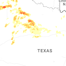


Connect with Interactive Hail Maps