

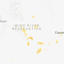
Hail Map for Atlantic City, WY
The Atlantic City, WY area has had 0 reports of on-the-ground hail by trained spotters, and has been under severe weather warnings 0 times during the past 12 months. Doppler radar has detected hail at or near Atlantic City, WY on 3 occasions.
| Name: | Atlantic City, WY |
| Where Located: | 40.6 miles SSW of Riverton, WY |
| Map: | Google Map for Atlantic City, WY |
| Population: | 37 |
| Housing Units: | 134 |
| More Info: | Search Google for Atlantic City, WY |
5
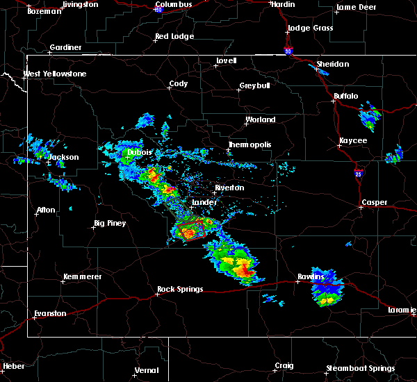
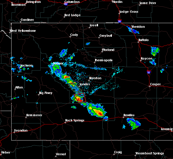
The Top Recent Hail Date for Atlantic City, WY is Saturday, June 22, 2013 (1st out of 3)

Hail and Wind Damage Spotted near Atlantic City, WY
| Date / Time | Report Details |
|---|---|
| 6/28/2020 4:05 PM MDT |
 At 404 pm mdt, a severe thunderstorm was located near south pass city, which is 23 miles south of lander, moving northeast at 55 mph (radar indicated). Hazards include 60 mph wind gusts. Expect damage to roofs, siding, and trees. this severe thunderstorm will be near, red canyon around 415 pm mdt. sand draw around 440 pm mdt. Other locations impacted by this severe thunderstorm include atlantic city, highway 28, and the red canyon area. At 404 pm mdt, a severe thunderstorm was located near south pass city, which is 23 miles south of lander, moving northeast at 55 mph (radar indicated). Hazards include 60 mph wind gusts. Expect damage to roofs, siding, and trees. this severe thunderstorm will be near, red canyon around 415 pm mdt. sand draw around 440 pm mdt. Other locations impacted by this severe thunderstorm include atlantic city, highway 28, and the red canyon area.
|
| 6/7/2020 3:02 PM MDT |
 At 301 pm mdt, a severe thunderstorm was located over lander, moving northeast at 35 mph (radar indicated). Hazards include 60 mph wind gusts. Expect damage to roofs, siding, and trees. this severe storm will be near, hudson around 310 pm mdt. arapahoe around 320 pm mdt. wind gusts near 50 mph were reported at lander hunt field just before 3 pm. Gusts above 60 mph have been measured on highway 28 around red canyon. At 301 pm mdt, a severe thunderstorm was located over lander, moving northeast at 35 mph (radar indicated). Hazards include 60 mph wind gusts. Expect damage to roofs, siding, and trees. this severe storm will be near, hudson around 310 pm mdt. arapahoe around 320 pm mdt. wind gusts near 50 mph were reported at lander hunt field just before 3 pm. Gusts above 60 mph have been measured on highway 28 around red canyon.
|
| 6/7/2020 2:42 PM MDT |
 At 242 pm mdt, a severe thunderstorm was located over sinks canyon state park, which is 8 miles south of lander, moving northeast at 55 mph (radar indicated). Hazards include 60 mph wind gusts. Expect damage to roofs, siding, and trees. this severe thunderstorm will be near, lander and milford around 250 pm mdt. hudson around 300 pm mdt. arapahoe around 305 pm mdt. Other locations impacted by this severe thunderstorm include atlantic city, sinks canyon campground, and lander hunt field. At 242 pm mdt, a severe thunderstorm was located over sinks canyon state park, which is 8 miles south of lander, moving northeast at 55 mph (radar indicated). Hazards include 60 mph wind gusts. Expect damage to roofs, siding, and trees. this severe thunderstorm will be near, lander and milford around 250 pm mdt. hudson around 300 pm mdt. arapahoe around 305 pm mdt. Other locations impacted by this severe thunderstorm include atlantic city, sinks canyon campground, and lander hunt field.
|
| 6/6/2020 3:34 PM MDT |
 At 332 pm mdt, severe thunderstorms were located along a line extending from 6 miles southeast of hidden valley to near alcova, moving east at 65 mph (radar indicated). Hazards include 60 to 65 mph wind gusts. Expect damage to roofs, siding, and trees. severe thunderstorms will be near, hiland, waltman and waltman rest area around 350 pm mdt. powder river around 355 pm mdt. goldeneye reservoir around 400 pm mdt. casper, bar nunn, homa hills and antelope hills around 410 pm mdt. other locations impacted by these severe thunderstorms include atlantic city, casper mountain, and casper-natrona county international airport. this includes interstate 25 between mile markers 176 and 208. Time, mot, loc 2132z 273deg 134kt 4310 10813 4208 10660 4251 10665. At 332 pm mdt, severe thunderstorms were located along a line extending from 6 miles southeast of hidden valley to near alcova, moving east at 65 mph (radar indicated). Hazards include 60 to 65 mph wind gusts. Expect damage to roofs, siding, and trees. severe thunderstorms will be near, hiland, waltman and waltman rest area around 350 pm mdt. powder river around 355 pm mdt. goldeneye reservoir around 400 pm mdt. casper, bar nunn, homa hills and antelope hills around 410 pm mdt. other locations impacted by these severe thunderstorms include atlantic city, casper mountain, and casper-natrona county international airport. this includes interstate 25 between mile markers 176 and 208. Time, mot, loc 2132z 273deg 134kt 4310 10813 4208 10660 4251 10665.
|
| 6/6/2020 2:59 PM MDT |
 At 257 pm mdt, severe thunderstorms were located along a line extending from near lander to 14 miles west of seminoe dam, moving north at 65 mph (radar indicated). Hazards include 60 to 65 mph wind gusts. Expect damage to roofs, siding, and trees. these severe storms will be near, devil`s gate around 310 pm mdt. independence rock around 315 pm mdt. Other locations impacted by these severe thunderstorms include atlantic city, sinks canyon campground, riverton landfill and lander hunt field. At 257 pm mdt, severe thunderstorms were located along a line extending from near lander to 14 miles west of seminoe dam, moving north at 65 mph (radar indicated). Hazards include 60 to 65 mph wind gusts. Expect damage to roofs, siding, and trees. these severe storms will be near, devil`s gate around 310 pm mdt. independence rock around 315 pm mdt. Other locations impacted by these severe thunderstorms include atlantic city, sinks canyon campground, riverton landfill and lander hunt field.
|
| 6/6/2020 2:32 PM MDT |
 At 230 pm mdt, severe thunderstorms were located along a line extending from near south pass to 6 miles northwest of bairoil, moving north northeast at 65 mph (radar indicated). Hazards include 60 to 65 mph wind gusts. Expect damage to roofs, siding, and trees. severe thunderstorms will be near, red canyon around 240 pm mdt. hudson around 245 pm mdt. devil`s gate around 310 pm mdt. independence rock around 315 pm mdt. Other locations impacted by these severe thunderstorms include atlantic city, sinks canyon campground, riverton landfill and lander hunt field. At 230 pm mdt, severe thunderstorms were located along a line extending from near south pass to 6 miles northwest of bairoil, moving north northeast at 65 mph (radar indicated). Hazards include 60 to 65 mph wind gusts. Expect damage to roofs, siding, and trees. severe thunderstorms will be near, red canyon around 240 pm mdt. hudson around 245 pm mdt. devil`s gate around 310 pm mdt. independence rock around 315 pm mdt. Other locations impacted by these severe thunderstorms include atlantic city, sinks canyon campground, riverton landfill and lander hunt field.
|
| 5/27/2018 1:09 PM MDT |
 The tornado warning for south central fremont county will expire at 115 pm mdt, the storm which prompted the warning has weakened and no longer appears capable of producing a tornado. therefore the tornado warning will be allowed to expire. however, heavy rain is still possible with thunderstorms across fremont county this afternoon a severe thunderstorm watch remains in effect until 800 pm mdt for central wyoming. The tornado warning for south central fremont county will expire at 115 pm mdt, the storm which prompted the warning has weakened and no longer appears capable of producing a tornado. therefore the tornado warning will be allowed to expire. however, heavy rain is still possible with thunderstorms across fremont county this afternoon a severe thunderstorm watch remains in effect until 800 pm mdt for central wyoming.
|
| 5/27/2018 12:57 PM MDT |
 At 1256 pm mdt, a severe thunderstorm capable of producing a tornado was located over south pass city, which is 23 miles south of lander, moving north at 10 to 15 mph (radar indicated rotation). Hazards include tornado and half dollar size hail. Flying debris will be dangerous to those caught without shelter. mobile homes will be damaged or destroyed. damage to roofs, windows, and vehicles will occur. tree damage is likely. this dangerous storm will cross state highway 28 near the old us steel mine. Other locations impacted by this tornadic thunderstorm include atlantic city and south pass city. At 1256 pm mdt, a severe thunderstorm capable of producing a tornado was located over south pass city, which is 23 miles south of lander, moving north at 10 to 15 mph (radar indicated rotation). Hazards include tornado and half dollar size hail. Flying debris will be dangerous to those caught without shelter. mobile homes will be damaged or destroyed. damage to roofs, windows, and vehicles will occur. tree damage is likely. this dangerous storm will cross state highway 28 near the old us steel mine. Other locations impacted by this tornadic thunderstorm include atlantic city and south pass city.
|
| 5/27/2018 12:45 PM MDT |
 At 1245 pm mdt, a severe thunderstorm capable of producing a tornado was located near south pass city, which is 26 miles south of lander, moving north at 15 mph (radar indicated rotation). Hazards include tornado and half dollar size hail. Flying debris will be dangerous to those caught without shelter. mobile homes will be damaged or destroyed. damage to roofs, windows, and vehicles will occur. tree damage is likely. This dangerous storm will be near, south pass city and atlantic city around 1255 pm mdt. At 1245 pm mdt, a severe thunderstorm capable of producing a tornado was located near south pass city, which is 26 miles south of lander, moving north at 15 mph (radar indicated rotation). Hazards include tornado and half dollar size hail. Flying debris will be dangerous to those caught without shelter. mobile homes will be damaged or destroyed. damage to roofs, windows, and vehicles will occur. tree damage is likely. This dangerous storm will be near, south pass city and atlantic city around 1255 pm mdt.
|
| 5/27/2018 12:35 PM MDT |
 At 1234 pm mdt, a severe thunderstorm capable of producing a tornado was located near south pass city, which is 29 miles south of lander, moving north at 10 mph (radar indicated rotation). Hazards include tornado and half dollar size hail. Flying debris will be dangerous to those caught without shelter. mobile homes will be damaged or destroyed. damage to roofs, windows, and vehicles will occur. tree damage is likely. This dangerous storm will be near, south pass city and atlantic city around 1245 pm mdt. At 1234 pm mdt, a severe thunderstorm capable of producing a tornado was located near south pass city, which is 29 miles south of lander, moving north at 10 mph (radar indicated rotation). Hazards include tornado and half dollar size hail. Flying debris will be dangerous to those caught without shelter. mobile homes will be damaged or destroyed. damage to roofs, windows, and vehicles will occur. tree damage is likely. This dangerous storm will be near, south pass city and atlantic city around 1245 pm mdt.
|
| 5/27/2018 12:23 PM MDT |
 At 1222 pm mdt, a severe thunderstorm capable of producing a tornado was located 8 miles southeast of south pass city, which is 31 miles south of lander, and is moving north (radar indicated rotation). Hazards include tornado and half dollar size hail. Flying debris will be dangerous to those caught without shelter. mobile homes will be damaged or destroyed. damage to roofs, windows, and vehicles will occur. tree damage is likely. this dangerous storm will be near, south pass city around 1240 pm mdt. Other locations impacted by this tornadic thunderstorm include atlantic city. At 1222 pm mdt, a severe thunderstorm capable of producing a tornado was located 8 miles southeast of south pass city, which is 31 miles south of lander, and is moving north (radar indicated rotation). Hazards include tornado and half dollar size hail. Flying debris will be dangerous to those caught without shelter. mobile homes will be damaged or destroyed. damage to roofs, windows, and vehicles will occur. tree damage is likely. this dangerous storm will be near, south pass city around 1240 pm mdt. Other locations impacted by this tornadic thunderstorm include atlantic city.
|
| 5/27/2018 12:18 PM MDT |
 At 1217 pm mdt, a severe thunderstorm capable of producing a tornado was located 7 miles southeast of south pass city, which is 29 miles south of lander, moving north at 10 mph (radar indicated rotation). Hazards include tornado and half dollar size hail. Flying debris will be dangerous to those caught without shelter. mobile homes will be damaged or destroyed. damage to roofs, windows, and vehicles will occur. tree damage is likely. this dangerous storm will be near, south pass city around 1245 pm mdt. Other locations impacted by this tornadic thunderstorm include atlantic city. At 1217 pm mdt, a severe thunderstorm capable of producing a tornado was located 7 miles southeast of south pass city, which is 29 miles south of lander, moving north at 10 mph (radar indicated rotation). Hazards include tornado and half dollar size hail. Flying debris will be dangerous to those caught without shelter. mobile homes will be damaged or destroyed. damage to roofs, windows, and vehicles will occur. tree damage is likely. this dangerous storm will be near, south pass city around 1245 pm mdt. Other locations impacted by this tornadic thunderstorm include atlantic city.
|
Hail Maps for Atlantic City, WY


Connect with Interactive Hail Maps