

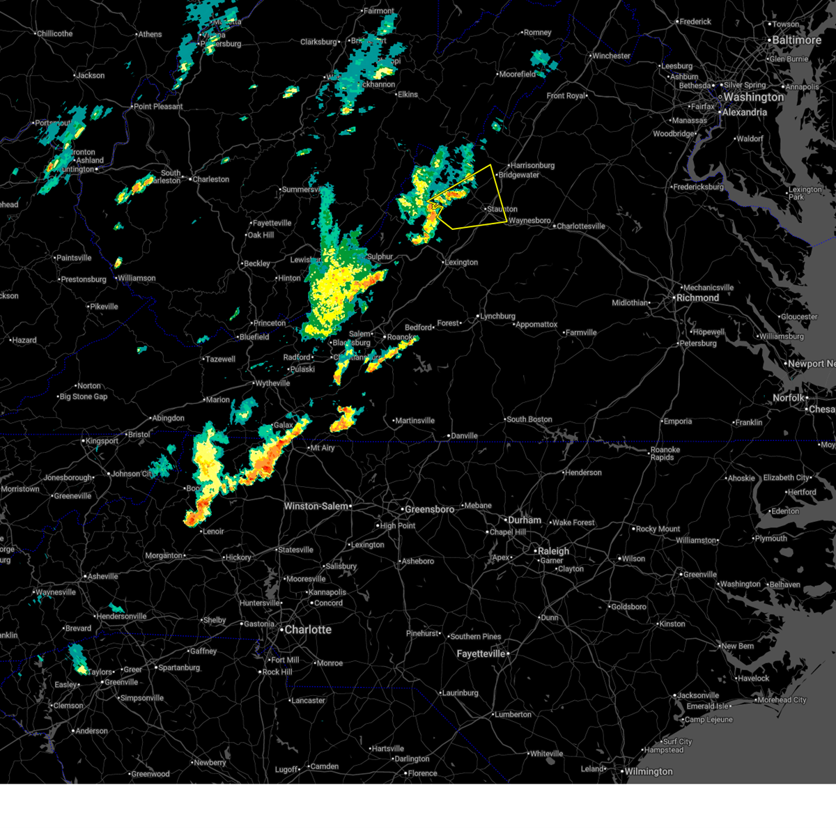
Hail Map for Augusta Springs, VA
The Augusta Springs, VA area has had 0 reports of on-the-ground hail by trained spotters, and has been under severe weather warnings 3 times during the past 12 months. Doppler radar has detected hail at or near Augusta Springs, VA on 27 occasions.
| Name: | Augusta Springs, VA |
| Where Located: | 62.5 miles SSE of Elkins, WV |
| Map: | Google Map for Augusta Springs, VA |
| Population: | 257 |
| Housing Units: | 122 |
| More Info: | Search Google for Augusta Springs, VA |
5
The Top Recent Hail Date for Augusta Springs, VA is Monday, August 7, 2023 (2nd out of 27)

Hail and Wind Damage Spotted near Augusta Springs, VA
| Date / Time | Report Details |
|---|---|
| 6/19/2025 2:10 PM EDT | the severe thunderstorm warning has been cancelled and is no longer in effect |
| 6/19/2025 2:10 PM EDT | At 209 pm edt, a severe thunderstorm was located 7 miles west of staunton, moving east at 45 mph (radar indicated). Hazards include 60 mph wind gusts and quarter size hail. Damaging winds will cause some trees and large branches to fall. this could injure those outdoors, as well as damage homes and vehicles. roadways may become blocked by downed trees. localized power outages are possible. unsecured light objects may become projectiles. Locations impacted include, staunton, waynesboro, stuarts draft, fishersville, verona, mount sidney, augusta springs, middlebrook, churchville, mint spring, moscow, buffalo gap, summerdean, trimbles mill, mount solon, sangerville, christian, fort defiance, and swoope. |
| 6/19/2025 1:45 PM EDT |
 Svrlwx the national weather service in sterling virginia has issued a * severe thunderstorm warning for, southwestern rockingham county in western virginia, augusta county in western virginia, the city of staunton in western virginia, the northwestern city of waynesboro in western virginia, southeastern highland county in western virginia, * until 230 pm edt. * at 145 pm edt, a severe thunderstorm was located near yost, or 8 miles north of goshen, moving east at 45 mph (radar indicated). Hazards include 60 mph wind gusts and quarter size hail. Damaging winds will cause some trees and large branches to fall. this could injure those outdoors, as well as damage homes and vehicles. roadways may become blocked by downed trees. localized power outages are possible. Unsecured light objects may become projectiles. Svrlwx the national weather service in sterling virginia has issued a * severe thunderstorm warning for, southwestern rockingham county in western virginia, augusta county in western virginia, the city of staunton in western virginia, the northwestern city of waynesboro in western virginia, southeastern highland county in western virginia, * until 230 pm edt. * at 145 pm edt, a severe thunderstorm was located near yost, or 8 miles north of goshen, moving east at 45 mph (radar indicated). Hazards include 60 mph wind gusts and quarter size hail. Damaging winds will cause some trees and large branches to fall. this could injure those outdoors, as well as damage homes and vehicles. roadways may become blocked by downed trees. localized power outages are possible. Unsecured light objects may become projectiles.
|
| 5/26/2024 7:42 PM EDT |
 Svrlwx the national weather service in sterling virginia has issued a * severe thunderstorm warning for, nelson county in central virginia, rockingham county in western virginia, western albemarle county in central virginia, western greene county in central virginia, augusta county in western virginia, the city of staunton in western virginia, the city of harrisonburg in western virginia, the city of waynesboro in western virginia, eastern highland county in western virginia, pendleton county in eastern west virginia, southwestern hardy county in eastern west virginia, * until 845 pm edt. * at 742 pm edt, severe thunderstorms were located along a line extending from 13 miles southeast of elkins to monterey to near fairfield to near evington, moving east at 40 mph (radar indicated). Hazards include 60 mph wind gusts. Damaging winds will cause some trees and large branches to fall. this could injure those outdoors, as well as damage homes and vehicles. roadways may become blocked by downed trees. localized power outages are possible. Unsecured light objects may become projectiles. Svrlwx the national weather service in sterling virginia has issued a * severe thunderstorm warning for, nelson county in central virginia, rockingham county in western virginia, western albemarle county in central virginia, western greene county in central virginia, augusta county in western virginia, the city of staunton in western virginia, the city of harrisonburg in western virginia, the city of waynesboro in western virginia, eastern highland county in western virginia, pendleton county in eastern west virginia, southwestern hardy county in eastern west virginia, * until 845 pm edt. * at 742 pm edt, severe thunderstorms were located along a line extending from 13 miles southeast of elkins to monterey to near fairfield to near evington, moving east at 40 mph (radar indicated). Hazards include 60 mph wind gusts. Damaging winds will cause some trees and large branches to fall. this could injure those outdoors, as well as damage homes and vehicles. roadways may become blocked by downed trees. localized power outages are possible. Unsecured light objects may become projectiles.
|
| 5/26/2024 7:10 PM EDT |
 At 710 pm edt, severe thunderstorms were located along a line extending from near dailey to 6 miles northwest of greenbank to 7 miles north of mountain grove to near collierstown, moving east at 45 mph (radar indicated). Hazards include 60 mph wind gusts. Damaging winds will cause some trees and large branches to fall. this could injure those outdoors, as well as damage homes and vehicles. roadways may become blocked by downed trees. localized power outages are possible. unsecured light objects may become projectiles. Locations impacted include, staunton, franklin, monterey, stuarts draft, sherando, shipman, wintergreen, montebello, fishersville, verona, lyndhurst, nellysford, craigsville, greenville, arrington, lovingston, augusta springs, middlebrook, churchville, and deerfield. At 710 pm edt, severe thunderstorms were located along a line extending from near dailey to 6 miles northwest of greenbank to 7 miles north of mountain grove to near collierstown, moving east at 45 mph (radar indicated). Hazards include 60 mph wind gusts. Damaging winds will cause some trees and large branches to fall. this could injure those outdoors, as well as damage homes and vehicles. roadways may become blocked by downed trees. localized power outages are possible. unsecured light objects may become projectiles. Locations impacted include, staunton, franklin, monterey, stuarts draft, sherando, shipman, wintergreen, montebello, fishersville, verona, lyndhurst, nellysford, craigsville, greenville, arrington, lovingston, augusta springs, middlebrook, churchville, and deerfield.
|
| 5/26/2024 6:44 PM EDT |
 Svrlwx the national weather service in sterling virginia has issued a * severe thunderstorm warning for, central nelson county in central virginia, augusta county in western virginia, the city of staunton in western virginia, highland county in western virginia, pendleton county in eastern west virginia, * until 745 pm edt. * at 644 pm edt, severe thunderstorms were located along a line extending from 6 miles southeast of rock cave to 10 miles west of snowshoe to near marlinton to near low moor, moving east at 45 mph (radar indicated). Hazards include 60 mph wind gusts and quarter size hail. Damaging winds will cause some trees and large branches to fall. this could injure those outdoors, as well as damage homes and vehicles. roadways may become blocked by downed trees. localized power outages are possible. Unsecured light objects may become projectiles. Svrlwx the national weather service in sterling virginia has issued a * severe thunderstorm warning for, central nelson county in central virginia, augusta county in western virginia, the city of staunton in western virginia, highland county in western virginia, pendleton county in eastern west virginia, * until 745 pm edt. * at 644 pm edt, severe thunderstorms were located along a line extending from 6 miles southeast of rock cave to 10 miles west of snowshoe to near marlinton to near low moor, moving east at 45 mph (radar indicated). Hazards include 60 mph wind gusts and quarter size hail. Damaging winds will cause some trees and large branches to fall. this could injure those outdoors, as well as damage homes and vehicles. roadways may become blocked by downed trees. localized power outages are possible. Unsecured light objects may become projectiles.
|
| 8/7/2023 4:09 PM EDT |
 At 408 pm edt, a severe thunderstorm capable of producing a tornado was located 8 miles southwest of staunton, moving east at 35 mph (radar indicated rotation). Hazards include tornado and two inch hail. For those in the direct path of a tornado touchdown, flying debris will be dangerous to those caught without shelter. damage to roofs, siding, and windows may occur. mobile homes may be damaged or destroyed. tree damage is likely. this dangerous storm will be near, staunton and stuarts draft around 425 pm edt. waynesboro around 435 pm edt. Other locations impacted by this tornadic thunderstorm include summerdean, fishersville, lyndhurst, trimbles mill, greenville, fort defiance, mint spring, middlebrook, verona and swoope. At 408 pm edt, a severe thunderstorm capable of producing a tornado was located 8 miles southwest of staunton, moving east at 35 mph (radar indicated rotation). Hazards include tornado and two inch hail. For those in the direct path of a tornado touchdown, flying debris will be dangerous to those caught without shelter. damage to roofs, siding, and windows may occur. mobile homes may be damaged or destroyed. tree damage is likely. this dangerous storm will be near, staunton and stuarts draft around 425 pm edt. waynesboro around 435 pm edt. Other locations impacted by this tornadic thunderstorm include summerdean, fishersville, lyndhurst, trimbles mill, greenville, fort defiance, mint spring, middlebrook, verona and swoope.
|
| 8/7/2023 3:59 PM EDT |
 At 359 pm edt, a severe thunderstorm capable of producing a tornado was located 8 miles east of bells valley, or 12 miles east of goshen, moving east at 35 mph (radar indicated rotation). Hazards include tornado and ping pong ball size hail. For those in the direct path of a tornado touchdown, flying debris will be dangerous to those caught without shelter. damage to roofs, siding, and windows may occur. mobile homes may be damaged or destroyed. tree damage is likely. this dangerous storm will be near, stuarts draft around 425 pm edt. staunton, waynesboro and sherando around 430 pm edt. Other locations impacted by this tornadic thunderstorm include summerdean, fishersville, lyndhurst, trimbles mill, greenville, craigsville, fort defiance, mint spring, middlebrook and verona. At 359 pm edt, a severe thunderstorm capable of producing a tornado was located 8 miles east of bells valley, or 12 miles east of goshen, moving east at 35 mph (radar indicated rotation). Hazards include tornado and ping pong ball size hail. For those in the direct path of a tornado touchdown, flying debris will be dangerous to those caught without shelter. damage to roofs, siding, and windows may occur. mobile homes may be damaged or destroyed. tree damage is likely. this dangerous storm will be near, stuarts draft around 425 pm edt. staunton, waynesboro and sherando around 430 pm edt. Other locations impacted by this tornadic thunderstorm include summerdean, fishersville, lyndhurst, trimbles mill, greenville, craigsville, fort defiance, mint spring, middlebrook and verona.
|
| 8/7/2023 3:51 PM EDT |
 At 351 pm edt, a severe thunderstorm was located near bells valley, or 9 miles northeast of goshen, moving east at 40 mph (radar indicated). Hazards include 70 mph wind gusts and ping pong ball size hail. Damaging winds will cause some trees and large branches to fall. this could injure those outdoors, as well as damage homes and vehicles. roadways may become blocked by downed trees. localized power outages are possible. unsecured light objects may become projectiles. locations impacted include, craigsville, augusta springs, middlebrook, deerfield, west augusta, buffalo gap, summerdean, trimbles mill, christian, mint spring and swoope. thunderstorm damage threat, considerable hail threat, radar indicated max hail size, 1. 50 in wind threat, radar indicated max wind gust, 70 mph. At 351 pm edt, a severe thunderstorm was located near bells valley, or 9 miles northeast of goshen, moving east at 40 mph (radar indicated). Hazards include 70 mph wind gusts and ping pong ball size hail. Damaging winds will cause some trees and large branches to fall. this could injure those outdoors, as well as damage homes and vehicles. roadways may become blocked by downed trees. localized power outages are possible. unsecured light objects may become projectiles. locations impacted include, craigsville, augusta springs, middlebrook, deerfield, west augusta, buffalo gap, summerdean, trimbles mill, christian, mint spring and swoope. thunderstorm damage threat, considerable hail threat, radar indicated max hail size, 1. 50 in wind threat, radar indicated max wind gust, 70 mph.
|
| 8/7/2023 3:37 PM EDT |
 At 336 pm edt, a severe thunderstorm was located near burnsville, or 10 miles northwest of goshen, moving northeast at 40 mph (radar indicated). Hazards include 70 mph wind gusts and quarter size hail. Damaging winds will cause some trees and large branches to fall. this could injure those outdoors, as well as damage homes and vehicles. roadways may become blocked by downed trees. localized power outages are possible. Unsecured light objects may become projectiles. At 336 pm edt, a severe thunderstorm was located near burnsville, or 10 miles northwest of goshen, moving northeast at 40 mph (radar indicated). Hazards include 70 mph wind gusts and quarter size hail. Damaging winds will cause some trees and large branches to fall. this could injure those outdoors, as well as damage homes and vehicles. roadways may become blocked by downed trees. localized power outages are possible. Unsecured light objects may become projectiles.
|
| 7/28/2023 6:58 PM EDT |
 The severe thunderstorm warning for west central rockingham and western augusta counties will expire at 700 pm edt, the storms which prompted the warning have moved out of the area. therefore, the warning will be allowed to expire. a severe thunderstorm watch remains in effect until 1100 pm edt for western virginia. to report severe weather, contact your nearest law enforcement agency. they will relay your report to the national weather service sterling virginia. The severe thunderstorm warning for west central rockingham and western augusta counties will expire at 700 pm edt, the storms which prompted the warning have moved out of the area. therefore, the warning will be allowed to expire. a severe thunderstorm watch remains in effect until 1100 pm edt for western virginia. to report severe weather, contact your nearest law enforcement agency. they will relay your report to the national weather service sterling virginia.
|
| 7/28/2023 6:37 PM EDT |
 At 637 pm edt, severe thunderstorms were located along a line extending from 8 miles southeast of brandywine to near bells valley, moving east at 15 mph (radar indicated). Hazards include 60 mph wind gusts. Damaging winds will cause some trees and large branches to fall. this could injure those outdoors, as well as damage homes and vehicles. roadways may become blocked by downed trees. localized power outages are possible. unsecured light objects may become projectiles. locations impacted include, bridgewater, broadway, timberville, dale enterprise, dayton, craigsville, augusta springs, middlebrook, churchville, deerfield, moscow, buffalo gap, clover hill, hinton, cherry grove, singers glen, rawley springs, west augusta, summerdean and montezuma. hail threat, radar indicated max hail size, <. 75 in wind threat, radar indicated max wind gust, 60 mph. At 637 pm edt, severe thunderstorms were located along a line extending from 8 miles southeast of brandywine to near bells valley, moving east at 15 mph (radar indicated). Hazards include 60 mph wind gusts. Damaging winds will cause some trees and large branches to fall. this could injure those outdoors, as well as damage homes and vehicles. roadways may become blocked by downed trees. localized power outages are possible. unsecured light objects may become projectiles. locations impacted include, bridgewater, broadway, timberville, dale enterprise, dayton, craigsville, augusta springs, middlebrook, churchville, deerfield, moscow, buffalo gap, clover hill, hinton, cherry grove, singers glen, rawley springs, west augusta, summerdean and montezuma. hail threat, radar indicated max hail size, <. 75 in wind threat, radar indicated max wind gust, 60 mph.
|
| 7/28/2023 6:04 PM EDT |
 At 604 pm edt, severe thunderstorms were located along a line extending from near brandywine to near burnsville, moving east at 15 mph (radar indicated). Hazards include 60 mph wind gusts. Damaging winds will cause some trees and large branches to fall. this could injure those outdoors, as well as damage homes and vehicles. roadways may become blocked by downed trees. localized power outages are possible. Unsecured light objects may become projectiles. At 604 pm edt, severe thunderstorms were located along a line extending from near brandywine to near burnsville, moving east at 15 mph (radar indicated). Hazards include 60 mph wind gusts. Damaging winds will cause some trees and large branches to fall. this could injure those outdoors, as well as damage homes and vehicles. roadways may become blocked by downed trees. localized power outages are possible. Unsecured light objects may become projectiles.
|
| 8/10/2022 2:37 PM EDT | Several trees down along little calf pasture highway in augusta county VA, 3.1 miles WSW of Augusta Springs, VA |
| 6/17/2022 4:14 PM EDT |
 At 414 pm edt, a severe thunderstorm was located near monterey, moving southeast at 30 mph (radar indicated). Hazards include 60 mph wind gusts. Damaging winds will cause some trees and large branches to fall. this could injure those outdoors, as well as damage homes and vehicles. roadways may become blocked by downed trees. localized power outages are possible. Unsecured light objects may become projectiles. At 414 pm edt, a severe thunderstorm was located near monterey, moving southeast at 30 mph (radar indicated). Hazards include 60 mph wind gusts. Damaging winds will cause some trees and large branches to fall. this could injure those outdoors, as well as damage homes and vehicles. roadways may become blocked by downed trees. localized power outages are possible. Unsecured light objects may become projectiles.
|
| 5/27/2022 11:45 AM EDT | Report of large tree branch that fell on a vehicle on 2700 block of little calf pasture hwy. car was damaged but road was not blocke in augusta county VA, 1.4 miles W of Augusta Springs, VA |
| 5/6/2022 8:43 PM EDT |
 At 843 pm edt, severe thunderstorms were located along a line extending from bells valley to near vesuvius to near pleasant view, moving east at 35 mph (radar indicated). Hazards include 60 mph wind gusts. Damaging winds will cause some trees and large branches to fall. this could injure those outdoors, as well as damage homes and vehicles. roadways may become blocked by downed trees. localized power outages are possible. unsecured light objects may become projectiles. locations impacted include, stuarts draft, sherando, wintergreen, montebello, craigsville, greenville, middlebrook, summerdean, tyro and spottswood. hail threat, radar indicated max hail size, <. 75 in wind threat, radar indicated max wind gust, 60 mph. At 843 pm edt, severe thunderstorms were located along a line extending from bells valley to near vesuvius to near pleasant view, moving east at 35 mph (radar indicated). Hazards include 60 mph wind gusts. Damaging winds will cause some trees and large branches to fall. this could injure those outdoors, as well as damage homes and vehicles. roadways may become blocked by downed trees. localized power outages are possible. unsecured light objects may become projectiles. locations impacted include, stuarts draft, sherando, wintergreen, montebello, craigsville, greenville, middlebrook, summerdean, tyro and spottswood. hail threat, radar indicated max hail size, <. 75 in wind threat, radar indicated max wind gust, 60 mph.
|
| 5/6/2022 8:28 PM EDT |
 At 827 pm edt, severe thunderstorms were located along a line extending from near goshen to lexington to near glasgow, moving east at 30 mph (radar indicated). Hazards include 60 mph wind gusts and quarter size hail. Damaging winds will cause some trees and large branches to fall. this could injure those outdoors, as well as damage homes and vehicles. roadways may become blocked by downed trees. localized power outages are possible. Unsecured light objects may become projectiles. At 827 pm edt, severe thunderstorms were located along a line extending from near goshen to lexington to near glasgow, moving east at 30 mph (radar indicated). Hazards include 60 mph wind gusts and quarter size hail. Damaging winds will cause some trees and large branches to fall. this could injure those outdoors, as well as damage homes and vehicles. roadways may become blocked by downed trees. localized power outages are possible. Unsecured light objects may become projectiles.
|
| 8/29/2021 2:26 PM EDT |
 The severe thunderstorm warning for west central augusta and southeastern highland counties will expire at 230 pm edt, the storms which prompted the warning have weakened below severe limits, and no longer pose an immediate threat to life or property. therefore, the warning will be allowed to expire. The severe thunderstorm warning for west central augusta and southeastern highland counties will expire at 230 pm edt, the storms which prompted the warning have weakened below severe limits, and no longer pose an immediate threat to life or property. therefore, the warning will be allowed to expire.
|
| 8/29/2021 2:03 PM EDT |
 At 203 pm edt, severe thunderstorms were located along a line extending from 13 miles west of staunton to 11 miles east of burnsville, moving southeast at 10 mph (radar indicated). Hazards include 60 mph wind gusts. Damaging winds will cause some trees and large branches to fall. this could injure those outdoors, as well as damage homes and vehicles. roadways may become blocked by downed trees. localized power outages are possible. unsecured light objects may become projectiles. locations impacted include, augusta springs, churchville, deerfield, west augusta, williamsville, buffalo gap, head waters and liberty. hail threat, radar indicated max hail size, <. 75 in wind threat, radar indicated max wind gust, 60 mph. At 203 pm edt, severe thunderstorms were located along a line extending from 13 miles west of staunton to 11 miles east of burnsville, moving southeast at 10 mph (radar indicated). Hazards include 60 mph wind gusts. Damaging winds will cause some trees and large branches to fall. this could injure those outdoors, as well as damage homes and vehicles. roadways may become blocked by downed trees. localized power outages are possible. unsecured light objects may become projectiles. locations impacted include, augusta springs, churchville, deerfield, west augusta, williamsville, buffalo gap, head waters and liberty. hail threat, radar indicated max hail size, <. 75 in wind threat, radar indicated max wind gust, 60 mph.
|
| 8/29/2021 1:43 PM EDT |
 At 143 pm edt, a severe thunderstorm was located 12 miles northeast of burnsville, or 13 miles southeast of monterey, moving southeast at 10 mph (radar indicated). Hazards include 60 mph wind gusts. Damaging winds will cause some trees and large branches to fall. this could injure those outdoors, as well as damage homes and vehicles. roadways may become blocked by downed trees. localized power outages are possible. Unsecured light objects may become projectiles. At 143 pm edt, a severe thunderstorm was located 12 miles northeast of burnsville, or 13 miles southeast of monterey, moving southeast at 10 mph (radar indicated). Hazards include 60 mph wind gusts. Damaging winds will cause some trees and large branches to fall. this could injure those outdoors, as well as damage homes and vehicles. roadways may become blocked by downed trees. localized power outages are possible. Unsecured light objects may become projectiles.
|
| 7/5/2020 6:22 PM EDT |
 At 621 pm edt, a severe thunderstorm was located over bells valley, or 7 miles northeast of goshen, moving southeast at 5 mph (radar indicated). Hazards include 60 mph wind gusts and quarter size hail. Damaging winds will cause some trees and large branches to fall. this could injure those outdoors, as well as damage homes and vehicles. roadways may become blocked by downed trees. localized power outages are possible. Unsecured light objects may become projectiles. At 621 pm edt, a severe thunderstorm was located over bells valley, or 7 miles northeast of goshen, moving southeast at 5 mph (radar indicated). Hazards include 60 mph wind gusts and quarter size hail. Damaging winds will cause some trees and large branches to fall. this could injure those outdoors, as well as damage homes and vehicles. roadways may become blocked by downed trees. localized power outages are possible. Unsecured light objects may become projectiles.
|
| 7/5/2020 6:08 PM EDT |
 The severe thunderstorm warning for west central augusta county will expire at 615 pm edt, the storm which prompted the warning has weakened below severe limits, and no longer poses an immediate threat to life or property. therefore, the warning will be allowed to expire. The severe thunderstorm warning for west central augusta county will expire at 615 pm edt, the storm which prompted the warning has weakened below severe limits, and no longer poses an immediate threat to life or property. therefore, the warning will be allowed to expire.
|
| 7/5/2020 5:23 PM EDT |
 At 523 pm edt, a severe thunderstorm was located 16 miles southeast of monterey, moving southeast at 5 mph (radar indicated). Hazards include 60 mph wind gusts and quarter size hail. Damaging winds will cause some trees and large branches to fall. this could injure those outdoors, as well as damage homes and vehicles. roadways may become blocked by downed trees. localized power outages are possible. Unsecured light objects may become projectiles. At 523 pm edt, a severe thunderstorm was located 16 miles southeast of monterey, moving southeast at 5 mph (radar indicated). Hazards include 60 mph wind gusts and quarter size hail. Damaging winds will cause some trees and large branches to fall. this could injure those outdoors, as well as damage homes and vehicles. roadways may become blocked by downed trees. localized power outages are possible. Unsecured light objects may become projectiles.
|
| 6/4/2020 4:07 PM EDT |
 At 407 pm edt, a severe thunderstorm was located over fairfield, or near rockbridge baths, moving northeast at 30 mph (radar indicated). Hazards include 60 mph wind gusts and quarter size hail. Damaging winds will cause some trees and large branches to fall. this could injure those outdoors, as well as damage homes and vehicles. roadways may become blocked by downed trees. localized power outages are possible. unsecured light objects may become projectiles. Locations impacted include, stuarts draft, greenville, augusta springs, middlebrook, summerdean, trimbles mill, mint spring, swoope and spottswood. At 407 pm edt, a severe thunderstorm was located over fairfield, or near rockbridge baths, moving northeast at 30 mph (radar indicated). Hazards include 60 mph wind gusts and quarter size hail. Damaging winds will cause some trees and large branches to fall. this could injure those outdoors, as well as damage homes and vehicles. roadways may become blocked by downed trees. localized power outages are possible. unsecured light objects may become projectiles. Locations impacted include, stuarts draft, greenville, augusta springs, middlebrook, summerdean, trimbles mill, mint spring, swoope and spottswood.
|
| 6/4/2020 3:50 PM EDT |
 At 350 pm edt, a severe thunderstorm was located over buena vista, moving northeast at 30 mph (radar indicated). Hazards include 60 mph wind gusts and quarter size hail. Damaging winds will cause some trees and large branches to fall. this could injure those outdoors, as well as damage homes and vehicles. roadways may become blocked by downed trees. localized power outages are possible. Unsecured light objects may become projectiles. At 350 pm edt, a severe thunderstorm was located over buena vista, moving northeast at 30 mph (radar indicated). Hazards include 60 mph wind gusts and quarter size hail. Damaging winds will cause some trees and large branches to fall. this could injure those outdoors, as well as damage homes and vehicles. roadways may become blocked by downed trees. localized power outages are possible. Unsecured light objects may become projectiles.
|
| 4/9/2020 4:05 AM EDT |
 The severe thunderstorm warning for augusta , the city of staunton and the city of waynesboro will expire at 415 am edt, the storms which prompted the warning have moved out of the area. therefore, the warning will be allowed to expire. a severe thunderstorm watch remains in effect until 600 am edt for central and western virginia. to report severe weather, contact your nearest law enforcement agency. they will relay your report to the national weather service sterling virginia. The severe thunderstorm warning for augusta , the city of staunton and the city of waynesboro will expire at 415 am edt, the storms which prompted the warning have moved out of the area. therefore, the warning will be allowed to expire. a severe thunderstorm watch remains in effect until 600 am edt for central and western virginia. to report severe weather, contact your nearest law enforcement agency. they will relay your report to the national weather service sterling virginia.
|
| 4/9/2020 3:55 AM EDT |
 At 355 am edt, severe thunderstorms were located along a line extending from 6 miles southwest of bridgewater to 6 miles northwest of stuarts draft, moving east at 60 mph (radar indicated). Hazards include 60 mph wind gusts. Damaging winds will cause some trees and large branches to fall. this could injure those outdoors, as well as damage homes and vehicles. roadways may become blocked by downed trees. localized power outages are possible. unsecured light objects may become projectiles. Locations impacted include, staunton, waynesboro, stuarts draft, grottoes, crimora, sherando, fishersville, verona, weyers cave, lyndhurst, greenville, new hope, mount sidney, augusta springs, middlebrook, churchville, hermitage, moscow, buffalo gap and afton mountain. At 355 am edt, severe thunderstorms were located along a line extending from 6 miles southwest of bridgewater to 6 miles northwest of stuarts draft, moving east at 60 mph (radar indicated). Hazards include 60 mph wind gusts. Damaging winds will cause some trees and large branches to fall. this could injure those outdoors, as well as damage homes and vehicles. roadways may become blocked by downed trees. localized power outages are possible. unsecured light objects may become projectiles. Locations impacted include, staunton, waynesboro, stuarts draft, grottoes, crimora, sherando, fishersville, verona, weyers cave, lyndhurst, greenville, new hope, mount sidney, augusta springs, middlebrook, churchville, hermitage, moscow, buffalo gap and afton mountain.
|
| 4/9/2020 3:44 AM EDT |
 At 344 am edt, severe thunderstorms were located along a line extending from 14 miles northwest of staunton to near brownsburg, moving east at 65 mph (radar indicated). Hazards include 60 mph wind gusts. Damaging winds will cause some trees and large branches to fall. this could injure those outdoors, as well as damage homes and vehicles. roadways may become blocked by downed trees. localized power outages are possible. unsecured light objects may become projectiles. Locations impacted include, staunton, waynesboro, stuarts draft, grottoes, crimora, sherando, fishersville, verona, weyers cave, lyndhurst, craigsville, greenville, new hope, mount sidney, augusta springs, middlebrook, churchville, deerfield, hermitage and moscow. At 344 am edt, severe thunderstorms were located along a line extending from 14 miles northwest of staunton to near brownsburg, moving east at 65 mph (radar indicated). Hazards include 60 mph wind gusts. Damaging winds will cause some trees and large branches to fall. this could injure those outdoors, as well as damage homes and vehicles. roadways may become blocked by downed trees. localized power outages are possible. unsecured light objects may become projectiles. Locations impacted include, staunton, waynesboro, stuarts draft, grottoes, crimora, sherando, fishersville, verona, weyers cave, lyndhurst, craigsville, greenville, new hope, mount sidney, augusta springs, middlebrook, churchville, deerfield, hermitage and moscow.
|
| 4/9/2020 3:14 AM EDT |
 At 314 am edt, severe thunderstorms were located along a line extending from near burnsville to near nimrod hall, moving east at 65 mph (radar indicated). Hazards include 60 mph wind gusts and quarter size hail. Damaging winds will cause some trees and large branches to fall. this could injure those outdoors, as well as damage homes and vehicles. roadways may become blocked by downed trees. localized power outages are possible. Unsecured light objects may become projectiles. At 314 am edt, severe thunderstorms were located along a line extending from near burnsville to near nimrod hall, moving east at 65 mph (radar indicated). Hazards include 60 mph wind gusts and quarter size hail. Damaging winds will cause some trees and large branches to fall. this could injure those outdoors, as well as damage homes and vehicles. roadways may become blocked by downed trees. localized power outages are possible. Unsecured light objects may become projectiles.
|
| 4/8/2020 5:32 AM EDT |
 At 532 am edt, a severe thunderstorm was located 15 miles northwest of staunton, moving southeast at 70 mph (radar indicated). Hazards include 60 mph wind gusts and quarter size hail. Damaging winds will cause some trees and large branches to fall. this could injure those outdoors, as well as damage homes and vehicles. roadways may become blocked by downed trees. localized power outages are possible. Unsecured light objects may become projectiles. At 532 am edt, a severe thunderstorm was located 15 miles northwest of staunton, moving southeast at 70 mph (radar indicated). Hazards include 60 mph wind gusts and quarter size hail. Damaging winds will cause some trees and large branches to fall. this could injure those outdoors, as well as damage homes and vehicles. roadways may become blocked by downed trees. localized power outages are possible. Unsecured light objects may become projectiles.
|
| 4/7/2020 10:03 PM EDT |
 At 1003 pm edt, a severe thunderstorm was located near bells valley, or 9 miles northeast of goshen, moving southeast at 35 mph (radar indicated). Hazards include 60 mph wind gusts and quarter size hail. Damaging winds will cause some trees and large branches to fall. this could injure those outdoors, as well as damage homes and vehicles. roadways may become blocked by downed trees. localized power outages are possible. unsecured light objects may become projectiles. Locations impacted include, craigsville, greenville, augusta springs, middlebrook, summerdean and spottswood. At 1003 pm edt, a severe thunderstorm was located near bells valley, or 9 miles northeast of goshen, moving southeast at 35 mph (radar indicated). Hazards include 60 mph wind gusts and quarter size hail. Damaging winds will cause some trees and large branches to fall. this could injure those outdoors, as well as damage homes and vehicles. roadways may become blocked by downed trees. localized power outages are possible. unsecured light objects may become projectiles. Locations impacted include, craigsville, greenville, augusta springs, middlebrook, summerdean and spottswood.
|
| 4/7/2020 9:54 PM EDT |
 At 954 pm edt, a severe thunderstorm was located near bells valley, or 8 miles northeast of goshen, moving southeast at 35 mph (radar indicated). Hazards include 60 mph wind gusts and quarter size hail. Damaging winds will cause some trees and large branches to fall. this could injure those outdoors, as well as damage homes and vehicles. roadways may become blocked by downed trees. localized power outages are possible. Unsecured light objects may become projectiles. At 954 pm edt, a severe thunderstorm was located near bells valley, or 8 miles northeast of goshen, moving southeast at 35 mph (radar indicated). Hazards include 60 mph wind gusts and quarter size hail. Damaging winds will cause some trees and large branches to fall. this could injure those outdoors, as well as damage homes and vehicles. roadways may become blocked by downed trees. localized power outages are possible. Unsecured light objects may become projectiles.
|
| 8/1/2019 5:15 PM EDT |
 At 514 pm edt, a severe thunderstorm was located 10 miles southwest of staunton, moving east at 5 mph (radar indicated). Hazards include 60 mph wind gusts. Damaging winds will cause some trees and large branches to fall. this could injure those outdoors, as well as damage homes and vehicles. roadways may become blocked by downed trees. localized power outages are possible. Unsecured light objects may become projectiles. At 514 pm edt, a severe thunderstorm was located 10 miles southwest of staunton, moving east at 5 mph (radar indicated). Hazards include 60 mph wind gusts. Damaging winds will cause some trees and large branches to fall. this could injure those outdoors, as well as damage homes and vehicles. roadways may become blocked by downed trees. localized power outages are possible. Unsecured light objects may become projectiles.
|
| 8/1/2019 5:07 PM EDT |
 The severe thunderstorm warning for west central augusta county will expire at 515 pm edt, the storm which prompted the warning has weakened below severe limits, and no longer poses an immediate threat to life or property. therefore, the warning will be allowed to expire. heavy rain still possible. The severe thunderstorm warning for west central augusta county will expire at 515 pm edt, the storm which prompted the warning has weakened below severe limits, and no longer poses an immediate threat to life or property. therefore, the warning will be allowed to expire. heavy rain still possible.
|
| 8/1/2019 4:39 PM EDT |
 At 439 pm edt, a severe thunderstorm was located 9 miles northeast of bells valley, or 14 miles northeast of goshen, and is nearly stationary (radar indicated). Hazards include 60 mph wind gusts. Damaging winds will cause some trees and large branches to fall. this could injure those outdoors, as well as damage homes and vehicles. roadways may become blocked by downed trees. localized power outages are possible. Unsecured light objects may become projectiles. At 439 pm edt, a severe thunderstorm was located 9 miles northeast of bells valley, or 14 miles northeast of goshen, and is nearly stationary (radar indicated). Hazards include 60 mph wind gusts. Damaging winds will cause some trees and large branches to fall. this could injure those outdoors, as well as damage homes and vehicles. roadways may become blocked by downed trees. localized power outages are possible. Unsecured light objects may become projectiles.
|
| 7/31/2019 3:04 PM EDT |
 At 304 pm edt, a severe thunderstorm was located near bells valley, or 8 miles northeast of goshen, and is nearly stationary (radar indicated). Hazards include 60 mph wind gusts and quarter size hail. Damaging winds will cause some trees and large branches to fall. this could injure those outdoors, as well as damage homes and vehicles. roadways may become blocked by downed trees. localized power outages are possible. Unsecured light objects may become projectiles. At 304 pm edt, a severe thunderstorm was located near bells valley, or 8 miles northeast of goshen, and is nearly stationary (radar indicated). Hazards include 60 mph wind gusts and quarter size hail. Damaging winds will cause some trees and large branches to fall. this could injure those outdoors, as well as damage homes and vehicles. roadways may become blocked by downed trees. localized power outages are possible. Unsecured light objects may become projectiles.
|
| 7/21/2019 4:11 PM EDT |
 At 411 pm edt, severe thunderstorms were located along a line extending from near grottoes to 15 miles north of bells valley, moving east at 5 mph (radar indicated). Hazards include 60 mph wind gusts and quarter size hail. Damaging winds will cause some trees and large branches to fall. this could injure those outdoors, as well as damage homes and vehicles. roadways may become blocked by downed trees. localized power outages are possible. unsecured light objects may become projectiles. Locations impacted include, weyers cave, mount sidney, augusta springs, churchville, deerfield, moscow, west augusta, williamsville, buffalo gap, mount solon, sangerville, christian and staunton airport. At 411 pm edt, severe thunderstorms were located along a line extending from near grottoes to 15 miles north of bells valley, moving east at 5 mph (radar indicated). Hazards include 60 mph wind gusts and quarter size hail. Damaging winds will cause some trees and large branches to fall. this could injure those outdoors, as well as damage homes and vehicles. roadways may become blocked by downed trees. localized power outages are possible. unsecured light objects may become projectiles. Locations impacted include, weyers cave, mount sidney, augusta springs, churchville, deerfield, moscow, west augusta, williamsville, buffalo gap, mount solon, sangerville, christian and staunton airport.
|
| 7/21/2019 3:53 PM EDT |
 At 352 pm edt, severe thunderstorms were located along a line extending from 9 miles north of staunton to 14 miles northeast of bells valley, moving slowly eastward (radar indicated). Hazards include 60 mph wind gusts and quarter size hail. Damaging winds will cause some trees and large branches to fall. this could injure those outdoors, as well as damage homes and vehicles. roadways may become blocked by downed trees. localized power outages are possible. Unsecured light objects may become projectiles. At 352 pm edt, severe thunderstorms were located along a line extending from 9 miles north of staunton to 14 miles northeast of bells valley, moving slowly eastward (radar indicated). Hazards include 60 mph wind gusts and quarter size hail. Damaging winds will cause some trees and large branches to fall. this could injure those outdoors, as well as damage homes and vehicles. roadways may become blocked by downed trees. localized power outages are possible. Unsecured light objects may become projectiles.
|
| 7/11/2019 3:45 PM EDT |
 At 345 pm edt, a severe thunderstorm was located 8 miles north of brownsburg, or 12 miles northeast of rockbridge baths, moving northeast at 45 mph (radar indicated). Hazards include 60 mph wind gusts. Damaging winds will cause some trees and large branches to fall. this could injure those outdoors, as well as damage homes and vehicles. roadways may become blocked by downed trees. localized power outages are possible. Unsecured light objects may become projectiles. At 345 pm edt, a severe thunderstorm was located 8 miles north of brownsburg, or 12 miles northeast of rockbridge baths, moving northeast at 45 mph (radar indicated). Hazards include 60 mph wind gusts. Damaging winds will cause some trees and large branches to fall. this could injure those outdoors, as well as damage homes and vehicles. roadways may become blocked by downed trees. localized power outages are possible. Unsecured light objects may become projectiles.
|
| 6/28/2019 3:19 PM EDT |
 At 319 pm edt, a severe thunderstorm was located near staunton, and is nearly stationary (radar indicated). Hazards include 60 mph wind gusts. Damaging winds will cause some trees and large branches to fall. this could injure those outdoors, as well as damage homes and vehicles. roadways may become blocked by downed trees. localized power outages are possible. unsecured light objects may become projectiles. Locations impacted include, staunton, stuarts draft, verona, greenville, augusta springs, middlebrook, churchville, mint spring, buffalo gap, summerdean, trimbles mill, christian and swoope. At 319 pm edt, a severe thunderstorm was located near staunton, and is nearly stationary (radar indicated). Hazards include 60 mph wind gusts. Damaging winds will cause some trees and large branches to fall. this could injure those outdoors, as well as damage homes and vehicles. roadways may become blocked by downed trees. localized power outages are possible. unsecured light objects may become projectiles. Locations impacted include, staunton, stuarts draft, verona, greenville, augusta springs, middlebrook, churchville, mint spring, buffalo gap, summerdean, trimbles mill, christian and swoope.
|
| 6/28/2019 3:06 PM EDT |
 At 306 pm edt, a severe thunderstorm was located 7 miles southwest of staunton, and is nearly stationary (radar indicated). Hazards include 60 mph wind gusts. Damaging winds will cause some trees and large branches to fall. this could injure those outdoors, as well as damage homes and vehicles. roadways may become blocked by downed trees. localized power outages are possible. Unsecured light objects may become projectiles. At 306 pm edt, a severe thunderstorm was located 7 miles southwest of staunton, and is nearly stationary (radar indicated). Hazards include 60 mph wind gusts. Damaging winds will cause some trees and large branches to fall. this could injure those outdoors, as well as damage homes and vehicles. roadways may become blocked by downed trees. localized power outages are possible. Unsecured light objects may become projectiles.
|
| 5/31/2019 5:02 PM EDT |
 At 501 pm edt, a severe thunderstorm was located over goshen, moving northeast at 15 mph (radar indicated). Hazards include 60 mph wind gusts and quarter size hail. Damaging winds will cause some trees and large branches to fall. this could injure those outdoors, as well as damage homes and vehicles. roadways may become blocked by downed trees. localized power outages are possible. Unsecured light objects may become projectiles. At 501 pm edt, a severe thunderstorm was located over goshen, moving northeast at 15 mph (radar indicated). Hazards include 60 mph wind gusts and quarter size hail. Damaging winds will cause some trees and large branches to fall. this could injure those outdoors, as well as damage homes and vehicles. roadways may become blocked by downed trees. localized power outages are possible. Unsecured light objects may become projectiles.
|
| 6/24/2018 1:46 PM EDT |
 At 146 pm edt, a severe thunderstorm was located 12 miles west of staunton, moving east at 40 mph (radar indicated). Hazards include 60 mph wind gusts and quarter size hail. Damaging winds will cause some trees and large branches to fall. this could injure those outdoors, as well as damage homes and vehicles. roadways may become blocked by downed trees. localized power outages are possible. Unsecured light objects may become projectiles. At 146 pm edt, a severe thunderstorm was located 12 miles west of staunton, moving east at 40 mph (radar indicated). Hazards include 60 mph wind gusts and quarter size hail. Damaging winds will cause some trees and large branches to fall. this could injure those outdoors, as well as damage homes and vehicles. roadways may become blocked by downed trees. localized power outages are possible. Unsecured light objects may become projectiles.
|
| 5/14/2018 5:42 PM EDT |
 At 542 pm edt, severe thunderstorms were located along a line extending from bridgewater to 7 miles northeast of bells valley, moving southeast at 30 mph (radar indicated). Hazards include 60 mph wind gusts and quarter size hail. Damaging winds will cause some trees and large branches to fall. this could injure those outdoors, as well as damage homes and vehicles. roadways may become blocked by downed trees. localized power outages are possible. Unsecured light objects may become projectiles. At 542 pm edt, severe thunderstorms were located along a line extending from bridgewater to 7 miles northeast of bells valley, moving southeast at 30 mph (radar indicated). Hazards include 60 mph wind gusts and quarter size hail. Damaging winds will cause some trees and large branches to fall. this could injure those outdoors, as well as damage homes and vehicles. roadways may become blocked by downed trees. localized power outages are possible. Unsecured light objects may become projectiles.
|
| 4/15/2018 7:50 PM EDT |
 At 749 pm edt, a line of severe thunderstorms were located along a line extending from 14 miles southeast of monterey to 7 miles southwest of staunton to near lowesville, moving north at 40 mph (radar indicated). Hazards include 60 mph wind gusts and quarter size hail. Damaging winds will cause some trees and large branches to fall. this could injure those outdoors, as well as damage homes and vehicles. roadways may become blocked by downed trees. localized power outages are possible. unsecured light objects may become projectiles. Locations impacted include, staunton, waynesboro, stuarts draft, sherando, shipman, schuyler, wintergreen, montebello, fishersville, verona, lyndhurst, nellysford, craigsville, greenville, arrington, lovingston, augusta springs, middlebrook, churchville and deerfield. At 749 pm edt, a line of severe thunderstorms were located along a line extending from 14 miles southeast of monterey to 7 miles southwest of staunton to near lowesville, moving north at 40 mph (radar indicated). Hazards include 60 mph wind gusts and quarter size hail. Damaging winds will cause some trees and large branches to fall. this could injure those outdoors, as well as damage homes and vehicles. roadways may become blocked by downed trees. localized power outages are possible. unsecured light objects may become projectiles. Locations impacted include, staunton, waynesboro, stuarts draft, sherando, shipman, schuyler, wintergreen, montebello, fishersville, verona, lyndhurst, nellysford, craigsville, greenville, arrington, lovingston, augusta springs, middlebrook, churchville and deerfield.
|
| 4/15/2018 7:10 PM EDT |
 At 708 pm edt, a line of severe thunderstorms were located along a line extending from near goshen to cornwall to near madison heights, moving north at 50 mph (radar indicated). Hazards include 60 mph wind gusts and quarter size hail. Damaging winds will cause some trees and large branches to fall. this could injure those outdoors, as well as damage homes and vehicles. roadways may become blocked by downed trees. localized power outages are possible. Unsecured light objects may become projectiles. At 708 pm edt, a line of severe thunderstorms were located along a line extending from near goshen to cornwall to near madison heights, moving north at 50 mph (radar indicated). Hazards include 60 mph wind gusts and quarter size hail. Damaging winds will cause some trees and large branches to fall. this could injure those outdoors, as well as damage homes and vehicles. roadways may become blocked by downed trees. localized power outages are possible. Unsecured light objects may become projectiles.
|
| 3/1/2017 12:08 PM EST |
 At 1208 pm est, severe thunderstorms were located along a line extending from near mathias to near bells valley, moving east at 50 mph (radar indicated). Hazards include 60 mph wind gusts. Damaging winds will cause some trees and large branches to fall. this could injure those outdoors, as well as damage homes and vehicles. roadways may become blocked by downed trees. localized power outages are possible. unsecured light objects may become projectiles. Locations impacted include, harrisonburg, staunton, waynesboro, front royal, strasburg, woodstock, stuarts draft, bridgewater, crozet, luray, broadway, grottoes, timberville, shenandoah, massanutten, crimora, mount jackson, stanley, sherando and wintergreen. At 1208 pm est, severe thunderstorms were located along a line extending from near mathias to near bells valley, moving east at 50 mph (radar indicated). Hazards include 60 mph wind gusts. Damaging winds will cause some trees and large branches to fall. this could injure those outdoors, as well as damage homes and vehicles. roadways may become blocked by downed trees. localized power outages are possible. unsecured light objects may become projectiles. Locations impacted include, harrisonburg, staunton, waynesboro, front royal, strasburg, woodstock, stuarts draft, bridgewater, crozet, luray, broadway, grottoes, timberville, shenandoah, massanutten, crimora, mount jackson, stanley, sherando and wintergreen.
|
| 3/1/2017 11:56 AM EST |
 At 1156 am est, severe thunderstorms were located along a line extending from near rough run to near yost, moving east at 50 mph (radar indicated). Hazards include 60 mph wind gusts. Damaging winds will cause some trees and large branches to fall. this could injure those outdoors, as well as damage homes and vehicles. roadways may become blocked by downed trees. localized power outages are possible. Unsecured light objects may become projectiles. At 1156 am est, severe thunderstorms were located along a line extending from near rough run to near yost, moving east at 50 mph (radar indicated). Hazards include 60 mph wind gusts. Damaging winds will cause some trees and large branches to fall. this could injure those outdoors, as well as damage homes and vehicles. roadways may become blocked by downed trees. localized power outages are possible. Unsecured light objects may become projectiles.
|
| 6/16/2016 7:41 PM EDT | Trees down in 1930 block of little calf pasture highwa in augusta county VA, 2.6 miles WSW of Augusta Springs, VA |
| 6/16/2016 7:22 PM EDT |
 At 722 pm edt, severe thunderstorms were located along a line extending from 7 miles southeast of wardensville to near broadway to 12 miles west of staunton, moving east at 45 mph (radar indicated). Hazards include 60 mph wind gusts and quarter size hail. Damaging winds will cause some trees and large branches to fall. this could injure those outdoors, as well as damage homes and vehicles. roadways may become blocked by downed trees. localized power outages are possible. unsecured light objects may become projectiles. Locations impacted include, harrisonburg, staunton, waynesboro, stuarts draft, bridgewater, luray, broadway, grottoes, timberville, shenandoah, massanutten, crimora, mount jackson, stanley, dale enterprise, big meadows, basye-bryce mountain, fishersville, woodstock and verona. At 722 pm edt, severe thunderstorms were located along a line extending from 7 miles southeast of wardensville to near broadway to 12 miles west of staunton, moving east at 45 mph (radar indicated). Hazards include 60 mph wind gusts and quarter size hail. Damaging winds will cause some trees and large branches to fall. this could injure those outdoors, as well as damage homes and vehicles. roadways may become blocked by downed trees. localized power outages are possible. unsecured light objects may become projectiles. Locations impacted include, harrisonburg, staunton, waynesboro, stuarts draft, bridgewater, luray, broadway, grottoes, timberville, shenandoah, massanutten, crimora, mount jackson, stanley, dale enterprise, big meadows, basye-bryce mountain, fishersville, woodstock and verona.
|
| 6/16/2016 6:55 PM EDT |
 At 654 pm edt, severe thunderstorms were located along a line extending from 6 miles east of moorefield to near brandywine to 6 miles northeast of burnsville, moving east at 45 mph (radar indicated). Hazards include 60 mph wind gusts and quarter size hail. Damaging winds will cause some trees and large branches to fall. this could injure those outdoors, as well as damage homes and vehicles. roadways may become blocked by downed trees. localized power outages are possible. Unsecured light objects may become projectiles. At 654 pm edt, severe thunderstorms were located along a line extending from 6 miles east of moorefield to near brandywine to 6 miles northeast of burnsville, moving east at 45 mph (radar indicated). Hazards include 60 mph wind gusts and quarter size hail. Damaging winds will cause some trees and large branches to fall. this could injure those outdoors, as well as damage homes and vehicles. roadways may become blocked by downed trees. localized power outages are possible. Unsecured light objects may become projectiles.
|
| 9/4/2015 2:46 PM EDT |
 At 245 pm edt, doppler radar indicated a severe thunderstorm capable of producing quarter size hail and damaging winds in excess of 60 mph. this storm was located over bells valley, or near goshen, and moving southwest at 20 mph. At 245 pm edt, doppler radar indicated a severe thunderstorm capable of producing quarter size hail and damaging winds in excess of 60 mph. this storm was located over bells valley, or near goshen, and moving southwest at 20 mph.
|
| 7/18/2015 5:55 PM EDT |
 The severe thunderstorm warning for west central augusta and southeastern highland counties will expire at 600 pm edt, the storm which prompted the warning has weakened below severe limits, and no longer poses an immediate threat to life or property. therefore the warning will be allowed to expire. The severe thunderstorm warning for west central augusta and southeastern highland counties will expire at 600 pm edt, the storm which prompted the warning has weakened below severe limits, and no longer poses an immediate threat to life or property. therefore the warning will be allowed to expire.
|
| 7/18/2015 5:35 PM EDT |
 At 535 pm edt, doppler radar indicated a severe thunderstorm capable of producing quarter size hail and damaging winds in excess of 60 mph. this storm was located 13 miles northeast of burnsville, or 19 miles north of goshen, moving south at 15 mph. locations impacted include, liberty and deerfield. At 535 pm edt, doppler radar indicated a severe thunderstorm capable of producing quarter size hail and damaging winds in excess of 60 mph. this storm was located 13 miles northeast of burnsville, or 19 miles north of goshen, moving south at 15 mph. locations impacted include, liberty and deerfield.
|
| 7/18/2015 5:13 PM EDT |
 At 512 pm edt, doppler radar indicated a severe thunderstorm capable of producing quarter size hail and damaging winds in excess of 60 mph. this storm was located 14 miles northeast of burnsville, or 21 miles east of greenbank, and moving south at 10 mph. At 512 pm edt, doppler radar indicated a severe thunderstorm capable of producing quarter size hail and damaging winds in excess of 60 mph. this storm was located 14 miles northeast of burnsville, or 21 miles east of greenbank, and moving south at 10 mph.
|
| 5/11/2015 4:41 PM EDT | At 441 pm edt, doppler radar indicated a severe thunderstorm capable of producing quarter size hail. this storm was located 7 miles south of buffalo gap, and moving southeast at 10 mph. |
| 7/31/2012 7:51 PM EDT | Tree down at the 800 block of little calf pasture highway due to strong thunderstorm wind in augusta county VA, 3.3 miles WSW of Augusta Springs, VA |
| 1/1/0001 12:00 AM | Tree down in the 2800 block of little calf pasture highway in augusta county VA, 1.2 miles NW of Augusta Springs, VA |
Hail Maps for Augusta Springs, VA


Connect with Interactive Hail Maps