

Hail Map for Basin, MT
The Basin, MT area has had 1 report of on-the-ground hail by trained spotters, and has been under severe weather warnings 1 time during the past 12 months. Doppler radar has detected hail at or near Basin, MT on 16 occasions.
| Name: | Basin, MT |
| Where Located: | 73.2 miles NW of Bozeman, MT |
| Map: | Google Map for Basin, MT |
| Population: | 212 |
| Housing Units: | 122 |
| More Info: | Search Google for Basin, MT |
0
The Top Recent Hail Date for Basin, MT is Thursday, July 27, 2023 (16th out of 16)

Hail and Wind Damage Spotted near Basin, MT
| Date / Time | Report Details |
|---|---|
| 5/10/2025 4:00 PM MDT |
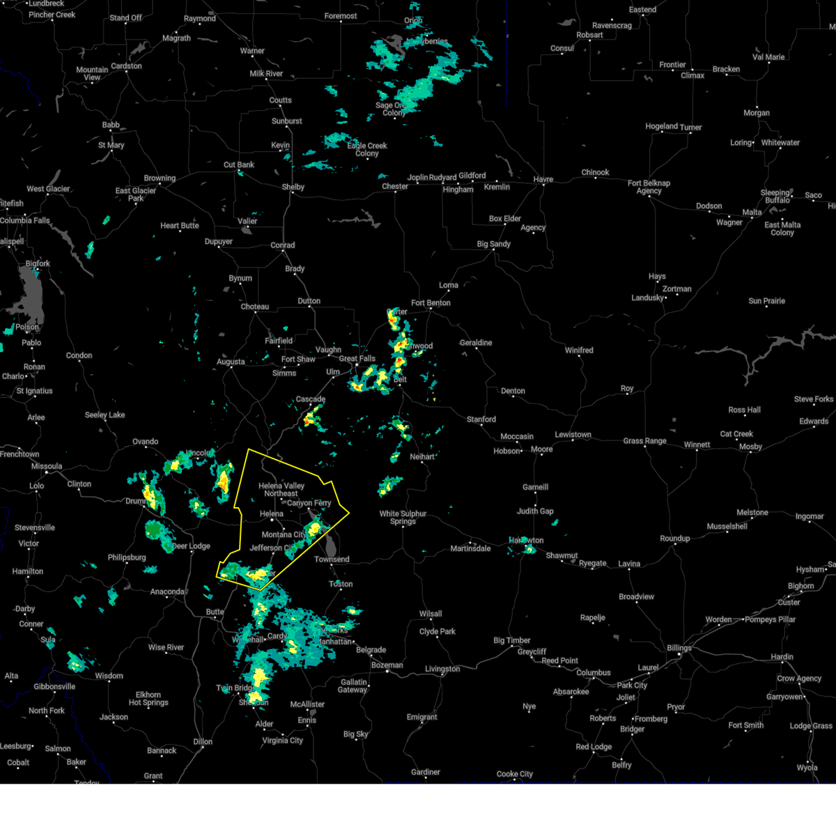 Svrtfx the national weather service in great falls has issued a * severe thunderstorm warning for, southeastern lewis and clark county in west central montana, northwestern broadwater county in southwestern montana, northern jefferson county in southwestern montana, * until 500 pm mdt. * at 359 pm mdt, severe thunderstorms were located along a line extending from near basin to near boulder, moving northeast at 40 mph (radar indicated). Hazards include 60 mph wind gusts. expect damage to roofs, siding, and trees Svrtfx the national weather service in great falls has issued a * severe thunderstorm warning for, southeastern lewis and clark county in west central montana, northwestern broadwater county in southwestern montana, northern jefferson county in southwestern montana, * until 500 pm mdt. * at 359 pm mdt, severe thunderstorms were located along a line extending from near basin to near boulder, moving northeast at 40 mph (radar indicated). Hazards include 60 mph wind gusts. expect damage to roofs, siding, and trees
|
| 7/6/2023 12:29 PM MDT | Quarter sized hail reported 1.4 miles WNW of Basin, MT, hail estimated up to quarter size. |
| 7/7/2021 3:26 PM MDT |
 At 325 pm mdt, a severe thunderstorm was located 11 miles west of basin, or 16 miles southeast of deer lodge, moving east at 50 mph (radar indicated). Hazards include 60 mph wind gusts. expect damage to roofs, siding, and trees At 325 pm mdt, a severe thunderstorm was located 11 miles west of basin, or 16 miles southeast of deer lodge, moving east at 50 mph (radar indicated). Hazards include 60 mph wind gusts. expect damage to roofs, siding, and trees
|
| 8/10/2019 8:08 PM MDT |
 At 808 pm mdt, a severe thunderstorm was located 8 miles southwest of boulder, moving northeast at 35 mph (radar indicated). Hazards include 60 mph wind gusts and quarter size hail. Hail damage to vehicles is expected. expect wind damage to roofs, siding, and trees. Locations impacted include, boulder, elkhorn state park and wickes. At 808 pm mdt, a severe thunderstorm was located 8 miles southwest of boulder, moving northeast at 35 mph (radar indicated). Hazards include 60 mph wind gusts and quarter size hail. Hail damage to vehicles is expected. expect wind damage to roofs, siding, and trees. Locations impacted include, boulder, elkhorn state park and wickes.
|
| 8/10/2019 7:58 PM MDT |
 At 758 pm mdt, a severe thunderstorm was located 11 miles east of walkerville, or 11 miles northeast of butte, moving northeast at 35 mph (radar indicated). Hazards include 60 mph wind gusts and quarter size hail. Hail damage to vehicles is expected. Expect wind damage to roofs, siding, and trees. At 758 pm mdt, a severe thunderstorm was located 11 miles east of walkerville, or 11 miles northeast of butte, moving northeast at 35 mph (radar indicated). Hazards include 60 mph wind gusts and quarter size hail. Hail damage to vehicles is expected. Expect wind damage to roofs, siding, and trees.
|
| 8/10/2019 6:02 PM MDT |
 At 601 pm mdt, severe thunderstorms were located along a line extending from near basin to 7 miles south of boulder, moving northeast at 30 mph (radar indicated). Hazards include 60 mph wind gusts and half dollar size hail. Hail damage to vehicles is expected. expect wind damage to roofs, siding, and trees. Locations impacted include, boulder, wickes, alhambra, corbin, clancy, jefferson city and elkhorn state park. At 601 pm mdt, severe thunderstorms were located along a line extending from near basin to 7 miles south of boulder, moving northeast at 30 mph (radar indicated). Hazards include 60 mph wind gusts and half dollar size hail. Hail damage to vehicles is expected. expect wind damage to roofs, siding, and trees. Locations impacted include, boulder, wickes, alhambra, corbin, clancy, jefferson city and elkhorn state park.
|
| 8/10/2019 5:48 PM MDT |
 At 548 pm mdt, severe thunderstorms were located along a line extending from near basin to 12 miles south of boulder, moving northeast at 30 mph (radar indicated). Hazards include 60 mph wind gusts and half dollar size hail. Hail damage to vehicles is expected. Expect wind damage to roofs, siding, and trees. At 548 pm mdt, severe thunderstorms were located along a line extending from near basin to 12 miles south of boulder, moving northeast at 30 mph (radar indicated). Hazards include 60 mph wind gusts and half dollar size hail. Hail damage to vehicles is expected. Expect wind damage to roofs, siding, and trees.
|
| 8/10/2019 5:33 PM MDT |
 At 532 pm mdt, severe thunderstorms were located along a line extending from 8 miles west of basin to 10 miles east of butte, moving northeast at 30 mph (radar indicated). Hazards include 60 mph wind gusts and quarter size hail. Hail damage to vehicles is expected. expect wind damage to roofs, siding, and trees. Locations impacted include, boulder, basin and elk park. At 532 pm mdt, severe thunderstorms were located along a line extending from 8 miles west of basin to 10 miles east of butte, moving northeast at 30 mph (radar indicated). Hazards include 60 mph wind gusts and quarter size hail. Hail damage to vehicles is expected. expect wind damage to roofs, siding, and trees. Locations impacted include, boulder, basin and elk park.
|
| 8/10/2019 5:16 PM MDT |
 At 516 pm mdt, severe thunderstorms were located along a line extending from 9 miles north of walkerville to 6 miles southeast of butte, moving northeast at 30 mph (radar indicated). Hazards include 60 mph wind gusts and quarter size hail. Hail damage to vehicles is expected. Expect wind damage to roofs, siding, and trees. At 516 pm mdt, severe thunderstorms were located along a line extending from 9 miles north of walkerville to 6 miles southeast of butte, moving northeast at 30 mph (radar indicated). Hazards include 60 mph wind gusts and quarter size hail. Hail damage to vehicles is expected. Expect wind damage to roofs, siding, and trees.
|
| 8/10/2019 4:43 PM MDT |
 At 443 pm mdt, a severe thunderstorm was located near basin, or 11 miles west of boulder, moving northeast at 25 mph (radar indicated). Hazards include 60 mph wind gusts and quarter size hail. Hail damage to vehicles is expected. expect wind damage to roofs, siding, and trees. Locations impacted include, basin. At 443 pm mdt, a severe thunderstorm was located near basin, or 11 miles west of boulder, moving northeast at 25 mph (radar indicated). Hazards include 60 mph wind gusts and quarter size hail. Hail damage to vehicles is expected. expect wind damage to roofs, siding, and trees. Locations impacted include, basin.
|
| 8/10/2019 4:24 PM MDT |
 At 424 pm mdt, a severe thunderstorm was located 9 miles north of walkerville, or 11 miles north of butte, moving northeast at 25 mph (radar indicated). Hazards include 60 mph wind gusts and quarter size hail. Hail damage to vehicles is expected. Expect wind damage to roofs, siding, and trees. At 424 pm mdt, a severe thunderstorm was located 9 miles north of walkerville, or 11 miles north of butte, moving northeast at 25 mph (radar indicated). Hazards include 60 mph wind gusts and quarter size hail. Hail damage to vehicles is expected. Expect wind damage to roofs, siding, and trees.
|
| 6/27/2019 1:45 PM MDT |
 At 145 pm mdt, a severe thunderstorm was located near basin, or 10 miles northwest of boulder, moving northeast at 40 mph (radar indicated). Hazards include 60 mph wind gusts and quarter size hail. Hail damage to vehicles is expected. Expect wind damage to roofs, siding, and trees. At 145 pm mdt, a severe thunderstorm was located near basin, or 10 miles northwest of boulder, moving northeast at 40 mph (radar indicated). Hazards include 60 mph wind gusts and quarter size hail. Hail damage to vehicles is expected. Expect wind damage to roofs, siding, and trees.
|
| 6/27/2019 1:35 PM MDT |
 At 135 pm mdt, a severe thunderstorm was located 10 miles south of basin, or 12 miles southwest of boulder, moving northeast at 35 mph (radar indicated). Hazards include 60 mph wind gusts and quarter size hail. Hail damage to vehicles is expected. expect wind damage to roofs, siding, and trees. Locations impacted include, boulder and basin. At 135 pm mdt, a severe thunderstorm was located 10 miles south of basin, or 12 miles southwest of boulder, moving northeast at 35 mph (radar indicated). Hazards include 60 mph wind gusts and quarter size hail. Hail damage to vehicles is expected. expect wind damage to roofs, siding, and trees. Locations impacted include, boulder and basin.
|
| 6/27/2019 1:21 PM MDT |
 The national weather service in great falls has issued a * severe thunderstorm warning for. southwestern jefferson county in southwestern montana. until 145 pm mdt. At 120 pm mdt, a severe thunderstorm was located 7 miles east of butte, moving northeast at 35 mph. The national weather service in great falls has issued a * severe thunderstorm warning for. southwestern jefferson county in southwestern montana. until 145 pm mdt. At 120 pm mdt, a severe thunderstorm was located 7 miles east of butte, moving northeast at 35 mph.
|
| 7/5/2017 5:36 PM MDT | Ktvm relayed report of a tree down in the basin area. the tree landed on a truck and damaged a carport. time estimated from rada in jefferson county MT, 1.4 miles WNW of Basin, MT |
| 8/7/2016 4:27 PM MDT |
 At 425 pm, a severe thunderstorm was located near walkerville, or 7 miles northeast of butte, moving northeast at 40 mph (trained weather spotters). Hazards include 60 mph wind gusts and quarter size hail. Hail damage to vehicles is expected. expect wind damage to roofs, siding, and trees. locations impacted include, elk park. This storm has produced one inch hail in the newcomb area. At 425 pm, a severe thunderstorm was located near walkerville, or 7 miles northeast of butte, moving northeast at 40 mph (trained weather spotters). Hazards include 60 mph wind gusts and quarter size hail. Hail damage to vehicles is expected. expect wind damage to roofs, siding, and trees. locations impacted include, elk park. This storm has produced one inch hail in the newcomb area.
|
| 8/7/2016 4:08 PM MDT |
 At 408 pm mdt, a severe thunderstorm was located near butte, moving northeast at 45 mph (radar indicated). Hazards include 60 mph wind gusts and quarter size hail. Hail damage to vehicles is expected. Expect wind damage to roofs, siding, and trees. At 408 pm mdt, a severe thunderstorm was located near butte, moving northeast at 45 mph (radar indicated). Hazards include 60 mph wind gusts and quarter size hail. Hail damage to vehicles is expected. Expect wind damage to roofs, siding, and trees.
|
| 1/1/0001 12:00 AM | 59 mph wind gust at the dot sensor near elk par in jefferson county MT, 10.6 miles NE of Basin, MT |
Hail Maps for Basin, MT


Connect with Interactive Hail Maps