

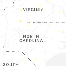
Hail Map for Friday, July 18, 2025

Number of Impacted Households on 7/18/2025
0
Impacted by 1" or Larger Hail
0
Impacted by 1.75" or Larger Hail
0
Impacted by 2.5" or Larger Hail
Square Miles of Populated Area Impacted on 7/18/2025
0
Impacted by 1" or Larger Hail
0
Impacted by 1.75" or Larger Hail
0
Impacted by 2.5" or Larger Hail

Cities Most Affected by Hail Storms of 7/18/2025
| Hail Size | Demographics of Zip Codes Affected | ||||||
|---|---|---|---|---|---|---|---|
| City | Count | Average | Largest | Pop Density | House Value | Income | Age |
Hail and Wind Damage Spotted on 7/18/2025
Filter by Report Type:Hail ReportsWind Reports
Alabama
| Local Time | Report Details |
|---|---|
| 12:30 PM CDT | Tree down blocking both lanes of roadwa in jackson county AL, 47.3 miles SW of Chattanooga, TN |
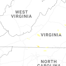
Virginia
| Local Time | Report Details |
|---|---|
| 1:40 PM EDT | Small tree down and blocking one lane near the dump at the intersection of clearview drive and arden drive in martinsville... va. time estimated from rada in henry county VA, 39 miles S of Roanoke, VA |
| 1:45 PM EDT | Two large trees down near the intersection of emerald drive and ruby court... power lines also brought down with the tree in henry county VA, 43.5 miles S of Roanoke, VA |
| 1:45 PM EDT | Tree down at a residence on irisburg road near axton... v in henry county VA, 44.1 miles S of Roanoke, VA |
| 1:55 PM EDT | Tree down along old liberty drive near the intersection at mount olive road in axton... v in henry county VA, 42.8 miles S of Roanoke, VA |
| 1:55 PM EDT | Quarter sized hail reported near Ridgeway, VA, 46.3 miles S of Roanoke, VA, report of quarter size hail near ridgeway... va. time estimated from radar. |
| 2:10 PM EDT | Tree down on power line... blocking the southbound lane of axton road near axton... v in henry county VA, 49.2 miles SSE of Roanoke, VA |
| 3:30 PM EDT | Multiple trees down... partially blocking the roadway near the intersection of franklin street and sawmill road near ferrum... va. time is estimated from rada in franklin county VA, 25.1 miles SSW of Roanoke, VA |
| 3:45 PM EDT | Quarter sized hail reported near Vinton, VA, 10.1 miles ENE of Roanoke, VA, measured hail report of quarter size north of stewartsville... va. |
| 3:50 PM EDT | Tree down on davis lane in stewartsville... v in bedford county VA, 6.1 miles E of Roanoke, VA |
| 3:50 PM EDT | Quarter sized hail reported near Goodview, VA, 8.3 miles E of Roanoke, VA, measured report of quarter size hail in stewartsville... va. |
| 3:50 PM EDT | A personal weather station reported a 60mph wind gus in bedford county VA, 8.3 miles E of Roanoke, VA |
| 3:50 PM EDT | Personal weather station measured a 62 mph wind gust near stewartsville... v in bedford county VA, 5.6 miles E of Roanoke, VA |
| 4:17 PM EDT | Tree down on the 1500 block of copper line road. time estimate in louisa county VA, 26.3 miles NNW of Richmond, VA |
| 4:20 PM EDT | Quarter sized hail reported near Bumpass, VA, 26.4 miles NNW of Richmond, VA, quarter size hail in locust creek. |
North Carolina
| Local Time | Report Details |
|---|---|
| 2:06 PM EDT | Tree down near the intersection of east pine street and slate mountain road in mount airy... n in surry county NC, 60.7 miles SSW of Roanoke, VA |
| 2:15 PM EDT | Tree down near the intersection of epperson church road and banks valley lane in mount airy... n in surry county NC, 59 miles SSW of Roanoke, VA |
| 3:00 PM EDT | Tree down blocking both lanes of travel on belvue drive in mount airy... n in surry county NC, 66.9 miles SW of Roanoke, VA |
Connect with Interactive Hail Maps