

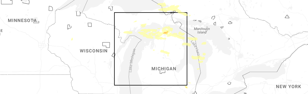
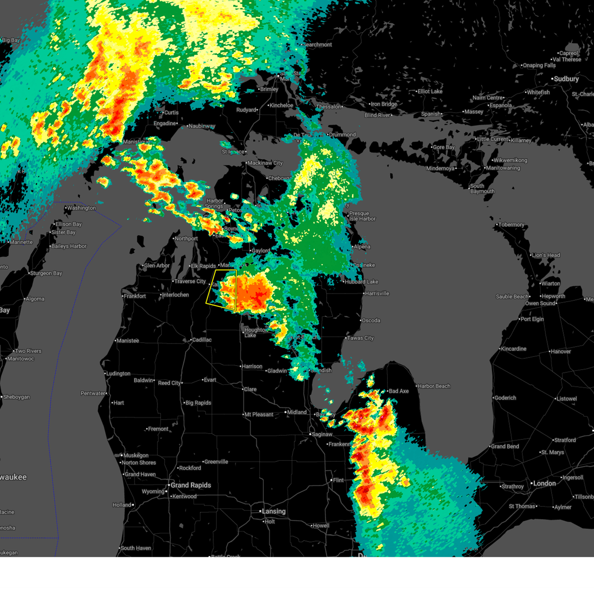
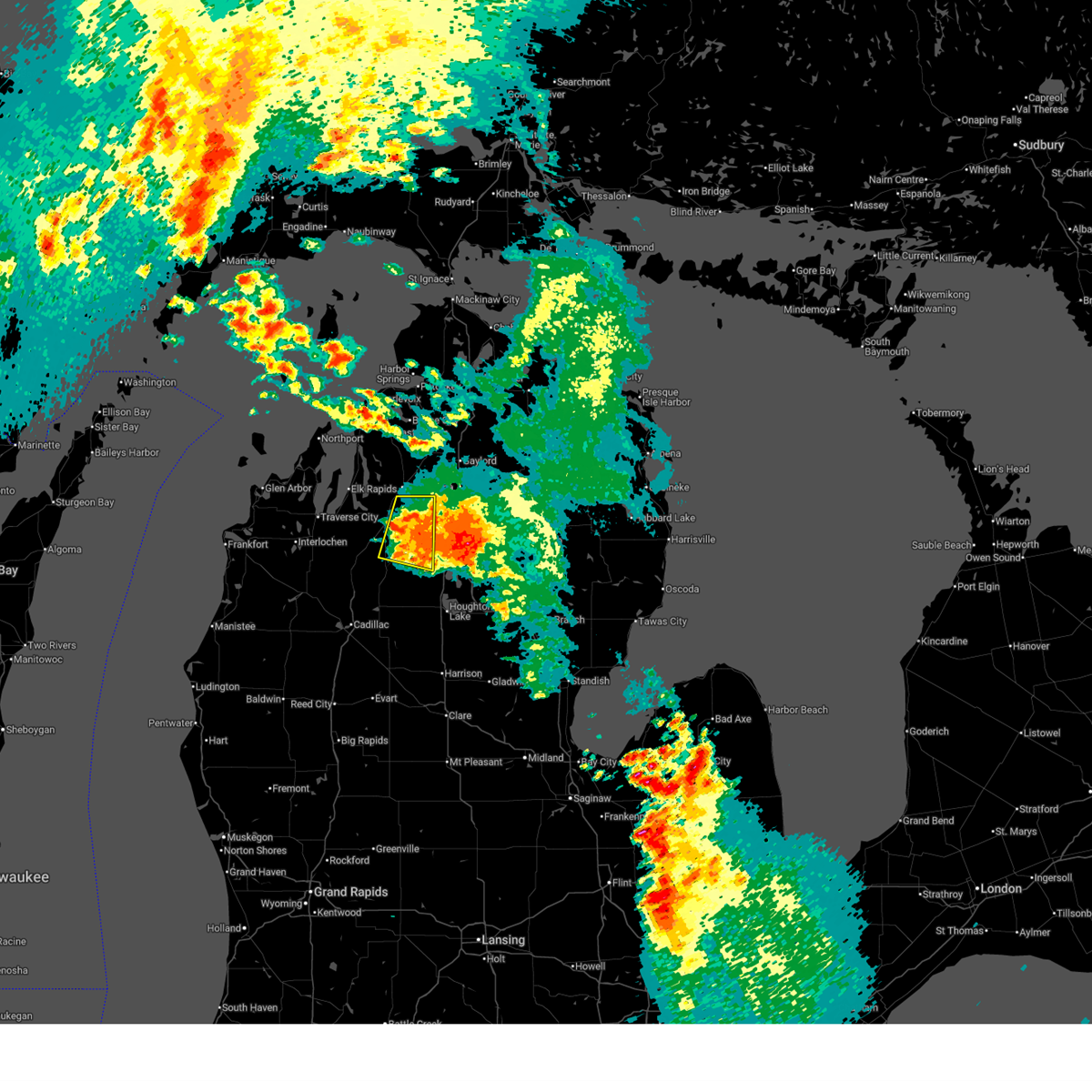
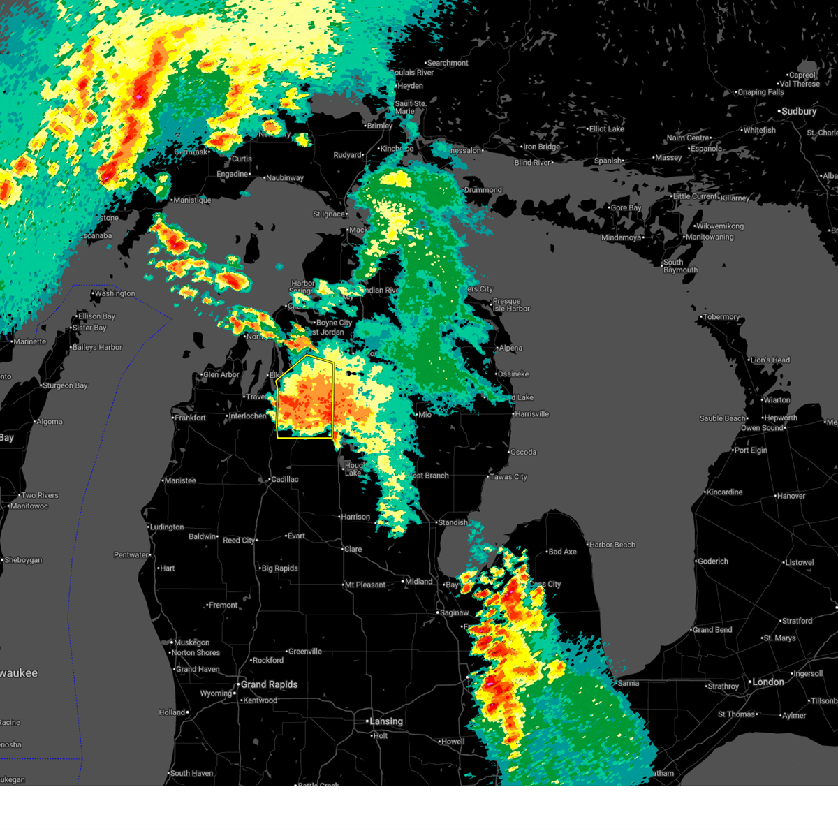
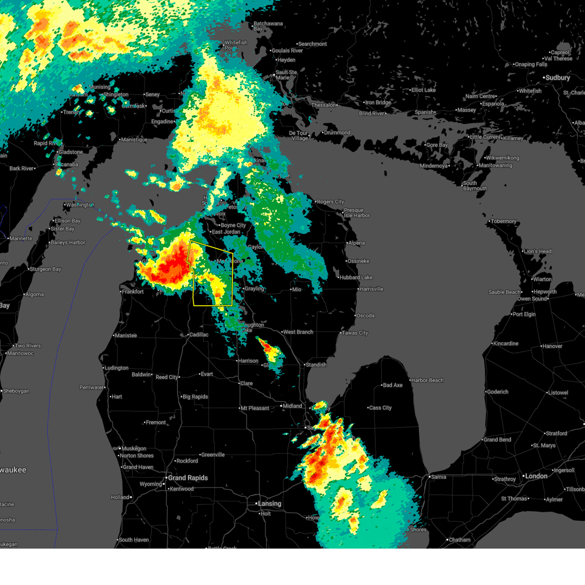
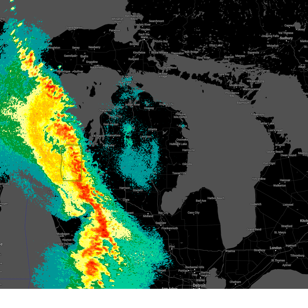
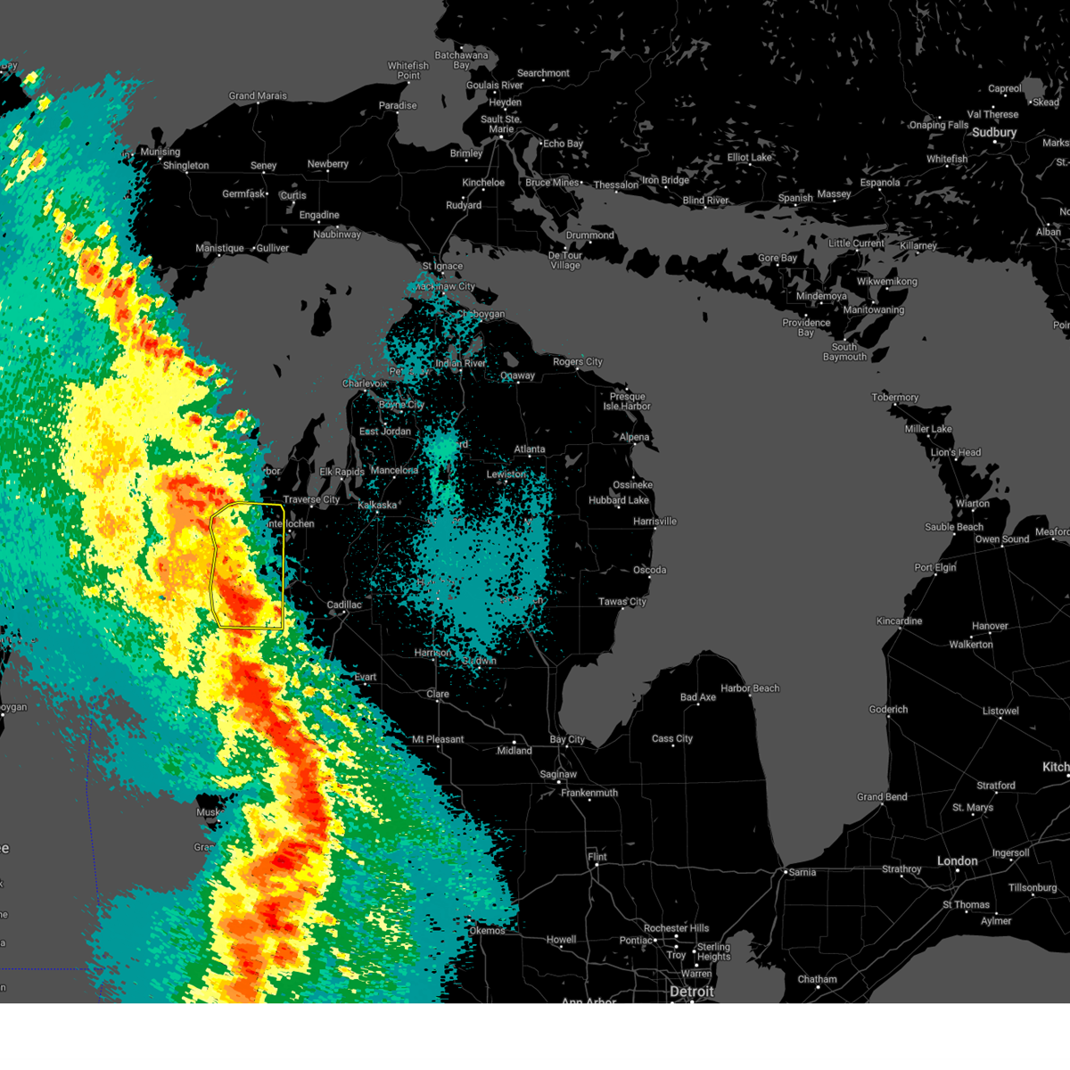
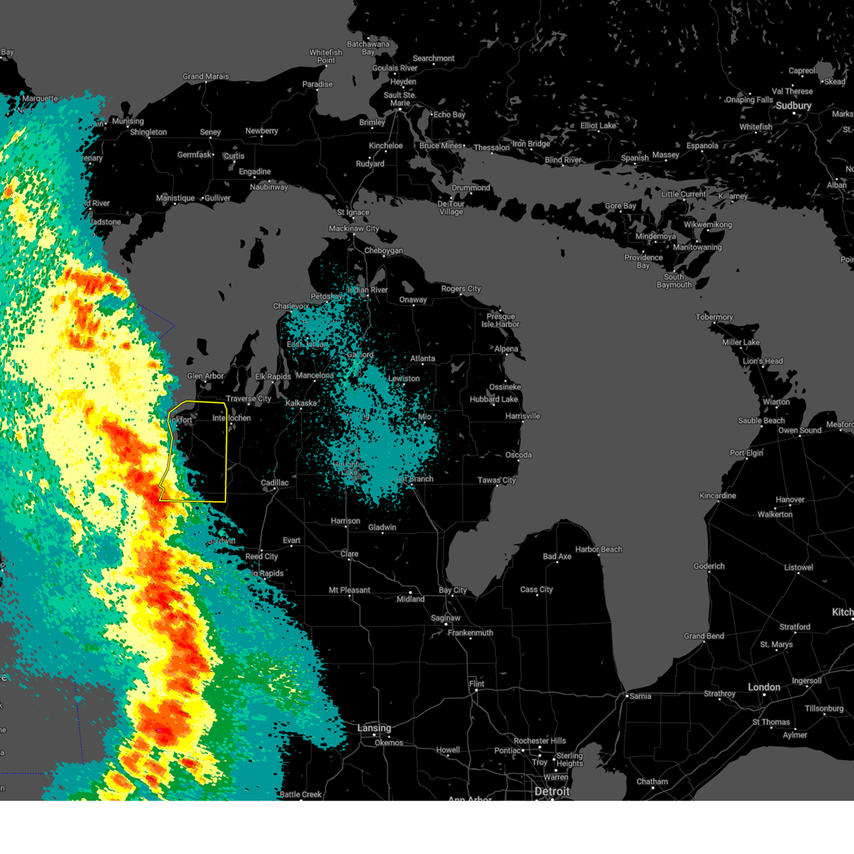
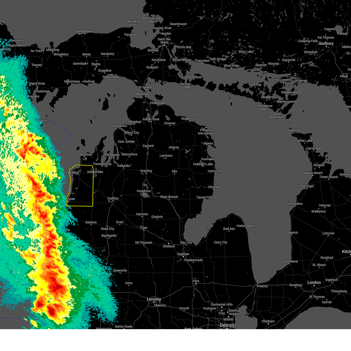
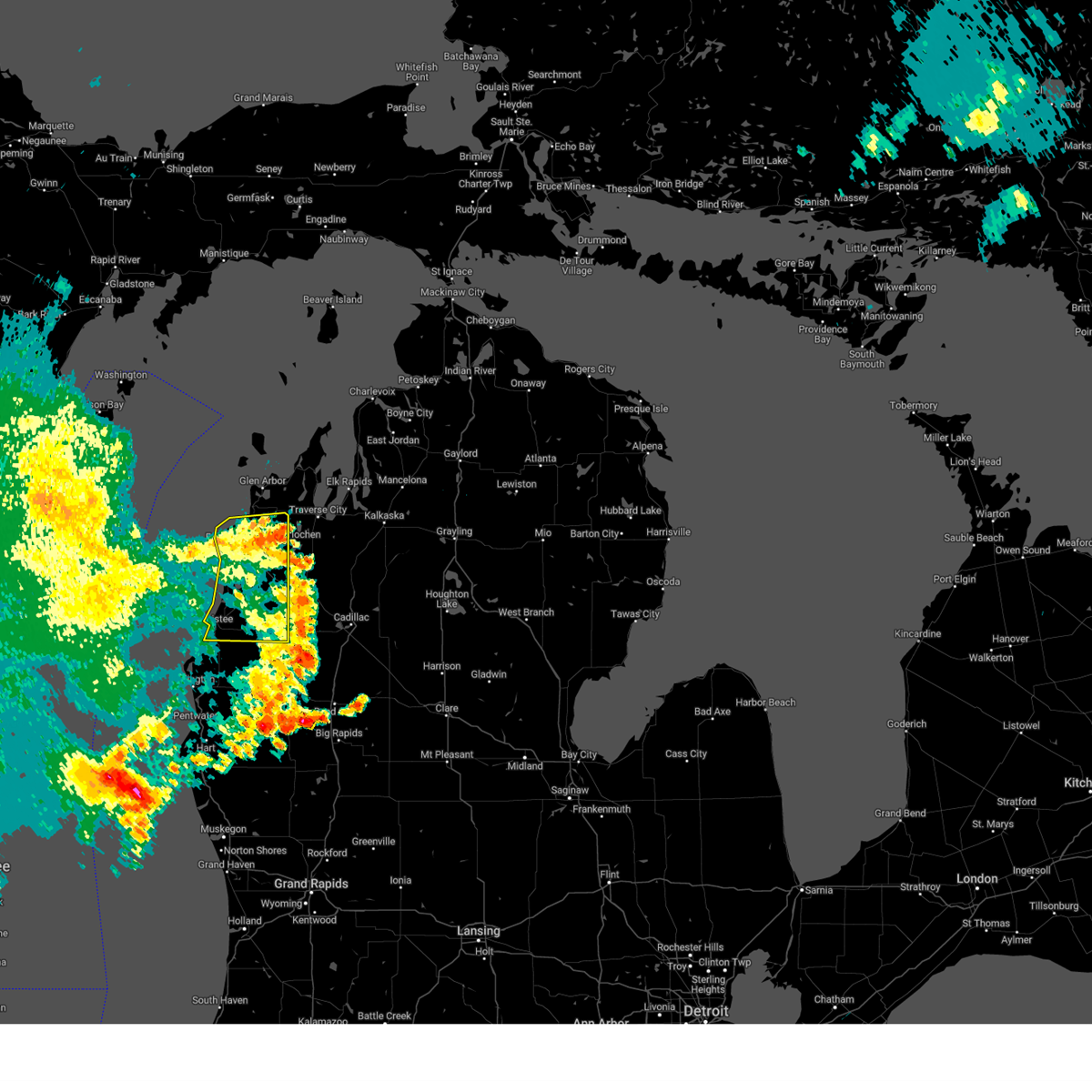
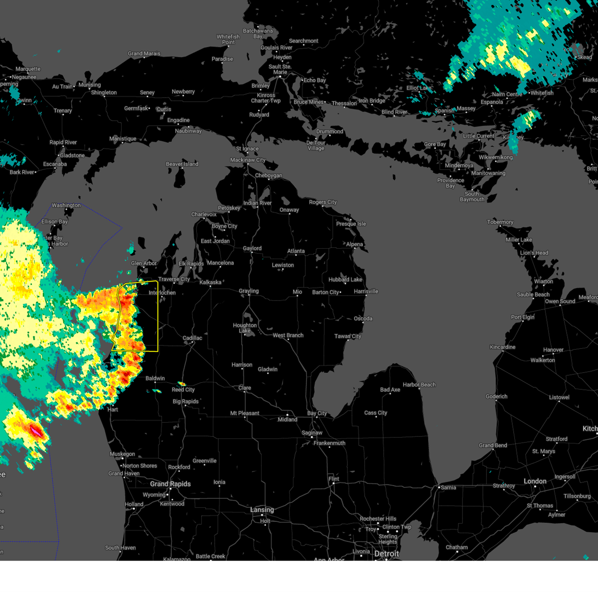
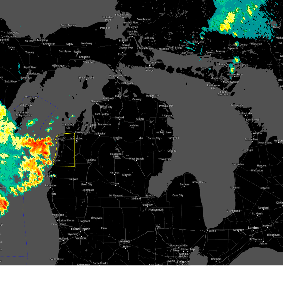
Hail Map for Bear Lake, MI
The Bear Lake, MI area has had 2 reports of on-the-ground hail by trained spotters, and has been under severe weather warnings 15 times during the past 12 months. Doppler radar has detected hail at or near Bear Lake, MI on 42 occasions, including 1 occasion during the past year.
| Name: | Bear Lake, MI |
| Where Located: | 33.5 miles E of Traverse City, MI |
| Map: | Google Map for Bear Lake, MI |
| Population: | 327 |
| Housing Units: | 628 |
| More Info: | Search Google for Bear Lake, MI |
1
The Top Recent Hail Date for Bear Lake, MI is Saturday, June 21, 2025 (12th out of 42)
Hail and Wind Damage Spotted near Bear Lake, MI
| Date / Time | Report Details |
|---|---|
| 6/21/2025 8:33 AM EDT |
 the severe thunderstorm warning has been cancelled and is no longer in effect the severe thunderstorm warning has been cancelled and is no longer in effect
|
| 6/21/2025 8:26 AM EDT |
 At 825 am edt, a severe thunderstorm was located near sigma, or 10 miles west of grayling, moving east at 40 mph (radar indicated). Hazards include 60 mph wind gusts and nickel size hail. Expect damage to roofs, siding, and trees. Locations impacted include, sharon, darragh, sigma, and blue lake township. At 825 am edt, a severe thunderstorm was located near sigma, or 10 miles west of grayling, moving east at 40 mph (radar indicated). Hazards include 60 mph wind gusts and nickel size hail. Expect damage to roofs, siding, and trees. Locations impacted include, sharon, darragh, sigma, and blue lake township.
|
| 6/21/2025 8:26 AM EDT |
 the severe thunderstorm warning has been cancelled and is no longer in effect the severe thunderstorm warning has been cancelled and is no longer in effect
|
| 6/21/2025 8:14 AM EDT |
 At 813 am edt, a severe thunderstorm was located 7 miles west of grayling, moving east at 40 mph (radar indicated). Hazards include 60 mph wind gusts and quarter size hail. Hail damage to vehicles is expected. expect wind damage to roofs, siding, and trees. Locations impacted include, kalkaska, mancelona, antrim, sharon, fife lake, barker creek, rapid city, sigma, darragh, south boardman, blue lake township, and smithville. At 813 am edt, a severe thunderstorm was located 7 miles west of grayling, moving east at 40 mph (radar indicated). Hazards include 60 mph wind gusts and quarter size hail. Hail damage to vehicles is expected. expect wind damage to roofs, siding, and trees. Locations impacted include, kalkaska, mancelona, antrim, sharon, fife lake, barker creek, rapid city, sigma, darragh, south boardman, blue lake township, and smithville.
|
| 6/21/2025 8:01 AM EDT |
 At 800 am edt, a severe thunderstorm was located over darragh, or 9 miles east of kalkaska, moving east at 30 mph (trained spotters reported quarter to half dollar sized hail near williamsburg). Hazards include 60 mph wind gusts and quarter size hail. Hail damage to vehicles is expected. expect wind damage to roofs, siding, and trees. This severe thunderstorm will remain over mainly rural areas of southeastern antrim and kalkaska counties, including the following locations, blue lake township and smithville. At 800 am edt, a severe thunderstorm was located over darragh, or 9 miles east of kalkaska, moving east at 30 mph (trained spotters reported quarter to half dollar sized hail near williamsburg). Hazards include 60 mph wind gusts and quarter size hail. Hail damage to vehicles is expected. expect wind damage to roofs, siding, and trees. This severe thunderstorm will remain over mainly rural areas of southeastern antrim and kalkaska counties, including the following locations, blue lake township and smithville.
|
| 6/21/2025 7:25 AM EDT |
 Svrapx the national weather service in gaylord has issued a * severe thunderstorm warning for, southern antrim county in northern michigan, kalkaska county in northern michigan, * until 845 am edt. * at 723 am edt, a severe thunderstorm was located near barker creek, or near elk rapids, moving east at 30 mph (radar indicated). Hazards include 60 mph wind gusts and quarter size hail. Hail damage to vehicles is expected. expect wind damage to roofs, siding, and trees. this severe thunderstorm will be near, kalkaska, clam river, alden, rapid city, and barker creek around 730 am edt. mancelona, antrim, and darragh around 740 am edt. Other locations impacted by this severe thunderstorm include blue lake township, smithville, and lake bellaire. Svrapx the national weather service in gaylord has issued a * severe thunderstorm warning for, southern antrim county in northern michigan, kalkaska county in northern michigan, * until 845 am edt. * at 723 am edt, a severe thunderstorm was located near barker creek, or near elk rapids, moving east at 30 mph (radar indicated). Hazards include 60 mph wind gusts and quarter size hail. Hail damage to vehicles is expected. expect wind damage to roofs, siding, and trees. this severe thunderstorm will be near, kalkaska, clam river, alden, rapid city, and barker creek around 730 am edt. mancelona, antrim, and darragh around 740 am edt. Other locations impacted by this severe thunderstorm include blue lake township, smithville, and lake bellaire.
|
| 5/16/2025 8:56 PM EDT | At 856 pm edt, severe thunderstorms were located along a line extending from 6 miles northwest of empire to honor to 6 miles north of meauwataka, moving north at 55 mph (radar indicated). Hazards include 60 mph wind gusts and quarter size hail. Hail damage to vehicles is expected. expect wind damage to roofs, siding, and trees. these severe storms will be near, platte township, hannah, honor, bendon, interlochen state park, kingsley, buckley, interlochen, and karlin around 900 pm edt. Other locations impacted by these severe thunderstorms include wallin, blaine township, and pere marquette state forest. |
| 5/16/2025 8:20 PM EDT | Svrapx the national weather service in gaylord has issued a * severe thunderstorm warning for, benzie county in northern michigan, wexford county in northern michigan, southern grand traverse county in northern michigan, manistee county in northern michigan, * until 915 pm edt. * at 820 pm edt, severe thunderstorms were located along a line extending from near elberta to norwalk to near brethren to 10 miles east of luther, moving north at 40 mph (radar indicated). Hazards include 60 mph wind gusts and quarter size hail. Hail damage to vehicles is expected. expect wind damage to roofs, siding, and trees. severe thunderstorms will be near, beulah, harrietta, kaleva, mitchell state park, yuma, wildwood, honor, boon, bear lake, and cadillac around 825 pm edt. platte township, mesick, sherman, and copemish around 830 pm edt. meauwataka and thompsonville around 835 pm edt. buckley around 840 pm edt. manton, interlochen state park, and karlin around 845 pm edt. hannah, bendon, kingsley, and interlochen around 850 pm edt. Other locations impacted by these severe thunderstorms include wallin, blaine township, and pere marquette state forest. |
| 5/15/2025 10:50 PM EDT |
 The storms which prompted the warning have moved out of the area. therefore, the warning has been allowed to expire. a tornado watch remains in effect until 300 am edt for northern michigan. The storms which prompted the warning have moved out of the area. therefore, the warning has been allowed to expire. a tornado watch remains in effect until 300 am edt for northern michigan.
|
| 5/15/2025 10:27 PM EDT |
 At 1027 pm edt, severe thunderstorms were located along a line extending from 24 miles west of sleeping bear point to near empire to 10 miles southeast of baldwin, moving northeast at 40 mph (radar indicated). Hazards include 60 mph wind gusts and penny size hail. Expect damage to roofs, siding, and trees. these severe storms will be near, thompsonville, platte township, honor, and copemish around 1030 pm edt. bendon and lake ann around 1035 pm edt. Other locations impacted by these severe thunderstorms include wallin, blaine township, star crossing, and pere marquette state forest. At 1027 pm edt, severe thunderstorms were located along a line extending from 24 miles west of sleeping bear point to near empire to 10 miles southeast of baldwin, moving northeast at 40 mph (radar indicated). Hazards include 60 mph wind gusts and penny size hail. Expect damage to roofs, siding, and trees. these severe storms will be near, thompsonville, platte township, honor, and copemish around 1030 pm edt. bendon and lake ann around 1035 pm edt. Other locations impacted by these severe thunderstorms include wallin, blaine township, star crossing, and pere marquette state forest.
|
| 5/15/2025 9:55 PM EDT |
 At 955 pm edt, severe thunderstorms were located along a line extending from 22 miles southeast of jacksonport to 11 miles west of arcadia to near hesperia, moving northeast at 40 mph (radar indicated). Hazards include 60 mph wind gusts and penny size hail. Expect damage to roofs, siding, and trees. these severe storms will be near, eastlake, parkdale, manistee, and orchard beach state park around 1000 pm edt. pierport and onekama around 1005 pm edt. norwalk and arcadia around 1010 pm edt. frankfort, wildwood, bear lake, and elberta around 1015 pm edt. brethren around 1025 pm edt. beulah, kaleva, dublin, wellston, and benzonia around 1030 pm edt. thompsonville, honor, and copemish around 1040 pm edt. platte township around 1045 pm edt. Other locations impacted by these severe thunderstorms include wallin, blaine township, star crossing, and pere marquette state forest. At 955 pm edt, severe thunderstorms were located along a line extending from 22 miles southeast of jacksonport to 11 miles west of arcadia to near hesperia, moving northeast at 40 mph (radar indicated). Hazards include 60 mph wind gusts and penny size hail. Expect damage to roofs, siding, and trees. these severe storms will be near, eastlake, parkdale, manistee, and orchard beach state park around 1000 pm edt. pierport and onekama around 1005 pm edt. norwalk and arcadia around 1010 pm edt. frankfort, wildwood, bear lake, and elberta around 1015 pm edt. brethren around 1025 pm edt. beulah, kaleva, dublin, wellston, and benzonia around 1030 pm edt. thompsonville, honor, and copemish around 1040 pm edt. platte township around 1045 pm edt. Other locations impacted by these severe thunderstorms include wallin, blaine township, star crossing, and pere marquette state forest.
|
| 5/15/2025 9:29 PM EDT |
 Svrapx the national weather service in gaylord has issued a * severe thunderstorm warning for, benzie county in northern michigan, manistee county in northern michigan, * until 1045 pm edt. * at 928 pm edt, severe thunderstorms were located along a line extending from 9 miles east of sturgeon bay to 27 miles northwest of orchard beach state park to near montague, moving northeast at 60 mph (radar indicated). Hazards include 60 mph wind gusts and penny size hail. Expect damage to roofs, siding, and trees. severe thunderstorms will be near, eastlake, manistee, and orchard beach state park around 945 pm edt. parkdale around 950 pm edt. norwalk, pierport, arcadia, and onekama around 955 pm edt. frankfort, wildwood, bear lake, and elberta around 1000 pm edt. beulah, kaleva, benzonia, and brethren around 1005 pm edt. dublin, wellston, and honor around 1010 pm edt. thompsonville, platte township, and copemish around 1015 pm edt. bendon and lake ann around 1025 pm edt. Other locations impacted by these severe thunderstorms include wallin, blaine township, star crossing, and pere marquette state forest. Svrapx the national weather service in gaylord has issued a * severe thunderstorm warning for, benzie county in northern michigan, manistee county in northern michigan, * until 1045 pm edt. * at 928 pm edt, severe thunderstorms were located along a line extending from 9 miles east of sturgeon bay to 27 miles northwest of orchard beach state park to near montague, moving northeast at 60 mph (radar indicated). Hazards include 60 mph wind gusts and penny size hail. Expect damage to roofs, siding, and trees. severe thunderstorms will be near, eastlake, manistee, and orchard beach state park around 945 pm edt. parkdale around 950 pm edt. norwalk, pierport, arcadia, and onekama around 955 pm edt. frankfort, wildwood, bear lake, and elberta around 1000 pm edt. beulah, kaleva, benzonia, and brethren around 1005 pm edt. dublin, wellston, and honor around 1010 pm edt. thompsonville, platte township, and copemish around 1015 pm edt. bendon and lake ann around 1025 pm edt. Other locations impacted by these severe thunderstorms include wallin, blaine township, star crossing, and pere marquette state forest.
|
| 8/27/2024 2:23 PM EDT |
 The storms which prompted the warning have moved out of the area. therefore, the warning will be allowed to expire. a severe thunderstorm watch remains in effect until 800 pm edt for northern michigan. The storms which prompted the warning have moved out of the area. therefore, the warning will be allowed to expire. a severe thunderstorm watch remains in effect until 800 pm edt for northern michigan.
|
| 8/27/2024 2:00 PM EDT |
 At 159 pm edt, severe thunderstorms were located along a line extending from near honor to near bear lake to 7 miles south of norwalk, moving east at 50 mph (radar indicated). Hazards include 60 mph wind gusts and penny size hail. Expect damage to roofs, siding, and trees. these severe storms will be near, thompsonville, kaleva, honor, copemish, dublin, wellston, and brethren around 205 pm edt. lake ann and bendon around 210 pm edt. Other locations impacted by these severe thunderstorms include wallin, blaine township, star crossing, and pere marquette state forest. At 159 pm edt, severe thunderstorms were located along a line extending from near honor to near bear lake to 7 miles south of norwalk, moving east at 50 mph (radar indicated). Hazards include 60 mph wind gusts and penny size hail. Expect damage to roofs, siding, and trees. these severe storms will be near, thompsonville, kaleva, honor, copemish, dublin, wellston, and brethren around 205 pm edt. lake ann and bendon around 210 pm edt. Other locations impacted by these severe thunderstorms include wallin, blaine township, star crossing, and pere marquette state forest.
|
| 8/27/2024 1:34 PM EDT |
 Svrapx the national weather service in gaylord has issued a * severe thunderstorm warning for, benzie county in northern michigan, manistee county in northern michigan, * until 230 pm edt. * at 133 pm edt, severe thunderstorms were located along a line extending from 13 miles west of frankfort to 11 miles west of pierport to 11 miles west of manistee, moving east at 45 mph (radar indicated). Hazards include 60 mph wind gusts and penny size hail. Expect damage to roofs, siding, and trees. severe thunderstorms will be near, manistee, eastlake, parkdale, and orchard beach state park around 140 pm edt. frankfort, arcadia, onekama, elberta, and pierport around 145 pm edt. bear lake, wildwood, and norwalk around 150 pm edt. beulah and benzonia around 155 pm edt. thompsonville, kaleva, honor, and brethren around 200 pm edt. copemish and platte township around 205 pm edt. lake ann, dublin, wellston, and bendon around 210 pm edt. Other locations impacted by these severe thunderstorms include wallin, blaine township, star crossing, and pere marquette state forest. Svrapx the national weather service in gaylord has issued a * severe thunderstorm warning for, benzie county in northern michigan, manistee county in northern michigan, * until 230 pm edt. * at 133 pm edt, severe thunderstorms were located along a line extending from 13 miles west of frankfort to 11 miles west of pierport to 11 miles west of manistee, moving east at 45 mph (radar indicated). Hazards include 60 mph wind gusts and penny size hail. Expect damage to roofs, siding, and trees. severe thunderstorms will be near, manistee, eastlake, parkdale, and orchard beach state park around 140 pm edt. frankfort, arcadia, onekama, elberta, and pierport around 145 pm edt. bear lake, wildwood, and norwalk around 150 pm edt. beulah and benzonia around 155 pm edt. thompsonville, kaleva, honor, and brethren around 200 pm edt. copemish and platte township around 205 pm edt. lake ann, dublin, wellston, and bendon around 210 pm edt. Other locations impacted by these severe thunderstorms include wallin, blaine township, star crossing, and pere marquette state forest.
|
| 4/27/2024 9:48 PM EDT |
 the severe thunderstorm warning has been cancelled and is no longer in effect the severe thunderstorm warning has been cancelled and is no longer in effect
|
| 4/27/2024 9:48 PM EDT |
 At 947 pm edt, a severe thunderstorm was located over sigma, or 7 miles southeast of kalkaska, moving east at 45 mph (trained weather spotters). Hazards include quarter size hail. Damage to vehicles is expected. This severe thunderstorm will remain over mainly rural areas of southeastern kalkaska county. At 947 pm edt, a severe thunderstorm was located over sigma, or 7 miles southeast of kalkaska, moving east at 45 mph (trained weather spotters). Hazards include quarter size hail. Damage to vehicles is expected. This severe thunderstorm will remain over mainly rural areas of southeastern kalkaska county.
|
| 4/27/2024 9:38 PM EDT |
 The storm which prompted the warning has weakened below severe limits, and no longer poses an immediate threat to life or property. therefore, the warning will be allowed to expire. however, heavy rain is still possible with this thunderstorm. The storm which prompted the warning has weakened below severe limits, and no longer poses an immediate threat to life or property. therefore, the warning will be allowed to expire. however, heavy rain is still possible with this thunderstorm.
|
| 4/27/2024 9:31 PM EDT |
 Svrapx the national weather service in gaylord has issued a * severe thunderstorm warning for, southeastern grand traverse county in northern michigan, central kalkaska county in northern michigan, * until 1000 pm edt. * at 930 pm edt, a severe thunderstorm was located over fife lake, or 11 miles southwest of kalkaska, moving east at 45 mph (trained weather spotters). Hazards include 60 mph wind gusts and quarter size hail. Hail damage to vehicles is expected. expect wind damage to roofs, siding, and trees. This severe thunderstorm will be near, kalkaska, sharon, sigma, and south boardman around 935 pm edt. Svrapx the national weather service in gaylord has issued a * severe thunderstorm warning for, southeastern grand traverse county in northern michigan, central kalkaska county in northern michigan, * until 1000 pm edt. * at 930 pm edt, a severe thunderstorm was located over fife lake, or 11 miles southwest of kalkaska, moving east at 45 mph (trained weather spotters). Hazards include 60 mph wind gusts and quarter size hail. Hail damage to vehicles is expected. expect wind damage to roofs, siding, and trees. This severe thunderstorm will be near, kalkaska, sharon, sigma, and south boardman around 935 pm edt.
|
| 4/27/2024 9:23 PM EDT |
 the severe thunderstorm warning has been cancelled and is no longer in effect the severe thunderstorm warning has been cancelled and is no longer in effect
|
| 4/27/2024 9:23 PM EDT |
 At 922 pm edt, a severe thunderstorm was located over kaleva, or 11 miles southwest of thompsonville, moving east at 45 mph (radar indicated). Hazards include 60 mph wind gusts and half dollar size hail. Hail damage to vehicles is expected. expect wind damage to roofs, siding, and trees. this severe storm will be near, sherman, mesick, and copemish around 930 pm edt. Buckley around 935 pm edt. At 922 pm edt, a severe thunderstorm was located over kaleva, or 11 miles southwest of thompsonville, moving east at 45 mph (radar indicated). Hazards include 60 mph wind gusts and half dollar size hail. Hail damage to vehicles is expected. expect wind damage to roofs, siding, and trees. this severe storm will be near, sherman, mesick, and copemish around 930 pm edt. Buckley around 935 pm edt.
|
| 4/27/2024 9:18 PM EDT |
 the severe thunderstorm warning has been cancelled and is no longer in effect the severe thunderstorm warning has been cancelled and is no longer in effect
|
| 4/27/2024 9:11 PM EDT |
 the severe thunderstorm warning has been cancelled and is no longer in effect the severe thunderstorm warning has been cancelled and is no longer in effect
|
| 4/27/2024 9:08 PM EDT |
 Svrapx the national weather service in gaylord has issued a * severe thunderstorm warning for, southeastern benzie county in northern michigan, northwestern wexford county in northern michigan, southwestern grand traverse county in northern michigan, central manistee county in northern michigan, * until 945 pm edt. * at 908 pm edt, a severe thunderstorm was located over orchard beach state park, or near manistee, moving east at 45 mph (radar indicated). Hazards include 60 mph wind gusts and half dollar size hail. Hail damage to vehicles is expected. expect wind damage to roofs, siding, and trees. this severe thunderstorm will be near, kaleva, onekama, bear lake, wildwood, norwalk, and pierport around 915 pm edt. copemish around 920 pm edt. thompsonville around 925 pm edt. sherman, buckley, and mesick around 930 pm edt. Other locations impacted by this severe thunderstorm include wallin and pere marquette state forest. Svrapx the national weather service in gaylord has issued a * severe thunderstorm warning for, southeastern benzie county in northern michigan, northwestern wexford county in northern michigan, southwestern grand traverse county in northern michigan, central manistee county in northern michigan, * until 945 pm edt. * at 908 pm edt, a severe thunderstorm was located over orchard beach state park, or near manistee, moving east at 45 mph (radar indicated). Hazards include 60 mph wind gusts and half dollar size hail. Hail damage to vehicles is expected. expect wind damage to roofs, siding, and trees. this severe thunderstorm will be near, kaleva, onekama, bear lake, wildwood, norwalk, and pierport around 915 pm edt. copemish around 920 pm edt. thompsonville around 925 pm edt. sherman, buckley, and mesick around 930 pm edt. Other locations impacted by this severe thunderstorm include wallin and pere marquette state forest.
|
| 4/27/2024 8:58 PM EDT |
 Svrapx the national weather service in gaylord has issued a * severe thunderstorm warning for, southwestern crawford county in northern michigan, southern kalkaska county in northern michigan, * until 945 pm edt. * at 858 pm edt, a severe thunderstorm was located near south boardman, or 10 miles south of kalkaska, moving east at 50 mph (radar indicated). Hazards include 60 mph wind gusts and quarter size hail. Hail damage to vehicles is expected. expect wind damage to roofs, siding, and trees. this severe thunderstorm will be near, sharon and sigma around 905 pm edt. grayling around 920 pm edt. hartwick pines state park around 925 pm edt. Other locations impacted by this severe thunderstorm include smithville. Svrapx the national weather service in gaylord has issued a * severe thunderstorm warning for, southwestern crawford county in northern michigan, southern kalkaska county in northern michigan, * until 945 pm edt. * at 858 pm edt, a severe thunderstorm was located near south boardman, or 10 miles south of kalkaska, moving east at 50 mph (radar indicated). Hazards include 60 mph wind gusts and quarter size hail. Hail damage to vehicles is expected. expect wind damage to roofs, siding, and trees. this severe thunderstorm will be near, sharon and sigma around 905 pm edt. grayling around 920 pm edt. hartwick pines state park around 925 pm edt. Other locations impacted by this severe thunderstorm include smithville.
|
| 4/27/2024 8:54 PM EDT |
 the severe thunderstorm warning has been cancelled and is no longer in effect the severe thunderstorm warning has been cancelled and is no longer in effect
|
| 4/27/2024 8:54 PM EDT |
 At 854 pm edt, a severe thunderstorm was located near sigma, or near kalkaska, moving northeast at 40 mph (radar indicated). Hazards include 60 mph wind gusts and quarter size hail. Hail damage to vehicles is expected. expect wind damage to roofs, siding, and trees. this severe storm will be near, darragh around 900 pm edt. frederic around 905 pm edt. Other locations impacted by this severe thunderstorm include blue lake township. At 854 pm edt, a severe thunderstorm was located near sigma, or near kalkaska, moving northeast at 40 mph (radar indicated). Hazards include 60 mph wind gusts and quarter size hail. Hail damage to vehicles is expected. expect wind damage to roofs, siding, and trees. this severe storm will be near, darragh around 900 pm edt. frederic around 905 pm edt. Other locations impacted by this severe thunderstorm include blue lake township.
|
| 4/27/2024 8:43 PM EDT |
 Svrapx the national weather service in gaylord has issued a * severe thunderstorm warning for, east central grand traverse county in northern michigan, northwestern crawford county in northern michigan, kalkaska county in northern michigan, * until 930 pm edt. * at 842 pm edt, a severe thunderstorm was located over south boardman, or 8 miles southwest of kalkaska, moving northeast at 45 mph (radar indicated). Hazards include 60 mph wind gusts and quarter size hail. Hail damage to vehicles is expected. expect wind damage to roofs, siding, and trees. this severe thunderstorm will be near, kalkaska, sigma, and darragh around 850 pm edt. frederic around 905 pm edt. Other locations impacted by this severe thunderstorm include blue lake township. Svrapx the national weather service in gaylord has issued a * severe thunderstorm warning for, east central grand traverse county in northern michigan, northwestern crawford county in northern michigan, kalkaska county in northern michigan, * until 930 pm edt. * at 842 pm edt, a severe thunderstorm was located over south boardman, or 8 miles southwest of kalkaska, moving northeast at 45 mph (radar indicated). Hazards include 60 mph wind gusts and quarter size hail. Hail damage to vehicles is expected. expect wind damage to roofs, siding, and trees. this severe thunderstorm will be near, kalkaska, sigma, and darragh around 850 pm edt. frederic around 905 pm edt. Other locations impacted by this severe thunderstorm include blue lake township.
|
| 8/3/2023 6:27 PM EDT |
 The severe thunderstorm warning for kalkaska county will expire at 630 pm edt, the storm which prompted the warning has weakened below severe limits, and no longer poses an immediate threat to life or property. therefore, the warning will be allowed to expire. The severe thunderstorm warning for kalkaska county will expire at 630 pm edt, the storm which prompted the warning has weakened below severe limits, and no longer poses an immediate threat to life or property. therefore, the warning will be allowed to expire.
|
| 8/3/2023 6:13 PM EDT |
 At 612 pm edt, a severe thunderstorm was located near south boardman, or near kalkaska, moving east at 35 mph (radar indicated). Hazards include 60 mph wind gusts and quarter size hail. Hail damage to vehicles is expected. expect wind damage to roofs, siding, and trees. locations impacted include, kalkaska, sharon, fife lake, barker creek, sigma, darragh and south boardman. hail threat, radar indicated max hail size, 1. 00 in wind threat, radar indicated max wind gust, 60 mph. At 612 pm edt, a severe thunderstorm was located near south boardman, or near kalkaska, moving east at 35 mph (radar indicated). Hazards include 60 mph wind gusts and quarter size hail. Hail damage to vehicles is expected. expect wind damage to roofs, siding, and trees. locations impacted include, kalkaska, sharon, fife lake, barker creek, sigma, darragh and south boardman. hail threat, radar indicated max hail size, 1. 00 in wind threat, radar indicated max wind gust, 60 mph.
|
| 8/3/2023 5:48 PM EDT |
 At 548 pm edt, a severe thunderstorm was located over traverse city, moving southeast at 40 mph (radar indicated). Hazards include 60 mph wind gusts and quarter size hail. Hail damage to vehicles is expected. Expect wind damage to roofs, siding, and trees. At 548 pm edt, a severe thunderstorm was located over traverse city, moving southeast at 40 mph (radar indicated). Hazards include 60 mph wind gusts and quarter size hail. Hail damage to vehicles is expected. Expect wind damage to roofs, siding, and trees.
|
| 6/25/2023 7:04 PM EDT |
 At 704 pm edt, severe thunderstorms were located along a line extending from clam river to near darragh to near sharon, moving east at 20 mph (radar indicated). Hazards include 60 mph wind gusts. Expect damage to roofs, siding, and trees. locations impacted include, kalkaska, elk rapids, mancelona, bellaire, antrim, sharon, torch lake, central lake, clam river, kewadin, rapid city, alden, sigma, darragh, blue lake township and lake bellaire. hail threat, radar indicated max hail size, <. 75 in wind threat, radar indicated max wind gust, 60 mph. At 704 pm edt, severe thunderstorms were located along a line extending from clam river to near darragh to near sharon, moving east at 20 mph (radar indicated). Hazards include 60 mph wind gusts. Expect damage to roofs, siding, and trees. locations impacted include, kalkaska, elk rapids, mancelona, bellaire, antrim, sharon, torch lake, central lake, clam river, kewadin, rapid city, alden, sigma, darragh, blue lake township and lake bellaire. hail threat, radar indicated max hail size, <. 75 in wind threat, radar indicated max wind gust, 60 mph.
|
| 6/25/2023 7:02 PM EDT |
 At 702 pm edt, severe thunderstorms were located along a line extending from near rhodes to near st. helen to 8 miles southeast of sigma, moving northeast at 30 mph (radar indicated). Hazards include 60 mph wind gusts. Expect damage to roofs, siding, and trees. locations impacted include, gladwin, west branch, grayling, roscommon, st. helen, hockaday, rhodes, higgins lake, north higgins lake, lake st. helen, winegars, twin lakes area, wooden shoe village, south branch township, nester township, moorestown, clear lake, bowmanville, south higgins lake and foster township. hail threat, radar indicated max hail size, <. 75 in wind threat, radar indicated max wind gust, 60 mph. At 702 pm edt, severe thunderstorms were located along a line extending from near rhodes to near st. helen to 8 miles southeast of sigma, moving northeast at 30 mph (radar indicated). Hazards include 60 mph wind gusts. Expect damage to roofs, siding, and trees. locations impacted include, gladwin, west branch, grayling, roscommon, st. helen, hockaday, rhodes, higgins lake, north higgins lake, lake st. helen, winegars, twin lakes area, wooden shoe village, south branch township, nester township, moorestown, clear lake, bowmanville, south higgins lake and foster township. hail threat, radar indicated max hail size, <. 75 in wind threat, radar indicated max wind gust, 60 mph.
|
| 6/25/2023 6:46 PM EDT |
 At 646 pm edt, severe thunderstorms were located along a line extending from near winegars to near nester township to near moorestown, moving northeast at 30 mph (radar indicated). Hazards include 60 mph wind gusts and penny size hail. expect damage to roofs, siding, and trees At 646 pm edt, severe thunderstorms were located along a line extending from near winegars to near nester township to near moorestown, moving northeast at 30 mph (radar indicated). Hazards include 60 mph wind gusts and penny size hail. expect damage to roofs, siding, and trees
|
| 6/25/2023 6:29 PM EDT |
 At 629 pm edt, severe thunderstorms were located along a line extending from near elk rapids to near south boardman to near morey, moving northeast at 20 mph (radar indicated). Hazards include 60 mph wind gusts and nickel size hail. expect damage to roofs, siding, and trees At 629 pm edt, severe thunderstorms were located along a line extending from near elk rapids to near south boardman to near morey, moving northeast at 20 mph (radar indicated). Hazards include 60 mph wind gusts and nickel size hail. expect damage to roofs, siding, and trees
|
| 6/25/2023 5:37 PM EDT |
 At 537 pm edt, severe thunderstorms were located along a line extending from near benzonia to near buckley to near meauwataka, moving northeast at 50 mph (radar indicated). Hazards include 60 mph wind gusts and quarter size hail. Hail damage to vehicles is expected. expect wind damage to roofs, siding, and trees. locations impacted include, thompsonville, arcadia, sherman, buckley, boon, kaleva, mesick, bear lake, copemish, harrietta, meauwataka, pierport, hoxeyville, wildwood, yuma and pere marquette state forest. hail threat, radar indicated max hail size, 1. 00 in wind threat, radar indicated max wind gust, 60 mph. At 537 pm edt, severe thunderstorms were located along a line extending from near benzonia to near buckley to near meauwataka, moving northeast at 50 mph (radar indicated). Hazards include 60 mph wind gusts and quarter size hail. Hail damage to vehicles is expected. expect wind damage to roofs, siding, and trees. locations impacted include, thompsonville, arcadia, sherman, buckley, boon, kaleva, mesick, bear lake, copemish, harrietta, meauwataka, pierport, hoxeyville, wildwood, yuma and pere marquette state forest. hail threat, radar indicated max hail size, 1. 00 in wind threat, radar indicated max wind gust, 60 mph.
|
| 6/25/2023 5:28 PM EDT |
 At 528 pm edt, severe thunderstorms were located along a line extending from near bear lake to near mesick to near mitchell state park, moving northeast at 45 mph (radar indicated). Hazards include 60 mph wind gusts and quarter size hail. Hail damage to vehicles is expected. expect wind damage to roofs, siding, and trees. locations impacted include, thompsonville, arcadia, sherman, buckley, boon, kaleva, onekama, mesick, bear lake, copemish, harrietta, wellston, meauwataka, pierport, dublin, hoxeyville, wildwood, brethren, norwalk and yuma. hail threat, radar indicated max hail size, 1. 00 in wind threat, radar indicated max wind gust, 60 mph. At 528 pm edt, severe thunderstorms were located along a line extending from near bear lake to near mesick to near mitchell state park, moving northeast at 45 mph (radar indicated). Hazards include 60 mph wind gusts and quarter size hail. Hail damage to vehicles is expected. expect wind damage to roofs, siding, and trees. locations impacted include, thompsonville, arcadia, sherman, buckley, boon, kaleva, onekama, mesick, bear lake, copemish, harrietta, wellston, meauwataka, pierport, dublin, hoxeyville, wildwood, brethren, norwalk and yuma. hail threat, radar indicated max hail size, 1. 00 in wind threat, radar indicated max wind gust, 60 mph.
|
| 6/25/2023 4:53 PM EDT |
 At 452 pm edt, severe thunderstorms were located along a line extending from 6 miles southwest of manistee to near free soil to baldwin, moving northeast at 45 mph (radar indicated). Hazards include 60 mph wind gusts and quarter size hail. Hail damage to vehicles is expected. Expect wind damage to roofs, siding, and trees. At 452 pm edt, severe thunderstorms were located along a line extending from 6 miles southwest of manistee to near free soil to baldwin, moving northeast at 45 mph (radar indicated). Hazards include 60 mph wind gusts and quarter size hail. Hail damage to vehicles is expected. Expect wind damage to roofs, siding, and trees.
|
| 4/5/2023 2:39 AM EDT |
 At 239 am edt, a severe thunderstorm was located near pierport, or 12 miles north of manistee, moving northeast at 55 mph (radar indicated). Hazards include quarter size hail. damage to vehicles is expected At 239 am edt, a severe thunderstorm was located near pierport, or 12 miles north of manistee, moving northeast at 55 mph (radar indicated). Hazards include quarter size hail. damage to vehicles is expected
|
| 9/21/2022 8:20 AM EDT | Quarter sized hail reported 0.2 miles E of Bear Lake, MI, bear lake area. report relayed by local broadcast media. |
| 8/3/2022 10:25 AM EDT |
 The severe thunderstorm warning for south central leelanau, benzie, northwestern wexford, southwestern grand traverse and manistee counties will expire at 1030 am edt, the storm which prompted the warning has weakened below severe limits, and no longer poses an immediate threat to life or property. therefore, the warning will be allowed to expire. however gusty winds and heavy rain are still possible with this thunderstorm. The severe thunderstorm warning for south central leelanau, benzie, northwestern wexford, southwestern grand traverse and manistee counties will expire at 1030 am edt, the storm which prompted the warning has weakened below severe limits, and no longer poses an immediate threat to life or property. therefore, the warning will be allowed to expire. however gusty winds and heavy rain are still possible with this thunderstorm.
|
| 8/3/2022 9:46 AM EDT |
 At 945 am edt, a severe thunderstorm was located 15 miles northwest of orchard beach state park, or 16 miles northwest of manistee, moving east at 60 mph (radar indicated. this storm has a history of producing wind damage in northeast wisconsin). Hazards include 60 mph wind gusts and penny size hail. Expect damage to roofs, siding, and trees. this severe thunderstorm will be near, onekama and pierport around 1000 am edt. arcadia, bear lake and wildwood around 1005 am edt. other locations in the path of this severe thunderstorm include thompsonville, copemish, karlin, bendon, interlochen state park and interlochen. hail threat, radar indicated max hail size, 0. 75 in wind threat, radar indicated max wind gust, 60 mph. At 945 am edt, a severe thunderstorm was located 15 miles northwest of orchard beach state park, or 16 miles northwest of manistee, moving east at 60 mph (radar indicated. this storm has a history of producing wind damage in northeast wisconsin). Hazards include 60 mph wind gusts and penny size hail. Expect damage to roofs, siding, and trees. this severe thunderstorm will be near, onekama and pierport around 1000 am edt. arcadia, bear lake and wildwood around 1005 am edt. other locations in the path of this severe thunderstorm include thompsonville, copemish, karlin, bendon, interlochen state park and interlochen. hail threat, radar indicated max hail size, 0. 75 in wind threat, radar indicated max wind gust, 60 mph.
|
| 9/7/2021 11:43 AM EDT |
 At 1143 am edt, severe thunderstorms were located along a line extending from near onekama to near norwalk to near brethren to 6 miles north of free soil, moving east at 50 mph (radar indicated). Hazards include 60 mph wind gusts and quarter size hail. Hail damage to vehicles is expected. expect wind damage to roofs, siding, and trees. locations impacted include, copemish, dublin and wellston. hail threat, radar indicated max hail size, 1. 00 in wind threat, radar indicated max wind gust, 60 mph. At 1143 am edt, severe thunderstorms were located along a line extending from near onekama to near norwalk to near brethren to 6 miles north of free soil, moving east at 50 mph (radar indicated). Hazards include 60 mph wind gusts and quarter size hail. Hail damage to vehicles is expected. expect wind damage to roofs, siding, and trees. locations impacted include, copemish, dublin and wellston. hail threat, radar indicated max hail size, 1. 00 in wind threat, radar indicated max wind gust, 60 mph.
|
| 9/7/2021 11:28 AM EDT |
 At 1128 am edt, a severe thunderstorm was located over sigma, or 9 miles southeast of kalkaska, moving east at 55 mph (radar indicated). Hazards include 60 mph wind gusts and quarter size hail. Hail damage to vehicles is expected. expect wind damage to roofs, siding, and trees. this severe thunderstorm will be near, grayling and frederic around 1145 am edt. other locations in the path of this severe thunderstorm include hartwick pines state park and lovells. hail threat, radar indicated max hail size, 1. 00 in wind threat, radar indicated max wind gust, 60 mph. At 1128 am edt, a severe thunderstorm was located over sigma, or 9 miles southeast of kalkaska, moving east at 55 mph (radar indicated). Hazards include 60 mph wind gusts and quarter size hail. Hail damage to vehicles is expected. expect wind damage to roofs, siding, and trees. this severe thunderstorm will be near, grayling and frederic around 1145 am edt. other locations in the path of this severe thunderstorm include hartwick pines state park and lovells. hail threat, radar indicated max hail size, 1. 00 in wind threat, radar indicated max wind gust, 60 mph.
|
| 9/7/2021 11:24 AM EDT |
 At 1124 am edt, severe thunderstorms were located along a line extending from 12 miles west of arcadia to 11 miles northwest of orchard beach state park to 6 miles west of manistee to 10 miles west of eastlake, moving east at 45 mph (radar indicated). Hazards include 60 mph wind gusts and quarter size hail. Hail damage to vehicles is expected. expect wind damage to roofs, siding, and trees. severe thunderstorms will be near, manistee, eastlake, parkdale and orchard beach state park around 1135 am edt. arcadia and pierport around 1140 am edt. other locations in the path of these severe thunderstorms include onekama, norwalk, wildwood, bear lake, kaleva, wellston, brethren, thompsonville, copemish and dublin. hail threat, radar indicated max hail size, 1. 00 in wind threat, radar indicated max wind gust, 60 mph. At 1124 am edt, severe thunderstorms were located along a line extending from 12 miles west of arcadia to 11 miles northwest of orchard beach state park to 6 miles west of manistee to 10 miles west of eastlake, moving east at 45 mph (radar indicated). Hazards include 60 mph wind gusts and quarter size hail. Hail damage to vehicles is expected. expect wind damage to roofs, siding, and trees. severe thunderstorms will be near, manistee, eastlake, parkdale and orchard beach state park around 1135 am edt. arcadia and pierport around 1140 am edt. other locations in the path of these severe thunderstorms include onekama, norwalk, wildwood, bear lake, kaleva, wellston, brethren, thompsonville, copemish and dublin. hail threat, radar indicated max hail size, 1. 00 in wind threat, radar indicated max wind gust, 60 mph.
|
| 9/7/2021 10:13 AM EDT |
 The severe thunderstorm warning for southeastern antrim and northern kalkaska counties will expire at 1015 am edt, the storms which prompted the warning have weakened below severe limits, and no longer pose an immediate threat to life or property. therefore, the warning will be allowed to expire. however gusty winds are still possible with these thunderstorms. The severe thunderstorm warning for southeastern antrim and northern kalkaska counties will expire at 1015 am edt, the storms which prompted the warning have weakened below severe limits, and no longer pose an immediate threat to life or property. therefore, the warning will be allowed to expire. however gusty winds are still possible with these thunderstorms.
|
| 9/7/2021 10:00 AM EDT |
 At 959 am edt, severe thunderstorms were located along a line extending from near kalkaska to near sigma, moving east at 55 mph (law enforcement). Hazards include 60 mph wind gusts. Expect damage to roofs, siding, and trees. locations impacted include, sigma. hail threat, radar indicated max hail size, <. 75 in wind threat, radar indicated max wind gust, 60 mph. At 959 am edt, severe thunderstorms were located along a line extending from near kalkaska to near sigma, moving east at 55 mph (law enforcement). Hazards include 60 mph wind gusts. Expect damage to roofs, siding, and trees. locations impacted include, sigma. hail threat, radar indicated max hail size, <. 75 in wind threat, radar indicated max wind gust, 60 mph.
|
| 9/7/2021 9:40 AM EDT |
 At 939 am edt, severe thunderstorms were located along a line extending from bellaire to near williamsburg, moving east at 50 mph (law enforcement. at 926 am edt, multiple down trees were reported at washington street and boardman avenue). Hazards include 60 mph wind gusts and penny size hail. Expect damage to roofs, siding, and trees. these severe storms will be near, bellaire around 945 am edt. other locations in the path of these severe thunderstorms include mancelona, kalkaska, alba, sigma and darragh. hail threat, radar indicated max hail size, 0. 75 in wind threat, radar indicated max wind gust, 60 mph. At 939 am edt, severe thunderstorms were located along a line extending from bellaire to near williamsburg, moving east at 50 mph (law enforcement. at 926 am edt, multiple down trees were reported at washington street and boardman avenue). Hazards include 60 mph wind gusts and penny size hail. Expect damage to roofs, siding, and trees. these severe storms will be near, bellaire around 945 am edt. other locations in the path of these severe thunderstorms include mancelona, kalkaska, alba, sigma and darragh. hail threat, radar indicated max hail size, 0. 75 in wind threat, radar indicated max wind gust, 60 mph.
|
| 9/7/2021 9:25 AM EDT |
 At 924 am edt, severe thunderstorms were located along a line extending from near old mission to near grawn, moving east at 50 mph (law enforcement. at 920 am edt, trees down were reported by grand traverse law enforcement). Hazards include 60 mph wind gusts and quarter size hail. Hail damage to vehicles is expected. expect wind damage to roofs, siding, and trees. severe thunderstorms will be near, elk rapids, kewadin and alden around 930 am edt. clam river around 935 am edt. bellaire and williamsburg around 940 am edt. other locations in the path of these severe thunderstorms include mancelona, antrim, barker creek, kalkaska, alba, sigma and darragh. hail threat, radar indicated max hail size, 1. 00 in wind threat, radar indicated max wind gust, 60 mph. At 924 am edt, severe thunderstorms were located along a line extending from near old mission to near grawn, moving east at 50 mph (law enforcement. at 920 am edt, trees down were reported by grand traverse law enforcement). Hazards include 60 mph wind gusts and quarter size hail. Hail damage to vehicles is expected. expect wind damage to roofs, siding, and trees. severe thunderstorms will be near, elk rapids, kewadin and alden around 930 am edt. clam river around 935 am edt. bellaire and williamsburg around 940 am edt. other locations in the path of these severe thunderstorms include mancelona, antrim, barker creek, kalkaska, alba, sigma and darragh. hail threat, radar indicated max hail size, 1. 00 in wind threat, radar indicated max wind gust, 60 mph.
|
| 9/7/2021 9:18 AM EDT |
 At 917 am edt, severe thunderstorms were located along a line extending from near honor to near onekama, moving east at 50 mph (radar indicated. at 913 am edt, penny size hail was reported 1 mile east of beulah). Hazards include 60 mph wind gusts and quarter size hail. Hail damage to vehicles is expected. expect wind damage to roofs, siding, and trees. locations impacted include, thompsonville, honor, wildwood, bear lake, bendon, kaleva, karlin, interlochen state park, interlochen and brethren. hail threat, radar indicated max hail size, 1. 00 in wind threat, radar indicated max wind gust, 60 mph. At 917 am edt, severe thunderstorms were located along a line extending from near honor to near onekama, moving east at 50 mph (radar indicated. at 913 am edt, penny size hail was reported 1 mile east of beulah). Hazards include 60 mph wind gusts and quarter size hail. Hail damage to vehicles is expected. expect wind damage to roofs, siding, and trees. locations impacted include, thompsonville, honor, wildwood, bear lake, bendon, kaleva, karlin, interlochen state park, interlochen and brethren. hail threat, radar indicated max hail size, 1. 00 in wind threat, radar indicated max wind gust, 60 mph.
|
| 9/7/2021 8:57 AM EDT |
 At 857 am edt, severe thunderstorms were located along a line extending from frankfort to 13 miles northwest of orchard beach state park, moving east at 55 mph (radar indicated). Hazards include 60 mph wind gusts and quarter size hail. Hail damage to vehicles is expected. expect wind damage to roofs, siding, and trees. severe thunderstorms will be near, frankfort and elberta around 900 am edt. beulah and benzonia around 905 am edt. honor, pierport and orchard beach state park around 910 am edt. thompsonville, onekama, bear lake, norwalk and wildwood around 915 am edt. other locations in the path of these severe thunderstorms include bendon, kaleva, interlochen state park, karlin, brethren and interlochen. hail threat, radar indicated max hail size, 1. 00 in wind threat, radar indicated max wind gust, 60 mph. At 857 am edt, severe thunderstorms were located along a line extending from frankfort to 13 miles northwest of orchard beach state park, moving east at 55 mph (radar indicated). Hazards include 60 mph wind gusts and quarter size hail. Hail damage to vehicles is expected. expect wind damage to roofs, siding, and trees. severe thunderstorms will be near, frankfort and elberta around 900 am edt. beulah and benzonia around 905 am edt. honor, pierport and orchard beach state park around 910 am edt. thompsonville, onekama, bear lake, norwalk and wildwood around 915 am edt. other locations in the path of these severe thunderstorms include bendon, kaleva, interlochen state park, karlin, brethren and interlochen. hail threat, radar indicated max hail size, 1. 00 in wind threat, radar indicated max wind gust, 60 mph.
|
| 8/29/2021 2:32 PM EDT |
 At 231 pm edt, severe thunderstorms were located along a line extending from near darragh to sigma to near lake city, moving northeast at 50 mph (radar indicated). Hazards include 60 mph wind gusts. Expect damage to roofs, siding, and trees. locations impacted include, sigma, darragh and moorestown. hail threat, radar indicated max hail size, <. 75 in wind threat, radar indicated max wind gust, 60 mph. At 231 pm edt, severe thunderstorms were located along a line extending from near darragh to sigma to near lake city, moving northeast at 50 mph (radar indicated). Hazards include 60 mph wind gusts. Expect damage to roofs, siding, and trees. locations impacted include, sigma, darragh and moorestown. hail threat, radar indicated max hail size, <. 75 in wind threat, radar indicated max wind gust, 60 mph.
|
| 8/29/2021 2:12 PM EDT |
 At 212 pm edt, severe thunderstorms were located along a line extending from near south boardman to near fife lake to near meauwataka, moving northeast at 50 mph (radar indicated). Hazards include 60 mph wind gusts. Expect damage to roofs, siding, and trees. severe thunderstorms will be near, kalkaska and south boardman around 220 pm edt. darragh around 225 pm edt. other locations in the path of these severe thunderstorms include sigma, sharon and moorestown. hail threat, radar indicated max hail size, <. 75 in wind threat, radar indicated max wind gust, 60 mph. At 212 pm edt, severe thunderstorms were located along a line extending from near south boardman to near fife lake to near meauwataka, moving northeast at 50 mph (radar indicated). Hazards include 60 mph wind gusts. Expect damage to roofs, siding, and trees. severe thunderstorms will be near, kalkaska and south boardman around 220 pm edt. darragh around 225 pm edt. other locations in the path of these severe thunderstorms include sigma, sharon and moorestown. hail threat, radar indicated max hail size, <. 75 in wind threat, radar indicated max wind gust, 60 mph.
|
| 8/28/2021 2:27 PM EDT |
 At 227 pm edt, a severe thunderstorm was located over sigma, or 7 miles southeast of kalkaska, moving northeast at 25 mph (radar indicated). Hazards include 60 mph wind gusts and penny size hail. Expect damage to roofs, siding, and trees. locations impacted include, darragh. hail threat, radar indicated max hail size, 0. 75 in wind threat, radar indicated max wind gust, 60 mph. At 227 pm edt, a severe thunderstorm was located over sigma, or 7 miles southeast of kalkaska, moving northeast at 25 mph (radar indicated). Hazards include 60 mph wind gusts and penny size hail. Expect damage to roofs, siding, and trees. locations impacted include, darragh. hail threat, radar indicated max hail size, 0. 75 in wind threat, radar indicated max wind gust, 60 mph.
|
| 8/28/2021 2:07 PM EDT |
 At 206 pm edt, a severe thunderstorm was located near south boardman, or near kalkaska, moving northeast at 20 mph (radar indicated). Hazards include 60 mph wind gusts and penny size hail. Expect damage to roofs, siding, and trees. this severe thunderstorm will be near, kalkaska around 220 pm edt. sigma around 225 pm edt. other locations in the path of this severe thunderstorm include darragh. hail threat, radar indicated max hail size, 0. 75 in wind threat, radar indicated max wind gust, 60 mph. At 206 pm edt, a severe thunderstorm was located near south boardman, or near kalkaska, moving northeast at 20 mph (radar indicated). Hazards include 60 mph wind gusts and penny size hail. Expect damage to roofs, siding, and trees. this severe thunderstorm will be near, kalkaska around 220 pm edt. sigma around 225 pm edt. other locations in the path of this severe thunderstorm include darragh. hail threat, radar indicated max hail size, 0. 75 in wind threat, radar indicated max wind gust, 60 mph.
|
| 8/11/2021 7:06 PM EDT |
 At 706 pm edt, a severe thunderstorm was located near darragh, or near kalkaska, moving east at 55 mph (radar indicated). Hazards include 60 mph wind gusts. Expect damage to roofs, siding, and trees. this severe thunderstorm will remain over mainly rural areas of southern antrim and northern kalkaska counties, including the following locations, blue lake township. hail threat, radar indicated max hail size, <. 75 in wind threat, radar indicated max wind gust, 60 mph. At 706 pm edt, a severe thunderstorm was located near darragh, or near kalkaska, moving east at 55 mph (radar indicated). Hazards include 60 mph wind gusts. Expect damage to roofs, siding, and trees. this severe thunderstorm will remain over mainly rural areas of southern antrim and northern kalkaska counties, including the following locations, blue lake township. hail threat, radar indicated max hail size, <. 75 in wind threat, radar indicated max wind gust, 60 mph.
|
| 8/11/2021 6:54 PM EDT |
 At 653 pm edt, a severe thunderstorm was located over rapid city, or 7 miles southeast of elk rapids, moving east at 55 mph (radar indicated). Hazards include 60 mph wind gusts. Expect damage to roofs, siding, and trees. this severe storm will be near, antrim and darragh around 705 pm edt. mancelona around 710 pm edt. other locations impacted by this severe thunderstorm include blue lake township and bates. hail threat, radar indicated max hail size, <. 75 in wind threat, radar indicated max wind gust, 60 mph. At 653 pm edt, a severe thunderstorm was located over rapid city, or 7 miles southeast of elk rapids, moving east at 55 mph (radar indicated). Hazards include 60 mph wind gusts. Expect damage to roofs, siding, and trees. this severe storm will be near, antrim and darragh around 705 pm edt. mancelona around 710 pm edt. other locations impacted by this severe thunderstorm include blue lake township and bates. hail threat, radar indicated max hail size, <. 75 in wind threat, radar indicated max wind gust, 60 mph.
|
| 8/11/2021 6:40 PM EDT |
 At 639 pm edt, a severe thunderstorm was located over traverse city state park, moving east at 55 mph (radar indicated). Hazards include 70 mph wind gusts. Expect considerable tree damage. damage is likely to mobile homes, roofs, and outbuildings. this severe storm will be near, elk rapids and williamsburg around 650 pm edt. rapid city, barker creek and alden around 655 pm edt. kalkaska around 700 pm edt. mancelona, antrim and darragh around 705 pm edt. other locations impacted by this severe thunderstorm include blue lake township, bates and lake bellaire. thunderstorm damage threat, considerable hail threat, radar indicated max hail size, <. 75 in wind threat, radar indicated max wind gust, 70 mph. At 639 pm edt, a severe thunderstorm was located over traverse city state park, moving east at 55 mph (radar indicated). Hazards include 70 mph wind gusts. Expect considerable tree damage. damage is likely to mobile homes, roofs, and outbuildings. this severe storm will be near, elk rapids and williamsburg around 650 pm edt. rapid city, barker creek and alden around 655 pm edt. kalkaska around 700 pm edt. mancelona, antrim and darragh around 705 pm edt. other locations impacted by this severe thunderstorm include blue lake township, bates and lake bellaire. thunderstorm damage threat, considerable hail threat, radar indicated max hail size, <. 75 in wind threat, radar indicated max wind gust, 70 mph.
|
| 8/11/2021 6:24 PM EDT |
 At 623 pm edt, a severe thunderstorm was located over lake ann, or 10 miles east of empire, moving east at 65 mph (radar indicated). Hazards include 70 mph wind gusts. Expect considerable tree damage. damage is likely to mobile homes, roofs, and outbuildings. this severe thunderstorm will be near, traverse city and greilickville around 635 pm edt. elk rapids and williamsburg around 645 pm edt. rapid city, barker creek and alden around 650 pm edt. kalkaska around 655 pm edt. mancelona around 700 pm edt. other locations impacted by this severe thunderstorm include blue lake township, bates and lake bellaire. thunderstorm damage threat, considerable hail threat, radar indicated max hail size, <. 75 in wind threat, radar indicated max wind gust, 70 mph. At 623 pm edt, a severe thunderstorm was located over lake ann, or 10 miles east of empire, moving east at 65 mph (radar indicated). Hazards include 70 mph wind gusts. Expect considerable tree damage. damage is likely to mobile homes, roofs, and outbuildings. this severe thunderstorm will be near, traverse city and greilickville around 635 pm edt. elk rapids and williamsburg around 645 pm edt. rapid city, barker creek and alden around 650 pm edt. kalkaska around 655 pm edt. mancelona around 700 pm edt. other locations impacted by this severe thunderstorm include blue lake township, bates and lake bellaire. thunderstorm damage threat, considerable hail threat, radar indicated max hail size, <. 75 in wind threat, radar indicated max wind gust, 70 mph.
|
| 8/10/2021 11:28 PM EDT |
 At 1127 pm edt, severe thunderstorms were located along a line extending from near grayling to near moorestown, moving east at 50 mph (radar indicated). Hazards include 60 mph wind gusts and nickel size hail. Expect damage to roofs, siding, and trees. severe thunderstorms will be near, houghton lake, higgins lake and north higgins lake around 1135 pm edt. south higgins lake and roscommon county airport around 1140 pm edt. roscommon and prudenville around 1145 pm edt. other locations in the path of these severe thunderstorms include lake st. helen, south branch township and st. helen. hail threat, radar indicated max hail size, 0. 88 in wind threat, radar indicated max wind gust, 60 mph. At 1127 pm edt, severe thunderstorms were located along a line extending from near grayling to near moorestown, moving east at 50 mph (radar indicated). Hazards include 60 mph wind gusts and nickel size hail. Expect damage to roofs, siding, and trees. severe thunderstorms will be near, houghton lake, higgins lake and north higgins lake around 1135 pm edt. south higgins lake and roscommon county airport around 1140 pm edt. roscommon and prudenville around 1145 pm edt. other locations in the path of these severe thunderstorms include lake st. helen, south branch township and st. helen. hail threat, radar indicated max hail size, 0. 88 in wind threat, radar indicated max wind gust, 60 mph.
|
| 8/10/2021 11:24 PM EDT |
 At 1124 pm edt, severe thunderstorms were located along a line extending from near mancelona to near bear lake, moving northeast at 40 mph (radar indicated). Hazards include 60 mph wind gusts and nickel size hail. Expect damage to roofs, siding, and trees. severe thunderstorms will be near, frederic and hartwick pines state park around 1140 pm edt. Other locations in the path of these severe thunderstorms include otsego lake state park, waters, gaylord, lovells, sparr, chester township, johannesburg and lewiston. At 1124 pm edt, severe thunderstorms were located along a line extending from near mancelona to near bear lake, moving northeast at 40 mph (radar indicated). Hazards include 60 mph wind gusts and nickel size hail. Expect damage to roofs, siding, and trees. severe thunderstorms will be near, frederic and hartwick pines state park around 1140 pm edt. Other locations in the path of these severe thunderstorms include otsego lake state park, waters, gaylord, lovells, sparr, chester township, johannesburg and lewiston.
|
| 8/10/2021 11:18 PM EDT |
 At 1118 pm edt, severe thunderstorms were located along a line extending from bear lake to near sigma to near sharon, moving southeast at 55 mph (radar indicated). Hazards include 60 mph wind gusts and nickel size hail. Expect damage to roofs, siding, and trees. these severe thunderstorms will remain over mainly rural areas of eastern kalkaska and northern missaukee counties, including the following locations, stittsville and smithville. hail threat, radar indicated max hail size, 0. 88 in wind threat, radar indicated max wind gust, 60 mph. At 1118 pm edt, severe thunderstorms were located along a line extending from bear lake to near sigma to near sharon, moving southeast at 55 mph (radar indicated). Hazards include 60 mph wind gusts and nickel size hail. Expect damage to roofs, siding, and trees. these severe thunderstorms will remain over mainly rural areas of eastern kalkaska and northern missaukee counties, including the following locations, stittsville and smithville. hail threat, radar indicated max hail size, 0. 88 in wind threat, radar indicated max wind gust, 60 mph.
|
| 8/10/2021 11:05 PM EDT |
 At 1105 pm edt, severe thunderstorms were located along a line extending from kalkaska to near south boardman to near fife lake, moving east at 55 mph (radar indicated). Hazards include 70 mph wind gusts and nickel size hail. Expect considerable tree damage. damage is likely to mobile homes, roofs, and outbuildings. these severe storms will be near, sharon, darragh and sigma around 1110 pm edt. other locations in the path of these severe thunderstorms include moorestown. thunderstorm damage threat, considerable hail threat, radar indicated max hail size, 0. 88 in wind threat, radar indicated max wind gust, 70 mph. At 1105 pm edt, severe thunderstorms were located along a line extending from kalkaska to near south boardman to near fife lake, moving east at 55 mph (radar indicated). Hazards include 70 mph wind gusts and nickel size hail. Expect considerable tree damage. damage is likely to mobile homes, roofs, and outbuildings. these severe storms will be near, sharon, darragh and sigma around 1110 pm edt. other locations in the path of these severe thunderstorms include moorestown. thunderstorm damage threat, considerable hail threat, radar indicated max hail size, 0. 88 in wind threat, radar indicated max wind gust, 70 mph.
|
| 8/10/2021 10:56 PM EDT |
 At 1055 pm edt, severe thunderstorms were located along a line extending from near williamsburg to near spider lake to hannah, moving southeast at 45 mph (radar indicated). Hazards include 70 mph wind gusts and nickel size hail. Expect considerable tree damage. damage is likely to mobile homes, roofs, and outbuildings. these severe storms will be near, kalkaska, fife lake and south boardman around 1105 pm edt. other locations in the path of these severe thunderstorms include sharon, sigma, morey and moorestown. thunderstorm damage threat, considerable hail threat, radar indicated max hail size, 0. 88 in wind threat, radar indicated max wind gust, 70 mph. At 1055 pm edt, severe thunderstorms were located along a line extending from near williamsburg to near spider lake to hannah, moving southeast at 45 mph (radar indicated). Hazards include 70 mph wind gusts and nickel size hail. Expect considerable tree damage. damage is likely to mobile homes, roofs, and outbuildings. these severe storms will be near, kalkaska, fife lake and south boardman around 1105 pm edt. other locations in the path of these severe thunderstorms include sharon, sigma, morey and moorestown. thunderstorm damage threat, considerable hail threat, radar indicated max hail size, 0. 88 in wind threat, radar indicated max wind gust, 70 mph.
|
| 8/10/2021 10:45 PM EDT |
 At 1044 pm edt, severe thunderstorms were located along a line extending from near traverse city state park to near spider lake to interlochen, moving southeast at 50 mph (radar indicated). Hazards include 70 mph wind gusts and nickel size hail. Expect considerable tree damage. damage is likely to mobile homes, roofs, and outbuildings. severe thunderstorms will be near, spider lake and williamsburg around 1050 pm edt. barker creek around 1055 pm edt. kingsley and fife lake around 1100 pm edt. other locations in the path of these severe thunderstorms include kalkaska, south boardman, sharon, manton, sigma, morey and moorestown. thunderstorm damage threat, considerable hail threat, radar indicated max hail size, 0. 88 in wind threat, radar indicated max wind gust, 70 mph. At 1044 pm edt, severe thunderstorms were located along a line extending from near traverse city state park to near spider lake to interlochen, moving southeast at 50 mph (radar indicated). Hazards include 70 mph wind gusts and nickel size hail. Expect considerable tree damage. damage is likely to mobile homes, roofs, and outbuildings. severe thunderstorms will be near, spider lake and williamsburg around 1050 pm edt. barker creek around 1055 pm edt. kingsley and fife lake around 1100 pm edt. other locations in the path of these severe thunderstorms include kalkaska, south boardman, sharon, manton, sigma, morey and moorestown. thunderstorm damage threat, considerable hail threat, radar indicated max hail size, 0. 88 in wind threat, radar indicated max wind gust, 70 mph.
|
| 11/10/2020 7:48 PM EST |
 At 748 pm est, a severe thunderstorm was located 7 miles southeast of mancelona, moving northeast at 80 mph (radar indicated). Hazards include 70 mph wind gusts and quarter size hail. Hail damage to vehicles is expected. expect considerable tree damage. wind damage is also likely to mobile homes, roofs, and outbuildings. Locations impacted include, boyne city, gaylord, mancelona, antrim, elmira, frederic, boyne falls, sparr, otsego lake state park, warner township, alba, waters and blue lake township. At 748 pm est, a severe thunderstorm was located 7 miles southeast of mancelona, moving northeast at 80 mph (radar indicated). Hazards include 70 mph wind gusts and quarter size hail. Hail damage to vehicles is expected. expect considerable tree damage. wind damage is also likely to mobile homes, roofs, and outbuildings. Locations impacted include, boyne city, gaylord, mancelona, antrim, elmira, frederic, boyne falls, sparr, otsego lake state park, warner township, alba, waters and blue lake township.
|
| 11/10/2020 7:35 PM EST |
 At 735 pm est, a severe thunderstorm was located near sharon, or 8 miles south of kalkaska, moving northeast at 80 mph (radar indicated). Hazards include 60 mph wind gusts and quarter size hail. Hail damage to vehicles is expected. Expect wind damage to roofs, siding, and trees. At 735 pm est, a severe thunderstorm was located near sharon, or 8 miles south of kalkaska, moving northeast at 80 mph (radar indicated). Hazards include 60 mph wind gusts and quarter size hail. Hail damage to vehicles is expected. Expect wind damage to roofs, siding, and trees.
|
| 11/10/2020 7:22 PM EST |
 At 721 pm est, severe thunderstorms were located along a line extending from 12 miles northwest of ludington sp to near ludington, moving northeast at 60 mph (radar indicated). Hazards include 60 mph wind gusts. expect damage to roofs, siding, and trees At 721 pm est, severe thunderstorms were located along a line extending from 12 miles northwest of ludington sp to near ludington, moving northeast at 60 mph (radar indicated). Hazards include 60 mph wind gusts. expect damage to roofs, siding, and trees
|
| 9/26/2020 9:38 AM EDT |
 At 936 am edt, a severe thunderstorm was located near williamsburg, or near elk rapids, moving east at 40 mph (radar indicated. at 930 am edt, nickel sized hail was reported 4 miles nw of traverse city). Hazards include quarter size hail. damage to vehicles is expected At 936 am edt, a severe thunderstorm was located near williamsburg, or near elk rapids, moving east at 40 mph (radar indicated. at 930 am edt, nickel sized hail was reported 4 miles nw of traverse city). Hazards include quarter size hail. damage to vehicles is expected
|
| 8/26/2020 3:42 AM EDT |
 At 342 am edt, a severe thunderstorm was located near kaleva, or 12 miles southwest of thompsonville, moving east at 45 mph (radar indicated). Hazards include 60 mph wind gusts and quarter size hail. Hail damage to vehicles is expected. expect wind damage to roofs, siding, and trees. Locations impacted include, kaleva, onekama, wellston, brethren, norwalk, dublin and star crossing. At 342 am edt, a severe thunderstorm was located near kaleva, or 12 miles southwest of thompsonville, moving east at 45 mph (radar indicated). Hazards include 60 mph wind gusts and quarter size hail. Hail damage to vehicles is expected. expect wind damage to roofs, siding, and trees. Locations impacted include, kaleva, onekama, wellston, brethren, norwalk, dublin and star crossing.
|
| 8/26/2020 3:24 AM EDT |
 At 323 am edt, a severe thunderstorm was located 8 miles west of pierport, or 12 miles north of manistee, moving east at 40 mph (radar indicated). Hazards include 60 mph wind gusts and quarter size hail. Hail damage to vehicles is expected. Expect wind damage to roofs, siding, and trees. At 323 am edt, a severe thunderstorm was located 8 miles west of pierport, or 12 miles north of manistee, moving east at 40 mph (radar indicated). Hazards include 60 mph wind gusts and quarter size hail. Hail damage to vehicles is expected. Expect wind damage to roofs, siding, and trees.
|
| 7/18/2020 11:57 AM EDT |
 The severe thunderstorm warning for northern crawford and northern kalkaska counties will expire at noon edt, the storms which prompted the warning have weakened below severe limits, and no longer pose an immediate threat to life or property. therefore, the warning will be allowed to expire. however gusty winds and heavy rain are still possible with these thunderstorms. The severe thunderstorm warning for northern crawford and northern kalkaska counties will expire at noon edt, the storms which prompted the warning have weakened below severe limits, and no longer pose an immediate threat to life or property. therefore, the warning will be allowed to expire. however gusty winds and heavy rain are still possible with these thunderstorms.
|
| 7/18/2020 11:49 AM EDT |
 At 1148 am edt, severe thunderstorms were located along a line extending from loud township to garland to near grayling, moving east at 45 mph (radar indicated). Hazards include 60 mph wind gusts. Expect damage to roofs, siding, and trees. Locations impacted include, grayling, frederic, lovells, darragh, hartwick pines state park and blue lake township. At 1148 am edt, severe thunderstorms were located along a line extending from loud township to garland to near grayling, moving east at 45 mph (radar indicated). Hazards include 60 mph wind gusts. Expect damage to roofs, siding, and trees. Locations impacted include, grayling, frederic, lovells, darragh, hartwick pines state park and blue lake township.
|
| 7/18/2020 11:29 AM EDT |
 At 1129 am edt, severe thunderstorms were located along a line extending from near hetherton to near lovells to sigma, moving east at 40 mph (radar indicated). Hazards include 60 mph wind gusts. Expect damage to roofs, siding, and trees. Locations impacted include, grayling, frederic, lovells, darragh, hartwick pines state park and blue lake township. At 1129 am edt, severe thunderstorms were located along a line extending from near hetherton to near lovells to sigma, moving east at 40 mph (radar indicated). Hazards include 60 mph wind gusts. Expect damage to roofs, siding, and trees. Locations impacted include, grayling, frederic, lovells, darragh, hartwick pines state park and blue lake township.
|
| 7/18/2020 11:08 AM EDT |
 At 1107 am edt, severe thunderstorms were located along a line extending from near eastern corwith township to near frederic to near south boardman, moving east at 40 mph (radar indicated). Hazards include 60 mph wind gusts. expect damage to roofs, siding, and trees At 1107 am edt, severe thunderstorms were located along a line extending from near eastern corwith township to near frederic to near south boardman, moving east at 40 mph (radar indicated). Hazards include 60 mph wind gusts. expect damage to roofs, siding, and trees
|
| 7/18/2020 10:55 AM EDT |
 At 1054 am edt, a severe thunderstorm was located over kalkaska, moving east at 30 mph (radar indicated). Hazards include 60 mph wind gusts. expect damage to roofs, siding, and trees At 1054 am edt, a severe thunderstorm was located over kalkaska, moving east at 30 mph (radar indicated). Hazards include 60 mph wind gusts. expect damage to roofs, siding, and trees
|
| 4/7/2020 6:15 PM EDT | Quarter sized hail reported 0.2 miles E of Bear Lake, MI, corrects previous hail report from bear lake. |
| 4/7/2020 6:03 PM EDT |
 At 602 pm edt, a severe thunderstorm was located near pierport, or 10 miles southwest of thompsonville, moving southeast at 55 mph (radar indicated). Hazards include ping pong ball size hail and 60 mph wind gusts. People and animals outdoors will be injured. expect hail damage to roofs, siding, windows, and vehicles. expect wind damage to roofs, siding, and trees. this severe storm will be near, bear lake, copemish and brethren around 610 pm edt. Other locations impacted by this severe thunderstorm include star crossing and pere marquette state forest. At 602 pm edt, a severe thunderstorm was located near pierport, or 10 miles southwest of thompsonville, moving southeast at 55 mph (radar indicated). Hazards include ping pong ball size hail and 60 mph wind gusts. People and animals outdoors will be injured. expect hail damage to roofs, siding, windows, and vehicles. expect wind damage to roofs, siding, and trees. this severe storm will be near, bear lake, copemish and brethren around 610 pm edt. Other locations impacted by this severe thunderstorm include star crossing and pere marquette state forest.
|
| 4/7/2020 5:51 PM EDT |
 At 550 pm edt, a severe thunderstorm was located near arcadia, or 10 miles southwest of frankfort, moving southeast at 55 mph (radar indicated). Hazards include 60 mph wind gusts and quarter size hail. Hail damage to vehicles is expected. expect wind damage to roofs, siding, and trees. this severe thunderstorm will be near, pierport around 555 pm edt. onekama, bear lake and wildwood around 600 pm edt. norwalk around 605 pm edt. kaleva, copemish and brethren around 610 pm edt. Other locations impacted by this severe thunderstorm include blaine township, star crossing and pere marquette state forest. At 550 pm edt, a severe thunderstorm was located near arcadia, or 10 miles southwest of frankfort, moving southeast at 55 mph (radar indicated). Hazards include 60 mph wind gusts and quarter size hail. Hail damage to vehicles is expected. expect wind damage to roofs, siding, and trees. this severe thunderstorm will be near, pierport around 555 pm edt. onekama, bear lake and wildwood around 600 pm edt. norwalk around 605 pm edt. kaleva, copemish and brethren around 610 pm edt. Other locations impacted by this severe thunderstorm include blaine township, star crossing and pere marquette state forest.
|
| 4/7/2020 5:30 PM EDT |
 At 529 pm edt, a severe thunderstorm was located over kaleva, or 9 miles southwest of thompsonville, moving east at 60 mph (radar indicated. at 529 pm edt...half inch size hail was reported in bear lake in manistee county). Hazards include 60 mph wind gusts and quarter size hail. Hail damage to vehicles is expected. expect wind damage to roofs, siding, and trees. Locations impacted include, kaleva, onekama, copemish, brethren, norwalk, pierport, orchard beach state park and pere marquette state forest. At 529 pm edt, a severe thunderstorm was located over kaleva, or 9 miles southwest of thompsonville, moving east at 60 mph (radar indicated. at 529 pm edt...half inch size hail was reported in bear lake in manistee county). Hazards include 60 mph wind gusts and quarter size hail. Hail damage to vehicles is expected. expect wind damage to roofs, siding, and trees. Locations impacted include, kaleva, onekama, copemish, brethren, norwalk, pierport, orchard beach state park and pere marquette state forest.
|
| 4/7/2020 5:12 PM EDT |
 At 512 pm edt, a severe thunderstorm was located near pierport, or 13 miles southwest of frankfort, moving east at 55 mph (radar indicated). Hazards include quarter size hail. damage to vehicles is expected At 512 pm edt, a severe thunderstorm was located near pierport, or 13 miles southwest of frankfort, moving east at 55 mph (radar indicated). Hazards include quarter size hail. damage to vehicles is expected
|
| 7/20/2019 2:39 PM EDT |
 The severe thunderstorm warning for manistee county will expire at 245 pm edt, the storms which prompted the warning have weakened below severe limits, and no longer pose an immediate threat to life or property. therefore, the warning will be allowed to expire. however gusty winds are still possible with these thunderstorms. a severe thunderstorm watch remains in effect until 1000 pm edt for northern michigan. The severe thunderstorm warning for manistee county will expire at 245 pm edt, the storms which prompted the warning have weakened below severe limits, and no longer pose an immediate threat to life or property. therefore, the warning will be allowed to expire. however gusty winds are still possible with these thunderstorms. a severe thunderstorm watch remains in effect until 1000 pm edt for northern michigan.
|
| 7/20/2019 2:16 PM EDT |
 At 216 pm edt, severe thunderstorms were located along a line extending from 8 miles west of pierport to near free soil to 9 miles southwest of silver lake sp, moving east at 70 mph (radar indicated). Hazards include 60 mph wind gusts and penny size hail. Expect damage to roofs, siding, and trees. Locations impacted include, manistee, thompsonville, arcadia, eastlake, kaleva, onekama, copemish, wellston, pierport, dublin, brethren, norwalk, parkdale, orchard beach state park, pere marquette state forest and star crossing. At 216 pm edt, severe thunderstorms were located along a line extending from 8 miles west of pierport to near free soil to 9 miles southwest of silver lake sp, moving east at 70 mph (radar indicated). Hazards include 60 mph wind gusts and penny size hail. Expect damage to roofs, siding, and trees. Locations impacted include, manistee, thompsonville, arcadia, eastlake, kaleva, onekama, copemish, wellston, pierport, dublin, brethren, norwalk, parkdale, orchard beach state park, pere marquette state forest and star crossing.
|
| 7/20/2019 1:52 PM EDT |
 At 151 pm edt, severe thunderstorms were located along a line extending from 24 miles southeast of algoma to 10 miles northwest of ludington state park to 24 miles east of sheboygan, moving east at 70 mph (radar indicated). Hazards include 60 mph wind gusts and penny size hail. expect damage to roofs, siding, and trees At 151 pm edt, severe thunderstorms were located along a line extending from 24 miles southeast of algoma to 10 miles northwest of ludington state park to 24 miles east of sheboygan, moving east at 70 mph (radar indicated). Hazards include 60 mph wind gusts and penny size hail. expect damage to roofs, siding, and trees
|
| 7/20/2019 1:18 AM EDT |
 At 117 am edt, severe thunderstorms were located along a line extending from near kalkaska to 6 miles southwest of moorestown to 8 miles south of evart, moving east at 45 mph (radar indicated). Hazards include 60 mph wind gusts and penny size hail. Expect damage to roofs, siding, and trees. Locations impacted include, kalkaska, lake city, sharon, mcbain, moddersville, vogel center, sigma, lucas, darragh, jennings, south boardman, moorestown, morey, falmouth, merritt, stittsville, blue lake township and smithville. At 117 am edt, severe thunderstorms were located along a line extending from near kalkaska to 6 miles southwest of moorestown to 8 miles south of evart, moving east at 45 mph (radar indicated). Hazards include 60 mph wind gusts and penny size hail. Expect damage to roofs, siding, and trees. Locations impacted include, kalkaska, lake city, sharon, mcbain, moddersville, vogel center, sigma, lucas, darragh, jennings, south boardman, moorestown, morey, falmouth, merritt, stittsville, blue lake township and smithville.
|
| 7/20/2019 1:06 AM EDT |
 At 105 am edt, doppler radar indicated a line of severe thunderstorms capable of producing damaging winds in excess of 60 mph. these storms were located along a line extending from near elk rapids to morey to reed city, and moving east at 40 mph. penny size hail may also accompany the damaging winds. At 105 am edt, doppler radar indicated a line of severe thunderstorms capable of producing damaging winds in excess of 60 mph. these storms were located along a line extending from near elk rapids to morey to reed city, and moving east at 40 mph. penny size hail may also accompany the damaging winds.
|
| 7/20/2019 12:57 AM EDT |
 The severe thunderstorm warning for leelanau, benzie, wexford, grand traverse and manistee counties will expire at 100 am edt, the storms which prompted the warning have weakened below severe limits, and no longer pose an immediate threat to life or property. therefore, the warning will be allowed to expire. however gusty winds are still possible with these thunderstorms as they track into kalkaska and missaukee counties. a severe thunderstorm watch remains in effect until 600 am edt for northern michigan. The severe thunderstorm warning for leelanau, benzie, wexford, grand traverse and manistee counties will expire at 100 am edt, the storms which prompted the warning have weakened below severe limits, and no longer pose an immediate threat to life or property. therefore, the warning will be allowed to expire. however gusty winds are still possible with these thunderstorms as they track into kalkaska and missaukee counties. a severe thunderstorm watch remains in effect until 600 am edt for northern michigan.
|
| 7/20/2019 12:34 AM EDT |
 At 1232 am edt, severe thunderstorms were located along a line extending from 7 miles northwest of sleeping bear point to mesick to near dublin to near mears state park, moving east at 55 mph (radar indicated). Hazards include 70 mph wind gusts and penny size hail. Expect considerable tree damage. damage is likely to mobile homes, roofs, and outbuildings. several reports of downed trees have been reported across benzie county. wind gusts over 50 mph have also been reported with this line of thunderstorms. Locations impacted include, traverse city, cadillac, manistee, leland, elk rapids, frankfort, thompsonville, empire, beulah, grand traverse light, sleeping bear point, arcadia, bingham, kingsley, manton, sherman, glen arbor, buckley, boon and suttons bay. At 1232 am edt, severe thunderstorms were located along a line extending from 7 miles northwest of sleeping bear point to mesick to near dublin to near mears state park, moving east at 55 mph (radar indicated). Hazards include 70 mph wind gusts and penny size hail. Expect considerable tree damage. damage is likely to mobile homes, roofs, and outbuildings. several reports of downed trees have been reported across benzie county. wind gusts over 50 mph have also been reported with this line of thunderstorms. Locations impacted include, traverse city, cadillac, manistee, leland, elk rapids, frankfort, thompsonville, empire, beulah, grand traverse light, sleeping bear point, arcadia, bingham, kingsley, manton, sherman, glen arbor, buckley, boon and suttons bay.
|
| 7/20/2019 12:15 AM EDT |
 At 1214 am edt, severe thunderstorms were located along a line extending from 21 miles west of sleeping bear point to near copemish to near free soil to 12 miles southwest of ludington, moving east at 55 mph (radar indicated). Hazards include 70 mph wind gusts and penny size hail. Expect considerable tree damage. damage is likely to mobile homes, roofs, and outbuildings. at 1202 am, a 51 mph wind gust was reported in manistee. Locations impacted include, traverse city, cadillac, manistee, leland, elk rapids, frankfort, thompsonville, empire, beulah, grand traverse light, sleeping bear point, arcadia, bingham, kingsley, manton, sherman, glen arbor, buckley, boon and suttons bay. At 1214 am edt, severe thunderstorms were located along a line extending from 21 miles west of sleeping bear point to near copemish to near free soil to 12 miles southwest of ludington, moving east at 55 mph (radar indicated). Hazards include 70 mph wind gusts and penny size hail. Expect considerable tree damage. damage is likely to mobile homes, roofs, and outbuildings. at 1202 am, a 51 mph wind gust was reported in manistee. Locations impacted include, traverse city, cadillac, manistee, leland, elk rapids, frankfort, thompsonville, empire, beulah, grand traverse light, sleeping bear point, arcadia, bingham, kingsley, manton, sherman, glen arbor, buckley, boon and suttons bay.
|
| 7/19/2019 11:57 PM EDT |
 At 1156 pm edt, severe thunderstorms were located along a line extending from 18 miles southeast of newport state park to near arcadia to 7 miles west of manistee to 23 miles west of ludington state park, moving east at 50 mph (radar indicated). Hazards include 70 mph wind gusts and penny size hail. Expect considerable tree damage. damage is likely to mobile homes, roofs, and outbuildings. Locations impacted include, traverse city, cadillac, manistee, leland, elk rapids, frankfort, thompsonville, empire, beulah, grand traverse light, sleeping bear point, arcadia, bingham, kingsley, manton, sherman, glen arbor, buckley, boon and suttons bay. At 1156 pm edt, severe thunderstorms were located along a line extending from 18 miles southeast of newport state park to near arcadia to 7 miles west of manistee to 23 miles west of ludington state park, moving east at 50 mph (radar indicated). Hazards include 70 mph wind gusts and penny size hail. Expect considerable tree damage. damage is likely to mobile homes, roofs, and outbuildings. Locations impacted include, traverse city, cadillac, manistee, leland, elk rapids, frankfort, thompsonville, empire, beulah, grand traverse light, sleeping bear point, arcadia, bingham, kingsley, manton, sherman, glen arbor, buckley, boon and suttons bay.
|
| 7/19/2019 11:40 PM EDT |
 At 1139 pm edt, severe thunderstorms were located along a line extending from 7 miles southeast of newport state park to 16 miles west of frankfort to 20 miles west of manistee to 22 miles east of manitowoc, moving east at 55 mph (radar indicated). Hazards include 70 mph wind gusts. Expect considerable tree damage. Damage is likely to mobile homes, roofs, and outbuildings. At 1139 pm edt, severe thunderstorms were located along a line extending from 7 miles southeast of newport state park to 16 miles west of frankfort to 20 miles west of manistee to 22 miles east of manitowoc, moving east at 55 mph (radar indicated). Hazards include 70 mph wind gusts. Expect considerable tree damage. Damage is likely to mobile homes, roofs, and outbuildings.
|
| 8/28/2018 6:46 PM EDT |
 At 646 pm edt, severe thunderstorms were located along a line extending from near thompsonville to near manistee, moving east at 45 mph (radar indicated). Hazards include 60 mph wind gusts. expect damage to roofs, siding, and trees At 646 pm edt, severe thunderstorms were located along a line extending from near thompsonville to near manistee, moving east at 45 mph (radar indicated). Hazards include 60 mph wind gusts. expect damage to roofs, siding, and trees
|
| 8/28/2018 2:37 AM EDT |
 The severe thunderstorm warning for otsego, crawford and southeastern kalkaska counties will expire at 245 am edt, the storms which prompted the warning have moved out of the area. therefore, the warning will be allowed to expire. The severe thunderstorm warning for otsego, crawford and southeastern kalkaska counties will expire at 245 am edt, the storms which prompted the warning have moved out of the area. therefore, the warning will be allowed to expire.
|
| 8/28/2018 2:27 AM EDT |
 At 227 am edt, severe thunderstorms were located along a line extending from near tomahawk creek flooding to atlanta to near roscommon, moving east at 75 mph (radar indicated). Hazards include 60 mph wind gusts. Expect damage to roofs, siding, and trees. Locations impacted include, gaylord, grayling, frederic, lovells, sparr, otsego lake state park, chester township, south branch township, johannesburg, eastern corwith township, waters and hartwick pines state park. At 227 am edt, severe thunderstorms were located along a line extending from near tomahawk creek flooding to atlanta to near roscommon, moving east at 75 mph (radar indicated). Hazards include 60 mph wind gusts. Expect damage to roofs, siding, and trees. Locations impacted include, gaylord, grayling, frederic, lovells, sparr, otsego lake state park, chester township, south branch township, johannesburg, eastern corwith township, waters and hartwick pines state park.
|
| 8/28/2018 1:58 AM EDT |
 At 158 am edt, severe thunderstorms were located along a line extending from near boyne falls to near alba to near fife lake, moving east at 75 mph (radar indicated). Hazards include 60 mph wind gusts. expect damage to roofs, siding, and trees At 158 am edt, severe thunderstorms were located along a line extending from near boyne falls to near alba to near fife lake, moving east at 75 mph (radar indicated). Hazards include 60 mph wind gusts. expect damage to roofs, siding, and trees
|
| 8/28/2018 1:19 AM EDT |
 At 119 am edt, severe thunderstorms were located along a line extending from 6 miles northwest of fishermans island state park to greilickville to near norwalk, moving east at 60 mph (radar indicated. at 110 am, leland harbor reported a wind gust to 65 mph). Hazards include 70 mph wind gusts. Expect considerable tree damage. damage is likely to mobile homes, roofs, and outbuildings. Locations impacted include, traverse city, cadillac, kalkaska, elk rapids, mancelona, bellaire, lake city, ellsworth, antrim, sharon, kingsley, manton, torch lake, sherman, central lake, buckley, boon, mcbain, fife lake and mesick. At 119 am edt, severe thunderstorms were located along a line extending from 6 miles northwest of fishermans island state park to greilickville to near norwalk, moving east at 60 mph (radar indicated. at 110 am, leland harbor reported a wind gust to 65 mph). Hazards include 70 mph wind gusts. Expect considerable tree damage. damage is likely to mobile homes, roofs, and outbuildings. Locations impacted include, traverse city, cadillac, kalkaska, elk rapids, mancelona, bellaire, lake city, ellsworth, antrim, sharon, kingsley, manton, torch lake, sherman, central lake, buckley, boon, mcbain, fife lake and mesick.
|
| 8/28/2018 1:17 AM EDT |
 At 117 am edt, severe thunderstorms were located along a line extending from near grand traverse light to near fouch to near eastlake, moving east at 60 mph (radar indicated. at 110 am, leland harbor reported a wind gust of 65 mph). Hazards include 70 mph wind gusts. Expect considerable tree damage. damage is likely to mobile homes, roofs, and outbuildings. Locations impacted include, traverse city, manistee, frankfort, thompsonville, empire, beulah, sleeping bear point, arcadia, bingham, glen arbor, suttons bay, northport, eastlake, benzonia, kaleva, cedar, onekama, elberta, honor and lake ann. At 117 am edt, severe thunderstorms were located along a line extending from near grand traverse light to near fouch to near eastlake, moving east at 60 mph (radar indicated. at 110 am, leland harbor reported a wind gust of 65 mph). Hazards include 70 mph wind gusts. Expect considerable tree damage. damage is likely to mobile homes, roofs, and outbuildings. Locations impacted include, traverse city, manistee, frankfort, thompsonville, empire, beulah, sleeping bear point, arcadia, bingham, glen arbor, suttons bay, northport, eastlake, benzonia, kaleva, cedar, onekama, elberta, honor and lake ann.
|
| 8/28/2018 1:06 AM EDT |
 At 105 am edt, severe thunderstorms were located along a line extending from 12 miles northwest of leelanau state park to near platte township to 8 miles west of manistee, moving east at 45 mph (radar indicated). Hazards include 60 mph wind gusts. Expect damage to roofs, siding, and trees. Locations impacted include, traverse city, manistee, frankfort, thompsonville, empire, beulah, sleeping bear point, arcadia, bingham, glen arbor, suttons bay, northport, eastlake, benzonia, kaleva, cedar, onekama, elberta, honor and lake ann. At 105 am edt, severe thunderstorms were located along a line extending from 12 miles northwest of leelanau state park to near platte township to 8 miles west of manistee, moving east at 45 mph (radar indicated). Hazards include 60 mph wind gusts. Expect damage to roofs, siding, and trees. Locations impacted include, traverse city, manistee, frankfort, thompsonville, empire, beulah, sleeping bear point, arcadia, bingham, glen arbor, suttons bay, northport, eastlake, benzonia, kaleva, cedar, onekama, elberta, honor and lake ann.
|
| 8/28/2018 1:01 AM EDT |
 At 101 am edt, severe thunderstorms were located along a line extending from 14 miles northwest of grand traverse light to near empire to 9 miles west of manistee, moving east at 60 mph (radar indicated). Hazards include 70 mph wind gusts. Expect considerable tree damage. Damage is likely to mobile homes, roofs, and outbuildings. At 101 am edt, severe thunderstorms were located along a line extending from 14 miles northwest of grand traverse light to near empire to 9 miles west of manistee, moving east at 60 mph (radar indicated). Hazards include 70 mph wind gusts. Expect considerable tree damage. Damage is likely to mobile homes, roofs, and outbuildings.
|
| 8/28/2018 12:26 AM EDT |
 At 1224 am edt, severe thunderstorms were located along a line extending from 29 miles south of garden to 27 miles northwest of ludington sp, moving east at 65 mph (radar indicated). Hazards include 60 mph wind gusts. expect damage to roofs, siding, and trees At 1224 am edt, severe thunderstorms were located along a line extending from 29 miles south of garden to 27 miles northwest of ludington sp, moving east at 65 mph (radar indicated). Hazards include 60 mph wind gusts. expect damage to roofs, siding, and trees
|
| 8/17/2018 3:41 PM EDT |
 At 340 pm edt, a severe thunderstorm was located over thompsonville, and near copemish and nearly stationary (radar indicated). Hazards include quarter size hail. Damage to vehicles is expected. Locations impacted include, thompsonville, kaleva, copemish and pere marquette state forest. At 340 pm edt, a severe thunderstorm was located over thompsonville, and near copemish and nearly stationary (radar indicated). Hazards include quarter size hail. Damage to vehicles is expected. Locations impacted include, thompsonville, kaleva, copemish and pere marquette state forest.
|
| 8/17/2018 3:22 PM EDT |
 At 322 pm edt, a severe thunderstorm was located over copemish, or near thompsonville, moving east at 10 mph (radar indicated). Hazards include quarter size hail. Damage to vehicles is expected. Locations impacted include, thompsonville, kaleva, copemish and pere marquette state forest. At 322 pm edt, a severe thunderstorm was located over copemish, or near thompsonville, moving east at 10 mph (radar indicated). Hazards include quarter size hail. Damage to vehicles is expected. Locations impacted include, thompsonville, kaleva, copemish and pere marquette state forest.
|
| 8/17/2018 3:07 PM EDT |
 At 307 pm edt, a severe thunderstorm was located near copemish, or near thompsonville, and is nearly stationary (radar indicated). Hazards include quarter size hail. damage to vehicles is expected At 307 pm edt, a severe thunderstorm was located near copemish, or near thompsonville, and is nearly stationary (radar indicated). Hazards include quarter size hail. damage to vehicles is expected
|
| 7/1/2018 9:24 PM EDT |
 At 922 pm edt, severe thunderstorms were located along a line extending from elmira to near otsego lake state park to near lovells to near roscommon, moving northeast at 45 mph (radar indicated. at 916 pm a wind gust of 52 mph was reported at the national weather service office, 9 miles south-southwest of gaylord). Hazards include 60 mph wind gusts. Expect damage to roofs, siding, and trees. Locations impacted include, gaylord, grayling, mancelona, lewiston, elmira, frederic, lovells, vanderbilt, sparr, otsego lake state park, pickerel lake, johannesburg, chester township, alba, eastern corwith township, waters, hartwick pines state park and blue lake township. At 922 pm edt, severe thunderstorms were located along a line extending from elmira to near otsego lake state park to near lovells to near roscommon, moving northeast at 45 mph (radar indicated. at 916 pm a wind gust of 52 mph was reported at the national weather service office, 9 miles south-southwest of gaylord). Hazards include 60 mph wind gusts. Expect damage to roofs, siding, and trees. Locations impacted include, gaylord, grayling, mancelona, lewiston, elmira, frederic, lovells, vanderbilt, sparr, otsego lake state park, pickerel lake, johannesburg, chester township, alba, eastern corwith township, waters, hartwick pines state park and blue lake township.
|
| 7/1/2018 9:17 PM EDT |
 At 916 pm edt, severe thunderstorms were located along a line extending from alba to near waters to near north higgins lake, moving northeast at 55 mph (radar indicated). Hazards include 60 mph wind gusts. Expect damage to roofs, siding, and trees. Locations impacted include, gaylord, grayling, mancelona, lewiston, elmira, frederic, lovells, vanderbilt, sparr, otsego lake state park, pickerel lake, johannesburg, chester township, alba, eastern corwith township, waters, hartwick pines state park and blue lake township. At 916 pm edt, severe thunderstorms were located along a line extending from alba to near waters to near north higgins lake, moving northeast at 55 mph (radar indicated). Hazards include 60 mph wind gusts. Expect damage to roofs, siding, and trees. Locations impacted include, gaylord, grayling, mancelona, lewiston, elmira, frederic, lovells, vanderbilt, sparr, otsego lake state park, pickerel lake, johannesburg, chester township, alba, eastern corwith township, waters, hartwick pines state park and blue lake township.
|
| 7/1/2018 9:03 PM EDT |
 At 903 pm edt, severe thunderstorms were located along a line extending from near mancelona to 6 miles northwest of north higgins lake, moving northeast at 50 mph (radar indicated). Hazards include 60 mph wind gusts. expect damage to roofs, siding, and trees At 903 pm edt, severe thunderstorms were located along a line extending from near mancelona to 6 miles northwest of north higgins lake, moving northeast at 50 mph (radar indicated). Hazards include 60 mph wind gusts. expect damage to roofs, siding, and trees
|
| 7/1/2018 8:51 PM EDT |
 At 851 pm edt, severe thunderstorms were located along a line extending from near darragh to near sigma to near moorestown to mcbain, moving northeast at 50 mph (radar indicated). Hazards include 60 mph wind gusts. Expect damage to roofs, siding, and trees. Locations impacted include, kalkaska, lake city, sharon, mcbain, vogel center, sigma, lucas, darragh, jennings, south boardman, moorestown, morey, falmouth, merritt, stittsville, blue lake township and smithville. At 851 pm edt, severe thunderstorms were located along a line extending from near darragh to near sigma to near moorestown to mcbain, moving northeast at 50 mph (radar indicated). Hazards include 60 mph wind gusts. Expect damage to roofs, siding, and trees. Locations impacted include, kalkaska, lake city, sharon, mcbain, vogel center, sigma, lucas, darragh, jennings, south boardman, moorestown, morey, falmouth, merritt, stittsville, blue lake township and smithville.
|
| 7/1/2018 8:44 PM EDT |
 At 843 pm edt, severe thunderstorms were located along a line extending from near kalkaska to near south boardman to near morey to lucas, moving northeast at 55 mph (radar indicated). Hazards include 60 mph wind gusts. Expect damage to roofs, siding, and trees. Locations impacted include, kalkaska, lake city, sharon, mcbain, vogel center, sigma, lucas, darragh, jennings, south boardman, moorestown, morey, falmouth, merritt, stittsville, blue lake township and smithville. At 843 pm edt, severe thunderstorms were located along a line extending from near kalkaska to near south boardman to near morey to lucas, moving northeast at 55 mph (radar indicated). Hazards include 60 mph wind gusts. Expect damage to roofs, siding, and trees. Locations impacted include, kalkaska, lake city, sharon, mcbain, vogel center, sigma, lucas, darragh, jennings, south boardman, moorestown, morey, falmouth, merritt, stittsville, blue lake township and smithville.
|
| 7/1/2018 8:31 PM EDT |
 At 831 pm edt, severe thunderstorms were located along a line extending from near south boardman to 6 miles northwest of manton to near jennings to 7 miles south of mitchell state park, moving northeast at 35 mph (radar indicated). Hazards include 60 mph wind gusts. Expect damage to roofs, siding, and trees. Locations impacted include, kalkaska, lake city, sharon, mcbain, vogel center, sigma, lucas, darragh, jennings, south boardman, moorestown, morey, falmouth, merritt, stittsville, blue lake township and smithville. At 831 pm edt, severe thunderstorms were located along a line extending from near south boardman to 6 miles northwest of manton to near jennings to 7 miles south of mitchell state park, moving northeast at 35 mph (radar indicated). Hazards include 60 mph wind gusts. Expect damage to roofs, siding, and trees. Locations impacted include, kalkaska, lake city, sharon, mcbain, vogel center, sigma, lucas, darragh, jennings, south boardman, moorestown, morey, falmouth, merritt, stittsville, blue lake township and smithville.
|
| 7/1/2018 8:19 PM EDT |
 At 818 pm edt, severe thunderstorms were located along a line extending from near buckley to near mitchell state park, moving northeast at 45 mph (radar indicated). Hazards include 60 mph wind gusts. expect damage to roofs, siding, and trees At 818 pm edt, severe thunderstorms were located along a line extending from near buckley to near mitchell state park, moving northeast at 45 mph (radar indicated). Hazards include 60 mph wind gusts. expect damage to roofs, siding, and trees
|
| 7/1/2018 8:08 PM EDT |
 At 808 pm edt, severe thunderstorms were located along a line extending from charlevoix to near central lake to near sherman, moving northeast at 55 mph (radar indicated). Hazards include 60 mph wind gusts. Expect damage to roofs, siding, and trees. Locations impacted include, boyne city, east jordan, kalkaska, elk rapids, mancelona, bellaire, ellsworth, antrim, central lake, fife lake, boyne falls, clam river, kewadin, sigma, warner township, young state park, ironton, alba, horton bay and clarion. At 808 pm edt, severe thunderstorms were located along a line extending from charlevoix to near central lake to near sherman, moving northeast at 55 mph (radar indicated). Hazards include 60 mph wind gusts. Expect damage to roofs, siding, and trees. Locations impacted include, boyne city, east jordan, kalkaska, elk rapids, mancelona, bellaire, ellsworth, antrim, central lake, fife lake, boyne falls, clam river, kewadin, sigma, warner township, young state park, ironton, alba, horton bay and clarion.
|
| 7/1/2018 7:59 PM EDT |
 At 759 pm edt, severe thunderstorms were located along a line extending from norwood to near central lake to mesick, moving northeast at 50 mph (radar indicated). Hazards include 60 mph wind gusts. Expect damage to roofs, siding, and trees. Locations impacted include, boyne city, east jordan, kalkaska, elk rapids, mancelona, bellaire, ellsworth, antrim, central lake, fife lake, boyne falls, clam river, kewadin, sigma, warner township, young state park, ironton, alba, horton bay and clarion. At 759 pm edt, severe thunderstorms were located along a line extending from norwood to near central lake to mesick, moving northeast at 50 mph (radar indicated). Hazards include 60 mph wind gusts. Expect damage to roofs, siding, and trees. Locations impacted include, boyne city, east jordan, kalkaska, elk rapids, mancelona, bellaire, ellsworth, antrim, central lake, fife lake, boyne falls, clam river, kewadin, sigma, warner township, young state park, ironton, alba, horton bay and clarion.
|
| 7/1/2018 7:37 PM EDT |
 At 736 pm edt, severe thunderstorms were located along a line extending from near peshawbestown to hannah, moving northeast at 40 mph (radar indicated). Hazards include 60 mph wind gusts. expect damage to roofs, siding, and trees At 736 pm edt, severe thunderstorms were located along a line extending from near peshawbestown to hannah, moving northeast at 40 mph (radar indicated). Hazards include 60 mph wind gusts. expect damage to roofs, siding, and trees
|
| 7/1/2018 7:10 PM EDT |
 At 709 pm edt, severe thunderstorms were located along a line extending from near beulah to near brethren, moving northeast at 50 mph (radar indicated). Hazards include 60 mph wind gusts. expect damage to roofs, siding, and trees At 709 pm edt, severe thunderstorms were located along a line extending from near beulah to near brethren, moving northeast at 50 mph (radar indicated). Hazards include 60 mph wind gusts. expect damage to roofs, siding, and trees
|
| 7/6/2017 5:19 PM EDT |
 At 518 pm edt, a severe thunderstorm was located near sigma, or 12 miles west of grayling, moving southeast at 35 mph (radar indicated). Hazards include 60 mph wind gusts and half dollar size hail. Hail damage to vehicles is expected. Expect wind damage to roofs, siding, and trees. At 518 pm edt, a severe thunderstorm was located near sigma, or 12 miles west of grayling, moving southeast at 35 mph (radar indicated). Hazards include 60 mph wind gusts and half dollar size hail. Hail damage to vehicles is expected. Expect wind damage to roofs, siding, and trees.
|
| 6/14/2017 7:53 PM EDT |
 At 750 pm edt, severe thunderstorms moving north-northeast at 30 mph continue across parts of the warned area with additional thunderstorms moving from mason into southern manistee county over the next 20 minutes (radar indicated). Hazards include 60 mph wind gusts and quarter size hail. Hail damage to vehicles is expected. expect wind damage to roofs, siding, and trees. Locations impacted include, manistee, frankfort, thompsonville, empire, beulah, sleeping bear point, arcadia, glen arbor, eastlake, benzonia, kaleva, onekama, elberta, honor, lake ann, copemish, dublin, brethren, bendon and orchard beach state park. At 750 pm edt, severe thunderstorms moving north-northeast at 30 mph continue across parts of the warned area with additional thunderstorms moving from mason into southern manistee county over the next 20 minutes (radar indicated). Hazards include 60 mph wind gusts and quarter size hail. Hail damage to vehicles is expected. expect wind damage to roofs, siding, and trees. Locations impacted include, manistee, frankfort, thompsonville, empire, beulah, sleeping bear point, arcadia, glen arbor, eastlake, benzonia, kaleva, onekama, elberta, honor, lake ann, copemish, dublin, brethren, bendon and orchard beach state park.
|
| 6/14/2017 7:17 PM EDT |
 At 713 pm edt, severe thunderstorms continue across northern manistee, benzie and leelanau counties, moving north at 30 mph. additional strong thunderstorms developing across mason county will enter the warned area over the 20 minutes (radar indicated). Hazards include 60 mph wind gusts and quarter size hail. Hail damage to vehicles is expected. expect wind damage to roofs, siding, and trees. Locations impacted include, manistee, frankfort, thompsonville, empire, beulah, sleeping bear point, arcadia, glen arbor, eastlake, benzonia, kaleva, onekama, elberta, honor, lake ann, copemish, dublin, brethren, bendon and orchard beach state park. At 713 pm edt, severe thunderstorms continue across northern manistee, benzie and leelanau counties, moving north at 30 mph. additional strong thunderstorms developing across mason county will enter the warned area over the 20 minutes (radar indicated). Hazards include 60 mph wind gusts and quarter size hail. Hail damage to vehicles is expected. expect wind damage to roofs, siding, and trees. Locations impacted include, manistee, frankfort, thompsonville, empire, beulah, sleeping bear point, arcadia, glen arbor, eastlake, benzonia, kaleva, onekama, elberta, honor, lake ann, copemish, dublin, brethren, bendon and orchard beach state park.
|
| 6/14/2017 7:01 PM EDT |
 At 700 pm edt, several severe thunderstorms were located across manistee, benzie, and leelanau counties moving north at 30 mph (radar indicated). Hazards include 60 mph wind gusts and quarter size hail. Hail damage to vehicles is expected. Expect wind damage to roofs, siding, and trees. At 700 pm edt, several severe thunderstorms were located across manistee, benzie, and leelanau counties moving north at 30 mph (radar indicated). Hazards include 60 mph wind gusts and quarter size hail. Hail damage to vehicles is expected. Expect wind damage to roofs, siding, and trees.
|
| 6/13/2017 12:22 AM EDT |
 The severe thunderstorm warning for southeastern antrim, western crawford and kalkaska counties will expire at 1230 am edt, the storms which prompted the warning have weakened below severe limits, and no longer pose an immediate threat to life or property. therefore the warning will be allowed to expire. a severe thunderstorm watch remains in effect until 400 am edt for northern michigan. The severe thunderstorm warning for southeastern antrim, western crawford and kalkaska counties will expire at 1230 am edt, the storms which prompted the warning have weakened below severe limits, and no longer pose an immediate threat to life or property. therefore the warning will be allowed to expire. a severe thunderstorm watch remains in effect until 400 am edt for northern michigan.
|
| 6/12/2017 11:58 PM EDT |
 At 1157 pm edt, severe thunderstorms were located along a line extending from near alden to kalkaska to near south boardman, moving northeast at 55 mph (radar indicated). Hazards include 60 mph wind gusts. Expect damage to roofs, siding, and trees. Locations impacted include, kalkaska, mancelona, antrim, sharon, barker creek, rapid city, sigma, darragh, south boardman, blue lake township and smithville. At 1157 pm edt, severe thunderstorms were located along a line extending from near alden to kalkaska to near south boardman, moving northeast at 55 mph (radar indicated). Hazards include 60 mph wind gusts. Expect damage to roofs, siding, and trees. Locations impacted include, kalkaska, mancelona, antrim, sharon, barker creek, rapid city, sigma, darragh, south boardman, blue lake township and smithville.
|
| 6/12/2017 11:30 PM EDT |
 At 1130 pm edt, severe thunderstorms were located along a line extending from near greilickville to near meauwataka, moving east at 45 mph (radar indicated). Hazards include 60 mph wind gusts. expect damage to roofs, siding, and trees At 1130 pm edt, severe thunderstorms were located along a line extending from near greilickville to near meauwataka, moving east at 45 mph (radar indicated). Hazards include 60 mph wind gusts. expect damage to roofs, siding, and trees
|
| 6/12/2017 10:34 PM EDT |
 At 1034 pm edt, severe thunderstorms were located along a line extending from 21 miles west of frankfort to 10 miles west of pierport to near manistee, moving east at 60 mph (radar indicated). Hazards include 60 mph wind gusts and nickel size hail. expect damage to roofs, siding, and trees At 1034 pm edt, severe thunderstorms were located along a line extending from 21 miles west of frankfort to 10 miles west of pierport to near manistee, moving east at 60 mph (radar indicated). Hazards include 60 mph wind gusts and nickel size hail. expect damage to roofs, siding, and trees
|
| 7/12/2016 4:07 PM EDT |
 At 406 pm edt, a severe thunderstorm was located near sigma, or 10 miles southeast of kalkaska, moving northeast at 40 mph (radar indicated). Hazards include 60 mph wind gusts. Expect damage to roofs. siding. and trees. Locations impacted include, sharon, sigma and smithville. At 406 pm edt, a severe thunderstorm was located near sigma, or 10 miles southeast of kalkaska, moving northeast at 40 mph (radar indicated). Hazards include 60 mph wind gusts. Expect damage to roofs. siding. and trees. Locations impacted include, sharon, sigma and smithville.
|
| 7/12/2016 3:52 PM EDT |
 At 351 pm edt, a severe thunderstorm was located near sharon, or 13 miles north of lake city, moving northeast at 40 mph (radar indicated). Hazards include 60 mph wind gusts. Expect damage to roofs. siding. and trees. this severe thunderstorm will be near, sharon around 400 pm edt. sigma around 410 pm edt. Other locations impacted by this severe thunderstorm include smithville. At 351 pm edt, a severe thunderstorm was located near sharon, or 13 miles north of lake city, moving northeast at 40 mph (radar indicated). Hazards include 60 mph wind gusts. Expect damage to roofs. siding. and trees. this severe thunderstorm will be near, sharon around 400 pm edt. sigma around 410 pm edt. Other locations impacted by this severe thunderstorm include smithville.
|
| 7/8/2016 11:57 AM EDT |
 At 1157 am edt, a severe thunderstorm was located near frederic, or 13 miles north of grayling, moving east at 35 mph (radar indicated). Hazards include two inch hail and 70 mph wind gusts. People and animals outdoors will be injured. expect hail damage to roofs, siding, windows, and vehicles. expect considerable tree damage. wind damage is also likely to mobile homes, roofs, and outbuildings. Locations impacted include, gaylord, frederic, lovells, waters, otsego lake state park, chester township, sparr, johannesburg and blue lake township. At 1157 am edt, a severe thunderstorm was located near frederic, or 13 miles north of grayling, moving east at 35 mph (radar indicated). Hazards include two inch hail and 70 mph wind gusts. People and animals outdoors will be injured. expect hail damage to roofs, siding, windows, and vehicles. expect considerable tree damage. wind damage is also likely to mobile homes, roofs, and outbuildings. Locations impacted include, gaylord, frederic, lovells, waters, otsego lake state park, chester township, sparr, johannesburg and blue lake township.
|
| 7/8/2016 11:24 AM EDT |
 At 1122 am edt, a severe thunderstorm was located near kalkaska, moving northeast at 35 mph (radar indicated. quarter size hail has been reported with this storm). Hazards include 60 mph wind gusts and quarter size hail. Hail damage to vehicles is expected. Expect wind damage to roofs, siding, and trees. At 1122 am edt, a severe thunderstorm was located near kalkaska, moving northeast at 35 mph (radar indicated. quarter size hail has been reported with this storm). Hazards include 60 mph wind gusts and quarter size hail. Hail damage to vehicles is expected. Expect wind damage to roofs, siding, and trees.
|
| 8/2/2015 6:22 PM EDT |
 At 620 pm edt, severe thunderstorms were located along a line extending from near copemish to 6 miles north of ludington, moving east at 55 mph (trained weather spotters. at 614 pm...train spotters reported trees down and estimated wind gusts to 60 mph in the city of manistee). Hazards include 60 mph wind gusts and quarter size hail. Hail damage to vehicles is expected. expect wind damage to roofs, siding and trees. Locations impacted include, manistee, thompsonville, eastlake, kaleva, onekama, copemish, brethren, norwalk, parkdale, wellston, dublin, wallin, star crossing and pere marquette state forest. At 620 pm edt, severe thunderstorms were located along a line extending from near copemish to 6 miles north of ludington, moving east at 55 mph (trained weather spotters. at 614 pm...train spotters reported trees down and estimated wind gusts to 60 mph in the city of manistee). Hazards include 60 mph wind gusts and quarter size hail. Hail damage to vehicles is expected. expect wind damage to roofs, siding and trees. Locations impacted include, manistee, thompsonville, eastlake, kaleva, onekama, copemish, brethren, norwalk, parkdale, wellston, dublin, wallin, star crossing and pere marquette state forest.
|
| 8/2/2015 5:58 PM EDT |
 At 558 pm edt, severe thunderstorms were located along a line extending from near arcadia to 19 miles northwest of ludington, moving east at 35 mph (radar indicated). Hazards include 60 mph wind gusts and quarter size hail. Hail damage to vehicles is expected. Expect wind damage to roofs, siding and trees. At 558 pm edt, severe thunderstorms were located along a line extending from near arcadia to 19 miles northwest of ludington, moving east at 35 mph (radar indicated). Hazards include 60 mph wind gusts and quarter size hail. Hail damage to vehicles is expected. Expect wind damage to roofs, siding and trees.
|
| 8/2/2015 5:04 PM EDT |
 At 502 pm edt, severe thunderstorms were located along a line extending from near northport to cedar to near bendon to near elberta, and are nearly stationary (radar indicated. there have numerous reports of 60 to 70 mph winds and widespread wind damage). Hazards include 60 mph wind gusts and quarter size hail. Expect damage to roofs. siding and trees. Locations impacted include, east jordan, kalkaska, elk rapids, mancelona, bellaire, lake city, ellsworth, antrim, sharon, torch lake, central lake, mcbain, fife lake, darragh, kewadin, moddersville, vogel center, sigma, morey and south boardman. At 502 pm edt, severe thunderstorms were located along a line extending from near northport to cedar to near bendon to near elberta, and are nearly stationary (radar indicated. there have numerous reports of 60 to 70 mph winds and widespread wind damage). Hazards include 60 mph wind gusts and quarter size hail. Expect damage to roofs. siding and trees. Locations impacted include, east jordan, kalkaska, elk rapids, mancelona, bellaire, lake city, ellsworth, antrim, sharon, torch lake, central lake, mcbain, fife lake, darragh, kewadin, moddersville, vogel center, sigma, morey and south boardman.
|
| 8/2/2015 4:44 PM EDT |
 At 440 pm edt, severe thunderstorms were located along a line extending from 18 miles northwest of sleeping bear point to 20 miles east of algoma, and are nearly stationary (radar indicated. at 426pm and later 60 mph winds were reported in leelanau and grand traverse counties). Hazards include 70 mph wind gusts and quarter size hail. Hail damage to vehicles is expected. expect considerable tree damage. wind damage is also likely to mobile homes, roofs and outbuildings. Locations impacted include, traverse city, cadillac, manistee, elk rapids, thompsonville, empire, beulah, sleeping bear point, bingham, kingsley, manton, sherman, glen arbor, buckley, boon, suttons bay, northport, eastlake, benzonia and kaleva. At 440 pm edt, severe thunderstorms were located along a line extending from 18 miles northwest of sleeping bear point to 20 miles east of algoma, and are nearly stationary (radar indicated. at 426pm and later 60 mph winds were reported in leelanau and grand traverse counties). Hazards include 70 mph wind gusts and quarter size hail. Hail damage to vehicles is expected. expect considerable tree damage. wind damage is also likely to mobile homes, roofs and outbuildings. Locations impacted include, traverse city, cadillac, manistee, elk rapids, thompsonville, empire, beulah, sleeping bear point, bingham, kingsley, manton, sherman, glen arbor, buckley, boon, suttons bay, northport, eastlake, benzonia and kaleva.
|
| 8/2/2015 4:31 PM EDT |
 At 428 pm edt, severe thunderstorms were located along a line extending from near northport to cedar to near bendon to near elberta, moving east at 60 mph (radar indicated. at 426 pm 60 mph wind gust was reported at lake ann). Hazards include 60 mph wind gusts and penny size hail. Expect damage to roofs. Siding and trees. At 428 pm edt, severe thunderstorms were located along a line extending from near northport to cedar to near bendon to near elberta, moving east at 60 mph (radar indicated. at 426 pm 60 mph wind gust was reported at lake ann). Hazards include 60 mph wind gusts and penny size hail. Expect damage to roofs. Siding and trees.
|
| 8/2/2015 4:16 PM EDT |
 At 416 pm edt, severe thunderstorms were located along a line extending from 18 miles northwest of sleeping bear point to 20 miles east of algoma, and are nearly stationary (radar indicated). Hazards include 70 mph wind gusts and penny size hail. Expect considerable tree damage. damage is likely to mobile homes, roofs and outbuildings. Locations impacted include, traverse city, cadillac, manistee, elk rapids, thompsonville, empire, beulah, sleeping bear point, bingham, kingsley, manton, sherman, glen arbor, buckley, boon, suttons bay, northport, eastlake, benzonia and kaleva. At 416 pm edt, severe thunderstorms were located along a line extending from 18 miles northwest of sleeping bear point to 20 miles east of algoma, and are nearly stationary (radar indicated). Hazards include 70 mph wind gusts and penny size hail. Expect considerable tree damage. damage is likely to mobile homes, roofs and outbuildings. Locations impacted include, traverse city, cadillac, manistee, elk rapids, thompsonville, empire, beulah, sleeping bear point, bingham, kingsley, manton, sherman, glen arbor, buckley, boon, suttons bay, northport, eastlake, benzonia and kaleva.
|
| 8/2/2015 3:57 PM EDT |
 At 356 pm edt, severe thunderstorms were located along a line extending from 18 miles northwest of sleeping bear point to 20 miles east of algoma, moving southeast at 45 mph (radar indicated). Hazards include 70 mph wind gusts and penny size hail. Expect considerable tree damage. Damage is likely to mobile homes, roofs and outbuildings. At 356 pm edt, severe thunderstorms were located along a line extending from 18 miles northwest of sleeping bear point to 20 miles east of algoma, moving southeast at 45 mph (radar indicated). Hazards include 70 mph wind gusts and penny size hail. Expect considerable tree damage. Damage is likely to mobile homes, roofs and outbuildings.
|
| 8/2/2015 12:16 PM EDT |
 At 1216 pm edt, a severe thunderstorm was located 7 miles northwest of manton, or 15 miles north of cadillac, moving east at 45 mph (radar indicated). Hazards include 60 mph wind gusts and quarter size hail. Hail damage to vehicles is expected. Expect wind damage to roofs, siding and trees. At 1216 pm edt, a severe thunderstorm was located 7 miles northwest of manton, or 15 miles north of cadillac, moving east at 45 mph (radar indicated). Hazards include 60 mph wind gusts and quarter size hail. Hail damage to vehicles is expected. Expect wind damage to roofs, siding and trees.
|
| 8/2/2015 11:52 AM EDT |
 At 1151 am edt, severe thunderstorms were located along a line extending from near good hart to bingham, moving east at 55 mph (radar indicated). Hazards include 60 mph wind gusts and quarter size hail. Hail damage to vehicles is expected. Expect wind damage to roofs, siding and trees. At 1151 am edt, severe thunderstorms were located along a line extending from near good hart to bingham, moving east at 55 mph (radar indicated). Hazards include 60 mph wind gusts and quarter size hail. Hail damage to vehicles is expected. Expect wind damage to roofs, siding and trees.
|
| 8/2/2015 11:40 AM EDT |
 At 1139 am edt, a severe thunderstorm was located over manistee, moving east at 55 mph (radar indicated). Hazards include 60 mph wind gusts and quarter size hail. Hail damage to vehicles is expected. Expect wind damage to roofs, siding and trees. At 1139 am edt, a severe thunderstorm was located over manistee, moving east at 55 mph (radar indicated). Hazards include 60 mph wind gusts and quarter size hail. Hail damage to vehicles is expected. Expect wind damage to roofs, siding and trees.
|
| 8/7/2013 3:25 AM EDT | Numerous trees down between milarch and erdman roads in onekama townshi in manistee county MI, 2.7 miles E of Bear Lake, MI |
Hail Maps for Bear Lake, MI
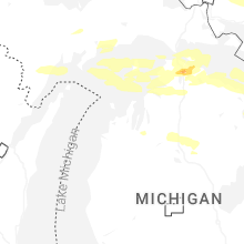


Connect with Interactive Hail Maps