

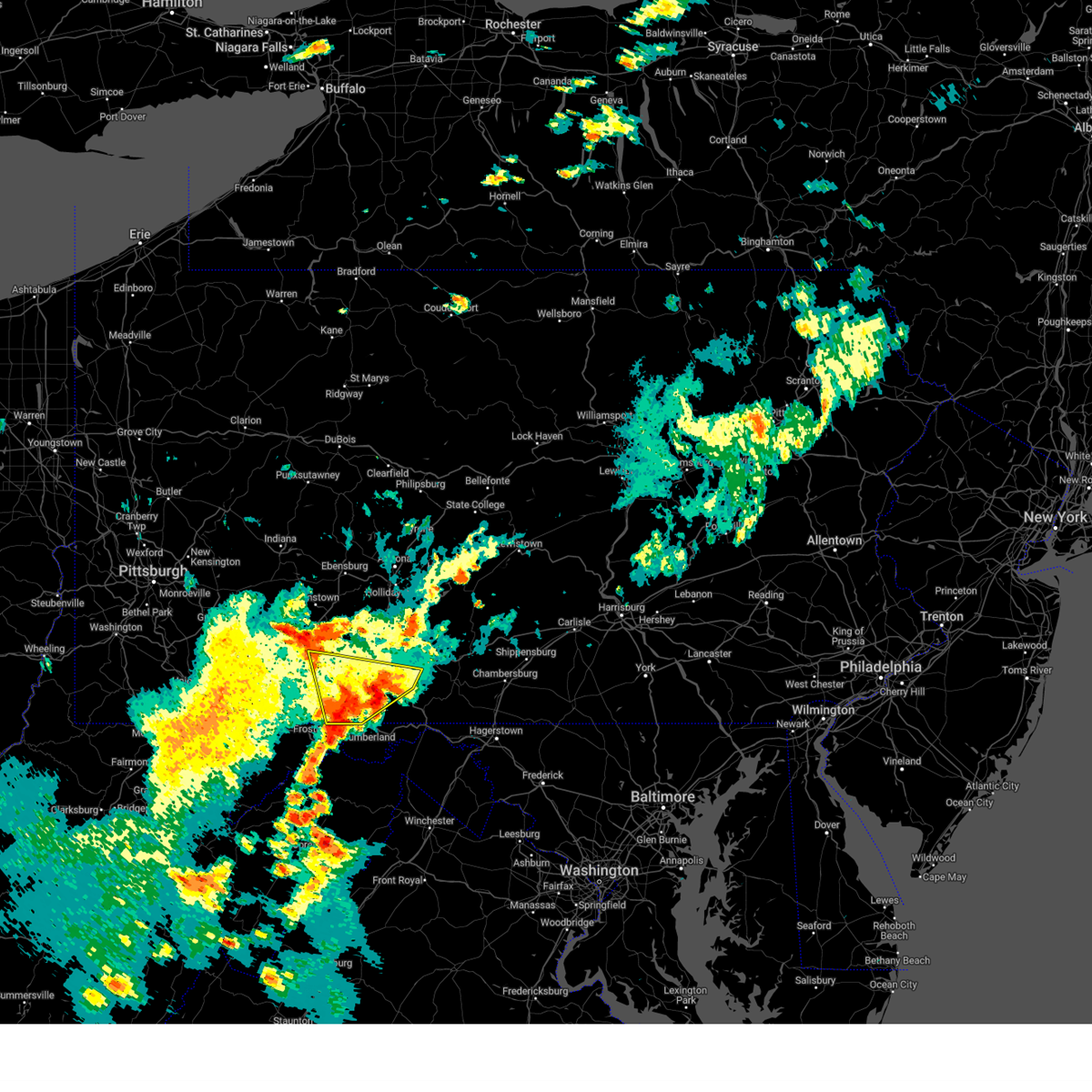
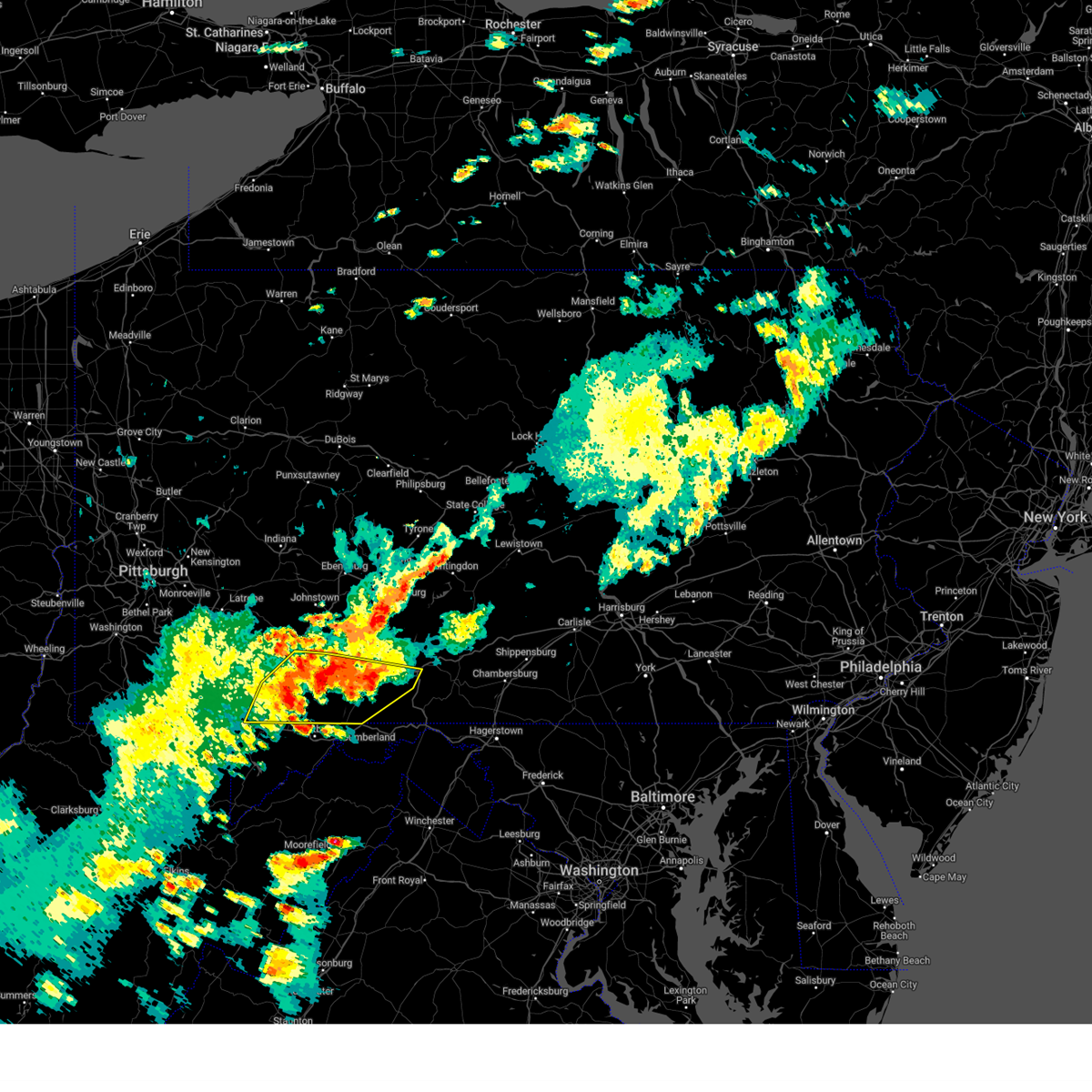
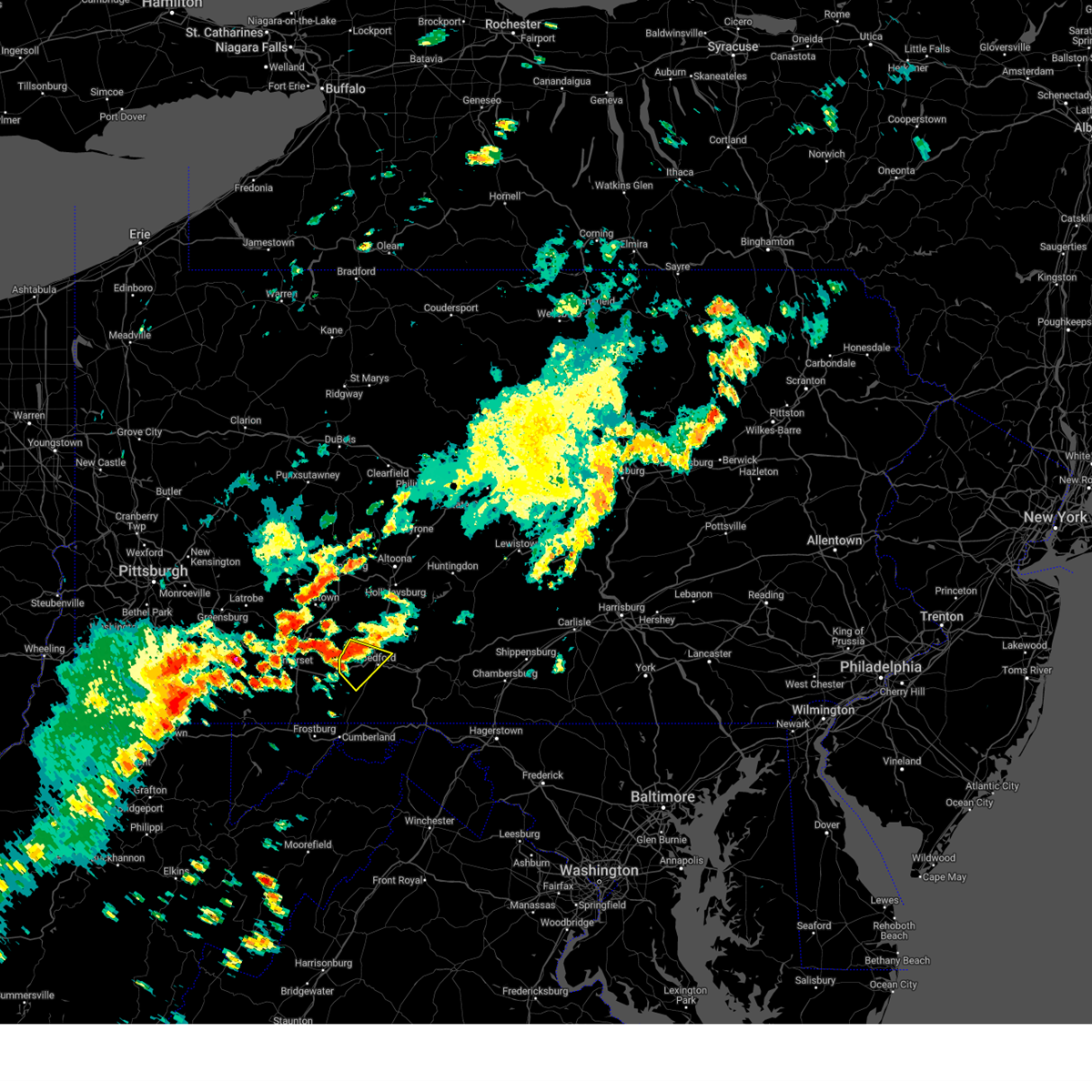
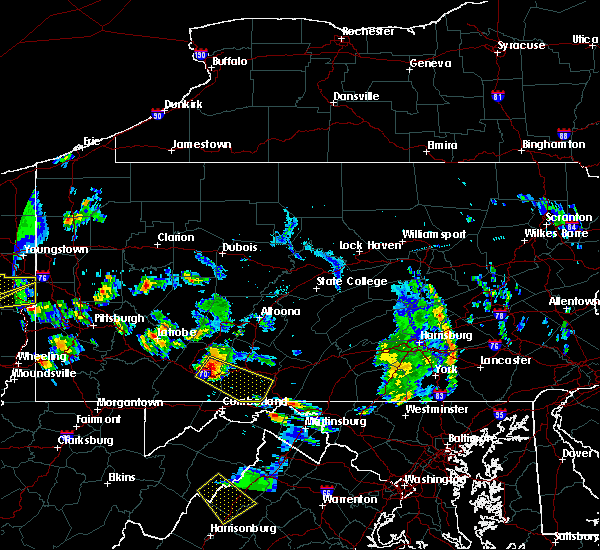
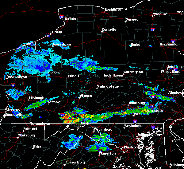
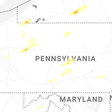
Hail Map for Bedford, PA
The Bedford, PA area has had 0 reports of on-the-ground hail by trained spotters, and has been under severe weather warnings 5 times during the past 12 months. Doppler radar has detected hail at or near Bedford, PA on 25 occasions, including 3 occasions during the past year.
| Name: | Bedford, PA |
| Where Located: | 63.5 miles SSW of State College, PA |
| Map: | Google Map for Bedford, PA |
| Population: | 2841 |
| Housing Units: | 1676 |
| More Info: | Search Google for Bedford, PA |
0
The Top Recent Hail Date for Bedford, PA is Monday, June 9, 2025 (25th out of 25)

Hail and Wind Damage Spotted near Bedford, PA
| Date / Time | Report Details |
|---|---|
| 6/19/2025 6:44 PM EDT | Svrctp the national weather service in state college pa has issued a * severe thunderstorm warning for, northern bedford county in south central pennsylvania, southern blair county in central pennsylvania, * until 715 pm edt. * at 643 pm edt, severe thunderstorms were located along a line extending from duncansville to central city, moving east at 45 mph (radar indicated). Hazards include 60 mph wind gusts. expect damage to roofs, siding, and trees |
| 3/16/2025 3:08 PM EDT | Corrects time previous tstm wnd dmg report from bedford... damage time-matched to radar. trees dow in bedford county PA, 0.4 miles NNW of Bedford, PA |
| 3/16/2025 2:55 PM EDT | Trees dow in bedford county PA, 0.4 miles NNW of Bedford, PA |
| 3/16/2025 2:08 PM EDT | Corrects time (radar-matched) of previous tstm wnd dmg report from bedford. trees dow in bedford county PA, 0.4 miles NNW of Bedford, PA |
| 3/16/2025 1:47 PM EDT |
 Svrctp the national weather service in state college pa has issued a * severe thunderstorm warning for, bedford county in south central pennsylvania, blair county in central pennsylvania, cambria county in central pennsylvania, southwestern centre county in central pennsylvania, clearfield county in central pennsylvania, eastern elk county in north central pennsylvania, eastern somerset county in south central pennsylvania, * until 230 pm edt. * at 147 pm edt, severe thunderstorms were located along a line extending from near portland mills to near punxsutawney to near friedens, moving northeast at 80 mph (trained weather spotters). Hazards include 60 mph wind gusts and penny size hail. expect damage to roofs, siding, and trees Svrctp the national weather service in state college pa has issued a * severe thunderstorm warning for, bedford county in south central pennsylvania, blair county in central pennsylvania, cambria county in central pennsylvania, southwestern centre county in central pennsylvania, clearfield county in central pennsylvania, eastern elk county in north central pennsylvania, eastern somerset county in south central pennsylvania, * until 230 pm edt. * at 147 pm edt, severe thunderstorms were located along a line extending from near portland mills to near punxsutawney to near friedens, moving northeast at 80 mph (trained weather spotters). Hazards include 60 mph wind gusts and penny size hail. expect damage to roofs, siding, and trees
|
| 8/31/2024 4:02 PM EDT |
 At 402 pm edt, a severe thunderstorm was located over inglesmith, moving southeast at 20 mph (radar indicated). Hazards include 60 mph wind gusts. Expect damage to roofs, siding, and trees. locations impacted include, bedford, breezewood, clearville, everett, buffalo mills, lake gordon, hyndman, ellerslie, indian lake, schellsburg, manns choice, and shanksville. this includes the following interstates, interstate 70 from mile markers 147 to 150. The pennsylvania turnpike between mile markers 119 and 142, and from mile markers 147 to 163. At 402 pm edt, a severe thunderstorm was located over inglesmith, moving southeast at 20 mph (radar indicated). Hazards include 60 mph wind gusts. Expect damage to roofs, siding, and trees. locations impacted include, bedford, breezewood, clearville, everett, buffalo mills, lake gordon, hyndman, ellerslie, indian lake, schellsburg, manns choice, and shanksville. this includes the following interstates, interstate 70 from mile markers 147 to 150. The pennsylvania turnpike between mile markers 119 and 142, and from mile markers 147 to 163.
|
| 8/31/2024 3:45 PM EDT | Tree down on wires 3000 block main rd in rainsburg bor in bedford county PA, 8.7 miles N of Bedford, PA |
| 8/31/2024 3:28 PM EDT |
 Svrctp the national weather service in state college pa has issued a * severe thunderstorm warning for, southern bedford county in south central pennsylvania, somerset county in south central pennsylvania, * until 430 pm edt. * at 327 pm edt, severe thunderstorms were located along a line extending from bedford to mount davis, moving east at 35 mph (radar indicated). Hazards include 60 mph wind gusts and quarter size hail. Hail damage to vehicles is expected. Expect wind damage to roofs, siding, and trees. Svrctp the national weather service in state college pa has issued a * severe thunderstorm warning for, southern bedford county in south central pennsylvania, somerset county in south central pennsylvania, * until 430 pm edt. * at 327 pm edt, severe thunderstorms were located along a line extending from bedford to mount davis, moving east at 35 mph (radar indicated). Hazards include 60 mph wind gusts and quarter size hail. Hail damage to vehicles is expected. Expect wind damage to roofs, siding, and trees.
|
| 8/31/2024 2:34 PM EDT |
 Svrctp the national weather service in state college pa has issued a * severe thunderstorm warning for, west central bedford county in south central pennsylvania, * until 315 pm edt. * at 233 pm edt, a severe thunderstorm was located near buffalo mills, moving southeast at 10 mph (radar indicated). Hazards include 60 mph wind gusts and quarter size hail. Hail damage to vehicles is expected. Expect wind damage to roofs, siding, and trees. Svrctp the national weather service in state college pa has issued a * severe thunderstorm warning for, west central bedford county in south central pennsylvania, * until 315 pm edt. * at 233 pm edt, a severe thunderstorm was located near buffalo mills, moving southeast at 10 mph (radar indicated). Hazards include 60 mph wind gusts and quarter size hail. Hail damage to vehicles is expected. Expect wind damage to roofs, siding, and trees.
|
| 5/26/2024 8:54 PM EDT |
 Svrctp the national weather service in state college pa has issued a * severe thunderstorm warning for, bedford county in south central pennsylvania, southwestern blair county in central pennsylvania, cambria county in central pennsylvania, western fulton county in south central pennsylvania, eastern somerset county in south central pennsylvania, * until 945 pm edt. * at 850 pm edt, severe thunderstorms were located along a line extending from near ligonier to somerset to frostburg to near meyersdale to lonaconing to near keyser, moving northeast at 50 mph (radar indicated). Hazards include 60 mph wind gusts. expect damage to roofs, siding, and trees Svrctp the national weather service in state college pa has issued a * severe thunderstorm warning for, bedford county in south central pennsylvania, southwestern blair county in central pennsylvania, cambria county in central pennsylvania, western fulton county in south central pennsylvania, eastern somerset county in south central pennsylvania, * until 945 pm edt. * at 850 pm edt, severe thunderstorms were located along a line extending from near ligonier to somerset to frostburg to near meyersdale to lonaconing to near keyser, moving northeast at 50 mph (radar indicated). Hazards include 60 mph wind gusts. expect damage to roofs, siding, and trees
|
| 8/7/2023 2:58 PM EDT |
 At 257 pm edt, severe thunderstorms were located along a line extending from bedford to barnes gap, moving east at 35 mph (radar indicated). Hazards include 60 mph wind gusts. expect damage to roofs, siding, and trees At 257 pm edt, severe thunderstorms were located along a line extending from bedford to barnes gap, moving east at 35 mph (radar indicated). Hazards include 60 mph wind gusts. expect damage to roofs, siding, and trees
|
| 8/7/2023 2:40 PM EDT |
 At 239 pm edt, severe thunderstorms were located along a line extending from buffalo mills to lake gordon, moving east at 45 mph (radar indicated). Hazards include 60 mph wind gusts. Expect damage to roofs, siding, and trees. locations impacted include, bedford, clearville, everett, buffalo mills, lake gordon, inglesmith, hyndman, manns choice and rainsburg. this includes the following interstates, the pennsylvania turnpike from mile markers 130 to 158. Interstate 99 from mile markers 0 to 1. At 239 pm edt, severe thunderstorms were located along a line extending from buffalo mills to lake gordon, moving east at 45 mph (radar indicated). Hazards include 60 mph wind gusts. Expect damage to roofs, siding, and trees. locations impacted include, bedford, clearville, everett, buffalo mills, lake gordon, inglesmith, hyndman, manns choice and rainsburg. this includes the following interstates, the pennsylvania turnpike from mile markers 130 to 158. Interstate 99 from mile markers 0 to 1.
|
| 8/7/2023 2:13 PM EDT |
 At 213 pm edt, severe thunderstorms were located along a line extending from near berlin to frostburg, moving east at 40 mph (radar indicated). Hazards include 60 mph wind gusts. expect damage to roofs, siding, and trees At 213 pm edt, severe thunderstorms were located along a line extending from near berlin to frostburg, moving east at 40 mph (radar indicated). Hazards include 60 mph wind gusts. expect damage to roofs, siding, and trees
|
| 7/20/2023 11:46 PM EDT |
 At 1145 pm edt, severe thunderstorms were located along a line extending from sunbury to alfarata to raystown dam to shy beaver to near buffalo mills, moving east at 40 mph (radar indicated). Hazards include 60 mph wind gusts and penny size hail. expect damage to roofs, siding, and trees At 1145 pm edt, severe thunderstorms were located along a line extending from sunbury to alfarata to raystown dam to shy beaver to near buffalo mills, moving east at 40 mph (radar indicated). Hazards include 60 mph wind gusts and penny size hail. expect damage to roofs, siding, and trees
|
| 7/15/2023 9:08 PM EDT |
 The severe thunderstorm warning for bedford, southwestern franklin, southern fulton and southeastern somerset counties will expire at 915 pm edt, the storms which prompted the warning have weakened below severe limits, and no longer pose an immediate threat to life or property. therefore, the warning will be allowed to expire. however gusty winds and heavy rain are still possible with these thunderstorms. The severe thunderstorm warning for bedford, southwestern franklin, southern fulton and southeastern somerset counties will expire at 915 pm edt, the storms which prompted the warning have weakened below severe limits, and no longer pose an immediate threat to life or property. therefore, the warning will be allowed to expire. however gusty winds and heavy rain are still possible with these thunderstorms.
|
| 7/15/2023 8:29 PM EDT |
 At 828 pm edt, severe thunderstorms were located along a line extending from near berlin to near berkeley springs, moving northeast at 25 mph (trained weather spotters). Hazards include 60 mph wind gusts. expect damage to roofs, siding, and trees At 828 pm edt, severe thunderstorms were located along a line extending from near berlin to near berkeley springs, moving northeast at 25 mph (trained weather spotters). Hazards include 60 mph wind gusts. expect damage to roofs, siding, and trees
|
| 7/14/2023 1:50 PM EDT |
 At 148 pm edt, a severe thunderstorm was located over everett, moving east at 15 mph (radar indicated). Hazards include 60 mph wind gusts and nickel size hail. Expect damage to roofs, siding, and trees. locations impacted include, bedford, everett, cessna, schellsburg and manns choice. this includes the following interstates, the pennsylvania turnpike from mile markers 136 to 155. interstate 99 from mile markers 0 to 4. hail threat, radar indicated max hail size, 0. 88 in wind threat, radar indicated max wind gust, 60 mph. At 148 pm edt, a severe thunderstorm was located over everett, moving east at 15 mph (radar indicated). Hazards include 60 mph wind gusts and nickel size hail. Expect damage to roofs, siding, and trees. locations impacted include, bedford, everett, cessna, schellsburg and manns choice. this includes the following interstates, the pennsylvania turnpike from mile markers 136 to 155. interstate 99 from mile markers 0 to 4. hail threat, radar indicated max hail size, 0. 88 in wind threat, radar indicated max wind gust, 60 mph.
|
| 7/14/2023 1:04 PM EDT |
 At 101 pm edt, a severe thunderstorm was located over cessna, moving east at 15 mph (radar indicated). Hazards include 60 mph wind gusts and nickel size hail. expect damage to roofs, siding, and trees At 101 pm edt, a severe thunderstorm was located over cessna, moving east at 15 mph (radar indicated). Hazards include 60 mph wind gusts and nickel size hail. expect damage to roofs, siding, and trees
|
| 6/26/2023 2:40 PM EDT | Trees down on wire in bedford county PA, 21.2 miles NNE of Bedford, PA |
| 4/5/2023 10:37 PM EDT |
 The severe thunderstorm warning for western bedford, southwestern blair, south central cambria and eastern somerset counties will expire at 1045 pm edt, the storms which prompted the warning have weakened below severe limits, and have exited the warned area. therefore, the warning will be allowed to expire. however, gusty winds are still possible with these thunderstorms. The severe thunderstorm warning for western bedford, southwestern blair, south central cambria and eastern somerset counties will expire at 1045 pm edt, the storms which prompted the warning have weakened below severe limits, and have exited the warned area. therefore, the warning will be allowed to expire. however, gusty winds are still possible with these thunderstorms.
|
| 4/5/2023 10:18 PM EDT |
 At 1018 pm edt, severe thunderstorms were located along a line extending from lilly to near central city to near la vale, moving east at 45 mph (radar indicated). Hazards include 60 mph wind gusts. Expect damage to roofs, siding, and trees. locations impacted include, bedford, portage, claysburg, osterburg, central city, beaverdale-lloydell, buffalo mills, dunlo, st. clairsville, lake gordon, blue knob state park and cessna. this includes the following interstates, the pennsylvania turnpike from mile markers 123 to 151. interstate 99 from mile markers 0 to 15. hail threat, radar indicated max hail size, <. 75 in wind threat, radar indicated max wind gust, 60 mph. At 1018 pm edt, severe thunderstorms were located along a line extending from lilly to near central city to near la vale, moving east at 45 mph (radar indicated). Hazards include 60 mph wind gusts. Expect damage to roofs, siding, and trees. locations impacted include, bedford, portage, claysburg, osterburg, central city, beaverdale-lloydell, buffalo mills, dunlo, st. clairsville, lake gordon, blue knob state park and cessna. this includes the following interstates, the pennsylvania turnpike from mile markers 123 to 151. interstate 99 from mile markers 0 to 15. hail threat, radar indicated max hail size, <. 75 in wind threat, radar indicated max wind gust, 60 mph.
|
| 4/5/2023 10:09 PM EDT |
 At 1009 pm edt, severe thunderstorms were located along a line extending from portage to central city to near meyersdale, moving east at 55 mph (radar indicated). Hazards include 60 mph wind gusts. Expect damage to roofs, siding, and trees. locations impacted include, johnstown, windber, bedford, belmont, portage, geistown, meyersdale, berlin, claysburg, friedens, vinco and osterburg. this includes the following interstates, the pennsylvania turnpike from mile markers 114 to 151. interstate 99 from mile markers 0 to 15. hail threat, radar indicated max hail size, <. 75 in wind threat, radar indicated max wind gust, 60 mph. At 1009 pm edt, severe thunderstorms were located along a line extending from portage to central city to near meyersdale, moving east at 55 mph (radar indicated). Hazards include 60 mph wind gusts. Expect damage to roofs, siding, and trees. locations impacted include, johnstown, windber, bedford, belmont, portage, geistown, meyersdale, berlin, claysburg, friedens, vinco and osterburg. this includes the following interstates, the pennsylvania turnpike from mile markers 114 to 151. interstate 99 from mile markers 0 to 15. hail threat, radar indicated max hail size, <. 75 in wind threat, radar indicated max wind gust, 60 mph.
|
| 4/5/2023 9:57 PM EDT |
 At 957 pm edt, a severe thunderstorm was located over friedens, moving east at 45 mph (radar indicated). Hazards include 60 mph wind gusts. expect damage to roofs, siding, and trees At 957 pm edt, a severe thunderstorm was located over friedens, moving east at 45 mph (radar indicated). Hazards include 60 mph wind gusts. expect damage to roofs, siding, and trees
|
| 8/5/2022 2:32 PM EDT |
 At 232 pm edt, a severe thunderstorm was located over bedford, moving east at 10 mph (radar indicated). Hazards include 60 mph wind gusts and penny size hail. expect damage to roofs, siding, and trees At 232 pm edt, a severe thunderstorm was located over bedford, moving east at 10 mph (radar indicated). Hazards include 60 mph wind gusts and penny size hail. expect damage to roofs, siding, and trees
|
| 7/23/2022 5:03 PM EDT | Multiple trees down near bedfor in bedford county PA, 0.8 miles WNW of Bedford, PA |
| 7/23/2022 5:00 PM EDT |
 At 459 pm edt, a severe thunderstorm was located over bedford, moving east at 20 mph (radar indicated). Hazards include 60 mph wind gusts and nickel size hail. expect damage to roofs, siding, and trees At 459 pm edt, a severe thunderstorm was located over bedford, moving east at 20 mph (radar indicated). Hazards include 60 mph wind gusts and nickel size hail. expect damage to roofs, siding, and trees
|
| 6/22/2022 7:21 PM EDT | Trees down on wire in bedford county PA, 0.9 miles ESE of Bedford, PA |
| 6/22/2022 7:21 PM EDT |
 At 720 pm edt, a severe thunderstorm was located over clearville, moving southeast at 40 mph (radar indicated). Hazards include 60 mph wind gusts and quarter size hail. Hail damage to vehicles is expected. Expect wind damage to roofs, siding, and trees. At 720 pm edt, a severe thunderstorm was located over clearville, moving southeast at 40 mph (radar indicated). Hazards include 60 mph wind gusts and quarter size hail. Hail damage to vehicles is expected. Expect wind damage to roofs, siding, and trees.
|
| 6/22/2022 7:19 PM EDT | Trees down on wire in bedford county PA, 2.2 miles SE of Bedford, PA |
| 6/22/2022 7:16 PM EDT |
 At 716 pm edt, a severe thunderstorm was located over bedford, moving southeast at 40 mph (radar indicated). Hazards include 60 mph wind gusts and nickel size hail. Expect damage to roofs, siding, and trees. locations impacted include, bedford, roaring spring, new enterprise, martinsburg, everett, claysburg, osterburg, st. clairsville, blue knob state park, queen, cessna and ski gap. this includes the following interstates, the pennsylvania turnpike between mile markers 132 and 151, and near mile marker 153. interstate 99 from mile markers 0 to 23. hail threat, radar indicated max hail size, 0. 88 in wind threat, radar indicated max wind gust, 60 mph. At 716 pm edt, a severe thunderstorm was located over bedford, moving southeast at 40 mph (radar indicated). Hazards include 60 mph wind gusts and nickel size hail. Expect damage to roofs, siding, and trees. locations impacted include, bedford, roaring spring, new enterprise, martinsburg, everett, claysburg, osterburg, st. clairsville, blue knob state park, queen, cessna and ski gap. this includes the following interstates, the pennsylvania turnpike between mile markers 132 and 151, and near mile marker 153. interstate 99 from mile markers 0 to 23. hail threat, radar indicated max hail size, 0. 88 in wind threat, radar indicated max wind gust, 60 mph.
|
| 6/22/2022 6:45 PM EDT |
 At 645 pm edt, a severe thunderstorm was located over ogletown, moving southeast at 40 mph (radar indicated). Hazards include 60 mph wind gusts and quarter size hail. Hail damage to vehicles is expected. Expect wind damage to roofs, siding, and trees. At 645 pm edt, a severe thunderstorm was located over ogletown, moving southeast at 40 mph (radar indicated). Hazards include 60 mph wind gusts and quarter size hail. Hail damage to vehicles is expected. Expect wind damage to roofs, siding, and trees.
|
| 6/8/2022 11:26 PM EDT |
 At 1126 pm edt, a severe thunderstorm was located over cessna, moving northeast at 50 mph (radar indicated). Hazards include 60 mph wind gusts. expect damage to roofs, siding, and trees At 1126 pm edt, a severe thunderstorm was located over cessna, moving northeast at 50 mph (radar indicated). Hazards include 60 mph wind gusts. expect damage to roofs, siding, and trees
|
| 5/20/2022 11:51 AM EDT |
 At 1150 am edt, severe thunderstorms were located along a line extending from bedford to near buffalo mills to near cumberland, moving east at 55 mph (radar indicated). Hazards include 70 mph wind gusts. Expect considerable tree damage. damage is likely to mobile homes, roofs, and outbuildings. locations impacted include, bedford, breezewood, clearville, everett, buffalo mills, crystal springs, lake gordon, inglesmith, hyndman, wellersburg and rainsburg. this includes the following interstates, interstate 70 from mile markers 147 to 150. The pennsylvania turnpike from mile markers 149 to 165. At 1150 am edt, severe thunderstorms were located along a line extending from bedford to near buffalo mills to near cumberland, moving east at 55 mph (radar indicated). Hazards include 70 mph wind gusts. Expect considerable tree damage. damage is likely to mobile homes, roofs, and outbuildings. locations impacted include, bedford, breezewood, clearville, everett, buffalo mills, crystal springs, lake gordon, inglesmith, hyndman, wellersburg and rainsburg. this includes the following interstates, interstate 70 from mile markers 147 to 150. The pennsylvania turnpike from mile markers 149 to 165.
|
| 5/20/2022 11:23 AM EDT |
 At 1122 am edt, severe thunderstorms were located along a line extending from ski gap to claysburg to new enterprise to bedford, moving northeast at 60 mph (radar indicated). Hazards include 60 mph wind gusts. Expect damage to roofs, siding, and trees. locations impacted include, hollidaysburg, bedford, roaring spring, new enterprise, martinsburg, lakemont, everett, claysburg, williamsburg, duncansville, osterburg and waterfall. this includes the following interstates, the pennsylvania turnpike from mile markers 145 to 150. interstate 99 from mile markers 0 to 28. hail threat, radar indicated max hail size, <. 75 in wind threat, radar indicated max wind gust, 60 mph. At 1122 am edt, severe thunderstorms were located along a line extending from ski gap to claysburg to new enterprise to bedford, moving northeast at 60 mph (radar indicated). Hazards include 60 mph wind gusts. Expect damage to roofs, siding, and trees. locations impacted include, hollidaysburg, bedford, roaring spring, new enterprise, martinsburg, lakemont, everett, claysburg, williamsburg, duncansville, osterburg and waterfall. this includes the following interstates, the pennsylvania turnpike from mile markers 145 to 150. interstate 99 from mile markers 0 to 28. hail threat, radar indicated max hail size, <. 75 in wind threat, radar indicated max wind gust, 60 mph.
|
| 5/20/2022 11:20 AM EDT |
 At 1118 am edt, severe thunderstorms were located along a line extending from new centerville to grantsville to accident, moving east at 55 mph (radar indicated). Hazards include 70 mph wind gusts. Expect considerable tree damage. Damage is likely to mobile homes, roofs, and outbuildings. At 1118 am edt, severe thunderstorms were located along a line extending from new centerville to grantsville to accident, moving east at 55 mph (radar indicated). Hazards include 70 mph wind gusts. Expect considerable tree damage. Damage is likely to mobile homes, roofs, and outbuildings.
|
| 5/20/2022 10:56 AM EDT |
 At 1055 am edt, severe thunderstorms were located along a line extending from jerome to near central city to berlin to meyersdale, moving northeast at 60 mph (radar indicated). Hazards include 60 mph wind gusts. expect damage to roofs, siding, and trees At 1055 am edt, severe thunderstorms were located along a line extending from jerome to near central city to berlin to meyersdale, moving northeast at 60 mph (radar indicated). Hazards include 60 mph wind gusts. expect damage to roofs, siding, and trees
|
| 3/31/2022 3:00 PM EDT |
 At 259 pm edt, severe thunderstorms were located along a line extending from new enterprise to near la vale, moving northeast at 45 mph (radar indicated). Hazards include 60 mph wind gusts and penny size hail. expect damage to roofs, siding, and trees At 259 pm edt, severe thunderstorms were located along a line extending from new enterprise to near la vale, moving northeast at 45 mph (radar indicated). Hazards include 60 mph wind gusts and penny size hail. expect damage to roofs, siding, and trees
|
| 3/31/2022 2:37 PM EDT |
 At 236 pm edt, a severe thunderstorm was located over buffalo mills, moving northeast at 55 mph (radar indicated). Hazards include 60 mph wind gusts and penny size hail. expect damage to roofs, siding, and trees At 236 pm edt, a severe thunderstorm was located over buffalo mills, moving northeast at 55 mph (radar indicated). Hazards include 60 mph wind gusts and penny size hail. expect damage to roofs, siding, and trees
|
| 3/7/2022 6:12 PM EST |
 The severe thunderstorm warning for bedford, huntingdon and eastern blair counties will expire at 615 pm est, the storms which prompted the warning have weakened below severe limits, and have exited the warned area. therefore, the warning will be allowed to expire. however gusty winds are still possible with this line of showers. a severe thunderstorm watch remains in effect until 900 pm est for south central and central pennsylvania. The severe thunderstorm warning for bedford, huntingdon and eastern blair counties will expire at 615 pm est, the storms which prompted the warning have weakened below severe limits, and have exited the warned area. therefore, the warning will be allowed to expire. however gusty winds are still possible with this line of showers. a severe thunderstorm watch remains in effect until 900 pm est for south central and central pennsylvania.
|
| 3/7/2022 5:53 PM EST | Trees and wires dow in bedford county PA, 1.8 miles W of Bedford, PA |
| 3/7/2022 5:51 PM EST |
 At 550 pm est, severe thunderstorms were located along a line extending from port matilda to martinsburg to buffalo mills, moving east at 60 mph (trained weather spotters). Hazards include 60 mph wind gusts. Expect damage to roofs, siding, and trees. locations impacted include, huntingdon, hollidaysburg, tyrone, bedford, breezewood, roaring spring, mount union, clearville, bald eagle, new enterprise, martinsburg, everett, bellwood, warriors mark, williamsburg, osterburg, tipton, buffalo mills, allensville and spruce creek. this includes the following interstates, interstate 70 from mile markers 147 to 150. the pennsylvania turnpike from mile markers 136 to 165. interstate 99 between mile markers 0 and 14, and from mile markers 38 to 55. hail threat, radar indicated max hail size, <. 75 in wind threat, radar indicated max wind gust, 60 mph. At 550 pm est, severe thunderstorms were located along a line extending from port matilda to martinsburg to buffalo mills, moving east at 60 mph (trained weather spotters). Hazards include 60 mph wind gusts. Expect damage to roofs, siding, and trees. locations impacted include, huntingdon, hollidaysburg, tyrone, bedford, breezewood, roaring spring, mount union, clearville, bald eagle, new enterprise, martinsburg, everett, bellwood, warriors mark, williamsburg, osterburg, tipton, buffalo mills, allensville and spruce creek. this includes the following interstates, interstate 70 from mile markers 147 to 150. the pennsylvania turnpike from mile markers 136 to 165. interstate 99 between mile markers 0 and 14, and from mile markers 38 to 55. hail threat, radar indicated max hail size, <. 75 in wind threat, radar indicated max wind gust, 60 mph.
|
| 3/7/2022 5:27 PM EST |
 At 527 pm est, severe thunderstorms were located along a line extending from prince gallitzin state park to ogletown to meyersdale, moving east at 60 mph (trained weather spotters). Hazards include 60 mph wind gusts. expect damage to roofs, siding, and trees At 527 pm est, severe thunderstorms were located along a line extending from prince gallitzin state park to ogletown to meyersdale, moving east at 60 mph (trained weather spotters). Hazards include 60 mph wind gusts. expect damage to roofs, siding, and trees
|
| 8/18/2021 10:34 AM EDT | Trees and wires dow in bedford county PA, 1 miles S of Bedford, PA |
| 8/18/2021 10:33 AM EDT | Trees and wires dow in bedford county PA, 0.5 miles SE of Bedford, PA |
| 8/18/2021 10:32 AM EDT |
 At 1031 am edt, a severe thunderstorm was located over cessna, moving northeast at 40 mph (radar indicated). Hazards include 60 mph wind gusts. expect damage to roofs, siding, and trees At 1031 am edt, a severe thunderstorm was located over cessna, moving northeast at 40 mph (radar indicated). Hazards include 60 mph wind gusts. expect damage to roofs, siding, and trees
|
| 7/11/2021 6:57 PM EDT |
 At 655 pm edt, severe thunderstorms were located along a line extending from near julian to near huntingdon to near trough creek state park to near everett to near lake gordon, moving east at 40 mph (radar indicated). Hazards include 70 mph wind gusts. Expect considerable tree damage. Damage is likely to mobile homes, roofs, and outbuildings. At 655 pm edt, severe thunderstorms were located along a line extending from near julian to near huntingdon to near trough creek state park to near everett to near lake gordon, moving east at 40 mph (radar indicated). Hazards include 70 mph wind gusts. Expect considerable tree damage. Damage is likely to mobile homes, roofs, and outbuildings.
|
| 7/11/2021 6:03 PM EDT |
 At 602 pm edt, severe thunderstorms were located along a line extending from near blandburg to near ski gap to near central city to near meyersdale, moving east at 30 mph (radar indicated). Hazards include 60 mph wind gusts. expect damage to roofs, siding, and trees At 602 pm edt, severe thunderstorms were located along a line extending from near blandburg to near ski gap to near central city to near meyersdale, moving east at 30 mph (radar indicated). Hazards include 60 mph wind gusts. expect damage to roofs, siding, and trees
|
| 11/15/2020 4:23 PM EST |
 At 423 pm est, severe thunderstorms were located along a line extending from near dunlo to near central city to near berlin to 6 miles north of accident, moving east at 55 mph (radar indicated). Hazards include 60 mph wind gusts. expect damage to trees, roofs, and siding At 423 pm est, severe thunderstorms were located along a line extending from near dunlo to near central city to near berlin to 6 miles north of accident, moving east at 55 mph (radar indicated). Hazards include 60 mph wind gusts. expect damage to trees, roofs, and siding
|
| 8/27/2020 7:09 PM EDT |
 At 709 pm edt, severe thunderstorms were located along a line extending from near osterburg to near central city to 7 miles northeast of seven springs, moving southeast at 40 mph (radar indicated). Hazards include 60 mph wind gusts and quarter size hail. Hail damage to vehicles is expected. Expect wind damage to trees, roofs, and siding. At 709 pm edt, severe thunderstorms were located along a line extending from near osterburg to near central city to 7 miles northeast of seven springs, moving southeast at 40 mph (radar indicated). Hazards include 60 mph wind gusts and quarter size hail. Hail damage to vehicles is expected. Expect wind damage to trees, roofs, and siding.
|
| 8/25/2020 3:49 PM EDT |
 At 348 pm edt, a severe thunderstorm was located near central city, moving southeast at 50 mph (radar indicated). Hazards include 60 mph wind gusts and quarter size hail. Hail damage to vehicles is expected. Expect wind damage to trees, roofs, and siding. At 348 pm edt, a severe thunderstorm was located near central city, moving southeast at 50 mph (radar indicated). Hazards include 60 mph wind gusts and quarter size hail. Hail damage to vehicles is expected. Expect wind damage to trees, roofs, and siding.
|
| 6/4/2020 7:58 PM EDT |
 At 758 pm edt, severe thunderstorms were located along a line extending from near allensville to near hancock, moving east at 50 mph (radar indicated). Hazards include 70 mph wind gusts and quarter size hail. Hail damage to vehicles is expected. expect considerable tree damage. wind damage is also likely to mobile homes, roofs, and outbuildings. locations impacted include, bedford, roaring spring, clearville, new enterprise, martinsburg, everett, williamsburg, spruce creek, sinking valley, canoe creek state park, entriken, inglesmith, royer, shy beaver, cessna, saxton, alexandria, woodbury, hopewell and marklesburg. this includes the following interstates, the pennsylvania turnpike from mile markers 145 to 159. Interstate 99 from mile markers 0 to 1. At 758 pm edt, severe thunderstorms were located along a line extending from near allensville to near hancock, moving east at 50 mph (radar indicated). Hazards include 70 mph wind gusts and quarter size hail. Hail damage to vehicles is expected. expect considerable tree damage. wind damage is also likely to mobile homes, roofs, and outbuildings. locations impacted include, bedford, roaring spring, clearville, new enterprise, martinsburg, everett, williamsburg, spruce creek, sinking valley, canoe creek state park, entriken, inglesmith, royer, shy beaver, cessna, saxton, alexandria, woodbury, hopewell and marklesburg. this includes the following interstates, the pennsylvania turnpike from mile markers 145 to 159. Interstate 99 from mile markers 0 to 1.
|
| 6/4/2020 7:33 PM EDT |
 At 732 pm edt, severe thunderstorms were located along a line extending from bellwood to near lake gordon, moving east at 50 mph (radar indicated). Hazards include 70 mph wind gusts and quarter size hail. Hail damage to vehicles is expected. expect considerable tree damage. Wind damage is also likely to mobile homes, roofs, and outbuildings. At 732 pm edt, severe thunderstorms were located along a line extending from bellwood to near lake gordon, moving east at 50 mph (radar indicated). Hazards include 70 mph wind gusts and quarter size hail. Hail damage to vehicles is expected. expect considerable tree damage. Wind damage is also likely to mobile homes, roofs, and outbuildings.
|
| 6/4/2020 6:09 PM EDT |
 At 609 pm edt, a severe thunderstorm was located near clearville, moving northeast at 25 mph (radar indicated). Hazards include 60 mph wind gusts. expect damage to trees, roofs, and siding At 609 pm edt, a severe thunderstorm was located near clearville, moving northeast at 25 mph (radar indicated). Hazards include 60 mph wind gusts. expect damage to trees, roofs, and siding
|
| 4/8/2020 2:26 AM EDT |
 At 226 am edt, severe thunderstorms were located along a line extending from 6 miles northwest of doylesburg to 6 miles west of bedford, moving east at 75 mph (radar indicated). Hazards include 60 mph wind gusts and quarter size hail. Hail damage to vehicles is expected. Expect wind damage to trees, roofs, and siding. At 226 am edt, severe thunderstorms were located along a line extending from 6 miles northwest of doylesburg to 6 miles west of bedford, moving east at 75 mph (radar indicated). Hazards include 60 mph wind gusts and quarter size hail. Hail damage to vehicles is expected. Expect wind damage to trees, roofs, and siding.
|
| 7/21/2019 8:43 PM EDT |
 At 843 pm edt, a severe thunderstorm was located near bedford, moving northeast at 20 mph (radar indicated). Hazards include 60 mph wind gusts and nickel size hail. expect damage to trees, roofs, and siding At 843 pm edt, a severe thunderstorm was located near bedford, moving northeast at 20 mph (radar indicated). Hazards include 60 mph wind gusts and nickel size hail. expect damage to trees, roofs, and siding
|
| 5/29/2019 4:06 PM EDT |
 At 405 pm edt, a severe thunderstorm was located near osterburg, moving east at 40 mph (radar indicated). Hazards include 60 mph wind gusts and quarter size hail. Hail damage to vehicles is expected. Expect wind damage to trees, roofs, and siding. At 405 pm edt, a severe thunderstorm was located near osterburg, moving east at 40 mph (radar indicated). Hazards include 60 mph wind gusts and quarter size hail. Hail damage to vehicles is expected. Expect wind damage to trees, roofs, and siding.
|
| 5/28/2019 10:50 PM EDT |
 At 1050 pm edt, a severe thunderstorm was located over ogletown, moving east at 55 mph (radar indicated). Hazards include 60 mph wind gusts. expect damage to trees, roofs, and siding At 1050 pm edt, a severe thunderstorm was located over ogletown, moving east at 55 mph (radar indicated). Hazards include 60 mph wind gusts. expect damage to trees, roofs, and siding
|
| 5/23/2019 10:03 PM EDT |
 At 1002 pm edt, a severe thunderstorm was located over big cove tannery, moving southeast at 45 mph (radar indicated). Hazards include 60 mph wind gusts and quarter size hail. Hail damage to vehicles is expected. expect wind damage to trees, roofs, and siding. locations impacted include, bedford, clearville and everett. this includes the following interstates, the pennsylvania turnpike from mile markers 144 to 160. Interstate 99 from mile markers 0 to 1. At 1002 pm edt, a severe thunderstorm was located over big cove tannery, moving southeast at 45 mph (radar indicated). Hazards include 60 mph wind gusts and quarter size hail. Hail damage to vehicles is expected. expect wind damage to trees, roofs, and siding. locations impacted include, bedford, clearville and everett. this includes the following interstates, the pennsylvania turnpike from mile markers 144 to 160. Interstate 99 from mile markers 0 to 1.
|
| 5/23/2019 9:47 PM EDT |
 At 946 pm edt, a severe thunderstorm was located over cessna, moving southeast at 50 mph (radar indicated). Hazards include 60 mph wind gusts and dime size hail. Expect wind damage to trees, roofs, and siding. locations impacted include, bedford, clearville, everett, st. Clairsville, cessna and new paris. At 946 pm edt, a severe thunderstorm was located over cessna, moving southeast at 50 mph (radar indicated). Hazards include 60 mph wind gusts and dime size hail. Expect wind damage to trees, roofs, and siding. locations impacted include, bedford, clearville, everett, st. Clairsville, cessna and new paris.
|
| 5/23/2019 9:30 PM EDT |
 At 929 pm edt, a severe thunderstorm was located near osterburg, moving southeast at 45 mph (radar indicated). Hazards include 60 mph wind gusts and quarter size hail. Hail damage to vehicles is expected. Expect wind damage to trees, roofs, and siding. At 929 pm edt, a severe thunderstorm was located near osterburg, moving southeast at 45 mph (radar indicated). Hazards include 60 mph wind gusts and quarter size hail. Hail damage to vehicles is expected. Expect wind damage to trees, roofs, and siding.
|
| 4/14/2019 10:52 PM EDT |
 At 1051 pm edt, severe thunderstorms were located along a line extending from near houtzdale to near ski gap to near bedford, moving northeast at 60 mph (radar indicated). Hazards include 60 mph wind gusts and penny size hail. Expect damage to roofs, siding, and trees. locations impacted include, altoona, hollidaysburg, tyrone, bedford, breezewood, roaring spring, clearville, new enterprise, martinsburg, lakemont, everett, bellwood, claysburg, duncansville, osterburg, tipton, buffalo mills, crystal springs, blandburg and st. clairsville. this includes the following interstates, interstate 70 from mile markers 147 to 164. the pennsylvania turnpike from mile markers 136 to 163. interstate 99 from mile markers 0 to 49. A tornado watch remains in effect until 300 am edt for south central and central pennsylvania. At 1051 pm edt, severe thunderstorms were located along a line extending from near houtzdale to near ski gap to near bedford, moving northeast at 60 mph (radar indicated). Hazards include 60 mph wind gusts and penny size hail. Expect damage to roofs, siding, and trees. locations impacted include, altoona, hollidaysburg, tyrone, bedford, breezewood, roaring spring, clearville, new enterprise, martinsburg, lakemont, everett, bellwood, claysburg, duncansville, osterburg, tipton, buffalo mills, crystal springs, blandburg and st. clairsville. this includes the following interstates, interstate 70 from mile markers 147 to 164. the pennsylvania turnpike from mile markers 136 to 163. interstate 99 from mile markers 0 to 49. A tornado watch remains in effect until 300 am edt for south central and central pennsylvania.
|
| 4/14/2019 10:17 PM EDT |
 At 1017 pm edt, severe thunderstorms were located along a line extending from belsano to friedens to near frostburg, moving northeast at 60 mph (radar indicated). Hazards include 60 mph wind gusts and penny size hail. expect damage to roofs, siding, and trees At 1017 pm edt, severe thunderstorms were located along a line extending from belsano to friedens to near frostburg, moving northeast at 60 mph (radar indicated). Hazards include 60 mph wind gusts and penny size hail. expect damage to roofs, siding, and trees
|
| 8/21/2018 4:04 PM EDT |
 At 402 pm edt, a severe thunderstorm was located near clearville, moving northeast at 35 mph (radar indicated). Hazards include 70 mph wind gusts. Expect considerable tree damage. damage is likely to mobile homes, roofs, and outbuildings. this severe thunderstorm will impact clearville, locust grove, and inglesmith. this includes the following interstates, interstate 70 from mile markers 154 to 170. The pennsylvania turnpike from mile markers 148 to 159. At 402 pm edt, a severe thunderstorm was located near clearville, moving northeast at 35 mph (radar indicated). Hazards include 70 mph wind gusts. Expect considerable tree damage. damage is likely to mobile homes, roofs, and outbuildings. this severe thunderstorm will impact clearville, locust grove, and inglesmith. this includes the following interstates, interstate 70 from mile markers 154 to 170. The pennsylvania turnpike from mile markers 148 to 159.
|
| 8/21/2018 3:43 PM EDT |
 At 342 pm edt, a severe thunderstorm was located over lake gordon, moving northeast at 25 mph (radar indicated). Hazards include 70 mph wind gusts. Expect considerable tree damage. damage is likely to mobile homes, roofs, and outbuildings. this severe storm will be near, clearville around 410 pm edt. other locations impacted by this severe thunderstorm include rainsburg, wellersburg and hyndman. this includes the following interstates, interstate 70 from mile markers 154 to 170. The pennsylvania turnpike from mile markers 148 to 159. At 342 pm edt, a severe thunderstorm was located over lake gordon, moving northeast at 25 mph (radar indicated). Hazards include 70 mph wind gusts. Expect considerable tree damage. damage is likely to mobile homes, roofs, and outbuildings. this severe storm will be near, clearville around 410 pm edt. other locations impacted by this severe thunderstorm include rainsburg, wellersburg and hyndman. this includes the following interstates, interstate 70 from mile markers 154 to 170. The pennsylvania turnpike from mile markers 148 to 159.
|
| 8/21/2018 3:27 PM EDT |
 At 326 pm edt, a severe thunderstorm capable of producing a tornado was located near buffalo mills, moving northeast at 35 mph (radar indicated rotation). Hazards include tornado. Flying debris will be dangerous to those caught without shelter. mobile homes will be damaged or destroyed. damage to roofs, windows, and vehicles will occur. tree damage is likely. this dangerous storm will be near, bedford, cessna and st. clairsville around 340 pm edt. other locations impacted by this tornadic thunderstorm include schellsburg, hyndman, rainsburg, new paris and manns choice. this includes the following interstates, the pennsylvania turnpike from mile markers 131 to 152. Interstate 99 from mile markers 0 to 9. At 326 pm edt, a severe thunderstorm capable of producing a tornado was located near buffalo mills, moving northeast at 35 mph (radar indicated rotation). Hazards include tornado. Flying debris will be dangerous to those caught without shelter. mobile homes will be damaged or destroyed. damage to roofs, windows, and vehicles will occur. tree damage is likely. this dangerous storm will be near, bedford, cessna and st. clairsville around 340 pm edt. other locations impacted by this tornadic thunderstorm include schellsburg, hyndman, rainsburg, new paris and manns choice. this includes the following interstates, the pennsylvania turnpike from mile markers 131 to 152. Interstate 99 from mile markers 0 to 9.
|
| 8/21/2018 3:12 PM EDT |
 At 312 pm edt, a severe thunderstorm was located over frostburg, moving northeast at 25 mph (radar indicated). Hazards include 70 mph wind gusts. Expect considerable tree damage. damage is likely to mobile homes, roofs, and outbuildings. this severe thunderstorm will be near, lake gordon around 340 pm edt. clearville around 410 pm edt. other locations impacted by this severe thunderstorm include wellersburg, callimont, hyndman and rainsburg. this includes the following interstates, interstate 70 from mile markers 154 to 170. The pennsylvania turnpike from mile markers 148 to 159. At 312 pm edt, a severe thunderstorm was located over frostburg, moving northeast at 25 mph (radar indicated). Hazards include 70 mph wind gusts. Expect considerable tree damage. damage is likely to mobile homes, roofs, and outbuildings. this severe thunderstorm will be near, lake gordon around 340 pm edt. clearville around 410 pm edt. other locations impacted by this severe thunderstorm include wellersburg, callimont, hyndman and rainsburg. this includes the following interstates, interstate 70 from mile markers 154 to 170. The pennsylvania turnpike from mile markers 148 to 159.
|
| 8/21/2018 3:09 PM EDT | Trees down along pine ridge road in cumberland townshi in bedford county PA, 20.6 miles NNE of Bedford, PA |
| 8/21/2018 2:55 PM EDT |
 At 255 pm edt, a severe thunderstorm capable of producing a tornado was located near berlin, moving northeast at 35 mph (radar indicated rotation). Hazards include tornado. Flying debris will be dangerous to those caught without shelter. mobile homes will be damaged or destroyed. damage to roofs, windows, and vehicles will occur. tree damage is likely. this dangerous storm will be near, buffalo mills around 320 pm edt. bedford, cessna, st. clairsville and osterburg around 340 pm edt. other locations impacted by this tornadic thunderstorm include callimont, schellsburg, new baltimore, rainsburg, hyndman, new paris, manns choice, garrett and indian lake. this includes the following interstates, the pennsylvania turnpike from mile markers 118 to 152. Interstate 99 from mile markers 0 to 9. At 255 pm edt, a severe thunderstorm capable of producing a tornado was located near berlin, moving northeast at 35 mph (radar indicated rotation). Hazards include tornado. Flying debris will be dangerous to those caught without shelter. mobile homes will be damaged or destroyed. damage to roofs, windows, and vehicles will occur. tree damage is likely. this dangerous storm will be near, buffalo mills around 320 pm edt. bedford, cessna, st. clairsville and osterburg around 340 pm edt. other locations impacted by this tornadic thunderstorm include callimont, schellsburg, new baltimore, rainsburg, hyndman, new paris, manns choice, garrett and indian lake. this includes the following interstates, the pennsylvania turnpike from mile markers 118 to 152. Interstate 99 from mile markers 0 to 9.
|
| 5/13/2018 6:21 PM EDT | Tree blocking teaberry road near the intersection with buck falls roa in bedford county PA, 8 miles NE of Bedford, PA |
| 5/13/2018 6:00 PM EDT |
 At 600 pm edt, severe thunderstorms were located along a line extending from ogletown to 6 miles southwest of central city to near new centerville, moving southeast at 30 mph (radar indicated). Hazards include 60 mph wind gusts and quarter size hail. Hail damage to vehicles is possible. Expect wind damage to trees and power lines. At 600 pm edt, severe thunderstorms were located along a line extending from ogletown to 6 miles southwest of central city to near new centerville, moving southeast at 30 mph (radar indicated). Hazards include 60 mph wind gusts and quarter size hail. Hail damage to vehicles is possible. Expect wind damage to trees and power lines.
|
| 5/12/2018 6:21 PM EDT |
 At 621 pm edt, a severe thunderstorm was located near jerome, moving east at 50 mph (radar indicated). Hazards include 60 mph wind gusts and quarter size hail. Hail damage to vehicles is possible. Expect wind damage to trees and power lines. At 621 pm edt, a severe thunderstorm was located near jerome, moving east at 50 mph (radar indicated). Hazards include 60 mph wind gusts and quarter size hail. Hail damage to vehicles is possible. Expect wind damage to trees and power lines.
|
| 8/22/2017 5:46 PM EDT |
 At 546 pm edt, severe thunderstorms were located along a line extending from near prince gallitzin state park to near berlin, moving east at 45 mph (radar indicated). Hazards include 60 mph wind gusts. expect damage to trees and power lines At 546 pm edt, severe thunderstorms were located along a line extending from near prince gallitzin state park to near berlin, moving east at 45 mph (radar indicated). Hazards include 60 mph wind gusts. expect damage to trees and power lines
|
| 8/19/2017 6:18 PM EDT |
 At 618 pm edt, severe thunderstorms were located along a line extending from near ogletown to 6 miles east of berlin to near ursina, moving east at 40 mph (radar indicated). Hazards include 60 mph wind gusts and nickel size hail. Expect damage to trees and power lines. severe thunderstorms will be near, queen, blue knob state park, osterburg and st. clairsville around 630 pm edt. buffalo mills and new enterprise around 640 pm edt. bedford around 650 pm edt. clearville and coaldale around 700 pm edt. other locations impacted by these severe thunderstorms include schellsburg, rainsburg, woodbury, hopewell, saxton, defiance, hyndman, new paris, manns choice and ellerslie. this includes the following interstates, interstate 70 from mile markers 147 to 149. the pennsylvania turnpike from mile markers 131 to 162. Interstate 99 from mile markers 0 to 14. At 618 pm edt, severe thunderstorms were located along a line extending from near ogletown to 6 miles east of berlin to near ursina, moving east at 40 mph (radar indicated). Hazards include 60 mph wind gusts and nickel size hail. Expect damage to trees and power lines. severe thunderstorms will be near, queen, blue knob state park, osterburg and st. clairsville around 630 pm edt. buffalo mills and new enterprise around 640 pm edt. bedford around 650 pm edt. clearville and coaldale around 700 pm edt. other locations impacted by these severe thunderstorms include schellsburg, rainsburg, woodbury, hopewell, saxton, defiance, hyndman, new paris, manns choice and ellerslie. this includes the following interstates, interstate 70 from mile markers 147 to 149. the pennsylvania turnpike from mile markers 131 to 162. Interstate 99 from mile markers 0 to 14.
|
| 5/1/2017 5:21 PM EDT |
 At 521 pm edt, severe thunderstorms were located along a line extending from 6 miles northwest of blandburg to 6 miles east of friedens, moving northeast at 40 mph (radar indicated). Hazards include 60 mph wind gusts. expect damage to roofs, siding, and trees At 521 pm edt, severe thunderstorms were located along a line extending from 6 miles northwest of blandburg to 6 miles east of friedens, moving northeast at 40 mph (radar indicated). Hazards include 60 mph wind gusts. expect damage to roofs, siding, and trees
|
| 2/12/2017 8:52 PM EST |
 At 851 pm est, severe thunderstorms were located along a line extending from royer to near farmington, moving east at 80 mph (radar indicated). Hazards include 60 mph wind gusts. Expect damage to roofs, siding, and trees. locations impacted include, bedford, somerset, lake gordon, osterburg, martinsburg, everett, new enterprise, central city, buffalo mills, cessna, ursina, roaring spring, inglesmith, meyersdale, royer, berlin, queen, clearville, st. Clairsville and claysburg. At 851 pm est, severe thunderstorms were located along a line extending from royer to near farmington, moving east at 80 mph (radar indicated). Hazards include 60 mph wind gusts. Expect damage to roofs, siding, and trees. locations impacted include, bedford, somerset, lake gordon, osterburg, martinsburg, everett, new enterprise, central city, buffalo mills, cessna, ursina, roaring spring, inglesmith, meyersdale, royer, berlin, queen, clearville, st. Clairsville and claysburg.
|
| 2/12/2017 8:11 PM EST |
 At 810 pm est, severe thunderstorms were located along a line extending from near belsano to near cameron, moving east-southeast at 45 mph (radar indicated). Hazards include 60 mph wind gusts. expect damage to roofs, siding, and trees At 810 pm est, severe thunderstorms were located along a line extending from near belsano to near cameron, moving east-southeast at 45 mph (radar indicated). Hazards include 60 mph wind gusts. expect damage to roofs, siding, and trees
|
| 8/16/2016 8:33 PM EDT |
 At 833 pm edt, severe thunderstorms were located along a line extending from new enterprise to near clearville to near ridgeley, moving east at 50 mph (radar indicated). Hazards include 60 mph wind gusts. Expect damage to roofs. siding. and trees. locations impacted include, breezewood, bedford, buffalo mills, st. Clairsville, new enterprise, cessna, clearville, inglesmith, lake gordon, everett, osterburg, pleasantville, hyndman, saxton, new paris, hopewell, rainsburg, ellerslie, manns choice and defiance. At 833 pm edt, severe thunderstorms were located along a line extending from new enterprise to near clearville to near ridgeley, moving east at 50 mph (radar indicated). Hazards include 60 mph wind gusts. Expect damage to roofs. siding. and trees. locations impacted include, breezewood, bedford, buffalo mills, st. Clairsville, new enterprise, cessna, clearville, inglesmith, lake gordon, everett, osterburg, pleasantville, hyndman, saxton, new paris, hopewell, rainsburg, ellerslie, manns choice and defiance.
|
| 8/16/2016 8:04 PM EDT |
 At 804 pm edt, severe thunderstorms were located along a line extending from near central city to berlin to near bittinger, moving east at 50 mph (radar indicated). Hazards include 60 mph wind gusts. Expect damage to roofs. siding. And trees. At 804 pm edt, severe thunderstorms were located along a line extending from near central city to berlin to near bittinger, moving east at 50 mph (radar indicated). Hazards include 60 mph wind gusts. Expect damage to roofs. siding. And trees.
|
| 6/16/2016 4:26 PM EDT |
 At 426 pm edt, a severe thunderstorm was located near bedford, moving southeast at 25 mph (radar indicated). Hazards include 60 mph wind gusts. Expect damage to roofs. siding. and trees. Locations impacted include, bedford and everett. At 426 pm edt, a severe thunderstorm was located near bedford, moving southeast at 25 mph (radar indicated). Hazards include 60 mph wind gusts. Expect damage to roofs. siding. and trees. Locations impacted include, bedford and everett.
|
| 6/16/2016 4:02 PM EDT |
 At 400 pm edt, a severe thunderstorm was located near cessna, moving east at 25 mph (radar indicated). Hazards include 60 mph wind gusts. Expect damage to roofs. siding. and trees. locations impacted include, bedford, st. Clairsville, everett, cessna, osterburg, pleasantville, manns choice, schellsburg and new paris. At 400 pm edt, a severe thunderstorm was located near cessna, moving east at 25 mph (radar indicated). Hazards include 60 mph wind gusts. Expect damage to roofs. siding. and trees. locations impacted include, bedford, st. Clairsville, everett, cessna, osterburg, pleasantville, manns choice, schellsburg and new paris.
|
| 6/16/2016 3:43 PM EDT |
 At 342 pm edt, a severe thunderstorm was located near central city, moving southeast at 20 mph (radar indicated). Hazards include 60 mph wind gusts. Expect damage to roofs. siding. And trees. At 342 pm edt, a severe thunderstorm was located near central city, moving southeast at 20 mph (radar indicated). Hazards include 60 mph wind gusts. Expect damage to roofs. siding. And trees.
|
| 6/16/2016 3:01 PM EDT |
 At 259 pm edt, a severe thunderstorm was located over buffalo mills, moving southeast at 30 mph (radar indicated). Hazards include 60 mph wind gusts and penny size hail. Expect damage to roofs. siding. and trees. Locations impacted include, bedford, buffalo mills, clearville, inglesmith, lake gordon, hyndman, rainsburg, manns choice and schellsburg. At 259 pm edt, a severe thunderstorm was located over buffalo mills, moving southeast at 30 mph (radar indicated). Hazards include 60 mph wind gusts and penny size hail. Expect damage to roofs. siding. and trees. Locations impacted include, bedford, buffalo mills, clearville, inglesmith, lake gordon, hyndman, rainsburg, manns choice and schellsburg.
|
| 6/16/2016 2:36 PM EDT |
 At 235 pm edt, a severe thunderstorm was located near central city, moving southeast at 30 mph (radar indicated). Hazards include 60 mph wind gusts and penny size hail. Expect damage to roofs. siding. And trees. At 235 pm edt, a severe thunderstorm was located near central city, moving southeast at 30 mph (radar indicated). Hazards include 60 mph wind gusts and penny size hail. Expect damage to roofs. siding. And trees.
|
| 6/4/2016 7:16 PM EDT |
 At 715 pm edt, a severe thunderstorm was located near buffalo mills, moving east at 20 mph (radar indicated). Hazards include 60 mph wind gusts. Expect damage to roofs. siding. And trees. At 715 pm edt, a severe thunderstorm was located near buffalo mills, moving east at 20 mph (radar indicated). Hazards include 60 mph wind gusts. Expect damage to roofs. siding. And trees.
|
| 6/4/2016 6:52 PM EDT |
 At 651 pm edt, a severe thunderstorm capable of producing a tornado was located near berlin, moving east at 25 mph (radar indicated rotation). Hazards include tornado and quarter size hail. Flying debris will be dangerous to those caught without shelter. mobile homes will be damaged or destroyed. damage to roofs, windows, and vehicles will occur. tree damage is likely. this dangerous storm will be near, buffalo mills around 710 pm edt. other locations impacted by this tornadic thunderstorm include rainsburg and manns choice. this includes the following interstates, the pennsylvania turnpike between mile markers 132 and 134, and from mile markers 136 to 145. Interstate 99 near mile marker 2. At 651 pm edt, a severe thunderstorm capable of producing a tornado was located near berlin, moving east at 25 mph (radar indicated rotation). Hazards include tornado and quarter size hail. Flying debris will be dangerous to those caught without shelter. mobile homes will be damaged or destroyed. damage to roofs, windows, and vehicles will occur. tree damage is likely. this dangerous storm will be near, buffalo mills around 710 pm edt. other locations impacted by this tornadic thunderstorm include rainsburg and manns choice. this includes the following interstates, the pennsylvania turnpike between mile markers 132 and 134, and from mile markers 136 to 145. Interstate 99 near mile marker 2.
|
| 6/12/2015 7:52 PM EDT |
 At 752 pm edt, doppler radar indicated a line of severe thunderstorms capable of producing damaging winds around 60 mph. these storms were located along a line extending from near ligonier to near seven springs to near chalkhill, and moving east at 40 mph. At 752 pm edt, doppler radar indicated a line of severe thunderstorms capable of producing damaging winds around 60 mph. these storms were located along a line extending from near ligonier to near seven springs to near chalkhill, and moving east at 40 mph.
|
| 5/6/2015 6:19 PM EDT | At 619 pm edt, doppler radar indicated a severe thunderstorm capable of producing quarter size hail and damaging winds around 60 mph. this storm was located near clearville, and moving southeast at 20 mph. |
| 4/20/2015 7:29 PM EDT | At 729 pm edt, doppler radar indicated a severe thunderstorm capable of producing quarter size hail and damaging winds in excess of 60 mph. this storm was located near bedford, moving northeast at 45 mph. locations impacted include, bedford, clearville, new enterprise, everett, cessna, saxton, manns choice, woodbury, defiance and hopewell. |
| 4/20/2015 7:09 PM EDT | At 708 pm edt, doppler radar indicated a severe thunderstorm capable of producing quarter size hail and damaging winds around 60 mph. this storm was located near buffalo mills, and moving northeast at 35 mph. |
| 4/20/2015 6:15 PM EDT | At 614 pm edt, doppler radar indicated a severe thunderstorm capable of producing large hail up to ping pong ball size and damaging winds in excess of 60 mph. this storm was located near everett, moving northeast at 35 mph. locations impacted include, bedford, breezewood, new enterprise and everett. |
| 4/20/2015 5:51 PM EDT | At 551 pm edt, doppler radar indicated a severe thunderstorm capable of producing large hail up to ping pong ball size and damaging winds in excess of 60 mph. this storm was located near clearville, moving northeast at 40 mph. locations impacted include, bedford, breezewood, clearville, new enterprise, everett and rainsburg. |
| 4/20/2015 5:25 PM EDT | At 525 pm edt, doppler radar indicated a severe thunderstorm capable of producing quarter size hail and damaging winds in excess of 60 mph. this storm was located near cumberland, and moving northeast at 40 mph. |
| 7/8/2014 5:15 PM EDT | Trees and wires down countywide. six mile run area especially hard hi in bedford county PA, 0.4 miles NNW of Bedford, PA |
| 11/1/2013 5:05 AM EDT | Trees and wires down. two blocked roadways and pine trees blow into the side of a hous in bedford county PA, 0.4 miles NNW of Bedford, PA |
| 6/25/2013 8:16 PM EDT | Trees down countywide...most numerous across northern and central portion in bedford county PA, 0.4 miles NNW of Bedford, PA |
Hail Maps for Bedford, PA


Connect with Interactive Hail Maps