

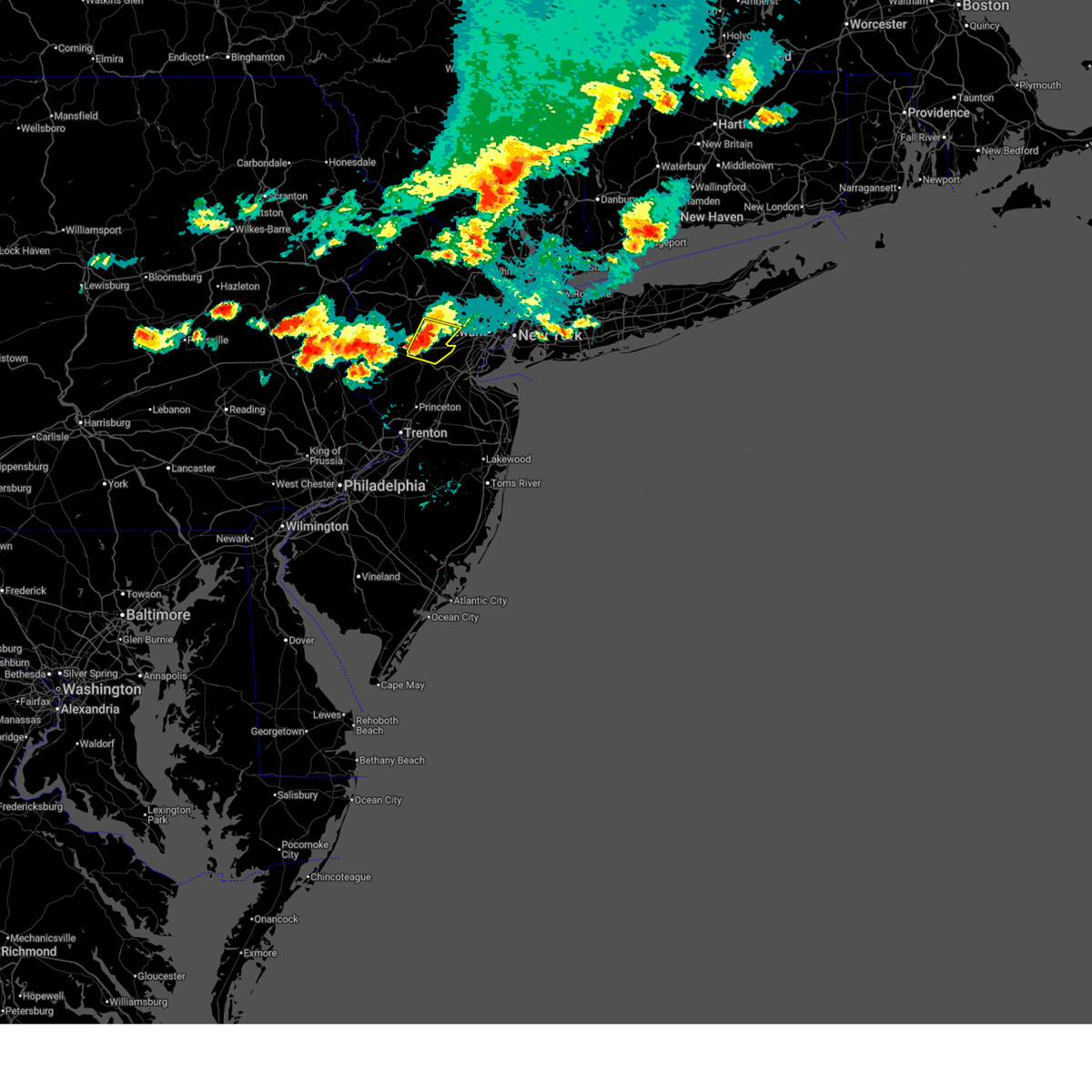
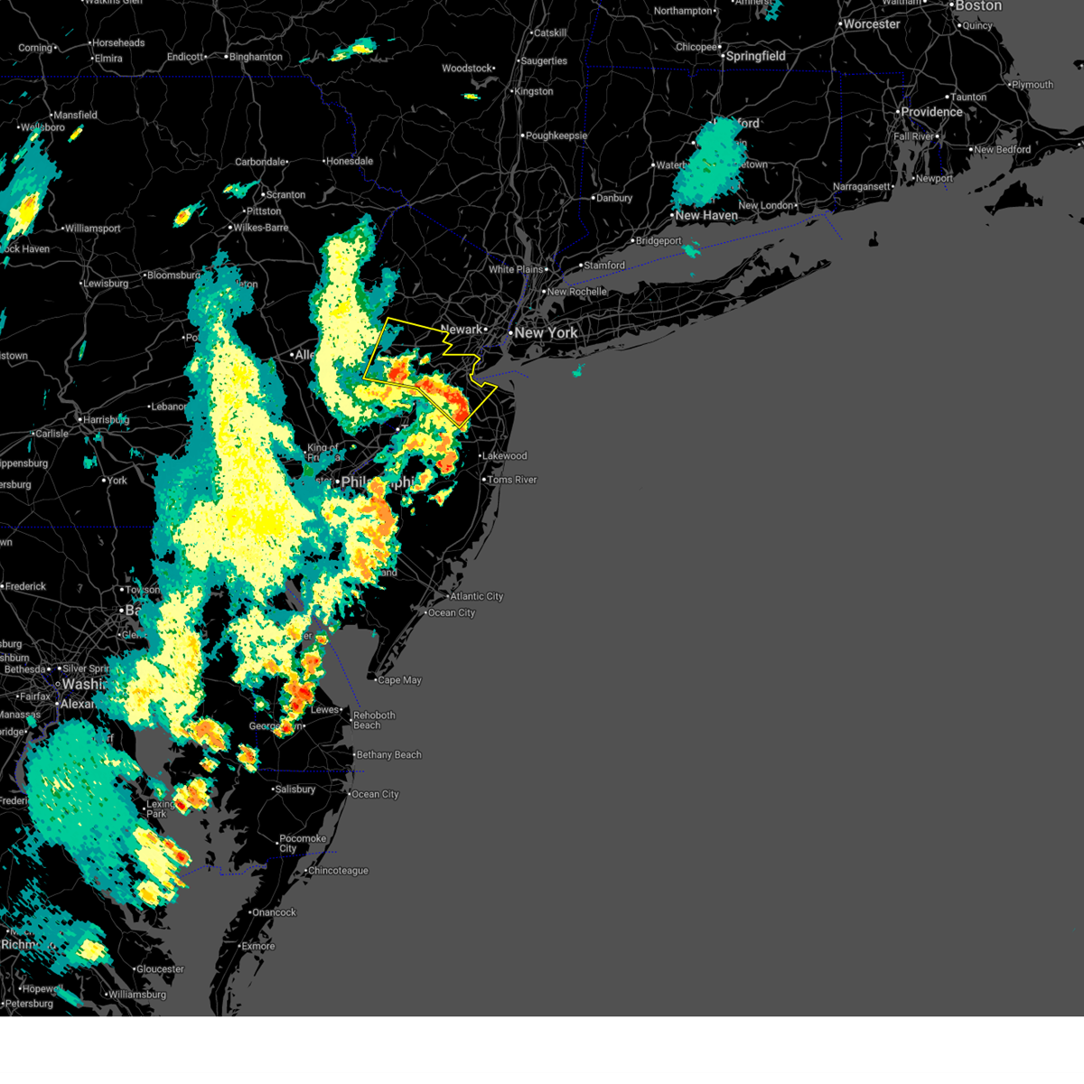
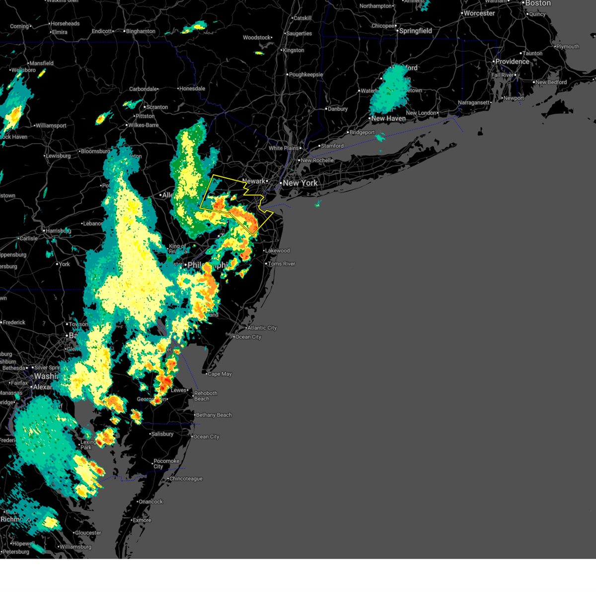
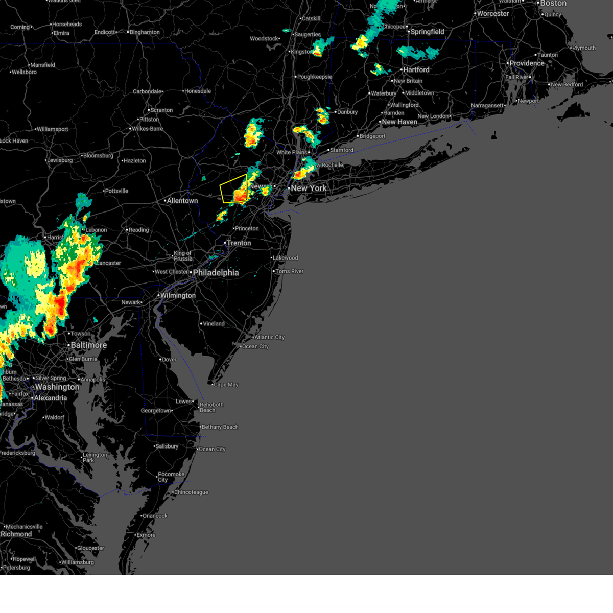
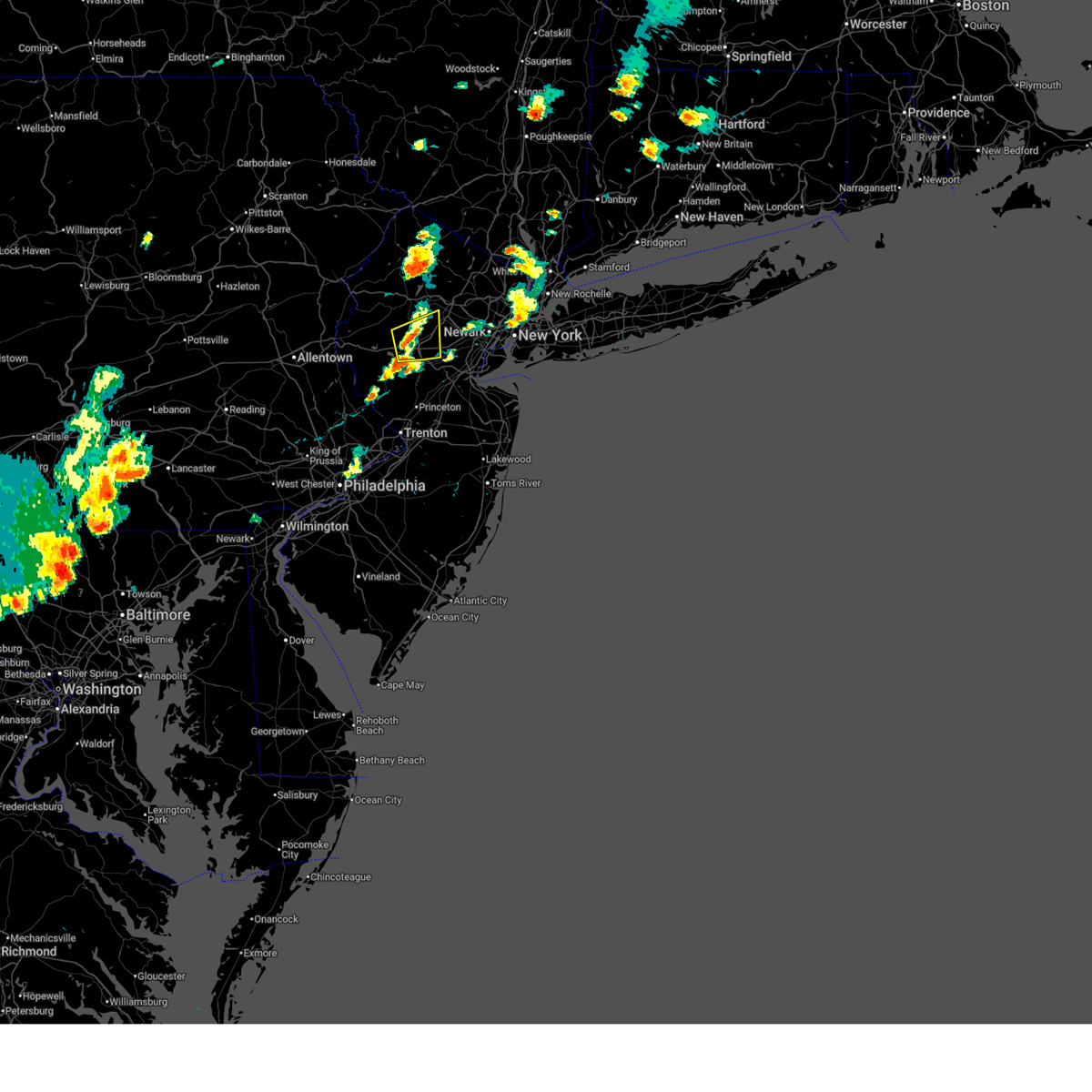
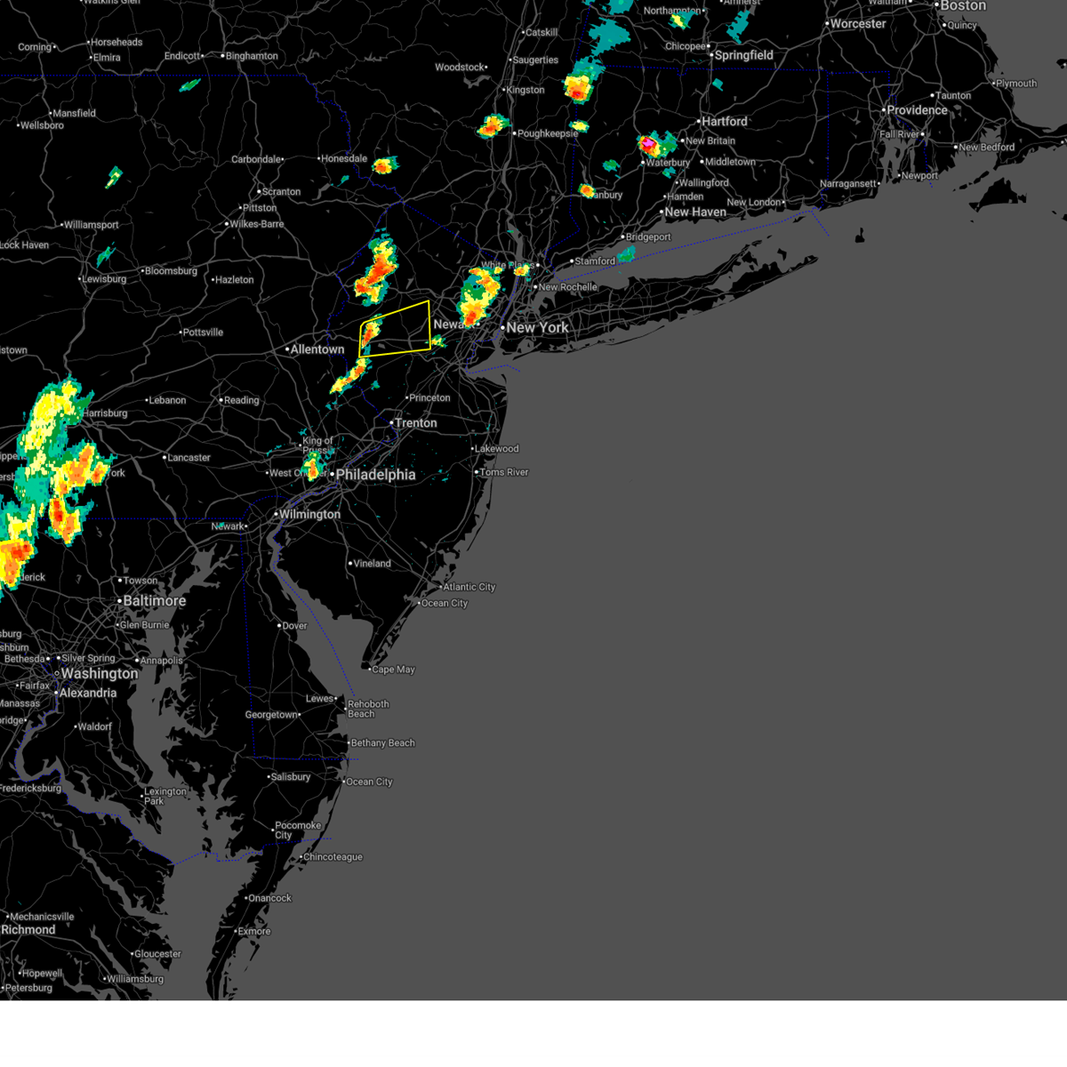
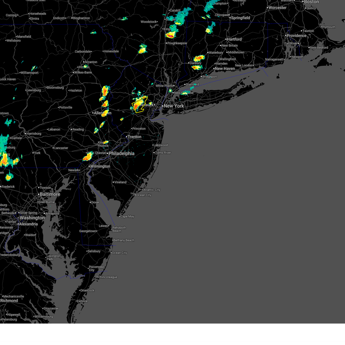
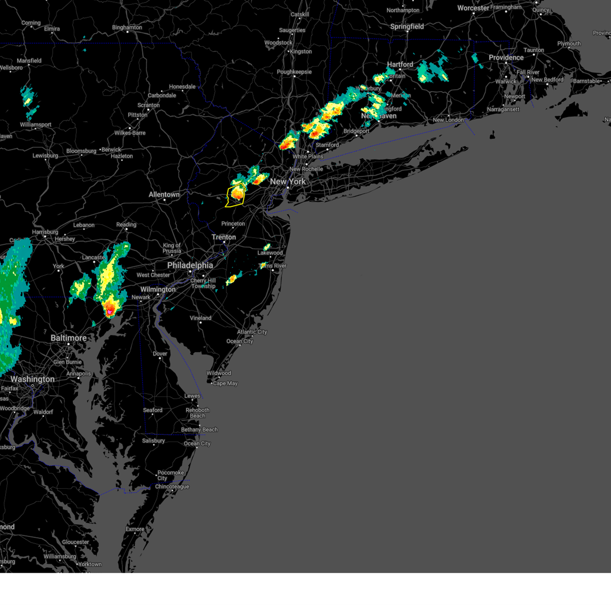
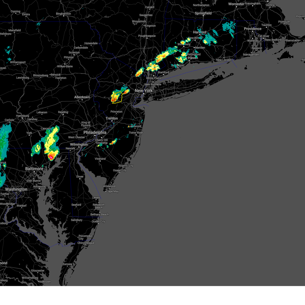
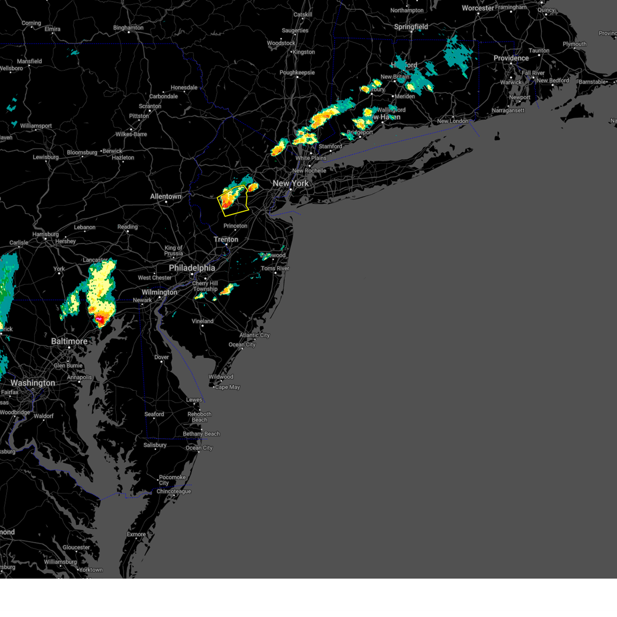
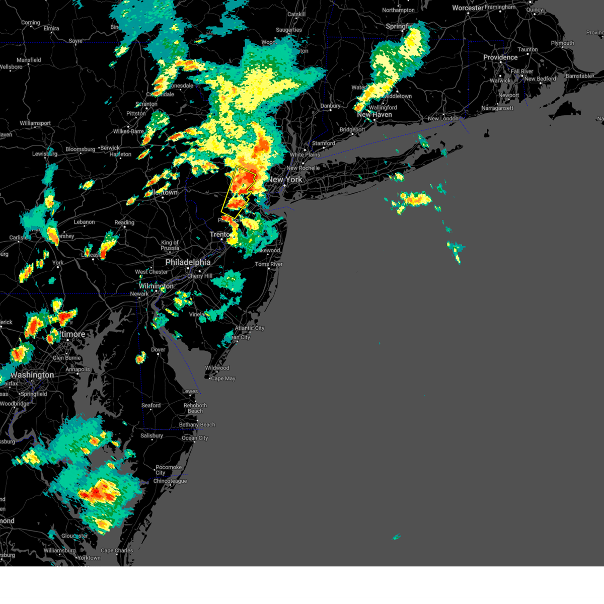
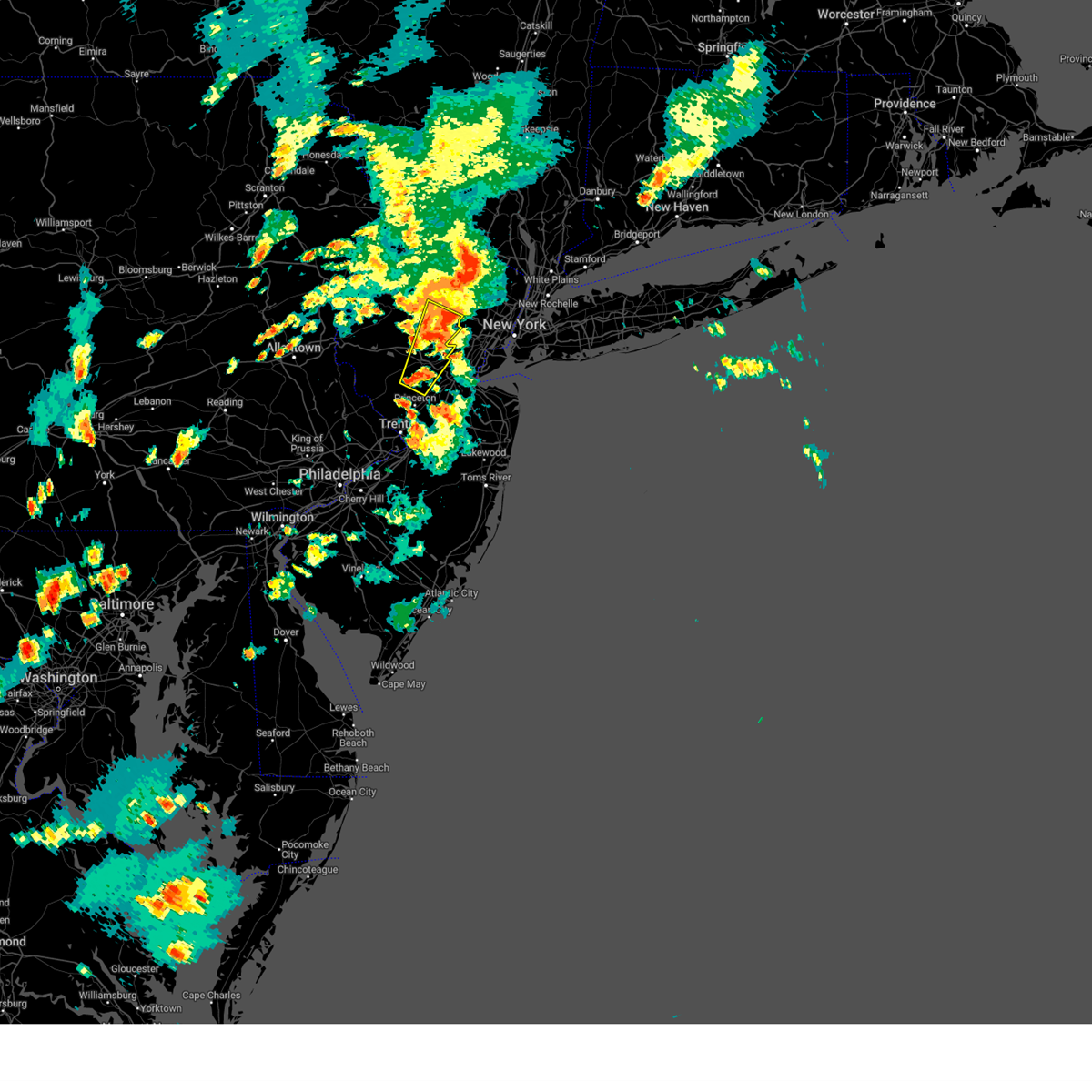
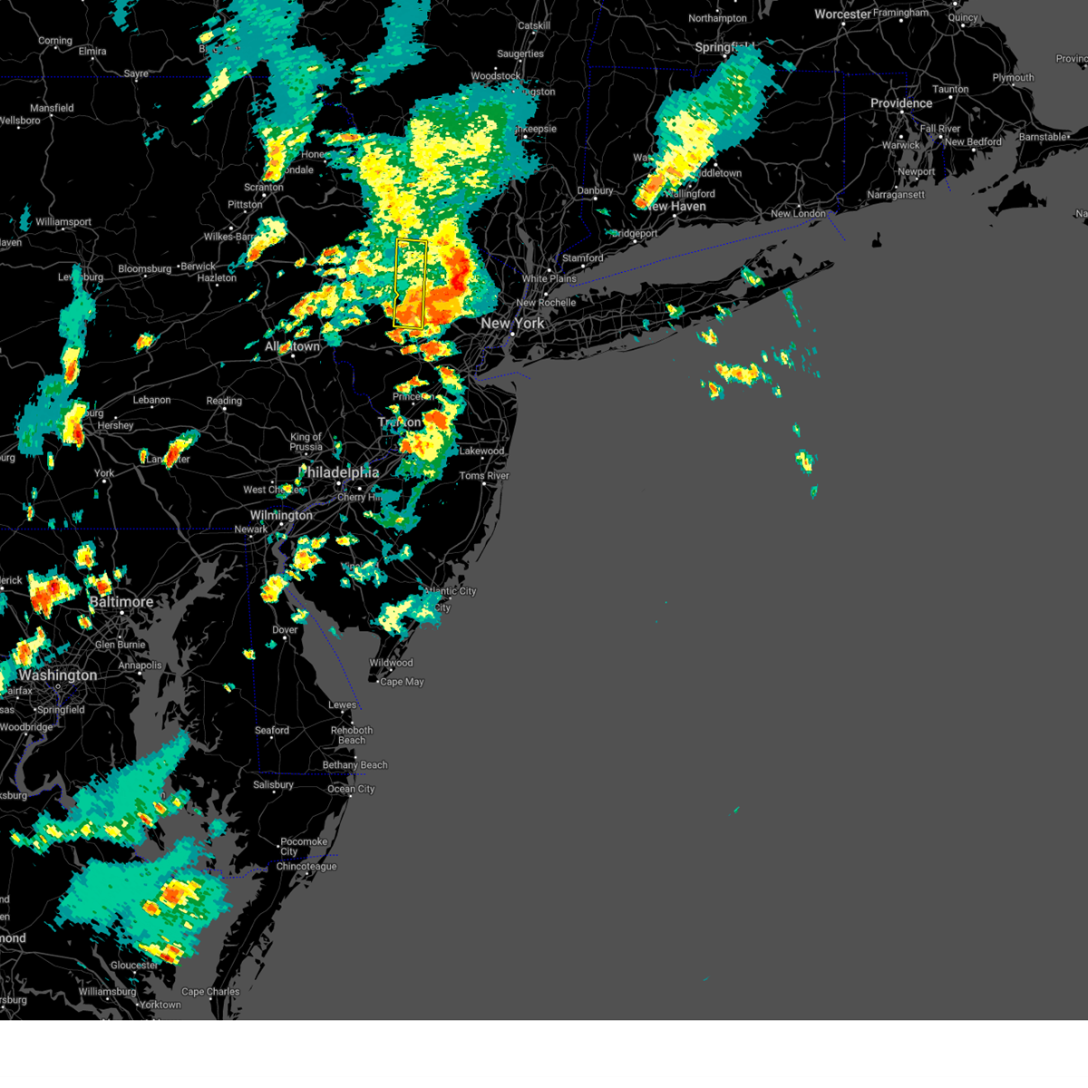
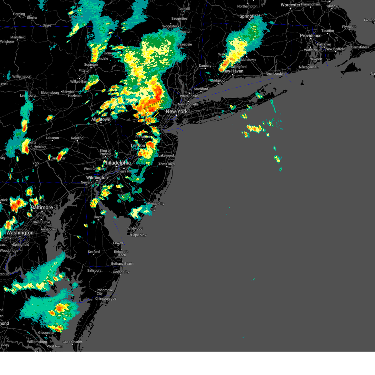
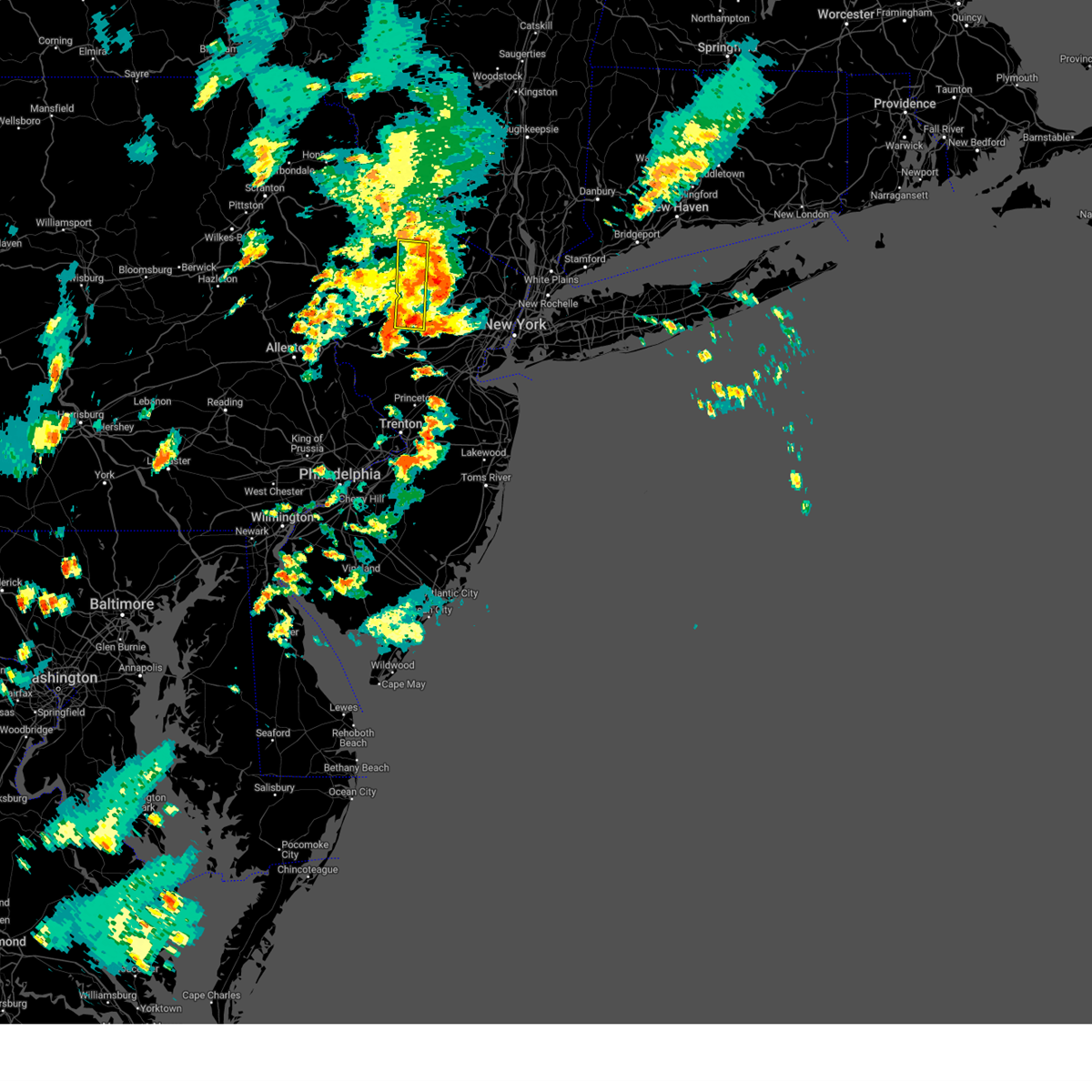
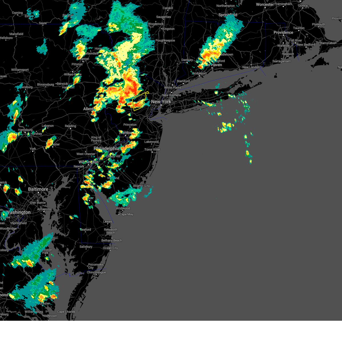
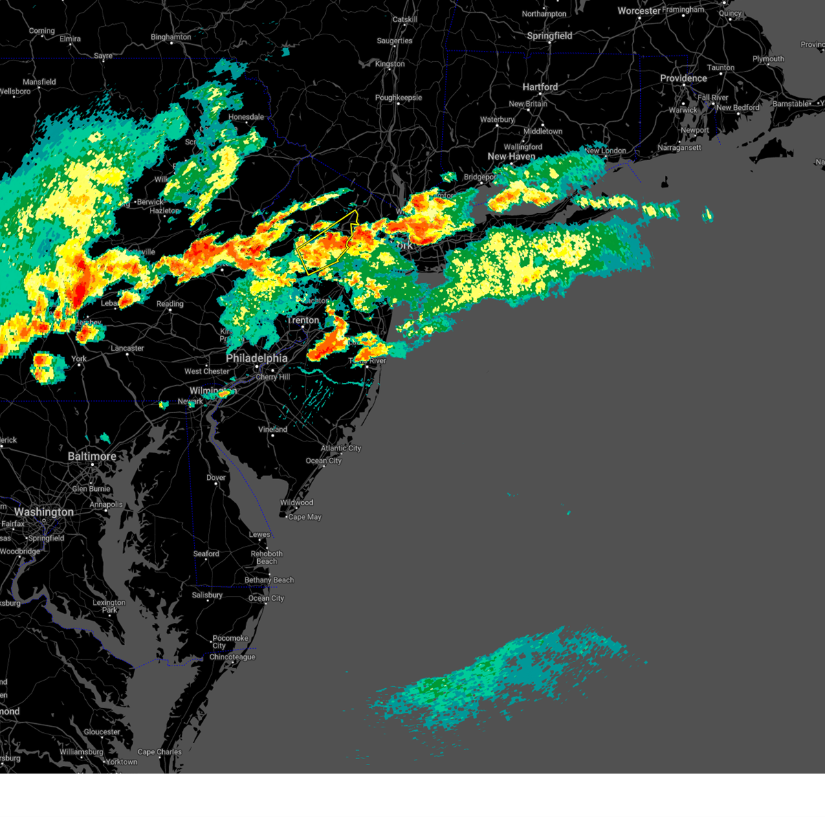
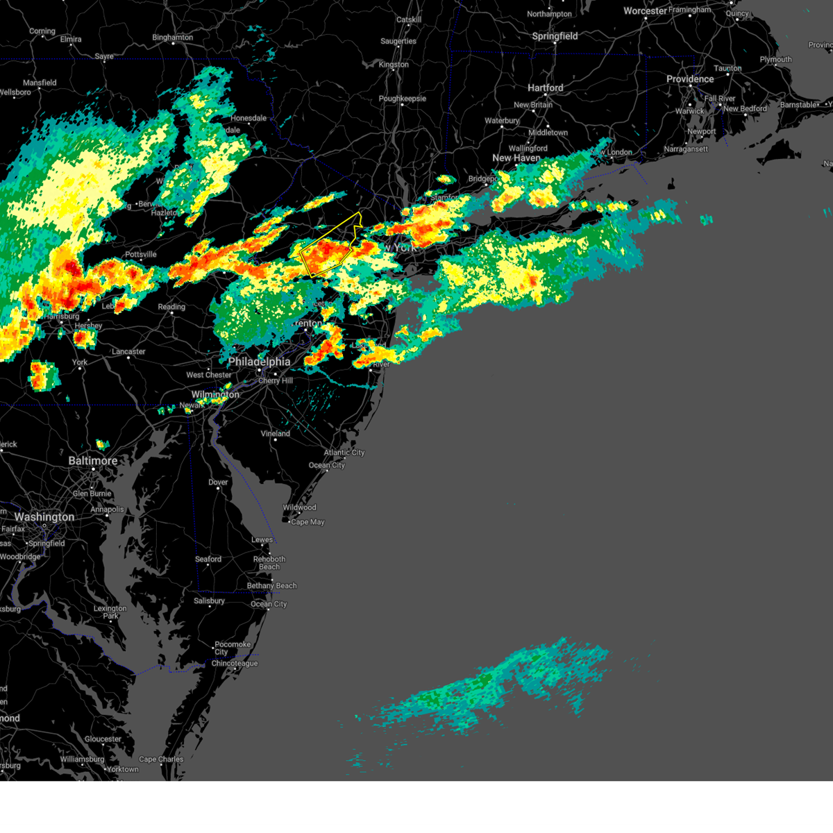
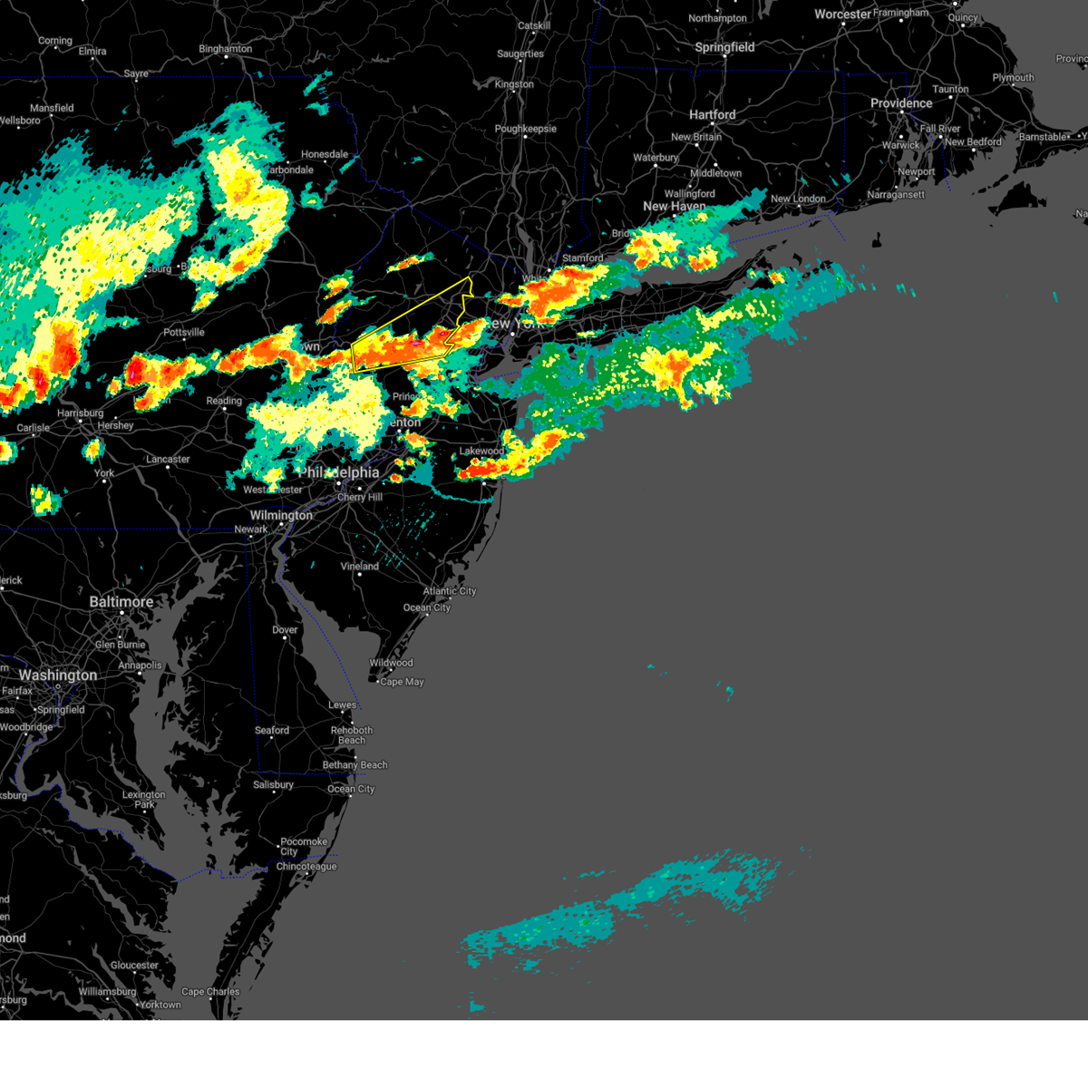
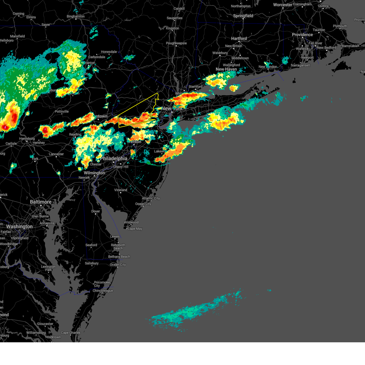
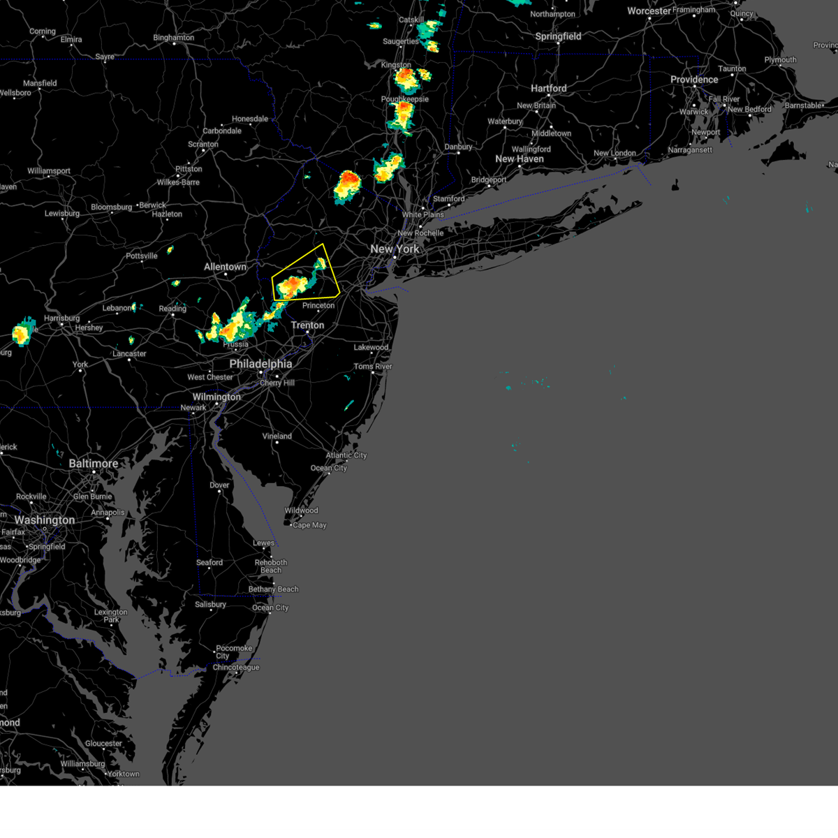
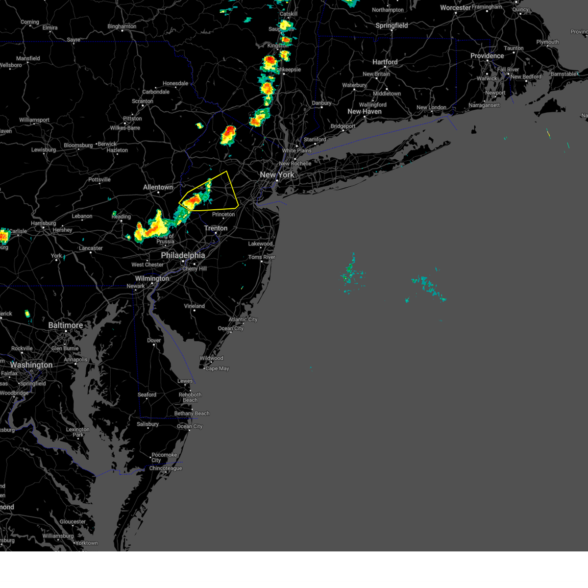
Hail Map for Bernardsville, NJ
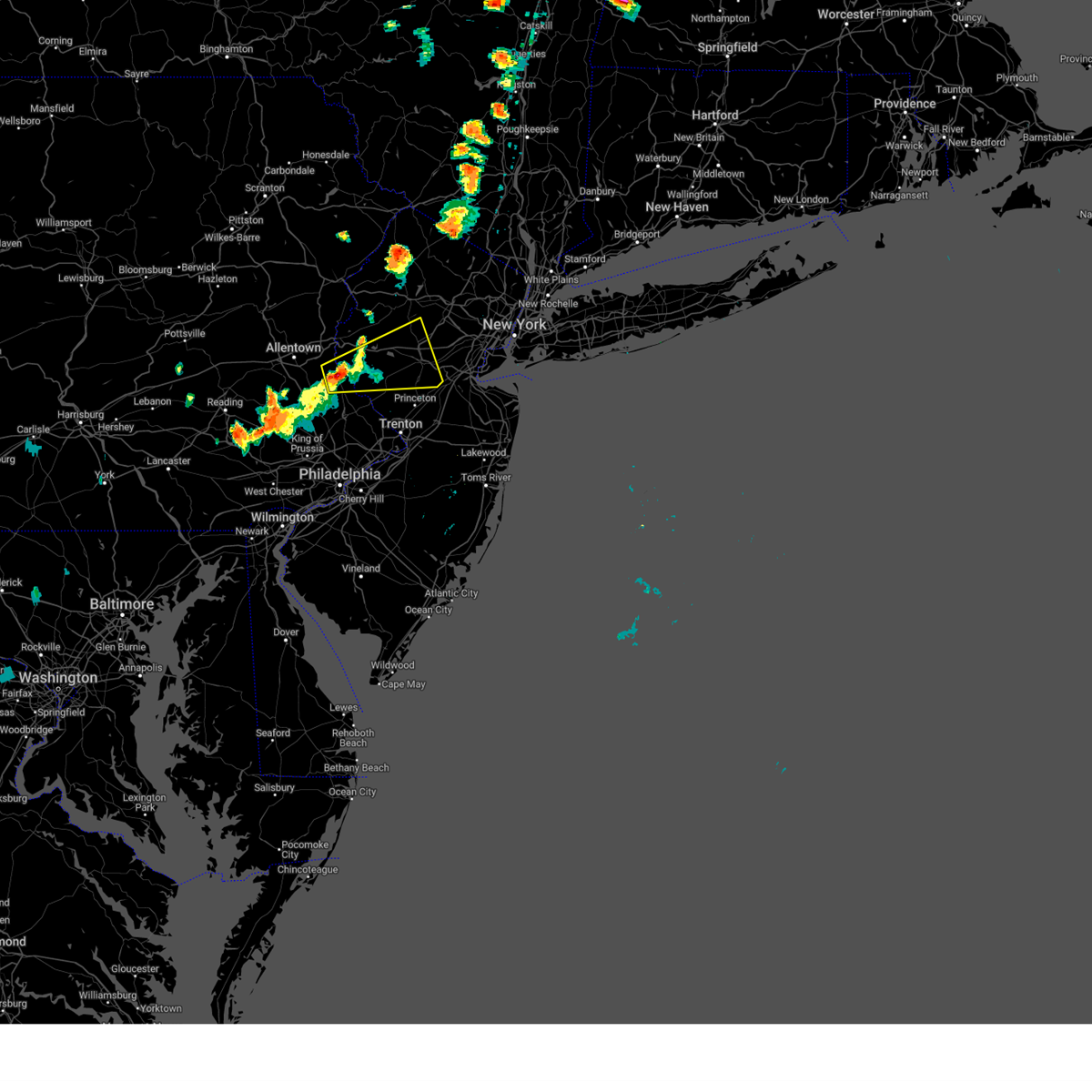
The Bernardsville, NJ area has had 1 report of on-the-ground hail by trained spotters, and has been under severe weather warnings 40 times during the past 12 months. Doppler radar has detected hail at or near Bernardsville, NJ on 20 occasions, including 1 occasion during the past year.
| Name: | Bernardsville, NJ |
| Where Located: | 31.1 miles W of Brooklyn, NY |
| Map: | Google Map for Bernardsville, NJ |
| Population: | 7707 |
| Housing Units: | 2871 |
| More Info: | Search Google for Bernardsville, NJ |
0
The Top Recent Hail Date for Bernardsville, NJ is Tuesday, August 6, 2024 (19th out of 20)

Hail and Wind Damage Spotted near Bernardsville, NJ
| Date / Time | Report Details |
|---|---|
| 7/3/2025 5:47 PM EDT |
 At 547 pm edt, a severe thunderstorm was located over millington, or near somerville, moving southeast at 30 mph (trained weather spotters). Hazards include 60 mph wind gusts and penny size hail. Damage to roofs, siding, trees, and power lines is possible. Locations impacted include, bridgewater, madison, middlesex, bound brook, chatham, mendham, peapack and gladstone, far hills, millington, martinsville, basking ridge, north plainfield, bernardsville, and watchung. At 547 pm edt, a severe thunderstorm was located over millington, or near somerville, moving southeast at 30 mph (trained weather spotters). Hazards include 60 mph wind gusts and penny size hail. Damage to roofs, siding, trees, and power lines is possible. Locations impacted include, bridgewater, madison, middlesex, bound brook, chatham, mendham, peapack and gladstone, far hills, millington, martinsville, basking ridge, north plainfield, bernardsville, and watchung.
|
| 7/3/2025 5:47 PM EDT |
 the severe thunderstorm warning has been cancelled and is no longer in effect the severe thunderstorm warning has been cancelled and is no longer in effect
|
| 7/3/2025 5:33 PM EDT |
 At 531 pm edt, a severe thunderstorm was located over peapack and gladstone, or 10 miles northwest of somerville, moving southeast at 30 mph. a measured wind gust to 62 mph occurred in washington, warren county earlier with this storm (trained weather spotters). Hazards include 60 mph wind gusts and penny size hail. Damage to roofs, siding, trees, and power lines is possible. Locations impacted include, morristown, somerville, bridgewater, madison, middlesex, florham park, east hanover, bound brook, manville, chatham, morris plains, mendham, high bridge, netcong, peapack and gladstone, chester, lebanon, califon, far hills, and long valley. At 531 pm edt, a severe thunderstorm was located over peapack and gladstone, or 10 miles northwest of somerville, moving southeast at 30 mph. a measured wind gust to 62 mph occurred in washington, warren county earlier with this storm (trained weather spotters). Hazards include 60 mph wind gusts and penny size hail. Damage to roofs, siding, trees, and power lines is possible. Locations impacted include, morristown, somerville, bridgewater, madison, middlesex, florham park, east hanover, bound brook, manville, chatham, morris plains, mendham, high bridge, netcong, peapack and gladstone, chester, lebanon, califon, far hills, and long valley.
|
| 7/3/2025 5:33 PM EDT |
 the severe thunderstorm warning has been cancelled and is no longer in effect the severe thunderstorm warning has been cancelled and is no longer in effect
|
| 7/3/2025 5:16 PM EDT |
 Svrphi the national weather service in mount holly nj has issued a * severe thunderstorm warning for, southern morris county in northern new jersey, northeastern hunterdon county in northwestern new jersey, southeastern warren county in northwestern new jersey, northern somerset county in northern new jersey, * until 600 pm edt. * at 515 pm edt, a severe thunderstorm was located near washington, or 17 miles east of easton, moving southeast at 30 mph (radar indicated). Hazards include 60 mph wind gusts and penny size hail. damage to roofs, siding, trees, and power lines is possible Svrphi the national weather service in mount holly nj has issued a * severe thunderstorm warning for, southern morris county in northern new jersey, northeastern hunterdon county in northwestern new jersey, southeastern warren county in northwestern new jersey, northern somerset county in northern new jersey, * until 600 pm edt. * at 515 pm edt, a severe thunderstorm was located near washington, or 17 miles east of easton, moving southeast at 30 mph (radar indicated). Hazards include 60 mph wind gusts and penny size hail. damage to roofs, siding, trees, and power lines is possible
|
| 6/19/2025 6:45 PM EDT | The storms which prompted the warning have weakened below severe limits, and have exited the warned area. therefore, the warning will be allowed to expire. however gusty winds and heavy rain are still possible with these thunderstorms. a severe thunderstorm watch remains in effect until 900 pm edt for northern, central and northwestern new jersey. to report severe weather, contact your nearest law enforcement agency. they will relay your report to the national weather service mount holly nj. |
| 6/19/2025 6:33 PM EDT |
 At 632 pm edt, severe thunderstorms were located along a line extending from near flemington to millstone to near yorketown, moving northeast at 45 mph (radar indicated). Hazards include 60 mph wind gusts and penny size hail. Damage to roofs, siding, trees, and power lines is possible. Locations impacted include, new brunswick, perth amboy, somerville, somerset, edison, old bridge, east brunswick, bridgewater, south brunswick, sayreville, north brunswick, marlboro, carteret, middlesex, bound brook, manville, matawan, jamesburg, mendham, and flemington. At 632 pm edt, severe thunderstorms were located along a line extending from near flemington to millstone to near yorketown, moving northeast at 45 mph (radar indicated). Hazards include 60 mph wind gusts and penny size hail. Damage to roofs, siding, trees, and power lines is possible. Locations impacted include, new brunswick, perth amboy, somerville, somerset, edison, old bridge, east brunswick, bridgewater, south brunswick, sayreville, north brunswick, marlboro, carteret, middlesex, bound brook, manville, matawan, jamesburg, mendham, and flemington.
|
| 6/19/2025 6:33 PM EDT |
 the severe thunderstorm warning has been cancelled and is no longer in effect the severe thunderstorm warning has been cancelled and is no longer in effect
|
| 6/19/2025 6:14 PM EDT | Svrphi the national weather service in mount holly nj has issued a * severe thunderstorm warning for, southwestern morris county in northern new jersey, hunterdon county in northwestern new jersey, mercer county in central new jersey, east central warren county in northwestern new jersey, somerset county in northern new jersey, central monmouth county in central new jersey, middlesex county in northern new jersey, central bucks county in southeastern pennsylvania, * until 645 pm edt. * at 613 pm edt, severe thunderstorms were located along a line extending from near byram to skillman to twin rivers, moving northeast at 55 mph (radar indicated). Hazards include 60 mph wind gusts and penny size hail. damage to roofs, siding, trees, and power lines is possible |
| 6/19/2025 3:55 PM EDT |
 The storm which prompted the warning has weakened below severe limits, and no longer poses an immediate threat to life or property. therefore, the warning will be allowed to expire. however, small hail, gusty winds and heavy rain are still possible with this thunderstorm. a severe thunderstorm watch remains in effect until 900 pm edt for northern and northwestern new jersey. to report severe weather, contact your nearest law enforcement agency. they will relay your report to the national weather service mount holly nj. The storm which prompted the warning has weakened below severe limits, and no longer poses an immediate threat to life or property. therefore, the warning will be allowed to expire. however, small hail, gusty winds and heavy rain are still possible with this thunderstorm. a severe thunderstorm watch remains in effect until 900 pm edt for northern and northwestern new jersey. to report severe weather, contact your nearest law enforcement agency. they will relay your report to the national weather service mount holly nj.
|
| 6/19/2025 3:33 PM EDT |
 At 332 pm edt, a severe thunderstorm was located near peapack and gladstone, or 9 miles northwest of somerville, moving east at 30 mph (radar indicated). Hazards include 60 mph wind gusts and penny size hail. Damage to roofs, siding, trees, and power lines is possible. Locations impacted include, bridgewater, mendham, peapack and gladstone, chester, far hills, millington, martinsville, white house station, basking ridge, and bernardsville. At 332 pm edt, a severe thunderstorm was located near peapack and gladstone, or 9 miles northwest of somerville, moving east at 30 mph (radar indicated). Hazards include 60 mph wind gusts and penny size hail. Damage to roofs, siding, trees, and power lines is possible. Locations impacted include, bridgewater, mendham, peapack and gladstone, chester, far hills, millington, martinsville, white house station, basking ridge, and bernardsville.
|
| 6/19/2025 3:14 PM EDT |
 Svrphi the national weather service in mount holly nj has issued a * severe thunderstorm warning for, southwestern morris county in northern new jersey, northeastern hunterdon county in northwestern new jersey, northwestern somerset county in northern new jersey, * until 400 pm edt. * at 313 pm edt, a severe thunderstorm was located over high bridge, or 16 miles northwest of somerville, moving east at 30 mph (radar indicated). Hazards include 60 mph wind gusts and penny size hail. damage to roofs, siding, trees, and power lines is possible Svrphi the national weather service in mount holly nj has issued a * severe thunderstorm warning for, southwestern morris county in northern new jersey, northeastern hunterdon county in northwestern new jersey, northwestern somerset county in northern new jersey, * until 400 pm edt. * at 313 pm edt, a severe thunderstorm was located over high bridge, or 16 miles northwest of somerville, moving east at 30 mph (radar indicated). Hazards include 60 mph wind gusts and penny size hail. damage to roofs, siding, trees, and power lines is possible
|
| 6/19/2025 2:47 PM EDT | Multiple trees down on wires. time estimated from rada in morris county NJ, 4.2 miles W of Bernardsville, NJ |
| 6/19/2025 2:47 PM EDT | Tree on vehicle. time estimated from rada in morris county NJ, 4.2 miles W of Bernardsville, NJ |
| 6/19/2025 2:44 PM EDT |
 Svrphi the national weather service in mount holly nj has issued a * severe thunderstorm warning for, southeastern morris county in northern new jersey, northeastern somerset county in northern new jersey, * until 315 pm edt. * at 243 pm edt, a severe thunderstorm was located over millington, or 7 miles south of morristown, moving east at 30 mph (radar indicated). Hazards include 60 mph wind gusts. damage to roofs, siding, trees, and power lines is possible Svrphi the national weather service in mount holly nj has issued a * severe thunderstorm warning for, southeastern morris county in northern new jersey, northeastern somerset county in northern new jersey, * until 315 pm edt. * at 243 pm edt, a severe thunderstorm was located over millington, or 7 miles south of morristown, moving east at 30 mph (radar indicated). Hazards include 60 mph wind gusts. damage to roofs, siding, trees, and power lines is possible
|
| 5/3/2025 5:58 PM EDT |
 The storm which prompted the warning has weakened below severe limits, and has exited the warned area. therefore, the warning will be allowed to expire. a severe thunderstorm watch remains in effect until 1100 pm edt for northern and northwestern new jersey. to report severe weather, contact your nearest law enforcement agency. they will relay your report to the national weather service mount holly nj. The storm which prompted the warning has weakened below severe limits, and has exited the warned area. therefore, the warning will be allowed to expire. a severe thunderstorm watch remains in effect until 1100 pm edt for northern and northwestern new jersey. to report severe weather, contact your nearest law enforcement agency. they will relay your report to the national weather service mount holly nj.
|
| 5/3/2025 5:50 PM EDT |
 the severe thunderstorm warning has been cancelled and is no longer in effect the severe thunderstorm warning has been cancelled and is no longer in effect
|
| 5/3/2025 5:50 PM EDT |
 At 549 pm edt, a severe thunderstorm was located over bridgewater, or near somerville, moving east at 30 mph (radar indicated). Hazards include 60 mph wind gusts and quarter size hail. Minor damage to vehicles is possible. wind damage to roofs, siding, trees, and power lines is possible. locations impacted include, raritan, bernardsville, far hills, peapack and gladstone, bridgewater, martinsville, basking ridge, somerville, and bound brook. this includes the following highways, interstate 78 in new jersey between mile markers 27 and 37. Interstate 287 in new jersey between mile markers 14 and 29. At 549 pm edt, a severe thunderstorm was located over bridgewater, or near somerville, moving east at 30 mph (radar indicated). Hazards include 60 mph wind gusts and quarter size hail. Minor damage to vehicles is possible. wind damage to roofs, siding, trees, and power lines is possible. locations impacted include, raritan, bernardsville, far hills, peapack and gladstone, bridgewater, martinsville, basking ridge, somerville, and bound brook. this includes the following highways, interstate 78 in new jersey between mile markers 27 and 37. Interstate 287 in new jersey between mile markers 14 and 29.
|
| 5/3/2025 5:43 PM EDT |
 At 543 pm edt, a severe thunderstorm was located over white house station, or 7 miles west of somerville, moving east at 30 mph (radar indicated). Hazards include 60 mph wind gusts and quarter size hail. Minor damage to vehicles is possible. wind damage to roofs, siding, trees, and power lines is possible. locations impacted include, manville, flagtown, south bound brook, raritan, bernardsville, bridgewater, bound brook, lebanon, cloverhill, far hills, peapack and gladstone, martinsville, white house station, basking ridge, somerville, and middlesex. this includes the following highways, interstate 78 in new jersey between mile markers 20 and 37. Interstate 287 in new jersey between mile markers 11 and 29. At 543 pm edt, a severe thunderstorm was located over white house station, or 7 miles west of somerville, moving east at 30 mph (radar indicated). Hazards include 60 mph wind gusts and quarter size hail. Minor damage to vehicles is possible. wind damage to roofs, siding, trees, and power lines is possible. locations impacted include, manville, flagtown, south bound brook, raritan, bernardsville, bridgewater, bound brook, lebanon, cloverhill, far hills, peapack and gladstone, martinsville, white house station, basking ridge, somerville, and middlesex. this includes the following highways, interstate 78 in new jersey between mile markers 20 and 37. Interstate 287 in new jersey between mile markers 11 and 29.
|
| 5/3/2025 5:21 PM EDT |
 Svrphi the national weather service in mount holly nj has issued a * severe thunderstorm warning for, northeastern hunterdon county in northwestern new jersey, somerset county in northern new jersey, * until 600 pm edt. * at 521 pm edt, a severe thunderstorm was located near sand brook, or 17 miles west of somerville, moving east at 30 mph (radar indicated). Hazards include 60 mph wind gusts and quarter size hail. Minor damage to vehicles is possible. Wind damage to roofs, siding, trees, and power lines is possible. Svrphi the national weather service in mount holly nj has issued a * severe thunderstorm warning for, northeastern hunterdon county in northwestern new jersey, somerset county in northern new jersey, * until 600 pm edt. * at 521 pm edt, a severe thunderstorm was located near sand brook, or 17 miles west of somerville, moving east at 30 mph (radar indicated). Hazards include 60 mph wind gusts and quarter size hail. Minor damage to vehicles is possible. Wind damage to roofs, siding, trees, and power lines is possible.
|
| 8/18/2024 7:21 PM EDT |
 The storm which prompted the warning has weakened below severe limits, and no longer poses an immediate threat to life or property. therefore, the warning will be allowed to expire. however gusty winds and heavy rain are still possible with this thunderstorm. a flash flood warning remains in effect for portion of this area until 1045 pm edt. a severe thunderstorm watch remains in effect until 1000 pm edt for northern new jersey. to report severe weather, contact your nearest law enforcement agency. they will relay your report to the national weather service mount holly nj. The storm which prompted the warning has weakened below severe limits, and no longer poses an immediate threat to life or property. therefore, the warning will be allowed to expire. however gusty winds and heavy rain are still possible with this thunderstorm. a flash flood warning remains in effect for portion of this area until 1045 pm edt. a severe thunderstorm watch remains in effect until 1000 pm edt for northern new jersey. to report severe weather, contact your nearest law enforcement agency. they will relay your report to the national weather service mount holly nj.
|
| 8/18/2024 6:51 PM EDT |
 At 651 pm edt, a severe thunderstorm was located over martinsville, or near somerville, moving northeast at 25 mph (radar indicated). Hazards include 60 mph wind gusts and quarter size hail. Minor damage to vehicles is possible. wind damage to roofs, siding, trees, and power lines is possible. locations impacted include, morristown, somerville, somerset, bridgewater, dover, madison, middlesex, florham park, bound brook, manville, chatham, morris plains, mendham, victory gardens, far hills, millstone, flagtown, belle mead, martinsville, and millington. this includes the following highways, interstate 78 in new jersey between mile markers 31 and 42. Interstate 287 in new jersey between mile markers 8 and 40. At 651 pm edt, a severe thunderstorm was located over martinsville, or near somerville, moving northeast at 25 mph (radar indicated). Hazards include 60 mph wind gusts and quarter size hail. Minor damage to vehicles is possible. wind damage to roofs, siding, trees, and power lines is possible. locations impacted include, morristown, somerville, somerset, bridgewater, dover, madison, middlesex, florham park, bound brook, manville, chatham, morris plains, mendham, victory gardens, far hills, millstone, flagtown, belle mead, martinsville, and millington. this includes the following highways, interstate 78 in new jersey between mile markers 31 and 42. Interstate 287 in new jersey between mile markers 8 and 40.
|
| 8/18/2024 6:38 PM EDT |
 At 638 pm edt, a severe thunderstorm was located over somerville, moving northeast at 25 mph (radar indicated). Hazards include 60 mph wind gusts and quarter size hail. Minor damage to vehicles is possible. wind damage to roofs, siding, trees, and power lines is possible. locations impacted include, morristown, somerville, somerset, bridgewater, dover, madison, middlesex, florham park, bound brook, manville, chatham, wharton, morris plains, mendham, peapack and gladstone, victory gardens, far hills, millstone, flagtown, and belle mead. this includes the following highways, interstate 78 in new jersey between mile markers 29 and 42. Interstate 287 in new jersey between mile markers 8 and 40. At 638 pm edt, a severe thunderstorm was located over somerville, moving northeast at 25 mph (radar indicated). Hazards include 60 mph wind gusts and quarter size hail. Minor damage to vehicles is possible. wind damage to roofs, siding, trees, and power lines is possible. locations impacted include, morristown, somerville, somerset, bridgewater, dover, madison, middlesex, florham park, bound brook, manville, chatham, wharton, morris plains, mendham, peapack and gladstone, victory gardens, far hills, millstone, flagtown, and belle mead. this includes the following highways, interstate 78 in new jersey between mile markers 29 and 42. Interstate 287 in new jersey between mile markers 8 and 40.
|
| 8/18/2024 6:24 PM EDT |
 Svrphi the national weather service in mount holly nj has issued a * severe thunderstorm warning for, southeastern morris county in northern new jersey, somerset county in northern new jersey, north central middlesex county in northern new jersey, * until 730 pm edt. * at 624 pm edt, a severe thunderstorm was located over flagtown, or near somerville, moving northeast at 25 mph (radar indicated). Hazards include 60 mph wind gusts and quarter size hail. Minor damage to vehicles is possible. Wind damage to roofs, siding, trees, and power lines is possible. Svrphi the national weather service in mount holly nj has issued a * severe thunderstorm warning for, southeastern morris county in northern new jersey, somerset county in northern new jersey, north central middlesex county in northern new jersey, * until 730 pm edt. * at 624 pm edt, a severe thunderstorm was located over flagtown, or near somerville, moving northeast at 25 mph (radar indicated). Hazards include 60 mph wind gusts and quarter size hail. Minor damage to vehicles is possible. Wind damage to roofs, siding, trees, and power lines is possible.
|
| 8/18/2024 6:17 PM EDT |
 the severe thunderstorm warning has been cancelled and is no longer in effect the severe thunderstorm warning has been cancelled and is no longer in effect
|
| 8/18/2024 6:16 PM EDT |
 The storm which prompted the warning has weakened below severe limits, and no longer poses an immediate threat to life or property. therefore, the warning has been allowed to expire. however heavy rain is still possible with this thunderstorm. a severe thunderstorm watch remains in effect until 1000 pm edt for northern new jersey. to report severe weather, contact your nearest law enforcement agency. they will relay your report to the national weather service mount holly nj. The storm which prompted the warning has weakened below severe limits, and no longer poses an immediate threat to life or property. therefore, the warning has been allowed to expire. however heavy rain is still possible with this thunderstorm. a severe thunderstorm watch remains in effect until 1000 pm edt for northern new jersey. to report severe weather, contact your nearest law enforcement agency. they will relay your report to the national weather service mount holly nj.
|
| 8/18/2024 5:59 PM EDT |
 Svrphi the national weather service in mount holly nj has issued a * severe thunderstorm warning for, western morris county in northern new jersey, south central sussex county in northwestern new jersey, * until 645 pm edt. * at 559 pm edt, a severe thunderstorm was located over succasunna, or 10 miles west of morristown, moving north at 25 mph (radar indicated). Hazards include 60 mph wind gusts and penny size hail. damage to roofs, siding, trees, and power lines is possible Svrphi the national weather service in mount holly nj has issued a * severe thunderstorm warning for, western morris county in northern new jersey, south central sussex county in northwestern new jersey, * until 645 pm edt. * at 559 pm edt, a severe thunderstorm was located over succasunna, or 10 miles west of morristown, moving north at 25 mph (radar indicated). Hazards include 60 mph wind gusts and penny size hail. damage to roofs, siding, trees, and power lines is possible
|
| 8/18/2024 5:51 PM EDT |
 Svrphi the national weather service in mount holly nj has issued a * severe thunderstorm warning for, southeastern morris county in northern new jersey, northeastern somerset county in northern new jersey, * until 615 pm edt. * at 551 pm edt, a severe thunderstorm was located over morristown, moving east at 40 mph (radar indicated). Hazards include 60 mph wind gusts and penny size hail. damage to roofs, siding, trees, and power lines is possible Svrphi the national weather service in mount holly nj has issued a * severe thunderstorm warning for, southeastern morris county in northern new jersey, northeastern somerset county in northern new jersey, * until 615 pm edt. * at 551 pm edt, a severe thunderstorm was located over morristown, moving east at 40 mph (radar indicated). Hazards include 60 mph wind gusts and penny size hail. damage to roofs, siding, trees, and power lines is possible
|
| 8/6/2024 5:54 PM EDT |
 The storm which prompted the warning has weakened below severe limits, and no longer poses an immediate threat to life or property. therefore, the warning will be allowed to expire. however gusty winds and heavy rain are still possible with this thunderstorm. a severe thunderstorm watch remains in effect until 1100 pm edt for northern and northwestern new jersey. The storm which prompted the warning has weakened below severe limits, and no longer poses an immediate threat to life or property. therefore, the warning will be allowed to expire. however gusty winds and heavy rain are still possible with this thunderstorm. a severe thunderstorm watch remains in effect until 1100 pm edt for northern and northwestern new jersey.
|
| 8/6/2024 5:42 PM EDT |
 At 542 pm edt, a severe thunderstorm was located over madison, or near morristown, moving northeast at 15 mph (radar indicated). Hazards include 60 mph wind gusts and quarter size hail. Minor damage to vehicles is possible. wind damage to roofs, siding, trees, and power lines is possible. locations impacted include, morristown, bridgewater, madison, florham park, east hanover, lincoln park, chatham, boonton, rockaway, morris plains, mendham, mountain lakes, riverdale, peapack and gladstone, chester, victory gardens, far hills, parsippany, pequannock township, and millington. this includes the following highways, interstate 78 in new jersey between mile markers 25 and 39. interstate 80 in new jersey between mile markers 39 and 48. Interstate 287 in new jersey between mile markers 18 and 53. At 542 pm edt, a severe thunderstorm was located over madison, or near morristown, moving northeast at 15 mph (radar indicated). Hazards include 60 mph wind gusts and quarter size hail. Minor damage to vehicles is possible. wind damage to roofs, siding, trees, and power lines is possible. locations impacted include, morristown, bridgewater, madison, florham park, east hanover, lincoln park, chatham, boonton, rockaway, morris plains, mendham, mountain lakes, riverdale, peapack and gladstone, chester, victory gardens, far hills, parsippany, pequannock township, and millington. this includes the following highways, interstate 78 in new jersey between mile markers 25 and 39. interstate 80 in new jersey between mile markers 39 and 48. Interstate 287 in new jersey between mile markers 18 and 53.
|
| 8/6/2024 5:29 PM EDT |
 At 527 pm edt, a severe thunderstorm was located near madison, or near morristown, moving northeast at 15 mph. additional severe thunderstorms extend back to the west. the strongest thunderstorms are in northern somerset and southern morris counties (radar indicated). Hazards include 60 mph wind gusts and quarter size hail. Minor damage to vehicles is possible. wind damage to roofs, siding, trees, and power lines is possible. locations impacted include, morristown, somerville, bridgewater, dover, madison, florham park, east hanover, lincoln park, chatham, boonton, rockaway, morris plains, mendham, mountain lakes, high bridge, riverdale, clinton, peapack and gladstone, glen gardner, and chester. this includes the following highways, interstate 78 in new jersey between mile markers 8 and 42. interstate 80 in new jersey between mile markers 38 and 48. Interstate 287 in new jersey between mile markers 16 and 53. At 527 pm edt, a severe thunderstorm was located near madison, or near morristown, moving northeast at 15 mph. additional severe thunderstorms extend back to the west. the strongest thunderstorms are in northern somerset and southern morris counties (radar indicated). Hazards include 60 mph wind gusts and quarter size hail. Minor damage to vehicles is possible. wind damage to roofs, siding, trees, and power lines is possible. locations impacted include, morristown, somerville, bridgewater, dover, madison, florham park, east hanover, lincoln park, chatham, boonton, rockaway, morris plains, mendham, mountain lakes, high bridge, riverdale, clinton, peapack and gladstone, glen gardner, and chester. this includes the following highways, interstate 78 in new jersey between mile markers 8 and 42. interstate 80 in new jersey between mile markers 38 and 48. Interstate 287 in new jersey between mile markers 16 and 53.
|
| 8/6/2024 5:29 PM EDT |
 the severe thunderstorm warning has been cancelled and is no longer in effect the severe thunderstorm warning has been cancelled and is no longer in effect
|
| 8/6/2024 5:06 PM EDT |
 Svrphi the national weather service in mount holly nj has issued a * severe thunderstorm warning for, hunterdon county in northwestern new jersey, central morris county in northern new jersey, northern somerset county in northern new jersey, north central middlesex county in northern new jersey, * until 600 pm edt. * at 505 pm edt, a severe thunderstorm was located over millington, or 7 miles south of morristown, moving northeast at 25 mph. additional thunderstorms are along a line west of millington and areas of damaging downburst winds can occur (radar indicated). Hazards include 60 mph wind gusts and quarter size hail. Minor damage to vehicles is possible. Wind damage to roofs, siding, trees, and power lines is possible. Svrphi the national weather service in mount holly nj has issued a * severe thunderstorm warning for, hunterdon county in northwestern new jersey, central morris county in northern new jersey, northern somerset county in northern new jersey, north central middlesex county in northern new jersey, * until 600 pm edt. * at 505 pm edt, a severe thunderstorm was located over millington, or 7 miles south of morristown, moving northeast at 25 mph. additional thunderstorms are along a line west of millington and areas of damaging downburst winds can occur (radar indicated). Hazards include 60 mph wind gusts and quarter size hail. Minor damage to vehicles is possible. Wind damage to roofs, siding, trees, and power lines is possible.
|
| 7/16/2024 8:31 PM EDT |
 At 830 pm edt, severe thunderstorms were located along a line extending from middlesex to new hope, moving east at 35 mph. these storms may impact first responders responding to storms from earlier this evening across the warned area (radar indicated). Hazards include 60 mph wind gusts. Damage to roofs, siding, trees, and power lines is possible. locations impacted include, trenton, new brunswick, perth amboy, somerville, somerset, edison, east brunswick, bridgewater, south brunswick, sayreville, north brunswick, ewing, carteret, middlesex, princeton, bound brook, manville, doylestown, byram, and souderton. this includes the following highways, new jersey turnpike between exits 9 and 12. northeast extension between mile markers 32 and 33. interstate 78 in new jersey between mile markers 24 and 42. interstate 295 in new jersey between mile markers 65 and 76. interstate 287 in new jersey between mile markers 0 and 28. Garden state parkway between mile markers 126 and 134. At 830 pm edt, severe thunderstorms were located along a line extending from middlesex to new hope, moving east at 35 mph. these storms may impact first responders responding to storms from earlier this evening across the warned area (radar indicated). Hazards include 60 mph wind gusts. Damage to roofs, siding, trees, and power lines is possible. locations impacted include, trenton, new brunswick, perth amboy, somerville, somerset, edison, east brunswick, bridgewater, south brunswick, sayreville, north brunswick, ewing, carteret, middlesex, princeton, bound brook, manville, doylestown, byram, and souderton. this includes the following highways, new jersey turnpike between exits 9 and 12. northeast extension between mile markers 32 and 33. interstate 78 in new jersey between mile markers 24 and 42. interstate 295 in new jersey between mile markers 65 and 76. interstate 287 in new jersey between mile markers 0 and 28. Garden state parkway between mile markers 126 and 134.
|
| 7/16/2024 8:13 PM EDT |
 Svrphi the national weather service in mount holly nj has issued a * severe thunderstorm warning for, hunterdon county in northwestern new jersey, south central morris county in northern new jersey, mercer county in central new jersey, somerset county in northern new jersey, middlesex county in northern new jersey, central montgomery county in southeastern pennsylvania, central bucks county in southeastern pennsylvania, * until 915 pm edt. * at 812 pm edt, severe thunderstorms were located along a line extending from near bridgewater to bedminster, moving east at 35 mph. these storms may impact first responders responding to storms from earlier this evening across the warned area (radar indicated). Hazards include 60 mph wind gusts. damage to roofs, siding, trees, and power lines is possible Svrphi the national weather service in mount holly nj has issued a * severe thunderstorm warning for, hunterdon county in northwestern new jersey, south central morris county in northern new jersey, mercer county in central new jersey, somerset county in northern new jersey, middlesex county in northern new jersey, central montgomery county in southeastern pennsylvania, central bucks county in southeastern pennsylvania, * until 915 pm edt. * at 812 pm edt, severe thunderstorms were located along a line extending from near bridgewater to bedminster, moving east at 35 mph. these storms may impact first responders responding to storms from earlier this evening across the warned area (radar indicated). Hazards include 60 mph wind gusts. damage to roofs, siding, trees, and power lines is possible
|
| 7/16/2024 6:22 PM EDT |
 Svrphi the national weather service in mount holly nj has issued a * severe thunderstorm warning for, southeastern morris county in northern new jersey, somerset county in northern new jersey, northeastern middlesex county in northern new jersey, * until 700 pm edt. * at 621 pm edt, a severe thunderstorm was located over flagtown, or near somerville, moving east at 45 mph. this storm has a history of producing damaging winds across hunterdon county (radar indicated). Hazards include 60 mph wind gusts. damage to roofs, siding, trees, and power lines is possible Svrphi the national weather service in mount holly nj has issued a * severe thunderstorm warning for, southeastern morris county in northern new jersey, somerset county in northern new jersey, northeastern middlesex county in northern new jersey, * until 700 pm edt. * at 621 pm edt, a severe thunderstorm was located over flagtown, or near somerville, moving east at 45 mph. this storm has a history of producing damaging winds across hunterdon county (radar indicated). Hazards include 60 mph wind gusts. damage to roofs, siding, trees, and power lines is possible
|
| 7/16/2024 6:20 PM EDT | the severe thunderstorm warning has been cancelled and is no longer in effect |
| 7/16/2024 6:20 PM EDT | At 619 pm edt, a severe thunderstorm was located over flagtown, or near somerville, moving east at 40 mph (public. at 6 pm, a 61 mph wind gust was measured by the new jersey weather net station at pittstown). Hazards include 70 mph wind gusts and quarter size hail. Minor damage to vehicles is possible. expect considerable tree damage. wind damage is also likely to mobile homes, roofs, and outbuildings. locations impacted include, new brunswick, somerville, somerset, bridgewater, middlesex, bound brook, manville, mendham, flemington, peapack and gladstone, far hills, millstone, flagtown, cloverhill, belle mead, martinsville, white house station, sand brook, north brunswick township, and bernardsville. this includes the following highways, interstate 78 in new jersey between mile markers 24 and 35. Interstate 287 in new jersey between mile markers 11 and 26. |
| 7/16/2024 6:06 PM EDT |
 the severe thunderstorm warning has been cancelled and is no longer in effect the severe thunderstorm warning has been cancelled and is no longer in effect
|
| 7/16/2024 6:06 PM EDT |
 At 605 pm edt, a severe thunderstorm was located over flemington, or 13 miles west of somerville, moving east at 40 mph (mesonet. at 6 pm, a 61 mph wind gust was measured by the new jersey weather net station at pittstown). Hazards include 70 mph wind gusts and quarter size hail. Minor damage to vehicles is possible. expect considerable tree damage. wind damage is also likely to mobile homes, roofs, and outbuildings. locations impacted include, new brunswick, somerville, somerset, bridgewater, middlesex, bound brook, manville, mendham, flemington, high bridge, clinton, peapack and gladstone, frenchtown, lebanon, far hills, millstone, flagtown, belle mead, martinsville, and sergeantsville. this includes the following highways, interstate 78 in new jersey between mile markers 14 and 35. Interstate 287 in new jersey between mile markers 11 and 26. At 605 pm edt, a severe thunderstorm was located over flemington, or 13 miles west of somerville, moving east at 40 mph (mesonet. at 6 pm, a 61 mph wind gust was measured by the new jersey weather net station at pittstown). Hazards include 70 mph wind gusts and quarter size hail. Minor damage to vehicles is possible. expect considerable tree damage. wind damage is also likely to mobile homes, roofs, and outbuildings. locations impacted include, new brunswick, somerville, somerset, bridgewater, middlesex, bound brook, manville, mendham, flemington, high bridge, clinton, peapack and gladstone, frenchtown, lebanon, far hills, millstone, flagtown, belle mead, martinsville, and sergeantsville. this includes the following highways, interstate 78 in new jersey between mile markers 14 and 35. Interstate 287 in new jersey between mile markers 11 and 26.
|
| 7/16/2024 5:56 PM EDT |
 At 556 pm edt, a severe thunderstorm was located near frenchtown, or 16 miles southeast of easton, moving east at 45 mph (radar indicated). Hazards include 70 mph wind gusts and quarter size hail. Minor damage to vehicles is possible. expect considerable tree damage. wind damage is also likely to mobile homes, roofs, and outbuildings. locations impacted include, new brunswick, somerville, somerset, bridgewater, middlesex, bound brook, manville, mendham, flemington, tinicum, high bridge, clinton, peapack and gladstone, ferndale, frenchtown, lebanon, milford, califon, far hills, and millstone. this includes the following highways, interstate 78 in new jersey between mile markers 12 and 35. Interstate 287 in new jersey between mile markers 11 and 26. At 556 pm edt, a severe thunderstorm was located near frenchtown, or 16 miles southeast of easton, moving east at 45 mph (radar indicated). Hazards include 70 mph wind gusts and quarter size hail. Minor damage to vehicles is possible. expect considerable tree damage. wind damage is also likely to mobile homes, roofs, and outbuildings. locations impacted include, new brunswick, somerville, somerset, bridgewater, middlesex, bound brook, manville, mendham, flemington, tinicum, high bridge, clinton, peapack and gladstone, ferndale, frenchtown, lebanon, milford, califon, far hills, and millstone. this includes the following highways, interstate 78 in new jersey between mile markers 12 and 35. Interstate 287 in new jersey between mile markers 11 and 26.
|
| 7/16/2024 5:43 PM EDT |
 Svrphi the national weather service in mount holly nj has issued a * severe thunderstorm warning for, hunterdon county in northwestern new jersey, southwestern morris county in northern new jersey, somerset county in northern new jersey, north central bucks county in southeastern pennsylvania, * until 630 pm edt. * at 542 pm edt, a severe thunderstorm was located over revere, or 12 miles south of easton, moving east at 45 mph (radar indicated). Hazards include 70 mph wind gusts and quarter size hail. Minor damage to vehicles is possible. expect considerable tree damage. Wind damage is also likely to mobile homes, roofs, and outbuildings. Svrphi the national weather service in mount holly nj has issued a * severe thunderstorm warning for, hunterdon county in northwestern new jersey, southwestern morris county in northern new jersey, somerset county in northern new jersey, north central bucks county in southeastern pennsylvania, * until 630 pm edt. * at 542 pm edt, a severe thunderstorm was located over revere, or 12 miles south of easton, moving east at 45 mph (radar indicated). Hazards include 70 mph wind gusts and quarter size hail. Minor damage to vehicles is possible. expect considerable tree damage. Wind damage is also likely to mobile homes, roofs, and outbuildings.
|
| 6/30/2024 4:44 PM EDT |
 Svrphi the national weather service in mount holly nj has issued a * severe thunderstorm warning for, east central hunterdon county in northwestern new jersey, south central morris county in northern new jersey, northern somerset county in northern new jersey, northeastern middlesex county in northern new jersey, * until 515 pm edt. * at 444 pm edt, a severe thunderstorm was located over middlesex, or over plainfield, moving east at 30 mph (radar indicated). Hazards include 60 mph wind gusts. damage to roofs, siding, trees, and power lines is possible Svrphi the national weather service in mount holly nj has issued a * severe thunderstorm warning for, east central hunterdon county in northwestern new jersey, south central morris county in northern new jersey, northern somerset county in northern new jersey, northeastern middlesex county in northern new jersey, * until 515 pm edt. * at 444 pm edt, a severe thunderstorm was located over middlesex, or over plainfield, moving east at 30 mph (radar indicated). Hazards include 60 mph wind gusts. damage to roofs, siding, trees, and power lines is possible
|
| 6/30/2024 4:10 PM EDT |
 Svrphi the national weather service in mount holly nj has issued a * severe thunderstorm warning for, northeastern hunterdon county in northwestern new jersey, southern morris county in northern new jersey, northern somerset county in northern new jersey, northeastern middlesex county in northern new jersey, * until 445 pm edt. * at 410 pm edt, a severe thunderstorm was located over far hills, or 9 miles north of somerville, moving east at 45 mph (radar indicated). Hazards include 60 mph wind gusts and penny size hail. damage to roofs, siding, trees, and power lines is possible Svrphi the national weather service in mount holly nj has issued a * severe thunderstorm warning for, northeastern hunterdon county in northwestern new jersey, southern morris county in northern new jersey, northern somerset county in northern new jersey, northeastern middlesex county in northern new jersey, * until 445 pm edt. * at 410 pm edt, a severe thunderstorm was located over far hills, or 9 miles north of somerville, moving east at 45 mph (radar indicated). Hazards include 60 mph wind gusts and penny size hail. damage to roofs, siding, trees, and power lines is possible
|
| 6/30/2024 4:02 PM EDT |
 the severe thunderstorm warning has been cancelled and is no longer in effect the severe thunderstorm warning has been cancelled and is no longer in effect
|
| 6/30/2024 4:02 PM EDT |
 At 401 pm edt, a severe thunderstorm was located near peapack and gladstone, or 12 miles northwest of somerville, moving east at 45 mph (public). Hazards include 60 mph wind gusts. Damage to roofs, siding, trees, and power lines is possible. locations impacted include, morristown, bridgewater, hackettstown, morris plains, mendham, high bridge, clinton, peapack and gladstone, glen gardner, chester, hampton, lebanon, califon, far hills, long valley, annandale, martinsville, millington, white house station, and basking ridge. this includes the following highways, interstate 78 in new jersey between mile markers 17 and 38. Interstate 287 in new jersey between mile markers 18 and 36. At 401 pm edt, a severe thunderstorm was located near peapack and gladstone, or 12 miles northwest of somerville, moving east at 45 mph (public). Hazards include 60 mph wind gusts. Damage to roofs, siding, trees, and power lines is possible. locations impacted include, morristown, bridgewater, hackettstown, morris plains, mendham, high bridge, clinton, peapack and gladstone, glen gardner, chester, hampton, lebanon, califon, far hills, long valley, annandale, martinsville, millington, white house station, and basking ridge. this includes the following highways, interstate 78 in new jersey between mile markers 17 and 38. Interstate 287 in new jersey between mile markers 18 and 36.
|
| 6/30/2024 3:47 PM EDT |
 At 346 pm edt, a severe thunderstorm was located over washington, or 15 miles east of easton, moving east at 45 mph (public. at 330 pm in nazareth in northampton county pa, large branches were reported snapped along with estimated winds of 60 mph). Hazards include 60 mph wind gusts. Damage to roofs, siding, trees, and power lines is possible. locations impacted include, morristown, bridgewater, hackettstown, washington, morris plains, mendham, high bridge, clinton, belvidere, harmony, peapack and gladstone, oxford, alpha, glen gardner, chester, hampton, lebanon, califon, far hills, and bloomsbury. this includes the following highways, interstate 78 in new jersey near mile marker 0, between mile markers 4 and 11, and between mile markers 17 and 38. Interstate 287 in new jersey between mile markers 18 and 36. At 346 pm edt, a severe thunderstorm was located over washington, or 15 miles east of easton, moving east at 45 mph (public. at 330 pm in nazareth in northampton county pa, large branches were reported snapped along with estimated winds of 60 mph). Hazards include 60 mph wind gusts. Damage to roofs, siding, trees, and power lines is possible. locations impacted include, morristown, bridgewater, hackettstown, washington, morris plains, mendham, high bridge, clinton, belvidere, harmony, peapack and gladstone, oxford, alpha, glen gardner, chester, hampton, lebanon, califon, far hills, and bloomsbury. this includes the following highways, interstate 78 in new jersey near mile marker 0, between mile markers 4 and 11, and between mile markers 17 and 38. Interstate 287 in new jersey between mile markers 18 and 36.
|
| 6/30/2024 3:47 PM EDT |
 the severe thunderstorm warning has been cancelled and is no longer in effect the severe thunderstorm warning has been cancelled and is no longer in effect
|
| 6/30/2024 3:38 PM EDT |
 At 334 pm edt, a severe thunderstorm was located over roxburg, or 7 miles northeast of easton, moving east at 45 mph (public. at 330 pm in nazareth in northampton county pa, large branches were reported snapped along with estimated winds of 60 mph). Hazards include 60 mph wind gusts. Damage to roofs, siding, trees, and power lines is possible. locations impacted include, easton, morristown, somerville, bridgewater, forks, middlesex, bound brook, hackettstown, wilson, washington, nazareth, morris plains, bangor, mendham, high bridge, pen argyl, wind gap, clinton, belvidere, and harmony. this includes the following highways, interstate 78 in new jersey near mile marker 0, and between mile markers 3 and 38. Interstate 287 in new jersey between mile markers 14 and 36. At 334 pm edt, a severe thunderstorm was located over roxburg, or 7 miles northeast of easton, moving east at 45 mph (public. at 330 pm in nazareth in northampton county pa, large branches were reported snapped along with estimated winds of 60 mph). Hazards include 60 mph wind gusts. Damage to roofs, siding, trees, and power lines is possible. locations impacted include, easton, morristown, somerville, bridgewater, forks, middlesex, bound brook, hackettstown, wilson, washington, nazareth, morris plains, bangor, mendham, high bridge, pen argyl, wind gap, clinton, belvidere, and harmony. this includes the following highways, interstate 78 in new jersey near mile marker 0, and between mile markers 3 and 38. Interstate 287 in new jersey between mile markers 14 and 36.
|
| 6/30/2024 3:26 PM EDT |
 Svrphi the national weather service in mount holly nj has issued a * severe thunderstorm warning for, northern hunterdon county in northwestern new jersey, southwestern morris county in northern new jersey, southern warren county in northwestern new jersey, northern somerset county in northern new jersey, northeastern northampton county in eastern pennsylvania, * until 415 pm edt. * at 325 pm edt, a severe thunderstorm was located over belfast, or near easton, moving east at 45 mph (radar indicated). Hazards include 60 mph wind gusts. damage to roofs, siding, trees, and power lines is possible Svrphi the national weather service in mount holly nj has issued a * severe thunderstorm warning for, northern hunterdon county in northwestern new jersey, southwestern morris county in northern new jersey, southern warren county in northwestern new jersey, northern somerset county in northern new jersey, northeastern northampton county in eastern pennsylvania, * until 415 pm edt. * at 325 pm edt, a severe thunderstorm was located over belfast, or near easton, moving east at 45 mph (radar indicated). Hazards include 60 mph wind gusts. damage to roofs, siding, trees, and power lines is possible
|
| 6/30/2024 3:11 PM EDT |
 At 311 pm edt, severe thunderstorms were located along a line extending from near boonton to succasunna to near washington, moving southeast at 40 mph (radar indicated). Hazards include 60 mph wind gusts. Damage to roofs, siding, trees, and power lines is possible. locations impacted include, morristown, dover, madison, hopatcong, florham park, east hanover, lincoln park, kinnelon, hackettstown, chatham, boonton, wharton, washington, rockaway, morris plains, mount arlington, franklin, mendham, mountain lakes, and stanhope. this includes the following highways, interstate 78 in new jersey between mile markers 22 and 39. interstate 80 in new jersey between mile markers 12 and 49. Interstate 287 in new jersey between mile markers 19 and 51. At 311 pm edt, severe thunderstorms were located along a line extending from near boonton to succasunna to near washington, moving southeast at 40 mph (radar indicated). Hazards include 60 mph wind gusts. Damage to roofs, siding, trees, and power lines is possible. locations impacted include, morristown, dover, madison, hopatcong, florham park, east hanover, lincoln park, kinnelon, hackettstown, chatham, boonton, wharton, washington, rockaway, morris plains, mount arlington, franklin, mendham, mountain lakes, and stanhope. this includes the following highways, interstate 78 in new jersey between mile markers 22 and 39. interstate 80 in new jersey between mile markers 12 and 49. Interstate 287 in new jersey between mile markers 19 and 51.
|
| 6/30/2024 3:11 PM EDT |
 the severe thunderstorm warning has been cancelled and is no longer in effect the severe thunderstorm warning has been cancelled and is no longer in effect
|
| 6/30/2024 2:42 PM EDT |
 Svrphi the national weather service in mount holly nj has issued a * severe thunderstorm warning for, northeastern hunterdon county in northwestern new jersey, morris county in northern new jersey, southwestern sussex county in northwestern new jersey, warren county in northwestern new jersey, northern somerset county in northern new jersey, northeastern northampton county in eastern pennsylvania, * until 345 pm edt. * at 242 pm edt, severe thunderstorms were located along a line extending from near ogdensburg to near allamuchy-panther valley to east bangor, moving southeast at 25 mph (radar indicated). Hazards include 60 mph wind gusts. damage to roofs, siding, trees, and power lines is possible Svrphi the national weather service in mount holly nj has issued a * severe thunderstorm warning for, northeastern hunterdon county in northwestern new jersey, morris county in northern new jersey, southwestern sussex county in northwestern new jersey, warren county in northwestern new jersey, northern somerset county in northern new jersey, northeastern northampton county in eastern pennsylvania, * until 345 pm edt. * at 242 pm edt, severe thunderstorms were located along a line extending from near ogdensburg to near allamuchy-panther valley to east bangor, moving southeast at 25 mph (radar indicated). Hazards include 60 mph wind gusts. damage to roofs, siding, trees, and power lines is possible
|
| 6/26/2024 8:06 PM EDT |
 the severe thunderstorm warning has been cancelled and is no longer in effect the severe thunderstorm warning has been cancelled and is no longer in effect
|
| 6/26/2024 8:06 PM EDT |
 At 806 pm edt, severe thunderstorms were located along a line extending from near warwick to near millington, moving east at 55 mph (radar indicated). Hazards include 70 mph wind gusts. Expect considerable tree damage. damage is likely to mobile homes, roofs, and outbuildings. locations impacted include, new brunswick, perth amboy, morristown, somerville, somerset, edison, east brunswick, carteret, dover, madison, middlesex, florham park, east hanover, lincoln park, bound brook, manville, kinnelon, chatham, boonton, and butler. this includes the following highways, new jersey turnpike between exits 10 and 13. interstate 78 in new jersey between mile markers 32 and 42. interstate 80 in new jersey between mile markers 33 and 47. interstate 287 in new jersey between mile markers 0 and 20, and between mile markers 24 and 54. Garden state parkway between mile markers 125 and 134. At 806 pm edt, severe thunderstorms were located along a line extending from near warwick to near millington, moving east at 55 mph (radar indicated). Hazards include 70 mph wind gusts. Expect considerable tree damage. damage is likely to mobile homes, roofs, and outbuildings. locations impacted include, new brunswick, perth amboy, morristown, somerville, somerset, edison, east brunswick, carteret, dover, madison, middlesex, florham park, east hanover, lincoln park, bound brook, manville, kinnelon, chatham, boonton, and butler. this includes the following highways, new jersey turnpike between exits 10 and 13. interstate 78 in new jersey between mile markers 32 and 42. interstate 80 in new jersey between mile markers 33 and 47. interstate 287 in new jersey between mile markers 0 and 20, and between mile markers 24 and 54. Garden state parkway between mile markers 125 and 134.
|
| 6/26/2024 8:05 PM EDT |
 the severe thunderstorm warning has been cancelled and is no longer in effect the severe thunderstorm warning has been cancelled and is no longer in effect
|
| 6/26/2024 8:05 PM EDT |
 At 805 pm edt, a severe thunderstorm was located over bridgewater, or near somerville, moving east at 40 mph (radar indicated). Hazards include 70 mph wind gusts and quarter size hail. Minor damage to vehicles is possible. expect considerable tree damage. wind damage is also likely to mobile homes, roofs, and outbuildings. locations impacted include, somerville, somerset, bridgewater, middlesex, bound brook, manville, far hills, millstone, flagtown, martinsville, millington, society hill, basking ridge, south plainfield, north plainfield, metuchen, bernardsville, dunellen, raritan, and watchung. this includes the following highways, interstate 78 in new jersey between mile markers 29 and 42. Interstate 287 in new jersey between mile markers 3 and 34. At 805 pm edt, a severe thunderstorm was located over bridgewater, or near somerville, moving east at 40 mph (radar indicated). Hazards include 70 mph wind gusts and quarter size hail. Minor damage to vehicles is possible. expect considerable tree damage. wind damage is also likely to mobile homes, roofs, and outbuildings. locations impacted include, somerville, somerset, bridgewater, middlesex, bound brook, manville, far hills, millstone, flagtown, martinsville, millington, society hill, basking ridge, south plainfield, north plainfield, metuchen, bernardsville, dunellen, raritan, and watchung. this includes the following highways, interstate 78 in new jersey between mile markers 29 and 42. Interstate 287 in new jersey between mile markers 3 and 34.
|
| 6/26/2024 7:59 PM EDT |
 At 759 pm edt, severe thunderstorms were located along a line extending from vernon valley to near martinsville, moving east at 55 mph (radar indicated). Hazards include 70 mph wind gusts. Expect considerable tree damage. damage is likely to mobile homes, roofs, and outbuildings. locations impacted include, new brunswick, perth amboy, morristown, somerville, newton, somerset, edison, east brunswick, bridgewater, carteret, dover, madison, hopatcong, middlesex, florham park, east hanover, lincoln park, bound brook, manville, and kinnelon. this includes the following highways, new jersey turnpike between exits 10 and 13. interstate 78 in new jersey between mile markers 20 and 42. interstate 80 in new jersey between mile markers 20 and 47. interstate 287 in new jersey between mile markers 0 and 54. Garden state parkway between mile markers 125 and 134. At 759 pm edt, severe thunderstorms were located along a line extending from vernon valley to near martinsville, moving east at 55 mph (radar indicated). Hazards include 70 mph wind gusts. Expect considerable tree damage. damage is likely to mobile homes, roofs, and outbuildings. locations impacted include, new brunswick, perth amboy, morristown, somerville, newton, somerset, edison, east brunswick, bridgewater, carteret, dover, madison, hopatcong, middlesex, florham park, east hanover, lincoln park, bound brook, manville, and kinnelon. this includes the following highways, new jersey turnpike between exits 10 and 13. interstate 78 in new jersey between mile markers 20 and 42. interstate 80 in new jersey between mile markers 20 and 47. interstate 287 in new jersey between mile markers 0 and 54. Garden state parkway between mile markers 125 and 134.
|
| 6/26/2024 7:59 PM EDT |
 At 758 pm edt, a severe thunderstorm was located near bridgewater, or near somerville, moving east at 40 mph (radar indicated). Hazards include 70 mph wind gusts and quarter size hail. Minor damage to vehicles is possible. expect considerable tree damage. wind damage is also likely to mobile homes, roofs, and outbuildings. locations impacted include, somerville, somerset, bridgewater, middlesex, bound brook, manville, flemington, far hills, millstone, flagtown, cloverhill, martinsville, millington, white house station, society hill, basking ridge, south plainfield, north plainfield, metuchen, and bernardsville. this includes the following highways, interstate 78 in new jersey between mile markers 27 and 42. Interstate 287 in new jersey between mile markers 3 and 34. At 758 pm edt, a severe thunderstorm was located near bridgewater, or near somerville, moving east at 40 mph (radar indicated). Hazards include 70 mph wind gusts and quarter size hail. Minor damage to vehicles is possible. expect considerable tree damage. wind damage is also likely to mobile homes, roofs, and outbuildings. locations impacted include, somerville, somerset, bridgewater, middlesex, bound brook, manville, flemington, far hills, millstone, flagtown, cloverhill, martinsville, millington, white house station, society hill, basking ridge, south plainfield, north plainfield, metuchen, and bernardsville. this includes the following highways, interstate 78 in new jersey between mile markers 27 and 42. Interstate 287 in new jersey between mile markers 3 and 34.
|
| 6/26/2024 7:52 PM EDT | Nj dot - stmc: downed wires on i-287 both directions south of exit 30 - north maple ave (bernards twp) all lanes close in somerset county NJ, 2.2 miles NNW of Bernardsville, NJ |
| 6/26/2024 7:50 PM EDT |
 At 750 pm edt, a severe thunderstorm was located near flemington, or 10 miles west of somerville, moving east at 40 mph (radar indicated). Hazards include 70 mph wind gusts and quarter size hail. Minor damage to vehicles is possible. expect considerable tree damage. wind damage is also likely to mobile homes, roofs, and outbuildings. locations impacted include, somerville, somerset, bridgewater, middlesex, bound brook, manville, flemington, peapack and gladstone, far hills, millstone, flagtown, martinsville, millington, cloverhill, white house station, society hill, basking ridge, south plainfield, north plainfield, and metuchen. this includes the following highways, interstate 78 in new jersey between mile markers 26 and 42. Interstate 287 in new jersey between mile markers 3 and 34. At 750 pm edt, a severe thunderstorm was located near flemington, or 10 miles west of somerville, moving east at 40 mph (radar indicated). Hazards include 70 mph wind gusts and quarter size hail. Minor damage to vehicles is possible. expect considerable tree damage. wind damage is also likely to mobile homes, roofs, and outbuildings. locations impacted include, somerville, somerset, bridgewater, middlesex, bound brook, manville, flemington, peapack and gladstone, far hills, millstone, flagtown, martinsville, millington, cloverhill, white house station, society hill, basking ridge, south plainfield, north plainfield, and metuchen. this includes the following highways, interstate 78 in new jersey between mile markers 26 and 42. Interstate 287 in new jersey between mile markers 3 and 34.
|
| 6/26/2024 7:50 PM EDT |
 the severe thunderstorm warning has been cancelled and is no longer in effect the severe thunderstorm warning has been cancelled and is no longer in effect
|
| 6/26/2024 7:37 PM EDT |
 Svrphi the national weather service in mount holly nj has issued a * severe thunderstorm warning for, hunterdon county in northwestern new jersey, morris county in northern new jersey, sussex county in northwestern new jersey, eastern warren county in northwestern new jersey, somerset county in northern new jersey, northeastern middlesex county in northern new jersey, * until 815 pm edt. * at 737 pm edt, severe thunderstorms were located along a line extending from near crandon lakes to near clinton, moving east at 55 mph (radar indicated). Hazards include 70 mph wind gusts. Expect considerable tree damage. Damage is likely to mobile homes, roofs, and outbuildings. Svrphi the national weather service in mount holly nj has issued a * severe thunderstorm warning for, hunterdon county in northwestern new jersey, morris county in northern new jersey, sussex county in northwestern new jersey, eastern warren county in northwestern new jersey, somerset county in northern new jersey, northeastern middlesex county in northern new jersey, * until 815 pm edt. * at 737 pm edt, severe thunderstorms were located along a line extending from near crandon lakes to near clinton, moving east at 55 mph (radar indicated). Hazards include 70 mph wind gusts. Expect considerable tree damage. Damage is likely to mobile homes, roofs, and outbuildings.
|
| 6/26/2024 7:28 PM EDT |
 Svrphi the national weather service in mount holly nj has issued a * severe thunderstorm warning for, hunterdon county in northwestern new jersey, south central morris county in northern new jersey, somerset county in northern new jersey, north central middlesex county in northern new jersey, north central bucks county in southeastern pennsylvania, * until 815 pm edt. * at 728 pm edt, a severe thunderstorm was located over erwinna, or 16 miles southeast of easton, moving east at 40 mph (radar indicated). Hazards include 60 mph wind gusts and quarter size hail. Minor damage to vehicles is possible. Wind damage to roofs, siding, trees, and power lines is possible. Svrphi the national weather service in mount holly nj has issued a * severe thunderstorm warning for, hunterdon county in northwestern new jersey, south central morris county in northern new jersey, somerset county in northern new jersey, north central middlesex county in northern new jersey, north central bucks county in southeastern pennsylvania, * until 815 pm edt. * at 728 pm edt, a severe thunderstorm was located over erwinna, or 16 miles southeast of easton, moving east at 40 mph (radar indicated). Hazards include 60 mph wind gusts and quarter size hail. Minor damage to vehicles is possible. Wind damage to roofs, siding, trees, and power lines is possible.
|
| 6/22/2024 7:54 PM EDT |
 the severe thunderstorm warning has been cancelled and is no longer in effect the severe thunderstorm warning has been cancelled and is no longer in effect
|
| 6/22/2024 7:44 PM EDT |
 At 744 pm edt, a severe thunderstorm was located over martinsville, or near somerville, moving east at 15 mph (radar indicated). Hazards include 60 mph wind gusts. Damage to roofs, siding, trees, and power lines is possible. locations impacted include, somerville, middlesex, bound brook, far hills, martinsville, millington, basking ridge, south plainfield, north plainfield, bernardsville, dunellen, and watchung. this includes the following highways, interstate 78 in new jersey between mile markers 34 and 43. Interstate 287 in new jersey between mile markers 13 and 15, and between mile markers 25 and 28. At 744 pm edt, a severe thunderstorm was located over martinsville, or near somerville, moving east at 15 mph (radar indicated). Hazards include 60 mph wind gusts. Damage to roofs, siding, trees, and power lines is possible. locations impacted include, somerville, middlesex, bound brook, far hills, martinsville, millington, basking ridge, south plainfield, north plainfield, bernardsville, dunellen, and watchung. this includes the following highways, interstate 78 in new jersey between mile markers 34 and 43. Interstate 287 in new jersey between mile markers 13 and 15, and between mile markers 25 and 28.
|
| 6/22/2024 7:32 PM EDT |
 Svrphi the national weather service in mount holly nj has issued a * severe thunderstorm warning for, south central morris county in northern new jersey, northern somerset county in northern new jersey, north central middlesex county in northern new jersey, * until 815 pm edt. * at 731 pm edt, a severe thunderstorm was located over bridgewater, or near somerville, moving east at 15 mph (radar indicated). Hazards include 60 mph wind gusts. damage to roofs, siding, trees, and power lines is possible Svrphi the national weather service in mount holly nj has issued a * severe thunderstorm warning for, south central morris county in northern new jersey, northern somerset county in northern new jersey, north central middlesex county in northern new jersey, * until 815 pm edt. * at 731 pm edt, a severe thunderstorm was located over bridgewater, or near somerville, moving east at 15 mph (radar indicated). Hazards include 60 mph wind gusts. damage to roofs, siding, trees, and power lines is possible
|
| 6/14/2024 6:10 PM EDT |
 The storms which prompted the warning have weakened below severe limits, and have exited the warned area. therefore, the warning will be allowed to expire. however gusty winds are still possible with these thunderstorms. a severe thunderstorm watch remains in effect until 900 pm edt for central, northern and northwestern new jersey. to report severe weather, contact your nearest law enforcement agency. they will relay your report to the national weather service mount holly nj. The storms which prompted the warning have weakened below severe limits, and have exited the warned area. therefore, the warning will be allowed to expire. however gusty winds are still possible with these thunderstorms. a severe thunderstorm watch remains in effect until 900 pm edt for central, northern and northwestern new jersey. to report severe weather, contact your nearest law enforcement agency. they will relay your report to the national weather service mount holly nj.
|
| 6/14/2024 5:59 PM EDT |
 At 559 pm edt, severe thunderstorms were located along a line extending from mendham to near cloverhill, moving east at 30 mph (radar indicated). Hazards include 60 mph wind gusts. Damage to roofs, siding, trees, and power lines is possible. locations impacted include, new brunswick, perth amboy, morristown, somerville, somerset, edison, old bridge, east brunswick, bridgewater, south brunswick, sayreville, north brunswick, carteret, madison, middlesex, bound brook, manville, chatham, matawan, and jamesburg. this includes the following highways, new jersey turnpike between exits 10 and 12. interstate 78 in new jersey between mile markers 28 and 42. interstate 287 in new jersey between mile markers 0 and 35. Garden state parkway between mile markers 121 and 133. At 559 pm edt, severe thunderstorms were located along a line extending from mendham to near cloverhill, moving east at 30 mph (radar indicated). Hazards include 60 mph wind gusts. Damage to roofs, siding, trees, and power lines is possible. locations impacted include, new brunswick, perth amboy, morristown, somerville, somerset, edison, old bridge, east brunswick, bridgewater, south brunswick, sayreville, north brunswick, carteret, madison, middlesex, bound brook, manville, chatham, matawan, and jamesburg. this includes the following highways, new jersey turnpike between exits 10 and 12. interstate 78 in new jersey between mile markers 28 and 42. interstate 287 in new jersey between mile markers 0 and 35. Garden state parkway between mile markers 121 and 133.
|
| 6/14/2024 5:59 PM EDT |
 the severe thunderstorm warning has been cancelled and is no longer in effect the severe thunderstorm warning has been cancelled and is no longer in effect
|
| 6/14/2024 5:23 PM EDT |
 Svrphi the national weather service in mount holly nj has issued a * severe thunderstorm warning for, hunterdon county in northwestern new jersey, southern morris county in northern new jersey, south central warren county in northwestern new jersey, somerset county in northern new jersey, middlesex county in northern new jersey, north central bucks county in southeastern pennsylvania, * until 615 pm edt. * at 523 pm edt, severe thunderstorms were located along a line extending from near washington to near erwinna, moving east at 50 mph (radar indicated). Hazards include 60 mph wind gusts. damage to roofs, siding, trees, and power lines is possible Svrphi the national weather service in mount holly nj has issued a * severe thunderstorm warning for, hunterdon county in northwestern new jersey, southern morris county in northern new jersey, south central warren county in northwestern new jersey, somerset county in northern new jersey, middlesex county in northern new jersey, north central bucks county in southeastern pennsylvania, * until 615 pm edt. * at 523 pm edt, severe thunderstorms were located along a line extending from near washington to near erwinna, moving east at 50 mph (radar indicated). Hazards include 60 mph wind gusts. damage to roofs, siding, trees, and power lines is possible
|
| 5/23/2024 9:45 AM EDT |
 The storms which prompted the warning have moved out of the area. therefore, the warning has been allowed to expire. The storms which prompted the warning have moved out of the area. therefore, the warning has been allowed to expire.
|
| 5/23/2024 9:27 AM EDT |
 At 926 am edt, severe thunderstorms were located along a line extending from rockaway to near chatham to society hill, moving east at 50 mph (radar indicated). Hazards include 60 mph wind gusts and penny size hail. Damage to roofs, siding, trees, and power lines is possible. locations impacted include, perth amboy, morristown, edison, carteret, dover, madison, middlesex, florham park, east hanover, lincoln park, bound brook, chatham, boonton, wharton, rockaway, morris plains, mendham, mountain lakes, riverdale, and victory gardens. this includes the following highways, new jersey turnpike between exits 11 and 13. interstate 78 in new jersey between mile markers 34 and 43. interstate 80 in new jersey between mile markers 32 and 48. interstate 287 in new jersey between mile markers 0 and 14, and between mile markers 25 and 53. Garden state parkway between mile markers 129 and 134. At 926 am edt, severe thunderstorms were located along a line extending from rockaway to near chatham to society hill, moving east at 50 mph (radar indicated). Hazards include 60 mph wind gusts and penny size hail. Damage to roofs, siding, trees, and power lines is possible. locations impacted include, perth amboy, morristown, edison, carteret, dover, madison, middlesex, florham park, east hanover, lincoln park, bound brook, chatham, boonton, wharton, rockaway, morris plains, mendham, mountain lakes, riverdale, and victory gardens. this includes the following highways, new jersey turnpike between exits 11 and 13. interstate 78 in new jersey between mile markers 34 and 43. interstate 80 in new jersey between mile markers 32 and 48. interstate 287 in new jersey between mile markers 0 and 14, and between mile markers 25 and 53. Garden state parkway between mile markers 129 and 134.
|
| 5/23/2024 9:27 AM EDT |
 the severe thunderstorm warning has been cancelled and is no longer in effect the severe thunderstorm warning has been cancelled and is no longer in effect
|
| 5/23/2024 9:13 AM EDT |
 At 912 am edt, severe thunderstorms were located along a line extending from budd lake to far hills to flagtown, moving east at 50 mph (radar indicated). Hazards include 60 mph wind gusts and penny size hail. Damage to roofs, siding, trees, and power lines is possible. locations impacted include, perth amboy, morristown, somerville, edison, bridgewater, carteret, dover, madison, hopatcong, middlesex, florham park, east hanover, lincoln park, bound brook, manville, hackettstown, chatham, boonton, wharton, and rockaway. this includes the following highways, new jersey turnpike between exits 11 and 13. interstate 78 in new jersey between mile markers 21 and 43. interstate 80 in new jersey between mile markers 22 and 48. interstate 287 in new jersey between mile markers 0 and 53. Garden state parkway between mile markers 129 and 134. At 912 am edt, severe thunderstorms were located along a line extending from budd lake to far hills to flagtown, moving east at 50 mph (radar indicated). Hazards include 60 mph wind gusts and penny size hail. Damage to roofs, siding, trees, and power lines is possible. locations impacted include, perth amboy, morristown, somerville, edison, bridgewater, carteret, dover, madison, hopatcong, middlesex, florham park, east hanover, lincoln park, bound brook, manville, hackettstown, chatham, boonton, wharton, and rockaway. this includes the following highways, new jersey turnpike between exits 11 and 13. interstate 78 in new jersey between mile markers 21 and 43. interstate 80 in new jersey between mile markers 22 and 48. interstate 287 in new jersey between mile markers 0 and 53. Garden state parkway between mile markers 129 and 134.
|
| 5/23/2024 8:59 AM EDT |
 Svrphi the national weather service in mount holly nj has issued a * severe thunderstorm warning for, northeastern hunterdon county in northwestern new jersey, morris county in northern new jersey, south central sussex county in northwestern new jersey, central warren county in northwestern new jersey, somerset county in northern new jersey, northeastern middlesex county in northern new jersey, * until 945 am edt. * at 858 am edt, severe thunderstorms were located along a line extending from near hope to high bridge to near sand brook, moving east at 50 mph (radar indicated). Hazards include 60 mph wind gusts and penny size hail. damage to roofs, siding, trees, and power lines is possible Svrphi the national weather service in mount holly nj has issued a * severe thunderstorm warning for, northeastern hunterdon county in northwestern new jersey, morris county in northern new jersey, south central sussex county in northwestern new jersey, central warren county in northwestern new jersey, somerset county in northern new jersey, northeastern middlesex county in northern new jersey, * until 945 am edt. * at 858 am edt, severe thunderstorms were located along a line extending from near hope to high bridge to near sand brook, moving east at 50 mph (radar indicated). Hazards include 60 mph wind gusts and penny size hail. damage to roofs, siding, trees, and power lines is possible
|
| 9/9/2023 4:21 PM EDT |
 At 421 pm edt, a severe thunderstorm was located over rockaway, or near morristown, moving north at 10 mph (radar indicated). Hazards include ping pong ball size hail and 60 mph wind gusts. People and animals outdoors will be injured. expect hail damage to roofs, siding, windows, and vehicles. wind damage to roofs, siding, trees, and power lines is possible. locations impacted include, morristown, dover, madison, hopatcong, florham park, east hanover, lincoln park, kinnelon, boonton, butler, wharton, rockaway, morris plains, mount arlington, mendham, mountain lakes, riverdale, victory gardens, green pond and succasunna. this includes the following highways, interstate 80 in new jersey between mile markers 29 and 48. interstate 287 in new jersey between mile markers 31 and 54. hail threat, radar indicated max hail size, 1. 50 in wind threat, radar indicated max wind gust, 60 mph. At 421 pm edt, a severe thunderstorm was located over rockaway, or near morristown, moving north at 10 mph (radar indicated). Hazards include ping pong ball size hail and 60 mph wind gusts. People and animals outdoors will be injured. expect hail damage to roofs, siding, windows, and vehicles. wind damage to roofs, siding, trees, and power lines is possible. locations impacted include, morristown, dover, madison, hopatcong, florham park, east hanover, lincoln park, kinnelon, boonton, butler, wharton, rockaway, morris plains, mount arlington, mendham, mountain lakes, riverdale, victory gardens, green pond and succasunna. this includes the following highways, interstate 80 in new jersey between mile markers 29 and 48. interstate 287 in new jersey between mile markers 31 and 54. hail threat, radar indicated max hail size, 1. 50 in wind threat, radar indicated max wind gust, 60 mph.
|
| 9/9/2023 4:08 PM EDT |
 At 408 pm edt, a severe thunderstorm was located over morris plains, or over morristown, moving north at 5 mph (radar indicated). Hazards include 60 mph wind gusts and quarter size hail. Minor damage to vehicles is possible. Wind damage to roofs, siding, trees, and power lines is possible. At 408 pm edt, a severe thunderstorm was located over morris plains, or over morristown, moving north at 5 mph (radar indicated). Hazards include 60 mph wind gusts and quarter size hail. Minor damage to vehicles is possible. Wind damage to roofs, siding, trees, and power lines is possible.
|
| 9/8/2023 5:28 PM EDT |
 The severe thunderstorm warning for hunterdon, southwestern morris, south central sussex, southeastern warren and northwestern somerset counties will expire at 530 pm edt, the storm which prompted the warning has weakened below severe limits, and no longer poses an immediate threat to life or property. therefore, the warning will be allowed to expire. however gusty winds and heavy rain are still possible with this thunderstorm. a severe thunderstorm watch remains in effect until 1100 pm edt for northern and northwestern new jersey. to report severe weather, contact your nearest law enforcement agency. they will relay your report to the national weather service mount holly nj. remember, a severe thunderstorm warning still remains in effect for southwestern hunterdon county until 6:00 pm edt. The severe thunderstorm warning for hunterdon, southwestern morris, south central sussex, southeastern warren and northwestern somerset counties will expire at 530 pm edt, the storm which prompted the warning has weakened below severe limits, and no longer poses an immediate threat to life or property. therefore, the warning will be allowed to expire. however gusty winds and heavy rain are still possible with this thunderstorm. a severe thunderstorm watch remains in effect until 1100 pm edt for northern and northwestern new jersey. to report severe weather, contact your nearest law enforcement agency. they will relay your report to the national weather service mount holly nj. remember, a severe thunderstorm warning still remains in effect for southwestern hunterdon county until 6:00 pm edt.
|
| 9/8/2023 5:03 PM EDT |
 At 503 pm edt, a severe thunderstorm was located over long valley, or 14 miles west of morristown, moving northeast at 20 mph (radar indicated). Hazards include 60 mph wind gusts and nickel size hail. Damage to roofs, siding, trees, and power lines is possible. locations impacted include, morristown, bridgewater, dover, hopatcong, hackettstown, wharton, morris plains, mount arlington, mendham, flemington, high bridge, stanhope, netcong, clinton, peapack and gladstone, glen gardner, chester, victory gardens, hampton and lebanon. this includes the following highways, interstate 78 in new jersey between mile markers 11 and 33. interstate 80 in new jersey between mile markers 18 and 32. interstate 287 in new jersey between mile markers 20 and 39. hail threat, radar indicated max hail size, 0. 88 in wind threat, radar indicated max wind gust, 60 mph. At 503 pm edt, a severe thunderstorm was located over long valley, or 14 miles west of morristown, moving northeast at 20 mph (radar indicated). Hazards include 60 mph wind gusts and nickel size hail. Damage to roofs, siding, trees, and power lines is possible. locations impacted include, morristown, bridgewater, dover, hopatcong, hackettstown, wharton, morris plains, mount arlington, mendham, flemington, high bridge, stanhope, netcong, clinton, peapack and gladstone, glen gardner, chester, victory gardens, hampton and lebanon. this includes the following highways, interstate 78 in new jersey between mile markers 11 and 33. interstate 80 in new jersey between mile markers 18 and 32. interstate 287 in new jersey between mile markers 20 and 39. hail threat, radar indicated max hail size, 0. 88 in wind threat, radar indicated max wind gust, 60 mph.
|
| 9/8/2023 4:50 PM EDT |
 At 450 pm edt, a severe thunderstorm was located over califon, or 15 miles northwest of somerville, moving northeast at 20 mph (radar indicated). Hazards include 60 mph wind gusts and nickel size hail. damage to roofs, siding, trees, and power lines is possible At 450 pm edt, a severe thunderstorm was located over califon, or 15 miles northwest of somerville, moving northeast at 20 mph (radar indicated). Hazards include 60 mph wind gusts and nickel size hail. damage to roofs, siding, trees, and power lines is possible
|
| 8/13/2023 2:02 AM EDT |
 At 202 am edt, severe thunderstorms were located along a line extending from near victory gardens to near chatham to near edison, moving northeast at 50 mph (radar indicated). Hazards include 60 mph wind gusts. Damage to roofs, siding, trees, and power lines is possible. locations impacted include, new brunswick, perth amboy, morristown, somerset, edison, old bridge, east brunswick, sayreville, north brunswick, carteret, madison, middlesex, florham park, east hanover, lincoln park, chatham, boonton, morris plains, riverdale and far hills. this includes the following highways, new jersey turnpike between exits 10 and 13. interstate 78 in new jersey between mile markers 35 and 42. interstate 80 in new jersey between mile markers 43 and 48. interstate 287 in new jersey between mile markers 0 and 9, between mile markers 25 and 43, and between mile markers 46 and 53. garden state parkway between mile markers 121 and 134. hail threat, radar indicated max hail size, <. 75 in wind threat, radar indicated max wind gust, 60 mph. At 202 am edt, severe thunderstorms were located along a line extending from near victory gardens to near chatham to near edison, moving northeast at 50 mph (radar indicated). Hazards include 60 mph wind gusts. Damage to roofs, siding, trees, and power lines is possible. locations impacted include, new brunswick, perth amboy, morristown, somerset, edison, old bridge, east brunswick, sayreville, north brunswick, carteret, madison, middlesex, florham park, east hanover, lincoln park, chatham, boonton, morris plains, riverdale and far hills. this includes the following highways, new jersey turnpike between exits 10 and 13. interstate 78 in new jersey between mile markers 35 and 42. interstate 80 in new jersey between mile markers 43 and 48. interstate 287 in new jersey between mile markers 0 and 9, between mile markers 25 and 43, and between mile markers 46 and 53. garden state parkway between mile markers 121 and 134. hail threat, radar indicated max hail size, <. 75 in wind threat, radar indicated max wind gust, 60 mph.
|
| 8/13/2023 1:53 AM EDT | Trees down on keats road. time estimated from rada in somerset county NJ, 5.4 miles NNW of Bernardsville, NJ |
| 8/13/2023 1:49 AM EDT |
 At 149 am edt, a severe thunderstorm capable of producing a tornado was located over bridgewater, or near somerville, moving northeast at 40 mph (radar indicated rotation). Hazards include tornado. Flying debris will be dangerous to those caught without shelter. mobile homes will be damaged or destroyed. damage to roofs, windows, and vehicles will occur. Tree damage is likely. At 149 am edt, a severe thunderstorm capable of producing a tornado was located over bridgewater, or near somerville, moving northeast at 40 mph (radar indicated rotation). Hazards include tornado. Flying debris will be dangerous to those caught without shelter. mobile homes will be damaged or destroyed. damage to roofs, windows, and vehicles will occur. Tree damage is likely.
|
| 8/13/2023 1:48 AM EDT | Tree on house in bernardsville. time estimated from rada in somerset county NJ, 1.4 miles NNW of Bernardsville, NJ |
| 8/13/2023 1:41 AM EDT |
 At 141 am edt, severe thunderstorms were located along a line extending from near lebanon to near flagtown to rocky hill, moving northeast at 50 mph (radar indicated). Hazards include 70 mph wind gusts. Expect considerable tree damage. Damage is likely to mobile homes, roofs, and outbuildings. At 141 am edt, severe thunderstorms were located along a line extending from near lebanon to near flagtown to rocky hill, moving northeast at 50 mph (radar indicated). Hazards include 70 mph wind gusts. Expect considerable tree damage. Damage is likely to mobile homes, roofs, and outbuildings.
|
| 7/25/2023 2:41 PM EDT |
 The severe thunderstorm warning for northeastern hunterdon, morris, sussex, northeastern warren, northern somerset and east central monroe counties will expire at 245 pm edt, the storms which prompted the warning have moved out of the area. therefore, the warning will be allowed to expire. a severe thunderstorm watch remains in effect until 800 pm edt for northern and northwestern new jersey, and northeastern pennsylvania. remember, a severe thunderstorm warning still remains in effect for portions of morris, sussex, and somerset counties until 3:30 pm edt. The severe thunderstorm warning for northeastern hunterdon, morris, sussex, northeastern warren, northern somerset and east central monroe counties will expire at 245 pm edt, the storms which prompted the warning have moved out of the area. therefore, the warning will be allowed to expire. a severe thunderstorm watch remains in effect until 800 pm edt for northern and northwestern new jersey, and northeastern pennsylvania. remember, a severe thunderstorm warning still remains in effect for portions of morris, sussex, and somerset counties until 3:30 pm edt.
|
| 7/25/2023 2:39 PM EDT |
 At 239 pm edt, severe thunderstorms were located along a line extending from newton to morris plains to martinsville, moving east at 10 mph (radar indicated). Hazards include 60 mph wind gusts and penny size hail. damage to roofs, siding, trees, and power lines is possible At 239 pm edt, severe thunderstorms were located along a line extending from newton to morris plains to martinsville, moving east at 10 mph (radar indicated). Hazards include 60 mph wind gusts and penny size hail. damage to roofs, siding, trees, and power lines is possible
|
| 7/25/2023 2:34 PM EDT | Report of large branches down across hilltop rd in bernardsvill in somerset county NJ, 0.1 miles SSE of Bernardsville, NJ |
| 7/25/2023 2:06 PM EDT |
 At 206 pm edt, severe thunderstorms were located along a line extending from echo lake to hackettstown to near white house station, moving east at 40 mph (radar indicated). Hazards include 60 mph wind gusts and penny size hail. damage to roofs, siding, trees, and power lines is possible At 206 pm edt, severe thunderstorms were located along a line extending from echo lake to hackettstown to near white house station, moving east at 40 mph (radar indicated). Hazards include 60 mph wind gusts and penny size hail. damage to roofs, siding, trees, and power lines is possible
|
| 7/16/2023 5:18 AM EDT |
 At 518 am edt, a severe thunderstorm capable of producing a tornado was located over white house station, or 9 miles northwest of somerville, moving northeast at 25 mph (radar indicated rotation). Hazards include tornado. Flying debris will be dangerous to those caught without shelter. mobile homes will be damaged or destroyed. damage to roofs, windows, and vehicles will occur. tree damage is likely. locations impacted include, peapack and gladstone, lebanon, far hills, white house station and long valley. this includes the following highways, interstate 78 in new jersey between mile markers 22 and 29. Interstate 287 in new jersey between mile markers 23 and 25. At 518 am edt, a severe thunderstorm capable of producing a tornado was located over white house station, or 9 miles northwest of somerville, moving northeast at 25 mph (radar indicated rotation). Hazards include tornado. Flying debris will be dangerous to those caught without shelter. mobile homes will be damaged or destroyed. damage to roofs, windows, and vehicles will occur. tree damage is likely. locations impacted include, peapack and gladstone, lebanon, far hills, white house station and long valley. this includes the following highways, interstate 78 in new jersey between mile markers 22 and 29. Interstate 287 in new jersey between mile markers 23 and 25.
|
| 7/16/2023 5:07 AM EDT |
 At 507 am edt, a severe thunderstorm capable of producing a tornado was located near white house station, or 11 miles west of somerville, moving northeast at 25 mph (radar indicated rotation). Hazards include tornado. Flying debris will be dangerous to those caught without shelter. mobile homes will be damaged or destroyed. damage to roofs, windows, and vehicles will occur. Tree damage is likely. At 507 am edt, a severe thunderstorm capable of producing a tornado was located near white house station, or 11 miles west of somerville, moving northeast at 25 mph (radar indicated rotation). Hazards include tornado. Flying debris will be dangerous to those caught without shelter. mobile homes will be damaged or destroyed. damage to roofs, windows, and vehicles will occur. Tree damage is likely.
|
| 7/14/2023 10:09 PM EDT |
 At 1009 pm edt, severe thunderstorms were located along a line extending from madison to near millington, moving east at 20 mph (radar indicated). Hazards include 60 mph wind gusts and quarter size hail. Minor damage to vehicles is possible. wind damage to roofs, siding, trees, and power lines is possible. locations impacted include, morristown, madison, middlesex, florham park, east hanover, bound brook, chatham, morris plains, mendham, far hills, martinsville, millington, society hill, basking ridge, south plainfield, north plainfield, bernardsville, dunellen, watchung and south bound brook. this includes the following highways, interstate 78 in new jersey between mile markers 31 and 42. interstate 287 in new jersey between mile markers 4 and 9, between mile markers 19 and 21, and between mile markers 23 and 41. hail threat, radar indicated max hail size, 1. 00 in wind threat, radar indicated max wind gust, 60 mph. At 1009 pm edt, severe thunderstorms were located along a line extending from madison to near millington, moving east at 20 mph (radar indicated). Hazards include 60 mph wind gusts and quarter size hail. Minor damage to vehicles is possible. wind damage to roofs, siding, trees, and power lines is possible. locations impacted include, morristown, madison, middlesex, florham park, east hanover, bound brook, chatham, morris plains, mendham, far hills, martinsville, millington, society hill, basking ridge, south plainfield, north plainfield, bernardsville, dunellen, watchung and south bound brook. this includes the following highways, interstate 78 in new jersey between mile markers 31 and 42. interstate 287 in new jersey between mile markers 4 and 9, between mile markers 19 and 21, and between mile markers 23 and 41. hail threat, radar indicated max hail size, 1. 00 in wind threat, radar indicated max wind gust, 60 mph.
|
| 7/14/2023 9:57 PM EDT |
 At 957 pm edt, severe thunderstorms were located along a line extending from near morristown to far hills, moving east at 10 mph (radar indicated). Hazards include 60 mph wind gusts and quarter size hail. Minor damage to vehicles is possible. Wind damage to roofs, siding, trees, and power lines is possible. At 957 pm edt, severe thunderstorms were located along a line extending from near morristown to far hills, moving east at 10 mph (radar indicated). Hazards include 60 mph wind gusts and quarter size hail. Minor damage to vehicles is possible. Wind damage to roofs, siding, trees, and power lines is possible.
|
| 7/14/2023 6:57 AM EDT | Trees down in bernards township. time estimated via rada in somerset county NJ, 3.4 miles NW of Bernardsville, NJ |
| 7/2/2023 11:13 PM EDT |
 At 1112 pm edt, a severe thunderstorm was located over millington, or near somerville, moving east at 30 mph (radar indicated). Hazards include 60 mph wind gusts. damage to roofs, siding, trees, and power lines is possible At 1112 pm edt, a severe thunderstorm was located over millington, or near somerville, moving east at 30 mph (radar indicated). Hazards include 60 mph wind gusts. damage to roofs, siding, trees, and power lines is possible
|
| 6/26/2023 11:42 PM EDT |
 At 1141 pm edt, severe thunderstorms were located along a line extending from near white house station to rocky hill to near allentown, moving northeast at 45 mph (radar indicated). Hazards include 60 mph wind gusts. damage to roofs, siding, trees, and power lines is possible At 1141 pm edt, severe thunderstorms were located along a line extending from near white house station to rocky hill to near allentown, moving northeast at 45 mph (radar indicated). Hazards include 60 mph wind gusts. damage to roofs, siding, trees, and power lines is possible
|
| 6/26/2023 10:05 PM EDT |
 The severe thunderstorm warning for east central hunterdon, somerset and north central middlesex counties will expire at 1015 pm edt, the storm which prompted the warning has weakened below severe limits, and no longer poses an immediate threat to life or property. therefore, the warning will be allowed to expire. a severe thunderstorm watch remains in effect until 1100 pm edt for northern and northwestern new jersey. to report severe weather, contact your nearest law enforcement agency. they will relay your report to the national weather service mount holly nj. The severe thunderstorm warning for east central hunterdon, somerset and north central middlesex counties will expire at 1015 pm edt, the storm which prompted the warning has weakened below severe limits, and no longer poses an immediate threat to life or property. therefore, the warning will be allowed to expire. a severe thunderstorm watch remains in effect until 1100 pm edt for northern and northwestern new jersey. to report severe weather, contact your nearest law enforcement agency. they will relay your report to the national weather service mount holly nj.
|
| 6/26/2023 9:43 PM EDT |
 At 942 pm edt, a severe thunderstorm was located over flagtown, or near somerville, moving northeast at 25 mph (radar indicated). Hazards include 60 mph wind gusts and nickel size hail. Damage to roofs, siding, trees, and power lines is possible. locations impacted include, new brunswick, somerville, somerset, bridgewater, middlesex, bound brook, manville, peapack and gladstone, far hills, millstone, flagtown, belle mead, martinsville, society hill, cloverhill, south plainfield, highland park, metuchen, bernardsville and dunellen. this includes the following highways, interstate 78 in new jersey between mile markers 28 and 38. interstate 287 in new jersey between mile markers 3 and 27. hail threat, radar indicated max hail size, 0. 88 in wind threat, radar indicated max wind gust, 60 mph. At 942 pm edt, a severe thunderstorm was located over flagtown, or near somerville, moving northeast at 25 mph (radar indicated). Hazards include 60 mph wind gusts and nickel size hail. Damage to roofs, siding, trees, and power lines is possible. locations impacted include, new brunswick, somerville, somerset, bridgewater, middlesex, bound brook, manville, peapack and gladstone, far hills, millstone, flagtown, belle mead, martinsville, society hill, cloverhill, south plainfield, highland park, metuchen, bernardsville and dunellen. this includes the following highways, interstate 78 in new jersey between mile markers 28 and 38. interstate 287 in new jersey between mile markers 3 and 27. hail threat, radar indicated max hail size, 0. 88 in wind threat, radar indicated max wind gust, 60 mph.
|
| 6/26/2023 9:31 PM EDT |
 At 931 pm edt, a severe thunderstorm was located over cloverhill, or 9 miles southwest of somerville, moving northeast at 25 mph (radar indicated). Hazards include 60 mph wind gusts and nickel size hail. damage to roofs, siding, trees, and power lines is possible At 931 pm edt, a severe thunderstorm was located over cloverhill, or 9 miles southwest of somerville, moving northeast at 25 mph (radar indicated). Hazards include 60 mph wind gusts and nickel size hail. damage to roofs, siding, trees, and power lines is possible
|
| 6/26/2023 3:57 PM EDT |
 At 357 pm edt, a severe thunderstorm was located over succasunna, or 8 miles west of morristown, moving north at 30 mph (radar indicated). Hazards include 60 mph wind gusts and penny size hail. Damage to roofs, siding, trees, and power lines is possible. locations impacted include, morristown, dover, hopatcong, kinnelon, boonton, butler, wharton, rockaway, morris plains, mount arlington, franklin, mendham, mountain lakes, stanhope, riverdale, netcong, peapack and gladstone, ogdensburg, chester and victory gardens. this includes the following highways, interstate 78 in new jersey between mile markers 25 and 27. interstate 80 in new jersey between mile markers 24 and 46. Interstate 287 in new jersey near mile marker 23, and between mile markers 26 and 54. At 357 pm edt, a severe thunderstorm was located over succasunna, or 8 miles west of morristown, moving north at 30 mph (radar indicated). Hazards include 60 mph wind gusts and penny size hail. Damage to roofs, siding, trees, and power lines is possible. locations impacted include, morristown, dover, hopatcong, kinnelon, boonton, butler, wharton, rockaway, morris plains, mount arlington, franklin, mendham, mountain lakes, stanhope, riverdale, netcong, peapack and gladstone, ogdensburg, chester and victory gardens. this includes the following highways, interstate 78 in new jersey between mile markers 25 and 27. interstate 80 in new jersey between mile markers 24 and 46. Interstate 287 in new jersey near mile marker 23, and between mile markers 26 and 54.
|
| 6/26/2023 3:40 PM EDT |
 At 339 pm edt, a severe thunderstorm was located over peapack and gladstone, or 10 miles northwest of somerville, moving north at 30 mph (radar indicated). Hazards include 60 mph wind gusts and penny size hail. damage to roofs, siding, trees, and power lines is possible At 339 pm edt, a severe thunderstorm was located over peapack and gladstone, or 10 miles northwest of somerville, moving north at 30 mph (radar indicated). Hazards include 60 mph wind gusts and penny size hail. damage to roofs, siding, trees, and power lines is possible
|
| 6/26/2023 3:28 PM EDT |
 At 328 pm edt, a severe thunderstorm was located over mendham, or near morristown, moving north at 25 mph (radar indicated). Hazards include 60 mph wind gusts and quarter size hail. Minor damage to vehicles is possible. wind damage to roofs, siding, trees, and power lines is possible. locations impacted include, morristown, dover, madison, hopatcong, boonton, wharton, rockaway, morris plains, mount arlington, mendham, mountain lakes, peapack and gladstone, chester, victory gardens, far hills, succasunna, succasunna-kenvil, parsippany, basking ridge and lake telemark. this includes the following highways, interstate 78 in new jersey between mile markers 29 and 31. interstate 80 in new jersey between mile markers 29 and 44. interstate 287 in new jersey between mile markers 21 and 47. hail threat, radar indicated max hail size, 1. 00 in wind threat, radar indicated max wind gust, 60 mph. At 328 pm edt, a severe thunderstorm was located over mendham, or near morristown, moving north at 25 mph (radar indicated). Hazards include 60 mph wind gusts and quarter size hail. Minor damage to vehicles is possible. wind damage to roofs, siding, trees, and power lines is possible. locations impacted include, morristown, dover, madison, hopatcong, boonton, wharton, rockaway, morris plains, mount arlington, mendham, mountain lakes, peapack and gladstone, chester, victory gardens, far hills, succasunna, succasunna-kenvil, parsippany, basking ridge and lake telemark. this includes the following highways, interstate 78 in new jersey between mile markers 29 and 31. interstate 80 in new jersey between mile markers 29 and 44. interstate 287 in new jersey between mile markers 21 and 47. hail threat, radar indicated max hail size, 1. 00 in wind threat, radar indicated max wind gust, 60 mph.
|
| 6/26/2023 3:27 PM EDT |
 The severe thunderstorm warning for hunterdon, southwestern morris, central warren and northwestern somerset counties will expire at 330 pm edt, the storm which prompted the warning has moved out of the area. therefore, the warning will be allowed to expire. a severe thunderstorm watch remains in effect until 900 pm edt for central, northern and northwestern new jersey. remember, a tornado warning still remains in effect for eastern hunterdon and western somerset counties. The severe thunderstorm warning for hunterdon, southwestern morris, central warren and northwestern somerset counties will expire at 330 pm edt, the storm which prompted the warning has moved out of the area. therefore, the warning will be allowed to expire. a severe thunderstorm watch remains in effect until 900 pm edt for central, northern and northwestern new jersey. remember, a tornado warning still remains in effect for eastern hunterdon and western somerset counties.
|
| 6/26/2023 3:08 PM EDT |
 At 308 pm edt, a severe thunderstorm was located over high bridge, or 14 miles northwest of somerville, moving north at 35 mph (radar indicated). Hazards include 60 mph wind gusts and quarter size hail. Minor damage to vehicles is possible. wind damage to roofs, siding, trees, and power lines is possible. locations impacted include, hackettstown, washington, mendham, flemington, high bridge, clinton, peapack and gladstone, oxford, hope, glen gardner, chester, hampton, lebanon, califon, far hills, brass castle, long valley, great meadows-vienna, succasunna and pleasant valley. this includes the following highways, interstate 78 in new jersey between mile markers 10 and 31. interstate 80 in new jersey between mile markers 10 and 14. interstate 287 in new jersey between mile markers 21 and 23. hail threat, radar indicated max hail size, 1. 00 in wind threat, radar indicated max wind gust, 60 mph. At 308 pm edt, a severe thunderstorm was located over high bridge, or 14 miles northwest of somerville, moving north at 35 mph (radar indicated). Hazards include 60 mph wind gusts and quarter size hail. Minor damage to vehicles is possible. wind damage to roofs, siding, trees, and power lines is possible. locations impacted include, hackettstown, washington, mendham, flemington, high bridge, clinton, peapack and gladstone, oxford, hope, glen gardner, chester, hampton, lebanon, califon, far hills, brass castle, long valley, great meadows-vienna, succasunna and pleasant valley. this includes the following highways, interstate 78 in new jersey between mile markers 10 and 31. interstate 80 in new jersey between mile markers 10 and 14. interstate 287 in new jersey between mile markers 21 and 23. hail threat, radar indicated max hail size, 1. 00 in wind threat, radar indicated max wind gust, 60 mph.
|
| 6/26/2023 3:04 PM EDT |
 At 303 pm edt, a severe thunderstorm was located over bridgewater, or near somerville, moving north at 30 mph (radar indicated). Hazards include 60 mph wind gusts and quarter size hail. Minor damage to vehicles is possible. Wind damage to roofs, siding, trees, and power lines is possible. At 303 pm edt, a severe thunderstorm was located over bridgewater, or near somerville, moving north at 30 mph (radar indicated). Hazards include 60 mph wind gusts and quarter size hail. Minor damage to vehicles is possible. Wind damage to roofs, siding, trees, and power lines is possible.
|
| 6/26/2023 2:49 PM EDT |
 At 249 pm edt, a severe thunderstorm was located near sand brook, or 16 miles west of somerville, moving north at 35 mph (radar indicated). Hazards include 60 mph wind gusts and quarter size hail. Minor damage to vehicles is possible. Wind damage to roofs, siding, trees, and power lines is possible. At 249 pm edt, a severe thunderstorm was located near sand brook, or 16 miles west of somerville, moving north at 35 mph (radar indicated). Hazards include 60 mph wind gusts and quarter size hail. Minor damage to vehicles is possible. Wind damage to roofs, siding, trees, and power lines is possible.
|
| 6/25/2023 6:55 PM EDT |
 The severe thunderstorm warning for south central morris, northern somerset and north central middlesex counties will expire at 700 pm edt, the storm which prompted the warning has weakened below severe limits, and no longer poses an immediate threat to life or property. therefore, the warning will be allowed to expire. to report severe weather, contact your nearest law enforcement agency. they will relay your report to the national weather service mount holly nj. The severe thunderstorm warning for south central morris, northern somerset and north central middlesex counties will expire at 700 pm edt, the storm which prompted the warning has weakened below severe limits, and no longer poses an immediate threat to life or property. therefore, the warning will be allowed to expire. to report severe weather, contact your nearest law enforcement agency. they will relay your report to the national weather service mount holly nj.
|
| 6/25/2023 6:47 PM EDT |
 At 647 pm edt, a severe thunderstorm was located near middlesex, or near plainfield, moving northeast at 10 mph (radar indicated). Hazards include 60 mph wind gusts and penny size hail. Damage to roofs, siding, trees, and power lines is possible. locations impacted include, somerville, bridgewater, middlesex, bound brook, manville, mendham, peapack and gladstone, far hills, martinsville, millington, society hill, basking ridge, south plainfield, north plainfield, bernardsville, dunellen, raritan, watchung and south bound brook. this includes the following highways, interstate 78 in new jersey between mile markers 28 and 43. interstate 287 in new jersey between mile markers 5 and 30. hail threat, radar indicated max hail size, 0. 75 in wind threat, radar indicated max wind gust, 60 mph. At 647 pm edt, a severe thunderstorm was located near middlesex, or near plainfield, moving northeast at 10 mph (radar indicated). Hazards include 60 mph wind gusts and penny size hail. Damage to roofs, siding, trees, and power lines is possible. locations impacted include, somerville, bridgewater, middlesex, bound brook, manville, mendham, peapack and gladstone, far hills, martinsville, millington, society hill, basking ridge, south plainfield, north plainfield, bernardsville, dunellen, raritan, watchung and south bound brook. this includes the following highways, interstate 78 in new jersey between mile markers 28 and 43. interstate 287 in new jersey between mile markers 5 and 30. hail threat, radar indicated max hail size, 0. 75 in wind threat, radar indicated max wind gust, 60 mph.
|
| 6/25/2023 6:31 PM EDT |
 At 630 pm edt, a severe thunderstorm was located over middlesex, or near somerville, moving northeast at 10 mph (radar indicated). Hazards include 60 mph wind gusts and nickel size hail. damage to roofs, siding, trees, and power lines is possible At 630 pm edt, a severe thunderstorm was located over middlesex, or near somerville, moving northeast at 10 mph (radar indicated). Hazards include 60 mph wind gusts and nickel size hail. damage to roofs, siding, trees, and power lines is possible
|
| 4/22/2023 7:24 PM EDT |
 At 724 pm edt, a severe thunderstorm was located near lebanon, or 12 miles northwest of somerville, moving north at 40 mph (radar indicated). Hazards include 60 mph wind gusts and quarter size hail. Minor damage to vehicles is possible. Wind damage to roofs, siding, trees, and power lines is possible. At 724 pm edt, a severe thunderstorm was located near lebanon, or 12 miles northwest of somerville, moving north at 40 mph (radar indicated). Hazards include 60 mph wind gusts and quarter size hail. Minor damage to vehicles is possible. Wind damage to roofs, siding, trees, and power lines is possible.
|
| 4/1/2023 6:53 PM EDT |
 At 652 pm edt, severe thunderstorms were located along a line extending from millburn to hopewell, moving east at 45 mph (radar indicated). Hazards include 60 mph wind gusts and penny size hail. Damage to roofs, siding, trees, and power lines is possible. locations impacted include, new brunswick, perth amboy, morristown, somerville, somerset, edison, east brunswick, bridgewater, south brunswick, sayreville, north brunswick, carteret, madison, middlesex, princeton, florham park, east hanover, bound brook, manville and chatham. this includes the following highways, new jersey turnpike between exits 9 and 13. interstate 78 in new jersey between mile markers 29 and 41. interstate 80 in new jersey between mile markers 41 and 48. interstate 287 in new jersey between mile markers 0 and 44. garden state parkway between mile markers 125 and 134. hail threat, radar indicated max hail size, 0. 75 in wind threat, radar indicated max wind gust, 60 mph. At 652 pm edt, severe thunderstorms were located along a line extending from millburn to hopewell, moving east at 45 mph (radar indicated). Hazards include 60 mph wind gusts and penny size hail. Damage to roofs, siding, trees, and power lines is possible. locations impacted include, new brunswick, perth amboy, morristown, somerville, somerset, edison, east brunswick, bridgewater, south brunswick, sayreville, north brunswick, carteret, madison, middlesex, princeton, florham park, east hanover, bound brook, manville and chatham. this includes the following highways, new jersey turnpike between exits 9 and 13. interstate 78 in new jersey between mile markers 29 and 41. interstate 80 in new jersey between mile markers 41 and 48. interstate 287 in new jersey between mile markers 0 and 44. garden state parkway between mile markers 125 and 134. hail threat, radar indicated max hail size, 0. 75 in wind threat, radar indicated max wind gust, 60 mph.
|
| 4/1/2023 6:31 PM EDT |
 At 631 pm edt, severe thunderstorms were located along a line extending from chester to tinicum, moving east at 45 mph (radar indicated). Hazards include 60 mph wind gusts and penny size hail. damage to roofs, siding, trees, and power lines is possible At 631 pm edt, severe thunderstorms were located along a line extending from chester to tinicum, moving east at 45 mph (radar indicated). Hazards include 60 mph wind gusts and penny size hail. damage to roofs, siding, trees, and power lines is possible
|
| 4/14/2022 4:16 PM EDT |
 At 415 pm edt, a severe thunderstorm was located over chester, or 9 miles west of morristown, moving east at 30 mph (radar indicated). Hazards include 60 mph wind gusts. damage to roofs, siding, trees, and power lines is possible At 415 pm edt, a severe thunderstorm was located over chester, or 9 miles west of morristown, moving east at 30 mph (radar indicated). Hazards include 60 mph wind gusts. damage to roofs, siding, trees, and power lines is possible
|
| 3/31/2022 10:03 PM EDT |
 At 1003 pm edt, severe thunderstorms were located along a line extending from near califon to stockton to east norriton to kennett square, moving northeast at 45 mph (radar indicated). Hazards include 60 mph wind gusts and penny size hail. Damage to roofs, siding, trees, and power lines is possible. locations impacted include, philadelphia, trenton, camden, west chester, bensalem, bridgewater, ewing, norristown, dover, phoenixville, lansdale, west norriton, east norriton, yeadon, westtown, perkasie, doylestown, byram, downingtown and conshohocken. this includes the following highways, pennsylvania turnpike between mile markers 312 and 354. northeast extension between mile markers 21 and 33. interstate 95 in pennsylvania between mile markers 2 and 14, and between mile markers 21 and 28. interstate 76 in pennsylvania between mile markers 327 and 349. interstate 78 in new jersey between mile markers 7 and 32. interstate 295 in new jersey between mile markers 71 and 76. interstate 287 in new jersey between mile markers 19 and 24. interstate 676 in pennsylvania between mile markers 0 and 1. interstate 476 in pennsylvania between mile markers 0 and 19. hail threat, radar indicated max hail size, 0. 75 in wind threat, radar indicated max wind gust, 60 mph. At 1003 pm edt, severe thunderstorms were located along a line extending from near califon to stockton to east norriton to kennett square, moving northeast at 45 mph (radar indicated). Hazards include 60 mph wind gusts and penny size hail. Damage to roofs, siding, trees, and power lines is possible. locations impacted include, philadelphia, trenton, camden, west chester, bensalem, bridgewater, ewing, norristown, dover, phoenixville, lansdale, west norriton, east norriton, yeadon, westtown, perkasie, doylestown, byram, downingtown and conshohocken. this includes the following highways, pennsylvania turnpike between mile markers 312 and 354. northeast extension between mile markers 21 and 33. interstate 95 in pennsylvania between mile markers 2 and 14, and between mile markers 21 and 28. interstate 76 in pennsylvania between mile markers 327 and 349. interstate 78 in new jersey between mile markers 7 and 32. interstate 295 in new jersey between mile markers 71 and 76. interstate 287 in new jersey between mile markers 19 and 24. interstate 676 in pennsylvania between mile markers 0 and 1. interstate 476 in pennsylvania between mile markers 0 and 19. hail threat, radar indicated max hail size, 0. 75 in wind threat, radar indicated max wind gust, 60 mph.
|
| 3/31/2022 9:36 PM EDT |
 At 935 pm edt, severe thunderstorms were located along a line extending from old orchard to souderton to near lionville-marchwood to near oxford, moving east at 45 mph (radar indicated). Hazards include 60 mph wind gusts and penny size hail. damage to roofs, siding, trees, and power lines is possible At 935 pm edt, severe thunderstorms were located along a line extending from old orchard to souderton to near lionville-marchwood to near oxford, moving east at 45 mph (radar indicated). Hazards include 60 mph wind gusts and penny size hail. damage to roofs, siding, trees, and power lines is possible
|
| 3/7/2022 9:10 PM EST |
 At 909 pm est, severe showers and embedded thunderstorms were located along a line extending from near ridgewood to plainfield to near richboro, moving east at 60 mph. this line has a history of producing areas of wind damage (radar indicated). Hazards include 70 mph wind gusts. Expect considerable tree damage. damage is likely to mobile homes, roofs, and outbuildings. locations impacted include, trenton, new brunswick, perth amboy, long branch, morristown, asbury park, somerville, somerset, edison, middletown, old bridge, howell, east brunswick, bridgewater, south brunswick, sayreville, north brunswick, marlboro, manalapan and ewing. this includes the following highways, new jersey turnpike between exits 8 and 12. interstate 78 in new jersey between mile markers 32 and 41. interstate 80 in new jersey between mile markers 44 and 47. interstate 195 in new jersey between mile markers 0 and 9. interstate 295 in new jersey between mile markers 61 and 76. interstate 287 in new jersey between mile markers 0 and 20, between mile markers 25 and 42, and between mile markers 47 and 53. garden state parkway between mile markers 99 and 133. thunderstorm damage threat, considerable hail threat, radar indicated max hail size, <. 75 in wind threat, radar indicated max wind gust, 70 mph. At 909 pm est, severe showers and embedded thunderstorms were located along a line extending from near ridgewood to plainfield to near richboro, moving east at 60 mph. this line has a history of producing areas of wind damage (radar indicated). Hazards include 70 mph wind gusts. Expect considerable tree damage. damage is likely to mobile homes, roofs, and outbuildings. locations impacted include, trenton, new brunswick, perth amboy, long branch, morristown, asbury park, somerville, somerset, edison, middletown, old bridge, howell, east brunswick, bridgewater, south brunswick, sayreville, north brunswick, marlboro, manalapan and ewing. this includes the following highways, new jersey turnpike between exits 8 and 12. interstate 78 in new jersey between mile markers 32 and 41. interstate 80 in new jersey between mile markers 44 and 47. interstate 195 in new jersey between mile markers 0 and 9. interstate 295 in new jersey between mile markers 61 and 76. interstate 287 in new jersey between mile markers 0 and 20, between mile markers 25 and 42, and between mile markers 47 and 53. garden state parkway between mile markers 99 and 133. thunderstorm damage threat, considerable hail threat, radar indicated max hail size, <. 75 in wind threat, radar indicated max wind gust, 70 mph.
|
| 3/7/2022 9:00 PM EST | Downed tree on i-287 southbound north of exit 30 - north maple ave (harding twp in morris county NJ, 2.2 miles WNW of Bernardsville, NJ |
| 3/7/2022 8:54 PM EST |
 At 853 pm est, severe showers and embedded thunderstorms were located along a line extending from near kinnelon to near bridgewater to near east norriton, moving east at 60 mph. this line has a history of producing areas of wind damage (radar indicated). Hazards include 70 mph wind gusts. Expect considerable tree damage. Damage is likely to mobile homes, roofs, and outbuildings. At 853 pm est, severe showers and embedded thunderstorms were located along a line extending from near kinnelon to near bridgewater to near east norriton, moving east at 60 mph. this line has a history of producing areas of wind damage (radar indicated). Hazards include 70 mph wind gusts. Expect considerable tree damage. Damage is likely to mobile homes, roofs, and outbuildings.
|
| 3/7/2022 8:46 PM EST |
 At 844 pm est, severe showers and embedded thunderstorms were located along a line extending from near vernon valley to near clinton to royersford, moving east at 50 mph. this line has a history of producing areas of wind damage (trained weather spotters). Hazards include 70 mph wind gusts. Expect considerable tree damage. damage is likely to mobile homes, roofs, and outbuildings. locations impacted include, easton, morristown, somerville, newton, bridgewater, pottstown, dover, lansdale, madison, hopatcong, florham park, east hanover, lincoln park, kinnelon, hackettstown, quakertown, perkasie, doylestown, byram and boonton. this includes the following highways, northeast extension between mile markers 25 and 45. interstate 78 in new jersey between mile markers 0 and 37. interstate 80 in new jersey between mile markers 12 and 47. interstate 287 in new jersey between mile markers 16 and 54. thunderstorm damage threat, considerable hail threat, radar indicated max hail size, <. 75 in wind threat, radar indicated max wind gust, 70 mph. At 844 pm est, severe showers and embedded thunderstorms were located along a line extending from near vernon valley to near clinton to royersford, moving east at 50 mph. this line has a history of producing areas of wind damage (trained weather spotters). Hazards include 70 mph wind gusts. Expect considerable tree damage. damage is likely to mobile homes, roofs, and outbuildings. locations impacted include, easton, morristown, somerville, newton, bridgewater, pottstown, dover, lansdale, madison, hopatcong, florham park, east hanover, lincoln park, kinnelon, hackettstown, quakertown, perkasie, doylestown, byram and boonton. this includes the following highways, northeast extension between mile markers 25 and 45. interstate 78 in new jersey between mile markers 0 and 37. interstate 80 in new jersey between mile markers 12 and 47. interstate 287 in new jersey between mile markers 16 and 54. thunderstorm damage threat, considerable hail threat, radar indicated max hail size, <. 75 in wind threat, radar indicated max wind gust, 70 mph.
|
| 3/7/2022 8:29 PM EST |
 At 826 pm est, severe showers and embedded thunderstorms were located along a line extending from near milford to alpha to near new morgan, moving east at 55 mph. this line has had a history of producing areas of wind damage (trained weather spotters. a 66 mph wind gust was measured in forks township in northampton county). Hazards include 70 mph wind gusts. Expect considerable tree damage. damage is likely to mobile homes, roofs, and outbuildings. locations impacted include, allentown, reading, easton, morristown, somerville, newton, montague, bethlehem, bridgewater, pottstown, dover, lansdale, madison, hopatcong, forks, florham park, emmaus, east hanover, lincoln park and wyomissing. this includes the following highways, pennsylvania turnpike between mile markers 295 and 303. northeast extension between mile markers 26 and 57. interstate 78 in pennsylvania between mile markers 54 and 76. interstate 78 in new jersey between mile markers 0 and 37. interstate 80 in pennsylvania between mile markers 310 and 314. interstate 80 in new jersey between mile markers 0 and 47. interstate 287 in new jersey between mile markers 16 and 54. interstate 176 in pennsylvania between mile markers 1 and 11. thunderstorm damage threat, considerable hail threat, radar indicated max hail size, <. 75 in wind threat, radar indicated max wind gust, 70 mph. At 826 pm est, severe showers and embedded thunderstorms were located along a line extending from near milford to alpha to near new morgan, moving east at 55 mph. this line has had a history of producing areas of wind damage (trained weather spotters. a 66 mph wind gust was measured in forks township in northampton county). Hazards include 70 mph wind gusts. Expect considerable tree damage. damage is likely to mobile homes, roofs, and outbuildings. locations impacted include, allentown, reading, easton, morristown, somerville, newton, montague, bethlehem, bridgewater, pottstown, dover, lansdale, madison, hopatcong, forks, florham park, emmaus, east hanover, lincoln park and wyomissing. this includes the following highways, pennsylvania turnpike between mile markers 295 and 303. northeast extension between mile markers 26 and 57. interstate 78 in pennsylvania between mile markers 54 and 76. interstate 78 in new jersey between mile markers 0 and 37. interstate 80 in pennsylvania between mile markers 310 and 314. interstate 80 in new jersey between mile markers 0 and 47. interstate 287 in new jersey between mile markers 16 and 54. interstate 176 in pennsylvania between mile markers 1 and 11. thunderstorm damage threat, considerable hail threat, radar indicated max hail size, <. 75 in wind threat, radar indicated max wind gust, 70 mph.
|
| 3/7/2022 8:11 PM EST |
 At 810 pm est, severe showers and embedded thunderstorms were located along a line extending from blooming grove to near northampton to near denver, moving east at 55 mph (public). Hazards include 60 mph wind gusts. a 59 mph wind gust was reported in lehighton pennsylvania. Damage to roofs, siding, trees, and power lines is possible. locations impacted include, allentown, reading, easton, morristown, somerville, newton, montague, bethlehem, bridgewater, pottstown, dover, lansdale, madison, hopatcong, forks, florham park, emmaus, east hanover, lincoln park and wyomissing. this includes the following highways, pennsylvania turnpike between mile markers 295 and 303. northeast extension between mile markers 26 and 57. interstate 78 in pennsylvania between mile markers 54 and 76. interstate 78 in new jersey between mile markers 0 and 37. interstate 80 in pennsylvania between mile markers 308 and 314. interstate 80 in new jersey between mile markers 0 and 47. interstate 287 in new jersey between mile markers 16 and 54. interstate 176 in pennsylvania between mile markers 1 and 11. hail threat, radar indicated max hail size, <. 75 in wind threat, radar indicated max wind gust, 60 mph. At 810 pm est, severe showers and embedded thunderstorms were located along a line extending from blooming grove to near northampton to near denver, moving east at 55 mph (public). Hazards include 60 mph wind gusts. a 59 mph wind gust was reported in lehighton pennsylvania. Damage to roofs, siding, trees, and power lines is possible. locations impacted include, allentown, reading, easton, morristown, somerville, newton, montague, bethlehem, bridgewater, pottstown, dover, lansdale, madison, hopatcong, forks, florham park, emmaus, east hanover, lincoln park and wyomissing. this includes the following highways, pennsylvania turnpike between mile markers 295 and 303. northeast extension between mile markers 26 and 57. interstate 78 in pennsylvania between mile markers 54 and 76. interstate 78 in new jersey between mile markers 0 and 37. interstate 80 in pennsylvania between mile markers 308 and 314. interstate 80 in new jersey between mile markers 0 and 47. interstate 287 in new jersey between mile markers 16 and 54. interstate 176 in pennsylvania between mile markers 1 and 11. hail threat, radar indicated max hail size, <. 75 in wind threat, radar indicated max wind gust, 60 mph.
|
| 3/7/2022 8:05 PM EST |
 At 803 pm est, severe showers and embedded thunderstorms were located along a line extending from near hawley to kunkletown to wernersville, moving east at 50 mph. this line has had a history of producing areas of wind damage (radar indicated). Hazards include 60 mph wind gusts. damage to roofs, siding, trees, and power lines is possible At 803 pm est, severe showers and embedded thunderstorms were located along a line extending from near hawley to kunkletown to wernersville, moving east at 50 mph. this line has had a history of producing areas of wind damage (radar indicated). Hazards include 60 mph wind gusts. damage to roofs, siding, trees, and power lines is possible
|
| 11/13/2021 12:56 PM EST |
 At 1256 pm est, a severe thunderstorm was located over hopatcong, or 8 miles southeast of newton, moving northeast at 45 mph (radar indicated). Hazards include 60 mph wind gusts and quarter size hail. Minor damage to vehicles is possible. wind damage to roofs, siding, trees, and power lines is possible. locations impacted include, morristown, dover, madison, hopatcong, east hanover, lincoln park, kinnelon, boonton, butler, wharton, rockaway, morris plains, mount arlington, franklin, mendham, mountain lakes, high bridge, stanhope, riverdale and netcong. this includes the following highways, interstate 78 in new jersey between mile markers 21 and 27. interstate 80 in new jersey between mile markers 24 and 49. interstate 287 in new jersey between mile markers 30 and 54. hail threat, radar indicated max hail size, 1. 00 in wind threat, radar indicated max wind gust, 60 mph. At 1256 pm est, a severe thunderstorm was located over hopatcong, or 8 miles southeast of newton, moving northeast at 45 mph (radar indicated). Hazards include 60 mph wind gusts and quarter size hail. Minor damage to vehicles is possible. wind damage to roofs, siding, trees, and power lines is possible. locations impacted include, morristown, dover, madison, hopatcong, east hanover, lincoln park, kinnelon, boonton, butler, wharton, rockaway, morris plains, mount arlington, franklin, mendham, mountain lakes, high bridge, stanhope, riverdale and netcong. this includes the following highways, interstate 78 in new jersey between mile markers 21 and 27. interstate 80 in new jersey between mile markers 24 and 49. interstate 287 in new jersey between mile markers 30 and 54. hail threat, radar indicated max hail size, 1. 00 in wind threat, radar indicated max wind gust, 60 mph.
|
| 11/13/2021 12:44 PM EST |
 At 1244 pm est, a severe thunderstorm was located over budd lake, or 13 miles south of newton, moving northeast at 45 mph (radar indicated). Hazards include 60 mph wind gusts and penny size hail. Damage to roofs, siding, trees, and power lines is possible. locations impacted include, morristown, newton, dover, madison, hopatcong, east hanover, lincoln park, kinnelon, hackettstown, boonton, butler, wharton, rockaway, morris plains, mount arlington, franklin, mendham, mountain lakes, high bridge and stanhope. this includes the following highways, interstate 78 in new jersey between mile markers 14 and 27. interstate 80 in new jersey between mile markers 19 and 49. interstate 287 in new jersey between mile markers 30 and 54. hail threat, radar indicated max hail size, 0. 75 in wind threat, radar indicated max wind gust, 60 mph. At 1244 pm est, a severe thunderstorm was located over budd lake, or 13 miles south of newton, moving northeast at 45 mph (radar indicated). Hazards include 60 mph wind gusts and penny size hail. Damage to roofs, siding, trees, and power lines is possible. locations impacted include, morristown, newton, dover, madison, hopatcong, east hanover, lincoln park, kinnelon, hackettstown, boonton, butler, wharton, rockaway, morris plains, mount arlington, franklin, mendham, mountain lakes, high bridge and stanhope. this includes the following highways, interstate 78 in new jersey between mile markers 14 and 27. interstate 80 in new jersey between mile markers 19 and 49. interstate 287 in new jersey between mile markers 30 and 54. hail threat, radar indicated max hail size, 0. 75 in wind threat, radar indicated max wind gust, 60 mph.
|
| 11/13/2021 12:22 PM EST |
 At 1221 pm est, a severe thunderstorm was located over high bridge, or 15 miles east of easton, moving northeast at 45 mph (radar indicated). Hazards include 60 mph wind gusts and penny size hail. damage to roofs, siding, trees, and power lines is possible At 1221 pm est, a severe thunderstorm was located over high bridge, or 15 miles east of easton, moving northeast at 45 mph (radar indicated). Hazards include 60 mph wind gusts and penny size hail. damage to roofs, siding, trees, and power lines is possible
|
| 10/16/2021 4:38 PM EDT |
 The severe thunderstorm warning for eastern hunterdon, south central morris, northwestern mercer, somerset and northwestern middlesex counties will expire at 445 pm edt, the storms which prompted the warning have weakened below severe limits, and have exited the warned area. therefore, the warning will be allowed to expire. The severe thunderstorm warning for eastern hunterdon, south central morris, northwestern mercer, somerset and northwestern middlesex counties will expire at 445 pm edt, the storms which prompted the warning have weakened below severe limits, and have exited the warned area. therefore, the warning will be allowed to expire.
|
| 10/16/2021 4:19 PM EDT |
 At 419 pm edt, severe thunderstorms were located along a line extending from near peapack and gladstone to near cloverhill, moving northeast at 45 mph (radar indicated). Hazards include 60 mph wind gusts. Damage to roofs, siding, trees, and power lines is possible. locations impacted include, somerville, somerset, bridgewater, south brunswick, middlesex, bound brook, manville, mendham, flemington, clinton, pennington, peapack and gladstone, hopewell, lebanon, far hills, rocky hill, millstone, skillman, flagtown and kingston. this includes the following highways, interstate 78 in new jersey between mile markers 16 and 38. interstate 287 in new jersey between mile markers 10 and 33. hail threat, radar indicated max hail size, <. 75 in wind threat, radar indicated max wind gust, 60 mph. At 419 pm edt, severe thunderstorms were located along a line extending from near peapack and gladstone to near cloverhill, moving northeast at 45 mph (radar indicated). Hazards include 60 mph wind gusts. Damage to roofs, siding, trees, and power lines is possible. locations impacted include, somerville, somerset, bridgewater, south brunswick, middlesex, bound brook, manville, mendham, flemington, clinton, pennington, peapack and gladstone, hopewell, lebanon, far hills, rocky hill, millstone, skillman, flagtown and kingston. this includes the following highways, interstate 78 in new jersey between mile markers 16 and 38. interstate 287 in new jersey between mile markers 10 and 33. hail threat, radar indicated max hail size, <. 75 in wind threat, radar indicated max wind gust, 60 mph.
|
| 10/16/2021 4:02 PM EDT |
 At 402 pm edt, severe thunderstorms were located along a line extending from near clinton to near new hope, moving northeast at 50 mph (radar indicated). Hazards include 60 mph wind gusts. damage to roofs, siding, trees, and power lines is possible At 402 pm edt, severe thunderstorms were located along a line extending from near clinton to near new hope, moving northeast at 50 mph (radar indicated). Hazards include 60 mph wind gusts. damage to roofs, siding, trees, and power lines is possible
|
| 9/23/2021 4:07 PM EDT |
 The severe thunderstorm warning for southeastern morris, northeastern somerset and north central middlesex counties will expire at 415 pm edt, the storm which prompted the warning has weakened below severe limits and is exiting the warned area. therefore, the warning will be allowed to expire. however gusty winds and heavy rain are still possible with this thunderstorm. The severe thunderstorm warning for southeastern morris, northeastern somerset and north central middlesex counties will expire at 415 pm edt, the storm which prompted the warning has weakened below severe limits and is exiting the warned area. therefore, the warning will be allowed to expire. however gusty winds and heavy rain are still possible with this thunderstorm.
|
| 9/23/2021 3:57 PM EDT |
 At 344 pm edt, a severe thunderstorm was located near bridgewater, or near somerville, moving north at 40 mph (radar indicated). Hazards include 60 mph wind gusts. Damage to roofs, siding, trees, and power lines is possible. locations impacted include, somerville, somerset, bridgewater, madison, middlesex, bound brook, manville, chatham, mendham, peapack and gladstone, chester, far hills, rocky hill, millstone, flagtown, kingston, belle mead, martinsville, millington and kendall park. this includes the following highways, interstate 78 in new jersey between mile markers 27 and 42. interstate 287 in new jersey between mile markers 9 and 34. hail threat, radar indicated max hail size, <. 75 in wind threat, radar indicated max wind gust, 60 mph. At 344 pm edt, a severe thunderstorm was located near bridgewater, or near somerville, moving north at 40 mph (radar indicated). Hazards include 60 mph wind gusts. Damage to roofs, siding, trees, and power lines is possible. locations impacted include, somerville, somerset, bridgewater, madison, middlesex, bound brook, manville, chatham, mendham, peapack and gladstone, chester, far hills, rocky hill, millstone, flagtown, kingston, belle mead, martinsville, millington and kendall park. this includes the following highways, interstate 78 in new jersey between mile markers 27 and 42. interstate 287 in new jersey between mile markers 9 and 34. hail threat, radar indicated max hail size, <. 75 in wind threat, radar indicated max wind gust, 60 mph.
|
| 9/23/2021 3:44 PM EDT |
 At 344 pm edt, a severe thunderstorm was located near bridgewater, or near somerville, moving north at 40 mph (radar indicated). Hazards include 60 mph wind gusts. Damage to roofs, siding, trees, and power lines is possible. locations impacted include, somerville, somerset, bridgewater, madison, middlesex, bound brook, manville, chatham, mendham, peapack and gladstone, chester, far hills, rocky hill, millstone, flagtown, kingston, belle mead, martinsville, millington and kendall park. this includes the following highways, interstate 78 in new jersey between mile markers 27 and 42. interstate 287 in new jersey between mile markers 9 and 34. hail threat, radar indicated max hail size, <. 75 in wind threat, radar indicated max wind gust, 60 mph. At 344 pm edt, a severe thunderstorm was located near bridgewater, or near somerville, moving north at 40 mph (radar indicated). Hazards include 60 mph wind gusts. Damage to roofs, siding, trees, and power lines is possible. locations impacted include, somerville, somerset, bridgewater, madison, middlesex, bound brook, manville, chatham, mendham, peapack and gladstone, chester, far hills, rocky hill, millstone, flagtown, kingston, belle mead, martinsville, millington and kendall park. this includes the following highways, interstate 78 in new jersey between mile markers 27 and 42. interstate 287 in new jersey between mile markers 9 and 34. hail threat, radar indicated max hail size, <. 75 in wind threat, radar indicated max wind gust, 60 mph.
|
| 9/23/2021 3:35 PM EDT |
 At 334 pm edt, a severe thunderstorm was located over belle mead, or near somerville, moving north at 35 mph (radar indicated). Hazards include 60 mph wind gusts. Damage to roofs, siding, trees, and power lines is possible. locations impacted include, somerville, somerset, bridgewater, madison, middlesex, bound brook, manville, chatham, mendham, peapack and gladstone, chester, far hills, rocky hill, millstone, skillman, flagtown, kingston, belle mead, martinsville and millington. this includes the following highways, interstate 78 in new jersey between mile markers 24 and 42. interstate 287 in new jersey between mile markers 9 and 34. hail threat, radar indicated max hail size, <. 75 in wind threat, radar indicated max wind gust, 60 mph. At 334 pm edt, a severe thunderstorm was located over belle mead, or near somerville, moving north at 35 mph (radar indicated). Hazards include 60 mph wind gusts. Damage to roofs, siding, trees, and power lines is possible. locations impacted include, somerville, somerset, bridgewater, madison, middlesex, bound brook, manville, chatham, mendham, peapack and gladstone, chester, far hills, rocky hill, millstone, skillman, flagtown, kingston, belle mead, martinsville and millington. this includes the following highways, interstate 78 in new jersey between mile markers 24 and 42. interstate 287 in new jersey between mile markers 9 and 34. hail threat, radar indicated max hail size, <. 75 in wind threat, radar indicated max wind gust, 60 mph.
|
| 9/23/2021 3:23 PM EDT |
 At 323 pm edt, a severe thunderstorm was located over skillman, or 12 miles north of trenton, moving north at 35 mph (radar indicated). Hazards include 60 mph wind gusts. damage to roofs, siding, trees, and power lines is possible At 323 pm edt, a severe thunderstorm was located over skillman, or 12 miles north of trenton, moving north at 35 mph (radar indicated). Hazards include 60 mph wind gusts. damage to roofs, siding, trees, and power lines is possible
|
| 9/13/2021 9:51 PM EDT |
 The severe thunderstorm warning for eastern hunterdon, southeastern morris and northwestern somerset counties will expire at 1000 pm edt, the storm which prompted the warning has moved out of the area. therefore, the warning will be allowed to expire. a severe thunderstorm watch remains in effect until 100 am edt for northern new jersey. The severe thunderstorm warning for eastern hunterdon, southeastern morris and northwestern somerset counties will expire at 1000 pm edt, the storm which prompted the warning has moved out of the area. therefore, the warning will be allowed to expire. a severe thunderstorm watch remains in effect until 100 am edt for northern new jersey.
|
| 9/13/2021 9:40 PM EDT |
 At 940 pm edt, a severe thunderstorm was located over millburn, moving east at 50 mph (radar indicated). Hazards include 60 mph wind gusts and penny size hail. Damage to roofs, siding, trees, and power lines is possible. locations impacted include, morristown, madison, florham park, east hanover, chatham, boonton, morris plains, mendham, mountain lakes, peapack and gladstone, far hills, parsippany, millington, basking ridge, bernardsville and hanover township. this includes the following highways, interstate 80 in new jersey between mile markers 40 and 48. interstate 287 in new jersey between mile markers 25 and 45. hail threat, radar indicated max hail size, 0. 75 in wind threat, radar indicated max wind gust, 60 mph. At 940 pm edt, a severe thunderstorm was located over millburn, moving east at 50 mph (radar indicated). Hazards include 60 mph wind gusts and penny size hail. Damage to roofs, siding, trees, and power lines is possible. locations impacted include, morristown, madison, florham park, east hanover, chatham, boonton, morris plains, mendham, mountain lakes, peapack and gladstone, far hills, parsippany, millington, basking ridge, bernardsville and hanover township. this includes the following highways, interstate 80 in new jersey between mile markers 40 and 48. interstate 287 in new jersey between mile markers 25 and 45. hail threat, radar indicated max hail size, 0. 75 in wind threat, radar indicated max wind gust, 60 mph.
|
| 9/13/2021 9:31 PM EDT |
 At 931 pm edt, a severe thunderstorm was located over madison, or near summit, moving east at 40 mph (radar indicated). Hazards include 60 mph wind gusts and nickel size hail. Damage to roofs, siding, trees, and power lines is possible. locations impacted include, morristown, dover, madison, florham park, east hanover, chatham, boonton, wharton, rockaway, morris plains, mount arlington, mendham, mountain lakes, high bridge, netcong, peapack and gladstone, glen gardner, chester, victory gardens and hampton. this includes the following highways, interstate 80 in new jersey between mile markers 27 and 48. interstate 287 in new jersey between mile markers 25 and 45. hail threat, radar indicated max hail size, 0. 88 in wind threat, radar indicated max wind gust, 60 mph. At 931 pm edt, a severe thunderstorm was located over madison, or near summit, moving east at 40 mph (radar indicated). Hazards include 60 mph wind gusts and nickel size hail. Damage to roofs, siding, trees, and power lines is possible. locations impacted include, morristown, dover, madison, florham park, east hanover, chatham, boonton, wharton, rockaway, morris plains, mount arlington, mendham, mountain lakes, high bridge, netcong, peapack and gladstone, glen gardner, chester, victory gardens and hampton. this includes the following highways, interstate 80 in new jersey between mile markers 27 and 48. interstate 287 in new jersey between mile markers 25 and 45. hail threat, radar indicated max hail size, 0. 88 in wind threat, radar indicated max wind gust, 60 mph.
|
| 9/13/2021 9:03 PM EDT |
 At 903 pm edt, a severe thunderstorm was located over long valley, or 14 miles west of morristown, moving east at 35 mph (radar indicated). Hazards include 60 mph wind gusts and quarter size hail. Minor damage to vehicles is possible. Wind damage to roofs, siding, trees, and power lines is possible. At 903 pm edt, a severe thunderstorm was located over long valley, or 14 miles west of morristown, moving east at 35 mph (radar indicated). Hazards include 60 mph wind gusts and quarter size hail. Minor damage to vehicles is possible. Wind damage to roofs, siding, trees, and power lines is possible.
|
| 9/1/2021 7:54 PM EDT |
 The severe thunderstorm warning for southeastern hunterdon, southeastern morris, mercer, somerset, north central monmouth, middlesex and southeastern bucks counties will expire at 800 pm edt, the storms which prompted the warning have weakened below severe limits, and no longer pose an immediate threat to life or property. therefore, the warning will be allowed to expire. a tornado watch remains in effect until 1000 pm edt for central, northern and northwestern new jersey, and southeastern pennsylvania. The severe thunderstorm warning for southeastern hunterdon, southeastern morris, mercer, somerset, north central monmouth, middlesex and southeastern bucks counties will expire at 800 pm edt, the storms which prompted the warning have weakened below severe limits, and no longer pose an immediate threat to life or property. therefore, the warning will be allowed to expire. a tornado watch remains in effect until 1000 pm edt for central, northern and northwestern new jersey, and southeastern pennsylvania.
|
| 9/1/2021 7:50 PM EDT |
 At 750 pm edt, severe thunderstorms were located along a line extending from cloverhill to palmyra, moving southwest at 50 mph (radar indicated). Hazards include 60 mph wind gusts. Damage to roofs, siding, trees, and power lines is possible. locations impacted include, trenton, new brunswick, perth amboy, morristown, somerville, somerset, edison, old bridge, east brunswick, bridgewater, south brunswick, sayreville, north brunswick, ewing, carteret, madison, middlesex, princeton, florham park and east hanover. this includes the following highways, new jersey turnpike between exits 9 and 13. interstate 78 in new jersey between mile markers 21 and 42. interstate 80 in new jersey between mile markers 45 and 51. interstate 295 in new jersey between mile markers 64 and 76. interstate 287 in new jersey between mile markers 0 and 40. Garden state parkway between mile markers 117 and 134. At 750 pm edt, severe thunderstorms were located along a line extending from cloverhill to palmyra, moving southwest at 50 mph (radar indicated). Hazards include 60 mph wind gusts. Damage to roofs, siding, trees, and power lines is possible. locations impacted include, trenton, new brunswick, perth amboy, morristown, somerville, somerset, edison, old bridge, east brunswick, bridgewater, south brunswick, sayreville, north brunswick, ewing, carteret, madison, middlesex, princeton, florham park and east hanover. this includes the following highways, new jersey turnpike between exits 9 and 13. interstate 78 in new jersey between mile markers 21 and 42. interstate 80 in new jersey between mile markers 45 and 51. interstate 295 in new jersey between mile markers 64 and 76. interstate 287 in new jersey between mile markers 0 and 40. Garden state parkway between mile markers 117 and 134.
|
| 9/1/2021 6:59 PM EDT |
 At 659 pm edt, severe thunderstorms were located along a line extending from white house station to lawrenceville, moving northeast at 65 mph (radar indicated). Hazards include 60 mph wind gusts. damage to roofs, siding, trees, and power lines is possible At 659 pm edt, severe thunderstorms were located along a line extending from white house station to lawrenceville, moving northeast at 65 mph (radar indicated). Hazards include 60 mph wind gusts. damage to roofs, siding, trees, and power lines is possible
|
| 9/1/2021 6:59 PM EDT |
 The national weather service in mount holly nj has issued a * severe thunderstorm warning for. hunterdon county in northwestern new jersey. southeastern morris county in northern new jersey. mercer county in central new jersey. Somerset county in northern new jersey. The national weather service in mount holly nj has issued a * severe thunderstorm warning for. hunterdon county in northwestern new jersey. southeastern morris county in northern new jersey. mercer county in central new jersey. Somerset county in northern new jersey.
|
| 8/12/2021 4:11 PM EDT |
 At 411 pm edt, severe thunderstorms were located along a line extending from near pellettown to lake mohawk to allamuchy-panther valley, moving east at 50 mph (law enforcement. theses storms have a history of producing downed trees and power lines). Hazards include 60 mph wind gusts. damage to roofs, siding, trees, and power lines is possible At 411 pm edt, severe thunderstorms were located along a line extending from near pellettown to lake mohawk to allamuchy-panther valley, moving east at 50 mph (law enforcement. theses storms have a history of producing downed trees and power lines). Hazards include 60 mph wind gusts. damage to roofs, siding, trees, and power lines is possible
|
| 8/11/2021 7:33 PM EDT |
 At 733 pm edt, a severe thunderstorm was located over dover, or 7 miles northwest of morristown, moving east at 20 mph (radar indicated). Hazards include 60 mph wind gusts and penny size hail. Damage to roofs, siding, trees, and power lines is possible. locations impacted include, morristown, dover, madison, florham park, east hanover, lincoln park, hackettstown, boonton, wharton, rockaway, morris plains, mount arlington, mendham, mountain lakes, chester, victory gardens, long valley, succasunna, succasunna-kenvil and parsippany. this includes the following highways, interstate 80 in new jersey between mile markers 28 and 48. interstate 287 in new jersey between mile markers 31 and 52. hail threat, radar indicated max hail size, 0. 75 in wind threat, radar indicated max wind gust, 60 mph. At 733 pm edt, a severe thunderstorm was located over dover, or 7 miles northwest of morristown, moving east at 20 mph (radar indicated). Hazards include 60 mph wind gusts and penny size hail. Damage to roofs, siding, trees, and power lines is possible. locations impacted include, morristown, dover, madison, florham park, east hanover, lincoln park, hackettstown, boonton, wharton, rockaway, morris plains, mount arlington, mendham, mountain lakes, chester, victory gardens, long valley, succasunna, succasunna-kenvil and parsippany. this includes the following highways, interstate 80 in new jersey between mile markers 28 and 48. interstate 287 in new jersey between mile markers 31 and 52. hail threat, radar indicated max hail size, 0. 75 in wind threat, radar indicated max wind gust, 60 mph.
|
| 8/11/2021 7:21 PM EDT |
 At 721 pm edt, a severe thunderstorm was located over succasunna-kenvil, or 9 miles northwest of morristown, moving east at 20 mph (radar indicated). Hazards include 60 mph wind gusts and penny size hail. Damage to roofs, siding, trees, and power lines is possible. locations impacted include, morristown, dover, madison, hopatcong, florham park, east hanover, lincoln park, kinnelon, hackettstown, boonton, butler, wharton, rockaway, morris plains, mount arlington, mendham, mountain lakes, stanhope, riverdale and netcong. this includes the following highways, interstate 80 in new jersey between mile markers 17 and 48. interstate 287 in new jersey between mile markers 31 and 54. hail threat, radar indicated max hail size, 0. 75 in wind threat, radar indicated max wind gust, 60 mph. At 721 pm edt, a severe thunderstorm was located over succasunna-kenvil, or 9 miles northwest of morristown, moving east at 20 mph (radar indicated). Hazards include 60 mph wind gusts and penny size hail. Damage to roofs, siding, trees, and power lines is possible. locations impacted include, morristown, dover, madison, hopatcong, florham park, east hanover, lincoln park, kinnelon, hackettstown, boonton, butler, wharton, rockaway, morris plains, mount arlington, mendham, mountain lakes, stanhope, riverdale and netcong. this includes the following highways, interstate 80 in new jersey between mile markers 17 and 48. interstate 287 in new jersey between mile markers 31 and 54. hail threat, radar indicated max hail size, 0. 75 in wind threat, radar indicated max wind gust, 60 mph.
|
| 8/11/2021 7:04 PM EDT |
 At 704 pm edt, a severe thunderstorm was located over budd lake, or 14 miles south of newton, moving east at 20 mph (radar indicated). Hazards include 60 mph wind gusts and penny size hail. damage to roofs, siding, trees, and power lines is possible At 704 pm edt, a severe thunderstorm was located over budd lake, or 14 miles south of newton, moving east at 20 mph (radar indicated). Hazards include 60 mph wind gusts and penny size hail. damage to roofs, siding, trees, and power lines is possible
|
| 7/17/2021 7:48 PM EDT |
 At 748 pm edt, a severe thunderstorm was located over manville, or over somerville, moving northeast at 30 mph (radar indicated). Hazards include 60 mph wind gusts and quarter size hail. Minor damage to vehicles is possible. wind damage to roofs, siding, trees, and power lines is possible. locations impacted include, trenton, somerville, somerset, bridgewater, south brunswick, ewing, middlesex, princeton, bound brook, manville, flemington, pennington, new hope, hopewell, far hills, rocky hill, stockton, millstone, washington crossing and skillman. this includes the following highways, interstate 78 in new jersey between mile markers 25 and 40. interstate 295 in new jersey between mile markers 65 and 76. Interstate 287 in new jersey between mile markers 8 and 27. At 748 pm edt, a severe thunderstorm was located over manville, or over somerville, moving northeast at 30 mph (radar indicated). Hazards include 60 mph wind gusts and quarter size hail. Minor damage to vehicles is possible. wind damage to roofs, siding, trees, and power lines is possible. locations impacted include, trenton, somerville, somerset, bridgewater, south brunswick, ewing, middlesex, princeton, bound brook, manville, flemington, pennington, new hope, hopewell, far hills, rocky hill, stockton, millstone, washington crossing and skillman. this includes the following highways, interstate 78 in new jersey between mile markers 25 and 40. interstate 295 in new jersey between mile markers 65 and 76. Interstate 287 in new jersey between mile markers 8 and 27.
|
| 7/17/2021 7:26 PM EDT |
 At 725 pm edt, a severe thunderstorm was located over cloverhill, or 10 miles southwest of somerville, moving northeast at 30 mph (radar indicated). Hazards include 60 mph wind gusts and quarter size hail. Minor damage to vehicles is possible. Wind damage to roofs, siding, trees, and power lines is possible. At 725 pm edt, a severe thunderstorm was located over cloverhill, or 10 miles southwest of somerville, moving northeast at 30 mph (radar indicated). Hazards include 60 mph wind gusts and quarter size hail. Minor damage to vehicles is possible. Wind damage to roofs, siding, trees, and power lines is possible.
|
| 7/17/2021 7:24 PM EDT |
 The severe thunderstorm warning for southeastern hunterdon, south central morris, northwestern mercer, somerset, northwestern middlesex and northeastern bucks counties will expire at 730 pm edt, a new severe thunderstorm warning will be issued shortly for much of the same area. a severe thunderstorm watch remains in effect until 1100 pm edt for central, northern and northwestern new jersey, and southeastern pennsylvania. The severe thunderstorm warning for southeastern hunterdon, south central morris, northwestern mercer, somerset, northwestern middlesex and northeastern bucks counties will expire at 730 pm edt, a new severe thunderstorm warning will be issued shortly for much of the same area. a severe thunderstorm watch remains in effect until 1100 pm edt for central, northern and northwestern new jersey, and southeastern pennsylvania.
|
| 7/17/2021 7:03 PM EDT |
 At 701 pm edt, a severe thunderstorm was located just south of flemington, moving east at 20 mph (radar indicated). Hazards include 60 mph wind gusts and quarter size hail. Minor damage to vehicles is possible. wind damage to roofs, siding, trees, and power lines is possible. locations impacted include, somerville, somerset, bridgewater, middlesex, princeton, bound brook, manville, flemington, pennington, peapack and gladstone, new hope, hopewell, far hills, rocky hill, stockton, millstone, skillman, flagtown, kingston and belle mead. this includes the following highways, interstate 78 in new jersey between mile markers 24 and 42. Interstate 287 in new jersey between mile markers 6 and 28. At 701 pm edt, a severe thunderstorm was located just south of flemington, moving east at 20 mph (radar indicated). Hazards include 60 mph wind gusts and quarter size hail. Minor damage to vehicles is possible. wind damage to roofs, siding, trees, and power lines is possible. locations impacted include, somerville, somerset, bridgewater, middlesex, princeton, bound brook, manville, flemington, pennington, peapack and gladstone, new hope, hopewell, far hills, rocky hill, stockton, millstone, skillman, flagtown, kingston and belle mead. this includes the following highways, interstate 78 in new jersey between mile markers 24 and 42. Interstate 287 in new jersey between mile markers 6 and 28.
|
| 7/17/2021 6:39 PM EDT |
 At 639 pm edt, a severe thunderstorm was located over bridgewater, or over somerville, moving east at 20 mph (radar indicated). Hazards include 60 mph wind gusts and quarter size hail. Minor damage to vehicles is possible. Wind damage to roofs, siding, trees, and power lines is possible. At 639 pm edt, a severe thunderstorm was located over bridgewater, or over somerville, moving east at 20 mph (radar indicated). Hazards include 60 mph wind gusts and quarter size hail. Minor damage to vehicles is possible. Wind damage to roofs, siding, trees, and power lines is possible.
|
| 7/17/2021 5:39 PM EDT |
 The severe thunderstorm warning for hunterdon and northwestern somerset counties will expire at 545 pm edt, the storm which prompted the warning has weakened below severe limits, and no longer poses an immediate threat to life or property. therefore, the warning will be allowed to expire. however gusty winds are still possible with this thunderstorm. a severe thunderstorm watch remains in effect until 1100 pm edt for northern and northwestern new jersey. The severe thunderstorm warning for hunterdon and northwestern somerset counties will expire at 545 pm edt, the storm which prompted the warning has weakened below severe limits, and no longer poses an immediate threat to life or property. therefore, the warning will be allowed to expire. however gusty winds are still possible with this thunderstorm. a severe thunderstorm watch remains in effect until 1100 pm edt for northern and northwestern new jersey.
|
| 7/17/2021 5:16 PM EDT |
 At 516 pm edt, a severe thunderstorm was located near flemington, or 15 miles west of somerville, moving north at 20 mph (radar indicated). Hazards include 60 mph wind gusts and quarter size hail. Minor damage to vehicles is possible. wind damage to roofs, siding, trees, and power lines is possible. locations impacted include, flemington, high bridge, clinton, peapack and gladstone, glen gardner, lebanon, califon, far hills, sergeantsville, cloverhill, annandale, white house station, sand brook and bernardsville. this includes the following highways, interstate 78 in new jersey between mile markers 13 and 30. Interstate 287 in new jersey between mile markers 22 and 23. At 516 pm edt, a severe thunderstorm was located near flemington, or 15 miles west of somerville, moving north at 20 mph (radar indicated). Hazards include 60 mph wind gusts and quarter size hail. Minor damage to vehicles is possible. wind damage to roofs, siding, trees, and power lines is possible. locations impacted include, flemington, high bridge, clinton, peapack and gladstone, glen gardner, lebanon, califon, far hills, sergeantsville, cloverhill, annandale, white house station, sand brook and bernardsville. this includes the following highways, interstate 78 in new jersey between mile markers 13 and 30. Interstate 287 in new jersey between mile markers 22 and 23.
|
| 7/17/2021 4:55 PM EDT |
 At 455 pm edt, a severe thunderstorm was located over sergeantsville, or 18 miles northwest of trenton, moving northeast at 20 mph (radar indicated). Hazards include 60 mph wind gusts and quarter size hail. Minor damage to vehicles is possible. Wind damage to roofs, siding, trees, and power lines is possible. At 455 pm edt, a severe thunderstorm was located over sergeantsville, or 18 miles northwest of trenton, moving northeast at 20 mph (radar indicated). Hazards include 60 mph wind gusts and quarter size hail. Minor damage to vehicles is possible. Wind damage to roofs, siding, trees, and power lines is possible.
|
| 7/17/2021 2:10 PM EDT |
 At 210 pm edt, a severe thunderstorm was located over lebanon, or 13 miles northwest of somerville, moving northeast at 20 mph (radar indicated). Hazards include 60 mph wind gusts and quarter size hail. Minor damage to vehicles is possible. wind damage to roofs, siding, trees, and power lines is possible. locations impacted include, somerville, bridgewater, middlesex, bound brook, manville, hackettstown, washington, flemington, high bridge, clinton, peapack and gladstone, glen gardner, chester, hampton, lebanon, califon, far hills, flagtown, long valley and martinsville. this includes the following highways, interstate 78 in new jersey between mile markers 9 and 40. Interstate 287 in new jersey between mile markers 13 and 28. At 210 pm edt, a severe thunderstorm was located over lebanon, or 13 miles northwest of somerville, moving northeast at 20 mph (radar indicated). Hazards include 60 mph wind gusts and quarter size hail. Minor damage to vehicles is possible. wind damage to roofs, siding, trees, and power lines is possible. locations impacted include, somerville, bridgewater, middlesex, bound brook, manville, hackettstown, washington, flemington, high bridge, clinton, peapack and gladstone, glen gardner, chester, hampton, lebanon, califon, far hills, flagtown, long valley and martinsville. this includes the following highways, interstate 78 in new jersey between mile markers 9 and 40. Interstate 287 in new jersey between mile markers 13 and 28.
|
| 7/17/2021 1:56 PM EDT |
 At 155 pm edt, a severe thunderstorm was located over clinton, or 15 miles west of somerville, moving northeast at 20 mph (trained weather spotters. downed trees and power outages were reported with this cell over eastern pennsylvania). Hazards include 60 mph wind gusts and quarter size hail. Minor damage to vehicles is possible. Wind damage to roofs, siding, trees, and power lines is possible. At 155 pm edt, a severe thunderstorm was located over clinton, or 15 miles west of somerville, moving northeast at 20 mph (trained weather spotters. downed trees and power outages were reported with this cell over eastern pennsylvania). Hazards include 60 mph wind gusts and quarter size hail. Minor damage to vehicles is possible. Wind damage to roofs, siding, trees, and power lines is possible.
|
| 7/8/2021 6:53 PM EDT |
 The severe thunderstorm warning for northeastern hunterdon, central morris, south central sussex and northwestern somerset counties will expire at 700 pm edt, the storm which prompted the warning has weakened below severe limits, and no longer poses an immediate threat to life or property. therefore, the warning will be allowed to expire. a severe thunderstorm watch remains in effect until 900 pm edt for northern and northwestern new jersey. The severe thunderstorm warning for northeastern hunterdon, central morris, south central sussex and northwestern somerset counties will expire at 700 pm edt, the storm which prompted the warning has weakened below severe limits, and no longer poses an immediate threat to life or property. therefore, the warning will be allowed to expire. a severe thunderstorm watch remains in effect until 900 pm edt for northern and northwestern new jersey.
|
| 7/8/2021 6:27 PM EDT |
 At 626 pm edt, a severe thunderstorm was located over peapack and gladstone, or 11 miles northwest of somerville, moving northeast at 20 mph (radar indicated). Hazards include 60 mph wind gusts and quarter size hail. Minor damage to vehicles is possible. wind damage to roofs, siding, trees, and power lines is possible. locations impacted include, morristown, dover, madison, hopatcong, wharton, rockaway, morris plains, mount arlington, mendham, stanhope, netcong, peapack and gladstone, chester, victory gardens, califon, far hills, succasunna, succasunna-kenvil, long valley and basking ridge. this includes the following highways, interstate 78 in new jersey between mile markers 23 and 31. interstate 80 in new jersey between mile markers 27 and 36, and near mile marker 41. Interstate 287 in new jersey between mile markers 21 and 40. At 626 pm edt, a severe thunderstorm was located over peapack and gladstone, or 11 miles northwest of somerville, moving northeast at 20 mph (radar indicated). Hazards include 60 mph wind gusts and quarter size hail. Minor damage to vehicles is possible. wind damage to roofs, siding, trees, and power lines is possible. locations impacted include, morristown, dover, madison, hopatcong, wharton, rockaway, morris plains, mount arlington, mendham, stanhope, netcong, peapack and gladstone, chester, victory gardens, califon, far hills, succasunna, succasunna-kenvil, long valley and basking ridge. this includes the following highways, interstate 78 in new jersey between mile markers 23 and 31. interstate 80 in new jersey between mile markers 27 and 36, and near mile marker 41. Interstate 287 in new jersey between mile markers 21 and 40.
|
| 7/8/2021 6:09 PM EDT |
 At 609 pm edt, a severe thunderstorm was located over white house station, or 10 miles northwest of somerville, moving northeast at 20 mph (radar indicated). Hazards include 60 mph wind gusts and quarter size hail. Minor damage to vehicles is possible. Wind damage to roofs, siding, trees, and power lines is possible. At 609 pm edt, a severe thunderstorm was located over white house station, or 10 miles northwest of somerville, moving northeast at 20 mph (radar indicated). Hazards include 60 mph wind gusts and quarter size hail. Minor damage to vehicles is possible. Wind damage to roofs, siding, trees, and power lines is possible.
|
| 7/8/2021 3:36 PM EDT |
 The severe thunderstorm warning for southeastern morris, northern somerset and north central middlesex counties will expire at 345 pm edt, the storm which prompted the warning has weakened below severe limits, and has exited the warned area. therefore, the warning will be allowed to expire. a severe thunderstorm watch remains in effect until 900 pm edt for northern and northwestern new jersey. to report severe weather, contact your nearest law enforcement agency. they will relay your report to the national weather service mount holly nj. The severe thunderstorm warning for southeastern morris, northern somerset and north central middlesex counties will expire at 345 pm edt, the storm which prompted the warning has weakened below severe limits, and has exited the warned area. therefore, the warning will be allowed to expire. a severe thunderstorm watch remains in effect until 900 pm edt for northern and northwestern new jersey. to report severe weather, contact your nearest law enforcement agency. they will relay your report to the national weather service mount holly nj.
|
| 7/8/2021 3:22 PM EDT |
 At 321 pm edt, a severe thunderstorm was located over far hills, or near somerville, moving northeast at 20 mph (radar indicated). Hazards include 60 mph wind gusts and quarter size hail. Minor damage to vehicles is possible. wind damage to roofs, siding, trees, and power lines is possible. locations impacted include, morristown, somerville, bridgewater, madison, middlesex, florham park, east hanover, bound brook, chatham, mendham, peapack and gladstone, far hills, martinsville, millington, basking ridge, north plainfield, bernardsville, dunellen, raritan and watchung. this includes the following highways, interstate 78 in new jersey between mile markers 28 and 42. interstate 80 in new jersey near mile marker 48. Interstate 287 in new jersey between mile markers 14 and 39. At 321 pm edt, a severe thunderstorm was located over far hills, or near somerville, moving northeast at 20 mph (radar indicated). Hazards include 60 mph wind gusts and quarter size hail. Minor damage to vehicles is possible. wind damage to roofs, siding, trees, and power lines is possible. locations impacted include, morristown, somerville, bridgewater, madison, middlesex, florham park, east hanover, bound brook, chatham, mendham, peapack and gladstone, far hills, martinsville, millington, basking ridge, north plainfield, bernardsville, dunellen, raritan and watchung. this includes the following highways, interstate 78 in new jersey between mile markers 28 and 42. interstate 80 in new jersey near mile marker 48. Interstate 287 in new jersey between mile markers 14 and 39.
|
| 7/8/2021 3:08 PM EDT |
 The severe thunderstorm warning for hunterdon, southwestern morris, central warren and northwestern somerset counties will expire at 315 pm edt, the storm which prompted the warning has moved out of the area. therefore, the warning will be allowed to expire. a severe thunderstorm watch remains in effect until 900 pm edt for northern and northwestern new jersey, and eastern and southeastern pennsylvania. to report severe weather, contact your nearest law enforcement agency. they will relay your report to the national weather service mount holly nj. The severe thunderstorm warning for hunterdon, southwestern morris, central warren and northwestern somerset counties will expire at 315 pm edt, the storm which prompted the warning has moved out of the area. therefore, the warning will be allowed to expire. a severe thunderstorm watch remains in effect until 900 pm edt for northern and northwestern new jersey, and eastern and southeastern pennsylvania. to report severe weather, contact your nearest law enforcement agency. they will relay your report to the national weather service mount holly nj.
|
| 7/8/2021 3:03 PM EDT |
 At 302 pm edt, a severe thunderstorm was located over white house station, or 7 miles northwest of somerville, moving northeast at 20 mph (radar indicated). Hazards include 60 mph wind gusts and quarter size hail. Minor damage to vehicles is possible. Wind damage to roofs, siding, trees, and power lines is possible. At 302 pm edt, a severe thunderstorm was located over white house station, or 7 miles northwest of somerville, moving northeast at 20 mph (radar indicated). Hazards include 60 mph wind gusts and quarter size hail. Minor damage to vehicles is possible. Wind damage to roofs, siding, trees, and power lines is possible.
|
| 7/8/2021 2:29 PM EDT |
 At 229 pm edt, a severe thunderstorm was located near bloomsbury, or 11 miles east of easton, moving northeast at 25 mph (radar indicated). Hazards include 60 mph wind gusts and quarter size hail. Minor damage to vehicles is possible. Wind damage to roofs, siding, trees, and power lines is possible. At 229 pm edt, a severe thunderstorm was located near bloomsbury, or 11 miles east of easton, moving northeast at 25 mph (radar indicated). Hazards include 60 mph wind gusts and quarter size hail. Minor damage to vehicles is possible. Wind damage to roofs, siding, trees, and power lines is possible.
|
| 7/6/2021 9:29 PM EDT |
 At 929 pm edt, severe thunderstorms were located along a line extending from madison to white house station to near new hope, moving east at 35 mph (radar indicated). Hazards include 60 mph wind gusts and half dollar size hail. Minor damage to vehicles is possible. Wind damage to roofs, siding, trees, and power lines is possible. At 929 pm edt, severe thunderstorms were located along a line extending from madison to white house station to near new hope, moving east at 35 mph (radar indicated). Hazards include 60 mph wind gusts and half dollar size hail. Minor damage to vehicles is possible. Wind damage to roofs, siding, trees, and power lines is possible.
|
| 7/6/2021 9:01 PM EDT |
 At 901 pm edt, severe thunderstorms were located along a line extending from near martinsville to near colonia to near east brunswick, moving east at 40 mph (radar indicated). Hazards include 70 mph wind gusts and half dollar size hail. Minor damage to vehicles is possible. expect considerable tree damage. wind damage is also likely to mobile homes, roofs, and outbuildings. locations impacted include, new brunswick, perth amboy, long branch, morristown, somerville, sandy hook, somerset, edison, middletown, old bridge, east brunswick, bridgewater, sayreville, north brunswick, carteret, tinton falls, holmdel, madison, middlesex and red bank. this includes the following highways, new jersey turnpike between exits 10 and 13. interstate 78 in new jersey between mile markers 21 and 42. interstate 287 in new jersey between mile markers 0 and 36. Garden state parkway between mile markers 110 and 134. At 901 pm edt, severe thunderstorms were located along a line extending from near martinsville to near colonia to near east brunswick, moving east at 40 mph (radar indicated). Hazards include 70 mph wind gusts and half dollar size hail. Minor damage to vehicles is possible. expect considerable tree damage. wind damage is also likely to mobile homes, roofs, and outbuildings. locations impacted include, new brunswick, perth amboy, long branch, morristown, somerville, sandy hook, somerset, edison, middletown, old bridge, east brunswick, bridgewater, sayreville, north brunswick, carteret, tinton falls, holmdel, madison, middlesex and red bank. this includes the following highways, new jersey turnpike between exits 10 and 13. interstate 78 in new jersey between mile markers 21 and 42. interstate 287 in new jersey between mile markers 0 and 36. Garden state parkway between mile markers 110 and 134.
|
| 7/6/2021 8:37 PM EDT |
 At 837 pm edt, an area of severe thunderstorms were located along a line extending from peapack and gladstone to white house station to society hill to near east brunswick, moving east at 40 mph (radar indicated). Hazards include 60 mph wind gusts and quarter size hail. Minor damage to vehicles is possible. Wind damage to roofs, siding, trees, and power lines is possible. At 837 pm edt, an area of severe thunderstorms were located along a line extending from peapack and gladstone to white house station to society hill to near east brunswick, moving east at 40 mph (radar indicated). Hazards include 60 mph wind gusts and quarter size hail. Minor damage to vehicles is possible. Wind damage to roofs, siding, trees, and power lines is possible.
|
| 7/6/2021 7:09 PM EDT |
 At 708 pm edt, severe thunderstorms were located along a line extending from near sandy hook to matawan to belle mead, moving southeast at 35 mph. this storm has a history of producing wind damage (public). Hazards include 70 mph wind gusts and quarter size hail. Minor damage to vehicles is possible. expect considerable tree damage. wind damage is also likely to mobile homes, roofs, and outbuildings. locations impacted include, new brunswick, perth amboy, somerville, somerset, edison, middletown, old bridge, east brunswick, bridgewater, south brunswick, sayreville, north brunswick, marlboro, carteret, holmdel, middlesex, bound brook, manville, matawan and jamesburg. this includes the following highways, new jersey turnpike between exits 9 and 12. interstate 78 in new jersey between mile markers 20 and 42. interstate 287 in new jersey between mile markers 0 and 27. Garden state parkway between mile markers 112 and 133. At 708 pm edt, severe thunderstorms were located along a line extending from near sandy hook to matawan to belle mead, moving southeast at 35 mph. this storm has a history of producing wind damage (public). Hazards include 70 mph wind gusts and quarter size hail. Minor damage to vehicles is possible. expect considerable tree damage. wind damage is also likely to mobile homes, roofs, and outbuildings. locations impacted include, new brunswick, perth amboy, somerville, somerset, edison, middletown, old bridge, east brunswick, bridgewater, south brunswick, sayreville, north brunswick, marlboro, carteret, holmdel, middlesex, bound brook, manville, matawan and jamesburg. this includes the following highways, new jersey turnpike between exits 9 and 12. interstate 78 in new jersey between mile markers 20 and 42. interstate 287 in new jersey between mile markers 0 and 27. Garden state parkway between mile markers 112 and 133.
|
| 7/6/2021 6:55 PM EDT |
 At 655 pm edt, severe thunderstorms were located along a line extending from near keansburg to near sayreville to cloverhill, moving southeast at 35 mph. this line of storms has a history of producing wind damage (public). Hazards include 70 mph wind gusts and quarter size hail. Minor damage to vehicles is possible. expect considerable tree damage. wind damage is also likely to mobile homes, roofs, and outbuildings. locations impacted include, new brunswick, perth amboy, somerville, somerset, edison, middletown, old bridge, east brunswick, bridgewater, south brunswick, sayreville, north brunswick, marlboro, carteret, holmdel, middlesex, bound brook, manville, matawan and jamesburg. this includes the following highways, new jersey turnpike between exits 9 and 12. interstate 78 in new jersey between mile markers 20 and 42. interstate 287 in new jersey between mile markers 0 and 30. Garden state parkway between mile markers 112 and 133. At 655 pm edt, severe thunderstorms were located along a line extending from near keansburg to near sayreville to cloverhill, moving southeast at 35 mph. this line of storms has a history of producing wind damage (public). Hazards include 70 mph wind gusts and quarter size hail. Minor damage to vehicles is possible. expect considerable tree damage. wind damage is also likely to mobile homes, roofs, and outbuildings. locations impacted include, new brunswick, perth amboy, somerville, somerset, edison, middletown, old bridge, east brunswick, bridgewater, south brunswick, sayreville, north brunswick, marlboro, carteret, holmdel, middlesex, bound brook, manville, matawan and jamesburg. this includes the following highways, new jersey turnpike between exits 9 and 12. interstate 78 in new jersey between mile markers 20 and 42. interstate 287 in new jersey between mile markers 0 and 30. Garden state parkway between mile markers 112 and 133.
|
| 7/6/2021 6:22 PM EDT | Mping report of trees dow in somerset county NJ, 2.2 miles WNW of Bernardsville, NJ |
| 7/6/2021 6:20 PM EDT |
 At 619 pm edt, severe thunderstorms were located along a line extending from fairfield to millington to near califon, moving southeast at 40 mph (public). Hazards include 70 mph wind gusts and quarter size hail. Minor damage to vehicles is possible. expect considerable tree damage. wind damage is also likely to mobile homes, roofs, and outbuildings. locations impacted include, morristown, madison, florham park, east hanover, lincoln park, bound brook, hackettstown, chatham, boonton, rockaway, morris plains, mendham, mountain lakes, riverdale, peapack and gladstone, oxford, chester, victory gardens, califon and far hills. this includes the following highways, interstate 78 in new jersey between mile markers 26 and 42. interstate 80 in new jersey between mile markers 39 and 47. Interstate 287 in new jersey between mile markers 19 and 53. At 619 pm edt, severe thunderstorms were located along a line extending from fairfield to millington to near califon, moving southeast at 40 mph (public). Hazards include 70 mph wind gusts and quarter size hail. Minor damage to vehicles is possible. expect considerable tree damage. wind damage is also likely to mobile homes, roofs, and outbuildings. locations impacted include, morristown, madison, florham park, east hanover, lincoln park, bound brook, hackettstown, chatham, boonton, rockaway, morris plains, mendham, mountain lakes, riverdale, peapack and gladstone, oxford, chester, victory gardens, califon and far hills. this includes the following highways, interstate 78 in new jersey between mile markers 26 and 42. interstate 80 in new jersey between mile markers 39 and 47. Interstate 287 in new jersey between mile markers 19 and 53.
|
| 7/6/2021 6:17 PM EDT |
 At 617 pm edt, severe thunderstorms were located along a line extending from chatham to near bridgewater, moving southeast at 35 mph (radar indicated). Hazards include 60 mph wind gusts and quarter size hail. Minor damage to vehicles is possible. Wind damage to roofs, siding, trees, and power lines is possible. At 617 pm edt, severe thunderstorms were located along a line extending from chatham to near bridgewater, moving southeast at 35 mph (radar indicated). Hazards include 60 mph wind gusts and quarter size hail. Minor damage to vehicles is possible. Wind damage to roofs, siding, trees, and power lines is possible.
|
| 7/6/2021 6:02 PM EDT |
 At 601 pm edt, severe thunderstorms were located along a line extending from upper greenwood lake to kinnelon to near morristown to long valley, moving east at 45 mph. this line of storms has a history of producing wind damage in east stroudsburg, pennsylvania (public). Hazards include 70 mph wind gusts and quarter size hail. Minor damage to vehicles is possible. expect considerable tree damage. wind damage is also likely to mobile homes, roofs, and outbuildings. locations impacted include, morristown, dover, madison, hopatcong, florham park, east hanover, lincoln park, bound brook, kinnelon, hackettstown, chatham, boonton, butler, wharton, rockaway, morris plains, mount arlington, mendham, mountain lakes and stanhope. this includes the following highways, interstate 78 in new jersey between mile markers 26 and 42. interstate 80 in new jersey between mile markers 11 and 47. Interstate 287 in new jersey between mile markers 19 and 54. At 601 pm edt, severe thunderstorms were located along a line extending from upper greenwood lake to kinnelon to near morristown to long valley, moving east at 45 mph. this line of storms has a history of producing wind damage in east stroudsburg, pennsylvania (public). Hazards include 70 mph wind gusts and quarter size hail. Minor damage to vehicles is possible. expect considerable tree damage. wind damage is also likely to mobile homes, roofs, and outbuildings. locations impacted include, morristown, dover, madison, hopatcong, florham park, east hanover, lincoln park, bound brook, kinnelon, hackettstown, chatham, boonton, butler, wharton, rockaway, morris plains, mount arlington, mendham, mountain lakes and stanhope. this includes the following highways, interstate 78 in new jersey between mile markers 26 and 42. interstate 80 in new jersey between mile markers 11 and 47. Interstate 287 in new jersey between mile markers 19 and 54.
|
| 7/6/2021 5:46 PM EDT |
 At 546 pm edt, severe thunderstorms were located along a line extending from near sussex to near lake telemark to budd lake to near hope, moving east at 45 mph (radar indicated). Hazards include 70 mph wind gusts and quarter size hail. Minor damage to vehicles is possible. expect considerable tree damage. Wind damage is also likely to mobile homes, roofs, and outbuildings. At 546 pm edt, severe thunderstorms were located along a line extending from near sussex to near lake telemark to budd lake to near hope, moving east at 45 mph (radar indicated). Hazards include 70 mph wind gusts and quarter size hail. Minor damage to vehicles is possible. expect considerable tree damage. Wind damage is also likely to mobile homes, roofs, and outbuildings.
|
| 6/14/2021 7:24 PM EDT |
 The severe thunderstorm warning for morris, east central sussex and north central somerset counties will expire at 730 pm edt, the storms which prompted the warning have weakened below severe limits, and are exiting the warned area. therefore, the warning will be allowed to expire. however, gusty winds are still possible with these thunderstorms. a severe thunderstorm watch remains in effect until 900 pm edt for northern and northwestern new jersey. The severe thunderstorm warning for morris, east central sussex and north central somerset counties will expire at 730 pm edt, the storms which prompted the warning have weakened below severe limits, and are exiting the warned area. therefore, the warning will be allowed to expire. however, gusty winds are still possible with these thunderstorms. a severe thunderstorm watch remains in effect until 900 pm edt for northern and northwestern new jersey.
|
| 6/14/2021 7:15 PM EDT |
 At 714 pm edt, severe thunderstorms were located along a line extending from near chester to upper greenwood lake to butler to morristown, moving east at 40 mph (law enforcement. several reports of power lines down have been received in eastern sussex and northwestern morris counties). Hazards include 60 mph wind gusts. Damage to roofs, siding, trees, and power lines is possible. locations impacted include, morristown, dover, madison, florham park, east hanover, lincoln park, kinnelon, chatham, boonton, butler, wharton, rockaway, morris plains, mendham, mountain lakes, riverdale, peapack and gladstone, victory gardens, far hills and green pond. people at the morris county mega site should seek safe shelter immediately! this includes the following highways, interstate 80 in new jersey between mile markers 32 and 48. Interstate 287 in new jersey between mile markers 26 and 54. At 714 pm edt, severe thunderstorms were located along a line extending from near chester to upper greenwood lake to butler to morristown, moving east at 40 mph (law enforcement. several reports of power lines down have been received in eastern sussex and northwestern morris counties). Hazards include 60 mph wind gusts. Damage to roofs, siding, trees, and power lines is possible. locations impacted include, morristown, dover, madison, florham park, east hanover, lincoln park, kinnelon, chatham, boonton, butler, wharton, rockaway, morris plains, mendham, mountain lakes, riverdale, peapack and gladstone, victory gardens, far hills and green pond. people at the morris county mega site should seek safe shelter immediately! this includes the following highways, interstate 80 in new jersey between mile markers 32 and 48. Interstate 287 in new jersey between mile markers 26 and 54.
|
| 6/14/2021 7:02 PM EDT |
 At 701 pm edt, severe thunderstorms were located along a line extending from florida to near highland lake to near green pond to mendham, moving east at 40 mph (radar indicated. a couple of reports of power lines down have been received from sussex county). Hazards include 60 mph wind gusts. Damage to roofs, siding, trees, and power lines is possible. locations impacted include, morristown, dover, madison, hopatcong, florham park, east hanover, lincoln park, kinnelon, chatham, boonton, butler, wharton, rockaway, morris plains, mount arlington, franklin, mendham, mountain lakes, riverdale and hamburg. people at the morris county mega site should seek safe shelter immediately! this includes the following highways, interstate 80 in new jersey between mile markers 29 and 48. Interstate 287 in new jersey between mile markers 26 and 54. At 701 pm edt, severe thunderstorms were located along a line extending from florida to near highland lake to near green pond to mendham, moving east at 40 mph (radar indicated. a couple of reports of power lines down have been received from sussex county). Hazards include 60 mph wind gusts. Damage to roofs, siding, trees, and power lines is possible. locations impacted include, morristown, dover, madison, hopatcong, florham park, east hanover, lincoln park, kinnelon, chatham, boonton, butler, wharton, rockaway, morris plains, mount arlington, franklin, mendham, mountain lakes, riverdale and hamburg. people at the morris county mega site should seek safe shelter immediately! this includes the following highways, interstate 80 in new jersey between mile markers 29 and 48. Interstate 287 in new jersey between mile markers 26 and 54.
|
| 6/14/2021 6:48 PM EDT |
 At 647 pm edt, severe thunderstorms were located along a line extending from near unionville to near franklin to near hopatcong to near long valley, moving east at 45 mph (radar indicated). Hazards include 60 mph wind gusts. damage to roofs, siding, trees, and power lines is possible At 647 pm edt, severe thunderstorms were located along a line extending from near unionville to near franklin to near hopatcong to near long valley, moving east at 45 mph (radar indicated). Hazards include 60 mph wind gusts. damage to roofs, siding, trees, and power lines is possible
|
| 6/4/2021 3:36 PM EDT |
 The severe thunderstorm warning for northeastern hunterdon, southeastern morris, northern somerset and north central middlesex counties will expire at 345 pm edt, the storms which prompted the warning have moved out of the area. therefore, the warning will be allowed to expire. however, gusty winds and heavy rain are still possible with these thunderstorms. a severe thunderstorm watch remains in effect until 800 pm edt for northern and northwestern new jersey. The severe thunderstorm warning for northeastern hunterdon, southeastern morris, northern somerset and north central middlesex counties will expire at 345 pm edt, the storms which prompted the warning have moved out of the area. therefore, the warning will be allowed to expire. however, gusty winds and heavy rain are still possible with these thunderstorms. a severe thunderstorm watch remains in effect until 800 pm edt for northern and northwestern new jersey.
|
| 6/4/2021 3:19 PM EDT |
 At 319 pm edt, severe thunderstorms were located along a line extending from near wayne to near white house station, moving southeast at 30 mph (radar indicated). Hazards include 60 mph wind gusts and quarter size hail. Minor damage to vehicles is possible. wind damage to roofs, siding, trees, and power lines is possible. locations impacted include, morristown, bridgewater, madison, middlesex, florham park, east hanover, lincoln park, bound brook, kinnelon, chatham, boonton, morris plains, mendham, mountain lakes, riverdale, peapack and gladstone, far hills, martinsville, millington and parsippany. this includes the following highways, interstate 78 in new jersey between mile markers 27 and 42. interstate 80 in new jersey between mile markers 40 and 49. Interstate 287 in new jersey between mile markers 17 and 53. At 319 pm edt, severe thunderstorms were located along a line extending from near wayne to near white house station, moving southeast at 30 mph (radar indicated). Hazards include 60 mph wind gusts and quarter size hail. Minor damage to vehicles is possible. wind damage to roofs, siding, trees, and power lines is possible. locations impacted include, morristown, bridgewater, madison, middlesex, florham park, east hanover, lincoln park, bound brook, kinnelon, chatham, boonton, morris plains, mendham, mountain lakes, riverdale, peapack and gladstone, far hills, martinsville, millington and parsippany. this includes the following highways, interstate 78 in new jersey between mile markers 27 and 42. interstate 80 in new jersey between mile markers 40 and 49. Interstate 287 in new jersey between mile markers 17 and 53.
|
| 6/4/2021 3:06 PM EDT |
 At 305 pm edt, severe thunderstorms were located along a line extending from bloomingdale to lebanon, moving southeast at 30 mph (radar indicated). Hazards include 60 mph wind gusts and quarter size hail. Minor damage to vehicles is possible. wind damage to roofs, siding, trees, and power lines is possible. locations impacted include, morristown, bridgewater, dover, madison, hopatcong, middlesex, florham park, east hanover, lincoln park, bound brook, kinnelon, chatham, boonton, butler, wharton, rockaway, morris plains, mount arlington, mendham and mountain lakes. people at the morris county mega site should seek safe shelter immediately! this includes the following highways, interstate 78 in new jersey between mile markers 16 and 42. interstate 80 in new jersey between mile markers 28 and 49. Interstate 287 in new jersey between mile markers 18 and 54. At 305 pm edt, severe thunderstorms were located along a line extending from bloomingdale to lebanon, moving southeast at 30 mph (radar indicated). Hazards include 60 mph wind gusts and quarter size hail. Minor damage to vehicles is possible. wind damage to roofs, siding, trees, and power lines is possible. locations impacted include, morristown, bridgewater, dover, madison, hopatcong, middlesex, florham park, east hanover, lincoln park, bound brook, kinnelon, chatham, boonton, butler, wharton, rockaway, morris plains, mount arlington, mendham and mountain lakes. people at the morris county mega site should seek safe shelter immediately! this includes the following highways, interstate 78 in new jersey between mile markers 16 and 42. interstate 80 in new jersey between mile markers 28 and 49. Interstate 287 in new jersey between mile markers 18 and 54.
|
| 6/4/2021 2:55 PM EDT |
 At 254 pm edt, severe thunderstorms were located along a line extending from near green pond to high bridge, moving southeast at 30 mph (radar indicated). Hazards include 60 mph wind gusts and nickel size hail. Damage to roofs, siding, trees, and power lines is possible. locations impacted include, morristown, bridgewater, dover, madison, hopatcong, middlesex, florham park, east hanover, lincoln park, bound brook, kinnelon, hackettstown, chatham, boonton, butler, wharton, rockaway, morris plains, mount arlington and franklin. people at the morris county mega site should seek safe shelter immediately! this includes the following highways, interstate 78 in new jersey between mile markers 9 and 42. interstate 80 in new jersey between mile markers 22 and 49. Interstate 287 in new jersey between mile markers 17 and 54. At 254 pm edt, severe thunderstorms were located along a line extending from near green pond to high bridge, moving southeast at 30 mph (radar indicated). Hazards include 60 mph wind gusts and nickel size hail. Damage to roofs, siding, trees, and power lines is possible. locations impacted include, morristown, bridgewater, dover, madison, hopatcong, middlesex, florham park, east hanover, lincoln park, bound brook, kinnelon, hackettstown, chatham, boonton, butler, wharton, rockaway, morris plains, mount arlington and franklin. people at the morris county mega site should seek safe shelter immediately! this includes the following highways, interstate 78 in new jersey between mile markers 9 and 42. interstate 80 in new jersey between mile markers 22 and 49. Interstate 287 in new jersey between mile markers 17 and 54.
|
| 6/4/2021 2:43 PM EDT |
 At 243 pm edt, severe thunderstorms were located along a line extending from ogdensburg to near pleasant valley, moving southeast at 30 mph (radar indicated). Hazards include 60 mph wind gusts and nickel size hail. damage to roofs, siding, trees, and power lines is possible At 243 pm edt, severe thunderstorms were located along a line extending from ogdensburg to near pleasant valley, moving southeast at 30 mph (radar indicated). Hazards include 60 mph wind gusts and nickel size hail. damage to roofs, siding, trees, and power lines is possible
|
| 5/26/2021 6:22 PM EDT | Downed tree limbs and wires reported in several locations between lyons and millington. time estimated from rada in somerset county NJ, 4.8 miles NNW of Bernardsville, NJ |
| 5/26/2021 6:21 PM EDT |
 At 621 pm edt, severe thunderstorms were located along a line extending from near morris plains to martinsville, moving east at 35 mph (radar indicated). Hazards include 60 mph wind gusts and nickel size hail. Damage to roofs, siding, trees, and power lines is possible. locations impacted include, perth amboy, morristown, somerville, edison, bridgewater, carteret, dover, madison, middlesex, florham park, east hanover, bound brook, manville, chatham, boonton, wharton, rockaway, morris plains, mendham and mountain lakes. people at the morris county mega site should seek safe shelter immediately! this includes the following highways, new jersey turnpike between exits 11 and 12. interstate 78 in new jersey between mile markers 29 and 41. interstate 80 in new jersey between mile markers 32 and 34, and between mile markers 38 and 48. interstate 287 in new jersey between mile markers 0 and 9, and between mile markers 12 and 46. Garden state parkway between mile markers 126 and 133. At 621 pm edt, severe thunderstorms were located along a line extending from near morris plains to martinsville, moving east at 35 mph (radar indicated). Hazards include 60 mph wind gusts and nickel size hail. Damage to roofs, siding, trees, and power lines is possible. locations impacted include, perth amboy, morristown, somerville, edison, bridgewater, carteret, dover, madison, middlesex, florham park, east hanover, bound brook, manville, chatham, boonton, wharton, rockaway, morris plains, mendham and mountain lakes. people at the morris county mega site should seek safe shelter immediately! this includes the following highways, new jersey turnpike between exits 11 and 12. interstate 78 in new jersey between mile markers 29 and 41. interstate 80 in new jersey between mile markers 32 and 34, and between mile markers 38 and 48. interstate 287 in new jersey between mile markers 0 and 9, and between mile markers 12 and 46. Garden state parkway between mile markers 126 and 133.
|
| 5/26/2021 6:19 PM EDT | Downed tree on u.s. highway 202 southbound north of county road 613. lane restrictions required. time estimated from rada in somerset county NJ, 2 miles NW of Bernardsville, NJ |
| 5/26/2021 6:08 PM EDT |
 At 608 pm edt, severe thunderstorms were located along a line extending from near budd lake to white house station, moving east at 30 mph (radar indicated). Hazards include 60 mph wind gusts. damage to roofs, siding, trees, and power lines is possible At 608 pm edt, severe thunderstorms were located along a line extending from near budd lake to white house station, moving east at 30 mph (radar indicated). Hazards include 60 mph wind gusts. damage to roofs, siding, trees, and power lines is possible
|
| 4/21/2021 2:06 PM EDT |
 At 206 pm edt, severe thunderstorms were located along a line extending from mountain lakes to rocky hill, moving east at 30 mph (radar indicated). Hazards include 60 mph wind gusts and quarter size hail. Minor damage to vehicles is possible. wind damage to roofs, siding, trees, and power lines is possible. locations impacted include, morristown, dover, madison, florham park, east hanover, lincoln park, kinnelon, chatham, boonton, butler, wharton, rockaway, morris plains, mendham, mountain lakes, victory gardens, green pond, martinsville, millington and parsippany. people at the morris county mega site should seek safe shelter immediately! this includes the following highways, interstate 78 in new jersey between mile markers 34 and 42. interstate 80 in new jersey between mile markers 34 and 49. Interstate 287 in new jersey between mile markers 26 and 52. At 206 pm edt, severe thunderstorms were located along a line extending from mountain lakes to rocky hill, moving east at 30 mph (radar indicated). Hazards include 60 mph wind gusts and quarter size hail. Minor damage to vehicles is possible. wind damage to roofs, siding, trees, and power lines is possible. locations impacted include, morristown, dover, madison, florham park, east hanover, lincoln park, kinnelon, chatham, boonton, butler, wharton, rockaway, morris plains, mendham, mountain lakes, victory gardens, green pond, martinsville, millington and parsippany. people at the morris county mega site should seek safe shelter immediately! this includes the following highways, interstate 78 in new jersey between mile markers 34 and 42. interstate 80 in new jersey between mile markers 34 and 49. Interstate 287 in new jersey between mile markers 26 and 52.
|
| 4/21/2021 1:43 PM EDT |
 At 143 pm edt, severe thunderstorms were located along a line extending from near netcong to near hopewell, moving east at 30 mph (radar indicated). Hazards include 60 mph wind gusts and quarter size hail. Minor damage to vehicles is possible. Wind damage to roofs, siding, trees, and power lines is possible. At 143 pm edt, severe thunderstorms were located along a line extending from near netcong to near hopewell, moving east at 30 mph (radar indicated). Hazards include 60 mph wind gusts and quarter size hail. Minor damage to vehicles is possible. Wind damage to roofs, siding, trees, and power lines is possible.
|
| 3/28/2021 7:13 PM EDT |
 At 712 pm edt, severe thunderstorms were located along a line extending from near morristown to flagtown to trenton, moving east at 45 mph (radar indicated). Hazards include 60 mph wind gusts. Damage to roofs, siding, trees, and power lines is possible. locations impacted include, trenton, morristown, somerville, bridgewater, ewing, madison, middlesex, princeton, florham park, east hanover, bound brook, manville, chatham, morris plains, mendham, pennington, peapack and gladstone, yardley, hopewell and tullytown. this includes the following highways, interstate 78 in new jersey between mile markers 30 and 42. interstate 195 in new jersey near mile marker 0. interstate 295 in new jersey between mile markers 60 and 76. Interstate 287 in new jersey between mile markers 9 and 39. At 712 pm edt, severe thunderstorms were located along a line extending from near morristown to flagtown to trenton, moving east at 45 mph (radar indicated). Hazards include 60 mph wind gusts. Damage to roofs, siding, trees, and power lines is possible. locations impacted include, trenton, morristown, somerville, bridgewater, ewing, madison, middlesex, princeton, florham park, east hanover, bound brook, manville, chatham, morris plains, mendham, pennington, peapack and gladstone, yardley, hopewell and tullytown. this includes the following highways, interstate 78 in new jersey between mile markers 30 and 42. interstate 195 in new jersey near mile marker 0. interstate 295 in new jersey between mile markers 60 and 76. Interstate 287 in new jersey between mile markers 9 and 39.
|
| 3/28/2021 6:56 PM EDT |
 At 655 pm edt, severe thunderstorms were located along a line extending from near long valley to sand brook to near hatboro, moving east at 40 mph (radar indicated). Hazards include 60 mph wind gusts. Damage to roofs, siding, trees, and power lines is possible. locations impacted include, trenton, morristown, somerville, bridgewater, ewing, madison, middlesex, princeton, florham park, east hanover, bound brook, manville, chatham, hatboro, morris plains, mendham, flemington, high bridge, clinton and pennington. this includes the following highways, pennsylvania turnpike between mile markers 341 and 350, and between mile markers 355 and 356. interstate 78 in new jersey between mile markers 18 and 43. interstate 195 in new jersey near mile marker 0. interstate 295 in new jersey between mile markers 60 and 76. Interstate 287 in new jersey between mile markers 9 and 39. At 655 pm edt, severe thunderstorms were located along a line extending from near long valley to sand brook to near hatboro, moving east at 40 mph (radar indicated). Hazards include 60 mph wind gusts. Damage to roofs, siding, trees, and power lines is possible. locations impacted include, trenton, morristown, somerville, bridgewater, ewing, madison, middlesex, princeton, florham park, east hanover, bound brook, manville, chatham, hatboro, morris plains, mendham, flemington, high bridge, clinton and pennington. this includes the following highways, pennsylvania turnpike between mile markers 341 and 350, and between mile markers 355 and 356. interstate 78 in new jersey between mile markers 18 and 43. interstate 195 in new jersey near mile marker 0. interstate 295 in new jersey between mile markers 60 and 76. Interstate 287 in new jersey between mile markers 9 and 39.
|
| 3/28/2021 6:43 PM EDT |
 At 642 pm edt, severe thunderstorms were located along a line extending from near beatyestown to near lansdale, moving east at 40 mph (radar indicated). Hazards include 60 mph wind gusts. damage to roofs, siding, trees, and power lines is possible At 642 pm edt, severe thunderstorms were located along a line extending from near beatyestown to near lansdale, moving east at 40 mph (radar indicated). Hazards include 60 mph wind gusts. damage to roofs, siding, trees, and power lines is possible
|
| 11/30/2020 6:09 PM EST |
 The severe thunderstorm warning for northeastern mercer, somerset and northwestern middlesex counties will expire at 615 pm est, the storm which prompted the warning has weakened below severe limits, and no longer poses an immediate threat to life or property. therefore, the warning will be allowed to expire. however gusty winds are still possible with this thunderstorm. a tornado watch remains in effect until 700 pm est for central, northern and northwestern new jersey. The severe thunderstorm warning for northeastern mercer, somerset and northwestern middlesex counties will expire at 615 pm est, the storm which prompted the warning has weakened below severe limits, and no longer poses an immediate threat to life or property. therefore, the warning will be allowed to expire. however gusty winds are still possible with this thunderstorm. a tornado watch remains in effect until 700 pm est for central, northern and northwestern new jersey.
|
| 11/30/2020 5:46 PM EST |
 At 545 pm est, a severe thunderstorm was located over kendall park, or 8 miles west of new brunswick, moving northeast at 45 mph. a second potentially severe thunderstorm was located just southwest of princeton and also moving northeast (radar indicated). Hazards include 60 mph wind gusts. Damage to roofs, siding, trees, and power lines is possible. locations impacted include, new brunswick, somerville, somerset, edison, east brunswick, bridgewater, south brunswick, north brunswick, middlesex, princeton, bound brook, manville, pennington, hopewell, far hills, rocky hill, millstone, skillman, flagtown and colonia. this includes the following highways, new jersey turnpike between exits 10 and 11. interstate 78 in new jersey between mile markers 32 and 41. interstate 295 in new jersey between mile markers 65 and 71. interstate 287 in new jersey between mile markers 0 and 20, and between mile markers 24 and 27. Garden state parkway between mile markers 130 and 133. At 545 pm est, a severe thunderstorm was located over kendall park, or 8 miles west of new brunswick, moving northeast at 45 mph. a second potentially severe thunderstorm was located just southwest of princeton and also moving northeast (radar indicated). Hazards include 60 mph wind gusts. Damage to roofs, siding, trees, and power lines is possible. locations impacted include, new brunswick, somerville, somerset, edison, east brunswick, bridgewater, south brunswick, north brunswick, middlesex, princeton, bound brook, manville, pennington, hopewell, far hills, rocky hill, millstone, skillman, flagtown and colonia. this includes the following highways, new jersey turnpike between exits 10 and 11. interstate 78 in new jersey between mile markers 32 and 41. interstate 295 in new jersey between mile markers 65 and 71. interstate 287 in new jersey between mile markers 0 and 20, and between mile markers 24 and 27. Garden state parkway between mile markers 130 and 133.
|
| 11/30/2020 5:29 PM EST |
 At 529 pm est, a severe thunderstorm was located over lawrenceville, or near trenton, moving northeast at 50 mph (radar indicated). Hazards include 60 mph wind gusts. damage to roofs, siding, trees, and power lines is possible At 529 pm est, a severe thunderstorm was located over lawrenceville, or near trenton, moving northeast at 50 mph (radar indicated). Hazards include 60 mph wind gusts. damage to roofs, siding, trees, and power lines is possible
|
| 11/15/2020 8:16 PM EST |
 At 816 pm est, intense showers and embedded severe thunderstorms were located along a line extending from near new windsor to near greenwood lake to lincoln park to edison to kendall park to near woodside, moving east at 45 mph. this line may contain little or no lightning. do not wait until you hear thunder before taking cover (trained weather spotters). Hazards include 60 mph wind gusts. Damage to roofs, siding, trees, and power lines is possible. locations impacted include, trenton, new brunswick, perth amboy, long branch, morristown, asbury park, somerville, sandy hook, somerset, edison, middletown, old bridge, howell, east brunswick, bridgewater, south brunswick, sayreville, north brunswick, marlboro and manalapan. this includes the following highways, new jersey turnpike between exits 8 and 13. interstate 78 in new jersey between mile markers 29 and 41. interstate 80 in new jersey between mile markers 35 and 48. interstate 195 in new jersey between mile markers 0 and 9. interstate 295 in new jersey between mile markers 60 and 76. interstate 287 in new jersey between mile markers 0 and 54. Garden state parkway between mile markers 99 and 134. At 816 pm est, intense showers and embedded severe thunderstorms were located along a line extending from near new windsor to near greenwood lake to lincoln park to edison to kendall park to near woodside, moving east at 45 mph. this line may contain little or no lightning. do not wait until you hear thunder before taking cover (trained weather spotters). Hazards include 60 mph wind gusts. Damage to roofs, siding, trees, and power lines is possible. locations impacted include, trenton, new brunswick, perth amboy, long branch, morristown, asbury park, somerville, sandy hook, somerset, edison, middletown, old bridge, howell, east brunswick, bridgewater, south brunswick, sayreville, north brunswick, marlboro and manalapan. this includes the following highways, new jersey turnpike between exits 8 and 13. interstate 78 in new jersey between mile markers 29 and 41. interstate 80 in new jersey between mile markers 35 and 48. interstate 195 in new jersey between mile markers 0 and 9. interstate 295 in new jersey between mile markers 60 and 76. interstate 287 in new jersey between mile markers 0 and 54. Garden state parkway between mile markers 99 and 134.
|
| 11/15/2020 7:31 PM EST |
 At 730 pm est, intense showers and embedded severe thunderstorms were located along a line extending from near millrift to dingmans ferry to near great meadows-vienna to near frenchtown to dublin to collegeville, moving east at 45 mph. this line may contain little or no lightning. do not wait until you hear thunder before taking cover (trained weather spotters). Hazards include 60 mph wind gusts. damage to roofs, siding, trees, and power lines is possible At 730 pm est, intense showers and embedded severe thunderstorms were located along a line extending from near millrift to dingmans ferry to near great meadows-vienna to near frenchtown to dublin to collegeville, moving east at 45 mph. this line may contain little or no lightning. do not wait until you hear thunder before taking cover (trained weather spotters). Hazards include 60 mph wind gusts. damage to roofs, siding, trees, and power lines is possible
|
| 11/15/2020 7:20 PM EST |
 At 718 pm est, intense showers and embedded severe thunderstorms were located along a line extending from near dingmans ferry to harmony to near ottsville to near pottstown, moving east at 60 mph. this line may contain little or no lightning. do not wait until you hear thunder before taking cover (radar indicated). Hazards include 60 mph wind gusts. Damage to roofs, siding, trees, and power lines is possible. locations impacted include, easton, newton, montague, bethlehem, pottstown, dover, phoenixville, lansdale, west norriton, hopatcong, forks, east norriton, east stroudsburg, hackettstown, quakertown, perkasie, doylestown, byram, wilson and hatboro. this includes the following highways, pennsylvania turnpike between mile markers 342 and 347. northeast extension between mile markers 23 and 48. interstate 78 in pennsylvania between mile markers 62 and 76. interstate 78 in new jersey between mile markers 0 and 25. interstate 80 in pennsylvania between mile markers 309 and 314. Interstate 80 in new jersey between mile markers 0 and 38. At 718 pm est, intense showers and embedded severe thunderstorms were located along a line extending from near dingmans ferry to harmony to near ottsville to near pottstown, moving east at 60 mph. this line may contain little or no lightning. do not wait until you hear thunder before taking cover (radar indicated). Hazards include 60 mph wind gusts. Damage to roofs, siding, trees, and power lines is possible. locations impacted include, easton, newton, montague, bethlehem, pottstown, dover, phoenixville, lansdale, west norriton, hopatcong, forks, east norriton, east stroudsburg, hackettstown, quakertown, perkasie, doylestown, byram, wilson and hatboro. this includes the following highways, pennsylvania turnpike between mile markers 342 and 347. northeast extension between mile markers 23 and 48. interstate 78 in pennsylvania between mile markers 62 and 76. interstate 78 in new jersey between mile markers 0 and 25. interstate 80 in pennsylvania between mile markers 309 and 314. Interstate 80 in new jersey between mile markers 0 and 38.
|
| 11/15/2020 6:44 PM EST |
 At 643 pm est, intense showers and some embedded severe thunderstorms were located along a line extending from near sterling to near jordan valley to near fleetwood to near terre hill, moving northeast at 70 mph. this line may contain little or no lightning. do not wait until you hear thunder before taking cover (radar indicated). Hazards include 60 mph wind gusts. damage to roofs, siding, trees, and power lines is possible At 643 pm est, intense showers and some embedded severe thunderstorms were located along a line extending from near sterling to near jordan valley to near fleetwood to near terre hill, moving northeast at 70 mph. this line may contain little or no lightning. do not wait until you hear thunder before taking cover (radar indicated). Hazards include 60 mph wind gusts. damage to roofs, siding, trees, and power lines is possible
|
| 8/18/2020 2:09 AM EDT |
 At 155 am edt, severe thunderstorms were located along a line extending from near west milford to near victory gardens to near clinton, moving east at 40 mph (radar indicated). Hazards include 60 mph wind gusts. Damage to roofs, siding, trees, and power lines is possible. locations impacted include, morristown, somerville, newton, bridgewater, dover, madison, hopatcong, middlesex, florham park, east hanover, lincoln park, bound brook, manville, kinnelon, hackettstown, chatham, boonton, butler, wharton and rockaway. this includes the following highways, interstate 78 in new jersey between mile markers 12 and 42. interstate 80 in new jersey between mile markers 18 and 48. Interstate 287 in new jersey between mile markers 8 and 54. At 155 am edt, severe thunderstorms were located along a line extending from near west milford to near victory gardens to near clinton, moving east at 40 mph (radar indicated). Hazards include 60 mph wind gusts. Damage to roofs, siding, trees, and power lines is possible. locations impacted include, morristown, somerville, newton, bridgewater, dover, madison, hopatcong, middlesex, florham park, east hanover, lincoln park, bound brook, manville, kinnelon, hackettstown, chatham, boonton, butler, wharton and rockaway. this includes the following highways, interstate 78 in new jersey between mile markers 12 and 42. interstate 80 in new jersey between mile markers 18 and 48. Interstate 287 in new jersey between mile markers 8 and 54.
|
| 8/18/2020 1:57 AM EDT |
 At 155 am edt, severe thunderstorms were located along a line extending from near west milford to near victory gardens to near clinton, moving east at 40 mph (radar indicated). Hazards include 60 mph wind gusts. Damage to roofs, siding, trees, and power lines is possible. locations impacted include, morristown, somerville, newton, bridgewater, dover, madison, hopatcong, middlesex, florham park, east hanover, lincoln park, bound brook, manville, kinnelon, hackettstown, chatham, boonton, butler, wharton and rockaway. this includes the following highways, interstate 78 in new jersey between mile markers 12 and 42. interstate 80 in new jersey between mile markers 18 and 48. Interstate 287 in new jersey between mile markers 8 and 54. At 155 am edt, severe thunderstorms were located along a line extending from near west milford to near victory gardens to near clinton, moving east at 40 mph (radar indicated). Hazards include 60 mph wind gusts. Damage to roofs, siding, trees, and power lines is possible. locations impacted include, morristown, somerville, newton, bridgewater, dover, madison, hopatcong, middlesex, florham park, east hanover, lincoln park, bound brook, manville, kinnelon, hackettstown, chatham, boonton, butler, wharton and rockaway. this includes the following highways, interstate 78 in new jersey between mile markers 12 and 42. interstate 80 in new jersey between mile markers 18 and 48. Interstate 287 in new jersey between mile markers 8 and 54.
|
| 8/18/2020 1:38 AM EDT |
 At 137 am edt, severe thunderstorms were located along a line extending from branchville to beatyestown to ferndale, moving east at 30 mph (radar indicated). Hazards include 60 mph wind gusts. damage to roofs, siding, trees, and power lines is possible At 137 am edt, severe thunderstorms were located along a line extending from branchville to beatyestown to ferndale, moving east at 30 mph (radar indicated). Hazards include 60 mph wind gusts. damage to roofs, siding, trees, and power lines is possible
|
| 8/3/2020 8:50 PM EDT |
 At 850 pm edt, a severe thunderstorm was located over madison, or near morristown, moving northeast at 35 mph (radar indicated). Hazards include 60 mph wind gusts. Damage to roofs, siding, trees, and power lines is possible. locations impacted include, morristown, dover, madison, florham park, east hanover, chatham, boonton, wharton, rockaway, morris plains, mount arlington, mendham, mountain lakes, peapack and gladstone, chester, victory gardens, far hills, long valley, millington and succasunna. this includes the following highways, interstate 78 in new jersey between mile markers 37 and 42. interstate 80 in new jersey between mile markers 28 and 48. Interstate 287 in new jersey between mile markers 25 and 45. At 850 pm edt, a severe thunderstorm was located over madison, or near morristown, moving northeast at 35 mph (radar indicated). Hazards include 60 mph wind gusts. Damage to roofs, siding, trees, and power lines is possible. locations impacted include, morristown, dover, madison, florham park, east hanover, chatham, boonton, wharton, rockaway, morris plains, mount arlington, mendham, mountain lakes, peapack and gladstone, chester, victory gardens, far hills, long valley, millington and succasunna. this includes the following highways, interstate 78 in new jersey between mile markers 37 and 42. interstate 80 in new jersey between mile markers 28 and 48. Interstate 287 in new jersey between mile markers 25 and 45.
|
| 8/3/2020 8:26 PM EDT |
 At 826 pm edt, a severe thunderstorm was located over bridgewater, or near somerville, moving northeast at 30 mph (radar indicated). Hazards include 60 mph wind gusts. damage to roofs, siding, trees, and power lines is possible At 826 pm edt, a severe thunderstorm was located over bridgewater, or near somerville, moving northeast at 30 mph (radar indicated). Hazards include 60 mph wind gusts. damage to roofs, siding, trees, and power lines is possible
|
| 7/31/2020 12:33 AM EDT |
 At 1232 am edt, severe thunderstorms were located along a line extending from white house station to near vista center, moving east at 45 mph (radar indicated). Hazards include 60 mph wind gusts. damage to roofs, siding, trees, and power lines is possible At 1232 am edt, severe thunderstorms were located along a line extending from white house station to near vista center, moving east at 45 mph (radar indicated). Hazards include 60 mph wind gusts. damage to roofs, siding, trees, and power lines is possible
|
| 7/24/2020 2:51 AM EDT |
 The severe thunderstorm warning for southeastern morris, northern somerset and northeastern middlesex counties will expire at 300 am edt, the storms which prompted the warning have weakened below severe limits, and no longer pose an immediate threat to life or property. therefore, the warning will be allowed to expire. however gusty winds and heavy rain are still possible with these thunderstorms. The severe thunderstorm warning for southeastern morris, northern somerset and northeastern middlesex counties will expire at 300 am edt, the storms which prompted the warning have weakened below severe limits, and no longer pose an immediate threat to life or property. therefore, the warning will be allowed to expire. however gusty winds and heavy rain are still possible with these thunderstorms.
|
| 7/24/2020 2:38 AM EDT |
 At 238 am edt, severe thunderstorms were located along a line extending from near far hills to near martinsville to near perth amboy, moving northeast at 20 mph (radar indicated). Hazards include 60 mph wind gusts. Damage to roofs, siding, trees, and power lines is possible. locations impacted include, perth amboy, somerville, edison, bridgewater, carteret, madison, middlesex, bound brook, chatham, mendham, peapack and gladstone, far hills, colonia, martinsville, millington, society hill, basking ridge, woodbridge, south plainfield and north plainfield. this includes the following highways, new jersey turnpike between exits 11 and 13. interstate 78 in new jersey between mile markers 27 and 42. interstate 287 in new jersey between mile markers 0 and 9, and between mile markers 13 and 34. Garden state parkway between mile markers 127 and 134. At 238 am edt, severe thunderstorms were located along a line extending from near far hills to near martinsville to near perth amboy, moving northeast at 20 mph (radar indicated). Hazards include 60 mph wind gusts. Damage to roofs, siding, trees, and power lines is possible. locations impacted include, perth amboy, somerville, edison, bridgewater, carteret, madison, middlesex, bound brook, chatham, mendham, peapack and gladstone, far hills, colonia, martinsville, millington, society hill, basking ridge, woodbridge, south plainfield and north plainfield. this includes the following highways, new jersey turnpike between exits 11 and 13. interstate 78 in new jersey between mile markers 27 and 42. interstate 287 in new jersey between mile markers 0 and 9, and between mile markers 13 and 34. Garden state parkway between mile markers 127 and 134.
|
| 7/24/2020 2:18 AM EDT |
 At 218 am edt, severe thunderstorms were located along a line extending from near white house station to near tottenville, moving east at 30 mph (radar indicated). Hazards include 60 mph wind gusts. damage to roofs, siding, trees, and power lines is possible At 218 am edt, severe thunderstorms were located along a line extending from near white house station to near tottenville, moving east at 30 mph (radar indicated). Hazards include 60 mph wind gusts. damage to roofs, siding, trees, and power lines is possible
|
| 7/22/2020 6:33 PM EDT |
 At 632 pm edt, severe thunderstorms were located along a line extending from lake telemark to bridgewater, moving east at 25 mph (radar indicated). Hazards include 60 mph wind gusts and penny size hail. Damage to roofs, siding, trees, and power lines is possible. locations impacted include, perth amboy, morristown, somerville, somerset, edison, bridgewater, carteret, dover, madison, middlesex, florham park, east hanover, lincoln park, bound brook, manville, chatham, boonton, wharton, rockaway and morris plains. this includes the following highways, new jersey turnpike between exits 11 and 13. interstate 78 in new jersey between mile markers 28 and 42. interstate 80 in new jersey between mile markers 33 and 48. interstate 287 in new jersey between mile markers 0 and 52. Garden state parkway between mile markers 128 and 134. At 632 pm edt, severe thunderstorms were located along a line extending from lake telemark to bridgewater, moving east at 25 mph (radar indicated). Hazards include 60 mph wind gusts and penny size hail. Damage to roofs, siding, trees, and power lines is possible. locations impacted include, perth amboy, morristown, somerville, somerset, edison, bridgewater, carteret, dover, madison, middlesex, florham park, east hanover, lincoln park, bound brook, manville, chatham, boonton, wharton, rockaway and morris plains. this includes the following highways, new jersey turnpike between exits 11 and 13. interstate 78 in new jersey between mile markers 28 and 42. interstate 80 in new jersey between mile markers 33 and 48. interstate 287 in new jersey between mile markers 0 and 52. Garden state parkway between mile markers 128 and 134.
|
| 7/22/2020 6:04 PM EDT |
 At 604 pm edt, severe thunderstorms were located along a line extending from near andover to near clinton, moving east at 25 mph (radar indicated). Hazards include 60 mph wind gusts and penny size hail. damage to roofs, siding, trees, and power lines is possible At 604 pm edt, severe thunderstorms were located along a line extending from near andover to near clinton, moving east at 25 mph (radar indicated). Hazards include 60 mph wind gusts and penny size hail. damage to roofs, siding, trees, and power lines is possible
|
| 7/22/2020 5:36 PM EDT |
 The severe thunderstorm warning for southwestern morris, northeastern hunterdon and northern somerset counties will expire at 545 pm edt, the severe thunderstorm which prompted the warning has weakened. therefore, the warning will be allowed to expire. a severe thunderstorm watch remains in effect until 1000 pm edt for northern and northwestern new jersey. The severe thunderstorm warning for southwestern morris, northeastern hunterdon and northern somerset counties will expire at 545 pm edt, the severe thunderstorm which prompted the warning has weakened. therefore, the warning will be allowed to expire. a severe thunderstorm watch remains in effect until 1000 pm edt for northern and northwestern new jersey.
|
| 7/22/2020 5:18 PM EDT |
 At 517 pm edt, a severe thunderstorm was located near white house station, or 9 miles northwest of somerville, moving northeast at 10 mph (radar indicated). Hazards include 60 mph wind gusts and penny size hail. Damage to roofs, siding, trees, and power lines is possible. locations impacted include, bridgewater, mendham, peapack and gladstone, chester, califon, far hills, millington, basking ridge, long valley, succasunna-kenvil, bernardsville and raritan. this includes the following highways, interstate 78 in new jersey between mile markers 24 and 38. Interstate 287 in new jersey between mile markers 18 and 30. At 517 pm edt, a severe thunderstorm was located near white house station, or 9 miles northwest of somerville, moving northeast at 10 mph (radar indicated). Hazards include 60 mph wind gusts and penny size hail. Damage to roofs, siding, trees, and power lines is possible. locations impacted include, bridgewater, mendham, peapack and gladstone, chester, califon, far hills, millington, basking ridge, long valley, succasunna-kenvil, bernardsville and raritan. this includes the following highways, interstate 78 in new jersey between mile markers 24 and 38. Interstate 287 in new jersey between mile markers 18 and 30.
|
| 7/22/2020 4:56 PM EDT |
 At 456 pm edt, a severe thunderstorm was located over white house station, or 10 miles west of somerville, moving northeast at 10 mph (radar indicated). Hazards include 60 mph wind gusts and quarter size hail. Minor damage to vehicles is possible. Wind damage to roofs, siding, trees, and power lines is possible. At 456 pm edt, a severe thunderstorm was located over white house station, or 10 miles west of somerville, moving northeast at 10 mph (radar indicated). Hazards include 60 mph wind gusts and quarter size hail. Minor damage to vehicles is possible. Wind damage to roofs, siding, trees, and power lines is possible.
|
| 7/6/2020 4:10 PM EDT |
 The severe thunderstorm warning for southern morris, northeastern hunterdon and northern somerset counties will expire at 415 pm edt, the storm which prompted the warning has weakened below severe limits, and no longer poses an immediate threat to life or property. therefore, the warning will be allowed to expire. however, heavy rain is still possible with this thunderstorm. this storm brought several trees down in the morristown area. a severe thunderstorm watch remains in effect until 1100 pm edt for northern and northwestern new jersey. The severe thunderstorm warning for southern morris, northeastern hunterdon and northern somerset counties will expire at 415 pm edt, the storm which prompted the warning has weakened below severe limits, and no longer poses an immediate threat to life or property. therefore, the warning will be allowed to expire. however, heavy rain is still possible with this thunderstorm. this storm brought several trees down in the morristown area. a severe thunderstorm watch remains in effect until 1100 pm edt for northern and northwestern new jersey.
|
| 7/6/2020 4:03 PM EDT |
 At 402 pm edt, a severe thunderstorm was located over madison, or near summit, moving south at 10 mph (law enforcement. this storm has produced widespread tree damage in morristown). Hazards include 70 mph wind gusts and half dollar size hail. Minor damage to vehicles is possible. expect considerable tree damage. wind damage is also likely to mobile homes, roofs, and outbuildings. locations impacted include, morristown, somerville, bridgewater, madison, florham park, east hanover, chatham, morris plains, mendham, peapack and gladstone, chester, far hills, parsippany, long valley, martinsville, millington, basking ridge, succasunna-kenvil, north plainfield and bernardsville. this includes the following highways, interstate 78 in new jersey between mile markers 25 and 42. interstate 80 in new jersey between mile markers 42 and 46. Interstate 287 in new jersey between mile markers 15 and 42. At 402 pm edt, a severe thunderstorm was located over madison, or near summit, moving south at 10 mph (law enforcement. this storm has produced widespread tree damage in morristown). Hazards include 70 mph wind gusts and half dollar size hail. Minor damage to vehicles is possible. expect considerable tree damage. wind damage is also likely to mobile homes, roofs, and outbuildings. locations impacted include, morristown, somerville, bridgewater, madison, florham park, east hanover, chatham, morris plains, mendham, peapack and gladstone, chester, far hills, parsippany, long valley, martinsville, millington, basking ridge, succasunna-kenvil, north plainfield and bernardsville. this includes the following highways, interstate 78 in new jersey between mile markers 25 and 42. interstate 80 in new jersey between mile markers 42 and 46. Interstate 287 in new jersey between mile markers 15 and 42.
|
| 7/6/2020 3:36 PM EDT |
 At 336 pm edt, a severe thunderstorm was located over morristown, moving south at 10 mph (radar indicated). Hazards include 70 mph wind gusts and half dollar size hail. Minor damage to vehicles is possible. expect considerable tree damage. Wind damage is also likely to mobile homes, roofs, and outbuildings. At 336 pm edt, a severe thunderstorm was located over morristown, moving south at 10 mph (radar indicated). Hazards include 70 mph wind gusts and half dollar size hail. Minor damage to vehicles is possible. expect considerable tree damage. Wind damage is also likely to mobile homes, roofs, and outbuildings.
|
| 6/28/2020 6:42 PM EDT |
 The severe thunderstorm warning for eastern morris county will expire at 645 pm edt, the storm which prompted the warning has moved out of the area. therefore, the warning will be allowed to expire. a severe thunderstorm watch remains in effect until 800 pm edt for northern new jersey. to report severe weather, contact your nearest law enforcement agency. they will relay your report to the national weather service mount holly nj. The severe thunderstorm warning for eastern morris county will expire at 645 pm edt, the storm which prompted the warning has moved out of the area. therefore, the warning will be allowed to expire. a severe thunderstorm watch remains in effect until 800 pm edt for northern new jersey. to report severe weather, contact your nearest law enforcement agency. they will relay your report to the national weather service mount holly nj.
|
| 6/28/2020 6:25 PM EDT |
 At 624 pm edt, a severe thunderstorm was located over parsippany, or near morristown, moving southeast at 15 mph (radar indicated. there has also been a report of downed power lines in lincoln park). Hazards include 60 mph wind gusts and quarter size hail. Minor damage to vehicles is possible. wind damage to roofs, siding, trees, and power lines is possible. locations impacted include, morristown, dover, madison, florham park, east hanover, lincoln park, kinnelon, chatham, boonton, butler, wharton, rockaway, morris plains, mendham, mountain lakes, riverdale, victory gardens, parsippany, pequannock township and succasunna-kenvil. this includes the following highways, interstate 80 in new jersey between mile markers 34 and 48. Interstate 287 in new jersey between mile markers 31 and 54. At 624 pm edt, a severe thunderstorm was located over parsippany, or near morristown, moving southeast at 15 mph (radar indicated. there has also been a report of downed power lines in lincoln park). Hazards include 60 mph wind gusts and quarter size hail. Minor damage to vehicles is possible. wind damage to roofs, siding, trees, and power lines is possible. locations impacted include, morristown, dover, madison, florham park, east hanover, lincoln park, kinnelon, chatham, boonton, butler, wharton, rockaway, morris plains, mendham, mountain lakes, riverdale, victory gardens, parsippany, pequannock township and succasunna-kenvil. this includes the following highways, interstate 80 in new jersey between mile markers 34 and 48. Interstate 287 in new jersey between mile markers 31 and 54.
|
| 6/28/2020 6:15 PM EDT |
 At 615 pm edt, a severe thunderstorm was located over boonton, or 7 miles northwest of caldwell, moving southeast at 20 mph (radar indicated). Hazards include 60 mph wind gusts and quarter size hail. Minor damage to vehicles is possible. Wind damage to roofs, siding, trees, and power lines is possible. At 615 pm edt, a severe thunderstorm was located over boonton, or 7 miles northwest of caldwell, moving southeast at 20 mph (radar indicated). Hazards include 60 mph wind gusts and quarter size hail. Minor damage to vehicles is possible. Wind damage to roofs, siding, trees, and power lines is possible.
|
| 6/28/2020 4:08 PM EDT |
 At 408 pm edt, a severe thunderstorm was located over morristown, moving east at 20 mph (radar indicated). Hazards include 60 mph wind gusts and half dollar size hail. Minor damage to vehicles is possible. wind damage to roofs, siding, trees, and power lines is possible. locations impacted include, morristown, madison, florham park, east hanover, chatham, mendham, peapack and gladstone, chester, bernardsville and hanover township. This includes interstate 287 in new jersey between mile markers 30 and 38. At 408 pm edt, a severe thunderstorm was located over morristown, moving east at 20 mph (radar indicated). Hazards include 60 mph wind gusts and half dollar size hail. Minor damage to vehicles is possible. wind damage to roofs, siding, trees, and power lines is possible. locations impacted include, morristown, madison, florham park, east hanover, chatham, mendham, peapack and gladstone, chester, bernardsville and hanover township. This includes interstate 287 in new jersey between mile markers 30 and 38.
|
| 6/28/2020 3:53 PM EDT |
 At 353 pm edt, a severe thunderstorm was located over mendham, or 7 miles west of morristown, moving east at 20 mph (radar indicated). Hazards include 60 mph wind gusts and half dollar size hail. Minor damage to vehicles is possible. wind damage to roofs, siding, trees, and power lines is possible. locations impacted include, morristown, madison, florham park, east hanover, chatham, morris plains, mendham, mountain lakes, peapack and gladstone, chester, victory gardens, succasunna, succasunna-kenvil, parsippany, budd lake, bernardsville and hanover township. this includes the following highways, interstate 80 in new jersey between mile markers 41 and 48. Interstate 287 in new jersey between mile markers 30 and 43. At 353 pm edt, a severe thunderstorm was located over mendham, or 7 miles west of morristown, moving east at 20 mph (radar indicated). Hazards include 60 mph wind gusts and half dollar size hail. Minor damage to vehicles is possible. wind damage to roofs, siding, trees, and power lines is possible. locations impacted include, morristown, madison, florham park, east hanover, chatham, morris plains, mendham, mountain lakes, peapack and gladstone, chester, victory gardens, succasunna, succasunna-kenvil, parsippany, budd lake, bernardsville and hanover township. this includes the following highways, interstate 80 in new jersey between mile markers 41 and 48. Interstate 287 in new jersey between mile markers 30 and 43.
|
| 6/28/2020 3:41 PM EDT |
 At 341 pm edt, a severe thunderstorm was located over chester, or 10 miles west of morristown, moving east at 20 mph (radar indicated). Hazards include 60 mph wind gusts and half dollar size hail. Minor damage to vehicles is possible. Wind damage to roofs, siding, trees, and power lines is possible. At 341 pm edt, a severe thunderstorm was located over chester, or 10 miles west of morristown, moving east at 20 mph (radar indicated). Hazards include 60 mph wind gusts and half dollar size hail. Minor damage to vehicles is possible. Wind damage to roofs, siding, trees, and power lines is possible.
|
| 4/21/2020 1:59 PM EDT |
 The national weather service in mount holly nj has issued a * severe thunderstorm warning for. ocean county in southern new jersey. southeastern morris county in northern new jersey. southeastern hunterdon county in northwestern new jersey. Northwestern camden county in southern new jersey. The national weather service in mount holly nj has issued a * severe thunderstorm warning for. ocean county in southern new jersey. southeastern morris county in northern new jersey. southeastern hunterdon county in northwestern new jersey. Northwestern camden county in southern new jersey.
|
| 4/21/2020 1:42 PM EDT |
 At 142 pm edt, severe thunderstorms were located along a line extending from near lake telemark to near richboro to chestnut hill, moving east at 45 mph (radar indicated). Hazards include 60 mph wind gusts. Damage to roofs, siding, trees, and power lines is possible. locations impacted include, philadelphia, trenton, camden, new brunswick, morristown, somerville, somerset, bensalem, east brunswick, bridgewater, south brunswick, mount laurel, north brunswick, ewing, willingboro, dover, madison, middlesex, princeton and florence. people attending covid-19 drive through testing should seek safe shelter immediately! this includes the following highways, interstate 195 in new jersey between mile markers 0 and 7. interstate 287 in new jersey between mile markers 3 and 47. interstate 295 in new jersey between mile markers 35 and 76. interstate 78 in new jersey between mile markers 23 and 42. interstate 80 in new jersey between mile markers 32 and 48. interstate 95 in pennsylvania between mile markers 22 and 40. new jersey turnpike between exits 4 and 8, and between exits 9 and 10. pennsylvania turnpike between exits 339 and 353. Interstate 76 in pennsylvania between mile markers 332 and 342. At 142 pm edt, severe thunderstorms were located along a line extending from near lake telemark to near richboro to chestnut hill, moving east at 45 mph (radar indicated). Hazards include 60 mph wind gusts. Damage to roofs, siding, trees, and power lines is possible. locations impacted include, philadelphia, trenton, camden, new brunswick, morristown, somerville, somerset, bensalem, east brunswick, bridgewater, south brunswick, mount laurel, north brunswick, ewing, willingboro, dover, madison, middlesex, princeton and florence. people attending covid-19 drive through testing should seek safe shelter immediately! this includes the following highways, interstate 195 in new jersey between mile markers 0 and 7. interstate 287 in new jersey between mile markers 3 and 47. interstate 295 in new jersey between mile markers 35 and 76. interstate 78 in new jersey between mile markers 23 and 42. interstate 80 in new jersey between mile markers 32 and 48. interstate 95 in pennsylvania between mile markers 22 and 40. new jersey turnpike between exits 4 and 8, and between exits 9 and 10. pennsylvania turnpike between exits 339 and 353. Interstate 76 in pennsylvania between mile markers 332 and 342.
|
| 4/21/2020 1:28 PM EDT |
 At 127 pm edt, severe thunderstorms were located along a line extending from wharton to near washington crossing to lima, moving east at 40 mph (radar indicated). Hazards include 60 mph wind gusts. damage to roofs, siding, trees, and power lines is possible At 127 pm edt, severe thunderstorms were located along a line extending from wharton to near washington crossing to lima, moving east at 40 mph (radar indicated). Hazards include 60 mph wind gusts. damage to roofs, siding, trees, and power lines is possible
|
| 4/9/2020 1:37 PM EDT |
 The severe thunderstorm warning for southern morris, southeastern hunterdon, northwestern mercer, somerset, northwestern middlesex, southeastern montgomery, southeastern bucks, philadelphia and eastern delaware counties will expire at 145 pm edt, the storms which prompted the warning have moved out of the area. therefore, the warning will be allowed to expire. however gusty winds are still possible with these thunderstorms. a severe thunderstorm watch remains in effect until 400 pm edt for central, northern and northwestern new jersey, and southeastern pennsylvania. to report severe weather, contact your nearest law enforcement agency. they will relay your report to the national weather service mount holly nj. The severe thunderstorm warning for southern morris, southeastern hunterdon, northwestern mercer, somerset, northwestern middlesex, southeastern montgomery, southeastern bucks, philadelphia and eastern delaware counties will expire at 145 pm edt, the storms which prompted the warning have moved out of the area. therefore, the warning will be allowed to expire. however gusty winds are still possible with these thunderstorms. a severe thunderstorm watch remains in effect until 400 pm edt for central, northern and northwestern new jersey, and southeastern pennsylvania. to report severe weather, contact your nearest law enforcement agency. they will relay your report to the national weather service mount holly nj.
|
| 4/9/2020 1:23 PM EDT |
 At 123 pm edt, severe thunderstorms were located along a line extending from near bridgewater to pennington to langhorne, moving east at 70 mph (radar indicated). Hazards include 60 mph wind gusts and penny size hail. damage to roofs, siding, trees, and power lines is possible At 123 pm edt, severe thunderstorms were located along a line extending from near bridgewater to pennington to langhorne, moving east at 70 mph (radar indicated). Hazards include 60 mph wind gusts and penny size hail. damage to roofs, siding, trees, and power lines is possible
|
| 4/9/2020 1:20 PM EDT |
 At 119 pm edt, severe thunderstorms were located along a line extending from near white house station to near washington crossing to nether providence township, moving east at 60 mph (radar indicated). Hazards include 60 mph wind gusts and penny size hail. Damage to roofs, siding, trees, and power lines is possible. locations impacted include, philadelphia, trenton, somerville, bensalem, bridgewater, ewing, chester, middlesex, princeton, yeadon, bound brook, manville, hatboro, folcroft, swarthmore, flemington, jenkintown, narberth, east lansdowne and pennington. this includes the following highways, interstate 287 in new jersey between mile markers 8 and 27. interstate 295 in new jersey between mile markers 68 and 76. interstate 78 in new jersey between mile markers 23 and 43. interstate 95 in pennsylvania between mile markers 6 and 10. interstate 476 in pennsylvania between mile markers 0 and 9. pennsylvania turnpike between exits 340 and 353. interstate 676 in pennsylvania between mile markers 0 and 1. Interstate 76 in pennsylvania between mile markers 335 and 347. At 119 pm edt, severe thunderstorms were located along a line extending from near white house station to near washington crossing to nether providence township, moving east at 60 mph (radar indicated). Hazards include 60 mph wind gusts and penny size hail. Damage to roofs, siding, trees, and power lines is possible. locations impacted include, philadelphia, trenton, somerville, bensalem, bridgewater, ewing, chester, middlesex, princeton, yeadon, bound brook, manville, hatboro, folcroft, swarthmore, flemington, jenkintown, narberth, east lansdowne and pennington. this includes the following highways, interstate 287 in new jersey between mile markers 8 and 27. interstate 295 in new jersey between mile markers 68 and 76. interstate 78 in new jersey between mile markers 23 and 43. interstate 95 in pennsylvania between mile markers 6 and 10. interstate 476 in pennsylvania between mile markers 0 and 9. pennsylvania turnpike between exits 340 and 353. interstate 676 in pennsylvania between mile markers 0 and 1. Interstate 76 in pennsylvania between mile markers 335 and 347.
|
| 4/9/2020 1:00 PM EDT |
 At 100 pm edt, severe thunderstorms were located along a line extending from near bloomsbury to near fricks to marshallton, moving east at 45 mph (radar indicated). Hazards include 60 mph wind gusts and penny size hail. damage to roofs, siding, trees, and power lines is possible At 100 pm edt, severe thunderstorms were located along a line extending from near bloomsbury to near fricks to marshallton, moving east at 45 mph (radar indicated). Hazards include 60 mph wind gusts and penny size hail. damage to roofs, siding, trees, and power lines is possible
|
| 3/3/2020 9:09 PM EST |
 At 908 pm est, severe thunderstorms were located along a line extending from great meadows-vienna to chalfont to fair hill, moving southeast at 40 mph (radar indicated). Hazards include 60 mph wind gusts. damage to roofs, siding, trees, and power lines is possible At 908 pm est, severe thunderstorms were located along a line extending from great meadows-vienna to chalfont to fair hill, moving southeast at 40 mph (radar indicated). Hazards include 60 mph wind gusts. damage to roofs, siding, trees, and power lines is possible
|
| 2/7/2020 10:43 AM EST |
 At 1043 am est, severe thunderstorms were located along a line extending from near washington to sand brook, moving northeast at 55 mph (radar indicated). Hazards include 60 mph wind gusts. damage to roofs, siding, trees, and power lines is possible At 1043 am est, severe thunderstorms were located along a line extending from near washington to sand brook, moving northeast at 55 mph (radar indicated). Hazards include 60 mph wind gusts. damage to roofs, siding, trees, and power lines is possible
|
| 11/1/2019 12:18 AM EDT | Downed tree on u.s. highway 202 north of finney avenue. all lanes closed. time estimated from rada in somerset county NJ, 1.6 miles NW of Bernardsville, NJ |
| 11/1/2019 12:15 AM EDT | Downed tree on interstate 287 northbound north of exit 26. lane closures in place. time estimated from rada in somerset county NJ, 3.4 miles N of Bernardsville, NJ |
| 10/31/2019 11:24 PM EDT |
 At 1123 pm edt, severe thunderstorms were located along a line extending from near hope to fricks, moving northeast at 65 mph (radar indicated). Hazards include 60 mph wind gusts. damage to roofs, siding, trees, and power lines is possible At 1123 pm edt, severe thunderstorms were located along a line extending from near hope to fricks, moving northeast at 65 mph (radar indicated). Hazards include 60 mph wind gusts. damage to roofs, siding, trees, and power lines is possible
|
| 8/22/2019 8:09 PM EDT |
 The severe thunderstorm warning for southeastern morris and northeastern somerset counties will expire at 815 pm edt, the storm which prompted the warning has moved out of the area. therefore, the warning will be allowed to expire. to report severe weather, contact your nearest law enforcement agency. they will relay your report to the national weather service mount holly nj. The severe thunderstorm warning for southeastern morris and northeastern somerset counties will expire at 815 pm edt, the storm which prompted the warning has moved out of the area. therefore, the warning will be allowed to expire. to report severe weather, contact your nearest law enforcement agency. they will relay your report to the national weather service mount holly nj.
|
| 8/22/2019 7:57 PM EDT |
 At 757 pm edt, a severe thunderstorm was located over madison, or near summit, moving southeast at 35 mph (radar indicated). Hazards include 60 mph wind gusts. damage to roofs, siding, trees, and power lines is possible At 757 pm edt, a severe thunderstorm was located over madison, or near summit, moving southeast at 35 mph (radar indicated). Hazards include 60 mph wind gusts. damage to roofs, siding, trees, and power lines is possible
|
| 8/22/2019 7:30 PM EDT |
 At 729 pm edt, a severe thunderstorm was located over succasunna, or 11 miles northwest of morristown, moving east at 40 mph (radar indicated). Hazards include 60 mph wind gusts. damage to roofs, siding, trees, and power lines is possible At 729 pm edt, a severe thunderstorm was located over succasunna, or 11 miles northwest of morristown, moving east at 40 mph (radar indicated). Hazards include 60 mph wind gusts. damage to roofs, siding, trees, and power lines is possible
|
| 8/21/2019 5:21 PM EDT |
 The severe thunderstorm warning for southeastern morris, northeastern somerset and northeastern middlesex counties will expire at 530 pm edt, the storm which prompted the warning has moved out of the area. therefore, the warning will be allowed to expire. a severe thunderstorm watch remains in effect until 1000 pm edt for northern new jersey. The severe thunderstorm warning for southeastern morris, northeastern somerset and northeastern middlesex counties will expire at 530 pm edt, the storm which prompted the warning has moved out of the area. therefore, the warning will be allowed to expire. a severe thunderstorm watch remains in effect until 1000 pm edt for northern new jersey.
|
| 8/21/2019 5:03 PM EDT |
 At 503 pm edt, a severe thunderstorm was located over martinsville, or near somerville, moving east at 25 mph (radar indicated). Hazards include 60 mph wind gusts and penny size hail. Damage to roofs, siding, trees, and power lines is possible. locations impacted include, perth amboy, somerville, edison, bridgewater, carteret, madison, middlesex, bound brook, chatham, peapack and gladstone, far hills, colonia, martinsville, millington, basking ridge, society hill, woodbridge, south plainfield, north plainfield and metuchen. this includes the following highways, garden state parkway between mile markers 128 and 134. interstate 287 in new jersey between mile markers 0 and 8, and between mile markers 14 and 31. interstate 78 in new jersey between mile markers 31 and 41. New jersey turnpike between exits 11 and 13. At 503 pm edt, a severe thunderstorm was located over martinsville, or near somerville, moving east at 25 mph (radar indicated). Hazards include 60 mph wind gusts and penny size hail. Damage to roofs, siding, trees, and power lines is possible. locations impacted include, perth amboy, somerville, edison, bridgewater, carteret, madison, middlesex, bound brook, chatham, peapack and gladstone, far hills, colonia, martinsville, millington, basking ridge, society hill, woodbridge, south plainfield, north plainfield and metuchen. this includes the following highways, garden state parkway between mile markers 128 and 134. interstate 287 in new jersey between mile markers 0 and 8, and between mile markers 14 and 31. interstate 78 in new jersey between mile markers 31 and 41. New jersey turnpike between exits 11 and 13.
|
| 8/21/2019 4:55 PM EDT | Trees and wires down. time estimated from rada in somerset county NJ, 3.1 miles NNW of Bernardsville, NJ |
| 8/21/2019 4:53 PM EDT |
 A severe thunderstorm warning remains in effect until 530 pm edt for southeastern morris. northern somerset and northeastern middlesex counties. at 453 pm edt, a severe thunderstorm was located near far hills, or near somerville, moving east at 25 mph. hazard. 60 mph wind gusts and nickel size hail. A severe thunderstorm warning remains in effect until 530 pm edt for southeastern morris. northern somerset and northeastern middlesex counties. at 453 pm edt, a severe thunderstorm was located near far hills, or near somerville, moving east at 25 mph. hazard. 60 mph wind gusts and nickel size hail.
|
| 8/21/2019 4:36 PM EDT |
 At 436 pm edt, a severe thunderstorm was located over white house station, or 9 miles northwest of somerville, moving east at 25 mph (radar indicated). Hazards include 60 mph wind gusts and nickel size hail. damage to roofs, siding, trees, and power lines is possible At 436 pm edt, a severe thunderstorm was located over white house station, or 9 miles northwest of somerville, moving east at 25 mph (radar indicated). Hazards include 60 mph wind gusts and nickel size hail. damage to roofs, siding, trees, and power lines is possible
|
| 8/18/2019 7:07 PM EDT |
 A severe thunderstorm warning remains in effect until 745 pm edt for morris. northeastern hunterdon. sussex. central warren. north central somerset and northeastern northampton counties. At 707 pm edt, severe thunderstorms were located along a line extending from near highland lake to near lake mohawk to near hackettstown, moving east at 40 mph. A severe thunderstorm warning remains in effect until 745 pm edt for morris. northeastern hunterdon. sussex. central warren. north central somerset and northeastern northampton counties. At 707 pm edt, severe thunderstorms were located along a line extending from near highland lake to near lake mohawk to near hackettstown, moving east at 40 mph.
|
| 8/18/2019 6:40 PM EDT |
 The national weather service in mount holly nj has issued a * severe thunderstorm warning for. morris county in northern new jersey. northeastern hunterdon county in northwestern new jersey. sussex county in northwestern new jersey. Warren county in northwestern new jersey. The national weather service in mount holly nj has issued a * severe thunderstorm warning for. morris county in northern new jersey. northeastern hunterdon county in northwestern new jersey. sussex county in northwestern new jersey. Warren county in northwestern new jersey.
|
| 8/18/2019 6:13 PM EDT |
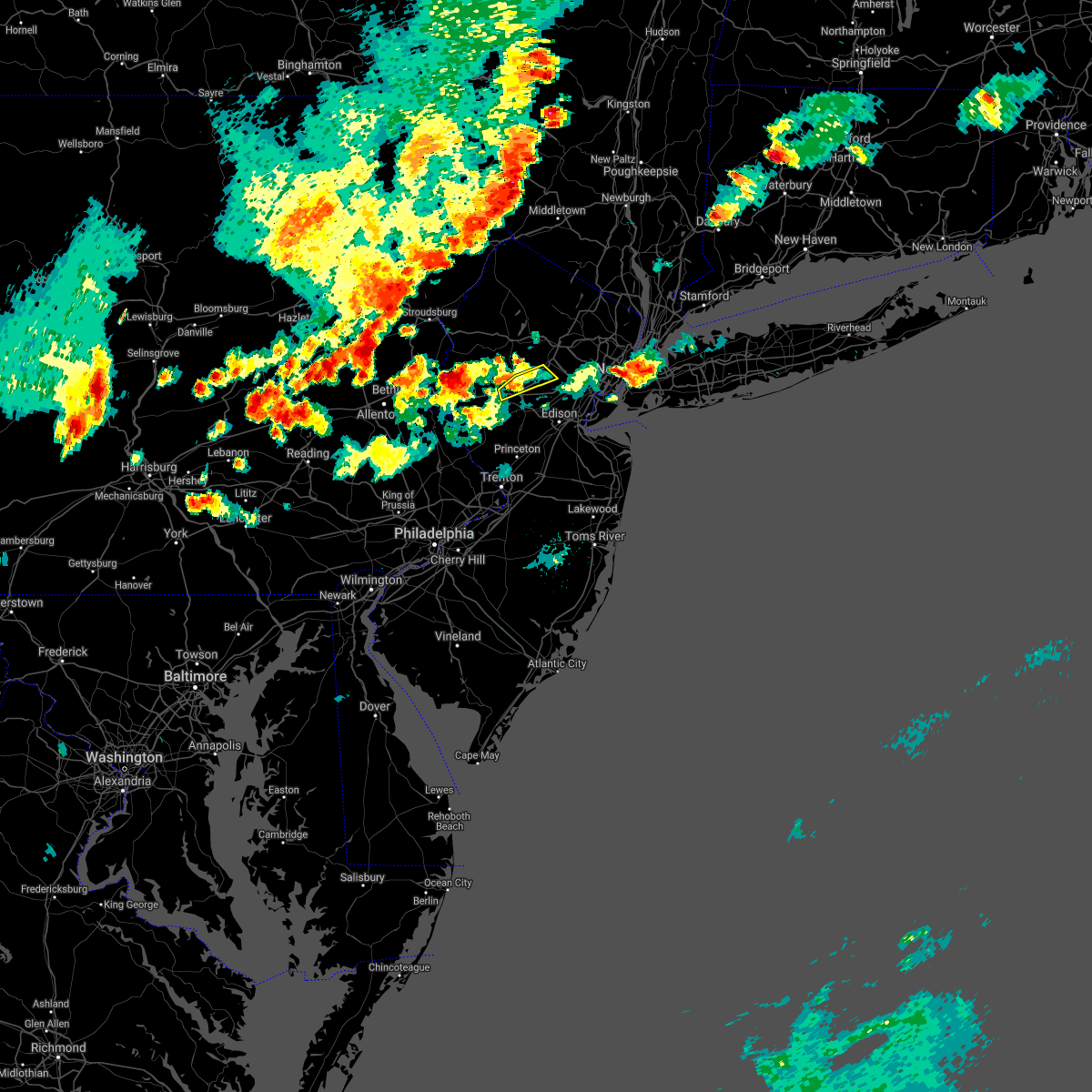 The severe thunderstorm warning for south central morris. east central hunterdon and northwestern somerset counties will expire at 615 pm edt. the storm which prompted the warning has weakened below severe limits, and has exited the warned area. therefore, the warning will be allowed to expire. However small hail, gusty winds, and heavy. The severe thunderstorm warning for south central morris. east central hunterdon and northwestern somerset counties will expire at 615 pm edt. the storm which prompted the warning has weakened below severe limits, and has exited the warned area. therefore, the warning will be allowed to expire. However small hail, gusty winds, and heavy.
|
| 8/18/2019 5:59 PM EDT |
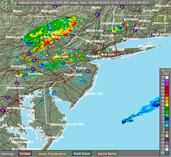 At 559 pm edt, a severe thunderstorm was located near white house station, or 9 miles northwest of somerville, moving northeast at 10 mph (radar indicated). Hazards include 60 mph wind gusts and quarter size hail. Minor damage to vehicles is possible. wind damage to roofs, siding, trees, and power lines is possible. locations impacted include, mendham, peapack and gladstone, far hills, basking ridge and bernardsville. this includes the following highways, interstate 287 in new jersey between mile markers 22 and 33. Interstate 78 in new jersey between mile markers 25 and 28. At 559 pm edt, a severe thunderstorm was located near white house station, or 9 miles northwest of somerville, moving northeast at 10 mph (radar indicated). Hazards include 60 mph wind gusts and quarter size hail. Minor damage to vehicles is possible. wind damage to roofs, siding, trees, and power lines is possible. locations impacted include, mendham, peapack and gladstone, far hills, basking ridge and bernardsville. this includes the following highways, interstate 287 in new jersey between mile markers 22 and 33. Interstate 78 in new jersey between mile markers 25 and 28.
|
| 8/18/2019 5:32 PM EDT |
 At 532 pm edt, a severe thunderstorm was located over bridgewater, or over somerville, moving east at 10 mph (radar indicated). Hazards include 60 mph wind gusts and quarter size hail. Minor damage to vehicles is possible. Wind damage to roofs, siding, trees, and power lines is possible. At 532 pm edt, a severe thunderstorm was located over bridgewater, or over somerville, moving east at 10 mph (radar indicated). Hazards include 60 mph wind gusts and quarter size hail. Minor damage to vehicles is possible. Wind damage to roofs, siding, trees, and power lines is possible.
|
| 8/8/2019 7:39 PM EDT |
 At 723 pm edt, severe thunderstorms were located along a line extending from bloomingdale to chester, moving east at 35 mph (radar indicated). Hazards include 60 mph wind gusts and penny size hail. Damage to roofs, siding, trees, and power lines is possible. locations impacted include, morristown, dover, madison, hopatcong, florham park, east hanover, lincoln park, kinnelon, chatham, boonton, butler, wharton, rockaway, morris plains, mount arlington, mendham, mountain lakes, stanhope, riverdale and netcong. This includes interstate 287 in new jersey between mile markers 23 and 54. At 723 pm edt, severe thunderstorms were located along a line extending from bloomingdale to chester, moving east at 35 mph (radar indicated). Hazards include 60 mph wind gusts and penny size hail. Damage to roofs, siding, trees, and power lines is possible. locations impacted include, morristown, dover, madison, hopatcong, florham park, east hanover, lincoln park, kinnelon, chatham, boonton, butler, wharton, rockaway, morris plains, mount arlington, mendham, mountain lakes, stanhope, riverdale and netcong. This includes interstate 287 in new jersey between mile markers 23 and 54.
|
| 8/8/2019 7:24 PM EDT |
 At 723 pm edt, severe thunderstorms were located along a line extending from bloomingdale to chester, moving east at 35 mph (radar indicated). Hazards include 60 mph wind gusts and penny size hail. Damage to roofs, siding, trees, and power lines is possible. locations impacted include, morristown, dover, madison, hopatcong, florham park, east hanover, lincoln park, kinnelon, chatham, boonton, butler, wharton, rockaway, morris plains, mount arlington, mendham, mountain lakes, stanhope, riverdale and netcong. This includes interstate 287 in new jersey between mile markers 23 and 54. At 723 pm edt, severe thunderstorms were located along a line extending from bloomingdale to chester, moving east at 35 mph (radar indicated). Hazards include 60 mph wind gusts and penny size hail. Damage to roofs, siding, trees, and power lines is possible. locations impacted include, morristown, dover, madison, hopatcong, florham park, east hanover, lincoln park, kinnelon, chatham, boonton, butler, wharton, rockaway, morris plains, mount arlington, mendham, mountain lakes, stanhope, riverdale and netcong. This includes interstate 287 in new jersey between mile markers 23 and 54.
|
| 8/8/2019 7:01 PM EDT |
 The national weather service in mount holly nj has issued a * severe thunderstorm warning for. morris county in northern new jersey. northeastern hunterdon county in northwestern new jersey. southeastern sussex county in northwestern new jersey. East central warren county in northwestern new jersey. The national weather service in mount holly nj has issued a * severe thunderstorm warning for. morris county in northern new jersey. northeastern hunterdon county in northwestern new jersey. southeastern sussex county in northwestern new jersey. East central warren county in northwestern new jersey.
|
| 8/7/2019 4:53 PM EDT |
 The severe thunderstorm warning for southwestern morris, northeastern hunterdon, southwestern sussex, warren, northwestern somerset, east central monroe and northeastern northampton counties will expire at 500 pm edt, the storms which prompted the warning have weakened below severe limits, and no longer pose an immediate threat to life or property. therefore, the warning will be allowed to expire. however gusty winds are still possible with these thunderstorms. a severe thunderstorm watch remains in effect until 900 pm edt for northern and northwestern new jersey, and eastern and northeastern pennsylvania. The severe thunderstorm warning for southwestern morris, northeastern hunterdon, southwestern sussex, warren, northwestern somerset, east central monroe and northeastern northampton counties will expire at 500 pm edt, the storms which prompted the warning have weakened below severe limits, and no longer pose an immediate threat to life or property. therefore, the warning will be allowed to expire. however gusty winds are still possible with these thunderstorms. a severe thunderstorm watch remains in effect until 900 pm edt for northern and northwestern new jersey, and eastern and northeastern pennsylvania.
|
| 8/7/2019 4:46 PM EDT |
 At 445 pm edt, severe thunderstorms were located along a line extending from near echo lake to near califon, moving northeast at 30 mph (radar indicated). Hazards include 60 mph wind gusts and penny size hail. Damage to roofs, siding, trees, and power lines is possible. locations impacted include, hackettstown, washington, blairstown, mendham, high bridge, clinton, belvidere, peapack and gladstone, oxford, hope, glen gardner, chester, hampton, lebanon, califon, far hills, bloomsbury, brass castle, werry lake and greendell. This includes interstate 287 in new jersey between mile markers 22 and 26. At 445 pm edt, severe thunderstorms were located along a line extending from near echo lake to near califon, moving northeast at 30 mph (radar indicated). Hazards include 60 mph wind gusts and penny size hail. Damage to roofs, siding, trees, and power lines is possible. locations impacted include, hackettstown, washington, blairstown, mendham, high bridge, clinton, belvidere, peapack and gladstone, oxford, hope, glen gardner, chester, hampton, lebanon, califon, far hills, bloomsbury, brass castle, werry lake and greendell. This includes interstate 287 in new jersey between mile markers 22 and 26.
|
| 8/7/2019 4:14 PM EDT |
 At 413 pm edt, severe thunderstorms were located along a line extending from near pen argyl to near bloomsbury, moving northeast at 30 mph (radar indicated). Hazards include 60 mph wind gusts and penny size hail. damage to roofs, siding, trees, and power lines is possible At 413 pm edt, severe thunderstorms were located along a line extending from near pen argyl to near bloomsbury, moving northeast at 30 mph (radar indicated). Hazards include 60 mph wind gusts and penny size hail. damage to roofs, siding, trees, and power lines is possible
|
| 8/7/2019 2:17 PM EDT |
 At 217 pm edt, a severe thunderstorm was located near basking ridge, or near morristown, moving east at 20 mph (radar indicated). Hazards include 60 mph wind gusts and quarter size hail. Minor damage to vehicles is possible. wind damage to roofs, siding, trees, and power lines is possible. locations impacted include, morristown, madison, florham park, east hanover, chatham, morris plains, mendham, far hills, parsippany, millington, basking ridge, bernardsville and hanover township. This includes interstate 287 in new jersey between mile markers 25 and 42. At 217 pm edt, a severe thunderstorm was located near basking ridge, or near morristown, moving east at 20 mph (radar indicated). Hazards include 60 mph wind gusts and quarter size hail. Minor damage to vehicles is possible. wind damage to roofs, siding, trees, and power lines is possible. locations impacted include, morristown, madison, florham park, east hanover, chatham, morris plains, mendham, far hills, parsippany, millington, basking ridge, bernardsville and hanover township. This includes interstate 287 in new jersey between mile markers 25 and 42.
|
| 8/7/2019 1:52 PM EDT |
 At 152 pm edt, a severe thunderstorm was located over peapack and gladstone, or 10 miles southwest of morristown, moving east at 15 mph (radar indicated). Hazards include 60 mph wind gusts and quarter size hail. Minor damage to vehicles is possible. Wind damage to roofs, siding, trees, and power lines is possible. At 152 pm edt, a severe thunderstorm was located over peapack and gladstone, or 10 miles southwest of morristown, moving east at 15 mph (radar indicated). Hazards include 60 mph wind gusts and quarter size hail. Minor damage to vehicles is possible. Wind damage to roofs, siding, trees, and power lines is possible.
|
| 8/7/2019 1:22 PM EDT |
 At 121 pm edt, severe thunderstorms were located along a line extending from near califon to frenchtown, moving northeast at 20 mph (radar indicated). Hazards include 60 mph wind gusts and penny size hail. damage to roofs, siding, trees, and power lines is possible At 121 pm edt, severe thunderstorms were located along a line extending from near califon to frenchtown, moving northeast at 20 mph (radar indicated). Hazards include 60 mph wind gusts and penny size hail. damage to roofs, siding, trees, and power lines is possible
|
| 7/31/2019 3:38 PM EDT |
 At 337 pm edt, severe thunderstorms were located along a line extending from near mendham to near flagtown, moving east at 25 mph (radar indicated). Hazards include 60 mph wind gusts. Damage to roofs, siding, trees, and power lines is possible. locations impacted include, new brunswick, morristown, somerville, somerset, east brunswick, bridgewater, north brunswick, madison, middlesex, florham park, east hanover, bound brook, manville, chatham, morris plains, mendham, flemington, mountain lakes, peapack and gladstone and chester. This includes interstate 287 in new jersey between mile markers 5 and 43. At 337 pm edt, severe thunderstorms were located along a line extending from near mendham to near flagtown, moving east at 25 mph (radar indicated). Hazards include 60 mph wind gusts. Damage to roofs, siding, trees, and power lines is possible. locations impacted include, new brunswick, morristown, somerville, somerset, east brunswick, bridgewater, north brunswick, madison, middlesex, florham park, east hanover, bound brook, manville, chatham, morris plains, mendham, flemington, mountain lakes, peapack and gladstone and chester. This includes interstate 287 in new jersey between mile markers 5 and 43.
|
| 7/31/2019 3:20 PM EDT |
 At 320 pm edt, severe thunderstorms were located along a line extending from chester to flemington, moving east at 20 mph (radar indicated). Hazards include 60 mph wind gusts. damage to roofs, siding, trees, and power lines is possible At 320 pm edt, severe thunderstorms were located along a line extending from chester to flemington, moving east at 20 mph (radar indicated). Hazards include 60 mph wind gusts. damage to roofs, siding, trees, and power lines is possible
|
| 7/22/2019 6:43 PM EDT |
 At 642 pm edt, severe thunderstorms were located along a line extending from near east hanover to new hope, moving east at 30 mph (law enforcement reports several trees and wires down in somerset and middlesex counties). Hazards include 70 mph wind gusts and penny size hail. Expect considerable tree damage. damage is likely to mobile homes, roofs, and outbuildings. Locations impacted include, new brunswick, perth amboy, morristown, somerville, somerset, edison, old bridge, east brunswick, bridgewater, sayreville, north brunswick, carteret, madison, middlesex, florham park, east hanover, bound brook, manville, chatham and matawan. At 642 pm edt, severe thunderstorms were located along a line extending from near east hanover to new hope, moving east at 30 mph (law enforcement reports several trees and wires down in somerset and middlesex counties). Hazards include 70 mph wind gusts and penny size hail. Expect considerable tree damage. damage is likely to mobile homes, roofs, and outbuildings. Locations impacted include, new brunswick, perth amboy, morristown, somerville, somerset, edison, old bridge, east brunswick, bridgewater, sayreville, north brunswick, carteret, madison, middlesex, florham park, east hanover, bound brook, manville, chatham and matawan.
|
| 7/22/2019 6:27 PM EDT |
 At 626 pm edt, severe thunderstorms were located along a line extending from morris plains to gardenville, moving east at 30 mph (law enforcement. several reports of trees and wires down have been received from somerset, warren, hunterdon, and mercer counties in association with these storms). Hazards include 70 mph wind gusts and penny size hail. Expect considerable tree damage. Damage is likely to mobile homes, roofs, and outbuildings. At 626 pm edt, severe thunderstorms were located along a line extending from morris plains to gardenville, moving east at 30 mph (law enforcement. several reports of trees and wires down have been received from somerset, warren, hunterdon, and mercer counties in association with these storms). Hazards include 70 mph wind gusts and penny size hail. Expect considerable tree damage. Damage is likely to mobile homes, roofs, and outbuildings.
|
| 7/22/2019 6:13 PM EDT |
 At 612 pm edt, severe thunderstorms were located along a line extending from near mountain lakes to kendall park, moving east at 40 mph (law enforcement. several reports of wind damage have occurred with these storms). Hazards include 70 mph wind gusts. Expect considerable tree damage. damage is likely to mobile homes, roofs, and outbuildings. Locations impacted include, trenton, new brunswick, perth amboy, morristown, somerville, somerset, edison, old bridge, east brunswick, bridgewater, south brunswick, sayreville, north brunswick, ewing, carteret, dover, madison, hopatcong, middlesex and princeton. At 612 pm edt, severe thunderstorms were located along a line extending from near mountain lakes to kendall park, moving east at 40 mph (law enforcement. several reports of wind damage have occurred with these storms). Hazards include 70 mph wind gusts. Expect considerable tree damage. damage is likely to mobile homes, roofs, and outbuildings. Locations impacted include, trenton, new brunswick, perth amboy, morristown, somerville, somerset, edison, old bridge, east brunswick, bridgewater, south brunswick, sayreville, north brunswick, ewing, carteret, dover, madison, hopatcong, middlesex and princeton.
|
| 7/22/2019 6:08 PM EDT |
 At 607 pm edt, severe thunderstorms were located along a line extending from wharton to near perkasie, moving northeast at 30 mph (law enforcement. widespread wind damage has been reported in warren, lehigh, and northampton counties with these storms). Hazards include 70 mph wind gusts and quarter size hail. Minor damage to vehicles is possible. expect considerable tree damage. wind damage is also likely to mobile homes, roofs, and outbuildings. Locations impacted include, morristown, dover, hackettstown, quakertown, perkasie, byram, bedminster, washington, morris plains, mendham, flemington, mountain lakes, tinicum, high bridge, clinton, peapack and gladstone, new hope, oxford, dublin and glen gardner. At 607 pm edt, severe thunderstorms were located along a line extending from wharton to near perkasie, moving northeast at 30 mph (law enforcement. widespread wind damage has been reported in warren, lehigh, and northampton counties with these storms). Hazards include 70 mph wind gusts and quarter size hail. Minor damage to vehicles is possible. expect considerable tree damage. wind damage is also likely to mobile homes, roofs, and outbuildings. Locations impacted include, morristown, dover, hackettstown, quakertown, perkasie, byram, bedminster, washington, morris plains, mendham, flemington, mountain lakes, tinicum, high bridge, clinton, peapack and gladstone, new hope, oxford, dublin and glen gardner.
|
| 7/22/2019 5:55 PM EDT |
 At 554 pm edt, severe thunderstorms were located along a line extending from succasunna to near perkasie, moving east at 25 mph (law enforcement. widespread wind damage has been reported with these storms). Hazards include 70 mph wind gusts. Expect considerable tree damage. damage is likely to mobile homes, roofs, and outbuildings. Locations impacted include, easton, morristown, bethlehem, dover, forks, hackettstown, quakertown, perkasie, byram, wilson, bedminster, washington, hellertown, morris plains, mendham, flemington, mountain lakes, tinicum, high bridge and east greenville. At 554 pm edt, severe thunderstorms were located along a line extending from succasunna to near perkasie, moving east at 25 mph (law enforcement. widespread wind damage has been reported with these storms). Hazards include 70 mph wind gusts. Expect considerable tree damage. damage is likely to mobile homes, roofs, and outbuildings. Locations impacted include, easton, morristown, bethlehem, dover, forks, hackettstown, quakertown, perkasie, byram, wilson, bedminster, washington, hellertown, morris plains, mendham, flemington, mountain lakes, tinicum, high bridge and east greenville.
|
| 7/22/2019 5:50 PM EDT |
 At 549 pm edt, severe thunderstorms were located along a line extending from boonton to green lane, moving east at 40 mph (law enforcement. widespread wind damage has occurred with these storms). Hazards include 70 mph wind gusts. Expect considerable tree damage. Damage is likely to mobile homes, roofs, and outbuildings. At 549 pm edt, severe thunderstorms were located along a line extending from boonton to green lane, moving east at 40 mph (law enforcement. widespread wind damage has occurred with these storms). Hazards include 70 mph wind gusts. Expect considerable tree damage. Damage is likely to mobile homes, roofs, and outbuildings.
|
| 7/22/2019 5:17 PM EDT |
 At 517 pm edt, several severe thunderstorms were located along a line extending from washington to near bally, moving east at 30 mph (law enforcement. numerous reports of wind damage have been received from lehigh and warren counties with these storms). Hazards include 70 mph wind gusts. Expect considerable tree damage. Damage is likely to mobile homes, roofs, and outbuildings. At 517 pm edt, several severe thunderstorms were located along a line extending from washington to near bally, moving east at 30 mph (law enforcement. numerous reports of wind damage have been received from lehigh and warren counties with these storms). Hazards include 70 mph wind gusts. Expect considerable tree damage. Damage is likely to mobile homes, roofs, and outbuildings.
|
| 7/21/2019 10:12 PM EDT |
 At 1011 pm edt, severe thunderstorms were located along a line extending from madison to basking ridge to near flagtown, moving east at 30 mph (radar indicated). Hazards include 60 mph wind gusts. damage to roofs, siding, trees, and power lines is possible At 1011 pm edt, severe thunderstorms were located along a line extending from madison to basking ridge to near flagtown, moving east at 30 mph (radar indicated). Hazards include 60 mph wind gusts. damage to roofs, siding, trees, and power lines is possible
|
| 7/21/2019 9:49 PM EDT |
 At 948 pm edt, severe thunderstorms were located along a line extending from near victory gardens to glen gardner to ferndale to near geryville, moving east at 35 mph (radar indicated). Hazards include 60 mph wind gusts and quarter size hail. Minor damage to vehicles is possible. wind damage to roofs, siding, trees, and power lines is possible. Locations impacted include, allentown, easton, morristown, somerville, bethlehem, bridgewater, dover, madison, middlesex, florham park, emmaus, east hanover, bound brook, manville, hackettstown, quakertown, chatham, perkasie, byram and bedminster. At 948 pm edt, severe thunderstorms were located along a line extending from near victory gardens to glen gardner to ferndale to near geryville, moving east at 35 mph (radar indicated). Hazards include 60 mph wind gusts and quarter size hail. Minor damage to vehicles is possible. wind damage to roofs, siding, trees, and power lines is possible. Locations impacted include, allentown, easton, morristown, somerville, bethlehem, bridgewater, dover, madison, middlesex, florham park, emmaus, east hanover, bound brook, manville, hackettstown, quakertown, chatham, perkasie, byram and bedminster.
|
| 7/21/2019 9:24 PM EDT |
 At 922 pm edt, severe thunderstorms were located along a line extending from netcong to harmony to hellertown to near topton, moving east at 35 mph (radar indicated). Hazards include 60 mph wind gusts and quarter size hail. Minor damage to vehicles is possible. Wind damage to roofs, siding, trees, and power lines is possible. At 922 pm edt, severe thunderstorms were located along a line extending from netcong to harmony to hellertown to near topton, moving east at 35 mph (radar indicated). Hazards include 60 mph wind gusts and quarter size hail. Minor damage to vehicles is possible. Wind damage to roofs, siding, trees, and power lines is possible.
|
| 7/21/2019 7:13 PM EDT |
 At 712 pm edt, severe thunderstorms were located along a line extending from near millington to near bridgewater to lebanon, moving east at 25 mph (radar indicated). Hazards include 60 mph wind gusts. Damage to roofs, siding, trees, and power lines is possible. Locations impacted include, perth amboy, morristown, somerville, edison, bridgewater, carteret, madison, middlesex, bound brook, manville, chatham, mendham, peapack and gladstone, lebanon, far hills, colonia, martinsville, millington, white house station and society hill. At 712 pm edt, severe thunderstorms were located along a line extending from near millington to near bridgewater to lebanon, moving east at 25 mph (radar indicated). Hazards include 60 mph wind gusts. Damage to roofs, siding, trees, and power lines is possible. Locations impacted include, perth amboy, morristown, somerville, edison, bridgewater, carteret, madison, middlesex, bound brook, manville, chatham, mendham, peapack and gladstone, lebanon, far hills, colonia, martinsville, millington, white house station and society hill.
|
| 7/21/2019 6:58 PM EDT |
 At 658 pm edt, severe thunderstorms were located along a line extending from basking ridge to near white house station to high bridge, moving east at 30 mph (radar indicated). Hazards include 60 mph wind gusts. Damage to roofs, siding, trees, and power lines is possible. Locations impacted include, perth amboy, morristown, somerville, edison, bridgewater, carteret, madison, middlesex, bound brook, manville, chatham, mendham, high bridge, clinton, peapack and gladstone, glen gardner, chester, hampton, lebanon and califon. At 658 pm edt, severe thunderstorms were located along a line extending from basking ridge to near white house station to high bridge, moving east at 30 mph (radar indicated). Hazards include 60 mph wind gusts. Damage to roofs, siding, trees, and power lines is possible. Locations impacted include, perth amboy, morristown, somerville, edison, bridgewater, carteret, madison, middlesex, bound brook, manville, chatham, mendham, high bridge, clinton, peapack and gladstone, glen gardner, chester, hampton, lebanon and califon.
|
| 7/21/2019 6:49 PM EDT |
 At 648 pm edt, severe thunderstorms were located along a line extending from near peapack and gladstone to near lebanon to near hampton, moving east at 35 mph (radar indicated). Hazards include 60 mph wind gusts. damage to roofs, siding, trees, and power lines is possible At 648 pm edt, severe thunderstorms were located along a line extending from near peapack and gladstone to near lebanon to near hampton, moving east at 35 mph (radar indicated). Hazards include 60 mph wind gusts. damage to roofs, siding, trees, and power lines is possible
|
| 6/29/2019 5:10 PM EDT |
 The severe thunderstorm warning for southeastern morris and north central somerset counties will expire at 515 pm edt, the storm which prompted the warning has moved out of the area. therefore, the warning will be allowed to expire. a severe thunderstorm watch remains in effect until 700 pm edt for northern new jersey. The severe thunderstorm warning for southeastern morris and north central somerset counties will expire at 515 pm edt, the storm which prompted the warning has moved out of the area. therefore, the warning will be allowed to expire. a severe thunderstorm watch remains in effect until 700 pm edt for northern new jersey.
|
| 6/29/2019 4:58 PM EDT |
 At 457 pm edt, a severe thunderstorm was located over basking ridge, or near morristown, moving southeast at 35 mph (radar indicated). Hazards include 70 mph wind gusts and quarter size hail. Minor damage to vehicles is possible. expect considerable tree damage. wind damage is also likely to mobile homes, roofs, and outbuildings. Locations impacted include, morristown, madison, mendham, peapack and gladstone, far hills, millington, basking ridge and bernardsville. At 457 pm edt, a severe thunderstorm was located over basking ridge, or near morristown, moving southeast at 35 mph (radar indicated). Hazards include 70 mph wind gusts and quarter size hail. Minor damage to vehicles is possible. expect considerable tree damage. wind damage is also likely to mobile homes, roofs, and outbuildings. Locations impacted include, morristown, madison, mendham, peapack and gladstone, far hills, millington, basking ridge and bernardsville.
|
| 6/29/2019 4:56 PM EDT | A tree and a few large limbs down. time estimated from rada in somerset county NJ, 2.5 miles NW of Bernardsville, NJ |
| 6/29/2019 4:55 PM EDT | Photos of several trees down in the area. time estimated from rada in somerset county NJ, 3.1 miles NNW of Bernardsville, NJ |
| 6/29/2019 4:54 PM EDT | Mping report of tree limbs down and property damage from thunderstorm damage at this location. time estimated from rada in somerset county NJ, 2 miles NW of Bernardsville, NJ |
| 6/29/2019 4:53 PM EDT |
 At 453 pm edt, a severe thunderstorm was located over morris plains, or near morristown, moving southeast at 30 mph (radar indicated). Hazards include 70 mph wind gusts. Expect considerable tree damage. Damage is likely to mobile homes, roofs, and outbuildings. At 453 pm edt, a severe thunderstorm was located over morris plains, or near morristown, moving southeast at 30 mph (radar indicated). Hazards include 70 mph wind gusts. Expect considerable tree damage. Damage is likely to mobile homes, roofs, and outbuildings.
|
| 6/29/2019 4:27 PM EDT |
 At 427 pm edt, a severe thunderstorm was located over budd lake, or 10 miles south of newton, moving southeast at 30 mph (radar indicated). Hazards include 60 mph wind gusts and quarter size hail. Minor damage to vehicles is possible. Wind damage to roofs, siding, trees, and power lines is possible. At 427 pm edt, a severe thunderstorm was located over budd lake, or 10 miles south of newton, moving southeast at 30 mph (radar indicated). Hazards include 60 mph wind gusts and quarter size hail. Minor damage to vehicles is possible. Wind damage to roofs, siding, trees, and power lines is possible.
|
| 6/2/2019 9:07 PM EDT |
 At 906 pm edt, severe thunderstorms were located along a line extending from far hills to near edison, moving east at 25 mph (radar indicated). Hazards include 60 mph wind gusts and penny size hail. damage to roofs, siding, trees, and power lines is possible At 906 pm edt, severe thunderstorms were located along a line extending from far hills to near edison, moving east at 25 mph (radar indicated). Hazards include 60 mph wind gusts and penny size hail. damage to roofs, siding, trees, and power lines is possible
|
| 5/30/2019 5:43 PM EDT |
 A severe thunderstorm warning remains in effect until 600 pm edt for southern morris. northeastern hunterdon. somerset and north central middlesex counties. At 542 pm edt, severe thunderstorms were located along a line extending from near morristown to near white house station, moving east at 35 mph. A severe thunderstorm warning remains in effect until 600 pm edt for southern morris. northeastern hunterdon. somerset and north central middlesex counties. At 542 pm edt, severe thunderstorms were located along a line extending from near morristown to near white house station, moving east at 35 mph.
|
| 5/30/2019 5:20 PM EDT |
 At 519 pm edt, severe thunderstorms were located along a line extending from long valley to milford, moving east at 25 mph (radar indicated). Hazards include 60 mph wind gusts and penny size hail. damage to roofs, siding, trees, and power lines is possible At 519 pm edt, severe thunderstorms were located along a line extending from long valley to milford, moving east at 25 mph (radar indicated). Hazards include 60 mph wind gusts and penny size hail. damage to roofs, siding, trees, and power lines is possible
|
| 5/30/2019 5:20 PM EDT |
 The national weather service in mount holly nj has issued a * severe thunderstorm warning for. morris county in northern new jersey. hunterdon county in northwestern new jersey. southeastern warren county in northwestern new jersey. Somerset county in northern new jersey. The national weather service in mount holly nj has issued a * severe thunderstorm warning for. morris county in northern new jersey. hunterdon county in northwestern new jersey. southeastern warren county in northwestern new jersey. Somerset county in northern new jersey.
|
| 5/28/2019 9:12 PM EDT |
 At 912 pm edt, a severe thunderstorm was located near succasunna-kenvil, or 7 miles northwest of morristown, moving southeast at 30 mph (radar indicated). Hazards include 60 mph wind gusts and quarter size hail. Minor damage to vehicles is possible. wind damage to roofs, siding, trees, and power lines is possible. Locations impacted include, morristown, newton, dover, madison, hopatcong, florham park, east hanover, lincoln park, kinnelon, hackettstown, chatham, boonton, butler, wharton, rockaway, blairstown, morris plains, mount arlington, franklin and mendham. At 912 pm edt, a severe thunderstorm was located near succasunna-kenvil, or 7 miles northwest of morristown, moving southeast at 30 mph (radar indicated). Hazards include 60 mph wind gusts and quarter size hail. Minor damage to vehicles is possible. wind damage to roofs, siding, trees, and power lines is possible. Locations impacted include, morristown, newton, dover, madison, hopatcong, florham park, east hanover, lincoln park, kinnelon, hackettstown, chatham, boonton, butler, wharton, rockaway, blairstown, morris plains, mount arlington, franklin and mendham.
|
| 5/28/2019 8:44 PM EDT |
 At 843 pm edt, a severe thunderstorm was located over allamuchy-panther valley, or 8 miles southwest of newton, moving southeast at 45 mph (radar indicated). Hazards include 60 mph wind gusts and half dollar size hail. Minor damage to vehicles is possible. Wind damage to roofs, siding, trees, and power lines is possible. At 843 pm edt, a severe thunderstorm was located over allamuchy-panther valley, or 8 miles southwest of newton, moving southeast at 45 mph (radar indicated). Hazards include 60 mph wind gusts and half dollar size hail. Minor damage to vehicles is possible. Wind damage to roofs, siding, trees, and power lines is possible.
|
| 5/28/2019 8:30 PM EDT |
 At 830 pm edt, a severe thunderstorm capable of producing a tornado was located over netcong, or 10 miles south of newton, moving southeast at 35 mph (radar indicated rotation). Hazards include tornado and half dollar size hail. Flying debris will be dangerous to those caught without shelter. mobile homes will be damaged or destroyed. damage to roofs, windows, and vehicles will occur. Tree damage is likely. At 830 pm edt, a severe thunderstorm capable of producing a tornado was located over netcong, or 10 miles south of newton, moving southeast at 35 mph (radar indicated rotation). Hazards include tornado and half dollar size hail. Flying debris will be dangerous to those caught without shelter. mobile homes will be damaged or destroyed. damage to roofs, windows, and vehicles will occur. Tree damage is likely.
|
| 5/19/2019 10:27 PM EDT |
 At 1025 pm edt, thunderstorms, some of them possibly severe, were moving through far eastern bucks county in pennsylvania and hunterdon county in western new jersey. these thunderstorms were moving east at 45 mph and will be moving through new jersey through the late evening hours (radar indicated). Hazards include 60 mph wind gusts and quarter size hail. Minor damage to vehicles is possible. Wind damage to roofs, siding, trees, and power lines is possible. At 1025 pm edt, thunderstorms, some of them possibly severe, were moving through far eastern bucks county in pennsylvania and hunterdon county in western new jersey. these thunderstorms were moving east at 45 mph and will be moving through new jersey through the late evening hours (radar indicated). Hazards include 60 mph wind gusts and quarter size hail. Minor damage to vehicles is possible. Wind damage to roofs, siding, trees, and power lines is possible.
|
| 5/19/2019 10:08 PM EDT |
 At 1008 pm edt, severe thunderstorms were located along a line extending from glen gardner to near gardenville to near royersford, moving east at 40 mph (radar indicated). Hazards include 60 mph wind gusts and quarter size hail. Minor damage to vehicles is possible. wind damage to roofs, siding, trees, and power lines is possible. Locations impacted include, bridgewater, ewing, lansdale, quakertown, perkasie, doylestown, byram, souderton, bedminster, washington, mendham, flemington, chalfont, tinicum, high bridge, hatfield, clinton, pennington, peapack and gladstone and new hope. At 1008 pm edt, severe thunderstorms were located along a line extending from glen gardner to near gardenville to near royersford, moving east at 40 mph (radar indicated). Hazards include 60 mph wind gusts and quarter size hail. Minor damage to vehicles is possible. wind damage to roofs, siding, trees, and power lines is possible. Locations impacted include, bridgewater, ewing, lansdale, quakertown, perkasie, doylestown, byram, souderton, bedminster, washington, mendham, flemington, chalfont, tinicum, high bridge, hatfield, clinton, pennington, peapack and gladstone and new hope.
|
| 5/19/2019 9:46 PM EDT |
 At 946 pm edt, severe thunderstorms were located along a line extending from alpha to hatfield to near elverson, moving east at 40 mph (radar indicated). Hazards include 60 mph wind gusts and quarter size hail. Minor damage to vehicles is possible. Wind damage to roofs, siding, trees, and power lines is possible. At 946 pm edt, severe thunderstorms were located along a line extending from alpha to hatfield to near elverson, moving east at 40 mph (radar indicated). Hazards include 60 mph wind gusts and quarter size hail. Minor damage to vehicles is possible. Wind damage to roofs, siding, trees, and power lines is possible.
|
| 4/15/2019 3:57 AM EDT |
 At 356 am edt, severe thunderstorms were located along a line extending from mendham to belle mead, moving northeast at 55 mph (radar indicated). Hazards include 60 mph wind gusts and penny size hail. damage to roofs, siding, trees, and power lines is possible At 356 am edt, severe thunderstorms were located along a line extending from mendham to belle mead, moving northeast at 55 mph (radar indicated). Hazards include 60 mph wind gusts and penny size hail. damage to roofs, siding, trees, and power lines is possible
|
| 4/15/2019 3:45 AM EDT |
 At 344 am edt, severe thunderstorms were located along a line extending from white house station to near hatboro, moving northeast at 65 mph (radar indicated). Hazards include 60 mph wind gusts and penny size hail. Damage to roofs, siding, trees, and power lines is possible. locations impacted include, morristown, bridgewater, hatboro, flemington, peapack and gladstone, new hope, lebanon, ivyland, far hills, stockton, lumberville, richboro, sergeantsville, cloverhill, white house station, basking ridge, sand brook, willow grove, horsham and bernardsville. A tornado watch remains in effect until 700 am edt for central, northern and northwestern new jersey, and southeastern pennsylvania. At 344 am edt, severe thunderstorms were located along a line extending from white house station to near hatboro, moving northeast at 65 mph (radar indicated). Hazards include 60 mph wind gusts and penny size hail. Damage to roofs, siding, trees, and power lines is possible. locations impacted include, morristown, bridgewater, hatboro, flemington, peapack and gladstone, new hope, lebanon, ivyland, far hills, stockton, lumberville, richboro, sergeantsville, cloverhill, white house station, basking ridge, sand brook, willow grove, horsham and bernardsville. A tornado watch remains in effect until 700 am edt for central, northern and northwestern new jersey, and southeastern pennsylvania.
|
| 4/15/2019 3:27 AM EDT |
 At 327 am edt, severe thunderstorms were located along a line extending from tinicum to paoli, moving northeast at 45 mph (radar indicated). Hazards include 60 mph wind gusts and penny size hail. damage to roofs, siding, trees, and power lines is possible At 327 am edt, severe thunderstorms were located along a line extending from tinicum to paoli, moving northeast at 45 mph (radar indicated). Hazards include 60 mph wind gusts and penny size hail. damage to roofs, siding, trees, and power lines is possible
|
| 3/15/2019 8:00 PM EDT |
 At 800 pm edt, severe thunderstorms were located along a line extending from mendham to near far hills to near bridgewater to near white house station, moving east at 50 mph (radar indicated). Hazards include 60 mph wind gusts and nickel size hail. Damage to roofs, siding, trees, and power lines is possible. Locations impacted include, morristown, bridgewater, madison, florham park, east hanover, chatham, morris plains, mendham, peapack and gladstone, far hills, martinsville, millington, basking ridge, parsippany, north plainfield, bernardsville, watchung and hanover township. At 800 pm edt, severe thunderstorms were located along a line extending from mendham to near far hills to near bridgewater to near white house station, moving east at 50 mph (radar indicated). Hazards include 60 mph wind gusts and nickel size hail. Damage to roofs, siding, trees, and power lines is possible. Locations impacted include, morristown, bridgewater, madison, florham park, east hanover, chatham, morris plains, mendham, peapack and gladstone, far hills, martinsville, millington, basking ridge, parsippany, north plainfield, bernardsville, watchung and hanover township.
|
| 3/15/2019 7:56 PM EDT | Tree reported down. time estimated from rada in somerset county NJ, 1.4 miles NNW of Bernardsville, NJ |
| 3/15/2019 7:47 PM EDT |
 At 746 pm edt, a severe thunderstorm was located over mountain lakes, or near morristown, moving east at 45 mph (radar indicated). Hazards include 60 mph wind gusts and nickel size hail. Damage to roofs, siding, trees, and power lines is possible. Locations impacted include, morristown, dover, madison, florham park, east hanover, lincoln park, kinnelon, boonton, butler, rockaway, morris plains, mountain lakes, riverdale, victory gardens, parsippany, pequannock township, lake telemark, bernardsville, white meadow lake and hanover township. At 746 pm edt, a severe thunderstorm was located over mountain lakes, or near morristown, moving east at 45 mph (radar indicated). Hazards include 60 mph wind gusts and nickel size hail. Damage to roofs, siding, trees, and power lines is possible. Locations impacted include, morristown, dover, madison, florham park, east hanover, lincoln park, kinnelon, boonton, butler, rockaway, morris plains, mountain lakes, riverdale, victory gardens, parsippany, pequannock township, lake telemark, bernardsville, white meadow lake and hanover township.
|
| 3/15/2019 7:45 PM EDT |
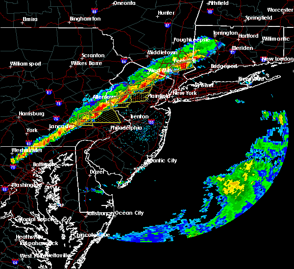 At 745 pm edt, severe thunderstorms were located along a line extending from long valley to near califon to near clinton to frenchtown, moving east at 45 mph (radar indicated). Hazards include 60 mph wind gusts and nickel size hail. damage to roofs, siding, trees, and power lines is possible At 745 pm edt, severe thunderstorms were located along a line extending from long valley to near califon to near clinton to frenchtown, moving east at 45 mph (radar indicated). Hazards include 60 mph wind gusts and nickel size hail. damage to roofs, siding, trees, and power lines is possible
|
| 3/15/2019 7:33 PM EDT |
 At 733 pm edt, a severe thunderstorm was located over succasunna, or 8 miles west of morristown, moving east at 50 mph (radar indicated). Hazards include 60 mph wind gusts and nickel size hail. Damage to roofs, siding, trees, and power lines is possible. Locations impacted include, morristown, dover, madison, hopatcong, florham park, east hanover, lincoln park, kinnelon, boonton, butler, wharton, rockaway, morris plains, mount arlington, mendham, mountain lakes, stanhope, riverdale, netcong and chester. At 733 pm edt, a severe thunderstorm was located over succasunna, or 8 miles west of morristown, moving east at 50 mph (radar indicated). Hazards include 60 mph wind gusts and nickel size hail. Damage to roofs, siding, trees, and power lines is possible. Locations impacted include, morristown, dover, madison, hopatcong, florham park, east hanover, lincoln park, kinnelon, boonton, butler, wharton, rockaway, morris plains, mount arlington, mendham, mountain lakes, stanhope, riverdale, netcong and chester.
|
| 3/15/2019 7:11 PM EDT |
 At 711 pm edt, a severe thunderstorm was located over washington, or 14 miles east of easton, moving east at 45 mph (radar indicated). Hazards include 60 mph wind gusts and nickel size hail. damage to roofs, siding, trees, and power lines is possible At 711 pm edt, a severe thunderstorm was located over washington, or 14 miles east of easton, moving east at 45 mph (radar indicated). Hazards include 60 mph wind gusts and nickel size hail. damage to roofs, siding, trees, and power lines is possible
|
| 11/3/2018 12:07 AM EDT |
 At 1206 am edt, a severe thunderstorm capable of producing a tornado was located over sergeantsville, or 18 miles southwest of somerville, moving northeast at 35 mph (radar indicated rotation). Hazards include tornado. Flying debris will be dangerous to those caught without shelter. mobile homes will be damaged or destroyed. damage to roofs, windows, and vehicles will occur. tree damage is likely. Locations impacted include, somerville, somerset, bridgewater, middlesex, bound brook, manville, flemington, peapack and gladstone, frenchtown, lebanon, far hills, stockton, millstone, flagtown, belle mead, martinsville, sergeantsville, cloverhill, white house station and sand brook. At 1206 am edt, a severe thunderstorm capable of producing a tornado was located over sergeantsville, or 18 miles southwest of somerville, moving northeast at 35 mph (radar indicated rotation). Hazards include tornado. Flying debris will be dangerous to those caught without shelter. mobile homes will be damaged or destroyed. damage to roofs, windows, and vehicles will occur. tree damage is likely. Locations impacted include, somerville, somerset, bridgewater, middlesex, bound brook, manville, flemington, peapack and gladstone, frenchtown, lebanon, far hills, stockton, millstone, flagtown, belle mead, martinsville, sergeantsville, cloverhill, white house station and sand brook.
|
| 11/2/2018 11:49 PM EDT |
 At 1149 pm edt, a severe thunderstorm capable of producing a tornado was located over gardenville, or 20 miles northwest of trenton, moving northeast at 35 mph (radar indicated rotation). Hazards include tornado. Flying debris will be dangerous to those caught without shelter. mobile homes will be damaged or destroyed. damage to roofs, windows, and vehicles will occur. tree damage is likely. this dangerous storm will be near, byram and lumberville around 1155 pm edt. new hope, stockton and erwinna around 1200 am edt. sergeantsville around 1205 am edt. sand brook around 1210 am edt. flemington around 1215 am edt. cloverhill around 1220 am edt. belle mead around 1225 am edt. somerville, bridgewater, manville, flagtown and white house station around 1230 am edt. Other locations impacted by this tornadic thunderstorm include south bound brook, raritan, lambertville and bernardsville. At 1149 pm edt, a severe thunderstorm capable of producing a tornado was located over gardenville, or 20 miles northwest of trenton, moving northeast at 35 mph (radar indicated rotation). Hazards include tornado. Flying debris will be dangerous to those caught without shelter. mobile homes will be damaged or destroyed. damage to roofs, windows, and vehicles will occur. tree damage is likely. this dangerous storm will be near, byram and lumberville around 1155 pm edt. new hope, stockton and erwinna around 1200 am edt. sergeantsville around 1205 am edt. sand brook around 1210 am edt. flemington around 1215 am edt. cloverhill around 1220 am edt. belle mead around 1225 am edt. somerville, bridgewater, manville, flagtown and white house station around 1230 am edt. Other locations impacted by this tornadic thunderstorm include south bound brook, raritan, lambertville and bernardsville.
|
| 9/17/2018 4:25 PM EDT |
 At 425 pm edt, a severe thunderstorm was located over bound brook, or near somerville, moving northeast at 20 mph (radar indicated). Hazards include 60 mph wind gusts. damage to roofs, siding, trees, and power lines is possible At 425 pm edt, a severe thunderstorm was located over bound brook, or near somerville, moving northeast at 20 mph (radar indicated). Hazards include 60 mph wind gusts. damage to roofs, siding, trees, and power lines is possible
|
| 8/18/2018 12:05 AM EDT |
 The severe thunderstorm warning for southeastern morris, northeastern somerset and north central middlesex counties will expire at 1215 am edt, the storm which prompted the warning has weakened below severe limits, and has exited the warned area. therefore, the warning will be allowed to expire. to report severe weather, contact your nearest law enforcement agency. they will relay your report to the national weather service in mount holly nj. The severe thunderstorm warning for southeastern morris, northeastern somerset and north central middlesex counties will expire at 1215 am edt, the storm which prompted the warning has weakened below severe limits, and has exited the warned area. therefore, the warning will be allowed to expire. to report severe weather, contact your nearest law enforcement agency. they will relay your report to the national weather service in mount holly nj.
|
| 8/17/2018 11:41 PM EDT |
 The national weather service in mount holly nj has issued a * severe thunderstorm warning for. southeastern morris county in northern new jersey. northeastern somerset county in northern new jersey. north central middlesex county in northern new jersey. Until 1215 am edt. The national weather service in mount holly nj has issued a * severe thunderstorm warning for. southeastern morris county in northern new jersey. northeastern somerset county in northern new jersey. north central middlesex county in northern new jersey. Until 1215 am edt.
|
| 8/17/2018 9:21 PM EDT |
 The severe thunderstorm warning for eastern morris, southeastern hunterdon, northern mercer, somerset and middlesex counties will expire at 930 pm edt, the storms which prompted the warning have weakened below severe limits, and no longer pose an immediate threat to life or property. therefore, the warning will be allowed to expire. however gusty winds and heavy rain are still possible with these thunderstorms. a severe thunderstorm watch remains in effect until 1100 pm edt for northern new jersey. to report severe weather, contact your nearest law enforcement agency. they will relay your report to the national weather service in mount holly nj. The severe thunderstorm warning for eastern morris, southeastern hunterdon, northern mercer, somerset and middlesex counties will expire at 930 pm edt, the storms which prompted the warning have weakened below severe limits, and no longer pose an immediate threat to life or property. therefore, the warning will be allowed to expire. however gusty winds and heavy rain are still possible with these thunderstorms. a severe thunderstorm watch remains in effect until 1100 pm edt for northern new jersey. to report severe weather, contact your nearest law enforcement agency. they will relay your report to the national weather service in mount holly nj.
|
| 8/17/2018 9:10 PM EDT |
 At 910 pm edt, severe thunderstorms were located along a line extending from near bloomingdale to florham park to near washington crossing, moving east at 30 mph (public. several reports of wind damage have been received with this line of storms). Hazards include 70 mph wind gusts. Expect considerable tree damage. damage is likely to mobile homes, roofs, and outbuildings. Locations impacted include, new brunswick, perth amboy, morristown, somerville, somerset, edison, old bridge, east brunswick, bridgewater, south brunswick, sayreville, north brunswick, carteret, madison, middlesex, princeton, florham park, east hanover, lincoln park and bound brook. At 910 pm edt, severe thunderstorms were located along a line extending from near bloomingdale to florham park to near washington crossing, moving east at 30 mph (public. several reports of wind damage have been received with this line of storms). Hazards include 70 mph wind gusts. Expect considerable tree damage. damage is likely to mobile homes, roofs, and outbuildings. Locations impacted include, new brunswick, perth amboy, morristown, somerville, somerset, edison, old bridge, east brunswick, bridgewater, south brunswick, sayreville, north brunswick, carteret, madison, middlesex, princeton, florham park, east hanover, lincoln park and bound brook.
|
| 8/17/2018 8:52 PM EDT |
 At 851 pm edt, severe thunderstorms were located along a line extending from hamburg to near lake telemark to near flemington, moving northeast at 40 mph (emergency management. several reports of wind damage have been received from warren and hunterdon counties). Hazards include 70 mph wind gusts. Expect considerable tree damage. damage is likely to mobile homes, roofs, and outbuildings. Locations impacted include, morristown, somerville, bridgewater, dover, hopatcong, manville, wharton, rockaway, morris plains, mount arlington, franklin, mendham, flemington, mountain lakes, high bridge, stanhope, netcong, clinton, peapack and gladstone and ogdensburg. At 851 pm edt, severe thunderstorms were located along a line extending from hamburg to near lake telemark to near flemington, moving northeast at 40 mph (emergency management. several reports of wind damage have been received from warren and hunterdon counties). Hazards include 70 mph wind gusts. Expect considerable tree damage. damage is likely to mobile homes, roofs, and outbuildings. Locations impacted include, morristown, somerville, bridgewater, dover, hopatcong, manville, wharton, rockaway, morris plains, mount arlington, franklin, mendham, flemington, mountain lakes, high bridge, stanhope, netcong, clinton, peapack and gladstone and ogdensburg.
|
| 8/17/2018 8:47 PM EDT |
 At 846 pm edt, severe thunderstorms were located along a line extending from ogdensburg to near mendham to new hope, moving east at 30 mph (emergency management. hunterdon county reported tree damage with this storm in hampton earlier). Hazards include 70 mph wind gusts. Expect considerable tree damage. Damage is likely to mobile homes, roofs, and outbuildings. At 846 pm edt, severe thunderstorms were located along a line extending from ogdensburg to near mendham to new hope, moving east at 30 mph (emergency management. hunterdon county reported tree damage with this storm in hampton earlier). Hazards include 70 mph wind gusts. Expect considerable tree damage. Damage is likely to mobile homes, roofs, and outbuildings.
|
| 8/17/2018 8:35 PM EDT |
 At 835 pm edt, severe thunderstorms were located along a line extending from near newton to succasunna-kenvil to near byram, moving northeast at 40 mph (radar indicated). Hazards include 70 mph wind gusts. Expect considerable tree damage. damage is likely to mobile homes, roofs, and outbuildings. Locations impacted include, morristown, somerville, newton, bridgewater, dover, hopatcong, manville, hackettstown, wharton, washington, rockaway, morris plains, mount arlington, franklin, mendham, flemington, mountain lakes, tinicum, high bridge and stanhope. At 835 pm edt, severe thunderstorms were located along a line extending from near newton to succasunna-kenvil to near byram, moving northeast at 40 mph (radar indicated). Hazards include 70 mph wind gusts. Expect considerable tree damage. damage is likely to mobile homes, roofs, and outbuildings. Locations impacted include, morristown, somerville, newton, bridgewater, dover, hopatcong, manville, hackettstown, wharton, washington, rockaway, morris plains, mount arlington, franklin, mendham, flemington, mountain lakes, tinicum, high bridge and stanhope.
|
| 8/17/2018 8:17 PM EDT |
 At 816 pm edt, severe thunderstorms were located along a line extending from blairstown to beatyestown to milford, moving northeast at 40 mph (radar indicated). Hazards include 60 mph wind gusts. damage to roofs, siding, trees, and power lines is possible At 816 pm edt, severe thunderstorms were located along a line extending from blairstown to beatyestown to milford, moving northeast at 40 mph (radar indicated). Hazards include 60 mph wind gusts. damage to roofs, siding, trees, and power lines is possible
|
| 7/27/2018 2:35 PM EDT |
 The severe thunderstorm warning for southeastern morris and northern somerset counties will expire at 245 pm edt, the storm which prompted the warning has moved out of the area. therefore, the warning will be allowed to expire. however gusty winds and heavy rain are still possible with this thunderstorm. a severe thunderstorm watch remains in effect until 1000 pm edt for northern and northwestern new jersey. The severe thunderstorm warning for southeastern morris and northern somerset counties will expire at 245 pm edt, the storm which prompted the warning has moved out of the area. therefore, the warning will be allowed to expire. however gusty winds and heavy rain are still possible with this thunderstorm. a severe thunderstorm watch remains in effect until 1000 pm edt for northern and northwestern new jersey.
|
| 7/27/2018 2:04 PM EDT |
 At 204 pm edt, a severe thunderstorm was located near madison, or near morristown, moving east at 15 mph (radar indicated). Hazards include 60 mph wind gusts. damage to roofs, siding, trees, and power lines is possible At 204 pm edt, a severe thunderstorm was located near madison, or near morristown, moving east at 15 mph (radar indicated). Hazards include 60 mph wind gusts. damage to roofs, siding, trees, and power lines is possible
|
| 6/18/2018 8:15 PM EDT |
 At 813 pm edt, severe thunderstorms were located along a line extending from near morristown to near flemington, moving east at 40 mph (radar indicated). Hazards include 60 mph wind gusts. Damage to roofs, siding, trees, and power lines is possible. Locations impacted include, morristown, somerville, bridgewater, madison, middlesex, florham park, east hanover, bound brook, manville, chatham, morris plains, mendham, flemington, high bridge, clinton, peapack and gladstone, frenchtown, lebanon, milford and far hills. At 813 pm edt, severe thunderstorms were located along a line extending from near morristown to near flemington, moving east at 40 mph (radar indicated). Hazards include 60 mph wind gusts. Damage to roofs, siding, trees, and power lines is possible. Locations impacted include, morristown, somerville, bridgewater, madison, middlesex, florham park, east hanover, bound brook, manville, chatham, morris plains, mendham, flemington, high bridge, clinton, peapack and gladstone, frenchtown, lebanon, milford and far hills.
|
| 6/18/2018 7:30 PM EDT |
 At 729 pm edt, severe thunderstorms were located along a line extending from near ogdensburg in new jersey to near allentown in pennsylvania, moving east at 40 mph (radar indicated). Hazards include 60 mph wind gusts. damage to roofs, siding, trees, and power lines is possible At 729 pm edt, severe thunderstorms were located along a line extending from near ogdensburg in new jersey to near allentown in pennsylvania, moving east at 40 mph (radar indicated). Hazards include 60 mph wind gusts. damage to roofs, siding, trees, and power lines is possible
|
| 6/13/2018 11:44 PM EDT |
 At 1143 pm edt, a severe thunderstorm was located over beatyestown, or 18 miles east of easton, moving east at 40 mph. wind damage was reported on interstate 80 in warren county with this storm earlier (radar indicated). Hazards include 60 mph wind gusts and penny size hail. Damage to roofs, siding, trees, and power lines is possible. Locations impacted include, hackettstown, washington, mendham, high bridge, clinton, harmony, peapack and gladstone, oxford, glen gardner, chester, hampton, lebanon, califon, far hills, brass castle, long valley, great meadows-vienna, pleasant valley, annandale and white house station. At 1143 pm edt, a severe thunderstorm was located over beatyestown, or 18 miles east of easton, moving east at 40 mph. wind damage was reported on interstate 80 in warren county with this storm earlier (radar indicated). Hazards include 60 mph wind gusts and penny size hail. Damage to roofs, siding, trees, and power lines is possible. Locations impacted include, hackettstown, washington, mendham, high bridge, clinton, harmony, peapack and gladstone, oxford, glen gardner, chester, hampton, lebanon, califon, far hills, brass castle, long valley, great meadows-vienna, pleasant valley, annandale and white house station.
|
| 6/13/2018 11:27 PM EDT |
 At 1127 pm edt, a severe thunderstorm was located over belvidere, or 12 miles northeast of easton, moving east at 45 mph (radar indicated). Hazards include 60 mph wind gusts and penny size hail. damage to roofs, siding, trees, and power lines is possible At 1127 pm edt, a severe thunderstorm was located over belvidere, or 12 miles northeast of easton, moving east at 45 mph (radar indicated). Hazards include 60 mph wind gusts and penny size hail. damage to roofs, siding, trees, and power lines is possible
|
| 5/15/2018 5:10 PM EDT |
 At 510 pm edt, severe thunderstorms were located along a line extending from new york to near glenmoore, moving southeast at 25 mph (radar indicated). Hazards include 70 mph wind gusts and quarter size hail. Minor damage to vehicles is possible. expect considerable tree damage. wind damage is also likely to mobile homes, roofs, and outbuildings. Locations impacted include, allentown, reading, new brunswick, perth amboy, morristown, somerville, somerset, edison, bethlehem, east brunswick, bridgewater, south brunswick, sayreville, north brunswick, ewing, norristown, carteret, pottstown, dover and phoenixville. At 510 pm edt, severe thunderstorms were located along a line extending from new york to near glenmoore, moving southeast at 25 mph (radar indicated). Hazards include 70 mph wind gusts and quarter size hail. Minor damage to vehicles is possible. expect considerable tree damage. wind damage is also likely to mobile homes, roofs, and outbuildings. Locations impacted include, allentown, reading, new brunswick, perth amboy, morristown, somerville, somerset, edison, bethlehem, east brunswick, bridgewater, south brunswick, sayreville, north brunswick, ewing, norristown, carteret, pottstown, dover and phoenixville.
|
| 5/15/2018 4:41 PM EDT |
 At 441 pm edt, severe thunderstorms were located along a line extending from near hawthorne to spring ridge, moving east at 55 mph (radar indicated). Hazards include 70 mph wind gusts and quarter size hail. Minor damage to vehicles is possible. expect considerable tree damage. Wind damage is also likely to mobile homes, roofs, and outbuildings. At 441 pm edt, severe thunderstorms were located along a line extending from near hawthorne to spring ridge, moving east at 55 mph (radar indicated). Hazards include 70 mph wind gusts and quarter size hail. Minor damage to vehicles is possible. expect considerable tree damage. Wind damage is also likely to mobile homes, roofs, and outbuildings.
|
| 5/15/2018 4:28 PM EDT | Downed tree on u.s. highway 202 near mount airy road in bernardsville. all lanes closed and detoured. time approximated from rada in somerset county NJ, 1.4 miles NNW of Bernardsville, NJ |
| 9/5/2017 7:06 PM EDT |
 At 705 pm edt, severe thunderstorms were located along a line extending from wharton to near peapack and gladstone to near cloverhill, moving east at 45 mph (radar indicated). Hazards include 60 mph wind gusts. Possible localized damage to trees and power lines. Locations impacted include, somerville, bridgewater, hopatcong, manville, mount arlington, mendham, flemington, stanhope, netcong, peapack and gladstone, chester, lebanon, far hills, millstone, flagtown, belle mead, succasunna, succasunna-kenvil, cloverhill and white house station. At 705 pm edt, severe thunderstorms were located along a line extending from wharton to near peapack and gladstone to near cloverhill, moving east at 45 mph (radar indicated). Hazards include 60 mph wind gusts. Possible localized damage to trees and power lines. Locations impacted include, somerville, bridgewater, hopatcong, manville, mount arlington, mendham, flemington, stanhope, netcong, peapack and gladstone, chester, lebanon, far hills, millstone, flagtown, belle mead, succasunna, succasunna-kenvil, cloverhill and white house station.
|
| 9/5/2017 6:47 PM EDT |
 At 647 pm edt, severe thunderstorms were located along a line extending from hackettstown to clinton to sand brook, moving northeast at 35 mph (radar indicated). Hazards include 60 mph wind gusts. Expect damage to trees and power lines. Locations impacted include, somerville, bridgewater, hopatcong, manville, hackettstown, mount arlington, mendham, flemington, high bridge, stanhope, netcong, clinton, peapack and gladstone, glen gardner, chester, lebanon, califon, far hills, millstone and flagtown. At 647 pm edt, severe thunderstorms were located along a line extending from hackettstown to clinton to sand brook, moving northeast at 35 mph (radar indicated). Hazards include 60 mph wind gusts. Expect damage to trees and power lines. Locations impacted include, somerville, bridgewater, hopatcong, manville, hackettstown, mount arlington, mendham, flemington, high bridge, stanhope, netcong, clinton, peapack and gladstone, glen gardner, chester, lebanon, califon, far hills, millstone and flagtown.
|
| 9/5/2017 6:26 PM EDT |
 At 625 pm edt, severe thunderstorms were located along a line extending from pen argyl to springtown to perkasie, moving east at 45 mph (doppler radar and trained weather spotters. these storms have produced wind damage across berks and upper portions of montgomery county). Hazards include 60 mph wind gusts and penny size hail. Expect damage to trees and power lines. severe thunderstorms will be near, bangor, pen argyl, wind gap, belfast and east bangor around 630 pm edt. ferndale, riegelsville, glendon and revere around 635 pm edt. tinicum, belvidere, alpha, milford, pipersville, columbia, ottsville and gardenville around 640 pm edt. byram, oxford, frenchtown, bloomsbury, lumberville and erwinna around 645 pm edt. hope, stockton, sergeantsville and great meadows-vienna around 650 pm edt. hackettstown, clinton, glen gardner, hampton, sand brook, annandale and allamuchy-panther valley around 655 pm edt. flemington, high bridge, lebanon and greendell around 700 pm edt. stanhope, netcong, califon, andover, cloverhill, white house station and budd lake around 705 pm edt. Other locations impacted by these severe thunderstorms include coopersburg, portland, sellersville, raritan, beattyestown, bernardsville, richlandtown, stockertown, silverdale and eastlawn gardens. At 625 pm edt, severe thunderstorms were located along a line extending from pen argyl to springtown to perkasie, moving east at 45 mph (doppler radar and trained weather spotters. these storms have produced wind damage across berks and upper portions of montgomery county). Hazards include 60 mph wind gusts and penny size hail. Expect damage to trees and power lines. severe thunderstorms will be near, bangor, pen argyl, wind gap, belfast and east bangor around 630 pm edt. ferndale, riegelsville, glendon and revere around 635 pm edt. tinicum, belvidere, alpha, milford, pipersville, columbia, ottsville and gardenville around 640 pm edt. byram, oxford, frenchtown, bloomsbury, lumberville and erwinna around 645 pm edt. hope, stockton, sergeantsville and great meadows-vienna around 650 pm edt. hackettstown, clinton, glen gardner, hampton, sand brook, annandale and allamuchy-panther valley around 655 pm edt. flemington, high bridge, lebanon and greendell around 700 pm edt. stanhope, netcong, califon, andover, cloverhill, white house station and budd lake around 705 pm edt. Other locations impacted by these severe thunderstorms include coopersburg, portland, sellersville, raritan, beattyestown, bernardsville, richlandtown, stockertown, silverdale and eastlawn gardens.
|
| 8/22/2017 10:01 PM EDT |
 At 1000 pm edt, severe thunderstorms were located along a line extending from mendham to cloverhill to near perkasie, moving east at 45 mph (law enforcement. wind damage has been reported in hunterdon county as the line has moved through). Hazards include 70 mph wind gusts and penny size hail. Expect considerable tree damage. damage is likely to mobile homes, roofs, and outbuildings. Locations impacted include, new brunswick, perth amboy, morristown, somerville, somerset, edison, old bridge, east brunswick, bridgewater, south brunswick, sayreville, north brunswick, ewing, carteret, dover, madison, middlesex, princeton, florham park and east hanover. At 1000 pm edt, severe thunderstorms were located along a line extending from mendham to cloverhill to near perkasie, moving east at 45 mph (law enforcement. wind damage has been reported in hunterdon county as the line has moved through). Hazards include 70 mph wind gusts and penny size hail. Expect considerable tree damage. damage is likely to mobile homes, roofs, and outbuildings. Locations impacted include, new brunswick, perth amboy, morristown, somerville, somerset, edison, old bridge, east brunswick, bridgewater, south brunswick, sayreville, north brunswick, ewing, carteret, dover, madison, middlesex, princeton, florham park and east hanover.
|
| 8/22/2017 9:42 PM EDT |
 At 941 pm edt, severe thunderstorms were located along a line extending from beatyestown to near erwinna to near green lane, moving east at 40 mph. this line of storms has a history of producing wind damage in much of eastern pennsylvania (radar indicated). Hazards include 70 mph wind gusts and penny size hail. Expect considerable tree damage. Damage is likely to mobile homes, roofs, and outbuildings. At 941 pm edt, severe thunderstorms were located along a line extending from beatyestown to near erwinna to near green lane, moving east at 40 mph. this line of storms has a history of producing wind damage in much of eastern pennsylvania (radar indicated). Hazards include 70 mph wind gusts and penny size hail. Expect considerable tree damage. Damage is likely to mobile homes, roofs, and outbuildings.
|
| 8/18/2017 6:24 PM EDT |
 The severe thunderstorm warning for southern morris, northeastern hunterdon and northern somerset counties will expire at 630 pm edt, the storm which prompted the warning has weakened below severe limits, and no longer poses an immediate threat to life or property. therefore the warning will be allowed to expire. however gusty winds are still possible with this thunderstorm. a severe thunderstorm watch remains in effect until 900 pm edt for northern and northwestern new jersey. The severe thunderstorm warning for southern morris, northeastern hunterdon and northern somerset counties will expire at 630 pm edt, the storm which prompted the warning has weakened below severe limits, and no longer poses an immediate threat to life or property. therefore the warning will be allowed to expire. however gusty winds are still possible with this thunderstorm. a severe thunderstorm watch remains in effect until 900 pm edt for northern and northwestern new jersey.
|
| 8/18/2017 6:07 PM EDT |
 At 606 pm edt, a severe thunderstorm was located near peapack and gladstone, or 9 miles northwest of somerville, moving east at 25 mph (radar indicated). Hazards include 60 mph wind gusts and nickel size hail. Expect damage to trees and power lines. Locations impacted include, morristown, somerville, bridgewater, madison, chatham, morris plains, mendham, peapack and gladstone, chester, lebanon, califon, far hills, martinsville, millington, white house station, basking ridge, parsippany, long valley, north plainfield and bernardsville. At 606 pm edt, a severe thunderstorm was located near peapack and gladstone, or 9 miles northwest of somerville, moving east at 25 mph (radar indicated). Hazards include 60 mph wind gusts and nickel size hail. Expect damage to trees and power lines. Locations impacted include, morristown, somerville, bridgewater, madison, chatham, morris plains, mendham, peapack and gladstone, chester, lebanon, califon, far hills, martinsville, millington, white house station, basking ridge, parsippany, long valley, north plainfield and bernardsville.
|
| 8/18/2017 5:46 PM EDT |
 At 546 pm edt, a severe thunderstorm was located over annandale, or 14 miles northwest of somerville, moving east at 25 mph (radar indicated). Hazards include 60 mph wind gusts and nickel size hail. expect damage to trees and power lines At 546 pm edt, a severe thunderstorm was located over annandale, or 14 miles northwest of somerville, moving east at 25 mph (radar indicated). Hazards include 60 mph wind gusts and nickel size hail. expect damage to trees and power lines
|
| 7/20/2017 6:50 PM EDT |
 At 649 pm edt, severe thunderstorms were located along a line extending from matamoras to near greendell to near stormville, moving southeast at 35 mph (radar indicated). Hazards include 60 mph wind gusts. Expect damage to trees and power lines. these severe storms will be near, newton and five points around 655 pm edt. greendell, high point and allamuchy-panther valley around 700 pm edt. hackettstown, andover and lake mohawk around 705 pm edt. hopatcong, stanhope and sussex around 710 pm edt. mount arlington, hamburg, netcong, belvidere, hope, vernon valley and budd lake around 715 pm edt. oxford, chester, succasunna-kenvil, succasunna and highland lake around 720 pm edt. dover, wharton, washington, rockaway, victory gardens, brass castle, pleasant valley and great meadows-vienna around 725 pm edt. morris plains, mendham, glen gardner, hampton, califon, upper greenwood lake, beatyestown and long valley around 730 pm edt. Other locations impacted by these severe thunderstorms include portland, white meadow lake, beattyestown, stroudsburg, shawnee, roseto, bernardsville and arlington heights. At 649 pm edt, severe thunderstorms were located along a line extending from matamoras to near greendell to near stormville, moving southeast at 35 mph (radar indicated). Hazards include 60 mph wind gusts. Expect damage to trees and power lines. these severe storms will be near, newton and five points around 655 pm edt. greendell, high point and allamuchy-panther valley around 700 pm edt. hackettstown, andover and lake mohawk around 705 pm edt. hopatcong, stanhope and sussex around 710 pm edt. mount arlington, hamburg, netcong, belvidere, hope, vernon valley and budd lake around 715 pm edt. oxford, chester, succasunna-kenvil, succasunna and highland lake around 720 pm edt. dover, wharton, washington, rockaway, victory gardens, brass castle, pleasant valley and great meadows-vienna around 725 pm edt. morris plains, mendham, glen gardner, hampton, califon, upper greenwood lake, beatyestown and long valley around 730 pm edt. Other locations impacted by these severe thunderstorms include portland, white meadow lake, beattyestown, stroudsburg, shawnee, roseto, bernardsville and arlington heights.
|
| 7/20/2017 6:24 PM EDT |
 At 623 pm edt, severe thunderstorms were located along a line extending from shohola to near werry lake to pocono pines, moving southeast at 35 mph (radar indicated). Hazards include 60 mph wind gusts. Expect damage to trees and power lines. severe thunderstorms will be near, werry lake and echo lake around 635 pm edt. millbrook, flatbrookville and paradise valley around 640 pm edt. port jervis, blairstown, milford, five points, analomink and hernyville around 645 pm edt. montague around 650 pm edt. newton, east stroudsburg, high point and stormville around 655 pm edt. bangor, pen argyl, delaware water gap, andover, greendell, delaware water gap and allamuchy-panther valley around 700 pm edt. hackettstown, east bangor, columbia and lake mohawk around 705 pm edt. hopatcong, stanhope and sussex around 710 pm edt. Other locations impacted by these severe thunderstorms include portland, cresco, marshalls creek, arlington heights, roseto, white meadow lake, hidden lake, beattyestown, stroudsburg and bartonsville. At 623 pm edt, severe thunderstorms were located along a line extending from shohola to near werry lake to pocono pines, moving southeast at 35 mph (radar indicated). Hazards include 60 mph wind gusts. Expect damage to trees and power lines. severe thunderstorms will be near, werry lake and echo lake around 635 pm edt. millbrook, flatbrookville and paradise valley around 640 pm edt. port jervis, blairstown, milford, five points, analomink and hernyville around 645 pm edt. montague around 650 pm edt. newton, east stroudsburg, high point and stormville around 655 pm edt. bangor, pen argyl, delaware water gap, andover, greendell, delaware water gap and allamuchy-panther valley around 700 pm edt. hackettstown, east bangor, columbia and lake mohawk around 705 pm edt. hopatcong, stanhope and sussex around 710 pm edt. Other locations impacted by these severe thunderstorms include portland, cresco, marshalls creek, arlington heights, roseto, white meadow lake, hidden lake, beattyestown, stroudsburg and bartonsville.
|
| 7/13/2017 4:50 PM EDT |
 At 449 pm edt, a severe thunderstorm was located near white house station, or near somerville, moving east at 30 mph (radar indicated). Hazards include 60 mph wind gusts. Expect damage to trees and power lines. this severe thunderstorm will be near, belle mead around 455 pm edt. somerville and bridgewater around 500 pm edt. manville, millstone and martinsville around 505 pm edt. bound brook and millington around 510 pm edt. somerset, middlesex and society hill around 515 pm edt. new brunswick and north brunswick township around 520 pm edt. east brunswick around 525 pm edt. edison around 530 pm edt. Other locations impacted by this severe thunderstorm include iselin, bernardsville, watchung, port reading, strathmore, dunellen, milltown, heathcote, south river and laurence harbor. At 449 pm edt, a severe thunderstorm was located near white house station, or near somerville, moving east at 30 mph (radar indicated). Hazards include 60 mph wind gusts. Expect damage to trees and power lines. this severe thunderstorm will be near, belle mead around 455 pm edt. somerville and bridgewater around 500 pm edt. manville, millstone and martinsville around 505 pm edt. bound brook and millington around 510 pm edt. somerset, middlesex and society hill around 515 pm edt. new brunswick and north brunswick township around 520 pm edt. east brunswick around 525 pm edt. edison around 530 pm edt. Other locations impacted by this severe thunderstorm include iselin, bernardsville, watchung, port reading, strathmore, dunellen, milltown, heathcote, south river and laurence harbor.
|
| 7/1/2017 6:21 PM EDT |
 The severe thunderstorm warning for morris, northeastern hunterdon, southeastern sussex, northeastern warren, central mercer, somerset and western middlesex counties will expire at 630 pm edt, the storms which prompted the warning have weakened below severe limits, and no longer pose an immediate threat to life or property. therefore the warning will be allowed to expire. however gusty winds are still possible with these thunderstorms. a severe thunderstorm watch remains in effect until 900 pm edt for central, northern and northwestern new jersey, and southeastern pennsylvania. The severe thunderstorm warning for morris, northeastern hunterdon, southeastern sussex, northeastern warren, central mercer, somerset and western middlesex counties will expire at 630 pm edt, the storms which prompted the warning have weakened below severe limits, and no longer pose an immediate threat to life or property. therefore the warning will be allowed to expire. however gusty winds are still possible with these thunderstorms. a severe thunderstorm watch remains in effect until 900 pm edt for central, northern and northwestern new jersey, and southeastern pennsylvania.
|
| 7/1/2017 6:10 PM EDT |
 At 610 pm edt, severe thunderstorms were located along a line extending from near hopatcong to near far hills to near hopewell, moving northeast at 40 mph (radar indicated). Hazards include 60 mph wind gusts and penny size hail. Expect damage to trees and power lines. Locations impacted include, trenton, new brunswick, morristown, somerville, newton, somerset, east brunswick, bridgewater, south brunswick, north brunswick, ewing, dover, madison, hopatcong, middlesex, princeton, florham park, east hanover, bound brook and manville. At 610 pm edt, severe thunderstorms were located along a line extending from near hopatcong to near far hills to near hopewell, moving northeast at 40 mph (radar indicated). Hazards include 60 mph wind gusts and penny size hail. Expect damage to trees and power lines. Locations impacted include, trenton, new brunswick, morristown, somerville, newton, somerset, east brunswick, bridgewater, south brunswick, north brunswick, ewing, dover, madison, hopatcong, middlesex, princeton, florham park, east hanover, bound brook and manville.
|
| 7/1/2017 5:50 PM EDT |
 At 549 pm edt, severe thunderstorms were located along a line extending from great meadows-vienna to near flemington to near washington crossing, moving northeast at 35 mph (radar indicated). Hazards include 60 mph wind gusts and penny size hail. expect damage to trees and power lines At 549 pm edt, severe thunderstorms were located along a line extending from great meadows-vienna to near flemington to near washington crossing, moving northeast at 35 mph (radar indicated). Hazards include 60 mph wind gusts and penny size hail. expect damage to trees and power lines
|
| 7/1/2017 5:32 PM EDT |
 At 531 pm edt, severe thunderstorms were located along a line extending from washington to robesonia, moving east at 35 mph (radar indicated). Hazards include 60 mph wind gusts and penny size hail. Expect damage to trees and power lines. Locations impacted include, easton, bridgewater, ewing, dover, forks, hackettstown, perkasie, doylestown, byram, wilson, bedminster, wharton, washington, rockaway, mount arlington, mendham, flemington, tinicum, high bridge and stanhope. At 531 pm edt, severe thunderstorms were located along a line extending from washington to robesonia, moving east at 35 mph (radar indicated). Hazards include 60 mph wind gusts and penny size hail. Expect damage to trees and power lines. Locations impacted include, easton, bridgewater, ewing, dover, forks, hackettstown, perkasie, doylestown, byram, wilson, bedminster, wharton, washington, rockaway, mount arlington, mendham, flemington, tinicum, high bridge and stanhope.
|
| 7/1/2017 5:08 PM EDT |
 At 507 pm edt, severe thunderstorms were located along a line extending from near belfast to near perkasie, moving east at 40 mph (radar indicated). Hazards include 60 mph wind gusts and quarter size hail. Minor damage to vehicles is possible. Expect damage to trees and power lines. At 507 pm edt, severe thunderstorms were located along a line extending from near belfast to near perkasie, moving east at 40 mph (radar indicated). Hazards include 60 mph wind gusts and quarter size hail. Minor damage to vehicles is possible. Expect damage to trees and power lines.
|
| 6/19/2017 4:16 PM EDT |
 At 416 pm edt, severe thunderstorms were located along a line extending from pleasant valley to near bloomsbury to gardenville, moving northeast at 35 mph (radar indicated). Hazards include 60 mph wind gusts. Expect damage to trees and power lines. these severe storms will be near, washington, glen gardner, hampton, brass castle and pleasant valley around 420 pm edt. clinton and annandale around 425 pm edt. high bridge, frenchtown and lebanon around 430 pm edt. califon, beatyestown and white house station around 435 pm edt. sand brook and long valley around 440 pm edt. mendham, flemington, peapack and gladstone, chester, far hills, succasunna and succasunna-kenvil around 445 pm edt. Other locations impacted by these severe thunderstorms include raritan and bernardsville. At 416 pm edt, severe thunderstorms were located along a line extending from pleasant valley to near bloomsbury to gardenville, moving northeast at 35 mph (radar indicated). Hazards include 60 mph wind gusts. Expect damage to trees and power lines. these severe storms will be near, washington, glen gardner, hampton, brass castle and pleasant valley around 420 pm edt. clinton and annandale around 425 pm edt. high bridge, frenchtown and lebanon around 430 pm edt. califon, beatyestown and white house station around 435 pm edt. sand brook and long valley around 440 pm edt. mendham, flemington, peapack and gladstone, chester, far hills, succasunna and succasunna-kenvil around 445 pm edt. Other locations impacted by these severe thunderstorms include raritan and bernardsville.
|
| 6/19/2017 3:56 PM EDT |
 At 356 pm edt, severe thunderstorms were located along a line extending from near harmony to riegelsville to perkasie, moving northeast at 50 mph (radar indicated). Hazards include 60 mph wind gusts. Expect damage to trees and power lines. severe thunderstorms will be near, easton, alpha and milford around 400 pm edt. washington, bloomsbury, pleasant valley and brass castle around 405 pm edt. byram, tinicum, clinton, hampton and ottsville around 410 pm edt. high bridge, glen gardner, frenchtown, lebanon, annandale and erwinna around 415 pm edt. califon, sand brook, long valley and sergeantsville around 420 pm edt. flemington around 425 pm edt. peapack and gladstone, chester, succasunna-kenvil and succasunna around 430 pm edt. dover, wharton, mendham and white house station around 435 pm edt. Other locations impacted by these severe thunderstorms include telford, sellersville, raritan, bernardsville, richlandtown, phillipsburg and silverdale. At 356 pm edt, severe thunderstorms were located along a line extending from near harmony to riegelsville to perkasie, moving northeast at 50 mph (radar indicated). Hazards include 60 mph wind gusts. Expect damage to trees and power lines. severe thunderstorms will be near, easton, alpha and milford around 400 pm edt. washington, bloomsbury, pleasant valley and brass castle around 405 pm edt. byram, tinicum, clinton, hampton and ottsville around 410 pm edt. high bridge, glen gardner, frenchtown, lebanon, annandale and erwinna around 415 pm edt. califon, sand brook, long valley and sergeantsville around 420 pm edt. flemington around 425 pm edt. peapack and gladstone, chester, succasunna-kenvil and succasunna around 430 pm edt. dover, wharton, mendham and white house station around 435 pm edt. Other locations impacted by these severe thunderstorms include telford, sellersville, raritan, bernardsville, richlandtown, phillipsburg and silverdale.
|
| 4/29/2017 5:07 AM EDT |
 The severe thunderstorm warning for southeastern morris, southeastern hunterdon, northwestern mercer, somerset, northeastern monmouth and middlesex counties will expire at 515 am edt, the storm which prompted the warning has weakened below severe limits, and has exited the warned area. therefore, the warning will be allowed to expire. The severe thunderstorm warning for southeastern morris, southeastern hunterdon, northwestern mercer, somerset, northeastern monmouth and middlesex counties will expire at 515 am edt, the storm which prompted the warning has weakened below severe limits, and has exited the warned area. therefore, the warning will be allowed to expire.
|
| 4/29/2017 4:57 AM EDT |
 At 456 am edt, a severe thunderstorm was located over edison, or near new brunswick, moving east at 55 mph (radar indicated). Hazards include 60 mph wind gusts and quarter size hail. Hail damage to vehicles is expected. expect wind damage to roofs, siding, and trees. Locations impacted include, new brunswick, perth amboy, morristown, somerville, sandy hook, somerset, edison, old bridge, east brunswick, bridgewater, south brunswick, sayreville, north brunswick, carteret, madison, middlesex, princeton, florham park, east hanover and bound brook. At 456 am edt, a severe thunderstorm was located over edison, or near new brunswick, moving east at 55 mph (radar indicated). Hazards include 60 mph wind gusts and quarter size hail. Hail damage to vehicles is expected. expect wind damage to roofs, siding, and trees. Locations impacted include, new brunswick, perth amboy, morristown, somerville, sandy hook, somerset, edison, old bridge, east brunswick, bridgewater, south brunswick, sayreville, north brunswick, carteret, madison, middlesex, princeton, florham park, east hanover and bound brook.
|
| 4/29/2017 4:32 AM EDT |
 At 432 am edt, a severe thunderstorm was located over cloverhill, or 12 miles southwest of somerville, moving east at 55 mph (radar indicated). Hazards include 60 mph wind gusts and quarter size hail. Hail damage to vehicles is expected. Expect wind damage to roofs, siding, and trees. At 432 am edt, a severe thunderstorm was located over cloverhill, or 12 miles southwest of somerville, moving east at 55 mph (radar indicated). Hazards include 60 mph wind gusts and quarter size hail. Hail damage to vehicles is expected. Expect wind damage to roofs, siding, and trees.
|
| 2/25/2017 5:35 PM EST |
 At 535 pm est, severe thunderstorms were located along a line extending from near otisville to near florida to near green pond to hopatcong to near white house station, moving northeast at 45 mph (radar indicated). Hazards include 60 mph wind gusts. Expect damage to roofs, siding, and trees. these severe storms will be near, kinnelon around 540 pm est. butler, upper greenwood lake and highland lake around 545 pm est. Other locations impacted by these severe thunderstorms include white meadow lake and bernardsville. At 535 pm est, severe thunderstorms were located along a line extending from near otisville to near florida to near green pond to hopatcong to near white house station, moving northeast at 45 mph (radar indicated). Hazards include 60 mph wind gusts. Expect damage to roofs, siding, and trees. these severe storms will be near, kinnelon around 540 pm est. butler, upper greenwood lake and highland lake around 545 pm est. Other locations impacted by these severe thunderstorms include white meadow lake and bernardsville.
|
| 2/25/2017 5:26 PM EST |
 At 525 pm est, severe thunderstorms were located along a line extending from matamoras to unionville to near hopatcong to budd lake to near lebanon, moving northeast at 45 mph (radar indicated). Hazards include 60 mph wind gusts and penny size hail. Expect damage to roofs, siding, and trees. these severe storms will be near, ogdensburg, high point and vernon valley around 530 pm est. green pond around 535 pm est. kinnelon, rockaway, peapack and gladstone and victory gardens around 540 pm est. boonton, butler, mendham, mountain lakes, riverdale, far hills, lake telemark and pequannock township around 545 pm est. Other locations impacted by these severe thunderstorms include white meadow lake, beattyestown and bernardsville. At 525 pm est, severe thunderstorms were located along a line extending from matamoras to unionville to near hopatcong to budd lake to near lebanon, moving northeast at 45 mph (radar indicated). Hazards include 60 mph wind gusts and penny size hail. Expect damage to roofs, siding, and trees. these severe storms will be near, ogdensburg, high point and vernon valley around 530 pm est. green pond around 535 pm est. kinnelon, rockaway, peapack and gladstone and victory gardens around 540 pm est. boonton, butler, mendham, mountain lakes, riverdale, far hills, lake telemark and pequannock township around 545 pm est. Other locations impacted by these severe thunderstorms include white meadow lake, beattyestown and bernardsville.
|
| 2/25/2017 4:54 PM EST |
 At 453 pm est, severe thunderstorms were located along a line extending from near werry lake to millbrook to pleasant valley to alpha to ottsville, moving northeast at 80 mph (radar indicated). Hazards include 60 mph wind gusts and penny size hail. Expect damage to roofs, siding, and trees. severe thunderstorms will be near, crandon lakes, five points, flatbrookville and millbrook around 500 pm est. hackettstown, clinton, branchville, annandale, hainesville and pellettown around 505 pm est. montague, high bridge, stanhope, netcong, sussex, lebanon, allamuchy-panther valley, beatyestown, great meadows-vienna and high point around 510 pm est. port jervis, hopatcong, peapack and gladstone, far hills, lake mohawk, long valley and greendell around 515 pm est. newton, mendham, chester, andover and succasunna around 520 pm est. dover, wharton, rockaway, morris plains, mount arlington, ogdensburg, victory gardens, highland lake and succasunna-kenvil around 525 pm est. boonton, franklin, mountain lakes, hamburg, lake telemark, upper greenwood lake, green pond and parsippany around 530 pm est. kinnelon, butler, riverdale, vernon valley and pequannock township around 535 pm est. Other locations impacted by these severe thunderstorms include white meadow lake, hidden lake, beattyestown and bernardsville. At 453 pm est, severe thunderstorms were located along a line extending from near werry lake to millbrook to pleasant valley to alpha to ottsville, moving northeast at 80 mph (radar indicated). Hazards include 60 mph wind gusts and penny size hail. Expect damage to roofs, siding, and trees. severe thunderstorms will be near, crandon lakes, five points, flatbrookville and millbrook around 500 pm est. hackettstown, clinton, branchville, annandale, hainesville and pellettown around 505 pm est. montague, high bridge, stanhope, netcong, sussex, lebanon, allamuchy-panther valley, beatyestown, great meadows-vienna and high point around 510 pm est. port jervis, hopatcong, peapack and gladstone, far hills, lake mohawk, long valley and greendell around 515 pm est. newton, mendham, chester, andover and succasunna around 520 pm est. dover, wharton, rockaway, morris plains, mount arlington, ogdensburg, victory gardens, highland lake and succasunna-kenvil around 525 pm est. boonton, franklin, mountain lakes, hamburg, lake telemark, upper greenwood lake, green pond and parsippany around 530 pm est. kinnelon, butler, riverdale, vernon valley and pequannock township around 535 pm est. Other locations impacted by these severe thunderstorms include white meadow lake, hidden lake, beattyestown and bernardsville.
|
| 7/25/2016 5:06 PM EDT |
 At 506 pm edt, a severe thunderstorm was located near flemington, or 15 miles west of somerville, moving east at 35 mph (radar indicated). Hazards include 60 mph wind gusts and nickel size hail. frequent cloud to ground lightning is occurring. Expect damage to roofs. siding. and trees. Locations impacted include, easton, somerville, bridgewater, dover, hopatcong, manville, hackettstown, wharton, washington, rockaway, hellertown, mount arlington, mendham, flemington, high bridge, stanhope, netcong, clinton, belvidere and harmony. At 506 pm edt, a severe thunderstorm was located near flemington, or 15 miles west of somerville, moving east at 35 mph (radar indicated). Hazards include 60 mph wind gusts and nickel size hail. frequent cloud to ground lightning is occurring. Expect damage to roofs. siding. and trees. Locations impacted include, easton, somerville, bridgewater, dover, hopatcong, manville, hackettstown, wharton, washington, rockaway, hellertown, mount arlington, mendham, flemington, high bridge, stanhope, netcong, clinton, belvidere and harmony.
|
| 7/25/2016 4:34 PM EDT |
 At 433 pm edt, severe thunderstorms were located along a line extending from bangor to springtown to near bechtelsville, moving east at 35 mph (radar indicated). Hazards include 60 mph wind gusts and quarter size hail. frequent lightning is occurring. Hail damage to vehicles is expected. Expect wind damage to roofs, siding, and trees. At 433 pm edt, severe thunderstorms were located along a line extending from bangor to springtown to near bechtelsville, moving east at 35 mph (radar indicated). Hazards include 60 mph wind gusts and quarter size hail. frequent lightning is occurring. Hail damage to vehicles is expected. Expect wind damage to roofs, siding, and trees.
|
| 7/18/2016 4:07 PM EDT |
 At 407 pm edt, a severe thunderstorm was located over somerville, moving east at 45 mph (radar indicated). Hazards include 60 mph wind gusts and penny size hail. Expect damage to roofs. siding. And trees. At 407 pm edt, a severe thunderstorm was located over somerville, moving east at 45 mph (radar indicated). Hazards include 60 mph wind gusts and penny size hail. Expect damage to roofs. siding. And trees.
|
| 7/14/2016 3:36 PM EDT |
 At 334 pm edt, a severe thunderstorm was located near parsippany, or near morristown, moving east at 40 mph (radar indicated). Hazards include 70 mph wind gusts. Expect considerable tree damage. damage is likely to mobile homes, roofs, and outbuildings. Locations impacted include, morristown, dover, madison, florham park, east hanover, chatham, boonton, rockaway, morris plains, mendham, mountain lakes, victory gardens, parsippany, bernardsville and hanover township. At 334 pm edt, a severe thunderstorm was located near parsippany, or near morristown, moving east at 40 mph (radar indicated). Hazards include 70 mph wind gusts. Expect considerable tree damage. damage is likely to mobile homes, roofs, and outbuildings. Locations impacted include, morristown, dover, madison, florham park, east hanover, chatham, boonton, rockaway, morris plains, mendham, mountain lakes, victory gardens, parsippany, bernardsville and hanover township.
|
| 7/14/2016 3:26 PM EDT |
 At 325 pm edt, a severe thunderstorm was located near victory lakes, or near morristown, moving east at 40 mph (law enforcement). Hazards include 70 mph wind gusts. Expect considerable tree damage. damage is likely to mobile homes, roofs, and outbuildings. Locations impacted include, morristown, dover, madison, hopatcong, florham park, east hanover, lincoln park, kinnelon, chatham, boonton, wharton, rockaway, morris plains, mount arlington, mendham, mountain lakes, stanhope, riverdale, netcong and chester. At 325 pm edt, a severe thunderstorm was located near victory lakes, or near morristown, moving east at 40 mph (law enforcement). Hazards include 70 mph wind gusts. Expect considerable tree damage. damage is likely to mobile homes, roofs, and outbuildings. Locations impacted include, morristown, dover, madison, hopatcong, florham park, east hanover, lincoln park, kinnelon, chatham, boonton, wharton, rockaway, morris plains, mount arlington, mendham, mountain lakes, stanhope, riverdale, netcong and chester.
|
| 7/14/2016 3:18 PM EDT |
 At 318 pm edt, a severe thunderstorm was located near peapack and gladstone, or 12 miles west of morristown, moving east at 35 mph (radar indicated). Hazards include 60 mph wind gusts. Expect damage to roofs. siding. And trees. At 318 pm edt, a severe thunderstorm was located near peapack and gladstone, or 12 miles west of morristown, moving east at 35 mph (radar indicated). Hazards include 60 mph wind gusts. Expect damage to roofs. siding. And trees.
|
| 7/14/2016 3:07 PM EDT |
 At 306 pm edt, a severe thunderstorm was located over beatyestown, or 16 miles south of newton, moving east at 40 mph (law enforcement). Hazards include 70 mph wind gusts. Expect considerable tree damage. Damage is likely to mobile homes, roofs, and outbuildings. At 306 pm edt, a severe thunderstorm was located over beatyestown, or 16 miles south of newton, moving east at 40 mph (law enforcement). Hazards include 70 mph wind gusts. Expect considerable tree damage. Damage is likely to mobile homes, roofs, and outbuildings.
|
| 7/8/2016 5:08 PM EDT |
 The severe thunderstorm warning for central warren, northeastern hunterdon, northern somerset and southwestern morris counties will expire at 515 pm edt, the storms which prompted the warning have weakened below severe limits, and no longer pose an immediate threat to life or property. therefore the warning will be allowed to expire. however gusty winds and heavy rain are still possible with these thunderstorms. The severe thunderstorm warning for central warren, northeastern hunterdon, northern somerset and southwestern morris counties will expire at 515 pm edt, the storms which prompted the warning have weakened below severe limits, and no longer pose an immediate threat to life or property. therefore the warning will be allowed to expire. however gusty winds and heavy rain are still possible with these thunderstorms.
|
| 7/8/2016 4:56 PM EDT |
 At 453 pm edt, severe thunderstorms were located along a line extending from near far hills to near califon, moving east at 5 mph (county emergency management). Hazards include 60 mph wind gusts. Expect damage to roofs. siding. and trees. Locations impacted include, somerville, bridgewater, middlesex, bound brook, manville, hackettstown, washington, mendham, high bridge, clinton, peapack and gladstone, oxford, glen gardner, chester, hampton, lebanon, califon, far hills, great meadows-vienna and beatyestown. At 453 pm edt, severe thunderstorms were located along a line extending from near far hills to near califon, moving east at 5 mph (county emergency management). Hazards include 60 mph wind gusts. Expect damage to roofs. siding. and trees. Locations impacted include, somerville, bridgewater, middlesex, bound brook, manville, hackettstown, washington, mendham, high bridge, clinton, peapack and gladstone, oxford, glen gardner, chester, hampton, lebanon, califon, far hills, great meadows-vienna and beatyestown.
|
| 7/8/2016 4:29 PM EDT |
 At 429 pm edt, severe thunderstorms were located along a line extending from near basking ridge to near washington, moving southeast at 15 mph (radar indicated). Hazards include 60 mph wind gusts and penny size hail. Expect damage to roofs. siding. And trees. At 429 pm edt, severe thunderstorms were located along a line extending from near basking ridge to near washington, moving southeast at 15 mph (radar indicated). Hazards include 60 mph wind gusts and penny size hail. Expect damage to roofs. siding. And trees.
|
| 7/8/2016 4:18 PM EDT |
 At 417 pm edt, a severe thunderstorm was located over mendham, or 7 miles southwest of morristown, moving southeast at 20 mph (radar indicated. at 352 pm...dime size hail was reported at budd lake). Hazards include 60 mph wind gusts. Expect damage to roofs. siding. and trees. Locations impacted include, madison, mendham, peapack and gladstone, far hills, millington, basking ridge and bernardsville. At 417 pm edt, a severe thunderstorm was located over mendham, or 7 miles southwest of morristown, moving southeast at 20 mph (radar indicated. at 352 pm...dime size hail was reported at budd lake). Hazards include 60 mph wind gusts. Expect damage to roofs. siding. and trees. Locations impacted include, madison, mendham, peapack and gladstone, far hills, millington, basking ridge and bernardsville.
|
| 7/8/2016 4:06 PM EDT |
 At 404 pm edt, a severe thunderstorm was located over chester, or 9 miles west of morristown, moving southeast at 15 mph (radar indicated. at 352 pm...dime size hail was reported at budd lake). Hazards include 60 mph wind gusts. Expect damage to roofs. siding. and trees. Locations impacted include, morristown, dover, madison, morris plains, mendham, peapack and gladstone, chester, far hills, succasunna, millington, succasunna-kenvil, basking ridge, long valley and bernardsville. At 404 pm edt, a severe thunderstorm was located over chester, or 9 miles west of morristown, moving southeast at 15 mph (radar indicated. at 352 pm...dime size hail was reported at budd lake). Hazards include 60 mph wind gusts. Expect damage to roofs. siding. and trees. Locations impacted include, morristown, dover, madison, morris plains, mendham, peapack and gladstone, chester, far hills, succasunna, millington, succasunna-kenvil, basking ridge, long valley and bernardsville.
|
| 7/8/2016 3:45 PM EDT |
 At 345 pm edt, a severe thunderstorm was located over budd lake, or 12 miles south of newton, moving southeast at 10 mph (radar indicated). Hazards include 60 mph wind gusts and penny size hail. Expect damage to roofs. siding. And trees. At 345 pm edt, a severe thunderstorm was located over budd lake, or 12 miles south of newton, moving southeast at 10 mph (radar indicated). Hazards include 60 mph wind gusts and penny size hail. Expect damage to roofs. siding. And trees.
|
| 6/5/2016 6:07 PM EDT |
 At 606 pm edt, severe thunderstorms were located along a line extending from riverdale to chatham to near pennington, moving east at 60 mph (radar indicated). Hazards include 60 mph wind gusts. Expect damage to roofs. siding. and trees. locations impacted include, trenton, new brunswick, perth amboy, morristown, somerville, somerset, edison, old bridge, east brunswick, bridgewater, south brunswick, sayreville, north brunswick, ewing, carteret, dover, madison, middlesex, princeton and florham park. Areas of damaging winds are expected along the fast moving squall line. At 606 pm edt, severe thunderstorms were located along a line extending from riverdale to chatham to near pennington, moving east at 60 mph (radar indicated). Hazards include 60 mph wind gusts. Expect damage to roofs. siding. and trees. locations impacted include, trenton, new brunswick, perth amboy, morristown, somerville, somerset, edison, old bridge, east brunswick, bridgewater, south brunswick, sayreville, north brunswick, ewing, carteret, dover, madison, middlesex, princeton and florham park. Areas of damaging winds are expected along the fast moving squall line.
|
| 6/5/2016 5:53 PM EDT |
 At 552 pm edt, severe thunderstorms were located along a line extending from rockaway to mendham to near flemington, moving northeast at 65 mph (radar indicated). Hazards include 60 mph wind gusts. Expect damage to roofs. siding. And trees. At 552 pm edt, severe thunderstorms were located along a line extending from rockaway to mendham to near flemington, moving northeast at 65 mph (radar indicated). Hazards include 60 mph wind gusts. Expect damage to roofs. siding. And trees.
|
| 6/5/2016 5:30 PM EDT |
 At 529 pm edt, severe thunderstorms were located along a line extending from near newton to washington, moving east at 50 mph (radar indicated). Hazards include 60 mph wind gusts. Expect damage to roofs. siding. and trees. Locations impacted include, newton, dover, hopatcong, hackettstown, wharton, washington, rockaway, blairstown, mount arlington, franklin, mendham, stanhope, hamburg, netcong, oxford, ogdensburg, hope, chester, victory gardens and andover. At 529 pm edt, severe thunderstorms were located along a line extending from near newton to washington, moving east at 50 mph (radar indicated). Hazards include 60 mph wind gusts. Expect damage to roofs. siding. and trees. Locations impacted include, newton, dover, hopatcong, hackettstown, wharton, washington, rockaway, blairstown, mount arlington, franklin, mendham, stanhope, hamburg, netcong, oxford, ogdensburg, hope, chester, victory gardens and andover.
|
| 6/5/2016 5:06 PM EDT |
 At 505 pm edt, severe thunderstorms were located along a line extending from delaware water gap to tatamy, moving east at 40 mph (radar indicated). Hazards include 60 mph wind gusts. Expect damage to roofs. siding. And trees. At 505 pm edt, severe thunderstorms were located along a line extending from delaware water gap to tatamy, moving east at 40 mph (radar indicated). Hazards include 60 mph wind gusts. Expect damage to roofs. siding. And trees.
|
| 2/24/2016 11:03 PM EST |
 At 1103 pm est, doppler radar indicated a severe thunderstorm capable of producing damaging winds in excess of 60 mph. this storm was located over trenton, and moving northeast at 100 mph. At 1103 pm est, doppler radar indicated a severe thunderstorm capable of producing damaging winds in excess of 60 mph. this storm was located over trenton, and moving northeast at 100 mph.
|
| 2/16/2016 1:56 PM EST |
 At 153 pm est, doppler radar indicated a severe thunderstorm capable of producing damaging winds in excess of 60 mph. this storm was located over sussex, or 11 miles northwest of west milford, and moving northeast at 45 mph. severe gusty winds up to 60 mph are possible along the entire line of heavy showers extending from near high point southeast through morris county. * this severe thunderstorm will be near, vernon valley around 200 pm est. other locations impacted by this severe thunderstorm include white meadow lake, hanover township and bernardsville. At 153 pm est, doppler radar indicated a severe thunderstorm capable of producing damaging winds in excess of 60 mph. this storm was located over sussex, or 11 miles northwest of west milford, and moving northeast at 45 mph. severe gusty winds up to 60 mph are possible along the entire line of heavy showers extending from near high point southeast through morris county. * this severe thunderstorm will be near, vernon valley around 200 pm est. other locations impacted by this severe thunderstorm include white meadow lake, hanover township and bernardsville.
|
| 2/16/2016 1:28 PM EST |
 At 127 pm est, doppler radar indicated a severe thunderstorm capable of producing damaging winds in excess of 60 mph. this storm was located over flatbrookville, or 12 miles west of newton, moving northeast at 50 mph. locations impacted include, morristown, newton, dover, madison, hopatcong, florham park, east hanover, lincoln park, kinnelon, hackettstown, boonton, butler, wharton, rockaway, blairstown, morris plains, mount arlington, franklin, mendham and mountain lakes. At 127 pm est, doppler radar indicated a severe thunderstorm capable of producing damaging winds in excess of 60 mph. this storm was located over flatbrookville, or 12 miles west of newton, moving northeast at 50 mph. locations impacted include, morristown, newton, dover, madison, hopatcong, florham park, east hanover, lincoln park, kinnelon, hackettstown, boonton, butler, wharton, rockaway, blairstown, morris plains, mount arlington, franklin, mendham and mountain lakes.
|
| 2/16/2016 1:21 PM EST |
 At 117 pm est, doppler radar indicated a line of heavy showers, some containing strong gusty winds in excess of 60mph, just east of the delaware river. this line was moving east at 45 mph, and will be moving through the northern part of new jersey through the mid afternoon hours. At 117 pm est, doppler radar indicated a line of heavy showers, some containing strong gusty winds in excess of 60mph, just east of the delaware river. this line was moving east at 45 mph, and will be moving through the northern part of new jersey through the mid afternoon hours.
|
| 2/16/2016 1:11 PM EST |
 At 108 pm est, doppler radar indicated a line of severe thunderstorms just east of the delaware river moving east at 45 mph.these thunderstorms have a history of producing wind gusts near 60 mph, with tree and wire damage. At 108 pm est, doppler radar indicated a line of severe thunderstorms just east of the delaware river moving east at 45 mph.these thunderstorms have a history of producing wind gusts near 60 mph, with tree and wire damage.
|
| 6/12/2015 3:13 PM EDT |
 At 313 pm edt, doppler radar indicated a severe thunderstorm capable of producing damaging winds in excess of 60 mph. this storm was located over mendham, or 8 miles west of morristown, and moving east at 20 mph. * this severe thunderstorm will be near, mendham around 320 pm edt. dover around 345 pm edt. victory gardens around 350 pm edt. morristown around 355 pm edt. madison, florham park, east hanover, chatham, rockaway, morris plains, mountain lakes and parsippany around 400 pm edt. other locations impacted by this severe thunderstorm include hanover township and bernardsville. At 313 pm edt, doppler radar indicated a severe thunderstorm capable of producing damaging winds in excess of 60 mph. this storm was located over mendham, or 8 miles west of morristown, and moving east at 20 mph. * this severe thunderstorm will be near, mendham around 320 pm edt. dover around 345 pm edt. victory gardens around 350 pm edt. morristown around 355 pm edt. madison, florham park, east hanover, chatham, rockaway, morris plains, mountain lakes and parsippany around 400 pm edt. other locations impacted by this severe thunderstorm include hanover township and bernardsville.
|
| 5/16/2015 7:28 PM EDT | At 728 pm edt, doppler radar indicated a severe thunderstorm capable of producing quarter size hail and damaging winds in excess of 60 mph. this storm was located over millington, or near plainfield, and moving southeast at 20 mph. |
| 5/16/2015 7:15 PM EDT | At 714 pm edt, doppler radar indicated a severe thunderstorm capable of producing a tornado. this dangerous storm was located near basking ridge, or near morristown, and moving southeast at 25 mph. |
| 5/16/2015 6:53 PM EDT | At 652 pm edt, doppler radar indicated a severe thunderstorm capable of producing quarter size hail and damaging winds in excess of 60 mph. this storm was located over chester, or 9 miles west of morristown, and moving southeast at 20 mph. * this severe thunderstorm will be near, mendham around 700 pm edt. morristown and peapack and gladstone around 705 pm edt. far hills around 710 pm edt. madison and basking ridge around 720 pm edt. millington around 725 pm edt. other locations impacted by this severe thunderstorm include bernardsville. |
| 5/16/2015 6:39 PM EDT | At 639 pm edt, doppler radar indicated a severe thunderstorm capable of producing quarter size hail and damaging winds in excess of 60 mph. this storm was located near mendham, or 7 miles west of morristown. this storm was nearly stationary. this severe storm will be near, morris plains around 645 pm edt. morristown and far hills around 650 pm edt. madison around 700 pm edt. other locations impacted by this severe thunderstorm include bernardsville, hanover township and white meadow lake. |
| 5/16/2015 6:10 PM EDT | At 610 pm edt, doppler radar indicated a severe thunderstorm capable of producing quarter size hail and damaging winds in excess of 60 mph. this storm was located over greendell, or near newton, and moving southeast at 30 mph. * this severe thunderstorm will be near, hopatcong and hackettstown around 615 pm edt. stanhope and beatyestown around 620 pm edt. mount arlington, netcong, budd lake and long valley around 625 pm edt. succasunna and succasunna-kenvil around 630 pm edt. dover, wharton, chester and victory gardens around 635 pm edt. mendham around 640 pm edt. morris plains and peapack and gladstone around 645 pm edt. morristown and far hills around 650 pm edt. other locations impacted by this severe thunderstorm include white meadow lake, bernardsville, beattyestown and hanover township. |
| 5/10/2014 2:05 PM EDT | Trees and power poles down in several areas. power ou in somerset county NJ, 2.5 miles NW of Bernardsville, NJ |
| 7/7/2013 8:35 PM EDT | Some trees and power lines down on north maple avenue and madisonville roa in somerset county NJ, 2.5 miles NW of Bernardsville, NJ |
| 6/25/2013 4:05 PM EDT | Trees and wires down in bernardsvill in somerset county NJ, 0.8 miles NE of Bernardsville, NJ |
| 7/23/2012 4:10 PM EDT | Quarter sized hail reported 2.5 miles NW of Bernardsville, NJ |
| 6/10/2012 6:08 PM EDT | Trees and wires dow in somerset county NJ, 3.1 miles NNW of Bernardsville, NJ |
Hail Maps for Bernardsville, NJ


Connect with Interactive Hail Maps