

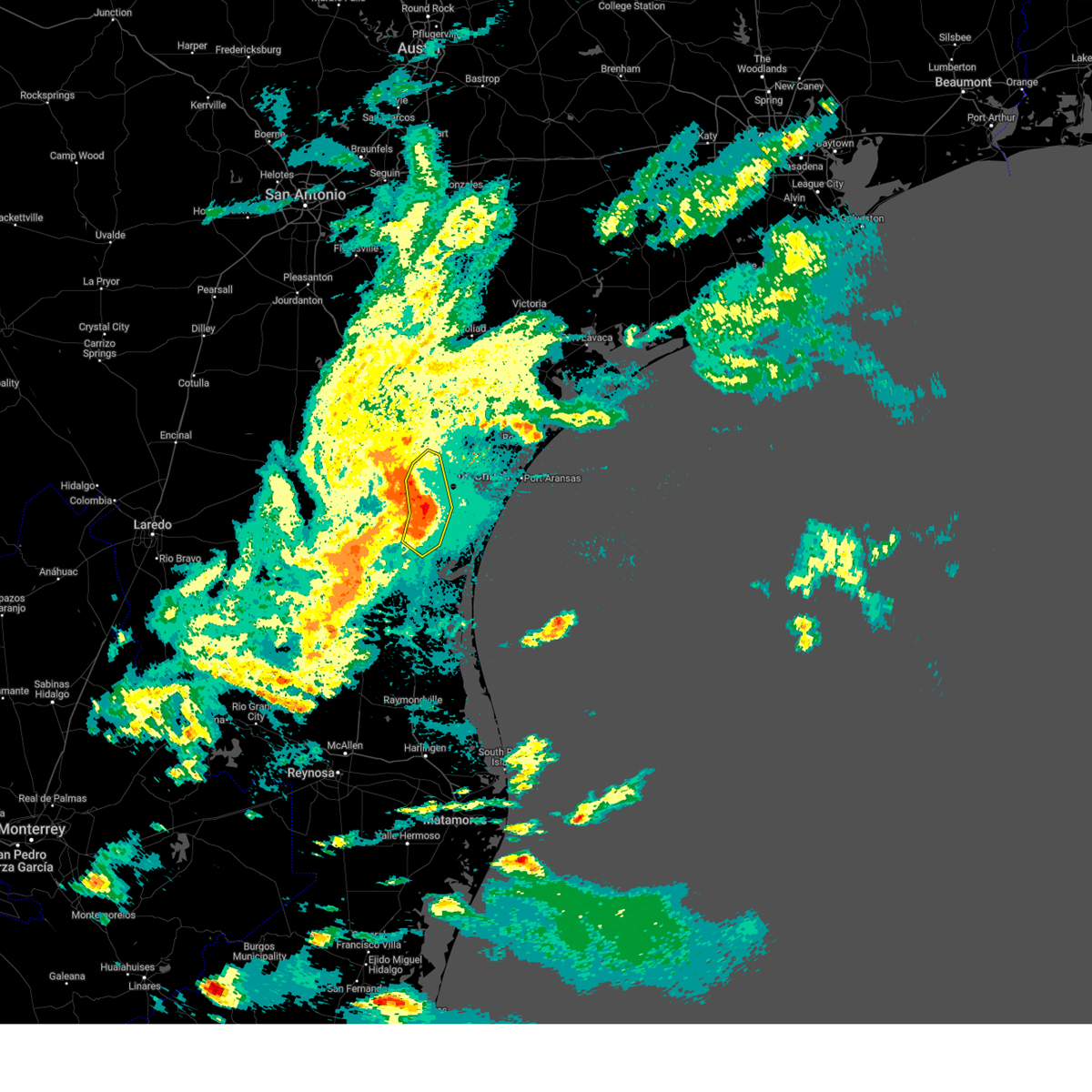
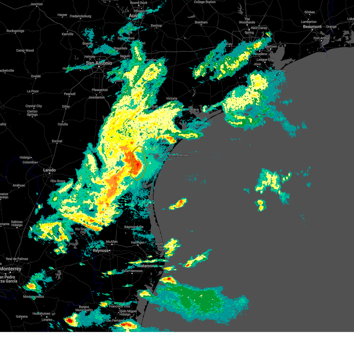
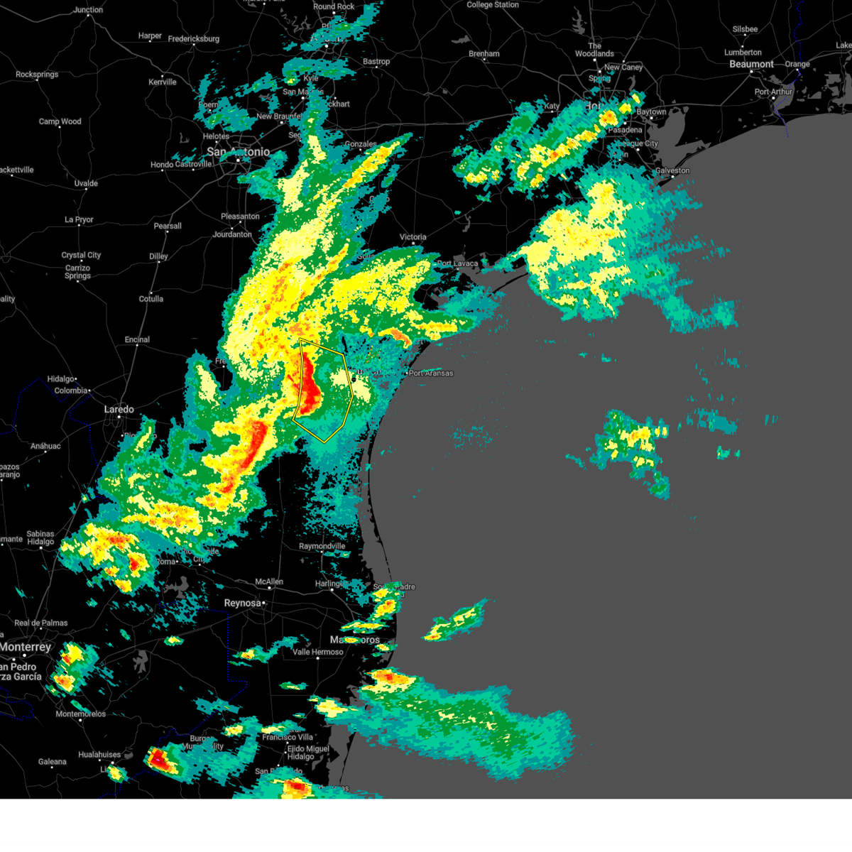
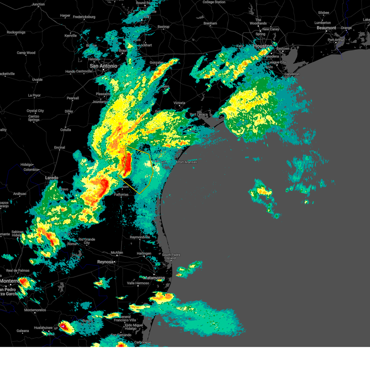
Hail Map for Bishop, TX
The Bishop, TX area has had 0 reports of on-the-ground hail by trained spotters, and has been under severe weather warnings 4 times during the past 12 months. Doppler radar has detected hail at or near Bishop, TX on 23 occasions, including 1 occasion during the past year.
| Name: | Bishop, TX |
| Where Located: | 28.2 miles WSW of Corpus Christi, TX |
| Map: | Google Map for Bishop, TX |
| Population: | 3134 |
| Housing Units: | 1270 |
| More Info: | Search Google for Bishop, TX |
2
The Top Recent Hail Date for Bishop, TX is Thursday, May 8, 2025 (5th out of 23)

Hail and Wind Damage Spotted near Bishop, TX
| Date / Time | Report Details |
|---|---|
| 5/8/2025 11:02 PM CDT | Multiple accidents reported along us 77. 2 18 wheelers flipped southbound. 1 18 wheeler reported flipped northboun in nueces county TX, 0.6 miles NW of Bishop, TX |
| 5/8/2025 10:29 PM CDT | Public reported overturned 18 wheeler at us-77 and fm 66 in nueces county TX, 5.7 miles SSW of Bishop, TX |
| 5/8/2025 10:07 PM CDT |
 the severe thunderstorm warning has been cancelled and is no longer in effect the severe thunderstorm warning has been cancelled and is no longer in effect
|
| 5/8/2025 10:07 PM CDT |
 At 1006 pm cdt, severe thunderstorms were located along a line extending from near robstown to near driscoll to near kingsville naval air station to ricardo, moving southeast at 35 mph (emergency management). Hazards include 70 mph wind gusts and nickel size hail. Expect considerable tree damage. damage is likely to mobile homes, roofs, and outbuildings. locations impacted include, corpus christi, kingsville, robstown, driscoll, bishop, odem, edroy, bluntzer, banquete, annaville, calallen, kingsville naval air station, petronila, and north san pedro. this includes the following highways, interstate 37 between mile markers 12 and 24. Us highway 77 between mile markers 656 and 688. At 1006 pm cdt, severe thunderstorms were located along a line extending from near robstown to near driscoll to near kingsville naval air station to ricardo, moving southeast at 35 mph (emergency management). Hazards include 70 mph wind gusts and nickel size hail. Expect considerable tree damage. damage is likely to mobile homes, roofs, and outbuildings. locations impacted include, corpus christi, kingsville, robstown, driscoll, bishop, odem, edroy, bluntzer, banquete, annaville, calallen, kingsville naval air station, petronila, and north san pedro. this includes the following highways, interstate 37 between mile markers 12 and 24. Us highway 77 between mile markers 656 and 688.
|
| 5/8/2025 9:46 PM CDT |
 At 945 pm cdt, severe thunderstorms were located along a line extending from near bluntzer to banquete to near bishop to 7 miles west of kingsville, moving southeast at 35 mph (emergency management). Hazards include 70 mph wind gusts and nickel size hail. Expect considerable tree damage. damage is likely to mobile homes, roofs, and outbuildings. locations impacted include, corpus christi, kingsville, robstown, driscoll, bishop, odem, orange grove, san patricio, ricardo, edroy, bluntzer, banquete, sandia, annaville, calallen, kingsville naval air station, alfred-south la paloma, agua dulce, petronila, and north san pedro. this includes the following highways, interstate 37 between mile markers 12 and 25. Us highway 77 between mile markers 656 and 702. At 945 pm cdt, severe thunderstorms were located along a line extending from near bluntzer to banquete to near bishop to 7 miles west of kingsville, moving southeast at 35 mph (emergency management). Hazards include 70 mph wind gusts and nickel size hail. Expect considerable tree damage. damage is likely to mobile homes, roofs, and outbuildings. locations impacted include, corpus christi, kingsville, robstown, driscoll, bishop, odem, orange grove, san patricio, ricardo, edroy, bluntzer, banquete, sandia, annaville, calallen, kingsville naval air station, alfred-south la paloma, agua dulce, petronila, and north san pedro. this includes the following highways, interstate 37 between mile markers 12 and 25. Us highway 77 between mile markers 656 and 702.
|
| 5/8/2025 9:25 PM CDT |
 Svrcrp the national weather service in corpus christi has issued a * severe thunderstorm warning for, nueces county in south central texas, southwestern san patricio county in south central texas, northern jim wells county in south central texas, southeastern live oak county in south central texas, western kleberg county in south central texas, * until 1015 pm cdt. * at 924 pm cdt, severe thunderstorms were located along a line extending from near westdale to alfred-south la paloma to near ben bolt to near palito blanco, moving southeast at 35 mph (radar indicated. wind observed by kali). Hazards include 70 mph wind gusts and quarter size hail. Hail damage to vehicles is expected. expect considerable tree damage. Wind damage is also likely to mobile homes, roofs, and outbuildings. Svrcrp the national weather service in corpus christi has issued a * severe thunderstorm warning for, nueces county in south central texas, southwestern san patricio county in south central texas, northern jim wells county in south central texas, southeastern live oak county in south central texas, western kleberg county in south central texas, * until 1015 pm cdt. * at 924 pm cdt, severe thunderstorms were located along a line extending from near westdale to alfred-south la paloma to near ben bolt to near palito blanco, moving southeast at 35 mph (radar indicated. wind observed by kali). Hazards include 70 mph wind gusts and quarter size hail. Hail damage to vehicles is expected. expect considerable tree damage. Wind damage is also likely to mobile homes, roofs, and outbuildings.
|
| 4/23/2023 10:55 AM CDT |
 At 1055 am cdt, severe thunderstorms were located along a line extending from near key allegro to near port aransas to near south texas botanical gardens, moving east at 45 mph (trained weather spotters). Hazards include 60 mph wind gusts and half dollar size hail. Hail damage to vehicles is expected. expect wind damage to roofs, siding, and trees. locations impacted include, corpus christi, kingsville, portland, robstown, rockport, port aransas, driscoll, corpus christi international airport, ingleside, aransas pass, bishop, gregory, ingleside on the bay, flour bluff, palm harbor, corpus christi north beach, kings crossing subdivision, padre balli park, bay area medical center and spohn hospital south. this includes the following highways, interstate 37 between mile markers 1 and 15. us highway 181 between mile markers 636 and 648. us highway 77 between mile markers 672 and 694. hail threat, radar indicated max hail size, 1. 25 in wind threat, observed max wind gust, 60 mph. At 1055 am cdt, severe thunderstorms were located along a line extending from near key allegro to near port aransas to near south texas botanical gardens, moving east at 45 mph (trained weather spotters). Hazards include 60 mph wind gusts and half dollar size hail. Hail damage to vehicles is expected. expect wind damage to roofs, siding, and trees. locations impacted include, corpus christi, kingsville, portland, robstown, rockport, port aransas, driscoll, corpus christi international airport, ingleside, aransas pass, bishop, gregory, ingleside on the bay, flour bluff, palm harbor, corpus christi north beach, kings crossing subdivision, padre balli park, bay area medical center and spohn hospital south. this includes the following highways, interstate 37 between mile markers 1 and 15. us highway 181 between mile markers 636 and 648. us highway 77 between mile markers 672 and 694. hail threat, radar indicated max hail size, 1. 25 in wind threat, observed max wind gust, 60 mph.
|
| 4/23/2023 10:33 AM CDT |
 At 1033 am cdt, severe thunderstorms were located along a line extending from near bayside to near ingleside on the bay to 7 miles southeast of driscoll, moving east at 45 mph (radar indicated). Hazards include 60 mph wind gusts and half dollar size hail. Hail damage to vehicles is expected. Expect wind damage to roofs, siding, and trees. At 1033 am cdt, severe thunderstorms were located along a line extending from near bayside to near ingleside on the bay to 7 miles southeast of driscoll, moving east at 45 mph (radar indicated). Hazards include 60 mph wind gusts and half dollar size hail. Hail damage to vehicles is expected. Expect wind damage to roofs, siding, and trees.
|
| 11/11/2022 7:41 PM CST |
 At 740 pm cst, a severe thunderstorm was located 12 miles north of riviera beach, or 15 miles east of kingsville, moving southeast at 25 mph (radar indicated). Hazards include 60 mph wind gusts and quarter size hail. Hail damage to vehicles is expected. Expect wind damage to roofs, siding, and trees. At 740 pm cst, a severe thunderstorm was located 12 miles north of riviera beach, or 15 miles east of kingsville, moving southeast at 25 mph (radar indicated). Hazards include 60 mph wind gusts and quarter size hail. Hail damage to vehicles is expected. Expect wind damage to roofs, siding, and trees.
|
| 11/1/2022 9:50 AM CDT |
 At 950 am cdt, a severe thunderstorm was located near bishop, or near driscoll, moving northeast at 25 mph (radar indicated). Hazards include 60 mph wind gusts. Expect damage to roofs, siding, and trees. locations impacted include, kingsville, driscoll, bishop, kingsville naval air station, petronila and chapman ranch. this includes us highway 77 between mile markers 676 and 690. hail threat, radar indicated max hail size, <. 75 in wind threat, observed max wind gust, 60 mph. At 950 am cdt, a severe thunderstorm was located near bishop, or near driscoll, moving northeast at 25 mph (radar indicated). Hazards include 60 mph wind gusts. Expect damage to roofs, siding, and trees. locations impacted include, kingsville, driscoll, bishop, kingsville naval air station, petronila and chapman ranch. this includes us highway 77 between mile markers 676 and 690. hail threat, radar indicated max hail size, <. 75 in wind threat, observed max wind gust, 60 mph.
|
| 11/1/2022 9:36 AM CDT |
 At 936 am cdt, a severe thunderstorm was located over kingsville naval air station, or near kingsville, moving northeast at 25 mph (radar indicated). Hazards include 60 mph wind gusts. expect damage to roofs, siding, and trees At 936 am cdt, a severe thunderstorm was located over kingsville naval air station, or near kingsville, moving northeast at 25 mph (radar indicated). Hazards include 60 mph wind gusts. expect damage to roofs, siding, and trees
|
| 7/1/2022 6:49 PM CDT |
 At 648 pm cdt, severe thunderstorms were located along a line extending from banquete to near driscoll to near kingsville naval air station, moving east at 20 mph (radar indicated). Hazards include 60 mph wind gusts. Expect damage to roofs, siding, and trees. locations impacted include, kingsville, robstown, driscoll, bishop, banquete, kingsville naval air station, petronila and north san pedro. this includes us highway 77 between mile markers 672 and 698. hail threat, radar indicated max hail size, <. 75 in wind threat, radar indicated max wind gust, 60 mph. At 648 pm cdt, severe thunderstorms were located along a line extending from banquete to near driscoll to near kingsville naval air station, moving east at 20 mph (radar indicated). Hazards include 60 mph wind gusts. Expect damage to roofs, siding, and trees. locations impacted include, kingsville, robstown, driscoll, bishop, banquete, kingsville naval air station, petronila and north san pedro. this includes us highway 77 between mile markers 672 and 698. hail threat, radar indicated max hail size, <. 75 in wind threat, radar indicated max wind gust, 60 mph.
|
| 7/1/2022 6:32 PM CDT |
 At 632 pm cdt, severe thunderstorms were located along a line extending from near banquete to near bishop to ricardo, moving east at 20 mph (radar indicated). Hazards include 60 mph wind gusts. expect damage to roofs, siding, and trees At 632 pm cdt, severe thunderstorms were located along a line extending from near banquete to near bishop to ricardo, moving east at 20 mph (radar indicated). Hazards include 60 mph wind gusts. expect damage to roofs, siding, and trees
|
| 7/1/2022 6:16 PM CDT |
 At 616 pm cdt, severe thunderstorms were located along a line extending from banquete to near bishop to near ricardo, moving east at 30 mph (radar indicated). Hazards include 60 mph wind gusts and penny size hail. Expect damage to roofs, siding, and trees. locations impacted include, kingsville, alice, robstown, driscoll, bishop, ben bolt, palito blanco, alice acres, banquete, kingsville naval air station, agua dulce and petronila. this includes the following highways, us highway 281 between mile markers 676 and 696. us highway 77 between mile markers 672 and 698. hail threat, radar indicated max hail size, 0. 75 in wind threat, radar indicated max wind gust, 60 mph. At 616 pm cdt, severe thunderstorms were located along a line extending from banquete to near bishop to near ricardo, moving east at 30 mph (radar indicated). Hazards include 60 mph wind gusts and penny size hail. Expect damage to roofs, siding, and trees. locations impacted include, kingsville, alice, robstown, driscoll, bishop, ben bolt, palito blanco, alice acres, banquete, kingsville naval air station, agua dulce and petronila. this includes the following highways, us highway 281 between mile markers 676 and 696. us highway 77 between mile markers 672 and 698. hail threat, radar indicated max hail size, 0. 75 in wind threat, radar indicated max wind gust, 60 mph.
|
| 7/1/2022 5:59 PM CDT |
 At 559 pm cdt, severe thunderstorms were located along a line extending from 6 miles south of alfred to near bishop to near ricardo, moving east at 30 mph (radar indicated). Hazards include 60 mph wind gusts and penny size hail. expect damage to roofs, siding, and trees At 559 pm cdt, severe thunderstorms were located along a line extending from 6 miles south of alfred to near bishop to near ricardo, moving east at 30 mph (radar indicated). Hazards include 60 mph wind gusts and penny size hail. expect damage to roofs, siding, and trees
|
| 5/22/2022 8:27 AM CDT |
 The severe thunderstorm warning for southwestern nueces, south central jim wells and western kleberg counties will expire at 830 am cdt, the storms which prompted the warning have weakened below severe limits, and no longer pose an immediate threat to life or property. therefore, the warning will be allowed to expire. however small hail and gusty winds are still possible with these thunderstorms. The severe thunderstorm warning for southwestern nueces, south central jim wells and western kleberg counties will expire at 830 am cdt, the storms which prompted the warning have weakened below severe limits, and no longer pose an immediate threat to life or property. therefore, the warning will be allowed to expire. however small hail and gusty winds are still possible with these thunderstorms.
|
| 5/22/2022 8:15 AM CDT |
 At 814 am cdt, severe thunderstorms were located along a line extending from 7 miles east of bishop to near riviera to 8 miles west of sarita, moving east at 25 mph (radar indicated). Hazards include 60 mph wind gusts and quarter size hail. Hail damage to vehicles is expected. expect wind damage to roofs, siding, and trees. locations impacted include, kingsville, bishop, riviera, ricardo, kingsville naval air station and loyola beach. this includes us highway 77 between mile markers 684 and 708. hail threat, radar indicated max hail size, 1. 00 in wind threat, radar indicated max wind gust, 60 mph. At 814 am cdt, severe thunderstorms were located along a line extending from 7 miles east of bishop to near riviera to 8 miles west of sarita, moving east at 25 mph (radar indicated). Hazards include 60 mph wind gusts and quarter size hail. Hail damage to vehicles is expected. expect wind damage to roofs, siding, and trees. locations impacted include, kingsville, bishop, riviera, ricardo, kingsville naval air station and loyola beach. this includes us highway 77 between mile markers 684 and 708. hail threat, radar indicated max hail size, 1. 00 in wind threat, radar indicated max wind gust, 60 mph.
|
| 5/22/2022 8:00 AM CDT |
 At 800 am cdt, severe thunderstorms were located along a line extending from bishop to near ricardo to near airport road addition, moving southeast at 20 mph (radar indicated). Hazards include 60 mph wind gusts and penny size hail. Expect damage to roofs, siding, and trees. locations impacted include, kingsville, premont, bishop, riviera, la gloria, ricardo, kingsville naval air station and loyola beach. this includes the following highways, us highway 281 between mile markers 688 and 708. us highway 77 between mile markers 682 and 708. hail threat, radar indicated max hail size, 0. 75 in wind threat, radar indicated max wind gust, 60 mph. At 800 am cdt, severe thunderstorms were located along a line extending from bishop to near ricardo to near airport road addition, moving southeast at 20 mph (radar indicated). Hazards include 60 mph wind gusts and penny size hail. Expect damage to roofs, siding, and trees. locations impacted include, kingsville, premont, bishop, riviera, la gloria, ricardo, kingsville naval air station and loyola beach. this includes the following highways, us highway 281 between mile markers 688 and 708. us highway 77 between mile markers 682 and 708. hail threat, radar indicated max hail size, 0. 75 in wind threat, radar indicated max wind gust, 60 mph.
|
| 5/22/2022 7:40 AM CDT |
 At 740 am cdt, severe thunderstorms were located along a line extending from 6 miles west of driscoll to premont, moving southeast at 15 mph (radar indicated). Hazards include 60 mph wind gusts and quarter size hail. Hail damage to vehicles is expected. Expect wind damage to roofs, siding, and trees. At 740 am cdt, severe thunderstorms were located along a line extending from 6 miles west of driscoll to premont, moving southeast at 15 mph (radar indicated). Hazards include 60 mph wind gusts and quarter size hail. Hail damage to vehicles is expected. Expect wind damage to roofs, siding, and trees.
|
| 6/14/2021 8:16 PM CDT |
 At 816 pm cdt, a severe thunderstorm was located 9 miles northwest of bishop, or 10 miles northwest of kingsville, moving southwest at 25 mph (radar indicated). Hazards include 60 mph wind gusts and nickel size hail. expect damage to roofs, siding, and trees At 816 pm cdt, a severe thunderstorm was located 9 miles northwest of bishop, or 10 miles northwest of kingsville, moving southwest at 25 mph (radar indicated). Hazards include 60 mph wind gusts and nickel size hail. expect damage to roofs, siding, and trees
|
| 6/14/2021 7:50 PM CDT |
 At 750 pm cdt, a severe thunderstorm was located over banquete, or 9 miles west of robstown, moving southwest at 10 mph (radar indicated). Hazards include 60 mph wind gusts and nickel size hail. expect damage to roofs, siding, and trees At 750 pm cdt, a severe thunderstorm was located over banquete, or 9 miles west of robstown, moving southwest at 10 mph (radar indicated). Hazards include 60 mph wind gusts and nickel size hail. expect damage to roofs, siding, and trees
|
| 5/18/2021 2:06 AM CDT |
 At 206 am cdt, severe thunderstorms were located along a line extending from near midway to near bluntzer to 6 miles east of driscoll, moving northeast at 50 mph (radar indicated). Hazards include 70 mph wind gusts and penny size hail. Expect considerable tree damage. damage is likely to mobile homes, roofs, and outbuildings. these severe storms will be near, sandia around 215 am cdt. other locations impacted by these severe thunderstorms include pernitas point, agua dulce and lake alice. this includes the following highways, us highway 281 between mile markers 656 and 678. Us highway 77 between mile markers 674 and 682. At 206 am cdt, severe thunderstorms were located along a line extending from near midway to near bluntzer to 6 miles east of driscoll, moving northeast at 50 mph (radar indicated). Hazards include 70 mph wind gusts and penny size hail. Expect considerable tree damage. damage is likely to mobile homes, roofs, and outbuildings. these severe storms will be near, sandia around 215 am cdt. other locations impacted by these severe thunderstorms include pernitas point, agua dulce and lake alice. this includes the following highways, us highway 281 between mile markers 656 and 678. Us highway 77 between mile markers 674 and 682.
|
| 5/18/2021 1:43 AM CDT |
 At 143 am cdt, severe thunderstorms were located along a line extending from near tecalote to kingsville naval air station to riviera beach, moving east at 50 mph (radar indicated). Hazards include 70 mph wind gusts and penny size hail. Expect considerable tree damage. damage is likely to mobile homes, roofs, and outbuildings. severe thunderstorms will be near, riviera beach around 150 am cdt. alfred-south la paloma around 200 am cdt. banquete around 210 am cdt. other locations impacted by these severe thunderstorms include loyola beach, pernitas point, agua dulce, lake alice and petronila. this includes the following highways, us highway 281 between mile markers 656 and 708. Us highway 77 between mile markers 674 and 708. At 143 am cdt, severe thunderstorms were located along a line extending from near tecalote to kingsville naval air station to riviera beach, moving east at 50 mph (radar indicated). Hazards include 70 mph wind gusts and penny size hail. Expect considerable tree damage. damage is likely to mobile homes, roofs, and outbuildings. severe thunderstorms will be near, riviera beach around 150 am cdt. alfred-south la paloma around 200 am cdt. banquete around 210 am cdt. other locations impacted by these severe thunderstorms include loyola beach, pernitas point, agua dulce, lake alice and petronila. this includes the following highways, us highway 281 between mile markers 656 and 708. Us highway 77 between mile markers 674 and 708.
|
| 8/20/2020 6:44 PM CDT |
 At 643 pm cdt, a severe thunderstorm was located over palito blanco, or 12 miles south of san diego, moving southeast at 25 mph (radar indicated). Hazards include 60 mph wind gusts and quarter size hail. Hail damage to vehicles is expected. Expect wind damage to roofs, siding, and trees. At 643 pm cdt, a severe thunderstorm was located over palito blanco, or 12 miles south of san diego, moving southeast at 25 mph (radar indicated). Hazards include 60 mph wind gusts and quarter size hail. Hail damage to vehicles is expected. Expect wind damage to roofs, siding, and trees.
|
| 8/18/2020 7:02 PM CDT |
 At 702 pm cdt, severe thunderstorms were located along a line extending from 7 miles east of ben bolt to near driscoll, moving southwest at 10 mph (radar indicated). Hazards include 60 mph wind gusts and quarter size hail. Hail damage to vehicles is expected. expect wind damage to roofs, siding, and trees. Locations impacted include, kingsville, alice, robstown, driscoll, bishop, ben bolt, kingsville naval air station, alice acres and petronila. At 702 pm cdt, severe thunderstorms were located along a line extending from 7 miles east of ben bolt to near driscoll, moving southwest at 10 mph (radar indicated). Hazards include 60 mph wind gusts and quarter size hail. Hail damage to vehicles is expected. expect wind damage to roofs, siding, and trees. Locations impacted include, kingsville, alice, robstown, driscoll, bishop, ben bolt, kingsville naval air station, alice acres and petronila.
|
| 8/18/2020 6:26 PM CDT |
 At 626 pm cdt, severe thunderstorms were located along a line extending from 9 miles southwest of banquete to near driscoll, moving southwest at 10 mph (radar indicated). Hazards include 60 mph wind gusts and quarter size hail. Hail damage to vehicles is expected. Expect wind damage to roofs, siding, and trees. At 626 pm cdt, severe thunderstorms were located along a line extending from 9 miles southwest of banquete to near driscoll, moving southwest at 10 mph (radar indicated). Hazards include 60 mph wind gusts and quarter size hail. Hail damage to vehicles is expected. Expect wind damage to roofs, siding, and trees.
|
| 8/18/2020 6:00 PM CDT |
 At 600 pm cdt, severe thunderstorms were located along a line extending from near annaville to near clarkwood to near driscoll, moving south at 40 mph (radar indicated). Hazards include 60 mph wind gusts and quarter size hail. Hail damage to vehicles is expected. Expect wind damage to roofs, siding, and trees. At 600 pm cdt, severe thunderstorms were located along a line extending from near annaville to near clarkwood to near driscoll, moving south at 40 mph (radar indicated). Hazards include 60 mph wind gusts and quarter size hail. Hail damage to vehicles is expected. Expect wind damage to roofs, siding, and trees.
|
| 7/25/2020 7:33 PM CDT |
 At 732 pm cdt, a severe thunderstorm capable of producing a tornado was located near palito blanco, or 12 miles north of premont, moving southwest at 40 mph (radar indicated rotation). Hazards include tornado. Flying debris will be dangerous to those caught without shelter. mobile homes will be damaged or destroyed. damage to roofs, windows, and vehicles will occur. tree damage is likely. Locations impacted include, kingsville and bishop. At 732 pm cdt, a severe thunderstorm capable of producing a tornado was located near palito blanco, or 12 miles north of premont, moving southwest at 40 mph (radar indicated rotation). Hazards include tornado. Flying debris will be dangerous to those caught without shelter. mobile homes will be damaged or destroyed. damage to roofs, windows, and vehicles will occur. tree damage is likely. Locations impacted include, kingsville and bishop.
|
| 7/25/2020 7:08 PM CDT |
 At 708 pm cdt, a severe thunderstorm capable of producing a tornado was located near bishop, or 7 miles north of kingsville, moving west at 40 mph (radar indicated rotation). Hazards include tornado. Flying debris will be dangerous to those caught without shelter. mobile homes will be damaged or destroyed. damage to roofs, windows, and vehicles will occur. tree damage is likely. This tornadic thunderstorm will remain over mainly rural areas of southwestern nueces, southwestern jim wells and northwestern kleberg counties. At 708 pm cdt, a severe thunderstorm capable of producing a tornado was located near bishop, or 7 miles north of kingsville, moving west at 40 mph (radar indicated rotation). Hazards include tornado. Flying debris will be dangerous to those caught without shelter. mobile homes will be damaged or destroyed. damage to roofs, windows, and vehicles will occur. tree damage is likely. This tornadic thunderstorm will remain over mainly rural areas of southwestern nueces, southwestern jim wells and northwestern kleberg counties.
|
| 5/16/2020 1:37 AM CDT |
 At 137 am cdt, severe thunderstorms were located along a line extending from 6 miles southwest of woodsboro to near kingsville, moving east at 45 mph (radar indicated). Hazards include 60 mph wind gusts and penny size hail. expect damage to roofs, siding, and trees At 137 am cdt, severe thunderstorms were located along a line extending from 6 miles southwest of woodsboro to near kingsville, moving east at 45 mph (radar indicated). Hazards include 60 mph wind gusts and penny size hail. expect damage to roofs, siding, and trees
|
| 6/11/2019 7:42 PM CDT |
 The severe thunderstorm warning for southwestern nueces and northeastern kleberg counties will expire at 745 pm cdt, the storm which prompted the warning has weakened below severe limits. therefore, the warning will be allowed to expire. however gusty winds are still possible with this thunderstorm. The severe thunderstorm warning for southwestern nueces and northeastern kleberg counties will expire at 745 pm cdt, the storm which prompted the warning has weakened below severe limits. therefore, the warning will be allowed to expire. however gusty winds are still possible with this thunderstorm.
|
| 6/11/2019 7:21 PM CDT |
 At 720 pm cdt, a severe thunderstorm was located near bishop, or 9 miles southeast of driscoll, moving southeast at 25 mph (radar indicated). Hazards include 60 mph wind gusts. expect damage to roofs, siding, and trees At 720 pm cdt, a severe thunderstorm was located near bishop, or 9 miles southeast of driscoll, moving southeast at 25 mph (radar indicated). Hazards include 60 mph wind gusts. expect damage to roofs, siding, and trees
|
| 6/6/2019 7:39 PM CDT |
 At 738 pm cdt, a severe thunderstorm was located 12 miles southwest of kings crossing golf course, or 12 miles southeast of driscoll, moving east at 25 mph. this is a very dangerous storm (radar indicated). Hazards include 80 mph wind gusts and ping pong ball size hail. Flying debris will be dangerous to those caught without shelter. mobile homes will be heavily damaged. expect considerable damage to roofs, windows, and vehicles. extensive tree damage and power outages are likely. Locations impacted include, corpus christi, kingsville, driscoll, bishop, riviera beach, ricardo, malaquite beach, kingsville naval air station, petronila, loyola beach and chapman ranch. At 738 pm cdt, a severe thunderstorm was located 12 miles southwest of kings crossing golf course, or 12 miles southeast of driscoll, moving east at 25 mph. this is a very dangerous storm (radar indicated). Hazards include 80 mph wind gusts and ping pong ball size hail. Flying debris will be dangerous to those caught without shelter. mobile homes will be heavily damaged. expect considerable damage to roofs, windows, and vehicles. extensive tree damage and power outages are likely. Locations impacted include, corpus christi, kingsville, driscoll, bishop, riviera beach, ricardo, malaquite beach, kingsville naval air station, petronila, loyola beach and chapman ranch.
|
| 6/6/2019 7:26 PM CDT |
 At 725 pm cdt, a severe thunderstorm was located 7 miles southeast of driscoll, moving east at 25 mph (radar indicated). Hazards include ping pong ball size hail and 60 mph wind gusts. People and animals outdoors will be injured. expect hail damage to roofs, siding, windows, and vehicles. expect wind damage to roofs, siding, and trees. Locations impacted include, corpus christi, kingsville, driscoll, bishop, riviera beach, ricardo, malaquite beach, kingsville naval air station, petronila, loyola beach and chapman ranch. At 725 pm cdt, a severe thunderstorm was located 7 miles southeast of driscoll, moving east at 25 mph (radar indicated). Hazards include ping pong ball size hail and 60 mph wind gusts. People and animals outdoors will be injured. expect hail damage to roofs, siding, windows, and vehicles. expect wind damage to roofs, siding, and trees. Locations impacted include, corpus christi, kingsville, driscoll, bishop, riviera beach, ricardo, malaquite beach, kingsville naval air station, petronila, loyola beach and chapman ranch.
|
| 6/6/2019 7:13 PM CDT |
 At 712 pm cdt, a severe thunderstorm was located near driscoll, moving east at 25 mph (radar indicated). Hazards include 60 mph wind gusts and quarter size hail. Hail damage to vehicles is expected. Expect wind damage to roofs, siding, and trees. At 712 pm cdt, a severe thunderstorm was located near driscoll, moving east at 25 mph (radar indicated). Hazards include 60 mph wind gusts and quarter size hail. Hail damage to vehicles is expected. Expect wind damage to roofs, siding, and trees.
|
| 6/6/2019 7:06 PM CDT |
 At 705 pm cdt, a severe thunderstorm was located near driscoll, moving east at 35 mph (radar indicated). Hazards include 60 mph wind gusts and half dollar size hail. Hail damage to vehicles is expected. expect wind damage to roofs, siding, and trees. Locations impacted include, kingsville, alice, robstown, driscoll, bishop, ben bolt, alice acres, agua dulce, petronila and lake alice. At 705 pm cdt, a severe thunderstorm was located near driscoll, moving east at 35 mph (radar indicated). Hazards include 60 mph wind gusts and half dollar size hail. Hail damage to vehicles is expected. expect wind damage to roofs, siding, and trees. Locations impacted include, kingsville, alice, robstown, driscoll, bishop, ben bolt, alice acres, agua dulce, petronila and lake alice.
|
| 6/6/2019 6:44 PM CDT |
 At 643 pm cdt, a severe thunderstorm was located 8 miles west of driscoll, moving east at 35 mph (radar indicated). Hazards include 60 mph wind gusts and half dollar size hail. Hail damage to vehicles is expected. Expect wind damage to roofs, siding, and trees. At 643 pm cdt, a severe thunderstorm was located 8 miles west of driscoll, moving east at 35 mph (radar indicated). Hazards include 60 mph wind gusts and half dollar size hail. Hail damage to vehicles is expected. Expect wind damage to roofs, siding, and trees.
|
| 5/6/2019 12:27 PM CDT |
 The severe thunderstorm warning for southern nueces, south central jim wells and kleberg counties will expire at 1230 pm cdt, the storms which prompted the warning have weakened below severe limits, and have exited the warned area. therefore, the warning will be allowed to expire. however gusty winds are still possible with these thunderstorms. remember, a severe thunderstorm warning still remains in effect for nueces and san patricio counties. The severe thunderstorm warning for southern nueces, south central jim wells and kleberg counties will expire at 1230 pm cdt, the storms which prompted the warning have weakened below severe limits, and have exited the warned area. therefore, the warning will be allowed to expire. however gusty winds are still possible with these thunderstorms. remember, a severe thunderstorm warning still remains in effect for nueces and san patricio counties.
|
| 5/6/2019 11:50 AM CDT |
 At 1150 am cdt, severe thunderstorms were located along a line extending from near ben bolt to ricardo to 8 miles southwest of sarita, moving east at 40 mph (radar indicated). Hazards include 60 mph wind gusts and penny size hail. expect damage to roofs, siding, and trees At 1150 am cdt, severe thunderstorms were located along a line extending from near ben bolt to ricardo to 8 miles southwest of sarita, moving east at 40 mph (radar indicated). Hazards include 60 mph wind gusts and penny size hail. expect damage to roofs, siding, and trees
|
| 5/3/2019 9:25 AM CDT |
 The severe thunderstorm warning for nueces, san patricio and northeastern jim wells counties will expire at 930 am cdt, the storm which prompted the warning has weakened below severe limits, and no longer poses an immediate threat to life or property. therefore, the warning will be allowed to expire. however gusty winds are still possible. a severe thunderstorm watch remains in effect until 100 pm cdt for south central texas. The severe thunderstorm warning for nueces, san patricio and northeastern jim wells counties will expire at 930 am cdt, the storm which prompted the warning has weakened below severe limits, and no longer poses an immediate threat to life or property. therefore, the warning will be allowed to expire. however gusty winds are still possible. a severe thunderstorm watch remains in effect until 100 pm cdt for south central texas.
|
| 5/3/2019 9:14 AM CDT |
 At 914 am cdt, a severe thunderstorm was located 7 miles northwest of corpus christi north beach, or 7 miles southwest of taft, moving northeast at 40 mph (radar indicated). Hazards include 60 mph wind gusts. Expect damage to roofs, siding, and trees. locations impacted include, corpus christi, portland, robstown, sinton, mathis, port aransas, taft, driscoll, corpus christi international airport, ingleside, aransas pass, bishop, odem, gregory, orange grove, st. Paul, ingleside on the bay, san patricio, christus spohn hospital south and corpus christi north beach. At 914 am cdt, a severe thunderstorm was located 7 miles northwest of corpus christi north beach, or 7 miles southwest of taft, moving northeast at 40 mph (radar indicated). Hazards include 60 mph wind gusts. Expect damage to roofs, siding, and trees. locations impacted include, corpus christi, portland, robstown, sinton, mathis, port aransas, taft, driscoll, corpus christi international airport, ingleside, aransas pass, bishop, odem, gregory, orange grove, st. Paul, ingleside on the bay, san patricio, christus spohn hospital south and corpus christi north beach.
|
| 5/3/2019 9:02 AM CDT |
 At 902 am cdt, a severe thunderstorm was located over annaville, or near robstown, moving northeast at 40 mph (radar indicated). Hazards include 70 mph wind gusts. Expect considerable tree damage. damage is likely to mobile homes, roofs, and outbuildings. locations impacted include, corpus christi, kingsville, alice, portland, robstown, sinton, mathis, port aransas, taft, driscoll, corpus christi international airport, skidmore, ingleside, aransas pass, bishop, odem, gregory, orange grove, st. Paul and ingleside on the bay. At 902 am cdt, a severe thunderstorm was located over annaville, or near robstown, moving northeast at 40 mph (radar indicated). Hazards include 70 mph wind gusts. Expect considerable tree damage. damage is likely to mobile homes, roofs, and outbuildings. locations impacted include, corpus christi, kingsville, alice, portland, robstown, sinton, mathis, port aransas, taft, driscoll, corpus christi international airport, skidmore, ingleside, aransas pass, bishop, odem, gregory, orange grove, st. Paul and ingleside on the bay.
|
| 5/3/2019 8:26 AM CDT |
 At 825 am cdt, a severe thunderstorm was located 8 miles southeast of alice, moving northeast at 40 mph. this is a very dangerous storm (radar indicated). Hazards include 80 mph wind gusts. Flying debris will be dangerous to those caught without shelter. mobile homes will be heavily damaged. expect considerable damage to roofs, windows, and vehicles. Extensive tree damage and power outages are likely. At 825 am cdt, a severe thunderstorm was located 8 miles southeast of alice, moving northeast at 40 mph. this is a very dangerous storm (radar indicated). Hazards include 80 mph wind gusts. Flying debris will be dangerous to those caught without shelter. mobile homes will be heavily damaged. expect considerable damage to roofs, windows, and vehicles. Extensive tree damage and power outages are likely.
|
| 4/7/2019 7:14 AM CDT |
 At 713 am cdt, severe thunderstorms were located along a line extending from argenta to 6 miles east of alice to premont, moving east at 40 mph (radar indicated). Hazards include 70 mph wind gusts and quarter size hail. Hail damage to vehicles is expected. expect considerable tree damage. wind damage is also likely to mobile homes, roofs, and outbuildings. Locations impacted include, kingsville, alice, robstown, mathis, san diego, premont, george west, driscoll, skidmore, bishop, orange grove, lake city, san patricio, midway, edroy, river creek acres, banquete, tynan, san jose and sandia. At 713 am cdt, severe thunderstorms were located along a line extending from argenta to 6 miles east of alice to premont, moving east at 40 mph (radar indicated). Hazards include 70 mph wind gusts and quarter size hail. Hail damage to vehicles is expected. expect considerable tree damage. wind damage is also likely to mobile homes, roofs, and outbuildings. Locations impacted include, kingsville, alice, robstown, mathis, san diego, premont, george west, driscoll, skidmore, bishop, orange grove, lake city, san patricio, midway, edroy, river creek acres, banquete, tynan, san jose and sandia.
|
| 4/7/2019 6:51 AM CDT |
 At 650 am cdt, severe thunderstorms were located along a line extending from near river creek acres to near tecalote to rios, moving east at 45 mph (radar indicated). Hazards include 60 mph wind gusts and nickel size hail. expect damage to roofs, siding, and trees At 650 am cdt, severe thunderstorms were located along a line extending from near river creek acres to near tecalote to rios, moving east at 45 mph (radar indicated). Hazards include 60 mph wind gusts and nickel size hail. expect damage to roofs, siding, and trees
|
| 4/14/2018 2:09 AM CDT |
 At 208 am cdt, severe thunderstorms were located along a line extending from edroy to near ben bolt, moving southeast at 50 mph (radar indicated). Hazards include 60 mph wind gusts. Expect damage to roofs, siding, and trees. Locations impacted include, corpus christi, kingsville, alice, portland, robstown, mathis, port aransas, driscoll, corpus christi international airport, ingleside, aransas pass, bishop, odem, gregory, orange grove, ingleside on the bay, san patricio, christus spohn hospital south, corpus christi north beach and bay area medical center. At 208 am cdt, severe thunderstorms were located along a line extending from edroy to near ben bolt, moving southeast at 50 mph (radar indicated). Hazards include 60 mph wind gusts. Expect damage to roofs, siding, and trees. Locations impacted include, corpus christi, kingsville, alice, portland, robstown, mathis, port aransas, driscoll, corpus christi international airport, ingleside, aransas pass, bishop, odem, gregory, orange grove, ingleside on the bay, san patricio, christus spohn hospital south, corpus christi north beach and bay area medical center.
|
| 4/14/2018 1:58 AM CDT |
 At 157 am cdt, severe thunderstorms were located along a line extending from near west sinton to near alice acres, moving southeast at 50 mph (radar indicated). Hazards include 60 mph wind gusts. expect damage to roofs, siding, and trees At 157 am cdt, severe thunderstorms were located along a line extending from near west sinton to near alice acres, moving southeast at 50 mph (radar indicated). Hazards include 60 mph wind gusts. expect damage to roofs, siding, and trees
|
| 3/29/2018 12:56 AM CDT |
 At 1255 am cdt, severe thunderstorms were located along a line extending from near oak village to near sinton to near driscoll, moving east at 45 mph (radar indicated). Hazards include 70 mph wind gusts and penny size hail. Expect considerable tree damage. Damage is likely to mobile homes, roofs, and outbuildings. At 1255 am cdt, severe thunderstorms were located along a line extending from near oak village to near sinton to near driscoll, moving east at 45 mph (radar indicated). Hazards include 70 mph wind gusts and penny size hail. Expect considerable tree damage. Damage is likely to mobile homes, roofs, and outbuildings.
|
| 3/29/2018 12:47 AM CDT |
 At 1247 am cdt, severe thunderstorms were located along a line extending from near schroeder to sinton to 9 miles east of ben bolt, moving east at 45 mph (radar indicated). Hazards include 70 mph wind gusts and penny size hail. Expect considerable tree damage. damage is likely to mobile homes, roofs, and outbuildings. Locations impacted include, corpus christi, victoria, portland, robstown, sinton, mathis, taft, refugio, goliad, woodsboro, driscoll, mcfaddin, corpus christi international airport, skidmore, guadalupe, fannin, bishop, odem, gregory and orange grove. At 1247 am cdt, severe thunderstorms were located along a line extending from near schroeder to sinton to 9 miles east of ben bolt, moving east at 45 mph (radar indicated). Hazards include 70 mph wind gusts and penny size hail. Expect considerable tree damage. damage is likely to mobile homes, roofs, and outbuildings. Locations impacted include, corpus christi, victoria, portland, robstown, sinton, mathis, taft, refugio, goliad, woodsboro, driscoll, mcfaddin, corpus christi international airport, skidmore, guadalupe, fannin, bishop, odem, gregory and orange grove.
|
| 3/29/2018 12:33 AM CDT |
 At 1232 am cdt, severe thunderstorms were located along a line extending from near weesatche to near west sinton to near alice acres, moving east at 45 mph (radar indicated). Hazards include 70 mph wind gusts and penny size hail. Expect considerable tree damage. damage is likely to mobile homes, roofs, and outbuildings. Locations impacted include, corpus christi, victoria, alice, portland, beeville, robstown, sinton, mathis, san diego, taft, refugio, george west, goliad, woodsboro, driscoll, mcfaddin, corpus christi international airport, skidmore, guadalupe and fannin. At 1232 am cdt, severe thunderstorms were located along a line extending from near weesatche to near west sinton to near alice acres, moving east at 45 mph (radar indicated). Hazards include 70 mph wind gusts and penny size hail. Expect considerable tree damage. damage is likely to mobile homes, roofs, and outbuildings. Locations impacted include, corpus christi, victoria, alice, portland, beeville, robstown, sinton, mathis, san diego, taft, refugio, george west, goliad, woodsboro, driscoll, mcfaddin, corpus christi international airport, skidmore, guadalupe and fannin.
|
| 3/29/2018 12:14 AM CDT |
 At 1213 am cdt, severe thunderstorms were located along a line extending from near charco to near sandia to near benavides, moving east at 45 mph (radar indicated). Hazards include 70 mph wind gusts. Expect considerable tree damage. Damage is likely to mobile homes, roofs, and outbuildings. At 1213 am cdt, severe thunderstorms were located along a line extending from near charco to near sandia to near benavides, moving east at 45 mph (radar indicated). Hazards include 70 mph wind gusts. Expect considerable tree damage. Damage is likely to mobile homes, roofs, and outbuildings.
|
| 6/5/2017 2:55 PM CDT |
 At 255 pm cdt, a severe thunderstorm was located 7 miles east of driscoll, moving east at 20 mph (radar indicated). Hazards include golf ball size hail and 70 mph wind gusts. People and animals outdoors will be injured. expect hail damage to roofs, siding, windows, and vehicles. expect considerable tree damage. wind damage is also likely to mobile homes, roofs, and outbuildings. Locations impacted include, robstown, driscoll, bishop and petronila. At 255 pm cdt, a severe thunderstorm was located 7 miles east of driscoll, moving east at 20 mph (radar indicated). Hazards include golf ball size hail and 70 mph wind gusts. People and animals outdoors will be injured. expect hail damage to roofs, siding, windows, and vehicles. expect considerable tree damage. wind damage is also likely to mobile homes, roofs, and outbuildings. Locations impacted include, robstown, driscoll, bishop and petronila.
|
| 6/5/2017 2:42 PM CDT |
 At 242 pm cdt, a severe thunderstorm was located over driscoll, moving east at 20 mph (radar indicated). Hazards include golf ball size hail and 70 mph wind gusts. People and animals outdoors will be injured. expect hail damage to roofs, siding, windows, and vehicles. expect considerable tree damage. wind damage is also likely to mobile homes, roofs, and outbuildings. Locations impacted include, driscoll, bishop and petronila. At 242 pm cdt, a severe thunderstorm was located over driscoll, moving east at 20 mph (radar indicated). Hazards include golf ball size hail and 70 mph wind gusts. People and animals outdoors will be injured. expect hail damage to roofs, siding, windows, and vehicles. expect considerable tree damage. wind damage is also likely to mobile homes, roofs, and outbuildings. Locations impacted include, driscoll, bishop and petronila.
|
| 6/5/2017 2:34 PM CDT |
 At 234 pm cdt, a severe thunderstorm was located over driscoll, moving east at 20 mph (radar indicated). Hazards include 60 mph wind gusts and quarter size hail. Hail damage to vehicles is expected. Expect wind damage to roofs, siding, and trees. At 234 pm cdt, a severe thunderstorm was located over driscoll, moving east at 20 mph (radar indicated). Hazards include 60 mph wind gusts and quarter size hail. Hail damage to vehicles is expected. Expect wind damage to roofs, siding, and trees.
|
| 5/29/2017 2:44 AM CDT |
 At 243 am cdt, a severe thunderstorm was located near edroy, or 8 miles north of robstown, moving northeast at 50 mph (radar indicated). Hazards include 70 mph wind gusts. Expect considerable tree damage. damage is likely to mobile homes, roofs, and outbuildings. Locations impacted include, kingsville, alice, robstown, driscoll, bishop, riviera beach, ricardo, alfred-south la paloma, bluntzer, banquete, ben bolt, riviera, tecalote, alice acres, alfred, kingsville naval air station, agua dulce, petronila, loyola beach and north san pedro. At 243 am cdt, a severe thunderstorm was located near edroy, or 8 miles north of robstown, moving northeast at 50 mph (radar indicated). Hazards include 70 mph wind gusts. Expect considerable tree damage. damage is likely to mobile homes, roofs, and outbuildings. Locations impacted include, kingsville, alice, robstown, driscoll, bishop, riviera beach, ricardo, alfred-south la paloma, bluntzer, banquete, ben bolt, riviera, tecalote, alice acres, alfred, kingsville naval air station, agua dulce, petronila, loyola beach and north san pedro.
|
| 5/29/2017 2:19 AM CDT |
 At 218 am cdt, a severe thunderstorm was located near alfred, or near alice, moving northeast at 50 mph (radar indicated). Hazards include 70 mph wind gusts. Expect considerable tree damage. Damage is likely to mobile homes, roofs, and outbuildings. At 218 am cdt, a severe thunderstorm was located near alfred, or near alice, moving northeast at 50 mph (radar indicated). Hazards include 70 mph wind gusts. Expect considerable tree damage. Damage is likely to mobile homes, roofs, and outbuildings.
|
| 4/17/2017 4:30 AM CDT |
 At 430 am cdt, severe thunderstorms were located along a line extending from near alfred to la gloria, moving east at 50 mph (radar indicated). Hazards include 60 mph wind gusts and penny size hail. Expect damage to roofs, siding, and trees. Locations impacted include, kingsville, alice, san diego, premont, benavides, bishop, ricardo, alfred-south la paloma, ramirez, bluntzer, banquete, san jose, ben bolt, concepcion, tecalote, palito blanco, la gloria, cruz calle, alice acres and alfred. At 430 am cdt, severe thunderstorms were located along a line extending from near alfred to la gloria, moving east at 50 mph (radar indicated). Hazards include 60 mph wind gusts and penny size hail. Expect damage to roofs, siding, and trees. Locations impacted include, kingsville, alice, san diego, premont, benavides, bishop, ricardo, alfred-south la paloma, ramirez, bluntzer, banquete, san jose, ben bolt, concepcion, tecalote, palito blanco, la gloria, cruz calle, alice acres and alfred.
|
| 4/17/2017 4:01 AM CDT |
 At 400 am cdt, severe thunderstorms were located along a line extending from 8 miles southeast of seven sisters to 7 miles west of ramirez, moving east at 50 mph (radar indicated). Hazards include 60 mph wind gusts and penny size hail. expect damage to roofs, siding, and trees At 400 am cdt, severe thunderstorms were located along a line extending from 8 miles southeast of seven sisters to 7 miles west of ramirez, moving east at 50 mph (radar indicated). Hazards include 60 mph wind gusts and penny size hail. expect damage to roofs, siding, and trees
|
| 10/20/2016 4:49 PM CDT |
 At 448 pm cdt, a severe thunderstorm was located near bishop, or near driscoll, moving southwest at 30 mph (radar indicated). Hazards include 60 mph wind gusts and penny size hail. Expect damage to roofs. siding. And trees. At 448 pm cdt, a severe thunderstorm was located near bishop, or near driscoll, moving southwest at 30 mph (radar indicated). Hazards include 60 mph wind gusts and penny size hail. Expect damage to roofs. siding. And trees.
|
| 6/2/2016 3:49 PM CDT |
 At 348 pm cdt, a severe thunderstorm was located 8 miles east of driscoll, moving east at 20 mph (radar indicated). Hazards include quarter size hail with 60 mph wind gusts. Hail damage to vehicles is expected. expect wind damage to roofs, siding, and trees. Locations impacted include, driscoll, bishop and petronila. At 348 pm cdt, a severe thunderstorm was located 8 miles east of driscoll, moving east at 20 mph (radar indicated). Hazards include quarter size hail with 60 mph wind gusts. Hail damage to vehicles is expected. expect wind damage to roofs, siding, and trees. Locations impacted include, driscoll, bishop and petronila.
|
| 6/2/2016 3:33 PM CDT |
 At 332 pm cdt, a severe thunderstorm was located over driscoll, moving east at 20 mph (radar indicated). Hazards include quarter size hail and wind gusts up to 60 mph. Hail damage to vehicles is expected. Expect wind damage to roofs, siding, and trees. At 332 pm cdt, a severe thunderstorm was located over driscoll, moving east at 20 mph (radar indicated). Hazards include quarter size hail and wind gusts up to 60 mph. Hail damage to vehicles is expected. Expect wind damage to roofs, siding, and trees.
|
| 5/31/2016 5:32 PM CDT |
 At 531 pm cdt, a severe thunderstorm was located near bishop, or 7 miles north of kingsville, moving east at 15 mph (radar indicated). Hazards include ping pong ball size hail and 60 mph wind gusts. People and animals outdoors will be injured. expect hail damage to roofs, siding, windows, and vehicles. expect wind damage to roofs, siding, and trees. Locations impacted include, kingsville, driscoll, bishop and kingsville naval air station. At 531 pm cdt, a severe thunderstorm was located near bishop, or 7 miles north of kingsville, moving east at 15 mph (radar indicated). Hazards include ping pong ball size hail and 60 mph wind gusts. People and animals outdoors will be injured. expect hail damage to roofs, siding, windows, and vehicles. expect wind damage to roofs, siding, and trees. Locations impacted include, kingsville, driscoll, bishop and kingsville naval air station.
|
| 5/31/2016 5:17 PM CDT |
 At 516 pm cdt, a severe thunderstorm was located 8 miles east of ben bolt, or 10 miles northwest of kingsville, moving east at 15 mph (radar indicated). Hazards include 60 mph wind gusts and quarter size hail. Hail damage to vehicles is expected. Expect wind damage to roofs, siding, and trees. At 516 pm cdt, a severe thunderstorm was located 8 miles east of ben bolt, or 10 miles northwest of kingsville, moving east at 15 mph (radar indicated). Hazards include 60 mph wind gusts and quarter size hail. Hail damage to vehicles is expected. Expect wind damage to roofs, siding, and trees.
|
| 3/19/2016 12:45 AM CDT |
 At 1244 am cdt, severe thunderstorms were located along a line extending from clarkwood to naval air station cabaniss field to 12 miles northeast of riviera beach, moving east at 40 mph. this storm produced 68 mph winds as it moved into corpus christi airport (radar indicated). Hazards include 70 mph wind gusts and quarter size hail. Hail damage to vehicles is expected. expect considerable tree damage. Wind damage is also likely to mobile homes, roofs, and outbuildings. At 1244 am cdt, severe thunderstorms were located along a line extending from clarkwood to naval air station cabaniss field to 12 miles northeast of riviera beach, moving east at 40 mph. this storm produced 68 mph winds as it moved into corpus christi airport (radar indicated). Hazards include 70 mph wind gusts and quarter size hail. Hail damage to vehicles is expected. expect considerable tree damage. Wind damage is also likely to mobile homes, roofs, and outbuildings.
|
| 3/19/2016 12:04 AM CDT |
 At 1203 am cdt, severe thunderstorms were located along a line extending from near alfred to 8 miles west of ricardo, moving east at 45 mph (radar indicated). Hazards include 60 mph wind gusts and quarter size hail. Hail damage to vehicles is expected. Expect wind damage to roofs, siding, and trees. At 1203 am cdt, severe thunderstorms were located along a line extending from near alfred to 8 miles west of ricardo, moving east at 45 mph (radar indicated). Hazards include 60 mph wind gusts and quarter size hail. Hail damage to vehicles is expected. Expect wind damage to roofs, siding, and trees.
|
| 10/24/2015 12:55 PM CDT |
 At 1252 pm cdt, severe thunderstorms were located along a line extending from near alfred to near aguilares, moving south at 25 mph (trained weather spotters). Hazards include 60 mph wind gusts. Expect damage to roofs. Siding and trees. At 1252 pm cdt, severe thunderstorms were located along a line extending from near alfred to near aguilares, moving south at 25 mph (trained weather spotters). Hazards include 60 mph wind gusts. Expect damage to roofs. Siding and trees.
|
| 5/29/2015 5:17 AM CDT | At 516 am cdt, doppler radar indicated a line of severe thunderstorms capable of producing damaging winds in excess of 60 mph. these storms were located along a line extending from near mustang island state park to near ricardo, moving southeast at 30 mph. locations impacted include, corpus christi, kingsville, port aransas, driscoll, corpus christi international airport, ingleside, aransas pass, bishop, ingleside on the bay, flour bluff, ingleside--aransas pass, corpus christi country club, riviera beach, kings crossing golf course, christus spohn hospital south, mustang island state park, driscoll childrens hospital, corpus christi north beach, cole park and downtown corpus christi. |
| 5/29/2015 4:57 AM CDT | At 456 am cdt, doppler radar indicated a line of severe thunderstorms capable of producing damaging winds in excess of 60 mph. these storms were located along a line extending from near palm harbor to near bishop, and moving southeast at 30 mph. |
| 5/24/2015 1:27 AM CDT | The severe thunderstorm warning for southwestern nueces and central kleberg counties will expire at 130 am cdt, the storm which prompted the warning has weakened below severe limits and exited the warned area. therefore the warning will be allowed to expire. however heavy rain is still possible with this thunderstorm. remember, an additional severe thunderstorm warning still remains in effect for central nueces county. |
| 5/24/2015 1:15 AM CDT | At 114 am cdt, doppler radar indicated a severe thunderstorm capable of producing damaging winds in excess of 60 mph. this storm was located near bishop, or 9 miles south of driscoll, moving northeast at 40 mph. locations impacted include, kingsville, driscoll, bishop and kingsville naval air station. |
| 5/24/2015 1:02 AM CDT | At 101 am cdt, doppler radar indicated a severe thunderstorm capable of producing damaging winds in excess of 60 mph. this storm was located over driscoll, moving northeast at 40 mph. locations impacted include, kingsville, driscoll, bishop, ricardo, kingsville naval air station and riviera. |
| 5/24/2015 12:44 AM CDT | At 1243 am cdt, doppler radar indicated a severe thunderstorm capable of producing damaging winds in excess of 60 mph. this storm was located over kingsville, and moving northeast at 40 mph. |
| 5/21/2015 5:01 PM CDT | At 500 pm cdt, doppler radar indicated a severe thunderstorm capable of producing a tornado. this dangerous storm was located over bishop, or near kingsville, and moving southeast at 10 mph. * this dangerous storm will be near, kingsville around 510 pm cdt. kingsville naval air station around 525 pm cdt. |
| 5/15/2015 12:27 PM CDT | Barn roof blown onto highway 7 in nueces county TX, 0.4 miles NNE of Bishop, TX |
| 4/17/2015 9:01 PM CDT | A tornado warning remains in effect until 915 pm cdt for southwestern nueces county. at 901 pm cdt. doppler radar indicated a severe thunderstorm capable of producing a tornado. this dangerous storm was located over banquete. or 7 miles northwest of driscoll. Moving east-southeast at 30 mph. |
| 4/17/2015 8:44 PM CDT | The national weather service in corpus christi has issued a * tornado warning for. western nueces county in south central texas. until 915 pm cdt * at 842 pm cdt. trained weather spotters reported a tornado just east of alice. Doppler radar showed this tornado moving to the. |
| 4/14/2015 6:40 AM CDT | The national weather service in corpus christi has issued a * severe thunderstorm warning for. south central nueces county in south central texas. kleberg county in south central texas. until 715 am cdt * at 639 am cdt. Doppler radar indicated a line of severe. |
| 4/12/2015 11:18 PM CDT | The national weather service in corpus christi has issued a * severe thunderstorm warning for. nueces county in south central texas. central san patricio county in south central texas. southwestern aransas county in south central texas. Northern jim wells county in south central texas. |
| 4/12/2015 10:58 PM CDT | A severe thunderstorm warning remains in effect until 1115 pm cdt for western nueces. jim wells. western kleberg and eastern duval counties. at 1057 pm cdt. doppler radar indicated a line of severe thunderstorms capable of producing quarter size hail and damaging winds in excess of 60 mph. These storms were located along a line. |
| 4/12/2015 10:30 PM CDT | The national weather service in corpus christi has issued a * severe thunderstorm warning for. western nueces county in south central texas. jim wells county in south central texas. western kleberg county in south central texas. Eastern duval county in south central texas. |
Hail Maps for Bishop, TX


Connect with Interactive Hail Maps