

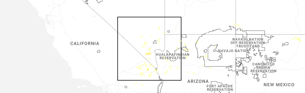
Hail Map for Cal-Nev-Ari, NV
The Cal-Nev-Ari, NV area has had 0 reports of on-the-ground hail by trained spotters, and has been under severe weather warnings 3 times during the past 12 months. Doppler radar has detected hail at or near Cal-Nev-Ari, NV on 15 occasions, including 2 occasions during the past year.
| Name: | Cal-Nev-Ari, NV |
| Where Located: | 62.2 miles SSE of Las Vegas, NV |
| Map: | Google Map for Cal-Nev-Ari, NV |
| Population: | 244 |
| Housing Units: | 168 |
| More Info: | Search Google for Cal-Nev-Ari, NV |
0
The Top Recent Hail Date for Cal-Nev-Ari, NV is Tuesday, June 3, 2025 (15th out of 15)
Hail and Wind Damage Spotted near Cal-Nev-Ari, NV
| Date / Time | Report Details |
|---|---|
| 7/22/2024 2:59 PM PDT |
 The storm which prompted the warning has weakened, and no longer poses an immediate threat to life or property. therefore, the warning will be allowed to expire. The storm which prompted the warning has weakened, and no longer poses an immediate threat to life or property. therefore, the warning will be allowed to expire.
|
| 7/22/2024 2:26 PM PDT |
 At 226 pm pdt, a severe thunderstorm was located over searchlight, moving northeast at 5 mph (radar indicated). Hazards include 60 mph wind gusts. Expect damage to roofs and trees. nearby observation gusted to 78 mph from this storm. locations impacted include, cima, mountain pass, nipton and ivanpah roads, mid hills campground, nipton, nipton road mile marker 3, and cal-nev-ari. this includes the following roads, interstate 15 in california between mile markers 168 and 186. highway 95 in clark county between mile markers 8 and 16. State route 164 in clark county between mile markers 1 and 15. At 226 pm pdt, a severe thunderstorm was located over searchlight, moving northeast at 5 mph (radar indicated). Hazards include 60 mph wind gusts. Expect damage to roofs and trees. nearby observation gusted to 78 mph from this storm. locations impacted include, cima, mountain pass, nipton and ivanpah roads, mid hills campground, nipton, nipton road mile marker 3, and cal-nev-ari. this includes the following roads, interstate 15 in california between mile markers 168 and 186. highway 95 in clark county between mile markers 8 and 16. State route 164 in clark county between mile markers 1 and 15.
|
| 7/22/2024 2:09 PM PDT |
 Svrvef the national weather service in las vegas has issued a * severe thunderstorm warning for, north central san bernardino county in southern california, south central clark county in southern nevada, * until 300 pm pdt. * at 209 pm pdt, a severe thunderstorm was located near nipton road mile marker 3, or 16 miles west of searchlight, moving northeast at 5 mph (radar indicated). Hazards include 60 mph wind gusts. expect damage to roofs and trees Svrvef the national weather service in las vegas has issued a * severe thunderstorm warning for, north central san bernardino county in southern california, south central clark county in southern nevada, * until 300 pm pdt. * at 209 pm pdt, a severe thunderstorm was located near nipton road mile marker 3, or 16 miles west of searchlight, moving northeast at 5 mph (radar indicated). Hazards include 60 mph wind gusts. expect damage to roofs and trees
|
| 9/4/2022 7:08 PM MST |
 The severe thunderstorm warning for west central mohave, east central san bernardino and south central clark counties will expire at 715 pm pdt/715 pm mst/, the storms which moved through the laughlin/bullhead city area have weakened slightly, and no longer pose an immediate threat to life or property. therefore, the warning will be allowed to expire. however gusty winds and heavy rain are still possible with these thunderstorms. The severe thunderstorm warning for west central mohave, east central san bernardino and south central clark counties will expire at 715 pm pdt/715 pm mst/, the storms which moved through the laughlin/bullhead city area have weakened slightly, and no longer pose an immediate threat to life or property. therefore, the warning will be allowed to expire. however gusty winds and heavy rain are still possible with these thunderstorms.
|
| 9/4/2022 6:36 PM MST |
 At 634 pm pdt/634 pm mst/, severe thunderstorms were located along a line extending from near katherine landing to arizona village, moving west at 40 mph. at 625 pm mst, a trained spotter in bullhead city reported wind gusts to 70 mph (radar indicated). Hazards include 70 mph wind gusts and quarter size hail. Hail damage to vehicles is expected. expect considerable tree damage. wind damage is also likely to mobile homes, roofs, and outbuildings. locations impacted include, bullhead city, laughlin, katherine landing, needles, oatman, mojave ranch estates, mohave valley, big bend rec area, highway 95 and i-40, mesquite creek, arizona village, cal-nev-ari and willow valley. this includes interstate 40 in california between mile markers 129 and 145. thunderstorm damage threat, considerable hail threat, radar indicated max hail size, 1. 00 in wind threat, radar indicated max wind gust, 70 mph. At 634 pm pdt/634 pm mst/, severe thunderstorms were located along a line extending from near katherine landing to arizona village, moving west at 40 mph. at 625 pm mst, a trained spotter in bullhead city reported wind gusts to 70 mph (radar indicated). Hazards include 70 mph wind gusts and quarter size hail. Hail damage to vehicles is expected. expect considerable tree damage. wind damage is also likely to mobile homes, roofs, and outbuildings. locations impacted include, bullhead city, laughlin, katherine landing, needles, oatman, mojave ranch estates, mohave valley, big bend rec area, highway 95 and i-40, mesquite creek, arizona village, cal-nev-ari and willow valley. this includes interstate 40 in california between mile markers 129 and 145. thunderstorm damage threat, considerable hail threat, radar indicated max hail size, 1. 00 in wind threat, radar indicated max wind gust, 70 mph.
|
| 9/4/2022 6:08 PM MST |
 At 607 pm pdt/607 pm mst/, severe thunderstorms were located along a line extending from 8 miles northeast of katherine landing to 7 miles southeast of oatman, moving west at 25 mph (radar indicated). Hazards include 60 mph wind gusts and quarter size hail. Hail damage to vehicles is expected. Expect wind damage to roofs and trees. At 607 pm pdt/607 pm mst/, severe thunderstorms were located along a line extending from 8 miles northeast of katherine landing to 7 miles southeast of oatman, moving west at 25 mph (radar indicated). Hazards include 60 mph wind gusts and quarter size hail. Hail damage to vehicles is expected. Expect wind damage to roofs and trees.
|
| 7/28/2022 10:58 PM PDT |
 At 1054 pm pdt/1054 pm mst/, a cluster of severe thunderstorms were located along a line extending from mountain pass, to 10 miles north of searchlight, to golden valley. these storms were moving generally south-southwest at 35 mph (radar indicated). Hazards include 60 mph wind gusts. Possible wind damage to roofs and trees, power lines and periods of blowing dust near dry lake beds. locations impacted include, bullhead city, laughlin, searchlight, cima, katherine landing, primm, needles, mountain pass, oatman, mid hills campground, nipton, mojave ranch estates, mohave valley, cottonwood cove campground, big bend rec area, golden valley, mesquite creek, nipton and ivanpah roads, cottonwood cove and nipton road mile marker 3. this includes the following highways, interstate 15 in california between mile markers 146 and 186. interstate 15 in nevada between mile markers 1 and 9. hail threat, radar indicated max hail size, <. 75 in wind threat, observed max wind gust, 60 mph. At 1054 pm pdt/1054 pm mst/, a cluster of severe thunderstorms were located along a line extending from mountain pass, to 10 miles north of searchlight, to golden valley. these storms were moving generally south-southwest at 35 mph (radar indicated). Hazards include 60 mph wind gusts. Possible wind damage to roofs and trees, power lines and periods of blowing dust near dry lake beds. locations impacted include, bullhead city, laughlin, searchlight, cima, katherine landing, primm, needles, mountain pass, oatman, mid hills campground, nipton, mojave ranch estates, mohave valley, cottonwood cove campground, big bend rec area, golden valley, mesquite creek, nipton and ivanpah roads, cottonwood cove and nipton road mile marker 3. this includes the following highways, interstate 15 in california between mile markers 146 and 186. interstate 15 in nevada between mile markers 1 and 9. hail threat, radar indicated max hail size, <. 75 in wind threat, observed max wind gust, 60 mph.
|
| 7/28/2022 10:18 PM PDT |
 At 1013 pm pdt/1013 pm mst/, a cluster of severe thunderstorms was located along a line extending from sandy valley to the highway 93 corridor in arizona northwest of kingman. these storms were moving southwest at 30 mph (radar indicated). Hazards include 60 mph wind gusts and hail up to penny size. expect wind damage to roofs and trees, power lines and periods of blowing dust with the high winds At 1013 pm pdt/1013 pm mst/, a cluster of severe thunderstorms was located along a line extending from sandy valley to the highway 93 corridor in arizona northwest of kingman. these storms were moving southwest at 30 mph (radar indicated). Hazards include 60 mph wind gusts and hail up to penny size. expect wind damage to roofs and trees, power lines and periods of blowing dust with the high winds
|
| 9/9/2021 5:30 PM PDT |
 At 529 pm pdt/529 pm mst/, a severe thunderstorm was located near katherine landing, moving northwest at 20 mph (radar indicated). Hazards include 60 mph wind gusts. Expect damage to roofs and trees. locations impacted include, bullhead city, laughlin, katherine landing, big bend rec area and cal-nev-ari. hail threat, radar indicated max hail size, <. 75 in wind threat, radar indicated max wind gust, 60 mph. At 529 pm pdt/529 pm mst/, a severe thunderstorm was located near katherine landing, moving northwest at 20 mph (radar indicated). Hazards include 60 mph wind gusts. Expect damage to roofs and trees. locations impacted include, bullhead city, laughlin, katherine landing, big bend rec area and cal-nev-ari. hail threat, radar indicated max hail size, <. 75 in wind threat, radar indicated max wind gust, 60 mph.
|
| 9/9/2021 5:11 PM PDT |
 At 510 pm pdt/510 pm mst/, a severe thunderstorm was located over katherine landing, moving northwest at 20 mph (radar indicated). Hazards include 60 mph wind gusts. expect damage to roofs and trees At 510 pm pdt/510 pm mst/, a severe thunderstorm was located over katherine landing, moving northwest at 20 mph (radar indicated). Hazards include 60 mph wind gusts. expect damage to roofs and trees
|
| 8/1/2021 10:59 AM PDT |
 At 1059 am pdt, a severe thunderstorm was located near searchlight, moving southeast at 10 mph (radar indicated). Hazards include 60 mph wind gusts. expect damage to roofs and trees At 1059 am pdt, a severe thunderstorm was located near searchlight, moving southeast at 10 mph (radar indicated). Hazards include 60 mph wind gusts. expect damage to roofs and trees
|
| 7/25/2021 9:53 PM PDT |
 The severe thunderstorm warning for western mohave, western clark and southeastern nye counties will expire at 1000 pm pdt/1000 pm mst/, the storms which prompted the warning continue to move southwest through far southern clark county and southern nye county. additional, severe thunderstorm warnings will be issued. gusty winds are still possible with these thunderstorms. The severe thunderstorm warning for western mohave, western clark and southeastern nye counties will expire at 1000 pm pdt/1000 pm mst/, the storms which prompted the warning continue to move southwest through far southern clark county and southern nye county. additional, severe thunderstorm warnings will be issued. gusty winds are still possible with these thunderstorms.
|
| 7/25/2021 9:32 PM PDT |
 At 930 pm pdt/930 pm mst/, severe thunderstorms were located along a line extending from near cottonwood cove campground to near goodsprings to 6 miles west of indian springs, moving south at 35 mph (radar indicated). Hazards include 70 mph wind gusts. Expect considerable tree damage. damage is likely to mobile homes, roofs, and outbuildings. locations impacted include, henderson, pahrump, laughlin, rainbow canyon, mountains edge, blue diamond, southern highlands, jean, mt. charleston, red rock canyon, enterprise, searchlight, primm, spring mountains, mercury, summerlin, spring valley, paradise, kyle canyon campground and fletcher view campground. This includes interstate 15 in nevada between mile markers 1 and 25. At 930 pm pdt/930 pm mst/, severe thunderstorms were located along a line extending from near cottonwood cove campground to near goodsprings to 6 miles west of indian springs, moving south at 35 mph (radar indicated). Hazards include 70 mph wind gusts. Expect considerable tree damage. damage is likely to mobile homes, roofs, and outbuildings. locations impacted include, henderson, pahrump, laughlin, rainbow canyon, mountains edge, blue diamond, southern highlands, jean, mt. charleston, red rock canyon, enterprise, searchlight, primm, spring mountains, mercury, summerlin, spring valley, paradise, kyle canyon campground and fletcher view campground. This includes interstate 15 in nevada between mile markers 1 and 25.
|
| 7/25/2021 8:59 PM PDT |
 At 857 pm pdt/857 pm mst/, severe thunderstorms were located along a line extending from 13 miles north of cottonwood cove campground to spring valley to 15 miles north of indian springs, moving south at 35 mph (radar indicated). Hazards include 70 mph wind gusts. Expect considerable tree damage. Damage is likely to mobile homes, roofs, and outbuildings. At 857 pm pdt/857 pm mst/, severe thunderstorms were located along a line extending from 13 miles north of cottonwood cove campground to spring valley to 15 miles north of indian springs, moving south at 35 mph (radar indicated). Hazards include 70 mph wind gusts. Expect considerable tree damage. Damage is likely to mobile homes, roofs, and outbuildings.
|
| 7/25/2021 6:57 PM PDT | Nvenergy reports 205 customers without power due to thunderstorm wind in clark county NV, 1 miles SSW of Cal-Nev-Ari, NV |
| 7/25/2021 6:36 PM MST |
 At 635 pm pdt/635 pm mst/, severe thunderstorms were located along a line extending from 13 miles south of hoover dam to 7 miles north of cottonwood cove campground to near big bend rec area, moving west (radar indicated). Hazards include 60 mph wind gusts. Expect damage to roofs and trees. Locations impacted include, bullhead city, laughlin, katherine landing, searchlight, cottonwood cove, cottonwood cove campground, big bend rec area, cal-nev-ari, dolan springs and golden valley. At 635 pm pdt/635 pm mst/, severe thunderstorms were located along a line extending from 13 miles south of hoover dam to 7 miles north of cottonwood cove campground to near big bend rec area, moving west (radar indicated). Hazards include 60 mph wind gusts. Expect damage to roofs and trees. Locations impacted include, bullhead city, laughlin, katherine landing, searchlight, cottonwood cove, cottonwood cove campground, big bend rec area, cal-nev-ari, dolan springs and golden valley.
|
| 7/25/2021 6:01 PM MST |
 At 559 pm pdt/559 pm mst/, severe thunderstorms were located along a line extending from 16 miles southeast of grand canyon ranch to 13 miles northeast of packsaddle campground to near hualapai mountain park, moving west at 25 mph (radar indicated). Hazards include 40 to 60 mph wind gusts. This storm will produce sudden wind gusts over the colorado river from laughlin to willow beach which could exceed 40 mph. Possible damage to roofs and trees as well. At 559 pm pdt/559 pm mst/, severe thunderstorms were located along a line extending from 16 miles southeast of grand canyon ranch to 13 miles northeast of packsaddle campground to near hualapai mountain park, moving west at 25 mph (radar indicated). Hazards include 40 to 60 mph wind gusts. This storm will produce sudden wind gusts over the colorado river from laughlin to willow beach which could exceed 40 mph. Possible damage to roofs and trees as well.
|
| 8/16/2018 4:49 PM PDT |
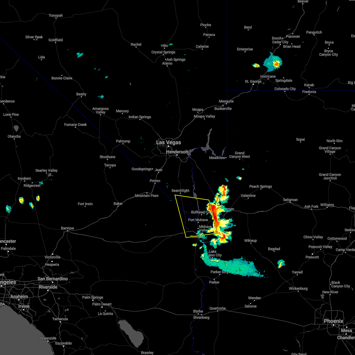
 At 448 pm pdt/448 pm mst/, a severe thunderstorm was located near cal-nev-ari, or 8 miles north of katherine landing, and is nearly stationary (radar indicated). Hazards include 60 mph wind gusts and quarter size hail. Hail damage to vehicles is expected. expect wind damage to roofs and trees. strong winds can create hazardous boating conditions on lake mohave. Locations impacted include, searchlight, katherine landing, cottonwood cove, cottonwood cove campground and cal-nev-ari. At 448 pm pdt/448 pm mst/, a severe thunderstorm was located near cal-nev-ari, or 8 miles north of katherine landing, and is nearly stationary (radar indicated). Hazards include 60 mph wind gusts and quarter size hail. Hail damage to vehicles is expected. expect wind damage to roofs and trees. strong winds can create hazardous boating conditions on lake mohave. Locations impacted include, searchlight, katherine landing, cottonwood cove, cottonwood cove campground and cal-nev-ari.
|
| 8/16/2018 4:49 PM PDT |
 At 448 pm pdt/448 pm mst/, a severe thunderstorm was located near cal-nev-ari, or 8 miles north of katherine landing, and is nearly stationary (radar indicated). Hazards include 60 mph wind gusts and quarter size hail. Hail damage to vehicles is expected. expect wind damage to roofs and trees. strong winds can create hazardous boating conditions on lake mohave. Locations impacted include, searchlight, katherine landing, cottonwood cove, cottonwood cove campground and cal-nev-ari. At 448 pm pdt/448 pm mst/, a severe thunderstorm was located near cal-nev-ari, or 8 miles north of katherine landing, and is nearly stationary (radar indicated). Hazards include 60 mph wind gusts and quarter size hail. Hail damage to vehicles is expected. expect wind damage to roofs and trees. strong winds can create hazardous boating conditions on lake mohave. Locations impacted include, searchlight, katherine landing, cottonwood cove, cottonwood cove campground and cal-nev-ari.
|
| 8/16/2018 4:17 PM PDT |
 At 416 pm pdt/416 pm mst/, a severe thunderstorm was located 7 miles northeast of cal-nev-ari, or 8 miles southeast of searchlight, moving south at 5 mph (radar indicated). Hazards include 60 mph wind gusts and quarter size hail. Hail damage to vehicles is expected. Expect wind damage to roofs and trees. At 416 pm pdt/416 pm mst/, a severe thunderstorm was located 7 miles northeast of cal-nev-ari, or 8 miles southeast of searchlight, moving south at 5 mph (radar indicated). Hazards include 60 mph wind gusts and quarter size hail. Hail damage to vehicles is expected. Expect wind damage to roofs and trees.
|
| 8/11/2018 8:41 PM PDT |
 At 801 pm pdt/801 pm mst/, thunderstorms near oatman, bullhead city and laughlin continue to produce severe winds. the storms were moving west at 20 mph (radar indicated). Hazards include 60 mph wind gusts. expect damage to roofs and trees At 801 pm pdt/801 pm mst/, thunderstorms near oatman, bullhead city and laughlin continue to produce severe winds. the storms were moving west at 20 mph (radar indicated). Hazards include 60 mph wind gusts. expect damage to roofs and trees
|
| 8/11/2018 8:41 PM PDT |
 The severe thunderstorm warning for west central mohave, eastern san bernardino and southern clark counties will expire at 845 pm pdt/845 pm mst/, the storm which prompted the warning has weakened below severe limits, and no longer poses an immediate threat to life or property. therefore, the warning will be allowed to expire. be aware that storms were continuing to produce moderate to locally heavy rain in the warned area. The severe thunderstorm warning for west central mohave, eastern san bernardino and southern clark counties will expire at 845 pm pdt/845 pm mst/, the storm which prompted the warning has weakened below severe limits, and no longer poses an immediate threat to life or property. therefore, the warning will be allowed to expire. be aware that storms were continuing to produce moderate to locally heavy rain in the warned area.
|
| 8/11/2018 8:03 PM PDT |
 The national weather service in las vegas has issued a * severe thunderstorm warning for. west central mohave county in northwestern arizona. eastern san bernardino county in southern california. southern clark county in southern nevada. Until 845 pm pdt/845 pm mst/. The national weather service in las vegas has issued a * severe thunderstorm warning for. west central mohave county in northwestern arizona. eastern san bernardino county in southern california. southern clark county in southern nevada. Until 845 pm pdt/845 pm mst/.
|
| 8/11/2018 8:03 PM PDT |
 At 801 pm pdt/801 pm mst/, thunderstorms near oatman, bullhead city and laughlin continue to produce severe winds. the storms were moving west at 20 mph (radar indicated). Hazards include 60 mph wind gusts. expect damage to roofs and trees At 801 pm pdt/801 pm mst/, thunderstorms near oatman, bullhead city and laughlin continue to produce severe winds. the storms were moving west at 20 mph (radar indicated). Hazards include 60 mph wind gusts. expect damage to roofs and trees
|
| 8/26/2016 10:02 PM PDT |
 At 1001 pm pdt/1001 pm mst/, doppler radar indicated a severe thunderstorm capable of producing quarter size hail and damaging winds in excess of 60 mph. this storm was located near cal-nev- ari, or 7 miles northwest of katherine landing, and moving east at 10 mph. this replaces the previous severe thunderstorm warning in effect for the area. At 1001 pm pdt/1001 pm mst/, doppler radar indicated a severe thunderstorm capable of producing quarter size hail and damaging winds in excess of 60 mph. this storm was located near cal-nev- ari, or 7 miles northwest of katherine landing, and moving east at 10 mph. this replaces the previous severe thunderstorm warning in effect for the area.
|
| 8/26/2016 10:02 PM PDT |
 The national weather service in las vegas has issued a * severe thunderstorm warning for. southwestern mohave county in northwestern arizona. south central clark county in southern nevada. until 1045 pm pdt/1045 pm mst/ * at 1001 pm pdt/1001 pm mst/. Doppler radar indicated a severe. The national weather service in las vegas has issued a * severe thunderstorm warning for. southwestern mohave county in northwestern arizona. south central clark county in southern nevada. until 1045 pm pdt/1045 pm mst/ * at 1001 pm pdt/1001 pm mst/. Doppler radar indicated a severe.
|
| 8/26/2016 9:46 PM PDT |
 At 945 pm pdt, doppler radar indicated a severe thunderstorm capable of producing quarter size hail and damaging winds in excess of 60 mph. this storm was located over cal-nev-ari, or 9 miles northwest of katherine landing. this storm was moving east at 10 mph. locations impacted include, cal-nev-ari. At 945 pm pdt, doppler radar indicated a severe thunderstorm capable of producing quarter size hail and damaging winds in excess of 60 mph. this storm was located over cal-nev-ari, or 9 miles northwest of katherine landing. this storm was moving east at 10 mph. locations impacted include, cal-nev-ari.
|
| 8/26/2016 9:23 PM PDT |
 The national weather service in las vegas has issued a * severe thunderstorm warning for. northeastern san bernardino county in southern california. south central clark county in southern nevada. until 1015 pm pdt * at 923 pm pdt. Doppler radar indicated a severe thunderstorm. The national weather service in las vegas has issued a * severe thunderstorm warning for. northeastern san bernardino county in southern california. south central clark county in southern nevada. until 1015 pm pdt * at 923 pm pdt. Doppler radar indicated a severe thunderstorm.
|
| 8/18/2016 3:40 PM PDT | The severe thunderstorm warning for southern clark county will expire at 345 pm pdt, the storm which prompted the warning has weakened below severe limits, and no longer poses an immediate threat to life or property. therefore the warning will be allowed to expire. however heavy rain is still likely with this thunderstorm. |
| 8/18/2016 3:08 PM PDT |
 At 307 pm pdt, doppler radar indicated a severe thunderstorm capable of producing quarter size hail and damaging winds in excess of 60 mph. this storm was located over cal-nev-ari, or near katherine landing, and moving southeast at 10 mph. At 307 pm pdt, doppler radar indicated a severe thunderstorm capable of producing quarter size hail and damaging winds in excess of 60 mph. this storm was located over cal-nev-ari, or near katherine landing, and moving southeast at 10 mph.
|
| 6/30/2016 6:14 PM PDT |
 At 611 pm pdt/611 pm mst/, doppler radar indicated a severe thunderstorm capable of producing destructive winds in excess of 70 mph. this storm was located near big bend rec area, or near laughlin, moving northeast at 15 mph. another severe storm was located 5 miles southwest of cal-nev-ari, moving southeast at 20 mph. this storm was also capable of producing winds to 70 mph. at 535 pm mst, a 62 mph wind gust was reported at bullhead city airport. locations impacted include, bullhead city, laughlin, katherine landing, topock, needles, arizona village, mesquite creek, big bend rec area, mojave ranch estates, cal-nev-ari, mohave valley, highway 95 and i-40 and willow valley. At 611 pm pdt/611 pm mst/, doppler radar indicated a severe thunderstorm capable of producing destructive winds in excess of 70 mph. this storm was located near big bend rec area, or near laughlin, moving northeast at 15 mph. another severe storm was located 5 miles southwest of cal-nev-ari, moving southeast at 20 mph. this storm was also capable of producing winds to 70 mph. at 535 pm mst, a 62 mph wind gust was reported at bullhead city airport. locations impacted include, bullhead city, laughlin, katherine landing, topock, needles, arizona village, mesquite creek, big bend rec area, mojave ranch estates, cal-nev-ari, mohave valley, highway 95 and i-40 and willow valley.
|
| 6/30/2016 5:48 PM PDT |
 At 546 pm pdt/546 pm mst/, doppler radar indicated a severe thunderstorm capable of producing destructive winds in excess of 70 mph. this storm was located over mesquite creek, or 11 miles south of bullhead city, and moving northeast at 25 mph. another severe storm was located 10 miles west of cal-nev-ari, moving southeast at 20 mph. At 546 pm pdt/546 pm mst/, doppler radar indicated a severe thunderstorm capable of producing destructive winds in excess of 70 mph. this storm was located over mesquite creek, or 11 miles south of bullhead city, and moving northeast at 25 mph. another severe storm was located 10 miles west of cal-nev-ari, moving southeast at 20 mph.
|
| 6/30/2016 5:32 PM PDT |
 At 530 pm pdt/530 pm mst/, doppler radar indicated a severe thunderstorm capable of producing damaging winds in excess of 60 mph. this storm was located near cottonwood cove, or 14 miles east of searchlight, moving southeast at 15 mph. another severe storm was located near cal-nev-ari, moving southeast at 20 mph. locations impacted include, bullhead city, laughlin, katherine landing, searchlight, cal-nev-ari, cottonwood cove and cottonwood cove campground. At 530 pm pdt/530 pm mst/, doppler radar indicated a severe thunderstorm capable of producing damaging winds in excess of 60 mph. this storm was located near cottonwood cove, or 14 miles east of searchlight, moving southeast at 15 mph. another severe storm was located near cal-nev-ari, moving southeast at 20 mph. locations impacted include, bullhead city, laughlin, katherine landing, searchlight, cal-nev-ari, cottonwood cove and cottonwood cove campground.
|
| 6/30/2016 4:52 PM PDT |
 At 450 pm pdt/450 pm mst/, doppler radar indicated a severe thunderstorm capable of producing damaging winds in excess of 60 mph. this storm was located over searchlight, and moving southeast at 25 mph. At 450 pm pdt/450 pm mst/, doppler radar indicated a severe thunderstorm capable of producing damaging winds in excess of 60 mph. this storm was located over searchlight, and moving southeast at 25 mph.
|
| 7/17/2015 11:09 PM MST |
 The severe thunderstorm warning for west central mohave, east central san bernardino and south central clark counties will expire at 1115 pm pdt, the storms which prompted the warning have weakened below severe limits, and no longer poses an immediate threat to life or property. therefore the warning will be allowed to expire. however heavy rain and flash flooding is still possible with these thunderstorms. The severe thunderstorm warning for west central mohave, east central san bernardino and south central clark counties will expire at 1115 pm pdt, the storms which prompted the warning have weakened below severe limits, and no longer poses an immediate threat to life or property. therefore the warning will be allowed to expire. however heavy rain and flash flooding is still possible with these thunderstorms.
|
| 7/17/2015 10:53 PM MST |
 At 1051 pm pdt /1051 pm mst/, doppler radar indicated a line of severe thunderstorms capable of producing quarter size hail and damaging winds in excess of 60 mph. these storms were located along a line extending from 6 miles northwest of dolan springs to 8 miles southwest of big bend rec area, moving east at 15 mph. gusts around 60 mph have been reported in the bullhead city area. locations impacted include, bullhead city, laughlin, katherine landing, oatman, dolan springs, big bend rec area, chloride, cal-nev-ari, packsaddle campground, pierce ferry and antares roads, golden valley, cottonwood cove, cottonwood cove campground, windy point campground and mohave valley. At 1051 pm pdt /1051 pm mst/, doppler radar indicated a line of severe thunderstorms capable of producing quarter size hail and damaging winds in excess of 60 mph. these storms were located along a line extending from 6 miles northwest of dolan springs to 8 miles southwest of big bend rec area, moving east at 15 mph. gusts around 60 mph have been reported in the bullhead city area. locations impacted include, bullhead city, laughlin, katherine landing, oatman, dolan springs, big bend rec area, chloride, cal-nev-ari, packsaddle campground, pierce ferry and antares roads, golden valley, cottonwood cove, cottonwood cove campground, windy point campground and mohave valley.
|
| 7/17/2015 10:27 PM MST |
 At 1026 pm pdt /1026 pm mst/, doppler radar indicated a line of severe thunderstorms capable of producing quarter size hail and damaging winds in excess of 60 mph. these storms were located along a line extending from 12 miles west of dolan springs to 9 miles northwest of highway 95 and i-40, and moving east at 20 mph. At 1026 pm pdt /1026 pm mst/, doppler radar indicated a line of severe thunderstorms capable of producing quarter size hail and damaging winds in excess of 60 mph. these storms were located along a line extending from 12 miles west of dolan springs to 9 miles northwest of highway 95 and i-40, and moving east at 20 mph.
|
| 8/19/2014 1:00 PM PDT | Cal-nev-ari business reports several downed trees due to wind in cal-nev-ari. time estimated based on rada in clark county NV, 1.8 miles SSE of Cal-Nev-Ari, NV |
Hail Maps for Cal-Nev-Ari, NV


Connect with Interactive Hail Maps