

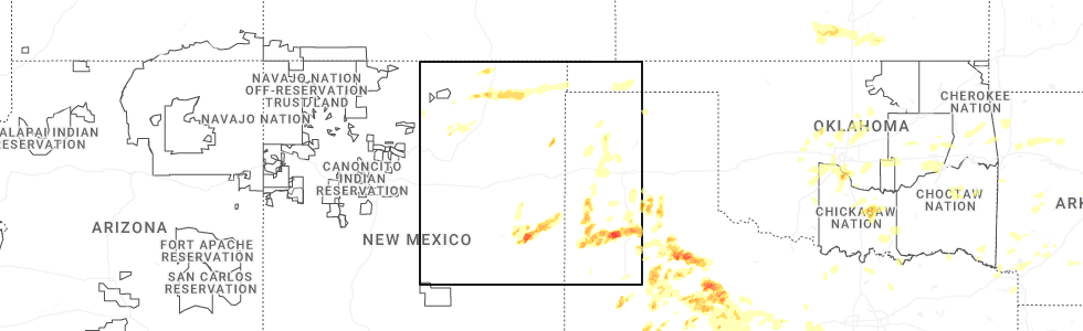
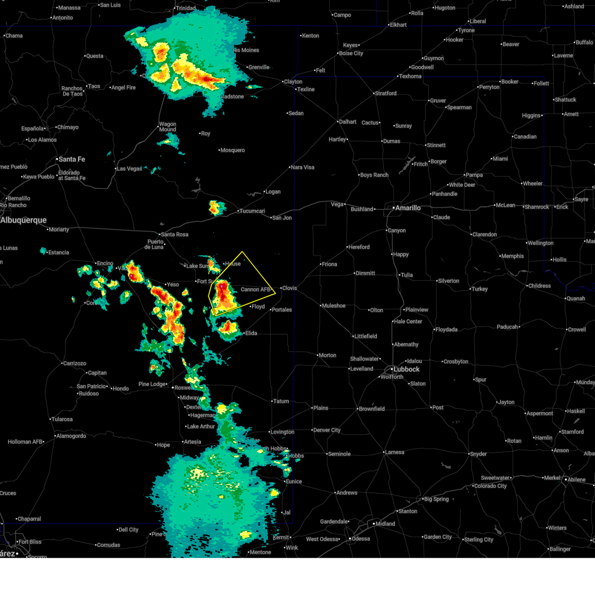
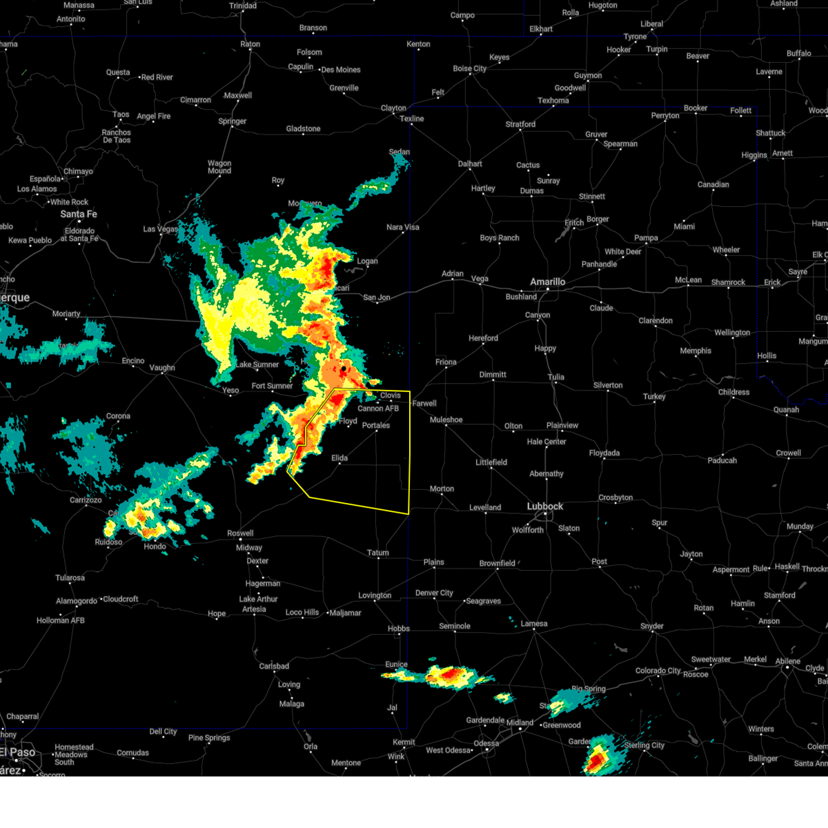
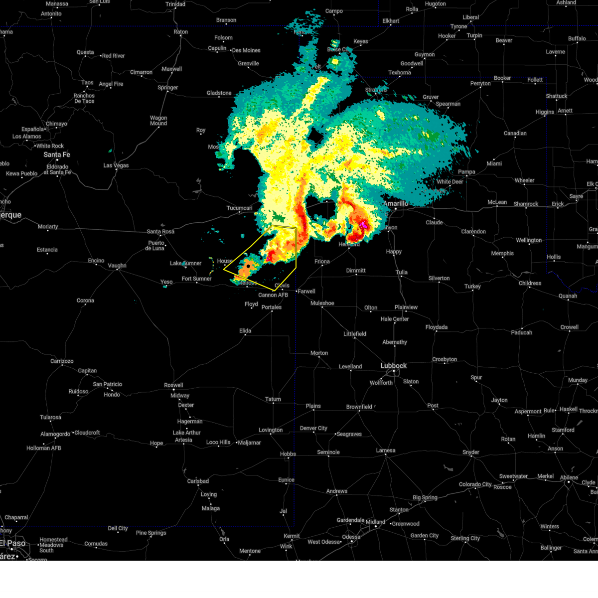
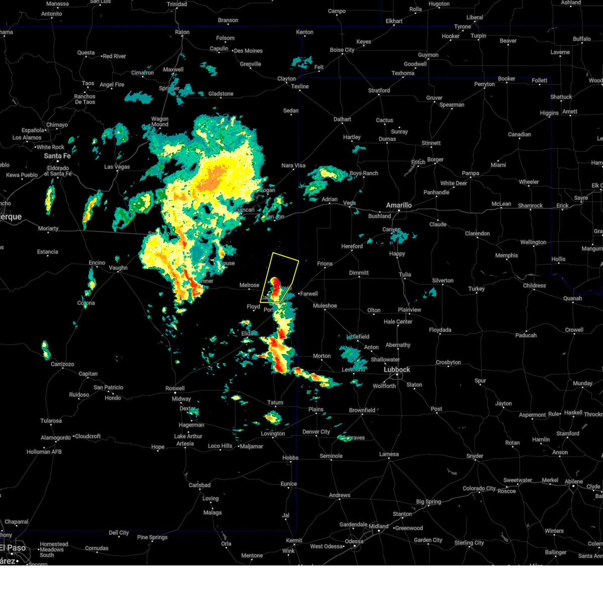
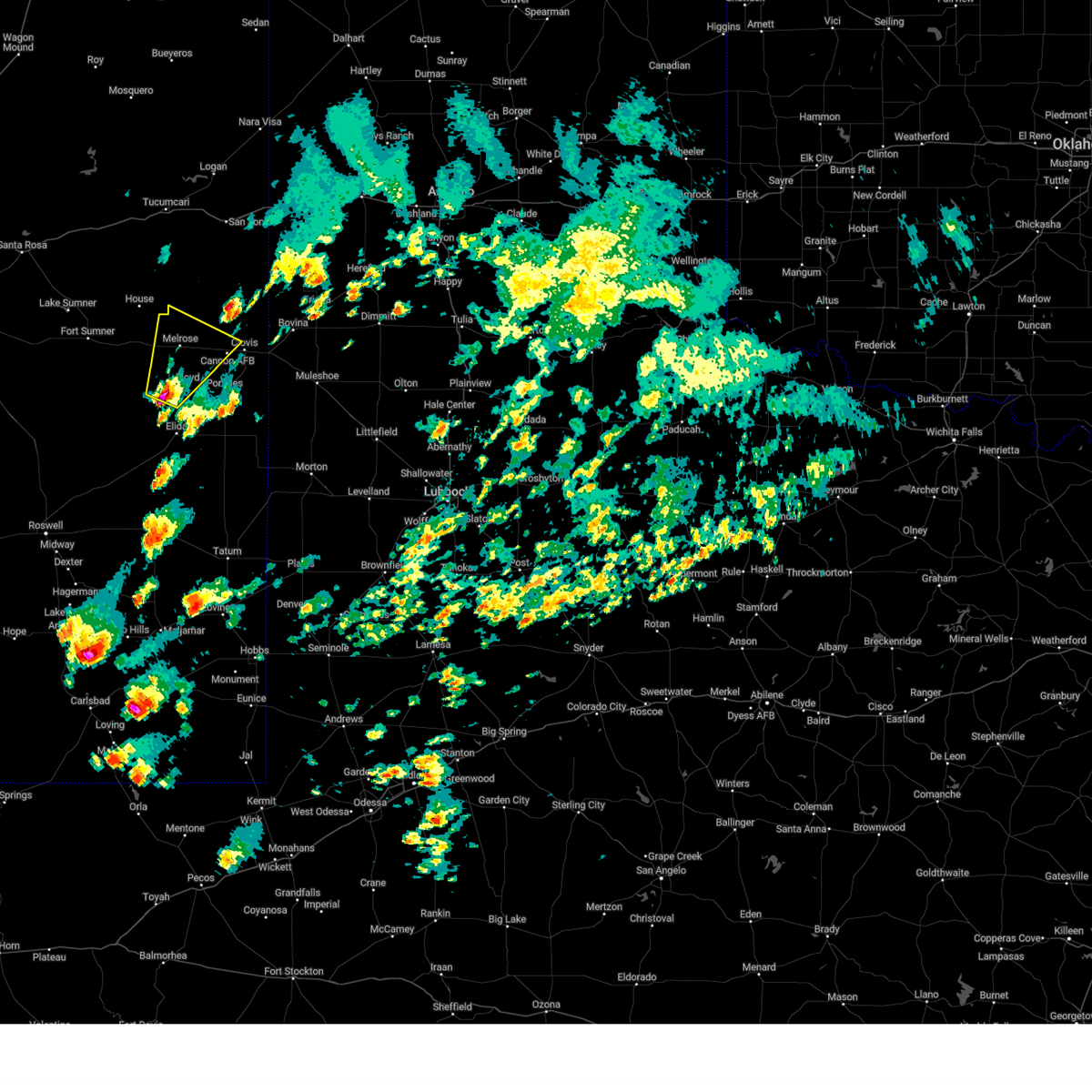
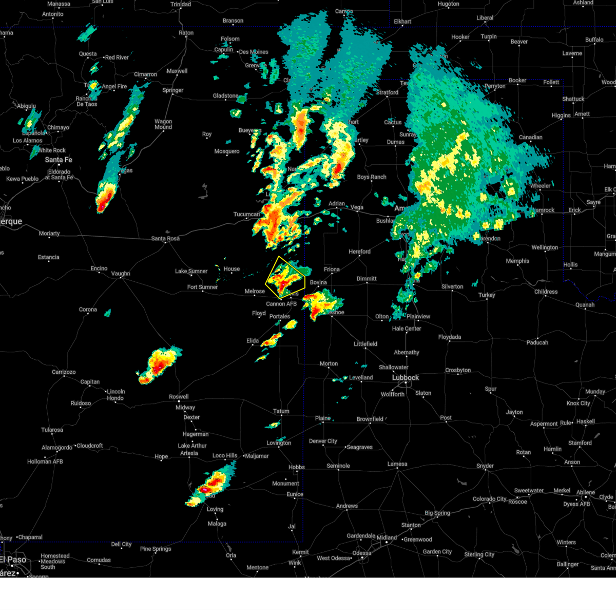
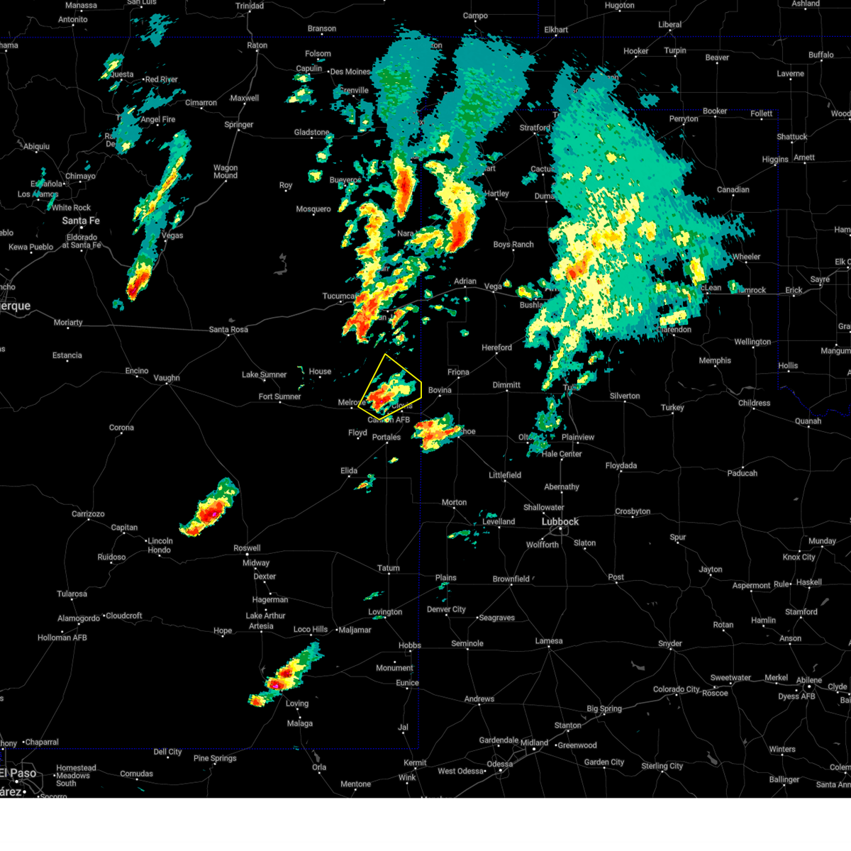
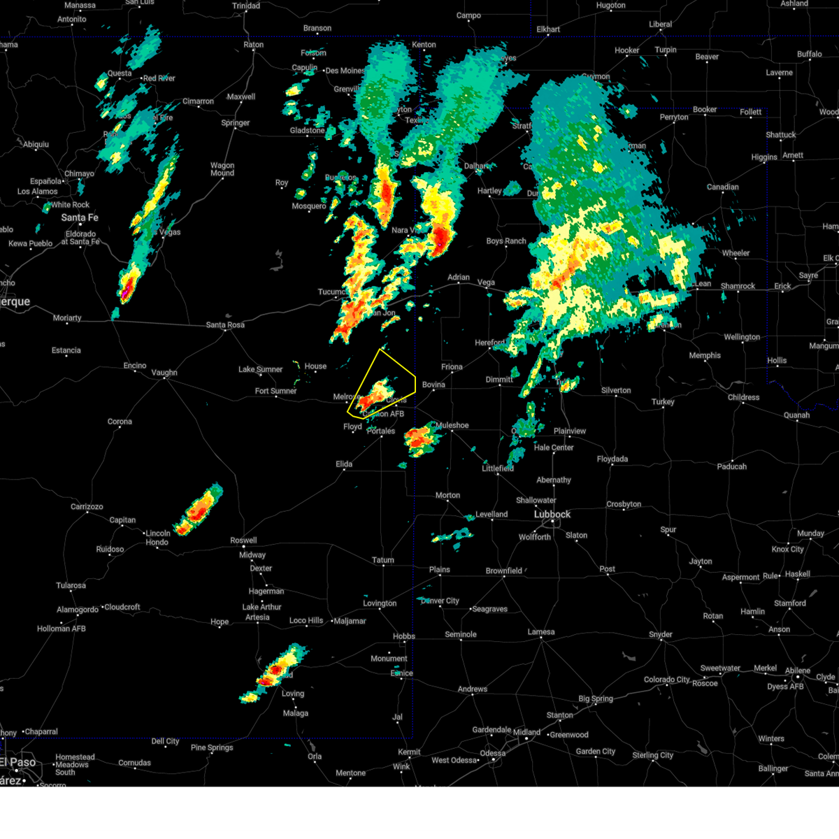
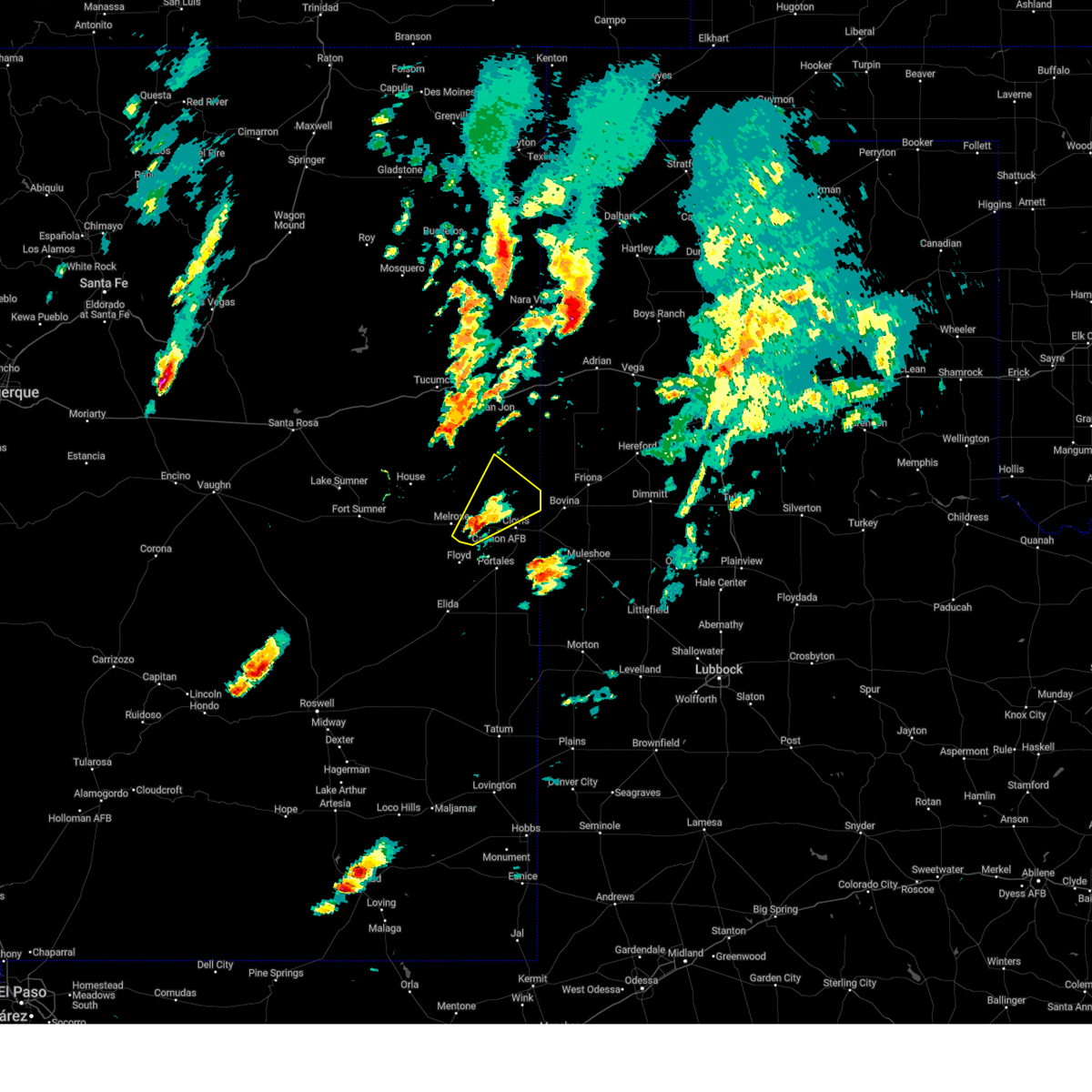
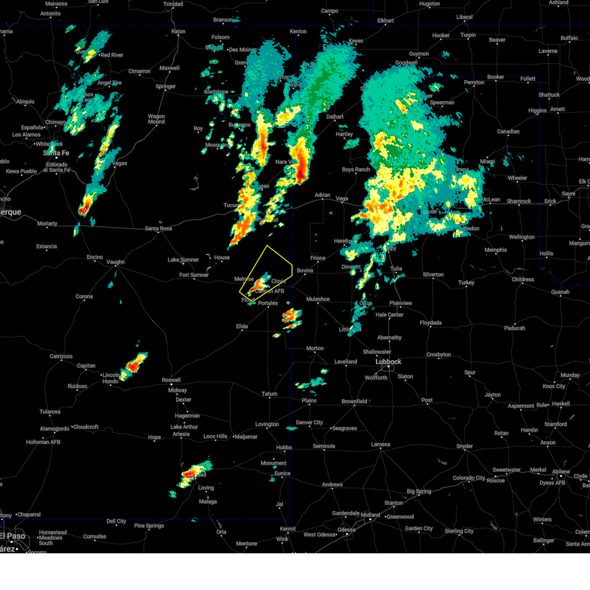
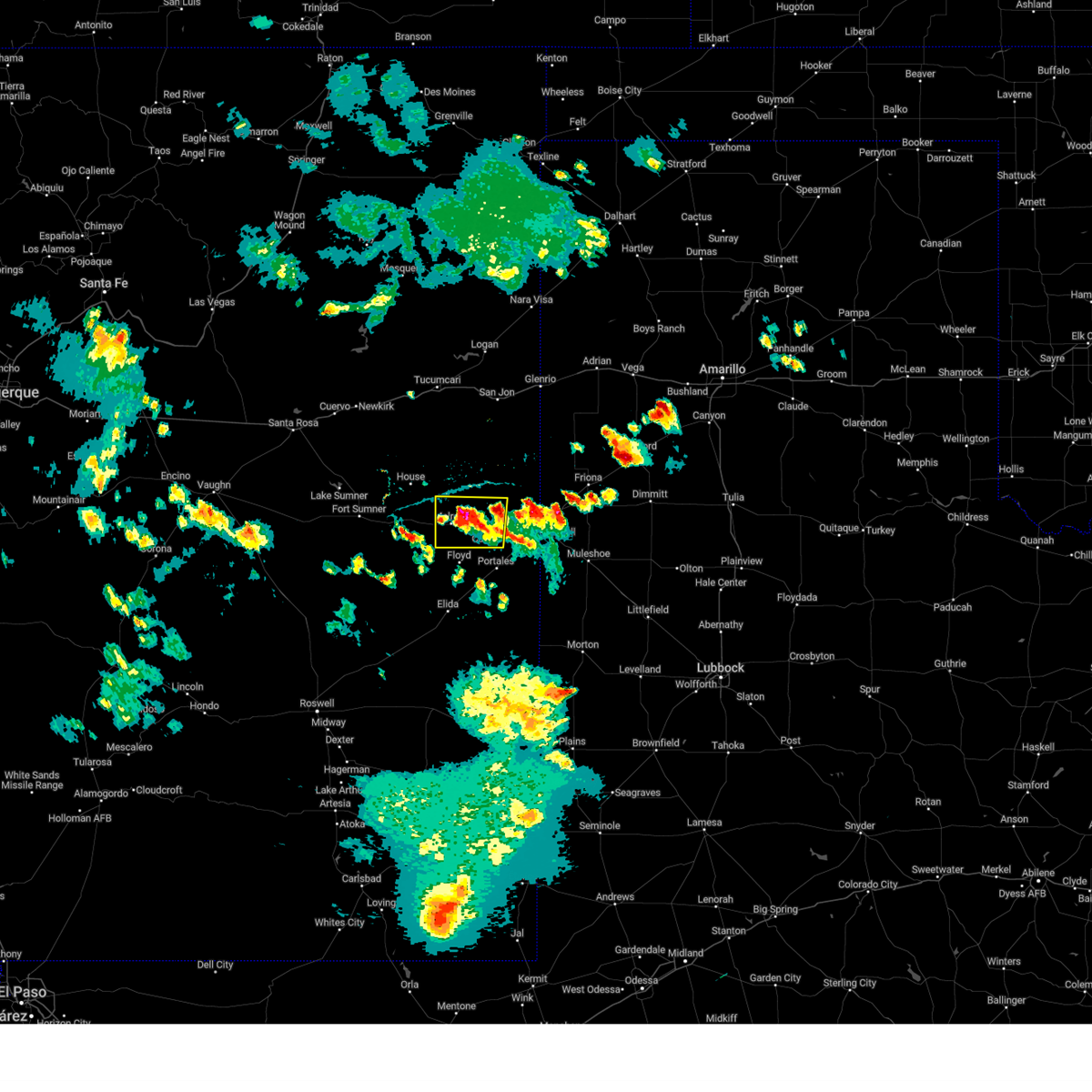
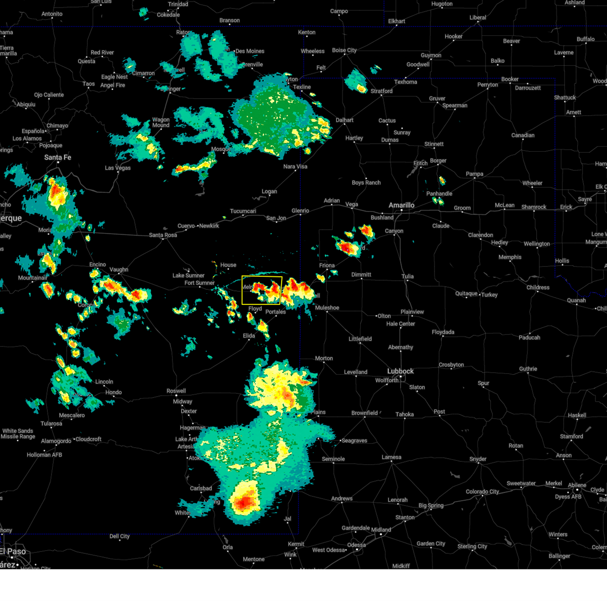
Hail Map for Cannon AFB, NM
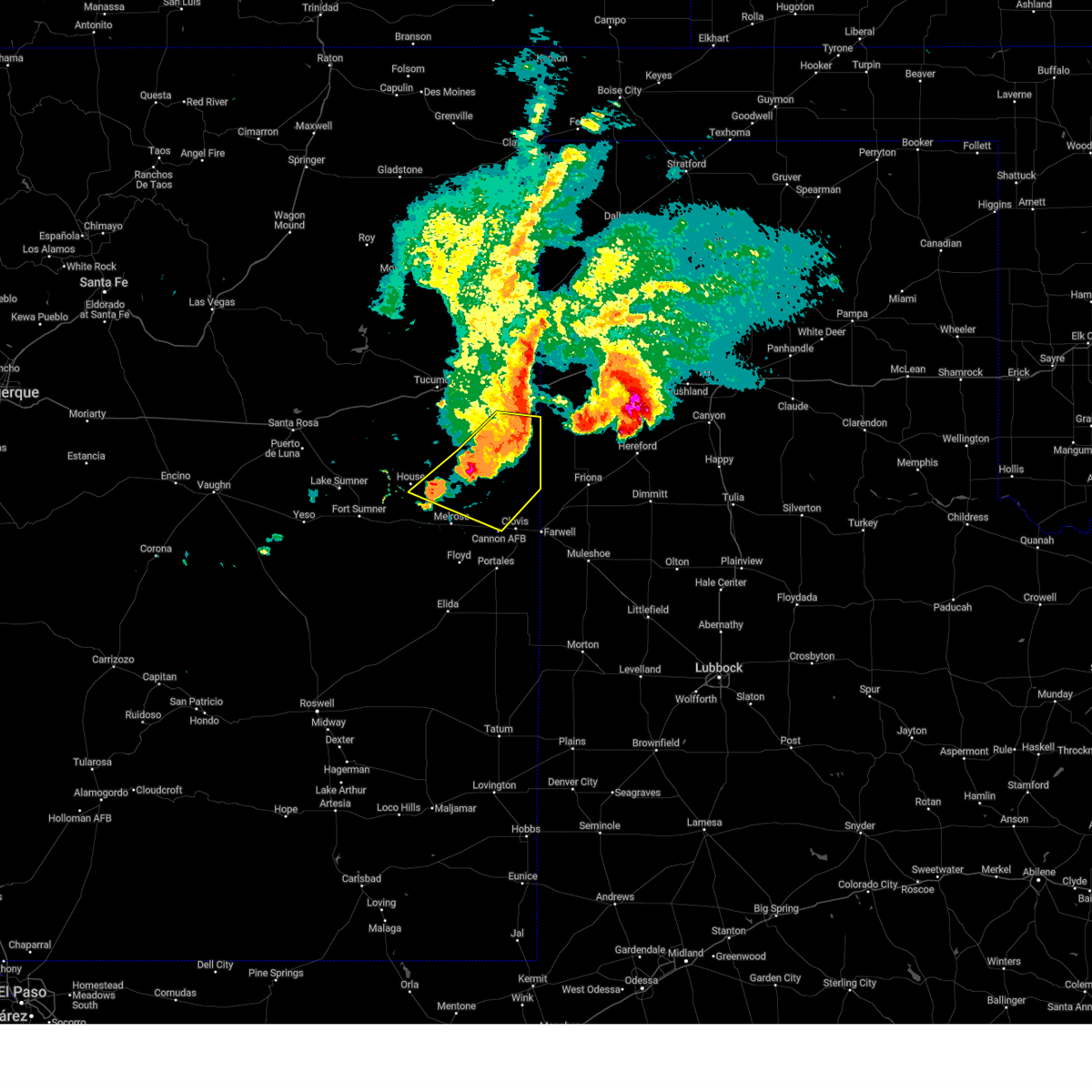
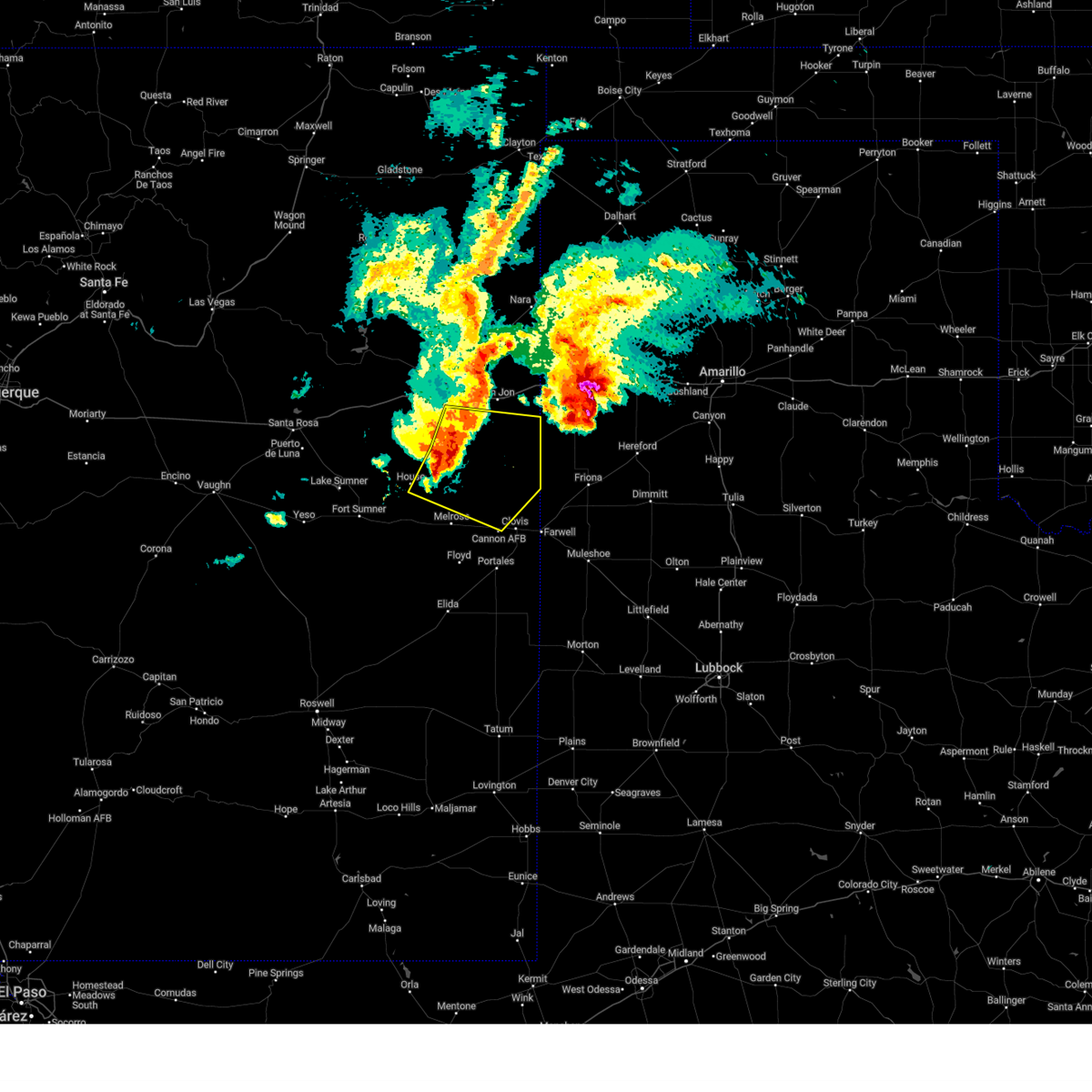
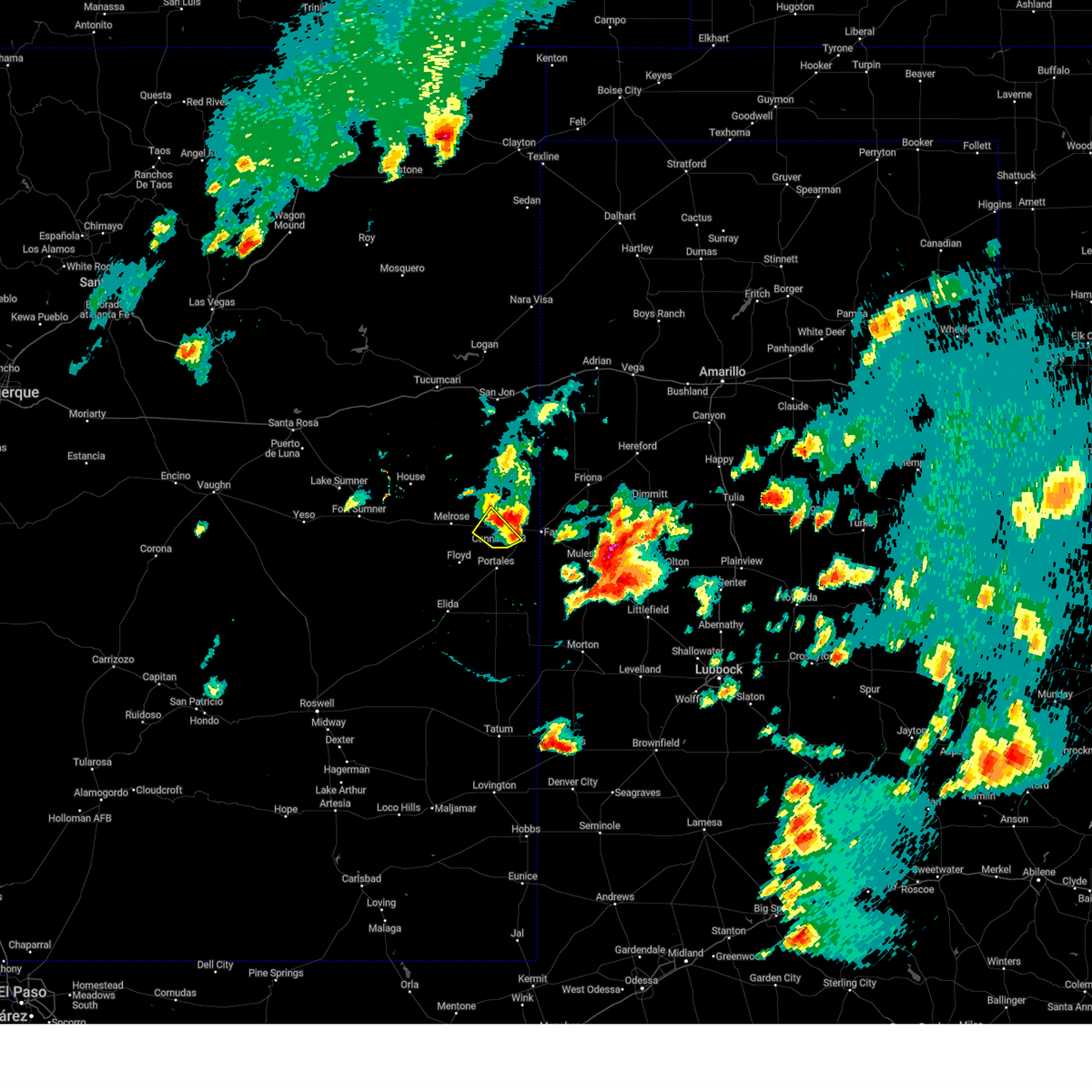
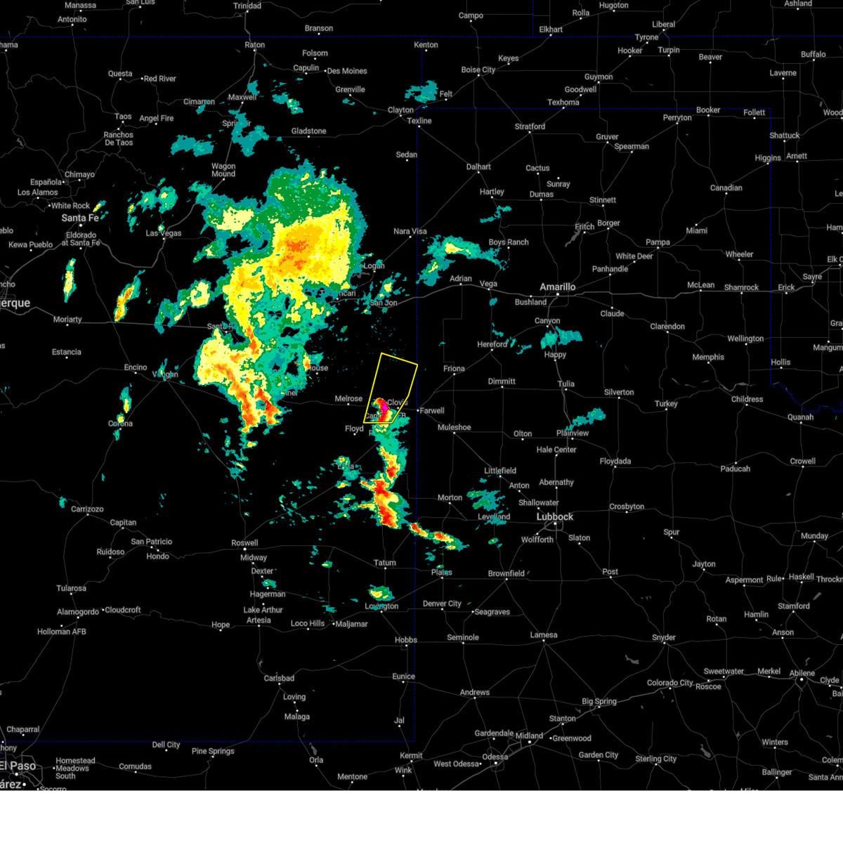
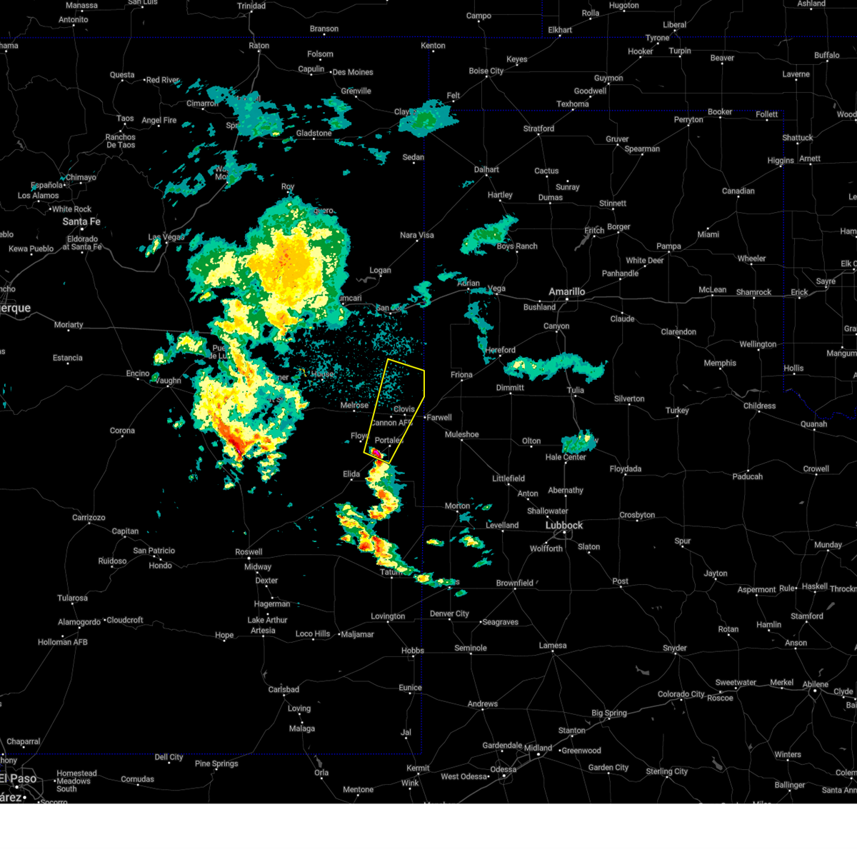
The Cannon AFB, NM area has had 4 reports of on-the-ground hail by trained spotters, and has been under severe weather warnings 38 times during the past 12 months. Doppler radar has detected hail at or near Cannon AFB, NM on 79 occasions, including 9 occasions during the past year.
| Name: | Cannon AFB, NM |
| Where Located: | 58.7 miles SSE of Tucumcari, NM |
| Map: | Google Map for Cannon AFB, NM |
| Population: | 2245 |
| Housing Units: | 987 |
| More Info: | Search Google for Cannon AFB, NM |
2
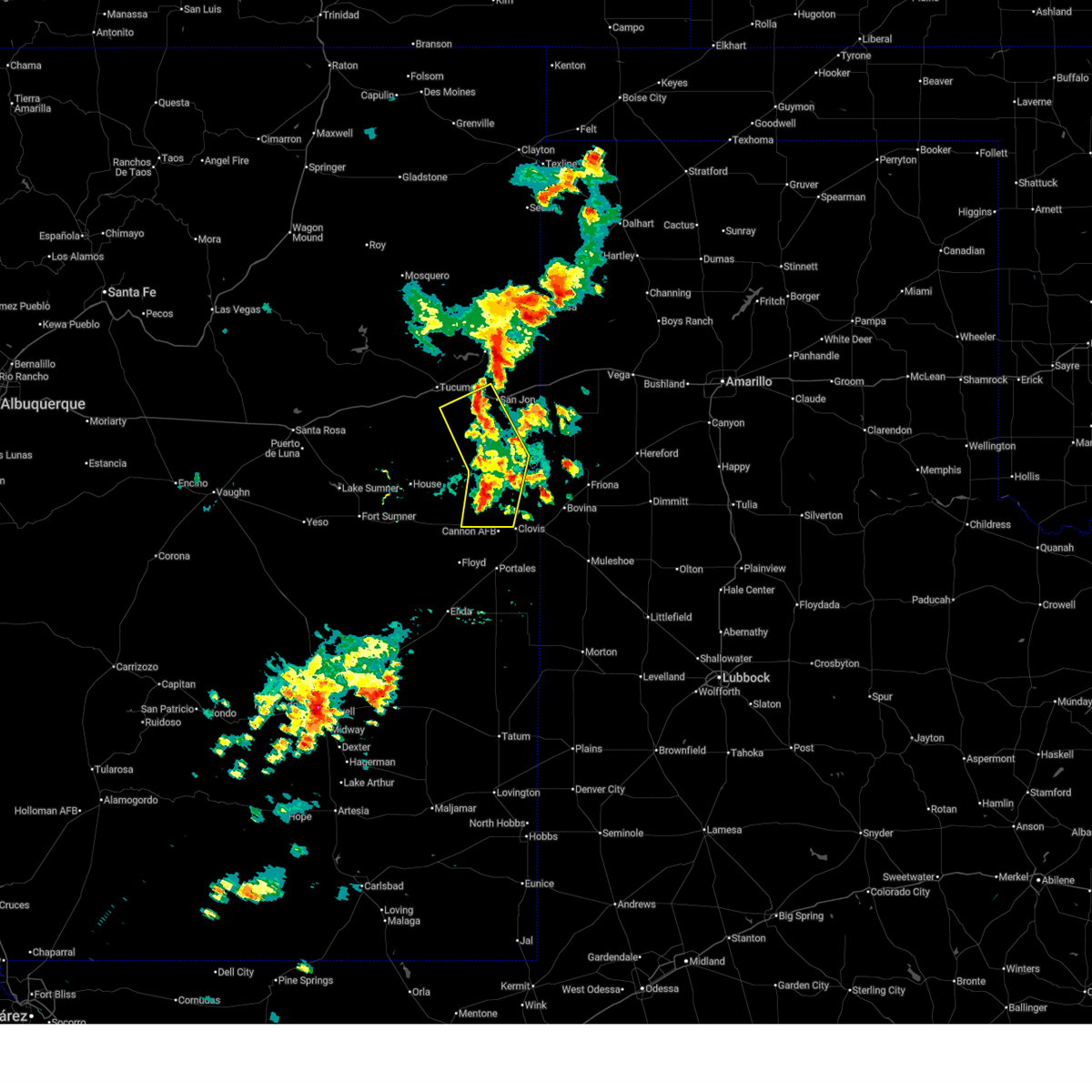
The Top Recent Hail Date for Cannon AFB, NM is Sunday, May 25, 2025 (6th out of 79)
Hail and Wind Damage Spotted near Cannon AFB, NM
| Date / Time | Report Details |
|---|---|
| 6/22/2025 5:53 PM MDT |
 The severe thunderstorm warning that was previously in effect has been reissued for curry and quay counties and is in effect until 630 pm mdt. please refer to that bulletin for the latest severe weather information. The severe thunderstorm warning that was previously in effect has been reissued for curry and quay counties and is in effect until 630 pm mdt. please refer to that bulletin for the latest severe weather information.
|
| 6/22/2025 5:44 PM MDT |
 At 544 pm mdt, severe thunderstorms were located along a line from 6 miles west of san jon to 7 miles northeast of saint vrain, moving northeast at 15 mph (radar indicated). Hazards include 60 mph wind gusts and small hail. Expect damage to roofs, siding, and trees. locations impacted include, san jon, grady, wheatland, broadview, ranchvale and saint vrain. this includes the following highways, interstate 40 between mile markers 348 and 356. Highway 60 between mile markers 368 and 377. At 544 pm mdt, severe thunderstorms were located along a line from 6 miles west of san jon to 7 miles northeast of saint vrain, moving northeast at 15 mph (radar indicated). Hazards include 60 mph wind gusts and small hail. Expect damage to roofs, siding, and trees. locations impacted include, san jon, grady, wheatland, broadview, ranchvale and saint vrain. this includes the following highways, interstate 40 between mile markers 348 and 356. Highway 60 between mile markers 368 and 377.
|
| 6/22/2025 5:17 PM MDT |
 Svrabq the national weather service in albuquerque has issued a * severe thunderstorm warning for, central curry county in east central new mexico, southeastern quay county in east central new mexico, * until 600 pm mdt. * at 517 pm mdt, severe thunderstorms were located along a line from 8 miles east of quay to near saint vrain, moving east at 10 mph (radar indicated). Hazards include 60 mph wind gusts and small hail. expect damage to roofs, siding, and trees Svrabq the national weather service in albuquerque has issued a * severe thunderstorm warning for, central curry county in east central new mexico, southeastern quay county in east central new mexico, * until 600 pm mdt. * at 517 pm mdt, severe thunderstorms were located along a line from 8 miles east of quay to near saint vrain, moving east at 10 mph (radar indicated). Hazards include 60 mph wind gusts and small hail. expect damage to roofs, siding, and trees
|
| 6/15/2025 7:13 PM MDT |
 The severe thunderstorm warning that was previously in effect has been reissued for curry and quay counties and is in effect until 815 pm mdt. please refer to that bulletin for the latest severe weather information. a severe thunderstorm watch remains in effect until 1100 pm mdt sunday for a portion of east central new mexico. The severe thunderstorm warning that was previously in effect has been reissued for curry and quay counties and is in effect until 815 pm mdt. please refer to that bulletin for the latest severe weather information. a severe thunderstorm watch remains in effect until 1100 pm mdt sunday for a portion of east central new mexico.
|
| 6/15/2025 6:41 PM MDT |
 At 641 pm mdt, a severe thunderstorm was located 10 miles north of melrose, or 26 miles west of clovis, moving northeast at 30 mph (radar indicated). Hazards include 60 mph wind gusts and quarter size hail. Hail damage to vehicles is expected. expect wind damage to roofs, siding, and trees. locations impacted include, clovis, melrose, saint vrain, ranchvale, cannon air force base, forrest and portair. This includes highway 60 between mile markers 353 and 387. At 641 pm mdt, a severe thunderstorm was located 10 miles north of melrose, or 26 miles west of clovis, moving northeast at 30 mph (radar indicated). Hazards include 60 mph wind gusts and quarter size hail. Hail damage to vehicles is expected. expect wind damage to roofs, siding, and trees. locations impacted include, clovis, melrose, saint vrain, ranchvale, cannon air force base, forrest and portair. This includes highway 60 between mile markers 353 and 387.
|
| 6/15/2025 6:26 PM MDT |
 Svrabq the national weather service in albuquerque has issued a * severe thunderstorm warning for, southern curry county in east central new mexico, south central quay county in east central new mexico, northwestern roosevelt county in east central new mexico, * until 715 pm mdt. * at 626 pm mdt, a severe thunderstorm was located 9 miles northwest of melrose, or 28 miles east of fort sumner, moving northeast at 30 mph (radar indicated). Hazards include 60 mph wind gusts and half dollar size hail. Hail damage to vehicles is expected. Expect wind damage to roofs, siding, and trees. Svrabq the national weather service in albuquerque has issued a * severe thunderstorm warning for, southern curry county in east central new mexico, south central quay county in east central new mexico, northwestern roosevelt county in east central new mexico, * until 715 pm mdt. * at 626 pm mdt, a severe thunderstorm was located 9 miles northwest of melrose, or 28 miles east of fort sumner, moving northeast at 30 mph (radar indicated). Hazards include 60 mph wind gusts and half dollar size hail. Hail damage to vehicles is expected. Expect wind damage to roofs, siding, and trees.
|
| 6/15/2025 6:24 PM MDT |
 the severe thunderstorm warning has been cancelled and is no longer in effect the severe thunderstorm warning has been cancelled and is no longer in effect
|
| 6/15/2025 6:24 PM MDT |
 At 624 pm mdt, a severe thunderstorm was located 5 miles northwest of melrose, or 28 miles west of clovis, moving northeast at 30 mph (radar indicated). Hazards include 60 mph wind gusts and quarter size hail. Hail damage to vehicles is expected. expect wind damage to roofs, siding, and trees. locations impacted include, melrose, saint vrain, tolar and cannon air force base. This includes highway 60 between mile markers 346 and 381. At 624 pm mdt, a severe thunderstorm was located 5 miles northwest of melrose, or 28 miles west of clovis, moving northeast at 30 mph (radar indicated). Hazards include 60 mph wind gusts and quarter size hail. Hail damage to vehicles is expected. expect wind damage to roofs, siding, and trees. locations impacted include, melrose, saint vrain, tolar and cannon air force base. This includes highway 60 between mile markers 346 and 381.
|
| 6/15/2025 5:58 PM MDT |
 At 558 pm mdt, a severe thunderstorm was located 6 miles southeast of tolar, or 23 miles east of fort sumner, moving northeast at 30 mph (radar indicated). Hazards include 60 mph wind gusts and quarter size hail. Hail damage to vehicles is expected. expect wind damage to roofs, siding, and trees. locations impacted include, melrose, tolar, saint vrain, taiban and cannon air force base. This includes highway 60 between mile markers 339 and 381. At 558 pm mdt, a severe thunderstorm was located 6 miles southeast of tolar, or 23 miles east of fort sumner, moving northeast at 30 mph (radar indicated). Hazards include 60 mph wind gusts and quarter size hail. Hail damage to vehicles is expected. expect wind damage to roofs, siding, and trees. locations impacted include, melrose, tolar, saint vrain, taiban and cannon air force base. This includes highway 60 between mile markers 339 and 381.
|
| 6/15/2025 5:42 PM MDT | Svrabq the national weather service in albuquerque has issued a * severe thunderstorm warning for, southwestern curry county in east central new mexico, east central de baca county in east central new mexico, south central quay county in east central new mexico, northwestern roosevelt county in east central new mexico, * until 630 pm mdt. * at 542 pm mdt, a severe thunderstorm was located 10 miles south of tolar, or 21 miles southeast of fort sumner, moving northeast at 35 mph (radar indicated). Hazards include 60 mph wind gusts and quarter size hail. Hail damage to vehicles is expected. Expect wind damage to roofs, siding, and trees. |
| 6/9/2025 9:13 PM MDT |
 The storms which prompted the warning have weakened below severe limits, and no longer pose an immediate threat to life or property. therefore, the warning will be allowed to expire. however, small hail, gusty winds, and heavy rain are still possible with these thunderstorms. a severe thunderstorm watch remains in effect until 1000 pm mdt for portions of east central and southeast new mexico. The storms which prompted the warning have weakened below severe limits, and no longer pose an immediate threat to life or property. therefore, the warning will be allowed to expire. however, small hail, gusty winds, and heavy rain are still possible with these thunderstorms. a severe thunderstorm watch remains in effect until 1000 pm mdt for portions of east central and southeast new mexico.
|
| 6/9/2025 8:59 PM MDT |
 At 859 pm mdt, severe thunderstorms were located along a line from 10 miles northeast of texico to 14 miles west of milnesand, moving east at 45 mph (radar indicated). Hazards include 60 mph wind gusts and quarter size hail. Hail damage to vehicles is expected. expect wind damage to roofs, siding, and trees. locations impacted include, clovis, portales, texico, elida, dora, causey, pep, oasis state park, arch and lingo. This includes highway 60 between mile markers 374 and 397. At 859 pm mdt, severe thunderstorms were located along a line from 10 miles northeast of texico to 14 miles west of milnesand, moving east at 45 mph (radar indicated). Hazards include 60 mph wind gusts and quarter size hail. Hail damage to vehicles is expected. expect wind damage to roofs, siding, and trees. locations impacted include, clovis, portales, texico, elida, dora, causey, pep, oasis state park, arch and lingo. This includes highway 60 between mile markers 374 and 397.
|
| 6/9/2025 8:28 PM MDT |
 At 828 pm mdt, severe thunderstorms were located along a line from over clovis to 8 miles southeast of elida, moving east at 45 mph (trained spotters reported). Hazards include 70 mph wind gusts and quarter size hail. Hail damage to vehicles is expected. expect considerable tree damage. wind damage is also likely to mobile homes, roofs, and outbuildings. locations impacted include, clovis, portales, texico, elida, dora, causey, pep, oasis state park, arch and cannon air force base. This includes highway 60 between mile markers 366 and 397. At 828 pm mdt, severe thunderstorms were located along a line from over clovis to 8 miles southeast of elida, moving east at 45 mph (trained spotters reported). Hazards include 70 mph wind gusts and quarter size hail. Hail damage to vehicles is expected. expect considerable tree damage. wind damage is also likely to mobile homes, roofs, and outbuildings. locations impacted include, clovis, portales, texico, elida, dora, causey, pep, oasis state park, arch and cannon air force base. This includes highway 60 between mile markers 366 and 397.
|
| 6/9/2025 7:58 PM MDT |
 Svrabq the national weather service in albuquerque has issued a * severe thunderstorm warning for, southern curry county in east central new mexico, roosevelt county in east central new mexico, northeastern chaves county in southeastern new mexico, * until 915 pm mdt. * at 758 pm mdt, severe thunderstorms were located along a line from near melrose to 14 miles north of elkins, moving east at 45 mph (trained spotters reported). Hazards include 60 mph wind gusts and quarter size hail. Hail damage to vehicles is expected. Expect wind damage to roofs, siding, and trees. Svrabq the national weather service in albuquerque has issued a * severe thunderstorm warning for, southern curry county in east central new mexico, roosevelt county in east central new mexico, northeastern chaves county in southeastern new mexico, * until 915 pm mdt. * at 758 pm mdt, severe thunderstorms were located along a line from near melrose to 14 miles north of elkins, moving east at 45 mph (trained spotters reported). Hazards include 60 mph wind gusts and quarter size hail. Hail damage to vehicles is expected. Expect wind damage to roofs, siding, and trees.
|
| 6/8/2025 6:27 PM MDT | Awos station kcvs cannon air force bas in curry county NM, 1.7 miles N of Cannon AFB, NM |
| 6/6/2025 10:54 PM MDT |
 the severe thunderstorm warning has been cancelled and is no longer in effect the severe thunderstorm warning has been cancelled and is no longer in effect
|
| 6/6/2025 10:54 PM MDT |
 At 1054 pm mdt, a severe thunderstorm was located over clovis, moving northeast at 45 mph (emergency management reported half dollar size hail in clovis). Hazards include ping pong ball size hail and 60 mph wind gusts. People and animals outdoors will be injured. expect hail damage to roofs, siding, windows, and vehicles. expect wind damage to roofs, siding, and trees. locations impacted include, clovis, texico, ranchvale, cannon air force base, portair and pleasant hill. This includes highway 60 between mile markers 380 and 397. At 1054 pm mdt, a severe thunderstorm was located over clovis, moving northeast at 45 mph (emergency management reported half dollar size hail in clovis). Hazards include ping pong ball size hail and 60 mph wind gusts. People and animals outdoors will be injured. expect hail damage to roofs, siding, windows, and vehicles. expect wind damage to roofs, siding, and trees. locations impacted include, clovis, texico, ranchvale, cannon air force base, portair and pleasant hill. This includes highway 60 between mile markers 380 and 397.
|
| 6/6/2025 10:38 PM MDT |
 Svrabq the national weather service in albuquerque has issued a * severe thunderstorm warning for, southeastern curry county in east central new mexico, east central roosevelt county in east central new mexico, * until 1130 pm mdt. * at 1038 pm mdt, a severe thunderstorm was located near cannon air force base, or 11 miles southwest of clovis, moving northeast at 45 mph (radar indicated). Hazards include 60 mph wind gusts and quarter size hail. Hail damage to vehicles is expected. Expect wind damage to roofs, siding, and trees. Svrabq the national weather service in albuquerque has issued a * severe thunderstorm warning for, southeastern curry county in east central new mexico, east central roosevelt county in east central new mexico, * until 1130 pm mdt. * at 1038 pm mdt, a severe thunderstorm was located near cannon air force base, or 11 miles southwest of clovis, moving northeast at 45 mph (radar indicated). Hazards include 60 mph wind gusts and quarter size hail. Hail damage to vehicles is expected. Expect wind damage to roofs, siding, and trees.
|
| 6/5/2025 5:12 PM MDT |
 Svrabq the national weather service in albuquerque has issued a * severe thunderstorm warning for, southeastern curry county in east central new mexico, * until 545 pm mdt. * at 512 pm mdt, a severe thunderstorm was located near clovis, moving east at 20 mph (radar indicated). Hazards include 60 mph wind gusts and quarter size hail. Hail damage to vehicles is expected. Expect wind damage to roofs, siding, and trees. Svrabq the national weather service in albuquerque has issued a * severe thunderstorm warning for, southeastern curry county in east central new mexico, * until 545 pm mdt. * at 512 pm mdt, a severe thunderstorm was located near clovis, moving east at 20 mph (radar indicated). Hazards include 60 mph wind gusts and quarter size hail. Hail damage to vehicles is expected. Expect wind damage to roofs, siding, and trees.
|
| 6/4/2025 9:29 PM MDT |
 The storms which prompted the warning have weakened below severe limits, and have exited the warned area. therefore, the warning will be allowed to expire. however, small hail and gusty winds are still possible with these thunderstorms. a severe thunderstorm watch remains in effect until 1100 pm mdt for a portion of east central new mexico. The storms which prompted the warning have weakened below severe limits, and have exited the warned area. therefore, the warning will be allowed to expire. however, small hail and gusty winds are still possible with these thunderstorms. a severe thunderstorm watch remains in effect until 1100 pm mdt for a portion of east central new mexico.
|
| 6/4/2025 9:13 PM MDT |
 At 913 pm mdt, severe thunderstorms were located along a line from 5 miles east of bellview to 6 miles northwest of saint vrain, moving east at 35 mph (radar indicated). Hazards include 60 mph wind gusts and quarter size hail. Hail damage to vehicles is expected. expect wind damage to roofs, siding, and trees. locations impacted include, clovis, grady, broadview, wheatland, ranchvale, bellview, cannon air force base, forrest, portair and mcalister. This includes highway 60 between mile markers 381 and 383. At 913 pm mdt, severe thunderstorms were located along a line from 5 miles east of bellview to 6 miles northwest of saint vrain, moving east at 35 mph (radar indicated). Hazards include 60 mph wind gusts and quarter size hail. Hail damage to vehicles is expected. expect wind damage to roofs, siding, and trees. locations impacted include, clovis, grady, broadview, wheatland, ranchvale, bellview, cannon air force base, forrest, portair and mcalister. This includes highway 60 between mile markers 381 and 383.
|
| 6/4/2025 8:44 PM MDT |
 Svrabq the national weather service in albuquerque has issued a * severe thunderstorm warning for, curry county in east central new mexico, southeastern quay county in east central new mexico, northern roosevelt county in east central new mexico, * until 930 pm mdt. * at 844 pm mdt, severe thunderstorms were located along a line from near wheatland to 9 miles northwest of melrose, moving east at 35 mph (radar indicated). Hazards include 60 mph wind gusts and half dollar size hail. Hail damage to vehicles is expected. Expect wind damage to roofs, siding, and trees. Svrabq the national weather service in albuquerque has issued a * severe thunderstorm warning for, curry county in east central new mexico, southeastern quay county in east central new mexico, northern roosevelt county in east central new mexico, * until 930 pm mdt. * at 844 pm mdt, severe thunderstorms were located along a line from near wheatland to 9 miles northwest of melrose, moving east at 35 mph (radar indicated). Hazards include 60 mph wind gusts and half dollar size hail. Hail damage to vehicles is expected. Expect wind damage to roofs, siding, and trees.
|
| 6/2/2025 1:06 PM MDT | Awos station kcvs cannon air force bas in curry county NM, 1.7 miles N of Cannon AFB, NM |
| 6/2/2025 1:01 PM MDT | Awos station kcvs cannon air force bas in curry county NM, 1.7 miles N of Cannon AFB, NM |
| 5/25/2025 6:18 PM MDT |
 the severe thunderstorm warning has been cancelled and is no longer in effect the severe thunderstorm warning has been cancelled and is no longer in effect
|
| 5/25/2025 6:07 PM MDT | At 607 pm mdt, a severe thunderstorm was located near cannon air force base, or 12 miles north of portales, moving northeast at 15 mph (radar indicated). Hazards include 60 mph wind gusts and quarter size hail. Hail damage to vehicles is expected. expect wind damage to roofs, siding, and trees. locations impacted include, clovis, cannon air force base and portair. This includes highway 60 between mile markers 373 and 386. |
| 5/25/2025 6:07 PM MDT | the severe thunderstorm warning has been cancelled and is no longer in effect |
| 5/25/2025 5:49 PM MDT | Svrabq the national weather service in albuquerque has issued a * severe thunderstorm warning for, south central curry county in east central new mexico, central roosevelt county in east central new mexico, * until 630 pm mdt. * at 549 pm mdt, a severe thunderstorm was located 6 miles northwest of oasis state park, or 10 miles northwest of portales, moving northeast at 15 mph (radar indicated). Hazards include 60 mph wind gusts and quarter size hail. Hail damage to vehicles is expected. Expect wind damage to roofs, siding, and trees. |
| 5/5/2025 3:05 AM MDT |
 The storm which prompted the warning has weakened below severe limits, and no longer poses an immediate threat to life or property. therefore, the warning will be allowed to expire. however, small hail, gusty winds, and heavy rain are still possible with this thunderstorm. The storm which prompted the warning has weakened below severe limits, and no longer poses an immediate threat to life or property. therefore, the warning will be allowed to expire. however, small hail, gusty winds, and heavy rain are still possible with this thunderstorm.
|
| 5/5/2025 2:53 AM MDT |
 the severe thunderstorm warning has been cancelled and is no longer in effect the severe thunderstorm warning has been cancelled and is no longer in effect
|
| 5/5/2025 2:53 AM MDT |
 At 253 am mdt, a severe thunderstorm was located near ranchvale, or 7 miles west of clovis, moving north at 45 mph (radar indicated). Hazards include 60 mph wind gusts and small hail. Expect damage to roofs, siding, and trees. locations impacted include, clovis, ranchvale, cannon air force base and portair. This includes highway 60 between mile markers 373 and 388. At 253 am mdt, a severe thunderstorm was located near ranchvale, or 7 miles west of clovis, moving north at 45 mph (radar indicated). Hazards include 60 mph wind gusts and small hail. Expect damage to roofs, siding, and trees. locations impacted include, clovis, ranchvale, cannon air force base and portair. This includes highway 60 between mile markers 373 and 388.
|
| 5/5/2025 2:26 AM MDT |
 Svrabq the national weather service in albuquerque has issued a * severe thunderstorm warning for, southeastern curry county in east central new mexico, central roosevelt county in east central new mexico, * until 315 am mdt. * at 226 am mdt, a severe thunderstorm was located near portales, moving north at 45 mph (radar indicated). Hazards include 60 mph wind gusts and quarter size hail. Hail damage to vehicles is expected. Expect wind damage to roofs, siding, and trees. Svrabq the national weather service in albuquerque has issued a * severe thunderstorm warning for, southeastern curry county in east central new mexico, central roosevelt county in east central new mexico, * until 315 am mdt. * at 226 am mdt, a severe thunderstorm was located near portales, moving north at 45 mph (radar indicated). Hazards include 60 mph wind gusts and quarter size hail. Hail damage to vehicles is expected. Expect wind damage to roofs, siding, and trees.
|
| 11/2/2024 2:12 PM MDT |
 The storm which prompted the warning has weakened below severe limits, and no longer poses an immediate threat to life or property. therefore, the warning will be allowed to expire. however, small hail and gusty winds are still possible with this thunderstorm. The storm which prompted the warning has weakened below severe limits, and no longer poses an immediate threat to life or property. therefore, the warning will be allowed to expire. however, small hail and gusty winds are still possible with this thunderstorm.
|
| 11/2/2024 1:29 PM MDT |
 Svrabq the national weather service in albuquerque has issued a * severe thunderstorm warning for, southwestern curry county in east central new mexico, northwestern roosevelt county in east central new mexico, * until 215 pm mdt. * at 129 pm mdt, a severe thunderstorm was located 17 miles north of elida, or 21 miles west of portales, moving north at 40 mph (radar indicated). Hazards include two inch hail and 70 mph wind gusts. People and animals outdoors will be injured. expect hail damage to roofs, siding, windows, and vehicles. expect considerable tree damage. Wind damage is also likely to mobile homes, roofs, and outbuildings. Svrabq the national weather service in albuquerque has issued a * severe thunderstorm warning for, southwestern curry county in east central new mexico, northwestern roosevelt county in east central new mexico, * until 215 pm mdt. * at 129 pm mdt, a severe thunderstorm was located 17 miles north of elida, or 21 miles west of portales, moving north at 40 mph (radar indicated). Hazards include two inch hail and 70 mph wind gusts. People and animals outdoors will be injured. expect hail damage to roofs, siding, windows, and vehicles. expect considerable tree damage. Wind damage is also likely to mobile homes, roofs, and outbuildings.
|
| 9/21/2024 3:17 PM MDT |
 At 317 pm mdt, a severe thunderstorm was located near ranchvale, or 9 miles northwest of clovis, moving northeast at 35 mph (radar indicated). Hazards include 60 mph wind gusts and quarter size hail. Hail damage to vehicles is expected. expect wind damage to roofs, siding, and trees. locations impacted include, clovis, ranchvale, cannon air force base and pleasant hill. This includes highway 60 near mile marker 380. At 317 pm mdt, a severe thunderstorm was located near ranchvale, or 9 miles northwest of clovis, moving northeast at 35 mph (radar indicated). Hazards include 60 mph wind gusts and quarter size hail. Hail damage to vehicles is expected. expect wind damage to roofs, siding, and trees. locations impacted include, clovis, ranchvale, cannon air force base and pleasant hill. This includes highway 60 near mile marker 380.
|
| 9/21/2024 3:08 PM MDT |
 At 308 pm mdt, a severe thunderstorm was located near ranchvale, or 11 miles northwest of clovis, moving northeast at 35 mph (radar indicated). Hazards include 60 mph wind gusts and quarter size hail. Hail damage to vehicles is expected. expect wind damage to roofs, siding, and trees. locations impacted include, clovis, ranchvale, cannon air force base, saint vrain, portair and pleasant hill. This includes highway 60 between mile markers 370 and 383. At 308 pm mdt, a severe thunderstorm was located near ranchvale, or 11 miles northwest of clovis, moving northeast at 35 mph (radar indicated). Hazards include 60 mph wind gusts and quarter size hail. Hail damage to vehicles is expected. expect wind damage to roofs, siding, and trees. locations impacted include, clovis, ranchvale, cannon air force base, saint vrain, portair and pleasant hill. This includes highway 60 between mile markers 370 and 383.
|
| 9/21/2024 2:55 PM MDT |
 the severe thunderstorm warning has been cancelled and is no longer in effect the severe thunderstorm warning has been cancelled and is no longer in effect
|
| 9/21/2024 2:55 PM MDT |
 At 255 pm mdt, a severe thunderstorm was located near saint vrain, or 14 miles west of clovis, moving northeast at 35 mph (radar indicated). Hazards include 60 mph wind gusts and quarter size hail. Hail damage to vehicles is expected. expect wind damage to roofs, siding, and trees. locations impacted include, clovis, ranchvale, cannon air force base, saint vrain, portair and pleasant hill. This includes highway 60 between mile markers 366 and 383. At 255 pm mdt, a severe thunderstorm was located near saint vrain, or 14 miles west of clovis, moving northeast at 35 mph (radar indicated). Hazards include 60 mph wind gusts and quarter size hail. Hail damage to vehicles is expected. expect wind damage to roofs, siding, and trees. locations impacted include, clovis, ranchvale, cannon air force base, saint vrain, portair and pleasant hill. This includes highway 60 between mile markers 366 and 383.
|
| 9/21/2024 2:43 PM MDT |
 Svrabq the national weather service in albuquerque has issued a * severe thunderstorm warning for, southern curry county in east central new mexico, central roosevelt county in east central new mexico, * until 330 pm mdt. * at 243 pm mdt, a severe thunderstorm was located near saint vrain, or 16 miles northwest of portales, moving northeast at 40 mph (radar indicated). Hazards include 60 mph wind gusts and quarter size hail. Hail damage to vehicles is expected. Expect wind damage to roofs, siding, and trees. Svrabq the national weather service in albuquerque has issued a * severe thunderstorm warning for, southern curry county in east central new mexico, central roosevelt county in east central new mexico, * until 330 pm mdt. * at 243 pm mdt, a severe thunderstorm was located near saint vrain, or 16 miles northwest of portales, moving northeast at 40 mph (radar indicated). Hazards include 60 mph wind gusts and quarter size hail. Hail damage to vehicles is expected. Expect wind damage to roofs, siding, and trees.
|
| 8/17/2024 4:34 PM MDT | Awos station kcvs cannon air force base. caused by a thunderstorm induced microburs in curry county NM, 1.7 miles N of Cannon AFB, NM |
| 7/8/2024 6:54 AM MDT | Peak wind gusts of 54 knots at canon af in curry county NM, 1.7 miles N of Cannon AFB, NM |
| 7/7/2024 5:06 PM MDT |
 the severe thunderstorm warning has been cancelled and is no longer in effect the severe thunderstorm warning has been cancelled and is no longer in effect
|
| 7/7/2024 4:57 PM MDT |
 Svrabq the national weather service in albuquerque has issued a * severe thunderstorm warning for, south central curry county in east central new mexico, * until 530 pm mdt. * at 457 pm mdt, a severe thunderstorm was located over cannon air force base, or 7 miles southwest of clovis, moving southeast at 5 mph (radar indicated). Hazards include 60 mph wind gusts and quarter size hail. Hail damage to vehicles is expected. Expect wind damage to roofs, siding, and trees. Svrabq the national weather service in albuquerque has issued a * severe thunderstorm warning for, south central curry county in east central new mexico, * until 530 pm mdt. * at 457 pm mdt, a severe thunderstorm was located over cannon air force base, or 7 miles southwest of clovis, moving southeast at 5 mph (radar indicated). Hazards include 60 mph wind gusts and quarter size hail. Hail damage to vehicles is expected. Expect wind damage to roofs, siding, and trees.
|
| 6/26/2024 6:28 PM MDT | Storm damage reported in curry county NM, 0.4 miles N of Cannon AFB, NM |
| 6/14/2024 5:42 PM MDT |
 At 542 pm mdt, severe thunderstorms were located along a line extending from 11 miles southeast of glenrio to near oasis state park, moving northeast at 15 mph (radar indicated). Hazards include 60 mph wind gusts and nickel size hail. Expect damage to roofs, siding, and trees. Locations impacted include, clovis, portales, melrose, elida, grady, saint vrain, ranchvale, oasis state park, cannon air force base, and broadview. At 542 pm mdt, severe thunderstorms were located along a line extending from 11 miles southeast of glenrio to near oasis state park, moving northeast at 15 mph (radar indicated). Hazards include 60 mph wind gusts and nickel size hail. Expect damage to roofs, siding, and trees. Locations impacted include, clovis, portales, melrose, elida, grady, saint vrain, ranchvale, oasis state park, cannon air force base, and broadview.
|
| 6/14/2024 5:11 PM MDT |
 Svrabq the national weather service in albuquerque has issued a * severe thunderstorm warning for, northwestern roosevelt county in east central new mexico, southeastern quay county in east central new mexico, curry county in east central new mexico, * until 615 pm mdt. * at 511 pm mdt, severe thunderstorms were located along a line extending from 8 miles north of broadview to 14 miles north of elida, moving northeast at 15 mph (radar indicated). Hazards include 60 mph wind gusts and nickel size hail. expect damage to roofs, siding, and trees Svrabq the national weather service in albuquerque has issued a * severe thunderstorm warning for, northwestern roosevelt county in east central new mexico, southeastern quay county in east central new mexico, curry county in east central new mexico, * until 615 pm mdt. * at 511 pm mdt, severe thunderstorms were located along a line extending from 8 miles north of broadview to 14 miles north of elida, moving northeast at 15 mph (radar indicated). Hazards include 60 mph wind gusts and nickel size hail. expect damage to roofs, siding, and trees
|
| 5/31/2024 7:25 PM MDT |
 The storms which prompted the warning have weakened below severe limits, and no longer pose an immediate threat to life or property. therefore, the warning will be allowed to expire. however, gusty winds and heavy rain are still possible with these thunderstorms. a severe thunderstorm watch remains in effect until 1000 pm mdt for east central new mexico. The storms which prompted the warning have weakened below severe limits, and no longer pose an immediate threat to life or property. therefore, the warning will be allowed to expire. however, gusty winds and heavy rain are still possible with these thunderstorms. a severe thunderstorm watch remains in effect until 1000 pm mdt for east central new mexico.
|
| 5/31/2024 7:09 PM MDT |
 the severe thunderstorm warning has been cancelled and is no longer in effect the severe thunderstorm warning has been cancelled and is no longer in effect
|
| 5/31/2024 7:09 PM MDT |
 At 708 pm mdt, severe thunderstorms were located along a line extending from 8 miles west of bovina to 8 miles south of melrose, moving southeast at 35 mph (radar indicated). Hazards include 60 mph wind gusts and quarter size hail. Hail damage to vehicles is expected. expect wind damage to roofs, siding, and trees. Locations impacted include, clovis, portales, farwell, texico, melrose, grady, saint vrain, ranchvale, oasis state park, and cannon air force base. At 708 pm mdt, severe thunderstorms were located along a line extending from 8 miles west of bovina to 8 miles south of melrose, moving southeast at 35 mph (radar indicated). Hazards include 60 mph wind gusts and quarter size hail. Hail damage to vehicles is expected. expect wind damage to roofs, siding, and trees. Locations impacted include, clovis, portales, farwell, texico, melrose, grady, saint vrain, ranchvale, oasis state park, and cannon air force base.
|
| 5/31/2024 6:35 PM MDT |
 Svrabq the national weather service in albuquerque has issued a * severe thunderstorm warning for, northern roosevelt county in east central new mexico, northeastern de baca county in east central new mexico, southeastern quay county in east central new mexico, curry county in east central new mexico, * until 730 pm mdt. * at 635 pm mdt, severe thunderstorms were located along a line extending from near wheatland to 6 miles northeast of tolar, moving southeast at 40 mph (radar indicated). Hazards include 60 mph wind gusts and quarter size hail. Hail damage to vehicles is expected. Expect wind damage to roofs, siding, and trees. Svrabq the national weather service in albuquerque has issued a * severe thunderstorm warning for, northern roosevelt county in east central new mexico, northeastern de baca county in east central new mexico, southeastern quay county in east central new mexico, curry county in east central new mexico, * until 730 pm mdt. * at 635 pm mdt, severe thunderstorms were located along a line extending from near wheatland to 6 miles northeast of tolar, moving southeast at 40 mph (radar indicated). Hazards include 60 mph wind gusts and quarter size hail. Hail damage to vehicles is expected. Expect wind damage to roofs, siding, and trees.
|
| 5/31/2024 4:17 PM MDT |
 Svrabq the national weather service in albuquerque has issued a * severe thunderstorm warning for, northwestern roosevelt county in east central new mexico, southwestern curry county in east central new mexico, * until 500 pm mdt. * at 417 pm mdt, a severe thunderstorm was located near melrose, or 20 miles northwest of portales, and is nearly stationary (radar indicated). Hazards include 60 mph wind gusts and half dollar size hail. Hail damage to vehicles is expected. Expect wind damage to roofs, siding, and trees. Svrabq the national weather service in albuquerque has issued a * severe thunderstorm warning for, northwestern roosevelt county in east central new mexico, southwestern curry county in east central new mexico, * until 500 pm mdt. * at 417 pm mdt, a severe thunderstorm was located near melrose, or 20 miles northwest of portales, and is nearly stationary (radar indicated). Hazards include 60 mph wind gusts and half dollar size hail. Hail damage to vehicles is expected. Expect wind damage to roofs, siding, and trees.
|
| 5/29/2024 11:15 PM MDT |
 Svrabq the national weather service in albuquerque has issued a * severe thunderstorm warning for, east central roosevelt county in east central new mexico, southeastern curry county in east central new mexico, * until 1215 am mdt. * at 1114 pm mdt, a severe thunderstorm was located near oasis state park, or near portales, moving south at 10 mph (radar indicated). Hazards include ping pong ball size hail and 60 mph wind gusts. People and animals outdoors will be injured. expect hail damage to roofs, siding, windows, and vehicles. Expect wind damage to roofs, siding, and trees. Svrabq the national weather service in albuquerque has issued a * severe thunderstorm warning for, east central roosevelt county in east central new mexico, southeastern curry county in east central new mexico, * until 1215 am mdt. * at 1114 pm mdt, a severe thunderstorm was located near oasis state park, or near portales, moving south at 10 mph (radar indicated). Hazards include ping pong ball size hail and 60 mph wind gusts. People and animals outdoors will be injured. expect hail damage to roofs, siding, windows, and vehicles. Expect wind damage to roofs, siding, and trees.
|
| 5/29/2024 10:31 PM MDT |
 Torabq the national weather service in albuquerque has issued a * tornado warning for, east central roosevelt county in east central new mexico, southeastern curry county in east central new mexico, * until 1115 pm mdt. * at 1031 pm mdt, a severe thunderstorm capable of producing a tornado was located near cannon air force base, or 10 miles north of portales, moving southeast at 25 mph (radar indicated rotation). Hazards include tornado and hail up to two inches in diameter. Flying debris will be dangerous to those caught without shelter. mobile homes will be damaged or destroyed. damage to roofs, windows, and vehicles will occur. tree damage is likely. This tornadic thunderstorm will remain over mainly rural areas of east central roosevelt and southeastern curry counties. Torabq the national weather service in albuquerque has issued a * tornado warning for, east central roosevelt county in east central new mexico, southeastern curry county in east central new mexico, * until 1115 pm mdt. * at 1031 pm mdt, a severe thunderstorm capable of producing a tornado was located near cannon air force base, or 10 miles north of portales, moving southeast at 25 mph (radar indicated rotation). Hazards include tornado and hail up to two inches in diameter. Flying debris will be dangerous to those caught without shelter. mobile homes will be damaged or destroyed. damage to roofs, windows, and vehicles will occur. tree damage is likely. This tornadic thunderstorm will remain over mainly rural areas of east central roosevelt and southeastern curry counties.
|
| 5/29/2024 10:30 PM MDT | Tennis Ball sized hail reported 1 miles N of Cannon AFB, NM |
| 5/29/2024 10:17 PM MDT |
 At 1016 pm mdt, a severe thunderstorm capable of producing a tornado was located near cannon air force base, or 11 miles southwest of clovis, moving south at 10 mph (radar indicated rotation). Hazards include tornado and two inch hail. Flying debris will be dangerous to those caught without shelter. mobile homes will be damaged or destroyed. damage to roofs, windows, and vehicles will occur. tree damage is likely. Locations impacted include, clovis, saint vrain, cannon air force base, ranchvale, and portair. At 1016 pm mdt, a severe thunderstorm capable of producing a tornado was located near cannon air force base, or 11 miles southwest of clovis, moving south at 10 mph (radar indicated rotation). Hazards include tornado and two inch hail. Flying debris will be dangerous to those caught without shelter. mobile homes will be damaged or destroyed. damage to roofs, windows, and vehicles will occur. tree damage is likely. Locations impacted include, clovis, saint vrain, cannon air force base, ranchvale, and portair.
|
| 5/29/2024 9:57 PM MDT |
 Torabq the national weather service in albuquerque has issued a * tornado warning for, southeastern curry county in east central new mexico, * until 1045 pm mdt. * at 956 pm mdt, a severe thunderstorm capable of producing a tornado was located near saint vrain, or 12 miles west of clovis, moving southeast at 10 mph towards cannon air force base (radar indicated rotation). Hazards include tornado and hail up to two inches in diameter. Flying debris will be dangerous to those caught without shelter. mobile homes will be damaged or destroyed. damage to roofs, windows, and vehicles will occur. Tree damage is likely. Torabq the national weather service in albuquerque has issued a * tornado warning for, southeastern curry county in east central new mexico, * until 1045 pm mdt. * at 956 pm mdt, a severe thunderstorm capable of producing a tornado was located near saint vrain, or 12 miles west of clovis, moving southeast at 10 mph towards cannon air force base (radar indicated rotation). Hazards include tornado and hail up to two inches in diameter. Flying debris will be dangerous to those caught without shelter. mobile homes will be damaged or destroyed. damage to roofs, windows, and vehicles will occur. Tree damage is likely.
|
| 5/28/2024 10:19 PM MDT |
 At 1018 pm mdt, severe thunderstorms were located along a line extending from near clovis to near cannon air force base to 6 miles west of oasis state park, moving south at 25 mph (radar indicated). Hazards include 70 mph wind gusts and ping pong ball size hail. People and animals outdoors will be injured. expect hail damage to roofs, siding, windows, and vehicles. expect considerable tree damage. wind damage is also likely to mobile homes, roofs, and outbuildings. Locations impacted include, clovis, portales, farwell, texico, saint vrain, cannon air force base, ranchvale, oasis state park, floyd, and portair. At 1018 pm mdt, severe thunderstorms were located along a line extending from near clovis to near cannon air force base to 6 miles west of oasis state park, moving south at 25 mph (radar indicated). Hazards include 70 mph wind gusts and ping pong ball size hail. People and animals outdoors will be injured. expect hail damage to roofs, siding, windows, and vehicles. expect considerable tree damage. wind damage is also likely to mobile homes, roofs, and outbuildings. Locations impacted include, clovis, portales, farwell, texico, saint vrain, cannon air force base, ranchvale, oasis state park, floyd, and portair.
|
| 5/28/2024 9:53 PM MDT |
 Svrabq the national weather service in albuquerque has issued a * severe thunderstorm warning for, central roosevelt county in east central new mexico, southern curry county in east central new mexico, * until 1045 pm mdt. * at 952 pm mdt, severe thunderstorms were located along a line extending from 11 miles north of clovis to near saint vrain, moving south at 25 mph (radar indicated). Hazards include 70 mph wind gusts and ping pong ball size hail. People and animals outdoors will be injured. expect hail damage to roofs, siding, windows, and vehicles. expect considerable tree damage. Wind damage is also likely to mobile homes, roofs, and outbuildings. Svrabq the national weather service in albuquerque has issued a * severe thunderstorm warning for, central roosevelt county in east central new mexico, southern curry county in east central new mexico, * until 1045 pm mdt. * at 952 pm mdt, severe thunderstorms were located along a line extending from 11 miles north of clovis to near saint vrain, moving south at 25 mph (radar indicated). Hazards include 70 mph wind gusts and ping pong ball size hail. People and animals outdoors will be injured. expect hail damage to roofs, siding, windows, and vehicles. expect considerable tree damage. Wind damage is also likely to mobile homes, roofs, and outbuildings.
|
| 12/23/2023 1:49 PM MST |
 At 149 pm mst, severe thunderstorms were located along a line extending from near logan to dora, moving northeast at 45 mph (radar indicated). Hazards include 60 mph wind gusts and penny size hail. expect damage to roofs, siding, and trees At 149 pm mst, severe thunderstorms were located along a line extending from near logan to dora, moving northeast at 45 mph (radar indicated). Hazards include 60 mph wind gusts and penny size hail. expect damage to roofs, siding, and trees
|
| 12/23/2023 1:33 PM MST |
 At 133 pm mst, severe thunderstorms were located along a line extending from 7 miles northeast of tucumcari to 8 miles west of pep, moving northeast at 45 mph (radar indicated). Hazards include 60 mph wind gusts and penny size hail. expect damage to roofs, siding, and trees At 133 pm mst, severe thunderstorms were located along a line extending from 7 miles northeast of tucumcari to 8 miles west of pep, moving northeast at 45 mph (radar indicated). Hazards include 60 mph wind gusts and penny size hail. expect damage to roofs, siding, and trees
|
| 10/2/2023 8:54 PM MDT |
 The severe thunderstorm warning for northwestern roosevelt, southeastern san miguel, northern de baca, quay, curry and northeastern guadalupe counties will expire at 900 pm mdt, the storms which prompted the warning have weakened below severe limits, and no longer pose an immediate threat to life or property. therefore, the warning will be allowed to expire. a severe thunderstorm watch remains in effect until 100 am mdt for east central new mexico. a severe thunderstorm watch also remains in effect until 300 am mdt for east central new mexico. The severe thunderstorm warning for northwestern roosevelt, southeastern san miguel, northern de baca, quay, curry and northeastern guadalupe counties will expire at 900 pm mdt, the storms which prompted the warning have weakened below severe limits, and no longer pose an immediate threat to life or property. therefore, the warning will be allowed to expire. a severe thunderstorm watch remains in effect until 100 am mdt for east central new mexico. a severe thunderstorm watch also remains in effect until 300 am mdt for east central new mexico.
|
| 10/2/2023 8:44 PM MDT |
 At 844 pm mdt, severe thunderstorms were located along a line extending from near ute lake state park to near fort sumner, moving east at 35 mph (radar indicated). Hazards include 60 mph wind gusts. Expect damage to roofs, siding, and trees. locations impacted include, clovis, quay, tucumcari, texico, logan, fort sumner, melrose, san jon, grady, and house. this includes the following highways, interstate 40 between mile markers 293 and 373. highway 60 between mile markers 300 and 397. state road 104 between mile markers 69 and 105. hail threat, radar indicated max hail size, <. 75 in wind threat, radar indicated max wind gust, 60 mph. At 844 pm mdt, severe thunderstorms were located along a line extending from near ute lake state park to near fort sumner, moving east at 35 mph (radar indicated). Hazards include 60 mph wind gusts. Expect damage to roofs, siding, and trees. locations impacted include, clovis, quay, tucumcari, texico, logan, fort sumner, melrose, san jon, grady, and house. this includes the following highways, interstate 40 between mile markers 293 and 373. highway 60 between mile markers 300 and 397. state road 104 between mile markers 69 and 105. hail threat, radar indicated max hail size, <. 75 in wind threat, radar indicated max wind gust, 60 mph.
|
| 10/2/2023 7:59 PM MDT |
 At 759 pm mdt, severe thunderstorms were located along a line extending from 11 miles east of conchas to near yeso, moving east at 40 mph (radar indicated). Hazards include 60 mph wind gusts. expect damage to roofs, siding, and trees At 759 pm mdt, severe thunderstorms were located along a line extending from 11 miles east of conchas to near yeso, moving east at 40 mph (radar indicated). Hazards include 60 mph wind gusts. expect damage to roofs, siding, and trees
|
| 10/2/2023 5:46 PM MDT |
 At 546 pm mdt, a severe thunderstorm was located over oasis state park, or near portales, moving northeast at 30 mph (radar indicated). Hazards include 60 mph wind gusts. expect damage to roofs, siding, and trees At 546 pm mdt, a severe thunderstorm was located over oasis state park, or near portales, moving northeast at 30 mph (radar indicated). Hazards include 60 mph wind gusts. expect damage to roofs, siding, and trees
|
| 10/2/2023 5:32 PM MDT |
 At 532 pm mdt, a severe thunderstorm was located over portales, moving northeast at 25 mph (radar indicated). Hazards include 60 mph wind gusts and quarter size hail. Hail damage to vehicles is expected. expect wind damage to roofs, siding, and trees. locations impacted include, clovis, portales, floyd, cannon air force base, ranchvale, oasis state park, portair, and pleasant hill. This includes highway 60 between mile markers 377 and 395. At 532 pm mdt, a severe thunderstorm was located over portales, moving northeast at 25 mph (radar indicated). Hazards include 60 mph wind gusts and quarter size hail. Hail damage to vehicles is expected. expect wind damage to roofs, siding, and trees. locations impacted include, clovis, portales, floyd, cannon air force base, ranchvale, oasis state park, portair, and pleasant hill. This includes highway 60 between mile markers 377 and 395.
|
| 10/2/2023 5:20 PM MDT |
 At 520 pm mdt, a severe thunderstorm was located near portales, moving north at 30 mph (radar indicated). Hazards include 60 mph wind gusts and quarter size hail. Hail damage to vehicles is expected. Expect wind damage to roofs, siding, and trees. At 520 pm mdt, a severe thunderstorm was located near portales, moving north at 30 mph (radar indicated). Hazards include 60 mph wind gusts and quarter size hail. Hail damage to vehicles is expected. Expect wind damage to roofs, siding, and trees.
|
| 10/2/2023 3:11 PM MDT |
 At 311 pm mdt, severe thunderstorms were located along a line extending from 10 miles west of elida to near kenna, moving northeast at 30 mph (radar indicated). Hazards include 60 mph wind gusts and quarter size hail. Hail damage to vehicles is expected. Expect wind damage to roofs, siding, and trees. At 311 pm mdt, severe thunderstorms were located along a line extending from 10 miles west of elida to near kenna, moving northeast at 30 mph (radar indicated). Hazards include 60 mph wind gusts and quarter size hail. Hail damage to vehicles is expected. Expect wind damage to roofs, siding, and trees.
|
| 9/15/2023 10:12 PM MDT |
 The severe thunderstorm warning for central curry county will expire at 1015 pm mdt, the storm which prompted the warning has weakened below severe limits, and no longer poses an immediate threat to life or property. therefore, the warning will be allowed to expire. however, small hail, gusty winds and heavy rain are still possible with this thunderstorm. a severe thunderstorm watch remains in effect until 100 am mdt for east central new mexico. to report severe weather, contact your local law enforcement and the national weather service in albuquerque. The severe thunderstorm warning for central curry county will expire at 1015 pm mdt, the storm which prompted the warning has weakened below severe limits, and no longer poses an immediate threat to life or property. therefore, the warning will be allowed to expire. however, small hail, gusty winds and heavy rain are still possible with this thunderstorm. a severe thunderstorm watch remains in effect until 100 am mdt for east central new mexico. to report severe weather, contact your local law enforcement and the national weather service in albuquerque.
|
| 9/15/2023 10:02 PM MDT |
 At 1001 pm mdt, a severe thunderstorm was located 10 miles northwest of ranchvale, or 18 miles northwest of clovis, moving southeast at 30 mph (radar indicated). Hazards include 60 mph wind gusts and quarter size hail. Hail damage to vehicles is expected. expect wind damage to roofs, siding, and trees. locations impacted include, clovis, ranchvale, portair, and cannon air force base. this includes highway 60 between mile markers 383 and 384. hail threat, radar indicated max hail size, 1. 00 in wind threat, radar indicated max wind gust, 60 mph. At 1001 pm mdt, a severe thunderstorm was located 10 miles northwest of ranchvale, or 18 miles northwest of clovis, moving southeast at 30 mph (radar indicated). Hazards include 60 mph wind gusts and quarter size hail. Hail damage to vehicles is expected. expect wind damage to roofs, siding, and trees. locations impacted include, clovis, ranchvale, portair, and cannon air force base. this includes highway 60 between mile markers 383 and 384. hail threat, radar indicated max hail size, 1. 00 in wind threat, radar indicated max wind gust, 60 mph.
|
| 9/15/2023 9:55 PM MDT |
 At 955 pm mdt, a severe thunderstorm was located 12 miles northwest of ranchvale, or 20 miles northwest of clovis, moving southeast at 35 mph (radar indicated). Hazards include 60 mph wind gusts and quarter size hail. Hail damage to vehicles is expected. expect wind damage to roofs, siding, and trees. locations impacted include, clovis, ranchvale, portair, and cannon air force base. this includes highway 60 between mile markers 383 and 384. hail threat, radar indicated max hail size, 1. 00 in wind threat, radar indicated max wind gust, 60 mph. At 955 pm mdt, a severe thunderstorm was located 12 miles northwest of ranchvale, or 20 miles northwest of clovis, moving southeast at 35 mph (radar indicated). Hazards include 60 mph wind gusts and quarter size hail. Hail damage to vehicles is expected. expect wind damage to roofs, siding, and trees. locations impacted include, clovis, ranchvale, portair, and cannon air force base. this includes highway 60 between mile markers 383 and 384. hail threat, radar indicated max hail size, 1. 00 in wind threat, radar indicated max wind gust, 60 mph.
|
| 9/15/2023 9:31 PM MDT |
 At 931 pm mdt, a severe thunderstorm was located near ragland, or 27 miles south of tucumcari, moving southeast at 30 mph (radar indicated). Hazards include 60 mph wind gusts and quarter size hail. Hail damage to vehicles is expected. Expect wind damage to roofs, siding, and trees. At 931 pm mdt, a severe thunderstorm was located near ragland, or 27 miles south of tucumcari, moving southeast at 30 mph (radar indicated). Hazards include 60 mph wind gusts and quarter size hail. Hail damage to vehicles is expected. Expect wind damage to roofs, siding, and trees.
|
| 6/23/2023 3:27 PM MDT |
 At 326 pm mdt, a severe thunderstorm was located near cannon air force base, or near clovis, moving east at 40 mph (radar indicated). Hazards include 70 mph wind gusts and quarter size hail. Hail damage to vehicles is expected. expect considerable tree damage. Wind damage is also likely to mobile homes, roofs, and outbuildings. At 326 pm mdt, a severe thunderstorm was located near cannon air force base, or near clovis, moving east at 40 mph (radar indicated). Hazards include 70 mph wind gusts and quarter size hail. Hail damage to vehicles is expected. expect considerable tree damage. Wind damage is also likely to mobile homes, roofs, and outbuildings.
|
| 6/23/2023 3:19 PM MDT | Awos station kcvs cannon air force bas in curry county NM, 1.7 miles N of Cannon AFB, NM |
| 6/20/2023 5:36 PM MDT |
 The severe thunderstorm warning for east central roosevelt and south central curry counties will expire at 545 pm mdt, the severe thunderstorm which prompted the warning has weakened. therefore, the warning will be allowed to expire. however gusty winds are still possible with this dry thunderstorm. The severe thunderstorm warning for east central roosevelt and south central curry counties will expire at 545 pm mdt, the severe thunderstorm which prompted the warning has weakened. therefore, the warning will be allowed to expire. however gusty winds are still possible with this dry thunderstorm.
|
| 6/20/2023 5:25 PM MDT |
 At 524 pm mdt, a severe thunderstorm was located near saint vrain, or 13 miles west of clovis, moving east at 35 mph (radar indicated). Hazards include 60 mph wind gusts. Expect damage to roofs, siding, and trees. locations impacted include, floyd, saint vrain, cannon air force base, ranchvale, oasis state park and portair. this includes highway 60 between mile markers 369 and 383. hail threat, radar indicated max hail size, <. 75 in wind threat, radar indicated max wind gust, 60 mph. At 524 pm mdt, a severe thunderstorm was located near saint vrain, or 13 miles west of clovis, moving east at 35 mph (radar indicated). Hazards include 60 mph wind gusts. Expect damage to roofs, siding, and trees. locations impacted include, floyd, saint vrain, cannon air force base, ranchvale, oasis state park and portair. this includes highway 60 between mile markers 369 and 383. hail threat, radar indicated max hail size, <. 75 in wind threat, radar indicated max wind gust, 60 mph.
|
| 6/20/2023 5:08 PM MDT |
 At 507 pm mdt, a severe thunderstorm was located 7 miles south of melrose, or 16 miles northwest of portales, moving east at 35 mph (radar indicated). Hazards include 60 mph wind gusts and localized blowing dust. expect damage to roofs, siding, and trees At 507 pm mdt, a severe thunderstorm was located 7 miles south of melrose, or 16 miles northwest of portales, moving east at 35 mph (radar indicated). Hazards include 60 mph wind gusts and localized blowing dust. expect damage to roofs, siding, and trees
|
| 6/20/2023 4:40 PM MDT | Dry microburst at awos station kcvs cannon air force bas in curry county NM, 1.7 miles N of Cannon AFB, NM |
| 6/3/2023 5:58 PM MDT |
 At 558 pm mdt, a severe thunderstorm was located near saint vrain, or 20 miles west of clovis, and is nearly stationary (radar indicated). Hazards include 60 mph wind gusts and quarter size hail. Hail damage to vehicles is expected. expect wind damage to roofs, siding, and trees. locations impacted include, melrose, saint vrain, cannon air force base, ranchvale and portair. this includes highway 60 between mile markers 357 and 383. hail threat, radar indicated max hail size, 1. 00 in wind threat, radar indicated max wind gust, 60 mph. At 558 pm mdt, a severe thunderstorm was located near saint vrain, or 20 miles west of clovis, and is nearly stationary (radar indicated). Hazards include 60 mph wind gusts and quarter size hail. Hail damage to vehicles is expected. expect wind damage to roofs, siding, and trees. locations impacted include, melrose, saint vrain, cannon air force base, ranchvale and portair. this includes highway 60 between mile markers 357 and 383. hail threat, radar indicated max hail size, 1. 00 in wind threat, radar indicated max wind gust, 60 mph.
|
| 6/3/2023 5:48 PM MDT |
 At 548 pm mdt, a severe thunderstorm was located near saint vrain, or 20 miles west of clovis, and is nearly stationary (radar indicated). Hazards include 60 mph wind gusts and half dollar size hail. Hail damage to vehicles is expected. Expect wind damage to roofs, siding, and trees. At 548 pm mdt, a severe thunderstorm was located near saint vrain, or 20 miles west of clovis, and is nearly stationary (radar indicated). Hazards include 60 mph wind gusts and half dollar size hail. Hail damage to vehicles is expected. Expect wind damage to roofs, siding, and trees.
|
| 6/1/2023 12:12 AM MDT |
 At 1212 am mdt, severe thunderstorms were located along a line extending from broadview to 7 miles north of arch, moving east at 30 mph (radar indicated). Hazards include 70 mph wind gusts and ping pong ball size hail. People and animals outdoors will be injured. expect hail damage to roofs, siding, windows, and vehicles. expect considerable tree damage. wind damage is also likely to mobile homes, roofs, and outbuildings. locations impacted include, clovis, portales, farwell, texico, grady, cannon air force base, ranchvale, broadview, bellview and portair. this includes highway 60 between mile markers 381 and 397. thunderstorm damage threat, considerable hail threat, radar indicated max hail size, 1. 50 in wind threat, radar indicated max wind gust, 70 mph. At 1212 am mdt, severe thunderstorms were located along a line extending from broadview to 7 miles north of arch, moving east at 30 mph (radar indicated). Hazards include 70 mph wind gusts and ping pong ball size hail. People and animals outdoors will be injured. expect hail damage to roofs, siding, windows, and vehicles. expect considerable tree damage. wind damage is also likely to mobile homes, roofs, and outbuildings. locations impacted include, clovis, portales, farwell, texico, grady, cannon air force base, ranchvale, broadview, bellview and portair. this includes highway 60 between mile markers 381 and 397. thunderstorm damage threat, considerable hail threat, radar indicated max hail size, 1. 50 in wind threat, radar indicated max wind gust, 70 mph.
|
| 5/31/2023 11:44 PM MDT |
 At 1144 pm mdt, severe thunderstorms were located along a line extending from near grady to near portales, moving east at 30 mph (radar indicated). Hazards include 70 mph wind gusts and ping pong ball size hail. People and animals outdoors will be injured. expect hail damage to roofs, siding, windows, and vehicles. expect considerable tree damage. Wind damage is also likely to mobile homes, roofs, and outbuildings. At 1144 pm mdt, severe thunderstorms were located along a line extending from near grady to near portales, moving east at 30 mph (radar indicated). Hazards include 70 mph wind gusts and ping pong ball size hail. People and animals outdoors will be injured. expect hail damage to roofs, siding, windows, and vehicles. expect considerable tree damage. Wind damage is also likely to mobile homes, roofs, and outbuildings.
|
| 5/28/2023 7:12 PM MDT |
 The severe thunderstorm warning for east central roosevelt and southeastern curry counties will expire at 715 pm mdt, the storm which prompted the warning has weakened below severe limits, and no longer poses an immediate threat to life or property. therefore, the warning will be allowed to expire. however small hail, gusty winds and heavy rain are still possible with this thunderstorm. remember, a severe thunderstorm warning remains in effect for extreme southern roosevelt county until 8 pm mdt. The severe thunderstorm warning for east central roosevelt and southeastern curry counties will expire at 715 pm mdt, the storm which prompted the warning has weakened below severe limits, and no longer poses an immediate threat to life or property. therefore, the warning will be allowed to expire. however small hail, gusty winds and heavy rain are still possible with this thunderstorm. remember, a severe thunderstorm warning remains in effect for extreme southern roosevelt county until 8 pm mdt.
|
| 5/28/2023 6:50 PM MDT |
 At 650 pm mdt, a severe thunderstorm was located over clovis, moving east at 20 mph (radar indicated). Hazards include 60 mph wind gusts and quarter size hail. Hail damage to vehicles is expected. expect wind damage to roofs, siding, and trees. locations impacted include, clovis, farwell, texico, saint vrain, cannon air force base, ranchvale, portair and pleasant hill. This includes highway 60 between mile markers 370 and 397. At 650 pm mdt, a severe thunderstorm was located over clovis, moving east at 20 mph (radar indicated). Hazards include 60 mph wind gusts and quarter size hail. Hail damage to vehicles is expected. expect wind damage to roofs, siding, and trees. locations impacted include, clovis, farwell, texico, saint vrain, cannon air force base, ranchvale, portair and pleasant hill. This includes highway 60 between mile markers 370 and 397.
|
| 5/28/2023 6:18 PM MDT |
 At 618 pm mdt, a severe thunderstorm was located near cannon air force base, or 10 miles west of clovis, moving east at 20 mph (radar indicated). Hazards include 60 mph wind gusts and quarter size hail. Hail damage to vehicles is expected. Expect wind damage to roofs, siding, and trees. At 618 pm mdt, a severe thunderstorm was located near cannon air force base, or 10 miles west of clovis, moving east at 20 mph (radar indicated). Hazards include 60 mph wind gusts and quarter size hail. Hail damage to vehicles is expected. Expect wind damage to roofs, siding, and trees.
|
| 5/26/2023 4:05 AM MDT |
 The severe thunderstorm warning for southern curry county will expire at 415 am mdt, the storm which prompted the warning has weakened below severe limits, and no longer poses an immediate threat to life or property. therefore, the warning will be allowed to expire. however small hail, gusty winds and heavy rain are still possible with this thunderstorm. a severe thunderstorm watch remains in effect until 600 am mdt for east central new mexico. The severe thunderstorm warning for southern curry county will expire at 415 am mdt, the storm which prompted the warning has weakened below severe limits, and no longer poses an immediate threat to life or property. therefore, the warning will be allowed to expire. however small hail, gusty winds and heavy rain are still possible with this thunderstorm. a severe thunderstorm watch remains in effect until 600 am mdt for east central new mexico.
|
| 5/26/2023 3:36 AM MDT |
 At 336 am mdt, a severe thunderstorm was located over texico, or 7 miles east of clovis, moving east at 15 mph (radar indicated). Hazards include 60 mph wind gusts and penny size hail. Expect damage to roofs, siding, and trees. locations impacted include, clovis, farwell, texico, saint vrain, cannon air force base, ranchvale, portair and pleasant hill. this includes highway 60 between mile markers 366 and 397. hail threat, radar indicated max hail size, 0. 75 in wind threat, radar indicated max wind gust, 60 mph. At 336 am mdt, a severe thunderstorm was located over texico, or 7 miles east of clovis, moving east at 15 mph (radar indicated). Hazards include 60 mph wind gusts and penny size hail. Expect damage to roofs, siding, and trees. locations impacted include, clovis, farwell, texico, saint vrain, cannon air force base, ranchvale, portair and pleasant hill. this includes highway 60 between mile markers 366 and 397. hail threat, radar indicated max hail size, 0. 75 in wind threat, radar indicated max wind gust, 60 mph.
|
| 5/26/2023 3:11 AM MDT |
 At 311 am mdt, a severe thunderstorm was located over clovis, moving southeast at 15 mph (radar indicated). Hazards include 60 mph wind gusts and quarter size hail. Hail damage to vehicles is expected. Expect wind damage to roofs, siding, and trees. At 311 am mdt, a severe thunderstorm was located over clovis, moving southeast at 15 mph (radar indicated). Hazards include 60 mph wind gusts and quarter size hail. Hail damage to vehicles is expected. Expect wind damage to roofs, siding, and trees.
|
| 5/24/2023 9:50 PM MDT |
 At 950 pm mdt, a severe thunderstorm was located near arch, or near portales, moving southeast at 15 mph (emergency management). Hazards include ping pong ball size hail and 60 mph wind gusts. People and animals outdoors will be injured. expect hail damage to roofs, siding, windows, and vehicles. expect wind damage to roofs, siding, and trees. locations impacted include, clovis, portales, farwell, texico, melrose, floyd, saint vrain, ranchvale, arch and oasis state park. this includes highway 60 between mile markers 354 and 397. hail threat, radar indicated max hail size, 1. 50 in wind threat, radar indicated max wind gust, 60 mph. At 950 pm mdt, a severe thunderstorm was located near arch, or near portales, moving southeast at 15 mph (emergency management). Hazards include ping pong ball size hail and 60 mph wind gusts. People and animals outdoors will be injured. expect hail damage to roofs, siding, windows, and vehicles. expect wind damage to roofs, siding, and trees. locations impacted include, clovis, portales, farwell, texico, melrose, floyd, saint vrain, ranchvale, arch and oasis state park. this includes highway 60 between mile markers 354 and 397. hail threat, radar indicated max hail size, 1. 50 in wind threat, radar indicated max wind gust, 60 mph.
|
| 5/24/2023 9:42 PM MDT |
 At 942 pm mdt, a severe thunderstorm was located near portales, moving east at 20 mph (radar indicated). Hazards include 60 mph wind gusts and half dollar size hail. Hail damage to vehicles is expected. expect wind damage to roofs, siding, and trees. locations impacted include, clovis, portales, farwell, texico, melrose, floyd, saint vrain, ranchvale, arch and oasis state park. this includes highway 60 between mile markers 354 and 397. hail threat, radar indicated max hail size, 1. 25 in wind threat, radar indicated max wind gust, 60 mph. At 942 pm mdt, a severe thunderstorm was located near portales, moving east at 20 mph (radar indicated). Hazards include 60 mph wind gusts and half dollar size hail. Hail damage to vehicles is expected. expect wind damage to roofs, siding, and trees. locations impacted include, clovis, portales, farwell, texico, melrose, floyd, saint vrain, ranchvale, arch and oasis state park. this includes highway 60 between mile markers 354 and 397. hail threat, radar indicated max hail size, 1. 25 in wind threat, radar indicated max wind gust, 60 mph.
|
| 5/24/2023 9:14 PM MDT |
 At 914 pm mdt, a severe thunderstorm was located near saint vrain, or 18 miles west of clovis, moving southeast at 15 mph (radar indicated). Hazards include 70 mph wind gusts and ping pong ball size hail. People and animals outdoors will be injured. expect hail damage to roofs, siding, windows, and vehicles. expect considerable tree damage. Wind damage is also likely to mobile homes, roofs, and outbuildings. At 914 pm mdt, a severe thunderstorm was located near saint vrain, or 18 miles west of clovis, moving southeast at 15 mph (radar indicated). Hazards include 70 mph wind gusts and ping pong ball size hail. People and animals outdoors will be injured. expect hail damage to roofs, siding, windows, and vehicles. expect considerable tree damage. Wind damage is also likely to mobile homes, roofs, and outbuildings.
|
| 5/24/2023 8:45 PM MDT |
 At 843 pm mdt, a severe thunderstorm was located 8 miles southeast of arch, or 19 miles southeast of portales, moving south at 40 mph. this is a destructive storm for southeast curry (trained weather spotters). Hazards include 80 mph wind gusts and golf ball size hail. Flying debris will be dangerous to those caught without shelter. mobile homes will be heavily damaged. expect considerable damage to roofs, windows, and vehicles. extensive tree damage and power outages are likely. locations impacted include, clovis, portales, farwell, texico, dora, floyd, causey, saint vrain, ranchvale and arch. This includes highway 60 between mile markers 369 and 397. At 843 pm mdt, a severe thunderstorm was located 8 miles southeast of arch, or 19 miles southeast of portales, moving south at 40 mph. this is a destructive storm for southeast curry (trained weather spotters). Hazards include 80 mph wind gusts and golf ball size hail. Flying debris will be dangerous to those caught without shelter. mobile homes will be heavily damaged. expect considerable damage to roofs, windows, and vehicles. extensive tree damage and power outages are likely. locations impacted include, clovis, portales, farwell, texico, dora, floyd, causey, saint vrain, ranchvale and arch. This includes highway 60 between mile markers 369 and 397.
|
| 5/24/2023 8:38 PM MDT | Asos station kcvs cannon air force bas in curry county NM, 1.7 miles N of Cannon AFB, NM |
| 5/24/2023 8:05 PM MDT |
 At 805 pm mdt, a severe thunderstorm was located near clovis, moving south at 40 mph. this is a destructive storm for clovis and portales (trained weather spotters). Hazards include 80 mph wind gusts and two inch hail. Flying debris will be dangerous to those caught without shelter. mobile homes will be heavily damaged. expect considerable damage to roofs, windows, and vehicles. Extensive tree damage and power outages are likely. At 805 pm mdt, a severe thunderstorm was located near clovis, moving south at 40 mph. this is a destructive storm for clovis and portales (trained weather spotters). Hazards include 80 mph wind gusts and two inch hail. Flying debris will be dangerous to those caught without shelter. mobile homes will be heavily damaged. expect considerable damage to roofs, windows, and vehicles. Extensive tree damage and power outages are likely.
|
| 5/24/2023 7:57 PM MDT |
 At 756 pm mdt, a severe thunderstorm was located 7 miles southeast of friona, moving east at 60 mph. this is a destructive storm for much of curry county (public). Hazards include 80 mph wind gusts and two inch hail. Flying debris will be dangerous to those caught without shelter. mobile homes will be heavily damaged. expect considerable damage to roofs, windows, and vehicles. extensive tree damage and power outages are likely. locations impacted include, clovis, melrose, san jon, grady, saint vrain, glenrio, ranchvale, cannon air force base, broadview and wheatland. this includes the following highways, interstate 40 between mile markers 339 and 373. Highway 60 between mile markers 369 and 394. At 756 pm mdt, a severe thunderstorm was located 7 miles southeast of friona, moving east at 60 mph. this is a destructive storm for much of curry county (public). Hazards include 80 mph wind gusts and two inch hail. Flying debris will be dangerous to those caught without shelter. mobile homes will be heavily damaged. expect considerable damage to roofs, windows, and vehicles. extensive tree damage and power outages are likely. locations impacted include, clovis, melrose, san jon, grady, saint vrain, glenrio, ranchvale, cannon air force base, broadview and wheatland. this includes the following highways, interstate 40 between mile markers 339 and 373. Highway 60 between mile markers 369 and 394.
|
| 5/24/2023 7:22 PM MDT |
 At 720 pm mdt, a severe thunderstorm was located 8 miles south of broadview, or 18 miles north of clovis, moving east at 60 mph. this is a destructive storm for much of curry county (public). Hazards include 90 mph wind gusts and two inch hail. You are in a life-threatening situation. flying debris may be deadly to those caught without shelter. mobile homes will be heavily damaged or destroyed. homes and businesses will have substantial roof and window damage. Expect extensive tree damage and power outages. At 720 pm mdt, a severe thunderstorm was located 8 miles south of broadview, or 18 miles north of clovis, moving east at 60 mph. this is a destructive storm for much of curry county (public). Hazards include 90 mph wind gusts and two inch hail. You are in a life-threatening situation. flying debris may be deadly to those caught without shelter. mobile homes will be heavily damaged or destroyed. homes and businesses will have substantial roof and window damage. Expect extensive tree damage and power outages.
|
| 5/10/2023 11:24 PM MDT |
 The severe thunderstorm warning for southeastern roosevelt and southeastern curry counties will expire at 1130 pm mdt, the storms which prompted the warning have weakened below severe limits, and have exited the warned area. therefore, the warning will be allowed to expire. The severe thunderstorm warning for southeastern roosevelt and southeastern curry counties will expire at 1130 pm mdt, the storms which prompted the warning have weakened below severe limits, and have exited the warned area. therefore, the warning will be allowed to expire.
|
| 5/10/2023 11:13 PM MDT |
 At 1112 pm mdt, severe thunderstorms were located along a line extending from near clovis to near causey, moving northeast at 40 mph (radar indicated). Hazards include 60 mph wind gusts and quarter size hail. Hail damage to vehicles is expected. expect wind damage to roofs, siding, and trees. locations impacted include, clovis, texico, dora, causey, arch, portair, pleasant hill, rogers and cannon air force base. this includes highway 60 between mile markers 382 and 397. hail threat, radar indicated max hail size, 1. 00 in wind threat, radar indicated max wind gust, 60 mph. At 1112 pm mdt, severe thunderstorms were located along a line extending from near clovis to near causey, moving northeast at 40 mph (radar indicated). Hazards include 60 mph wind gusts and quarter size hail. Hail damage to vehicles is expected. expect wind damage to roofs, siding, and trees. locations impacted include, clovis, texico, dora, causey, arch, portair, pleasant hill, rogers and cannon air force base. this includes highway 60 between mile markers 382 and 397. hail threat, radar indicated max hail size, 1. 00 in wind threat, radar indicated max wind gust, 60 mph.
|
| 5/10/2023 10:51 PM MDT |
 At 1050 pm mdt, severe thunderstorms were located along a line extending from near cannon air force base to near pep, moving northeast at 60 mph (radar indicated). Hazards include 60 mph wind gusts and half dollar size hail. Hail damage to vehicles is expected. Expect wind damage to roofs, siding, and trees. At 1050 pm mdt, severe thunderstorms were located along a line extending from near cannon air force base to near pep, moving northeast at 60 mph (radar indicated). Hazards include 60 mph wind gusts and half dollar size hail. Hail damage to vehicles is expected. Expect wind damage to roofs, siding, and trees.
|
| 5/3/2023 8:18 PM MDT |
 At 818 pm mdt, a severe thunderstorm was located near portales, moving northeast at 30 mph (radar indicated). Hazards include 60 mph wind gusts and quarter size hail. Hail damage to vehicles is expected. expect wind damage to roofs, siding, and trees. locations impacted include, clovis, portales, farwell, texico, cannon air force base, arch, oasis state park and portair. this includes highway 60 between mile markers 380 and 397. hail threat, radar indicated max hail size, 1. 00 in wind threat, radar indicated max wind gust, 60 mph. At 818 pm mdt, a severe thunderstorm was located near portales, moving northeast at 30 mph (radar indicated). Hazards include 60 mph wind gusts and quarter size hail. Hail damage to vehicles is expected. expect wind damage to roofs, siding, and trees. locations impacted include, clovis, portales, farwell, texico, cannon air force base, arch, oasis state park and portair. this includes highway 60 between mile markers 380 and 397. hail threat, radar indicated max hail size, 1. 00 in wind threat, radar indicated max wind gust, 60 mph.
|
| 5/3/2023 8:07 PM MDT |
 At 807 pm mdt, a severe thunderstorm was located near portales, moving northeast at 50 mph (radar indicated). Hazards include 60 mph wind gusts and quarter size hail. Hail damage to vehicles is expected. Expect wind damage to roofs, siding, and trees. At 807 pm mdt, a severe thunderstorm was located near portales, moving northeast at 50 mph (radar indicated). Hazards include 60 mph wind gusts and quarter size hail. Hail damage to vehicles is expected. Expect wind damage to roofs, siding, and trees.
|
| 8/4/2022 4:58 PM MDT |
 At 456 pm mdt, a severe thunderstorm was located near saint vrain, or 20 miles west of clovis, moving north at 10 mph (radar indicated). Hazards include 60 mph wind gusts and penny size hail. Expect damage to roofs, siding, and trees. locations impacted include, portales, melrose, floyd, saint vrain, cannon air force base, oasis state park and portair. this includes highway 60 between mile markers 359 and 383. hail threat, radar indicated max hail size, 0. 75 in wind threat, radar indicated max wind gust, 60 mph. At 456 pm mdt, a severe thunderstorm was located near saint vrain, or 20 miles west of clovis, moving north at 10 mph (radar indicated). Hazards include 60 mph wind gusts and penny size hail. Expect damage to roofs, siding, and trees. locations impacted include, portales, melrose, floyd, saint vrain, cannon air force base, oasis state park and portair. this includes highway 60 between mile markers 359 and 383. hail threat, radar indicated max hail size, 0. 75 in wind threat, radar indicated max wind gust, 60 mph.
|
| 8/4/2022 4:40 PM MDT |
 At 439 pm mdt, a severe thunderstorm was located near saint vrain, or 17 miles northwest of portales, moving north at 15 mph (radar indicated). Hazards include 60 mph wind gusts and penny size hail. expect damage to roofs, siding, and trees At 439 pm mdt, a severe thunderstorm was located near saint vrain, or 17 miles northwest of portales, moving north at 15 mph (radar indicated). Hazards include 60 mph wind gusts and penny size hail. expect damage to roofs, siding, and trees
|
| 5/23/2022 8:00 PM MDT |
 At 759 pm mdt, a severe thunderstorm was located near clovis, moving east at 20 mph (radar indicated). Hazards include 60 mph wind gusts and quarter size hail. Hail damage to vehicles is expected. Expect wind damage to roofs, siding, and trees. At 759 pm mdt, a severe thunderstorm was located near clovis, moving east at 20 mph (radar indicated). Hazards include 60 mph wind gusts and quarter size hail. Hail damage to vehicles is expected. Expect wind damage to roofs, siding, and trees.
|
| 5/23/2022 4:22 PM MDT |
 At 422 pm mdt, a severe thunderstorm was located 9 miles north of texico, or 10 miles northeast of clovis, moving northeast at 40 mph (trained weather spotters). Hazards include 60 mph wind gusts and quarter size hail. Hail damage to vehicles is expected. expect wind damage to roofs, siding, and trees. locations impacted include, clovis, farwell, texico, cannon air force base, portair and pleasant hill. this includes highway 60 between mile markers 380 and 397. hail threat, radar indicated max hail size, 1. 00 in wind threat, radar indicated max wind gust, 60 mph. At 422 pm mdt, a severe thunderstorm was located 9 miles north of texico, or 10 miles northeast of clovis, moving northeast at 40 mph (trained weather spotters). Hazards include 60 mph wind gusts and quarter size hail. Hail damage to vehicles is expected. expect wind damage to roofs, siding, and trees. locations impacted include, clovis, farwell, texico, cannon air force base, portair and pleasant hill. this includes highway 60 between mile markers 380 and 397. hail threat, radar indicated max hail size, 1. 00 in wind threat, radar indicated max wind gust, 60 mph.
|
| 5/23/2022 3:58 PM MDT |
 At 358 pm mdt, a severe thunderstorm was located near cannon air force base, or near clovis, moving northeast at 40 mph (radar indicated). Hazards include 60 mph wind gusts and quarter size hail. Hail damage to vehicles is expected. Expect wind damage to roofs, siding, and trees. At 358 pm mdt, a severe thunderstorm was located near cannon air force base, or near clovis, moving northeast at 40 mph (radar indicated). Hazards include 60 mph wind gusts and quarter size hail. Hail damage to vehicles is expected. Expect wind damage to roofs, siding, and trees.
|
| 7/26/2021 2:22 PM MDT |
 The severe thunderstorm warning for central roosevelt and south central curry counties will expire at 230 pm mdt, the storm which prompted the warning has weakened below severe limits, and no longer poses an immediate threat to life or property. therefore, the warning will be allowed to expire. however small hail, gusty winds and heavy rain are still possible with this thunderstorm. The severe thunderstorm warning for central roosevelt and south central curry counties will expire at 230 pm mdt, the storm which prompted the warning has weakened below severe limits, and no longer poses an immediate threat to life or property. therefore, the warning will be allowed to expire. however small hail, gusty winds and heavy rain are still possible with this thunderstorm.
|
| 7/26/2021 1:57 PM MDT |
 At 157 pm mdt, a severe thunderstorm was located near oasis state park, or near portales, moving northeast at 15 mph (radar indicated). Hazards include 60 mph wind gusts and quarter size hail. Hail damage to vehicles is expected. Expect wind damage to roofs, siding, and trees. At 157 pm mdt, a severe thunderstorm was located near oasis state park, or near portales, moving northeast at 15 mph (radar indicated). Hazards include 60 mph wind gusts and quarter size hail. Hail damage to vehicles is expected. Expect wind damage to roofs, siding, and trees.
|
| 7/5/2021 12:16 AM MDT |
 At 1216 am mdt, severe thunderstorms were located along a line extending from 14 miles south of taiban to 16 miles north of elida to near farwell, moving south at 40 mph. these are very dangerous storms (radar indicated). Hazards include 70 to 80 mph wind gusts. Flying debris will be dangerous to those caught without shelter. mobile homes will be heavily damaged. expect considerable damage to roofs, windows, and vehicles. extensive tree damage and power outages are likely. locations impacted include, clovis, portales, texico, melrose, floyd, saint vrain, ranchvale, arch, oasis state park and taiban. This includes highway 60 between mile markers 336 and 397. At 1216 am mdt, severe thunderstorms were located along a line extending from 14 miles south of taiban to 16 miles north of elida to near farwell, moving south at 40 mph. these are very dangerous storms (radar indicated). Hazards include 70 to 80 mph wind gusts. Flying debris will be dangerous to those caught without shelter. mobile homes will be heavily damaged. expect considerable damage to roofs, windows, and vehicles. extensive tree damage and power outages are likely. locations impacted include, clovis, portales, texico, melrose, floyd, saint vrain, ranchvale, arch, oasis state park and taiban. This includes highway 60 between mile markers 336 and 397.
|
| 7/4/2021 11:52 PM MDT |
 At 1150 pm mdt, severe thunderstorms were located along a line extending from near taiban to near melrose to 10 miles southwest of rhea, moving south at 40 mph (radar indicated). Hazards include 70 mph wind gusts. Expect considerable tree damage. damage is likely to mobile homes, roofs, and outbuildings. locations impacted include, clovis, portales, texico, melrose, floyd, grady, house, saint vrain, ranchvale and arch. This includes highway 60 between mile markers 336 and 397. At 1150 pm mdt, severe thunderstorms were located along a line extending from near taiban to near melrose to 10 miles southwest of rhea, moving south at 40 mph (radar indicated). Hazards include 70 mph wind gusts. Expect considerable tree damage. damage is likely to mobile homes, roofs, and outbuildings. locations impacted include, clovis, portales, texico, melrose, floyd, grady, house, saint vrain, ranchvale and arch. This includes highway 60 between mile markers 336 and 397.
|
| 7/4/2021 11:30 PM MDT |
 At 1129 pm mdt, severe thunderstorms were located along a line extending from 10 miles west of house to 11 miles north of melrose to 7 miles southeast of bellview, moving south at 40 mph (radar indicated). Hazards include 70 mph wind gusts. Expect considerable tree damage. Damage is likely to mobile homes, roofs, and outbuildings. At 1129 pm mdt, severe thunderstorms were located along a line extending from 10 miles west of house to 11 miles north of melrose to 7 miles southeast of bellview, moving south at 40 mph (radar indicated). Hazards include 70 mph wind gusts. Expect considerable tree damage. Damage is likely to mobile homes, roofs, and outbuildings.
|
| 7/4/2021 11:07 PM MDT |
 At 1106 pm mdt, severe thunderstorms were located along a line extending from 6 miles south of newkirk to near bellview, moving south at 40 mph. these are very dangerous storms (radar indicated). Hazards include 80 mph wind gusts and penny size hail. Flying debris will be dangerous to those caught without shelter. mobile homes will be heavily damaged. expect considerable damage to roofs, windows, and vehicles. extensive tree damage and power outages are likely. locations impacted include, clovis, texico, melrose, grady, house, saint vrain, ragland, ranchvale, cannon air force base and broadview. This includes highway 60 between mile markers 371 and 397. At 1106 pm mdt, severe thunderstorms were located along a line extending from 6 miles south of newkirk to near bellview, moving south at 40 mph. these are very dangerous storms (radar indicated). Hazards include 80 mph wind gusts and penny size hail. Flying debris will be dangerous to those caught without shelter. mobile homes will be heavily damaged. expect considerable damage to roofs, windows, and vehicles. extensive tree damage and power outages are likely. locations impacted include, clovis, texico, melrose, grady, house, saint vrain, ragland, ranchvale, cannon air force base and broadview. This includes highway 60 between mile markers 371 and 397.
|
| 7/4/2021 10:52 PM MDT |
 At 1051 pm mdt, severe thunderstorms were located along a line extending from near newkirk to near bellview, moving south at 35 mph (radar indicated). Hazards include 70 mph wind gusts and penny size hail. Expect considerable tree damage. Damage is likely to mobile homes, roofs, and outbuildings. At 1051 pm mdt, severe thunderstorms were located along a line extending from near newkirk to near bellview, moving south at 35 mph (radar indicated). Hazards include 70 mph wind gusts and penny size hail. Expect considerable tree damage. Damage is likely to mobile homes, roofs, and outbuildings.
|
| 7/4/2021 9:17 PM MDT |
 At 917 pm mdt, severe thunderstorms were located along a line extending from near melrose to 7 miles north of farwell, moving southwest at 20 mph (spotter and radar indicated). Hazards include 70 mph wind gusts and quarter size hail. Hail damage to vehicles is expected. expect considerable tree damage. Wind damage is also likely to mobile homes, roofs, and outbuildings. At 917 pm mdt, severe thunderstorms were located along a line extending from near melrose to 7 miles north of farwell, moving southwest at 20 mph (spotter and radar indicated). Hazards include 70 mph wind gusts and quarter size hail. Hail damage to vehicles is expected. expect considerable tree damage. Wind damage is also likely to mobile homes, roofs, and outbuildings.
|
| 7/4/2021 8:51 PM MDT |
 At 850 pm mdt, a severe thunderstorm was located near ranchvale, or 13 miles northwest of clovis, moving southwest at 30 mph (spotter and radar indicated). Hazards include 70 mph wind gusts and quarter size hail. Hail damage to vehicles is expected. expect considerable tree damage. Wind damage is also likely to mobile homes, roofs, and outbuildings. At 850 pm mdt, a severe thunderstorm was located near ranchvale, or 13 miles northwest of clovis, moving southwest at 30 mph (spotter and radar indicated). Hazards include 70 mph wind gusts and quarter size hail. Hail damage to vehicles is expected. expect considerable tree damage. Wind damage is also likely to mobile homes, roofs, and outbuildings.
|
| 7/4/2021 7:59 PM MDT |
 The national weather service in albuquerque has issued a * severe thunderstorm warning for. northern roosevelt county in east central new mexico. southeastern quay county in east central new mexico. curry county in east central new mexico. Until 900 pm mdt. The national weather service in albuquerque has issued a * severe thunderstorm warning for. northern roosevelt county in east central new mexico. southeastern quay county in east central new mexico. curry county in east central new mexico. Until 900 pm mdt.
|
| 6/26/2021 6:07 PM MDT |
 At 606 pm mdt, severe thunderstorms were located along a line extending from near rhea to 8 miles north of farwell to 7 miles southeast of clovis to 8 miles east of portales to 8 miles southwest of arch to near dora, moving southeast at 35 mph. cannon air force base reported a wind gust of 61 mph at 555 pm mdt (radar indicated). Hazards include 60 mph wind gusts and penny size hail. Expect damage to roofs, siding, and trees. locations impacted include, clovis, portales, texico, dora, floyd, causey, ranchvale, arch, oasis state park and cannon air force base. This includes highway 60 between mile markers 377 and 397. At 606 pm mdt, severe thunderstorms were located along a line extending from near rhea to 8 miles north of farwell to 7 miles southeast of clovis to 8 miles east of portales to 8 miles southwest of arch to near dora, moving southeast at 35 mph. cannon air force base reported a wind gust of 61 mph at 555 pm mdt (radar indicated). Hazards include 60 mph wind gusts and penny size hail. Expect damage to roofs, siding, and trees. locations impacted include, clovis, portales, texico, dora, floyd, causey, ranchvale, arch, oasis state park and cannon air force base. This includes highway 60 between mile markers 377 and 397.
|
| 6/26/2021 5:55 PM MDT | Kcvs aso in curry county NM, 0.7 miles WNW of Cannon AFB, NM |
| 6/26/2021 5:43 PM MDT |
 At 543 pm mdt, severe thunderstorms were located along a line extending from near bellview to 10 miles northeast of ranchvale to near cannon air force base to near oasis state park to 6 miles south of portales to 6 miles west of dora, moving southeast at 35 mph (radar indicated). Hazards include 70 mph wind gusts and penny size hail. Expect considerable tree damage. Damage is likely to mobile homes, roofs, and outbuildings. At 543 pm mdt, severe thunderstorms were located along a line extending from near bellview to 10 miles northeast of ranchvale to near cannon air force base to near oasis state park to 6 miles south of portales to 6 miles west of dora, moving southeast at 35 mph (radar indicated). Hazards include 70 mph wind gusts and penny size hail. Expect considerable tree damage. Damage is likely to mobile homes, roofs, and outbuildings.
|
| 6/26/2021 5:35 PM MDT |
 At 535 pm mdt, severe thunderstorms were located along a line extending from near broadview to 7 miles northeast of ranchvale to near cannon air force base, moving southeast at 30 mph (radar indicated). Hazards include 70 mph wind gusts. Hail damage to vehicles is expected. expect considerable tree damage. wind damage is also likely to mobile homes, roofs, and outbuildings. locations impacted include, clovis, texico, grady, cannon air force base, ranchvale, broadview, wheatland, bellview, portair and pleasant hill. This includes highway 60 between mile markers 379 and 397. At 535 pm mdt, severe thunderstorms were located along a line extending from near broadview to 7 miles northeast of ranchvale to near cannon air force base, moving southeast at 30 mph (radar indicated). Hazards include 70 mph wind gusts. Hail damage to vehicles is expected. expect considerable tree damage. wind damage is also likely to mobile homes, roofs, and outbuildings. locations impacted include, clovis, texico, grady, cannon air force base, ranchvale, broadview, wheatland, bellview, portair and pleasant hill. This includes highway 60 between mile markers 379 and 397.
|
| 6/26/2021 5:34 PM MDT |
 At 534 pm mdt, severe thunderstorms were located along a line extending from near ranchvale to near cannon air force base to 6 miles southwest of portales, moving east at 40 mph. this line of outflow winds and storms will be approaching the clovis area (radar indicated). Hazards include 70 mph wind gusts. Expect considerable tree damage. damage is likely to mobile homes, roofs, and outbuildings. locations impacted include, portales, melrose, floyd, saint vrain, cannon air force base, arch and oasis state park. This includes highway 60 between mile markers 358 and 379. At 534 pm mdt, severe thunderstorms were located along a line extending from near ranchvale to near cannon air force base to 6 miles southwest of portales, moving east at 40 mph. this line of outflow winds and storms will be approaching the clovis area (radar indicated). Hazards include 70 mph wind gusts. Expect considerable tree damage. damage is likely to mobile homes, roofs, and outbuildings. locations impacted include, portales, melrose, floyd, saint vrain, cannon air force base, arch and oasis state park. This includes highway 60 between mile markers 358 and 379.
|
| 6/26/2021 5:08 PM MDT |
 At 508 pm mdt, severe thunderstorms were located along a line extending from 9 miles northwest of saint vrain to near melrose, moving east at 40 mph (radar indicated). Hazards include 70 mph wind gusts. Expect considerable tree damage. Damage is likely to mobile homes, roofs, and outbuildings. At 508 pm mdt, severe thunderstorms were located along a line extending from 9 miles northwest of saint vrain to near melrose, moving east at 40 mph (radar indicated). Hazards include 70 mph wind gusts. Expect considerable tree damage. Damage is likely to mobile homes, roofs, and outbuildings.
|
| 6/26/2021 4:44 PM MDT |
 At 442 pm mdt, severe thunderstorms were located along a line extending from 10 miles east of quay to 8 miles southeast of ragland to 10 miles east of house, moving southeast at 35 mph. a storm west of forrest may be capable of producing quarter size hail. outflow winds ahead of the storms will be capable of reaching 70 mph (radar indicated). Hazards include 70 mph wind gusts and quarter size hail. Hail damage to vehicles is expected. expect considerable tree damage. Wind damage is also likely to mobile homes, roofs, and outbuildings. At 442 pm mdt, severe thunderstorms were located along a line extending from 10 miles east of quay to 8 miles southeast of ragland to 10 miles east of house, moving southeast at 35 mph. a storm west of forrest may be capable of producing quarter size hail. outflow winds ahead of the storms will be capable of reaching 70 mph (radar indicated). Hazards include 70 mph wind gusts and quarter size hail. Hail damage to vehicles is expected. expect considerable tree damage. Wind damage is also likely to mobile homes, roofs, and outbuildings.
|
| 6/12/2021 9:52 PM MDT |
 The severe thunderstorm warning for roosevelt, northeastern chaves and southeastern curry counties will expire at 1000 pm mdt, the storms which prompted the warning have weakened below severe limits, and no longer pose an immediate threat to life or property. therefore, the warning will be allowed to expire. however heavy rain is still possible with these thunderstorms. a severe thunderstorm watch remains in effect until 1000 pm mdt for southeastern and east central new mexico. The severe thunderstorm warning for roosevelt, northeastern chaves and southeastern curry counties will expire at 1000 pm mdt, the storms which prompted the warning have weakened below severe limits, and no longer pose an immediate threat to life or property. therefore, the warning will be allowed to expire. however heavy rain is still possible with these thunderstorms. a severe thunderstorm watch remains in effect until 1000 pm mdt for southeastern and east central new mexico.
|
| 6/12/2021 9:24 PM MDT |
 At 923 pm mdt, severe thunderstorms were located along a line extending from near cannon air force base to near dora to 12 miles south of kenna, moving southeast at 30 mph (radar indicated). Hazards include 60 mph wind gusts and half dollar size hail. Hail damage to vehicles is expected. Expect wind damage to roofs, siding, and trees. At 923 pm mdt, severe thunderstorms were located along a line extending from near cannon air force base to near dora to 12 miles south of kenna, moving southeast at 30 mph (radar indicated). Hazards include 60 mph wind gusts and half dollar size hail. Hail damage to vehicles is expected. Expect wind damage to roofs, siding, and trees.
|
| 6/12/2021 8:35 PM MDT |
 At 835 pm mdt, severe thunderstorms were located along a line extending from near melrose to 12 miles north of elida to 8 miles north of elkins, moving southeast at 30 mph (radar indicated). Hazards include 60 mph wind gusts and half dollar size hail. Hail damage to vehicles is expected. Expect wind damage to roofs, siding, and trees. At 835 pm mdt, severe thunderstorms were located along a line extending from near melrose to 12 miles north of elida to 8 miles north of elkins, moving southeast at 30 mph (radar indicated). Hazards include 60 mph wind gusts and half dollar size hail. Hail damage to vehicles is expected. Expect wind damage to roofs, siding, and trees.
|
| 6/6/2021 6:56 PM MDT |
 At 655 pm mdt, severe winds from decaying thunderstorms were located along a line extending from 6 miles southeast of bellview to near portales, moving east at 30 mph (radar indicated). Hazards include 60 mph wind gusts. Expect damage to roofs, siding, and trees. locations impacted include, clovis, portales, texico, floyd, cannon air force base, ranchvale, arch, oasis state park, portair and pleasant hill. This includes highway 60 between mile markers 376 and 397. At 655 pm mdt, severe winds from decaying thunderstorms were located along a line extending from 6 miles southeast of bellview to near portales, moving east at 30 mph (radar indicated). Hazards include 60 mph wind gusts. Expect damage to roofs, siding, and trees. locations impacted include, clovis, portales, texico, floyd, cannon air force base, ranchvale, arch, oasis state park, portair and pleasant hill. This includes highway 60 between mile markers 376 and 397.
|
| 6/6/2021 6:36 PM MDT |
 At 635 pm mdt, severe wind gusts from decaying thunderstorms were located along a line extending from near broadview to 9 miles southwest of portales, moving east at 30 mph (radar indicated). Hazards include 60 mph wind gusts. expect damage to roofs, siding, and trees At 635 pm mdt, severe wind gusts from decaying thunderstorms were located along a line extending from near broadview to 9 miles southwest of portales, moving east at 30 mph (radar indicated). Hazards include 60 mph wind gusts. expect damage to roofs, siding, and trees
|
| 6/2/2021 6:54 PM MDT |
 At 654 pm mdt, a severe thunderstorm was located over clovis, moving southeast at 20 mph (radar indicated). Hazards include 60 mph wind gusts and quarter size hail. Hail damage to vehicles is expected. expect wind damage to roofs, siding, and trees. locations impacted include, clovis, portales, melrose, floyd, saint vrain, cannon air force base, ranchvale, oasis state park and portair. This includes highway 60 between mile markers 363 and 395. At 654 pm mdt, a severe thunderstorm was located over clovis, moving southeast at 20 mph (radar indicated). Hazards include 60 mph wind gusts and quarter size hail. Hail damage to vehicles is expected. expect wind damage to roofs, siding, and trees. locations impacted include, clovis, portales, melrose, floyd, saint vrain, cannon air force base, ranchvale, oasis state park and portair. This includes highway 60 between mile markers 363 and 395.
|
| 6/2/2021 6:24 PM MDT |
 At 624 pm mdt, a severe thunderstorm was located near saint vrain, or 14 miles northwest of clovis, moving southeast at 15 mph (radar indicated). Hazards include 60 mph wind gusts and half dollar size hail. Hail damage to vehicles is expected. Expect wind damage to roofs, siding, and trees. At 624 pm mdt, a severe thunderstorm was located near saint vrain, or 14 miles northwest of clovis, moving southeast at 15 mph (radar indicated). Hazards include 60 mph wind gusts and half dollar size hail. Hail damage to vehicles is expected. Expect wind damage to roofs, siding, and trees.
|
| 6/1/2021 11:16 PM MDT |
 At 1116 pm mdt, severe thunderstorms were located along a line extending from near saint vrain to 14 miles north of elida, moving southeast at 25 mph (radar indicated). Hazards include 60 mph wind gusts. expect damage to roofs, siding, and trees At 1116 pm mdt, severe thunderstorms were located along a line extending from near saint vrain to 14 miles north of elida, moving southeast at 25 mph (radar indicated). Hazards include 60 mph wind gusts. expect damage to roofs, siding, and trees
|
| 5/28/2021 6:18 PM MDT |
 At 618 pm mdt, severe thunderstorms were located along a line extending from 6 miles south of grady to 11 miles southwest of melrose to 22 miles south of taiban, moving southeast at 30 mph (radar indicated). Hazards include 60 mph wind gusts and quarter size hail. Hail damage to vehicles is expected. expect wind damage to roofs, siding, and trees. locations impacted include, clovis, portales, melrose, floyd, grady, saint vrain, cannon air force base, ranchvale, oasis state park and portair. This includes highway 60 between mile markers 355 and 393. At 618 pm mdt, severe thunderstorms were located along a line extending from 6 miles south of grady to 11 miles southwest of melrose to 22 miles south of taiban, moving southeast at 30 mph (radar indicated). Hazards include 60 mph wind gusts and quarter size hail. Hail damage to vehicles is expected. expect wind damage to roofs, siding, and trees. locations impacted include, clovis, portales, melrose, floyd, grady, saint vrain, cannon air force base, ranchvale, oasis state park and portair. This includes highway 60 between mile markers 355 and 393.
|
| 5/28/2021 5:50 PM MDT |
 At 549 pm mdt, severe thunderstorms were located along a line extending from near wheatland to near tolar to 13 miles south of fort sumner, moving southeast at 30 mph (radar indicated). Hazards include 60 mph wind gusts and quarter size hail. Hail damage to vehicles is expected. Expect wind damage to roofs, siding, and trees. At 549 pm mdt, severe thunderstorms were located along a line extending from near wheatland to near tolar to 13 miles south of fort sumner, moving southeast at 30 mph (radar indicated). Hazards include 60 mph wind gusts and quarter size hail. Hail damage to vehicles is expected. Expect wind damage to roofs, siding, and trees.
|
| 5/28/2021 6:12 AM MDT |
 At 611 am mdt, a severe thunderstorm was located near ranchvale, or 14 miles northwest of clovis, moving southeast at 10 mph (radar indicated). Hazards include 60 mph wind gusts and quarter size hail. Hail damage to vehicles is expected. Expect wind damage to roofs, siding, and trees. At 611 am mdt, a severe thunderstorm was located near ranchvale, or 14 miles northwest of clovis, moving southeast at 10 mph (radar indicated). Hazards include 60 mph wind gusts and quarter size hail. Hail damage to vehicles is expected. Expect wind damage to roofs, siding, and trees.
|
| 5/21/2021 8:01 PM MDT |
 At 801 pm mdt, a severe thunderstorm was located near cannon air force base, or near clovis, moving northeast at 45 mph (radar indicated). Hazards include 70 mph wind gusts. Expect considerable tree damage. damage is likely to mobile homes, roofs, and outbuildings. locations impacted include, clovis, portales, cannon air force base, ranchvale, oasis state park and portair. This includes highway 60 between mile markers 377 and 387. At 801 pm mdt, a severe thunderstorm was located near cannon air force base, or near clovis, moving northeast at 45 mph (radar indicated). Hazards include 70 mph wind gusts. Expect considerable tree damage. damage is likely to mobile homes, roofs, and outbuildings. locations impacted include, clovis, portales, cannon air force base, ranchvale, oasis state park and portair. This includes highway 60 between mile markers 377 and 387.
|
| 5/21/2021 7:47 PM MDT |
 At 746 pm mdt, a severe thunderstorm was located over portales, moving northeast at 45 mph (radar indicated). Hazards include 70 mph wind gusts. Expect considerable tree damage. Damage is likely to mobile homes, roofs, and outbuildings. At 746 pm mdt, a severe thunderstorm was located over portales, moving northeast at 45 mph (radar indicated). Hazards include 70 mph wind gusts. Expect considerable tree damage. Damage is likely to mobile homes, roofs, and outbuildings.
|
| 5/14/2021 4:21 PM MDT |
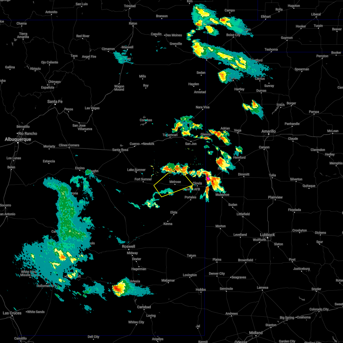 The severe thunderstorm warning for northwestern roosevelt, east central de baca and southwestern curry counties will expire at 430 pm mdt, the storm which prompted the warning has weakened below severe limits, and no longer poses an immediate threat to life or property. therefore, the warning will be allowed to expire. however gusty winds are still possible with this thunderstorm. a severe thunderstorm watch remains in effect until 1000 pm mdt for east central new mexico. The severe thunderstorm warning for northwestern roosevelt, east central de baca and southwestern curry counties will expire at 430 pm mdt, the storm which prompted the warning has weakened below severe limits, and no longer poses an immediate threat to life or property. therefore, the warning will be allowed to expire. however gusty winds are still possible with this thunderstorm. a severe thunderstorm watch remains in effect until 1000 pm mdt for east central new mexico.
|
| 5/14/2021 4:12 PM MDT |
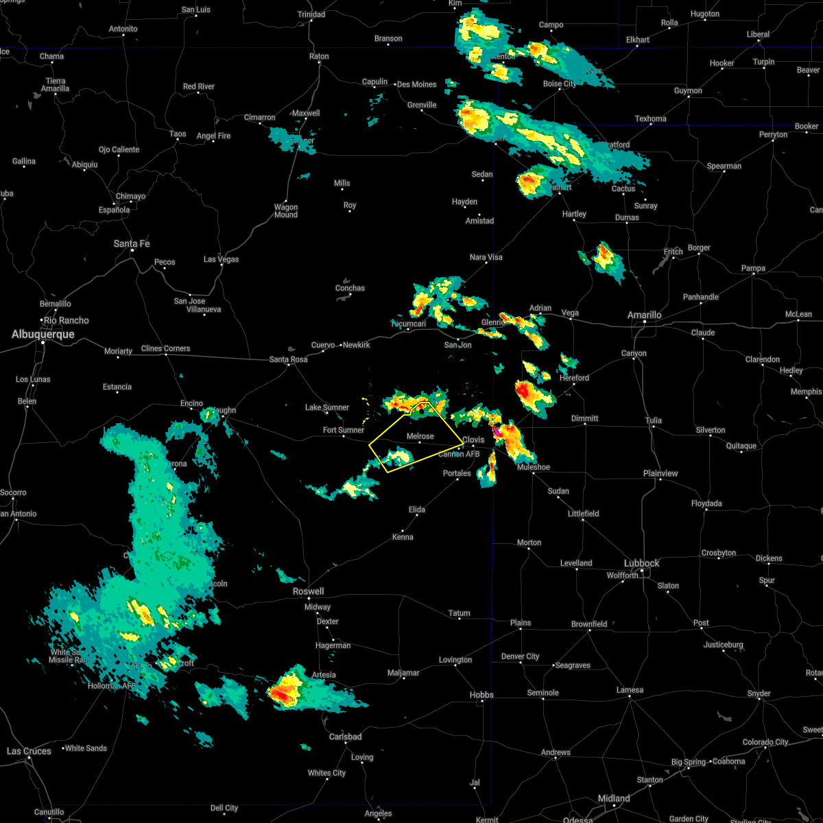 At 410 pm mdt, a strong outflow boundary ahead of a decaying thunderstorm was located 8 miles west of melrose, or 26 miles east of fort sumner, moving northeast at 20 mph (radar indicated). Hazards include 65 mph wind gusts. Expect damage to roofs, siding, and trees. locations impacted include, melrose, saint vrain, tolar and cannon air force base. This includes highway 60 between mile markers 343 and 379. At 410 pm mdt, a strong outflow boundary ahead of a decaying thunderstorm was located 8 miles west of melrose, or 26 miles east of fort sumner, moving northeast at 20 mph (radar indicated). Hazards include 65 mph wind gusts. Expect damage to roofs, siding, and trees. locations impacted include, melrose, saint vrain, tolar and cannon air force base. This includes highway 60 between mile markers 343 and 379.
|
| 5/14/2021 3:51 PM MDT |
 At 350 pm mdt, a strong outflow boundary ahead of a severe thunderstorm was located 8 miles east of tolar, or 26 miles east of fort sumner, moving east at 30 mph (radar indicated). Hazards include 65 mph wind gusts and nickel size hail. expect damage to roofs, siding, and trees At 350 pm mdt, a strong outflow boundary ahead of a severe thunderstorm was located 8 miles east of tolar, or 26 miles east of fort sumner, moving east at 30 mph (radar indicated). Hazards include 65 mph wind gusts and nickel size hail. expect damage to roofs, siding, and trees
|
| 9/1/2020 4:32 PM MDT |
 At 432 pm mdt, severe thunderstorms were located along a line extending from near quay to 11 miles east of ragland to 9 miles west of oasis state park to near elida, moving northeast at 45 mph (radar indicated). Hazards include 60 mph wind gusts. Expect damage to roofs, siding, and trees. locations impacted include, clovis, portales, melrose, san jon, elida, dora, floyd, grady, house and saint vrain. this includes the following highways, interstate 40 between mile markers 350 and 359. Highway 60 between mile markers 351 and 391. At 432 pm mdt, severe thunderstorms were located along a line extending from near quay to 11 miles east of ragland to 9 miles west of oasis state park to near elida, moving northeast at 45 mph (radar indicated). Hazards include 60 mph wind gusts. Expect damage to roofs, siding, and trees. locations impacted include, clovis, portales, melrose, san jon, elida, dora, floyd, grady, house and saint vrain. this includes the following highways, interstate 40 between mile markers 350 and 359. Highway 60 between mile markers 351 and 391.
|
| 9/1/2020 4:04 PM MDT |
 At 403 pm mdt, severe thunderstorms were located along a line extending from 15 miles west of ragland to near house to 13 miles northwest of elida to near elkins, moving northeast at 45 mph. this line of storms has a history of producing wind damage in fort sumner (radar indicated). Hazards include 60 mph wind gusts. expect damage to roofs, siding, and trees At 403 pm mdt, severe thunderstorms were located along a line extending from 15 miles west of ragland to near house to 13 miles northwest of elida to near elkins, moving northeast at 45 mph. this line of storms has a history of producing wind damage in fort sumner (radar indicated). Hazards include 60 mph wind gusts. expect damage to roofs, siding, and trees
|
| 8/21/2020 7:30 PM MDT |
 At 730 pm mdt, a severe thunderstorm was located near oasis state park, or near portales, moving southwest at 35 mph (radar indicated). Hazards include 60 mph wind gusts and half dollar size hail. Hail damage to vehicles is expected. expect wind damage to roofs, siding, and trees. Locations impacted include, portales, floyd, oasis state park and cannon air force base. At 730 pm mdt, a severe thunderstorm was located near oasis state park, or near portales, moving southwest at 35 mph (radar indicated). Hazards include 60 mph wind gusts and half dollar size hail. Hail damage to vehicles is expected. expect wind damage to roofs, siding, and trees. Locations impacted include, portales, floyd, oasis state park and cannon air force base.
|
| 8/21/2020 7:17 PM MDT |
 At 716 pm mdt, a severe thunderstorm was located near cannon air force base, or 10 miles west of clovis, moving southwest at 35 mph (radar indicated). Hazards include 60 mph wind gusts and half dollar size hail. Hail damage to vehicles is expected. Expect wind damage to roofs, siding, and trees. At 716 pm mdt, a severe thunderstorm was located near cannon air force base, or 10 miles west of clovis, moving southwest at 35 mph (radar indicated). Hazards include 60 mph wind gusts and half dollar size hail. Hail damage to vehicles is expected. Expect wind damage to roofs, siding, and trees.
|
| 8/21/2020 7:04 PM MDT |
 At 704 pm mdt, a severe thunderstorm was located near portales, moving south at 25 mph (radar indicated). Hazards include 60 mph wind gusts and quarter size hail. Hail damage to vehicles is expected. expect wind damage to roofs, siding, and trees. locations impacted include, clovis, cannon air force base, ranchvale and portair. This includes highway 60 between mile markers 376 and 391. At 704 pm mdt, a severe thunderstorm was located near portales, moving south at 25 mph (radar indicated). Hazards include 60 mph wind gusts and quarter size hail. Hail damage to vehicles is expected. expect wind damage to roofs, siding, and trees. locations impacted include, clovis, cannon air force base, ranchvale and portair. This includes highway 60 between mile markers 376 and 391.
|
| 8/21/2020 6:42 PM MDT |
 At 642 pm mdt, a severe thunderstorm was located near ranchvale, or 12 miles north of clovis, moving south at 25 mph (radar indicated). Hazards include 60 mph wind gusts and half dollar size hail. Hail damage to vehicles is expected. Expect wind damage to roofs, siding, and trees. At 642 pm mdt, a severe thunderstorm was located near ranchvale, or 12 miles north of clovis, moving south at 25 mph (radar indicated). Hazards include 60 mph wind gusts and half dollar size hail. Hail damage to vehicles is expected. Expect wind damage to roofs, siding, and trees.
|
| 8/9/2020 4:58 PM MDT | Kcvs aso in curry county NM, 0.7 miles WNW of Cannon AFB, NM |
| 7/15/2020 6:23 PM MDT |
 At 622 pm mdt, severe thunderstorms were located along a line extending from 11 miles northwest of house to near melrose, moving northeast at 25 mph (radar indicated). Hazards include 70 mph wind gusts and penny size hail. Expect considerable tree damage. damage is likely to mobile homes, roofs, and outbuildings. locations impacted include, quay, melrose, floyd, house, saint vrain, ragland, ranchvale, taiban, tolar and cannon air force base. This includes highway 60 between mile markers 340 and 383. At 622 pm mdt, severe thunderstorms were located along a line extending from 11 miles northwest of house to near melrose, moving northeast at 25 mph (radar indicated). Hazards include 70 mph wind gusts and penny size hail. Expect considerable tree damage. damage is likely to mobile homes, roofs, and outbuildings. locations impacted include, quay, melrose, floyd, house, saint vrain, ragland, ranchvale, taiban, tolar and cannon air force base. This includes highway 60 between mile markers 340 and 383.
|
| 7/15/2020 5:59 PM MDT |
 The national weather service in albuquerque has issued a * severe thunderstorm warning for. northwestern roosevelt county in east central new mexico. northeastern de baca county in east central new mexico. southwestern quay county in east central new mexico. Southwestern curry county in east central new mexico. The national weather service in albuquerque has issued a * severe thunderstorm warning for. northwestern roosevelt county in east central new mexico. northeastern de baca county in east central new mexico. southwestern quay county in east central new mexico. Southwestern curry county in east central new mexico.
|
| 6/23/2020 8:58 PM MDT |
 The severe thunderstorm warning for east central roosevelt and curry counties will expire at 900 pm mdt, the storm which prompted the warning is weakening and beginning to exit the warned area. therefore, the warning will be allowed to expire. however, small hail, gusty winds and heavy rain will still be possible with this and other nearby thunderstorms over the next several minutes. The severe thunderstorm warning for east central roosevelt and curry counties will expire at 900 pm mdt, the storm which prompted the warning is weakening and beginning to exit the warned area. therefore, the warning will be allowed to expire. however, small hail, gusty winds and heavy rain will still be possible with this and other nearby thunderstorms over the next several minutes.
|
| 6/23/2020 8:39 PM MDT |
 At 838 pm mdt, a severe thunderstorm was located near clovis, moving southeast at 30 mph (radar indicated). Hazards include 60 mph wind gusts. Expect damage to roofs, siding, and trees. locations impacted include, clovis, portales, texico, floyd, saint vrain, cannon air force base, ranchvale, broadview, oasis state park and portair. This includes highway 60 between mile markers 369 and 397. At 838 pm mdt, a severe thunderstorm was located near clovis, moving southeast at 30 mph (radar indicated). Hazards include 60 mph wind gusts. Expect damage to roofs, siding, and trees. locations impacted include, clovis, portales, texico, floyd, saint vrain, cannon air force base, ranchvale, broadview, oasis state park and portair. This includes highway 60 between mile markers 369 and 397.
|
| 6/23/2020 8:12 PM MDT |
 At 810 pm mdt, a severe thunderstorm was located 8 miles north of ranchvale, or 15 miles northwest of clovis, moving southeast at 30 mph (radar indicated). Hazards include 60 mph wind gusts. penny sized hail. expect damage to roofs, siding, and trees At 810 pm mdt, a severe thunderstorm was located 8 miles north of ranchvale, or 15 miles northwest of clovis, moving southeast at 30 mph (radar indicated). Hazards include 60 mph wind gusts. penny sized hail. expect damage to roofs, siding, and trees
|
| 6/23/2020 7:51 PM MDT |
 At 751 pm mdt, a severe thunderstorm was located 7 miles north of saint vrain, or 17 miles northwest of clovis, moving southeast at 40 mph (radar indicated). Hazards include 60 mph wind gusts. Expect damage to roofs, siding, and trees. locations impacted include, clovis, melrose, floyd, saint vrain, cannon air force base, ranchvale and portair. This includes highway 60 between mile markers 364 and 390. At 751 pm mdt, a severe thunderstorm was located 7 miles north of saint vrain, or 17 miles northwest of clovis, moving southeast at 40 mph (radar indicated). Hazards include 60 mph wind gusts. Expect damage to roofs, siding, and trees. locations impacted include, clovis, melrose, floyd, saint vrain, cannon air force base, ranchvale and portair. This includes highway 60 between mile markers 364 and 390.
|
| 6/23/2020 7:32 PM MDT |
 At 731 pm mdt, a severe thunderstorm was located 12 miles southeast of ragland, or 29 miles northwest of clovis, moving southeast at 40 mph (radar indicated). Hazards include 60 mph wind gusts. expect damage to roofs, siding, and trees At 731 pm mdt, a severe thunderstorm was located 12 miles southeast of ragland, or 29 miles northwest of clovis, moving southeast at 40 mph (radar indicated). Hazards include 60 mph wind gusts. expect damage to roofs, siding, and trees
|
| 6/22/2020 10:51 PM MDT |
 The severe thunderstorm warning for east central roosevelt and southeastern curry counties will expire at 1100 pm mdt, the storm which prompted the warning has weakened below severe limits, and no longer poses an immediate threat to life or property. therefore, the warning will be allowed to expire. however, small hail and gusty winds are still possible with nearby thunderstorms. The severe thunderstorm warning for east central roosevelt and southeastern curry counties will expire at 1100 pm mdt, the storm which prompted the warning has weakened below severe limits, and no longer poses an immediate threat to life or property. therefore, the warning will be allowed to expire. however, small hail and gusty winds are still possible with nearby thunderstorms.
|
| 6/22/2020 10:27 PM MDT |
 At 1026 pm mdt, a severe thunderstorm was located near arch, or 12 miles east of portales, moving southeast at 25 mph (radar indicated). Hazards include 60 mph wind gusts and quarter size hail. Hail damage to vehicles is expected. expect wind damage to roofs, siding, and trees. locations impacted include, clovis, portales, farwell, texico, cannon air force base, arch, oasis state park and portair. This includes highway 60 between mile markers 381 and 397. At 1026 pm mdt, a severe thunderstorm was located near arch, or 12 miles east of portales, moving southeast at 25 mph (radar indicated). Hazards include 60 mph wind gusts and quarter size hail. Hail damage to vehicles is expected. expect wind damage to roofs, siding, and trees. locations impacted include, clovis, portales, farwell, texico, cannon air force base, arch, oasis state park and portair. This includes highway 60 between mile markers 381 and 397.
|
| 6/22/2020 9:53 PM MDT |
 At 952 pm mdt, a severe thunderstorm was located near cannon air force base, or near clovis, moving southeast at 15 mph (radar indicated). Hazards include 60 mph wind gusts and quarter size hail. Hail damage to vehicles is expected. Expect wind damage to roofs, siding, and trees. At 952 pm mdt, a severe thunderstorm was located near cannon air force base, or near clovis, moving southeast at 15 mph (radar indicated). Hazards include 60 mph wind gusts and quarter size hail. Hail damage to vehicles is expected. Expect wind damage to roofs, siding, and trees.
|
| 6/22/2020 7:26 PM MDT |
 At 725 pm mdt, a severe thunderstorm was located over saint vrain, or 16 miles west of clovis, moving southeast at 20 mph (radar indicated). Hazards include ping pong ball size hail and 60 mph wind gusts. People and animals outdoors will be injured. expect hail damage to roofs, siding, windows, and vehicles. expect wind damage to roofs, siding, and trees. locations impacted include, clovis, texico, melrose, floyd, saint vrain, cannon air force base, ranchvale, oasis state park and portair. This includes highway 60 between mile markers 361 and 397. At 725 pm mdt, a severe thunderstorm was located over saint vrain, or 16 miles west of clovis, moving southeast at 20 mph (radar indicated). Hazards include ping pong ball size hail and 60 mph wind gusts. People and animals outdoors will be injured. expect hail damage to roofs, siding, windows, and vehicles. expect wind damage to roofs, siding, and trees. locations impacted include, clovis, texico, melrose, floyd, saint vrain, cannon air force base, ranchvale, oasis state park and portair. This includes highway 60 between mile markers 361 and 397.
|
| 6/22/2020 6:57 PM MDT |
 The national weather service in albuquerque has issued a * severe thunderstorm warning for. northern roosevelt county in east central new mexico. south central quay county in east central new mexico. curry county in east central new mexico. Until 800 pm mdt. The national weather service in albuquerque has issued a * severe thunderstorm warning for. northern roosevelt county in east central new mexico. south central quay county in east central new mexico. curry county in east central new mexico. Until 800 pm mdt.
|
| 9/19/2019 2:06 PM MDT |
 The severe thunderstorm warning for southeastern curry county will expire at 215 pm mdt, the storm which prompted the warning has weakened below severe limits, and no longer poses an immediate threat to life or property. therefore, the warning will be allowed to expire. however small hail, gusty winds and heavy rain are still possible with this thunderstorm. The severe thunderstorm warning for southeastern curry county will expire at 215 pm mdt, the storm which prompted the warning has weakened below severe limits, and no longer poses an immediate threat to life or property. therefore, the warning will be allowed to expire. however small hail, gusty winds and heavy rain are still possible with this thunderstorm.
|
| 9/19/2019 1:30 PM MDT |
 At 130 pm mdt, a severe thunderstorm was located near ranchvale, moving northeast at 25 mph (radar indicated). Hazards include 60 mph wind gusts and quarter size hail. Hail damage to vehicles is expected. Expect wind damage to roofs, siding, and trees. At 130 pm mdt, a severe thunderstorm was located near ranchvale, moving northeast at 25 mph (radar indicated). Hazards include 60 mph wind gusts and quarter size hail. Hail damage to vehicles is expected. Expect wind damage to roofs, siding, and trees.
|
| 8/14/2019 6:58 AM MDT |
 At 657 am mdt, a severe thunderstorm was located near melrose, or 20 miles northwest of portales, moving southeast at 20 mph (radar indicated). Hazards include 60 mph wind gusts and quarter size hail. Hail damage to vehicles is expected. expect wind damage to roofs, siding, and trees. Locations impacted include, melrose, floyd, saint vrain, cannon air force base, ranchvale and portair. At 657 am mdt, a severe thunderstorm was located near melrose, or 20 miles northwest of portales, moving southeast at 20 mph (radar indicated). Hazards include 60 mph wind gusts and quarter size hail. Hail damage to vehicles is expected. expect wind damage to roofs, siding, and trees. Locations impacted include, melrose, floyd, saint vrain, cannon air force base, ranchvale and portair.
|
| 8/14/2019 6:56 AM MDT |
 At 656 am mdt, a severe thunderstorm was located near melrose, or 17 miles northwest of portales, moving southeast at 25 mph (radar indicated). Hazards include 60 mph wind gusts and quarter size hail. Hail damage to vehicles is expected. Expect wind damage to roofs, siding, and trees. At 656 am mdt, a severe thunderstorm was located near melrose, or 17 miles northwest of portales, moving southeast at 25 mph (radar indicated). Hazards include 60 mph wind gusts and quarter size hail. Hail damage to vehicles is expected. Expect wind damage to roofs, siding, and trees.
|
| 8/14/2019 6:32 AM MDT |
 At 631 am mdt, a severe thunderstorm was located near melrose, or 27 miles west of clovis, moving southeast at 20 mph (radar indicated). Hazards include 60 mph wind gusts and quarter size hail. Hail damage to vehicles is expected. expect wind damage to roofs, siding, and trees. Locations impacted include, melrose, floyd, saint vrain, tolar, cannon air force base, ranchvale and portair. At 631 am mdt, a severe thunderstorm was located near melrose, or 27 miles west of clovis, moving southeast at 20 mph (radar indicated). Hazards include 60 mph wind gusts and quarter size hail. Hail damage to vehicles is expected. expect wind damage to roofs, siding, and trees. Locations impacted include, melrose, floyd, saint vrain, tolar, cannon air force base, ranchvale and portair.
|
| 8/14/2019 6:09 AM MDT |
 At 609 am mdt, a severe thunderstorm was located 9 miles east of house, or 29 miles east of fort sumner, moving southeast at 20 mph (radar indicated). Hazards include 60 mph wind gusts and quarter size hail. Hail damage to vehicles is expected. Expect wind damage to roofs, siding, and trees. At 609 am mdt, a severe thunderstorm was located 9 miles east of house, or 29 miles east of fort sumner, moving southeast at 20 mph (radar indicated). Hazards include 60 mph wind gusts and quarter size hail. Hail damage to vehicles is expected. Expect wind damage to roofs, siding, and trees.
|
| 7/19/2019 4:58 PM MDT | Kcvs aso in curry county NM, 0.7 miles WNW of Cannon AFB, NM |
| 6/27/2019 8:53 PM MDT |
 At 852 pm mdt, damaging winds from an outflow boundary were located along a line extending from near ranchvale to near clovis to 9 miles north of arch, moving east at 40 mph (radar indicated). Hazards include 70 mph wind gusts. Expect considerable tree damage. damage is likely to mobile homes, roofs, and outbuildings. crosswinds along u. s. highway 70 from clovis to portales will create dangerous travel conditions. Locations impacted include, clovis, farwell, texico, cannon air force base, ranchvale, portair and pleasant hill. At 852 pm mdt, damaging winds from an outflow boundary were located along a line extending from near ranchvale to near clovis to 9 miles north of arch, moving east at 40 mph (radar indicated). Hazards include 70 mph wind gusts. Expect considerable tree damage. damage is likely to mobile homes, roofs, and outbuildings. crosswinds along u. s. highway 70 from clovis to portales will create dangerous travel conditions. Locations impacted include, clovis, farwell, texico, cannon air force base, ranchvale, portair and pleasant hill.
|
| 6/27/2019 8:37 PM MDT |
 At 835 pm mdt, severe thunderstorms were located along a line extending from 9 miles northwest of ranchvale to near cannon air force base to near oasis state park, moving east at 25 mph (radar indicated). Hazards include 70 mph wind gusts. Expect considerable tree damage. damage is likely to mobile homes, roofs, and outbuildings. strong crosswinds will create dangerous travel on north to south oriented roadways including u. s. Highway 70 between clovis and portales. At 835 pm mdt, severe thunderstorms were located along a line extending from 9 miles northwest of ranchvale to near cannon air force base to near oasis state park, moving east at 25 mph (radar indicated). Hazards include 70 mph wind gusts. Expect considerable tree damage. damage is likely to mobile homes, roofs, and outbuildings. strong crosswinds will create dangerous travel on north to south oriented roadways including u. s. Highway 70 between clovis and portales.
|
| 6/17/2019 7:45 PM MDT |
 At 745 pm mdt, a severe thunderstorm was located near cannon air force base, or near clovis, moving north at 20 mph (radar indicated). Hazards include 60 mph wind gusts and quarter size hail. Hail damage to vehicles is expected. Expect wind damage to roofs, siding, and trees. At 745 pm mdt, a severe thunderstorm was located near cannon air force base, or near clovis, moving north at 20 mph (radar indicated). Hazards include 60 mph wind gusts and quarter size hail. Hail damage to vehicles is expected. Expect wind damage to roofs, siding, and trees.
|
| 6/17/2019 7:13 PM MDT |
 The severe thunderstorm warning for east central roosevelt and southeastern curry counties will expire at 715 pm mdt, the storm which prompted the warning has weakened below severe limits, and no longer poses an immediate threat to life or property. therefore the warning will be allowed to expire. however small hail, gusty winds and heavy rain are still possible with this thunderstorm. a severe thunderstorm watch remains in effect until 900 pm mdt for east central new mexico. to report severe weather, contact your nearest law enforcement agency. they will relay your report to the national weather service albuquerque. remember, a severe thunderstorm warning remains in effect for rogers and arch until 730 pm mdt. The severe thunderstorm warning for east central roosevelt and southeastern curry counties will expire at 715 pm mdt, the storm which prompted the warning has weakened below severe limits, and no longer poses an immediate threat to life or property. therefore the warning will be allowed to expire. however small hail, gusty winds and heavy rain are still possible with this thunderstorm. a severe thunderstorm watch remains in effect until 900 pm mdt for east central new mexico. to report severe weather, contact your nearest law enforcement agency. they will relay your report to the national weather service albuquerque. remember, a severe thunderstorm warning remains in effect for rogers and arch until 730 pm mdt.
|
| 6/17/2019 6:41 PM MDT |
 At 641 pm mdt, a severe thunderstorm was located near texico, or 9 miles southeast of clovis, and is nearly stationary (radar indicated). Hazards include 60 mph wind gusts and quarter size hail. Hail damage to vehicles is expected. expect wind damage to roofs, siding, and trees. Locations impacted include, clovis, farwell, texico, cannon air force base and portair. At 641 pm mdt, a severe thunderstorm was located near texico, or 9 miles southeast of clovis, and is nearly stationary (radar indicated). Hazards include 60 mph wind gusts and quarter size hail. Hail damage to vehicles is expected. expect wind damage to roofs, siding, and trees. Locations impacted include, clovis, farwell, texico, cannon air force base and portair.
|
| 6/17/2019 6:19 PM MDT |
 At 618 pm mdt, a severe thunderstorm was located near west camp, or 11 miles southeast of clovis, and is nearly stationary. the potential exists for flash flooding to develop (radar indicated). Hazards include ping pong ball size hail and 60 mph wind gusts. People and animals outdoors will be injured. expect hail damage to roofs, siding, windows, and vehicles. Expect wind damage to roofs, siding, and trees. At 618 pm mdt, a severe thunderstorm was located near west camp, or 11 miles southeast of clovis, and is nearly stationary. the potential exists for flash flooding to develop (radar indicated). Hazards include ping pong ball size hail and 60 mph wind gusts. People and animals outdoors will be injured. expect hail damage to roofs, siding, windows, and vehicles. Expect wind damage to roofs, siding, and trees.
|
| 6/17/2019 5:47 PM MDT |
 At 545 pm mdt, a severe thunderstorm was located 8 miles southwest of texico, or 9 miles southeast of clovis, moving northwest at 5 mph (radar indicated). Hazards include 60 mph wind gusts and quarter size hail. Hail damage to vehicles is expected. expect wind damage to roofs, siding, and trees. Locations impacted include, clovis, farwell, texico, cannon air force base and portair. At 545 pm mdt, a severe thunderstorm was located 8 miles southwest of texico, or 9 miles southeast of clovis, moving northwest at 5 mph (radar indicated). Hazards include 60 mph wind gusts and quarter size hail. Hail damage to vehicles is expected. expect wind damage to roofs, siding, and trees. Locations impacted include, clovis, farwell, texico, cannon air force base and portair.
|
| 6/17/2019 5:15 PM MDT |
 At 515 pm mdt, a severe thunderstorm was located 7 miles south of clovis, moving north at 5 mph (radar indicated). Hazards include 60 mph wind gusts and quarter size hail. Hail damage to vehicles is expected. Expect wind damage to roofs, siding, and trees. At 515 pm mdt, a severe thunderstorm was located 7 miles south of clovis, moving north at 5 mph (radar indicated). Hazards include 60 mph wind gusts and quarter size hail. Hail damage to vehicles is expected. Expect wind damage to roofs, siding, and trees.
|
| 6/5/2019 3:37 PM MDT |
 At 336 pm mdt, a severe thunderstorm was located 7 miles north of clovis, moving northeast at 30 mph (radar indicated). Hazards include 70 mph wind gusts and penny size hail. Expect considerable tree damage. damage is likely to mobile homes, roofs, and outbuildings. Locations impacted include, clovis, cannon air force base, ranchvale, portair and pleasant hill. At 336 pm mdt, a severe thunderstorm was located 7 miles north of clovis, moving northeast at 30 mph (radar indicated). Hazards include 70 mph wind gusts and penny size hail. Expect considerable tree damage. damage is likely to mobile homes, roofs, and outbuildings. Locations impacted include, clovis, cannon air force base, ranchvale, portair and pleasant hill.
|
| 6/5/2019 3:15 PM MDT | Kcvs aso in curry county NM, 0.7 miles WNW of Cannon AFB, NM |
| 6/5/2019 3:15 PM MDT |
 At 315 pm mdt, a severe thunderstorm was located near saint vrain, or 12 miles west of clovis, moving east at 15 mph (radar indicated). Hazards include 70 mph wind gusts and quarter size hail. Hail damage to vehicles is expected. expect considerable tree damage. Wind damage is also likely to mobile homes, roofs, and outbuildings. At 315 pm mdt, a severe thunderstorm was located near saint vrain, or 12 miles west of clovis, moving east at 15 mph (radar indicated). Hazards include 70 mph wind gusts and quarter size hail. Hail damage to vehicles is expected. expect considerable tree damage. Wind damage is also likely to mobile homes, roofs, and outbuildings.
|
| 6/5/2019 3:06 PM MDT | Kcvs aso in curry county NM, 0.7 miles WNW of Cannon AFB, NM |
| 6/1/2019 7:24 PM MDT | Kcvs aso in curry county NM, 0.7 miles WNW of Cannon AFB, NM |
| 6/1/2019 1:24 PM MDT | Kcvs aso in curry county NM, 0.7 miles WNW of Cannon AFB, NM |
| 5/26/2019 7:26 PM MDT |
 The severe thunderstorm warning for southeastern roosevelt, eastern chaves and southeastern curry counties will expire at 730 pm mdt, the storms which prompted the warning have weakened below severe limits, and no longer pose an immediate threat to life or property. therefore the warning will be allowed to expire. however small hail is still possible with these thunderstorms. a severe thunderstorm watch remains in effect until 900 pm mdt for east central new mexico. remember, a tornado warning remains in effect for southern roosevelt county until 800 pm mdt. The severe thunderstorm warning for southeastern roosevelt, eastern chaves and southeastern curry counties will expire at 730 pm mdt, the storms which prompted the warning have weakened below severe limits, and no longer pose an immediate threat to life or property. therefore the warning will be allowed to expire. however small hail is still possible with these thunderstorms. a severe thunderstorm watch remains in effect until 900 pm mdt for east central new mexico. remember, a tornado warning remains in effect for southern roosevelt county until 800 pm mdt.
|
| 5/26/2019 7:09 PM MDT |
 At 709 pm mdt, severe thunderstorms were located along a line extending from near bootleg to 13 miles west of milnesand, moving east at 35 mph. these are very dangerous storms (radar indicated). Hazards include three inch hail and 70 mph wind gusts. People and animals outdoors will be severely injured. expect shattered windows, extensive damage to roofs, siding, and vehicles. Locations impacted include, clovis, portales, farwell, texico, elida, dora, causey, ranchvale, arch and oasis state park. At 709 pm mdt, severe thunderstorms were located along a line extending from near bootleg to 13 miles west of milnesand, moving east at 35 mph. these are very dangerous storms (radar indicated). Hazards include three inch hail and 70 mph wind gusts. People and animals outdoors will be severely injured. expect shattered windows, extensive damage to roofs, siding, and vehicles. Locations impacted include, clovis, portales, farwell, texico, elida, dora, causey, ranchvale, arch and oasis state park.
|
| 5/26/2019 6:49 PM MDT |
 At 648 pm mdt, severe thunderstorms were located along a line extending from near bellview to 6 miles south of kenna, moving east at 35 mph (radar indicated). Hazards include 70 mph wind gusts and quarter size hail. Hail damage to vehicles is expected. expect considerable tree damage. Wind damage is also likely to mobile homes, roofs, and outbuildings. At 648 pm mdt, severe thunderstorms were located along a line extending from near bellview to 6 miles south of kenna, moving east at 35 mph (radar indicated). Hazards include 70 mph wind gusts and quarter size hail. Hail damage to vehicles is expected. expect considerable tree damage. Wind damage is also likely to mobile homes, roofs, and outbuildings.
|
| 5/26/2019 6:42 PM MDT |
 At 642 pm mdt, a severe thunderstorm capable of producing a tornado was located near clovis, moving east at 35 mph (radar indicated rotation). Hazards include tornado. Flying debris will be dangerous to those caught without shelter. mobile homes will be damaged or destroyed. damage to roofs, windows, and vehicles will occur. tree damage is likely. This dangerous storm will be near, texico and pleasant hill around 700 pm mdt. At 642 pm mdt, a severe thunderstorm capable of producing a tornado was located near clovis, moving east at 35 mph (radar indicated rotation). Hazards include tornado. Flying debris will be dangerous to those caught without shelter. mobile homes will be damaged or destroyed. damage to roofs, windows, and vehicles will occur. tree damage is likely. This dangerous storm will be near, texico and pleasant hill around 700 pm mdt.
|
| 5/26/2019 6:31 PM MDT |
 At 630 pm mdt, severe thunderstorms were located along a line extending from broadview to 6 miles southwest of portales, moving east at 40 mph (radar indicated). Hazards include 60 mph wind gusts and quarter size hail. Hail damage to vehicles is expected. expect wind damage to roofs, siding, and trees. locations impacted include, clovis, portales, farwell, texico, melrose, floyd, grady, saint vrain, ranchvale and oasis state park. A tornado watch remains in effect until 900 pm mdt for east central new mexico. At 630 pm mdt, severe thunderstorms were located along a line extending from broadview to 6 miles southwest of portales, moving east at 40 mph (radar indicated). Hazards include 60 mph wind gusts and quarter size hail. Hail damage to vehicles is expected. expect wind damage to roofs, siding, and trees. locations impacted include, clovis, portales, farwell, texico, melrose, floyd, grady, saint vrain, ranchvale and oasis state park. A tornado watch remains in effect until 900 pm mdt for east central new mexico.
|
| 5/26/2019 5:46 PM MDT |
 At 546 pm mdt, severe thunderstorms were located along a line extending from 9 miles southeast of ragland to 18 miles northwest of elida, moving northeast at 50 mph (radar indicated). Hazards include 60 mph wind gusts and half dollar size hail. Hail damage to vehicles is expected. Expect wind damage to roofs, siding, and trees. At 546 pm mdt, severe thunderstorms were located along a line extending from 9 miles southeast of ragland to 18 miles northwest of elida, moving northeast at 50 mph (radar indicated). Hazards include 60 mph wind gusts and half dollar size hail. Hail damage to vehicles is expected. Expect wind damage to roofs, siding, and trees.
|
| 5/25/2019 1:23 PM MDT |
 At 122 pm mdt, a severe thunderstorm was located over ranchvale, or 10 miles northwest of clovis, moving north at 20 mph (radar indicated). Hazards include 60 mph wind gusts and half dollar size hail. Hail damage to vehicles is expected. expect wind damage to roofs, siding, and trees. Locations impacted include, clovis, saint vrain, cannon air force base, ranchvale and portair. At 122 pm mdt, a severe thunderstorm was located over ranchvale, or 10 miles northwest of clovis, moving north at 20 mph (radar indicated). Hazards include 60 mph wind gusts and half dollar size hail. Hail damage to vehicles is expected. expect wind damage to roofs, siding, and trees. Locations impacted include, clovis, saint vrain, cannon air force base, ranchvale and portair.
|
| 5/25/2019 1:05 PM MDT |
 At 105 pm mdt, a severe thunderstorm was located near cannon air force base, or 11 miles west of clovis, moving northeast at 20 mph (radar indicated). Hazards include ping pong ball size hail and 60 mph wind gusts. People and animals outdoors will be injured. expect hail damage to roofs, siding, windows, and vehicles. Expect wind damage to roofs, siding, and trees. At 105 pm mdt, a severe thunderstorm was located near cannon air force base, or 11 miles west of clovis, moving northeast at 20 mph (radar indicated). Hazards include ping pong ball size hail and 60 mph wind gusts. People and animals outdoors will be injured. expect hail damage to roofs, siding, windows, and vehicles. Expect wind damage to roofs, siding, and trees.
|
| 5/25/2019 12:44 PM MDT |
 At 1243 pm mdt, a severe thunderstorm was located near clovis, moving northeast at 35 mph (public). Hazards include quarter size hail. Damage to vehicles is expected. Locations impacted include, clovis, portales, farwell, texico, cannon air force base, oasis state park, portair and pleasant hill. At 1243 pm mdt, a severe thunderstorm was located near clovis, moving northeast at 35 mph (public). Hazards include quarter size hail. Damage to vehicles is expected. Locations impacted include, clovis, portales, farwell, texico, cannon air force base, oasis state park, portair and pleasant hill.
|
| 5/25/2019 12:17 PM MDT |
 At 1217 pm mdt, a severe thunderstorm was located near oasis state park, or 7 miles northeast of portales, moving northeast at 35 mph (radar indicated). Hazards include ping pong ball size hail and 60 mph wind gusts. People and animals outdoors will be injured. expect hail damage to roofs, siding, windows, and vehicles. Expect wind damage to roofs, siding, and trees. At 1217 pm mdt, a severe thunderstorm was located near oasis state park, or 7 miles northeast of portales, moving northeast at 35 mph (radar indicated). Hazards include ping pong ball size hail and 60 mph wind gusts. People and animals outdoors will be injured. expect hail damage to roofs, siding, windows, and vehicles. Expect wind damage to roofs, siding, and trees.
|
| 3/8/2019 11:31 PM MST | Kcvs aso in curry county NM, 0.7 miles WNW of Cannon AFB, NM |
| 9/1/2018 2:54 PM MDT | Kcvs aso in curry county NM, 0.7 miles WNW of Cannon AFB, NM |
| 6/22/2018 6:20 PM MDT |
 At 619 pm mdt, a severe thunderstorm was located near texico, or 8 miles northeast of clovis, moving east at 30 mph (radar indicated). Hazards include ping pong ball size hail and 60 mph wind gusts. People and animals outdoors will be injured. expect hail damage to roofs, siding, windows, and vehicles. expect wind damage to roofs, siding, and trees. Locations impacted include, clovis, texico, cannon air force base, ranchvale, portair and pleasant hill. At 619 pm mdt, a severe thunderstorm was located near texico, or 8 miles northeast of clovis, moving east at 30 mph (radar indicated). Hazards include ping pong ball size hail and 60 mph wind gusts. People and animals outdoors will be injured. expect hail damage to roofs, siding, windows, and vehicles. expect wind damage to roofs, siding, and trees. Locations impacted include, clovis, texico, cannon air force base, ranchvale, portair and pleasant hill.
|
| 6/22/2018 6:12 PM MDT |
 At 612 pm mdt, a severe thunderstorm was located near clovis, moving east at 30 mph (radar indicated). Hazards include 60 mph wind gusts and half dollar size hail. Hail damage to vehicles is expected. expect wind damage to roofs, siding, and trees. Locations impacted include, clovis, texico, cannon air force base, ranchvale, portair and pleasant hill. At 612 pm mdt, a severe thunderstorm was located near clovis, moving east at 30 mph (radar indicated). Hazards include 60 mph wind gusts and half dollar size hail. Hail damage to vehicles is expected. expect wind damage to roofs, siding, and trees. Locations impacted include, clovis, texico, cannon air force base, ranchvale, portair and pleasant hill.
|
| 6/22/2018 6:00 PM MDT |
 At 600 pm mdt, a severe thunderstorm was located near clovis, moving east at 30 mph (radar indicated). Hazards include 60 mph wind gusts and quarter size hail. Hail damage to vehicles is expected. Expect wind damage to roofs, siding, and trees. At 600 pm mdt, a severe thunderstorm was located near clovis, moving east at 30 mph (radar indicated). Hazards include 60 mph wind gusts and quarter size hail. Hail damage to vehicles is expected. Expect wind damage to roofs, siding, and trees.
|
| 6/22/2018 5:31 PM MDT | Kcvs aso in curry county NM, 0.7 miles WNW of Cannon AFB, NM |
| 5/23/2018 7:14 PM MDT |
 At 714 pm mdt, a severe thunderstorm was located near clovis, moving northeast at 25 mph (radar indicated). Hazards include ping pong ball size hail and 60 mph wind gusts. People and animals outdoors will be injured. expect hail damage to roofs, siding, windows, and vehicles. expect wind damage to roofs, siding, and trees. Locations impacted include, clovis, farwell, texico, portair, oasis state park and cannon air force base. At 714 pm mdt, a severe thunderstorm was located near clovis, moving northeast at 25 mph (radar indicated). Hazards include ping pong ball size hail and 60 mph wind gusts. People and animals outdoors will be injured. expect hail damage to roofs, siding, windows, and vehicles. expect wind damage to roofs, siding, and trees. Locations impacted include, clovis, farwell, texico, portair, oasis state park and cannon air force base.
|
| 5/23/2018 6:59 PM MDT |
 At 658 pm mdt, a severe thunderstorm was located 7 miles east of oasis state park, or 9 miles northeast of portales, moving northeast at 25 mph (radar indicated). Hazards include ping pong ball size hail and 60 mph wind gusts. People and animals outdoors will be injured. expect hail damage to roofs, siding, windows, and vehicles. Expect wind damage to roofs, siding, and trees. At 658 pm mdt, a severe thunderstorm was located 7 miles east of oasis state park, or 9 miles northeast of portales, moving northeast at 25 mph (radar indicated). Hazards include ping pong ball size hail and 60 mph wind gusts. People and animals outdoors will be injured. expect hail damage to roofs, siding, windows, and vehicles. Expect wind damage to roofs, siding, and trees.
|
| 5/23/2018 6:27 PM MDT |
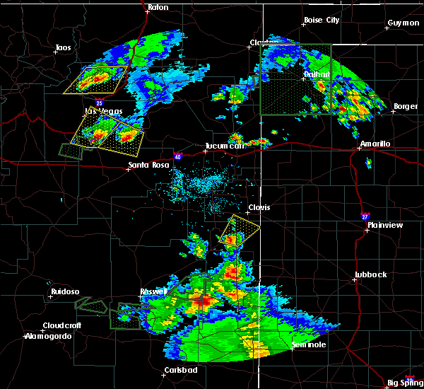 At 627 pm mdt, a severe thunderstorm was located near portales, moving northeast at 20 mph (radar indicated). Hazards include 60 mph wind gusts and quarter size hail. Hail damage to vehicles is expected. expect wind damage to roofs, siding, and trees. Locations impacted include, portales, oasis state park and cannon air force base. At 627 pm mdt, a severe thunderstorm was located near portales, moving northeast at 20 mph (radar indicated). Hazards include 60 mph wind gusts and quarter size hail. Hail damage to vehicles is expected. expect wind damage to roofs, siding, and trees. Locations impacted include, portales, oasis state park and cannon air force base.
|
| 5/23/2018 6:12 PM MDT |
 At 612 pm mdt, a severe thunderstorm was located 8 miles northwest of dora, or 10 miles south of portales, moving northeast at 30 mph (radar indicated). Hazards include golf ball size hail and 60 mph wind gusts. People and animals outdoors will be injured. expect hail damage to roofs, siding, windows, and vehicles. expect wind damage to roofs, siding, and trees. Locations impacted include, portales, dora, oasis state park and cannon air force base. At 612 pm mdt, a severe thunderstorm was located 8 miles northwest of dora, or 10 miles south of portales, moving northeast at 30 mph (radar indicated). Hazards include golf ball size hail and 60 mph wind gusts. People and animals outdoors will be injured. expect hail damage to roofs, siding, windows, and vehicles. expect wind damage to roofs, siding, and trees. Locations impacted include, portales, dora, oasis state park and cannon air force base.
|
| 5/23/2018 6:01 PM MDT |
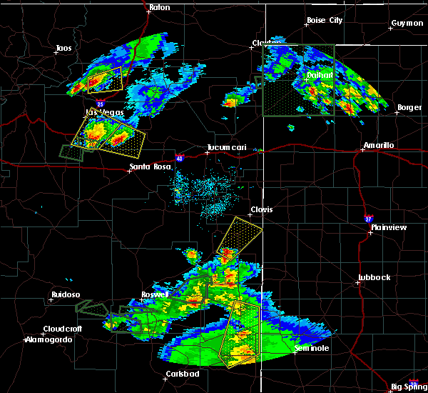 At 601 pm mdt, a severe thunderstorm was located 7 miles west of dora, or 15 miles southwest of portales, moving northeast at 25 mph (radar indicated). Hazards include 60 mph wind gusts and half dollar size hail. Hail damage to vehicles is expected. Expect wind damage to roofs, siding, and trees. At 601 pm mdt, a severe thunderstorm was located 7 miles west of dora, or 15 miles southwest of portales, moving northeast at 25 mph (radar indicated). Hazards include 60 mph wind gusts and half dollar size hail. Hail damage to vehicles is expected. Expect wind damage to roofs, siding, and trees.
|
| 5/21/2018 10:52 PM MDT |
 At 1052 pm mdt, a severe thunderstorm was located near taiban, or 14 miles east of fort sumner, moving northeast at 35 mph (radar indicated). Hazards include 70 mph wind gusts and nickel size hail. Expect considerable tree damage. Damage is likely to mobile homes, roofs, and outbuildings. At 1052 pm mdt, a severe thunderstorm was located near taiban, or 14 miles east of fort sumner, moving northeast at 35 mph (radar indicated). Hazards include 70 mph wind gusts and nickel size hail. Expect considerable tree damage. Damage is likely to mobile homes, roofs, and outbuildings.
|
| 4/29/2018 3:35 PM MDT |
 At 335 pm mdt, a severe thunderstorm was located over clovis, moving northeast at 10 mph (emergency management). Hazards include quarter size hail. Damage to vehicles is expected. Locations impacted include, clovis, texico, portair, pleasant hill and cannon air force base. At 335 pm mdt, a severe thunderstorm was located over clovis, moving northeast at 10 mph (emergency management). Hazards include quarter size hail. Damage to vehicles is expected. Locations impacted include, clovis, texico, portair, pleasant hill and cannon air force base.
|
| 4/29/2018 3:18 PM MDT |
 At 318 pm mdt, a severe thunderstorm was located over clovis, moving northeast at 15 mph (radar indicated). Hazards include 60 mph wind gusts and quarter size hail. Hail damage to vehicles is expected. Expect wind damage to roofs, siding, and trees. At 318 pm mdt, a severe thunderstorm was located over clovis, moving northeast at 15 mph (radar indicated). Hazards include 60 mph wind gusts and quarter size hail. Hail damage to vehicles is expected. Expect wind damage to roofs, siding, and trees.
|
| 7/30/2017 4:55 PM MDT |
 The severe thunderstorm warning for east central roosevelt and southeastern curry counties will expire at 500 pm mdt, the storm which prompted the warning has weakened below severe limits, and no longer pose an immediate threat to life or property. therefore the warning will be allowed to expire. however small hail, gusty winds and heavy rain are still possible with this thunderstorm. The severe thunderstorm warning for east central roosevelt and southeastern curry counties will expire at 500 pm mdt, the storm which prompted the warning has weakened below severe limits, and no longer pose an immediate threat to life or property. therefore the warning will be allowed to expire. however small hail, gusty winds and heavy rain are still possible with this thunderstorm.
|
| 7/30/2017 4:52 PM MDT |
 The severe thunderstorm warning for eastern curry county will expire at 500 pm mdt, the storm which prompted the warning for central and east-central curry county has weakened below severe limits, and no longer pose an immediate threat to life or property. therefore the warning will be allowed to expire. however gusty winds and heavy rain are still possible with this thunderstorm. remember, a severe thunderstorm warning remains in effect for southeast curry county until 500 pm mdt. The severe thunderstorm warning for eastern curry county will expire at 500 pm mdt, the storm which prompted the warning for central and east-central curry county has weakened below severe limits, and no longer pose an immediate threat to life or property. therefore the warning will be allowed to expire. however gusty winds and heavy rain are still possible with this thunderstorm. remember, a severe thunderstorm warning remains in effect for southeast curry county until 500 pm mdt.
|
| 7/30/2017 4:44 PM MDT |
 At 443 pm mdt, a severe thunderstorm was located 11 miles west of rhea, or 16 miles north of clovis, moving northeast at 25 mph (radar indicated). Hazards include 70 mph wind gusts and nickel size hail. Expect considerable tree damage. damage is likely to mobile homes, roofs, and outbuildings. Locations impacted include, broadview, ranchvale, bellview, portair and cannon air force base. At 443 pm mdt, a severe thunderstorm was located 11 miles west of rhea, or 16 miles north of clovis, moving northeast at 25 mph (radar indicated). Hazards include 70 mph wind gusts and nickel size hail. Expect considerable tree damage. damage is likely to mobile homes, roofs, and outbuildings. Locations impacted include, broadview, ranchvale, bellview, portair and cannon air force base.
|
| 7/30/2017 4:36 PM MDT |
 At 436 pm mdt, a severe thunderstorm was located near texico, or near clovis, moving north at 20 mph (trained weather spotters). Hazards include 70 mph wind gusts and quarter size hail. Hail damage to vehicles is expected. expect considerable tree damage. wind damage is also likely to mobile homes, roofs, and outbuildings. Locations impacted include, clovis, farwell, texico, cannon air force base, portair and pleasant hill. At 436 pm mdt, a severe thunderstorm was located near texico, or near clovis, moving north at 20 mph (trained weather spotters). Hazards include 70 mph wind gusts and quarter size hail. Hail damage to vehicles is expected. expect considerable tree damage. wind damage is also likely to mobile homes, roofs, and outbuildings. Locations impacted include, clovis, farwell, texico, cannon air force base, portair and pleasant hill.
|
| 7/30/2017 4:30 PM MDT |
 At 429 pm mdt, a severe thunderstorm was located 10 miles north of ranchvale, or 17 miles north of clovis, moving north at 30 mph (radar indicated). Hazards include 70 mph wind gusts and quarter size hail. Hail damage to vehicles is expected. expect considerable tree damage. Wind damage is also likely to mobile homes, roofs, and outbuildings. At 429 pm mdt, a severe thunderstorm was located 10 miles north of ranchvale, or 17 miles north of clovis, moving north at 30 mph (radar indicated). Hazards include 70 mph wind gusts and quarter size hail. Hail damage to vehicles is expected. expect considerable tree damage. Wind damage is also likely to mobile homes, roofs, and outbuildings.
|
| 7/30/2017 4:17 PM MDT |
 At 417 pm mdt, a severe thunderstorm was located near oasis state park, or 7 miles northeast of portales, moving north at 40 mph (trained weather spotters). Hazards include 70 mph wind gusts and quarter size hail. Hail damage to vehicles is expected. expect considerable tree damage. Wind damage is also likely to mobile homes, roofs, and outbuildings. At 417 pm mdt, a severe thunderstorm was located near oasis state park, or 7 miles northeast of portales, moving north at 40 mph (trained weather spotters). Hazards include 70 mph wind gusts and quarter size hail. Hail damage to vehicles is expected. expect considerable tree damage. Wind damage is also likely to mobile homes, roofs, and outbuildings.
|
| 7/30/2017 4:08 PM MDT |
 At 407 pm mdt, a severe thunderstorm was located near cannon air force base, or 8 miles west of clovis, moving northeast at 25 mph (trained weather spotters). Hazards include 70 mph wind gusts and quarter size hail. Hail damage to vehicles is expected. expect considerable tree damage. wind damage is also likely to mobile homes, roofs, and outbuildings. Locations impacted include, clovis, portales, floyd, saint vrain, cannon air force base, ranchvale, oasis state park, portair and pleasant hill. At 407 pm mdt, a severe thunderstorm was located near cannon air force base, or 8 miles west of clovis, moving northeast at 25 mph (trained weather spotters). Hazards include 70 mph wind gusts and quarter size hail. Hail damage to vehicles is expected. expect considerable tree damage. wind damage is also likely to mobile homes, roofs, and outbuildings. Locations impacted include, clovis, portales, floyd, saint vrain, cannon air force base, ranchvale, oasis state park, portair and pleasant hill.
|
| 7/30/2017 3:58 PM MDT |
 At 357 pm mdt, a severe thunderstorm was located near saint vrain, or 11 miles north of portales, moving northeast at 35 mph (trained weather spotters). Hazards include 70 mph wind gusts and nickel size hail. Expect considerable tree damage. damage is likely to mobile homes, roofs, and outbuildings. Locations impacted include, clovis, portales, floyd, saint vrain, cannon air force base, ranchvale, oasis state park, portair and pleasant hill. At 357 pm mdt, a severe thunderstorm was located near saint vrain, or 11 miles north of portales, moving northeast at 35 mph (trained weather spotters). Hazards include 70 mph wind gusts and nickel size hail. Expect considerable tree damage. damage is likely to mobile homes, roofs, and outbuildings. Locations impacted include, clovis, portales, floyd, saint vrain, cannon air force base, ranchvale, oasis state park, portair and pleasant hill.
|
| 7/30/2017 3:52 PM MDT | Kcvs aso in curry county NM, 0.7 miles WNW of Cannon AFB, NM |
| 7/30/2017 3:49 PM MDT | Kcvs aso in curry county NM, 0.7 miles WNW of Cannon AFB, NM |
| 7/30/2017 3:45 PM MDT |
 At 345 pm mdt, a severe thunderstorm was located 8 miles west of oasis state park, or 9 miles northwest of portales, moving northeast at 35 mph (radar indicated). Hazards include 60 mph wind gusts and quarter size hail. Hail damage to vehicles is expected. Expect wind damage to roofs, siding, and trees. At 345 pm mdt, a severe thunderstorm was located 8 miles west of oasis state park, or 9 miles northwest of portales, moving northeast at 35 mph (radar indicated). Hazards include 60 mph wind gusts and quarter size hail. Hail damage to vehicles is expected. Expect wind damage to roofs, siding, and trees.
|
| 7/22/2017 5:54 PM MDT |
 The severe thunderstorm warning for central roosevelt and south central curry counties will expire at 600 pm mdt, the severe thunderstorm which prompted the warning for cannon afb has weakened and moved south of the air force base. therefore the warning will be allowed to expire. the severe thunderstorm warning for melrose bombing range remains in effect until 630 pm mdt. The severe thunderstorm warning for central roosevelt and south central curry counties will expire at 600 pm mdt, the severe thunderstorm which prompted the warning for cannon afb has weakened and moved south of the air force base. therefore the warning will be allowed to expire. the severe thunderstorm warning for melrose bombing range remains in effect until 630 pm mdt.
|
| 7/22/2017 5:24 PM MDT |
 At 511 pm mdt, a severe thunderstorm was located near cannon air force base, or 9 miles west of clovis, moving southwest at 15 mph (radar indicated). Hazards include 60 mph wind gusts and quarter size hail. Hail damage to vehicles is expected. Expect wind damage to roofs, siding, and trees. At 511 pm mdt, a severe thunderstorm was located near cannon air force base, or 9 miles west of clovis, moving southwest at 15 mph (radar indicated). Hazards include 60 mph wind gusts and quarter size hail. Hail damage to vehicles is expected. Expect wind damage to roofs, siding, and trees.
|
| 7/22/2017 5:19 PM MDT | Kcvs aso in curry county NM, 0.7 miles WNW of Cannon AFB, NM |
| 7/22/2017 5:15 PM MDT | Kcvs aso in curry county NM, 0.7 miles WNW of Cannon AFB, NM |
| 7/22/2017 5:11 PM MDT |
 The national weather service in albuquerque has issued a * severe thunderstorm warning for. central roosevelt county in east central new mexico. south central curry county in east central new mexico. until 600 pm mdt. At 511 pm mdt, a severe thunderstorm was located near cannon air. The national weather service in albuquerque has issued a * severe thunderstorm warning for. central roosevelt county in east central new mexico. south central curry county in east central new mexico. until 600 pm mdt. At 511 pm mdt, a severe thunderstorm was located near cannon air.
|
| 7/3/2017 3:18 PM MDT | Kcvs aso in curry county NM, 0.7 miles WNW of Cannon AFB, NM |
| 7/1/2017 10:25 PM MDT |
 The severe thunderstorm warning for east central roosevelt and southeastern curry counties will expire at 1030 pm mdt, the storm which prompted the warning has weakened below severe limits, and no longer pose an immediate threat to life or property. therefore the warning will be allowed to expire. however gusty winds are still possible with this thunderstorm. The severe thunderstorm warning for east central roosevelt and southeastern curry counties will expire at 1030 pm mdt, the storm which prompted the warning has weakened below severe limits, and no longer pose an immediate threat to life or property. therefore the warning will be allowed to expire. however gusty winds are still possible with this thunderstorm.
|
| 7/1/2017 10:07 PM MDT |
 At 1007 pm mdt, a severe thunderstorm was located near arch, or 11 miles southeast of portales, moving southeast at 25 mph (radar indicated). Hazards include 70 mph wind gusts and nickel size hail. Expect considerable tree damage. damage is likely to mobile homes, roofs, and outbuildings. Locations impacted include, clovis, portales, texico, floyd, causey, saint vrain, ranchvale, arch, oasis state park and cannon air force base. At 1007 pm mdt, a severe thunderstorm was located near arch, or 11 miles southeast of portales, moving southeast at 25 mph (radar indicated). Hazards include 70 mph wind gusts and nickel size hail. Expect considerable tree damage. damage is likely to mobile homes, roofs, and outbuildings. Locations impacted include, clovis, portales, texico, floyd, causey, saint vrain, ranchvale, arch, oasis state park and cannon air force base.
|
| 7/1/2017 9:46 PM MDT |
 At 946 pm mdt, a severe thunderstorm was located near oasis state park, or 7 miles northwest of portales, moving southeast at 25 mph (radar indicated). Hazards include 70 mph wind gusts. Expect considerable tree damage. Damage is likely to mobile homes, roofs, and outbuildings. At 946 pm mdt, a severe thunderstorm was located near oasis state park, or 7 miles northwest of portales, moving southeast at 25 mph (radar indicated). Hazards include 70 mph wind gusts. Expect considerable tree damage. Damage is likely to mobile homes, roofs, and outbuildings.
|
| 7/1/2017 9:31 PM MDT | Kcvs aso in curry county NM, 0.7 miles WNW of Cannon AFB, NM |
| 7/1/2017 8:23 PM MDT |
 At 823 pm mdt, a severe thunderstorm was located near melrose, or 17 miles northwest of portales, moving northeast at 15 mph (radar indicated). Hazards include 60 mph wind gusts and quarter size hail. Hail damage to vehicles is expected. expect wind damage to roofs, siding, and trees. Locations impacted include, saint vrain and cannon air force base. At 823 pm mdt, a severe thunderstorm was located near melrose, or 17 miles northwest of portales, moving northeast at 15 mph (radar indicated). Hazards include 60 mph wind gusts and quarter size hail. Hail damage to vehicles is expected. expect wind damage to roofs, siding, and trees. Locations impacted include, saint vrain and cannon air force base.
|
| 7/1/2017 7:57 PM MDT |
 At 757 pm mdt, a severe thunderstorm was located 8 miles south of melrose, or 19 miles northwest of portales, moving northeast at 15 mph (radar indicated). Hazards include 60 mph wind gusts and quarter size hail. Hail damage to vehicles is expected. Expect wind damage to roofs, siding, and trees. At 757 pm mdt, a severe thunderstorm was located 8 miles south of melrose, or 19 miles northwest of portales, moving northeast at 15 mph (radar indicated). Hazards include 60 mph wind gusts and quarter size hail. Hail damage to vehicles is expected. Expect wind damage to roofs, siding, and trees.
|
| 5/10/2017 1:16 AM MDT |
 At 115 am mdt, severe thunderstorms were located along a line extending from 6 miles northeast of elida to 7 miles south of arch, moving north at 35 mph (radar indicated). Hazards include 60 mph wind gusts. expect damage to roofs, siding, and trees At 115 am mdt, severe thunderstorms were located along a line extending from 6 miles northeast of elida to 7 miles south of arch, moving north at 35 mph (radar indicated). Hazards include 60 mph wind gusts. expect damage to roofs, siding, and trees
|
| 5/10/2017 12:13 AM MDT |
 The severe thunderstorm warning for east central roosevelt and southeastern curry counties will expire at 1215 am mdt. the storm which prompted the warning has weakened below severe limits, and no longer pose an immediate threat to life or property. therefore the warning will be allowed to expire. However heavy rain and pockets of small hail are still possible with this thunderstorm. The severe thunderstorm warning for east central roosevelt and southeastern curry counties will expire at 1215 am mdt. the storm which prompted the warning has weakened below severe limits, and no longer pose an immediate threat to life or property. therefore the warning will be allowed to expire. However heavy rain and pockets of small hail are still possible with this thunderstorm.
|
| 5/9/2017 11:50 PM MDT |
 At 1150 pm mdt, a severe thunderstorm was located over oasis state park, or near portales, moving northeast at 35 mph (radar indicated). Hazards include 60 mph wind gusts and half dollar size hail. Hail damage to vehicles is expected. expect wind damage to roofs, siding, and trees. Locations impacted include, clovis, portales, floyd, cannon air force base, ranchvale, oasis state park and portair. At 1150 pm mdt, a severe thunderstorm was located over oasis state park, or near portales, moving northeast at 35 mph (radar indicated). Hazards include 60 mph wind gusts and half dollar size hail. Hail damage to vehicles is expected. expect wind damage to roofs, siding, and trees. Locations impacted include, clovis, portales, floyd, cannon air force base, ranchvale, oasis state park and portair.
|
| 5/9/2017 11:29 PM MDT |
 At 1129 pm mdt, a severe thunderstorm was located 11 miles southwest of portales, moving northeast at 35 mph (radar indicated). Hazards include ping pong ball size hail and 60 mph wind gusts. People and animals outdoors will be injured. expect hail damage to roofs, siding, windows, and vehicles. Expect wind damage to roofs, siding, and trees. At 1129 pm mdt, a severe thunderstorm was located 11 miles southwest of portales, moving northeast at 35 mph (radar indicated). Hazards include ping pong ball size hail and 60 mph wind gusts. People and animals outdoors will be injured. expect hail damage to roofs, siding, windows, and vehicles. Expect wind damage to roofs, siding, and trees.
|
| 5/9/2017 6:01 PM MDT |
 At 600 pm mdt, a severe thunderstorm was located 12 miles west of rhea, or 13 miles north of clovis, moving northeast at 25 mph. this is a very dangerous storm (radar indicated). Hazards include three inch hail and 70 mph wind gusts. People and animals outdoors will be severely injured. expect shattered windows, extensive damage to roofs, siding, and vehicles. locations impacted include, clovis, ranchvale, portair, pleasant hill and cannon air force base. A tornado watch remains in effect until 1000 pm mdt for east central new mexico. At 600 pm mdt, a severe thunderstorm was located 12 miles west of rhea, or 13 miles north of clovis, moving northeast at 25 mph. this is a very dangerous storm (radar indicated). Hazards include three inch hail and 70 mph wind gusts. People and animals outdoors will be severely injured. expect shattered windows, extensive damage to roofs, siding, and vehicles. locations impacted include, clovis, ranchvale, portair, pleasant hill and cannon air force base. A tornado watch remains in effect until 1000 pm mdt for east central new mexico.
|
| 5/9/2017 5:38 PM MDT |
 At 538 pm mdt, a severe thunderstorm was located near ranchvale, or near clovis, moving northeast at 35 mph (radar indicated). Hazards include tennis ball size hail and 70 mph wind gusts. People and animals outdoors will be injured. expect hail damage to roofs, siding, windows, and vehicles. expect considerable tree damage. wind damage is also likely to mobile homes, roofs, and outbuildings. locations impacted include, clovis, saint vrain, cannon air force base, ranchvale, portair and pleasant hill. A tornado watch remains in effect until 1000 pm mdt for east central new mexico. At 538 pm mdt, a severe thunderstorm was located near ranchvale, or near clovis, moving northeast at 35 mph (radar indicated). Hazards include tennis ball size hail and 70 mph wind gusts. People and animals outdoors will be injured. expect hail damage to roofs, siding, windows, and vehicles. expect considerable tree damage. wind damage is also likely to mobile homes, roofs, and outbuildings. locations impacted include, clovis, saint vrain, cannon air force base, ranchvale, portair and pleasant hill. A tornado watch remains in effect until 1000 pm mdt for east central new mexico.
|
| 5/9/2017 5:31 PM MDT |
 At 531 pm mdt, a severe thunderstorm capable of producing a tornado was located over ranchvale, or near clovis, moving northeast at 35 mph (radar indicated rotation). Hazards include tornado and two inch hail. Flying debris will be dangerous to those caught without shelter. mobile homes will be damaged or destroyed. damage to roofs, windows, and vehicles will occur. tree damage is likely. Locations impacted include, clovis, ranchvale, portair and cannon air force base. At 531 pm mdt, a severe thunderstorm capable of producing a tornado was located over ranchvale, or near clovis, moving northeast at 35 mph (radar indicated rotation). Hazards include tornado and two inch hail. Flying debris will be dangerous to those caught without shelter. mobile homes will be damaged or destroyed. damage to roofs, windows, and vehicles will occur. tree damage is likely. Locations impacted include, clovis, ranchvale, portair and cannon air force base.
|
| 5/9/2017 5:28 PM MDT | Hen Egg sized hail reported 1.2 miles NNW of Cannon AFB, NM |
| 5/9/2017 5:25 PM MDT | Quarter sized hail reported 1.2 miles NNW of Cannon AFB, NM |
| 5/9/2017 5:20 PM MDT |
 At 519 pm mdt, a severe thunderstorm capable of producing a tornado was located near cannon air force base, or 10 miles west of clovis, moving northeast at 30 mph (radar indicated rotation). Hazards include tornado and two inch hail. Flying debris will be dangerous to those caught without shelter. mobile homes will be damaged or destroyed. damage to roofs, windows, and vehicles will occur. tree damage is likely. Locations impacted include, clovis, saint vrain, cannon air force base, ranchvale and portair. At 519 pm mdt, a severe thunderstorm capable of producing a tornado was located near cannon air force base, or 10 miles west of clovis, moving northeast at 30 mph (radar indicated rotation). Hazards include tornado and two inch hail. Flying debris will be dangerous to those caught without shelter. mobile homes will be damaged or destroyed. damage to roofs, windows, and vehicles will occur. tree damage is likely. Locations impacted include, clovis, saint vrain, cannon air force base, ranchvale and portair.
|
| 5/9/2017 5:14 PM MDT |
 At 513 pm mdt, a severe thunderstorm capable of producing a tornado was located near saint vrain, or 11 miles northwest of portales, moving northeast at 30 mph (radar indicated rotation). Hazards include tornado and hail up to two inches in diameter. Flying debris will be dangerous to those caught without shelter. mobile homes will be damaged or destroyed. damage to roofs, windows, and vehicles will occur. Tree damage is likely. At 513 pm mdt, a severe thunderstorm capable of producing a tornado was located near saint vrain, or 11 miles northwest of portales, moving northeast at 30 mph (radar indicated rotation). Hazards include tornado and hail up to two inches in diameter. Flying debris will be dangerous to those caught without shelter. mobile homes will be damaged or destroyed. damage to roofs, windows, and vehicles will occur. Tree damage is likely.
|
| 5/9/2017 5:09 PM MDT |
 At 509 pm mdt, a severe thunderstorm was located near saint vrain, or 12 miles northwest of portales, moving northeast at 30 mph (radar indicated). Hazards include two inch hail and 60 mph wind gusts. People and animals outdoors will be injured. expect hail damage to roofs, siding, windows, and vehicles. Expect wind damage to roofs, siding, and trees. At 509 pm mdt, a severe thunderstorm was located near saint vrain, or 12 miles northwest of portales, moving northeast at 30 mph (radar indicated). Hazards include two inch hail and 60 mph wind gusts. People and animals outdoors will be injured. expect hail damage to roofs, siding, windows, and vehicles. Expect wind damage to roofs, siding, and trees.
|
| 5/9/2017 4:18 PM MDT |
 At 418 pm mdt, a severe thunderstorm was located 9 miles north of elida, or 20 miles west of portales, moving northeast at 30 mph (radar indicated). Hazards include ping pong ball size hail and 60 mph wind gusts. People and animals outdoors will be injured. expect hail damage to roofs, siding, windows, and vehicles. expect wind damage to roofs, siding, and trees. locations impacted include, portales, melrose, elida, floyd, saint vrain, oasis state park and cannon air force base. A tornado watch remains in effect until 1000 pm mdt for southeastern and east central new mexico. At 418 pm mdt, a severe thunderstorm was located 9 miles north of elida, or 20 miles west of portales, moving northeast at 30 mph (radar indicated). Hazards include ping pong ball size hail and 60 mph wind gusts. People and animals outdoors will be injured. expect hail damage to roofs, siding, windows, and vehicles. expect wind damage to roofs, siding, and trees. locations impacted include, portales, melrose, elida, floyd, saint vrain, oasis state park and cannon air force base. A tornado watch remains in effect until 1000 pm mdt for southeastern and east central new mexico.
|
| 5/9/2017 4:17 PM MDT |
 At 417 pm mdt, a severe thunderstorm was located 13 miles north of elida, or 18 miles west of portales, moving northeast at 45 mph (radar indicated). Hazards include ping pong ball size hail and 60 mph wind gusts. People and animals outdoors will be injured. expect hail damage to roofs, siding, windows, and vehicles. expect wind damage to roofs, siding, and trees. locations impacted include, clovis, portales, melrose, elida, floyd, saint vrain, cannon air force base, kenna, oasis state park and portair. A tornado watch remains in effect until 1000 pm mdt for southeastern and east central new mexico. At 417 pm mdt, a severe thunderstorm was located 13 miles north of elida, or 18 miles west of portales, moving northeast at 45 mph (radar indicated). Hazards include ping pong ball size hail and 60 mph wind gusts. People and animals outdoors will be injured. expect hail damage to roofs, siding, windows, and vehicles. expect wind damage to roofs, siding, and trees. locations impacted include, clovis, portales, melrose, elida, floyd, saint vrain, cannon air force base, kenna, oasis state park and portair. A tornado watch remains in effect until 1000 pm mdt for southeastern and east central new mexico.
|
| 5/9/2017 4:05 PM MDT |
 At 405 pm mdt, a severe thunderstorm was located 7 miles northwest of elida, or 25 miles southwest of portales, moving northeast at 40 mph (radar indicated). Hazards include ping pong ball size hail and 60 mph wind gusts. People and animals outdoors will be injured. expect hail damage to roofs, siding, windows, and vehicles. expect wind damage to roofs, siding, and trees. locations impacted include, clovis, portales, melrose, elida, floyd, saint vrain, cannon air force base, kenna, oasis state park and portair. A tornado watch remains in effect until 1000 pm mdt for southeastern and east central new mexico. At 405 pm mdt, a severe thunderstorm was located 7 miles northwest of elida, or 25 miles southwest of portales, moving northeast at 40 mph (radar indicated). Hazards include ping pong ball size hail and 60 mph wind gusts. People and animals outdoors will be injured. expect hail damage to roofs, siding, windows, and vehicles. expect wind damage to roofs, siding, and trees. locations impacted include, clovis, portales, melrose, elida, floyd, saint vrain, cannon air force base, kenna, oasis state park and portair. A tornado watch remains in effect until 1000 pm mdt for southeastern and east central new mexico.
|
| 5/9/2017 3:50 PM MDT |
 At 350 pm mdt, a severe thunderstorm was located near kenna, or 35 miles southwest of portales, moving northeast at 40 mph (radar indicated). Hazards include 60 mph wind gusts and half dollar size hail. Hail damage to vehicles is expected. Expect wind damage to roofs, siding, and trees. At 350 pm mdt, a severe thunderstorm was located near kenna, or 35 miles southwest of portales, moving northeast at 40 mph (radar indicated). Hazards include 60 mph wind gusts and half dollar size hail. Hail damage to vehicles is expected. Expect wind damage to roofs, siding, and trees.
|
| 3/23/2017 4:07 PM MDT | Kcvs aso in curry county NM, 0.7 miles WNW of Cannon AFB, NM |
| 9/15/2016 1:56 AM MDT | The severe thunderstorm warning for south central curry and central roosevelt counties will expire at 200 am mdt, the storm which prompted the warning has weakened below severe limits, and no longer pose an immediate threat to life or property. therefore the warning will be allowed to expire. however small hail, gusty winds and heavy rain are still possible with this thunderstorm. to report severe weather, contact your nearest law enforcement agency. they will relay your report to the national weather service albuquerque. |
| 9/15/2016 1:46 AM MDT |
 At 145 am mdt, a severe thunderstorm was located 6 miles southeast of saint vrain, or 11 miles northwest of portales, moving east at 15 mph (radar indicated). Hazards include 60 mph wind gusts and half dollar size hail. Hail damage to vehicles is expected. expect wind damage to roofs, siding, and trees. Locations impacted include, oasis state park and cannon air force base. At 145 am mdt, a severe thunderstorm was located 6 miles southeast of saint vrain, or 11 miles northwest of portales, moving east at 15 mph (radar indicated). Hazards include 60 mph wind gusts and half dollar size hail. Hail damage to vehicles is expected. expect wind damage to roofs, siding, and trees. Locations impacted include, oasis state park and cannon air force base.
|
| 9/15/2016 1:32 AM MDT |
 At 131 am mdt, a severe thunderstorm was located near saint vrain, or 13 miles northwest of portales, moving east at 15 mph (radar indicated). Hazards include 60 mph wind gusts and half dollar size hail. Hail damage to vehicles is expected. expect wind damage to roofs, siding, and trees. Locations impacted include, oasis state park and cannon air force base. At 131 am mdt, a severe thunderstorm was located near saint vrain, or 13 miles northwest of portales, moving east at 15 mph (radar indicated). Hazards include 60 mph wind gusts and half dollar size hail. Hail damage to vehicles is expected. expect wind damage to roofs, siding, and trees. Locations impacted include, oasis state park and cannon air force base.
|
| 9/15/2016 1:13 AM MDT |
 At 113 am mdt, a severe thunderstorm was located 7 miles southwest of saint vrain, or 15 miles northwest of portales, moving east at 20 mph (radar indicated). Hazards include 60 mph wind gusts and half dollar size hail. Hail damage to vehicles is expected. Expect wind damage to roofs, siding, and trees. At 113 am mdt, a severe thunderstorm was located 7 miles southwest of saint vrain, or 15 miles northwest of portales, moving east at 20 mph (radar indicated). Hazards include 60 mph wind gusts and half dollar size hail. Hail damage to vehicles is expected. Expect wind damage to roofs, siding, and trees.
|
| 6/13/2016 4:22 PM MDT |
 The severe thunderstorm warning for southeastern curry county will expire at 430 pm mdt, the storm which prompted the warning has weakened below severe limits, and no longer pose an immediate threat to life or property. therefore the warning will be allowed to expire. however small. The severe thunderstorm warning for southeastern curry county will expire at 430 pm mdt, the storm which prompted the warning has weakened below severe limits, and no longer pose an immediate threat to life or property. therefore the warning will be allowed to expire. however small.
|
| 6/13/2016 3:52 PM MDT |
 At 352 pm mdt, a severe thunderstorm was located near cannon air force base, or near clovis, moving northeast at 35 mph (radar indicated). Hazards include quarter size hail and 60 mph wind gusts. Hail damage to vehicles is expected. Expect wind damage to roofs, siding, and trees. At 352 pm mdt, a severe thunderstorm was located near cannon air force base, or near clovis, moving northeast at 35 mph (radar indicated). Hazards include quarter size hail and 60 mph wind gusts. Hail damage to vehicles is expected. Expect wind damage to roofs, siding, and trees.
|
| 10/21/2015 11:18 AM MDT |
 A severe thunderstorm warning remains in effect until 1130 am mdt for curry and southeastern quay counties. at 1118 am mdt. severe thunderstorms were located along a line extending from 6 miles west of wheatland to 7 miles north of ranchvale. moving northeast at 40 mph. hazard. Golf ball size hail and 60 mph wind gusts. A severe thunderstorm warning remains in effect until 1130 am mdt for curry and southeastern quay counties. at 1118 am mdt. severe thunderstorms were located along a line extending from 6 miles west of wheatland to 7 miles north of ranchvale. moving northeast at 40 mph. hazard. Golf ball size hail and 60 mph wind gusts.
|
| 10/21/2015 10:53 AM MDT |
 At 1052 am mdt, severe thunderstorms were located along a line extending from near ragland to 11 miles north of melrose, moving northeast at 50 mph (trained weather spotters). Hazards include golf ball size hail and 60 mph wind gusts. People and animals outdoors will be injured. expect hail damage to roofs, siding, windows and vehicles. expect wind damage to roofs, siding and trees. locations impacted include, clovis, tucumcari, quay, melrose, grady, house, broadview, saint vrain, wheatland and ranchvale. This includes interstate 40 between mile markers 329 and 339. At 1052 am mdt, severe thunderstorms were located along a line extending from near ragland to 11 miles north of melrose, moving northeast at 50 mph (trained weather spotters). Hazards include golf ball size hail and 60 mph wind gusts. People and animals outdoors will be injured. expect hail damage to roofs, siding, windows and vehicles. expect wind damage to roofs, siding and trees. locations impacted include, clovis, tucumcari, quay, melrose, grady, house, broadview, saint vrain, wheatland and ranchvale. This includes interstate 40 between mile markers 329 and 339.
|
| 10/21/2015 10:43 AM MDT |
 At 1043 am mdt, severe thunderstorms were located along a line extending from 7 miles north of house to 5 miles north of melrose, moving northeast at 50 mph (radar indicated). Hazards include golf ball size hail and 60 mph wind gusts. People and animals outdoors will be injured. expect hail damage to roofs, siding, windows and vehicles. Expect wind damage to roofs, siding and trees. At 1043 am mdt, severe thunderstorms were located along a line extending from 7 miles north of house to 5 miles north of melrose, moving northeast at 50 mph (radar indicated). Hazards include golf ball size hail and 60 mph wind gusts. People and animals outdoors will be injured. expect hail damage to roofs, siding, windows and vehicles. Expect wind damage to roofs, siding and trees.
|
| 10/21/2015 10:33 AM MDT |
 At 1032 am mdt, a severe thunderstorm was located 9 miles northwest of melrose, or 29 miles east of fort sumner, moving northeast at 50 mph. golf ball size hail has been reported at the melrose bombing range with this storm (radar indicated). Hazards include golf ball size hail and 60 mph wind gusts. People and animals outdoors will be injured. expect hail damage to roofs, siding, windows and vehicles. expect wind damage to roofs, siding and trees. Locations impacted include, clovis, quay, melrose, house, ranchvale, saint vrain, tolar, taiban, ragland and cannon air force base. At 1032 am mdt, a severe thunderstorm was located 9 miles northwest of melrose, or 29 miles east of fort sumner, moving northeast at 50 mph. golf ball size hail has been reported at the melrose bombing range with this storm (radar indicated). Hazards include golf ball size hail and 60 mph wind gusts. People and animals outdoors will be injured. expect hail damage to roofs, siding, windows and vehicles. expect wind damage to roofs, siding and trees. Locations impacted include, clovis, quay, melrose, house, ranchvale, saint vrain, tolar, taiban, ragland and cannon air force base.
|
| 10/21/2015 10:28 AM MDT |
 At 1027 am mdt, a severe thunderstorm was located 8 miles east of tolar, or 25 miles east of fort sumner, moving northeast at 30 mph (radar indicated). Hazards include 60 mph wind gusts and half dollar size hail. Hail damage to vehicles is expected. expect wind damage to roofs, siding and trees. Locations impacted include, clovis, quay, melrose, house, ranchvale, saint vrain, tolar, taiban, ragland and cannon air force base. At 1027 am mdt, a severe thunderstorm was located 8 miles east of tolar, or 25 miles east of fort sumner, moving northeast at 30 mph (radar indicated). Hazards include 60 mph wind gusts and half dollar size hail. Hail damage to vehicles is expected. expect wind damage to roofs, siding and trees. Locations impacted include, clovis, quay, melrose, house, ranchvale, saint vrain, tolar, taiban, ragland and cannon air force base.
|
| 10/21/2015 10:16 AM MDT |
 At 1016 am mdt, a severe thunderstorm was located near tolar, or 22 miles east of fort sumner, moving northeast at 30 mph (radar indicated). Hazards include ping pong ball size hail and 60 mph wind gusts. People and animals outdoors will be injured. expect hail damage to roofs, siding, windows and vehicles. expect wind damage to roofs, siding and trees. locations impacted include, clovis, fort sumner, quay, melrose, house, saint vrain, ranchvale, cannon air force base, tolar and taiban. Other locations affected include fort sumner state monument. At 1016 am mdt, a severe thunderstorm was located near tolar, or 22 miles east of fort sumner, moving northeast at 30 mph (radar indicated). Hazards include ping pong ball size hail and 60 mph wind gusts. People and animals outdoors will be injured. expect hail damage to roofs, siding, windows and vehicles. expect wind damage to roofs, siding and trees. locations impacted include, clovis, fort sumner, quay, melrose, house, saint vrain, ranchvale, cannon air force base, tolar and taiban. Other locations affected include fort sumner state monument.
|
| 10/21/2015 9:57 AM MDT |
 At 957 am mdt, a severe thunderstorm was located 10 miles south of tolar, or 20 miles southeast of fort sumner, moving northeast at 50 mph (radar indicated). Hazards include ping pong size hail and 60 mph wind gusts. People and animals outdoors will be injured. expect hail damage to roofs, siding, windows and vehicles. Expect wind damage to roofs, siding and trees. At 957 am mdt, a severe thunderstorm was located 10 miles south of tolar, or 20 miles southeast of fort sumner, moving northeast at 50 mph (radar indicated). Hazards include ping pong size hail and 60 mph wind gusts. People and animals outdoors will be injured. expect hail damage to roofs, siding, windows and vehicles. Expect wind damage to roofs, siding and trees.
|
| 10/7/2015 4:49 PM MDT |
 At 440 pm mdt, a severe thunderstorm was located near saint vrain, or 11 miles west of clovis, moving northeast between 15 and 20 mph (radar indicated). Hazards include 60 mph wind gusts and quarter size hail. Hail damage to vehicles is expected. expect wind damage to roofs, siding and trees. Locations impacted include, clovis, ranchvale, cannon air force base, saint vrain and portair. At 440 pm mdt, a severe thunderstorm was located near saint vrain, or 11 miles west of clovis, moving northeast between 15 and 20 mph (radar indicated). Hazards include 60 mph wind gusts and quarter size hail. Hail damage to vehicles is expected. expect wind damage to roofs, siding and trees. Locations impacted include, clovis, ranchvale, cannon air force base, saint vrain and portair.
|
| 10/7/2015 4:45 PM MDT |
 At 445 pm mdt, a severe thunderstorm was located over ranchvale, or 11 miles northwest of clovis, moving northeast at 25 mph (radar indicated). Hazards include 60 mph wind gusts and quarter size hail. Hail damage to vehicles is expected. expect wind damage to roofs, siding and trees. Locations impacted include, clovis, ranchvale, cannon air force base, saint vrain and portair. At 445 pm mdt, a severe thunderstorm was located over ranchvale, or 11 miles northwest of clovis, moving northeast at 25 mph (radar indicated). Hazards include 60 mph wind gusts and quarter size hail. Hail damage to vehicles is expected. expect wind damage to roofs, siding and trees. Locations impacted include, clovis, ranchvale, cannon air force base, saint vrain and portair.
|
| 10/7/2015 4:16 PM MDT |
 At 415 pm mdt, a severe thunderstorm was located near saint vrain, or 13 miles northwest of portales, moving northeast at 20 mph (radar indicated). Hazards include quarter size hail and 60 mph wind gusts. Hail damage to vehicles is expected. Expect wind damage to roofs, siding and trees. At 415 pm mdt, a severe thunderstorm was located near saint vrain, or 13 miles northwest of portales, moving northeast at 20 mph (radar indicated). Hazards include quarter size hail and 60 mph wind gusts. Hail damage to vehicles is expected. Expect wind damage to roofs, siding and trees.
|
| 8/8/2015 5:22 PM MDT | Kcvs aso in curry county NM, 0.7 miles WNW of Cannon AFB, NM |
| 6/13/2015 5:42 PM MDT | The severe thunderstorm warning for southern curry, northeastern chaves and roosevelt counties will expire at 545 pm mdt, the severe thunderstorm which prompted the warning has weakened. therefore the warning will be allowed to expire. a severe thunderstorm watch remains in effect until 900 pm mdt for southeastern new mexico. |
| 6/13/2015 5:30 PM MDT |
 At 529 pm mdt, a severe thunderstorm was located near kenna, or 38 miles southwest of portales, moving northeast at 45 mph (radar indicated). Hazards include 60 mph wind gusts and quarter size hail. Hail damage to vehicles is expected. expect wind damage to roofs, siding and trees. locations impacted include, clovis, portales, farwell, texico, melrose, elida, dora, causey, oasis state park and saint vrain. Other locations affected include grulla national wildlife refuge. At 529 pm mdt, a severe thunderstorm was located near kenna, or 38 miles southwest of portales, moving northeast at 45 mph (radar indicated). Hazards include 60 mph wind gusts and quarter size hail. Hail damage to vehicles is expected. expect wind damage to roofs, siding and trees. locations impacted include, clovis, portales, farwell, texico, melrose, elida, dora, causey, oasis state park and saint vrain. Other locations affected include grulla national wildlife refuge.
|
| 6/13/2015 5:07 PM MDT |
 At 506 pm mdt, severe thunderstorms were located along a line extending from 5 miles northeast of saint vrain to 6 miles northwest of oasis state park to 10 miles north of elida to 5 miles southwest of kenna, moving east at 35 mph (radar indicated). Hazards include 60 mph wind gusts and penny size hail. Expect damage to roofs. Siding and trees. At 506 pm mdt, severe thunderstorms were located along a line extending from 5 miles northeast of saint vrain to 6 miles northwest of oasis state park to 10 miles north of elida to 5 miles southwest of kenna, moving east at 35 mph (radar indicated). Hazards include 60 mph wind gusts and penny size hail. Expect damage to roofs. Siding and trees.
|
| 5/29/2015 7:09 PM MDT | The severe thunderstorm warning for southeastern curry and east central roosevelt counties will expire at 715 pm mdt, the storm which prompted the warning has moved out of the area. therefore the warning will be allowed to expire. a severe thunderstorm watch remains in effect until 1000 pm mdt for east central new mexico. |
| 5/29/2015 6:57 PM MDT | At 656 pm mdt, a severe thunderstorm was located over farwell, or 10 miles east of clovis, moving east at 25 mph (radar indicated). Hazards include 60 mph wind gusts and penny size hail. Expect damage to roofs. siding and trees. Locations impacted include, clovis, texico, ranchvale, cannon air force base, pleasant hill and portair. |
| 5/29/2015 6:54 PM MDT | The severe thunderstorm warning for southwestern curry and central roosevelt counties will expire at 700 pm mdt, the storm which prompted the warning has weakened below severe limits, and no longer pose an immediate threat to life or property. therefore the warning will be allowed to expire. however small. |
| 5/29/2015 6:29 PM MDT | At 629 pm mdt, a severe thunderstorm was located over clovis, moving east at 25 mph (radar indicated). Hazards include quarter size hail and 60 mph wind gusts. Hail damage to vehicles is expected. Expect wind damage to roofs, siding and trees. |
| 5/29/2015 6:18 PM MDT | At 618 pm mdt, a severe thunderstorm was located 9 miles southwest of saint vrain, or 14 miles northwest of portales, moving southeast at 25 mph (radar indicated). Hazards include golf ball size hail and 70 mph wind gusts. People and animals outdoors will be injured. expect hail damage to roofs, siding, windows and vehicles. expect considerable tree damage. wind damage is also likely to mobile homes, roofs and outbuildings. Locations impacted include, melrose, cannon air force base, oasis state park, saint vrain, floyd and portair. |
| 5/29/2015 6:00 PM MDT | At 600 pm mdt, a severe thunderstorm was located over melrose, or 21 miles northwest of portales, moving southeast at 40 mph (radar indicated). Hazards include half dollar size hail and 60 mph wind gusts. Hail damage to vehicles is expected. Expect wind damage to roofs, siding and trees. |
| 5/28/2015 5:09 PM MDT | The severe thunderstorm warning for southeastern curry county will expire at 515 pm mdt, the storm which prompted the warning has weakened below severe limits, and no longer pose an immediate threat to life or property. therefore the warning will be allowed to expire. a tornado watch remains in effect until 700 pm mdt for east central new mexico. |
| 5/28/2015 4:51 PM MDT | At 450 pm mdt, a severe thunderstorm was located near cannon air force base, or 8 miles southwest of clovis, moving southeast at 10 mph (radar indicated). Hazards include 60 mph wind gusts and quarter size hail. Hail damage to vehicles is expected. expect wind damage to roofs, siding and trees. locations impacted include, clovis, farwell, texico, cannon air force base, saint vrain, pleasant hill and portair. A tornado watch remains in effect until 700 pm mdt for east central new mexico. |
| 5/28/2015 4:32 PM MDT | Quarter sized hail reported 0.7 miles WNW of Cannon AFB, NM, kcvs asos. mostly 0.50 inch...but a number of 1.00 inch stones measured by cannon afb weather |
| 5/28/2015 4:24 PM MDT | At 423 pm mdt, a severe thunderstorm was located over cannon air force base, or 8 miles west of clovis, moving east at 15 mph (radar indicated). Hazards include half dollar size hail and 60 mph wind gusts. Hail damage to vehicles is expected. Expect wind damage to roofs, siding and trees. |
| 5/28/2015 3:38 PM MDT | At 338 pm mdt, a severe thunderstorm was located near cannon air force base, or 9 miles west of clovis, moving east at 15 mph (radar indicated). Hazards include 60 mph wind gusts and quarter size hail. Hail damage to vehicles is expected. expect wind damage to roofs, siding and trees. Locations impacted include, clovis, ranchvale, cannon air force base and portair. |
| 5/28/2015 3:13 PM MDT | At 312 pm mdt, a severe thunderstorm was located near saint vrain, or 11 miles west of clovis, moving east at 15 mph (radar indicated). Hazards include quarter size hail and 60 mph wind gusts. Hail damage to vehicles is expected. Expect wind damage to roofs, siding and trees. |
| 5/9/2015 2:54 AM MDT | At 248 am mdt, a severe thunderstorm was located near cannon afb, and moving northeast at 35 mph (radar indicated). Hazards include 60 mph wind gusts and quarter size hail. Hail damage to vehicles is expected. Expect wind damage to roofs, siding and trees. |
| 5/4/2015 6:14 PM MDT | At 612 pm mdt, a severe thunderstorm was located near cannon afb, and moving northeast at 5 mph (radar indicated). Hazards include 60 mph wind gusts and half dollar size hail. Hail damage to vehicles is expected. expect wind damage to roofs, siding and trees. locations impacted include, portair. 1. 25in. |
| 5/4/2015 5:41 PM MDT | At 536 pm mdt, a severe thunderstorm was located near cannon afb, and moving east at 10 mph (radar indicated). Hazards include 60 mph wind gusts and half dollar size hail. Hail damage to vehicles is expected. Expect wind damage to roofs, siding and trees. |
| 6/13/2014 6:12 PM MDT | Kcvs aso in curry county NM, 0.7 miles WNW of Cannon AFB, NM |
| 6/13/2014 6:07 PM MDT | Ranchvale elementary schoolnet in curry county NM, 6.5 miles S of Cannon AFB, NM |
| 6/6/2014 5:52 PM MDT | Kcvs aso in curry county NM, 0.7 miles WNW of Cannon AFB, NM |
| 6/19/2013 5:22 PM MDT | Kcvs aso in curry county NM, 0.7 miles WNW of Cannon AFB, NM |
| 6/17/2013 6:12 PM MDT | Kcvs aso in curry county NM, 0.7 miles WNW of Cannon AFB, NM |
| 6/5/2013 7:38 PM MDT | 4 inch diameter tree limbs broke in curry county NM, 1.2 miles NNW of Cannon AFB, NM |
| 6/5/2013 7:20 PM MDT | Kcvs aso in curry county NM, 0.7 miles WNW of Cannon AFB, NM |
| 6/5/2013 7:16 PM MDT | Storm damage reported in curry county NM, 3.8 miles S of Cannon AFB, NM |
| 12/14/2012 1:30 PM MST | Storm damage reported in curry county NM, 6.5 miles S of Cannon AFB, NM |
| 12/14/2012 1:27 PM MST | Kcvs aso in curry county NM, 0.7 miles WNW of Cannon AFB, NM |
| 1/1/0001 12:00 AM | Kcvs aso in curry county NM, 0.7 miles WNW of Cannon AFB, NM |
| 1/1/0001 12:00 AM | Kcvs aso in curry county NM, 0.7 miles WNW of Cannon AFB, NM |
| 1/1/0001 12:00 AM | Kcvs aso in curry county NM, 0.7 miles WNW of Cannon AFB, NM |
| 1/1/0001 12:00 AM | Kcvs aso in curry county NM, 0.7 miles WNW of Cannon AFB, NM |
Hail Maps for Cannon AFB, NM
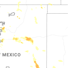


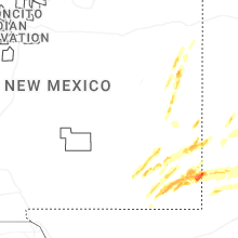


Connect with Interactive Hail Maps