

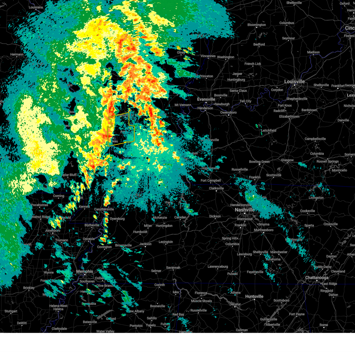
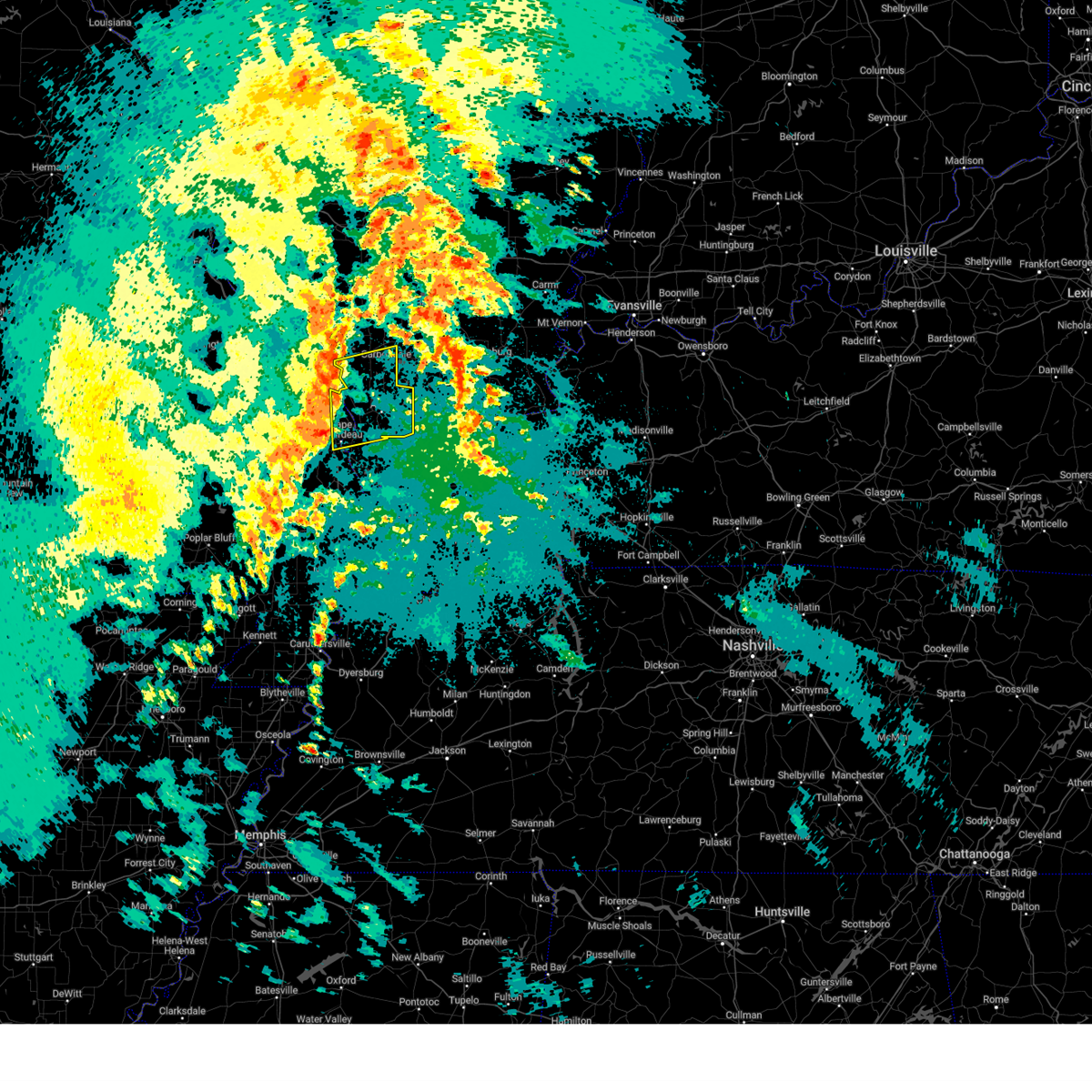
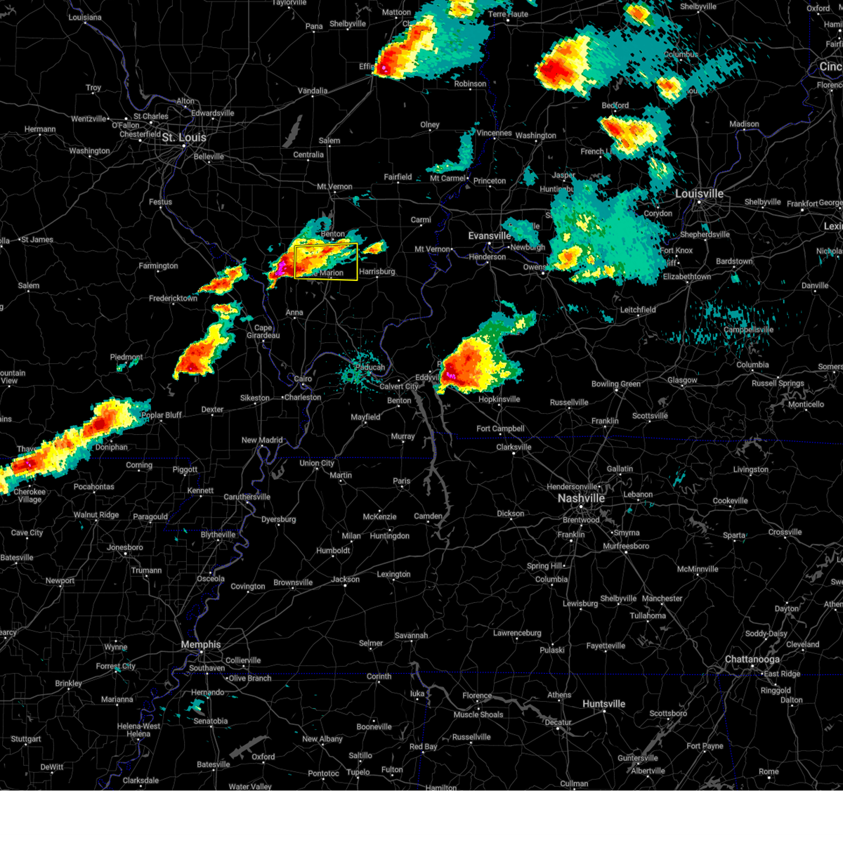
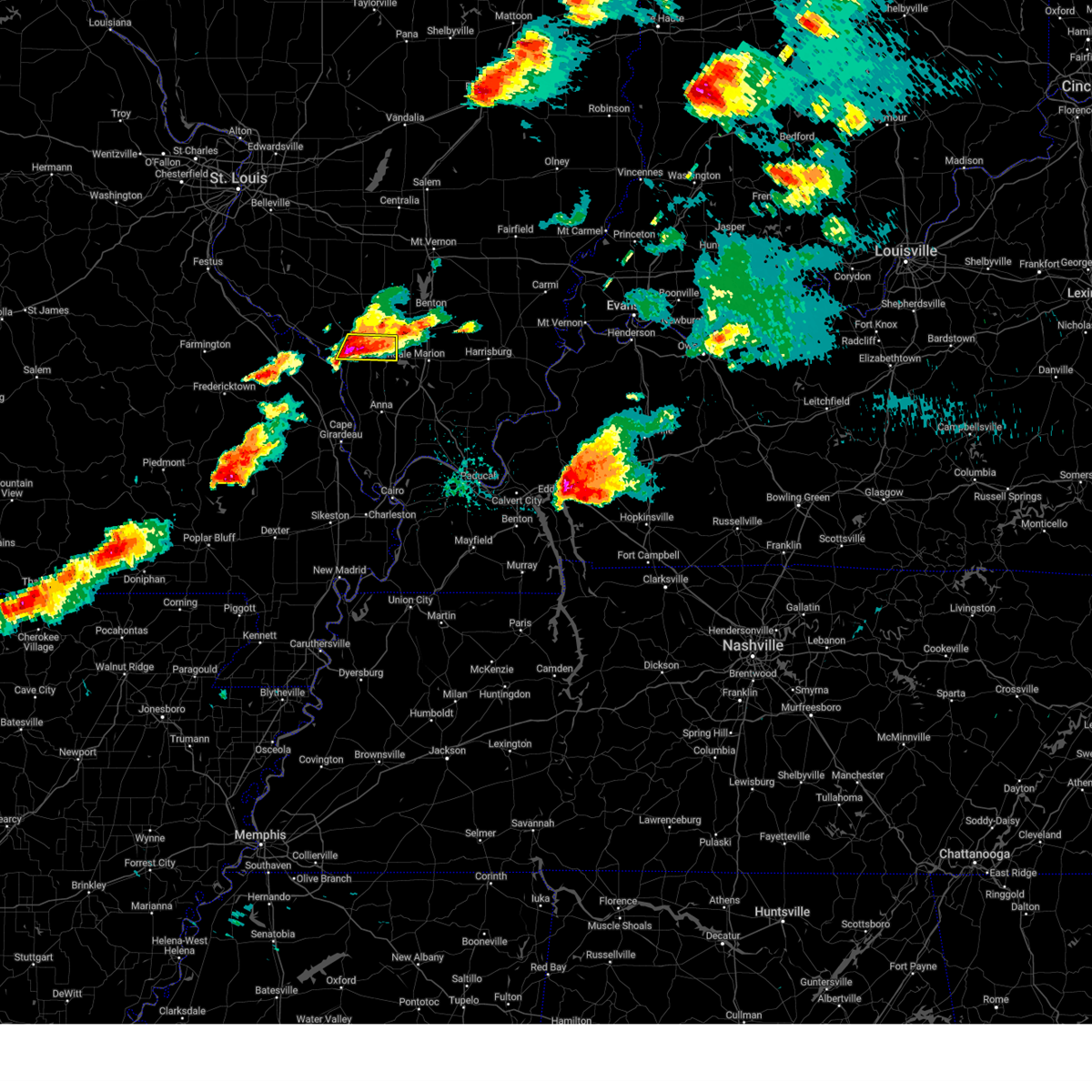
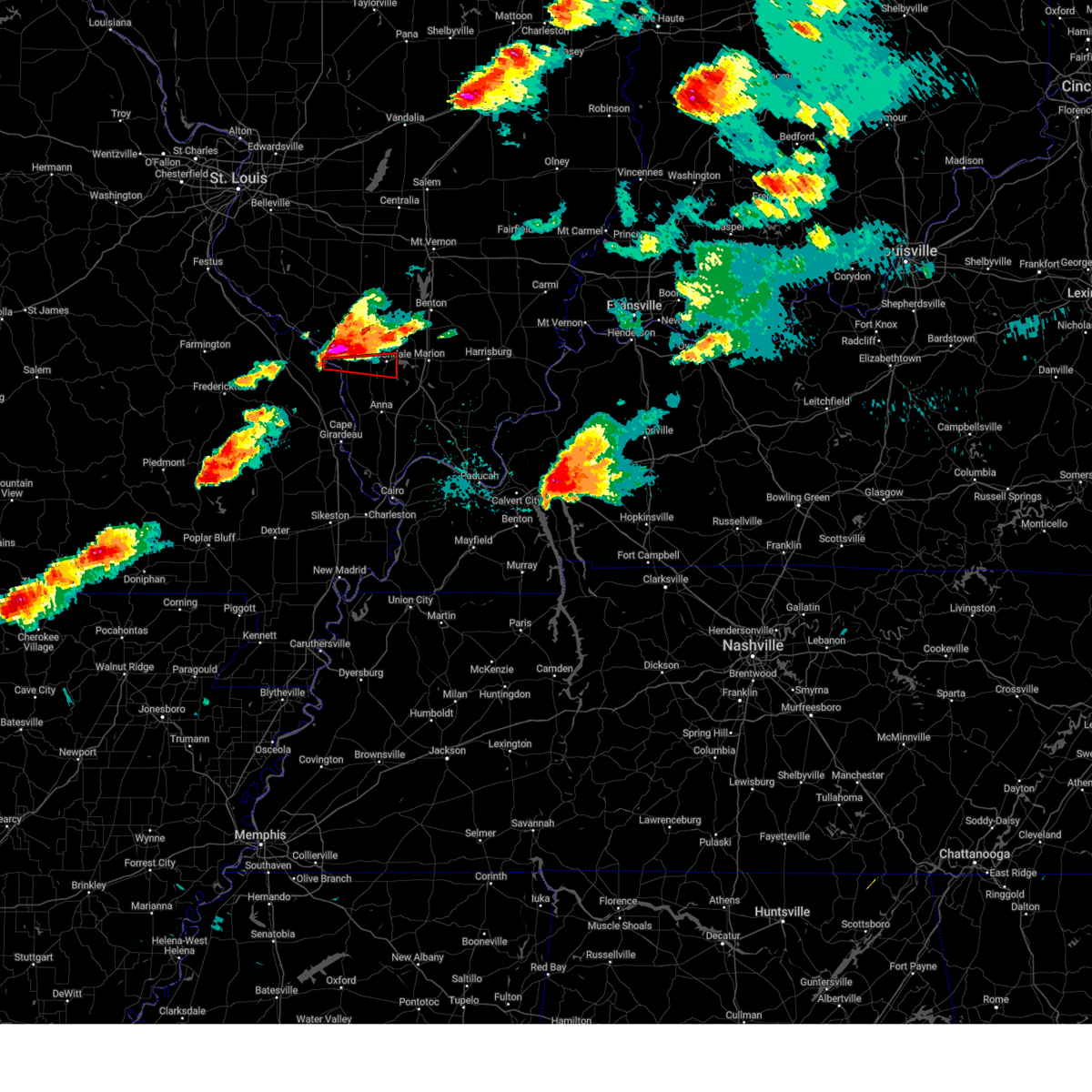
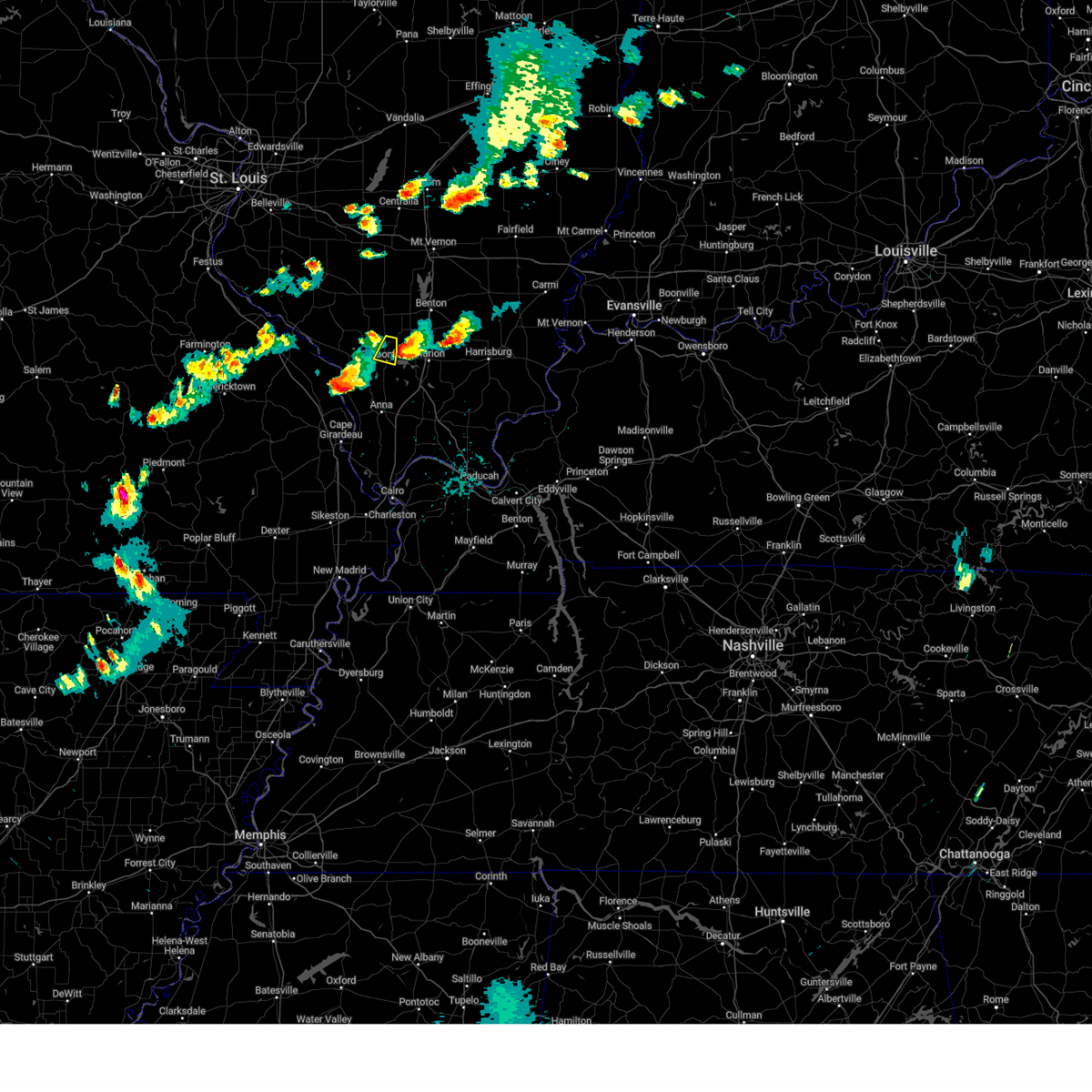
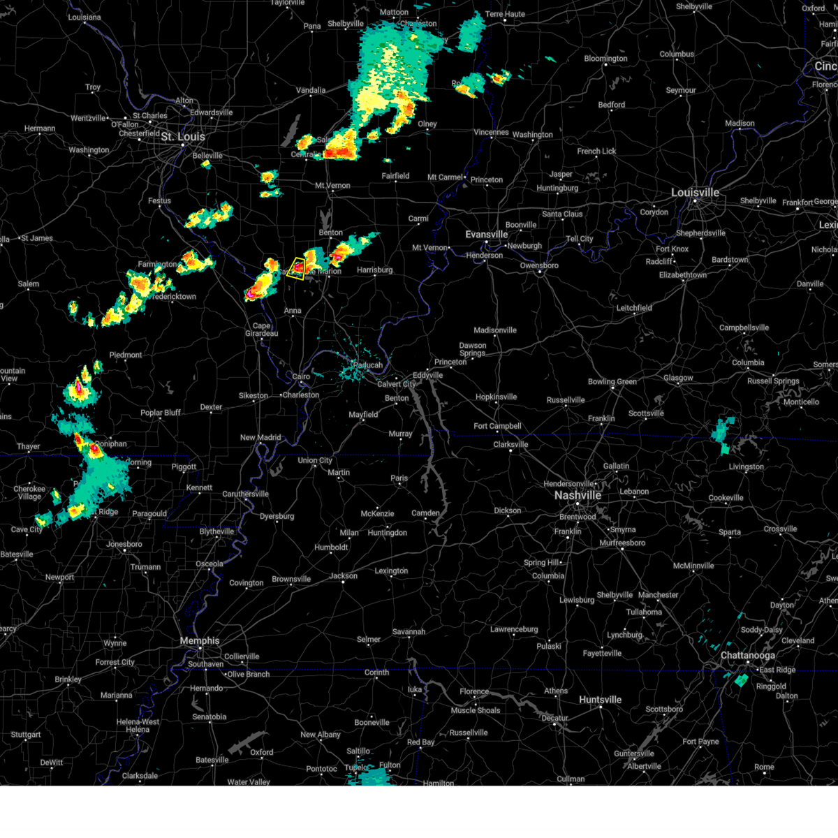
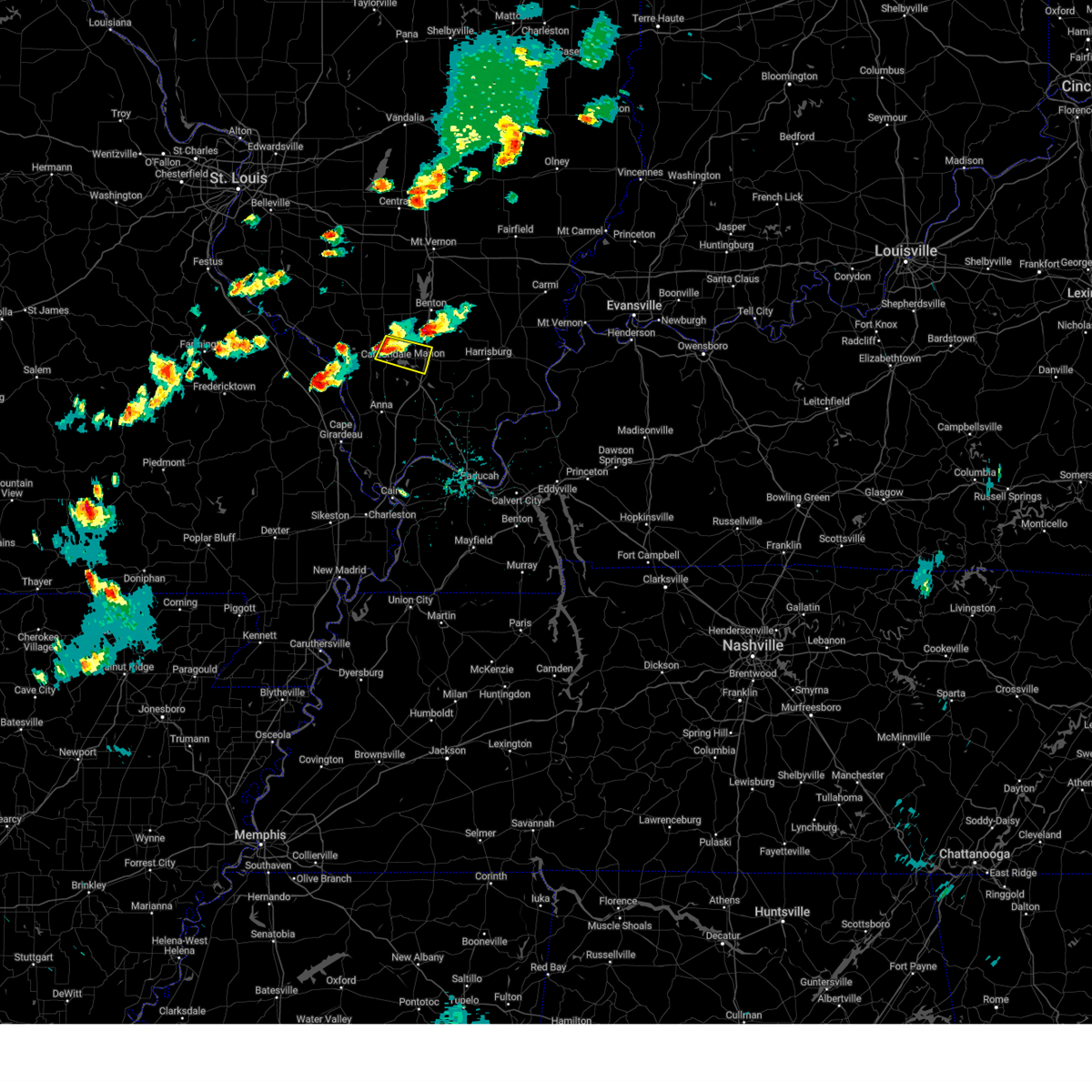
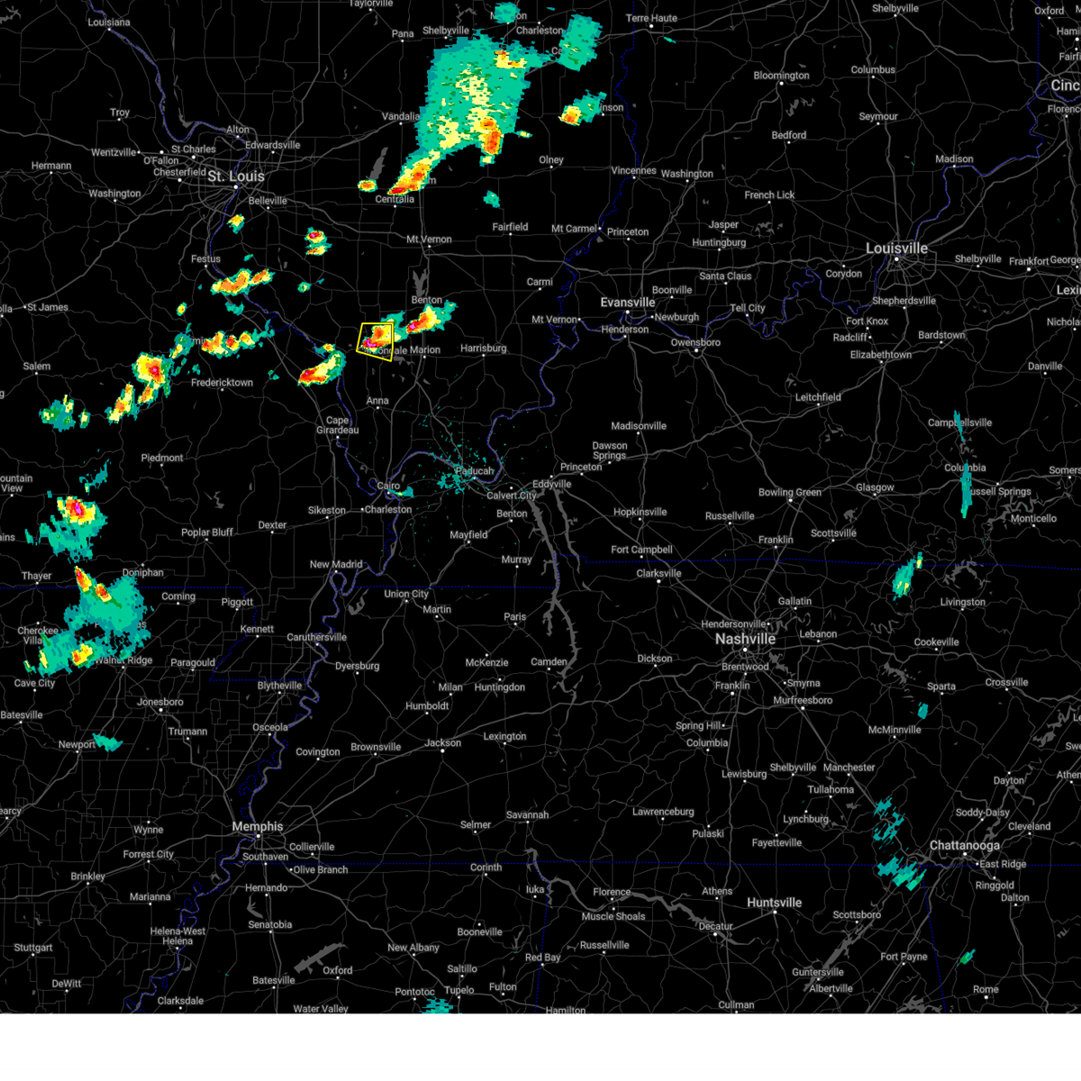
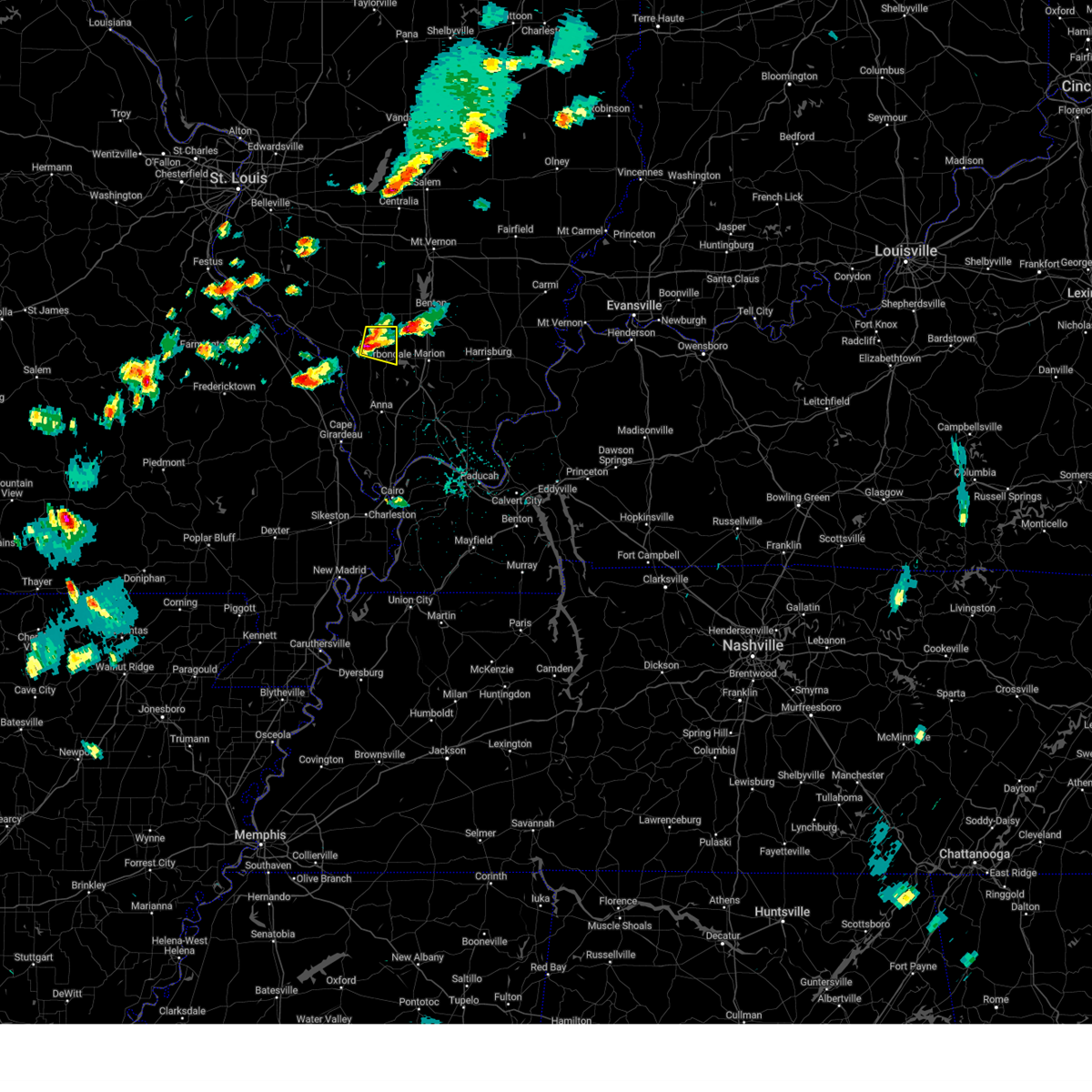
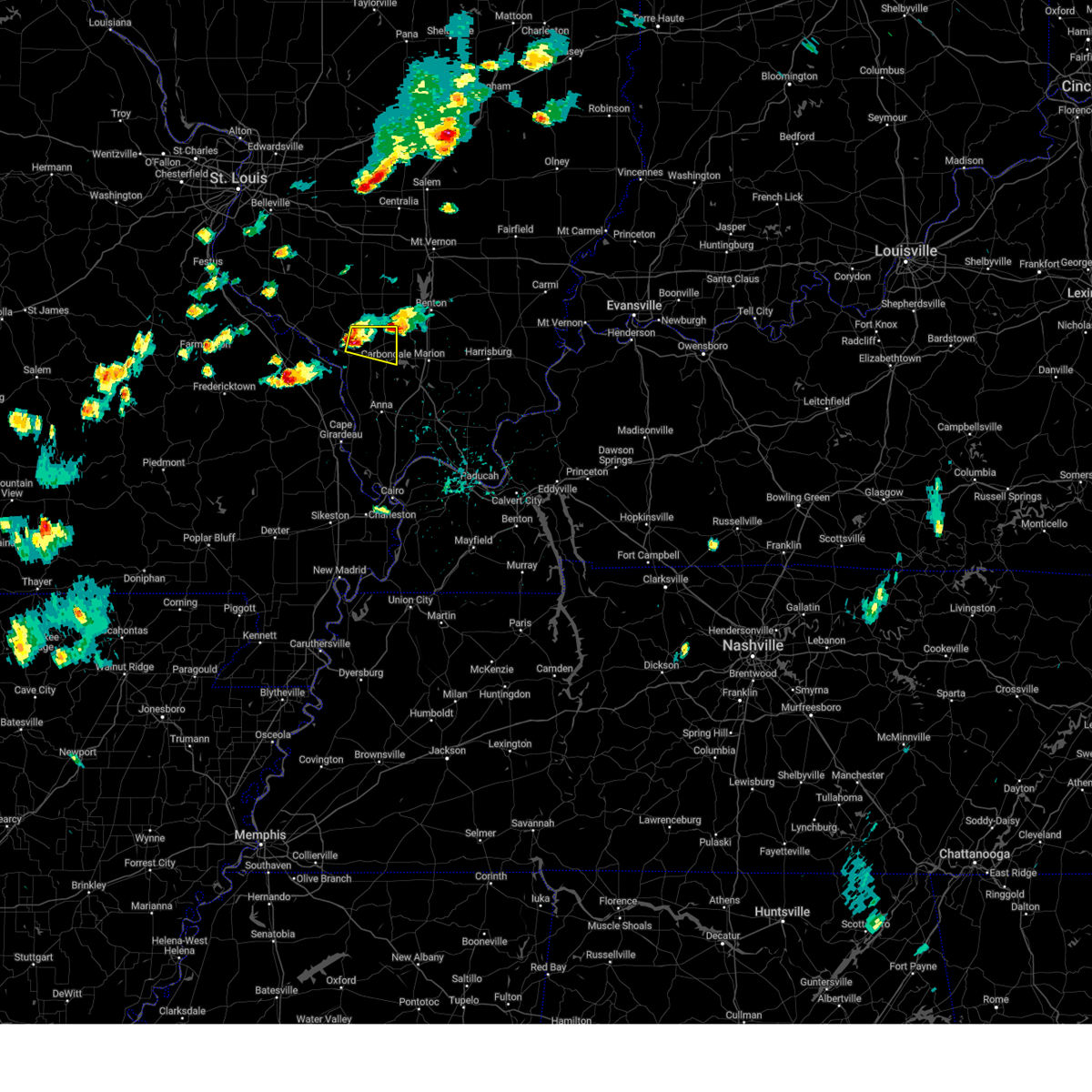
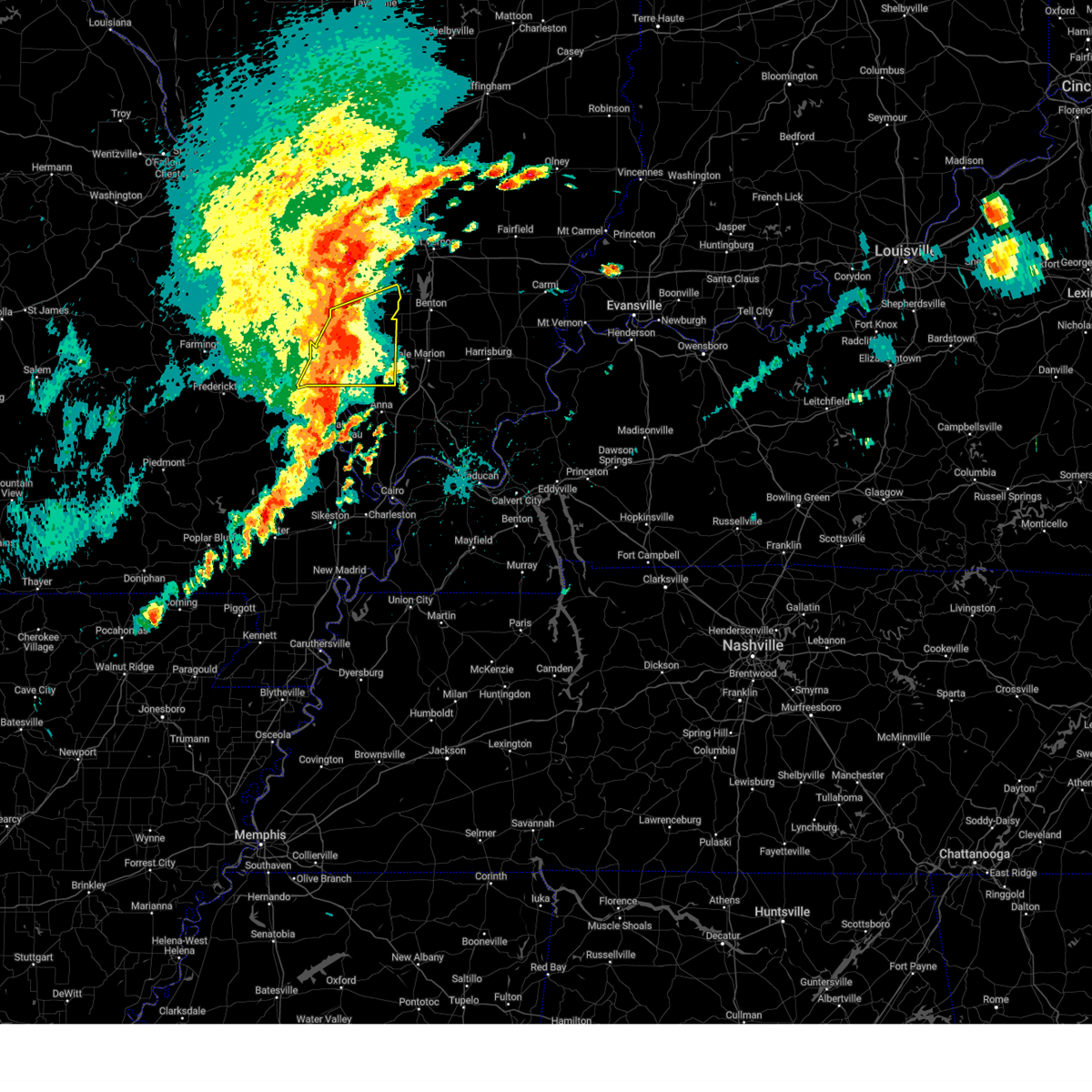
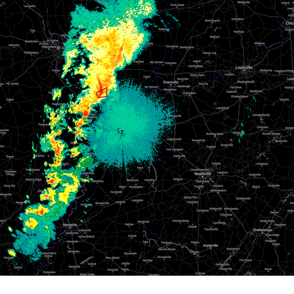
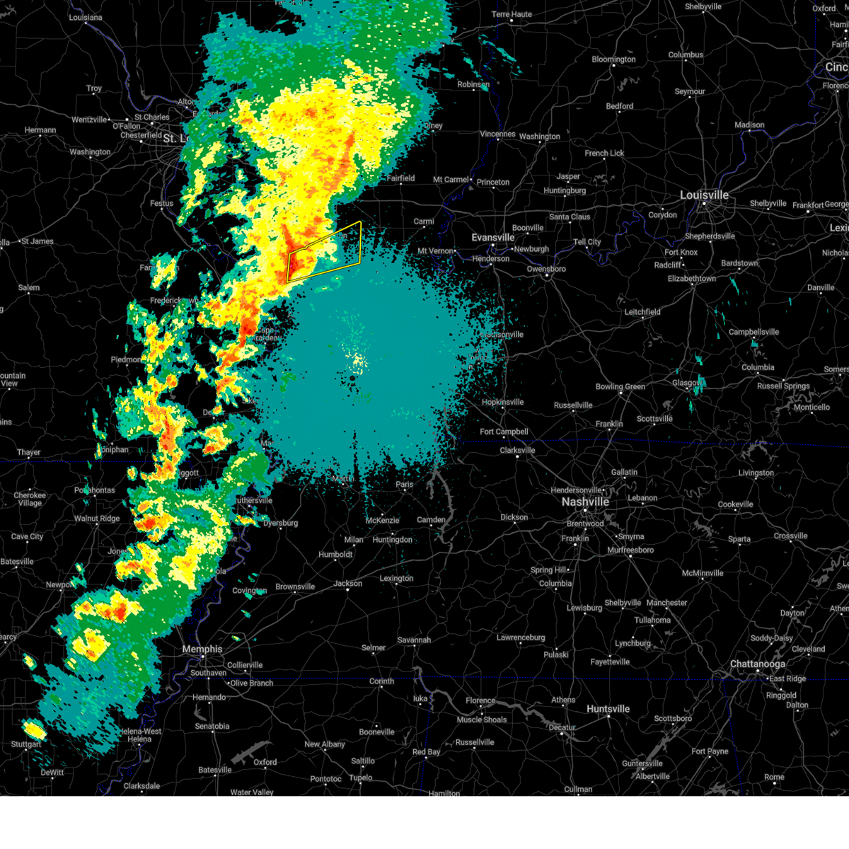
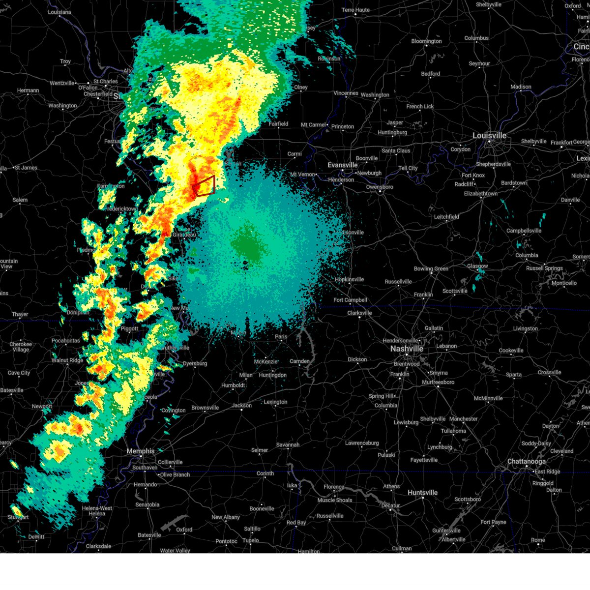
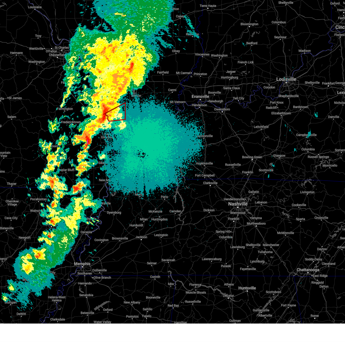
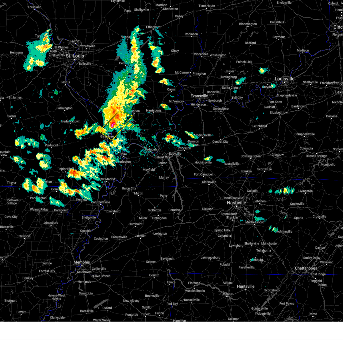
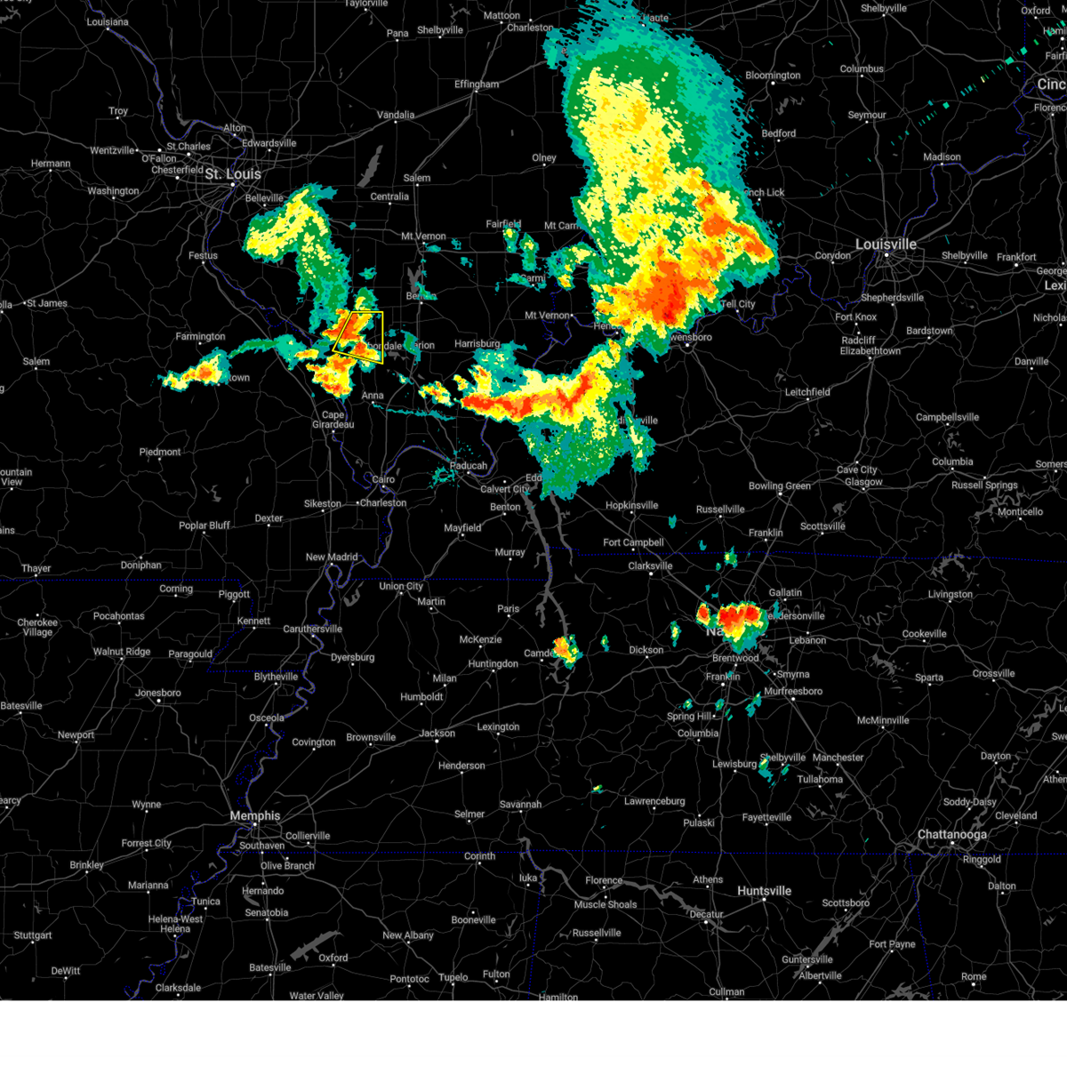
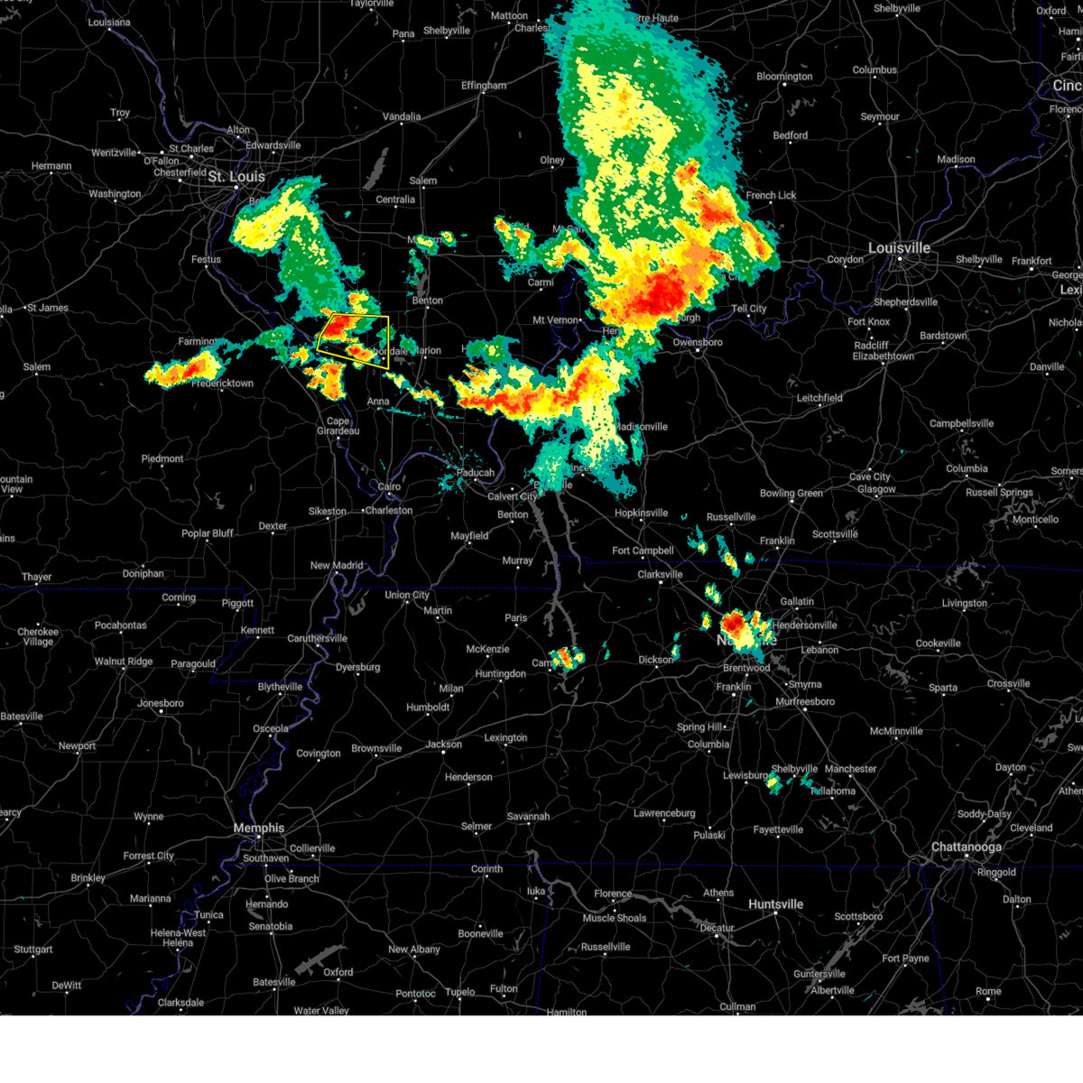
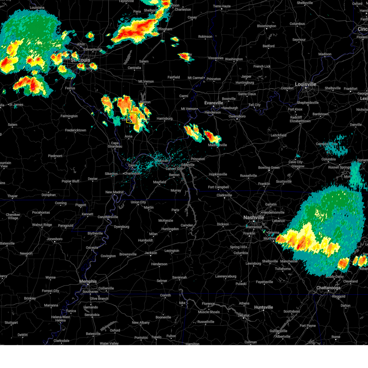
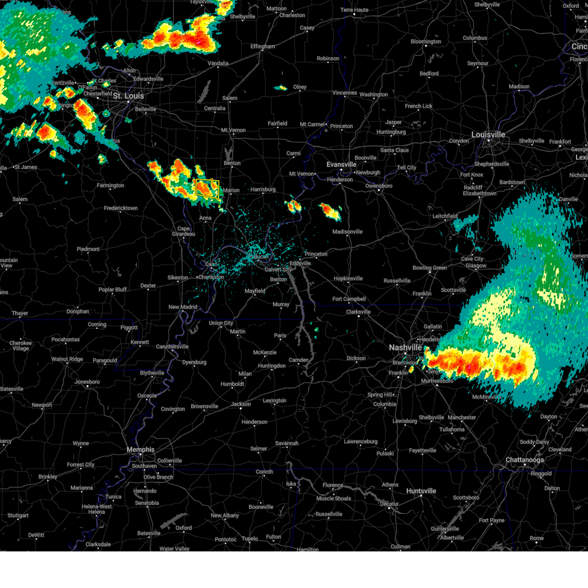
Hail Map for Carbondale, IL
The Carbondale, IL area has had 19 reports of on-the-ground hail by trained spotters, and has been under severe weather warnings 56 times during the past 12 months. Doppler radar has detected hail at or near Carbondale, IL on 82 occasions, including 7 occasions during the past year.
| Name: | Carbondale, IL |
| Where Located: | 34.6 miles NNE of Cape Girardeau, MO |
| Map: | Google Map for Carbondale, IL |
| Population: | 25902 |
| Housing Units: | 12419 |
| More Info: | Search Google for Carbondale, IL |
3
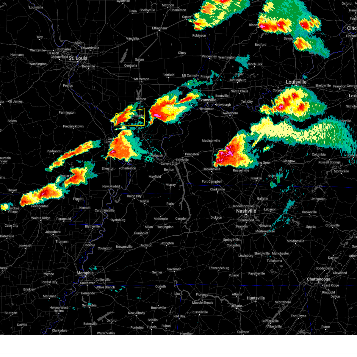
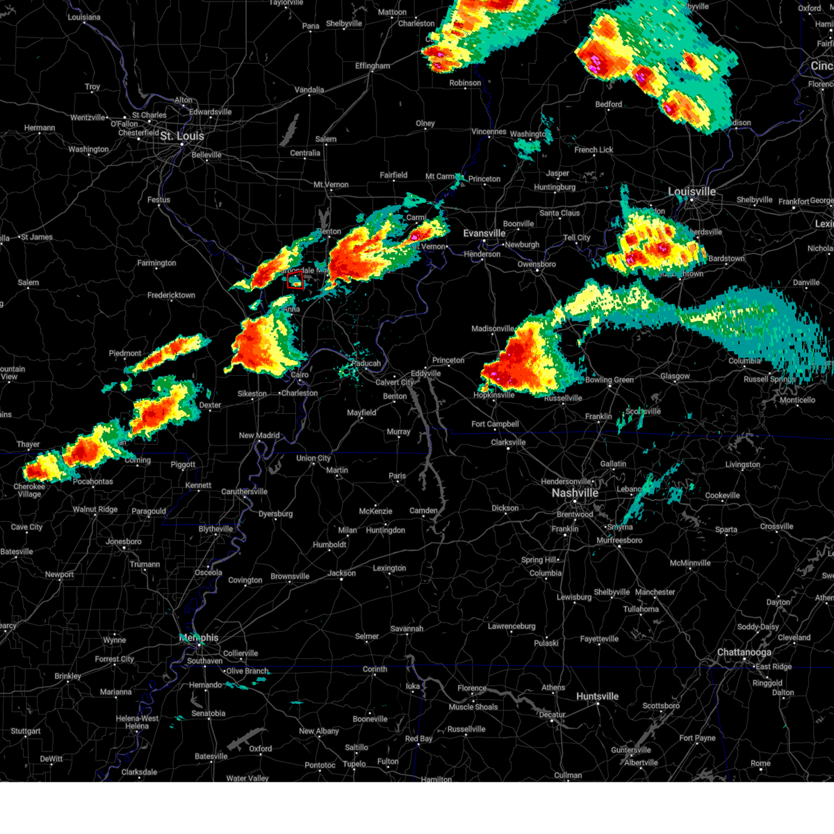
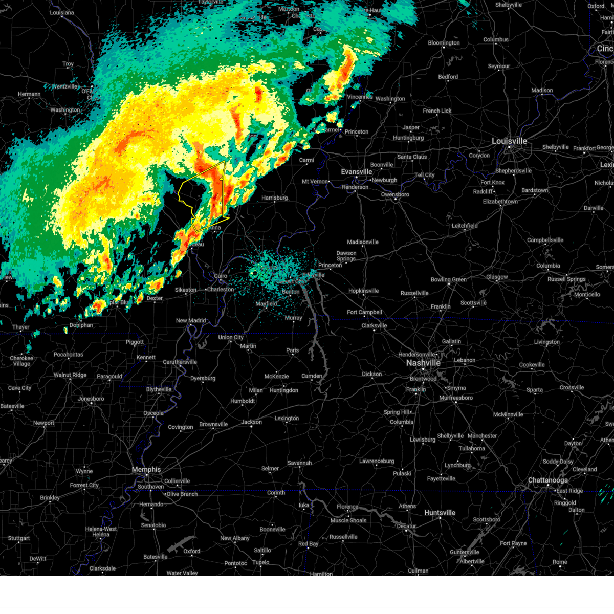
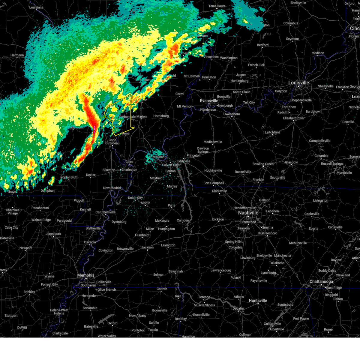
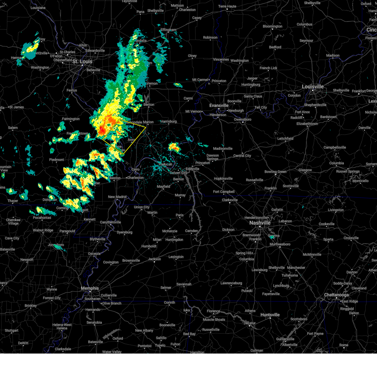
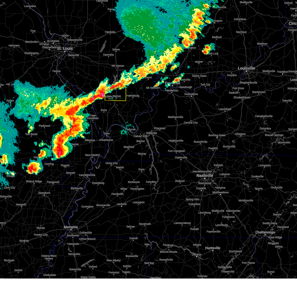
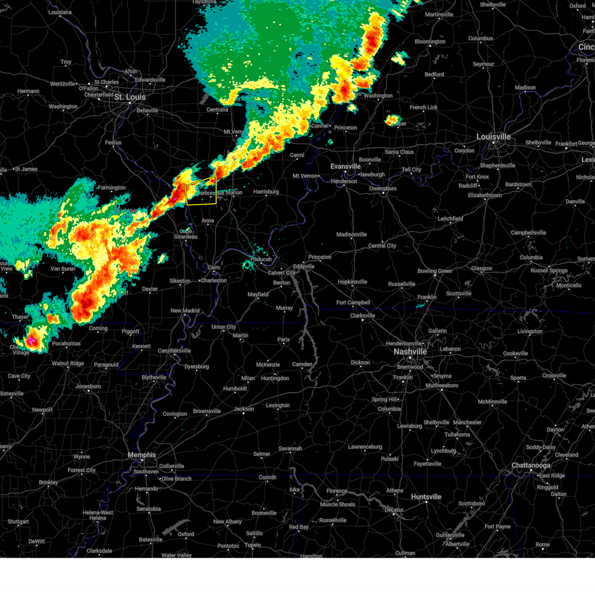
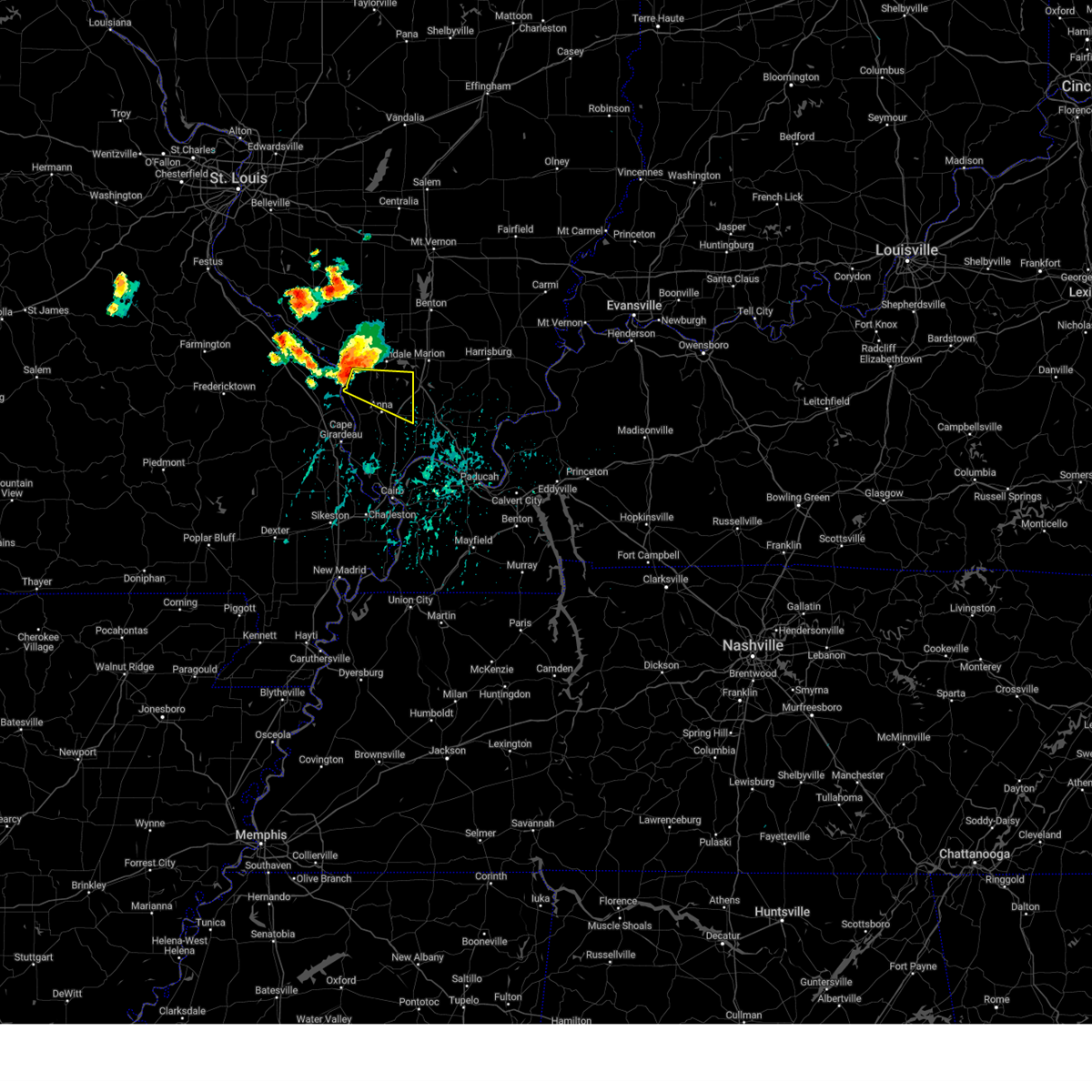
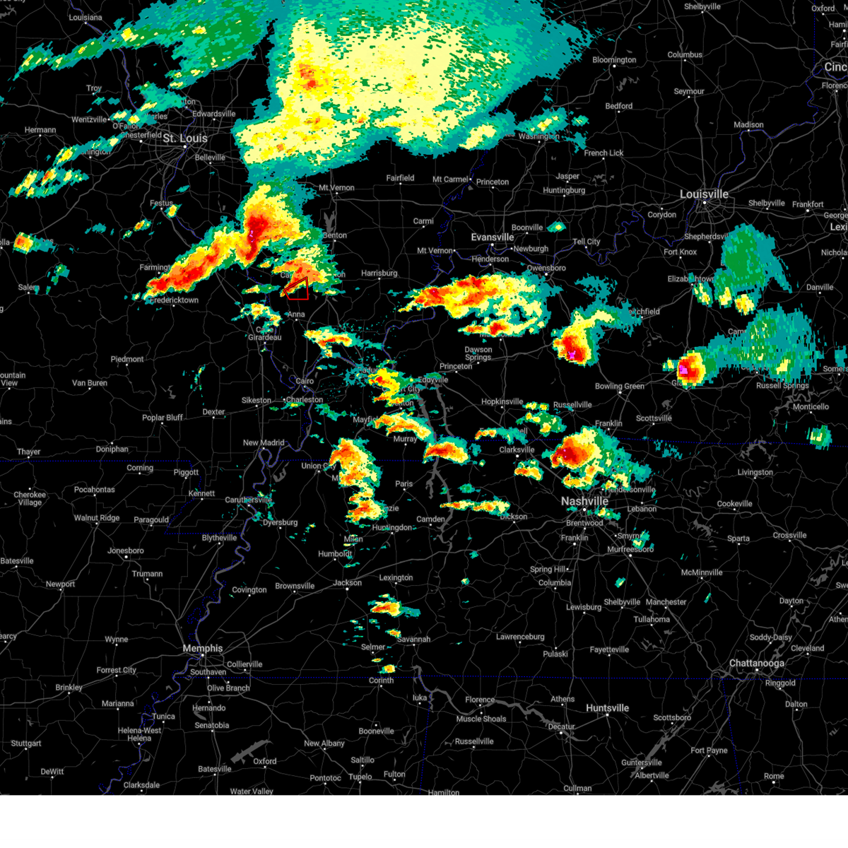
The Top Recent Hail Date for Carbondale, IL is Friday, May 16, 2025 (3rd out of 82)

Hail and Wind Damage Spotted near Carbondale, IL
| Date / Time | Report Details |
|---|---|
| 5/20/2025 1:17 AM CDT |
 the severe thunderstorm warning has been cancelled and is no longer in effect the severe thunderstorm warning has been cancelled and is no longer in effect
|
| 5/20/2025 1:10 AM CDT |
 Svrpah the national weather service in paducah has issued a * severe thunderstorm warning for, union county in southern illinois, southern jackson county in southern illinois, northwestern alexander county in southern illinois, northeastern cape girardeau county in southeastern missouri, * until 200 am cdt. * at 110 am cdt, severe thunderstorms were located along a line extending from grand tower to cape girardeau, moving east at 45 mph (radar indicated). Hazards include 60 mph wind gusts. expect damage to roofs, siding, and trees Svrpah the national weather service in paducah has issued a * severe thunderstorm warning for, union county in southern illinois, southern jackson county in southern illinois, northwestern alexander county in southern illinois, northeastern cape girardeau county in southeastern missouri, * until 200 am cdt. * at 110 am cdt, severe thunderstorms were located along a line extending from grand tower to cape girardeau, moving east at 45 mph (radar indicated). Hazards include 60 mph wind gusts. expect damage to roofs, siding, and trees
|
| 5/16/2025 6:39 PM CDT |
 Svrpah the national weather service in paducah has issued a * severe thunderstorm warning for, williamson county in southern illinois, southeastern jackson county in southern illinois, southern franklin county in south central illinois, * until 730 pm cdt. * at 639 pm cdt, a severe thunderstorm was located near cedar lake area, or 7 miles southwest of carbondale, moving east at 55 mph (radar indicated). Hazards include 60 mph wind gusts and quarter size hail. Hail damage to vehicles is expected. Expect wind damage to roofs, siding, and trees. Svrpah the national weather service in paducah has issued a * severe thunderstorm warning for, williamson county in southern illinois, southeastern jackson county in southern illinois, southern franklin county in south central illinois, * until 730 pm cdt. * at 639 pm cdt, a severe thunderstorm was located near cedar lake area, or 7 miles southwest of carbondale, moving east at 55 mph (radar indicated). Hazards include 60 mph wind gusts and quarter size hail. Hail damage to vehicles is expected. Expect wind damage to roofs, siding, and trees.
|
| 5/16/2025 6:27 PM CDT |
 The storm which prompted the warning has moved out of the area. therefore, the warning will be allowed to expire. a tornado watch remains in effect until 700 pm cdt for southern illinois. a tornado watch also remains in effect until 1000 pm cdt for southern illinois. The storm which prompted the warning has moved out of the area. therefore, the warning will be allowed to expire. a tornado watch remains in effect until 700 pm cdt for southern illinois. a tornado watch also remains in effect until 1000 pm cdt for southern illinois.
|
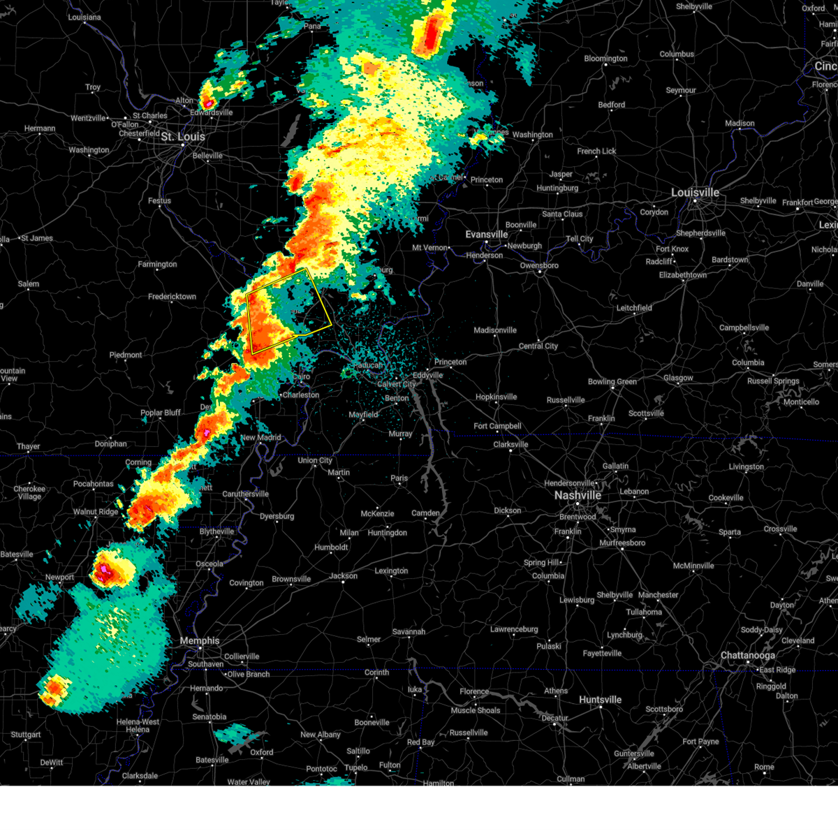
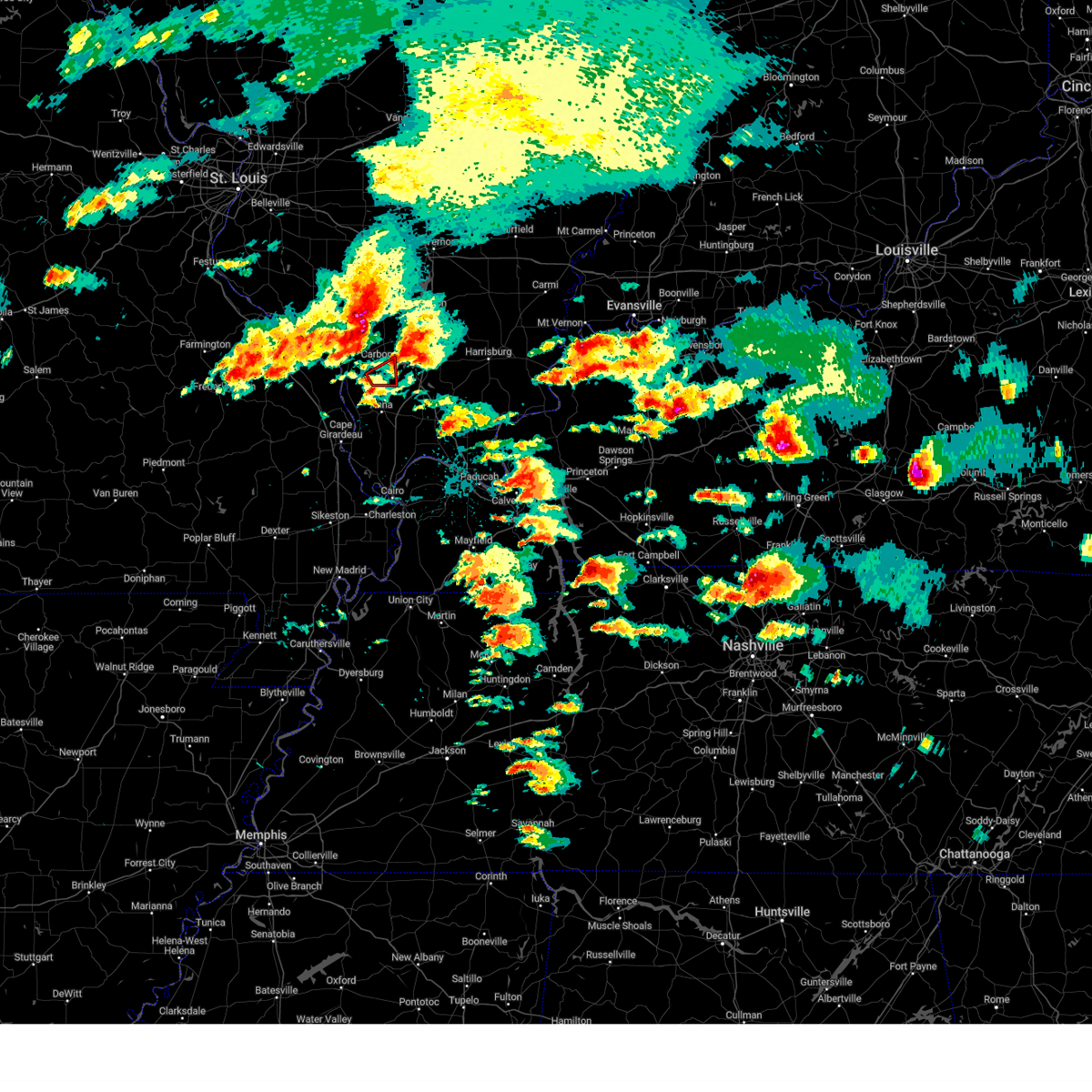
| 5/16/2025 6:11 PM CDT | At 611 pm cdt, a severe thunderstorm capable of producing a tornado was located near carbondale, moving east at 30 mph (radar indicated rotation). Hazards include tornado and two inch hail. Flying debris will be dangerous to those caught without shelter. mobile homes will be damaged or destroyed. damage to roofs, windows, and vehicles will occur. tree damage is likely. This tornadic thunderstorm will remain over mainly rural areas of east central jackson county. |
| 5/16/2025 6:08 PM CDT |
 Torpah the national weather service in paducah has issued a * tornado warning for, williamson county in southern illinois, southeastern jackson county in southern illinois, * until 700 pm cdt. * at 608 pm cdt, a severe thunderstorm capable of producing a tornado was located near carbondale, moving east at 55 mph (radar indicated rotation). Hazards include tornado and hail up to two inches in diameter. Flying debris will be dangerous to those caught without shelter. mobile homes will be damaged or destroyed. damage to roofs, windows, and vehicles will occur. tree damage is likely. this dangerous storm will be near, marion, carterville, crainville, energy, and lake of egypt area around 615 pm cdt. pittsburg and creal springs around 620 pm cdt. other locations impacted by this tornadic thunderstorm include spillertown, williamson county regional airport, and stonefort. This includes interstate 57 in illinois between mile markers 45 and 56. Torpah the national weather service in paducah has issued a * tornado warning for, williamson county in southern illinois, southeastern jackson county in southern illinois, * until 700 pm cdt. * at 608 pm cdt, a severe thunderstorm capable of producing a tornado was located near carbondale, moving east at 55 mph (radar indicated rotation). Hazards include tornado and hail up to two inches in diameter. Flying debris will be dangerous to those caught without shelter. mobile homes will be damaged or destroyed. damage to roofs, windows, and vehicles will occur. tree damage is likely. this dangerous storm will be near, marion, carterville, crainville, energy, and lake of egypt area around 615 pm cdt. pittsburg and creal springs around 620 pm cdt. other locations impacted by this tornadic thunderstorm include spillertown, williamson county regional airport, and stonefort. This includes interstate 57 in illinois between mile markers 45 and 56.
|
| 5/16/2025 6:07 PM CDT | Ping Pong Ball sized hail reported 3.3 miles SW of Carbondale, IL, report from mping: ping pong ball (1.50 in.). |
| 5/16/2025 6:07 PM CDT |
 Svrpah the national weather service in paducah has issued a * severe thunderstorm warning for, northern williamson county in southern illinois, northeastern jackson county in southern illinois, southern franklin county in south central illinois, * until 645 pm cdt. * at 606 pm cdt, a severe thunderstorm was located over de soto, or near carbondale, moving east at 50 mph (radar indicated. ping pong ball sized hail has also been reported near murphysboro). Hazards include two inch hail and 60 mph wind gusts. People and animals outdoors will be injured. expect hail damage to roofs, siding, windows, and vehicles. Expect wind damage to roofs, siding, and trees. Svrpah the national weather service in paducah has issued a * severe thunderstorm warning for, northern williamson county in southern illinois, northeastern jackson county in southern illinois, southern franklin county in south central illinois, * until 645 pm cdt. * at 606 pm cdt, a severe thunderstorm was located over de soto, or near carbondale, moving east at 50 mph (radar indicated. ping pong ball sized hail has also been reported near murphysboro). Hazards include two inch hail and 60 mph wind gusts. People and animals outdoors will be injured. expect hail damage to roofs, siding, windows, and vehicles. Expect wind damage to roofs, siding, and trees.
|
| 5/16/2025 6:02 PM CDT |
 At 602 pm cdt, a severe thunderstorm was located over murphysboro, moving east at 50 mph (emergency management reported golf ball sized hail northwest of murphysboro around 600 pm cdt). Hazards include golf ball size hail and 60 mph wind gusts. People and animals outdoors will be injured. expect hail damage to roofs, siding, windows, and vehicles. expect wind damage to roofs, siding, and trees. Locations impacted include, carbondale, murphysboro, de soto, and hurst. At 602 pm cdt, a severe thunderstorm was located over murphysboro, moving east at 50 mph (emergency management reported golf ball sized hail northwest of murphysboro around 600 pm cdt). Hazards include golf ball size hail and 60 mph wind gusts. People and animals outdoors will be injured. expect hail damage to roofs, siding, windows, and vehicles. expect wind damage to roofs, siding, and trees. Locations impacted include, carbondale, murphysboro, de soto, and hurst.
|
| 5/16/2025 6:01 PM CDT | Quarter sized hail reported 3.3 miles SW of Carbondale, IL, report from mping: quarter (1.00 in.). |
| 5/16/2025 5:55 PM CDT |
 the tornado warning has been cancelled and is no longer in effect the tornado warning has been cancelled and is no longer in effect
|
| 5/16/2025 5:55 PM CDT |
 At 555 pm cdt, a severe thunderstorm capable of producing a tornado was located near grand tower, or 7 miles southwest of murphysboro, moving east at 65 mph (radar indicated rotation). Hazards include tornado and ping pong ball size hail. Flying debris will be dangerous to those caught without shelter. mobile homes will be damaged or destroyed. damage to roofs, windows, and vehicles will occur. tree damage is likely. this dangerous storm will be near, carbondale and murphysboro around 600 pm cdt. Other locations impacted by this tornadic thunderstorm include gorham. At 555 pm cdt, a severe thunderstorm capable of producing a tornado was located near grand tower, or 7 miles southwest of murphysboro, moving east at 65 mph (radar indicated rotation). Hazards include tornado and ping pong ball size hail. Flying debris will be dangerous to those caught without shelter. mobile homes will be damaged or destroyed. damage to roofs, windows, and vehicles will occur. tree damage is likely. this dangerous storm will be near, carbondale and murphysboro around 600 pm cdt. Other locations impacted by this tornadic thunderstorm include gorham.
|
| 5/16/2025 5:54 PM CDT |
 the severe thunderstorm warning has been cancelled and is no longer in effect the severe thunderstorm warning has been cancelled and is no longer in effect
|
| 5/16/2025 5:54 PM CDT |
 At 553 pm cdt, a severe thunderstorm was located near murphysboro, moving east at 50 mph (radar indicated). Hazards include 60 mph wind gusts and half dollar size hail. Hail damage to vehicles is expected. expect wind damage to roofs, siding, and trees. Locations impacted include, carbondale, murphysboro, de soto, and hurst. At 553 pm cdt, a severe thunderstorm was located near murphysboro, moving east at 50 mph (radar indicated). Hazards include 60 mph wind gusts and half dollar size hail. Hail damage to vehicles is expected. expect wind damage to roofs, siding, and trees. Locations impacted include, carbondale, murphysboro, de soto, and hurst.
|
| 5/16/2025 5:49 PM CDT |
 Torpah the national weather service in paducah has issued a * tornado warning for, central jackson county in southern illinois, eastern perry county in southeastern missouri, * until 630 pm cdt. * at 549 pm cdt, a severe thunderstorm capable of producing a tornado was located near altenburg, or 14 miles east of perryville, moving east at 50 mph (radar indicated rotation. trained weather spotters have reported a wall cloud with this storm, and it could produce a tornado at anytime!). Hazards include tornado. Flying debris will be dangerous to those caught without shelter. mobile homes will be damaged or destroyed. damage to roofs, windows, and vehicles will occur. tree damage is likely. this dangerous storm will be near, murphysboro around 555 pm cdt. carbondale around 600 pm cdt. Other locations impacted by this tornadic thunderstorm include gorham. Torpah the national weather service in paducah has issued a * tornado warning for, central jackson county in southern illinois, eastern perry county in southeastern missouri, * until 630 pm cdt. * at 549 pm cdt, a severe thunderstorm capable of producing a tornado was located near altenburg, or 14 miles east of perryville, moving east at 50 mph (radar indicated rotation. trained weather spotters have reported a wall cloud with this storm, and it could produce a tornado at anytime!). Hazards include tornado. Flying debris will be dangerous to those caught without shelter. mobile homes will be damaged or destroyed. damage to roofs, windows, and vehicles will occur. tree damage is likely. this dangerous storm will be near, murphysboro around 555 pm cdt. carbondale around 600 pm cdt. Other locations impacted by this tornadic thunderstorm include gorham.
|
| 5/16/2025 5:33 PM CDT | Svrpah the national weather service in paducah has issued a * severe thunderstorm warning for, central jackson county in southern illinois, central perry county in southeastern missouri, * until 615 pm cdt. * at 533 pm cdt, a severe thunderstorm was located 9 miles northeast of perryville, moving east at 55 mph (radar indicated). Hazards include 60 mph wind gusts and half dollar size hail. Hail damage to vehicles is expected. Expect wind damage to roofs, siding, and trees. |
| 5/1/2025 6:21 PM CDT |
 The storm which prompted the warning has moved out of the area. therefore, the warning will be allowed to expire. The storm which prompted the warning has moved out of the area. therefore, the warning will be allowed to expire.
|
| 5/1/2025 6:09 PM CDT |
 At 609 pm cdt, a severe thunderstorm was located over cambria, or near carterville, moving east at 25 mph (emergency management). Hazards include 60 mph wind gusts and quarter size hail. Hail damage to vehicles is expected. expect wind damage to roofs, siding, and trees. Locations impacted include, carbondale, de soto, and hurst. At 609 pm cdt, a severe thunderstorm was located over cambria, or near carterville, moving east at 25 mph (emergency management). Hazards include 60 mph wind gusts and quarter size hail. Hail damage to vehicles is expected. expect wind damage to roofs, siding, and trees. Locations impacted include, carbondale, de soto, and hurst.
|
| 5/1/2025 5:55 PM CDT |
 Svrpah the national weather service in paducah has issued a * severe thunderstorm warning for, northwestern williamson county in southern illinois, east central jackson county in southern illinois, * until 645 pm cdt. * at 555 pm cdt, a severe thunderstorm was located over de soto, or near carbondale, moving east at 25 mph (radar indicated). Hazards include 60 mph wind gusts and half dollar size hail. Hail damage to vehicles is expected. Expect wind damage to roofs, siding, and trees. Svrpah the national weather service in paducah has issued a * severe thunderstorm warning for, northwestern williamson county in southern illinois, east central jackson county in southern illinois, * until 645 pm cdt. * at 555 pm cdt, a severe thunderstorm was located over de soto, or near carbondale, moving east at 25 mph (radar indicated). Hazards include 60 mph wind gusts and half dollar size hail. Hail damage to vehicles is expected. Expect wind damage to roofs, siding, and trees.
|
| 5/1/2025 5:48 PM CDT |
 Svrpah the national weather service in paducah has issued a * severe thunderstorm warning for, northeastern jackson county in southern illinois, * until 630 pm cdt. * at 548 pm cdt, a severe thunderstorm was located over de soto, or near carbondale, moving east at 30 mph (emergency management). Hazards include golf ball size hail and 60 mph wind gusts. People and animals outdoors will be injured. expect hail damage to roofs, siding, windows, and vehicles. Expect wind damage to roofs, siding, and trees. Svrpah the national weather service in paducah has issued a * severe thunderstorm warning for, northeastern jackson county in southern illinois, * until 630 pm cdt. * at 548 pm cdt, a severe thunderstorm was located over de soto, or near carbondale, moving east at 30 mph (emergency management). Hazards include golf ball size hail and 60 mph wind gusts. People and animals outdoors will be injured. expect hail damage to roofs, siding, windows, and vehicles. Expect wind damage to roofs, siding, and trees.
|
| 5/1/2025 5:42 PM CDT |
 At 541 pm cdt, a severe thunderstorm was located over murphysboro, moving east at 25 mph (radar indicated). Hazards include 60 mph wind gusts and quarter size hail. Hail damage to vehicles is expected. expect wind damage to roofs, siding, and trees. Locations impacted include, carbondale, murphysboro, de soto, elkville, hurst, and vergennes. At 541 pm cdt, a severe thunderstorm was located over murphysboro, moving east at 25 mph (radar indicated). Hazards include 60 mph wind gusts and quarter size hail. Hail damage to vehicles is expected. expect wind damage to roofs, siding, and trees. Locations impacted include, carbondale, murphysboro, de soto, elkville, hurst, and vergennes.
|
| 5/1/2025 5:22 PM CDT |
 Svrpah the national weather service in paducah has issued a * severe thunderstorm warning for, northeastern jackson county in southern illinois, * until 600 pm cdt. * at 521 pm cdt, a severe thunderstorm was located near murphysboro, moving east at 30 mph (radar indicated). Hazards include 60 mph wind gusts and quarter size hail. Hail damage to vehicles is expected. Expect wind damage to roofs, siding, and trees. Svrpah the national weather service in paducah has issued a * severe thunderstorm warning for, northeastern jackson county in southern illinois, * until 600 pm cdt. * at 521 pm cdt, a severe thunderstorm was located near murphysboro, moving east at 30 mph (radar indicated). Hazards include 60 mph wind gusts and quarter size hail. Hail damage to vehicles is expected. Expect wind damage to roofs, siding, and trees.
|
| 4/29/2025 2:03 PM CDT |
 Svrpah the national weather service in paducah has issued a * severe thunderstorm warning for, southeastern perry county in south central illinois, eastern union county in southern illinois, northern pulaski county in southern illinois, western johnson county in southern illinois, williamson county in southern illinois, eastern jackson county in southern illinois, north central alexander county in southern illinois, franklin county in south central illinois, * until 245 pm cdt. * at 202 pm cdt, severe thunderstorms were located along a line extending from du quoin to near carbondale to near scott city, moving east at 40 mph (radar indicated). Hazards include 60 mph wind gusts. expect damage to roofs, siding, and trees Svrpah the national weather service in paducah has issued a * severe thunderstorm warning for, southeastern perry county in south central illinois, eastern union county in southern illinois, northern pulaski county in southern illinois, western johnson county in southern illinois, williamson county in southern illinois, eastern jackson county in southern illinois, north central alexander county in southern illinois, franklin county in south central illinois, * until 245 pm cdt. * at 202 pm cdt, severe thunderstorms were located along a line extending from du quoin to near carbondale to near scott city, moving east at 40 mph (radar indicated). Hazards include 60 mph wind gusts. expect damage to roofs, siding, and trees
|
| 4/29/2025 1:56 PM CDT |
 At 155 pm cdt, severe thunderstorms were located along a line extending from near pinckneyville to near murphysboro to near grand tower, moving east at 45 mph (radar indicated). Hazards include 60 mph wind gusts and penny size hail. Expect damage to roofs, siding, and trees. locations impacted include, dowell, campbell hill, st. johns, ava, vergennes, du quoin, gorham, frohna, carbondale, elkville, makanda, grand tower, murphysboro, cedar lake area, de soto, altenburg, willisville, and pinckneyville. This includes interstate 55 between mile markers 120 and 121. At 155 pm cdt, severe thunderstorms were located along a line extending from near pinckneyville to near murphysboro to near grand tower, moving east at 45 mph (radar indicated). Hazards include 60 mph wind gusts and penny size hail. Expect damage to roofs, siding, and trees. locations impacted include, dowell, campbell hill, st. johns, ava, vergennes, du quoin, gorham, frohna, carbondale, elkville, makanda, grand tower, murphysboro, cedar lake area, de soto, altenburg, willisville, and pinckneyville. This includes interstate 55 between mile markers 120 and 121.
|
| 4/29/2025 1:34 PM CDT |
 Svrpah the national weather service in paducah has issued a * severe thunderstorm warning for, southern perry county in south central illinois, jackson county in southern illinois, southeastern perry county in southeastern missouri, * until 215 pm cdt. * at 134 pm cdt, severe thunderstorms were located along a line extending from near willisville to 9 miles southwest of ava to near altenburg, moving east at 40 mph (radar indicated). Hazards include 60 mph wind gusts and penny size hail. expect damage to roofs, siding, and trees Svrpah the national weather service in paducah has issued a * severe thunderstorm warning for, southern perry county in south central illinois, jackson county in southern illinois, southeastern perry county in southeastern missouri, * until 215 pm cdt. * at 134 pm cdt, severe thunderstorms were located along a line extending from near willisville to 9 miles southwest of ava to near altenburg, moving east at 40 mph (radar indicated). Hazards include 60 mph wind gusts and penny size hail. expect damage to roofs, siding, and trees
|
| 4/20/2025 10:02 PM CDT |
 the tornado warning has been cancelled and is no longer in effect the tornado warning has been cancelled and is no longer in effect
|
| 4/20/2025 9:54 PM CDT |
 Svrpah the national weather service in paducah has issued a * severe thunderstorm warning for, northern williamson county in southern illinois, northeastern jackson county in southern illinois, franklin county in south central illinois, * until 1030 pm cdt. * at 954 pm cdt, a severe thunderstorm was located over de soto, or near murphysboro, moving northeast at 60 mph (radar indicated). Hazards include 60 mph wind gusts. expect damage to roofs, siding, and trees Svrpah the national weather service in paducah has issued a * severe thunderstorm warning for, northern williamson county in southern illinois, northeastern jackson county in southern illinois, franklin county in south central illinois, * until 1030 pm cdt. * at 954 pm cdt, a severe thunderstorm was located over de soto, or near murphysboro, moving northeast at 60 mph (radar indicated). Hazards include 60 mph wind gusts. expect damage to roofs, siding, and trees
|
| 4/20/2025 9:50 PM CDT |
 At 950 pm cdt, a severe thunderstorm capable of producing a tornado was located near de soto, or just north of near murphysboro, moving northeast at 55 mph (radar indicated rotation). Hazards include tornado. Flying debris will be dangerous to those caught without shelter. mobile homes will be damaged or destroyed. damage to roofs, windows, and vehicles will occur. tree damage is likely. This dangerous storm will be near, de soto and hurst around 955 pm cdt. At 950 pm cdt, a severe thunderstorm capable of producing a tornado was located near de soto, or just north of near murphysboro, moving northeast at 55 mph (radar indicated rotation). Hazards include tornado. Flying debris will be dangerous to those caught without shelter. mobile homes will be damaged or destroyed. damage to roofs, windows, and vehicles will occur. tree damage is likely. This dangerous storm will be near, de soto and hurst around 955 pm cdt.
|
| 4/20/2025 9:36 PM CDT |
 Torpah the national weather service in paducah has issued a * tornado warning for, southern jackson county in southern illinois, * until 1015 pm cdt. * at 935 pm cdt, a severe thunderstorm capable of producing a tornado was located near grand tower, or 11 miles southwest of murphysboro, moving northeast at 45 mph (radar indicated rotation). Hazards include tornado. Flying debris will be dangerous to those caught without shelter. mobile homes will be damaged or destroyed. damage to roofs, windows, and vehicles will occur. tree damage is likely. this dangerous storm will be near, murphysboro and carbondale around 940 pm cdt. de soto around 950 pm cdt. hurst around 955 pm cdt. Other locations impacted by this tornadic thunderstorm include gorham. Torpah the national weather service in paducah has issued a * tornado warning for, southern jackson county in southern illinois, * until 1015 pm cdt. * at 935 pm cdt, a severe thunderstorm capable of producing a tornado was located near grand tower, or 11 miles southwest of murphysboro, moving northeast at 45 mph (radar indicated rotation). Hazards include tornado. Flying debris will be dangerous to those caught without shelter. mobile homes will be damaged or destroyed. damage to roofs, windows, and vehicles will occur. tree damage is likely. this dangerous storm will be near, murphysboro and carbondale around 940 pm cdt. de soto around 950 pm cdt. hurst around 955 pm cdt. Other locations impacted by this tornadic thunderstorm include gorham.
|
| 4/19/2025 6:48 AM CDT |
 the severe thunderstorm warning has been cancelled and is no longer in effect the severe thunderstorm warning has been cancelled and is no longer in effect
|
| 4/19/2025 6:18 AM CDT |
 Svrpah the national weather service in paducah has issued a * severe thunderstorm warning for, southeastern perry county in south central illinois, northwestern union county in southern illinois, jackson county in southern illinois, * until 715 am cdt. * at 618 am cdt, severe thunderstorms were located along a line extending from 6 miles northeast of perryville to 6 miles northeast of millersville, moving northeast at 80 mph (radar indicated). Hazards include 60 mph wind gusts and quarter size hail. Hail damage to vehicles is expected. Expect wind damage to roofs, siding, and trees. Svrpah the national weather service in paducah has issued a * severe thunderstorm warning for, southeastern perry county in south central illinois, northwestern union county in southern illinois, jackson county in southern illinois, * until 715 am cdt. * at 618 am cdt, severe thunderstorms were located along a line extending from 6 miles northeast of perryville to 6 miles northeast of millersville, moving northeast at 80 mph (radar indicated). Hazards include 60 mph wind gusts and quarter size hail. Hail damage to vehicles is expected. Expect wind damage to roofs, siding, and trees.
|
| 4/10/2025 1:54 PM CDT |
 At 154 pm cdt, severe thunderstorms were located along a line extending from near cedar lake area to near trail of tears state park, moving southeast at 35 mph (radar indicated). Hazards include 60 mph wind gusts and quarter size hail. Hail damage to vehicles is expected. expect wind damage to roofs, siding, and trees. locations impacted include, ware, jonesboro, carbondale, makanda, trail of tears state park, cobden, cedar lake area, anna, alto pass, and cape girardeau. This includes interstate 55 between mile markers 104 and 107. At 154 pm cdt, severe thunderstorms were located along a line extending from near cedar lake area to near trail of tears state park, moving southeast at 35 mph (radar indicated). Hazards include 60 mph wind gusts and quarter size hail. Hail damage to vehicles is expected. expect wind damage to roofs, siding, and trees. locations impacted include, ware, jonesboro, carbondale, makanda, trail of tears state park, cobden, cedar lake area, anna, alto pass, and cape girardeau. This includes interstate 55 between mile markers 104 and 107.
|
| 4/10/2025 1:54 PM CDT |
 the severe thunderstorm warning has been cancelled and is no longer in effect the severe thunderstorm warning has been cancelled and is no longer in effect
|
| 4/10/2025 1:33 PM CDT |
 Svrpah the national weather service in paducah has issued a * severe thunderstorm warning for, central union county in southern illinois, southwestern williamson county in southern illinois, southern jackson county in southern illinois, north central alexander county in southern illinois, southeastern perry county in southeastern missouri, northern cape girardeau county in southeastern missouri, * until 215 pm cdt. * at 133 pm cdt, severe thunderstorms were located along a line extending from 7 miles west of murphysboro to near daisy, moving southeast at 35 mph (radar indicated). Hazards include 60 mph wind gusts and quarter size hail. Hail damage to vehicles is expected. Expect wind damage to roofs, siding, and trees. Svrpah the national weather service in paducah has issued a * severe thunderstorm warning for, central union county in southern illinois, southwestern williamson county in southern illinois, southern jackson county in southern illinois, north central alexander county in southern illinois, southeastern perry county in southeastern missouri, northern cape girardeau county in southeastern missouri, * until 215 pm cdt. * at 133 pm cdt, severe thunderstorms were located along a line extending from 7 miles west of murphysboro to near daisy, moving southeast at 35 mph (radar indicated). Hazards include 60 mph wind gusts and quarter size hail. Hail damage to vehicles is expected. Expect wind damage to roofs, siding, and trees.
|
| 4/4/2025 8:37 PM CDT | the severe thunderstorm warning has been cancelled and is no longer in effect |
| 4/4/2025 8:37 PM CDT | At 837 pm cdt, severe thunderstorms were located along a line extending from near murphysboro to ware, moving east at 45 mph (radar indicated). Hazards include 60 mph wind gusts and penny size hail. Expect damage to roofs, siding, and trees. Locations impacted include, gorham, carbondale, makanda, trail of tears state park, cobden, grand tower, cedar lake area, alto pass, murphysboro, and anna. |
| 4/4/2025 8:20 PM CDT | Svrpah the national weather service in paducah has issued a * severe thunderstorm warning for, northern union county in southern illinois, southeastern jackson county in southern illinois, southeastern perry county in southeastern missouri, northeastern cape girardeau county in southeastern missouri, * until 900 pm cdt. * at 820 pm cdt, severe thunderstorms were located along a line extending from near altenburg to near jackson, moving northeast at 40 mph (radar indicated). Hazards include 60 mph wind gusts and quarter size hail. Hail damage to vehicles is expected. Expect wind damage to roofs, siding, and trees. |
| 4/2/2025 6:59 PM CDT | At 659 pm cdt, a severe squall line capable of producing both tornadoes and extensive straight line wind damage was located along a line extending from du quoin to near herrin to near marion, moving east at 85 mph (radar indicated rotation). Hazards include tornado. Flying debris will be dangerous to those caught without shelter. mobile homes will be damaged or destroyed. damage to roofs, windows, and vehicles will occur. tree damage is likely. these dangerous storms will be near, thompsonville, johnston city, benton, west frankfort, west city, sesser, valier, marion, rend lake area, and pittsburg around 705 pm cdt. other locations impacted by these tornadic storms include whiteash, orient, spillertown, dowell, bonnie, north city, nason, buckner, hanaford, and freeman spur. This includes interstate 57 in illinois between mile markers 53 and 87. |
| 4/2/2025 6:54 PM CDT | Svrpah the national weather service in paducah has issued a * severe thunderstorm warning for, union county in southern illinois, northwestern pope county in southern illinois, johnson county in southern illinois, williamson county in southern illinois, western saline county in southern illinois, southeastern jackson county in southern illinois, south central hamilton county in south central illinois, southeastern franklin county in south central illinois, east central cape girardeau county in southeastern missouri, * until 745 pm cdt. * at 654 pm cdt, severe thunderstorms were located along a line extending from near elkville to 6 miles southwest of cedar lake area to cape girardeau, moving east at 40 mph (radar indicated). Hazards include 60 mph wind gusts and quarter size hail. Hail damage to vehicles is expected. Expect wind damage to roofs, siding, and trees. |
| 4/2/2025 6:43 PM CDT | At 643 pm cdt, severe thunderstorms were located along a line extending from willisville to 6 miles north of grand tower to near delta, moving northeast at 65 mph (radar indicated). Hazards include 60 mph wind gusts and quarter size hail. Hail damage to vehicles is expected. expect wind damage to roofs, siding, and trees. locations impacted include, cape girardeau, pocahontas, millersville, jackson, cutler, alto pass, bollinger mill state historic site, gorham, dutchtown, jonesboro, frohna, allenville, elkville, grand tower, murphysboro, pinckneyville, oak ridge, anna, old appleton, and dowell. This includes interstate 55 between mile markers 93 and 124. |
| 4/2/2025 6:36 PM CDT | Svrpah the national weather service in paducah has issued a * severe thunderstorm warning for, eastern perry county in south central illinois, western wayne county in south central illinois, jefferson county in south central illinois, northern williamson county in southern illinois, northwestern saline county in southern illinois, northeastern jackson county in southern illinois, western hamilton county in south central illinois, franklin county in south central illinois, * until 715 pm cdt. * at 636 pm cdt, severe thunderstorms were located along a line extending from near irvington to near tamaroa to 6 miles east of ava, moving northeast at 55 mph (radar indicated). Hazards include 60 mph wind gusts and quarter size hail. Hail damage to vehicles is expected. Expect wind damage to roofs, siding, and trees. |
| 4/2/2025 6:28 PM CDT | Torpah the national weather service in paducah has issued a * tornado warning for, perry county in south central illinois, southern jefferson county in south central illinois, northern williamson county in southern illinois, jackson county in southern illinois, franklin county in south central illinois, * until 715 pm cdt. * at 628 pm cdt, severe thunderstorms capable of producing both tornadoes and extensive straight line wind damage were located along a line extending from near st. mary to 8 miles east of perryville to 6 miles southwest of altenburg, moving east at 85 mph (radar indicated rotation). Hazards include tornado. Flying debris will be dangerous to those caught without shelter. mobile homes will be damaged or destroyed. damage to roofs, windows, and vehicles will occur. tree damage is likely. these dangerous storms will be near, grand tower around 635 pm cdt. willisville, ava, murphysboro, and carbondale around 640 pm cdt. de soto around 645 pm cdt. royalton, energy, elkville, hurst, crainville, herrin, cambria, carterville, and du quoin around 650 pm cdt. johnston city, west frankfort, marion, christopher, and zeigler around 655 pm cdt. benton, west city, sesser, valier, rend lake area, and pittsburg around 700 pm cdt. thompsonville around 705 pm cdt. other locations impacted by these tornadic storms include whiteash, orient, spillertown, dowell, bonnie, north city, nason, buckner, hanaford, and campbell hill. This includes interstate 57 in illinois between mile markers 53 and 87. |
| 4/2/2025 6:01 PM CDT | Svrpah the national weather service in paducah has issued a * severe thunderstorm warning for, perry county in south central illinois, union county in southern illinois, jackson county in southern illinois, bollinger county in southeastern missouri, perry county in southeastern missouri, eastern wayne county in southeastern missouri, cape girardeau county in southeastern missouri, * until 700 pm cdt. * at 601 pm cdt, severe thunderstorms were located along a line extending from near womac to marquand to hendrickson, moving northeast at 65 mph (radar indicated). Hazards include 60 mph wind gusts and quarter size hail. Hail damage to vehicles is expected. Expect wind damage to roofs, siding, and trees. |
| 3/30/2025 5:26 PM CDT |
 Svrpah the national weather service in paducah has issued a * severe thunderstorm warning for, williamson county in southern illinois, east central jackson county in southern illinois, southern franklin county in south central illinois, * until 615 pm cdt. * at 525 pm cdt, a severe thunderstorm was located over de soto, or near carbondale, moving east at 45 mph (radar indicated). Hazards include 60 mph wind gusts and half dollar size hail. Hail damage to vehicles is expected. Expect wind damage to roofs, siding, and trees. Svrpah the national weather service in paducah has issued a * severe thunderstorm warning for, williamson county in southern illinois, east central jackson county in southern illinois, southern franklin county in south central illinois, * until 615 pm cdt. * at 525 pm cdt, a severe thunderstorm was located over de soto, or near carbondale, moving east at 45 mph (radar indicated). Hazards include 60 mph wind gusts and half dollar size hail. Hail damage to vehicles is expected. Expect wind damage to roofs, siding, and trees.
|
| 3/30/2025 5:01 PM CDT |
 Svrpah the national weather service in paducah has issued a * severe thunderstorm warning for, eastern jackson county in southern illinois, * until 545 pm cdt. * at 501 pm cdt, a severe thunderstorm was located near altenburg, or 13 miles west of murphysboro, moving east at 45 mph (radar indicated). Hazards include ping pong ball size hail and 60 mph wind gusts. People and animals outdoors will be injured. expect hail damage to roofs, siding, windows, and vehicles. Expect wind damage to roofs, siding, and trees. Svrpah the national weather service in paducah has issued a * severe thunderstorm warning for, eastern jackson county in southern illinois, * until 545 pm cdt. * at 501 pm cdt, a severe thunderstorm was located near altenburg, or 13 miles west of murphysboro, moving east at 45 mph (radar indicated). Hazards include ping pong ball size hail and 60 mph wind gusts. People and animals outdoors will be injured. expect hail damage to roofs, siding, windows, and vehicles. Expect wind damage to roofs, siding, and trees.
|
| 3/15/2025 12:32 AM CDT |
 Svrpah the national weather service in paducah has issued a * severe thunderstorm warning for, union county in southern illinois, northwestern johnson county in southern illinois, southwestern williamson county in southern illinois, southeastern jackson county in southern illinois, northwestern alexander county in southern illinois, north central scott county in southeastern missouri, southeastern perry county in southeastern missouri, eastern cape girardeau county in southeastern missouri, * until 115 am cdt. * at 1232 am cdt, severe thunderstorms were located along a line extending from near altenburg to cape girardeau, moving northeast at 55 mph (trained weather spotters). Hazards include 70 mph wind gusts. the cape girardeau airport gusted to 77 mph. Expect considerable tree damage. Damage is likely to mobile homes, roofs, and outbuildings. Svrpah the national weather service in paducah has issued a * severe thunderstorm warning for, union county in southern illinois, northwestern johnson county in southern illinois, southwestern williamson county in southern illinois, southeastern jackson county in southern illinois, northwestern alexander county in southern illinois, north central scott county in southeastern missouri, southeastern perry county in southeastern missouri, eastern cape girardeau county in southeastern missouri, * until 115 am cdt. * at 1232 am cdt, severe thunderstorms were located along a line extending from near altenburg to cape girardeau, moving northeast at 55 mph (trained weather spotters). Hazards include 70 mph wind gusts. the cape girardeau airport gusted to 77 mph. Expect considerable tree damage. Damage is likely to mobile homes, roofs, and outbuildings.
|
| 3/15/2025 12:26 AM CDT | the tornado warning has been cancelled and is no longer in effect |
| 3/15/2025 12:26 AM CDT | At 1226 am cdt, a severe thunderstorm capable of producing a tornado was located over murphysboro, moving northeast at 50 mph (radar indicated rotation). Hazards include tornado. Flying debris will be dangerous to those caught without shelter. mobile homes will be damaged or destroyed. damage to roofs, windows, and vehicles will occur. tree damage is likely. this dangerous storm will be near, royalton, de soto, elkville, hurst, herrin, cambria, carterville, and carbondale around 1230 am cdt. energy, crainville, and zeigler around 1235 am cdt. johnston city, west frankfort, and christopher around 1240 am cdt. valier around 1250 am cdt. other locations impacted by this tornadic thunderstorm include colp, orient, freeman spur, north city, buckner, and bush. This includes interstate 57 in illinois between mile markers 57 and 65. |
| 3/15/2025 12:09 AM CDT | Torpah the national weather service in paducah has issued a * tornado warning for, northwestern williamson county in southern illinois, southeastern jackson county in southern illinois, southwestern franklin county in south central illinois, east central perry county in southeastern missouri, * until 100 am cdt. * at 1209 am cdt, a severe thunderstorm capable of producing a tornado was located near grand tower, or 11 miles southwest of murphysboro, moving northeast at 65 mph (radar indicated rotation). Hazards include tornado. Flying debris will be dangerous to those caught without shelter. mobile homes will be damaged or destroyed. damage to roofs, windows, and vehicles will occur. tree damage is likely. this dangerous storm will be near, murphysboro and carbondale around 1215 am cdt. de soto and hurst around 1220 am cdt. royalton, elkville, herrin, cambria, and carterville around 1225 am cdt. energy, crainville, christopher, and zeigler around 1230 am cdt. johnston city, west frankfort, and valier around 1235 am cdt. other locations impacted by this tornadic thunderstorm include whiteash, colp, gorham, orient, north city, buckner, bush, and freeman spur. This includes interstate 57 in illinois between mile markers 57 and 65. |
| 8/15/2024 5:24 PM CDT |
 Svrpah the national weather service in paducah has issued a * severe thunderstorm warning for, northern union county in southern illinois, southwestern williamson county in southern illinois, southeastern jackson county in southern illinois, * until 615 pm cdt. * at 523 pm cdt, a severe thunderstorm was located near grand tower, or 10 miles south of murphysboro, moving east at 30 mph (radar indicated). Hazards include 60 mph wind gusts and half dollar size hail. Hail damage to vehicles is expected. Expect wind damage to roofs, siding, and trees. Svrpah the national weather service in paducah has issued a * severe thunderstorm warning for, northern union county in southern illinois, southwestern williamson county in southern illinois, southeastern jackson county in southern illinois, * until 615 pm cdt. * at 523 pm cdt, a severe thunderstorm was located near grand tower, or 10 miles south of murphysboro, moving east at 30 mph (radar indicated). Hazards include 60 mph wind gusts and half dollar size hail. Hail damage to vehicles is expected. Expect wind damage to roofs, siding, and trees.
|
| 7/30/2024 7:22 PM CDT |
 The storm which prompted the warning has weakened below severe limits, and has exited the warned area. therefore, the warning will be allowed to expire. a severe thunderstorm watch remains in effect until 1000 pm cdt for southern illinois. The storm which prompted the warning has weakened below severe limits, and has exited the warned area. therefore, the warning will be allowed to expire. a severe thunderstorm watch remains in effect until 1000 pm cdt for southern illinois.
|
| 7/30/2024 7:10 PM CDT |
 At 709 pm cdt, a severe thunderstorm was located near murphysboro, moving southeast at 30 mph (radar indicated). Hazards include 60 mph wind gusts. Expect damage to roofs, siding, and trees. Locations impacted include, carbondale, murphysboro, de soto, and elkville. At 709 pm cdt, a severe thunderstorm was located near murphysboro, moving southeast at 30 mph (radar indicated). Hazards include 60 mph wind gusts. Expect damage to roofs, siding, and trees. Locations impacted include, carbondale, murphysboro, de soto, and elkville.
|
| 7/30/2024 6:58 PM CDT |
 At 657 pm cdt, a severe thunderstorm was located near murphysboro, moving southeast at 30 mph (radar indicated). Hazards include 60 mph wind gusts. Expect damage to roofs, siding, and trees. Locations impacted include, carbondale, murphysboro, de soto, elkville, dowell, and vergennes. At 657 pm cdt, a severe thunderstorm was located near murphysboro, moving southeast at 30 mph (radar indicated). Hazards include 60 mph wind gusts. Expect damage to roofs, siding, and trees. Locations impacted include, carbondale, murphysboro, de soto, elkville, dowell, and vergennes.
|
| 7/30/2024 6:58 PM CDT |
 the severe thunderstorm warning has been cancelled and is no longer in effect the severe thunderstorm warning has been cancelled and is no longer in effect
|
| 7/30/2024 6:45 PM CDT |
 Svrpah the national weather service in paducah has issued a * severe thunderstorm warning for, south central perry county in south central illinois, jackson county in southern illinois, * until 730 pm cdt. * at 644 pm cdt, a severe thunderstorm was located over ava, or 10 miles northwest of murphysboro, moving southeast at 30 mph (radar indicated). Hazards include 60 mph wind gusts and penny size hail. expect damage to roofs, siding, and trees Svrpah the national weather service in paducah has issued a * severe thunderstorm warning for, south central perry county in south central illinois, jackson county in southern illinois, * until 730 pm cdt. * at 644 pm cdt, a severe thunderstorm was located over ava, or 10 miles northwest of murphysboro, moving southeast at 30 mph (radar indicated). Hazards include 60 mph wind gusts and penny size hail. expect damage to roofs, siding, and trees
|
| 7/30/2024 4:26 PM CDT |
 the severe thunderstorm warning has been cancelled and is no longer in effect the severe thunderstorm warning has been cancelled and is no longer in effect
|
| 7/30/2024 4:20 PM CDT | At 420 pm cdt, a severe thunderstorm was located near de soto, or near carbondale, moving east at 15 mph (radar indicated). Hazards include 60 mph wind gusts and penny size hail. Expect damage to roofs, siding, and trees. Locations impacted include, carbondale, carterville, de soto, cambria, hurst, bush, and colp. |
| 7/30/2024 4:04 PM CDT |
 Svrpah the national weather service in paducah has issued a * severe thunderstorm warning for, northwestern williamson county in southern illinois, northeastern jackson county in southern illinois, * until 445 pm cdt. * at 404 pm cdt, a severe thunderstorm was located over murphysboro, moving east at 10 mph (radar indicated). Hazards include 60 mph wind gusts and nickel size hail. expect damage to roofs, siding, and trees Svrpah the national weather service in paducah has issued a * severe thunderstorm warning for, northwestern williamson county in southern illinois, northeastern jackson county in southern illinois, * until 445 pm cdt. * at 404 pm cdt, a severe thunderstorm was located over murphysboro, moving east at 10 mph (radar indicated). Hazards include 60 mph wind gusts and nickel size hail. expect damage to roofs, siding, and trees
|
| 7/5/2024 3:49 AM CDT |
 the severe thunderstorm warning has been cancelled and is no longer in effect the severe thunderstorm warning has been cancelled and is no longer in effect
|
| 7/5/2024 3:40 AM CDT |
 At 340 am cdt, a severe thunderstorm was located near murphysboro, moving northeast at 30 mph (radar indicated). Hazards include 60 mph wind gusts. Expect damage to roofs, siding, and trees. Locations impacted include, carbondale, murphysboro, de soto, ava, grand tower, vergennes, and gorham. At 340 am cdt, a severe thunderstorm was located near murphysboro, moving northeast at 30 mph (radar indicated). Hazards include 60 mph wind gusts. Expect damage to roofs, siding, and trees. Locations impacted include, carbondale, murphysboro, de soto, ava, grand tower, vergennes, and gorham.
|
| 7/5/2024 3:40 AM CDT |
 the severe thunderstorm warning has been cancelled and is no longer in effect the severe thunderstorm warning has been cancelled and is no longer in effect
|
| 7/5/2024 3:17 AM CDT |
 Svrpah the national weather service in paducah has issued a * severe thunderstorm warning for, jackson county in southern illinois, eastern perry county in southeastern missouri, * until 400 am cdt. * at 317 am cdt, a severe thunderstorm was located near altenburg, or 13 miles east of perryville, moving northeast at 25 mph (radar indicated). Hazards include 60 mph wind gusts. expect damage to roofs, siding, and trees Svrpah the national weather service in paducah has issued a * severe thunderstorm warning for, jackson county in southern illinois, eastern perry county in southeastern missouri, * until 400 am cdt. * at 317 am cdt, a severe thunderstorm was located near altenburg, or 13 miles east of perryville, moving northeast at 25 mph (radar indicated). Hazards include 60 mph wind gusts. expect damage to roofs, siding, and trees
|
| 5/26/2024 8:37 PM CDT |
 The storms which prompted the warning have moved out of the area. therefore, the warning will be allowed to expire. The storms which prompted the warning have moved out of the area. therefore, the warning will be allowed to expire.
|
| 5/26/2024 8:37 PM CDT |
 The storms which prompted the warning have moved out of the warned area. therefore, the warning has been allowed to expire. a tornado watch remains in effect until 1100 pm cdt for southern illinois, and southeastern missouri. The storms which prompted the warning have moved out of the warned area. therefore, the warning has been allowed to expire. a tornado watch remains in effect until 1100 pm cdt for southern illinois, and southeastern missouri.
|
| 5/26/2024 8:06 PM CDT |
 At 806 pm cdt, severe thunderstorms were located along a line extending from near murphysboro to near altenburg to near burfordville, moving east at 45 mph (radar indicated). Hazards include 70 mph wind gusts and quarter size hail. Hail damage to vehicles is expected. expect considerable tree damage. wind damage is also likely to mobile homes, roofs, and outbuildings. locations impacted include, carbondale, murphysboro, bollinger mill state historic site, de soto, grand tower, altenburg, burfordville, millersville, frohna, oak ridge, gorham, and pocahontas. This includes interstate 55 between mile markers 107 and 114. At 806 pm cdt, severe thunderstorms were located along a line extending from near murphysboro to near altenburg to near burfordville, moving east at 45 mph (radar indicated). Hazards include 70 mph wind gusts and quarter size hail. Hail damage to vehicles is expected. expect considerable tree damage. wind damage is also likely to mobile homes, roofs, and outbuildings. locations impacted include, carbondale, murphysboro, bollinger mill state historic site, de soto, grand tower, altenburg, burfordville, millersville, frohna, oak ridge, gorham, and pocahontas. This includes interstate 55 between mile markers 107 and 114.
|
| 5/26/2024 7:53 PM CDT |
 Svrpah the national weather service in paducah has issued a * severe thunderstorm warning for, union county in southern illinois, western williamson county in southern illinois, southeastern jackson county in southern illinois, northwestern alexander county in southern illinois, central cape girardeau county in southeastern missouri, * until 845 pm cdt. * at 753 pm cdt, severe thunderstorms were located along a line extending from near murphysboro to near grand tower to near burfordville, moving east at 60 mph (radar indicated). Hazards include 70 mph wind gusts. Expect considerable tree damage. Damage is likely to mobile homes, roofs, and outbuildings. Svrpah the national weather service in paducah has issued a * severe thunderstorm warning for, union county in southern illinois, western williamson county in southern illinois, southeastern jackson county in southern illinois, northwestern alexander county in southern illinois, central cape girardeau county in southeastern missouri, * until 845 pm cdt. * at 753 pm cdt, severe thunderstorms were located along a line extending from near murphysboro to near grand tower to near burfordville, moving east at 60 mph (radar indicated). Hazards include 70 mph wind gusts. Expect considerable tree damage. Damage is likely to mobile homes, roofs, and outbuildings.
|
| 5/26/2024 7:48 PM CDT |
 At 748 pm cdt, severe thunderstorms were located along a line extending from 9 miles north of altenburg to near daisy to near marble hill, moving east at 30 mph (radar indicated). Hazards include 70 mph wind gusts and quarter size hail. Hail damage to vehicles is expected. expect considerable tree damage. wind damage is also likely to mobile homes, roofs, and outbuildings. locations impacted include, carbondale, perryville, murphysboro, marble hill, bollinger mill state historic site, de soto, grand tower, altenburg, patton, millersville, burfordville, daisy, frohna, oak ridge, gorham, sedgewickville, pocahontas, longtown, old appleton, and glenallen. This includes interstate 55 between mile markers 107 and 128. At 748 pm cdt, severe thunderstorms were located along a line extending from 9 miles north of altenburg to near daisy to near marble hill, moving east at 30 mph (radar indicated). Hazards include 70 mph wind gusts and quarter size hail. Hail damage to vehicles is expected. expect considerable tree damage. wind damage is also likely to mobile homes, roofs, and outbuildings. locations impacted include, carbondale, perryville, murphysboro, marble hill, bollinger mill state historic site, de soto, grand tower, altenburg, patton, millersville, burfordville, daisy, frohna, oak ridge, gorham, sedgewickville, pocahontas, longtown, old appleton, and glenallen. This includes interstate 55 between mile markers 107 and 128.
|
| 5/26/2024 7:44 PM CDT |
 Svrpah the national weather service in paducah has issued a * severe thunderstorm warning for, southwestern williamson county in southern illinois, southeastern jackson county in southern illinois, * until 815 pm cdt. * at 744 pm cdt, a severe thunderstorm was located near cedar lake area, or near carbondale, moving east at 30 mph (radar indicated). Hazards include 60 mph wind gusts and half dollar size hail. Hail damage to vehicles is expected. Expect wind damage to roofs, siding, and trees. Svrpah the national weather service in paducah has issued a * severe thunderstorm warning for, southwestern williamson county in southern illinois, southeastern jackson county in southern illinois, * until 815 pm cdt. * at 744 pm cdt, a severe thunderstorm was located near cedar lake area, or near carbondale, moving east at 30 mph (radar indicated). Hazards include 60 mph wind gusts and half dollar size hail. Hail damage to vehicles is expected. Expect wind damage to roofs, siding, and trees.
|
| 5/26/2024 7:29 PM CDT |
 At 729 pm cdt, severe thunderstorms were located along a line extending from 6 miles northeast of perryville to near alliance to near grassy, moving east at 45 mph (radar indicated). Hazards include 70 mph wind gusts and quarter size hail. Hail damage to vehicles is expected. expect considerable tree damage. wind damage is also likely to mobile homes, roofs, and outbuildings. locations impacted include, carbondale, perryville, murphysboro, marble hill, bollinger mill state historic site, de soto, grand tower, altenburg, patton, millersville, burfordville, daisy, alliance, frohna, oak ridge, gorham, sedgewickville, pocahontas, longtown, and old appleton. This includes interstate 55 between mile markers 107 and 139. At 729 pm cdt, severe thunderstorms were located along a line extending from 6 miles northeast of perryville to near alliance to near grassy, moving east at 45 mph (radar indicated). Hazards include 70 mph wind gusts and quarter size hail. Hail damage to vehicles is expected. expect considerable tree damage. wind damage is also likely to mobile homes, roofs, and outbuildings. locations impacted include, carbondale, perryville, murphysboro, marble hill, bollinger mill state historic site, de soto, grand tower, altenburg, patton, millersville, burfordville, daisy, alliance, frohna, oak ridge, gorham, sedgewickville, pocahontas, longtown, and old appleton. This includes interstate 55 between mile markers 107 and 139.
|
| 5/26/2024 7:26 PM CDT |
 Svrpah the national weather service in paducah has issued a * severe thunderstorm warning for, central jackson county in southern illinois, northern bollinger county in southeastern missouri, perry county in southeastern missouri, northwestern cape girardeau county in southeastern missouri, * until 830 pm cdt. * at 726 pm cdt, severe thunderstorms were located along a line extending from 6 miles southwest of st. mary to buckhorn, moving east at 25 mph (radar indicated). Hazards include 60 mph wind gusts and quarter size hail. Hail damage to vehicles is expected. Expect wind damage to roofs, siding, and trees. Svrpah the national weather service in paducah has issued a * severe thunderstorm warning for, central jackson county in southern illinois, northern bollinger county in southeastern missouri, perry county in southeastern missouri, northwestern cape girardeau county in southeastern missouri, * until 830 pm cdt. * at 726 pm cdt, severe thunderstorms were located along a line extending from 6 miles southwest of st. mary to buckhorn, moving east at 25 mph (radar indicated). Hazards include 60 mph wind gusts and quarter size hail. Hail damage to vehicles is expected. Expect wind damage to roofs, siding, and trees.
|
| 5/8/2024 10:25 PM CDT |
 The storms which prompted the warning have weakened below severe limits, and no longer pose an immediate threat to life or property. therefore, the warning will be allowed to expire. a tornado watch remains in effect until midnight cdt for southern illinois, and southeastern missouri. The storms which prompted the warning have weakened below severe limits, and no longer pose an immediate threat to life or property. therefore, the warning will be allowed to expire. a tornado watch remains in effect until midnight cdt for southern illinois, and southeastern missouri.
|
| 5/8/2024 10:19 PM CDT |
 the severe thunderstorm warning has been cancelled and is no longer in effect the severe thunderstorm warning has been cancelled and is no longer in effect
|
| 5/8/2024 10:19 PM CDT |
 At 1019 pm cdt, severe thunderstorms were located along a line extending from near murphysboro to near cobden, moving east at 45 mph (radar indicated). Hazards include 60 mph wind gusts. Expect damage to roofs, siding, and trees. locations impacted include, carbondale, murphysboro, anna, jonesboro, de soto, cobden, elkville, ware, cedar lake area, makanda, dowell, alto pass, and vergennes. This includes interstate 57 in illinois between mile markers 33 and 39. At 1019 pm cdt, severe thunderstorms were located along a line extending from near murphysboro to near cobden, moving east at 45 mph (radar indicated). Hazards include 60 mph wind gusts. Expect damage to roofs, siding, and trees. locations impacted include, carbondale, murphysboro, anna, jonesboro, de soto, cobden, elkville, ware, cedar lake area, makanda, dowell, alto pass, and vergennes. This includes interstate 57 in illinois between mile markers 33 and 39.
|
| 5/8/2024 10:15 PM CDT |
 the tornado warning has been cancelled and is no longer in effect the tornado warning has been cancelled and is no longer in effect
|
| 5/8/2024 10:04 PM CDT |
 At 1004 pm cdt, a severe thunderstorm capable of producing a tornado was located near grand tower, or 10 miles north of trail of tears state park, moving east at 55 mph (radar indicated rotation). Hazards include tornado. Flying debris will be dangerous to those caught without shelter. mobile homes will be damaged or destroyed. damage to roofs, windows, and vehicles will occur. tree damage is likely. this dangerous storm will be near, carbondale and cedar lake area around 1010 pm cdt. Other locations impacted by this tornadic thunderstorm include makanda. At 1004 pm cdt, a severe thunderstorm capable of producing a tornado was located near grand tower, or 10 miles north of trail of tears state park, moving east at 55 mph (radar indicated rotation). Hazards include tornado. Flying debris will be dangerous to those caught without shelter. mobile homes will be damaged or destroyed. damage to roofs, windows, and vehicles will occur. tree damage is likely. this dangerous storm will be near, carbondale and cedar lake area around 1010 pm cdt. Other locations impacted by this tornadic thunderstorm include makanda.
|
| 5/8/2024 10:03 PM CDT |
 the severe thunderstorm warning has been cancelled and is no longer in effect the severe thunderstorm warning has been cancelled and is no longer in effect
|
| 5/8/2024 10:03 PM CDT |
 At 1003 pm cdt, severe thunderstorms were located along a line extending from 7 miles southwest of ava to near trail of tears state park, moving east at 45 mph (radar indicated). Hazards include 60 mph wind gusts. Expect damage to roofs, siding, and trees. locations impacted include, carbondale, jackson, murphysboro, anna, jonesboro, trail of tears state park, de soto, cobden, elkville, hurst, ava, grand tower, altenburg, ware, cedar lake area, makanda, dowell, alto pass, vergennes, and frohna. this includes the following highways, interstate 57 in illinois between mile markers 33 and 39. Interstate 55 between mile markers 102 and 114. At 1003 pm cdt, severe thunderstorms were located along a line extending from 7 miles southwest of ava to near trail of tears state park, moving east at 45 mph (radar indicated). Hazards include 60 mph wind gusts. Expect damage to roofs, siding, and trees. locations impacted include, carbondale, jackson, murphysboro, anna, jonesboro, trail of tears state park, de soto, cobden, elkville, hurst, ava, grand tower, altenburg, ware, cedar lake area, makanda, dowell, alto pass, vergennes, and frohna. this includes the following highways, interstate 57 in illinois between mile markers 33 and 39. Interstate 55 between mile markers 102 and 114.
|
| 5/8/2024 9:55 PM CDT |
 Torpah the national weather service in paducah has issued a * tornado warning for, northwestern union county in southern illinois, southern jackson county in southern illinois, southeastern perry county in southeastern missouri, * until 1030 pm cdt. * at 955 pm cdt, a severe thunderstorm capable of producing a tornado was located over altenburg, or 12 miles northwest of trail of tears state park, moving east at 55 mph (radar indicated rotation). Hazards include tornado. Flying debris will be dangerous to those caught without shelter. mobile homes will be damaged or destroyed. damage to roofs, windows, and vehicles will occur. tree damage is likely. this dangerous storm will be near, grand tower around 1000 pm cdt. carbondale, murphysboro, and cedar lake area around 1005 pm cdt. de soto around 1015 pm cdt. hurst around 1020 pm cdt. Other locations impacted by this tornadic thunderstorm include frohna, makanda, and gorham. Torpah the national weather service in paducah has issued a * tornado warning for, northwestern union county in southern illinois, southern jackson county in southern illinois, southeastern perry county in southeastern missouri, * until 1030 pm cdt. * at 955 pm cdt, a severe thunderstorm capable of producing a tornado was located over altenburg, or 12 miles northwest of trail of tears state park, moving east at 55 mph (radar indicated rotation). Hazards include tornado. Flying debris will be dangerous to those caught without shelter. mobile homes will be damaged or destroyed. damage to roofs, windows, and vehicles will occur. tree damage is likely. this dangerous storm will be near, grand tower around 1000 pm cdt. carbondale, murphysboro, and cedar lake area around 1005 pm cdt. de soto around 1015 pm cdt. hurst around 1020 pm cdt. Other locations impacted by this tornadic thunderstorm include frohna, makanda, and gorham.
|
| 5/8/2024 9:52 PM CDT |
 At 952 pm cdt, severe thunderstorms were located along a line extending from 9 miles east of perryville to near jackson, moving east at 55 mph (radar indicated). Hazards include 60 mph wind gusts. Expect damage to roofs, siding, and trees. locations impacted include, carbondale, jackson, perryville, murphysboro, anna, jonesboro, marble hill, bollinger mill state historic site, trail of tears state park, de soto, cobden, elkville, hurst, ava, grand tower, altenburg, millersville, alliance, patton, and burfordville. this includes the following highways, interstate 57 in illinois between mile markers 33 and 39. Interstate 55 between mile markers 102 and 134. At 952 pm cdt, severe thunderstorms were located along a line extending from 9 miles east of perryville to near jackson, moving east at 55 mph (radar indicated). Hazards include 60 mph wind gusts. Expect damage to roofs, siding, and trees. locations impacted include, carbondale, jackson, perryville, murphysboro, anna, jonesboro, marble hill, bollinger mill state historic site, trail of tears state park, de soto, cobden, elkville, hurst, ava, grand tower, altenburg, millersville, alliance, patton, and burfordville. this includes the following highways, interstate 57 in illinois between mile markers 33 and 39. Interstate 55 between mile markers 102 and 134.
|
| 5/8/2024 9:33 PM CDT |
 Svrpah the national weather service in paducah has issued a * severe thunderstorm warning for, northern union county in southern illinois, jackson county in southern illinois, northeastern bollinger county in southeastern missouri, perry county in southeastern missouri, northern cape girardeau county in southeastern missouri, * until 1030 pm cdt. * at 933 pm cdt, severe thunderstorms were located along a line extending from 7 miles north of alliance to near marble hill, moving east at 50 mph (radar indicated). Hazards include 70 mph wind gusts. Expect considerable tree damage. Damage is likely to mobile homes, roofs, and outbuildings. Svrpah the national weather service in paducah has issued a * severe thunderstorm warning for, northern union county in southern illinois, jackson county in southern illinois, northeastern bollinger county in southeastern missouri, perry county in southeastern missouri, northern cape girardeau county in southeastern missouri, * until 1030 pm cdt. * at 933 pm cdt, severe thunderstorms were located along a line extending from 7 miles north of alliance to near marble hill, moving east at 50 mph (radar indicated). Hazards include 70 mph wind gusts. Expect considerable tree damage. Damage is likely to mobile homes, roofs, and outbuildings.
|
| 5/8/2024 7:26 PM CDT |
 At 725 pm cdt, severe thunderstorms were located along a line extending from near sesser to near murphysboro, moving east at 50 mph (radar indicated). Hazards include 60 mph wind gusts and quarter size hail. Hail damage to vehicles is expected. expect wind damage to roofs, siding, and trees. locations impacted include, carbondale, herrin, west frankfort, murphysboro, benton, carterville, johnston city, christopher, rend lake area, sesser, zeigler, de soto, crainville, cambria, royalton, energy, elkville, hurst, valier, and west city. This includes interstate 57 in illinois between mile markers 56 and 80. At 725 pm cdt, severe thunderstorms were located along a line extending from near sesser to near murphysboro, moving east at 50 mph (radar indicated). Hazards include 60 mph wind gusts and quarter size hail. Hail damage to vehicles is expected. expect wind damage to roofs, siding, and trees. locations impacted include, carbondale, herrin, west frankfort, murphysboro, benton, carterville, johnston city, christopher, rend lake area, sesser, zeigler, de soto, crainville, cambria, royalton, energy, elkville, hurst, valier, and west city. This includes interstate 57 in illinois between mile markers 56 and 80.
|
| 5/8/2024 6:58 PM CDT |
 Svrpah the national weather service in paducah has issued a * severe thunderstorm warning for, williamson county in southern illinois, jackson county in southern illinois, franklin county in south central illinois, * until 745 pm cdt. * at 658 pm cdt, severe thunderstorms were located along a line extending from 6 miles northeast of percy to 9 miles north of altenburg, moving east at 60 mph (radar indicated). Hazards include 60 mph wind gusts and quarter size hail. Hail damage to vehicles is expected. Expect wind damage to roofs, siding, and trees. Svrpah the national weather service in paducah has issued a * severe thunderstorm warning for, williamson county in southern illinois, jackson county in southern illinois, franklin county in south central illinois, * until 745 pm cdt. * at 658 pm cdt, severe thunderstorms were located along a line extending from 6 miles northeast of percy to 9 miles north of altenburg, moving east at 60 mph (radar indicated). Hazards include 60 mph wind gusts and quarter size hail. Hail damage to vehicles is expected. Expect wind damage to roofs, siding, and trees.
|
| 5/8/2024 3:22 PM CDT |
 The storm which prompted the warning has moved out of the area. therefore, the warning will be allowed to expire. a tornado watch remains in effect until 500 pm cdt for southern illinois. The storm which prompted the warning has moved out of the area. therefore, the warning will be allowed to expire. a tornado watch remains in effect until 500 pm cdt for southern illinois.
|
| 5/8/2024 3:17 PM CDT | Trees dow in williamson county IL, 6.9 miles NW of Carbondale, IL |
| 5/8/2024 3:02 PM CDT |
 Torpah the national weather service in paducah has issued a * tornado warning for, southeastern jackson county in southern illinois, * until 330 pm cdt. * at 302 pm cdt, a severe thunderstorm capable of producing a tornado was located over cedar lake area, or near carbondale, moving east at 30 mph (radar indicated rotation). Hazards include tornado. Flying debris will be dangerous to those caught without shelter. mobile homes will be damaged or destroyed. damage to roofs, windows, and vehicles will occur. tree damage is likely. this dangerous storm will be near, carbondale and cedar lake area around 305 pm cdt. Other locations impacted by this tornadic thunderstorm include makanda. Torpah the national weather service in paducah has issued a * tornado warning for, southeastern jackson county in southern illinois, * until 330 pm cdt. * at 302 pm cdt, a severe thunderstorm capable of producing a tornado was located over cedar lake area, or near carbondale, moving east at 30 mph (radar indicated rotation). Hazards include tornado. Flying debris will be dangerous to those caught without shelter. mobile homes will be damaged or destroyed. damage to roofs, windows, and vehicles will occur. tree damage is likely. this dangerous storm will be near, carbondale and cedar lake area around 305 pm cdt. Other locations impacted by this tornadic thunderstorm include makanda.
|
| 4/18/2024 9:53 PM CDT |
 The tornado threat has diminished and the tornado warning has been cancelled. however, large hail and damaging winds remain likely and a severe thunderstorm warning remains in effect for the area. a severe thunderstorm watch remains in effect until 200 am cdt for southern illinois, and southeastern missouri. The tornado threat has diminished and the tornado warning has been cancelled. however, large hail and damaging winds remain likely and a severe thunderstorm warning remains in effect for the area. a severe thunderstorm watch remains in effect until 200 am cdt for southern illinois, and southeastern missouri.
|
| 4/18/2024 9:45 PM CDT |
 At 945 pm cdt, a severe thunderstorm capable of producing a tornado was located over grand tower, or 10 miles north of trail of tears state park, moving east at 25 mph (radar indicated rotation). Hazards include tornado. Flying debris will be dangerous to those caught without shelter. mobile homes will be damaged or destroyed. damage to roofs, windows, and vehicles will occur. tree damage is likely. this dangerous storm will be near, cedar lake area around 955 pm cdt. Other locations impacted by this tornadic thunderstorm include alto pass. At 945 pm cdt, a severe thunderstorm capable of producing a tornado was located over grand tower, or 10 miles north of trail of tears state park, moving east at 25 mph (radar indicated rotation). Hazards include tornado. Flying debris will be dangerous to those caught without shelter. mobile homes will be damaged or destroyed. damage to roofs, windows, and vehicles will occur. tree damage is likely. this dangerous storm will be near, cedar lake area around 955 pm cdt. Other locations impacted by this tornadic thunderstorm include alto pass.
|
| 4/18/2024 9:33 PM CDT |
 Torpah the national weather service in paducah has issued a * tornado warning for, northwestern union county in southern illinois, southern jackson county in southern illinois, southeastern perry county in southeastern missouri, * until 1000 pm cdt. * at 933 pm cdt, a severe thunderstorm capable of producing a tornado was located over altenburg, or 14 miles north of trail of tears state park, moving east at 25 mph (radar indicated rotation). Hazards include tornado. Flying debris will be dangerous to those caught without shelter. mobile homes will be damaged or destroyed. damage to roofs, windows, and vehicles will occur. tree damage is likely. this dangerous storm will be near, grand tower around 940 pm cdt. Other locations impacted by this tornadic thunderstorm include frohna, gorham, and alto pass. Torpah the national weather service in paducah has issued a * tornado warning for, northwestern union county in southern illinois, southern jackson county in southern illinois, southeastern perry county in southeastern missouri, * until 1000 pm cdt. * at 933 pm cdt, a severe thunderstorm capable of producing a tornado was located over altenburg, or 14 miles north of trail of tears state park, moving east at 25 mph (radar indicated rotation). Hazards include tornado. Flying debris will be dangerous to those caught without shelter. mobile homes will be damaged or destroyed. damage to roofs, windows, and vehicles will occur. tree damage is likely. this dangerous storm will be near, grand tower around 940 pm cdt. Other locations impacted by this tornadic thunderstorm include frohna, gorham, and alto pass.
|
| 4/18/2024 4:19 PM CDT |
 the severe thunderstorm warning has been cancelled and is no longer in effect the severe thunderstorm warning has been cancelled and is no longer in effect
|
| 4/18/2024 4:02 PM CDT |
 Svrpah the national weather service in paducah has issued a * severe thunderstorm warning for, northwestern williamson county in southern illinois, east central jackson county in southern illinois, southern franklin county in south central illinois, * until 430 pm cdt. * at 402 pm cdt, a severe thunderstorm was located over cambria, or over carterville, moving northeast at 30 mph (radar indicated). Hazards include 60 mph wind gusts and quarter size hail. Hail damage to vehicles is expected. Expect wind damage to roofs, siding, and trees. Svrpah the national weather service in paducah has issued a * severe thunderstorm warning for, northwestern williamson county in southern illinois, east central jackson county in southern illinois, southern franklin county in south central illinois, * until 430 pm cdt. * at 402 pm cdt, a severe thunderstorm was located over cambria, or over carterville, moving northeast at 30 mph (radar indicated). Hazards include 60 mph wind gusts and quarter size hail. Hail damage to vehicles is expected. Expect wind damage to roofs, siding, and trees.
|
| 4/18/2024 3:45 PM CDT |
 the severe thunderstorm warning has been cancelled and is no longer in effect the severe thunderstorm warning has been cancelled and is no longer in effect
|
| 4/18/2024 3:33 PM CDT |
 At 333 pm cdt, a severe thunderstorm was located near cedar lake area, or 9 miles north of jonesboro, moving northeast at 35 mph (radar indicated). Hazards include 60 mph wind gusts and quarter size hail. Hail damage to vehicles is expected. expect wind damage to roofs, siding, and trees. Locations impacted include, carbondale, anna, jonesboro, cobden, cedar lake area, makanda, and alto pass. At 333 pm cdt, a severe thunderstorm was located near cedar lake area, or 9 miles north of jonesboro, moving northeast at 35 mph (radar indicated). Hazards include 60 mph wind gusts and quarter size hail. Hail damage to vehicles is expected. expect wind damage to roofs, siding, and trees. Locations impacted include, carbondale, anna, jonesboro, cobden, cedar lake area, makanda, and alto pass.
|
| 4/18/2024 3:17 PM CDT |
 Svrpah the national weather service in paducah has issued a * severe thunderstorm warning for, union county in southern illinois, southwestern williamson county in southern illinois, southeastern jackson county in southern illinois, * until 400 pm cdt. * at 317 pm cdt, a severe thunderstorm was located over ware, or near trail of tears state park, moving northeast at 35 mph (radar indicated). Hazards include 60 mph wind gusts and quarter size hail. Hail damage to vehicles is expected. Expect wind damage to roofs, siding, and trees. Svrpah the national weather service in paducah has issued a * severe thunderstorm warning for, union county in southern illinois, southwestern williamson county in southern illinois, southeastern jackson county in southern illinois, * until 400 pm cdt. * at 317 pm cdt, a severe thunderstorm was located over ware, or near trail of tears state park, moving northeast at 35 mph (radar indicated). Hazards include 60 mph wind gusts and quarter size hail. Hail damage to vehicles is expected. Expect wind damage to roofs, siding, and trees.
|
| 4/2/2024 12:30 PM CDT |
 Svrpah the national weather service in paducah has issued a * severe thunderstorm warning for, northeastern union county in southern illinois, northwestern johnson county in southern illinois, williamson county in southern illinois, southeastern jackson county in southern illinois, southeastern franklin county in south central illinois, * until 100 pm cdt. * at 1229 pm cdt, a severe thunderstorm was located near cedar lake area, or 7 miles south of carbondale, moving northeast at 70 mph (radar indicated). Hazards include 60 mph wind gusts and quarter size hail. Hail damage to vehicles is expected. Expect wind damage to roofs, siding, and trees. Svrpah the national weather service in paducah has issued a * severe thunderstorm warning for, northeastern union county in southern illinois, northwestern johnson county in southern illinois, williamson county in southern illinois, southeastern jackson county in southern illinois, southeastern franklin county in south central illinois, * until 100 pm cdt. * at 1229 pm cdt, a severe thunderstorm was located near cedar lake area, or 7 miles south of carbondale, moving northeast at 70 mph (radar indicated). Hazards include 60 mph wind gusts and quarter size hail. Hail damage to vehicles is expected. Expect wind damage to roofs, siding, and trees.
|
| 4/2/2024 4:35 AM CDT |
 Svrpah the national weather service in paducah has issued a * severe thunderstorm warning for, union county in southern illinois, pulaski county in southern illinois, pope county in southern illinois, johnson county in southern illinois, saline county in southern illinois, alexander county in southern illinois, southeastern franklin county in south central illinois, massac county in southern illinois, williamson county in southern illinois, southeastern jackson county in southern illinois, ballard county in western kentucky, mccracken county in western kentucky, western livingston county in western kentucky, north central mississippi county in southeastern missouri, east central scott county in southeastern missouri, * until 515 am cdt. * at 435 am cdt, severe thunderstorms were located along a line extending from near hurst to near olive branch, moving east at 55 mph (trained weather spotters. cape girardeau airport reported gusts to 66 mph). Hazards include 70 mph wind gusts. Expect considerable tree damage. Damage is likely to mobile homes, roofs, and outbuildings. Svrpah the national weather service in paducah has issued a * severe thunderstorm warning for, union county in southern illinois, pulaski county in southern illinois, pope county in southern illinois, johnson county in southern illinois, saline county in southern illinois, alexander county in southern illinois, southeastern franklin county in south central illinois, massac county in southern illinois, williamson county in southern illinois, southeastern jackson county in southern illinois, ballard county in western kentucky, mccracken county in western kentucky, western livingston county in western kentucky, north central mississippi county in southeastern missouri, east central scott county in southeastern missouri, * until 515 am cdt. * at 435 am cdt, severe thunderstorms were located along a line extending from near hurst to near olive branch, moving east at 55 mph (trained weather spotters. cape girardeau airport reported gusts to 66 mph). Hazards include 70 mph wind gusts. Expect considerable tree damage. Damage is likely to mobile homes, roofs, and outbuildings.
|
| 4/2/2024 4:12 AM CDT |
 Svrpah the national weather service in paducah has issued a * severe thunderstorm warning for, southern perry county in south central illinois, western williamson county in southern illinois, jackson county in southern illinois, southwestern franklin county in south central illinois, southeastern perry county in southeastern missouri, * until 445 am cdt. * at 412 am cdt, severe thunderstorms were located along a line extending from near ava to near altenburg, moving east at 50 mph (radar indicated). Hazards include 60 mph wind gusts. expect damage to roofs, siding, and trees Svrpah the national weather service in paducah has issued a * severe thunderstorm warning for, southern perry county in south central illinois, western williamson county in southern illinois, jackson county in southern illinois, southwestern franklin county in south central illinois, southeastern perry county in southeastern missouri, * until 445 am cdt. * at 412 am cdt, severe thunderstorms were located along a line extending from near ava to near altenburg, moving east at 50 mph (radar indicated). Hazards include 60 mph wind gusts. expect damage to roofs, siding, and trees
|
| 8/3/2023 12:21 AM CDT |
 At 1221 am cdt, severe thunderstorms were located along a line extending from near carbondale to near jonesboro to chaffee, moving east at 50 mph (radar indicated). Hazards include 70 mph wind gusts. Expect considerable tree damage. damage is likely to mobile homes, roofs, and outbuildings. locations impacted include, cape girardeau, carbondale, jackson, murphysboro, carterville, scott city, anna, chaffee, jonesboro, benton, trail of tears state park, cobden, goreville, dongola, tamms, grand tower, kelso, delta, gordonville and altenburg. this includes the following highways, interstate 24 in illinois between mile markers 1 and 2. interstate 57 in illinois between mile markers 16 and 51. interstate 55 between mile markers 82 and 109. thunderstorm damage threat, considerable hail threat, radar indicated max hail size, <. 75 in wind threat, radar indicated max wind gust, 70 mph. At 1221 am cdt, severe thunderstorms were located along a line extending from near carbondale to near jonesboro to chaffee, moving east at 50 mph (radar indicated). Hazards include 70 mph wind gusts. Expect considerable tree damage. damage is likely to mobile homes, roofs, and outbuildings. locations impacted include, cape girardeau, carbondale, jackson, murphysboro, carterville, scott city, anna, chaffee, jonesboro, benton, trail of tears state park, cobden, goreville, dongola, tamms, grand tower, kelso, delta, gordonville and altenburg. this includes the following highways, interstate 24 in illinois between mile markers 1 and 2. interstate 57 in illinois between mile markers 16 and 51. interstate 55 between mile markers 82 and 109. thunderstorm damage threat, considerable hail threat, radar indicated max hail size, <. 75 in wind threat, radar indicated max wind gust, 70 mph.
|
| 8/3/2023 12:11 AM CDT |
 At 1210 am cdt, severe thunderstorms were located along a line extending from 6 miles west of murphysboro to near ware to near delta, moving east at 50 mph (radar indicated). Hazards include 70 mph wind gusts. Expect considerable tree damage. damage is likely to mobile homes, roofs, and outbuildings. locations impacted include, cape girardeau, carbondale, jackson, murphysboro, carterville, scott city, anna, chaffee, jonesboro, marble hill, benton, bollinger mill state historic site, trail of tears state park, cobden, goreville, dongola, tamms, grand tower, kelso and delta. this includes the following highways, interstate 24 in illinois between mile markers 1 and 2. interstate 57 in illinois between mile markers 16 and 51. Interstate 55 between mile markers 82 and 117. At 1210 am cdt, severe thunderstorms were located along a line extending from 6 miles west of murphysboro to near ware to near delta, moving east at 50 mph (radar indicated). Hazards include 70 mph wind gusts. Expect considerable tree damage. damage is likely to mobile homes, roofs, and outbuildings. locations impacted include, cape girardeau, carbondale, jackson, murphysboro, carterville, scott city, anna, chaffee, jonesboro, marble hill, benton, bollinger mill state historic site, trail of tears state park, cobden, goreville, dongola, tamms, grand tower, kelso and delta. this includes the following highways, interstate 24 in illinois between mile markers 1 and 2. interstate 57 in illinois between mile markers 16 and 51. Interstate 55 between mile markers 82 and 117.
|
| 8/2/2023 11:53 PM CDT |
 At 1153 pm cdt, severe thunderstorms were located along a line extending from 7 miles southwest of ava to near jackson to near marquand, moving east at 50 mph (radar indicated). Hazards include 70 mph wind gusts and penny size hail. Expect considerable tree damage. Damage is likely to mobile homes, roofs, and outbuildings. At 1153 pm cdt, severe thunderstorms were located along a line extending from 7 miles southwest of ava to near jackson to near marquand, moving east at 50 mph (radar indicated). Hazards include 70 mph wind gusts and penny size hail. Expect considerable tree damage. Damage is likely to mobile homes, roofs, and outbuildings.
|
| 7/29/2023 5:40 PM CDT |
 At 540 pm cdt, severe thunderstorms were located along a line extending from carterville to 6 miles north of trail of tears state park, moving east at 30 mph (radar indicated). Hazards include 70 mph wind gusts. Expect considerable tree damage. Damage is likely to mobile homes, roofs, and outbuildings. At 540 pm cdt, severe thunderstorms were located along a line extending from carterville to 6 miles north of trail of tears state park, moving east at 30 mph (radar indicated). Hazards include 70 mph wind gusts. Expect considerable tree damage. Damage is likely to mobile homes, roofs, and outbuildings.
|
| 7/29/2023 5:09 PM CDT |
 At 507 pm cdt, severe thunderstorms were located along a line extending from near coulterville to near ava to 6 miles west of perryville, moving east at 50 mph (radar indicated. wind gusts to near 60 mph were measured at the airports in sparta illinois and perryville missouri within the past 10 to 15 minutes). Hazards include 70 mph wind gusts and quarter size hail. Hail damage to vehicles is expected. expect considerable tree damage. wind damage is also likely to mobile homes, roofs, and outbuildings. locations impacted include, carbondale, perryville, murphysboro, du quoin, pinckneyville, de soto, elkville, hurst, ava, tamaroa, willisville, grand tower, altenburg, cutler, dowell, campbell hill, vergennes, frohna, gorham and st. johns. this includes interstate 55 between mile markers 122 and 139. thunderstorm damage threat, considerable hail threat, radar indicated max hail size, 1. 00 in wind threat, observed max wind gust, 70 mph. At 507 pm cdt, severe thunderstorms were located along a line extending from near coulterville to near ava to 6 miles west of perryville, moving east at 50 mph (radar indicated. wind gusts to near 60 mph were measured at the airports in sparta illinois and perryville missouri within the past 10 to 15 minutes). Hazards include 70 mph wind gusts and quarter size hail. Hail damage to vehicles is expected. expect considerable tree damage. wind damage is also likely to mobile homes, roofs, and outbuildings. locations impacted include, carbondale, perryville, murphysboro, du quoin, pinckneyville, de soto, elkville, hurst, ava, tamaroa, willisville, grand tower, altenburg, cutler, dowell, campbell hill, vergennes, frohna, gorham and st. johns. this includes interstate 55 between mile markers 122 and 139. thunderstorm damage threat, considerable hail threat, radar indicated max hail size, 1. 00 in wind threat, observed max wind gust, 70 mph.
|
| 7/29/2023 4:53 PM CDT |
 At 453 pm cdt, severe thunderstorms were located along a line extending from near lively grove to near bremen to near coffman, moving east at 35 mph (radar indicated. this line of storms has a history of producing widespread wind damage and gusts in excess of 70 mph as it tracked across the st. louis metro area). Hazards include 70 mph wind gusts and quarter size hail. Hail damage to vehicles is expected. expect considerable tree damage. Wind damage is also likely to mobile homes, roofs, and outbuildings. At 453 pm cdt, severe thunderstorms were located along a line extending from near lively grove to near bremen to near coffman, moving east at 35 mph (radar indicated. this line of storms has a history of producing widespread wind damage and gusts in excess of 70 mph as it tracked across the st. louis metro area). Hazards include 70 mph wind gusts and quarter size hail. Hail damage to vehicles is expected. expect considerable tree damage. Wind damage is also likely to mobile homes, roofs, and outbuildings.
|
| 7/19/2023 6:11 AM CDT |
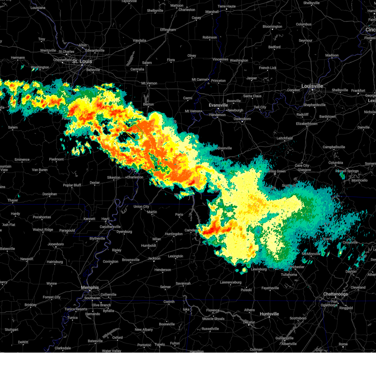 At 611 am cdt, a severe thunderstorm was located near cedar lake area, or 7 miles southeast of carbondale, moving southeast at 30 mph (radar indicated). Hazards include 60 mph wind gusts. Expect damage to roofs, siding, and trees. locations impacted include, carbondale, cobden, cedar lake area and makanda. this includes interstate 57 in illinois between mile markers 35 and 39. hail threat, radar indicated max hail size, <. 75 in wind threat, radar indicated max wind gust, 60 mph. At 611 am cdt, a severe thunderstorm was located near cedar lake area, or 7 miles southeast of carbondale, moving southeast at 30 mph (radar indicated). Hazards include 60 mph wind gusts. Expect damage to roofs, siding, and trees. locations impacted include, carbondale, cobden, cedar lake area and makanda. this includes interstate 57 in illinois between mile markers 35 and 39. hail threat, radar indicated max hail size, <. 75 in wind threat, radar indicated max wind gust, 60 mph.
|
| 7/19/2023 5:59 AM CDT |
 At 559 am cdt, a severe thunderstorm was located near carbondale, moving southeast at 30 mph (radar indicated). Hazards include 60 mph wind gusts. Expect damage to roofs, siding, and trees. locations impacted include, carbondale, murphysboro, cobden, cedar lake area and makanda. this includes interstate 57 in illinois between mile markers 35 and 39. hail threat, radar indicated max hail size, <. 75 in wind threat, radar indicated max wind gust, 60 mph. At 559 am cdt, a severe thunderstorm was located near carbondale, moving southeast at 30 mph (radar indicated). Hazards include 60 mph wind gusts. Expect damage to roofs, siding, and trees. locations impacted include, carbondale, murphysboro, cobden, cedar lake area and makanda. this includes interstate 57 in illinois between mile markers 35 and 39. hail threat, radar indicated max hail size, <. 75 in wind threat, radar indicated max wind gust, 60 mph.
|
| 7/19/2023 5:48 AM CDT |
 At 547 am cdt, a severe thunderstorm was located over murphysboro, moving southeast at 30 mph (radar indicated). Hazards include 60 mph wind gusts and penny size hail. expect damage to roofs, siding, and trees At 547 am cdt, a severe thunderstorm was located over murphysboro, moving southeast at 30 mph (radar indicated). Hazards include 60 mph wind gusts and penny size hail. expect damage to roofs, siding, and trees
|
| 7/19/2023 5:18 AM CDT |
 At 518 am cdt, a severe thunderstorm was located over elkville, or near du quoin, moving southeast at 30 mph (radar indicated). Hazards include 60 mph wind gusts and penny size hail. Expect damage to roofs, siding, and trees. locations impacted include, carbondale, murphysboro, de soto, elkville, hurst, dowell and vergennes. hail threat, radar indicated max hail size, 0. 75 in wind threat, radar indicated max wind gust, 60 mph. At 518 am cdt, a severe thunderstorm was located over elkville, or near du quoin, moving southeast at 30 mph (radar indicated). Hazards include 60 mph wind gusts and penny size hail. Expect damage to roofs, siding, and trees. locations impacted include, carbondale, murphysboro, de soto, elkville, hurst, dowell and vergennes. hail threat, radar indicated max hail size, 0. 75 in wind threat, radar indicated max wind gust, 60 mph.
|
| 7/19/2023 5:05 AM CDT |
 At 505 am cdt, a severe thunderstorm was located 7 miles northwest of elkville, or 8 miles southwest of du quoin, moving south at 40 mph (radar indicated). Hazards include 60 mph wind gusts and penny size hail. expect damage to roofs, siding, and trees At 505 am cdt, a severe thunderstorm was located 7 miles northwest of elkville, or 8 miles southwest of du quoin, moving south at 40 mph (radar indicated). Hazards include 60 mph wind gusts and penny size hail. expect damage to roofs, siding, and trees
|
| 7/18/2023 12:17 PM CDT |
 At 1217 pm cdt, severe thunderstorms were located along a line extending from 6 miles southwest of murphysboro to near scott city to near essex, moving east, southeast at 55 mph (radar indicated). Hazards include 70 mph wind gusts and penny size hail. Expect considerable tree damage. Damage is likely to mobile homes, roofs, and outbuildings. At 1217 pm cdt, severe thunderstorms were located along a line extending from 6 miles southwest of murphysboro to near scott city to near essex, moving east, southeast at 55 mph (radar indicated). Hazards include 70 mph wind gusts and penny size hail. Expect considerable tree damage. Damage is likely to mobile homes, roofs, and outbuildings.
|
| 7/18/2023 12:14 PM CDT |
 At 1213 pm cdt, severe thunderstorms were located along a line extending from near grand tower to near chaffee to near bloomfield, moving east at 55 mph (radar indicated. at 1212 pm, 66 mph winds were measured at cape girardeau regional airport). Hazards include 70 mph wind gusts and penny size hail. Expect considerable tree damage. damage is likely to mobile homes, roofs, and outbuildings. locations impacted include, cape girardeau, carbondale, jackson, scott city, chaffee, bloomfield, advance, oran, benton, trail of tears state park, cobden, puxico, morley, grand tower, kelso, bell city, delta, gordonville, altenburg and dutchtown. this includes interstate 55 between mile markers 76 and 111. thunderstorm damage threat, considerable hail threat, radar indicated max hail size, 0. 75 in wind threat, radar indicated max wind gust, 70 mph. At 1213 pm cdt, severe thunderstorms were located along a line extending from near grand tower to near chaffee to near bloomfield, moving east at 55 mph (radar indicated. at 1212 pm, 66 mph winds were measured at cape girardeau regional airport). Hazards include 70 mph wind gusts and penny size hail. Expect considerable tree damage. damage is likely to mobile homes, roofs, and outbuildings. locations impacted include, cape girardeau, carbondale, jackson, scott city, chaffee, bloomfield, advance, oran, benton, trail of tears state park, cobden, puxico, morley, grand tower, kelso, bell city, delta, gordonville, altenburg and dutchtown. this includes interstate 55 between mile markers 76 and 111. thunderstorm damage threat, considerable hail threat, radar indicated max hail size, 0. 75 in wind threat, radar indicated max wind gust, 70 mph.
|
| 7/18/2023 11:46 AM CDT |
 At 1145 am cdt, severe thunderstorms were located along a line extending from perryville to near marble hill to near shook, moving east, southeast at 55 mph (radar indicated). Hazards include 60 mph wind gusts and nickel size hail. expect damage to roofs, siding, and trees At 1145 am cdt, severe thunderstorms were located along a line extending from perryville to near marble hill to near shook, moving east, southeast at 55 mph (radar indicated). Hazards include 60 mph wind gusts and nickel size hail. expect damage to roofs, siding, and trees
|
| 7/2/2023 2:52 PM CDT |
 At 252 pm cdt, a severe thunderstorm was located over hurst, or near carterville, moving east at 45 mph (radar indicated). Hazards include 60 mph wind gusts. expect damage to roofs, siding, and trees At 252 pm cdt, a severe thunderstorm was located over hurst, or near carterville, moving east at 45 mph (radar indicated). Hazards include 60 mph wind gusts. expect damage to roofs, siding, and trees
|
| 7/2/2023 2:40 PM CDT |
 The severe thunderstorm warning for northwestern williamson and southeastern jackson counties will expire at 245 pm cdt, the storm which prompted the warning has weakened below severe limits, and no longer poses an immediate threat to life or property. therefore, the warning will be allowed to expire. a severe thunderstorm watch remains in effect until 800 pm cdt for southern illinois. The severe thunderstorm warning for northwestern williamson and southeastern jackson counties will expire at 245 pm cdt, the storm which prompted the warning has weakened below severe limits, and no longer poses an immediate threat to life or property. therefore, the warning will be allowed to expire. a severe thunderstorm watch remains in effect until 800 pm cdt for southern illinois.
|
| 7/2/2023 2:18 PM CDT | Quarter sized hail reported 0.8 miles N of Carbondale, IL, report from mping: quarter (1.00 in.). |
| 7/2/2023 2:10 PM CDT |
 At 209 pm cdt, a severe thunderstorm was located over carbondale, moving northeast at 30 mph (radar indicated). Hazards include 60 mph wind gusts and quarter size hail. Hail damage to vehicles is expected. Expect wind damage to roofs, siding, and trees. At 209 pm cdt, a severe thunderstorm was located over carbondale, moving northeast at 30 mph (radar indicated). Hazards include 60 mph wind gusts and quarter size hail. Hail damage to vehicles is expected. Expect wind damage to roofs, siding, and trees.
|
| 7/2/2023 1:35 PM CDT |
 At 135 pm cdt, a severe thunderstorm was located over cedar lake area, or about 5 miles south of carbondale, moving northeast at 30 mph (radar indicated). Hazards include 60 mph wind gusts and quarter size hail. Hail damage to vehicles is expected. expect wind damage to roofs, siding, and trees. locations impacted include, carbondale, herrin, carterville, crainville, cambria, cedar lake area, makanda and colp. hail threat, radar indicated max hail size, 1. 00 in wind threat, radar indicated max wind gust, 60 mph. At 135 pm cdt, a severe thunderstorm was located over cedar lake area, or about 5 miles south of carbondale, moving northeast at 30 mph (radar indicated). Hazards include 60 mph wind gusts and quarter size hail. Hail damage to vehicles is expected. expect wind damage to roofs, siding, and trees. locations impacted include, carbondale, herrin, carterville, crainville, cambria, cedar lake area, makanda and colp. hail threat, radar indicated max hail size, 1. 00 in wind threat, radar indicated max wind gust, 60 mph.
|
| 7/2/2023 1:14 PM CDT |
 At 114 pm cdt, a severe thunderstorm was located near grand tower, or 7 miles northeast of trail of tears state park, moving northeast at 30 mph (radar indicated). Hazards include 60 mph wind gusts and quarter size hail. Hail damage to vehicles is expected. Expect wind damage to roofs, siding, and trees. At 114 pm cdt, a severe thunderstorm was located near grand tower, or 7 miles northeast of trail of tears state park, moving northeast at 30 mph (radar indicated). Hazards include 60 mph wind gusts and quarter size hail. Hail damage to vehicles is expected. Expect wind damage to roofs, siding, and trees.
|
| 6/30/2023 6:06 PM CDT |
 At 606 pm cdt, a severe thunderstorm was located over cambria, or near carterville, moving east at 25 mph (radar indicated). Hazards include 60 mph wind gusts and half dollar size hail. Hail damage to vehicles is expected. Expect wind damage to roofs, siding, and trees. At 606 pm cdt, a severe thunderstorm was located over cambria, or near carterville, moving east at 25 mph (radar indicated). Hazards include 60 mph wind gusts and half dollar size hail. Hail damage to vehicles is expected. Expect wind damage to roofs, siding, and trees.
|
| 6/30/2023 5:40 PM CDT | Golf Ball sized hail reported 1.8 miles NNW of Carbondale, IL |
| 6/30/2023 5:01 PM CDT | Half Dollar sized hail reported 5 miles N of Carbondale, IL, corrects previous hail report from 3 nne makanda. |
| 6/30/2023 5:00 PM CDT | Golf Ball sized hail reported 5.6 miles NNW of Carbondale, IL |
| 6/30/2023 4:57 PM CDT |
 At 457 pm cdt, a severe thunderstorm was located 7 miles northwest of goreville, or 9 miles south of carterville, moving east at 15 mph (radar indicated). Hazards include 70 mph wind gusts and ping pong ball size hail. People and animals outdoors will be injured. expect hail damage to roofs, siding, windows, and vehicles. expect considerable tree damage. Wind damage is also likely to mobile homes, roofs, and outbuildings. At 457 pm cdt, a severe thunderstorm was located 7 miles northwest of goreville, or 9 miles south of carterville, moving east at 15 mph (radar indicated). Hazards include 70 mph wind gusts and ping pong ball size hail. People and animals outdoors will be injured. expect hail damage to roofs, siding, windows, and vehicles. expect considerable tree damage. Wind damage is also likely to mobile homes, roofs, and outbuildings.
|
| 6/30/2023 4:52 PM CDT | Half Dollar sized hail reported 5 miles N of Carbondale, IL |
| 5/7/2023 2:18 PM CDT | Quarter sized hail reported 0.8 miles N of Carbondale, IL, report from mping: quarter (1.00 in.). |
| 5/7/2023 2:16 PM CDT |
 At 215 pm cdt, severe thunderstorms were located along a line extending from near du quoin to 7 miles southeast of creal springs to near dixon springs, moving northeast at 50 mph (radar indicated). Hazards include 60 mph wind gusts and quarter size hail. Hail damage to vehicles is expected. expect wind damage to roofs, siding, and trees. locations impacted include, carbondale, marion, herrin, harrisburg, west frankfort, murphysboro, benton, carterville, johnston city, christopher, vienna, zeigler, de soto, crainville, cambria, royalton, energy, goreville, elkville and hurst. this includes the following highways, interstate 24 in illinois between mile markers 1 and 22. interstate 57 in illinois between mile markers 33 and 73. hail threat, radar indicated max hail size, 1. 00 in wind threat, radar indicated max wind gust, 60 mph. At 215 pm cdt, severe thunderstorms were located along a line extending from near du quoin to 7 miles southeast of creal springs to near dixon springs, moving northeast at 50 mph (radar indicated). Hazards include 60 mph wind gusts and quarter size hail. Hail damage to vehicles is expected. expect wind damage to roofs, siding, and trees. locations impacted include, carbondale, marion, herrin, harrisburg, west frankfort, murphysboro, benton, carterville, johnston city, christopher, vienna, zeigler, de soto, crainville, cambria, royalton, energy, goreville, elkville and hurst. this includes the following highways, interstate 24 in illinois between mile markers 1 and 22. interstate 57 in illinois between mile markers 33 and 73. hail threat, radar indicated max hail size, 1. 00 in wind threat, radar indicated max wind gust, 60 mph.
|
| 5/7/2023 2:01 PM CDT |
 At 200 pm cdt, severe thunderstorms were located along a line extending from near ava to 6 miles southeast of goreville to near vienna, moving northeast at 50 mph (radar indicated). Hazards include 60 mph wind gusts and quarter size hail. Hail damage to vehicles is expected. expect wind damage to roofs, siding, and trees. locations impacted include, carbondale, marion, herrin, harrisburg, west frankfort, murphysboro, benton, carterville, anna, johnston city, christopher, jonesboro, vienna, zeigler, de soto, crainville, cambria, cobden, royalton and energy. this includes the following highways, interstate 24 in illinois between mile markers 1 and 22. interstate 57 in illinois between mile markers 24 and 73. hail threat, radar indicated max hail size, 1. 00 in wind threat, radar indicated max wind gust, 60 mph. At 200 pm cdt, severe thunderstorms were located along a line extending from near ava to 6 miles southeast of goreville to near vienna, moving northeast at 50 mph (radar indicated). Hazards include 60 mph wind gusts and quarter size hail. Hail damage to vehicles is expected. expect wind damage to roofs, siding, and trees. locations impacted include, carbondale, marion, herrin, harrisburg, west frankfort, murphysboro, benton, carterville, anna, johnston city, christopher, jonesboro, vienna, zeigler, de soto, crainville, cambria, cobden, royalton and energy. this includes the following highways, interstate 24 in illinois between mile markers 1 and 22. interstate 57 in illinois between mile markers 24 and 73. hail threat, radar indicated max hail size, 1. 00 in wind threat, radar indicated max wind gust, 60 mph.
|
| 5/7/2023 1:47 PM CDT |
 At 146 pm cdt, severe thunderstorms were located along a line extending from 6 miles west of ava to 8 miles northeast of dongola to near karnak, moving east at 50 mph (radar indicated). Hazards include 60 mph wind gusts and quarter size hail. Hail damage to vehicles is expected. Expect wind damage to roofs, siding, and trees. At 146 pm cdt, severe thunderstorms were located along a line extending from 6 miles west of ava to 8 miles northeast of dongola to near karnak, moving east at 50 mph (radar indicated). Hazards include 60 mph wind gusts and quarter size hail. Hail damage to vehicles is expected. Expect wind damage to roofs, siding, and trees.
|
| 5/7/2023 9:17 AM CDT | Quarter sized hail reported 0.8 miles N of Carbondale, IL |
| 5/7/2023 9:14 AM CDT |
 At 914 am cdt, a severe thunderstorm was located over carbondale, moving east at 35 mph (radar indicated). Hazards include 60 mph wind gusts and quarter size hail. Hail damage to vehicles is expected. expect wind damage to roofs, siding, and trees. locations impacted include, carbondale, carterville, crainville, cambria, energy, cedar lake area, makanda and williamson county regional airport. hail threat, radar indicated max hail size, 1. 00 in wind threat, radar indicated max wind gust, 60 mph. At 914 am cdt, a severe thunderstorm was located over carbondale, moving east at 35 mph (radar indicated). Hazards include 60 mph wind gusts and quarter size hail. Hail damage to vehicles is expected. expect wind damage to roofs, siding, and trees. locations impacted include, carbondale, carterville, crainville, cambria, energy, cedar lake area, makanda and williamson county regional airport. hail threat, radar indicated max hail size, 1. 00 in wind threat, radar indicated max wind gust, 60 mph.
|
| 5/7/2023 9:04 AM CDT |
 At 903 am cdt, a severe thunderstorm was located near cedar lake area, or near carbondale, moving east at 35 mph (radar indicated). Hazards include 60 mph wind gusts and quarter size hail. Hail damage to vehicles is expected. Expect wind damage to roofs, siding, and trees. At 903 am cdt, a severe thunderstorm was located near cedar lake area, or near carbondale, moving east at 35 mph (radar indicated). Hazards include 60 mph wind gusts and quarter size hail. Hail damage to vehicles is expected. Expect wind damage to roofs, siding, and trees.
|
| 4/15/2023 7:55 PM CDT |
 At 755 pm cdt, a severe thunderstorm was located near grand tower, or 10 miles south of murphysboro, moving northeast at 35 mph (radar indicated). Hazards include 60 mph wind gusts and quarter size hail. Hail damage to vehicles is expected. Expect wind damage to roofs, siding, and trees. At 755 pm cdt, a severe thunderstorm was located near grand tower, or 10 miles south of murphysboro, moving northeast at 35 mph (radar indicated). Hazards include 60 mph wind gusts and quarter size hail. Hail damage to vehicles is expected. Expect wind damage to roofs, siding, and trees.
|
| 4/5/2023 4:57 AM CDT |
 At 457 am cdt, severe thunderstorms were located along a line extending from near cedar lake area to near advance, moving east at 45 mph (radar indicated). Hazards include 60 mph wind gusts. expect damage to roofs, siding, and trees At 457 am cdt, severe thunderstorms were located along a line extending from near cedar lake area to near advance, moving east at 45 mph (radar indicated). Hazards include 60 mph wind gusts. expect damage to roofs, siding, and trees
|
| 4/5/2023 4:39 AM CDT |
 At 439 am cdt, severe thunderstorms were located along a line extending from near gordonville to 8 miles south of grassy, moving northeast at 80 mph (radar indicated). Hazards include 60 mph wind gusts. Expect damage to roofs, siding, and trees. locations impacted include, cape girardeau, carbondale, jackson, anna, jonesboro, trail of tears state park, cobden, dongola, grand tower, gordonville, altenburg, dutchtown, ware, cedar lake area, makanda, alto pass, whitewater, allenville, pocahontas and mill creek. this includes the following highways, interstate 57 in illinois between mile markers 23 and 39. interstate 55 between mile markers 94 and 110. hail threat, radar indicated max hail size, <. 75 in wind threat, radar indicated max wind gust, 60 mph. At 439 am cdt, severe thunderstorms were located along a line extending from near gordonville to 8 miles south of grassy, moving northeast at 80 mph (radar indicated). Hazards include 60 mph wind gusts. Expect damage to roofs, siding, and trees. locations impacted include, cape girardeau, carbondale, jackson, anna, jonesboro, trail of tears state park, cobden, dongola, grand tower, gordonville, altenburg, dutchtown, ware, cedar lake area, makanda, alto pass, whitewater, allenville, pocahontas and mill creek. this includes the following highways, interstate 57 in illinois between mile markers 23 and 39. interstate 55 between mile markers 94 and 110. hail threat, radar indicated max hail size, <. 75 in wind threat, radar indicated max wind gust, 60 mph.
|
| 4/5/2023 4:18 AM CDT |
 At 418 am cdt, severe thunderstorms were located along a line extending from 6 miles west of elkville to near gordonville, moving northeast at 55 mph (trained weather spotters near grand tower). Hazards include 60 mph wind gusts. expect damage to roofs, siding, and trees At 418 am cdt, severe thunderstorms were located along a line extending from 6 miles west of elkville to near gordonville, moving northeast at 55 mph (trained weather spotters near grand tower). Hazards include 60 mph wind gusts. expect damage to roofs, siding, and trees
|
| 2/22/2023 3:08 PM CST |
 At 307 pm cst, severe thunderstorms were located along a line extending from near wamac to near cedar lake area, moving east at 50 mph (radar indicated). Hazards include 60 mph wind gusts. Expect damage to roofs, siding, and trees. severe thunderstorms will be near, lake of egypt area around 325 pm cst. other locations in the path of these severe thunderstorms include creal springs. this includes the following highways, interstate 24 in illinois near mile marker 1. interstate 57 in illinois between mile markers 44 and 105. interstate 64 in illinois between mile markers 63 and 90. hail threat, radar indicated max hail size, <. 75 in wind threat, radar indicated max wind gust, 60 mph. At 307 pm cst, severe thunderstorms were located along a line extending from near wamac to near cedar lake area, moving east at 50 mph (radar indicated). Hazards include 60 mph wind gusts. Expect damage to roofs, siding, and trees. severe thunderstorms will be near, lake of egypt area around 325 pm cst. other locations in the path of these severe thunderstorms include creal springs. this includes the following highways, interstate 24 in illinois near mile marker 1. interstate 57 in illinois between mile markers 44 and 105. interstate 64 in illinois between mile markers 63 and 90. hail threat, radar indicated max hail size, <. 75 in wind threat, radar indicated max wind gust, 60 mph.
|
| 2/22/2023 3:00 PM CST | Power pole leaning at old hwy 13 and country club road in carbondale illinoi in jackson county IL, 0.8 miles N of Carbondale, IL |
| 2/22/2023 2:32 PM CST |
 At 232 pm cst, severe thunderstorms were located along a line extending from near new athens to near bremen to near alliance, moving east at 50 mph (radar indicated). Hazards include 60 mph wind gusts. Expect damage to roofs, siding, and trees. severe thunderstorms will be near, willisville around 250 pm cst. other locations in the path of these severe thunderstorms include ava, altenburg, grand tower, du quoin, de soto, elkville and hurst. this includes interstate 55 between mile markers 121 and 139. hail threat, radar indicated max hail size, <. 75 in wind threat, radar indicated max wind gust, 60 mph. At 232 pm cst, severe thunderstorms were located along a line extending from near new athens to near bremen to near alliance, moving east at 50 mph (radar indicated). Hazards include 60 mph wind gusts. Expect damage to roofs, siding, and trees. severe thunderstorms will be near, willisville around 250 pm cst. other locations in the path of these severe thunderstorms include ava, altenburg, grand tower, du quoin, de soto, elkville and hurst. this includes interstate 55 between mile markers 121 and 139. hail threat, radar indicated max hail size, <. 75 in wind threat, radar indicated max wind gust, 60 mph.
|
| 2/9/2023 3:22 AM CST | Tree damage reported in the carbondale area due to strong wind gusts with passing line of showers. winds were estimated at 60 mp in jackson county IL, 0.2 miles NE of Carbondale, IL |
| 7/8/2022 6:55 PM CDT |
 At 655 pm cdt, a severe thunderstorm was located over carterville, moving east at 40 mph (radar indicated). Hazards include 60 mph wind gusts and penny size hail. Expect damage to roofs, siding, and trees. locations impacted include, marion, west frankfort and johnston city. this includes interstate 57 in illinois between mile markers 49 and 66. hail threat, radar indicated max hail size, 0. 75 in wind threat, radar indicated max wind gust, 60 mph. At 655 pm cdt, a severe thunderstorm was located over carterville, moving east at 40 mph (radar indicated). Hazards include 60 mph wind gusts and penny size hail. Expect damage to roofs, siding, and trees. locations impacted include, marion, west frankfort and johnston city. this includes interstate 57 in illinois between mile markers 49 and 66. hail threat, radar indicated max hail size, 0. 75 in wind threat, radar indicated max wind gust, 60 mph.
|
| 7/8/2022 6:38 PM CDT |
 At 638 pm cdt, a severe thunderstorm was located near de soto, or near murphysboro, moving southeast at 35 mph (radar indicated). Hazards include 60 mph wind gusts and nickel size hail. Expect damage to roofs, siding, and trees. this severe thunderstorm will be near, carbondale and de soto around 645 pm cdt. royalton and hurst around 650 pm cdt. cambria around 655 pm cdt. other locations in the path of this severe thunderstorm include herrin, carterville, crainville, energy, johnston city and marion. this includes interstate 57 in illinois between mile markers 49 and 66. hail threat, radar indicated max hail size, 0. 88 in wind threat, radar indicated max wind gust, 60 mph. At 638 pm cdt, a severe thunderstorm was located near de soto, or near murphysboro, moving southeast at 35 mph (radar indicated). Hazards include 60 mph wind gusts and nickel size hail. Expect damage to roofs, siding, and trees. this severe thunderstorm will be near, carbondale and de soto around 645 pm cdt. royalton and hurst around 650 pm cdt. cambria around 655 pm cdt. other locations in the path of this severe thunderstorm include herrin, carterville, crainville, energy, johnston city and marion. this includes interstate 57 in illinois between mile markers 49 and 66. hail threat, radar indicated max hail size, 0. 88 in wind threat, radar indicated max wind gust, 60 mph.
|
| 5/18/2022 7:18 AM CDT |
 At 717 am cdt, severe thunderstorms were located along a line extending from near ashley to near elkville to near cobden, moving east at 35 mph (radar indicated). Hazards include 60 mph wind gusts and nickel size hail. Expect damage to roofs, siding, and trees. locations impacted include, carbondale, murphysboro, du quoin, pinckneyville, de soto, elkville, hurst, tamaroa, cedar lake area, makanda, dowell, vergennes and st. johns. hail threat, radar indicated max hail size, 0. 88 in wind threat, radar indicated max wind gust, 60 mph. At 717 am cdt, severe thunderstorms were located along a line extending from near ashley to near elkville to near cobden, moving east at 35 mph (radar indicated). Hazards include 60 mph wind gusts and nickel size hail. Expect damage to roofs, siding, and trees. locations impacted include, carbondale, murphysboro, du quoin, pinckneyville, de soto, elkville, hurst, tamaroa, cedar lake area, makanda, dowell, vergennes and st. johns. hail threat, radar indicated max hail size, 0. 88 in wind threat, radar indicated max wind gust, 60 mph.
|
| 5/18/2022 7:04 AM CDT |
 At 703 am cdt, severe thunderstorms were located along a line extending from near nashville to 7 miles northwest of elkville to near grand tower, moving east at 35 mph (radar indicated). Hazards include 60 mph wind gusts and nickel size hail. Expect damage to roofs, siding, and trees. locations impacted include, carbondale, murphysboro, du quoin, pinckneyville, de soto, elkville, hurst, ava, tamaroa, grand tower, cedar lake area, makanda, dowell, campbell hill, vergennes, gorham and st. johns. hail threat, radar indicated max hail size, 0. 88 in wind threat, radar indicated max wind gust, 60 mph. At 703 am cdt, severe thunderstorms were located along a line extending from near nashville to 7 miles northwest of elkville to near grand tower, moving east at 35 mph (radar indicated). Hazards include 60 mph wind gusts and nickel size hail. Expect damage to roofs, siding, and trees. locations impacted include, carbondale, murphysboro, du quoin, pinckneyville, de soto, elkville, hurst, ava, tamaroa, grand tower, cedar lake area, makanda, dowell, campbell hill, vergennes, gorham and st. johns. hail threat, radar indicated max hail size, 0. 88 in wind threat, radar indicated max wind gust, 60 mph.
|
| 5/18/2022 6:53 AM CDT |
 At 653 am cdt, severe thunderstorms were located along a line extending from 6 miles southwest of nashville to near ava to near altenburg, moving east at 35 mph (radar indicated). Hazards include 60 mph wind gusts and nickel size hail. expect damage to roofs, siding, and trees At 653 am cdt, severe thunderstorms were located along a line extending from 6 miles southwest of nashville to near ava to near altenburg, moving east at 35 mph (radar indicated). Hazards include 60 mph wind gusts and nickel size hail. expect damage to roofs, siding, and trees
|
| 5/14/2022 11:20 PM CDT |
 At 1119 pm cdt, a severe thunderstorm was located between carbondale and carterville, moving east at 15 mph (radar indicated). Hazards include 60 mph wind gusts and penny size hail. Expect damage to roofs, siding, and trees. this severe storm will be near, carterville around 1125 pm cdt. other locations in the path of this severe thunderstorm include crainville. hail threat, radar indicated max hail size, 0. 75 in wind threat, observed max wind gust, 60 mph. At 1119 pm cdt, a severe thunderstorm was located between carbondale and carterville, moving east at 15 mph (radar indicated). Hazards include 60 mph wind gusts and penny size hail. Expect damage to roofs, siding, and trees. this severe storm will be near, carterville around 1125 pm cdt. other locations in the path of this severe thunderstorm include crainville. hail threat, radar indicated max hail size, 0. 75 in wind threat, observed max wind gust, 60 mph.
|
| 5/14/2022 11:05 PM CDT |
 At 1104 pm cdt, a severe thunderstorm was located over carbondale, moving east at 20 mph (trained weather spotters. at 1100 pm, a 60 mph wind gust was reported in carbondale). Hazards include 60 mph wind gusts and quarter size hail. Hail damage to vehicles is expected. expect wind damage to roofs, siding, and trees. this severe thunderstorm will be near, cambria around 1115 pm cdt. carterville around 1120 pm cdt. other locations in the path of this severe thunderstorm include crainville and energy. hail threat, radar indicated max hail size, 1. 00 in wind threat, observed max wind gust, 60 mph. At 1104 pm cdt, a severe thunderstorm was located over carbondale, moving east at 20 mph (trained weather spotters. at 1100 pm, a 60 mph wind gust was reported in carbondale). Hazards include 60 mph wind gusts and quarter size hail. Hail damage to vehicles is expected. expect wind damage to roofs, siding, and trees. this severe thunderstorm will be near, cambria around 1115 pm cdt. carterville around 1120 pm cdt. other locations in the path of this severe thunderstorm include crainville and energy. hail threat, radar indicated max hail size, 1. 00 in wind threat, observed max wind gust, 60 mph.
|
| 5/14/2022 11:00 PM CDT | Spotter also observed pea size hai in jackson county IL, 0.2 miles NE of Carbondale, IL |
| 5/14/2022 10:59 PM CDT | Half Dollar sized hail reported 0.8 miles N of Carbondale, IL, report from mping: half dollar (1.25 in.). |
| 4/30/2022 9:25 PM CDT |
 At 924 pm cdt, a severe thunderstorm was located over hurst, or near carterville, moving east at 35 mph (radar indicated). Hazards include 60 mph wind gusts and quarter size hail. Hail damage to vehicles is expected. expect wind damage to roofs, siding, and trees. this severe thunderstorm will be near, carterville around 930 pm cdt. herrin, zeigler, crainville and energy around 935 pm cdt. other locations in the path of this severe thunderstorm include marion, west frankfort, johnston city, pittsburg and thompsonville. this includes interstate 57 in illinois between mile markers 55 and 68. hail threat, radar indicated max hail size, 1. 00 in wind threat, radar indicated max wind gust, 60 mph. At 924 pm cdt, a severe thunderstorm was located over hurst, or near carterville, moving east at 35 mph (radar indicated). Hazards include 60 mph wind gusts and quarter size hail. Hail damage to vehicles is expected. expect wind damage to roofs, siding, and trees. this severe thunderstorm will be near, carterville around 930 pm cdt. herrin, zeigler, crainville and energy around 935 pm cdt. other locations in the path of this severe thunderstorm include marion, west frankfort, johnston city, pittsburg and thompsonville. this includes interstate 57 in illinois between mile markers 55 and 68. hail threat, radar indicated max hail size, 1. 00 in wind threat, radar indicated max wind gust, 60 mph.
|
| 3/30/2022 4:39 PM CDT |
 The severe thunderstorm warning for jackson county will expire at 445 pm cdt, the storm which prompted the warning has weakened below severe limits, and no longer poses an immediate threat to life or property. therefore, the warning will be allowed to expire. a tornado watch remains in effect until 1000 pm cdt for south central and southern illinois, and southeastern missouri. The severe thunderstorm warning for jackson county will expire at 445 pm cdt, the storm which prompted the warning has weakened below severe limits, and no longer poses an immediate threat to life or property. therefore, the warning will be allowed to expire. a tornado watch remains in effect until 1000 pm cdt for south central and southern illinois, and southeastern missouri.
|
| 3/30/2022 4:26 PM CDT |
 At 426 pm cdt, a severe thunderstorm was located near murphysboro, moving northeast at 40 mph (radar indicated). Hazards include 60 mph wind gusts. Expect damage to roofs, siding, and trees. Locations impacted include, murphysboro, carbondale, de soto, elkville and hurst. At 426 pm cdt, a severe thunderstorm was located near murphysboro, moving northeast at 40 mph (radar indicated). Hazards include 60 mph wind gusts. Expect damage to roofs, siding, and trees. Locations impacted include, murphysboro, carbondale, de soto, elkville and hurst.
|
| 3/30/2022 4:05 PM CDT |
 At 405 pm cdt, a severe thunderstorm was located near altenburg, or 11 miles east of perryville, moving northeast at 40 mph (radar indicated). Hazards include 60 mph wind gusts. Expect damage to roofs, siding, and trees. this severe thunderstorm will be near, ava around 425 pm cdt. Other locations in the path of this severe thunderstorm include murphysboro, carbondale, de soto, elkville and hurst. At 405 pm cdt, a severe thunderstorm was located near altenburg, or 11 miles east of perryville, moving northeast at 40 mph (radar indicated). Hazards include 60 mph wind gusts. Expect damage to roofs, siding, and trees. this severe thunderstorm will be near, ava around 425 pm cdt. Other locations in the path of this severe thunderstorm include murphysboro, carbondale, de soto, elkville and hurst.
|
| 5/27/2021 4:59 PM CDT |
 At 459 pm cdt, severe thunderstorms were located along a line extending from near mount vernon to near murphysboro, moving east at 45 mph (radar indicated). Hazards include 60 mph wind gusts and quarter size hail. Hail damage to vehicles is expected. expect wind damage to roofs, siding, and trees. Locations impacted include, cambria, hurst, herrin, carterville, crainville, energy, marion, johnston city and pittsburg. At 459 pm cdt, severe thunderstorms were located along a line extending from near mount vernon to near murphysboro, moving east at 45 mph (radar indicated). Hazards include 60 mph wind gusts and quarter size hail. Hail damage to vehicles is expected. expect wind damage to roofs, siding, and trees. Locations impacted include, cambria, hurst, herrin, carterville, crainville, energy, marion, johnston city and pittsburg.
|
| 5/27/2021 4:47 PM CDT |
 At 447 pm cdt, severe thunderstorms were located along a line extending from near mount vernon to 8 miles north of grand tower, moving east at 30 mph (radar indicated). Hazards include 60 mph wind gusts and quarter size hail. Hail damage to vehicles is expected. expect wind damage to roofs, siding, and trees. these severe storms will be near, mount vernon around 450 pm cdt. Other locations in the path of these severe thunderstorms include carbondale, de soto, cambria, carterville, crainville and energy. At 447 pm cdt, severe thunderstorms were located along a line extending from near mount vernon to 8 miles north of grand tower, moving east at 30 mph (radar indicated). Hazards include 60 mph wind gusts and quarter size hail. Hail damage to vehicles is expected. expect wind damage to roofs, siding, and trees. these severe storms will be near, mount vernon around 450 pm cdt. Other locations in the path of these severe thunderstorms include carbondale, de soto, cambria, carterville, crainville and energy.
|
| 5/27/2021 4:31 PM CDT |
 At 430 pm cdt, severe thunderstorms were located along a line extending from near woodlawn to 7 miles southwest of ava, moving east at 45 mph (radar indicated). Hazards include 60 mph wind gusts and quarter size hail. Hail damage to vehicles is expected. expect wind damage to roofs, siding, and trees. severe thunderstorms will be near, mount vernon around 440 pm cdt. murphysboro around 450 pm cdt. Other locations in the path of these severe thunderstorms include carbondale, de soto, elkville, royalton, hurst, carterville, zeigler, cambria, marion, herrin, johnston city, crainville and energy. At 430 pm cdt, severe thunderstorms were located along a line extending from near woodlawn to 7 miles southwest of ava, moving east at 45 mph (radar indicated). Hazards include 60 mph wind gusts and quarter size hail. Hail damage to vehicles is expected. expect wind damage to roofs, siding, and trees. severe thunderstorms will be near, mount vernon around 440 pm cdt. murphysboro around 450 pm cdt. Other locations in the path of these severe thunderstorms include carbondale, de soto, elkville, royalton, hurst, carterville, zeigler, cambria, marion, herrin, johnston city, crainville and energy.
|
| 3/11/2021 3:26 PM CST |
 At 325 pm cst, a severe thunderstorm was located over cedar lake area, or 7 miles southwest of carbondale, moving east at 50 mph (trained weather spotters). Hazards include 60 mph wind gusts and penny size hail. Expect damage to roofs, siding, and trees. Locations impacted include, carbondale, cobden, grand tower, cedar lake area, makanda and alto pass. At 325 pm cst, a severe thunderstorm was located over cedar lake area, or 7 miles southwest of carbondale, moving east at 50 mph (trained weather spotters). Hazards include 60 mph wind gusts and penny size hail. Expect damage to roofs, siding, and trees. Locations impacted include, carbondale, cobden, grand tower, cedar lake area, makanda and alto pass.
|
| 3/11/2021 3:09 PM CST |
 At 308 pm cst, a severe thunderstorm was located over altenburg, moving east at 50 mph (trained weather spotters). Hazards include 60 mph wind gusts and quarter size hail. Hail damage to vehicles is expected. Expect wind damage to roofs, siding, and trees. At 308 pm cst, a severe thunderstorm was located over altenburg, moving east at 50 mph (trained weather spotters). Hazards include 60 mph wind gusts and quarter size hail. Hail damage to vehicles is expected. Expect wind damage to roofs, siding, and trees.
|
| 8/10/2020 8:04 PM CDT |
 At 804 pm cdt, severe thunderstorms were located along a line extending from near carmi to near pittsburg, moving east at 75 mph (radar indicated). Hazards include 60 mph wind gusts. Expect damage to roofs, siding, and trees. Locations impacted include, carbondale, marion, herrin, murphysboro, carterville, johnston city, de soto, crainville, cambria, energy, hurst, grand tower, pittsburg, creal springs, cedar lake area, lake of egypt area, makanda, stonefort, freeman spur and bush. At 804 pm cdt, severe thunderstorms were located along a line extending from near carmi to near pittsburg, moving east at 75 mph (radar indicated). Hazards include 60 mph wind gusts. Expect damage to roofs, siding, and trees. Locations impacted include, carbondale, marion, herrin, murphysboro, carterville, johnston city, de soto, crainville, cambria, energy, hurst, grand tower, pittsburg, creal springs, cedar lake area, lake of egypt area, makanda, stonefort, freeman spur and bush.
|
| 8/10/2020 7:36 PM CDT |
 At 735 pm cdt, severe thunderstorms were located along a line extending from 8 miles west of mcleansboro to near murphysboro, moving east at 65 mph (radar indicated). Hazards include 60 mph wind gusts. expect damage to roofs, siding, and trees At 735 pm cdt, severe thunderstorms were located along a line extending from 8 miles west of mcleansboro to near murphysboro, moving east at 65 mph (radar indicated). Hazards include 60 mph wind gusts. expect damage to roofs, siding, and trees
|
| 7/21/2020 3:30 PM CDT |
 At 329 pm cdt, a severe thunderstorm was located over de soto, or near murphysboro, moving northeast at 25 mph (radar indicated). Hazards include 60 mph wind gusts and quarter size hail. Hail damage to vehicles is expected. expect wind damage to roofs, siding, and trees. Locations impacted include, carbondale, murphysboro, de soto, elkville, hurst and vergennes. At 329 pm cdt, a severe thunderstorm was located over de soto, or near murphysboro, moving northeast at 25 mph (radar indicated). Hazards include 60 mph wind gusts and quarter size hail. Hail damage to vehicles is expected. expect wind damage to roofs, siding, and trees. Locations impacted include, carbondale, murphysboro, de soto, elkville, hurst and vergennes.
|
| 7/21/2020 3:20 PM CDT |
 At 320 pm cdt, a severe thunderstorm was located over murphysboro, moving northeast at 30 mph (radar indicated). Hazards include 60 mph wind gusts and quarter size hail. Hail damage to vehicles is expected. Expect wind damage to roofs, siding, and trees. At 320 pm cdt, a severe thunderstorm was located over murphysboro, moving northeast at 30 mph (radar indicated). Hazards include 60 mph wind gusts and quarter size hail. Hail damage to vehicles is expected. Expect wind damage to roofs, siding, and trees.
|
| 7/17/2020 4:30 PM CDT | Numerous trees down in the hickory ridge area near pomon in jackson county IL, 9 miles NE of Carbondale, IL |
| 4/8/2020 6:31 PM CDT |
 At 631 pm cdt, severe thunderstorms were located along a line extending from 10 miles southeast of chester to 6 miles southeast of perryville to alliance, moving east at 40 mph (radar indicated). Hazards include 60 mph wind gusts and quarter size hail. Hail damage to vehicles is expected. Expect wind damage to roofs, siding, and trees. At 631 pm cdt, severe thunderstorms were located along a line extending from 10 miles southeast of chester to 6 miles southeast of perryville to alliance, moving east at 40 mph (radar indicated). Hazards include 60 mph wind gusts and quarter size hail. Hail damage to vehicles is expected. Expect wind damage to roofs, siding, and trees.
|
| 4/8/2020 5:59 PM CDT |
 At 558 pm cdt, a severe thunderstorm was located near percy, or 8 miles west of pinckneyville, moving southeast at 25 mph (radar indicated). Hazards include 60 mph wind gusts and half dollar size hail. Hail damage to vehicles is expected. Expect wind damage to roofs, siding, and trees. At 558 pm cdt, a severe thunderstorm was located near percy, or 8 miles west of pinckneyville, moving southeast at 25 mph (radar indicated). Hazards include 60 mph wind gusts and half dollar size hail. Hail damage to vehicles is expected. Expect wind damage to roofs, siding, and trees.
|
| 3/12/2020 2:10 PM CDT |
 At 209 pm cdt, severe thunderstorms were located along a line extending from near benton to carbondale, moving east at 50 mph (trained weather spotters). Hazards include 60 mph wind gusts and half dollar size hail. Hail damage to vehicles is expected. expect wind damage to roofs, siding, and trees. Locations impacted include, carbondale, marion, herrin, west frankfort, murphysboro, benton, carterville, johnston city, christopher, zeigler, de soto, crainville, cambria, royalton, energy, elkville, hurst, valier, west city and pittsburg. At 209 pm cdt, severe thunderstorms were located along a line extending from near benton to carbondale, moving east at 50 mph (trained weather spotters). Hazards include 60 mph wind gusts and half dollar size hail. Hail damage to vehicles is expected. expect wind damage to roofs, siding, and trees. Locations impacted include, carbondale, marion, herrin, west frankfort, murphysboro, benton, carterville, johnston city, christopher, zeigler, de soto, crainville, cambria, royalton, energy, elkville, hurst, valier, west city and pittsburg.
|
| 3/12/2020 1:54 PM CDT |
 At 152 pm cdt, severe thunderstorms were located along a line extending from du quoin to 8 miles south of ava, moving east at 40 mph (trained weather spotters. quarter size hail was reported in southern perry county). Hazards include 60 mph wind gusts and quarter size hail. Hail damage to vehicles is expected. expect wind damage to roofs, siding, and trees. Locations impacted include, carbondale, marion, herrin, west frankfort, murphysboro, benton, du quoin, carterville, johnston city, christopher, rend lake area, zeigler, de soto, crainville, cambria, royalton, energy, elkville, hurst and valier. At 152 pm cdt, severe thunderstorms were located along a line extending from du quoin to 8 miles south of ava, moving east at 40 mph (trained weather spotters. quarter size hail was reported in southern perry county). Hazards include 60 mph wind gusts and quarter size hail. Hail damage to vehicles is expected. expect wind damage to roofs, siding, and trees. Locations impacted include, carbondale, marion, herrin, west frankfort, murphysboro, benton, du quoin, carterville, johnston city, christopher, rend lake area, zeigler, de soto, crainville, cambria, royalton, energy, elkville, hurst and valier.
|
| 3/12/2020 1:39 PM CDT |
 At 139 pm cdt, severe thunderstorms were located along a line extending from pinckneyville to 11 miles southeast of chester, moving east at 40 mph (radar indicated). Hazards include 60 mph wind gusts and quarter size hail. Hail damage to vehicles is expected. Expect wind damage to roofs, siding, and trees. At 139 pm cdt, severe thunderstorms were located along a line extending from pinckneyville to 11 miles southeast of chester, moving east at 40 mph (radar indicated). Hazards include 60 mph wind gusts and quarter size hail. Hail damage to vehicles is expected. Expect wind damage to roofs, siding, and trees.
|
| 1/11/2020 2:19 AM CST |
 At 219 am cst, severe thunderstorms were located along a line extending from near carbondale to near cobden to near jonesboro, moving northeast at 60 mph (radar indicated). Hazards include 60 mph wind gusts. expect damage to roofs, siding, and trees At 219 am cst, severe thunderstorms were located along a line extending from near carbondale to near cobden to near jonesboro, moving northeast at 60 mph (radar indicated). Hazards include 60 mph wind gusts. expect damage to roofs, siding, and trees
|
| 1/11/2020 2:04 AM CST |
 At 203 am cst, a severe thunderstorm was located over ware, or near trail of tears state park, moving northeast at 40 mph (radar indicated). Hazards include 60 mph wind gusts. Expect damage to roofs, siding, and trees. Locations impacted include, anna, jonesboro, cobden, ware, cedar lake area, makanda and alto pass. At 203 am cst, a severe thunderstorm was located over ware, or near trail of tears state park, moving northeast at 40 mph (radar indicated). Hazards include 60 mph wind gusts. Expect damage to roofs, siding, and trees. Locations impacted include, anna, jonesboro, cobden, ware, cedar lake area, makanda and alto pass.
|
| 1/11/2020 2:01 AM CST | Storm damage reported in jackson county IL, 1.2 miles E of Carbondale, IL |
| 1/11/2020 1:51 AM CST |
 At 151 am cst, a severe thunderstorm was located near cape girardeau, moving northeast at 40 mph (radar indicated). Hazards include 60 mph wind gusts. expect damage to roofs, siding, and trees At 151 am cst, a severe thunderstorm was located near cape girardeau, moving northeast at 40 mph (radar indicated). Hazards include 60 mph wind gusts. expect damage to roofs, siding, and trees
|
| 11/30/2019 9:35 AM CST |
 The severe thunderstorm warning for western williamson and east central jackson counties will expire at 945 am cst, the storm which prompted the warning has weakened below severe limits, and no longer poses an immediate threat to life or property. therefore, the warning will be allowed to expire. however small hail and gusty winds are still possible with this thunderstorm. The severe thunderstorm warning for western williamson and east central jackson counties will expire at 945 am cst, the storm which prompted the warning has weakened below severe limits, and no longer poses an immediate threat to life or property. therefore, the warning will be allowed to expire. however small hail and gusty winds are still possible with this thunderstorm.
|
| 11/30/2019 9:30 AM CST |
 At 929 am cst, a severe thunderstorm was located near carterville, moving northeast at 55 mph (radar indicated). Hazards include 60 mph wind gusts and quarter size hail. Hail damage to vehicles is expected. expect wind damage to roofs, siding, and trees. Locations impacted include, carbondale, marion, herrin, carterville, crainville, cambria, energy, williamson county regional airport and colp. At 929 am cst, a severe thunderstorm was located near carterville, moving northeast at 55 mph (radar indicated). Hazards include 60 mph wind gusts and quarter size hail. Hail damage to vehicles is expected. expect wind damage to roofs, siding, and trees. Locations impacted include, carbondale, marion, herrin, carterville, crainville, cambria, energy, williamson county regional airport and colp.
|
| 11/30/2019 9:10 AM CST |
 At 910 am cst, a severe thunderstorm was located near grand tower, or 9 miles north of trail of tears state park, moving northeast at 65 mph (radar indicated). Hazards include 60 mph wind gusts and quarter size hail. Hail damage to vehicles is expected. Expect wind damage to roofs, siding, and trees. At 910 am cst, a severe thunderstorm was located near grand tower, or 9 miles north of trail of tears state park, moving northeast at 65 mph (radar indicated). Hazards include 60 mph wind gusts and quarter size hail. Hail damage to vehicles is expected. Expect wind damage to roofs, siding, and trees.
|
| 8/18/2019 2:36 PM CDT |
 The severe thunderstorm warning for southwestern perry and northern jackson counties will expire at 245 pm cdt, the storm which prompted the warning has weakened below severe limits, and no longer poses an immediate threat to life or property. therefore, the warning will be allowed to expire. however small hail and gusty winds are still possible with this thunderstorm. a severe thunderstorm watch remains in effect until 700 pm cdt for southern and south central illinois, and southeastern missouri. The severe thunderstorm warning for southwestern perry and northern jackson counties will expire at 245 pm cdt, the storm which prompted the warning has weakened below severe limits, and no longer poses an immediate threat to life or property. therefore, the warning will be allowed to expire. however small hail and gusty winds are still possible with this thunderstorm. a severe thunderstorm watch remains in effect until 700 pm cdt for southern and south central illinois, and southeastern missouri.
|
| 8/18/2019 1:59 PM CDT |
 At 159 pm cdt, a severe thunderstorm was located near ava, or 13 miles east of chester, moving east at 40 mph (radar indicated). Hazards include 60 mph wind gusts and quarter size hail. Hail damage to vehicles is expected. Expect wind damage to roofs, siding, and trees. At 159 pm cdt, a severe thunderstorm was located near ava, or 13 miles east of chester, moving east at 40 mph (radar indicated). Hazards include 60 mph wind gusts and quarter size hail. Hail damage to vehicles is expected. Expect wind damage to roofs, siding, and trees.
|
| 7/21/2019 6:59 PM CDT | A power pole and tree limbs down between 800 and 900 new era rd. possible tornad in jackson county IL, 1.9 miles ESE of Carbondale, IL |
| 6/26/2019 5:35 PM CDT |
 At 535 pm cdt, severe thunderstorms were located along a line extending from near du quoin to near elkville, moving east at 15 mph (radar indicated). Hazards include 60 mph wind gusts and quarter size hail. Hail damage to vehicles is expected. expect wind damage to roofs, siding, and trees. locations impacted include, murphysboro, du quoin, de soto, elkville, dowell, vergennes and st. Johns. At 535 pm cdt, severe thunderstorms were located along a line extending from near du quoin to near elkville, moving east at 15 mph (radar indicated). Hazards include 60 mph wind gusts and quarter size hail. Hail damage to vehicles is expected. expect wind damage to roofs, siding, and trees. locations impacted include, murphysboro, du quoin, de soto, elkville, dowell, vergennes and st. Johns.
|
| 6/26/2019 5:10 PM CDT |
 At 509 pm cdt, severe thunderstorms were located along a line extending from pinckneyville to near ava, moving east at 10 mph (radar indicated). Hazards include 60 mph wind gusts and quarter size hail. Hail damage to vehicles is expected. Expect wind damage to roofs, siding, and trees. At 509 pm cdt, severe thunderstorms were located along a line extending from pinckneyville to near ava, moving east at 10 mph (radar indicated). Hazards include 60 mph wind gusts and quarter size hail. Hail damage to vehicles is expected. Expect wind damage to roofs, siding, and trees.
|
| 6/21/2019 4:58 PM CDT |
 At 454 pm cdt, severe thunderstorms were located along a line extending from near goreville to near charleston to parma to near fisk to near qulin, moving southeast at 50 mph (spotters and automated weather observation stations indicated winds of 60 to 70 mph and widespread wind damage over parts of southeast missouri into southwest illinois. flooding is also occurring due to the torrential rainfall). Hazards include 70 mph wind gusts and nickel size hail. Expect considerable tree damage. damage is likely to mobile homes, roofs, and outbuildings. Locations impacted include, cape girardeau, carbondale, poplar bluff, sikeston, dexter, scott city, anna, chaffee, cairo, bernie, bloomfield, jonesboro, oran, benton, trail of tears state park, lake wappapello state park, cobden, puxico, dongola and morley. At 454 pm cdt, severe thunderstorms were located along a line extending from near goreville to near charleston to parma to near fisk to near qulin, moving southeast at 50 mph (spotters and automated weather observation stations indicated winds of 60 to 70 mph and widespread wind damage over parts of southeast missouri into southwest illinois. flooding is also occurring due to the torrential rainfall). Hazards include 70 mph wind gusts and nickel size hail. Expect considerable tree damage. damage is likely to mobile homes, roofs, and outbuildings. Locations impacted include, cape girardeau, carbondale, poplar bluff, sikeston, dexter, scott city, anna, chaffee, cairo, bernie, bloomfield, jonesboro, oran, benton, trail of tears state park, lake wappapello state park, cobden, puxico, dongola and morley.
|
| 6/21/2019 4:51 PM CDT |
 At 451 pm cdt, severe thunderstorms were located along a line extending from centralia to near sesser to near valier to near elkville to near carbondale, moving northeast at 55 mph (radar indicated). Hazards include 60 mph wind gusts and nickel size hail. Expect damage to roofs, siding, and trees. locations impacted include, carbondale, murphysboro, du quoin, de soto, elkville, tamaroa, dowell and st. Johns. At 451 pm cdt, severe thunderstorms were located along a line extending from centralia to near sesser to near valier to near elkville to near carbondale, moving northeast at 55 mph (radar indicated). Hazards include 60 mph wind gusts and nickel size hail. Expect damage to roofs, siding, and trees. locations impacted include, carbondale, murphysboro, du quoin, de soto, elkville, tamaroa, dowell and st. Johns.
|
| 6/21/2019 4:40 PM CDT | Large tree branch on house. tree limbs down around the area as well. time estimate in jackson county IL, 0.2 miles NE of Carbondale, IL |
| 6/21/2019 4:27 PM CDT |
 At 427 pm cdt, severe thunderstorms were located along a line extending from near murphysboro to near chaffee to near dudley to near williamsville to milltown, moving southeast at 50 mph (radar indicated). Hazards include 60 mph wind gusts and quarter size hail. Hail damage to vehicles is expected. Expect wind damage to roofs, siding, and trees. At 427 pm cdt, severe thunderstorms were located along a line extending from near murphysboro to near chaffee to near dudley to near williamsville to milltown, moving southeast at 50 mph (radar indicated). Hazards include 60 mph wind gusts and quarter size hail. Hail damage to vehicles is expected. Expect wind damage to roofs, siding, and trees.
|
| 6/21/2019 4:20 PM CDT |
 At 420 pm cdt, severe thunderstorms were located along a line extending from near lively grove to near ava to 9 miles north of grand tower to near altenburg to 8 miles east of daisy, moving northeast at 55 mph (radar indicated). Hazards include 60 mph wind gusts and quarter size hail. Hail damage to vehicles is expected. Expect wind damage to roofs, siding, and trees. At 420 pm cdt, severe thunderstorms were located along a line extending from near lively grove to near ava to 9 miles north of grand tower to near altenburg to 8 miles east of daisy, moving northeast at 55 mph (radar indicated). Hazards include 60 mph wind gusts and quarter size hail. Hail damage to vehicles is expected. Expect wind damage to roofs, siding, and trees.
|
| 6/21/2019 3:42 PM CDT |
 At 341 pm cdt, a severe thunderstorm was located near cedar lake area, or 7 miles south of carbondale, moving east at 20 mph (radar indicated). Hazards include 60 mph wind gusts and quarter size hail. Hail damage to vehicles is expected. expect wind damage to roofs, siding, and trees. Locations impacted include, carbondale, cobden, cedar lake area, makanda and alto pass. At 341 pm cdt, a severe thunderstorm was located near cedar lake area, or 7 miles south of carbondale, moving east at 20 mph (radar indicated). Hazards include 60 mph wind gusts and quarter size hail. Hail damage to vehicles is expected. expect wind damage to roofs, siding, and trees. Locations impacted include, carbondale, cobden, cedar lake area, makanda and alto pass.
|
| 6/21/2019 3:14 PM CDT |
 The national weather service in paducah has issued a * severe thunderstorm warning for. northern union county in southern illinois. southwestern williamson county in southern illinois. southeastern jackson county in southern illinois. Until 400 pm cdt. The national weather service in paducah has issued a * severe thunderstorm warning for. northern union county in southern illinois. southwestern williamson county in southern illinois. southeastern jackson county in southern illinois. Until 400 pm cdt.
|
| 6/16/2019 4:19 PM CDT |
 At 418 pm cdt, a severe thunderstorm was located over de soto, or near carbondale, moving northeast at 15 mph (radar indicated. at 414 pm, 55 mph winds were measured at carbondale southern illinois airport. the storm has weakened slightly). Hazards include 60 mph wind gusts. Expect damage to roofs, siding, and trees. Locations impacted include, carbondale, murphysboro and de soto. At 418 pm cdt, a severe thunderstorm was located over de soto, or near carbondale, moving northeast at 15 mph (radar indicated. at 414 pm, 55 mph winds were measured at carbondale southern illinois airport. the storm has weakened slightly). Hazards include 60 mph wind gusts. Expect damage to roofs, siding, and trees. Locations impacted include, carbondale, murphysboro and de soto.
|
| 6/16/2019 4:04 PM CDT |
 At 404 pm cdt, a severe thunderstorm was located over de soto, or near murphysboro, moving northeast at 15 mph (radar indicated). Hazards include 60 mph wind gusts and quarter size hail. Hail damage to vehicles is expected. Expect wind damage to roofs, siding, and trees. At 404 pm cdt, a severe thunderstorm was located over de soto, or near murphysboro, moving northeast at 15 mph (radar indicated). Hazards include 60 mph wind gusts and quarter size hail. Hail damage to vehicles is expected. Expect wind damage to roofs, siding, and trees.
|
| 5/21/2019 4:36 PM CDT |
 The national weather service in paducah has issued a * tornado warning for. central union county in southern illinois. southwestern williamson county in southern illinois. southeastern jackson county in southern illinois. Northern alexander county in southern illinois. The national weather service in paducah has issued a * tornado warning for. central union county in southern illinois. southwestern williamson county in southern illinois. southeastern jackson county in southern illinois. Northern alexander county in southern illinois.
|
| 2/7/2019 8:54 AM CST |
 At 853 am cst, a severe thunderstorm was located near grand tower, or 11 miles west of murphysboro, moving northeast at 65 mph (radar indicated). Hazards include 60 mph wind gusts and nickel size hail. expect damage to roofs, siding, and trees At 853 am cst, a severe thunderstorm was located near grand tower, or 11 miles west of murphysboro, moving northeast at 65 mph (radar indicated). Hazards include 60 mph wind gusts and nickel size hail. expect damage to roofs, siding, and trees
|
| 6/28/2018 7:44 PM CDT |
 At 744 pm cdt, severe thunderstorms were located along a line extending from near equality to 8 miles north of golconda to 6 miles northeast of vienna to near cobden, moving southeast at 65 mph (trained weather spotters). Hazards include 70 mph wind gusts and half dollar size hail. Hail damage to vehicles is expected. expect considerable tree damage. wind damage is also likely to mobile homes, roofs, and outbuildings. Locations impacted include, carbondale, marion, herrin, harrisburg, murphysboro, carterville, anna, eldorado, johnston city, jonesboro, vienna, crainville, cambria, cobden, energy, goreville, galatia, ridgway, hurst and dongola. At 744 pm cdt, severe thunderstorms were located along a line extending from near equality to 8 miles north of golconda to 6 miles northeast of vienna to near cobden, moving southeast at 65 mph (trained weather spotters). Hazards include 70 mph wind gusts and half dollar size hail. Hail damage to vehicles is expected. expect considerable tree damage. wind damage is also likely to mobile homes, roofs, and outbuildings. Locations impacted include, carbondale, marion, herrin, harrisburg, murphysboro, carterville, anna, eldorado, johnston city, jonesboro, vienna, crainville, cambria, cobden, energy, goreville, galatia, ridgway, hurst and dongola.
|
| 6/28/2018 7:30 PM CDT | Tree damage and power lines down in carbondal in jackson county IL, 0.8 miles N of Carbondale, IL |
| 6/28/2018 7:20 PM CDT | Multiple trees blown down... power poles down... intense lightning. old route 13 blocked due to multiple trees across road between giant city rd and reed station r in jackson county IL, 0.8 miles N of Carbondale, IL |
| 6/28/2018 7:18 PM CDT | Multiple trees down in carbondale. spotter reported a possible funnel clou in jackson county IL, 0.8 miles N of Carbondale, IL |
| 6/28/2018 7:13 PM CDT | 67 mph wind gust recorded at southern illinois airport in carbondal in jackson county IL, 0.8 miles N of Carbondale, IL |
| 6/28/2018 7:00 PM CDT |
 At 659 pm cdt, severe thunderstorms were located along a line extending from near bluford to near christopher to percy, moving southeast at 50 mph (radar indicated). Hazards include 70 mph wind gusts and half dollar size hail. Hail damage to vehicles is expected. expect considerable tree damage. Wind damage is also likely to mobile homes, roofs, and outbuildings. At 659 pm cdt, severe thunderstorms were located along a line extending from near bluford to near christopher to percy, moving southeast at 50 mph (radar indicated). Hazards include 70 mph wind gusts and half dollar size hail. Hail damage to vehicles is expected. expect considerable tree damage. Wind damage is also likely to mobile homes, roofs, and outbuildings.
|
| 6/26/2018 4:45 PM CDT | Eight inch tree limbs down. chimney damage to a hous in jackson county IL, 3.6 miles N of Carbondale, IL |
| 6/14/2018 7:56 PM CDT |
 At 756 pm cdt, severe thunderstorms were located along a line extending from near chester to near perryville to 8 miles north of daisy, moving east at 30 mph (radar indicated). Hazards include 60 mph wind gusts and quarter size hail. Hail damage to vehicles is expected. Expect wind damage to roofs, siding, and trees. At 756 pm cdt, severe thunderstorms were located along a line extending from near chester to near perryville to 8 miles north of daisy, moving east at 30 mph (radar indicated). Hazards include 60 mph wind gusts and quarter size hail. Hail damage to vehicles is expected. Expect wind damage to roofs, siding, and trees.
|
| 6/12/2018 1:56 PM CDT |
 At 156 pm cdt, a severe thunderstorm was located over cedar lake area, or 7 miles south of murphysboro, moving east at 20 mph (radar indicated). Hazards include 60 mph wind gusts and nickel size hail. Expect damage to roofs, siding, and trees. Locations impacted include, carbondale, murphysboro, cedar lake area, makanda and alto pass. At 156 pm cdt, a severe thunderstorm was located over cedar lake area, or 7 miles south of murphysboro, moving east at 20 mph (radar indicated). Hazards include 60 mph wind gusts and nickel size hail. Expect damage to roofs, siding, and trees. Locations impacted include, carbondale, murphysboro, cedar lake area, makanda and alto pass.
|
| 6/12/2018 1:45 PM CDT |
 At 145 pm cdt, a severe thunderstorm was located near grand tower, or 9 miles southwest of murphysboro, moving east at 20 mph (radar indicated). Hazards include 60 mph wind gusts and nickel size hail. expect damage to roofs, siding, and trees At 145 pm cdt, a severe thunderstorm was located near grand tower, or 9 miles southwest of murphysboro, moving east at 20 mph (radar indicated). Hazards include 60 mph wind gusts and nickel size hail. expect damage to roofs, siding, and trees
|
| 9/18/2017 8:42 PM CDT |
 At 841 pm cdt, a severe thunderstorm was located just north of carbondale, moving northeast at 25 mph. dime size hail was observed near makanda with this storm (radar indicated). Hazards include quarter size hail. Damage to vehicles is expected. Locations impacted include, carbondale, carterville, de soto and cambria. At 841 pm cdt, a severe thunderstorm was located just north of carbondale, moving northeast at 25 mph. dime size hail was observed near makanda with this storm (radar indicated). Hazards include quarter size hail. Damage to vehicles is expected. Locations impacted include, carbondale, carterville, de soto and cambria.
|
| 9/18/2017 8:33 PM CDT | Golf Ball sized hail reported 0.8 miles N of Carbondale, IL, public report of golfball hail relayed by wsil-tv. |
| 9/18/2017 8:25 PM CDT |
 At 824 pm cdt, a severe thunderstorm was located over cedar lake area, or near carbondale, moving northeast at 25 mph (radar indicated). Hazards include quarter size hail. damage to vehicles is expected At 824 pm cdt, a severe thunderstorm was located over cedar lake area, or near carbondale, moving northeast at 25 mph (radar indicated). Hazards include quarter size hail. damage to vehicles is expected
|
| 5/27/2017 5:55 PM CDT |
 At 554 pm cdt, severe thunderstorms were located along a line extending from grand tower to cobden to near tamms to near sikeston, moving east at 65 mph. these are very dangerous storms (trained weather spotters. law enforcement reported 80 mph wind gust just north of sikeston missouri. structural damage was reported out of bollinger county). Hazards include 80 mph wind gusts and quarter size hail. Flying debris will be dangerous to those caught without shelter. mobile homes will be heavily damaged. expect considerable damage to roofs, windows, and vehicles. extensive tree damage and power outages are likely. locations impacted include, carbondale, sikeston, murphysboro, charleston, anna, cairo, jonesboro, oran, la center, miner, benton, bardwell, wickliffe, cobden, bertrand, mounds, dongola, morley, barlow and tamms. A tornado watch remains in effect until 700 pm cdt for southeastern missouri. At 554 pm cdt, severe thunderstorms were located along a line extending from grand tower to cobden to near tamms to near sikeston, moving east at 65 mph. these are very dangerous storms (trained weather spotters. law enforcement reported 80 mph wind gust just north of sikeston missouri. structural damage was reported out of bollinger county). Hazards include 80 mph wind gusts and quarter size hail. Flying debris will be dangerous to those caught without shelter. mobile homes will be heavily damaged. expect considerable damage to roofs, windows, and vehicles. extensive tree damage and power outages are likely. locations impacted include, carbondale, sikeston, murphysboro, charleston, anna, cairo, jonesboro, oran, la center, miner, benton, bardwell, wickliffe, cobden, bertrand, mounds, dongola, morley, barlow and tamms. A tornado watch remains in effect until 700 pm cdt for southeastern missouri.
|
| 5/27/2017 5:55 PM CDT |
 At 536 pm cdt, severe thunderstorms were located along a line extending from 6 miles west of altenburg to 6 miles northwest of ware to near kelso to 7 miles northwest of morehouse, moving east at 90 mph (radar indicated). Hazards include 70 mph wind gusts and quarter size hail. Hail damage to vehicles is expected. expect considerable tree damage. Wind damage is also likely to mobile homes, roofs, and outbuildings. At 536 pm cdt, severe thunderstorms were located along a line extending from 6 miles west of altenburg to 6 miles northwest of ware to near kelso to 7 miles northwest of morehouse, moving east at 90 mph (radar indicated). Hazards include 70 mph wind gusts and quarter size hail. Hail damage to vehicles is expected. expect considerable tree damage. Wind damage is also likely to mobile homes, roofs, and outbuildings.
|
| 5/27/2017 5:37 PM CDT |
 At 536 pm cdt, severe thunderstorms were located along a line extending from 6 miles west of altenburg to 6 miles northwest of ware to near kelso to 7 miles northwest of morehouse, moving east at 90 mph (radar indicated). Hazards include 70 mph wind gusts and quarter size hail. Hail damage to vehicles is expected. expect considerable tree damage. Wind damage is also likely to mobile homes, roofs, and outbuildings. At 536 pm cdt, severe thunderstorms were located along a line extending from 6 miles west of altenburg to 6 miles northwest of ware to near kelso to 7 miles northwest of morehouse, moving east at 90 mph (radar indicated). Hazards include 70 mph wind gusts and quarter size hail. Hail damage to vehicles is expected. expect considerable tree damage. Wind damage is also likely to mobile homes, roofs, and outbuildings.
|
| 5/27/2017 3:55 PM CDT |
 At 354 pm cdt, a severe thunderstorm was located over jonesboro, moving east at 40 mph (trained weather spotters. spotters reported trees snapped or uprooted in carbondale illinois). Hazards include 60 mph wind gusts and quarter size hail. Hail damage to vehicles is expected. expect wind damage to roofs, siding, and trees. locations impacted include, carbondale, marion, herrin, carterville, anna, johnston city, jonesboro, crainville, cambria, cobden, energy, hurst, ware, cedar lake area, makanda, alto pass, freeman spur, bush, whiteash and colp. A tornado watch remains in effect until 700 pm cdt for southeastern missouri. At 354 pm cdt, a severe thunderstorm was located over jonesboro, moving east at 40 mph (trained weather spotters. spotters reported trees snapped or uprooted in carbondale illinois). Hazards include 60 mph wind gusts and quarter size hail. Hail damage to vehicles is expected. expect wind damage to roofs, siding, and trees. locations impacted include, carbondale, marion, herrin, carterville, anna, johnston city, jonesboro, crainville, cambria, cobden, energy, hurst, ware, cedar lake area, makanda, alto pass, freeman spur, bush, whiteash and colp. A tornado watch remains in effect until 700 pm cdt for southeastern missouri.
|
| 5/27/2017 3:51 PM CDT | Trees snapped or uprooted in jackson county IL, 0.8 miles N of Carbondale, IL |
| 5/27/2017 3:34 PM CDT |
 At 333 pm cdt, a severe thunderstorm was located near altenburg, or 14 miles northeast of jackson, moving east at 40 mph (radar indicated). Hazards include 60 mph wind gusts and quarter size hail. these storms downed a tree in murphysboro. Hail damage to vehicles is expected. Expect wind damage to roofs, siding, and trees. At 333 pm cdt, a severe thunderstorm was located near altenburg, or 14 miles northeast of jackson, moving east at 40 mph (radar indicated). Hazards include 60 mph wind gusts and quarter size hail. these storms downed a tree in murphysboro. Hail damage to vehicles is expected. Expect wind damage to roofs, siding, and trees.
|
| 4/30/2017 3:38 AM CDT |
 At 337 am cdt, severe thunderstorms were located along a line extending from 6 miles north of grand tower to near cobden to near tamms, moving northeast at 55 mph (radar indicated). Hazards include 60 mph wind gusts. Expect damage to roofs, siding, and trees. Locations impacted include, carbondale, murphysboro, anna, jonesboro, cobden, dongola, ava, tamms, grand tower, ware, cedar lake area, makanda, ullin, alto pass, gorham and mill creek. At 337 am cdt, severe thunderstorms were located along a line extending from 6 miles north of grand tower to near cobden to near tamms, moving northeast at 55 mph (radar indicated). Hazards include 60 mph wind gusts. Expect damage to roofs, siding, and trees. Locations impacted include, carbondale, murphysboro, anna, jonesboro, cobden, dongola, ava, tamms, grand tower, ware, cedar lake area, makanda, ullin, alto pass, gorham and mill creek.
|
| 4/30/2017 3:21 AM CDT |
 At 321 am cdt, severe thunderstorms were located along a line extending from near altenburg to 6 miles southwest of ware to near olive branch, moving northeast at 50 mph (radar indicated). Hazards include 60 mph wind gusts. expect damage to roofs, siding, and trees At 321 am cdt, severe thunderstorms were located along a line extending from near altenburg to 6 miles southwest of ware to near olive branch, moving northeast at 50 mph (radar indicated). Hazards include 60 mph wind gusts. expect damage to roofs, siding, and trees
|
| 4/28/2017 10:15 PM CDT | Quarter sized hail reported 0.8 miles N of Carbondale, IL |
| 4/28/2017 10:08 PM CDT |
 At 1005 pm cdt, a severe thunderstorm was located over carbondale, moving northeast at 50 mph (radar indicated). Hazards include 60 mph wind gusts and quarter size hail. Hail damage to vehicles is expected. expect wind damage to roofs, siding, and trees. Locations impacted include, carbondale, cobden, grand tower, cedar lake area, makanda and alto pass. At 1005 pm cdt, a severe thunderstorm was located over carbondale, moving northeast at 50 mph (radar indicated). Hazards include 60 mph wind gusts and quarter size hail. Hail damage to vehicles is expected. expect wind damage to roofs, siding, and trees. Locations impacted include, carbondale, cobden, grand tower, cedar lake area, makanda and alto pass.
|
| 4/28/2017 9:45 PM CDT |
 At 944 pm cdt, a severe thunderstorm was located near grand tower, or 13 miles northwest of jonesboro, moving northeast at 50 mph (radar indicated). Hazards include 60 mph wind gusts and quarter size hail. Hail damage to vehicles is expected. Expect wind damage to roofs, siding, and trees. At 944 pm cdt, a severe thunderstorm was located near grand tower, or 13 miles northwest of jonesboro, moving northeast at 50 mph (radar indicated). Hazards include 60 mph wind gusts and quarter size hail. Hail damage to vehicles is expected. Expect wind damage to roofs, siding, and trees.
|
| 4/26/2017 4:52 PM CDT |
 At 451 pm cdt, severe thunderstorms were located along a line extending from dutchtown to kelso, moving northeast at 55 mph (radar indicated). Hazards include 60 mph wind gusts and penny size hail. expect damage to roofs, siding, and trees At 451 pm cdt, severe thunderstorms were located along a line extending from dutchtown to kelso, moving northeast at 55 mph (radar indicated). Hazards include 60 mph wind gusts and penny size hail. expect damage to roofs, siding, and trees
|
| 4/26/2017 2:30 PM CDT |
 At 229 pm cdt, severe thunderstorms were located along a line extending from near steeleville to ava to 6 miles west of murphysboro to near grand tower, moving northeast at 50 mph (radar indicated). Hazards include 60 mph wind gusts and quarter size hail. Hail damage to vehicles is expected. Expect wind damage to roofs, siding, and trees. At 229 pm cdt, severe thunderstorms were located along a line extending from near steeleville to ava to 6 miles west of murphysboro to near grand tower, moving northeast at 50 mph (radar indicated). Hazards include 60 mph wind gusts and quarter size hail. Hail damage to vehicles is expected. Expect wind damage to roofs, siding, and trees.
|
| 4/5/2017 2:08 PM CDT | Significant roof damage to home and tree slammed through garage. damage oriented northwest to southeast. occurred on cameron dr near dogwood r in jackson county IL, 4.3 miles WNW of Carbondale, IL |
| 4/5/2017 2:54 AM CDT |
 The severe thunderstorm warning for perry and northeastern jackson counties will expire at 300 am cdt, the storms which prompted the warning will move out of the warned area by 3 am cdt. therefore the warning will be allowed to expire. however small hail and gusty winds are still possible with these thunderstorms until at least 310 am cdt. to report severe weather, contact your nearest law enforcement agency. they will relay your report to the national weather service paducah. The severe thunderstorm warning for perry and northeastern jackson counties will expire at 300 am cdt, the storms which prompted the warning will move out of the warned area by 3 am cdt. therefore the warning will be allowed to expire. however small hail and gusty winds are still possible with these thunderstorms until at least 310 am cdt. to report severe weather, contact your nearest law enforcement agency. they will relay your report to the national weather service paducah.
|
| 4/5/2017 2:46 AM CDT |
 At 246 am cdt, severe thunderstorms were located along a line extending from near nashville to near elkville to near murphysboro, moving northeast at 45 mph (radar indicated). Hazards include 60 mph wind gusts and penny size hail. Expect damage to roofs, siding, and trees. locations impacted include, carbondale, murphysboro, du quoin, pinckneyville, de soto, elkville, hurst, tamaroa, dowell, vergennes and st. Johns. At 246 am cdt, severe thunderstorms were located along a line extending from near nashville to near elkville to near murphysboro, moving northeast at 45 mph (radar indicated). Hazards include 60 mph wind gusts and penny size hail. Expect damage to roofs, siding, and trees. locations impacted include, carbondale, murphysboro, du quoin, pinckneyville, de soto, elkville, hurst, tamaroa, dowell, vergennes and st. Johns.
|
| 4/5/2017 2:19 AM CDT |
 At 218 am cdt, severe thunderstorms were located along a line extending from near steeleville to near ava to near altenburg, moving northeast at 55 mph (radar indicated). Hazards include 60 mph wind gusts and quarter size hail. Hail damage to vehicles is expected. Expect wind damage to roofs, siding, and trees. At 218 am cdt, severe thunderstorms were located along a line extending from near steeleville to near ava to near altenburg, moving northeast at 55 mph (radar indicated). Hazards include 60 mph wind gusts and quarter size hail. Hail damage to vehicles is expected. Expect wind damage to roofs, siding, and trees.
|
| 3/1/2017 4:06 AM CST |
 At 405 am cst, a severe thunderstorm capable of producing a tornado was located over grand tower, or 12 miles southwest of murphysboro, moving east at 70 mph (radar indicated rotation). Hazards include tornado and golf ball size hail. Flying debris will be dangerous to those caught without shelter. mobile homes will be damaged or destroyed. damage to roofs, windows, and vehicles will occur. tree damage is likely. this dangerous storm will be near, cedar lake area around 415 am cst. carbondale around 420 am cst. Other locations impacted by this tornadic thunderstorm include makanda and gorham. At 405 am cst, a severe thunderstorm capable of producing a tornado was located over grand tower, or 12 miles southwest of murphysboro, moving east at 70 mph (radar indicated rotation). Hazards include tornado and golf ball size hail. Flying debris will be dangerous to those caught without shelter. mobile homes will be damaged or destroyed. damage to roofs, windows, and vehicles will occur. tree damage is likely. this dangerous storm will be near, cedar lake area around 415 am cst. carbondale around 420 am cst. Other locations impacted by this tornadic thunderstorm include makanda and gorham.
|
| 2/28/2017 10:55 PM CST |
 The tornado warning for southeastern jackson county will expire at 1100 pm cst, the storm which prompted the warning has moved out of the area. therefore the warning will be allowed to expire. a tornado watch remains in effect until 400 am cst for southern illinois. The tornado warning for southeastern jackson county will expire at 1100 pm cst, the storm which prompted the warning has moved out of the area. therefore the warning will be allowed to expire. a tornado watch remains in effect until 400 am cst for southern illinois.
|
| 2/28/2017 10:34 PM CST |
 At 1033 pm cst, a severe thunderstorm was located over carbondale, moving northeast at 50 mph (radar indicated). Hazards include 60 mph wind gusts and half dollar size hail. Hail damage to vehicles is expected. Expect wind damage to roofs, siding, and trees. At 1033 pm cst, a severe thunderstorm was located over carbondale, moving northeast at 50 mph (radar indicated). Hazards include 60 mph wind gusts and half dollar size hail. Hail damage to vehicles is expected. Expect wind damage to roofs, siding, and trees.
|
| 2/28/2017 10:30 PM CST |
 At 1029 pm cst, a confirmed tornado was located over cedar lake area, or near carbondale, moving east at 50 mph (weather spotters confirmed tornado). Hazards include damaging tornado and golf ball size hail. Flying debris will be dangerous to those caught without shelter. mobile homes will be damaged or destroyed. damage to roofs, windows, and vehicles will occur. Tree damage is likely. At 1029 pm cst, a confirmed tornado was located over cedar lake area, or near carbondale, moving east at 50 mph (weather spotters confirmed tornado). Hazards include damaging tornado and golf ball size hail. Flying debris will be dangerous to those caught without shelter. mobile homes will be damaged or destroyed. damage to roofs, windows, and vehicles will occur. Tree damage is likely.
|
| 2/28/2017 10:29 PM CST | Quarter sized hail reported 0.8 miles N of Carbondale, IL, quarter size hail reported. |
| 8/26/2016 11:46 AM CDT |
 At 1145 am cdt, a severe thunderstorm was located near murphysboro, moving northeast at 15 mph (radar indicated). Hazards include 60 mph wind gusts and quarter size hail. Hail damage to vehicles is expected. Expect wind damage to roofs, siding, and trees. At 1145 am cdt, a severe thunderstorm was located near murphysboro, moving northeast at 15 mph (radar indicated). Hazards include 60 mph wind gusts and quarter size hail. Hail damage to vehicles is expected. Expect wind damage to roofs, siding, and trees.
|
| 7/13/2016 4:57 PM CDT |
 The severe thunderstorm warning for jackson and perry counties will expire at 500 pm cdt, the main part of the storms, which prompted the warning, have moved east and out of the area. lingering storm activity was still producing 45 to 55 mph winds in and near carbondale and carterville as the bulk of the storms continue to depart to the east. as a result, the warning will be allowed to expire. however gusty winds are still possible with these lingering thunderstorms. a severe thunderstorm watch remains in effect until 900 pm cdt for south central and southern illinois, and southeastern missouri. The severe thunderstorm warning for jackson and perry counties will expire at 500 pm cdt, the main part of the storms, which prompted the warning, have moved east and out of the area. lingering storm activity was still producing 45 to 55 mph winds in and near carbondale and carterville as the bulk of the storms continue to depart to the east. as a result, the warning will be allowed to expire. however gusty winds are still possible with these lingering thunderstorms. a severe thunderstorm watch remains in effect until 900 pm cdt for south central and southern illinois, and southeastern missouri.
|
| 7/13/2016 4:50 PM CDT | Large tree down and tree limb in jackson county IL, 0.8 miles N of Carbondale, IL |
| 7/13/2016 4:45 PM CDT | Tree on a house reported from wsil channel in jackson county IL, 0.8 miles N of Carbondale, IL |
| 7/13/2016 4:14 PM CDT |
 At 413 pm cdt, a severe thunderstorm was located near percy, or 8 miles west of pinckneyville, moving east at 60 mph. this storm just produced widespread damage all across randolph county with up to 70 mph winds, so take cover now! (radar indicated). Hazards include 70 mph wind gusts and penny size hail. Expect considerable tree damage. damage is likely to mobile homes, roofs, and outbuildings. locations impacted include, carbondale, murphysboro, du quoin, pinckneyville, de soto, elkville, hurst, ava, tamaroa, willisville, grand tower, cedar lake area, makanda, cutler, dowell, campbell hill, vergennes, gorham and st. Johns. At 413 pm cdt, a severe thunderstorm was located near percy, or 8 miles west of pinckneyville, moving east at 60 mph. this storm just produced widespread damage all across randolph county with up to 70 mph winds, so take cover now! (radar indicated). Hazards include 70 mph wind gusts and penny size hail. Expect considerable tree damage. damage is likely to mobile homes, roofs, and outbuildings. locations impacted include, carbondale, murphysboro, du quoin, pinckneyville, de soto, elkville, hurst, ava, tamaroa, willisville, grand tower, cedar lake area, makanda, cutler, dowell, campbell hill, vergennes, gorham and st. Johns.
|
| 7/13/2016 4:09 PM CDT |
 At 353 pm cdt, a severe thunderstorm was located near evansville, or 8 miles northeast of ste. genevieve, moving east at 60 mph (radar indicated). Hazards include 70 mph wind gusts and penny size hail. Expect considerable tree damage. Damage is likely to mobile homes, roofs, and outbuildings. At 353 pm cdt, a severe thunderstorm was located near evansville, or 8 miles northeast of ste. genevieve, moving east at 60 mph (radar indicated). Hazards include 70 mph wind gusts and penny size hail. Expect considerable tree damage. Damage is likely to mobile homes, roofs, and outbuildings.
|
| 7/13/2016 4:05 PM CDT | Several large tree limbs and branches down in jackson county IL, 0.8 miles N of Carbondale, IL |
| 7/13/2016 3:54 PM CDT |
 At 353 pm cdt, a severe thunderstorm was located near evansville, or 8 miles northeast of ste. genevieve, moving east at 60 mph (radar indicated). Hazards include 70 mph wind gusts and penny size hail. Expect considerable tree damage. Damage is likely to mobile homes, roofs, and outbuildings. At 353 pm cdt, a severe thunderstorm was located near evansville, or 8 miles northeast of ste. genevieve, moving east at 60 mph (radar indicated). Hazards include 70 mph wind gusts and penny size hail. Expect considerable tree damage. Damage is likely to mobile homes, roofs, and outbuildings.
|
| 7/6/2016 1:25 PM CDT | 2-3 inch limbs dow in jackson county IL, 5.7 miles NNE of Carbondale, IL |
| 5/11/2016 11:16 PM CDT | Several large limbs down in southwest side of the city in jackson county IL, 0.8 miles N of Carbondale, IL |
| 5/11/2016 10:59 PM CDT |
 At 1059 pm cdt, a severe thunderstorm was located near elkville, or 9 miles north of murphysboro, moving southeast at 60 mph (radar indicated). Hazards include 60 mph wind gusts and quarter size hail. Hail damage to vehicles is expected. Expect wind damage to roofs, siding, and trees. At 1059 pm cdt, a severe thunderstorm was located near elkville, or 9 miles north of murphysboro, moving southeast at 60 mph (radar indicated). Hazards include 60 mph wind gusts and quarter size hail. Hail damage to vehicles is expected. Expect wind damage to roofs, siding, and trees.
|
| 5/11/2016 7:24 PM CDT |
 At 723 pm cdt, severe thunderstorms were located along a line extending from 6 miles southwest of galatia to 6 miles east of cedar lake area, moving east at 25 mph (radar indicated). Hazards include 60 mph wind gusts and quarter size hail. Hail damage to vehicles is expected. expect wind damage to roofs, siding, and trees. locations impacted include, carbondale, marion, herrin, west frankfort, carterville, johnston city, christopher, zeigler, de soto, crainville, cambria, royalton, energy, hurst, west city, cedar lake area, north city, makanda, buckner and orient. Time, mot, loc 0023z 304deg 112kt 3777 8871 3763 8919. At 723 pm cdt, severe thunderstorms were located along a line extending from 6 miles southwest of galatia to 6 miles east of cedar lake area, moving east at 25 mph (radar indicated). Hazards include 60 mph wind gusts and quarter size hail. Hail damage to vehicles is expected. expect wind damage to roofs, siding, and trees. locations impacted include, carbondale, marion, herrin, west frankfort, carterville, johnston city, christopher, zeigler, de soto, crainville, cambria, royalton, energy, hurst, west city, cedar lake area, north city, makanda, buckner and orient. Time, mot, loc 0023z 304deg 112kt 3777 8871 3763 8919.
|
| 5/11/2016 6:58 PM CDT |
 At 657 pm cdt, severe thunderstorms were located along a line extending from near west frankfort to 6 miles west of murphysboro, moving east at 35 mph (radar indicated). Hazards include 60 mph wind gusts and quarter size hail. Hail damage to vehicles is expected. Expect wind damage to roofs, siding, and trees. At 657 pm cdt, severe thunderstorms were located along a line extending from near west frankfort to 6 miles west of murphysboro, moving east at 35 mph (radar indicated). Hazards include 60 mph wind gusts and quarter size hail. Hail damage to vehicles is expected. Expect wind damage to roofs, siding, and trees.
|
| 5/11/2016 6:40 PM CDT |
 At 639 pm cdt, spotters reported a confirmed tornado was located just north and west of orient, moving east at 35 mph (radar confirmed tornado). Hazards include damaging tornado. Flying debris will be dangerous to those caught without shelter. mobile homes will be damaged or destroyed. damage to roofs, windows, and vehicles will occur. tree damage is likely. This tornadic thunderstorm will remain over mainly rural areas of northeastern jackson, southeastern perry, western franklin and northern williamson counties, including the following locations: buckner, dowell, colp, freeman spur, orient, bush, whiteash, north city and spillertown. At 639 pm cdt, spotters reported a confirmed tornado was located just north and west of orient, moving east at 35 mph (radar confirmed tornado). Hazards include damaging tornado. Flying debris will be dangerous to those caught without shelter. mobile homes will be damaged or destroyed. damage to roofs, windows, and vehicles will occur. tree damage is likely. This tornadic thunderstorm will remain over mainly rural areas of northeastern jackson, southeastern perry, western franklin and northern williamson counties, including the following locations: buckner, dowell, colp, freeman spur, orient, bush, whiteash, north city and spillertown.
|
| 5/11/2016 6:30 PM CDT |
 At 630 pm cdt, a severe thunderstorm capable of producing a tornado was located over zeigler, or near christopher, moving southeast at 40 mph. a rotating wall cloud is confirmed sighted near zeigler (radar indicated rotation). Hazards include tornado. Flying debris will be dangerous to those caught without shelter. mobile homes will be damaged or destroyed. damage to roofs, windows, and vehicles will occur. tree damage is likely. this dangerous storm will be near, west frankfort and carterville around 635 pm cdt. herrin, crainville and energy around 640 pm cdt. johnston city around 645 pm cdt. marion and pittsburg around 650 pm cdt. Other locations impacted by this tornadic thunderstorm include buckner, dowell, colp, freeman spur, orient, bush, whiteash, north city and spillertown. At 630 pm cdt, a severe thunderstorm capable of producing a tornado was located over zeigler, or near christopher, moving southeast at 40 mph. a rotating wall cloud is confirmed sighted near zeigler (radar indicated rotation). Hazards include tornado. Flying debris will be dangerous to those caught without shelter. mobile homes will be damaged or destroyed. damage to roofs, windows, and vehicles will occur. tree damage is likely. this dangerous storm will be near, west frankfort and carterville around 635 pm cdt. herrin, crainville and energy around 640 pm cdt. johnston city around 645 pm cdt. marion and pittsburg around 650 pm cdt. Other locations impacted by this tornadic thunderstorm include buckner, dowell, colp, freeman spur, orient, bush, whiteash, north city and spillertown.
|
| 12/23/2015 11:41 AM CST | The severe thunderstorm warning for western pulaski. eastern jackson. alexander. eastern perry. central union and southeastern scott counties will expire at 1145 am cst. the storms which prompted the warning have moved out of the area. however storms remain over alexander county illinois and scott county in missouri. these are expected to weaken. Therefore the. |
| 12/23/2015 11:41 AM CST | The severe thunderstorm warning for western pulaski. eastern jackson. alexander. eastern perry. central union and southeastern scott counties will expire at 1145 am cst. the storms which prompted the warning have moved out of the area. however storms remain over alexander county illinois and scott county in missouri. these are expected to weaken. Therefore the. |
| 12/23/2015 11:34 AM CST | At 1132 am cst, severe thunderstorms were located along a line extending from near tamaroa to 7 miles northeast of cobden to near mounds, moving east at 55 mph (trained weather spotters. 60 mph winds were reported in du quoin il as these storms moved through). Hazards include 60 mph wind gusts. Expect damage to roofs. siding and trees. locations impacted include, carbondale, sikeston, du quoin, pinckneyville, anna, cairo, jonesboro, miner, de soto, cobden, elkville, mounds, dongola, tamaroa, tamms, olive branch, horseshoe lake conservation area, makanda, ullin and dowell. A tornado watch remains in effect until 500 pm cst for southern illinois, western kentucky and southeastern missouri. |
| 12/23/2015 11:34 AM CST | At 1132 am cst, severe thunderstorms were located along a line extending from near tamaroa to 7 miles northeast of cobden to near mounds, moving east at 55 mph (trained weather spotters. 60 mph winds were reported in du quoin il as these storms moved through). Hazards include 60 mph wind gusts. Expect damage to roofs. siding and trees. locations impacted include, carbondale, sikeston, du quoin, pinckneyville, anna, cairo, jonesboro, miner, de soto, cobden, elkville, mounds, dongola, tamaroa, tamms, olive branch, horseshoe lake conservation area, makanda, ullin and dowell. A tornado watch remains in effect until 500 pm cst for southern illinois, western kentucky and southeastern missouri. |
| 12/23/2015 11:29 AM CST | Reported near unity point schoo in jackson county IL, 5.6 miles N of Carbondale, IL |
| 12/23/2015 11:28 AM CST | At 1127 am cst, severe thunderstorms were located along a line extending from near du quoin to near cobden to near olive branch, moving east at 60 mph (radar indicated). Hazards include 60 mph wind gusts. Expect damage to roofs. Siding and trees. |
| 12/23/2015 11:23 AM CST | At 1123 am cst, severe thunderstorms were located along a line extending from pinckneyville to near cobden to near horseshoe lake conservation area, moving northeast at 90 mph (trained weather spotters). Hazards include 60 mph wind gusts. Expect damage to roofs. siding and trees. locations impacted include, carbondale, sikeston, murphysboro, du quoin, pinckneyville, anna, cairo, jonesboro, miner, de soto, cobden, elkville, mounds, dongola, ava, tamaroa, tamms, east cape girardeau, cedar lake area and ware. A tornado watch remains in effect until 500 pm cst for southern illinois, western kentucky and southeastern missouri. |
| 12/23/2015 11:23 AM CST | At 1123 am cst, severe thunderstorms were located along a line extending from pinckneyville to near cobden to near horseshoe lake conservation area, moving northeast at 90 mph (trained weather spotters). Hazards include 60 mph wind gusts. Expect damage to roofs. siding and trees. locations impacted include, carbondale, sikeston, murphysboro, du quoin, pinckneyville, anna, cairo, jonesboro, miner, de soto, cobden, elkville, mounds, dongola, ava, tamaroa, tamms, east cape girardeau, cedar lake area and ware. A tornado watch remains in effect until 500 pm cst for southern illinois, western kentucky and southeastern missouri. |
| 12/23/2015 11:06 AM CST | At 1106 am cst, severe thunderstorms were located along a line extending from 7 miles southeast of chester to near jackson to near morehouse, moving east at 55 mph. this line of storms has a mistory of producing wind damage across southeast missouri (trained weather spotters). Hazards include 60 mph wind gusts. Expect damage to roofs. Siding and trees. |
| 12/23/2015 11:06 AM CST | At 1106 am cst, severe thunderstorms were located along a line extending from 7 miles southeast of chester to near jackson to near morehouse, moving east at 55 mph. this line of storms has a mistory of producing wind damage across southeast missouri (trained weather spotters). Hazards include 60 mph wind gusts. Expect damage to roofs. Siding and trees. |
| 12/23/2015 9:38 AM CST | At 937 am cst, a severe thunderstorm was located near elkville, or near murphysboro, moving northeast at 85 mph (radar indicated). Hazards include 60 mph wind gusts. Expect damage to roofs. Siding and trees. |
| 8/9/2015 8:34 PM CDT |
 At 834 pm cdt, severe thunderstorms were located along a line extending from near tilden to near chester to near alliance, moving east southeast at 45 mph (radar indicated). Hazards include 60 mph wind gusts. Expect damage to roofs. Siding and trees. At 834 pm cdt, severe thunderstorms were located along a line extending from near tilden to near chester to near alliance, moving east southeast at 45 mph (radar indicated). Hazards include 60 mph wind gusts. Expect damage to roofs. Siding and trees.
|
| 4/25/2015 4:30 PM CDT | At 430 pm cdt, a severe thunderstorm was located near de soto, or near murphysboro, moving east at 40 mph (radar indicated). Hazards include 60 mph wind gusts and half dollar size hail. Hail damage to vehicles is expected. Expect wind damage to roofs, siding and trees. |
| 4/9/2015 10:03 PM CDT | A severe thunderstorm warning remains in effect until 1030 pm cdt for east central jackson and western williamson counties. at 1002 pm cdt. a severe thunderstorm was located near cambria. or near carterville. moving northeast at 60 mph. hazard. 60 mph wind gusts and quarter size hail. source. Radar indicated. |
| 4/9/2015 9:53 PM CDT | The national weather service in paducah has issued a * severe thunderstorm warning for. north central union county in southern illinois. southeastern jackson county in southern illinois. western williamson county in southern illinois. Until 1030 pm cdt. |
| 4/7/2015 2:15 PM CDT | The national weather service in paducah has issued a * severe thunderstorm warning for. east central jackson county in southern illinois. williamson county in southern illinois. until 300 pm cdt * at 214 pm cdt. Severe thunderstorms were located along a line. |
| 4/7/2015 1:36 PM CDT | The national weather service in paducah has issued a * severe thunderstorm warning for. jackson county in southern illinois. until 215 pm cdt * at 135 pm cdt. Severe thunderstorms were located along a line extending from 9 miles south of pinckneyville to near ava to 8. |
| 4/3/2015 12:06 AM CST | Quarter sized hail reported 0.8 miles N of Carbondale, IL, quarter size hail reported. |
| 4/3/2015 1:04 AM CDT | The national weather service in paducah has issued a * severe thunderstorm warning for. east central jackson county in southern illinois. northwestern williamson county in southern illinois. until 130 am cdt * at 103 am cdt. A severe thunderstorm was located over. |
| 3/25/2015 7:38 PM CDT | The national weather service in paducah has issued a * severe thunderstorm warning for. northwestern union county in southern illinois. southeastern jackson county in southern illinois. williamson county in southern illinois. Northeastern cape girardeau county in southeastern missouri. |
| 3/25/2015 7:38 PM CDT | The national weather service in paducah has issued a * severe thunderstorm warning for. northwestern union county in southern illinois. southeastern jackson county in southern illinois. williamson county in southern illinois. Northeastern cape girardeau county in southeastern missouri. |
| 2/20/2014 5:33 PM CST | Storm damage reported in jackson county IL, 0.8 miles N of Carbondale, IL |
| 2/20/2014 4:59 PM CST | Storm damage reported in jackson county IL, 0.8 miles N of Carbondale, IL |
| 2/20/2014 4:50 PM CST | Quarter sized hail reported 0.8 miles N of Carbondale, IL |
| 2/20/2014 4:30 PM CST | 2 six foot sections of fence blown down. awning on second home detached. late repor in jackson county IL, 0.8 miles N of Carbondale, IL |
| 1/29/2013 9:46 PM CST | Storm damage reported in jackson county IL, 0.8 miles N of Carbondale, IL |
| 1/29/2013 9:25 PM CST | Correction to time of event in jackson county IL, 0.8 miles N of Carbondale, IL |
| 9/7/2012 7:22 PM CDT | Storm damage reported in jackson county IL, 0.8 miles N of Carbondale, IL |
| 9/7/2012 7:22 PM CDT | Tree damage reported in jackson county IL, 0.8 miles N of Carbondale, IL |
| 7/26/2012 3:40 PM CDT | Quarter sized hail reported 3.6 miles N of Carbondale, IL, quarter size hail reported south of carbondale |
| 3/2/2012 12:27 PM CST | Dime size hail reported with this stor in jackson county IL, 3.3 miles WNW of Carbondale, IL |
| 1/1/0001 12:00 AM | Quarter sized hail reported 4.3 miles N of Carbondale, IL, quarter size hail. power outages reported in the area. |
| 1/1/0001 12:00 AM | Wind measured at aso in jackson county IL, 0.8 miles N of Carbondale, IL |
| 1/1/0001 12:00 AM | Late report. time estimated. police station had 1/3 of roof blown off which landed onto 3 nearby homes. em determined event was straight line wind in jackson county IL, 0.8 miles N of Carbondale, IL |
| 1/1/0001 12:00 AM | Storm damage reported in jackson county IL, 0.8 miles N of Carbondale, IL |
| 1/1/0001 12:00 AM | Quarter sized hail reported 10.7 miles NW of Carbondale, IL |
| 1/1/0001 12:00 AM | Quarter sized hail reported 1.5 miles N of Carbondale, IL |
Hail Maps for Carbondale, IL
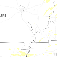

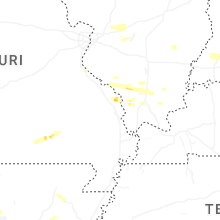
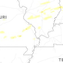


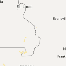


Connect with Interactive Hail Maps