

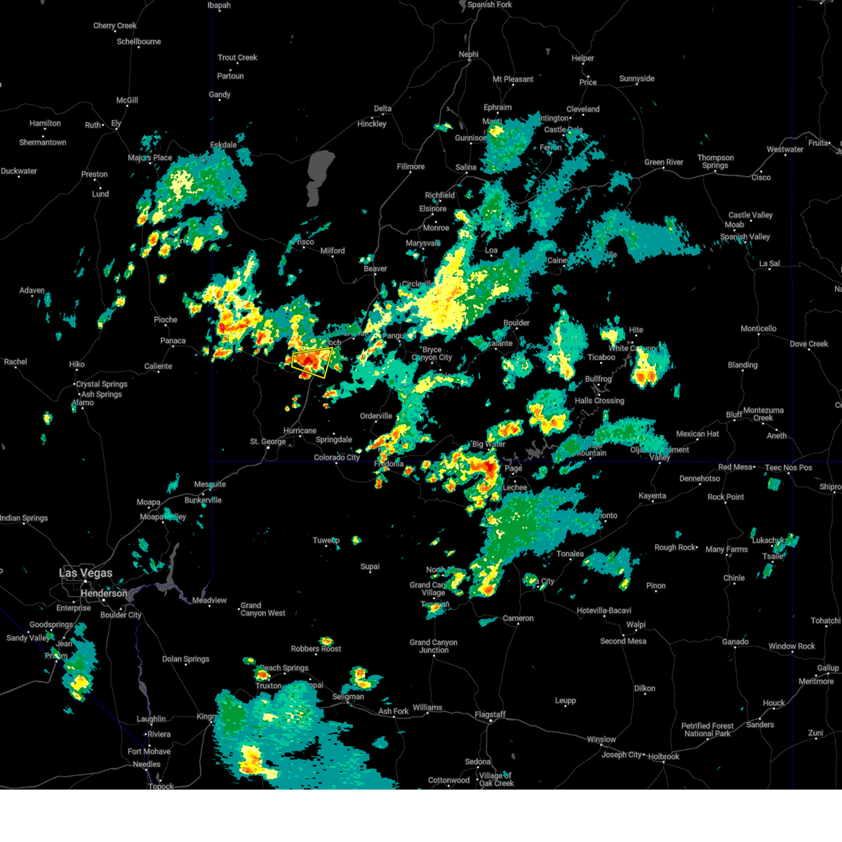
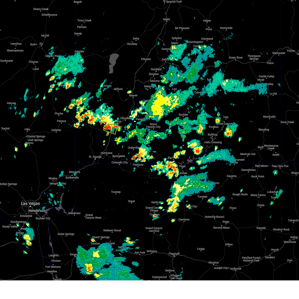
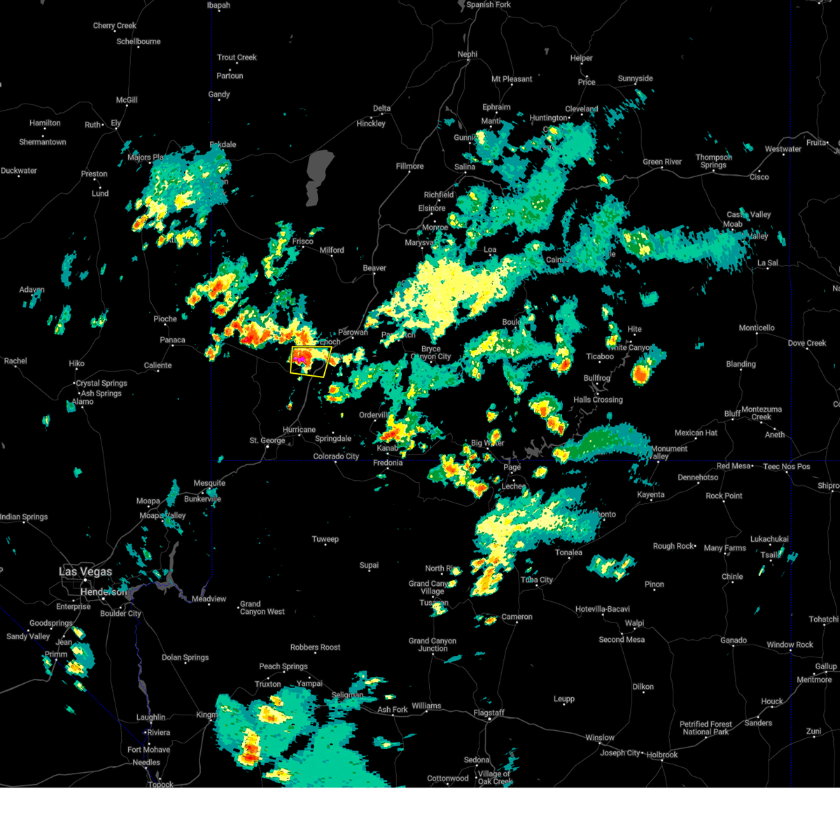
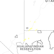
Hail Map for Cedar City, UT
The Cedar City, UT area has had 4 reports of on-the-ground hail by trained spotters, and has been under severe weather warnings 3 times during the past 12 months. Doppler radar has detected hail at or near Cedar City, UT on 28 occasions, including 3 occasions during the past year.
| Name: | Cedar City, UT |
| Where Located: | 47.9 miles NNE of Saint George, UT |
| Map: | Google Map for Cedar City, UT |
| Population: | 28857 |
| Housing Units: | 10860 |
| More Info: | Search Google for Cedar City, UT |
2
The Top Recent Hail Date for Cedar City, UT is Thursday, August 8, 2024 (4th out of 28)

Hail and Wind Damage Spotted near Cedar City, UT
| Date / Time | Report Details |
|---|---|
| 8/8/2024 5:00 PM MDT |
 The storm which prompted the warning has weakened below severe limits, and no longer poses an immediate threat to life or property. therefore, the warning will be allowed to expire. The storm which prompted the warning has weakened below severe limits, and no longer poses an immediate threat to life or property. therefore, the warning will be allowed to expire.
|
| 8/8/2024 4:47 PM MDT |
 At 446 pm mdt, a severe thunderstorm was located near cedar city, moving east at 20 mph (radar indicated). Hazards include 60 mph wind gusts and quarter size hail. Hail damage to vehicles is expected. expect wind damage to roofs, siding, and trees. locations impacted include, cedar city, enoch, and hamilton fort. this includes the following highways, interstate 15 between mile markers 51 and 65. Utah route 56 between mile markers 48 and 61. At 446 pm mdt, a severe thunderstorm was located near cedar city, moving east at 20 mph (radar indicated). Hazards include 60 mph wind gusts and quarter size hail. Hail damage to vehicles is expected. expect wind damage to roofs, siding, and trees. locations impacted include, cedar city, enoch, and hamilton fort. this includes the following highways, interstate 15 between mile markers 51 and 65. Utah route 56 between mile markers 48 and 61.
|
| 8/8/2024 4:32 PM MDT |
 Svrslc the national weather service in salt lake city has issued a * severe thunderstorm warning for, south central iron county in southern utah, * until 500 pm mdt. * at 432 pm mdt, a severe thunderstorm was located 10 miles west of cedar city, moving east at 20 mph (radar indicated). Hazards include 60 mph wind gusts and quarter size hail. Hail damage to vehicles is expected. Expect wind damage to roofs, siding, and trees. Svrslc the national weather service in salt lake city has issued a * severe thunderstorm warning for, south central iron county in southern utah, * until 500 pm mdt. * at 432 pm mdt, a severe thunderstorm was located 10 miles west of cedar city, moving east at 20 mph (radar indicated). Hazards include 60 mph wind gusts and quarter size hail. Hail damage to vehicles is expected. Expect wind damage to roofs, siding, and trees.
|
| 8/2/2024 6:10 PM MDT | Mesonet station uthft i-15 mp 54 hamiltons for in iron county UT, 4.2 miles NNE of Cedar City, UT |
| 8/31/2023 10:44 PM MDT |
 At 1043 pm mdt, a severe thunderstorm was located near enoch, or 8 miles northeast of cedar city, moving northeast at 35 mph (radar indicated). Hazards include 60 mph wind gusts and penny size hail. Expect damage to roofs, siding, and trees. locations impacted include, cedar city, enoch, parowan, paragonah, cedar breaks national monument, summit, kanarraville, brian head and hamilton fort. this includes the following highways, interstate 15 between mile markers 46 and 82. utah route 56 between mile markers 43 and 61. hail threat, radar indicated max hail size, 0. 75 in wind threat, radar indicated max wind gust, 60 mph. At 1043 pm mdt, a severe thunderstorm was located near enoch, or 8 miles northeast of cedar city, moving northeast at 35 mph (radar indicated). Hazards include 60 mph wind gusts and penny size hail. Expect damage to roofs, siding, and trees. locations impacted include, cedar city, enoch, parowan, paragonah, cedar breaks national monument, summit, kanarraville, brian head and hamilton fort. this includes the following highways, interstate 15 between mile markers 46 and 82. utah route 56 between mile markers 43 and 61. hail threat, radar indicated max hail size, 0. 75 in wind threat, radar indicated max wind gust, 60 mph.
|
| 8/31/2023 10:21 PM MDT |
 At 1019 pm mdt, a severe thunderstorm was located over cedar city, moving northeast at 35 mph (radar indicated and surface observation confirmed. at 10:10 pm mdt, the cedar city municipal airport recorded a wind gust to 61 mph). Hazards include 60 mph wind gusts and penny size hail. expect damage to roofs, siding, and trees At 1019 pm mdt, a severe thunderstorm was located over cedar city, moving northeast at 35 mph (radar indicated and surface observation confirmed. at 10:10 pm mdt, the cedar city municipal airport recorded a wind gust to 61 mph). Hazards include 60 mph wind gusts and penny size hail. expect damage to roofs, siding, and trees
|
| 8/31/2023 10:09 PM MDT | Asos station kcdc cedar city municipal airpor in iron county UT, 0.8 miles SSW of Cedar City, UT |
| 6/15/2023 2:58 PM MDT |
 The severe thunderstorm warning for northeastern washington and south central iron counties will expire at 300 pm mdt, the storm which prompted the warning has weakened below severe limits, and no longer poses an immediate threat to life or property. therefore, the warning will be allowed to expire. however small hail and heavy rain are still possible with this thunderstorm. The severe thunderstorm warning for northeastern washington and south central iron counties will expire at 300 pm mdt, the storm which prompted the warning has weakened below severe limits, and no longer poses an immediate threat to life or property. therefore, the warning will be allowed to expire. however small hail and heavy rain are still possible with this thunderstorm.
|
| 6/15/2023 2:34 PM MDT |
 At 233 pm mdt, a severe thunderstorm was located 8 miles northeast of new harmony, or 11 miles southwest of cedar city, moving southeast at 15 mph (radar indicated). Hazards include 60 mph wind gusts and half dollar size hail. Hail damage to vehicles is expected. expect wind damage to roofs, siding, and trees. locations impacted include, cedar city, kanarraville and hamilton fort. this includes the following highways, interstate 15 between mile markers 43 and 60. utah route 56 between mile markers 52 and 61. hail threat, radar indicated max hail size, 1. 25 in wind threat, radar indicated max wind gust, 60 mph. At 233 pm mdt, a severe thunderstorm was located 8 miles northeast of new harmony, or 11 miles southwest of cedar city, moving southeast at 15 mph (radar indicated). Hazards include 60 mph wind gusts and half dollar size hail. Hail damage to vehicles is expected. expect wind damage to roofs, siding, and trees. locations impacted include, cedar city, kanarraville and hamilton fort. this includes the following highways, interstate 15 between mile markers 43 and 60. utah route 56 between mile markers 52 and 61. hail threat, radar indicated max hail size, 1. 25 in wind threat, radar indicated max wind gust, 60 mph.
|
| 6/15/2023 2:13 PM MDT |
 At 212 pm mdt, a severe thunderstorm was located 7 miles north of new harmony, or 14 miles southwest of cedar city, moving southeast at 15 mph (radar indicated). Hazards include 60 mph wind gusts and half dollar size hail. Hail damage to vehicles is expected. Expect wind damage to roofs, siding, and trees. At 212 pm mdt, a severe thunderstorm was located 7 miles north of new harmony, or 14 miles southwest of cedar city, moving southeast at 15 mph (radar indicated). Hazards include 60 mph wind gusts and half dollar size hail. Hail damage to vehicles is expected. Expect wind damage to roofs, siding, and trees.
|
| 5/14/2023 3:27 PM MDT |
 The severe thunderstorm warning for central iron county will expire at 330 pm mdt, the storm which prompted the warning has weakened below severe limits, and has exited the warned area. therefore, the warning will be allowed to expire. however gusty winds and heavy rain are still possible with this thunderstorm. The severe thunderstorm warning for central iron county will expire at 330 pm mdt, the storm which prompted the warning has weakened below severe limits, and has exited the warned area. therefore, the warning will be allowed to expire. however gusty winds and heavy rain are still possible with this thunderstorm.
|
| 5/14/2023 3:16 PM MDT |
 At 316 pm mdt, a severe thunderstorm was located 7 miles west of enoch, or 9 miles northwest of cedar city, moving northeast at 20 mph (radar indicated). Hazards include 60 mph wind gusts and nickel size hail. Expect damage to roofs, siding, and trees. locations impacted include, cedar city and enoch, as well as the i-15 corridor in this area. this includes interstate 15 between mile markers 61 and 64. hail threat, radar indicated max hail size, 0. 88 in wind threat, radar indicated max wind gust, 60 mph. At 316 pm mdt, a severe thunderstorm was located 7 miles west of enoch, or 9 miles northwest of cedar city, moving northeast at 20 mph (radar indicated). Hazards include 60 mph wind gusts and nickel size hail. Expect damage to roofs, siding, and trees. locations impacted include, cedar city and enoch, as well as the i-15 corridor in this area. this includes interstate 15 between mile markers 61 and 64. hail threat, radar indicated max hail size, 0. 88 in wind threat, radar indicated max wind gust, 60 mph.
|
| 5/14/2023 3:08 PM MDT |
 At 308 pm mdt, a severe thunderstorm was located 8 miles northwest of cedar city, moving northeast at 20 mph (radar indicated). Hazards include 70 mph wind gusts and nickel size hail. Expect considerable tree damage. Damage is likely to mobile homes, roofs, and outbuildings. At 308 pm mdt, a severe thunderstorm was located 8 miles northwest of cedar city, moving northeast at 20 mph (radar indicated). Hazards include 70 mph wind gusts and nickel size hail. Expect considerable tree damage. Damage is likely to mobile homes, roofs, and outbuildings.
|
| 5/14/2023 3:00 PM MDT | Kcdc asos measured ssw 43g62 mph in iron county UT, 2.3 miles NW of Cedar City, UT |
| 10/2/2022 5:49 PM MDT |
 At 549 pm mdt, a severe thunderstorm was located over panguitch lake, or 22 miles east of cedar city, moving east at 25 mph (public). Hazards include 60 mph wind gusts and half dollar size hail. Hail damage to vehicles is expected. expect wind damage to roofs, siding, and trees. locations impacted include, cedar city, enoch, parowan, hatch, panguitch lake, cedar breaks national monument, summit and brian head. this includes the following highways, interstate 15 between mile markers 62 and 79. us route 89 between mile markers 109 and 117. hail threat, observed max hail size, 1. 25 in wind threat, radar indicated max wind gust, 60 mph. At 549 pm mdt, a severe thunderstorm was located over panguitch lake, or 22 miles east of cedar city, moving east at 25 mph (public). Hazards include 60 mph wind gusts and half dollar size hail. Hail damage to vehicles is expected. expect wind damage to roofs, siding, and trees. locations impacted include, cedar city, enoch, parowan, hatch, panguitch lake, cedar breaks national monument, summit and brian head. this includes the following highways, interstate 15 between mile markers 62 and 79. us route 89 between mile markers 109 and 117. hail threat, observed max hail size, 1. 25 in wind threat, radar indicated max wind gust, 60 mph.
|
| 10/2/2022 5:33 PM MDT |
 At 532 pm mdt, a severe thunderstorm was located near parowan, or 15 miles east of cedar city, moving east at 25 mph (public). Hazards include 60 mph wind gusts and half dollar size hail. Hail damage to vehicles is expected. Expect wind damage to roofs, siding, and trees. At 532 pm mdt, a severe thunderstorm was located near parowan, or 15 miles east of cedar city, moving east at 25 mph (public). Hazards include 60 mph wind gusts and half dollar size hail. Hail damage to vehicles is expected. Expect wind damage to roofs, siding, and trees.
|
| 10/2/2022 5:30 PM MDT |
 At 530 pm mdt, a severe thunderstorm was located 16 miles west of cedar city, moving east at 20 mph (radar indicated). Hazards include 60 mph wind gusts and quarter size hail. Hail damage to vehicles is expected. Expect wind damage to roofs, siding, and trees. At 530 pm mdt, a severe thunderstorm was located 16 miles west of cedar city, moving east at 20 mph (radar indicated). Hazards include 60 mph wind gusts and quarter size hail. Hail damage to vehicles is expected. Expect wind damage to roofs, siding, and trees.
|
| 10/2/2022 5:16 PM MDT |
 At 516 pm mdt, a severe thunderstorm was located near enoch, or 7 miles northeast of cedar city, moving east at 15 mph (public). Hazards include 60 mph wind gusts and half dollar size hail. Hail damage to vehicles is expected. expect wind damage to roofs, siding, and trees. locations impacted include, cedar city, enoch, parowan, cedar breaks national monument, summit and brian head. this includes the following highways, interstate 15 between mile markers 58 and 73. utah route 56 between mile markers 58 and 61. hail threat, observed max hail size, 1. 25 in wind threat, radar indicated max wind gust, 60 mph. At 516 pm mdt, a severe thunderstorm was located near enoch, or 7 miles northeast of cedar city, moving east at 15 mph (public). Hazards include 60 mph wind gusts and half dollar size hail. Hail damage to vehicles is expected. expect wind damage to roofs, siding, and trees. locations impacted include, cedar city, enoch, parowan, cedar breaks national monument, summit and brian head. this includes the following highways, interstate 15 between mile markers 58 and 73. utah route 56 between mile markers 58 and 61. hail threat, observed max hail size, 1. 25 in wind threat, radar indicated max wind gust, 60 mph.
|
| 10/2/2022 5:02 PM MDT |
 At 501 pm mdt, a severe thunderstorm was located over enoch, or near cedar city, moving east at 15 mph (public). Hazards include 60 mph wind gusts and half dollar size hail. Hail damage to vehicles is expected. Expect wind damage to roofs, siding, and trees. At 501 pm mdt, a severe thunderstorm was located over enoch, or near cedar city, moving east at 15 mph (public). Hazards include 60 mph wind gusts and half dollar size hail. Hail damage to vehicles is expected. Expect wind damage to roofs, siding, and trees.
|
| 10/2/2022 4:55 PM MDT | Half Dollar sized hail reported 6.3 miles SSW of Cedar City, UT |
| 10/2/2022 4:55 PM MDT | Ping Pong Ball sized hail reported 6 miles SW of Cedar City, UT, many pictures on social media shared by broadcast media of hail and hail damage in the cedar city to enoch area. largest pictured thus far is ping pong ball sized. vide |
| 10/2/2022 4:46 PM MDT |
 At 445 pm mdt, a severe thunderstorm was located near enoch, or 8 miles northeast of cedar city, moving east at 25 mph (radar indicated). Hazards include 60 mph wind gusts and quarter size hail. Hail damage to vehicles is expected. expect wind damage to roofs, siding, and trees. locations impacted include, cedar city, enoch, parowan, cedar breaks national monument, summit and brian head. this includes interstate 15 between mile markers 60 and 77. hail threat, radar indicated max hail size, 1. 00 in wind threat, radar indicated max wind gust, 60 mph. At 445 pm mdt, a severe thunderstorm was located near enoch, or 8 miles northeast of cedar city, moving east at 25 mph (radar indicated). Hazards include 60 mph wind gusts and quarter size hail. Hail damage to vehicles is expected. expect wind damage to roofs, siding, and trees. locations impacted include, cedar city, enoch, parowan, cedar breaks national monument, summit and brian head. this includes interstate 15 between mile markers 60 and 77. hail threat, radar indicated max hail size, 1. 00 in wind threat, radar indicated max wind gust, 60 mph.
|
| 10/2/2022 4:25 PM MDT |
 At 425 pm mdt, a severe thunderstorm was located over enoch, or near cedar city, moving east at 25 mph (radar indicated). Hazards include 60 mph wind gusts and quarter size hail. Hail damage to vehicles is expected. Expect wind damage to roofs, siding, and trees. At 425 pm mdt, a severe thunderstorm was located over enoch, or near cedar city, moving east at 25 mph (radar indicated). Hazards include 60 mph wind gusts and quarter size hail. Hail damage to vehicles is expected. Expect wind damage to roofs, siding, and trees.
|
| 8/1/2021 6:30 PM MDT | Over 3000 people without power in the city of enoc in iron county UT, 6 miles SW of Cedar City, UT |
| 8/1/2021 4:00 PM MDT | Quarter sized hail reported 6 miles SW of Cedar City, UT, photos from social media. |
| 7/29/2021 2:26 PM MDT |
 The severe thunderstorm warning for northeastern washington and south central iron counties will expire at 230 pm mdt, the storm which prompted the warning has weakened below severe limits, and no longer poses an immediate threat to life or property. therefore, the warning will be allowed to expire. The severe thunderstorm warning for northeastern washington and south central iron counties will expire at 230 pm mdt, the storm which prompted the warning has weakened below severe limits, and no longer poses an immediate threat to life or property. therefore, the warning will be allowed to expire.
|
| 7/29/2021 2:18 PM MDT |
 At 218 pm mdt, a severe thunderstorm was located 13 miles north of new harmony, or 13 miles west of cedar city, moving east at 5 mph (radar indicated). Hazards include ping pong ball size hail. People and animals outdoors will be injured. expect damage to roofs, siding, windows, and vehicles. locations impacted include, cedar city. This includes utah route 56 between mile markers 38 and 56. At 218 pm mdt, a severe thunderstorm was located 13 miles north of new harmony, or 13 miles west of cedar city, moving east at 5 mph (radar indicated). Hazards include ping pong ball size hail. People and animals outdoors will be injured. expect damage to roofs, siding, windows, and vehicles. locations impacted include, cedar city. This includes utah route 56 between mile markers 38 and 56.
|
| 7/29/2021 2:00 PM MDT |
 At 159 pm mdt, a severe thunderstorm was located 14 miles north of new harmony, or 15 miles west of cedar city, moving east at 5 mph (radar indicated). Hazards include ping pong ball size hail. People and animals outdoors will be injured. Expect damage to roofs, siding, windows, and vehicles. At 159 pm mdt, a severe thunderstorm was located 14 miles north of new harmony, or 15 miles west of cedar city, moving east at 5 mph (radar indicated). Hazards include ping pong ball size hail. People and animals outdoors will be injured. Expect damage to roofs, siding, windows, and vehicles.
|
| 7/25/2021 4:11 PM MDT |
 The severe thunderstorm warning for east central iron county will expire at 415 pm mdt. the severe thunderstorm which prompted the warning has weakened. therefore, the warning will be allowed to expire. However gusty winds are still possible with this thunderstorm. The severe thunderstorm warning for east central iron county will expire at 415 pm mdt. the severe thunderstorm which prompted the warning has weakened. therefore, the warning will be allowed to expire. However gusty winds are still possible with this thunderstorm.
|
| 7/25/2021 4:10 PM MDT | Measured at the udot rwis along i-15 at mp 62.5 in iron county UT, 2.8 miles SW of Cedar City, UT |
| 7/25/2021 3:59 PM MDT |
 At 359 pm mdt, a severe thunderstorm was located near parowan, or 14 miles northeast of cedar city, moving southwest at 20 mph (radar indicated). Hazards include 60 mph wind gusts and quarter size hail. Hail damage to vehicles is expected. expect wind damage to roofs, siding, and trees. locations impacted include, cedar city, enoch, parowan and summit. This includes interstate 15 between mile markers 62 and 79. At 359 pm mdt, a severe thunderstorm was located near parowan, or 14 miles northeast of cedar city, moving southwest at 20 mph (radar indicated). Hazards include 60 mph wind gusts and quarter size hail. Hail damage to vehicles is expected. expect wind damage to roofs, siding, and trees. locations impacted include, cedar city, enoch, parowan and summit. This includes interstate 15 between mile markers 62 and 79.
|
| 7/25/2021 3:49 PM MDT |
 At 348 pm mdt, a severe thunderstorm was located near parowan, or 17 miles northeast of cedar city, moving southwest at 20 mph (radar indicated). Hazards include 60 mph wind gusts and quarter size hail. Hail damage to vehicles is expected. Expect wind damage to roofs, siding, and trees. At 348 pm mdt, a severe thunderstorm was located near parowan, or 17 miles northeast of cedar city, moving southwest at 20 mph (radar indicated). Hazards include 60 mph wind gusts and quarter size hail. Hail damage to vehicles is expected. Expect wind damage to roofs, siding, and trees.
|
| 7/14/2021 5:37 PM MDT |
 The severe thunderstorm warning for southeastern iron county will expire at 545 pm mdt, the storm which prompted the warning has weakened below severe limits, and has exited the warned area. therefore, the warning will be allowed to expire. The severe thunderstorm warning for southeastern iron county will expire at 545 pm mdt, the storm which prompted the warning has weakened below severe limits, and has exited the warned area. therefore, the warning will be allowed to expire.
|
| 7/14/2021 5:15 PM MDT |
 At 515 pm mdt, a severe thunderstorm was located near enoch, or near cedar city, moving south at 5 mph (radar indicated). Hazards include 60 mph wind gusts and penny size hail. Expect damage to roofs, siding, and trees. locations impacted include, cedar city, cedar breaks national monument and brian head. this includes the following highways, interstate 15 between mile markers 60 and 63. Utah route 56 near mile marker 61. At 515 pm mdt, a severe thunderstorm was located near enoch, or near cedar city, moving south at 5 mph (radar indicated). Hazards include 60 mph wind gusts and penny size hail. Expect damage to roofs, siding, and trees. locations impacted include, cedar city, cedar breaks national monument and brian head. this includes the following highways, interstate 15 between mile markers 60 and 63. Utah route 56 near mile marker 61.
|
| 7/14/2021 4:45 PM MDT | Quarter sized hail reported 6 miles SW of Cedar City, UT, hail up to quarter size measured. reported via social media. |
| 7/14/2021 4:39 PM MDT |
 At 438 pm mdt, a severe thunderstorm was located near enoch, or 8 miles northeast of cedar city, moving south at 5 mph (radar indicated). Hazards include 60 mph wind gusts and quarter size hail. Hail damage to vehicles is expected. Expect wind damage to roofs, siding, and trees. At 438 pm mdt, a severe thunderstorm was located near enoch, or 8 miles northeast of cedar city, moving south at 5 mph (radar indicated). Hazards include 60 mph wind gusts and quarter size hail. Hail damage to vehicles is expected. Expect wind damage to roofs, siding, and trees.
|
| 4/29/2019 7:41 PM MDT |
 A severe thunderstorm warning remains in effect until 800 pm mdt for northeastern washington and south central iron counties. at 741 pm mdt, a severe thunderstorm was located 8 miles south of cedar city, moving northeast at 35 mph. hazard. 60 mph wind gusts. source. Radar indicated. A severe thunderstorm warning remains in effect until 800 pm mdt for northeastern washington and south central iron counties. at 741 pm mdt, a severe thunderstorm was located 8 miles south of cedar city, moving northeast at 35 mph. hazard. 60 mph wind gusts. source. Radar indicated.
|
| 4/29/2019 7:12 PM MDT |
 At 711 pm mdt, a severe thunderstorm was located near pintura, or 23 miles southwest of cedar city, moving northeast at 30 mph (radar indicated). Hazards include 60 mph wind gusts. expect damage to roofs, siding, and trees At 711 pm mdt, a severe thunderstorm was located near pintura, or 23 miles southwest of cedar city, moving northeast at 30 mph (radar indicated). Hazards include 60 mph wind gusts. expect damage to roofs, siding, and trees
|
| 6/5/2015 1:44 PM MDT | At 143 pm mdt, doppler radar indicated a severe thunderstorm capable of producing quarter size hail and damaging winds in excess of 60 mph. this storm was located 10 miles north of zion national park, or 20 miles south of cedar city, moving north at 30 mph. locations impacted include, hamilton fort. |
| 6/5/2015 1:34 PM MDT | At 133 pm mdt, doppler radar indicated a severe thunderstorm capable of producing quarter size hail and damaging winds in excess of 60 mph. this storm was located near zion national park, or 24 miles south of cedar city, and moving north at 35 mph. |
| 7/7/2013 7:00 PM MDT | Cedar city asos...kcd in iron county UT, 1.4 miles S of Cedar City, UT |
Hail Maps for Cedar City, UT


Connect with Interactive Hail Maps