

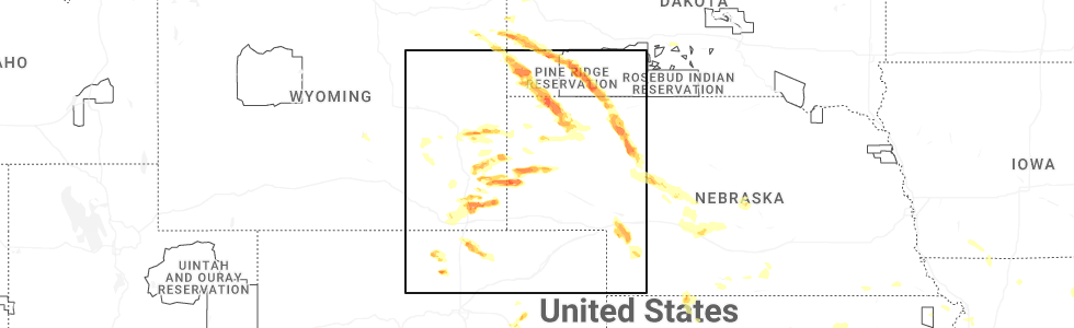
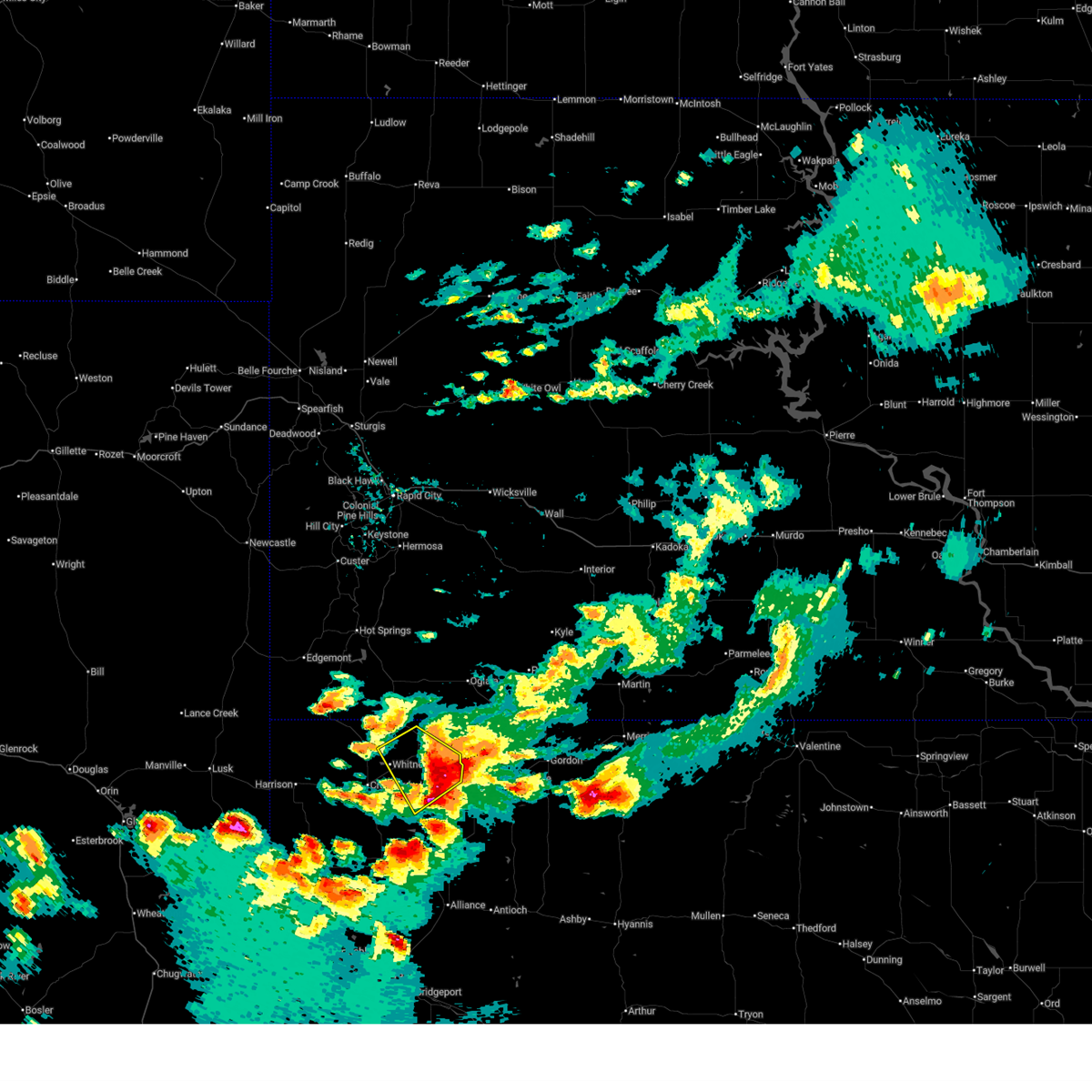
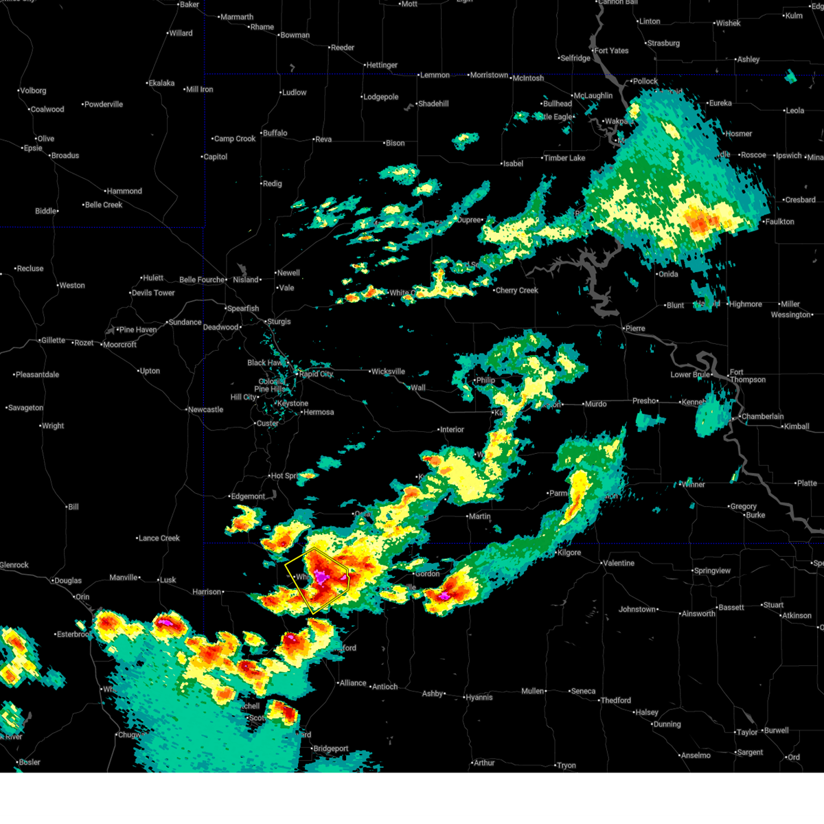
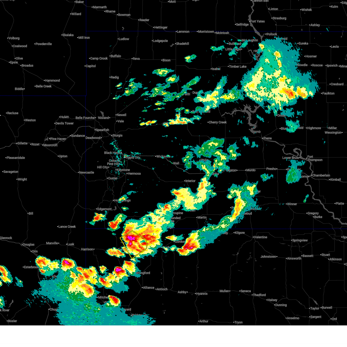
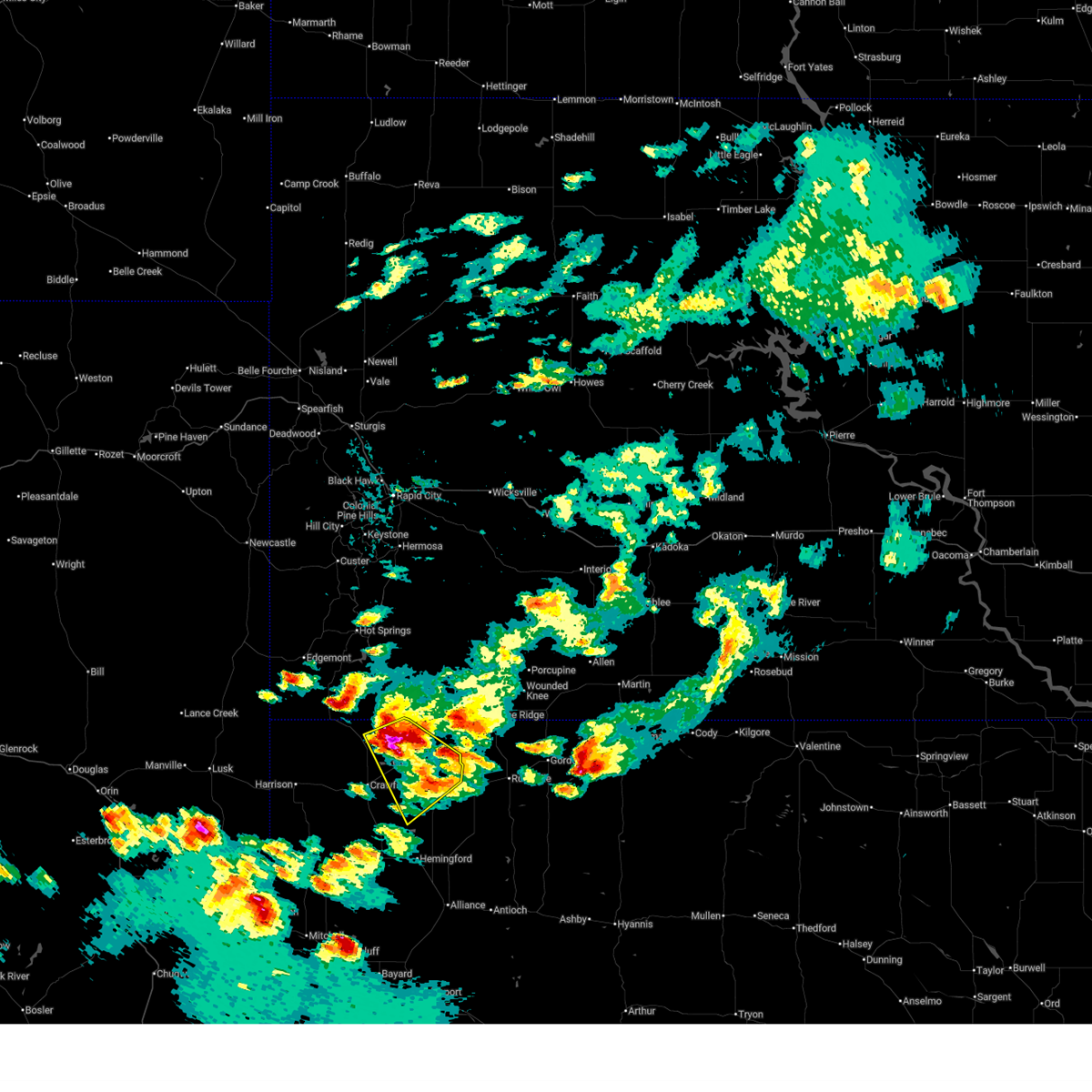
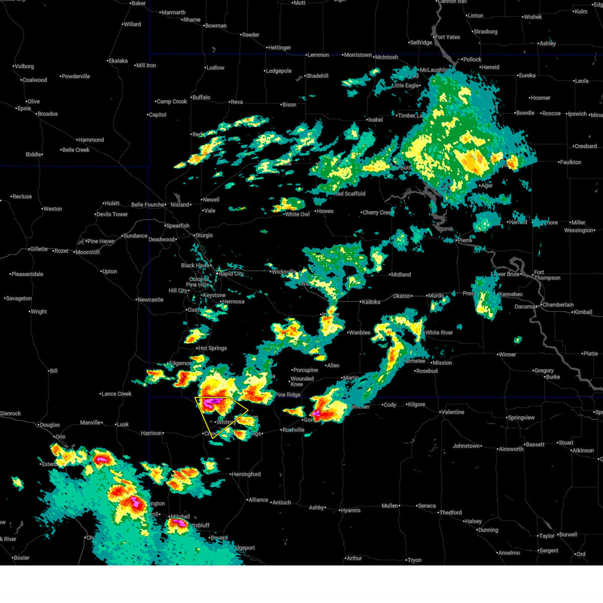
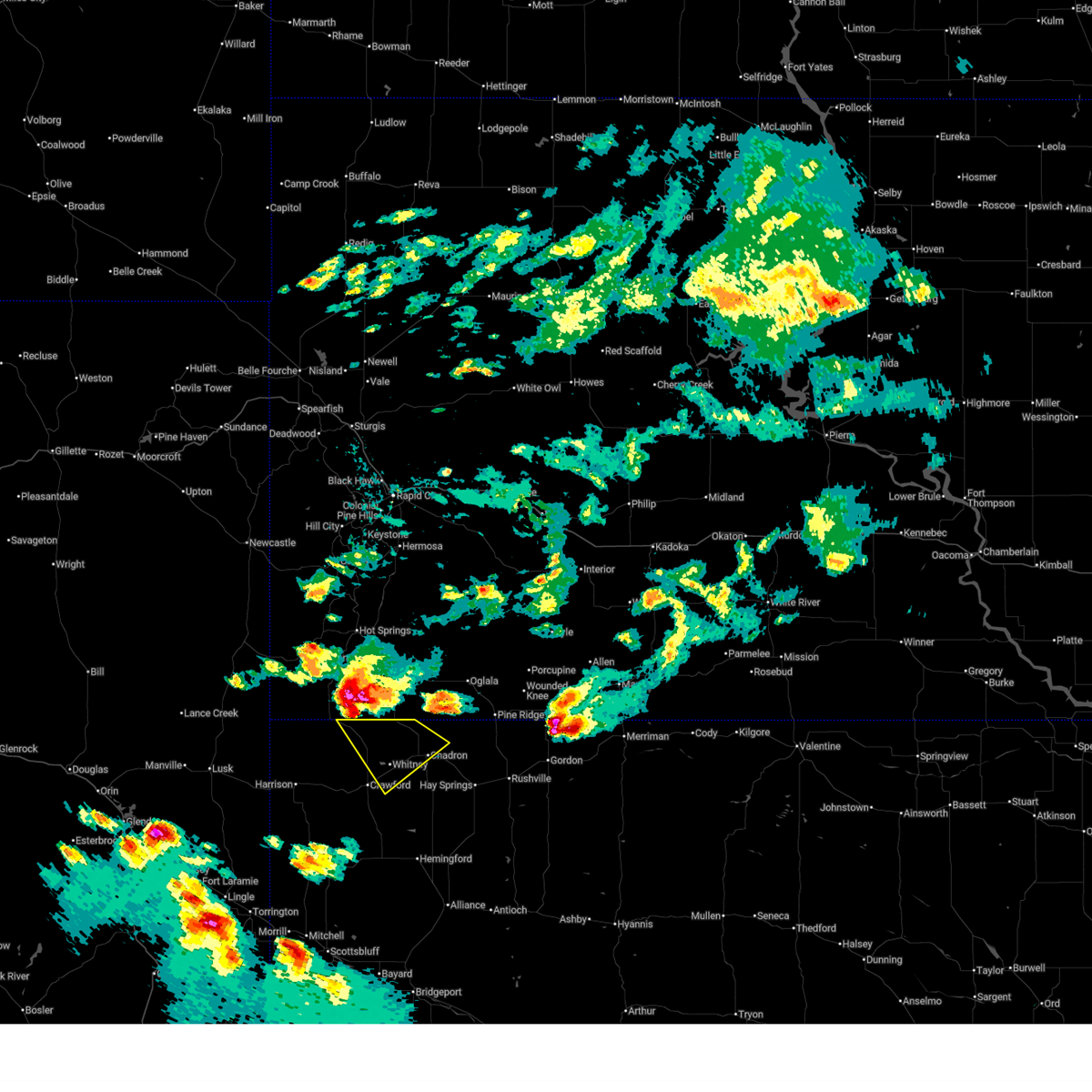
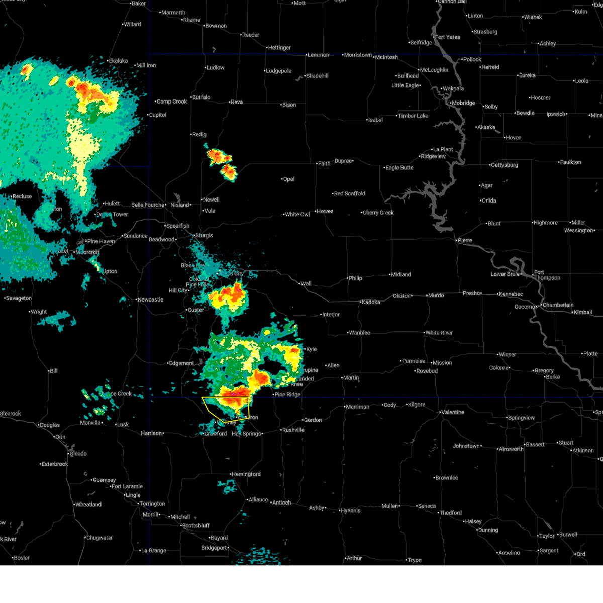
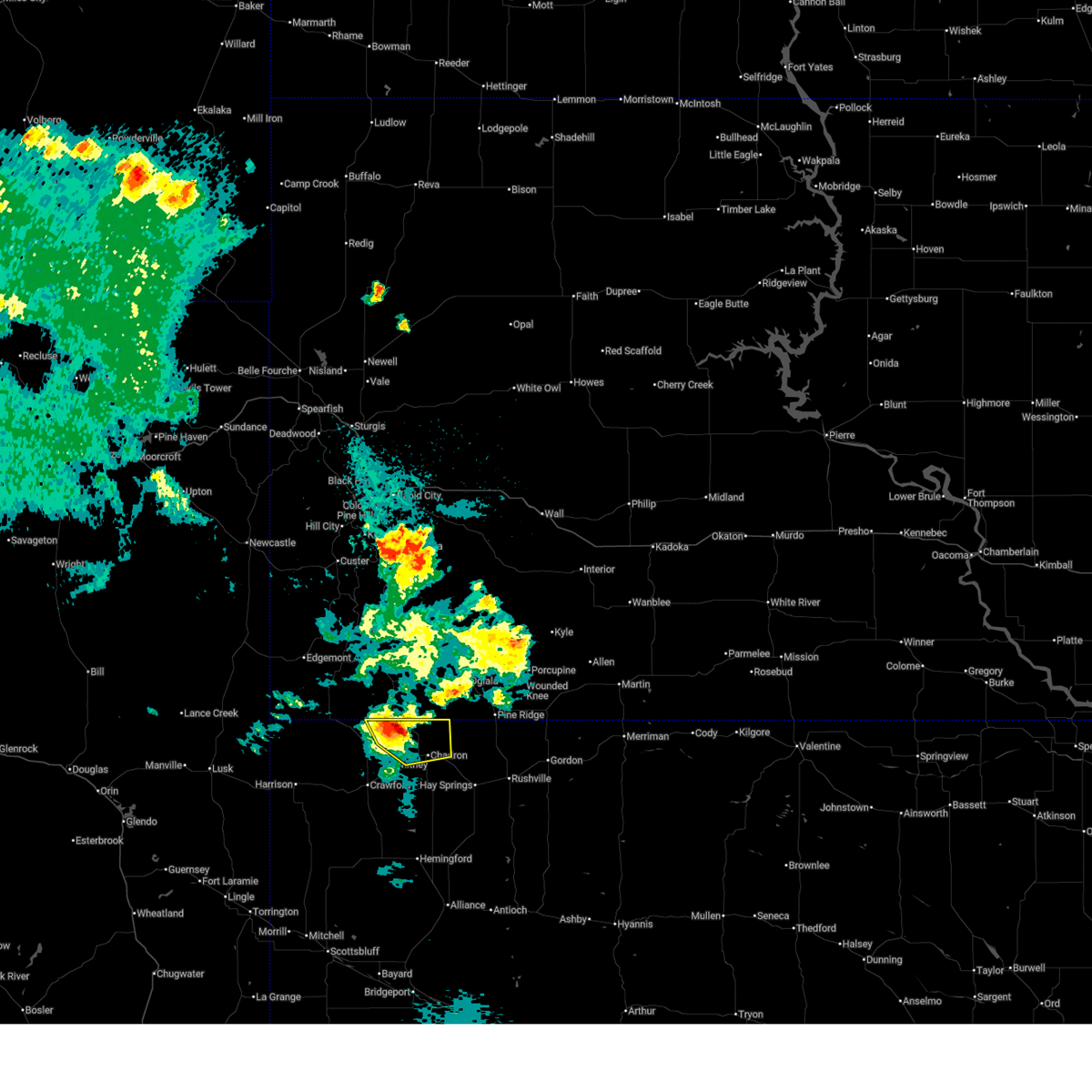
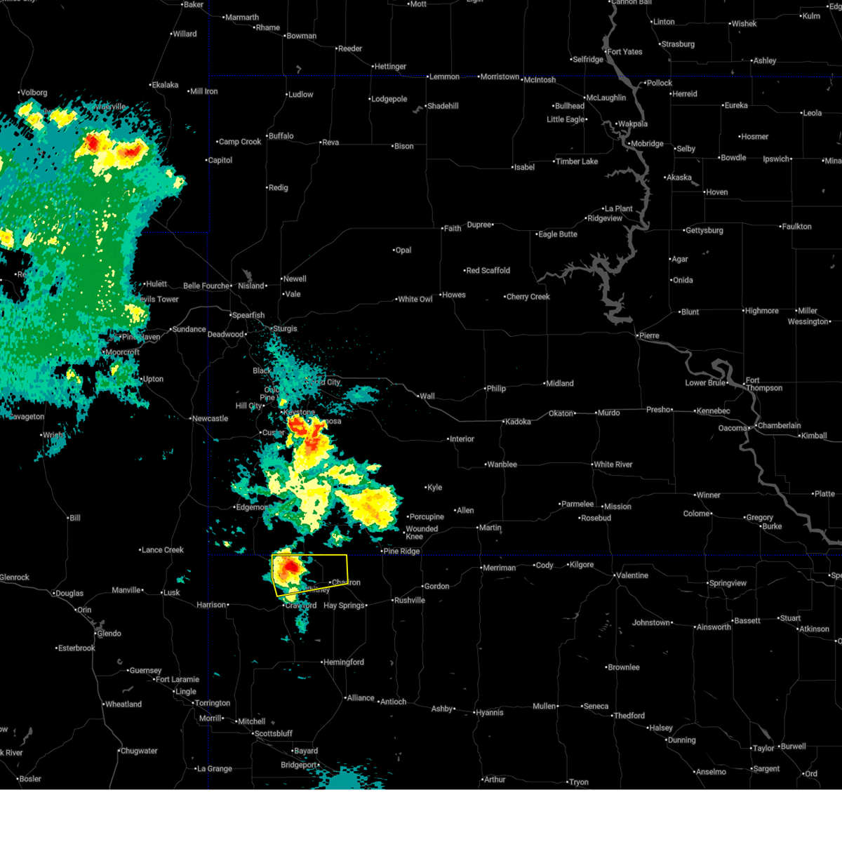
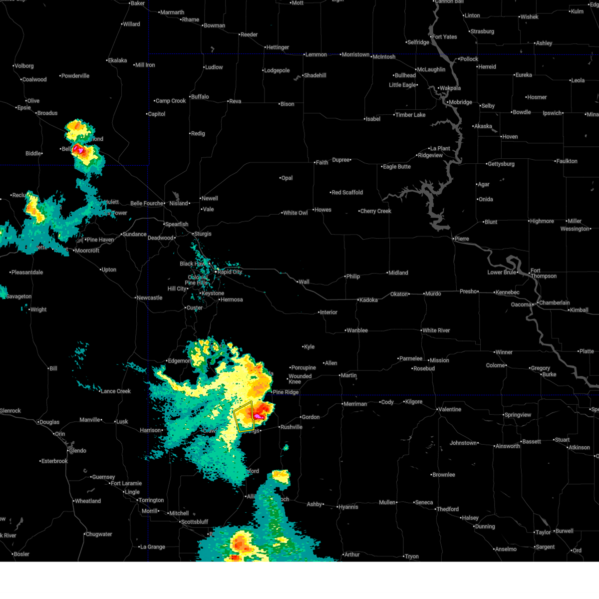
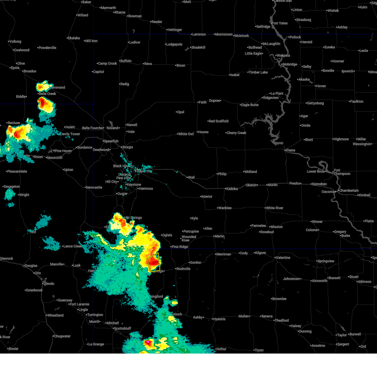
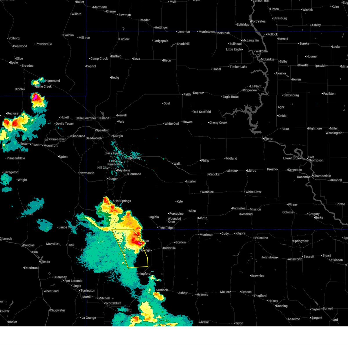
Hail Map for Chadron, NE
The Chadron, NE area has had 61 reports of on-the-ground hail by trained spotters, and has been under severe weather warnings 33 times during the past 12 months. Doppler radar has detected hail at or near Chadron, NE on 101 occasions, including 9 occasions during the past year.
| Name: | Chadron, NE |
| Where Located: | 74.4 miles NNE of Scottsbluff, NE |
| Map: | Google Map for Chadron, NE |
| Population: | 5851 |
| Housing Units: | 2559 |
| More Info: | Search Google for Chadron, NE |
3
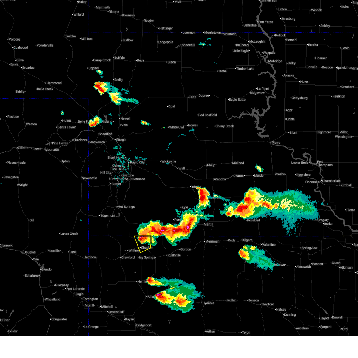
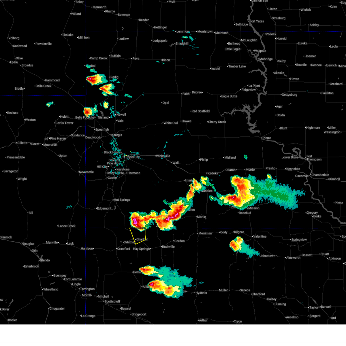
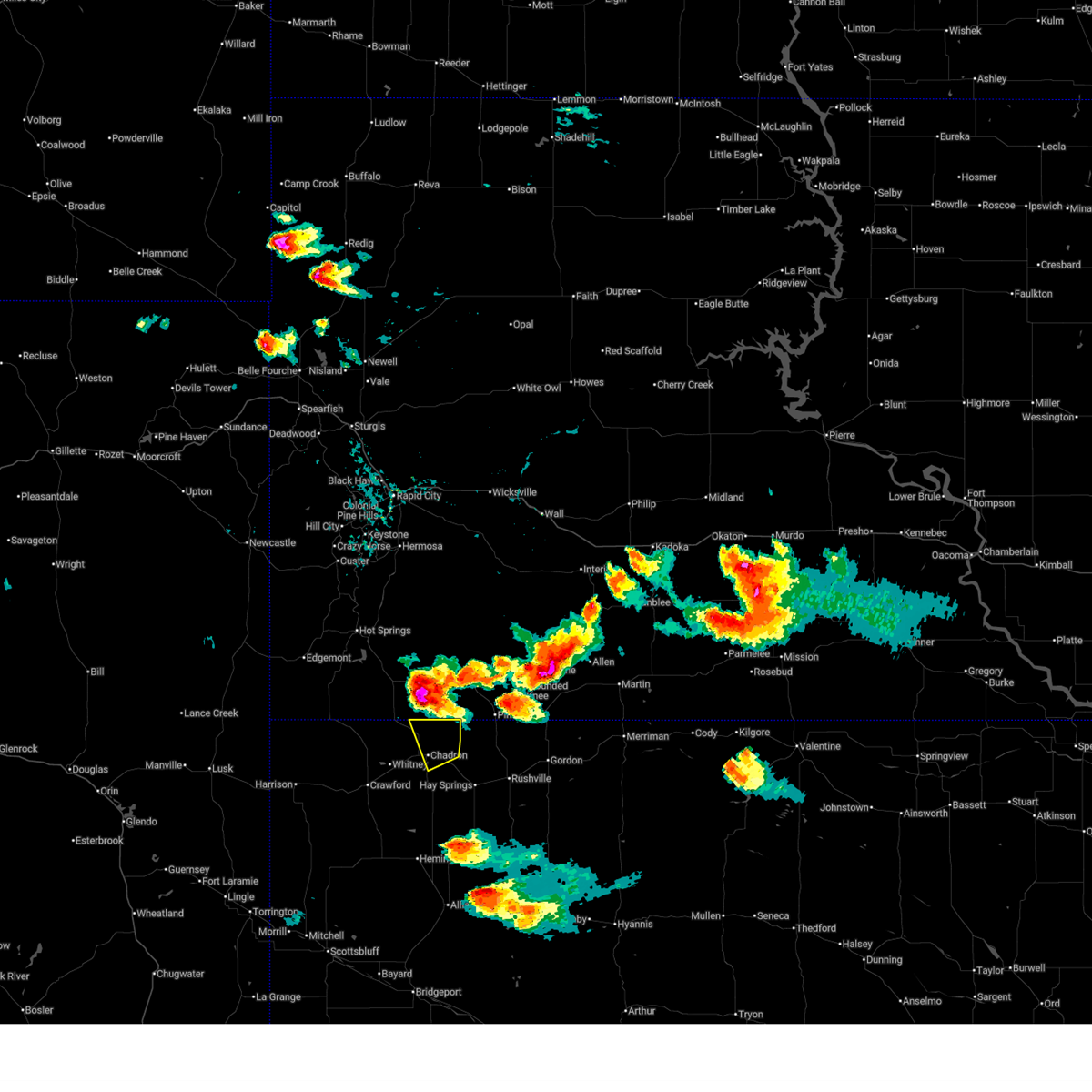
The Top Recent Hail Date for Chadron, NE is Sunday, June 29, 2025 (2nd out of 101)
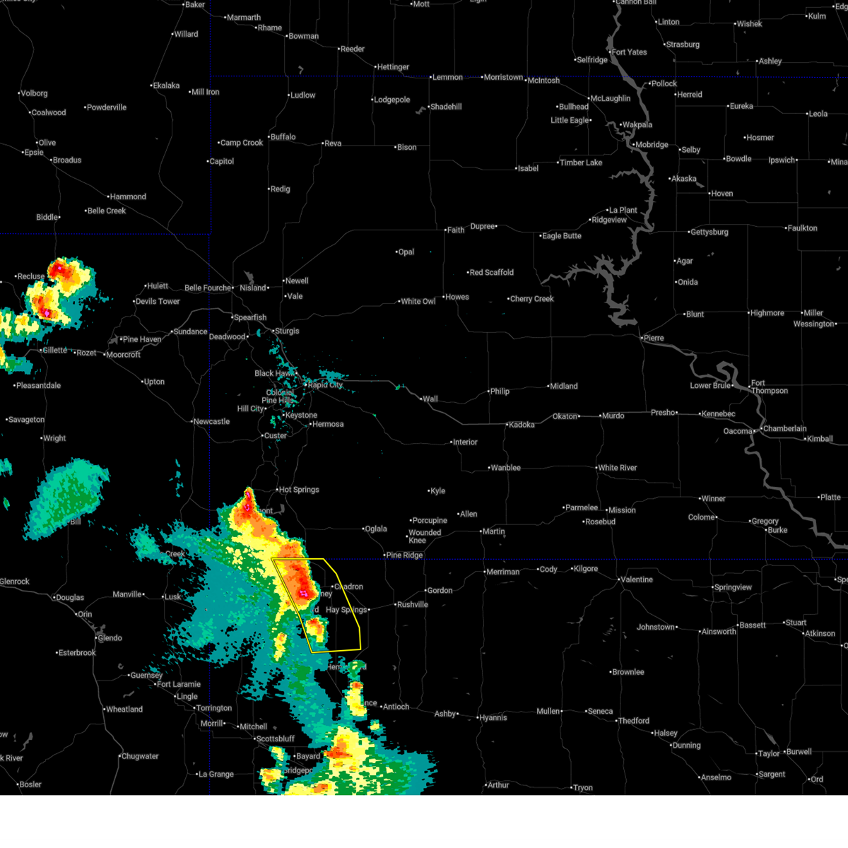
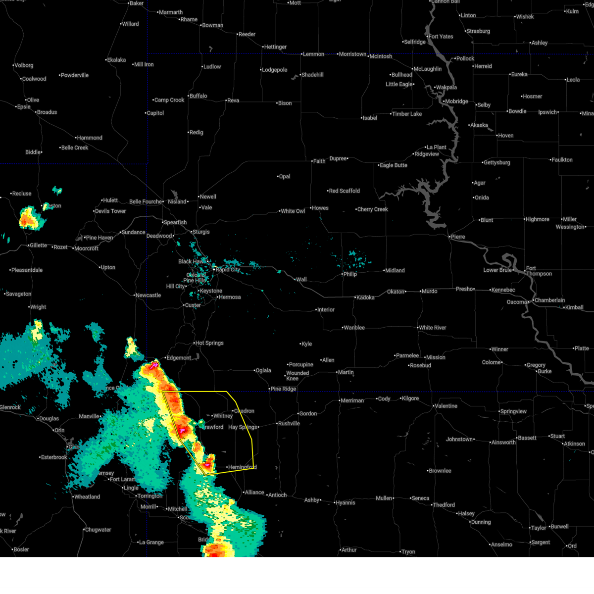
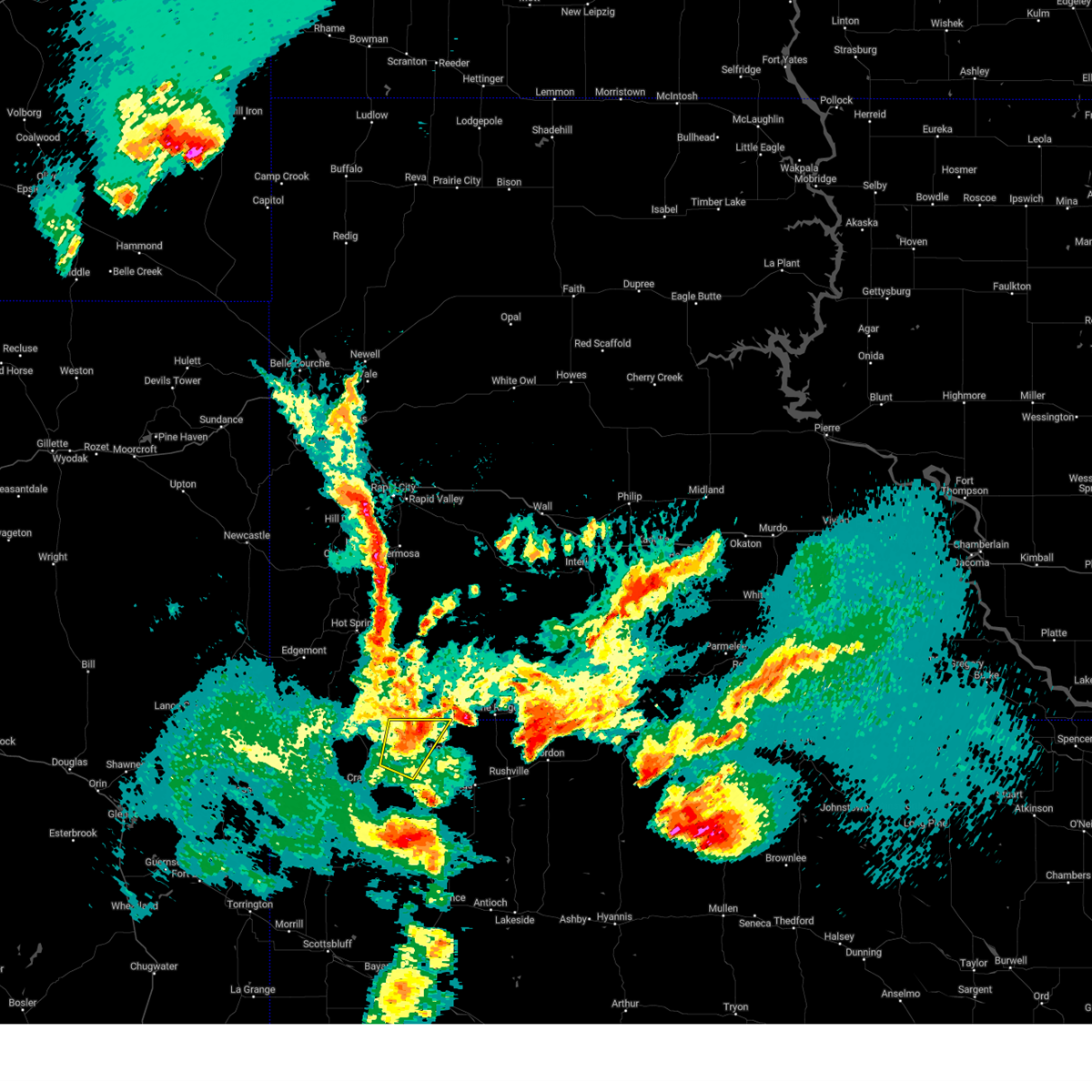
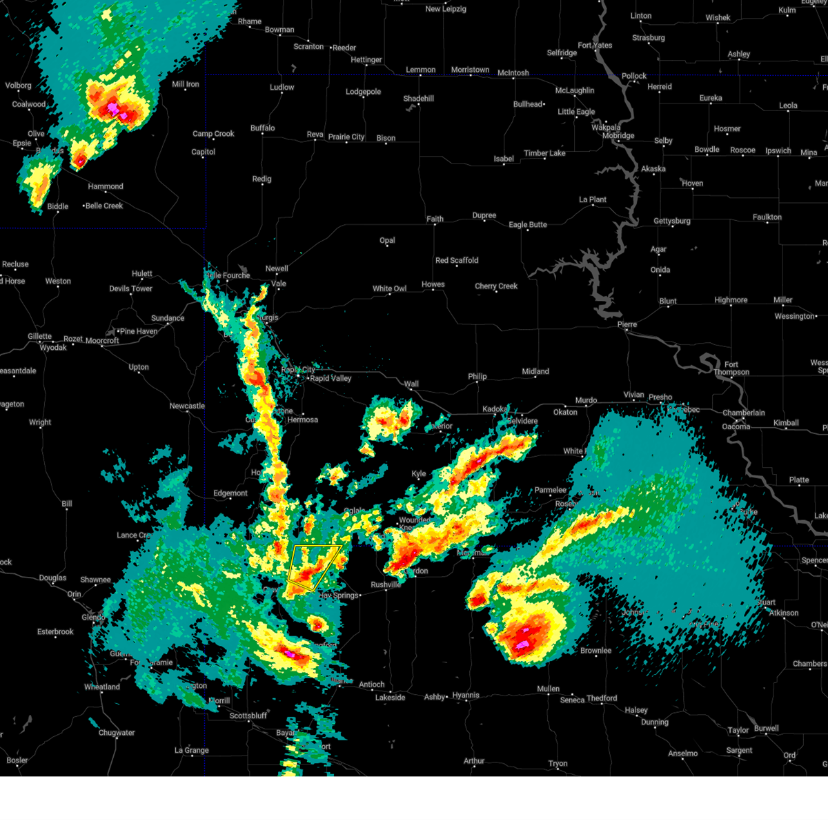
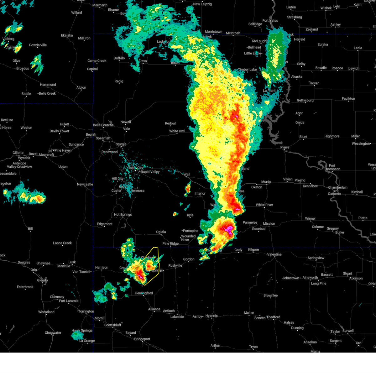
Hail and Wind Damage Spotted near Chadron, NE
| Date / Time | Report Details |
|---|---|
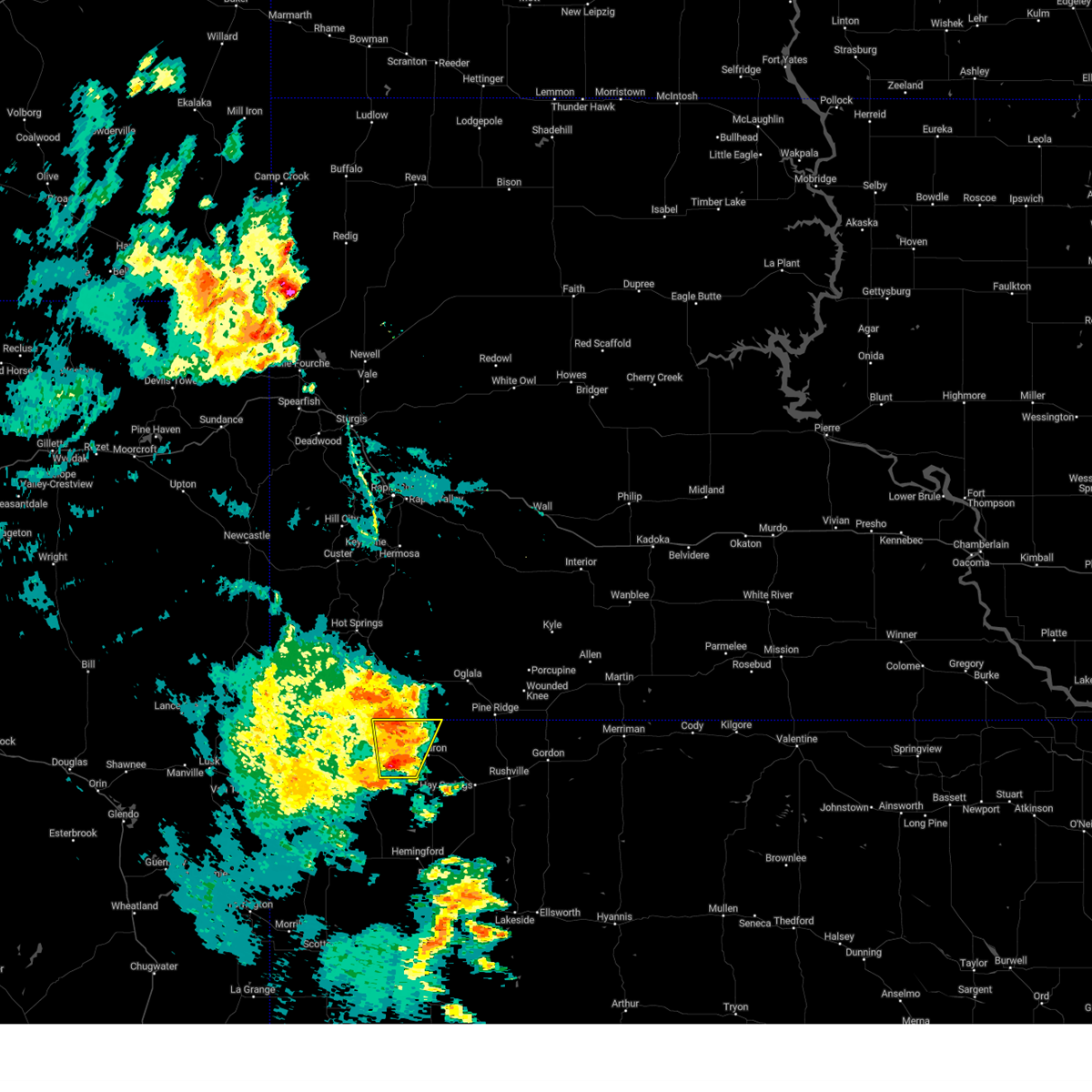
| 7/1/2025 7:18 PM MDT |
 the severe thunderstorm warning has been cancelled and is no longer in effect the severe thunderstorm warning has been cancelled and is no longer in effect
|
| 7/1/2025 7:09 PM MDT |
 At 709 pm mdt, a severe thunderstorm was located 9 miles south of slim butte, or 10 miles northeast of chadron, moving southeast at 20 mph (radar indicated). Hazards include ping pong ball size hail and 60 mph wind gusts. People and animals outdoors will be injured. expect hail damage to roofs, siding, windows, and vehicles. expect wind damage to roofs, siding, and trees. Locations impacted include, chadron and dawes county fairgrounds. At 709 pm mdt, a severe thunderstorm was located 9 miles south of slim butte, or 10 miles northeast of chadron, moving southeast at 20 mph (radar indicated). Hazards include ping pong ball size hail and 60 mph wind gusts. People and animals outdoors will be injured. expect hail damage to roofs, siding, windows, and vehicles. expect wind damage to roofs, siding, and trees. Locations impacted include, chadron and dawes county fairgrounds.
|
| 7/1/2025 6:58 PM MDT |
 At 657 pm mdt, a severe thunderstorm was located near slim butte, or 13 miles north of chadron, moving southeast at 20 mph (mesonet station in south dakota near the nebraska border reported a 77 mph wind gust with this storm). Hazards include golf ball size hail and 70 mph wind gusts. People and animals outdoors will be injured. expect hail damage to roofs, siding, windows, and vehicles. expect considerable tree damage. wind damage is also likely to mobile homes, roofs, and outbuildings. Locations impacted include, chadron and dawes county fairgrounds. At 657 pm mdt, a severe thunderstorm was located near slim butte, or 13 miles north of chadron, moving southeast at 20 mph (mesonet station in south dakota near the nebraska border reported a 77 mph wind gust with this storm). Hazards include golf ball size hail and 70 mph wind gusts. People and animals outdoors will be injured. expect hail damage to roofs, siding, windows, and vehicles. expect considerable tree damage. wind damage is also likely to mobile homes, roofs, and outbuildings. Locations impacted include, chadron and dawes county fairgrounds.
|
| 7/1/2025 6:46 PM MDT |
 Svrcys the national weather service in cheyenne has issued a * severe thunderstorm warning for, northeastern dawes county in the panhandle of nebraska, * until 730 pm mdt. * at 645 pm mdt, a severe thunderstorm was located near slim butte, or 17 miles north of chadron, moving southeast at 20 mph (radar indicated). Hazards include golf ball size hail and 60 mph wind gusts. People and animals outdoors will be injured. expect hail damage to roofs, siding, windows, and vehicles. Expect wind damage to roofs, siding, and trees. Svrcys the national weather service in cheyenne has issued a * severe thunderstorm warning for, northeastern dawes county in the panhandle of nebraska, * until 730 pm mdt. * at 645 pm mdt, a severe thunderstorm was located near slim butte, or 17 miles north of chadron, moving southeast at 20 mph (radar indicated). Hazards include golf ball size hail and 60 mph wind gusts. People and animals outdoors will be injured. expect hail damage to roofs, siding, windows, and vehicles. Expect wind damage to roofs, siding, and trees.
|
| 6/29/2025 7:12 PM MDT | Storm damage reported in dawes county NE, 12 miles N of Chadron, NE |
| 6/29/2025 7:05 PM MDT |
 The storm which prompted the warning has moved out of the area. therefore, the warning will be allowed to expire. a severe thunderstorm watch remains in effect until 900 pm mdt for the panhandle of nebraska. The storm which prompted the warning has moved out of the area. therefore, the warning will be allowed to expire. a severe thunderstorm watch remains in effect until 900 pm mdt for the panhandle of nebraska.
|
| 6/29/2025 6:58 PM MDT |
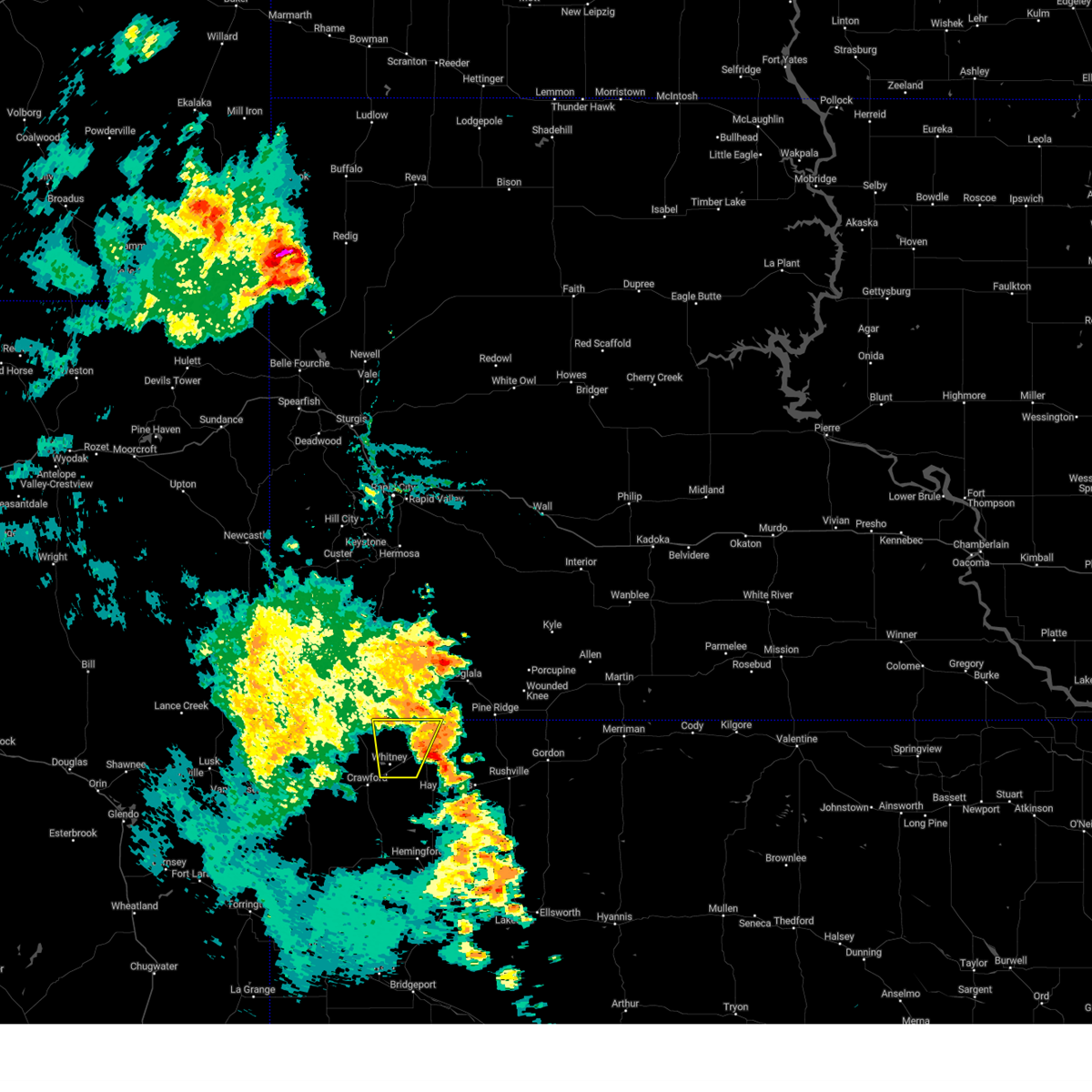
 At 658 pm mdt, a severe thunderstorm was located over chadron state park, or near chadron, moving southeast at 30 mph (trained weather spotters). Hazards include ping pong ball size hail and 60 mph wind gusts. People and animals outdoors will be injured. expect hail damage to roofs, siding, windows, and vehicles. expect wind damage to roofs, siding, and trees. Locations impacted include, chadron, whitney, chadron municipal airport, roberts trailhead campground, chadron state park, red cloud campground, dawes county fairgrounds, and chadron state park campground. At 658 pm mdt, a severe thunderstorm was located over chadron state park, or near chadron, moving southeast at 30 mph (trained weather spotters). Hazards include ping pong ball size hail and 60 mph wind gusts. People and animals outdoors will be injured. expect hail damage to roofs, siding, windows, and vehicles. expect wind damage to roofs, siding, and trees. Locations impacted include, chadron, whitney, chadron municipal airport, roberts trailhead campground, chadron state park, red cloud campground, dawes county fairgrounds, and chadron state park campground.
|
| 6/29/2025 6:50 PM MDT | Asos station kcdr chadron airport - cd in dawes county NE, 4.8 miles E of Chadron, NE |
| 6/29/2025 6:49 PM MDT |
 At 649 pm mdt, a severe thunderstorm was located near chadron, moving southeast at 40 mph (radar indicated). Hazards include golf ball size hail and 60 mph wind gusts. People and animals outdoors will be injured. expect hail damage to roofs, siding, windows, and vehicles. expect wind damage to roofs, siding, and trees. Locations impacted include, chadron, whitney, chadron municipal airport, roberts trailhead campground, chadron state park, red cloud campground, dawes county fairgrounds, and chadron state park campground. At 649 pm mdt, a severe thunderstorm was located near chadron, moving southeast at 40 mph (radar indicated). Hazards include golf ball size hail and 60 mph wind gusts. People and animals outdoors will be injured. expect hail damage to roofs, siding, windows, and vehicles. expect wind damage to roofs, siding, and trees. Locations impacted include, chadron, whitney, chadron municipal airport, roberts trailhead campground, chadron state park, red cloud campground, dawes county fairgrounds, and chadron state park campground.
|
| 6/29/2025 6:44 PM MDT | Ping Pong Ball sized hail reported 4.8 miles E of Chadron, NE |
| 6/29/2025 6:37 PM MDT |
 The storm which prompted the warning has moved out of the area. therefore, the warning will be allowed to expire. a severe thunderstorm watch remains in effect until 900 pm mdt for the panhandle of nebraska. a severe thunderstorm warning still remains in effect for dawes county until 7:15 pm. The storm which prompted the warning has moved out of the area. therefore, the warning will be allowed to expire. a severe thunderstorm watch remains in effect until 900 pm mdt for the panhandle of nebraska. a severe thunderstorm warning still remains in effect for dawes county until 7:15 pm.
|
| 6/29/2025 6:36 PM MDT |
 Svrcys the national weather service in cheyenne has issued a * severe thunderstorm warning for, central dawes county in the panhandle of nebraska, * until 715 pm mdt. * at 635 pm mdt, a severe thunderstorm was located near chadron municipal airport, or 11 miles west of chadron, moving southeast at 30 mph (radar indicated). Hazards include two inch hail and 60 mph wind gusts. People and animals outdoors will be injured. expect hail damage to roofs, siding, windows, and vehicles. Expect wind damage to roofs, siding, and trees. Svrcys the national weather service in cheyenne has issued a * severe thunderstorm warning for, central dawes county in the panhandle of nebraska, * until 715 pm mdt. * at 635 pm mdt, a severe thunderstorm was located near chadron municipal airport, or 11 miles west of chadron, moving southeast at 30 mph (radar indicated). Hazards include two inch hail and 60 mph wind gusts. People and animals outdoors will be injured. expect hail damage to roofs, siding, windows, and vehicles. Expect wind damage to roofs, siding, and trees.
|
| 6/29/2025 6:31 PM MDT |
 At 630 pm mdt, a severe thunderstorm was located 9 miles northwest of chadron municipal airport, or 13 miles northwest of chadron, moving southeast at 35 mph (radar indicated). Hazards include golf ball size hail and 60 mph wind gusts. People and animals outdoors will be injured. expect hail damage to roofs, siding, windows, and vehicles. expect wind damage to roofs, siding, and trees. Locations impacted include, chadron, whitney, whitney lake, chadron municipal airport, and dawes county fairgrounds. At 630 pm mdt, a severe thunderstorm was located 9 miles northwest of chadron municipal airport, or 13 miles northwest of chadron, moving southeast at 35 mph (radar indicated). Hazards include golf ball size hail and 60 mph wind gusts. People and animals outdoors will be injured. expect hail damage to roofs, siding, windows, and vehicles. expect wind damage to roofs, siding, and trees. Locations impacted include, chadron, whitney, whitney lake, chadron municipal airport, and dawes county fairgrounds.
|
| 6/29/2025 6:24 PM MDT | At 623 pm mdt, a severe thunderstorm was located 12 miles north of whitney lake, or 19 miles northwest of chadron, moving southeast at 30 mph (radar indicated). Hazards include 60 mph wind gusts and half dollar size hail. Hail damage to vehicles is expected. expect wind damage to roofs, siding, and trees. Locations impacted include, chadron, whitney, whitney lake, chadron municipal airport, and dawes county fairgrounds. |
| 6/29/2025 6:24 PM MDT | the severe thunderstorm warning has been cancelled and is no longer in effect |
| 6/29/2025 6:05 PM MDT |
 Svrcys the national weather service in cheyenne has issued a * severe thunderstorm warning for, northern dawes county in the panhandle of nebraska, northern sioux county in the panhandle of nebraska, * until 645 pm mdt. * at 605 pm mdt, a severe thunderstorm was located 10 miles east of ardmore, or 24 miles southeast of edgemont, moving southeast at 30 mph (radar indicated). Hazards include 60 mph wind gusts and quarter size hail. Hail damage to vehicles is expected. Expect wind damage to roofs, siding, and trees. Svrcys the national weather service in cheyenne has issued a * severe thunderstorm warning for, northern dawes county in the panhandle of nebraska, northern sioux county in the panhandle of nebraska, * until 645 pm mdt. * at 605 pm mdt, a severe thunderstorm was located 10 miles east of ardmore, or 24 miles southeast of edgemont, moving southeast at 30 mph (radar indicated). Hazards include 60 mph wind gusts and quarter size hail. Hail damage to vehicles is expected. Expect wind damage to roofs, siding, and trees.
|
| 6/14/2025 10:40 PM MDT |
 The storm which prompted the warning has moved out of the area. therefore, the warning will be allowed to expire. The storm which prompted the warning has moved out of the area. therefore, the warning will be allowed to expire.
|
| 6/14/2025 10:26 PM MDT |
 At 1025 pm mdt, a severe thunderstorm was located 9 miles north of chadron municipal airport, or 12 miles northwest of chadron, moving east at 30 mph (radar indicated). Hazards include 60 mph wind gusts and quarter size hail. Hail damage to vehicles is expected. expect wind damage to roofs, siding, and trees. Locations impacted include, chadron, chadron municipal airport, and dawes county fairgrounds. At 1025 pm mdt, a severe thunderstorm was located 9 miles north of chadron municipal airport, or 12 miles northwest of chadron, moving east at 30 mph (radar indicated). Hazards include 60 mph wind gusts and quarter size hail. Hail damage to vehicles is expected. expect wind damage to roofs, siding, and trees. Locations impacted include, chadron, chadron municipal airport, and dawes county fairgrounds.
|
| 6/14/2025 10:11 PM MDT |
 Svrcys the national weather service in cheyenne has issued a * severe thunderstorm warning for, northern dawes county in the panhandle of nebraska, * until 1045 pm mdt. * at 1010 pm mdt, a severe thunderstorm was located 10 miles north of whitney lake, or 16 miles northwest of chadron, moving east at 30 mph (radar indicated). Hazards include 60 mph wind gusts and quarter size hail. Hail damage to vehicles is expected. Expect wind damage to roofs, siding, and trees. Svrcys the national weather service in cheyenne has issued a * severe thunderstorm warning for, northern dawes county in the panhandle of nebraska, * until 1045 pm mdt. * at 1010 pm mdt, a severe thunderstorm was located 10 miles north of whitney lake, or 16 miles northwest of chadron, moving east at 30 mph (radar indicated). Hazards include 60 mph wind gusts and quarter size hail. Hail damage to vehicles is expected. Expect wind damage to roofs, siding, and trees.
|
| 6/13/2025 7:47 PM MDT |
 the severe thunderstorm warning has been cancelled and is no longer in effect the severe thunderstorm warning has been cancelled and is no longer in effect
|
| 6/13/2025 7:24 PM MDT |
 Svrcys the national weather service in cheyenne has issued a * severe thunderstorm warning for, northeastern dawes county in the panhandle of nebraska, * until 800 pm mdt. * at 724 pm mdt, a severe thunderstorm was located near chadron, moving east at 20 mph (radar indicated). Hazards include 60 mph wind gusts and quarter size hail. Hail damage to vehicles is expected. Expect wind damage to roofs, siding, and trees. Svrcys the national weather service in cheyenne has issued a * severe thunderstorm warning for, northeastern dawes county in the panhandle of nebraska, * until 800 pm mdt. * at 724 pm mdt, a severe thunderstorm was located near chadron, moving east at 20 mph (radar indicated). Hazards include 60 mph wind gusts and quarter size hail. Hail damage to vehicles is expected. Expect wind damage to roofs, siding, and trees.
|
| 6/13/2025 7:17 PM MDT |
 The storms which prompted the warning have moved out of the area. therefore, the warning has been allowed to expire. however, gusty winds and heavy rain are still possible with these thunderstorms. a severe thunderstorm watch remains in effect until 1000 pm mdt for the panhandle of nebraska. The storms which prompted the warning have moved out of the area. therefore, the warning has been allowed to expire. however, gusty winds and heavy rain are still possible with these thunderstorms. a severe thunderstorm watch remains in effect until 1000 pm mdt for the panhandle of nebraska.
|
| 6/13/2025 7:02 PM MDT | Quarter sized hail reported 6.8 miles ENE of Chadron, NE, trained spotter reported quarter sized hail ongoing. |
| 6/13/2025 6:52 PM MDT |
 At 651 pm mdt, severe thunderstorms were located along a line extending from 9 miles northeast of ardmore to box butte reservoir, moving east at 20 mph (radar indicated). Hazards include 60 mph wind gusts and quarter size hail. Hail damage to vehicles is expected. expect wind damage to roofs, siding, and trees. Locations impacted include, chadron, whitney, chadron municipal airport, roberts trailhead campground, chadron state park, box butte campground, whitney lake, red cloud campground, box butte reservoir, dawes county fairgrounds, chadron state park campground, and box butte dam. At 651 pm mdt, severe thunderstorms were located along a line extending from 9 miles northeast of ardmore to box butte reservoir, moving east at 20 mph (radar indicated). Hazards include 60 mph wind gusts and quarter size hail. Hail damage to vehicles is expected. expect wind damage to roofs, siding, and trees. Locations impacted include, chadron, whitney, chadron municipal airport, roberts trailhead campground, chadron state park, box butte campground, whitney lake, red cloud campground, box butte reservoir, dawes county fairgrounds, chadron state park campground, and box butte dam.
|
| 6/13/2025 6:12 PM MDT |
 Svrcys the national weather service in cheyenne has issued a * severe thunderstorm warning for, northern box butte county in the panhandle of nebraska, dawes county in the panhandle of nebraska, northeastern sioux county in the panhandle of nebraska, * until 715 pm mdt. * at 612 pm mdt, severe thunderstorms were located along a line extending from near ardmore to 8 miles east of flahertys corner, moving northeast at 20 mph (radar indicated). Hazards include 60 mph wind gusts and quarter size hail. Hail damage to vehicles is expected. Expect wind damage to roofs, siding, and trees. Svrcys the national weather service in cheyenne has issued a * severe thunderstorm warning for, northern box butte county in the panhandle of nebraska, dawes county in the panhandle of nebraska, northeastern sioux county in the panhandle of nebraska, * until 715 pm mdt. * at 612 pm mdt, severe thunderstorms were located along a line extending from near ardmore to 8 miles east of flahertys corner, moving northeast at 20 mph (radar indicated). Hazards include 60 mph wind gusts and quarter size hail. Hail damage to vehicles is expected. Expect wind damage to roofs, siding, and trees.
|
| 4/27/2025 8:57 PM MDT | Kcdr reported a wind gust of 58mph at 8:57p in dawes county NE, 0.5 miles SSW of Chadron, NE |
| 4/27/2025 8:55 PM MDT |
 The storm which prompted the warning has weakened below severe limits, and has exited the warned area. therefore, the warning will be allowed to expire. however, heavy rain is still possible with this thunderstorm. a tornado watch remains in effect until 1100 pm mdt for the panhandle of nebraska. The storm which prompted the warning has weakened below severe limits, and has exited the warned area. therefore, the warning will be allowed to expire. however, heavy rain is still possible with this thunderstorm. a tornado watch remains in effect until 1100 pm mdt for the panhandle of nebraska.
|
| 4/27/2025 8:33 PM MDT |
 Svrcys the national weather service in cheyenne has issued a * severe thunderstorm warning for, north central dawes county in the panhandle of nebraska, * until 900 pm mdt. * at 833 pm mdt, a severe thunderstorm was located near chadron municipal airport, or 8 miles west of chadron, moving northeast at 40 mph (radar indicated). Hazards include 60 mph wind gusts and quarter size hail. Hail damage to vehicles is expected. Expect wind damage to roofs, siding, and trees. Svrcys the national weather service in cheyenne has issued a * severe thunderstorm warning for, north central dawes county in the panhandle of nebraska, * until 900 pm mdt. * at 833 pm mdt, a severe thunderstorm was located near chadron municipal airport, or 8 miles west of chadron, moving northeast at 40 mph (radar indicated). Hazards include 60 mph wind gusts and quarter size hail. Hail damage to vehicles is expected. Expect wind damage to roofs, siding, and trees.
|
| 9/17/2024 6:52 PM MDT |
 The storm which prompted the warning has weakened below severe limits, and has exited the warned area. therefore, the warning will be allowed to expire. however, gusty winds and heavy rain are still possible with this thunderstorm. a severe thunderstorm watch remains in effect until 900 pm mdt for the panhandle of nebraska. The storm which prompted the warning has weakened below severe limits, and has exited the warned area. therefore, the warning will be allowed to expire. however, gusty winds and heavy rain are still possible with this thunderstorm. a severe thunderstorm watch remains in effect until 900 pm mdt for the panhandle of nebraska.
|
| 9/17/2024 6:32 PM MDT | Kcdr asos reports 59mph wind gus in dawes county NE, 0.5 miles SSW of Chadron, NE |
| 9/17/2024 6:31 PM MDT |
 Svrcys the national weather service in cheyenne has issued a * severe thunderstorm warning for, northwestern dawes county in the panhandle of nebraska, * until 700 pm mdt. * at 630 pm mdt, a severe thunderstorm was located near whitney, or 10 miles west of chadron, moving north at 55 mph (radar indicated). Hazards include 60 mph wind gusts and penny size hail. expect damage to roofs, siding, and trees Svrcys the national weather service in cheyenne has issued a * severe thunderstorm warning for, northwestern dawes county in the panhandle of nebraska, * until 700 pm mdt. * at 630 pm mdt, a severe thunderstorm was located near whitney, or 10 miles west of chadron, moving north at 55 mph (radar indicated). Hazards include 60 mph wind gusts and penny size hail. expect damage to roofs, siding, and trees
|
| 8/26/2024 7:20 PM MDT |
 The storm which prompted the warning has weakened below severe limits, and has exited the warned area. therefore, the warning will be allowed to expire. a severe thunderstorm watch remains in effect until 1000 pm mdt for the panhandle of nebraska. The storm which prompted the warning has weakened below severe limits, and has exited the warned area. therefore, the warning will be allowed to expire. a severe thunderstorm watch remains in effect until 1000 pm mdt for the panhandle of nebraska.
|
| 8/26/2024 7:10 PM MDT |
 At 710 pm mdt, a severe thunderstorm was located 8 miles southeast of chadron, moving northeast at 45 mph (radar indicated). Hazards include 60 mph wind gusts and quarter size hail. Hail damage to vehicles is expected. expect wind damage to roofs, siding, and trees. Locations impacted include, chadron, red cloud campground, chadron state park, dawes county fairgrounds, and chadron state park campground. At 710 pm mdt, a severe thunderstorm was located 8 miles southeast of chadron, moving northeast at 45 mph (radar indicated). Hazards include 60 mph wind gusts and quarter size hail. Hail damage to vehicles is expected. expect wind damage to roofs, siding, and trees. Locations impacted include, chadron, red cloud campground, chadron state park, dawes county fairgrounds, and chadron state park campground.
|
| 8/26/2024 6:52 PM MDT |
 Svrcys the national weather service in cheyenne has issued a * severe thunderstorm warning for, eastern dawes county in the panhandle of nebraska, * until 730 pm mdt. * at 651 pm mdt, a severe thunderstorm was located near roberts trailhead campground, or 14 miles south of chadron, moving northeast at 45 mph (radar indicated). Hazards include 60 mph wind gusts and quarter size hail. Hail damage to vehicles is expected. Expect wind damage to roofs, siding, and trees. Svrcys the national weather service in cheyenne has issued a * severe thunderstorm warning for, eastern dawes county in the panhandle of nebraska, * until 730 pm mdt. * at 651 pm mdt, a severe thunderstorm was located near roberts trailhead campground, or 14 miles south of chadron, moving northeast at 45 mph (radar indicated). Hazards include 60 mph wind gusts and quarter size hail. Hail damage to vehicles is expected. Expect wind damage to roofs, siding, and trees.
|
| 7/27/2024 8:11 PM MDT |
 The storms which prompted the warning have weakened below severe limits, and have exited the warned area. therefore, the warning will be allowed to expire. however, gusty winds and heavy rain are still possible with these thunderstorms. The storms which prompted the warning have weakened below severe limits, and have exited the warned area. therefore, the warning will be allowed to expire. however, gusty winds and heavy rain are still possible with these thunderstorms.
|
| 7/27/2024 7:30 PM MDT |
 Svrcys the national weather service in cheyenne has issued a * severe thunderstorm warning for, central box butte county in the panhandle of nebraska, dawes county in the panhandle of nebraska, * until 815 pm mdt. * at 729 pm mdt, severe thunderstorms were located along a line extending from 13 miles south of oelrichs to 12 miles northeast of berea, moving east at 45 mph (radar indicated). Hazards include 70 mph wind gusts. Expect considerable tree damage. Damage is likely to mobile homes, roofs, and outbuildings. Svrcys the national weather service in cheyenne has issued a * severe thunderstorm warning for, central box butte county in the panhandle of nebraska, dawes county in the panhandle of nebraska, * until 815 pm mdt. * at 729 pm mdt, severe thunderstorms were located along a line extending from 13 miles south of oelrichs to 12 miles northeast of berea, moving east at 45 mph (radar indicated). Hazards include 70 mph wind gusts. Expect considerable tree damage. Damage is likely to mobile homes, roofs, and outbuildings.
|
| 7/27/2024 7:21 PM MDT | Chadron asos (kcdr). thunderstorm wind gust 67 mph at 715 p in dawes county NE, 5 miles ESE of Chadron, NE |
| 7/19/2024 4:54 PM MDT |
 the severe thunderstorm warning has been cancelled and is no longer in effect the severe thunderstorm warning has been cancelled and is no longer in effect
|
| 7/19/2024 4:29 PM MDT |
 Svrcys the national weather service in cheyenne has issued a * severe thunderstorm warning for, northeastern dawes county in the panhandle of nebraska, * until 515 pm mdt. * at 429 pm mdt, a severe thunderstorm was located 7 miles southwest of slim butte, or 12 miles north of chadron, moving south at 25 mph (radar indicated). Hazards include 60 mph wind gusts and quarter size hail. Hail damage to vehicles is expected. Expect wind damage to roofs, siding, and trees. Svrcys the national weather service in cheyenne has issued a * severe thunderstorm warning for, northeastern dawes county in the panhandle of nebraska, * until 515 pm mdt. * at 429 pm mdt, a severe thunderstorm was located 7 miles southwest of slim butte, or 12 miles north of chadron, moving south at 25 mph (radar indicated). Hazards include 60 mph wind gusts and quarter size hail. Hail damage to vehicles is expected. Expect wind damage to roofs, siding, and trees.
|
| 7/17/2024 4:22 PM MDT | Mesonet station hrsn1 7 s chadron - kings canyon raws - hr in dawes county NE, 7.4 miles NNW of Chadron, NE |
| 7/12/2024 11:12 PM MDT |
 Svrcys the national weather service in cheyenne has issued a * severe thunderstorm warning for, north central box butte county in the panhandle of nebraska, dawes county in the panhandle of nebraska, northeastern sioux county in the panhandle of nebraska, * until 1230 am mdt. * at 1111 pm mdt, a severe thunderstorm was located 11 miles northwest of crawford, or 26 miles west of chadron, moving east at 35 mph (radar indicated). Hazards include golf ball size hail and 60 mph wind gusts. People and animals outdoors will be injured. expect hail damage to roofs, siding, windows, and vehicles. Expect wind damage to roofs, siding, and trees. Svrcys the national weather service in cheyenne has issued a * severe thunderstorm warning for, north central box butte county in the panhandle of nebraska, dawes county in the panhandle of nebraska, northeastern sioux county in the panhandle of nebraska, * until 1230 am mdt. * at 1111 pm mdt, a severe thunderstorm was located 11 miles northwest of crawford, or 26 miles west of chadron, moving east at 35 mph (radar indicated). Hazards include golf ball size hail and 60 mph wind gusts. People and animals outdoors will be injured. expect hail damage to roofs, siding, windows, and vehicles. Expect wind damage to roofs, siding, and trees.
|
| 7/3/2024 8:34 PM MDT |
 At 834 pm mdt, a severe thunderstorm was located near chadron, moving east at 40 mph (radar indicated). Hazards include ping pong ball size hail and 60 mph wind gusts. People and animals outdoors will be injured. expect hail damage to roofs, siding, windows, and vehicles. expect wind damage to roofs, siding, and trees. Locations impacted include, chadron, red cloud campground, chadron state park, chadron municipal airport, dawes county fairgrounds, and chadron state park campground. At 834 pm mdt, a severe thunderstorm was located near chadron, moving east at 40 mph (radar indicated). Hazards include ping pong ball size hail and 60 mph wind gusts. People and animals outdoors will be injured. expect hail damage to roofs, siding, windows, and vehicles. expect wind damage to roofs, siding, and trees. Locations impacted include, chadron, red cloud campground, chadron state park, chadron municipal airport, dawes county fairgrounds, and chadron state park campground.
|
| 7/3/2024 8:17 PM MDT | Storm damage reported in dawes county NE, 9 miles NE of Chadron, NE |
| 7/3/2024 8:16 PM MDT |
 At 816 pm mdt, a severe thunderstorm was located near chadron municipal airport, or near chadron, moving east at 40 mph (radar indicated). Hazards include ping pong ball size hail and 60 mph wind gusts. People and animals outdoors will be injured. expect hail damage to roofs, siding, windows, and vehicles. expect wind damage to roofs, siding, and trees. Locations impacted include, chadron, whitney, chadron municipal airport, roberts trailhead campground, chadron state park, red cloud campground, whitney lake, dawes county fairgrounds, and chadron state park campground. At 816 pm mdt, a severe thunderstorm was located near chadron municipal airport, or near chadron, moving east at 40 mph (radar indicated). Hazards include ping pong ball size hail and 60 mph wind gusts. People and animals outdoors will be injured. expect hail damage to roofs, siding, windows, and vehicles. expect wind damage to roofs, siding, and trees. Locations impacted include, chadron, whitney, chadron municipal airport, roberts trailhead campground, chadron state park, red cloud campground, whitney lake, dawes county fairgrounds, and chadron state park campground.
|
| 7/3/2024 8:00 PM MDT |
 At 759 pm mdt, a severe thunderstorm was located 9 miles north of whitney lake, or 17 miles northwest of chadron, moving east at 40 mph (radar indicated). Hazards include 60 mph wind gusts and quarter size hail. Hail damage to vehicles is expected. expect wind damage to roofs, siding, and trees. Locations impacted include, chadron, whitney, chadron municipal airport, roberts trailhead campground, chadron state park, whitney lake, red cloud campground, dawes county fairgrounds, and chadron state park campground. At 759 pm mdt, a severe thunderstorm was located 9 miles north of whitney lake, or 17 miles northwest of chadron, moving east at 40 mph (radar indicated). Hazards include 60 mph wind gusts and quarter size hail. Hail damage to vehicles is expected. expect wind damage to roofs, siding, and trees. Locations impacted include, chadron, whitney, chadron municipal airport, roberts trailhead campground, chadron state park, whitney lake, red cloud campground, dawes county fairgrounds, and chadron state park campground.
|
| 7/3/2024 8:00 PM MDT |
 the severe thunderstorm warning has been cancelled and is no longer in effect the severe thunderstorm warning has been cancelled and is no longer in effect
|
| 7/3/2024 7:47 PM MDT |
 Svrcys the national weather service in cheyenne has issued a * severe thunderstorm warning for, dawes county in the panhandle of nebraska, northeastern sioux county in the panhandle of nebraska, * until 845 pm mdt. * at 747 pm mdt, a severe thunderstorm was located 10 miles southeast of ardmore, or 25 miles west of chadron, moving east at 40 mph (radar indicated). Hazards include 60 mph wind gusts and quarter size hail. Hail damage to vehicles is expected. Expect wind damage to roofs, siding, and trees. Svrcys the national weather service in cheyenne has issued a * severe thunderstorm warning for, dawes county in the panhandle of nebraska, northeastern sioux county in the panhandle of nebraska, * until 845 pm mdt. * at 747 pm mdt, a severe thunderstorm was located 10 miles southeast of ardmore, or 25 miles west of chadron, moving east at 40 mph (radar indicated). Hazards include 60 mph wind gusts and quarter size hail. Hail damage to vehicles is expected. Expect wind damage to roofs, siding, and trees.
|
| 7/1/2024 3:10 PM MDT |
 The storms which prompted the warning have moved out of the area. therefore, the warning will be allowed to expire. a severe thunderstorm watch remains in effect until 800 pm mdt for the panhandle of nebraska. The storms which prompted the warning have moved out of the area. therefore, the warning will be allowed to expire. a severe thunderstorm watch remains in effect until 800 pm mdt for the panhandle of nebraska.
|
| 7/1/2024 2:53 PM MDT |
 At 253 pm mdt, severe thunderstorms were located along a line extending from 8 miles south of slim butte to near chadron to near red cloud campground, moving east at 40 mph (radar indicated. at 242 pm, a wind gust of 71 mph was reported at chadron airport). Hazards include 70 mph wind gusts and half dollar size hail. Hail damage to vehicles is expected. expect considerable tree damage. wind damage is also likely to mobile homes, roofs, and outbuildings. Locations impacted include, chadron, red cloud campground, chadron state park, dawes county fairgrounds, and chadron state park campground. At 253 pm mdt, severe thunderstorms were located along a line extending from 8 miles south of slim butte to near chadron to near red cloud campground, moving east at 40 mph (radar indicated. at 242 pm, a wind gust of 71 mph was reported at chadron airport). Hazards include 70 mph wind gusts and half dollar size hail. Hail damage to vehicles is expected. expect considerable tree damage. wind damage is also likely to mobile homes, roofs, and outbuildings. Locations impacted include, chadron, red cloud campground, chadron state park, dawes county fairgrounds, and chadron state park campground.
|
| 7/1/2024 2:47 PM MDT | Asos station kcdr chadron airport - cd in dawes county NE, 4.8 miles E of Chadron, NE |
| 7/1/2024 2:42 PM MDT |
 Svrcys the national weather service in cheyenne has issued a * severe thunderstorm warning for, northeastern dawes county in the panhandle of nebraska, * until 315 pm mdt. * at 242 pm mdt, severe thunderstorms were located along a line extending from 9 miles north of chadron municipal airport to chadron to near roberts trailhead campground, moving east at 40 mph (radar indicated). Hazards include 60 mph wind gusts and half dollar size hail. Hail damage to vehicles is expected. Expect wind damage to roofs, siding, and trees. Svrcys the national weather service in cheyenne has issued a * severe thunderstorm warning for, northeastern dawes county in the panhandle of nebraska, * until 315 pm mdt. * at 242 pm mdt, severe thunderstorms were located along a line extending from 9 miles north of chadron municipal airport to chadron to near roberts trailhead campground, moving east at 40 mph (radar indicated). Hazards include 60 mph wind gusts and half dollar size hail. Hail damage to vehicles is expected. Expect wind damage to roofs, siding, and trees.
|
| 6/10/2024 4:12 PM MDT |
 At 410 pm mdt, a severe thunderstorm was located over chadron municipal airport, or near chadron, moving east at 25 mph (chadron airport recently reported a wind gust to 61 mph). Hazards include 70 mph wind gusts and ping pong ball size hail. People and animals outdoors will be injured. expect hail damage to roofs, siding, windows, and vehicles. expect considerable tree damage. wind damage is also likely to mobile homes, roofs, and outbuildings. Locations impacted include, chadron, chadron municipal airport, and dawes county fairgrounds. At 410 pm mdt, a severe thunderstorm was located over chadron municipal airport, or near chadron, moving east at 25 mph (chadron airport recently reported a wind gust to 61 mph). Hazards include 70 mph wind gusts and ping pong ball size hail. People and animals outdoors will be injured. expect hail damage to roofs, siding, windows, and vehicles. expect considerable tree damage. wind damage is also likely to mobile homes, roofs, and outbuildings. Locations impacted include, chadron, chadron municipal airport, and dawes county fairgrounds.
|
| 6/10/2024 4:02 PM MDT | Wind gust measured at kcdr asos. spotters report a large number of tumbleweeds blowing in the are in dawes county NE, 5 miles ESE of Chadron, NE |
| 6/10/2024 3:52 PM MDT |
 the severe thunderstorm warning has been cancelled and is no longer in effect the severe thunderstorm warning has been cancelled and is no longer in effect
|
| 6/10/2024 3:52 PM MDT |
 At 351 pm mdt, a severe thunderstorm was located 7 miles north of whitney lake, or 14 miles west of chadron, moving east at 25 mph (radar indicated). Hazards include 70 mph wind gusts and ping pong ball size hail. People and animals outdoors will be injured. expect hail damage to roofs, siding, windows, and vehicles. expect considerable tree damage. wind damage is also likely to mobile homes, roofs, and outbuildings. Locations impacted include, chadron, whitney, whitney lake, chadron municipal airport, and dawes county fairgrounds. At 351 pm mdt, a severe thunderstorm was located 7 miles north of whitney lake, or 14 miles west of chadron, moving east at 25 mph (radar indicated). Hazards include 70 mph wind gusts and ping pong ball size hail. People and animals outdoors will be injured. expect hail damage to roofs, siding, windows, and vehicles. expect considerable tree damage. wind damage is also likely to mobile homes, roofs, and outbuildings. Locations impacted include, chadron, whitney, whitney lake, chadron municipal airport, and dawes county fairgrounds.
|
| 6/10/2024 3:28 PM MDT |
 Svrcys the national weather service in cheyenne has issued a * severe thunderstorm warning for, northern dawes county in the panhandle of nebraska, northeastern sioux county in the panhandle of nebraska, * until 445 pm mdt. * at 327 pm mdt, a severe thunderstorm was located 12 miles northwest of whitney lake, or 24 miles west of chadron, moving east at 25 mph (radar indicated). Hazards include 70 mph wind gusts and ping pong ball size hail. People and animals outdoors will be injured. expect hail damage to roofs, siding, windows, and vehicles. expect considerable tree damage. Wind damage is also likely to mobile homes, roofs, and outbuildings. Svrcys the national weather service in cheyenne has issued a * severe thunderstorm warning for, northern dawes county in the panhandle of nebraska, northeastern sioux county in the panhandle of nebraska, * until 445 pm mdt. * at 327 pm mdt, a severe thunderstorm was located 12 miles northwest of whitney lake, or 24 miles west of chadron, moving east at 25 mph (radar indicated). Hazards include 70 mph wind gusts and ping pong ball size hail. People and animals outdoors will be injured. expect hail damage to roofs, siding, windows, and vehicles. expect considerable tree damage. Wind damage is also likely to mobile homes, roofs, and outbuildings.
|
| 6/1/2024 9:38 PM MDT |
 The storm which prompted the warning has moved out of the area. therefore, the warning will be allowed to expire. The storm which prompted the warning has moved out of the area. therefore, the warning will be allowed to expire.
|
| 6/1/2024 9:18 PM MDT |
 At 918 pm mdt, a severe thunderstorm was located near chadron, moving east at 25 mph (radar indicated). Hazards include 60 mph wind gusts and quarter size hail. Hail damage to vehicles is expected. expect wind damage to roofs, siding, and trees. This severe thunderstorm will remain over mainly rural areas of northeastern dawes county. At 918 pm mdt, a severe thunderstorm was located near chadron, moving east at 25 mph (radar indicated). Hazards include 60 mph wind gusts and quarter size hail. Hail damage to vehicles is expected. expect wind damage to roofs, siding, and trees. This severe thunderstorm will remain over mainly rural areas of northeastern dawes county.
|
| 6/1/2024 9:06 PM MDT |
 Svrcys the national weather service in cheyenne has issued a * severe thunderstorm warning for, northeastern dawes county in the panhandle of nebraska, * until 945 pm mdt. * at 906 pm mdt, a severe thunderstorm was located near chadron, moving east at 25 mph (radar indicated). Hazards include 60 mph wind gusts and quarter size hail. Hail damage to vehicles is expected. Expect wind damage to roofs, siding, and trees. Svrcys the national weather service in cheyenne has issued a * severe thunderstorm warning for, northeastern dawes county in the panhandle of nebraska, * until 945 pm mdt. * at 906 pm mdt, a severe thunderstorm was located near chadron, moving east at 25 mph (radar indicated). Hazards include 60 mph wind gusts and quarter size hail. Hail damage to vehicles is expected. Expect wind damage to roofs, siding, and trees.
|
| 5/17/2024 6:12 PM MDT |
 the severe thunderstorm warning has been cancelled and is no longer in effect the severe thunderstorm warning has been cancelled and is no longer in effect
|
| 5/17/2024 5:35 PM MDT |
 Svrcys the national weather service in cheyenne has issued a * severe thunderstorm warning for, dawes county in the panhandle of nebraska, northern sioux county in the panhandle of nebraska, * until 630 pm mdt. * at 535 pm mdt, severe thunderstorms were located along a line extending from 6 miles southeast of ardmore to prairie center, moving east at 45 mph (public. at 524pm, a gust of 77 mph was reported in northern sioux county). Hazards include 70 mph wind gusts. Expect considerable tree damage. Damage is likely to mobile homes, roofs, and outbuildings. Svrcys the national weather service in cheyenne has issued a * severe thunderstorm warning for, dawes county in the panhandle of nebraska, northern sioux county in the panhandle of nebraska, * until 630 pm mdt. * at 535 pm mdt, severe thunderstorms were located along a line extending from 6 miles southeast of ardmore to prairie center, moving east at 45 mph (public. at 524pm, a gust of 77 mph was reported in northern sioux county). Hazards include 70 mph wind gusts. Expect considerable tree damage. Damage is likely to mobile homes, roofs, and outbuildings.
|
| 10/2/2023 6:33 PM MDT | Storm damage reported in sheridan county NE, 13.7 miles WSW of Chadron, NE |
| 10/2/2023 6:33 PM MDT | Quarter sized hail reported 14 miles WSW of Chadron, NE |
| 8/7/2023 6:59 PM MDT |
 At 659 pm mdt, a severe thunderstorm was located over red cloud campground, or 8 miles south of chadron, moving southeast at 20 mph (trained weather spotters). Hazards include tennis ball size hail and 60 mph wind gusts. People and animals outdoors will be injured. expect hail damage to roofs, siding, windows, and vehicles. expect wind damage to roofs, siding, and trees. locations impacted include, chadron, red cloud campground, chadron campground and chadron st park. thunderstorm damage threat, considerable hail threat, radar indicated max hail size, 2. 50 in wind threat, radar indicated max wind gust, 60 mph. At 659 pm mdt, a severe thunderstorm was located over red cloud campground, or 8 miles south of chadron, moving southeast at 20 mph (trained weather spotters). Hazards include tennis ball size hail and 60 mph wind gusts. People and animals outdoors will be injured. expect hail damage to roofs, siding, windows, and vehicles. expect wind damage to roofs, siding, and trees. locations impacted include, chadron, red cloud campground, chadron campground and chadron st park. thunderstorm damage threat, considerable hail threat, radar indicated max hail size, 2. 50 in wind threat, radar indicated max wind gust, 60 mph.
|
| 8/7/2023 6:42 PM MDT | Golf Ball sized hail reported 9 miles E of Chadron, NE, picture from social media showing golf ball size hail. |
| 8/7/2023 6:41 PM MDT |
 At 641 pm mdt, a severe thunderstorm was located over chadron airport, or near chadron, moving southeast at 15 mph (trained weather spotters. this storm has a history of golf ball to tennis ball sized hail!). Hazards include tennis ball size hail and 60 mph wind gusts. People and animals outdoors will be injured. expect hail damage to roofs, siding, windows, and vehicles. Expect wind damage to roofs, siding, and trees. At 641 pm mdt, a severe thunderstorm was located over chadron airport, or near chadron, moving southeast at 15 mph (trained weather spotters. this storm has a history of golf ball to tennis ball sized hail!). Hazards include tennis ball size hail and 60 mph wind gusts. People and animals outdoors will be injured. expect hail damage to roofs, siding, windows, and vehicles. Expect wind damage to roofs, siding, and trees.
|
| 8/7/2023 6:36 PM MDT |
 At 635 pm mdt, a severe thunderstorm was located over chadron airport, or near chadron, moving southeast at 15 mph (trained weather spotters. golf ball to hen egg size hail has been confirmed 1 mile west of the chadron airport with this storm!). Hazards include two inch hail and 70 mph wind gusts. People and animals outdoors will be injured. expect hail damage to roofs, siding, windows, and vehicles. expect considerable tree damage. wind damage is also likely to mobile homes, roofs, and outbuildings. locations impacted include, chadron and chadron airport. thunderstorm damage threat, considerable hail threat, radar indicated max hail size, 2. 00 in wind threat, radar indicated max wind gust, 70 mph. At 635 pm mdt, a severe thunderstorm was located over chadron airport, or near chadron, moving southeast at 15 mph (trained weather spotters. golf ball to hen egg size hail has been confirmed 1 mile west of the chadron airport with this storm!). Hazards include two inch hail and 70 mph wind gusts. People and animals outdoors will be injured. expect hail damage to roofs, siding, windows, and vehicles. expect considerable tree damage. wind damage is also likely to mobile homes, roofs, and outbuildings. locations impacted include, chadron and chadron airport. thunderstorm damage threat, considerable hail threat, radar indicated max hail size, 2. 00 in wind threat, radar indicated max wind gust, 70 mph.
|
| 8/7/2023 6:35 PM MDT | Golf Ball sized hail reported 6.4 miles E of Chadron, NE, trained spotter reports slightly larger than golf ball size hail. |
| 8/7/2023 6:20 PM MDT |
 At 620 pm mdt, a severe thunderstorm was located over chadron airport, or near chadron, moving southeast at 20 mph (radar indicated). Hazards include golf ball size hail and 70 mph wind gusts. People and animals outdoors will be injured. expect hail damage to roofs, siding, windows, and vehicles. expect considerable tree damage. wind damage is also likely to mobile homes, roofs, and outbuildings. locations impacted include, chadron and chadron airport. thunderstorm damage threat, considerable hail threat, radar indicated max hail size, 1. 75 in wind threat, radar indicated max wind gust, 70 mph. At 620 pm mdt, a severe thunderstorm was located over chadron airport, or near chadron, moving southeast at 20 mph (radar indicated). Hazards include golf ball size hail and 70 mph wind gusts. People and animals outdoors will be injured. expect hail damage to roofs, siding, windows, and vehicles. expect considerable tree damage. wind damage is also likely to mobile homes, roofs, and outbuildings. locations impacted include, chadron and chadron airport. thunderstorm damage threat, considerable hail threat, radar indicated max hail size, 1. 75 in wind threat, radar indicated max wind gust, 70 mph.
|
| 8/7/2023 6:03 PM MDT |
 At 603 pm mdt, severe thunderstorms were located along a line extending from slim buttes housing to 6 miles northwest of chadron airport, moving southeast at 40 mph (radar indicated). Hazards include 70 mph wind gusts and quarter size hail. Hail damage to vehicles is expected. expect considerable tree damage. Wind damage is also likely to mobile homes, roofs, and outbuildings. At 603 pm mdt, severe thunderstorms were located along a line extending from slim buttes housing to 6 miles northwest of chadron airport, moving southeast at 40 mph (radar indicated). Hazards include 70 mph wind gusts and quarter size hail. Hail damage to vehicles is expected. expect considerable tree damage. Wind damage is also likely to mobile homes, roofs, and outbuildings.
|
| 8/3/2023 8:55 PM MDT |
 At 854 pm mdt, a severe thunderstorm was located near chadron, moving northeast at 15 mph (radar indicated). Hazards include ping pong ball size hail and 60 mph wind gusts. People and animals outdoors will be injured. expect hail damage to roofs, siding, windows, and vehicles. expect wind damage to roofs, siding, and trees. locations impacted include, chadron, chadron campground, whitney lake, red cloud campground, chadron airport, whitney and chadron st park. hail threat, radar indicated max hail size, 1. 50 in wind threat, radar indicated max wind gust, 60 mph. At 854 pm mdt, a severe thunderstorm was located near chadron, moving northeast at 15 mph (radar indicated). Hazards include ping pong ball size hail and 60 mph wind gusts. People and animals outdoors will be injured. expect hail damage to roofs, siding, windows, and vehicles. expect wind damage to roofs, siding, and trees. locations impacted include, chadron, chadron campground, whitney lake, red cloud campground, chadron airport, whitney and chadron st park. hail threat, radar indicated max hail size, 1. 50 in wind threat, radar indicated max wind gust, 60 mph.
|
| 8/3/2023 8:16 PM MDT |
 At 816 pm mdt, a severe thunderstorm was located over chadron airport, or near chadron, moving northeast at 15 mph (radar indicated). Hazards include two inch hail and 60 mph wind gusts. People and animals outdoors will be injured. expect hail damage to roofs, siding, windows, and vehicles. Expect wind damage to roofs, siding, and trees. At 816 pm mdt, a severe thunderstorm was located over chadron airport, or near chadron, moving northeast at 15 mph (radar indicated). Hazards include two inch hail and 60 mph wind gusts. People and animals outdoors will be injured. expect hail damage to roofs, siding, windows, and vehicles. Expect wind damage to roofs, siding, and trees.
|
| 8/3/2023 8:01 PM MDT |
 At 801 pm mdt, a severe thunderstorm was located 8 miles north of chadron airport, or 10 miles northwest of chadron, moving northeast at 20 mph (radar indicated). Hazards include two inch hail and 60 mph wind gusts. People and animals outdoors will be injured. expect hail damage to roofs, siding, windows, and vehicles. expect wind damage to roofs, siding, and trees. locations impacted include, chadron, whitney lake, chadron airport and whitney. thunderstorm damage threat, considerable hail threat, observed max hail size, 2. 00 in wind threat, radar indicated max wind gust, 60 mph. At 801 pm mdt, a severe thunderstorm was located 8 miles north of chadron airport, or 10 miles northwest of chadron, moving northeast at 20 mph (radar indicated). Hazards include two inch hail and 60 mph wind gusts. People and animals outdoors will be injured. expect hail damage to roofs, siding, windows, and vehicles. expect wind damage to roofs, siding, and trees. locations impacted include, chadron, whitney lake, chadron airport and whitney. thunderstorm damage threat, considerable hail threat, observed max hail size, 2. 00 in wind threat, radar indicated max wind gust, 60 mph.
|
| 8/3/2023 7:41 PM MDT |
 At 741 pm mdt, a severe thunderstorm was located near chadron airport, or 9 miles northwest of chadron, moving northeast at 20 mph (radar indicated). Hazards include tennis ball size hail and 60 mph wind gusts. People and animals outdoors will be injured. expect hail damage to roofs, siding, windows, and vehicles. expect wind damage to roofs, siding, and trees. locations impacted include, chadron, whitney lake, chadron airport and whitney. thunderstorm damage threat, considerable hail threat, observed max hail size, 2. 50 in wind threat, radar indicated max wind gust, 60 mph. At 741 pm mdt, a severe thunderstorm was located near chadron airport, or 9 miles northwest of chadron, moving northeast at 20 mph (radar indicated). Hazards include tennis ball size hail and 60 mph wind gusts. People and animals outdoors will be injured. expect hail damage to roofs, siding, windows, and vehicles. expect wind damage to roofs, siding, and trees. locations impacted include, chadron, whitney lake, chadron airport and whitney. thunderstorm damage threat, considerable hail threat, observed max hail size, 2. 50 in wind threat, radar indicated max wind gust, 60 mph.
|
| 8/3/2023 7:31 PM MDT |
 At 731 pm mdt, a severe thunderstorm was located near chadron airport, or 10 miles west of chadron, moving northeast at 20 mph (spotter reported quarter sized hail with this storm). Hazards include ping pong ball size hail and 60 mph wind gusts. People and animals outdoors will be injured. expect hail damage to roofs, siding, windows, and vehicles. Expect wind damage to roofs, siding, and trees. At 731 pm mdt, a severe thunderstorm was located near chadron airport, or 10 miles west of chadron, moving northeast at 20 mph (spotter reported quarter sized hail with this storm). Hazards include ping pong ball size hail and 60 mph wind gusts. People and animals outdoors will be injured. expect hail damage to roofs, siding, windows, and vehicles. Expect wind damage to roofs, siding, and trees.
|
| 7/24/2023 10:54 PM MDT |
 The severe thunderstorm warning for northern dawes and northeastern sioux counties will expire at 1100 pm mdt, the storm which prompted the warning has weakened below severe limits, and no longer poses an immediate threat to life or property. therefore, the warning will be allowed to expire. however small hail, gusty winds and heavy rain are still possible with this thunderstorm. The severe thunderstorm warning for northern dawes and northeastern sioux counties will expire at 1100 pm mdt, the storm which prompted the warning has weakened below severe limits, and no longer poses an immediate threat to life or property. therefore, the warning will be allowed to expire. however small hail, gusty winds and heavy rain are still possible with this thunderstorm.
|
| 7/24/2023 10:49 PM MDT |
 At 1048 pm mdt, a severe thunderstorm was located near chadron, moving east at 30 mph (radar indicated). Hazards include 60 mph wind gusts and half dollar size hail. Hail damage to vehicles is expected. expect wind damage to roofs, siding, and trees. locations impacted include, chadron, whitney lake, chadron airport and whitney. hail threat, radar indicated max hail size, 1. 25 in wind threat, radar indicated max wind gust, 60 mph. At 1048 pm mdt, a severe thunderstorm was located near chadron, moving east at 30 mph (radar indicated). Hazards include 60 mph wind gusts and half dollar size hail. Hail damage to vehicles is expected. expect wind damage to roofs, siding, and trees. locations impacted include, chadron, whitney lake, chadron airport and whitney. hail threat, radar indicated max hail size, 1. 25 in wind threat, radar indicated max wind gust, 60 mph.
|
| 7/24/2023 10:37 PM MDT |
 At 1036 pm mdt, another severe thunderstorm was developing near chadron airport, or near chadron, moving northeast at 25 mph (radar indicated). Hazards include 60 mph wind gusts and half dollar size hail. Hail damage to vehicles is expected. expect wind damage to roofs, siding, and trees. locations impacted include, chadron, whitney lake, chadron airport and whitney. hail threat, radar indicated max hail size, 1. 25 in wind threat, radar indicated max wind gust, 60 mph. At 1036 pm mdt, another severe thunderstorm was developing near chadron airport, or near chadron, moving northeast at 25 mph (radar indicated). Hazards include 60 mph wind gusts and half dollar size hail. Hail damage to vehicles is expected. expect wind damage to roofs, siding, and trees. locations impacted include, chadron, whitney lake, chadron airport and whitney. hail threat, radar indicated max hail size, 1. 25 in wind threat, radar indicated max wind gust, 60 mph.
|
| 7/24/2023 10:27 PM MDT |
 At 1027 pm mdt, a severe thunderstorm was located 7 miles north of whitney lake, or 13 miles west of chadron, moving east at 45 mph (radar indicated). Hazards include 60 mph wind gusts and half dollar size hail. Hail damage to vehicles is expected. expect wind damage to roofs, siding, and trees. locations impacted include, chadron, whitney lake, chadron airport and whitney. hail threat, radar indicated max hail size, 1. 25 in wind threat, radar indicated max wind gust, 60 mph. At 1027 pm mdt, a severe thunderstorm was located 7 miles north of whitney lake, or 13 miles west of chadron, moving east at 45 mph (radar indicated). Hazards include 60 mph wind gusts and half dollar size hail. Hail damage to vehicles is expected. expect wind damage to roofs, siding, and trees. locations impacted include, chadron, whitney lake, chadron airport and whitney. hail threat, radar indicated max hail size, 1. 25 in wind threat, radar indicated max wind gust, 60 mph.
|
| 7/24/2023 10:17 PM MDT |
 At 1017 pm mdt, a severe thunderstorm was located 9 miles northwest of whitney lake, or 22 miles west of chadron, moving east at 45 mph (radar indicated). Hazards include golf ball size hail and 60 mph wind gusts. People and animals outdoors will be injured. expect hail damage to roofs, siding, windows, and vehicles. expect wind damage to roofs, siding, and trees. locations impacted include, chadron, whitney lake, chadron airport and whitney. thunderstorm damage threat, considerable hail threat, radar indicated max hail size, 1. 75 in wind threat, radar indicated max wind gust, 60 mph. At 1017 pm mdt, a severe thunderstorm was located 9 miles northwest of whitney lake, or 22 miles west of chadron, moving east at 45 mph (radar indicated). Hazards include golf ball size hail and 60 mph wind gusts. People and animals outdoors will be injured. expect hail damage to roofs, siding, windows, and vehicles. expect wind damage to roofs, siding, and trees. locations impacted include, chadron, whitney lake, chadron airport and whitney. thunderstorm damage threat, considerable hail threat, radar indicated max hail size, 1. 75 in wind threat, radar indicated max wind gust, 60 mph.
|
| 7/24/2023 10:10 PM MDT |
 At 1010 pm mdt, a severe thunderstorm was located 10 miles northwest of whitney lake, or 24 miles west of chadron, moving east at 50 mph (radar indicated). Hazards include 60 mph wind gusts and half dollar size hail. Hail damage to vehicles is expected. Expect wind damage to roofs, siding, and trees. At 1010 pm mdt, a severe thunderstorm was located 10 miles northwest of whitney lake, or 24 miles west of chadron, moving east at 50 mph (radar indicated). Hazards include 60 mph wind gusts and half dollar size hail. Hail damage to vehicles is expected. Expect wind damage to roofs, siding, and trees.
|
| 7/17/2023 8:35 PM MDT |
 The severe thunderstorm warning for northeastern dawes county will expire at 845 pm mdt, the storm which prompted the warning has moved out of the area. therefore, the warning will be allowed to expire. a severe thunderstorm watch remains in effect until 100 am mdt for the panhandle of nebraska. The severe thunderstorm warning for northeastern dawes county will expire at 845 pm mdt, the storm which prompted the warning has moved out of the area. therefore, the warning will be allowed to expire. a severe thunderstorm watch remains in effect until 100 am mdt for the panhandle of nebraska.
|
| 7/17/2023 8:20 PM MDT |
 At 820 pm mdt, a severe thunderstorm was located over chadron campground, or near chadron, moving northeast at 35 mph (radar indicated). Hazards include 60 mph wind gusts and quarter size hail. Hail damage to vehicles is expected. Expect wind damage to roofs, siding, and trees. At 820 pm mdt, a severe thunderstorm was located over chadron campground, or near chadron, moving northeast at 35 mph (radar indicated). Hazards include 60 mph wind gusts and quarter size hail. Hail damage to vehicles is expected. Expect wind damage to roofs, siding, and trees.
|
| 7/16/2023 4:58 PM MDT | Quarter sized hail reported 3.9 miles WNW of Chadron, NE, hail lasted for 1 minute. |
| 7/16/2023 4:58 PM MDT |
 At 458 pm mdt, a severe thunderstorm was located 7 miles northwest of hay springs, moving southeast at 50 mph (trained weather spotters). Hazards include 60 mph wind gusts and half dollar size hail. Hail damage to vehicles is expected. expect wind damage to roofs, siding, and trees. locations impacted include, chadron. hail threat, radar indicated max hail size, 1. 25 in wind threat, radar indicated max wind gust, 60 mph. At 458 pm mdt, a severe thunderstorm was located 7 miles northwest of hay springs, moving southeast at 50 mph (trained weather spotters). Hazards include 60 mph wind gusts and half dollar size hail. Hail damage to vehicles is expected. expect wind damage to roofs, siding, and trees. locations impacted include, chadron. hail threat, radar indicated max hail size, 1. 25 in wind threat, radar indicated max wind gust, 60 mph.
|
| 7/16/2023 4:52 PM MDT |
 At 451 pm mdt, a severe thunderstorm was located near chadron, moving southeast at 50 mph (trained weather spotters). Hazards include 60 mph wind gusts and half dollar size hail. Hail damage to vehicles is expected. Expect wind damage to roofs, siding, and trees. At 451 pm mdt, a severe thunderstorm was located near chadron, moving southeast at 50 mph (trained weather spotters). Hazards include 60 mph wind gusts and half dollar size hail. Hail damage to vehicles is expected. Expect wind damage to roofs, siding, and trees.
|
| 7/16/2023 4:45 PM MDT | Quarter sized hail reported 5.4 miles SSE of Chadron, NE |
| 7/16/2023 4:36 PM MDT |
 At 435 pm mdt, a severe thunderstorm was located near chadron airport, or 8 miles northwest of chadron, moving southeast at 45 mph (radar indicated). Hazards include ping pong ball size hail and 60 mph wind gusts. People and animals outdoors will be injured. expect hail damage to roofs, siding, windows, and vehicles. expect wind damage to roofs, siding, and trees. locations impacted include, chadron, red cloud campground, chadron airport, chadron campground and chadron st park. hail threat, radar indicated max hail size, 1. 50 in wind threat, radar indicated max wind gust, 60 mph. At 435 pm mdt, a severe thunderstorm was located near chadron airport, or 8 miles northwest of chadron, moving southeast at 45 mph (radar indicated). Hazards include ping pong ball size hail and 60 mph wind gusts. People and animals outdoors will be injured. expect hail damage to roofs, siding, windows, and vehicles. expect wind damage to roofs, siding, and trees. locations impacted include, chadron, red cloud campground, chadron airport, chadron campground and chadron st park. hail threat, radar indicated max hail size, 1. 50 in wind threat, radar indicated max wind gust, 60 mph.
|
| 7/16/2023 4:21 PM MDT |
 At 420 pm mdt, a severe thunderstorm was located 11 miles south of oelrichs, or 16 miles northwest of chadron, moving southeast at 45 mph (radar indicated). Hazards include 60 mph wind gusts and quarter size hail. Hail damage to vehicles is expected. Expect wind damage to roofs, siding, and trees. At 420 pm mdt, a severe thunderstorm was located 11 miles south of oelrichs, or 16 miles northwest of chadron, moving southeast at 45 mph (radar indicated). Hazards include 60 mph wind gusts and quarter size hail. Hail damage to vehicles is expected. Expect wind damage to roofs, siding, and trees.
|
| 1/1/0001 12:00 AM | Quarter sized hail reported 0.5 miles SSE of Chadron, NE |
| 1/1/0001 12:00 AM | Ping Pong Ball sized hail reported 1.2 miles SSW of Chadron, NE, received photo on facebook of quarter to ping pong ball size hail on the north side of chadron. |
| 7/13/2023 4:38 PM MDT |
 At 438 pm mdt, a severe thunderstorm was located near chadron, moving east at 45 mph (radar indicated). Hazards include ping pong ball size hail and 60 mph wind gusts. People and animals outdoors will be injured. expect hail damage to roofs, siding, windows, and vehicles. expect wind damage to roofs, siding, and trees. locations impacted include, chadron and chadron airport. hail threat, radar indicated max hail size, 1. 50 in wind threat, radar indicated max wind gust, 60 mph. At 438 pm mdt, a severe thunderstorm was located near chadron, moving east at 45 mph (radar indicated). Hazards include ping pong ball size hail and 60 mph wind gusts. People and animals outdoors will be injured. expect hail damage to roofs, siding, windows, and vehicles. expect wind damage to roofs, siding, and trees. locations impacted include, chadron and chadron airport. hail threat, radar indicated max hail size, 1. 50 in wind threat, radar indicated max wind gust, 60 mph.
|
| 7/13/2023 4:29 PM MDT |
 At 429 pm mdt, a severe thunderstorm was located over chadron airport, or near chadron, moving east at 40 mph (radar indicated). Hazards include golf ball size hail and 60 mph wind gusts. People and animals outdoors will be injured. expect hail damage to roofs, siding, windows, and vehicles. Expect wind damage to roofs, siding, and trees. At 429 pm mdt, a severe thunderstorm was located over chadron airport, or near chadron, moving east at 40 mph (radar indicated). Hazards include golf ball size hail and 60 mph wind gusts. People and animals outdoors will be injured. expect hail damage to roofs, siding, windows, and vehicles. Expect wind damage to roofs, siding, and trees.
|
| 7/3/2023 10:15 PM MDT |
 At 1015 pm mdt, severe thunderstorms were located along a line extending from near slim butte to 10 miles south of hay springs to near alliance airport, moving northeast at 40 mph (radar indicated). Hazards include 60 mph wind gusts. Expect damage to roofs, siding, and trees. locations impacted include, alliance, chadron, wild horse butte, alliance airport, chadron campground, red cloud campground and chadron st park. hail threat, radar indicated max hail size, <. 75 in wind threat, radar indicated max wind gust, 60 mph. At 1015 pm mdt, severe thunderstorms were located along a line extending from near slim butte to 10 miles south of hay springs to near alliance airport, moving northeast at 40 mph (radar indicated). Hazards include 60 mph wind gusts. Expect damage to roofs, siding, and trees. locations impacted include, alliance, chadron, wild horse butte, alliance airport, chadron campground, red cloud campground and chadron st park. hail threat, radar indicated max hail size, <. 75 in wind threat, radar indicated max wind gust, 60 mph.
|
| 7/3/2023 9:49 PM MDT | Chadron aso in dawes county NE, 0.5 miles SSW of Chadron, NE |
| 7/3/2023 9:49 PM MDT |
 At 949 pm mdt, severe thunderstorms were located along a line extending from 6 miles west of oelrichs to 7 miles north of chadron airport to 8 miles east of box butte dam to near alliance airport, moving east at 35 mph (radar indicated). Hazards include 70 mph wind gusts. Expect considerable tree damage. Damage is likely to mobile homes, roofs, and outbuildings. At 949 pm mdt, severe thunderstorms were located along a line extending from 6 miles west of oelrichs to 7 miles north of chadron airport to 8 miles east of box butte dam to near alliance airport, moving east at 35 mph (radar indicated). Hazards include 70 mph wind gusts. Expect considerable tree damage. Damage is likely to mobile homes, roofs, and outbuildings.
|
| 7/3/2023 9:44 PM MDT | Asos station kcdr chadron airport - cd in dawes county NE, 4.8 miles E of Chadron, NE |
| 7/3/2023 9:37 PM MDT |
 At 937 pm mdt, severe thunderstorms were located along a line extending from 11 miles northeast of ardmore to 9 miles north of whitney lake to 8 miles southeast of crawford, moving northeast at 40 mph (radar indicated). Hazards include 70 mph wind gusts and quarter size hail. Hail damage to vehicles is expected. expect considerable tree damage. wind damage is also likely to mobile homes, roofs, and outbuildings. locations impacted include, chadron, crawford, fort robinson campground, chadron campground, whitney lake, red cloud campground, chadron airport, whitney, fort robinson and chadron st park. thunderstorm damage threat, considerable hail threat, radar indicated max hail size, 1. 00 in wind threat, radar indicated max wind gust, 70 mph. At 937 pm mdt, severe thunderstorms were located along a line extending from 11 miles northeast of ardmore to 9 miles north of whitney lake to 8 miles southeast of crawford, moving northeast at 40 mph (radar indicated). Hazards include 70 mph wind gusts and quarter size hail. Hail damage to vehicles is expected. expect considerable tree damage. wind damage is also likely to mobile homes, roofs, and outbuildings. locations impacted include, chadron, crawford, fort robinson campground, chadron campground, whitney lake, red cloud campground, chadron airport, whitney, fort robinson and chadron st park. thunderstorm damage threat, considerable hail threat, radar indicated max hail size, 1. 00 in wind threat, radar indicated max wind gust, 70 mph.
|
| 7/3/2023 9:06 PM MDT |
 At 905 pm mdt, severe thunderstorms were located along a line extending from 13 miles west of ardmore to near montrose to 8 miles southwest of fort robinson campground to near agate bed national monument, moving northeast at 35 mph (trained weather spotters. this storm has a history of producing widespread wind damage). Hazards include 70 mph wind gusts and quarter size hail. Hail damage to vehicles is expected. expect considerable tree damage. Wind damage is also likely to mobile homes, roofs, and outbuildings. At 905 pm mdt, severe thunderstorms were located along a line extending from 13 miles west of ardmore to near montrose to 8 miles southwest of fort robinson campground to near agate bed national monument, moving northeast at 35 mph (trained weather spotters. this storm has a history of producing widespread wind damage). Hazards include 70 mph wind gusts and quarter size hail. Hail damage to vehicles is expected. expect considerable tree damage. Wind damage is also likely to mobile homes, roofs, and outbuildings.
|
| 6/27/2023 12:16 AM MDT | Quarter sized hail reported 3 miles N of Chadron, NE, facebook comment with picture of hail stone. |
| 6/27/2023 12:15 AM MDT |
 At 1214 am mdt, a severe thunderstorm was located near chadron, moving east at 30 mph (radar indicated). Hazards include golf ball size hail and 60 mph wind gusts. People and animals outdoors will be injured. expect hail damage to roofs, siding, windows, and vehicles. Expect wind damage to roofs, siding, and trees. At 1214 am mdt, a severe thunderstorm was located near chadron, moving east at 30 mph (radar indicated). Hazards include golf ball size hail and 60 mph wind gusts. People and animals outdoors will be injured. expect hail damage to roofs, siding, windows, and vehicles. Expect wind damage to roofs, siding, and trees.
|
| 6/27/2023 12:14 AM MDT | Quarter sized hail reported 0.5 miles SSW of Chadron, NE, facebook message reporting quarter inch hail. |
| 6/26/2023 11:58 PM MDT |
 At 1158 pm mdt, severe thunderstorms were located along a line extending from 8 miles northwest of whitney lake to near chadron airport, moving east at 35 mph (radar indicated). Hazards include 60 mph wind gusts and quarter size hail. Hail damage to vehicles is expected. expect wind damage to roofs, siding, and trees. locations impacted include, chadron, chadron campground, whitney lake, red cloud campground, chadron airport, whitney and chadron st park. hail threat, radar indicated max hail size, 1. 00 in wind threat, radar indicated max wind gust, 60 mph. At 1158 pm mdt, severe thunderstorms were located along a line extending from 8 miles northwest of whitney lake to near chadron airport, moving east at 35 mph (radar indicated). Hazards include 60 mph wind gusts and quarter size hail. Hail damage to vehicles is expected. expect wind damage to roofs, siding, and trees. locations impacted include, chadron, chadron campground, whitney lake, red cloud campground, chadron airport, whitney and chadron st park. hail threat, radar indicated max hail size, 1. 00 in wind threat, radar indicated max wind gust, 60 mph.
|
| 6/26/2023 11:43 PM MDT |
 At 1143 pm mdt, severe thunderstorms were located along a line extending from 9 miles southeast of ardmore to whitney lake to near red cloud campground, moving east at 35 mph (radar indicated). Hazards include 60 mph wind gusts and quarter size hail. Hail damage to vehicles is expected. expect wind damage to roofs, siding, and trees. locations impacted include, chadron, chadron campground, whitney lake, red cloud campground, chadron airport, whitney and chadron st park. hail threat, radar indicated max hail size, 1. 00 in wind threat, radar indicated max wind gust, 60 mph. At 1143 pm mdt, severe thunderstorms were located along a line extending from 9 miles southeast of ardmore to whitney lake to near red cloud campground, moving east at 35 mph (radar indicated). Hazards include 60 mph wind gusts and quarter size hail. Hail damage to vehicles is expected. expect wind damage to roofs, siding, and trees. locations impacted include, chadron, chadron campground, whitney lake, red cloud campground, chadron airport, whitney and chadron st park. hail threat, radar indicated max hail size, 1. 00 in wind threat, radar indicated max wind gust, 60 mph.
|
| 6/26/2023 11:28 PM MDT |
 At 1128 pm mdt, severe thunderstorms were located along a line extending from near montrose to near crawford to near chadron campground, moving east at 40 mph (radar indicated). Hazards include 60 mph wind gusts and quarter size hail. Hail damage to vehicles is expected. Expect wind damage to roofs, siding, and trees. At 1128 pm mdt, severe thunderstorms were located along a line extending from near montrose to near crawford to near chadron campground, moving east at 40 mph (radar indicated). Hazards include 60 mph wind gusts and quarter size hail. Hail damage to vehicles is expected. Expect wind damage to roofs, siding, and trees.
|
| 6/26/2023 6:54 AM MDT |
 At 653 am mdt, a severe thunderstorm was located near red cloud campground, or 11 miles south of chadron, moving southeast at 35 mph (radar indicated). Hazards include 60 mph wind gusts and quarter size hail. Hail damage to vehicles is expected. Expect wind damage to roofs, siding, and trees. At 653 am mdt, a severe thunderstorm was located near red cloud campground, or 11 miles south of chadron, moving southeast at 35 mph (radar indicated). Hazards include 60 mph wind gusts and quarter size hail. Hail damage to vehicles is expected. Expect wind damage to roofs, siding, and trees.
|
| 6/26/2023 6:41 AM MDT |
 At 639 am mdt, a severe thunderstorm was located near chadron campground, or 8 miles southwest of chadron, moving southeast at 35 mph (trained weather spotters. quarter sized hail was reported 11 miles north of crawford with this storm). Hazards include ping pong ball size hail and 60 mph wind gusts. People and animals outdoors will be injured. expect hail damage to roofs, siding, windows, and vehicles. expect wind damage to roofs, siding, and trees. locations impacted include, chadron, crawford, chadron campground, whitney lake, box butte campground, red cloud campground, chadron airport, box butte dam, whitney and chadron st park. hail threat, radar indicated max hail size, 1. 50 in wind threat, radar indicated max wind gust, 60 mph. At 639 am mdt, a severe thunderstorm was located near chadron campground, or 8 miles southwest of chadron, moving southeast at 35 mph (trained weather spotters. quarter sized hail was reported 11 miles north of crawford with this storm). Hazards include ping pong ball size hail and 60 mph wind gusts. People and animals outdoors will be injured. expect hail damage to roofs, siding, windows, and vehicles. expect wind damage to roofs, siding, and trees. locations impacted include, chadron, crawford, chadron campground, whitney lake, box butte campground, red cloud campground, chadron airport, box butte dam, whitney and chadron st park. hail threat, radar indicated max hail size, 1. 50 in wind threat, radar indicated max wind gust, 60 mph.
|
| 6/26/2023 6:14 AM MDT |
 At 614 am mdt, a severe thunderstorm was located 7 miles northwest of whitney lake, or 21 miles west of chadron, moving southeast at 35 mph (radar indicated). Hazards include golf ball size hail and 60 mph wind gusts. People and animals outdoors will be injured. expect hail damage to roofs, siding, windows, and vehicles. Expect wind damage to roofs, siding, and trees. At 614 am mdt, a severe thunderstorm was located 7 miles northwest of whitney lake, or 21 miles west of chadron, moving southeast at 35 mph (radar indicated). Hazards include golf ball size hail and 60 mph wind gusts. People and animals outdoors will be injured. expect hail damage to roofs, siding, windows, and vehicles. Expect wind damage to roofs, siding, and trees.
|
| 6/26/2023 5:56 AM MDT |
 At 556 am mdt, a severe thunderstorm was located near montrose, or 27 miles southeast of edgemont, moving southeast at 35 mph. a second severe thunderstorm was located over chadron state park (radar indicated). Hazards include 60 mph wind gusts and quarter size hail. Hail damage to vehicles is expected. expect wind damage to roofs, siding, and trees. locations impacted include, chadron, crawford, chadron campground, whitney lake, red cloud campground, chadron airport, whitney and chadron st park. hail threat, radar indicated max hail size, 1. 00 in wind threat, radar indicated max wind gust, 60 mph. At 556 am mdt, a severe thunderstorm was located near montrose, or 27 miles southeast of edgemont, moving southeast at 35 mph. a second severe thunderstorm was located over chadron state park (radar indicated). Hazards include 60 mph wind gusts and quarter size hail. Hail damage to vehicles is expected. expect wind damage to roofs, siding, and trees. locations impacted include, chadron, crawford, chadron campground, whitney lake, red cloud campground, chadron airport, whitney and chadron st park. hail threat, radar indicated max hail size, 1. 00 in wind threat, radar indicated max wind gust, 60 mph.
|
| 6/26/2023 5:32 AM MDT |
 At 531 am mdt, a severe thunderstorm was located 9 miles northwest of chadron airport, or 13 miles northwest of chadron, moving east at 15 mph. additional thunderstorms were developing across northern dawes county, and could also become severe at any time (radar indicated). Hazards include 60 mph wind gusts and quarter size hail. Hail damage to vehicles is expected. Expect wind damage to roofs, siding, and trees. At 531 am mdt, a severe thunderstorm was located 9 miles northwest of chadron airport, or 13 miles northwest of chadron, moving east at 15 mph. additional thunderstorms were developing across northern dawes county, and could also become severe at any time (radar indicated). Hazards include 60 mph wind gusts and quarter size hail. Hail damage to vehicles is expected. Expect wind damage to roofs, siding, and trees.
|
| 5/17/2023 3:20 PM MDT | Quarter sized hail reported 17.1 miles WSW of Chadron, NE, quarter size hail with 60 mph wind gusts. |
| 7/7/2022 5:55 PM MDT |
 The severe thunderstorm warning for eastern dawes county will expire at 600 pm mdt, the storm which prompted the warning has weakened below severe limits, and no longer poses an immediate threat to life or property. therefore, the warning will be allowed to expire. however heavy rain is still possible with this thunderstorm. The severe thunderstorm warning for eastern dawes county will expire at 600 pm mdt, the storm which prompted the warning has weakened below severe limits, and no longer poses an immediate threat to life or property. therefore, the warning will be allowed to expire. however heavy rain is still possible with this thunderstorm.
|
| 7/7/2022 5:34 PM MDT |
 At 533 pm mdt, a severe thunderstorm was located near chadron campground, or 8 miles southwest of chadron, moving southeast at 20 mph (radar indicated). Hazards include quarter size hail. Damage to vehicles is expected. locations impacted include, chadron, red cloud campground, chadron airport, chadron campground, whitney and chadron st park. hail threat, radar indicated max hail size, 1. 00 in wind threat, radar indicated max wind gust, <50 mph. At 533 pm mdt, a severe thunderstorm was located near chadron campground, or 8 miles southwest of chadron, moving southeast at 20 mph (radar indicated). Hazards include quarter size hail. Damage to vehicles is expected. locations impacted include, chadron, red cloud campground, chadron airport, chadron campground, whitney and chadron st park. hail threat, radar indicated max hail size, 1. 00 in wind threat, radar indicated max wind gust, <50 mph.
|
| 7/7/2022 5:13 PM MDT |
 At 511 pm mdt, a severe thunderstorm was located near chadron airport, or 9 miles west of chadron, moving southeast at 15 mph (radar indicated). Hazards include 60 mph wind gusts and quarter size hail. Hail damage to vehicles is expected. expect wind damage to roofs, siding, and trees. locations impacted include, chadron, red cloud campground, chadron airport, chadron campground, whitney and chadron st park. hail threat, radar indicated max hail size, 1. 00 in wind threat, radar indicated max wind gust, 60 mph. At 511 pm mdt, a severe thunderstorm was located near chadron airport, or 9 miles west of chadron, moving southeast at 15 mph (radar indicated). Hazards include 60 mph wind gusts and quarter size hail. Hail damage to vehicles is expected. expect wind damage to roofs, siding, and trees. locations impacted include, chadron, red cloud campground, chadron airport, chadron campground, whitney and chadron st park. hail threat, radar indicated max hail size, 1. 00 in wind threat, radar indicated max wind gust, 60 mph.
|
| 7/7/2022 5:12 PM MDT | Quarter sized hail reported 9.9 miles E of Chadron, NE |
| 7/7/2022 4:56 PM MDT |
 At 455 pm mdt, a severe thunderstorm was located near chadron airport, or 9 miles west of chadron, moving southeast at 20 mph (radar indicated). Hazards include 60 mph wind gusts and quarter size hail. Hail damage to vehicles is expected. Expect wind damage to roofs, siding, and trees. At 455 pm mdt, a severe thunderstorm was located near chadron airport, or 9 miles west of chadron, moving southeast at 20 mph (radar indicated). Hazards include 60 mph wind gusts and quarter size hail. Hail damage to vehicles is expected. Expect wind damage to roofs, siding, and trees.
|
| 7/4/2022 6:00 PM MDT | Quarter sized hail reported 11.6 miles NNW of Chadron, NE, chadron state park employee reports approximately 15 mins of hail...largest hail sizes reported over the phone were nickel to quarter sized. |
| 5/29/2022 5:40 PM MDT |
 The severe thunderstorm warning for eastern dawes county will expire at 545 pm mdt, the storms which prompted the warning have weakened below severe limits, and have exited the warned area. therefore, the warning will be allowed to expire. a severe thunderstorm watch remains in effect until 900 pm mdt for the panhandle of nebraska. The severe thunderstorm warning for eastern dawes county will expire at 545 pm mdt, the storms which prompted the warning have weakened below severe limits, and have exited the warned area. therefore, the warning will be allowed to expire. a severe thunderstorm watch remains in effect until 900 pm mdt for the panhandle of nebraska.
|
| 5/29/2022 5:26 PM MDT |
 At 525 pm mdt, severe thunderstorms were located along a line extending from 9 miles north of chadron airport to 8 miles southwest of ellsworth, moving northeast at 55 mph (radar indicated). Hazards include 60 mph wind gusts and penny size hail. Expect damage to roofs, siding, and trees. locations impacted include, chadron, red cloud campground, chadron airport, chadron campground and chadron st park. hail threat, radar indicated max hail size, 0. 75 in wind threat, radar indicated max wind gust, 60 mph. At 525 pm mdt, severe thunderstorms were located along a line extending from 9 miles north of chadron airport to 8 miles southwest of ellsworth, moving northeast at 55 mph (radar indicated). Hazards include 60 mph wind gusts and penny size hail. Expect damage to roofs, siding, and trees. locations impacted include, chadron, red cloud campground, chadron airport, chadron campground and chadron st park. hail threat, radar indicated max hail size, 0. 75 in wind threat, radar indicated max wind gust, 60 mph.
|
| 5/29/2022 5:11 PM MDT | Storm damage reported in dawes county NE, 5 miles ESE of Chadron, NE |
| 5/29/2022 4:59 PM MDT |
 At 459 pm mdt, severe thunderstorms were located along a line extending from near whitney lake to 13 miles south of alliance airport, moving northeast at 55 mph (radar indicated). Hazards include 60 mph wind gusts and penny size hail. blowing dust will reduce visibilities. expect damage to roofs, siding, and trees At 459 pm mdt, severe thunderstorms were located along a line extending from near whitney lake to 13 miles south of alliance airport, moving northeast at 55 mph (radar indicated). Hazards include 60 mph wind gusts and penny size hail. blowing dust will reduce visibilities. expect damage to roofs, siding, and trees
|
| 5/29/2022 4:47 PM MDT |
 At 446 pm mdt, severe thunderstorms were located along a line extending from near chadron airport to near wild horse butte to 8 miles southeast of the intersection of highway 385 and 92, moving east at 45 mph (radar indicated). Hazards include 60 mph wind gusts and penny size hail. blowing dust will reduce visibilities. Expect damage to roofs, siding, and trees. locations impacted include, alliance, chadron, bridgeport, bayard, crawford, hemingford, potter, dalton, gurley, alliance airport, northport, montrose, angora, box butte dam, fort robinson campground, chadron campground, court house and jail rocks, berea, flahertys corner and chadron airport. this includes interstate 80 in nebraska between mile markers 39 and 42. hail threat, radar indicated max hail size, 0. 75 in wind threat, radar indicated max wind gust, 60 mph. At 446 pm mdt, severe thunderstorms were located along a line extending from near chadron airport to near wild horse butte to 8 miles southeast of the intersection of highway 385 and 92, moving east at 45 mph (radar indicated). Hazards include 60 mph wind gusts and penny size hail. blowing dust will reduce visibilities. Expect damage to roofs, siding, and trees. locations impacted include, alliance, chadron, bridgeport, bayard, crawford, hemingford, potter, dalton, gurley, alliance airport, northport, montrose, angora, box butte dam, fort robinson campground, chadron campground, court house and jail rocks, berea, flahertys corner and chadron airport. this includes interstate 80 in nebraska between mile markers 39 and 42. hail threat, radar indicated max hail size, 0. 75 in wind threat, radar indicated max wind gust, 60 mph.
|
| 5/29/2022 4:38 PM MDT |
 At 437 pm mdt, severe thunderstorms were located along a line extending from near whitney lake to near wild horse butte to 6 miles southeast of the intersection of highway 385 and 92, moving northeast at 45 mph (radar indicated). Hazards include 60 mph wind gusts. Expect damage to roofs, siding, and trees. Blowing dust will reduce visibilities. At 437 pm mdt, severe thunderstorms were located along a line extending from near whitney lake to near wild horse butte to 6 miles southeast of the intersection of highway 385 and 92, moving northeast at 45 mph (radar indicated). Hazards include 60 mph wind gusts. Expect damage to roofs, siding, and trees. Blowing dust will reduce visibilities.
|
| 5/29/2022 4:21 PM MDT |
 At 420 pm mdt, severe thunderstorms were located along a line extending from near fort robinson campground to near berea to near dalton, moving east at 45 mph (radar indicated). Hazards include 60 mph wind gusts. Expect damage to roofs, siding, and trees. blowing dust will reduce visibilities. locations impacted include, alliance, chadron, bridgeport, bayard, crawford, hemingford, potter, dalton, harrison, gurley, alliance airport, northport, montrose, angora, box butte dam, fort robinson campground, chadron campground, court house and jail rocks, berea and flahertys corner. this includes interstate 80 in nebraska between mile markers 35 and 42. hail threat, radar indicated max hail size, <. 75 in wind threat, radar indicated max wind gust, 60 mph. At 420 pm mdt, severe thunderstorms were located along a line extending from near fort robinson campground to near berea to near dalton, moving east at 45 mph (radar indicated). Hazards include 60 mph wind gusts. Expect damage to roofs, siding, and trees. blowing dust will reduce visibilities. locations impacted include, alliance, chadron, bridgeport, bayard, crawford, hemingford, potter, dalton, harrison, gurley, alliance airport, northport, montrose, angora, box butte dam, fort robinson campground, chadron campground, court house and jail rocks, berea and flahertys corner. this includes interstate 80 in nebraska between mile markers 35 and 42. hail threat, radar indicated max hail size, <. 75 in wind threat, radar indicated max wind gust, 60 mph.
|
| 5/29/2022 3:56 PM MDT |
 At 354 pm mdt, severe thunderstorms were located along a line extending from 8 miles southeast of harrison to near kilpatrick lake to 6 miles north of potter, moving northeast at 45 mph (radar indicated). Hazards include 60 mph wind gusts. expect damage to roofs, siding, and trees At 354 pm mdt, severe thunderstorms were located along a line extending from 8 miles southeast of harrison to near kilpatrick lake to 6 miles north of potter, moving northeast at 45 mph (radar indicated). Hazards include 60 mph wind gusts. expect damage to roofs, siding, and trees
|
| 8/14/2021 7:09 PM MDT |
 At 709 pm mdt, a severe thunderstorm was located 10 miles northwest of chadron airport, or 13 miles northwest of chadron, moving south at 20 mph (radar indicated). Hazards include 60 mph wind gusts and quarter size hail. Hail damage to vehicles is expected. Expect wind damage to roofs, siding, and trees. At 709 pm mdt, a severe thunderstorm was located 10 miles northwest of chadron airport, or 13 miles northwest of chadron, moving south at 20 mph (radar indicated). Hazards include 60 mph wind gusts and quarter size hail. Hail damage to vehicles is expected. Expect wind damage to roofs, siding, and trees.
|
| 8/14/2021 6:55 PM MDT |
 At 655 pm mdt, a severe thunderstorm was located 12 miles south of oelrichs, or 17 miles northwest of chadron, moving south at 20 mph (radar indicated). Hazards include two inch hail and 60 mph wind gusts. People and animals outdoors will be injured. expect hail damage to roofs, siding, windows, and vehicles. expect wind damage to roofs, siding, and trees. locations impacted include, chadron and chadron airport. thunderstorm damage threat, considerable hail threat, radar indicated max hail size, 2. 00 in wind threat, radar indicated max wind gust, 60 mph. At 655 pm mdt, a severe thunderstorm was located 12 miles south of oelrichs, or 17 miles northwest of chadron, moving south at 20 mph (radar indicated). Hazards include two inch hail and 60 mph wind gusts. People and animals outdoors will be injured. expect hail damage to roofs, siding, windows, and vehicles. expect wind damage to roofs, siding, and trees. locations impacted include, chadron and chadron airport. thunderstorm damage threat, considerable hail threat, radar indicated max hail size, 2. 00 in wind threat, radar indicated max wind gust, 60 mph.
|
| 8/14/2021 6:29 PM MDT |
 At 628 pm mdt, a severe thunderstorm was located near oelrichs, or 21 miles northwest of chadron, moving south/southeast at 20 mph (radar indicated). Hazards include ping pong ball size hail and 60 mph wind gusts. People and animals outdoors will be injured. expect hail damage to roofs, siding, windows, and vehicles. Expect wind damage to roofs, siding, and trees. At 628 pm mdt, a severe thunderstorm was located near oelrichs, or 21 miles northwest of chadron, moving south/southeast at 20 mph (radar indicated). Hazards include ping pong ball size hail and 60 mph wind gusts. People and animals outdoors will be injured. expect hail damage to roofs, siding, windows, and vehicles. Expect wind damage to roofs, siding, and trees.
|
| 8/14/2021 4:14 PM MDT |
 At 414 pm mdt, a severe thunderstorm was located 7 miles east of chadron, moving southeast at 15 mph (radar indicated). Hazards include golf ball size hail and 60 mph wind gusts. People and animals outdoors will be injured. expect hail damage to roofs, siding, windows, and vehicles. expect wind damage to roofs, siding, and trees. this severe thunderstorm will remain over mainly rural areas of northeastern dawes county. thunderstorm damage threat, considerable hail threat, radar indicated max hail size, 1. 75 in wind threat, radar indicated max wind gust, 60 mph. At 414 pm mdt, a severe thunderstorm was located 7 miles east of chadron, moving southeast at 15 mph (radar indicated). Hazards include golf ball size hail and 60 mph wind gusts. People and animals outdoors will be injured. expect hail damage to roofs, siding, windows, and vehicles. expect wind damage to roofs, siding, and trees. this severe thunderstorm will remain over mainly rural areas of northeastern dawes county. thunderstorm damage threat, considerable hail threat, radar indicated max hail size, 1. 75 in wind threat, radar indicated max wind gust, 60 mph.
|
| 8/6/2021 5:57 PM MDT |
 At 556 pm mdt, a severe thunderstorm was located 7 miles east of chadron, moving east at 30 mph (radar indicated). Hazards include 60 mph wind gusts. expect damage to roofs, siding, and trees At 556 pm mdt, a severe thunderstorm was located 7 miles east of chadron, moving east at 30 mph (radar indicated). Hazards include 60 mph wind gusts. expect damage to roofs, siding, and trees
|
| 7/16/2021 7:20 PM MDT | Storm damage reported in dawes county NE, 7.2 miles WNW of Chadron, NE |
| 7/16/2021 7:10 PM MDT |
 At 710 pm mdt, a severe thunderstorm was located 10 miles east of chadron, moving east at 30 mph (radar indicated). Hazards include 60 mph wind gusts and half dollar size hail. Hail damage to vehicles is expected. expect wind damage to roofs, siding, and trees. This severe thunderstorm will remain over mainly rural areas of northeastern dawes county. At 710 pm mdt, a severe thunderstorm was located 10 miles east of chadron, moving east at 30 mph (radar indicated). Hazards include 60 mph wind gusts and half dollar size hail. Hail damage to vehicles is expected. expect wind damage to roofs, siding, and trees. This severe thunderstorm will remain over mainly rural areas of northeastern dawes county.
|
| 7/16/2021 7:02 PM MDT | Asos station kcdr chadron airport - cd in dawes county NE, 4.8 miles E of Chadron, NE |
| 7/9/2021 9:28 PM MDT | Storm damage reported in dawes county NE, 3.8 miles E of Chadron, NE |
| 7/9/2021 9:23 PM MDT | Ping Pong Ball sized hail reported 7.9 miles ENE of Chadron, NE, spotter reported broken windows |
| 7/9/2021 9:15 PM MDT |
 At 915 pm mdt, a severe thunderstorm was located over chadron campground, or 8 miles south of chadron, moving southeast at 35 mph (radar indicated). Hazards include two inch hail and 60 mph wind gusts. People and animals outdoors will be injured. expect hail damage to roofs, siding, windows, and vehicles. expect wind damage to roofs, siding, and trees. This severe thunderstorm will remain over mainly rural areas of central dawes county, including the following locations, whitney and chadron st park. At 915 pm mdt, a severe thunderstorm was located over chadron campground, or 8 miles south of chadron, moving southeast at 35 mph (radar indicated). Hazards include two inch hail and 60 mph wind gusts. People and animals outdoors will be injured. expect hail damage to roofs, siding, windows, and vehicles. expect wind damage to roofs, siding, and trees. This severe thunderstorm will remain over mainly rural areas of central dawes county, including the following locations, whitney and chadron st park.
|
| 7/9/2021 9:05 PM MDT |
 At 905 pm mdt, a severe thunderstorm was located near chadron airport, or 7 miles southwest of chadron, moving southeast at 40 mph (radar indicated). Hazards include two inch hail and 60 mph wind gusts. People and animals outdoors will be injured. expect hail damage to roofs, siding, windows, and vehicles. expect wind damage to roofs, siding, and trees. Locations impacted include, chadron, chadron campground, whitney lake, red cloud campground, chadron airport, whitney and chadron st park. At 905 pm mdt, a severe thunderstorm was located near chadron airport, or 7 miles southwest of chadron, moving southeast at 40 mph (radar indicated). Hazards include two inch hail and 60 mph wind gusts. People and animals outdoors will be injured. expect hail damage to roofs, siding, windows, and vehicles. expect wind damage to roofs, siding, and trees. Locations impacted include, chadron, chadron campground, whitney lake, red cloud campground, chadron airport, whitney and chadron st park.
|
| 7/9/2021 9:03 PM MDT | Quarter sized hail reported 6.8 miles ENE of Chadron, NE |
| 7/9/2021 8:47 PM MDT |
 At 846 pm mdt, a severe thunderstorm was located 7 miles north of whitney lake, or 15 miles west of chadron, moving east at 35 mph (radar indicated). Hazards include ping pong ball size hail and 60 mph wind gusts. People and animals outdoors will be injured. expect hail damage to roofs, siding, windows, and vehicles. Expect wind damage to roofs, siding, and trees. At 846 pm mdt, a severe thunderstorm was located 7 miles north of whitney lake, or 15 miles west of chadron, moving east at 35 mph (radar indicated). Hazards include ping pong ball size hail and 60 mph wind gusts. People and animals outdoors will be injured. expect hail damage to roofs, siding, windows, and vehicles. Expect wind damage to roofs, siding, and trees.
|
| 7/3/2021 5:22 PM MDT |
 The severe thunderstorm warning for northeastern dawes county will expire at 530 pm mdt, the storm which prompted the warning has weakened below severe limits, and no longer poses an immediate threat to life or property. therefore, the warning will be allowed to expire. a severe thunderstorm watch remains in effect until 1000 pm mdt for the panhandle of nebraska. to report severe weather, contact your nearest law enforcement agency. they will relay your report to the national weather service cheyenne. The severe thunderstorm warning for northeastern dawes county will expire at 530 pm mdt, the storm which prompted the warning has weakened below severe limits, and no longer poses an immediate threat to life or property. therefore, the warning will be allowed to expire. a severe thunderstorm watch remains in effect until 1000 pm mdt for the panhandle of nebraska. to report severe weather, contact your nearest law enforcement agency. they will relay your report to the national weather service cheyenne.
|
| 7/3/2021 5:10 PM MDT |
 At 510 pm mdt, a severe thunderstorm was located over chadron airport, or near chadron, moving southeast at 10 mph (radar indicated). Hazards include 60 mph wind gusts and quarter size hail. Hail damage to vehicles is expected. expect wind damage to roofs, siding, and trees. Locations impacted include, chadron, red cloud campground, chadron airport, chadron campground and chadron st park. At 510 pm mdt, a severe thunderstorm was located over chadron airport, or near chadron, moving southeast at 10 mph (radar indicated). Hazards include 60 mph wind gusts and quarter size hail. Hail damage to vehicles is expected. expect wind damage to roofs, siding, and trees. Locations impacted include, chadron, red cloud campground, chadron airport, chadron campground and chadron st park.
|
| 7/3/2021 4:43 PM MDT |
 At 442 pm mdt, a severe thunderstorm was located over chadron airport, or near chadron, moving east at 10 mph (radar indicated). Hazards include 60 mph wind gusts and quarter size hail. Hail damage to vehicles is expected. Expect wind damage to roofs, siding, and trees. At 442 pm mdt, a severe thunderstorm was located over chadron airport, or near chadron, moving east at 10 mph (radar indicated). Hazards include 60 mph wind gusts and quarter size hail. Hail damage to vehicles is expected. Expect wind damage to roofs, siding, and trees.
|
| 6/13/2021 7:32 PM MDT |
 At 732 pm mdt, a severe thunderstorm was located near whitney lake, or 14 miles west of chadron, moving northeast at 20 mph (radar indicated). Hazards include golf ball size hail and 60 mph wind gusts. People and animals outdoors will be injured. expect hail damage to roofs, siding, windows, and vehicles. Expect wind damage to roofs, siding, and trees. At 732 pm mdt, a severe thunderstorm was located near whitney lake, or 14 miles west of chadron, moving northeast at 20 mph (radar indicated). Hazards include golf ball size hail and 60 mph wind gusts. People and animals outdoors will be injured. expect hail damage to roofs, siding, windows, and vehicles. Expect wind damage to roofs, siding, and trees.
|
| 6/10/2021 11:25 PM MDT |
 The severe thunderstorm warning for northeastern dawes county will expire at 1130 pm mdt, the storm which prompted the warning has weakened below severe limits, and has exited the warned area. therefore, the warning will be allowed to expire. however small hail, gusty winds and heavy rain are still possible with this thunderstorm. a severe thunderstorm watch remains in effect until 200 am mdt for most of the panhandle of nebraska. The severe thunderstorm warning for northeastern dawes county will expire at 1130 pm mdt, the storm which prompted the warning has weakened below severe limits, and has exited the warned area. therefore, the warning will be allowed to expire. however small hail, gusty winds and heavy rain are still possible with this thunderstorm. a severe thunderstorm watch remains in effect until 200 am mdt for most of the panhandle of nebraska.
|
| 6/10/2021 11:09 PM MDT |
 At 1109 pm mdt, a severe thunderstorm was located 8 miles southeast of red cloud campground, or 8 miles west of hay springs, moving northeast at 35 mph (radar indicated). Hazards include 60 mph wind gusts and quarter size hail. Hail damage to vehicles is expected. expect wind damage to roofs, siding, and trees. This severe thunderstorm will remain over mainly rural areas of northeastern dawes county, including the following locations, chadron st park. At 1109 pm mdt, a severe thunderstorm was located 8 miles southeast of red cloud campground, or 8 miles west of hay springs, moving northeast at 35 mph (radar indicated). Hazards include 60 mph wind gusts and quarter size hail. Hail damage to vehicles is expected. expect wind damage to roofs, siding, and trees. This severe thunderstorm will remain over mainly rural areas of northeastern dawes county, including the following locations, chadron st park.
|
| 6/10/2021 10:55 PM MDT |
 At 1054 pm mdt, severe thunderstorms were located along a line extending from near chadron to near box butte dam, moving east at 50 mph (radar indicated). Hazards include 60 mph wind gusts and quarter size hail. Hail damage to vehicles is expected. expect wind damage to roofs, siding, and trees. These severe thunderstorms will remain over mainly rural areas of eastern dawes county, including the following locations, chadron st park. At 1054 pm mdt, severe thunderstorms were located along a line extending from near chadron to near box butte dam, moving east at 50 mph (radar indicated). Hazards include 60 mph wind gusts and quarter size hail. Hail damage to vehicles is expected. expect wind damage to roofs, siding, and trees. These severe thunderstorms will remain over mainly rural areas of eastern dawes county, including the following locations, chadron st park.
|
| 6/10/2021 10:41 PM MDT |
 At 1041 pm mdt, a severe thunderstorm was located near whitney lake, or 11 miles west of chadron, moving northeast at 50 mph (radar indicated). Hazards include 60 mph wind gusts and quarter size hail. Hail damage to vehicles is expected. expect wind damage to roofs, siding, and trees. this severe storm will be near, chadron airport around 1050 pm mdt. chadron around 1055 pm mdt. Other locations impacted by this severe thunderstorm include whitney and chadron st park. At 1041 pm mdt, a severe thunderstorm was located near whitney lake, or 11 miles west of chadron, moving northeast at 50 mph (radar indicated). Hazards include 60 mph wind gusts and quarter size hail. Hail damage to vehicles is expected. expect wind damage to roofs, siding, and trees. this severe storm will be near, chadron airport around 1050 pm mdt. chadron around 1055 pm mdt. Other locations impacted by this severe thunderstorm include whitney and chadron st park.
|
| 6/10/2021 10:29 PM MDT | Storm damage reported in dawes county NE, 5 miles ESE of Chadron, NE |
| 6/10/2021 10:23 PM MDT |
 At 1023 pm mdt, a severe thunderstorm was located near crawford, or 26 miles southwest of chadron, moving northeast at 60 mph (radar indicated). Hazards include 60 mph wind gusts and quarter size hail. Hail damage to vehicles is expected. expect wind damage to roofs, siding, and trees. this severe thunderstorm will be near, whitney lake around 1035 pm mdt. chadron airport around 1045 pm mdt. chadron around 1050 pm mdt. Other locations impacted by this severe thunderstorm include fort robinson, whitney and chadron st park. At 1023 pm mdt, a severe thunderstorm was located near crawford, or 26 miles southwest of chadron, moving northeast at 60 mph (radar indicated). Hazards include 60 mph wind gusts and quarter size hail. Hail damage to vehicles is expected. expect wind damage to roofs, siding, and trees. this severe thunderstorm will be near, whitney lake around 1035 pm mdt. chadron airport around 1045 pm mdt. chadron around 1050 pm mdt. Other locations impacted by this severe thunderstorm include fort robinson, whitney and chadron st park.
|
| 5/26/2021 5:46 PM MDT | From 543 to 546 pm md in dawes county NE, 5 miles ESE of Chadron, NE |
| 5/26/2021 4:58 PM MDT | Quarter sized hail reported 11.3 miles N of Chadron, NE |
| 5/26/2021 3:56 PM MDT |
 The severe thunderstorm warning for northeastern dawes county will expire at 400 pm mdt, the storm which prompted the warning has weakened below severe limits, and no longer poses an immediate threat to life or property. therefore, the warning will be allowed to expire. however small hail and gusty winds are still possible with this thunderstorm. a severe thunderstorm watch remains in effect until 900 pm mdt for the panhandle of nebraska. The severe thunderstorm warning for northeastern dawes county will expire at 400 pm mdt, the storm which prompted the warning has weakened below severe limits, and no longer poses an immediate threat to life or property. therefore, the warning will be allowed to expire. however small hail and gusty winds are still possible with this thunderstorm. a severe thunderstorm watch remains in effect until 900 pm mdt for the panhandle of nebraska.
|
| 5/26/2021 3:48 PM MDT | Quarter sized hail reported 4.3 miles SE of Chadron, NE |
| 5/26/2021 3:46 PM MDT |
 At 346 pm mdt, a severe thunderstorm was located near chadron airport, or 9 miles northwest of chadron, moving northeast at 20 mph (radar indicated). Hazards include 60 mph wind gusts and quarter size hail. Hail damage to vehicles is expected. expect wind damage to roofs, siding, and trees. Locations impacted include, chadron and chadron airport. At 346 pm mdt, a severe thunderstorm was located near chadron airport, or 9 miles northwest of chadron, moving northeast at 20 mph (radar indicated). Hazards include 60 mph wind gusts and quarter size hail. Hail damage to vehicles is expected. expect wind damage to roofs, siding, and trees. Locations impacted include, chadron and chadron airport.
|
| 5/26/2021 3:20 PM MDT |
 At 320 pm mdt, a severe thunderstorm was located near whitney lake, or 15 miles west of chadron, moving northeast at 30 mph (radar indicated). Hazards include 60 mph wind gusts and quarter size hail. Hail damage to vehicles is expected. Expect wind damage to roofs, siding, and trees. At 320 pm mdt, a severe thunderstorm was located near whitney lake, or 15 miles west of chadron, moving northeast at 30 mph (radar indicated). Hazards include 60 mph wind gusts and quarter size hail. Hail damage to vehicles is expected. Expect wind damage to roofs, siding, and trees.
|
| 5/23/2021 4:07 PM MDT | Storm damage reported in dawes county NE, 0.5 miles SSW of Chadron, NE |
| 5/21/2021 6:06 PM MDT |
 The severe thunderstorm warning for northeastern dawes county will expire at 615 pm mdt, the severe thunderstorm which prompted the warning has weakened. therefore, the warning will be allowed to expire. a severe thunderstorm watch remains in effect until 1000 pm mdt for the panhandle of nebraska. The severe thunderstorm warning for northeastern dawes county will expire at 615 pm mdt, the severe thunderstorm which prompted the warning has weakened. therefore, the warning will be allowed to expire. a severe thunderstorm watch remains in effect until 1000 pm mdt for the panhandle of nebraska.
|
| 5/21/2021 5:41 PM MDT |
 At 540 pm mdt, a severe thunderstorm was located near red cloud campground, or 9 miles southeast of chadron, moving north at 40 mph (radar indicated. at 538 pm...quarter to golf ball sized hail was reported 12 miles south of chadron). Hazards include golf ball size hail and 60 mph wind gusts. People and animals outdoors will be injured. expect hail damage to roofs, siding, windows, and vehicles. expect wind damage to roofs, siding, and trees. Locations impacted include, chadron, red cloud campground, chadron campground and chadron st park. At 540 pm mdt, a severe thunderstorm was located near red cloud campground, or 9 miles southeast of chadron, moving north at 40 mph (radar indicated. at 538 pm...quarter to golf ball sized hail was reported 12 miles south of chadron). Hazards include golf ball size hail and 60 mph wind gusts. People and animals outdoors will be injured. expect hail damage to roofs, siding, windows, and vehicles. expect wind damage to roofs, siding, and trees. Locations impacted include, chadron, red cloud campground, chadron campground and chadron st park.
|
| 5/21/2021 5:38 PM MDT | Golf Ball sized hail reported 12 miles N of Chadron, NE, many quarter size hail and a few golfball size. |
| 5/21/2021 5:35 PM MDT | Ping Pong Ball sized hail reported 0.5 miles SSW of Chadron, NE, at the job corps building. |
| 5/21/2021 5:32 PM MDT |
 At 532 pm mdt, a severe thunderstorm was located near red cloud campground, or 13 miles west of hay springs, moving northeast at 40 mph (radar indicated). Hazards include 60 mph wind gusts and quarter size hail. Hail damage to vehicles is expected. Expect wind damage to roofs, siding, and trees. At 532 pm mdt, a severe thunderstorm was located near red cloud campground, or 13 miles west of hay springs, moving northeast at 40 mph (radar indicated). Hazards include 60 mph wind gusts and quarter size hail. Hail damage to vehicles is expected. Expect wind damage to roofs, siding, and trees.
|
| 5/21/2021 5:21 PM MDT |
 The severe thunderstorm warning for eastern dawes county will expire at 530 pm mdt, the storm which prompted the warning has weakened below severe limits, and no longer poses an immediate threat to life or property. therefore, the warning will be allowed to expire. however heavy rain is still possible with this thunderstorm. a severe thunderstorm watch remains in effect until 1000 pm mdt for the panhandle of nebraska. to report severe weather, contact your nearest law enforcement agency. they will relay your report to the national weather service cheyenne. The severe thunderstorm warning for eastern dawes county will expire at 530 pm mdt, the storm which prompted the warning has weakened below severe limits, and no longer poses an immediate threat to life or property. therefore, the warning will be allowed to expire. however heavy rain is still possible with this thunderstorm. a severe thunderstorm watch remains in effect until 1000 pm mdt for the panhandle of nebraska. to report severe weather, contact your nearest law enforcement agency. they will relay your report to the national weather service cheyenne.
|
| 5/21/2021 5:16 PM MDT |
 At 516 pm mdt, a severe thunderstorm was located near chadron, moving north at 45 mph (radar indicated). Hazards include 60 mph wind gusts and quarter size hail. Hail damage to vehicles is expected. expect wind damage to roofs, siding, and trees. Locations impacted include, chadron, chadron campground, box butte campground, red cloud campground, chadron airport, box butte dam and chadron st park. At 516 pm mdt, a severe thunderstorm was located near chadron, moving north at 45 mph (radar indicated). Hazards include 60 mph wind gusts and quarter size hail. Hail damage to vehicles is expected. expect wind damage to roofs, siding, and trees. Locations impacted include, chadron, chadron campground, box butte campground, red cloud campground, chadron airport, box butte dam and chadron st park.
|
| 5/21/2021 4:44 PM MDT |
 At 443 pm mdt, a severe thunderstorm was located 7 miles north of box butte campground, or 18 miles south of chadron, moving north at 45 mph (radar indicated). Hazards include ping pong ball size hail and 60 mph wind gusts. People and animals outdoors will be injured. expect hail damage to roofs, siding, windows, and vehicles. expect wind damage to roofs, siding, and trees. Locations impacted include, chadron, chadron campground, box butte campground, red cloud campground, chadron airport, box butte dam and chadron st park. At 443 pm mdt, a severe thunderstorm was located 7 miles north of box butte campground, or 18 miles south of chadron, moving north at 45 mph (radar indicated). Hazards include ping pong ball size hail and 60 mph wind gusts. People and animals outdoors will be injured. expect hail damage to roofs, siding, windows, and vehicles. expect wind damage to roofs, siding, and trees. Locations impacted include, chadron, chadron campground, box butte campground, red cloud campground, chadron airport, box butte dam and chadron st park.
|
| 5/21/2021 4:38 PM MDT |
 At 437 pm mdt, a severe thunderstorm was located near box butte campground, or 22 miles south of chadron, moving north at 45 mph (radar indicated). Hazards include ping pong ball size hail and 60 mph wind gusts. People and animals outdoors will be injured. expect hail damage to roofs, siding, windows, and vehicles. Expect wind damage to roofs, siding, and trees. At 437 pm mdt, a severe thunderstorm was located near box butte campground, or 22 miles south of chadron, moving north at 45 mph (radar indicated). Hazards include ping pong ball size hail and 60 mph wind gusts. People and animals outdoors will be injured. expect hail damage to roofs, siding, windows, and vehicles. Expect wind damage to roofs, siding, and trees.
|
| 8/27/2020 6:24 PM MDT |
 At 623 pm mdt, a severe thunderstorm was located near chadron, moving northeast at 15 mph (radar indicated. at 609 pm mdt, a wind gust to 74 mph was recorded at the chadron airport). Hazards include 60 mph wind gusts and penny size hail. Expect damage to roofs, siding, and trees. This severe thunderstorm will remain over mainly rural areas of northeastern dawes county. At 623 pm mdt, a severe thunderstorm was located near chadron, moving northeast at 15 mph (radar indicated. at 609 pm mdt, a wind gust to 74 mph was recorded at the chadron airport). Hazards include 60 mph wind gusts and penny size hail. Expect damage to roofs, siding, and trees. This severe thunderstorm will remain over mainly rural areas of northeastern dawes county.
|
| 8/27/2020 6:09 PM MDT | Storm damage reported in dawes county NE, 0.5 miles SSW of Chadron, NE |
| 8/27/2020 5:59 PM MDT |
 At 559 pm mdt, a severe thunderstorm was located over chadron airport, or near chadron, moving southeast at 35 mph (radar indicated). Hazards include 60 mph wind gusts and quarter size hail. Hail damage to vehicles is expected. expect wind damage to roofs, siding, and trees. This severe thunderstorm will be near, chadron around 605 pm mdt. At 559 pm mdt, a severe thunderstorm was located over chadron airport, or near chadron, moving southeast at 35 mph (radar indicated). Hazards include 60 mph wind gusts and quarter size hail. Hail damage to vehicles is expected. expect wind damage to roofs, siding, and trees. This severe thunderstorm will be near, chadron around 605 pm mdt.
|
| 8/17/2020 5:24 PM MDT | Quarter sized hail reported 4.8 miles NW of Chadron, NE |
| 8/17/2020 4:40 PM MDT | Chadrad radio reporting power outages to 450 customers from nebraska public power district in southwest part of chadro in dawes county NE, 0.3 miles NE of Chadron, NE |
| 8/17/2020 4:38 PM MDT |
 At 437 pm mdt, a severe thunderstorm was located near red cloud campground, or 9 miles west of hay springs, moving southeast at 25 mph (radar indicated). Hazards include golf ball size hail and 60 mph wind gusts. People and animals outdoors will be injured. expect hail damage to roofs, siding, windows, and vehicles. Expect wind damage to roofs, siding, and trees. At 437 pm mdt, a severe thunderstorm was located near red cloud campground, or 9 miles west of hay springs, moving southeast at 25 mph (radar indicated). Hazards include golf ball size hail and 60 mph wind gusts. People and animals outdoors will be injured. expect hail damage to roofs, siding, windows, and vehicles. Expect wind damage to roofs, siding, and trees.
|
| 8/17/2020 4:35 PM MDT | Quarter sized hail reported 4.8 miles NW of Chadron, NE, corrects previous hail report from 5 se chadron. |
| 8/17/2020 4:24 PM MDT |
 At 423 pm mdt, a severe thunderstorm was located 7 miles southeast of chadron, moving southeast at 20 mph (radar indicated). Hazards include ping pong ball size hail and 60 mph wind gusts. People and animals outdoors will be injured. expect hail damage to roofs, siding, windows, and vehicles. expect wind damage to roofs, siding, and trees. Locations impacted include, chadron. At 423 pm mdt, a severe thunderstorm was located 7 miles southeast of chadron, moving southeast at 20 mph (radar indicated). Hazards include ping pong ball size hail and 60 mph wind gusts. People and animals outdoors will be injured. expect hail damage to roofs, siding, windows, and vehicles. expect wind damage to roofs, siding, and trees. Locations impacted include, chadron.
|
| 8/17/2020 4:15 PM MDT | Ping Pong Ball sized hail reported 4.3 miles W of Chadron, NE, public reports estimated winds of 60mph and hail up to the size of ping pongs. damage to property crop also noted. |
| 8/17/2020 4:13 PM MDT |
 At 413 pm mdt, a severe thunderstorm was located 9 miles southeast of chadron, moving southeast at 30 mph (radar indicated). Hazards include ping pong ball size hail and 60 mph wind gusts. People and animals outdoors will be injured. expect hail damage to roofs, siding, windows, and vehicles. Expect wind damage to roofs, siding, and trees. At 413 pm mdt, a severe thunderstorm was located 9 miles southeast of chadron, moving southeast at 30 mph (radar indicated). Hazards include ping pong ball size hail and 60 mph wind gusts. People and animals outdoors will be injured. expect hail damage to roofs, siding, windows, and vehicles. Expect wind damage to roofs, siding, and trees.
|
| 8/8/2020 6:22 PM MDT | Mesonet station hrsn1 7 s chadron - kings canyon raws - hr in dawes county NE, 7.4 miles NNW of Chadron, NE |
| 8/8/2020 6:22 PM MDT |
 The severe thunderstorm warning for central dawes county will expire at 630 pm mdt, the storm which prompted the warning has weakened below severe limits, and no longer poses an immediate threat to life or property. therefore, the warning will be allowed to expire. however gusty winds are still possible with this thunderstorm. a severe thunderstorm watch remains in effect until 1100 pm mdt for the panhandle of nebraska. The severe thunderstorm warning for central dawes county will expire at 630 pm mdt, the storm which prompted the warning has weakened below severe limits, and no longer poses an immediate threat to life or property. therefore, the warning will be allowed to expire. however gusty winds are still possible with this thunderstorm. a severe thunderstorm watch remains in effect until 1100 pm mdt for the panhandle of nebraska.
|
| 8/8/2020 6:08 PM MDT |
 At 608 pm mdt, a severe thunderstorm was located near red cloud campground, or 14 miles south of chadron, moving east at 30 mph. this is a very dangerous storm (radar indicated). Hazards include 80 mph wind gusts and penny size hail. Flying debris will be dangerous to those caught without shelter. mobile homes will be heavily damaged. expect considerable damage to roofs, windows, and vehicles. extensive tree damage and power outages are likely. this severe storm will be near, chadron campground around 615 pm mdt. red cloud campground around 620 pm mdt. Other locations impacted by this severe thunderstorm include whitney and chadron st park. At 608 pm mdt, a severe thunderstorm was located near red cloud campground, or 14 miles south of chadron, moving east at 30 mph. this is a very dangerous storm (radar indicated). Hazards include 80 mph wind gusts and penny size hail. Flying debris will be dangerous to those caught without shelter. mobile homes will be heavily damaged. expect considerable damage to roofs, windows, and vehicles. extensive tree damage and power outages are likely. this severe storm will be near, chadron campground around 615 pm mdt. red cloud campground around 620 pm mdt. Other locations impacted by this severe thunderstorm include whitney and chadron st park.
|
| 8/8/2020 6:07 PM MDT | Asos station kcdr chadron airport - cd in dawes county NE, 4.8 miles E of Chadron, NE |
| 8/8/2020 6:06 PM MDT |
 At 606 pm mdt, a severe thunderstorm was located near red cloud campground, or 14 miles south of chadron, moving east at 30 mph (radar indicated). Hazards include 60 mph wind gusts and quarter size hail. Hail damage to vehicles is expected. expect wind damage to roofs, siding, and trees. this severe storm will be near, chadron campground around 610 pm mdt. red cloud campground around 615 pm mdt. Other locations impacted by this severe thunderstorm include whitney and chadron st park. At 606 pm mdt, a severe thunderstorm was located near red cloud campground, or 14 miles south of chadron, moving east at 30 mph (radar indicated). Hazards include 60 mph wind gusts and quarter size hail. Hail damage to vehicles is expected. expect wind damage to roofs, siding, and trees. this severe storm will be near, chadron campground around 610 pm mdt. red cloud campground around 615 pm mdt. Other locations impacted by this severe thunderstorm include whitney and chadron st park.
|
| 8/8/2020 6:02 PM MDT |
 At 601 pm mdt, a severe thunderstorm was located 8 miles southwest of chadron campground, or 15 miles southwest of chadron, moving east at 30 mph (radar indicated). Hazards include 60 mph wind gusts and penny size hail. Expect damage to roofs, siding, and trees. this severe thunderstorm will be near, chadron campground around 615 pm mdt. red cloud campground around 620 pm mdt. Other locations impacted by this severe thunderstorm include whitney and chadron st park. At 601 pm mdt, a severe thunderstorm was located 8 miles southwest of chadron campground, or 15 miles southwest of chadron, moving east at 30 mph (radar indicated). Hazards include 60 mph wind gusts and penny size hail. Expect damage to roofs, siding, and trees. this severe thunderstorm will be near, chadron campground around 615 pm mdt. red cloud campground around 620 pm mdt. Other locations impacted by this severe thunderstorm include whitney and chadron st park.
|
| 8/8/2020 6:00 PM MDT | Asos station kcdr chadron airport - cd in dawes county NE, 4.8 miles E of Chadron, NE |
| 8/8/2020 5:51 PM MDT | 53 knot gus in dawes county NE, 3.1 miles SE of Chadron, NE |
| 8/8/2020 5:49 PM MDT |
 At 549 pm mdt, a severe thunderstorm was located 9 miles east of crawford, or 17 miles southwest of chadron, moving east at 30 mph (radar indicated). Hazards include 60 mph wind gusts and quarter size hail. Hail damage to vehicles is expected. expect wind damage to roofs, siding, and trees. this severe storm will be near, red cloud campground and chadron campground around 615 pm mdt. Other locations impacted by this severe thunderstorm include whitney and chadron st park. At 549 pm mdt, a severe thunderstorm was located 9 miles east of crawford, or 17 miles southwest of chadron, moving east at 30 mph (radar indicated). Hazards include 60 mph wind gusts and quarter size hail. Hail damage to vehicles is expected. expect wind damage to roofs, siding, and trees. this severe storm will be near, red cloud campground and chadron campground around 615 pm mdt. Other locations impacted by this severe thunderstorm include whitney and chadron st park.
|
| 8/8/2020 5:33 PM MDT |
 At 532 pm mdt, a severe thunderstorm was located over crawford, or 23 miles southwest of chadron, moving east at 25 mph (radar indicated). Hazards include 60 mph wind gusts and quarter size hail. Hail damage to vehicles is expected. expect wind damage to roofs, siding, and trees. this severe thunderstorm will be near, red cloud campground and chadron campground around 615 pm mdt. Other locations impacted by this severe thunderstorm include whitney and chadron st park. At 532 pm mdt, a severe thunderstorm was located over crawford, or 23 miles southwest of chadron, moving east at 25 mph (radar indicated). Hazards include 60 mph wind gusts and quarter size hail. Hail damage to vehicles is expected. expect wind damage to roofs, siding, and trees. this severe thunderstorm will be near, red cloud campground and chadron campground around 615 pm mdt. Other locations impacted by this severe thunderstorm include whitney and chadron st park.
|
| 7/8/2020 5:59 PM MDT |
 At 559 pm mdt, severe thunderstorms were located along a line extending from 10 miles south of slim butte to near hemingford, moving east at 25 mph (radar indicated). Hazards include 70 mph wind gusts and ping pong ball size hail. People and animals outdoors will be injured. expect hail damage to roofs, siding, windows, and vehicles. expect considerable tree damage. wind damage is also likely to mobile homes, roofs, and outbuildings. Locations impacted include, chadron, hemingford, wild horse butte, chadron campground, box butte campground, red cloud campground, chadron airport, box butte dam, marsland and chadron st park. At 559 pm mdt, severe thunderstorms were located along a line extending from 10 miles south of slim butte to near hemingford, moving east at 25 mph (radar indicated). Hazards include 70 mph wind gusts and ping pong ball size hail. People and animals outdoors will be injured. expect hail damage to roofs, siding, windows, and vehicles. expect considerable tree damage. wind damage is also likely to mobile homes, roofs, and outbuildings. Locations impacted include, chadron, hemingford, wild horse butte, chadron campground, box butte campground, red cloud campground, chadron airport, box butte dam, marsland and chadron st park.
|
| 7/8/2020 5:36 PM MDT |
 At 536 pm mdt, severe thunderstorms were located along a line extending from near chadron to near hemingford, moving east at 25 mph (radar indicated). Hazards include 70 mph wind gusts and ping pong ball size hail. People and animals outdoors will be injured. expect hail damage to roofs, siding, windows, and vehicles. expect considerable tree damage. Wind damage is also likely to mobile homes, roofs, and outbuildings. At 536 pm mdt, severe thunderstorms were located along a line extending from near chadron to near hemingford, moving east at 25 mph (radar indicated). Hazards include 70 mph wind gusts and ping pong ball size hail. People and animals outdoors will be injured. expect hail damage to roofs, siding, windows, and vehicles. expect considerable tree damage. Wind damage is also likely to mobile homes, roofs, and outbuildings.
|
| 6/6/2020 7:30 PM MDT |
 At 729 pm mdt, severe thunderstorms were located along a line extending from 7 miles north of whitney lake to near sunol, moving east at 50 mph (radar indicated). Hazards include 70 mph wind gusts. Expect considerable tree damage. Damage is likely to mobile homes, roofs, and outbuildings. At 729 pm mdt, severe thunderstorms were located along a line extending from 7 miles north of whitney lake to near sunol, moving east at 50 mph (radar indicated). Hazards include 70 mph wind gusts. Expect considerable tree damage. Damage is likely to mobile homes, roofs, and outbuildings.
|
| 6/6/2020 7:22 PM MDT | Kings canyon mesonet site wind gust of 68mph at chadron state par in dawes county NE, 7.4 miles NNW of Chadron, NE |
| 6/6/2020 7:12 PM MDT |
 The severe thunderstorm warning for box butte, dawes and northern sioux counties will expire at 715 pm mdt, the storms which prompted the warning have moved out of the area. therefore, the warning will be allowed to expire. however gusty winds to 45 mph are still possible with these thunderstorms. a severe thunderstorm watch remains in effect until 800 pm mdt for the panhandle of nebraska. The severe thunderstorm warning for box butte, dawes and northern sioux counties will expire at 715 pm mdt, the storms which prompted the warning have moved out of the area. therefore, the warning will be allowed to expire. however gusty winds to 45 mph are still possible with these thunderstorms. a severe thunderstorm watch remains in effect until 800 pm mdt for the panhandle of nebraska.
|
| 6/6/2020 6:55 PM MDT |
 At 653 pm mdt, severe thunderstorms were located along a line extending from 8 miles south of oelrichs to 12 miles south of hay springs, moving north at 55 mph. at 642 pm mdt, chadron municipal airport reported 75 mph wind gust (mesonet station). Hazards include 70 mph wind gusts. Expect considerable tree damage. damage is likely to mobile homes, roofs, and outbuildings. Locations impacted include, alliance, chadron, crawford, hemingford, harrison, wild horse butte, alliance airport, whitney lake, box butte campground, red cloud campground, montrose, box butte dam, kilpatrick lake, fort robinson campground, chadron campground, berea, flahertys corner, chadron airport, whitney and marsland. At 653 pm mdt, severe thunderstorms were located along a line extending from 8 miles south of oelrichs to 12 miles south of hay springs, moving north at 55 mph. at 642 pm mdt, chadron municipal airport reported 75 mph wind gust (mesonet station). Hazards include 70 mph wind gusts. Expect considerable tree damage. damage is likely to mobile homes, roofs, and outbuildings. Locations impacted include, alliance, chadron, crawford, hemingford, harrison, wild horse butte, alliance airport, whitney lake, box butte campground, red cloud campground, montrose, box butte dam, kilpatrick lake, fort robinson campground, chadron campground, berea, flahertys corner, chadron airport, whitney and marsland.
|
| 6/6/2020 6:49 PM MDT | Chadron... chadron municipal airpor in dawes county NE, 5 miles ESE of Chadron, NE |
| 6/6/2020 6:32 PM MDT |
 At 630 pm mdt, severe thunderstorms were located along a line extending from near montrose to near berea, moving northeast at 65 mph. at 621 pm mdt, alliance municipal airport asos reported 73 mph wind gust (mesonet station). Hazards include 70 mph wind gusts. Expect considerable tree damage. damage is likely to mobile homes, roofs, and outbuildings. Locations impacted include, alliance, chadron, crawford, hemingford, harrison, alliance airport, montrose, angora, box butte dam, fort robinson campground, chadron campground, berea, flahertys corner, chadron airport, wild horse butte, whitney lake, box butte campground, red cloud campground, agate bed national monument and kilpatrick lake. At 630 pm mdt, severe thunderstorms were located along a line extending from near montrose to near berea, moving northeast at 65 mph. at 621 pm mdt, alliance municipal airport asos reported 73 mph wind gust (mesonet station). Hazards include 70 mph wind gusts. Expect considerable tree damage. damage is likely to mobile homes, roofs, and outbuildings. Locations impacted include, alliance, chadron, crawford, hemingford, harrison, alliance airport, montrose, angora, box butte dam, fort robinson campground, chadron campground, berea, flahertys corner, chadron airport, wild horse butte, whitney lake, box butte campground, red cloud campground, agate bed national monument and kilpatrick lake.
|
| 6/6/2020 5:58 PM MDT |
 At 556 pm mdt, severe thunderstorms were located along a line extending from 9 miles northwest of agate bed national monument to near bayard, moving northeast at 65 mph (radar indicated). Hazards include 70 mph wind gusts. Expect considerable tree damage. Damage is likely to mobile homes, roofs, and outbuildings. At 556 pm mdt, severe thunderstorms were located along a line extending from 9 miles northwest of agate bed national monument to near bayard, moving northeast at 65 mph (radar indicated). Hazards include 70 mph wind gusts. Expect considerable tree damage. Damage is likely to mobile homes, roofs, and outbuildings.
|
| 6/5/2020 8:31 PM MDT |
 At 830 pm mdt, a severe thunderstorm was located 9 miles southeast of whitney lake, or 14 miles southwest of chadron, moving southeast at 50 mph. this is a very dangerous storm (radar indicated). Hazards include baseball size hail. People and animals outdoors will be severely injured. expect shattered windows, extensive damage to roofs, siding, and vehicles. Locations impacted include, crawford, whitney lake, red cloud campground, chadron campground, whitney and chadron st park. At 830 pm mdt, a severe thunderstorm was located 9 miles southeast of whitney lake, or 14 miles southwest of chadron, moving southeast at 50 mph. this is a very dangerous storm (radar indicated). Hazards include baseball size hail. People and animals outdoors will be severely injured. expect shattered windows, extensive damage to roofs, siding, and vehicles. Locations impacted include, crawford, whitney lake, red cloud campground, chadron campground, whitney and chadron st park.
|
| 6/5/2020 8:13 PM MDT |
 At 813 pm mdt, a severe thunderstorm was located near fort robinson campground, or 23 miles west of chadron, moving southeast at 50 mph. this is a very dangerous storm (radar indicated). Hazards include baseball size hail. People and animals outdoors will be severely injured. Expect shattered windows, extensive damage to roofs, siding, and vehicles. At 813 pm mdt, a severe thunderstorm was located near fort robinson campground, or 23 miles west of chadron, moving southeast at 50 mph. this is a very dangerous storm (radar indicated). Hazards include baseball size hail. People and animals outdoors will be severely injured. Expect shattered windows, extensive damage to roofs, siding, and vehicles.
|
| 9/20/2019 5:05 PM MDT |
 The severe thunderstorm warning for northeastern dawes county will expire at 515 pm mdt, the storm which prompted the warning has weakened below severe limits, and no longer poses an immediate threat to life or property. therefore, the warning will be allowed to expire. however small hail and gusty winds are still possible with this thunderstorm. a severe thunderstorm watch remains in effect until 100 am mdt for the panhandle of nebraska. The severe thunderstorm warning for northeastern dawes county will expire at 515 pm mdt, the storm which prompted the warning has weakened below severe limits, and no longer poses an immediate threat to life or property. therefore, the warning will be allowed to expire. however small hail and gusty winds are still possible with this thunderstorm. a severe thunderstorm watch remains in effect until 100 am mdt for the panhandle of nebraska.
|
| 9/20/2019 4:49 PM MDT |
 At 449 pm mdt, a severe thunderstorm was located near chadron, moving north at 25 mph (radar indicated). Hazards include 60 mph wind gusts and quarter size hail. Hail damage to vehicles is expected. expect wind damage to roofs, siding, and trees. Locations impacted include, chadron. At 449 pm mdt, a severe thunderstorm was located near chadron, moving north at 25 mph (radar indicated). Hazards include 60 mph wind gusts and quarter size hail. Hail damage to vehicles is expected. expect wind damage to roofs, siding, and trees. Locations impacted include, chadron.
|
| 9/20/2019 4:26 PM MDT |
 At 426 pm mdt, a severe thunderstorm was located near chadron, moving north at 25 mph (radar indicated). Hazards include 60 mph wind gusts and quarter size hail. Hail damage to vehicles is expected. Expect wind damage to roofs, siding, and trees. At 426 pm mdt, a severe thunderstorm was located near chadron, moving north at 25 mph (radar indicated). Hazards include 60 mph wind gusts and quarter size hail. Hail damage to vehicles is expected. Expect wind damage to roofs, siding, and trees.
|
| 8/25/2019 9:50 PM MDT | Quarter sized hail reported 0.5 miles SSW of Chadron, NE |
| 8/25/2019 9:50 PM MDT | Dawes county dispatch reported three calls regarding multiple trees blown over. a 3 foot diameter tree is estimated to be blown over at the halfway point on top of a ve in dawes county NE, 0.5 miles SSW of Chadron, NE |
| 8/25/2019 9:47 PM MDT |
 At 947 pm mdt, a severe thunderstorm was located over chadron, moving southeast at 45 mph. this is a very dangerous storm (radar indicated). Hazards include baseball size hail and 70 mph wind gusts. People and animals outdoors will be severely injured. expect shattered windows, extensive damage to roofs, siding, and vehicles. Locations impacted include, chadron, red cloud campground, chadron airport, chadron campground and chadron st park. At 947 pm mdt, a severe thunderstorm was located over chadron, moving southeast at 45 mph. this is a very dangerous storm (radar indicated). Hazards include baseball size hail and 70 mph wind gusts. People and animals outdoors will be severely injured. expect shattered windows, extensive damage to roofs, siding, and vehicles. Locations impacted include, chadron, red cloud campground, chadron airport, chadron campground and chadron st park.
|
| 8/25/2019 9:45 PM MDT | Quarter sized hail reported 0.9 miles ESE of Chadron, NE, wind gust to 56 mph on official equipment. |
| 8/25/2019 9:35 PM MDT |
 At 934 pm mdt, a severe thunderstorm was located 7 miles north of chadron airport, or 9 miles northwest of chadron, moving southeast at 50 mph. this is a very dangerous storm (radar indicated). Hazards include baseball size hail and 70 mph wind gusts. People and animals outdoors will be severely injured. expect shattered windows, extensive damage to roofs, siding, and vehicles. Locations impacted include, chadron, red cloud campground, chadron airport, chadron campground and chadron st park. At 934 pm mdt, a severe thunderstorm was located 7 miles north of chadron airport, or 9 miles northwest of chadron, moving southeast at 50 mph. this is a very dangerous storm (radar indicated). Hazards include baseball size hail and 70 mph wind gusts. People and animals outdoors will be severely injured. expect shattered windows, extensive damage to roofs, siding, and vehicles. Locations impacted include, chadron, red cloud campground, chadron airport, chadron campground and chadron st park.
|
| 8/25/2019 9:19 PM MDT |
 At 919 pm mdt, a severe thunderstorm was located 8 miles southwest of oelrichs, or 24 miles northwest of chadron, moving southeast at 45 mph (radar indicated). Hazards include golf ball size hail and 70 mph wind gusts. People and animals outdoors will be injured. expect hail damage to roofs, siding, windows, and vehicles. expect considerable tree damage. Wind damage is also likely to mobile homes, roofs, and outbuildings. At 919 pm mdt, a severe thunderstorm was located 8 miles southwest of oelrichs, or 24 miles northwest of chadron, moving southeast at 45 mph (radar indicated). Hazards include golf ball size hail and 70 mph wind gusts. People and animals outdoors will be injured. expect hail damage to roofs, siding, windows, and vehicles. expect considerable tree damage. Wind damage is also likely to mobile homes, roofs, and outbuildings.
|
| 8/20/2019 10:23 PM MDT |
 At 1023 pm mdt, severe thunderstorms were located along a line extending from near chadron campground to near whitaker, moving northeast at 10 mph (radar indicated). Hazards include 70 mph wind gusts and quarter size hail. Hail damage to vehicles is expected. expect considerable tree damage. wind damage is also likely to mobile homes, roofs, and outbuildings. locations impacted include, scottsbluff, torrington, chadron, gering, mitchell, terrytown, morrill, minatare, hemingford, la grange, lyman, yoder, wildcat hills state recreation area, stegall, wildcat hills campground, hawk springs, box butte dam, hawk springs campground, hubbard hill and chadron campground. This includes interstate 25 in wyoming between mile markers 38 and 41. At 1023 pm mdt, severe thunderstorms were located along a line extending from near chadron campground to near whitaker, moving northeast at 10 mph (radar indicated). Hazards include 70 mph wind gusts and quarter size hail. Hail damage to vehicles is expected. expect considerable tree damage. wind damage is also likely to mobile homes, roofs, and outbuildings. locations impacted include, scottsbluff, torrington, chadron, gering, mitchell, terrytown, morrill, minatare, hemingford, la grange, lyman, yoder, wildcat hills state recreation area, stegall, wildcat hills campground, hawk springs, box butte dam, hawk springs campground, hubbard hill and chadron campground. This includes interstate 25 in wyoming between mile markers 38 and 41.
|
| 8/20/2019 10:07 PM MDT |
 At 1006 pm mdt, severe thunderstorms were located along a line extending from near chadron campground to near whitaker, moving northeast at 10 mph (radar indicated). Hazards include 70 mph wind gusts and quarter size hail. Hail damage to vehicles is expected. expect considerable tree damage. Wind damage is also likely to mobile homes, roofs, and outbuildings. At 1006 pm mdt, severe thunderstorms were located along a line extending from near chadron campground to near whitaker, moving northeast at 10 mph (radar indicated). Hazards include 70 mph wind gusts and quarter size hail. Hail damage to vehicles is expected. expect considerable tree damage. Wind damage is also likely to mobile homes, roofs, and outbuildings.
|
| 8/15/2019 2:40 AM MDT |
 The severe thunderstorm warning for northwestern dawes and northeastern sioux counties will expire at 245 am mdt, the storms which prompted the warning have weakened below severe limits, and no longer pose an immediate threat to life or property. therefore, the warning will be allowed to expire. however gusty winds are still possible with these thunderstorms. to report severe weather, contact your nearest law enforcement agency. they will relay your report to the national weather service cheyenne. The severe thunderstorm warning for northwestern dawes and northeastern sioux counties will expire at 245 am mdt, the storms which prompted the warning have weakened below severe limits, and no longer pose an immediate threat to life or property. therefore, the warning will be allowed to expire. however gusty winds are still possible with these thunderstorms. to report severe weather, contact your nearest law enforcement agency. they will relay your report to the national weather service cheyenne.
|
| 8/15/2019 2:35 AM MDT |
 At 222 am mdt, severe thunderstorms were located along a line extending from 12 miles south of oelrichs to near fort robinson campground, moving southeast at 45 mph (radar indicated). Hazards include 70 mph wind gusts and quarter size hail. Hail damage to vehicles is expected. expect considerable tree damage. wind damage is also likely to mobile homes, roofs, and outbuildings. Locations impacted include, chadron, crawford, fort robinson campground, whitney lake, chadron airport, whitney and fort robinson. At 222 am mdt, severe thunderstorms were located along a line extending from 12 miles south of oelrichs to near fort robinson campground, moving southeast at 45 mph (radar indicated). Hazards include 70 mph wind gusts and quarter size hail. Hail damage to vehicles is expected. expect considerable tree damage. wind damage is also likely to mobile homes, roofs, and outbuildings. Locations impacted include, chadron, crawford, fort robinson campground, whitney lake, chadron airport, whitney and fort robinson.
|
| 8/15/2019 2:23 AM MDT |
 At 222 am mdt, severe thunderstorms were located along a line extending from 12 miles south of oelrichs to near fort robinson campground, moving southeast at 45 mph (radar indicated). Hazards include 70 mph wind gusts and quarter size hail. Hail damage to vehicles is expected. expect considerable tree damage. wind damage is also likely to mobile homes, roofs, and outbuildings. Locations impacted include, chadron, crawford, fort robinson campground, whitney lake, chadron airport, whitney and fort robinson. At 222 am mdt, severe thunderstorms were located along a line extending from 12 miles south of oelrichs to near fort robinson campground, moving southeast at 45 mph (radar indicated). Hazards include 70 mph wind gusts and quarter size hail. Hail damage to vehicles is expected. expect considerable tree damage. wind damage is also likely to mobile homes, roofs, and outbuildings. Locations impacted include, chadron, crawford, fort robinson campground, whitney lake, chadron airport, whitney and fort robinson.
|
| 8/15/2019 1:55 AM MDT |
 At 155 am mdt, severe thunderstorms were located along a line extending from 9 miles east of rumford to near montrose, moving southeast at 45 mph (radar indicated). Hazards include 70 mph wind gusts and quarter size hail. Hail damage to vehicles is expected. expect considerable tree damage. Wind damage is also likely to mobile homes, roofs, and outbuildings. At 155 am mdt, severe thunderstorms were located along a line extending from 9 miles east of rumford to near montrose, moving southeast at 45 mph (radar indicated). Hazards include 70 mph wind gusts and quarter size hail. Hail damage to vehicles is expected. expect considerable tree damage. Wind damage is also likely to mobile homes, roofs, and outbuildings.
|
| 8/13/2019 4:53 AM MDT |
 At 452 am mdt, severe thunderstorms were located along a line extending from 10 miles southeast of montrose to near rushville, moving east at 25 mph (radar indicated). Hazards include quarter size hail. Damage to vehicles is expected. Locations impacted include, chadron, whitney lake, chadron airport and whitney. At 452 am mdt, severe thunderstorms were located along a line extending from 10 miles southeast of montrose to near rushville, moving east at 25 mph (radar indicated). Hazards include quarter size hail. Damage to vehicles is expected. Locations impacted include, chadron, whitney lake, chadron airport and whitney.
|
| 8/13/2019 4:43 AM MDT |
 At 443 am mdt, severe thunderstorms were located along a line extending from 8 miles southeast of montrose to near rushville, moving east at 25 mph (radar indicated). Hazards include quarter size hail. damage to vehicles is expected At 443 am mdt, severe thunderstorms were located along a line extending from 8 miles southeast of montrose to near rushville, moving east at 25 mph (radar indicated). Hazards include quarter size hail. damage to vehicles is expected
|
| 8/10/2019 5:43 PM MDT | Asos station kcdr chadron airport - cdr. duration of 6 minutes from 543 to 54 in dawes county NE, 4.8 miles E of Chadron, NE |
| 7/29/2019 11:27 PM MDT |
 At 1126 pm mdt, a severe thunderstorm was located over chadron, moving east at 40 mph (radar indicated). Hazards include 60 mph wind gusts. expect damage to roofs, siding, and trees At 1126 pm mdt, a severe thunderstorm was located over chadron, moving east at 40 mph (radar indicated). Hazards include 60 mph wind gusts. expect damage to roofs, siding, and trees
|
| 7/29/2019 11:20 PM MDT | Asos station kcdr chadron airport - cd in dawes county NE, 4.8 miles E of Chadron, NE |
| 7/29/2019 11:01 PM MDT |
 At 1101 pm mdt, a severe thunderstorm was located over whitney lake, or 18 miles west of chadron, moving east at 40 mph (radar indicated). Hazards include 60 mph wind gusts and quarter size hail. Hail damage to vehicles is expected. expect wind damage to roofs, siding, and trees. Locations impacted include, chadron, crawford, chadron campground, whitney lake, red cloud campground, chadron airport, whitney and chadron st park. At 1101 pm mdt, a severe thunderstorm was located over whitney lake, or 18 miles west of chadron, moving east at 40 mph (radar indicated). Hazards include 60 mph wind gusts and quarter size hail. Hail damage to vehicles is expected. expect wind damage to roofs, siding, and trees. Locations impacted include, chadron, crawford, chadron campground, whitney lake, red cloud campground, chadron airport, whitney and chadron st park.
|
| 7/29/2019 10:48 PM MDT |
 At 1047 pm mdt, a severe thunderstorm was located near fort robinson campground, or 27 miles west of chadron, moving east at 40 mph (radar indicated). Hazards include ping pong ball size hail and 60 mph wind gusts. People and animals outdoors will be injured. expect hail damage to roofs, siding, windows, and vehicles. Expect wind damage to roofs, siding, and trees. At 1047 pm mdt, a severe thunderstorm was located near fort robinson campground, or 27 miles west of chadron, moving east at 40 mph (radar indicated). Hazards include ping pong ball size hail and 60 mph wind gusts. People and animals outdoors will be injured. expect hail damage to roofs, siding, windows, and vehicles. Expect wind damage to roofs, siding, and trees.
|
| 7/28/2019 2:55 PM MDT | Quarter sized hail reported 10.3 miles NW of Chadron, NE |
| 7/28/2019 2:17 PM MDT |
 At 217 pm mdt, a severe thunderstorm was located 9 miles southwest of slim butte, or 12 miles north of chadron, moving southeast at 30 mph (trained weather spotters). Hazards include ping pong ball size hail and 60 mph wind gusts. People and animals outdoors will be injured. expect hail damage to roofs, siding, windows, and vehicles. Expect wind damage to roofs, siding, and trees. At 217 pm mdt, a severe thunderstorm was located 9 miles southwest of slim butte, or 12 miles north of chadron, moving southeast at 30 mph (trained weather spotters). Hazards include ping pong ball size hail and 60 mph wind gusts. People and animals outdoors will be injured. expect hail damage to roofs, siding, windows, and vehicles. Expect wind damage to roofs, siding, and trees.
|
| 7/17/2019 7:40 PM MDT | Half Dollar sized hail reported 9.9 miles N of Chadron, NE, nickel to half dollar size hail. |
| 7/17/2019 7:35 PM MDT | Quarter sized hail reported 9 miles NE of Chadron, NE |
| 7/17/2019 7:27 PM MDT |
 At 726 pm mdt, a severe thunderstorm was located near chadron campground, or 10 miles southwest of chadron, moving east at 30 mph (radar indicated). Hazards include 70 mph wind gusts and ping pong ball size hail. People and animals outdoors will be injured. expect hail damage to roofs, siding, windows, and vehicles. expect considerable tree damage. Wind damage is also likely to mobile homes, roofs, and outbuildings. At 726 pm mdt, a severe thunderstorm was located near chadron campground, or 10 miles southwest of chadron, moving east at 30 mph (radar indicated). Hazards include 70 mph wind gusts and ping pong ball size hail. People and animals outdoors will be injured. expect hail damage to roofs, siding, windows, and vehicles. expect considerable tree damage. Wind damage is also likely to mobile homes, roofs, and outbuildings.
|
| 7/17/2019 7:08 PM MDT |
 At 707 pm mdt, a severe thunderstorm was located over whitney lake, or 16 miles west of chadron, moving southeast at 25 mph (radar indicated). Hazards include 70 mph wind gusts and ping pong ball size hail. People and animals outdoors will be injured. expect hail damage to roofs, siding, windows, and vehicles. expect considerable tree damage. wind damage is also likely to mobile homes, roofs, and outbuildings. Locations impacted include, chadron, crawford, chadron campground, whitney lake, red cloud campground, chadron airport, whitney and chadron st park. At 707 pm mdt, a severe thunderstorm was located over whitney lake, or 16 miles west of chadron, moving southeast at 25 mph (radar indicated). Hazards include 70 mph wind gusts and ping pong ball size hail. People and animals outdoors will be injured. expect hail damage to roofs, siding, windows, and vehicles. expect considerable tree damage. wind damage is also likely to mobile homes, roofs, and outbuildings. Locations impacted include, chadron, crawford, chadron campground, whitney lake, red cloud campground, chadron airport, whitney and chadron st park.
|
| 7/17/2019 6:45 PM MDT |
 At 645 pm mdt, a severe thunderstorm was located 8 miles north of fort robinson campground, or 26 miles west of chadron, moving southeast at 40 mph (radar indicated). Hazards include 70 mph wind gusts and ping pong ball size hail. People and animals outdoors will be injured. expect hail damage to roofs, siding, windows, and vehicles. expect considerable tree damage. Wind damage is also likely to mobile homes, roofs, and outbuildings. At 645 pm mdt, a severe thunderstorm was located 8 miles north of fort robinson campground, or 26 miles west of chadron, moving southeast at 40 mph (radar indicated). Hazards include 70 mph wind gusts and ping pong ball size hail. People and animals outdoors will be injured. expect hail damage to roofs, siding, windows, and vehicles. expect considerable tree damage. Wind damage is also likely to mobile homes, roofs, and outbuildings.
|
| 7/15/2019 7:31 PM MDT |
 At 731 pm mdt, a severe thunderstorm was located over red cloud campground, or 10 miles south of chadron, moving northeast at 30 mph (radar indicated). Hazards include 60 mph wind gusts and quarter size hail. Hail damage to vehicles is expected. expect wind damage to roofs, siding, and trees. Locations impacted include, chadron, red cloud campground, chadron airport, chadron campground and chadron st park. At 731 pm mdt, a severe thunderstorm was located over red cloud campground, or 10 miles south of chadron, moving northeast at 30 mph (radar indicated). Hazards include 60 mph wind gusts and quarter size hail. Hail damage to vehicles is expected. expect wind damage to roofs, siding, and trees. Locations impacted include, chadron, red cloud campground, chadron airport, chadron campground and chadron st park.
|
| 7/15/2019 7:12 PM MDT |
 At 712 pm mdt, a severe thunderstorm was located 8 miles north of box butte campground, or 18 miles south of chadron, moving northeast at 30 mph (radar indicated). Hazards include 60 mph wind gusts and quarter size hail. Hail damage to vehicles is expected. Expect wind damage to roofs, siding, and trees. At 712 pm mdt, a severe thunderstorm was located 8 miles north of box butte campground, or 18 miles south of chadron, moving northeast at 30 mph (radar indicated). Hazards include 60 mph wind gusts and quarter size hail. Hail damage to vehicles is expected. Expect wind damage to roofs, siding, and trees.
|
| 7/9/2019 3:21 PM MDT |
 At 309 pm mdt, a severe thunderstorm was located near chadron airport, or 8 miles northwest of chadron, moving east at 55 mph (radar indicated). Hazards include 70 mph wind gusts and ping pong ball size hail. People and animals outdoors will be injured. expect hail damage to roofs, siding, windows, and vehicles. expect considerable tree damage. Wind damage is also likely to mobile homes, roofs, and outbuildings. At 309 pm mdt, a severe thunderstorm was located near chadron airport, or 8 miles northwest of chadron, moving east at 55 mph (radar indicated). Hazards include 70 mph wind gusts and ping pong ball size hail. People and animals outdoors will be injured. expect hail damage to roofs, siding, windows, and vehicles. expect considerable tree damage. Wind damage is also likely to mobile homes, roofs, and outbuildings.
|
| 7/9/2019 3:19 PM MDT | Asos station kcdr chadron airport - cd in dawes county NE, 4.8 miles E of Chadron, NE |
| 7/9/2019 3:09 PM MDT |
 At 309 pm mdt, a severe thunderstorm was located near chadron airport, or 8 miles northwest of chadron, moving east at 55 mph (radar indicated). Hazards include 70 mph wind gusts and ping pong ball size hail. People and animals outdoors will be injured. expect hail damage to roofs, siding, windows, and vehicles. expect considerable tree damage. Wind damage is also likely to mobile homes, roofs, and outbuildings. At 309 pm mdt, a severe thunderstorm was located near chadron airport, or 8 miles northwest of chadron, moving east at 55 mph (radar indicated). Hazards include 70 mph wind gusts and ping pong ball size hail. People and animals outdoors will be injured. expect hail damage to roofs, siding, windows, and vehicles. expect considerable tree damage. Wind damage is also likely to mobile homes, roofs, and outbuildings.
|
| 6/26/2019 7:48 PM MDT | 60 mph wind gust in chadron via t-storm in dawes county NE, 0.5 miles SSW of Chadron, NE |
| 6/20/2019 7:50 PM MDT | Quarter sized hail reported 0.5 miles SSW of Chadron, NE, nickel to quarter size hail in chadron. |
| 6/20/2019 7:27 PM MDT |
 At 726 pm mdt, severe thunderstorms were located along a line extending from 9 miles southeast of oelrichs to 10 miles south of crawford, moving northeast at 40 mph (radar indicated). Hazards include 70 mph wind gusts and quarter size hail. Hail damage to vehicles is expected. expect considerable tree damage. wind damage is also likely to mobile homes, roofs, and outbuildings. severe thunderstorms will be near, chadron campground and red cloud campground around 800 pm mdt. Other locations impacted by these severe thunderstorms include whitney and chadron st park. At 726 pm mdt, severe thunderstorms were located along a line extending from 9 miles southeast of oelrichs to 10 miles south of crawford, moving northeast at 40 mph (radar indicated). Hazards include 70 mph wind gusts and quarter size hail. Hail damage to vehicles is expected. expect considerable tree damage. wind damage is also likely to mobile homes, roofs, and outbuildings. severe thunderstorms will be near, chadron campground and red cloud campground around 800 pm mdt. Other locations impacted by these severe thunderstorms include whitney and chadron st park.
|
| 6/19/2019 11:44 PM MDT |
 At 1144 pm mdt, a severe thunderstorm was located near chadron, moving east at 50 mph (radar indicated). Hazards include 60 mph wind gusts and quarter size hail. Hail damage to vehicles is expected. Expect wind damage to roofs, siding, and trees. At 1144 pm mdt, a severe thunderstorm was located near chadron, moving east at 50 mph (radar indicated). Hazards include 60 mph wind gusts and quarter size hail. Hail damage to vehicles is expected. Expect wind damage to roofs, siding, and trees.
|
| 6/19/2019 11:31 PM MDT |
 At 1131 pm mdt, a severe thunderstorm was located near chadron, moving southeast at 50 mph (radar indicated). Hazards include 60 mph wind gusts and half dollar size hail. Hail damage to vehicles is expected. expect wind damage to roofs, siding, and trees. Locations impacted include, chadron and chadron airport. At 1131 pm mdt, a severe thunderstorm was located near chadron, moving southeast at 50 mph (radar indicated). Hazards include 60 mph wind gusts and half dollar size hail. Hail damage to vehicles is expected. expect wind damage to roofs, siding, and trees. Locations impacted include, chadron and chadron airport.
|
| 6/19/2019 11:12 PM MDT |
 At 1111 pm mdt, a severe thunderstorm was located 13 miles southwest of oelrichs, or 20 miles northwest of chadron, moving southeast at 50 mph (radar indicated). Hazards include 60 mph wind gusts and quarter size hail. Hail damage to vehicles is expected. Expect wind damage to roofs, siding, and trees. At 1111 pm mdt, a severe thunderstorm was located 13 miles southwest of oelrichs, or 20 miles northwest of chadron, moving southeast at 50 mph (radar indicated). Hazards include 60 mph wind gusts and quarter size hail. Hail damage to vehicles is expected. Expect wind damage to roofs, siding, and trees.
|
| 6/19/2019 9:51 PM MDT |
 At 951 pm mdt, a severe thunderstorm was located 7 miles north of chadron, moving east at 30 mph (radar indicated). Hazards include ping pong ball size hail and 60 mph wind gusts. People and animals outdoors will be injured. expect hail damage to roofs, siding, windows, and vehicles. expect wind damage to roofs, siding, and trees. Locations impacted include, chadron and chadron airport. At 951 pm mdt, a severe thunderstorm was located 7 miles north of chadron, moving east at 30 mph (radar indicated). Hazards include ping pong ball size hail and 60 mph wind gusts. People and animals outdoors will be injured. expect hail damage to roofs, siding, windows, and vehicles. expect wind damage to roofs, siding, and trees. Locations impacted include, chadron and chadron airport.
|
| 6/19/2019 9:37 PM MDT |
 At 937 pm mdt, a severe thunderstorm was located 8 miles north of chadron airport, or 11 miles northwest of chadron, moving east at 30 mph (radar indicated). Hazards include 60 mph wind gusts and quarter size hail. Hail damage to vehicles is expected. Expect wind damage to roofs, siding, and trees. At 937 pm mdt, a severe thunderstorm was located 8 miles north of chadron airport, or 11 miles northwest of chadron, moving east at 30 mph (radar indicated). Hazards include 60 mph wind gusts and quarter size hail. Hail damage to vehicles is expected. Expect wind damage to roofs, siding, and trees.
|
| 6/13/2019 5:55 PM MDT |
 At 554 pm mdt, a severe thunderstorm was located near chadron, moving east at 25 mph (radar indicated). Hazards include 60 mph wind gusts and quarter size hail. Hail damage to vehicles is expected. expect wind damage to roofs, siding, and trees. Locations impacted include, chadron, chadron airport and chadron campground. At 554 pm mdt, a severe thunderstorm was located near chadron, moving east at 25 mph (radar indicated). Hazards include 60 mph wind gusts and quarter size hail. Hail damage to vehicles is expected. expect wind damage to roofs, siding, and trees. Locations impacted include, chadron, chadron airport and chadron campground.
|
| 6/13/2019 5:52 PM MDT | Storm damage reported in dawes county NE, 5.1 miles N of Chadron, NE |
| 6/13/2019 5:45 PM MDT |
 At 545 pm mdt, a severe thunderstorm was located near chadron airport, or near chadron, moving east at 25 mph (radar indicated). Hazards include 60 mph wind gusts and quarter size hail. Hail damage to vehicles is expected. Expect wind damage to roofs, siding, and trees. At 545 pm mdt, a severe thunderstorm was located near chadron airport, or near chadron, moving east at 25 mph (radar indicated). Hazards include 60 mph wind gusts and quarter size hail. Hail damage to vehicles is expected. Expect wind damage to roofs, siding, and trees.
|
| 6/2/2019 4:33 PM MDT |
 At 433 pm mdt, a severe thunderstorm was located over chadron airport, or 7 miles west of chadron, moving east at 5 mph (radar indicated). Hazards include 60 mph wind gusts and quarter size hail. Hail damage to vehicles is expected. Expect wind damage to roofs, siding, and trees. At 433 pm mdt, a severe thunderstorm was located over chadron airport, or 7 miles west of chadron, moving east at 5 mph (radar indicated). Hazards include 60 mph wind gusts and quarter size hail. Hail damage to vehicles is expected. Expect wind damage to roofs, siding, and trees.
|
| 7/29/2018 3:20 PM MDT |
 The severe thunderstorm warning for eastern dawes county will expire at 330 pm mdt, the storm which prompted the warning has weakened below severe limits, and has exited the warned area. therefore, the warning will be allowed to expire. however small hail is still possible with this thunderstorm. a tornado watch remains in effect until 900 pm mdt for the panhandle of nebraska. The severe thunderstorm warning for eastern dawes county will expire at 330 pm mdt, the storm which prompted the warning has weakened below severe limits, and has exited the warned area. therefore, the warning will be allowed to expire. however small hail is still possible with this thunderstorm. a tornado watch remains in effect until 900 pm mdt for the panhandle of nebraska.
|
| 7/29/2018 2:52 PM MDT |
 At 252 pm mdt, a severe thunderstorm was located 7 miles southwest of slim butte, or 11 miles north of chadron, moving southeast at 35 mph (radar indicated). Hazards include 60 mph wind gusts and quarter size hail. Hail damage to vehicles is expected. Expect wind damage to roofs, siding, and trees. At 252 pm mdt, a severe thunderstorm was located 7 miles southwest of slim butte, or 11 miles north of chadron, moving southeast at 35 mph (radar indicated). Hazards include 60 mph wind gusts and quarter size hail. Hail damage to vehicles is expected. Expect wind damage to roofs, siding, and trees.
|
| 7/17/2018 11:13 PM MDT |
 At 1113 pm mdt, severe thunderstorms were located along a line extending from 9 miles north of whitney lake to near crawford to 7 miles south of fort robinson campground, moving east at 45 mph (radar indicated). Hazards include 60 mph wind gusts and penny size hail. Expect damage to roofs, siding, and trees. Locations impacted include, chadron, crawford, fort robinson campground, chadron campground, whitney lake, box butte campground, red cloud campground, chadron airport, box butte dam, whitney, fort robinson and chadron st park. At 1113 pm mdt, severe thunderstorms were located along a line extending from 9 miles north of whitney lake to near crawford to 7 miles south of fort robinson campground, moving east at 45 mph (radar indicated). Hazards include 60 mph wind gusts and penny size hail. Expect damage to roofs, siding, and trees. Locations impacted include, chadron, crawford, fort robinson campground, chadron campground, whitney lake, box butte campground, red cloud campground, chadron airport, box butte dam, whitney, fort robinson and chadron st park.
|
| 7/17/2018 10:51 PM MDT |
 At 1051 pm mdt, severe thunderstorms were located along a line extending from near montrose to 7 miles west of fort robinson campground to 10 miles southeast of harrison, moving east at 45 mph (radar indicated). Hazards include 60 mph wind gusts and penny size hail. expect damage to roofs, siding, and trees At 1051 pm mdt, severe thunderstorms were located along a line extending from near montrose to 7 miles west of fort robinson campground to 10 miles southeast of harrison, moving east at 45 mph (radar indicated). Hazards include 60 mph wind gusts and penny size hail. expect damage to roofs, siding, and trees
|
| 5/17/2018 7:26 PM MDT | Quarter sized hail reported 0.5 miles SSW of Chadron, NE |
| 5/17/2018 6:58 PM MDT | Quarter sized hail reported 15.7 miles ESE of Chadron, NE |
| 8/26/2017 4:44 PM MDT | Hen Egg sized hail reported 12 miles N of Chadron, NE |
| 8/26/2017 4:23 PM MDT |
 At 423 pm mdt, a severe thunderstorm was located near chadron campground, or near chadron, moving southeast at 15 mph (radar indicated). Hazards include 60 mph wind gusts and quarter size hail. Hail damage to vehicles is expected. expect wind damage to roofs, siding, and trees. this severe storm will be near, chadron campground around 435 pm mdt. red cloud campground around 440 pm mdt. Other locations impacted by this severe thunderstorm include chadron st park. At 423 pm mdt, a severe thunderstorm was located near chadron campground, or near chadron, moving southeast at 15 mph (radar indicated). Hazards include 60 mph wind gusts and quarter size hail. Hail damage to vehicles is expected. expect wind damage to roofs, siding, and trees. this severe storm will be near, chadron campground around 435 pm mdt. red cloud campground around 440 pm mdt. Other locations impacted by this severe thunderstorm include chadron st park.
|
| 8/26/2017 4:09 PM MDT | Quarter sized hail reported 2.4 miles NE of Chadron, NE |
| 8/26/2017 4:09 PM MDT | Quarter sized hail reported 3.6 miles NE of Chadron, NE |
| 8/26/2017 3:58 PM MDT |
 At 357 pm mdt, a severe thunderstorm was located over chadron airport, or near chadron, moving southeast at 20 mph (radar indicated. at 348 pm mdt...1.25 inch diameter hail was reported 4 miles north of chadron). Hazards include 60 mph wind gusts and half dollar size hail. Hail damage to vehicles is expected. expect wind damage to roofs, siding, and trees. this severe thunderstorm will be near, chadron around 405 pm mdt. chadron campground around 430 pm mdt. red cloud campground around 435 pm mdt. Other locations impacted by this severe thunderstorm include chadron st park. At 357 pm mdt, a severe thunderstorm was located over chadron airport, or near chadron, moving southeast at 20 mph (radar indicated. at 348 pm mdt...1.25 inch diameter hail was reported 4 miles north of chadron). Hazards include 60 mph wind gusts and half dollar size hail. Hail damage to vehicles is expected. expect wind damage to roofs, siding, and trees. this severe thunderstorm will be near, chadron around 405 pm mdt. chadron campground around 430 pm mdt. red cloud campground around 435 pm mdt. Other locations impacted by this severe thunderstorm include chadron st park.
|
| 8/26/2017 3:48 PM MDT | Half Dollar sized hail reported 3.9 miles S of Chadron, NE, half dollar or larger from the chadron air port. |
| 8/26/2017 3:47 PM MDT |
 At 347 pm mdt, a severe thunderstorm capable of producing a tornado was located near chadron airport, or 7 miles northwest of chadron, moving south at 25 mph (weather spotters reported a funnel cloud). Hazards include tornado and quarter size hail. Flying debris will be dangerous to those caught without shelter. mobile homes will be damaged or destroyed. damage to roofs, windows, and vehicles will occur. tree damage is likely. This dangerous storm will be near, chadron and chadron airport around 355 pm mdt. At 347 pm mdt, a severe thunderstorm capable of producing a tornado was located near chadron airport, or 7 miles northwest of chadron, moving south at 25 mph (weather spotters reported a funnel cloud). Hazards include tornado and quarter size hail. Flying debris will be dangerous to those caught without shelter. mobile homes will be damaged or destroyed. damage to roofs, windows, and vehicles will occur. tree damage is likely. This dangerous storm will be near, chadron and chadron airport around 355 pm mdt.
|
| 8/26/2017 3:30 PM MDT |
 At 329 pm mdt, a severe thunderstorm capable of producing a tornado was located 8 miles north of chadron airport, or 10 miles northwest of chadron, moving southeast at 15 mph (weather spotters reported funnel cloud). Hazards include tornado. Flying debris will be dangerous to those caught without shelter. mobile homes will be damaged or destroyed. damage to roofs, windows, and vehicles will occur. tree damage is likely. this dangerous storm will be near, chadron airport around 355 pm mdt. Chadron around 400 pm mdt. At 329 pm mdt, a severe thunderstorm capable of producing a tornado was located 8 miles north of chadron airport, or 10 miles northwest of chadron, moving southeast at 15 mph (weather spotters reported funnel cloud). Hazards include tornado. Flying debris will be dangerous to those caught without shelter. mobile homes will be damaged or destroyed. damage to roofs, windows, and vehicles will occur. tree damage is likely. this dangerous storm will be near, chadron airport around 355 pm mdt. Chadron around 400 pm mdt.
|
| 7/6/2017 10:41 PM MDT |
 The severe thunderstorm warning for north central box butte and eastern dawes counties will expire at 1045 pm mdt, the storms which prompted the warning have weakened below severe limits, and no longer pose an immediate threat to life or property. therefore the warning will be allowed to expire. however gusty winds are still possible with these thunderstorms. The severe thunderstorm warning for north central box butte and eastern dawes counties will expire at 1045 pm mdt, the storms which prompted the warning have weakened below severe limits, and no longer pose an immediate threat to life or property. therefore the warning will be allowed to expire. however gusty winds are still possible with these thunderstorms.
|
| 7/6/2017 10:29 PM MDT |
 At 1028 pm mdt, severe thunderstorms were located along a line extending from 6 miles south of slim butte to 10 miles east of box butte dam, moving east at 40 mph (radar indicated). Hazards include 60 mph wind gusts. Expect damage to roofs, siding, and trees. Locations impacted include, chadron, red cloud campground, chadron campground and chadron st park. At 1028 pm mdt, severe thunderstorms were located along a line extending from 6 miles south of slim butte to 10 miles east of box butte dam, moving east at 40 mph (radar indicated). Hazards include 60 mph wind gusts. Expect damage to roofs, siding, and trees. Locations impacted include, chadron, red cloud campground, chadron campground and chadron st park.
|
| 7/6/2017 10:15 PM MDT |
 At 1014 pm mdt, severe thunderstorms were located along a line extending from chadron to box butte dam, moving east at 60 mph (radar indicated). Hazards include 60 mph wind gusts. expect damage to roofs, siding, and trees At 1014 pm mdt, severe thunderstorms were located along a line extending from chadron to box butte dam, moving east at 60 mph (radar indicated). Hazards include 60 mph wind gusts. expect damage to roofs, siding, and trees
|
| 7/6/2017 10:02 PM MDT | Storm damage reported in dawes county NE, 0.5 miles SSW of Chadron, NE |
| 6/27/2017 4:40 PM MDT | Quarter sized hail reported 12.6 miles NW of Chadron, NE |
| 6/5/2017 8:54 PM MDT |
 The severe thunderstorm warning for northeastern dawes county will expire at 900 pm mdt, the storm which prompted the warning has weakened below severe limits, and no longer poses an immediate threat to life or property. therefore the warning will be allowed to expire. however gusty winds are still possible with this thunderstorm. The severe thunderstorm warning for northeastern dawes county will expire at 900 pm mdt, the storm which prompted the warning has weakened below severe limits, and no longer poses an immediate threat to life or property. therefore the warning will be allowed to expire. however gusty winds are still possible with this thunderstorm.
|
| 6/5/2017 8:38 PM MDT |
 At 838 pm mdt, a severe thunderstorm was located 8 miles north of chadron airport, or 9 miles northwest of chadron, moving east at 15 mph (radar indicated). Hazards include 60 mph wind gusts and quarter size hail. Hail damage to vehicles is expected. expect wind damage to roofs, siding, and trees. Locations impacted include, chadron. At 838 pm mdt, a severe thunderstorm was located 8 miles north of chadron airport, or 9 miles northwest of chadron, moving east at 15 mph (radar indicated). Hazards include 60 mph wind gusts and quarter size hail. Hail damage to vehicles is expected. expect wind damage to roofs, siding, and trees. Locations impacted include, chadron.
|
| 6/5/2017 8:23 PM MDT |
 At 822 pm mdt, a severe thunderstorm was located 9 miles north of chadron airport, or 12 miles northwest of chadron, moving east at 10 mph (radar indicated). Hazards include 60 mph wind gusts and quarter size hail. Hail damage to vehicles is expected. Expect wind damage to roofs, siding, and trees. At 822 pm mdt, a severe thunderstorm was located 9 miles north of chadron airport, or 12 miles northwest of chadron, moving east at 10 mph (radar indicated). Hazards include 60 mph wind gusts and quarter size hail. Hail damage to vehicles is expected. Expect wind damage to roofs, siding, and trees.
|
| 5/14/2017 11:23 PM MDT |
 At 1122 pm mdt, a severe thunderstorm was located 9 miles north of chadron, moving east at 35 mph (automated observation as chadron airport). Hazards include 70 mph wind gusts. Expect considerable tree damage. Damage is likely to mobile homes, roofs, and outbuildings. At 1122 pm mdt, a severe thunderstorm was located 9 miles north of chadron, moving east at 35 mph (automated observation as chadron airport). Hazards include 70 mph wind gusts. Expect considerable tree damage. Damage is likely to mobile homes, roofs, and outbuildings.
|
| 5/14/2017 11:15 PM MDT | Storm damage reported in dawes county NE, 5 miles ESE of Chadron, NE |
| 4/19/2017 1:52 AM MDT |
 The severe thunderstorm warning for northeastern dawes county will expire at 200 am mdt, the severe thunderstorm which prompted the warning has weakened. therefore, the warning will be allowed to expire. The severe thunderstorm warning for northeastern dawes county will expire at 200 am mdt, the severe thunderstorm which prompted the warning has weakened. therefore, the warning will be allowed to expire.
|
| 4/19/2017 1:11 AM MDT |
 At 111 am mdt, a severe thunderstorm was located near chadron campground, or 10 miles southwest of chadron, moving northeast at 20 mph (radar indicated). Hazards include quarter size hail. damage to vehicles is expected At 111 am mdt, a severe thunderstorm was located near chadron campground, or 10 miles southwest of chadron, moving northeast at 20 mph (radar indicated). Hazards include quarter size hail. damage to vehicles is expected
|
| 4/19/2017 12:56 AM MDT |
 The severe thunderstorm warning for northeastern dawes county will expire at 100 am mdt, the storm which prompted the warning has weakened below severe limits, and no longer pose an immediate threat to life or property. therefore, the warning will be allowed to expire. however small hail is still possible with this thunderstorm. The severe thunderstorm warning for northeastern dawes county will expire at 100 am mdt, the storm which prompted the warning has weakened below severe limits, and no longer pose an immediate threat to life or property. therefore, the warning will be allowed to expire. however small hail is still possible with this thunderstorm.
|
| 4/19/2017 12:28 AM MDT |
 At 1227 am mdt, a severe thunderstorm was located near chadron airport, or near chadron, moving northeast at 20 mph (radar indicated). Hazards include quarter size hail. damage to vehicles is expected At 1227 am mdt, a severe thunderstorm was located near chadron airport, or near chadron, moving northeast at 20 mph (radar indicated). Hazards include quarter size hail. damage to vehicles is expected
|
| 10/3/2016 3:11 PM MDT |
 At 310 pm mdt, severe thunderstorms were located along a line extending from 11 miles north of chadron airport to 8 miles southeast of red cloud campground to near wild horse butte, moving northeast at 35 mph (radar indicated. at 249 pm mdt...a 73 mph wind gust was reported at the chadron airport. at 302 pm mdt, quarter size hail was reported 2 miles north of alliance). Hazards include 60 mph wind gusts and quarter size hail. Hail damage to vehicles is expected. expect wind damage to roofs, siding, and trees. These severe thunderstorms will remain over mainly rural areas of eastern dawes and eastern box butte counties, including the following locations: chadron st park. At 310 pm mdt, severe thunderstorms were located along a line extending from 11 miles north of chadron airport to 8 miles southeast of red cloud campground to near wild horse butte, moving northeast at 35 mph (radar indicated. at 249 pm mdt...a 73 mph wind gust was reported at the chadron airport. at 302 pm mdt, quarter size hail was reported 2 miles north of alliance). Hazards include 60 mph wind gusts and quarter size hail. Hail damage to vehicles is expected. expect wind damage to roofs, siding, and trees. These severe thunderstorms will remain over mainly rural areas of eastern dawes and eastern box butte counties, including the following locations: chadron st park.
|
| 10/3/2016 2:58 PM MDT |
 At 258 pm mdt, severe thunderstorms were located along a line extending from 11 miles northwest of chadron airport to 9 miles northeast of box butte dam to near alliance, moving east at 50 mph (radar indicated). Hazards include 60 mph wind gusts and quarter size hail. Hail damage to vehicles is expected. expect wind damage to roofs, siding, and trees. These severe thunderstorms will remain over mainly rural areas of dawes and eastern box butte counties, including the following locations: whitney and chadron st park. At 258 pm mdt, severe thunderstorms were located along a line extending from 11 miles northwest of chadron airport to 9 miles northeast of box butte dam to near alliance, moving east at 50 mph (radar indicated). Hazards include 60 mph wind gusts and quarter size hail. Hail damage to vehicles is expected. expect wind damage to roofs, siding, and trees. These severe thunderstorms will remain over mainly rural areas of dawes and eastern box butte counties, including the following locations: whitney and chadron st park.
|
| 10/3/2016 2:49 PM MDT | Storm damage reported in dawes county NE, 0.5 miles SSW of Chadron, NE |
| 9/23/2016 4:34 PM MDT |
 At 434 pm mdt, a severe thunderstorm was located over chadron airport, or near chadron, moving north at 35 mph (trained weather spotters. half dollar sized hail was reported near whitney with this storm at 430 pm mdt). Hazards include golf ball size hail and 60 mph wind gusts. People and animals outdoors will be injured. expect hail damage to roofs, siding, windows, and vehicles. expect wind damage to roofs, siding, and trees. Locations impacted include, chadron, chadron airport and whitney. At 434 pm mdt, a severe thunderstorm was located over chadron airport, or near chadron, moving north at 35 mph (trained weather spotters. half dollar sized hail was reported near whitney with this storm at 430 pm mdt). Hazards include golf ball size hail and 60 mph wind gusts. People and animals outdoors will be injured. expect hail damage to roofs, siding, windows, and vehicles. expect wind damage to roofs, siding, and trees. Locations impacted include, chadron, chadron airport and whitney.
|
| 9/23/2016 4:20 PM MDT |
 At 420 pm mdt, a severe thunderstorm was located near chadron campground, or 11 miles southwest of chadron, moving north at 30 mph (radar indicated). Hazards include two inch hail and 60 mph wind gusts. People and animals outdoors will be injured. expect hail damage to roofs, siding, windows, and vehicles. Expect wind damage to roofs, siding, and trees. At 420 pm mdt, a severe thunderstorm was located near chadron campground, or 11 miles southwest of chadron, moving north at 30 mph (radar indicated). Hazards include two inch hail and 60 mph wind gusts. People and animals outdoors will be injured. expect hail damage to roofs, siding, windows, and vehicles. Expect wind damage to roofs, siding, and trees.
|
| 9/4/2016 5:25 PM MDT | Half Dollar sized hail reported 17.1 miles WSW of Chadron, NE, in addition to hail...winds were estimated at 30-40 mph |
| 9/4/2016 5:22 PM MDT | King canyon raws in dawes county NE, 5.1 miles N of Chadron, NE |
| 9/4/2016 5:16 PM MDT | Half Dollar sized hail reported 17.1 miles WSW of Chadron, NE, in addition to hail...winds were estimated at 30-40 mph |
| 9/3/2016 5:38 PM MDT |
 At 537 pm mdt, a severe thunderstorm was located near red cloud campground, or near chadron, moving north at 10 mph (radar indicated). Hazards include 60 mph wind gusts and quarter size hail. Expect wind damage to roofs. siding. And trees. At 537 pm mdt, a severe thunderstorm was located near red cloud campground, or near chadron, moving north at 10 mph (radar indicated). Hazards include 60 mph wind gusts and quarter size hail. Expect wind damage to roofs. siding. And trees.
|
| 8/3/2016 5:22 PM MDT |
 At 520 pm mdt, a severe thunderstorm was located near chadron, and is moving east at 20 mph (radar indicated. at chadron airport...winds between 55 to 60 mph were reported at 515 pm mdt). Hazards include 60 mph wind gusts and penny size hail. Expect damage to roofs. siding. and trees. Locations impacted include, chadron, red cloud campground, chadron airport, chadron campground and chadron st park. At 520 pm mdt, a severe thunderstorm was located near chadron, and is moving east at 20 mph (radar indicated. at chadron airport...winds between 55 to 60 mph were reported at 515 pm mdt). Hazards include 60 mph wind gusts and penny size hail. Expect damage to roofs. siding. and trees. Locations impacted include, chadron, red cloud campground, chadron airport, chadron campground and chadron st park.
|
| 8/3/2016 5:07 PM MDT |
 At 506 pm mdt, a severe thunderstorm was located over chadron, moving east at 40 mph (radar indicated). Hazards include 60 mph wind gusts and penny size hail. Expect damage to roofs. siding. And trees. At 506 pm mdt, a severe thunderstorm was located over chadron, moving east at 40 mph (radar indicated). Hazards include 60 mph wind gusts and penny size hail. Expect damage to roofs. siding. And trees.
|
| 8/3/2016 5:06 PM MDT | Storm damage reported in dawes county NE, 0.5 miles SSW of Chadron, NE |
| 7/29/2016 6:25 PM MDT |
 At 625 pm mdt, a severe thunderstorm was located near chadron, moving southeast at 35 mph (radar indicated). Hazards include 60 mph wind gusts and quarter size hail. Hail damage to vehicles is expected. expect wind damage to roofs, siding, and trees. Locations impacted include, chadron, red cloud campground, chadron campground and chadron st park. At 625 pm mdt, a severe thunderstorm was located near chadron, moving southeast at 35 mph (radar indicated). Hazards include 60 mph wind gusts and quarter size hail. Hail damage to vehicles is expected. expect wind damage to roofs, siding, and trees. Locations impacted include, chadron, red cloud campground, chadron campground and chadron st park.
|
| 7/29/2016 5:59 PM MDT |
 At 558 pm mdt, a severe thunderstorm was located 9 miles southwest of slim butte, or 11 miles north of chadron, moving south at 35 mph (radar indicated). Hazards include 60 mph wind gusts and half dollar size hail. Hail damage to vehicles is expected. Expect wind damage to roofs, siding, and trees. At 558 pm mdt, a severe thunderstorm was located 9 miles southwest of slim butte, or 11 miles north of chadron, moving south at 35 mph (radar indicated). Hazards include 60 mph wind gusts and half dollar size hail. Hail damage to vehicles is expected. Expect wind damage to roofs, siding, and trees.
|
| 7/26/2016 7:32 PM MDT |
 At 732 pm mdt, a severe thunderstorm was located over chadron airport, or near chadron, moving east at 50 mph (radar indicated). Hazards include golf ball size hail and 70 mph wind gusts. People and animals outdoors will be injured. expect hail damage to roofs, siding, windows, and vehicles. expect considerable tree damage. wind damage is also likely to mobile homes, roofs, and outbuildings. Locations impacted include, chadron, red cloud campground, chadron airport, chadron campground, whitney and chadron st park. At 732 pm mdt, a severe thunderstorm was located over chadron airport, or near chadron, moving east at 50 mph (radar indicated). Hazards include golf ball size hail and 70 mph wind gusts. People and animals outdoors will be injured. expect hail damage to roofs, siding, windows, and vehicles. expect considerable tree damage. wind damage is also likely to mobile homes, roofs, and outbuildings. Locations impacted include, chadron, red cloud campground, chadron airport, chadron campground, whitney and chadron st park.
|
| 7/26/2016 7:27 PM MDT | Said that winds were 60+ mph. had not seen any damage ye in dawes county NE, 10.3 miles NW of Chadron, NE |
| 7/26/2016 7:22 PM MDT | Sustained at 38 mp in dawes county NE, 6.4 miles N of Chadron, NE |
| 7/26/2016 7:15 PM MDT | Golf Ball sized hail reported 5.4 miles W of Chadron, NE, mostly marble sized with some golf balls. winds estimated at 60+ mph. |
| 7/26/2016 7:14 PM MDT |
 At 712 pm mdt, a severe thunderstorm was located 13 miles north of whitney lake, or 18 miles northwest of chadron, moving southeast at 40 mph. a second severe thunderstorm was located about 9 miles east of chadron along the dawes and sheridan county line (radar indicated). Hazards include golf ball size hail and 60 mph wind gusts. People and animals outdoors will be injured. expect hail damage to roofs, siding, windows, and vehicles. Expect wind damage to roofs, siding, and trees. At 712 pm mdt, a severe thunderstorm was located 13 miles north of whitney lake, or 18 miles northwest of chadron, moving southeast at 40 mph. a second severe thunderstorm was located about 9 miles east of chadron along the dawes and sheridan county line (radar indicated). Hazards include golf ball size hail and 60 mph wind gusts. People and animals outdoors will be injured. expect hail damage to roofs, siding, windows, and vehicles. Expect wind damage to roofs, siding, and trees.
|
| 7/26/2016 7:01 PM MDT |
 At 701 pm mdt, a severe thunderstorm was located 7 miles northeast of chadron, moving southeast at 35 mph (radar indicated). Hazards include two inch hail and 60 mph wind gusts. People and animals outdoors will be injured. expect hail damage to roofs, siding, windows, and vehicles. expect wind damage to roofs, siding, and trees. locations impacted include, chadron, red cloud campground, chadron airport, chadron campground and chadron st park. A tornado warning is also in effect for portions of eastern dawes county until 730 pm mdt. At 701 pm mdt, a severe thunderstorm was located 7 miles northeast of chadron, moving southeast at 35 mph (radar indicated). Hazards include two inch hail and 60 mph wind gusts. People and animals outdoors will be injured. expect hail damage to roofs, siding, windows, and vehicles. expect wind damage to roofs, siding, and trees. locations impacted include, chadron, red cloud campground, chadron airport, chadron campground and chadron st park. A tornado warning is also in effect for portions of eastern dawes county until 730 pm mdt.
|
| 7/26/2016 6:56 PM MDT | Quarter sized hail reported 3.8 miles E of Chadron, NE |
| 7/26/2016 6:53 PM MDT |
 At 653 pm mdt, a severe thunderstorm capable of producing a tornado was located near chadron, moving southeast at 20 mph (radar indicated rotation). Hazards include tornado and hail up to two inches in diameter. Flying debris will be dangerous to those caught without shelter. mobile homes will be damaged or destroyed. damage to roofs, windows, and vehicles will occur. tree damage is likely. This tornadic thunderstorm will remain over mainly rural areas of northeastern dawes county. At 653 pm mdt, a severe thunderstorm capable of producing a tornado was located near chadron, moving southeast at 20 mph (radar indicated rotation). Hazards include tornado and hail up to two inches in diameter. Flying debris will be dangerous to those caught without shelter. mobile homes will be damaged or destroyed. damage to roofs, windows, and vehicles will occur. tree damage is likely. This tornadic thunderstorm will remain over mainly rural areas of northeastern dawes county.
|
| 7/26/2016 6:50 PM MDT | Estimates 50-60 mph in dawes county NE, 9.6 miles SW of Chadron, NE |
| 7/26/2016 6:48 PM MDT |
 At 647 pm mdt, a severe thunderstorm was located 7 miles north of chadron, moving southeast at 25 mph (radar indicated). Hazards include golf ball size hail and 60 mph wind gusts. People and animals outdoors will be injured. expect hail damage to roofs, siding, windows, and vehicles. expect wind damage to roofs, siding, and trees. Locations impacted include, chadron, red cloud campground, chadron airport, chadron campground and chadron st park. At 647 pm mdt, a severe thunderstorm was located 7 miles north of chadron, moving southeast at 25 mph (radar indicated). Hazards include golf ball size hail and 60 mph wind gusts. People and animals outdoors will be injured. expect hail damage to roofs, siding, windows, and vehicles. expect wind damage to roofs, siding, and trees. Locations impacted include, chadron, red cloud campground, chadron airport, chadron campground and chadron st park.
|
| 7/26/2016 6:37 PM MDT |
 At 637 pm mdt, a severe thunderstorm was located 12 miles north of chadron airport, or 13 miles north of chadron, moving southeast at 30 mph (radar indicated). Hazards include 60 mph wind gusts and quarter size hail. Hail damage to vehicles is expected. Expect wind damage to roofs, siding, and trees. At 637 pm mdt, a severe thunderstorm was located 12 miles north of chadron airport, or 13 miles north of chadron, moving southeast at 30 mph (radar indicated). Hazards include 60 mph wind gusts and quarter size hail. Hail damage to vehicles is expected. Expect wind damage to roofs, siding, and trees.
|
| 7/22/2016 4:12 PM MDT |
 At 412 pm mdt, a severe thunderstorm was located over chadron airport, or near chadron, moving northeast at 20 mph (radar indicated). Hazards include quarter size hail. damage to vehicles is expected At 412 pm mdt, a severe thunderstorm was located over chadron airport, or near chadron, moving northeast at 20 mph (radar indicated). Hazards include quarter size hail. damage to vehicles is expected
|
| 7/10/2016 8:21 PM MDT | Kings canyon raw in dawes county NE, 6.4 miles N of Chadron, NE |
| 7/10/2016 8:08 PM MDT |
 At 807 pm mdt, a severe thunderstorm was located near chadron, moving northeast at 45 mph (radar indicated). Hazards include 70 mph wind gusts. Expect considerable tree damage. Damage is likely to mobile homes, roofs, and outbuildings. At 807 pm mdt, a severe thunderstorm was located near chadron, moving northeast at 45 mph (radar indicated). Hazards include 70 mph wind gusts. Expect considerable tree damage. Damage is likely to mobile homes, roofs, and outbuildings.
|
| 7/10/2016 7:57 PM MDT | Storm damage reported in dawes county NE, 0.5 miles SSW of Chadron, NE |
| 7/6/2016 4:38 PM MDT |
 At 438 pm mdt, a severe thunderstorm was located near chadron, moving east at 40 mph (radar indicated). Hazards include 60 mph wind gusts and quarter size hail. Hail damage to vehicles is expected. expect wind damage to roofs, siding, and trees. this severe thunderstorm will remain over mainly rural areas of northeastern dawes county. A tornado watch remains in effect until 900 pm mdt for the panhandle of nebraska. At 438 pm mdt, a severe thunderstorm was located near chadron, moving east at 40 mph (radar indicated). Hazards include 60 mph wind gusts and quarter size hail. Hail damage to vehicles is expected. expect wind damage to roofs, siding, and trees. this severe thunderstorm will remain over mainly rural areas of northeastern dawes county. A tornado watch remains in effect until 900 pm mdt for the panhandle of nebraska.
|
| 7/6/2016 4:25 PM MDT |
 At 425 pm mdt, a severe thunderstorm was located near chadron, moving east at 45 mph (radar indicated). Hazards include 60 mph wind gusts and quarter size hail. Hail damage to vehicles is expected. expect wind damage to roofs, siding, and trees. this severe thunderstorm will remain over mainly rural areas of northeastern dawes county, including the following locations: chadron st park. A tornado watch remains in effect until 900 pm mdt for the panhandle of nebraska. At 425 pm mdt, a severe thunderstorm was located near chadron, moving east at 45 mph (radar indicated). Hazards include 60 mph wind gusts and quarter size hail. Hail damage to vehicles is expected. expect wind damage to roofs, siding, and trees. this severe thunderstorm will remain over mainly rural areas of northeastern dawes county, including the following locations: chadron st park. A tornado watch remains in effect until 900 pm mdt for the panhandle of nebraska.
|
| 7/6/2016 4:08 PM MDT |
 At 408 pm mdt, a severe thunderstorm was located over whitney lake, or 16 miles west of chadron, moving east at 40 mph (radar indicated). Hazards include 60 mph wind gusts and quarter size hail. Hail damage to vehicles is expected. expect wind damage to roofs, siding, and trees. this severe thunderstorm will be near, chadron airport around 425 pm mdt. chadron, chadron campground and red cloud campground around 430 pm mdt. other locations impacted by this severe thunderstorm include whitney and chadron st park. A tornado watch remains in effect until 900 pm mdt for the panhandle of nebraska. At 408 pm mdt, a severe thunderstorm was located over whitney lake, or 16 miles west of chadron, moving east at 40 mph (radar indicated). Hazards include 60 mph wind gusts and quarter size hail. Hail damage to vehicles is expected. expect wind damage to roofs, siding, and trees. this severe thunderstorm will be near, chadron airport around 425 pm mdt. chadron, chadron campground and red cloud campground around 430 pm mdt. other locations impacted by this severe thunderstorm include whitney and chadron st park. A tornado watch remains in effect until 900 pm mdt for the panhandle of nebraska.
|
| 6/28/2016 5:22 PM MDT | King canyon raws in dawes county NE, 6.4 miles N of Chadron, NE |
| 6/28/2016 5:20 PM MDT |
 At 519 pm mdt, a severe thunderstorm was located over chadron airport, or near chadron, moving southeast at 45 mph. this is a very dangerous storm (radar indicated. at 507 pm mdt...a wind gust to 84 mph was reported at the chadron airport). Hazards include 80 mph wind gusts and ping pong ball size hail. Flying debris will be dangerous to those caught without shelter. mobile homes will be heavily damaged. expect considerable damage to roofs, windows, and vehicles. extensive tree damage and power outages are likely. this severe storm will be near, red cloud campground and chadron campground around 530 pm mdt. Other locations impacted by this severe thunderstorm include whitney and chadron st park. At 519 pm mdt, a severe thunderstorm was located over chadron airport, or near chadron, moving southeast at 45 mph. this is a very dangerous storm (radar indicated. at 507 pm mdt...a wind gust to 84 mph was reported at the chadron airport). Hazards include 80 mph wind gusts and ping pong ball size hail. Flying debris will be dangerous to those caught without shelter. mobile homes will be heavily damaged. expect considerable damage to roofs, windows, and vehicles. extensive tree damage and power outages are likely. this severe storm will be near, red cloud campground and chadron campground around 530 pm mdt. Other locations impacted by this severe thunderstorm include whitney and chadron st park.
|
| 6/28/2016 5:16 PM MDT | Tree branches have snapped off and fallen over. power lines are also down in the cit in dawes county NE, 3.8 miles E of Chadron, NE |
| 6/28/2016 5:16 PM MDT | Storm damage reported in dawes county NE, 0.5 miles SSW of Chadron, NE |
| 6/28/2016 5:14 PM MDT | 73 knot gus in dawes county NE, 0.5 miles SSW of Chadron, NE |
| 6/28/2016 5:09 PM MDT |
 At 508 pm mdt, a severe thunderstorm was located 7 miles northwest of chadron airport, or 10 miles northwest of chadron, moving southeast at 45 mph. this is a very dangerous storm (trained weather spotters. at 500 pm...spotters 12 miles northwest of chadron estimated winds at 80 mph). Hazards include 80 mph wind gusts and ping pong ball size hail. Flying debris will be dangerous to those caught without shelter. mobile homes will be heavily damaged. expect considerable damage to roofs, windows, and vehicles. extensive tree damage and power outages are likely. this severe storm will be near, chadron and chadron airport around 520 pm mdt. chadron campground and red cloud campground around 530 pm mdt. Other locations impacted by this severe thunderstorm include whitney and chadron st park. At 508 pm mdt, a severe thunderstorm was located 7 miles northwest of chadron airport, or 10 miles northwest of chadron, moving southeast at 45 mph. this is a very dangerous storm (trained weather spotters. at 500 pm...spotters 12 miles northwest of chadron estimated winds at 80 mph). Hazards include 80 mph wind gusts and ping pong ball size hail. Flying debris will be dangerous to those caught without shelter. mobile homes will be heavily damaged. expect considerable damage to roofs, windows, and vehicles. extensive tree damage and power outages are likely. this severe storm will be near, chadron and chadron airport around 520 pm mdt. chadron campground and red cloud campground around 530 pm mdt. Other locations impacted by this severe thunderstorm include whitney and chadron st park.
|
| 6/28/2016 5:07 PM MDT | 73 knot gus in dawes county NE, 0.5 miles SSW of Chadron, NE |
| 6/28/2016 5:00 PM MDT | Also receiving pea to dime size hail in dawes county NE, 12.1 miles SE of Chadron, NE |
| 6/28/2016 4:51 PM MDT |
 At 450 pm mdt, a severe thunderstorm was located near oelrichs, or 22 miles northwest of chadron, moving southeast at 45 mph (radar indicated). Hazards include golf ball size hail and 70 mph wind gusts. People and animals outdoors will be injured. expect hail damage to roofs, siding, windows, and vehicles. expect considerable tree damage. wind damage is also likely to mobile homes, roofs, and outbuildings. this severe thunderstorm will be near, chadron airport around 515 pm mdt. chadron around 520 pm mdt. red cloud campground and chadron campground around 530 pm mdt. Other locations impacted by this severe thunderstorm include whitney and chadron st park. At 450 pm mdt, a severe thunderstorm was located near oelrichs, or 22 miles northwest of chadron, moving southeast at 45 mph (radar indicated). Hazards include golf ball size hail and 70 mph wind gusts. People and animals outdoors will be injured. expect hail damage to roofs, siding, windows, and vehicles. expect considerable tree damage. wind damage is also likely to mobile homes, roofs, and outbuildings. this severe thunderstorm will be near, chadron airport around 515 pm mdt. chadron around 520 pm mdt. red cloud campground and chadron campground around 530 pm mdt. Other locations impacted by this severe thunderstorm include whitney and chadron st park.
|
| 6/27/2016 7:30 PM MDT | Quarter sized hail reported 12 miles N of Chadron, NE |
| 6/27/2016 7:14 PM MDT |
 At 713 pm mdt, a severe thunderstorm was located over chadron campground, or near chadron, moving south at 30 mph (radar indicated). Hazards include two inch hail and 70 mph wind gusts. People and animals outdoors will be injured. expect hail damage to roofs, siding, windows, and vehicles. expect considerable tree damage. wind damage is also likely to mobile homes, roofs, and outbuildings. this severe thunderstorm will be near, red cloud campground around 720 pm mdt. this replaces the previous severe thunderstorm warning that was in effect. other locations impacted by this severe thunderstorm include chadron st park. A tornado watch remains in effect until 800 pm mdt for central nebraska. At 713 pm mdt, a severe thunderstorm was located over chadron campground, or near chadron, moving south at 30 mph (radar indicated). Hazards include two inch hail and 70 mph wind gusts. People and animals outdoors will be injured. expect hail damage to roofs, siding, windows, and vehicles. expect considerable tree damage. wind damage is also likely to mobile homes, roofs, and outbuildings. this severe thunderstorm will be near, red cloud campground around 720 pm mdt. this replaces the previous severe thunderstorm warning that was in effect. other locations impacted by this severe thunderstorm include chadron st park. A tornado watch remains in effect until 800 pm mdt for central nebraska.
|
| 6/27/2016 7:03 PM MDT | Golf Ball sized hail reported 2.4 miles NE of Chadron, NE |
| 6/27/2016 7:02 PM MDT |
 At 701 pm mdt, a severe thunderstorm was located over chadron, moving south at 25 mph (golf ball size hail was reported at chadron airport). Hazards include golf ball size hail and 70 mph wind gusts. People and animals outdoors will be injured. expect hail damage to roofs, siding, windows, and vehicles. expect considerable tree damage. wind damage is also likely to mobile homes, roofs, and outbuildings. this severe thunderstorm will remain over mainly rural areas of northeastern dawes county. A tornado watch remains in effect until 800 pm mdt for central nebraska. At 701 pm mdt, a severe thunderstorm was located over chadron, moving south at 25 mph (golf ball size hail was reported at chadron airport). Hazards include golf ball size hail and 70 mph wind gusts. People and animals outdoors will be injured. expect hail damage to roofs, siding, windows, and vehicles. expect considerable tree damage. wind damage is also likely to mobile homes, roofs, and outbuildings. this severe thunderstorm will remain over mainly rural areas of northeastern dawes county. A tornado watch remains in effect until 800 pm mdt for central nebraska.
|
| 6/27/2016 7:00 PM MDT | Chadron airport in dawes county NE, 3.8 miles E of Chadron, NE |
| 6/27/2016 7:00 PM MDT | Golf Ball sized hail reported 3.8 miles E of Chadron, NE, location at the chadron airport |
| 6/27/2016 6:36 PM MDT |
 At 635 pm mdt, a severe thunderstorm was located 9 miles north of chadron, moving south at 30 mph (radar indicated). Hazards include golf ball size hail and 60 mph wind gusts. People and animals outdoors will be injured. expect hail damage to roofs, siding, windows, and vehicles. expect wind damage to roofs, siding, and trees. this severe thunderstorm will be near, chadron and chadron airport around 650 pm mdt. chadron campground around 710 pm mdt. red cloud campground around 715 pm mdt. other locations impacted by this severe thunderstorm include chadron st park. A tornado watch remains in effect until 800 pm mdt for the western nebraska panhandle. At 635 pm mdt, a severe thunderstorm was located 9 miles north of chadron, moving south at 30 mph (radar indicated). Hazards include golf ball size hail and 60 mph wind gusts. People and animals outdoors will be injured. expect hail damage to roofs, siding, windows, and vehicles. expect wind damage to roofs, siding, and trees. this severe thunderstorm will be near, chadron and chadron airport around 650 pm mdt. chadron campground around 710 pm mdt. red cloud campground around 715 pm mdt. other locations impacted by this severe thunderstorm include chadron st park. A tornado watch remains in effect until 800 pm mdt for the western nebraska panhandle.
|
| 6/24/2016 4:18 PM MDT | Sustained 39 mp in dawes county NE, 0.5 miles SSW of Chadron, NE |
| 6/24/2016 4:18 PM MDT | Sustained 39 mp in dawes county NE, 0.5 miles SSW of Chadron, NE |
| 7/1/2015 11:39 PM MDT |
 At 1139 pm mdt, a severe thunderstorm was located 8 miles north of whitney lake, or 14 miles west of chadron, moving east at 45 mph (radar indicated). Hazards include quarter size hail and 70 mph wind gusts. Hail damage to vehicles is expected. expect considerable tree damage. Wind damage is also likely to mobile homes, roofs and outbuildings. At 1139 pm mdt, a severe thunderstorm was located 8 miles north of whitney lake, or 14 miles west of chadron, moving east at 45 mph (radar indicated). Hazards include quarter size hail and 70 mph wind gusts. Hail damage to vehicles is expected. expect considerable tree damage. Wind damage is also likely to mobile homes, roofs and outbuildings.
|
| 6/18/2015 12:42 AM MDT |
 At 1239 am mdt, severe thunderstorms were located along a line extending from near metcalf state wildlife management area to 6 miles west of fort robinson campground, moving southeast at 35 mph (radar indicated). Hazards include quarter size hail and 60 mph wind gusts. Hail damage to vehicles is expected. Expect wind damage to roofs, siding and trees. At 1239 am mdt, severe thunderstorms were located along a line extending from near metcalf state wildlife management area to 6 miles west of fort robinson campground, moving southeast at 35 mph (radar indicated). Hazards include quarter size hail and 60 mph wind gusts. Hail damage to vehicles is expected. Expect wind damage to roofs, siding and trees.
|
| 6/18/2015 12:15 AM MDT |
 At 1215 am mdt, severe thunderstorms were located along a line extending from near slim butte to 12 miles northwest of chadron airport, moving southeast at 45 mph (radar indicated). Hazards include quarter size hail and 60 mph wind gusts. Hail damage to vehicles is expected. Expect wind damage to roofs, siding and trees. At 1215 am mdt, severe thunderstorms were located along a line extending from near slim butte to 12 miles northwest of chadron airport, moving southeast at 45 mph (radar indicated). Hazards include quarter size hail and 60 mph wind gusts. Hail damage to vehicles is expected. Expect wind damage to roofs, siding and trees.
|
| 6/17/2015 8:20 PM MDT | Half Dollar sized hail reported 10.6 miles N of Chadron, NE |
| 6/17/2015 7:57 PM MDT |
 At 756 pm mdt, a severe thunderstorm was located near red cloud campground, or 6 miles south of chadron, moving east at 25 mph (law enforcement). Hazards include ping pong size hail was reported near chadron city dam 5 miles south of chadron. People and animals outdoors will be injured. expect hail damage to roofs, siding, windows and vehicles. expect wind damage to roofs, siding and trees. Locations impacted include, chadron, red cloud campground, chadron campground and chadron st park. At 756 pm mdt, a severe thunderstorm was located near red cloud campground, or 6 miles south of chadron, moving east at 25 mph (law enforcement). Hazards include ping pong size hail was reported near chadron city dam 5 miles south of chadron. People and animals outdoors will be injured. expect hail damage to roofs, siding, windows and vehicles. expect wind damage to roofs, siding and trees. Locations impacted include, chadron, red cloud campground, chadron campground and chadron st park.
|
| 6/17/2015 7:52 PM MDT | Ping Pong Ball sized hail reported 5.1 miles N of Chadron, NE, reported at the chadron city dam. |
| 6/17/2015 7:44 PM MDT |
 At 744 pm mdt, a severe thunderstorm was located over red cloud campground, or 8 miles south of chadron, moving east at 30 mph (radar indicated). Hazards include half dollar size hail and 60 mph wind gusts. Hail damage to vehicles is expected. Expect wind damage to roofs, siding and trees. At 744 pm mdt, a severe thunderstorm was located over red cloud campground, or 8 miles south of chadron, moving east at 30 mph (radar indicated). Hazards include half dollar size hail and 60 mph wind gusts. Hail damage to vehicles is expected. Expect wind damage to roofs, siding and trees.
|
| 6/6/2015 7:11 PM MDT | At 710 pm mdt, a severe thunderstorm was located near chadron airport, or 8 miles west of chadron, moving northeast at 25 mph (radar indicated). Hazards include quarter size hail and 60 mph wind gusts. Hail damage to vehicles is expected. expect wind damage to roofs, siding and trees. this severe thunderstorm will be near, chadron airport around 720 pm mdt. chadron around 730 pm mdt. Other locations impacted by this severe thunderstorm include whitney. |
| 6/5/2015 8:45 PM MDT | At 845 pm mdt, doppler radar indicated a severe thunderstorm capable of producing quarter size hail. this storm was located near chadron airport, or near chadron, and moving northeast at 15 mph. |
| 4/23/2015 6:34 PM MDT | Storm damage reported in dawes county NE, 0.5 miles SSW of Chadron, NE |
| 8/31/2014 3:20 PM MDT | Limbs being blown off trees. very heavy rai in dawes county NE, 2.4 miles NE of Chadron, NE |
| 8/26/2014 6:45 PM MDT | Quarter sized hail reported 15.4 miles WSW of Chadron, NE, quite a bit of smaller marbel size hail as well. |
| 7/22/2014 9:34 PM MDT | Quarter sized hail reported 0.5 miles SSW of Chadron, NE |
| 7/22/2014 9:34 PM MDT | Golf Ball sized hail reported 1 miles NNW of Chadron, NE, also some fell 1w of chadron same size. |
| 7/22/2014 9:29 PM MDT | Storm damage reported in dawes county NE, 0.5 miles SSW of Chadron, NE |
| 7/22/2014 9:25 PM MDT | Ping Pong Ball sized hail reported 6.9 miles E of Chadron, NE, spotter said some were larger but average was pingpong. |
| 7/22/2014 9:05 PM MDT | Ping Pong Ball sized hail reported 16.7 miles SE of Chadron, NE |
| 6/13/2014 7:31 PM MDT | Storm damage reported in dawes county NE, 0.5 miles SSW of Chadron, NE |
| 8/30/2013 5:00 PM MDT | Storm damage reported in dawes county NE, 9.4 miles NW of Chadron, NE |
| 8/11/2013 7:08 PM MDT | Storm damage reported in dawes county NE, 5 miles ESE of Chadron, NE |
| 8/11/2013 7:08 PM MDT | Storm damage reported in dawes county NE, 5 miles ESE of Chadron, NE |
| 7/30/2013 7:11 PM MDT | Wind gusts in excess of 58 mph from 658 pm until 711 pm md in dawes county NE, 5 miles ESE of Chadron, NE |
| 7/30/2013 7:06 PM MDT | Storm damage reported in dawes county NE, 5 miles ESE of Chadron, NE |
| 7/30/2013 6:58 PM MDT | Storm damage reported in dawes county NE, 5 miles ESE of Chadron, NE |
| 7/10/2013 6:23 PM MDT | Quarter sized hail reported 0.5 miles SSW of Chadron, NE, event duration 5 minutes. |
| 7/10/2013 6:21 PM MDT | Quarter sized hail reported 0.5 miles SSW of Chadron, NE |
| 7/6/2013 5:20 PM MDT | Storm damage reported in dawes county NE, 8.1 miles S of Chadron, NE |
| 6/16/2013 3:08 PM MDT | Golf Ball sized hail reported 10.3 miles NW of Chadron, NE |
| 5/18/2013 5:50 PM MDT | Quarter sized hail reported 14.6 miles WSW of Chadron, NE, stones ranged in size from dimes to quarters. time is estimated by radar. |
| 5/18/2013 5:30 PM MDT | Quarter sized hail reported 17.1 miles WSW of Chadron, NE, stones ranged in size from peas to quarters. |
| 5/18/2013 5:15 PM MDT | Quarter sized hail reported 16.3 miles WSW of Chadron, NE |
| 6/25/2012 6:05 PM MDT | Downburst winds estimated 55 to 60 mph. no hai in dawes county NE, 5.4 miles W of Chadron, NE |
| 1/1/0001 12:00 AM | Small branches dow in dawes county NE, 2.4 miles NE of Chadron, NE |
| 1/1/0001 12:00 AM | Quarter sized hail reported 0.5 miles SSW of Chadron, NE |
| 1/1/0001 12:00 AM | Quarter sized hail reported 6.9 miles E of Chadron, NE, 60 mph winds also. |
| 1/1/0001 12:00 AM | Half Dollar sized hail reported 2.3 miles WSW of Chadron, NE, some marble sized also. |
| 1/1/0001 12:00 AM | Quarter sized hail reported 0.5 miles SSW of Chadron, NE, hail broke out window in house |
| 1/1/0001 12:00 AM | 12 inch diameter pine tree down. a few penny sized hail stone in dawes county NE, 10.4 miles W of Chadron, NE |
| 1/1/0001 12:00 AM | Storm damage reported in dawes county NE, 14.8 miles N of Chadron, NE |
| 1/1/0001 12:00 AM | Baseball sized hail reported 14.7 miles N of Chadron, NE |
Hail Maps for Chadron, NE
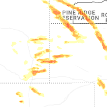
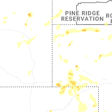
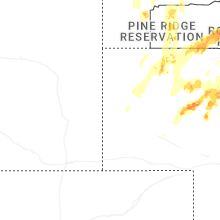


Connect with Interactive Hail Maps