

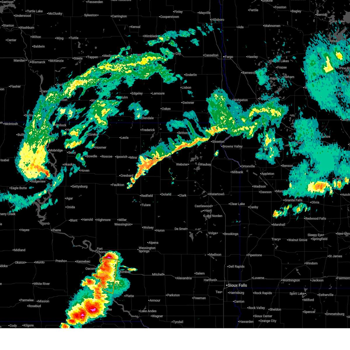
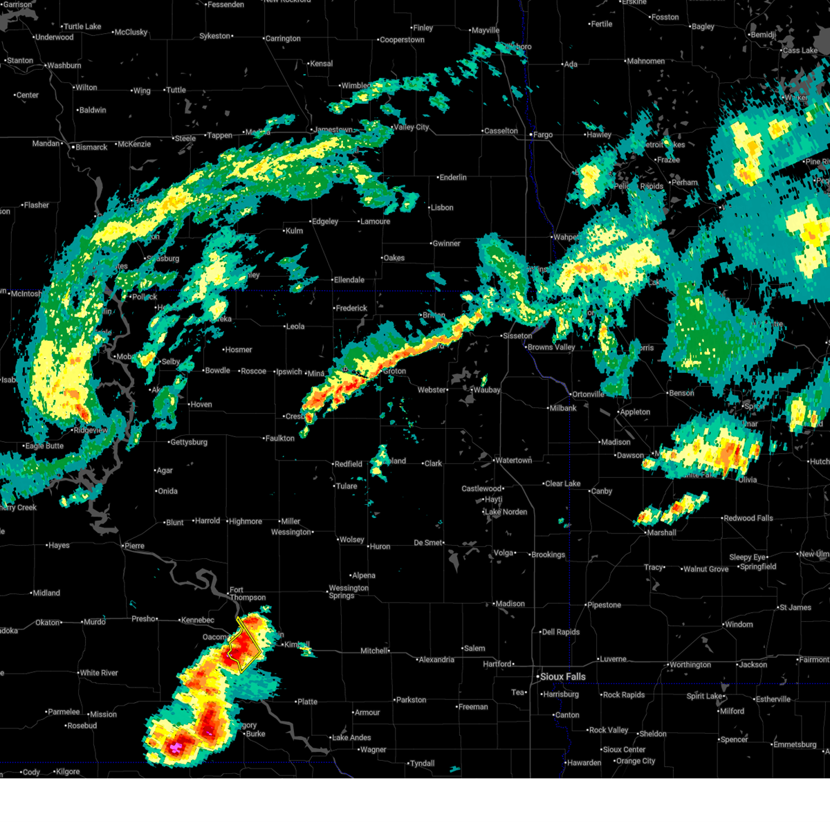
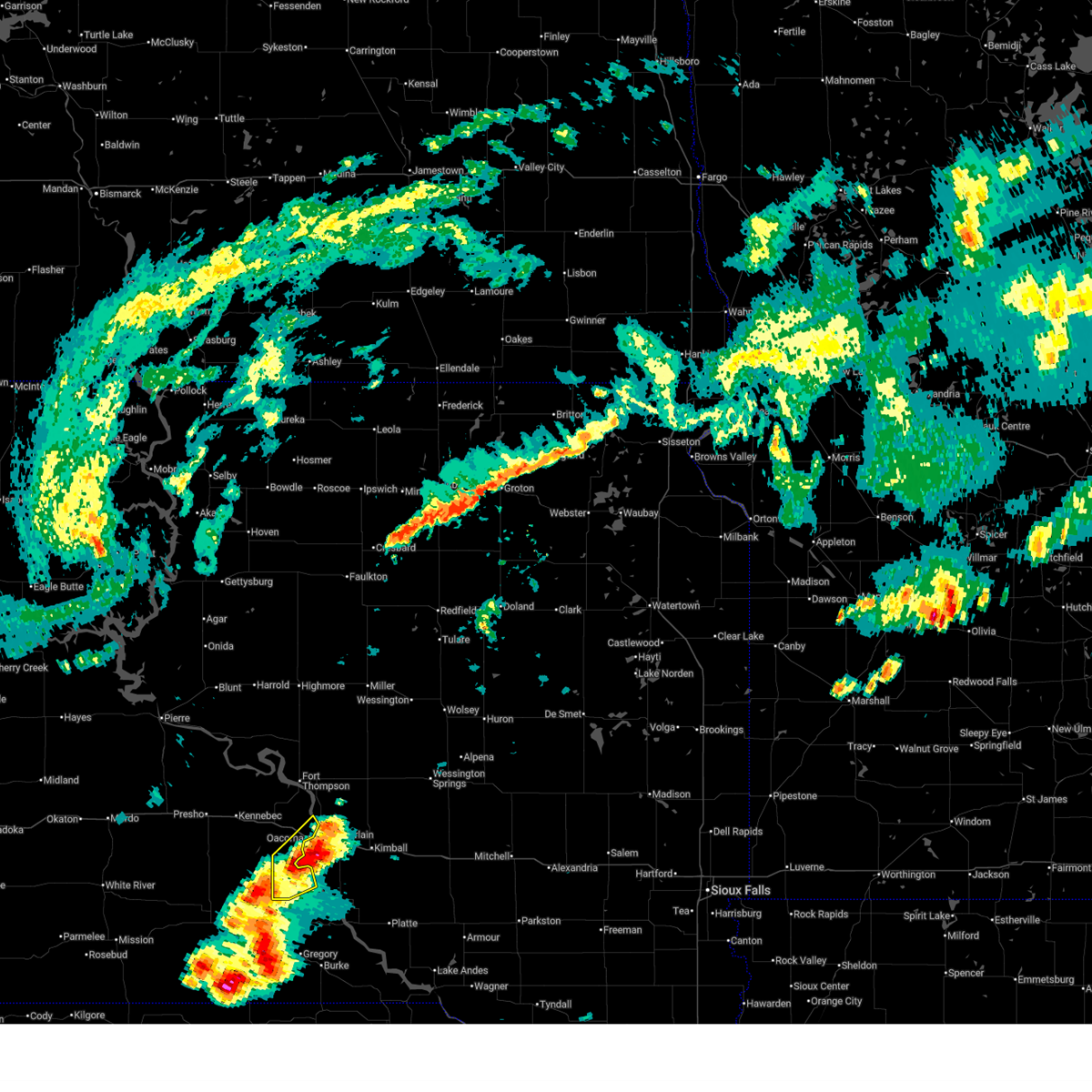
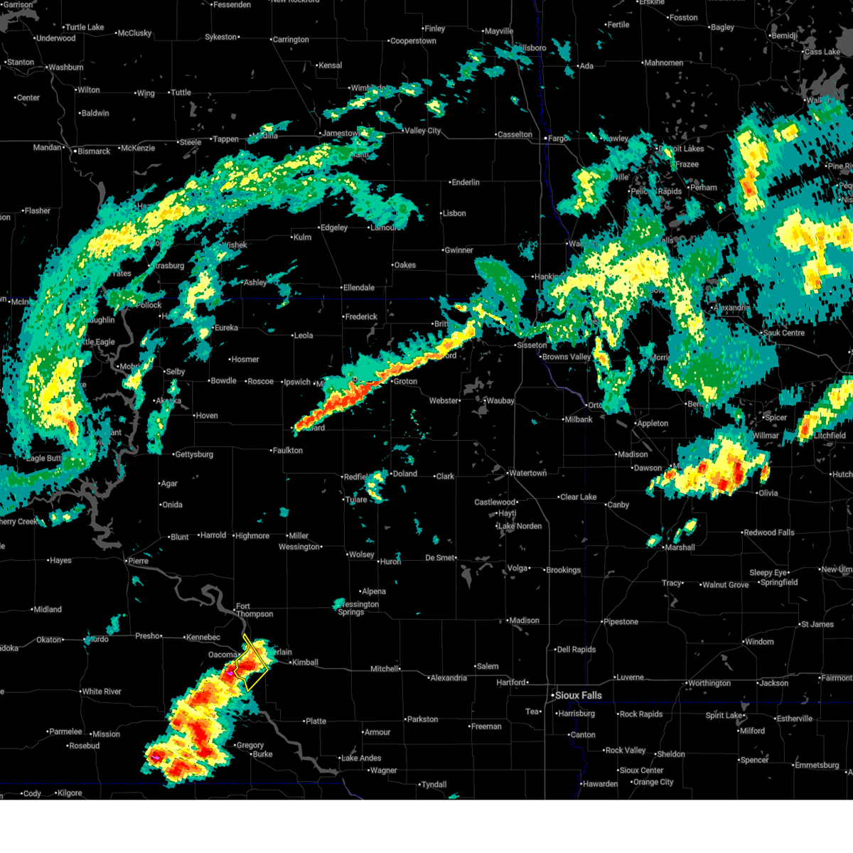
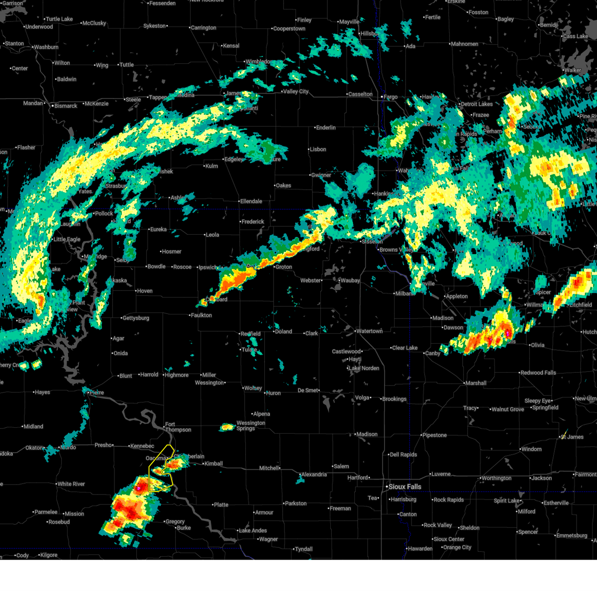
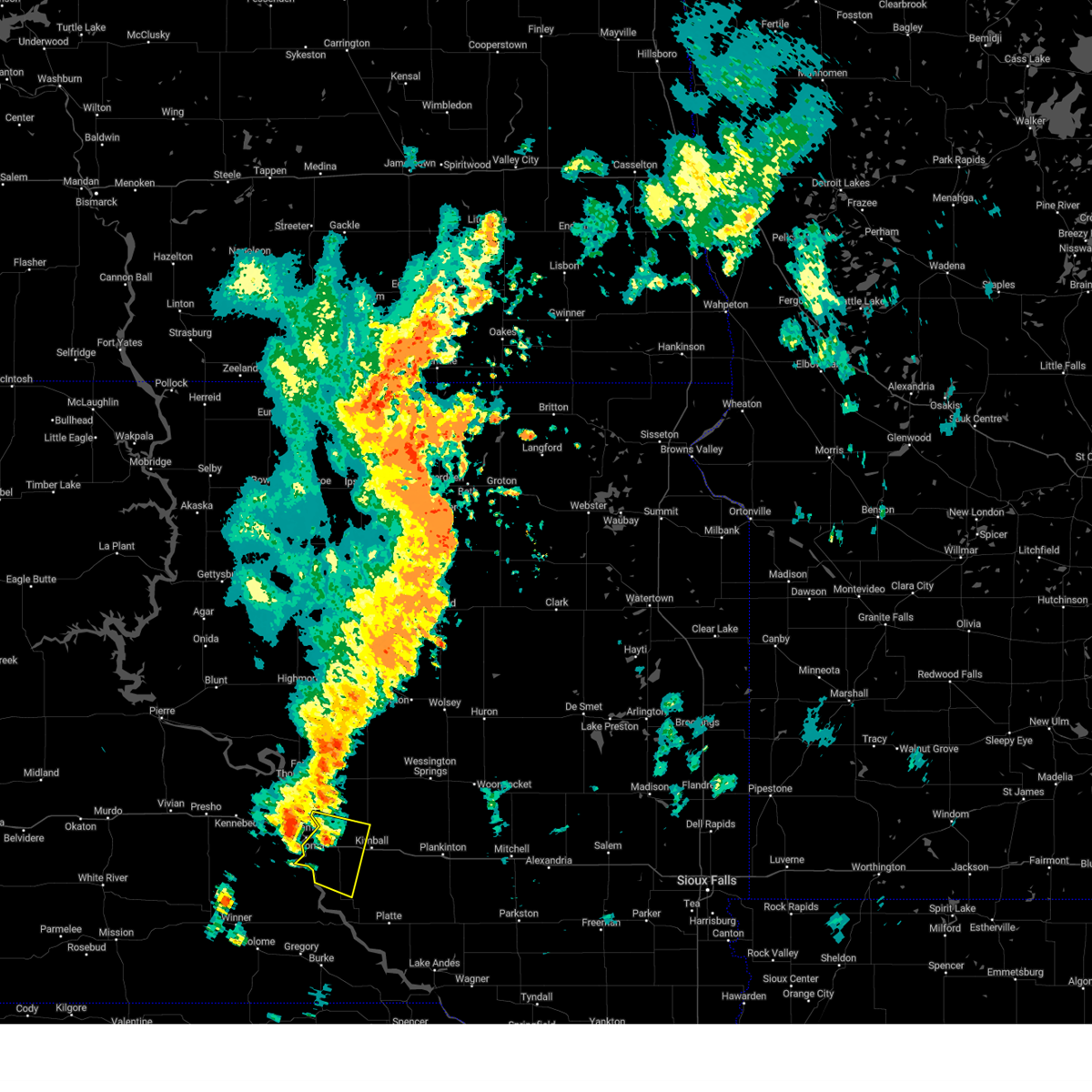
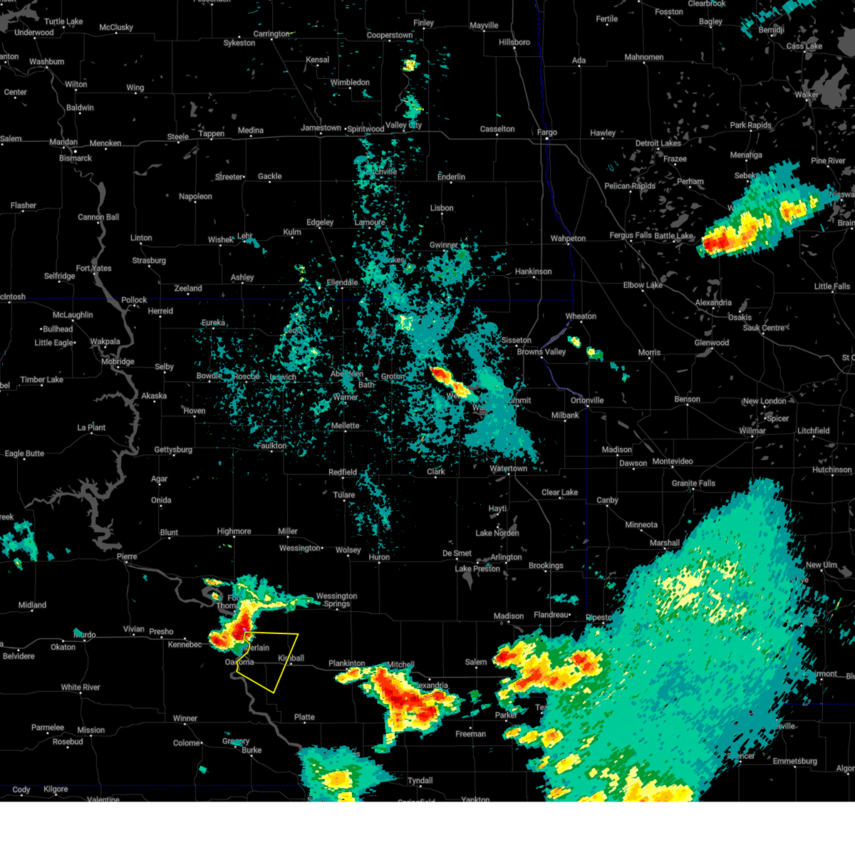
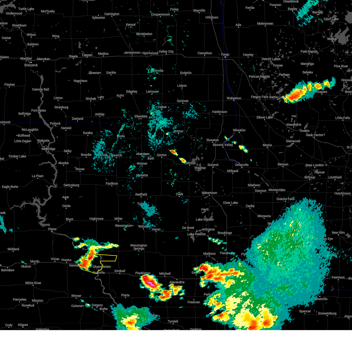
Hail Map for Chamberlain, SD
The Chamberlain, SD area has had 19 reports of on-the-ground hail by trained spotters, and has been under severe weather warnings 14 times during the past 12 months. Doppler radar has detected hail at or near Chamberlain, SD on 83 occasions, including 6 occasions during the past year.
| Name: | Chamberlain, SD |
| Where Located: | 65 miles SE of Pierre, SD |
| Map: | Google Map for Chamberlain, SD |
| Population: | 2387 |
| Housing Units: | 1142 |
| More Info: | Search Google for Chamberlain, SD |
1
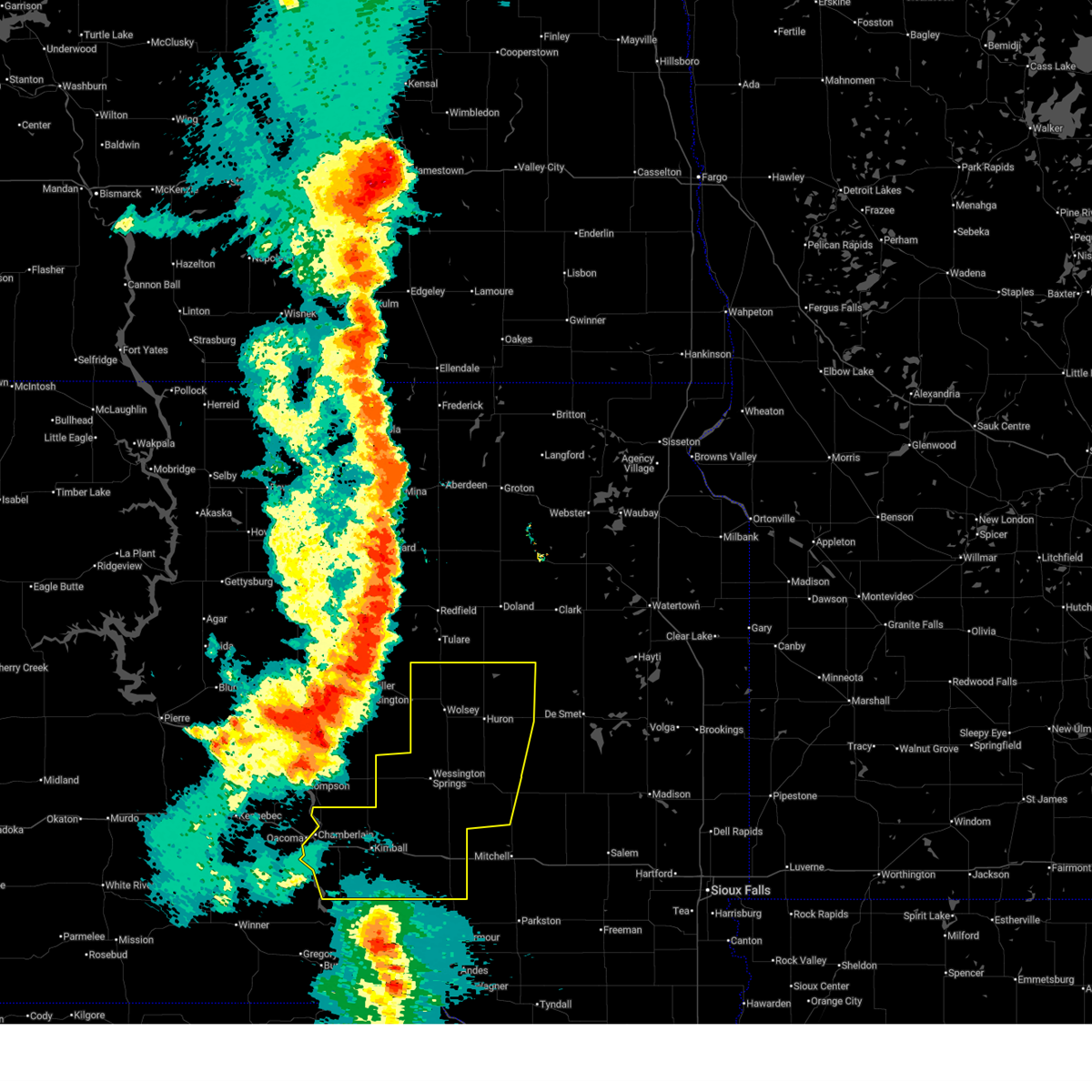
The Top Recent Hail Date for Chamberlain, SD is Wednesday, August 14, 2024 (16th out of 83)

Hail and Wind Damage Spotted near Chamberlain, SD
| Date / Time | Report Details |
|---|---|
| 7/15/2025 4:58 PM CDT |
 Svrfsd the national weather service in sioux falls has issued a * severe thunderstorm warning for, northwestern charles mix county in south central south dakota, central brule county in south central south dakota, * until 545 pm cdt. * at 458 pm cdt, severe thunderstorms were located along a line extending from near shelby to 9 miles east of iona, moving east at 10 mph (radar indicated). Hazards include 60 mph wind gusts and quarter size hail. Hail damage to vehicles is expected. expect wind damage to roofs, siding, and trees. These severe thunderstorms will remain over mainly rural areas of northwestern charles mix and central brule counties, including the following locations, pukwana. Svrfsd the national weather service in sioux falls has issued a * severe thunderstorm warning for, northwestern charles mix county in south central south dakota, central brule county in south central south dakota, * until 545 pm cdt. * at 458 pm cdt, severe thunderstorms were located along a line extending from near shelby to 9 miles east of iona, moving east at 10 mph (radar indicated). Hazards include 60 mph wind gusts and quarter size hail. Hail damage to vehicles is expected. expect wind damage to roofs, siding, and trees. These severe thunderstorms will remain over mainly rural areas of northwestern charles mix and central brule counties, including the following locations, pukwana.
|
| 7/15/2025 4:36 PM CDT |
 The storm which prompted the warning has weakened below severe limits, and no longer poses an immediate threat to life or property. therefore, the warning will be allowed to expire. The storm which prompted the warning has weakened below severe limits, and no longer poses an immediate threat to life or property. therefore, the warning will be allowed to expire.
|
| 7/15/2025 4:32 PM CDT |
 At 432 pm cdt, a severe thunderstorm was located near lake francis case, or near chamberlain, moving east at 5 mph (radar indicated). Hazards include 60 mph wind gusts and quarter size hail. Hail damage to vehicles is expected. expect wind damage to roofs, siding, and trees. This severe storm will be near, chamberlain around 435 pm cdt. At 432 pm cdt, a severe thunderstorm was located near lake francis case, or near chamberlain, moving east at 5 mph (radar indicated). Hazards include 60 mph wind gusts and quarter size hail. Hail damage to vehicles is expected. expect wind damage to roofs, siding, and trees. This severe storm will be near, chamberlain around 435 pm cdt.
|
| 7/15/2025 4:23 PM CDT |
 At 423 pm cdt, a severe thunderstorm was located near lake francis case, or 9 miles south of oacoma, moving northeast at 10 mph (radar indicated). Hazards include 60 mph wind gusts and quarter size hail. Hail damage to vehicles is expected. expect wind damage to roofs, siding, and trees. Locations impacted include, lake francis case. At 423 pm cdt, a severe thunderstorm was located near lake francis case, or 9 miles south of oacoma, moving northeast at 10 mph (radar indicated). Hazards include 60 mph wind gusts and quarter size hail. Hail damage to vehicles is expected. expect wind damage to roofs, siding, and trees. Locations impacted include, lake francis case.
|
| 7/15/2025 4:19 PM CDT |
 At 418 pm cdt, a severe thunderstorm was located near lake francis case, or near chamberlain, and is nearly stationary (radar indicated). Hazards include 60 mph wind gusts and quarter size hail. Hail damage to vehicles is expected. expect wind damage to roofs, siding, and trees. This severe storm will be near, chamberlain around 425 pm cdt. At 418 pm cdt, a severe thunderstorm was located near lake francis case, or near chamberlain, and is nearly stationary (radar indicated). Hazards include 60 mph wind gusts and quarter size hail. Hail damage to vehicles is expected. expect wind damage to roofs, siding, and trees. This severe storm will be near, chamberlain around 425 pm cdt.
|
| 7/15/2025 4:07 PM CDT |
 Svrfsd the national weather service in sioux falls has issued a * severe thunderstorm warning for, western brule county in south central south dakota, * until 500 pm cdt. * at 406 pm cdt, a severe thunderstorm was located near lake francis case, or near chamberlain, and is nearly stationary (radar indicated). Hazards include 60 mph wind gusts and quarter size hail. Hail damage to vehicles is expected. expect wind damage to roofs, siding, and trees. This severe thunderstorm will be near, chamberlain around 410 pm cdt. Svrfsd the national weather service in sioux falls has issued a * severe thunderstorm warning for, western brule county in south central south dakota, * until 500 pm cdt. * at 406 pm cdt, a severe thunderstorm was located near lake francis case, or near chamberlain, and is nearly stationary (radar indicated). Hazards include 60 mph wind gusts and quarter size hail. Hail damage to vehicles is expected. expect wind damage to roofs, siding, and trees. This severe thunderstorm will be near, chamberlain around 410 pm cdt.
|
| 7/15/2025 4:03 PM CDT |
 Svrabr the national weather service in aberdeen has issued a * severe thunderstorm warning for, southeastern lyman county in central south dakota, * until 445 pm cdt. * at 403 pm cdt, a severe thunderstorm was located near lake francis case, or 7 miles southwest of oacoma, moving northeast at 15 mph (radar indicated). Hazards include 60 mph wind gusts and quarter size hail. Hail damage to vehicles is expected. expect wind damage to roofs, siding, and trees. This severe thunderstorm will be near, oacoma, lake francis case, and dude ranch around 410 pm cdt. Svrabr the national weather service in aberdeen has issued a * severe thunderstorm warning for, southeastern lyman county in central south dakota, * until 445 pm cdt. * at 403 pm cdt, a severe thunderstorm was located near lake francis case, or 7 miles southwest of oacoma, moving northeast at 15 mph (radar indicated). Hazards include 60 mph wind gusts and quarter size hail. Hail damage to vehicles is expected. expect wind damage to roofs, siding, and trees. This severe thunderstorm will be near, oacoma, lake francis case, and dude ranch around 410 pm cdt.
|
| 7/9/2025 9:30 PM CDT |
 Svrfsd the national weather service in sioux falls has issued a * severe thunderstorm warning for, sanborn county in east central south dakota, beadle county in east central south dakota, aurora county in south central south dakota, jerauld county in central south dakota, brule county in south central south dakota, * until 1100 pm cdt. * at 929 pm cdt, severe thunderstorms were located along a line extending from near zell to 6 miles northeast of vayland to pleasant valley country church to 6 miles west of crow creek housing, moving east at 25 mph (radar indicated). Hazards include 60 mph wind gusts and quarter size hail. Hail damage to vehicles is expected. expect wind damage to roofs, siding, and trees. severe thunderstorms will be near, wessington around 935 pm cdt. Other locations in the path of these severe thunderstorms include wolsey, hitchcock, virgil, wessington springs, huron, alpena, lane, white lake and cavour. Svrfsd the national weather service in sioux falls has issued a * severe thunderstorm warning for, sanborn county in east central south dakota, beadle county in east central south dakota, aurora county in south central south dakota, jerauld county in central south dakota, brule county in south central south dakota, * until 1100 pm cdt. * at 929 pm cdt, severe thunderstorms were located along a line extending from near zell to 6 miles northeast of vayland to pleasant valley country church to 6 miles west of crow creek housing, moving east at 25 mph (radar indicated). Hazards include 60 mph wind gusts and quarter size hail. Hail damage to vehicles is expected. expect wind damage to roofs, siding, and trees. severe thunderstorms will be near, wessington around 935 pm cdt. Other locations in the path of these severe thunderstorms include wolsey, hitchcock, virgil, wessington springs, huron, alpena, lane, white lake and cavour.
|
| 6/27/2025 8:19 PM CDT |
 Svrfsd the national weather service in sioux falls has issued a * severe thunderstorm warning for, northwestern charles mix county in south central south dakota, northwestern gregory county in south central south dakota, southern brule county in south central south dakota, * until 900 pm cdt. * at 818 pm cdt, a severe thunderstorm was located near lake francis case, or 8 miles south of oacoma, moving southeast at 30 mph (radar indicated). Hazards include 60 mph wind gusts and nickel size hail. Expect damage to roofs, siding, and trees. This severe thunderstorm will be near, chamberlain and lake francis case through 830 pm cdt. Svrfsd the national weather service in sioux falls has issued a * severe thunderstorm warning for, northwestern charles mix county in south central south dakota, northwestern gregory county in south central south dakota, southern brule county in south central south dakota, * until 900 pm cdt. * at 818 pm cdt, a severe thunderstorm was located near lake francis case, or 8 miles south of oacoma, moving southeast at 30 mph (radar indicated). Hazards include 60 mph wind gusts and nickel size hail. Expect damage to roofs, siding, and trees. This severe thunderstorm will be near, chamberlain and lake francis case through 830 pm cdt.
|
| 8/14/2024 8:30 PM CDT |
 The storm which prompted the warning has weakened below severe limits, and no longer poses an immediate threat to life or property. therefore, the warning has been allowed to expire. however, small hail and gusty winds are still possible with this thunderstorm as well as storms extending from near huron south into gregory county. The storm which prompted the warning has weakened below severe limits, and no longer poses an immediate threat to life or property. therefore, the warning has been allowed to expire. however, small hail and gusty winds are still possible with this thunderstorm as well as storms extending from near huron south into gregory county.
|
| 8/14/2024 7:59 PM CDT |
 At 758 pm cdt, a severe thunderstorm was located over chamberlain, moving east at 25 mph (radar indicated). Hazards include 60 mph wind gusts and quarter size hail. Hail damage to vehicles is expected. expect wind damage to roofs, siding, and trees. at 758 pm cdt, dime sized hail was reported in chamberlain. This severe thunderstorm will remain over mainly rural areas of central brule county, including the following locations, pukwana. At 758 pm cdt, a severe thunderstorm was located over chamberlain, moving east at 25 mph (radar indicated). Hazards include 60 mph wind gusts and quarter size hail. Hail damage to vehicles is expected. expect wind damage to roofs, siding, and trees. at 758 pm cdt, dime sized hail was reported in chamberlain. This severe thunderstorm will remain over mainly rural areas of central brule county, including the following locations, pukwana.
|
| 8/14/2024 7:46 PM CDT |
 Svrfsd the national weather service in sioux falls has issued a * severe thunderstorm warning for, central brule county in south central south dakota, * until 830 pm cdt. * at 746 pm cdt, a severe thunderstorm was located over oacoma, moving east at 25 mph (radar indicated). Hazards include 60 mph wind gusts and quarter size hail. Hail damage to vehicles is expected. expect wind damage to roofs, siding, and trees. This severe thunderstorm will be near, chamberlain and lake francis case around 750 pm cdt. Svrfsd the national weather service in sioux falls has issued a * severe thunderstorm warning for, central brule county in south central south dakota, * until 830 pm cdt. * at 746 pm cdt, a severe thunderstorm was located over oacoma, moving east at 25 mph (radar indicated). Hazards include 60 mph wind gusts and quarter size hail. Hail damage to vehicles is expected. expect wind damage to roofs, siding, and trees. This severe thunderstorm will be near, chamberlain and lake francis case around 750 pm cdt.
|
| 7/30/2024 6:15 AM CDT |
 Svrfsd the national weather service in sioux falls has issued a * severe thunderstorm warning for, brule county in south central south dakota, * until 700 am cdt. * at 615 am cdt, a severe thunderstorm was located 8 miles north of oacoma, moving east at 30 mph (radar indicated). Hazards include 60 mph wind gusts and quarter size hail. Hail damage to vehicles is expected. expect wind damage to roofs, siding, and trees. This severe thunderstorm will be near, chamberlain and lake francis case around 620 am cdt. Svrfsd the national weather service in sioux falls has issued a * severe thunderstorm warning for, brule county in south central south dakota, * until 700 am cdt. * at 615 am cdt, a severe thunderstorm was located 8 miles north of oacoma, moving east at 30 mph (radar indicated). Hazards include 60 mph wind gusts and quarter size hail. Hail damage to vehicles is expected. expect wind damage to roofs, siding, and trees. This severe thunderstorm will be near, chamberlain and lake francis case around 620 am cdt.
|
| 7/30/2024 6:09 AM CDT |
 Svrabr the national weather service in aberdeen has issued a * severe thunderstorm warning for, east central lyman county in central south dakota, southeastern buffalo county in central south dakota, * until 715 am cdt. * at 609 am cdt, a severe thunderstorm was located over reliance, or 10 miles northwest of oacoma, moving east at 25 mph (radar indicated). Hazards include 60 mph wind gusts and quarter size hail. Hail damage to vehicles is expected. expect wind damage to roofs, siding, and trees. this severe thunderstorm will be near, lake francis case around 615 am cdt. oacoma around 625 am cdt. Other locations in the path of this severe thunderstorm include shelby and crow creek housing. Svrabr the national weather service in aberdeen has issued a * severe thunderstorm warning for, east central lyman county in central south dakota, southeastern buffalo county in central south dakota, * until 715 am cdt. * at 609 am cdt, a severe thunderstorm was located over reliance, or 10 miles northwest of oacoma, moving east at 25 mph (radar indicated). Hazards include 60 mph wind gusts and quarter size hail. Hail damage to vehicles is expected. expect wind damage to roofs, siding, and trees. this severe thunderstorm will be near, lake francis case around 615 am cdt. oacoma around 625 am cdt. Other locations in the path of this severe thunderstorm include shelby and crow creek housing.
|
| 7/14/2024 4:14 AM CDT |
 The storms which prompted the warning have weakened below severe limits, and no longer pose an immediate threat to life or property. therefore, the warning will be allowed to expire. however, gusty winds and heavy rain are still possible with these thunderstorms. a severe thunderstorm watch remains in effect until 800 am cdt for south central, central, southeastern and east central south dakota. The storms which prompted the warning have weakened below severe limits, and no longer pose an immediate threat to life or property. therefore, the warning will be allowed to expire. however, gusty winds and heavy rain are still possible with these thunderstorms. a severe thunderstorm watch remains in effect until 800 am cdt for south central, central, southeastern and east central south dakota.
|
| 7/14/2024 3:50 AM CDT |
 At 348 am cdt, severe thunderstorms were located along a line extending from de smet to canova to 6 miles south of clayton, moving east at 50 mph (trained weather spotters. at 336 am, the huron regional airport asos recorded a 62 mph wind gust). Hazards include 70 mph wind gusts. Expect considerable tree damage. damage is likely to mobile homes, roofs, and outbuildings. Locations impacted include, mitchell, huron, chamberlain, plankinton, kimball, lake vermillion state recreation area, lake thompson state recreation area, salem, de smet, wessington springs, arlington, howard, canistota, woonsocket, alexandria, lake preston, bridgewater, montrose, mount vernon, and emery. At 348 am cdt, severe thunderstorms were located along a line extending from de smet to canova to 6 miles south of clayton, moving east at 50 mph (trained weather spotters. at 336 am, the huron regional airport asos recorded a 62 mph wind gust). Hazards include 70 mph wind gusts. Expect considerable tree damage. damage is likely to mobile homes, roofs, and outbuildings. Locations impacted include, mitchell, huron, chamberlain, plankinton, kimball, lake vermillion state recreation area, lake thompson state recreation area, salem, de smet, wessington springs, arlington, howard, canistota, woonsocket, alexandria, lake preston, bridgewater, montrose, mount vernon, and emery.
|
| 7/14/2024 3:19 AM CDT |
 At 318 am cdt, severe thunderstorms were located along a line extending from near yale to near artesian to near parkston, moving east at 50 mph (trained weather spotters. at 257 am, an sddot site 3 nnw of wolsey recorded a 70 mph wind gust). Hazards include 70 mph wind gusts. Expect considerable tree damage. damage is likely to mobile homes, roofs, and outbuildings. Locations impacted include, alexandria, ethan, iroquois, fulton, fedora, carthage, roswell, farmer, emery, vilas, de smet, howard, spencer in mccook county, canova, lake thompson state recreation area, bridgewater, salem, lake preston, canistota, oldham, montrose and hetland. At 318 am cdt, severe thunderstorms were located along a line extending from near yale to near artesian to near parkston, moving east at 50 mph (trained weather spotters. at 257 am, an sddot site 3 nnw of wolsey recorded a 70 mph wind gust). Hazards include 70 mph wind gusts. Expect considerable tree damage. damage is likely to mobile homes, roofs, and outbuildings. Locations impacted include, alexandria, ethan, iroquois, fulton, fedora, carthage, roswell, farmer, emery, vilas, de smet, howard, spencer in mccook county, canova, lake thompson state recreation area, bridgewater, salem, lake preston, canistota, oldham, montrose and hetland.
|
| 7/14/2024 3:02 AM CDT |
 Svrfsd the national weather service in sioux falls has issued a * severe thunderstorm warning for, davison county in southeastern south dakota, kingsbury county in east central south dakota, sanborn county in east central south dakota, beadle county in east central south dakota, aurora county in south central south dakota, jerauld county in central south dakota, miner county in east central south dakota, mccook county in southeastern south dakota, hanson county in southeastern south dakota, brule county in south central south dakota, * until 415 am cdt. * at 301 am cdt, severe thunderstorms were located along a line extending from 9 miles northwest of huron to near woonsocket to near corsica, moving east at 50 mph (radar indicated). Hazards include 70 mph wind gusts. Expect considerable tree damage. damage is likely to mobile homes, roofs, and outbuildings. severe thunderstorms will be near, huron, woonsocket, mount vernon, letcher, forestburg, and loomis around 305 am cdt. mitchell and cavour around 310 am cdt. ethan, artesian, and yale around 315 am cdt. iroquois around 320 am cdt. Other locations in the path of these severe thunderstorms include fulton, fedora, alexandria, carthage, roswell, vilas, farmer, de smet, howard, emery, spencer in mccook county and canova. Svrfsd the national weather service in sioux falls has issued a * severe thunderstorm warning for, davison county in southeastern south dakota, kingsbury county in east central south dakota, sanborn county in east central south dakota, beadle county in east central south dakota, aurora county in south central south dakota, jerauld county in central south dakota, miner county in east central south dakota, mccook county in southeastern south dakota, hanson county in southeastern south dakota, brule county in south central south dakota, * until 415 am cdt. * at 301 am cdt, severe thunderstorms were located along a line extending from 9 miles northwest of huron to near woonsocket to near corsica, moving east at 50 mph (radar indicated). Hazards include 70 mph wind gusts. Expect considerable tree damage. damage is likely to mobile homes, roofs, and outbuildings. severe thunderstorms will be near, huron, woonsocket, mount vernon, letcher, forestburg, and loomis around 305 am cdt. mitchell and cavour around 310 am cdt. ethan, artesian, and yale around 315 am cdt. iroquois around 320 am cdt. Other locations in the path of these severe thunderstorms include fulton, fedora, alexandria, carthage, roswell, vilas, farmer, de smet, howard, emery, spencer in mccook county and canova.
|
| 7/14/2024 2:44 AM CDT |
 At 242 am cdt, severe thunderstorms were located along a line extending from near burdette to 7 miles northwest of wessington springs to 10 miles southwest of grass ranch colony, moving southeast at 60 mph (radar indicated. at 235 pm, the chamberlain asos recorded a 60 mph wind gust). Hazards include 70 mph wind gusts. Expect considerable tree damage. damage is likely to mobile homes, roofs, and outbuildings. Locations impacted include, wessington springs, white lake, wessington, lane, plankinton, wolsey, alpena, virgil, aurora center, woonsocket, stickney, storla, hitchcock, huron, mount vernon, letcher, forestburg, mitchell and loomis. At 242 am cdt, severe thunderstorms were located along a line extending from near burdette to 7 miles northwest of wessington springs to 10 miles southwest of grass ranch colony, moving southeast at 60 mph (radar indicated. at 235 pm, the chamberlain asos recorded a 60 mph wind gust). Hazards include 70 mph wind gusts. Expect considerable tree damage. damage is likely to mobile homes, roofs, and outbuildings. Locations impacted include, wessington springs, white lake, wessington, lane, plankinton, wolsey, alpena, virgil, aurora center, woonsocket, stickney, storla, hitchcock, huron, mount vernon, letcher, forestburg, mitchell and loomis.
|
| 7/14/2024 2:35 AM CDT | The chamberlain asos recorded a 60 mph wind gus in brule county SD, 1.2 miles N of Chamberlain, SD |
| 7/14/2024 2:06 AM CDT |
 Svrfsd the national weather service in sioux falls has issued a * severe thunderstorm warning for, davison county in southeastern south dakota, western kingsbury county in east central south dakota, sanborn county in east central south dakota, beadle county in east central south dakota, aurora county in south central south dakota, jerauld county in central south dakota, brule county in south central south dakota, * until 300 am cdt. * at 206 am cdt, severe thunderstorms were located along a line extending from 9 miles east of stone lake to 7 miles northeast of stephan to 9 miles north of hamill, moving southeast at 60 mph (radar indicated). Hazards include 70 mph wind gusts. Expect considerable tree damage. damage is likely to mobile homes, roofs, and outbuildings. severe thunderstorms will be near, lake francis case around 210 am cdt. chamberlain around 215 am cdt. Other locations in the path of these severe thunderstorms include kimball, wessington, grass ranch colony, wessington springs, white lake and lane. Svrfsd the national weather service in sioux falls has issued a * severe thunderstorm warning for, davison county in southeastern south dakota, western kingsbury county in east central south dakota, sanborn county in east central south dakota, beadle county in east central south dakota, aurora county in south central south dakota, jerauld county in central south dakota, brule county in south central south dakota, * until 300 am cdt. * at 206 am cdt, severe thunderstorms were located along a line extending from 9 miles east of stone lake to 7 miles northeast of stephan to 9 miles north of hamill, moving southeast at 60 mph (radar indicated). Hazards include 70 mph wind gusts. Expect considerable tree damage. damage is likely to mobile homes, roofs, and outbuildings. severe thunderstorms will be near, lake francis case around 210 am cdt. chamberlain around 215 am cdt. Other locations in the path of these severe thunderstorms include kimball, wessington, grass ranch colony, wessington springs, white lake and lane.
|
| 7/18/2023 8:29 PM CDT |
 At 828 pm cdt, severe thunderstorms were located along a line extending from 7 miles northwest of kimball to 7 miles south of chamberlain to 10 miles northwest of hamill, moving southeast at 35 mph (chamberlain asos reported a gust of 61 mph around 827 pm cdt). Hazards include 60 mph wind gusts and nickel size hail. Expect damage to roofs, siding, and trees. severe thunderstorms will be near, kimball around 840 pm cdt. other locations in the path of these severe thunderstorms include white lake and grass ranch colony. hail threat, radar indicated max hail size, 0. 88 in wind threat, observed max wind gust, 60 mph. At 828 pm cdt, severe thunderstorms were located along a line extending from 7 miles northwest of kimball to 7 miles south of chamberlain to 10 miles northwest of hamill, moving southeast at 35 mph (chamberlain asos reported a gust of 61 mph around 827 pm cdt). Hazards include 60 mph wind gusts and nickel size hail. Expect damage to roofs, siding, and trees. severe thunderstorms will be near, kimball around 840 pm cdt. other locations in the path of these severe thunderstorms include white lake and grass ranch colony. hail threat, radar indicated max hail size, 0. 88 in wind threat, observed max wind gust, 60 mph.
|
| 7/18/2023 8:22 PM CDT | Corrects previous tstm wnd gst report from 3 s chamberlai in brule county SD, 1.2 miles N of Chamberlain, SD |
| 7/18/2023 8:22 PM CDT | Corrects previous tstm wnd gst report from 3 s chamberlai in brule county SD, 1.2 miles N of Chamberlain, SD |
| 7/18/2023 8:03 PM CDT |
 At 801 pm cdt, severe thunderstorms were located along a line extending from near crow creek housing to near oacoma to near earling hill, moving southeast at 35 mph (radar indicated). Hazards include ping pong ball size hail and 60 mph wind gusts. People and animals outdoors will be injured. expect hail damage to roofs, siding, windows, and vehicles. expect wind damage to roofs, siding, and trees. severe thunderstorms will be near, lake francis case around 810 pm cdt. chamberlain around 815 pm cdt. other locations in the path of these severe thunderstorms include kimball, white lake and grass ranch colony. hail threat, radar indicated max hail size, 1. 50 in wind threat, radar indicated max wind gust, 60 mph. At 801 pm cdt, severe thunderstorms were located along a line extending from near crow creek housing to near oacoma to near earling hill, moving southeast at 35 mph (radar indicated). Hazards include ping pong ball size hail and 60 mph wind gusts. People and animals outdoors will be injured. expect hail damage to roofs, siding, windows, and vehicles. expect wind damage to roofs, siding, and trees. severe thunderstorms will be near, lake francis case around 810 pm cdt. chamberlain around 815 pm cdt. other locations in the path of these severe thunderstorms include kimball, white lake and grass ranch colony. hail threat, radar indicated max hail size, 1. 50 in wind threat, radar indicated max wind gust, 60 mph.
|
| 6/24/2023 1:27 AM CDT | Asos station k9v9 chamberlain municipal airpor in brule county SD, 1.2 miles N of Chamberlain, SD |
| 8/2/2022 6:56 PM CDT |
 At 655 pm cdt, a severe thunderstorm was located 9 miles east of chamberlain, moving northeast at 35 mph (radar indicated). Hazards include 60 mph wind gusts. Expect damage to roofs, siding, and trees. this severe thunderstorm will be near, grass ranch colony around 705 pm cdt. kimball around 710 pm cdt. white lake around 725 pm cdt. other locations impacted by this severe thunderstorm include pukwana. hail threat, radar indicated max hail size, <. 75 in wind threat, radar indicated max wind gust, 60 mph. At 655 pm cdt, a severe thunderstorm was located 9 miles east of chamberlain, moving northeast at 35 mph (radar indicated). Hazards include 60 mph wind gusts. Expect damage to roofs, siding, and trees. this severe thunderstorm will be near, grass ranch colony around 705 pm cdt. kimball around 710 pm cdt. white lake around 725 pm cdt. other locations impacted by this severe thunderstorm include pukwana. hail threat, radar indicated max hail size, <. 75 in wind threat, radar indicated max wind gust, 60 mph.
|
| 8/2/2022 6:48 PM CDT |
 At 648 pm cdt, a severe thunderstorm was located over lake francis case, or over chamberlain, moving northeast at 35 mph (radar indicated). Hazards include 60 mph wind gusts. Expect damage to roofs, siding, and trees. this severe thunderstorm will remain over mainly rural areas of northwestern charles mix, northwestern gregory and western brule counties, including the following locations, dixon in gregory county and pukwana. hail threat, radar indicated max hail size, <. 75 in wind threat, radar indicated max wind gust, 60 mph. At 648 pm cdt, a severe thunderstorm was located over lake francis case, or over chamberlain, moving northeast at 35 mph (radar indicated). Hazards include 60 mph wind gusts. Expect damage to roofs, siding, and trees. this severe thunderstorm will remain over mainly rural areas of northwestern charles mix, northwestern gregory and western brule counties, including the following locations, dixon in gregory county and pukwana. hail threat, radar indicated max hail size, <. 75 in wind threat, radar indicated max wind gust, 60 mph.
|
| 8/2/2022 6:19 PM CDT |
 At 619 pm cdt, a severe thunderstorm was located 7 miles north of hamill, or 18 miles west of chamberlain, moving northeast at 35 mph (radar indicated). Hazards include 60 mph wind gusts. Expect damage to roofs, siding, and trees. this severe thunderstorm will be near, lake francis case around 635 pm cdt. chamberlain around 650 pm cdt. other locations impacted by this severe thunderstorm include dixon in gregory county and pukwana. hail threat, radar indicated max hail size, <. 75 in wind threat, radar indicated max wind gust, 60 mph. At 619 pm cdt, a severe thunderstorm was located 7 miles north of hamill, or 18 miles west of chamberlain, moving northeast at 35 mph (radar indicated). Hazards include 60 mph wind gusts. Expect damage to roofs, siding, and trees. this severe thunderstorm will be near, lake francis case around 635 pm cdt. chamberlain around 650 pm cdt. other locations impacted by this severe thunderstorm include dixon in gregory county and pukwana. hail threat, radar indicated max hail size, <. 75 in wind threat, radar indicated max wind gust, 60 mph.
|
| 7/5/2022 1:23 PM CDT |
 At 121 pm cdt, severe thunderstorms were located along a line extending from 9 miles southwest of virgil to 6 miles southwest of wessington springs to 9 miles east of chamberlain, moving southeast at 45 mph (trained weather spotters. at 120 pm cdt, a 60 mph wind gust was reported at 13 miles west-northwest of wessington springs). Hazards include 70 mph wind gusts and quarter size hail. Hail damage to vehicles is expected. expect considerable tree damage. wind damage is also likely to mobile homes, roofs, and outbuildings. these severe storms will be near, wessington springs around 125 pm cdt. alpena around 135 pm cdt. lane around 140 pm cdt. other locations impacted by these severe thunderstorms include pukwana. thunderstorm damage threat, considerable hail threat, radar indicated max hail size, 1. 00 in wind threat, radar indicated max wind gust, 70 mph. At 121 pm cdt, severe thunderstorms were located along a line extending from 9 miles southwest of virgil to 6 miles southwest of wessington springs to 9 miles east of chamberlain, moving southeast at 45 mph (trained weather spotters. at 120 pm cdt, a 60 mph wind gust was reported at 13 miles west-northwest of wessington springs). Hazards include 70 mph wind gusts and quarter size hail. Hail damage to vehicles is expected. expect considerable tree damage. wind damage is also likely to mobile homes, roofs, and outbuildings. these severe storms will be near, wessington springs around 125 pm cdt. alpena around 135 pm cdt. lane around 140 pm cdt. other locations impacted by these severe thunderstorms include pukwana. thunderstorm damage threat, considerable hail threat, radar indicated max hail size, 1. 00 in wind threat, radar indicated max wind gust, 70 mph.
|
| 7/5/2022 1:00 PM CDT |
 At 100 pm cdt, severe thunderstorms were located along a line extending from near rosehill dam to 7 miles southeast of pleasant valley country church to 7 miles north of oacoma, moving southeast at 40 mph (trained weather spotters). Hazards include 70 mph wind gusts and quarter size hail. Hail damage to vehicles is expected. expect considerable tree damage. wind damage is also likely to mobile homes, roofs, and outbuildings. these severe storms will be near, wessington springs around 130 pm cdt. kimball, alpena and lane around 140 pm cdt. other locations impacted by these severe thunderstorms include pukwana. thunderstorm damage threat, considerable hail threat, radar indicated max hail size, 1. 00 in wind threat, radar indicated max wind gust, 70 mph. At 100 pm cdt, severe thunderstorms were located along a line extending from near rosehill dam to 7 miles southeast of pleasant valley country church to 7 miles north of oacoma, moving southeast at 40 mph (trained weather spotters). Hazards include 70 mph wind gusts and quarter size hail. Hail damage to vehicles is expected. expect considerable tree damage. wind damage is also likely to mobile homes, roofs, and outbuildings. these severe storms will be near, wessington springs around 130 pm cdt. kimball, alpena and lane around 140 pm cdt. other locations impacted by these severe thunderstorms include pukwana. thunderstorm damage threat, considerable hail threat, radar indicated max hail size, 1. 00 in wind threat, radar indicated max wind gust, 70 mph.
|
| 7/5/2022 12:43 PM CDT |
 At 1242 pm cdt, severe thunderstorms were located along a line extending from near sunshine bible academy to near pleasant valley country church to medicine butte, moving southeast at 40 mph (trained weather spotters). Hazards include 70 mph wind gusts and nickel size hail. Expect considerable tree damage. damage is likely to mobile homes, roofs, and outbuildings. severe thunderstorms will be near, chamberlain around 110 pm cdt. wessington springs around 125 pm cdt. alpena and lane around 135 pm cdt. kimball around 140 pm cdt. other locations impacted by these severe thunderstorms include pukwana. thunderstorm damage threat, considerable hail threat, radar indicated max hail size, 0. 88 in wind threat, radar indicated max wind gust, 70 mph. At 1242 pm cdt, severe thunderstorms were located along a line extending from near sunshine bible academy to near pleasant valley country church to medicine butte, moving southeast at 40 mph (trained weather spotters). Hazards include 70 mph wind gusts and nickel size hail. Expect considerable tree damage. damage is likely to mobile homes, roofs, and outbuildings. severe thunderstorms will be near, chamberlain around 110 pm cdt. wessington springs around 125 pm cdt. alpena and lane around 135 pm cdt. kimball around 140 pm cdt. other locations impacted by these severe thunderstorms include pukwana. thunderstorm damage threat, considerable hail threat, radar indicated max hail size, 0. 88 in wind threat, radar indicated max wind gust, 70 mph.
|
| 7/4/2022 1:56 AM CDT |
 At 156 am cdt, severe thunderstorms were located along a line extending from 8 miles east of stephan to near chamberlain to near iona, moving east at 30 mph (radar indicated). Hazards include 60 mph wind gusts and penny size hail. Expect damage to roofs, siding, and trees. locations impacted include, kimball. hail threat, radar indicated max hail size, 0. 75 in wind threat, radar indicated max wind gust, 60 mph. At 156 am cdt, severe thunderstorms were located along a line extending from 8 miles east of stephan to near chamberlain to near iona, moving east at 30 mph (radar indicated). Hazards include 60 mph wind gusts and penny size hail. Expect damage to roofs, siding, and trees. locations impacted include, kimball. hail threat, radar indicated max hail size, 0. 75 in wind threat, radar indicated max wind gust, 60 mph.
|
| 7/4/2022 1:36 AM CDT |
 At 136 am cdt, severe thunderstorms were located along a line extending from near stephan to near dude ranch to near hamill, moving east at 30 mph (radar indicated). Hazards include 60 mph wind gusts and penny size hail. Expect damage to roofs, siding, and trees. severe thunderstorms will be near, lake francis case around 140 am cdt. chamberlain around 150 am cdt. other locations in the path of these severe thunderstorms include kimball. hail threat, radar indicated max hail size, 0. 75 in wind threat, radar indicated max wind gust, 60 mph. At 136 am cdt, severe thunderstorms were located along a line extending from near stephan to near dude ranch to near hamill, moving east at 30 mph (radar indicated). Hazards include 60 mph wind gusts and penny size hail. Expect damage to roofs, siding, and trees. severe thunderstorms will be near, lake francis case around 140 am cdt. chamberlain around 150 am cdt. other locations in the path of these severe thunderstorms include kimball. hail threat, radar indicated max hail size, 0. 75 in wind threat, radar indicated max wind gust, 60 mph.
|
| 7/4/2022 1:32 AM CDT |
 At 132 am cdt, severe thunderstorms were located along a line extending from 6 miles north of stephan to near oacoma to 10 miles south of hamill, moving east at 30 mph (radar indicated). Hazards include 60 mph wind gusts. Expect damage to roofs, siding, and trees. severe thunderstorms will be near, oacoma and dude ranch around 135 am cdt. crow creek housing around 145 am cdt. shelby and iona around 150 am cdt. other locations in the path of these severe thunderstorms include sunshine bible academy, pleasant valley country church and rosehill dam. hail threat, radar indicated max hail size, <. 75 in wind threat, radar indicated max wind gust, 60 mph. At 132 am cdt, severe thunderstorms were located along a line extending from 6 miles north of stephan to near oacoma to 10 miles south of hamill, moving east at 30 mph (radar indicated). Hazards include 60 mph wind gusts. Expect damage to roofs, siding, and trees. severe thunderstorms will be near, oacoma and dude ranch around 135 am cdt. crow creek housing around 145 am cdt. shelby and iona around 150 am cdt. other locations in the path of these severe thunderstorms include sunshine bible academy, pleasant valley country church and rosehill dam. hail threat, radar indicated max hail size, <. 75 in wind threat, radar indicated max wind gust, 60 mph.
|
| 7/3/2022 2:28 AM CDT |
 At 227 am cdt, a severe thunderstorm was located near oacoma, or near chamberlain, moving east at 35 mph (radar indicated). Hazards include 60 mph wind gusts and penny size hail. Expect damage to roofs, siding, and trees. this severe thunderstorm will remain over mainly rural areas of northern brule county, including the following locations, pukwana. hail threat, radar indicated max hail size, 0. 75 in wind threat, radar indicated max wind gust, 60 mph. At 227 am cdt, a severe thunderstorm was located near oacoma, or near chamberlain, moving east at 35 mph (radar indicated). Hazards include 60 mph wind gusts and penny size hail. Expect damage to roofs, siding, and trees. this severe thunderstorm will remain over mainly rural areas of northern brule county, including the following locations, pukwana. hail threat, radar indicated max hail size, 0. 75 in wind threat, radar indicated max wind gust, 60 mph.
|
| 6/29/2022 6:54 PM CDT |
 At 654 pm cdt, severe thunderstorms were located along a line extending from fort thompson to 7 miles east of reliance to near dude ranch, moving east at 40 mph (radar indicated). Hazards include 60 mph wind gusts and penny size hail. Expect damage to roofs, siding, and trees. severe thunderstorms will be near, chamberlain around 710 pm cdt. other locations in the path of these severe thunderstorms include kimball. hail threat, radar indicated max hail size, 0. 75 in wind threat, radar indicated max wind gust, 60 mph. At 654 pm cdt, severe thunderstorms were located along a line extending from fort thompson to 7 miles east of reliance to near dude ranch, moving east at 40 mph (radar indicated). Hazards include 60 mph wind gusts and penny size hail. Expect damage to roofs, siding, and trees. severe thunderstorms will be near, chamberlain around 710 pm cdt. other locations in the path of these severe thunderstorms include kimball. hail threat, radar indicated max hail size, 0. 75 in wind threat, radar indicated max wind gust, 60 mph.
|
| 6/24/2022 10:39 PM CDT |
 The severe thunderstorm warning for southeastern lyman county will expire at 1045 pm cdt, the storm which prompted the warning has moved out of the area. therefore, the warning will be allowed to expire. however gusty winds are still possible with this thunderstorm. a severe thunderstorm watch remains in effect until midnight cdt for central south dakota. The severe thunderstorm warning for southeastern lyman county will expire at 1045 pm cdt, the storm which prompted the warning has moved out of the area. therefore, the warning will be allowed to expire. however gusty winds are still possible with this thunderstorm. a severe thunderstorm watch remains in effect until midnight cdt for central south dakota.
|
| 6/24/2022 10:39 PM CDT |
 At 1038 pm cdt, a severe thunderstorm was located near chamberlain, moving northeast at 40 mph (radar indicated). Hazards include 60 mph wind gusts. Expect damage to roofs, siding, and trees. this severe storm will be near, kimball around 1055 pm cdt. other locations impacted by this severe thunderstorm include pukwana. hail threat, radar indicated max hail size, <. 75 in wind threat, radar indicated max wind gust, 60 mph. At 1038 pm cdt, a severe thunderstorm was located near chamberlain, moving northeast at 40 mph (radar indicated). Hazards include 60 mph wind gusts. Expect damage to roofs, siding, and trees. this severe storm will be near, kimball around 1055 pm cdt. other locations impacted by this severe thunderstorm include pukwana. hail threat, radar indicated max hail size, <. 75 in wind threat, radar indicated max wind gust, 60 mph.
|
| 6/24/2022 10:31 PM CDT |
 At 1031 pm cdt, a severe thunderstorm was located near lake francis case, or 7 miles south of chamberlain, moving east at 35 mph (radar indicated). Hazards include 60 mph wind gusts and penny size hail. Expect damage to roofs, siding, and trees. this severe thunderstorm will remain over mainly rural areas of southeastern lyman county. hail threat, radar indicated max hail size, 0. 75 in wind threat, radar indicated max wind gust, 60 mph. At 1031 pm cdt, a severe thunderstorm was located near lake francis case, or 7 miles south of chamberlain, moving east at 35 mph (radar indicated). Hazards include 60 mph wind gusts and penny size hail. Expect damage to roofs, siding, and trees. this severe thunderstorm will remain over mainly rural areas of southeastern lyman county. hail threat, radar indicated max hail size, 0. 75 in wind threat, radar indicated max wind gust, 60 mph.
|
| 6/24/2022 10:21 PM CDT |
 At 1020 pm cdt, a severe thunderstorm was located near lake francis case, or near chamberlain, moving northeast at 40 mph (radar indicated). Hazards include 60 mph wind gusts and nickel size hail. Expect damage to roofs, siding, and trees. this severe thunderstorm will be near, chamberlain around 1025 pm cdt. other locations impacted by this severe thunderstorm include pukwana and kimball. hail threat, radar indicated max hail size, 0. 88 in wind threat, radar indicated max wind gust, 60 mph. At 1020 pm cdt, a severe thunderstorm was located near lake francis case, or near chamberlain, moving northeast at 40 mph (radar indicated). Hazards include 60 mph wind gusts and nickel size hail. Expect damage to roofs, siding, and trees. this severe thunderstorm will be near, chamberlain around 1025 pm cdt. other locations impacted by this severe thunderstorm include pukwana and kimball. hail threat, radar indicated max hail size, 0. 88 in wind threat, radar indicated max wind gust, 60 mph.
|
| 6/24/2022 10:08 PM CDT |
 At 1008 pm cdt, a severe thunderstorm was located 7 miles northeast of hamill, or 14 miles southwest of chamberlain, moving northeast at 45 mph (radar indicated). Hazards include 60 mph wind gusts and quarter size hail. Hail damage to vehicles is expected. expect wind damage to roofs, siding, and trees. this severe thunderstorm will be near, lake francis case around 1020 pm cdt. oacoma and dude ranch around 1025 pm cdt. hail threat, radar indicated max hail size, 1. 00 in wind threat, radar indicated max wind gust, 60 mph. At 1008 pm cdt, a severe thunderstorm was located 7 miles northeast of hamill, or 14 miles southwest of chamberlain, moving northeast at 45 mph (radar indicated). Hazards include 60 mph wind gusts and quarter size hail. Hail damage to vehicles is expected. expect wind damage to roofs, siding, and trees. this severe thunderstorm will be near, lake francis case around 1020 pm cdt. oacoma and dude ranch around 1025 pm cdt. hail threat, radar indicated max hail size, 1. 00 in wind threat, radar indicated max wind gust, 60 mph.
|
| 6/13/2022 12:09 AM CDT | Personal weather statio in brule county SD, 2.3 miles S of Chamberlain, SD |
| 6/13/2022 12:08 AM CDT |
 At 1207 am cdt, severe thunderstorms were located along a line extending from near stephan to near oacoma to 7 miles north of iona, moving east at 40 mph (trained weather spotters. a report of 69 mph winds was observed near reliance). Hazards include 70 mph wind gusts and quarter size hail. Hail damage to vehicles is expected. expect considerable tree damage. wind damage is also likely to mobile homes, roofs, and outbuildings. these severe storms will be near, chamberlain around 1210 am cdt. other locations in the path of these severe thunderstorms include kimball and grass ranch colony. thunderstorm damage threat, considerable hail threat, radar indicated max hail size, 1. 00 in wind threat, radar indicated max wind gust, 70 mph. At 1207 am cdt, severe thunderstorms were located along a line extending from near stephan to near oacoma to 7 miles north of iona, moving east at 40 mph (trained weather spotters. a report of 69 mph winds was observed near reliance). Hazards include 70 mph wind gusts and quarter size hail. Hail damage to vehicles is expected. expect considerable tree damage. wind damage is also likely to mobile homes, roofs, and outbuildings. these severe storms will be near, chamberlain around 1210 am cdt. other locations in the path of these severe thunderstorms include kimball and grass ranch colony. thunderstorm damage threat, considerable hail threat, radar indicated max hail size, 1. 00 in wind threat, radar indicated max wind gust, 70 mph.
|
| 6/12/2022 11:53 PM CDT |
 At 1152 pm cdt, severe thunderstorms were located along a line extending from near lower brule to reliance to near hamill, moving east at 40 mph (radar indicated). Hazards include 70 mph wind gusts and ping pong ball size hail. People and animals outdoors will be injured. expect hail damage to roofs, siding, windows, and vehicles. expect considerable tree damage. wind damage is also likely to mobile homes, roofs, and outbuildings. severe thunderstorms will be near, lake francis case around 1200 am cdt. chamberlain around 1210 am cdt. other locations in the path of these severe thunderstorms include kimball and grass ranch colony. thunderstorm damage threat, considerable hail threat, radar indicated max hail size, 1. 50 in wind threat, radar indicated max wind gust, 70 mph. At 1152 pm cdt, severe thunderstorms were located along a line extending from near lower brule to reliance to near hamill, moving east at 40 mph (radar indicated). Hazards include 70 mph wind gusts and ping pong ball size hail. People and animals outdoors will be injured. expect hail damage to roofs, siding, windows, and vehicles. expect considerable tree damage. wind damage is also likely to mobile homes, roofs, and outbuildings. severe thunderstorms will be near, lake francis case around 1200 am cdt. chamberlain around 1210 am cdt. other locations in the path of these severe thunderstorms include kimball and grass ranch colony. thunderstorm damage threat, considerable hail threat, radar indicated max hail size, 1. 50 in wind threat, radar indicated max wind gust, 70 mph.
|
| 6/12/2022 1:24 AM CDT |
 The severe thunderstorm warning for southeastern lyman county will expire at 130 am cdt, the storm which prompted the warning has moved out of the area. therefore, the warning will be allowed to expire. however gusty winds are still possible with this thunderstorm. a severe thunderstorm watch remains in effect until 300 am cdt for central south dakota. The severe thunderstorm warning for southeastern lyman county will expire at 130 am cdt, the storm which prompted the warning has moved out of the area. therefore, the warning will be allowed to expire. however gusty winds are still possible with this thunderstorm. a severe thunderstorm watch remains in effect until 300 am cdt for central south dakota.
|
| 6/12/2022 1:01 AM CDT |
 At 100 am cdt, a severe thunderstorm was located 9 miles northwest of hamill, or 18 miles southeast of presho, moving east at 55 mph (radar indicated). Hazards include 60 mph wind gusts. Expect damage to roofs, siding, and trees. locations impacted include, oacoma, iona, dude ranch and lake francis case. hail threat, radar indicated max hail size, <. 75 in wind threat, radar indicated max wind gust, 60 mph. At 100 am cdt, a severe thunderstorm was located 9 miles northwest of hamill, or 18 miles southeast of presho, moving east at 55 mph (radar indicated). Hazards include 60 mph wind gusts. Expect damage to roofs, siding, and trees. locations impacted include, oacoma, iona, dude ranch and lake francis case. hail threat, radar indicated max hail size, <. 75 in wind threat, radar indicated max wind gust, 60 mph.
|
| 6/12/2022 12:45 AM CDT |
 At 1245 am cdt, severe thunderstorms were located along a line extending from 5 mile corner to near earling hill to 10 miles northwest of ideal, moving east at 55 mph (radar indicated). Hazards include 60 mph wind gusts. expect damage to roofs, siding, and trees At 1245 am cdt, severe thunderstorms were located along a line extending from 5 mile corner to near earling hill to 10 miles northwest of ideal, moving east at 55 mph (radar indicated). Hazards include 60 mph wind gusts. expect damage to roofs, siding, and trees
|
| 8/22/2021 5:37 PM CDT |
 At 537 pm cdt, a severe thunderstorm was located near shelby, or 14 miles north of kimball, moving east at 45 mph (radar indicated). Hazards include 60 mph wind gusts and quarter size hail. Hail damage to vehicles is expected. expect wind damage to roofs, siding, and trees. locations impacted include, chamberlain and pukwana. hail threat, radar indicated max hail size, 1. 00 in wind threat, radar indicated max wind gust, 60 mph. At 537 pm cdt, a severe thunderstorm was located near shelby, or 14 miles north of kimball, moving east at 45 mph (radar indicated). Hazards include 60 mph wind gusts and quarter size hail. Hail damage to vehicles is expected. expect wind damage to roofs, siding, and trees. locations impacted include, chamberlain and pukwana. hail threat, radar indicated max hail size, 1. 00 in wind threat, radar indicated max wind gust, 60 mph.
|
| 8/22/2021 5:15 PM CDT |
 At 515 pm cdt, a severe thunderstorm was located near oacoma, or near chamberlain, moving east at 45 mph (radar indicated). Hazards include ping pong ball size hail and 60 mph wind gusts. People and animals outdoors will be injured. expect hail damage to roofs, siding, windows, and vehicles. expect wind damage to roofs, siding, and trees. this severe thunderstorm will remain over mainly rural areas of northern brule county, including the following locations, pukwana. hail threat, radar indicated max hail size, 1. 50 in wind threat, radar indicated max wind gust, 60 mph. At 515 pm cdt, a severe thunderstorm was located near oacoma, or near chamberlain, moving east at 45 mph (radar indicated). Hazards include ping pong ball size hail and 60 mph wind gusts. People and animals outdoors will be injured. expect hail damage to roofs, siding, windows, and vehicles. expect wind damage to roofs, siding, and trees. this severe thunderstorm will remain over mainly rural areas of northern brule county, including the following locations, pukwana. hail threat, radar indicated max hail size, 1. 50 in wind threat, radar indicated max wind gust, 60 mph.
|
| 8/6/2021 11:26 PM CDT |
 At 1125 pm cdt, a severe thunderstorm was located near chamberlain, moving northeast at 35 mph (radar indicated). Hazards include 60 mph wind gusts and quarter size hail. Hail damage to vehicles is expected. expect wind damage to roofs, siding, and trees. this severe thunderstorm will remain over mainly rural areas of western brule county, including the following locations, pukwana. hail threat, radar indicated max hail size, 1. 00 in wind threat, radar indicated max wind gust, 60 mph. At 1125 pm cdt, a severe thunderstorm was located near chamberlain, moving northeast at 35 mph (radar indicated). Hazards include 60 mph wind gusts and quarter size hail. Hail damage to vehicles is expected. expect wind damage to roofs, siding, and trees. this severe thunderstorm will remain over mainly rural areas of western brule county, including the following locations, pukwana. hail threat, radar indicated max hail size, 1. 00 in wind threat, radar indicated max wind gust, 60 mph.
|
| 8/6/2021 11:10 PM CDT |
 At 1109 pm cdt, a severe thunderstorm was located near dude ranch, or 9 miles southwest of chamberlain, moving northeast at 35 mph (radar indicated). Hazards include 60 mph wind gusts and quarter size hail. Hail damage to vehicles is expected. expect wind damage to roofs, siding, and trees. this severe thunderstorm will be near, lake francis case around 1115 pm cdt. other locations in the path of this severe thunderstorm include chamberlain. hail threat, radar indicated max hail size, 1. 00 in wind threat, radar indicated max wind gust, 60 mph. At 1109 pm cdt, a severe thunderstorm was located near dude ranch, or 9 miles southwest of chamberlain, moving northeast at 35 mph (radar indicated). Hazards include 60 mph wind gusts and quarter size hail. Hail damage to vehicles is expected. expect wind damage to roofs, siding, and trees. this severe thunderstorm will be near, lake francis case around 1115 pm cdt. other locations in the path of this severe thunderstorm include chamberlain. hail threat, radar indicated max hail size, 1. 00 in wind threat, radar indicated max wind gust, 60 mph.
|
| 7/5/2021 3:38 PM CDT |
 At 336 pm cdt, a severe thunderstorm was located 8 miles south of chamberlain, moving northeast at 5 mph (spotter reported. at 3:19 pm cdt quarter size hail was reported 11 miles south of chamberlain). Hazards include 60 mph wind gusts and half dollar size hail. Hail damage to vehicles is expected. expect wind damage to roofs, siding, and trees. Locations impacted include, chamberlain and lake francis case. At 336 pm cdt, a severe thunderstorm was located 8 miles south of chamberlain, moving northeast at 5 mph (spotter reported. at 3:19 pm cdt quarter size hail was reported 11 miles south of chamberlain). Hazards include 60 mph wind gusts and half dollar size hail. Hail damage to vehicles is expected. expect wind damage to roofs, siding, and trees. Locations impacted include, chamberlain and lake francis case.
|
| 7/5/2021 3:19 PM CDT | Quarter sized hail reported 9.4 miles N of Chamberlain, SD, most of the hail was pea sized... but some of the stones were as big as quarters. this was accompanied by very heavy rain. |
| 7/5/2021 3:17 PM CDT |
 At 317 pm cdt, a severe thunderstorm was located 8 miles northeast of iona, or 10 miles south of chamberlain, moving northeast at 5 mph (radar indicated). Hazards include 60 mph wind gusts and half dollar size hail. Hail damage to vehicles is expected. expect wind damage to roofs, siding, and trees. This severe thunderstorm will remain over mainly rural areas of southwestern brule county. At 317 pm cdt, a severe thunderstorm was located 8 miles northeast of iona, or 10 miles south of chamberlain, moving northeast at 5 mph (radar indicated). Hazards include 60 mph wind gusts and half dollar size hail. Hail damage to vehicles is expected. expect wind damage to roofs, siding, and trees. This severe thunderstorm will remain over mainly rural areas of southwestern brule county.
|
| 6/11/2021 3:28 AM CDT |
 At 328 am cdt, severe thunderstorms were located along a line extending from 6 miles northeast of etbauer hill to 8 miles west of kimball to near dallas, moving east at 45 mph (radar indicated. at 315 am cdt, a 62 mph wind gust was reported at the airport in chamberlain). Hazards include 60 mph wind gusts. Expect damage to roofs, siding, and trees. these severe storms will be near, kimball around 340 am cdt. herrick around 350 am cdt. Other locations impacted by these severe thunderstorms include dixon in gregory county and pukwana. At 328 am cdt, severe thunderstorms were located along a line extending from 6 miles northeast of etbauer hill to 8 miles west of kimball to near dallas, moving east at 45 mph (radar indicated. at 315 am cdt, a 62 mph wind gust was reported at the airport in chamberlain). Hazards include 60 mph wind gusts. Expect damage to roofs, siding, and trees. these severe storms will be near, kimball around 340 am cdt. herrick around 350 am cdt. Other locations impacted by these severe thunderstorms include dixon in gregory county and pukwana.
|
| 6/11/2021 3:15 AM CDT | Storm damage reported in brule county SD, 1.2 miles N of Chamberlain, SD |
| 6/11/2021 3:13 AM CDT |
 At 312 am cdt, severe thunderstorms were located along a line extending from near lees corner to lake francis case to 6 miles southwest of colome, moving east at 45 mph (radar indicated). Hazards include 60 mph wind gusts. Expect damage to roofs, siding, and trees. severe thunderstorms will be near, chamberlain around 320 am cdt. gregory around 335 am cdt. kimball around 340 am cdt. burke around 345 am cdt. herrick around 350 am cdt. st. charles around 355 am cdt. Other locations impacted by these severe thunderstorms include dixon in gregory county and pukwana. At 312 am cdt, severe thunderstorms were located along a line extending from near lees corner to lake francis case to 6 miles southwest of colome, moving east at 45 mph (radar indicated). Hazards include 60 mph wind gusts. Expect damage to roofs, siding, and trees. severe thunderstorms will be near, chamberlain around 320 am cdt. gregory around 335 am cdt. kimball around 340 am cdt. burke around 345 am cdt. herrick around 350 am cdt. st. charles around 355 am cdt. Other locations impacted by these severe thunderstorms include dixon in gregory county and pukwana.
|
| 5/23/2021 10:33 PM CDT |
 At 1031 pm cdt, severe thunderstorms were located along a line extending from near reliance to 7 miles south of lake francis case to 10 miles northeast of gregory, moving northeast at 55 mph (radar indicated). Hazards include 60 mph wind gusts. Expect damage to roofs, siding, and trees. these severe storms will be near, chamberlain around 1040 pm cdt. Other locations impacted by these severe thunderstorms include dixon in gregory county and pukwana. At 1031 pm cdt, severe thunderstorms were located along a line extending from near reliance to 7 miles south of lake francis case to 10 miles northeast of gregory, moving northeast at 55 mph (radar indicated). Hazards include 60 mph wind gusts. Expect damage to roofs, siding, and trees. these severe storms will be near, chamberlain around 1040 pm cdt. Other locations impacted by these severe thunderstorms include dixon in gregory county and pukwana.
|
| 5/23/2021 10:17 PM CDT |
 At 1016 pm cdt, severe thunderstorms were located along a line extending from 11 miles south of lyman to 6 miles southeast of hamill to near dallas, moving northeast at 50 mph (radar indicated). Hazards include 60 mph wind gusts. Expect damage to roofs, siding, and trees. severe thunderstorms will be near, lake francis case around 1030 pm cdt. chamberlain around 1045 pm cdt. Other locations impacted by these severe thunderstorms include dixon in gregory county and pukwana in brule county. At 1016 pm cdt, severe thunderstorms were located along a line extending from 11 miles south of lyman to 6 miles southeast of hamill to near dallas, moving northeast at 50 mph (radar indicated). Hazards include 60 mph wind gusts. Expect damage to roofs, siding, and trees. severe thunderstorms will be near, lake francis case around 1030 pm cdt. chamberlain around 1045 pm cdt. Other locations impacted by these severe thunderstorms include dixon in gregory county and pukwana in brule county.
|
| 8/30/2020 6:05 PM CDT | Quarter sized hail reported 6.3 miles SW of Chamberlain, SD |
| 8/9/2020 12:15 AM CDT | Storm damage reported in brule county SD, 1.2 miles N of Chamberlain, SD |
| 8/9/2020 12:11 AM CDT |
 At 1211 am cdt, severe thunderstorms were located along a line extending from 6 miles west of kimball to near geddes to near gross, moving east at 50 mph (radar indicated). Hazards include 60 mph wind gusts and penny size hail. Expect damage to roofs, siding, and trees. these severe storms will be near, marty and new holland around 1215 am cdt. harrison and grass ranch colony around 1220 am cdt. Other locations impacted by these severe thunderstorms include fairfax and pukwana. At 1211 am cdt, severe thunderstorms were located along a line extending from 6 miles west of kimball to near geddes to near gross, moving east at 50 mph (radar indicated). Hazards include 60 mph wind gusts and penny size hail. Expect damage to roofs, siding, and trees. these severe storms will be near, marty and new holland around 1215 am cdt. harrison and grass ranch colony around 1220 am cdt. Other locations impacted by these severe thunderstorms include fairfax and pukwana.
|
| 8/8/2020 11:52 PM CDT |
 At 1152 pm cdt, severe thunderstorms were located along a line extending from 6 miles south of lake francis case to 12 miles southwest of platte to near butte, moving east at 40 mph (radar indicated). Hazards include 60 mph wind gusts and penny size hail. Expect damage to roofs, siding, and trees. severe thunderstorms will be near, platte around 1205 am cdt. geddes around 1215 am cdt. kimball around 1230 am cdt. grass ranch colony around 1235 am cdt. Other locations impacted by these severe thunderstorms include fairfax and pukwana. At 1152 pm cdt, severe thunderstorms were located along a line extending from 6 miles south of lake francis case to 12 miles southwest of platte to near butte, moving east at 40 mph (radar indicated). Hazards include 60 mph wind gusts and penny size hail. Expect damage to roofs, siding, and trees. severe thunderstorms will be near, platte around 1205 am cdt. geddes around 1215 am cdt. kimball around 1230 am cdt. grass ranch colony around 1235 am cdt. Other locations impacted by these severe thunderstorms include fairfax and pukwana.
|
| 8/8/2020 11:38 PM CDT |
 At 1137 pm cdt, severe thunderstorms were located along a line extending from near iona to 6 miles northeast of burke to 10 miles south of naper, moving east at 50 mph (radar indicated). Hazards include 60 mph wind gusts. Expect damage to roofs, siding, and trees. these severe storms will be near, platte around 1200 am cdt. Other locations impacted by these severe thunderstorms include dixon in gregory county and fairfax. At 1137 pm cdt, severe thunderstorms were located along a line extending from near iona to 6 miles northeast of burke to 10 miles south of naper, moving east at 50 mph (radar indicated). Hazards include 60 mph wind gusts. Expect damage to roofs, siding, and trees. these severe storms will be near, platte around 1200 am cdt. Other locations impacted by these severe thunderstorms include dixon in gregory county and fairfax.
|
| 8/8/2020 11:18 PM CDT |
 At 1118 pm cdt, severe thunderstorms were located along a line extending from near ideal to near dallas to 11 miles north of newport, moving east at 50 mph (radar indicated). Hazards include 60 mph wind gusts. Expect damage to roofs, siding, and trees. severe thunderstorms will be near, gregory around 1125 pm cdt. burke around 1130 pm cdt. herrick around 1135 pm cdt. Other locations impacted by these severe thunderstorms include dixon in gregory county and fairfax. At 1118 pm cdt, severe thunderstorms were located along a line extending from near ideal to near dallas to 11 miles north of newport, moving east at 50 mph (radar indicated). Hazards include 60 mph wind gusts. Expect damage to roofs, siding, and trees. severe thunderstorms will be near, gregory around 1125 pm cdt. burke around 1130 pm cdt. herrick around 1135 pm cdt. Other locations impacted by these severe thunderstorms include dixon in gregory county and fairfax.
|
| 7/24/2020 8:36 PM CDT |
 The severe thunderstorm warning for brule county will expire at 845 pm cdt, the storm which prompted the warning has weakened below severe limits, and no longer poses an immediate threat to life or property. therefore, the warning will be allowed to expire. however gusty winds are still possible with this thunderstorm. The severe thunderstorm warning for brule county will expire at 845 pm cdt, the storm which prompted the warning has weakened below severe limits, and no longer poses an immediate threat to life or property. therefore, the warning will be allowed to expire. however gusty winds are still possible with this thunderstorm.
|
| 7/24/2020 8:25 PM CDT |
 At 825 pm cdt, a severe thunderstorm was located 9 miles southeast of chamberlain, moving east at 30 mph (radar indicated). Hazards include 60 mph wind gusts. Expect damage to roofs, siding, and trees. this severe storm will be near, kimball around 850 pm cdt. Other locations impacted by this severe thunderstorm include pukwana. At 825 pm cdt, a severe thunderstorm was located 9 miles southeast of chamberlain, moving east at 30 mph (radar indicated). Hazards include 60 mph wind gusts. Expect damage to roofs, siding, and trees. this severe storm will be near, kimball around 850 pm cdt. Other locations impacted by this severe thunderstorm include pukwana.
|
| 7/24/2020 8:20 PM CDT | Brief burst of wind before settling back to 30 to 40 mp in brule county SD, 4 miles N of Chamberlain, SD |
| 7/24/2020 7:53 PM CDT |
 At 753 pm cdt, a severe thunderstorm was located near dude ranch, or 9 miles southwest of chamberlain, moving east at 35 mph (radar indicated). Hazards include 60 mph wind gusts. Expect damage to roofs, siding, and trees. this severe thunderstorm will be near, lake francis case around 800 pm cdt. chamberlain around 805 pm cdt. kimball around 835 pm cdt. Other locations impacted by this severe thunderstorm include pukwana. At 753 pm cdt, a severe thunderstorm was located near dude ranch, or 9 miles southwest of chamberlain, moving east at 35 mph (radar indicated). Hazards include 60 mph wind gusts. Expect damage to roofs, siding, and trees. this severe thunderstorm will be near, lake francis case around 800 pm cdt. chamberlain around 805 pm cdt. kimball around 835 pm cdt. Other locations impacted by this severe thunderstorm include pukwana.
|
| 7/7/2020 12:58 AM CDT | Asos station k9v9 chamberlain municipal airport... called in and listened to the minute by minute observation in brule county SD, 1.2 miles N of Chamberlain, SD |
| 7/7/2020 12:56 AM CDT |
 At 1253 am cdt, severe thunderstorms were located along a line extending from near shelby to 14 miles northeast of burke to 14 miles northeast of springview, moving east at 50 mph (radar indicated). Hazards include 70 mph wind gusts. Expect considerable tree damage. damage is likely to mobile homes, roofs, and outbuildings. these severe storms will be near, kimball and platte around 110 am cdt. Other locations impacted by these severe thunderstorms include dixon and burke in gregory county, and pukwana. At 1253 am cdt, severe thunderstorms were located along a line extending from near shelby to 14 miles northeast of burke to 14 miles northeast of springview, moving east at 50 mph (radar indicated). Hazards include 70 mph wind gusts. Expect considerable tree damage. damage is likely to mobile homes, roofs, and outbuildings. these severe storms will be near, kimball and platte around 110 am cdt. Other locations impacted by these severe thunderstorms include dixon and burke in gregory county, and pukwana.
|
| 7/7/2020 12:31 AM CDT |
 At 1231 am cdt, severe thunderstorms were located along a line extending from tailrace rec area to near iona, moving east at 50 mph (radar indicated). Hazards include 60 mph wind gusts and penny size hail. Expect damage to roofs, siding, and trees. severe thunderstorms will be near, fort thompson and tailrace rec area around 1235 am cdt. Gann valley around 1255 am cdt. At 1231 am cdt, severe thunderstorms were located along a line extending from tailrace rec area to near iona, moving east at 50 mph (radar indicated). Hazards include 60 mph wind gusts and penny size hail. Expect damage to roofs, siding, and trees. severe thunderstorms will be near, fort thompson and tailrace rec area around 1235 am cdt. Gann valley around 1255 am cdt.
|
| 7/7/2020 12:28 AM CDT |
 At 1227 am cdt, severe thunderstorms were located along a line extending from near counselor creek boat access area to 7 miles southwest of iona to near wewela, moving east at 50 mph (radar indicated). Hazards include 70 mph wind gusts. Expect considerable tree damage. damage is likely to mobile homes, roofs, and outbuildings. severe thunderstorms will be near, kimball around 105 am cdt. platte around 110 am cdt. Other locations impacted by these severe thunderstorms include dixon in gregory county and pukwana. At 1227 am cdt, severe thunderstorms were located along a line extending from near counselor creek boat access area to 7 miles southwest of iona to near wewela, moving east at 50 mph (radar indicated). Hazards include 70 mph wind gusts. Expect considerable tree damage. damage is likely to mobile homes, roofs, and outbuildings. severe thunderstorms will be near, kimball around 105 am cdt. platte around 110 am cdt. Other locations impacted by these severe thunderstorms include dixon in gregory county and pukwana.
|
| 7/5/2020 7:33 PM CDT |
 At 730 pm cdt, severe thunderstorms were located along a line extending from shelby to near chamberlain to near iona, moving east at 40 mph (radar indicated. earlier, at 654 pm cdt, wind gusts to 72 mph were reported near reliance sd). Hazards include 60 mph wind gusts and penny size hail. Expect damage to roofs, siding, and trees. These severe thunderstorms will remain over mainly rural areas of central brule county, including the following locations, pukwana. At 730 pm cdt, severe thunderstorms were located along a line extending from shelby to near chamberlain to near iona, moving east at 40 mph (radar indicated. earlier, at 654 pm cdt, wind gusts to 72 mph were reported near reliance sd). Hazards include 60 mph wind gusts and penny size hail. Expect damage to roofs, siding, and trees. These severe thunderstorms will remain over mainly rural areas of central brule county, including the following locations, pukwana.
|
| 7/5/2020 7:15 PM CDT | Storm damage reported in brule county SD, 1.2 miles SE of Chamberlain, SD |
| 7/5/2020 7:07 PM CDT |
 At 706 pm cdt, severe thunderstorms were located along a line extending from tailrace rec area to near dude ranch to near hamill, moving southeast at 30 mph (surface observation station). Hazards include 70 mph wind gusts and nickel size hail. Expect considerable tree damage. damage is likely to mobile homes, roofs, and outbuildings. severe thunderstorms will be near, lake francis case around 710 pm cdt. chamberlain around 720 pm cdt. Other locations impacted by these severe thunderstorms include pukwana. At 706 pm cdt, severe thunderstorms were located along a line extending from tailrace rec area to near dude ranch to near hamill, moving southeast at 30 mph (surface observation station). Hazards include 70 mph wind gusts and nickel size hail. Expect considerable tree damage. damage is likely to mobile homes, roofs, and outbuildings. severe thunderstorms will be near, lake francis case around 710 pm cdt. chamberlain around 720 pm cdt. Other locations impacted by these severe thunderstorms include pukwana.
|
| 6/20/2020 6:26 PM CDT |
 The severe thunderstorm warning for northwestern brule county will expire at 630 pm cdt, the storm which prompted the warning has moved out of the chamberlain area.therefore, the warning will be allowed to expire. however a new severe thunderstorm warning has been issued for central brule county until 715 pm cdt. a severe thunderstorm watch remains in effect until 1000 pm cdt for south central south dakota. to report severe weather, contact your nearest law enforcement agency. they will relay your report to the national weather service sioux falls. The severe thunderstorm warning for northwestern brule county will expire at 630 pm cdt, the storm which prompted the warning has moved out of the chamberlain area.therefore, the warning will be allowed to expire. however a new severe thunderstorm warning has been issued for central brule county until 715 pm cdt. a severe thunderstorm watch remains in effect until 1000 pm cdt for south central south dakota. to report severe weather, contact your nearest law enforcement agency. they will relay your report to the national weather service sioux falls.
|
| 6/20/2020 6:20 PM CDT | 1 inch diameter tree branches down. a lot of dime size hail covering the ground to a depth of around 1 inc in buffalo county SD, 12.9 miles SSW of Chamberlain, SD |
| 6/20/2020 6:20 PM CDT | Golf Ball sized hail reported 2.5 miles WNW of Chamberlain, SD |
| 6/20/2020 6:18 PM CDT | Golf Ball sized hail reported 1.3 miles NNW of Chamberlain, SD |
| 6/20/2020 6:16 PM CDT |
 At 616 pm cdt, a severe thunderstorm was located near chamberlain, moving east at 25 mph (trained weather spotters. at 559 pm ping pong size hail was reported near chamberlain). Hazards include two inch hail and 60 mph wind gusts. People and animals outdoors will be injured. expect hail damage to roofs, siding, windows, and vehicles. expect wind damage to roofs, siding, and trees. Locations impacted include, chamberlain, lake francis case and pukwana. At 616 pm cdt, a severe thunderstorm was located near chamberlain, moving east at 25 mph (trained weather spotters. at 559 pm ping pong size hail was reported near chamberlain). Hazards include two inch hail and 60 mph wind gusts. People and animals outdoors will be injured. expect hail damage to roofs, siding, windows, and vehicles. expect wind damage to roofs, siding, and trees. Locations impacted include, chamberlain, lake francis case and pukwana.
|
| 6/20/2020 6:12 PM CDT | Golf Ball sized hail reported 1.4 miles NE of Chamberlain, SD, ground covered with 1.5 to 1.75 inch hail. |
| 6/20/2020 6:03 PM CDT |
 At 603 pm cdt, a severe thunderstorm was located over chamberlain, moving east at 20 mph (trained weather spotters. at 559 pm cdt ping pong size hail was reported in chamberlain). Hazards include two inch hail and 60 mph wind gusts. People and animals outdoors will be injured. expect hail damage to roofs, siding, windows, and vehicles. expect wind damage to roofs, siding, and trees. This severe thunderstorm will remain over mainly rural areas of northwestern brule county, including the following locations, pukwana. At 603 pm cdt, a severe thunderstorm was located over chamberlain, moving east at 20 mph (trained weather spotters. at 559 pm cdt ping pong size hail was reported in chamberlain). Hazards include two inch hail and 60 mph wind gusts. People and animals outdoors will be injured. expect hail damage to roofs, siding, windows, and vehicles. expect wind damage to roofs, siding, and trees. This severe thunderstorm will remain over mainly rural areas of northwestern brule county, including the following locations, pukwana.
|
| 6/20/2020 6:01 PM CDT |
 At 601 pm cdt, a severe thunderstorm was located over chamberlain, moving east at 20 mph (radar indicated). Hazards include two inch hail and 60 mph wind gusts. People and animals outdoors will be injured. expect hail damage to roofs, siding, windows, and vehicles. expect wind damage to roofs, siding, and trees. This severe thunderstorm will remain over mainly rural areas of northwestern brule county, including the following locations, pukwana. At 601 pm cdt, a severe thunderstorm was located over chamberlain, moving east at 20 mph (radar indicated). Hazards include two inch hail and 60 mph wind gusts. People and animals outdoors will be injured. expect hail damage to roofs, siding, windows, and vehicles. expect wind damage to roofs, siding, and trees. This severe thunderstorm will remain over mainly rural areas of northwestern brule county, including the following locations, pukwana.
|
| 6/20/2020 5:58 PM CDT | Ping Pong Ball sized hail reported 1.6 miles SSE of Chamberlain, SD, report received via twitter. |
| 6/20/2020 5:56 PM CDT |
 The severe thunderstorm warning for east central lyman county will expire at 600 pm cdt, the storm which prompted the warning has moved out of the area. therefore, the warning will be allowed to expire. a severe thunderstorm watch remains in effect until 1000 pm cdt for central south dakota. The severe thunderstorm warning for east central lyman county will expire at 600 pm cdt, the storm which prompted the warning has moved out of the area. therefore, the warning will be allowed to expire. a severe thunderstorm watch remains in effect until 1000 pm cdt for central south dakota.
|
| 6/20/2020 5:51 PM CDT |
 At 550 pm cdt, a severe thunderstorm was located over oacoma, or near chamberlain, moving east at 20 mph (radar indicated). Hazards include 60 mph wind gusts and half dollar size hail. Hail damage to vehicles is expected. expect wind damage to roofs, siding, and trees. this severe storm will be near, chamberlain around 600 pm cdt. Other locations impacted by this severe thunderstorm include pukwana. At 550 pm cdt, a severe thunderstorm was located over oacoma, or near chamberlain, moving east at 20 mph (radar indicated). Hazards include 60 mph wind gusts and half dollar size hail. Hail damage to vehicles is expected. expect wind damage to roofs, siding, and trees. this severe storm will be near, chamberlain around 600 pm cdt. Other locations impacted by this severe thunderstorm include pukwana.
|
| 6/20/2020 5:46 PM CDT |
 At 545 pm cdt, a severe thunderstorm was located near oacoma, or near chamberlain, moving east at 15 mph (trained weather spotters). Hazards include ping pong ball size hail. People and animals outdoors will be injured. expect damage to roofs, siding, windows, and vehicles. Locations impacted include, oacoma, dude ranch and lake francis case. At 545 pm cdt, a severe thunderstorm was located near oacoma, or near chamberlain, moving east at 15 mph (trained weather spotters). Hazards include ping pong ball size hail. People and animals outdoors will be injured. expect damage to roofs, siding, windows, and vehicles. Locations impacted include, oacoma, dude ranch and lake francis case.
|
| 6/20/2020 5:37 PM CDT |
 At 537 pm cdt, a severe thunderstorm was located near dude ranch, or 9 miles northwest of chamberlain, moving east at 20 mph (radar indicated). Hazards include 60 mph wind gusts and half dollar size hail. Hail damage to vehicles is expected. expect wind damage to roofs, siding, and trees. this severe thunderstorm will be near, lake francis case around 540 pm cdt. chamberlain around 605 pm cdt. Other locations impacted by this severe thunderstorm include pukwana. At 537 pm cdt, a severe thunderstorm was located near dude ranch, or 9 miles northwest of chamberlain, moving east at 20 mph (radar indicated). Hazards include 60 mph wind gusts and half dollar size hail. Hail damage to vehicles is expected. expect wind damage to roofs, siding, and trees. this severe thunderstorm will be near, lake francis case around 540 pm cdt. chamberlain around 605 pm cdt. Other locations impacted by this severe thunderstorm include pukwana.
|
| 6/20/2020 5:32 PM CDT |
 At 532 pm cdt, a severe thunderstorm was located near reliance, or 10 miles west of chamberlain, moving east at 15 mph (trained weather spotters). Hazards include ping pong ball size hail. People and animals outdoors will be injured. Expect damage to roofs, siding, windows, and vehicles. At 532 pm cdt, a severe thunderstorm was located near reliance, or 10 miles west of chamberlain, moving east at 15 mph (trained weather spotters). Hazards include ping pong ball size hail. People and animals outdoors will be injured. Expect damage to roofs, siding, windows, and vehicles.
|
| 6/6/2020 11:41 PM CDT |
 The severe thunderstorm warning for western aurora, northwestern charles mix, western jerauld, gregory and brule counties will expire at 1145 pm cdt, the storms which prompted the warning have weakened below severe limits, and no longer pose an immediate threat to life or property. therefore, the warning will be allowed to expire. however small hail and gusty winds are still possible with these thunderstorms. a severe thunderstorm watch remains in effect until 100 am cdt for south central south dakota. a severe thunderstorm watch also remains in effect until 400 am cdt for central and east central south dakota. to report severe weather, contact your nearest law enforcement agency. they will relay your report to the national weather service sioux falls. The severe thunderstorm warning for western aurora, northwestern charles mix, western jerauld, gregory and brule counties will expire at 1145 pm cdt, the storms which prompted the warning have weakened below severe limits, and no longer pose an immediate threat to life or property. therefore, the warning will be allowed to expire. however small hail and gusty winds are still possible with these thunderstorms. a severe thunderstorm watch remains in effect until 100 am cdt for south central south dakota. a severe thunderstorm watch also remains in effect until 400 am cdt for central and east central south dakota. to report severe weather, contact your nearest law enforcement agency. they will relay your report to the national weather service sioux falls.
|
| 6/6/2020 11:35 PM CDT |
 At 1134 pm cdt, severe thunderstorms were located along a line extending from near etbauer hill to 10 miles east of iona to 15 miles southwest of naper, moving northeast at 55 mph (radar indicated). Hazards include 60 mph wind gusts and penny size hail. Expect damage to roofs, siding, and trees. locations impacted include, chamberlain, kimball, gregory, platte, burke, white lake, bonesteel, dallas, herrick, st. Charles, grass ranch colony, lake francis case, pukwana, fairfax and dixon in gregory county. At 1134 pm cdt, severe thunderstorms were located along a line extending from near etbauer hill to 10 miles east of iona to 15 miles southwest of naper, moving northeast at 55 mph (radar indicated). Hazards include 60 mph wind gusts and penny size hail. Expect damage to roofs, siding, and trees. locations impacted include, chamberlain, kimball, gregory, platte, burke, white lake, bonesteel, dallas, herrick, st. Charles, grass ranch colony, lake francis case, pukwana, fairfax and dixon in gregory county.
|
| 6/6/2020 10:46 PM CDT |
 At 1046 pm cdt, severe thunderstorms were located along a line extending from lower brule to near hamill to near wewela, moving northeast at 70 mph (radar indicated). Hazards include 60 mph wind gusts and penny size hail. Expect damage to roofs, siding, and trees. severe thunderstorms will be near, lake francis case around 1055 pm cdt. chamberlain and dallas around 1100 pm cdt. gregory and burke around 1105 pm cdt. grass ranch colony around 1135 pm cdt. kimball around 1140 pm cdt. white lake around 1145 pm cdt. Other locations impacted by these severe thunderstorms include dixon in gregory county, fairfax and pukwana. At 1046 pm cdt, severe thunderstorms were located along a line extending from lower brule to near hamill to near wewela, moving northeast at 70 mph (radar indicated). Hazards include 60 mph wind gusts and penny size hail. Expect damage to roofs, siding, and trees. severe thunderstorms will be near, lake francis case around 1055 pm cdt. chamberlain and dallas around 1100 pm cdt. gregory and burke around 1105 pm cdt. grass ranch colony around 1135 pm cdt. kimball around 1140 pm cdt. white lake around 1145 pm cdt. Other locations impacted by these severe thunderstorms include dixon in gregory county, fairfax and pukwana.
|
| 9/10/2019 7:12 PM CDT |
 The severe thunderstorm warning for central brule county will expire at 715 pm cdt, the storm which prompted the warning has weakened below severe limits, and no longer poses an immediate threat to life or property. therefore, the warning will be allowed to expire. however small hail and gusty winds are still possible with this thunderstorm. a severe thunderstorm watch remains in effect until 1000 pm cdt for south central south dakota. The severe thunderstorm warning for central brule county will expire at 715 pm cdt, the storm which prompted the warning has weakened below severe limits, and no longer poses an immediate threat to life or property. therefore, the warning will be allowed to expire. however small hail and gusty winds are still possible with this thunderstorm. a severe thunderstorm watch remains in effect until 1000 pm cdt for south central south dakota.
|
| 9/10/2019 7:03 PM CDT |
 At 703 pm cdt, a severe thunderstorm was located 7 miles southeast of chamberlain, moving northeast at 30 mph (radar indicated). Hazards include ping pong ball size hail and 60 mph wind gusts. People and animals outdoors will be injured. expect hail damage to roofs, siding, windows, and vehicles. expect wind damage to roofs, siding, and trees. Locations impacted include, chamberlain, kimball, lake francis case and pukwana. At 703 pm cdt, a severe thunderstorm was located 7 miles southeast of chamberlain, moving northeast at 30 mph (radar indicated). Hazards include ping pong ball size hail and 60 mph wind gusts. People and animals outdoors will be injured. expect hail damage to roofs, siding, windows, and vehicles. expect wind damage to roofs, siding, and trees. Locations impacted include, chamberlain, kimball, lake francis case and pukwana.
|
| 9/10/2019 6:41 PM CDT |
 At 640 pm cdt, a severe thunderstorm was located 8 miles northeast of iona, or 13 miles south of chamberlain, moving northeast at 30 mph (radar indicated). Hazards include ping pong ball size hail and 60 mph wind gusts. People and animals outdoors will be injured. expect hail damage to roofs, siding, windows, and vehicles. expect wind damage to roofs, siding, and trees. This severe thunderstorm will remain over mainly rural areas of central brule county, including the following locations, pukwana. At 640 pm cdt, a severe thunderstorm was located 8 miles northeast of iona, or 13 miles south of chamberlain, moving northeast at 30 mph (radar indicated). Hazards include ping pong ball size hail and 60 mph wind gusts. People and animals outdoors will be injured. expect hail damage to roofs, siding, windows, and vehicles. expect wind damage to roofs, siding, and trees. This severe thunderstorm will remain over mainly rural areas of central brule county, including the following locations, pukwana.
|
| 9/10/2019 6:27 PM CDT |
 At 627 pm cdt, a severe thunderstorm was located near lake francis case, or 8 miles southwest of chamberlain, moving north at 30 mph (radar indicated). Hazards include golf ball size hail and 60 mph wind gusts. People and animals outdoors will be injured. expect hail damage to roofs, siding, windows, and vehicles. expect wind damage to roofs, siding, and trees. this severe storm will be near, lake francis case around 635 pm cdt. chamberlain around 645 pm cdt. Other locations impacted by this severe thunderstorm include pukwana. At 627 pm cdt, a severe thunderstorm was located near lake francis case, or 8 miles southwest of chamberlain, moving north at 30 mph (radar indicated). Hazards include golf ball size hail and 60 mph wind gusts. People and animals outdoors will be injured. expect hail damage to roofs, siding, windows, and vehicles. expect wind damage to roofs, siding, and trees. this severe storm will be near, lake francis case around 635 pm cdt. chamberlain around 645 pm cdt. Other locations impacted by this severe thunderstorm include pukwana.
|
| 9/10/2019 6:10 PM CDT |
 At 610 pm cdt, a severe thunderstorm was located over iona, or 17 miles south of chamberlain, moving north at 30 mph (radar indicated). Hazards include golf ball size hail and 60 mph wind gusts. People and animals outdoors will be injured. expect hail damage to roofs, siding, windows, and vehicles. expect wind damage to roofs, siding, and trees. this severe thunderstorm will be near, lake francis case around 635 pm cdt. chamberlain around 645 pm cdt. Other locations impacted by this severe thunderstorm include pukwana. At 610 pm cdt, a severe thunderstorm was located over iona, or 17 miles south of chamberlain, moving north at 30 mph (radar indicated). Hazards include golf ball size hail and 60 mph wind gusts. People and animals outdoors will be injured. expect hail damage to roofs, siding, windows, and vehicles. expect wind damage to roofs, siding, and trees. this severe thunderstorm will be near, lake francis case around 635 pm cdt. chamberlain around 645 pm cdt. Other locations impacted by this severe thunderstorm include pukwana.
|
| 8/17/2019 7:31 PM CDT |
 At 731 pm cdt, severe thunderstorms were located along a line extending from near etbauer hill to near iona, moving east at 20 mph (radar indicated). Hazards include 70 mph wind gusts and quarter size hail. Hail damage to vehicles is expected. expect considerable tree damage. wind damage is also likely to mobile homes, roofs, and outbuildings. Locations impacted include, chamberlain, lake francis case and pukwana. At 731 pm cdt, severe thunderstorms were located along a line extending from near etbauer hill to near iona, moving east at 20 mph (radar indicated). Hazards include 70 mph wind gusts and quarter size hail. Hail damage to vehicles is expected. expect considerable tree damage. wind damage is also likely to mobile homes, roofs, and outbuildings. Locations impacted include, chamberlain, lake francis case and pukwana.
|
| 8/17/2019 7:29 PM CDT |
 At 728 pm cdt, severe thunderstorms were located along a line extending from 6 miles northwest of crow creek housing to iona, moving east at 20 mph (radar indicated). Hazards include 60 mph wind gusts and quarter size hail. Hail damage to vehicles is expected. expect wind damage to roofs, siding, and trees. Locations impacted include, fort thompson, oacoma, shelby, iona, counselor creek boat access area, crow creek housing, tailrace rec area, dude ranch, etbauer hill, gann valley, lees corner and lake francis case. At 728 pm cdt, severe thunderstorms were located along a line extending from 6 miles northwest of crow creek housing to iona, moving east at 20 mph (radar indicated). Hazards include 60 mph wind gusts and quarter size hail. Hail damage to vehicles is expected. expect wind damage to roofs, siding, and trees. Locations impacted include, fort thompson, oacoma, shelby, iona, counselor creek boat access area, crow creek housing, tailrace rec area, dude ranch, etbauer hill, gann valley, lees corner and lake francis case.
|
| 8/17/2019 7:14 PM CDT |
 At 713 pm cdt, severe thunderstorms were located along a line extending from near tailrace rec area to near iona, moving east at 20 mph (radar indicated). Hazards include 60 mph wind gusts and quarter size hail. Hail damage to vehicles is expected. Expect wind damage to roofs, siding, and trees. At 713 pm cdt, severe thunderstorms were located along a line extending from near tailrace rec area to near iona, moving east at 20 mph (radar indicated). Hazards include 60 mph wind gusts and quarter size hail. Hail damage to vehicles is expected. Expect wind damage to roofs, siding, and trees.
|
| 8/17/2019 7:10 PM CDT |
 At 710 pm cdt, severe thunderstorms were located along a line extending from near lees corner to near iona, moving east at 20 mph (radar indicated). Hazards include 70 mph wind gusts and quarter size hail. Hail damage to vehicles is expected. expect considerable tree damage. wind damage is also likely to mobile homes, roofs, and outbuildings. These severe thunderstorms will remain over mainly rural areas of northwestern charles mix, northwestern gregory and western brule counties, including the following locations, pukwana. At 710 pm cdt, severe thunderstorms were located along a line extending from near lees corner to near iona, moving east at 20 mph (radar indicated). Hazards include 70 mph wind gusts and quarter size hail. Hail damage to vehicles is expected. expect considerable tree damage. wind damage is also likely to mobile homes, roofs, and outbuildings. These severe thunderstorms will remain over mainly rural areas of northwestern charles mix, northwestern gregory and western brule counties, including the following locations, pukwana.
|
| 8/17/2019 1:15 AM CDT |
 A severe thunderstorm warning remains in effect until 130 am cdt for central brule county. at 114 am cdt, a severe thunderstorm was located 8 miles southeast of chamberlain, moving east at 20 mph. hazard. 60 mph wind gusts and quarter size hail. source. Radar indicated. A severe thunderstorm warning remains in effect until 130 am cdt for central brule county. at 114 am cdt, a severe thunderstorm was located 8 miles southeast of chamberlain, moving east at 20 mph. hazard. 60 mph wind gusts and quarter size hail. source. Radar indicated.
|
| 8/17/2019 12:58 AM CDT |
 The national weather service in sioux falls has issued a * severe thunderstorm warning for. central brule county in south central south dakota. until 130 am cdt. At 1257 am cdt, a severe thunderstorm was located near chamberlain, moving east at 15 mph. The national weather service in sioux falls has issued a * severe thunderstorm warning for. central brule county in south central south dakota. until 130 am cdt. At 1257 am cdt, a severe thunderstorm was located near chamberlain, moving east at 15 mph.
|
| 8/16/2019 11:52 PM CDT | Quarter sized hail reported 1.2 miles SE of Chamberlain, SD, nickel to quarter size hail reported in chamberlain. |
| 8/9/2019 6:40 PM CDT |
 At 640 pm cdt, a severe thunderstorm was located 10 miles southwest of kimball, moving southeast at 25 mph (radar indicated). Hazards include 70 mph wind gusts. Expect considerable tree damage. damage is likely to mobile homes, roofs, and outbuildings. Locations impacted include, chamberlain, kimball, lake francis case and pukwana. At 640 pm cdt, a severe thunderstorm was located 10 miles southwest of kimball, moving southeast at 25 mph (radar indicated). Hazards include 70 mph wind gusts. Expect considerable tree damage. damage is likely to mobile homes, roofs, and outbuildings. Locations impacted include, chamberlain, kimball, lake francis case and pukwana.
|
| 8/9/2019 6:09 PM CDT |
 At 609 pm cdt, a severe thunderstorm was located near lake francis case, or near chamberlain, moving southeast at 20 mph (radar indicated). Hazards include 70 mph wind gusts. Expect considerable tree damage. damage is likely to mobile homes, roofs, and outbuildings. This severe thunderstorm will remain over mainly rural areas of northwestern charles mix and brule counties, including the following locations, pukwana. At 609 pm cdt, a severe thunderstorm was located near lake francis case, or near chamberlain, moving southeast at 20 mph (radar indicated). Hazards include 70 mph wind gusts. Expect considerable tree damage. damage is likely to mobile homes, roofs, and outbuildings. This severe thunderstorm will remain over mainly rural areas of northwestern charles mix and brule counties, including the following locations, pukwana.
|
| 8/9/2019 5:50 PM CDT |
 At 550 pm cdt, severe thunderstorms were located along a line extending from 7 miles south of gann valley to near iona, moving southeast at 25 mph (radar indicated). Hazards include 70 mph wind gusts. Expect considerable tree damage. damage is likely to mobile homes, roofs, and outbuildings. These severe thunderstorms will remain over mainly rural areas of brule county, including the following locations, pukwana. At 550 pm cdt, severe thunderstorms were located along a line extending from 7 miles south of gann valley to near iona, moving southeast at 25 mph (radar indicated). Hazards include 70 mph wind gusts. Expect considerable tree damage. damage is likely to mobile homes, roofs, and outbuildings. These severe thunderstorms will remain over mainly rural areas of brule county, including the following locations, pukwana.
|
| 8/9/2019 5:33 PM CDT |
 At 533 pm cdt, severe thunderstorms were located along a line extending from near shelby to near hamill, moving southeast at 30 mph (radar indicated). Hazards include 70 mph wind gusts. Expect considerable tree damage. damage is likely to mobile homes, roofs, and outbuildings. severe thunderstorms will be near, kimball around 600 pm cdt. Other locations impacted by these severe thunderstorms include pukwana. At 533 pm cdt, severe thunderstorms were located along a line extending from near shelby to near hamill, moving southeast at 30 mph (radar indicated). Hazards include 70 mph wind gusts. Expect considerable tree damage. damage is likely to mobile homes, roofs, and outbuildings. severe thunderstorms will be near, kimball around 600 pm cdt. Other locations impacted by these severe thunderstorms include pukwana.
|
| 8/6/2019 10:11 PM CDT |
 The severe thunderstorm warning for southwestern brule county will expire at 1015 pm cdt, this severe thunderstorm warning has expired. however, another severe thunderstorm warning still remains in effect for portions of brule county. a severe thunderstorm watch remains in effect until 300 am cdt for south central south dakota. The severe thunderstorm warning for southwestern brule county will expire at 1015 pm cdt, this severe thunderstorm warning has expired. however, another severe thunderstorm warning still remains in effect for portions of brule county. a severe thunderstorm watch remains in effect until 300 am cdt for south central south dakota.
|
| 8/6/2019 9:57 PM CDT |
 At 956 pm cdt, a severe thunderstorm was located 8 miles southeast of lake francis case, or 9 miles south of chamberlain, moving southeast at 45 mph (radar indicated). Hazards include ping pong ball size hail and 60 mph wind gusts. People and animals outdoors will be injured. expect hail damage to roofs, siding, windows, and vehicles. expect wind damage to roofs, siding, and trees. Locations impacted include, chamberlain and lake francis case. At 956 pm cdt, a severe thunderstorm was located 8 miles southeast of lake francis case, or 9 miles south of chamberlain, moving southeast at 45 mph (radar indicated). Hazards include ping pong ball size hail and 60 mph wind gusts. People and animals outdoors will be injured. expect hail damage to roofs, siding, windows, and vehicles. expect wind damage to roofs, siding, and trees. Locations impacted include, chamberlain and lake francis case.
|
| 8/6/2019 9:54 PM CDT | Golf Ball sized hail reported 3.2 miles N of Chamberlain, SD, nickel up to golf ball sized hail fell. |
| 8/6/2019 9:47 PM CDT |
 At 946 pm cdt, a severe thunderstorm was located over lake francis case, or near chamberlain, moving southeast at 40 mph (radar indicated). Hazards include two inch hail and 70 mph wind gusts. People and animals outdoors will be injured. expect hail damage to roofs, siding, windows, and vehicles. expect considerable tree damage. wind damage is also likely to mobile homes, roofs, and outbuildings. This severe thunderstorm will remain over mainly rural areas of western brule county, including the following locations, pukwana. At 946 pm cdt, a severe thunderstorm was located over lake francis case, or near chamberlain, moving southeast at 40 mph (radar indicated). Hazards include two inch hail and 70 mph wind gusts. People and animals outdoors will be injured. expect hail damage to roofs, siding, windows, and vehicles. expect considerable tree damage. wind damage is also likely to mobile homes, roofs, and outbuildings. This severe thunderstorm will remain over mainly rural areas of western brule county, including the following locations, pukwana.
|
| 8/6/2019 9:42 PM CDT |
 The severe thunderstorm warning for northwestern charles mix, northwestern gregory and brule counties will expire at 945 pm cdt, the severe thunderstorm warning has has expired, however, additional severe thunderstorm warnings remain in effect in the aforementioned area. a severe thunderstorm watch remains in effect until 300 am cdt for south central south dakota. The severe thunderstorm warning for northwestern charles mix, northwestern gregory and brule counties will expire at 945 pm cdt, the severe thunderstorm warning has has expired, however, additional severe thunderstorm warnings remain in effect in the aforementioned area. a severe thunderstorm watch remains in effect until 300 am cdt for south central south dakota.
|
| 8/6/2019 9:34 PM CDT |
 At 933 pm cdt, a severe thunderstorm was located near dude ranch, or 8 miles west of chamberlain, moving southeast at 45 mph (radar indicated). Hazards include tennis ball size hail and 70 mph wind gusts. People and animals outdoors will be injured. expect hail damage to roofs, siding, windows, and vehicles. expect considerable tree damage. wind damage is also likely to mobile homes, roofs, and outbuildings. this severe thunderstorm will be near, chamberlain and lake francis case around 940 pm cdt. Other locations impacted by this severe thunderstorm include pukwana. At 933 pm cdt, a severe thunderstorm was located near dude ranch, or 8 miles west of chamberlain, moving southeast at 45 mph (radar indicated). Hazards include tennis ball size hail and 70 mph wind gusts. People and animals outdoors will be injured. expect hail damage to roofs, siding, windows, and vehicles. expect considerable tree damage. wind damage is also likely to mobile homes, roofs, and outbuildings. this severe thunderstorm will be near, chamberlain and lake francis case around 940 pm cdt. Other locations impacted by this severe thunderstorm include pukwana.
|
| 8/6/2019 9:29 PM CDT |
 At 927 pm cdt, a severe thunderstorm was located 12 miles southeast of iona, or 23 miles southwest of kimball, moving southeast at 35 mph (trained weather spotters). Hazards include ping pong ball size hail and 60 mph wind gusts. a second severe thunderstorm will likely enter the warned area in the next 30 minutes. People and animals outdoors will be injured. expect hail damage to roofs, siding, windows, and vehicles. expect wind damage to roofs, siding, and trees. Locations impacted include, chamberlain, kimball, grass ranch colony, lake francis case and pukwana. At 927 pm cdt, a severe thunderstorm was located 12 miles southeast of iona, or 23 miles southwest of kimball, moving southeast at 35 mph (trained weather spotters). Hazards include ping pong ball size hail and 60 mph wind gusts. a second severe thunderstorm will likely enter the warned area in the next 30 minutes. People and animals outdoors will be injured. expect hail damage to roofs, siding, windows, and vehicles. expect wind damage to roofs, siding, and trees. Locations impacted include, chamberlain, kimball, grass ranch colony, lake francis case and pukwana.
|
| 8/6/2019 9:20 PM CDT |
 At 919 pm cdt, a severe thunderstorm was located 11 miles northwest of platte, or 18 miles south of kimball, moving southeast at 45 mph (trained weather spotters. spotters have reported up to quarter sized hail with larger hail likely). Hazards include golf ball size hail and 60 mph wind gusts. People and animals outdoors will be injured. expect hail damage to roofs, siding, windows, and vehicles. expect wind damage to roofs, siding, and trees. Locations impacted include, chamberlain, kimball, grass ranch colony, lake francis case and pukwana. At 919 pm cdt, a severe thunderstorm was located 11 miles northwest of platte, or 18 miles south of kimball, moving southeast at 45 mph (trained weather spotters. spotters have reported up to quarter sized hail with larger hail likely). Hazards include golf ball size hail and 60 mph wind gusts. People and animals outdoors will be injured. expect hail damage to roofs, siding, windows, and vehicles. expect wind damage to roofs, siding, and trees. Locations impacted include, chamberlain, kimball, grass ranch colony, lake francis case and pukwana.
|
| 8/6/2019 9:15 PM CDT | Hen Egg sized hail reported 4.1 miles NNE of Chamberlain, SD |
| 8/6/2019 9:04 PM CDT |
 At 904 pm cdt, a severe thunderstorm was located over west bend rec area, or 8 miles northwest of lower brule, moving southeast at 35 mph (radar indicated). Hazards include tennis ball size hail and 70 mph wind gusts. People and animals outdoors will be injured. expect hail damage to roofs, siding, windows, and vehicles. expect considerable tree damage. wind damage is also likely to mobile homes, roofs, and outbuildings. Locations impacted include, lower brule, fort thompson, oacoma, shelby, crow creek housing, tailrace rec area, joe creek rec area, medicine butte, counselor creek boat access area, stephan, dude ranch, etbauer hill, lake sharpe, lees corner, west bend rec area and lake francis case. At 904 pm cdt, a severe thunderstorm was located over west bend rec area, or 8 miles northwest of lower brule, moving southeast at 35 mph (radar indicated). Hazards include tennis ball size hail and 70 mph wind gusts. People and animals outdoors will be injured. expect hail damage to roofs, siding, windows, and vehicles. expect considerable tree damage. wind damage is also likely to mobile homes, roofs, and outbuildings. Locations impacted include, lower brule, fort thompson, oacoma, shelby, crow creek housing, tailrace rec area, joe creek rec area, medicine butte, counselor creek boat access area, stephan, dude ranch, etbauer hill, lake sharpe, lees corner, west bend rec area and lake francis case.
|
| 8/6/2019 9:03 PM CDT |
 At 902 pm cdt, a severe thunderstorm was located 12 miles northeast of iona, or 14 miles southeast of chamberlain, moving southeast at 45 mph (trained weather spotters. at 857 pm cdt quarter-sized hail was reported 8 miles south of chamberlain). Hazards include golf ball size hail and 70 mph wind gusts. People and animals outdoors will be injured. expect hail damage to roofs, siding, windows, and vehicles. expect considerable tree damage. wind damage is also likely to mobile homes, roofs, and outbuildings. Locations impacted include, chamberlain, kimball, grass ranch colony, lake francis case and pukwana. At 902 pm cdt, a severe thunderstorm was located 12 miles northeast of iona, or 14 miles southeast of chamberlain, moving southeast at 45 mph (trained weather spotters. at 857 pm cdt quarter-sized hail was reported 8 miles south of chamberlain). Hazards include golf ball size hail and 70 mph wind gusts. People and animals outdoors will be injured. expect hail damage to roofs, siding, windows, and vehicles. expect considerable tree damage. wind damage is also likely to mobile homes, roofs, and outbuildings. Locations impacted include, chamberlain, kimball, grass ranch colony, lake francis case and pukwana.
|
| 8/6/2019 9:00 PM CDT | Quarter sized hail reported 4.1 miles NNE of Chamberlain, SD, hail stones have been increasing in size over the past 5 minutes. |
| 8/6/2019 8:57 PM CDT | Quarter sized hail reported 4.1 miles NNE of Chamberlain, SD, hail stones have been increasing in size over the past 5 minutes. |
| 8/6/2019 8:57 PM CDT | Quarter sized hail reported 6 miles NNE of Chamberlain, SD |
| 8/6/2019 8:56 PM CDT |
 At 856 pm cdt, a severe thunderstorm was located near west bend rec area, or 12 miles north of lower brule, moving southeast at 40 mph (radar indicated). Hazards include two inch hail and 70 mph wind gusts. People and animals outdoors will be injured. expect hail damage to roofs, siding, windows, and vehicles. expect considerable tree damage. Wind damage is also likely to mobile homes, roofs, and outbuildings. At 856 pm cdt, a severe thunderstorm was located near west bend rec area, or 12 miles north of lower brule, moving southeast at 40 mph (radar indicated). Hazards include two inch hail and 70 mph wind gusts. People and animals outdoors will be injured. expect hail damage to roofs, siding, windows, and vehicles. expect considerable tree damage. Wind damage is also likely to mobile homes, roofs, and outbuildings.
|
| 8/6/2019 8:52 PM CDT |
 At 852 pm cdt, a severe thunderstorm was located near lake francis case, or 7 miles south of chamberlain, moving southeast at 45 mph (radar indicated). Hazards include 70 mph wind gusts and ping pong ball size hail. People and animals outdoors will be injured. expect hail damage to roofs, siding, windows, and vehicles. expect considerable tree damage. wind damage is also likely to mobile homes, roofs, and outbuildings. This severe thunderstorm will remain over mainly rural areas of northwestern charles mix, northwestern gregory and brule counties, including the following locations, pukwana. At 852 pm cdt, a severe thunderstorm was located near lake francis case, or 7 miles south of chamberlain, moving southeast at 45 mph (radar indicated). Hazards include 70 mph wind gusts and ping pong ball size hail. People and animals outdoors will be injured. expect hail damage to roofs, siding, windows, and vehicles. expect considerable tree damage. wind damage is also likely to mobile homes, roofs, and outbuildings. This severe thunderstorm will remain over mainly rural areas of northwestern charles mix, northwestern gregory and brule counties, including the following locations, pukwana.
|
| 8/6/2019 8:40 PM CDT |
 At 840 pm cdt, a severe thunderstorm was located near dude ranch, or 7 miles west of chamberlain, moving southeast at 35 mph (radar indicated). Hazards include 70 mph wind gusts and ping pong ball size hail. People and animals outdoors will be injured. expect hail damage to roofs, siding, windows, and vehicles. expect considerable tree damage. Wind damage is also likely to mobile homes, roofs, and outbuildings. At 840 pm cdt, a severe thunderstorm was located near dude ranch, or 7 miles west of chamberlain, moving southeast at 35 mph (radar indicated). Hazards include 70 mph wind gusts and ping pong ball size hail. People and animals outdoors will be injured. expect hail damage to roofs, siding, windows, and vehicles. expect considerable tree damage. Wind damage is also likely to mobile homes, roofs, and outbuildings.
|
| 8/6/2019 8:37 PM CDT |
 At 836 pm cdt, a severe thunderstorm was located near dude ranch, or 7 miles west of chamberlain, moving southeast at 45 mph (radar indicated). Hazards include two inch hail and 70 mph wind gusts. People and animals outdoors will be injured. expect hail damage to roofs, siding, windows, and vehicles. expect considerable tree damage. wind damage is also likely to mobile homes, roofs, and outbuildings. This severe storm will be near, chamberlain and lake francis case around 840 pm cdt. At 836 pm cdt, a severe thunderstorm was located near dude ranch, or 7 miles west of chamberlain, moving southeast at 45 mph (radar indicated). Hazards include two inch hail and 70 mph wind gusts. People and animals outdoors will be injured. expect hail damage to roofs, siding, windows, and vehicles. expect considerable tree damage. wind damage is also likely to mobile homes, roofs, and outbuildings. This severe storm will be near, chamberlain and lake francis case around 840 pm cdt.
|
| 8/6/2019 8:26 PM CDT |
 At 825 pm cdt, a severe thunderstorm was located over dude ranch, or 8 miles west of chamberlain, moving southeast at 45 mph (radar indicated). Hazards include 60 mph wind gusts and quarter size hail. Hail damage to vehicles is expected. expect wind damage to roofs, siding, and trees. This severe thunderstorm will remain over mainly rural areas of western brule county. At 825 pm cdt, a severe thunderstorm was located over dude ranch, or 8 miles west of chamberlain, moving southeast at 45 mph (radar indicated). Hazards include 60 mph wind gusts and quarter size hail. Hail damage to vehicles is expected. expect wind damage to roofs, siding, and trees. This severe thunderstorm will remain over mainly rural areas of western brule county.
|
| 8/6/2019 8:15 PM CDT |
 At 813 pm cdt, a severe thunderstorm was located over reliance, or 12 miles south of lower brule, moving southeast at 45 mph (trained weather spotters). Hazards include 70 mph wind gusts and half dollar size hail. Hail damage to vehicles is expected. expect considerable tree damage. wind damage is also likely to mobile homes, roofs, and outbuildings. This severe thunderstorm will be near, lake francis case around 825 pm cdt. At 813 pm cdt, a severe thunderstorm was located over reliance, or 12 miles south of lower brule, moving southeast at 45 mph (trained weather spotters). Hazards include 70 mph wind gusts and half dollar size hail. Hail damage to vehicles is expected. expect considerable tree damage. wind damage is also likely to mobile homes, roofs, and outbuildings. This severe thunderstorm will be near, lake francis case around 825 pm cdt.
|
| 7/20/2019 6:42 AM CDT |
 The severe thunderstorm warning for northwestern davison, western kingsbury, sanborn, beadle, aurora, jerauld, northwestern miner and brule counties will expire at 645 am cdt, the storms which prompted the warning have moved out of the area. therefore, the warning will be allowed to expire. a severe thunderstorm watch remains in effect until 1100 am cdt for south central, central, southeastern and east central south dakota. remember, a severe thunderstorm warning still remains in effect for portions of davison, kingsbury, sanborn, beadle, aurora, and miner counties until 715 am cdt. The severe thunderstorm warning for northwestern davison, western kingsbury, sanborn, beadle, aurora, jerauld, northwestern miner and brule counties will expire at 645 am cdt, the storms which prompted the warning have moved out of the area. therefore, the warning will be allowed to expire. a severe thunderstorm watch remains in effect until 1100 am cdt for south central, central, southeastern and east central south dakota. remember, a severe thunderstorm warning still remains in effect for portions of davison, kingsbury, sanborn, beadle, aurora, and miner counties until 715 am cdt.
|
| 7/20/2019 6:12 AM CDT |
 At 611 am cdt, severe thunderstorms were located along a line extending from near carpenter to 9 miles south of cavour to near kimball, moving east at 35 mph (radar indicated. at 604 am, huron airport reported a wind gust of 62 mph). Hazards include 70 mph wind gusts and quarter size hail. Hail damage to vehicles is expected. expect considerable tree damage. wind damage is also likely to mobile homes, roofs, and outbuildings. these severe storms will be near, white lake around 635 am cdt. plankinton and carthage around 645 am cdt. Other locations impacted by these severe thunderstorms include bancroft, broadland and pukwana. At 611 am cdt, severe thunderstorms were located along a line extending from near carpenter to 9 miles south of cavour to near kimball, moving east at 35 mph (radar indicated. at 604 am, huron airport reported a wind gust of 62 mph). Hazards include 70 mph wind gusts and quarter size hail. Hail damage to vehicles is expected. expect considerable tree damage. wind damage is also likely to mobile homes, roofs, and outbuildings. these severe storms will be near, white lake around 635 am cdt. plankinton and carthage around 645 am cdt. Other locations impacted by these severe thunderstorms include bancroft, broadland and pukwana.
|
| 7/20/2019 6:08 AM CDT | Asos station k9v9 chamberlain municipal airpor in brule county SD, 1.2 miles N of Chamberlain, SD |
| 7/20/2019 5:55 AM CDT |
 At 555 am cdt, severe thunderstorms were located along a line extending from 7 miles west of carpenter to near alpena to 8 miles east of chamberlain, moving east at 35 mph (radar indicated). Hazards include 60 mph wind gusts and penny size hail. Expect damage to roofs, siding, and trees. severe thunderstorms will be near, alpena around 600 am cdt. white lake around 630 am cdt. plankinton and carthage around 645 am cdt. Other locations impacted by these severe thunderstorms include bancroft, broadland and pukwana. At 555 am cdt, severe thunderstorms were located along a line extending from 7 miles west of carpenter to near alpena to 8 miles east of chamberlain, moving east at 35 mph (radar indicated). Hazards include 60 mph wind gusts and penny size hail. Expect damage to roofs, siding, and trees. severe thunderstorms will be near, alpena around 600 am cdt. white lake around 630 am cdt. plankinton and carthage around 645 am cdt. Other locations impacted by these severe thunderstorms include bancroft, broadland and pukwana.
|
| 7/20/2019 5:47 AM CDT |
 At 547 am cdt, severe thunderstorms were located along a line extending from 6 miles northeast of gann valley to near chamberlain, moving east at 40 mph (radar indicated). Hazards include 60 mph wind gusts and penny size hail. Expect damage to roofs, siding, and trees. Locations impacted include, chamberlain, lake francis case and pukwana. At 547 am cdt, severe thunderstorms were located along a line extending from 6 miles northeast of gann valley to near chamberlain, moving east at 40 mph (radar indicated). Hazards include 60 mph wind gusts and penny size hail. Expect damage to roofs, siding, and trees. Locations impacted include, chamberlain, lake francis case and pukwana.
|
| 7/20/2019 5:36 AM CDT |
 At 535 am cdt, severe thunderstorms were located along a line extending from near gann valley to near oacoma, moving east at 40 mph (radar indicated). Hazards include 60 mph wind gusts and penny size hail. Expect damage to roofs, siding, and trees. These severe thunderstorms will remain over mainly rural areas of southwestern jerauld and northern brule counties, including the following locations, pukwana. At 535 am cdt, severe thunderstorms were located along a line extending from near gann valley to near oacoma, moving east at 40 mph (radar indicated). Hazards include 60 mph wind gusts and penny size hail. Expect damage to roofs, siding, and trees. These severe thunderstorms will remain over mainly rural areas of southwestern jerauld and northern brule counties, including the following locations, pukwana.
|
| 7/17/2019 4:19 AM CDT |
 At 419 am cdt, severe thunderstorms were located along a line extending from near grass ranch colony to 10 miles west of platte, moving east at 50 mph (radar indicated). Hazards include 70 mph wind gusts and ping pong ball size hail. People and animals outdoors will be injured. expect hail damage to roofs, siding, windows, and vehicles. expect considerable tree damage. wind damage is also likely to mobile homes, roofs, and outbuildings. these severe storms will be near, white lake around 425 am cdt. platte around 430 am cdt. Other locations impacted by these severe thunderstorms include pukwana. At 419 am cdt, severe thunderstorms were located along a line extending from near grass ranch colony to 10 miles west of platte, moving east at 50 mph (radar indicated). Hazards include 70 mph wind gusts and ping pong ball size hail. People and animals outdoors will be injured. expect hail damage to roofs, siding, windows, and vehicles. expect considerable tree damage. wind damage is also likely to mobile homes, roofs, and outbuildings. these severe storms will be near, white lake around 425 am cdt. platte around 430 am cdt. Other locations impacted by these severe thunderstorms include pukwana.
|
| 7/17/2019 4:09 AM CDT |
 At 408 am cdt, severe thunderstorms were located along a line extending from 8 miles southwest of kimball to 10 miles southeast of iona, moving east at 20 mph (radar indicated). Hazards include ping pong ball size hail and 60 mph wind gusts. People and animals outdoors will be injured. expect hail damage to roofs, siding, windows, and vehicles. expect wind damage to roofs, siding, and trees. severe thunderstorms will be near, kimball around 435 am cdt. grass ranch colony around 440 am cdt. platte and white lake around 500 am cdt. Other locations impacted by these severe thunderstorms include pukwana. At 408 am cdt, severe thunderstorms were located along a line extending from 8 miles southwest of kimball to 10 miles southeast of iona, moving east at 20 mph (radar indicated). Hazards include ping pong ball size hail and 60 mph wind gusts. People and animals outdoors will be injured. expect hail damage to roofs, siding, windows, and vehicles. expect wind damage to roofs, siding, and trees. severe thunderstorms will be near, kimball around 435 am cdt. grass ranch colony around 440 am cdt. platte and white lake around 500 am cdt. Other locations impacted by these severe thunderstorms include pukwana.
|
| 7/3/2019 10:55 PM CDT |
 At 1054 pm cdt, severe thunderstorms were located along a line extending from 6 miles southeast of chamberlain to 12 miles west of platte to 6 miles southwest of burke, moving east at 35 mph (radar indicated). Hazards include 60 mph wind gusts. Expect damage to roofs, siding, and trees. these severe storms will be near, kimball and platte around 1115 pm cdt. Other locations impacted by these severe thunderstorms include pukwana. At 1054 pm cdt, severe thunderstorms were located along a line extending from 6 miles southeast of chamberlain to 12 miles west of platte to 6 miles southwest of burke, moving east at 35 mph (radar indicated). Hazards include 60 mph wind gusts. Expect damage to roofs, siding, and trees. these severe storms will be near, kimball and platte around 1115 pm cdt. Other locations impacted by these severe thunderstorms include pukwana.
|
| 7/3/2019 10:34 PM CDT |
 At 1034 pm cdt, severe thunderstorms were located along a line extending from near lake francis case to 9 miles northeast of gregory to 9 miles northeast of wewela, moving east at 35 mph (radar indicated). Hazards include 60 mph wind gusts and nickel size hail. Expect damage to roofs, siding, and trees. severe thunderstorms will be near, lake francis case around 1040 pm cdt. chamberlain around 1045 pm cdt. kimball and platte around 1115 pm cdt. Other locations impacted by these severe thunderstorms include pukwana. At 1034 pm cdt, severe thunderstorms were located along a line extending from near lake francis case to 9 miles northeast of gregory to 9 miles northeast of wewela, moving east at 35 mph (radar indicated). Hazards include 60 mph wind gusts and nickel size hail. Expect damage to roofs, siding, and trees. severe thunderstorms will be near, lake francis case around 1040 pm cdt. chamberlain around 1045 pm cdt. kimball and platte around 1115 pm cdt. Other locations impacted by these severe thunderstorms include pukwana.
|
| 8/6/2018 8:12 PM CDT |
 At 809 pm cdt, a severe thunderstorm was located over kimball, moving east at 30 mph (public reported. at 752 pm cdt, a 60 mph wind gust was reported 6 ssw of pukwana). Hazards include 60 mph wind gusts and quarter size hail. Hail damage to vehicles is expected. expect wind damage to roofs, siding, and trees. This severe storm will be near, grass ranch colony around 820 pm cdt. At 809 pm cdt, a severe thunderstorm was located over kimball, moving east at 30 mph (public reported. at 752 pm cdt, a 60 mph wind gust was reported 6 ssw of pukwana). Hazards include 60 mph wind gusts and quarter size hail. Hail damage to vehicles is expected. expect wind damage to roofs, siding, and trees. This severe storm will be near, grass ranch colony around 820 pm cdt.
|
| 8/6/2018 7:49 PM CDT |
 At 749 pm cdt, a severe thunderstorm was located 7 miles southeast of chamberlain, moving east at 35 mph (radar indicated). Hazards include 60 mph wind gusts and quarter size hail. Hail damage to vehicles is expected. expect wind damage to roofs, siding, and trees. this severe thunderstorm will be near, kimball around 815 pm cdt. grass ranch colony around 820 pm cdt. Other locations impacted by this severe thunderstorm include pukwana. At 749 pm cdt, a severe thunderstorm was located 7 miles southeast of chamberlain, moving east at 35 mph (radar indicated). Hazards include 60 mph wind gusts and quarter size hail. Hail damage to vehicles is expected. expect wind damage to roofs, siding, and trees. this severe thunderstorm will be near, kimball around 815 pm cdt. grass ranch colony around 820 pm cdt. Other locations impacted by this severe thunderstorm include pukwana.
|
| 8/6/2018 7:45 PM CDT | Strong wind gusts at leading edge of storm blew plastic play set across the yard... ripped off roof shingles... and broke drain spouts. ground covered with pea-sized ha in brule county SD, 4 miles N of Chamberlain, SD |
| 8/4/2018 11:35 PM CDT |
 At 1135 pm cdt, a severe thunderstorm was located near crow creek housing, or 7 miles north of chamberlain, moving southeast at 35 mph (radar indicated). Hazards include 60 mph wind gusts and quarter size hail. Hail damage to vehicles is expected. expect wind damage to roofs, siding, and trees. Locations impacted include, crow creek housing and lake francis case. At 1135 pm cdt, a severe thunderstorm was located near crow creek housing, or 7 miles north of chamberlain, moving southeast at 35 mph (radar indicated). Hazards include 60 mph wind gusts and quarter size hail. Hail damage to vehicles is expected. expect wind damage to roofs, siding, and trees. Locations impacted include, crow creek housing and lake francis case.
|
| 8/4/2018 11:29 PM CDT |
 At 1128 pm cdt, a severe thunderstorm was located near crow creek housing, or 8 miles north of chamberlain, moving east at 40 mph (radar indicated). Hazards include 70 mph wind gusts and quarter size hail. Hail damage to vehicles is expected. expect considerable tree damage. wind damage is also likely to mobile homes, roofs, and outbuildings. this severe thunderstorm will be near, chamberlain around 1140 pm cdt. kimball around 1205 am cdt. Other locations impacted by this severe thunderstorm include pukwana. At 1128 pm cdt, a severe thunderstorm was located near crow creek housing, or 8 miles north of chamberlain, moving east at 40 mph (radar indicated). Hazards include 70 mph wind gusts and quarter size hail. Hail damage to vehicles is expected. expect considerable tree damage. wind damage is also likely to mobile homes, roofs, and outbuildings. this severe thunderstorm will be near, chamberlain around 1140 pm cdt. kimball around 1205 am cdt. Other locations impacted by this severe thunderstorm include pukwana.
|
| 8/4/2018 11:23 PM CDT |
 At 1113 pm cdt, a severe thunderstorm was located over counselor creek boat access area, or near lower brule, moving southeast at 30 mph (radar indicated). Hazards include 60 mph wind gusts and quarter size hail. Hail damage to vehicles is expected. Expect wind damage to roofs, siding, and trees. At 1113 pm cdt, a severe thunderstorm was located over counselor creek boat access area, or near lower brule, moving southeast at 30 mph (radar indicated). Hazards include 60 mph wind gusts and quarter size hail. Hail damage to vehicles is expected. Expect wind damage to roofs, siding, and trees.
|
| 8/4/2018 11:14 PM CDT |
 The national weather service in aberdeen has issued a * severe thunderstorm warning for. northeastern lyman county in central south dakota. southwestern buffalo county in central south dakota. until midnight cdt. At 1113 pm cdt, a severe thunderstorm was located over counselor. The national weather service in aberdeen has issued a * severe thunderstorm warning for. northeastern lyman county in central south dakota. southwestern buffalo county in central south dakota. until midnight cdt. At 1113 pm cdt, a severe thunderstorm was located over counselor.
|
| 6/27/2018 8:42 AM CDT |
 The national weather service in sioux falls has issued a * severe thunderstorm warning for. southwestern aurora county in south central south dakota. northwestern charles mix county in south central south dakota. brule county in south central south dakota. Until 930 am cdt. The national weather service in sioux falls has issued a * severe thunderstorm warning for. southwestern aurora county in south central south dakota. northwestern charles mix county in south central south dakota. brule county in south central south dakota. Until 930 am cdt.
|
| 6/27/2018 8:32 AM CDT | Quarter sized hail reported 4 miles N of Chamberlain, SD |
| 6/27/2018 8:27 AM CDT | Storm damage reported in brule county SD, 1.2 miles N of Chamberlain, SD |
| 6/27/2018 8:23 AM CDT |
 At 822 am cdt, a severe thunderstorm was located over lake francis case, or near chamberlain, moving southeast at 35 mph (radar indicated). Hazards include 70 mph wind gusts and ping pong ball size hail. People and animals outdoors will be injured. expect hail damage to roofs, siding, windows, and vehicles. expect considerable tree damage. wind damage is also likely to mobile homes, roofs, and outbuildings. This severe thunderstorm will remain over mainly rural areas of brule county, including the following locations, pukwana. At 822 am cdt, a severe thunderstorm was located over lake francis case, or near chamberlain, moving southeast at 35 mph (radar indicated). Hazards include 70 mph wind gusts and ping pong ball size hail. People and animals outdoors will be injured. expect hail damage to roofs, siding, windows, and vehicles. expect considerable tree damage. wind damage is also likely to mobile homes, roofs, and outbuildings. This severe thunderstorm will remain over mainly rural areas of brule county, including the following locations, pukwana.
|
| 6/27/2018 8:13 AM CDT |
 At 813 am cdt, a severe thunderstorm was located over dude ranch, or 7 miles west of chamberlain, moving southeast at 35 mph (public). Hazards include ping pong ball size hail and 60 mph wind gusts. People and animals outdoors will be injured. expect hail damage to roofs, siding, windows, and vehicles. Expect wind damage to roofs, siding, and trees. At 813 am cdt, a severe thunderstorm was located over dude ranch, or 7 miles west of chamberlain, moving southeast at 35 mph (public). Hazards include ping pong ball size hail and 60 mph wind gusts. People and animals outdoors will be injured. expect hail damage to roofs, siding, windows, and vehicles. Expect wind damage to roofs, siding, and trees.
|
| 6/27/2018 8:06 AM CDT |
 The national weather service in sioux falls has issued a * severe thunderstorm warning for. brule county in south central south dakota. until 845 am cdt. At 805 am cdt, a severe thunderstorm was located near reliance, or 10 miles west of chamberlain, moving southeast at 35 mph. The national weather service in sioux falls has issued a * severe thunderstorm warning for. brule county in south central south dakota. until 845 am cdt. At 805 am cdt, a severe thunderstorm was located near reliance, or 10 miles west of chamberlain, moving southeast at 35 mph.
|
| 6/27/2018 7:53 AM CDT |
 At 753 am cdt, a severe thunderstorm was located near reliance, or 12 miles west of chamberlain, moving southeast at 40 mph (public). Hazards include ping pong ball size hail. People and animals outdoors will be injured. expect damage to roofs, siding, windows, and vehicles. Locations impacted include, lyman, oacoma, reliance, shelby, medicine butte, crow creek housing, dude ranch and lake francis case. At 753 am cdt, a severe thunderstorm was located near reliance, or 12 miles west of chamberlain, moving southeast at 40 mph (public). Hazards include ping pong ball size hail. People and animals outdoors will be injured. expect damage to roofs, siding, windows, and vehicles. Locations impacted include, lyman, oacoma, reliance, shelby, medicine butte, crow creek housing, dude ranch and lake francis case.
|
| 6/27/2018 7:25 AM CDT |
 At 724 am cdt, a severe thunderstorm was located near byre lake, or 12 miles west of lower brule, moving southeast at 35 mph (radar indicated). Hazards include ping pong ball size hail and 60 mph wind gusts. People and animals outdoors will be injured. expect hail damage to roofs, siding, windows, and vehicles. Expect wind damage to roofs, siding, and trees. At 724 am cdt, a severe thunderstorm was located near byre lake, or 12 miles west of lower brule, moving southeast at 35 mph (radar indicated). Hazards include ping pong ball size hail and 60 mph wind gusts. People and animals outdoors will be injured. expect hail damage to roofs, siding, windows, and vehicles. Expect wind damage to roofs, siding, and trees.
|
| 6/27/2018 7:21 AM CDT |
 The severe thunderstorm warning for northwestern brule county will expire at 730 am cdt, the storm which prompted the warning has weakened below severe limits, and no longer poses an immediate threat to life or property. therefore, the warning will be allowed to expire. a severe thunderstorm watch remains in effect until 1000 am cdt for south central south dakota. The severe thunderstorm warning for northwestern brule county will expire at 730 am cdt, the storm which prompted the warning has weakened below severe limits, and no longer poses an immediate threat to life or property. therefore, the warning will be allowed to expire. a severe thunderstorm watch remains in effect until 1000 am cdt for south central south dakota.
|
| 6/27/2018 7:09 AM CDT |
 At 708 am cdt, a severe thunderstorm was located near shelby, or 7 miles northeast of chamberlain, moving east at 30 mph (radar indicated). Hazards include 60 mph wind gusts and half dollar size hail. Hail damage to vehicles is expected. expect wind damage to roofs, siding, and trees. This severe thunderstorm will remain over mainly rural areas of northwestern brule county, including the following locations, pukwana. At 708 am cdt, a severe thunderstorm was located near shelby, or 7 miles northeast of chamberlain, moving east at 30 mph (radar indicated). Hazards include 60 mph wind gusts and half dollar size hail. Hail damage to vehicles is expected. expect wind damage to roofs, siding, and trees. This severe thunderstorm will remain over mainly rural areas of northwestern brule county, including the following locations, pukwana.
|
| 6/27/2018 6:46 AM CDT |
 At 646 am cdt, a severe thunderstorm was located near oacoma, or 7 miles northwest of chamberlain, moving east at 30 mph (radar indicated). Hazards include 60 mph wind gusts and half dollar size hail. Hail damage to vehicles is expected. expect wind damage to roofs, siding, and trees. this severe thunderstorm will be near, chamberlain around 655 am cdt. Other locations impacted by this severe thunderstorm include pukwana. At 646 am cdt, a severe thunderstorm was located near oacoma, or 7 miles northwest of chamberlain, moving east at 30 mph (radar indicated). Hazards include 60 mph wind gusts and half dollar size hail. Hail damage to vehicles is expected. expect wind damage to roofs, siding, and trees. this severe thunderstorm will be near, chamberlain around 655 am cdt. Other locations impacted by this severe thunderstorm include pukwana.
|
| 6/27/2018 6:43 AM CDT |
 At 642 am cdt, a severe thunderstorm was located near oacoma, or 7 miles northwest of chamberlain, moving east at 30 mph (radar indicated). Hazards include 60 mph wind gusts and half dollar size hail. Hail damage to vehicles is expected. Expect wind damage to roofs, siding, and trees. At 642 am cdt, a severe thunderstorm was located near oacoma, or 7 miles northwest of chamberlain, moving east at 30 mph (radar indicated). Hazards include 60 mph wind gusts and half dollar size hail. Hail damage to vehicles is expected. Expect wind damage to roofs, siding, and trees.
|
| 6/27/2018 6:11 AM CDT |
 At 611 am cdt, a severe thunderstorm was located near grass ranch colony, or near kimball, moving southeast at 50 mph (radar indicated). Hazards include 60 mph wind gusts and half dollar size hail. Hail damage to vehicles is expected. expect wind damage to roofs, siding, and trees. this severe storm will be near, white lake around 615 am cdt. Other locations impacted by this severe thunderstorm include pukwana. At 611 am cdt, a severe thunderstorm was located near grass ranch colony, or near kimball, moving southeast at 50 mph (radar indicated). Hazards include 60 mph wind gusts and half dollar size hail. Hail damage to vehicles is expected. expect wind damage to roofs, siding, and trees. this severe storm will be near, white lake around 615 am cdt. Other locations impacted by this severe thunderstorm include pukwana.
|
| 6/27/2018 5:45 AM CDT |
 At 544 am cdt, a severe thunderstorm was located near chamberlain, moving southeast at 50 mph (radar indicated). Hazards include 60 mph wind gusts and half dollar size hail. Hail damage to vehicles is expected. expect wind damage to roofs, siding, and trees. this severe thunderstorm will be near, kimball around 605 am cdt. grass ranch colony around 610 am cdt. white lake around 615 am cdt. Other locations impacted by this severe thunderstorm include pukwana. At 544 am cdt, a severe thunderstorm was located near chamberlain, moving southeast at 50 mph (radar indicated). Hazards include 60 mph wind gusts and half dollar size hail. Hail damage to vehicles is expected. expect wind damage to roofs, siding, and trees. this severe thunderstorm will be near, kimball around 605 am cdt. grass ranch colony around 610 am cdt. white lake around 615 am cdt. Other locations impacted by this severe thunderstorm include pukwana.
|
| 6/8/2018 9:49 PM CDT |
 At 947 pm cdt, severe thunderstorms were located along a line extending from near shelby to 12 miles east of iona to near wewela, moving east at 40 mph (emergency management. at 938 pm cdt, 65 mph winds and damaged garage doors were reported in chamberlain). Hazards include 70 mph wind gusts. Expect considerable tree damage. damage is likely to mobile homes, roofs, and outbuildings. these severe storms will be near, kimball around 1010 pm cdt. Other locations impacted by these severe thunderstorms include dixon in gregory county and pukwana. At 947 pm cdt, severe thunderstorms were located along a line extending from near shelby to 12 miles east of iona to near wewela, moving east at 40 mph (emergency management. at 938 pm cdt, 65 mph winds and damaged garage doors were reported in chamberlain). Hazards include 70 mph wind gusts. Expect considerable tree damage. damage is likely to mobile homes, roofs, and outbuildings. these severe storms will be near, kimball around 1010 pm cdt. Other locations impacted by these severe thunderstorms include dixon in gregory county and pukwana.
|
| 6/8/2018 9:47 PM CDT |
 At 946 pm cdt, severe thunderstorms were located along a line extending from near etbauer hill to 10 miles southeast of iona, moving east at 40 mph (trained weather spotters. at 935 pm, a 65 mph wind gust was reported in oacoma). Hazards include 70 mph wind gusts and nickel size hail. Expect considerable tree damage. damage is likely to mobile homes, roofs, and outbuildings. Locations impacted include, lower brule, fort thompson, oacoma, shelby, iona, crow creek housing, tailrace rec area, counselor creek boat access area, dude ranch, etbauer hill, gann valley, lees corner and lake francis case. At 946 pm cdt, severe thunderstorms were located along a line extending from near etbauer hill to 10 miles southeast of iona, moving east at 40 mph (trained weather spotters. at 935 pm, a 65 mph wind gust was reported in oacoma). Hazards include 70 mph wind gusts and nickel size hail. Expect considerable tree damage. damage is likely to mobile homes, roofs, and outbuildings. Locations impacted include, lower brule, fort thompson, oacoma, shelby, iona, crow creek housing, tailrace rec area, counselor creek boat access area, dude ranch, etbauer hill, gann valley, lees corner and lake francis case.
|
| 6/8/2018 9:38 PM CDT | Wind gusts estimated at 60 to 65 mph blew a garage door i in brule county SD, 1.6 miles S of Chamberlain, SD |
| 6/8/2018 9:29 PM CDT |
 At 929 pm cdt, severe thunderstorms were located along a line extending from tailrace rec area to 6 miles south of iona, moving east at 40 mph (radar indicated). Hazards include 70 mph wind gusts and nickel size hail. Expect considerable tree damage. Damage is likely to mobile homes, roofs, and outbuildings. At 929 pm cdt, severe thunderstorms were located along a line extending from tailrace rec area to 6 miles south of iona, moving east at 40 mph (radar indicated). Hazards include 70 mph wind gusts and nickel size hail. Expect considerable tree damage. Damage is likely to mobile homes, roofs, and outbuildings.
|
| 6/8/2018 9:18 PM CDT |
 At 918 pm cdt, severe thunderstorms were located along a line extending from near reliance to 7 miles west of iona to near keyapaha, moving east at 40 mph (radar indicated). Hazards include 70 mph wind gusts. Expect considerable tree damage. damage is likely to mobile homes, roofs, and outbuildings. severe thunderstorms will be near, chamberlain around 935 pm cdt. kimball around 1005 pm cdt. Other locations impacted by these severe thunderstorms include dixon in gregory county and pukwana. At 918 pm cdt, severe thunderstorms were located along a line extending from near reliance to 7 miles west of iona to near keyapaha, moving east at 40 mph (radar indicated). Hazards include 70 mph wind gusts. Expect considerable tree damage. damage is likely to mobile homes, roofs, and outbuildings. severe thunderstorms will be near, chamberlain around 935 pm cdt. kimball around 1005 pm cdt. Other locations impacted by these severe thunderstorms include dixon in gregory county and pukwana.
|
| 5/17/2018 11:02 PM CDT |
 At 1101 pm cdt, severe thunderstorms were located along a line extending from near lower brule to near clearfield, moving east at 45 mph (radar indicated). Hazards include 60 mph wind gusts and nickel size hail. Expect damage to roofs, siding, and trees. locations impacted include, chamberlain, kimball, gregory, burke, bonesteel, dallas, herrick, st. Charles, grass ranch colony, lake francis case, pukwana and dixon in gregory county. At 1101 pm cdt, severe thunderstorms were located along a line extending from near lower brule to near clearfield, moving east at 45 mph (radar indicated). Hazards include 60 mph wind gusts and nickel size hail. Expect damage to roofs, siding, and trees. locations impacted include, chamberlain, kimball, gregory, burke, bonesteel, dallas, herrick, st. Charles, grass ranch colony, lake francis case, pukwana and dixon in gregory county.
|
| 5/17/2018 10:50 PM CDT |
 At 1049 pm cdt, severe thunderstorms were located along a line extending from 7 miles south of joe creek rec area to near keyapaha, moving east at 45 mph (radar indicated). Hazards include 60 mph wind gusts and nickel size hail. Expect damage to roofs, siding, and trees. These severe thunderstorms will remain over mainly rural areas of northwestern charles mix, gregory and brule counties, including the following locations, dixon in gregory county and pukwana. At 1049 pm cdt, severe thunderstorms were located along a line extending from 7 miles south of joe creek rec area to near keyapaha, moving east at 45 mph (radar indicated). Hazards include 60 mph wind gusts and nickel size hail. Expect damage to roofs, siding, and trees. These severe thunderstorms will remain over mainly rural areas of northwestern charles mix, gregory and brule counties, including the following locations, dixon in gregory county and pukwana.
|
| 8/25/2017 6:26 PM CDT |
 The severe thunderstorm warning for northern brule county will expire at 630 pm cdt, the storm which prompted the warning has weakened below severe limits, and no longer poses an immediate threat to life or property. therefore the warning will be allowed to expire. however small hail and gusty winds are still possible with this thunderstorm. a severe thunderstorm watch remains in effect until 1100 pm cdt for south central south dakota. be alert for future warnings in this area as storms can reintensify with little advanced warning. The severe thunderstorm warning for northern brule county will expire at 630 pm cdt, the storm which prompted the warning has weakened below severe limits, and no longer poses an immediate threat to life or property. therefore the warning will be allowed to expire. however small hail and gusty winds are still possible with this thunderstorm. a severe thunderstorm watch remains in effect until 1100 pm cdt for south central south dakota. be alert for future warnings in this area as storms can reintensify with little advanced warning.
|
| 8/25/2017 6:05 PM CDT | Storm damage reported in brule county SD, 13.2 miles NNW of Chamberlain, SD |
| 8/25/2017 5:59 PM CDT |
 At 558 pm cdt, a severe thunderstorm was located near kimball, moving east at 35 mph (radar indicated). Hazards include 60 mph wind gusts and half dollar size hail. Hail damage to vehicles is expected. expect wind damage to roofs, siding, and trees. this severe storm will be near, kimball around 610 pm cdt. other locations impacted by this severe thunderstorm include pukwana. At 545 pm cdt, quarter sized hail was reported by a trained spotter 8 miles south of chamberlain. At 558 pm cdt, a severe thunderstorm was located near kimball, moving east at 35 mph (radar indicated). Hazards include 60 mph wind gusts and half dollar size hail. Hail damage to vehicles is expected. expect wind damage to roofs, siding, and trees. this severe storm will be near, kimball around 610 pm cdt. other locations impacted by this severe thunderstorm include pukwana. At 545 pm cdt, quarter sized hail was reported by a trained spotter 8 miles south of chamberlain.
|
| 8/25/2017 5:45 PM CDT | Quarter sized hail reported 6.7 miles N of Chamberlain, SD |
| 8/25/2017 5:32 PM CDT |
 At 532 pm cdt, a severe thunderstorm was located near lake francis case, or 7 miles south of chamberlain, moving northeast at 15 mph (radar indicated). Hazards include ping pong ball size hail and 60 mph wind gusts. People and animals outdoors will be injured. expect hail damage to roofs, siding, windows, and vehicles. expect wind damage to roofs, siding, and trees. this severe thunderstorm will be near, chamberlain around 555 pm cdt. Other locations impacted by this severe thunderstorm include pukwana. At 532 pm cdt, a severe thunderstorm was located near lake francis case, or 7 miles south of chamberlain, moving northeast at 15 mph (radar indicated). Hazards include ping pong ball size hail and 60 mph wind gusts. People and animals outdoors will be injured. expect hail damage to roofs, siding, windows, and vehicles. expect wind damage to roofs, siding, and trees. this severe thunderstorm will be near, chamberlain around 555 pm cdt. Other locations impacted by this severe thunderstorm include pukwana.
|
| 8/21/2017 11:00 AM CDT | Ping Pong Ball sized hail reported 9.4 miles N of Chamberlain, SD |
| 8/12/2017 4:17 PM CDT |
 At 417 pm cdt, a severe thunderstorm was located near dude ranch, or 10 miles southwest of chamberlain, moving southeast at 20 mph (radar indicated). Hazards include 60 mph wind gusts and quarter size hail. Hail damage to vehicles is expected. expect wind damage to roofs, siding, and trees. Locations impacted include, oacoma, dude ranch and lake francis case. At 417 pm cdt, a severe thunderstorm was located near dude ranch, or 10 miles southwest of chamberlain, moving southeast at 20 mph (radar indicated). Hazards include 60 mph wind gusts and quarter size hail. Hail damage to vehicles is expected. expect wind damage to roofs, siding, and trees. Locations impacted include, oacoma, dude ranch and lake francis case.
|
| 8/12/2017 3:56 PM CDT |
 At 356 pm cdt, a severe thunderstorm was located near reliance, or 12 miles west of chamberlain, moving southeast at 20 mph (radar indicated). Hazards include 60 mph wind gusts and half dollar size hail. Hail damage to vehicles is expected. expect wind damage to roofs, siding, and trees. Locations impacted include, oacoma, reliance, dude ranch and lake francis case. At 356 pm cdt, a severe thunderstorm was located near reliance, or 12 miles west of chamberlain, moving southeast at 20 mph (radar indicated). Hazards include 60 mph wind gusts and half dollar size hail. Hail damage to vehicles is expected. expect wind damage to roofs, siding, and trees. Locations impacted include, oacoma, reliance, dude ranch and lake francis case.
|
| 8/12/2017 3:45 PM CDT |
 At 344 pm cdt, a severe thunderstorm was located over reliance, or 14 miles south of lower brule, moving southeast at 20 mph (radar indicated). Hazards include tennis ball size hail and 60 mph wind gusts. People and animals outdoors will be injured. expect hail damage to roofs, siding, windows, and vehicles. Expect wind damage to roofs, siding, and trees. At 344 pm cdt, a severe thunderstorm was located over reliance, or 14 miles south of lower brule, moving southeast at 20 mph (radar indicated). Hazards include tennis ball size hail and 60 mph wind gusts. People and animals outdoors will be injured. expect hail damage to roofs, siding, windows, and vehicles. Expect wind damage to roofs, siding, and trees.
|
| 7/17/2017 7:44 PM CDT | Kicked up a large amount of dus in brule county SD, 1.6 miles S of Chamberlain, SD |
| 7/17/2017 7:38 PM CDT |
 At 738 pm cdt, severe thunderstorms were located along a line extending from near gann valley to near chamberlain to 8 miles west of dude ranch, moving east at 30 mph (radar indicated). Hazards include 70 mph wind gusts and penny size hail. Expect considerable tree damage. damage is likely to mobile homes, roofs, and outbuildings. These severe thunderstorms will remain over mainly rural areas of southwestern jerauld and northern brule counties, including the following locations: pukwana. At 738 pm cdt, severe thunderstorms were located along a line extending from near gann valley to near chamberlain to 8 miles west of dude ranch, moving east at 30 mph (radar indicated). Hazards include 70 mph wind gusts and penny size hail. Expect considerable tree damage. damage is likely to mobile homes, roofs, and outbuildings. These severe thunderstorms will remain over mainly rural areas of southwestern jerauld and northern brule counties, including the following locations: pukwana.
|
| 7/17/2017 7:14 PM CDT |
 At 713 pm cdt, severe thunderstorms were located along a line extending from near etbauer hill to near reliance to 8 miles southwest of lyman, moving east at 30 mph (radar indicated). Hazards include 60 mph wind gusts and penny size hail. Expect damage to roofs, siding, and trees. severe thunderstorms will be near, chamberlain around 735 pm cdt. lake francis case around 745 pm cdt. kimball around 800 pm cdt. Other locations impacted by these severe thunderstorms include pukwana. At 713 pm cdt, severe thunderstorms were located along a line extending from near etbauer hill to near reliance to 8 miles southwest of lyman, moving east at 30 mph (radar indicated). Hazards include 60 mph wind gusts and penny size hail. Expect damage to roofs, siding, and trees. severe thunderstorms will be near, chamberlain around 735 pm cdt. lake francis case around 745 pm cdt. kimball around 800 pm cdt. Other locations impacted by these severe thunderstorms include pukwana.
|
| 7/5/2017 10:57 PM CDT |
 At 1031 pm cdt, severe thunderstorms were located along a line extending from 12 miles north of white lake to iona, moving southeast at 45 mph (radar indicated). Hazards include 60 mph wind gusts and nickel size hail. Expect damage to roofs, siding, and trees. these severe storms will be near, white lake around 1045 pm cdt. other locations impacted by these severe thunderstorms include pukwana. At 1025 pm, the chamberlain airport was gusting to 52 mph. At 1031 pm cdt, severe thunderstorms were located along a line extending from 12 miles north of white lake to iona, moving southeast at 45 mph (radar indicated). Hazards include 60 mph wind gusts and nickel size hail. Expect damage to roofs, siding, and trees. these severe storms will be near, white lake around 1045 pm cdt. other locations impacted by these severe thunderstorms include pukwana. At 1025 pm, the chamberlain airport was gusting to 52 mph.
|
| 7/5/2017 10:33 PM CDT |
 At 1031 pm cdt, severe thunderstorms were located along a line extending from 12 miles north of white lake to iona, moving southeast at 45 mph (radar indicated). Hazards include 60 mph wind gusts and nickel size hail. Expect damage to roofs, siding, and trees. these severe storms will be near, white lake around 1045 pm cdt. other locations impacted by these severe thunderstorms include pukwana. At 1025 pm, the chamberlain airport was gusting to 52 mph. At 1031 pm cdt, severe thunderstorms were located along a line extending from 12 miles north of white lake to iona, moving southeast at 45 mph (radar indicated). Hazards include 60 mph wind gusts and nickel size hail. Expect damage to roofs, siding, and trees. these severe storms will be near, white lake around 1045 pm cdt. other locations impacted by these severe thunderstorms include pukwana. At 1025 pm, the chamberlain airport was gusting to 52 mph.
|
| 7/5/2017 10:16 PM CDT |
 At 1016 pm cdt, severe thunderstorms were located along a line extending from near gann valley to near hamill, moving southeast at 45 mph (radar indicated). Hazards include 60 mph wind gusts and nickel size hail. Expect damage to roofs, siding, and trees. severe thunderstorms will be near, white lake around 1045 pm cdt. Other locations impacted by these severe thunderstorms include pukwana. At 1016 pm cdt, severe thunderstorms were located along a line extending from near gann valley to near hamill, moving southeast at 45 mph (radar indicated). Hazards include 60 mph wind gusts and nickel size hail. Expect damage to roofs, siding, and trees. severe thunderstorms will be near, white lake around 1045 pm cdt. Other locations impacted by these severe thunderstorms include pukwana.
|
| 6/21/2017 3:45 AM CDT |
 At 344 am cdt, severe thunderstorms were located along a line extending from 6 miles north of gann valley to 9 miles east of shelby to 8 miles west of kimball, moving east at 45 mph (radar indicated). Hazards include 60 mph wind gusts. Expect damage to roofs, siding, and trees. These severe thunderstorms will remain over mainly rural areas of northwestern aurora, western jerauld and central brule counties, including the following locations: pukwana. At 344 am cdt, severe thunderstorms were located along a line extending from 6 miles north of gann valley to 9 miles east of shelby to 8 miles west of kimball, moving east at 45 mph (radar indicated). Hazards include 60 mph wind gusts. Expect damage to roofs, siding, and trees. These severe thunderstorms will remain over mainly rural areas of northwestern aurora, western jerauld and central brule counties, including the following locations: pukwana.
|
| 6/21/2017 3:22 AM CDT |
 At 322 am cdt, severe thunderstorms were located along a line extending from lees corner to near chamberlain to near lake francis case, moving east at 45 mph (radar indicated). Hazards include 60 mph wind gusts. Expect damage to roofs, siding, and trees. severe thunderstorms will be near, kimball around 355 am cdt. Other locations impacted by these severe thunderstorms include pukwana. At 322 am cdt, severe thunderstorms were located along a line extending from lees corner to near chamberlain to near lake francis case, moving east at 45 mph (radar indicated). Hazards include 60 mph wind gusts. Expect damage to roofs, siding, and trees. severe thunderstorms will be near, kimball around 355 am cdt. Other locations impacted by these severe thunderstorms include pukwana.
|
| 6/13/2017 4:52 PM CDT |
 The severe thunderstorm warning for northwestern brule county will expire at 500 pm cdt, the storm which prompted the warning has weakened below severe limits, and no longer poses an immediate threat to life or property. therefore the warning will be allowed to expire. however gusty winds are still possible with this thunderstorm. a tornado watch remains in effect until 1000 pm cdt for south central south dakota. to report severe weather, contact your nearest law enforcement agency. they will relay your report to the national weather service sioux falls. The severe thunderstorm warning for northwestern brule county will expire at 500 pm cdt, the storm which prompted the warning has weakened below severe limits, and no longer poses an immediate threat to life or property. therefore the warning will be allowed to expire. however gusty winds are still possible with this thunderstorm. a tornado watch remains in effect until 1000 pm cdt for south central south dakota. to report severe weather, contact your nearest law enforcement agency. they will relay your report to the national weather service sioux falls.
|
| 6/13/2017 4:38 PM CDT |
 At 438 pm cdt, a severe thunderstorm was located near chamberlain, moving north at 30 mph (radar indicated). Hazards include 60 mph wind gusts and quarter size hail. Hail damage to vehicles is expected. expect wind damage to roofs, siding, and trees. this severe storm will be near, chamberlain around 445 pm cdt. other locations impacted by this severe thunderstorm include pukwana. A tornado watch remains in effect until 1000 pm cdt for south central south dakota. At 438 pm cdt, a severe thunderstorm was located near chamberlain, moving north at 30 mph (radar indicated). Hazards include 60 mph wind gusts and quarter size hail. Hail damage to vehicles is expected. expect wind damage to roofs, siding, and trees. this severe storm will be near, chamberlain around 445 pm cdt. other locations impacted by this severe thunderstorm include pukwana. A tornado watch remains in effect until 1000 pm cdt for south central south dakota.
|
| 6/13/2017 4:27 PM CDT |
 At 426 pm cdt, a severe thunderstorm was located 7 miles southeast of lake francis case, or 8 miles south of chamberlain, moving north at 35 mph (radar indicated). Hazards include 60 mph wind gusts and quarter size hail. Hail damage to vehicles is expected. expect wind damage to roofs, siding, and trees. this severe thunderstorm will be near, chamberlain around 445 pm cdt. other locations impacted by this severe thunderstorm include pukwana. A tornado watch remains in effect until 1000 pm cdt for south central south dakota. At 426 pm cdt, a severe thunderstorm was located 7 miles southeast of lake francis case, or 8 miles south of chamberlain, moving north at 35 mph (radar indicated). Hazards include 60 mph wind gusts and quarter size hail. Hail damage to vehicles is expected. expect wind damage to roofs, siding, and trees. this severe thunderstorm will be near, chamberlain around 445 pm cdt. other locations impacted by this severe thunderstorm include pukwana. A tornado watch remains in effect until 1000 pm cdt for south central south dakota.
|
| 8/14/2016 11:53 PM CDT |
 The severe thunderstorm warning for western sanborn, northern aurora, beadle, northern brule and jerauld counties will expire at midnight cdt, the storms which prompted the warning have weakened below severe limits, and no longer pose an immediate threat to life or property. therefore, the warning will be allowed to expire. however gusty winds are still possible with these thunderstorms. a severe thunderstorm watch remains in effect until 100 am cdt for south central and central south dakota. The severe thunderstorm warning for western sanborn, northern aurora, beadle, northern brule and jerauld counties will expire at midnight cdt, the storms which prompted the warning have weakened below severe limits, and no longer pose an immediate threat to life or property. therefore, the warning will be allowed to expire. however gusty winds are still possible with these thunderstorms. a severe thunderstorm watch remains in effect until 100 am cdt for south central and central south dakota.
|
| 8/14/2016 11:39 PM CDT |
 At 1139 pm cdt, severe thunderstorms were located along a line extending from near tulare to 8 miles northeast of gann valley to 6 miles southeast of chamberlain, moving east at 60 mph (radar indicated). Hazards include 60 mph wind gusts. Expect damage to roofs. siding. and trees. these severe storms will be near, hitchcock around 1145 pm cdt. wessington springs around 1155 pm cdt. woonsocket, white lake and lane around 1200 am cdt. Other locations impacted by these severe thunderstorms include broadland and pukwana. At 1139 pm cdt, severe thunderstorms were located along a line extending from near tulare to 8 miles northeast of gann valley to 6 miles southeast of chamberlain, moving east at 60 mph (radar indicated). Hazards include 60 mph wind gusts. Expect damage to roofs. siding. and trees. these severe storms will be near, hitchcock around 1145 pm cdt. wessington springs around 1155 pm cdt. woonsocket, white lake and lane around 1200 am cdt. Other locations impacted by these severe thunderstorms include broadland and pukwana.
|
| 8/14/2016 11:09 PM CDT |
 At 1108 pm cdt, severe thunderstorms were located along a line extending from cottonwood lake to 6 miles southwest of pleasant valley country church to near oacoma, moving east at 65 mph (radar indicated). Hazards include 60 mph wind gusts. Expect damage to roofs. siding. and trees. severe thunderstorms will be near, kimball and wessington springs around 1130 pm cdt. white lake, alpena and lane around 1140 pm cdt. woonsocket around 1145 pm cdt. plankinton around 1155 pm cdt. aurora center around 1200 am cdt. Other locations impacted by these severe thunderstorms include broadland and pukwana. At 1108 pm cdt, severe thunderstorms were located along a line extending from cottonwood lake to 6 miles southwest of pleasant valley country church to near oacoma, moving east at 65 mph (radar indicated). Hazards include 60 mph wind gusts. Expect damage to roofs. siding. and trees. severe thunderstorms will be near, kimball and wessington springs around 1130 pm cdt. white lake, alpena and lane around 1140 pm cdt. woonsocket around 1145 pm cdt. plankinton around 1155 pm cdt. aurora center around 1200 am cdt. Other locations impacted by these severe thunderstorms include broadland and pukwana.
|
| 8/14/2016 11:03 PM CDT |
 At 1103 pm cdt, a severe thunderstorm was located near tailrace rec area, or 8 miles south of fort thompson, moving east at 40 mph (radar indicated). Hazards include 60 mph wind gusts. Expect damage to roofs. siding. and trees. this severe thunderstorm will be near, crow creek housing around 1115 pm cdt. shelby and etbauer hill around 1120 pm cdt. Gann valley around 1135 pm cdt. At 1103 pm cdt, a severe thunderstorm was located near tailrace rec area, or 8 miles south of fort thompson, moving east at 40 mph (radar indicated). Hazards include 60 mph wind gusts. Expect damage to roofs. siding. and trees. this severe thunderstorm will be near, crow creek housing around 1115 pm cdt. shelby and etbauer hill around 1120 pm cdt. Gann valley around 1135 pm cdt.
|
| 7/6/2016 9:22 PM CDT |
 The severe thunderstorm warning for northern brule county will expire at 930 pm cdt, the storm which prompted the warning has moved out of the area. therefore, the warning will be allowed to expire. a severe thunderstorm watch remains in effect until 200 am cdt for south central south dakota. The severe thunderstorm warning for northern brule county will expire at 930 pm cdt, the storm which prompted the warning has moved out of the area. therefore, the warning will be allowed to expire. a severe thunderstorm watch remains in effect until 200 am cdt for south central south dakota.
|
| 7/6/2016 9:02 PM CDT |
 At 902 pm cdt, a severe thunderstorm was located near chamberlain, moving east at 20 mph (radar indicated). Hazards include 60 mph wind gusts and quarter size hail. Hail damage to vehicles is expected. expect wind damage to roofs, siding, and trees. this severe thunderstorm will remain over mainly rural areas of east central lyman county. A tornado watch remains in effect until 1000 pm cdt for central south dakota. At 902 pm cdt, a severe thunderstorm was located near chamberlain, moving east at 20 mph (radar indicated). Hazards include 60 mph wind gusts and quarter size hail. Hail damage to vehicles is expected. expect wind damage to roofs, siding, and trees. this severe thunderstorm will remain over mainly rural areas of east central lyman county. A tornado watch remains in effect until 1000 pm cdt for central south dakota.
|
| 7/6/2016 9:01 PM CDT |
 At 900 pm cdt, a severe thunderstorm was located near chamberlain, moving northeast at 20 mph (radar indicated. at 855 pm cdt...a 60 mph wind gust was reported at the airport in chamberlain). Hazards include 70 mph wind gusts and ping pong ball size hail. People and animals outdoors will be injured. expect hail damage to roofs, siding, windows, and vehicles. expect considerable tree damage. wind damage is also likely to mobile homes, roofs, and outbuildings. This severe thunderstorm will remain over mainly rural areas of northern brule county, including the following locations: pukwana. At 900 pm cdt, a severe thunderstorm was located near chamberlain, moving northeast at 20 mph (radar indicated. at 855 pm cdt...a 60 mph wind gust was reported at the airport in chamberlain). Hazards include 70 mph wind gusts and ping pong ball size hail. People and animals outdoors will be injured. expect hail damage to roofs, siding, windows, and vehicles. expect considerable tree damage. wind damage is also likely to mobile homes, roofs, and outbuildings. This severe thunderstorm will remain over mainly rural areas of northern brule county, including the following locations: pukwana.
|
| 7/6/2016 9:00 PM CDT | Ping Pong Ball sized hail reported 1.2 miles N of Chamberlain, SD, . |
| 7/6/2016 9:00 PM CDT | . in brule county SD, 1.6 miles SSE of Chamberlain, SD |
| 7/6/2016 8:56 PM CDT |
 At 856 pm cdt, a severe thunderstorm was located near oacoma, or near chamberlain, moving northeast at 20 mph (radar indicated). Hazards include 60 mph wind gusts and half dollar size hail. Hail damage to vehicles is expected. expect wind damage to roofs, siding, and trees. this severe thunderstorm will be near, chamberlain around 900 pm cdt. Other locations impacted by this severe thunderstorm include pukwana. At 856 pm cdt, a severe thunderstorm was located near oacoma, or near chamberlain, moving northeast at 20 mph (radar indicated). Hazards include 60 mph wind gusts and half dollar size hail. Hail damage to vehicles is expected. expect wind damage to roofs, siding, and trees. this severe thunderstorm will be near, chamberlain around 900 pm cdt. Other locations impacted by this severe thunderstorm include pukwana.
|
| 7/6/2016 8:55 PM CDT | . in brule county SD, 1.2 miles N of Chamberlain, SD |
| 9/7/2015 8:22 PM CDT |
 At 822 pm cdt, a severe thunderstorm was located near lake francis case, or 8 miles southwest of chamberlain, moving east at 30 mph (radar indicated). Hazards include 60 mph wind gusts and quarter size hail. Hail damage to vehicles is expected. expect wind damage to roofs, siding and trees. This severe thunderstorm will remain over mainly rural areas of central brule county, including the following locations, pukwana. At 822 pm cdt, a severe thunderstorm was located near lake francis case, or 8 miles southwest of chamberlain, moving east at 30 mph (radar indicated). Hazards include 60 mph wind gusts and quarter size hail. Hail damage to vehicles is expected. expect wind damage to roofs, siding and trees. This severe thunderstorm will remain over mainly rural areas of central brule county, including the following locations, pukwana.
|
| 9/7/2015 8:16 PM CDT |
 At 816 pm cdt, a severe thunderstorm was located over lake francis case, or near chamberlain, moving southeast at 40 mph (radar indicated). Hazards include 60 mph wind gusts and quarter size hail. Hail damage to vehicles is expected. expect wind damage to roofs, siding and trees. This severe thunderstorm will remain over mainly rural areas of east central lyman county. At 816 pm cdt, a severe thunderstorm was located over lake francis case, or near chamberlain, moving southeast at 40 mph (radar indicated). Hazards include 60 mph wind gusts and quarter size hail. Hail damage to vehicles is expected. expect wind damage to roofs, siding and trees. This severe thunderstorm will remain over mainly rural areas of east central lyman county.
|
| 9/7/2015 8:03 PM CDT |
 At 803 pm cdt, a severe thunderstorm was located near dude ranch, or 11 miles west of chamberlain, moving east at 40 mph (radar indicated). Hazards include 60 mph wind gusts and quarter size hail. Hail damage to vehicles is expected. expect wind damage to roofs, siding and trees. this severe thunderstorm will be near, lake francis case around 810 pm cdt. chamberlain around 820 pm cdt. Other locations impacted by this severe thunderstorm include pukwana. At 803 pm cdt, a severe thunderstorm was located near dude ranch, or 11 miles west of chamberlain, moving east at 40 mph (radar indicated). Hazards include 60 mph wind gusts and quarter size hail. Hail damage to vehicles is expected. expect wind damage to roofs, siding and trees. this severe thunderstorm will be near, lake francis case around 810 pm cdt. chamberlain around 820 pm cdt. Other locations impacted by this severe thunderstorm include pukwana.
|
| 9/7/2015 7:36 PM CDT |
 At 736 pm cdt, a severe thunderstorm was located over kennebec, or 11 miles east of presho, moving southeast at 40 mph (radar indicated). Hazards include 60 mph wind gusts and quarter size hail. Hail damage to vehicles is expected. expect wind damage to roofs, siding and trees. this severe thunderstorm will be near, lyman around 745 pm cdt. reliance around 750 pm cdt. lake francis case and dude ranch around 805 pm cdt. Oacoma around 810 pm cdt. At 736 pm cdt, a severe thunderstorm was located over kennebec, or 11 miles east of presho, moving southeast at 40 mph (radar indicated). Hazards include 60 mph wind gusts and quarter size hail. Hail damage to vehicles is expected. expect wind damage to roofs, siding and trees. this severe thunderstorm will be near, lyman around 745 pm cdt. reliance around 750 pm cdt. lake francis case and dude ranch around 805 pm cdt. Oacoma around 810 pm cdt.
|
| 7/28/2015 1:26 AM CDT |
 The severe thunderstorm warning for northeastern brule, jerauld, western beadle and western aurora counties will expire at 130 am cdt, the storms which prompted the warning are weakening below severe limits, and no longer pose an immediate threat to life or property. therefore the warning will be allowed to expire. a severe thunderstorm watch remains in effect until 500 am cdt for southeastern south dakota. The severe thunderstorm warning for northeastern brule, jerauld, western beadle and western aurora counties will expire at 130 am cdt, the storms which prompted the warning are weakening below severe limits, and no longer pose an immediate threat to life or property. therefore the warning will be allowed to expire. a severe thunderstorm watch remains in effect until 500 am cdt for southeastern south dakota.
|
| 7/28/2015 1:09 AM CDT |
 At 108 am cdt, severe thunderstorms were located along a line extending from near wolsey to near grass ranch colony, moving east at 35 mph (radar indicated). Hazards include 60 mph wind gusts and penny size hail. Expect damage to roofs. siding and trees. these severe storms will be near, wolsey around 115 am cdt. huron around 125 am cdt. Other locations impacted by these severe thunderstorms include broadland and pukwana. At 108 am cdt, severe thunderstorms were located along a line extending from near wolsey to near grass ranch colony, moving east at 35 mph (radar indicated). Hazards include 60 mph wind gusts and penny size hail. Expect damage to roofs. siding and trees. these severe storms will be near, wolsey around 115 am cdt. huron around 125 am cdt. Other locations impacted by these severe thunderstorms include broadland and pukwana.
|
| 7/28/2015 12:40 AM CDT |
 At 1240 am cdt, severe thunderstorms were located along a line extending from near vayland to 8 miles west of kimball, moving east at 35 mph (radar indicated). Hazards include 60 mph wind gusts and penny size hail. Expect damage to roofs. siding and trees. severe thunderstorms will be near, wessington around 1245 am cdt. grass ranch colony around 100 am cdt. wolsey around 105 am cdt. white lake around 115 am cdt. huron around 125 am cdt. Other locations impacted by these severe thunderstorms include broadland and pukwana. At 1240 am cdt, severe thunderstorms were located along a line extending from near vayland to 8 miles west of kimball, moving east at 35 mph (radar indicated). Hazards include 60 mph wind gusts and penny size hail. Expect damage to roofs. siding and trees. severe thunderstorms will be near, wessington around 1245 am cdt. grass ranch colony around 100 am cdt. wolsey around 105 am cdt. white lake around 115 am cdt. huron around 125 am cdt. Other locations impacted by these severe thunderstorms include broadland and pukwana.
|
| 7/28/2015 12:24 AM CDT |
 At 1223 am cdt, severe thunderstorms were located along a line extending from 7 miles north of etbauer hill to near iona, moving east at 40 mph (radar indicated). Hazards include 70 mph wind gusts and penny size hail. Expect considerable tree damage. damage is likely to mobile homes, roofs and outbuildings. Locations impacted include, chamberlain, kimball, lake francis case, grass ranch colony, pukwana and dixon in gregory county. At 1223 am cdt, severe thunderstorms were located along a line extending from 7 miles north of etbauer hill to near iona, moving east at 40 mph (radar indicated). Hazards include 70 mph wind gusts and penny size hail. Expect considerable tree damage. damage is likely to mobile homes, roofs and outbuildings. Locations impacted include, chamberlain, kimball, lake francis case, grass ranch colony, pukwana and dixon in gregory county.
|
| 7/28/2015 12:07 AM CDT |
 At 1207 am cdt, severe thunderstorms were located along a line extending from near stephan to 7 miles southeast of hamill, moving east at 40 mph (radar indicated). Hazards include 70 mph wind gusts and penny size hail. Expect considerable tree damage. damage is likely to mobile homes, roofs and outbuildings. These severe thunderstorms will remain over mainly rural areas of northwestern gregory, brule, western jerauld, northwestern aurora and northwestern charles mix counties, including the following locations, pukwana and dixon in gregory county. At 1207 am cdt, severe thunderstorms were located along a line extending from near stephan to 7 miles southeast of hamill, moving east at 40 mph (radar indicated). Hazards include 70 mph wind gusts and penny size hail. Expect considerable tree damage. damage is likely to mobile homes, roofs and outbuildings. These severe thunderstorms will remain over mainly rural areas of northwestern gregory, brule, western jerauld, northwestern aurora and northwestern charles mix counties, including the following locations, pukwana and dixon in gregory county.
|
| 7/13/2015 12:27 AM CDT |
 At 1226 am cdt, a severe thunderstorm was located over tailrace rec area, or over fort thompson, moving east at 50 mph (radar indicated). Hazards include 60 mph wind gusts. Expect damage to roofs. siding and trees. this severe storm will be near, lees corner around 1235 am cdt. crow creek housing around 1240 am cdt. shelby and etbauer hill around 1245 am cdt. Gann valley around 1255 am cdt. At 1226 am cdt, a severe thunderstorm was located over tailrace rec area, or over fort thompson, moving east at 50 mph (radar indicated). Hazards include 60 mph wind gusts. Expect damage to roofs. siding and trees. this severe storm will be near, lees corner around 1235 am cdt. crow creek housing around 1240 am cdt. shelby and etbauer hill around 1245 am cdt. Gann valley around 1255 am cdt.
|
| 7/12/2015 11:57 PM CDT |
 At 1157 pm cdt, a severe thunderstorm was located near byre lake, or 11 miles northeast of presho, moving east at 55 mph (radar indicated). Hazards include 60 mph wind gusts. Expect damage to roofs. siding and trees. this severe thunderstorm will be near, lyman around 1205 am cdt. lower brule and medicine butte around 1210 am cdt. reliance and counselor creek boat access area around 1215 am cdt. tailrace rec area and lake sharpe around 1220 am cdt. fort thompson and lees corner around 1225 am cdt. shelby and crow creek housing around 1235 am cdt. Gann valley around 1245 am cdt. At 1157 pm cdt, a severe thunderstorm was located near byre lake, or 11 miles northeast of presho, moving east at 55 mph (radar indicated). Hazards include 60 mph wind gusts. Expect damage to roofs. siding and trees. this severe thunderstorm will be near, lyman around 1205 am cdt. lower brule and medicine butte around 1210 am cdt. reliance and counselor creek boat access area around 1215 am cdt. tailrace rec area and lake sharpe around 1220 am cdt. fort thompson and lees corner around 1225 am cdt. shelby and crow creek housing around 1235 am cdt. Gann valley around 1245 am cdt.
|
| 7/5/2015 10:33 PM CDT |
 At 1031 pm cdt, severe thunderstorms were located along a line extending from 6 miles southeast of chamberlain to near kimball to near platte, moving northeast at 50 mph (radar indicated). Hazards include 60 mph wind gusts. Expect damage to roofs. siding and trees. these severe storms will be near, grass ranch colony around 1035 pm cdt. kimball around 1040 pm cdt. Other locations impacted by these severe thunderstorms include pukwana. At 1031 pm cdt, severe thunderstorms were located along a line extending from 6 miles southeast of chamberlain to near kimball to near platte, moving northeast at 50 mph (radar indicated). Hazards include 60 mph wind gusts. Expect damage to roofs. siding and trees. these severe storms will be near, grass ranch colony around 1035 pm cdt. kimball around 1040 pm cdt. Other locations impacted by these severe thunderstorms include pukwana.
|
| 7/5/2015 10:00 PM CDT |
 At 959 pm cdt, severe thunderstorms were located along a line extending from near dude ranch to 12 miles northeast of iona to 10 miles west of platte, moving northeast at 30 mph (radar indicated). Hazards include 70 mph wind gusts. Expect considerable tree damage. damage is likely to mobile homes, roofs and outbuildings. severe thunderstorms will be near, chamberlainn around 1005 pm cdt. grass ranch colony around 1025 pm cdt. kimball around 1030 pm cdt. Other locations impacted by these severe thunderstorms include pukwana. At 959 pm cdt, severe thunderstorms were located along a line extending from near dude ranch to 12 miles northeast of iona to 10 miles west of platte, moving northeast at 30 mph (radar indicated). Hazards include 70 mph wind gusts. Expect considerable tree damage. damage is likely to mobile homes, roofs and outbuildings. severe thunderstorms will be near, chamberlainn around 1005 pm cdt. grass ranch colony around 1025 pm cdt. kimball around 1030 pm cdt. Other locations impacted by these severe thunderstorms include pukwana.
|
| 7/5/2015 9:53 PM CDT |
 At 951 pm cdt, severe thunderstorms were located along a line extending from oacoma to 10 miles northeast of iona to 16 miles west of platte, moving northeast at 40 mph. strongest wind potential will be moving into areas near and south of chamberlain before 1000 pm cdt (radar indicated). Hazards include 70 mph wind gusts and penny size hail. Expect considerable tree damage. damage is likely to mobile homes, roofs and outbuildings. Locations impacted include, chamberlain, lake francis case, and pukwana. At 951 pm cdt, severe thunderstorms were located along a line extending from oacoma to 10 miles northeast of iona to 16 miles west of platte, moving northeast at 40 mph. strongest wind potential will be moving into areas near and south of chamberlain before 1000 pm cdt (radar indicated). Hazards include 70 mph wind gusts and penny size hail. Expect considerable tree damage. damage is likely to mobile homes, roofs and outbuildings. Locations impacted include, chamberlain, lake francis case, and pukwana.
|
| 7/5/2015 9:44 PM CDT |
 At 944 pm cdt, severe thunderstorms were located along a line extending from 6 miles south of lyman to near lake francis case to near iona, moving northeast at 40 mph (radar indicated). Hazards include 60 mph wind gusts. Expect damage to roofs. siding and trees. These severe storms will be near, oacoma, dude ranch and lake francis case around 950 pm cdt. At 944 pm cdt, severe thunderstorms were located along a line extending from 6 miles south of lyman to near lake francis case to near iona, moving northeast at 40 mph (radar indicated). Hazards include 60 mph wind gusts. Expect damage to roofs. siding and trees. These severe storms will be near, oacoma, dude ranch and lake francis case around 950 pm cdt.
|
| 7/5/2015 9:40 PM CDT |
 At 921 pm cdt, 60 mph winds were reported by a storm chaser just east of dixon. at 937 pm cdt, severe thunderstorms were located along a line extending from 6 miles southwest of lake francis case to near iona to 13 miles northeast of gregory, moving northeast at 50 mph (radar indicated). Hazards include 70 mph wind gusts and penny size hail. Expect considerable tree damage. damage is likely to mobile homes, roofs and outbuildings. locations impacted include, chamberlain, lake francis case, pukwana and dixon in gregory county. The potential for strongest winds will be moving into areas near and south of chamberlain between 945 pm and 1000 pm cdt. At 921 pm cdt, 60 mph winds were reported by a storm chaser just east of dixon. at 937 pm cdt, severe thunderstorms were located along a line extending from 6 miles southwest of lake francis case to near iona to 13 miles northeast of gregory, moving northeast at 50 mph (radar indicated). Hazards include 70 mph wind gusts and penny size hail. Expect considerable tree damage. damage is likely to mobile homes, roofs and outbuildings. locations impacted include, chamberlain, lake francis case, pukwana and dixon in gregory county. The potential for strongest winds will be moving into areas near and south of chamberlain between 945 pm and 1000 pm cdt.
|
| 7/5/2015 9:12 PM CDT |
 At 911 pm cdt, severe thunderstorms were located along a line extending from 10 miles north of ideal to hamill to 11 miles north of dallas, moving northeast at 30 mph (radar indicated). Hazards include 70 mph wind gusts. Expect considerable tree damage. damage is likely to mobile homes, roofs and outbuildings. severe thunderstorms will be near, iona around 935 pm cdt. lake francis case around 940 pm cdt. oacoma and dude ranch around 945 pm cdt. Reliance around 950 pm cdt. At 911 pm cdt, severe thunderstorms were located along a line extending from 10 miles north of ideal to hamill to 11 miles north of dallas, moving northeast at 30 mph (radar indicated). Hazards include 70 mph wind gusts. Expect considerable tree damage. damage is likely to mobile homes, roofs and outbuildings. severe thunderstorms will be near, iona around 935 pm cdt. lake francis case around 940 pm cdt. oacoma and dude ranch around 945 pm cdt. Reliance around 950 pm cdt.
|
| 7/5/2015 9:12 PM CDT |
 At 910 pm cdt, a severe thunderstorm was located 10 miles southwest of iona, or 14 miles east of winner, moving northeast at 50 mph (radar indicated). Hazards include 70 mph wind gusts and nickel size hail. Expect considerable tree damage. damage is likely to mobile homes, roofs and outbuildings. This severe thunderstorm will remain over mainly rural areas of northwestern gregory, brule and northwestern charles mix counties, including the following locations, dixon in gregory county and chamberlain and pukwana in brule county. At 910 pm cdt, a severe thunderstorm was located 10 miles southwest of iona, or 14 miles east of winner, moving northeast at 50 mph (radar indicated). Hazards include 70 mph wind gusts and nickel size hail. Expect considerable tree damage. damage is likely to mobile homes, roofs and outbuildings. This severe thunderstorm will remain over mainly rural areas of northwestern gregory, brule and northwestern charles mix counties, including the following locations, dixon in gregory county and chamberlain and pukwana in brule county.
|
| 7/2/2015 6:21 AM CDT |
 The severe thunderstorm warning for southeastern lyman county will expire at 630 am cdt, the storm which prompted the warning has weakened below severe limits, and no longer poses an immediate threat to life or property. therefore the warning will be allowed to expire. however gusty winds and heavy rain are still possible with this thunderstorm. The severe thunderstorm warning for southeastern lyman county will expire at 630 am cdt, the storm which prompted the warning has weakened below severe limits, and no longer poses an immediate threat to life or property. therefore the warning will be allowed to expire. however gusty winds and heavy rain are still possible with this thunderstorm.
|
| 7/2/2015 6:13 AM CDT |
 At 613 am cdt, a severe thunderstorm was located 7 miles southeast of lake francis case, or 9 miles south of chamberlain, moving southeast at 15 mph (radar indicated). Hazards include ping pong ball size hail and 60 mph wind gusts. People and animals outdoors will be injured. expect hail damage to roofs, siding, windows and vehicles. expect wind damage to roofs, siding and trees. Locations impacted include, chamberlain and lake francis case. At 613 am cdt, a severe thunderstorm was located 7 miles southeast of lake francis case, or 9 miles south of chamberlain, moving southeast at 15 mph (radar indicated). Hazards include ping pong ball size hail and 60 mph wind gusts. People and animals outdoors will be injured. expect hail damage to roofs, siding, windows and vehicles. expect wind damage to roofs, siding and trees. Locations impacted include, chamberlain and lake francis case.
|
| 7/2/2015 6:06 AM CDT |
 At 606 am cdt, a severe thunderstorm was located over dude ranch, or near chamberlain, moving southeast at 25 mph (radar indicated). Hazards include 60 mph wind gusts and penny size hail. Expect damage to roofs. siding and trees. this severe storm will be near, dude ranch and lake francis case around 610 am cdt. Oacoma around 615 am cdt. At 606 am cdt, a severe thunderstorm was located over dude ranch, or near chamberlain, moving southeast at 25 mph (radar indicated). Hazards include 60 mph wind gusts and penny size hail. Expect damage to roofs. siding and trees. this severe storm will be near, dude ranch and lake francis case around 610 am cdt. Oacoma around 615 am cdt.
|
| 7/2/2015 6:00 AM CDT |
 At 600 am cdt, a severe thunderstorm was located near lake francis case, or near chamberlain, moving southeast at 15 mph (radar indicated). Hazards include 60 mph wind gusts and half dollar size hail. Hail damage to vehicles is expected. expect wind damage to roofs, siding and trees. This severe thunderstorm will remain over mainly rural areas of southwestern brule county. At 600 am cdt, a severe thunderstorm was located near lake francis case, or near chamberlain, moving southeast at 15 mph (radar indicated). Hazards include 60 mph wind gusts and half dollar size hail. Hail damage to vehicles is expected. expect wind damage to roofs, siding and trees. This severe thunderstorm will remain over mainly rural areas of southwestern brule county.
|
| 7/2/2015 5:56 AM CDT |
 At 556 am cdt, a severe thunderstorm was located near reliance, or 9 miles northwest of chamberlain, moving southeast at 25 mph (radar indicated). Hazards include 60 mph wind gusts and penny size hail. Expect damage to roofs. siding and trees. This severe storm will be near, oacoma, dude ranch and lake francis case around 610 am cdt. At 556 am cdt, a severe thunderstorm was located near reliance, or 9 miles northwest of chamberlain, moving southeast at 25 mph (radar indicated). Hazards include 60 mph wind gusts and penny size hail. Expect damage to roofs. siding and trees. This severe storm will be near, oacoma, dude ranch and lake francis case around 610 am cdt.
|
| 7/2/2015 5:28 AM CDT |
 At 528 am cdt, a severe thunderstorm was located over medicine butte, or near lower brule, moving southeast at 30 mph (radar indicated). Hazards include 60 mph wind gusts and quarter size hail. Hail damage to vehicles is expected. expect wind damage to roofs, siding and trees. this severe thunderstorm will be near, reliance around 545 am cdt. Oacoma, dude ranch and lake francis case around 605 am cdt. At 528 am cdt, a severe thunderstorm was located over medicine butte, or near lower brule, moving southeast at 30 mph (radar indicated). Hazards include 60 mph wind gusts and quarter size hail. Hail damage to vehicles is expected. expect wind damage to roofs, siding and trees. this severe thunderstorm will be near, reliance around 545 am cdt. Oacoma, dude ranch and lake francis case around 605 am cdt.
|
| 6/22/2015 3:12 AM CDT | The severe thunderstorm warning for brule and western aurora counties will expire at 315 am cdt, the storm which prompted the warning has weakened below severe limits, and no longer pose an immediate threat to life or property. therefore the warning will be allowed to expire. however small hail and gusty winds are still possible with this thunderstorm. a severe thunderstorm watch remains in effect until 900 am cdt for south central south dakota. |
| 6/22/2015 2:53 AM CDT |
 At 252 am cdt, a severe thunderstorm was located 8 miles northeast of hamill, or 14 miles southwest of chamberlain, moving east at 55 mph (radar indicated). Hazards include 60 mph wind gusts and quarter size hail. Hail damage to vehicles is expected. expect wind damage to roofs, siding and trees. This severe thunderstorm will remain over mainly rural areas of brule and western aurora counties, including the following locations, pukwana. At 252 am cdt, a severe thunderstorm was located 8 miles northeast of hamill, or 14 miles southwest of chamberlain, moving east at 55 mph (radar indicated). Hazards include 60 mph wind gusts and quarter size hail. Hail damage to vehicles is expected. expect wind damage to roofs, siding and trees. This severe thunderstorm will remain over mainly rural areas of brule and western aurora counties, including the following locations, pukwana.
|
| 6/22/2015 2:23 AM CDT |
 At 223 am cdt, a severe thunderstorm was located over dude ranch, or 8 miles southwest of chamberlain, moving east at 55 mph (radar indicated). Hazards include 60 mph wind gusts and quarter size hail. Hail damage to vehicles is expected. expect wind damage to roofs, siding and trees. this severe thunderstorm will be near, chamberlain around 230 am cdt. kimball around 250 am cdt. grass ranch colony around 255 am cdt. white lake around 305 am cdt. Other locations impacted by this severe thunderstorm include pukwana. At 223 am cdt, a severe thunderstorm was located over dude ranch, or 8 miles southwest of chamberlain, moving east at 55 mph (radar indicated). Hazards include 60 mph wind gusts and quarter size hail. Hail damage to vehicles is expected. expect wind damage to roofs, siding and trees. this severe thunderstorm will be near, chamberlain around 230 am cdt. kimball around 250 am cdt. grass ranch colony around 255 am cdt. white lake around 305 am cdt. Other locations impacted by this severe thunderstorm include pukwana.
|
| 6/20/2015 1:31 AM CDT |
 At 128 am cdt, severe thunderstorms were located along a line extending from 7 miles north of gann valley to near iona, moving east at 60 mph (radar indicated). Hazards include 70 mph wind gusts and nickel size hail. Expect considerable tree damage. damage is likely to mobile homes, roofs and outbuildings. these severe storms will be near, grass ranch colony around 155 am cdt. at 128 am, chamberlain awos measured a wind gust to 60 mph. Other locations impacted by these severe thunderstorms include pukwana. At 128 am cdt, severe thunderstorms were located along a line extending from 7 miles north of gann valley to near iona, moving east at 60 mph (radar indicated). Hazards include 70 mph wind gusts and nickel size hail. Expect considerable tree damage. damage is likely to mobile homes, roofs and outbuildings. these severe storms will be near, grass ranch colony around 155 am cdt. at 128 am, chamberlain awos measured a wind gust to 60 mph. Other locations impacted by these severe thunderstorms include pukwana.
|
| 6/20/2015 1:30 AM CDT | Storm damage reported in brule county SD, 1.6 miles S of Chamberlain, SD |
| 6/20/2015 1:21 AM CDT |
 At 119 am cdt, severe thunderstorms were located along a line extending from 6 miles north of fort thompson to near iona, moving east at 60 mph (radar indicated). Hazards include 70 mph wind gusts and nickel size hail. Expect considerable tree damage. damage is likely to mobile homes, roofs and outbuildings. severe thunderstorms will be near, grass ranch colony around 150 am cdt. white lake around 200 am cdt. Other locations impacted by these severe thunderstorms include pukwana. At 119 am cdt, severe thunderstorms were located along a line extending from 6 miles north of fort thompson to near iona, moving east at 60 mph (radar indicated). Hazards include 70 mph wind gusts and nickel size hail. Expect considerable tree damage. damage is likely to mobile homes, roofs and outbuildings. severe thunderstorms will be near, grass ranch colony around 150 am cdt. white lake around 200 am cdt. Other locations impacted by these severe thunderstorms include pukwana.
|
| 6/9/2015 6:29 PM CDT |
 At 628 pm cdt, a severe thunderstorm was located near lower brule, moving southeast at 30 mph (radar indicated). Hazards include 60 mph wind gusts and quarter size hail. Hail damage to vehicles is expected. expect wind damage to roofs, siding and trees. this severe thunderstorm will be near, lower brule around 635 pm cdt. counselor creek boat access area and medicine butte around 645 pm cdt. fort thompson and tailrace rec area around 650 pm cdt. lees corner around 655 pm cdt. Shelby and crow creek housing around 715 pm cdt. At 628 pm cdt, a severe thunderstorm was located near lower brule, moving southeast at 30 mph (radar indicated). Hazards include 60 mph wind gusts and quarter size hail. Hail damage to vehicles is expected. expect wind damage to roofs, siding and trees. this severe thunderstorm will be near, lower brule around 635 pm cdt. counselor creek boat access area and medicine butte around 645 pm cdt. fort thompson and tailrace rec area around 650 pm cdt. lees corner around 655 pm cdt. Shelby and crow creek housing around 715 pm cdt.
|
| 6/16/2014 10:36 AM CDT | Ping Pong Ball sized hail reported 2.3 miles S of Chamberlain, SD |
| 7/20/2013 10:30 PM CDT | Storm damage reported in brule county SD, 1.6 miles S of Chamberlain, SD |
| 7/7/2013 5:06 PM CDT | Storm damage reported in brule county SD, 1.6 miles S of Chamberlain, SD |
| 6/22/2013 10:59 PM CDT | Storm damage reported in brule county SD, 1.6 miles S of Chamberlain, SD |
| 5/28/2013 12:00 AM CDT | Storm damage reported in brule county SD, 1.6 miles S of Chamberlain, SD |
| 5/5/2012 8:10 AM CDT | Golf Ball sized hail reported 1.6 miles S of Chamberlain, SD |
| 5/5/2012 8:08 AM CDT | Quarter sized hail reported 4.9 miles SSW of Chamberlain, SD |
| 1/1/0001 12:00 AM | Large branches dow in brule county SD, 0.9 miles ENE of Chamberlain, SD |
| 1/1/0001 12:00 AM | Tree branches down in brule county SD, 4.3 miles SSW of Chamberlain, SD |
| 1/1/0001 12:00 AM | Storm damage reported in brule county SD, 1.2 miles N of Chamberlain, SD |
Hail Maps for Chamberlain, SD

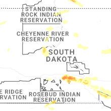


Connect with Interactive Hail Maps