

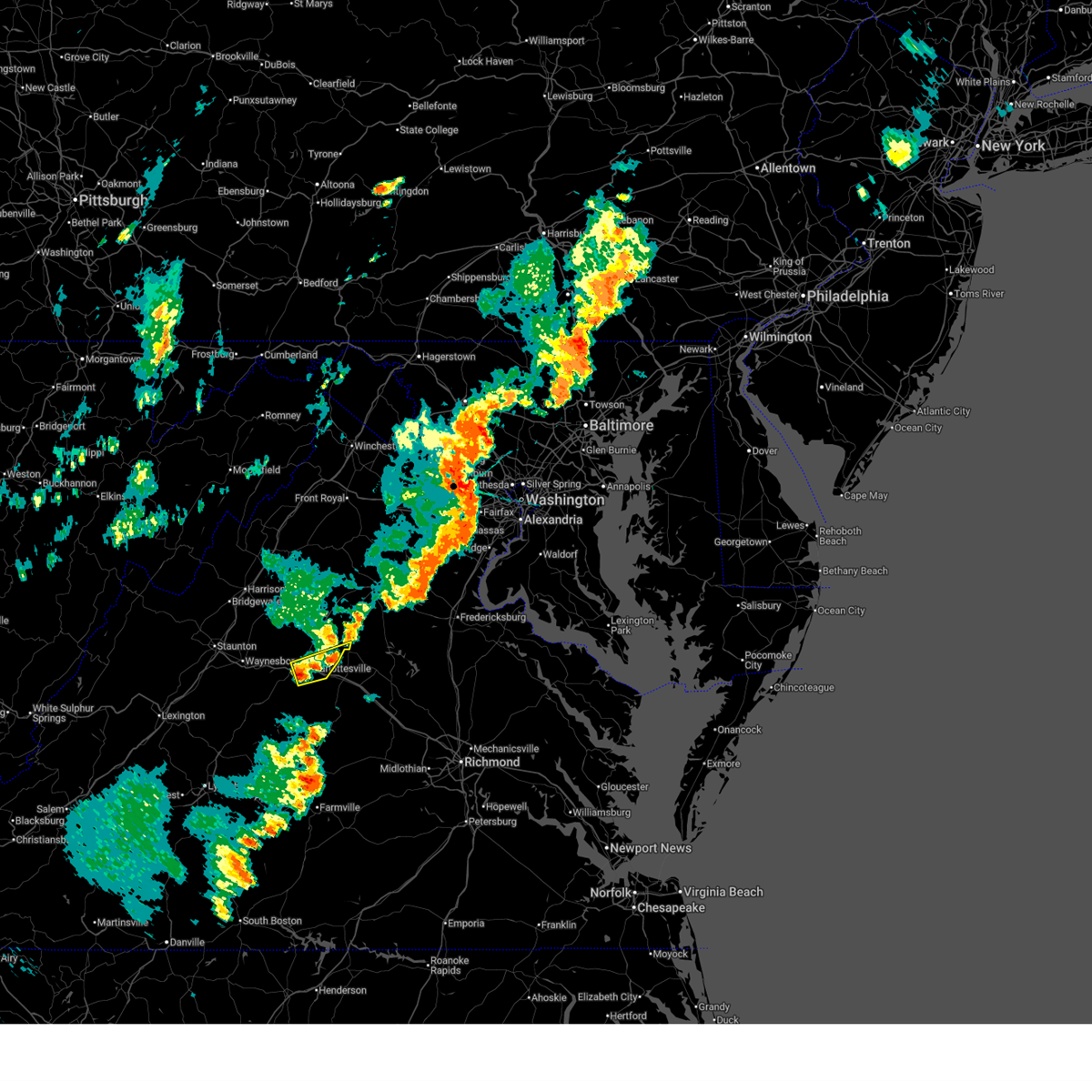
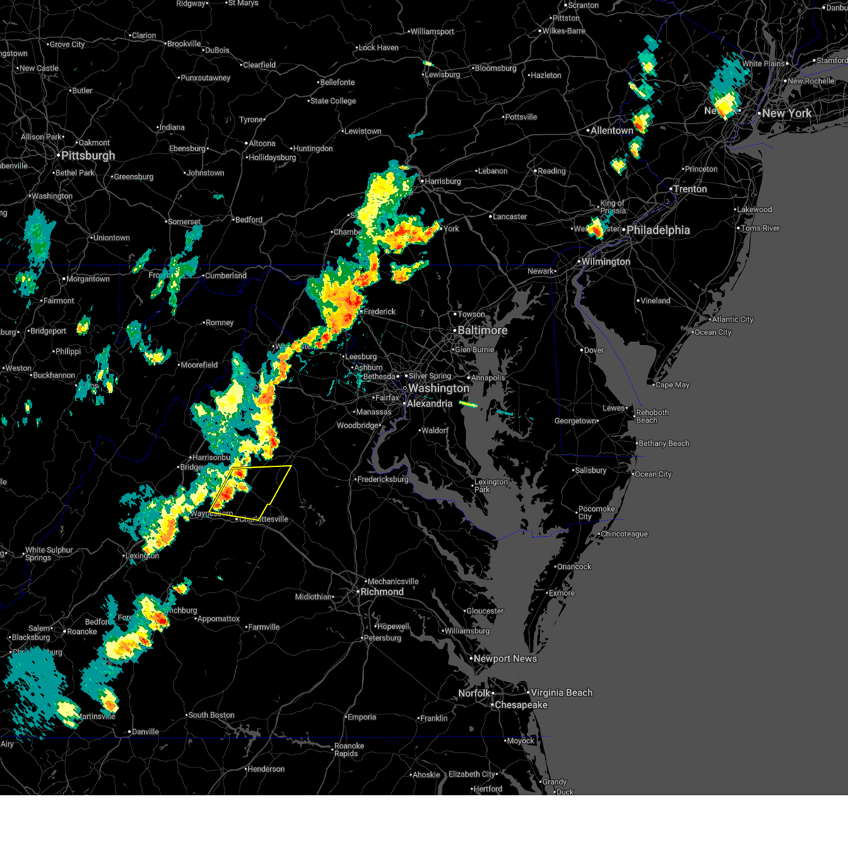
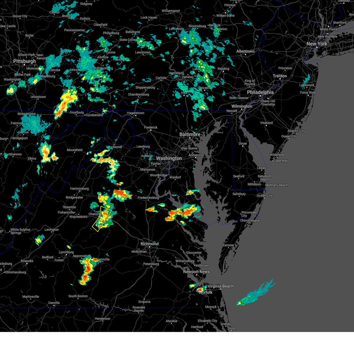
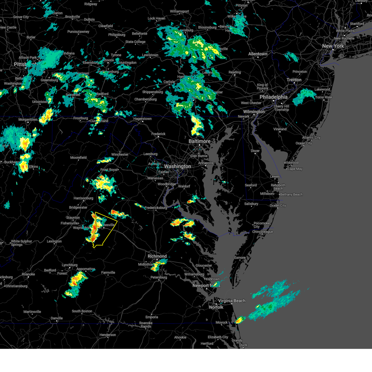
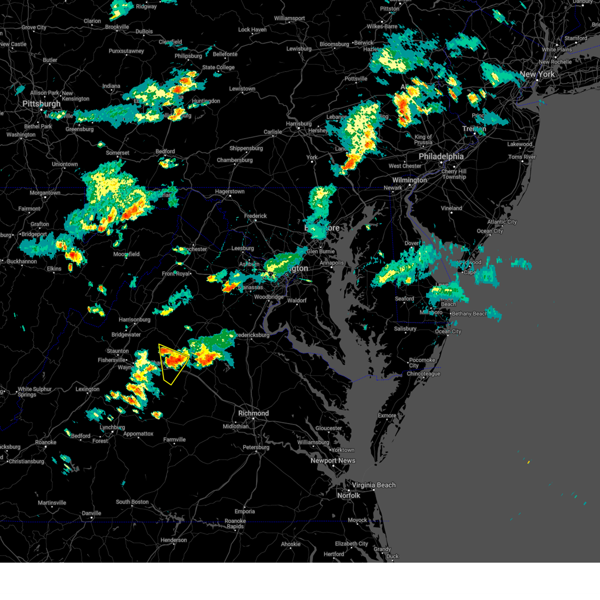
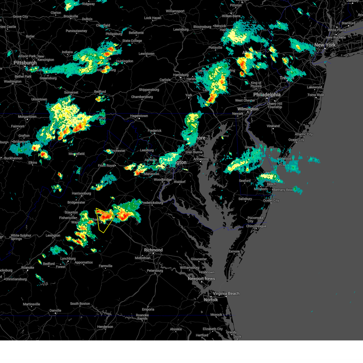
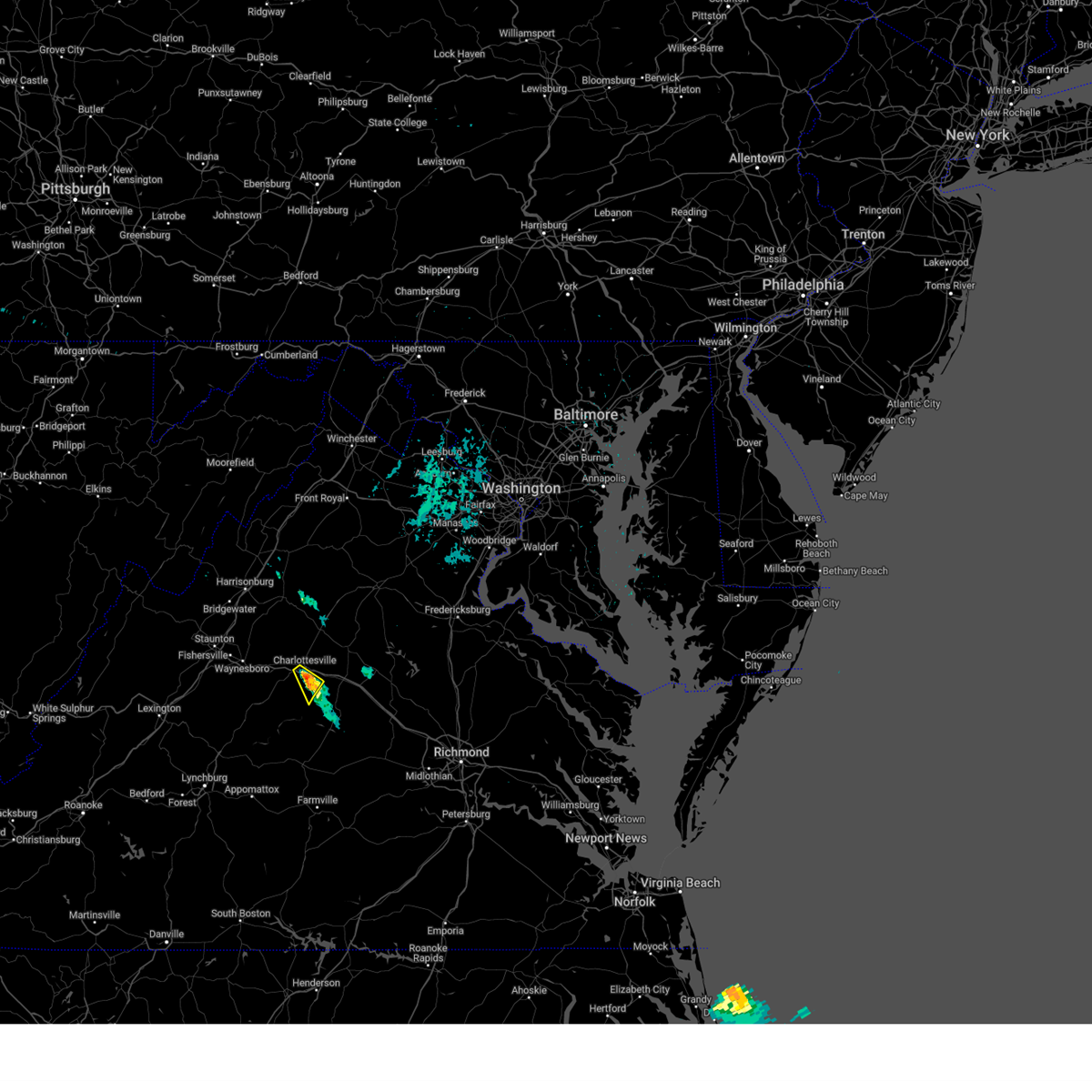
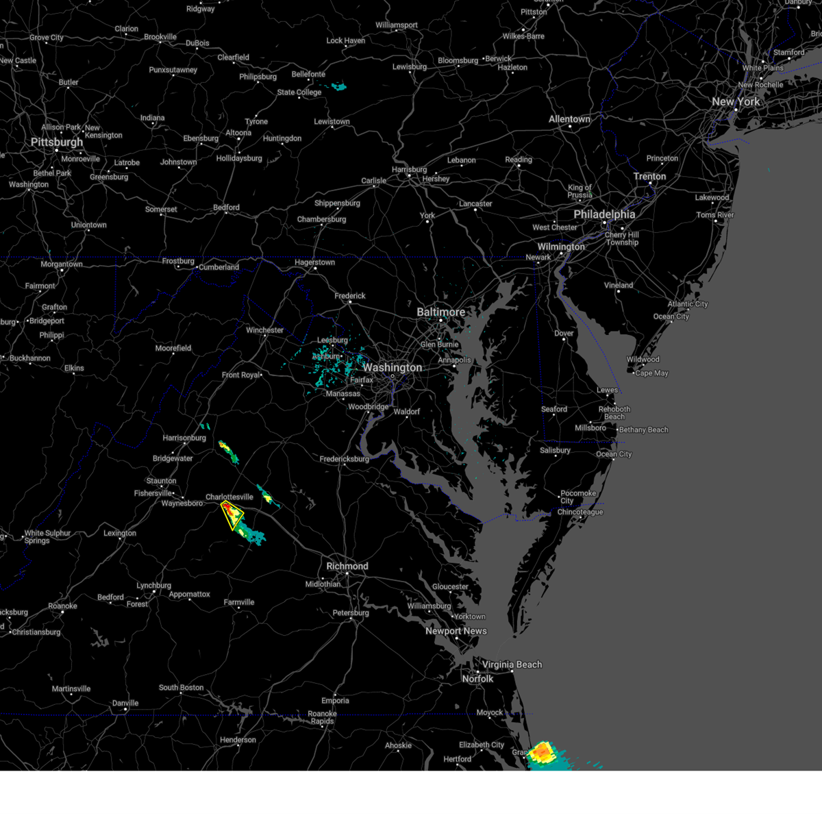
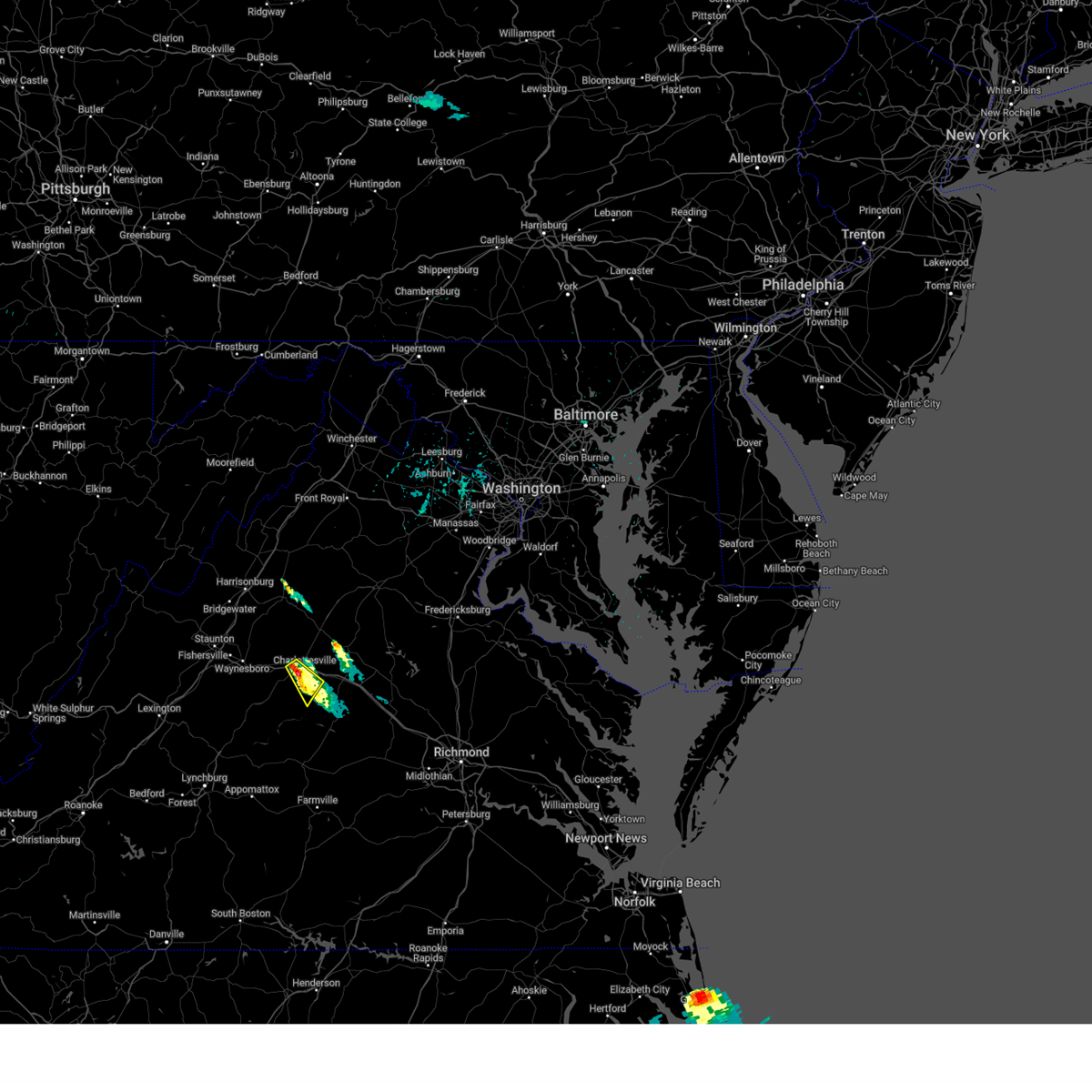
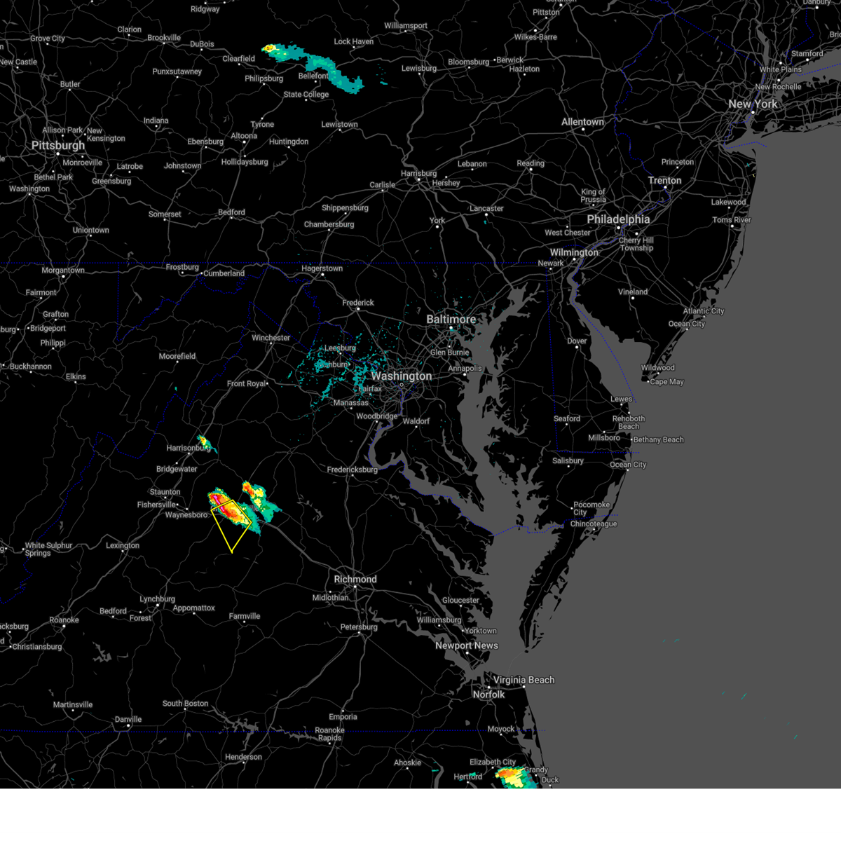
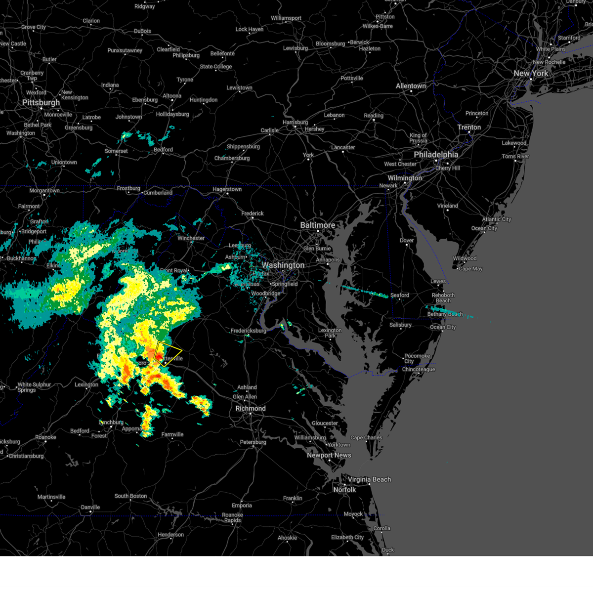
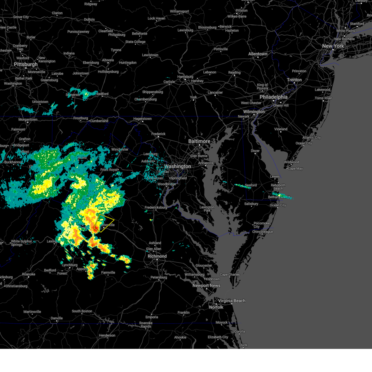
Hail Map for Charlottesville, VA
The Charlottesville, VA area has had 20 reports of on-the-ground hail by trained spotters, and has been under severe weather warnings 18 times during the past 12 months. Doppler radar has detected hail at or near Charlottesville, VA on 45 occasions, including 2 occasions during the past year.
| Name: | Charlottesville, VA |
| Where Located: | 58.7 miles NW of Richmond, VA |
| Map: | Google Map for Charlottesville, VA |
| Population: | 43475 |
| Housing Units: | 19189 |
| More Info: | Search Google for Charlottesville, VA |
1
The Top Recent Hail Date for Charlottesville, VA is Thursday, May 15, 2025 (15th out of 45)

Hail and Wind Damage Spotted near Charlottesville, VA
| Date / Time | Report Details |
|---|---|
| 7/9/2025 2:34 PM EDT | Portion of a large tree fell onto utility lines and across alderman r in city of charlottes county VA, 1.1 miles ESE of Charlottesville, VA |
| 6/19/2025 4:01 PM EDT |
 Svrlwx the national weather service in sterling virginia has issued a * severe thunderstorm warning for, the city of charlottesville in central virginia, southwestern orange county in central virginia, east central albemarle county in central virginia, * until 430 pm edt. * at 401 pm edt, a severe thunderstorm was located over charlottesville, moving northeast at 45 mph (radar indicated). Hazards include 60 mph wind gusts and quarter size hail. Damaging winds will cause some trees and large branches to fall. this could injure those outdoors, as well as damage homes and vehicles. roadways may become blocked by downed trees. localized power outages are possible. Unsecured light objects may become projectiles. Svrlwx the national weather service in sterling virginia has issued a * severe thunderstorm warning for, the city of charlottesville in central virginia, southwestern orange county in central virginia, east central albemarle county in central virginia, * until 430 pm edt. * at 401 pm edt, a severe thunderstorm was located over charlottesville, moving northeast at 45 mph (radar indicated). Hazards include 60 mph wind gusts and quarter size hail. Damaging winds will cause some trees and large branches to fall. this could injure those outdoors, as well as damage homes and vehicles. roadways may become blocked by downed trees. localized power outages are possible. Unsecured light objects may become projectiles.
|
| 6/19/2025 3:04 PM EDT |
 Svrlwx the national weather service in sterling virginia has issued a * severe thunderstorm warning for, southern madison county in northwestern virginia, the northern city of charlottesville in central virginia, southwestern orange county in central virginia, northern albemarle county in central virginia, greene county in central virginia, southwestern culpeper county in northern virginia, * until 330 pm edt. * at 304 pm edt, severe thunderstorms were located along a line extending from near stanardsville to near free union, moving east at 40 mph (radar indicated). Hazards include 60 mph wind gusts. Damaging winds will cause some trees and large branches to fall. this could injure those outdoors, as well as damage homes and vehicles. roadways may become blocked by downed trees. localized power outages are possible. Unsecured light objects may become projectiles. Svrlwx the national weather service in sterling virginia has issued a * severe thunderstorm warning for, southern madison county in northwestern virginia, the northern city of charlottesville in central virginia, southwestern orange county in central virginia, northern albemarle county in central virginia, greene county in central virginia, southwestern culpeper county in northern virginia, * until 330 pm edt. * at 304 pm edt, severe thunderstorms were located along a line extending from near stanardsville to near free union, moving east at 40 mph (radar indicated). Hazards include 60 mph wind gusts. Damaging winds will cause some trees and large branches to fall. this could injure those outdoors, as well as damage homes and vehicles. roadways may become blocked by downed trees. localized power outages are possible. Unsecured light objects may become projectiles.
|
| 6/8/2025 5:42 PM EDT |
 The storms which prompted the warning have weakened below severe limits, and have exited the warned area. therefore, the warning will be allowed to expire. a tornado watch remains in effect until 1000 pm edt for central virginia. to report severe weather, contact your nearest law enforcement agency. they will relay your report to the national weather service sterling virginia. The storms which prompted the warning have weakened below severe limits, and have exited the warned area. therefore, the warning will be allowed to expire. a tornado watch remains in effect until 1000 pm edt for central virginia. to report severe weather, contact your nearest law enforcement agency. they will relay your report to the national weather service sterling virginia.
|
| 6/8/2025 5:28 PM EDT | At 528 pm edt, severe thunderstorms were located along a line extending from near stanardsville to near charlottesville to 8 miles north of centenary, moving east at 20 mph (radar indicated). Hazards include 60 mph wind gusts. Damaging winds will cause some trees and large branches to fall. this could injure those outdoors, as well as damage homes and vehicles. roadways may become blocked by downed trees. localized power outages are possible. unsecured light objects may become projectiles. Locations impacted include, cobham, cismont, campbell, hollymead, boyd tavern, monticello, keswick, woodridge, stony point, shadwell, keene, glendower, overton, scottsville, and charlottesville. |
| 6/8/2025 5:28 PM EDT | the severe thunderstorm warning has been cancelled and is no longer in effect |
| 6/8/2025 5:18 PM EDT | At 517 pm edt, severe thunderstorms were located along a line extending from near stanardsville to near charlottesville to 8 miles east of schuyler, moving east at 20 mph (radar indicated). Hazards include 60 mph wind gusts. Damaging winds will cause some trees and large branches to fall. this could injure those outdoors, as well as damage homes and vehicles. roadways may become blocked by downed trees. localized power outages are possible. unsecured light objects may become projectiles. Locations impacted include, hollymead, stony point, flordon, westmoreland, scott stadium, cobham, charlottesville, cismont, campbell, newcomb hall, boyd tavern, monticello, keswick, woodridge, carrsbrook, earlysville, shadwell, barracks, esmont, and keene. |
| 6/8/2025 5:06 PM EDT |
 Svrlwx the national weather service in sterling virginia has issued a * severe thunderstorm warning for, the city of charlottesville in central virginia, albemarle county in central virginia, * until 545 pm edt. * at 506 pm edt, severe thunderstorms were located along a line extending from near free union to near charlottesville to near schuyler, moving east at 20 mph (radar indicated). Hazards include 60 mph wind gusts. Damaging winds will cause some trees and large branches to fall. this could injure those outdoors, as well as damage homes and vehicles. roadways may become blocked by downed trees. localized power outages are possible. Unsecured light objects may become projectiles. Svrlwx the national weather service in sterling virginia has issued a * severe thunderstorm warning for, the city of charlottesville in central virginia, albemarle county in central virginia, * until 545 pm edt. * at 506 pm edt, severe thunderstorms were located along a line extending from near free union to near charlottesville to near schuyler, moving east at 20 mph (radar indicated). Hazards include 60 mph wind gusts. Damaging winds will cause some trees and large branches to fall. this could injure those outdoors, as well as damage homes and vehicles. roadways may become blocked by downed trees. localized power outages are possible. Unsecured light objects may become projectiles.
|
| 6/6/2025 4:15 PM EDT | Trees and wires blew down in the 1700 block of va-20 stony point roa in albemarle county VA, 3 miles WSW of Charlottesville, VA |
| 6/6/2025 4:13 PM EDT |
 At 413 pm edt, a severe thunderstorm was located near charlottesville, moving southeast at 15 mph (radar indicated). Hazards include 60 mph wind gusts. Damaging winds will cause some trees and large branches to fall. this could injure those outdoors, as well as damage homes and vehicles. roadways may become blocked by downed trees. localized power outages are possible. unsecured light objects may become projectiles. Locations impacted include, cobham, charlottesville, cismont, campbell, newcomb hall, hollymead, boyd tavern, monticello, keswick, woodridge, stony point, carrsbrook, earlysville, free union, shadwell, barracks, overton, westmoreland, scott stadium, and advance mills. At 413 pm edt, a severe thunderstorm was located near charlottesville, moving southeast at 15 mph (radar indicated). Hazards include 60 mph wind gusts. Damaging winds will cause some trees and large branches to fall. this could injure those outdoors, as well as damage homes and vehicles. roadways may become blocked by downed trees. localized power outages are possible. unsecured light objects may become projectiles. Locations impacted include, cobham, charlottesville, cismont, campbell, newcomb hall, hollymead, boyd tavern, monticello, keswick, woodridge, stony point, carrsbrook, earlysville, free union, shadwell, barracks, overton, westmoreland, scott stadium, and advance mills.
|
| 6/6/2025 4:08 PM EDT |
 Svrlwx the national weather service in sterling virginia has issued a * severe thunderstorm warning for, the city of charlottesville in central virginia, northeastern albemarle county in central virginia, * until 445 pm edt. * at 408 pm edt, a severe thunderstorm was located near charlottesville, moving south at 15 mph (radar indicated). Hazards include 60 mph wind gusts and quarter size hail. Damaging winds will cause some trees and large branches to fall. this could injure those outdoors, as well as damage homes and vehicles. roadways may become blocked by downed trees. localized power outages are possible. Unsecured light objects may become projectiles. Svrlwx the national weather service in sterling virginia has issued a * severe thunderstorm warning for, the city of charlottesville in central virginia, northeastern albemarle county in central virginia, * until 445 pm edt. * at 408 pm edt, a severe thunderstorm was located near charlottesville, moving south at 15 mph (radar indicated). Hazards include 60 mph wind gusts and quarter size hail. Damaging winds will cause some trees and large branches to fall. this could injure those outdoors, as well as damage homes and vehicles. roadways may become blocked by downed trees. localized power outages are possible. Unsecured light objects may become projectiles.
|
| 5/15/2025 8:37 PM EDT |
 The storm which prompted the warning has weakened below severe limits, and no longer poses an immediate threat to life or property. therefore, the warning will be allowed to expire. a severe thunderstorm watch remains in effect until midnight edt for central virginia. to report severe weather, contact your nearest law enforcement agency. they will relay your report to the national weather service sterling virginia. The storm which prompted the warning has weakened below severe limits, and no longer poses an immediate threat to life or property. therefore, the warning will be allowed to expire. a severe thunderstorm watch remains in effect until midnight edt for central virginia. to report severe weather, contact your nearest law enforcement agency. they will relay your report to the national weather service sterling virginia.
|
| 5/15/2025 8:26 PM EDT |
 At 826 pm edt, a severe thunderstorm was located near charlottesville, moving southeast at 25 mph (radar indicated). Hazards include 60 mph wind gusts and quarter size hail. Damaging winds will cause some trees and large branches to fall. this could injure those outdoors, as well as damage homes and vehicles. roadways may become blocked by downed trees. localized power outages are possible. unsecured light objects may become projectiles. Locations impacted include, scott stadium, monticello, woodridge, overton, newcomb hall, and charlottesville. At 826 pm edt, a severe thunderstorm was located near charlottesville, moving southeast at 25 mph (radar indicated). Hazards include 60 mph wind gusts and quarter size hail. Damaging winds will cause some trees and large branches to fall. this could injure those outdoors, as well as damage homes and vehicles. roadways may become blocked by downed trees. localized power outages are possible. unsecured light objects may become projectiles. Locations impacted include, scott stadium, monticello, woodridge, overton, newcomb hall, and charlottesville.
|
| 5/15/2025 8:16 PM EDT |
 At 816 pm edt, a severe thunderstorm was located over charlottesville, moving southeast at 10 mph (radar indicated). Hazards include 60 mph wind gusts and quarter size hail. Damaging winds will cause some trees and large branches to fall. this could injure those outdoors, as well as damage homes and vehicles. roadways may become blocked by downed trees. localized power outages are possible. unsecured light objects may become projectiles. Locations impacted include, charlottesville, overton, newcomb hall, scott stadium, monticello, woodridge, flordon, and barracks. At 816 pm edt, a severe thunderstorm was located over charlottesville, moving southeast at 10 mph (radar indicated). Hazards include 60 mph wind gusts and quarter size hail. Damaging winds will cause some trees and large branches to fall. this could injure those outdoors, as well as damage homes and vehicles. roadways may become blocked by downed trees. localized power outages are possible. unsecured light objects may become projectiles. Locations impacted include, charlottesville, overton, newcomb hall, scott stadium, monticello, woodridge, flordon, and barracks.
|
| 5/15/2025 8:01 PM EDT |
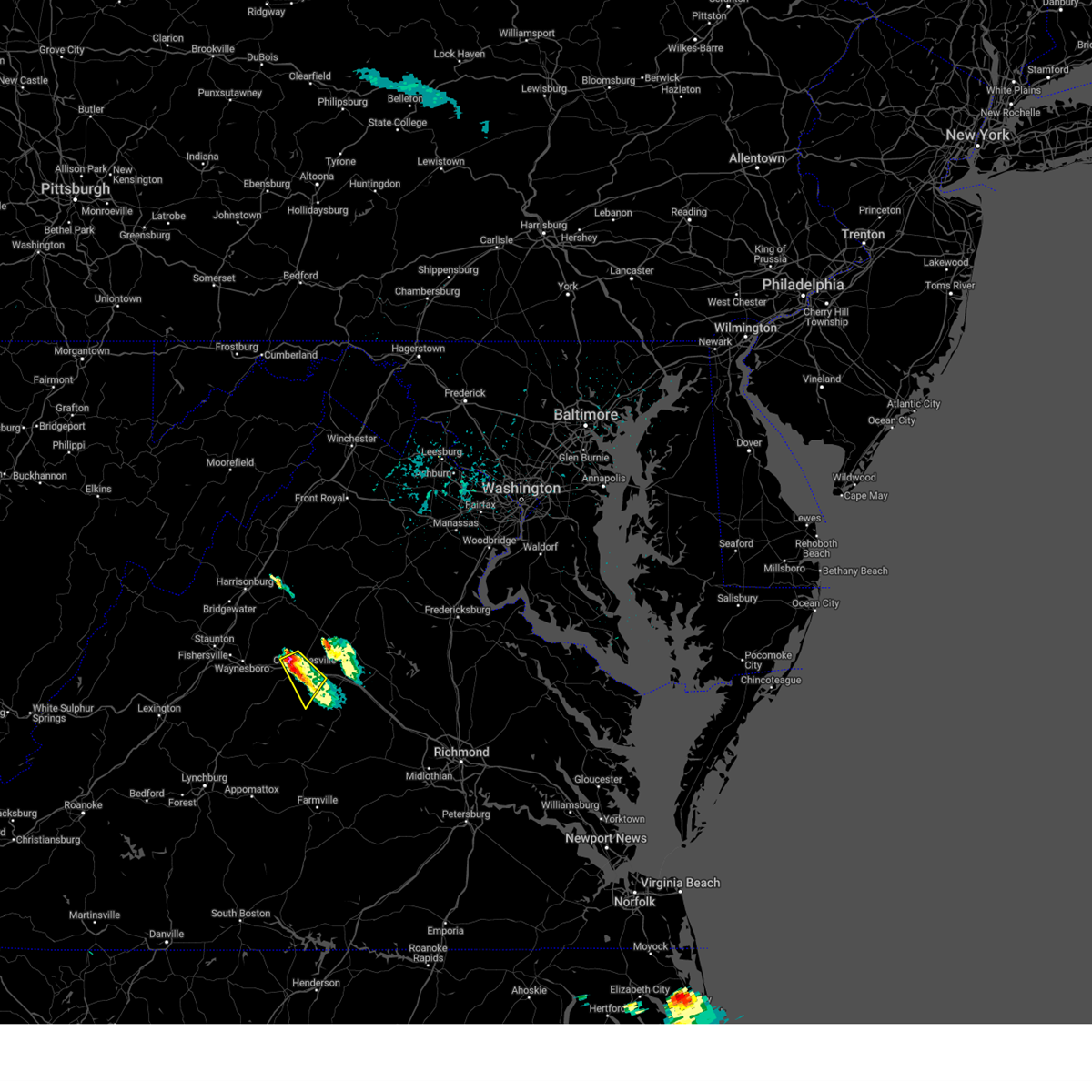 At 801 pm edt, a severe thunderstorm was located over charlottesville, moving southeast at 20 mph (radar indicated). Hazards include 60 mph wind gusts and quarter size hail. Damaging winds will cause some trees and large branches to fall. this could injure those outdoors, as well as damage homes and vehicles. roadways may become blocked by downed trees. localized power outages are possible. unsecured light objects may become projectiles. Locations impacted include, charlottesville, overton, newcomb hall, scott stadium, monticello, woodridge, flordon, ivy, shadwell, and barracks. At 801 pm edt, a severe thunderstorm was located over charlottesville, moving southeast at 20 mph (radar indicated). Hazards include 60 mph wind gusts and quarter size hail. Damaging winds will cause some trees and large branches to fall. this could injure those outdoors, as well as damage homes and vehicles. roadways may become blocked by downed trees. localized power outages are possible. unsecured light objects may become projectiles. Locations impacted include, charlottesville, overton, newcomb hall, scott stadium, monticello, woodridge, flordon, ivy, shadwell, and barracks.
|
| 5/15/2025 7:42 PM EDT | Golf Ball sized hail reported 10.5 miles SE of Charlottesville, VA |
| 5/15/2025 7:39 PM EDT |
 Svrlwx the national weather service in sterling virginia has issued a * severe thunderstorm warning for, the city of charlottesville in central virginia, central albemarle county in central virginia, * until 845 pm edt. * at 739 pm edt, a severe thunderstorm was located near free union, or 7 miles northwest of charlottesville, moving southeast at 25 mph (radar indicated). Hazards include 60 mph wind gusts and half dollar size hail. Damaging winds will cause some trees and large branches to fall. this could injure those outdoors, as well as damage homes and vehicles. roadways may become blocked by downed trees. localized power outages are possible. Unsecured light objects may become projectiles. Svrlwx the national weather service in sterling virginia has issued a * severe thunderstorm warning for, the city of charlottesville in central virginia, central albemarle county in central virginia, * until 845 pm edt. * at 739 pm edt, a severe thunderstorm was located near free union, or 7 miles northwest of charlottesville, moving southeast at 25 mph (radar indicated). Hazards include 60 mph wind gusts and half dollar size hail. Damaging winds will cause some trees and large branches to fall. this could injure those outdoors, as well as damage homes and vehicles. roadways may become blocked by downed trees. localized power outages are possible. Unsecured light objects may become projectiles.
|
| 9/26/2024 1:14 AM EDT |
 At 113 am edt, a severe thunderstorm was located near charlottesville, moving northeast at 25 mph (radar indicated). Hazards include 60 mph wind gusts and possible tornado. Damaging winds will cause some trees and large branches to fall. this could injure those outdoors, as well as damage homes and vehicles. roadways may become blocked by downed trees. localized power outages are possible. unsecured light objects may become projectiles. Locations impacted include, charlottesville, free union, westmoreland, hollymead, ivy, newcomb hall, stony point, flordon, carrsbrook, earlysville, barracks, scott stadium, and advance mills. At 113 am edt, a severe thunderstorm was located near charlottesville, moving northeast at 25 mph (radar indicated). Hazards include 60 mph wind gusts and possible tornado. Damaging winds will cause some trees and large branches to fall. this could injure those outdoors, as well as damage homes and vehicles. roadways may become blocked by downed trees. localized power outages are possible. unsecured light objects may become projectiles. Locations impacted include, charlottesville, free union, westmoreland, hollymead, ivy, newcomb hall, stony point, flordon, carrsbrook, earlysville, barracks, scott stadium, and advance mills.
|
| 9/26/2024 1:07 AM EDT | There were several calls for trees blown down between crozet and charlottesvill in albemarle county VA, 5 miles ESE of Charlottesville, VA |
| 9/26/2024 1:04 AM EDT |
 Svrlwx the national weather service in sterling virginia has issued a * severe thunderstorm warning for, the city of charlottesville in central virginia, northeastern albemarle county in central virginia, * until 130 am edt. * at 104 am edt, a severe thunderstorm was located near charlottesville, moving northeast at 25 mph (radar indicated). Hazards include 60 mph wind gusts and possible tornado. Damaging winds will cause some trees and large branches to fall. this could injure those outdoors, as well as damage homes and vehicles. roadways may become blocked by downed trees. localized power outages are possible. Unsecured light objects may become projectiles. Svrlwx the national weather service in sterling virginia has issued a * severe thunderstorm warning for, the city of charlottesville in central virginia, northeastern albemarle county in central virginia, * until 130 am edt. * at 104 am edt, a severe thunderstorm was located near charlottesville, moving northeast at 25 mph (radar indicated). Hazards include 60 mph wind gusts and possible tornado. Damaging winds will cause some trees and large branches to fall. this could injure those outdoors, as well as damage homes and vehicles. roadways may become blocked by downed trees. localized power outages are possible. Unsecured light objects may become projectiles.
|
| 7/31/2024 5:12 PM EDT |
 the severe thunderstorm warning has been cancelled and is no longer in effect the severe thunderstorm warning has been cancelled and is no longer in effect
|
| 7/31/2024 4:48 PM EDT |
 Svrlwx the national weather service in sterling virginia has issued a * severe thunderstorm warning for, the city of charlottesville in central virginia, east central albemarle county in central virginia, * until 530 pm edt. * at 448 pm edt, a severe thunderstorm was located over charlottesville, moving east at 15 mph (radar indicated). Hazards include 60 mph wind gusts and quarter size hail. Damaging winds will cause some trees and large branches to fall. this could injure those outdoors, as well as damage homes and vehicles. roadways may become blocked by downed trees. localized power outages are possible. Unsecured light objects may become projectiles. Svrlwx the national weather service in sterling virginia has issued a * severe thunderstorm warning for, the city of charlottesville in central virginia, east central albemarle county in central virginia, * until 530 pm edt. * at 448 pm edt, a severe thunderstorm was located over charlottesville, moving east at 15 mph (radar indicated). Hazards include 60 mph wind gusts and quarter size hail. Damaging winds will cause some trees and large branches to fall. this could injure those outdoors, as well as damage homes and vehicles. roadways may become blocked by downed trees. localized power outages are possible. Unsecured light objects may become projectiles.
|
| 7/17/2024 5:03 PM EDT |
 the severe thunderstorm warning has been cancelled and is no longer in effect the severe thunderstorm warning has been cancelled and is no longer in effect
|
| 7/17/2024 4:42 PM EDT |
 At 442 pm edt, a severe thunderstorm was located near charlottesville, moving east at 40 mph (emergency management). Hazards include 60 mph wind gusts. Damaging winds will cause some trees and large branches to fall. this could injure those outdoors, as well as damage homes and vehicles. roadways may become blocked by downed trees. localized power outages are possible. unsecured light objects may become projectiles. Locations impacted include, charlottesville, campbell, westmoreland, hollymead, cobham, cismont, newcomb hall, boyd tavern, keswick, monticello, stony point, flordon, carrsbrook, earlysville, shadwell, barracks, overton, scott stadium, and advance mills. At 442 pm edt, a severe thunderstorm was located near charlottesville, moving east at 40 mph (emergency management). Hazards include 60 mph wind gusts. Damaging winds will cause some trees and large branches to fall. this could injure those outdoors, as well as damage homes and vehicles. roadways may become blocked by downed trees. localized power outages are possible. unsecured light objects may become projectiles. Locations impacted include, charlottesville, campbell, westmoreland, hollymead, cobham, cismont, newcomb hall, boyd tavern, keswick, monticello, stony point, flordon, carrsbrook, earlysville, shadwell, barracks, overton, scott stadium, and advance mills.
|
| 7/17/2024 4:38 PM EDT | Trees and wires down near shadwel in albemarle county VA, 5.2 miles WNW of Charlottesville, VA |
| 7/17/2024 4:33 PM EDT | Reports of trees... branches... and wires down on the south side of charlottesvill in albemarle county VA, 0.4 miles S of Charlottesville, VA |
| 7/17/2024 4:12 PM EDT |
 Svrlwx the national weather service in sterling virginia has issued a * severe thunderstorm warning for, the city of charlottesville in central virginia, albemarle county in central virginia, * until 515 pm edt. * at 411 pm edt, a severe thunderstorm was located near afton, or near waynesboro, moving east at 40 mph (radar indicated). Hazards include 60 mph wind gusts. Damaging winds will cause some trees and large branches to fall. this could injure those outdoors, as well as damage homes and vehicles. roadways may become blocked by downed trees. localized power outages are possible. Unsecured light objects may become projectiles. Svrlwx the national weather service in sterling virginia has issued a * severe thunderstorm warning for, the city of charlottesville in central virginia, albemarle county in central virginia, * until 515 pm edt. * at 411 pm edt, a severe thunderstorm was located near afton, or near waynesboro, moving east at 40 mph (radar indicated). Hazards include 60 mph wind gusts. Damaging winds will cause some trees and large branches to fall. this could injure those outdoors, as well as damage homes and vehicles. roadways may become blocked by downed trees. localized power outages are possible. Unsecured light objects may become projectiles.
|
| 7/16/2024 9:18 PM EDT |
 At 918 pm edt, a severe thunderstorm was located near charlottesville, moving northeast at 10 mph (radar indicated). Hazards include 60 mph wind gusts. Damaging winds will cause some trees and large branches to fall. this could injure those outdoors, as well as damage homes and vehicles. roadways may become blocked by downed trees. localized power outages are possible. unsecured light objects may become projectiles. Locations impacted include, charlottesville, campbell, westmoreland, overton, boyd tavern, keswick, monticello, woodridge, carrsbrook, and shadwell. At 918 pm edt, a severe thunderstorm was located near charlottesville, moving northeast at 10 mph (radar indicated). Hazards include 60 mph wind gusts. Damaging winds will cause some trees and large branches to fall. this could injure those outdoors, as well as damage homes and vehicles. roadways may become blocked by downed trees. localized power outages are possible. unsecured light objects may become projectiles. Locations impacted include, charlottesville, campbell, westmoreland, overton, boyd tavern, keswick, monticello, woodridge, carrsbrook, and shadwell.
|
| 7/16/2024 9:05 PM EDT | Tree down near buck island rd and caribbean l in albemarle county VA, 8.1 miles NW of Charlottesville, VA |
| 7/16/2024 9:04 PM EDT |
 Svrlwx the national weather service in sterling virginia has issued a * severe thunderstorm warning for, the city of charlottesville in central virginia, central albemarle county in central virginia, * until 930 pm edt. * at 904 pm edt, a severe thunderstorm was located 7 miles south of charlottesville, moving northeast at 10 mph (radar indicated). Hazards include 60 mph wind gusts. Damaging winds will cause some trees and large branches to fall. this could injure those outdoors, as well as damage homes and vehicles. roadways may become blocked by downed trees. localized power outages are possible. Unsecured light objects may become projectiles. Svrlwx the national weather service in sterling virginia has issued a * severe thunderstorm warning for, the city of charlottesville in central virginia, central albemarle county in central virginia, * until 930 pm edt. * at 904 pm edt, a severe thunderstorm was located 7 miles south of charlottesville, moving northeast at 10 mph (radar indicated). Hazards include 60 mph wind gusts. Damaging winds will cause some trees and large branches to fall. this could injure those outdoors, as well as damage homes and vehicles. roadways may become blocked by downed trees. localized power outages are possible. Unsecured light objects may become projectiles.
|
| 7/16/2024 7:36 PM EDT | Tree down near taylors gap rd amd red hill r in albemarle county VA, 8.2 miles ENE of Charlottesville, VA |
| 7/16/2024 7:23 PM EDT | Tree down near dick woods rd and dry bridge rd in albemarle county VA, 7.6 miles E of Charlottesville, VA |
| 5/26/2024 8:20 PM EDT | Numerous trees and wires down county-wide and in the city of charlottesvill in albemarle county VA, 0.4 miles S of Charlottesville, VA |
| 5/26/2024 8:09 PM EDT |
 Svrlwx the national weather service in sterling virginia has issued a * severe thunderstorm warning for, madison county in northwestern virginia, the city of charlottesville in central virginia, southwestern orange county in central virginia, southeastern rockingham county in western virginia, central albemarle county in central virginia, southern rappahannock county in northwestern virginia, greene county in central virginia, southwestern culpeper county in northern virginia, * until 915 pm edt. * at 809 pm edt, a severe thunderstorm was located near crozet, or 10 miles southeast of waynesboro, moving northeast at 55 mph (radar indicated). Hazards include 60 mph wind gusts and quarter size hail. Damaging winds will cause some trees and large branches to fall. this could injure those outdoors, as well as damage homes and vehicles. roadways may become blocked by downed trees. localized power outages are possible. Unsecured light objects may become projectiles. Svrlwx the national weather service in sterling virginia has issued a * severe thunderstorm warning for, madison county in northwestern virginia, the city of charlottesville in central virginia, southwestern orange county in central virginia, southeastern rockingham county in western virginia, central albemarle county in central virginia, southern rappahannock county in northwestern virginia, greene county in central virginia, southwestern culpeper county in northern virginia, * until 915 pm edt. * at 809 pm edt, a severe thunderstorm was located near crozet, or 10 miles southeast of waynesboro, moving northeast at 55 mph (radar indicated). Hazards include 60 mph wind gusts and quarter size hail. Damaging winds will cause some trees and large branches to fall. this could injure those outdoors, as well as damage homes and vehicles. roadways may become blocked by downed trees. localized power outages are possible. Unsecured light objects may become projectiles.
|
| 9/8/2023 9:26 PM EDT | Calls for a couple individual trees down in/near keswic in albemarle county VA, 0.4 miles S of Charlottesville, VA |
| 8/7/2023 5:00 PM EDT |
 At 500 pm edt, a severe thunderstorm was located near charlottesville, moving east at 40 mph (radar indicated). Hazards include 60 mph wind gusts and quarter size hail. Damaging winds will cause some trees and large branches to fall. this could injure those outdoors, as well as damage homes and vehicles. roadways may become blocked by downed trees. localized power outages are possible. Unsecured light objects may become projectiles. At 500 pm edt, a severe thunderstorm was located near charlottesville, moving east at 40 mph (radar indicated). Hazards include 60 mph wind gusts and quarter size hail. Damaging winds will cause some trees and large branches to fall. this could injure those outdoors, as well as damage homes and vehicles. roadways may become blocked by downed trees. localized power outages are possible. Unsecured light objects may become projectiles.
|
| 8/7/2023 4:46 PM EDT | Tree down near the intersection of garth road and yule farm in albemarle county VA, 8.8 miles SE of Charlottesville, VA |
| 7/28/2023 8:24 PM EDT |
 The severe thunderstorm warning for southwestern orange, northeastern albemarle and southeastern greene counties and the eastern city of charlottesville will expire at 830 pm edt, the storm which prompted the warning has weakened below severe limits, and no longer poses an immediate threat to life or property. therefore, the warning will be allowed to expire. a severe thunderstorm watch remains in effect until 1100 pm edt for central virginia. to report severe weather, contact your nearest law enforcement agency. they will relay your report to the national weather service sterling virginia. The severe thunderstorm warning for southwestern orange, northeastern albemarle and southeastern greene counties and the eastern city of charlottesville will expire at 830 pm edt, the storm which prompted the warning has weakened below severe limits, and no longer poses an immediate threat to life or property. therefore, the warning will be allowed to expire. a severe thunderstorm watch remains in effect until 1100 pm edt for central virginia. to report severe weather, contact your nearest law enforcement agency. they will relay your report to the national weather service sterling virginia.
|
| 7/28/2023 8:04 PM EDT |
 At 804 pm edt, a severe thunderstorm was located near lake monticello, or 7 miles southeast of charlottesville, moving east at 30 mph (law enforcement). Hazards include 60 mph wind gusts. Damaging winds will cause some trees and large branches to fall. this could injure those outdoors, as well as damage homes and vehicles. roadways may become blocked by downed trees. localized power outages are possible. unsecured light objects may become projectiles. locations impacted include, charlottesville, campbell, westmoreland, hollymead, gordonsville, ruckersville, cobham, cismont, eheart, boyd tavern, barboursville, keswick, monticello, stony point, carrsbrook, madison run, shadwell, lahore, old somerset and advance mills. hail threat, radar indicated max hail size, <. 75 in wind threat, observed max wind gust, 60 mph. At 804 pm edt, a severe thunderstorm was located near lake monticello, or 7 miles southeast of charlottesville, moving east at 30 mph (law enforcement). Hazards include 60 mph wind gusts. Damaging winds will cause some trees and large branches to fall. this could injure those outdoors, as well as damage homes and vehicles. roadways may become blocked by downed trees. localized power outages are possible. unsecured light objects may become projectiles. locations impacted include, charlottesville, campbell, westmoreland, hollymead, gordonsville, ruckersville, cobham, cismont, eheart, boyd tavern, barboursville, keswick, monticello, stony point, carrsbrook, madison run, shadwell, lahore, old somerset and advance mills. hail threat, radar indicated max hail size, <. 75 in wind threat, observed max wind gust, 60 mph.
|
| 7/28/2023 7:47 PM EDT | Multiple trees down in the city of charlottesville per 911 cente in albemarle county VA, 0.4 miles S of Charlottesville, VA |
| 7/28/2023 7:29 PM EDT | Multiple trees down in free union. roads close in albemarle county VA, 8.9 miles SSE of Charlottesville, VA |
| 7/28/2023 7:24 PM EDT | A couple trees down near white hall per 911 cente in albemarle county VA, 11 miles ESE of Charlottesville, VA |
| 7/28/2023 7:20 PM EDT |
 At 719 pm edt, severe thunderstorms were located along a line extending from 8 miles northwest of free union to near wintergreen, moving east at 35 mph (law enforcement). Hazards include 60 mph wind gusts. Damaging winds will cause some trees and large branches to fall. this could injure those outdoors, as well as damage homes and vehicles. roadways may become blocked by downed trees. localized power outages are possible. Unsecured light objects may become projectiles. At 719 pm edt, severe thunderstorms were located along a line extending from 8 miles northwest of free union to near wintergreen, moving east at 35 mph (law enforcement). Hazards include 60 mph wind gusts. Damaging winds will cause some trees and large branches to fall. this could injure those outdoors, as well as damage homes and vehicles. roadways may become blocked by downed trees. localized power outages are possible. Unsecured light objects may become projectiles.
|
| 7/6/2023 10:27 PM EDT | A few trees reported down in western albemarle county in albemarle county VA, 11 miles ESE of Charlottesville, VA |
| 7/3/2023 9:27 PM EDT |
 The severe thunderstorm warning for central albemarle county and the city of charlottesville will expire at 930 pm edt, the storm which prompted the warning has weakened below severe limits, and no longer poses an immediate threat to life or property. therefore, the warning will be allowed to expire. however gusty winds are still possible with this thunderstorm. a severe thunderstorm watch remains in effect until 1000 pm edt for central virginia. The severe thunderstorm warning for central albemarle county and the city of charlottesville will expire at 930 pm edt, the storm which prompted the warning has weakened below severe limits, and no longer poses an immediate threat to life or property. therefore, the warning will be allowed to expire. however gusty winds are still possible with this thunderstorm. a severe thunderstorm watch remains in effect until 1000 pm edt for central virginia.
|
| 7/3/2023 9:21 PM EDT | Several trees down due to thunderstorm winds along stony point roa in albemarle county VA, 2.3 miles W of Charlottesville, VA |
| 7/3/2023 9:02 PM EDT |
 At 902 pm edt, a severe thunderstorm was located 7 miles southwest of charlottesville, moving northeast at 35 mph (radar indicated). Hazards include 60 mph wind gusts and quarter size hail. Damaging winds will cause some trees and large branches to fall. this could injure those outdoors, as well as damage homes and vehicles. roadways may become blocked by downed trees. localized power outages are possible. unsecured light objects may become projectiles. locations impacted include, charlottesville, free union, campbell, westmoreland, hollymead, ivy, scottsville, esmont, north garden, stony point, flordon, scott stadium, cismont, newcomb hall, boyd tavern, keswick, monticello, woodridge, carrsbrook and earlysville. hail threat, radar indicated max hail size, 1. 00 in wind threat, radar indicated max wind gust, 60 mph. At 902 pm edt, a severe thunderstorm was located 7 miles southwest of charlottesville, moving northeast at 35 mph (radar indicated). Hazards include 60 mph wind gusts and quarter size hail. Damaging winds will cause some trees and large branches to fall. this could injure those outdoors, as well as damage homes and vehicles. roadways may become blocked by downed trees. localized power outages are possible. unsecured light objects may become projectiles. locations impacted include, charlottesville, free union, campbell, westmoreland, hollymead, ivy, scottsville, esmont, north garden, stony point, flordon, scott stadium, cismont, newcomb hall, boyd tavern, keswick, monticello, woodridge, carrsbrook and earlysville. hail threat, radar indicated max hail size, 1. 00 in wind threat, radar indicated max wind gust, 60 mph.
|
| 7/3/2023 8:42 PM EDT |
 At 841 pm edt, a severe thunderstorm was located near schuyler, or 18 miles southwest of charlottesville, moving northeast at 35 mph (radar indicated). Hazards include 60 mph wind gusts. Damaging winds will cause some trees and large branches to fall. this could injure those outdoors, as well as damage homes and vehicles. roadways may become blocked by downed trees. localized power outages are possible. Unsecured light objects may become projectiles. At 841 pm edt, a severe thunderstorm was located near schuyler, or 18 miles southwest of charlottesville, moving northeast at 35 mph (radar indicated). Hazards include 60 mph wind gusts. Damaging winds will cause some trees and large branches to fall. this could injure those outdoors, as well as damage homes and vehicles. roadways may become blocked by downed trees. localized power outages are possible. Unsecured light objects may become projectiles.
|
| 7/3/2023 4:08 PM EDT |
 The severe thunderstorm warning for northeastern nelson and central albemarle counties and the city of charlottesville will expire at 415 pm edt, the storms which prompted the warning have weakened below severe limits, and no longer pose an immediate threat to life or property. therefore, the warning will be allowed to expire. a severe thunderstorm watch remains in effect until 1000 pm edt for central virginia. The severe thunderstorm warning for northeastern nelson and central albemarle counties and the city of charlottesville will expire at 415 pm edt, the storms which prompted the warning have weakened below severe limits, and no longer pose an immediate threat to life or property. therefore, the warning will be allowed to expire. a severe thunderstorm watch remains in effect until 1000 pm edt for central virginia.
|
| 7/3/2023 3:39 PM EDT |
 At 339 pm edt, severe thunderstorms were located along a line extending from 7 miles south of wintergreen to 8 miles north of schuyler to 7 miles southwest of lake monticello, moving northeast at 30 mph (radar indicated). Hazards include 60 mph wind gusts. Damaging winds will cause some trees and large branches to fall. this could injure those outdoors, as well as damage homes and vehicles. roadways may become blocked by downed trees. localized power outages are possible. unsecured light objects may become projectiles. locations impacted include, charlottesville, crozet, shipman, schuyler, wintergreen, nellysford, ivy, scottsville, esmont, lovingston, north garden, covesville, yancey mills, tyro, flordon, jonesboro, scott stadium, faber, massies mill and bryant. hail threat, radar indicated max hail size, <. 75 in wind threat, radar indicated max wind gust, 60 mph. At 339 pm edt, severe thunderstorms were located along a line extending from 7 miles south of wintergreen to 8 miles north of schuyler to 7 miles southwest of lake monticello, moving northeast at 30 mph (radar indicated). Hazards include 60 mph wind gusts. Damaging winds will cause some trees and large branches to fall. this could injure those outdoors, as well as damage homes and vehicles. roadways may become blocked by downed trees. localized power outages are possible. unsecured light objects may become projectiles. locations impacted include, charlottesville, crozet, shipman, schuyler, wintergreen, nellysford, ivy, scottsville, esmont, lovingston, north garden, covesville, yancey mills, tyro, flordon, jonesboro, scott stadium, faber, massies mill and bryant. hail threat, radar indicated max hail size, <. 75 in wind threat, radar indicated max wind gust, 60 mph.
|
| 7/3/2023 3:27 PM EDT |
 At 327 pm edt, severe thunderstorms were located along a line extending from near lowesville to 8 miles northwest of schuyler to 8 miles north of centenary, moving northeast at 30 mph (radar indicated). Hazards include 60 mph wind gusts. Damaging winds will cause some trees and large branches to fall. this could injure those outdoors, as well as damage homes and vehicles. roadways may become blocked by downed trees. localized power outages are possible. Unsecured light objects may become projectiles. At 327 pm edt, severe thunderstorms were located along a line extending from near lowesville to 8 miles northwest of schuyler to 8 miles north of centenary, moving northeast at 30 mph (radar indicated). Hazards include 60 mph wind gusts. Damaging winds will cause some trees and large branches to fall. this could injure those outdoors, as well as damage homes and vehicles. roadways may become blocked by downed trees. localized power outages are possible. Unsecured light objects may become projectiles.
|
| 7/3/2023 3:05 PM EDT |
 At 305 pm edt, severe thunderstorms were located along a line extending from 6 miles northwest of shipman to near schuyler, moving northeast at 25 mph (radar indicated). Hazards include 60 mph wind gusts. Damaging winds will cause some trees and large branches to fall. this could injure those outdoors, as well as damage homes and vehicles. roadways may become blocked by downed trees. localized power outages are possible. Unsecured light objects may become projectiles. At 305 pm edt, severe thunderstorms were located along a line extending from 6 miles northwest of shipman to near schuyler, moving northeast at 25 mph (radar indicated). Hazards include 60 mph wind gusts. Damaging winds will cause some trees and large branches to fall. this could injure those outdoors, as well as damage homes and vehicles. roadways may become blocked by downed trees. localized power outages are possible. Unsecured light objects may become projectiles.
|
| 6/26/2023 5:06 PM EDT |
 At 504 pm edt, a severe thunderstorm was located near charlottesville, moving east at 20 mph (trained weather spotters reported quarter-sized hail soutwest of charlottesville). Hazards include 60 mph wind gusts and half dollar size hail. Damaging winds will cause some trees and large branches to fall. this could injure those outdoors, as well as damage homes and vehicles. roadways may become blocked by downed trees. localized power outages are possible. unsecured light objects may become projectiles. locations impacted include, charlottesville, westmoreland, overton, newcomb hall, scott stadium, monticello, woodridge, barracks and flordon. hail threat, radar indicated max hail size, 1. 25 in wind threat, radar indicated max wind gust, 60 mph. At 504 pm edt, a severe thunderstorm was located near charlottesville, moving east at 20 mph (trained weather spotters reported quarter-sized hail soutwest of charlottesville). Hazards include 60 mph wind gusts and half dollar size hail. Damaging winds will cause some trees and large branches to fall. this could injure those outdoors, as well as damage homes and vehicles. roadways may become blocked by downed trees. localized power outages are possible. unsecured light objects may become projectiles. locations impacted include, charlottesville, westmoreland, overton, newcomb hall, scott stadium, monticello, woodridge, barracks and flordon. hail threat, radar indicated max hail size, 1. 25 in wind threat, radar indicated max wind gust, 60 mph.
|
| 6/26/2023 4:38 PM EDT |
 At 438 pm edt, a severe thunderstorm was located near crozet, or 11 miles west of charlottesville, moving east at 20 mph (radar indicated). Hazards include 60 mph wind gusts and half dollar size hail. Damaging winds will cause some trees and large branches to fall. this could injure those outdoors, as well as damage homes and vehicles. roadways may become blocked by downed trees. localized power outages are possible. Unsecured light objects may become projectiles. At 438 pm edt, a severe thunderstorm was located near crozet, or 11 miles west of charlottesville, moving east at 20 mph (radar indicated). Hazards include 60 mph wind gusts and half dollar size hail. Damaging winds will cause some trees and large branches to fall. this could injure those outdoors, as well as damage homes and vehicles. roadways may become blocked by downed trees. localized power outages are possible. Unsecured light objects may become projectiles.
|
| 6/19/2023 4:37 PM EDT | Several trees down and abundant branch damage around the intersection of dickerson road and towncenter driv in albemarle county VA, 7 miles SSW of Charlottesville, VA |
| 6/19/2023 4:26 PM EDT | Per twitter... couple large trees were down on rio road near greenbria in albemarle county VA, 2.8 miles SSW of Charlottesville, VA |
| 6/19/2023 4:24 PM EDT | One tree down onto a house due to thunderstorm winds along the 1600 block of greenleaf lan in albemarle county VA, 1.1 miles S of Charlottesville, VA |
| 6/19/2023 4:24 PM EDT | One tree down onto a house due to thunderstorm winds along the 1400 block of kenwood lan in albemarle county VA, 1.9 miles SSW of Charlottesville, VA |
| 6/19/2023 4:23 PM EDT |
 At 422 pm edt, a severe thunderstorm was located over charlottesville, moving north at 25 mph (radar indicated). Hazards include 60 mph wind gusts and quarter size hail. Damaging winds will cause some trees and large branches to fall. this could injure those outdoors, as well as damage homes and vehicles. roadways may become blocked by downed trees. localized power outages are possible. Unsecured light objects may become projectiles. At 422 pm edt, a severe thunderstorm was located over charlottesville, moving north at 25 mph (radar indicated). Hazards include 60 mph wind gusts and quarter size hail. Damaging winds will cause some trees and large branches to fall. this could injure those outdoors, as well as damage homes and vehicles. roadways may become blocked by downed trees. localized power outages are possible. Unsecured light objects may become projectiles.
|
| 6/19/2023 3:58 PM EDT | Several trees and branches down due to thunderstorm winds along scottsville road and carters mountain roa in albemarle county VA, 8.9 miles NNE of Charlottesville, VA |
| 8/26/2022 5:29 PM EDT | Two trees down near miller school road and i-64. numerous small and large branches down as wel in albemarle county VA, 11.4 miles E of Charlottesville, VA |
| 7/25/2022 3:54 PM EDT |
 At 354 pm edt, a severe thunderstorm was located near troy, or 10 miles east of charlottesville, moving east at 20 mph (radar indicated). Hazards include 60 mph wind gusts and quarter size hail. Damaging winds will cause some trees and large branches to fall. this could injure those outdoors, as well as damage homes and vehicles. roadways may become blocked by downed trees. localized power outages are possible. unsecured light objects may become projectiles. locations impacted include, charlottesville, campbell, cismont, boyd tavern, monticello, keswick and shadwell. hail threat, radar indicated max hail size, 1. 00 in wind threat, radar indicated max wind gust, 60 mph. At 354 pm edt, a severe thunderstorm was located near troy, or 10 miles east of charlottesville, moving east at 20 mph (radar indicated). Hazards include 60 mph wind gusts and quarter size hail. Damaging winds will cause some trees and large branches to fall. this could injure those outdoors, as well as damage homes and vehicles. roadways may become blocked by downed trees. localized power outages are possible. unsecured light objects may become projectiles. locations impacted include, charlottesville, campbell, cismont, boyd tavern, monticello, keswick and shadwell. hail threat, radar indicated max hail size, 1. 00 in wind threat, radar indicated max wind gust, 60 mph.
|
| 7/25/2022 3:41 PM EDT | Dozens of trees... wires... and large branches blew down just east of charlottesville in the pantops are in albemarle county VA, 2.3 miles W of Charlottesville, VA |
| 7/25/2022 3:41 PM EDT | Golf Ball sized hail reported 2.8 miles W of Charlottesville, VA, hail up to golf ball size was reported in pantops. |
| 7/25/2022 3:38 PM EDT |
 At 338 pm edt, a severe thunderstorm was located near charlottesville, moving east at 20 mph. this is a destructive storm for areas just east of charlottesville (radar indicated). Hazards include 80 mph wind gusts and ping pong ball size hail. Expect considerable damage to trees and power lines. your life is at significant risk if outdoors. in addition to some trees falling into homes, wind damage is possible to roofs, sheds, open garages, and mobile homes. locations impacted include, charlottesville, campbell, cismont, boyd tavern, monticello, keswick and shadwell. thunderstorm damage threat, destructive hail threat, radar indicated max hail size, 1. 50 in wind threat, radar indicated max wind gust, 80 mph. At 338 pm edt, a severe thunderstorm was located near charlottesville, moving east at 20 mph. this is a destructive storm for areas just east of charlottesville (radar indicated). Hazards include 80 mph wind gusts and ping pong ball size hail. Expect considerable damage to trees and power lines. your life is at significant risk if outdoors. in addition to some trees falling into homes, wind damage is possible to roofs, sheds, open garages, and mobile homes. locations impacted include, charlottesville, campbell, cismont, boyd tavern, monticello, keswick and shadwell. thunderstorm damage threat, destructive hail threat, radar indicated max hail size, 1. 50 in wind threat, radar indicated max wind gust, 80 mph.
|
| 7/25/2022 3:34 PM EDT | Quarter sized hail reported 2.8 miles W of Charlottesville, VA |
| 7/25/2022 3:32 PM EDT | Quarter sized hail reported 2.8 miles W of Charlottesville, VA, quarter size hail was reported in pantops. |
| 7/25/2022 3:32 PM EDT |
 At 327 pm edt, a severe thunderstorm was located over charlottesville, moving east at 20 mph (radar indicated). Hazards include 60 mph wind gusts and quarter size hail. Damaging winds will cause some trees and large branches to fall. this could injure those outdoors, as well as damage homes and vehicles. roadways may become blocked by downed trees. localized power outages are possible. Unsecured light objects may become projectiles. At 327 pm edt, a severe thunderstorm was located over charlottesville, moving east at 20 mph (radar indicated). Hazards include 60 mph wind gusts and quarter size hail. Damaging winds will cause some trees and large branches to fall. this could injure those outdoors, as well as damage homes and vehicles. roadways may become blocked by downed trees. localized power outages are possible. Unsecured light objects may become projectiles.
|
| 7/25/2022 3:29 PM EDT | Several trees... wires and tree limbs blew down in and near the city of charlottesvill in albemarle county VA, 0.4 miles S of Charlottesville, VA |
| 7/25/2022 3:27 PM EDT |
 At 327 pm edt, a severe thunderstorm was located over charlottesville, moving east at 20 mph (radar indicated). Hazards include 60 mph wind gusts and quarter size hail. Damaging winds will cause some trees and large branches to fall. this could injure those outdoors, as well as damage homes and vehicles. roadways may become blocked by downed trees. localized power outages are possible. Unsecured light objects may become projectiles. At 327 pm edt, a severe thunderstorm was located over charlottesville, moving east at 20 mph (radar indicated). Hazards include 60 mph wind gusts and quarter size hail. Damaging winds will cause some trees and large branches to fall. this could injure those outdoors, as well as damage homes and vehicles. roadways may become blocked by downed trees. localized power outages are possible. Unsecured light objects may become projectiles.
|
| 7/25/2022 3:04 PM EDT |
 At 303 pm edt, a severe thunderstorm was located over charlottesville, moving east at 25 mph (radar indicated). Hazards include 60 mph wind gusts and quarter size hail. Damaging winds will cause some trees and large branches to fall. this could injure those outdoors, as well as damage homes and vehicles. roadways may become blocked by downed trees. localized power outages are possible. unsecured light objects may become projectiles. locations impacted include, charlottesville, campbell, westmoreland, hollymead, cobham, cismont, newcomb hall, keswick, stony point, carrsbrook, shadwell and monticello. hail threat, radar indicated max hail size, 1. 00 in wind threat, radar indicated max wind gust, 60 mph. At 303 pm edt, a severe thunderstorm was located over charlottesville, moving east at 25 mph (radar indicated). Hazards include 60 mph wind gusts and quarter size hail. Damaging winds will cause some trees and large branches to fall. this could injure those outdoors, as well as damage homes and vehicles. roadways may become blocked by downed trees. localized power outages are possible. unsecured light objects may become projectiles. locations impacted include, charlottesville, campbell, westmoreland, hollymead, cobham, cismont, newcomb hall, keswick, stony point, carrsbrook, shadwell and monticello. hail threat, radar indicated max hail size, 1. 00 in wind threat, radar indicated max wind gust, 60 mph.
|
| 7/25/2022 2:46 PM EDT |
 At 246 pm edt, a severe thunderstorm was located near charlottesville, moving east at 20 mph (radar indicated). Hazards include 60 mph wind gusts and quarter size hail. Damaging winds will cause some trees and large branches to fall. this could injure those outdoors, as well as damage homes and vehicles. roadways may become blocked by downed trees. localized power outages are possible. Unsecured light objects may become projectiles. At 246 pm edt, a severe thunderstorm was located near charlottesville, moving east at 20 mph (radar indicated). Hazards include 60 mph wind gusts and quarter size hail. Damaging winds will cause some trees and large branches to fall. this could injure those outdoors, as well as damage homes and vehicles. roadways may become blocked by downed trees. localized power outages are possible. Unsecured light objects may become projectiles.
|
| 7/2/2022 3:07 PM EDT | Two trees blew down near the intersection of va-635 miller school road and samuel miller loo in albemarle county VA, 12.2 miles E of Charlottesville, VA |
| 7/2/2022 2:58 PM EDT | Two trees blew down near miller school rd and samuel miller loo in albemarle county VA, 12.2 miles E of Charlottesville, VA |
| 6/22/2022 6:19 PM EDT | Trees down in ivy in albemarle county VA, 6.2 miles ESE of Charlottesville, VA |
| 6/22/2022 6:07 PM EDT |
 At 607 pm edt, severe thunderstorms were located along a line extending from near charlottesville to 7 miles south of orange, moving south at 35 mph (radar indicated). Hazards include 60 mph wind gusts and quarter size hail. Damaging winds will cause some trees and large branches to fall. this could injure those outdoors, as well as damage homes and vehicles. roadways may become blocked by downed trees. localized power outages are possible. unsecured light objects may become projectiles. locations impacted include, charlottesville, stanardsville, free union, campbell, westmoreland, hollymead, gordonsville, ruckersville, ivy, scottsville, quinque, north garden, eheart, barboursville, stony point, flordon, newtown, old somerset, amicus and scott stadium. hail threat, radar indicated max hail size, 1. 00 in wind threat, radar indicated max wind gust, 60 mph. At 607 pm edt, severe thunderstorms were located along a line extending from near charlottesville to 7 miles south of orange, moving south at 35 mph (radar indicated). Hazards include 60 mph wind gusts and quarter size hail. Damaging winds will cause some trees and large branches to fall. this could injure those outdoors, as well as damage homes and vehicles. roadways may become blocked by downed trees. localized power outages are possible. unsecured light objects may become projectiles. locations impacted include, charlottesville, stanardsville, free union, campbell, westmoreland, hollymead, gordonsville, ruckersville, ivy, scottsville, quinque, north garden, eheart, barboursville, stony point, flordon, newtown, old somerset, amicus and scott stadium. hail threat, radar indicated max hail size, 1. 00 in wind threat, radar indicated max wind gust, 60 mph.
|
| 6/22/2022 5:41 PM EDT |
 At 540 pm edt, severe thunderstorms were located along a line extending from near stanardsville to near bumpass, moving south at 40 mph (radar indicated). Hazards include 60 mph wind gusts. Damaging winds will cause some trees and large branches to fall. this could injure those outdoors, as well as damage homes and vehicles. roadways may become blocked by downed trees. localized power outages are possible. Unsecured light objects may become projectiles. At 540 pm edt, severe thunderstorms were located along a line extending from near stanardsville to near bumpass, moving south at 40 mph (radar indicated). Hazards include 60 mph wind gusts. Damaging winds will cause some trees and large branches to fall. this could injure those outdoors, as well as damage homes and vehicles. roadways may become blocked by downed trees. localized power outages are possible. Unsecured light objects may become projectiles.
|
| 6/13/2022 6:58 PM EDT | Tree down on cartners mountain road near grand cru driv in albemarle county VA, 5.8 miles N of Charlottesville, VA |
| 6/13/2022 6:43 PM EDT |
 At 643 pm edt, a severe thunderstorm was located near charlottesville, moving southeast at 20 mph (radar indicated). Hazards include 60 mph wind gusts and quarter size hail. Damaging winds will cause some trees and large branches to fall. this could injure those outdoors, as well as damage homes and vehicles. roadways may become blocked by downed trees. localized power outages are possible. unsecured light objects may become projectiles. locations impacted include, charlottesville, overton, newcomb hall, scott stadium, monticello, woodridge, flordon and barracks. hail threat, radar indicated max hail size, 1. 00 in wind threat, radar indicated max wind gust, 60 mph. At 643 pm edt, a severe thunderstorm was located near charlottesville, moving southeast at 20 mph (radar indicated). Hazards include 60 mph wind gusts and quarter size hail. Damaging winds will cause some trees and large branches to fall. this could injure those outdoors, as well as damage homes and vehicles. roadways may become blocked by downed trees. localized power outages are possible. unsecured light objects may become projectiles. locations impacted include, charlottesville, overton, newcomb hall, scott stadium, monticello, woodridge, flordon and barracks. hail threat, radar indicated max hail size, 1. 00 in wind threat, radar indicated max wind gust, 60 mph.
|
| 6/13/2022 6:40 PM EDT | Two trees blew down in the 3000 block of va-729 buck island roa in albemarle county VA, 6.9 miles NW of Charlottesville, VA |
| 6/13/2022 6:33 PM EDT |
 At 633 pm edt, a severe thunderstorm was located over charlottesville, moving southeast at 20 mph (radar indicated). Hazards include 60 mph wind gusts and quarter size hail. Damaging winds will cause some trees and large branches to fall. this could injure those outdoors, as well as damage homes and vehicles. roadways may become blocked by downed trees. localized power outages are possible. unsecured light objects may become projectiles. locations impacted include, charlottesville, ivy, overton, newcomb hall, boyd tavern, scott stadium, monticello, woodridge, keswick, flordon, shadwell and barracks. hail threat, radar indicated max hail size, 1. 00 in wind threat, radar indicated max wind gust, 60 mph. At 633 pm edt, a severe thunderstorm was located over charlottesville, moving southeast at 20 mph (radar indicated). Hazards include 60 mph wind gusts and quarter size hail. Damaging winds will cause some trees and large branches to fall. this could injure those outdoors, as well as damage homes and vehicles. roadways may become blocked by downed trees. localized power outages are possible. unsecured light objects may become projectiles. locations impacted include, charlottesville, ivy, overton, newcomb hall, boyd tavern, scott stadium, monticello, woodridge, keswick, flordon, shadwell and barracks. hail threat, radar indicated max hail size, 1. 00 in wind threat, radar indicated max wind gust, 60 mph.
|
| 6/13/2022 6:18 PM EDT |
 At 618 pm edt, a severe thunderstorm was located near crozet, or near charlottesville, moving southeast at 20 mph (radar indicated). Hazards include 60 mph wind gusts and quarter size hail. Damaging winds will cause some trees and large branches to fall. this could injure those outdoors, as well as damage homes and vehicles. roadways may become blocked by downed trees. localized power outages are possible. Unsecured light objects may become projectiles. At 618 pm edt, a severe thunderstorm was located near crozet, or near charlottesville, moving southeast at 20 mph (radar indicated). Hazards include 60 mph wind gusts and quarter size hail. Damaging winds will cause some trees and large branches to fall. this could injure those outdoors, as well as damage homes and vehicles. roadways may become blocked by downed trees. localized power outages are possible. Unsecured light objects may become projectiles.
|
| 6/2/2022 4:23 PM EDT |
 At 422 pm edt, a severe thunderstorm was located over charlottesville, moving east at 30 mph (radar indicated). Hazards include 60 mph wind gusts. Damaging winds will cause some trees and large branches to fall. this could injure those outdoors, as well as damage homes and vehicles. roadways may become blocked by downed trees. localized power outages are possible. unsecured light objects may become projectiles. locations impacted include, charlottesville, westmoreland, hollymead, ivy, cismont, north garden, newcomb hall, boyd tavern, monticello, woodridge, keswick, stony point, flordon, carrsbrook, shadwell, barracks, overton and scott stadium. hail threat, radar indicated max hail size, <. 75 in wind threat, radar indicated max wind gust, 60 mph. At 422 pm edt, a severe thunderstorm was located over charlottesville, moving east at 30 mph (radar indicated). Hazards include 60 mph wind gusts. Damaging winds will cause some trees and large branches to fall. this could injure those outdoors, as well as damage homes and vehicles. roadways may become blocked by downed trees. localized power outages are possible. unsecured light objects may become projectiles. locations impacted include, charlottesville, westmoreland, hollymead, ivy, cismont, north garden, newcomb hall, boyd tavern, monticello, woodridge, keswick, stony point, flordon, carrsbrook, shadwell, barracks, overton and scott stadium. hail threat, radar indicated max hail size, <. 75 in wind threat, radar indicated max wind gust, 60 mph.
|
| 6/2/2022 4:19 PM EDT | Multiple trees and large branches downed in and near charlottesville in albemarle county VA, 0.4 miles S of Charlottesville, VA |
| 6/2/2022 4:06 PM EDT | Numerous trees down across the western portion of the county as well as the city of charlottesvill in albemarle county VA, 7.9 miles ENE of Charlottesville, VA |
| 6/2/2022 4:05 PM EDT |
 At 405 pm edt, a severe thunderstorm was located near crozet, or 10 miles west of charlottesville, moving east at 30 mph (radar indicated). Hazards include 60 mph wind gusts and quarter size hail. Damaging winds will cause some trees and large branches to fall. this could injure those outdoors, as well as damage homes and vehicles. roadways may become blocked by downed trees. localized power outages are possible. Unsecured light objects may become projectiles. At 405 pm edt, a severe thunderstorm was located near crozet, or 10 miles west of charlottesville, moving east at 30 mph (radar indicated). Hazards include 60 mph wind gusts and quarter size hail. Damaging winds will cause some trees and large branches to fall. this could injure those outdoors, as well as damage homes and vehicles. roadways may become blocked by downed trees. localized power outages are possible. Unsecured light objects may become projectiles.
|
| 6/1/2022 4:18 PM EDT | Tree down in the 1600 block of monacan trail roa in albemarle county VA, 5.7 miles ENE of Charlottesville, VA |
| 6/1/2022 4:18 PM EDT | Tree down near the intersection of monacan trail road and poorhouse roa in albemarle county VA, 5.4 miles ENE of Charlottesville, VA |
| 5/27/2022 7:11 PM EDT |
 The severe thunderstorm warning for southern albemarle county and the city of charlottesville will expire at 715 pm edt, the storm which prompted the warning has moved out of the area. therefore, the warning will be allowed to expire. however gusty winds are still possible with this thunderstorm. a severe thunderstorm watch remains in effect until 1000 pm edt for central virginia. to report severe weather, contact your nearest law enforcement agency. they will relay your report to the national weather service sterling virginia. The severe thunderstorm warning for southern albemarle county and the city of charlottesville will expire at 715 pm edt, the storm which prompted the warning has moved out of the area. therefore, the warning will be allowed to expire. however gusty winds are still possible with this thunderstorm. a severe thunderstorm watch remains in effect until 1000 pm edt for central virginia. to report severe weather, contact your nearest law enforcement agency. they will relay your report to the national weather service sterling virginia.
|
| 5/27/2022 6:49 PM EDT |
 At 649 pm edt, a severe thunderstorm was located 7 miles northeast of schuyler, or 13 miles south of charlottesville, moving northeast at 25 mph (radar indicated). Hazards include 60 mph wind gusts and quarter size hail. Damaging winds will cause some trees and large branches to fall. this could injure those outdoors, as well as damage homes and vehicles. roadways may become blocked by downed trees. localized power outages are possible. unsecured light objects may become projectiles. this severe storm will be near, charlottesville around 720 pm edt. Other locations impacted by this severe thunderstorm include damon, newcomb hall, monticello, woodridge, shadwell, esmont, glendower, keene, overton and alberene. At 649 pm edt, a severe thunderstorm was located 7 miles northeast of schuyler, or 13 miles south of charlottesville, moving northeast at 25 mph (radar indicated). Hazards include 60 mph wind gusts and quarter size hail. Damaging winds will cause some trees and large branches to fall. this could injure those outdoors, as well as damage homes and vehicles. roadways may become blocked by downed trees. localized power outages are possible. unsecured light objects may become projectiles. this severe storm will be near, charlottesville around 720 pm edt. Other locations impacted by this severe thunderstorm include damon, newcomb hall, monticello, woodridge, shadwell, esmont, glendower, keene, overton and alberene.
|
| 5/27/2022 6:24 PM EDT |
 At 623 pm edt, a severe thunderstorm was located near shipman, or 15 miles northeast of clifford, moving northeast at 30 mph (radar indicated). Hazards include 60 mph wind gusts and quarter size hail. Damaging winds will cause some trees and large branches to fall. this could injure those outdoors, as well as damage homes and vehicles. roadways may become blocked by downed trees. localized power outages are possible. unsecured light objects may become projectiles. this severe thunderstorm will be near, charlottesville around 715 pm edt. Other locations impacted by this severe thunderstorm include damon, north garden, newcomb hall, batesville, covesville, monticello, woodridge, flordon, ivy and shadwell. At 623 pm edt, a severe thunderstorm was located near shipman, or 15 miles northeast of clifford, moving northeast at 30 mph (radar indicated). Hazards include 60 mph wind gusts and quarter size hail. Damaging winds will cause some trees and large branches to fall. this could injure those outdoors, as well as damage homes and vehicles. roadways may become blocked by downed trees. localized power outages are possible. unsecured light objects may become projectiles. this severe thunderstorm will be near, charlottesville around 715 pm edt. Other locations impacted by this severe thunderstorm include damon, north garden, newcomb hall, batesville, covesville, monticello, woodridge, flordon, ivy and shadwell.
|
| 5/27/2022 9:27 AM EDT |
 At 926 am edt, severe thunderstorms were located along a line extending from near free union to near tower hill, moving east at 45 mph (radar indicated). Hazards include 60 mph wind gusts. Damaging winds will cause some trees and large branches to fall. this could injure those outdoors, as well as damage homes and vehicles. roadways may become blocked by downed trees. localized power outages are possible. unsecured light objects may become projectiles. locations impacted include, charlottesville, crozet, shipman, schuyler, free union, westmoreland, hollymead, ivy, arrington, scottsville, esmont, allens creek, north garden, covesville, yancey mills, stony point, buffalo springs, flordon, norwood and scott stadium. hail threat, radar indicated max hail size, <. 75 in wind threat, radar indicated max wind gust, 60 mph. At 926 am edt, severe thunderstorms were located along a line extending from near free union to near tower hill, moving east at 45 mph (radar indicated). Hazards include 60 mph wind gusts. Damaging winds will cause some trees and large branches to fall. this could injure those outdoors, as well as damage homes and vehicles. roadways may become blocked by downed trees. localized power outages are possible. unsecured light objects may become projectiles. locations impacted include, charlottesville, crozet, shipman, schuyler, free union, westmoreland, hollymead, ivy, arrington, scottsville, esmont, allens creek, north garden, covesville, yancey mills, stony point, buffalo springs, flordon, norwood and scott stadium. hail threat, radar indicated max hail size, <. 75 in wind threat, radar indicated max wind gust, 60 mph.
|
| 5/27/2022 9:06 AM EDT |
 At 905 am edt, severe thunderstorms were located along a line extending from 6 miles south of afton to near spout spring, moving northeast at 45 mph (radar indicated). Hazards include 60 mph wind gusts. Damaging winds will cause some trees and large branches to fall. this could injure those outdoors, as well as damage homes and vehicles. roadways may become blocked by downed trees. localized power outages are possible. Unsecured light objects may become projectiles. At 905 am edt, severe thunderstorms were located along a line extending from 6 miles south of afton to near spout spring, moving northeast at 45 mph (radar indicated). Hazards include 60 mph wind gusts. Damaging winds will cause some trees and large branches to fall. this could injure those outdoors, as well as damage homes and vehicles. roadways may become blocked by downed trees. localized power outages are possible. Unsecured light objects may become projectiles.
|
| 5/22/2022 6:18 PM EDT | Tree down near stony point rd and watts passage in albemarle county VA, 8.4 miles SW of Charlottesville, VA |
| 5/22/2022 6:15 PM EDT |
 At 615 pm edt, severe thunderstorms were located along a line extending from 6 miles east of stanardsville to near charlottesville, moving east at 25 mph (radar indicated). Hazards include 60 mph wind gusts. Damaging winds will cause some trees and large branches to fall. this could injure those outdoors, as well as damage homes and vehicles. roadways may become blocked by downed trees. localized power outages are possible. unsecured light objects may become projectiles. locations impacted include, charlottesville, campbell, westmoreland, hollymead, gordonsville, ruckersville, quinque, eheart, barboursville, stony point, montpelier station, newtown, madison mills, montford, old somerset, scott stadium, somerset, cobham, cismont and newcomb hall. hail threat, radar indicated max hail size, <. 75 in wind threat, radar indicated max wind gust, 60 mph. At 615 pm edt, severe thunderstorms were located along a line extending from 6 miles east of stanardsville to near charlottesville, moving east at 25 mph (radar indicated). Hazards include 60 mph wind gusts. Damaging winds will cause some trees and large branches to fall. this could injure those outdoors, as well as damage homes and vehicles. roadways may become blocked by downed trees. localized power outages are possible. unsecured light objects may become projectiles. locations impacted include, charlottesville, campbell, westmoreland, hollymead, gordonsville, ruckersville, quinque, eheart, barboursville, stony point, montpelier station, newtown, madison mills, montford, old somerset, scott stadium, somerset, cobham, cismont and newcomb hall. hail threat, radar indicated max hail size, <. 75 in wind threat, radar indicated max wind gust, 60 mph.
|
| 5/22/2022 6:12 PM EDT | Tree down near james monroe pkwy and ashlawn-highland d in albemarle county VA, 4.6 miles NW of Charlottesville, VA |
| 5/22/2022 6:00 PM EDT | Tree down in 2100 blk of morgantown rd in albemarle county VA, 6.2 miles ESE of Charlottesville, VA |
| 5/22/2022 5:48 PM EDT |
 At 547 pm edt, severe thunderstorms were located along a line extending from 6 miles west of stanardsville to 7 miles southeast of crozet, moving east at 25 mph (radar indicated). Hazards include 60 mph wind gusts. Damaging winds will cause some trees and large branches to fall. this could injure those outdoors, as well as damage homes and vehicles. roadways may become blocked by downed trees. localized power outages are possible. Unsecured light objects may become projectiles. At 547 pm edt, severe thunderstorms were located along a line extending from 6 miles west of stanardsville to 7 miles southeast of crozet, moving east at 25 mph (radar indicated). Hazards include 60 mph wind gusts. Damaging winds will cause some trees and large branches to fall. this could injure those outdoors, as well as damage homes and vehicles. roadways may become blocked by downed trees. localized power outages are possible. Unsecured light objects may become projectiles.
|
| 5/6/2022 10:21 PM EDT |
 At 1020 pm edt, severe thunderstorms were located along a line extending from 9 miles southeast of stanardsville to troy, moving east at 45 mph (radar indicated). Hazards include 60 mph wind gusts. Damaging winds will cause some trees and large branches to fall. this could injure those outdoors, as well as damage homes and vehicles. roadways may become blocked by downed trees. localized power outages are possible. unsecured light objects may become projectiles. locations impacted include, charlottesville, free union, campbell, westmoreland, hollymead, gordonsville, ruckersville, quinque, eheart, barboursville, stony point, haneytown, newtown, amicus, scott stadium, somerset, shady grove, cobham, cismont and boonesville. hail threat, radar indicated max hail size, <. 75 in wind threat, radar indicated max wind gust, 60 mph. At 1020 pm edt, severe thunderstorms were located along a line extending from 9 miles southeast of stanardsville to troy, moving east at 45 mph (radar indicated). Hazards include 60 mph wind gusts. Damaging winds will cause some trees and large branches to fall. this could injure those outdoors, as well as damage homes and vehicles. roadways may become blocked by downed trees. localized power outages are possible. unsecured light objects may become projectiles. locations impacted include, charlottesville, free union, campbell, westmoreland, hollymead, gordonsville, ruckersville, quinque, eheart, barboursville, stony point, haneytown, newtown, amicus, scott stadium, somerset, shady grove, cobham, cismont and boonesville. hail threat, radar indicated max hail size, <. 75 in wind threat, radar indicated max wind gust, 60 mph.
|
| 5/6/2022 10:05 PM EDT |
 At 1005 pm edt, severe thunderstorms were located along a line extending from 8 miles east of grottoes to 6 miles southwest of lake monticello, moving northeast at 30 mph (radar indicated). Hazards include 60 mph wind gusts. Damaging winds will cause some trees and large branches to fall. this could injure those outdoors, as well as damage homes and vehicles. roadways may become blocked by downed trees. localized power outages are possible. unsecured light objects may become projectiles. Locations impacted include, charlottesville, crozet, free union, campbell, westmoreland, hollymead, gordonsville, ruckersville, ivy, scottsville, quinque, eheart, barboursville, stony point, flordon, haneytown, newtown, amicus, scott stadium and somerset. At 1005 pm edt, severe thunderstorms were located along a line extending from 8 miles east of grottoes to 6 miles southwest of lake monticello, moving northeast at 30 mph (radar indicated). Hazards include 60 mph wind gusts. Damaging winds will cause some trees and large branches to fall. this could injure those outdoors, as well as damage homes and vehicles. roadways may become blocked by downed trees. localized power outages are possible. unsecured light objects may become projectiles. Locations impacted include, charlottesville, crozet, free union, campbell, westmoreland, hollymead, gordonsville, ruckersville, ivy, scottsville, quinque, eheart, barboursville, stony point, flordon, haneytown, newtown, amicus, scott stadium and somerset.
|
| 5/6/2022 9:53 PM EDT |
 At 953 pm edt, severe thunderstorms were located along a line extending from near grottoes to 9 miles north of centenary, moving northeast at 30 mph (radar indicated). Hazards include 60 mph wind gusts. Damaging winds will cause some trees and large branches to fall. this could injure those outdoors, as well as damage homes and vehicles. roadways may become blocked by downed trees. localized power outages are possible. Unsecured light objects may become projectiles. At 953 pm edt, severe thunderstorms were located along a line extending from near grottoes to 9 miles north of centenary, moving northeast at 30 mph (radar indicated). Hazards include 60 mph wind gusts. Damaging winds will cause some trees and large branches to fall. this could injure those outdoors, as well as damage homes and vehicles. roadways may become blocked by downed trees. localized power outages are possible. Unsecured light objects may become projectiles.
|
| 5/6/2022 9:50 PM EDT | A tree blew down near the intersection of va-708 red hill road and red hill depot roa in albemarle county VA, 8.2 miles NE of Charlottesville, VA |
| 5/6/2022 9:42 PM EDT |
 At 942 pm edt, severe thunderstorms were located along a line extending from near free union to near charlottesville to near centenary, moving east at 45 mph (radar indicated). Hazards include 60 mph wind gusts. Damaging winds will cause some trees and large branches to fall. this could injure those outdoors, as well as damage homes and vehicles. roadways may become blocked by downed trees. localized power outages are possible. unsecured light objects may become projectiles. Locations impacted include, charlottesville, crozet, campbell, westmoreland, hollymead, ivy, scottsville, esmont, north garden, covesville, yancey mills, stony point, flordon, scott stadium, cobham, cismont, damon, greenwood, newcomb hall and batesville. At 942 pm edt, severe thunderstorms were located along a line extending from near free union to near charlottesville to near centenary, moving east at 45 mph (radar indicated). Hazards include 60 mph wind gusts. Damaging winds will cause some trees and large branches to fall. this could injure those outdoors, as well as damage homes and vehicles. roadways may become blocked by downed trees. localized power outages are possible. unsecured light objects may become projectiles. Locations impacted include, charlottesville, crozet, campbell, westmoreland, hollymead, ivy, scottsville, esmont, north garden, covesville, yancey mills, stony point, flordon, scott stadium, cobham, cismont, damon, greenwood, newcomb hall and batesville.
|
| 5/6/2022 9:28 PM EDT |
 At 928 pm edt, severe thunderstorms were located along a line extending from near crimora to 8 miles south of crozet to near shipman, moving east at 40 mph (radar indicated). Hazards include 60 mph wind gusts. Damaging winds will cause some trees and large branches to fall. this could injure those outdoors, as well as damage homes and vehicles. roadways may become blocked by downed trees. localized power outages are possible. unsecured light objects may become projectiles. Locations impacted include, charlottesville, crozet, shipman, schuyler, campbell, westmoreland, hollymead, ivy, arrington, scottsville, esmont, allens creek, north garden, covesville, yancey mills, stony point, buffalo springs, flordon, norwood and scott stadium. At 928 pm edt, severe thunderstorms were located along a line extending from near crimora to 8 miles south of crozet to near shipman, moving east at 40 mph (radar indicated). Hazards include 60 mph wind gusts. Damaging winds will cause some trees and large branches to fall. this could injure those outdoors, as well as damage homes and vehicles. roadways may become blocked by downed trees. localized power outages are possible. unsecured light objects may become projectiles. Locations impacted include, charlottesville, crozet, shipman, schuyler, campbell, westmoreland, hollymead, ivy, arrington, scottsville, esmont, allens creek, north garden, covesville, yancey mills, stony point, buffalo springs, flordon, norwood and scott stadium.
|
| 5/6/2022 9:06 PM EDT |
 At 906 pm edt, severe thunderstorms were located along a line extending from stuarts draft to near wintergreen to new glasgow, moving east at 45 mph (radar indicated). Hazards include 60 mph wind gusts. Damaging winds will cause some trees and large branches to fall. this could injure those outdoors, as well as damage homes and vehicles. roadways may become blocked by downed trees. localized power outages are possible. Unsecured light objects may become projectiles. At 906 pm edt, severe thunderstorms were located along a line extending from stuarts draft to near wintergreen to new glasgow, moving east at 45 mph (radar indicated). Hazards include 60 mph wind gusts. Damaging winds will cause some trees and large branches to fall. this could injure those outdoors, as well as damage homes and vehicles. roadways may become blocked by downed trees. localized power outages are possible. Unsecured light objects may become projectiles.
|
| 4/26/2022 1:42 PM EDT | Multiple trees and large limbs down off of tilman roa in albemarle county VA, 7.7 miles ESE of Charlottesville, VA |
| 4/26/2022 1:42 PM EDT | Quarter sized hail reported 7.7 miles ESE of Charlottesville, VA |
| 10/25/2021 6:11 PM EDT |
 At 610 pm edt, a severe thunderstorm was located near charlottesville, moving northeast at 30 mph (radar indicated). Hazards include 60 mph wind gusts and quarter size hail. Damaging winds will cause some trees and large branches to fall. this could injure those outdoors, as well as damage homes and vehicles. roadways may become blocked by downed trees. localized power outages are possible. Unsecured light objects may become projectiles. At 610 pm edt, a severe thunderstorm was located near charlottesville, moving northeast at 30 mph (radar indicated). Hazards include 60 mph wind gusts and quarter size hail. Damaging winds will cause some trees and large branches to fall. this could injure those outdoors, as well as damage homes and vehicles. roadways may become blocked by downed trees. localized power outages are possible. Unsecured light objects may become projectiles.
|
| 9/28/2021 7:28 PM EDT |
 At 728 pm edt, a severe thunderstorm was located near charlottesville, moving southeast at 20 mph (radar indicated). Hazards include 60 mph wind gusts and quarter size hail. Damaging winds will cause some trees and large branches to fall. this could injure those outdoors, as well as damage homes and vehicles. roadways may become blocked by downed trees. localized power outages are possible. unsecured light objects may become projectiles. locations impacted include, charlottesville, boyd tavern, monticello, keswick, overton and shadwell. hail threat, radar indicated max hail size, 1. 00 in wind threat, radar indicated max wind gust, 60 mph. At 728 pm edt, a severe thunderstorm was located near charlottesville, moving southeast at 20 mph (radar indicated). Hazards include 60 mph wind gusts and quarter size hail. Damaging winds will cause some trees and large branches to fall. this could injure those outdoors, as well as damage homes and vehicles. roadways may become blocked by downed trees. localized power outages are possible. unsecured light objects may become projectiles. locations impacted include, charlottesville, boyd tavern, monticello, keswick, overton and shadwell. hail threat, radar indicated max hail size, 1. 00 in wind threat, radar indicated max wind gust, 60 mph.
|
| 9/28/2021 7:23 PM EDT |
 At 723 pm edt, a severe thunderstorm was located over charlottesville, moving southeast at 20 mph (radar indicated). Hazards include 60 mph wind gusts and quarter size hail. Damaging winds will cause some trees and large branches to fall. this could injure those outdoors, as well as damage homes and vehicles. roadways may become blocked by downed trees. localized power outages are possible. unsecured light objects may become projectiles. locations impacted include, charlottesville, campbell, westmoreland, cismont, newcomb hall, boyd tavern, monticello, keswick, flordon, shadwell, barracks, overton and scott stadium. hail threat, radar indicated max hail size, 1. 00 in wind threat, radar indicated max wind gust, 60 mph. At 723 pm edt, a severe thunderstorm was located over charlottesville, moving southeast at 20 mph (radar indicated). Hazards include 60 mph wind gusts and quarter size hail. Damaging winds will cause some trees and large branches to fall. this could injure those outdoors, as well as damage homes and vehicles. roadways may become blocked by downed trees. localized power outages are possible. unsecured light objects may become projectiles. locations impacted include, charlottesville, campbell, westmoreland, cismont, newcomb hall, boyd tavern, monticello, keswick, flordon, shadwell, barracks, overton and scott stadium. hail threat, radar indicated max hail size, 1. 00 in wind threat, radar indicated max wind gust, 60 mph.
|
| 9/28/2021 7:17 PM EDT |
 At 717 pm edt, a severe thunderstorm was located over charlottesville, moving southeast at 20 mph (radar indicated). Hazards include 60 mph wind gusts and quarter size hail. Damaging winds will cause some trees and large branches to fall. this could injure those outdoors, as well as damage homes and vehicles. roadways may become blocked by downed trees. localized power outages are possible. unsecured light objects may become projectiles. locations impacted include, charlottesville, campbell, westmoreland, ivy, cismont, newcomb hall, boyd tavern, monticello, keswick, flordon, carrsbrook, shadwell, barracks, overton and scott stadium. hail threat, radar indicated max hail size, 1. 00 in wind threat, radar indicated max wind gust, 60 mph. At 717 pm edt, a severe thunderstorm was located over charlottesville, moving southeast at 20 mph (radar indicated). Hazards include 60 mph wind gusts and quarter size hail. Damaging winds will cause some trees and large branches to fall. this could injure those outdoors, as well as damage homes and vehicles. roadways may become blocked by downed trees. localized power outages are possible. unsecured light objects may become projectiles. locations impacted include, charlottesville, campbell, westmoreland, ivy, cismont, newcomb hall, boyd tavern, monticello, keswick, flordon, carrsbrook, shadwell, barracks, overton and scott stadium. hail threat, radar indicated max hail size, 1. 00 in wind threat, radar indicated max wind gust, 60 mph.
|
| 9/28/2021 7:15 PM EDT | Quarter sized hail reported 2 miles SE of Charlottesville, VA |
| 9/28/2021 7:02 PM EDT |
 At 702 pm edt, a severe thunderstorm was located near free union, or near charlottesville, moving southeast at 20 mph (radar indicated). Hazards include quarter size hail. some hail damage to agriculture is expected At 702 pm edt, a severe thunderstorm was located near free union, or near charlottesville, moving southeast at 20 mph (radar indicated). Hazards include quarter size hail. some hail damage to agriculture is expected
|
| 9/28/2021 6:50 PM EDT |
 The severe thunderstorm warning for east central albemarle county will expire at 700 pm edt, the storm which prompted the warning has weakened below severe limits, and has exited the warned area. therefore, the warning will be allowed to expire. to report severe weather, contact your nearest law enforcement agency. they will relay your report to the national weather service sterling virginia. The severe thunderstorm warning for east central albemarle county will expire at 700 pm edt, the storm which prompted the warning has weakened below severe limits, and has exited the warned area. therefore, the warning will be allowed to expire. to report severe weather, contact your nearest law enforcement agency. they will relay your report to the national weather service sterling virginia.
|
| 9/28/2021 6:35 PM EDT |
 At 635 pm edt, a severe thunderstorm with a history of producing large hail was located near troy, or 10 miles east of charlottesville, moving southeast at 20 mph (trained weather spotters). Hazards include 60 mph wind gusts and quarter size hail. Damaging winds will cause some trees and large branches to fall. this could injure those outdoors, as well as damage homes and vehicles. roadways may become blocked by downed trees. localized power outages are possible. unsecured light objects may become projectiles. locations impacted include, campbell, boyd tavern, keswick, cismont and cobham. hail threat, radar indicated max hail size, 1. 00 in wind threat, radar indicated max wind gust, 60 mph. At 635 pm edt, a severe thunderstorm with a history of producing large hail was located near troy, or 10 miles east of charlottesville, moving southeast at 20 mph (trained weather spotters). Hazards include 60 mph wind gusts and quarter size hail. Damaging winds will cause some trees and large branches to fall. this could injure those outdoors, as well as damage homes and vehicles. roadways may become blocked by downed trees. localized power outages are possible. unsecured light objects may become projectiles. locations impacted include, campbell, boyd tavern, keswick, cismont and cobham. hail threat, radar indicated max hail size, 1. 00 in wind threat, radar indicated max wind gust, 60 mph.
|
| 9/28/2021 6:24 PM EDT |
 At 623 pm edt, a severe thunderstorm with a history of producing gusty winds and large hail was located 7 miles east of charlottesville, moving southeast at 20 mph (trained spotters). Hazards include 60 mph wind gusts and quarter size hail. Damaging winds will cause some trees and large branches to fall. this could injure those outdoors, as well as damage homes and vehicles. roadways may become blocked by downed trees. localized power outages are possible. unsecured light objects may become projectiles. locations impacted include, campbell, westmoreland, hollymead, cobham, cismont, boyd tavern, keswick, stony point and carrsbrook. hail threat, radar indicated max hail size, 1. 00 in wind threat, radar indicated max wind gust, 60 mph. At 623 pm edt, a severe thunderstorm with a history of producing gusty winds and large hail was located 7 miles east of charlottesville, moving southeast at 20 mph (trained spotters). Hazards include 60 mph wind gusts and quarter size hail. Damaging winds will cause some trees and large branches to fall. this could injure those outdoors, as well as damage homes and vehicles. roadways may become blocked by downed trees. localized power outages are possible. unsecured light objects may become projectiles. locations impacted include, campbell, westmoreland, hollymead, cobham, cismont, boyd tavern, keswick, stony point and carrsbrook. hail threat, radar indicated max hail size, 1. 00 in wind threat, radar indicated max wind gust, 60 mph.
|
| 9/28/2021 6:17 PM EDT | Golf Ball sized hail reported 5.5 miles SSW of Charlottesville, VA |
| 9/28/2021 6:15 PM EDT | Quarter sized hail reported 5.4 miles SSW of Charlottesville, VA |
| 9/28/2021 6:11 PM EDT | Quarter sized hail reported 6 miles SSW of Charlottesville, VA |
| 8/31/2021 11:40 PM EDT |
 At 1140 pm edt, a severe thunderstorm capable of producing a tornado was located near charlottesville, moving northeast at 25 mph (radar indicated rotation). Hazards include tornado. For those in the direct path of a tornado touchdown, flying debris will be dangerous to those caught without shelter. damage to roofs, siding, and windows may occur. mobile homes may be damaged or destroyed. tree damage is likely. This tornadic thunderstorm will remain over mainly rural areas of east central albemarle county and the southeastern city of charlottesville, including the following locations, boyd tavern, monticello, keswick, overton and shadwell. At 1140 pm edt, a severe thunderstorm capable of producing a tornado was located near charlottesville, moving northeast at 25 mph (radar indicated rotation). Hazards include tornado. For those in the direct path of a tornado touchdown, flying debris will be dangerous to those caught without shelter. damage to roofs, siding, and windows may occur. mobile homes may be damaged or destroyed. tree damage is likely. This tornadic thunderstorm will remain over mainly rural areas of east central albemarle county and the southeastern city of charlottesville, including the following locations, boyd tavern, monticello, keswick, overton and shadwell.
|
| 8/31/2021 11:23 PM EDT |
 At 1123 pm edt, a severe thunderstorm capable of producing a tornado was located 9 miles south of charlottesville, moving northeast at 25 mph (radar indicated rotation). Hazards include tornado. For those in the direct path of a tornado touchdown, flying debris will be dangerous to those caught without shelter. damage to roofs, siding, and windows may occur. mobile homes may be damaged or destroyed. tree damage is likely. this dangerous storm will be near, charlottesville around 1150 pm edt. Other locations impacted by this tornadic thunderstorm include boyd tavern, monticello, keswick, keene, overton and shadwell. At 1123 pm edt, a severe thunderstorm capable of producing a tornado was located 9 miles south of charlottesville, moving northeast at 25 mph (radar indicated rotation). Hazards include tornado. For those in the direct path of a tornado touchdown, flying debris will be dangerous to those caught without shelter. damage to roofs, siding, and windows may occur. mobile homes may be damaged or destroyed. tree damage is likely. this dangerous storm will be near, charlottesville around 1150 pm edt. Other locations impacted by this tornadic thunderstorm include boyd tavern, monticello, keswick, keene, overton and shadwell.
|
| 8/28/2021 9:18 PM EDT |
 At 917 pm edt, severe thunderstorms were located along a line extending from 7 miles north of mineral to boswells tavern, moving east at 30 mph (radar indicated). Hazards include 60 mph wind gusts. Damaging winds will cause some trees and large branches to fall. this could injure those outdoors, as well as damage homes and vehicles. roadways may become blocked by downed trees. localized power outages are possible. unsecured light objects may become projectiles. locations impacted include, charlottesville, campbell, westmoreland, gordonsville, cobham, cismont, monticello, keswick, stony point and shadwell. hail threat, radar indicated max hail size, <. 75 in wind threat, radar indicated max wind gust, 60 mph. At 917 pm edt, severe thunderstorms were located along a line extending from 7 miles north of mineral to boswells tavern, moving east at 30 mph (radar indicated). Hazards include 60 mph wind gusts. Damaging winds will cause some trees and large branches to fall. this could injure those outdoors, as well as damage homes and vehicles. roadways may become blocked by downed trees. localized power outages are possible. unsecured light objects may become projectiles. locations impacted include, charlottesville, campbell, westmoreland, gordonsville, cobham, cismont, monticello, keswick, stony point and shadwell. hail threat, radar indicated max hail size, <. 75 in wind threat, radar indicated max wind gust, 60 mph.
|
| 8/28/2021 9:03 PM EDT | Powerlines down on greenleaf lan in albemarle county VA, 1.3 miles SSW of Charlottesville, VA |
| 8/28/2021 9:00 PM EDT |
 At 900 pm edt, severe thunderstorms were located along a line extending from near stanardsville to near charlottesville, moving east at 15 mph (radar indicated). Hazards include 60 mph wind gusts. Damaging winds will cause some trees and large branches to fall. this could injure those outdoors, as well as damage homes and vehicles. roadways may become blocked by downed trees. localized power outages are possible. unsecured light objects may become projectiles. locations impacted include, charlottesville, hollymead, ivy, newcomb hall, scott stadium, flordon, advance mills, carrsbrook, earlysville and barracks. hail threat, radar indicated max hail size, <. 75 in wind threat, radar indicated max wind gust, 60 mph. At 900 pm edt, severe thunderstorms were located along a line extending from near stanardsville to near charlottesville, moving east at 15 mph (radar indicated). Hazards include 60 mph wind gusts. Damaging winds will cause some trees and large branches to fall. this could injure those outdoors, as well as damage homes and vehicles. roadways may become blocked by downed trees. localized power outages are possible. unsecured light objects may become projectiles. locations impacted include, charlottesville, hollymead, ivy, newcomb hall, scott stadium, flordon, advance mills, carrsbrook, earlysville and barracks. hail threat, radar indicated max hail size, <. 75 in wind threat, radar indicated max wind gust, 60 mph.
|
| 8/28/2021 8:59 PM EDT |
 At 859 pm edt, severe thunderstorms were located along a line extending from 8 miles north of louisa to 7 miles west of boswells tavern, moving east at 30 mph (radar indicated). Hazards include 60 mph wind gusts. Damaging winds will cause some trees and large branches to fall. this could injure those outdoors, as well as damage homes and vehicles. roadways may become blocked by downed trees. localized power outages are possible. unsecured light objects may become projectiles. locations impacted include, charlottesville, campbell, westmoreland, hollymead, gordonsville, ruckersville, cobham, cismont, eheart, barboursville, monticello, keswick, stony point, carrsbrook, shadwell, newtown and somerset. hail threat, radar indicated max hail size, <. 75 in wind threat, radar indicated max wind gust, 60 mph. At 859 pm edt, severe thunderstorms were located along a line extending from 8 miles north of louisa to 7 miles west of boswells tavern, moving east at 30 mph (radar indicated). Hazards include 60 mph wind gusts. Damaging winds will cause some trees and large branches to fall. this could injure those outdoors, as well as damage homes and vehicles. roadways may become blocked by downed trees. localized power outages are possible. unsecured light objects may become projectiles. locations impacted include, charlottesville, campbell, westmoreland, hollymead, gordonsville, ruckersville, cobham, cismont, eheart, barboursville, monticello, keswick, stony point, carrsbrook, shadwell, newtown and somerset. hail threat, radar indicated max hail size, <. 75 in wind threat, radar indicated max wind gust, 60 mph.
|
| 8/28/2021 8:41 PM EDT |
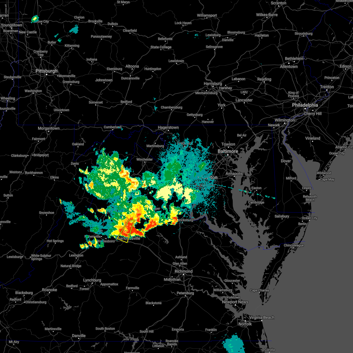 At 841 pm edt, severe thunderstorms were located along a line extending from stanardsville to near crozet, moving east at 20 mph (radar indicated). Hazards include 60 mph wind gusts. Damaging winds will cause some trees and large branches to fall. this could injure those outdoors, as well as damage homes and vehicles. roadways may become blocked by downed trees. localized power outages are possible. Unsecured light objects may become projectiles. At 841 pm edt, severe thunderstorms were located along a line extending from stanardsville to near crozet, moving east at 20 mph (radar indicated). Hazards include 60 mph wind gusts. Damaging winds will cause some trees and large branches to fall. this could injure those outdoors, as well as damage homes and vehicles. roadways may become blocked by downed trees. localized power outages are possible. Unsecured light objects may become projectiles.
|
| 8/28/2021 8:38 PM EDT |
 At 838 pm edt, severe thunderstorms were located along a line extending from 6 miles north of boswells tavern to near free union, moving east at 25 mph (radar indicated). Hazards include 60 mph wind gusts. Damaging winds will cause some trees and large branches to fall. this could injure those outdoors, as well as damage homes and vehicles. roadways may become blocked by downed trees. localized power outages are possible. Unsecured light objects may become projectiles. At 838 pm edt, severe thunderstorms were located along a line extending from 6 miles north of boswells tavern to near free union, moving east at 25 mph (radar indicated). Hazards include 60 mph wind gusts. Damaging winds will cause some trees and large branches to fall. this could injure those outdoors, as well as damage homes and vehicles. roadways may become blocked by downed trees. localized power outages are possible. Unsecured light objects may become projectiles.
|
| 8/28/2021 8:33 PM EDT |
 At 832 pm edt, a severe thunderstorm was located over free union, or 9 miles northwest of charlottesville, moving east at 25 mph (radar indicated). Hazards include 60 mph wind gusts. Damaging winds will cause some trees and large branches to fall. this could injure those outdoors, as well as damage homes and vehicles. roadways may become blocked by downed trees. localized power outages are possible. unsecured light objects may become projectiles. locations impacted include, charlottesville, crozet, free union, hollymead, ivy, boonesville, newcomb hall, flordon, earlysville, barracks, amicus, scott stadium, advance mills, shady grove, white hall, mission home and carrsbrook. hail threat, radar indicated max hail size, <. 75 in wind threat, radar indicated max wind gust, 60 mph. At 832 pm edt, a severe thunderstorm was located over free union, or 9 miles northwest of charlottesville, moving east at 25 mph (radar indicated). Hazards include 60 mph wind gusts. Damaging winds will cause some trees and large branches to fall. this could injure those outdoors, as well as damage homes and vehicles. roadways may become blocked by downed trees. localized power outages are possible. unsecured light objects may become projectiles. locations impacted include, charlottesville, crozet, free union, hollymead, ivy, boonesville, newcomb hall, flordon, earlysville, barracks, amicus, scott stadium, advance mills, shady grove, white hall, mission home and carrsbrook. hail threat, radar indicated max hail size, <. 75 in wind threat, radar indicated max wind gust, 60 mph.
|
| 8/28/2021 8:05 PM EDT |
 At 805 pm edt, a severe thunderstorm was located near crimora, or 12 miles northeast of waynesboro, moving east at 25 mph (radar indicated). Hazards include 60 mph wind gusts. Damaging winds will cause some trees and large branches to fall. this could injure those outdoors, as well as damage homes and vehicles. roadways may become blocked by downed trees. localized power outages are possible. Unsecured light objects may become projectiles. At 805 pm edt, a severe thunderstorm was located near crimora, or 12 miles northeast of waynesboro, moving east at 25 mph (radar indicated). Hazards include 60 mph wind gusts. Damaging winds will cause some trees and large branches to fall. this could injure those outdoors, as well as damage homes and vehicles. roadways may become blocked by downed trees. localized power outages are possible. Unsecured light objects may become projectiles.
|
| 8/25/2021 4:20 PM EDT | Tree down on the 3000 block of watts passage road near the intersection with doctors crossing in albemarle county VA, 8.5 miles SW of Charlottesville, VA |
| 8/25/2021 4:20 PM EDT | Tree down on the 3000 block of watts farm road in albemarle county VA, 8.6 miles SW of Charlottesville, VA |
| 8/25/2021 4:12 PM EDT |
 At 412 pm edt, a severe thunderstorm was located northeast of charlottesville, and is drifting northeastward (radar indicated). Hazards include 65 mph wind gusts and quarter size hail. Damaging winds will cause some trees and large branches to fall. this could injure those outdoors, as well as damage homes and vehicles. roadways may become blocked by downed trees. localized power outages are possible. unsecured light objects may become projectiles. locations impacted include, charlottesville, westmoreland, hollymead, boyd tavern, keswick, stony point, carrsbrook and shadwell. hail threat, radar indicated max hail size, 1. 00 in wind threat, radar indicated max wind gust, 60 mph. At 412 pm edt, a severe thunderstorm was located northeast of charlottesville, and is drifting northeastward (radar indicated). Hazards include 65 mph wind gusts and quarter size hail. Damaging winds will cause some trees and large branches to fall. this could injure those outdoors, as well as damage homes and vehicles. roadways may become blocked by downed trees. localized power outages are possible. unsecured light objects may become projectiles. locations impacted include, charlottesville, westmoreland, hollymead, boyd tavern, keswick, stony point, carrsbrook and shadwell. hail threat, radar indicated max hail size, 1. 00 in wind threat, radar indicated max wind gust, 60 mph.
|
| 8/25/2021 4:01 PM EDT |
 At 400 pm edt, a severe thunderstorm was located east of charlottesville, and is drifting northward (radar indicated). Hazards include 60 mph wind gusts. Damaging winds will cause some trees and large branches to fall. this could injure those outdoors, as well as damage homes and vehicles. roadways may become blocked by downed trees. localized power outages are possible. unsecured light objects may become projectiles. locations impacted include, charlottesville, westmoreland, hollymead, boyd tavern, monticello, keswick, stony point, carrsbrook and shadwell. hail threat, radar indicated max hail size, <. 75 in wind threat, radar indicated max wind gust, 60 mph. At 400 pm edt, a severe thunderstorm was located east of charlottesville, and is drifting northward (radar indicated). Hazards include 60 mph wind gusts. Damaging winds will cause some trees and large branches to fall. this could injure those outdoors, as well as damage homes and vehicles. roadways may become blocked by downed trees. localized power outages are possible. unsecured light objects may become projectiles. locations impacted include, charlottesville, westmoreland, hollymead, boyd tavern, monticello, keswick, stony point, carrsbrook and shadwell. hail threat, radar indicated max hail size, <. 75 in wind threat, radar indicated max wind gust, 60 mph.
|
| 8/25/2021 3:48 PM EDT |
 At 346 pm edt, a severe thunderstorm was located just east of the city of charlottesville, and was nearly stationary (radar indicated). Hazards include 60 mph wind gusts. Damaging winds will cause some trees and large branches to fall. this could injure those outdoors, as well as damage homes and vehicles. roadways may become blocked by downed trees. localized power outages are possible. Unsecured light objects may become projectiles. At 346 pm edt, a severe thunderstorm was located just east of the city of charlottesville, and was nearly stationary (radar indicated). Hazards include 60 mph wind gusts. Damaging winds will cause some trees and large branches to fall. this could injure those outdoors, as well as damage homes and vehicles. roadways may become blocked by downed trees. localized power outages are possible. Unsecured light objects may become projectiles.
|
| 8/14/2021 6:58 PM EDT |
 At 658 pm edt, a severe thunderstorm was located near charlottesville, moving southeast at 15 mph (radar indicated). Hazards include 60 mph wind gusts. Damaging winds will cause some trees and large branches to fall. this could injure those outdoors, as well as damage homes and vehicles. roadways may become blocked by downed trees. localized power outages are possible. unsecured light objects may become projectiles. locations impacted include, charlottesville, crozet, free union, westmoreland, hollymead, ivy, newcomb hall, monticello, flordon, carrsbrook, barracks, scott stadium and earlysville. hail threat, radar indicated max hail size, <. 75 in wind threat, radar indicated max wind gust, 60 mph. At 658 pm edt, a severe thunderstorm was located near charlottesville, moving southeast at 15 mph (radar indicated). Hazards include 60 mph wind gusts. Damaging winds will cause some trees and large branches to fall. this could injure those outdoors, as well as damage homes and vehicles. roadways may become blocked by downed trees. localized power outages are possible. unsecured light objects may become projectiles. locations impacted include, charlottesville, crozet, free union, westmoreland, hollymead, ivy, newcomb hall, monticello, flordon, carrsbrook, barracks, scott stadium and earlysville. hail threat, radar indicated max hail size, <. 75 in wind threat, radar indicated max wind gust, 60 mph.
|
| 8/14/2021 6:52 PM EDT |
 At 652 pm edt, severe thunderstorms were located along a line extending from near free union to near crozet, moving southeast at 10 mph (radar indicated). Hazards include 70 mph wind gusts and ping pong ball size hail, especially just southeast of greenwood and crozet to near north garden. Damaging winds will cause some trees and large branches to fall. this could injure those outdoors, as well as damage homes and vehicles. roadways may become blocked by downed trees. localized power outages are possible. unsecured light objects may become projectiles. locations impacted include, charlottesville, crozet, free union, westmoreland, hollymead, ivy, greenwood, north garden, newcomb hall, batesville, covesville, yancey mills, monticello, flordon, carrsbrook, barracks, scott stadium, white hall and earlysville. thunderstorm damage threat, considerable hail threat, radar indicated max hail size, 1. 50 in wind threat, radar indicated max wind gust, 70 mph. At 652 pm edt, severe thunderstorms were located along a line extending from near free union to near crozet, moving southeast at 10 mph (radar indicated). Hazards include 70 mph wind gusts and ping pong ball size hail, especially just southeast of greenwood and crozet to near north garden. Damaging winds will cause some trees and large branches to fall. this could injure those outdoors, as well as damage homes and vehicles. roadways may become blocked by downed trees. localized power outages are possible. unsecured light objects may become projectiles. locations impacted include, charlottesville, crozet, free union, westmoreland, hollymead, ivy, greenwood, north garden, newcomb hall, batesville, covesville, yancey mills, monticello, flordon, carrsbrook, barracks, scott stadium, white hall and earlysville. thunderstorm damage threat, considerable hail threat, radar indicated max hail size, 1. 50 in wind threat, radar indicated max wind gust, 70 mph.
|
| 8/14/2021 6:44 PM EDT |
 At 643 pm edt, severe thunderstorms were located along a line extending from free union to near crozet, moving southeast at 10 mph (radar indicated). Hazards include 70 mph wind gusts and quarter size hail, especially near crozet. Winds will cause considerable damage to some trees. this could injure those outdoors, as well as damage homes and vehicles. roadways may become blocked by downed trees. localized power outages are possible. unsecured light objects may become projectiles. locations impacted include, charlottesville, crozet, free union, westmoreland, hollymead, ivy, greenwood, north garden, newcomb hall, batesville, covesville, yancey mills, monticello, flordon, carrsbrook, barracks, scott stadium, white hall and earlysville. thunderstorm damage threat, considerable hail threat, radar indicated max hail size, 1. 00 in wind threat, radar indicated max wind gust, 70 mph. At 643 pm edt, severe thunderstorms were located along a line extending from free union to near crozet, moving southeast at 10 mph (radar indicated). Hazards include 70 mph wind gusts and quarter size hail, especially near crozet. Winds will cause considerable damage to some trees. this could injure those outdoors, as well as damage homes and vehicles. roadways may become blocked by downed trees. localized power outages are possible. unsecured light objects may become projectiles. locations impacted include, charlottesville, crozet, free union, westmoreland, hollymead, ivy, greenwood, north garden, newcomb hall, batesville, covesville, yancey mills, monticello, flordon, carrsbrook, barracks, scott stadium, white hall and earlysville. thunderstorm damage threat, considerable hail threat, radar indicated max hail size, 1. 00 in wind threat, radar indicated max wind gust, 70 mph.
|
| 8/14/2021 6:33 PM EDT |
 At 633 pm edt, severe thunderstorms were located along a line extending from free union to near crozet, moving east at 10 mph (radar indicated). Hazards include 60 mph wind gusts and quarter size hail. Damaging winds will cause some trees and large branches to fall. this could injure those outdoors, as well as damage homes and vehicles. roadways may become blocked by downed trees. localized power outages are possible. unsecured light objects may become projectiles. locations impacted include, charlottesville, crozet, free union, westmoreland, hollymead, ivy, greenwood, north garden, newcomb hall, batesville, covesville, yancey mills, monticello, flordon, carrsbrook, barracks, scott stadium, white hall and earlysville. hail threat, radar indicated max hail size, 1. 00 in wind threat, radar indicated max wind gust, 60 mph. At 633 pm edt, severe thunderstorms were located along a line extending from free union to near crozet, moving east at 10 mph (radar indicated). Hazards include 60 mph wind gusts and quarter size hail. Damaging winds will cause some trees and large branches to fall. this could injure those outdoors, as well as damage homes and vehicles. roadways may become blocked by downed trees. localized power outages are possible. unsecured light objects may become projectiles. locations impacted include, charlottesville, crozet, free union, westmoreland, hollymead, ivy, greenwood, north garden, newcomb hall, batesville, covesville, yancey mills, monticello, flordon, carrsbrook, barracks, scott stadium, white hall and earlysville. hail threat, radar indicated max hail size, 1. 00 in wind threat, radar indicated max wind gust, 60 mph.
|
| 8/14/2021 6:29 PM EDT |
 At 629 pm edt, severe thunderstorms were located along a line extending from free union to near crozet, moving southeast at 10 mph (radar indicated). Hazards include 60 mph wind gusts. Damaging winds will cause some trees and large branches to fall. this could injure those outdoors, as well as damage homes and vehicles. roadways may become blocked by downed trees. localized power outages are possible. Unsecured light objects may become projectiles. At 629 pm edt, severe thunderstorms were located along a line extending from free union to near crozet, moving southeast at 10 mph (radar indicated). Hazards include 60 mph wind gusts. Damaging winds will cause some trees and large branches to fall. this could injure those outdoors, as well as damage homes and vehicles. roadways may become blocked by downed trees. localized power outages are possible. Unsecured light objects may become projectiles.
|
| 8/13/2021 3:31 PM EDT | Large tree down near ivy rd and rockfish gap turnpike in albemarle county VA, 8.9 miles ESE of Charlottesville, VA |
| 8/13/2021 3:28 PM EDT | Large tree blocking entire road at 895 old ballard rd in albemarle county VA, 4.7 miles ESE of Charlottesville, VA |
| 8/11/2021 4:11 PM EDT |
 At 410 pm edt, severe thunderstorms were located along a line extending from 9 miles northwest of boswells tavern to charlottesville, moving east at 15 mph (radar indicated). Hazards include 60 mph wind gusts. Damaging winds will cause some trees and large branches to fall. this could injure those outdoors, as well as damage homes and vehicles. roadways may become blocked by downed trees. localized power outages are possible. unsecured light objects may become projectiles. locations impacted include, charlottesville, free union, campbell, westmoreland, hollymead, ivy, cobham, cismont, newcomb hall, boyd tavern, monticello, woodridge, keswick, stony point, flordon, carrsbrook, earlysville, shadwell, barracks and overton. hail threat, radar indicated max hail size, <. 75 in wind threat, radar indicated max wind gust, 60 mph. At 410 pm edt, severe thunderstorms were located along a line extending from 9 miles northwest of boswells tavern to charlottesville, moving east at 15 mph (radar indicated). Hazards include 60 mph wind gusts. Damaging winds will cause some trees and large branches to fall. this could injure those outdoors, as well as damage homes and vehicles. roadways may become blocked by downed trees. localized power outages are possible. unsecured light objects may become projectiles. locations impacted include, charlottesville, free union, campbell, westmoreland, hollymead, ivy, cobham, cismont, newcomb hall, boyd tavern, monticello, woodridge, keswick, stony point, flordon, carrsbrook, earlysville, shadwell, barracks and overton. hail threat, radar indicated max hail size, <. 75 in wind threat, radar indicated max wind gust, 60 mph.
|
| 8/11/2021 4:10 PM EDT | Multiple reports of trees and wires blown down across northeastern albemarle count in albemarle county VA, 7.1 miles WSW of Charlottesville, VA |
| 8/11/2021 3:37 PM EDT |
 At 337 pm edt, severe thunderstorms were located along a line extending from near free union to near charlottesville, moving east at 10 mph (radar indicated). Hazards include 60 mph wind gusts. Damaging winds will cause some trees and large branches to fall. this could injure those outdoors, as well as damage homes and vehicles. roadways may become blocked by downed trees. localized power outages are possible. Unsecured light objects may become projectiles. At 337 pm edt, severe thunderstorms were located along a line extending from near free union to near charlottesville, moving east at 10 mph (radar indicated). Hazards include 60 mph wind gusts. Damaging winds will cause some trees and large branches to fall. this could injure those outdoors, as well as damage homes and vehicles. roadways may become blocked by downed trees. localized power outages are possible. Unsecured light objects may become projectiles.
|
| 8/11/2021 3:15 PM EDT | Tree down in the 4300 block of free union d in albemarle county VA, 8.9 miles SSE of Charlottesville, VA |
| 8/10/2021 2:52 PM EDT | A tree blew down onto power lines near the intersection of pen park lane and lochlyn hill lan in albemarle county VA, 2 miles SW of Charlottesville, VA |
| 8/10/2021 2:44 PM EDT |
 At 244 pm edt, a severe thunderstorm was located near charlottesville, moving southeast at 10 mph (radar indicated). Hazards include 60 mph wind gusts. Damaging winds will cause some trees and large branches to fall. this could injure those outdoors, as well as damage homes and vehicles. roadways may become blocked by downed trees. localized power outages are possible. Unsecured light objects may become projectiles. At 244 pm edt, a severe thunderstorm was located near charlottesville, moving southeast at 10 mph (radar indicated). Hazards include 60 mph wind gusts. Damaging winds will cause some trees and large branches to fall. this could injure those outdoors, as well as damage homes and vehicles. roadways may become blocked by downed trees. localized power outages are possible. Unsecured light objects may become projectiles.
|
| 7/28/2021 10:06 PM EDT | Branches down on old lynchburg roa in albemarle county VA, 2.3 miles NE of Charlottesville, VA |
| 7/28/2021 10:05 PM EDT | Tree down on jefferson park ave near fry's spring beach clu in albemarle county VA, 1.4 miles NE of Charlottesville, VA |
| 7/27/2021 11:24 PM EDT |
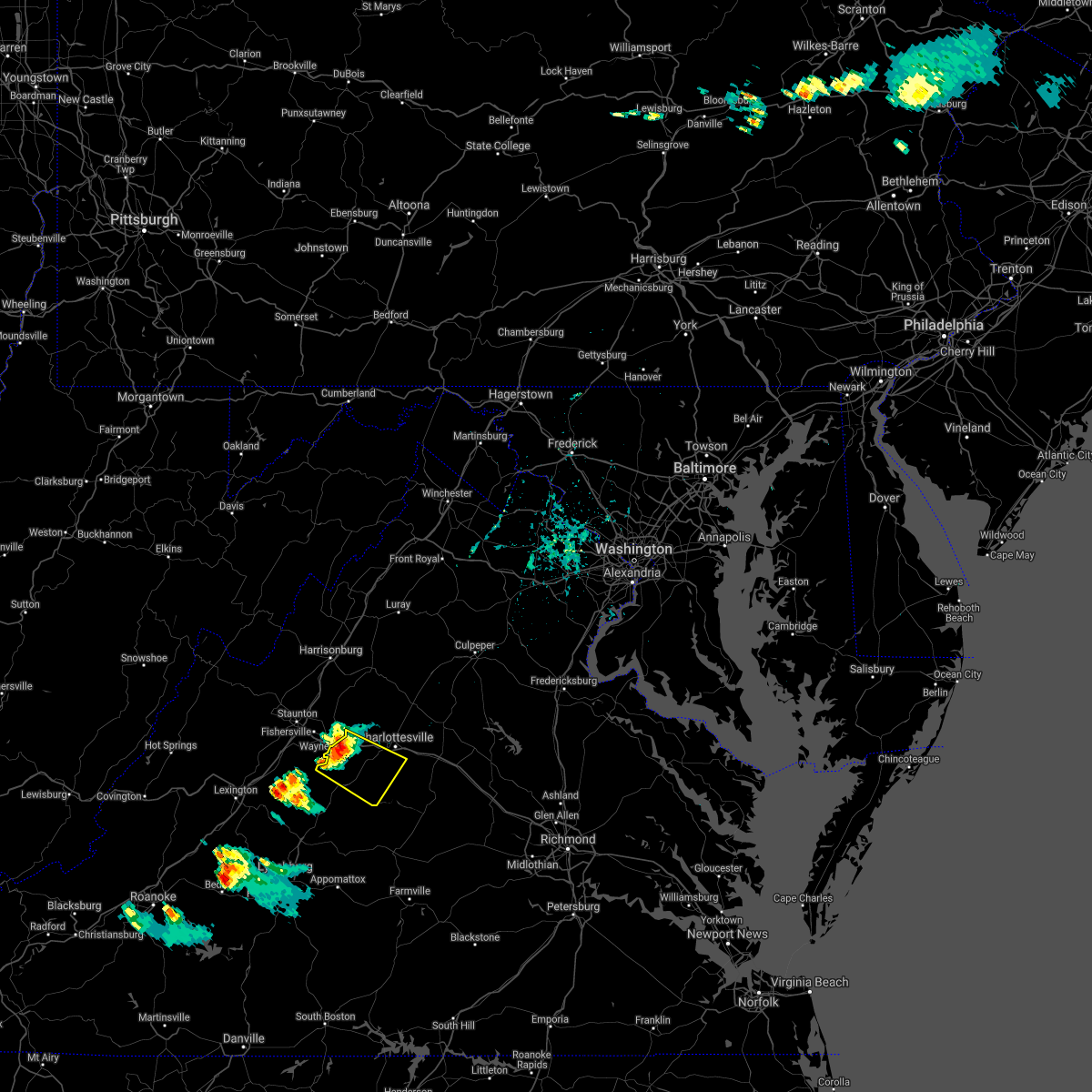 At 1124 pm edt, a severe thunderstorm was located near afton, or 7 miles southeast of waynesboro, moving southeast at 15 mph (radar indicated). Hazards include 60 mph wind gusts and quarter size hail. Damaging winds will cause some trees and large branches to fall. this could injure those outdoors, as well as damage homes and vehicles. roadways may become blocked by downed trees. localized power outages are possible. Unsecured light objects may become projectiles. At 1124 pm edt, a severe thunderstorm was located near afton, or 7 miles southeast of waynesboro, moving southeast at 15 mph (radar indicated). Hazards include 60 mph wind gusts and quarter size hail. Damaging winds will cause some trees and large branches to fall. this could injure those outdoors, as well as damage homes and vehicles. roadways may become blocked by downed trees. localized power outages are possible. Unsecured light objects may become projectiles.
|
| 7/17/2021 1:18 PM EDT |
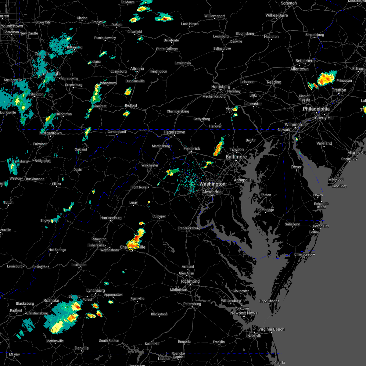 At 118 pm edt, a severe thunderstorm was located near charlottesville, moving northeast at 15 mph (radar indicated). Hazards include 60 mph wind gusts and quarter size hail. Damaging winds will cause some trees and large branches to fall. this could injure those outdoors, as well as damage homes and vehicles. roadways may become blocked by downed trees. localized power outages are possible. unsecured light objects may become projectiles. Locations impacted include, charlottesville, westmoreland, hollymead, newcomb hall, carrsbrook, earlysville and barracks. At 118 pm edt, a severe thunderstorm was located near charlottesville, moving northeast at 15 mph (radar indicated). Hazards include 60 mph wind gusts and quarter size hail. Damaging winds will cause some trees and large branches to fall. this could injure those outdoors, as well as damage homes and vehicles. roadways may become blocked by downed trees. localized power outages are possible. unsecured light objects may become projectiles. Locations impacted include, charlottesville, westmoreland, hollymead, newcomb hall, carrsbrook, earlysville and barracks.
|
| 7/17/2021 1:06 PM EDT |
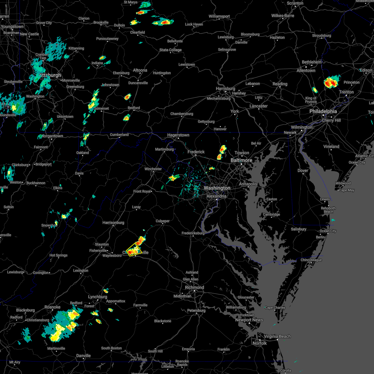 At 106 pm edt, a severe thunderstorm was located near charlottesville, moving northeast at 15 mph (radar indicated). Hazards include 60 mph wind gusts and quarter size hail. Damaging winds will cause some trees and large branches to fall. this could injure those outdoors, as well as damage homes and vehicles. roadways may become blocked by downed trees. localized power outages are possible. Unsecured light objects may become projectiles. At 106 pm edt, a severe thunderstorm was located near charlottesville, moving northeast at 15 mph (radar indicated). Hazards include 60 mph wind gusts and quarter size hail. Damaging winds will cause some trees and large branches to fall. this could injure those outdoors, as well as damage homes and vehicles. roadways may become blocked by downed trees. localized power outages are possible. Unsecured light objects may become projectiles.
|
| 7/7/2021 4:31 PM EDT | Minor tree damage reported southwest of charlottesville in albemarle county VA, 3.6 miles ENE of Charlottesville, VA |
| 5/4/2021 4:24 PM EDT |
 At 424 pm edt, severe thunderstorms were located along a line extending from near charlottesville to near lake monticello, moving northeast at 40 mph (radar indicated). Hazards include 60 mph wind gusts. Damaging winds will cause some trees and large branches to fall. this could injure those outdoors, as well as damage homes and vehicles. roadways may become blocked by downed trees. localized power outages are possible. unsecured light objects may become projectiles. Locations impacted include, charlottesville, campbell, westmoreland, hollymead, ivy, scottsville, cobham, cismont, newcomb hall, boyd tavern, monticello, woodridge, keswick, stony point, flordon, carrsbrook, shadwell, barracks, overton and scott stadium. At 424 pm edt, severe thunderstorms were located along a line extending from near charlottesville to near lake monticello, moving northeast at 40 mph (radar indicated). Hazards include 60 mph wind gusts. Damaging winds will cause some trees and large branches to fall. this could injure those outdoors, as well as damage homes and vehicles. roadways may become blocked by downed trees. localized power outages are possible. unsecured light objects may become projectiles. Locations impacted include, charlottesville, campbell, westmoreland, hollymead, ivy, scottsville, cobham, cismont, newcomb hall, boyd tavern, monticello, woodridge, keswick, stony point, flordon, carrsbrook, shadwell, barracks, overton and scott stadium.
|
| 5/4/2021 4:08 PM EDT |
 At 407 pm edt, severe thunderstorms were located along a line extending from near crozet to near wingina, moving northeast at 55 mph (law enforcement. numerous trees have been downed in nelson county). Hazards include 60 mph wind gusts. Damaging winds will cause some trees and large branches to fall. this could injure those outdoors, as well as damage homes and vehicles. roadways may become blocked by downed trees. localized power outages are possible. Unsecured light objects may become projectiles. At 407 pm edt, severe thunderstorms were located along a line extending from near crozet to near wingina, moving northeast at 55 mph (law enforcement. numerous trees have been downed in nelson county). Hazards include 60 mph wind gusts. Damaging winds will cause some trees and large branches to fall. this could injure those outdoors, as well as damage homes and vehicles. roadways may become blocked by downed trees. localized power outages are possible. Unsecured light objects may become projectiles.
|
| 8/17/2020 4:50 PM EDT | Reports of trees blown down along plank roa in albemarle county VA, 11 miles NNE of Charlottesville, VA |
| 8/6/2020 5:14 PM EDT | Trees down at 116 blueberry rd in albemarle county VA, 3.3 miles WSW of Charlottesville, VA |
| 8/6/2020 5:06 PM EDT |
 At 505 pm edt, a severe thunderstorm was located over free union, or 9 miles north of charlottesville, moving northeast at 10 mph (radar indicated). Hazards include 70 mph wind gusts and quarter size hail. Damaging winds will cause some trees and large branches to fall. this could injure those outdoors, as well as damage homes and vehicles. roadways may become blocked by downed trees. localized power outages are possible. unsecured light objects may become projectiles. Locations impacted include, charlottesville, stanardsville, free union, campbell, westmoreland, hollymead, ruckersville, quinque, eheart, barboursville, stony point, flordon, newtown, amicus, cobham, cismont, newcomb hall, keswick, carrsbrook and earlysville. At 505 pm edt, a severe thunderstorm was located over free union, or 9 miles north of charlottesville, moving northeast at 10 mph (radar indicated). Hazards include 70 mph wind gusts and quarter size hail. Damaging winds will cause some trees and large branches to fall. this could injure those outdoors, as well as damage homes and vehicles. roadways may become blocked by downed trees. localized power outages are possible. unsecured light objects may become projectiles. Locations impacted include, charlottesville, stanardsville, free union, campbell, westmoreland, hollymead, ruckersville, quinque, eheart, barboursville, stony point, flordon, newtown, amicus, cobham, cismont, newcomb hall, keswick, carrsbrook and earlysville.
|
| 8/6/2020 5:05 PM EDT | Tree down on the 3000 block of dickerson road in albemarle county VA, 9.3 miles SSW of Charlottesville, VA |
| 8/6/2020 5:02 PM EDT |
 At 502 pm edt, a severe thunderstorm capable of producing a tornado was located over charlottesville, moving east at 20 mph (radar indicated rotation). Hazards include tornado. For those in the direct path of a tornado touchdown, flying debris will be dangerous to those caught without shelter. damage to roofs, siding, and windows may occur. mobile homes may be damaged or destroyed. tree damage is likely. This tornadic thunderstorm will remain over mainly rural areas of northeastern albemarle county and the city of charlottesville, including the following locations, scott stadium, westmoreland, newcomb hall and carrsbrook. At 502 pm edt, a severe thunderstorm capable of producing a tornado was located over charlottesville, moving east at 20 mph (radar indicated rotation). Hazards include tornado. For those in the direct path of a tornado touchdown, flying debris will be dangerous to those caught without shelter. damage to roofs, siding, and windows may occur. mobile homes may be damaged or destroyed. tree damage is likely. This tornadic thunderstorm will remain over mainly rural areas of northeastern albemarle county and the city of charlottesville, including the following locations, scott stadium, westmoreland, newcomb hall and carrsbrook.
|
| 8/6/2020 4:59 PM EDT |
 The national weather service in sterling virginia has issued a * tornado warning for. the city of charlottesville in central virginia. central albemarle county in central virginia. until 530 pm edt. At 458 pm edt, a severe thunderstorm capable of producing a tornado. The national weather service in sterling virginia has issued a * tornado warning for. the city of charlottesville in central virginia. central albemarle county in central virginia. until 530 pm edt. At 458 pm edt, a severe thunderstorm capable of producing a tornado.
|
| 8/6/2020 4:55 PM EDT | Quarter sized hail reported 1.3 miles SSW of Charlottesville, VA |
| 8/6/2020 4:55 PM EDT |
 At 454 pm edt, a severe thunderstorm was located over free union, or 9 miles northwest of charlottesville, moving northeast at 10 mph. this is a very dangerous storm (radar indicated). Hazards include 80 mph wind gusts and golf ball size hail. Expect considerable damage to trees and power lines, especially near free union and earlysville. your life is at significant risk if outdoors. In addition to some trees falling into homes, wind damage is possible to roofs, sheds, open garages, and mobile homes. At 454 pm edt, a severe thunderstorm was located over free union, or 9 miles northwest of charlottesville, moving northeast at 10 mph. this is a very dangerous storm (radar indicated). Hazards include 80 mph wind gusts and golf ball size hail. Expect considerable damage to trees and power lines, especially near free union and earlysville. your life is at significant risk if outdoors. In addition to some trees falling into homes, wind damage is possible to roofs, sheds, open garages, and mobile homes.
|
| 8/6/2020 4:53 PM EDT | Half Dollar sized hail reported 8.9 miles SSE of Charlottesville, VA |
| 7/24/2020 5:42 PM EDT |
 At 542 pm edt, severe thunderstorms were located along a line extending from near charlottesville to 7 miles south of crozet, moving south at 20 mph (radar indicated). Hazards include 60 mph wind gusts and quarter size hail. Damaging winds will cause some trees and large branches to fall. this could injure those outdoors, as well as damage homes and vehicles. roadways may become blocked by downed trees. localized power outages are possible. Unsecured light objects may become projectiles. At 542 pm edt, severe thunderstorms were located along a line extending from near charlottesville to 7 miles south of crozet, moving south at 20 mph (radar indicated). Hazards include 60 mph wind gusts and quarter size hail. Damaging winds will cause some trees and large branches to fall. this could injure those outdoors, as well as damage homes and vehicles. roadways may become blocked by downed trees. localized power outages are possible. Unsecured light objects may become projectiles.
|
| 7/23/2020 6:40 PM EDT | Several trees down southeast of the city of charlottesvill in albemarle county VA, 5.8 miles NW of Charlottesville, VA |
| 7/23/2020 6:38 PM EDT |
 At 638 pm edt, a severe thunderstorm was located 8 miles west of boswells tavern, or 8 miles northeast of charlottesville, moving northeast at 15 mph (radar indicated). Hazards include isolated damaging wind gusts of up to 60 mph. Damaging winds will cause some trees and large branches to fall. this could injure those outdoors, as well as damage homes and vehicles. roadways may become blocked by downed trees. localized power outages are possible. Unsecured light objects may become projectiles. At 638 pm edt, a severe thunderstorm was located 8 miles west of boswells tavern, or 8 miles northeast of charlottesville, moving northeast at 15 mph (radar indicated). Hazards include isolated damaging wind gusts of up to 60 mph. Damaging winds will cause some trees and large branches to fall. this could injure those outdoors, as well as damage homes and vehicles. roadways may become blocked by downed trees. localized power outages are possible. Unsecured light objects may become projectiles.
|
| 7/23/2020 6:21 PM EDT |
 At 621 pm edt, a severe thunderstorm was located near charlottesville, moving east at 10 mph (radar indicated). Hazards include isolated damaging wind gusts of up to 60 mph. Damaging winds will cause some trees and large branches to fall. this could injure those outdoors, as well as damage homes and vehicles. roadways may become blocked by downed trees. localized power outages are possible. unsecured light objects may become projectiles. Locations impacted include, scottsville, keene, glendower, overton, alberene, north garden and woodridge. At 621 pm edt, a severe thunderstorm was located near charlottesville, moving east at 10 mph (radar indicated). Hazards include isolated damaging wind gusts of up to 60 mph. Damaging winds will cause some trees and large branches to fall. this could injure those outdoors, as well as damage homes and vehicles. roadways may become blocked by downed trees. localized power outages are possible. unsecured light objects may become projectiles. Locations impacted include, scottsville, keene, glendower, overton, alberene, north garden and woodridge.
|
| 7/23/2020 6:13 PM EDT |
 At 613 pm edt, a severe thunderstorm was located 7 miles south of charlottesville, and is nearly stationary (radar indicated). Hazards include isolated damaging wind gusts of up to 60 mph. Damaging winds will cause some trees and large branches to fall. this could injure those outdoors, as well as damage homes and vehicles. roadways may become blocked by downed trees. localized power outages are possible. unsecured light objects may become projectiles. Locations impacted include, crozet, scottsville, keene, glendower, overton, alberene, north garden, batesville and woodridge. At 613 pm edt, a severe thunderstorm was located 7 miles south of charlottesville, and is nearly stationary (radar indicated). Hazards include isolated damaging wind gusts of up to 60 mph. Damaging winds will cause some trees and large branches to fall. this could injure those outdoors, as well as damage homes and vehicles. roadways may become blocked by downed trees. localized power outages are possible. unsecured light objects may become projectiles. Locations impacted include, crozet, scottsville, keene, glendower, overton, alberene, north garden, batesville and woodridge.
|
| 7/23/2020 6:04 PM EDT |
 At 604 pm edt, a severe thunderstorm was located 7 miles south of charlottesville, and is nearly stationary (radar indicated). Hazards include isolated damaging wind gusts of up to 60 mph. Damaging winds will cause some trees and large branches to fall. this could injure those outdoors, as well as damage homes and vehicles. roadways may become blocked by downed trees. localized power outages are possible. Unsecured light objects may become projectiles. At 604 pm edt, a severe thunderstorm was located 7 miles south of charlottesville, and is nearly stationary (radar indicated). Hazards include isolated damaging wind gusts of up to 60 mph. Damaging winds will cause some trees and large branches to fall. this could injure those outdoors, as well as damage homes and vehicles. roadways may become blocked by downed trees. localized power outages are possible. Unsecured light objects may become projectiles.
|
| 7/22/2020 1:55 PM EDT |
 At 155 pm edt, a severe thunderstorm was located near charlottesville, moving east at 15 mph (radar indicated). Hazards include 60 mph wind gusts. Damaging winds will cause some trees and large branches to fall. this could injure those outdoors, as well as damage homes and vehicles. roadways may become blocked by downed trees. localized power outages are possible. unsecured light objects may become projectiles. Locations impacted include, charlottesville, campbell, westmoreland, hollymead, cobham, cismont, boyd tavern, monticello, keswick, stony point, carrsbrook and shadwell. At 155 pm edt, a severe thunderstorm was located near charlottesville, moving east at 15 mph (radar indicated). Hazards include 60 mph wind gusts. Damaging winds will cause some trees and large branches to fall. this could injure those outdoors, as well as damage homes and vehicles. roadways may become blocked by downed trees. localized power outages are possible. unsecured light objects may become projectiles. Locations impacted include, charlottesville, campbell, westmoreland, hollymead, cobham, cismont, boyd tavern, monticello, keswick, stony point, carrsbrook and shadwell.
|
| 7/22/2020 1:39 PM EDT | Numerous trees down in the fry's spring neighborhood in albemarle county VA, 1.4 miles NE of Charlottesville, VA |
| 7/22/2020 1:39 PM EDT |
 At 139 pm edt, a severe thunderstorm was located over charlottesville, moving east at 15 mph (radar indicated). Hazards include 60 mph wind gusts. Damaging winds will cause some trees and large branches to fall. this could injure those outdoors, as well as damage homes and vehicles. roadways may become blocked by downed trees. localized power outages are possible. Unsecured light objects may become projectiles. At 139 pm edt, a severe thunderstorm was located over charlottesville, moving east at 15 mph (radar indicated). Hazards include 60 mph wind gusts. Damaging winds will cause some trees and large branches to fall. this could injure those outdoors, as well as damage homes and vehicles. roadways may become blocked by downed trees. localized power outages are possible. Unsecured light objects may become projectiles.
|
| 7/22/2020 1:34 PM EDT | Multiple trees down along harris s in albemarle county VA, 0.7 miles SW of Charlottesville, VA |
| 7/22/2020 1:34 PM EDT | Tree down across old lynchburg rd at sunset ave in albemarle county VA, 3.2 miles NE of Charlottesville, VA |
| 7/22/2020 1:30 PM EDT | Tree down on powerline in the 200 block of mobile lane in albemarle county VA, 2.3 miles NE of Charlottesville, VA |
| 7/22/2020 1:21 PM EDT | Numerous trees down near the 400 block of old lynchburg road and i-6 in albemarle county VA, 2.3 miles NE of Charlottesville, VA |
| 7/22/2020 1:19 PM EDT |
 At 119 pm edt, a severe thunderstorm was located near charlottesville, moving east at 10 mph (radar indicated). Hazards include 60 mph wind gusts and quarter size hail. Damaging winds will cause some trees and large branches to fall. this could injure those outdoors, as well as damage homes and vehicles. roadways may become blocked by downed trees. localized power outages are possible. unsecured light objects may become projectiles. Locations impacted include, charlottesville, westmoreland, hollymead, ivy, newcomb hall, scott stadium, monticello, flordon, carrsbrook, shadwell and barracks. At 119 pm edt, a severe thunderstorm was located near charlottesville, moving east at 10 mph (radar indicated). Hazards include 60 mph wind gusts and quarter size hail. Damaging winds will cause some trees and large branches to fall. this could injure those outdoors, as well as damage homes and vehicles. roadways may become blocked by downed trees. localized power outages are possible. unsecured light objects may become projectiles. Locations impacted include, charlottesville, westmoreland, hollymead, ivy, newcomb hall, scott stadium, monticello, flordon, carrsbrook, shadwell and barracks.
|
| 7/22/2020 12:57 PM EDT |
 At 1257 pm edt, a severe thunderstorm was located near crozet, or 7 miles west of charlottesville, moving east at 10 mph (radar indicated). Hazards include 60 mph wind gusts and quarter size hail. Damaging winds will cause some trees and large branches to fall. this could injure those outdoors, as well as damage homes and vehicles. roadways may become blocked by downed trees. localized power outages are possible. Unsecured light objects may become projectiles. At 1257 pm edt, a severe thunderstorm was located near crozet, or 7 miles west of charlottesville, moving east at 10 mph (radar indicated). Hazards include 60 mph wind gusts and quarter size hail. Damaging winds will cause some trees and large branches to fall. this could injure those outdoors, as well as damage homes and vehicles. roadways may become blocked by downed trees. localized power outages are possible. Unsecured light objects may become projectiles.
|
| 7/5/2020 3:10 PM EDT | Multiple trees down blocking roads in the ivy area in albemarle county VA, 6.2 miles ESE of Charlottesville, VA |
| 7/5/2020 3:07 PM EDT |
 At 306 pm edt, a severe thunderstorm was located near crozet, or near charlottesville, moving southeast at 5 mph (radar indicated). Hazards include 60 mph wind gusts and quarter size hail. Damaging winds will cause some trees and large branches to fall. this could injure those outdoors, as well as damage homes and vehicles. roadways may become blocked by downed trees. localized power outages are possible. Unsecured light objects may become projectiles. At 306 pm edt, a severe thunderstorm was located near crozet, or near charlottesville, moving southeast at 5 mph (radar indicated). Hazards include 60 mph wind gusts and quarter size hail. Damaging winds will cause some trees and large branches to fall. this could injure those outdoors, as well as damage homes and vehicles. roadways may become blocked by downed trees. localized power outages are possible. Unsecured light objects may become projectiles.
|
| 7/1/2020 4:12 PM EDT | Numerous trees down near the intersection of carters mountain road and scottsville road in albemarle county VA, 8.9 miles NNE of Charlottesville, VA |
| 7/1/2020 4:02 PM EDT |
 At 402 pm edt, a severe thunderstorm was located near charlottesville, moving southeast at 30 mph (radar indicated). Hazards include 60 mph wind gusts and quarter size hail. Damaging winds will cause some trees and large branches to fall. this could injure those outdoors, as well as damage homes and vehicles. roadways may become blocked by downed trees. localized power outages are possible. Unsecured light objects may become projectiles. At 402 pm edt, a severe thunderstorm was located near charlottesville, moving southeast at 30 mph (radar indicated). Hazards include 60 mph wind gusts and quarter size hail. Damaging winds will cause some trees and large branches to fall. this could injure those outdoors, as well as damage homes and vehicles. roadways may become blocked by downed trees. localized power outages are possible. Unsecured light objects may become projectiles.
|
| 6/4/2020 5:24 PM EDT | 5-6 oak trees down at the intersection of ivy farm drive and wing field r in albemarle county VA, 4.2 miles SSE of Charlottesville, VA |
| 6/4/2020 5:11 PM EDT | Tree down in the 3100 block of seminole trail. power lines down across all lanes of traffi in albemarle county VA, 6.4 miles SSW of Charlottesville, VA |
| 6/4/2020 5:10 PM EDT | Large branches and a tree were down along timberwood boulevard between pavilion circle and the timberwood parkwa in albemarle county VA, 6.6 miles SSW of Charlottesville, VA |
| 6/4/2020 5:09 PM EDT |
 At 509 pm edt, a severe thunderstorm was located near charlottesville, moving northeast at 30 mph (radar indicated). Hazards include 60 mph wind gusts. Damaging winds will cause some trees and large branches to fall. this could injure those outdoors, as well as damage homes and vehicles. roadways may become blocked by downed trees. localized power outages are possible. Unsecured light objects may become projectiles. At 509 pm edt, a severe thunderstorm was located near charlottesville, moving northeast at 30 mph (radar indicated). Hazards include 60 mph wind gusts. Damaging winds will cause some trees and large branches to fall. this could injure those outdoors, as well as damage homes and vehicles. roadways may become blocked by downed trees. localized power outages are possible. Unsecured light objects may become projectiles.
|
| 9/11/2019 5:29 PM EDT | Tree reported down on dudley mountain road near poplar driv in albemarle county VA, 5.3 miles NE of Charlottesville, VA |
| 9/11/2019 5:24 PM EDT | Tree reported down on the 4900 block of seminole trai in albemarle county VA, 10.4 miles SSW of Charlottesville, VA |
| 9/11/2019 5:24 PM EDT | Tree and power lines reported down on the 5000 block of watts passage roa in albemarle county VA, 10.6 miles SSW of Charlottesville, VA |
| 9/11/2019 5:09 PM EDT | Tree reported down on the 2000 block of lakeside driv in albemarle county VA, 8.9 miles ESE of Charlottesville, VA |
| 9/11/2019 5:09 PM EDT |
 At 508 pm edt, severe thunderstorms were located along a line extending from free union to crozet to near afton, moving southeast at 20 mph (radar indicated). Hazards include 60 mph wind gusts and quarter size hail. Damaging winds will cause some trees and large branches to fall. this could injure those outdoors, as well as damage homes and vehicles. roadways may become blocked by downed trees. localized power outages are possible. unsecured light objects may become projectiles. Locations impacted include, charlottesville, crozet, schuyler, free union, campbell, westmoreland, hollymead, ivy, scottsville, esmont, north garden, covesville, yancey mills, stony point, flordon, scott stadium, faber, cobham, cismont and damon. At 508 pm edt, severe thunderstorms were located along a line extending from free union to crozet to near afton, moving southeast at 20 mph (radar indicated). Hazards include 60 mph wind gusts and quarter size hail. Damaging winds will cause some trees and large branches to fall. this could injure those outdoors, as well as damage homes and vehicles. roadways may become blocked by downed trees. localized power outages are possible. unsecured light objects may become projectiles. Locations impacted include, charlottesville, crozet, schuyler, free union, campbell, westmoreland, hollymead, ivy, scottsville, esmont, north garden, covesville, yancey mills, stony point, flordon, scott stadium, faber, cobham, cismont and damon.
|
| 9/11/2019 5:01 PM EDT |
 At 501 pm edt, severe thunderstorms were located along a line extending from free union to crozet to near afton, moving southeast at 20 mph (radar indicated). Hazards include 60 mph wind gusts and quarter size hail. Damaging winds will cause some trees and large branches to fall. this could injure those outdoors, as well as damage homes and vehicles. roadways may become blocked by downed trees. localized power outages are possible. Unsecured light objects may become projectiles. At 501 pm edt, severe thunderstorms were located along a line extending from free union to crozet to near afton, moving southeast at 20 mph (radar indicated). Hazards include 60 mph wind gusts and quarter size hail. Damaging winds will cause some trees and large branches to fall. this could injure those outdoors, as well as damage homes and vehicles. roadways may become blocked by downed trees. localized power outages are possible. Unsecured light objects may become projectiles.
|
| 8/22/2019 4:24 PM EDT | Several calls of trees and wires down in and near the city of charlottesvill in city of charlottes county VA, 0.4 miles S of Charlottesville, VA |
| 8/22/2019 4:19 PM EDT |
 At 418 pm edt, severe thunderstorms were located along a line extending from 7 miles northeast of charlottesville to near lake monticello, moving east at 20 mph (radar indicated. this storm has a history of downing trees). Hazards include 60 mph wind gusts. Damaging winds will cause some trees and large branches to fall. this could injure those outdoors, as well as damage homes and vehicles. roadways may become blocked by downed trees. localized power outages are possible. unsecured light objects may become projectiles. Locations impacted include, charlottesville, campbell, hollymead, cobham, cismont, boyd tavern, monticello, keswick, stony point and shadwell. At 418 pm edt, severe thunderstorms were located along a line extending from 7 miles northeast of charlottesville to near lake monticello, moving east at 20 mph (radar indicated. this storm has a history of downing trees). Hazards include 60 mph wind gusts. Damaging winds will cause some trees and large branches to fall. this could injure those outdoors, as well as damage homes and vehicles. roadways may become blocked by downed trees. localized power outages are possible. unsecured light objects may become projectiles. Locations impacted include, charlottesville, campbell, hollymead, cobham, cismont, boyd tavern, monticello, keswick, stony point and shadwell.
|
| 8/22/2019 3:58 PM EDT | Several calls of trees and wires down in and near the city of charlottesville. corrected event tim in city of charlottes county VA, 0.4 miles S of Charlottesville, VA |
| 8/22/2019 3:54 PM EDT |
 At 353 pm edt, a severe thunderstorm was located over charlottesville, moving east at 20 mph (law enforcement has reported trees down in the ivy and crozet areas). Hazards include 60 mph wind gusts. Damaging winds will cause some trees and large branches to fall. this could injure those outdoors, as well as damage homes and vehicles. roadways may become blocked by downed trees. localized power outages are possible. Unsecured light objects may become projectiles. At 353 pm edt, a severe thunderstorm was located over charlottesville, moving east at 20 mph (law enforcement has reported trees down in the ivy and crozet areas). Hazards include 60 mph wind gusts. Damaging winds will cause some trees and large branches to fall. this could injure those outdoors, as well as damage homes and vehicles. roadways may become blocked by downed trees. localized power outages are possible. Unsecured light objects may become projectiles.
|
| 8/22/2019 3:47 PM EDT |
 At 347 pm edt, a severe thunderstorm was located near charlottesville, moving east at 25 mph (law enforcement has reported multiple trees down in the ivy and crozet areas). Hazards include 60 mph wind gusts. Damaging winds will cause some trees and large branches to fall. this could injure those outdoors, as well as damage homes and vehicles. roadways may become blocked by downed trees. localized power outages are possible. unsecured light objects may become projectiles. Locations impacted include, charlottesville, crozet, free union, westmoreland, hollymead, ivy, newcomb hall, monticello, flordon, carrsbrook, barracks, overton and scott stadium. At 347 pm edt, a severe thunderstorm was located near charlottesville, moving east at 25 mph (law enforcement has reported multiple trees down in the ivy and crozet areas). Hazards include 60 mph wind gusts. Damaging winds will cause some trees and large branches to fall. this could injure those outdoors, as well as damage homes and vehicles. roadways may become blocked by downed trees. localized power outages are possible. unsecured light objects may become projectiles. Locations impacted include, charlottesville, crozet, free union, westmoreland, hollymead, ivy, newcomb hall, monticello, flordon, carrsbrook, barracks, overton and scott stadium.
|
| 8/22/2019 3:38 PM EDT | Several trees down blocking roadways in the ivy and crozet area in albemarle county VA, 6.2 miles ESE of Charlottesville, VA |
| 8/22/2019 3:36 PM EDT |
 At 336 pm edt, a severe thunderstorm was located near crozet, or 8 miles west of charlottesville, moving east at 25 mph (radar indicated). Hazards include 60 mph wind gusts. Damaging winds will cause some trees and large branches to fall. this could injure those outdoors, as well as damage homes and vehicles. roadways may become blocked by downed trees. localized power outages are possible. unsecured light objects may become projectiles. Locations impacted include, charlottesville, crozet, free union, westmoreland, hollymead, ivy, newcomb hall, batesville, yancey mills, monticello, flordon, carrsbrook, barracks, overton, scott stadium and white hall. At 336 pm edt, a severe thunderstorm was located near crozet, or 8 miles west of charlottesville, moving east at 25 mph (radar indicated). Hazards include 60 mph wind gusts. Damaging winds will cause some trees and large branches to fall. this could injure those outdoors, as well as damage homes and vehicles. roadways may become blocked by downed trees. localized power outages are possible. unsecured light objects may become projectiles. Locations impacted include, charlottesville, crozet, free union, westmoreland, hollymead, ivy, newcomb hall, batesville, yancey mills, monticello, flordon, carrsbrook, barracks, overton, scott stadium and white hall.
|
| 8/22/2019 3:20 PM EDT |
 At 320 pm edt, a severe thunderstorm was located near crozet, or 8 miles east of waynesboro, moving east at 25 mph (radar indicated). Hazards include 60 mph wind gusts. Damaging winds will cause some trees and large branches to fall. this could injure those outdoors, as well as damage homes and vehicles. roadways may become blocked by downed trees. localized power outages are possible. Unsecured light objects may become projectiles. At 320 pm edt, a severe thunderstorm was located near crozet, or 8 miles east of waynesboro, moving east at 25 mph (radar indicated). Hazards include 60 mph wind gusts. Damaging winds will cause some trees and large branches to fall. this could injure those outdoors, as well as damage homes and vehicles. roadways may become blocked by downed trees. localized power outages are possible. Unsecured light objects may become projectiles.
|
| 8/19/2019 6:07 PM EDT |
 At 606 pm edt, a severe thunderstorm was located over charlottesville, moving southeast at 15 mph (albemarle county law enforcement is receiving multiple reports of wind damage). Hazards include 60 mph wind gusts and quarter size hail. Damaging winds will cause some trees and large branches to fall. this could injure those outdoors, as well as damage homes and vehicles. roadways may become blocked by downed trees. localized power outages are possible. unsecured light objects may become projectiles. Locations impacted include, charlottesville, campbell, westmoreland, hollymead, cismont, boyd tavern, monticello, keswick, carrsbrook and shadwell. At 606 pm edt, a severe thunderstorm was located over charlottesville, moving southeast at 15 mph (albemarle county law enforcement is receiving multiple reports of wind damage). Hazards include 60 mph wind gusts and quarter size hail. Damaging winds will cause some trees and large branches to fall. this could injure those outdoors, as well as damage homes and vehicles. roadways may become blocked by downed trees. localized power outages are possible. unsecured light objects may become projectiles. Locations impacted include, charlottesville, campbell, westmoreland, hollymead, cismont, boyd tavern, monticello, keswick, carrsbrook and shadwell.
|
| 8/19/2019 6:06 PM EDT | Tree reported down on river oaks lane in the dunlora area of charlottesvill in albemarle county VA, 3.4 miles SW of Charlottesville, VA |
| 8/19/2019 6:00 PM EDT | Trees reported down on commonwealth driv in albemarle county VA, 2.5 miles S of Charlottesville, VA |
| 8/19/2019 6:00 PM EDT | Large tree reported down blocking parts of four seasons drive in the rio are in albemarle county VA, 3.2 miles S of Charlottesville, VA |
| 8/19/2019 5:58 PM EDT | Downed tree near greenbrier dr and rio rd in albemarle county VA, 2.8 miles SSW of Charlottesville, VA |
| 8/19/2019 5:57 PM EDT |
 The national weather service in sterling virginia has issued a * severe thunderstorm warning for. the city of charlottesville in central virginia. east central albemarle county in central virginia. until 700 pm edt. At 556 pm edt, a severe thunderstorm was located over. The national weather service in sterling virginia has issued a * severe thunderstorm warning for. the city of charlottesville in central virginia. east central albemarle county in central virginia. until 700 pm edt. At 556 pm edt, a severe thunderstorm was located over.
|
| 8/19/2019 5:55 PM EDT | Multiple downed trees across hydraulic rd in albemarle county VA, 2.6 miles S of Charlottesville, VA |
| 8/19/2019 5:51 PM EDT |
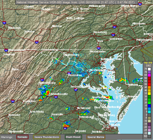 A severe thunderstorm warning remains in effect until 615 pm edt for north central albemarle county and the north central city of charlottesville. at 551 pm edt, a severe thunderstorm was located near free union, or northwest of charlottesville, moving southeast at 10 mph. hazard. 60 mph wind gusts and quarter size hail. A severe thunderstorm warning remains in effect until 615 pm edt for north central albemarle county and the north central city of charlottesville. at 551 pm edt, a severe thunderstorm was located near free union, or northwest of charlottesville, moving southeast at 10 mph. hazard. 60 mph wind gusts and quarter size hail.
|
| 8/19/2019 5:33 PM EDT |
 The national weather service in sterling virginia has issued a * severe thunderstorm warning for. the north central city of charlottesville in central virginia. north central albemarle county in central virginia. until 615 pm edt. At 532 pm edt, a severe thunderstorm was located over free union,. The national weather service in sterling virginia has issued a * severe thunderstorm warning for. the north central city of charlottesville in central virginia. north central albemarle county in central virginia. until 615 pm edt. At 532 pm edt, a severe thunderstorm was located over free union,.
|
| 8/13/2019 6:57 PM EDT | Tree down near the intersection of seminole trail and boulders roa in albemarle county VA, 9.5 miles SSW of Charlottesville, VA |
| 8/1/2019 10:50 PM EDT |
 The severe thunderstorm warning for central albemarle county and the city of charlottesville will expire at 1100 pm edt, the storm which prompted the warning has weakened below severe limits, and no longer poses an immediate threat to life or property. therefore, the warning will be allowed to expire. however heavy rain is still possible with this thunderstorm. to report severe weather, contact your nearest law enforcement agency. they will relay your report to the national weather service sterling virginia. The severe thunderstorm warning for central albemarle county and the city of charlottesville will expire at 1100 pm edt, the storm which prompted the warning has weakened below severe limits, and no longer poses an immediate threat to life or property. therefore, the warning will be allowed to expire. however heavy rain is still possible with this thunderstorm. to report severe weather, contact your nearest law enforcement agency. they will relay your report to the national weather service sterling virginia.
|
| 8/1/2019 10:45 PM EDT |
 At 1045 pm edt, a severe thunderstorm was located near charlottesville, and is nearly stationary (radar indicated). Hazards include 60 mph wind gusts. Damaging winds will cause some trees and large branches to fall. this could injure those outdoors, as well as damage homes and vehicles. roadways may become blocked by downed trees. localized power outages are possible. unsecured light objects may become projectiles. Locations impacted include, charlottesville, crozet, westmoreland, ivy, overton, newcomb hall, scott stadium, monticello, flordon, carrsbrook, barracks and white hall. At 1045 pm edt, a severe thunderstorm was located near charlottesville, and is nearly stationary (radar indicated). Hazards include 60 mph wind gusts. Damaging winds will cause some trees and large branches to fall. this could injure those outdoors, as well as damage homes and vehicles. roadways may become blocked by downed trees. localized power outages are possible. unsecured light objects may become projectiles. Locations impacted include, charlottesville, crozet, westmoreland, ivy, overton, newcomb hall, scott stadium, monticello, flordon, carrsbrook, barracks and white hall.
|
| 8/1/2019 10:37 PM EDT |
 At 1037 pm edt, a severe thunderstorm was located near charlottesville, and is nearly stationary (radar indicated). Hazards include 60 mph wind gusts and quarter size hail. Damaging winds will cause some trees and large branches to fall. this could injure those outdoors, as well as damage homes and vehicles. roadways may become blocked by downed trees. localized power outages are possible. Unsecured light objects may become projectiles. At 1037 pm edt, a severe thunderstorm was located near charlottesville, and is nearly stationary (radar indicated). Hazards include 60 mph wind gusts and quarter size hail. Damaging winds will cause some trees and large branches to fall. this could injure those outdoors, as well as damage homes and vehicles. roadways may become blocked by downed trees. localized power outages are possible. Unsecured light objects may become projectiles.
|
| 8/1/2019 9:20 PM EDT |
 The severe thunderstorm warning for central albemarle county and the city of charlottesville will expire at 930 pm edt, the storm which prompted the warning has moved out of the area. therefore, the warning will be allowed to expire. The severe thunderstorm warning for central albemarle county and the city of charlottesville will expire at 930 pm edt, the storm which prompted the warning has moved out of the area. therefore, the warning will be allowed to expire.
|
| 8/1/2019 8:55 PM EDT | Quarter sized hail reported 0.4 miles S of Charlottesville, VA, dime to quarter size hail |
| 8/1/2019 8:47 PM EDT |
 At 847 pm edt, a severe thunderstorm was located near charlottesville, and is nearly stationary (radar indicated). Hazards include 60 mph wind gusts. Damaging winds will cause some trees and large branches to fall. this could injure those outdoors, as well as damage homes and vehicles. roadways may become blocked by downed trees. localized power outages are possible. Unsecured light objects may become projectiles. At 847 pm edt, a severe thunderstorm was located near charlottesville, and is nearly stationary (radar indicated). Hazards include 60 mph wind gusts. Damaging winds will cause some trees and large branches to fall. this could injure those outdoors, as well as damage homes and vehicles. roadways may become blocked by downed trees. localized power outages are possible. Unsecured light objects may become projectiles.
|
| 7/31/2019 5:07 PM EDT |
 The severe thunderstorm warning for eastern albemarle county and the city of charlottesville will expire at 515 pm edt, the storms which prompted the warning have moved out of the area. therefore, the warning will be allowed to expire. a severe thunderstorm watch remains in effect until 900 pm edt for central virginia. to report severe weather, contact your nearest law enforcement agency. they will relay your report to the national weather service sterling virginia. The severe thunderstorm warning for eastern albemarle county and the city of charlottesville will expire at 515 pm edt, the storms which prompted the warning have moved out of the area. therefore, the warning will be allowed to expire. a severe thunderstorm watch remains in effect until 900 pm edt for central virginia. to report severe weather, contact your nearest law enforcement agency. they will relay your report to the national weather service sterling virginia.
|
| 7/31/2019 4:31 PM EDT |
 At 430 pm edt, severe thunderstorms were located along a line extending from 8 miles northeast of charlottesville to 11 miles southeast of crozet, moving east at 20 mph (law enforcement reported multiple trees have been downed in the city of charlottesville). Hazards include 60 mph wind gusts. Damaging winds will cause some trees and large branches to fall. this could injure those outdoors, as well as damage homes and vehicles. roadways may become blocked by downed trees. localized power outages are possible. unsecured light objects may become projectiles. Locations impacted include, charlottesville, campbell, westmoreland, hollymead, cobham, cismont, newcomb hall, boyd tavern, woodridge, monticello, keswick, stony point, carrsbrook, shadwell, keene, overton, alberene and scott stadium. At 430 pm edt, severe thunderstorms were located along a line extending from 8 miles northeast of charlottesville to 11 miles southeast of crozet, moving east at 20 mph (law enforcement reported multiple trees have been downed in the city of charlottesville). Hazards include 60 mph wind gusts. Damaging winds will cause some trees and large branches to fall. this could injure those outdoors, as well as damage homes and vehicles. roadways may become blocked by downed trees. localized power outages are possible. unsecured light objects may become projectiles. Locations impacted include, charlottesville, campbell, westmoreland, hollymead, cobham, cismont, newcomb hall, boyd tavern, woodridge, monticello, keswick, stony point, carrsbrook, shadwell, keene, overton, alberene and scott stadium.
|
| 7/31/2019 4:30 PM EDT | Several trees down on va-20 in northeastern albemarle count in albemarle county VA, 8.4 miles SW of Charlottesville, VA |
| 7/31/2019 4:25 PM EDT | Multiple reports of trees down in the city of charlottesvill in city of charlottes county VA, 0.4 miles S of Charlottesville, VA |
| 7/31/2019 4:18 PM EDT |
 At 417 pm edt, severe thunderstorms were located along a line extending from 8 miles east of free union to 9 miles south of crozet, moving east at 25 mph (radar indicated). Hazards include 60 mph wind gusts. Damaging winds will cause some trees and large branches to fall. this could injure those outdoors, as well as damage homes and vehicles. roadways may become blocked by downed trees. localized power outages are possible. Unsecured light objects may become projectiles. At 417 pm edt, severe thunderstorms were located along a line extending from 8 miles east of free union to 9 miles south of crozet, moving east at 25 mph (radar indicated). Hazards include 60 mph wind gusts. Damaging winds will cause some trees and large branches to fall. this could injure those outdoors, as well as damage homes and vehicles. roadways may become blocked by downed trees. localized power outages are possible. Unsecured light objects may become projectiles.
|
| 7/31/2019 4:09 PM EDT |
 A severe thunderstorm warning remains in effect until 430 pm edt for northeastern nelson and central albemarle counties and the city of charlottesville. At 409 pm edt, severe thunderstorms were located along a line extending from free union to 6 miles southeast of crozet, moving east at 15 mph. A severe thunderstorm warning remains in effect until 430 pm edt for northeastern nelson and central albemarle counties and the city of charlottesville. At 409 pm edt, severe thunderstorms were located along a line extending from free union to 6 miles southeast of crozet, moving east at 15 mph.
|
| 7/31/2019 3:50 PM EDT |
 At 349 pm edt, severe thunderstorms were located along a line extending from near free union to 6 miles south of crozet, moving east at 15 mph (radar indicated). Hazards include 60 mph wind gusts. Damaging winds will cause some trees and large branches to fall. this could injure those outdoors, as well as damage homes and vehicles. roadways may become blocked by downed trees. localized power outages are possible. Unsecured light objects may become projectiles. At 349 pm edt, severe thunderstorms were located along a line extending from near free union to 6 miles south of crozet, moving east at 15 mph (radar indicated). Hazards include 60 mph wind gusts. Damaging winds will cause some trees and large branches to fall. this could injure those outdoors, as well as damage homes and vehicles. roadways may become blocked by downed trees. localized power outages are possible. Unsecured light objects may become projectiles.
|
| 7/30/2019 6:16 PM EDT | Tree down on wires with fire near the intersection of us-29 seminole trail and dew maw lane. tree down on us-29 seminole trail near cypress drive blocking northbound la in albemarle county VA, 8.1 miles SSW of Charlottesville, VA |
| 7/30/2019 2:26 PM EDT | Tree down near the intersection of route 29 and gander d in albemarle county VA, 4.1 miles SSW of Charlottesville, VA |
| 7/22/2019 6:28 PM EDT |
 At 628 pm edt, severe thunderstorms were located along a line extending from charlottesville to 6 miles north of lake monticello to palmyra, moving northeast at 35 mph (radar indicated). Hazards include 60 mph wind gusts. Damaging winds will cause some trees and large branches to fall. this could injure those outdoors, as well as damage homes and vehicles. roadways may become blocked by downed trees. localized power outages are possible. unsecured light objects may become projectiles. Locations impacted include, charlottesville, campbell, westmoreland, hollymead, ivy, cobham, cismont, newcomb hall, boyd tavern, monticello, keswick, stony point, flordon, carrsbrook, shadwell, barracks and scott stadium. At 628 pm edt, severe thunderstorms were located along a line extending from charlottesville to 6 miles north of lake monticello to palmyra, moving northeast at 35 mph (radar indicated). Hazards include 60 mph wind gusts. Damaging winds will cause some trees and large branches to fall. this could injure those outdoors, as well as damage homes and vehicles. roadways may become blocked by downed trees. localized power outages are possible. unsecured light objects may become projectiles. Locations impacted include, charlottesville, campbell, westmoreland, hollymead, ivy, cobham, cismont, newcomb hall, boyd tavern, monticello, keswick, stony point, flordon, carrsbrook, shadwell, barracks and scott stadium.
|
| 7/22/2019 6:26 PM EDT | Tree down on polo grounds rd near montgomery ridge rd in albemarle county VA, 5.1 miles SSW of Charlottesville, VA |
| 7/22/2019 6:21 PM EDT | Tree blown down across cherry avenue near buford middle school blocking both direction in albemarle county VA, 0.6 miles ENE of Charlottesville, VA |
| 7/22/2019 6:18 PM EDT | Large tree down across cherry ave blocking both lanes across from buford middle school in albemarle county VA, 0.6 miles ENE of Charlottesville, VA |
| 7/22/2019 6:18 PM EDT |
 At 618 pm edt, severe thunderstorms were located along a line extending from near crozet to 6 miles south of charlottesville to 7 miles northwest of fork union, moving northeast at 35 mph (radar indicated). Hazards include 60 mph wind gusts. Damaging winds will cause some trees and large branches to fall. this could injure those outdoors, as well as damage homes and vehicles. roadways may become blocked by downed trees. localized power outages are possible. unsecured light objects may become projectiles. Locations impacted include, charlottesville, campbell, westmoreland, hollymead, ivy, scottsville, esmont, north garden, stony point, flordon, scott stadium, cobham, cismont, newcomb hall, boyd tavern, woodridge, monticello, keswick, carrsbrook and shadwell. At 618 pm edt, severe thunderstorms were located along a line extending from near crozet to 6 miles south of charlottesville to 7 miles northwest of fork union, moving northeast at 35 mph (radar indicated). Hazards include 60 mph wind gusts. Damaging winds will cause some trees and large branches to fall. this could injure those outdoors, as well as damage homes and vehicles. roadways may become blocked by downed trees. localized power outages are possible. unsecured light objects may become projectiles. Locations impacted include, charlottesville, campbell, westmoreland, hollymead, ivy, scottsville, esmont, north garden, stony point, flordon, scott stadium, cobham, cismont, newcomb hall, boyd tavern, woodridge, monticello, keswick, carrsbrook and shadwell.
|
| 7/22/2019 6:00 PM EDT |
 At 600 pm edt, severe thunderstorms were located along a line extending from 6 miles east of wintergreen to near centenary, moving northeast at 35 mph (radar indicated. several downed trees were reported in nelson county). Hazards include 60 mph wind gusts. Damaging winds will cause some trees and large branches to fall. this could injure those outdoors, as well as damage homes and vehicles. roadways may become blocked by downed trees. localized power outages are possible. Unsecured light objects may become projectiles. At 600 pm edt, severe thunderstorms were located along a line extending from 6 miles east of wintergreen to near centenary, moving northeast at 35 mph (radar indicated. several downed trees were reported in nelson county). Hazards include 60 mph wind gusts. Damaging winds will cause some trees and large branches to fall. this could injure those outdoors, as well as damage homes and vehicles. roadways may become blocked by downed trees. localized power outages are possible. Unsecured light objects may become projectiles.
|
| 7/14/2019 7:36 PM EDT | Downed tree near the intersection of ivy road and morgantown roa in albemarle county VA, 6.2 miles ESE of Charlottesville, VA |
| 7/14/2019 7:33 PM EDT | Tree on powerlines on dry bridge roa in albemarle county VA, 7.1 miles E of Charlottesville, VA |
| 7/14/2019 7:29 PM EDT | Large trees down near the intersection of three notched road and old three notched roa in albemarle county VA, 9.6 miles ESE of Charlottesville, VA |
| 7/11/2019 5:13 PM EDT | Trees and power lines down in 2200 block of stony point roa in albemarle county VA, 4.3 miles WSW of Charlottesville, VA |
| 7/11/2019 5:08 PM EDT | Tree down onto house on kenwood lan in albemarle county VA, 2.1 miles SSW of Charlottesville, VA |
| 7/11/2019 5:00 PM EDT | Tree down blocking both lanes of coulhurst drive near falcon driv in albemarle county VA, 2.8 miles SE of Charlottesville, VA |
| 6/29/2019 4:02 PM EDT |
 At 402 pm edt, a severe thunderstorm was located near free union, or near charlottesville, moving east at 10 mph (radar indicated). Hazards include 60 mph wind gusts and quarter size hail. Damaging winds will cause some trees and large branches to fall. this could injure those outdoors, as well as damage homes and vehicles. roadways may become blocked by downed trees. localized power outages are possible. unsecured light objects may become projectiles. Locations impacted include, charlottesville, westmoreland, hollymead, cobham, cismont, stony point, carrsbrook and earlysville. At 402 pm edt, a severe thunderstorm was located near free union, or near charlottesville, moving east at 10 mph (radar indicated). Hazards include 60 mph wind gusts and quarter size hail. Damaging winds will cause some trees and large branches to fall. this could injure those outdoors, as well as damage homes and vehicles. roadways may become blocked by downed trees. localized power outages are possible. unsecured light objects may become projectiles. Locations impacted include, charlottesville, westmoreland, hollymead, cobham, cismont, stony point, carrsbrook and earlysville.
|
| 6/29/2019 3:56 PM EDT | Tree down at the intersection of seminole trail and lewis and clark d in albemarle county VA, 8.9 miles SSW of Charlottesville, VA |
| 6/29/2019 3:54 PM EDT |
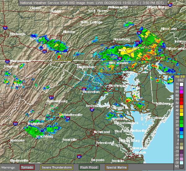 At 354 pm edt, a severe thunderstorm was located near free union, or just north of the city of charlottesville, moving east at 10 mph (radar indicated). Hazards include 60 mph wind gusts. Damaging winds will cause some trees and large branches to fall. this could injure those outdoors, as well as damage homes and vehicles. roadways may become blocked by downed trees. localized power outages are possible. Unsecured light objects may become projectiles. At 354 pm edt, a severe thunderstorm was located near free union, or just north of the city of charlottesville, moving east at 10 mph (radar indicated). Hazards include 60 mph wind gusts. Damaging winds will cause some trees and large branches to fall. this could injure those outdoors, as well as damage homes and vehicles. roadways may become blocked by downed trees. localized power outages are possible. Unsecured light objects may become projectiles.
|
| 6/29/2019 3:23 PM EDT |
 At 322 pm edt, a severe thunderstorm was located over free union, or 8 miles northwest of charlottesville, moving east at 5 mph (radar indicated). Hazards include 60 mph wind gusts and quarter size hail. Damaging winds will cause some trees and large branches to fall. this could injure those outdoors, as well as damage homes and vehicles. roadways may become blocked by downed trees. localized power outages are possible. Unsecured light objects may become projectiles. At 322 pm edt, a severe thunderstorm was located over free union, or 8 miles northwest of charlottesville, moving east at 5 mph (radar indicated). Hazards include 60 mph wind gusts and quarter size hail. Damaging winds will cause some trees and large branches to fall. this could injure those outdoors, as well as damage homes and vehicles. roadways may become blocked by downed trees. localized power outages are possible. Unsecured light objects may become projectiles.
|
| 6/28/2019 5:11 PM EDT |
 At 511 pm edt, a severe thunderstorm was located 7 miles northeast of schuyler, or 14 miles south of charlottesville, moving east at 10 mph (radar indicated). Hazards include 60 mph wind gusts and quarter size hail. Damaging winds will cause some trees and large branches to fall. this could injure those outdoors, as well as damage homes and vehicles. roadways may become blocked by downed trees. localized power outages are possible. Unsecured light objects may become projectiles. At 511 pm edt, a severe thunderstorm was located 7 miles northeast of schuyler, or 14 miles south of charlottesville, moving east at 10 mph (radar indicated). Hazards include 60 mph wind gusts and quarter size hail. Damaging winds will cause some trees and large branches to fall. this could injure those outdoors, as well as damage homes and vehicles. roadways may become blocked by downed trees. localized power outages are possible. Unsecured light objects may become projectiles.
|
| 6/17/2019 5:26 PM EDT |
 The severe thunderstorm warning for central albemarle county and the city of charlottesville will expire at 530 pm edt, the storm which prompted the warning has weakened below severe limits, and no longer poses an immediate threat to life or property. therefore, the warning will be allowed to expire. The severe thunderstorm warning for central albemarle county and the city of charlottesville will expire at 530 pm edt, the storm which prompted the warning has weakened below severe limits, and no longer poses an immediate threat to life or property. therefore, the warning will be allowed to expire.
|
| 6/17/2019 5:16 PM EDT |
 At 515 pm edt, a severe thunderstorm was located over charlottesville, moving southeast at 20 mph (radar indicated). Hazards include 60 mph wind gusts and quarter size hail. Damaging winds will cause some trees and large branches to fall. this could injure those outdoors, as well as damage homes and vehicles. roadways may become blocked by downed trees. localized power outages are possible. unsecured light objects may become projectiles. Locations impacted include, charlottesville, campbell, westmoreland, hollymead, ivy, cismont, newcomb hall, boyd tavern, monticello, woodridge, keswick, flordon, carrsbrook, shadwell, barracks, overton, scott stadium and cobham. At 515 pm edt, a severe thunderstorm was located over charlottesville, moving southeast at 20 mph (radar indicated). Hazards include 60 mph wind gusts and quarter size hail. Damaging winds will cause some trees and large branches to fall. this could injure those outdoors, as well as damage homes and vehicles. roadways may become blocked by downed trees. localized power outages are possible. unsecured light objects may become projectiles. Locations impacted include, charlottesville, campbell, westmoreland, hollymead, ivy, cismont, newcomb hall, boyd tavern, monticello, woodridge, keswick, flordon, carrsbrook, shadwell, barracks, overton, scott stadium and cobham.
|
| 6/17/2019 5:12 PM EDT | Quarter sized hail reported 0.6 miles ENE of Charlottesville, VA |
| 6/17/2019 5:10 PM EDT | Tree down on commonwealth d in albemarle county VA, 2.6 miles S of Charlottesville, VA |
| 6/17/2019 5:09 PM EDT | Large tree blocking roadway near the intersection of va-20 and red hill r in albemarle county VA, 8.5 miles NNE of Charlottesville, VA |
| 6/17/2019 5:05 PM EDT | Multiple trees and branches reported down in the frys spring section of charlottesville in albemarle county VA, 1.4 miles NE of Charlottesville, VA |
| 6/17/2019 4:54 PM EDT |
 At 453 pm edt, a severe thunderstorm was located near crozet, or near charlottesville, moving southeast at 20 mph (radar indicated). Hazards include 60 mph wind gusts and quarter size hail. Damaging winds will cause some trees and large branches to fall. this could injure those outdoors, as well as damage homes and vehicles. roadways may become blocked by downed trees. localized power outages are possible. Unsecured light objects may become projectiles. At 453 pm edt, a severe thunderstorm was located near crozet, or near charlottesville, moving southeast at 20 mph (radar indicated). Hazards include 60 mph wind gusts and quarter size hail. Damaging winds will cause some trees and large branches to fall. this could injure those outdoors, as well as damage homes and vehicles. roadways may become blocked by downed trees. localized power outages are possible. Unsecured light objects may become projectiles.
|
| 5/31/2019 6:13 PM EDT | Tree down on a home near the intersection of cherry ave and crestmont av in albemarle county VA, 1.4 miles NE of Charlottesville, VA |
| 5/26/2019 5:20 PM EDT | Tree down on power lines on route 20 just north of keen in albemarle county VA, 11.9 miles NNE of Charlottesville, VA |
| 5/26/2019 2:53 PM EDT | Tree down on the 3400 block of stony point roa in albemarle county VA, 7.2 miles SW of Charlottesville, VA |
| 5/26/2019 2:50 PM EDT | Tree down on the 2000 block of hawkshill lan in albemarle county VA, 7.2 miles WSW of Charlottesville, VA |
| 5/26/2019 2:46 PM EDT | Tree down on georgetown road near terrell road in albemarle county VA, 2.6 miles S of Charlottesville, VA |
| 5/26/2019 2:35 PM EDT | Tree down on 3900 block of free union roa in albemarle county VA, 8.9 miles SSE of Charlottesville, VA |
| 4/26/2019 1:38 PM EDT |
 At 138 pm edt, severe thunderstorms were located along a line extending from near stanardsville to 6 miles northeast of charlottesville, moving northeast at 45 mph (radar indicated). Hazards include 60 mph wind gusts. Damaging winds will cause some trees and large branches to fall. this could injure those outdoors, as well as damage homes and vehicles. roadways may become blocked by downed trees. localized power outages are possible. unsecured light objects may become projectiles. Locations impacted include, charlottesville, campbell, westmoreland, hollymead, cobham, cismont, boyd tavern, monticello, keswick, stony point, carrsbrook, shadwell and advance mills. At 138 pm edt, severe thunderstorms were located along a line extending from near stanardsville to 6 miles northeast of charlottesville, moving northeast at 45 mph (radar indicated). Hazards include 60 mph wind gusts. Damaging winds will cause some trees and large branches to fall. this could injure those outdoors, as well as damage homes and vehicles. roadways may become blocked by downed trees. localized power outages are possible. unsecured light objects may become projectiles. Locations impacted include, charlottesville, campbell, westmoreland, hollymead, cobham, cismont, boyd tavern, monticello, keswick, stony point, carrsbrook, shadwell and advance mills.
|
| 4/26/2019 1:28 PM EDT | Tree down on power lines at 1300 polo grounds rd in albemarle county VA, 4.9 miles SSW of Charlottesville, VA |
| 4/26/2019 1:21 PM EDT |
 At 121 pm edt, severe thunderstorms were located along a line extending from near free union to near charlottesville, moving northeast at 45 mph (radar indicated). Hazards include 60 mph wind gusts. Damaging winds will cause some trees and large branches to fall. this could injure those outdoors, as well as damage homes and vehicles. roadways may become blocked by downed trees. localized power outages are possible. unsecured light objects may become projectiles. Locations impacted include, charlottesville, crozet, free union, campbell, westmoreland, hollymead, ivy, scottsville, north garden, stony point, flordon, scott stadium, cobham, cismont, boonesville, newcomb hall, boyd tavern, monticello, woodridge and keswick. At 121 pm edt, severe thunderstorms were located along a line extending from near free union to near charlottesville, moving northeast at 45 mph (radar indicated). Hazards include 60 mph wind gusts. Damaging winds will cause some trees and large branches to fall. this could injure those outdoors, as well as damage homes and vehicles. roadways may become blocked by downed trees. localized power outages are possible. unsecured light objects may become projectiles. Locations impacted include, charlottesville, crozet, free union, campbell, westmoreland, hollymead, ivy, scottsville, north garden, stony point, flordon, scott stadium, cobham, cismont, boonesville, newcomb hall, boyd tavern, monticello, woodridge and keswick.
|
| 4/26/2019 1:14 PM EDT |
 At 113 pm edt, severe thunderstorms were located along a line extending from crozet to 10 miles southwest of charlottesville, moving northeast at 45 mph (radar indicated). Hazards include 60 mph wind gusts. Damaging winds will cause some trees and large branches to fall. this could injure those outdoors, as well as damage homes and vehicles. roadways may become blocked by downed trees. localized power outages are possible. Unsecured light objects may become projectiles. At 113 pm edt, severe thunderstorms were located along a line extending from crozet to 10 miles southwest of charlottesville, moving northeast at 45 mph (radar indicated). Hazards include 60 mph wind gusts. Damaging winds will cause some trees and large branches to fall. this could injure those outdoors, as well as damage homes and vehicles. roadways may become blocked by downed trees. localized power outages are possible. Unsecured light objects may become projectiles.
|
| 4/14/2019 6:32 PM EDT |
 At 632 pm edt, a severe thunderstorm was located near crozet, or 11 miles northwest of charlottesville, moving northeast at 45 mph (radar indicated). Hazards include 60 mph wind gusts. Damaging winds will cause some trees and large branches to fall. this could injure those outdoors, as well as damage homes and vehicles. roadways may become blocked by downed trees. localized power outages are possible. unsecured light objects may become projectiles. Locations impacted include, charlottesville, waynesboro, crozet, grottoes, crimora, sherando, free union, wintergreen, afton, westmoreland, hollymead, lyndhurst, nellysford, ivy, new hope, north garden, covesville, yancey mills, stony point and flordon. At 632 pm edt, a severe thunderstorm was located near crozet, or 11 miles northwest of charlottesville, moving northeast at 45 mph (radar indicated). Hazards include 60 mph wind gusts. Damaging winds will cause some trees and large branches to fall. this could injure those outdoors, as well as damage homes and vehicles. roadways may become blocked by downed trees. localized power outages are possible. unsecured light objects may become projectiles. Locations impacted include, charlottesville, waynesboro, crozet, grottoes, crimora, sherando, free union, wintergreen, afton, westmoreland, hollymead, lyndhurst, nellysford, ivy, new hope, north garden, covesville, yancey mills, stony point and flordon.
|
| 4/14/2019 5:59 PM EDT |
 At 558 pm edt, a severe thunderstorm was located near wintergreen, or 14 miles north of clifford, moving northeast at 45 mph (radar indicated). Hazards include 60 mph wind gusts and quarter size hail. Damaging winds will cause some trees and large branches to fall. this could injure those outdoors, as well as damage homes and vehicles. roadways may become blocked by downed trees. localized power outages are possible. Unsecured light objects may become projectiles. At 558 pm edt, a severe thunderstorm was located near wintergreen, or 14 miles north of clifford, moving northeast at 45 mph (radar indicated). Hazards include 60 mph wind gusts and quarter size hail. Damaging winds will cause some trees and large branches to fall. this could injure those outdoors, as well as damage homes and vehicles. roadways may become blocked by downed trees. localized power outages are possible. Unsecured light objects may become projectiles.
|
| 10/11/2018 5:08 PM EDT | Several trees down near 3985 blenheim rd in albemarle county VA, 7.2 miles N of Charlottesville, VA |
| 9/19/2018 4:27 PM EDT | Tree down on wires on watts passage blocking the entire roadway near sylvan lan in albemarle county VA, 10.3 miles SSW of Charlottesville, VA |
| 8/30/2018 7:05 PM EDT |
 The severe thunderstorm warning for central albemarle county and the city of charlottesville will expire at 715 pm edt, the storm which prompted the warning has weakened below severe limits, and no longer pose an immediate threat to life or property. therefore the warning will be allowed to expire. to report severe weather, contact your nearest law enforcement agency. they will relay your report to the national weather service sterling virginia. The severe thunderstorm warning for central albemarle county and the city of charlottesville will expire at 715 pm edt, the storm which prompted the warning has weakened below severe limits, and no longer pose an immediate threat to life or property. therefore the warning will be allowed to expire. to report severe weather, contact your nearest law enforcement agency. they will relay your report to the national weather service sterling virginia.
|
| 8/30/2018 6:52 PM EDT |
 At 651 pm edt, a severe thunderstorm was located near crozet, or near charlottesville, moving east at 10 mph (radar indicated). Hazards include 60 mph wind gusts. Damaging winds will cause some trees and large branches to fall. this could injure those outdoors, as well as damage homes and vehicles. roadways may become blocked by downed trees. localized power outages are possible. unsecured light objects may become projectiles. Locations impacted include, charlottesville, crozet, westmoreland, hollymead, ivy, north garden, newcomb hall, batesville, yancey mills, monticello, flordon, carrsbrook, shadwell, barracks, overton, scott stadium and white hall. At 651 pm edt, a severe thunderstorm was located near crozet, or near charlottesville, moving east at 10 mph (radar indicated). Hazards include 60 mph wind gusts. Damaging winds will cause some trees and large branches to fall. this could injure those outdoors, as well as damage homes and vehicles. roadways may become blocked by downed trees. localized power outages are possible. unsecured light objects may become projectiles. Locations impacted include, charlottesville, crozet, westmoreland, hollymead, ivy, north garden, newcomb hall, batesville, yancey mills, monticello, flordon, carrsbrook, shadwell, barracks, overton, scott stadium and white hall.
|
| 8/30/2018 6:34 PM EDT |
 At 633 pm edt, a severe thunderstorm was located near crozet, or 9 miles west of charlottesville, moving east at 10 mph (radar indicated. trained spotters reported strong wind gusts resulting in downed branches near crozet). Hazards include 60 mph wind gusts. Damaging winds will cause some trees and large branches to fall. this could injure those outdoors, as well as damage homes and vehicles. roadways may become blocked by downed trees. localized power outages are possible. unsecured light objects may become projectiles. Locations impacted include, charlottesville, crozet, free union, westmoreland, hollymead, ivy, greenwood, north garden, newcomb hall, batesville, yancey mills, monticello, flordon, carrsbrook, shadwell, barracks, overton, scott stadium and white hall. At 633 pm edt, a severe thunderstorm was located near crozet, or 9 miles west of charlottesville, moving east at 10 mph (radar indicated. trained spotters reported strong wind gusts resulting in downed branches near crozet). Hazards include 60 mph wind gusts. Damaging winds will cause some trees and large branches to fall. this could injure those outdoors, as well as damage homes and vehicles. roadways may become blocked by downed trees. localized power outages are possible. unsecured light objects may become projectiles. Locations impacted include, charlottesville, crozet, free union, westmoreland, hollymead, ivy, greenwood, north garden, newcomb hall, batesville, yancey mills, monticello, flordon, carrsbrook, shadwell, barracks, overton, scott stadium and white hall.
|
| 8/30/2018 6:07 PM EDT |
 At 607 pm edt, a severe thunderstorm was located near crozet, or 8 miles east of waynesboro, moving east at 10 mph (radar indicated). Hazards include 60 mph wind gusts. Damaging winds will cause some trees and large branches to fall. this could injure those outdoors, as well as damage homes and vehicles. roadways may become blocked by downed trees. localized power outages are possible. Unsecured light objects may become projectiles. At 607 pm edt, a severe thunderstorm was located near crozet, or 8 miles east of waynesboro, moving east at 10 mph (radar indicated). Hazards include 60 mph wind gusts. Damaging winds will cause some trees and large branches to fall. this could injure those outdoors, as well as damage homes and vehicles. roadways may become blocked by downed trees. localized power outages are possible. Unsecured light objects may become projectiles.
|
| 8/30/2018 4:29 PM EDT | Tree down in the 2100 block of old lynchburg roa in albemarle county VA, 7.2 miles NE of Charlottesville, VA |
| 8/8/2018 6:47 PM EDT |
 At 647 pm edt, severe thunderstorms were located along a line extending from 6 miles north of boswells tavern to 7 miles northwest of troy to 7 miles south of charlottesville, moving southeast at 25 mph (radar indicated). Hazards include 60 mph wind gusts. Damaging winds will cause some trees and large branches to fall. this could injure those outdoors, as well as damage homes and vehicles. roadways may become blocked by downed trees. localized power outages are possible. unsecured light objects may become projectiles. Locations impacted include, charlottesville, campbell, cobham, cismont, overton, newcomb hall, boyd tavern, scott stadium, woodridge, monticello, keswick and shadwell. At 647 pm edt, severe thunderstorms were located along a line extending from 6 miles north of boswells tavern to 7 miles northwest of troy to 7 miles south of charlottesville, moving southeast at 25 mph (radar indicated). Hazards include 60 mph wind gusts. Damaging winds will cause some trees and large branches to fall. this could injure those outdoors, as well as damage homes and vehicles. roadways may become blocked by downed trees. localized power outages are possible. unsecured light objects may become projectiles. Locations impacted include, charlottesville, campbell, cobham, cismont, overton, newcomb hall, boyd tavern, scott stadium, woodridge, monticello, keswick and shadwell.
|
| 8/8/2018 6:21 PM EDT | Tree down near intersection of garth road and millington roa in albemarle county VA, 9.2 miles SE of Charlottesville, VA |
| 8/8/2018 6:20 PM EDT |
 At 620 pm edt, severe thunderstorms were located along a line extending from near stanardsville to near free union to near crozet, moving southeast at 25 mph (radar indicated). Hazards include 60 mph wind gusts. Damaging winds will cause some trees and large branches to fall. this could injure those outdoors, as well as damage homes and vehicles. roadways may become blocked by downed trees. localized power outages are possible. Unsecured light objects may become projectiles. At 620 pm edt, severe thunderstorms were located along a line extending from near stanardsville to near free union to near crozet, moving southeast at 25 mph (radar indicated). Hazards include 60 mph wind gusts. Damaging winds will cause some trees and large branches to fall. this could injure those outdoors, as well as damage homes and vehicles. roadways may become blocked by downed trees. localized power outages are possible. Unsecured light objects may become projectiles.
|
| 8/7/2018 4:47 PM EDT | Tree down near scottsville road at ann street extension in albemarle county VA, 3.8 miles NNE of Charlottesville, VA |
| 8/7/2018 4:07 PM EDT | Tree down on stony point road in albemarle county VA, 3.8 miles WSW of Charlottesville, VA |
| 8/2/2018 11:08 AM EDT | Tree down on scottsvill rd at avon street extende in albemarle county VA, 3 miles N of Charlottesville, VA |
| 7/28/2018 12:47 AM EDT | Tree down across dickerson road... power lines down in albemarle county VA, 9.3 miles SSW of Charlottesville, VA |
| 7/22/2018 7:50 PM EDT |
 The severe thunderstorm warning for albemarle county and the city of charlottesville will expire at 800 pm edt, the storm which prompted the warning has weakened below severe limits, and no longer pose an immediate threat to life or property. therefore the warning will be allowed to expire. however heavy rain is still possible with this thunderstorm. The severe thunderstorm warning for albemarle county and the city of charlottesville will expire at 800 pm edt, the storm which prompted the warning has weakened below severe limits, and no longer pose an immediate threat to life or property. therefore the warning will be allowed to expire. however heavy rain is still possible with this thunderstorm.
|
| 7/22/2018 7:47 PM EDT | Tree down near the intersection of va-649 proffit road and va-20 stony point roa in albemarle county VA, 5.9 miles WSW of Charlottesville, VA |
| 7/22/2018 7:25 PM EDT |
 At 705 pm edt, a severe thunderstorm was located over lake monticello, or near palmyra, moving northwest at 25 mph (radar indicated). Hazards include 60 mph wind gusts. Damaging winds will cause some trees and large branches to fall. this could injure those outdoors, as well as damage homes and vehicles. roadways may become blocked by downed trees. localized power outages are possible. Unsecured light objects may become projectiles. At 705 pm edt, a severe thunderstorm was located over lake monticello, or near palmyra, moving northwest at 25 mph (radar indicated). Hazards include 60 mph wind gusts. Damaging winds will cause some trees and large branches to fall. this could injure those outdoors, as well as damage homes and vehicles. roadways may become blocked by downed trees. localized power outages are possible. Unsecured light objects may become projectiles.
|
| 7/22/2018 7:05 PM EDT |
 At 705 pm edt, a severe thunderstorm was located over lake monticello, or near palmyra, moving northwest at 25 mph (radar indicated). Hazards include 60 mph wind gusts. Damaging winds will cause some trees and large branches to fall. this could injure those outdoors, as well as damage homes and vehicles. roadways may become blocked by downed trees. localized power outages are possible. Unsecured light objects may become projectiles. At 705 pm edt, a severe thunderstorm was located over lake monticello, or near palmyra, moving northwest at 25 mph (radar indicated). Hazards include 60 mph wind gusts. Damaging winds will cause some trees and large branches to fall. this could injure those outdoors, as well as damage homes and vehicles. roadways may become blocked by downed trees. localized power outages are possible. Unsecured light objects may become projectiles.
|
| 6/24/2018 3:14 PM EDT | Tree down at the 1000 block of preston av in city of charlottes county VA, 0.4 miles S of Charlottesville, VA |
| 6/24/2018 3:09 PM EDT | Tree down at the 800 block of hammocks gap roa in albemarle county VA, 5.3 miles WSW of Charlottesville, VA |
| 6/18/2018 4:46 PM EDT |
 At 446 pm edt, a severe thunderstorm was located near charlottesville, moving southeast at 20 mph (radar indicated). Hazards include 60 mph wind gusts. Damaging winds will cause some trees and large branches to fall. this could injure those outdoors, as well as damage homes and vehicles. roadways may become blocked by downed trees. localized power outages are possible. unsecured light objects may become projectiles. Locations impacted include, charlottesville, campbell, westmoreland, cismont, newcomb hall, boyd tavern, woodridge, monticello, keswick, carrsbrook, shadwell, barracks, overton and scott stadium. At 446 pm edt, a severe thunderstorm was located near charlottesville, moving southeast at 20 mph (radar indicated). Hazards include 60 mph wind gusts. Damaging winds will cause some trees and large branches to fall. this could injure those outdoors, as well as damage homes and vehicles. roadways may become blocked by downed trees. localized power outages are possible. unsecured light objects may become projectiles. Locations impacted include, charlottesville, campbell, westmoreland, cismont, newcomb hall, boyd tavern, woodridge, monticello, keswick, carrsbrook, shadwell, barracks, overton and scott stadium.
|
| 6/18/2018 4:43 PM EDT | Tree blocking intersection at scotsville rd and avon st. ex in albemarle county VA, 3.8 miles NNE of Charlottesville, VA |
| 6/18/2018 4:36 PM EDT |
 At 436 pm edt, a severe thunderstorm was located near charlottesville, moving southeast at 20 mph (radar indicated). Hazards include 60 mph wind gusts. Damaging winds will cause some trees and large branches to fall. this could injure those outdoors, as well as damage homes and vehicles. roadways may become blocked by downed trees. localized power outages are possible. Unsecured light objects may become projectiles. At 436 pm edt, a severe thunderstorm was located near charlottesville, moving southeast at 20 mph (radar indicated). Hazards include 60 mph wind gusts. Damaging winds will cause some trees and large branches to fall. this could injure those outdoors, as well as damage homes and vehicles. roadways may become blocked by downed trees. localized power outages are possible. Unsecured light objects may become projectiles.
|
| 6/18/2018 4:29 PM EDT | Tree down near intersection of lonicera way and dickerson rd in albemarle county VA, 10.2 miles SSW of Charlottesville, VA |
| 6/18/2018 4:27 PM EDT | At least a dozen trees down in the north pines subdivisio in albemarle county VA, 10 miles SSW of Charlottesville, VA |
| 6/18/2018 4:23 PM EDT | Tree blocking intersection at ivy rd and west leigh d in albemarle county VA, 5 miles ESE of Charlottesville, VA |
| 6/18/2018 4:18 PM EDT | Tree down near intersection of holkham dr and owensville rd in albemarle county VA, 6 miles ESE of Charlottesville, VA |
| 6/10/2018 4:39 PM EDT |
 At 439 pm edt, severe thunderstorms were located along a line extending from 7 miles southeast of afton to near lake monticello, moving southeast at 20 mph (radar indicated). Hazards include 60 mph wind gusts and quarter size hail. Damaging winds will cause some trees and large branches to fall. this could injure those outdoors, as well as damage homes and vehicles. roadways may become blocked by downed trees. localized power outages are possible. unsecured light objects may become projectiles. Locations impacted include, charlottesville, campbell, scottsville, esmont, cobham, cismont, damon, north garden, newcomb hall, batesville, covesville, boyd tavern, woodridge, monticello, keswick, shadwell, glendower, keene, overton and alberene. At 439 pm edt, severe thunderstorms were located along a line extending from 7 miles southeast of afton to near lake monticello, moving southeast at 20 mph (radar indicated). Hazards include 60 mph wind gusts and quarter size hail. Damaging winds will cause some trees and large branches to fall. this could injure those outdoors, as well as damage homes and vehicles. roadways may become blocked by downed trees. localized power outages are possible. unsecured light objects may become projectiles. Locations impacted include, charlottesville, campbell, scottsville, esmont, cobham, cismont, damon, north garden, newcomb hall, batesville, covesville, boyd tavern, woodridge, monticello, keswick, shadwell, glendower, keene, overton and alberene.
|
| 6/10/2018 4:12 PM EDT | Trees down along monacan trail rd in albemarle county VA, 4.1 miles ENE of Charlottesville, VA |
| 6/10/2018 4:12 PM EDT | Multiple reports of trees down throughout the city of charlottesville in city of charlottes county VA, 0.4 miles S of Charlottesville, VA |
| 6/10/2018 4:09 PM EDT |
 At 409 pm edt, a severe thunderstorm was located over charlottesville, moving southeast at 10 mph (radar indicated). Hazards include 60 mph wind gusts and quarter size hail. Damaging winds will cause some trees and large branches to fall. this could injure those outdoors, as well as damage homes and vehicles. roadways may become blocked by downed trees. localized power outages are possible. unsecured light objects may become projectiles. Locations impacted include, charlottesville, westmoreland, hollymead, ivy, stony point, flordon, carrsbrook and barracks. At 409 pm edt, a severe thunderstorm was located over charlottesville, moving southeast at 10 mph (radar indicated). Hazards include 60 mph wind gusts and quarter size hail. Damaging winds will cause some trees and large branches to fall. this could injure those outdoors, as well as damage homes and vehicles. roadways may become blocked by downed trees. localized power outages are possible. unsecured light objects may become projectiles. Locations impacted include, charlottesville, westmoreland, hollymead, ivy, stony point, flordon, carrsbrook and barracks.
|
| 6/10/2018 4:08 PM EDT |
 At 407 pm edt, severe thunderstorms were located along a line extending from near afton to charlottesville, moving southeast at 20 mph (radar indicated). Hazards include golf ball size hail and 70 mph wind gusts. Expect wind damage to trees and power lines. hail is large enough to dent and damage vehicles. some hail damage to roofs, siding, and windows is possible. Locations impacted include, charlottesville, crozet, free union, campbell, westmoreland, hollymead, ivy, north garden, covesville, yancey mills, stony point, flordon, scott stadium, cobham, cismont, greenwood, newcomb hall, batesville, boyd tavern and woodridge. At 407 pm edt, severe thunderstorms were located along a line extending from near afton to charlottesville, moving southeast at 20 mph (radar indicated). Hazards include golf ball size hail and 70 mph wind gusts. Expect wind damage to trees and power lines. hail is large enough to dent and damage vehicles. some hail damage to roofs, siding, and windows is possible. Locations impacted include, charlottesville, crozet, free union, campbell, westmoreland, hollymead, ivy, north garden, covesville, yancey mills, stony point, flordon, scott stadium, cobham, cismont, greenwood, newcomb hall, batesville, boyd tavern and woodridge.
|
| 6/10/2018 4:05 PM EDT | Trees down on garth rd in albemarle county VA, 3 miles SSE of Charlottesville, VA |
| 6/10/2018 4:01 PM EDT |
 At 400 pm edt, severe thunderstorms were located along a line extending from near afton to 7 miles east of charlottesville, moving southeast at 15 mph (radar indicated). Hazards include 60 mph wind gusts and quarter size hail. Damaging winds will cause some trees and large branches to fall. this could injure those outdoors, as well as damage homes and vehicles. roadways may become blocked by downed trees. localized power outages are possible. Unsecured light objects may become projectiles. At 400 pm edt, severe thunderstorms were located along a line extending from near afton to 7 miles east of charlottesville, moving southeast at 15 mph (radar indicated). Hazards include 60 mph wind gusts and quarter size hail. Damaging winds will cause some trees and large branches to fall. this could injure those outdoors, as well as damage homes and vehicles. roadways may become blocked by downed trees. localized power outages are possible. Unsecured light objects may become projectiles.
|
| 6/10/2018 3:53 PM EDT |
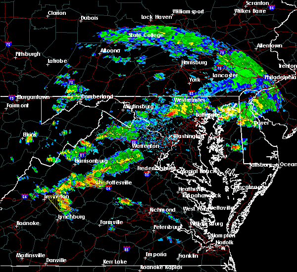 At 353 pm edt, a severe thunderstorm was located near charlottesville, moving east at 20 mph (radar indicated). Hazards include 70 mph wind gusts and ping pong ball size hail. Damaging winds will cause some trees and large branches to fall. this could injure those outdoors, as well as damage homes and vehicles. roadways may become blocked by downed trees. localized power outages are possible. unsecured light objects may become projectiles. Locations impacted include, charlottesville, free union, westmoreland, hollymead, ivy, stony point, advance mills, flordon, carrsbrook, earlysville and barracks. At 353 pm edt, a severe thunderstorm was located near charlottesville, moving east at 20 mph (radar indicated). Hazards include 70 mph wind gusts and ping pong ball size hail. Damaging winds will cause some trees and large branches to fall. this could injure those outdoors, as well as damage homes and vehicles. roadways may become blocked by downed trees. localized power outages are possible. unsecured light objects may become projectiles. Locations impacted include, charlottesville, free union, westmoreland, hollymead, ivy, stony point, advance mills, flordon, carrsbrook, earlysville and barracks.
|
| 6/10/2018 3:33 PM EDT |
 At 332 pm edt, a severe thunderstorm was located over free union, or 7 miles northwest of charlottesville, moving east at 10 mph (radar indicated). Hazards include 60 mph wind gusts and quarter size hail. Damaging winds will cause some trees and large branches to fall. this could injure those outdoors, as well as damage homes and vehicles. roadways may become blocked by downed trees. localized power outages are possible. Unsecured light objects may become projectiles. At 332 pm edt, a severe thunderstorm was located over free union, or 7 miles northwest of charlottesville, moving east at 10 mph (radar indicated). Hazards include 60 mph wind gusts and quarter size hail. Damaging winds will cause some trees and large branches to fall. this could injure those outdoors, as well as damage homes and vehicles. roadways may become blocked by downed trees. localized power outages are possible. Unsecured light objects may become projectiles.
|
| 5/22/2018 3:44 PM EDT |
 At 343 pm edt, severe thunderstorms were located along a line extending from near stanardsville to near charlottesville to 10 miles southeast of crozet, moving east at 20 mph (radar indicated. tree damage has been reported in charlottesville). Hazards include 70 mph wind gusts and quarter size hail. Damaging winds will cause some trees and large branches to fall. this could injure those outdoors, as well as damage homes and vehicles. roadways may become blocked by downed trees. localized power outages are possible. unsecured light objects may become projectiles. Locations impacted include, charlottesville, stanardsville, campbell, westmoreland, hollymead, gordonsville, ruckersville, ivy, scottsville, quinque, north garden, eheart, oakpark, barboursville, stony point, flordon, montpelier station, newtown, montford and old somerset. At 343 pm edt, severe thunderstorms were located along a line extending from near stanardsville to near charlottesville to 10 miles southeast of crozet, moving east at 20 mph (radar indicated. tree damage has been reported in charlottesville). Hazards include 70 mph wind gusts and quarter size hail. Damaging winds will cause some trees and large branches to fall. this could injure those outdoors, as well as damage homes and vehicles. roadways may become blocked by downed trees. localized power outages are possible. unsecured light objects may become projectiles. Locations impacted include, charlottesville, stanardsville, campbell, westmoreland, hollymead, gordonsville, ruckersville, ivy, scottsville, quinque, north garden, eheart, oakpark, barboursville, stony point, flordon, montpelier station, newtown, montford and old somerset.
|
| 5/22/2018 3:34 PM EDT | Large tree down blocking 5th street near cherry avenue. brought down power line in city of charlottes county VA, 0.3 miles N of Charlottesville, VA |
| 5/22/2018 3:32 PM EDT | Tree down on power lines causing fire in the 2400 block of ivy roa in albemarle county VA, 2 miles SE of Charlottesville, VA |
| 5/22/2018 3:32 PM EDT |
 At 331 pm edt, severe thunderstorms were located along a line extending from stanardsville to near charlottesville to 8 miles south of crozet, moving east at 20 mph (radar indicated). Hazards include 70 mph wind gusts and quarter size hail. Damaging winds will cause some trees and large branches to fall. this could injure those outdoors, as well as damage homes and vehicles. roadways may become blocked by downed trees. localized power outages are possible. unsecured light objects may become projectiles. Locations impacted include, charlottesville, stanardsville, free union, campbell, westmoreland, hollymead, gordonsville, ruckersville, ivy, scottsville, quinque, north garden, eheart, lydia, oakpark, barboursville, stony point, flordon, montpelier station and newtown. At 331 pm edt, severe thunderstorms were located along a line extending from stanardsville to near charlottesville to 8 miles south of crozet, moving east at 20 mph (radar indicated). Hazards include 70 mph wind gusts and quarter size hail. Damaging winds will cause some trees and large branches to fall. this could injure those outdoors, as well as damage homes and vehicles. roadways may become blocked by downed trees. localized power outages are possible. unsecured light objects may become projectiles. Locations impacted include, charlottesville, stanardsville, free union, campbell, westmoreland, hollymead, gordonsville, ruckersville, ivy, scottsville, quinque, north garden, eheart, lydia, oakpark, barboursville, stony point, flordon, montpelier station and newtown.
|
| 5/22/2018 3:27 PM EDT |
 At 326 pm edt, severe thunderstorms were located along a line extending from near stanardsville to near free union to 7 miles south of crozet, moving east at 20 mph (radar indicated). Hazards include 60 mph wind gusts and quarter size hail. Damaging winds will cause some trees and large branches to fall. this could injure those outdoors, as well as damage homes and vehicles. roadways may become blocked by downed trees. localized power outages are possible. unsecured light objects may become projectiles. Locations impacted include, charlottesville, stanardsville, free union, campbell, westmoreland, hollymead, gordonsville, ruckersville, ivy, scottsville, north garden, eheart, oakpark, barboursville, stony point, montpelier station, montford, old somerset, amicus and scott stadium. At 326 pm edt, severe thunderstorms were located along a line extending from near stanardsville to near free union to 7 miles south of crozet, moving east at 20 mph (radar indicated). Hazards include 60 mph wind gusts and quarter size hail. Damaging winds will cause some trees and large branches to fall. this could injure those outdoors, as well as damage homes and vehicles. roadways may become blocked by downed trees. localized power outages are possible. unsecured light objects may become projectiles. Locations impacted include, charlottesville, stanardsville, free union, campbell, westmoreland, hollymead, gordonsville, ruckersville, ivy, scottsville, north garden, eheart, oakpark, barboursville, stony point, montpelier station, montford, old somerset, amicus and scott stadium.
|
| 5/22/2018 3:14 PM EDT |
 At 314 pm edt, severe thunderstorms were located along a line extending from 8 miles west of stanardsville to free union to near crozet, moving east at 20 mph (radar indicated). Hazards include 60 mph wind gusts. Damaging winds will cause some trees and large branches to fall. this could injure those outdoors, as well as damage homes and vehicles. roadways may become blocked by downed trees. localized power outages are possible. Unsecured light objects may become projectiles. At 314 pm edt, severe thunderstorms were located along a line extending from 8 miles west of stanardsville to free union to near crozet, moving east at 20 mph (radar indicated). Hazards include 60 mph wind gusts. Damaging winds will cause some trees and large branches to fall. this could injure those outdoors, as well as damage homes and vehicles. roadways may become blocked by downed trees. localized power outages are possible. Unsecured light objects may become projectiles.
|
| 5/14/2018 7:08 PM EDT |
 At 708 pm edt, severe thunderstorms with a history of producing damaging winds and hail were located along a line extending from near mineral to near centenary, moving southeast at 40 mph (radar indicated). Hazards include 60 mph wind gusts and quarter size hail. Damaging winds will cause some trees and large branches to fall. this could injure those outdoors, as well as damage homes and vehicles. roadways may become blocked by downed trees. localized power outages are possible. unsecured light objects may become projectiles. Locations impacted include, charlottesville, shipman, schuyler, wintergreen, montebello, campbell, westmoreland, hollymead, nellysford, ivy, arrington, scottsville, esmont, lovingston, allens creek, north garden, stony point, tyro, buffalo springs and gladstone. At 708 pm edt, severe thunderstorms with a history of producing damaging winds and hail were located along a line extending from near mineral to near centenary, moving southeast at 40 mph (radar indicated). Hazards include 60 mph wind gusts and quarter size hail. Damaging winds will cause some trees and large branches to fall. this could injure those outdoors, as well as damage homes and vehicles. roadways may become blocked by downed trees. localized power outages are possible. unsecured light objects may become projectiles. Locations impacted include, charlottesville, shipman, schuyler, wintergreen, montebello, campbell, westmoreland, hollymead, nellysford, ivy, arrington, scottsville, esmont, lovingston, allens creek, north garden, stony point, tyro, buffalo springs and gladstone.
|
| 5/14/2018 6:49 PM EDT |
 At 649 pm edt, severe thunderstorms with a history of producing damaging winds and hail were located along a line extending from near louisa to near shipman, moving southeast at 40 mph (radar indicated). Hazards include 60 mph wind gusts and quarter size hail. Damaging winds will cause some trees and large branches to fall. this could injure those outdoors, as well as damage homes and vehicles. roadways may become blocked by downed trees. localized power outages are possible. unsecured light objects may become projectiles. Locations impacted include, charlottesville, crozet, shipman, schuyler, free union, wintergreen, afton, montebello, campbell, westmoreland, hollymead, nellysford, ivy, arrington, scottsville, esmont, lovingston, allens creek, north garden and yancey mills. At 649 pm edt, severe thunderstorms with a history of producing damaging winds and hail were located along a line extending from near louisa to near shipman, moving southeast at 40 mph (radar indicated). Hazards include 60 mph wind gusts and quarter size hail. Damaging winds will cause some trees and large branches to fall. this could injure those outdoors, as well as damage homes and vehicles. roadways may become blocked by downed trees. localized power outages are possible. unsecured light objects may become projectiles. Locations impacted include, charlottesville, crozet, shipman, schuyler, free union, wintergreen, afton, montebello, campbell, westmoreland, hollymead, nellysford, ivy, arrington, scottsville, esmont, lovingston, allens creek, north garden and yancey mills.
|
| 5/14/2018 6:33 PM EDT |
 At 633 pm edt, severe thunderstorms were located along a line extending from near boswells tavern to near wintergreen, moving southeast at 40 mph (radar indicated). Hazards include 60 mph wind gusts and quarter size hail. Damaging winds will cause some trees and large branches to fall. this could injure those outdoors, as well as damage homes and vehicles. roadways may become blocked by downed trees. localized power outages are possible. unsecured light objects may become projectiles. Locations impacted include, charlottesville, crozet, shipman, schuyler, free union, wintergreen, afton, montebello, campbell, westmoreland, hollymead, nellysford, ivy, arrington, scottsville, esmont, lovingston, allens creek, north garden and yancey mills. At 633 pm edt, severe thunderstorms were located along a line extending from near boswells tavern to near wintergreen, moving southeast at 40 mph (radar indicated). Hazards include 60 mph wind gusts and quarter size hail. Damaging winds will cause some trees and large branches to fall. this could injure those outdoors, as well as damage homes and vehicles. roadways may become blocked by downed trees. localized power outages are possible. unsecured light objects may become projectiles. Locations impacted include, charlottesville, crozet, shipman, schuyler, free union, wintergreen, afton, montebello, campbell, westmoreland, hollymead, nellysford, ivy, arrington, scottsville, esmont, lovingston, allens creek, north garden and yancey mills.
|
| 5/14/2018 6:14 PM EDT |
 At 613 pm edt, severe thunderstorms were located along a line extending from 6 miles south of stanardsville to near vesuvius, moving southeast at 40 mph (radar indicated). Hazards include 60 mph wind gusts and quarter size hail. Damaging winds will cause some trees and large branches to fall. this could injure those outdoors, as well as damage homes and vehicles. roadways may become blocked by downed trees. localized power outages are possible. Unsecured light objects may become projectiles. At 613 pm edt, severe thunderstorms were located along a line extending from 6 miles south of stanardsville to near vesuvius, moving southeast at 40 mph (radar indicated). Hazards include 60 mph wind gusts and quarter size hail. Damaging winds will cause some trees and large branches to fall. this could injure those outdoors, as well as damage homes and vehicles. roadways may become blocked by downed trees. localized power outages are possible. Unsecured light objects may become projectiles.
|
| 5/10/2018 2:22 PM EDT |
 At 221 pm edt, severe thunderstorms were located along a line extending from 7 miles northwest of troy to 8 miles south of crozet, moving southeast at 25 mph (city of charlottesville 911 center has reported damaging winds within the city limits). Hazards include 60 mph wind gusts and quarter size hail. Damaging winds will cause some trees and large branches to fall. this could injure those outdoors, as well as damage homes and vehicles. roadways may become blocked by downed trees. localized power outages are possible. unsecured light objects may become projectiles. Locations impacted include, charlottesville, campbell, scottsville, esmont, cobham, cismont, north garden, covesville, boyd tavern, woodridge, monticello, keswick, shadwell, glendower, keene, overton and alberene. At 221 pm edt, severe thunderstorms were located along a line extending from 7 miles northwest of troy to 8 miles south of crozet, moving southeast at 25 mph (city of charlottesville 911 center has reported damaging winds within the city limits). Hazards include 60 mph wind gusts and quarter size hail. Damaging winds will cause some trees and large branches to fall. this could injure those outdoors, as well as damage homes and vehicles. roadways may become blocked by downed trees. localized power outages are possible. unsecured light objects may become projectiles. Locations impacted include, charlottesville, campbell, scottsville, esmont, cobham, cismont, north garden, covesville, boyd tavern, woodridge, monticello, keswick, shadwell, glendower, keene, overton and alberene.
|
| 5/10/2018 2:12 PM EDT | Several trees and power lines down including one tree into a structur in city of charlottes county VA, 0.4 miles S of Charlottesville, VA |
| 5/10/2018 2:12 PM EDT | Several trees down along sunset blvd extende in albemarle county VA, 2.7 miles NE of Charlottesville, VA |
| 5/10/2018 2:07 PM EDT |
 At 206 pm edt, severe thunderstorms were located along a line extending from near charlottesville to 8 miles southeast of afton, moving east at 40 mph (radar indicated). Hazards include 60 mph wind gusts and quarter size hail. Damaging winds will cause some trees and large branches to fall. this could injure those outdoors, as well as damage homes and vehicles. roadways may become blocked by downed trees. localized power outages are possible. Unsecured light objects may become projectiles. At 206 pm edt, severe thunderstorms were located along a line extending from near charlottesville to 8 miles southeast of afton, moving east at 40 mph (radar indicated). Hazards include 60 mph wind gusts and quarter size hail. Damaging winds will cause some trees and large branches to fall. this could injure those outdoors, as well as damage homes and vehicles. roadways may become blocked by downed trees. localized power outages are possible. Unsecured light objects may become projectiles.
|
| 4/15/2018 8:38 PM EDT |
 The severe thunderstorm warning for southeastern rockingham and northern albemarle counties and the city of charlottesville will expire at 845 pm edt, the storms which prompted the warning have moved out of the area. therefore the warning will be allowed to expire. The severe thunderstorm warning for southeastern rockingham and northern albemarle counties and the city of charlottesville will expire at 845 pm edt, the storms which prompted the warning have moved out of the area. therefore the warning will be allowed to expire.
|
| 4/15/2018 8:22 PM EDT |
 A severe thunderstorm warning remains in effect until 845 pm edt for southeastern rockingham and northern albemarle counties and the city of charlottesville. At 821 pm edt, severe thunderstorms were located along a line extending from 7 miles northeast of charlottesville to troy to near lakeside village, moving northeast at 45 mph. A severe thunderstorm warning remains in effect until 845 pm edt for southeastern rockingham and northern albemarle counties and the city of charlottesville. At 821 pm edt, severe thunderstorms were located along a line extending from 7 miles northeast of charlottesville to troy to near lakeside village, moving northeast at 45 mph.
|
| 4/15/2018 7:47 PM EDT |
 At 747 pm edt, severe thunderstorms were located along a line extending from schuyler to near buckingham to near sheppards, moving northeast at 50 mph (radar indicated). Hazards include 60 mph wind gusts and quarter size hail. Damaging winds will cause some trees and large branches to fall. this could injure those outdoors, as well as damage homes and vehicles. roadways may become blocked by downed trees. localized power outages are possible. Unsecured light objects may become projectiles. At 747 pm edt, severe thunderstorms were located along a line extending from schuyler to near buckingham to near sheppards, moving northeast at 50 mph (radar indicated). Hazards include 60 mph wind gusts and quarter size hail. Damaging winds will cause some trees and large branches to fall. this could injure those outdoors, as well as damage homes and vehicles. roadways may become blocked by downed trees. localized power outages are possible. Unsecured light objects may become projectiles.
|
| 9/5/2017 4:56 PM EDT |
 The severe thunderstorm warning for southeastern nelson, southeastern madison, southwestern orange, albemarle and southeastern greene counties and the city of charlottesville will expire at 500 pm edt, the storms which prompted the warning have weakened below severe limits, and no longer pose an immediate threat to life or property. therefore the warning will be allowed to expire. however gusty winds and heavy rain are still possible with these thunderstorms. to report severe weather, contact your nearest law enforcement agency. they will relay your report to the national weather service sterling virginia. The severe thunderstorm warning for southeastern nelson, southeastern madison, southwestern orange, albemarle and southeastern greene counties and the city of charlottesville will expire at 500 pm edt, the storms which prompted the warning have weakened below severe limits, and no longer pose an immediate threat to life or property. therefore the warning will be allowed to expire. however gusty winds and heavy rain are still possible with these thunderstorms. to report severe weather, contact your nearest law enforcement agency. they will relay your report to the national weather service sterling virginia.
|
| 9/5/2017 4:44 PM EDT |
 At 444 pm edt, severe thunderstorms were located along a line extending from 6 miles east of stanardsville to near schuyler, moving east at 35 mph (radar indicated). Hazards include 60 mph wind gusts. Damaging winds will cause some trees and large branches to fall. this could injure those outdoors, as well as damage homes and vehicles. roadways may become blocked by downed trees. localized power outages are possible. unsecured light objects may become projectiles. Locations impacted include, charlottesville, shipman, schuyler, free union, westmoreland, hollymead, ruckersville, ivy, arrington, scottsville, esmont, lovingston, quinque, north garden, eheart, covesville, barboursville, stony point, flordon and montpelier station. At 444 pm edt, severe thunderstorms were located along a line extending from 6 miles east of stanardsville to near schuyler, moving east at 35 mph (radar indicated). Hazards include 60 mph wind gusts. Damaging winds will cause some trees and large branches to fall. this could injure those outdoors, as well as damage homes and vehicles. roadways may become blocked by downed trees. localized power outages are possible. unsecured light objects may become projectiles. Locations impacted include, charlottesville, shipman, schuyler, free union, westmoreland, hollymead, ruckersville, ivy, arrington, scottsville, esmont, lovingston, quinque, north garden, eheart, covesville, barboursville, stony point, flordon and montpelier station.
|
| 9/5/2017 4:36 PM EDT | Tree down at the intersection of holly knoll lane and woodlands roa in albemarle county VA, 5.3 miles S of Charlottesville, VA |
| 9/5/2017 4:34 PM EDT |
 At 432 pm edt, severe thunderstorms were located along a line extending from near stanardsville to schuyler, moving east at 35 mph (radar indicated). Hazards include 60 mph wind gusts. Damaging winds will cause some trees and large branches to fall. this could injure those outdoors, as well as damage homes and vehicles. roadways may become blocked by downed trees. localized power outages are possible. unsecured light objects may become projectiles. Locations impacted include, charlottesville, orange, crozet, shipman, schuyler, free union, campbell, westmoreland, hollymead, ruckersville, nellysford, ivy, arrington, scottsville, esmont, lovingston, north garden, eheart, barboursville and yancey mills. At 432 pm edt, severe thunderstorms were located along a line extending from near stanardsville to schuyler, moving east at 35 mph (radar indicated). Hazards include 60 mph wind gusts. Damaging winds will cause some trees and large branches to fall. this could injure those outdoors, as well as damage homes and vehicles. roadways may become blocked by downed trees. localized power outages are possible. unsecured light objects may become projectiles. Locations impacted include, charlottesville, orange, crozet, shipman, schuyler, free union, campbell, westmoreland, hollymead, ruckersville, nellysford, ivy, arrington, scottsville, esmont, lovingston, north garden, eheart, barboursville and yancey mills.
|
| 9/5/2017 4:12 PM EDT |
 At 411 pm edt, severe thunderstorms were located along a line extending from near free union to near shipman, moving east at 35 mph (radar indicated). Hazards include 60 mph wind gusts. Damaging winds will cause some trees and large branches to fall. this could injure those outdoors, as well as damage homes and vehicles. roadways may become blocked by downed trees. localized power outages are possible. Unsecured light objects may become projectiles. At 411 pm edt, severe thunderstorms were located along a line extending from near free union to near shipman, moving east at 35 mph (radar indicated). Hazards include 60 mph wind gusts. Damaging winds will cause some trees and large branches to fall. this could injure those outdoors, as well as damage homes and vehicles. roadways may become blocked by downed trees. localized power outages are possible. Unsecured light objects may become projectiles.
|
| 9/5/2017 3:58 PM EDT |
 At 357 pm edt, a severe thunderstorm was located near afton, or near waynesboro, moving northeast at 55 mph (radar indicated). Hazards include 60 mph wind gusts. Damaging winds will cause some trees and large branches to fall. this could injure those outdoors, as well as damage homes and vehicles. roadways may become blocked by downed trees. localized power outages are possible. unsecured light objects may become projectiles. Locations impacted include, charlottesville, waynesboro, stuarts draft, crozet, crimora, sherando, free union, wintergreen, montebello, afton, westmoreland, hollymead, fishersville, lyndhurst, nellysford, ivy, yancey mills, stony point, tyro and flordon. At 357 pm edt, a severe thunderstorm was located near afton, or near waynesboro, moving northeast at 55 mph (radar indicated). Hazards include 60 mph wind gusts. Damaging winds will cause some trees and large branches to fall. this could injure those outdoors, as well as damage homes and vehicles. roadways may become blocked by downed trees. localized power outages are possible. unsecured light objects may become projectiles. Locations impacted include, charlottesville, waynesboro, stuarts draft, crozet, crimora, sherando, free union, wintergreen, montebello, afton, westmoreland, hollymead, fishersville, lyndhurst, nellysford, ivy, yancey mills, stony point, tyro and flordon.
|
| 9/5/2017 3:36 PM EDT |
 At 336 pm edt, a severe thunderstorm was located near montebello, or 15 miles north of forks of buffalo, moving northeast at 55 mph (radar indicated). Hazards include 60 mph wind gusts. Damaging winds will cause some trees and large branches to fall. this could injure those outdoors, as well as damage homes and vehicles. roadways may become blocked by downed trees. localized power outages are possible. Unsecured light objects may become projectiles. At 336 pm edt, a severe thunderstorm was located near montebello, or 15 miles north of forks of buffalo, moving northeast at 55 mph (radar indicated). Hazards include 60 mph wind gusts. Damaging winds will cause some trees and large branches to fall. this could injure those outdoors, as well as damage homes and vehicles. roadways may become blocked by downed trees. localized power outages are possible. Unsecured light objects may become projectiles.
|
| 7/22/2017 10:42 PM EDT | Tree down in the 2500 block of buck island roa in albemarle county VA, 6.2 miles NW of Charlottesville, VA |
| 7/22/2017 10:30 PM EDT | Tree down on power lines on madison avenu in city of charlottes county VA, 0.7 miles SE of Charlottesville, VA |
| 7/22/2017 10:16 PM EDT |
 At 1016 pm edt, severe thunderstorms were located along a line extending from near orange to near charlottesville, moving southeast at 25 mph (law enforcement reported trees down in greene county). Hazards include 60 mph wind gusts. Damaging winds will cause some trees and large branches to fall. this could injure those outdoors, as well as damage homes and vehicles. roadways may become blocked by downed trees. localized power outages are possible. unsecured light objects may become projectiles. Locations impacted include, charlottesville, campbell, westmoreland, hollymead, gordonsville, cobham, cismont, boyd tavern, barboursville, keswick, stony point, madison run, montpelier station, carrsbrook, shadwell, old somerset and somerset. At 1016 pm edt, severe thunderstorms were located along a line extending from near orange to near charlottesville, moving southeast at 25 mph (law enforcement reported trees down in greene county). Hazards include 60 mph wind gusts. Damaging winds will cause some trees and large branches to fall. this could injure those outdoors, as well as damage homes and vehicles. roadways may become blocked by downed trees. localized power outages are possible. unsecured light objects may become projectiles. Locations impacted include, charlottesville, campbell, westmoreland, hollymead, gordonsville, cobham, cismont, boyd tavern, barboursville, keswick, stony point, madison run, montpelier station, carrsbrook, shadwell, old somerset and somerset.
|
| 7/22/2017 10:15 PM EDT | Tree down near the intersection of john warner parkway and east rio roa in albemarle county VA, 2.5 miles SW of Charlottesville, VA |
| 7/22/2017 10:09 PM EDT |
 At 1009 pm edt, severe thunderstorms were located along a line extending from near orange to near charlottesville, moving southeast at 30 mph (radar indicated). Hazards include 60 mph wind gusts. Damaging winds will cause some trees and large branches to fall. this could injure those outdoors, as well as damage homes and vehicles. roadways may become blocked by downed trees. localized power outages are possible. unsecured light objects may become projectiles. Locations impacted include, charlottesville, orange, campbell, westmoreland, hollymead, gordonsville, ruckersville, cobham, cismont, eheart, boyd tavern, barboursville, keswick, stony point, madison run, montpelier station, carrsbrook, shadwell, newtown and montford. At 1009 pm edt, severe thunderstorms were located along a line extending from near orange to near charlottesville, moving southeast at 30 mph (radar indicated). Hazards include 60 mph wind gusts. Damaging winds will cause some trees and large branches to fall. this could injure those outdoors, as well as damage homes and vehicles. roadways may become blocked by downed trees. localized power outages are possible. unsecured light objects may become projectiles. Locations impacted include, charlottesville, orange, campbell, westmoreland, hollymead, gordonsville, ruckersville, cobham, cismont, eheart, boyd tavern, barboursville, keswick, stony point, madison run, montpelier station, carrsbrook, shadwell, newtown and montford.
|
| 7/22/2017 10:08 PM EDT | Tree into structure in the 600 block of cabell avenu in city of charlottes county VA, 0.7 miles SE of Charlottesville, VA |
| 7/22/2017 9:50 PM EDT |
 At 949 pm edt, severe thunderstorms were located along a line extending from near stanardsville to free union, moving southeast at 25 mph (radar indicated). Hazards include 60 mph wind gusts. Damaging winds will cause some trees and large branches to fall. this could injure those outdoors, as well as damage homes and vehicles. roadways may become blocked by downed trees. localized power outages are possible. Unsecured light objects may become projectiles. At 949 pm edt, severe thunderstorms were located along a line extending from near stanardsville to free union, moving southeast at 25 mph (radar indicated). Hazards include 60 mph wind gusts. Damaging winds will cause some trees and large branches to fall. this could injure those outdoors, as well as damage homes and vehicles. roadways may become blocked by downed trees. localized power outages are possible. Unsecured light objects may become projectiles.
|
| 6/30/2017 5:47 PM EDT | Tree down on polo grounds road just east of route 2 in albemarle county VA, 4.9 miles SSW of Charlottesville, VA |
| 5/5/2017 6:16 AM EDT | Tree down in the 1700 block of polo grounds roa in albemarle county VA, 5.4 miles SSW of Charlottesville, VA |
| 5/5/2017 6:14 AM EDT |
 At 614 am edt, a severe thunderstorm was located near lake monticello, or near charlottesville, moving northeast at 40 mph (radar indicated). Hazards include 60 mph wind gusts. Damaging winds will cause some trees and large branches to fall. this could injure those outdoors, as well as damage homes and vehicles. roadways may become blocked by downed trees. localized power outages are possible. Unsecured light objects may become projectiles. At 614 am edt, a severe thunderstorm was located near lake monticello, or near charlottesville, moving northeast at 40 mph (radar indicated). Hazards include 60 mph wind gusts. Damaging winds will cause some trees and large branches to fall. this could injure those outdoors, as well as damage homes and vehicles. roadways may become blocked by downed trees. localized power outages are possible. Unsecured light objects may become projectiles.
|
| 5/5/2017 5:51 AM EDT |
 At 551 am edt, a severe thunderstorm was located near schuyler, or 15 miles southwest of charlottesville, moving northeast at 45 mph (radar indicated). Hazards include 60 mph wind gusts. Damaging winds will cause some trees and large branches to fall. this could injure those outdoors, as well as damage homes and vehicles. roadways may become blocked by downed trees. localized power outages are possible. unsecured light objects may become projectiles. Locations impacted include, charlottesville, schuyler, scottsville, esmont, damon, north garden, newcomb hall, covesville, woodridge, monticello, barracks, keene, glendower, overton, alberene and scott stadium. At 551 am edt, a severe thunderstorm was located near schuyler, or 15 miles southwest of charlottesville, moving northeast at 45 mph (radar indicated). Hazards include 60 mph wind gusts. Damaging winds will cause some trees and large branches to fall. this could injure those outdoors, as well as damage homes and vehicles. roadways may become blocked by downed trees. localized power outages are possible. unsecured light objects may become projectiles. Locations impacted include, charlottesville, schuyler, scottsville, esmont, damon, north garden, newcomb hall, covesville, woodridge, monticello, barracks, keene, glendower, overton, alberene and scott stadium.
|
| 5/5/2017 5:48 AM EDT | Tree down near the intersection of miller school road and samuel miller loo in albemarle county VA, 11.5 miles E of Charlottesville, VA |
| 5/5/2017 5:29 AM EDT |
 At 529 am edt, a severe thunderstorm was located near shipman, or 9 miles north of bent creek, moving northeast at 45 mph (radar indicated). Hazards include 60 mph wind gusts. Damaging winds will cause some trees and large branches to fall. this could injure those outdoors, as well as damage homes and vehicles. roadways may become blocked by downed trees. localized power outages are possible. Unsecured light objects may become projectiles. At 529 am edt, a severe thunderstorm was located near shipman, or 9 miles north of bent creek, moving northeast at 45 mph (radar indicated). Hazards include 60 mph wind gusts. Damaging winds will cause some trees and large branches to fall. this could injure those outdoors, as well as damage homes and vehicles. roadways may become blocked by downed trees. localized power outages are possible. Unsecured light objects may become projectiles.
|
| 3/1/2017 12:56 PM EST |
 At 1255 pm est, severe thunderstorms were located along a line extending from 7 miles south of madison to near schuyler, moving east at 50 mph (radar indicated). Hazards include 60 mph wind gusts. Damaging winds will cause some trees and large branches to fall. this could injure those outdoors, as well as damage homes and vehicles. roadways may become blocked by downed trees. localized power outages are possible. unsecured light objects may become projectiles. Locations impacted include, charlottesville, orange, shipman, schuyler, campbell, westmoreland, hollymead, gordonsville, ruckersville, ivy, arrington, scottsville, esmont, lovingston, allens creek, eheart, north garden, barboursville, stony point and verdiersville. At 1255 pm est, severe thunderstorms were located along a line extending from 7 miles south of madison to near schuyler, moving east at 50 mph (radar indicated). Hazards include 60 mph wind gusts. Damaging winds will cause some trees and large branches to fall. this could injure those outdoors, as well as damage homes and vehicles. roadways may become blocked by downed trees. localized power outages are possible. unsecured light objects may become projectiles. Locations impacted include, charlottesville, orange, shipman, schuyler, campbell, westmoreland, hollymead, gordonsville, ruckersville, ivy, arrington, scottsville, esmont, lovingston, allens creek, eheart, north garden, barboursville, stony point and verdiersville.
|
| 3/1/2017 12:48 PM EST | Trees down in hollymead in albemarle county VA, 6.6 miles SSW of Charlottesville, VA |
| 3/1/2017 12:32 PM EST |
 At 1232 pm est, severe thunderstorms were located along a line extending from 10 miles southeast of massanutten to near lowesville, moving east at 50 mph (radar indicated). Hazards include 60 mph wind gusts. Damaging winds will cause some trees and large branches to fall. this could injure those outdoors, as well as damage homes and vehicles. roadways may become blocked by downed trees. localized power outages are possible. Unsecured light objects may become projectiles. At 1232 pm est, severe thunderstorms were located along a line extending from 10 miles southeast of massanutten to near lowesville, moving east at 50 mph (radar indicated). Hazards include 60 mph wind gusts. Damaging winds will cause some trees and large branches to fall. this could injure those outdoors, as well as damage homes and vehicles. roadways may become blocked by downed trees. localized power outages are possible. Unsecured light objects may become projectiles.
|
| 2/25/2017 1:42 PM EST |
 The severe thunderstorm warning for central albemarle and south central greene counties and the city of charlottesville will expire at 145 pm est, the storm which prompted the warning has moved out of the area. therefore the warning will be allowed to expire. a severe thunderstorm watch remains in effect until 800 pm est for central virginia. The severe thunderstorm warning for central albemarle and south central greene counties and the city of charlottesville will expire at 145 pm est, the storm which prompted the warning has moved out of the area. therefore the warning will be allowed to expire. a severe thunderstorm watch remains in effect until 800 pm est for central virginia.
|
| 2/25/2017 1:24 PM EST | Multiple trees down and dime size hail in albemarle county VA, 2.3 miles NW of Charlottesville, VA |
| 2/25/2017 1:22 PM EST | Tree down at 1500 block of dairy rd in city of charlottes county VA, 1.1 miles S of Charlottesville, VA |
| 2/25/2017 1:22 PM EST |
 At 121 pm est, a severe thunderstorm was located near charlottesville, moving northeast at 30 mph (radar indicated). Hazards include 60 mph wind gusts and quarter size hail. Damaging winds will cause some trees and large branches to fall. this could injure those outdoors, as well as damage homes and vehicles. roadways may become blocked by downed trees. localized power outages are possible. unsecured light objects may become projectiles. Locations impacted include, charlottesville, free union, campbell, westmoreland, hollymead, ivy, north garden, stony point, flordon, haneytown, scott stadium, cismont, newcomb hall, boyd tavern, woodridge, keswick, monticello, carrsbrook, earlysville and shadwell. At 121 pm est, a severe thunderstorm was located near charlottesville, moving northeast at 30 mph (radar indicated). Hazards include 60 mph wind gusts and quarter size hail. Damaging winds will cause some trees and large branches to fall. this could injure those outdoors, as well as damage homes and vehicles. roadways may become blocked by downed trees. localized power outages are possible. unsecured light objects may become projectiles. Locations impacted include, charlottesville, free union, campbell, westmoreland, hollymead, ivy, north garden, stony point, flordon, haneytown, scott stadium, cismont, newcomb hall, boyd tavern, woodridge, keswick, monticello, carrsbrook, earlysville and shadwell.
|
| 2/25/2017 1:09 PM EST |
 At 108 pm est, a severe thunderstorm was located 8 miles south of crozet, or 11 miles southwest of charlottesville, moving northeast at 35 mph (radar indicated). Hazards include 60 mph wind gusts and quarter size hail. Damaging winds will cause some trees and large branches to fall. this could injure those outdoors, as well as damage homes and vehicles. roadways may become blocked by downed trees. localized power outages are possible. Unsecured light objects may become projectiles. At 108 pm est, a severe thunderstorm was located 8 miles south of crozet, or 11 miles southwest of charlottesville, moving northeast at 35 mph (radar indicated). Hazards include 60 mph wind gusts and quarter size hail. Damaging winds will cause some trees and large branches to fall. this could injure those outdoors, as well as damage homes and vehicles. roadways may become blocked by downed trees. localized power outages are possible. Unsecured light objects may become projectiles.
|
| 8/6/2016 4:46 PM EDT |
 At 446 pm edt, a severe thunderstorm was located 9 miles south of charlottesville, moving southeast at 30 mph (radar indicated). Hazards include 60 mph wind gusts. Damaging winds will cause some trees and large branches to fall. this could injure those outdoors, as well as damage homes and vehicles. roadways may become blocked by downed trees. localized power outages are possible. unsecured light objects may become projectiles. Locations impacted include, charlottesville, scottsville, esmont, north garden, keene, overton, batesville, woodridge, glendower and alberene. At 446 pm edt, a severe thunderstorm was located 9 miles south of charlottesville, moving southeast at 30 mph (radar indicated). Hazards include 60 mph wind gusts. Damaging winds will cause some trees and large branches to fall. this could injure those outdoors, as well as damage homes and vehicles. roadways may become blocked by downed trees. localized power outages are possible. unsecured light objects may become projectiles. Locations impacted include, charlottesville, scottsville, esmont, north garden, keene, overton, batesville, woodridge, glendower and alberene.
|
| 8/6/2016 4:44 PM EDT | Tree down near the intersection of scottsville road and red hill roa in albemarle county VA, 8.5 miles NNE of Charlottesville, VA |
| 8/6/2016 4:40 PM EDT | Tree down near the intersection of thomas jefferson parkway and milton roa in albemarle county VA, 4.1 miles NW of Charlottesville, VA |
| 8/6/2016 4:40 PM EDT | Tree down on carters mountain road near deer ridge far in albemarle county VA, 6.5 miles N of Charlottesville, VA |
| 8/6/2016 4:29 PM EDT | Wires down near the intersection of 18th street northeast and east market stree in city of charlottes county VA, 1.9 miles WNW of Charlottesville, VA |
| 8/6/2016 4:28 PM EDT |
 At 428 pm edt, a severe thunderstorm was located near charlottesville, moving southeast at 25 mph (radar indicated). Hazards include 60 mph wind gusts. Damaging winds will cause some trees and large branches to fall. this could injure those outdoors, as well as damage homes and vehicles. roadways may become blocked by downed trees. localized power outages are possible. unsecured light objects may become projectiles. Locations impacted include, charlottesville, crozet, free union, campbell, westmoreland, hollymead, ivy, scottsville, esmont, keene, keswick, flordon, white hall, woodridge, scott stadium, glendower, monticello, carrsbrook, greenwood and barracks. At 428 pm edt, a severe thunderstorm was located near charlottesville, moving southeast at 25 mph (radar indicated). Hazards include 60 mph wind gusts. Damaging winds will cause some trees and large branches to fall. this could injure those outdoors, as well as damage homes and vehicles. roadways may become blocked by downed trees. localized power outages are possible. unsecured light objects may become projectiles. Locations impacted include, charlottesville, crozet, free union, campbell, westmoreland, hollymead, ivy, scottsville, esmont, keene, keswick, flordon, white hall, woodridge, scott stadium, glendower, monticello, carrsbrook, greenwood and barracks.
|
| 8/6/2016 4:27 PM EDT | Tree down in the 900 block of monacan trail roa in albemarle county VA, 3.6 miles ENE of Charlottesville, VA |
| 8/6/2016 4:23 PM EDT | Tree down near the intersection of morgantown road and ivy roa in albemarle county VA, 6.2 miles ESE of Charlottesville, VA |
| 8/6/2016 4:22 PM EDT | Tree down near the intersection of morgantown road and grassmere roa in albemarle county VA, 6.7 miles ESE of Charlottesville, VA |
| 8/6/2016 4:22 PM EDT | Tree down near the intersection of monacan trail road and poorhouse roa in albemarle county VA, 5.4 miles ENE of Charlottesville, VA |
| 8/6/2016 4:20 PM EDT | Tree down on tilman road near ivy roa in albemarle county VA, 6.2 miles ESE of Charlottesville, VA |
| 8/6/2016 4:16 PM EDT | Tree down blocking the roadway near the intersection of langford drive and dick woods roa in albemarle county VA, 6 miles E of Charlottesville, VA |
| 8/6/2016 4:14 PM EDT | Tree down on dick woods road near taylors gap roa in albemarle county VA, 7.6 miles E of Charlottesville, VA |
| 8/6/2016 4:11 PM EDT |
 At 411 pm edt, a severe thunderstorm was located near charlottesville, moving southeast at 30 mph (radar indicated). Hazards include 60 mph wind gusts. Damaging winds will cause some trees and large branches to fall. this could injure those outdoors, as well as damage homes and vehicles. roadways may become blocked by downed trees. localized power outages are possible. Unsecured light objects may become projectiles. At 411 pm edt, a severe thunderstorm was located near charlottesville, moving southeast at 30 mph (radar indicated). Hazards include 60 mph wind gusts. Damaging winds will cause some trees and large branches to fall. this could injure those outdoors, as well as damage homes and vehicles. roadways may become blocked by downed trees. localized power outages are possible. Unsecured light objects may become projectiles.
|
| 7/30/2016 8:13 PM EDT | Tree knocked down onto a house near the 1000 block of sheridan ave in city of charlottes county VA, 1.2 miles WSW of Charlottesville, VA |
| 7/30/2016 4:53 PM EDT |
 At 453 pm edt, a severe thunderstorm was located near lake monticello, or 8 miles east of charlottesville, moving east at 20 mph (radar indicated). Hazards include 60 mph wind gusts. Damaging winds will cause some trees and large branches to fall. this could injure those outdoors, as well as damage homes and vehicles. roadways may become blocked by downed trees. localized power outages are possible. unsecured light objects may become projectiles. Locations impacted include, campbell, keswick, cismont, cobham, shadwell, boyd tavern and monticello. At 453 pm edt, a severe thunderstorm was located near lake monticello, or 8 miles east of charlottesville, moving east at 20 mph (radar indicated). Hazards include 60 mph wind gusts. Damaging winds will cause some trees and large branches to fall. this could injure those outdoors, as well as damage homes and vehicles. roadways may become blocked by downed trees. localized power outages are possible. unsecured light objects may become projectiles. Locations impacted include, campbell, keswick, cismont, cobham, shadwell, boyd tavern and monticello.
|
| 7/30/2016 4:42 PM EDT |
 At 441 pm edt, a severe thunderstorm was located near charlottesville, moving east at 20 mph (radar indicated). Hazards include 60 mph wind gusts. Damaging winds will cause some trees and large branches to fall. this could injure those outdoors, as well as damage homes and vehicles. roadways may become blocked by downed trees. localized power outages are possible. Unsecured light objects may become projectiles. At 441 pm edt, a severe thunderstorm was located near charlottesville, moving east at 20 mph (radar indicated). Hazards include 60 mph wind gusts. Damaging winds will cause some trees and large branches to fall. this could injure those outdoors, as well as damage homes and vehicles. roadways may become blocked by downed trees. localized power outages are possible. Unsecured light objects may become projectiles.
|
| 7/30/2016 4:25 PM EDT |
 At 425 pm edt, a severe thunderstorm was located near charlottesville, moving east at 20 mph (radar indicated). Hazards include 60 mph wind gusts and quarter size hail. Damaging winds will cause some trees and large branches to fall. this could injure those outdoors, as well as damage homes and vehicles. roadways may become blocked by downed trees. localized power outages are possible. unsecured light objects may become projectiles. Locations impacted include, charlottesville, campbell, westmoreland, hollymead, gordonsville, somerset, barboursville, old somerset, keswick, cobham, newcomb hall, scott stadium, monticello, carrsbrook, cismont, shadwell, barracks, earlysville, boyd tavern and eheart. At 425 pm edt, a severe thunderstorm was located near charlottesville, moving east at 20 mph (radar indicated). Hazards include 60 mph wind gusts and quarter size hail. Damaging winds will cause some trees and large branches to fall. this could injure those outdoors, as well as damage homes and vehicles. roadways may become blocked by downed trees. localized power outages are possible. unsecured light objects may become projectiles. Locations impacted include, charlottesville, campbell, westmoreland, hollymead, gordonsville, somerset, barboursville, old somerset, keswick, cobham, newcomb hall, scott stadium, monticello, carrsbrook, cismont, shadwell, barracks, earlysville, boyd tavern and eheart.
|
| 7/30/2016 4:05 PM EDT |
 At 405 pm edt, a severe thunderstorm was located near charlottesville, moving east at 20 mph (radar indicated). Hazards include 60 mph wind gusts and quarter size hail. Damaging winds will cause some trees and large branches to fall. this could injure those outdoors, as well as damage homes and vehicles. roadways may become blocked by downed trees. localized power outages are possible. Unsecured light objects may become projectiles. At 405 pm edt, a severe thunderstorm was located near charlottesville, moving east at 20 mph (radar indicated). Hazards include 60 mph wind gusts and quarter size hail. Damaging winds will cause some trees and large branches to fall. this could injure those outdoors, as well as damage homes and vehicles. roadways may become blocked by downed trees. localized power outages are possible. Unsecured light objects may become projectiles.
|
| 7/27/2016 3:09 PM EDT |
 The severe thunderstorm warning for central albemarle county and the city of charlottesville will expire at 315 pm edt, the storm which prompted the warning has weakened below severe limits, and no longer pose an immediate threat to life or property. therefore the warning will be allowed to expire. to report severe weather, contact your nearest law enforcement agency. they will relay your report to the national weather service sterling virginia. The severe thunderstorm warning for central albemarle county and the city of charlottesville will expire at 315 pm edt, the storm which prompted the warning has weakened below severe limits, and no longer pose an immediate threat to life or property. therefore the warning will be allowed to expire. to report severe weather, contact your nearest law enforcement agency. they will relay your report to the national weather service sterling virginia.
|
| 7/27/2016 2:53 PM EDT |
 At 252 pm edt, a severe thunderstorm was located near charlottesville, moving southeast at 30 mph (radar indicated). Hazards include 60 mph wind gusts. Damaging winds will cause some trees and large branches to fall. this could injure those outdoors, as well as damage homes and vehicles. roadways may become blocked by downed trees. localized power outages are possible. unsecured light objects may become projectiles. Locations impacted include, charlottesville, university of virginia, westmoreland, ivy, carrsbrook, overton, flordon, shadwell, barracks, newcomb hall, scott stadium and monticello. At 252 pm edt, a severe thunderstorm was located near charlottesville, moving southeast at 30 mph (radar indicated). Hazards include 60 mph wind gusts. Damaging winds will cause some trees and large branches to fall. this could injure those outdoors, as well as damage homes and vehicles. roadways may become blocked by downed trees. localized power outages are possible. unsecured light objects may become projectiles. Locations impacted include, charlottesville, university of virginia, westmoreland, ivy, carrsbrook, overton, flordon, shadwell, barracks, newcomb hall, scott stadium and monticello.
|
| 7/27/2016 2:29 PM EDT |
 At 229 pm edt, a severe thunderstorm was located over crozet, or 9 miles west of charlottesville, moving southeast at 30 mph (radar indicated). Hazards include 60 mph wind gusts. Damaging winds will cause some trees and large branches to fall. this could injure those outdoors, as well as damage homes and vehicles. roadways may become blocked by downed trees. localized power outages are possible. Unsecured light objects may become projectiles. At 229 pm edt, a severe thunderstorm was located over crozet, or 9 miles west of charlottesville, moving southeast at 30 mph (radar indicated). Hazards include 60 mph wind gusts. Damaging winds will cause some trees and large branches to fall. this could injure those outdoors, as well as damage homes and vehicles. roadways may become blocked by downed trees. localized power outages are possible. Unsecured light objects may become projectiles.
|
| 7/16/2016 4:40 PM EDT |
 At 440 pm edt, a severe thunderstorm was located near crozet, or 11 miles west of charlottesville, moving east at 25 mph (radar indicated). Hazards include 60 mph wind gusts. Damaging winds will cause some trees and large branches to fall. this could injure those outdoors, as well as damage homes and vehicles. roadways may become blocked by downed trees. localized power outages are possible. unsecured light objects may become projectiles. Locations impacted include, charlottesville, crozet, westmoreland, hollymead, nellysford, ivy, greenfield, flordon, woodridge, yancey mills, newcomb hall, scott stadium, monticello, covesville, carrsbrook, north garden, overton, batesville, greenwood and barracks. At 440 pm edt, a severe thunderstorm was located near crozet, or 11 miles west of charlottesville, moving east at 25 mph (radar indicated). Hazards include 60 mph wind gusts. Damaging winds will cause some trees and large branches to fall. this could injure those outdoors, as well as damage homes and vehicles. roadways may become blocked by downed trees. localized power outages are possible. unsecured light objects may become projectiles. Locations impacted include, charlottesville, crozet, westmoreland, hollymead, nellysford, ivy, greenfield, flordon, woodridge, yancey mills, newcomb hall, scott stadium, monticello, covesville, carrsbrook, north garden, overton, batesville, greenwood and barracks.
|
| 7/16/2016 4:26 PM EDT |
 At 426 pm edt, a severe thunderstorm was located near afton, or 8 miles southeast of waynesboro, moving east at 25 mph (radar indicated). Hazards include 60 mph wind gusts. Damaging winds will cause some trees and large branches to fall. this could injure those outdoors, as well as damage homes and vehicles. roadways may become blocked by downed trees. localized power outages are possible. Unsecured light objects may become projectiles. At 426 pm edt, a severe thunderstorm was located near afton, or 8 miles southeast of waynesboro, moving east at 25 mph (radar indicated). Hazards include 60 mph wind gusts. Damaging winds will cause some trees and large branches to fall. this could injure those outdoors, as well as damage homes and vehicles. roadways may become blocked by downed trees. localized power outages are possible. Unsecured light objects may become projectiles.
|
| 6/21/2016 3:40 PM EDT |
 At 340 pm edt, a severe thunderstorm was located near charlottesville, moving southeast at 25 mph (radar indicated). Hazards include 60 mph wind gusts and quarter size hail. Damaging winds will cause some trees and large branches to fall. this could injure those outdoors, as well as damage homes and vehicles. roadways may become blocked by downed trees. localized power outages are possible. Unsecured light objects may become projectiles. At 340 pm edt, a severe thunderstorm was located near charlottesville, moving southeast at 25 mph (radar indicated). Hazards include 60 mph wind gusts and quarter size hail. Damaging winds will cause some trees and large branches to fall. this could injure those outdoors, as well as damage homes and vehicles. roadways may become blocked by downed trees. localized power outages are possible. Unsecured light objects may become projectiles.
|
| 6/21/2016 3:25 PM EDT |
 At 325 pm edt, a severe thunderstorm was located near charlottesville, moving southeast at 25 mph (radar indicated). Hazards include 60 mph wind gusts and quarter size hail. Damaging winds will cause some trees and large branches to fall. this could injure those outdoors, as well as damage homes and vehicles. roadways may become blocked by downed trees. localized power outages are possible. unsecured light objects may become projectiles. Locations impacted include, charlottesville, campbell, westmoreland, hollymead, ivy, keswick, flordon, cobham, newcomb hall, scott stadium, monticello, carrsbrook, cismont, shadwell, barracks, earlysville, boyd tavern and stony point. At 325 pm edt, a severe thunderstorm was located near charlottesville, moving southeast at 25 mph (radar indicated). Hazards include 60 mph wind gusts and quarter size hail. Damaging winds will cause some trees and large branches to fall. this could injure those outdoors, as well as damage homes and vehicles. roadways may become blocked by downed trees. localized power outages are possible. unsecured light objects may become projectiles. Locations impacted include, charlottesville, campbell, westmoreland, hollymead, ivy, keswick, flordon, cobham, newcomb hall, scott stadium, monticello, carrsbrook, cismont, shadwell, barracks, earlysville, boyd tavern and stony point.
|
| 6/21/2016 3:14 PM EDT |
 At 314 pm edt, a severe thunderstorm was located over free union, or 7 miles northwest of charlottesville, moving southeast at 25 mph (radar indicated). Hazards include 60 mph wind gusts and quarter size hail. Damaging winds will cause some trees and large branches to fall. this could injure those outdoors, as well as damage homes and vehicles. roadways may become blocked by downed trees. localized power outages are possible. unsecured light objects may become projectiles. Locations impacted include, charlottesville, free union, campbell, westmoreland, hollymead, ivy, keswick, advance mills, flordon, white hall, cobham, newcomb hall, scott stadium, monticello, carrsbrook, cismont, shadwell, barracks, earlysville and boyd tavern. At 314 pm edt, a severe thunderstorm was located over free union, or 7 miles northwest of charlottesville, moving southeast at 25 mph (radar indicated). Hazards include 60 mph wind gusts and quarter size hail. Damaging winds will cause some trees and large branches to fall. this could injure those outdoors, as well as damage homes and vehicles. roadways may become blocked by downed trees. localized power outages are possible. unsecured light objects may become projectiles. Locations impacted include, charlottesville, free union, campbell, westmoreland, hollymead, ivy, keswick, advance mills, flordon, white hall, cobham, newcomb hall, scott stadium, monticello, carrsbrook, cismont, shadwell, barracks, earlysville and boyd tavern.
|
| 6/21/2016 2:58 PM EDT |
 At 258 pm edt, a severe thunderstorm was located near free union, or 14 miles northwest of charlottesville, moving southeast at 25 mph (radar indicated). Hazards include 60 mph wind gusts and quarter size hail. Damaging winds will cause some trees and large branches to fall. this could injure those outdoors, as well as damage homes and vehicles. roadways may become blocked by downed trees. localized power outages are possible. Unsecured light objects may become projectiles. At 258 pm edt, a severe thunderstorm was located near free union, or 14 miles northwest of charlottesville, moving southeast at 25 mph (radar indicated). Hazards include 60 mph wind gusts and quarter size hail. Damaging winds will cause some trees and large branches to fall. this could injure those outdoors, as well as damage homes and vehicles. roadways may become blocked by downed trees. localized power outages are possible. Unsecured light objects may become projectiles.
|
| 6/16/2016 8:23 PM EDT |
 A severe thunderstorm warning remains in effect until 845 pm edt for southwestern orange. southeastern greene. southwestern culpeper. southeastern augusta. southern madison. albemarle and northeastern nelson counties and the city of charlottesville. at 823 pm edt. Severe thunderstorms were located along a line extending from near madison to near charlottesville to 10 miles. A severe thunderstorm warning remains in effect until 845 pm edt for southwestern orange. southeastern greene. southwestern culpeper. southeastern augusta. southern madison. albemarle and northeastern nelson counties and the city of charlottesville. at 823 pm edt. Severe thunderstorms were located along a line extending from near madison to near charlottesville to 10 miles.
|
| 6/16/2016 8:15 PM EDT | Large tree limbs down in university height in city of charlottes county VA, 0.4 miles S of Charlottesville, VA |
| 6/16/2016 8:10 PM EDT | Tree down in the 600 block of grove avenu in city of charlottes county VA, 1.2 miles WNW of Charlottesville, VA |
| 6/16/2016 8:04 PM EDT | Storm damage reported in albemarle county VA, 2.8 miles W of Charlottesville, VA |
| 6/16/2016 7:48 PM EDT |
 At 748 pm edt, severe thunderstorms were located along a line extending from near shenandoah to near crimora to near sherando, moving east at 50 mph (radar indicated). Hazards include 60 mph wind gusts and quarter size hail. Damaging winds will cause some trees and large branches to fall. this could injure those outdoors, as well as damage homes and vehicles. roadways may become blocked by downed trees. localized power outages are possible. Unsecured light objects may become projectiles. At 748 pm edt, severe thunderstorms were located along a line extending from near shenandoah to near crimora to near sherando, moving east at 50 mph (radar indicated). Hazards include 60 mph wind gusts and quarter size hail. Damaging winds will cause some trees and large branches to fall. this could injure those outdoors, as well as damage homes and vehicles. roadways may become blocked by downed trees. localized power outages are possible. Unsecured light objects may become projectiles.
|
| 6/4/2016 10:43 PM EDT |
 At 1043 pm edt, a severe thunderstorm was located near schuyler, or 14 miles southwest of charlottesville, moving northeast at 15 mph (radar indicated). Hazards include 60 mph wind gusts. Damaging winds will cause some trees and large branches to fall. this could injure those outdoors, as well as damage homes and vehicles. roadways may become blocked by downed trees. localized power outages are possible. unsecured light objects may become projectiles. Locations impacted include, charlottesville, shipman, schuyler, westmoreland, hollymead, nellysford, ivy, scottsville, esmont, lovingston, bryant, keene, keswick, faber, flordon, woodridge, scott stadium, glendower, monticello and covesville. At 1043 pm edt, a severe thunderstorm was located near schuyler, or 14 miles southwest of charlottesville, moving northeast at 15 mph (radar indicated). Hazards include 60 mph wind gusts. Damaging winds will cause some trees and large branches to fall. this could injure those outdoors, as well as damage homes and vehicles. roadways may become blocked by downed trees. localized power outages are possible. unsecured light objects may become projectiles. Locations impacted include, charlottesville, shipman, schuyler, westmoreland, hollymead, nellysford, ivy, scottsville, esmont, lovingston, bryant, keene, keswick, faber, flordon, woodridge, scott stadium, glendower, monticello and covesville.
|
| 6/4/2016 10:33 PM EDT | Tree down in the 1100 block of scottsville roa in albemarle county VA, 2.4 miles NNW of Charlottesville, VA |
| 6/4/2016 10:26 PM EDT | Numerous trees down in the vicinity of scottsville road and red hill roa in albemarle county VA, 8.5 miles NNE of Charlottesville, VA |
| 6/4/2016 10:16 PM EDT |
 At 1014 pm edt, numerous showers and thunderstorms were affecting nelson and albermarle counties. the strongest storm was located over schuyler, or 19 miles north of bent creek, moving northeast at 15 mph. widespread wind damage and torrential downpours can be expected with these storms (radar indicated). Hazards include 60 mph wind gusts. Damaging winds will cause some trees and large branches to fall. this could injure those outdoors, as well as damage homes and vehicles. roadways may become blocked by downed trees. localized power outages are possible. Unsecured light objects may become projectiles. At 1014 pm edt, numerous showers and thunderstorms were affecting nelson and albermarle counties. the strongest storm was located over schuyler, or 19 miles north of bent creek, moving northeast at 15 mph. widespread wind damage and torrential downpours can be expected with these storms (radar indicated). Hazards include 60 mph wind gusts. Damaging winds will cause some trees and large branches to fall. this could injure those outdoors, as well as damage homes and vehicles. roadways may become blocked by downed trees. localized power outages are possible. Unsecured light objects may become projectiles.
|
| 6/2/2016 5:53 PM EDT | Tree down on shelton mill road in albemarle county VA, 10.9 miles E of Charlottesville, VA |
| 4/1/2016 4:18 PM EDT |
 At 417 pm edt, doppler radar indicated a severe thunderstorm capable of producing quarter size hail and damaging winds in excess of 60 mph. this storm was located near schuyler, or 15 miles southwest of charlottesville, moving east at 30 mph. locations impacted include, charlottesville, schuyler, scottsville, esmont, keene, keswick, faber, woodridge, glendower, monticello, covesville, north garden, damon, overton, shadwell, boyd tavern and alberene. At 417 pm edt, doppler radar indicated a severe thunderstorm capable of producing quarter size hail and damaging winds in excess of 60 mph. this storm was located near schuyler, or 15 miles southwest of charlottesville, moving east at 30 mph. locations impacted include, charlottesville, schuyler, scottsville, esmont, keene, keswick, faber, woodridge, glendower, monticello, covesville, north garden, damon, overton, shadwell, boyd tavern and alberene.
|
| 4/1/2016 4:07 PM EDT |
 At 407 pm edt, doppler radar indicated a severe thunderstorm capable of producing quarter size hail and damaging winds in excess of 60 mph. this storm was located near schuyler, or 16 miles southeast of waynesboro, moving east at 30 mph. locations impacted include, charlottesville, shipman, schuyler, wintergreen, nellysford, scottsville, esmont, lovingston, keene, keswick, faber, woodridge, scott stadium, glendower, monticello, covesville, boyd tavern, elma, greenfield and newcomb hall. At 407 pm edt, doppler radar indicated a severe thunderstorm capable of producing quarter size hail and damaging winds in excess of 60 mph. this storm was located near schuyler, or 16 miles southeast of waynesboro, moving east at 30 mph. locations impacted include, charlottesville, shipman, schuyler, wintergreen, nellysford, scottsville, esmont, lovingston, keene, keswick, faber, woodridge, scott stadium, glendower, monticello, covesville, boyd tavern, elma, greenfield and newcomb hall.
|
| 4/1/2016 4:01 PM EDT |
 At 401 pm edt, doppler radar indicated a severe thunderstorm capable of producing damaging winds in excess of 60 mph. this storm was located near wintergreen, or 16 miles south of waynesboro, and moving east at 30 mph. At 401 pm edt, doppler radar indicated a severe thunderstorm capable of producing damaging winds in excess of 60 mph. this storm was located near wintergreen, or 16 miles south of waynesboro, and moving east at 30 mph.
|
| 6/30/2015 11:07 PM EDT |
 The severe thunderstorm warning for southern albemarle, east central nelson counties and the city of charlottesville will expire at 1115 pm edt, the storms which prompted the warning have weakened below severe limits, and no longer poses an immediate threat to life or property. therefore the warning will be allowed to expire. however gusty winds and heavy rain are still possible with these thunderstorms. to report severe weather, contact your nearest law enforcement agency. they will relay your report to the national weather service sterling virginia. The severe thunderstorm warning for southern albemarle, east central nelson counties and the city of charlottesville will expire at 1115 pm edt, the storms which prompted the warning have weakened below severe limits, and no longer poses an immediate threat to life or property. therefore the warning will be allowed to expire. however gusty winds and heavy rain are still possible with these thunderstorms. to report severe weather, contact your nearest law enforcement agency. they will relay your report to the national weather service sterling virginia.
|
| 6/30/2015 10:45 PM EDT |
 At 1045 pm edt, doppler radar indicated a line of severe thunderstorms capable of producing damaging winds in excess of 60 mph. these storms were located along a line extending from near schuyler to near centenary, moving northeast at 40 mph. locations impacted include, charlottesville, schuyler, westmoreland, scottsville, keene, woodridge, newcomb hall, scott stadium, glendower, monticello, carrsbrook, north garden, damon, overton, shadwell, barracks, boyd tavern, esmont and alberene. At 1045 pm edt, doppler radar indicated a line of severe thunderstorms capable of producing damaging winds in excess of 60 mph. these storms were located along a line extending from near schuyler to near centenary, moving northeast at 40 mph. locations impacted include, charlottesville, schuyler, westmoreland, scottsville, keene, woodridge, newcomb hall, scott stadium, glendower, monticello, carrsbrook, north garden, damon, overton, shadwell, barracks, boyd tavern, esmont and alberene.
|
| 6/30/2015 10:28 PM EDT |
 At 1028 pm edt, doppler radar indicated a line of severe thunderstorms capable of producing damaging winds in excess of 60 mph. these storms were located along a line extending from near schuyler to 6 miles east of wingina, and moving northeast at 40 mph. At 1028 pm edt, doppler radar indicated a line of severe thunderstorms capable of producing damaging winds in excess of 60 mph. these storms were located along a line extending from near schuyler to 6 miles east of wingina, and moving northeast at 40 mph.
|
| 6/25/2015 8:42 PM EDT |
 At 841 pm edt, doppler radar indicated a severe thunderstorm capable of producing damaging winds in excess of 60 mph. this storm was located near lake monticello, or 8 miles southeast of charlottesville, moving southeast at 35 mph. locations impacted include, charlottesville, keene, overton, shadwell, woodridge, barracks, newcomb hall, scott stadium, boyd tavern and monticello. At 841 pm edt, doppler radar indicated a severe thunderstorm capable of producing damaging winds in excess of 60 mph. this storm was located near lake monticello, or 8 miles southeast of charlottesville, moving southeast at 35 mph. locations impacted include, charlottesville, keene, overton, shadwell, woodridge, barracks, newcomb hall, scott stadium, boyd tavern and monticello.
|
| 6/25/2015 8:32 PM EDT | Few trees down near intersection of old lynchburg rd and richland dr in albemarle county VA, 4.6 miles NE of Charlottesville, VA |
| 6/25/2015 8:31 PM EDT |
 At 830 pm edt, doppler radar indicated a severe thunderstorm capable of producing damaging winds in excess of 60 mph. this storm was located near charlottesville, and moving southeast at 40 mph. At 830 pm edt, doppler radar indicated a severe thunderstorm capable of producing damaging winds in excess of 60 mph. this storm was located near charlottesville, and moving southeast at 40 mph.
|
| 6/20/2015 6:07 PM EDT | At 606 pm edt, doppler radar indicated a severe thunderstorm capable of producing damaging winds in excess of 60 mph. this storm was located near charlottesville, moving northeast at 45 mph. locations impacted include, campbell, keswick, cismont, cobham, shadwell, boyd tavern, monticello and stony point. |
| 6/18/2015 12:09 AM EDT |
 At 1208 am edt, doppler radar indicated a severe thunderstorm capable of producing damaging winds in excess of 60 mph. this storm was located near charlottesville, moving southeast at 30 mph. locations impacted include, charlottesville, campbell, westmoreland, keswick, flordon, cobham, woodridge, newcomb hall, scott stadium, monticello, ivy, carrsbrook, north garden, overton, cismont, shadwell, barracks, boyd tavern and stony point. At 1208 am edt, doppler radar indicated a severe thunderstorm capable of producing damaging winds in excess of 60 mph. this storm was located near charlottesville, moving southeast at 30 mph. locations impacted include, charlottesville, campbell, westmoreland, keswick, flordon, cobham, woodridge, newcomb hall, scott stadium, monticello, ivy, carrsbrook, north garden, overton, cismont, shadwell, barracks, boyd tavern and stony point.
|
| 6/17/2015 11:48 PM EDT |
 At 1148 pm edt, doppler radar indicated a severe thunderstorm capable of producing damaging winds in excess of 60 mph. this storm was located near crozet, or 8 miles northwest of charlottesville, and moving east at 25 mph. At 1148 pm edt, doppler radar indicated a severe thunderstorm capable of producing damaging winds in excess of 60 mph. this storm was located near crozet, or 8 miles northwest of charlottesville, and moving east at 25 mph.
|
| 6/1/2015 2:15 PM EDT | At 215 pm edt, doppler radar indicated a severe thunderstorm capable of producing quarter size hail and damaging winds in excess of 60 mph. this storm was located over crozet, or 10 miles west of charlottesville, and moving east at 10 mph. |
| 5/12/2014 3:45 PM EDT | Tree on mobile home in southwood estates mobile home park in albemarle county VA, 2.5 miles NNE of Charlottesville, VA |
| 10/7/2013 10:09 AM EDT | Tree down on old lynchburg road just north of dudley mountain roa in albemarle county VA, 4.9 miles NE of Charlottesville, VA |
| 8/31/2013 6:00 PM EDT | Trees down on old lynchburg rd near rivanna rifle and pistol club in albemarle county VA, 5.4 miles NE of Charlottesville, VA |
| 8/31/2013 4:55 PM EDT | Tree down blocking traffic at 100 block monticello rd downtown in city of charlottes county VA, 0.6 miles WNW of Charlottesville, VA |
| 8/31/2013 4:55 PM EDT | Tree down blocking traffic in city of charlottes county VA, 0.6 miles WNW of Charlottesville, VA |
| 8/10/2013 11:49 AM EDT | Tree knocked down onto power lines along rt 20 south of charlottesville in albemarle county VA, 2.3 miles N of Charlottesville, VA |
| 6/26/2013 4:11 PM EDT | Two trees down in 100 block of overlook d in albemarle county VA, 3.1 miles ENE of Charlottesville, VA |
| 5/23/2013 3:37 PM EDT | Tree down as well as transformer on fire in city of charlottes county VA, 2.3 miles NE of Charlottesville, VA |
| 1/30/2013 6:18 PM EST | Trees down blocking us hwy 29 near intersection of us hwy 250 nw of charlottesville in city of charlottes county VA, 1.2 miles SSE of Charlottesville, VA |
| 9/8/2012 3:38 PM EDT | A tree was blown down near the 1700 block of earlysville roa in albemarle county VA, 3.9 miles S of Charlottesville, VA |
| 9/8/2012 3:28 PM EDT | A tree was blown down near the 1700 block of lynchburg roa in albemarle county VA, 6.3 miles NE of Charlottesville, VA |
| 6/29/2012 9:51 PM EDT | Several trees fell on houses in city of charlottes county VA, 0.4 miles S of Charlottesville, VA |
| 6/29/2012 9:46 PM EDT | Several trees fell on houses in city of charlottes county VA, 0.4 miles S of Charlottesville, VA |
| 6/1/2012 3:20 PM EDT | Tree down at allwood ln and rio rd in city of charlottes county VA, 1.6 miles SW of Charlottesville, VA |
| 5/3/2012 9:29 PM EDT | Quarter sized hail reported 7.3 miles WSW of Charlottesville, VA |
| 5/3/2012 9:28 PM EDT | Half Dollar sized hail reported 7.3 miles WSW of Charlottesville, VA |
| 1/1/0001 12:00 AM | Tree down on vehicle at jefferson park ave and shamrock r in city of charlottes county VA, 1.1 miles ENE of Charlottesville, VA |
| 1/1/0001 12:00 AM | Large trees down near intersection of rolling rd and blue slate ln in albemarle county VA, 6 miles NNW of Charlottesville, VA |
| 1/1/0001 12:00 AM | Trees down in the city of charlottesville in city of charlottes county VA, 0.4 miles S of Charlottesville, VA |
| 1/1/0001 12:00 AM | 2 to 3 inch branches were blown down with thunderstorm wind gust in albemarle county VA, 7.9 miles N of Charlottesville, VA |
| 1/1/0001 12:00 AM | 2 inch limbs blown down with strong wind gust in albemarle county VA, 7.9 miles N of Charlottesville, VA |
| 1/1/0001 12:00 AM | Quarter sized hail reported 8.5 miles SW of Charlottesville, VA |
| 1/1/0001 12:00 AM | Tree knocked down onto red hill roa in albemarle county VA, 7.8 miles NNE of Charlottesville, VA |
| 1/1/0001 12:00 AM | Trees down along charlottesville bypass hwy 250 in albemarle county VA, 3 miles SSW of Charlottesville, VA |
| 1/1/0001 12:00 AM | Half Dollar sized hail reported 7.1 miles E of Charlottesville, VA, quarter to half-dollar size hail reported |
| 1/1/0001 12:00 AM | Multiple 15-20 plus inch diameter trees blown dow in albemarle county VA, 7.8 miles NE of Charlottesville, VA |
| 1/1/0001 12:00 AM | 8-12 inch diameter tree blown dow in albemarle county VA, 6.6 miles NE of Charlottesville, VA |
| 1/1/0001 12:00 AM | Quarter sized hail reported 7.5 miles SE of Charlottesville, VA, dime to quarter size hail |
| 1/1/0001 12:00 AM | Ping Pong Ball sized hail reported 8.8 miles SE of Charlottesville, VA |
| 1/1/0001 12:00 AM | Ping Pong Ball sized hail reported 8.8 miles SE of Charlottesville, VA |
| 1/1/0001 12:00 AM | Trees down on bollingbrook driv in albemarle county VA, 3.3 miles WSW of Charlottesville, VA |
| 1/1/0001 12:00 AM | Tree over scottsville roa in albemarle county VA, 7 miles NNE of Charlottesville, VA |
| 1/1/0001 12:00 AM | About 10 large oak trees blown down 1.5 miles east of route 53 and route 20 intersection. road closed for several hour in albemarle county VA, 3.7 miles NW of Charlottesville, VA |
| 1/1/0001 12:00 AM | *** 1 inj *** pine tree down on automobile with one injury. tree down due to wind gus in city of charlottes county VA, 1.5 miles NW of Charlottesville, VA |
| 1/1/0001 12:00 AM | Tree fell and snapped power pole and brought power lines down in city of charlottes county VA, 0.9 miles N of Charlottesville, VA |
| 1/1/0001 12:00 AM | Damage to siding and roof of apt building. few trees cracked in hal in albemarle county VA, 2.3 miles N of Charlottesville, VA |
Hail Maps for Charlottesville, VA


Connect with Interactive Hail Maps