

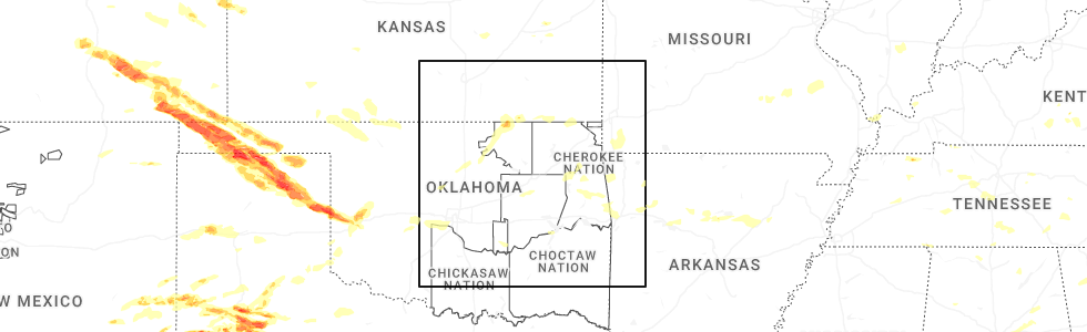
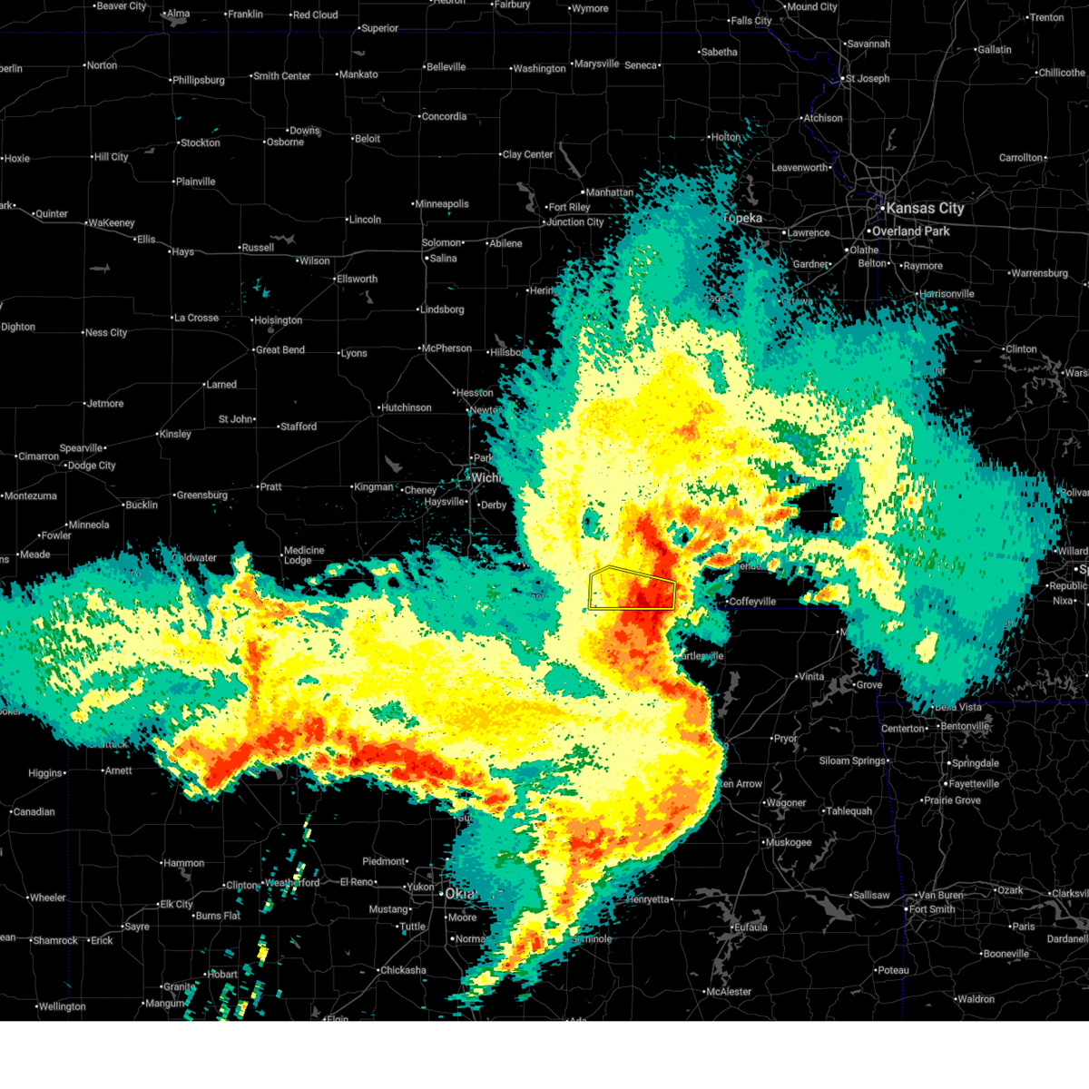
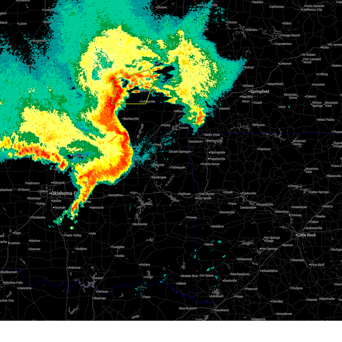
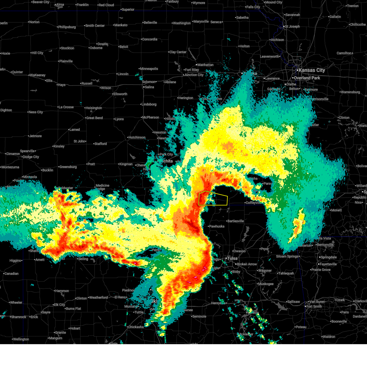
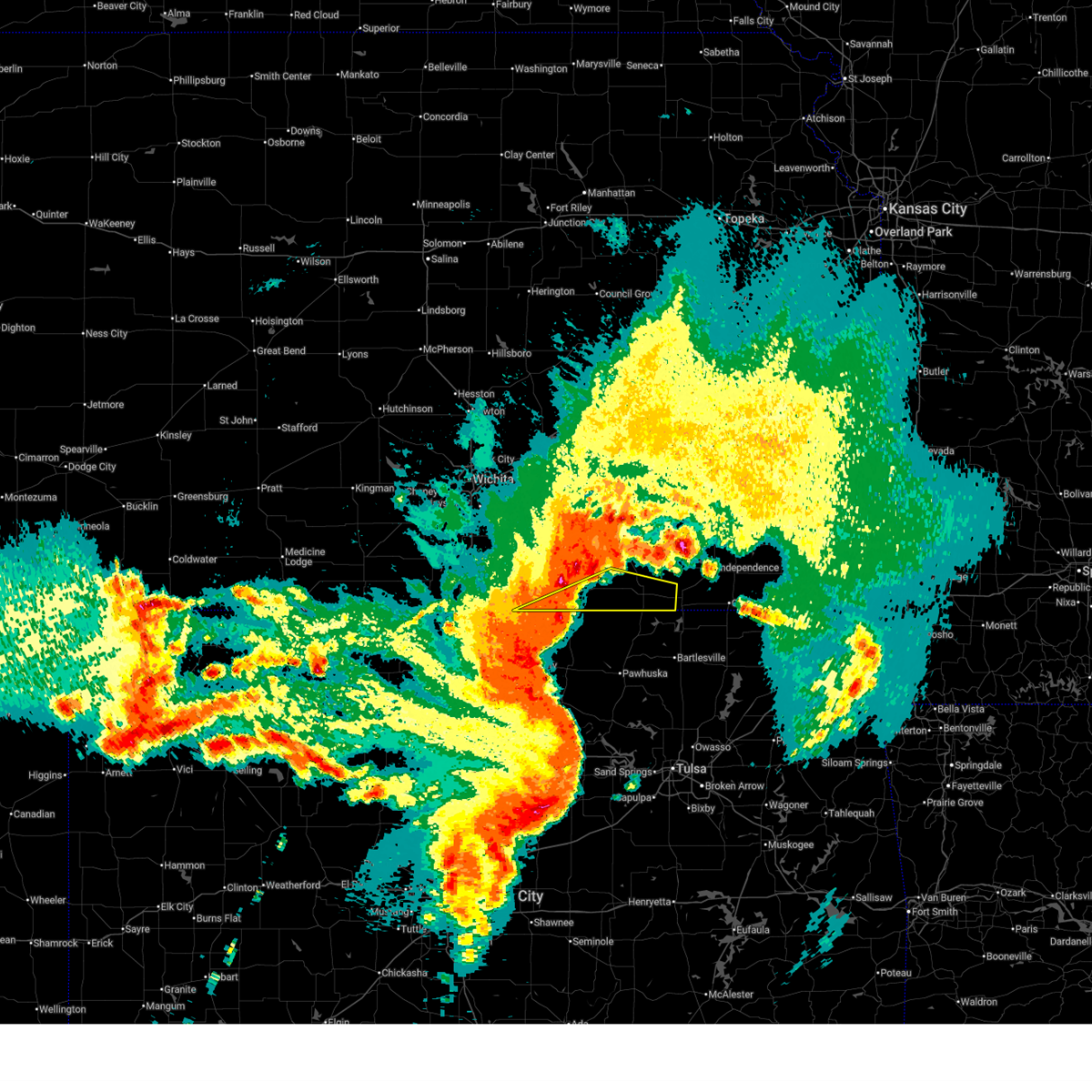
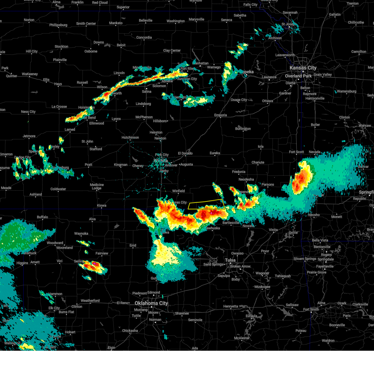
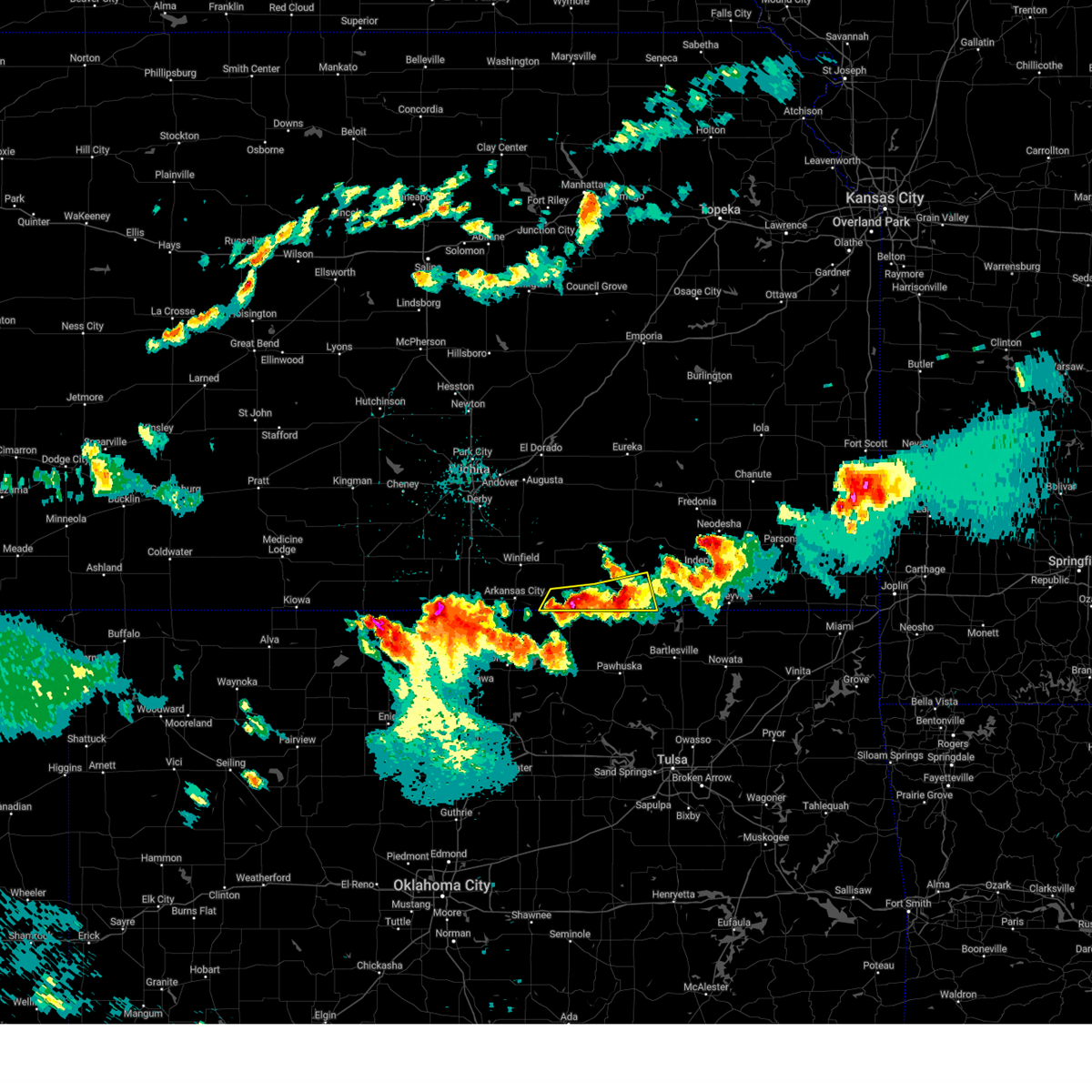
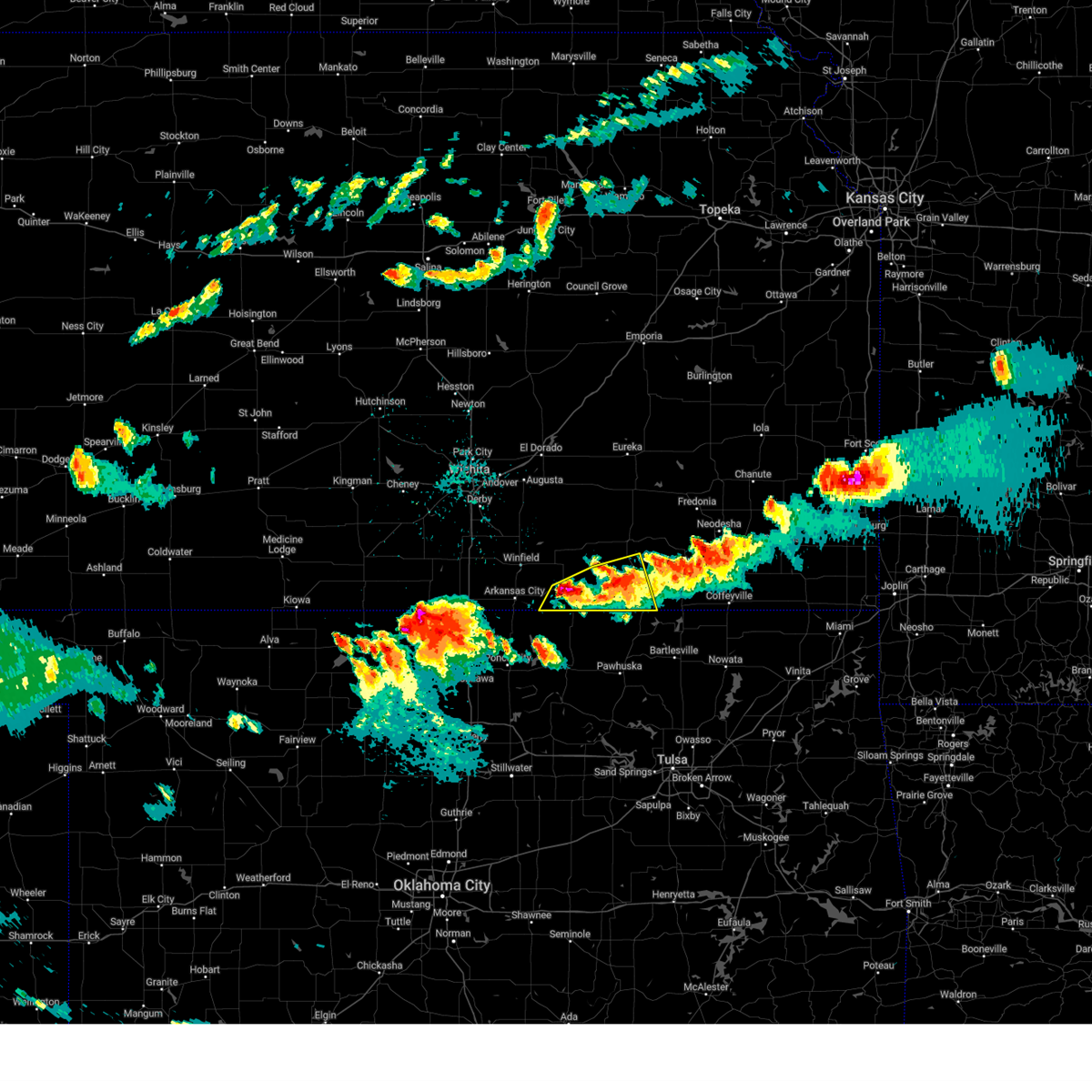
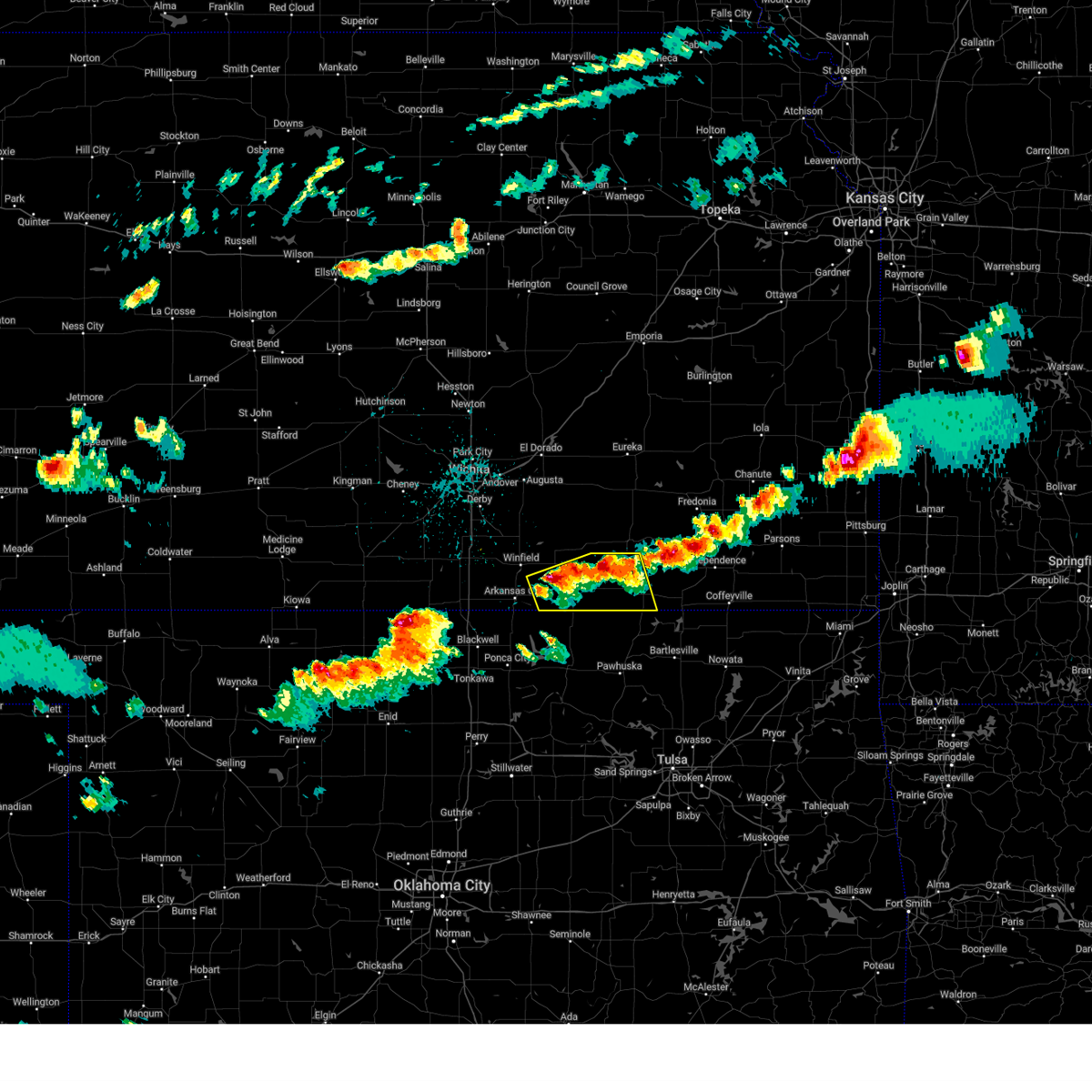
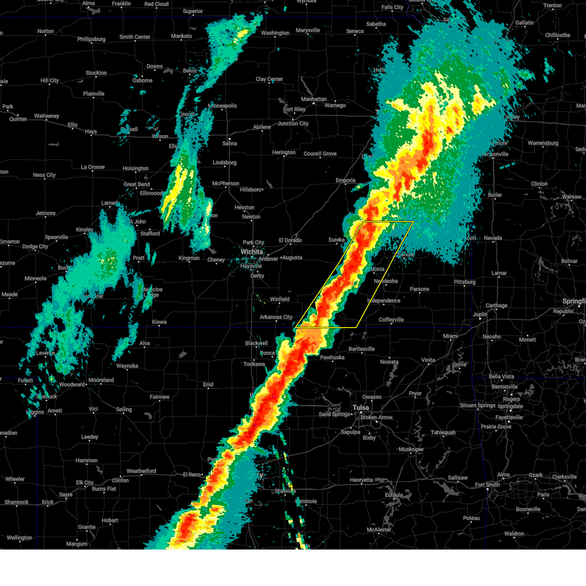
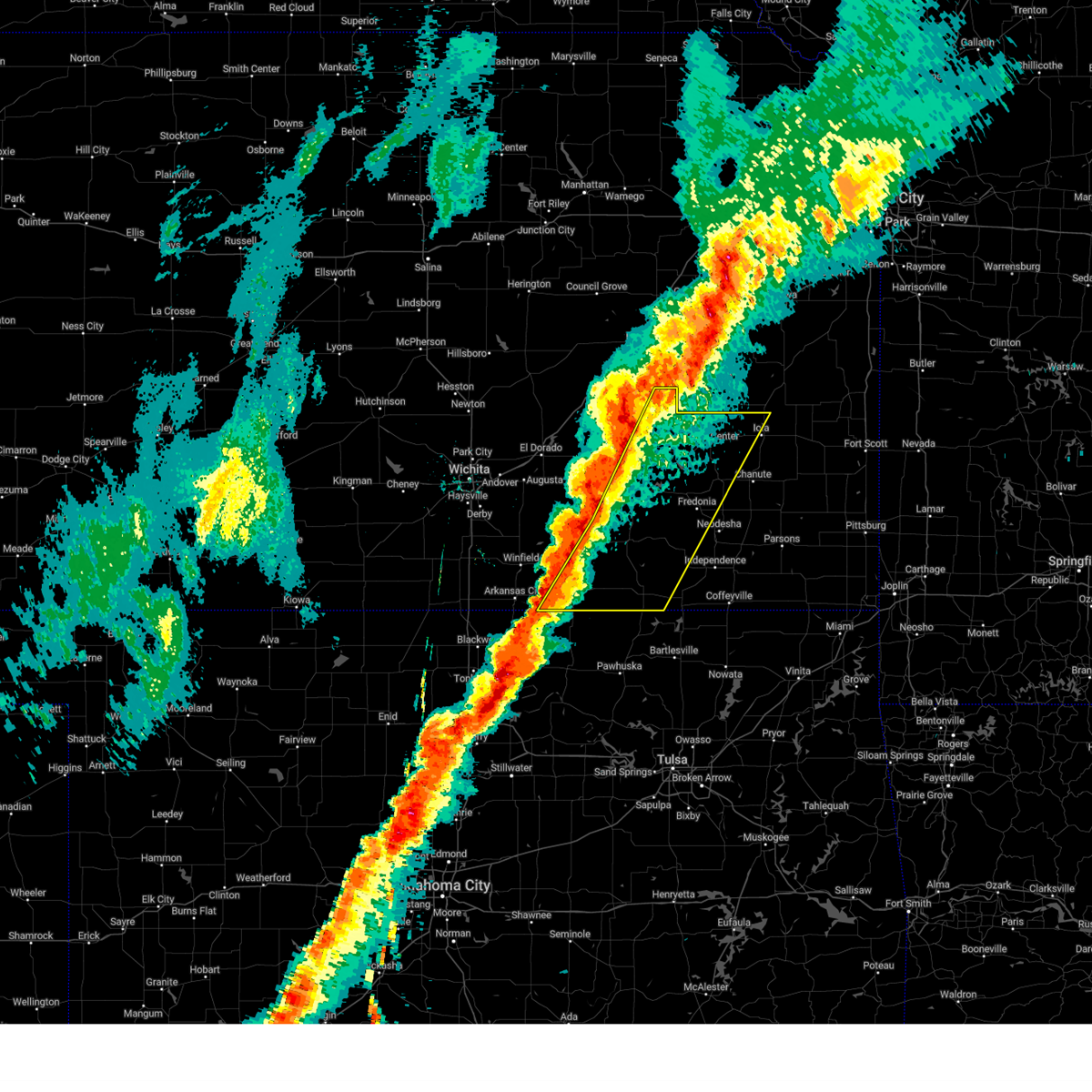
Hail Map for Chautauqua, KS
The Chautauqua, KS area has had 5 reports of on-the-ground hail by trained spotters, and has been under severe weather warnings 30 times during the past 12 months. Doppler radar has detected hail at or near Chautauqua, KS on 89 occasions, including 5 occasions during the past year.
| Name: | Chautauqua, KS |
| Where Located: | 60.4 miles SW of Chanute, KS |
| Map: | Google Map for Chautauqua, KS |
| Population: | 111 |
| Housing Units: | 72 |
| More Info: | Search Google for Chautauqua, KS |
1
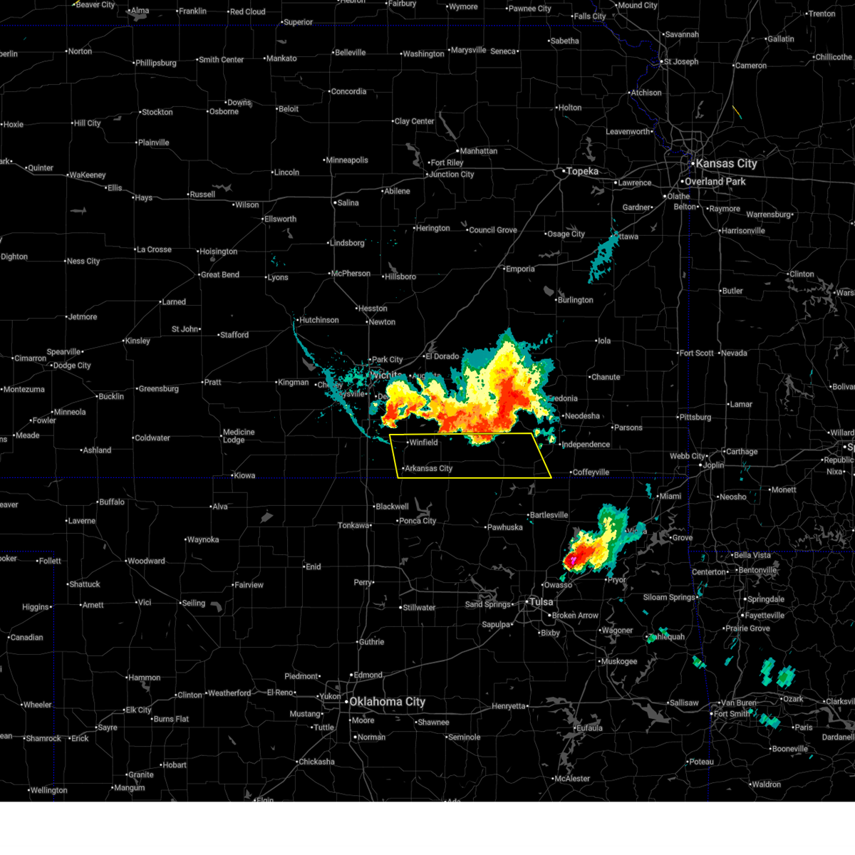
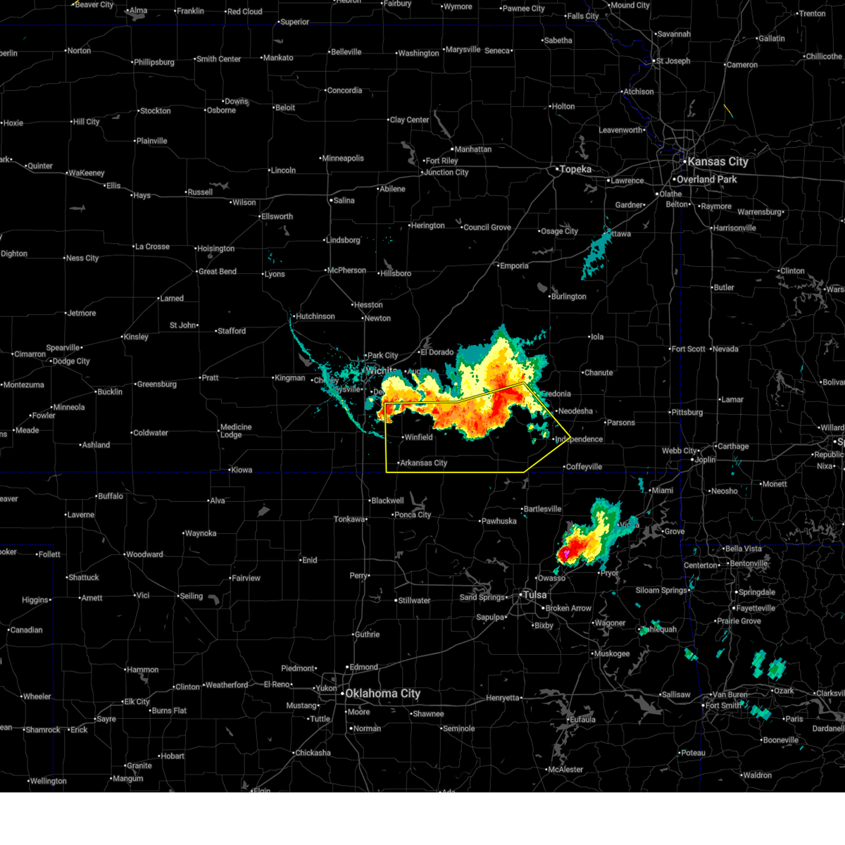
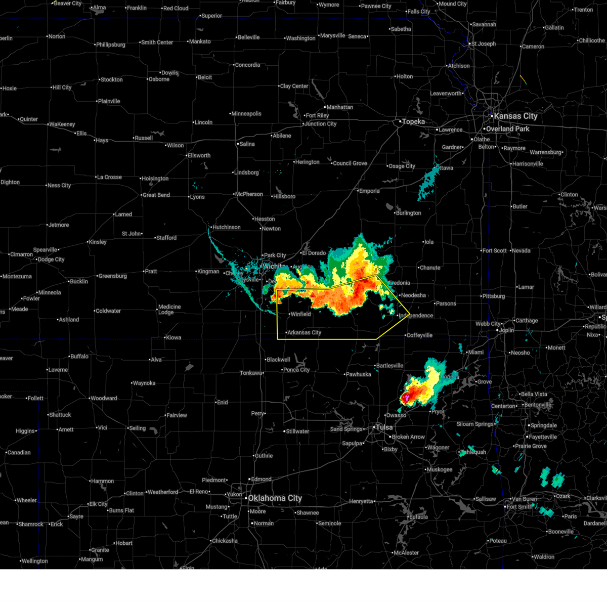
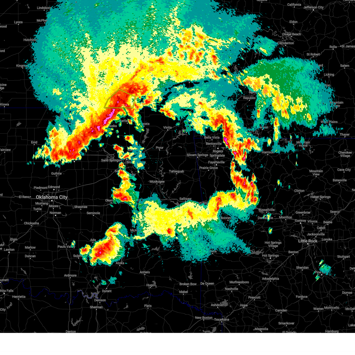
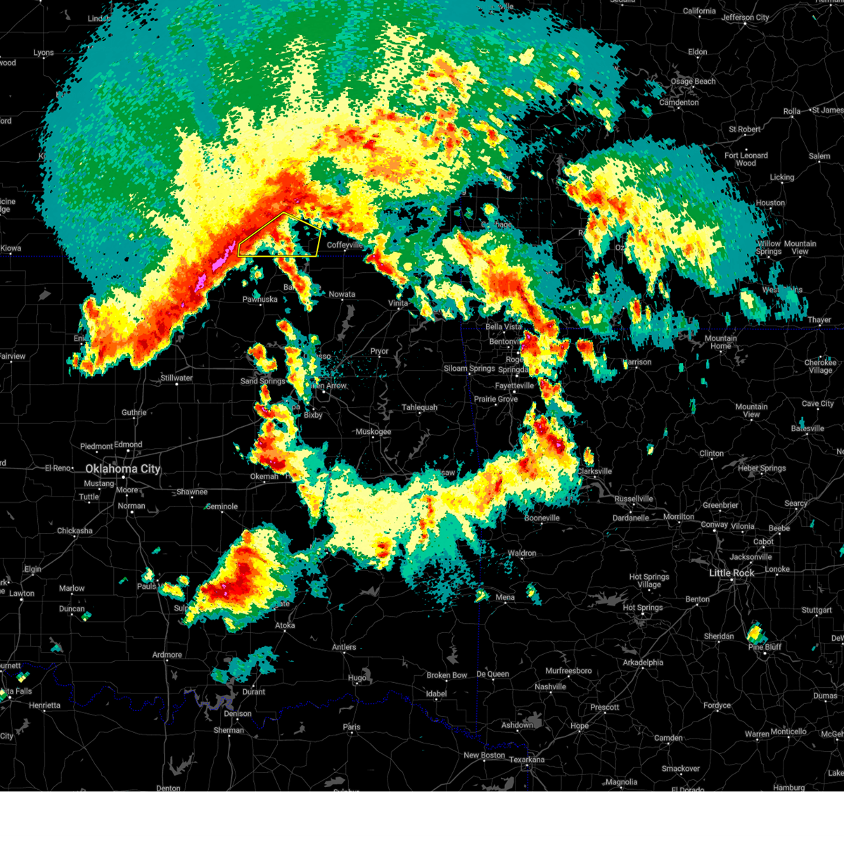
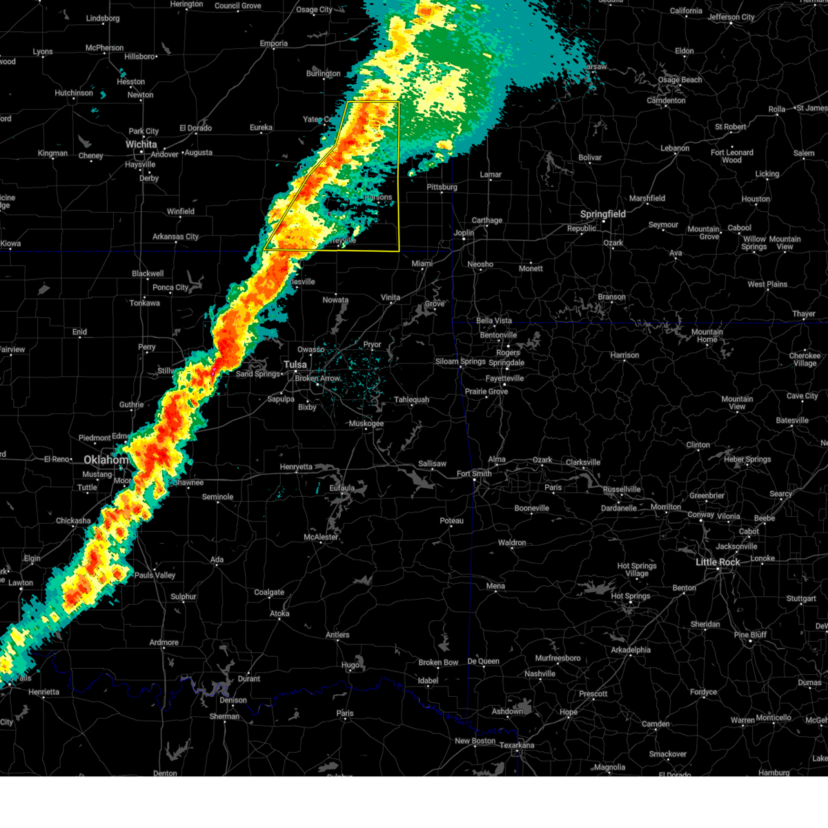
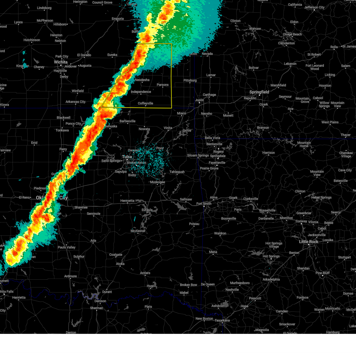
The Top Recent Hail Date for Chautauqua, KS is Friday, June 6, 2025 (28th out of 89)
Hail and Wind Damage Spotted near Chautauqua, KS
| Date / Time | Report Details |
|---|---|
| 6/29/2025 9:14 PM CDT |
 Svrict the national weather service in wichita has issued a * severe thunderstorm warning for, southern cowley county in south central kansas, southwestern montgomery county in southeastern kansas, chautauqua county in southeastern kansas, * until 1000 pm cdt. * at 913 pm cdt, severe thunderstorms were located along a line extending from near tyro to arkansas city, moving southeast at 50 mph (at 903 pm cdt, a 69 mph wind gust was reported at winfield). Hazards include 70 mph wind gusts. Expect considerable tree damage. Damage is likely to mobile homes, roofs, and outbuildings. Svrict the national weather service in wichita has issued a * severe thunderstorm warning for, southern cowley county in south central kansas, southwestern montgomery county in southeastern kansas, chautauqua county in southeastern kansas, * until 1000 pm cdt. * at 913 pm cdt, severe thunderstorms were located along a line extending from near tyro to arkansas city, moving southeast at 50 mph (at 903 pm cdt, a 69 mph wind gust was reported at winfield). Hazards include 70 mph wind gusts. Expect considerable tree damage. Damage is likely to mobile homes, roofs, and outbuildings.
|
| 6/29/2025 9:03 PM CDT |
 the severe thunderstorm warning has been cancelled and is no longer in effect the severe thunderstorm warning has been cancelled and is no longer in effect
|
| 6/29/2025 9:03 PM CDT |
 At 902 pm cdt, severe thunderstorms were located along a line extending from near independence to near hulah to 6 miles northwest of hardy, moving southeast at 40 mph (at 858 pm cdt, a 68 mph wind gust was reported at winfield). Hazards include 70 mph wind gusts and quarter size hail. Hail damage to vehicles is expected. expect considerable tree damage. wind damage is also likely to mobile homes, roofs, and outbuildings. Locations impacted include, arkansas city, winfield, independence, caney, sedan, cedar vale, elk city, dexter, peru, chautauqua, havana, elgin, bolton, niotaze, elk city lake, elk city state park, hale, maple city, independence airport, and strother field airport. At 902 pm cdt, severe thunderstorms were located along a line extending from near independence to near hulah to 6 miles northwest of hardy, moving southeast at 40 mph (at 858 pm cdt, a 68 mph wind gust was reported at winfield). Hazards include 70 mph wind gusts and quarter size hail. Hail damage to vehicles is expected. expect considerable tree damage. wind damage is also likely to mobile homes, roofs, and outbuildings. Locations impacted include, arkansas city, winfield, independence, caney, sedan, cedar vale, elk city, dexter, peru, chautauqua, havana, elgin, bolton, niotaze, elk city lake, elk city state park, hale, maple city, independence airport, and strother field airport.
|
| 6/29/2025 8:49 PM CDT |
 the severe thunderstorm warning has been cancelled and is no longer in effect the severe thunderstorm warning has been cancelled and is no longer in effect
|
| 6/29/2025 8:49 PM CDT |
 At 848 pm cdt, severe thunderstorms were located along a line extending from 7 miles south of fredonia to near peru to near winfield, moving southeast at 40 mph (trained weather spotters. at 845 pm cdt, 60 mph wind was reported west of winfield). Hazards include 60 mph wind gusts and quarter size hail. Hail damage to vehicles is expected. expect wind damage to roofs, siding, and trees. Locations impacted include, arkansas city, winfield, independence, caney, sedan, udall, howard, cedar vale, burden, moline, longton, elk city, dexter, grenola, atlanta, peru, chautauqua, elk falls, havana, and elgin. At 848 pm cdt, severe thunderstorms were located along a line extending from 7 miles south of fredonia to near peru to near winfield, moving southeast at 40 mph (trained weather spotters. at 845 pm cdt, 60 mph wind was reported west of winfield). Hazards include 60 mph wind gusts and quarter size hail. Hail damage to vehicles is expected. expect wind damage to roofs, siding, and trees. Locations impacted include, arkansas city, winfield, independence, caney, sedan, udall, howard, cedar vale, burden, moline, longton, elk city, dexter, grenola, atlanta, peru, chautauqua, elk falls, havana, and elgin.
|
| 6/29/2025 8:24 PM CDT |
 Svrict the national weather service in wichita has issued a * severe thunderstorm warning for, elk county in southeastern kansas, southwestern wilson county in southeastern kansas, cowley county in south central kansas, montgomery county in southeastern kansas, northeastern sumner county in south central kansas, chautauqua county in southeastern kansas, southeastern greenwood county in southeastern kansas, * until 915 pm cdt. * at 822 pm cdt, severe thunderstorms were located along a line extending from near fall river to near moline to near udall, moving southeast at 40 mph (radar indicated). Hazards include 60 mph wind gusts and quarter size hail. Hail damage to vehicles is expected. Expect wind damage to roofs, siding, and trees. Svrict the national weather service in wichita has issued a * severe thunderstorm warning for, elk county in southeastern kansas, southwestern wilson county in southeastern kansas, cowley county in south central kansas, montgomery county in southeastern kansas, northeastern sumner county in south central kansas, chautauqua county in southeastern kansas, southeastern greenwood county in southeastern kansas, * until 915 pm cdt. * at 822 pm cdt, severe thunderstorms were located along a line extending from near fall river to near moline to near udall, moving southeast at 40 mph (radar indicated). Hazards include 60 mph wind gusts and quarter size hail. Hail damage to vehicles is expected. Expect wind damage to roofs, siding, and trees.
|
| 6/18/2025 12:14 AM CDT |
 The storms which prompted the warning have moved out of the area. therefore, the warning will be allowed to expire. however, gusty winds are still possible with these thunderstorms. a severe thunderstorm watch remains in effect until 400 am cdt for south central and southeastern kansas. The storms which prompted the warning have moved out of the area. therefore, the warning will be allowed to expire. however, gusty winds are still possible with these thunderstorms. a severe thunderstorm watch remains in effect until 400 am cdt for south central and southeastern kansas.
|
| 6/18/2025 12:10 AM CDT |
 Svrict the national weather service in wichita has issued a * severe thunderstorm warning for, southeastern elk county in southeastern kansas, southern wilson county in southeastern kansas, western labette county in southeastern kansas, southwestern neosho county in southeastern kansas, montgomery county in southeastern kansas, eastern chautauqua county in southeastern kansas, * until 115 am cdt. * at 1210 am cdt, severe thunderstorms were located along a line extending from longton to 5 miles southwest of elk city to near peru, moving east at 50 mph (radar indicated). Hazards include 60 mph wind gusts. expect damage to roofs, siding, and trees Svrict the national weather service in wichita has issued a * severe thunderstorm warning for, southeastern elk county in southeastern kansas, southern wilson county in southeastern kansas, western labette county in southeastern kansas, southwestern neosho county in southeastern kansas, montgomery county in southeastern kansas, eastern chautauqua county in southeastern kansas, * until 115 am cdt. * at 1210 am cdt, severe thunderstorms were located along a line extending from longton to 5 miles southwest of elk city to near peru, moving east at 50 mph (radar indicated). Hazards include 60 mph wind gusts. expect damage to roofs, siding, and trees
|
| 6/17/2025 11:47 PM CDT |
 the severe thunderstorm warning has been cancelled and is no longer in effect the severe thunderstorm warning has been cancelled and is no longer in effect
|
| 6/17/2025 11:47 PM CDT |
 At 1146 pm cdt, severe thunderstorms were located along a line extending from 8 miles west of elgin to 6 miles northwest of sedan, moving east at 40 mph (radar indicated). Hazards include 60 mph wind gusts. Expect damage to roofs, siding, and trees. Locations impacted include, sedan, cedar vale, peru, chautauqua, elgin, and niotaze. At 1146 pm cdt, severe thunderstorms were located along a line extending from 8 miles west of elgin to 6 miles northwest of sedan, moving east at 40 mph (radar indicated). Hazards include 60 mph wind gusts. Expect damage to roofs, siding, and trees. Locations impacted include, sedan, cedar vale, peru, chautauqua, elgin, and niotaze.
|
| 6/17/2025 11:27 PM CDT |
 Svrict the national weather service in wichita has issued a * severe thunderstorm warning for, southeastern cowley county in south central kansas, chautauqua county in southeastern kansas, * until 1215 am cdt. * at 1127 pm cdt, severe thunderstorms were located along a line extending from near chilocco to 9 miles northwest of sedan, moving east at 50 mph (radar indicated). Hazards include 60 mph wind gusts. expect damage to roofs, siding, and trees Svrict the national weather service in wichita has issued a * severe thunderstorm warning for, southeastern cowley county in south central kansas, chautauqua county in southeastern kansas, * until 1215 am cdt. * at 1127 pm cdt, severe thunderstorms were located along a line extending from near chilocco to 9 miles northwest of sedan, moving east at 50 mph (radar indicated). Hazards include 60 mph wind gusts. expect damage to roofs, siding, and trees
|
| 6/8/2025 4:35 PM CDT |
 The storms which prompted the warning have moved out of the area. therefore, the warning will be allowed to expire. however, gusty winds are still possible with these thunderstorms. a severe thunderstorm watch remains in effect until 1000 pm cdt for south central and southeastern kansas. The storms which prompted the warning have moved out of the area. therefore, the warning will be allowed to expire. however, gusty winds are still possible with these thunderstorms. a severe thunderstorm watch remains in effect until 1000 pm cdt for south central and southeastern kansas.
|
| 6/8/2025 4:26 PM CDT | At 426 pm cdt, severe thunderstorms were located along a line extending from elgin to near grainola, moving south at 10 mph (radar indicated). Hazards include 60 mph wind gusts and quarter size hail. Hail damage to vehicles is expected. expect wind damage to roofs, siding, and trees. Locations impacted include, sedan, cedar vale, chautauqua, elgin, and maple city. |
| 6/8/2025 4:11 PM CDT |
 Svrict the national weather service in wichita has issued a * severe thunderstorm warning for, southeastern cowley county in south central kansas, southwestern chautauqua county in southeastern kansas, * until 445 pm cdt. * at 410 pm cdt, severe thunderstorms were located along a line extending from near elgin to 5 miles north of grainola, moving south at 10 mph. this warning replaces the previous severe thunderstorm warning that was in effect for the same area (radar indicated). Hazards include 60 mph wind gusts and quarter size hail. Hail damage to vehicles is expected. Expect wind damage to roofs, siding, and trees. Svrict the national weather service in wichita has issued a * severe thunderstorm warning for, southeastern cowley county in south central kansas, southwestern chautauqua county in southeastern kansas, * until 445 pm cdt. * at 410 pm cdt, severe thunderstorms were located along a line extending from near elgin to 5 miles north of grainola, moving south at 10 mph. this warning replaces the previous severe thunderstorm warning that was in effect for the same area (radar indicated). Hazards include 60 mph wind gusts and quarter size hail. Hail damage to vehicles is expected. Expect wind damage to roofs, siding, and trees.
|
| 6/8/2025 3:58 PM CDT |
 At 357 pm cdt, severe thunderstorms were located along a line extending from near sedan to 8 miles north of grainola, moving southeast at 15 mph (radar indicated). Hazards include 60 mph wind gusts and quarter size hail. Hail damage to vehicles is expected. expect wind damage to roofs, siding, and trees. Locations impacted include, sedan, cedar vale, chautauqua, elgin, and maple city. At 357 pm cdt, severe thunderstorms were located along a line extending from near sedan to 8 miles north of grainola, moving southeast at 15 mph (radar indicated). Hazards include 60 mph wind gusts and quarter size hail. Hail damage to vehicles is expected. expect wind damage to roofs, siding, and trees. Locations impacted include, sedan, cedar vale, chautauqua, elgin, and maple city.
|
| 6/8/2025 3:26 PM CDT |
 the severe thunderstorm warning has been cancelled and is no longer in effect the severe thunderstorm warning has been cancelled and is no longer in effect
|
| 6/8/2025 3:26 PM CDT |
 At 325 pm cdt, severe thunderstorms were located along a line extending from 5 miles northwest of sedan to near dexter, moving southeast at 30 mph (radar indicated). Hazards include 60 mph wind gusts and half dollar size hail. Hail damage to vehicles is expected. expect wind damage to roofs, siding, and trees. Locations impacted include, sedan, cedar vale, dexter, chautauqua, elgin, and maple city. At 325 pm cdt, severe thunderstorms were located along a line extending from 5 miles northwest of sedan to near dexter, moving southeast at 30 mph (radar indicated). Hazards include 60 mph wind gusts and half dollar size hail. Hail damage to vehicles is expected. expect wind damage to roofs, siding, and trees. Locations impacted include, sedan, cedar vale, dexter, chautauqua, elgin, and maple city.
|
| 6/8/2025 3:16 PM CDT | Svrict the national weather service in wichita has issued a * severe thunderstorm warning for, southwestern elk county in southeastern kansas, southeastern cowley county in south central kansas, chautauqua county in southeastern kansas, * until 415 pm cdt. * at 316 pm cdt, a severe thunderstorm was located near dexter, or 14 miles west of cedar vale, moving southeast at 15 mph (radar indicated). Hazards include 60 mph wind gusts and half dollar size hail. Hail damage to vehicles is expected. Expect wind damage to roofs, siding, and trees. |
| 6/7/2025 2:52 AM CDT | Svrict the national weather service in wichita has issued a * severe thunderstorm warning for, southern elk county in southeastern kansas, cowley county in south central kansas, chautauqua county in southeastern kansas, * until 345 am cdt. * at 252 am cdt, a severe thunderstorm was located 5 miles south of dexter, moving east at 60 mph (radar indicated). Hazards include 60 mph wind gusts. expect damage to roofs, siding, and trees |
| 6/7/2025 2:29 AM CDT | Svrict the national weather service in wichita has issued a * severe thunderstorm warning for, southeastern cowley county in south central kansas, chautauqua county in southeastern kansas, * until 300 am cdt. * at 229 am cdt, a severe thunderstorm was located 8 miles northeast of foraker, moving northeast at 55 mph (radar indicated). Hazards include 60 mph wind gusts and quarter size hail. Hail damage to vehicles is expected. Expect wind damage to roofs, siding, and trees. |
| 5/24/2025 5:10 AM CDT |
 At 510 am cdt, severe thunderstorms were located along a line extending from 5 miles southeast of elk city to near elgin, moving east at 50 mph (radar indicated). Hazards include 60 mph wind gusts. Expect damage to roofs, siding, and trees. Locations impacted include, caney, sedan, peru, chautauqua, havana, elgin, niotaze, and hale. At 510 am cdt, severe thunderstorms were located along a line extending from 5 miles southeast of elk city to near elgin, moving east at 50 mph (radar indicated). Hazards include 60 mph wind gusts. Expect damage to roofs, siding, and trees. Locations impacted include, caney, sedan, peru, chautauqua, havana, elgin, niotaze, and hale.
|
| 5/24/2025 4:48 AM CDT |
 Svrict the national weather service in wichita has issued a * severe thunderstorm warning for, southwestern montgomery county in southeastern kansas, chautauqua county in southeastern kansas, * until 545 am cdt. * at 448 am cdt, severe thunderstorms were located along a line extending from 7 miles south of elk falls to 6 miles northeast of grainola, moving east at 50 mph (radar indicated). Hazards include 60 mph wind gusts. expect damage to roofs, siding, and trees Svrict the national weather service in wichita has issued a * severe thunderstorm warning for, southwestern montgomery county in southeastern kansas, chautauqua county in southeastern kansas, * until 545 am cdt. * at 448 am cdt, severe thunderstorms were located along a line extending from 7 miles south of elk falls to 6 miles northeast of grainola, moving east at 50 mph (radar indicated). Hazards include 60 mph wind gusts. expect damage to roofs, siding, and trees
|
| 4/2/2025 5:38 AM CDT |
 At 538 am cdt, severe thunderstorms were located along a line extending from near colony to near chanute to 7 miles west of neodesha to near peru, moving east at 40 mph (radar indicated). Hazards include 60 mph wind gusts and quarter size hail. Hail damage to vehicles is expected. expect wind damage to roofs, siding, and trees. Locations impacted include, elsmore, parsons tri city airport, lake parsons, mound valley, angola, buxton, humboldt, erie, elk city lake, tyro, big hill lake, earlton, edna, neodesha, iola, piqua, dearing, petrolia, savonburg, and altamont. At 538 am cdt, severe thunderstorms were located along a line extending from near colony to near chanute to 7 miles west of neodesha to near peru, moving east at 40 mph (radar indicated). Hazards include 60 mph wind gusts and quarter size hail. Hail damage to vehicles is expected. expect wind damage to roofs, siding, and trees. Locations impacted include, elsmore, parsons tri city airport, lake parsons, mound valley, angola, buxton, humboldt, erie, elk city lake, tyro, big hill lake, earlton, edna, neodesha, iola, piqua, dearing, petrolia, savonburg, and altamont.
|
| 4/2/2025 5:14 AM CDT |
 Svrict the national weather service in wichita has issued a * severe thunderstorm warning for, eastern elk county in southeastern kansas, wilson county in southeastern kansas, labette county in southeastern kansas, neosho county in southeastern kansas, montgomery county in southeastern kansas, chautauqua county in southeastern kansas, woodson county in southeastern kansas, allen county in southeastern kansas, * until 645 am cdt. * at 514 am cdt, severe thunderstorms were located along a line extending from 5 miles west of neosho falls to 6 miles west of buffalo to longton to near elgin, moving east at 35 mph (radar indicated). Hazards include 60 mph wind gusts and quarter size hail. Hail damage to vehicles is expected. Expect wind damage to roofs, siding, and trees. Svrict the national weather service in wichita has issued a * severe thunderstorm warning for, eastern elk county in southeastern kansas, wilson county in southeastern kansas, labette county in southeastern kansas, neosho county in southeastern kansas, montgomery county in southeastern kansas, chautauqua county in southeastern kansas, woodson county in southeastern kansas, allen county in southeastern kansas, * until 645 am cdt. * at 514 am cdt, severe thunderstorms were located along a line extending from 5 miles west of neosho falls to 6 miles west of buffalo to longton to near elgin, moving east at 35 mph (radar indicated). Hazards include 60 mph wind gusts and quarter size hail. Hail damage to vehicles is expected. Expect wind damage to roofs, siding, and trees.
|
| 4/2/2025 4:55 AM CDT |
 At 454 am cdt, severe thunderstorms were located along a line extending from near burlington to 8 miles south of fall river to 7 miles northwest of elgin, moving east at 55 mph (radar indicated). Hazards include 60 mph wind gusts and quarter size hail. Hail damage to vehicles is expected. expect wind damage to roofs, siding, and trees. Locations impacted include, severy, moline, buxton, benedict, rose, elk falls, howard, fall river, grenola, elgin, piqua, chautauqua, sedan, buffalo, fredonia, toronto lake, batesville, coyville, niotaze, and new albany. At 454 am cdt, severe thunderstorms were located along a line extending from near burlington to 8 miles south of fall river to 7 miles northwest of elgin, moving east at 55 mph (radar indicated). Hazards include 60 mph wind gusts and quarter size hail. Hail damage to vehicles is expected. expect wind damage to roofs, siding, and trees. Locations impacted include, severy, moline, buxton, benedict, rose, elk falls, howard, fall river, grenola, elgin, piqua, chautauqua, sedan, buffalo, fredonia, toronto lake, batesville, coyville, niotaze, and new albany.
|
| 4/2/2025 4:31 AM CDT |
 Svrict the national weather service in wichita has issued a * severe thunderstorm warning for, elk county in southeastern kansas, wilson county in southeastern kansas, southeastern cowley county in south central kansas, northwestern montgomery county in southeastern kansas, chautauqua county in southeastern kansas, woodson county in southeastern kansas, eastern greenwood county in southeastern kansas, northwestern allen county in southeastern kansas, * until 515 am cdt. * at 430 am cdt, severe thunderstorms were located along a line extending from near madison to 5 miles northwest of howard to 5 miles southeast of dexter, moving northeast at 60 mph (radar indicated). Hazards include 60 mph wind gusts and quarter size hail. Hail damage to vehicles is expected. Expect wind damage to roofs, siding, and trees. Svrict the national weather service in wichita has issued a * severe thunderstorm warning for, elk county in southeastern kansas, wilson county in southeastern kansas, southeastern cowley county in south central kansas, northwestern montgomery county in southeastern kansas, chautauqua county in southeastern kansas, woodson county in southeastern kansas, eastern greenwood county in southeastern kansas, northwestern allen county in southeastern kansas, * until 515 am cdt. * at 430 am cdt, severe thunderstorms were located along a line extending from near madison to 5 miles northwest of howard to 5 miles southeast of dexter, moving northeast at 60 mph (radar indicated). Hazards include 60 mph wind gusts and quarter size hail. Hail damage to vehicles is expected. Expect wind damage to roofs, siding, and trees.
|
| 4/2/2025 4:29 AM CDT |
 Svrict the national weather service in wichita has issued a * severe thunderstorm warning for, elk county in southeastern kansas, wilson county in southeastern kansas, southeastern cowley county in south central kansas, northwestern montgomery county in southeastern kansas, chautauqua county in southeastern kansas, woodson county in southeastern kansas, eastern greenwood county in southeastern kansas, northwestern allen county in southeastern kansas, * until 515 am cdt. * at 428 am cdt, severe thunderstorms were located along a line extending from near madison to 5 miles northwest of howard to 5 miles southeast of dexter, moving northeast at 110 mph (radar indicated). Hazards include 60 mph wind gusts and quarter size hail. Hail damage to vehicles is expected. Expect wind damage to roofs, siding, and trees. Svrict the national weather service in wichita has issued a * severe thunderstorm warning for, elk county in southeastern kansas, wilson county in southeastern kansas, southeastern cowley county in south central kansas, northwestern montgomery county in southeastern kansas, chautauqua county in southeastern kansas, woodson county in southeastern kansas, eastern greenwood county in southeastern kansas, northwestern allen county in southeastern kansas, * until 515 am cdt. * at 428 am cdt, severe thunderstorms were located along a line extending from near madison to 5 miles northwest of howard to 5 miles southeast of dexter, moving northeast at 110 mph (radar indicated). Hazards include 60 mph wind gusts and quarter size hail. Hail damage to vehicles is expected. Expect wind damage to roofs, siding, and trees.
|
| 10/30/2024 7:28 PM CDT |
 the severe thunderstorm warning has been cancelled and is no longer in effect the severe thunderstorm warning has been cancelled and is no longer in effect
|
| 10/30/2024 7:13 PM CDT |
 At 713 pm cdt, severe thunderstorms were located along a line extending from 8 miles south of grenola to 5 miles east of cedar vale to near foraker, moving northeast at 55 mph (radar indicated). Hazards include 60 mph wind gusts and penny size hail. Expect damage to roofs, siding, and trees. Locations impacted include, sedan, cedar vale, moline, longton, peru, chautauqua, elk falls, elgin, niotaze, and hale. At 713 pm cdt, severe thunderstorms were located along a line extending from 8 miles south of grenola to 5 miles east of cedar vale to near foraker, moving northeast at 55 mph (radar indicated). Hazards include 60 mph wind gusts and penny size hail. Expect damage to roofs, siding, and trees. Locations impacted include, sedan, cedar vale, moline, longton, peru, chautauqua, elk falls, elgin, niotaze, and hale.
|
| 10/30/2024 7:01 PM CDT |
 Svrict the national weather service in wichita has issued a * severe thunderstorm warning for, southeastern elk county in southeastern kansas, southeastern cowley county in south central kansas, chautauqua county in southeastern kansas, * until 800 pm cdt. * at 700 pm cdt, severe thunderstorms were located along a line extending from near dexter to grainola to near shidler, moving northeast at 55 mph (radar indicated). Hazards include 60 mph wind gusts and penny size hail. expect damage to roofs, siding, and trees Svrict the national weather service in wichita has issued a * severe thunderstorm warning for, southeastern elk county in southeastern kansas, southeastern cowley county in south central kansas, chautauqua county in southeastern kansas, * until 800 pm cdt. * at 700 pm cdt, severe thunderstorms were located along a line extending from near dexter to grainola to near shidler, moving northeast at 55 mph (radar indicated). Hazards include 60 mph wind gusts and penny size hail. expect damage to roofs, siding, and trees
|
| 6/25/2024 8:23 PM CDT |
 At 822 pm cdt, a severe thunderstorm was located 8 miles northeast of sedan, moving east at 25 mph (radar indicated). Hazards include golf ball size hail and 60 mph wind gusts. People and animals outdoors will be injured. expect hail damage to roofs, siding, windows, and vehicles. expect wind damage to roofs, siding, and trees. Locations impacted include, sedan, longton, peru, chautauqua, niotaze, and hale. At 822 pm cdt, a severe thunderstorm was located 8 miles northeast of sedan, moving east at 25 mph (radar indicated). Hazards include golf ball size hail and 60 mph wind gusts. People and animals outdoors will be injured. expect hail damage to roofs, siding, windows, and vehicles. expect wind damage to roofs, siding, and trees. Locations impacted include, sedan, longton, peru, chautauqua, niotaze, and hale.
|
| 6/25/2024 8:07 PM CDT |
 Svrict the national weather service in wichita has issued a * severe thunderstorm warning for, southeastern elk county in southeastern kansas, chautauqua county in southeastern kansas, * until 915 pm cdt. * at 807 pm cdt, a severe thunderstorm was located near sedan, moving east at 20 mph (radar indicated). Hazards include ping pong ball size hail and 60 mph wind gusts. People and animals outdoors will be injured. expect hail damage to roofs, siding, windows, and vehicles. Expect wind damage to roofs, siding, and trees. Svrict the national weather service in wichita has issued a * severe thunderstorm warning for, southeastern elk county in southeastern kansas, chautauqua county in southeastern kansas, * until 915 pm cdt. * at 807 pm cdt, a severe thunderstorm was located near sedan, moving east at 20 mph (radar indicated). Hazards include ping pong ball size hail and 60 mph wind gusts. People and animals outdoors will be injured. expect hail damage to roofs, siding, windows, and vehicles. Expect wind damage to roofs, siding, and trees.
|
| 5/26/2024 1:20 AM CDT |
 the tornado warning has been cancelled and is no longer in effect the tornado warning has been cancelled and is no longer in effect
|
| 5/26/2024 12:55 AM CDT |
 At 1255 am cdt, a severe thunderstorm capable of producing a tornado was located just west of chautauqua, or 8 miles south of sedan, moving east at 45 mph (radar indicated rotation). Hazards include tornado and golf ball size hail. Flying debris will be dangerous to those caught without shelter. mobile homes will be damaged or destroyed. damage to roofs, windows, and vehicles will occur. tree damage is likely. This tornadic thunderstorm will remain over mainly rural areas of southern chautauqua county, including the following locations, niotaze. At 1255 am cdt, a severe thunderstorm capable of producing a tornado was located just west of chautauqua, or 8 miles south of sedan, moving east at 45 mph (radar indicated rotation). Hazards include tornado and golf ball size hail. Flying debris will be dangerous to those caught without shelter. mobile homes will be damaged or destroyed. damage to roofs, windows, and vehicles will occur. tree damage is likely. This tornadic thunderstorm will remain over mainly rural areas of southern chautauqua county, including the following locations, niotaze.
|
| 5/26/2024 12:44 AM CDT |
 At 1244 am cdt, a severe thunderstorm capable of producing a tornado was located 3 miles west of elgin, or 9 miles southeast of cedar vale, moving east at 40 mph (radar indicated rotation). Hazards include tornado and golf ball size hail. Flying debris will be dangerous to those caught without shelter. mobile homes will be damaged or destroyed. damage to roofs, windows, and vehicles will occur. tree damage is likely. this dangerous storm will be near, elgin around 1250 am cdt. chautauqua around 1255 am cdt. peru around 105 am cdt. Other locations impacted by this tornadic thunderstorm include niotaze. At 1244 am cdt, a severe thunderstorm capable of producing a tornado was located 3 miles west of elgin, or 9 miles southeast of cedar vale, moving east at 40 mph (radar indicated rotation). Hazards include tornado and golf ball size hail. Flying debris will be dangerous to those caught without shelter. mobile homes will be damaged or destroyed. damage to roofs, windows, and vehicles will occur. tree damage is likely. this dangerous storm will be near, elgin around 1250 am cdt. chautauqua around 1255 am cdt. peru around 105 am cdt. Other locations impacted by this tornadic thunderstorm include niotaze.
|
| 5/26/2024 12:44 AM CDT |
 the tornado warning has been cancelled and is no longer in effect the tornado warning has been cancelled and is no longer in effect
|
| 5/26/2024 12:37 AM CDT |
 At 1237 am cdt, a severe thunderstorm capable of producing a tornado was located 7 miles southeast of cedar vale, moving east at 40 mph (radar indicated rotation). Hazards include tornado and golf ball size hail. Flying debris will be dangerous to those caught without shelter. mobile homes will be damaged or destroyed. damage to roofs, windows, and vehicles will occur. tree damage is likely. this dangerous storm will be near, elgin around 1245 am cdt. chautauqua around 1255 am cdt. Other locations impacted by this tornadic thunderstorm include niotaze. At 1237 am cdt, a severe thunderstorm capable of producing a tornado was located 7 miles southeast of cedar vale, moving east at 40 mph (radar indicated rotation). Hazards include tornado and golf ball size hail. Flying debris will be dangerous to those caught without shelter. mobile homes will be damaged or destroyed. damage to roofs, windows, and vehicles will occur. tree damage is likely. this dangerous storm will be near, elgin around 1245 am cdt. chautauqua around 1255 am cdt. Other locations impacted by this tornadic thunderstorm include niotaze.
|
| 5/26/2024 12:24 AM CDT |
 Torict the national weather service in wichita has issued a * tornado warning for, southeastern cowley county in south central kansas, southern chautauqua county in southeastern kansas, * until 130 am cdt. * at 1223 am cdt, a severe thunderstorm capable of producing a tornado was located 8 miles southwest of cedar vale, moving east at 40 mph (radar indicated rotation). Hazards include tornado and golf ball size hail. Flying debris will be dangerous to those caught without shelter. mobile homes will be damaged or destroyed. damage to roofs, windows, and vehicles will occur. tree damage is likely. this dangerous storm will be near, elgin around 1245 am cdt. chautauqua around 1255 am cdt. peru around 105 am cdt. Other locations impacted by this tornadic thunderstorm include niotaze. Torict the national weather service in wichita has issued a * tornado warning for, southeastern cowley county in south central kansas, southern chautauqua county in southeastern kansas, * until 130 am cdt. * at 1223 am cdt, a severe thunderstorm capable of producing a tornado was located 8 miles southwest of cedar vale, moving east at 40 mph (radar indicated rotation). Hazards include tornado and golf ball size hail. Flying debris will be dangerous to those caught without shelter. mobile homes will be damaged or destroyed. damage to roofs, windows, and vehicles will occur. tree damage is likely. this dangerous storm will be near, elgin around 1245 am cdt. chautauqua around 1255 am cdt. peru around 105 am cdt. Other locations impacted by this tornadic thunderstorm include niotaze.
|
| 5/6/2024 9:58 PM CDT |
 At 957 pm cdt, severe thunderstorms were located along a line extending from near iola to caney, moving northeast at 60 mph. 70mph winds were reported near elk city kansas (emergency management). Hazards include 70 mph wind gusts and nickel size hail. Expect considerable tree damage. damage is likely to mobile homes, roofs, and outbuildings. Locations impacted include, coffeyville, independence, chanute, iola, neodesha, fredonia, cherryvale, caney, humboldt, yates center, la harpe, gas, thayer, dearing, altoona, elk city, buffalo, tyro, neosho falls, and peru. At 957 pm cdt, severe thunderstorms were located along a line extending from near iola to caney, moving northeast at 60 mph. 70mph winds were reported near elk city kansas (emergency management). Hazards include 70 mph wind gusts and nickel size hail. Expect considerable tree damage. damage is likely to mobile homes, roofs, and outbuildings. Locations impacted include, coffeyville, independence, chanute, iola, neodesha, fredonia, cherryvale, caney, humboldt, yates center, la harpe, gas, thayer, dearing, altoona, elk city, buffalo, tyro, neosho falls, and peru.
|
| 5/6/2024 9:34 PM CDT |
 At 933 pm cdt, severe thunderstorms were located along a line extending from near yates center to 5 miles northwest of hulah, moving north at 60 mph (emergency management). Hazards include 70 mph wind gusts and nickel size hail. Expect considerable tree damage. damage is likely to mobile homes, roofs, and outbuildings. Locations impacted include, coffeyville, independence, chanute, iola, neodesha, fredonia, cherryvale, caney, humboldt, yates center, la harpe, gas, thayer, dearing, altoona, elk city, buffalo, tyro, neosho falls, and peru. At 933 pm cdt, severe thunderstorms were located along a line extending from near yates center to 5 miles northwest of hulah, moving north at 60 mph (emergency management). Hazards include 70 mph wind gusts and nickel size hail. Expect considerable tree damage. damage is likely to mobile homes, roofs, and outbuildings. Locations impacted include, coffeyville, independence, chanute, iola, neodesha, fredonia, cherryvale, caney, humboldt, yates center, la harpe, gas, thayer, dearing, altoona, elk city, buffalo, tyro, neosho falls, and peru.
|
| 5/6/2024 9:30 PM CDT |
 The storm which prompted the warning has weakened and no longer appears capable of producing a tornado. therefore, the warning will be allowed to expire. a tornado watch remains in effect until 1100 pm cdt for southeastern kansas. remember, a severe thunderstorm warning still remains in effect for chautauqua and elk counties. The storm which prompted the warning has weakened and no longer appears capable of producing a tornado. therefore, the warning will be allowed to expire. a tornado watch remains in effect until 1100 pm cdt for southeastern kansas. remember, a severe thunderstorm warning still remains in effect for chautauqua and elk counties.
|
| 5/6/2024 9:11 PM CDT |
 At 908 pm cdt, a severe thunderstorm capable of producing a tornado was located 7 miles west of sedan, moving northeast at 45 mph. a second area of rotation capable of producing a tornado was located 2 miles south of moline, moving northeast at 45 mph. public reported possible tornado crossing the stateline at 855pm (radar indicated rotation). Hazards include tornado. Flying debris will be dangerous to those caught without shelter. mobile homes will be damaged or destroyed. damage to roofs, windows, and vehicles will occur. tree damage is likely. Locations impacted include, sedan, moline, longton, chautauqua, elk falls, elgin, and hale. At 908 pm cdt, a severe thunderstorm capable of producing a tornado was located 7 miles west of sedan, moving northeast at 45 mph. a second area of rotation capable of producing a tornado was located 2 miles south of moline, moving northeast at 45 mph. public reported possible tornado crossing the stateline at 855pm (radar indicated rotation). Hazards include tornado. Flying debris will be dangerous to those caught without shelter. mobile homes will be damaged or destroyed. damage to roofs, windows, and vehicles will occur. tree damage is likely. Locations impacted include, sedan, moline, longton, chautauqua, elk falls, elgin, and hale.
|
| 5/6/2024 9:10 PM CDT |
 Svrict the national weather service in wichita has issued a * severe thunderstorm warning for, southeastern elk county in southeastern kansas, wilson county in southeastern kansas, northwestern labette county in southeastern kansas, western neosho county in southeastern kansas, montgomery county in southeastern kansas, eastern chautauqua county in southeastern kansas, eastern woodson county in southeastern kansas, allen county in southeastern kansas, * until 1030 pm cdt. * at 910 pm cdt, severe thunderstorms were located along a line extending from 7 miles north of yates center to chautauqua, moving east at 30 mph (radar indicated). Hazards include 70 mph wind gusts and nickel size hail. Expect considerable tree damage. Damage is likely to mobile homes, roofs, and outbuildings. Svrict the national weather service in wichita has issued a * severe thunderstorm warning for, southeastern elk county in southeastern kansas, wilson county in southeastern kansas, northwestern labette county in southeastern kansas, western neosho county in southeastern kansas, montgomery county in southeastern kansas, eastern chautauqua county in southeastern kansas, eastern woodson county in southeastern kansas, allen county in southeastern kansas, * until 1030 pm cdt. * at 910 pm cdt, severe thunderstorms were located along a line extending from 7 miles north of yates center to chautauqua, moving east at 30 mph (radar indicated). Hazards include 70 mph wind gusts and nickel size hail. Expect considerable tree damage. Damage is likely to mobile homes, roofs, and outbuildings.
|
| 5/6/2024 8:51 PM CDT |
 Torict the national weather service in wichita has issued a * tornado warning for, southeastern elk county in southeastern kansas, chautauqua county in southeastern kansas, * until 930 pm cdt. * at 851 pm cdt, a severe thunderstorm capable of producing a tornado was located 8 miles west of elgin, or 10 miles south of cedar vale, moving northeast at 45 mph (radar indicated rotation). Hazards include tornado and quarter size hail. Flying debris will be dangerous to those caught without shelter. mobile homes will be damaged or destroyed. damage to roofs, windows, and vehicles will occur. Tree damage is likely. Torict the national weather service in wichita has issued a * tornado warning for, southeastern elk county in southeastern kansas, chautauqua county in southeastern kansas, * until 930 pm cdt. * at 851 pm cdt, a severe thunderstorm capable of producing a tornado was located 8 miles west of elgin, or 10 miles south of cedar vale, moving northeast at 45 mph (radar indicated rotation). Hazards include tornado and quarter size hail. Flying debris will be dangerous to those caught without shelter. mobile homes will be damaged or destroyed. damage to roofs, windows, and vehicles will occur. Tree damage is likely.
|
| 4/30/2024 9:37 PM CDT |
 the severe thunderstorm warning has been cancelled and is no longer in effect the severe thunderstorm warning has been cancelled and is no longer in effect
|
| 4/30/2024 9:11 PM CDT |
 the severe thunderstorm warning has been cancelled and is no longer in effect the severe thunderstorm warning has been cancelled and is no longer in effect
|
| 4/30/2024 9:11 PM CDT |
 At 910 pm cdt, a severe thunderstorm was located over tyro, or near caney, moving southeast at 30 mph (radar indicated). Hazards include 60 to 70 mph wind gusts and penny size hail. Expect considerable tree damage. damage is likely to mobile homes, roofs, and outbuildings. Locations impacted include, coffeyville, independence, caney, sedan, dearing, elk city, tyro, peru, liberty, chautauqua, havana, elgin, bolton, niotaze, hale, independence airport, coffeyville airport, elk city lake, and elk city state park. At 910 pm cdt, a severe thunderstorm was located over tyro, or near caney, moving southeast at 30 mph (radar indicated). Hazards include 60 to 70 mph wind gusts and penny size hail. Expect considerable tree damage. damage is likely to mobile homes, roofs, and outbuildings. Locations impacted include, coffeyville, independence, caney, sedan, dearing, elk city, tyro, peru, liberty, chautauqua, havana, elgin, bolton, niotaze, hale, independence airport, coffeyville airport, elk city lake, and elk city state park.
|
| 4/30/2024 8:53 PM CDT |
 Svrict the national weather service in wichita has issued a * severe thunderstorm warning for, southeastern elk county in southeastern kansas, montgomery county in southeastern kansas, eastern chautauqua county in southeastern kansas, * until 1000 pm cdt. * at 853 pm cdt, a severe thunderstorm was located near havana, or 7 miles northwest of caney, moving southeast at 30 mph (radar indicated). Hazards include 60 to 70 mph wind gusts and quarter size hail. Hail damage to vehicles is expected. expect considerable tree damage. Wind damage is also likely to mobile homes, roofs, and outbuildings. Svrict the national weather service in wichita has issued a * severe thunderstorm warning for, southeastern elk county in southeastern kansas, montgomery county in southeastern kansas, eastern chautauqua county in southeastern kansas, * until 1000 pm cdt. * at 853 pm cdt, a severe thunderstorm was located near havana, or 7 miles northwest of caney, moving southeast at 30 mph (radar indicated). Hazards include 60 to 70 mph wind gusts and quarter size hail. Hail damage to vehicles is expected. expect considerable tree damage. Wind damage is also likely to mobile homes, roofs, and outbuildings.
|
| 4/30/2024 8:51 PM CDT |
 The tornado threat has diminished and the tornado warning has been cancelled. however, damaging winds remain likely. a tornado watch remains in effect until 1100 pm cdt for southeastern kansas. The tornado threat has diminished and the tornado warning has been cancelled. however, damaging winds remain likely. a tornado watch remains in effect until 1100 pm cdt for southeastern kansas.
|
| 4/30/2024 8:41 PM CDT |
 At 840 pm cdt, a severe thunderstorm capable of producing a tornado was located near sedan, moving southeast at 30 mph (radar indicated rotation. storm chasers reported a rotating wall cloud with this storm). Hazards include tornado. Flying debris will be dangerous to those caught without shelter. mobile homes will be damaged or destroyed. damage to roofs, windows, and vehicles will occur. tree damage is likely. this dangerous storm will be near, sedan and peru around 845 pm cdt. caney around 905 pm cdt. Other locations impacted by this tornadic thunderstorm include niotaze. At 840 pm cdt, a severe thunderstorm capable of producing a tornado was located near sedan, moving southeast at 30 mph (radar indicated rotation. storm chasers reported a rotating wall cloud with this storm). Hazards include tornado. Flying debris will be dangerous to those caught without shelter. mobile homes will be damaged or destroyed. damage to roofs, windows, and vehicles will occur. tree damage is likely. this dangerous storm will be near, sedan and peru around 845 pm cdt. caney around 905 pm cdt. Other locations impacted by this tornadic thunderstorm include niotaze.
|
| 4/30/2024 8:26 PM CDT |
 Torict the national weather service in wichita has issued a * tornado warning for, southwestern montgomery county in southeastern kansas, central chautauqua county in southeastern kansas, * until 900 pm cdt. * at 826 pm cdt, a severe thunderstorm capable of producing a tornado was located 9 miles northwest of sedan, moving southeast at 30 mph (radar indicated rotation). Hazards include tornado. Flying debris will be dangerous to those caught without shelter. mobile homes will be damaged or destroyed. damage to roofs, windows, and vehicles will occur. tree damage is likely. this dangerous storm will be near, sedan around 835 pm cdt. peru around 845 pm cdt. Other locations impacted by this tornadic thunderstorm include niotaze. Torict the national weather service in wichita has issued a * tornado warning for, southwestern montgomery county in southeastern kansas, central chautauqua county in southeastern kansas, * until 900 pm cdt. * at 826 pm cdt, a severe thunderstorm capable of producing a tornado was located 9 miles northwest of sedan, moving southeast at 30 mph (radar indicated rotation). Hazards include tornado. Flying debris will be dangerous to those caught without shelter. mobile homes will be damaged or destroyed. damage to roofs, windows, and vehicles will occur. tree damage is likely. this dangerous storm will be near, sedan around 835 pm cdt. peru around 845 pm cdt. Other locations impacted by this tornadic thunderstorm include niotaze.
|
| 4/30/2024 8:16 PM CDT |
 At 816 pm cdt, severe thunderstorms were located along a line extending from 5 miles northeast of cedar vale to 5 miles northeast of hardy, moving southeast at 35 mph (radar indicated). Hazards include 60 mph wind gusts and quarter size hail. Hail damage to vehicles is expected. expect wind damage to roofs, siding, and trees. Locations impacted include, arkansas city, sedan, cedar vale, dexter, grenola, peru, chautauqua, elgin, niotaze, maple city, and strother field airport. At 816 pm cdt, severe thunderstorms were located along a line extending from 5 miles northeast of cedar vale to 5 miles northeast of hardy, moving southeast at 35 mph (radar indicated). Hazards include 60 mph wind gusts and quarter size hail. Hail damage to vehicles is expected. expect wind damage to roofs, siding, and trees. Locations impacted include, arkansas city, sedan, cedar vale, dexter, grenola, peru, chautauqua, elgin, niotaze, maple city, and strother field airport.
|
| 4/30/2024 7:49 PM CDT |
 Svrict the national weather service in wichita has issued a * severe thunderstorm warning for, southwestern elk county in southeastern kansas, southern cowley county in south central kansas, chautauqua county in southeastern kansas, * until 845 pm cdt. * at 749 pm cdt, severe thunderstorms were located along a line extending from near burden to near winfield, moving southeast at 35 mph (radar indicated). Hazards include 60 to 70 mph wind gusts and quarter size hail. Hail damage to vehicles is expected. expect considerable tree damage. Wind damage is also likely to mobile homes, roofs, and outbuildings. Svrict the national weather service in wichita has issued a * severe thunderstorm warning for, southwestern elk county in southeastern kansas, southern cowley county in south central kansas, chautauqua county in southeastern kansas, * until 845 pm cdt. * at 749 pm cdt, severe thunderstorms were located along a line extending from near burden to near winfield, moving southeast at 35 mph (radar indicated). Hazards include 60 to 70 mph wind gusts and quarter size hail. Hail damage to vehicles is expected. expect considerable tree damage. Wind damage is also likely to mobile homes, roofs, and outbuildings.
|
| 4/28/2024 12:43 AM CDT |
 the severe thunderstorm warning has been cancelled and is no longer in effect the severe thunderstorm warning has been cancelled and is no longer in effect
|
| 4/28/2024 12:29 AM CDT |
 At 1229 am cdt, severe thunderstorms were located along a line extending from 7 miles southwest of elk city to dearing to 5 miles southeast of south coffeyville to 6 miles east of lenapah to 5 miles northeast of new alluwe, moving northeast at 55 mph (radar indicated). Hazards include 60 mph wind gusts. Expect damage to roofs, siding, and trees. Locations impacted include, coffeyville, independence, cherryvale, caney, sedan, dearing, longton, elk city, tyro, peru, liberty, chautauqua, havana, elgin, bolton, niotaze, angola, elk city lake, elk city state park, and hale. At 1229 am cdt, severe thunderstorms were located along a line extending from 7 miles southwest of elk city to dearing to 5 miles southeast of south coffeyville to 6 miles east of lenapah to 5 miles northeast of new alluwe, moving northeast at 55 mph (radar indicated). Hazards include 60 mph wind gusts. Expect damage to roofs, siding, and trees. Locations impacted include, coffeyville, independence, cherryvale, caney, sedan, dearing, longton, elk city, tyro, peru, liberty, chautauqua, havana, elgin, bolton, niotaze, angola, elk city lake, elk city state park, and hale.
|
| 4/28/2024 12:23 AM CDT |
 At 1223 am cdt, severe thunderstorms were located along a line extending from 5 miles north of peru to 5 miles northeast of wann to lenapah to near delaware to new alluwe, moving northeast at 55 mph (radar indicated). Hazards include 60 mph wind gusts and penny size hail. Expect damage to roofs, siding, and trees. Locations impacted include, coffeyville, independence, cherryvale, caney, sedan, dearing, longton, elk city, tyro, peru, liberty, chautauqua, havana, elgin, bolton, niotaze, angola, elk city lake, elk city state park, and hale. At 1223 am cdt, severe thunderstorms were located along a line extending from 5 miles north of peru to 5 miles northeast of wann to lenapah to near delaware to new alluwe, moving northeast at 55 mph (radar indicated). Hazards include 60 mph wind gusts and penny size hail. Expect damage to roofs, siding, and trees. Locations impacted include, coffeyville, independence, cherryvale, caney, sedan, dearing, longton, elk city, tyro, peru, liberty, chautauqua, havana, elgin, bolton, niotaze, angola, elk city lake, elk city state park, and hale.
|
| 4/28/2024 12:10 AM CDT |
 Svrict the national weather service in wichita has issued a * severe thunderstorm warning for, southeastern elk county in southeastern kansas, southwestern labette county in southeastern kansas, montgomery county in southeastern kansas, chautauqua county in southeastern kansas, * until 115 am cdt. * at 1210 am cdt, severe thunderstorms were located along a line extending from chautauqua to 5 miles east of dewey to 5 miles west of nowata to watova to near foyil, moving northeast at 50 mph (radar indicated). Hazards include 70 mph wind gusts and penny size hail. Expect considerable tree damage. Damage is likely to mobile homes, roofs, and outbuildings. Svrict the national weather service in wichita has issued a * severe thunderstorm warning for, southeastern elk county in southeastern kansas, southwestern labette county in southeastern kansas, montgomery county in southeastern kansas, chautauqua county in southeastern kansas, * until 115 am cdt. * at 1210 am cdt, severe thunderstorms were located along a line extending from chautauqua to 5 miles east of dewey to 5 miles west of nowata to watova to near foyil, moving northeast at 50 mph (radar indicated). Hazards include 70 mph wind gusts and penny size hail. Expect considerable tree damage. Damage is likely to mobile homes, roofs, and outbuildings.
|
| 4/27/2024 7:47 PM CDT |
 At 747 pm cdt, severe thunderstorms were located along a line extending from near longton to near peru, moving northeast at 50 mph (radar indicated). Hazards include 60 mph wind gusts and half dollar size hail. Hail damage to vehicles is expected. expect wind damage to roofs, siding, and trees. Locations impacted include, sedan, longton, peru, chautauqua, niotaze, and hale. At 747 pm cdt, severe thunderstorms were located along a line extending from near longton to near peru, moving northeast at 50 mph (radar indicated). Hazards include 60 mph wind gusts and half dollar size hail. Hail damage to vehicles is expected. expect wind damage to roofs, siding, and trees. Locations impacted include, sedan, longton, peru, chautauqua, niotaze, and hale.
|
| 4/27/2024 7:30 PM CDT |
 Svrict the national weather service in wichita has issued a * severe thunderstorm warning for, eastern elk county in southeastern kansas, chautauqua county in southeastern kansas, * until 830 pm cdt. * at 729 pm cdt, a severe thunderstorm was located 6 miles north of elgin, or 6 miles west of sedan, moving northeast at 50 mph (radar indicated). Hazards include 60 mph wind gusts and quarter size hail. Hail damage to vehicles is expected. Expect wind damage to roofs, siding, and trees. Svrict the national weather service in wichita has issued a * severe thunderstorm warning for, eastern elk county in southeastern kansas, chautauqua county in southeastern kansas, * until 830 pm cdt. * at 729 pm cdt, a severe thunderstorm was located 6 miles north of elgin, or 6 miles west of sedan, moving northeast at 50 mph (radar indicated). Hazards include 60 mph wind gusts and quarter size hail. Hail damage to vehicles is expected. Expect wind damage to roofs, siding, and trees.
|
| 4/27/2024 6:13 PM CDT |
 Torict the national weather service in wichita has issued a * tornado warning for, eastern chautauqua county in southeastern kansas, * until 645 pm cdt. * at 613 pm cdt, a severe thunderstorm capable of producing a tornado was located over chautauqua, or near sedan, moving northeast at 35 mph (radar indicated rotation). Hazards include tornado and half dollar size hail. Flying debris will be dangerous to those caught without shelter. mobile homes will be damaged or destroyed. damage to roofs, windows, and vehicles will occur. tree damage is likely. this dangerous storm will be near, peru around 620 pm cdt. Other locations impacted by this tornadic thunderstorm include hale and niotaze. Torict the national weather service in wichita has issued a * tornado warning for, eastern chautauqua county in southeastern kansas, * until 645 pm cdt. * at 613 pm cdt, a severe thunderstorm capable of producing a tornado was located over chautauqua, or near sedan, moving northeast at 35 mph (radar indicated rotation). Hazards include tornado and half dollar size hail. Flying debris will be dangerous to those caught without shelter. mobile homes will be damaged or destroyed. damage to roofs, windows, and vehicles will occur. tree damage is likely. this dangerous storm will be near, peru around 620 pm cdt. Other locations impacted by this tornadic thunderstorm include hale and niotaze.
|
| 4/1/2024 4:24 PM CDT |
 At 423 pm cdt, a severe thunderstorm was located near hulah, or 6 miles west of caney, moving northeast at 60 mph (radar indicated). Hazards include tennis ball size hail and 70 mph wind gusts. People and animals outdoors will be injured. expect hail damage to roofs, siding, windows, and vehicles. expect considerable tree damage. wind damage is also likely to mobile homes, roofs, and outbuildings. Locations impacted include, coffeyville, independence, cherryvale, caney, dearing, tyro, peru, liberty, chautauqua, havana, bolton, niotaze, elk city lake, elk city state park, independence airport, and coffeyville airport. At 423 pm cdt, a severe thunderstorm was located near hulah, or 6 miles west of caney, moving northeast at 60 mph (radar indicated). Hazards include tennis ball size hail and 70 mph wind gusts. People and animals outdoors will be injured. expect hail damage to roofs, siding, windows, and vehicles. expect considerable tree damage. wind damage is also likely to mobile homes, roofs, and outbuildings. Locations impacted include, coffeyville, independence, cherryvale, caney, dearing, tyro, peru, liberty, chautauqua, havana, bolton, niotaze, elk city lake, elk city state park, independence airport, and coffeyville airport.
|
| 4/1/2024 4:15 PM CDT |
 Svrict the national weather service in wichita has issued a * severe thunderstorm warning for, montgomery county in southeastern kansas, southeastern chautauqua county in southeastern kansas, * until 500 pm cdt. * at 414 pm cdt, a severe thunderstorm was located near chautauqua, or 10 miles south of sedan, moving northeast at 65 mph (radar indicated). Hazards include 70 mph wind gusts and ping pong ball size hail. People and animals outdoors will be injured. expect hail damage to roofs, siding, windows, and vehicles. expect considerable tree damage. Wind damage is also likely to mobile homes, roofs, and outbuildings. Svrict the national weather service in wichita has issued a * severe thunderstorm warning for, montgomery county in southeastern kansas, southeastern chautauqua county in southeastern kansas, * until 500 pm cdt. * at 414 pm cdt, a severe thunderstorm was located near chautauqua, or 10 miles south of sedan, moving northeast at 65 mph (radar indicated). Hazards include 70 mph wind gusts and ping pong ball size hail. People and animals outdoors will be injured. expect hail damage to roofs, siding, windows, and vehicles. expect considerable tree damage. Wind damage is also likely to mobile homes, roofs, and outbuildings.
|
| 4/1/2024 3:44 PM CDT |
 At 344 pm cdt, a severe thunderstorm was located over peru, or 7 miles east of sedan, moving northeast at 55 mph (radar indicated). Hazards include ping pong ball size hail and 60 mph wind gusts. People and animals outdoors will be injured. expect hail damage to roofs, siding, windows, and vehicles. expect wind damage to roofs, siding, and trees. Locations impacted include, sedan, peru, chautauqua, and niotaze. At 344 pm cdt, a severe thunderstorm was located over peru, or 7 miles east of sedan, moving northeast at 55 mph (radar indicated). Hazards include ping pong ball size hail and 60 mph wind gusts. People and animals outdoors will be injured. expect hail damage to roofs, siding, windows, and vehicles. expect wind damage to roofs, siding, and trees. Locations impacted include, sedan, peru, chautauqua, and niotaze.
|
| 4/1/2024 3:38 PM CDT |
 At 338 pm cdt, a severe thunderstorm was located over chautauqua, or near sedan, moving northeast at 55 mph (radar indicated). Hazards include 60 mph wind gusts and half dollar size hail. Hail damage to vehicles is expected. expect wind damage to roofs, siding, and trees. Locations impacted include, sedan, peru, chautauqua, elgin, niotaze, and hale. At 338 pm cdt, a severe thunderstorm was located over chautauqua, or near sedan, moving northeast at 55 mph (radar indicated). Hazards include 60 mph wind gusts and half dollar size hail. Hail damage to vehicles is expected. expect wind damage to roofs, siding, and trees. Locations impacted include, sedan, peru, chautauqua, elgin, niotaze, and hale.
|
| 4/1/2024 3:23 PM CDT |
 Svrict the national weather service in wichita has issued a * severe thunderstorm warning for, southeastern chautauqua county in southeastern kansas, * until 400 pm cdt. * at 322 pm cdt, a severe thunderstorm was located 7 miles southwest of elgin, or 12 miles southeast of cedar vale, moving northeast at 50 mph (radar indicated). Hazards include 60 mph wind gusts and half dollar size hail. Hail damage to vehicles is expected. Expect wind damage to roofs, siding, and trees. Svrict the national weather service in wichita has issued a * severe thunderstorm warning for, southeastern chautauqua county in southeastern kansas, * until 400 pm cdt. * at 322 pm cdt, a severe thunderstorm was located 7 miles southwest of elgin, or 12 miles southeast of cedar vale, moving northeast at 50 mph (radar indicated). Hazards include 60 mph wind gusts and half dollar size hail. Hail damage to vehicles is expected. Expect wind damage to roofs, siding, and trees.
|
| 8/6/2023 12:56 AM CDT |
 At 1255 am cdt, severe thunderstorms were located along a line extending from near yates center to 6 miles southwest of fredonia to 6 miles east of dexter, moving east-southeast at 60 mph (radar indicated). Hazards include 60 mph wind gusts and penny size hail. Expect damage to roofs, siding, and trees. locations impacted include, independence, neodesha, fredonia, yates center, sedan, howard, cedar vale, altoona, moline, longton, elk city, toronto, dexter, severy, buffalo, grenola, fall river, peru, chautauqua and elk falls. hail threat, radar indicated max hail size, 0. 75 in wind threat, radar indicated max wind gust, 60 mph. At 1255 am cdt, severe thunderstorms were located along a line extending from near yates center to 6 miles southwest of fredonia to 6 miles east of dexter, moving east-southeast at 60 mph (radar indicated). Hazards include 60 mph wind gusts and penny size hail. Expect damage to roofs, siding, and trees. locations impacted include, independence, neodesha, fredonia, yates center, sedan, howard, cedar vale, altoona, moline, longton, elk city, toronto, dexter, severy, buffalo, grenola, fall river, peru, chautauqua and elk falls. hail threat, radar indicated max hail size, 0. 75 in wind threat, radar indicated max wind gust, 60 mph.
|
| 8/6/2023 12:34 AM CDT |
 At 1233 am cdt, severe thunderstorms were located along a line extending from 7 miles southeast of hamilton to near severy to burden, moving east at 70 mph (radar indicated). Hazards include 70 mph wind gusts and nickel size hail. Expect considerable tree damage. Damage is likely to mobile homes, roofs, and outbuildings. At 1233 am cdt, severe thunderstorms were located along a line extending from 7 miles southeast of hamilton to near severy to burden, moving east at 70 mph (radar indicated). Hazards include 70 mph wind gusts and nickel size hail. Expect considerable tree damage. Damage is likely to mobile homes, roofs, and outbuildings.
|
| 8/5/2023 7:40 AM CDT |
 The severe thunderstorm warning for southwestern elk and chautauqua counties will expire at 745 am cdt, the storms which prompted the warning have moved out of the area. therefore, the warning will be allowed to expire. a severe thunderstorm watch remains in effect until 1000 am cdt for southeastern kansas. The severe thunderstorm warning for southwestern elk and chautauqua counties will expire at 745 am cdt, the storms which prompted the warning have moved out of the area. therefore, the warning will be allowed to expire. a severe thunderstorm watch remains in effect until 1000 am cdt for southeastern kansas.
|
| 8/5/2023 7:02 AM CDT |
 At 701 am cdt, severe thunderstorms were located along a line extending from near grenola to 7 miles northeast of cedar vale to 7 miles west of elgin, moving east at 35 mph (radar indicated). Hazards include 60 to 70 mph wind gusts. Expect considerable tree damage. damage is likely to mobile homes, roofs, and outbuildings. locations impacted include, sedan, cedar vale, moline, grenola, peru, chautauqua and elgin. thunderstorm damage threat, considerable hail threat, radar indicated max hail size, <. 75 in wind threat, radar indicated max wind gust, 70 mph. At 701 am cdt, severe thunderstorms were located along a line extending from near grenola to 7 miles northeast of cedar vale to 7 miles west of elgin, moving east at 35 mph (radar indicated). Hazards include 60 to 70 mph wind gusts. Expect considerable tree damage. damage is likely to mobile homes, roofs, and outbuildings. locations impacted include, sedan, cedar vale, moline, grenola, peru, chautauqua and elgin. thunderstorm damage threat, considerable hail threat, radar indicated max hail size, <. 75 in wind threat, radar indicated max wind gust, 70 mph.
|
| 8/5/2023 6:36 AM CDT |
 At 636 am cdt, severe thunderstorms were located along a line extending from near burden to dexter to near hardy, moving east at 30 mph (radar indicated). Hazards include 60 to 70 mph wind gusts. Expect considerable tree damage. Damage is likely to mobile homes, roofs, and outbuildings. At 636 am cdt, severe thunderstorms were located along a line extending from near burden to dexter to near hardy, moving east at 30 mph (radar indicated). Hazards include 60 to 70 mph wind gusts. Expect considerable tree damage. Damage is likely to mobile homes, roofs, and outbuildings.
|
| 7/21/2023 6:50 AM CDT |
 The severe thunderstorm warning for chautauqua county will expire at 700 am cdt, the storm which prompted the warning has weakened below severe limits, and no longer poses an immediate threat to life or property. therefore, the warning will be allowed to expire. The severe thunderstorm warning for chautauqua county will expire at 700 am cdt, the storm which prompted the warning has weakened below severe limits, and no longer poses an immediate threat to life or property. therefore, the warning will be allowed to expire.
|
| 7/21/2023 6:18 AM CDT |
 At 618 am cdt, a severe thunderstorm was located near elgin, or 9 miles southwest of sedan, moving northeast at 40 mph (radar indicated). Hazards include 60 mph wind gusts. expect damage to roofs, siding, and trees At 618 am cdt, a severe thunderstorm was located near elgin, or 9 miles southwest of sedan, moving northeast at 40 mph (radar indicated). Hazards include 60 mph wind gusts. expect damage to roofs, siding, and trees
|
| 7/17/2023 2:04 PM CDT |
 At 204 pm cdt, a severe thunderstorm was located over chautauqua, or 8 miles south of sedan, moving southeast at 30 mph (radar indicated). Hazards include 60 mph wind gusts and quarter size hail. Hail damage to vehicles is expected. expect wind damage to roofs, siding, and trees. locations impacted include, peru, chautauqua and niotaze. hail threat, radar indicated max hail size, 1. 00 in wind threat, radar indicated max wind gust, 60 mph. At 204 pm cdt, a severe thunderstorm was located over chautauqua, or 8 miles south of sedan, moving southeast at 30 mph (radar indicated). Hazards include 60 mph wind gusts and quarter size hail. Hail damage to vehicles is expected. expect wind damage to roofs, siding, and trees. locations impacted include, peru, chautauqua and niotaze. hail threat, radar indicated max hail size, 1. 00 in wind threat, radar indicated max wind gust, 60 mph.
|
| 7/17/2023 2:00 PM CDT | Quarter sized hail reported 0.4 miles NNE of Chautauqua, KS, picture of quarter sized hail. delayed report. time estimated by radar. |
| 7/17/2023 1:50 PM CDT |
 At 149 pm cdt, a severe thunderstorm was located over peru, or 6 miles east of sedan, moving southeast at 40 mph (radar indicated). Hazards include golf ball size hail and 60 mph wind gusts. People and animals outdoors will be injured. expect hail damage to roofs, siding, windows, and vehicles. expect wind damage to roofs, siding, and trees. locations impacted include, caney, sedan, tyro, peru, chautauqua, havana, niotaze and hale. thunderstorm damage threat, considerable hail threat, radar indicated max hail size, 1. 75 in wind threat, radar indicated max wind gust, 60 mph. At 149 pm cdt, a severe thunderstorm was located over peru, or 6 miles east of sedan, moving southeast at 40 mph (radar indicated). Hazards include golf ball size hail and 60 mph wind gusts. People and animals outdoors will be injured. expect hail damage to roofs, siding, windows, and vehicles. expect wind damage to roofs, siding, and trees. locations impacted include, caney, sedan, tyro, peru, chautauqua, havana, niotaze and hale. thunderstorm damage threat, considerable hail threat, radar indicated max hail size, 1. 75 in wind threat, radar indicated max wind gust, 60 mph.
|
| 7/17/2023 1:36 PM CDT |
 At 136 pm cdt, a severe thunderstorm was located 8 miles northeast of sedan, moving southeast at 35 mph (radar indicated). Hazards include ping pong ball size hail and 60 mph wind gusts. People and animals outdoors will be injured. expect hail damage to roofs, siding, windows, and vehicles. expect wind damage to roofs, siding, and trees. locations impacted include, coffeyville, independence, caney, sedan, dearing, elk city, tyro, peru, chautauqua, havana, bolton, niotaze, elk city lake, elk city state park, hale and independence airport. hail threat, radar indicated max hail size, 1. 50 in wind threat, radar indicated max wind gust, 60 mph. At 136 pm cdt, a severe thunderstorm was located 8 miles northeast of sedan, moving southeast at 35 mph (radar indicated). Hazards include ping pong ball size hail and 60 mph wind gusts. People and animals outdoors will be injured. expect hail damage to roofs, siding, windows, and vehicles. expect wind damage to roofs, siding, and trees. locations impacted include, coffeyville, independence, caney, sedan, dearing, elk city, tyro, peru, chautauqua, havana, bolton, niotaze, elk city lake, elk city state park, hale and independence airport. hail threat, radar indicated max hail size, 1. 50 in wind threat, radar indicated max wind gust, 60 mph.
|
| 7/17/2023 1:20 PM CDT |
 At 120 pm cdt, a severe thunderstorm was located over elk falls, or 9 miles southeast of howard, moving southeast at 40 mph (radar indicated). Hazards include 60 mph wind gusts and quarter size hail. Hail damage to vehicles is expected. Expect wind damage to roofs, siding, and trees. At 120 pm cdt, a severe thunderstorm was located over elk falls, or 9 miles southeast of howard, moving southeast at 40 mph (radar indicated). Hazards include 60 mph wind gusts and quarter size hail. Hail damage to vehicles is expected. Expect wind damage to roofs, siding, and trees.
|
| 7/17/2023 12:20 PM CDT |
 The severe thunderstorm warning for southern chautauqua county will expire at 1230 pm cdt, the storms which prompted the warning have moved out of the area. therefore, the warning will be allowed to expire. however gusty winds are still possible with these thunderstorms. a severe thunderstorm watch remains in effect until 500 pm cdt for south central and southeastern kansas. The severe thunderstorm warning for southern chautauqua county will expire at 1230 pm cdt, the storms which prompted the warning have moved out of the area. therefore, the warning will be allowed to expire. however gusty winds are still possible with these thunderstorms. a severe thunderstorm watch remains in effect until 500 pm cdt for south central and southeastern kansas.
|
| 7/17/2023 12:08 PM CDT |
 At 1208 pm cdt, severe thunderstorms were located along a line extending from near peru to elgin, moving southeast at 30 mph (radar indicated). Hazards include 70 mph wind gusts and quarter size hail. Hail damage to vehicles is expected. expect considerable tree damage. wind damage is also likely to mobile homes, roofs, and outbuildings. locations impacted include, peru, chautauqua, elgin and niotaze. thunderstorm damage threat, considerable hail threat, radar indicated max hail size, 1. 00 in wind threat, radar indicated max wind gust, 70 mph. At 1208 pm cdt, severe thunderstorms were located along a line extending from near peru to elgin, moving southeast at 30 mph (radar indicated). Hazards include 70 mph wind gusts and quarter size hail. Hail damage to vehicles is expected. expect considerable tree damage. wind damage is also likely to mobile homes, roofs, and outbuildings. locations impacted include, peru, chautauqua, elgin and niotaze. thunderstorm damage threat, considerable hail threat, radar indicated max hail size, 1. 00 in wind threat, radar indicated max wind gust, 70 mph.
|
| 7/17/2023 11:43 AM CDT |
 At 1143 am cdt, severe thunderstorms were located along a line extending from 6 miles northeast of sedan to near cedar vale, moving south at 30 mph (radar indicated). Hazards include 70 mph wind gusts and quarter size hail. Hail damage to vehicles is expected. expect considerable tree damage. Wind damage is also likely to mobile homes, roofs, and outbuildings. At 1143 am cdt, severe thunderstorms were located along a line extending from 6 miles northeast of sedan to near cedar vale, moving south at 30 mph (radar indicated). Hazards include 70 mph wind gusts and quarter size hail. Hail damage to vehicles is expected. expect considerable tree damage. Wind damage is also likely to mobile homes, roofs, and outbuildings.
|
| 7/14/2023 6:54 PM CDT |
 The severe thunderstorm warning for southern labette, southern montgomery and southern chautauqua counties will expire at 700 pm cdt, the storms which prompted the warning have moved out of the area. therefore, the warning will be allowed to expire. however gusty winds and heavy rain are still possible with these thunderstorms. The severe thunderstorm warning for southern labette, southern montgomery and southern chautauqua counties will expire at 700 pm cdt, the storms which prompted the warning have moved out of the area. therefore, the warning will be allowed to expire. however gusty winds and heavy rain are still possible with these thunderstorms.
|
| 7/14/2023 6:42 PM CDT |
 At 641 pm cdt, severe thunderstorms were located along a line extending from 5 miles southeast of oswego to south coffeyville to near grainola, moving east at 30 mph (radar indicated). Hazards include 60 mph wind gusts. Expect damage to roofs, siding, and trees. locations impacted include, coffeyville, caney, oswego, chetopa, altamont, edna, dearing, tyro, peru, chautauqua, havana, niotaze, bartlett, angola and coffeyville airport. hail threat, radar indicated max hail size, <. 75 in wind threat, radar indicated max wind gust, 60 mph. At 641 pm cdt, severe thunderstorms were located along a line extending from 5 miles southeast of oswego to south coffeyville to near grainola, moving east at 30 mph (radar indicated). Hazards include 60 mph wind gusts. Expect damage to roofs, siding, and trees. locations impacted include, coffeyville, caney, oswego, chetopa, altamont, edna, dearing, tyro, peru, chautauqua, havana, niotaze, bartlett, angola and coffeyville airport. hail threat, radar indicated max hail size, <. 75 in wind threat, radar indicated max wind gust, 60 mph.
|
| 7/14/2023 6:28 PM CDT |
 At 628 pm cdt, severe thunderstorms were located along a line extending from oswego to dearing to 5 miles north of grainola, moving east at 35 mph (radar indicated). Hazards include 60 mph wind gusts. Expect damage to roofs, siding, and trees. locations impacted include, parsons, coffeyville, independence, cherryvale, caney, oswego, chetopa, sedan, altamont, cedar vale, edna, dearing, mound valley, tyro, peru, liberty, chautauqua, havana, elgin and bolton. hail threat, radar indicated max hail size, <. 75 in wind threat, radar indicated max wind gust, 60 mph. At 628 pm cdt, severe thunderstorms were located along a line extending from oswego to dearing to 5 miles north of grainola, moving east at 35 mph (radar indicated). Hazards include 60 mph wind gusts. Expect damage to roofs, siding, and trees. locations impacted include, parsons, coffeyville, independence, cherryvale, caney, oswego, chetopa, sedan, altamont, cedar vale, edna, dearing, mound valley, tyro, peru, liberty, chautauqua, havana, elgin and bolton. hail threat, radar indicated max hail size, <. 75 in wind threat, radar indicated max wind gust, 60 mph.
|
| 7/14/2023 6:15 PM CDT |
 At 615 pm cdt, severe thunderstorms were located along a line extending from 5 miles southeast of parsons to near tyro to 7 miles northeast of hardy, moving southeast at 30 mph (radar indicated). Hazards include 60 mph wind gusts. expect damage to roofs, siding, and trees At 615 pm cdt, severe thunderstorms were located along a line extending from 5 miles southeast of parsons to near tyro to 7 miles northeast of hardy, moving southeast at 30 mph (radar indicated). Hazards include 60 mph wind gusts. expect damage to roofs, siding, and trees
|
| 7/14/2023 5:51 PM CDT |
 At 551 pm cdt, severe thunderstorms were located along a line extending from near st. paul to near independence to 6 miles north of grainola, moving southeast at 45 mph (radar indicated). Hazards include 70 mph wind gusts. Expect considerable tree damage. damage is likely to mobile homes, roofs, and outbuildings. locations impacted include, parsons, coffeyville, independence, neodesha, fredonia, cherryvale, caney, oswego, erie, chetopa, sedan, altamont, st. paul, cedar vale, thayer, edna, dearing, altoona, mound valley and elk city. thunderstorm damage threat, considerable hail threat, radar indicated max hail size, <. 75 in wind threat, radar indicated max wind gust, 70 mph. At 551 pm cdt, severe thunderstorms were located along a line extending from near st. paul to near independence to 6 miles north of grainola, moving southeast at 45 mph (radar indicated). Hazards include 70 mph wind gusts. Expect considerable tree damage. damage is likely to mobile homes, roofs, and outbuildings. locations impacted include, parsons, coffeyville, independence, neodesha, fredonia, cherryvale, caney, oswego, erie, chetopa, sedan, altamont, st. paul, cedar vale, thayer, edna, dearing, altoona, mound valley and elk city. thunderstorm damage threat, considerable hail threat, radar indicated max hail size, <. 75 in wind threat, radar indicated max wind gust, 70 mph.
|
| 7/14/2023 5:41 PM CDT |
 At 540 pm cdt, severe thunderstorms were located along a line extending from near erie to near independence to 6 miles north of hardy, moving east at 60 mph (radar indicated). Hazards include 70 mph wind gusts. Expect considerable tree damage. damage is likely to mobile homes, roofs, and outbuildings. locations impacted include, parsons, coffeyville, independence, neodesha, fredonia, cherryvale, caney, oswego, erie, chetopa, sedan, altamont, st. paul, cedar vale, thayer, edna, dearing, altoona, mound valley and elk city. thunderstorm damage threat, considerable hail threat, radar indicated max hail size, <. 75 in wind threat, radar indicated max wind gust, 70 mph. At 540 pm cdt, severe thunderstorms were located along a line extending from near erie to near independence to 6 miles north of hardy, moving east at 60 mph (radar indicated). Hazards include 70 mph wind gusts. Expect considerable tree damage. damage is likely to mobile homes, roofs, and outbuildings. locations impacted include, parsons, coffeyville, independence, neodesha, fredonia, cherryvale, caney, oswego, erie, chetopa, sedan, altamont, st. paul, cedar vale, thayer, edna, dearing, altoona, mound valley and elk city. thunderstorm damage threat, considerable hail threat, radar indicated max hail size, <. 75 in wind threat, radar indicated max wind gust, 70 mph.
|
| 7/14/2023 5:25 PM CDT |
 At 525 pm cdt, severe thunderstorms were located along a line extending from near altoona to 6 miles south of longton to near arkansas city, moving east at 50 mph (radar indicated). Hazards include 70 mph wind gusts. Expect considerable tree damage. Damage is likely to mobile homes, roofs, and outbuildings. At 525 pm cdt, severe thunderstorms were located along a line extending from near altoona to 6 miles south of longton to near arkansas city, moving east at 50 mph (radar indicated). Hazards include 70 mph wind gusts. Expect considerable tree damage. Damage is likely to mobile homes, roofs, and outbuildings.
|
| 6/28/2023 12:32 AM CDT |
 At 1231 am cdt, severe thunderstorms were located along a line extending from 7 miles south of grenola to 6 miles west of elgin to 7 miles north of pearsonia, moving east at 60 mph (radar indicated). Hazards include 60 mph wind gusts. expect damage to roofs, siding, and trees At 1231 am cdt, severe thunderstorms were located along a line extending from 7 miles south of grenola to 6 miles west of elgin to 7 miles north of pearsonia, moving east at 60 mph (radar indicated). Hazards include 60 mph wind gusts. expect damage to roofs, siding, and trees
|
| 6/27/2023 11:53 PM CDT |
 At 1152 pm cdt, severe thunderstorms were located along a line extending from near atlanta to near dexter to kaw lake, moving east at 60 mph (radar indicated). Hazards include 60 mph wind gusts. expect damage to roofs, siding, and trees At 1152 pm cdt, severe thunderstorms were located along a line extending from near atlanta to near dexter to kaw lake, moving east at 60 mph (radar indicated). Hazards include 60 mph wind gusts. expect damage to roofs, siding, and trees
|
| 6/18/2023 12:22 AM CDT |
 The severe thunderstorm warning for western elk, eastern cowley, western chase, eastern butler, eastern marion, chautauqua and southwestern greenwood counties will expire at 1230 am cdt, the storms which prompted the warning have weakened below severe limits, and no longer pose an immediate threat to life or property. therefore, the warning will be allowed to expire. however gusty winds and heavy rain are still possible with these thunderstorms. a severe thunderstorm watch remains in effect until 200 am cdt for south central and southeastern kansas. The severe thunderstorm warning for western elk, eastern cowley, western chase, eastern butler, eastern marion, chautauqua and southwestern greenwood counties will expire at 1230 am cdt, the storms which prompted the warning have weakened below severe limits, and no longer pose an immediate threat to life or property. therefore, the warning will be allowed to expire. however gusty winds and heavy rain are still possible with these thunderstorms. a severe thunderstorm watch remains in effect until 200 am cdt for south central and southeastern kansas.
|
| 6/18/2023 12:06 AM CDT |
 At 1206 am cdt, severe thunderstorms were located along a line extending from 7 miles east of florence to 12 miles southwest of eureka to 6 miles northwest of elgin, moving east at 40 mph (radar indicated). Hazards include 60 mph wind gusts and penny size hail. Expect damage to roofs, siding, and trees. locations impacted include, el dorado, marion, sedan, leon, howard, cedar vale, florence, burden, moline, dexter, burns, grenola, lincolnville, atlanta, latham, peru, chautauqua, elk falls, elgin and rosalia. hail threat, radar indicated max hail size, 0. 75 in wind threat, radar indicated max wind gust, 60 mph. At 1206 am cdt, severe thunderstorms were located along a line extending from 7 miles east of florence to 12 miles southwest of eureka to 6 miles northwest of elgin, moving east at 40 mph (radar indicated). Hazards include 60 mph wind gusts and penny size hail. Expect damage to roofs, siding, and trees. locations impacted include, el dorado, marion, sedan, leon, howard, cedar vale, florence, burden, moline, dexter, burns, grenola, lincolnville, atlanta, latham, peru, chautauqua, elk falls, elgin and rosalia. hail threat, radar indicated max hail size, 0. 75 in wind threat, radar indicated max wind gust, 60 mph.
|
| 6/17/2023 11:51 PM CDT |
 At 1150 pm cdt, severe thunderstorms were located along a line extending from near florence to 7 miles east of leon to near cedar vale, moving east at 45 mph (radar indicated). Hazards include 70 mph wind gusts and nickel size hail. Expect considerable tree damage. damage is likely to mobile homes, roofs, and outbuildings. locations impacted include, el dorado, arkansas city, winfield, andover, augusta, rose hill, marion, douglass, towanda, peabody, sedan, benton, udall, whitewater, leon, howard, cedar vale, florence, burden and potwin. thunderstorm damage threat, considerable hail threat, radar indicated max hail size, 0. 88 in wind threat, radar indicated max wind gust, 70 mph. At 1150 pm cdt, severe thunderstorms were located along a line extending from near florence to 7 miles east of leon to near cedar vale, moving east at 45 mph (radar indicated). Hazards include 70 mph wind gusts and nickel size hail. Expect considerable tree damage. damage is likely to mobile homes, roofs, and outbuildings. locations impacted include, el dorado, arkansas city, winfield, andover, augusta, rose hill, marion, douglass, towanda, peabody, sedan, benton, udall, whitewater, leon, howard, cedar vale, florence, burden and potwin. thunderstorm damage threat, considerable hail threat, radar indicated max hail size, 0. 88 in wind threat, radar indicated max wind gust, 70 mph.
|
| 6/17/2023 11:43 PM CDT |
 At 1143 pm cdt, severe thunderstorms were located along a line extending from 5 miles south of marion to near leon to 6 miles southwest of cedar vale, moving northeast at 55 mph (radar indicated). Hazards include 70 mph wind gusts and quarter size hail. Hail damage to vehicles is expected. expect considerable tree damage. wind damage is also likely to mobile homes, roofs, and outbuildings. locations impacted include, wichita, derby, newton, el dorado, arkansas city, winfield, andover, haysville, augusta, wellington, park city, valley center, bel aire, mulvane, rose hill, hesston, maize, hillsboro, clearwater and marion. thunderstorm damage threat, considerable hail threat, radar indicated max hail size, 1. 00 in wind threat, radar indicated max wind gust, 70 mph. At 1143 pm cdt, severe thunderstorms were located along a line extending from 5 miles south of marion to near leon to 6 miles southwest of cedar vale, moving northeast at 55 mph (radar indicated). Hazards include 70 mph wind gusts and quarter size hail. Hail damage to vehicles is expected. expect considerable tree damage. wind damage is also likely to mobile homes, roofs, and outbuildings. locations impacted include, wichita, derby, newton, el dorado, arkansas city, winfield, andover, haysville, augusta, wellington, park city, valley center, bel aire, mulvane, rose hill, hesston, maize, hillsboro, clearwater and marion. thunderstorm damage threat, considerable hail threat, radar indicated max hail size, 1. 00 in wind threat, radar indicated max wind gust, 70 mph.
|
| 6/17/2023 11:26 PM CDT |
 At 1125 pm cdt, severe thunderstorms were located along a line extending from near potwin to 8 miles east of arkansas city, moving east at 40 mph (radar indicated). Hazards include 70 mph wind gusts and quarter size hail. Hail damage to vehicles is expected. expect considerable tree damage. Wind damage is also likely to mobile homes, roofs, and outbuildings. At 1125 pm cdt, severe thunderstorms were located along a line extending from near potwin to 8 miles east of arkansas city, moving east at 40 mph (radar indicated). Hazards include 70 mph wind gusts and quarter size hail. Hail damage to vehicles is expected. expect considerable tree damage. Wind damage is also likely to mobile homes, roofs, and outbuildings.
|
| 5/9/2023 5:11 PM CDT |
 At 509 pm cdt, severe thunderstorms were located along a line extending from 7 miles west of humboldt to near grenola, moving south at 15 mph. damaging winds are occurring far beyond the area of precipitation, and along the leading gust front (radar indicated). Hazards include 70 mph wind gusts and penny size hail. Expect considerable tree damage. Damage is likely to mobile homes, roofs, and outbuildings. At 509 pm cdt, severe thunderstorms were located along a line extending from 7 miles west of humboldt to near grenola, moving south at 15 mph. damaging winds are occurring far beyond the area of precipitation, and along the leading gust front (radar indicated). Hazards include 70 mph wind gusts and penny size hail. Expect considerable tree damage. Damage is likely to mobile homes, roofs, and outbuildings.
|
| 4/5/2023 1:19 AM CDT |
 At 118 am cdt, a severe thunderstorm was located just south of peru, or 6 miles west of caney, moving east-northeast at 55 mph (radar indicated). Hazards include 70 mph wind gusts and half dollar size hail. Hail damage to vehicles is expected. expect considerable tree damage. wind damage is also likely to mobile homes, roofs, and outbuildings. Locations impacted include, coffeyville, independence, cherryvale, caney, sedan, dearing, elk city, tyro, peru, liberty, chautauqua, havana, bolton, sycamore, niotaze, elk city lake, elk city state park, hale, independence airport and coffeyville airport. At 118 am cdt, a severe thunderstorm was located just south of peru, or 6 miles west of caney, moving east-northeast at 55 mph (radar indicated). Hazards include 70 mph wind gusts and half dollar size hail. Hail damage to vehicles is expected. expect considerable tree damage. wind damage is also likely to mobile homes, roofs, and outbuildings. Locations impacted include, coffeyville, independence, cherryvale, caney, sedan, dearing, elk city, tyro, peru, liberty, chautauqua, havana, bolton, sycamore, niotaze, elk city lake, elk city state park, hale, independence airport and coffeyville airport.
|
| 4/5/2023 1:12 AM CDT |
 At 112 am cdt, a severe thunderstorm was located over chautauqua, or 7 miles south of sedan, moving east at 65 mph (radar indicated). Hazards include 70 mph wind gusts and half dollar size hail. Hail damage to vehicles is expected. expect considerable tree damage. Wind damage is also likely to mobile homes, roofs, and outbuildings. At 112 am cdt, a severe thunderstorm was located over chautauqua, or 7 miles south of sedan, moving east at 65 mph (radar indicated). Hazards include 70 mph wind gusts and half dollar size hail. Hail damage to vehicles is expected. expect considerable tree damage. Wind damage is also likely to mobile homes, roofs, and outbuildings.
|
| 2/26/2023 11:47 PM CST |
 At 1146 pm cst, severe thunderstorms were located along a line extending from 6 miles west of neosho falls to near buffalo to 7 miles northeast of sedan, moving northeast at 70 mph (radar indicated). Hazards include 60 mph wind gusts. Expect damage to roofs, siding, and trees. locations impacted include, coffeyville, independence, neodesha, fredonia, cherryvale, caney, yates center, sedan, dearing, altoona, longton, elk city, toronto, buffalo, tyro, fall river, neosho falls, peru, liberty and chautauqua. hail threat, radar indicated max hail size, <. 75 in wind threat, radar indicated max wind gust, 60 mph. At 1146 pm cst, severe thunderstorms were located along a line extending from 6 miles west of neosho falls to near buffalo to 7 miles northeast of sedan, moving northeast at 70 mph (radar indicated). Hazards include 60 mph wind gusts. Expect damage to roofs, siding, and trees. locations impacted include, coffeyville, independence, neodesha, fredonia, cherryvale, caney, yates center, sedan, dearing, altoona, longton, elk city, toronto, buffalo, tyro, fall river, neosho falls, peru, liberty and chautauqua. hail threat, radar indicated max hail size, <. 75 in wind threat, radar indicated max wind gust, 60 mph.
|
| 2/26/2023 11:02 PM CST |
 At 1102 pm cst, severe thunderstorms were located along a line extending from 10 miles northwest of eureka to near howard to near cedar vale, moving northeast at 65 mph (radar indicated). Hazards include 60 mph wind gusts. expect damage to roofs, siding, and trees At 1102 pm cst, severe thunderstorms were located along a line extending from 10 miles northwest of eureka to near howard to near cedar vale, moving northeast at 65 mph (radar indicated). Hazards include 60 mph wind gusts. expect damage to roofs, siding, and trees
|
| 8/16/2022 6:45 PM CDT | Cooperative observer estimated winds of 60 mph and visibility reduced to 100 yards from the rai in chautauqua county KS, 0.4 miles NNE of Chautauqua, KS |
| 6/11/2022 11:15 PM CDT |
 At 1115 pm cdt, severe thunderstorms were located along a line extending from near elk city to peru to near sedan, moving south at 35 mph (radar indicated). Hazards include 60 mph wind gusts and nickel size hail. Expect damage to roofs, siding, and trees. locations impacted include, coffeyville, independence, caney, sedan, dearing, elk city, tyro, peru, chautauqua, havana, elgin, bolton, niotaze, elk city lake, elk city state park, hale and independence airport. hail threat, radar indicated max hail size, 0. 88 in wind threat, radar indicated max wind gust, 60 mph. At 1115 pm cdt, severe thunderstorms were located along a line extending from near elk city to peru to near sedan, moving south at 35 mph (radar indicated). Hazards include 60 mph wind gusts and nickel size hail. Expect damage to roofs, siding, and trees. locations impacted include, coffeyville, independence, caney, sedan, dearing, elk city, tyro, peru, chautauqua, havana, elgin, bolton, niotaze, elk city lake, elk city state park, hale and independence airport. hail threat, radar indicated max hail size, 0. 88 in wind threat, radar indicated max wind gust, 60 mph.
|
| 6/11/2022 10:58 PM CDT |
 At 1058 pm cdt, severe thunderstorms were located along a line extending from near elk city to 7 miles northeast of sedan to 8 miles southeast of grenola, moving south at 35 mph (radar indicated). Hazards include 60 mph wind gusts and nickel size hail. expect damage to roofs, siding, and trees At 1058 pm cdt, severe thunderstorms were located along a line extending from near elk city to 7 miles northeast of sedan to 8 miles southeast of grenola, moving south at 35 mph (radar indicated). Hazards include 60 mph wind gusts and nickel size hail. expect damage to roofs, siding, and trees
|
| 5/31/2022 8:46 PM CDT |
 At 846 pm cdt, a severe thunderstorm was located near cedar vale, moving east at 30 mph (radar indicated). Hazards include ping pong ball size hail and 60 mph wind gusts. People and animals outdoors will be injured. expect hail damage to roofs, siding, windows, and vehicles. expect wind damage to roofs, siding, and trees. Locations impacted include, winfield, sedan, cedar vale, burden, dexter, atlanta, chautauqua, elgin, rock, cambridge, maple city and winfield city lake. At 846 pm cdt, a severe thunderstorm was located near cedar vale, moving east at 30 mph (radar indicated). Hazards include ping pong ball size hail and 60 mph wind gusts. People and animals outdoors will be injured. expect hail damage to roofs, siding, windows, and vehicles. expect wind damage to roofs, siding, and trees. Locations impacted include, winfield, sedan, cedar vale, burden, dexter, atlanta, chautauqua, elgin, rock, cambridge, maple city and winfield city lake.
|
| 5/31/2022 8:26 PM CDT |
 At 826 pm cdt, a severe thunderstorm was located near dexter, or 13 miles west of cedar vale, moving east at 25 mph (radar indicated). Hazards include two inch hail and 60 mph wind gusts. People and animals outdoors will be injured. expect hail damage to roofs, siding, windows, and vehicles. Expect wind damage to roofs, siding, and trees. At 826 pm cdt, a severe thunderstorm was located near dexter, or 13 miles west of cedar vale, moving east at 25 mph (radar indicated). Hazards include two inch hail and 60 mph wind gusts. People and animals outdoors will be injured. expect hail damage to roofs, siding, windows, and vehicles. Expect wind damage to roofs, siding, and trees.
|
| 4/30/2022 12:26 AM CDT |
 At 1225 am cdt, severe thunderstorms were located along a line extending from near galesburg to near chautauqua, moving east at 40 mph (radar indicated). Hazards include 60 mph wind gusts and penny size hail. Expect damage to roofs, siding, and trees. locations impacted include, independence, caney, peru, chautauqua, havana, elgin, bolton, niotaze, elk city lake, independence airport and elk city state park. hail threat, radar indicated max hail size, 0. 75 in wind threat, radar indicated max wind gust, 60 mph. At 1225 am cdt, severe thunderstorms were located along a line extending from near galesburg to near chautauqua, moving east at 40 mph (radar indicated). Hazards include 60 mph wind gusts and penny size hail. Expect damage to roofs, siding, and trees. locations impacted include, independence, caney, peru, chautauqua, havana, elgin, bolton, niotaze, elk city lake, independence airport and elk city state park. hail threat, radar indicated max hail size, 0. 75 in wind threat, radar indicated max wind gust, 60 mph.
|
| 4/30/2022 12:02 AM CDT |
 At 1202 am cdt, severe thunderstorms were located along a line extending from neodesha to 5 miles southeast of cedar vale, moving east at 40 mph (radar indicated). Hazards include 60 mph wind gusts and penny size hail. Expect damage to roofs, siding, and trees. locations impacted include, independence, neodesha, caney, sedan, elk city, peru, chautauqua, havana, elgin, bolton, sycamore, niotaze, buxton, elk city lake, elk city state park, hale and independence airport. hail threat, radar indicated max hail size, 0. 75 in wind threat, radar indicated max wind gust, 60 mph. At 1202 am cdt, severe thunderstorms were located along a line extending from neodesha to 5 miles southeast of cedar vale, moving east at 40 mph (radar indicated). Hazards include 60 mph wind gusts and penny size hail. Expect damage to roofs, siding, and trees. locations impacted include, independence, neodesha, caney, sedan, elk city, peru, chautauqua, havana, elgin, bolton, sycamore, niotaze, buxton, elk city lake, elk city state park, hale and independence airport. hail threat, radar indicated max hail size, 0. 75 in wind threat, radar indicated max wind gust, 60 mph.
|
| 4/29/2022 11:39 PM CDT |
 At 1139 pm cdt, severe thunderstorms were located along a line extending from 7 miles northeast of longton to 5 miles northeast of hardy, moving east at 40 mph (radar indicated). Hazards include 60 mph wind gusts and penny size hail. expect damage to roofs, siding, and trees At 1139 pm cdt, severe thunderstorms were located along a line extending from 7 miles northeast of longton to 5 miles northeast of hardy, moving east at 40 mph (radar indicated). Hazards include 60 mph wind gusts and penny size hail. expect damage to roofs, siding, and trees
|
| 3/29/2022 11:52 PM CDT |
 The severe thunderstorm warning for elk and chautauqua counties will expire at midnight cdt, the storms which prompted the warning have weakened below severe limits, and no longer pose an immediate threat to life or property. therefore, the warning will be allowed to expire. however gusty winds and heavy rain are still possible with these thunderstorms. a severe thunderstorm watch remains in effect until 200 am cdt for south central and southeastern kansas. The severe thunderstorm warning for elk and chautauqua counties will expire at midnight cdt, the storms which prompted the warning have weakened below severe limits, and no longer pose an immediate threat to life or property. therefore, the warning will be allowed to expire. however gusty winds and heavy rain are still possible with these thunderstorms. a severe thunderstorm watch remains in effect until 200 am cdt for south central and southeastern kansas.
|
| 3/29/2022 11:32 PM CDT |
 At 1131 pm cdt, severe thunderstorms were located along a line extending from 7 miles north of grenola to 6 miles south of moline to near elgin, moving east at 55 mph (radar indicated). Hazards include 60 mph wind gusts and penny size hail. Expect damage to roofs, siding, and trees. locations impacted include, sedan, howard, cedar vale, moline, longton, grenola, peru, chautauqua, elk falls, elgin, niotaze and hale. hail threat, radar indicated max hail size, 0. 75 in wind threat, radar indicated max wind gust, 60 mph. At 1131 pm cdt, severe thunderstorms were located along a line extending from 7 miles north of grenola to 6 miles south of moline to near elgin, moving east at 55 mph (radar indicated). Hazards include 60 mph wind gusts and penny size hail. Expect damage to roofs, siding, and trees. locations impacted include, sedan, howard, cedar vale, moline, longton, grenola, peru, chautauqua, elk falls, elgin, niotaze and hale. hail threat, radar indicated max hail size, 0. 75 in wind threat, radar indicated max wind gust, 60 mph.
|
| 3/29/2022 11:09 PM CDT |
 At 1108 pm cdt, severe thunderstorms were located along a line extending from near burden to 5 miles east of dexter to grainola, moving northeast at 55 mph (radar indicated). Hazards include 60 mph wind gusts and quarter size hail. Hail damage to vehicles is expected. Expect wind damage to roofs, siding, and trees. At 1108 pm cdt, severe thunderstorms were located along a line extending from near burden to 5 miles east of dexter to grainola, moving northeast at 55 mph (radar indicated). Hazards include 60 mph wind gusts and quarter size hail. Hail damage to vehicles is expected. Expect wind damage to roofs, siding, and trees.
|
| 7/10/2021 4:36 PM CDT |
 At 436 pm cdt, severe thunderstorms were located along a line extending from near havana to 7 miles northeast of foraker, moving southeast at 45 mph (public). Hazards include 60 mph wind gusts and penny size hail. Expect damage to roofs, siding, and trees. Locations impacted include, sedan, cedar vale, peru, chautauqua, havana, elgin, bolton, niotaze, hale and independence airport. At 436 pm cdt, severe thunderstorms were located along a line extending from near havana to 7 miles northeast of foraker, moving southeast at 45 mph (public). Hazards include 60 mph wind gusts and penny size hail. Expect damage to roofs, siding, and trees. Locations impacted include, sedan, cedar vale, peru, chautauqua, havana, elgin, bolton, niotaze, hale and independence airport.
|
| 7/10/2021 4:06 PM CDT |
 At 405 pm cdt, severe thunderstorms were located along a line extending from 8 miles northeast of sedan to 8 miles southeast of dexter, moving southeast at 25 mph (radar indicated). Hazards include 60 mph wind gusts and quarter size hail. Hail damage to vehicles is expected. expect wind damage to roofs, siding, and trees. Locations impacted include, sedan, cedar vale, moline, peru, chautauqua, havana, elgin, bolton, niotaze, hale, maple city and independence airport. At 405 pm cdt, severe thunderstorms were located along a line extending from 8 miles northeast of sedan to 8 miles southeast of dexter, moving southeast at 25 mph (radar indicated). Hazards include 60 mph wind gusts and quarter size hail. Hail damage to vehicles is expected. expect wind damage to roofs, siding, and trees. Locations impacted include, sedan, cedar vale, moline, peru, chautauqua, havana, elgin, bolton, niotaze, hale, maple city and independence airport.
|
| 7/10/2021 3:51 PM CDT |
 At 349 pm cdt, a severe thunderstorm was located 7 miles northeast of cedar vale and a second severe thunderstorm was located 2 miles southeast of dexter, moving southeast at 35 mph (radar indicated). Hazards include two inch hail and 60 mph wind gusts. People and animals outdoors will be injured. expect hail damage to roofs, siding, windows, and vehicles. Expect wind damage to roofs, siding, and trees. At 349 pm cdt, a severe thunderstorm was located 7 miles northeast of cedar vale and a second severe thunderstorm was located 2 miles southeast of dexter, moving southeast at 35 mph (radar indicated). Hazards include two inch hail and 60 mph wind gusts. People and animals outdoors will be injured. expect hail damage to roofs, siding, windows, and vehicles. Expect wind damage to roofs, siding, and trees.
|
| 5/27/2021 1:28 AM CDT |
 At 127 am cdt, severe thunderstorms were located along a line extending from 8 miles east of eureka to 7 miles northeast of cedar vale, moving east at 50 mph (radar indicated). Hazards include 60 mph wind gusts. Expect damage to roofs, siding, and trees. Locations impacted include, eureka, sedan, howard, cedar vale, burden, moline, longton, dexter, hamilton, severy, grenola, atlanta, fall river, peru, chautauqua, elk falls, cambridge, niotaze, climax and virgil. At 127 am cdt, severe thunderstorms were located along a line extending from 8 miles east of eureka to 7 miles northeast of cedar vale, moving east at 50 mph (radar indicated). Hazards include 60 mph wind gusts. Expect damage to roofs, siding, and trees. Locations impacted include, eureka, sedan, howard, cedar vale, burden, moline, longton, dexter, hamilton, severy, grenola, atlanta, fall river, peru, chautauqua, elk falls, cambridge, niotaze, climax and virgil.
|
| 5/27/2021 1:20 AM CDT |
 At 119 am cdt, severe thunderstorms were located along a line extending from near hamilton to 6 miles north of peru, moving east at 70 mph (radar indicated). Hazards include 60 mph wind gusts. Expect damage to roofs, siding, and trees. These severe thunderstorms will remain over mainly rural areas of elk, eastern cowley, chautauqua and greenwood counties, including the following locations, hale, maple city, eureka city lake, climax, virgil, fall river lake, eureka airport, niotaze, piedmont and cambridge. At 119 am cdt, severe thunderstorms were located along a line extending from near hamilton to 6 miles north of peru, moving east at 70 mph (radar indicated). Hazards include 60 mph wind gusts. Expect damage to roofs, siding, and trees. These severe thunderstorms will remain over mainly rural areas of elk, eastern cowley, chautauqua and greenwood counties, including the following locations, hale, maple city, eureka city lake, climax, virgil, fall river lake, eureka airport, niotaze, piedmont and cambridge.
|
| 5/27/2021 1:09 AM CDT |
 At 109 am cdt, severe thunderstorms were located along a line extending from 7 miles northwest of eureka to near sedan, moving east at 70 mph (radar indicated). Hazards include 70 mph wind gusts and penny size hail. Expect considerable tree damage. damage is likely to mobile homes, roofs, and outbuildings. Locations impacted include, peru and hamilton. At 109 am cdt, severe thunderstorms were located along a line extending from 7 miles northwest of eureka to near sedan, moving east at 70 mph (radar indicated). Hazards include 70 mph wind gusts and penny size hail. Expect considerable tree damage. damage is likely to mobile homes, roofs, and outbuildings. Locations impacted include, peru and hamilton.
|
| 5/27/2021 12:43 AM CDT |
 At 1241 am cdt, severe thunderstorms were located along a line extending from near el dorado to 7 miles north of hardy, moving east at 70 mph (radar indicated). Hazards include 70 mph wind gusts and penny size hail. Expect considerable tree damage. damage is likely to mobile homes, roofs, and outbuildings. severe thunderstorms will be near, el dorado around 1245 am cdt. dexter around 1250 am cdt. cedar vale around 100 am cdt. other locations in the path of these severe thunderstorms include eureka, sedan, hamilton and peru. This includes interstate 35 between mile markers 64 and 79. At 1241 am cdt, severe thunderstorms were located along a line extending from near el dorado to 7 miles north of hardy, moving east at 70 mph (radar indicated). Hazards include 70 mph wind gusts and penny size hail. Expect considerable tree damage. damage is likely to mobile homes, roofs, and outbuildings. severe thunderstorms will be near, el dorado around 1245 am cdt. dexter around 1250 am cdt. cedar vale around 100 am cdt. other locations in the path of these severe thunderstorms include eureka, sedan, hamilton and peru. This includes interstate 35 between mile markers 64 and 79.
|
| 11/24/2020 7:26 PM CST |
 At 726 pm cst, severe thunderstorms were located along a line extending from near sedan to near hulah, oklahoma, moving northeast at 40 mph (radar indicated). Hazards include 60 mph wind gusts and penny size hail. expect damage to roofs, siding, and trees At 726 pm cst, severe thunderstorms were located along a line extending from near sedan to near hulah, oklahoma, moving northeast at 40 mph (radar indicated). Hazards include 60 mph wind gusts and penny size hail. expect damage to roofs, siding, and trees
|
| 7/11/2020 7:37 PM CDT |
 At 737 pm cdt, severe thunderstorms were located along a line extending from near elk city to near longton, moving southeast at 25 mph (radar indicated). Hazards include two inch hail and 70 mph wind gusts. People and animals outdoors will be injured. expect hail damage to roofs, siding, windows, and vehicles. expect considerable tree damage. wind damage is also likely to mobile homes, roofs, and outbuildings. Locations impacted include, coffeyville, independence, cherryvale, caney, sedan, dearing, moline, longton, elk city, tyro, peru, liberty, chautauqua, elk falls, havana, elgin, bolton, sycamore, niotaze and elk city lake. At 737 pm cdt, severe thunderstorms were located along a line extending from near elk city to near longton, moving southeast at 25 mph (radar indicated). Hazards include two inch hail and 70 mph wind gusts. People and animals outdoors will be injured. expect hail damage to roofs, siding, windows, and vehicles. expect considerable tree damage. wind damage is also likely to mobile homes, roofs, and outbuildings. Locations impacted include, coffeyville, independence, cherryvale, caney, sedan, dearing, moline, longton, elk city, tyro, peru, liberty, chautauqua, elk falls, havana, elgin, bolton, sycamore, niotaze and elk city lake.
|
| 7/11/2020 7:27 PM CDT |
 At 726 pm cdt, severe thunderstorms were located along a line extending from 7 miles southwest of neodesha to elk falls, moving southeast at 20 mph. these are very dangerous storms (radar indicated). Hazards include three inch hail and 70 mph wind gusts. People and animals outdoors will be severely injured. expect shattered windows, extensive damage to roofs, siding, and vehicles. Locations impacted include, coffeyville, independence, cherryvale, caney, sedan, dearing, moline, longton, elk city, tyro, peru, liberty, chautauqua, elk falls, havana, elgin, bolton, sycamore, niotaze and elk city lake. At 726 pm cdt, severe thunderstorms were located along a line extending from 7 miles southwest of neodesha to elk falls, moving southeast at 20 mph. these are very dangerous storms (radar indicated). Hazards include three inch hail and 70 mph wind gusts. People and animals outdoors will be severely injured. expect shattered windows, extensive damage to roofs, siding, and vehicles. Locations impacted include, coffeyville, independence, cherryvale, caney, sedan, dearing, moline, longton, elk city, tyro, peru, liberty, chautauqua, elk falls, havana, elgin, bolton, sycamore, niotaze and elk city lake.
|
| 7/11/2020 7:17 PM CDT |
 At 717 pm cdt, severe thunderstorms were located along a line extending from 7 miles north of independence to near elk falls, and near chetopa moving southeast at 40 mph.. these are very dangerous storms (radar indicated). Hazards include three inch hail and 70 mph wind gusts. People and animals outdoors will be severely injured. Expect shattered windows, extensive damage to roofs, siding, and vehicles. At 717 pm cdt, severe thunderstorms were located along a line extending from 7 miles north of independence to near elk falls, and near chetopa moving southeast at 40 mph.. these are very dangerous storms (radar indicated). Hazards include three inch hail and 70 mph wind gusts. People and animals outdoors will be severely injured. Expect shattered windows, extensive damage to roofs, siding, and vehicles.
|
| 5/7/2020 5:10 PM CDT |
 At 510 pm cdt, a severe thunderstorm was located over sedan, moving east at 55 mph (radar indicated). Hazards include 60 mph wind gusts and quarter size hail. Hail damage to vehicles is expected. Expect wind damage to roofs, siding, and trees. At 510 pm cdt, a severe thunderstorm was located over sedan, moving east at 55 mph (radar indicated). Hazards include 60 mph wind gusts and quarter size hail. Hail damage to vehicles is expected. Expect wind damage to roofs, siding, and trees.
|
| 4/28/2020 4:47 PM CDT |
 At 447 pm cdt, severe thunderstorms were located along a line extending from 5 miles northwest of thayer to 5 miles south of elk city to near chautauqua, moving east-southeast at 30 mph (radar indicated). Hazards include 70 mph wind gusts and half dollar size hail. Hail damage to vehicles is expected. expect considerable tree damage. Wind damage is also likely to mobile homes, roofs, and outbuildings. At 447 pm cdt, severe thunderstorms were located along a line extending from 5 miles northwest of thayer to 5 miles south of elk city to near chautauqua, moving east-southeast at 30 mph (radar indicated). Hazards include 70 mph wind gusts and half dollar size hail. Hail damage to vehicles is expected. expect considerable tree damage. Wind damage is also likely to mobile homes, roofs, and outbuildings.
|
| 4/28/2020 4:27 PM CDT |
 At 426 pm cdt, severe thunderstorms were located along a line extending from 7 miles southwest of buffalo to 5 miles south of longton to near cedar vale, moving east-southeast at 35 mph (radar indicated). Hazards include 70 mph wind gusts and ping pong ball size hail. People and animals outdoors will be injured. expect hail damage to roofs, siding, windows, and vehicles. expect considerable tree damage. wind damage is also likely to mobile homes, roofs, and outbuildings. Locations impacted include, independence, neodesha, fredonia, sedan, howard, cedar vale, altoona, moline, longton, elk city, buffalo, grenola, peru, chautauqua, elk falls, havana, elgin, bolton, sycamore and niotaze. At 426 pm cdt, severe thunderstorms were located along a line extending from 7 miles southwest of buffalo to 5 miles south of longton to near cedar vale, moving east-southeast at 35 mph (radar indicated). Hazards include 70 mph wind gusts and ping pong ball size hail. People and animals outdoors will be injured. expect hail damage to roofs, siding, windows, and vehicles. expect considerable tree damage. wind damage is also likely to mobile homes, roofs, and outbuildings. Locations impacted include, independence, neodesha, fredonia, sedan, howard, cedar vale, altoona, moline, longton, elk city, buffalo, grenola, peru, chautauqua, elk falls, havana, elgin, bolton, sycamore and niotaze.
|
| 4/28/2020 4:17 PM CDT |
 At 416 pm cdt, severe thunderstorms were located along a line extending from 9 miles west of buffalo to near elk falls to 7 miles southwest of dexter, moving east at 35 mph (radar indicated). Hazards include 70 mph wind gusts and ping pong ball size hail. People and animals outdoors will be injured. expect hail damage to roofs, siding, windows, and vehicles. expect considerable tree damage. wind damage is also likely to mobile homes, roofs, and outbuildings. Locations impacted include, independence, neodesha, fredonia, sedan, howard, cedar vale, altoona, moline, longton, elk city, dexter, buffalo, grenola, fall river, peru, chautauqua, elk falls, havana, elgin and bolton. At 416 pm cdt, severe thunderstorms were located along a line extending from 9 miles west of buffalo to near elk falls to 7 miles southwest of dexter, moving east at 35 mph (radar indicated). Hazards include 70 mph wind gusts and ping pong ball size hail. People and animals outdoors will be injured. expect hail damage to roofs, siding, windows, and vehicles. expect considerable tree damage. wind damage is also likely to mobile homes, roofs, and outbuildings. Locations impacted include, independence, neodesha, fredonia, sedan, howard, cedar vale, altoona, moline, longton, elk city, dexter, buffalo, grenola, fall river, peru, chautauqua, elk falls, havana, elgin and bolton.
|
| 4/28/2020 4:14 PM CDT |
 At 413 pm cdt, severe thunderstorms were located along a line extending from 7 miles northeast of fall river to near elk falls to 8 miles north of hardy, moving east-southeast at 35 mph (radar indicated). Hazards include 70 mph wind gusts and ping pong ball size hail. People and animals outdoors will be injured. expect hail damage to roofs, siding, windows, and vehicles. expect considerable tree damage. wind damage is also likely to mobile homes, roofs, and outbuildings. Locations impacted include, independence, neodesha, fredonia, sedan, howard, cedar vale, altoona, moline, longton, elk city, dexter, buffalo, grenola, fall river, peru, chautauqua, elk falls, havana, elgin and bolton. At 413 pm cdt, severe thunderstorms were located along a line extending from 7 miles northeast of fall river to near elk falls to 8 miles north of hardy, moving east-southeast at 35 mph (radar indicated). Hazards include 70 mph wind gusts and ping pong ball size hail. People and animals outdoors will be injured. expect hail damage to roofs, siding, windows, and vehicles. expect considerable tree damage. wind damage is also likely to mobile homes, roofs, and outbuildings. Locations impacted include, independence, neodesha, fredonia, sedan, howard, cedar vale, altoona, moline, longton, elk city, dexter, buffalo, grenola, fall river, peru, chautauqua, elk falls, havana, elgin and bolton.
|
| 4/28/2020 4:06 PM CDT |
 At 406 pm cdt, severe thunderstorms were located along a line extending from 6 miles southwest of toronto to near moline to 9 miles northwest of hardy, moving east-southeast at 30 mph (radar indicated). Hazards include 70 mph wind gusts and half dollar size hail. Hail damage to vehicles is expected. expect considerable tree damage. Wind damage is also likely to mobile homes, roofs, and outbuildings. At 406 pm cdt, severe thunderstorms were located along a line extending from 6 miles southwest of toronto to near moline to 9 miles northwest of hardy, moving east-southeast at 30 mph (radar indicated). Hazards include 70 mph wind gusts and half dollar size hail. Hail damage to vehicles is expected. expect considerable tree damage. Wind damage is also likely to mobile homes, roofs, and outbuildings.
|
| 8/30/2019 2:15 AM CDT |
 At 215 am cdt, severe thunderstorms were located along a line extending from 6 miles northwest of fredonia to 5 miles southeast of longton to 6 miles northwest of elgin, moving southeast at 55 mph (radar indicated). Hazards include 60 mph wind gusts and nickel size hail. expect damage to roofs, siding, and trees At 215 am cdt, severe thunderstorms were located along a line extending from 6 miles northwest of fredonia to 5 miles southeast of longton to 6 miles northwest of elgin, moving southeast at 55 mph (radar indicated). Hazards include 60 mph wind gusts and nickel size hail. expect damage to roofs, siding, and trees
|
| 8/17/2019 8:06 AM CDT |
 The severe thunderstorm warning for southeastern cowley and chautauqua counties will expire at 815 am cdt, the storms which prompted the warning have moved out of the area. therefore, the warning will be allowed to expire. The severe thunderstorm warning for southeastern cowley and chautauqua counties will expire at 815 am cdt, the storms which prompted the warning have moved out of the area. therefore, the warning will be allowed to expire.
|
| 8/17/2019 7:47 AM CDT |
 A severe thunderstorm warning remains in effect until 815 am cdt for southeastern cowley and chautauqua counties. at 747 am cdt, severe thunderstorms were located along a line extending from 8 miles north of cedar vale to elgin, moving east at 25 mph. hazard. 60 mph wind gusts and quarter size hail. A severe thunderstorm warning remains in effect until 815 am cdt for southeastern cowley and chautauqua counties. at 747 am cdt, severe thunderstorms were located along a line extending from 8 miles north of cedar vale to elgin, moving east at 25 mph. hazard. 60 mph wind gusts and quarter size hail.
|
| 8/17/2019 7:33 AM CDT |
 At 733 am cdt, severe thunderstorms were located along a line extending from 6 miles north of cedar vale to 8 miles west of elgin, moving east at 30 mph (radar indicated). Hazards include 60 mph wind gusts and quarter size hail. Hail damage to vehicles is expected. Expect wind damage to roofs, siding, and trees. At 733 am cdt, severe thunderstorms were located along a line extending from 6 miles north of cedar vale to 8 miles west of elgin, moving east at 30 mph (radar indicated). Hazards include 60 mph wind gusts and quarter size hail. Hail damage to vehicles is expected. Expect wind damage to roofs, siding, and trees.
|
| 6/23/2019 6:33 AM CDT |
 At 633 am cdt, severe thunderstorms were located along a line extending from 7 miles southwest of gridley to 6 miles northeast of longton to chautauqua, moving east at 45 mph (radar indicated). Hazards include 60 mph wind gusts. Expect damage to roofs, siding, and trees. Locations impacted include, coffeyville, independence, neodesha, fredonia, cherryvale, caney, yates center, sedan, madison, dearing, altoona, longton, elk city, toronto, hamilton, severy, buffalo, tyro, fall river and neosho falls. At 633 am cdt, severe thunderstorms were located along a line extending from 7 miles southwest of gridley to 6 miles northeast of longton to chautauqua, moving east at 45 mph (radar indicated). Hazards include 60 mph wind gusts. Expect damage to roofs, siding, and trees. Locations impacted include, coffeyville, independence, neodesha, fredonia, cherryvale, caney, yates center, sedan, madison, dearing, altoona, longton, elk city, toronto, hamilton, severy, buffalo, tyro, fall river and neosho falls.
|
| 6/23/2019 6:07 AM CDT |
 At 607 am cdt, severe thunderstorms were located along a line extending from 11 miles west of hamilton to near howard to 6 miles southeast of cedar vale, moving east at 45 mph (radar indicated). Hazards include 60 mph wind gusts and penny size hail. expect damage to roofs, siding, and trees At 607 am cdt, severe thunderstorms were located along a line extending from 11 miles west of hamilton to near howard to 6 miles southeast of cedar vale, moving east at 45 mph (radar indicated). Hazards include 60 mph wind gusts and penny size hail. expect damage to roofs, siding, and trees
|
| 6/18/2019 8:14 PM CDT |
 At 814 pm cdt, a severe thunderstorm was located near havana, or 6 miles northwest of caney, moving east at 40 mph (radar indicated). Hazards include 60 mph wind gusts and quarter size hail. Hail damage to vehicles is expected. expect wind damage to roofs, siding, and trees. Locations impacted include, caney, peru, chautauqua, havana, niotaze and hale. At 814 pm cdt, a severe thunderstorm was located near havana, or 6 miles northwest of caney, moving east at 40 mph (radar indicated). Hazards include 60 mph wind gusts and quarter size hail. Hail damage to vehicles is expected. expect wind damage to roofs, siding, and trees. Locations impacted include, caney, peru, chautauqua, havana, niotaze and hale.
|
| 6/18/2019 7:54 PM CDT |
 The national weather service in wichita has issued a * severe thunderstorm warning for. southwestern montgomery county in southeastern kansas. eastern chautauqua county in southeastern kansas. until 900 pm cdt. At 754 pm cdt, a severe thunderstorm was located over sedan, moving. The national weather service in wichita has issued a * severe thunderstorm warning for. southwestern montgomery county in southeastern kansas. eastern chautauqua county in southeastern kansas. until 900 pm cdt. At 754 pm cdt, a severe thunderstorm was located over sedan, moving.
|
| 5/25/2019 10:51 PM CDT |
 The severe thunderstorm warning for elk, chautauqua and southern greenwood counties will expire at 1100 pm cdt, the storms which prompted the warning have weakened, therefore the warning will be allowed to expire. however heavy rain is still possible with these thunderstorms. a severe thunderstorm watch remains in effect until midnight cdt for south central kansas. a severe thunderstorm watch also remains in effect until 300 am cdt for southeastern kansas. The severe thunderstorm warning for elk, chautauqua and southern greenwood counties will expire at 1100 pm cdt, the storms which prompted the warning have weakened, therefore the warning will be allowed to expire. however heavy rain is still possible with these thunderstorms. a severe thunderstorm watch remains in effect until midnight cdt for south central kansas. a severe thunderstorm watch also remains in effect until 300 am cdt for southeastern kansas.
|
| 5/25/2019 10:26 PM CDT |
 At 1024 pm cdt, severe thunderstorms were located along a line extending from 13 miles northeast of latham to near moline to 7 miles west of elgin, moving east at 40 mph (radar indicated). Hazards include 60 mph wind gusts. Expect damage to roofs, siding, and trees. Locations impacted include, eureka, sedan, howard, cedar vale, moline, longton, severy, grenola, fall river, peru, chautauqua, elk falls, elgin, niotaze, climax, fall river state park, hale, fall river lake and piedmont. At 1024 pm cdt, severe thunderstorms were located along a line extending from 13 miles northeast of latham to near moline to 7 miles west of elgin, moving east at 40 mph (radar indicated). Hazards include 60 mph wind gusts. Expect damage to roofs, siding, and trees. Locations impacted include, eureka, sedan, howard, cedar vale, moline, longton, severy, grenola, fall river, peru, chautauqua, elk falls, elgin, niotaze, climax, fall river state park, hale, fall river lake and piedmont.
|
| 5/25/2019 10:04 PM CDT |
 At 1004 pm cdt, severe thunderstorms were located along a line extending from near leon to 7 miles west of grenola to near grainola, moving east at 45 mph (radar indicated). Hazards include 60 mph wind gusts. expect damage to roofs, siding, and trees At 1004 pm cdt, severe thunderstorms were located along a line extending from near leon to 7 miles west of grenola to near grainola, moving east at 45 mph (radar indicated). Hazards include 60 mph wind gusts. expect damage to roofs, siding, and trees
|
| 5/20/2019 6:47 PM CDT |
 A severe thunderstorm warning remains in effect until 745 pm cdt for southern wilson. montgomery and eastern chautauqua counties. at 647 pm cdt, severe thunderstorms were located along a line extending from 7 miles northeast of elk city to near tyro, moving northeast at 55 mph. hazard. 60 mph wind gusts. A severe thunderstorm warning remains in effect until 745 pm cdt for southern wilson. montgomery and eastern chautauqua counties. at 647 pm cdt, severe thunderstorms were located along a line extending from 7 miles northeast of elk city to near tyro, moving northeast at 55 mph. hazard. 60 mph wind gusts.
|
| 5/20/2019 6:42 PM CDT |
 At 642 pm cdt, a severe thunderstorm was located near independence, moving northeast at 80 mph (radar indicated). Hazards include 60 mph wind gusts. expect damage to roofs, siding, and trees At 642 pm cdt, a severe thunderstorm was located near independence, moving northeast at 80 mph (radar indicated). Hazards include 60 mph wind gusts. expect damage to roofs, siding, and trees
|
| 5/18/2019 11:34 PM CDT |
 At 1134 pm cdt, a severe thunderstorm was located over sedan, moving east at 50 mph (radar indicated). Hazards include 60 mph wind gusts. Expect damage to roofs, siding, and trees. Locations impacted include, sedan, peru, chautauqua, elgin, niotaze and hale. At 1134 pm cdt, a severe thunderstorm was located over sedan, moving east at 50 mph (radar indicated). Hazards include 60 mph wind gusts. Expect damage to roofs, siding, and trees. Locations impacted include, sedan, peru, chautauqua, elgin, niotaze and hale.
|
| 5/18/2019 11:25 PM CDT |
 At 1124 pm cdt, a severe thunderstorm was located 6 miles north of elgin, or 8 miles west of sedan, moving east at 50 mph (radar indicated). Hazards include 60 mph wind gusts. Expect damage to roofs, siding, and trees. Locations impacted include, sedan, peru, chautauqua, elgin, niotaze and hale. At 1124 pm cdt, a severe thunderstorm was located 6 miles north of elgin, or 8 miles west of sedan, moving east at 50 mph (radar indicated). Hazards include 60 mph wind gusts. Expect damage to roofs, siding, and trees. Locations impacted include, sedan, peru, chautauqua, elgin, niotaze and hale.
|
| 5/18/2019 11:06 PM CDT |
 At 1106 pm cdt, a severe thunderstorm was located 7 miles north of grainola, or 7 miles southwest of cedar vale, moving east at 50 mph (radar indicated). Hazards include 60 mph wind gusts. expect damage to roofs, siding, and trees At 1106 pm cdt, a severe thunderstorm was located 7 miles north of grainola, or 7 miles southwest of cedar vale, moving east at 50 mph (radar indicated). Hazards include 60 mph wind gusts. expect damage to roofs, siding, and trees
|
| 5/18/2019 11:06 PM CDT |
 At 1105 pm cdt, a severe thunderstorm was located 6 miles north of grainola, or 7 miles southwest of cedar vale, moving east at 50 mph (radar indicated). Hazards include 60 mph wind gusts. expect damage to roofs, siding, and trees At 1105 pm cdt, a severe thunderstorm was located 6 miles north of grainola, or 7 miles southwest of cedar vale, moving east at 50 mph (radar indicated). Hazards include 60 mph wind gusts. expect damage to roofs, siding, and trees
|
| 5/8/2019 1:54 AM CDT |
 At 153 am cdt, severe thunderstorms were located along a line extending from 10 miles west of hamilton to near severy to near longton to 5 miles west of caney, moving northeast at 35 mph (radar indicated). Hazards include 60 mph wind gusts. Expect damage to roofs, siding, and trees. Locations impacted include, eureka, sedan, madison, howard, moline, longton, hamilton, severy, fall river, peru, chautauqua, elk falls, niotaze, climax, virgil, eureka city lake, thrall, eureka airport, fall river state park and hale. At 153 am cdt, severe thunderstorms were located along a line extending from 10 miles west of hamilton to near severy to near longton to 5 miles west of caney, moving northeast at 35 mph (radar indicated). Hazards include 60 mph wind gusts. Expect damage to roofs, siding, and trees. Locations impacted include, eureka, sedan, madison, howard, moline, longton, hamilton, severy, fall river, peru, chautauqua, elk falls, niotaze, climax, virgil, eureka city lake, thrall, eureka airport, fall river state park and hale.
|
| 5/8/2019 1:40 AM CDT | Storm damage reported in chautauqua county KS, 0.4 miles NNE of Chautauqua, KS |
| 5/8/2019 1:23 AM CDT |
 At 123 am cdt, severe thunderstorms were located along a line extending from 13 miles west of eureka to 8 miles northwest of howard to near elgin, moving northeast at 35 mph (radar indicated). Hazards include 60 mph wind gusts. expect damage to roofs, siding, and trees At 123 am cdt, severe thunderstorms were located along a line extending from 13 miles west of eureka to 8 miles northwest of howard to near elgin, moving northeast at 35 mph (radar indicated). Hazards include 60 mph wind gusts. expect damage to roofs, siding, and trees
|
| 11/30/2018 10:05 PM CST |
 At 1005 pm cst, severe thunderstorms were located along a line extending from near howard to near havana, moving northeast at 50 mph (radar indicated). Hazards include 60 mph wind gusts and quarter size hail. Hail damage to vehicles is expected. expect wind damage to roofs, siding, and trees. locations impacted include, caney, sedan, moline, longton, elk city, tyro, grenola, peru, chautauqua, elk falls, havana, elgin, niotaze and hale. A tornado watch remains in effect until 500 am cst for southeastern kansas. At 1005 pm cst, severe thunderstorms were located along a line extending from near howard to near havana, moving northeast at 50 mph (radar indicated). Hazards include 60 mph wind gusts and quarter size hail. Hail damage to vehicles is expected. expect wind damage to roofs, siding, and trees. locations impacted include, caney, sedan, moline, longton, elk city, tyro, grenola, peru, chautauqua, elk falls, havana, elgin, niotaze and hale. A tornado watch remains in effect until 500 am cst for southeastern kansas.
|
| 11/30/2018 9:55 PM CST |
 At 955 pm cst, severe thunderstorms were located along a line extending from near moline to peru, moving northeast at 40 mph (radar indicated). Hazards include 60 mph wind gusts and quarter size hail. Hail damage to vehicles is expected. Expect wind damage to roofs, siding, and trees. At 955 pm cst, severe thunderstorms were located along a line extending from near moline to peru, moving northeast at 40 mph (radar indicated). Hazards include 60 mph wind gusts and quarter size hail. Hail damage to vehicles is expected. Expect wind damage to roofs, siding, and trees.
|
| 10/7/2018 9:39 PM CDT |
 At 938 pm cdt, a severe thunderstorm was located near sedan, moving northeast at 20 mph (radar indicated). Hazards include 60 mph wind gusts. Expect damage to roofs, siding, and trees. Locations impacted include, sedan, peru, chautauqua, elgin, niotaze and hale. At 938 pm cdt, a severe thunderstorm was located near sedan, moving northeast at 20 mph (radar indicated). Hazards include 60 mph wind gusts. Expect damage to roofs, siding, and trees. Locations impacted include, sedan, peru, chautauqua, elgin, niotaze and hale.
|
| 10/7/2018 9:27 PM CDT |
 At 926 pm cdt, a severe thunderstorm was located just west of chautauqua, or 6 miles south of sedan, moving northeast at 25 mph (radar indicated). Hazards include 60 mph wind gusts. Expect damage to roofs, siding, and trees. Locations impacted include, sedan, peru, chautauqua, elgin, niotaze and hale. At 926 pm cdt, a severe thunderstorm was located just west of chautauqua, or 6 miles south of sedan, moving northeast at 25 mph (radar indicated). Hazards include 60 mph wind gusts. Expect damage to roofs, siding, and trees. Locations impacted include, sedan, peru, chautauqua, elgin, niotaze and hale.
|
| 10/7/2018 9:13 PM CDT |
 At 912 pm cdt, a severe thunderstorm was located over elgin, or 10 miles south of sedan, moving northeast at 25 mph (radar indicated). Hazards include 60 mph wind gusts and penny size hail. expect damage to roofs, siding, and trees At 912 pm cdt, a severe thunderstorm was located over elgin, or 10 miles south of sedan, moving northeast at 25 mph (radar indicated). Hazards include 60 mph wind gusts and penny size hail. expect damage to roofs, siding, and trees
|
| 8/16/2018 5:40 PM CDT |
 The severe thunderstorm warning for montgomery and eastern chautauqua counties will expire at 545 pm cdt, the storms which prompted the warning have weakened below severe limits, and no longer pose an immediate threat to life or property. therefore, the warning will be allowed to expire. a severe thunderstorm watch remains in effect until 1100 pm cdt for southeastern kansas. The severe thunderstorm warning for montgomery and eastern chautauqua counties will expire at 545 pm cdt, the storms which prompted the warning have weakened below severe limits, and no longer pose an immediate threat to life or property. therefore, the warning will be allowed to expire. a severe thunderstorm watch remains in effect until 1100 pm cdt for southeastern kansas.
|
| 8/16/2018 5:27 PM CDT |
 At 527 pm cdt, severe thunderstorms were located along a line extending from 8 miles northeast of peru to near dearing, moving north at 30 mph (radar indicated). Hazards include 60 mph wind gusts and quarter size hail. Hail damage to vehicles is expected. expect wind damage to roofs, siding, and trees. Locations impacted include, coffeyville, independence, caney, dearing, tyro, peru, liberty, chautauqua, havana, bolton, niotaze, hale, independence airport, coffeyville airport, elk city state park and elk city lake. At 527 pm cdt, severe thunderstorms were located along a line extending from 8 miles northeast of peru to near dearing, moving north at 30 mph (radar indicated). Hazards include 60 mph wind gusts and quarter size hail. Hail damage to vehicles is expected. expect wind damage to roofs, siding, and trees. Locations impacted include, coffeyville, independence, caney, dearing, tyro, peru, liberty, chautauqua, havana, bolton, niotaze, hale, independence airport, coffeyville airport, elk city state park and elk city lake.
|
| 8/16/2018 5:02 PM CDT |
 At 502 pm cdt, severe thunderstorms were located along a line extending from peru to near lenapah, moving north at 20 mph (radar indicated). Hazards include 60 mph wind gusts and quarter size hail. Hail damage to vehicles is expected. Expect wind damage to roofs, siding, and trees. At 502 pm cdt, severe thunderstorms were located along a line extending from peru to near lenapah, moving north at 20 mph (radar indicated). Hazards include 60 mph wind gusts and quarter size hail. Hail damage to vehicles is expected. Expect wind damage to roofs, siding, and trees.
|
| 6/26/2018 1:44 PM CDT |
 At 144 pm cdt, a severe thunderstorm was located near sedan, moving southeast at 45 mph (trained spotters have reported 70 mph winds in cedar vale and 60 mph winds in sedan). Hazards include 70 mph wind gusts and quarter size hail. Hail damage to vehicles is expected. expect considerable tree damage. wind damage is also likely to mobile homes, roofs, and outbuildings. Locations impacted include, sedan, cedar vale, peru, chautauqua, niotaze and hale. At 144 pm cdt, a severe thunderstorm was located near sedan, moving southeast at 45 mph (trained spotters have reported 70 mph winds in cedar vale and 60 mph winds in sedan). Hazards include 70 mph wind gusts and quarter size hail. Hail damage to vehicles is expected. expect considerable tree damage. wind damage is also likely to mobile homes, roofs, and outbuildings. Locations impacted include, sedan, cedar vale, peru, chautauqua, niotaze and hale.
|
| 6/26/2018 1:29 PM CDT |
 At 129 pm cdt, a severe thunderstorm was located 6 miles northeast of cedar vale, moving southeast at 45 mph (radar indicated). Hazards include 70 mph wind gusts and quarter size hail. Hail damage to vehicles is expected. expect considerable tree damage. Wind damage is also likely to mobile homes, roofs, and outbuildings. At 129 pm cdt, a severe thunderstorm was located 6 miles northeast of cedar vale, moving southeast at 45 mph (radar indicated). Hazards include 70 mph wind gusts and quarter size hail. Hail damage to vehicles is expected. expect considerable tree damage. Wind damage is also likely to mobile homes, roofs, and outbuildings.
|
| 6/25/2018 3:51 AM CDT |
 The severe thunderstorm warning for elk and chautauqua counties will expire at 400 am cdt, the storms which prompted the warning have weakened below severe limits, and no longer pose an immediate threat to life or property. therefore, the warning will be allowed to expire. however, gusty winds and heavy rain are still possible with these thunderstorms. a severe thunderstorm watch remains in effect until 800 am cdt for south central and southeastern kansas. The severe thunderstorm warning for elk and chautauqua counties will expire at 400 am cdt, the storms which prompted the warning have weakened below severe limits, and no longer pose an immediate threat to life or property. therefore, the warning will be allowed to expire. however, gusty winds and heavy rain are still possible with these thunderstorms. a severe thunderstorm watch remains in effect until 800 am cdt for south central and southeastern kansas.
|
| 6/25/2018 3:35 AM CDT |
 At 335 am cdt, severe thunderstorms were located along a line extending from near severy, to 5 miles south of elk falls, to near chautauqua, moving east at 35 mph (radar indicated). Hazards include 60 mph wind gusts. Expect damage to roofs, siding, and trees. Locations impacted include, sedan, howard, cedar vale, moline, longton, grenola, peru, chautauqua, elk falls, elgin, niotaze and hale. At 335 am cdt, severe thunderstorms were located along a line extending from near severy, to 5 miles south of elk falls, to near chautauqua, moving east at 35 mph (radar indicated). Hazards include 60 mph wind gusts. Expect damage to roofs, siding, and trees. Locations impacted include, sedan, howard, cedar vale, moline, longton, grenola, peru, chautauqua, elk falls, elgin, niotaze and hale.
|
| 6/25/2018 3:01 AM CDT |
 At 301 am cdt, severe thunderstorms were located along a line extending from 5 miles southeast of latham, to 9 miles southwest of grenola, to 6 miles south of cedar vale, moving east at 35 mph (radar indicated). Hazards include 60 mph wind gusts and penny size hail. Expect damage to roofs, siding, and trees. Locations impacted include, sedan, howard, cedar vale, burden, moline, longton, dexter, grenola, atlanta, peru, chautauqua, elk falls, elgin, niotaze, cambridge, hale and maple city. At 301 am cdt, severe thunderstorms were located along a line extending from 5 miles southeast of latham, to 9 miles southwest of grenola, to 6 miles south of cedar vale, moving east at 35 mph (radar indicated). Hazards include 60 mph wind gusts and penny size hail. Expect damage to roofs, siding, and trees. Locations impacted include, sedan, howard, cedar vale, burden, moline, longton, dexter, grenola, atlanta, peru, chautauqua, elk falls, elgin, niotaze, cambridge, hale and maple city.
|
| 6/25/2018 2:47 AM CDT |
 At 247 am cdt, severe thunderstorms were located along a line extending from atlanta to near dexter to 6 miles northwest of grainola, moving east at 40 mph (radar indicated). Hazards include 60 mph wind gusts and penny size hail. expect damage to roofs, siding, and trees At 247 am cdt, severe thunderstorms were located along a line extending from atlanta to near dexter to 6 miles northwest of grainola, moving east at 40 mph (radar indicated). Hazards include 60 mph wind gusts and penny size hail. expect damage to roofs, siding, and trees
|
| 6/12/2018 4:11 AM CDT |
 At 409 am cdt, severe thunderstorms were located along a line extending from near dearing to caney to 5 miles south of elgin, moving southeast at 40 mph (radar indicated). Hazards include 70 mph wind gusts and quarter size hail. Hail damage to vehicles is expected. expect considerable tree damage. wind damage is also likely to mobile homes, roofs, and outbuildings. Locations impacted include, coffeyville, caney, sedan, dearing, elk city, tyro, peru, chautauqua, havana, elgin, bolton, niotaze, hale, independence airport and coffeyville airport. At 409 am cdt, severe thunderstorms were located along a line extending from near dearing to caney to 5 miles south of elgin, moving southeast at 40 mph (radar indicated). Hazards include 70 mph wind gusts and quarter size hail. Hail damage to vehicles is expected. expect considerable tree damage. wind damage is also likely to mobile homes, roofs, and outbuildings. Locations impacted include, coffeyville, caney, sedan, dearing, elk city, tyro, peru, chautauqua, havana, elgin, bolton, niotaze, hale, independence airport and coffeyville airport.
|
| 6/12/2018 3:57 AM CDT |
 At 355 am cdt, severe thunderstorms were located along a line extending from 5 miles north of dearing to near havana to near elgin, moving southeast at 45 mph (radar indicated). Hazards include 70 mph wind gusts and quarter size hail. Hail damage to vehicles is expected. expect considerable tree damage. wind damage is also likely to mobile homes, roofs, and outbuildings. Locations impacted include, coffeyville, caney, sedan, dearing, elk city, tyro, peru, chautauqua, havana, elgin, bolton, niotaze, hale, independence airport and coffeyville airport. At 355 am cdt, severe thunderstorms were located along a line extending from 5 miles north of dearing to near havana to near elgin, moving southeast at 45 mph (radar indicated). Hazards include 70 mph wind gusts and quarter size hail. Hail damage to vehicles is expected. expect considerable tree damage. wind damage is also likely to mobile homes, roofs, and outbuildings. Locations impacted include, coffeyville, caney, sedan, dearing, elk city, tyro, peru, chautauqua, havana, elgin, bolton, niotaze, hale, independence airport and coffeyville airport.
|
| 6/12/2018 3:27 AM CDT |
 At 326 am cdt, severe thunderstorms were located along a line extending from near elk city to sedan to near cedar vale, moving southeast at 45 mph (radar indicated). Hazards include 70 mph wind gusts and quarter size hail. Hail damage to vehicles is expected. expect considerable tree damage. Wind damage is also likely to mobile homes, roofs, and outbuildings. At 326 am cdt, severe thunderstorms were located along a line extending from near elk city to sedan to near cedar vale, moving southeast at 45 mph (radar indicated). Hazards include 70 mph wind gusts and quarter size hail. Hail damage to vehicles is expected. expect considerable tree damage. Wind damage is also likely to mobile homes, roofs, and outbuildings.
|
| 5/31/2018 2:46 AM CDT |
 At 245 am cdt, severe thunderstorms were located along a line extending from 8 miles southwest of fredonia to havana, moving east at 45 mph (radar indicated). Hazards include 60 mph wind gusts. Expect damage to roofs, siding, and trees. Locations impacted include, fredonia, caney, sedan, longton, elk city, tyro, peru, chautauqua, elk falls, havana, bolton, niotaze, buxton, elk city lake, elk city state park, hale and independence airport. At 245 am cdt, severe thunderstorms were located along a line extending from 8 miles southwest of fredonia to havana, moving east at 45 mph (radar indicated). Hazards include 60 mph wind gusts. Expect damage to roofs, siding, and trees. Locations impacted include, fredonia, caney, sedan, longton, elk city, tyro, peru, chautauqua, elk falls, havana, bolton, niotaze, buxton, elk city lake, elk city state park, hale and independence airport.
|
| 5/31/2018 2:25 AM CDT |
 At 225 am cdt, severe thunderstorms were located along a line extending from near elk falls to chautauqua, moving east at 50 mph (radar indicated). Hazards include 60 mph wind gusts. Expect damage to roofs, siding, and trees. Locations impacted include, fredonia, caney, sedan, howard, cedar vale, moline, longton, elk city, tyro, grenola, peru, chautauqua, elk falls, havana, elgin, bolton, niotaze, buxton, elk city lake and elk city state park. At 225 am cdt, severe thunderstorms were located along a line extending from near elk falls to chautauqua, moving east at 50 mph (radar indicated). Hazards include 60 mph wind gusts. Expect damage to roofs, siding, and trees. Locations impacted include, fredonia, caney, sedan, howard, cedar vale, moline, longton, elk city, tyro, grenola, peru, chautauqua, elk falls, havana, elgin, bolton, niotaze, buxton, elk city lake and elk city state park.
|
| 5/31/2018 2:10 AM CDT |
 At 210 am cdt, severe thunderstorms were located along a line extending from near grenola to 6 miles west of elgin, moving east at 50 mph (radar indicated). Hazards include 60 mph wind gusts. Expect damage to roofs, siding, and trees. This warning replaces the previous warning in affect for the area. At 210 am cdt, severe thunderstorms were located along a line extending from near grenola to 6 miles west of elgin, moving east at 50 mph (radar indicated). Hazards include 60 mph wind gusts. Expect damage to roofs, siding, and trees. This warning replaces the previous warning in affect for the area.
|
| 5/31/2018 1:49 AM CDT |
 At 148 am cdt, severe thunderstorms were located along a line extending from 6 miles northeast of winfield to near dexter to near hardy, moving east at 55 mph (radar indicated). Hazards include 70 mph wind gusts and penny size hail. Expect considerable tree damage. damage is likely to mobile homes, roofs, and outbuildings. Locations impacted include, arkansas city, winfield, douglass, sedan, udall, howard, cedar vale, burden, moline, longton, dexter, severy, grenola, atlanta, geuda springs, latham, peru, chautauqua, elk falls and elgin. At 148 am cdt, severe thunderstorms were located along a line extending from 6 miles northeast of winfield to near dexter to near hardy, moving east at 55 mph (radar indicated). Hazards include 70 mph wind gusts and penny size hail. Expect considerable tree damage. damage is likely to mobile homes, roofs, and outbuildings. Locations impacted include, arkansas city, winfield, douglass, sedan, udall, howard, cedar vale, burden, moline, longton, dexter, severy, grenola, atlanta, geuda springs, latham, peru, chautauqua, elk falls and elgin.
|
| 5/31/2018 1:36 AM CDT |
 At 136 am cdt, severe thunderstorms were located along a line extending from udall to 8 miles south of winfield to near newkirk, moving east at 55 mph. these are very dangerous storms (radar indicated). Hazards include 70 to 80 mph wind gusts and penny size hail. Flying debris will be dangerous to those caught without shelter. mobile homes will be heavily damaged. expect considerable damage to roofs, windows, and vehicles. extensive tree damage and power outages are likely. Locations impacted include, arkansas city, winfield, mulvane, douglass, belle plaine, sedan, oxford, udall, howard, cedar vale, burden, moline, longton, dexter, severy, grenola, atlanta, geuda springs, latham and peru. At 136 am cdt, severe thunderstorms were located along a line extending from udall to 8 miles south of winfield to near newkirk, moving east at 55 mph. these are very dangerous storms (radar indicated). Hazards include 70 to 80 mph wind gusts and penny size hail. Flying debris will be dangerous to those caught without shelter. mobile homes will be heavily damaged. expect considerable damage to roofs, windows, and vehicles. extensive tree damage and power outages are likely. Locations impacted include, arkansas city, winfield, mulvane, douglass, belle plaine, sedan, oxford, udall, howard, cedar vale, burden, moline, longton, dexter, severy, grenola, atlanta, geuda springs, latham and peru.
|
| 5/31/2018 1:22 AM CDT |
 At 122 am cdt, severe thunderstorms were located along a line extending from mulvane to 6 miles southwest of winfield to 6 miles west of newkirk, moving east at 60 mph. these are very dangerous storms (radar indicated). Hazards include 80 mph wind gusts and quarter size hail. Flying debris will be dangerous to those caught without shelter. mobile homes will be heavily damaged. expect considerable damage to roofs, windows, and vehicles. Extensive tree damage and power outages are likely. At 122 am cdt, severe thunderstorms were located along a line extending from mulvane to 6 miles southwest of winfield to 6 miles west of newkirk, moving east at 60 mph. these are very dangerous storms (radar indicated). Hazards include 80 mph wind gusts and quarter size hail. Flying debris will be dangerous to those caught without shelter. mobile homes will be heavily damaged. expect considerable damage to roofs, windows, and vehicles. Extensive tree damage and power outages are likely.
|
| 5/20/2018 2:57 AM CDT |
 The severe thunderstorm warning for southwestern montgomery and eastern chautauqua counties will expire at 300 am cdt, the storms which prompted the warning are moving out of the warned area. therefore, the warning will be allowed to expire. remember, a severe thunderstorm warning still remains in effect for portions of montgomery county until 345 am cdt. The severe thunderstorm warning for southwestern montgomery and eastern chautauqua counties will expire at 300 am cdt, the storms which prompted the warning are moving out of the warned area. therefore, the warning will be allowed to expire. remember, a severe thunderstorm warning still remains in effect for portions of montgomery county until 345 am cdt.
|
| 5/20/2018 2:47 AM CDT |
 At 247 am cdt, severe thunderstorms were located along a line extending from 7 miles west of elk city to 3 miles northwest of havana, moving northeast at 40 mph (radar indicated). Hazards include 60 mph wind gusts and quarter size hail. Hail damage to vehicles is expected. expect wind damage to roofs, siding, and trees. Locations impacted include, caney, sedan, tyro, peru, chautauqua and havana. At 247 am cdt, severe thunderstorms were located along a line extending from 7 miles west of elk city to 3 miles northwest of havana, moving northeast at 40 mph (radar indicated). Hazards include 60 mph wind gusts and quarter size hail. Hail damage to vehicles is expected. expect wind damage to roofs, siding, and trees. Locations impacted include, caney, sedan, tyro, peru, chautauqua and havana.
|
| 5/20/2018 2:32 AM CDT |
 At 232 am cdt, severe thunderstorms were located along a line extending from 5 miles north of sedan to near peru, moving northeast at 40 mph (radar indicated). Hazards include 60 mph wind gusts and quarter size hail. Hail damage to vehicles is expected. expect wind damage to roofs, siding, and trees. Locations impacted include, caney, sedan, tyro, peru, chautauqua, havana and elgin. At 232 am cdt, severe thunderstorms were located along a line extending from 5 miles north of sedan to near peru, moving northeast at 40 mph (radar indicated). Hazards include 60 mph wind gusts and quarter size hail. Hail damage to vehicles is expected. expect wind damage to roofs, siding, and trees. Locations impacted include, caney, sedan, tyro, peru, chautauqua, havana and elgin.
|
| 5/20/2018 2:19 AM CDT |
 At 205 am cdt, a severe thunderstorm was located 6 miles northwest of elgin, moving northeast at 35 mph (radar indicated). Hazards include 60 mph wind gusts and quarter size hail. Hail damage to vehicles is expected. Expect wind damage to roofs, siding, and trees. At 205 am cdt, a severe thunderstorm was located 6 miles northwest of elgin, moving northeast at 35 mph (radar indicated). Hazards include 60 mph wind gusts and quarter size hail. Hail damage to vehicles is expected. Expect wind damage to roofs, siding, and trees.
|
| 5/20/2018 2:06 AM CDT |
 At 205 am cdt, a severe thunderstorm was located 6 miles northwest of elgin, moving northeast at 35 mph (radar indicated). Hazards include 60 mph wind gusts and quarter size hail. Hail damage to vehicles is expected. Expect wind damage to roofs, siding, and trees. At 205 am cdt, a severe thunderstorm was located 6 miles northwest of elgin, moving northeast at 35 mph (radar indicated). Hazards include 60 mph wind gusts and quarter size hail. Hail damage to vehicles is expected. Expect wind damage to roofs, siding, and trees.
|
| 5/19/2018 10:36 PM CDT |
 At 1035 pm cdt, severe thunderstorms were located along a line extending from 7 miles southeast of elk falls to just southeast of cedar vale, moving east-northeast at 25 mph (radar indicated). Hazards include 60 mph wind gusts and quarter size hail. Hail damage to vehicles is expected. expect wind damage to roofs, siding, and trees. Locations impacted include, sedan, peru, chautauqua, elgin, niotaze and hale. At 1035 pm cdt, severe thunderstorms were located along a line extending from 7 miles southeast of elk falls to just southeast of cedar vale, moving east-northeast at 25 mph (radar indicated). Hazards include 60 mph wind gusts and quarter size hail. Hail damage to vehicles is expected. expect wind damage to roofs, siding, and trees. Locations impacted include, sedan, peru, chautauqua, elgin, niotaze and hale.
|
| 5/19/2018 10:23 PM CDT |
 At 1023 pm cdt, severe thunderstorms were scattered along a line extending from 7 miles south of moline to 6 miles south of cedar vale, moving east-northeast at 30 mph (radar indicated). Hazards include 60 mph wind gusts and quarter size hail. Hail damage to vehicles is expected. Expect wind damage to roofs, siding, and trees. At 1023 pm cdt, severe thunderstorms were scattered along a line extending from 7 miles south of moline to 6 miles south of cedar vale, moving east-northeast at 30 mph (radar indicated). Hazards include 60 mph wind gusts and quarter size hail. Hail damage to vehicles is expected. Expect wind damage to roofs, siding, and trees.
|
| 5/19/2018 1:06 AM CDT |
 At 106 am cdt, severe thunderstorms were located along a line extending from near leon, to near latham, to 8 miles north of cedar vale, to 6 miles northeast of grainola, moving northeast at 40 mph (radar indicated). Hazards include 60 mph wind gusts. expect damage to roofs, siding, and trees At 106 am cdt, severe thunderstorms were located along a line extending from near leon, to near latham, to 8 miles north of cedar vale, to 6 miles northeast of grainola, moving northeast at 40 mph (radar indicated). Hazards include 60 mph wind gusts. expect damage to roofs, siding, and trees
|
| 5/14/2018 10:08 PM CDT |
 At 1008 pm cdt, severe thunderstorms were located along a line extending from 9 miles southwest of uniontown to near cedar vale, moving southeast at 40 mph (radar indicated). Hazards include 60 mph wind gusts and half dollar size hail. Hail damage to vehicles is expected. Expect wind damage to roofs, siding, and trees. At 1008 pm cdt, severe thunderstorms were located along a line extending from 9 miles southwest of uniontown to near cedar vale, moving southeast at 40 mph (radar indicated). Hazards include 60 mph wind gusts and half dollar size hail. Hail damage to vehicles is expected. Expect wind damage to roofs, siding, and trees.
|
| 5/2/2018 11:02 PM CDT |
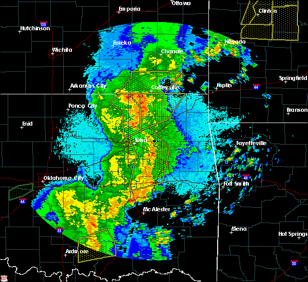 At 1046 pm cdt, a severe thunderstorm was located over copan, or 7 miles south of caney, moving northeast at 50 mph (radar indicated). Hazards include 60 to 70 mph wind gusts and penny size hail. Expect considerable tree damage. Damage is likely to mobile homes, roofs, and outbuildings. At 1046 pm cdt, a severe thunderstorm was located over copan, or 7 miles south of caney, moving northeast at 50 mph (radar indicated). Hazards include 60 to 70 mph wind gusts and penny size hail. Expect considerable tree damage. Damage is likely to mobile homes, roofs, and outbuildings.
|
| 5/2/2018 10:46 PM CDT |
 At 1046 pm cdt, a severe thunderstorm was located over copan, or 7 miles south of caney, moving northeast at 50 mph (radar indicated). Hazards include 60 to 70 mph wind gusts and penny size hail. Expect considerable tree damage. Damage is likely to mobile homes, roofs, and outbuildings. At 1046 pm cdt, a severe thunderstorm was located over copan, or 7 miles south of caney, moving northeast at 50 mph (radar indicated). Hazards include 60 to 70 mph wind gusts and penny size hail. Expect considerable tree damage. Damage is likely to mobile homes, roofs, and outbuildings.
|
| 9/16/2017 4:20 PM CDT |
 At 419 pm cdt, a severe thunderstorm was located near elk city, or 14 miles northeast of sedan, moving northeast at 25 mph (radar indicated). Hazards include 60 mph wind gusts and quarter size hail. Hail damage to vehicles is expected. Expect wind damage to roofs, siding, and trees. At 419 pm cdt, a severe thunderstorm was located near elk city, or 14 miles northeast of sedan, moving northeast at 25 mph (radar indicated). Hazards include 60 mph wind gusts and quarter size hail. Hail damage to vehicles is expected. Expect wind damage to roofs, siding, and trees.
|
| 9/16/2017 4:12 PM CDT | Storm damage reported in chautauqua county KS, 0.4 miles NNE of Chautauqua, KS |
| 9/16/2017 4:12 PM CDT | Storm damage reported in chautauqua county KS, 0.4 miles NNE of Chautauqua, KS |
| 9/16/2017 4:12 PM CDT |
 At 411 pm cdt, a severe thunderstorm was located near peru, or 7 miles east of sedan, moving east at 30 mph (radar indicated). Hazards include 60 mph wind gusts and quarter size hail. Hail damage to vehicles is expected. expect wind damage to roofs, siding, and trees. Locations impacted include, sedan, peru, chautauqua, elgin, niotaze and hale. At 411 pm cdt, a severe thunderstorm was located near peru, or 7 miles east of sedan, moving east at 30 mph (radar indicated). Hazards include 60 mph wind gusts and quarter size hail. Hail damage to vehicles is expected. expect wind damage to roofs, siding, and trees. Locations impacted include, sedan, peru, chautauqua, elgin, niotaze and hale.
|
| 9/16/2017 3:38 PM CDT |
 At 338 pm cdt, a severe thunderstorm was located 6 miles south of cedar vale, moving east at 30 mph (radar indicated). Hazards include 60 mph wind gusts and quarter size hail. Hail damage to vehicles is expected. Expect wind damage to roofs, siding, and trees. At 338 pm cdt, a severe thunderstorm was located 6 miles south of cedar vale, moving east at 30 mph (radar indicated). Hazards include 60 mph wind gusts and quarter size hail. Hail damage to vehicles is expected. Expect wind damage to roofs, siding, and trees.
|
| 8/16/2017 7:21 PM CDT |
 At 721 pm cdt, a severe thunderstorm was located 7 miles east of cedar vale, moving east at 35 mph (radar indicated). Hazards include 60 mph wind gusts and quarter size hail. Hail damage to vehicles is expected. Expect wind damage to roofs, siding, and trees. At 721 pm cdt, a severe thunderstorm was located 7 miles east of cedar vale, moving east at 35 mph (radar indicated). Hazards include 60 mph wind gusts and quarter size hail. Hail damage to vehicles is expected. Expect wind damage to roofs, siding, and trees.
|
| 6/17/2017 11:00 PM CDT |
 At 1100 pm cdt, severe thunderstorms were located along a line extending from 8 miles northeast of dexter to 8 miles southeast of moline to near longton to 8 miles south of fall river, moving southeast at 45 mph (radar indicated). Hazards include 60 mph wind gusts. expect damage to roofs, siding, and trees At 1100 pm cdt, severe thunderstorms were located along a line extending from 8 miles northeast of dexter to 8 miles southeast of moline to near longton to 8 miles south of fall river, moving southeast at 45 mph (radar indicated). Hazards include 60 mph wind gusts. expect damage to roofs, siding, and trees
|
| 6/15/2017 9:16 PM CDT |
 At 916 pm cdt, severe thunderstorms were located along a line extending from near mound valley to 5 miles southwest of elgin, moving southeast at 40 mph (radar indicated). Hazards include 60 mph wind gusts and penny size hail. Expect damage to roofs, siding, and trees. Locations impacted include, coffeyville, independence, cherryvale, caney, sedan, altamont, cedar vale, edna, dearing, mound valley, elk city, tyro, peru, liberty, chautauqua, havana, elgin, bolton, sycamore and niotaze. At 916 pm cdt, severe thunderstorms were located along a line extending from near mound valley to 5 miles southwest of elgin, moving southeast at 40 mph (radar indicated). Hazards include 60 mph wind gusts and penny size hail. Expect damage to roofs, siding, and trees. Locations impacted include, coffeyville, independence, cherryvale, caney, sedan, altamont, cedar vale, edna, dearing, mound valley, elk city, tyro, peru, liberty, chautauqua, havana, elgin, bolton, sycamore and niotaze.
|
| 6/15/2017 8:59 PM CDT |
 At 859 pm cdt, severe thunderstorms were located along a line extending from 7 miles south of thayer to near cedar vale, moving southeast at 40 mph (radar indicated). Hazards include 60 mph wind gusts and penny size hail. expect damage to roofs, siding, and trees At 859 pm cdt, severe thunderstorms were located along a line extending from 7 miles south of thayer to near cedar vale, moving southeast at 40 mph (radar indicated). Hazards include 60 mph wind gusts and penny size hail. expect damage to roofs, siding, and trees
|
| 5/18/2017 8:28 PM CDT |
 At 827 pm cdt, severe thunderstorms were located along a line extending from near moline to near elgin, moving northeast at 40 mph (radar indicated). Hazards include 60 mph wind gusts. Expect damage to roofs, siding, and trees. locations impacted include, sedan, moline, longton, peru, chautauqua, elk falls, niotaze and hale. A tornado watch remains in effect until 1100 pm cdt for southeastern kansas. At 827 pm cdt, severe thunderstorms were located along a line extending from near moline to near elgin, moving northeast at 40 mph (radar indicated). Hazards include 60 mph wind gusts. Expect damage to roofs, siding, and trees. locations impacted include, sedan, moline, longton, peru, chautauqua, elk falls, niotaze and hale. A tornado watch remains in effect until 1100 pm cdt for southeastern kansas.
|
| 5/18/2017 8:05 PM CDT |
 At 805 pm cdt, a severe thunderstorm was located 6 miles southeast of cedar vale, moving northeast at 45 mph (radar indicated). Hazards include 60 mph wind gusts. expect damage to roofs, siding, and trees At 805 pm cdt, a severe thunderstorm was located 6 miles southeast of cedar vale, moving northeast at 45 mph (radar indicated). Hazards include 60 mph wind gusts. expect damage to roofs, siding, and trees
|
| 4/16/2017 7:36 PM CDT |
 At 736 pm cdt, a severe thunderstorm was located over elgin, or 8 miles southwest of sedan, moving east at 10 mph (radar indicated). Hazards include 60 mph wind gusts and quarter size hail. Hail damage to vehicles is expected. expect wind damage to roofs, siding, and trees. Locations impacted include, chautauqua and elgin. At 736 pm cdt, a severe thunderstorm was located over elgin, or 8 miles southwest of sedan, moving east at 10 mph (radar indicated). Hazards include 60 mph wind gusts and quarter size hail. Hail damage to vehicles is expected. expect wind damage to roofs, siding, and trees. Locations impacted include, chautauqua and elgin.
|
| 4/16/2017 7:15 PM CDT |
 At 715 pm cdt, a severe thunderstorm was located near elgin, or 10 miles southeast of cedar vale, moving northeast at 15 mph (radar indicated). Hazards include 60 mph wind gusts and quarter size hail. Hail damage to vehicles is expected. expect wind damage to roofs, siding, and trees. Locations impacted include, sedan, cedar vale, chautauqua and elgin. At 715 pm cdt, a severe thunderstorm was located near elgin, or 10 miles southeast of cedar vale, moving northeast at 15 mph (radar indicated). Hazards include 60 mph wind gusts and quarter size hail. Hail damage to vehicles is expected. expect wind damage to roofs, siding, and trees. Locations impacted include, sedan, cedar vale, chautauqua and elgin.
|
| 4/16/2017 7:01 PM CDT |
 At 701 pm cdt, a severe thunderstorm was located near elgin, or 9 miles southeast of cedar vale, moving northeast at 15 mph (radar indicated). Hazards include 60 mph wind gusts and quarter size hail. Hail damage to vehicles is expected. Expect wind damage to roofs, siding, and trees. At 701 pm cdt, a severe thunderstorm was located near elgin, or 9 miles southeast of cedar vale, moving northeast at 15 mph (radar indicated). Hazards include 60 mph wind gusts and quarter size hail. Hail damage to vehicles is expected. Expect wind damage to roofs, siding, and trees.
|
| 4/4/2017 7:08 PM CDT | Storm damage reported in chautauqua county KS, 0.4 miles NNE of Chautauqua, KS |
| 3/6/2017 8:57 PM CST |
 At 857 pm cst, a severe thunderstorm was located over havana, or 7 miles north of caney, moving northeast at 60 mph (radar indicated). Hazards include 70 mph wind gusts and quarter size hail. Hail damage to vehicles is expected. expect considerable tree damage. Wind damage is also likely to mobile homes, roofs, and outbuildings. At 857 pm cst, a severe thunderstorm was located over havana, or 7 miles north of caney, moving northeast at 60 mph (radar indicated). Hazards include 70 mph wind gusts and quarter size hail. Hail damage to vehicles is expected. expect considerable tree damage. Wind damage is also likely to mobile homes, roofs, and outbuildings.
|
| 3/6/2017 8:44 PM CST |
 At 843 pm cst, severe thunderstorms were located along a line extending from neodesha to peru, moving east at 40 mph (radar indicated). Hazards include 60 mph wind gusts and quarter size hail. Hail damage to vehicles is expected. expect wind damage to roofs, siding, and trees. locations impacted include, independence, neodesha, sedan, elk city, peru, chautauqua, havana, elgin, bolton, sycamore, niotaze, elk city lake, elk city state park, hale and buxton. A tornado watch remains in effect until 300 am cst for southeastern kansas. At 843 pm cst, severe thunderstorms were located along a line extending from neodesha to peru, moving east at 40 mph (radar indicated). Hazards include 60 mph wind gusts and quarter size hail. Hail damage to vehicles is expected. expect wind damage to roofs, siding, and trees. locations impacted include, independence, neodesha, sedan, elk city, peru, chautauqua, havana, elgin, bolton, sycamore, niotaze, elk city lake, elk city state park, hale and buxton. A tornado watch remains in effect until 300 am cst for southeastern kansas.
|
| 3/6/2017 8:37 PM CST |
 At 837 pm cst, a severe thunderstorm capable of producing a tornado was located over havana, or 7 miles north of caney, moving east at 60 mph (radar indicated rotation). Hazards include tornado and golf ball size hail. Flying debris will be dangerous to those caught without shelter. mobile homes will be damaged or destroyed. damage to roofs, windows, and vehicles will occur. tree damage is likely. Locations impacted include, sedan, peru, chautauqua and niotaze. At 837 pm cst, a severe thunderstorm capable of producing a tornado was located over havana, or 7 miles north of caney, moving east at 60 mph (radar indicated rotation). Hazards include tornado and golf ball size hail. Flying debris will be dangerous to those caught without shelter. mobile homes will be damaged or destroyed. damage to roofs, windows, and vehicles will occur. tree damage is likely. Locations impacted include, sedan, peru, chautauqua and niotaze.
|
| 3/6/2017 8:36 PM CST |
 At 836 pm cst, severe thunderstorms were located along a line extending from 6 miles south of fredonia to near sedan, moving east at 40 mph (radar indicated). Hazards include 60 mph wind gusts and half dollar size hail. Hail damage to vehicles is expected. expect wind damage to roofs, siding, and trees. locations impacted include, independence, neodesha, sedan, elk city, peru, chautauqua, havana, elgin, bolton, sycamore, niotaze, elk city lake, elk city state park, hale and buxton. A tornado watch remains in effect until 300 am cst for southeastern kansas. At 836 pm cst, severe thunderstorms were located along a line extending from 6 miles south of fredonia to near sedan, moving east at 40 mph (radar indicated). Hazards include 60 mph wind gusts and half dollar size hail. Hail damage to vehicles is expected. expect wind damage to roofs, siding, and trees. locations impacted include, independence, neodesha, sedan, elk city, peru, chautauqua, havana, elgin, bolton, sycamore, niotaze, elk city lake, elk city state park, hale and buxton. A tornado watch remains in effect until 300 am cst for southeastern kansas.
|
| 3/6/2017 8:32 PM CST |
 At 832 pm cst, severe thunderstorms were located along a line extending from 5 miles south of fredonia to near sedan, moving east at 40 mph (radar indicated). Hazards include 60 mph wind gusts and half dollar size hail. Hail damage to vehicles is expected. expect wind damage to roofs, siding, and trees. locations impacted include, independence, neodesha, sedan, howard, cedar vale, moline, longton, elk city, peru, chautauqua, elk falls, havana, elgin, bolton, sycamore, niotaze, buxton, elk city lake, elk city state park and hale. A tornado watch remains in effect until 300 am cst for south central and southeastern kansas. At 832 pm cst, severe thunderstorms were located along a line extending from 5 miles south of fredonia to near sedan, moving east at 40 mph (radar indicated). Hazards include 60 mph wind gusts and half dollar size hail. Hail damage to vehicles is expected. expect wind damage to roofs, siding, and trees. locations impacted include, independence, neodesha, sedan, howard, cedar vale, moline, longton, elk city, peru, chautauqua, elk falls, havana, elgin, bolton, sycamore, niotaze, buxton, elk city lake, elk city state park and hale. A tornado watch remains in effect until 300 am cst for south central and southeastern kansas.
|
| 3/6/2017 8:28 PM CST |
 At 828 pm cst, a severe thunderstorm capable of producing a tornado was located over peru, or near sedan, moving east at 65 mph (radar indicated rotation). Hazards include tornado and golf ball size hail. Flying debris will be dangerous to those caught without shelter. mobile homes will be damaged or destroyed. damage to roofs, windows, and vehicles will occur. tree damage is likely. This tornadic thunderstorm will remain over mainly rural areas of southeastern chautauqua county, including the following locations: niotaze. At 828 pm cst, a severe thunderstorm capable of producing a tornado was located over peru, or near sedan, moving east at 65 mph (radar indicated rotation). Hazards include tornado and golf ball size hail. Flying debris will be dangerous to those caught without shelter. mobile homes will be damaged or destroyed. damage to roofs, windows, and vehicles will occur. tree damage is likely. This tornadic thunderstorm will remain over mainly rural areas of southeastern chautauqua county, including the following locations: niotaze.
|
| 3/6/2017 8:20 PM CST |
 At 820 pm cst, a severe thunderstorm capable of producing a tornado was located near elgin, or 8 miles southwest of sedan, moving east at 65 mph (radar indicated rotation). Hazards include tornado and golf ball size hail. Flying debris will be dangerous to those caught without shelter. mobile homes will be damaged or destroyed. damage to roofs, windows, and vehicles will occur. tree damage is likely. this dangerous storm will be near, sedan and chautauqua around 825 pm cst. peru around 830 pm cst. Other locations impacted by this tornadic thunderstorm include niotaze. At 820 pm cst, a severe thunderstorm capable of producing a tornado was located near elgin, or 8 miles southwest of sedan, moving east at 65 mph (radar indicated rotation). Hazards include tornado and golf ball size hail. Flying debris will be dangerous to those caught without shelter. mobile homes will be damaged or destroyed. damage to roofs, windows, and vehicles will occur. tree damage is likely. this dangerous storm will be near, sedan and chautauqua around 825 pm cst. peru around 830 pm cst. Other locations impacted by this tornadic thunderstorm include niotaze.
|
| 3/6/2017 8:17 PM CST |
 At 817 pm cst, severe thunderstorms were located along a line extending from 8 miles northeast of longton to 6 miles east of cedar vale, moving east at 40 mph (radar indicated). Hazards include 60 mph wind gusts and half dollar size hail. Hail damage to vehicles is expected. expect wind damage to roofs, siding, and trees. locations impacted include, independence, neodesha, sedan, howard, cedar vale, moline, longton, elk city, peru, chautauqua, elk falls, havana, elgin, bolton, sycamore, niotaze, buxton, elk city lake, elk city state park and hale. A tornado watch remains in effect until 300 am cst for south central and southeastern kansas. At 817 pm cst, severe thunderstorms were located along a line extending from 8 miles northeast of longton to 6 miles east of cedar vale, moving east at 40 mph (radar indicated). Hazards include 60 mph wind gusts and half dollar size hail. Hail damage to vehicles is expected. expect wind damage to roofs, siding, and trees. locations impacted include, independence, neodesha, sedan, howard, cedar vale, moline, longton, elk city, peru, chautauqua, elk falls, havana, elgin, bolton, sycamore, niotaze, buxton, elk city lake, elk city state park and hale. A tornado watch remains in effect until 300 am cst for south central and southeastern kansas.
|
| 3/6/2017 8:00 PM CST |
 At 800 pm cst, severe thunderstorms were located along a line extending from near howard to 6 miles northwest of cedar vale, moving east at 40 mph (radar indicated). Hazards include 70 mph wind gusts and quarter size hail. Hail damage to vehicles is expected. expect considerable tree damage. Wind damage is also likely to mobile homes, roofs, and outbuildings. At 800 pm cst, severe thunderstorms were located along a line extending from near howard to 6 miles northwest of cedar vale, moving east at 40 mph (radar indicated). Hazards include 70 mph wind gusts and quarter size hail. Hail damage to vehicles is expected. expect considerable tree damage. Wind damage is also likely to mobile homes, roofs, and outbuildings.
|
| 2/28/2017 10:24 PM CST |
 At 1023 pm cst, severe thunderstorms were located along a line extending from near longton to 5 miles west of elgin, moving east at 70 mph (radar indicated). Hazards include 70 mph wind gusts and quarter size hail. Hail damage to vehicles is expected. expect considerable tree damage. wind damage is also likely to mobile homes, roofs, and outbuildings. locations impacted include, fredonia, sedan, howard, cedar vale, moline, longton, elk city, peru, chautauqua, elk falls, havana, elgin, niotaze, buxton and hale. A tornado watch remains in effect until 400 am cst for southeastern kansas. At 1023 pm cst, severe thunderstorms were located along a line extending from near longton to 5 miles west of elgin, moving east at 70 mph (radar indicated). Hazards include 70 mph wind gusts and quarter size hail. Hail damage to vehicles is expected. expect considerable tree damage. wind damage is also likely to mobile homes, roofs, and outbuildings. locations impacted include, fredonia, sedan, howard, cedar vale, moline, longton, elk city, peru, chautauqua, elk falls, havana, elgin, niotaze, buxton and hale. A tornado watch remains in effect until 400 am cst for southeastern kansas.
|
| 2/28/2017 10:02 PM CST |
 At 1002 pm cst, severe thunderstorms were located along a line extending from near moline to just north of hardy, moving east at 50 mph (radar indicated). Hazards include 70 mph wind gusts and half dollar size hail. Hail damage to vehicles is expected. expect considerable tree damage. Wind damage is also likely to mobile homes, roofs, and outbuildings. At 1002 pm cst, severe thunderstorms were located along a line extending from near moline to just north of hardy, moving east at 50 mph (radar indicated). Hazards include 70 mph wind gusts and half dollar size hail. Hail damage to vehicles is expected. expect considerable tree damage. Wind damage is also likely to mobile homes, roofs, and outbuildings.
|
| 6/30/2016 5:39 PM CDT | 60 to 65 mph winds and pea size hai in chautauqua county KS, 0.4 miles NNE of Chautauqua, KS |
| 4/29/2016 2:54 PM CDT |
 At 253 pm cdt, severe thunderstorms were located along a line extending from near grenola to 8 miles northwest of sedan to 5 miles northwest of elgin, moving east at 55 mph (radar indicated). Hazards include golf ball size hail and 70 mph wind gusts. People and animals outdoors will be injured. expect hail damage to roofs, siding, windows, and vehicles. expect considerable tree damage. Wind damage is also likely to mobile homes, roofs, and outbuildings. At 253 pm cdt, severe thunderstorms were located along a line extending from near grenola to 8 miles northwest of sedan to 5 miles northwest of elgin, moving east at 55 mph (radar indicated). Hazards include golf ball size hail and 70 mph wind gusts. People and animals outdoors will be injured. expect hail damage to roofs, siding, windows, and vehicles. expect considerable tree damage. Wind damage is also likely to mobile homes, roofs, and outbuildings.
|
| 4/26/2016 10:26 PM CDT |
 At 1025 pm cdt, severe thunderstorms were located along a line extending from near moline to 6 miles northeast of havana, moving northeast at 60 mph (radar indicated). Hazards include 70 mph wind gusts. Expect considerable tree damage. damage is likely to mobile homes, roofs, and outbuildings. Locations impacted include, independence, caney, sedan, cedar vale, moline, longton, elk city, tyro, grenola, peru, chautauqua, elk falls, havana, elgin, bolton, sycamore, niotaze, independence airport, elk city state park and elk city lake. At 1025 pm cdt, severe thunderstorms were located along a line extending from near moline to 6 miles northeast of havana, moving northeast at 60 mph (radar indicated). Hazards include 70 mph wind gusts. Expect considerable tree damage. damage is likely to mobile homes, roofs, and outbuildings. Locations impacted include, independence, caney, sedan, cedar vale, moline, longton, elk city, tyro, grenola, peru, chautauqua, elk falls, havana, elgin, bolton, sycamore, niotaze, independence airport, elk city state park and elk city lake.
|
| 4/26/2016 10:15 PM CDT |
 At 1014 pm cdt, severe thunderstorms were located along a line extending from 5 miles northeast of cedar vale to caney, moving northeast at 55 mph (radar indicated). Hazards include 70 mph wind gusts. Expect considerable tree damage. damage is likely to mobile homes, roofs, and outbuildings. Locations impacted include, independence, caney, sedan, cedar vale, moline, longton, elk city, tyro, grenola, peru, chautauqua, elk falls, havana, elgin, bolton, sycamore, niotaze, independence airport, elk city state park and elk city lake. At 1014 pm cdt, severe thunderstorms were located along a line extending from 5 miles northeast of cedar vale to caney, moving northeast at 55 mph (radar indicated). Hazards include 70 mph wind gusts. Expect considerable tree damage. damage is likely to mobile homes, roofs, and outbuildings. Locations impacted include, independence, caney, sedan, cedar vale, moline, longton, elk city, tyro, grenola, peru, chautauqua, elk falls, havana, elgin, bolton, sycamore, niotaze, independence airport, elk city state park and elk city lake.
|
| 4/26/2016 10:00 PM CDT |
 At 1000 pm cdt, severe thunderstorms were located along a line extending from 6 miles southwest of cedar vale to 10 miles south of chautauqua, moving northeast at 55 mph (radar indicated). Hazards include 70 mph wind gusts. Expect considerable tree damage. Damage is likely to mobile homes, roofs, and outbuildings. At 1000 pm cdt, severe thunderstorms were located along a line extending from 6 miles southwest of cedar vale to 10 miles south of chautauqua, moving northeast at 55 mph (radar indicated). Hazards include 70 mph wind gusts. Expect considerable tree damage. Damage is likely to mobile homes, roofs, and outbuildings.
|
| 4/10/2016 9:53 PM CDT |
 At 953 pm cdt, severe thunderstorms were located along a line extending from 6 miles east of cedar vale to 6 miles northwest of havana, moving east at 25 mph (radar indicated). Hazards include 50 to 60 mph wind gusts and quarter size hail. Hail damage to vehicles is expected. expect wind damage to roofs, siding, and trees. Locations impacted include, sedan, peru, chautauqua, niotaze and hale. At 953 pm cdt, severe thunderstorms were located along a line extending from 6 miles east of cedar vale to 6 miles northwest of havana, moving east at 25 mph (radar indicated). Hazards include 50 to 60 mph wind gusts and quarter size hail. Hail damage to vehicles is expected. expect wind damage to roofs, siding, and trees. Locations impacted include, sedan, peru, chautauqua, niotaze and hale.
|
| 4/10/2016 9:31 PM CDT |
 At 929 pm cdt, three severe thunderstorms were occurring in the warned areas. one was located 8 miles south of longton, or 9 miles north of sedan, a second was located 10 miles east of arkansas city, and the third was located in northeast chautauqua county. all 3 severe thunderstorms were moving east at 40 mph (radar indicated). Hazards include 60 mph wind gusts and half dollar size hail. Hail damage to vehicles is expected. expect wind damage to roofs, siding, and trees. Locations impacted include, sedan, cedar vale, moline, longton, dexter, grenola, peru, chautauqua, elk falls, niotaze, maple city and hale. At 929 pm cdt, three severe thunderstorms were occurring in the warned areas. one was located 8 miles south of longton, or 9 miles north of sedan, a second was located 10 miles east of arkansas city, and the third was located in northeast chautauqua county. all 3 severe thunderstorms were moving east at 40 mph (radar indicated). Hazards include 60 mph wind gusts and half dollar size hail. Hail damage to vehicles is expected. expect wind damage to roofs, siding, and trees. Locations impacted include, sedan, cedar vale, moline, longton, dexter, grenola, peru, chautauqua, elk falls, niotaze, maple city and hale.
|
| 4/10/2016 9:24 PM CDT |
 At 922 pm cdt, a severe thunderstorm was located 8 miles north of sedan, moving east at 40 mph. another severe thudnerstorm was located in northeast chautauqua county. both severe thunderstorms were moving east around 40 mph (radar indicated). Hazards include half dollar size hail. Damage to vehicles is expected. Locations impacted include, sedan, cedar vale, moline, longton, dexter, grenola, peru, chautauqua, elk falls, niotaze, maple city and hale. At 922 pm cdt, a severe thunderstorm was located 8 miles north of sedan, moving east at 40 mph. another severe thudnerstorm was located in northeast chautauqua county. both severe thunderstorms were moving east around 40 mph (radar indicated). Hazards include half dollar size hail. Damage to vehicles is expected. Locations impacted include, sedan, cedar vale, moline, longton, dexter, grenola, peru, chautauqua, elk falls, niotaze, maple city and hale.
|
| 4/10/2016 9:10 PM CDT |
 At 909 pm cdt, a severe thunderstorm was located near dexter, or 8 miles west of cedar vale, moving east at 45 mph (radar indicated). Hazards include half dollar size hail. damage to vehicles is expected At 909 pm cdt, a severe thunderstorm was located near dexter, or 8 miles west of cedar vale, moving east at 45 mph (radar indicated). Hazards include half dollar size hail. damage to vehicles is expected
|
| 3/30/2016 7:08 PM CDT |
 The severe thunderstorm warning for chautauqua county will expire at 715 pm cdt, the storm which prompted the warning has moved out of the area. therefore the warning will be allowed to expire. a severe thunderstorm watch remains in effect until 900 pm cdt for southeastern kansas. The severe thunderstorm warning for chautauqua county will expire at 715 pm cdt, the storm which prompted the warning has moved out of the area. therefore the warning will be allowed to expire. a severe thunderstorm watch remains in effect until 900 pm cdt for southeastern kansas.
|
| 3/30/2016 6:51 PM CDT |
 At 651 pm cdt, a severe thunderstorm was located over caney, moving east at 30 mph (radar indicated). Hazards include golf ball size hail. People and animals outdoors will be injured. expect damage to roofs, siding, windows, and vehicles. Locations impacted include, sedan, peru, chautauqua, elgin, niotaze and hale. At 651 pm cdt, a severe thunderstorm was located over caney, moving east at 30 mph (radar indicated). Hazards include golf ball size hail. People and animals outdoors will be injured. expect damage to roofs, siding, windows, and vehicles. Locations impacted include, sedan, peru, chautauqua, elgin, niotaze and hale.
|
| 3/30/2016 6:37 PM CDT |
 At 637 pm cdt, a severe thunderstorm was located near chautauqua, or 9 miles west of caney, moving east at 50 mph (trained weather spotters). Hazards include golf ball size hail. People and animals outdoors will be injured. expect damage to roofs, siding, windows, and vehicles. Locations impacted include, sedan, peru, chautauqua, elgin, niotaze and hale. At 637 pm cdt, a severe thunderstorm was located near chautauqua, or 9 miles west of caney, moving east at 50 mph (trained weather spotters). Hazards include golf ball size hail. People and animals outdoors will be injured. expect damage to roofs, siding, windows, and vehicles. Locations impacted include, sedan, peru, chautauqua, elgin, niotaze and hale.
|
| 3/30/2016 6:36 PM CDT | Golf Ball sized hail reported 0.4 miles NNE of Chautauqua, KS, accumulating quarter to golf ball size hail. |
| 3/30/2016 6:33 PM CDT | Quarter sized hail reported 0.4 miles NNE of Chautauqua, KS |
| 3/30/2016 6:24 PM CDT |
 At 624 pm cdt, a severe thunderstorm was located near chautauqua, or 6 miles southwest of sedan, moving northeast at 30 mph (radar indicated). Hazards include 60 mph wind gusts and quarter size hail. Hail damage to vehicles is expected. Expect wind damage to roofs, siding, and trees. At 624 pm cdt, a severe thunderstorm was located near chautauqua, or 6 miles southwest of sedan, moving northeast at 30 mph (radar indicated). Hazards include 60 mph wind gusts and quarter size hail. Hail damage to vehicles is expected. Expect wind damage to roofs, siding, and trees.
|
| 4/2/2015 8:21 PM CDT | A severe thunderstorm warning remains in effect until 900 pm cdt for southwestern montgomery and southeastern chautauqua counties. at 821 pm cdt. a severe thunderstorm was located just south of peru. or 7 miles west of caney. moving east at 40 mph. hazard. ping pong size hail and 60 mph wind gusts. source. Radar indicated. |
| 4/2/2015 8:12 PM CDT | The national weather service in wichita has issued a * severe thunderstorm warning for. southwestern montgomery county in southeastern kansas. southeastern chautauqua county in southeastern kansas. until 900 pm cdt * at 812 pm cdt. a severe thunderstorm was located near peru. Or. |
| 5/31/2013 5:54 PM CDT | Delayed report...nickel hail also reporte in chautauqua county KS, 0.4 miles NNE of Chautauqua, KS |
| 5/29/2013 8:08 PM CDT | Emergency manager estimated 70 mph winds and reported damage in sedan and chautauqua as the storm moved through with downed trees. time of the report is estimated from in chautauqua county KS, 0.4 miles NNE of Chautauqua, KS |
| 5/29/2013 8:00 PM CDT | Widespread tree damage occurred from approximately 800 to 830 p in chautauqua county KS, 0.4 miles NNE of Chautauqua, KS |
| 5/20/2013 12:08 AM CDT | Golf Ball sized hail reported 0.4 miles NNE of Chautauqua, KS, quarter to golf ball hail reported |
| 1/1/0001 12:00 AM | Also nickel size hai in chautauqua county KS, 0.4 miles NNE of Chautauqua, KS |
| 1/1/0001 12:00 AM | 5 inch tree limbs were downed in the town of chautauqua. wind gusts were estimated over 60 mp in chautauqua county KS, 0.4 miles NNE of Chautauqua, KS |
| 1/1/0001 12:00 AM | Several power lines down in the city of chautauqu in chautauqua county KS, 0.4 miles NNE of Chautauqua, KS |
| 1/1/0001 12:00 AM | Amateur radio reports a 12 inch diameter tree limb dow in chautauqua county KS, 0.4 miles NNE of Chautauqua, KS |
| 1/1/0001 12:00 AM | Tennis Ball sized hail reported 0.4 miles NNE of Chautauqua, KS |
Hail Maps for Chautauqua, KS

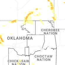
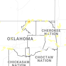
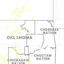


Connect with Interactive Hail Maps