

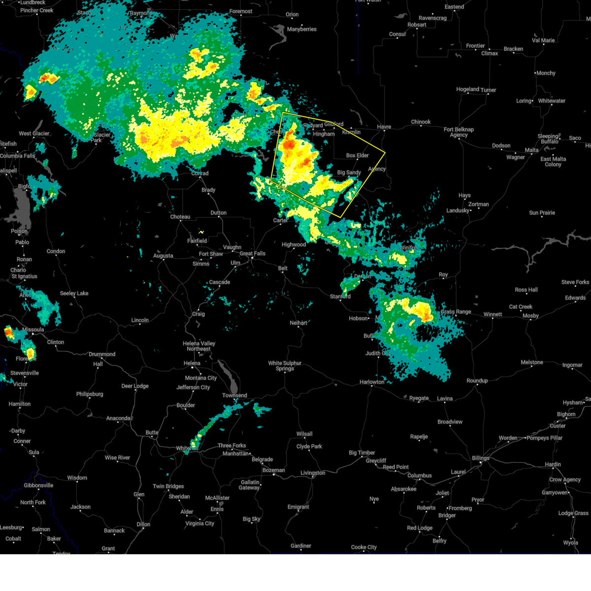
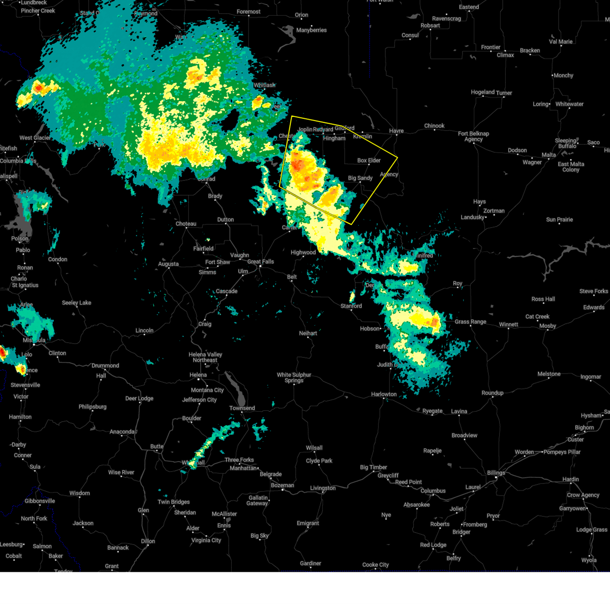
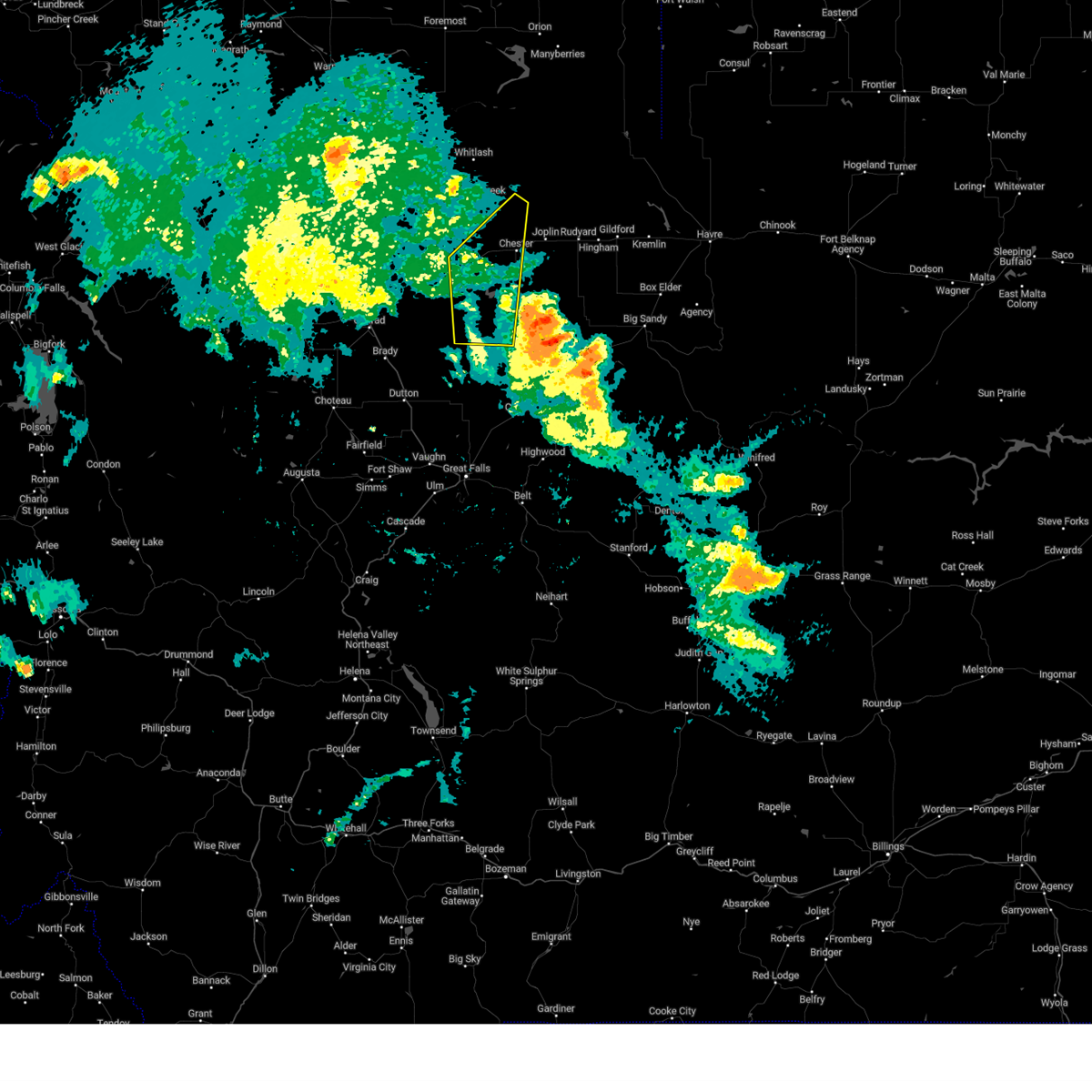
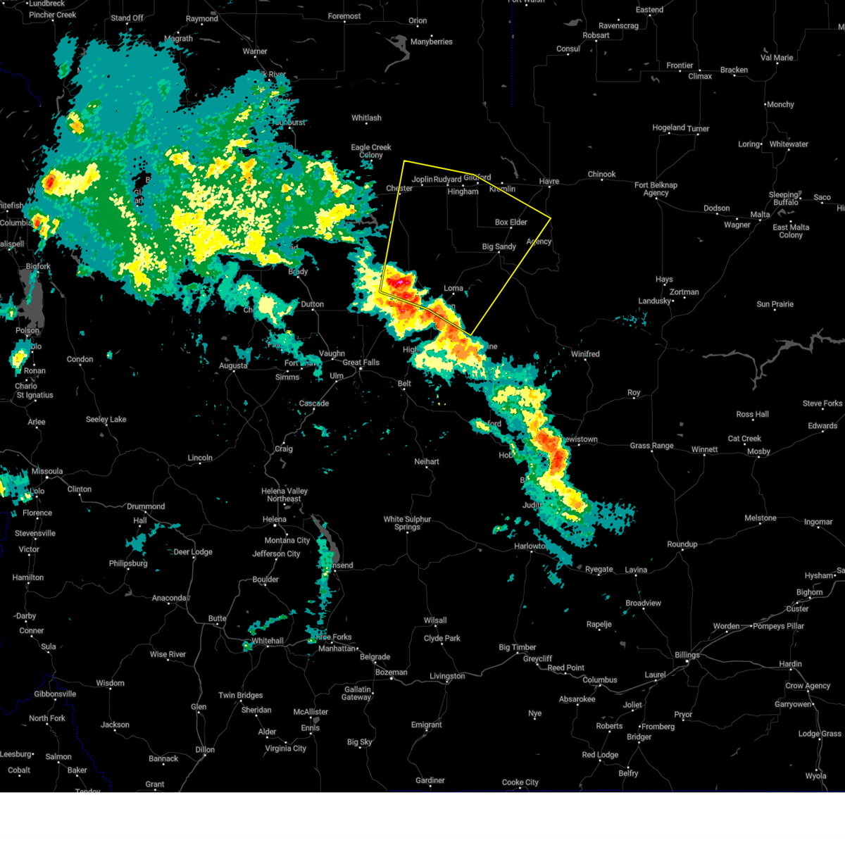
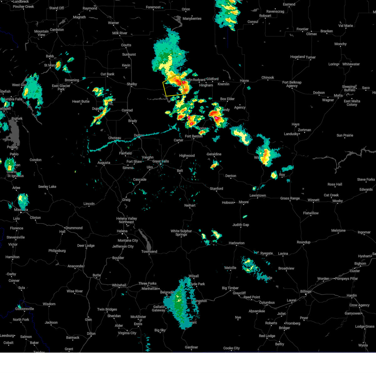
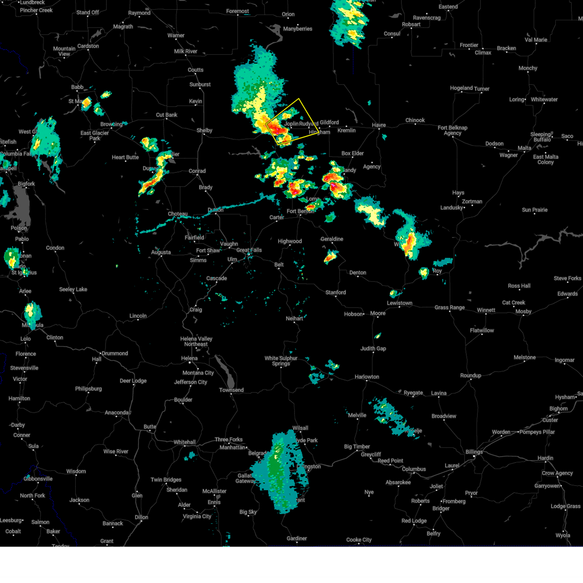
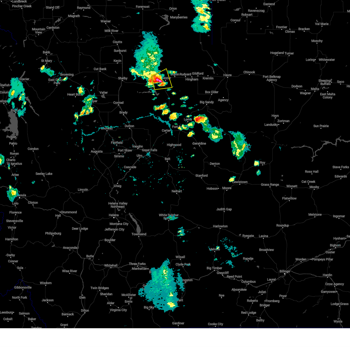
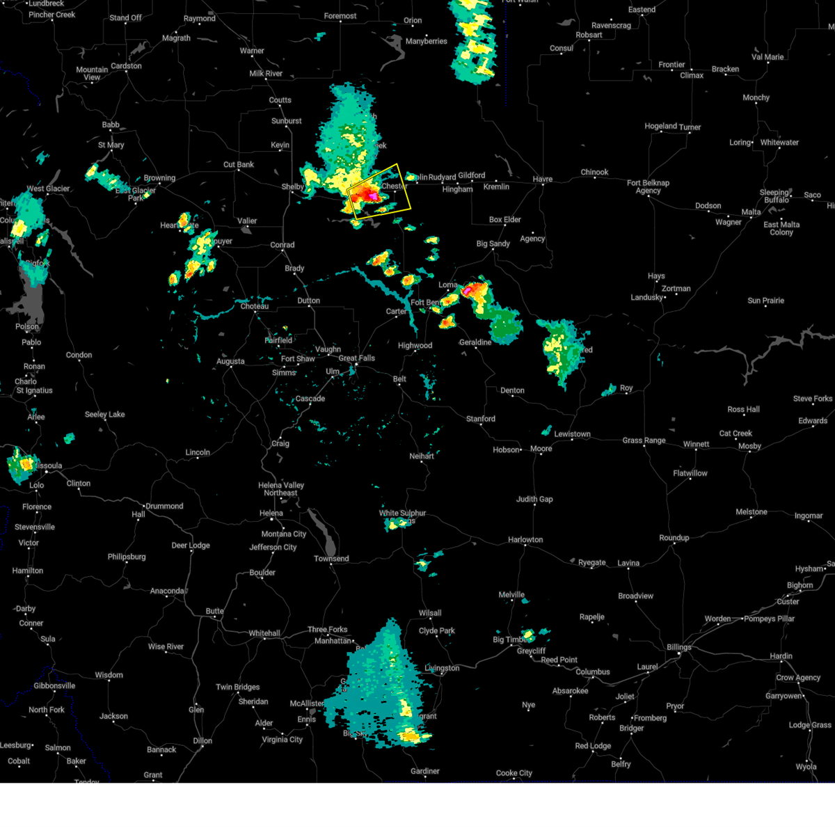
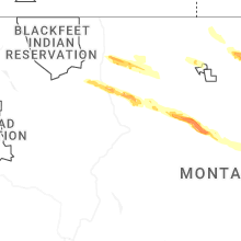
Hail Map for Chester, MT
The Chester, MT area has had 8 reports of on-the-ground hail by trained spotters, and has been under severe weather warnings 22 times during the past 12 months. Doppler radar has detected hail at or near Chester, MT on 17 occasions, including 3 occasions during the past year.
| Name: | Chester, MT |
| Where Located: | 59.4 miles W of Havre, MT |
| Map: | Google Map for Chester, MT |
| Population: | 847 |
| Housing Units: | 462 |
| More Info: | Search Google for Chester, MT |
2
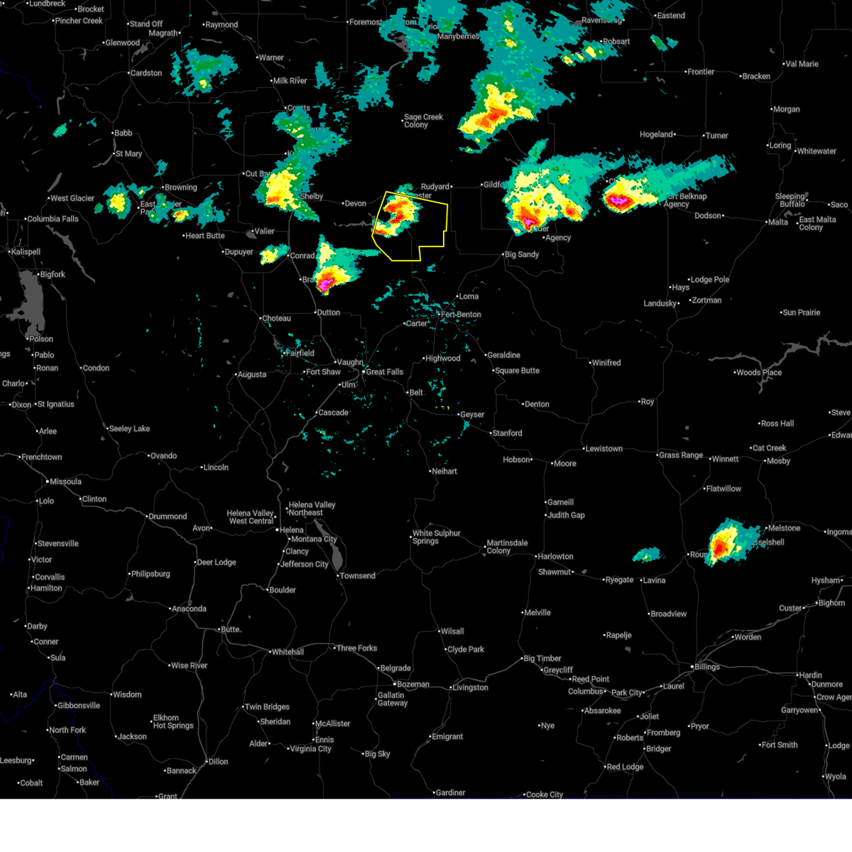
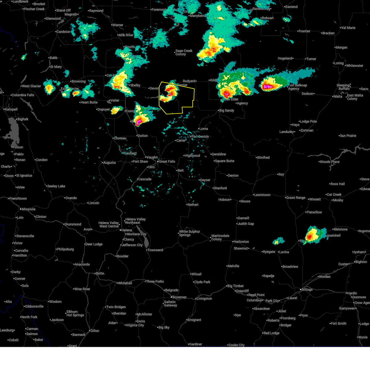
The Top Recent Hail Date for Chester, MT is Monday, August 12, 2024 (3rd out of 17)

Hail and Wind Damage Spotted near Chester, MT
| Date / Time | Report Details |
|---|---|
| 7/17/2025 4:54 PM MDT |
 the severe thunderstorm warning has been cancelled and is no longer in effect the severe thunderstorm warning has been cancelled and is no longer in effect
|
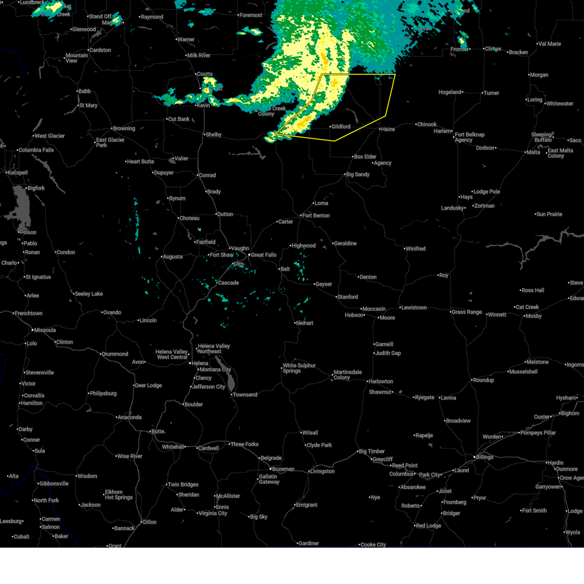
| 7/17/2025 4:38 PM MDT |
 At 437 pm mdt, severe thunderstorms were located along a line extending from 8 miles southwest of chester to 11 miles southeast of lothair to 18 miles north of the knees, moving southeast at 35 mph (radar indicated). Hazards include 60 mph wind gusts. Expect damage to roofs, siding, and trees. Locations impacted include, chester and tiber dam. At 437 pm mdt, severe thunderstorms were located along a line extending from 8 miles southwest of chester to 11 miles southeast of lothair to 18 miles north of the knees, moving southeast at 35 mph (radar indicated). Hazards include 60 mph wind gusts. Expect damage to roofs, siding, and trees. Locations impacted include, chester and tiber dam.
|
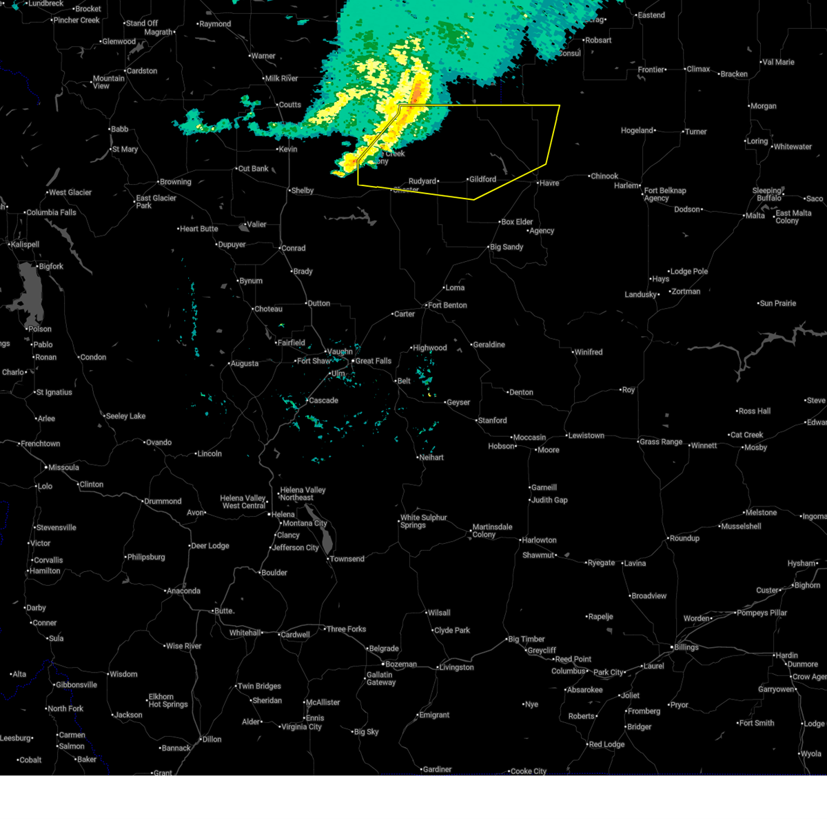
| 7/17/2025 4:29 PM MDT |
 Svrtfx the national weather service in great falls has issued a * severe thunderstorm warning for, southern liberty county in north central montana, southwestern hill county in north central montana, * until 515 pm mdt. * at 428 pm mdt, severe thunderstorms were located along a line extending from near lothair to 11 miles southwest of chester to 20 miles north of the knees, moving southeast at 30 mph (radar indicated). Hazards include 60 mph wind gusts and quarter size hail. Hail damage to vehicles is expected. Expect wind damage to roofs, siding, and trees. Svrtfx the national weather service in great falls has issued a * severe thunderstorm warning for, southern liberty county in north central montana, southwestern hill county in north central montana, * until 515 pm mdt. * at 428 pm mdt, severe thunderstorms were located along a line extending from near lothair to 11 miles southwest of chester to 20 miles north of the knees, moving southeast at 30 mph (radar indicated). Hazards include 60 mph wind gusts and quarter size hail. Hail damage to vehicles is expected. Expect wind damage to roofs, siding, and trees.
|
| 7/13/2025 11:30 PM MDT |
 At 1130 pm mdt, severe thunderstorms were located along a line extending from 37 miles north of beaver creek to 13 miles northeast of gildford to near inverness, moving east at 50 mph (radar indicated). Hazards include 60 mph wind gusts. Expect damage to roofs, siding, and trees. Locations impacted include, chester, joplin, inverness, gildford, hingham, rudyard, kremlin, and simpson. At 1130 pm mdt, severe thunderstorms were located along a line extending from 37 miles north of beaver creek to 13 miles northeast of gildford to near inverness, moving east at 50 mph (radar indicated). Hazards include 60 mph wind gusts. Expect damage to roofs, siding, and trees. Locations impacted include, chester, joplin, inverness, gildford, hingham, rudyard, kremlin, and simpson.
|
| 7/13/2025 10:58 PM MDT |
 Svrtfx the national weather service in great falls has issued a * severe thunderstorm warning for, northeastern liberty county in north central montana, hill county in north central montana, * until midnight mdt. * at 1058 pm mdt, severe thunderstorms were located along a line extending from 43 miles north of joplin to 18 miles north of inverness to 14 miles north of chester, moving east at 45 mph (radar indicated). Hazards include 60 mph wind gusts. expect damage to roofs, siding, and trees Svrtfx the national weather service in great falls has issued a * severe thunderstorm warning for, northeastern liberty county in north central montana, hill county in north central montana, * until midnight mdt. * at 1058 pm mdt, severe thunderstorms were located along a line extending from 43 miles north of joplin to 18 miles north of inverness to 14 miles north of chester, moving east at 45 mph (radar indicated). Hazards include 60 mph wind gusts. expect damage to roofs, siding, and trees
|
| 7/13/2025 10:35 PM MDT | Mesonet station gw3546 whitlash seven south. more exact timing estimated based on rada in liberty county MT, 24.6 miles SSE of Chester, MT |
| 7/2/2025 8:15 PM MDT | Mesonet station gw1852 tiber marin in liberty county MT, 14.8 miles NNE of Chester, MT |
| 9/20/2024 2:30 PM MDT | Mesonet station gw4063 eagle creek colon in liberty county MT, 16.9 miles SE of Chester, MT |
| 8/23/2024 7:09 PM MDT |
 The storms which prompted the warning have weakened below severe limits, and no longer pose an immediate threat to life or property. therefore, the warning will be allowed to expire. however, gusty winds around 55 mph are still possible with these thunderstorms. a severe thunderstorm watch remains in effect until 900 pm mdt for north central montana. The storms which prompted the warning have weakened below severe limits, and no longer pose an immediate threat to life or property. therefore, the warning will be allowed to expire. however, gusty winds around 55 mph are still possible with these thunderstorms. a severe thunderstorm watch remains in effect until 900 pm mdt for north central montana.
|
| 8/23/2024 6:47 PM MDT |
 the severe thunderstorm warning has been cancelled and is no longer in effect the severe thunderstorm warning has been cancelled and is no longer in effect
|
| 8/23/2024 6:47 PM MDT |
 At 647 pm mdt, severe thunderstorms were located along a line extending from 36 miles north of kiowa to 23 miles east of sunburst to 9 miles northwest of beaver creek, moving north at 85 mph (radar indicated). Hazards include 70 mph wind gusts. Expect considerable tree damage. damage is likely to mobile homes, roofs, and outbuildings. locations impacted include, havre, shelby, cut bank, chinook, chester, sunburst, kevin, parker school, beaver creek, lothair, joplin, azure, inverness, agency, st. Pierre, gildford, sangrey, boneau, box elder, and north browning. At 647 pm mdt, severe thunderstorms were located along a line extending from 36 miles north of kiowa to 23 miles east of sunburst to 9 miles northwest of beaver creek, moving north at 85 mph (radar indicated). Hazards include 70 mph wind gusts. Expect considerable tree damage. damage is likely to mobile homes, roofs, and outbuildings. locations impacted include, havre, shelby, cut bank, chinook, chester, sunburst, kevin, parker school, beaver creek, lothair, joplin, azure, inverness, agency, st. Pierre, gildford, sangrey, boneau, box elder, and north browning.
|
| 8/23/2024 6:15 PM MDT | Storm damage reported in liberty county MT, 13.3 miles N of Chester, MT |
| 8/23/2024 6:13 PM MDT |
 Svrtfx the national weather service in great falls has issued a * severe thunderstorm warning for, northeastern pondera county in north central montana, liberty county in north central montana, glacier county in north central montana, toole county in north central montana, northwestern blaine county in north central montana, hill county in north central montana, northern chouteau county in north central montana, * until 715 pm mdt. * at 612 pm mdt, severe thunderstorms were located along a line extending from 11 miles southwest of east glacier park village to 10 miles north of the knees to 17 miles southeast of big sandy, moving north at 85 mph. these are destructive storms for browning, box elder, and havre (radar indicated). Hazards include 80 mph wind gusts. Flying debris will be dangerous to those caught without shelter. mobile homes will be heavily damaged. expect considerable damage to roofs, windows, and vehicles. Extensive tree damage and power outages are likely. Svrtfx the national weather service in great falls has issued a * severe thunderstorm warning for, northeastern pondera county in north central montana, liberty county in north central montana, glacier county in north central montana, toole county in north central montana, northwestern blaine county in north central montana, hill county in north central montana, northern chouteau county in north central montana, * until 715 pm mdt. * at 612 pm mdt, severe thunderstorms were located along a line extending from 11 miles southwest of east glacier park village to 10 miles north of the knees to 17 miles southeast of big sandy, moving north at 85 mph. these are destructive storms for browning, box elder, and havre (radar indicated). Hazards include 80 mph wind gusts. Flying debris will be dangerous to those caught without shelter. mobile homes will be heavily damaged. expect considerable damage to roofs, windows, and vehicles. Extensive tree damage and power outages are likely.
|
| 8/23/2024 6:11 PM MDT |
 Svrtfx the national weather service in great falls has issued a * severe thunderstorm warning for, northeastern pondera county in north central montana, liberty county in north central montana, glacier county in north central montana, toole county in north central montana, northwestern blaine county in north central montana, hill county in north central montana, northern chouteau county in north central montana, * until 715 pm mdt. * at 610 pm mdt, severe thunderstorms were located along a line extending from 11 miles southwest of east glacier park village to 9 miles north of the knees to 19 miles southeast of big sandy, moving north at 85 mph. these are destructive storms for browning, box elder, and havre (radar indicated). Hazards include 80 mph wind gusts. Flying debris will be dangerous to those caught without shelter. mobile homes will be heavily damaged. expect considerable damage to roofs, windows, and vehicles. Extensive tree damage and power outages are likely. Svrtfx the national weather service in great falls has issued a * severe thunderstorm warning for, northeastern pondera county in north central montana, liberty county in north central montana, glacier county in north central montana, toole county in north central montana, northwestern blaine county in north central montana, hill county in north central montana, northern chouteau county in north central montana, * until 715 pm mdt. * at 610 pm mdt, severe thunderstorms were located along a line extending from 11 miles southwest of east glacier park village to 9 miles north of the knees to 19 miles southeast of big sandy, moving north at 85 mph. these are destructive storms for browning, box elder, and havre (radar indicated). Hazards include 80 mph wind gusts. Flying debris will be dangerous to those caught without shelter. mobile homes will be heavily damaged. expect considerable damage to roofs, windows, and vehicles. Extensive tree damage and power outages are likely.
|
| 8/19/2024 9:10 PM MDT |
 At 909 pm mdt, severe thunderstorms were located along a line extending from 34 miles east of sunburst to near gildford to 6 miles north of azure to 25 miles southeast of parker school, moving east at 65 mph (automated weather observation system). Hazards include 70 mph wind gusts. Expect considerable tree damage. damage is likely to mobile homes, roofs, and outbuildings. locations impacted include, havre, chinook, chester, big sandy, harlem, parker school, beaver creek, hays, joplin, azure, inverness, agency, st. Pierre, gildford, sangrey, boneau, fort belknap, box elder, hingham, and rudyard. At 909 pm mdt, severe thunderstorms were located along a line extending from 34 miles east of sunburst to near gildford to 6 miles north of azure to 25 miles southeast of parker school, moving east at 65 mph (automated weather observation system). Hazards include 70 mph wind gusts. Expect considerable tree damage. damage is likely to mobile homes, roofs, and outbuildings. locations impacted include, havre, chinook, chester, big sandy, harlem, parker school, beaver creek, hays, joplin, azure, inverness, agency, st. Pierre, gildford, sangrey, boneau, fort belknap, box elder, hingham, and rudyard.
|
| 8/19/2024 9:00 PM MDT |
 The storms which prompted the warning have moved out of the area. therefore, the warning has been allowed to expire. however, gusty winds are still possible with these thunderstorms. a severe thunderstorm watch remains in effect until 1000 pm mdt for north central montana. remember, a severe thunderstorm warning still remains in effect for northern liberty county, northeastern toole county, blaine county, hill county, and northeastern chouteau county until 10pm. The storms which prompted the warning have moved out of the area. therefore, the warning has been allowed to expire. however, gusty winds are still possible with these thunderstorms. a severe thunderstorm watch remains in effect until 1000 pm mdt for north central montana. remember, a severe thunderstorm warning still remains in effect for northern liberty county, northeastern toole county, blaine county, hill county, and northeastern chouteau county until 10pm.
|
| 8/19/2024 8:59 PM MDT |
 The storm which prompted the warning has moved out of the area. therefore, the warning will be allowed to expire. however, gusty winds are still possible with this thunderstorm. a severe thunderstorm watch remains in effect until 1000 pm mdt for north central montana. remember, a severe thunderstorm warning still remains in effect for northern liberty county, northeastern toole county, blaine county, hill county, and northeastern chouteau county until 10pm. The storm which prompted the warning has moved out of the area. therefore, the warning will be allowed to expire. however, gusty winds are still possible with this thunderstorm. a severe thunderstorm watch remains in effect until 1000 pm mdt for north central montana. remember, a severe thunderstorm warning still remains in effect for northern liberty county, northeastern toole county, blaine county, hill county, and northeastern chouteau county until 10pm.
|
| 8/19/2024 8:56 PM MDT |
 Svrtfx the national weather service in great falls has issued a * severe thunderstorm warning for, northern liberty county in north central montana, northeastern toole county in north central montana, blaine county in north central montana, hill county in north central montana, northeastern chouteau county in north central montana, * until 1000 pm mdt. * at 855 pm mdt, severe thunderstorms were located along a line extending from 25 miles east of sunburst to near inverness to near box elder to 19 miles southeast of parker school, moving east at 65 mph (radar indicated). Hazards include 60 mph wind gusts. expect damage to roofs, siding, and trees Svrtfx the national weather service in great falls has issued a * severe thunderstorm warning for, northern liberty county in north central montana, northeastern toole county in north central montana, blaine county in north central montana, hill county in north central montana, northeastern chouteau county in north central montana, * until 1000 pm mdt. * at 855 pm mdt, severe thunderstorms were located along a line extending from 25 miles east of sunburst to near inverness to near box elder to 19 miles southeast of parker school, moving east at 65 mph (radar indicated). Hazards include 60 mph wind gusts. expect damage to roofs, siding, and trees
|
| 8/19/2024 8:45 PM MDT |
 At 844 pm mdt, severe thunderstorms were located along a line extending from 6 miles southeast of chester to 14 miles southwest of gildford to near box elder, moving north at 45 mph (radar indicated). Hazards include 60 mph wind gusts. Expect damage to roofs, siding, and trees. locations impacted include, chester, big sandy, azure, inverness, st. Pierre, gildford, joplin, sangrey, boneau, box elder, agency, hingham, rudyard, laredo, loma, kenilworth, virgelle, and rocky boy. At 844 pm mdt, severe thunderstorms were located along a line extending from 6 miles southeast of chester to 14 miles southwest of gildford to near box elder, moving north at 45 mph (radar indicated). Hazards include 60 mph wind gusts. Expect damage to roofs, siding, and trees. locations impacted include, chester, big sandy, azure, inverness, st. Pierre, gildford, joplin, sangrey, boneau, box elder, agency, hingham, rudyard, laredo, loma, kenilworth, virgelle, and rocky boy.
|
| 8/19/2024 8:35 PM MDT |
 Svrtfx the national weather service in great falls has issued a * severe thunderstorm warning for, southern liberty county in north central montana, southeastern toole county in north central montana, northwestern chouteau county in north central montana, * until 900 pm mdt. * at 835 pm mdt, a severe thunderstorm was located 16 miles northeast of the knees, or 23 miles south of chester, moving north at 35 mph (radar indicated). Hazards include 60 mph wind gusts. expect damage to roofs, siding, and trees Svrtfx the national weather service in great falls has issued a * severe thunderstorm warning for, southern liberty county in north central montana, southeastern toole county in north central montana, northwestern chouteau county in north central montana, * until 900 pm mdt. * at 835 pm mdt, a severe thunderstorm was located 16 miles northeast of the knees, or 23 miles south of chester, moving north at 35 mph (radar indicated). Hazards include 60 mph wind gusts. expect damage to roofs, siding, and trees
|
| 8/19/2024 8:15 PM MDT | Mesonet station gw3478 tctibe in liberty county MT, 9.8 miles NE of Chester, MT |
| 8/19/2024 8:09 PM MDT |
 Svrtfx the national weather service in great falls has issued a * severe thunderstorm warning for, southeastern liberty county in north central montana, southern hill county in north central montana, northern chouteau county in north central montana, * until 900 pm mdt. * at 808 pm mdt, severe thunderstorms were located along a line extending from 12 miles east of the knees to 14 miles north of fort benton to 20 miles north of geraldine, moving north at 45 mph (radar indicated). Hazards include 60 mph wind gusts. expect damage to roofs, siding, and trees Svrtfx the national weather service in great falls has issued a * severe thunderstorm warning for, southeastern liberty county in north central montana, southern hill county in north central montana, northern chouteau county in north central montana, * until 900 pm mdt. * at 808 pm mdt, severe thunderstorms were located along a line extending from 12 miles east of the knees to 14 miles north of fort benton to 20 miles north of geraldine, moving north at 45 mph (radar indicated). Hazards include 60 mph wind gusts. expect damage to roofs, siding, and trees
|
| 8/12/2024 5:18 PM MDT |
 The previous warning for central liberty county has been allowed to expire, but this same storm now has a new warning in effect. The previous warning for central liberty county has been allowed to expire, but this same storm now has a new warning in effect.
|
| 8/12/2024 5:16 PM MDT |
 Svrtfx the national weather service in great falls has issued a * severe thunderstorm warning for, east central liberty county in north central montana, west central hill county in north central montana, * until 545 pm mdt. * at 516 pm mdt, a severe thunderstorm was located near chester, moving northeast at 25 mph (radar indicated). Hazards include 60 mph wind gusts and penny size hail. expect damage to roofs, siding, and trees Svrtfx the national weather service in great falls has issued a * severe thunderstorm warning for, east central liberty county in north central montana, west central hill county in north central montana, * until 545 pm mdt. * at 516 pm mdt, a severe thunderstorm was located near chester, moving northeast at 25 mph (radar indicated). Hazards include 60 mph wind gusts and penny size hail. expect damage to roofs, siding, and trees
|
| 8/12/2024 5:10 PM MDT | Mesonet station gw4015 chester four ne. peak wind gust from this thunderstorm at this sit in liberty county MT, 4.3 miles SW of Chester, MT |
| 8/12/2024 5:07 PM MDT | Mesonet station fw9939 cheste in liberty county MT, 0.3 miles NW of Chester, MT |
| 8/12/2024 5:05 PM MDT | Mesonet station gw4015 chester four n in liberty county MT, 4.3 miles SW of Chester, MT |
| 8/12/2024 5:03 PM MDT |
 At 501 pm mdt, a severe thunderstorm was located near chester, moving east at 20 mph (radar indicated). Hazards include 60 mph wind gusts and penny size hail. Expect damage to roofs, siding, and trees. Locations impacted include, chester. At 501 pm mdt, a severe thunderstorm was located near chester, moving east at 20 mph (radar indicated). Hazards include 60 mph wind gusts and penny size hail. Expect damage to roofs, siding, and trees. Locations impacted include, chester.
|
| 8/12/2024 5:03 PM MDT |
 the severe thunderstorm warning has been cancelled and is no longer in effect the severe thunderstorm warning has been cancelled and is no longer in effect
|
| 8/12/2024 5:00 PM MDT | Mesonet station cw1334 cheste in liberty county MT, 0.3 miles NW of Chester, MT |
| 8/12/2024 5:00 PM MDT | Mesonet station gw2112 chester n in liberty county MT, 1.7 miles ESE of Chester, MT |
| 8/12/2024 4:58 PM MDT | Caused power outag in liberty county MT, 0.3 miles NW of Chester, MT |
| 8/12/2024 4:58 PM MDT | Caused power outag in liberty county MT, 0.3 miles NW of Chester, MT |
| 8/12/2024 4:44 PM MDT |
 Svrtfx the national weather service in great falls has issued a * severe thunderstorm warning for, central liberty county in north central montana, east central toole county in north central montana, * until 515 pm mdt. * at 444 pm mdt, a severe thunderstorm was located over lothair, or 12 miles west of chester, moving east at 20 mph (radar indicated). Hazards include 60 mph wind gusts and penny size hail. expect damage to roofs, siding, and trees Svrtfx the national weather service in great falls has issued a * severe thunderstorm warning for, central liberty county in north central montana, east central toole county in north central montana, * until 515 pm mdt. * at 444 pm mdt, a severe thunderstorm was located over lothair, or 12 miles west of chester, moving east at 20 mph (radar indicated). Hazards include 60 mph wind gusts and penny size hail. expect damage to roofs, siding, and trees
|
| 7/2/2024 5:42 PM MDT |
 The storm which prompted the warning has weakened below severe limits, and no longer poses an immediate threat to life or property. therefore, the warning will be allowed to expire. however, small hail, gusty winds and heavy rain are still possible with this thunderstorm. to report severe weather, contact your nearest law enforcement agency. they will relay your report to the national weather service great falls. The storm which prompted the warning has weakened below severe limits, and no longer poses an immediate threat to life or property. therefore, the warning will be allowed to expire. however, small hail, gusty winds and heavy rain are still possible with this thunderstorm. to report severe weather, contact your nearest law enforcement agency. they will relay your report to the national weather service great falls.
|
| 7/2/2024 5:32 PM MDT |
 At 531 pm mdt, a severe thunderstorm was located near chester, moving east at 30 mph (radar indicated). Hazards include 60 mph wind gusts and quarter size hail. Hail damage to vehicles is expected. expect wind damage to roofs, siding, and trees. Locations impacted include, chester, joplin, and inverness. At 531 pm mdt, a severe thunderstorm was located near chester, moving east at 30 mph (radar indicated). Hazards include 60 mph wind gusts and quarter size hail. Hail damage to vehicles is expected. expect wind damage to roofs, siding, and trees. Locations impacted include, chester, joplin, and inverness.
|
| 7/2/2024 5:11 PM MDT |
 Svrtfx the national weather service in great falls has issued a * severe thunderstorm warning for, central liberty county in north central montana, west central hill county in north central montana, * until 545 pm mdt. * at 511 pm mdt, a severe thunderstorm was located 8 miles northeast of lothair, or 10 miles northwest of chester, moving east at 35 mph (radar indicated). Hazards include 60 mph wind gusts and quarter size hail. Hail damage to vehicles is expected. Expect wind damage to roofs, siding, and trees. Svrtfx the national weather service in great falls has issued a * severe thunderstorm warning for, central liberty county in north central montana, west central hill county in north central montana, * until 545 pm mdt. * at 511 pm mdt, a severe thunderstorm was located 8 miles northeast of lothair, or 10 miles northwest of chester, moving east at 35 mph (radar indicated). Hazards include 60 mph wind gusts and quarter size hail. Hail damage to vehicles is expected. Expect wind damage to roofs, siding, and trees.
|
| 4/30/2024 3:45 PM MDT | Convective outflow wind gust to 62 mph. sustained wind near 49 mph. mesonet station gw3478 tctibe in liberty county MT, 9.8 miles NE of Chester, MT |
| 4/30/2024 3:30 PM MDT | Convective outflow wind gust. mesonet station gw3478 tctibe in liberty county MT, 9.8 miles NE of Chester, MT |
| 9/4/2022 2:14 AM MDT |
 At 214 am mdt, severe thunderstorms were located along a line extending from 31 miles north of joplin to 11 miles south of inverness to 7 miles southeast of fort benton, moving east at 25 mph. these are destructive storms for inverness (radar indicated). Hazards include 80 mph wind gusts. Flying debris will be dangerous to those caught without shelter. mobile homes will be heavily damaged. expect considerable damage to roofs, windows, and vehicles. extensive tree damage and power outages are likely. locations impacted include, chester, big sandy, azure, beaver creek, inverness, st. pierre, gildford, joplin, sangrey, boneau, box elder, agency, hingham, rudyard, rocky boy, laredo, kenilworth, kremlin and simpson. thunderstorm damage threat, destructive hail threat, radar indicated max hail size, <. 75 in wind threat, radar indicated max wind gust, 80 mph. At 214 am mdt, severe thunderstorms were located along a line extending from 31 miles north of joplin to 11 miles south of inverness to 7 miles southeast of fort benton, moving east at 25 mph. these are destructive storms for inverness (radar indicated). Hazards include 80 mph wind gusts. Flying debris will be dangerous to those caught without shelter. mobile homes will be heavily damaged. expect considerable damage to roofs, windows, and vehicles. extensive tree damage and power outages are likely. locations impacted include, chester, big sandy, azure, beaver creek, inverness, st. pierre, gildford, joplin, sangrey, boneau, box elder, agency, hingham, rudyard, rocky boy, laredo, kenilworth, kremlin and simpson. thunderstorm damage threat, destructive hail threat, radar indicated max hail size, <. 75 in wind threat, radar indicated max wind gust, 80 mph.
|
| 9/4/2022 2:02 AM MDT |
 At 201 am mdt, severe thunderstorms were located along a line extending from 33 miles northwest of joplin to 10 miles southeast of chester to near fort benton, moving east at 25 mph (radar indicated). Hazards include 60 mph wind gusts. expect damage to roofs, siding, and trees At 201 am mdt, severe thunderstorms were located along a line extending from 33 miles northwest of joplin to 10 miles southeast of chester to near fort benton, moving east at 25 mph (radar indicated). Hazards include 60 mph wind gusts. expect damage to roofs, siding, and trees
|
| 9/4/2022 1:52 AM MDT |
 The severe thunderstorm warning for liberty, western hill and northwestern chouteau counties will expire at 200 am mdt, the storms which prompted the warning have weakened below severe limits, and no longer pose an immediate threat to life or property. therefore, the warning will be allowed to expire. however gusty winds are still possible with these thunderstorms. The severe thunderstorm warning for liberty, western hill and northwestern chouteau counties will expire at 200 am mdt, the storms which prompted the warning have weakened below severe limits, and no longer pose an immediate threat to life or property. therefore, the warning will be allowed to expire. however gusty winds are still possible with these thunderstorms.
|
| 9/4/2022 1:50 AM MDT |
 At 149 am mdt, severe thunderstorms were located along a line extending from 39 miles northeast of sunburst to 8 miles north of chester to 12 miles north of fort benton, moving east at 25 mph (radar indicated). Hazards include 60 mph wind gusts. Expect damage to roofs, siding, and trees. locations impacted include, fort benton, chester, joplin, inverness, lothair, hingham, loma, rudyard, kenilworth and tiber dam. hail threat, radar indicated max hail size, <. 75 in wind threat, radar indicated max wind gust, 60 mph. At 149 am mdt, severe thunderstorms were located along a line extending from 39 miles northeast of sunburst to 8 miles north of chester to 12 miles north of fort benton, moving east at 25 mph (radar indicated). Hazards include 60 mph wind gusts. Expect damage to roofs, siding, and trees. locations impacted include, fort benton, chester, joplin, inverness, lothair, hingham, loma, rudyard, kenilworth and tiber dam. hail threat, radar indicated max hail size, <. 75 in wind threat, radar indicated max wind gust, 60 mph.
|
| 9/4/2022 1:45 AM MDT | Mesonet station ew9427 chester-5n in liberty county MT, 5.1 miles SSE of Chester, MT |
| 9/4/2022 1:36 AM MDT |
 At 136 am mdt, severe thunderstorms were located along a line extending from 37 miles northeast of sunburst to 7 miles north of chester to 12 miles northwest of fort benton, moving east at 25 mph (radar indicated). Hazards include 60 mph wind gusts. Expect damage to roofs, siding, and trees. locations impacted include, fort benton, chester, inverness, lothair, joplin, the knees, hingham, oilmont, rudyard, tiber dam, galata, loma, whitlash, kenilworth, ferdig, devon and dunkirk. hail threat, radar indicated max hail size, <. 75 in wind threat, radar indicated max wind gust, 60 mph. At 136 am mdt, severe thunderstorms were located along a line extending from 37 miles northeast of sunburst to 7 miles north of chester to 12 miles northwest of fort benton, moving east at 25 mph (radar indicated). Hazards include 60 mph wind gusts. Expect damage to roofs, siding, and trees. locations impacted include, fort benton, chester, inverness, lothair, joplin, the knees, hingham, oilmont, rudyard, tiber dam, galata, loma, whitlash, kenilworth, ferdig, devon and dunkirk. hail threat, radar indicated max hail size, <. 75 in wind threat, radar indicated max wind gust, 60 mph.
|
| 9/4/2022 1:21 AM MDT |
 At 121 am mdt, severe thunderstorms were located along a line extending from 32 miles northeast of sunburst to 8 miles northwest of chester to 14 miles northwest of fort benton, moving east at 25 mph (radar indicated). Hazards include 70 mph wind gusts. Expect considerable tree damage. damage is likely to mobile homes, roofs, and outbuildings. locations impacted include, fort benton, chester, inverness, lothair, joplin, the knees, hingham, oilmont, rudyard, tiber dam, galata, loma, whitlash, kenilworth, ferdig, devon and dunkirk. thunderstorm damage threat, considerable hail threat, radar indicated max hail size, <. 75 in wind threat, radar indicated max wind gust, 70 mph. At 121 am mdt, severe thunderstorms were located along a line extending from 32 miles northeast of sunburst to 8 miles northwest of chester to 14 miles northwest of fort benton, moving east at 25 mph (radar indicated). Hazards include 70 mph wind gusts. Expect considerable tree damage. damage is likely to mobile homes, roofs, and outbuildings. locations impacted include, fort benton, chester, inverness, lothair, joplin, the knees, hingham, oilmont, rudyard, tiber dam, galata, loma, whitlash, kenilworth, ferdig, devon and dunkirk. thunderstorm damage threat, considerable hail threat, radar indicated max hail size, <. 75 in wind threat, radar indicated max wind gust, 70 mph.
|
| 9/4/2022 1:00 AM MDT | Mesonet station gw2112 chester n in liberty county MT, 1.7 miles ESE of Chester, MT |
| 9/4/2022 12:57 AM MDT |
 At 1256 am mdt, severe thunderstorms were located along a line extending from 24 miles northeast of sunburst to 6 miles north of lothair to 11 miles southeast of the knees, moving east at 25 mph (radar indicated). Hazards include 70 mph wind gusts. Expect considerable tree damage. Damage is likely to mobile homes, roofs, and outbuildings. At 1256 am mdt, severe thunderstorms were located along a line extending from 24 miles northeast of sunburst to 6 miles north of lothair to 11 miles southeast of the knees, moving east at 25 mph (radar indicated). Hazards include 70 mph wind gusts. Expect considerable tree damage. Damage is likely to mobile homes, roofs, and outbuildings.
|
| 7/9/2022 6:05 PM MDT |
 At 605 pm mdt, severe thunderstorms were located along a line extending from 7 miles southeast of chester to 13 miles south of inverness, moving east at 35 mph (radar indicated). Hazards include golf ball size hail and 70 mph wind gusts. People and animals outdoors will be injured. expect hail damage to roofs, siding, windows, and vehicles. expect considerable tree damage. wind damage is also likely to mobile homes, roofs, and outbuildings. Locations impacted include, chester, joplin, inverness, gildford, hingham and rudyard. At 605 pm mdt, severe thunderstorms were located along a line extending from 7 miles southeast of chester to 13 miles south of inverness, moving east at 35 mph (radar indicated). Hazards include golf ball size hail and 70 mph wind gusts. People and animals outdoors will be injured. expect hail damage to roofs, siding, windows, and vehicles. expect considerable tree damage. wind damage is also likely to mobile homes, roofs, and outbuildings. Locations impacted include, chester, joplin, inverness, gildford, hingham and rudyard.
|
| 7/9/2022 6:02 PM MDT |
 At 602 pm mdt, severe thunderstorms were located along a line extending from near chester to 22 miles south of joplin, moving east at 30 mph (radar indicated). Hazards include golf ball size hail and 70 mph wind gusts. People and animals outdoors will be injured. expect hail damage to roofs, siding, windows, and vehicles. expect considerable tree damage. wind damage is also likely to mobile homes, roofs, and outbuildings. Locations impacted include, chester, joplin, inverness, gildford, hingham and rudyard. At 602 pm mdt, severe thunderstorms were located along a line extending from near chester to 22 miles south of joplin, moving east at 30 mph (radar indicated). Hazards include golf ball size hail and 70 mph wind gusts. People and animals outdoors will be injured. expect hail damage to roofs, siding, windows, and vehicles. expect considerable tree damage. wind damage is also likely to mobile homes, roofs, and outbuildings. Locations impacted include, chester, joplin, inverness, gildford, hingham and rudyard.
|
| 7/9/2022 5:55 PM MDT |
 At 554 pm mdt, severe thunderstorms were located along a line extending from near chester to 20 miles south of joplin, moving east at 30 mph (radar indicated). Hazards include 70 mph wind gusts and ping pong ball size hail. People and animals outdoors will be injured. expect hail damage to roofs, siding, windows, and vehicles. expect considerable tree damage. wind damage is also likely to mobile homes, roofs, and outbuildings. Locations impacted include, chester, joplin, inverness, gildford, hingham, rudyard and tiber dam. At 554 pm mdt, severe thunderstorms were located along a line extending from near chester to 20 miles south of joplin, moving east at 30 mph (radar indicated). Hazards include 70 mph wind gusts and ping pong ball size hail. People and animals outdoors will be injured. expect hail damage to roofs, siding, windows, and vehicles. expect considerable tree damage. wind damage is also likely to mobile homes, roofs, and outbuildings. Locations impacted include, chester, joplin, inverness, gildford, hingham, rudyard and tiber dam.
|
| 7/9/2022 5:46 PM MDT |
 At 546 pm mdt, severe thunderstorms were located along a line extending from near chester to 21 miles southeast of lothair, moving east at 35 mph (radar indicated). Hazards include 60 mph wind gusts and quarter size hail. Hail damage to vehicles is expected. Expect wind damage to roofs, siding, and trees. At 546 pm mdt, severe thunderstorms were located along a line extending from near chester to 21 miles southeast of lothair, moving east at 35 mph (radar indicated). Hazards include 60 mph wind gusts and quarter size hail. Hail damage to vehicles is expected. Expect wind damage to roofs, siding, and trees.
|
| 7/8/2022 7:25 PM MDT |
 The severe thunderstorm warning for southeastern liberty, southwestern hill and northwestern chouteau counties will expire at 730 pm mdt, this severe thunderstorm warning will be replaced by severe thunderstorm warning 103, which will be in effect until 800 pm. a severe thunderstorm watch remains in effect until 1000 pm mdt for north central montana. remember, a severe thunderstorm warning still remains in effect for eastern liberty, southern hill, and northern chouteau counties until 800 pm. The severe thunderstorm warning for southeastern liberty, southwestern hill and northwestern chouteau counties will expire at 730 pm mdt, this severe thunderstorm warning will be replaced by severe thunderstorm warning 103, which will be in effect until 800 pm. a severe thunderstorm watch remains in effect until 1000 pm mdt for north central montana. remember, a severe thunderstorm warning still remains in effect for eastern liberty, southern hill, and northern chouteau counties until 800 pm.
|
| 7/8/2022 7:03 PM MDT |
 At 702 pm mdt, a severe thunderstorm was located 12 miles south of chester, moving northeast at 45 mph (radar indicated). Hazards include 60 mph wind gusts and half dollar size hail. Hail damage to vehicles is expected. Expect wind damage to roofs, siding, and trees. At 702 pm mdt, a severe thunderstorm was located 12 miles south of chester, moving northeast at 45 mph (radar indicated). Hazards include 60 mph wind gusts and half dollar size hail. Hail damage to vehicles is expected. Expect wind damage to roofs, siding, and trees.
|
| 7/8/2022 6:15 PM MDT | Ping Pong Ball sized hail reported 13 miles S of Chester, MT, reported 1.00 to 1.50 inch hail... with 30 mph winds. |
| 7/8/2022 6:13 PM MDT |
 At 613 pm mdt, a severe thunderstorm was located 9 miles south of chester, moving east at 50 mph (radar indicated). Hazards include 60 mph wind gusts and quarter size hail. Hail damage to vehicles is expected. Expect wind damage to roofs, siding, and trees. At 613 pm mdt, a severe thunderstorm was located 9 miles south of chester, moving east at 50 mph (radar indicated). Hazards include 60 mph wind gusts and quarter size hail. Hail damage to vehicles is expected. Expect wind damage to roofs, siding, and trees.
|
| 6/28/2022 11:07 PM MDT | Mesonet station fw9939 cheste in liberty county MT, 0.3 miles NW of Chester, MT |
| 6/28/2022 10:51 PM MDT |
 At 1050 pm mdt, a severe thunderstorm was located near joplin, or 12 miles northeast of chester, moving northeast at 45 mph (radar indicated). Hazards include 60 mph wind gusts and penny size hail. Expect damage to roofs, siding, and trees. locations impacted include, chester, joplin, inverness, gildford, hingham, rudyard and whitlash. this storm has had a history of producing wind gusts near 60 mph. hail threat, radar indicated max hail size, 0. 75 in wind threat, observed max wind gust, 60 mph. At 1050 pm mdt, a severe thunderstorm was located near joplin, or 12 miles northeast of chester, moving northeast at 45 mph (radar indicated). Hazards include 60 mph wind gusts and penny size hail. Expect damage to roofs, siding, and trees. locations impacted include, chester, joplin, inverness, gildford, hingham, rudyard and whitlash. this storm has had a history of producing wind gusts near 60 mph. hail threat, radar indicated max hail size, 0. 75 in wind threat, observed max wind gust, 60 mph.
|
| 6/28/2022 10:45 PM MDT | Mesonet station dw4821 cheste in liberty county MT, 15.8 miles S of Chester, MT |
| 6/28/2022 10:37 PM MDT | Mesonet station fw9939 cheste in liberty county MT, 0.3 miles NW of Chester, MT |
| 6/28/2022 10:31 PM MDT |
 At 1029 pm mdt, a severe thunderstorm was located near chester, moving northeast at 65 mph (radar indicated). Hazards include 60 mph wind gusts and nickel size hail. Expect damage to roofs, siding, and trees. locations impacted include, chester, sunburst, inverness, lothair, gildford, joplin, rudyard, and whitlash. this storm is capable of producing widespread wind gusts of 50 to 60 mph. take shelter if you are in the path of this storm. this storm will also affect locations along highway 2 from galata to inverness. hail threat, radar indicated max hail size, 0. 88 in wind threat, radar indicated max wind gust, 60 mph. At 1029 pm mdt, a severe thunderstorm was located near chester, moving northeast at 65 mph (radar indicated). Hazards include 60 mph wind gusts and nickel size hail. Expect damage to roofs, siding, and trees. locations impacted include, chester, sunburst, inverness, lothair, gildford, joplin, rudyard, and whitlash. this storm is capable of producing widespread wind gusts of 50 to 60 mph. take shelter if you are in the path of this storm. this storm will also affect locations along highway 2 from galata to inverness. hail threat, radar indicated max hail size, 0. 88 in wind threat, radar indicated max wind gust, 60 mph.
|
| 6/28/2022 10:28 PM MDT | Mesonet station gw0799 galata 12nn in toole county MT, 17.3 miles ESE of Chester, MT |
| 6/28/2022 10:20 PM MDT |
 At 1019 pm mdt, a severe thunderstorm was located near lothair, or 16 miles west of chester, moving northeast at 45 mph (radar indicated). Hazards include 60 mph wind gusts and nickel size hail. expect damage to roofs, siding, and trees At 1019 pm mdt, a severe thunderstorm was located near lothair, or 16 miles west of chester, moving northeast at 45 mph (radar indicated). Hazards include 60 mph wind gusts and nickel size hail. expect damage to roofs, siding, and trees
|
| 8/4/2021 7:24 PM MDT |
 The severe thunderstorm warning for central liberty and east central toole counties will expire at 730 pm mdt, the storm which prompted the warning has weakened below severe limits, and is exiting the warned area. therefore, the warning will be allowed to expire. however small hail, gusty winds and heavy rain are still possible with this thunderstorm. The severe thunderstorm warning for central liberty and east central toole counties will expire at 730 pm mdt, the storm which prompted the warning has weakened below severe limits, and is exiting the warned area. therefore, the warning will be allowed to expire. however small hail, gusty winds and heavy rain are still possible with this thunderstorm.
|
| 8/4/2021 7:06 PM MDT |
 At 705 pm mdt, a severe thunderstorm was located over lothair, or 12 miles southwest of chester, moving southeast at 40 mph (radar indicated). Hazards include 60 mph wind gusts and quarter size hail. Hail damage to vehicles is expected. expect wind damage to roofs, siding, and trees. locations impacted include, chester, lothair, galata and tiber dam. hail threat, radar indicated max hail size, 1. 00 in wind threat, radar indicated max wind gust, 60 mph. At 705 pm mdt, a severe thunderstorm was located over lothair, or 12 miles southwest of chester, moving southeast at 40 mph (radar indicated). Hazards include 60 mph wind gusts and quarter size hail. Hail damage to vehicles is expected. expect wind damage to roofs, siding, and trees. locations impacted include, chester, lothair, galata and tiber dam. hail threat, radar indicated max hail size, 1. 00 in wind threat, radar indicated max wind gust, 60 mph.
|
| 8/4/2021 6:55 PM MDT |
 At 654 pm mdt, a severe thunderstorm was located 8 miles west of lothair, or 19 miles west of chester, moving southeast at 30 mph (radar indicated). Hazards include quarter size hail. damage to vehicles is expected At 654 pm mdt, a severe thunderstorm was located 8 miles west of lothair, or 19 miles west of chester, moving southeast at 30 mph (radar indicated). Hazards include quarter size hail. damage to vehicles is expected
|
| 7/21/2021 6:09 PM MDT |
 The severe thunderstorm warning for east central liberty county will expire at 615 pm mdt, the storm which prompted the warning has weakened below severe limits, and no longer poses an immediate threat to life or property. therefore, the warning will be allowed to expire. however gusty winds up to 55 mph and heavy rain are still possible with this thunderstorm. The severe thunderstorm warning for east central liberty county will expire at 615 pm mdt, the storm which prompted the warning has weakened below severe limits, and no longer poses an immediate threat to life or property. therefore, the warning will be allowed to expire. however gusty winds up to 55 mph and heavy rain are still possible with this thunderstorm.
|
| 7/21/2021 6:04 PM MDT |
 At 603 pm mdt, a severe thunderstorm was located near joplin, or near chester, moving northeast at 30 mph (radar indicated). Hazards include 60 mph wind gusts and penny size hail. Expect damage to roofs, siding, and trees. Locations impacted include, chester and joplin. At 603 pm mdt, a severe thunderstorm was located near joplin, or near chester, moving northeast at 30 mph (radar indicated). Hazards include 60 mph wind gusts and penny size hail. Expect damage to roofs, siding, and trees. Locations impacted include, chester and joplin.
|
| 7/21/2021 5:44 PM MDT |
 At 544 pm mdt, a severe thunderstorm was located 8 miles southwest of chester, moving east at 25 mph (radar indicated). Hazards include 60 mph wind gusts and quarter size hail. Hail damage to vehicles is expected. expect wind damage to roofs, siding, and trees. Locations impacted include, chester, joplin, lothair and tiber dam. At 544 pm mdt, a severe thunderstorm was located 8 miles southwest of chester, moving east at 25 mph (radar indicated). Hazards include 60 mph wind gusts and quarter size hail. Hail damage to vehicles is expected. expect wind damage to roofs, siding, and trees. Locations impacted include, chester, joplin, lothair and tiber dam.
|
| 7/21/2021 5:29 PM MDT |
 At 528 pm mdt, a severe thunderstorm was located near lothair, or 13 miles southwest of chester, moving east at 25 mph (radar indicated). Hazards include 60 mph wind gusts and quarter size hail. severe wind gusts may occur well away from the heaviest part of the storm. Hail damage to vehicles is expected. Expect wind damage to roofs, siding, and trees. At 528 pm mdt, a severe thunderstorm was located near lothair, or 13 miles southwest of chester, moving east at 25 mph (radar indicated). Hazards include 60 mph wind gusts and quarter size hail. severe wind gusts may occur well away from the heaviest part of the storm. Hail damage to vehicles is expected. Expect wind damage to roofs, siding, and trees.
|
| 7/11/2021 4:34 PM MDT | Storm damage reported in toole county MT, 16.7 miles ESE of Chester, MT |
| 7/11/2021 4:34 PM MDT |
 At 432 pm mdt, a severe thunderstorm was located 7 miles southwest of chester, moving east at 55 mph (radar indicated). Hazards include 60 mph wind gusts and quarter size hail. severe wind gusts may occur well to the south and southwest of the main storm. Hail damage to vehicles is expected. expect wind damage to roofs, siding, and trees. Locations impacted include, chester, joplin, lothair, tiber dam, devon and galata. At 432 pm mdt, a severe thunderstorm was located 7 miles southwest of chester, moving east at 55 mph (radar indicated). Hazards include 60 mph wind gusts and quarter size hail. severe wind gusts may occur well to the south and southwest of the main storm. Hail damage to vehicles is expected. expect wind damage to roofs, siding, and trees. Locations impacted include, chester, joplin, lothair, tiber dam, devon and galata.
|
| 7/11/2021 4:30 PM MDT | Swing set blown away... many trees had significant number of limbs blown of in liberty county MT, 8.3 miles NE of Chester, MT |
| 7/11/2021 4:18 PM MDT |
 At 416 pm mdt, a severe thunderstorm was located 7 miles west of lothair, or 19 miles west of chester, moving east at 55 mph (radar indicated). Hazards include 60 mph wind gusts and quarter size hail. severe wind gusts may occur well to the south and southwest of the main storm. Hail damage to vehicles is expected. Expect wind damage to roofs, siding, and trees. At 416 pm mdt, a severe thunderstorm was located 7 miles west of lothair, or 19 miles west of chester, moving east at 55 mph (radar indicated). Hazards include 60 mph wind gusts and quarter size hail. severe wind gusts may occur well to the south and southwest of the main storm. Hail damage to vehicles is expected. Expect wind damage to roofs, siding, and trees.
|
| 7/31/2020 7:10 PM MDT | Golf Ball sized hail reported 8.3 miles NE of Chester, MT, golf ball sized hail reported with some gusty winds. reported major crop damage... damage to trees... and broken windows. |
| 7/31/2020 6:59 PM MDT |
 At 658 pm mdt, a severe thunderstorm was located near chester, moving southeast at 20 mph (radar indicated). Hazards include 60 mph wind gusts and quarter size hail. Hail damage to vehicles is expected. Expect wind damage to roofs, siding, and trees. At 658 pm mdt, a severe thunderstorm was located near chester, moving southeast at 20 mph (radar indicated). Hazards include 60 mph wind gusts and quarter size hail. Hail damage to vehicles is expected. Expect wind damage to roofs, siding, and trees.
|
| 7/31/2020 6:55 PM MDT | Hen Egg sized hail reported 7.3 miles E of Chester, MT, mix of 1.5 to 2 inch hail... and very gusty winds about 50 to 60 mph gusts. very heavy rainfall as well over the area for a prolonged time. no report of flooding condit |
| 7/31/2020 6:52 PM MDT |
 At 651 pm mdt, a severe thunderstorm was located near chester, moving southeast at 15 mph (radar indicated). Hazards include 60 mph wind gusts and quarter size hail. Hail damage to vehicles is expected. expect wind damage to roofs, siding, and trees. Locations impacted include, chester and lothair. At 651 pm mdt, a severe thunderstorm was located near chester, moving southeast at 15 mph (radar indicated). Hazards include 60 mph wind gusts and quarter size hail. Hail damage to vehicles is expected. expect wind damage to roofs, siding, and trees. Locations impacted include, chester and lothair.
|
| 7/31/2020 6:26 PM MDT |
 At 624 pm mdt, a severe thunderstorm was located near chester, moving southeast at 20 mph (radar indicated). Hazards include 60 mph wind gusts and quarter size hail. Hail damage to vehicles is expected. Expect wind damage to roofs, siding, and trees. At 624 pm mdt, a severe thunderstorm was located near chester, moving southeast at 20 mph (radar indicated). Hazards include 60 mph wind gusts and quarter size hail. Hail damage to vehicles is expected. Expect wind damage to roofs, siding, and trees.
|
| 6/13/2020 7:43 PM MDT | Ping Pong Ball sized hail reported 0.3 miles NE of Chester, MT, nickel to ping pong sized hail. |
| 6/13/2020 7:41 PM MDT |
 At 740 pm mdt, a severe thunderstorm was located near joplin, or near chester, moving northeast at 35 mph (radar indicated). Hazards include 60 mph wind gusts and quarter size hail. Hail damage to vehicles is expected. Expect wind damage to roofs, siding, and trees. At 740 pm mdt, a severe thunderstorm was located near joplin, or near chester, moving northeast at 35 mph (radar indicated). Hazards include 60 mph wind gusts and quarter size hail. Hail damage to vehicles is expected. Expect wind damage to roofs, siding, and trees.
|
| 6/18/2019 7:47 PM MDT |
 At 746 pm mdt, a severe thunderstorm was located near lothair, or 18 miles west of chester, moving east at 30 mph (radar indicated). Hazards include 60 mph wind gusts and quarter size hail. Hail damage to vehicles is expected. Expect wind damage to roofs, siding, and trees. At 746 pm mdt, a severe thunderstorm was located near lothair, or 18 miles west of chester, moving east at 30 mph (radar indicated). Hazards include 60 mph wind gusts and quarter size hail. Hail damage to vehicles is expected. Expect wind damage to roofs, siding, and trees.
|
| 6/7/2018 4:44 PM MDT |
 At 444 pm mdt, a severe thunderstorm was located 9 miles north of lothair, or 14 miles northwest of chester, moving east at 35 mph (radar indicated). Hazards include quarter size hail. Damage to vehicles is expected. Locations impacted include, chester and lothair. At 444 pm mdt, a severe thunderstorm was located 9 miles north of lothair, or 14 miles northwest of chester, moving east at 35 mph (radar indicated). Hazards include quarter size hail. Damage to vehicles is expected. Locations impacted include, chester and lothair.
|
| 6/7/2018 4:28 PM MDT |
 At 428 pm mdt, a severe thunderstorm was located 15 miles northwest of lothair, or 21 miles northeast of shelby, moving east at 35 mph (radar indicated). Hazards include 60 mph wind gusts and quarter size hail. Hail damage to vehicles is expected. Expect wind damage to roofs, siding, and trees. At 428 pm mdt, a severe thunderstorm was located 15 miles northwest of lothair, or 21 miles northeast of shelby, moving east at 35 mph (radar indicated). Hazards include 60 mph wind gusts and quarter size hail. Hail damage to vehicles is expected. Expect wind damage to roofs, siding, and trees.
|
| 6/8/2017 9:45 PM MDT |
 At 944 pm mdt, severe thunderstorms were located along a line extending from 12 miles north of joplin to 13 miles west of big sandy, moving northeast at 30 mph (radar indicated). Hazards include 70 mph wind gusts and penny size hail. Expect considerable tree damage. Damage is likely to mobile homes, roofs, and outbuildings. At 944 pm mdt, severe thunderstorms were located along a line extending from 12 miles north of joplin to 13 miles west of big sandy, moving northeast at 30 mph (radar indicated). Hazards include 70 mph wind gusts and penny size hail. Expect considerable tree damage. Damage is likely to mobile homes, roofs, and outbuildings.
|
| 6/8/2017 8:51 PM MDT |
 At 848 pm mdt, severe thunderstorms were located along a line extending from 38 miles northeast of sunburst to 35 miles north of joplin to 11 miles north of inverness, moving northeast at 50 mph. these are very dangerous storms (trained weather spotters and weather sensors). Hazards include 80 mph wind gusts and penny size hail. this storm has a history of producing 70 to 80 mph wind gusts and damage across toole county. Flying debris will be dangerous to those caught without shelter. mobile homes will be heavily damaged. expect considerable damage to roofs, windows, and vehicles. extensive tree damage and power outages are likely. Locations impacted include, chester and whitlash. At 848 pm mdt, severe thunderstorms were located along a line extending from 38 miles northeast of sunburst to 35 miles north of joplin to 11 miles north of inverness, moving northeast at 50 mph. these are very dangerous storms (trained weather spotters and weather sensors). Hazards include 80 mph wind gusts and penny size hail. this storm has a history of producing 70 to 80 mph wind gusts and damage across toole county. Flying debris will be dangerous to those caught without shelter. mobile homes will be heavily damaged. expect considerable damage to roofs, windows, and vehicles. extensive tree damage and power outages are likely. Locations impacted include, chester and whitlash.
|
| 6/8/2017 8:39 PM MDT | Mesonet station d4821... 13 nw jopli in liberty county MT, 15.8 miles S of Chester, MT |
| 6/8/2017 8:26 PM MDT |
 At 823 pm mdt, severe thunderstorms were located along a line extending from 15 miles north of sunburst to 27 miles north of chester to 7 miles north of joplin, moving east at 50 mph. these are very dangerous storms (at 752 pm, a department of highways site recorded an 83 mph wind gust in sunburst). Hazards include 70 to 80 mph wind gusts and penny size hail. Flying debris will be dangerous to those caught without shelter. mobile homes will be heavily damaged. expect considerable damage to roofs, windows, and vehicles. extensive tree damage and power outages are likely. Locations impacted include, chester, sunburst, sweet grass, ferdig and whitlash. At 823 pm mdt, severe thunderstorms were located along a line extending from 15 miles north of sunburst to 27 miles north of chester to 7 miles north of joplin, moving east at 50 mph. these are very dangerous storms (at 752 pm, a department of highways site recorded an 83 mph wind gust in sunburst). Hazards include 70 to 80 mph wind gusts and penny size hail. Flying debris will be dangerous to those caught without shelter. mobile homes will be heavily damaged. expect considerable damage to roofs, windows, and vehicles. extensive tree damage and power outages are likely. Locations impacted include, chester, sunburst, sweet grass, ferdig and whitlash.
|
| 6/8/2017 8:14 PM MDT |
 At 813 pm mdt, severe thunderstorms were located along a line extending from 9 miles north of sunburst to 23 miles north of lothair to near joplin, moving northeast at 50 mph (trained weather spotters). Hazards include 70 mph wind gusts and penny size hail. this storm has a history of producing wind damage across toole county, including damage to vehicles and buildings. Expect considerable tree damage. Damage is likely to mobile homes, roofs, and outbuildings. At 813 pm mdt, severe thunderstorms were located along a line extending from 9 miles north of sunburst to 23 miles north of lothair to near joplin, moving northeast at 50 mph (trained weather spotters). Hazards include 70 mph wind gusts and penny size hail. this storm has a history of producing wind damage across toole county, including damage to vehicles and buildings. Expect considerable tree damage. Damage is likely to mobile homes, roofs, and outbuildings.
|
| 5/12/2017 5:23 PM MDT |
 At 522 pm mdt, a severe thunderstorm was located near joplin, or 8 miles northeast of chester, moving northeast at 50 mph (trained weather spotters reported downed power lines 10 miles south of chester). Hazards include 60 mph wind gusts and quarter size hail. Hail damage to vehicles is expected. Expect wind damage to roofs, siding, and trees. At 522 pm mdt, a severe thunderstorm was located near joplin, or 8 miles northeast of chester, moving northeast at 50 mph (trained weather spotters reported downed power lines 10 miles south of chester). Hazards include 60 mph wind gusts and quarter size hail. Hail damage to vehicles is expected. Expect wind damage to roofs, siding, and trees.
|
| 5/12/2017 5:13 PM MDT | Quarter sized hail reported 0.3 miles NE of Chester, MT, sheriffs department estimated quarter size hail at the office. time estimated based on radar. |
| 5/12/2017 5:13 PM MDT |
 At 512 pm mdt, a severe thunderstorm was located 11 miles southeast of lothair, or 14 miles southwest of chester, moving northeast at 55 mph (radar indicated). Hazards include 60 mph wind gusts and quarter size hail. Hail damage to vehicles is expected. expect wind damage to roofs, siding, and trees. Locations impacted include, chester, lothair, tiber dam and galata. At 512 pm mdt, a severe thunderstorm was located 11 miles southeast of lothair, or 14 miles southwest of chester, moving northeast at 55 mph (radar indicated). Hazards include 60 mph wind gusts and quarter size hail. Hail damage to vehicles is expected. expect wind damage to roofs, siding, and trees. Locations impacted include, chester, lothair, tiber dam and galata.
|
| 5/12/2017 5:03 PM MDT | Trained spotter reports several power poles blown down on hwy 223 south of chester. fire department is on scene directing traffic. spotter reported hail but size was un in liberty county MT, 9.9 miles N of Chester, MT |
| 5/12/2017 4:51 PM MDT |
 At 451 pm mdt, a severe thunderstorm was located 14 miles north of the knees, or 25 miles southwest of chester, moving north at 55 mph (radar indicated). Hazards include 60 mph wind gusts and quarter size hail. Hail damage to vehicles is expected. Expect wind damage to roofs, siding, and trees. At 451 pm mdt, a severe thunderstorm was located 14 miles north of the knees, or 25 miles southwest of chester, moving north at 55 mph (radar indicated). Hazards include 60 mph wind gusts and quarter size hail. Hail damage to vehicles is expected. Expect wind damage to roofs, siding, and trees.
|
| 5/12/2017 3:32 PM MDT | Two power poles blown down in thunderstorm winds. highway 223 mm 42. spotter reports poles just downed upon arrival arcing live power in liberty county MT, 11.2 miles N of Chester, MT |
| 6/11/2016 5:18 AM MDT |
 At 517 am mdt, severe thunderstorms were located along a line extending from near lothair to 20 miles south of chester to 13 miles northwest of fort benton, moving east at 70 mph (radar indicated). Hazards include 60 mph wind gusts and quarter size hail. Hail damage to vehicles is expected. Expect wind damage to roofs, siding, and trees. At 517 am mdt, severe thunderstorms were located along a line extending from near lothair to 20 miles south of chester to 13 miles northwest of fort benton, moving east at 70 mph (radar indicated). Hazards include 60 mph wind gusts and quarter size hail. Hail damage to vehicles is expected. Expect wind damage to roofs, siding, and trees.
|
| 7/11/2015 6:46 PM MDT | 65 mph thunderstorm wind gust about 13 miles north of cheste in liberty county MT, 13 miles S of Chester, MT |
| 7/4/2015 10:33 PM MDT |
 At 1032 pm mdt, tornado producing storms were located along a line extending from 29 miles north of joplin to 13 miles southeast of chester, moving southeast at 40 mph (public confirmed tornado). Hazards include damaging tornado and hail up to two inches in diameter. Flying debris will be dangerous to those caught without shelter. mobile homes will be damaged or destroyed. damage to roofs, windows and vehicles will occur. tree damage is likely. These tornadic storms will remain over mainly rural areas of eastern liberty, western hill and north central chouteau counties, including the following locations, hingham and rudyard. At 1032 pm mdt, tornado producing storms were located along a line extending from 29 miles north of joplin to 13 miles southeast of chester, moving southeast at 40 mph (public confirmed tornado). Hazards include damaging tornado and hail up to two inches in diameter. Flying debris will be dangerous to those caught without shelter. mobile homes will be damaged or destroyed. damage to roofs, windows and vehicles will occur. tree damage is likely. These tornadic storms will remain over mainly rural areas of eastern liberty, western hill and north central chouteau counties, including the following locations, hingham and rudyard.
|
| 7/4/2015 10:14 PM MDT |
 At 1014 pm mdt, severe thunderstorms were located along a line extending from 21 miles northwest of joplin to near lothair, moving southeast at 55 mph (radar indicated). Hazards include 70 mph wind gusts and quarter size hail. Hail damage to vehicles is expected. expect considerable tree damage. wind damage is also likely to mobile homes, roofs and outbuildings. Locations impacted include, chester, inverness, joplin, lothair, galata and whitlash. At 1014 pm mdt, severe thunderstorms were located along a line extending from 21 miles northwest of joplin to near lothair, moving southeast at 55 mph (radar indicated). Hazards include 70 mph wind gusts and quarter size hail. Hail damage to vehicles is expected. expect considerable tree damage. wind damage is also likely to mobile homes, roofs and outbuildings. Locations impacted include, chester, inverness, joplin, lothair, galata and whitlash.
|
| 7/4/2015 9:54 PM MDT |
 At 953 pm mdt, severe thunderstorms were located along a line extending from 28 miles east of sunburst to 15 miles northwest of lothair, moving southeast at 55 mph (radar indicated). Hazards include 60 mph wind gusts and penny size hail. Expect damage to roofs. Siding and trees. At 953 pm mdt, severe thunderstorms were located along a line extending from 28 miles east of sunburst to 15 miles northwest of lothair, moving southeast at 55 mph (radar indicated). Hazards include 60 mph wind gusts and penny size hail. Expect damage to roofs. Siding and trees.
|
| 8/29/2013 8:36 PM MDT | Hanger and airplane were damged in liberty county MT, 0.3 miles NE of Chester, MT |
| 8/29/2013 8:36 PM MDT | Mesonet station chester cw1334 /cw1334/ tstm wnd gst duration 10 minutes in liberty county MT, 0.3 miles NW of Chester, MT |
| 8/29/2013 8:32 PM MDT | Chester courthouse reports gust to 60 mp in liberty county MT, 0.3 miles NE of Chester, MT |
| 8/29/2013 8:25 PM MDT | Storm damage reported in liberty county MT, 1.6 miles WSW of Chester, MT |
| 8/5/2013 4:30 PM MDT | 68 mph thunderstorm wind gust a few miles north of galata. time of event is estimate in toole county MT, 15.1 miles E of Chester, MT |
| 7/28/2013 10:09 PM MDT | Storm damage reported in toole county MT, 17.9 miles E of Chester, MT |
| 7/28/2013 7:14 PM MDT | Storm damage reported in liberty county MT, 13 miles S of Chester, MT |
| 7/6/2013 1:09 AM MDT | Storm damage reported in liberty county MT, 12.9 miles S of Chester, MT |
| 6/19/2013 8:10 PM MDT | Quarter sized hail reported 23 miles N of Chester, MT, quarter sized hail found on ground amid a covering of smaller hail. estimated 60 mph winds. mm 29 on hwy 223. |
| 6/26/2012 7:30 AM MDT | Quarter sized hail reported 0.3 miles NE of Chester, MT, quarter sized hail reported in chester. |
| 6/23/2012 10:27 PM MDT | Quarter sized hail reported 15.2 miles NNE of Chester, MT, tiber dam |
| 6/23/2012 10:00 PM MDT | 63 mph wind gust measured at north galat in toole county MT, 15.2 miles E of Chester, MT |
| 1/1/0001 12:00 AM | North galat in toole county MT, 15.2 miles E of Chester, MT |
Hail Maps for Chester, MT


Connect with Interactive Hail Maps