

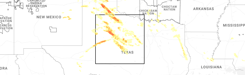
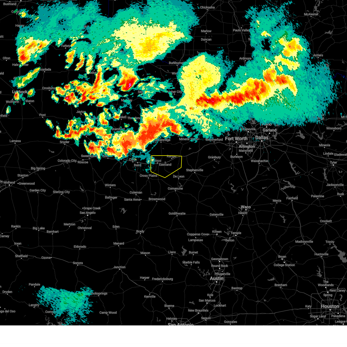
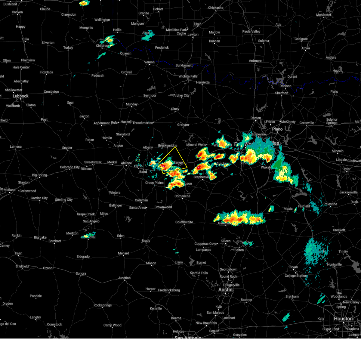
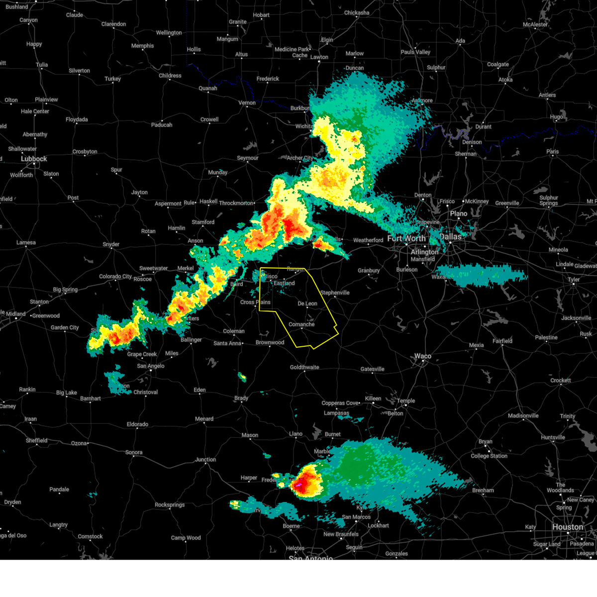
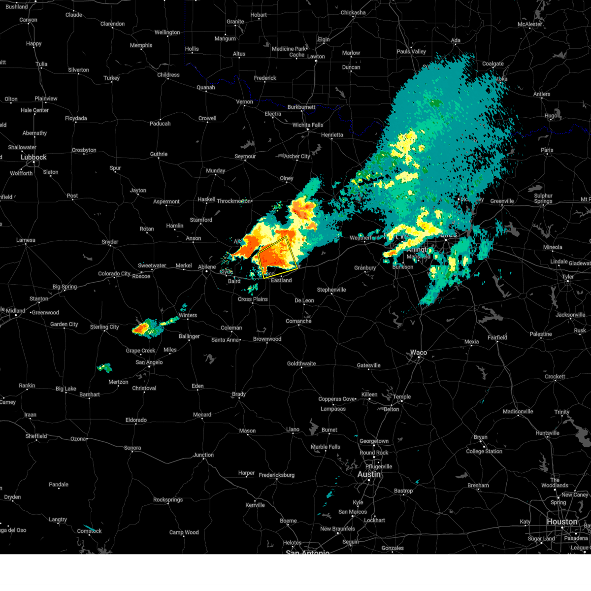
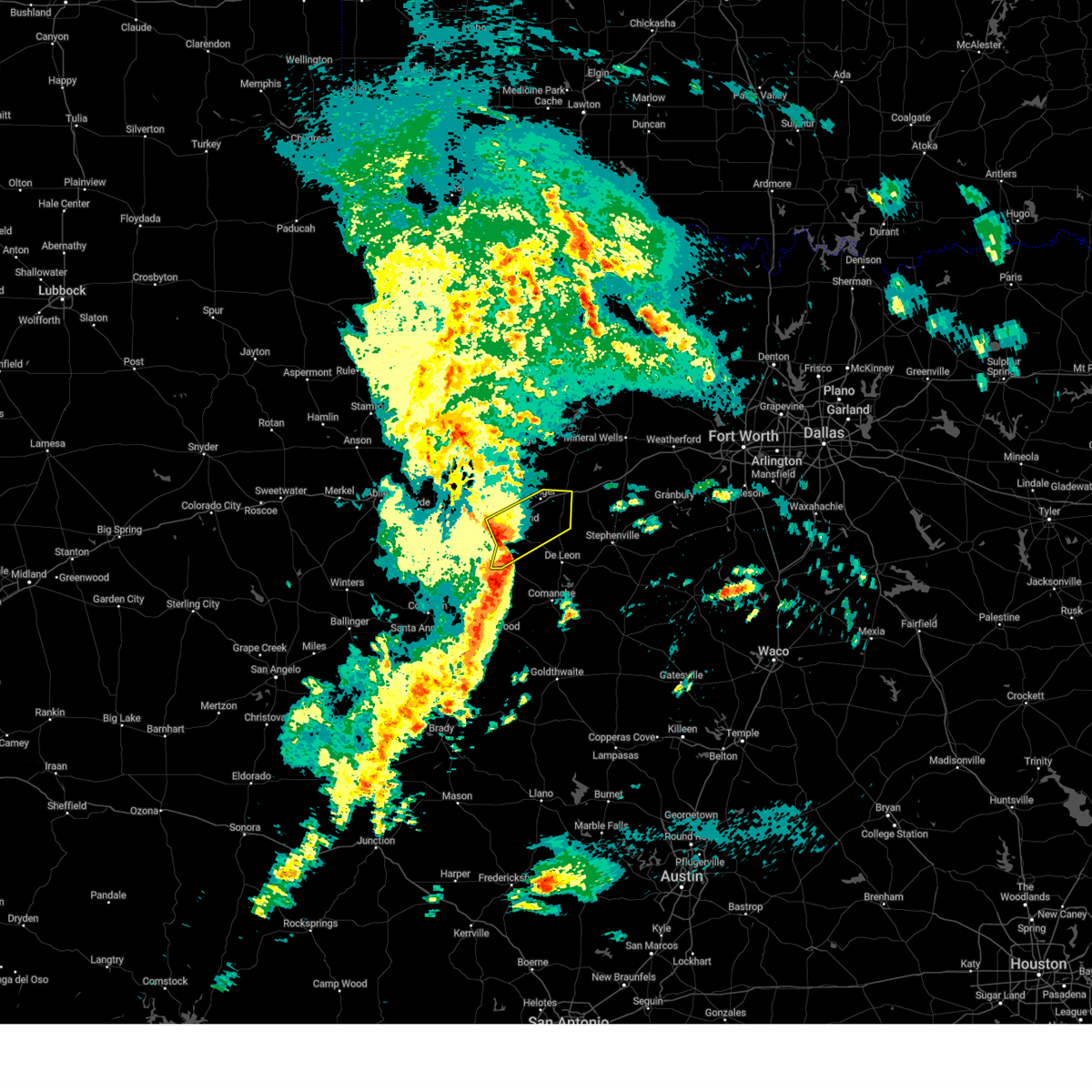
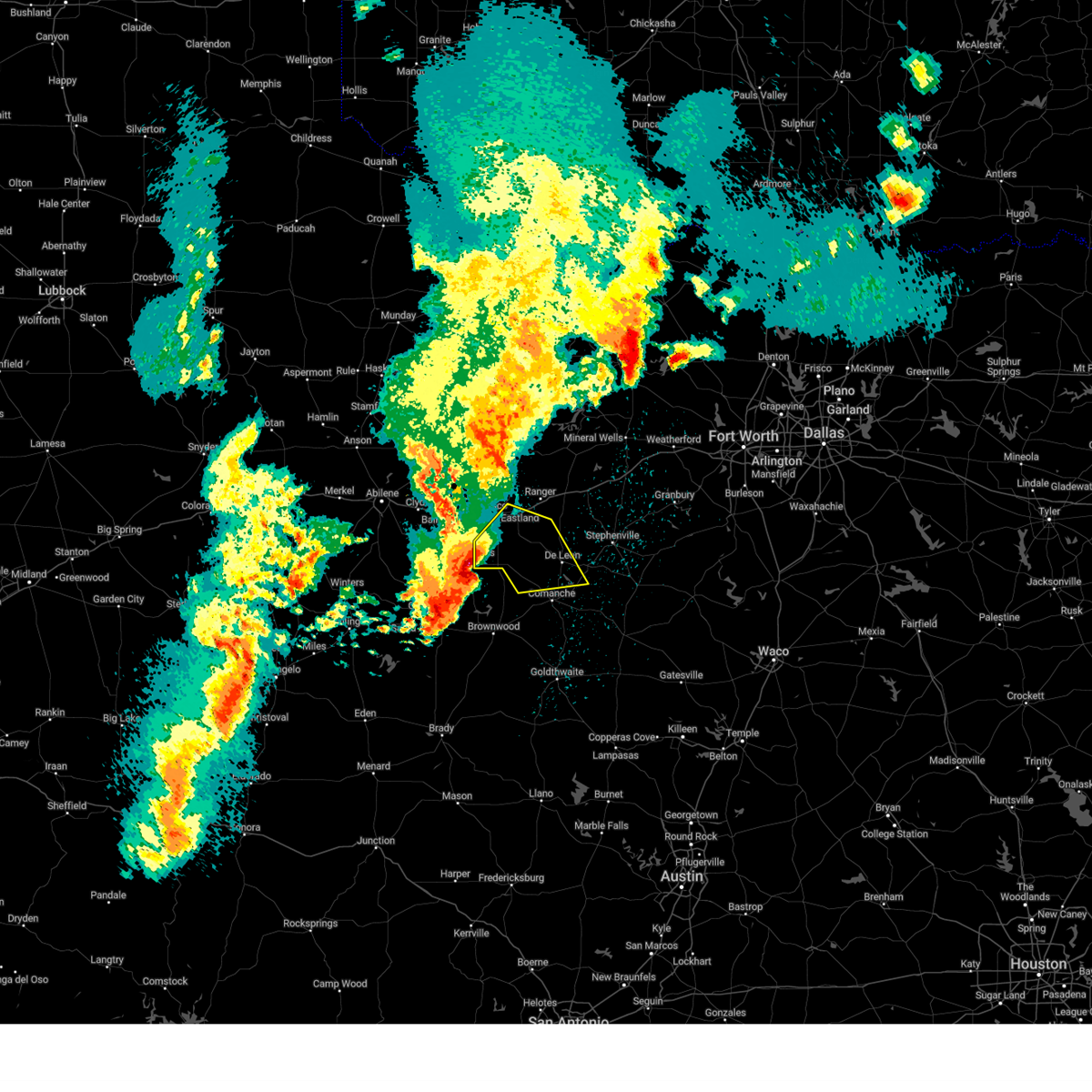
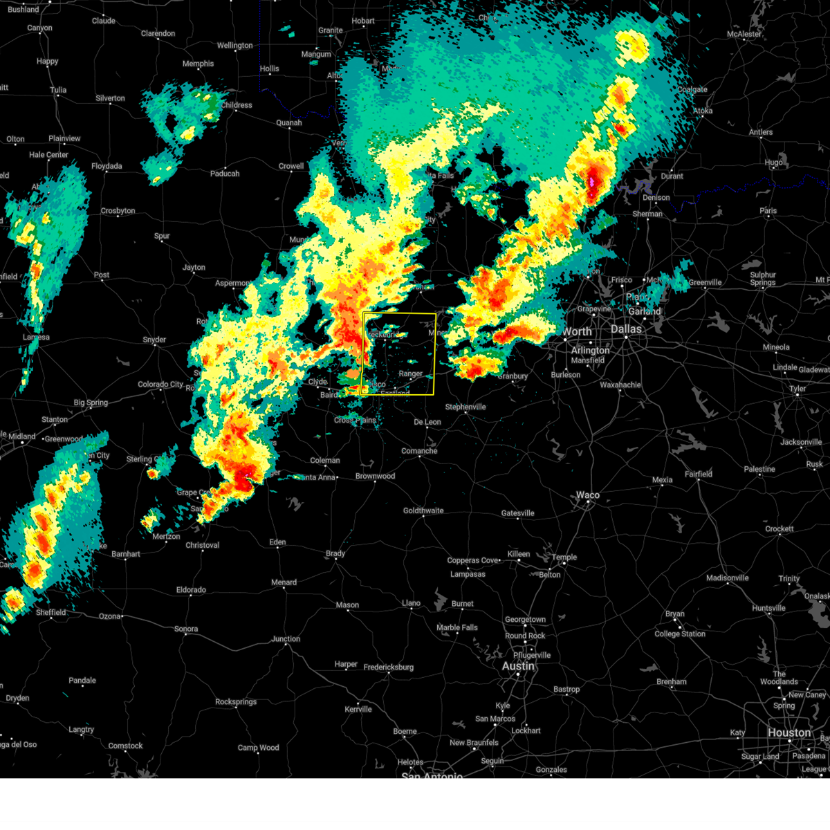
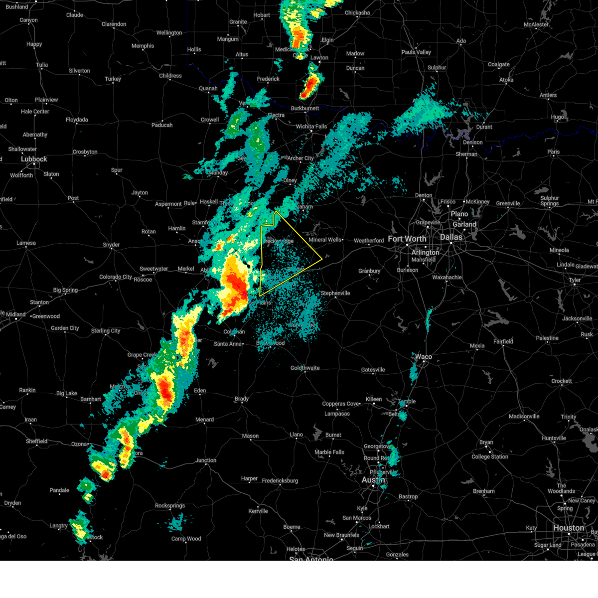
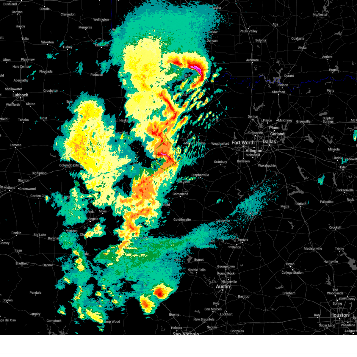
Hail Map for Cisco, TX
The Cisco, TX area has had 18 reports of on-the-ground hail by trained spotters, and has been under severe weather warnings 34 times during the past 12 months. Doppler radar has detected hail at or near Cisco, TX on 102 occasions, including 11 occasions during the past year.
| Name: | Cisco, TX |
| Where Located: | 44.6 miles E of Abilene, TX |
| Map: | Google Map for Cisco, TX |
| Population: | 3899 |
| Housing Units: | 1838 |
| More Info: | Search Google for Cisco, TX |
1
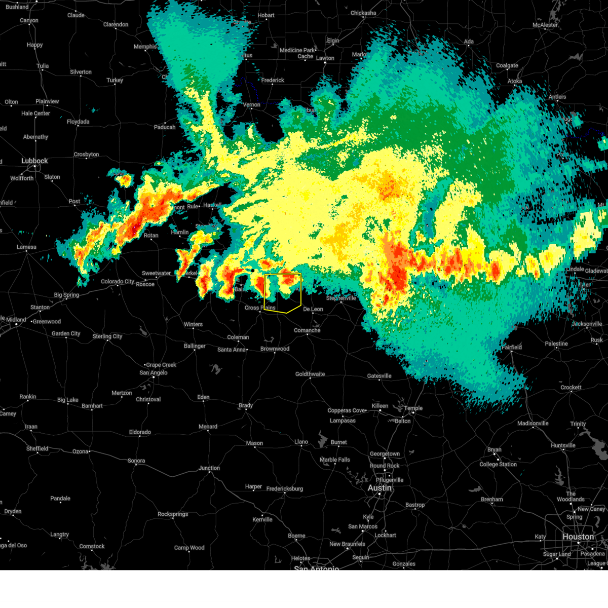
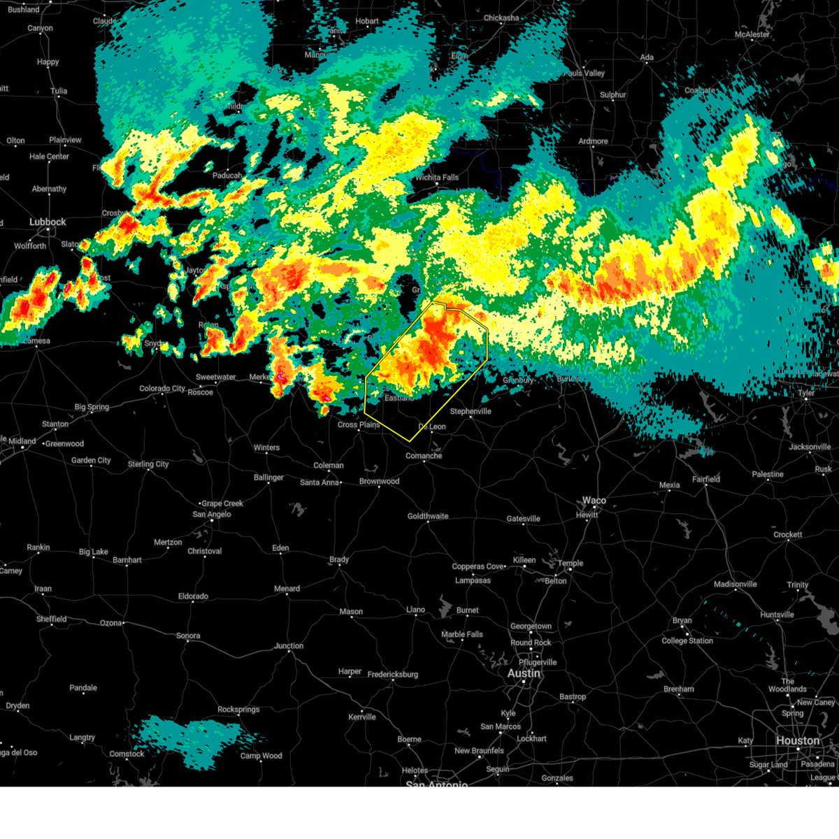
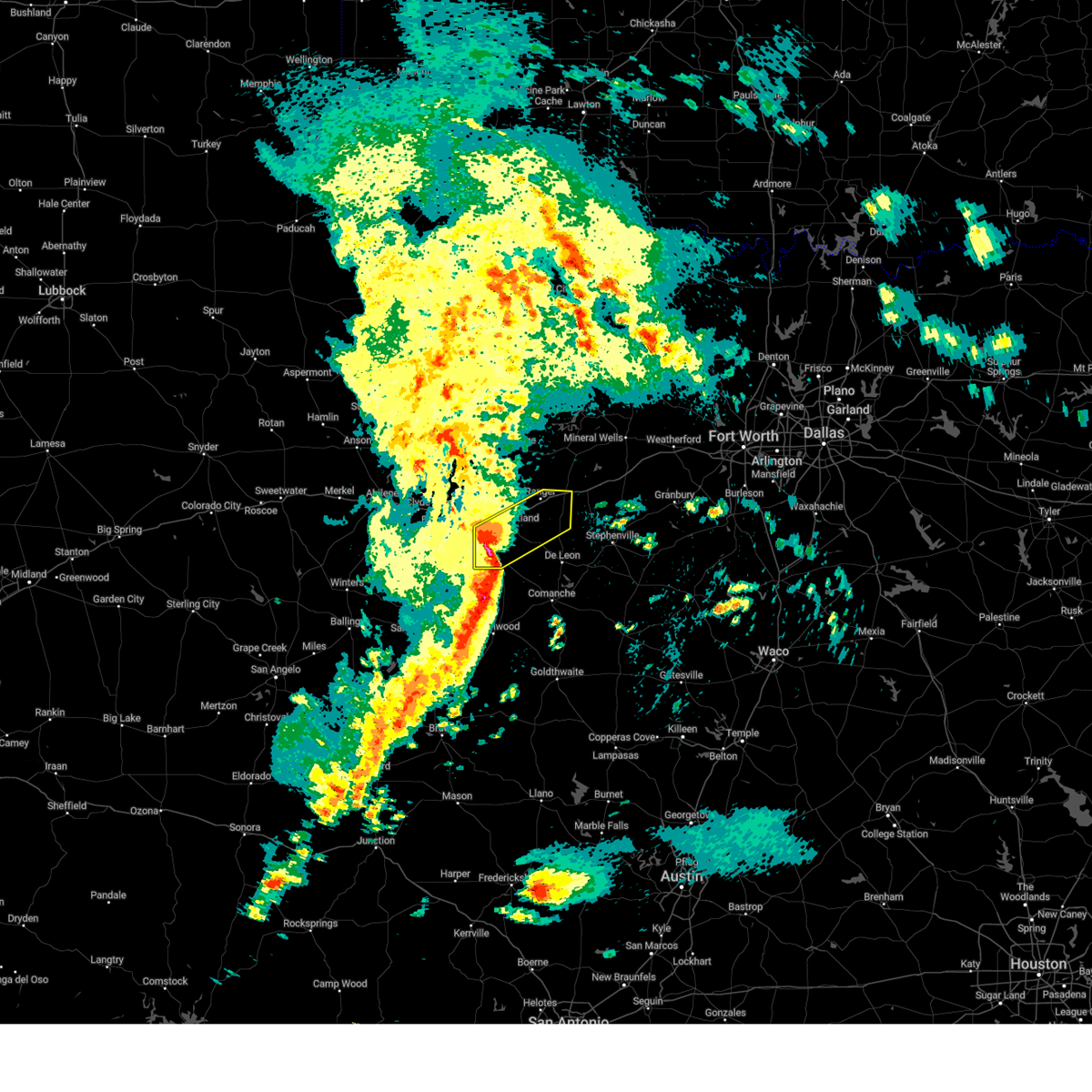
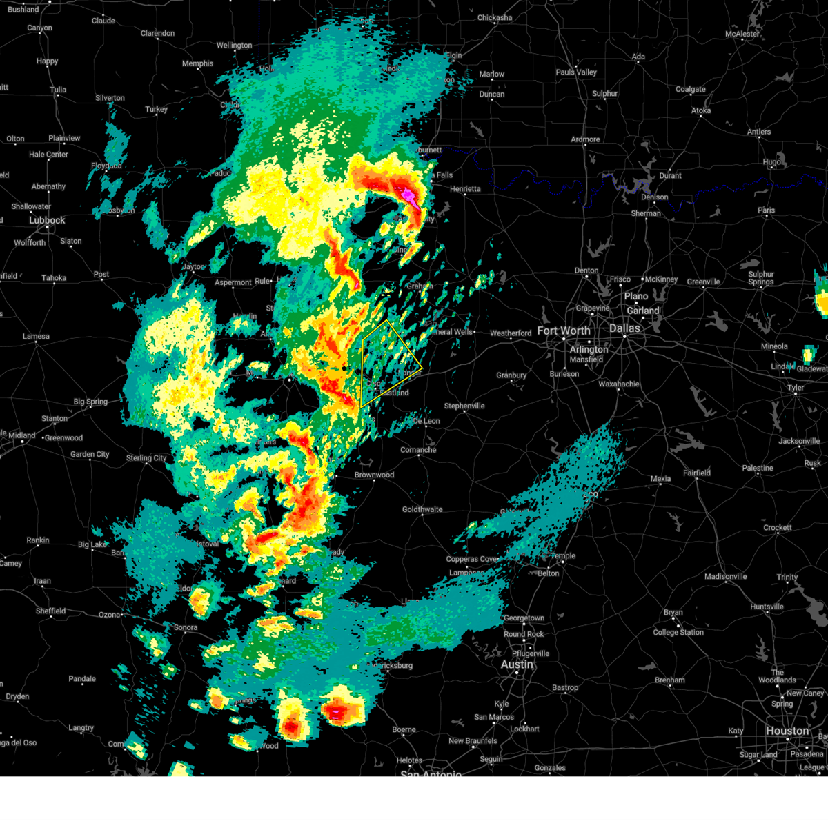
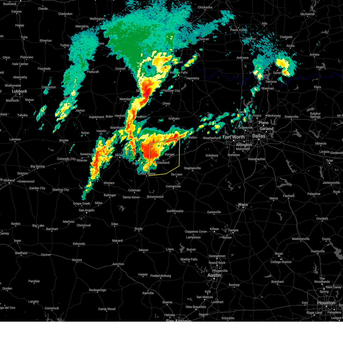
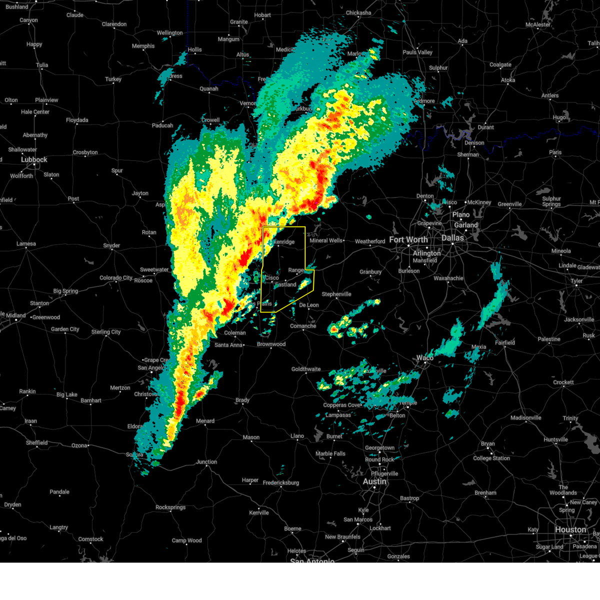
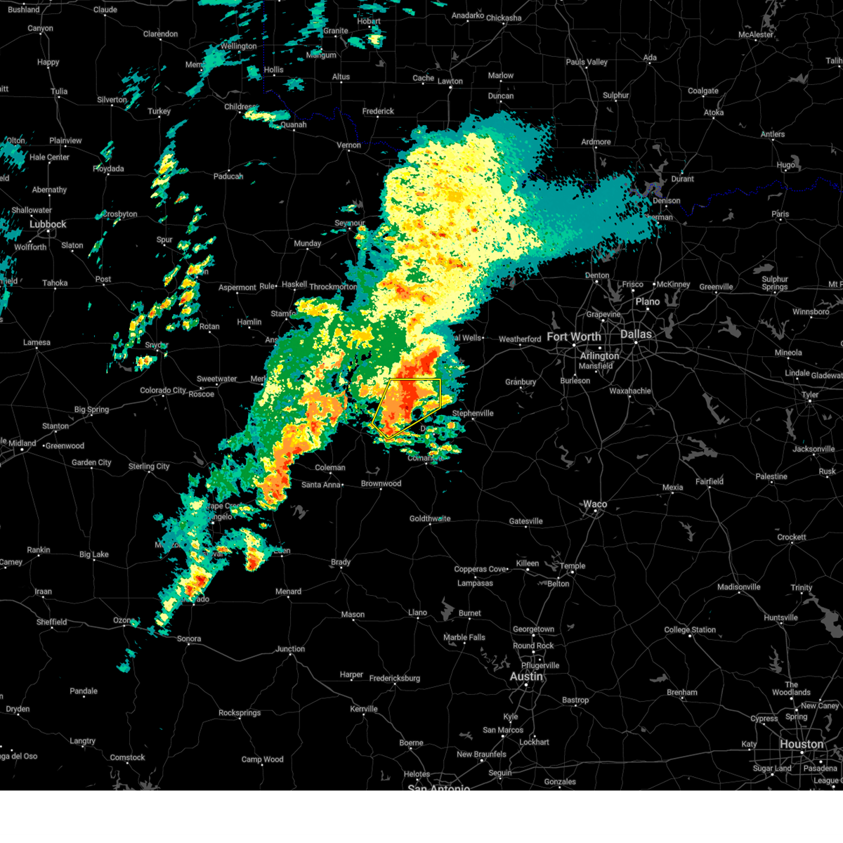
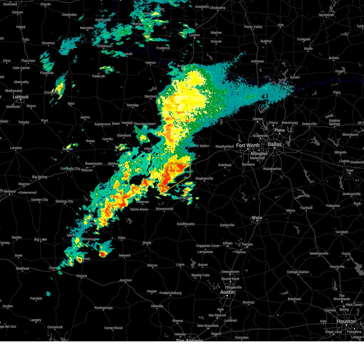
The Top Recent Hail Date for Cisco, TX is Sunday, June 8, 2025 (23rd out of 102)
Hail and Wind Damage Spotted near Cisco, TX
| Date / Time | Report Details |
|---|---|
| 6/9/2025 12:13 AM CDT | Svrfwd the national weather service in fort worth has issued a * severe thunderstorm warning for, western eastland county in north central texas, * until 100 am cdt. * at 1213 am cdt, a severe thunderstorm was located near atwell, or 11 miles southwest of cisco, moving east at 40 mph (radar indicated). Hazards include 70 mph wind gusts and half dollar size hail. Hail damage to vehicles is expected. expect considerable tree damage. Wind damage is also likely to mobile homes, roofs, and outbuildings. |
| 6/9/2025 12:01 AM CDT |
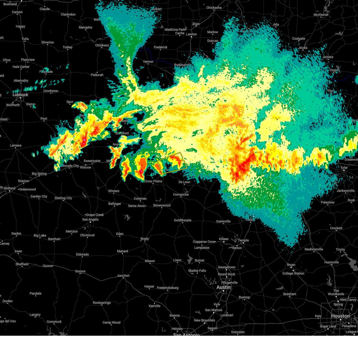 Svrfwd the national weather service in fort worth has issued a * severe thunderstorm warning for, northern eastland county in north central texas, southeastern stephens county in north central texas, * until 1245 am cdt. * at 1200 am cdt, a severe thunderstorm was located near cisco, moving east at 30 mph (radar indicated). Hazards include 60 mph wind gusts and half dollar size hail. Hail damage to vehicles is expected. Expect wind damage to roofs, siding, and trees. Svrfwd the national weather service in fort worth has issued a * severe thunderstorm warning for, northern eastland county in north central texas, southeastern stephens county in north central texas, * until 1245 am cdt. * at 1200 am cdt, a severe thunderstorm was located near cisco, moving east at 30 mph (radar indicated). Hazards include 60 mph wind gusts and half dollar size hail. Hail damage to vehicles is expected. Expect wind damage to roofs, siding, and trees.
|
| 6/8/2025 11:43 PM CDT |
 The storm which prompted the warning has weakened below severe limits. therefore the warning will be allowed to expire. however small hail and heavy rain are still possible with this thunderstorm. a severe thunderstorm watch remains in effect until 400 am cdt for central and north central texas. The storm which prompted the warning has weakened below severe limits. therefore the warning will be allowed to expire. however small hail and heavy rain are still possible with this thunderstorm. a severe thunderstorm watch remains in effect until 400 am cdt for central and north central texas.
|
| 6/8/2025 10:44 PM CDT | Svrfwd the national weather service in fort worth has issued a * severe thunderstorm warning for, eastland county in north central texas, * until 1145 pm cdt. * at 1044 pm cdt, a severe thunderstorm was located near putnam, or 10 miles southeast of baird, moving east at 35 mph (radar indicated). Hazards include ping pong ball size hail and 60 mph wind gusts. People and animals outdoors will be injured. expect hail damage to roofs, siding, windows, and vehicles. Expect wind damage to roofs, siding, and trees. |
| 6/8/2025 10:20 PM CDT |
 At 1019 pm cdt, severe thunderstorms were located along a line extending from near graford to near cisco, moving east at 45 mph (radar indicated). Hazards include 65 mph wind gusts and quarter size hail. Hail damage to vehicles is expected. expect wind damage to roofs, siding, and trees. these severe storms will be near, lake leon, eastland, ranger, graford, palo pinto, palo pinto mountains state park, and lake olden around 1025 pm cdt. mineral wells around 1030 pm cdt. lake palo pinto and gordon around 1035 pm cdt. Other locations impacted by these severe thunderstorms include nimrod, kokomo, santo, staff, carbon, okra, harpersville, duster, morton valley, and mingus. At 1019 pm cdt, severe thunderstorms were located along a line extending from near graford to near cisco, moving east at 45 mph (radar indicated). Hazards include 65 mph wind gusts and quarter size hail. Hail damage to vehicles is expected. expect wind damage to roofs, siding, and trees. these severe storms will be near, lake leon, eastland, ranger, graford, palo pinto, palo pinto mountains state park, and lake olden around 1025 pm cdt. mineral wells around 1030 pm cdt. lake palo pinto and gordon around 1035 pm cdt. Other locations impacted by these severe thunderstorms include nimrod, kokomo, santo, staff, carbon, okra, harpersville, duster, morton valley, and mingus.
|
| 6/8/2025 9:58 PM CDT | Svrfwd the national weather service in fort worth has issued a * severe thunderstorm warning for, southern young county in north central texas, northwestern erath county in north central texas, eastland county in north central texas, stephens county in north central texas, palo pinto county in north central texas, northwestern comanche county in central texas, * until 1100 pm cdt. * at 957 pm cdt, severe thunderstorms were located along a line extending from 7 miles north of possum kingdom lake to near lake cisco, moving southeast at 40 mph (radar indicated). Hazards include 65 mph wind gusts and half dollar size hail. Hail damage to vehicles is expected. expect wind damage to roofs, siding, and trees. severe thunderstorms will be near, lake cisco, necessity, possum kingdom state park, cisco, gunsight, caddo, and possum kingdom lake around 1005 pm cdt. eastland, ranger, graford, and palo pinto mountains state park around 1015 pm cdt. lake leon, palo pinto, and lake olden around 1020 pm cdt. mineral wells around 1025 pm cdt. lake palo pinto around 1030 pm cdt. gordon around 1035 pm cdt. gorman around 1040 pm cdt. other locations impacted by these severe thunderstorms include nimrod, kokomo, santo, staff, okra, harpersville, duster, morton valley, new salem, and thurber. This includes interstate 20 between mile markers 324 and 389. |
| 6/8/2025 9:32 PM CDT |
 Svrfwd the national weather service in fort worth has issued a * severe thunderstorm warning for, eastland county in north central texas, * until 1015 pm cdt. * at 931 pm cdt, a severe thunderstorm was located near moran, or 14 miles southeast of albany, moving southeast at 45 mph (radar indicated). Hazards include 60 mph wind gusts and quarter size hail. Hail damage to vehicles is expected. expect wind damage to roofs, siding, and trees. this severe thunderstorm will be near, lake cisco around 940 pm cdt. cisco around 945 pm cdt. other locations impacted by this severe thunderstorm include morton valley, nimrod, pleasant hill, kokomo, staff, scranton, olden, carbon, and desdemona. This includes interstate 20 between mile markers 324 and 363. Svrfwd the national weather service in fort worth has issued a * severe thunderstorm warning for, eastland county in north central texas, * until 1015 pm cdt. * at 931 pm cdt, a severe thunderstorm was located near moran, or 14 miles southeast of albany, moving southeast at 45 mph (radar indicated). Hazards include 60 mph wind gusts and quarter size hail. Hail damage to vehicles is expected. expect wind damage to roofs, siding, and trees. this severe thunderstorm will be near, lake cisco around 940 pm cdt. cisco around 945 pm cdt. other locations impacted by this severe thunderstorm include morton valley, nimrod, pleasant hill, kokomo, staff, scranton, olden, carbon, and desdemona. This includes interstate 20 between mile markers 324 and 363.
|
| 5/26/2025 1:14 PM CDT | Half Dollar sized hail reported 3.8 miles S of Cisco, TX, report from mping. |
| 5/26/2025 1:10 PM CDT | Quarter sized hail reported 3.8 miles S of Cisco, TX, report from mping. |
| 5/26/2025 1:09 PM CDT |
 Svrfwd the national weather service in fort worth has issued a * severe thunderstorm warning for, northern eastland county in north central texas, southeastern stephens county in north central texas, * until 215 pm cdt. * at 109 pm cdt, a severe thunderstorm was located over lake cisco, or near cisco, moving northeast at 20 mph (radar indicated). Hazards include 60 mph wind gusts and half dollar size hail. Hail damage to vehicles is expected. expect wind damage to roofs, siding, and trees. this severe thunderstorm will be near, ranger around 150 pm cdt. palo pinto mountains state park around 200 pm cdt. other locations impacted by this severe thunderstorm include morton valley, olden, harpersville, and staff. This includes interstate 20 between mile markers 329 and 358. Svrfwd the national weather service in fort worth has issued a * severe thunderstorm warning for, northern eastland county in north central texas, southeastern stephens county in north central texas, * until 215 pm cdt. * at 109 pm cdt, a severe thunderstorm was located over lake cisco, or near cisco, moving northeast at 20 mph (radar indicated). Hazards include 60 mph wind gusts and half dollar size hail. Hail damage to vehicles is expected. expect wind damage to roofs, siding, and trees. this severe thunderstorm will be near, ranger around 150 pm cdt. palo pinto mountains state park around 200 pm cdt. other locations impacted by this severe thunderstorm include morton valley, olden, harpersville, and staff. This includes interstate 20 between mile markers 329 and 358.
|
| 5/22/2025 9:49 PM CDT |
 At 947 pm cdt, a severe thunderstorm was located from eastland to rising star, moving southeast at 35 mph. a 75 mph wind gust was reported at ketn (radar indicated). Hazards include 70 mph wind gusts and quarter size hail. Hail damage to vehicles is expected. expect considerable tree damage. wind damage is also likely to mobile homes, roofs, and outbuildings. this severe storm will be near, de leon around 1000 pm cdt. proctor lake around 1005 pm cdt. gustine around 1030 pm cdt. Other locations impacted by this severe thunderstorm include nimrod, kokomo, staff, okra, duster, edna hill, morton valley, comyn, energy, and sipe springs. At 947 pm cdt, a severe thunderstorm was located from eastland to rising star, moving southeast at 35 mph. a 75 mph wind gust was reported at ketn (radar indicated). Hazards include 70 mph wind gusts and quarter size hail. Hail damage to vehicles is expected. expect considerable tree damage. wind damage is also likely to mobile homes, roofs, and outbuildings. this severe storm will be near, de leon around 1000 pm cdt. proctor lake around 1005 pm cdt. gustine around 1030 pm cdt. Other locations impacted by this severe thunderstorm include nimrod, kokomo, staff, okra, duster, edna hill, morton valley, comyn, energy, and sipe springs.
|
| 5/22/2025 9:38 PM CDT |
 Svrfwd the national weather service in fort worth has issued a * severe thunderstorm warning for, southwestern erath county in north central texas, eastland county in north central texas, comanche county in central texas, * until 1030 pm cdt. * at 937 pm cdt, a line of severe thunderstorms was located from ranger to rising star, moving southeast at 40 mph (radar indicated). Hazards include 65 mph wind gusts and quarter size hail. Hail damage to vehicles is expected. expect wind damage to roofs, siding, and trees. this severe thunderstorm will be near, gorman around 940 pm cdt. de leon around 945 pm cdt. proctor lake around 955 pm cdt. gustine around 1015 pm cdt. other locations impacted by this severe thunderstorm include nimrod, kokomo, staff, lingleville, okra, duster, edna hill, morton valley, comyn, and energy. This includes interstate 20 between mile markers 324 and 358. Svrfwd the national weather service in fort worth has issued a * severe thunderstorm warning for, southwestern erath county in north central texas, eastland county in north central texas, comanche county in central texas, * until 1030 pm cdt. * at 937 pm cdt, a line of severe thunderstorms was located from ranger to rising star, moving southeast at 40 mph (radar indicated). Hazards include 65 mph wind gusts and quarter size hail. Hail damage to vehicles is expected. expect wind damage to roofs, siding, and trees. this severe thunderstorm will be near, gorman around 940 pm cdt. de leon around 945 pm cdt. proctor lake around 955 pm cdt. gustine around 1015 pm cdt. other locations impacted by this severe thunderstorm include nimrod, kokomo, staff, lingleville, okra, duster, edna hill, morton valley, comyn, and energy. This includes interstate 20 between mile markers 324 and 358.
|
| 5/22/2025 8:53 PM CDT |
 Svrfwd the national weather service in fort worth has issued a * severe thunderstorm warning for, eastland county in north central texas, stephens county in north central texas, * until 945 pm cdt. * at 852 pm cdt, severe thunderstorms were located along a line extending from caddo to near moran, moving south at 30 mph (radar indicated). Hazards include 60 mph wind gusts and quarter size hail. Hail damage to vehicles is expected. expect wind damage to roofs, siding, and trees. severe thunderstorms will be near, necessity, gunsight, and lake daniel around 855 pm cdt. lake cisco around 900 pm cdt. cisco around 905 pm cdt. ranger and palo pinto mountains state park around 910 pm cdt. eastland around 915 pm cdt. lake olden around 920 pm cdt. lake leon around 925 pm cdt. other locations impacted by these severe thunderstorms include nimrod, kokomo, staff, carbon, okra, harpersville, morton valley, pleasant hill, pioneer, and ivan. This includes interstate 20 between mile markers 324 and 362. Svrfwd the national weather service in fort worth has issued a * severe thunderstorm warning for, eastland county in north central texas, stephens county in north central texas, * until 945 pm cdt. * at 852 pm cdt, severe thunderstorms were located along a line extending from caddo to near moran, moving south at 30 mph (radar indicated). Hazards include 60 mph wind gusts and quarter size hail. Hail damage to vehicles is expected. expect wind damage to roofs, siding, and trees. severe thunderstorms will be near, necessity, gunsight, and lake daniel around 855 pm cdt. lake cisco around 900 pm cdt. cisco around 905 pm cdt. ranger and palo pinto mountains state park around 910 pm cdt. eastland around 915 pm cdt. lake olden around 920 pm cdt. lake leon around 925 pm cdt. other locations impacted by these severe thunderstorms include nimrod, kokomo, staff, carbon, okra, harpersville, morton valley, pleasant hill, pioneer, and ivan. This includes interstate 20 between mile markers 324 and 362.
|
| 5/18/2025 6:52 PM CDT | Quarter sized hail reported 15.1 miles SSW of Cisco, TX, quarter sized hail in harpersville. |
| 5/18/2025 6:35 PM CDT |
 At 635 pm cdt, a severe thunderstorm was located near gunsight, or 12 miles north of cisco, moving east at 25 mph (radar indicated). Hazards include two inch hail and 60 mph wind gusts. People and animals outdoors will be injured. expect hail damage to roofs, siding, windows, and vehicles. expect wind damage to roofs, siding, and trees. Locations impacted include, morton valley, ranger, lake cisco, lake daniel, necessity, eolian, gunsight, harpersville, and cisco. At 635 pm cdt, a severe thunderstorm was located near gunsight, or 12 miles north of cisco, moving east at 25 mph (radar indicated). Hazards include two inch hail and 60 mph wind gusts. People and animals outdoors will be injured. expect hail damage to roofs, siding, windows, and vehicles. expect wind damage to roofs, siding, and trees. Locations impacted include, morton valley, ranger, lake cisco, lake daniel, necessity, eolian, gunsight, harpersville, and cisco.
|
| 5/18/2025 6:08 PM CDT | Svrfwd the national weather service in fort worth has issued a * severe thunderstorm warning for, northwestern eastland county in north central texas, southern stephens county in north central texas, * until 730 pm cdt. * at 607 pm cdt, a severe thunderstorm was located near moran, or 10 miles northwest of cisco, moving northeast at 15 mph (radar indicated). Hazards include ping pong ball size hail and 60 mph wind gusts. People and animals outdoors will be injured. expect hail damage to roofs, siding, windows, and vehicles. Expect wind damage to roofs, siding, and trees. |
| 5/6/2025 7:39 AM CDT |
 At 739 am cdt, a severe thunderstorm was located near gorman, or 10 miles south of eastland, moving northeast at 45 mph (radar indicated). Hazards include 60 mph wind gusts and quarter size hail. Hail damage to vehicles is expected. expect wind damage to roofs, siding, and trees. this severe storm will be near, lake leon around 745 am cdt. Other locations impacted by this severe thunderstorm include pleasant hill, kokomo, staff, olden, carbon, okra, and desdemona. At 739 am cdt, a severe thunderstorm was located near gorman, or 10 miles south of eastland, moving northeast at 45 mph (radar indicated). Hazards include 60 mph wind gusts and quarter size hail. Hail damage to vehicles is expected. expect wind damage to roofs, siding, and trees. this severe storm will be near, lake leon around 745 am cdt. Other locations impacted by this severe thunderstorm include pleasant hill, kokomo, staff, olden, carbon, okra, and desdemona.
|
| 5/6/2025 7:22 AM CDT |
 At 722 am cdt, a severe thunderstorm was located near rising star, or 15 miles south of cisco, moving northeast at 40 mph (radar indicated). Hazards include 60 mph wind gusts and half dollar size hail. Hail damage to vehicles is expected. expect wind damage to roofs, siding, and trees. this severe storm will be near, lake leon around 750 am cdt. Other locations impacted by this severe thunderstorm include nimrod, pleasant hill, kokomo, pioneer, staff, scranton, olden, sabanno, carbon, and okra. At 722 am cdt, a severe thunderstorm was located near rising star, or 15 miles south of cisco, moving northeast at 40 mph (radar indicated). Hazards include 60 mph wind gusts and half dollar size hail. Hail damage to vehicles is expected. expect wind damage to roofs, siding, and trees. this severe storm will be near, lake leon around 750 am cdt. Other locations impacted by this severe thunderstorm include nimrod, pleasant hill, kokomo, pioneer, staff, scranton, olden, sabanno, carbon, and okra.
|
| 5/6/2025 7:05 AM CDT |
 Svrfwd the national weather service in fort worth has issued a * severe thunderstorm warning for, eastland county in north central texas, * until 800 am cdt. * at 705 am cdt, a severe thunderstorm was located near cross plains, or 17 miles south of cisco, moving northeast at 45 mph (radar indicated). Hazards include half dollar size hail. Damage to vehicles is possible. this severe thunderstorm will be near, lake leon around 735 am cdt. other locations impacted by this severe thunderstorm include nimrod, pleasant hill, kokomo, pioneer, staff, scranton, olden, sabanno, carbon, and okra. This includes interstate 20 between mile markers 332 and 363. Svrfwd the national weather service in fort worth has issued a * severe thunderstorm warning for, eastland county in north central texas, * until 800 am cdt. * at 705 am cdt, a severe thunderstorm was located near cross plains, or 17 miles south of cisco, moving northeast at 45 mph (radar indicated). Hazards include half dollar size hail. Damage to vehicles is possible. this severe thunderstorm will be near, lake leon around 735 am cdt. other locations impacted by this severe thunderstorm include nimrod, pleasant hill, kokomo, pioneer, staff, scranton, olden, sabanno, carbon, and okra. This includes interstate 20 between mile markers 332 and 363.
|
| 4/20/2025 2:00 AM CDT | At 200 am cdt, severe thunderstorms were located along a line extending from near gunsight to lake olden to near gorman to 11 miles northwest of comanche, moving northeast at 60 mph (radar indicated). Hazards include 60 mph wind gusts and quarter size hail. Hail damage to vehicles is expected. expect wind damage to roofs, siding, and trees. these severe storms will be near, lake leon, ranger, de leon, and gorman around 205 am cdt. Other locations impacted by these severe thunderstorms include kokomo, staff, sidney, carbon, okra, duster, morton valley, downing, comyn, and pleasant hill. |
| 4/20/2025 1:29 AM CDT | Svrfwd the national weather service in fort worth has issued a * severe thunderstorm warning for, eastland county in north central texas, northwestern comanche county in central texas, * until 215 am cdt. * at 129 am cdt, severe thunderstorms were located along a line extending from near rowden to near cross plains to near cross cut to lake brownwood near thrifty, moving northeast at 60 mph (radar indicated). Hazards include 60 mph wind gusts and quarter size hail. Hail damage to vehicles is expected. expect wind damage to roofs, siding, and trees. severe thunderstorms will be near, rising star around 135 am cdt. cisco around 145 am cdt. lake cisco and eastland around 150 am cdt. lake leon, gorman, and lake olden around 155 am cdt. ranger around 200 am cdt. de leon around 205 am cdt. other locations impacted by these severe thunderstorms include nimrod, kokomo, staff, sidney, carbon, okra, duster, morton valley, downing, and comyn. This includes interstate 20 between mile markers 324 and 363. |
| 4/20/2025 12:21 AM CDT |
 At 1221 am cdt, a severe thunderstorm was located 9 miles northeast of rising star, or 13 miles south of eastland, moving northeast at 35 mph (radar indicated). Hazards include ping pong ball size hail and 60 mph wind gusts. People and animals outdoors will be injured. expect hail damage to roofs, siding, windows, and vehicles. expect wind damage to roofs, siding, and trees. this severe storm will be near, lake leon around 1235 am cdt. Other locations impacted by this severe thunderstorm include nimrod, kokomo, proctor, staff, carbon, okra, duster, downing, comyn, and pleasant hill. At 1221 am cdt, a severe thunderstorm was located 9 miles northeast of rising star, or 13 miles south of eastland, moving northeast at 35 mph (radar indicated). Hazards include ping pong ball size hail and 60 mph wind gusts. People and animals outdoors will be injured. expect hail damage to roofs, siding, windows, and vehicles. expect wind damage to roofs, siding, and trees. this severe storm will be near, lake leon around 1235 am cdt. Other locations impacted by this severe thunderstorm include nimrod, kokomo, proctor, staff, carbon, okra, duster, downing, comyn, and pleasant hill.
|
| 4/19/2025 11:48 PM CDT |
 Svrfwd the national weather service in fort worth has issued a * severe thunderstorm warning for, central eastland county in north central texas, northwestern comanche county in central texas, * until 1245 am cdt. * at 1148 pm cdt, a severe thunderstorm was located over cross cut, or 22 miles northeast of coleman, moving northeast at 35 mph (radar indicated). Hazards include two inch hail and 60 mph wind gusts. People and animals outdoors will be injured. expect hail damage to roofs, siding, windows, and vehicles. expect wind damage to roofs, siding, and trees. this severe thunderstorm will be near, rising star around 1200 am cdt. lake leon around 1235 am cdt. other locations impacted by this severe thunderstorm include nimrod, kokomo, proctor, staff, carbon, okra, duster, downing, comyn, and pleasant hill. This includes interstate 20 between mile markers 332 and 343. Svrfwd the national weather service in fort worth has issued a * severe thunderstorm warning for, central eastland county in north central texas, northwestern comanche county in central texas, * until 1245 am cdt. * at 1148 pm cdt, a severe thunderstorm was located over cross cut, or 22 miles northeast of coleman, moving northeast at 35 mph (radar indicated). Hazards include two inch hail and 60 mph wind gusts. People and animals outdoors will be injured. expect hail damage to roofs, siding, windows, and vehicles. expect wind damage to roofs, siding, and trees. this severe thunderstorm will be near, rising star around 1200 am cdt. lake leon around 1235 am cdt. other locations impacted by this severe thunderstorm include nimrod, kokomo, proctor, staff, carbon, okra, duster, downing, comyn, and pleasant hill. This includes interstate 20 between mile markers 332 and 343.
|
| 4/19/2025 10:40 PM CDT | the severe thunderstorm warning has been cancelled and is no longer in effect |
| 4/19/2025 10:15 PM CDT |
 Svrfwd the national weather service in fort worth has issued a * severe thunderstorm warning for, northern eastland county in north central texas, stephens county in north central texas, western palo pinto county in north central texas, * until 1115 pm cdt. * at 1014 pm cdt, a severe thunderstorm was located 7 miles southwest of breckenridge, moving east at 30 mph (radar indicated). Hazards include 60 mph wind gusts and quarter size hail. Hail damage to vehicles is expected. expect wind damage to roofs, siding, and trees. this severe thunderstorm will be near, lake daniel around 1020 pm cdt. breckenridge around 1025 pm cdt. caddo around 1040 pm cdt. other locations impacted by this severe thunderstorm include morton valley, staff, ivan, eolian, olden, strawn, harpersville, and eliasville. This includes interstate 20 between mile markers 324 and 363. Svrfwd the national weather service in fort worth has issued a * severe thunderstorm warning for, northern eastland county in north central texas, stephens county in north central texas, western palo pinto county in north central texas, * until 1115 pm cdt. * at 1014 pm cdt, a severe thunderstorm was located 7 miles southwest of breckenridge, moving east at 30 mph (radar indicated). Hazards include 60 mph wind gusts and quarter size hail. Hail damage to vehicles is expected. expect wind damage to roofs, siding, and trees. this severe thunderstorm will be near, lake daniel around 1020 pm cdt. breckenridge around 1025 pm cdt. caddo around 1040 pm cdt. other locations impacted by this severe thunderstorm include morton valley, staff, ivan, eolian, olden, strawn, harpersville, and eliasville. This includes interstate 20 between mile markers 324 and 363.
|
| 4/19/2025 2:35 AM CDT | Awos station kgzn in cisco measured a wind gust of 60 mp in eastland county TX, 2.4 miles ENE of Cisco, TX |
| 4/19/2025 2:18 AM CDT |
 Svrfwd the national weather service in fort worth has issued a * severe thunderstorm warning for, southwestern young county in north central texas, northwestern eastland county in north central texas, stephens county in north central texas, southwestern palo pinto county in north central texas, * until 315 am cdt. * at 217 am cdt, a severe thunderstorm was located near putnam, or 8 miles east of baird, moving northeast at 60 mph (radar indicated). Hazards include 65 mph wind gusts and quarter size hail. Hail damage to vehicles is expected. expect wind damage to roofs, siding, and trees. this severe thunderstorm will be near, lake daniel around 240 am cdt. breckenridge around 245 am cdt. other locations impacted by this severe thunderstorm include morton valley, eliasville, nimrod, ivan, scranton, eolian, murray, olden, strawn, and harpersville. This includes interstate 20 between mile markers 324 and 340, and between mile markers 343 and 345. Svrfwd the national weather service in fort worth has issued a * severe thunderstorm warning for, southwestern young county in north central texas, northwestern eastland county in north central texas, stephens county in north central texas, southwestern palo pinto county in north central texas, * until 315 am cdt. * at 217 am cdt, a severe thunderstorm was located near putnam, or 8 miles east of baird, moving northeast at 60 mph (radar indicated). Hazards include 65 mph wind gusts and quarter size hail. Hail damage to vehicles is expected. expect wind damage to roofs, siding, and trees. this severe thunderstorm will be near, lake daniel around 240 am cdt. breckenridge around 245 am cdt. other locations impacted by this severe thunderstorm include morton valley, eliasville, nimrod, ivan, scranton, eolian, murray, olden, strawn, and harpersville. This includes interstate 20 between mile markers 324 and 340, and between mile markers 343 and 345.
|
| 4/5/2025 2:03 AM CDT |
 At 203 am cdt, a severe thunderstorm was located over gunsight, or 11 miles south of breckenridge, moving northeast at 60 mph (radar indicated). Hazards include 60 mph wind gusts and half dollar size hail. Hail damage to vehicles is expected. expect wind damage to roofs, siding, and trees. Locations impacted include, lake cisco, necessity, harpersville, breckenridge, morton valley, lake daniel, cisco, eolian, gunsight, eastland, palo pinto mountains state park, hubbard creek reservoir, and ranger. At 203 am cdt, a severe thunderstorm was located over gunsight, or 11 miles south of breckenridge, moving northeast at 60 mph (radar indicated). Hazards include 60 mph wind gusts and half dollar size hail. Hail damage to vehicles is expected. expect wind damage to roofs, siding, and trees. Locations impacted include, lake cisco, necessity, harpersville, breckenridge, morton valley, lake daniel, cisco, eolian, gunsight, eastland, palo pinto mountains state park, hubbard creek reservoir, and ranger.
|
| 4/5/2025 1:35 AM CDT |
 Svrfwd the national weather service in fort worth has issued a * severe thunderstorm warning for, northwestern eastland county in north central texas, southwestern stephens county in north central texas, * until 215 am cdt. * at 134 am cdt, a severe thunderstorm was located near baird, moving northeast at 55 mph (radar indicated). Hazards include 60 mph wind gusts and quarter size hail. Hail damage to vehicles is expected. Expect wind damage to roofs, siding, and trees. Svrfwd the national weather service in fort worth has issued a * severe thunderstorm warning for, northwestern eastland county in north central texas, southwestern stephens county in north central texas, * until 215 am cdt. * at 134 am cdt, a severe thunderstorm was located near baird, moving northeast at 55 mph (radar indicated). Hazards include 60 mph wind gusts and quarter size hail. Hail damage to vehicles is expected. Expect wind damage to roofs, siding, and trees.
|
| 4/3/2025 6:02 AM CDT | At 601 am cdt, a severe thunderstorm was located near eastland, moving east at 50 mph (radar indicated). Hazards include two inch hail and 70 mph wind gusts. People and animals outdoors will be injured. expect hail damage to roofs, siding, windows, and vehicles. expect considerable tree damage. wind damage is also likely to mobile homes, roofs, and outbuildings. this severe storm will be near, ranger and palo pinto mountains state park around 605 am cdt. Other locations impacted by this severe thunderstorm include morton valley, eolian, olden, strawn, harpersville, and staff. |
| 4/3/2025 6:01 AM CDT | Hen Egg sized hail reported 3.8 miles S of Cisco, TX, report from mping. hen egg 2.25 in. |
| 4/3/2025 5:52 AM CDT |
 At 552 am cdt, a severe thunderstorm was located over cisco, moving east at 50 mph (radar indicated). Hazards include two inch hail and 70 mph wind gusts. People and animals outdoors will be injured. expect hail damage to roofs, siding, windows, and vehicles. expect considerable tree damage. wind damage is also likely to mobile homes, roofs, and outbuildings. this severe storm will be near, eastland around 600 am cdt. ranger around 605 am cdt. palo pinto mountains state park around 610 am cdt. Other locations impacted by this severe thunderstorm include nimrod, kokomo, staff, carbon, harpersville, morton valley, pleasant hill, scranton, eolian, and olden. At 552 am cdt, a severe thunderstorm was located over cisco, moving east at 50 mph (radar indicated). Hazards include two inch hail and 70 mph wind gusts. People and animals outdoors will be injured. expect hail damage to roofs, siding, windows, and vehicles. expect considerable tree damage. wind damage is also likely to mobile homes, roofs, and outbuildings. this severe storm will be near, eastland around 600 am cdt. ranger around 605 am cdt. palo pinto mountains state park around 610 am cdt. Other locations impacted by this severe thunderstorm include nimrod, kokomo, staff, carbon, harpersville, morton valley, pleasant hill, scranton, eolian, and olden.
|
| 4/3/2025 5:49 AM CDT | Hen Egg sized hail reported 0.4 miles SSW of Cisco, TX, report from mping. hen egg 2.00 in. |
| 4/3/2025 5:45 AM CDT | 54 kt gust at cisco awos - kgz in eastland county TX, 2.6 miles SSE of Cisco, TX |
| 4/3/2025 5:33 AM CDT | Svrfwd the national weather service in fort worth has issued a * severe thunderstorm warning for, eastland county in north central texas, southern stephens county in north central texas, southwestern palo pinto county in north central texas, * until 630 am cdt. * at 532 am cdt, a severe thunderstorm was located near putnam, or 11 miles southeast of baird, moving northeast at 45 mph (radar indicated). Hazards include two inch hail and 65 mph wind gusts. People and animals outdoors will be injured. expect hail damage to roofs, siding, windows, and vehicles. expect wind damage to roofs, siding, and trees. this severe thunderstorm will be near, cisco around 545 am cdt. lake cisco around 550 am cdt. eastland around 600 am cdt. ranger around 610 am cdt. palo pinto mountains state park around 620 am cdt. other locations impacted by this severe thunderstorm include nimrod, kokomo, staff, carbon, harpersville, morton valley, pleasant hill, scranton, eolian, and olden. This includes interstate 20 between mile markers 324 and 363. |
| 3/4/2025 3:08 AM CST |
 Svrfwd the national weather service in fort worth has issued a * severe thunderstorm warning for, eastland county in north central texas, stephens county in north central texas, * until 400 am cst. * at 307 am cst, severe thunderstorms were located along a line extending from near woodson to near ibex to oplin, moving east at 45 mph (radar indicated). Hazards include 65 mph wind gusts. Expect damage to roofs, siding, and trees. severe thunderstorms will be near, breckenridge and hubbard creek reservoir around 315 am cst. lake cisco and crystal falls around 320 am cst. cisco and lake daniel around 325 am cst. necessity and gunsight around 330 am cst. eastland, caddo, and possum kingdom lake around 340 am cst. lake leon, ranger, palo pinto mountains state park, and lake olden around 345 am cst. other locations impacted by these severe thunderstorms include nimrod, kokomo, staff, carbon, okra, harpersville, morton valley, pleasant hill, pioneer, and ivan. This includes interstate 20 between mile markers 324 and 363. Svrfwd the national weather service in fort worth has issued a * severe thunderstorm warning for, eastland county in north central texas, stephens county in north central texas, * until 400 am cst. * at 307 am cst, severe thunderstorms were located along a line extending from near woodson to near ibex to oplin, moving east at 45 mph (radar indicated). Hazards include 65 mph wind gusts. Expect damage to roofs, siding, and trees. severe thunderstorms will be near, breckenridge and hubbard creek reservoir around 315 am cst. lake cisco and crystal falls around 320 am cst. cisco and lake daniel around 325 am cst. necessity and gunsight around 330 am cst. eastland, caddo, and possum kingdom lake around 340 am cst. lake leon, ranger, palo pinto mountains state park, and lake olden around 345 am cst. other locations impacted by these severe thunderstorms include nimrod, kokomo, staff, carbon, okra, harpersville, morton valley, pleasant hill, pioneer, and ivan. This includes interstate 20 between mile markers 324 and 363.
|
| 11/7/2024 11:07 PM CST |
 The storm which prompted the warning has weakened below severe limits. therefore the warning will be allowed to expire. however small hail and heavy rain are still likely with this thunderstorm. The storm which prompted the warning has weakened below severe limits. therefore the warning will be allowed to expire. however small hail and heavy rain are still likely with this thunderstorm.
|
| 11/7/2024 10:30 PM CST |
 Svrfwd the national weather service in fort worth has issued a * severe thunderstorm warning for, eastland county in north central texas, * until 1115 pm cst. * at 1030 pm cst, a severe thunderstorm was located near rising star, or 13 miles south of cisco, moving northeast at 30 mph (radar indicated). Hazards include half dollar size hail. Damage to vehicles is possible. this severe thunderstorm will be near, lake leon and lake olden around 1055 pm cst. ranger around 1105 pm cst. other locations impacted by this severe thunderstorm include morton valley, pleasant hill, kokomo, staff, olden, carbon, okra, and desdemona. This includes interstate 20 between mile markers 332 and 362. Svrfwd the national weather service in fort worth has issued a * severe thunderstorm warning for, eastland county in north central texas, * until 1115 pm cst. * at 1030 pm cst, a severe thunderstorm was located near rising star, or 13 miles south of cisco, moving northeast at 30 mph (radar indicated). Hazards include half dollar size hail. Damage to vehicles is possible. this severe thunderstorm will be near, lake leon and lake olden around 1055 pm cst. ranger around 1105 pm cst. other locations impacted by this severe thunderstorm include morton valley, pleasant hill, kokomo, staff, olden, carbon, okra, and desdemona. This includes interstate 20 between mile markers 332 and 362.
|
| 9/24/2024 6:27 PM CDT | The storm which prompted the warning has weakened below severe limits. therefore the warning will be allowed to expire. however gusty winds are still possible with this thunderstorm. |
| 9/24/2024 5:55 PM CDT | At 555 pm cdt, a severe thunderstorm was located near ibex, or 12 miles southwest of breckenridge, moving south at 5 mph (radar indicated). Hazards include 60 mph wind gusts and quarter size hail. Hail damage to vehicles is expected. expect wind damage to roofs, siding, and trees. Locations impacted include, cisco, gunsight, lake cisco, eolian, harpersville, and morton valley. |
| 9/24/2024 5:29 PM CDT | Svrfwd the national weather service in fort worth has issued a * severe thunderstorm warning for, northwestern eastland county in north central texas, southwestern stephens county in north central texas, * until 630 pm cdt. * at 529 pm cdt, a severe thunderstorm was located near ibex, or 10 miles southwest of breckenridge, moving southeast at 10 mph (radar indicated). Hazards include 60 mph wind gusts and quarter size hail. Hail damage to vehicles is expected. expect wind damage to roofs, siding, and trees. This severe thunderstorm will remain over mainly rural areas of northwestern eastland and southwestern stephens counties, including the following locations, eolian, harpersville, and morton valley. |
| 6/11/2024 9:19 AM CDT |
 Svrfwd the national weather service in fort worth has issued a * severe thunderstorm warning for, southern eastland county in north central texas, northwestern comanche county in central texas, * until 1015 am cdt. * at 918 am cdt, a severe thunderstorm was located near romney, moving southeast at 25 mph (radar indicated). Hazards include 60 mph wind gusts. Expect damage to roofs, siding, and trees. this severe thunderstorm will include the following locations, nimrod, pleasant hill, kokomo, rucker, pioneer, beattie, scranton, sipe springs, sabanno, and carbon. This includes interstate 20 between mile markers 330 and 333. Svrfwd the national weather service in fort worth has issued a * severe thunderstorm warning for, southern eastland county in north central texas, northwestern comanche county in central texas, * until 1015 am cdt. * at 918 am cdt, a severe thunderstorm was located near romney, moving southeast at 25 mph (radar indicated). Hazards include 60 mph wind gusts. Expect damage to roofs, siding, and trees. this severe thunderstorm will include the following locations, nimrod, pleasant hill, kokomo, rucker, pioneer, beattie, scranton, sipe springs, sabanno, and carbon. This includes interstate 20 between mile markers 330 and 333.
|
| 5/30/2024 8:43 PM CDT |
 Svrfwd the national weather service in fort worth has issued a * severe thunderstorm warning for, eastland county in north central texas, comanche county in central texas, * until 945 pm cdt. * at 841 pm cdt, severe thunderstorms were located along a line extending from near atwell to near santa anna, moving east at 40 mph (radar indicated). Hazards include 65 mph wind gusts and quarter size hail. Hail damage to vehicles is expected. expect wind damage to roofs, siding, and trees. severe thunderstorms will be near, rising star around 900 pm cdt. gorman around 920 pm cdt. comanche and de leon around 935 pm cdt. proctor lake around 940 pm cdt. other locations impacted by these severe thunderstorms include nimrod, kokomo, staff, hasse, sidney, carbon, okra, duster, newburg, and downing. This includes interstate 20 between mile markers 324 and 352. Svrfwd the national weather service in fort worth has issued a * severe thunderstorm warning for, eastland county in north central texas, comanche county in central texas, * until 945 pm cdt. * at 841 pm cdt, severe thunderstorms were located along a line extending from near atwell to near santa anna, moving east at 40 mph (radar indicated). Hazards include 65 mph wind gusts and quarter size hail. Hail damage to vehicles is expected. expect wind damage to roofs, siding, and trees. severe thunderstorms will be near, rising star around 900 pm cdt. gorman around 920 pm cdt. comanche and de leon around 935 pm cdt. proctor lake around 940 pm cdt. other locations impacted by these severe thunderstorms include nimrod, kokomo, staff, hasse, sidney, carbon, okra, duster, newburg, and downing. This includes interstate 20 between mile markers 324 and 352.
|
| 5/25/2024 7:09 PM CDT |
 Svrfwd the national weather service in fort worth has issued a * severe thunderstorm warning for, eastland county in north central texas, northwestern comanche county in central texas, * until 815 pm cdt. * at 709 pm cdt, a severe thunderstorm was located 10 miles northeast of rising star, or 11 miles southeast of cisco, moving northeast at 30 mph (radar indicated). Hazards include 60 mph wind gusts and half dollar size hail. Hail damage to vehicles is expected. expect wind damage to roofs, siding, and trees. this severe thunderstorm will be near, lake leon around 725 pm cdt. other locations impacted by this severe thunderstorm include nimrod, pleasant hill, kokomo, staff, olden, carbon, okra, desdemona, and morton valley. This includes interstate 20 between mile markers 333 and 363. Svrfwd the national weather service in fort worth has issued a * severe thunderstorm warning for, eastland county in north central texas, northwestern comanche county in central texas, * until 815 pm cdt. * at 709 pm cdt, a severe thunderstorm was located 10 miles northeast of rising star, or 11 miles southeast of cisco, moving northeast at 30 mph (radar indicated). Hazards include 60 mph wind gusts and half dollar size hail. Hail damage to vehicles is expected. expect wind damage to roofs, siding, and trees. this severe thunderstorm will be near, lake leon around 725 pm cdt. other locations impacted by this severe thunderstorm include nimrod, pleasant hill, kokomo, staff, olden, carbon, okra, desdemona, and morton valley. This includes interstate 20 between mile markers 333 and 363.
|
| 5/25/2024 5:43 PM CDT |
 At 543 pm cdt, a severe thunderstorm was located 7 miles east of atwell, or 11 miles south of cisco, moving east at 35 mph (radar indicated). Hazards include tennis ball size hail and 60 mph wind gusts. People and animals outdoors will be injured. expect hail damage to roofs, siding, windows, and vehicles. expect wind damage to roofs, siding, and trees. this severe storm will be near, lake leon around 610 pm cdt. Other locations impacted by this severe thunderstorm include nimrod, pleasant hill, kokomo, pioneer, staff, scranton, olden, sabanno, carbon, and okra. At 543 pm cdt, a severe thunderstorm was located 7 miles east of atwell, or 11 miles south of cisco, moving east at 35 mph (radar indicated). Hazards include tennis ball size hail and 60 mph wind gusts. People and animals outdoors will be injured. expect hail damage to roofs, siding, windows, and vehicles. expect wind damage to roofs, siding, and trees. this severe storm will be near, lake leon around 610 pm cdt. Other locations impacted by this severe thunderstorm include nimrod, pleasant hill, kokomo, pioneer, staff, scranton, olden, sabanno, carbon, and okra.
|
| 5/25/2024 5:14 PM CDT |
 Svrfwd the national weather service in fort worth has issued a * severe thunderstorm warning for, eastland county in north central texas, northwestern comanche county in central texas, * until 615 pm cdt. * at 513 pm cdt, a severe thunderstorm was located near atwell, or 14 miles southwest of cisco, moving east at 30 mph (radar indicated). Hazards include 60 mph wind gusts and quarter size hail. Hail damage to vehicles is expected. expect wind damage to roofs, siding, and trees. this severe thunderstorm will be near, lake leon around 550 pm cdt. other locations impacted by this severe thunderstorm include nimrod, pleasant hill, kokomo, pioneer, staff, scranton, olden, sabanno, carbon, and okra. This includes interstate 20 between mile markers 334 and 358. Svrfwd the national weather service in fort worth has issued a * severe thunderstorm warning for, eastland county in north central texas, northwestern comanche county in central texas, * until 615 pm cdt. * at 513 pm cdt, a severe thunderstorm was located near atwell, or 14 miles southwest of cisco, moving east at 30 mph (radar indicated). Hazards include 60 mph wind gusts and quarter size hail. Hail damage to vehicles is expected. expect wind damage to roofs, siding, and trees. this severe thunderstorm will be near, lake leon around 550 pm cdt. other locations impacted by this severe thunderstorm include nimrod, pleasant hill, kokomo, pioneer, staff, scranton, olden, sabanno, carbon, and okra. This includes interstate 20 between mile markers 334 and 358.
|
| 4/28/2024 1:44 AM CDT |
 The storms which prompted the warning have weakened below severe limits. therefore the warning will be allowed to expire. however heavy rainfall is still occurring and may lead to flash flooding. do not drive your vehicle through flooded roadways. turn around, don't drown!. The storms which prompted the warning have weakened below severe limits. therefore the warning will be allowed to expire. however heavy rainfall is still occurring and may lead to flash flooding. do not drive your vehicle through flooded roadways. turn around, don't drown!.
|
| 4/28/2024 1:28 AM CDT |
 At 127 am cdt, severe thunderstorms were located near ranger, moving east at 40 mph (radar indicated). Hazards include 60 mph wind gusts and quarter size hail. Hail damage to vehicles is expected. expect wind damage to roofs, siding, and trees. Locations impacted include, eastland, cisco, ranger, gordon, lake cisco, lake palo pinto, morgan mill, gunsight, palo pinto mountains state park, strawn, mingus, new salem, santo, patillo, morton valley, thurber, brazos, olden, and hannibal. At 127 am cdt, severe thunderstorms were located near ranger, moving east at 40 mph (radar indicated). Hazards include 60 mph wind gusts and quarter size hail. Hail damage to vehicles is expected. expect wind damage to roofs, siding, and trees. Locations impacted include, eastland, cisco, ranger, gordon, lake cisco, lake palo pinto, morgan mill, gunsight, palo pinto mountains state park, strawn, mingus, new salem, santo, patillo, morton valley, thurber, brazos, olden, and hannibal.
|
| 4/28/2024 12:55 AM CDT |
 Svrfwd the national weather service in fort worth has issued a * severe thunderstorm warning for, northwestern erath county in north central texas, northern eastland county in north central texas, southern stephens county in north central texas, southern palo pinto county in north central texas, * until 145 am cdt. * at 1255 am cdt, severe thunderstorms were located near cisco, moving east at 50 mph (radar indicated). Hazards include 60 mph wind gusts and quarter size hail. Hail damage to vehicles is expected. expect wind damage to roofs, siding, and trees. severe thunderstorms will be near, eastland, cisco, and gunsight around 100 am cdt. ranger and palo pinto mountains state park around 110 am cdt. gordon around 130 am cdt. lake palo pinto around 135 am cdt. other locations impacted by these severe thunderstorms include morton valley, mingus, santo, patillo, new salem, thurber, brazos, olden, strawn, and hannibal. This includes interstate 20 between mile markers 343 and 389. Svrfwd the national weather service in fort worth has issued a * severe thunderstorm warning for, northwestern erath county in north central texas, northern eastland county in north central texas, southern stephens county in north central texas, southern palo pinto county in north central texas, * until 145 am cdt. * at 1255 am cdt, severe thunderstorms were located near cisco, moving east at 50 mph (radar indicated). Hazards include 60 mph wind gusts and quarter size hail. Hail damage to vehicles is expected. expect wind damage to roofs, siding, and trees. severe thunderstorms will be near, eastland, cisco, and gunsight around 100 am cdt. ranger and palo pinto mountains state park around 110 am cdt. gordon around 130 am cdt. lake palo pinto around 135 am cdt. other locations impacted by these severe thunderstorms include morton valley, mingus, santo, patillo, new salem, thurber, brazos, olden, strawn, and hannibal. This includes interstate 20 between mile markers 343 and 389.
|
| 4/1/2024 5:35 PM CDT |
 At 535 pm cdt, a severe thunderstorm was located over eastland, moving east at 45 mph. at 526 pm cdt, two inch hail was reported with this storm (radar indicated). Hazards include two inch hail and 65 mph wind gusts. People and animals outdoors will be injured. expect damage to roofs, siding, windows, and vehicles. this severe storm will be near, ranger around 540 pm cdt. palo pinto mountains state park around 550 pm cdt. Other locations impacted by this severe thunderstorm include scranton, morton valley, olden, strawn, and staff. At 535 pm cdt, a severe thunderstorm was located over eastland, moving east at 45 mph. at 526 pm cdt, two inch hail was reported with this storm (radar indicated). Hazards include two inch hail and 65 mph wind gusts. People and animals outdoors will be injured. expect damage to roofs, siding, windows, and vehicles. this severe storm will be near, ranger around 540 pm cdt. palo pinto mountains state park around 550 pm cdt. Other locations impacted by this severe thunderstorm include scranton, morton valley, olden, strawn, and staff.
|
| 4/1/2024 5:26 PM CDT | Hen Egg sized hail reported 0.4 miles SSW of Cisco, TX |
| 4/1/2024 5:10 PM CDT |
 At 509 pm cdt, a severe thunderstorm was located near cisco, moving east at 50 mph (radar indicated). Hazards include two inch hail and 65 mph wind gusts. People and animals outdoors will be injured. expect damage to roofs, siding, windows, and vehicles. this severe storm will be near, cisco and lake cisco around 515 pm cdt. eastland around 520 pm cdt. ranger around 530 pm cdt. palo pinto mountains state park around 535 pm cdt. Other locations impacted by this severe thunderstorm include scranton, morton valley, olden, strawn, and staff. At 509 pm cdt, a severe thunderstorm was located near cisco, moving east at 50 mph (radar indicated). Hazards include two inch hail and 65 mph wind gusts. People and animals outdoors will be injured. expect damage to roofs, siding, windows, and vehicles. this severe storm will be near, cisco and lake cisco around 515 pm cdt. eastland around 520 pm cdt. ranger around 530 pm cdt. palo pinto mountains state park around 535 pm cdt. Other locations impacted by this severe thunderstorm include scranton, morton valley, olden, strawn, and staff.
|
| 4/1/2024 4:57 PM CDT |
 Svrfwd the national weather service in fort worth has issued a * severe thunderstorm warning for, northern eastland county in north central texas, southern stephens county in north central texas, southwestern palo pinto county in north central texas, * until 600 pm cdt. * at 457 pm cdt, a severe thunderstorm was located over putnam, or 11 miles southeast of baird, moving east at 60 mph (radar indicated). Hazards include ping pong ball size hail and 65 mph wind gusts. People and animals outdoors will be injured. expect hail damage to roofs, siding, windows, and vehicles. expect wind damage to roofs, siding, and trees. this severe thunderstorm will be near, cisco around 505 pm cdt. lake cisco around 510 pm cdt. eastland around 515 pm cdt. lake leon and lake olden around 520 pm cdt. ranger around 525 pm cdt. palo pinto mountains state park around 535 pm cdt. other locations impacted by this severe thunderstorm include scranton, morton valley, olden, strawn, and staff. This includes interstate 20 between mile markers 324 and 363. Svrfwd the national weather service in fort worth has issued a * severe thunderstorm warning for, northern eastland county in north central texas, southern stephens county in north central texas, southwestern palo pinto county in north central texas, * until 600 pm cdt. * at 457 pm cdt, a severe thunderstorm was located over putnam, or 11 miles southeast of baird, moving east at 60 mph (radar indicated). Hazards include ping pong ball size hail and 65 mph wind gusts. People and animals outdoors will be injured. expect hail damage to roofs, siding, windows, and vehicles. expect wind damage to roofs, siding, and trees. this severe thunderstorm will be near, cisco around 505 pm cdt. lake cisco around 510 pm cdt. eastland around 515 pm cdt. lake leon and lake olden around 520 pm cdt. ranger around 525 pm cdt. palo pinto mountains state park around 535 pm cdt. other locations impacted by this severe thunderstorm include scranton, morton valley, olden, strawn, and staff. This includes interstate 20 between mile markers 324 and 363.
|
| 2/11/2024 12:56 AM CST |
 The severe thunderstorm warning for northwestern eastland county will expire at 100 am cst, the severe thunderstorm which prompted the warning has weakened. therefore, the warning will be allowed to expire. however small hail is still possible with this thunderstorm. a severe thunderstorm watch remains in effect until 400 am cst for western north central and central texas. The severe thunderstorm warning for northwestern eastland county will expire at 100 am cst, the severe thunderstorm which prompted the warning has weakened. therefore, the warning will be allowed to expire. however small hail is still possible with this thunderstorm. a severe thunderstorm watch remains in effect until 400 am cst for western north central and central texas.
|
| 2/11/2024 12:46 AM CST |
 At 1246 am cst, a severe thunderstorm was located over lake cisco, or near cisco, moving east at 30 mph (radar indicated). Hazards include quarter size hail. Damage to vehicles is possible. this severe storm will be near, cisco and lake cisco around 1250 am cst. eastland around 100 am cst. other locations impacted by this severe thunderstorm include morton valley. hail threat, radar indicated max hail size, 1. 00 in wind threat, radar indicated max wind gust, <50 mph. At 1246 am cst, a severe thunderstorm was located over lake cisco, or near cisco, moving east at 30 mph (radar indicated). Hazards include quarter size hail. Damage to vehicles is possible. this severe storm will be near, cisco and lake cisco around 1250 am cst. eastland around 100 am cst. other locations impacted by this severe thunderstorm include morton valley. hail threat, radar indicated max hail size, 1. 00 in wind threat, radar indicated max wind gust, <50 mph.
|
| 2/11/2024 12:18 AM CST |
 At 1218 am cst, a severe thunderstorm was located near putnam, or 10 miles west of cisco, moving northeast at 30 mph (radar indicated). Hazards include half dollar size hail. Damage to vehicles is possible. this severe thunderstorm will be near, cisco and lake cisco around 1225 am cst. other locations impacted by this severe thunderstorm include scranton and morton valley. this includes interstate 20 between mile markers 324 and 342. hail threat, radar indicated max hail size, 1. 25 in wind threat, radar indicated max wind gust, <50 mph. At 1218 am cst, a severe thunderstorm was located near putnam, or 10 miles west of cisco, moving northeast at 30 mph (radar indicated). Hazards include half dollar size hail. Damage to vehicles is possible. this severe thunderstorm will be near, cisco and lake cisco around 1225 am cst. other locations impacted by this severe thunderstorm include scranton and morton valley. this includes interstate 20 between mile markers 324 and 342. hail threat, radar indicated max hail size, 1. 25 in wind threat, radar indicated max wind gust, <50 mph.
|
| 9/11/2023 9:12 PM CDT |
 The severe thunderstorm warning for northwestern eastland and southwestern stephens counties will expire at 915 pm cdt, the storm which prompted the warning has weakened below severe limits. therefore the warning will be allowed to expire. however gusty winds are still possible with this thunderstorm. The severe thunderstorm warning for northwestern eastland and southwestern stephens counties will expire at 915 pm cdt, the storm which prompted the warning has weakened below severe limits. therefore the warning will be allowed to expire. however gusty winds are still possible with this thunderstorm.
|
| 9/11/2023 8:43 PM CDT |
 At 843 pm cdt, a severe thunderstorm was located over lake cisco, or near cisco, moving southeast at 30 mph (radar indicated). Hazards include 60 mph wind gusts. Expect damage to roofs, siding, and trees. locations impacted include, eastland, cisco, lake cisco, lake olden, gunsight, lake daniel, lake leon, hubbard creek reservoir, pleasant hill, carbon, staff, nimrod, eolian, harpersville, morton valley, scranton, and olden. hail threat, radar indicated max hail size, <. 75 in wind threat, radar indicated max wind gust, 60 mph. At 843 pm cdt, a severe thunderstorm was located over lake cisco, or near cisco, moving southeast at 30 mph (radar indicated). Hazards include 60 mph wind gusts. Expect damage to roofs, siding, and trees. locations impacted include, eastland, cisco, lake cisco, lake olden, gunsight, lake daniel, lake leon, hubbard creek reservoir, pleasant hill, carbon, staff, nimrod, eolian, harpersville, morton valley, scranton, and olden. hail threat, radar indicated max hail size, <. 75 in wind threat, radar indicated max wind gust, 60 mph.
|
| 9/11/2023 8:30 PM CDT |
 At 830 pm cdt, a severe thunderstorm was located near moran, or 10 miles northwest of cisco, moving southeast at 30 mph (radar indicated). Hazards include 60 mph wind gusts. expect damage to roofs, siding, and trees At 830 pm cdt, a severe thunderstorm was located near moran, or 10 miles northwest of cisco, moving southeast at 30 mph (radar indicated). Hazards include 60 mph wind gusts. expect damage to roofs, siding, and trees
|
| 8/9/2023 6:53 PM CDT |
 The severe thunderstorm warning for northwestern eastland and southwestern stephens counties will expire at 700 pm cdt, the storm which prompted the warning has weakened below severe limits. therefore the warning will be allowed to expire. however gusty winds are still possible with this thunderstorm. The severe thunderstorm warning for northwestern eastland and southwestern stephens counties will expire at 700 pm cdt, the storm which prompted the warning has weakened below severe limits. therefore the warning will be allowed to expire. however gusty winds are still possible with this thunderstorm.
|
| 8/9/2023 6:44 PM CDT |
 At 644 pm cdt, a severe thunderstorm was located near lake cisco, or 8 miles north of cisco, moving east at 20 mph (radar indicated). Hazards include 60 mph wind gusts. Expect damage to roofs, siding, and trees. locations impacted include, eastland, cisco, gunsight, lake cisco, and harpersville. hail threat, radar indicated max hail size, <. 75 in wind threat, radar indicated max wind gust, 60 mph. At 644 pm cdt, a severe thunderstorm was located near lake cisco, or 8 miles north of cisco, moving east at 20 mph (radar indicated). Hazards include 60 mph wind gusts. Expect damage to roofs, siding, and trees. locations impacted include, eastland, cisco, gunsight, lake cisco, and harpersville. hail threat, radar indicated max hail size, <. 75 in wind threat, radar indicated max wind gust, 60 mph.
|
| 8/9/2023 6:31 PM CDT |
 At 631 pm cdt, a severe thunderstorm was located near moran, or 11 miles northwest of cisco, moving east at 20 mph (radar indicated). Hazards include 70 mph wind gusts. Expect considerable tree damage. Damage is likely to mobile homes, roofs, and outbuildings. At 631 pm cdt, a severe thunderstorm was located near moran, or 11 miles northwest of cisco, moving east at 20 mph (radar indicated). Hazards include 70 mph wind gusts. Expect considerable tree damage. Damage is likely to mobile homes, roofs, and outbuildings.
|
| 6/11/2023 7:20 PM CDT |
 At 720 pm cdt, a severe thunderstorm was located near cisco, moving east at 25 mph (radar indicated). Hazards include 65 mph wind gusts and half dollar size hail. Hail damage to vehicles is expected. Expect wind damage to roofs, siding, and trees. At 720 pm cdt, a severe thunderstorm was located near cisco, moving east at 25 mph (radar indicated). Hazards include 65 mph wind gusts and half dollar size hail. Hail damage to vehicles is expected. Expect wind damage to roofs, siding, and trees.
|
| 6/1/2023 8:40 PM CDT |
 At 840 pm cdt, severe thunderstorms were located along a line extending from eastland to carbon, moving east at 20 mph (radar indicated). Hazards include 60 mph wind gusts and penny size hail. Expect damage to roofs, siding, and trees. locations impacted include, eastland, cisco, ranger, gorman, lake leon, lake olden, pleasant hill, carbon, staff, kokomo, morton valley and olden. hail threat, radar indicated max hail size, 0. 75 in wind threat, radar indicated max wind gust, 60 mph. At 840 pm cdt, severe thunderstorms were located along a line extending from eastland to carbon, moving east at 20 mph (radar indicated). Hazards include 60 mph wind gusts and penny size hail. Expect damage to roofs, siding, and trees. locations impacted include, eastland, cisco, ranger, gorman, lake leon, lake olden, pleasant hill, carbon, staff, kokomo, morton valley and olden. hail threat, radar indicated max hail size, 0. 75 in wind threat, radar indicated max wind gust, 60 mph.
|
| 6/1/2023 8:15 PM CDT |
 At 815 pm cdt, a severe thunderstorm was located along a line extending from cisco to atwell, moving east at 25 mph (radar indicated). Hazards include 60 mph wind gusts and quarter size hail. Hail damage to vehicles is expected. Expect wind damage to roofs, siding, and trees. At 815 pm cdt, a severe thunderstorm was located along a line extending from cisco to atwell, moving east at 25 mph (radar indicated). Hazards include 60 mph wind gusts and quarter size hail. Hail damage to vehicles is expected. Expect wind damage to roofs, siding, and trees.
|
| 5/6/2023 9:39 PM CDT | Quarter sized hail reported 4.5 miles N of Cisco, TX, report from mping: quarter (1.00 in.). |
| 5/6/2023 9:36 PM CDT |
 At 936 pm cdt, a severe thunderstorm was located over cisco, moving east at 20 mph (radar indicated). Hazards include 60 mph wind gusts and half dollar size hail. Hail damage to vehicles is expected. expect wind damage to roofs, siding, and trees. locations impacted include, breckenridge, eastland, cisco, ranger, lake cisco, necessity, lake olden, lake daniel, lake leon, gunsight, palo pinto mountains state park, caddo, hubbard creek reservoir, pleasant hill, staff, nimrod, eolian, harpersville, us-180 near the shackelford- stephens county line and morton valley. hail threat, radar indicated max hail size, 1. 25 in wind threat, radar indicated max wind gust, 60 mph. At 936 pm cdt, a severe thunderstorm was located over cisco, moving east at 20 mph (radar indicated). Hazards include 60 mph wind gusts and half dollar size hail. Hail damage to vehicles is expected. expect wind damage to roofs, siding, and trees. locations impacted include, breckenridge, eastland, cisco, ranger, lake cisco, necessity, lake olden, lake daniel, lake leon, gunsight, palo pinto mountains state park, caddo, hubbard creek reservoir, pleasant hill, staff, nimrod, eolian, harpersville, us-180 near the shackelford- stephens county line and morton valley. hail threat, radar indicated max hail size, 1. 25 in wind threat, radar indicated max wind gust, 60 mph.
|
| 5/6/2023 9:20 PM CDT |
 At 920 pm cdt, a severe thunderstorm was located near eastland, moving east at 25 mph (radar indicated). Hazards include 60 mph wind gusts and quarter size hail. Hail damage to vehicles is expected. expect wind damage to roofs, siding, and trees. locations impacted include, breckenridge, eastland, cisco, ranger, hubbard creek reservoir, lake cisco, necessity, lake olden, caddo, lake daniel, lake leon, gunsight, palo pinto mountains state park, pleasant hill, staff, nimrod, eolian, harpersville, us-180 near the shackelford- stephens county line and morton valley. hail threat, radar indicated max hail size, 1. 00 in wind threat, radar indicated max wind gust, 60 mph. At 920 pm cdt, a severe thunderstorm was located near eastland, moving east at 25 mph (radar indicated). Hazards include 60 mph wind gusts and quarter size hail. Hail damage to vehicles is expected. expect wind damage to roofs, siding, and trees. locations impacted include, breckenridge, eastland, cisco, ranger, hubbard creek reservoir, lake cisco, necessity, lake olden, caddo, lake daniel, lake leon, gunsight, palo pinto mountains state park, pleasant hill, staff, nimrod, eolian, harpersville, us-180 near the shackelford- stephens county line and morton valley. hail threat, radar indicated max hail size, 1. 00 in wind threat, radar indicated max wind gust, 60 mph.
|
| 5/6/2023 8:59 PM CDT |
 At 859 pm cdt, a severe thunderstorm was located over lake cisco, or near cisco, moving east at 25 mph (radar indicated). Hazards include 60 mph wind gusts and quarter size hail. Hail damage to vehicles is expected. Expect wind damage to roofs, siding, and trees. At 859 pm cdt, a severe thunderstorm was located over lake cisco, or near cisco, moving east at 25 mph (radar indicated). Hazards include 60 mph wind gusts and quarter size hail. Hail damage to vehicles is expected. Expect wind damage to roofs, siding, and trees.
|
| 4/26/2023 4:02 PM CDT | Quarter sized hail reported 1.1 miles N of Cisco, TX |
| 4/26/2023 3:50 PM CDT | Quarter sized hail reported 12.2 miles E of Cisco, TX |
| 4/26/2023 3:43 PM CDT |
 At 343 pm cdt, a severe thunderstorm was located near putnam, or 9 miles west of cisco, moving east at 30 mph (radar indicated). Hazards include ping pong ball size hail and 60 mph wind gusts. People and animals outdoors will be injured. expect hail damage to roofs, siding, windows, and vehicles. expect wind damage to roofs, siding, and trees. this severe thunderstorm will be near, cisco and lake cisco around 400 pm cdt. eastland around 420 pm cdt. lake olden around 425 pm cdt. lake leon around 430 pm cdt. ranger around 435 pm cdt. hail threat, radar indicated max hail size, 1. 50 in wind threat, radar indicated max wind gust, 60 mph. At 343 pm cdt, a severe thunderstorm was located near putnam, or 9 miles west of cisco, moving east at 30 mph (radar indicated). Hazards include ping pong ball size hail and 60 mph wind gusts. People and animals outdoors will be injured. expect hail damage to roofs, siding, windows, and vehicles. expect wind damage to roofs, siding, and trees. this severe thunderstorm will be near, cisco and lake cisco around 400 pm cdt. eastland around 420 pm cdt. lake olden around 425 pm cdt. lake leon around 430 pm cdt. ranger around 435 pm cdt. hail threat, radar indicated max hail size, 1. 50 in wind threat, radar indicated max wind gust, 60 mph.
|
| 4/2/2023 4:34 PM CDT |
 At 434 pm cdt, a severe thunderstorm was located near eastland, moving east at 45 mph (radar indicated). Hazards include ping pong ball size hail and 60 mph wind gusts. People and animals outdoors will be injured. expect hail damage to roofs, siding, windows, and vehicles. expect wind damage to roofs, siding, and trees. locations impacted include, eastland, cisco, ranger, gorman, lake olden, lake leon, lake cisco, pleasant hill, carbon, staff, kokomo, olden, desdemona and morton valley. hail threat, radar indicated max hail size, 1. 50 in wind threat, radar indicated max wind gust, 60 mph. At 434 pm cdt, a severe thunderstorm was located near eastland, moving east at 45 mph (radar indicated). Hazards include ping pong ball size hail and 60 mph wind gusts. People and animals outdoors will be injured. expect hail damage to roofs, siding, windows, and vehicles. expect wind damage to roofs, siding, and trees. locations impacted include, eastland, cisco, ranger, gorman, lake olden, lake leon, lake cisco, pleasant hill, carbon, staff, kokomo, olden, desdemona and morton valley. hail threat, radar indicated max hail size, 1. 50 in wind threat, radar indicated max wind gust, 60 mph.
|
| 4/2/2023 4:18 PM CDT |
 At 418 pm cdt, a severe thunderstorm was located near cisco, moving east at 45 mph (radar indicated). Hazards include 60 mph wind gusts and quarter size hail. Hail damage to vehicles is expected. Expect wind damage to roofs, siding, and trees. At 418 pm cdt, a severe thunderstorm was located near cisco, moving east at 45 mph (radar indicated). Hazards include 60 mph wind gusts and quarter size hail. Hail damage to vehicles is expected. Expect wind damage to roofs, siding, and trees.
|
| 3/24/2023 3:40 AM CDT |
 At 340 am cdt, a severe thunderstorm was located over gunsight, or 12 miles northwest of eastland, moving east at 45 mph (radar indicated). Hazards include 65 mph wind gusts and penny size hail. Expect damage to roofs, siding, and trees. Locations impacted include, eastland, cisco, ranger, gordon, lake cisco, necessity, caddo, lake daniel, gunsight, palo pinto mountains state park, hubbard creek reservoir, strawn, mingus, eolian, harpersville and morton valley. At 340 am cdt, a severe thunderstorm was located over gunsight, or 12 miles northwest of eastland, moving east at 45 mph (radar indicated). Hazards include 65 mph wind gusts and penny size hail. Expect damage to roofs, siding, and trees. Locations impacted include, eastland, cisco, ranger, gordon, lake cisco, necessity, caddo, lake daniel, gunsight, palo pinto mountains state park, hubbard creek reservoir, strawn, mingus, eolian, harpersville and morton valley.
|
| 3/24/2023 3:30 AM CDT |
 At 329 am cdt, a severe thunderstorm was located near cross cut, or 21 miles north of early, moving east at 50 mph (radar indicated). Hazards include 65 mph wind gusts and half dollar size hail. Hail damage to vehicles is expected. Expect wind damage to roofs, siding, and trees. At 329 am cdt, a severe thunderstorm was located near cross cut, or 21 miles north of early, moving east at 50 mph (radar indicated). Hazards include 65 mph wind gusts and half dollar size hail. Hail damage to vehicles is expected. Expect wind damage to roofs, siding, and trees.
|
| 3/24/2023 3:26 AM CDT |
 At 325 am cdt, a severe thunderstorm was located over moran, or 13 miles northwest of cisco, moving east at 45 mph (radar indicated). Hazards include 65 mph wind gusts and penny size hail. expect damage to roofs, siding, and trees At 325 am cdt, a severe thunderstorm was located over moran, or 13 miles northwest of cisco, moving east at 45 mph (radar indicated). Hazards include 65 mph wind gusts and penny size hail. expect damage to roofs, siding, and trees
|
| 3/2/2023 4:41 PM CST |
 The severe thunderstorm warning for northern eastland and stephens counties will expire at 445 pm cst, the storm which prompted the warning has weakened below severe limits, and has exited the warned area. therefore, the warning will be allowed to expire. however gusty winds and heavy rain are still possible with this thunderstorm. a tornado watch remains in effect until 1000 pm cst for north central texas. The severe thunderstorm warning for northern eastland and stephens counties will expire at 445 pm cst, the storm which prompted the warning has weakened below severe limits, and has exited the warned area. therefore, the warning will be allowed to expire. however gusty winds and heavy rain are still possible with this thunderstorm. a tornado watch remains in effect until 1000 pm cst for north central texas.
|
| 3/2/2023 4:13 PM CST |
 At 412 pm cst, a severe cluster of severe thunderstorms was located from eliasville to near caddo, moving east at 50 mph (radar indicated). Hazards include 70 mph wind gusts and quarter size hail. Hail damage to vehicles is expected. expect considerable tree damage. wind damage is also likely to mobile homes, roofs, and outbuildings. locations impacted include, breckenridge, eastland, cisco, ranger, lake cisco, necessity, lake olden, caddo, lake daniel, lake leon, gunsight, crystal falls, palo pinto mountains state park, hubbard creek reservoir, possum kingdom lake, staff, harpersville, morton valley, ivan and olden. thunderstorm damage threat, considerable hail threat, radar indicated max hail size, 1. 00 in wind threat, radar indicated max wind gust, 70 mph. At 412 pm cst, a severe cluster of severe thunderstorms was located from eliasville to near caddo, moving east at 50 mph (radar indicated). Hazards include 70 mph wind gusts and quarter size hail. Hail damage to vehicles is expected. expect considerable tree damage. wind damage is also likely to mobile homes, roofs, and outbuildings. locations impacted include, breckenridge, eastland, cisco, ranger, lake cisco, necessity, lake olden, caddo, lake daniel, lake leon, gunsight, crystal falls, palo pinto mountains state park, hubbard creek reservoir, possum kingdom lake, staff, harpersville, morton valley, ivan and olden. thunderstorm damage threat, considerable hail threat, radar indicated max hail size, 1. 00 in wind threat, radar indicated max wind gust, 70 mph.
|
| 3/2/2023 3:44 PM CST |
 At 344 pm cst, a severe line of severe thunderstorms was located from ibex to moran, moving east at 50 mph (radar indicated). Hazards include 70 mph wind gusts and quarter size hail. Hail damage to vehicles is expected. expect considerable tree damage. Wind damage is also likely to mobile homes, roofs, and outbuildings. At 344 pm cst, a severe line of severe thunderstorms was located from ibex to moran, moving east at 50 mph (radar indicated). Hazards include 70 mph wind gusts and quarter size hail. Hail damage to vehicles is expected. expect considerable tree damage. Wind damage is also likely to mobile homes, roofs, and outbuildings.
|
| 12/13/2022 5:00 AM CST |
 At 459 am cst, a severe thunderstorm was located near rising star, or 14 miles south of cisco, moving northeast at 35 mph (radar indicated). Hazards include 60 mph wind gusts and quarter size hail. Hail damage to vehicles is expected. Expect wind damage to roofs, siding, and trees. At 459 am cst, a severe thunderstorm was located near rising star, or 14 miles south of cisco, moving northeast at 35 mph (radar indicated). Hazards include 60 mph wind gusts and quarter size hail. Hail damage to vehicles is expected. Expect wind damage to roofs, siding, and trees.
|
| 5/13/2022 8:56 PM CDT |
 At 855 pm cdt, a severe thunderstorm was located 7 miles southwest of breckenridge, moving south at 30 mph (radar indicated). Hazards include 60 mph wind gusts and quarter size hail. Hail damage to vehicles is expected. Expect wind damage to roofs, siding, and trees. At 855 pm cdt, a severe thunderstorm was located 7 miles southwest of breckenridge, moving south at 30 mph (radar indicated). Hazards include 60 mph wind gusts and quarter size hail. Hail damage to vehicles is expected. Expect wind damage to roofs, siding, and trees.
|
| 3/21/2022 2:57 PM CDT |
 At 257 pm cdt, a severe thunderstorm was located near crystal falls, or 7 miles northeast of breckenridge, moving northeast at 50 mph (radar indicated). Hazards include 60 mph wind gusts and quarter size hail. Hail damage to vehicles is expected. expect wind damage to roofs, siding, and trees. locations impacted include, breckenridge, eastland, cisco, necessity, gunsight and crystal falls. hail threat, radar indicated max hail size, 1. 00 in wind threat, radar indicated max wind gust, 60 mph. At 257 pm cdt, a severe thunderstorm was located near crystal falls, or 7 miles northeast of breckenridge, moving northeast at 50 mph (radar indicated). Hazards include 60 mph wind gusts and quarter size hail. Hail damage to vehicles is expected. expect wind damage to roofs, siding, and trees. locations impacted include, breckenridge, eastland, cisco, necessity, gunsight and crystal falls. hail threat, radar indicated max hail size, 1. 00 in wind threat, radar indicated max wind gust, 60 mph.
|
| 3/21/2022 2:32 PM CDT |
 At 231 pm cdt, a severe thunderstorm was located near gunsight, or 9 miles north of cisco, moving northeast at 50 mph (radar indicated). Hazards include 60 mph wind gusts and quarter size hail. Hail damage to vehicles is expected. expect wind damage to roofs, siding, and trees. locations impacted include, breckenridge, eastland, cisco, necessity, gunsight and crystal falls. hail threat, radar indicated max hail size, 1. 00 in wind threat, radar indicated max wind gust, 60 mph. At 231 pm cdt, a severe thunderstorm was located near gunsight, or 9 miles north of cisco, moving northeast at 50 mph (radar indicated). Hazards include 60 mph wind gusts and quarter size hail. Hail damage to vehicles is expected. expect wind damage to roofs, siding, and trees. locations impacted include, breckenridge, eastland, cisco, necessity, gunsight and crystal falls. hail threat, radar indicated max hail size, 1. 00 in wind threat, radar indicated max wind gust, 60 mph.
|
| 3/21/2022 2:15 PM CDT |
 At 215 pm cdt, a severe thunderstorm was located near cisco, moving northeast at 50 mph (radar indicated). Hazards include 60 mph wind gusts and quarter size hail. Hail damage to vehicles is expected. Expect wind damage to roofs, siding, and trees. At 215 pm cdt, a severe thunderstorm was located near cisco, moving northeast at 50 mph (radar indicated). Hazards include 60 mph wind gusts and quarter size hail. Hail damage to vehicles is expected. Expect wind damage to roofs, siding, and trees.
|
| 2/21/2022 9:38 PM CST |
 At 937 pm cst, a severe thunderstorm was located 15 miles north of cisco, moving east at 50 mph (radar indicated). Hazards include 60 mph wind gusts and half dollar size hail. Hail damage to vehicles is expected. Expect wind damage to roofs, siding, and trees. At 937 pm cst, a severe thunderstorm was located 15 miles north of cisco, moving east at 50 mph (radar indicated). Hazards include 60 mph wind gusts and half dollar size hail. Hail damage to vehicles is expected. Expect wind damage to roofs, siding, and trees.
|
| 2/21/2022 8:19 PM CST |
 At 818 pm cst, a severe thunderstorm was located near atwell, or 13 miles southwest of cisco, moving northeast at 55 mph (radar indicated). Hazards include half dollar size hail. damage to vehicles is possible At 818 pm cst, a severe thunderstorm was located near atwell, or 13 miles southwest of cisco, moving northeast at 55 mph (radar indicated). Hazards include half dollar size hail. damage to vehicles is possible
|
| 10/10/2021 7:14 PM CDT |
 At 713 pm cdt, a severe thunderstorm was located near cisco, moving east at 50 mph (radar indicated). Hazards include 60 mph wind gusts and quarter size hail. Hail damage to vehicles is expected. Expect wind damage to roofs, siding, and trees. At 713 pm cdt, a severe thunderstorm was located near cisco, moving east at 50 mph (radar indicated). Hazards include 60 mph wind gusts and quarter size hail. Hail damage to vehicles is expected. Expect wind damage to roofs, siding, and trees.
|
| 9/30/2021 5:46 PM CDT |
 At 546 pm cdt, a severe thunderstorm was located near cisco, moving north at 10 mph (radar indicated). Hazards include quarter size hail. damage to vehicles is possible At 546 pm cdt, a severe thunderstorm was located near cisco, moving north at 10 mph (radar indicated). Hazards include quarter size hail. damage to vehicles is possible
|
| 4/28/2021 5:02 PM CDT |
 At 501 pm cdt, a severe thunderstorm was located near eastland, moving east at 30 mph (radar indicated). Hazards include 60 mph wind gusts and penny size hail. Expect damage to roofs, siding, and trees. locations impacted include, eastland, cisco, ranger, de leon, gorman, rising star and carbon. A tornado watch remains in effect until 900 pm cdt for central and north central texas. At 501 pm cdt, a severe thunderstorm was located near eastland, moving east at 30 mph (radar indicated). Hazards include 60 mph wind gusts and penny size hail. Expect damage to roofs, siding, and trees. locations impacted include, eastland, cisco, ranger, de leon, gorman, rising star and carbon. A tornado watch remains in effect until 900 pm cdt for central and north central texas.
|
| 4/28/2021 4:45 PM CDT |
 At 444 pm cdt, a severe thunderstorm was located near cisco, moving east at 35 mph. another severe storm was located near rising star, moving east at 35 mph (radar indicated). Hazards include 60 mph wind gusts and quarter size hail. Hail damage to vehicles is expected. expect wind damage to roofs, siding, and trees. locations impacted include, eastland, cisco, ranger, de leon, gorman, rising star and carbon. A tornado watch remains in effect until 900 pm cdt for central and north central texas. At 444 pm cdt, a severe thunderstorm was located near cisco, moving east at 35 mph. another severe storm was located near rising star, moving east at 35 mph (radar indicated). Hazards include 60 mph wind gusts and quarter size hail. Hail damage to vehicles is expected. expect wind damage to roofs, siding, and trees. locations impacted include, eastland, cisco, ranger, de leon, gorman, rising star and carbon. A tornado watch remains in effect until 900 pm cdt for central and north central texas.
|
| 4/28/2021 4:33 PM CDT |
 At 432 pm cdt, a severe thunderstorm was located near rising star, moving east at 30 mph. another severe storm is located just west of cisco, moving east at 30 mph (radar indicated). Hazards include 60 mph wind gusts and half dollar size hail. Hail damage to vehicles is expected. Expect wind damage to roofs, siding, and trees. At 432 pm cdt, a severe thunderstorm was located near rising star, moving east at 30 mph. another severe storm is located just west of cisco, moving east at 30 mph (radar indicated). Hazards include 60 mph wind gusts and half dollar size hail. Hail damage to vehicles is expected. Expect wind damage to roofs, siding, and trees.
|
| 3/17/2021 2:50 AM CDT |
 At 249 am cdt, severe thunderstorms were located along a line extending from cisco to zephyr, moving northeast at 55 mph (radar indicated. 63 mph winds were measured in brownwood). Hazards include 65 mph wind gusts and half dollar size hail. Hail damage to vehicles is expected. expect wind damage to roofs, siding, and trees. Locations impacted include, stephenville, comanche, eastland, cisco, dublin, hamilton, ranger, de leon, hico, gorman, rising star, gustine, mullin, huckabay, carbon and i-20 near the callahan-eastland county line. At 249 am cdt, severe thunderstorms were located along a line extending from cisco to zephyr, moving northeast at 55 mph (radar indicated. 63 mph winds were measured in brownwood). Hazards include 65 mph wind gusts and half dollar size hail. Hail damage to vehicles is expected. expect wind damage to roofs, siding, and trees. Locations impacted include, stephenville, comanche, eastland, cisco, dublin, hamilton, ranger, de leon, hico, gorman, rising star, gustine, mullin, huckabay, carbon and i-20 near the callahan-eastland county line.
|
| 3/17/2021 2:26 AM CDT |
 At 224 am cdt, severe thunderstorms were located along a line extending from near cross plains to brookesmith, moving northeast at 55 mph (radar indicated). Hazards include 60 mph wind gusts and quarter size hail. Hail damage to vehicles is expected. Expect wind damage to roofs, siding, and trees. At 224 am cdt, severe thunderstorms were located along a line extending from near cross plains to brookesmith, moving northeast at 55 mph (radar indicated). Hazards include 60 mph wind gusts and quarter size hail. Hail damage to vehicles is expected. Expect wind damage to roofs, siding, and trees.
|
| 6/23/2020 2:48 AM CDT |
 At 248 am cdt, a severe thunderstorm was located over cisco, moving southeast at 40 mph (radar indicated). Hazards include 60 mph wind gusts. expect damage to roofs, siding, and trees At 248 am cdt, a severe thunderstorm was located over cisco, moving southeast at 40 mph (radar indicated). Hazards include 60 mph wind gusts. expect damage to roofs, siding, and trees
|
| 5/15/2020 9:29 PM CDT |
 At 927 pm cdt, severe thunderstorms were located along a line extending from 13 miles south of windthorst to 12 miles northwest of gordon to rising star, moving east at 35 mph (weather station. at 910 pm, a 60 mph wind gust was reported at graham municipal airport). Hazards include 60 mph wind gusts and quarter size hail. Hail damage to vehicles is expected. expect wind damage to roofs, siding, and trees. Locations impacted include, mineral wells, graham, breckenridge, jacksboro, eastland, cisco, olney, ranger, gorman, rising star, graford, bryson, gordon, necessity, possum kingdom state park, gunsight, crystal falls, strawn, newcastle and carbon. At 927 pm cdt, severe thunderstorms were located along a line extending from 13 miles south of windthorst to 12 miles northwest of gordon to rising star, moving east at 35 mph (weather station. at 910 pm, a 60 mph wind gust was reported at graham municipal airport). Hazards include 60 mph wind gusts and quarter size hail. Hail damage to vehicles is expected. expect wind damage to roofs, siding, and trees. Locations impacted include, mineral wells, graham, breckenridge, jacksboro, eastland, cisco, olney, ranger, gorman, rising star, graford, bryson, gordon, necessity, possum kingdom state park, gunsight, crystal falls, strawn, newcastle and carbon.
|
| 5/15/2020 9:12 PM CDT |
 At 911 pm cdt, severe thunderstorms were located along a line extending from 11 miles east of olney to near necessity to near cross cut, moving east at 35 mph (radar indicated). Hazards include 60 mph wind gusts and quarter size hail. Hail damage to vehicles is expected. Expect wind damage to roofs, siding, and trees. At 911 pm cdt, severe thunderstorms were located along a line extending from 11 miles east of olney to near necessity to near cross cut, moving east at 35 mph (radar indicated). Hazards include 60 mph wind gusts and quarter size hail. Hail damage to vehicles is expected. Expect wind damage to roofs, siding, and trees.
|
| 4/28/2020 11:26 PM CDT |
 At 1126 pm cdt, a severe thunderstorm was located 8 miles south of eastland, moving southeast at 25 mph. at 1117 pm cdt, trained spotters reported egg size hail in eastland (trained weather spotters). Hazards include two inch hail and 60 mph wind gusts. People and animals outdoors will be injured. expect hail damage to roofs, siding, windows, and vehicles. Expect wind damage to roofs, siding, and trees. At 1126 pm cdt, a severe thunderstorm was located 8 miles south of eastland, moving southeast at 25 mph. at 1117 pm cdt, trained spotters reported egg size hail in eastland (trained weather spotters). Hazards include two inch hail and 60 mph wind gusts. People and animals outdoors will be injured. expect hail damage to roofs, siding, windows, and vehicles. Expect wind damage to roofs, siding, and trees.
|
| 4/28/2020 11:07 PM CDT |
 At 1107 pm cdt, a severe thunderstorm was located over eastland, moving southeast at 25 mph (radar indicated). Hazards include 60 mph wind gusts and half dollar size hail. Hail damage to vehicles is expected. expect wind damage to roofs, siding, and trees. Locations impacted include, eastland, cisco, gorman and carbon. At 1107 pm cdt, a severe thunderstorm was located over eastland, moving southeast at 25 mph (radar indicated). Hazards include 60 mph wind gusts and half dollar size hail. Hail damage to vehicles is expected. expect wind damage to roofs, siding, and trees. Locations impacted include, eastland, cisco, gorman and carbon.
|
| 4/28/2020 10:27 PM CDT |
 At 1027 pm cdt, a severe thunderstorm was located near gunsight, or 10 miles north of cisco, moving south at 25 mph (radar indicated). Hazards include 60 mph wind gusts and half dollar size hail. Hail damage to vehicles is expected. Expect wind damage to roofs, siding, and trees. At 1027 pm cdt, a severe thunderstorm was located near gunsight, or 10 miles north of cisco, moving south at 25 mph (radar indicated). Hazards include 60 mph wind gusts and half dollar size hail. Hail damage to vehicles is expected. Expect wind damage to roofs, siding, and trees.
|
| 4/28/2020 10:01 PM CDT |
 At 1000 pm cdt, a severe thunderstorm was located near breckenridge, moving south at 30 mph (emergency management). Hazards include golf ball size hail and 60 mph wind gusts. People and animals outdoors will be injured. expect hail damage to roofs, siding, windows, and vehicles. expect wind damage to roofs, siding, and trees. Locations impacted include, breckenridge, cisco, ranger and gunsight. At 1000 pm cdt, a severe thunderstorm was located near breckenridge, moving south at 30 mph (emergency management). Hazards include golf ball size hail and 60 mph wind gusts. People and animals outdoors will be injured. expect hail damage to roofs, siding, windows, and vehicles. expect wind damage to roofs, siding, and trees. Locations impacted include, breckenridge, cisco, ranger and gunsight.
|
| 4/28/2020 9:44 PM CDT |
 At 943 pm cdt, a severe thunderstorm was located 8 miles northwest of breckenridge, moving south at 30 mph. at 942 pm cdt, golf ball size hail was reported in northern stephens county (emergency management). Hazards include golf ball size hail and 60 mph wind gusts. People and animals outdoors will be injured. expect hail damage to roofs, siding, windows, and vehicles. expect wind damage to roofs, siding, and trees. Locations impacted include, breckenridge, cisco, ranger and gunsight. At 943 pm cdt, a severe thunderstorm was located 8 miles northwest of breckenridge, moving south at 30 mph. at 942 pm cdt, golf ball size hail was reported in northern stephens county (emergency management). Hazards include golf ball size hail and 60 mph wind gusts. People and animals outdoors will be injured. expect hail damage to roofs, siding, windows, and vehicles. expect wind damage to roofs, siding, and trees. Locations impacted include, breckenridge, cisco, ranger and gunsight.
|
| 4/28/2020 9:31 PM CDT |
 At 931 pm cdt, a severe thunderstorm was located 7 miles south of woodson, or 12 miles northwest of breckenridge, moving south at 30 mph (radar indicated). Hazards include 60 mph wind gusts and half dollar size hail. Hail damage to vehicles is expected. Expect wind damage to roofs, siding, and trees. At 931 pm cdt, a severe thunderstorm was located 7 miles south of woodson, or 12 miles northwest of breckenridge, moving south at 30 mph (radar indicated). Hazards include 60 mph wind gusts and half dollar size hail. Hail damage to vehicles is expected. Expect wind damage to roofs, siding, and trees.
|
| 3/18/2020 6:48 PM CDT |
 At 648 pm cdt, a severe thunderstorm was located near cisco, moving northeast at 30 mph (radar indicated). Hazards include 60 mph wind gusts and quarter size hail. Hail damage to vehicles is expected. expect wind damage to roofs, siding, and trees. locations impacted include, cisco. A tornado watch remains in effect until midnight cdt for north central texas. At 648 pm cdt, a severe thunderstorm was located near cisco, moving northeast at 30 mph (radar indicated). Hazards include 60 mph wind gusts and quarter size hail. Hail damage to vehicles is expected. expect wind damage to roofs, siding, and trees. locations impacted include, cisco. A tornado watch remains in effect until midnight cdt for north central texas.
|
| 3/18/2020 6:27 PM CDT |
 At 627 pm cdt, a severe thunderstorm was located near atwell, or 7 miles southwest of cisco, moving northeast at 25 mph (radar indicated). Hazards include 60 mph wind gusts and quarter size hail. Hail damage to vehicles is expected. expect wind damage to roofs, siding, and trees. locations impacted include, eastland, cisco and ranger. A tornado watch remains in effect until midnight cdt for north central texas. At 627 pm cdt, a severe thunderstorm was located near atwell, or 7 miles southwest of cisco, moving northeast at 25 mph (radar indicated). Hazards include 60 mph wind gusts and quarter size hail. Hail damage to vehicles is expected. expect wind damage to roofs, siding, and trees. locations impacted include, eastland, cisco and ranger. A tornado watch remains in effect until midnight cdt for north central texas.
|
| 3/18/2020 5:58 PM CDT |
 At 557 pm cdt, a severe thunderstorm was located near atwell, or 14 miles southeast of baird, moving northeast at 35 mph (radar indicated). Hazards include 60 mph wind gusts and half dollar size hail. Hail damage to vehicles is expected. Expect wind damage to roofs, siding, and trees. At 557 pm cdt, a severe thunderstorm was located near atwell, or 14 miles southeast of baird, moving northeast at 35 mph (radar indicated). Hazards include 60 mph wind gusts and half dollar size hail. Hail damage to vehicles is expected. Expect wind damage to roofs, siding, and trees.
|
| 6/23/2019 7:28 PM CDT |
 At 727 pm cdt, severe thunderstorms were located along a line extending from 8 miles east of crystal falls to 8 miles south of cisco, moving east at 30 mph (radar indicated). Hazards include 60 mph wind gusts and nickel size hail. Expect damage to roofs, siding, and trees. Locations impacted include, breckenridge, eastland, cisco, ranger, gorman, rising star, necessity, gunsight and carbon. At 727 pm cdt, severe thunderstorms were located along a line extending from 8 miles east of crystal falls to 8 miles south of cisco, moving east at 30 mph (radar indicated). Hazards include 60 mph wind gusts and nickel size hail. Expect damage to roofs, siding, and trees. Locations impacted include, breckenridge, eastland, cisco, ranger, gorman, rising star, necessity, gunsight and carbon.
|
| 6/23/2019 6:47 PM CDT |
 At 647 pm cdt, a severe thunderstorm was located near moran, or 11 miles northwest of cisco, moving east at 40 mph (radar indicated). Hazards include 60 mph wind gusts and quarter size hail. Hail damage to vehicles is expected. Expect wind damage to roofs, siding, and trees. At 647 pm cdt, a severe thunderstorm was located near moran, or 11 miles northwest of cisco, moving east at 40 mph (radar indicated). Hazards include 60 mph wind gusts and quarter size hail. Hail damage to vehicles is expected. Expect wind damage to roofs, siding, and trees.
|
| 6/18/2019 5:36 AM CDT |
 At 534 am cdt, a severe thunderstorm was located near cisco, moving southeast at 30 mph (radar indicated). Hazards include 70 mph wind gusts and quarter size hail. Hail damage to vehicles is expected. expect considerable tree damage. wind damage is also likely to mobile homes, roofs, and outbuildings. Locations impacted include, eastland, cisco, ranger, gorman, rising star, gunsight and carbon. At 534 am cdt, a severe thunderstorm was located near cisco, moving southeast at 30 mph (radar indicated). Hazards include 70 mph wind gusts and quarter size hail. Hail damage to vehicles is expected. expect considerable tree damage. wind damage is also likely to mobile homes, roofs, and outbuildings. Locations impacted include, eastland, cisco, ranger, gorman, rising star, gunsight and carbon.
|
| 6/18/2019 5:12 AM CDT |
 At 511 am cdt, a severe thunderstorm was located near moran, or 12 miles northwest of cisco, moving southeast at 30 mph (radar indicated. just before 5 am...a wind gust to 57 mph was observed near clyde). Hazards include 60 mph wind gusts and penny size hail. expect damage to roofs, siding, and trees At 511 am cdt, a severe thunderstorm was located near moran, or 12 miles northwest of cisco, moving southeast at 30 mph (radar indicated. just before 5 am...a wind gust to 57 mph was observed near clyde). Hazards include 60 mph wind gusts and penny size hail. expect damage to roofs, siding, and trees
|
| 5/18/2019 10:08 AM CDT |
 At 1007 am cdt, a severe thunderstorm was located 3 miles east of eastland, moving northeast at 35 mph (radar indicated). Hazards include 60 mph wind gusts and quarter size hail. Hail damage to vehicles is expected. expect wind damage to roofs, siding, and trees. locations impacted include, eastland, cisco, ranger and carbon. A tornado watch remains in effect until 500 pm cdt for north central texas. At 1007 am cdt, a severe thunderstorm was located 3 miles east of eastland, moving northeast at 35 mph (radar indicated). Hazards include 60 mph wind gusts and quarter size hail. Hail damage to vehicles is expected. expect wind damage to roofs, siding, and trees. locations impacted include, eastland, cisco, ranger and carbon. A tornado watch remains in effect until 500 pm cdt for north central texas.
|
| 5/18/2019 9:30 AM CDT |
 The national weather service in fort worth has issued a * severe thunderstorm warning for. eastland county in north central texas. until 1030 am cdt. At 930 am cdt, a severe thunderstorm was located near atwell, or 14 miles southwest of cisco, moving northeast at 40 mph. The national weather service in fort worth has issued a * severe thunderstorm warning for. eastland county in north central texas. until 1030 am cdt. At 930 am cdt, a severe thunderstorm was located near atwell, or 14 miles southwest of cisco, moving northeast at 40 mph.
|
| 4/27/2019 9:51 PM CDT |
 At 951 pm cdt, a severe thunderstorm was located over eastland, moving east at 40 mph (radar indicated). Hazards include 60 mph wind gusts and quarter size hail. Hail damage to vehicles is expected. expect wind damage to roofs, siding, and trees. Locations impacted include, eastland, cisco, ranger, gorman and carbon. At 951 pm cdt, a severe thunderstorm was located over eastland, moving east at 40 mph (radar indicated). Hazards include 60 mph wind gusts and quarter size hail. Hail damage to vehicles is expected. expect wind damage to roofs, siding, and trees. Locations impacted include, eastland, cisco, ranger, gorman and carbon.
|
| 4/27/2019 9:32 PM CDT |
 At 932 pm cdt, a severe thunderstorm was located near cisco, moving east at 45 mph (radar indicated). Hazards include 60 mph wind gusts and quarter size hail. Hail damage to vehicles is expected. Expect wind damage to roofs, siding, and trees. At 932 pm cdt, a severe thunderstorm was located near cisco, moving east at 45 mph (radar indicated). Hazards include 60 mph wind gusts and quarter size hail. Hail damage to vehicles is expected. Expect wind damage to roofs, siding, and trees.
|
| 4/23/2019 9:31 PM CDT |
 At 930 pm cdt, a severe thunderstorm was located 10 miles east of rising star, or 17 miles northwest of comanche, moving east at 35 mph (radar indicated). Hazards include 60 mph wind gusts and quarter size hail. Hail damage to vehicles is expected. expect wind damage to roofs, siding, and trees. Locations impacted include, eastland, cisco, ranger, de leon, gorman, rising star and carbon. At 930 pm cdt, a severe thunderstorm was located 10 miles east of rising star, or 17 miles northwest of comanche, moving east at 35 mph (radar indicated). Hazards include 60 mph wind gusts and quarter size hail. Hail damage to vehicles is expected. expect wind damage to roofs, siding, and trees. Locations impacted include, eastland, cisco, ranger, de leon, gorman, rising star and carbon.
|
| 4/23/2019 9:02 PM CDT |
 At 902 pm cdt, a severe thunderstorm was located near rising star, or 19 miles south of cisco, moving east at 35 mph (radar indicated). Hazards include 60 mph wind gusts and quarter size hail. Hail damage to vehicles is expected. Expect wind damage to roofs, siding, and trees. At 902 pm cdt, a severe thunderstorm was located near rising star, or 19 miles south of cisco, moving east at 35 mph (radar indicated). Hazards include 60 mph wind gusts and quarter size hail. Hail damage to vehicles is expected. Expect wind damage to roofs, siding, and trees.
|
| 4/23/2019 6:58 PM CDT |
 At 657 pm cdt, a severe thunderstorm was located near ranger, moving northeast at 40 mph. a 70 mph wind gust was reported at eastland airport in the last few minutes (radar indicated). Hazards include 70 mph wind gusts. Expect considerable tree damage. Damage is likely to mobile homes, roofs, and outbuildings. At 657 pm cdt, a severe thunderstorm was located near ranger, moving northeast at 40 mph. a 70 mph wind gust was reported at eastland airport in the last few minutes (radar indicated). Hazards include 70 mph wind gusts. Expect considerable tree damage. Damage is likely to mobile homes, roofs, and outbuildings.
|
| 3/13/2019 2:31 AM CDT |
 At 230 am cdt, severe thunderstorms were located along a line extending from 7 miles north of cisco to near grosvenor, moving east at 50 mph (radar indicated). Hazards include 65 mph wind gusts. expect damage to roofs, siding, and trees At 230 am cdt, severe thunderstorms were located along a line extending from 7 miles north of cisco to near grosvenor, moving east at 50 mph (radar indicated). Hazards include 65 mph wind gusts. expect damage to roofs, siding, and trees
|
| 12/26/2018 5:07 PM CST |
 At 507 pm cst, severe thunderstorms were located along a line extending from near albany to near cross plains, moving east at 45 mph (radar indicated). Hazards include 60 mph wind gusts. expect damage to roofs, siding, and trees At 507 pm cst, severe thunderstorms were located along a line extending from near albany to near cross plains, moving east at 45 mph (radar indicated). Hazards include 60 mph wind gusts. expect damage to roofs, siding, and trees
|
| 5/3/2018 8:04 AM CDT |
 At 803 am cdt, severe thunderstorms were located along a line extending from 8 miles southeast of crystal falls to 7 miles southeast of necessity to 8 miles northeast of rising star, moving northeast at 55 mph (radar indicated). Hazards include 60 mph wind gusts and quarter size hail. Hail damage to vehicles is expected. expect wind damage to roofs, siding, and trees. Locations impacted include, breckenridge, eastland, cisco, ranger, gorman, gordon, necessity, possum kingdom state park, gunsight, crystal falls, strawn, carbon and mingus. At 803 am cdt, severe thunderstorms were located along a line extending from 8 miles southeast of crystal falls to 7 miles southeast of necessity to 8 miles northeast of rising star, moving northeast at 55 mph (radar indicated). Hazards include 60 mph wind gusts and quarter size hail. Hail damage to vehicles is expected. expect wind damage to roofs, siding, and trees. Locations impacted include, breckenridge, eastland, cisco, ranger, gorman, gordon, necessity, possum kingdom state park, gunsight, crystal falls, strawn, carbon and mingus.
|
| 5/3/2018 7:48 AM CDT |
 At 748 am cdt, severe thunderstorms were located along a line extending from breckenridge to near gunsight to 6 miles east of cross plains, moving northeast at 55 mph (radar indicated). Hazards include 60 mph wind gusts and quarter size hail. Hail damage to vehicles is expected. Expect wind damage to roofs, siding, and trees. At 748 am cdt, severe thunderstorms were located along a line extending from breckenridge to near gunsight to 6 miles east of cross plains, moving northeast at 55 mph (radar indicated). Hazards include 60 mph wind gusts and quarter size hail. Hail damage to vehicles is expected. Expect wind damage to roofs, siding, and trees.
|
| 7/1/2017 6:42 AM CDT |
 The severe thunderstorm warning for eastland and southern stephens counties will expire at 645 am cdt, the storms which prompted the warning have weakened below severe limits. therefore the warning will be allowed to expire. however, gusty winds to 40 mph and heavy rain and minor flooding are still possible with these thunderstorms. The severe thunderstorm warning for eastland and southern stephens counties will expire at 645 am cdt, the storms which prompted the warning have weakened below severe limits. therefore the warning will be allowed to expire. however, gusty winds to 40 mph and heavy rain and minor flooding are still possible with these thunderstorms.
|
| 7/1/2017 6:21 AM CDT |
 At 620 am cdt, severe thunderstorms were located along a line extending from near ibex to near cisco to near cross plains, moving east at 25 mph (radar indicated). Hazards include up to 70 mph wind gusts and small hail, especially eastland county. Expect considerable tree damage. damage is likely to mobile homes, roofs, and outbuildings. Locations impacted include, eastland, cisco, ranger, gorman, rising star, necessity, gunsight and carbon. At 620 am cdt, severe thunderstorms were located along a line extending from near ibex to near cisco to near cross plains, moving east at 25 mph (radar indicated). Hazards include up to 70 mph wind gusts and small hail, especially eastland county. Expect considerable tree damage. damage is likely to mobile homes, roofs, and outbuildings. Locations impacted include, eastland, cisco, ranger, gorman, rising star, necessity, gunsight and carbon.
|
| 7/1/2017 5:51 AM CDT |
 At 550 am cdt, severe thunderstorms were located along a line extending from near albany to 6 miles northeast of oplin, moving east at 40 mph (radar indicated). Hazards include 60 mph wind gusts and dime size hail or smaller. damage to roofs, siding, and trees or tree limbs possible At 550 am cdt, severe thunderstorms were located along a line extending from near albany to 6 miles northeast of oplin, moving east at 40 mph (radar indicated). Hazards include 60 mph wind gusts and dime size hail or smaller. damage to roofs, siding, and trees or tree limbs possible
|
| 5/23/2017 1:40 AM CDT |
 At 139 am cdt, a severe thunderstorm was located near eastland, moving east at 40 mph (radar indicated). Hazards include 60 mph wind gusts and quarter size hail. Hail damage to vehicles is expected. Expect wind damage to roofs, siding, and trees. At 139 am cdt, a severe thunderstorm was located near eastland, moving east at 40 mph (radar indicated). Hazards include 60 mph wind gusts and quarter size hail. Hail damage to vehicles is expected. Expect wind damage to roofs, siding, and trees.
|
| 5/19/2017 1:03 AM CDT |
 At 102 am cdt, a severe thunderstorm was located near cross plains, or 21 miles south of cisco, moving northeast at 30 mph (radar indicated). Hazards include 60 mph wind gusts and quarter size hail. Hail damage to vehicles is expected. Expect wind damage to roofs, siding, and trees. At 102 am cdt, a severe thunderstorm was located near cross plains, or 21 miles south of cisco, moving northeast at 30 mph (radar indicated). Hazards include 60 mph wind gusts and quarter size hail. Hail damage to vehicles is expected. Expect wind damage to roofs, siding, and trees.
|
| 5/19/2017 12:44 AM CDT |
 At 1244 am cdt, a severe thunderstorm was located near cisco, moving northeast at 25 mph (radar indicated). Hazards include 60 mph wind gusts and quarter size hail. Hail damage to vehicles is expected. Expect wind damage to roofs, siding, and trees. At 1244 am cdt, a severe thunderstorm was located near cisco, moving northeast at 25 mph (radar indicated). Hazards include 60 mph wind gusts and quarter size hail. Hail damage to vehicles is expected. Expect wind damage to roofs, siding, and trees.
|
| 2/19/2017 5:27 PM CST |
 The tornado warning for northwestern eastland and southern stephens counties will expire at 530 pm cst, the rotation associated with the storm that prompted the tornado warning has weakened, and no longer appears capable of producing a tornado. therefore the tornado warning will be allowed to expire. however small hail and gusty winds are still possible with this thunderstorm. a severe thunderstorm watch remains in effect until midnight cst for north central texas. The tornado warning for northwestern eastland and southern stephens counties will expire at 530 pm cst, the rotation associated with the storm that prompted the tornado warning has weakened, and no longer appears capable of producing a tornado. therefore the tornado warning will be allowed to expire. however small hail and gusty winds are still possible with this thunderstorm. a severe thunderstorm watch remains in effect until midnight cst for north central texas.
|
| 2/19/2017 5:10 PM CST |
 At 509 pm cst, a severe thunderstorm capable of producing a tornado was located over eastland, moving northeast at 35 mph (radar indicated rotation). Hazards include tornado and half dollar size hail. Flying debris will be dangerous to those caught without shelter. mobile homes will be damaged or destroyed. damage to roofs, windows, and vehicles will occur. tree damage is likely. this dangerous storm will be near, ranger and gunsight around 520 pm cst. Necessity around 530 pm cst. At 509 pm cst, a severe thunderstorm capable of producing a tornado was located over eastland, moving northeast at 35 mph (radar indicated rotation). Hazards include tornado and half dollar size hail. Flying debris will be dangerous to those caught without shelter. mobile homes will be damaged or destroyed. damage to roofs, windows, and vehicles will occur. tree damage is likely. this dangerous storm will be near, ranger and gunsight around 520 pm cst. Necessity around 530 pm cst.
|
| 2/19/2017 4:55 PM CST |
 At 455 pm cst, a severe thunderstorm capable of producing a tornado was located near eastland, moving northeast at 30 mph (radar indicated rotation). Hazards include tornado and ping pong ball size hail. Flying debris will be dangerous to those caught without shelter. mobile homes will be damaged or destroyed. damage to roofs, windows, and vehicles will occur. tree damage is likely. this dangerous storm will be near, eastland around 510 pm cst. ranger and gunsight around 520 pm cst. necessity around 530 pm cst. other locations impacted by this tornadic thunderstorm include carbon. This includes interstate 20 between mile markerrs 330 and 356. At 455 pm cst, a severe thunderstorm capable of producing a tornado was located near eastland, moving northeast at 30 mph (radar indicated rotation). Hazards include tornado and ping pong ball size hail. Flying debris will be dangerous to those caught without shelter. mobile homes will be damaged or destroyed. damage to roofs, windows, and vehicles will occur. tree damage is likely. this dangerous storm will be near, eastland around 510 pm cst. ranger and gunsight around 520 pm cst. necessity around 530 pm cst. other locations impacted by this tornadic thunderstorm include carbon. This includes interstate 20 between mile markerrs 330 and 356.
|
| 2/19/2017 4:37 PM CST |
 At 437 pm cst, a severe thunderstorm was located 9 miles east of atwell, or 9 miles south of cisco, moving northeast at 35 mph (radar indicated). Hazards include ping pong ball size hail and 60 mph wind gusts. People and animals outdoors will be injured. expect hail damage to roofs, siding, windows, and vehicles. expect wind damage to roofs, siding, and trees. Locations impacted include, eastland and cisco. At 437 pm cst, a severe thunderstorm was located 9 miles east of atwell, or 9 miles south of cisco, moving northeast at 35 mph (radar indicated). Hazards include ping pong ball size hail and 60 mph wind gusts. People and animals outdoors will be injured. expect hail damage to roofs, siding, windows, and vehicles. expect wind damage to roofs, siding, and trees. Locations impacted include, eastland and cisco.
|
| 2/19/2017 4:18 PM CST |
 At 418 pm cst, a severe thunderstorm was located near cross plains, or 20 miles south of cisco, moving north at 35 mph (radar indicated). Hazards include quarter size hail. Damage to vehicles is possible. this severe thunderstorm will be near, cisco around 455 pm cst. This includes interstate 20 between mile markerrs 324 and 340. At 418 pm cst, a severe thunderstorm was located near cross plains, or 20 miles south of cisco, moving north at 35 mph (radar indicated). Hazards include quarter size hail. Damage to vehicles is possible. this severe thunderstorm will be near, cisco around 455 pm cst. This includes interstate 20 between mile markerrs 324 and 340.
|
| 7/4/2016 7:42 PM CDT |
 At 742 pm cdt, a severe thunderstorm was located near cisco, moving east at 15 mph (radar indicated). Hazards include 60 mph wind gusts and quarter size hail. Hail damage to vehicles is expected. expect wind damage to roofs, siding, and trees. this severe thunderstorm will be near, cisco around 750 pm cdt. other locations impacted by this severe thunderstorm include carbon. This includes interstate 20 between mile markers 324 and 341. At 742 pm cdt, a severe thunderstorm was located near cisco, moving east at 15 mph (radar indicated). Hazards include 60 mph wind gusts and quarter size hail. Hail damage to vehicles is expected. expect wind damage to roofs, siding, and trees. this severe thunderstorm will be near, cisco around 750 pm cdt. other locations impacted by this severe thunderstorm include carbon. This includes interstate 20 between mile markers 324 and 341.
|
| 5/29/2016 11:56 PM CDT | The severe thunderstorm warning for eastland and southern stephens counties will expire at midnight cdt, the storms which prompted the warning have weakened below severe limits. therefore the warning will be allowed to expire. however gusty winds and heavy rain are still possible with these thunderstorms. a flash flood warning is in effect until 230 am cdt. a severe thunderstorm watch remains in effect until 200 am cdt for north central texas. |
| 5/29/2016 11:40 PM CDT |
 At 1139 pm cdt, severe thunderstorms were located along a line extending from 7 miles south of possum kingdom state park to near eastland to near rising star, moving east at 30 mph (radar indicated). Hazards include 60 mph wind gusts and penny size hail. Expect damage to roofs. siding. and trees. these severe storms will be near, ranger around 1145 pm cdt. Other locations impacted by these severe thunderstorms include carbon. At 1139 pm cdt, severe thunderstorms were located along a line extending from 7 miles south of possum kingdom state park to near eastland to near rising star, moving east at 30 mph (radar indicated). Hazards include 60 mph wind gusts and penny size hail. Expect damage to roofs. siding. and trees. these severe storms will be near, ranger around 1145 pm cdt. Other locations impacted by these severe thunderstorms include carbon.
|
| 5/29/2016 11:01 PM CDT |
 At 1100 pm cdt, severe thunderstorms were located along a line extending from near crystal falls to near atwell, moving northeast at 20 mph (radar indicated). Hazards include 60 mph wind gusts and quarter size hail. Hail damage to vehicles is expected. expect wind damage to roofs, siding, and trees. severe thunderstorms will be near, crystal falls around 1105 pm cdt. cisco around 1125 pm cdt. eastland around 1155 pm cdt. ranger around 1200 am cdt. other locations impacted by these severe thunderstorms include us- 180 near the shackelford-stephens county line, carbon and strawn. This includes interstate 20 between mile markers 324 and 361. At 1100 pm cdt, severe thunderstorms were located along a line extending from near crystal falls to near atwell, moving northeast at 20 mph (radar indicated). Hazards include 60 mph wind gusts and quarter size hail. Hail damage to vehicles is expected. expect wind damage to roofs, siding, and trees. severe thunderstorms will be near, crystal falls around 1105 pm cdt. cisco around 1125 pm cdt. eastland around 1155 pm cdt. ranger around 1200 am cdt. other locations impacted by these severe thunderstorms include us- 180 near the shackelford-stephens county line, carbon and strawn. This includes interstate 20 between mile markers 324 and 361.
|
| 5/26/2016 8:29 PM CDT |
 At 828 pm cdt, a severe thunderstorm was located 7 miles southwest of gunsight, or 8 miles north of cisco, moving east at 20 mph (radar indicated). Hazards include ping pong ball size hail and 65 mph wind gusts. People and animals outdoors will be injured. expect hail damage to roofs, siding, windows, and vehicles. Expect wind damage to roofs, siding, and trees. At 828 pm cdt, a severe thunderstorm was located 7 miles southwest of gunsight, or 8 miles north of cisco, moving east at 20 mph (radar indicated). Hazards include ping pong ball size hail and 65 mph wind gusts. People and animals outdoors will be injured. expect hail damage to roofs, siding, windows, and vehicles. Expect wind damage to roofs, siding, and trees.
|
| 5/26/2016 8:26 PM CDT |
 The tornado warning for northwestern eastland and southwestern stephens counties will expire at 830 pm cdt, the rotation associated with the storm that prompted the tornado warning has weakened, and no longer appears capable of producing a tornado. therefore the tornado warning will be allowed to expire. however large hail, damaging winds and heavy rain are still possible with this thunderstorm. a severe thunderstorm watch remains in effect until 100 am cdt for north central texas. to report severe weather, contact your nearest law enforcement agency. they will relay your report to the national weather service fort worth. a new severe thunderstorm warning will be issued for portions of eastland county. The tornado warning for northwestern eastland and southwestern stephens counties will expire at 830 pm cdt, the rotation associated with the storm that prompted the tornado warning has weakened, and no longer appears capable of producing a tornado. therefore the tornado warning will be allowed to expire. however large hail, damaging winds and heavy rain are still possible with this thunderstorm. a severe thunderstorm watch remains in effect until 100 am cdt for north central texas. to report severe weather, contact your nearest law enforcement agency. they will relay your report to the national weather service fort worth. a new severe thunderstorm warning will be issued for portions of eastland county.
|
| 5/26/2016 7:45 PM CDT |
 At 745 pm cdt, a severe thunderstorm capable of producing a tornado was located near moran, or 12 miles northwest of cisco, moving east at 25 mph (radar indicated rotation). Hazards include tornado and golf ball size hail. Flying debris will be dangerous to those caught without shelter. mobile homes will be damaged or destroyed. damage to roofs, windows, and vehicles will occur. Tree damage is likely. At 745 pm cdt, a severe thunderstorm capable of producing a tornado was located near moran, or 12 miles northwest of cisco, moving east at 25 mph (radar indicated rotation). Hazards include tornado and golf ball size hail. Flying debris will be dangerous to those caught without shelter. mobile homes will be damaged or destroyed. damage to roofs, windows, and vehicles will occur. Tree damage is likely.
|
| 5/26/2016 7:19 PM CDT |
 At 717 pm cdt, a severe thunderstorm was located near baird, moving east at 20 mph (radar indicated). Hazards include golf ball size hail and 65 mph wind gusts. People and animals outdoors will be injured. expect hail damage to roofs, siding, windows, and vehicles. Expect wind damage to roofs, siding, and trees. At 717 pm cdt, a severe thunderstorm was located near baird, moving east at 20 mph (radar indicated). Hazards include golf ball size hail and 65 mph wind gusts. People and animals outdoors will be injured. expect hail damage to roofs, siding, windows, and vehicles. Expect wind damage to roofs, siding, and trees.
|
| 5/12/2016 3:13 AM CDT | The severe thunderstorm warning for western comanche and eastland counties will expire at 315 am cdt, the storm which prompted the warning has weakened below severe limits and exited the warned area. therefore the warning will be allowed to expire. however one additional storm near rising star may still produce gusty winds and heavy rain. |
| 5/12/2016 2:13 AM CDT |
 At 212 am cdt, a severe thunderstorm was located over rising star, or 19 miles south of cisco, moving southeast at 20 mph (radar indicated). Hazards include ping pong ball size hail and 60 mph wind gusts. People and animals outdoors will be injured. expect hail damage to roofs, siding, windows, and vehicles. expect wind damage to roofs, siding, and trees. this severe thunderstorm will be near, comanche around 315 am cdt. other locations impacted by this severe thunderstorm include carbon. This includes interstate 20 between mile markers 324 and 342. At 212 am cdt, a severe thunderstorm was located over rising star, or 19 miles south of cisco, moving southeast at 20 mph (radar indicated). Hazards include ping pong ball size hail and 60 mph wind gusts. People and animals outdoors will be injured. expect hail damage to roofs, siding, windows, and vehicles. expect wind damage to roofs, siding, and trees. this severe thunderstorm will be near, comanche around 315 am cdt. other locations impacted by this severe thunderstorm include carbon. This includes interstate 20 between mile markers 324 and 342.
|
| 5/12/2016 1:57 AM CDT |
 At 156 am cdt, a severe thunderstorm was located near rising star, or 15 miles south of cisco, moving east at 35 mph (radar indicated). Hazards include ping pong ball size hail and 60 mph wind gusts. People and animals outdoors will be injured. expect hail damage to roofs, siding, windows, and vehicles. expect wind damage to roofs, siding, and trees. this severe storm will be near, rising star around 200 am cdt. Other locations impacted by this severe thunderstorm include carbon. At 156 am cdt, a severe thunderstorm was located near rising star, or 15 miles south of cisco, moving east at 35 mph (radar indicated). Hazards include ping pong ball size hail and 60 mph wind gusts. People and animals outdoors will be injured. expect hail damage to roofs, siding, windows, and vehicles. expect wind damage to roofs, siding, and trees. this severe storm will be near, rising star around 200 am cdt. Other locations impacted by this severe thunderstorm include carbon.
|
| 5/12/2016 1:19 AM CDT |
 At 119 am cdt, a severe thunderstorm was located over putnam, or 10 miles east of baird, moving east at 25 mph (radar indicated). Hazards include ping pong ball size hail and 60 mph wind gusts. People and animals outdoors will be injured. expect hail damage to roofs, siding, windows, and vehicles. expect wind damage to roofs, siding, and trees. this severe thunderstorm will be near, cisco around 150 am cdt. eastland around 215 am cdt. other locations impacted by this severe thunderstorm include carbon. This includes interstate 20 between mile markers 324 and 363. At 119 am cdt, a severe thunderstorm was located over putnam, or 10 miles east of baird, moving east at 25 mph (radar indicated). Hazards include ping pong ball size hail and 60 mph wind gusts. People and animals outdoors will be injured. expect hail damage to roofs, siding, windows, and vehicles. expect wind damage to roofs, siding, and trees. this severe thunderstorm will be near, cisco around 150 am cdt. eastland around 215 am cdt. other locations impacted by this severe thunderstorm include carbon. This includes interstate 20 between mile markers 324 and 363.
|
| 5/11/2016 7:53 PM CDT |
 At 753 pm cdt, severe thunderstorms were located along a line extending from 8 miles southwest of crystal falls to near breckenridge to near cisco, moving east at 35 mph (radar indicated). Hazards include 65 mph wind gusts and half dollar size hail. Hail damage to vehicles is expected. expect wind damage to roofs, siding, and trees. severe thunderstorms will be near, breckenridge and crystal falls around 805 pm cdt. necessity around 810 pm cdt. eastland around 820 pm cdt. ranger around 830 pm cdt. possum kingdom state park around 840 pm cdt. other locations impacted by these severe thunderstorms include mingus, carbon, strawn and us-180 near the shackelford- stephens county line. This includes interstate 20 between mile markers 324 and 363, and between mile markers 368 and 389. At 753 pm cdt, severe thunderstorms were located along a line extending from 8 miles southwest of crystal falls to near breckenridge to near cisco, moving east at 35 mph (radar indicated). Hazards include 65 mph wind gusts and half dollar size hail. Hail damage to vehicles is expected. expect wind damage to roofs, siding, and trees. severe thunderstorms will be near, breckenridge and crystal falls around 805 pm cdt. necessity around 810 pm cdt. eastland around 820 pm cdt. ranger around 830 pm cdt. possum kingdom state park around 840 pm cdt. other locations impacted by these severe thunderstorms include mingus, carbon, strawn and us-180 near the shackelford- stephens county line. This includes interstate 20 between mile markers 324 and 363, and between mile markers 368 and 389.
|
| 5/11/2016 7:44 PM CDT |
 At 744 pm cdt, a severe thunderstorm was located near gunsight, or 11 miles north of cisco, moving east at 30 mph (radar indicated). Hazards include 70 mph wind gusts and half dollar size hail. Hail damage to vehicles is expected. expect considerable tree damage. wind damage is also likely to mobile homes, roofs, and outbuildings. this severe storm will be near, gunsight around 750 pm cdt. ranger around 800 pm cdt. Other locations impacted by this severe thunderstorm include i- 20 near the callahan-eastland county line and us- 180 near the shackelford-stephens county line. At 744 pm cdt, a severe thunderstorm was located near gunsight, or 11 miles north of cisco, moving east at 30 mph (radar indicated). Hazards include 70 mph wind gusts and half dollar size hail. Hail damage to vehicles is expected. expect considerable tree damage. wind damage is also likely to mobile homes, roofs, and outbuildings. this severe storm will be near, gunsight around 750 pm cdt. ranger around 800 pm cdt. Other locations impacted by this severe thunderstorm include i- 20 near the callahan-eastland county line and us- 180 near the shackelford-stephens county line.
|
| 5/11/2016 7:05 PM CDT |
 At 705 pm cdt, a severe thunderstorm was located near moran, or 10 miles south of albany, moving east at 35 mph (radar indicated). Hazards include 70 mph wind gusts and ping pong ball size hail. People and animals outdoors will be injured. expect hail damage to roofs, siding, windows, and vehicles. expect considerable tree damage. wind damage is also likely to mobile homes, roofs, and outbuildings. this severe thunderstorm will be near, cisco around 740 pm cdt. gunsight around 745 pm cdt. eastland around 755 pm cdt. ranger around 800 pm cdt. other locations impacted by this severe thunderstorm include carbon and us-180 near the shackelford-stephens county line. This includes interstate 20 between mile markers 324 and 362. At 705 pm cdt, a severe thunderstorm was located near moran, or 10 miles south of albany, moving east at 35 mph (radar indicated). Hazards include 70 mph wind gusts and ping pong ball size hail. People and animals outdoors will be injured. expect hail damage to roofs, siding, windows, and vehicles. expect considerable tree damage. wind damage is also likely to mobile homes, roofs, and outbuildings. this severe thunderstorm will be near, cisco around 740 pm cdt. gunsight around 745 pm cdt. eastland around 755 pm cdt. ranger around 800 pm cdt. other locations impacted by this severe thunderstorm include carbon and us-180 near the shackelford-stephens county line. This includes interstate 20 between mile markers 324 and 362.
|
| 5/8/2016 5:50 PM CDT |
 At 550 pm cdt, a severe thunderstorm was located near moran, or 12 miles south of albany, moving northeast at 45 mph (radar indicated). Hazards include 60 mph wind gusts and penny size hail. Expect damage to roofs. siding. and trees. this severe thunderstorm will be near, breckenridge around 625 pm cdt. necessity around 630 pm cdt. other locations impacted by this severe thunderstorm include us- 180 near the shackelford-stephens county line. This includes interstate 20 between mile markers 324 and 356. At 550 pm cdt, a severe thunderstorm was located near moran, or 12 miles south of albany, moving northeast at 45 mph (radar indicated). Hazards include 60 mph wind gusts and penny size hail. Expect damage to roofs. siding. and trees. this severe thunderstorm will be near, breckenridge around 625 pm cdt. necessity around 630 pm cdt. other locations impacted by this severe thunderstorm include us- 180 near the shackelford-stephens county line. This includes interstate 20 between mile markers 324 and 356.
|
| 4/26/2016 8:15 PM CDT |
 At 814 pm cdt, a severe thunderstorm was located near eastland, moving east at 30 mph (radar indicated). Hazards include 60 mph wind gusts and quarter size hail. Hail damage to vehicles is expected. expect wind damage to roofs, siding, and trees. this severe thunderstorm will be near, gorman around 840 pm cdt. other locations impacted by this severe thunderstorm include carbon. this includes interstate 20 between mile markers 327 and 363. A tornado watch remains in effect until midnight cdt for north central texas. At 814 pm cdt, a severe thunderstorm was located near eastland, moving east at 30 mph (radar indicated). Hazards include 60 mph wind gusts and quarter size hail. Hail damage to vehicles is expected. expect wind damage to roofs, siding, and trees. this severe thunderstorm will be near, gorman around 840 pm cdt. other locations impacted by this severe thunderstorm include carbon. this includes interstate 20 between mile markers 327 and 363. A tornado watch remains in effect until midnight cdt for north central texas.
|
| 4/26/2016 7:44 PM CDT |
 At 743 pm cdt, severe thunderstorms were located along a line extending from 8 miles northeast of crystal falls to gunsight to near atwell, moving east at 45 mph (radar indicated). Hazards include 65 mph wind gusts and quarter size hail. Hail damage to vehicles is expected. expect wind damage to roofs, siding, and trees. these severe storms will be near, necessity around 755 pm cdt. eastland around 810 pm cdt. ranger around 815 pm cdt. A tornado watch remains in effect until midnight cdt for north central texas. At 743 pm cdt, severe thunderstorms were located along a line extending from 8 miles northeast of crystal falls to gunsight to near atwell, moving east at 45 mph (radar indicated). Hazards include 65 mph wind gusts and quarter size hail. Hail damage to vehicles is expected. expect wind damage to roofs, siding, and trees. these severe storms will be near, necessity around 755 pm cdt. eastland around 810 pm cdt. ranger around 815 pm cdt. A tornado watch remains in effect until midnight cdt for north central texas.
|
| 4/26/2016 7:17 PM CDT |
 At 716 pm cdt, severe thunderstorms were located along a line extending from woodson to south of admiral, moving east at 40 mph (radar indicated). Hazards include 65 mph wind gusts and quarter size hail. Hail damage to vehicles is expected. expect wind damage to roofs, siding, and trees. severe thunderstorms will be near, crystal falls around 725 pm cdt. cisco and gunsight around 740 pm cdt. necessity around 750 pm cdt. eastland around 800 pm cdt. ranger around 810 pm cdt. other locations impacted by these severe thunderstorms include us- 180 near the shackelford-stephens county line and carbon. A tornado watch remains in effect until midnight cdt for north central texas. At 716 pm cdt, severe thunderstorms were located along a line extending from woodson to south of admiral, moving east at 40 mph (radar indicated). Hazards include 65 mph wind gusts and quarter size hail. Hail damage to vehicles is expected. expect wind damage to roofs, siding, and trees. severe thunderstorms will be near, crystal falls around 725 pm cdt. cisco and gunsight around 740 pm cdt. necessity around 750 pm cdt. eastland around 800 pm cdt. ranger around 810 pm cdt. other locations impacted by these severe thunderstorms include us- 180 near the shackelford-stephens county line and carbon. A tornado watch remains in effect until midnight cdt for north central texas.
|
| 4/20/2016 12:37 AM CDT |
 The severe thunderstorm warning for northwestern eastland and southwestern stephens counties will expire at 1245 am cdt, the storm which prompted the warning has weakened below severe limits, and no longer poses an immediate threat to life or property. therefore the warning will be allowed to expire. however heavy rain is still possible with this thunderstorm and others in the areas. a severe thunderstorm watch remains in effect until 300 am cdt for north central texas. The severe thunderstorm warning for northwestern eastland and southwestern stephens counties will expire at 1245 am cdt, the storm which prompted the warning has weakened below severe limits, and no longer poses an immediate threat to life or property. therefore the warning will be allowed to expire. however heavy rain is still possible with this thunderstorm and others in the areas. a severe thunderstorm watch remains in effect until 300 am cdt for north central texas.
|
| 4/20/2016 12:03 AM CDT |
 At 1203 am cdt, a severe thunderstorm was located near moran, or 14 miles northwest of cisco, moving east at 30 mph (radar indicated). Hazards include 60 mph wind gusts and quarter size hail. Hail damage to vehicles is expected. expect wind damage to roofs, siding, and trees. this severe thunderstorm will be near, gunsight around 1235 am cdt. This includes interstate 20 between mile markers 343 and 344. At 1203 am cdt, a severe thunderstorm was located near moran, or 14 miles northwest of cisco, moving east at 30 mph (radar indicated). Hazards include 60 mph wind gusts and quarter size hail. Hail damage to vehicles is expected. expect wind damage to roofs, siding, and trees. this severe thunderstorm will be near, gunsight around 1235 am cdt. This includes interstate 20 between mile markers 343 and 344.
|
| 11/17/2015 1:29 AM CST |
 At 129 am cst, a severe thunderstorm was located 7 miles southeast of necessity, or 9 miles north of ranger, moving northeast at 60 mph (radar indicated). Hazards include 60 mph wind gusts and penny size hail. Expect damage to roofs. siding and trees. locations impacted include, eastland, cisco and ranger. this includes interstate 20 between mile markers 330 and 363. A tornado watch remains in effect until 300 am cst for north central texas. At 129 am cst, a severe thunderstorm was located 7 miles southeast of necessity, or 9 miles north of ranger, moving northeast at 60 mph (radar indicated). Hazards include 60 mph wind gusts and penny size hail. Expect damage to roofs. siding and trees. locations impacted include, eastland, cisco and ranger. this includes interstate 20 between mile markers 330 and 363. A tornado watch remains in effect until 300 am cst for north central texas.
|
| 11/17/2015 1:08 AM CST |
 At 107 am cst, a severe thunderstorm was located near cisco, moving northeast at 50 mph (radar indicated). Hazards include 60 mph wind gusts and quarter size hail. Hail damage to vehicles is expected. expect wind damage to roofs, siding and trees. locations impacted include, eastland, cisco and ranger. this includes interstate 20 between mile markers 324 and 363. A tornado watch remains in effect until 300 am cst for north central texas. At 107 am cst, a severe thunderstorm was located near cisco, moving northeast at 50 mph (radar indicated). Hazards include 60 mph wind gusts and quarter size hail. Hail damage to vehicles is expected. expect wind damage to roofs, siding and trees. locations impacted include, eastland, cisco and ranger. this includes interstate 20 between mile markers 324 and 363. A tornado watch remains in effect until 300 am cst for north central texas.
|
| 11/17/2015 12:49 AM CST |
 At 1249 am cst, a severe thunderstorm was located near putnam, or 7 miles west of cisco, moving northeast at 55 mph (radar indicated). Hazards include 65 mph wind gusts. Expect damage to roofs. Siding and trees. At 1249 am cst, a severe thunderstorm was located near putnam, or 7 miles west of cisco, moving northeast at 55 mph (radar indicated). Hazards include 65 mph wind gusts. Expect damage to roofs. Siding and trees.
|
| 10/30/2015 9:13 PM CDT |
 The national weather service in fort worth has issued a * severe thunderstorm warning for. southern eastland county in north central texas. until 1015 pm cdt * at 912 pm cdt. a severe thunderstorm was located near cross plains. or 17 miles southwest of cisco. Moving northeast at 40. The national weather service in fort worth has issued a * severe thunderstorm warning for. southern eastland county in north central texas. until 1015 pm cdt * at 912 pm cdt. a severe thunderstorm was located near cross plains. or 17 miles southwest of cisco. Moving northeast at 40.
|
| 8/25/2015 6:34 PM CDT |
 At 634 pm cdt, severe thunderstorms were located along a line extending from 7 miles north of dublin to near gorman to 7 miles south of cisco, moving southwest at 35 mph (radar indicated). Hazards include 60 mph wind gusts. Expect damage to roofs. siding and trees. Locations impacted include, stephenville, eastland, cisco, dublin, de leon, gorman, rising star and carbon. At 634 pm cdt, severe thunderstorms were located along a line extending from 7 miles north of dublin to near gorman to 7 miles south of cisco, moving southwest at 35 mph (radar indicated). Hazards include 60 mph wind gusts. Expect damage to roofs. siding and trees. Locations impacted include, stephenville, eastland, cisco, dublin, de leon, gorman, rising star and carbon.
|
| 8/25/2015 6:00 PM CDT |
 At 559 pm cdt, a severe thunderstorm was located 10 miles southeast of ranger, moving southwest at 35 mph (radar indicated). Hazards include 60 mph wind gusts. Expect damage to roofs. Siding and trees. At 559 pm cdt, a severe thunderstorm was located 10 miles southeast of ranger, moving southwest at 35 mph (radar indicated). Hazards include 60 mph wind gusts. Expect damage to roofs. Siding and trees.
|
| 5/28/2015 7:34 PM CDT | At 734 pm cdt, a severe thunderstorm was located near atwell, or 11 miles southwest of cisco, moving east at 25 mph (radar indicated). Hazards include 60 mph wind gusts and quarter size hail. Hail damage to vehicles is expected. expect wind damage to roofs, siding and trees. locations impacted include, eastland, cisco, ranger and carbon. This includes interstate 20 between mile markers 324 and 354. |
| 5/28/2015 7:03 PM CDT | At 701 pm cdt, a severe thunderstorm was located near putnam, or 12 miles southwest of cisco, moving east at 35 mph (radar indicated). Hazards include 60 mph wind gusts and quarter size hail. Hail damage to vehicles is expected. Expect wind damage to roofs, siding and trees. |
| 5/26/2015 9:09 PM CDT | At 909 pm cdt, severe thunderstorms were located along a line extending from near moran to cross plains, moving east at 20 mph (radar indicated). Hazards include 60 mph wind gusts and quarter size hail. Hail damage to vehicles is expected. Expect wind damage to roofs, siding and trees. |
| 5/26/2015 8:28 PM CDT | The severe thunderstorm warning for northern eastland county will expire at 830 pm cdt, the severe thunderstorm which prompted the warning has weakened, therefore the warning will be allowed to expire. a tornado watch remains in effect until 1000 pm cdt for north central texas. |
| 5/26/2015 8:00 PM CDT | At 757 pm cdt, severe thunderstorms were located near along a line extending from cisco to eastland to ragner, moving east southeast at 10 mph. hazards, 60 mph wind gusts and quarter size hail (radar indicated). Hail damage to vehicles is expected. expect wind damage to roofs, siding and trees. locations impacted include, eastland, cisco and ranger. this includes interstate 20 between mile markers 324 and 362. A tornado watch remains in effect until 1000 pm cdt for north central texas. |
| 5/26/2015 7:23 PM CDT | At 723 pm cdt, a severe thunderstorm was located near gunsight, or 7 miles northwest of ranger, moving east at 35 mph (radar indicated). Hazards include 60 mph wind gusts and quarter size hail. Hail damage to vehicles is expected. expect wind damage to roofs, siding and trees. locations impacted may include, eastland, cisco, ranger, necessity and gunsight. A tornado watch remains in effect until 1000 pm cdt for north central texas. |
| 5/25/2015 12:08 PM CDT | At 1208 pm cdt, severe thunderstorms were located along a line extending from 10 miles northwest of possum kingdom state park to near ranger to near gorman, moving east at 35 mph (radar indicated). Hazards include 60 mph wind gusts. Expect damage to roofs. Siding and trees. |
| 5/25/2015 11:49 AM CDT | At 1148 am cdt, severe thunderstorms were located along a line extending from near woodson to gunsight to near rising star, moving east at 35 mph (radar indicated). Hazards include 70 mph wind gusts. Expect considerable tree damage. damage is likely to mobile homes, roofs and outbuildings. locations impacted include, breckenridge, eastland, cisco, ranger, gorman, rising star, necessity, gunsight, crystal falls and carbon. this includes interstate 20 between mile markers 324 and 357. A tornado watch remains in effect until 600 pm cdt for north central texas. |
| 5/25/2015 11:22 AM CDT | At 1122 am cdt, severe thunderstorms were located along a line extending from near fort griffin to near moran to 10 miles west of cross plains, moving northeast at 45 mph (radar indicated). Hazards include 70 mph wind gusts. Expect considerable tree damage. Damage is likely to mobile homes, roofs and outbuildings. |
| 5/19/2015 7:24 PM CDT | At 723 pm cdt, a severe thunderstorm was located over cross plains, or 18 miles southwest of cisco, moving east at 30 mph (radar indicated). Hazards include 60 mph wind gusts and half dollar size hail. Hail damage to vehicles is expected. Expect wind damage to roofs, siding and trees. |
| 5/16/2015 11:08 PM CDT | The severe thunderstorm warning for eastland and stephens counties will expire at 1115 pm cdt, the storms which prompted the warning have weakened below severe limits, therefore the warning will be allowed to expire. however gusty winds of up to 50 mph, frequent cloud to ground lightning, and heavy rain are still possible with these thunderstorms. |
| 5/16/2015 10:43 PM CDT | At 1042 pm cdt, severe thunderstorms were located along a line extending from 7 miles southwest of possum kingdom state park to near gunsight to near cross plains, moving east at 35 mph (radar indicated). Hazards include 60 mph wind gusts and quarter size hail. Hail damage to vehicles is expected. expect wind damage to roofs, siding and trees. these severe storms will be near, ranger around 1055 pm cdt. other locations impacted by these severe thunderstorms include carbon. this includes interstate 20 between mile markers 324 and 356. 1. 00in. |
| 5/16/2015 10:18 PM CDT | At 1016 pm cdt, severe thunderstorms were located along a line extending from 6 miles southeast of crystal falls to near moran to 15 miles south of clyde, moving northeast at 50 mph (radar indicated). Hazards include 60 mph wind gusts and quarter size hail. Hail damage to vehicles is expected. expect wind damage to roofs, siding and trees. severe thunderstorms will be near, breckenridge through 1040 pm cdt. crystal falls around 1050 pm cdt. cisco around 1055 pm cdt. eastland around 1110 pm cdt. ranger around 1115 pm cdt. a tornado watch remains in effect until 1100 pm cdt for north central texas. 1. 00in. |
| 5/10/2015 4:44 AM CDT | At 444 am cdt, severe thunderstorms were located along a line extending from 10 miles east of ranger to near de leon to 5 miles southwest of comanche, moving east at 35 mph (radar indicated). Hazards include 60 mph wind gusts. Expect damage to roofs. Siding and trees. |
| 5/10/2015 4:00 AM CDT | At 358 am cdt, severe thunderstorms were located along a line extending from near putnam to near rising star to near brownwood, moving east at 50 mph. a 69 mph wind gust was measured west of coleman with these storms. the strongest winds are likely to affect the rising star and carbon areas in the next few minutes (radar indicated). Hazards include 70 mph wind gusts. Expect considerable tree damage. damage is likely to mobile homes, roofs and outbuildings. locations impacted include, comanche, eastland, cisco, ranger, de leon, gorman, rising star, gustine and carbon. this includes interstate 20 between mile markers 324 and 362. 75in. |
| 5/10/2015 3:39 AM CDT | At 339 am cdt, severe thunderstorms were located along a line extending from near baird to near cross plains to near trickham, moving east at 45 mph (radar indicated). Hazards include 60 mph wind gusts. Expect damage to roofs. siding and trees. severe thunderstorms will be near, rising star around 400 am cdt. cisco around 415 am cdt. gorman around 425 am cdt. eastland and de leon around 430 am cdt. ranger around 435 am cdt. other locations impacted by these severe thunderstorms include carbon. this includes interstate 20 between mile markers 324 and 362. 75in. |
| 5/9/2015 9:31 PM CDT | At 930 pm cdt, a severe thunderstorm was located near eastland, moving east at 15 mph (radar indicated). Hazards include ping pong ball size hail and 60 mph wind gusts. People and animals outdoors will be injured. expect hail damage to roofs, siding, windows and vehicles. Expect wind damage to roofs, siding and trees. |
| 5/9/2015 8:57 PM CDT | At 856 pm cdt, a severe thunderstorm was located near ranger, moving northeast at 20 mph. storm spotters have reported 1 inch hail with this storm (trained weather spotters). Hazards include 60 mph wind gusts and quarter size hail. Hail damage to vehicles is expected. expect wind damage to roofs, siding and trees. this severe storm will be near, ranger around 905 pm cdt. other locations impacted by this severe thunderstorm include carbon. this includes interstate 20 between mile markers 324 and 363. a tornado watch remains in effect until 1100 pm cdt for north central texas. 1. 00in. |
| 5/9/2015 8:17 PM CDT | At 816 pm cdt, a severe thunderstorm was located over eastland, moving east at 30 mph (radar indicated). Hazards include 60 mph wind gusts and quarter size hail. Hail damage to vehicles is expected. expect wind damage to roofs, siding and trees. this severe thunderstorm will be near, ranger around 830 pm cdt. this includes interstate 20 between mile markers 324 and 363. in addition, other storms within the county may be capable of gusty winds and small hail. a tornado watch remains in effect until 900 pm. 1. 00in. |
| 5/9/2015 7:33 PM CDT | At 733 pm cdt, severe thunderstorms were located along a line extending from near cisco to near eastland to 9 miles southeast of ranger, moving northeast at 20 mph (radar indicated). Hazards include 60 mph wind gusts and quarter size hail. Hail damage to vehicles is expected. expect wind damage to roofs, siding and trees. locations impacted include, eastland, cisco, ranger and carbon. this includes interstate 20 between mile markers 329 and 362. a tornado watch remains in effect until 900 pm cdt for north central texas. 1. 00in. |
| 5/9/2015 7:07 PM CDT | At 707 pm cdt, severe thunderstorms were located along a line extending from near cisco to near eastland to 11 miles west of huckabay, moving east at 10 mph (radar indicated). Hazards include ping pong ball size hail and 60 mph wind gusts. People and animals outdoors will be injured. expect hail damage to roofs, siding, windows and vehicles. Expect wind damage to roofs, siding and trees. |
| 5/9/2015 5:54 PM CDT | At 552 pm cdt, a severe thunderstorm was located 7 miles south of ranger, and another was located 1 mile east of cisco, both moving east at 15 mph. this is a very dangerous storm (radar indicated). Hazards include baseball size hail and 60 mph wind gusts. People and animals outdoors will be severely injured. expect shattered windows, extensive damage to roofs, siding and vehicles. locations impacted include, cisco, eastland, ranger. this includes interstate 20 between mile markers 327 and 363. a tornado watch remains in effect until 900 pm cdt for north central texas. Possible. |
| 5/9/2015 5:44 PM CDT | At 543 pm cdt, a severe thunderstorm was located 7 miles southeast of eastland, moving east at 15 mph. this is a very dangerous storm (radar indicated). Hazards include baseball size hail and 65 mph wind gusts. People and animals outdoors will be severely injured. expect shattered windows, extensive damage to roofs, siding and vehicles. this includes interstate 20 between mile markers 327 and 363. a tornado watch remains in effect until 900 pm cdt for north central texas. Possible. |
| 5/9/2015 5:14 PM CDT | At 513 pm cdt, a severe thunderstorm was located southwest of ranger, moving east at 25 mph. this is a very dangerous storm (trained weather spotters). Hazards include three inch hail and 60 mph wind gusts. People and animals outdoors will be severely injured. expect shattered windows, extensive damage to roofs, siding and vehicles. this severe thunderstorm will remain over mainly rural areas of eastland county, including the following locations, carbon. this includes interstate 20 between mile markers 324 and 362. a tornado watch remains in effect until 900 pm cdt for north central texas. Possible. |
| 5/9/2015 4:41 PM CDT | At 440 pm cdt, a severe thunderstorm was located near eastland, moving east at 25 mph (radar indicated). Hazards include tennis ball size hail and 60 mph wind gusts. People and animals outdoors will be injured. expect hail damage to roofs, siding, windows and vehicles. expect wind damage to roofs, siding and trees. this severe thunderstorm will be near, eastland around 450 pm cdt. ranger around 510 pm cdt. other locations impacted by this severe thunderstorm include carbon. this includes interstate 20 between mile markers 324 and 362. a tornado watch remains in effect until 900 pm cdt for north central texas. Possible. |
| 5/9/2015 4:34 PM CDT | At 433 pm cdt, a confirmed tornado was located 7 south-southwest of cisco, near highway 206, moving east at 15 mph (radar confirmed tornado). Hazards include damaging tornado and three inch hail. Flying debris will be dangerous to those caught without shelter. mobile homes will be damaged or destroyed. damage to roofs, windows and vehicles will occur. tree damage is likely. this tornado will be near, cisco around 440 pm cdt. this includes interstate 20 between mile markers 330 and 332. Observed. |
| 5/9/2015 4:31 PM CDT | Ping Pong Ball sized hail reported 0.8 miles WNW of Cisco, TX, ping pong sized hail in cisco. |
| 5/9/2015 4:28 PM CDT | At 427 pm cdt, a severe thunderstorm capable of producing a tornado was located near cisco, moving northeast at 5 mph (radar indicated rotation). Hazards include tornado and hail up to three inches in diameter. Flying debris will be dangerous to those caught without shelter. mobile homes will be damaged or destroyed. damage to roofs, windows and vehicles will occur. tree damage is likely. this dangerous storm will be near, cisco around 515 pm cdt. this includes interstate 20 between mile markers 330 and 332. Radar indicated. |
| 5/9/2015 4:24 PM CDT | Tea Cup sized hail reported 1.8 miles NNE of Cisco, TX, orange-sized hal just south of cisco. |
| 5/9/2015 4:20 PM CDT | At 418 pm cdt, a severe thunderstorm was located over cisco, moving east at 30 mph. this is a very dangerous storm (radar indicated). Hazards include baseball size hail and 60 mph wind gusts. People and animals outdoors will be severely injured. expect shattered windows, extensive damage to roofs, siding and vehicles. this severe storm will be near, eastland around 440 pm cdt. other locations impacted by this severe thunderstorm include carbon. this includes interstate 20 between mile markers 324 and 346. a tornado watch remains in effect until 900 pm cdt for north central texas. Possible. |
| 5/9/2015 4:07 PM CDT | At 406 pm cdt, a severe thunderstorm was located near putnam, or 8 miles west of cisco, moving northeast at 15 mph (radar indicated). Hazards include golf ball size hail and 60 mph wind gusts. People and animals outdoors will be injured. expect hail damage to roofs, siding, windows and vehicles. expect wind damage to roofs, siding and trees. this severe storm will be near, cisco around 440 pm cdt. other locations impacted by this severe thunderstorm include carbon. this includes interstate 20 between mile markers 324 and 346. a tornado watch remains in effect until 900 pm cdt for north central texas. Possible. |
| 5/9/2015 3:44 PM CDT | At 343 pm cdt, a severe thunderstorm was located west of cisco, near the callahan county line, moving northeast at 30 mph (radar indicated). Hazards include ping pong ball size hail and 60 mph wind gusts. People and animals outdoors will be injured. expect hail damage to roofs, siding, windows and vehicles. expect wind damage to roofs, siding and trees. this severe thunderstorm will be near, gunsight around 415 pm cdt. other locations impacted by this severe thunderstorm include carbon. this includes interstate 20 between mile markers 324 and 346. a tornado watch remains in effect until 900 pm. 1. 50in. |
| 5/7/2015 8:13 PM CDT | At 813 pm cdt, a severe thunderstorm was located near cisco, moving east at 45 mph (radar indicated). Hazards include 60 mph wind gusts and quarter size hail. Hail damage to vehicles is expected. Expect wind damage to roofs, siding and trees. |
| 4/26/2015 9:18 PM CDT | At 917 pm cdt, a severe thunderstorm was located near rising star, or 15 miles south of cisco, moving northeast at 60 mph (radar indicated). Hazards include 60 mph wind gusts and quarter size hail. Hail damage to vehicles is expected. Expect wind damage to roofs, siding and trees. |
| 4/26/2015 7:23 PM CDT | At 722 pm cdt, a severe thunderstorm was located near ranger, moving northeast at 35 mph (radar indicated). Hazards include golf ball size hail and 60 mph wind gusts. People and animals outdoors will be injured. expect hail damage to roofs, siding, windows and vehicles. Expect wind damage to roofs, siding and trees. |
| 4/26/2015 6:37 PM CDT | At 636 pm cdt, a severe thunderstorm was located near rising star, or 13 miles south of cisco, moving northeast at 40 mph (radar indicated). Hazards include 60 mph wind gusts and quarter size hail. Hail damage to vehicles is expected. Expect wind damage to roofs, siding and trees. |
| 4/26/2015 5:29 PM CDT | At 529 pm cdt, a severe thunderstorm was located 8 miles west of gorman, or 13 miles south of eastland, moving northeast at 30 mph (radar indicated). Hazards include two inch hail and 60 mph wind gusts. People and animals outdoors will be injured. expect hail damage to roofs, siding, windows and vehicles. expect wind damage to roofs, siding and trees. locations impacted include, eastland, cisco, ranger, de leon, gorman and carbon. this includes interstate 20 between mile markers 332 and 359. a tornado watch remains in effect until 1100 pm cdt for north central texas. 2. 00in. |
| 4/26/2015 5:15 PM CDT | At 514 pm cdt, a severe thunderstorm was located over rising star, or 17 miles south of cisco, moving northeast at 30 mph (radar indicated). Hazards include two inch hail and 60 mph wind gusts. People and animals outdoors will be injured. expect hail damage to roofs, siding, windows and vehicles. expect wind damage to roofs, siding and trees. locations impacted include, eastland, cisco, ranger, de leon, gorman, rising star and carbon. this includes interstate 20 between mile markers 327 and 359. a tornado watch remains in effect until 1100 pm cdt for north central texas. 2. 00in. |
| 4/26/2015 5:03 PM CDT | At 503 pm cdt, a severe thunderstorm was located over rising star, or 20 miles south of cisco, moving northeast at 30 mph (radar indicated). Hazards include 60 mph wind gusts and quarter size hail. Hail damage to vehicles is expected. Expect wind damage to roofs, siding and trees. |
| 4/24/2015 4:27 PM CDT | At 426 pm cdt, a severe thunderstorm was located near cross cut, or 22 miles northeast of coleman, moving east at 45 mph (radar indicated). Hazards include golf ball size hail and 60 mph wind gusts. People and animals outdoors will be injured. expect hail damage to roofs, siding, windows and vehicles. Expect wind damage to roofs, siding and trees. |
| 5/7/2014 6:45 PM CDT | Quarter sized hail reported 12.2 miles E of Cisco, TX |
| 4/13/2014 4:10 PM CDT | Ping Pong Ball sized hail reported 12.2 miles NE of Cisco, TX |
| 6/12/2012 12:09 PM CDT | Golf Ball sized hail reported 2.2 miles E of Cisco, TX, quarter to golfball hail began around 1209 pm and still falling |
| 5/4/2012 7:00 PM CDT | Half Dollar sized hail reported 4.4 miles WSW of Cisco, TX, on i-20 between cisco and eastland |
| 4/3/2012 8:38 AM CDT | Quarter sized hail reported 0.8 miles WNW of Cisco, TX |
| 1/1/0001 12:00 AM | Golf Ball sized hail reported 0.8 miles WNW of Cisco, TX |
| 1/1/0001 12:00 AM | Golf Ball sized hail reported 0.8 miles WNW of Cisco, TX |
Hail Maps for Cisco, TX


Connect with Interactive Hail Maps