

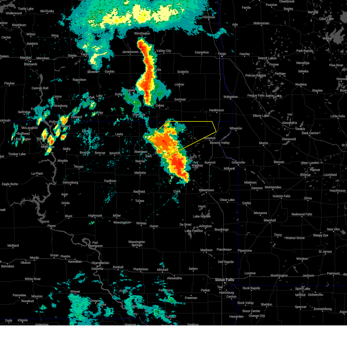
Hail Map for Claremont, SD
The Claremont, SD area has had 6 reports of on-the-ground hail by trained spotters, and has been under severe weather warnings 6 times during the past 12 months. Doppler radar has detected hail at or near Claremont, SD on 39 occasions, including 1 occasion during the past year.
| Name: | Claremont, SD |
| Where Located: | 27.2 miles ENE of Aberdeen, SD |
| Map: | Google Map for Claremont, SD |
| Population: | 127 |
| Housing Units: | 61 |
| More Info: | Search Google for Claremont, SD |
3
The Top Recent Hail Date for Claremont, SD is Wednesday, July 31, 2024 (16th out of 39)

Hail and Wind Damage Spotted near Claremont, SD
| Date / Time | Report Details |
|---|---|
| 7/4/2025 4:42 PM CDT |
 the severe thunderstorm warning has been cancelled and is no longer in effect the severe thunderstorm warning has been cancelled and is no longer in effect
|
| 7/4/2025 4:15 PM CDT |
 Svrabr the national weather service in aberdeen has issued a * severe thunderstorm warning for, southeastern edmunds county in north central south dakota, western marshall county in northeastern south dakota, northwestern day county in northeastern south dakota, brown county in northeastern south dakota, northeastern faulk county in north central south dakota, northwestern spink county in northeastern south dakota, * until 515 pm cdt. * at 415 pm cdt, severe thunderstorms were located along a line extending from 6 miles north of north scatterwood lake to near mellette, moving east at 30 mph (radar indicated). Hazards include 60 mph wind gusts and penny size hail. Expect damage to roofs, siding, and trees. severe thunderstorms will be near, warner and mansfield around 420 pm cdt. stratford around 430 pm cdt. aberdeen and hutterville colony around 435 pm cdt. Other locations in the path of these severe thunderstorms include bath. Svrabr the national weather service in aberdeen has issued a * severe thunderstorm warning for, southeastern edmunds county in north central south dakota, western marshall county in northeastern south dakota, northwestern day county in northeastern south dakota, brown county in northeastern south dakota, northeastern faulk county in north central south dakota, northwestern spink county in northeastern south dakota, * until 515 pm cdt. * at 415 pm cdt, severe thunderstorms were located along a line extending from 6 miles north of north scatterwood lake to near mellette, moving east at 30 mph (radar indicated). Hazards include 60 mph wind gusts and penny size hail. Expect damage to roofs, siding, and trees. severe thunderstorms will be near, warner and mansfield around 420 pm cdt. stratford around 430 pm cdt. aberdeen and hutterville colony around 435 pm cdt. Other locations in the path of these severe thunderstorms include bath.
|
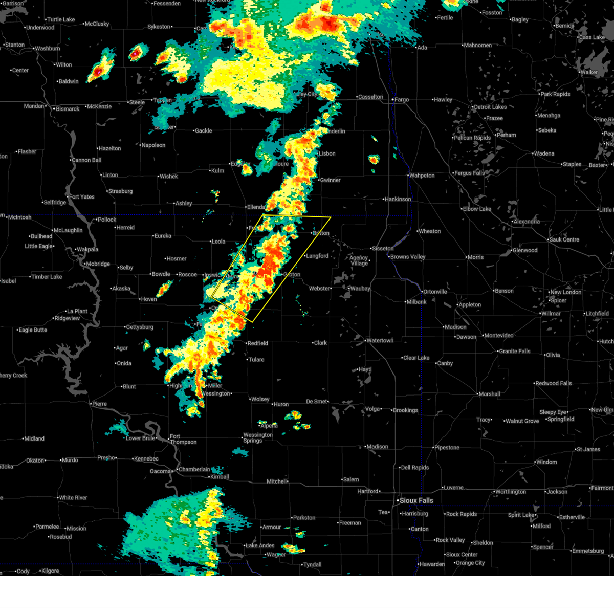
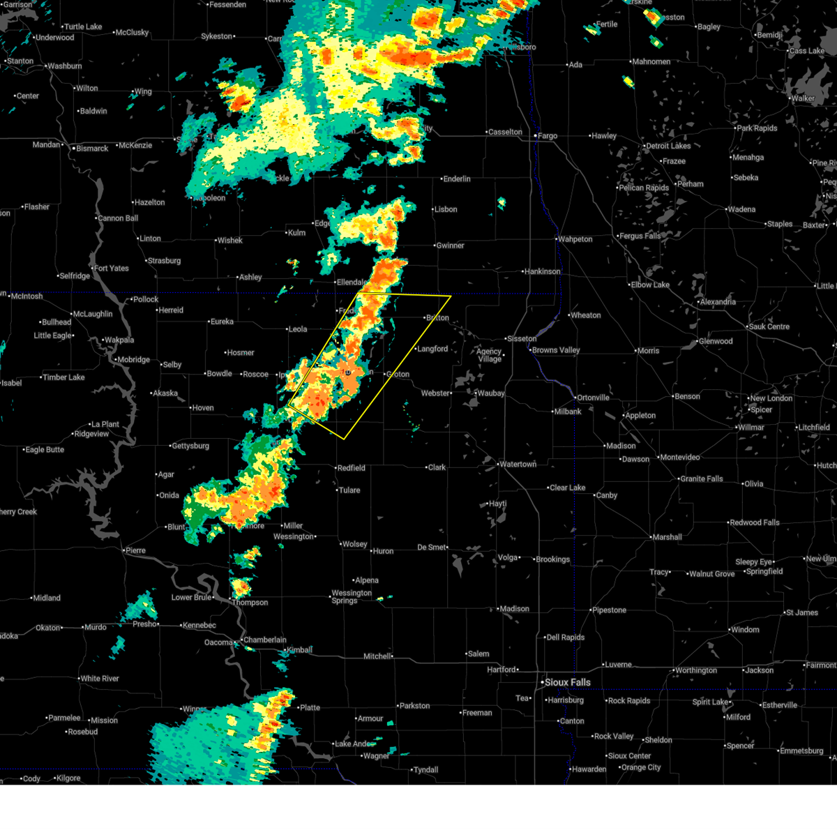
| 7/31/2024 4:21 PM CDT | At 421 pm cdt, a severe thunderstorm was located near putney, or near groton, moving northeast at 35 mph (radar indicated). Hazards include 60 mph wind gusts and quarter size hail. Hail damage to vehicles is expected. expect wind damage to roofs, siding, and trees. Locations impacted include, groton, pierpont, claremont, and putney. |
| 7/31/2024 4:06 PM CDT |
 At 405 pm cdt, a severe thunderstorm was located over bath, or 8 miles west of groton, moving northeast at 25 mph (radar indicated). Hazards include ping pong ball size hail and 60 mph wind gusts. People and animals outdoors will be injured. expect hail damage to roofs, siding, windows, and vehicles. expect wind damage to roofs, siding, and trees. Locations impacted include, putney, tacoma park, groton and claremont. At 405 pm cdt, a severe thunderstorm was located over bath, or 8 miles west of groton, moving northeast at 25 mph (radar indicated). Hazards include ping pong ball size hail and 60 mph wind gusts. People and animals outdoors will be injured. expect hail damage to roofs, siding, windows, and vehicles. expect wind damage to roofs, siding, and trees. Locations impacted include, putney, tacoma park, groton and claremont.
|
| 7/31/2024 3:44 PM CDT |
 Svrabr the national weather service in aberdeen has issued a * severe thunderstorm warning for, northwestern day county in northeastern south dakota, southwestern marshall county in northeastern south dakota, eastern brown county in northeastern south dakota, * until 445 pm cdt. * at 344 pm cdt, a severe thunderstorm was located near aberdeen, moving northeast at 30 mph (radar indicated). Hazards include 60 mph wind gusts and quarter size hail. Hail damage to vehicles is expected. expect wind damage to roofs, siding, and trees. this severe thunderstorm will be near, aberdeen and bath around 350 pm cdt. tacoma park around 355 pm cdt. Other locations in the path of this severe thunderstorm include putney and claremont. Svrabr the national weather service in aberdeen has issued a * severe thunderstorm warning for, northwestern day county in northeastern south dakota, southwestern marshall county in northeastern south dakota, eastern brown county in northeastern south dakota, * until 445 pm cdt. * at 344 pm cdt, a severe thunderstorm was located near aberdeen, moving northeast at 30 mph (radar indicated). Hazards include 60 mph wind gusts and quarter size hail. Hail damage to vehicles is expected. expect wind damage to roofs, siding, and trees. this severe thunderstorm will be near, aberdeen and bath around 350 pm cdt. tacoma park around 355 pm cdt. Other locations in the path of this severe thunderstorm include putney and claremont.
|
| 7/31/2024 11:27 AM CDT |
 Svrabr the national weather service in aberdeen has issued a * severe thunderstorm warning for, northwestern roberts county in northeastern south dakota, northwestern day county in northeastern south dakota, marshall county in northeastern south dakota, northeastern brown county in northeastern south dakota, * until 1215 pm cdt. * at 1127 am cdt, severe thunderstorms were located along a line extending from near opitz lake to 6 miles south of britton to 7 miles northwest of amherst, moving northeast at 35 mph (radar indicated). Hazards include 70 mph wind gusts and quarter size hail. Hail damage to vehicles is expected. expect considerable tree damage. wind damage is also likely to mobile homes, roofs, and outbuildings. severe thunderstorms will be near, britton, sunset colony, eden, opitz lake, cattail lake, amherst, roy lake rec area, and fort sisseton state park around 1130 am cdt. clear lake rec area around 1135 am cdt. kidder, lake city, westwood colony, and red iron housing around 1140 am cdt. Other locations in the path of these severe thunderstorms include hillhead, sica hollow state park, veblen and veblen flats housing. Svrabr the national weather service in aberdeen has issued a * severe thunderstorm warning for, northwestern roberts county in northeastern south dakota, northwestern day county in northeastern south dakota, marshall county in northeastern south dakota, northeastern brown county in northeastern south dakota, * until 1215 pm cdt. * at 1127 am cdt, severe thunderstorms were located along a line extending from near opitz lake to 6 miles south of britton to 7 miles northwest of amherst, moving northeast at 35 mph (radar indicated). Hazards include 70 mph wind gusts and quarter size hail. Hail damage to vehicles is expected. expect considerable tree damage. wind damage is also likely to mobile homes, roofs, and outbuildings. severe thunderstorms will be near, britton, sunset colony, eden, opitz lake, cattail lake, amherst, roy lake rec area, and fort sisseton state park around 1130 am cdt. clear lake rec area around 1135 am cdt. kidder, lake city, westwood colony, and red iron housing around 1140 am cdt. Other locations in the path of these severe thunderstorms include hillhead, sica hollow state park, veblen and veblen flats housing.
|
| 7/9/2024 6:45 PM CDT |
 Svrabr the national weather service in aberdeen has issued a * severe thunderstorm warning for, northeastern brown county in northeastern south dakota, * until 730 pm cdt. * at 645 pm cdt, a severe thunderstorm was located near sand lake wildlife refuge, or 18 miles northeast of aberdeen, moving southeast at 20 mph (radar indicated). Hazards include 60 mph wind gusts and quarter size hail. Hail damage to vehicles is expected. expect wind damage to roofs, siding, and trees. this severe thunderstorm will be near, columbia and sand lake wildlife refuge around 650 pm cdt. Putney and tacoma park around 705 pm cdt. Svrabr the national weather service in aberdeen has issued a * severe thunderstorm warning for, northeastern brown county in northeastern south dakota, * until 730 pm cdt. * at 645 pm cdt, a severe thunderstorm was located near sand lake wildlife refuge, or 18 miles northeast of aberdeen, moving southeast at 20 mph (radar indicated). Hazards include 60 mph wind gusts and quarter size hail. Hail damage to vehicles is expected. expect wind damage to roofs, siding, and trees. this severe thunderstorm will be near, columbia and sand lake wildlife refuge around 650 pm cdt. Putney and tacoma park around 705 pm cdt.
|
| 6/2/2024 7:50 PM CDT | Quarter sized hail reported 2.3 miles NNW of Claremont, SD |
| 6/2/2024 7:46 PM CDT |
 At 746 pm cdt, a severe thunderstorm was located over claremont, or 9 miles west of langford, moving east at 15 mph (radar indicated). Hazards include 60 mph wind gusts and quarter size hail. Hail damage to vehicles is expected. expect wind damage to roofs, siding, and trees. This severe storm will be near, newport colony around 750 pm cdt. At 746 pm cdt, a severe thunderstorm was located over claremont, or 9 miles west of langford, moving east at 15 mph (radar indicated). Hazards include 60 mph wind gusts and quarter size hail. Hail damage to vehicles is expected. expect wind damage to roofs, siding, and trees. This severe storm will be near, newport colony around 750 pm cdt.
|
| 6/2/2024 7:34 PM CDT |
 Svrabr the national weather service in aberdeen has issued a * severe thunderstorm warning for, northwestern day county in northeastern south dakota, southwestern marshall county in northeastern south dakota, east central brown county in northeastern south dakota, * until 815 pm cdt. * at 734 pm cdt, a severe thunderstorm was located near claremont, or 13 miles west of langford, moving east at 15 mph (radar indicated). Hazards include 60 mph wind gusts and quarter size hail. Hail damage to vehicles is expected. expect wind damage to roofs, siding, and trees. This severe thunderstorm will be near, claremont and newport colony around 740 pm cdt. Svrabr the national weather service in aberdeen has issued a * severe thunderstorm warning for, northwestern day county in northeastern south dakota, southwestern marshall county in northeastern south dakota, east central brown county in northeastern south dakota, * until 815 pm cdt. * at 734 pm cdt, a severe thunderstorm was located near claremont, or 13 miles west of langford, moving east at 15 mph (radar indicated). Hazards include 60 mph wind gusts and quarter size hail. Hail damage to vehicles is expected. expect wind damage to roofs, siding, and trees. This severe thunderstorm will be near, claremont and newport colony around 740 pm cdt.
|
| 5/17/2024 10:30 PM CDT |
 The storms which prompted the warning have weakened below severe limits, and no longer pose an immediate threat to life or property. therefore, the warning has been allowed to expire. however, gusty winds are still possible with these thunderstorms. a severe thunderstorm watch remains in effect until midnight cdt for northeastern south dakota. The storms which prompted the warning have weakened below severe limits, and no longer pose an immediate threat to life or property. therefore, the warning has been allowed to expire. however, gusty winds are still possible with these thunderstorms. a severe thunderstorm watch remains in effect until midnight cdt for northeastern south dakota.
|
| 5/17/2024 9:49 PM CDT |
 Svrabr the national weather service in aberdeen has issued a * severe thunderstorm warning for, northwestern day county in northeastern south dakota, western marshall county in northeastern south dakota, northern brown county in northeastern south dakota, * until 1030 pm cdt. * at 948 pm cdt, severe thunderstorms were located along a line extending from 8 miles northwest of hecla to richmond lake rec area, moving east at 50 mph (radar indicated). Hazards include 60 mph wind gusts. Expect damage to roofs, siding, and trees. severe thunderstorms will be near, hecla, columbia, sand lake wildlife refuge, and houghton around 955 pm cdt. tacoma park around 1000 pm cdt. putney around 1005 pm cdt. Other locations in the path of these severe thunderstorms include sunset colony, claremont, newport colony, westwood colony, amherst, britton and kidder. Svrabr the national weather service in aberdeen has issued a * severe thunderstorm warning for, northwestern day county in northeastern south dakota, western marshall county in northeastern south dakota, northern brown county in northeastern south dakota, * until 1030 pm cdt. * at 948 pm cdt, severe thunderstorms were located along a line extending from 8 miles northwest of hecla to richmond lake rec area, moving east at 50 mph (radar indicated). Hazards include 60 mph wind gusts. Expect damage to roofs, siding, and trees. severe thunderstorms will be near, hecla, columbia, sand lake wildlife refuge, and houghton around 955 pm cdt. tacoma park around 1000 pm cdt. putney around 1005 pm cdt. Other locations in the path of these severe thunderstorms include sunset colony, claremont, newport colony, westwood colony, amherst, britton and kidder.
|
| 8/5/2022 8:35 PM CDT |
 The severe thunderstorm warning for northeastern brown county will expire at 845 pm cdt, the storm which prompted the warning has weakened below severe limits, and has exited the warned area. therefore, the warning will be allowed to expire. a severe thunderstorm watch remains in effect until midnight cdt for northeastern south dakota. The severe thunderstorm warning for northeastern brown county will expire at 845 pm cdt, the storm which prompted the warning has weakened below severe limits, and has exited the warned area. therefore, the warning will be allowed to expire. a severe thunderstorm watch remains in effect until midnight cdt for northeastern south dakota.
|
| 8/5/2022 8:28 PM CDT |
 At 828 pm cdt, a severe thunderstorm was located over houghton, or 20 miles southeast of ellendale, moving northeast at 45 mph (trained weather spotters). Hazards include 60 mph wind gusts and penny size hail. Expect damage to roofs, siding, and trees. this severe thunderstorm will remain over mainly rural areas of northeastern brown county. hail threat, radar indicated max hail size, 0. 75 in wind threat, radar indicated max wind gust, 60 mph. At 828 pm cdt, a severe thunderstorm was located over houghton, or 20 miles southeast of ellendale, moving northeast at 45 mph (trained weather spotters). Hazards include 60 mph wind gusts and penny size hail. Expect damage to roofs, siding, and trees. this severe thunderstorm will remain over mainly rural areas of northeastern brown county. hail threat, radar indicated max hail size, 0. 75 in wind threat, radar indicated max wind gust, 60 mph.
|
| 8/5/2022 8:06 PM CDT |
 At 804 pm cdt, a severe thunderstorm was located near richmond lake rec area, or near aberdeen, moving northeast at 40 mph (trained weather spotters. at 751 pm strong winds of 60 mph were reported richmond lake. at 757 pm strong winds of 60 mph were reported near the aberdeen airport). Hazards include 60 mph wind gusts and quarter size hail. Hail damage to vehicles is expected. expect wind damage to roofs, siding, and trees. this severe thunderstorm will be near, westport around 815 pm cdt. other locations in the path of this severe thunderstorm include columbia, tacoma park, putney, houghton and claremont. hail threat, radar indicated max hail size, 1. 00 in wind threat, radar indicated max wind gust, 60 mph. At 804 pm cdt, a severe thunderstorm was located near richmond lake rec area, or near aberdeen, moving northeast at 40 mph (trained weather spotters. at 751 pm strong winds of 60 mph were reported richmond lake. at 757 pm strong winds of 60 mph were reported near the aberdeen airport). Hazards include 60 mph wind gusts and quarter size hail. Hail damage to vehicles is expected. expect wind damage to roofs, siding, and trees. this severe thunderstorm will be near, westport around 815 pm cdt. other locations in the path of this severe thunderstorm include columbia, tacoma park, putney, houghton and claremont. hail threat, radar indicated max hail size, 1. 00 in wind threat, radar indicated max wind gust, 60 mph.
|
| 7/21/2022 10:15 PM CDT |
 At 1015 pm cdt, a severe thunderstorm was located 9 miles southeast of ellendale, moving southeast at 55 mph (radar indicated). Hazards include quarter size hail. Damage to vehicles is expected. this severe thunderstorm will be near, hecla and sand lake wildlife refuge around 1025 pm cdt. other locations in the path of this severe thunderstorm include claremont. hail threat, radar indicated max hail size, 1. 00 in wind threat, radar indicated max wind gust, <50 mph. At 1015 pm cdt, a severe thunderstorm was located 9 miles southeast of ellendale, moving southeast at 55 mph (radar indicated). Hazards include quarter size hail. Damage to vehicles is expected. this severe thunderstorm will be near, hecla and sand lake wildlife refuge around 1025 pm cdt. other locations in the path of this severe thunderstorm include claremont. hail threat, radar indicated max hail size, 1. 00 in wind threat, radar indicated max wind gust, <50 mph.
|
| 6/20/2022 9:48 PM CDT |
 At 948 pm cdt, a severe thunderstorm was located near putney, or 9 miles north of groton, moving northeast at 55 mph (radar indicated). Hazards include 70 mph wind gusts. Expect considerable tree damage. damage is likely to mobile homes, roofs, and outbuildings. this severe thunderstorm will be near, claremont around 955 pm cdt. amherst around 1005 pm cdt. other locations in the path of this severe thunderstorm include britton and kidder. thunderstorm damage threat, considerable hail threat, radar indicated max hail size, <. 75 in wind threat, radar indicated max wind gust, 70 mph. At 948 pm cdt, a severe thunderstorm was located near putney, or 9 miles north of groton, moving northeast at 55 mph (radar indicated). Hazards include 70 mph wind gusts. Expect considerable tree damage. damage is likely to mobile homes, roofs, and outbuildings. this severe thunderstorm will be near, claremont around 955 pm cdt. amherst around 1005 pm cdt. other locations in the path of this severe thunderstorm include britton and kidder. thunderstorm damage threat, considerable hail threat, radar indicated max hail size, <. 75 in wind threat, radar indicated max wind gust, 70 mph.
|
| 6/14/2022 4:43 AM CDT |
 At 443 am cdt, a severe thunderstorm was located over aberdeen, moving northeast at 55 mph (radar indicated). Hazards include 60 mph wind gusts and quarter size hail. Hail damage to vehicles is expected. expect wind damage to roofs, siding, and trees. this severe thunderstorm will be near, bath around 450 am cdt. columbia and tacoma park around 500 am cdt. other locations in the path of this severe thunderstorm include putney and claremont. hail threat, radar indicated max hail size, 1. 00 in wind threat, radar indicated max wind gust, 60 mph. At 443 am cdt, a severe thunderstorm was located over aberdeen, moving northeast at 55 mph (radar indicated). Hazards include 60 mph wind gusts and quarter size hail. Hail damage to vehicles is expected. expect wind damage to roofs, siding, and trees. this severe thunderstorm will be near, bath around 450 am cdt. columbia and tacoma park around 500 am cdt. other locations in the path of this severe thunderstorm include putney and claremont. hail threat, radar indicated max hail size, 1. 00 in wind threat, radar indicated max wind gust, 60 mph.
|
| 5/12/2022 6:58 PM CDT |
 At 657 pm cdt, severe thunderstorms were located along a line extending from near ludden to claire city, moving north at 60 mph (radar indicated). Hazards include 70 mph wind gusts and penny size hail. Expect considerable tree damage. damage is likely to mobile homes, roofs, and outbuildings. These severe thunderstorms will remain over mainly rural areas of northwestern roberts, marshall and northeastern brown counties, including the following locations, northwestern lake traverse reservation. At 657 pm cdt, severe thunderstorms were located along a line extending from near ludden to claire city, moving north at 60 mph (radar indicated). Hazards include 70 mph wind gusts and penny size hail. Expect considerable tree damage. damage is likely to mobile homes, roofs, and outbuildings. These severe thunderstorms will remain over mainly rural areas of northwestern roberts, marshall and northeastern brown counties, including the following locations, northwestern lake traverse reservation.
|
| 5/12/2022 6:28 PM CDT |
 At 628 pm cdt, severe thunderstorms were located along a line extending from near putney to rudebusch corner, moving north at 65 mph (trained weather spotters). Hazards include 70 mph wind gusts and penny size hail. Expect considerable tree damage. damage is likely to mobile homes, roofs, and outbuildings. severe thunderstorms will be near, houghton and buffalo lakes around 640 pm cdt. sand lake wildlife refuge around 645 pm cdt. Other locations in the path of these severe thunderstorms include hecla and sica hollow state park. At 628 pm cdt, severe thunderstorms were located along a line extending from near putney to rudebusch corner, moving north at 65 mph (trained weather spotters). Hazards include 70 mph wind gusts and penny size hail. Expect considerable tree damage. damage is likely to mobile homes, roofs, and outbuildings. severe thunderstorms will be near, houghton and buffalo lakes around 640 pm cdt. sand lake wildlife refuge around 645 pm cdt. Other locations in the path of these severe thunderstorms include hecla and sica hollow state park.
|
| 5/7/2022 8:59 PM CDT |
 At 859 pm cdt, severe thunderstorms were located along a line extending from near claremont to 7 miles northeast of groton to near ferney, moving northeast at 40 mph (radar indicated). Hazards include 60 mph wind gusts and nickel size hail. Expect damage to roofs, siding, and trees. Locations impacted include, claremont, pierpont, amherst, langford, andover and britton. At 859 pm cdt, severe thunderstorms were located along a line extending from near claremont to 7 miles northeast of groton to near ferney, moving northeast at 40 mph (radar indicated). Hazards include 60 mph wind gusts and nickel size hail. Expect damage to roofs, siding, and trees. Locations impacted include, claremont, pierpont, amherst, langford, andover and britton.
|
| 5/7/2022 8:44 PM CDT |
 At 843 pm cdt, severe thunderstorms were located along a line extending from near columbia to near groton to near brentford, moving northeast at 40 mph (radar indicated). Hazards include 60 mph wind gusts and quarter size hail. Hail damage to vehicles is expected. expect wind damage to roofs, siding, and trees. severe thunderstorms will be near, groton and putney around 850 pm cdt. claremont around 900 pm cdt. Other locations in the path of these severe thunderstorms include ferney, pierpont, amherst, langford, andover and britton. At 843 pm cdt, severe thunderstorms were located along a line extending from near columbia to near groton to near brentford, moving northeast at 40 mph (radar indicated). Hazards include 60 mph wind gusts and quarter size hail. Hail damage to vehicles is expected. expect wind damage to roofs, siding, and trees. severe thunderstorms will be near, groton and putney around 850 pm cdt. claremont around 900 pm cdt. Other locations in the path of these severe thunderstorms include ferney, pierpont, amherst, langford, andover and britton.
|
| 4/22/2022 10:40 PM CDT | Quarter sized hail reported 3.3 miles S of Claremont, SD, relayed via social media. approximate location and time. |
| 10/9/2021 5:18 PM CDT |
 At 518 pm cdt, severe thunderstorms were located along a line extending from 8 miles northeast of frederick to 6 miles northwest of webster to 8 miles southeast of carpenter, moving east at 30 mph (radar indicated). Hazards include 60 mph wind gusts and penny size hail. Expect damage to roofs, siding, and trees. severe thunderstorms will be near, webster around 525 pm cdt. roslyn around 530 pm cdt. willow lake around 535 pm cdt. Other locations in the path of these severe thunderstorms include grenville, waubay lake, minnewasta lake, rush lake, waubay, waubay wildlife rec area, blue dog lake, bryant, enemy swim lake, campbell slough, enemy swim housing, pickerel lake rec area, rudebusch corner, hamlin education center and kellerton church. At 518 pm cdt, severe thunderstorms were located along a line extending from 8 miles northeast of frederick to 6 miles northwest of webster to 8 miles southeast of carpenter, moving east at 30 mph (radar indicated). Hazards include 60 mph wind gusts and penny size hail. Expect damage to roofs, siding, and trees. severe thunderstorms will be near, webster around 525 pm cdt. roslyn around 530 pm cdt. willow lake around 535 pm cdt. Other locations in the path of these severe thunderstorms include grenville, waubay lake, minnewasta lake, rush lake, waubay, waubay wildlife rec area, blue dog lake, bryant, enemy swim lake, campbell slough, enemy swim housing, pickerel lake rec area, rudebusch corner, hamlin education center and kellerton church.
|
| 10/9/2021 5:17 PM CDT |
 At 517 pm cdt, a severe thunderstorm capable of producing a tornado was located near claremont, or 13 miles southwest of britton, moving northeast at 35 mph (radar indicated rotation). Hazards include tornado. Flying debris will be dangerous to those caught without shelter. mobile homes will be damaged or destroyed. damage to roofs, windows, and vehicles will occur. tree damage is likely. this dangerous storm will be near, amherst around 525 pm cdt. Other locations in the path of this tornadic thunderstorm include britton. At 517 pm cdt, a severe thunderstorm capable of producing a tornado was located near claremont, or 13 miles southwest of britton, moving northeast at 35 mph (radar indicated rotation). Hazards include tornado. Flying debris will be dangerous to those caught without shelter. mobile homes will be damaged or destroyed. damage to roofs, windows, and vehicles will occur. tree damage is likely. this dangerous storm will be near, amherst around 525 pm cdt. Other locations in the path of this tornadic thunderstorm include britton.
|
| 8/24/2021 12:56 AM CDT |
 At 1255 am cdt, a severe thunderstorm was located near claremont, or 15 miles west of britton, moving east at 45 mph (radar indicated). Hazards include 70 mph wind gusts. Expect considerable tree damage. damage is likely to mobile homes, roofs, and outbuildings. this severe thunderstorm will be near, amherst around 105 am cdt. britton around 115 am cdt. other locations in the path of this severe thunderstorm include cattail lake, fort sisseton state park, eden, lake city, roy lake rec area, hillhead, red iron housing, clear lake rec area, sica hollow state park and buffalo lakes. thunderstorm damage threat, considerable hail threat, radar indicated max hail size, <. 75 in wind threat, radar indicated max wind gust, 70 mph. At 1255 am cdt, a severe thunderstorm was located near claremont, or 15 miles west of britton, moving east at 45 mph (radar indicated). Hazards include 70 mph wind gusts. Expect considerable tree damage. damage is likely to mobile homes, roofs, and outbuildings. this severe thunderstorm will be near, amherst around 105 am cdt. britton around 115 am cdt. other locations in the path of this severe thunderstorm include cattail lake, fort sisseton state park, eden, lake city, roy lake rec area, hillhead, red iron housing, clear lake rec area, sica hollow state park and buffalo lakes. thunderstorm damage threat, considerable hail threat, radar indicated max hail size, <. 75 in wind threat, radar indicated max wind gust, 70 mph.
|
| 8/24/2021 12:27 AM CDT |
 At 1226 am cdt, a severe thunderstorm was located near barnard, or 19 miles south of ellendale, moving east at 50 mph (radar indicated). Hazards include 60 mph wind gusts. Expect damage to roofs, siding, and trees. locations impacted include, sand lake wildlife refuge, houghton and claremont. hail threat, radar indicated max hail size, <. 75 in wind threat, radar indicated max wind gust, 60 mph. At 1226 am cdt, a severe thunderstorm was located near barnard, or 19 miles south of ellendale, moving east at 50 mph (radar indicated). Hazards include 60 mph wind gusts. Expect damage to roofs, siding, and trees. locations impacted include, sand lake wildlife refuge, houghton and claremont. hail threat, radar indicated max hail size, <. 75 in wind threat, radar indicated max wind gust, 60 mph.
|
| 8/24/2021 12:01 AM CDT |
 At 1201 am cdt, a severe thunderstorm was located near leola, or 21 miles northeast of ipswich, moving east at 50 mph (radar indicated). Hazards include 60 mph wind gusts. Expect damage to roofs, siding, and trees. this severe thunderstorm will be near, wetonka and grassland colony around 1205 am cdt. frederick, westport and barnard around 1220 am cdt. other locations in the path of this severe thunderstorm include sand lake wildlife refuge, houghton and claremont. hail threat, radar indicated max hail size, <. 75 in wind threat, radar indicated max wind gust, 60 mph. At 1201 am cdt, a severe thunderstorm was located near leola, or 21 miles northeast of ipswich, moving east at 50 mph (radar indicated). Hazards include 60 mph wind gusts. Expect damage to roofs, siding, and trees. this severe thunderstorm will be near, wetonka and grassland colony around 1205 am cdt. frederick, westport and barnard around 1220 am cdt. other locations in the path of this severe thunderstorm include sand lake wildlife refuge, houghton and claremont. hail threat, radar indicated max hail size, <. 75 in wind threat, radar indicated max wind gust, 60 mph.
|
| 8/22/2021 6:17 PM CDT |
 At 617 pm cdt, a severe thunderstorm was located near langford, or 12 miles northeast of groton, moving east at 45 mph. this is a destructive storm for portions of east central brown county (emergency management). Hazards include 80 mph wind gusts and quarter size hail. Flying debris will be dangerous to those caught without shelter. mobile homes will be heavily damaged. expect considerable damage to roofs, windows, and vehicles. extensive tree damage and power outages are likely. locations impacted include, claremont. thunderstorm damage threat, destructive hail threat, radar indicated max hail size, 1. 00 in wind threat, observed max wind gust, 80 mph. At 617 pm cdt, a severe thunderstorm was located near langford, or 12 miles northeast of groton, moving east at 45 mph. this is a destructive storm for portions of east central brown county (emergency management). Hazards include 80 mph wind gusts and quarter size hail. Flying debris will be dangerous to those caught without shelter. mobile homes will be heavily damaged. expect considerable damage to roofs, windows, and vehicles. extensive tree damage and power outages are likely. locations impacted include, claremont. thunderstorm damage threat, destructive hail threat, radar indicated max hail size, 1. 00 in wind threat, observed max wind gust, 80 mph.
|
| 8/22/2021 5:59 PM CDT |
 At 558 pm cdt, a severe thunderstorm was located over tacoma park, or 9 miles northwest of groton, moving east at 45 mph. this is a destructive storm for portions of east central brown county (emergency management. at 545 pm, a 79 mph wind gust was reported 3 miles north of aberdeen). Hazards include 80 mph wind gusts and quarter size hail. Flying debris will be dangerous to those caught without shelter. mobile homes will be heavily damaged. expect considerable damage to roofs, windows, and vehicles. extensive tree damage and power outages are likely. locations impacted include, claremont. thunderstorm damage threat, destructive hail threat, observed max hail size, 1. 00 in wind threat, observed max wind gust, 80 mph. At 558 pm cdt, a severe thunderstorm was located over tacoma park, or 9 miles northwest of groton, moving east at 45 mph. this is a destructive storm for portions of east central brown county (emergency management. at 545 pm, a 79 mph wind gust was reported 3 miles north of aberdeen). Hazards include 80 mph wind gusts and quarter size hail. Flying debris will be dangerous to those caught without shelter. mobile homes will be heavily damaged. expect considerable damage to roofs, windows, and vehicles. extensive tree damage and power outages are likely. locations impacted include, claremont. thunderstorm damage threat, destructive hail threat, observed max hail size, 1. 00 in wind threat, observed max wind gust, 80 mph.
|
| 8/22/2021 5:40 PM CDT |
 At 539 pm cdt, a severe thunderstorm was located near aberdeen, moving east at 45 mph (trained weather spotters. at 530 pm cdt, a 74 mph wind gust was reported at mina lake). Hazards include 70 mph wind gusts and quarter size hail. Hail damage to vehicles is expected. expect considerable tree damage. wind damage is also likely to mobile homes, roofs, and outbuildings. this severe thunderstorm will be near, aberdeen around 545 pm cdt. bath around 555 pm cdt. Other locations in the path of this severe thunderstorm include columbia, tacoma park, putney, groton and claremont. At 539 pm cdt, a severe thunderstorm was located near aberdeen, moving east at 45 mph (trained weather spotters. at 530 pm cdt, a 74 mph wind gust was reported at mina lake). Hazards include 70 mph wind gusts and quarter size hail. Hail damage to vehicles is expected. expect considerable tree damage. wind damage is also likely to mobile homes, roofs, and outbuildings. this severe thunderstorm will be near, aberdeen around 545 pm cdt. bath around 555 pm cdt. Other locations in the path of this severe thunderstorm include columbia, tacoma park, putney, groton and claremont.
|
| 7/23/2021 11:36 PM CDT |
 At 1136 pm cdt, a severe thunderstorm was located over amherst, or 10 miles west of britton, moving east at 35 mph (radar indicated). Hazards include 60 mph wind gusts and penny size hail. Expect damage to roofs, siding, and trees. Locations impacted include, britton. At 1136 pm cdt, a severe thunderstorm was located over amherst, or 10 miles west of britton, moving east at 35 mph (radar indicated). Hazards include 60 mph wind gusts and penny size hail. Expect damage to roofs, siding, and trees. Locations impacted include, britton.
|
| 7/23/2021 11:17 PM CDT |
 At 1117 pm cdt, a severe thunderstorm was located over houghton, or 21 miles west of britton, moving east at 35 mph (radar indicated). Hazards include 60 mph wind gusts and penny size hail. Expect damage to roofs, siding, and trees. this severe thunderstorm will be near, claremont around 1135 pm cdt. Other locations in the path of this severe thunderstorm include amherst and britton. At 1117 pm cdt, a severe thunderstorm was located over houghton, or 21 miles west of britton, moving east at 35 mph (radar indicated). Hazards include 60 mph wind gusts and penny size hail. Expect damage to roofs, siding, and trees. this severe thunderstorm will be near, claremont around 1135 pm cdt. Other locations in the path of this severe thunderstorm include amherst and britton.
|
| 6/11/2021 4:20 AM CDT | Quarter sized hail reported 2.3 miles NNW of Claremont, SD |
| 6/11/2021 4:16 AM CDT |
 At 415 am cdt, severe thunderstorms were located along a line extending from near kidder to near frankfort, moving east at 60 mph (radar indicated). Hazards include 60 mph wind gusts. Expect damage to roofs, siding, and trees. severe thunderstorms will be near, veblen flats housing and hillhead around 430 am cdt. veblen around 435 am cdt. Other locations in the path of these severe thunderstorms include claire city, new effington, garden city, victor, long lake and medicine lake. At 415 am cdt, severe thunderstorms were located along a line extending from near kidder to near frankfort, moving east at 60 mph (radar indicated). Hazards include 60 mph wind gusts. Expect damage to roofs, siding, and trees. severe thunderstorms will be near, veblen flats housing and hillhead around 430 am cdt. veblen around 435 am cdt. Other locations in the path of these severe thunderstorms include claire city, new effington, garden city, victor, long lake and medicine lake.
|
| 6/11/2021 4:12 AM CDT |
 At 411 am cdt, severe thunderstorms were located along a line extending from near kidder to near redfield, moving east at 45 mph (radar indicated). Hazards include 60 mph wind gusts and quarter size hail. Hail damage to vehicles is expected. expect wind damage to roofs, siding, and trees. Locations impacted include, britton and kidder. At 411 am cdt, severe thunderstorms were located along a line extending from near kidder to near redfield, moving east at 45 mph (radar indicated). Hazards include 60 mph wind gusts and quarter size hail. Hail damage to vehicles is expected. expect wind damage to roofs, siding, and trees. Locations impacted include, britton and kidder.
|
| 6/11/2021 3:38 AM CDT |
 At 338 am cdt, severe thunderstorms were located along a line extending from 7 miles west of hecla to near rockham, moving east at 45 mph (radar indicated). Hazards include 60 mph wind gusts and quarter size hail. Hail damage to vehicles is expected. expect wind damage to roofs, siding, and trees. severe thunderstorms will be near, sand lake wildlife refuge around 345 am cdt. hecla around 350 am cdt. Other locations in the path of these severe thunderstorms include redfield, ashton, britton, frankfort and kidder. At 338 am cdt, severe thunderstorms were located along a line extending from 7 miles west of hecla to near rockham, moving east at 45 mph (radar indicated). Hazards include 60 mph wind gusts and quarter size hail. Hail damage to vehicles is expected. expect wind damage to roofs, siding, and trees. severe thunderstorms will be near, sand lake wildlife refuge around 345 am cdt. hecla around 350 am cdt. Other locations in the path of these severe thunderstorms include redfield, ashton, britton, frankfort and kidder.
|
| 5/24/2021 12:46 AM CDT |
 At 1246 am cdt, severe thunderstorms were located along a line extending from 8 miles east of ellendale to near claremont to near pierpont, moving northeast at 40 mph (trained weather spotters. at 1235 am cdt, a 59 mph wind gust was reported 7 miles south of claremont). Hazards include 60 mph wind gusts. Expect damage to roofs, siding, and trees. Locations impacted include, langford, hecla, pierpont, claremont, andover, amherst, sand lake wildlife refuge and houghton. At 1246 am cdt, severe thunderstorms were located along a line extending from 8 miles east of ellendale to near claremont to near pierpont, moving northeast at 40 mph (trained weather spotters. at 1235 am cdt, a 59 mph wind gust was reported 7 miles south of claremont). Hazards include 60 mph wind gusts. Expect damage to roofs, siding, and trees. Locations impacted include, langford, hecla, pierpont, claremont, andover, amherst, sand lake wildlife refuge and houghton.
|
| 5/24/2021 12:30 AM CDT |
 At 1228 am cdt, severe thunderstorms were located along a line extending from near frederick to near putney to near andover, moving northeast at 45 mph (trained weather spotters. at 1219 pm cdt, a 58 mph wind gust was reported 4 miles southwest of columbia). Hazards include 60 mph wind gusts. Expect damage to roofs, siding, and trees. in addition, the wind gusts will lead to blowing dust and reduced visibilities. Locations impacted include, andover, claremont, langford, pierpont and amherst. At 1228 am cdt, severe thunderstorms were located along a line extending from near frederick to near putney to near andover, moving northeast at 45 mph (trained weather spotters. at 1219 pm cdt, a 58 mph wind gust was reported 4 miles southwest of columbia). Hazards include 60 mph wind gusts. Expect damage to roofs, siding, and trees. in addition, the wind gusts will lead to blowing dust and reduced visibilities. Locations impacted include, andover, claremont, langford, pierpont and amherst.
|
| 5/24/2021 12:11 AM CDT |
 At 1210 am cdt, severe thunderstorms were located along a line extending from near leola to near aberdeen to near stratford, moving northeast at 40 mph (trained weather spotters. at 1210 am cdt, a 58 mph wind gust was reported the aberdeen airport). Hazards include 60 mph wind gusts. Expect damage to roofs, siding, and trees. severe thunderstorms will be near, bath and verdon around 1215 am cdt. ferney and tacoma park around 1220 am cdt. columbia, putney, forbes and elm lake around 1225 am cdt. groton around 1230 am cdt. Other locations in the path of these severe thunderstorms include andover, houghton, sand lake wildlife refuge, pierpont, claremont, amherst and langford. At 1210 am cdt, severe thunderstorms were located along a line extending from near leola to near aberdeen to near stratford, moving northeast at 40 mph (trained weather spotters. at 1210 am cdt, a 58 mph wind gust was reported the aberdeen airport). Hazards include 60 mph wind gusts. Expect damage to roofs, siding, and trees. severe thunderstorms will be near, bath and verdon around 1215 am cdt. ferney and tacoma park around 1220 am cdt. columbia, putney, forbes and elm lake around 1225 am cdt. groton around 1230 am cdt. Other locations in the path of these severe thunderstorms include andover, houghton, sand lake wildlife refuge, pierpont, claremont, amherst and langford.
|
| 8/23/2020 6:08 PM CDT |
 At 607 pm cdt, a severe thunderstorm was located near houghton, or 20 miles southeast of ellendale, moving east at 35 mph (trained weather spotters). Hazards include 60 mph wind gusts and quarter size hail. Hail damage to vehicles is expected. expect wind damage to roofs, siding, and trees. this severe storm will be near, claremont around 625 pm cdt. Amherst around 630 pm cdt. At 607 pm cdt, a severe thunderstorm was located near houghton, or 20 miles southeast of ellendale, moving east at 35 mph (trained weather spotters). Hazards include 60 mph wind gusts and quarter size hail. Hail damage to vehicles is expected. expect wind damage to roofs, siding, and trees. this severe storm will be near, claremont around 625 pm cdt. Amherst around 630 pm cdt.
|
| 8/23/2020 5:57 PM CDT |
 At 557 pm cdt, a severe thunderstorm was located 7 miles north of sand lake wildlife refuge, or 14 miles southeast of ellendale, moving east at 35 mph (trained weather spotters. this storm has a history of producing large hail). Hazards include golf ball size hail. People and animals outdoors will be injured. expect damage to roofs, siding, windows, and vehicles. this severe thunderstorm will be near, sand lake wildlife refuge around 605 pm cdt. hecla and houghton around 610 pm cdt. claremont around 625 pm cdt. Amherst around 630 pm cdt. At 557 pm cdt, a severe thunderstorm was located 7 miles north of sand lake wildlife refuge, or 14 miles southeast of ellendale, moving east at 35 mph (trained weather spotters. this storm has a history of producing large hail). Hazards include golf ball size hail. People and animals outdoors will be injured. expect damage to roofs, siding, windows, and vehicles. this severe thunderstorm will be near, sand lake wildlife refuge around 605 pm cdt. hecla and houghton around 610 pm cdt. claremont around 625 pm cdt. Amherst around 630 pm cdt.
|
| 8/8/2020 8:58 AM CDT |
 At 857 am cdt, a severe thunderstorm was located near grassland colony, or 20 miles south of ellendale, moving east at 50 mph (radar indicated). Hazards include 60 mph wind gusts. expect damage to roofs, siding, and trees At 857 am cdt, a severe thunderstorm was located near grassland colony, or 20 miles south of ellendale, moving east at 50 mph (radar indicated). Hazards include 60 mph wind gusts. expect damage to roofs, siding, and trees
|
| 6/20/2020 6:57 PM CDT |
 At 657 pm cdt, a severe thunderstorm was located 7 miles east of langford, or 15 miles south of britton, moving east at 30 mph (radar indicated). Hazards include 60 mph wind gusts and quarter size hail. Hail damage to vehicles is expected. expect wind damage to roofs, siding, and trees. Locations impacted include, langford, roslyn, pierpont, fort sisseton state park, roy lake rec area, cattail lake, opitz lake and waubay lake. At 657 pm cdt, a severe thunderstorm was located 7 miles east of langford, or 15 miles south of britton, moving east at 30 mph (radar indicated). Hazards include 60 mph wind gusts and quarter size hail. Hail damage to vehicles is expected. expect wind damage to roofs, siding, and trees. Locations impacted include, langford, roslyn, pierpont, fort sisseton state park, roy lake rec area, cattail lake, opitz lake and waubay lake.
|
| 6/20/2020 6:52 PM CDT | Quarter sized hail reported 2.3 miles NNW of Claremont, SD, a lot of nickel to quarter size hail. some stones were slightly larger than quarter size. |
| 6/20/2020 6:41 PM CDT |
 At 641 pm cdt, a severe thunderstorm was located over langford, or 14 miles northeast of groton, moving east at 30 mph (radar indicated). Hazards include 60 mph wind gusts and quarter size hail. Hail damage to vehicles is expected. Expect wind damage to roofs, siding, and trees. At 641 pm cdt, a severe thunderstorm was located over langford, or 14 miles northeast of groton, moving east at 30 mph (radar indicated). Hazards include 60 mph wind gusts and quarter size hail. Hail damage to vehicles is expected. Expect wind damage to roofs, siding, and trees.
|
| 6/17/2020 8:20 PM CDT |
 At 820 pm cdt, a severe thunderstorm was located near houghton, or 15 miles north of groton, moving northeast at 30 mph (radar indicated). Hazards include 60 mph wind gusts and quarter size hail. Hail damage to vehicles is expected. Expect wind damage to roofs, siding, and trees. At 820 pm cdt, a severe thunderstorm was located near houghton, or 15 miles north of groton, moving northeast at 30 mph (radar indicated). Hazards include 60 mph wind gusts and quarter size hail. Hail damage to vehicles is expected. Expect wind damage to roofs, siding, and trees.
|
| 6/7/2020 9:49 PM CDT |
 At 948 pm cdt, severe thunderstorms were located along a line extending from near hecla to near amherst to near langford, moving northeast at 55 mph (radar indicated). Hazards include 70 mph wind gusts and penny size hail. Expect considerable tree damage. damage is likely to mobile homes, roofs, and outbuildings. Locations impacted include, britton, langford, hecla, claremont, kidder, amherst, sand lake wildlife refuge and houghton. At 948 pm cdt, severe thunderstorms were located along a line extending from near hecla to near amherst to near langford, moving northeast at 55 mph (radar indicated). Hazards include 70 mph wind gusts and penny size hail. Expect considerable tree damage. damage is likely to mobile homes, roofs, and outbuildings. Locations impacted include, britton, langford, hecla, claremont, kidder, amherst, sand lake wildlife refuge and houghton.
|
| 6/7/2020 9:34 PM CDT |
 At 933 pm cdt, severe thunderstorms were located along a line extending from near barnard to columbia to near bath, moving northeast at 60 mph (trained weather spotters. 60 to 70 mph wind was reported in warner with this storm, along with tree damage in aberdeen). Hazards include 70 mph wind gusts and penny size hail. Expect considerable tree damage. Damage is likely to mobile homes, roofs, and outbuildings. At 933 pm cdt, severe thunderstorms were located along a line extending from near barnard to columbia to near bath, moving northeast at 60 mph (trained weather spotters. 60 to 70 mph wind was reported in warner with this storm, along with tree damage in aberdeen). Hazards include 70 mph wind gusts and penny size hail. Expect considerable tree damage. Damage is likely to mobile homes, roofs, and outbuildings.
|
| 6/7/2020 8:55 PM CDT | Large trees down. time estimated by rada in brown county SD, 0.3 miles WNW of Claremont, SD |
| 6/7/2020 8:46 PM CDT |
 At 846 pm cdt, a severe thunderstorm was located over sand lake wildlife refuge, or 19 miles southeast of ellendale, moving northeast at 60 mph. this is a very dangerous storm (trained weather spotters). Hazards include 80 mph wind gusts. Flying debris will be dangerous to those caught without shelter. mobile homes will be heavily damaged. expect considerable damage to roofs, windows, and vehicles. extensive tree damage and power outages are likely. Locations impacted include, aberdeen, hecla, frederick, columbia, westport, claremont, putney, barnard, sand lake wildlife refuge and houghton. At 846 pm cdt, a severe thunderstorm was located over sand lake wildlife refuge, or 19 miles southeast of ellendale, moving northeast at 60 mph. this is a very dangerous storm (trained weather spotters). Hazards include 80 mph wind gusts. Flying debris will be dangerous to those caught without shelter. mobile homes will be heavily damaged. expect considerable damage to roofs, windows, and vehicles. extensive tree damage and power outages are likely. Locations impacted include, aberdeen, hecla, frederick, columbia, westport, claremont, putney, barnard, sand lake wildlife refuge and houghton.
|
| 6/7/2020 8:28 PM CDT |
 At 827 pm cdt, a severe thunderstorm was located near richmond lake rec area, or 10 miles northwest of aberdeen, moving northeast at 60 mph. this is a very dangerous storm (trained weather spotters). Hazards include 80 mph wind gusts. Flying debris will be dangerous to those caught without shelter. mobile homes will be heavily damaged. expect considerable damage to roofs, windows, and vehicles. extensive tree damage and power outages are likely. Locations impacted include, aberdeen, hecla, frederick, columbia, westport, claremont, putney, wetonka, barnard, grassland colony, houghton, sand lake wildlife refuge and richmond lake rec area. At 827 pm cdt, a severe thunderstorm was located near richmond lake rec area, or 10 miles northwest of aberdeen, moving northeast at 60 mph. this is a very dangerous storm (trained weather spotters). Hazards include 80 mph wind gusts. Flying debris will be dangerous to those caught without shelter. mobile homes will be heavily damaged. expect considerable damage to roofs, windows, and vehicles. extensive tree damage and power outages are likely. Locations impacted include, aberdeen, hecla, frederick, columbia, westport, claremont, putney, wetonka, barnard, grassland colony, houghton, sand lake wildlife refuge and richmond lake rec area.
|
| 6/7/2020 8:21 PM CDT |
 At 821 pm cdt, a severe thunderstorm was located near richmond lake rec area, or 11 miles northwest of aberdeen, moving northeast at 60 mph (radar indicated). Hazards include 70 mph wind gusts. Expect considerable tree damage. Damage is likely to mobile homes, roofs, and outbuildings. At 821 pm cdt, a severe thunderstorm was located near richmond lake rec area, or 11 miles northwest of aberdeen, moving northeast at 60 mph (radar indicated). Hazards include 70 mph wind gusts. Expect considerable tree damage. Damage is likely to mobile homes, roofs, and outbuildings.
|
| 4/6/2020 9:26 PM CDT |
 At 925 pm cdt, a severe thunderstorm was located over amherst, or 11 miles southwest of britton, moving east at 40 mph (radar indicated). Hazards include half dollar size hail. Damage to vehicles is expected. this severe storm will be near, britton around 940 pm cdt. fort sisseton state park around 955 pm cdt. Lake city, roy lake rec area and cattail lake around 1000 pm cdt. At 925 pm cdt, a severe thunderstorm was located over amherst, or 11 miles southwest of britton, moving east at 40 mph (radar indicated). Hazards include half dollar size hail. Damage to vehicles is expected. this severe storm will be near, britton around 940 pm cdt. fort sisseton state park around 955 pm cdt. Lake city, roy lake rec area and cattail lake around 1000 pm cdt.
|
| 4/6/2020 9:25 PM CDT | Ping Pong Ball sized hail reported 0.6 miles SSE of Claremont, SD, report received via social media. time estimated from radar. |
| 4/6/2020 9:20 PM CDT | Golf Ball sized hail reported 7.6 miles E of Claremont, SD, largest stones were golf ball size with plenty of smaller size stones. |
| 4/6/2020 9:14 PM CDT |
 At 914 pm cdt, a severe thunderstorm was located near claremont, or 17 miles west of britton, moving east at 45 mph (radar indicated). Hazards include quarter size hail. Damage to vehicles is expected. this severe thunderstorm will be near, amherst around 925 pm cdt. langford around 930 pm cdt. britton around 935 pm cdt. fort sisseton state park and cattail lake around 950 pm cdt. lake city and roy lake rec area around 955 pm cdt. Red iron housing, clear lake rec area and hillhead around 1000 pm cdt. At 914 pm cdt, a severe thunderstorm was located near claremont, or 17 miles west of britton, moving east at 45 mph (radar indicated). Hazards include quarter size hail. Damage to vehicles is expected. this severe thunderstorm will be near, amherst around 925 pm cdt. langford around 930 pm cdt. britton around 935 pm cdt. fort sisseton state park and cattail lake around 950 pm cdt. lake city and roy lake rec area around 955 pm cdt. Red iron housing, clear lake rec area and hillhead around 1000 pm cdt.
|
| 7/19/2019 9:24 AM CDT |
 At 922 am cdt, a severe thunderstorm was located near langford, or 14 miles south of britton, moving east at 50 mph. this storm has a history of downing power lines and large tree branches (radar indicated). Hazards include 70 mph wind gusts and nickel size hail. Expect considerable tree damage. Damage is likely to mobile homes, roofs, and outbuildings. At 922 am cdt, a severe thunderstorm was located near langford, or 14 miles south of britton, moving east at 50 mph. this storm has a history of downing power lines and large tree branches (radar indicated). Hazards include 70 mph wind gusts and nickel size hail. Expect considerable tree damage. Damage is likely to mobile homes, roofs, and outbuildings.
|
| 7/19/2019 9:14 AM CDT |
 At 913 am cdt, a severe thunderstorm was located near langford, or 12 miles northeast of groton, moving east at 55 mph. downed tree branches and power lines have been reported (radar indicated). Hazards include 70 mph wind gusts and quarter size hail. Hail damage to vehicles is expected. expect considerable tree damage. wind damage is also likely to mobile homes, roofs, and outbuildings. Locations impacted include, webster, groton, bristol, langford, roslyn, pierpont, claremont, putney, andover and waubay lake. At 913 am cdt, a severe thunderstorm was located near langford, or 12 miles northeast of groton, moving east at 55 mph. downed tree branches and power lines have been reported (radar indicated). Hazards include 70 mph wind gusts and quarter size hail. Hail damage to vehicles is expected. expect considerable tree damage. wind damage is also likely to mobile homes, roofs, and outbuildings. Locations impacted include, webster, groton, bristol, langford, roslyn, pierpont, claremont, putney, andover and waubay lake.
|
| 7/19/2019 9:04 AM CDT |
 At 902 am cdt, a severe thunderstorm was located near groton, moving east at 45 mph. large branches, power lines, and billboards have been damaged. this is a very dangerous storm (radar indicated). Hazards include 80 mph wind gusts and quarter size hail. Flying debris will be dangerous to those caught without shelter. mobile homes will be heavily damaged. expect considerable damage to roofs, windows, and vehicles. extensive tree damage and power outages are likely. Locations impacted include, webster, groton, bath, bristol, langford, roslyn, columbia, pierpont, claremont, putney, andover, ferney and waubay lake. At 902 am cdt, a severe thunderstorm was located near groton, moving east at 45 mph. large branches, power lines, and billboards have been damaged. this is a very dangerous storm (radar indicated). Hazards include 80 mph wind gusts and quarter size hail. Flying debris will be dangerous to those caught without shelter. mobile homes will be heavily damaged. expect considerable damage to roofs, windows, and vehicles. extensive tree damage and power outages are likely. Locations impacted include, webster, groton, bath, bristol, langford, roslyn, columbia, pierpont, claremont, putney, andover, ferney and waubay lake.
|
| 7/19/2019 8:48 AM CDT |
 At 848 am cdt, a severe thunderstorm was located over bath, or near aberdeen, moving east at 55 mph (radar indicated). Hazards include 70 mph wind gusts and quarter size hail. Hail damage to vehicles is expected. expect considerable tree damage. Wind damage is also likely to mobile homes, roofs, and outbuildings. At 848 am cdt, a severe thunderstorm was located over bath, or near aberdeen, moving east at 55 mph (radar indicated). Hazards include 70 mph wind gusts and quarter size hail. Hail damage to vehicles is expected. expect considerable tree damage. Wind damage is also likely to mobile homes, roofs, and outbuildings.
|
| 8/26/2018 9:03 AM CDT |
 At 903 am cdt, a severe thunderstorm was located over houghton, or 19 miles west of britton, moving east at 50 mph (public). Hazards include half dollar size hail. Damage to vehicles is expected. Locations impacted include, britton, hecla, claremont, kidder, amherst, roy lake rec area, sand lake wildlife refuge and houghton. At 903 am cdt, a severe thunderstorm was located over houghton, or 19 miles west of britton, moving east at 50 mph (public). Hazards include half dollar size hail. Damage to vehicles is expected. Locations impacted include, britton, hecla, claremont, kidder, amherst, roy lake rec area, sand lake wildlife refuge and houghton.
|
| 8/26/2018 8:46 AM CDT |
 At 845 am cdt, a severe thunderstorm was located near barnard, or 15 miles north of aberdeen, moving east at 50 mph (public. at 832 am half dollar sized hail was reported 7 miles west of westport). Hazards include half dollar size hail. damage to vehicles is expected At 845 am cdt, a severe thunderstorm was located near barnard, or 15 miles north of aberdeen, moving east at 50 mph (public. at 832 am half dollar sized hail was reported 7 miles west of westport). Hazards include half dollar size hail. damage to vehicles is expected
|
| 9/19/2017 8:55 PM CDT |
 The severe thunderstorm warning for northwestern day, southwestern marshall and southeastern brown counties will expire at 900 pm cdt, the storm which prompted the warning has weakened below severe limits, and no longer poses an immediate threat to life or property. therefore the warning will be allowed to expire. a tornado watch remains in effect until midnight cdt for northeastern south dakota. remember, a severe thunderstorm warning still remains in effect for northeastern brown county and northwestern marshall county. The severe thunderstorm warning for northwestern day, southwestern marshall and southeastern brown counties will expire at 900 pm cdt, the storm which prompted the warning has weakened below severe limits, and no longer poses an immediate threat to life or property. therefore the warning will be allowed to expire. a tornado watch remains in effect until midnight cdt for northeastern south dakota. remember, a severe thunderstorm warning still remains in effect for northeastern brown county and northwestern marshall county.
|
| 9/19/2017 8:43 PM CDT |
 At 842 pm cdt, a severe thunderstorm was located over groton, moving northeast at 35 mph (radar indicated). Hazards include 60 mph wind gusts and quarter size hail. Hail damage to vehicles is expected. expect wind damage to roofs, siding, and trees. this severe storm will be near, claremont around 900 pm cdt. A tornado watch remains in effect until midnight cdt for northeastern south dakota. At 842 pm cdt, a severe thunderstorm was located over groton, moving northeast at 35 mph (radar indicated). Hazards include 60 mph wind gusts and quarter size hail. Hail damage to vehicles is expected. expect wind damage to roofs, siding, and trees. this severe storm will be near, claremont around 900 pm cdt. A tornado watch remains in effect until midnight cdt for northeastern south dakota.
|
| 9/19/2017 8:23 PM CDT |
 The national weather service in aberdeen has issued a * severe thunderstorm warning for. northwestern day county in northeastern south dakota. southwestern marshall county in northeastern south dakota. southeastern brown county in northeastern south dakota. North central spink county in northeastern south dakota. The national weather service in aberdeen has issued a * severe thunderstorm warning for. northwestern day county in northeastern south dakota. southwestern marshall county in northeastern south dakota. southeastern brown county in northeastern south dakota. North central spink county in northeastern south dakota.
|
| 7/5/2017 9:21 PM CDT |
 At 921 pm cdt, severe thunderstorms were located along a line extending from sand lake wildlife refuge to near groton, moving east at 35 mph (radar indicated). Hazards include 60 mph wind gusts and quarter size hail. Hail damage to vehicles is expected. expect wind damage to roofs, siding, and trees. Locations impacted include, groton, claremont, putney, sand lake wildlife refuge, amherst and houghton. At 921 pm cdt, severe thunderstorms were located along a line extending from sand lake wildlife refuge to near groton, moving east at 35 mph (radar indicated). Hazards include 60 mph wind gusts and quarter size hail. Hail damage to vehicles is expected. expect wind damage to roofs, siding, and trees. Locations impacted include, groton, claremont, putney, sand lake wildlife refuge, amherst and houghton.
|
| 7/5/2017 9:01 PM CDT |
 At 901 pm cdt, severe thunderstorms were located along a line extending from near frederick to near putney, moving east at 35 mph (radar indicated). Hazards include 60 mph wind gusts and quarter size hail. Hail damage to vehicles is expected. Expect wind damage to roofs, siding, and trees. At 901 pm cdt, severe thunderstorms were located along a line extending from near frederick to near putney, moving east at 35 mph (radar indicated). Hazards include 60 mph wind gusts and quarter size hail. Hail damage to vehicles is expected. Expect wind damage to roofs, siding, and trees.
|
| 6/13/2017 7:40 PM CDT |
 The severe thunderstorm warning for northwestern day, southwestern marshall and northeastern brown counties will expire at 745 pm cdt, the storms which prompted the warning has moved into marshall county and will allow the existing warning to expire. a tornado watch remains in effect until 1000 pm cdt for northeastern south dakota. The severe thunderstorm warning for northwestern day, southwestern marshall and northeastern brown counties will expire at 745 pm cdt, the storms which prompted the warning has moved into marshall county and will allow the existing warning to expire. a tornado watch remains in effect until 1000 pm cdt for northeastern south dakota.
|
| 6/13/2017 7:24 PM CDT |
 At 724 pm cdt, severe thunderstorms were located along a line extending from 7 miles northeast of frederick to andover, moving northeast at 45 mph (radar indicated). Hazards include 70 mph wind gusts and quarter size hail. Hail damage to vehicles is expected. expect considerable tree damage. Wind damage is also likely to mobile homes, roofs, and outbuildings. At 724 pm cdt, severe thunderstorms were located along a line extending from 7 miles northeast of frederick to andover, moving northeast at 45 mph (radar indicated). Hazards include 70 mph wind gusts and quarter size hail. Hail damage to vehicles is expected. expect considerable tree damage. Wind damage is also likely to mobile homes, roofs, and outbuildings.
|
| 6/13/2017 6:23 PM CDT |
 At 623 pm cdt, a severe thunderstorm capable of producing a tornado was located near putney, or 7 miles north of groton, moving north at 15 mph (radar indicated rotation). Hazards include tornado and golf ball size hail. Flying debris will be dangerous to those caught without shelter. mobile homes will be damaged or destroyed. damage to roofs, windows, and vehicles will occur. tree damage is likely. Locations impacted include, claremont. At 623 pm cdt, a severe thunderstorm capable of producing a tornado was located near putney, or 7 miles north of groton, moving north at 15 mph (radar indicated rotation). Hazards include tornado and golf ball size hail. Flying debris will be dangerous to those caught without shelter. mobile homes will be damaged or destroyed. damage to roofs, windows, and vehicles will occur. tree damage is likely. Locations impacted include, claremont.
|
| 6/13/2017 6:08 PM CDT |
 At 607 pm cdt, a confirmed tornado was located over groton, moving north at 40 mph (weather spotters confirmed tornado. a tornado was reported 1 mile south of groton at 607 pm cdt). Hazards include damaging tornado and golf ball size hail. Flying debris will be dangerous to those caught without shelter. mobile homes will be damaged or destroyed. damage to roofs, windows, and vehicles will occur. Tree damage is likely. At 607 pm cdt, a confirmed tornado was located over groton, moving north at 40 mph (weather spotters confirmed tornado. a tornado was reported 1 mile south of groton at 607 pm cdt). Hazards include damaging tornado and golf ball size hail. Flying debris will be dangerous to those caught without shelter. mobile homes will be damaged or destroyed. damage to roofs, windows, and vehicles will occur. Tree damage is likely.
|
| 6/13/2017 4:10 AM CDT |
 The severe thunderstorm warning for northwestern marshall and northeastern brown counties will expire at 415 am cdt, the storm which prompted the warning has weakened below severe limits, and no longer poses an immediate threat to life or property. therefore the warning will be allowed to expire. however small hail, gusty winds to 50 mph and heavy rain are still possible with this thunderstorm. a severe thunderstorm watch remains in effect until 700 am cdt for northeastern south dakota. The severe thunderstorm warning for northwestern marshall and northeastern brown counties will expire at 415 am cdt, the storm which prompted the warning has weakened below severe limits, and no longer poses an immediate threat to life or property. therefore the warning will be allowed to expire. however small hail, gusty winds to 50 mph and heavy rain are still possible with this thunderstorm. a severe thunderstorm watch remains in effect until 700 am cdt for northeastern south dakota.
|
| 6/13/2017 3:58 AM CDT |
 At 358 am cdt, a severe thunderstorm was located near houghton, or 19 miles west of britton, moving northeast at 55 mph (radar indicated). Hazards include 60 mph wind gusts and penny size hail. Expect damage to roofs, siding, and trees. Locations impacted include, britton, hecla, columbia, claremont, putney, amherst, sand lake wildlife refuge and houghton. At 358 am cdt, a severe thunderstorm was located near houghton, or 19 miles west of britton, moving northeast at 55 mph (radar indicated). Hazards include 60 mph wind gusts and penny size hail. Expect damage to roofs, siding, and trees. Locations impacted include, britton, hecla, columbia, claremont, putney, amherst, sand lake wildlife refuge and houghton.
|
| 6/13/2017 3:36 AM CDT |
 At 335 am cdt, a severe thunderstorm was located near westport, or 9 miles north of aberdeen, moving northeast at 55 mph (radar indicated). Hazards include 70 mph wind gusts and penny size hail. Expect considerable tree damage. Damage is likely to mobile homes, roofs, and outbuildings. At 335 am cdt, a severe thunderstorm was located near westport, or 9 miles north of aberdeen, moving northeast at 55 mph (radar indicated). Hazards include 70 mph wind gusts and penny size hail. Expect considerable tree damage. Damage is likely to mobile homes, roofs, and outbuildings.
|
| 8/10/2016 2:18 AM CDT |
 At 218 am cdt, severe thunderstorms were located along a line extending from 7 miles east of ludden to near claremont to 6 miles east of mansfield, moving east at 50 mph (radar indicated). Hazards include 70 mph wind gusts and quarter size hail. Hail damage to vehicles is expected. expect considerable tree damage. wind damage is also likely to mobile homes, roofs, and outbuildings. severe thunderstorms will be near, amherst around 225 am cdt. langford around 230 am cdt. verdon and ferney around 235 am cdt. fort sisseton state park around 245 am cdt. eden, cattail lake, opitz lake and roy lake rec area around 250 am cdt. bristol, lake city, clear lake rec area and red iron housing around 255 am cdt. butler, lily, buffalo lakes, piyas lake and sica hollow state park around 300 am cdt. Long hollow housing around 305 am cdt. At 218 am cdt, severe thunderstorms were located along a line extending from 7 miles east of ludden to near claremont to 6 miles east of mansfield, moving east at 50 mph (radar indicated). Hazards include 70 mph wind gusts and quarter size hail. Hail damage to vehicles is expected. expect considerable tree damage. wind damage is also likely to mobile homes, roofs, and outbuildings. severe thunderstorms will be near, amherst around 225 am cdt. langford around 230 am cdt. verdon and ferney around 235 am cdt. fort sisseton state park around 245 am cdt. eden, cattail lake, opitz lake and roy lake rec area around 250 am cdt. bristol, lake city, clear lake rec area and red iron housing around 255 am cdt. butler, lily, buffalo lakes, piyas lake and sica hollow state park around 300 am cdt. Long hollow housing around 305 am cdt.
|
| 8/10/2016 2:08 AM CDT |
 At 208 am cdt, a severe thunderstorm was located over columbia, or 15 miles northeast of aberdeen, moving east at 35 mph (radar indicated). Hazards include 70 mph wind gusts and quarter size hail. Hail damage to vehicles is expected. expect considerable tree damage. wind damage is also likely to mobile homes, roofs, and outbuildings. this severe storm will be near, putney around 215 am cdt. Claremont around 230 am cdt. At 208 am cdt, a severe thunderstorm was located over columbia, or 15 miles northeast of aberdeen, moving east at 35 mph (radar indicated). Hazards include 70 mph wind gusts and quarter size hail. Hail damage to vehicles is expected. expect considerable tree damage. wind damage is also likely to mobile homes, roofs, and outbuildings. this severe storm will be near, putney around 215 am cdt. Claremont around 230 am cdt.
|
| 8/10/2016 1:34 AM CDT |
 At 134 am cdt, a severe thunderstorm was located over grassland colony, or 20 miles northeast of ipswich, moving east at 55 mph (radar indicated). Hazards include 60 mph wind gusts and quarter size hail. Hail damage to vehicles is expected. expect wind damage to roofs, siding, and trees. this severe thunderstorm will be near, westport and barnard around 150 am cdt. columbia around 200 am cdt. putney around 205 am cdt. Claremont around 210 am cdt. At 134 am cdt, a severe thunderstorm was located over grassland colony, or 20 miles northeast of ipswich, moving east at 55 mph (radar indicated). Hazards include 60 mph wind gusts and quarter size hail. Hail damage to vehicles is expected. expect wind damage to roofs, siding, and trees. this severe thunderstorm will be near, westport and barnard around 150 am cdt. columbia around 200 am cdt. putney around 205 am cdt. Claremont around 210 am cdt.
|
| 8/1/2016 11:02 PM CDT |
 At 1102 pm cdt, a severe thunderstorm was located near langford, or 12 miles northeast of groton, moving east at 25 mph (radar indicated). Hazards include 60 mph wind gusts and quarter size hail. Hail damage to vehicles is expected. expect wind damage to roofs, siding, and trees. This severe storm will be near, langford around 1115 pm cdt. At 1102 pm cdt, a severe thunderstorm was located near langford, or 12 miles northeast of groton, moving east at 25 mph (radar indicated). Hazards include 60 mph wind gusts and quarter size hail. Hail damage to vehicles is expected. expect wind damage to roofs, siding, and trees. This severe storm will be near, langford around 1115 pm cdt.
|
| 8/1/2016 10:39 PM CDT |
 At 1038 pm cdt, a severe thunderstorm was located near putney, or 13 miles north of groton, moving east at 25 mph (radar indicated). Hazards include golf ball size hail and 60 mph wind gusts. People and animals outdoors will be injured. expect hail damage to roofs, siding, windows, and vehicles. expect wind damage to roofs, siding, and trees. this severe storm will be near, claremont around 1050 pm cdt. Langford around 1115 pm cdt. At 1038 pm cdt, a severe thunderstorm was located near putney, or 13 miles north of groton, moving east at 25 mph (radar indicated). Hazards include golf ball size hail and 60 mph wind gusts. People and animals outdoors will be injured. expect hail damage to roofs, siding, windows, and vehicles. expect wind damage to roofs, siding, and trees. this severe storm will be near, claremont around 1050 pm cdt. Langford around 1115 pm cdt.
|
| 8/1/2016 10:33 PM CDT |
 At 1033 pm cdt, a severe thunderstorm was located near putney, or 14 miles north of groton, moving east at 25 mph (radar indicated). Hazards include 60 mph wind gusts and quarter size hail. Hail damage to vehicles is expected. expect wind damage to roofs, siding, and trees. this severe thunderstorm will be near, claremont around 1050 pm cdt. Langford around 1115 pm cdt. At 1033 pm cdt, a severe thunderstorm was located near putney, or 14 miles north of groton, moving east at 25 mph (radar indicated). Hazards include 60 mph wind gusts and quarter size hail. Hail damage to vehicles is expected. expect wind damage to roofs, siding, and trees. this severe thunderstorm will be near, claremont around 1050 pm cdt. Langford around 1115 pm cdt.
|
| 7/17/2016 12:05 AM CDT |
 At 1204 am cdt, a severe thunderstorm was located over putney, or 9 miles northwest of groton, moving east at 30 mph (radar indicated). Hazards include 60 mph wind gusts and quarter size hail. Hail damage to vehicles is expected. expect wind damage to roofs, siding, and trees. This severe thunderstorm will remain over mainly rural areas of brown county. At 1204 am cdt, a severe thunderstorm was located over putney, or 9 miles northwest of groton, moving east at 30 mph (radar indicated). Hazards include 60 mph wind gusts and quarter size hail. Hail damage to vehicles is expected. expect wind damage to roofs, siding, and trees. This severe thunderstorm will remain over mainly rural areas of brown county.
|
| 7/16/2016 11:31 PM CDT |
 At 1130 pm cdt, a severe thunderstorm was located near richmond lake rec area, or 8 miles west of aberdeen, moving east at 50 mph (trained weather spotters). Hazards include 70 mph wind gusts. Expect considerable tree damage. damage is likely to mobile homes, roofs, and outbuildings. this severe storm will be near, aberdeen around 1140 pm cdt. bath and columbia around 1150 pm cdt. putney around 1200 am cdt. Groton around 1205 am cdt. At 1130 pm cdt, a severe thunderstorm was located near richmond lake rec area, or 8 miles west of aberdeen, moving east at 50 mph (trained weather spotters). Hazards include 70 mph wind gusts. Expect considerable tree damage. damage is likely to mobile homes, roofs, and outbuildings. this severe storm will be near, aberdeen around 1140 pm cdt. bath and columbia around 1150 pm cdt. putney around 1200 am cdt. Groton around 1205 am cdt.
|
| 7/16/2016 11:09 PM CDT |
 At 1109 pm cdt, a severe thunderstorm was located over ipswich, moving east at 50 mph (emergency management). Hazards include 70 mph wind gusts. Expect considerable tree damage. damage is likely to mobile homes, roofs, and outbuildings. this severe thunderstorm will be near, deerfield colony around 1115 pm cdt. mina lake rec area and mina around 1125 pm cdt. richmond lake rec area around 1130 pm cdt. aberdeen around 1140 pm cdt. bath and columbia around 1150 pm cdt. putney around 1200 am cdt. Groton around 1205 am cdt. At 1109 pm cdt, a severe thunderstorm was located over ipswich, moving east at 50 mph (emergency management). Hazards include 70 mph wind gusts. Expect considerable tree damage. damage is likely to mobile homes, roofs, and outbuildings. this severe thunderstorm will be near, deerfield colony around 1115 pm cdt. mina lake rec area and mina around 1125 pm cdt. richmond lake rec area around 1130 pm cdt. aberdeen around 1140 pm cdt. bath and columbia around 1150 pm cdt. putney around 1200 am cdt. Groton around 1205 am cdt.
|
| 7/4/2016 6:35 PM CDT |
 The severe thunderstorm warning for northern brown county will expire at 645 pm cdt, the storm which prompted the warning has weakened below severe limits, and no longer pose an immediate threat to life or property. therefore the warning will be allowed to expire. a severe thunderstorm watch remains in effect until 1000 pm cdt for northeastern south dakota. The severe thunderstorm warning for northern brown county will expire at 645 pm cdt, the storm which prompted the warning has weakened below severe limits, and no longer pose an immediate threat to life or property. therefore the warning will be allowed to expire. a severe thunderstorm watch remains in effect until 1000 pm cdt for northeastern south dakota.
|
| 7/4/2016 6:17 PM CDT |
 At 616 pm cdt, a severe thunderstorm was located near frederick, or 10 miles south of ellendale, moving east at 45 mph (radar indicated). Hazards include 60 mph wind gusts and quarter size hail. Hail damage to vehicles is expected. expect wind damage to roofs, siding, and trees. this severe thunderstorm will be near, sand lake wildlife refuge around 630 pm cdt. Hecla and houghton around 635 pm cdt. At 616 pm cdt, a severe thunderstorm was located near frederick, or 10 miles south of ellendale, moving east at 45 mph (radar indicated). Hazards include 60 mph wind gusts and quarter size hail. Hail damage to vehicles is expected. expect wind damage to roofs, siding, and trees. this severe thunderstorm will be near, sand lake wildlife refuge around 630 pm cdt. Hecla and houghton around 635 pm cdt.
|
| 6/22/2016 3:26 AM CDT |
 At 325 am cdt, severe thunderstorms were located along a line extending from claremont to near putney to near bath, moving southeast at 65 mph (radar indicated). Hazards include 70 mph wind gusts and penny size hail. Expect considerable tree damage. damage is likely to mobile homes, roofs, and outbuildings. these severe storms will be near, groton around 330 am cdt. langford and ferney around 335 am cdt. pierpont and andover around 340 am cdt. Bristol around 345 am cdt. At 325 am cdt, severe thunderstorms were located along a line extending from claremont to near putney to near bath, moving southeast at 65 mph (radar indicated). Hazards include 70 mph wind gusts and penny size hail. Expect considerable tree damage. damage is likely to mobile homes, roofs, and outbuildings. these severe storms will be near, groton around 330 am cdt. langford and ferney around 335 am cdt. pierpont and andover around 340 am cdt. Bristol around 345 am cdt.
|
| 6/22/2016 3:13 AM CDT |
 At 311 am cdt, severe thunderstorms were located along a line extending from near houghton to columbia to near westport, moving southeast at 65 mph (radar indicated. at 305 am cdt...a 65 mph wind gust was reported 7 miles north of frederick). Hazards include 70 mph wind gusts and penny size hail. Expect considerable tree damage. damage is likely to mobile homes, roofs, and outbuildings. severe thunderstorms will be near, bath and putney around 320 am cdt. claremont and amherst around 325 am cdt. groton around 330 am cdt. langford, andover and ferney around 335 am cdt. pierpont around 340 am cdt. Bristol around 345 am cdt. At 311 am cdt, severe thunderstorms were located along a line extending from near houghton to columbia to near westport, moving southeast at 65 mph (radar indicated. at 305 am cdt...a 65 mph wind gust was reported 7 miles north of frederick). Hazards include 70 mph wind gusts and penny size hail. Expect considerable tree damage. damage is likely to mobile homes, roofs, and outbuildings. severe thunderstorms will be near, bath and putney around 320 am cdt. claremont and amherst around 325 am cdt. groton around 330 am cdt. langford, andover and ferney around 335 am cdt. pierpont around 340 am cdt. Bristol around 345 am cdt.
|
| 8/6/2015 1:55 AM CDT |
 At 154 am cdt, a severe thunderstorm was located near putney, or 12 miles north of groton, moving east at 15 mph (radar indicated). Hazards include 60 mph wind gusts and quarter size hail. Hail damage to vehicles is expected. expect wind damage to roofs, siding and trees. this severe storm will be near, putney around 205 am cdt. Claremont around 230 am cdt. At 154 am cdt, a severe thunderstorm was located near putney, or 12 miles north of groton, moving east at 15 mph (radar indicated). Hazards include 60 mph wind gusts and quarter size hail. Hail damage to vehicles is expected. expect wind damage to roofs, siding and trees. this severe storm will be near, putney around 205 am cdt. Claremont around 230 am cdt.
|
| 8/6/2015 1:30 AM CDT |
 At 130 am cdt, a severe thunderstorm was located over columbia, or 13 miles northeast of aberdeen, moving east at 20 mph (radar indicated). Hazards include golf ball size hail and 60 mph wind gusts. People and animals outdoors will be injured. expect hail damage to roofs, siding, windows and vehicles. expect wind damage to roofs, siding and trees. this severe thunderstorm will be near, putney around 145 am cdt. Claremont around 200 am cdt. At 130 am cdt, a severe thunderstorm was located over columbia, or 13 miles northeast of aberdeen, moving east at 20 mph (radar indicated). Hazards include golf ball size hail and 60 mph wind gusts. People and animals outdoors will be injured. expect hail damage to roofs, siding, windows and vehicles. expect wind damage to roofs, siding and trees. this severe thunderstorm will be near, putney around 145 am cdt. Claremont around 200 am cdt.
|
| 7/28/2015 1:35 AM CDT |
 At 135 am cdt, a severe thunderstorm was located near columbia, or 13 miles northwest of groton, moving northeast at 40 mph (radar indicated). Hazards include 60 mph wind gusts. Expect damage to roofs. siding and trees. This severe storm will be near, claremont around 150 am cdt. At 135 am cdt, a severe thunderstorm was located near columbia, or 13 miles northwest of groton, moving northeast at 40 mph (radar indicated). Hazards include 60 mph wind gusts. Expect damage to roofs. siding and trees. This severe storm will be near, claremont around 150 am cdt.
|
| 7/28/2015 1:00 AM CDT |
 At 100 am cdt, a severe thunderstorm was located near mina lake rec area, or 9 miles west of aberdeen, moving northeast at 40 mph (radar indicated). Hazards include 60 mph wind gusts. Expect damage to roofs. siding and trees. this severe thunderstorm will be near, richmond lake rec area around 105 am cdt. aberdeen around 110 am cdt. westport around 120 am cdt. bath around 125 am cdt. columbia around 130 am cdt. putney around 135 am cdt. Claremont around 150 am cdt. At 100 am cdt, a severe thunderstorm was located near mina lake rec area, or 9 miles west of aberdeen, moving northeast at 40 mph (radar indicated). Hazards include 60 mph wind gusts. Expect damage to roofs. siding and trees. this severe thunderstorm will be near, richmond lake rec area around 105 am cdt. aberdeen around 110 am cdt. westport around 120 am cdt. bath around 125 am cdt. columbia around 130 am cdt. putney around 135 am cdt. Claremont around 150 am cdt.
|
| 7/23/2015 11:23 PM CDT |
 At 1122 pm cdt, a severe thunderstorm was located near amherst, or near britton, moving east at 35 mph (radar indicated). Hazards include 70 mph wind gusts. Expect considerable tree damage. damage is likely to mobile homes, roofs and outbuildings. this severe storm will be near, britton around 1130 pm cdt. kidder around 1135 pm cdt. roy lake rec area around 1155 pm cdt. Lake city around 1200 am cdt. At 1122 pm cdt, a severe thunderstorm was located near amherst, or near britton, moving east at 35 mph (radar indicated). Hazards include 70 mph wind gusts. Expect considerable tree damage. damage is likely to mobile homes, roofs and outbuildings. this severe storm will be near, britton around 1130 pm cdt. kidder around 1135 pm cdt. roy lake rec area around 1155 pm cdt. Lake city around 1200 am cdt.
|
| 7/23/2015 11:05 PM CDT |
 At 1103 pm cdt, a severe thunderstorm was located 7 miles northwest of amherst, or 12 miles west of britton, moving east at 40 mph. this is a very dangerous storm (law enforcement. at 1050 pm cdt...local emergency management reported widespread tree damage in houghton). Hazards include 80 mph wind gusts. Flying debris will be dangerous to those caught without shelter. mobile homes will be heavily damaged. expect considerable damage to roofs, windows and vehicles. extensive tree damage and power outages are likely. this severe storm will be near, amherst around 1110 pm cdt. britton around 1120 pm cdt. kidder around 1125 pm cdt. Lake city and roy lake rec area around 1145 pm cdt. At 1103 pm cdt, a severe thunderstorm was located 7 miles northwest of amherst, or 12 miles west of britton, moving east at 40 mph. this is a very dangerous storm (law enforcement. at 1050 pm cdt...local emergency management reported widespread tree damage in houghton). Hazards include 80 mph wind gusts. Flying debris will be dangerous to those caught without shelter. mobile homes will be heavily damaged. expect considerable damage to roofs, windows and vehicles. extensive tree damage and power outages are likely. this severe storm will be near, amherst around 1110 pm cdt. britton around 1120 pm cdt. kidder around 1125 pm cdt. Lake city and roy lake rec area around 1145 pm cdt.
|
| 7/23/2015 10:57 PM CDT |
 The national weather service in aberdeen has issued a * severe thunderstorm warning for. northeastern brown county in northeastern south dakota. marshall county in northeastern south dakota. until midnight cdt * at 1057 pm cdt. a severe thunderstorm was located near hecla. Or. The national weather service in aberdeen has issued a * severe thunderstorm warning for. northeastern brown county in northeastern south dakota. marshall county in northeastern south dakota. until midnight cdt * at 1057 pm cdt. a severe thunderstorm was located near hecla. Or.
|
| 7/23/2015 10:35 PM CDT |
 At 1035 pm cdt, a severe thunderstorm was located over houghton, or 20 miles southeast of ellendale, moving northeast at 15 mph (radar indicated). Hazards include 60 mph wind gusts and half dollar size hail. Hail damage to vehicles is expected. expect wind damage to roofs, siding and trees. This severe thunderstorm will remain over mainly rural areas of northeastern brown and western marshall counties. At 1035 pm cdt, a severe thunderstorm was located over houghton, or 20 miles southeast of ellendale, moving northeast at 15 mph (radar indicated). Hazards include 60 mph wind gusts and half dollar size hail. Hail damage to vehicles is expected. expect wind damage to roofs, siding and trees. This severe thunderstorm will remain over mainly rural areas of northeastern brown and western marshall counties.
|
| 7/23/2015 10:02 PM CDT |
 At 1002 pm cdt, a severe thunderstorm was located near houghton, or 18 miles north of groton, moving northeast at 30 mph (radar indicated). Hazards include 60 mph wind gusts and half dollar size hail. Hail damage to vehicles is expected. expect wind damage to roofs, siding and trees. this severe thunderstorm will be near, houghton around 1005 pm cdt. claremont around 1015 pm cdt. Amherst around 1025 pm cdt. At 1002 pm cdt, a severe thunderstorm was located near houghton, or 18 miles north of groton, moving northeast at 30 mph (radar indicated). Hazards include 60 mph wind gusts and half dollar size hail. Hail damage to vehicles is expected. expect wind damage to roofs, siding and trees. this severe thunderstorm will be near, houghton around 1005 pm cdt. claremont around 1015 pm cdt. Amherst around 1025 pm cdt.
|
| 7/17/2015 7:02 PM CDT |
 At 702 pm cdt, severe thunderstorms were located along a line extending from 6 miles east of kidder to near fort sisseton state park to lily, moving east at 50 mph (radar indicated). Hazards include 70 mph wind gusts and quarter size hail. Hail damage to vehicles is expected. expect considerable tree damage. wind damage is also likely to mobile homes, roofs and outbuildings. severe thunderstorms will be near, fort sisseton state park and cattail lake around 705 pm cdt. eden, lake city, opitz lake and roy lake rec area around 710 pm cdt. hillhead, clear lake rec area and red iron housing around 715 pm cdt. veblen, veblen flats housing, piyas lake and buffalo lakes around 720 pm cdt. Long hollow housing around 725 pm cdt. At 702 pm cdt, severe thunderstorms were located along a line extending from 6 miles east of kidder to near fort sisseton state park to lily, moving east at 50 mph (radar indicated). Hazards include 70 mph wind gusts and quarter size hail. Hail damage to vehicles is expected. expect considerable tree damage. wind damage is also likely to mobile homes, roofs and outbuildings. severe thunderstorms will be near, fort sisseton state park and cattail lake around 705 pm cdt. eden, lake city, opitz lake and roy lake rec area around 710 pm cdt. hillhead, clear lake rec area and red iron housing around 715 pm cdt. veblen, veblen flats housing, piyas lake and buffalo lakes around 720 pm cdt. Long hollow housing around 725 pm cdt.
|
| 7/17/2015 6:50 PM CDT | Machine shed completely destroyed in brown county SD, 2.2 miles N of Claremont, SD |
| 7/17/2015 6:50 PM CDT |
 At 649 pm cdt, severe thunderstorms were located along a line extending from near kidder to 6 miles northeast of langford to near pierpont, moving east at 50 mph (radar indicated). Hazards include 70 mph wind gusts and quarter size hail. Hail damage to vehicles is expected. expect considerable tree damage. wind damage is also likely to mobile homes, roofs and outbuildings. These severe thunderstorms will remain over mainly rural areas of northeastern brown, northwestern day and western marshall counties. At 649 pm cdt, severe thunderstorms were located along a line extending from near kidder to 6 miles northeast of langford to near pierpont, moving east at 50 mph (radar indicated). Hazards include 70 mph wind gusts and quarter size hail. Hail damage to vehicles is expected. expect considerable tree damage. wind damage is also likely to mobile homes, roofs and outbuildings. These severe thunderstorms will remain over mainly rural areas of northeastern brown, northwestern day and western marshall counties.
|
| 7/17/2015 6:24 PM CDT |
 At 624 pm cdt, a severe thunderstorm was located near columbia, or 15 miles north of groton, moving east at 35 mph (emergency management). Hazards include 70 mph wind gusts and half dollar size hail. Hail damage to vehicles is expected. expect considerable tree damage. wind damage is also likely to mobile homes, roofs and outbuildings. this severe thunderstorm will be near, claremont around 640 pm cdt. amherst around 650 pm cdt. Langford around 655 pm cdt. At 624 pm cdt, a severe thunderstorm was located near columbia, or 15 miles north of groton, moving east at 35 mph (emergency management). Hazards include 70 mph wind gusts and half dollar size hail. Hail damage to vehicles is expected. expect considerable tree damage. wind damage is also likely to mobile homes, roofs and outbuildings. this severe thunderstorm will be near, claremont around 640 pm cdt. amherst around 650 pm cdt. Langford around 655 pm cdt.
|
| 7/16/2015 4:01 PM CDT |
 At 400 pm cdt, a severe thunderstorm was located near amherst, or 13 miles west of britton, moving southeast at 25 mph (radar indicated). Hazards include 60 mph wind gusts and quarter size hail. Hail damage to vehicles is expected. expect wind damage to roofs, siding and trees. this severe storm will be near, amherst around 410 pm cdt. Langford around 415 pm cdt. At 400 pm cdt, a severe thunderstorm was located near amherst, or 13 miles west of britton, moving southeast at 25 mph (radar indicated). Hazards include 60 mph wind gusts and quarter size hail. Hail damage to vehicles is expected. expect wind damage to roofs, siding and trees. this severe storm will be near, amherst around 410 pm cdt. Langford around 415 pm cdt.
|
| 7/16/2015 3:33 PM CDT |
 At 331 pm cdt, a severe thunderstorm was located near sand lake wildlife refuge, or 19 miles north of groton, moving southeast at 35 mph (radar indicated. also...at 320 pm cdt...60 mph thunderstorm wind gusts were reported five miles east of frederick). Hazards include 60 mph wind gusts and quarter size hail. Hail damage to vehicles is expected. expect wind damage to roofs, siding and trees. this severe storm will be near, claremont around 350 pm cdt. amherst around 355 pm cdt. Langford around 410 pm cdt. At 331 pm cdt, a severe thunderstorm was located near sand lake wildlife refuge, or 19 miles north of groton, moving southeast at 35 mph (radar indicated. also...at 320 pm cdt...60 mph thunderstorm wind gusts were reported five miles east of frederick). Hazards include 60 mph wind gusts and quarter size hail. Hail damage to vehicles is expected. expect wind damage to roofs, siding and trees. this severe storm will be near, claremont around 350 pm cdt. amherst around 355 pm cdt. Langford around 410 pm cdt.
|
| 7/16/2015 3:14 PM CDT |
 At 314 pm cdt, a severe thunderstorm was located near barnard, or 16 miles south of ellendale, moving southeast at 35 mph (radar indicated). Hazards include 60 mph wind gusts and quarter size hail. Hail damage to vehicles is expected. expect wind damage to roofs, siding and trees. this severe thunderstorm will be near, sand lake wildlife refuge around 325 pm cdt. columbia and houghton around 330 pm cdt. claremont around 350 pm cdt. Langford around 410 pm cdt. At 314 pm cdt, a severe thunderstorm was located near barnard, or 16 miles south of ellendale, moving southeast at 35 mph (radar indicated). Hazards include 60 mph wind gusts and quarter size hail. Hail damage to vehicles is expected. expect wind damage to roofs, siding and trees. this severe thunderstorm will be near, sand lake wildlife refuge around 325 pm cdt. columbia and houghton around 330 pm cdt. claremont around 350 pm cdt. Langford around 410 pm cdt.
|
| 1/1/0001 12:00 AM | Top half cut off a 12 ft. tree. 1 inch of rain in 15 mi in brown county SD, 2.3 miles NNW of Claremont, SD |
Hail Maps for Claremont, SD


Connect with Interactive Hail Maps