

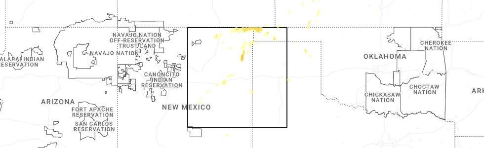
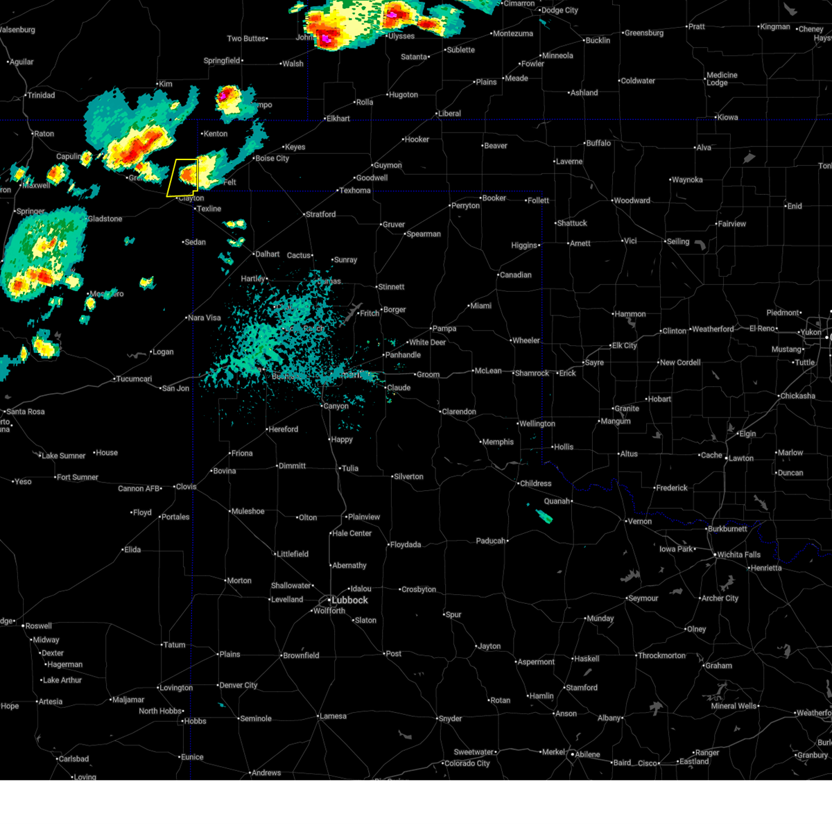
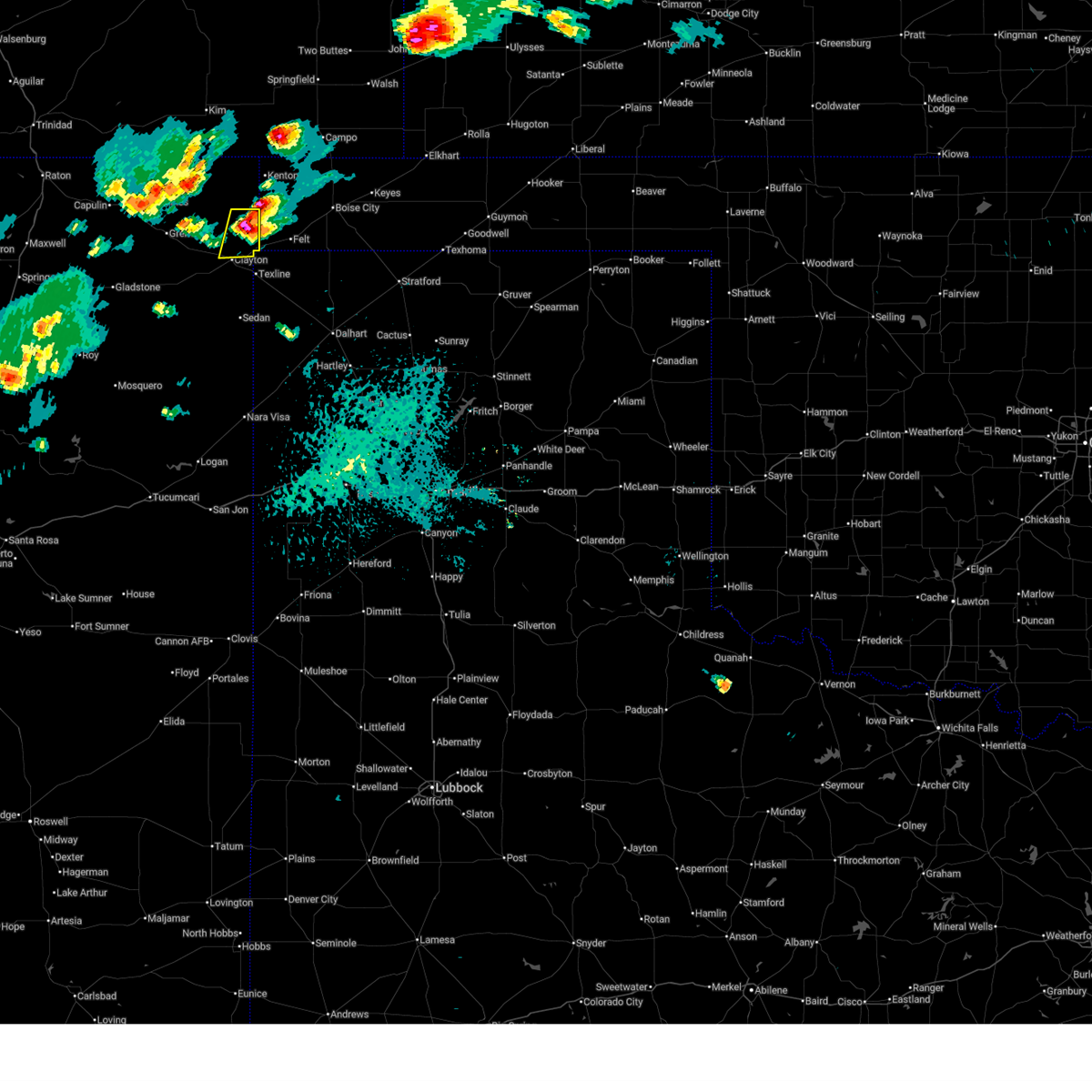
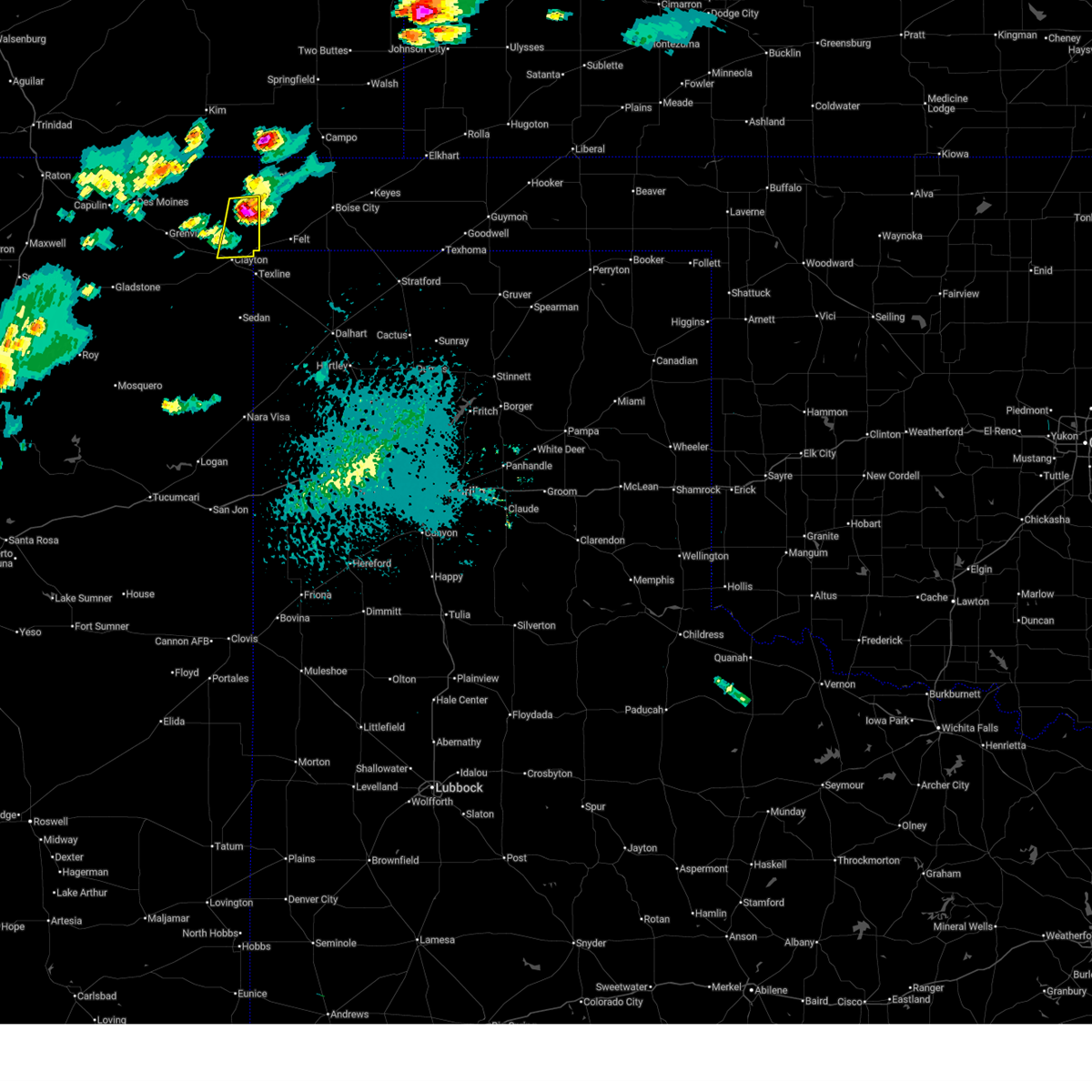
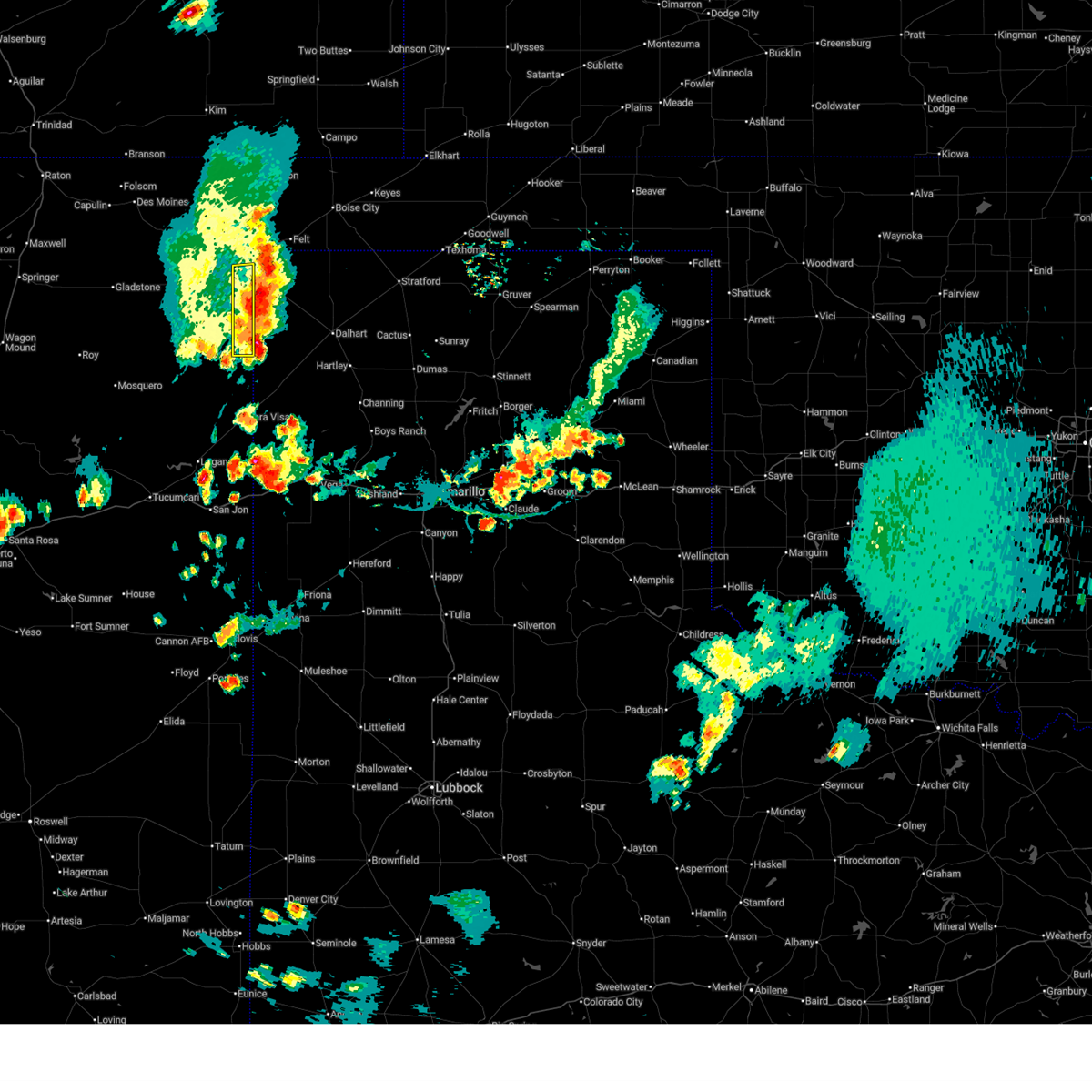
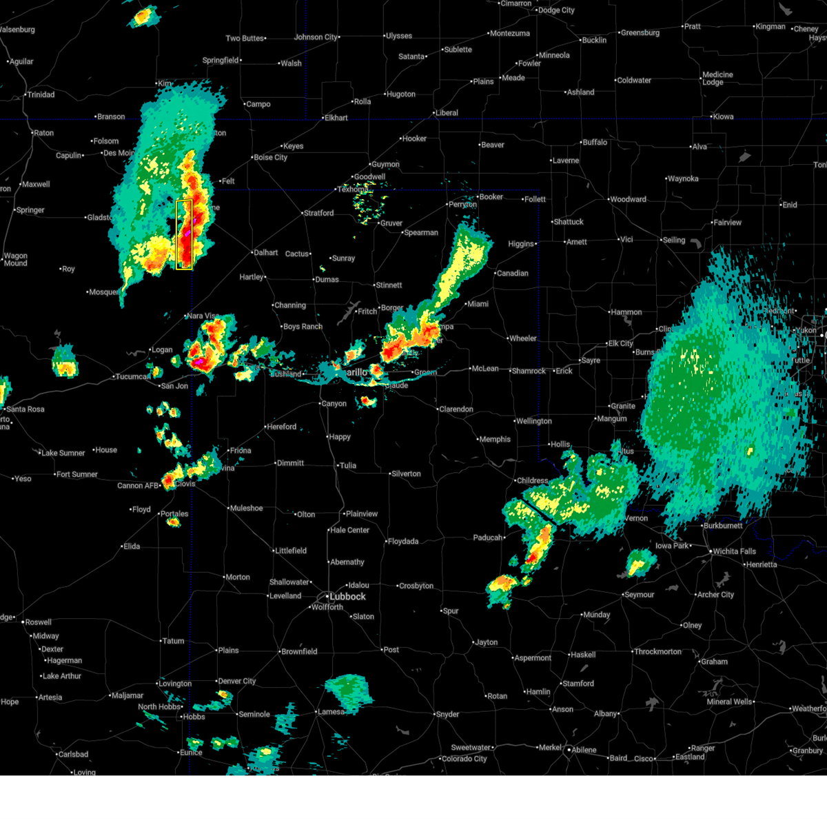
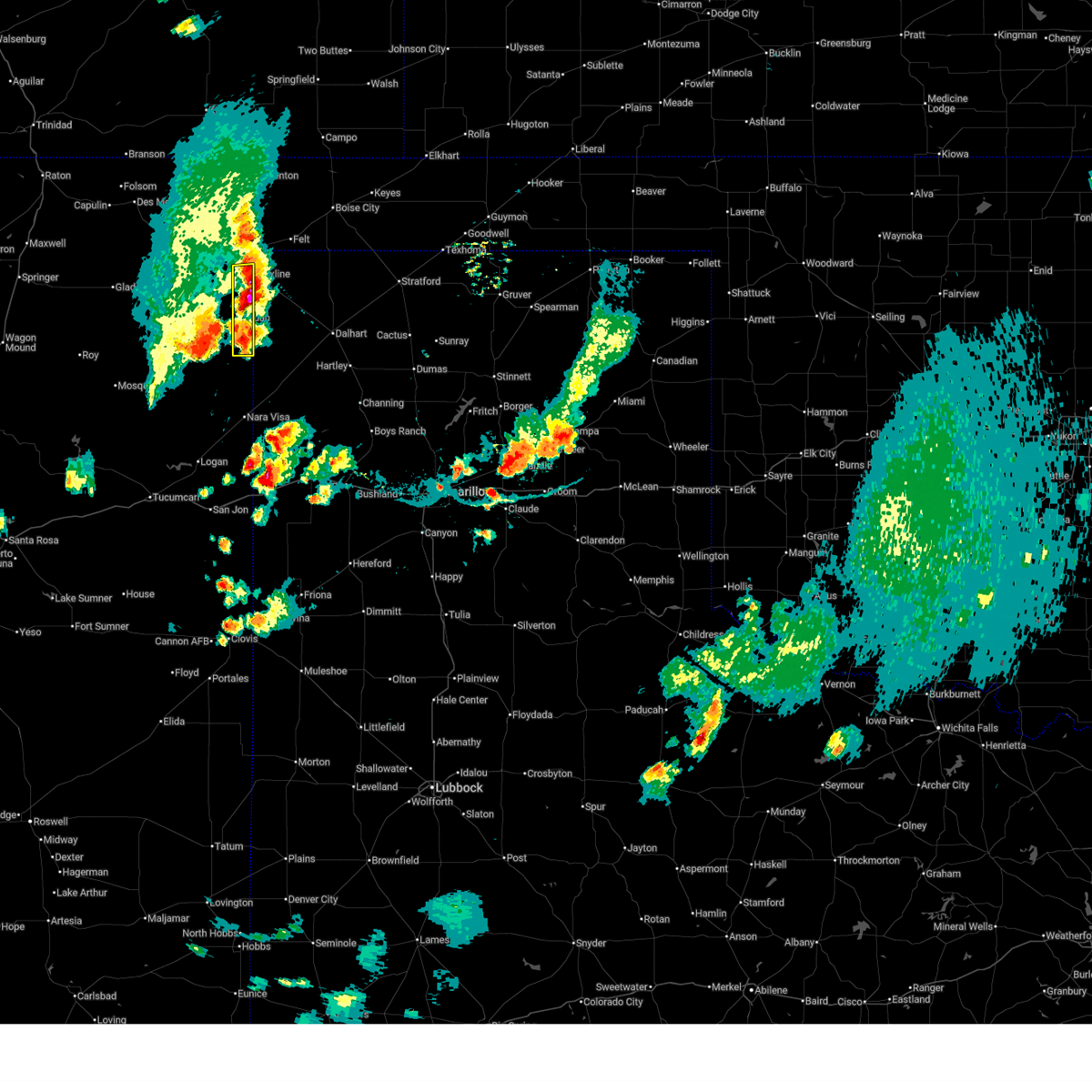
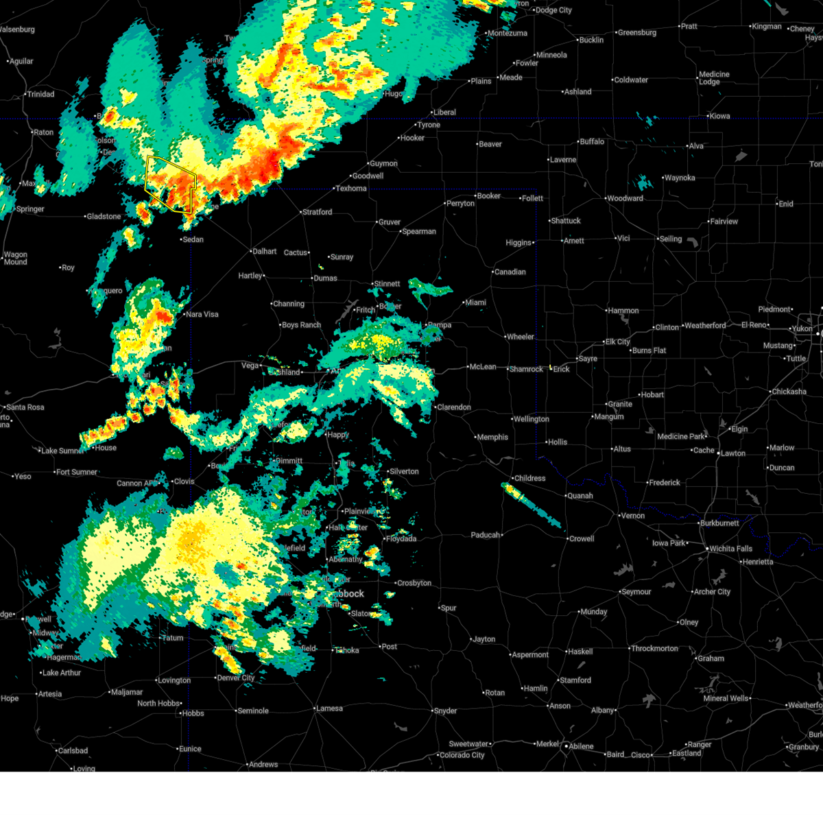
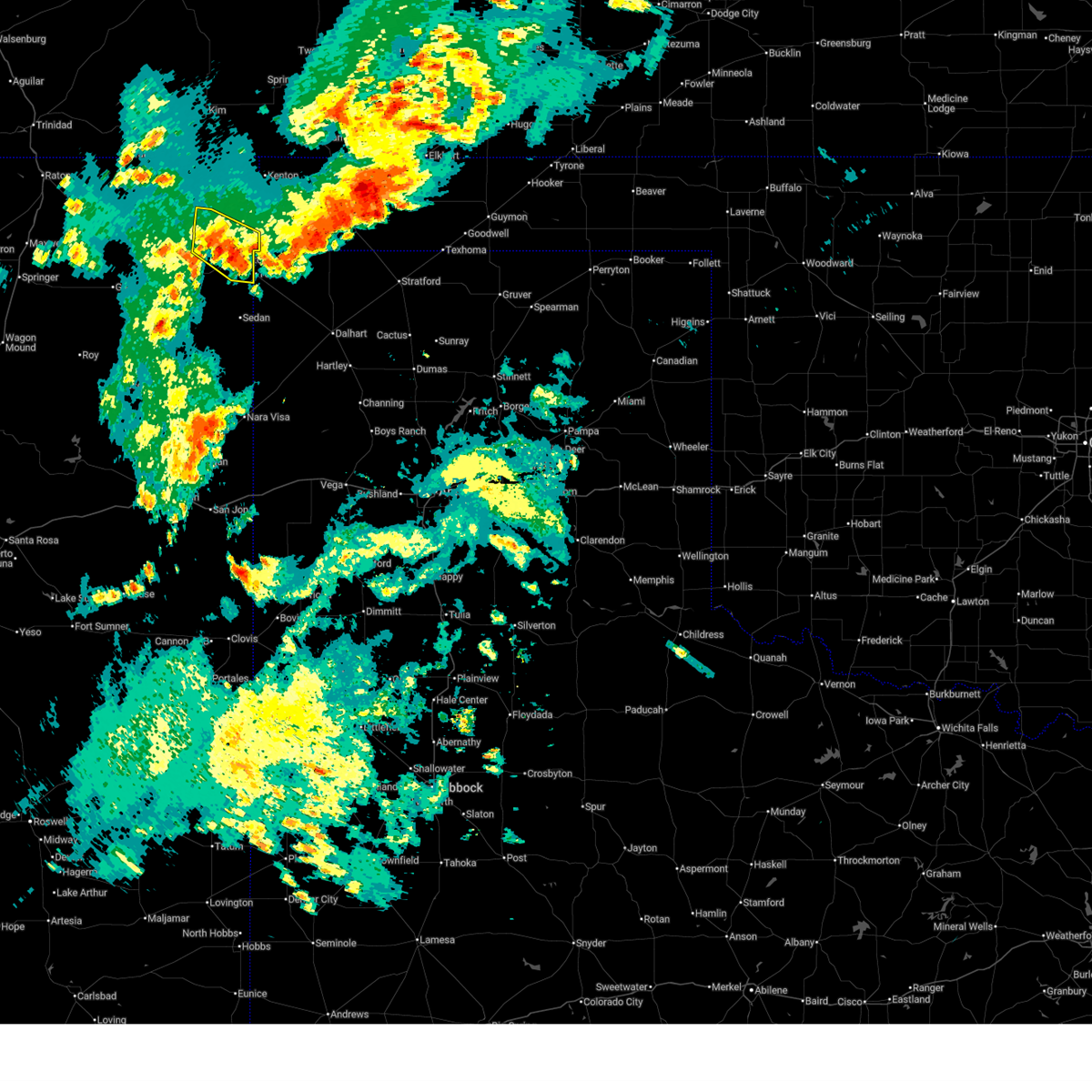
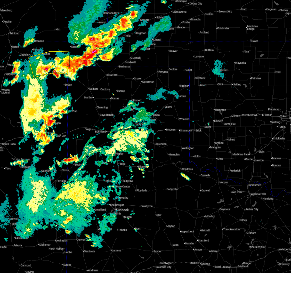
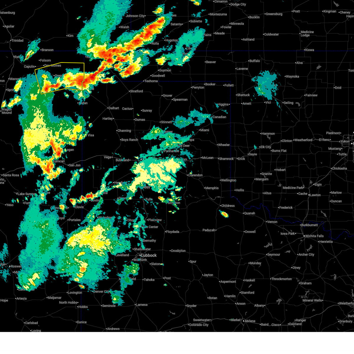
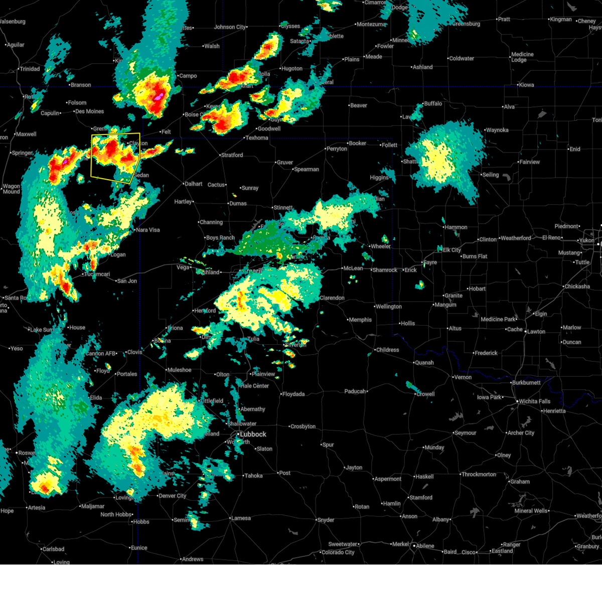
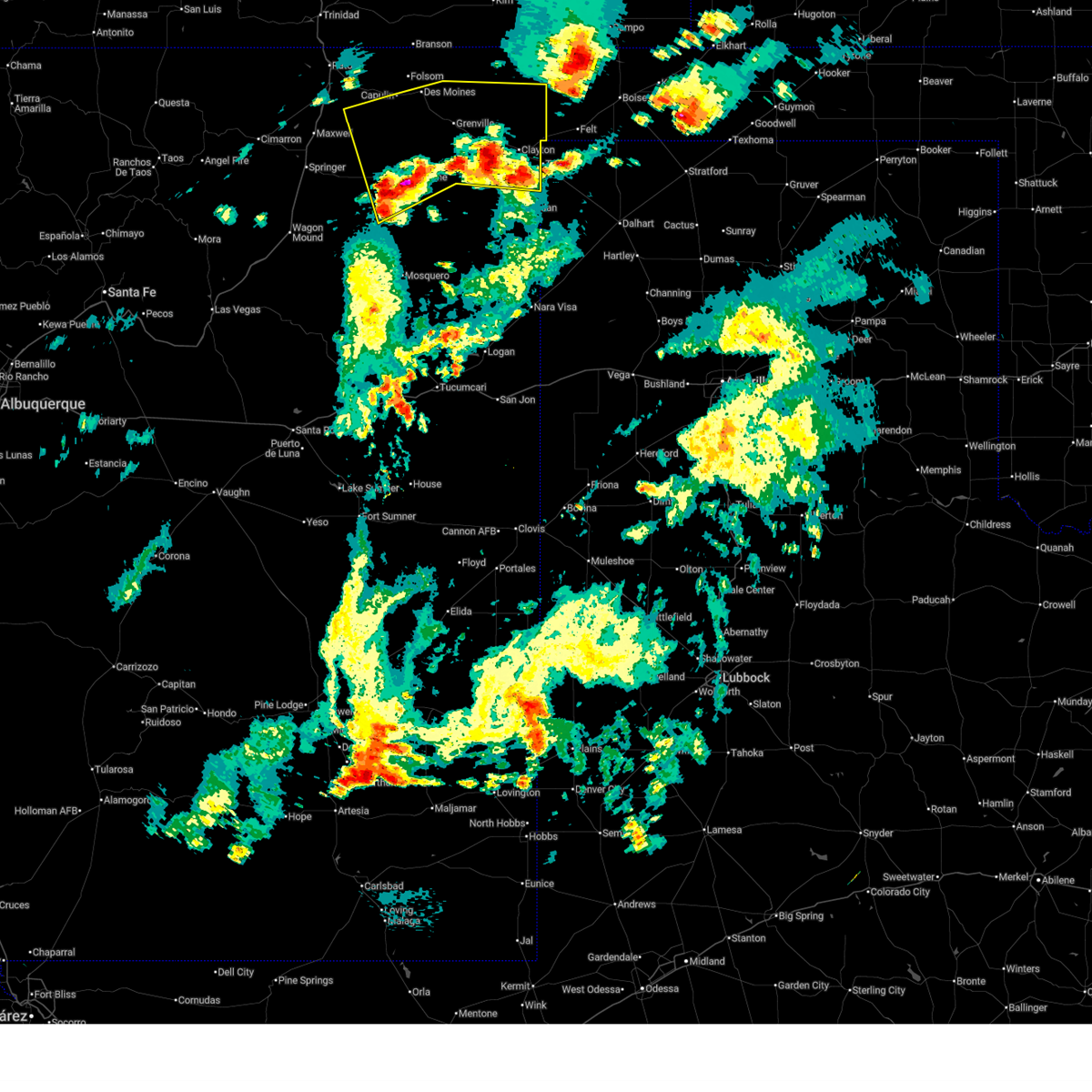
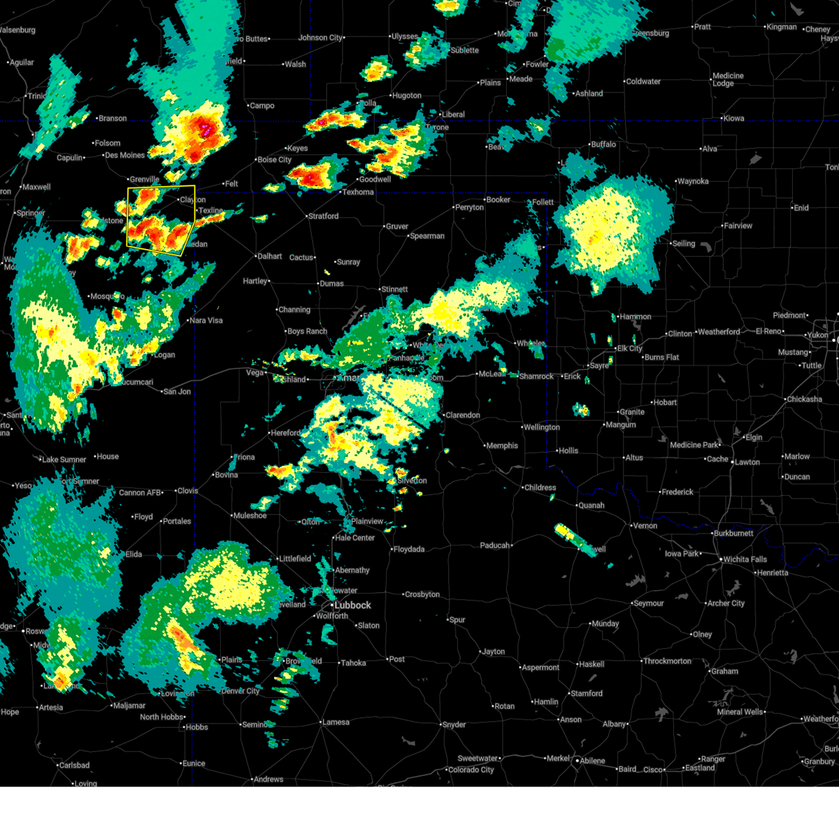
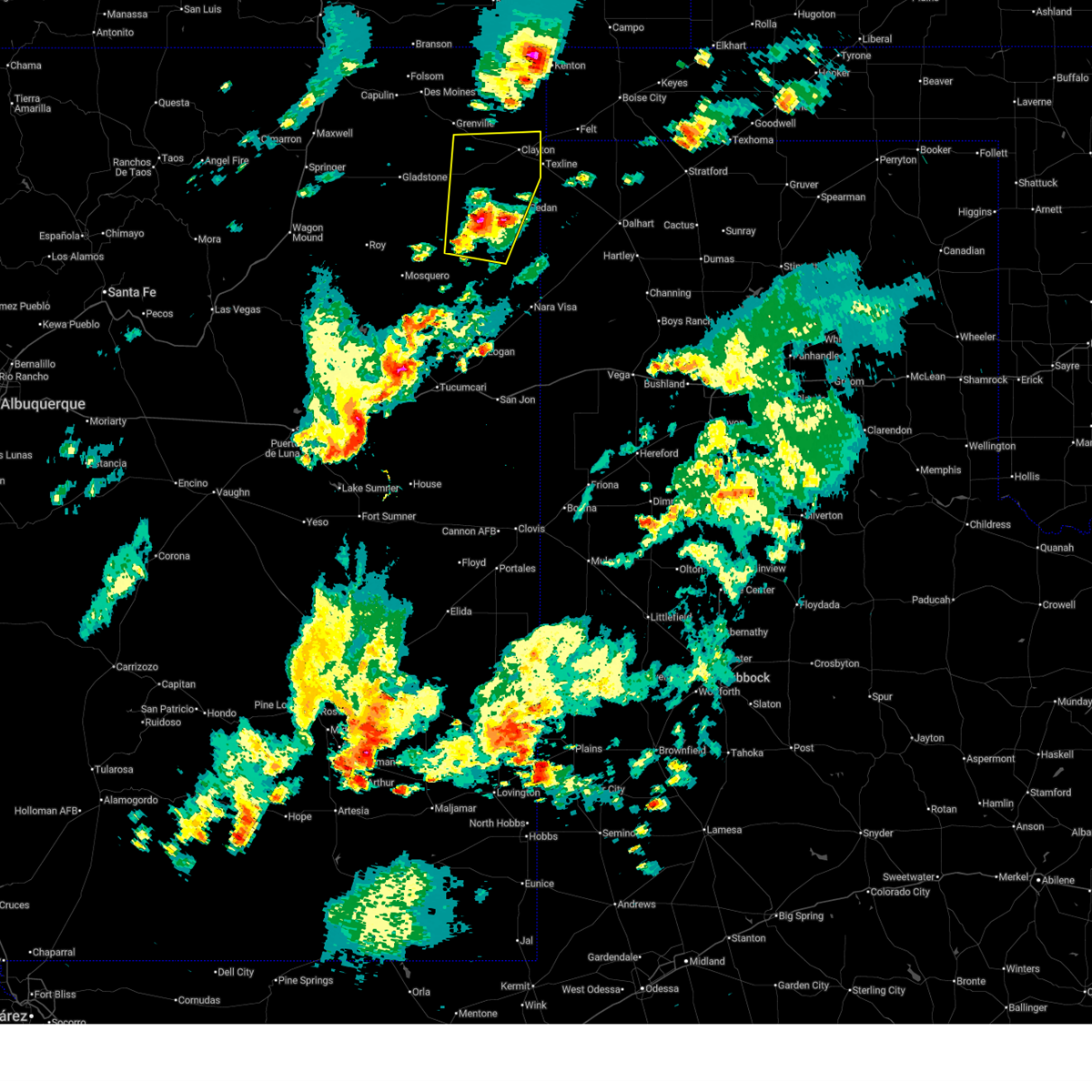
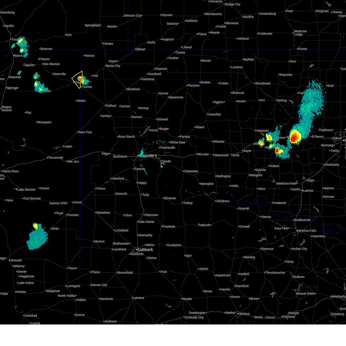
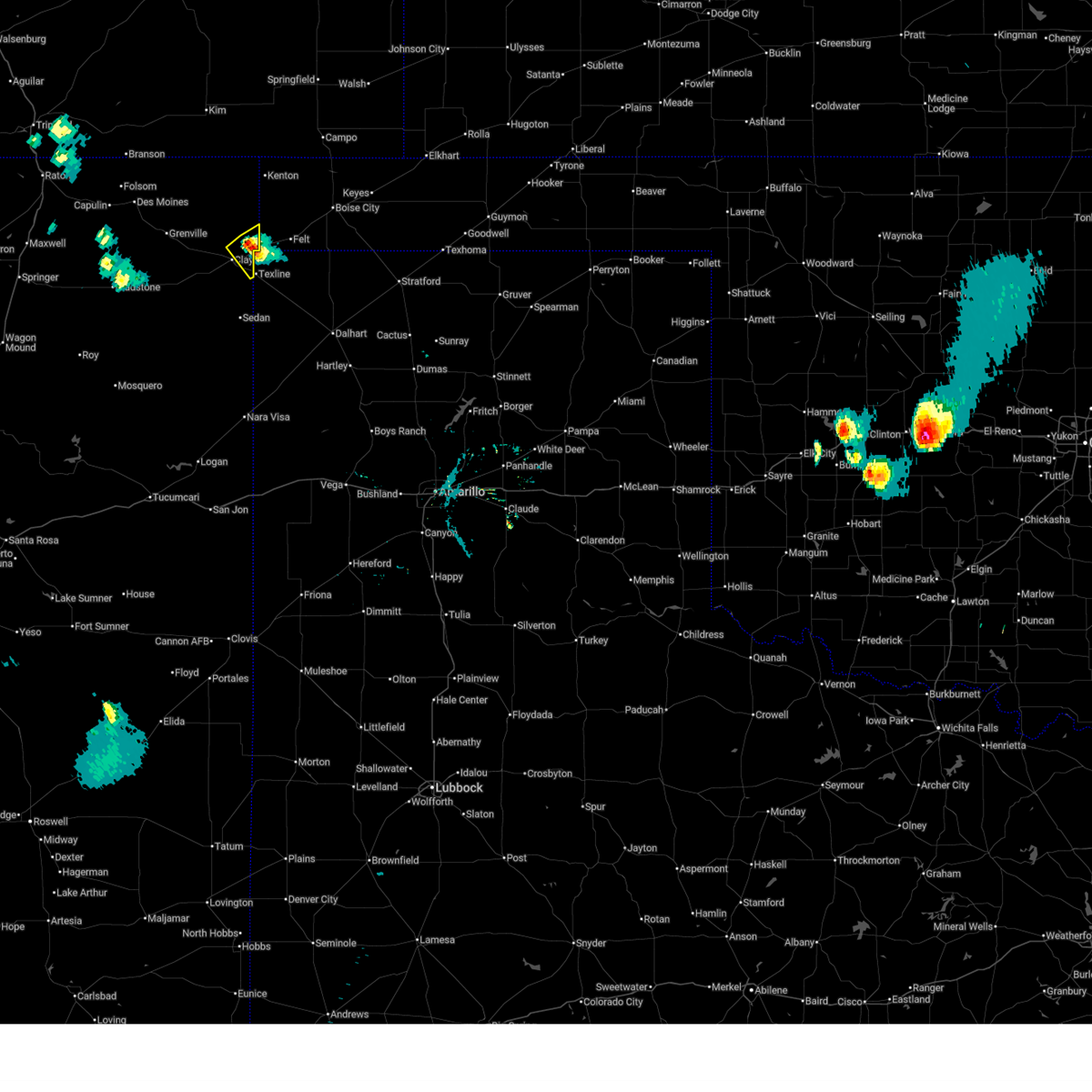
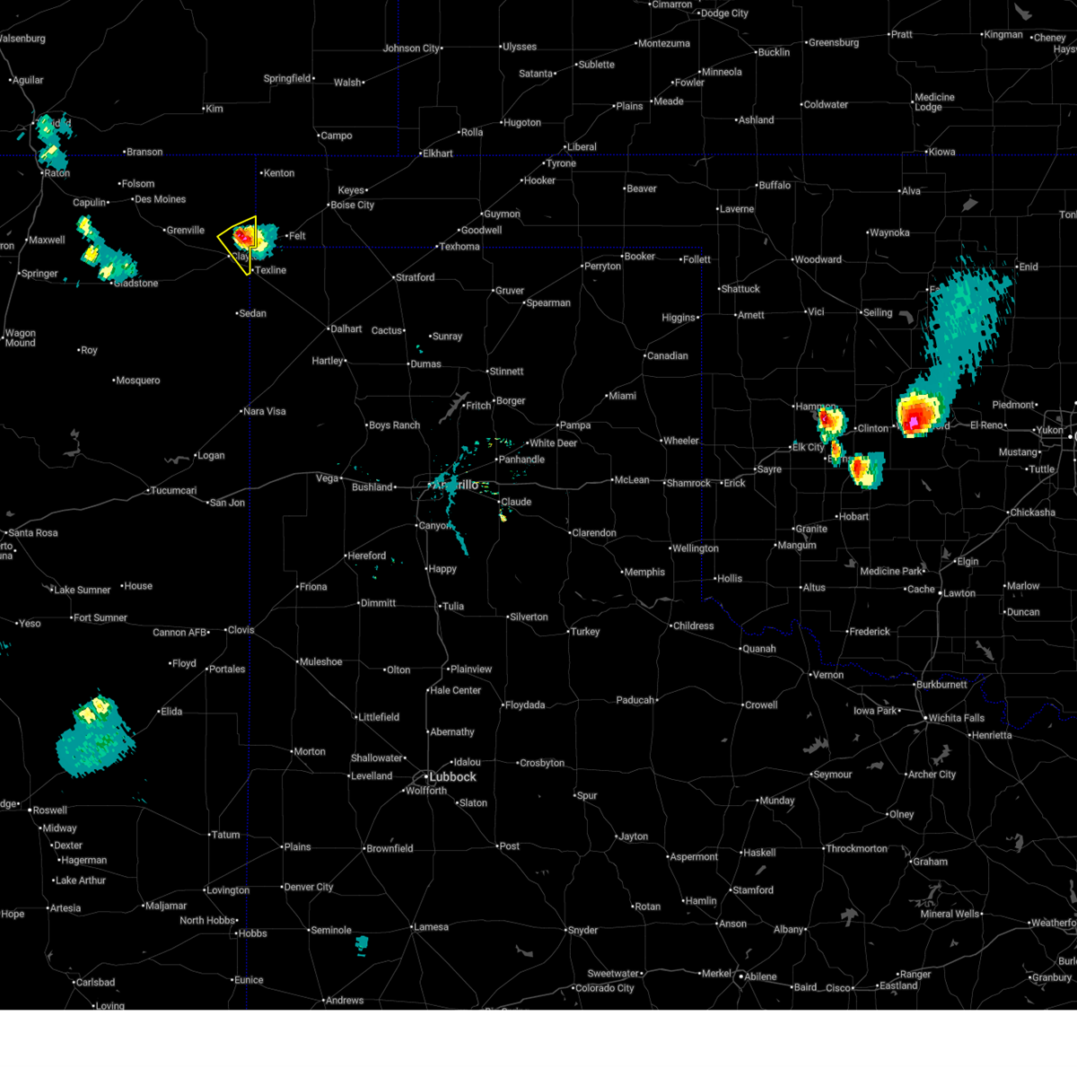
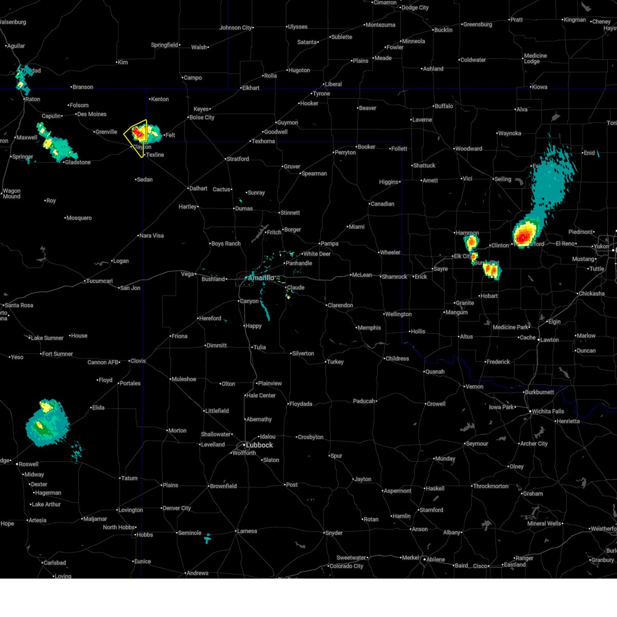
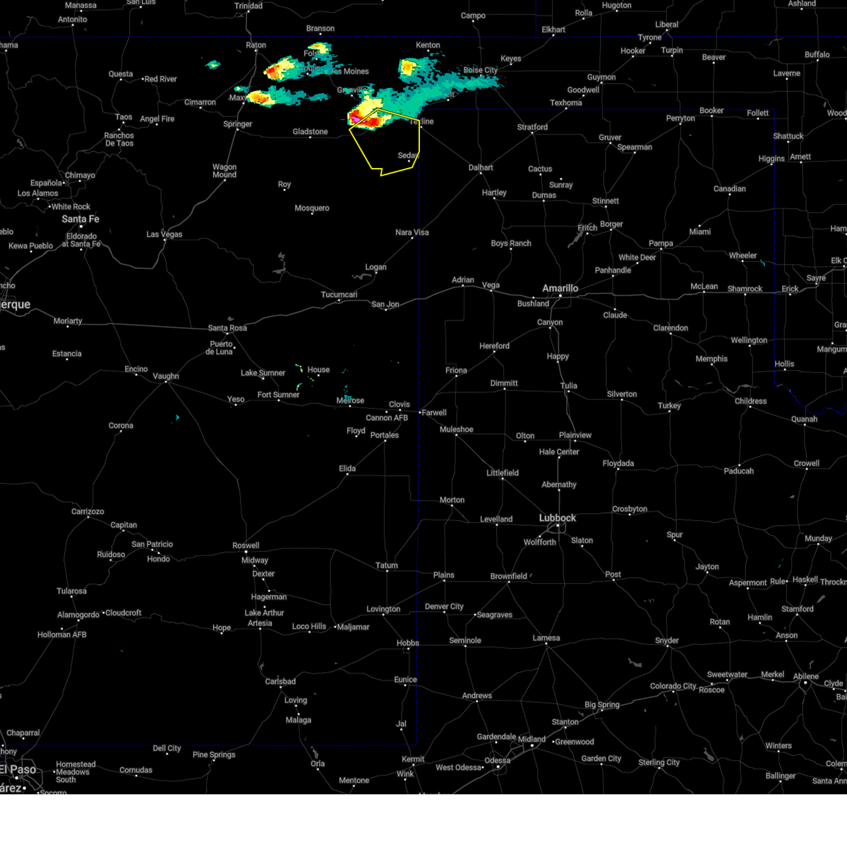
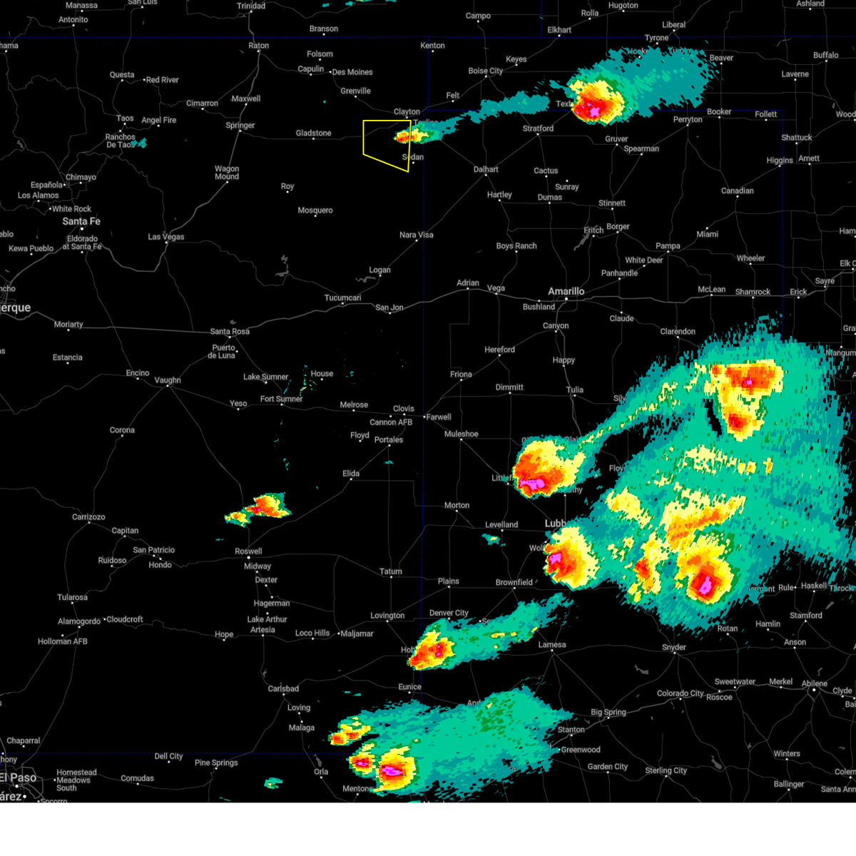
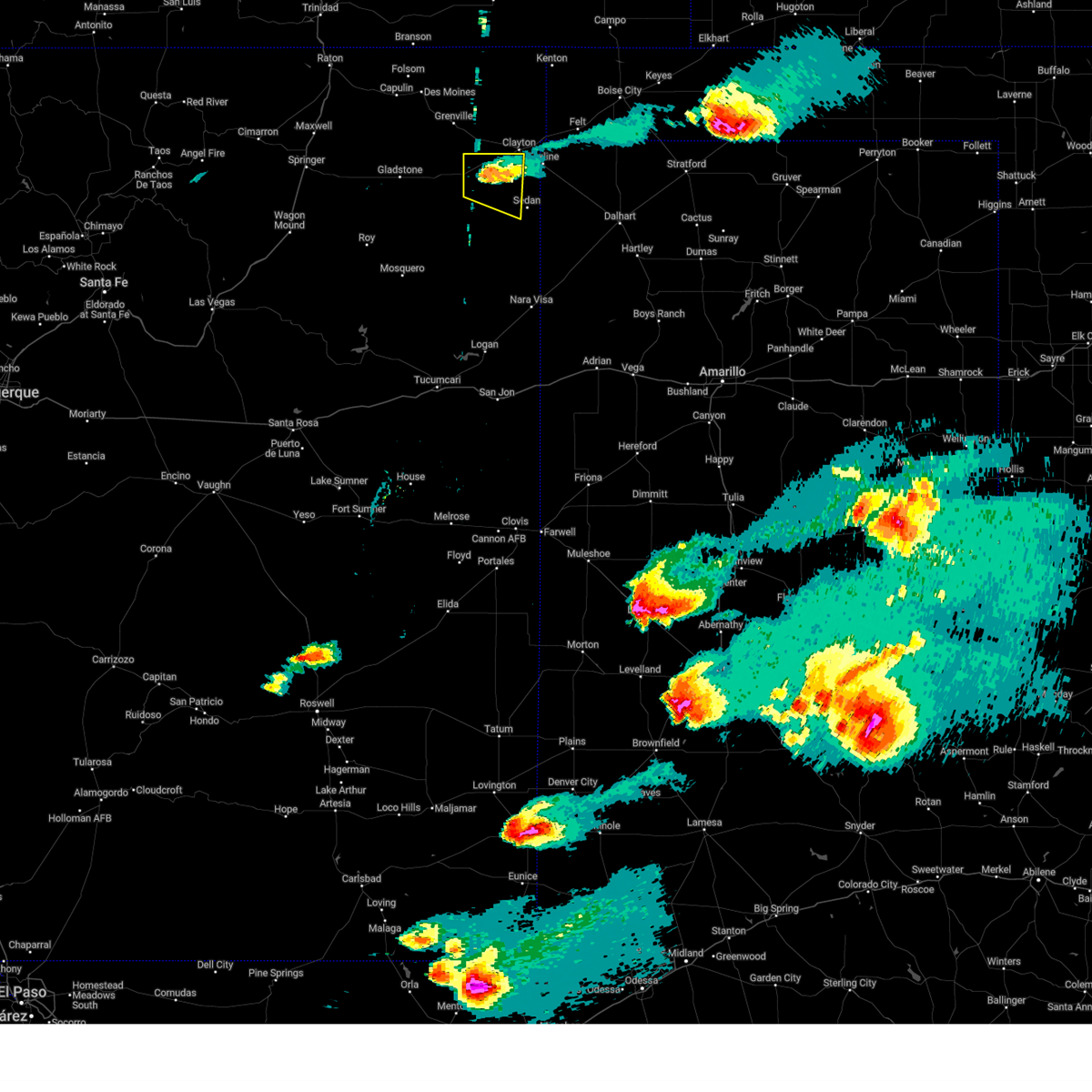
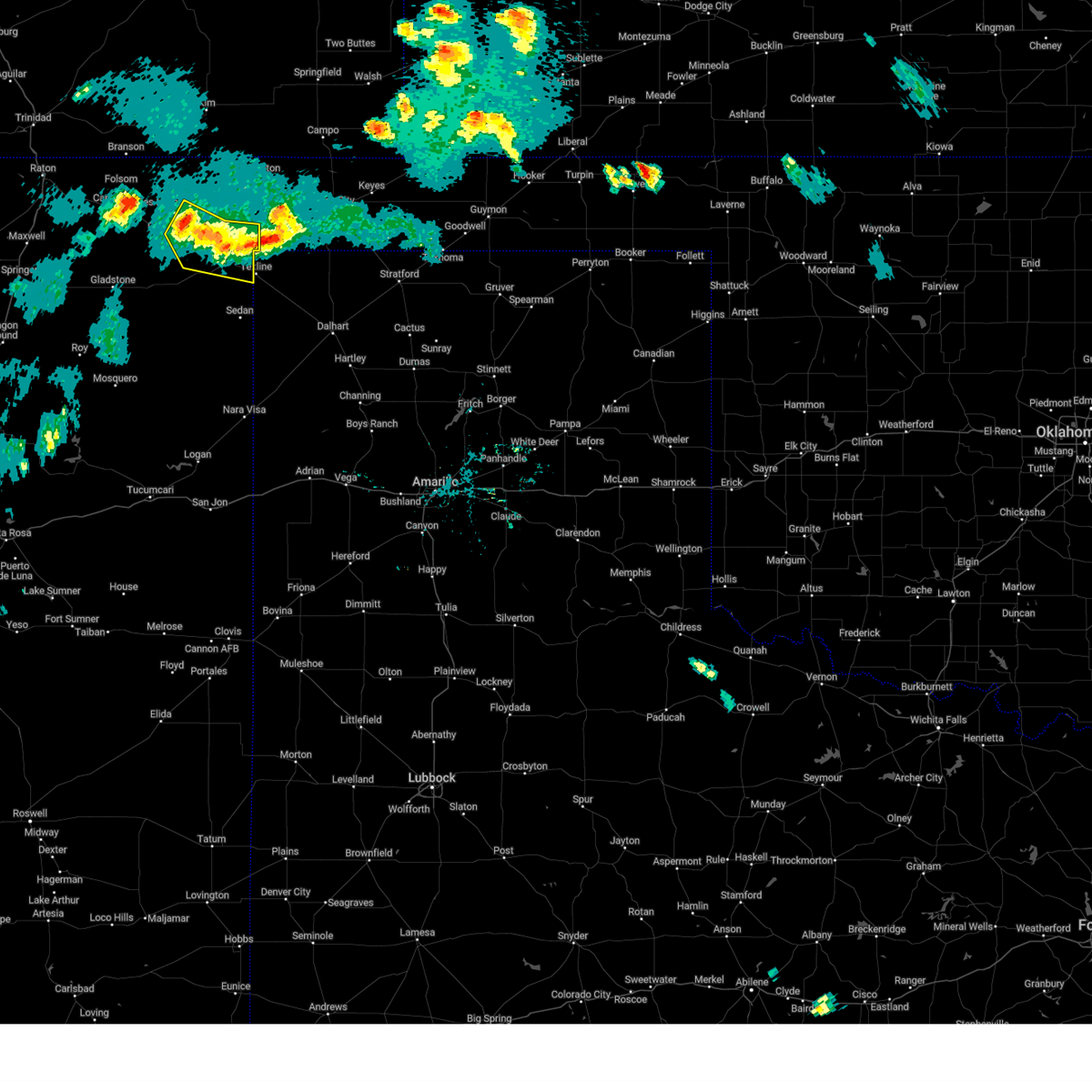
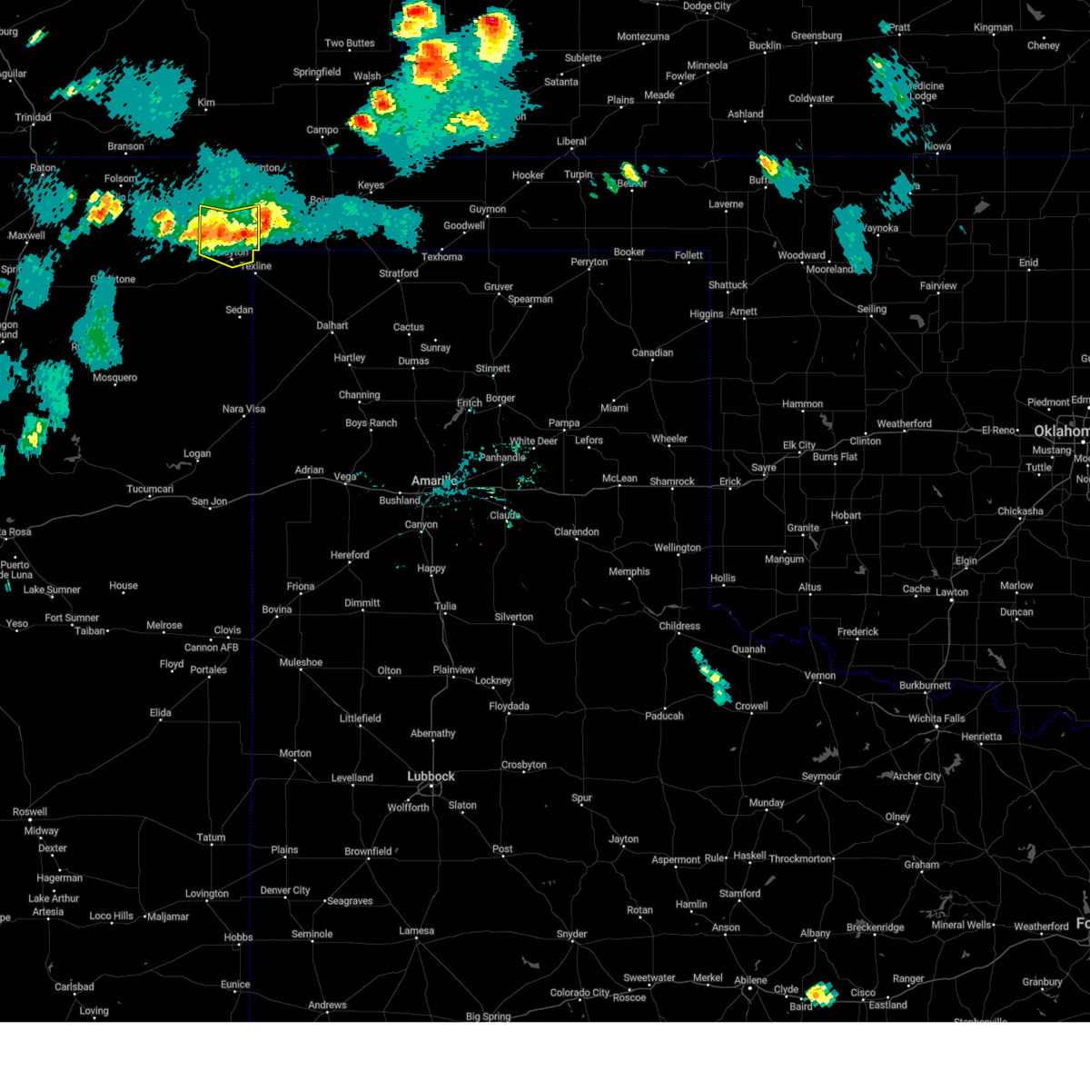
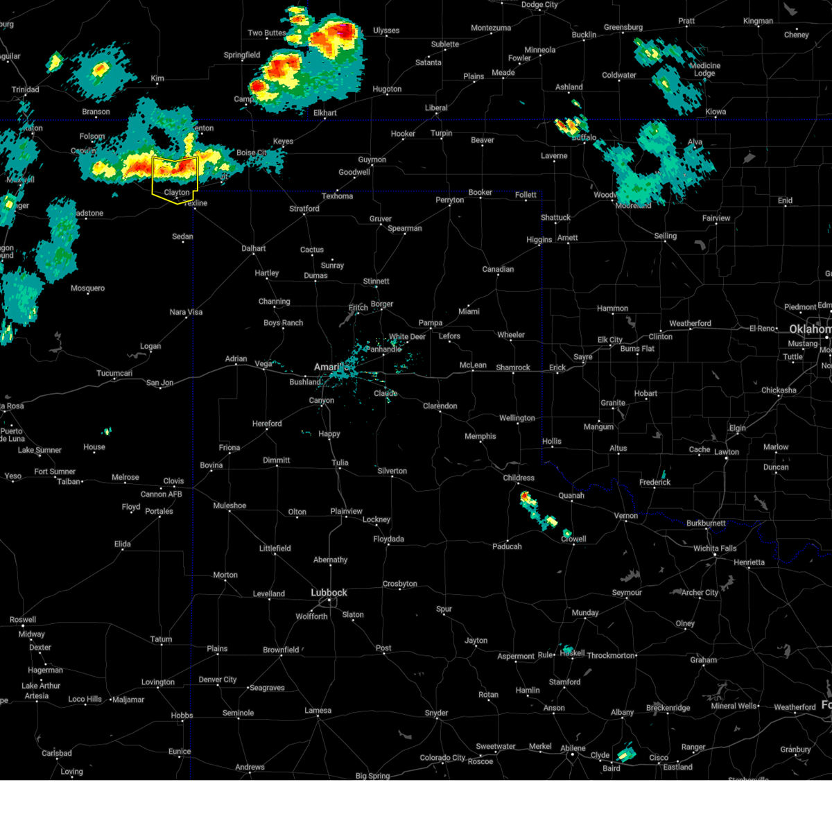
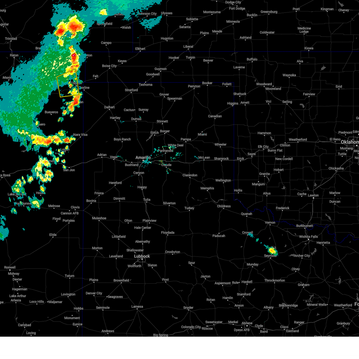
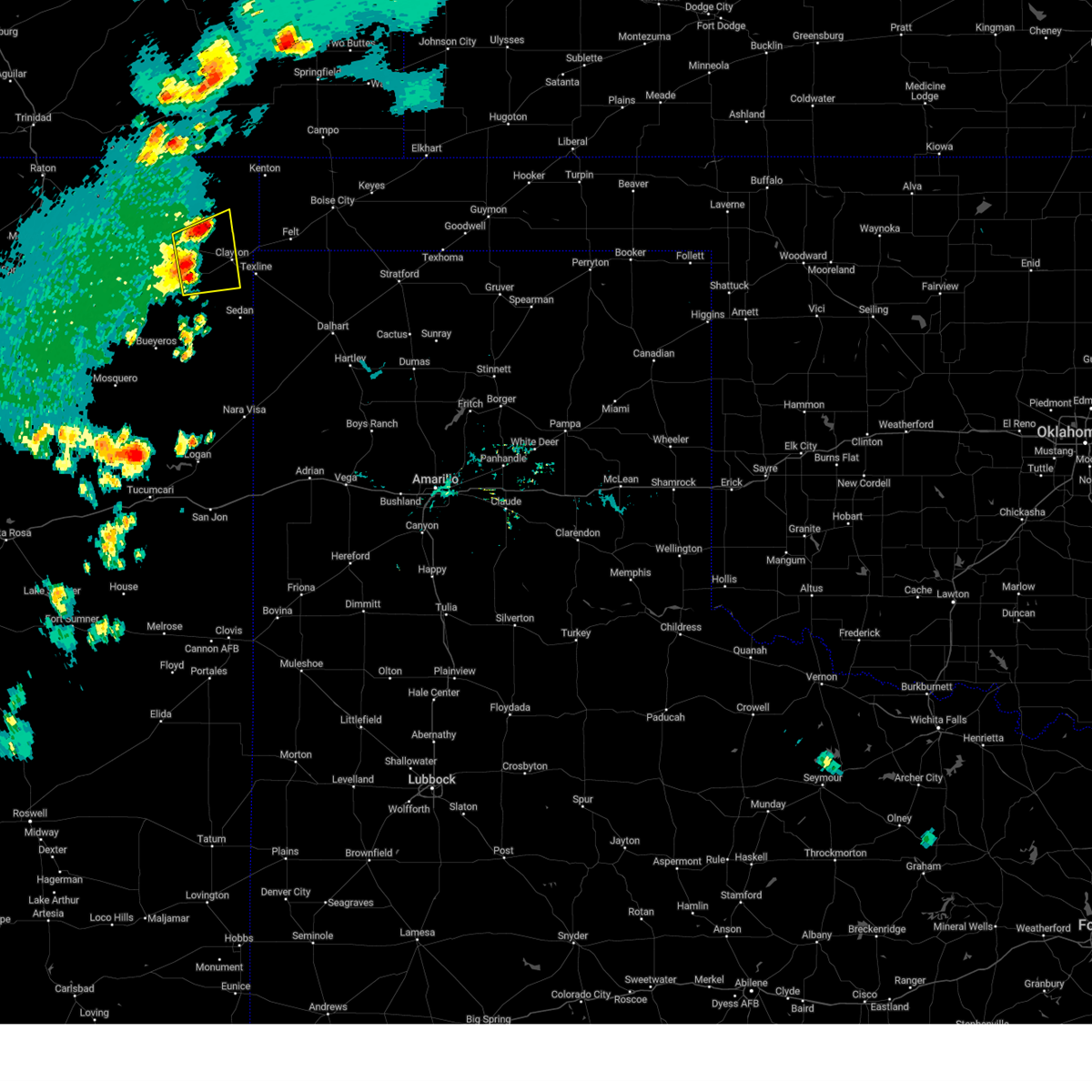
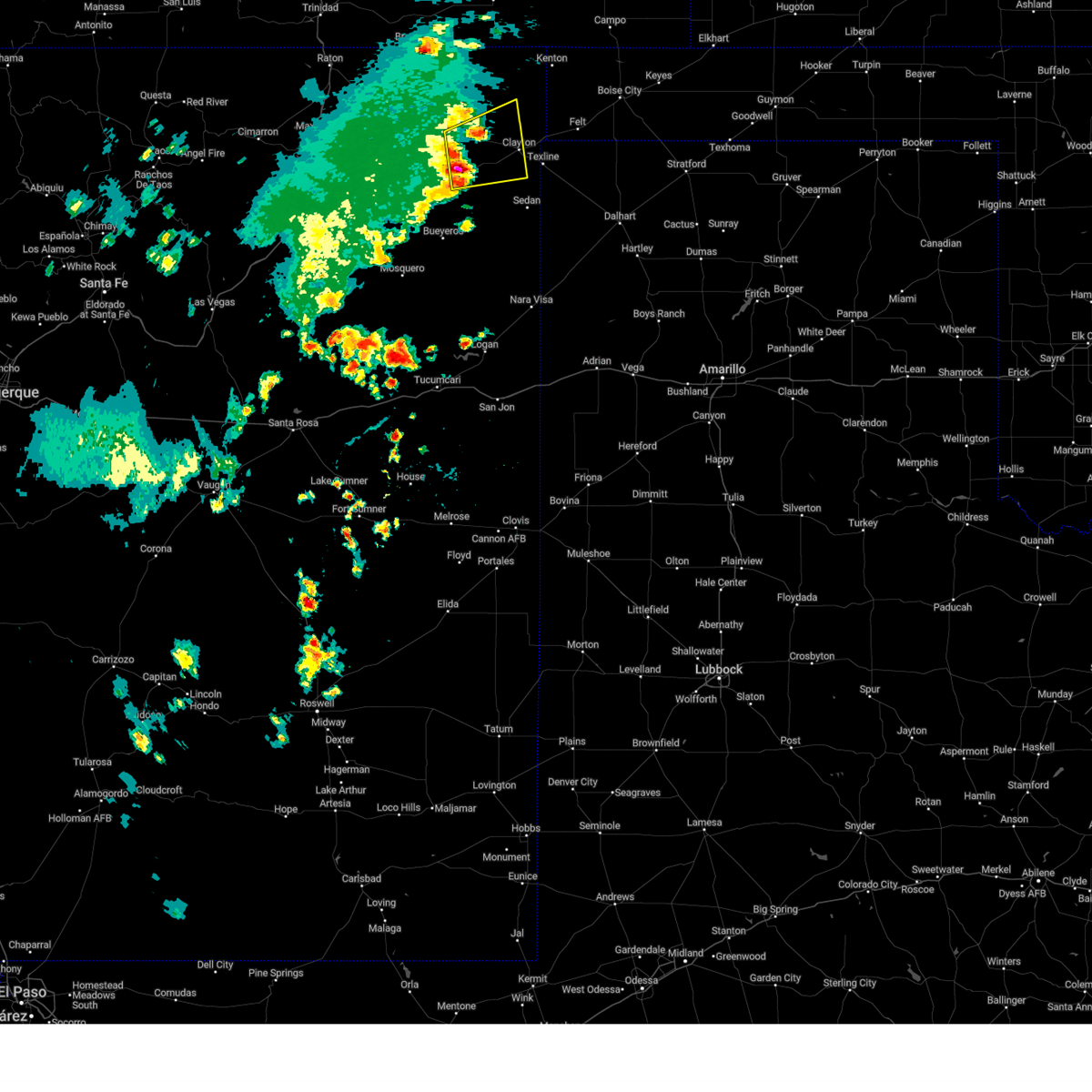
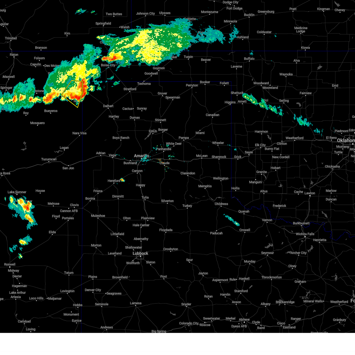
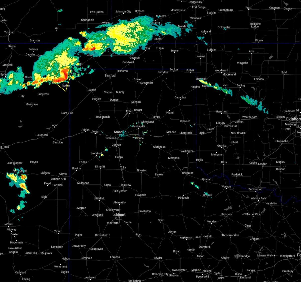
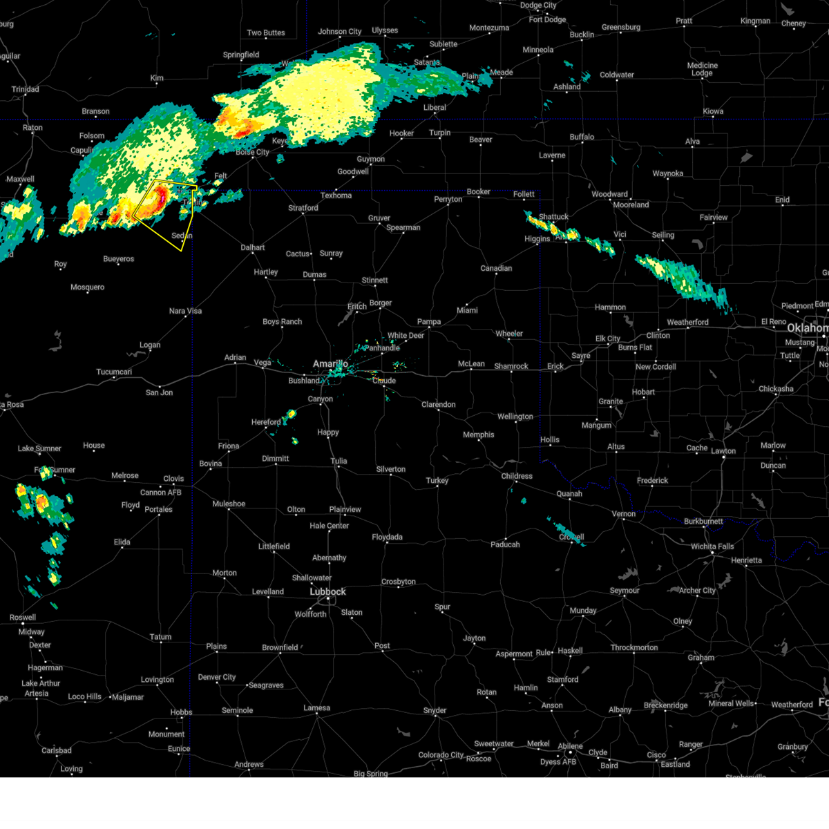
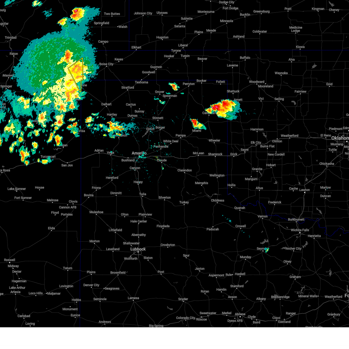
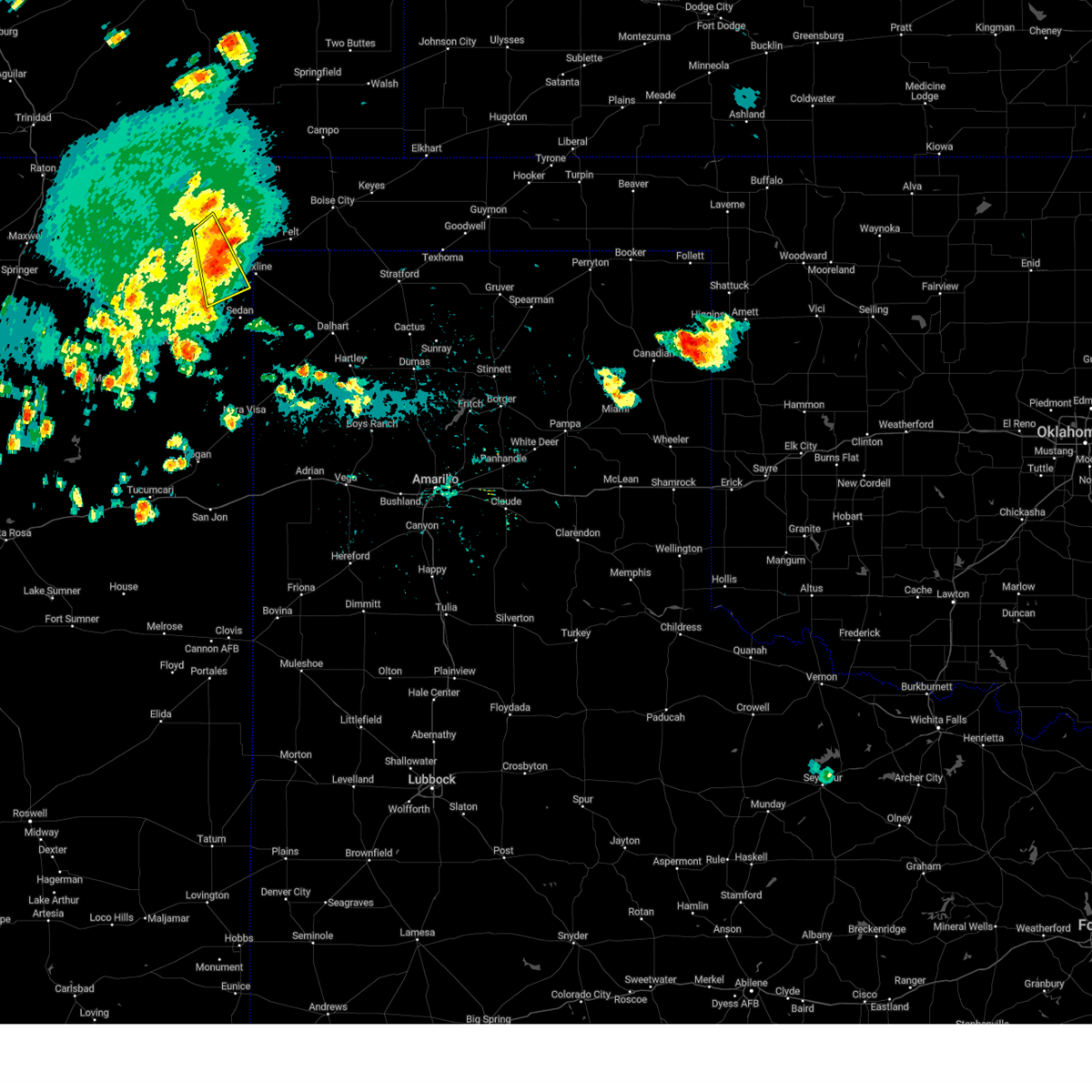
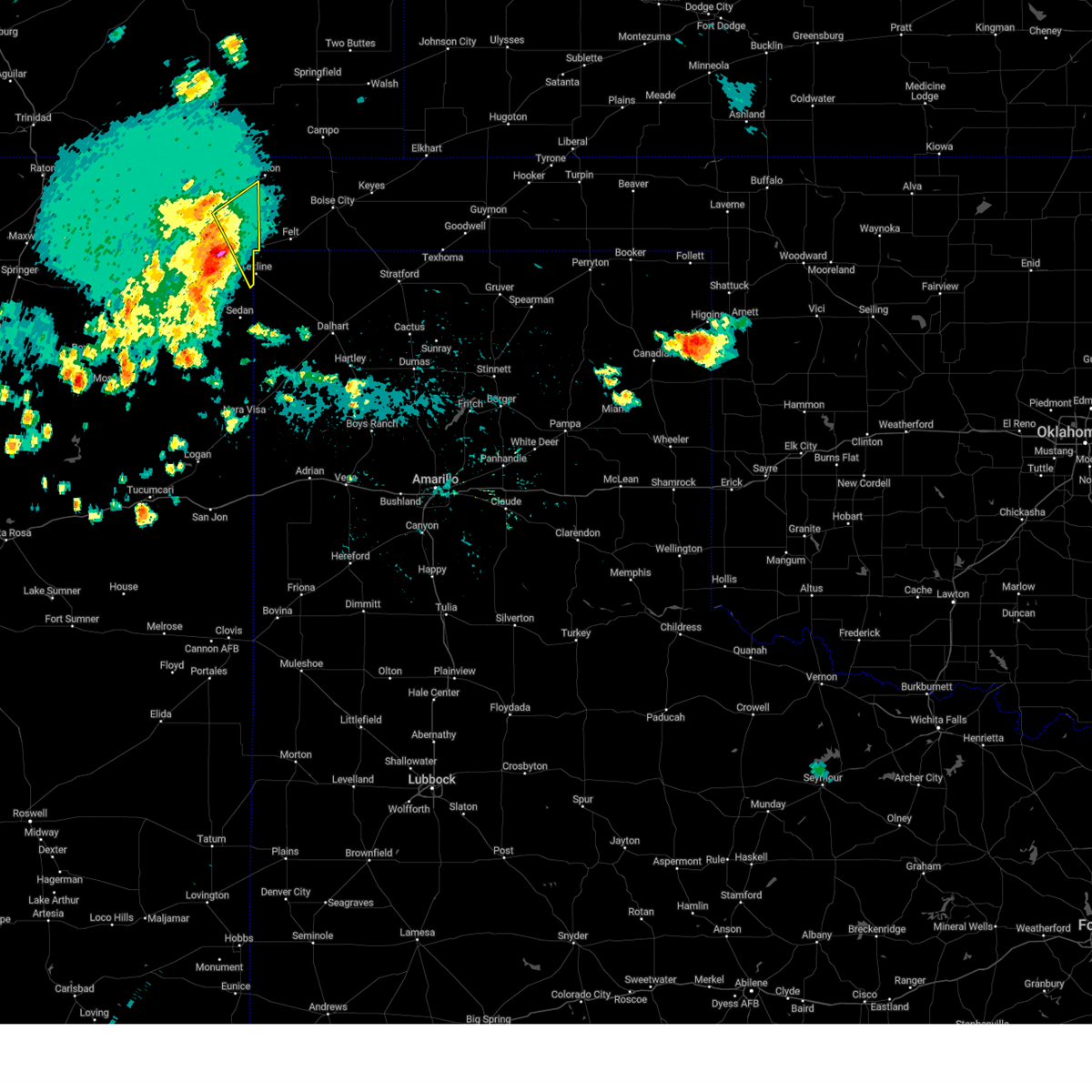
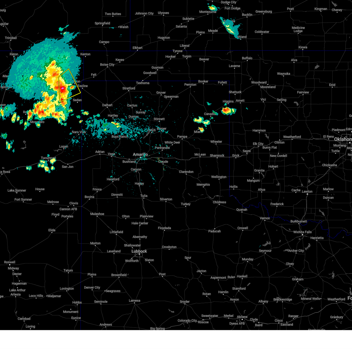
Hail Map for Clayton, NM
The Clayton, NM area has had 36 reports of on-the-ground hail by trained spotters, and has been under severe weather warnings 44 times during the past 12 months. Doppler radar has detected hail at or near Clayton, NM on 84 occasions, including 8 occasions during the past year.
| Name: | Clayton, NM |
| Where Located: | 92.6 miles NNE of Tucumcari, NM |
| Map: | Google Map for Clayton, NM |
| Population: | 2980 |
| Housing Units: | 1347 |
| More Info: | Search Google for Clayton, NM |
2
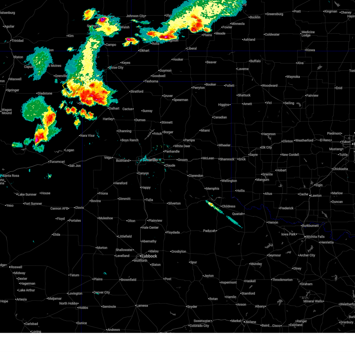
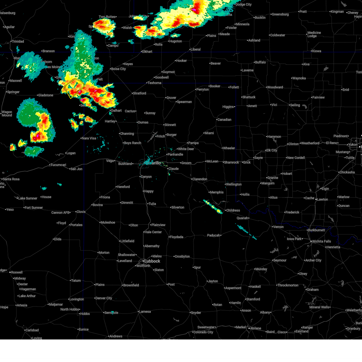
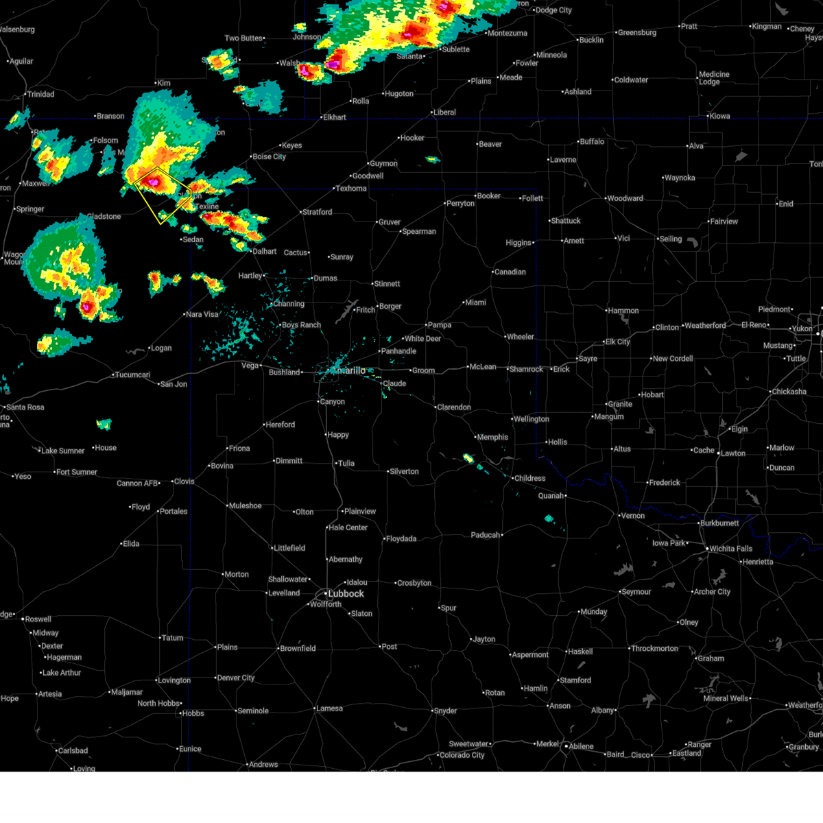
The Top Recent Hail Date for Clayton, NM is Monday, June 23, 2025 (9th out of 84)
Hail and Wind Damage Spotted near Clayton, NM
| Date / Time | Report Details |
|---|---|
| 7/10/2025 4:15 PM MDT | Lots of blowing dust kicked up with reduced visibilit in union county NM, 14 miles SSW of Clayton, NM |
| 7/5/2025 6:12 PM MDT |
 The storm which prompted the warning has moved out of the area. therefore, the warning will be allowed to expire. however, small hail and gusty winds are still possible with this thunderstorm. The storm which prompted the warning has moved out of the area. therefore, the warning will be allowed to expire. however, small hail and gusty winds are still possible with this thunderstorm.
|
| 7/5/2025 5:55 PM MDT |
 At 555 pm mdt, a severe thunderstorm was located 5 miles southwest of clayton, moving southeast at 15 mph (radar indicated). Hazards include 60 mph wind gusts and quarter size hail. Hail damage to vehicles is expected. expect wind damage to roofs, siding, and trees. locations impacted include, clayton. This includes highway 64 between mile markers 420 and 429. At 555 pm mdt, a severe thunderstorm was located 5 miles southwest of clayton, moving southeast at 15 mph (radar indicated). Hazards include 60 mph wind gusts and quarter size hail. Hail damage to vehicles is expected. expect wind damage to roofs, siding, and trees. locations impacted include, clayton. This includes highway 64 between mile markers 420 and 429.
|
| 7/5/2025 5:29 PM MDT |
 Svrabq the national weather service in albuquerque has issued a * severe thunderstorm warning for, east central union county in northeastern new mexico, * until 615 pm mdt. * at 529 pm mdt, a severe thunderstorm was located 5 miles southwest of clayton lake state park, or 10 miles northwest of clayton, moving southeast at 15 mph (radar indicated). Hazards include 60 mph wind gusts and quarter size hail. Hail damage to vehicles is expected. Expect wind damage to roofs, siding, and trees. Svrabq the national weather service in albuquerque has issued a * severe thunderstorm warning for, east central union county in northeastern new mexico, * until 615 pm mdt. * at 529 pm mdt, a severe thunderstorm was located 5 miles southwest of clayton lake state park, or 10 miles northwest of clayton, moving southeast at 15 mph (radar indicated). Hazards include 60 mph wind gusts and quarter size hail. Hail damage to vehicles is expected. Expect wind damage to roofs, siding, and trees.
|
| 7/5/2025 4:47 PM MDT |
 the severe thunderstorm warning has been cancelled and is no longer in effect the severe thunderstorm warning has been cancelled and is no longer in effect
|
| 7/5/2025 4:27 PM MDT |
 At 427 pm mdt, a severe thunderstorm was located near seneca, or 12 miles north of clayton, moving south at 15 mph (radar indicated). Hazards include 60 mph wind gusts and quarter size hail. Hail damage to vehicles is expected. expect wind damage to roofs, siding, and trees. locations impacted include, clayton, seneca and moses. This includes highway 64 between mile markers 426 and 427. At 427 pm mdt, a severe thunderstorm was located near seneca, or 12 miles north of clayton, moving south at 15 mph (radar indicated). Hazards include 60 mph wind gusts and quarter size hail. Hail damage to vehicles is expected. expect wind damage to roofs, siding, and trees. locations impacted include, clayton, seneca and moses. This includes highway 64 between mile markers 426 and 427.
|
| 7/5/2025 4:08 PM MDT |
 Svrabq the national weather service in albuquerque has issued a * severe thunderstorm warning for, northeastern union county in northeastern new mexico, * until 500 pm mdt. * at 408 pm mdt, a severe thunderstorm was located near seneca, or 17 miles north of clayton, moving south at 20 mph (radar indicated). Hazards include 60 mph wind gusts and quarter size hail. Hail damage to vehicles is expected. Expect wind damage to roofs, siding, and trees. Svrabq the national weather service in albuquerque has issued a * severe thunderstorm warning for, northeastern union county in northeastern new mexico, * until 500 pm mdt. * at 408 pm mdt, a severe thunderstorm was located near seneca, or 17 miles north of clayton, moving south at 20 mph (radar indicated). Hazards include 60 mph wind gusts and quarter size hail. Hail damage to vehicles is expected. Expect wind damage to roofs, siding, and trees.
|
| 6/26/2025 6:19 PM MDT |
 the severe thunderstorm warning has been cancelled and is no longer in effect the severe thunderstorm warning has been cancelled and is no longer in effect
|
| 6/26/2025 6:01 PM MDT |
 At 601 pm mdt, severe thunderstorms were located along a line from 9 miles southeast of clayton to 6 miles northeast of amistad, moving east at 5 mph (radar indicated). Hazards include ping pong ball size hail and 60 mph wind gusts. People and animals outdoors will be injured. expect hail damage to roofs, siding, windows, and vehicles. expect wind damage to roofs, siding, and trees. Locations impacted include, sedan. At 601 pm mdt, severe thunderstorms were located along a line from 9 miles southeast of clayton to 6 miles northeast of amistad, moving east at 5 mph (radar indicated). Hazards include ping pong ball size hail and 60 mph wind gusts. People and animals outdoors will be injured. expect hail damage to roofs, siding, windows, and vehicles. expect wind damage to roofs, siding, and trees. Locations impacted include, sedan.
|
| 6/26/2025 5:54 PM MDT |
 Svrabq the national weather service in albuquerque has issued a * severe thunderstorm warning for, east central union county in northeastern new mexico, * until 645 pm mdt. * at 554 pm mdt, severe thunderstorms were located along a line from 6 miles east of clayton to 5 miles northeast of amistad, moving east at 5 mph (radar indicated). Hazards include 60 mph wind gusts and quarter size hail. Hail damage to vehicles is expected. Expect wind damage to roofs, siding, and trees. Svrabq the national weather service in albuquerque has issued a * severe thunderstorm warning for, east central union county in northeastern new mexico, * until 645 pm mdt. * at 554 pm mdt, severe thunderstorms were located along a line from 6 miles east of clayton to 5 miles northeast of amistad, moving east at 5 mph (radar indicated). Hazards include 60 mph wind gusts and quarter size hail. Hail damage to vehicles is expected. Expect wind damage to roofs, siding, and trees.
|
| 6/23/2025 7:43 PM MDT |
 The storms which prompted the warning have weakened below severe limits, and no longer pose an immediate threat to life or property. therefore, the warning will be allowed to expire. however, small hail, gusty winds, and heavy rain are still possible with these thunderstorms. The storms which prompted the warning have weakened below severe limits, and no longer pose an immediate threat to life or property. therefore, the warning will be allowed to expire. however, small hail, gusty winds, and heavy rain are still possible with these thunderstorms.
|
| 6/23/2025 7:30 PM MDT |
 At 730 pm mdt, severe thunderstorms were located along a line from near clayton lake state park to near clayton, moving northeast at 15 mph (radar indicated). Hazards include 60 mph wind gusts and small hail. Expect damage to roofs, siding, and trees. locations impacted include, clayton, clayton lake state park and seneca. This includes highway 64 between mile markers 416 and 429. At 730 pm mdt, severe thunderstorms were located along a line from near clayton lake state park to near clayton, moving northeast at 15 mph (radar indicated). Hazards include 60 mph wind gusts and small hail. Expect damage to roofs, siding, and trees. locations impacted include, clayton, clayton lake state park and seneca. This includes highway 64 between mile markers 416 and 429.
|
| 6/23/2025 7:00 PM MDT |
 The storms which prompted the warning have moved out of the area. therefore, the warning has been allowed to expire. to report severe weather, contact the national weather service office in albuquerque at 1.888.386.7637. The storms which prompted the warning have moved out of the area. therefore, the warning has been allowed to expire. to report severe weather, contact the national weather service office in albuquerque at 1.888.386.7637.
|
| 6/23/2025 6:59 PM MDT |
 Svrabq the national weather service in albuquerque has issued a * severe thunderstorm warning for, central union county in northeastern new mexico, * until 745 pm mdt. * at 659 pm mdt, severe thunderstorms were located along a line from 8 miles southwest of grenville to 6 miles south of clayton, moving north at 15 mph (radar indicated). Hazards include 60 mph wind gusts and small hail. expect damage to roofs, siding, and trees Svrabq the national weather service in albuquerque has issued a * severe thunderstorm warning for, central union county in northeastern new mexico, * until 745 pm mdt. * at 659 pm mdt, severe thunderstorms were located along a line from 8 miles southwest of grenville to 6 miles south of clayton, moving north at 15 mph (radar indicated). Hazards include 60 mph wind gusts and small hail. expect damage to roofs, siding, and trees
|
| 6/23/2025 6:42 PM MDT |
 At 642 pm mdt, severe thunderstorms were located along a line from 10 miles northeast of gladstone to 10 miles southeast of seneca, moving north at 25 mph (radar indicated). Hazards include 60 mph wind gusts and quarter size hail. Hail damage to vehicles is expected. expect wind damage to roofs, siding, and trees. locations impacted include, clayton, grenville, mount dora, clayton lake state park, seneca and moses. This includes highway 64 between mile markers 388 and 429. At 642 pm mdt, severe thunderstorms were located along a line from 10 miles northeast of gladstone to 10 miles southeast of seneca, moving north at 25 mph (radar indicated). Hazards include 60 mph wind gusts and quarter size hail. Hail damage to vehicles is expected. expect wind damage to roofs, siding, and trees. locations impacted include, clayton, grenville, mount dora, clayton lake state park, seneca and moses. This includes highway 64 between mile markers 388 and 429.
|
| 6/23/2025 6:42 PM MDT |
 the severe thunderstorm warning has been cancelled and is no longer in effect the severe thunderstorm warning has been cancelled and is no longer in effect
|
| 6/23/2025 6:14 PM MDT |
 The severe thunderstorm warning that was previously in effect has been reissued for union county and is in effect until 700 pm mdt. please refer to that bulletin for the latest severe weather information. The severe thunderstorm warning that was previously in effect has been reissued for union county and is in effect until 700 pm mdt. please refer to that bulletin for the latest severe weather information.
|
| 6/23/2025 6:13 PM MDT |
 Svrabq the national weather service in albuquerque has issued a * severe thunderstorm warning for, southeastern colfax county in northeastern new mexico, north central harding county in northeastern new mexico, central union county in northeastern new mexico, * until 700 pm mdt. * at 613 pm mdt, severe thunderstorms were located along a line from 8 miles southwest of gladstone to 7 miles south of clayton, moving north at 30 mph (radar indicated). Hazards include 60 mph wind gusts and quarter size hail. Hail damage to vehicles is expected. Expect wind damage to roofs, siding, and trees. Svrabq the national weather service in albuquerque has issued a * severe thunderstorm warning for, southeastern colfax county in northeastern new mexico, north central harding county in northeastern new mexico, central union county in northeastern new mexico, * until 700 pm mdt. * at 613 pm mdt, severe thunderstorms were located along a line from 8 miles southwest of gladstone to 7 miles south of clayton, moving north at 30 mph (radar indicated). Hazards include 60 mph wind gusts and quarter size hail. Hail damage to vehicles is expected. Expect wind damage to roofs, siding, and trees.
|
| 6/23/2025 6:01 PM MDT |
 At 601 pm mdt, a severe thunderstorm was located 16 miles southwest of clayton, moving north at 35 mph (trained spotters reported at 540 pm mdt, quarter sized hail was reported 13 miles northwest of hayden). Hazards include 60 mph wind gusts and quarter size hail. Hail damage to vehicles is expected. expect wind damage to roofs, siding, and trees. locations impacted include, clayton, mount dora and sedan. This includes highway 64 between mile markers 411 and 429. At 601 pm mdt, a severe thunderstorm was located 16 miles southwest of clayton, moving north at 35 mph (trained spotters reported at 540 pm mdt, quarter sized hail was reported 13 miles northwest of hayden). Hazards include 60 mph wind gusts and quarter size hail. Hail damage to vehicles is expected. expect wind damage to roofs, siding, and trees. locations impacted include, clayton, mount dora and sedan. This includes highway 64 between mile markers 411 and 429.
|
| 6/23/2025 6:01 PM MDT |
 the severe thunderstorm warning has been cancelled and is no longer in effect the severe thunderstorm warning has been cancelled and is no longer in effect
|
| 6/23/2025 5:40 PM MDT | Quarter sized hail reported 27.6 miles NE of Clayton, NM, report from mping: quarter (1.00 in.). |
| 6/23/2025 5:31 PM MDT |
 Svrabq the national weather service in albuquerque has issued a * severe thunderstorm warning for, northeastern harding county in northeastern new mexico, southeastern union county in northeastern new mexico, * until 615 pm mdt. * at 531 pm mdt, a severe thunderstorm was located 12 miles northwest of hayden, or 19 miles northwest of amistad, moving north at 35 mph (trained spotters reported at 514 pm mdt, quarter sized hail was reported 6 miles northwest of rosebud). Hazards include 60 mph wind gusts and quarter size hail. Hail damage to vehicles is expected. Expect wind damage to roofs, siding, and trees. Svrabq the national weather service in albuquerque has issued a * severe thunderstorm warning for, northeastern harding county in northeastern new mexico, southeastern union county in northeastern new mexico, * until 615 pm mdt. * at 531 pm mdt, a severe thunderstorm was located 12 miles northwest of hayden, or 19 miles northwest of amistad, moving north at 35 mph (trained spotters reported at 514 pm mdt, quarter sized hail was reported 6 miles northwest of rosebud). Hazards include 60 mph wind gusts and quarter size hail. Hail damage to vehicles is expected. Expect wind damage to roofs, siding, and trees.
|
| 6/14/2025 7:12 PM MDT |
 The storm which prompted the warning has weakened below severe limits, and no longer poses an immediate threat to life or property. therefore, the warning will be allowed to expire. however, small hail and gusty winds are still possible with this thunderstorm. The storm which prompted the warning has weakened below severe limits, and no longer poses an immediate threat to life or property. therefore, the warning will be allowed to expire. however, small hail and gusty winds are still possible with this thunderstorm.
|
| 6/14/2025 7:05 PM MDT |
 At 705 pm mdt, a severe thunderstorm was located 9 miles southeast of seneca, or 9 miles northeast of clayton, moving southeast at 10 mph (radar indicated). Hazards include 60 mph wind gusts and quarter size hail. Hail damage to vehicles is expected. expect wind damage to roofs, siding, and trees. Locations impacted include, clayton. At 705 pm mdt, a severe thunderstorm was located 9 miles southeast of seneca, or 9 miles northeast of clayton, moving southeast at 10 mph (radar indicated). Hazards include 60 mph wind gusts and quarter size hail. Hail damage to vehicles is expected. expect wind damage to roofs, siding, and trees. Locations impacted include, clayton.
|
| 6/14/2025 6:54 PM MDT |
 At 654 pm mdt, a severe thunderstorm was located 7 miles southeast of seneca, or 8 miles northeast of clayton, moving southeast at 10 mph (radar indicated). Hazards include 60 mph wind gusts and half dollar size hail. Hail damage to vehicles is expected. expect wind damage to roofs, siding, and trees. Locations impacted include, clayton. At 654 pm mdt, a severe thunderstorm was located 7 miles southeast of seneca, or 8 miles northeast of clayton, moving southeast at 10 mph (radar indicated). Hazards include 60 mph wind gusts and half dollar size hail. Hail damage to vehicles is expected. expect wind damage to roofs, siding, and trees. Locations impacted include, clayton.
|
| 6/14/2025 6:42 PM MDT |
 Svrabq the national weather service in albuquerque has issued a * severe thunderstorm warning for, east central union county in northeastern new mexico, * until 715 pm mdt. * at 642 pm mdt, a severe thunderstorm was located 6 miles southeast of seneca, or 9 miles northeast of clayton, moving southeast at 15 mph (radar indicated). Hazards include 60 mph wind gusts and half dollar size hail. Hail damage to vehicles is expected. Expect wind damage to roofs, siding, and trees. Svrabq the national weather service in albuquerque has issued a * severe thunderstorm warning for, east central union county in northeastern new mexico, * until 715 pm mdt. * at 642 pm mdt, a severe thunderstorm was located 6 miles southeast of seneca, or 9 miles northeast of clayton, moving southeast at 15 mph (radar indicated). Hazards include 60 mph wind gusts and half dollar size hail. Hail damage to vehicles is expected. Expect wind damage to roofs, siding, and trees.
|
| 6/7/2025 7:20 PM MDT | Hen Egg sized hail reported 30.5 miles NNE of Clayton, NM, report from mping: hen egg (2.00 in.). |
| 6/7/2025 5:55 PM MDT | Golf Ball sized hail reported 21.5 miles N of Clayton, NM, report of golf ball sized hail near sedan. |
| 6/7/2025 4:50 PM MDT |
 Svrabq the national weather service in albuquerque has issued a * severe thunderstorm warning for, east central union county in northeastern new mexico, * until 530 pm mdt. * at 450 pm mdt, a severe thunderstorm was located 9 miles south of mount dora, or 16 miles west of clayton, moving southeast at 25 mph (radar indicated). Hazards include 60 mph wind gusts and half dollar size hail. Hail damage to vehicles is expected. Expect wind damage to roofs, siding, and trees. Svrabq the national weather service in albuquerque has issued a * severe thunderstorm warning for, east central union county in northeastern new mexico, * until 530 pm mdt. * at 450 pm mdt, a severe thunderstorm was located 9 miles south of mount dora, or 16 miles west of clayton, moving southeast at 25 mph (radar indicated). Hazards include 60 mph wind gusts and half dollar size hail. Hail damage to vehicles is expected. Expect wind damage to roofs, siding, and trees.
|
| 6/6/2025 7:06 PM MDT |
 the severe thunderstorm warning has been cancelled and is no longer in effect the severe thunderstorm warning has been cancelled and is no longer in effect
|
| 6/6/2025 6:48 PM MDT |
 At 648 pm mdt, a severe thunderstorm was located 14 miles southwest of clayton, moving east at 25 mph (radar indicated). Hazards include 60 mph wind gusts and small hail. Expect damage to roofs, siding, and trees. Locations impacted include, clayton. At 648 pm mdt, a severe thunderstorm was located 14 miles southwest of clayton, moving east at 25 mph (radar indicated). Hazards include 60 mph wind gusts and small hail. Expect damage to roofs, siding, and trees. Locations impacted include, clayton.
|
| 6/6/2025 6:30 PM MDT |
 At 630 pm mdt, a severe thunderstorm was located 14 miles south of mount dora, or 21 miles southwest of clayton, moving east at 15 mph (trained spotters reported). Hazards include 60 mph wind gusts and quarter size hail. Hail damage to vehicles is expected. expect wind damage to roofs, siding, and trees. Locations impacted include, clayton. At 630 pm mdt, a severe thunderstorm was located 14 miles south of mount dora, or 21 miles southwest of clayton, moving east at 15 mph (trained spotters reported). Hazards include 60 mph wind gusts and quarter size hail. Hail damage to vehicles is expected. expect wind damage to roofs, siding, and trees. Locations impacted include, clayton.
|
| 6/6/2025 6:13 PM MDT | Svrabq the national weather service in albuquerque has issued a * severe thunderstorm warning for, central union county in northeastern new mexico, * until 715 pm mdt. * at 613 pm mdt, a severe thunderstorm was located 15 miles southwest of mount dora, or 25 miles west of clayton, moving east at 25 mph (radar indicated). Hazards include ping pong ball size hail and 60 mph wind gusts. People and animals outdoors will be injured. expect hail damage to roofs, siding, windows, and vehicles. Expect wind damage to roofs, siding, and trees. |
| 5/28/2025 4:38 PM MDT |
 the severe thunderstorm warning has been cancelled and is no longer in effect the severe thunderstorm warning has been cancelled and is no longer in effect
|
| 5/28/2025 4:22 PM MDT |
 At 422 pm mdt, severe thunderstorms were located along a line from 18 miles southeast of seneca to near clayton lake state park, moving southeast at 20 mph (radar indicated). Hazards include 60 mph wind gusts and small hail. Expect damage to roofs, siding, and trees. locations impacted include, clayton, grenville, clayton lake state park, mount dora and seneca. This includes highway 64 between mile markers 403 and 429. At 422 pm mdt, severe thunderstorms were located along a line from 18 miles southeast of seneca to near clayton lake state park, moving southeast at 20 mph (radar indicated). Hazards include 60 mph wind gusts and small hail. Expect damage to roofs, siding, and trees. locations impacted include, clayton, grenville, clayton lake state park, mount dora and seneca. This includes highway 64 between mile markers 403 and 429.
|
| 5/28/2025 4:01 PM MDT |
 Svrabq the national weather service in albuquerque has issued a * severe thunderstorm warning for, northeastern union county in northeastern new mexico, * until 445 pm mdt. * at 401 pm mdt, severe thunderstorms were located along a line from 11 miles southeast of seneca to 7 miles north of mount dora, moving southeast at 20 mph (radar indicated). Hazards include 60 mph wind gusts and quarter size hail. Hail damage to vehicles is expected. Expect wind damage to roofs, siding, and trees. Svrabq the national weather service in albuquerque has issued a * severe thunderstorm warning for, northeastern union county in northeastern new mexico, * until 445 pm mdt. * at 401 pm mdt, severe thunderstorms were located along a line from 11 miles southeast of seneca to 7 miles north of mount dora, moving southeast at 20 mph (radar indicated). Hazards include 60 mph wind gusts and quarter size hail. Hail damage to vehicles is expected. Expect wind damage to roofs, siding, and trees.
|
| 5/28/2025 3:40 PM MDT |
 At 340 pm mdt, severe thunderstorms were located along a line from 10 miles east of seneca to over clayton lake state park, moving southeast at 15 mph (radar indicated). Hazards include 60 mph wind gusts and small hail. Expect damage to roofs, siding, and trees. locations impacted include, clayton, seneca, clayton lake state park and moses. This includes highway 64 between mile markers 418 and 429. At 340 pm mdt, severe thunderstorms were located along a line from 10 miles east of seneca to over clayton lake state park, moving southeast at 15 mph (radar indicated). Hazards include 60 mph wind gusts and small hail. Expect damage to roofs, siding, and trees. locations impacted include, clayton, seneca, clayton lake state park and moses. This includes highway 64 between mile markers 418 and 429.
|
| 5/28/2025 3:13 PM MDT |
 Svrabq the national weather service in albuquerque has issued a * severe thunderstorm warning for, northeastern union county in northeastern new mexico, * until 400 pm mdt. * at 313 pm mdt, severe thunderstorms were located along a line from 6 miles east of seneca to near clayton lake state park, moving southeast at 15 mph (radar indicated). Hazards include 60 mph wind gusts and quarter size hail. Hail damage to vehicles is expected. Expect wind damage to roofs, siding, and trees. Svrabq the national weather service in albuquerque has issued a * severe thunderstorm warning for, northeastern union county in northeastern new mexico, * until 400 pm mdt. * at 313 pm mdt, severe thunderstorms were located along a line from 6 miles east of seneca to near clayton lake state park, moving southeast at 15 mph (radar indicated). Hazards include 60 mph wind gusts and quarter size hail. Hail damage to vehicles is expected. Expect wind damage to roofs, siding, and trees.
|
| 5/1/2025 4:34 PM MDT | Asos station kcao clayton muni airpar in union county NM, 0.9 miles SW of Clayton, NM |
| 5/1/2025 4:26 PM MDT | Corrects previous tstm wnd gst report from 1 e clayton. asos station kcao clayton muni airpar in union county NM, 0.9 miles SW of Clayton, NM |
| 3/27/2025 7:20 PM MDT | Decaying thunderstorms at asos station kcao clayton muni airpar in union county NM, 0.9 miles SW of Clayton, NM |
| 9/17/2024 4:05 PM MDT | Severe wind gusts from storm heading directly toward texline blew thru clayton knocking out power for up to estimated 15hrs. three power poles reported down by swec in union county NM, 1.2 miles ESE of Clayton, NM |
| 8/12/2024 6:28 PM MDT |
 the severe thunderstorm warning has been cancelled and is no longer in effect the severe thunderstorm warning has been cancelled and is no longer in effect
|
| 8/12/2024 6:04 PM MDT |
 At 604 pm mdt, a severe thunderstorm was located near mount dora, or 14 miles west of clayton, moving northeast at 25 mph (radar indicated). Hazards include 60 mph wind gusts and penny size hail. Expect damage to roofs, siding, and trees. locations impacted include, clayton, clayton lake state park, and mount dora. This includes highway 64 between mile markers 407 and 429. At 604 pm mdt, a severe thunderstorm was located near mount dora, or 14 miles west of clayton, moving northeast at 25 mph (radar indicated). Hazards include 60 mph wind gusts and penny size hail. Expect damage to roofs, siding, and trees. locations impacted include, clayton, clayton lake state park, and mount dora. This includes highway 64 between mile markers 407 and 429.
|
| 8/12/2024 5:46 PM MDT |
 Svrabq the national weather service in albuquerque has issued a * severe thunderstorm warning for, central union county in northeastern new mexico, * until 645 pm mdt. * at 545 pm mdt, a severe thunderstorm was located 11 miles south of mount dora, or 21 miles west of clayton, moving northeast at 25 mph (radar indicated). Hazards include 60 mph wind gusts and quarter size hail. Hail damage to vehicles is expected. Expect wind damage to roofs, siding, and trees. Svrabq the national weather service in albuquerque has issued a * severe thunderstorm warning for, central union county in northeastern new mexico, * until 645 pm mdt. * at 545 pm mdt, a severe thunderstorm was located 11 miles south of mount dora, or 21 miles west of clayton, moving northeast at 25 mph (radar indicated). Hazards include 60 mph wind gusts and quarter size hail. Hail damage to vehicles is expected. Expect wind damage to roofs, siding, and trees.
|
| 8/9/2024 6:45 PM MDT |
 The storm which prompted the warning has moved out of the area. therefore, the warning has been allowed to expire. however, gusty winds and heavy rain are still possible with this thunderstorm. to report severe weather, contact your local law enforcement and the national weather service in albuquerque. The storm which prompted the warning has moved out of the area. therefore, the warning has been allowed to expire. however, gusty winds and heavy rain are still possible with this thunderstorm. to report severe weather, contact your local law enforcement and the national weather service in albuquerque.
|
| 8/9/2024 6:29 PM MDT |
 At 629 pm mdt, a severe thunderstorm was located near clayton, moving east at 25 mph (radar indicated). Hazards include 60 mph wind gusts and penny size hail. Expect damage to roofs, siding, and trees. locations impacted include, clayton and sedan. This includes highway 64 between mile markers 424 and 429. At 629 pm mdt, a severe thunderstorm was located near clayton, moving east at 25 mph (radar indicated). Hazards include 60 mph wind gusts and penny size hail. Expect damage to roofs, siding, and trees. locations impacted include, clayton and sedan. This includes highway 64 between mile markers 424 and 429.
|
| 8/9/2024 6:08 PM MDT |
 Svrabq the national weather service in albuquerque has issued a * severe thunderstorm warning for, east central union county in northeastern new mexico, * until 645 pm mdt. * at 608 pm mdt, a severe thunderstorm was located near clayton, moving east at 25 mph (radar indicated). Hazards include 60 mph wind gusts and penny size hail. expect damage to roofs, siding, and trees Svrabq the national weather service in albuquerque has issued a * severe thunderstorm warning for, east central union county in northeastern new mexico, * until 645 pm mdt. * at 608 pm mdt, a severe thunderstorm was located near clayton, moving east at 25 mph (radar indicated). Hazards include 60 mph wind gusts and penny size hail. expect damage to roofs, siding, and trees
|
| 8/1/2024 4:32 PM MDT |
 At 431 pm mdt, a severe thunderstorm was located near seneca, or 14 miles northeast of clayton, moving northeast at 25 mph (radar indicated). Hazards include 60 mph wind gusts and penny size hail. Expect damage to roofs, siding, and trees. Locations impacted include, clayton, seneca, and moses. At 431 pm mdt, a severe thunderstorm was located near seneca, or 14 miles northeast of clayton, moving northeast at 25 mph (radar indicated). Hazards include 60 mph wind gusts and penny size hail. Expect damage to roofs, siding, and trees. Locations impacted include, clayton, seneca, and moses.
|
| 8/1/2024 4:06 PM MDT |
 At 405 pm mdt, a severe thunderstorm was located near clayton, moving northeast at 25 mph (radar indicated). Hazards include 60 mph wind gusts and quarter size hail. Hail damage to vehicles is expected. expect wind damage to roofs, siding, and trees. locations impacted include, clayton and clayton lake state park. This includes highway 64 between mile markers 417 and 429. At 405 pm mdt, a severe thunderstorm was located near clayton, moving northeast at 25 mph (radar indicated). Hazards include 60 mph wind gusts and quarter size hail. Hail damage to vehicles is expected. expect wind damage to roofs, siding, and trees. locations impacted include, clayton and clayton lake state park. This includes highway 64 between mile markers 417 and 429.
|
| 8/1/2024 4:02 PM MDT |
 Svrabq the national weather service in albuquerque has issued a * severe thunderstorm warning for, northeastern union county in northeastern new mexico, * until 445 pm mdt. * at 402 pm mdt, a severe thunderstorm was located near clayton, moving northeast at 25 mph (radar indicated). Hazards include 70 mph wind gusts and quarter size hail. Hail damage to vehicles is expected. expect considerable tree damage. Wind damage is also likely to mobile homes, roofs, and outbuildings. Svrabq the national weather service in albuquerque has issued a * severe thunderstorm warning for, northeastern union county in northeastern new mexico, * until 445 pm mdt. * at 402 pm mdt, a severe thunderstorm was located near clayton, moving northeast at 25 mph (radar indicated). Hazards include 70 mph wind gusts and quarter size hail. Hail damage to vehicles is expected. expect considerable tree damage. Wind damage is also likely to mobile homes, roofs, and outbuildings.
|
| 8/1/2024 3:58 PM MDT | Lots of blowing dust and lawn furniture is getting thrashed abou in union county NM, 1.7 miles ESE of Clayton, NM |
| 8/1/2024 3:55 PM MDT | Large live tree snapped and damaged utility powerlines at 2nd and main st in clayto in union county NM, 1.2 miles ESE of Clayton, NM |
| 8/1/2024 3:55 PM MDT | Reported at clayton muni airpark airpor in union county NM, 0.9 miles SW of Clayton, NM |
| 8/1/2024 3:35 PM MDT |
 Svrabq the national weather service in albuquerque has issued a * severe thunderstorm warning for, east central union county in northeastern new mexico, * until 430 pm mdt. * at 335 pm mdt, a severe thunderstorm was located 11 miles south of mount dora, or 17 miles west of clayton, moving northeast at 15 mph (radar indicated). Hazards include 60 mph wind gusts and quarter size hail. Hail damage to vehicles is expected. Expect wind damage to roofs, siding, and trees. Svrabq the national weather service in albuquerque has issued a * severe thunderstorm warning for, east central union county in northeastern new mexico, * until 430 pm mdt. * at 335 pm mdt, a severe thunderstorm was located 11 miles south of mount dora, or 17 miles west of clayton, moving northeast at 15 mph (radar indicated). Hazards include 60 mph wind gusts and quarter size hail. Hail damage to vehicles is expected. Expect wind damage to roofs, siding, and trees.
|
| 6/14/2024 5:28 PM MDT |
 The storms which prompted the warning have moved out of the area. therefore, the warning will be allowed to expire. a severe thunderstorm watch remains in effect until 900 pm mdt for northeastern new mexico. The storms which prompted the warning have moved out of the area. therefore, the warning will be allowed to expire. a severe thunderstorm watch remains in effect until 900 pm mdt for northeastern new mexico.
|
| 6/14/2024 5:12 PM MDT |
 At 512 pm mdt, severe thunderstorms were located along a line extending from seneca to 7 miles north of glenrio, moving northeast at 30 mph (radar indicated). Hazards include 60 mph wind gusts. Expect damage to roofs, siding, and trees. Locations impacted include, clayton, amistad, nara visa, glenrio, seneca, sedan, and bard. At 512 pm mdt, severe thunderstorms were located along a line extending from seneca to 7 miles north of glenrio, moving northeast at 30 mph (radar indicated). Hazards include 60 mph wind gusts. Expect damage to roofs, siding, and trees. Locations impacted include, clayton, amistad, nara visa, glenrio, seneca, sedan, and bard.
|
| 6/14/2024 4:42 PM MDT |
 Svrabq the national weather service in albuquerque has issued a * severe thunderstorm warning for, northeastern quay county in east central new mexico, southeastern union county in northeastern new mexico, * until 530 pm mdt. * at 441 pm mdt, severe thunderstorms were located along a line extending from near clayton to 8 miles east of san jon, moving northeast at 30 mph (radar indicated. at 350 pm mdt, trained storm spotters near amistad reported 60 to 70 mph wind gusts). Hazards include 60 mph wind gusts. expect damage to roofs, siding, and trees Svrabq the national weather service in albuquerque has issued a * severe thunderstorm warning for, northeastern quay county in east central new mexico, southeastern union county in northeastern new mexico, * until 530 pm mdt. * at 441 pm mdt, severe thunderstorms were located along a line extending from near clayton to 8 miles east of san jon, moving northeast at 30 mph (radar indicated. at 350 pm mdt, trained storm spotters near amistad reported 60 to 70 mph wind gusts). Hazards include 60 mph wind gusts. expect damage to roofs, siding, and trees
|
| 6/14/2024 4:07 PM MDT |
 At 406 pm mdt, a severe thunderstorm was located 14 miles southwest of mount dora, or 27 miles south of des moines, moving northeast at 35 mph (radar indicated). Hazards include 60 mph wind gusts and quarter size hail. Hail damage to vehicles is expected. expect wind damage to roofs, siding, and trees. Locations impacted include, clayton, grenville, clayton lake state park, seneca, mount dora, and moses. At 406 pm mdt, a severe thunderstorm was located 14 miles southwest of mount dora, or 27 miles south of des moines, moving northeast at 35 mph (radar indicated). Hazards include 60 mph wind gusts and quarter size hail. Hail damage to vehicles is expected. expect wind damage to roofs, siding, and trees. Locations impacted include, clayton, grenville, clayton lake state park, seneca, mount dora, and moses.
|
| 6/14/2024 3:42 PM MDT |
 Svrabq the national weather service in albuquerque has issued a * severe thunderstorm warning for, union county in northeastern new mexico, * until 445 pm mdt. * at 341 pm mdt, a severe thunderstorm was located 12 miles southwest of grenville, or 23 miles south of des moines, moving northeast at 25 mph (radar indicated). Hazards include 60 mph wind gusts and half dollar size hail. Hail damage to vehicles is expected. Expect wind damage to roofs, siding, and trees. Svrabq the national weather service in albuquerque has issued a * severe thunderstorm warning for, union county in northeastern new mexico, * until 445 pm mdt. * at 341 pm mdt, a severe thunderstorm was located 12 miles southwest of grenville, or 23 miles south of des moines, moving northeast at 25 mph (radar indicated). Hazards include 60 mph wind gusts and half dollar size hail. Hail damage to vehicles is expected. Expect wind damage to roofs, siding, and trees.
|
| 6/14/2024 3:29 PM MDT |
 At 328 pm mdt, severe thunderstorms were located along a line extending from near grenville to 10 miles east of gladstone, moving northeast at 25 mph (radar indicated). Hazards include 60 mph wind gusts and penny size hail. Expect damage to roofs, siding, and trees. Locations impacted include, clayton, grenville, clayton lake state park, seneca, gladstone, mount dora, and moses. At 328 pm mdt, severe thunderstorms were located along a line extending from near grenville to 10 miles east of gladstone, moving northeast at 25 mph (radar indicated). Hazards include 60 mph wind gusts and penny size hail. Expect damage to roofs, siding, and trees. Locations impacted include, clayton, grenville, clayton lake state park, seneca, gladstone, mount dora, and moses.
|
| 6/14/2024 3:29 PM MDT |
 the severe thunderstorm warning has been cancelled and is no longer in effect the severe thunderstorm warning has been cancelled and is no longer in effect
|
| 6/14/2024 3:01 PM MDT |
 Svrabq the national weather service in albuquerque has issued a * severe thunderstorm warning for, union county in northeastern new mexico, east central colfax county in northeastern new mexico, * until 345 pm mdt. * at 301 pm mdt, severe thunderstorms were located along a line extending from 9 miles east of branson to 7 miles east of gladstone, moving northeast at 35 mph (radar indicated). Hazards include 60 mph wind gusts and penny size hail. expect damage to roofs, siding, and trees Svrabq the national weather service in albuquerque has issued a * severe thunderstorm warning for, union county in northeastern new mexico, east central colfax county in northeastern new mexico, * until 345 pm mdt. * at 301 pm mdt, severe thunderstorms were located along a line extending from 9 miles east of branson to 7 miles east of gladstone, moving northeast at 35 mph (radar indicated). Hazards include 60 mph wind gusts and penny size hail. expect damage to roofs, siding, and trees
|
| 6/14/2024 2:47 PM MDT |
 At 247 pm mdt, severe thunderstorms were located along a line extending from near des moines to 19 miles northwest of ute lake state park, moving northeast at 30 mph (radar indicated). Hazards include 60 mph wind gusts and penny size hail. Expect damage to roofs, siding, and trees. Locations impacted include, clayton, des moines, mosquero, amistad, nara visa, folsom, grenville, bueyeros, hayden, and clayton lake state park. At 247 pm mdt, severe thunderstorms were located along a line extending from near des moines to 19 miles northwest of ute lake state park, moving northeast at 30 mph (radar indicated). Hazards include 60 mph wind gusts and penny size hail. Expect damage to roofs, siding, and trees. Locations impacted include, clayton, des moines, mosquero, amistad, nara visa, folsom, grenville, bueyeros, hayden, and clayton lake state park.
|
| 6/14/2024 1:57 PM MDT |
 Svrabq the national weather service in albuquerque has issued a * severe thunderstorm warning for, northeastern san miguel county in northeastern new mexico, harding county in northeastern new mexico, northeastern quay county in east central new mexico, union county in northeastern new mexico, eastern colfax county in northeastern new mexico, * until 300 pm mdt. * at 156 pm mdt, severe thunderstorms were located along a line extending from near folsom to 9 miles southeast of mosquero, moving east at 30 mph (radar indicated). Hazards include 60 mph wind gusts and quarter size hail. Hail damage to vehicles is expected. Expect wind damage to roofs, siding, and trees. Svrabq the national weather service in albuquerque has issued a * severe thunderstorm warning for, northeastern san miguel county in northeastern new mexico, harding county in northeastern new mexico, northeastern quay county in east central new mexico, union county in northeastern new mexico, eastern colfax county in northeastern new mexico, * until 300 pm mdt. * at 156 pm mdt, severe thunderstorms were located along a line extending from near folsom to 9 miles southeast of mosquero, moving east at 30 mph (radar indicated). Hazards include 60 mph wind gusts and quarter size hail. Hail damage to vehicles is expected. Expect wind damage to roofs, siding, and trees.
|
| 6/7/2024 4:40 PM MDT |
 At 440 pm mdt, severe thunderstorms were located along a line extending from near seneca to 12 miles northwest of hayden, moving southeast at 25 mph. these storms produced at 63 mph wind gust in clayton earlier (radar indicated). Hazards include 70 mph wind gusts and penny size hail. Expect considerable tree damage. damage is likely to mobile homes, roofs, and outbuildings. Locations impacted include, clayton, amistad, hayden, seneca, and sedan. At 440 pm mdt, severe thunderstorms were located along a line extending from near seneca to 12 miles northwest of hayden, moving southeast at 25 mph. these storms produced at 63 mph wind gust in clayton earlier (radar indicated). Hazards include 70 mph wind gusts and penny size hail. Expect considerable tree damage. damage is likely to mobile homes, roofs, and outbuildings. Locations impacted include, clayton, amistad, hayden, seneca, and sedan.
|
| 6/7/2024 4:26 PM MDT | Asos station kcao clayton muni airpar in union county NM, 0.9 miles SW of Clayton, NM |
| 6/7/2024 4:21 PM MDT |
 Svrabq the national weather service in albuquerque has issued a * severe thunderstorm warning for, eastern harding county in northeastern new mexico, southeastern union county in northeastern new mexico, * until 500 pm mdt. * at 421 pm mdt, severe thunderstorms were located along a line extending from near seneca to 17 miles northeast of bueyeros, moving southeast at 35 mph (radar indicated). Hazards include 60 mph wind gusts and penny size hail. expect damage to roofs, siding, and trees Svrabq the national weather service in albuquerque has issued a * severe thunderstorm warning for, eastern harding county in northeastern new mexico, southeastern union county in northeastern new mexico, * until 500 pm mdt. * at 421 pm mdt, severe thunderstorms were located along a line extending from near seneca to 17 miles northeast of bueyeros, moving southeast at 35 mph (radar indicated). Hazards include 60 mph wind gusts and penny size hail. expect damage to roofs, siding, and trees
|
| 5/30/2024 2:26 PM MDT |
 The storms which prompted the warning have weakened below severe limits, and no longer pose an immediate threat to life or property. therefore, the warning will be allowed to expire. a severe thunderstorm watch remains in effect until 900 pm mdt for northeastern new mexico. The storms which prompted the warning have weakened below severe limits, and no longer pose an immediate threat to life or property. therefore, the warning will be allowed to expire. a severe thunderstorm watch remains in effect until 900 pm mdt for northeastern new mexico.
|
| 5/30/2024 2:13 PM MDT |
 At 212 pm mdt, severe thunderstorms were located along a line extending from 8 miles southeast of seneca to 12 miles northwest of sedan to 14 miles north of bueyeros, moving south at 25 mph (radar indicated). Hazards include 60 mph wind gusts and quarter size hail. Hail damage to vehicles is expected. expect wind damage to roofs, siding, and trees. Locations impacted include, clayton, clayton lake state park, and seneca. At 212 pm mdt, severe thunderstorms were located along a line extending from 8 miles southeast of seneca to 12 miles northwest of sedan to 14 miles north of bueyeros, moving south at 25 mph (radar indicated). Hazards include 60 mph wind gusts and quarter size hail. Hail damage to vehicles is expected. expect wind damage to roofs, siding, and trees. Locations impacted include, clayton, clayton lake state park, and seneca.
|
| 5/30/2024 1:51 PM MDT |
 At 150 pm mdt, severe thunderstorms were located along a line extending from felt to 19 miles west of sedan, moving east at 25 mph (radar indicated). Hazards include 60 mph wind gusts and quarter size hail. Hail damage to vehicles is expected. expect wind damage to roofs, siding, and trees. Locations impacted include, clayton, clayton lake state park, seneca, and mount dora. At 150 pm mdt, severe thunderstorms were located along a line extending from felt to 19 miles west of sedan, moving east at 25 mph (radar indicated). Hazards include 60 mph wind gusts and quarter size hail. Hail damage to vehicles is expected. expect wind damage to roofs, siding, and trees. Locations impacted include, clayton, clayton lake state park, seneca, and mount dora.
|
| 5/30/2024 1:24 PM MDT |
 Svrabq the national weather service in albuquerque has issued a * severe thunderstorm warning for, central union county in northeastern new mexico, * until 230 pm mdt. * at 124 pm mdt, severe thunderstorms were located along a line extending from 7 miles east of seneca to 17 miles east of gladstone, moving east at 25 mph (radar indicated). Hazards include 60 mph wind gusts and half dollar size hail. Hail damage to vehicles is expected. Expect wind damage to roofs, siding, and trees. Svrabq the national weather service in albuquerque has issued a * severe thunderstorm warning for, central union county in northeastern new mexico, * until 230 pm mdt. * at 124 pm mdt, severe thunderstorms were located along a line extending from 7 miles east of seneca to 17 miles east of gladstone, moving east at 25 mph (radar indicated). Hazards include 60 mph wind gusts and half dollar size hail. Hail damage to vehicles is expected. Expect wind damage to roofs, siding, and trees.
|
| 5/28/2024 4:56 PM MDT |
 the severe thunderstorm warning has been cancelled and is no longer in effect the severe thunderstorm warning has been cancelled and is no longer in effect
|
| 5/28/2024 4:27 PM MDT |
 Svrabq the national weather service in albuquerque has issued a * severe thunderstorm warning for, east central union county in northeastern new mexico, * until 515 pm mdt. * at 425 pm mdt, a severe thunderstorm was located 8 miles southwest of texline, or 13 miles south of clayton, moving southeast at 15 mph (radar indicated). Hazards include 60 mph wind gusts and quarter size hail. Hail damage to vehicles is expected. Expect wind damage to roofs, siding, and trees. Svrabq the national weather service in albuquerque has issued a * severe thunderstorm warning for, east central union county in northeastern new mexico, * until 515 pm mdt. * at 425 pm mdt, a severe thunderstorm was located 8 miles southwest of texline, or 13 miles south of clayton, moving southeast at 15 mph (radar indicated). Hazards include 60 mph wind gusts and quarter size hail. Hail damage to vehicles is expected. Expect wind damage to roofs, siding, and trees.
|
| 5/28/2024 4:13 PM MDT | Storm damage reported in union county NM, 1.7 miles ESE of Clayton, NM |
| 5/28/2024 4:12 PM MDT | Quarter sized hail reported 14.7 miles NE of Clayton, NM, event ongoing at the time of the report. |
| 5/28/2024 4:12 PM MDT | Quarter sized hail reported 1.7 miles ESE of Clayton, NM |
| 5/28/2024 4:02 PM MDT |
 At 402 pm mdt, a severe thunderstorm capable of producing a tornado was located 9 miles southeast of mount dora, or 12 miles west of clayton, moving southeast at 15 mph (radar indicated rotation). Hazards include tornado and half dollar size hail. Flying debris will be dangerous to those caught without shelter. mobile homes will be damaged or destroyed. damage to roofs, windows, and vehicles will occur. tree damage is likely. Locations impacted include, clayton. At 402 pm mdt, a severe thunderstorm capable of producing a tornado was located 9 miles southeast of mount dora, or 12 miles west of clayton, moving southeast at 15 mph (radar indicated rotation). Hazards include tornado and half dollar size hail. Flying debris will be dangerous to those caught without shelter. mobile homes will be damaged or destroyed. damage to roofs, windows, and vehicles will occur. tree damage is likely. Locations impacted include, clayton.
|
| 5/28/2024 4:00 PM MDT | Power lines down across u.s. highway 56 near otto cemetery. event type/cause of damage to be determine in union county NM, 12.3 miles ENE of Clayton, NM |
| 5/28/2024 4:00 PM MDT | Golf Ball sized hail reported 12.3 miles ENE of Clayton, NM |
| 5/28/2024 3:45 PM MDT |
 Torabq the national weather service in albuquerque has issued a * tornado warning for, east central union county in northeastern new mexico, * until 430 pm mdt. * at 344 pm mdt, a severe thunderstorm capable of producing a tornado was located near mount dora, or 14 miles west of clayton, moving southeast at 15 mph (radar indicated rotation). Hazards include tornado and half dollar size hail. Flying debris will be dangerous to those caught without shelter. mobile homes will be damaged or destroyed. damage to roofs, windows, and vehicles will occur. tree damage is likely. This tornadic thunderstorm will remain over mainly rural areas of east central union county. Torabq the national weather service in albuquerque has issued a * tornado warning for, east central union county in northeastern new mexico, * until 430 pm mdt. * at 344 pm mdt, a severe thunderstorm capable of producing a tornado was located near mount dora, or 14 miles west of clayton, moving southeast at 15 mph (radar indicated rotation). Hazards include tornado and half dollar size hail. Flying debris will be dangerous to those caught without shelter. mobile homes will be damaged or destroyed. damage to roofs, windows, and vehicles will occur. tree damage is likely. This tornadic thunderstorm will remain over mainly rural areas of east central union county.
|
| 5/15/2024 3:14 PM MDT |
 The storm that prompted the warning has moved out of the state. therefore, the warning will be allowed to expire. The storm that prompted the warning has moved out of the state. therefore, the warning will be allowed to expire.
|
| 5/15/2024 2:55 PM MDT |
 At 255 pm mdt, a severe thunderstorm was located over texline, or 10 miles east of clayton, moving east at 30 mph (radar indicated). Hazards include ping pong ball size hail and 60 mph wind gusts. People and animals outdoors will be injured. expect hail damage to roofs, siding, windows, and vehicles. expect wind damage to roofs, siding, and trees. This severe thunderstorm will remain over mainly rural areas of east central union county. At 255 pm mdt, a severe thunderstorm was located over texline, or 10 miles east of clayton, moving east at 30 mph (radar indicated). Hazards include ping pong ball size hail and 60 mph wind gusts. People and animals outdoors will be injured. expect hail damage to roofs, siding, windows, and vehicles. expect wind damage to roofs, siding, and trees. This severe thunderstorm will remain over mainly rural areas of east central union county.
|
| 5/15/2024 2:40 PM MDT |
 At 238 pm mdt, a severe thunderstorm was located over clayton, moving east at 25 mph along u.s. highway 64 and 87 (trained weather spotters. at 235 pm mdt, a trained weather spotter reported quarter size hail in clayton). Hazards include golf ball size hail and 60 mph wind gusts. People and animals outdoors will be injured. expect hail damage to roofs, siding, windows, and vehicles. expect wind damage to roofs, siding, and trees. Locations impacted include, clayton. At 238 pm mdt, a severe thunderstorm was located over clayton, moving east at 25 mph along u.s. highway 64 and 87 (trained weather spotters. at 235 pm mdt, a trained weather spotter reported quarter size hail in clayton). Hazards include golf ball size hail and 60 mph wind gusts. People and animals outdoors will be injured. expect hail damage to roofs, siding, windows, and vehicles. expect wind damage to roofs, siding, and trees. Locations impacted include, clayton.
|
| 5/15/2024 2:38 PM MDT | Quarter sized hail reported 1.7 miles ESE of Clayton, NM |
| 5/15/2024 2:35 PM MDT | Quarter sized hail reported 1.7 miles ESE of Clayton, NM, corrects previous hail report from 1 w clayton. |
| 5/15/2024 2:29 PM MDT | Quarter sized hail reported 6.2 miles S of Clayton, NM |
| 5/15/2024 2:24 PM MDT |
 Svrabq the national weather service in albuquerque has issued a * severe thunderstorm warning for, east central union county in northeastern new mexico, * until 315 pm mdt. * at 223 pm mdt, a severe thunderstorm was located near clayton, moving east at 25 mph along u.s 64 and 87 (radar indicated). Hazards include golf ball size hail and 60 mph wind gusts. People and animals outdoors will be injured. expect hail damage to roofs, siding, windows, and vehicles. Expect wind damage to roofs, siding, and trees. Svrabq the national weather service in albuquerque has issued a * severe thunderstorm warning for, east central union county in northeastern new mexico, * until 315 pm mdt. * at 223 pm mdt, a severe thunderstorm was located near clayton, moving east at 25 mph along u.s 64 and 87 (radar indicated). Hazards include golf ball size hail and 60 mph wind gusts. People and animals outdoors will be injured. expect hail damage to roofs, siding, windows, and vehicles. Expect wind damage to roofs, siding, and trees.
|
| 5/3/2024 4:50 PM MDT | Quarter sized hail reported 2.9 miles SE of Clayton, NM |
| 5/3/2024 4:48 PM MDT |
 Svrabq the national weather service in albuquerque has issued a * severe thunderstorm warning for, east central union county in northeastern new mexico, * until 545 pm mdt. * at 448 pm mdt, a severe thunderstorm was located over clayton, moving northeast at 35 mph (radar indicated). Hazards include 60 mph wind gusts and half dollar size hail. Hail damage to vehicles is expected. Expect wind damage to roofs, siding, and trees. Svrabq the national weather service in albuquerque has issued a * severe thunderstorm warning for, east central union county in northeastern new mexico, * until 545 pm mdt. * at 448 pm mdt, a severe thunderstorm was located over clayton, moving northeast at 35 mph (radar indicated). Hazards include 60 mph wind gusts and half dollar size hail. Hail damage to vehicles is expected. Expect wind damage to roofs, siding, and trees.
|
| 10/2/2023 6:58 PM MDT |
 At 657 pm mdt, a severe thunderstorm was located near mount dora, or 19 miles northwest of clayton, moving northeast at 40 mph (radar indicated). Hazards include 60 mph wind gusts and penny size hail. expect damage to roofs, siding, and trees At 657 pm mdt, a severe thunderstorm was located near mount dora, or 19 miles northwest of clayton, moving northeast at 40 mph (radar indicated). Hazards include 60 mph wind gusts and penny size hail. expect damage to roofs, siding, and trees
|
| 10/2/2023 6:44 PM MDT |
 At 642 pm mdt, severe thunderstorms were located along a line extending from 19 miles south of kim to 13 miles east of gladstone, moving northeast at speeds from 25 35 mph (radar indicated). Hazards include 60 mph wind gusts and quarter size hail. Hail damage to vehicles is expected. expect wind damage to roofs, siding, and trees. locations impacted include, clayton, grenville, clayton lake state park, seneca, mount dora, and moses. this includes highway 64 between mile markers 399 and 429. hail threat, radar indicated max hail size, 1. 00 in wind threat, radar indicated max wind gust, 60 mph. At 642 pm mdt, severe thunderstorms were located along a line extending from 19 miles south of kim to 13 miles east of gladstone, moving northeast at speeds from 25 35 mph (radar indicated). Hazards include 60 mph wind gusts and quarter size hail. Hail damage to vehicles is expected. expect wind damage to roofs, siding, and trees. locations impacted include, clayton, grenville, clayton lake state park, seneca, mount dora, and moses. this includes highway 64 between mile markers 399 and 429. hail threat, radar indicated max hail size, 1. 00 in wind threat, radar indicated max wind gust, 60 mph.
|
| 10/2/2023 6:16 PM MDT |
 At 615 pm mdt, severe thunderstorms were located along a line extending from 18 miles south of kim to near solano, moving northeast and north at speeds from 30 to 50 mph (radar indicated). Hazards include 60 mph wind gusts and quarter size hail. Hail damage to vehicles is expected. expect wind damage to roofs, siding, and trees. locations impacted include, clayton, grenville, amistad, bueyeros, hayden, clayton lake state park, seneca, sedan, mount dora, and yates. this includes highway 64 between mile markers 390 and 429. hail threat, radar indicated max hail size, 1. 00 in wind threat, radar indicated max wind gust, 60 mph. At 615 pm mdt, severe thunderstorms were located along a line extending from 18 miles south of kim to near solano, moving northeast and north at speeds from 30 to 50 mph (radar indicated). Hazards include 60 mph wind gusts and quarter size hail. Hail damage to vehicles is expected. expect wind damage to roofs, siding, and trees. locations impacted include, clayton, grenville, amistad, bueyeros, hayden, clayton lake state park, seneca, sedan, mount dora, and yates. this includes highway 64 between mile markers 390 and 429. hail threat, radar indicated max hail size, 1. 00 in wind threat, radar indicated max wind gust, 60 mph.
|
| 10/2/2023 5:58 PM MDT |
 At 558 pm mdt, severe thunderstorms were located along a line extending from 15 miles east of branson to near mosquero, moving north and northeast at speeds from 35 mph to 50 mph (radar indicated). Hazards include 60 mph wind gusts and quarter size hail. Hail damage to vehicles is expected. Expect wind damage to roofs, siding, and trees. At 558 pm mdt, severe thunderstorms were located along a line extending from 15 miles east of branson to near mosquero, moving north and northeast at speeds from 35 mph to 50 mph (radar indicated). Hazards include 60 mph wind gusts and quarter size hail. Hail damage to vehicles is expected. Expect wind damage to roofs, siding, and trees.
|
| 10/2/2023 1:26 PM MDT |
 At 126 pm mdt, a severe thunderstorm was located 16 miles north of bueyeros, or 32 miles southwest of clayton, moving north at 25 mph (radar indicated). Hazards include 60 mph wind gusts and quarter size hail. Hail damage to vehicles is expected. expect wind damage to roofs, siding, and trees. locations impacted include, clayton, clayton lake state park, and mount dora. this includes highway 64 between mile markers 409 and 429. hail threat, radar indicated max hail size, 1. 00 in wind threat, radar indicated max wind gust, 60 mph. At 126 pm mdt, a severe thunderstorm was located 16 miles north of bueyeros, or 32 miles southwest of clayton, moving north at 25 mph (radar indicated). Hazards include 60 mph wind gusts and quarter size hail. Hail damage to vehicles is expected. expect wind damage to roofs, siding, and trees. locations impacted include, clayton, clayton lake state park, and mount dora. this includes highway 64 between mile markers 409 and 429. hail threat, radar indicated max hail size, 1. 00 in wind threat, radar indicated max wind gust, 60 mph.
|
| 10/2/2023 1:06 PM MDT |
 At 105 pm mdt, a severe thunderstorm was located 18 miles north of bueyeros, or 27 miles southwest of clayton, moving northeast at 35 mph (radar indicated). Hazards include 60 mph wind gusts and quarter size hail. Hail damage to vehicles is expected. Expect wind damage to roofs, siding, and trees. At 105 pm mdt, a severe thunderstorm was located 18 miles north of bueyeros, or 27 miles southwest of clayton, moving northeast at 35 mph (radar indicated). Hazards include 60 mph wind gusts and quarter size hail. Hail damage to vehicles is expected. Expect wind damage to roofs, siding, and trees.
|
| 8/12/2023 2:36 PM MDT | Report of thunderstorm wind damage causing power poles to be knocked down along hwy 56 west of clayton b/w mms 73-74. power was lost for a few hour in union county NM, 10.3 miles ENE of Clayton, NM |
| 8/12/2023 2:15 PM MDT | Destroyed a wall and blew part of the roof off of a horse barn. also... blew two fiberglass windows out of a metal bar in union county NM, 15.1 miles NE of Clayton, NM |
| 8/6/2023 7:59 PM MDT | Half Dollar sized hail reported 1.2 miles ESE of Clayton, NM, reported by clayton fire chief. |
| 8/6/2023 7:59 PM MDT |
 At 759 pm mdt, a severe thunderstorm was located near texline, or 8 miles southeast of clayton, moving southeast at 45 mph (trained weather spotters). Hazards include 60 mph wind gusts and half dollar size hail. Hail damage to vehicles is expected. expect wind damage to roofs, siding, and trees. locations impacted include, clayton. hail threat, radar indicated max hail size, 1. 25 in wind threat, radar indicated max wind gust, 60 mph. At 759 pm mdt, a severe thunderstorm was located near texline, or 8 miles southeast of clayton, moving southeast at 45 mph (trained weather spotters). Hazards include 60 mph wind gusts and half dollar size hail. Hail damage to vehicles is expected. expect wind damage to roofs, siding, and trees. locations impacted include, clayton. hail threat, radar indicated max hail size, 1. 25 in wind threat, radar indicated max wind gust, 60 mph.
|
| 8/6/2023 7:37 PM MDT |
 At 737 pm mdt, a severe thunderstorm was located near clayton lake state park, or 8 miles northwest of clayton, moving southeast at 45 mph (radar indicated). Hazards include 60 mph wind gusts and half dollar size hail. Hail damage to vehicles is expected. Expect wind damage to roofs, siding, and trees. At 737 pm mdt, a severe thunderstorm was located near clayton lake state park, or 8 miles northwest of clayton, moving southeast at 45 mph (radar indicated). Hazards include 60 mph wind gusts and half dollar size hail. Hail damage to vehicles is expected. Expect wind damage to roofs, siding, and trees.
|
| 8/3/2023 6:33 PM MDT |
 At 633 pm mdt, a severe thunderstorm was located 7 miles south of texline, or 13 miles southeast of clayton, moving east at 25 mph (radar indicated). Hazards include 60 mph wind gusts and quarter size hail. Hail damage to vehicles is expected. expect wind damage to roofs, siding, and trees. locations impacted include, clayton and sedan. hail threat, radar indicated max hail size, 1. 00 in wind threat, radar indicated max wind gust, 60 mph. At 633 pm mdt, a severe thunderstorm was located 7 miles south of texline, or 13 miles southeast of clayton, moving east at 25 mph (radar indicated). Hazards include 60 mph wind gusts and quarter size hail. Hail damage to vehicles is expected. expect wind damage to roofs, siding, and trees. locations impacted include, clayton and sedan. hail threat, radar indicated max hail size, 1. 00 in wind threat, radar indicated max wind gust, 60 mph.
|
| 8/3/2023 6:12 PM MDT |
 At 612 pm mdt, a severe thunderstorm was located 10 miles northwest of sedan, or 12 miles south of clayton, moving east at 20 mph (radar indicated). Hazards include 60 mph wind gusts and half dollar size hail. Hail damage to vehicles is expected. Expect wind damage to roofs, siding, and trees. At 612 pm mdt, a severe thunderstorm was located 10 miles northwest of sedan, or 12 miles south of clayton, moving east at 20 mph (radar indicated). Hazards include 60 mph wind gusts and half dollar size hail. Hail damage to vehicles is expected. Expect wind damage to roofs, siding, and trees.
|
| 7/13/2023 7:34 PM MDT |
 At 734 pm mdt, a severe thunderstorm was located 8 miles northeast of clayton, moving southeast at 25 mph (radar indicated). Hazards include ping pong ball size hail and 60 mph wind gusts. People and animals outdoors will be injured. expect hail damage to roofs, siding, windows, and vehicles. expect wind damage to roofs, siding, and trees. locations impacted include, clayton. this includes highway 64 near mile marker 429. hail threat, radar indicated max hail size, 1. 50 in wind threat, radar indicated max wind gust, 60 mph. At 734 pm mdt, a severe thunderstorm was located 8 miles northeast of clayton, moving southeast at 25 mph (radar indicated). Hazards include ping pong ball size hail and 60 mph wind gusts. People and animals outdoors will be injured. expect hail damage to roofs, siding, windows, and vehicles. expect wind damage to roofs, siding, and trees. locations impacted include, clayton. this includes highway 64 near mile marker 429. hail threat, radar indicated max hail size, 1. 50 in wind threat, radar indicated max wind gust, 60 mph.
|
| 7/13/2023 7:29 PM MDT |
 At 728 pm mdt, a severe thunderstorm was located 9 miles north of texline, or 9 miles northeast of clayton, moving southeast at 30 mph (radar indicated). Hazards include 60 mph wind gusts and quarter size hail. Hail damage to vehicles is expected. expect wind damage to roofs, siding, and trees. locations impacted include, clayton. this includes highway 64 near mile marker 429. hail threat, radar indicated max hail size, 1. 00 in wind threat, radar indicated max wind gust, 60 mph. At 728 pm mdt, a severe thunderstorm was located 9 miles north of texline, or 9 miles northeast of clayton, moving southeast at 30 mph (radar indicated). Hazards include 60 mph wind gusts and quarter size hail. Hail damage to vehicles is expected. expect wind damage to roofs, siding, and trees. locations impacted include, clayton. this includes highway 64 near mile marker 429. hail threat, radar indicated max hail size, 1. 00 in wind threat, radar indicated max wind gust, 60 mph.
|
| 7/13/2023 7:00 PM MDT |
 At 700 pm mdt, a severe thunderstorm was located 7 miles southwest of wheeless, or 17 miles northeast of clayton, moving south at 15 mph (radar indicated). Hazards include 60 mph wind gusts and quarter size hail. Hail damage to vehicles is expected. Expect wind damage to roofs, siding, and trees. At 700 pm mdt, a severe thunderstorm was located 7 miles southwest of wheeless, or 17 miles northeast of clayton, moving south at 15 mph (radar indicated). Hazards include 60 mph wind gusts and quarter size hail. Hail damage to vehicles is expected. Expect wind damage to roofs, siding, and trees.
|
| 7/7/2023 3:51 PM MDT |
 The severe thunderstorm warning for east central union county will expire at 400 pm mdt, the storm which prompted the warning has moved out of the area. therefore, the warning will be allowed to expire. however gusty winds are still possible with this thunderstorm. a severe thunderstorm watch remains in effect until 800 pm mdt for northeastern new mexico. The severe thunderstorm warning for east central union county will expire at 400 pm mdt, the storm which prompted the warning has moved out of the area. therefore, the warning will be allowed to expire. however gusty winds are still possible with this thunderstorm. a severe thunderstorm watch remains in effect until 800 pm mdt for northeastern new mexico.
|
| 7/7/2023 3:15 PM MDT | Quarter sized hail reported 1.7 miles ESE of Clayton, NM |
| 7/7/2023 3:08 PM MDT |
 At 308 pm mdt, a severe thunderstorm was located near clayton, moving east at 20 mph (radar indicated). Hazards include 60 mph wind gusts and half dollar size hail. Hail damage to vehicles is expected. Expect wind damage to roofs, siding, and trees. At 308 pm mdt, a severe thunderstorm was located near clayton, moving east at 20 mph (radar indicated). Hazards include 60 mph wind gusts and half dollar size hail. Hail damage to vehicles is expected. Expect wind damage to roofs, siding, and trees.
|
| 7/7/2023 2:26 PM MDT |
 At 226 pm mdt, a severe thunderstorm was located near clayton lake state park, or 16 miles northwest of clayton, moving southeast at 30 mph (radar indicated). Hazards include golf ball size hail and 60 mph wind gusts. People and animals outdoors will be injured. expect hail damage to roofs, siding, windows, and vehicles. expect wind damage to roofs, siding, and trees. locations impacted include, clayton, grenville, clayton lake state park, seneca and mount dora. this includes highway 64 between mile markers 396 and 429. thunderstorm damage threat, considerable hail threat, radar indicated max hail size, 1. 75 in wind threat, radar indicated max wind gust, 60 mph. At 226 pm mdt, a severe thunderstorm was located near clayton lake state park, or 16 miles northwest of clayton, moving southeast at 30 mph (radar indicated). Hazards include golf ball size hail and 60 mph wind gusts. People and animals outdoors will be injured. expect hail damage to roofs, siding, windows, and vehicles. expect wind damage to roofs, siding, and trees. locations impacted include, clayton, grenville, clayton lake state park, seneca and mount dora. this includes highway 64 between mile markers 396 and 429. thunderstorm damage threat, considerable hail threat, radar indicated max hail size, 1. 75 in wind threat, radar indicated max wind gust, 60 mph.
|
| 7/7/2023 2:13 PM MDT |
 At 213 pm mdt, a severe thunderstorm was located 9 miles northeast of grenville, or 20 miles east of des moines, moving southeast at 30 mph (radar indicated). Hazards include 60 mph wind gusts and quarter size hail. Hail damage to vehicles is expected. Expect wind damage to roofs, siding, and trees. At 213 pm mdt, a severe thunderstorm was located 9 miles northeast of grenville, or 20 miles east of des moines, moving southeast at 30 mph (radar indicated). Hazards include 60 mph wind gusts and quarter size hail. Hail damage to vehicles is expected. Expect wind damage to roofs, siding, and trees.
|
| 7/2/2023 3:43 PM MDT |
 The severe thunderstorm warning for east central union county will expire at 345 pm mdt, the storm which prompted the warning has weakened below severe limits, and has exited the warned area. therefore, the warning will be allowed to expire. a severe thunderstorm watch remains in effect until 700 pm mdt for northeastern new mexico. The severe thunderstorm warning for east central union county will expire at 345 pm mdt, the storm which prompted the warning has weakened below severe limits, and has exited the warned area. therefore, the warning will be allowed to expire. a severe thunderstorm watch remains in effect until 700 pm mdt for northeastern new mexico.
|
| 7/2/2023 3:16 PM MDT |
 At 316 pm mdt, a severe thunderstorm was located near clayton, moving southeast at 25 mph (radar indicated). Hazards include 60 mph wind gusts and quarter size hail. Hail damage to vehicles is expected. expect wind damage to roofs, siding, and trees. locations impacted include, clayton, clayton lake state park, seneca, mount dora and moses. this includes highway 64 between mile markers 410 and 429. hail threat, radar indicated max hail size, 1. 00 in wind threat, radar indicated max wind gust, 60 mph. At 316 pm mdt, a severe thunderstorm was located near clayton, moving southeast at 25 mph (radar indicated). Hazards include 60 mph wind gusts and quarter size hail. Hail damage to vehicles is expected. expect wind damage to roofs, siding, and trees. locations impacted include, clayton, clayton lake state park, seneca, mount dora and moses. this includes highway 64 between mile markers 410 and 429. hail threat, radar indicated max hail size, 1. 00 in wind threat, radar indicated max wind gust, 60 mph.
|
| 7/2/2023 2:49 PM MDT |
 At 249 pm mdt, a severe thunderstorm was located 8 miles northwest of clayton lake state park, or 20 miles northwest of clayton, moving southeast at 15 mph (radar indicated). Hazards include 60 mph wind gusts and quarter size hail. Hail damage to vehicles is expected. Expect wind damage to roofs, siding, and trees. At 249 pm mdt, a severe thunderstorm was located 8 miles northwest of clayton lake state park, or 20 miles northwest of clayton, moving southeast at 15 mph (radar indicated). Hazards include 60 mph wind gusts and quarter size hail. Hail damage to vehicles is expected. Expect wind damage to roofs, siding, and trees.
|
| 6/27/2023 2:03 PM MDT |
 At 203 pm mdt, severe thunderstorms were located along a line extending from 6 miles west of wheeless to 7 miles west of clayton, moving east at 20 mph (radar indicated). Hazards include 60 mph wind gusts and quarter size hail. Hail damage to vehicles is expected. expect wind damage to roofs, siding, and trees. locations impacted include, clayton, clayton lake state park, seneca and moses. this includes highway 64 between mile markers 419 and 429. hail threat, radar indicated max hail size, 1. 00 in wind threat, radar indicated max wind gust, 60 mph. At 203 pm mdt, severe thunderstorms were located along a line extending from 6 miles west of wheeless to 7 miles west of clayton, moving east at 20 mph (radar indicated). Hazards include 60 mph wind gusts and quarter size hail. Hail damage to vehicles is expected. expect wind damage to roofs, siding, and trees. locations impacted include, clayton, clayton lake state park, seneca and moses. this includes highway 64 between mile markers 419 and 429. hail threat, radar indicated max hail size, 1. 00 in wind threat, radar indicated max wind gust, 60 mph.
|
| 6/27/2023 1:37 PM MDT |
 At 137 pm mdt, severe thunderstorms were located along a line extending from near seneca to 8 miles south of mount dora, moving northeast at 20 mph (radar indicated). Hazards include 60 mph wind gusts and half dollar size hail. Hail damage to vehicles is expected. Expect wind damage to roofs, siding, and trees. At 137 pm mdt, severe thunderstorms were located along a line extending from near seneca to 8 miles south of mount dora, moving northeast at 20 mph (radar indicated). Hazards include 60 mph wind gusts and half dollar size hail. Hail damage to vehicles is expected. Expect wind damage to roofs, siding, and trees.
|
| 6/22/2023 7:38 PM MDT |
 The severe thunderstorm warning for east central union county will expire at 745 pm mdt, the storm which prompted the warning has weakened below severe limits, and no longer poses an immediate threat to life or property. therefore, the warning will be allowed to expire. a severe thunderstorm watch remains in effect until 800 pm mdt for northeastern new mexico. The severe thunderstorm warning for east central union county will expire at 745 pm mdt, the storm which prompted the warning has weakened below severe limits, and no longer poses an immediate threat to life or property. therefore, the warning will be allowed to expire. a severe thunderstorm watch remains in effect until 800 pm mdt for northeastern new mexico.
|
| 6/22/2023 7:22 PM MDT |
 At 722 pm mdt, a severe thunderstorm was located near clayton, moving east at 30 mph (radar indicated). Hazards include 60 mph wind gusts and penny size hail. Expect damage to roofs, siding, and trees. locations impacted include, clayton. this includes highway 64 between mile markers 419 and 429. hail threat, radar indicated max hail size, 0. 75 in wind threat, radar indicated max wind gust, 60 mph. At 722 pm mdt, a severe thunderstorm was located near clayton, moving east at 30 mph (radar indicated). Hazards include 60 mph wind gusts and penny size hail. Expect damage to roofs, siding, and trees. locations impacted include, clayton. this includes highway 64 between mile markers 419 and 429. hail threat, radar indicated max hail size, 0. 75 in wind threat, radar indicated max wind gust, 60 mph.
|
| 6/22/2023 7:00 PM MDT |
 At 700 pm mdt, a severe thunderstorm was located near clayton, moving east at 25 mph (radar indicated). Hazards include 60 mph wind gusts and quarter size hail. Hail damage to vehicles is expected. Expect wind damage to roofs, siding, and trees. At 700 pm mdt, a severe thunderstorm was located near clayton, moving east at 25 mph (radar indicated). Hazards include 60 mph wind gusts and quarter size hail. Hail damage to vehicles is expected. Expect wind damage to roofs, siding, and trees.
|
| 6/22/2023 6:51 PM MDT |
 At 651 pm mdt, a severe thunderstorm was located 8 miles southeast of mount dora, or 10 miles west of clayton, moving east at 25 mph (radar indicated). Hazards include 60 mph wind gusts and half dollar size hail. Hail damage to vehicles is expected. expect wind damage to roofs, siding, and trees. locations impacted include, clayton and clayton lake state park. this includes highway 64 between mile markers 414 and 429. hail threat, radar indicated max hail size, 1. 25 in wind threat, radar indicated max wind gust, 60 mph. At 651 pm mdt, a severe thunderstorm was located 8 miles southeast of mount dora, or 10 miles west of clayton, moving east at 25 mph (radar indicated). Hazards include 60 mph wind gusts and half dollar size hail. Hail damage to vehicles is expected. expect wind damage to roofs, siding, and trees. locations impacted include, clayton and clayton lake state park. this includes highway 64 between mile markers 414 and 429. hail threat, radar indicated max hail size, 1. 25 in wind threat, radar indicated max wind gust, 60 mph.
|
| 6/22/2023 6:33 PM MDT |
 At 632 pm mdt, a severe thunderstorm was located near mount dora, or 19 miles west of clayton, moving east at 25 mph (radar indicated). Hazards include 60 mph wind gusts and half dollar size hail. Hail damage to vehicles is expected. Expect wind damage to roofs, siding, and trees. At 632 pm mdt, a severe thunderstorm was located near mount dora, or 19 miles west of clayton, moving east at 25 mph (radar indicated). Hazards include 60 mph wind gusts and half dollar size hail. Hail damage to vehicles is expected. Expect wind damage to roofs, siding, and trees.
|
| 6/12/2023 3:26 AM MDT |
 The severe thunderstorm warning for east central union county will expire at 330 am mdt, the storm which prompted the warning has moved out of the area. therefore, the warning will be allowed to expire. a storm spotter reported quarter size hail and around 1 inch of rain in just 15 minutes as the storm crossed clayton. a flash flood warning remains in effect for clayton until 615 am mdt. to report severe weather, contact your local law enforcement and the national weather service in albuquerque. remember, a severe thunderstorm warning remains in effect for the southern boarder of union county (near yates) until 330 am mdt. it will likely be extended in time and stretched further east to include sedan. The severe thunderstorm warning for east central union county will expire at 330 am mdt, the storm which prompted the warning has moved out of the area. therefore, the warning will be allowed to expire. a storm spotter reported quarter size hail and around 1 inch of rain in just 15 minutes as the storm crossed clayton. a flash flood warning remains in effect for clayton until 615 am mdt. to report severe weather, contact your local law enforcement and the national weather service in albuquerque. remember, a severe thunderstorm warning remains in effect for the southern boarder of union county (near yates) until 330 am mdt. it will likely be extended in time and stretched further east to include sedan.
|
| 6/12/2023 3:09 AM MDT | Quarter sized hail reported 1.7 miles ESE of Clayton, NM |
| 6/12/2023 2:56 AM MDT |
 At 254 am mdt, a severe thunderstorm was located near clayton, moving east at 30 mph (radar indicated). Hazards include 60 mph wind gusts and half dollar size hail. Hail damage to vehicles is expected. expect wind damage to roofs, siding, and trees. locations impacted include, clayton. this includes highway 64 between mile markers 421 and 429. hail threat, radar indicated max hail size, 1. 25 in wind threat, radar indicated max wind gust, 60 mph. At 254 am mdt, a severe thunderstorm was located near clayton, moving east at 30 mph (radar indicated). Hazards include 60 mph wind gusts and half dollar size hail. Hail damage to vehicles is expected. expect wind damage to roofs, siding, and trees. locations impacted include, clayton. this includes highway 64 between mile markers 421 and 429. hail threat, radar indicated max hail size, 1. 25 in wind threat, radar indicated max wind gust, 60 mph.
|
| 6/12/2023 2:28 AM MDT |
 At 228 am mdt, a severe thunderstorm was located 8 miles south of mount dora, or 15 miles west of clayton, moving east at 30 mph (radar indicated). Hazards include 60 mph wind gusts and half dollar size hail. Hail damage to vehicles is expected. Expect wind damage to roofs, siding, and trees. At 228 am mdt, a severe thunderstorm was located 8 miles south of mount dora, or 15 miles west of clayton, moving east at 30 mph (radar indicated). Hazards include 60 mph wind gusts and half dollar size hail. Hail damage to vehicles is expected. Expect wind damage to roofs, siding, and trees.
|
| 6/12/2023 1:15 AM MDT |
 At 114 am mdt, a severe thunderstorm was located near sedan, or 14 miles northeast of amistad, moving east at 30 mph (radar indicated). Hazards include golf ball size hail and 60 mph wind gusts. People and animals outdoors will be injured. expect hail damage to roofs, siding, windows, and vehicles. Expect wind damage to roofs, siding, and trees. At 114 am mdt, a severe thunderstorm was located near sedan, or 14 miles northeast of amistad, moving east at 30 mph (radar indicated). Hazards include golf ball size hail and 60 mph wind gusts. People and animals outdoors will be injured. expect hail damage to roofs, siding, windows, and vehicles. Expect wind damage to roofs, siding, and trees.
|
| 6/12/2023 1:04 AM MDT |
 At 104 am mdt, a severe thunderstorm was located 7 miles northeast of sedan, or 15 miles south of clayton, moving east at 30 mph (radar indicated). Hazards include ping pong ball size hail and 60 mph wind gusts. People and animals outdoors will be injured. expect hail damage to roofs, siding, windows, and vehicles. expect wind damage to roofs, siding, and trees. locations impacted include, clayton and sedan. hail threat, observed max hail size, 1. 50 in wind threat, radar indicated max wind gust, 60 mph. At 104 am mdt, a severe thunderstorm was located 7 miles northeast of sedan, or 15 miles south of clayton, moving east at 30 mph (radar indicated). Hazards include ping pong ball size hail and 60 mph wind gusts. People and animals outdoors will be injured. expect hail damage to roofs, siding, windows, and vehicles. expect wind damage to roofs, siding, and trees. locations impacted include, clayton and sedan. hail threat, observed max hail size, 1. 50 in wind threat, radar indicated max wind gust, 60 mph.
|
| 6/12/2023 12:52 AM MDT |
 At 1252 am mdt, a severe thunderstorm was located 8 miles northwest of sedan, or 13 miles south of clayton, moving east at 30 mph (radar indicated). Hazards include golf ball size hail and 60 mph wind gusts. People and animals outdoors will be injured. expect hail damage to roofs, siding, windows, and vehicles. expect wind damage to roofs, siding, and trees. locations impacted include, clayton and sedan. this includes highway 64 between mile markers 420 and 429. thunderstorm damage threat, considerable hail threat, observed max hail size, 1. 75 in wind threat, radar indicated max wind gust, 60 mph. At 1252 am mdt, a severe thunderstorm was located 8 miles northwest of sedan, or 13 miles south of clayton, moving east at 30 mph (radar indicated). Hazards include golf ball size hail and 60 mph wind gusts. People and animals outdoors will be injured. expect hail damage to roofs, siding, windows, and vehicles. expect wind damage to roofs, siding, and trees. locations impacted include, clayton and sedan. this includes highway 64 between mile markers 420 and 429. thunderstorm damage threat, considerable hail threat, observed max hail size, 1. 75 in wind threat, radar indicated max wind gust, 60 mph.
|
| 6/12/2023 12:29 AM MDT |
 At 1229 am mdt, a severe thunderstorm was located 16 miles northwest of sedan, or 17 miles southwest of clayton, moving east at 30 mph (radar indicated). Hazards include golf ball size hail and 60 mph wind gusts. People and animals outdoors will be injured. expect hail damage to roofs, siding, windows, and vehicles. Expect wind damage to roofs, siding, and trees. At 1229 am mdt, a severe thunderstorm was located 16 miles northwest of sedan, or 17 miles southwest of clayton, moving east at 30 mph (radar indicated). Hazards include golf ball size hail and 60 mph wind gusts. People and animals outdoors will be injured. expect hail damage to roofs, siding, windows, and vehicles. Expect wind damage to roofs, siding, and trees.
|
| 6/10/2023 6:14 PM MDT |
 At 613 pm mdt, a severe thunderstorm was located over texline, or 10 miles southeast of clayton, moving southeast at 20 mph (radar indicated). Hazards include 60 mph wind gusts and half dollar size hail. Hail damage to vehicles is expected. Expect wind damage to roofs, siding, and trees. At 613 pm mdt, a severe thunderstorm was located over texline, or 10 miles southeast of clayton, moving southeast at 20 mph (radar indicated). Hazards include 60 mph wind gusts and half dollar size hail. Hail damage to vehicles is expected. Expect wind damage to roofs, siding, and trees.
|
| 6/10/2023 5:57 PM MDT |
 At 555 pm mdt, a severe thunderstorm was located near clayton, moving southeast at 15 mph (trained weather spotters. at 543 pm mdt, a trained spotter reported ping pong ball sized hail falling 1 mile northwest of clayton). Hazards include ping pong ball size hail and 60 mph wind gusts. People and animals outdoors will be injured. expect hail damage to roofs, siding, windows, and vehicles. expect wind damage to roofs, siding, and trees. locations impacted include, clayton. this includes highway 64 between mile markers 428 and 429. hail threat, observed max hail size, 1. 50 in wind threat, radar indicated max wind gust, 60 mph. At 555 pm mdt, a severe thunderstorm was located near clayton, moving southeast at 15 mph (trained weather spotters. at 543 pm mdt, a trained spotter reported ping pong ball sized hail falling 1 mile northwest of clayton). Hazards include ping pong ball size hail and 60 mph wind gusts. People and animals outdoors will be injured. expect hail damage to roofs, siding, windows, and vehicles. expect wind damage to roofs, siding, and trees. locations impacted include, clayton. this includes highway 64 between mile markers 428 and 429. hail threat, observed max hail size, 1. 50 in wind threat, radar indicated max wind gust, 60 mph.
|
| 6/10/2023 5:43 PM MDT | Half Dollar sized hail reported 2 miles SE of Clayton, NM, spotter network report of half dollar size hail. |
| 6/10/2023 5:37 PM MDT |
 At 537 pm mdt, a severe thunderstorm was located over clayton, moving southeast at 20 mph (radar indicated). Hazards include 60 mph wind gusts and quarter size hail. Hail damage to vehicles is expected. expect wind damage to roofs, siding, and trees. locations impacted include, clayton and clayton lake state park. this includes highway 64 between mile markers 420 and 429. hail threat, radar indicated max hail size, 1. 00 in wind threat, radar indicated max wind gust, 60 mph. At 537 pm mdt, a severe thunderstorm was located over clayton, moving southeast at 20 mph (radar indicated). Hazards include 60 mph wind gusts and quarter size hail. Hail damage to vehicles is expected. expect wind damage to roofs, siding, and trees. locations impacted include, clayton and clayton lake state park. this includes highway 64 between mile markers 420 and 429. hail threat, radar indicated max hail size, 1. 00 in wind threat, radar indicated max wind gust, 60 mph.
|
| 6/10/2023 5:13 PM MDT |
 At 513 pm mdt, a severe thunderstorm was located over clayton lake state park, or 9 miles northwest of clayton, moving southeast at 15 mph (radar indicated). Hazards include 60 mph wind gusts and quarter size hail. Hail damage to vehicles is expected. Expect wind damage to roofs, siding, and trees. At 513 pm mdt, a severe thunderstorm was located over clayton lake state park, or 9 miles northwest of clayton, moving southeast at 15 mph (radar indicated). Hazards include 60 mph wind gusts and quarter size hail. Hail damage to vehicles is expected. Expect wind damage to roofs, siding, and trees.
|
| 6/10/2023 4:42 PM MDT | Quarter sized hail reported 4.3 miles WNW of Clayton, NM, storm chaser relayed report of nickel to quarter size hail covering the ground. timing based on radar. |
| 6/10/2023 4:42 PM MDT |
 The severe thunderstorm warning for east central union county will expire at 445 pm mdt, the storm which prompted the warning has weakened below severe limits, and no longer poses an immediate threat to life or property. therefore, the warning will be allowed to expire. however small hail is still possible with this thunderstorm. The severe thunderstorm warning for east central union county will expire at 445 pm mdt, the storm which prompted the warning has weakened below severe limits, and no longer poses an immediate threat to life or property. therefore, the warning will be allowed to expire. however small hail is still possible with this thunderstorm.
|
| 6/10/2023 4:30 PM MDT | Quarter sized hail reported 1.2 miles W of Clayton, NM, twitter report of pea to quarter size hail just east of clayton... nm. |
| 6/10/2023 4:18 PM MDT |
 At 418 pm mdt, a severe thunderstorm was located over clayton, moving southeast at 10 mph (radar indicated). Hazards include 60 mph wind gusts and quarter size hail. Hail damage to vehicles is expected. expect wind damage to roofs, siding, and trees. locations impacted include, clayton. this includes highway 64 between mile markers 421 and 429. hail threat, radar indicated max hail size, 1. 00 in wind threat, radar indicated max wind gust, 60 mph. At 418 pm mdt, a severe thunderstorm was located over clayton, moving southeast at 10 mph (radar indicated). Hazards include 60 mph wind gusts and quarter size hail. Hail damage to vehicles is expected. expect wind damage to roofs, siding, and trees. locations impacted include, clayton. this includes highway 64 between mile markers 421 and 429. hail threat, radar indicated max hail size, 1. 00 in wind threat, radar indicated max wind gust, 60 mph.
|
| 6/10/2023 3:58 PM MDT |
 At 358 pm mdt, a severe thunderstorm was located near clayton, moving southeast at 15 mph (radar indicated). Hazards include ping pong ball size hail and 60 mph wind gusts. People and animals outdoors will be injured. expect hail damage to roofs, siding, windows, and vehicles. Expect wind damage to roofs, siding, and trees. At 358 pm mdt, a severe thunderstorm was located near clayton, moving southeast at 15 mph (radar indicated). Hazards include ping pong ball size hail and 60 mph wind gusts. People and animals outdoors will be injured. expect hail damage to roofs, siding, windows, and vehicles. Expect wind damage to roofs, siding, and trees.
|
| 6/10/2023 3:38 PM MDT |
 At 338 pm mdt, a severe thunderstorm was located over clayton lake state park, or 10 miles northwest of clayton, moving southeast at 10 mph (radar indicated). Hazards include 60 mph wind gusts and half dollar size hail. Hail damage to vehicles is expected. expect wind damage to roofs, siding, and trees. locations impacted include, clayton and clayton lake state park. this includes highway 64 between mile markers 414 and 429. hail threat, radar indicated max hail size, 1. 25 in wind threat, radar indicated max wind gust, 60 mph. At 338 pm mdt, a severe thunderstorm was located over clayton lake state park, or 10 miles northwest of clayton, moving southeast at 10 mph (radar indicated). Hazards include 60 mph wind gusts and half dollar size hail. Hail damage to vehicles is expected. expect wind damage to roofs, siding, and trees. locations impacted include, clayton and clayton lake state park. this includes highway 64 between mile markers 414 and 429. hail threat, radar indicated max hail size, 1. 25 in wind threat, radar indicated max wind gust, 60 mph.
|
| 6/10/2023 3:14 PM MDT |
 At 314 pm mdt, a severe thunderstorm was located near clayton lake state park, or 15 miles northwest of clayton, moving southeast at 20 mph (radar indicated). Hazards include 60 mph wind gusts and quarter size hail. Hail damage to vehicles is expected. Expect wind damage to roofs, siding, and trees. At 314 pm mdt, a severe thunderstorm was located near clayton lake state park, or 15 miles northwest of clayton, moving southeast at 20 mph (radar indicated). Hazards include 60 mph wind gusts and quarter size hail. Hail damage to vehicles is expected. Expect wind damage to roofs, siding, and trees.
|
| 5/26/2023 10:28 PM MDT |
 The severe thunderstorm warning for central union county will expire at 1030 pm mdt, the storm which prompted the warning has weakened below severe limits, and no longer poses an immediate threat to life or property. therefore, the warning will be allowed to expire. however small hail, gusty winds and heavy rain are still possible with this thunderstorm. The severe thunderstorm warning for central union county will expire at 1030 pm mdt, the storm which prompted the warning has weakened below severe limits, and no longer poses an immediate threat to life or property. therefore, the warning will be allowed to expire. however small hail, gusty winds and heavy rain are still possible with this thunderstorm.
|
| 5/26/2023 10:14 PM MDT |
 At 1014 pm mdt, a severe thunderstorm was located near grenville, or 20 miles southeast of des moines, moving east at 15 mph (radar indicated). Hazards include golf ball size hail and 60 mph wind gusts. People and animals outdoors will be injured. expect hail damage to roofs, siding, windows, and vehicles. expect wind damage to roofs, siding, and trees. locations impacted include, clayton and mount dora. this includes highway 64 between mile markers 406 and 429. thunderstorm damage threat, considerable hail threat, radar indicated max hail size, 1. 75 in wind threat, radar indicated max wind gust, 60 mph. At 1014 pm mdt, a severe thunderstorm was located near grenville, or 20 miles southeast of des moines, moving east at 15 mph (radar indicated). Hazards include golf ball size hail and 60 mph wind gusts. People and animals outdoors will be injured. expect hail damage to roofs, siding, windows, and vehicles. expect wind damage to roofs, siding, and trees. locations impacted include, clayton and mount dora. this includes highway 64 between mile markers 406 and 429. thunderstorm damage threat, considerable hail threat, radar indicated max hail size, 1. 75 in wind threat, radar indicated max wind gust, 60 mph.
|
| 5/26/2023 9:55 PM MDT |
 At 955 pm mdt, a severe thunderstorm was located 8 miles southwest of grenville, or 19 miles south of des moines, moving east at 15 mph (radar indicated). Hazards include golf ball size hail and 60 mph wind gusts. People and animals outdoors will be injured. expect hail damage to roofs, siding, windows, and vehicles. Expect wind damage to roofs, siding, and trees. At 955 pm mdt, a severe thunderstorm was located 8 miles southwest of grenville, or 19 miles south of des moines, moving east at 15 mph (radar indicated). Hazards include golf ball size hail and 60 mph wind gusts. People and animals outdoors will be injured. expect hail damage to roofs, siding, windows, and vehicles. Expect wind damage to roofs, siding, and trees.
|
| 5/25/2023 8:15 PM MDT |
 At 815 pm mdt, a severe thunderstorm was located near texline, or 8 miles south of clayton, moving southeast at 30 mph (radar indicated). Hazards include 60 mph wind gusts and half dollar size hail. Hail damage to vehicles is expected. expect wind damage to roofs, siding, and trees. this severe thunderstorm will remain over mainly rural areas of east central union county. hail threat, radar indicated max hail size, 1. 25 in wind threat, radar indicated max wind gust, 60 mph. At 815 pm mdt, a severe thunderstorm was located near texline, or 8 miles south of clayton, moving southeast at 30 mph (radar indicated). Hazards include 60 mph wind gusts and half dollar size hail. Hail damage to vehicles is expected. expect wind damage to roofs, siding, and trees. this severe thunderstorm will remain over mainly rural areas of east central union county. hail threat, radar indicated max hail size, 1. 25 in wind threat, radar indicated max wind gust, 60 mph.
|
| 5/24/2023 6:05 PM MDT |
 At 605 pm mdt, a severe thunderstorm was located 11 miles west of hayden, or 18 miles west of amistad, moving northeast at 15 mph (radar indicated). Hazards include ping pong ball size hail and 60 mph wind gusts. People and animals outdoors will be injured. expect hail damage to roofs, siding, windows, and vehicles. expect wind damage to roofs, siding, and trees. locations impacted include, clayton and sedan. this includes highway 64 between mile markers 428 and 429. hail threat, radar indicated max hail size, 1. 50 in wind threat, radar indicated max wind gust, 60 mph. At 605 pm mdt, a severe thunderstorm was located 11 miles west of hayden, or 18 miles west of amistad, moving northeast at 15 mph (radar indicated). Hazards include ping pong ball size hail and 60 mph wind gusts. People and animals outdoors will be injured. expect hail damage to roofs, siding, windows, and vehicles. expect wind damage to roofs, siding, and trees. locations impacted include, clayton and sedan. this includes highway 64 between mile markers 428 and 429. hail threat, radar indicated max hail size, 1. 50 in wind threat, radar indicated max wind gust, 60 mph.
|
| 5/24/2023 5:34 PM MDT |
 At 533 pm mdt, a severe thunderstorm was located 10 miles southeast of bueyeros, or 19 miles east of mosquero, moving northeast at 15 mph (radar indicated). Hazards include golf ball size hail and 60 mph wind gusts. People and animals outdoors will be injured. expect hail damage to roofs, siding, windows, and vehicles. Expect wind damage to roofs, siding, and trees. At 533 pm mdt, a severe thunderstorm was located 10 miles southeast of bueyeros, or 19 miles east of mosquero, moving northeast at 15 mph (radar indicated). Hazards include golf ball size hail and 60 mph wind gusts. People and animals outdoors will be injured. expect hail damage to roofs, siding, windows, and vehicles. Expect wind damage to roofs, siding, and trees.
|
| 5/10/2023 7:36 PM MDT |
 The severe thunderstorm warning for union county will expire at 745 pm mdt, the storm which prompted the warning has weakened below severe limits, and no longer poses an immediate threat to life or property. therefore, the warning will be allowed to expire. however small hail and gusty winds are still possible with this thunderstorm. a severe thunderstorm watch remains in effect until 1000 pm mdt for northeastern new mexico. The severe thunderstorm warning for union county will expire at 745 pm mdt, the storm which prompted the warning has weakened below severe limits, and no longer poses an immediate threat to life or property. therefore, the warning will be allowed to expire. however small hail and gusty winds are still possible with this thunderstorm. a severe thunderstorm watch remains in effect until 1000 pm mdt for northeastern new mexico.
|
| 5/10/2023 7:24 PM MDT |
 At 722 pm mdt, a severe thunderstorm was located near clayton lake state park, or 15 miles northwest of clayton, moving north at 40 mph (radar indicated). Hazards include 60 mph wind gusts and nickel size hail. Expect damage to roofs, siding, and trees. locations impacted include, clayton, grenville, clayton lake state park, seneca, mount dora and moses. this includes highway 64 between mile markers 390 and 429. hail threat, radar indicated max hail size, 0. 88 in wind threat, radar indicated max wind gust, 60 mph. At 722 pm mdt, a severe thunderstorm was located near clayton lake state park, or 15 miles northwest of clayton, moving north at 40 mph (radar indicated). Hazards include 60 mph wind gusts and nickel size hail. Expect damage to roofs, siding, and trees. locations impacted include, clayton, grenville, clayton lake state park, seneca, mount dora and moses. this includes highway 64 between mile markers 390 and 429. hail threat, radar indicated max hail size, 0. 88 in wind threat, radar indicated max wind gust, 60 mph.
|
| 5/10/2023 6:59 PM MDT |
 At 658 pm mdt, a severe thunderstorm was located 11 miles southeast of mount dora, or 13 miles west of clayton, moving north at 40 mph (radar indicated). Hazards include 60 mph wind gusts and nickel size hail. expect damage to roofs, siding, and trees At 658 pm mdt, a severe thunderstorm was located 11 miles southeast of mount dora, or 13 miles west of clayton, moving north at 40 mph (radar indicated). Hazards include 60 mph wind gusts and nickel size hail. expect damage to roofs, siding, and trees
|
| 5/10/2023 6:44 PM MDT |
 At 643 pm mdt, severe thunderstorms were located along a line extending from 15 miles southwest of pritchett to near amistad, moving north at 25 mph. individual storm cells are moving north at 50 mph (radar indicated). Hazards include 60 mph wind gusts and nickel size hail. Expect damage to roofs, siding, and trees. locations impacted include, clayton, grenville, amistad, nara visa, bueyeros, hayden, clayton lake state park, seneca, mount dora and sedan. this includes highway 64 between mile markers 396 and 429. hail threat, radar indicated max hail size, 0. 88 in wind threat, radar indicated max wind gust, 60 mph. At 643 pm mdt, severe thunderstorms were located along a line extending from 15 miles southwest of pritchett to near amistad, moving north at 25 mph. individual storm cells are moving north at 50 mph (radar indicated). Hazards include 60 mph wind gusts and nickel size hail. Expect damage to roofs, siding, and trees. locations impacted include, clayton, grenville, amistad, nara visa, bueyeros, hayden, clayton lake state park, seneca, mount dora and sedan. this includes highway 64 between mile markers 396 and 429. hail threat, radar indicated max hail size, 0. 88 in wind threat, radar indicated max wind gust, 60 mph.
|
| 5/10/2023 6:15 PM MDT |
 At 614 pm mdt, severe thunderstorms were located along a line extending from 9 miles northwest of kenton to 9 miles northwest of nara visa, moving northeast at 25 mph. individual storms are moving north at 50 mph (radar indicated). Hazards include 60 mph wind gusts and nickel size hail. expect damage to roofs, siding, and trees At 614 pm mdt, severe thunderstorms were located along a line extending from 9 miles northwest of kenton to 9 miles northwest of nara visa, moving northeast at 25 mph. individual storms are moving north at 50 mph (radar indicated). Hazards include 60 mph wind gusts and nickel size hail. expect damage to roofs, siding, and trees
|
| 5/10/2023 6:04 PM MDT |
 At 604 pm mdt, a severe thunderstorm was located 13 miles west of kenton, or 35 miles north of clayton, moving north at 55 mph (radar indicated). Hazards include 60 mph wind gusts and quarter size hail. Hail damage to vehicles is expected. expect wind damage to roofs, siding, and trees. locations impacted include, clayton, clayton lake state park, seneca, mount dora and moses. this includes highway 64 between mile markers 406 and 429. hail threat, radar indicated max hail size, 1. 00 in wind threat, radar indicated max wind gust, 60 mph. At 604 pm mdt, a severe thunderstorm was located 13 miles west of kenton, or 35 miles north of clayton, moving north at 55 mph (radar indicated). Hazards include 60 mph wind gusts and quarter size hail. Hail damage to vehicles is expected. expect wind damage to roofs, siding, and trees. locations impacted include, clayton, clayton lake state park, seneca, mount dora and moses. this includes highway 64 between mile markers 406 and 429. hail threat, radar indicated max hail size, 1. 00 in wind threat, radar indicated max wind gust, 60 mph.
|
| 5/10/2023 5:45 PM MDT |
 At 545 pm mdt, a severe thunderstorm was located 9 miles northwest of seneca, or 18 miles north of clayton, moving north at 55 mph (radar indicated). Hazards include 60 mph wind gusts and quarter size hail. Hail damage to vehicles is expected. Expect wind damage to roofs, siding, and trees. At 545 pm mdt, a severe thunderstorm was located 9 miles northwest of seneca, or 18 miles north of clayton, moving north at 55 mph (radar indicated). Hazards include 60 mph wind gusts and quarter size hail. Hail damage to vehicles is expected. Expect wind damage to roofs, siding, and trees.
|
| 5/10/2023 5:30 PM MDT | Asos station kcao clayton muni airpar in union county NM, 0.9 miles SW of Clayton, NM |
| 5/10/2023 5:21 PM MDT |
 At 520 pm mdt, severe thunderstorms were located along a line extending from near mount dora to 6 miles west of texline, moving north at 50 mph (radar indicated). Hazards include 60 mph wind gusts and penny size hail. expect damage to roofs, siding, and trees At 520 pm mdt, severe thunderstorms were located along a line extending from near mount dora to 6 miles west of texline, moving north at 50 mph (radar indicated). Hazards include 60 mph wind gusts and penny size hail. expect damage to roofs, siding, and trees
|
| 5/10/2023 4:38 PM MDT | Asos station kcao clayton muni airpar in union county NM, 0.9 miles SW of Clayton, NM |
| 7/30/2022 5:24 PM MDT |
 The severe thunderstorm warning for east central union county will expire at 530 pm mdt, the storm which prompted the warning has weakened below severe limits, and no longer poses an immediate threat to life or property. therefore, the warning will be allowed to expire. The severe thunderstorm warning for east central union county will expire at 530 pm mdt, the storm which prompted the warning has weakened below severe limits, and no longer poses an immediate threat to life or property. therefore, the warning will be allowed to expire.
|
| 7/30/2022 5:12 PM MDT |
 At 512 pm mdt, a severe thunderstorm was located over clayton lake state park, or 10 miles northwest of clayton, moving north at 10 mph (radar indicated). Hazards include 60 mph wind gusts and half dollar size hail. Hail damage to vehicles is expected. expect wind damage to roofs, siding, and trees. locations impacted include, clayton and clayton lake state park. this includes highway 64 between mile markers 418 and 429. hail threat, radar indicated max hail size, 1. 25 in wind threat, radar indicated max wind gust, 60 mph. At 512 pm mdt, a severe thunderstorm was located over clayton lake state park, or 10 miles northwest of clayton, moving north at 10 mph (radar indicated). Hazards include 60 mph wind gusts and half dollar size hail. Hail damage to vehicles is expected. expect wind damage to roofs, siding, and trees. locations impacted include, clayton and clayton lake state park. this includes highway 64 between mile markers 418 and 429. hail threat, radar indicated max hail size, 1. 25 in wind threat, radar indicated max wind gust, 60 mph.
|
| 7/30/2022 4:52 PM MDT |
 At 451 pm mdt, a severe thunderstorm was located near clayton lake state park, or 7 miles northwest of clayton, moving north at 10 mph (radar indicated). Hazards include ping pong ball size hail and 60 mph wind gusts. People and animals outdoors will be injured. expect hail damage to roofs, siding, windows, and vehicles. Expect wind damage to roofs, siding, and trees. At 451 pm mdt, a severe thunderstorm was located near clayton lake state park, or 7 miles northwest of clayton, moving north at 10 mph (radar indicated). Hazards include ping pong ball size hail and 60 mph wind gusts. People and animals outdoors will be injured. expect hail damage to roofs, siding, windows, and vehicles. Expect wind damage to roofs, siding, and trees.
|
| 7/30/2022 4:35 PM MDT |
 At 435 pm mdt, a severe thunderstorm was located near clayton, moving east at 10 mph (radar indicated). Hazards include ping pong ball size hail and 60 mph wind gusts. People and animals outdoors will be injured. expect hail damage to roofs, siding, windows, and vehicles. Expect wind damage to roofs, siding, and trees. At 435 pm mdt, a severe thunderstorm was located near clayton, moving east at 10 mph (radar indicated). Hazards include ping pong ball size hail and 60 mph wind gusts. People and animals outdoors will be injured. expect hail damage to roofs, siding, windows, and vehicles. Expect wind damage to roofs, siding, and trees.
|
| 7/11/2022 9:09 PM MDT |
 At 909 pm mdt, severe thunderstorms were located along a line extending from 8 miles northwest of seneca to clayton to 13 miles west of sedan, moving northeast at 10 mph (radar indicated). Hazards include 60 mph wind gusts and nickel size hail. Expect damage to roofs, siding, and trees. locations impacted include, clayton, clayton lake state park, seneca, sedan, mount dora and moses. this includes highway 64 between mile markers 412 and 429. hail threat, radar indicated max hail size, 0. 88 in wind threat, radar indicated max wind gust, 60 mph. At 909 pm mdt, severe thunderstorms were located along a line extending from 8 miles northwest of seneca to clayton to 13 miles west of sedan, moving northeast at 10 mph (radar indicated). Hazards include 60 mph wind gusts and nickel size hail. Expect damage to roofs, siding, and trees. locations impacted include, clayton, clayton lake state park, seneca, sedan, mount dora and moses. this includes highway 64 between mile markers 412 and 429. hail threat, radar indicated max hail size, 0. 88 in wind threat, radar indicated max wind gust, 60 mph.
|
| 7/11/2022 8:45 PM MDT |
 At 845 pm mdt, severe thunderstorms were located along a line extending from 10 miles northwest of clayton lake state park to 11 miles southwest of clayton to 11 miles northeast of bueyeros, moving northeast at 10 mph (radar indicated). Hazards include 60 mph wind gusts and quarter size hail. Hail damage to vehicles is expected. Expect wind damage to roofs, siding, and trees. At 845 pm mdt, severe thunderstorms were located along a line extending from 10 miles northwest of clayton lake state park to 11 miles southwest of clayton to 11 miles northeast of bueyeros, moving northeast at 10 mph (radar indicated). Hazards include 60 mph wind gusts and quarter size hail. Hail damage to vehicles is expected. Expect wind damage to roofs, siding, and trees.
|
| 7/11/2022 8:40 PM MDT | Asos station kcao clayton muni airpar in union county NM, 0.9 miles SW of Clayton, NM |
| 7/11/2022 8:31 PM MDT | Asos station kcao clayton muni airpar in union county NM, 0.9 miles SW of Clayton, NM |
| 5/23/2022 5:50 PM MDT |
 The severe thunderstorm warning for east central union county will expire at 600 pm mdt, the storm which prompted the warning has moved out of the area. therefore, the warning will be allowed to expire. however gusty winds are still possible with this thunderstorm. a severe thunderstorm watch remains in effect until 1000 pm mdt for northeastern new mexico. The severe thunderstorm warning for east central union county will expire at 600 pm mdt, the storm which prompted the warning has moved out of the area. therefore, the warning will be allowed to expire. however gusty winds are still possible with this thunderstorm. a severe thunderstorm watch remains in effect until 1000 pm mdt for northeastern new mexico.
|
| 5/23/2022 5:33 PM MDT |
 At 532 pm mdt, a severe thunderstorm was located 7 miles northeast of clayton, moving east at 20 mph (radar indicated). Hazards include 60 mph wind gusts and half dollar size hail. Hail damage to vehicles is expected. expect wind damage to roofs, siding, and trees. locations impacted include, clayton. this includes highway 64 between mile markers 425 and 429. hail threat, radar indicated max hail size, 1. 25 in wind threat, radar indicated max wind gust, 60 mph. At 532 pm mdt, a severe thunderstorm was located 7 miles northeast of clayton, moving east at 20 mph (radar indicated). Hazards include 60 mph wind gusts and half dollar size hail. Hail damage to vehicles is expected. expect wind damage to roofs, siding, and trees. locations impacted include, clayton. this includes highway 64 between mile markers 425 and 429. hail threat, radar indicated max hail size, 1. 25 in wind threat, radar indicated max wind gust, 60 mph.
|
| 5/23/2022 5:18 PM MDT | Quarter sized hail reported 1.2 miles ESE of Clayton, NM, video of estimated quarter size hail in clayton via twitter. |
| 5/23/2022 5:16 PM MDT |
 At 516 pm mdt, a severe thunderstorm was located over clayton, moving east at 20 mph (radar indicated). Hazards include 60 mph wind gusts and half dollar size hail. Hail damage to vehicles is expected. Expect wind damage to roofs, siding, and trees. At 516 pm mdt, a severe thunderstorm was located over clayton, moving east at 20 mph (radar indicated). Hazards include 60 mph wind gusts and half dollar size hail. Hail damage to vehicles is expected. Expect wind damage to roofs, siding, and trees.
|
| 5/18/2022 3:57 PM MDT |
 At 357 pm mdt, a severe thunderstorm was located 10 miles south of mount dora, or 14 miles west of clayton, moving southeast at 30 mph (radar indicated). Hazards include 60 mph wind gusts and quarter size hail. Hail damage to vehicles is expected. expect wind damage to roofs, siding, and trees. locations impacted include, clayton, clayton lake state park and mount dora. this includes highway 64 between mile markers 408 and 429. hail threat, radar indicated max hail size, 1. 00 in wind threat, radar indicated max wind gust, 60 mph. At 357 pm mdt, a severe thunderstorm was located 10 miles south of mount dora, or 14 miles west of clayton, moving southeast at 30 mph (radar indicated). Hazards include 60 mph wind gusts and quarter size hail. Hail damage to vehicles is expected. expect wind damage to roofs, siding, and trees. locations impacted include, clayton, clayton lake state park and mount dora. this includes highway 64 between mile markers 408 and 429. hail threat, radar indicated max hail size, 1. 00 in wind threat, radar indicated max wind gust, 60 mph.
|
| 5/18/2022 3:35 PM MDT |
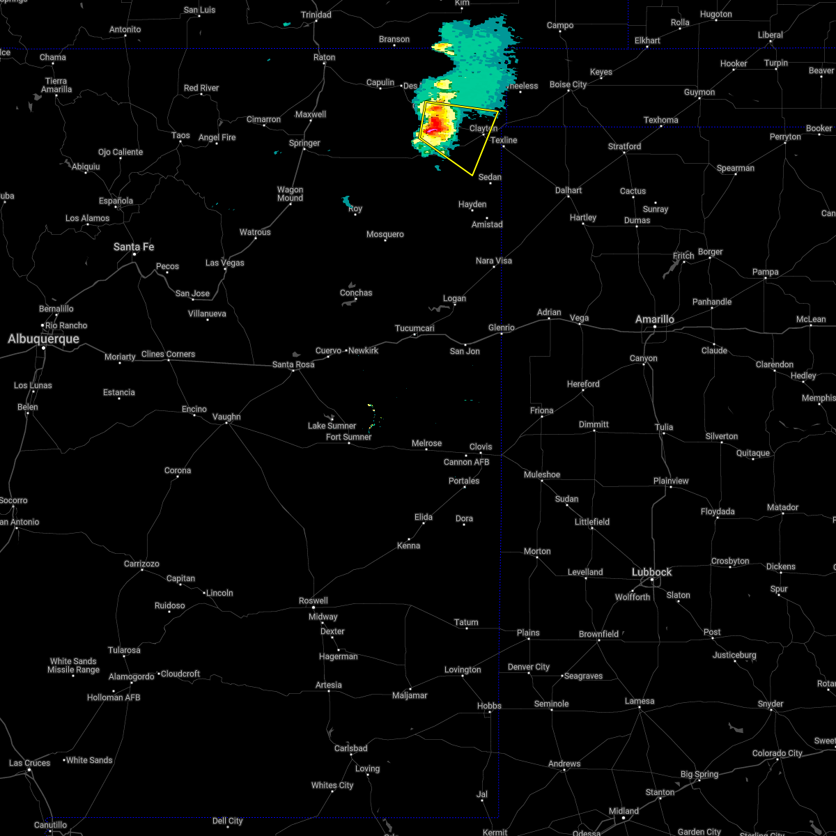 At 335 pm mdt, a severe thunderstorm was located near mount dora, or 20 miles west of clayton, moving east at 20 mph (radar indicated). Hazards include 60 mph wind gusts and quarter size hail. Hail damage to vehicles is expected. Expect wind damage to roofs, siding, and trees. At 335 pm mdt, a severe thunderstorm was located near mount dora, or 20 miles west of clayton, moving east at 20 mph (radar indicated). Hazards include 60 mph wind gusts and quarter size hail. Hail damage to vehicles is expected. Expect wind damage to roofs, siding, and trees.
|
| 5/16/2022 7:43 PM MDT | Asos station kcao clayton muni airpar in union county NM, 0.9 miles SW of Clayton, NM |
| 4/27/2022 7:14 PM MDT |
 At 713 pm mdt, a severe thunderstorm was located near clayton, moving east at 30 mph (radar indicated). Hazards include 60 mph wind gusts, blowing dust and penny size hail. Expect damage to roofs, siding, and trees. locations impacted include, clayton, clayton lake state park, seneca and moses. this includes highway 64 between mile markers 419 and 429. hail threat, radar indicated max hail size, 0. 75 in wind threat, radar indicated max wind gust, 60 mph. At 713 pm mdt, a severe thunderstorm was located near clayton, moving east at 30 mph (radar indicated). Hazards include 60 mph wind gusts, blowing dust and penny size hail. Expect damage to roofs, siding, and trees. locations impacted include, clayton, clayton lake state park, seneca and moses. this includes highway 64 between mile markers 419 and 429. hail threat, radar indicated max hail size, 0. 75 in wind threat, radar indicated max wind gust, 60 mph.
|
| 4/27/2022 7:12 PM MDT | Visibility down to one quarter of a mile briefly in blowing dus in union county NM, 2 miles SE of Clayton, NM |
| 4/27/2022 6:51 PM MDT |
 At 650 pm mdt, a severe thunderstorm was located near clayton lake state park, or 13 miles northwest of clayton, moving east at 30 mph (radar indicated). Hazards include 60 mph wind gusts and nickel size hail. expect damage to roofs, siding, and trees At 650 pm mdt, a severe thunderstorm was located near clayton lake state park, or 13 miles northwest of clayton, moving east at 30 mph (radar indicated). Hazards include 60 mph wind gusts and nickel size hail. expect damage to roofs, siding, and trees
|
| 9/6/2021 7:19 PM MDT |
 At 719 pm mdt, a severe thunderstorm was located near texline, or 8 miles southeast of clayton, moving south at 15 mph (radar indicated). Hazards include 60 mph wind gusts and quarter size hail. Hail damage to vehicles is expected. Expect wind damage to roofs, siding, and trees. At 719 pm mdt, a severe thunderstorm was located near texline, or 8 miles southeast of clayton, moving south at 15 mph (radar indicated). Hazards include 60 mph wind gusts and quarter size hail. Hail damage to vehicles is expected. Expect wind damage to roofs, siding, and trees.
|
| 9/6/2021 6:42 PM MDT |
 The severe thunderstorm warning for east central union county will expire at 645 pm mdt, the storm which prompted the warning has weakened below severe limits, and no longer poses an immediate threat to life or property. therefore, the warning will be allowed to expire. however small hail, gusty winds and heavy rain are still possible with this thunderstorm. The severe thunderstorm warning for east central union county will expire at 645 pm mdt, the storm which prompted the warning has weakened below severe limits, and no longer poses an immediate threat to life or property. therefore, the warning will be allowed to expire. however small hail, gusty winds and heavy rain are still possible with this thunderstorm.
|
| 9/6/2021 6:21 PM MDT |
 At 620 pm mdt, a severe thunderstorm was located near seneca, or 9 miles northeast of clayton, moving southeast at 10 mph (radar indicated). Hazards include 60 mph wind gusts and quarter size hail. Hail damage to vehicles is expected. expect wind damage to roofs, siding, and trees. locations impacted include, clayton, clayton lake state park and seneca. this includes highway 64 near mile marker 429. hail threat, radar indicated max hail size, 1. 00 in wind threat, radar indicated max wind gust, 60 mph. At 620 pm mdt, a severe thunderstorm was located near seneca, or 9 miles northeast of clayton, moving southeast at 10 mph (radar indicated). Hazards include 60 mph wind gusts and quarter size hail. Hail damage to vehicles is expected. expect wind damage to roofs, siding, and trees. locations impacted include, clayton, clayton lake state park and seneca. this includes highway 64 near mile marker 429. hail threat, radar indicated max hail size, 1. 00 in wind threat, radar indicated max wind gust, 60 mph.
|
| 9/6/2021 6:12 PM MDT | Quarter sized hail reported 13.2 miles S of Clayton, NM |
| 9/6/2021 6:03 PM MDT |
 At 602 pm mdt, a severe thunderstorm was located near seneca, or 9 miles northeast of clayton, moving southeast at 10 mph (radar indicated). Hazards include 60 mph wind gusts and quarter size hail. Hail damage to vehicles is expected. Expect wind damage to roofs, siding, and trees. At 602 pm mdt, a severe thunderstorm was located near seneca, or 9 miles northeast of clayton, moving southeast at 10 mph (radar indicated). Hazards include 60 mph wind gusts and quarter size hail. Hail damage to vehicles is expected. Expect wind damage to roofs, siding, and trees.
|
| 9/1/2021 5:59 PM MDT | Kcao aso in union county NM, 1.8 miles SW of Clayton, NM |
| 8/12/2021 3:32 PM MDT | Kcao aso in union county NM, 1.8 miles SW of Clayton, NM |
| 7/6/2021 4:46 PM MDT | Storm damage reported in union county NM, 11.6 miles NNE of Clayton, NM |
| 7/6/2021 4:29 PM MDT |
 At 428 pm mdt, a severe thunderstorm was located 8 miles south of clayton, moving southwest at 20 mph (radar indicated). Hazards include 60 mph wind gusts and half dollar size hail. Hail damage to vehicles is expected. Expect wind damage to roofs, siding, and trees. At 428 pm mdt, a severe thunderstorm was located 8 miles south of clayton, moving southwest at 20 mph (radar indicated). Hazards include 60 mph wind gusts and half dollar size hail. Hail damage to vehicles is expected. Expect wind damage to roofs, siding, and trees.
|
| 7/6/2021 4:19 PM MDT |
 At 419 pm mdt, a severe thunderstorm was located near texline, or 7 miles southeast of clayton, moving southwest at 15 mph (radar indicated). Hazards include 60 mph wind gusts and quarter size hail. Hail damage to vehicles is expected. expect wind damage to roofs, siding, and trees. locations impacted include, clayton and sedan. This includes highway 64 between mile markers 428 and 429. At 419 pm mdt, a severe thunderstorm was located near texline, or 7 miles southeast of clayton, moving southwest at 15 mph (radar indicated). Hazards include 60 mph wind gusts and quarter size hail. Hail damage to vehicles is expected. expect wind damage to roofs, siding, and trees. locations impacted include, clayton and sedan. This includes highway 64 between mile markers 428 and 429.
|
| 7/6/2021 3:52 PM MDT |
 At 351 pm mdt, a severe thunderstorm was located near texline, or 10 miles east of clayton, moving southwest at 15 mph (radar indicated). Hazards include 70 mph wind gusts and half dollar size hail. Hail damage to vehicles is expected. expect considerable tree damage. Wind damage is also likely to mobile homes, roofs, and outbuildings. At 351 pm mdt, a severe thunderstorm was located near texline, or 10 miles east of clayton, moving southwest at 15 mph (radar indicated). Hazards include 70 mph wind gusts and half dollar size hail. Hail damage to vehicles is expected. expect considerable tree damage. Wind damage is also likely to mobile homes, roofs, and outbuildings.
|
| 7/4/2021 7:42 PM MDT |
 At 742 pm mdt, a severe thunderstorm was located near seneca, or 12 miles northeast of clayton, moving southeast at 25 mph (radar indicated). Hazards include 60 mph wind gusts and quarter size hail. Hail damage to vehicles is expected. Expect wind damage to roofs, siding, and trees. At 742 pm mdt, a severe thunderstorm was located near seneca, or 12 miles northeast of clayton, moving southeast at 25 mph (radar indicated). Hazards include 60 mph wind gusts and quarter size hail. Hail damage to vehicles is expected. Expect wind damage to roofs, siding, and trees.
|
| 7/4/2021 5:59 PM MDT |
 At 540 pm mdt, a severe thunderstorm was located near seneca, or 8 miles north of clayton, moving southeast at 15 mph (radar indicated). Hazards include 60 mph wind gusts and quarter size hail. Hail damage to vehicles is expected. Expect wind damage to roofs, siding, and trees. At 540 pm mdt, a severe thunderstorm was located near seneca, or 8 miles north of clayton, moving southeast at 15 mph (radar indicated). Hazards include 60 mph wind gusts and quarter size hail. Hail damage to vehicles is expected. Expect wind damage to roofs, siding, and trees.
|
| 7/4/2021 5:41 PM MDT |
 At 540 pm mdt, a severe thunderstorm was located near seneca, or 8 miles north of clayton, moving southeast at 15 mph (radar indicated). Hazards include 60 mph wind gusts and quarter size hail. Hail damage to vehicles is expected. Expect wind damage to roofs, siding, and trees. At 540 pm mdt, a severe thunderstorm was located near seneca, or 8 miles north of clayton, moving southeast at 15 mph (radar indicated). Hazards include 60 mph wind gusts and quarter size hail. Hail damage to vehicles is expected. Expect wind damage to roofs, siding, and trees.
|
| 6/20/2021 10:10 PM MDT |
 The severe thunderstorm warning for northeastern union county will expire at 1015 pm mdt, the storm which prompted the warning has weakened below severe limits, and no longer poses an immediate threat to life or property. therefore, the warning will be allowed to expire. however gusty winds are still possible with this thunderstorm. The severe thunderstorm warning for northeastern union county will expire at 1015 pm mdt, the storm which prompted the warning has weakened below severe limits, and no longer poses an immediate threat to life or property. therefore, the warning will be allowed to expire. however gusty winds are still possible with this thunderstorm.
|
| 6/20/2021 10:00 PM MDT |
 At 1000 pm mdt, a severe thunderstorm was located near clayton lake state park, or 14 miles north of clayton, moving southeast at 20 mph (radar indicated). Hazards include 60 mph wind gusts and half dollar size hail. Hail damage to vehicles is expected. expect wind damage to roofs, siding, and trees. locations impacted include, clayton, clayton lake state park and seneca. This includes highway 64 between mile markers 421 and 429. At 1000 pm mdt, a severe thunderstorm was located near clayton lake state park, or 14 miles north of clayton, moving southeast at 20 mph (radar indicated). Hazards include 60 mph wind gusts and half dollar size hail. Hail damage to vehicles is expected. expect wind damage to roofs, siding, and trees. locations impacted include, clayton, clayton lake state park and seneca. This includes highway 64 between mile markers 421 and 429.
|
| 6/20/2021 9:40 PM MDT |
 At 940 pm mdt, a severe thunderstorm was located 8 miles north of clayton lake state park, or 19 miles northwest of clayton, moving southeast at 20 mph (radar indicated). Hazards include golf ball size hail and 60 mph wind gusts. People and animals outdoors will be injured. expect hail damage to roofs, siding, windows, and vehicles. expect wind damage to roofs, siding, and trees. locations impacted include, clayton, clayton lake state park, seneca and moses. This includes highway 64 between mile markers 414 and 429. At 940 pm mdt, a severe thunderstorm was located 8 miles north of clayton lake state park, or 19 miles northwest of clayton, moving southeast at 20 mph (radar indicated). Hazards include golf ball size hail and 60 mph wind gusts. People and animals outdoors will be injured. expect hail damage to roofs, siding, windows, and vehicles. expect wind damage to roofs, siding, and trees. locations impacted include, clayton, clayton lake state park, seneca and moses. This includes highway 64 between mile markers 414 and 429.
|
| 6/20/2021 9:20 PM MDT |
 At 919 pm mdt, a severe thunderstorm was located 13 miles northwest of clayton lake state park, or 23 miles east of des moines, moving southeast at 20 mph (radar indicated). Hazards include 60 mph wind gusts and half dollar size hail. Hail damage to vehicles is expected. Expect wind damage to roofs, siding, and trees. At 919 pm mdt, a severe thunderstorm was located 13 miles northwest of clayton lake state park, or 23 miles east of des moines, moving southeast at 20 mph (radar indicated). Hazards include 60 mph wind gusts and half dollar size hail. Hail damage to vehicles is expected. Expect wind damage to roofs, siding, and trees.
|
| 5/21/2021 10:19 PM MDT |
 At 1018 pm mdt, a severe thunderstorm was located over hayden, or near amistad, moving north at 60 mph (radar indicated). Hazards include 70 mph wind gusts. Expect considerable tree damage. Damage is likely to mobile homes, roofs, and outbuildings. At 1018 pm mdt, a severe thunderstorm was located over hayden, or near amistad, moving north at 60 mph (radar indicated). Hazards include 70 mph wind gusts. Expect considerable tree damage. Damage is likely to mobile homes, roofs, and outbuildings.
|
| 5/17/2021 6:31 PM MDT |
 At 631 pm mdt, a severe thunderstorm was located near texline, or 7 miles southeast of clayton, moving north at 20 mph (radar indicated). Hazards include 60 mph wind gusts and penny size hail. Expect damage to roofs, siding, and trees. Locations impacted include, clayton. At 631 pm mdt, a severe thunderstorm was located near texline, or 7 miles southeast of clayton, moving north at 20 mph (radar indicated). Hazards include 60 mph wind gusts and penny size hail. Expect damage to roofs, siding, and trees. Locations impacted include, clayton.
|
| 5/17/2021 6:27 PM MDT |
 At 557 pm mdt, severe thunderstorms were located along a line extending from 6 miles west of capulin to 11 miles northwest of sedan, moving northeast at 45 mph (radar indicated). Hazards include 60 mph wind gusts and penny size hail. Expect damage to roofs, siding, and trees. locations impacted include, clayton, des moines, folsom, grenville, clayton lake state park, seneca, capulin and mount dora. This includes highway 64 between mile markers 360 and 429. At 557 pm mdt, severe thunderstorms were located along a line extending from 6 miles west of capulin to 11 miles northwest of sedan, moving northeast at 45 mph (radar indicated). Hazards include 60 mph wind gusts and penny size hail. Expect damage to roofs, siding, and trees. locations impacted include, clayton, des moines, folsom, grenville, clayton lake state park, seneca, capulin and mount dora. This includes highway 64 between mile markers 360 and 429.
|
| 5/17/2021 6:10 PM MDT |
 At 610 pm mdt, a severe thunderstorm was located over sedan, or 16 miles north of amistad, moving north at 15 mph (radar indicated). Hazards include 60 mph wind gusts and quarter size hail. Hail damage to vehicles is expected. Expect wind damage to roofs, siding, and trees. At 610 pm mdt, a severe thunderstorm was located over sedan, or 16 miles north of amistad, moving north at 15 mph (radar indicated). Hazards include 60 mph wind gusts and quarter size hail. Hail damage to vehicles is expected. Expect wind damage to roofs, siding, and trees.
|
| 5/17/2021 5:58 PM MDT |
 At 557 pm mdt, severe thunderstorms were located along a line extending from 6 miles west of capulin to 11 miles northwest of sedan, moving northeast at 45 mph (radar indicated). Hazards include 60 mph wind gusts and penny size hail. Expect damage to roofs, siding, and trees. locations impacted include, clayton, des moines, folsom, grenville, clayton lake state park, seneca, capulin and mount dora. This includes highway 64 between mile markers 360 and 429. At 557 pm mdt, severe thunderstorms were located along a line extending from 6 miles west of capulin to 11 miles northwest of sedan, moving northeast at 45 mph (radar indicated). Hazards include 60 mph wind gusts and penny size hail. Expect damage to roofs, siding, and trees. locations impacted include, clayton, des moines, folsom, grenville, clayton lake state park, seneca, capulin and mount dora. This includes highway 64 between mile markers 360 and 429.
|
| 5/17/2021 5:30 PM MDT |
 At 530 pm mdt, severe thunderstorms were located along a line extending from 9 miles west of abbott to 7 miles east of bueyeros, moving northeast at 45 mph (radar indicated). Hazards include 60 mph wind gusts and penny size hail. expect damage to roofs, siding, and trees At 530 pm mdt, severe thunderstorms were located along a line extending from 9 miles west of abbott to 7 miles east of bueyeros, moving northeast at 45 mph (radar indicated). Hazards include 60 mph wind gusts and penny size hail. expect damage to roofs, siding, and trees
|
| 5/15/2021 6:04 PM MDT |
 At 604 pm mdt, a severe thunderstorm was located near clayton, moving northeast at 15 mph (radar indicated). Hazards include 60 mph wind gusts and quarter size hail. Hail damage to vehicles is expected. expect wind damage to roofs, siding, and trees. locations impacted include, clayton. This includes highway 64 between mile markers 421 and 429. At 604 pm mdt, a severe thunderstorm was located near clayton, moving northeast at 15 mph (radar indicated). Hazards include 60 mph wind gusts and quarter size hail. Hail damage to vehicles is expected. expect wind damage to roofs, siding, and trees. locations impacted include, clayton. This includes highway 64 between mile markers 421 and 429.
|
| 5/15/2021 5:32 PM MDT |
 At 531 pm mdt, a severe thunderstorm was located 11 miles southwest of clayton, moving northeast at 15 mph (radar indicated). Hazards include 60 mph wind gusts and quarter size hail. Hail damage to vehicles is expected. Expect wind damage to roofs, siding, and trees. At 531 pm mdt, a severe thunderstorm was located 11 miles southwest of clayton, moving northeast at 15 mph (radar indicated). Hazards include 60 mph wind gusts and quarter size hail. Hail damage to vehicles is expected. Expect wind damage to roofs, siding, and trees.
|
| 3/13/2021 12:29 PM MST |
 At 1229 pm mst, a severe thunderstorm was located near sedan, or 14 miles north of amistad, moving northeast at 40 mph (radar indicated). Hazards include 60 mph wind gusts and nickel size hail. Expect damage to roofs, siding, and trees. locations impacted include, clayton, amistad, hayden and sedan. This includes highway 64 between mile markers 421 and 429. At 1229 pm mst, a severe thunderstorm was located near sedan, or 14 miles north of amistad, moving northeast at 40 mph (radar indicated). Hazards include 60 mph wind gusts and nickel size hail. Expect damage to roofs, siding, and trees. locations impacted include, clayton, amistad, hayden and sedan. This includes highway 64 between mile markers 421 and 429.
|
| 3/13/2021 12:09 PM MST |
 At 1208 pm mst, a severe thunderstorm was located near hayden, or 10 miles west of amistad, moving north at 40 mph (radar indicated). Hazards include 60 mph wind gusts and nickel size hail. expect damage to roofs, siding, and trees At 1208 pm mst, a severe thunderstorm was located near hayden, or 10 miles west of amistad, moving north at 40 mph (radar indicated). Hazards include 60 mph wind gusts and nickel size hail. expect damage to roofs, siding, and trees
|
| 3/13/2021 10:51 AM MST |
 The severe thunderstorm warning for central union county will expire at 1100 am mst, the storm which prompted the warning has weakened below severe limits, and no longer poses an immediate threat to life or property. therefore, the warning will be allowed to expire. however, gusty winds are still possible with this thunderstorm. The severe thunderstorm warning for central union county will expire at 1100 am mst, the storm which prompted the warning has weakened below severe limits, and no longer poses an immediate threat to life or property. therefore, the warning will be allowed to expire. however, gusty winds are still possible with this thunderstorm.
|
| 3/13/2021 10:34 AM MST |
 At 1034 am mst, a severe thunderstorm was located 16 miles northeast of bueyeros, or 27 miles southwest of clayton, moving north at 55 mph (radar indicated). Hazards include 60 mph wind gusts and penny size hail. Expect damage to roofs, siding, and trees. locations impacted include, clayton, grenville, clayton lake state park and mount dora. This includes highway 64 between mile markers 404 and 429. At 1034 am mst, a severe thunderstorm was located 16 miles northeast of bueyeros, or 27 miles southwest of clayton, moving north at 55 mph (radar indicated). Hazards include 60 mph wind gusts and penny size hail. Expect damage to roofs, siding, and trees. locations impacted include, clayton, grenville, clayton lake state park and mount dora. This includes highway 64 between mile markers 404 and 429.
|
| 3/13/2021 10:21 AM MST |
 At 1020 am mst, a severe thunderstorm was located near bueyeros, or 24 miles northeast of mosquero, moving north at 55 mph (radar indicated). Hazards include 60 mph wind gusts and penny size hail. expect damage to roofs, siding, and trees At 1020 am mst, a severe thunderstorm was located near bueyeros, or 24 miles northeast of mosquero, moving north at 55 mph (radar indicated). Hazards include 60 mph wind gusts and penny size hail. expect damage to roofs, siding, and trees
|
| 8/2/2020 6:43 PM MDT |
 The severe thunderstorm warning for east central union county will expire at 645 pm mdt, the storm which prompted the warning has weakened below severe limits, and no longer poses an immediate threat to life or property. therefore, the warning will be allowed to expire. however small hail, gusty winds and heavy rain are still possible with this thunderstorm. a severe thunderstorm watch remains in effect until 900 pm mdt for northeastern new mexico. The severe thunderstorm warning for east central union county will expire at 645 pm mdt, the storm which prompted the warning has weakened below severe limits, and no longer poses an immediate threat to life or property. therefore, the warning will be allowed to expire. however small hail, gusty winds and heavy rain are still possible with this thunderstorm. a severe thunderstorm watch remains in effect until 900 pm mdt for northeastern new mexico.
|
| 8/2/2020 6:10 PM MDT |
 At 610 pm mdt, a severe thunderstorm was located 9 miles southeast of mount dora, or 12 miles west of clayton, moving southeast at 20 mph (radar indicated). Hazards include 60 mph wind gusts and quarter size hail. Hail damage to vehicles is expected. expect wind damage to roofs, siding, and trees. locations impacted include, clayton, grenville, clayton lake state park and mount dora. This includes highway 64 between mile markers 404 and 429. At 610 pm mdt, a severe thunderstorm was located 9 miles southeast of mount dora, or 12 miles west of clayton, moving southeast at 20 mph (radar indicated). Hazards include 60 mph wind gusts and quarter size hail. Hail damage to vehicles is expected. expect wind damage to roofs, siding, and trees. locations impacted include, clayton, grenville, clayton lake state park and mount dora. This includes highway 64 between mile markers 404 and 429.
|
| 8/2/2020 5:42 PM MDT |
 At 541 pm mdt, a severe thunderstorm was located over mount dora, or 19 miles west of clayton, moving southeast at 20 mph (radar indicated). Hazards include 60 mph wind gusts and quarter size hail. Hail damage to vehicles is expected. Expect wind damage to roofs, siding, and trees. At 541 pm mdt, a severe thunderstorm was located over mount dora, or 19 miles west of clayton, moving southeast at 20 mph (radar indicated). Hazards include 60 mph wind gusts and quarter size hail. Hail damage to vehicles is expected. Expect wind damage to roofs, siding, and trees.
|
| 7/24/2020 5:20 PM MDT | Kcao aso in union county NM, 1.8 miles SW of Clayton, NM |
| 7/15/2020 9:20 PM MDT |
 The severe thunderstorm warning for northeastern union county will expire at 930 pm mdt, the storm which prompted the warning has weakened below severe limits, and no longer poses an immediate threat to life or property. therefore the warning will be allowed to expire. a severe thunderstorm watch remains in effect until 1100 pm mdt for northeastern new mexico. The severe thunderstorm warning for northeastern union county will expire at 930 pm mdt, the storm which prompted the warning has weakened below severe limits, and no longer poses an immediate threat to life or property. therefore the warning will be allowed to expire. a severe thunderstorm watch remains in effect until 1100 pm mdt for northeastern new mexico.
|
| 7/15/2020 9:06 PM MDT |
 At 905 pm mdt, a severe thunderstorm was located near clayton lake state park, or 13 miles northwest of clayton, moving southeast at 10 mph (radar indicated). Hazards include 60 mph wind gusts and quarter size hail. Hail damage to vehicles is expected. expect wind damage to roofs, siding, and trees. locations impacted include, clayton, clayton lake state park and seneca. This includes highway 64 between mile markers 418 and 428. At 905 pm mdt, a severe thunderstorm was located near clayton lake state park, or 13 miles northwest of clayton, moving southeast at 10 mph (radar indicated). Hazards include 60 mph wind gusts and quarter size hail. Hail damage to vehicles is expected. expect wind damage to roofs, siding, and trees. locations impacted include, clayton, clayton lake state park and seneca. This includes highway 64 between mile markers 418 and 428.
|
| 7/15/2020 8:44 PM MDT |
 The national weather service in albuquerque has issued a * severe thunderstorm warning for. northeastern union county in northeastern new mexico. until 930 pm mdt. At 844 pm mdt, a severe thunderstorm was located near clayton lake state park, or 17 miles northwest of clayton, moving southeast at. The national weather service in albuquerque has issued a * severe thunderstorm warning for. northeastern union county in northeastern new mexico. until 930 pm mdt. At 844 pm mdt, a severe thunderstorm was located near clayton lake state park, or 17 miles northwest of clayton, moving southeast at.
|
| 6/22/2020 4:57 PM MDT |
 The severe thunderstorm warning for northeastern harding and southeastern union counties will expire at 500 pm mdt, the storm which prompted the warning has weakened below severe limits, and no longer poses an immediate threat to life or property. therefore the warning will be allowed to expire. however small hail, gusty winds and heavy rain are still possible with this thunderstorm. a severe thunderstorm watch remains in effect until 1000 pm mdt for northeastern new mexico. The severe thunderstorm warning for northeastern harding and southeastern union counties will expire at 500 pm mdt, the storm which prompted the warning has weakened below severe limits, and no longer poses an immediate threat to life or property. therefore the warning will be allowed to expire. however small hail, gusty winds and heavy rain are still possible with this thunderstorm. a severe thunderstorm watch remains in effect until 1000 pm mdt for northeastern new mexico.
|
| 6/22/2020 4:49 PM MDT |
 At 449 pm mdt, a severe thunderstorm was located 7 miles west of sedan, or 17 miles north of amistad, moving east at 35 mph (radar indicated). Hazards include 60 mph wind gusts and quarter size hail. Hail damage to vehicles is expected. expect wind damage to roofs, siding, and trees. Locations impacted include, hayden and sedan. At 449 pm mdt, a severe thunderstorm was located 7 miles west of sedan, or 17 miles north of amistad, moving east at 35 mph (radar indicated). Hazards include 60 mph wind gusts and quarter size hail. Hail damage to vehicles is expected. expect wind damage to roofs, siding, and trees. Locations impacted include, hayden and sedan.
|
| 6/22/2020 4:32 PM MDT |
 At 432 pm mdt, a severe thunderstorm was located 12 miles northwest of hayden, or 19 miles northwest of amistad, moving east at 30 mph (radar indicated). Hazards include 60 mph wind gusts and quarter size hail. Hail damage to vehicles is expected. expect wind damage to roofs, siding, and trees. Locations impacted include, hayden and sedan. At 432 pm mdt, a severe thunderstorm was located 12 miles northwest of hayden, or 19 miles northwest of amistad, moving east at 30 mph (radar indicated). Hazards include 60 mph wind gusts and quarter size hail. Hail damage to vehicles is expected. expect wind damage to roofs, siding, and trees. Locations impacted include, hayden and sedan.
|
| 6/22/2020 4:14 PM MDT |
 At 414 pm mdt, a severe thunderstorm was located 7 miles northeast of bueyeros, or 26 miles west of amistad, moving east at 30 mph (radar indicated). Hazards include 60 mph wind gusts and quarter size hail. Hail damage to vehicles is expected. Expect wind damage to roofs, siding, and trees. At 414 pm mdt, a severe thunderstorm was located 7 miles northeast of bueyeros, or 26 miles west of amistad, moving east at 30 mph (radar indicated). Hazards include 60 mph wind gusts and quarter size hail. Hail damage to vehicles is expected. Expect wind damage to roofs, siding, and trees.
|
| 8/23/2019 5:39 PM MDT |
 The severe thunderstorm warning for east central union county will expire at 545 pm mdt, the storms which prompted the warning have weakened below severe limits, and no longer pose an immediate threat to life or property. therefore the warning will be allowed to expire. however, heavy rain is still occurring with these thunderstorms. a severe thunderstorm watch remains in effect until 1000 pm mdt for northeastern new mexico. The severe thunderstorm warning for east central union county will expire at 545 pm mdt, the storms which prompted the warning have weakened below severe limits, and no longer pose an immediate threat to life or property. therefore the warning will be allowed to expire. however, heavy rain is still occurring with these thunderstorms. a severe thunderstorm watch remains in effect until 1000 pm mdt for northeastern new mexico.
|
| 8/23/2019 5:26 PM MDT |
 At 525 pm mdt, severe thunderstorms were located along a line extending from near texline to 17 miles southwest of mount dora, moving south at 15 mph (radar indicated). Hazards include 60 mph wind gusts and quarter size hail. Hail damage to vehicles is expected. expect wind damage to roofs, siding, and trees. Locations impacted include, clayton. At 525 pm mdt, severe thunderstorms were located along a line extending from near texline to 17 miles southwest of mount dora, moving south at 15 mph (radar indicated). Hazards include 60 mph wind gusts and quarter size hail. Hail damage to vehicles is expected. expect wind damage to roofs, siding, and trees. Locations impacted include, clayton.
|
| 8/23/2019 4:59 PM MDT |
 At 459 pm mdt, severe thunderstorms were located along a line extending from 6 miles northeast of clayton to 13 miles southwest of mount dora, moving south at 10 mph (radar indicated). Hazards include 60 mph wind gusts and quarter size hail. Hail damage to vehicles is expected. Expect wind damage to roofs, siding, and trees. At 459 pm mdt, severe thunderstorms were located along a line extending from 6 miles northeast of clayton to 13 miles southwest of mount dora, moving south at 10 mph (radar indicated). Hazards include 60 mph wind gusts and quarter size hail. Hail damage to vehicles is expected. Expect wind damage to roofs, siding, and trees.
|
| 8/2/2019 3:46 PM MDT | Kcao aso in union county NM, 1.8 miles SW of Clayton, NM |
| 7/5/2019 5:34 PM MDT |
 At 533 pm mdt, a severe thunderstorm was located 7 miles south of clayton, moving northeast at 35 mph (radar indicated). Hazards include 60 mph wind gusts and quarter size hail. Hail damage to vehicles is expected. expect wind damage to roofs, siding, and trees. Locations impacted include, clayton, seneca, sedan and moses. At 533 pm mdt, a severe thunderstorm was located 7 miles south of clayton, moving northeast at 35 mph (radar indicated). Hazards include 60 mph wind gusts and quarter size hail. Hail damage to vehicles is expected. expect wind damage to roofs, siding, and trees. Locations impacted include, clayton, seneca, sedan and moses.
|
| 7/5/2019 5:25 PM MDT | Golf Ball sized hail reported 15.6 miles SSW of Clayton, NM |
| 7/5/2019 5:25 PM MDT |
 At 525 pm mdt, severe thunderstorms were located along a line extending from near seneca to 18 miles west of sedan, moving east at 10 mph (radar indicated). Hazards include 60 mph wind gusts and half dollar size hail. Hail damage to vehicles is expected. expect wind damage to roofs, siding, and trees. Locations impacted include, clayton, clayton lake state park, seneca, sedan, mount dora and moses. At 525 pm mdt, severe thunderstorms were located along a line extending from near seneca to 18 miles west of sedan, moving east at 10 mph (radar indicated). Hazards include 60 mph wind gusts and half dollar size hail. Hail damage to vehicles is expected. expect wind damage to roofs, siding, and trees. Locations impacted include, clayton, clayton lake state park, seneca, sedan, mount dora and moses.
|
| 7/5/2019 5:21 PM MDT |
 At 519 pm mdt, severe thunderstorms were located along a line extending from near seneca to 18 miles west of sedan. motion was near stationary (radar indicated). Hazards include 60 mph wind gusts and half dollar size hail. Hail damage to vehicles is expected. Expect wind damage to roofs, siding, and trees. At 519 pm mdt, severe thunderstorms were located along a line extending from near seneca to 18 miles west of sedan. motion was near stationary (radar indicated). Hazards include 60 mph wind gusts and half dollar size hail. Hail damage to vehicles is expected. Expect wind damage to roofs, siding, and trees.
|
| 6/18/2019 7:20 PM MDT |
 At 720 pm mdt, a severe thunderstorm was located near clayton lake state park, or 9 miles north of clayton, moving east at 20 mph (radar indicated). Hazards include 60 mph wind gusts and half dollar size hail. Hail damage to vehicles is expected. Expect wind damage to roofs, siding, and trees. At 720 pm mdt, a severe thunderstorm was located near clayton lake state park, or 9 miles north of clayton, moving east at 20 mph (radar indicated). Hazards include 60 mph wind gusts and half dollar size hail. Hail damage to vehicles is expected. Expect wind damage to roofs, siding, and trees.
|
| 6/13/2019 8:00 PM MDT | Quarter sized hail reported 1.7 miles ESE of Clayton, NM |
| 6/13/2019 7:57 PM MDT | Quarter sized hail reported 2.5 miles ESE of Clayton, NM |
| 6/1/2019 2:05 PM MDT | Quarter sized hail reported 13.2 miles S of Clayton, NM |
| 6/1/2019 12:34 PM MDT | Quarter sized hail reported 0.7 miles SE of Clayton, NM |
| 6/1/2019 12:29 PM MDT |
 At 1229 pm mdt, a severe thunderstorm was located near clayton, moving east at 10 mph (radar indicated). Hazards include golf ball size hail and 60 mph wind gusts. People and animals outdoors will be injured. expect hail damage to roofs, siding, windows, and vehicles. expect wind damage to roofs, siding, and trees. Locations impacted include, clayton. At 1229 pm mdt, a severe thunderstorm was located near clayton, moving east at 10 mph (radar indicated). Hazards include golf ball size hail and 60 mph wind gusts. People and animals outdoors will be injured. expect hail damage to roofs, siding, windows, and vehicles. expect wind damage to roofs, siding, and trees. Locations impacted include, clayton.
|
| 6/1/2019 12:27 PM MDT | Quarter sized hail reported 0.7 miles SE of Clayton, NM |
| 6/1/2019 12:19 PM MDT |
 At 1219 pm mdt, a severe thunderstorm was located over clayton, moving southeast at 15 mph (radar indicated). Hazards include 60 mph wind gusts and half dollar size hail. Hail damage to vehicles is expected. Expect wind damage to roofs, siding, and trees. At 1219 pm mdt, a severe thunderstorm was located over clayton, moving southeast at 15 mph (radar indicated). Hazards include 60 mph wind gusts and half dollar size hail. Hail damage to vehicles is expected. Expect wind damage to roofs, siding, and trees.
|
| 5/26/2019 6:03 PM MDT |
 At 602 pm mdt, severe thunderstorms were located along a line extending from near clayton to near logan, moving northeast at 15 mph (radar indicated). Hazards include 70 mph wind gusts and quarter size hail. Hail damage to vehicles is expected. expect considerable tree damage. wind damage is also likely to mobile homes, roofs, and outbuildings. locations impacted include, clayton, logan, amistad, nara visa, hayden, ute lake state park, sedan and rosebud. A tornado watch remains in effect until 900 pm mdt for northeastern and east central new mexico. At 602 pm mdt, severe thunderstorms were located along a line extending from near clayton to near logan, moving northeast at 15 mph (radar indicated). Hazards include 70 mph wind gusts and quarter size hail. Hail damage to vehicles is expected. expect considerable tree damage. wind damage is also likely to mobile homes, roofs, and outbuildings. locations impacted include, clayton, logan, amistad, nara visa, hayden, ute lake state park, sedan and rosebud. A tornado watch remains in effect until 900 pm mdt for northeastern and east central new mexico.
|
| 5/26/2019 5:37 PM MDT |
 At 537 pm mdt, severe thunderstorms were located along a line extending from 15 miles northwest of sedan to near ute lake state park, moving northeast at 40 mph (radar indicated). Hazards include 70 mph wind gusts and ping pong ball size hail. People and animals outdoors will be injured. expect hail damage to roofs, siding, windows, and vehicles. expect considerable tree damage. Wind damage is also likely to mobile homes, roofs, and outbuildings. At 537 pm mdt, severe thunderstorms were located along a line extending from 15 miles northwest of sedan to near ute lake state park, moving northeast at 40 mph (radar indicated). Hazards include 70 mph wind gusts and ping pong ball size hail. People and animals outdoors will be injured. expect hail damage to roofs, siding, windows, and vehicles. expect considerable tree damage. Wind damage is also likely to mobile homes, roofs, and outbuildings.
|
| 5/26/2019 5:36 PM MDT |
 The tornado warning for east central union county will expire at 545 pm mdt, the storm which prompted the warning has moved out of the area. therefore the warning will be allowed to expire. a tornado watch remains in effect until 900 pm mdt for northeastern new mexico. remember, a tornado warning remains in effect for north central union county until 615 pm. The tornado warning for east central union county will expire at 545 pm mdt, the storm which prompted the warning has moved out of the area. therefore the warning will be allowed to expire. a tornado watch remains in effect until 900 pm mdt for northeastern new mexico. remember, a tornado warning remains in effect for north central union county until 615 pm.
|
| 5/26/2019 5:34 PM MDT |
 At 534 pm mdt, a confirmed tornado was located 7 miles south of clayton lake state park, or 8 miles west of clayton, moving north at 30 mph (weather spotters confirmed tornado). Hazards include damaging tornado and tennis ball size hail. Flying debris will be dangerous to those caught without shelter. mobile homes will be damaged or destroyed. damage to roofs, windows, and vehicles will occur. tree damage is likely. the tornado will be near, clayton lake state park around 550 pm mdt. seneca around 600 pm mdt. Moses around 615 pm mdt. At 534 pm mdt, a confirmed tornado was located 7 miles south of clayton lake state park, or 8 miles west of clayton, moving north at 30 mph (weather spotters confirmed tornado). Hazards include damaging tornado and tennis ball size hail. Flying debris will be dangerous to those caught without shelter. mobile homes will be damaged or destroyed. damage to roofs, windows, and vehicles will occur. tree damage is likely. the tornado will be near, clayton lake state park around 550 pm mdt. seneca around 600 pm mdt. Moses around 615 pm mdt.
|
| 5/26/2019 5:27 PM MDT | Tea Cup sized hail reported 12.8 miles ENE of Clayton, NM |
| 5/26/2019 5:25 PM MDT | Tea Cup sized hail reported 12.3 miles ENE of Clayton, NM |
| 5/26/2019 5:24 PM MDT |
 At 524 pm mdt, a confirmed tornado was located 10 miles southwest of clayton, moving northeast at 30 mph (weather spotters confirmed tornado). Hazards include damaging tornado and tennis ball size hail. Flying debris will be dangerous to those caught without shelter. mobile homes will be damaged or destroyed. damage to roofs, windows, and vehicles will occur. tree damage is likely. This tornado will be near, clayton around 545 pm mdt. At 524 pm mdt, a confirmed tornado was located 10 miles southwest of clayton, moving northeast at 30 mph (weather spotters confirmed tornado). Hazards include damaging tornado and tennis ball size hail. Flying debris will be dangerous to those caught without shelter. mobile homes will be damaged or destroyed. damage to roofs, windows, and vehicles will occur. tree damage is likely. This tornado will be near, clayton around 545 pm mdt.
|
| 5/26/2019 5:23 PM MDT | Tea Cup sized hail reported 10.7 miles ENE of Clayton, NM |
| 5/26/2019 5:15 PM MDT | Tea Cup sized hail reported 10.7 miles ENE of Clayton, NM |
| 5/26/2019 5:10 PM MDT | Ping Pong Ball sized hail reported 14.7 miles ENE of Clayton, NM |
| 5/26/2019 5:07 PM MDT |
 At 507 pm mdt, a tornado producing storm was located 14 miles south of mount dora, or 18 miles southwest of clayton, moving northeast at 30 mph (spotter confirmed tornado). Hazards include damaging tornado and quarter size hail. Flying debris will be dangerous to those caught without shelter. mobile homes will be damaged or destroyed. damage to roofs, windows, and vehicles will occur. tree damage is likely. This tornadic storm will be near, clayton around 545 pm mdt. At 507 pm mdt, a tornado producing storm was located 14 miles south of mount dora, or 18 miles southwest of clayton, moving northeast at 30 mph (spotter confirmed tornado). Hazards include damaging tornado and quarter size hail. Flying debris will be dangerous to those caught without shelter. mobile homes will be damaged or destroyed. damage to roofs, windows, and vehicles will occur. tree damage is likely. This tornadic storm will be near, clayton around 545 pm mdt.
|
| 8/8/2018 5:28 PM MDT |
 At 528 pm mdt, a severe thunderstorm was located 8 miles north of seneca, or 20 miles north of clayton, moving south at 15 mph (radar indicated). Hazards include ping pong ball size hail and 60 mph wind gusts. People and animals outdoors will be injured. expect hail damage to roofs, siding, windows, and vehicles. Expect wind damage to roofs, siding, and trees. At 528 pm mdt, a severe thunderstorm was located 8 miles north of seneca, or 20 miles north of clayton, moving south at 15 mph (radar indicated). Hazards include ping pong ball size hail and 60 mph wind gusts. People and animals outdoors will be injured. expect hail damage to roofs, siding, windows, and vehicles. Expect wind damage to roofs, siding, and trees.
|
| 8/8/2018 4:59 PM MDT |
 At 458 pm mdt, a severe thunderstorm was located 10 miles southwest of kenton, or 23 miles north of clayton, moving south at 20 mph (radar indicated). Hazards include 60 mph wind gusts and quarter size hail. Hail damage to vehicles is expected. expect wind damage to roofs, siding, and trees. Locations impacted include, seneca and moses. At 458 pm mdt, a severe thunderstorm was located 10 miles southwest of kenton, or 23 miles north of clayton, moving south at 20 mph (radar indicated). Hazards include 60 mph wind gusts and quarter size hail. Hail damage to vehicles is expected. expect wind damage to roofs, siding, and trees. Locations impacted include, seneca and moses.
|
| 8/8/2018 4:35 PM MDT |
 At 435 pm mdt, a severe thunderstorm was located 7 miles southwest of kenton, or 27 miles north of clayton, moving south at 25 mph (radar indicated). Hazards include ping pong ball size hail and 60 mph wind gusts. People and animals outdoors will be injured. expect hail damage to roofs, siding, windows, and vehicles. Expect wind damage to roofs, siding, and trees. At 435 pm mdt, a severe thunderstorm was located 7 miles southwest of kenton, or 27 miles north of clayton, moving south at 25 mph (radar indicated). Hazards include ping pong ball size hail and 60 mph wind gusts. People and animals outdoors will be injured. expect hail damage to roofs, siding, windows, and vehicles. Expect wind damage to roofs, siding, and trees.
|
| 8/7/2018 6:42 PM MDT |
 At 641 pm mdt, a severe thunderstorm was located over mount dora, or 20 miles west of clayton, moving southeast at 20 mph (radar indicated). Hazards include ping pong ball size hail and 60 mph wind gusts. People and animals outdoors will be injured. expect hail damage to roofs, siding, windows, and vehicles. Expect wind damage to roofs, siding, and trees. At 641 pm mdt, a severe thunderstorm was located over mount dora, or 20 miles west of clayton, moving southeast at 20 mph (radar indicated). Hazards include ping pong ball size hail and 60 mph wind gusts. People and animals outdoors will be injured. expect hail damage to roofs, siding, windows, and vehicles. Expect wind damage to roofs, siding, and trees.
|
| 7/29/2018 9:24 PM MDT |
 At 923 pm mdt, a severe thunderstorm was located near clayton, moving southeast at 25 mph (radar indicated). Hazards include 60 mph wind gusts and quarter size hail. Hail damage to vehicles is expected. expect wind damage to roofs, siding, and trees. Locations impacted include, clayton, clayton lake state park and sedan. At 923 pm mdt, a severe thunderstorm was located near clayton, moving southeast at 25 mph (radar indicated). Hazards include 60 mph wind gusts and quarter size hail. Hail damage to vehicles is expected. expect wind damage to roofs, siding, and trees. Locations impacted include, clayton, clayton lake state park and sedan.
|
| 7/29/2018 8:59 PM MDT |
 At 859 pm mdt, a severe thunderstorm was located near clayton lake state park, or 7 miles northwest of clayton, moving southeast at 35 mph (radar indicated). Hazards include 60 mph wind gusts and quarter size hail. Hail damage to vehicles is expected. Expect wind damage to roofs, siding, and trees. At 859 pm mdt, a severe thunderstorm was located near clayton lake state park, or 7 miles northwest of clayton, moving southeast at 35 mph (radar indicated). Hazards include 60 mph wind gusts and quarter size hail. Hail damage to vehicles is expected. Expect wind damage to roofs, siding, and trees.
|
| 6/7/2018 6:51 PM MDT | Kcao asos. fire and rescue reported some damage to roofs on outbuildings in town. a large tree was toppled near 200 block of monro in union county NM, 1.8 miles SW of Clayton, NM |
| 5/30/2018 5:09 PM MDT | Quarter sized hail reported 16.1 miles NNE of Clayton, NM, spotter reported 1 inch hail found on road after approximately 15 minutes of melting |
| 5/30/2018 4:26 PM MDT |
 At 426 pm mdt, a severe thunderstorm was located near clayton lake state park, or 9 miles northwest of clayton, moving east at 35 mph (radar indicated). Hazards include 60 mph wind gusts and quarter size hail. Hail damage to vehicles is expected. Expect wind damage to roofs, siding, and trees. At 426 pm mdt, a severe thunderstorm was located near clayton lake state park, or 9 miles northwest of clayton, moving east at 35 mph (radar indicated). Hazards include 60 mph wind gusts and quarter size hail. Hail damage to vehicles is expected. Expect wind damage to roofs, siding, and trees.
|
| 8/15/2017 5:26 PM MDT |
 The severe thunderstorm warning for east central union county will expire at 530 pm mdt, the storm which prompted the warning has weakened below severe limits, and has exited the warned area. therefore the warning will be allowed to expire. however heavy rain is still possible with this thunderstorm. remember, a severe thunderstorm warning remains in effect for northern union county until 545 pm. The severe thunderstorm warning for east central union county will expire at 530 pm mdt, the storm which prompted the warning has weakened below severe limits, and has exited the warned area. therefore the warning will be allowed to expire. however heavy rain is still possible with this thunderstorm. remember, a severe thunderstorm warning remains in effect for northern union county until 545 pm.
|
| 8/15/2017 5:13 PM MDT |
 At 513 pm mdt, a severe thunderstorm was located near seneca, or 9 miles north of clayton, moving northeast at 15 mph (radar indicated). Hazards include 60 mph wind gusts and penny size hail. Expect damage to roofs, siding, and trees. Locations impacted include, clayton, clayton lake state park, seneca and moses. At 513 pm mdt, a severe thunderstorm was located near seneca, or 9 miles north of clayton, moving northeast at 15 mph (radar indicated). Hazards include 60 mph wind gusts and penny size hail. Expect damage to roofs, siding, and trees. Locations impacted include, clayton, clayton lake state park, seneca and moses.
|
| 8/15/2017 4:45 PM MDT |
 At 444 pm mdt, a severe thunderstorm was located over clayton lake state park, or 9 miles northwest of clayton, moving northeast at 15 mph (radar indicated). Hazards include 60 mph wind gusts and quarter size hail. Hail damage to vehicles is expected. Expect wind damage to roofs, siding, and trees. At 444 pm mdt, a severe thunderstorm was located over clayton lake state park, or 9 miles northwest of clayton, moving northeast at 15 mph (radar indicated). Hazards include 60 mph wind gusts and quarter size hail. Hail damage to vehicles is expected. Expect wind damage to roofs, siding, and trees.
|
| 8/14/2017 4:43 PM MDT |
 At 443 pm mdt, severe thunderstorms were located along a line extending from 6 miles west of clayton to 12 miles southwest of grenville, moving south at 10 mph (radar indicated). Hazards include golf ball size hail and 60 mph wind gusts. People and animals outdoors will be injured. expect hail damage to roofs, siding, windows, and vehicles. expect wind damage to roofs, siding, and trees. Locations impacted include, clayton, gladstone and mount dora. At 443 pm mdt, severe thunderstorms were located along a line extending from 6 miles west of clayton to 12 miles southwest of grenville, moving south at 10 mph (radar indicated). Hazards include golf ball size hail and 60 mph wind gusts. People and animals outdoors will be injured. expect hail damage to roofs, siding, windows, and vehicles. expect wind damage to roofs, siding, and trees. Locations impacted include, clayton, gladstone and mount dora.
|
| 8/14/2017 4:35 PM MDT |
 At 435 pm mdt, a severe thunderstorm capable of producing a tornado was located 8 miles west of clayton, moving south at 15 mph (weather spotters reported funnel cloud). Hazards include tornado and hail up to two inches in diameter. Flying debris will be dangerous to those caught without shelter. mobile homes will be damaged or destroyed. damage to roofs, windows, and vehicles will occur. tree damage is likely. This tornadic thunderstorm will remain over mainly rural areas of east central union county. At 435 pm mdt, a severe thunderstorm capable of producing a tornado was located 8 miles west of clayton, moving south at 15 mph (weather spotters reported funnel cloud). Hazards include tornado and hail up to two inches in diameter. Flying debris will be dangerous to those caught without shelter. mobile homes will be damaged or destroyed. damage to roofs, windows, and vehicles will occur. tree damage is likely. This tornadic thunderstorm will remain over mainly rural areas of east central union county.
|
| 8/14/2017 4:27 PM MDT |
 At 426 pm mdt, severe thunderstorms were located along a line extending from near clayton to 12 miles southwest of grenville, moving south at 15 mph (radar indicated). Hazards include 60 mph wind gusts and half dollar size hail. Hail damage to vehicles is expected. Expect wind damage to roofs, siding, and trees. At 426 pm mdt, severe thunderstorms were located along a line extending from near clayton to 12 miles southwest of grenville, moving south at 15 mph (radar indicated). Hazards include 60 mph wind gusts and half dollar size hail. Hail damage to vehicles is expected. Expect wind damage to roofs, siding, and trees.
|
| 8/14/2017 4:01 PM MDT |
 At 400 pm mdt, severe thunderstorms were located along a line extending from near clayton lake state park to near grenville, moving south at 15 mph (radar indicated). Hazards include 60 mph wind gusts and quarter size hail. Hail damage to vehicles is expected. expect wind damage to roofs, siding, and trees. Locations impacted include, clayton, grenville, clayton lake state park and mount dora. At 400 pm mdt, severe thunderstorms were located along a line extending from near clayton lake state park to near grenville, moving south at 15 mph (radar indicated). Hazards include 60 mph wind gusts and quarter size hail. Hail damage to vehicles is expected. expect wind damage to roofs, siding, and trees. Locations impacted include, clayton, grenville, clayton lake state park and mount dora.
|
| 8/14/2017 3:43 PM MDT |
 At 343 pm mdt, severe thunderstorms were located along a line extending from near clayton lake state park to near grenville, moving south at 10 mph (radar indicated). Hazards include 60 mph wind gusts and quarter size hail. Hail damage to vehicles is expected. Expect wind damage to roofs, siding, and trees. At 343 pm mdt, severe thunderstorms were located along a line extending from near clayton lake state park to near grenville, moving south at 10 mph (radar indicated). Hazards include 60 mph wind gusts and quarter size hail. Hail damage to vehicles is expected. Expect wind damage to roofs, siding, and trees.
|
| 8/14/2017 3:26 PM MDT |
 At 326 pm mdt, a severe thunderstorm was located near clayton lake state park, or 12 miles north of clayton, moving south at 10 mph (radar indicated). Hazards include 60 mph wind gusts and quarter size hail. Hail damage to vehicles is expected. expect wind damage to roofs, siding, and trees. Locations impacted include, clayton, clayton lake state park and seneca. At 326 pm mdt, a severe thunderstorm was located near clayton lake state park, or 12 miles north of clayton, moving south at 10 mph (radar indicated). Hazards include 60 mph wind gusts and quarter size hail. Hail damage to vehicles is expected. expect wind damage to roofs, siding, and trees. Locations impacted include, clayton, clayton lake state park and seneca.
|
| 8/14/2017 3:00 PM MDT |
 At 300 pm mdt, a severe thunderstorm was located 7 miles northwest of seneca, or 15 miles north of clayton, moving south at 10 mph (radar indicated). Hazards include 60 mph wind gusts and quarter size hail. Hail damage to vehicles is expected. Expect wind damage to roofs, siding, and trees. At 300 pm mdt, a severe thunderstorm was located 7 miles northwest of seneca, or 15 miles north of clayton, moving south at 10 mph (radar indicated). Hazards include 60 mph wind gusts and quarter size hail. Hail damage to vehicles is expected. Expect wind damage to roofs, siding, and trees.
|
| 8/13/2017 4:11 PM MDT |
 The severe thunderstorm warning for east central union county will expire at 415 pm mdt, the core of the storm which prompted the warning has moved southeastward into texas. therefore the warning will be allowed to expire. however small hail and gusty winds are still possible with this thunderstorm east of a line from senaca to clayton. a severe thunderstorm watch remains in effect until 1100 pm mdt for northeastern new mexico. The severe thunderstorm warning for east central union county will expire at 415 pm mdt, the core of the storm which prompted the warning has moved southeastward into texas. therefore the warning will be allowed to expire. however small hail and gusty winds are still possible with this thunderstorm east of a line from senaca to clayton. a severe thunderstorm watch remains in effect until 1100 pm mdt for northeastern new mexico.
|
| 8/13/2017 3:45 PM MDT |
 At 345 pm mdt, a severe thunderstorm was located over seneca, or 12 miles northeast of clayton, moving southeast at 20 mph (radar indicated). Hazards include two inch hail and 70 mph wind gusts. People and animals outdoors will be injured. expect hail damage to roofs, siding, windows, and vehicles. expect considerable tree damage. wind damage is also likely to mobile homes, roofs, and outbuildings. Locations impacted include, seneca and moses. At 345 pm mdt, a severe thunderstorm was located over seneca, or 12 miles northeast of clayton, moving southeast at 20 mph (radar indicated). Hazards include two inch hail and 70 mph wind gusts. People and animals outdoors will be injured. expect hail damage to roofs, siding, windows, and vehicles. expect considerable tree damage. wind damage is also likely to mobile homes, roofs, and outbuildings. Locations impacted include, seneca and moses.
|
| 8/13/2017 3:39 PM MDT |
 At 338 pm mdt, a severe thunderstorm was located 7 miles southeast of mount dora, or 19 miles west of clayton, moving southeast at 20 mph (radar indicated). Hazards include 60 mph wind gusts and quarter size hail. Hail damage to vehicles is expected. expect wind damage to roofs, siding, and trees. Locations impacted include, clayton. At 338 pm mdt, a severe thunderstorm was located 7 miles southeast of mount dora, or 19 miles west of clayton, moving southeast at 20 mph (radar indicated). Hazards include 60 mph wind gusts and quarter size hail. Hail damage to vehicles is expected. expect wind damage to roofs, siding, and trees. Locations impacted include, clayton.
|
| 8/13/2017 3:28 PM MDT |
 At 328 pm mdt, a severe thunderstorm was located over seneca, or 15 miles north of clayton, moving southeast at 20 mph (radar indicated). Hazards include ping pong ball size hail and 60 mph wind gusts. People and animals outdoors will be injured. expect hail damage to roofs, siding, windows, and vehicles. Expect wind damage to roofs, siding, and trees. At 328 pm mdt, a severe thunderstorm was located over seneca, or 15 miles north of clayton, moving southeast at 20 mph (radar indicated). Hazards include ping pong ball size hail and 60 mph wind gusts. People and animals outdoors will be injured. expect hail damage to roofs, siding, windows, and vehicles. Expect wind damage to roofs, siding, and trees.
|
| 8/13/2017 3:04 PM MDT |
 At 304 pm mdt, a severe thunderstorm was located near mount dora, or 14 miles west of clayton, moving southeast at 10 mph (radar indicated). Hazards include 60 mph wind gusts and quarter size hail. Hail damage to vehicles is expected. Expect wind damage to roofs, siding, and trees. At 304 pm mdt, a severe thunderstorm was located near mount dora, or 14 miles west of clayton, moving southeast at 10 mph (radar indicated). Hazards include 60 mph wind gusts and quarter size hail. Hail damage to vehicles is expected. Expect wind damage to roofs, siding, and trees.
|
| 8/8/2017 9:18 PM MDT |
 At 917 pm mdt, a severe thunderstorm was located near clayton, moving south at 20 mph (radar indicated). Hazards include 60 mph wind gusts and quarter size hail. Hail damage to vehicles is expected. Expect wind damage to roofs, siding, and trees. At 917 pm mdt, a severe thunderstorm was located near clayton, moving south at 20 mph (radar indicated). Hazards include 60 mph wind gusts and quarter size hail. Hail damage to vehicles is expected. Expect wind damage to roofs, siding, and trees.
|
| 7/26/2017 5:40 PM MDT | Storm damage reported in union county NM, 15.1 miles NE of Clayton, NM |
| 7/4/2017 6:27 PM MDT |
 At 627 pm mdt, a severe thunderstorm was located 20 miles west of kenton, or 29 miles northeast of des moines, moving southeast at 20 mph (radar indicated). Hazards include 60 mph wind gusts and quarter size hail. Hail damage to vehicles is expected. expect wind damage to roofs, siding, and trees. Locations impacted include, clayton, grenville, clayton lake state park, seneca, mount dora and moses. At 627 pm mdt, a severe thunderstorm was located 20 miles west of kenton, or 29 miles northeast of des moines, moving southeast at 20 mph (radar indicated). Hazards include 60 mph wind gusts and quarter size hail. Hail damage to vehicles is expected. expect wind damage to roofs, siding, and trees. Locations impacted include, clayton, grenville, clayton lake state park, seneca, mount dora and moses.
|
| 7/4/2017 6:14 PM MDT |
 At 614 pm mdt, a severe thunderstorm was located 22 miles south of kim, or 26 miles northeast of des moines, moving southeast at 30 mph (radar indicated). Hazards include 60 mph wind gusts and quarter size hail. Hail damage to vehicles is expected. Expect wind damage to roofs, siding, and trees. At 614 pm mdt, a severe thunderstorm was located 22 miles south of kim, or 26 miles northeast of des moines, moving southeast at 30 mph (radar indicated). Hazards include 60 mph wind gusts and quarter size hail. Hail damage to vehicles is expected. Expect wind damage to roofs, siding, and trees.
|
| 7/2/2017 3:42 PM MDT |
 At 342 pm mdt, a severe thunderstorm was located over clayton, moving southeast at 10 mph (radar indicated). Hazards include 60 mph wind gusts and quarter size hail. Hail damage to vehicles is expected. expect wind damage to roofs, siding, and trees. Locations impacted include, clayton. At 342 pm mdt, a severe thunderstorm was located over clayton, moving southeast at 10 mph (radar indicated). Hazards include 60 mph wind gusts and quarter size hail. Hail damage to vehicles is expected. expect wind damage to roofs, siding, and trees. Locations impacted include, clayton.
|
| 7/2/2017 3:24 PM MDT |
 At 323 pm mdt, a severe thunderstorm was located near clayton, moving southeast at 15 mph (radar indicated). Hazards include 60 mph wind gusts and quarter size hail. Hail damage to vehicles is expected. Expect wind damage to roofs, siding, and trees. At 323 pm mdt, a severe thunderstorm was located near clayton, moving southeast at 15 mph (radar indicated). Hazards include 60 mph wind gusts and quarter size hail. Hail damage to vehicles is expected. Expect wind damage to roofs, siding, and trees.
|
| 6/30/2017 5:55 PM MDT | Storm damage reported in union county NM, 15.1 miles NE of Clayton, NM |
| 6/21/2017 2:40 PM MDT |
 At 240 pm mdt, a severe thunderstorm was located near texline, or near clayton, moving east at 25 mph (radar indicated). Hazards include 60 mph wind gusts and quarter size hail. Hail damage to vehicles is expected. expect wind damage to roofs, siding, and trees. This severe thunderstorm will remain over mainly rural areas of east central union county. At 240 pm mdt, a severe thunderstorm was located near texline, or near clayton, moving east at 25 mph (radar indicated). Hazards include 60 mph wind gusts and quarter size hail. Hail damage to vehicles is expected. expect wind damage to roofs, siding, and trees. This severe thunderstorm will remain over mainly rural areas of east central union county.
|
| 6/6/2017 3:27 PM MDT |
 At 327 pm mdt, a severe thunderstorm was located near mount dora, or 15 miles northwest of clayton, moving south at 5 mph (radar indicated). Hazards include 60 mph wind gusts and quarter size hail. Hail damage to vehicles is expected. Expect wind damage to roofs, siding, and trees. At 327 pm mdt, a severe thunderstorm was located near mount dora, or 15 miles northwest of clayton, moving south at 5 mph (radar indicated). Hazards include 60 mph wind gusts and quarter size hail. Hail damage to vehicles is expected. Expect wind damage to roofs, siding, and trees.
|
| 5/27/2017 6:16 PM MDT |
 At 616 pm mdt, a severe thunderstorm was located near clayton lake state park, or 11 miles north of clayton, moving southeast at 30 mph (radar indicated). Hazards include 60 mph wind gusts and quarter size hail. Hail damage to vehicles is expected. Expect wind damage to roofs, siding, and trees. At 616 pm mdt, a severe thunderstorm was located near clayton lake state park, or 11 miles north of clayton, moving southeast at 30 mph (radar indicated). Hazards include 60 mph wind gusts and quarter size hail. Hail damage to vehicles is expected. Expect wind damage to roofs, siding, and trees.
|
| 5/27/2017 5:50 PM MDT | Quarter sized hail reported 14 miles SSW of Clayton, NM |
| 5/9/2017 7:41 PM MDT |
 The severe thunderstorm warning for east central union county will expire at 745 pm mdt, the storm which prompted the warning has moved out of the area. therefore the warning will be allowed to expire. a tornado watch remains in effect until 1000 pm mdt for northeastern new mexico. The severe thunderstorm warning for east central union county will expire at 745 pm mdt, the storm which prompted the warning has moved out of the area. therefore the warning will be allowed to expire. a tornado watch remains in effect until 1000 pm mdt for northeastern new mexico.
|
| 5/9/2017 7:17 PM MDT |
 At 716 pm mdt, a severe thunderstorm was located near clayton lake state park, or 7 miles north of clayton, moving northeast at 30 mph (radar indicated). Hazards include 60 mph wind gusts and quarter size hail. Hail damage to vehicles is expected. expect wind damage to roofs, siding, and trees. locations impacted include, clayton, clayton lake state park, seneca and moses. A tornado watch remains in effect until 1000 pm mdt for northeastern new mexico. At 716 pm mdt, a severe thunderstorm was located near clayton lake state park, or 7 miles north of clayton, moving northeast at 30 mph (radar indicated). Hazards include 60 mph wind gusts and quarter size hail. Hail damage to vehicles is expected. expect wind damage to roofs, siding, and trees. locations impacted include, clayton, clayton lake state park, seneca and moses. A tornado watch remains in effect until 1000 pm mdt for northeastern new mexico.
|
| 5/9/2017 7:12 PM MDT | Kcao aso in union county NM, 1.8 miles SW of Clayton, NM |
| 5/9/2017 7:00 PM MDT | Small tree limbs down less than 2 in diamete in union county NM, 1.6 miles SE of Clayton, NM |
| 5/9/2017 6:58 PM MDT |
 At 658 pm mdt, a severe thunderstorm was located 7 miles west of clayton, moving northeast at 35 mph (radar indicated). Hazards include 60 mph wind gusts and quarter size hail. Hail damage to vehicles is expected. Expect wind damage to roofs, siding, and trees. At 658 pm mdt, a severe thunderstorm was located 7 miles west of clayton, moving northeast at 35 mph (radar indicated). Hazards include 60 mph wind gusts and quarter size hail. Hail damage to vehicles is expected. Expect wind damage to roofs, siding, and trees.
|
| 4/17/2017 7:47 PM MDT | Kcao aso in union county NM, 1.8 miles SW of Clayton, NM |
| 9/17/2016 5:26 PM MDT |
 At 525 pm mdt, a severe thunderstorm was located near texline, or 6 miles southeast of clayton, moving east at 20 mph (radar indicated). Hazards include 60 mph wind gusts and quarter size hail. Hail damage to vehicles is expected. expect wind damage to roofs, siding, and trees. This severe thunderstorm will remain over mainly rural areas of east central union county. At 525 pm mdt, a severe thunderstorm was located near texline, or 6 miles southeast of clayton, moving east at 20 mph (radar indicated). Hazards include 60 mph wind gusts and quarter size hail. Hail damage to vehicles is expected. expect wind damage to roofs, siding, and trees. This severe thunderstorm will remain over mainly rural areas of east central union county.
|
| 9/17/2016 5:09 PM MDT |
 At 508 pm mdt, a severe thunderstorm was located southwest of clayton, moving east southeast at 20 mph (radar indicated). Hazards include 60 mph wind gusts and quarter size hail. Hail damage to vehicles is expected. expect wind damage to roofs, siding, and trees. This severe storm will be near, due south of clayton around 515 pm mdt. At 508 pm mdt, a severe thunderstorm was located southwest of clayton, moving east southeast at 20 mph (radar indicated). Hazards include 60 mph wind gusts and quarter size hail. Hail damage to vehicles is expected. expect wind damage to roofs, siding, and trees. This severe storm will be near, due south of clayton around 515 pm mdt.
|
| 9/17/2016 4:58 PM MDT |
 At 458 pm mdt, a severe thunderstorm was located 7 miles southwest of clayton, moving east at 20 mph (radar indicated). Hazards include 60 mph wind gusts and half dollar size hail. Hail damage to vehicles is expected. expect wind damage to roofs, siding, and trees. Locations impacted include, clayton. At 458 pm mdt, a severe thunderstorm was located 7 miles southwest of clayton, moving east at 20 mph (radar indicated). Hazards include 60 mph wind gusts and half dollar size hail. Hail damage to vehicles is expected. expect wind damage to roofs, siding, and trees. Locations impacted include, clayton.
|
| 9/17/2016 4:45 PM MDT |
 At 445 pm mdt, a severe thunderstorm was located 9 miles southeast of mount dora, or 11 miles west of clayton, moving east at 20 mph (radar indicated). Hazards include 60 mph wind gusts and half dollar size hail. Hail damage to vehicles is expected. Expect wind damage to roofs, siding, and trees. At 445 pm mdt, a severe thunderstorm was located 9 miles southeast of mount dora, or 11 miles west of clayton, moving east at 20 mph (radar indicated). Hazards include 60 mph wind gusts and half dollar size hail. Hail damage to vehicles is expected. Expect wind damage to roofs, siding, and trees.
|
| 9/17/2016 4:34 PM MDT |
 At 434 pm mdt, a severe thunderstorm was located 7 miles southeast of mount dora, or 14 miles west of clayton, moving east at 25 mph (radar indicated). Hazards include 60 mph wind gusts and half dollar size hail. Hail damage to vehicles is expected. expect wind damage to roofs, siding, and trees. Locations impacted include, clayton and mount dora. At 434 pm mdt, a severe thunderstorm was located 7 miles southeast of mount dora, or 14 miles west of clayton, moving east at 25 mph (radar indicated). Hazards include 60 mph wind gusts and half dollar size hail. Hail damage to vehicles is expected. expect wind damage to roofs, siding, and trees. Locations impacted include, clayton and mount dora.
|
| 9/17/2016 4:17 PM MDT |
 At 416 pm mdt, a severe thunderstorm was located 6 miles southwest of mount dora, or 21 miles west of clayton, moving southeast at 30 mph (radar indicated). Hazards include 60 mph wind gusts and half dollar size hail. Hail damage to vehicles is expected. Expect wind damage to roofs, siding, and trees. At 416 pm mdt, a severe thunderstorm was located 6 miles southwest of mount dora, or 21 miles west of clayton, moving southeast at 30 mph (radar indicated). Hazards include 60 mph wind gusts and half dollar size hail. Hail damage to vehicles is expected. Expect wind damage to roofs, siding, and trees.
|
| 9/15/2016 1:30 AM MDT |
 The national weather service in albuquerque has issued a * severe thunderstorm warning for. east central union county in northeastern new mexico. until 200 am mdt. at 129 am mdt. a severe thunderstorm was located 8 miles southwest of clayton. Moving northeast at 35 mph. The national weather service in albuquerque has issued a * severe thunderstorm warning for. east central union county in northeastern new mexico. until 200 am mdt. at 129 am mdt. a severe thunderstorm was located 8 miles southwest of clayton. Moving northeast at 35 mph.
|
| 9/5/2016 9:18 PM MDT |
 At 918 pm mdt, severe thunderstorms were located along a line extending from 6 miles northeast of seneca to 11 miles northwest of sedan, moving east at 20 mph (radar indicated). Hazards include 60 mph wind gusts and half inch hail. Expect damage to roofs. siding. and trees. Locations impacted include, clayton, seneca and moses. At 918 pm mdt, severe thunderstorms were located along a line extending from 6 miles northeast of seneca to 11 miles northwest of sedan, moving east at 20 mph (radar indicated). Hazards include 60 mph wind gusts and half inch hail. Expect damage to roofs. siding. and trees. Locations impacted include, clayton, seneca and moses.
|
| 9/5/2016 8:57 PM MDT |
 The national weather service in albuquerque has issued a * severe thunderstorm warning for. northeastern union county in northeastern new mexico. until 945 pm mdt. at 857 pm mdt. Severe thunderstorms were located along a line extending from 5 miles northwest of seneca to 16 miles west of. The national weather service in albuquerque has issued a * severe thunderstorm warning for. northeastern union county in northeastern new mexico. until 945 pm mdt. at 857 pm mdt. Severe thunderstorms were located along a line extending from 5 miles northwest of seneca to 16 miles west of.
|
| 8/19/2016 4:13 PM MDT | Kcao aso in union county NM, 1.8 miles SW of Clayton, NM |
| 7/29/2016 5:30 PM MDT |
 At 529 pm mdt, a severe thunderstorm was located 8 miles southwest of clayton, moving north at 15 mph (radar indicated). Hazards include 60 mph wind gusts and quarter size hail. Hail damage to vehicles is expected. Expect wind damage to roofs, siding, and trees. At 529 pm mdt, a severe thunderstorm was located 8 miles southwest of clayton, moving north at 15 mph (radar indicated). Hazards include 60 mph wind gusts and quarter size hail. Hail damage to vehicles is expected. Expect wind damage to roofs, siding, and trees.
|
| 6/22/2016 8:51 PM MDT |
 At 850 pm mdt, a severe thunderstorm was located near seneca, or 7 miles north of clayton, moving northeast at 15 mph (radar indicated). Hazards include 60 mph wind gusts and half dollar size hail. Hail damage to vehicles is expected. expect wind damage to roofs, siding, and trees. Locations impacted include, clayton, clayton lake state park, seneca and moses. At 850 pm mdt, a severe thunderstorm was located near seneca, or 7 miles north of clayton, moving northeast at 15 mph (radar indicated). Hazards include 60 mph wind gusts and half dollar size hail. Hail damage to vehicles is expected. expect wind damage to roofs, siding, and trees. Locations impacted include, clayton, clayton lake state park, seneca and moses.
|
| 6/22/2016 8:31 PM MDT |
 At 830 pm mdt, a severe thunderstorm was located near clayton, moving northeast at 20 mph (radar indicated). Hazards include ping pong size hail and 60 mph wind gusts. People and animals outdoors may be injured. expect hail damage to roofs, siding, windows, and vehicles. Expect wind damage to roofs, siding, and trees. At 830 pm mdt, a severe thunderstorm was located near clayton, moving northeast at 20 mph (radar indicated). Hazards include ping pong size hail and 60 mph wind gusts. People and animals outdoors may be injured. expect hail damage to roofs, siding, windows, and vehicles. Expect wind damage to roofs, siding, and trees.
|
| 6/13/2016 4:20 PM MDT |
 The severe thunderstorm warning for northeastern union county will expire at 430 pm mdt, the storm which prompted the warning has weakened below severe limits, and no longer pose an immediate threat to life or property. therefore the warning will be allowed to expire. however small hail and gusty winds are still possible with this thunderstorm. a tornado watch remains in effect until 900 pm mdt for northeastern new mexico. The severe thunderstorm warning for northeastern union county will expire at 430 pm mdt, the storm which prompted the warning has weakened below severe limits, and no longer pose an immediate threat to life or property. therefore the warning will be allowed to expire. however small hail and gusty winds are still possible with this thunderstorm. a tornado watch remains in effect until 900 pm mdt for northeastern new mexico.
|
| 6/13/2016 3:58 PM MDT |
 At 358 pm mdt, a severe thunderstorm was located 7 miles south of mount dora, or 19 miles west of clayton, moving northeast at 50 mph (radar indicated). Hazards include quarter size hail and 60 mph wind gusts. Hail damage to vehicles is expected. Expect wind damage to roofs, siding, and trees. At 358 pm mdt, a severe thunderstorm was located 7 miles south of mount dora, or 19 miles west of clayton, moving northeast at 50 mph (radar indicated). Hazards include quarter size hail and 60 mph wind gusts. Hail damage to vehicles is expected. Expect wind damage to roofs, siding, and trees.
|
| 4/22/2016 7:00 PM MDT | Kcao aso in union county NM, 1.8 miles SW of Clayton, NM |
| 4/15/2016 5:31 PM MDT |
 At 531 pm mdt, a severe thunderstorm was located near seneca, or 13 miles northeast of clayton, moving northeast at 15 mph (radar indicated). Hazards include 60 mph wind gusts and half dollar size hail. Hail damage to vehicles is expected. expect wind damage to roofs, siding and trees. Locations impacted include, clayton, seneca and moses. At 531 pm mdt, a severe thunderstorm was located near seneca, or 13 miles northeast of clayton, moving northeast at 15 mph (radar indicated). Hazards include 60 mph wind gusts and half dollar size hail. Hail damage to vehicles is expected. expect wind damage to roofs, siding and trees. Locations impacted include, clayton, seneca and moses.
|
| 4/15/2016 5:25 PM MDT | Half Dollar sized hail reported 14 miles SSW of Clayton, NM |
| 4/15/2016 5:14 PM MDT |
 At 512 pm mdt, a severe thunderstorm was located 8 miles west of wheeless, or 21 miles north of clayton, moving northeast at 30 mph (radar indicated). Hazards include 60 mph wind gusts and penny size hail. Expect damage to roofs. siding and trees. Locations impacted include, clayton, seneca and moses. At 512 pm mdt, a severe thunderstorm was located 8 miles west of wheeless, or 21 miles north of clayton, moving northeast at 30 mph (radar indicated). Hazards include 60 mph wind gusts and penny size hail. Expect damage to roofs. siding and trees. Locations impacted include, clayton, seneca and moses.
|
| 4/15/2016 4:54 PM MDT |
 At 453 pm mdt, a severe thunderstorm was located over seneca, or 12 miles north of clayton, moving northeast at 30 mph (radar indicated). Hazards include 60 mph wind gusts and penny size hail. Expect damage to roofs. Siding and trees. At 453 pm mdt, a severe thunderstorm was located over seneca, or 12 miles north of clayton, moving northeast at 30 mph (radar indicated). Hazards include 60 mph wind gusts and penny size hail. Expect damage to roofs. Siding and trees.
|
| 8/17/2015 7:00 PM MDT | Half Dollar sized hail reported 14.7 miles NNE of Clayton, NM |
| 8/17/2015 6:55 PM MDT |
 At 655 pm mdt, a severe thunderstorm was located 14 miles northwest of sedan, or 14 miles southwest of clayton, moving south at 20 mph (radar indicated). Hazards include half dollar size hail and 60 mph wind gusts. Hail damage to vehicles is expected. Expect wind damage to roofs, siding and trees. At 655 pm mdt, a severe thunderstorm was located 14 miles northwest of sedan, or 14 miles southwest of clayton, moving south at 20 mph (radar indicated). Hazards include half dollar size hail and 60 mph wind gusts. Hail damage to vehicles is expected. Expect wind damage to roofs, siding and trees.
|
| 8/9/2015 8:52 PM MDT | Kcao aso in union county NM, 1.8 miles SW of Clayton, NM |
| 8/9/2015 8:30 PM MDT | Storm damage reported in union county NM, 0.7 miles SE of Clayton, NM |
| 5/28/2015 7:53 PM MDT | At 753 pm mdt, a severe thunderstorm was located near clayton, moving southeast at 15 mph (radar indicated). Hazards include 60 mph wind gusts and quarter size hail. Hail damage to vehicles is expected. expect wind damage to roofs, siding and trees. Locations impacted include, clayton. |
| 5/28/2015 7:32 PM MDT | At 731 pm mdt, a severe thunderstorm was located 7 miles west of clayton, moving southeast at 15 mph (radar indicated). Hazards include half dollar size hail and 60 mph wind gusts. Hail damage to vehicles is expected. Expect wind damage to roofs, siding and trees. |
| 5/28/2015 3:45 PM MDT | At 345 pm mdt, a severe thunderstorm was located over clayton, moving northeast at 30 mph (radar indicated). Hazards include half dollar size hail and 60 mph wind gusts. Hail damage to vehicles is expected. Expect wind damage to roofs, siding and trees. |
| 5/28/2015 3:36 PM MDT | At 336 pm mdt, a severe thunderstorm was located 14 miles northwest of sedan, or 14 miles southwest of clayton, moving northeast at 20 mph (radar indicated). Hazards include ping pong ball size hail and 60 mph wind gusts. People and animals outdoors will be injured. expect hail damage to roofs, siding, windows and vehicles. expect wind damage to roofs, siding and trees. Locations impacted include, clayton. |
| 5/28/2015 3:14 PM MDT | At 314 pm mdt, a severe thunderstorm was located 18 miles west of sedan, or 21 miles southwest of clayton, moving northeast at 20 mph (radar indicated). Hazards include half dollar size hail and 60 mph wind gusts. Hail damage to vehicles is expected. Expect wind damage to roofs, siding and trees. |
| 5/16/2015 2:21 PM MDT | At 218 pm mdt, a severe thunderstorm was located 8 miles north of hayden, and moving northeast at 45 mph (radar indicated). Hazards include 60 mph wind gusts. Expect damage to roofs. siding and trees. the severe thunderstorm will be near, sedan around 225 pm mdt clayton around 240 pm mdt. 75in. |
| 5/16/2015 2:05 PM MDT | At 200 pm mdt, a line of severe thunderstorms stretched from 17 miles southwest of amistad to 15 miles northwest of amistad. these storms were moving northeast at 45 mph (radar indicated). Hazards include 60 mph wind gusts and penny size hail. Expect damage to roofs. siding and trees. these severe thunderstorms will be near, hayden around 215 pm mdt. amistad around 230 pm mdt. sedan around 235 pm mdt. clayton around 240 pm mdt. 0. 75in. |
| 11/2/2014 5:11 PM MST | Kcao aso in union county NM, 1.8 miles SW of Clayton, NM |
| 5/22/2014 3:35 PM MDT | Kcao aso in union county NM, 1.8 miles SW of Clayton, NM |
| 10/10/2013 5:07 PM MDT | Kcao aso in union county NM, 1.8 miles SW of Clayton, NM |
| 8/7/2013 6:03 PM MDT | Quarter sized hail reported 0.7 miles SE of Clayton, NM |
| 6/18/2013 9:31 PM MDT | Golf Ball sized hail reported 13.5 miles NE of Clayton, NM |
| 6/3/2013 7:19 PM MDT | Kcao aso in union county NM, 1.8 miles SW of Clayton, NM |
| 10/12/2012 9:50 PM MDT | Kcao aso in union county NM, 1.8 miles SW of Clayton, NM |
| 8/19/2012 3:54 PM MDT | Half Dollar sized hail reported 33.7 miles ENE of Clayton, NM |
| 8/2/2012 4:45 PM MDT | Kcao aso in union county NM, 1.8 miles SW of Clayton, NM |
| 1/1/0001 12:00 AM | Roof blown off a house...numerous fences blow down in union county NM, 0.7 miles SE of Clayton, NM |
| 1/1/0001 12:00 AM | Kcao aso in union county NM, 1.8 miles SW of Clayton, NM |
| 1/1/0001 12:00 AM | Kcao aso in union county NM, 1.8 miles SW of Clayton, NM |
| 1/1/0001 12:00 AM | Kcao aso in union county NM, 1.8 miles SW of Clayton, NM |
| 1/1/0001 12:00 AM | Kcao aso in union county NM, 1.8 miles SW of Clayton, NM |
Hail Maps for Clayton, NM
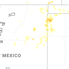
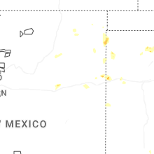
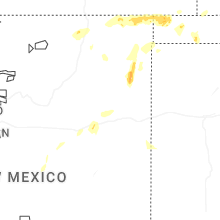


Connect with Interactive Hail Maps