

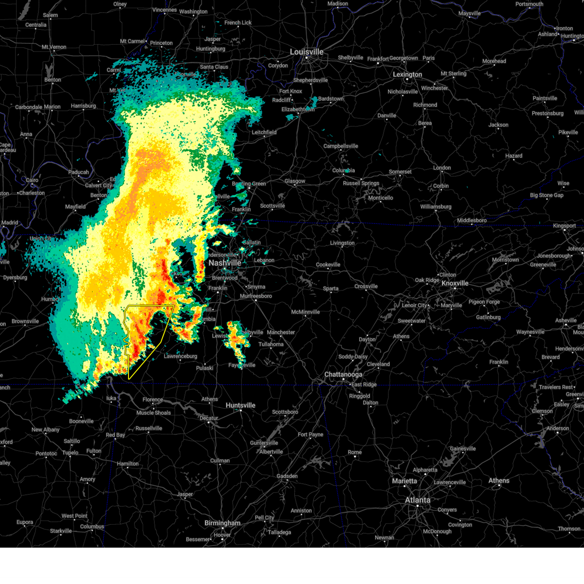
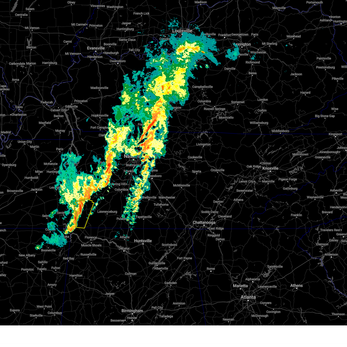
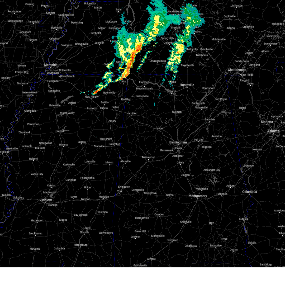
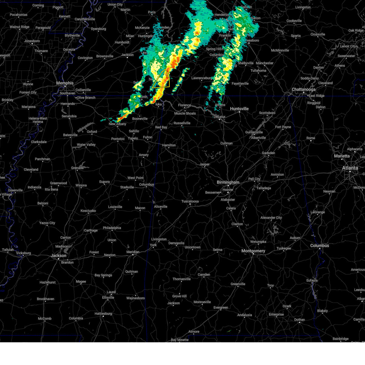
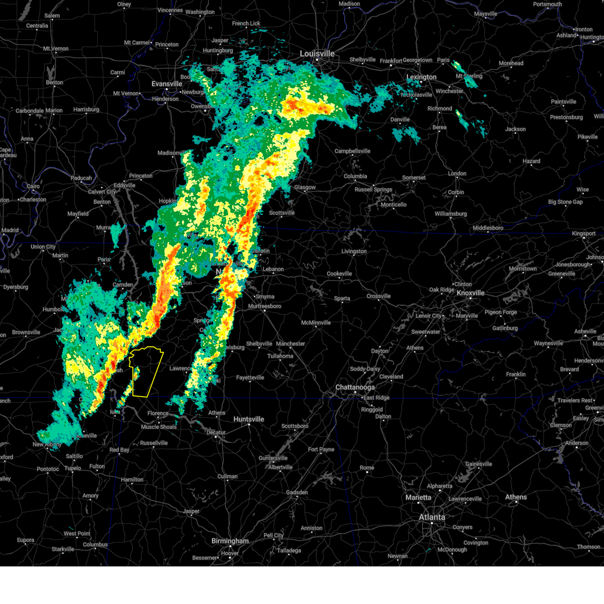
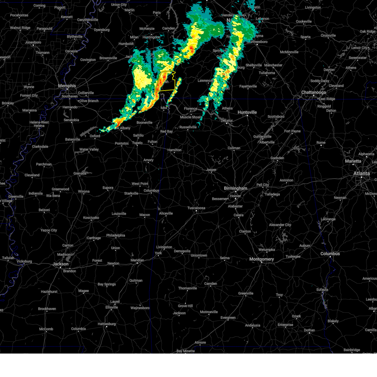
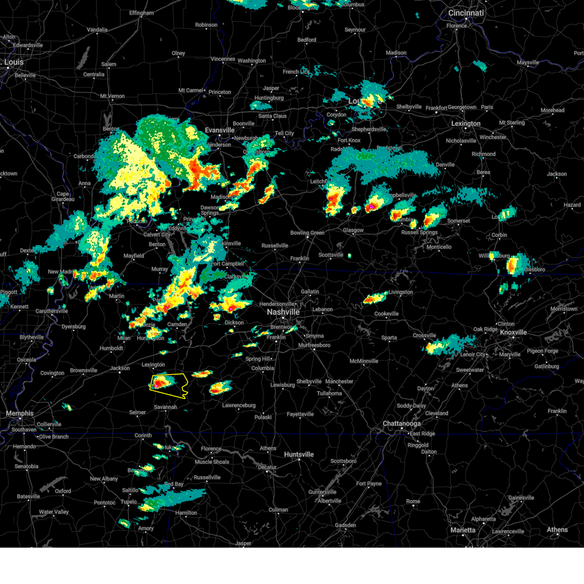
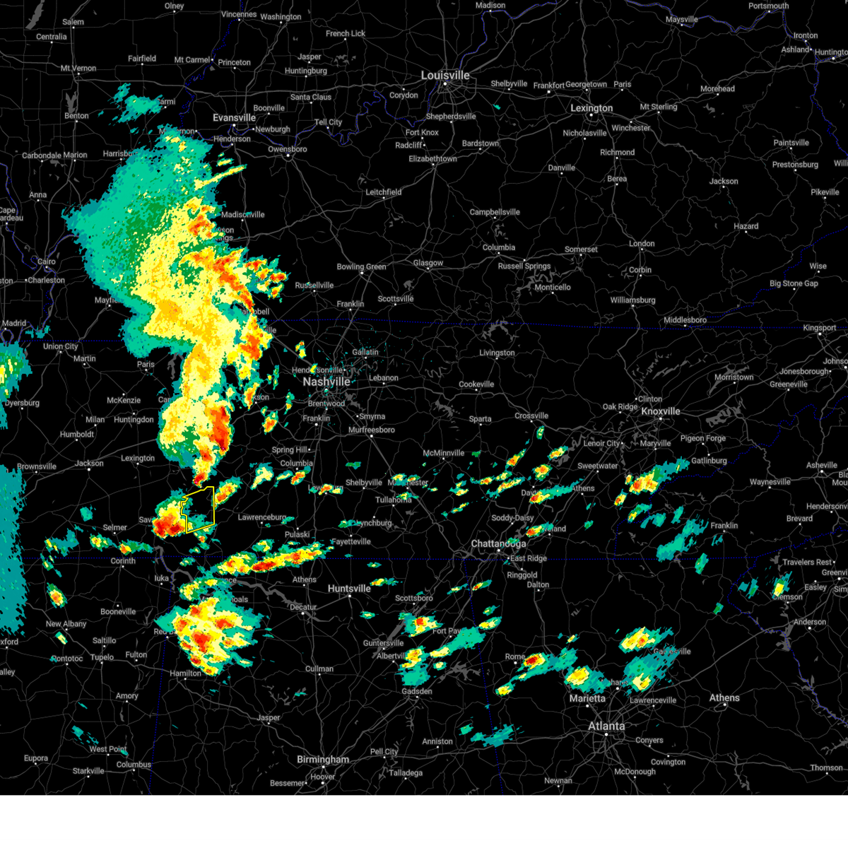
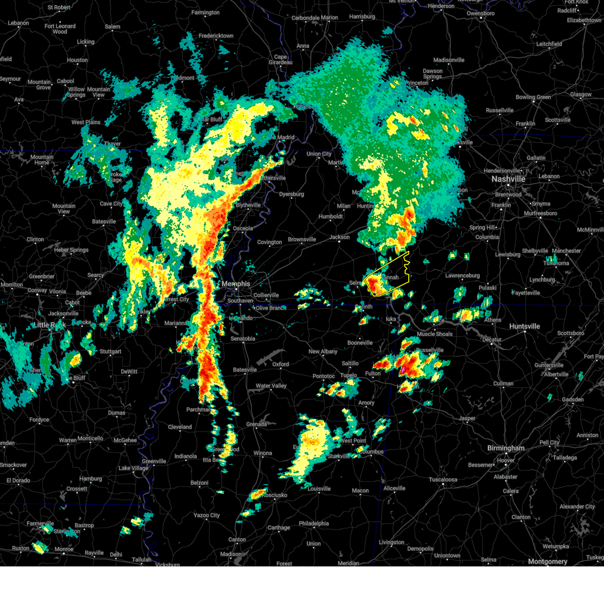
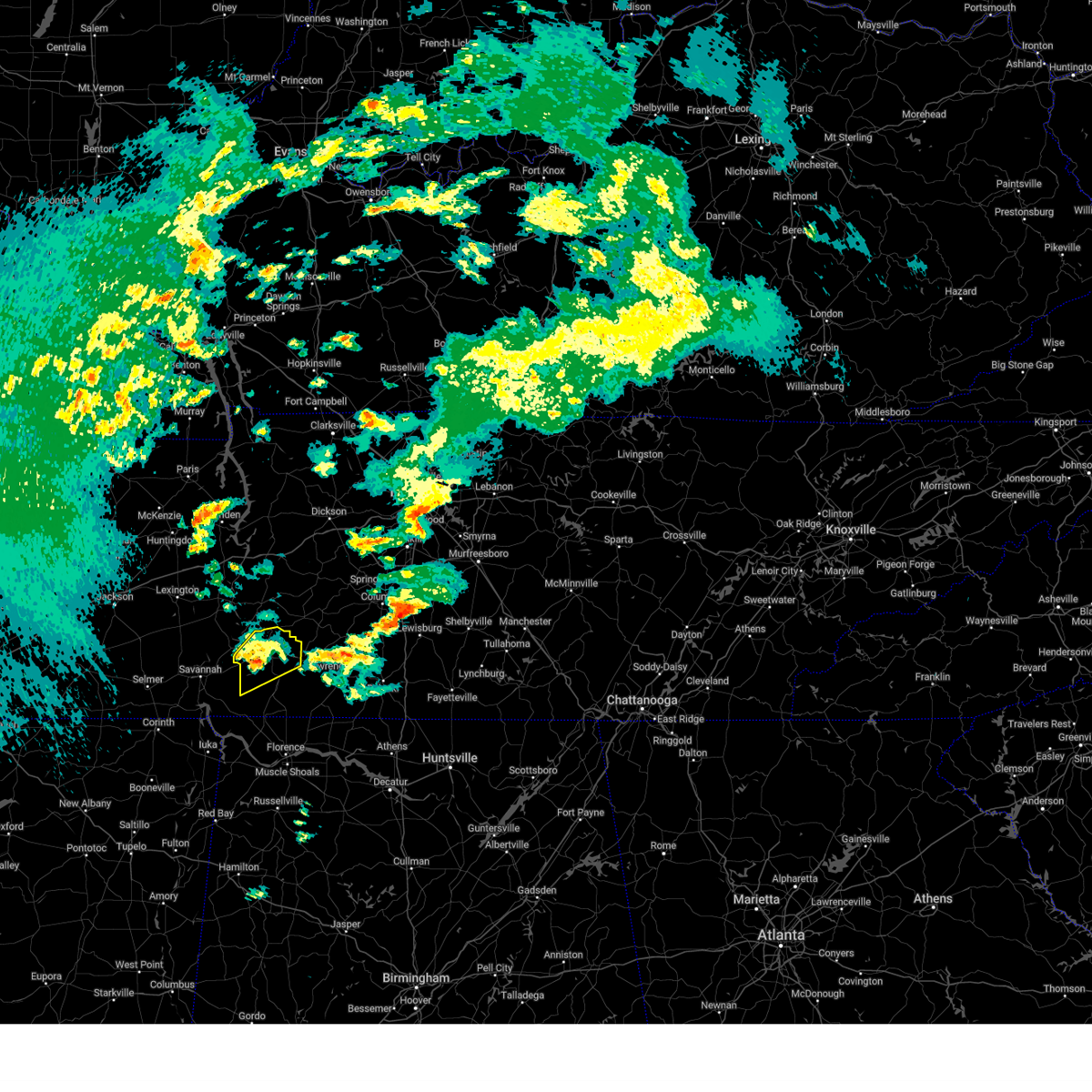
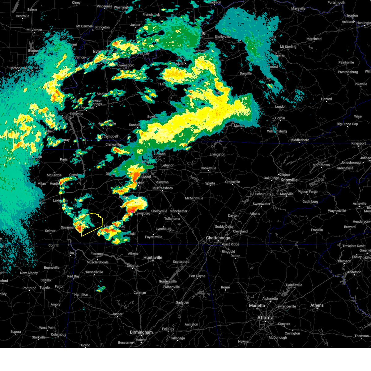
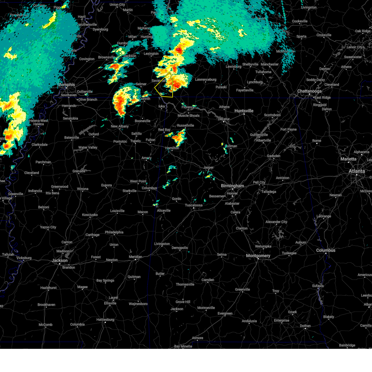
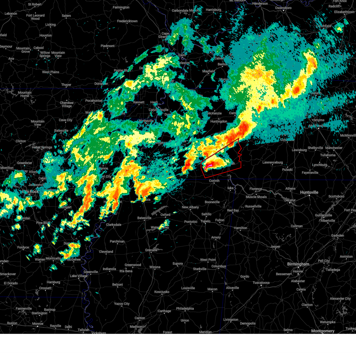
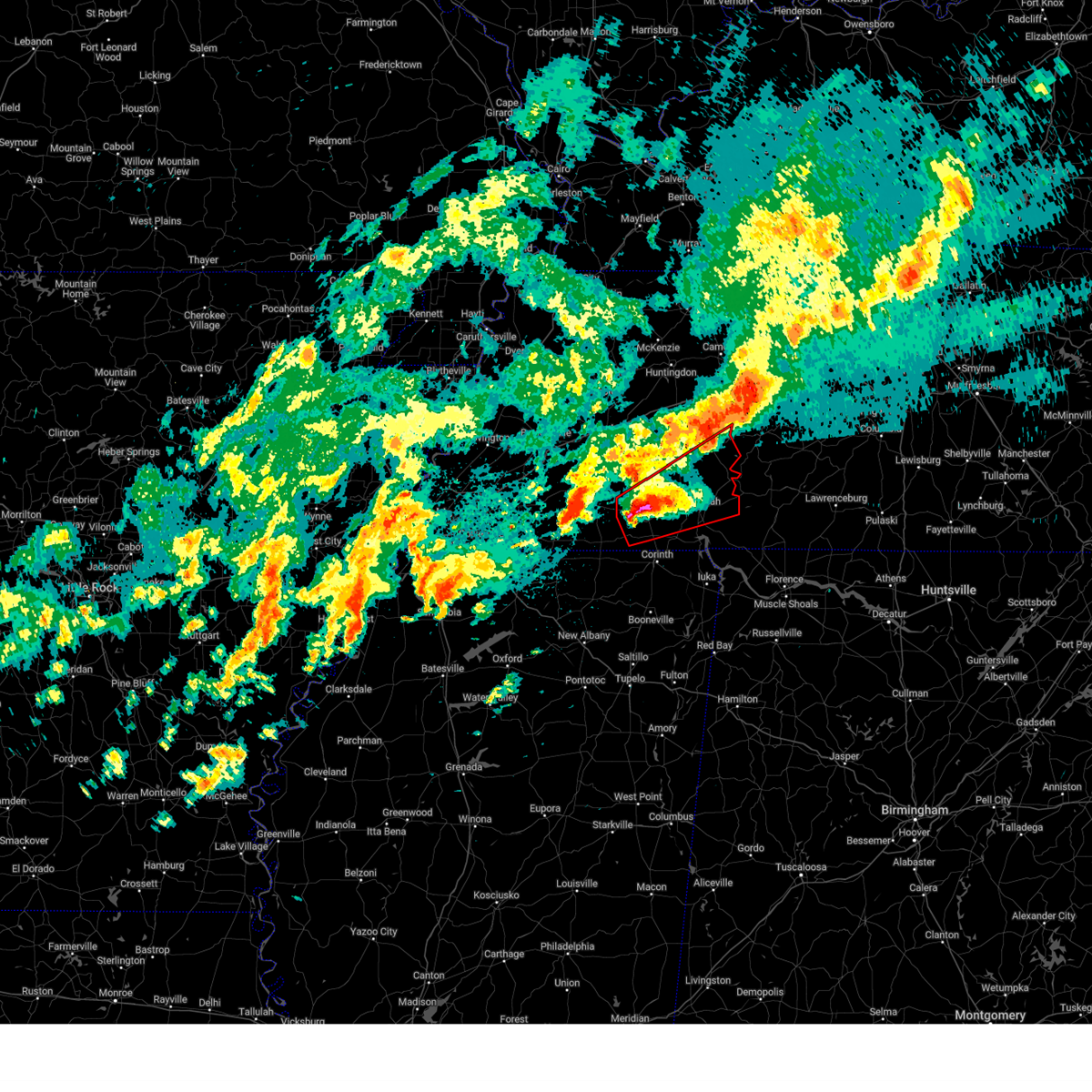
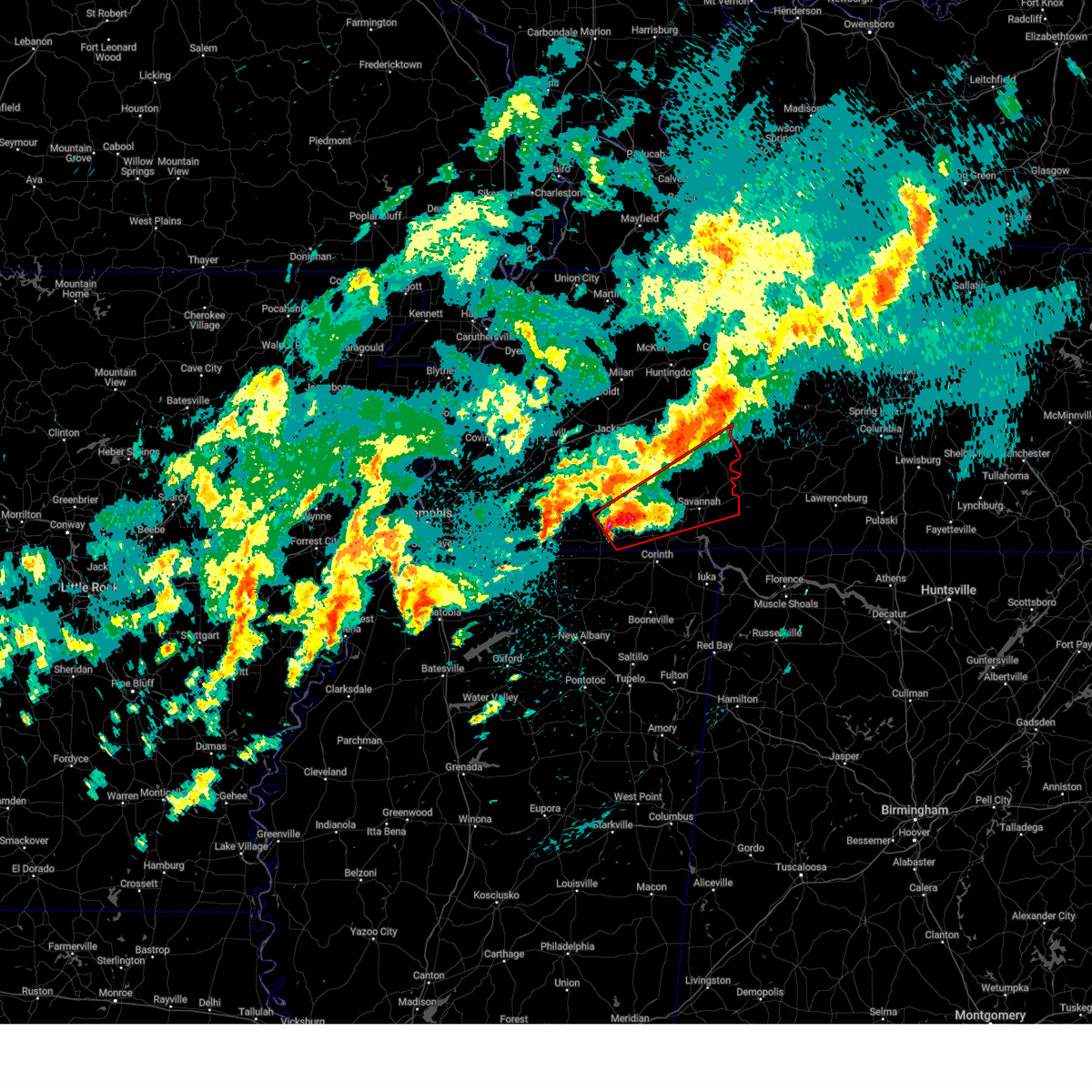
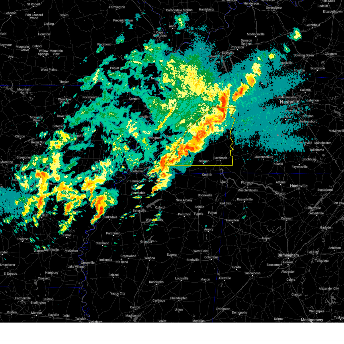
Hail Map for Clifton, TN
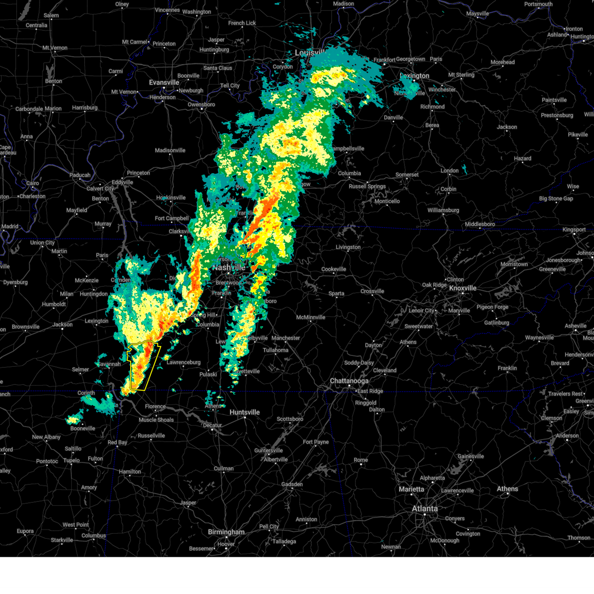
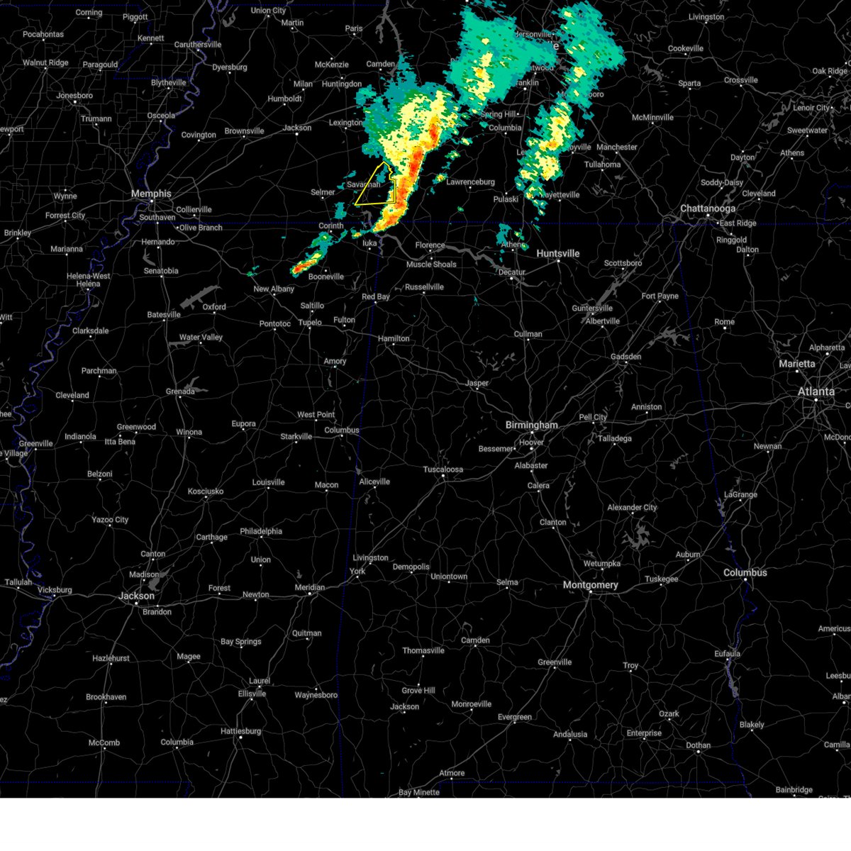
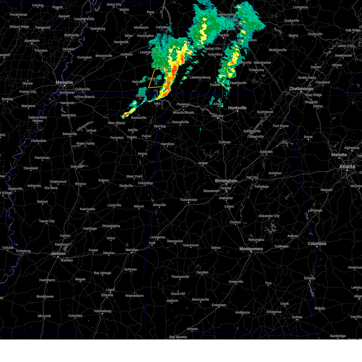
The Clifton, TN area has had 5 reports of on-the-ground hail by trained spotters, and has been under severe weather warnings 79 times during the past 12 months. Doppler radar has detected hail at or near Clifton, TN on 77 occasions, including 4 occasions during the past year.
| Name: | Clifton, TN |
| Where Located: | 43.7 miles NNW of Florence, AL |
| Map: | Google Map for Clifton, TN |
| Population: | 2694 |
| Housing Units: | 434 |
| More Info: | Search Google for Clifton, TN |
0
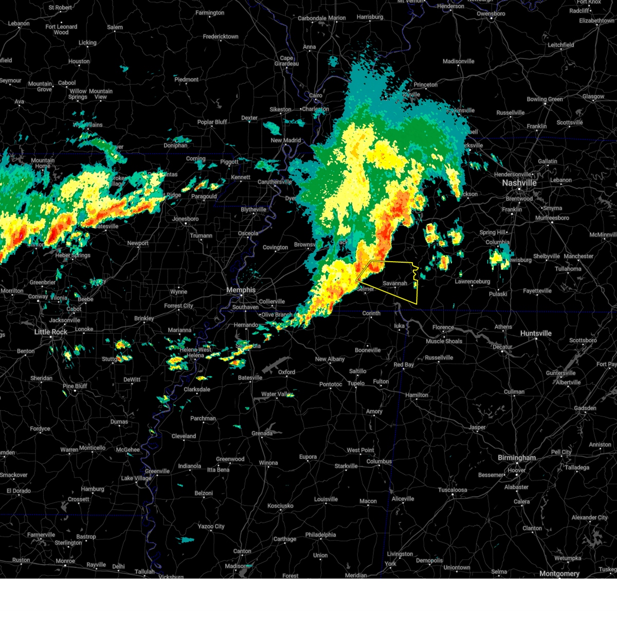
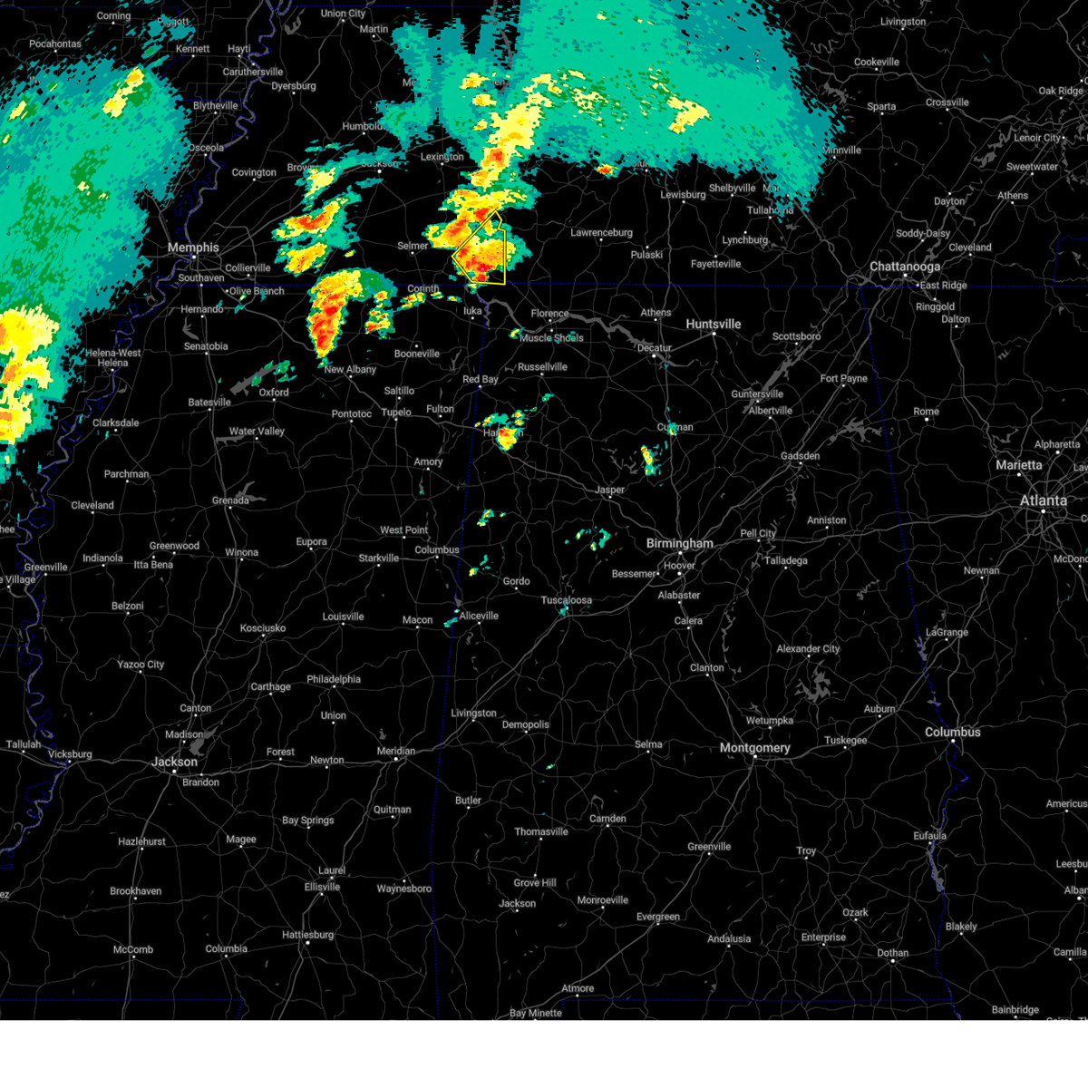
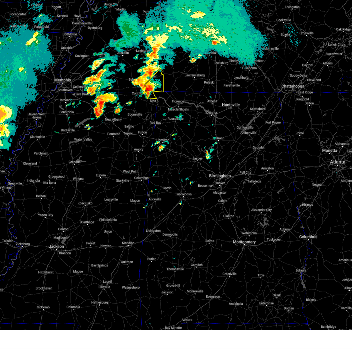
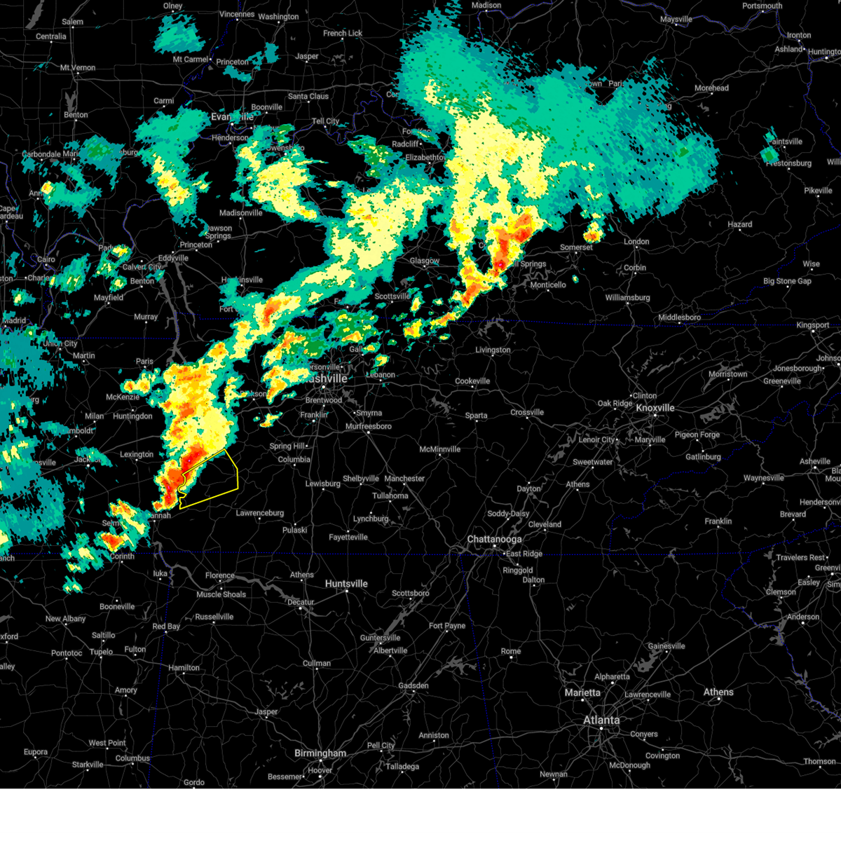
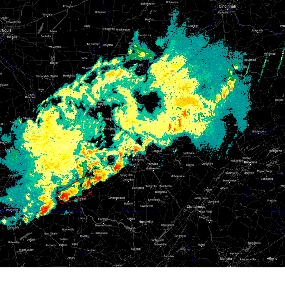
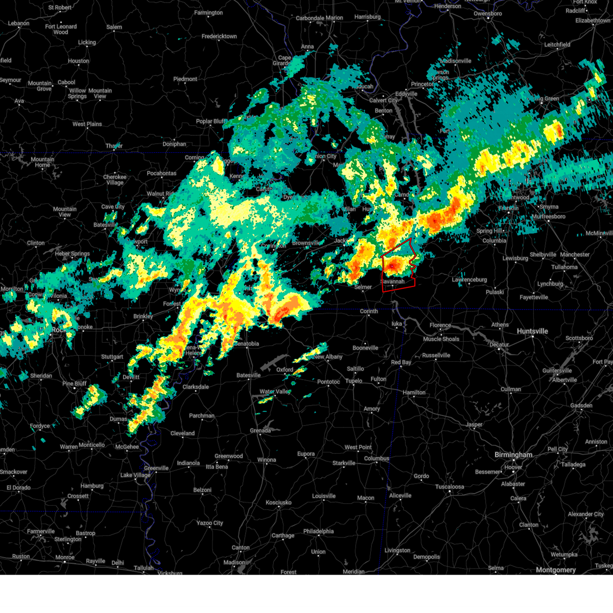
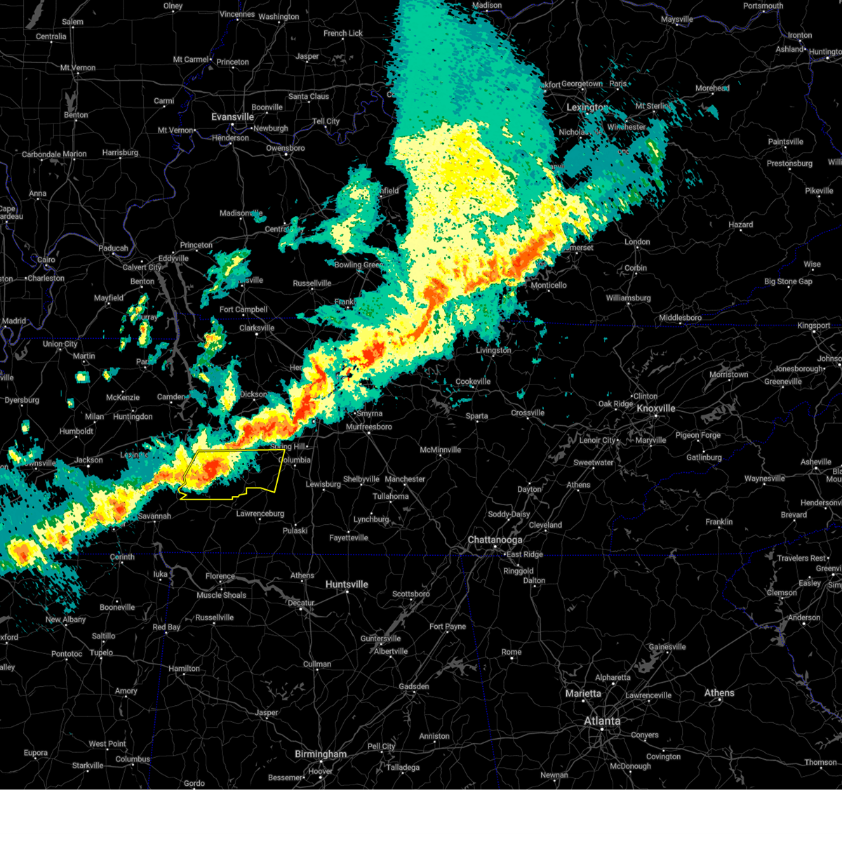
The Top Recent Hail Date for Clifton, TN is Thursday, May 8, 2025 (41st out of 77)

Hail and Wind Damage Spotted near Clifton, TN
| Date / Time | Report Details |
|---|---|
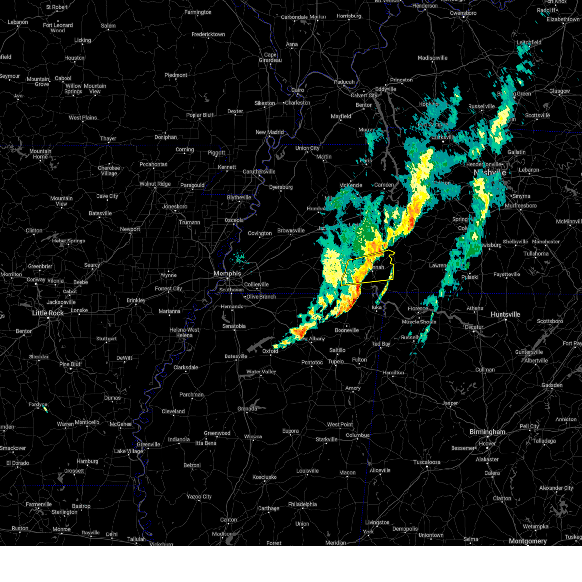
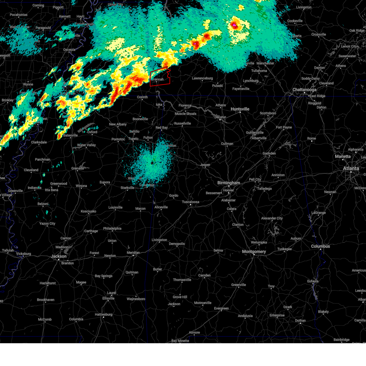
| 5/25/2025 2:24 PM CDT |
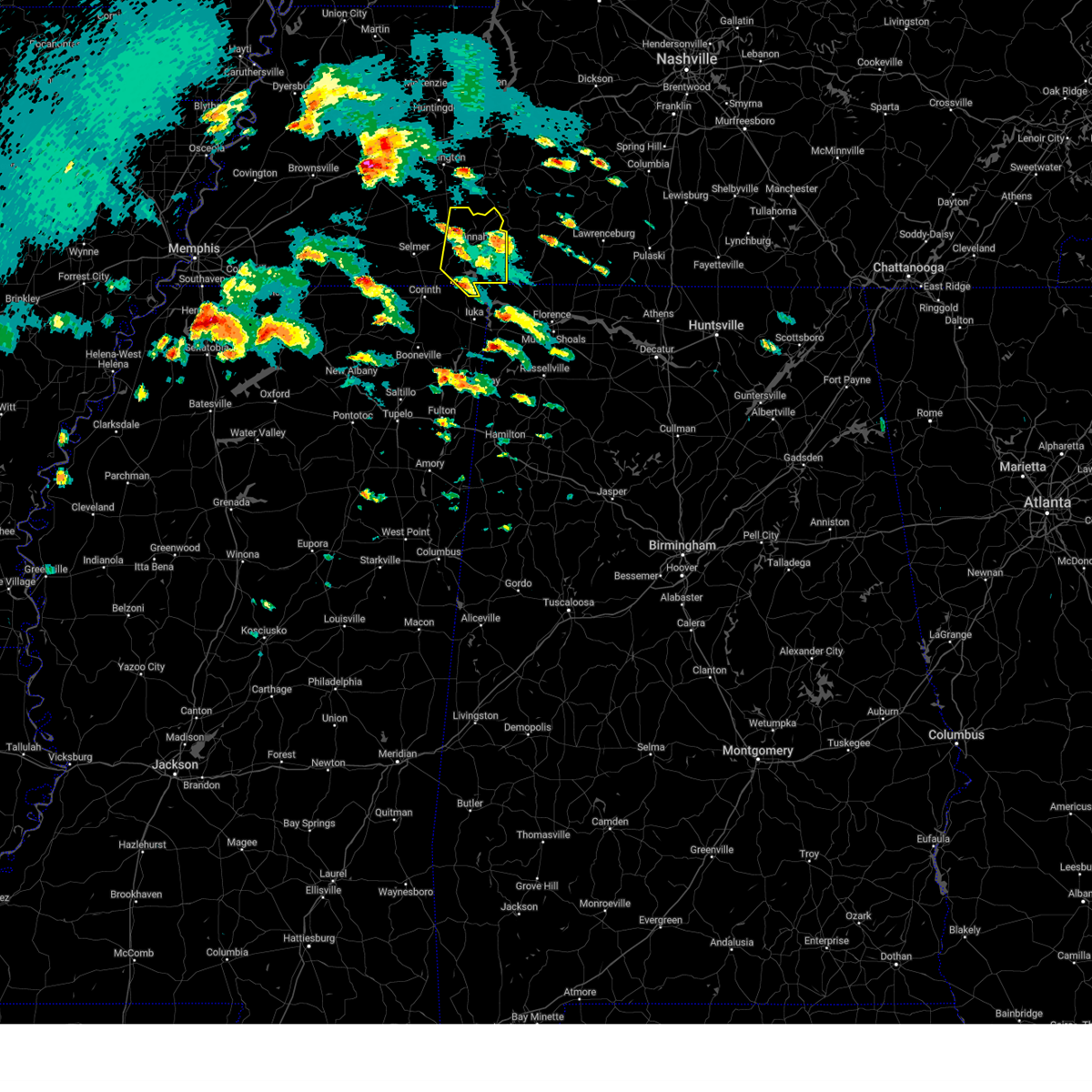
 At 223 pm cdt, severe thunderstorms were located along a line extending from 7 miles west of centerville to near waynesboro to near savannah, moving east at 60 mph (radar indicated). Hazards include 60 mph wind gusts. Expect damage to roofs, siding, and trees. Locations impacted include, hohenwald, centerville, waynesboro, linden, clifton, lobelville, kimmins, mousetail landing state park, pleasantville, flatwoods, and lutts. At 223 pm cdt, severe thunderstorms were located along a line extending from 7 miles west of centerville to near waynesboro to near savannah, moving east at 60 mph (radar indicated). Hazards include 60 mph wind gusts. Expect damage to roofs, siding, and trees. Locations impacted include, hohenwald, centerville, waynesboro, linden, clifton, lobelville, kimmins, mousetail landing state park, pleasantville, flatwoods, and lutts.
|
| 5/25/2025 2:21 PM CDT |
 The storm which prompted the warning has weakened below severe limits, and no longer poses an immediate threat to life or property. therefore, the warning will be allowed to expire. The storm which prompted the warning has weakened below severe limits, and no longer poses an immediate threat to life or property. therefore, the warning will be allowed to expire.
|
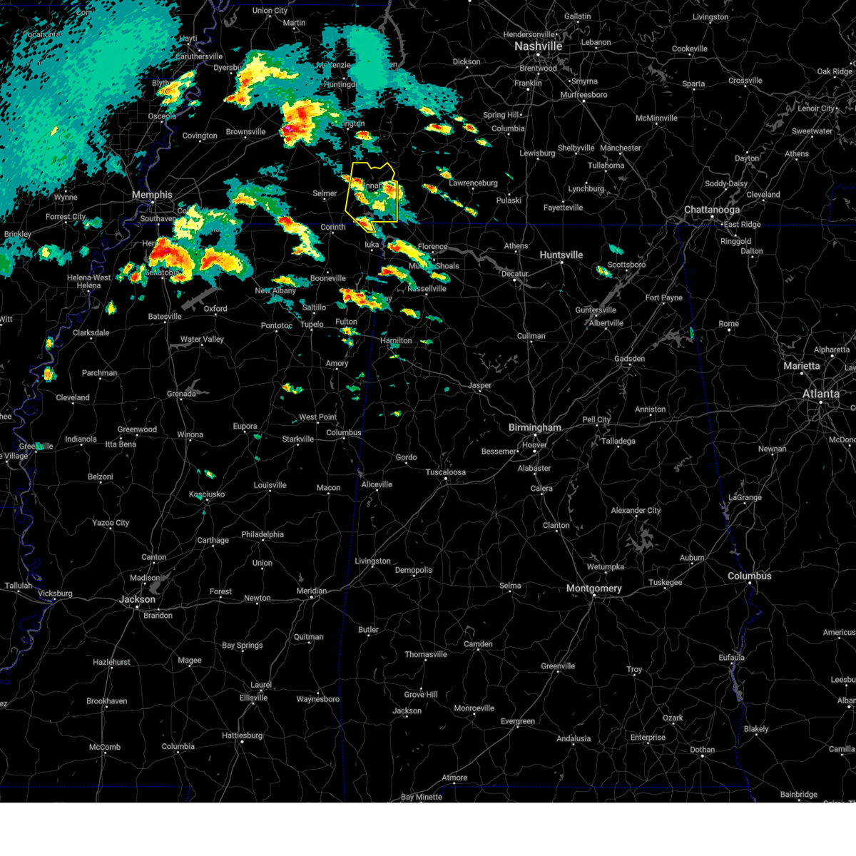
| 5/25/2025 2:17 PM CDT |
 At 216 pm cdt, a severe thunderstorm was located over waynesboro, moving east at 60 mph (radar indicated). Hazards include 60 mph wind gusts and penny size hail. Expect damage to roofs, siding, and trees. Locations impacted include, lowryville, center star, savannah, olive hill, maddox, swift, walkertown, olivehill, phillips, bucktown, and cerro gordo. At 216 pm cdt, a severe thunderstorm was located over waynesboro, moving east at 60 mph (radar indicated). Hazards include 60 mph wind gusts and penny size hail. Expect damage to roofs, siding, and trees. Locations impacted include, lowryville, center star, savannah, olive hill, maddox, swift, walkertown, olivehill, phillips, bucktown, and cerro gordo.
|
| 5/25/2025 2:17 PM CDT |
 the severe thunderstorm warning has been cancelled and is no longer in effect the severe thunderstorm warning has been cancelled and is no longer in effect
|
| 5/25/2025 2:07 PM CDT |
 the severe thunderstorm warning has been cancelled and is no longer in effect the severe thunderstorm warning has been cancelled and is no longer in effect
|
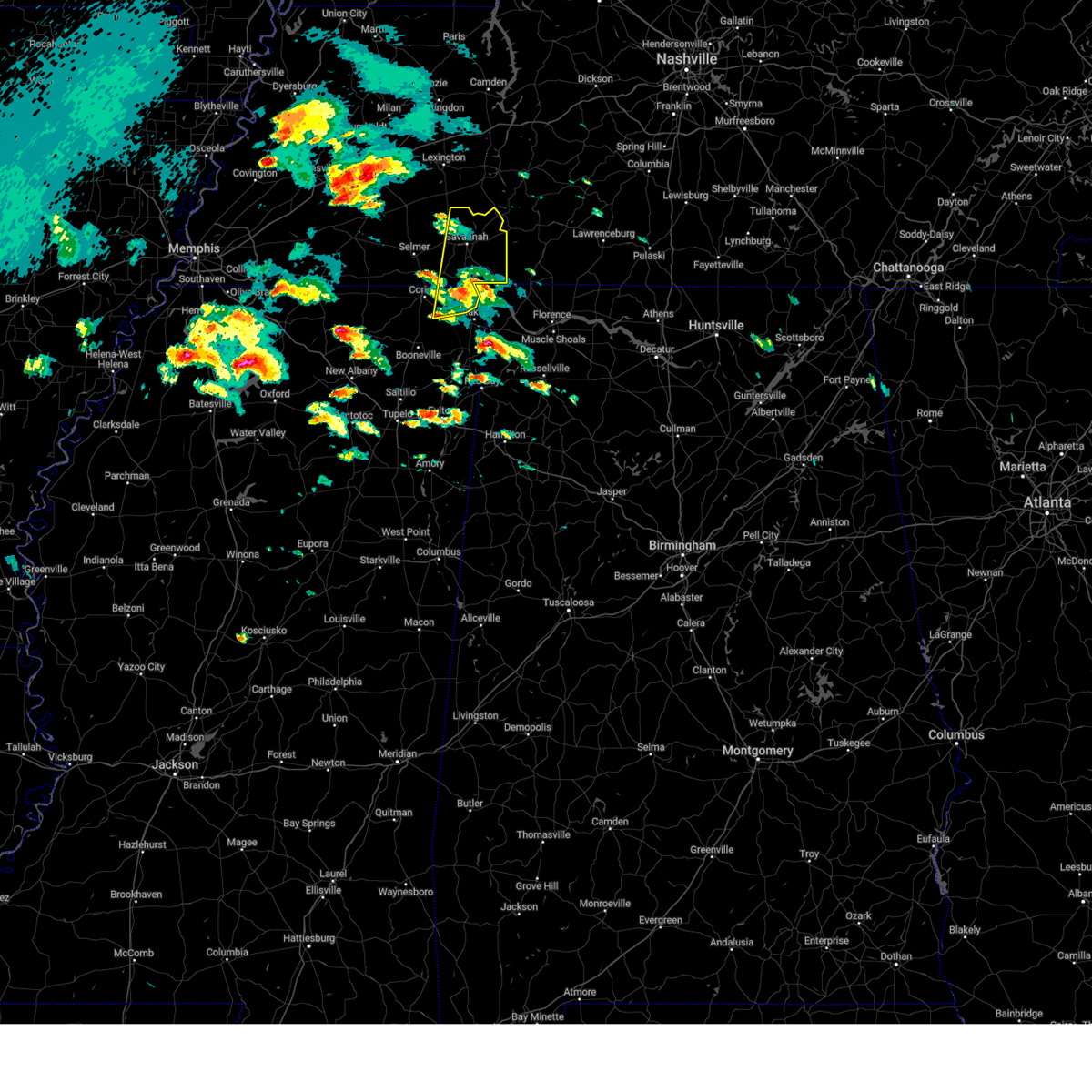
| 5/25/2025 2:07 PM CDT |
 At 207 pm cdt, a severe thunderstorm was located 7 miles west of waynesboro, moving east at 60 mph (radar indicated). Hazards include 60 mph wind gusts and penny size hail. Expect damage to roofs, siding, and trees. Locations impacted include, thurman, lowryville, saltillo, savannah, olive hill, right, crump, sibley, phillips, center star, bath springs, five forks, pleasant grove, maddox, swift, dunbar, walkertown, olivehill, bucktown, and cerro gordo. At 207 pm cdt, a severe thunderstorm was located 7 miles west of waynesboro, moving east at 60 mph (radar indicated). Hazards include 60 mph wind gusts and penny size hail. Expect damage to roofs, siding, and trees. Locations impacted include, thurman, lowryville, saltillo, savannah, olive hill, right, crump, sibley, phillips, center star, bath springs, five forks, pleasant grove, maddox, swift, dunbar, walkertown, olivehill, bucktown, and cerro gordo.
|
| 5/25/2025 1:58 PM CDT |
 At 158 pm cdt, a severe thunderstorm was located near olive hill, or 13 miles northeast of savannah, moving east at 60 mph (radar indicated). Hazards include 60 mph wind gusts and penny size hail. Expect damage to roofs, siding, and trees. Locations impacted include, saltillo, good hope, right, adamsville, crump, phillips, hinkle, pleasant grove, enville, walkertown, olivehill, cerro gordo, thurman, lowryville, hickory flats, savannah, olive hill, sardis, milledgeville, and sibley. At 158 pm cdt, a severe thunderstorm was located near olive hill, or 13 miles northeast of savannah, moving east at 60 mph (radar indicated). Hazards include 60 mph wind gusts and penny size hail. Expect damage to roofs, siding, and trees. Locations impacted include, saltillo, good hope, right, adamsville, crump, phillips, hinkle, pleasant grove, enville, walkertown, olivehill, cerro gordo, thurman, lowryville, hickory flats, savannah, olive hill, sardis, milledgeville, and sibley.
|
| 5/25/2025 1:50 PM CDT |
 Svrohx the national weather service in nashville has issued a * severe thunderstorm warning for, western lewis county in middle tennessee, northwestern wayne county in middle tennessee, perry county in middle tennessee, southwestern hickman county in middle tennessee, * until 230 pm cdt. * at 148 pm cdt, severe thunderstorms were located along a line extending from 6 miles southwest of new johnsonville to near decaturville to near masseyville, moving east at 45 mph (radar indicated). Hazards include 60 mph wind gusts. expect damage to roofs, siding, and trees Svrohx the national weather service in nashville has issued a * severe thunderstorm warning for, western lewis county in middle tennessee, northwestern wayne county in middle tennessee, perry county in middle tennessee, southwestern hickman county in middle tennessee, * until 230 pm cdt. * at 148 pm cdt, severe thunderstorms were located along a line extending from 6 miles southwest of new johnsonville to near decaturville to near masseyville, moving east at 45 mph (radar indicated). Hazards include 60 mph wind gusts. expect damage to roofs, siding, and trees
|
| 5/25/2025 1:43 PM CDT |
 Svrmeg the national weather service in memphis has issued a * severe thunderstorm warning for, south central henderson county in west tennessee, northern mcnairy county in west tennessee, hardin county in west tennessee, southeastern chester county in west tennessee, southern decatur county in west tennessee, * until 230 pm cdt. * at 143 pm cdt, a severe thunderstorm was located near morris chapel, or 11 miles northwest of savannah, moving east at 60 mph (radar indicated). Hazards include 60 mph wind gusts and penny size hail. expect damage to roofs, siding, and trees Svrmeg the national weather service in memphis has issued a * severe thunderstorm warning for, south central henderson county in west tennessee, northern mcnairy county in west tennessee, hardin county in west tennessee, southeastern chester county in west tennessee, southern decatur county in west tennessee, * until 230 pm cdt. * at 143 pm cdt, a severe thunderstorm was located near morris chapel, or 11 miles northwest of savannah, moving east at 60 mph (radar indicated). Hazards include 60 mph wind gusts and penny size hail. expect damage to roofs, siding, and trees
|
| 5/20/2025 10:36 AM CDT |
 The storms which prompted the warning have weakened below severe limits, and no longer pose an immediate threat to life or property. therefore, the warning will be allowed to expire. however, gusty winds are still possible with these thunderstorms. The storms which prompted the warning have weakened below severe limits, and no longer pose an immediate threat to life or property. therefore, the warning will be allowed to expire. however, gusty winds are still possible with these thunderstorms.
|
| 5/20/2025 10:29 AM CDT |
 The storm which prompted the warning has moved out of the area. therefore, the warning will be allowed to expire. The storm which prompted the warning has moved out of the area. therefore, the warning will be allowed to expire.
|
| 5/20/2025 10:28 AM CDT |
 The storm which prompted the warning has moved out of the area. therefore, the warning will be allowed to expire. The storm which prompted the warning has moved out of the area. therefore, the warning will be allowed to expire.
|
| 5/20/2025 10:23 AM CDT |
 At 1022 am cdt, severe thunderstorms were located along a line extending from 10 miles northwest of waynesboro to near walnut grove, moving east at 45 mph (radar indicated). Hazards include 60 mph wind gusts. Expect damage to roofs, siding, and trees. Locations impacted include, cypress inn, clifton, collinwood, waynesboro, lutts, and flatwoods. At 1022 am cdt, severe thunderstorms were located along a line extending from 10 miles northwest of waynesboro to near walnut grove, moving east at 45 mph (radar indicated). Hazards include 60 mph wind gusts. Expect damage to roofs, siding, and trees. Locations impacted include, cypress inn, clifton, collinwood, waynesboro, lutts, and flatwoods.
|
| 5/20/2025 10:17 AM CDT |
 At 1017 am cdt, a severe thunderstorm was located near olive hill, or 14 miles southwest of waynesboro, moving east at 55 mph (radar indicated). Hazards include 60 mph wind gusts. Expect damage to roofs, siding, and trees. Locations impacted include, center star, savannah, olive hill, maddox, swift, walkertown, olivehill, phillips, bucktown, and cerro gordo. At 1017 am cdt, a severe thunderstorm was located near olive hill, or 14 miles southwest of waynesboro, moving east at 55 mph (radar indicated). Hazards include 60 mph wind gusts. Expect damage to roofs, siding, and trees. Locations impacted include, center star, savannah, olive hill, maddox, swift, walkertown, olivehill, phillips, bucktown, and cerro gordo.
|
| 5/20/2025 10:17 AM CDT |
 the severe thunderstorm warning has been cancelled and is no longer in effect the severe thunderstorm warning has been cancelled and is no longer in effect
|
| 5/20/2025 10:02 AM CDT |
 Svrohx the national weather service in nashville has issued a * severe thunderstorm warning for, wayne county in middle tennessee, * until 1045 am cdt. * at 1001 am cdt, severe thunderstorms were located along a line extending from 9 miles northwest of olive hill to near pickwick dam, moving east at 45 mph (radar indicated). Hazards include 60 mph wind gusts. expect damage to roofs, siding, and trees Svrohx the national weather service in nashville has issued a * severe thunderstorm warning for, wayne county in middle tennessee, * until 1045 am cdt. * at 1001 am cdt, severe thunderstorms were located along a line extending from 9 miles northwest of olive hill to near pickwick dam, moving east at 45 mph (radar indicated). Hazards include 60 mph wind gusts. expect damage to roofs, siding, and trees
|
| 5/20/2025 9:59 AM CDT |
 Svrmeg the national weather service in memphis has issued a * severe thunderstorm warning for, central hardin county in west tennessee, southeastern decatur county in west tennessee, * until 1030 am cdt. * at 958 am cdt, a severe thunderstorm was located near savannah, moving east at 55 mph (radar indicated). Hazards include 60 mph wind gusts. expect damage to roofs, siding, and trees Svrmeg the national weather service in memphis has issued a * severe thunderstorm warning for, central hardin county in west tennessee, southeastern decatur county in west tennessee, * until 1030 am cdt. * at 958 am cdt, a severe thunderstorm was located near savannah, moving east at 55 mph (radar indicated). Hazards include 60 mph wind gusts. expect damage to roofs, siding, and trees
|
| 5/20/2025 9:47 AM CDT |
 At 946 am cdt, a severe thunderstorm was located near morris chapel, or near savannah, moving east at 45 mph (radar indicated). Hazards include 60 mph wind gusts and penny size hail. Expect damage to roofs, siding, and trees. Locations impacted include, shiloh national military park, saltillo, selmer, good hope, eastview, right, adamsville, crump, phillips, old lawton, hurley, walkertown, olivehill, purdy, cerro gordo, hickory flats, mount vinson, new lawton, martin camp, and savannah. At 946 am cdt, a severe thunderstorm was located near morris chapel, or near savannah, moving east at 45 mph (radar indicated). Hazards include 60 mph wind gusts and penny size hail. Expect damage to roofs, siding, and trees. Locations impacted include, shiloh national military park, saltillo, selmer, good hope, eastview, right, adamsville, crump, phillips, old lawton, hurley, walkertown, olivehill, purdy, cerro gordo, hickory flats, mount vinson, new lawton, martin camp, and savannah.
|
| 5/20/2025 9:30 AM CDT |
 the severe thunderstorm warning has been cancelled and is no longer in effect the severe thunderstorm warning has been cancelled and is no longer in effect
|
| 5/20/2025 9:30 AM CDT |
 At 929 am cdt, a severe thunderstorm was located near adamsville, or 7 miles northeast of selmer, moving east at 45 mph (radar indicated). Hazards include 60 mph wind gusts and penny size hail. Expect damage to roofs, siding, and trees. Locations impacted include, shiloh national military park, forty forks, saltillo, rose creek, selmer, good hope, bethel springs, pebble hill, eastview, right, adamsville, crump, phillips, old lawton, hurley, walkertown, olivehill, purdy, cerro gordo, and hickory flats. At 929 am cdt, a severe thunderstorm was located near adamsville, or 7 miles northeast of selmer, moving east at 45 mph (radar indicated). Hazards include 60 mph wind gusts and penny size hail. Expect damage to roofs, siding, and trees. Locations impacted include, shiloh national military park, forty forks, saltillo, rose creek, selmer, good hope, bethel springs, pebble hill, eastview, right, adamsville, crump, phillips, old lawton, hurley, walkertown, olivehill, purdy, cerro gordo, and hickory flats.
|
| 5/20/2025 9:17 AM CDT |
 Svrmeg the national weather service in memphis has issued a * severe thunderstorm warning for, east central hardeman county in west tennessee, mcnairy county in west tennessee, hardin county in west tennessee, southeastern decatur county in west tennessee, * until 1000 am cdt. * at 917 am cdt, a severe thunderstorm was located over selmer, moving east at 40 mph (radar indicated). Hazards include 60 mph wind gusts. expect damage to roofs, siding, and trees Svrmeg the national weather service in memphis has issued a * severe thunderstorm warning for, east central hardeman county in west tennessee, mcnairy county in west tennessee, hardin county in west tennessee, southeastern decatur county in west tennessee, * until 1000 am cdt. * at 917 am cdt, a severe thunderstorm was located over selmer, moving east at 40 mph (radar indicated). Hazards include 60 mph wind gusts. expect damage to roofs, siding, and trees
|
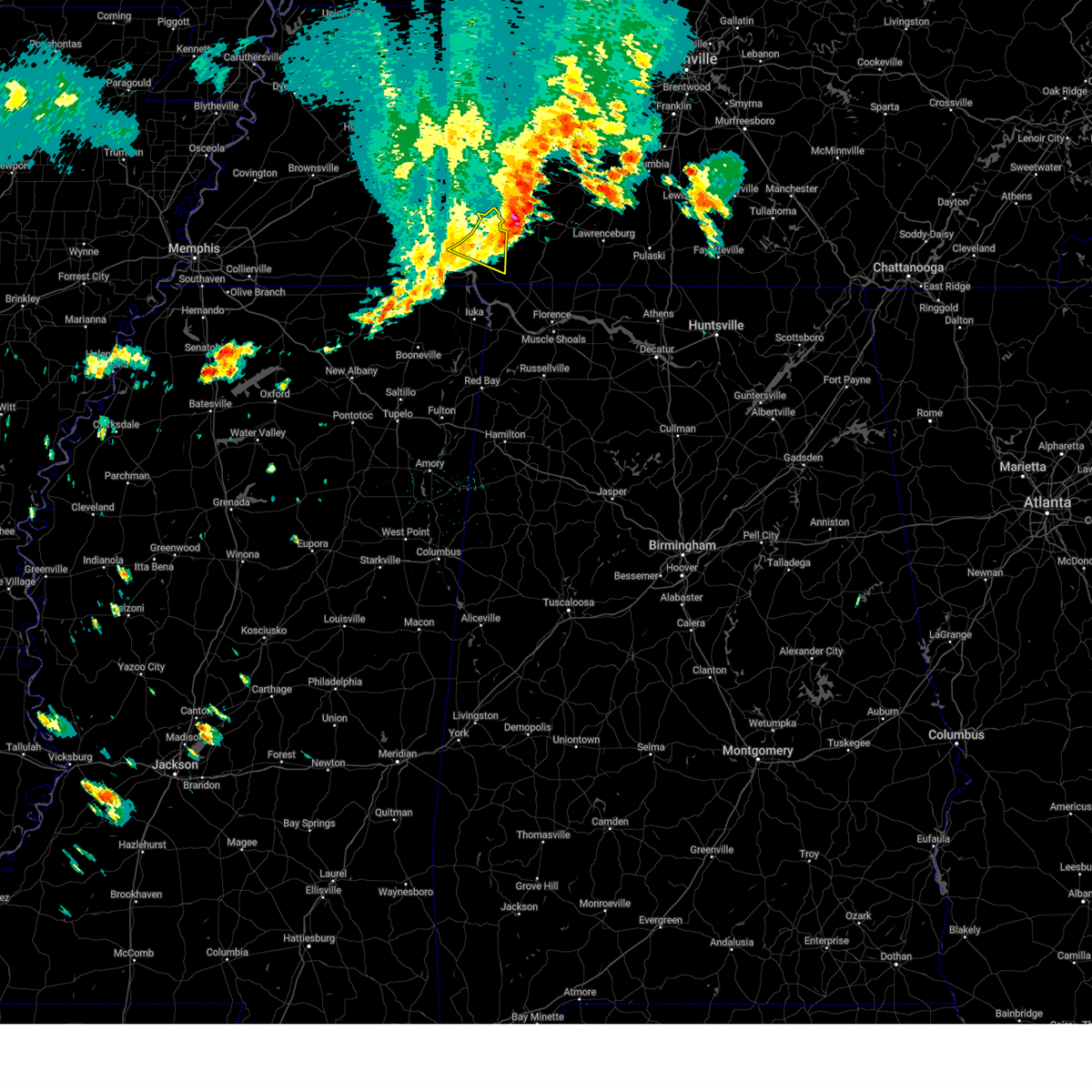
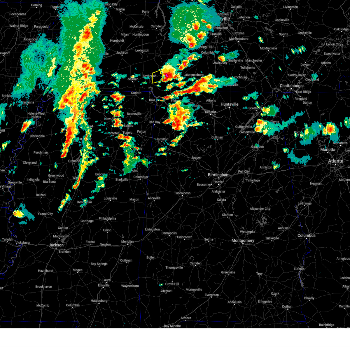
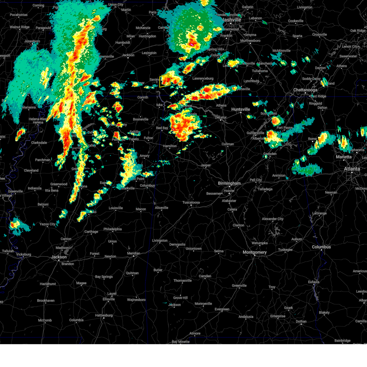
| 5/8/2025 2:37 PM CDT |
 Svrmeg the national weather service in memphis has issued a * severe thunderstorm warning for, southeastern henderson county in west tennessee, northeastern hardin county in west tennessee, eastern chester county in west tennessee, southern decatur county in west tennessee, * until 330 pm cdt. * at 237 pm cdt, a severe thunderstorm was located over reagan, or 12 miles south of lexington, moving east at 30 mph (radar indicated). Hazards include 60 mph wind gusts and quarter size hail. Hail damage to vehicles is expected. Expect wind damage to roofs, siding, and trees. Svrmeg the national weather service in memphis has issued a * severe thunderstorm warning for, southeastern henderson county in west tennessee, northeastern hardin county in west tennessee, eastern chester county in west tennessee, southern decatur county in west tennessee, * until 330 pm cdt. * at 237 pm cdt, a severe thunderstorm was located over reagan, or 12 miles south of lexington, moving east at 30 mph (radar indicated). Hazards include 60 mph wind gusts and quarter size hail. Hail damage to vehicles is expected. Expect wind damage to roofs, siding, and trees.
|
| 5/2/2025 12:30 PM CDT |
 the severe thunderstorm warning has been cancelled and is no longer in effect the severe thunderstorm warning has been cancelled and is no longer in effect
|
| 5/2/2025 12:13 PM CDT |
 Svrmeg the national weather service in memphis has issued a * severe thunderstorm warning for, northeastern hardin county in west tennessee, * until 1245 pm cdt. * at 1213 pm cdt, a severe thunderstorm was located near olive hill, or 7 miles east of savannah, moving east at 40 mph (radar indicated). Hazards include 60 mph wind gusts and quarter size hail. Hail damage to vehicles is expected. Expect wind damage to roofs, siding, and trees. Svrmeg the national weather service in memphis has issued a * severe thunderstorm warning for, northeastern hardin county in west tennessee, * until 1245 pm cdt. * at 1213 pm cdt, a severe thunderstorm was located near olive hill, or 7 miles east of savannah, moving east at 40 mph (radar indicated). Hazards include 60 mph wind gusts and quarter size hail. Hail damage to vehicles is expected. Expect wind damage to roofs, siding, and trees.
|
| 5/2/2025 12:06 PM CDT |
 Svrohx the national weather service in nashville has issued a * severe thunderstorm warning for, northwestern wayne county in middle tennessee, * until 1245 pm cdt. * at 1206 pm cdt, a severe thunderstorm was located near olive hill, or near savannah, moving northeast at 35 mph (radar indicated). Hazards include 60 mph wind gusts and quarter size hail. Hail damage to vehicles is expected. Expect wind damage to roofs, siding, and trees. Svrohx the national weather service in nashville has issued a * severe thunderstorm warning for, northwestern wayne county in middle tennessee, * until 1245 pm cdt. * at 1206 pm cdt, a severe thunderstorm was located near olive hill, or near savannah, moving northeast at 35 mph (radar indicated). Hazards include 60 mph wind gusts and quarter size hail. Hail damage to vehicles is expected. Expect wind damage to roofs, siding, and trees.
|
| 5/2/2025 12:02 PM CDT | At 1202 pm cdt, a severe thunderstorm was located near olive hill, or 11 miles northeast of savannah, moving northeast at 40 mph (radar indicated). Hazards include 60 mph wind gusts and quarter size hail. Hail damage to vehicles is expected. expect wind damage to roofs, siding, and trees. Locations impacted include, saltillo, savannah, olive hill, right, crump, sibley, phillips, bath springs, maddox, swift, walkertown, olivehill, bucktown, cerro gordo, and coffee landing. |
| 5/2/2025 11:51 AM CDT | At 1151 am cdt, a severe thunderstorm was located near savannah, moving northeast at 40 mph (radar indicated). Hazards include 60 mph wind gusts and quarter size hail. Hail damage to vehicles is expected. expect wind damage to roofs, siding, and trees. Locations impacted include, shiloh national military park, saltillo, savannah, olive hill, right, hamburg, crump, sibley, phillips, pittsburg landing, bath springs, five forks, pleasant grove, maddox, hurley, morris chapel, swift, walkertown, olivehill, and shiloh. |
| 5/2/2025 11:51 AM CDT | the severe thunderstorm warning has been cancelled and is no longer in effect |
| 5/2/2025 11:35 AM CDT |
 Svrmeg the national weather service in memphis has issued a * severe thunderstorm warning for, east central mcnairy county in west tennessee, central hardin county in west tennessee, southeastern decatur county in west tennessee, * until 1215 pm cdt. * at 1135 am cdt, a severe thunderstorm was located near adamsville, or 7 miles west of savannah, moving northeast at 40 mph (radar indicated). Hazards include 60 mph wind gusts and quarter size hail. Hail damage to vehicles is expected. Expect wind damage to roofs, siding, and trees. Svrmeg the national weather service in memphis has issued a * severe thunderstorm warning for, east central mcnairy county in west tennessee, central hardin county in west tennessee, southeastern decatur county in west tennessee, * until 1215 pm cdt. * at 1135 am cdt, a severe thunderstorm was located near adamsville, or 7 miles west of savannah, moving northeast at 40 mph (radar indicated). Hazards include 60 mph wind gusts and quarter size hail. Hail damage to vehicles is expected. Expect wind damage to roofs, siding, and trees.
|
| 4/3/2025 7:00 PM CDT |
 the severe thunderstorm warning has been cancelled and is no longer in effect the severe thunderstorm warning has been cancelled and is no longer in effect
|
| 4/3/2025 6:43 PM CDT |
 Svrohx the national weather service in nashville has issued a * severe thunderstorm warning for, northern wayne county in middle tennessee, * until 730 pm cdt. * at 642 pm cdt, a severe thunderstorm was located over olive hill, or 13 miles east of savannah, moving northeast at 45 mph (radar indicated). Hazards include 60 mph wind gusts and penny size hail. expect damage to roofs, siding, and trees Svrohx the national weather service in nashville has issued a * severe thunderstorm warning for, northern wayne county in middle tennessee, * until 730 pm cdt. * at 642 pm cdt, a severe thunderstorm was located over olive hill, or 13 miles east of savannah, moving northeast at 45 mph (radar indicated). Hazards include 60 mph wind gusts and penny size hail. expect damage to roofs, siding, and trees
|
| 4/3/2025 5:22 PM CDT |
 the severe thunderstorm warning has been cancelled and is no longer in effect the severe thunderstorm warning has been cancelled and is no longer in effect
|
| 4/3/2025 5:11 PM CDT |
 At 511 pm cdt, a severe thunderstorm was located near walnut grove, or 8 miles northeast of pickwick landing state park, moving northeast at 45 mph (radar indicated). Hazards include golf ball size hail and 60 mph wind gusts. People and animals outdoors will be injured. expect hail damage to roofs, siding, windows, and vehicles. expect wind damage to roofs, siding, and trees. Locations impacted include, lowryville, walnut grove, savannah, olive hill, pollards mill, phillips, bruton branch, pickwick landing state park, center star, maddox, walkertown, olivehill, and bucktown. At 511 pm cdt, a severe thunderstorm was located near walnut grove, or 8 miles northeast of pickwick landing state park, moving northeast at 45 mph (radar indicated). Hazards include golf ball size hail and 60 mph wind gusts. People and animals outdoors will be injured. expect hail damage to roofs, siding, windows, and vehicles. expect wind damage to roofs, siding, and trees. Locations impacted include, lowryville, walnut grove, savannah, olive hill, pollards mill, phillips, bruton branch, pickwick landing state park, center star, maddox, walkertown, olivehill, and bucktown.
|
| 4/3/2025 5:11 PM CDT |
 the severe thunderstorm warning has been cancelled and is no longer in effect the severe thunderstorm warning has been cancelled and is no longer in effect
|
| 4/3/2025 5:09 PM CDT |
 Svrohx the national weather service in nashville has issued a * severe thunderstorm warning for, central wayne county in middle tennessee, south central perry county in middle tennessee, * until 545 pm cdt. * at 509 pm cdt, a severe thunderstorm was located near walnut grove, or 7 miles northeast of pickwick landing state park, moving northeast at 45 mph (radar indicated). Hazards include 60 mph wind gusts and quarter size hail. Hail damage to vehicles is expected. Expect wind damage to roofs, siding, and trees. Svrohx the national weather service in nashville has issued a * severe thunderstorm warning for, central wayne county in middle tennessee, south central perry county in middle tennessee, * until 545 pm cdt. * at 509 pm cdt, a severe thunderstorm was located near walnut grove, or 7 miles northeast of pickwick landing state park, moving northeast at 45 mph (radar indicated). Hazards include 60 mph wind gusts and quarter size hail. Hail damage to vehicles is expected. Expect wind damage to roofs, siding, and trees.
|
| 4/3/2025 5:00 PM CDT |
 At 500 pm cdt, a severe thunderstorm was located over pickwick landing state park, moving northeast at 50 mph (radar indicated). Hazards include golf ball size hail and 60 mph wind gusts. People and animals outdoors will be injured. expect hail damage to roofs, siding, windows, and vehicles. expect wind damage to roofs, siding, and trees. Locations impacted include, counce, lowryville, walnut grove, damon, savannah, olive hill, doskie, j p coleman state park, pickwick dam, hamburg, pineflat, pollards mill, phillips, bruton branch, childers hill, pickwick landing state park, center star, maddox, walkertown, and olivehill. At 500 pm cdt, a severe thunderstorm was located over pickwick landing state park, moving northeast at 50 mph (radar indicated). Hazards include golf ball size hail and 60 mph wind gusts. People and animals outdoors will be injured. expect hail damage to roofs, siding, windows, and vehicles. expect wind damage to roofs, siding, and trees. Locations impacted include, counce, lowryville, walnut grove, damon, savannah, olive hill, doskie, j p coleman state park, pickwick dam, hamburg, pineflat, pollards mill, phillips, bruton branch, childers hill, pickwick landing state park, center star, maddox, walkertown, and olivehill.
|
| 4/3/2025 5:00 PM CDT |
 the severe thunderstorm warning has been cancelled and is no longer in effect the severe thunderstorm warning has been cancelled and is no longer in effect
|
| 4/3/2025 4:53 PM CDT | At 452 pm cdt, a severe thunderstorm was located near pineflat, or 8 miles west of pickwick landing state park, moving northeast at 45 mph (radar indicated. at 450 pm cdt, hail up to two inches in diameter was reported near farmington). Hazards include two inch hail and 60 mph wind gusts. People and animals outdoors will be injured. expect hail damage to roofs, siding, windows, and vehicles. expect wind damage to roofs, siding, and trees. Locations impacted include, shiloh national military park, walnut grove, doskie, j p coleman state park, pickwick dam, hamburg, pineflat, phillips, bruton branch, tulu, pickwick landing state park, acton, hurley, walkertown, olivehill, red sulphur springs, chambers, counce, lowryville, and damon. |
| 4/3/2025 4:51 PM CDT | At 450 pm cdt, a severe thunderstorm was located 7 miles west of pineflat, or 7 miles northeast of corinth, moving northeast at 50 mph (radar indicated). Hazards include 60 mph wind gusts and quarter size hail. Hail damage to vehicles is expected. expect wind damage to roofs, siding, and trees. Locations impacted include, shiloh national military park, walnut grove, doskie, j p coleman state park, pickwick dam, hamburg, pineflat, phillips, bruton branch, tulu, pickwick landing state park, acton, hurley, walkertown, olivehill, red sulphur springs, chambers, counce, lowryville, and damon. |
| 4/3/2025 4:31 PM CDT | Svrmeg the national weather service in memphis has issued a * severe thunderstorm warning for, northern tishomingo county in northeastern mississippi, alcorn county in northeastern mississippi, southeastern mcnairy county in west tennessee, hardin county in west tennessee, * until 545 pm cdt. * at 431 pm cdt, a severe thunderstorm was located near theo, or 8 miles southwest of corinth, moving northeast at 45 mph (radar indicated). Hazards include 60 mph wind gusts and quarter size hail. Hail damage to vehicles is expected. Expect wind damage to roofs, siding, and trees. |
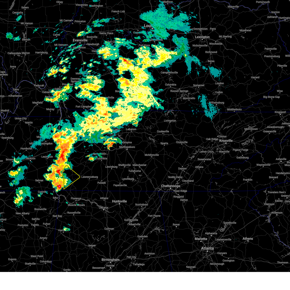
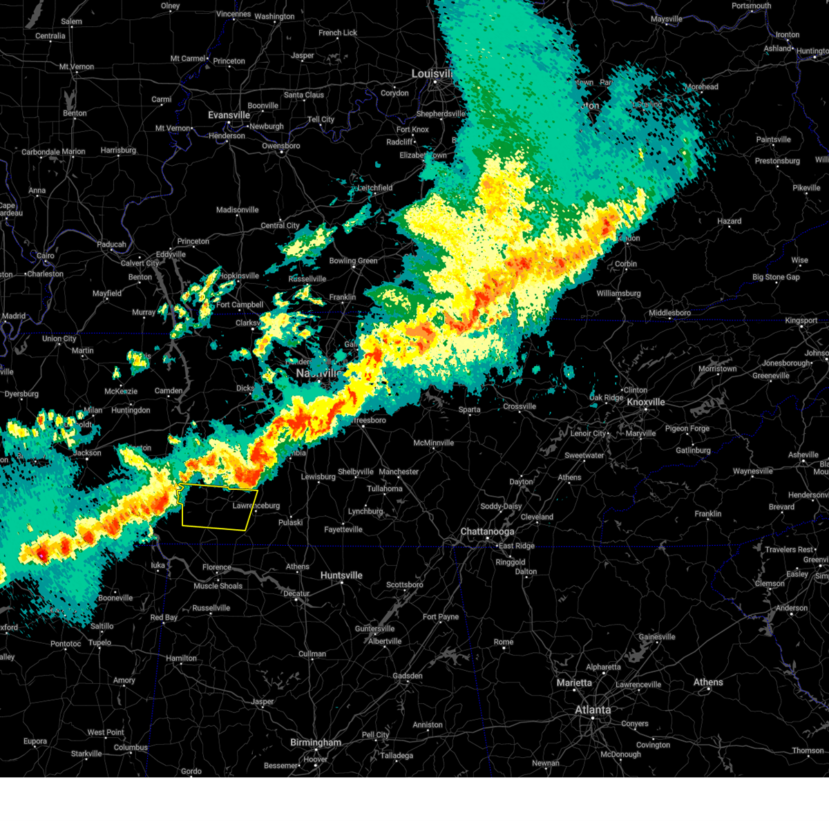
| 4/3/2025 2:34 PM CDT |
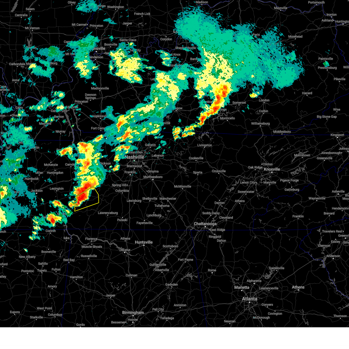 At 234 pm cdt, a severe thunderstorm was located 7 miles south of linden, moving northeast at 45 mph (radar indicated). Hazards include ping pong ball size hail and 60 mph wind gusts. People and animals outdoors will be injured. expect hail damage to roofs, siding, windows, and vehicles. expect wind damage to roofs, siding, and trees. Locations impacted include, clifton, flatwoods, hohenwald, linden, and pleasantville. At 234 pm cdt, a severe thunderstorm was located 7 miles south of linden, moving northeast at 45 mph (radar indicated). Hazards include ping pong ball size hail and 60 mph wind gusts. People and animals outdoors will be injured. expect hail damage to roofs, siding, windows, and vehicles. expect wind damage to roofs, siding, and trees. Locations impacted include, clifton, flatwoods, hohenwald, linden, and pleasantville.
|
| 4/3/2025 2:19 PM CDT |
 Svrohx the national weather service in nashville has issued a * severe thunderstorm warning for, western lewis county in middle tennessee, northern wayne county in middle tennessee, southern perry county in middle tennessee, southwestern hickman county in middle tennessee, * until 300 pm cdt. * at 218 pm cdt, a severe thunderstorm was located 9 miles north of olive hill, or 14 miles northeast of savannah, moving northeast at 40 mph (radar indicated). Hazards include 60 mph wind gusts and quarter size hail. Hail damage to vehicles is expected. Expect wind damage to roofs, siding, and trees. Svrohx the national weather service in nashville has issued a * severe thunderstorm warning for, western lewis county in middle tennessee, northern wayne county in middle tennessee, southern perry county in middle tennessee, southwestern hickman county in middle tennessee, * until 300 pm cdt. * at 218 pm cdt, a severe thunderstorm was located 9 miles north of olive hill, or 14 miles northeast of savannah, moving northeast at 40 mph (radar indicated). Hazards include 60 mph wind gusts and quarter size hail. Hail damage to vehicles is expected. Expect wind damage to roofs, siding, and trees.
|
| 4/3/2025 3:53 AM CDT | Svrohx the national weather service in nashville has issued a * severe thunderstorm warning for, western lewis county in middle tennessee, northern wayne county in middle tennessee, southern perry county in middle tennessee, southwestern hickman county in middle tennessee, * until 430 am cdt. * at 353 am cdt, a severe thunderstorm was located 10 miles north of olive hill, or 17 miles northeast of savannah, moving east at 50 mph (radar indicated). Hazards include 60 mph wind gusts and quarter size hail. Hail damage to vehicles is expected. Expect wind damage to roofs, siding, and trees. |
| 4/3/2025 3:09 AM CDT |
 Tormeg the national weather service in memphis has issued a * tornado warning for, northern hardin county in west tennessee, southern decatur county in west tennessee, * until 400 am cdt. * at 309 am cdt, a severe thunderstorm capable of producing a tornado was located near selmer, moving east at 45 mph (radar indicated rotation). Hazards include tornado and quarter size hail. Flying debris will be dangerous to those caught without shelter. mobile homes will be damaged or destroyed. damage to roofs, windows, and vehicles will occur. Tree damage is likely. Tormeg the national weather service in memphis has issued a * tornado warning for, northern hardin county in west tennessee, southern decatur county in west tennessee, * until 400 am cdt. * at 309 am cdt, a severe thunderstorm capable of producing a tornado was located near selmer, moving east at 45 mph (radar indicated rotation). Hazards include tornado and quarter size hail. Flying debris will be dangerous to those caught without shelter. mobile homes will be damaged or destroyed. damage to roofs, windows, and vehicles will occur. Tree damage is likely.
|
| 4/3/2025 3:04 AM CDT | At 303 am cdt, a severe thunderstorm capable of producing a tornado was located near decaturville, or 15 miles southwest of linden, moving northeast at 50 mph (radar indicated rotation). Hazards include tornado and quarter size hail. Flying debris will be dangerous to those caught without shelter. mobile homes will be damaged or destroyed. damage to roofs, windows, and vehicles will occur. tree damage is likely. Locations impacted include, busseltown, haney, pleasant grove, mount tabor, parsons, red walnut, decaturville, cozette, thurman, lick skillet, perryville, gumdale, montgomery, wilkinstown, darden, bath springs, garrett, beacon, hickory forks, and largo. |
| 4/3/2025 3:02 AM CDT | Svrohx the national weather service in nashville has issued a * severe thunderstorm warning for, northwestern lewis county in middle tennessee, northwestern wayne county in middle tennessee, perry county in middle tennessee, southwestern hickman county in middle tennessee, * until 345 am cdt. * at 301 am cdt, a severe thunderstorm was located near decaturville, or 14 miles southwest of linden, moving northeast at 50 mph (radar indicated). Hazards include 60 mph wind gusts and quarter size hail. Hail damage to vehicles is expected. Expect wind damage to roofs, siding, and trees. |
| 4/3/2025 2:54 AM CDT | At 253 am cdt, a large and extremely dangerous tornado was located near sardis, or 14 miles north of savannah, moving east at 45 mph. this is a particularly dangerous situation. take cover now! (radar indicated rotation). Hazards include damaging tornado. You are in a life-threatening situation. flying debris may be deadly to those caught without shelter. mobile homes will be destroyed. considerable damage to homes, businesses, and vehicles is likely and complete destruction is possible. Locations impacted include, saltillo, busseltown, reagan, haney, rock hill, hinkle, pleasant grove, mount tabor, parsons, red walnut, decaturville, scotts hill, cozette, thurman, lick skillet, sardis, perryville, gumdale, montgomery, and warrens bluff. |
| 4/3/2025 2:54 AM CDT | the tornado warning has been cancelled and is no longer in effect |
| 4/3/2025 2:47 AM CDT | At 247 am cdt, a large and extremely dangerous tornado was located over sardis, or 14 miles north of savannah, moving northeast at 50 mph. this is a particularly dangerous situation. take cover now! (radar indicated rotation). Hazards include damaging tornado. You are in a life-threatening situation. flying debris may be deadly to those caught without shelter. mobile homes will be destroyed. considerable damage to homes, businesses, and vehicles is likely and complete destruction is possible. Locations impacted include, saltillo, busseltown, right, adamsville, reagan, haney, rock hill, hinkle, roby, pleasant grove, mount tabor, cabo, middle fork, parsons, red walnut, decaturville, enville, scotts hill, cozette, and cerro gordo. |
| 4/3/2025 2:43 AM CDT | At 243 am cdt, a large and extremely dangerous tornado was located near sardis, or 13 miles north of savannah, moving northeast at 50 mph. this is a particularly dangerous situation. take cover now! (radar indicated rotation). Hazards include damaging tornado. You are in a life-threatening situation. flying debris may be deadly to those caught without shelter. mobile homes will be destroyed. considerable damage to homes, businesses, and vehicles is likely and complete destruction is possible. Locations impacted include, saltillo, busseltown, right, adamsville, reagan, haney, rock hill, hinkle, roby, pleasant grove, mount tabor, cabo, middle fork, parsons, red walnut, decaturville, enville, scotts hill, cozette, and cerro gordo. |
| 4/3/2025 2:33 AM CDT | At 233 am cdt, a large and extremely dangerous tornado was located 7 miles northwest of morris chapel, or 11 miles southeast of henderson, moving northeast at 50 mph. this is a particularly dangerous situation. take cover now! (radar indicated rotation). Hazards include damaging tornado. You are in a life-threatening situation. flying debris may be deadly to those caught without shelter. mobile homes will be destroyed. considerable damage to homes, businesses, and vehicles is likely and complete destruction is possible. Locations impacted include, adamsville, reagan, rock hill, pleasant grove, middle fork, decaturville, cerro gordo, thurman, lick skillet, milledgeville, perryville, montgomery, warrens bluff, bath springs, beacon, morris chapel, hickory forks, swift, dunbar, and taylors crossing. |
| 4/3/2025 2:33 AM CDT | the tornado warning has been cancelled and is no longer in effect |
| 4/3/2025 2:22 AM CDT |
 At 222 am cdt, a large and extremely dangerous tornado was located near masseyville, or 8 miles north of selmer, moving northeast at 50 mph. this is a particularly dangerous situation. take cover now! (radar indicated rotation). Hazards include damaging tornado. You are in a life-threatening situation. flying debris may be deadly to those caught without shelter. mobile homes will be destroyed. considerable damage to homes, businesses, and vehicles is likely and complete destruction is possible. Locations impacted include, pine top, masseyville, adamsville, reagan, rock hill, silerton, hickory corners, pleasant grove, middle fork, decaturville, cerro gordo, thurman, lick skillet, milledgeville, perryville, montgomery, woodville, warrens bluff, bath springs, and montezuma. At 222 am cdt, a large and extremely dangerous tornado was located near masseyville, or 8 miles north of selmer, moving northeast at 50 mph. this is a particularly dangerous situation. take cover now! (radar indicated rotation). Hazards include damaging tornado. You are in a life-threatening situation. flying debris may be deadly to those caught without shelter. mobile homes will be destroyed. considerable damage to homes, businesses, and vehicles is likely and complete destruction is possible. Locations impacted include, pine top, masseyville, adamsville, reagan, rock hill, silerton, hickory corners, pleasant grove, middle fork, decaturville, cerro gordo, thurman, lick skillet, milledgeville, perryville, montgomery, woodville, warrens bluff, bath springs, and montezuma.
|
| 4/3/2025 2:19 AM CDT |
 Tormeg the national weather service in memphis has issued a * tornado warning for, southern henderson county in west tennessee, northeastern hardeman county in west tennessee, northern mcnairy county in west tennessee, northern hardin county in west tennessee, chester county in west tennessee, decatur county in west tennessee, * until 315 am cdt. * at 219 am cdt, a severe thunderstorm capable of producing a tornado was located near masseyville, or 8 miles northwest of selmer, moving northeast at 50 mph (radar indicated rotation). Hazards include tornado and tennis ball size hail. Flying debris will be dangerous to those caught without shelter. mobile homes will be damaged or destroyed. damage to roofs, windows, and vehicles will occur. Tree damage is likely. Tormeg the national weather service in memphis has issued a * tornado warning for, southern henderson county in west tennessee, northeastern hardeman county in west tennessee, northern mcnairy county in west tennessee, northern hardin county in west tennessee, chester county in west tennessee, decatur county in west tennessee, * until 315 am cdt. * at 219 am cdt, a severe thunderstorm capable of producing a tornado was located near masseyville, or 8 miles northwest of selmer, moving northeast at 50 mph (radar indicated rotation). Hazards include tornado and tennis ball size hail. Flying debris will be dangerous to those caught without shelter. mobile homes will be damaged or destroyed. damage to roofs, windows, and vehicles will occur. Tree damage is likely.
|
| 4/3/2025 1:46 AM CDT | Svrohx the national weather service in nashville has issued a * severe thunderstorm warning for, northern lewis county in middle tennessee, northwestern wayne county in middle tennessee, perry county in middle tennessee, southern humphreys county in middle tennessee, hickman county in middle tennessee, * until 245 am cdt. * at 145 am cdt, a severe thunderstorm was located over decaturville, or 14 miles southeast of natchez trace state forest, moving northeast at 50 mph (radar indicated). Hazards include 60 mph wind gusts and quarter size hail. Hail damage to vehicles is expected. Expect wind damage to roofs, siding, and trees. |
| 4/3/2025 1:44 AM CDT | the severe thunderstorm warning has been cancelled and is no longer in effect |
| 4/3/2025 1:44 AM CDT | At 144 am cdt, a severe thunderstorm was located over parsons, or 11 miles southeast of natchez trace state forest, moving northeast at 60 mph (radar indicated). Hazards include 60 mph wind gusts and quarter size hail. Hail damage to vehicles is expected. expect wind damage to roofs, siding, and trees. Locations impacted include, saltillo, busseltown, jeannette, right, reagan, haney, rock hill, hinkle, pleasant grove, mount tabor, sugar tree, parsons, red walnut, decaturville, scotts hill, cozette, thurman, lick skillet, sardis, and perryville. |
| 4/3/2025 1:39 AM CDT | the severe thunderstorm warning has been cancelled and is no longer in effect |
| 4/3/2025 1:39 AM CDT | At 138 am cdt, a severe thunderstorm was located near darden, or 10 miles southeast of natchez trace state forest, moving northeast at 60 mph (radar indicated). Hazards include 60 mph wind gusts and quarter size hail. Hail damage to vehicles is expected. expect wind damage to roofs, siding, and trees. Locations impacted include, reagan, lexington, rock hill, pleasant grove, decaturville, hinson springs, thurman, lick skillet, milledgeville, perryville, montgomery, warrens bluff, natchez trace state park, bath springs, beacon, morris chapel, hickory forks, swift, natchez trace state forest, and dunbar. |
| 4/3/2025 1:26 AM CDT | At 126 am cdt, a severe thunderstorm was located over reagan, or 10 miles south of lexington, moving northeast at 60 mph (radar indicated). Hazards include 60 mph wind gusts and quarter size hail. Hail damage to vehicles is expected. expect wind damage to roofs, siding, and trees. Locations impacted include, adamsville, reagan, lexington, rock hill, pleasant grove, middle fork, decaturville, hinson springs, thurman, lick skillet, milledgeville, perryville, montgomery, huron, warrens bluff, mifflin, natchez trace state park, bath springs, five points, and beacon. |
| 4/3/2025 1:21 AM CDT | Svrmeg the national weather service in memphis has issued a * severe thunderstorm warning for, henderson county in west tennessee, southeastern benton county in west tennessee, northeastern mcnairy county in west tennessee, northern hardin county in west tennessee, east central madison county in west tennessee, central chester county in west tennessee, decatur county in west tennessee, * until 200 am cdt. * at 121 am cdt, a severe thunderstorm was located near jacks creek, or 10 miles east of henderson, moving northeast at 60 mph (radar indicated). Hazards include 60 mph wind gusts and quarter size hail. Hail damage to vehicles is expected. Expect wind damage to roofs, siding, and trees. |
| 4/3/2025 1:12 AM CDT |
 At 112 am cdt, a confirmed large and extremely dangerous tornado was located 7 miles southeast of sardis, or 10 miles north of savannah, moving northeast at 50 mph. this is a particularly dangerous situation. take cover now! (weather spotters confirmed tornado). Hazards include damaging tornado. You are in a life-threatening situation. flying debris may be deadly to those caught without shelter. mobile homes will be destroyed. considerable damage to homes, businesses, and vehicles is likely and complete destruction is possible. Locations impacted include, saltillo, right, crump, phillips, haney, hinkle, pleasant grove, mount tabor, red walnut, decaturville, walkertown, scotts hill, olivehill, cerro gordo, thurman, lick skillet, savannah, olive hill, sardis, and perryville. At 112 am cdt, a confirmed large and extremely dangerous tornado was located 7 miles southeast of sardis, or 10 miles north of savannah, moving northeast at 50 mph. this is a particularly dangerous situation. take cover now! (weather spotters confirmed tornado). Hazards include damaging tornado. You are in a life-threatening situation. flying debris may be deadly to those caught without shelter. mobile homes will be destroyed. considerable damage to homes, businesses, and vehicles is likely and complete destruction is possible. Locations impacted include, saltillo, right, crump, phillips, haney, hinkle, pleasant grove, mount tabor, red walnut, decaturville, walkertown, scotts hill, olivehill, cerro gordo, thurman, lick skillet, savannah, olive hill, sardis, and perryville.
|
| 4/3/2025 1:12 AM CDT |
 the tornado warning has been cancelled and is no longer in effect the tornado warning has been cancelled and is no longer in effect
|
| 4/3/2025 1:06 AM CDT | Torohx the national weather service in nashville has issued a * tornado warning for, western lewis county in middle tennessee, northern wayne county in middle tennessee, perry county in middle tennessee, southwestern hickman county in middle tennessee, * until 145 am cdt. * at 106 am cdt, a confirmed large and extremely dangerous tornado was located near morris chapel, or 9 miles northwest of savannah, moving northeast at 50 mph. this is a particularly dangerous situation. take cover now! (weather spotters confirmed tornado). Hazards include damaging tornado. You are in a life-threatening situation. flying debris may be deadly to those caught without shelter. mobile homes will be destroyed. considerable damage to homes, businesses, and vehicles is likely and complete destruction is possible. the tornado will be near, linden around 140 am cdt. Other locations impacted by this tornadic thunderstorm include clifton, flatwoods, lobelville, mousetail landing state park, and pleasantville. |
| 4/3/2025 1:00 AM CDT | At 100 am cdt, a confirmed large and extremely dangerous tornado was located over morris chapel, or 8 miles northwest of savannah, moving northeast at 50 mph. this is a particularly dangerous situation. take cover now! (weather spotters confirmed tornado). Hazards include damaging tornado. You are in a life-threatening situation. flying debris may be deadly to those caught without shelter. mobile homes will be destroyed. considerable damage to homes, businesses, and vehicles is likely and complete destruction is possible. Locations impacted include, adamsville, crump, pleasant grove, hurley, decaturville, walkertown, cerro gordo, thurman, lick skillet, mount vinson, savannah, milledgeville, perryville, montgomery, gilchrist, bath springs, morris chapel, swift, dunbar, and taylors crossing. |
| 4/3/2025 12:51 AM CDT | At 1250 am cdt, a confirmed large and extremely dangerous tornado was located near adamsville, or 7 miles northeast of selmer, moving northeast at 50 mph. this is a particularly dangerous situation. take cover now! (weather spotters confirmed tornado). Hazards include damaging tornado. You are in a life-threatening situation. flying debris may be deadly to those caught without shelter. mobile homes will be destroyed. considerable damage to homes, businesses, and vehicles is likely and complete destruction is possible. Locations impacted include, selmer, adamsville, crump, pleasant grove, hurley, decaturville, walkertown, cerro gordo, thurman, lick skillet, mount vinson, new lawton, martin camp, savannah, milledgeville, perryville, montgomery, gilchrist, bath springs, and morris chapel. |
| 4/3/2025 12:37 AM CDT |
 At 1237 am cdt, a confirmed large and extremely dangerous tornado was located near selmer, moving northeast at 50 mph. this is a particularly dangerous situation. take cover now! (weather spotters confirmed tornado). Hazards include damaging tornado. You are in a life-threatening situation. flying debris may be deadly to those caught without shelter. mobile homes will be destroyed. considerable damage to homes, businesses, and vehicles is likely and complete destruction is possible. Locations impacted include, selmer, eastview, masseyville, adamsville, crump, pleasant grove, hurley, decaturville, ramer, walkertown, cerro gordo, thurman, lick skillet, mount vinson, new lawton, martin camp, savannah, milledgeville, perryville, and montgomery. At 1237 am cdt, a confirmed large and extremely dangerous tornado was located near selmer, moving northeast at 50 mph. this is a particularly dangerous situation. take cover now! (weather spotters confirmed tornado). Hazards include damaging tornado. You are in a life-threatening situation. flying debris may be deadly to those caught without shelter. mobile homes will be destroyed. considerable damage to homes, businesses, and vehicles is likely and complete destruction is possible. Locations impacted include, selmer, eastview, masseyville, adamsville, crump, pleasant grove, hurley, decaturville, ramer, walkertown, cerro gordo, thurman, lick skillet, mount vinson, new lawton, martin camp, savannah, milledgeville, perryville, and montgomery.
|
| 4/3/2025 12:37 AM CDT |
 the tornado warning has been cancelled and is no longer in effect the tornado warning has been cancelled and is no longer in effect
|
| 4/3/2025 12:31 AM CDT |
 Tormeg the national weather service in memphis has issued a * tornado warning for, southeastern henderson county in west tennessee, east central hardeman county in west tennessee, mcnairy county in west tennessee, hardin county in west tennessee, southeastern chester county in west tennessee, southern decatur county in west tennessee, * until 130 am cdt. * at 1231 am cdt, a confirmed tornado was located near big hill pond state park, moving northeast at 50 mph (weather spotters confirmed tornado). Hazards include damaging tornado and hail up to two inches in diameter. Flying debris will be dangerous to those caught without shelter. mobile homes will be damaged or destroyed. damage to roofs, windows, and vehicles will occur. Tree damage is likely. Tormeg the national weather service in memphis has issued a * tornado warning for, southeastern henderson county in west tennessee, east central hardeman county in west tennessee, mcnairy county in west tennessee, hardin county in west tennessee, southeastern chester county in west tennessee, southern decatur county in west tennessee, * until 130 am cdt. * at 1231 am cdt, a confirmed tornado was located near big hill pond state park, moving northeast at 50 mph (weather spotters confirmed tornado). Hazards include damaging tornado and hail up to two inches in diameter. Flying debris will be dangerous to those caught without shelter. mobile homes will be damaged or destroyed. damage to roofs, windows, and vehicles will occur. Tree damage is likely.
|
| 4/2/2025 11:21 PM CDT |
 At 1120 pm cdt, a severe thunderstorm was located 7 miles south of bruceton, or 12 miles north of natchez trace state park, moving east at 65 mph (radar indicated). Hazards include 70 mph wind gusts and quarter size hail. Hail damage to vehicles is expected. expect considerable tree damage. wind damage is also likely to mobile homes, roofs, and outbuildings. Locations impacted include, neely, selmer, huntersville, masseyville, reagan, crump, westover, madison hall, uptonville, rock hill, silerton, bruceton, leach, walkertown, hinson springs, cerro gordo, buena vista, pinson mounds state archaeological park, hollow rock, and thurman. At 1120 pm cdt, a severe thunderstorm was located 7 miles south of bruceton, or 12 miles north of natchez trace state park, moving east at 65 mph (radar indicated). Hazards include 70 mph wind gusts and quarter size hail. Hail damage to vehicles is expected. expect considerable tree damage. wind damage is also likely to mobile homes, roofs, and outbuildings. Locations impacted include, neely, selmer, huntersville, masseyville, reagan, crump, westover, madison hall, uptonville, rock hill, silerton, bruceton, leach, walkertown, hinson springs, cerro gordo, buena vista, pinson mounds state archaeological park, hollow rock, and thurman.
|
| 4/2/2025 11:06 PM CDT | Svrmeg the national weather service in memphis has issued a * severe thunderstorm warning for, henderson county in west tennessee, southeastern gibson county in west tennessee, northeastern fayette county in west tennessee, hardeman county in west tennessee, benton county in west tennessee, mcnairy county in west tennessee, carroll county in west tennessee, hardin county in west tennessee, southeastern haywood county in west tennessee, madison county in west tennessee, chester county in west tennessee, decatur county in west tennessee, * until 1145 pm cdt. * at 1105 pm cdt, a severe thunderstorm was located 7 miles northwest of parkers crossroads, or 11 miles southwest of huntingdon, moving east at 65 mph. this is a destructive storm for humbolt, jackson, and henderson (radar indicated). Hazards include 80 mph wind gusts and quarter size hail. Flying debris will be dangerous to those caught without shelter. mobile homes will be heavily damaged. expect considerable damage to roofs, windows, and vehicles. Extensive tree damage and power outages are likely. |
| 4/2/2025 4:54 PM CDT |
 the severe thunderstorm warning has been cancelled and is no longer in effect the severe thunderstorm warning has been cancelled and is no longer in effect
|
| 4/2/2025 4:51 PM CDT |
 At 450 pm cdt, a severe thunderstorm was located near savannah, moving north at 55 mph (radar indicated). Hazards include 60 mph wind gusts and quarter size hail. Hail damage to vehicles is expected. expect wind damage to roofs, siding, and trees. Locations impacted include, shiloh national military park, saltillo, walnut grove, pickwick dam, right, hamburg, pineflat, crump, phillips, bruton branch, pickwick landing state park, hinkle, hurley, walkertown, olivehill, cerro gordo, red sulphur springs, chambers, counce, and lowryville. At 450 pm cdt, a severe thunderstorm was located near savannah, moving north at 55 mph (radar indicated). Hazards include 60 mph wind gusts and quarter size hail. Hail damage to vehicles is expected. expect wind damage to roofs, siding, and trees. Locations impacted include, shiloh national military park, saltillo, walnut grove, pickwick dam, right, hamburg, pineflat, crump, phillips, bruton branch, pickwick landing state park, hinkle, hurley, walkertown, olivehill, cerro gordo, red sulphur springs, chambers, counce, and lowryville.
|
| 4/2/2025 4:51 PM CDT |
 the severe thunderstorm warning has been cancelled and is no longer in effect the severe thunderstorm warning has been cancelled and is no longer in effect
|
| 4/2/2025 4:34 PM CDT |
 At 434 pm cdt, a severe thunderstorm was located over pickwick landing state park, moving north at 55 mph (radar indicated). Hazards include 60 mph wind gusts and quarter size hail. Hail damage to vehicles is expected. expect wind damage to roofs, siding, and trees. Locations impacted include, pickwick dam, crump, bruton branch, pickwick landing state park, hurley, walkertown, cerro gordo, chambers, mount vinson, damon, savannah, childers hill, center star, kendrick, morris chapel, swift, shiloh, farmington, coffee landing, and shiloh national military park. At 434 pm cdt, a severe thunderstorm was located over pickwick landing state park, moving north at 55 mph (radar indicated). Hazards include 60 mph wind gusts and quarter size hail. Hail damage to vehicles is expected. expect wind damage to roofs, siding, and trees. Locations impacted include, pickwick dam, crump, bruton branch, pickwick landing state park, hurley, walkertown, cerro gordo, chambers, mount vinson, damon, savannah, childers hill, center star, kendrick, morris chapel, swift, shiloh, farmington, coffee landing, and shiloh national military park.
|
| 4/2/2025 4:22 PM CDT | Svrmeg the national weather service in memphis has issued a * severe thunderstorm warning for, northern tishomingo county in northeastern mississippi, northeastern alcorn county in northeastern mississippi, southeastern mcnairy county in west tennessee, hardin county in west tennessee, * until 515 pm cdt. * at 422 pm cdt, a severe thunderstorm was located over burnsville, or near iuka, moving north at 55 mph (radar indicated). Hazards include 60 mph wind gusts and quarter size hail. Hail damage to vehicles is expected. Expect wind damage to roofs, siding, and trees. |
| 3/31/2025 12:02 AM CDT |
 Svrohx the national weather service in nashville has issued a * severe thunderstorm warning for, wayne county in middle tennessee, western lawrence county in middle tennessee, * until 100 am cdt. * at 1201 am cdt, a severe thunderstorm was located near olive hill, or 10 miles northeast of savannah, moving east at 40 mph (radar indicated). Hazards include 60 mph wind gusts and penny size hail. expect damage to roofs, siding, and trees Svrohx the national weather service in nashville has issued a * severe thunderstorm warning for, wayne county in middle tennessee, western lawrence county in middle tennessee, * until 100 am cdt. * at 1201 am cdt, a severe thunderstorm was located near olive hill, or 10 miles northeast of savannah, moving east at 40 mph (radar indicated). Hazards include 60 mph wind gusts and penny size hail. expect damage to roofs, siding, and trees
|
| 3/30/2025 11:25 PM CDT |
 Svrohx the national weather service in nashville has issued a * severe thunderstorm warning for, lewis county in middle tennessee, northern wayne county in middle tennessee, southwestern maury county in middle tennessee, southern perry county in middle tennessee, southern hickman county in middle tennessee, * until midnight cdt. * at 1124 pm cdt, a severe thunderstorm was located near linden, moving east at 45 mph (radar indicated). Hazards include 60 mph wind gusts and penny size hail. expect damage to roofs, siding, and trees Svrohx the national weather service in nashville has issued a * severe thunderstorm warning for, lewis county in middle tennessee, northern wayne county in middle tennessee, southwestern maury county in middle tennessee, southern perry county in middle tennessee, southern hickman county in middle tennessee, * until midnight cdt. * at 1124 pm cdt, a severe thunderstorm was located near linden, moving east at 45 mph (radar indicated). Hazards include 60 mph wind gusts and penny size hail. expect damage to roofs, siding, and trees
|
| 5/27/2024 2:26 AM CDT |
 the severe thunderstorm warning has been cancelled and is no longer in effect the severe thunderstorm warning has been cancelled and is no longer in effect
|
| 5/27/2024 2:26 AM CDT |
 At 226 am cdt, severe thunderstorms were located along a line extending from 7 miles east of waynesboro to 10 miles northwest of underwood-petersville, moving east at 50 mph (radar indicated). Hazards include 60 mph wind gusts. Expect damage to roofs, siding, and trees. locations impacted include, lawrenceburg, waynesboro, loretto, collinwood, clifton, st. Joseph, ethridge, leoma, westpoint, iron city, cypress inn, and lutts. At 226 am cdt, severe thunderstorms were located along a line extending from 7 miles east of waynesboro to 10 miles northwest of underwood-petersville, moving east at 50 mph (radar indicated). Hazards include 60 mph wind gusts. Expect damage to roofs, siding, and trees. locations impacted include, lawrenceburg, waynesboro, loretto, collinwood, clifton, st. Joseph, ethridge, leoma, westpoint, iron city, cypress inn, and lutts.
|
| 5/27/2024 2:23 AM CDT |
 The storm which prompted the warning has weakened below severe limits, and has exited the warned area. therefore, the warning will be allowed to expire. a tornado watch remains in effect until 500 am cdt for west tennessee. a tornado watch also remains in effect until 800 am cdt for northeastern mississippi. The storm which prompted the warning has weakened below severe limits, and has exited the warned area. therefore, the warning will be allowed to expire. a tornado watch remains in effect until 500 am cdt for west tennessee. a tornado watch also remains in effect until 800 am cdt for northeastern mississippi.
|
| 5/27/2024 2:12 AM CDT |
 the severe thunderstorm warning has been cancelled and is no longer in effect the severe thunderstorm warning has been cancelled and is no longer in effect
|
| 5/27/2024 2:12 AM CDT |
 At 211 am cdt, a severe thunderstorm was located over st. florian, or near florence, moving east at 80 mph (radar indicated). Hazards include 60 mph wind gusts and nickel size hail. Expect damage to roofs, siding, and trees. Locations impacted include, corinth, booneville, savannah, iuka, pickwick landing state park, j p coleman state park, tishomingo state park, adamsville, belmont, burnsville, jumpertown, glen, sardis, tishomingo, pickwick dam, thrashers, midway, morris chapel, shiloh, and walnut grove. At 211 am cdt, a severe thunderstorm was located over st. florian, or near florence, moving east at 80 mph (radar indicated). Hazards include 60 mph wind gusts and nickel size hail. Expect damage to roofs, siding, and trees. Locations impacted include, corinth, booneville, savannah, iuka, pickwick landing state park, j p coleman state park, tishomingo state park, adamsville, belmont, burnsville, jumpertown, glen, sardis, tishomingo, pickwick dam, thrashers, midway, morris chapel, shiloh, and walnut grove.
|
| 5/27/2024 2:11 AM CDT |
 At 210 am cdt, severe thunderstorms were located along a line extending from waynesboro to near j p coleman state park, moving east at 50 mph (radar indicated). Hazards include 60 mph wind gusts and penny size hail. Expect damage to roofs, siding, and trees. locations impacted include, lawrenceburg, waynesboro, loretto, collinwood, summertown, clifton, st. Joseph, ethridge, henryville, cypress inn, flatwoods, lutts, leoma, westpoint, and iron city. At 210 am cdt, severe thunderstorms were located along a line extending from waynesboro to near j p coleman state park, moving east at 50 mph (radar indicated). Hazards include 60 mph wind gusts and penny size hail. Expect damage to roofs, siding, and trees. locations impacted include, lawrenceburg, waynesboro, loretto, collinwood, summertown, clifton, st. Joseph, ethridge, henryville, cypress inn, flatwoods, lutts, leoma, westpoint, and iron city.
|
| 5/27/2024 1:59 AM CDT |
 the severe thunderstorm warning has been cancelled and is no longer in effect the severe thunderstorm warning has been cancelled and is no longer in effect
|
| 5/27/2024 1:59 AM CDT |
 At 159 am cdt, severe thunderstorms were located along a line extending from linden to pickwick dam, moving east at 50 mph (radar indicated). Hazards include 70 mph wind gusts and penny size hail. Expect considerable tree damage. damage is likely to mobile homes, roofs, and outbuildings. locations impacted include, lawrenceburg, waynesboro, loretto, collinwood, summertown, clifton, st. Joseph, ethridge, henryville, cypress inn, flatwoods, lutts, leoma, westpoint, and iron city. At 159 am cdt, severe thunderstorms were located along a line extending from linden to pickwick dam, moving east at 50 mph (radar indicated). Hazards include 70 mph wind gusts and penny size hail. Expect considerable tree damage. damage is likely to mobile homes, roofs, and outbuildings. locations impacted include, lawrenceburg, waynesboro, loretto, collinwood, summertown, clifton, st. Joseph, ethridge, henryville, cypress inn, flatwoods, lutts, leoma, westpoint, and iron city.
|
| 5/27/2024 1:58 AM CDT |
 the severe thunderstorm warning has been cancelled and is no longer in effect the severe thunderstorm warning has been cancelled and is no longer in effect
|
| 5/27/2024 1:58 AM CDT |
 At 158 am cdt, a severe thunderstorm was located 10 miles southeast of walnut grove, or 13 miles east of j p coleman state park, moving east at 80 mph (radar indicated). Hazards include 60 mph wind gusts and nickel size hail. Expect damage to roofs, siding, and trees. Locations impacted include, corinth, booneville, savannah, selmer, iuka, pickwick landing state park, j p coleman state park, big hill pond state park, tishomingo state park, adamsville, belmont, burnsville, jumpertown, glen, sardis, tishomingo, pickwick dam, theo, pineflat, and hinkle. At 158 am cdt, a severe thunderstorm was located 10 miles southeast of walnut grove, or 13 miles east of j p coleman state park, moving east at 80 mph (radar indicated). Hazards include 60 mph wind gusts and nickel size hail. Expect damage to roofs, siding, and trees. Locations impacted include, corinth, booneville, savannah, selmer, iuka, pickwick landing state park, j p coleman state park, big hill pond state park, tishomingo state park, adamsville, belmont, burnsville, jumpertown, glen, sardis, tishomingo, pickwick dam, theo, pineflat, and hinkle.
|
| 5/27/2024 1:56 AM CDT |
 The tornado threat has diminished and the tornado warning has been cancelled. however, large hail and damaging winds remain likely and a severe thunderstorm warning remains in effect for the area. a tornado watch remains in effect until 500 am cdt for west tennessee. The tornado threat has diminished and the tornado warning has been cancelled. however, large hail and damaging winds remain likely and a severe thunderstorm warning remains in effect for the area. a tornado watch remains in effect until 500 am cdt for west tennessee.
|
| 5/27/2024 1:49 AM CDT |
 At 148 am cdt, a severe thunderstorm was located near pickwick landing state park, moving east at 80 mph (radar indicated). Hazards include 70 mph wind gusts and nickel size hail. Expect considerable tree damage. damage is likely to mobile homes, roofs, and outbuildings. Locations impacted include, corinth, booneville, savannah, selmer, iuka, pickwick landing state park, j p coleman state park, big hill pond state park, tishomingo state park, adamsville, belmont, burnsville, jumpertown, glen, sardis, tishomingo, pickwick dam, theo, pocahontas, and pineflat. At 148 am cdt, a severe thunderstorm was located near pickwick landing state park, moving east at 80 mph (radar indicated). Hazards include 70 mph wind gusts and nickel size hail. Expect considerable tree damage. damage is likely to mobile homes, roofs, and outbuildings. Locations impacted include, corinth, booneville, savannah, selmer, iuka, pickwick landing state park, j p coleman state park, big hill pond state park, tishomingo state park, adamsville, belmont, burnsville, jumpertown, glen, sardis, tishomingo, pickwick dam, theo, pocahontas, and pineflat.
|
| 5/27/2024 1:49 AM CDT |
 the severe thunderstorm warning has been cancelled and is no longer in effect the severe thunderstorm warning has been cancelled and is no longer in effect
|
| 5/27/2024 1:48 AM CDT |
 At 147 am cdt, a severe thunderstorm capable of producing a tornado was located 9 miles southeast of sardis, or 10 miles northeast of savannah, moving east at 50 mph (radar indicated rotation). Hazards include tornado. Flying debris will be dangerous to those caught without shelter. mobile homes will be damaged or destroyed. damage to roofs, windows, and vehicles will occur. tree damage is likely. Locations impacted include, savannah, adamsville, sardis, reagan, olive hill, morris chapel, montgomery, scotts hill, saltillo, milledgeville, enville, right, phillips, haney, hinkle, roby, pleasant grove, red walnut, olivehill, and cerro gordo. At 147 am cdt, a severe thunderstorm capable of producing a tornado was located 9 miles southeast of sardis, or 10 miles northeast of savannah, moving east at 50 mph (radar indicated rotation). Hazards include tornado. Flying debris will be dangerous to those caught without shelter. mobile homes will be damaged or destroyed. damage to roofs, windows, and vehicles will occur. tree damage is likely. Locations impacted include, savannah, adamsville, sardis, reagan, olive hill, morris chapel, montgomery, scotts hill, saltillo, milledgeville, enville, right, phillips, haney, hinkle, roby, pleasant grove, red walnut, olivehill, and cerro gordo.
|
| 5/27/2024 1:40 AM CDT |
 At 140 am cdt, a severe thunderstorm capable of producing a tornado was located near sardis, or 11 miles north of savannah, moving east at 50 mph (radar indicated rotation). Hazards include tornado. Flying debris will be dangerous to those caught without shelter. mobile homes will be damaged or destroyed. damage to roofs, windows, and vehicles will occur. tree damage is likely. Locations impacted include, savannah, adamsville, sardis, reagan, jacks creek, olive hill, morris chapel, montgomery, scotts hill, saltillo, milledgeville, enville, right, phillips, haney, hinkle, roby, pleasant grove, cabo, and red walnut. At 140 am cdt, a severe thunderstorm capable of producing a tornado was located near sardis, or 11 miles north of savannah, moving east at 50 mph (radar indicated rotation). Hazards include tornado. Flying debris will be dangerous to those caught without shelter. mobile homes will be damaged or destroyed. damage to roofs, windows, and vehicles will occur. tree damage is likely. Locations impacted include, savannah, adamsville, sardis, reagan, jacks creek, olive hill, morris chapel, montgomery, scotts hill, saltillo, milledgeville, enville, right, phillips, haney, hinkle, roby, pleasant grove, cabo, and red walnut.
|
| 5/27/2024 1:36 AM CDT |
 Svrohx the national weather service in nashville has issued a * severe thunderstorm warning for, lewis county in middle tennessee, wayne county in middle tennessee, lawrence county in middle tennessee, southwestern maury county in middle tennessee, perry county in middle tennessee, southwestern hickman county in middle tennessee, * until 245 am cdt. * at 135 am cdt, severe thunderstorms were located along a line extending from near parsons to near corinth, moving east at 50 mph (radar indicated). Hazards include 70 mph wind gusts and penny size hail. Expect considerable tree damage. Damage is likely to mobile homes, roofs, and outbuildings. Svrohx the national weather service in nashville has issued a * severe thunderstorm warning for, lewis county in middle tennessee, wayne county in middle tennessee, lawrence county in middle tennessee, southwestern maury county in middle tennessee, perry county in middle tennessee, southwestern hickman county in middle tennessee, * until 245 am cdt. * at 135 am cdt, severe thunderstorms were located along a line extending from near parsons to near corinth, moving east at 50 mph (radar indicated). Hazards include 70 mph wind gusts and penny size hail. Expect considerable tree damage. Damage is likely to mobile homes, roofs, and outbuildings.
|
| 5/27/2024 1:26 AM CDT |
 Svrmeg the national weather service in memphis has issued a * severe thunderstorm warning for, northern tippah county in northeastern mississippi, northeastern benton county in northeastern mississippi, tishomingo county in northeastern mississippi, northern prentiss county in northeastern mississippi, alcorn county in northeastern mississippi, southeastern henderson county in west tennessee, southeastern hardeman county in west tennessee, mcnairy county in west tennessee, hardin county in west tennessee, chester county in west tennessee, southern decatur county in west tennessee, * until 230 am cdt. * at 126 am cdt, a severe thunderstorm was located near selmer, moving east at 80 mph (radar indicated). Hazards include 70 mph wind gusts and nickel size hail. Expect considerable tree damage. Damage is likely to mobile homes, roofs, and outbuildings. Svrmeg the national weather service in memphis has issued a * severe thunderstorm warning for, northern tippah county in northeastern mississippi, northeastern benton county in northeastern mississippi, tishomingo county in northeastern mississippi, northern prentiss county in northeastern mississippi, alcorn county in northeastern mississippi, southeastern henderson county in west tennessee, southeastern hardeman county in west tennessee, mcnairy county in west tennessee, hardin county in west tennessee, chester county in west tennessee, southern decatur county in west tennessee, * until 230 am cdt. * at 126 am cdt, a severe thunderstorm was located near selmer, moving east at 80 mph (radar indicated). Hazards include 70 mph wind gusts and nickel size hail. Expect considerable tree damage. Damage is likely to mobile homes, roofs, and outbuildings.
|
| 5/27/2024 1:19 AM CDT |
 Tormeg the national weather service in memphis has issued a * tornado warning for, southern henderson county in west tennessee, northeastern mcnairy county in west tennessee, northern hardin county in west tennessee, chester county in west tennessee, southern decatur county in west tennessee, * until 200 am cdt. * at 118 am cdt, a severe thunderstorm capable of producing a tornado was located over henderson, moving east at 50 mph (radar indicated rotation). Hazards include tornado. Flying debris will be dangerous to those caught without shelter. mobile homes will be damaged or destroyed. damage to roofs, windows, and vehicles will occur. Tree damage is likely. Tormeg the national weather service in memphis has issued a * tornado warning for, southern henderson county in west tennessee, northeastern mcnairy county in west tennessee, northern hardin county in west tennessee, chester county in west tennessee, southern decatur county in west tennessee, * until 200 am cdt. * at 118 am cdt, a severe thunderstorm capable of producing a tornado was located over henderson, moving east at 50 mph (radar indicated rotation). Hazards include tornado. Flying debris will be dangerous to those caught without shelter. mobile homes will be damaged or destroyed. damage to roofs, windows, and vehicles will occur. Tree damage is likely.
|
| 5/14/2024 3:22 PM CDT |
 The storm which prompted the warning has moved out of the area. therefore, the warning will be allowed to expire. a severe thunderstorm watch remains in effect until 800 pm cdt for west tennessee. The storm which prompted the warning has moved out of the area. therefore, the warning will be allowed to expire. a severe thunderstorm watch remains in effect until 800 pm cdt for west tennessee.
|
| 5/14/2024 3:16 PM CDT |
 At 315 pm cdt, a severe thunderstorm was located over olive hill, or 13 miles east of savannah, moving northeast at 30 mph (radar indicated). Hazards include 60 mph wind gusts and nickel size hail. Expect damage to roofs, siding, and trees. Locations impacted include, olive hill, center star, and olivehill. At 315 pm cdt, a severe thunderstorm was located over olive hill, or 13 miles east of savannah, moving northeast at 30 mph (radar indicated). Hazards include 60 mph wind gusts and nickel size hail. Expect damage to roofs, siding, and trees. Locations impacted include, olive hill, center star, and olivehill.
|
| 5/14/2024 3:07 PM CDT |
 At 306 pm cdt, a severe thunderstorm was located near olive hill, or 8 miles east of savannah, moving east at 30 mph (radar indicated). Hazards include 60 mph wind gusts and quarter size hail. Hail damage to vehicles is expected. expect wind damage to roofs, siding, and trees. Locations impacted include, savannah, olive hill, center star, maddox, olivehill, phillips, bucktown, and cerro gordo. At 306 pm cdt, a severe thunderstorm was located near olive hill, or 8 miles east of savannah, moving east at 30 mph (radar indicated). Hazards include 60 mph wind gusts and quarter size hail. Hail damage to vehicles is expected. expect wind damage to roofs, siding, and trees. Locations impacted include, savannah, olive hill, center star, maddox, olivehill, phillips, bucktown, and cerro gordo.
|
| 5/14/2024 2:51 PM CDT |
 Svrmeg the national weather service in memphis has issued a * severe thunderstorm warning for, central hardin county in west tennessee, * until 330 pm cdt. * at 250 pm cdt, a severe thunderstorm was located near savannah, moving northeast at 25 mph (radar indicated). Hazards include 60 mph wind gusts and quarter size hail. Hail damage to vehicles is expected. Expect wind damage to roofs, siding, and trees. Svrmeg the national weather service in memphis has issued a * severe thunderstorm warning for, central hardin county in west tennessee, * until 330 pm cdt. * at 250 pm cdt, a severe thunderstorm was located near savannah, moving northeast at 25 mph (radar indicated). Hazards include 60 mph wind gusts and quarter size hail. Hail damage to vehicles is expected. Expect wind damage to roofs, siding, and trees.
|
| 5/8/2024 4:06 PM CDT |
 At 405 pm cdt, a severe thunderstorm was located 10 miles south of linden, moving northeast at 35 mph (radar indicated). Hazards include golf ball size hail and 60 mph wind gusts. People and animals outdoors will be injured. expect hail damage to roofs, siding, windows, and vehicles. expect wind damage to roofs, siding, and trees. Locations impacted include, hohenwald, clifton, flatwoods, gordonsburg, and kimmins. At 405 pm cdt, a severe thunderstorm was located 10 miles south of linden, moving northeast at 35 mph (radar indicated). Hazards include golf ball size hail and 60 mph wind gusts. People and animals outdoors will be injured. expect hail damage to roofs, siding, windows, and vehicles. expect wind damage to roofs, siding, and trees. Locations impacted include, hohenwald, clifton, flatwoods, gordonsburg, and kimmins.
|
| 5/8/2024 3:59 PM CDT |
 Svrohx the national weather service in nashville has issued a * severe thunderstorm warning for, lewis county in middle tennessee, northern wayne county in middle tennessee, southern perry county in middle tennessee, southwestern hickman county in middle tennessee, * until 445 pm cdt. * at 358 pm cdt, a severe thunderstorm was located 11 miles northeast of olive hill, or 12 miles northwest of waynesboro, moving northeast at 35 mph (radar indicated). Hazards include 60 mph wind gusts and quarter size hail. Hail damage to vehicles is expected. Expect wind damage to roofs, siding, and trees. Svrohx the national weather service in nashville has issued a * severe thunderstorm warning for, lewis county in middle tennessee, northern wayne county in middle tennessee, southern perry county in middle tennessee, southwestern hickman county in middle tennessee, * until 445 pm cdt. * at 358 pm cdt, a severe thunderstorm was located 11 miles northeast of olive hill, or 12 miles northwest of waynesboro, moving northeast at 35 mph (radar indicated). Hazards include 60 mph wind gusts and quarter size hail. Hail damage to vehicles is expected. Expect wind damage to roofs, siding, and trees.
|
| 4/2/2024 10:09 AM CDT |
 The storm which prompted the warning has moved out of the area. therefore, the warning will be allowed to expire. a tornado watch remains in effect until 300 pm cdt for west tennessee. The storm which prompted the warning has moved out of the area. therefore, the warning will be allowed to expire. a tornado watch remains in effect until 300 pm cdt for west tennessee.
|
| 4/2/2024 10:04 AM CDT |
 the severe thunderstorm warning has been cancelled and is no longer in effect the severe thunderstorm warning has been cancelled and is no longer in effect
|
| 4/2/2024 10:04 AM CDT |
 At 1004 am cdt, a severe thunderstorm was located near darden, or 9 miles southeast of lexington, moving east at 40 mph (radar indicated). Hazards include 60 mph wind gusts and nickel size hail. Expect damage to roofs, siding, and trees. Locations impacted include, lexington, parsons, decaturville, darden, montgomery, scotts hill, busseltown, haney, rock hill, pleasant grove, mount tabor, red walnut, cozette, thurman, lick skillet, perryville, gumdale, warrens bluff, wilkinstown, and bath springs. At 1004 am cdt, a severe thunderstorm was located near darden, or 9 miles southeast of lexington, moving east at 40 mph (radar indicated). Hazards include 60 mph wind gusts and nickel size hail. Expect damage to roofs, siding, and trees. Locations impacted include, lexington, parsons, decaturville, darden, montgomery, scotts hill, busseltown, haney, rock hill, pleasant grove, mount tabor, red walnut, cozette, thurman, lick skillet, perryville, gumdale, warrens bluff, wilkinstown, and bath springs.
|
| 4/2/2024 9:57 AM CDT |
 the severe thunderstorm warning has been cancelled and is no longer in effect the severe thunderstorm warning has been cancelled and is no longer in effect
|
| 4/2/2024 9:57 AM CDT |
 At 957 am cdt, a severe thunderstorm was located over reagan, or 8 miles south of lexington, moving east at 40 mph (radar indicated). Hazards include 60 mph wind gusts and quarter size hail. Hail damage to vehicles is expected. expect wind damage to roofs, siding, and trees. Locations impacted include, lexington, parsons, decaturville, sardis, reagan, darden, montgomery, scotts hill, saltillo, milledgeville, busseltown, haney, rock hill, hinkle, roby, pleasant grove, mount tabor, red walnut, hinson springs, and cozette. At 957 am cdt, a severe thunderstorm was located over reagan, or 8 miles south of lexington, moving east at 40 mph (radar indicated). Hazards include 60 mph wind gusts and quarter size hail. Hail damage to vehicles is expected. expect wind damage to roofs, siding, and trees. Locations impacted include, lexington, parsons, decaturville, sardis, reagan, darden, montgomery, scotts hill, saltillo, milledgeville, busseltown, haney, rock hill, hinkle, roby, pleasant grove, mount tabor, red walnut, hinson springs, and cozette.
|
| 4/2/2024 9:37 AM CDT |
 Svrmeg the national weather service in memphis has issued a * severe thunderstorm warning for, central henderson county in west tennessee, northeastern mcnairy county in west tennessee, northwestern hardin county in west tennessee, southeastern madison county in west tennessee, chester county in west tennessee, decatur county in west tennessee, * until 1015 am cdt. * at 936 am cdt, a severe thunderstorm was located near mifflin, or near henderson, moving east at 40 mph (radar indicated). Hazards include 60 mph wind gusts and quarter size hail. Hail damage to vehicles is expected. Expect wind damage to roofs, siding, and trees. Svrmeg the national weather service in memphis has issued a * severe thunderstorm warning for, central henderson county in west tennessee, northeastern mcnairy county in west tennessee, northwestern hardin county in west tennessee, southeastern madison county in west tennessee, chester county in west tennessee, decatur county in west tennessee, * until 1015 am cdt. * at 936 am cdt, a severe thunderstorm was located near mifflin, or near henderson, moving east at 40 mph (radar indicated). Hazards include 60 mph wind gusts and quarter size hail. Hail damage to vehicles is expected. Expect wind damage to roofs, siding, and trees.
|
| 3/14/2024 8:21 PM CDT |
 The storm which prompted the warning has moved out of the area. therefore, the warning will be allowed to expire. however, small hail is still possible with this thunderstorm. The storm which prompted the warning has moved out of the area. therefore, the warning will be allowed to expire. however, small hail is still possible with this thunderstorm.
|
| 3/14/2024 8:12 PM CDT |
 Svrmeg the national weather service in memphis has issued a * severe thunderstorm warning for, northeastern hardin county in west tennessee, southeastern decatur county in west tennessee, * until 830 pm cdt. * at 812 pm cdt, a severe thunderstorm was located over olive hill, or 11 miles northeast of savannah, moving northeast at 25 mph (radar indicated). Hazards include 60 mph wind gusts and quarter size hail. Hail damage to vehicles is expected. Expect wind damage to roofs, siding, and trees. Svrmeg the national weather service in memphis has issued a * severe thunderstorm warning for, northeastern hardin county in west tennessee, southeastern decatur county in west tennessee, * until 830 pm cdt. * at 812 pm cdt, a severe thunderstorm was located over olive hill, or 11 miles northeast of savannah, moving northeast at 25 mph (radar indicated). Hazards include 60 mph wind gusts and quarter size hail. Hail damage to vehicles is expected. Expect wind damage to roofs, siding, and trees.
|
| 3/14/2024 8:05 PM CDT |
 The storms which prompted the warning have moved out of the area. therefore, the warning will be allowed to expire. however, small hail is still possible with these thunderstorms. The storms which prompted the warning have moved out of the area. therefore, the warning will be allowed to expire. however, small hail is still possible with these thunderstorms.
|
| 3/14/2024 7:58 PM CDT |
 the severe thunderstorm warning has been cancelled and is no longer in effect the severe thunderstorm warning has been cancelled and is no longer in effect
|
| 3/14/2024 7:58 PM CDT |
 At 757 pm cdt, severe thunderstorms were located along a line extending from 9 miles northwest of olive hill to near savannah, moving northeast at 50 mph (radar indicated). Hazards include 60 mph wind gusts and quarter size hail. Hail damage to vehicles is expected. expect wind damage to roofs, siding, and trees. Locations impacted include, savannah, pickwick landing state park, adamsville, sardis, pickwick dam, olive hill, morris chapel, shiloh, montgomery, crump, saltillo, milledgeville, right, hamburg, phillips, bruton branch, hinkle, pleasant grove, hurley, and red walnut. At 757 pm cdt, severe thunderstorms were located along a line extending from 9 miles northwest of olive hill to near savannah, moving northeast at 50 mph (radar indicated). Hazards include 60 mph wind gusts and quarter size hail. Hail damage to vehicles is expected. expect wind damage to roofs, siding, and trees. Locations impacted include, savannah, pickwick landing state park, adamsville, sardis, pickwick dam, olive hill, morris chapel, shiloh, montgomery, crump, saltillo, milledgeville, right, hamburg, phillips, bruton branch, hinkle, pleasant grove, hurley, and red walnut.
|
| 3/14/2024 7:47 PM CDT |
 At 746 pm cdt, severe thunderstorms were located along a line extending from near morris chapel to savannah to shiloh, moving northeast at 55 mph (radar indicated). Hazards include 60 mph wind gusts and quarter size hail. Hail damage to vehicles is expected. expect wind damage to roofs, siding, and trees. Locations impacted include, savannah, pickwick landing state park, adamsville, sardis, pickwick dam, morris chapel, shiloh, olive hill, montgomery, crump, michie, saltillo, stantonville, milledgeville, bruton branch, acton, pleasant grove, hurley, walkertown, and cerro gordo. At 746 pm cdt, severe thunderstorms were located along a line extending from near morris chapel to savannah to shiloh, moving northeast at 55 mph (radar indicated). Hazards include 60 mph wind gusts and quarter size hail. Hail damage to vehicles is expected. expect wind damage to roofs, siding, and trees. Locations impacted include, savannah, pickwick landing state park, adamsville, sardis, pickwick dam, morris chapel, shiloh, olive hill, montgomery, crump, michie, saltillo, stantonville, milledgeville, bruton branch, acton, pleasant grove, hurley, walkertown, and cerro gordo.
|
| 3/14/2024 7:47 PM CDT |
 the severe thunderstorm warning has been cancelled and is no longer in effect the severe thunderstorm warning has been cancelled and is no longer in effect
|
| 3/14/2024 7:35 PM CDT |
 Svrmeg the national weather service in memphis has issued a * severe thunderstorm warning for, southeastern henderson county in west tennessee, mcnairy county in west tennessee, hardin county in west tennessee, east central chester county in west tennessee, southern decatur county in west tennessee, * until 815 pm cdt. * at 734 pm cdt, severe thunderstorms were located along a line extending from near adamsville to near shiloh to 6 miles north of corinth, moving northeast at 50 mph (radar indicated). Hazards include 60 mph wind gusts and quarter size hail. Hail damage to vehicles is expected. Expect wind damage to roofs, siding, and trees. Svrmeg the national weather service in memphis has issued a * severe thunderstorm warning for, southeastern henderson county in west tennessee, mcnairy county in west tennessee, hardin county in west tennessee, east central chester county in west tennessee, southern decatur county in west tennessee, * until 815 pm cdt. * at 734 pm cdt, severe thunderstorms were located along a line extending from near adamsville to near shiloh to 6 miles north of corinth, moving northeast at 50 mph (radar indicated). Hazards include 60 mph wind gusts and quarter size hail. Hail damage to vehicles is expected. Expect wind damage to roofs, siding, and trees.
|
| 12/9/2023 4:24 PM CST |
 At 424 pm cst, severe thunderstorms were located along a line extending from hurricane mills to near big hill pond state park, moving northeast at 45 mph (radar indicated). Hazards include 60 mph wind gusts and quarter size hail. Hail damage to vehicles is expected. Expect wind damage to roofs, siding, and trees. At 424 pm cst, severe thunderstorms were located along a line extending from hurricane mills to near big hill pond state park, moving northeast at 45 mph (radar indicated). Hazards include 60 mph wind gusts and quarter size hail. Hail damage to vehicles is expected. Expect wind damage to roofs, siding, and trees.
|
| 8/26/2023 6:12 PM CDT |
 The severe thunderstorm warning for lewis, wayne, northern lawrence, southwestern maury and southern perry counties will expire at 615 pm cdt, the storms which prompted the warning have weakened below severe limits, and no longer pose an immediate threat to life or property. therefore, the warning will be allowed to expire. to report severe weather, contact your nearest law enforcement agency. they will relay your report to the national weather service nashville. The severe thunderstorm warning for lewis, wayne, northern lawrence, southwestern maury and southern perry counties will expire at 615 pm cdt, the storms which prompted the warning have weakened below severe limits, and no longer pose an immediate threat to life or property. therefore, the warning will be allowed to expire. to report severe weather, contact your nearest law enforcement agency. they will relay your report to the national weather service nashville.
|
| 8/26/2023 5:52 PM CDT |
 At 552 pm cdt, severe thunderstorms were located along a line extending from near summertown to 12 miles southwest of linden, moving south at 35 mph (radar indicated). Hazards include 60 mph wind gusts. Expect damage to roofs, siding, and trees. locations impacted include, lawrenceburg, hohenwald, waynesboro, linden, mount pleasant, collinwood, summertown, clifton, ethridge, henryville, flatwoods, and lutts. hail threat, radar indicated max hail size, <. 75 in wind threat, radar indicated max wind gust, 60 mph. At 552 pm cdt, severe thunderstorms were located along a line extending from near summertown to 12 miles southwest of linden, moving south at 35 mph (radar indicated). Hazards include 60 mph wind gusts. Expect damage to roofs, siding, and trees. locations impacted include, lawrenceburg, hohenwald, waynesboro, linden, mount pleasant, collinwood, summertown, clifton, ethridge, henryville, flatwoods, and lutts. hail threat, radar indicated max hail size, <. 75 in wind threat, radar indicated max wind gust, 60 mph.
|
| 8/26/2023 5:19 PM CDT |
 At 519 pm cdt, severe thunderstorms were located along a line extending from 9 miles southeast of centerville to linden, moving south at 30 mph (radar indicated). Hazards include 60 mph wind gusts. expect damage to roofs, siding, and trees At 519 pm cdt, severe thunderstorms were located along a line extending from 9 miles southeast of centerville to linden, moving south at 30 mph (radar indicated). Hazards include 60 mph wind gusts. expect damage to roofs, siding, and trees
|
| 8/10/2023 12:58 AM CDT |
 The severe thunderstorm warning for southeastern henderson, north central hardin and decatur counties will expire at 100 am cdt, the storm which prompted the warning has moved out of the area. therefore, the warning will be allowed to expire. a tornado watch remains in effect until 400 am cdt for west tennessee. The severe thunderstorm warning for southeastern henderson, north central hardin and decatur counties will expire at 100 am cdt, the storm which prompted the warning has moved out of the area. therefore, the warning will be allowed to expire. a tornado watch remains in effect until 400 am cdt for west tennessee.
|
| 8/10/2023 12:46 AM CDT |
 At 1246 am cdt, a severe thunderstorm was located over decaturville, or 13 miles west of linden, moving east at 60 mph (radar indicated). Hazards include 60 mph wind gusts. Expect damage to roofs, siding, and trees. Locations impacted include, parsons, decaturville, sardis, reagan, darden, montgomery, scotts hill, haney, rock hill, hinkle, pleasant grove, mount tabor, red walnut, thurman, lick skillet, perryville, gumdale, warrens bluff, wilkinstown and bath springs. At 1246 am cdt, a severe thunderstorm was located over decaturville, or 13 miles west of linden, moving east at 60 mph (radar indicated). Hazards include 60 mph wind gusts. Expect damage to roofs, siding, and trees. Locations impacted include, parsons, decaturville, sardis, reagan, darden, montgomery, scotts hill, haney, rock hill, hinkle, pleasant grove, mount tabor, red walnut, thurman, lick skillet, perryville, gumdale, warrens bluff, wilkinstown and bath springs.
|
| 8/10/2023 12:43 AM CDT |
 At 1243 am cdt, severe thunderstorms were located along a line extending from parsons to near savannah, moving east at 50 mph (radar indicated). Hazards include 60 mph wind gusts and penny size hail. expect damage to roofs, siding, and trees At 1243 am cdt, severe thunderstorms were located along a line extending from parsons to near savannah, moving east at 50 mph (radar indicated). Hazards include 60 mph wind gusts and penny size hail. expect damage to roofs, siding, and trees
|
| 8/10/2023 12:33 AM CDT |
 At 1233 am cdt, a severe thunderstorm was located near reagan, or 8 miles southeast of lexington, moving east at 45 mph (radar indicated). Hazards include 70 mph wind gusts. Expect considerable tree damage. damage is likely to mobile homes, roofs, and outbuildings. Locations impacted include, lexington, parsons, decaturville, sardis, reagan, darden, montgomery, scotts hill, enville, haney, hinkle, roby, pleasant grove, mount tabor, cabo, middle fork, red walnut, thurman, lick skillet and perryville. At 1233 am cdt, a severe thunderstorm was located near reagan, or 8 miles southeast of lexington, moving east at 45 mph (radar indicated). Hazards include 70 mph wind gusts. Expect considerable tree damage. damage is likely to mobile homes, roofs, and outbuildings. Locations impacted include, lexington, parsons, decaturville, sardis, reagan, darden, montgomery, scotts hill, enville, haney, hinkle, roby, pleasant grove, mount tabor, cabo, middle fork, red walnut, thurman, lick skillet and perryville.
|
| 8/10/2023 12:26 AM CDT |
 At 1226 am cdt, a severe thunderstorm was located over reagan, or 9 miles south of lexington, moving east at 55 mph (radar indicated). Hazards include 60 mph wind gusts. expect damage to roofs, siding, and trees At 1226 am cdt, a severe thunderstorm was located over reagan, or 9 miles south of lexington, moving east at 55 mph (radar indicated). Hazards include 60 mph wind gusts. expect damage to roofs, siding, and trees
|
| 8/9/2023 2:37 PM CDT |
 At 236 pm cdt, severe thunderstorms were located along a line extending from near waynesboro to cypress inn, moving east at 55 mph (radar indicated). Hazards include 70 mph wind gusts. Expect considerable tree damage. damage is likely to mobile homes, roofs, and outbuildings. locations impacted include, waynesboro, collinwood, clifton, cypress inn and lutts. thunderstorm damage threat, considerable hail threat, radar indicated max hail size, <. 75 in wind threat, radar indicated max wind gust, 70 mph. At 236 pm cdt, severe thunderstorms were located along a line extending from near waynesboro to cypress inn, moving east at 55 mph (radar indicated). Hazards include 70 mph wind gusts. Expect considerable tree damage. damage is likely to mobile homes, roofs, and outbuildings. locations impacted include, waynesboro, collinwood, clifton, cypress inn and lutts. thunderstorm damage threat, considerable hail threat, radar indicated max hail size, <. 75 in wind threat, radar indicated max wind gust, 70 mph.
|
| 8/9/2023 2:36 PM CDT |
 The severe thunderstorm warning for northeastern mcnairy, hardin, east central chester and southern decatur counties will expire at 245 pm cdt, the storm which prompted the warning has moved out of the area. therefore, the warning will be allowed to expire. a severe thunderstorm watch remains in effect until 800 pm cdt for west tennessee. The severe thunderstorm warning for northeastern mcnairy, hardin, east central chester and southern decatur counties will expire at 245 pm cdt, the storm which prompted the warning has moved out of the area. therefore, the warning will be allowed to expire. a severe thunderstorm watch remains in effect until 800 pm cdt for west tennessee.
|
| 8/9/2023 2:21 PM CDT |
 At 220 pm cdt, severe thunderstorms were located along a line extending from 7 miles northeast of savannah to near j p coleman state park, moving east at 50 mph (radar indicated). Hazards include 60 mph wind gusts. expect damage to roofs, siding, and trees At 220 pm cdt, severe thunderstorms were located along a line extending from 7 miles northeast of savannah to near j p coleman state park, moving east at 50 mph (radar indicated). Hazards include 60 mph wind gusts. expect damage to roofs, siding, and trees
|
| 8/9/2023 2:15 PM CDT |
 At 214 pm cdt, a severe thunderstorm was located near savannah, moving east at 55 mph (radar indicated). Hazards include 60 mph wind gusts. Expect damage to roofs, siding, and trees. locations impacted include, savannah, adamsville, sardis, olive hill, morris chapel, crump, saltillo, milledgeville, enville, right, phillips, old lawton, hinkle, pleasant grove, cabo, walkertown, olivehill, cerro gordo, thurman and hickory flats. hail threat, radar indicated max hail size, <. 75 in wind threat, radar indicated max wind gust, 60 mph. At 214 pm cdt, a severe thunderstorm was located near savannah, moving east at 55 mph (radar indicated). Hazards include 60 mph wind gusts. Expect damage to roofs, siding, and trees. locations impacted include, savannah, adamsville, sardis, olive hill, morris chapel, crump, saltillo, milledgeville, enville, right, phillips, old lawton, hinkle, pleasant grove, cabo, walkertown, olivehill, cerro gordo, thurman and hickory flats. hail threat, radar indicated max hail size, <. 75 in wind threat, radar indicated max wind gust, 60 mph.
|
| 8/9/2023 1:59 PM CDT |
 At 159 pm cdt, a severe thunderstorm was located over adamsville, or 9 miles west of savannah, moving east at 55 mph (radar indicated). Hazards include 60 mph wind gusts. expect damage to roofs, siding, and trees At 159 pm cdt, a severe thunderstorm was located over adamsville, or 9 miles west of savannah, moving east at 55 mph (radar indicated). Hazards include 60 mph wind gusts. expect damage to roofs, siding, and trees
|
| 8/7/2023 10:07 AM CDT |
 At 1007 am cdt, severe thunderstorms were located along a line extending from near decaturville to 8 miles northeast of savannah to near shiloh, moving east at 50 mph (radar indicated). Hazards include 60 mph wind gusts. Expect damage to roofs, siding, and trees. locations impacted include, savannah, parsons, adamsville, decaturville, olive hill, shiloh, darden, montgomery, scotts hill, saltillo, stantonville, pebble hill, busseltown, hamburg, phillips, haney, pleasant grove, mount tabor, hurley and red walnut. hail threat, radar indicated max hail size, <. 75 in wind threat, radar indicated max wind gust, 60 mph. At 1007 am cdt, severe thunderstorms were located along a line extending from near decaturville to 8 miles northeast of savannah to near shiloh, moving east at 50 mph (radar indicated). Hazards include 60 mph wind gusts. Expect damage to roofs, siding, and trees. locations impacted include, savannah, parsons, adamsville, decaturville, olive hill, shiloh, darden, montgomery, scotts hill, saltillo, stantonville, pebble hill, busseltown, hamburg, phillips, haney, pleasant grove, mount tabor, hurley and red walnut. hail threat, radar indicated max hail size, <. 75 in wind threat, radar indicated max wind gust, 60 mph.
|
| 8/7/2023 9:51 AM CDT |
 At 950 am cdt, severe thunderstorms were located along a line extending from near parsons to 6 miles southwest of shiloh, moving east at 50 mph (radar indicated). Hazards include 60 mph wind gusts and nickel size hail. expect damage to roofs, siding, and trees At 950 am cdt, severe thunderstorms were located along a line extending from near parsons to 6 miles southwest of shiloh, moving east at 50 mph (radar indicated). Hazards include 60 mph wind gusts and nickel size hail. expect damage to roofs, siding, and trees
|
| 8/7/2023 9:49 AM CDT |
 At 948 am cdt, severe thunderstorms were located along a line extending from reagan to near morris chapel to selmer, moving east at 50 mph (radar indicated). Hazards include 60 mph wind gusts. Expect damage to roofs, siding, and trees. locations impacted include, lexington, savannah, selmer, parsons, adamsville, decaturville, sardis, reagan, morris chapel, shiloh, olive hill, darden, jacks creek, montgomery, robertson, crump, scotts hill, bethel springs, eastview and hornsby. hail threat, radar indicated max hail size, <. 75 in wind threat, radar indicated max wind gust, 60 mph. At 948 am cdt, severe thunderstorms were located along a line extending from reagan to near morris chapel to selmer, moving east at 50 mph (radar indicated). Hazards include 60 mph wind gusts. Expect damage to roofs, siding, and trees. locations impacted include, lexington, savannah, selmer, parsons, adamsville, decaturville, sardis, reagan, morris chapel, shiloh, olive hill, darden, jacks creek, montgomery, robertson, crump, scotts hill, bethel springs, eastview and hornsby. hail threat, radar indicated max hail size, <. 75 in wind threat, radar indicated max wind gust, 60 mph.
|
| 8/7/2023 9:29 AM CDT |
 At 929 am cdt, severe thunderstorms were located along a line extending from near mifflin to near masseyville to 7 miles north of pocahontas, moving east at 50 mph (radar indicated). Hazards include 60 mph wind gusts and nickel size hail. expect damage to roofs, siding, and trees At 929 am cdt, severe thunderstorms were located along a line extending from near mifflin to near masseyville to 7 miles north of pocahontas, moving east at 50 mph (radar indicated). Hazards include 60 mph wind gusts and nickel size hail. expect damage to roofs, siding, and trees
|
| 7/21/2023 3:38 PM CDT |
 At 335 pm cdt, severe thunderstorms were located along a line extending from near mifflin to near savannah to near pineflat, moving east at 50 mph (public). Hazards include 60 mph wind gusts. Expect damage to roofs, siding, and trees. locations impacted include, lexington, savannah, pickwick landing state park, sardis, pickwick dam, reagan, walnut grove, olive hill, montgomery, scotts hill, saltillo, milledgeville, enville, bruton branch, rock hill, pleasant grove, middle fork, hinson springs, cerro gordo and thurman. hail threat, radar indicated max hail size, <. 75 in wind threat, radar indicated max wind gust, 60 mph. At 335 pm cdt, severe thunderstorms were located along a line extending from near mifflin to near savannah to near pineflat, moving east at 50 mph (public). Hazards include 60 mph wind gusts. Expect damage to roofs, siding, and trees. locations impacted include, lexington, savannah, pickwick landing state park, sardis, pickwick dam, reagan, walnut grove, olive hill, montgomery, scotts hill, saltillo, milledgeville, enville, bruton branch, rock hill, pleasant grove, middle fork, hinson springs, cerro gordo and thurman. hail threat, radar indicated max hail size, <. 75 in wind threat, radar indicated max wind gust, 60 mph.
|
| 7/21/2023 3:21 PM CDT |
 At 320 pm cdt, severe thunderstorms were located along a line extending from near mifflin to near shiloh to near corinth, moving east at 50 mph (public). Hazards include 60 mph wind gusts. Expect damage to roofs, siding, and trees. locations impacted include, lexington, savannah, henderson, selmer, pickwick landing state park, parsons, adamsville, decaturville, sardis, pickwick dam, masseyville, reagan, jacks creek, mifflin, morris chapel, shiloh, walnut grove, olive hill, darden and montgomery. hail threat, radar indicated max hail size, <. 75 in wind threat, radar indicated max wind gust, 60 mph. At 320 pm cdt, severe thunderstorms were located along a line extending from near mifflin to near shiloh to near corinth, moving east at 50 mph (public). Hazards include 60 mph wind gusts. Expect damage to roofs, siding, and trees. locations impacted include, lexington, savannah, henderson, selmer, pickwick landing state park, parsons, adamsville, decaturville, sardis, pickwick dam, masseyville, reagan, jacks creek, mifflin, morris chapel, shiloh, walnut grove, olive hill, darden and montgomery. hail threat, radar indicated max hail size, <. 75 in wind threat, radar indicated max wind gust, 60 mph.
|
| 7/21/2023 3:10 PM CDT |
 At 309 pm cdt, severe thunderstorms were located along a line extending from near bemis to near selmer to near theo, moving east at 50 mph (public). Hazards include 60 mph wind gusts. Expect damage to roofs, siding, and trees. locations impacted include, jackson, corinth, lexington, savannah, henderson, selmer, pickwick landing state park, j p coleman state park, chickasaw state park, chickasaw state forest, big hill pond state park, parsons, adamsville, decaturville, sardis, silerton, pickwick dam, masseyville, reagan and theo. hail threat, radar indicated max hail size, <. 75 in wind threat, radar indicated max wind gust, 60 mph. At 309 pm cdt, severe thunderstorms were located along a line extending from near bemis to near selmer to near theo, moving east at 50 mph (public). Hazards include 60 mph wind gusts. Expect damage to roofs, siding, and trees. locations impacted include, jackson, corinth, lexington, savannah, henderson, selmer, pickwick landing state park, j p coleman state park, chickasaw state park, chickasaw state forest, big hill pond state park, parsons, adamsville, decaturville, sardis, silerton, pickwick dam, masseyville, reagan and theo. hail threat, radar indicated max hail size, <. 75 in wind threat, radar indicated max wind gust, 60 mph.
|
| 7/21/2023 2:54 PM CDT |
 At 253 pm cdt, severe thunderstorms were located along a line extending from 7 miles north of mercer to 8 miles south of masseyville to 7 miles southwest of pocahontas, moving east at 50 mph (public). Hazards include 60 mph wind gusts and penny size hail. expect damage to roofs, siding, and trees At 253 pm cdt, severe thunderstorms were located along a line extending from 7 miles north of mercer to 8 miles south of masseyville to 7 miles southwest of pocahontas, moving east at 50 mph (public). Hazards include 60 mph wind gusts and penny size hail. expect damage to roofs, siding, and trees
|
| 7/18/2023 4:40 PM CDT |
 At 439 pm cdt, severe thunderstorms were located along a line extending from 8 miles northeast of pulaski to near loretto, moving southeast at 50 mph (radar indicated). Hazards include 60 mph wind gusts and penny size hail. Expect damage to roofs, siding, and trees. locations impacted include, lawrenceburg, pulaski, waynesboro, loretto, collinwood, clifton, ardmore, st. joseph, elkton, minor hill, ethridge, lynnville, cypress inn, lutts, goodspring, leoma, westpoint, frankewing, iron city and prospect. this includes interstate 65 between mile markers 1 and 22. hail threat, radar indicated max hail size, 0. 75 in wind threat, radar indicated max wind gust, 60 mph. At 439 pm cdt, severe thunderstorms were located along a line extending from 8 miles northeast of pulaski to near loretto, moving southeast at 50 mph (radar indicated). Hazards include 60 mph wind gusts and penny size hail. Expect damage to roofs, siding, and trees. locations impacted include, lawrenceburg, pulaski, waynesboro, loretto, collinwood, clifton, ardmore, st. joseph, elkton, minor hill, ethridge, lynnville, cypress inn, lutts, goodspring, leoma, westpoint, frankewing, iron city and prospect. this includes interstate 65 between mile markers 1 and 22. hail threat, radar indicated max hail size, 0. 75 in wind threat, radar indicated max wind gust, 60 mph.
|
| 7/18/2023 4:26 PM CDT |
 At 426 pm cdt, severe thunderstorms were located along a line extending from 11 miles southeast of mount pleasant to 7 miles east of collinwood, moving southeast at 60 mph (radar indicated). Hazards include 60 mph wind gusts and penny size hail. Expect damage to roofs, siding, and trees. locations impacted include, lawrenceburg, pulaski, waynesboro, mount pleasant, loretto, collinwood, summertown, clifton, ardmore, st. joseph, elkton, minor hill, ethridge, lynnville, henryville, cypress inn, lutts, goodspring, leoma and westpoint. this includes interstate 65 between mile markers 1 and 22. hail threat, radar indicated max hail size, 0. 75 in wind threat, radar indicated max wind gust, 60 mph. At 426 pm cdt, severe thunderstorms were located along a line extending from 11 miles southeast of mount pleasant to 7 miles east of collinwood, moving southeast at 60 mph (radar indicated). Hazards include 60 mph wind gusts and penny size hail. Expect damage to roofs, siding, and trees. locations impacted include, lawrenceburg, pulaski, waynesboro, mount pleasant, loretto, collinwood, summertown, clifton, ardmore, st. joseph, elkton, minor hill, ethridge, lynnville, henryville, cypress inn, lutts, goodspring, leoma and westpoint. this includes interstate 65 between mile markers 1 and 22. hail threat, radar indicated max hail size, 0. 75 in wind threat, radar indicated max wind gust, 60 mph.
|
| 7/18/2023 4:19 PM CDT |
 At 419 pm cdt, a severe thunderstorm was located near decaturville, or 17 miles southeast of lexington, moving southeast at 50 mph (radar indicated). Hazards include 60 mph wind gusts and penny size hail. expect damage to roofs, siding, and trees At 419 pm cdt, a severe thunderstorm was located near decaturville, or 17 miles southeast of lexington, moving southeast at 50 mph (radar indicated). Hazards include 60 mph wind gusts and penny size hail. expect damage to roofs, siding, and trees
|
| 7/18/2023 3:52 PM CDT |
 At 352 pm cdt, severe thunderstorms were located along a line extending from 6 miles east of centerville to 6 miles southwest of linden, moving southeast at 60 mph (radar indicated). Hazards include 60 mph wind gusts and penny size hail. expect damage to roofs, siding, and trees At 352 pm cdt, severe thunderstorms were located along a line extending from 6 miles east of centerville to 6 miles southwest of linden, moving southeast at 60 mph (radar indicated). Hazards include 60 mph wind gusts and penny size hail. expect damage to roofs, siding, and trees
|
| 7/18/2023 3:45 PM CDT |
 At 345 pm cdt, severe thunderstorms were located along a line extending from 6 miles southwest of linden to near mifflin, moving southeast at 35 mph (radar indicated). Hazards include 60 mph wind gusts. Expect damage to roofs, siding, and trees. locations impacted include, lexington, natchez trace state park, natchez trace state forest, parsons, decaturville, sardis, reagan, blue goose, bargerton, wildersville, parkers crossroads, darden, montgomery, scotts hill, saltillo, milledgeville, enville, rock hill, pleasant grove and middle fork. hail threat, radar indicated max hail size, <. 75 in wind threat, radar indicated max wind gust, 60 mph. At 345 pm cdt, severe thunderstorms were located along a line extending from 6 miles southwest of linden to near mifflin, moving southeast at 35 mph (radar indicated). Hazards include 60 mph wind gusts. Expect damage to roofs, siding, and trees. locations impacted include, lexington, natchez trace state park, natchez trace state forest, parsons, decaturville, sardis, reagan, blue goose, bargerton, wildersville, parkers crossroads, darden, montgomery, scotts hill, saltillo, milledgeville, enville, rock hill, pleasant grove and middle fork. hail threat, radar indicated max hail size, <. 75 in wind threat, radar indicated max wind gust, 60 mph.
|
| 7/18/2023 3:27 PM CDT |
 At 327 pm cdt, severe thunderstorms were located along a line extending from 10 miles northwest of linden to near mifflin, moving southeast at 45 mph (radar indicated). Hazards include 60 mph wind gusts and penny size hail. expect damage to roofs, siding, and trees At 327 pm cdt, severe thunderstorms were located along a line extending from 10 miles northwest of linden to near mifflin, moving southeast at 45 mph (radar indicated). Hazards include 60 mph wind gusts and penny size hail. expect damage to roofs, siding, and trees
|
| 7/1/2023 12:27 PM CDT |
 At 1226 pm cdt, a severe thunderstorm was located 10 miles south of linden, moving east at 20 mph (radar indicated). Hazards include 60 mph wind gusts and quarter size hail. Hail damage to vehicles is expected. expect wind damage to roofs, siding, and trees. locations impacted include, waynesboro, linden, clifton and flatwoods. hail threat, radar indicated max hail size, 1. 00 in wind threat, radar indicated max wind gust, 60 mph. At 1226 pm cdt, a severe thunderstorm was located 10 miles south of linden, moving east at 20 mph (radar indicated). Hazards include 60 mph wind gusts and quarter size hail. Hail damage to vehicles is expected. expect wind damage to roofs, siding, and trees. locations impacted include, waynesboro, linden, clifton and flatwoods. hail threat, radar indicated max hail size, 1. 00 in wind threat, radar indicated max wind gust, 60 mph.
|
| 7/1/2023 12:20 PM CDT |
 The severe thunderstorm warning for eastern henderson, southeastern benton, northern hardin and decatur counties will expire at 1230 pm cdt, the storm which prompted the warning has moved out of the area. therefore, the warning will be allowed to expire. a severe thunderstorm watch remains in effect until 900 pm cdt for west tennessee. The severe thunderstorm warning for eastern henderson, southeastern benton, northern hardin and decatur counties will expire at 1230 pm cdt, the storm which prompted the warning has moved out of the area. therefore, the warning will be allowed to expire. a severe thunderstorm watch remains in effect until 900 pm cdt for west tennessee.
|
| 7/1/2023 12:18 PM CDT |
 At 1218 pm cdt, a severe thunderstorm was located 7 miles south of decaturville, or 17 miles southeast of lexington, moving east at 20 mph (radar indicated). Hazards include 60 mph wind gusts and quarter size hail. Hail damage to vehicles is expected. expect wind damage to roofs, siding, and trees. locations impacted include, savannah, natchez trace state park, natchez trace state forest, parsons, adamsville, decaturville, sardis, morris chapel, olive hill, darden, reagan, montgomery, crump, scotts hill, saltillo, milledgeville, rock hill, pleasant grove, walkertown and cerro gordo. hail threat, radar indicated max hail size, 1. 00 in wind threat, radar indicated max wind gust, 60 mph. At 1218 pm cdt, a severe thunderstorm was located 7 miles south of decaturville, or 17 miles southeast of lexington, moving east at 20 mph (radar indicated). Hazards include 60 mph wind gusts and quarter size hail. Hail damage to vehicles is expected. expect wind damage to roofs, siding, and trees. locations impacted include, savannah, natchez trace state park, natchez trace state forest, parsons, adamsville, decaturville, sardis, morris chapel, olive hill, darden, reagan, montgomery, crump, scotts hill, saltillo, milledgeville, rock hill, pleasant grove, walkertown and cerro gordo. hail threat, radar indicated max hail size, 1. 00 in wind threat, radar indicated max wind gust, 60 mph.
|
| 7/1/2023 12:07 PM CDT |
 At 1207 pm cdt, a severe thunderstorm was located 10 miles southeast of decaturville, or 13 miles southwest of linden, moving east at 20 mph (radar indicated). Hazards include 60 mph wind gusts and quarter size hail. Hail damage to vehicles is expected. Expect wind damage to roofs, siding, and trees. At 1207 pm cdt, a severe thunderstorm was located 10 miles southeast of decaturville, or 13 miles southwest of linden, moving east at 20 mph (radar indicated). Hazards include 60 mph wind gusts and quarter size hail. Hail damage to vehicles is expected. Expect wind damage to roofs, siding, and trees.
|
| 7/1/2023 11:56 AM CDT |
 At 1156 am cdt, a severe thunderstorm was located over sardis, or 13 miles south of lexington, moving east at 20 mph (radar indicated). Hazards include 60 mph wind gusts and quarter size hail. Hail damage to vehicles is expected. Expect wind damage to roofs, siding, and trees. At 1156 am cdt, a severe thunderstorm was located over sardis, or 13 miles south of lexington, moving east at 20 mph (radar indicated). Hazards include 60 mph wind gusts and quarter size hail. Hail damage to vehicles is expected. Expect wind damage to roofs, siding, and trees.
|
| 6/25/2023 8:04 PM CDT |
 At 804 pm cdt, a severe thunderstorm was located near henderson, moving east at 40 mph (radar indicated). Hazards include 60 mph wind gusts and quarter size hail. Hail damage to vehicles is expected. Expect wind damage to roofs, siding, and trees. At 804 pm cdt, a severe thunderstorm was located near henderson, moving east at 40 mph (radar indicated). Hazards include 60 mph wind gusts and quarter size hail. Hail damage to vehicles is expected. Expect wind damage to roofs, siding, and trees.
|
| 6/11/2023 6:49 PM CDT |
 At 649 pm cdt, a severe thunderstorm was located 9 miles northwest of waynesboro, moving east at 30 mph (radar indicated). Hazards include ping pong ball size hail and 60 mph wind gusts. People and animals outdoors will be injured. expect hail damage to roofs, siding, windows, and vehicles. expect wind damage to roofs, siding, and trees. locations impacted include, waynesboro, clifton and flatwoods. hail threat, radar indicated max hail size, 1. 50 in wind threat, radar indicated max wind gust, 60 mph. At 649 pm cdt, a severe thunderstorm was located 9 miles northwest of waynesboro, moving east at 30 mph (radar indicated). Hazards include ping pong ball size hail and 60 mph wind gusts. People and animals outdoors will be injured. expect hail damage to roofs, siding, windows, and vehicles. expect wind damage to roofs, siding, and trees. locations impacted include, waynesboro, clifton and flatwoods. hail threat, radar indicated max hail size, 1. 50 in wind threat, radar indicated max wind gust, 60 mph.
|
| 6/11/2023 6:42 PM CDT |
 At 641 pm cdt, a severe thunderstorm was located 10 miles north of olive hill, or 13 miles northwest of waynesboro, moving east at 30 mph (radar indicated). Hazards include 60 mph wind gusts and quarter size hail. Hail damage to vehicles is expected. Expect wind damage to roofs, siding, and trees. At 641 pm cdt, a severe thunderstorm was located 10 miles north of olive hill, or 13 miles northwest of waynesboro, moving east at 30 mph (radar indicated). Hazards include 60 mph wind gusts and quarter size hail. Hail damage to vehicles is expected. Expect wind damage to roofs, siding, and trees.
|
| 3/31/2023 11:53 PM CDT | Trees and power lines down along hwy 128 just south of bryant l in wayne county TN, 0.2 miles ENE of Clifton, TN |
| 3/24/2023 9:41 PM CDT |
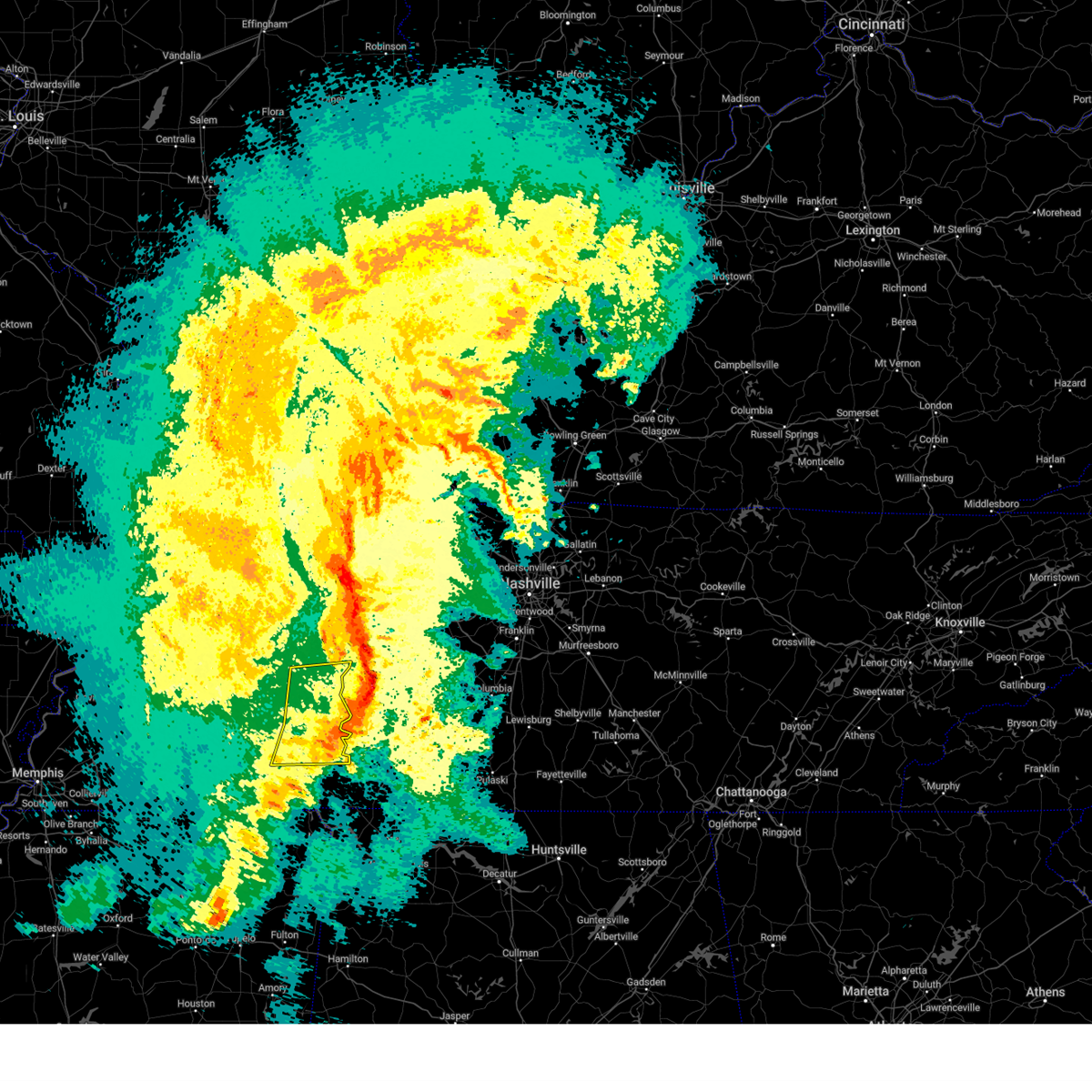 The severe thunderstorm warning for eastern henderson, northeastern mcnairy, northern hardin, east central chester and decatur counties will expire at 945 pm cdt, the storms which prompted the warning have moved out of the area. therefore, the warning will be allowed to expire. a tornado watch remains in effect until midnight cdt for west tennessee. The severe thunderstorm warning for eastern henderson, northeastern mcnairy, northern hardin, east central chester and decatur counties will expire at 945 pm cdt, the storms which prompted the warning have moved out of the area. therefore, the warning will be allowed to expire. a tornado watch remains in effect until midnight cdt for west tennessee.
|
| 3/24/2023 9:27 PM CDT |
 At 927 pm cdt, severe thunderstorms were located along a line extending from near natchez trace state park to decaturville to 6 miles southeast of sardis, moving east at 55 mph (radar indicated). Hazards include 60 mph wind gusts. Expect damage to roofs, siding, and trees. locations impacted include, lexington, natchez trace state park, natchez trace state forest, parsons, adamsville, decaturville, sardis, reagan, morris chapel, olive hill, darden, montgomery, scotts hill, saltillo, milledgeville, enville, rock hill, pleasant grove, cerro gordo and thurman. hail threat, radar indicated max hail size, <. 75 in wind threat, radar indicated max wind gust, 60 mph. At 927 pm cdt, severe thunderstorms were located along a line extending from near natchez trace state park to decaturville to 6 miles southeast of sardis, moving east at 55 mph (radar indicated). Hazards include 60 mph wind gusts. Expect damage to roofs, siding, and trees. locations impacted include, lexington, natchez trace state park, natchez trace state forest, parsons, adamsville, decaturville, sardis, reagan, morris chapel, olive hill, darden, montgomery, scotts hill, saltillo, milledgeville, enville, rock hill, pleasant grove, cerro gordo and thurman. hail threat, radar indicated max hail size, <. 75 in wind threat, radar indicated max wind gust, 60 mph.
|
| 3/24/2023 8:57 PM CDT |
 At 857 pm cdt, severe thunderstorms were located along a line extending from near blue goose to near mifflin to near masseyville, moving east at 55 mph (radar indicated). Hazards include 70 mph wind gusts. Expect considerable tree damage. Damage is likely to mobile homes, roofs, and outbuildings. At 857 pm cdt, severe thunderstorms were located along a line extending from near blue goose to near mifflin to near masseyville, moving east at 55 mph (radar indicated). Hazards include 70 mph wind gusts. Expect considerable tree damage. Damage is likely to mobile homes, roofs, and outbuildings.
|
| 5/25/2022 4:23 PM CDT |
 At 422 pm cdt, severe thunderstorms were located along a line extending from near walnut grove to muscle shoals, moving northeast at 45 mph (radar indicated). Hazards include 60 mph wind gusts. expect damage to roofs, siding, and trees At 422 pm cdt, severe thunderstorms were located along a line extending from near walnut grove to muscle shoals, moving northeast at 45 mph (radar indicated). Hazards include 60 mph wind gusts. expect damage to roofs, siding, and trees
|
| 5/13/2022 6:05 PM CDT |
 The severe thunderstorm warning for northern hardin county will expire at 615 pm cdt, the storm which prompted the warning has weakened below severe limits, and no longer poses an immediate threat to life or property. therefore, the warning will be allowed to expire. The severe thunderstorm warning for northern hardin county will expire at 615 pm cdt, the storm which prompted the warning has weakened below severe limits, and no longer poses an immediate threat to life or property. therefore, the warning will be allowed to expire.
|
| 5/13/2022 5:57 PM CDT |
 At 556 pm cdt, a severe thunderstorm was located over savannah, moving north at 10 mph (trained weather spotters). Hazards include quarter size hail. Damage to vehicles is expected. locations impacted include, savannah, sardis, morris chapel, crump, saltillo, right, sibley, phillips, hinkle, five forks, swift, bucktown, cerro gordo and coffee landing. hail threat, radar indicated max hail size, 1. 00 in wind threat, radar indicated max wind gust, <50 mph. At 556 pm cdt, a severe thunderstorm was located over savannah, moving north at 10 mph (trained weather spotters). Hazards include quarter size hail. Damage to vehicles is expected. locations impacted include, savannah, sardis, morris chapel, crump, saltillo, right, sibley, phillips, hinkle, five forks, swift, bucktown, cerro gordo and coffee landing. hail threat, radar indicated max hail size, 1. 00 in wind threat, radar indicated max wind gust, <50 mph.
|
| 5/13/2022 5:39 PM CDT |
 At 538 pm cdt, a severe thunderstorm was located over savannah, moving north at 10 mph (radar indicated). Hazards include quarter size hail. damage to vehicles is expected At 538 pm cdt, a severe thunderstorm was located over savannah, moving north at 10 mph (radar indicated). Hazards include quarter size hail. damage to vehicles is expected
|
| 5/2/2022 5:36 PM CDT |
 The severe thunderstorm warning for southeastern henderson, northeastern hardin and decatur counties will expire at 545 pm cdt, the storm which prompted the warning has weakened below severe limits, and no longer poses an immediate threat to life or property. therefore, the warning will be allowed to expire. however small hail is still possible with this thunderstorm. The severe thunderstorm warning for southeastern henderson, northeastern hardin and decatur counties will expire at 545 pm cdt, the storm which prompted the warning has weakened below severe limits, and no longer poses an immediate threat to life or property. therefore, the warning will be allowed to expire. however small hail is still possible with this thunderstorm.
|
| 5/2/2022 5:18 PM CDT |
 At 518 pm cdt, a severe thunderstorm was located near sardis, or 15 miles north of savannah, moving north at 35 mph (radar indicated). Hazards include 60 mph wind gusts and quarter size hail. Hail damage to vehicles is expected. expect wind damage to roofs, siding, and trees. locations impacted include, parsons, decaturville, sardis, darden, montgomery, scotts hill, saltillo, haney, hinkle, pleasant grove, mount tabor, red walnut, cerro gordo, thurman, lick skillet, perryville, gumdale, wilkinstown, bath springs and five forks. hail threat, radar indicated max hail size, 1. 00 in wind threat, radar indicated max wind gust, 60 mph. At 518 pm cdt, a severe thunderstorm was located near sardis, or 15 miles north of savannah, moving north at 35 mph (radar indicated). Hazards include 60 mph wind gusts and quarter size hail. Hail damage to vehicles is expected. expect wind damage to roofs, siding, and trees. locations impacted include, parsons, decaturville, sardis, darden, montgomery, scotts hill, saltillo, haney, hinkle, pleasant grove, mount tabor, red walnut, cerro gordo, thurman, lick skillet, perryville, gumdale, wilkinstown, bath springs and five forks. hail threat, radar indicated max hail size, 1. 00 in wind threat, radar indicated max wind gust, 60 mph.
|
| 5/2/2022 5:02 PM CDT |
 At 501 pm cdt, a severe thunderstorm was located near savannah, moving north at 35 mph (radar indicated). Hazards include 60 mph wind gusts and quarter size hail. Hail damage to vehicles is expected. Expect wind damage to roofs, siding, and trees. At 501 pm cdt, a severe thunderstorm was located near savannah, moving north at 35 mph (radar indicated). Hazards include 60 mph wind gusts and quarter size hail. Hail damage to vehicles is expected. Expect wind damage to roofs, siding, and trees.
|
| 4/13/2022 7:05 PM CDT |
 At 704 pm cdt, severe thunderstorms were located along a line extending from 8 miles northwest of centerville to 12 miles north of hohenwald to 8 miles north of waynesboro to 9 miles east of walnut grove, moving east at 60 mph (radar indicated). Hazards include 70 mph wind gusts. Expect considerable tree damage. damage is likely to mobile homes, roofs, and outbuildings. locations impacted include, hohenwald, centerville, waynesboro, linden, loretto, collinwood, clifton, lobelville, st. joseph, gordonsburg, bon aqua, kimmins, henryville, flatwoods, bucksnort, lutts, pleasantville, nunnelly, cypress inn and lyles. this includes interstate 40 between mile markers 134 and 161. thunderstorm damage threat, considerable hail threat, radar indicated max hail size, <. 75 in wind threat, radar indicated max wind gust, 70 mph. At 704 pm cdt, severe thunderstorms were located along a line extending from 8 miles northwest of centerville to 12 miles north of hohenwald to 8 miles north of waynesboro to 9 miles east of walnut grove, moving east at 60 mph (radar indicated). Hazards include 70 mph wind gusts. Expect considerable tree damage. damage is likely to mobile homes, roofs, and outbuildings. locations impacted include, hohenwald, centerville, waynesboro, linden, loretto, collinwood, clifton, lobelville, st. joseph, gordonsburg, bon aqua, kimmins, henryville, flatwoods, bucksnort, lutts, pleasantville, nunnelly, cypress inn and lyles. this includes interstate 40 between mile markers 134 and 161. thunderstorm damage threat, considerable hail threat, radar indicated max hail size, <. 75 in wind threat, radar indicated max wind gust, 70 mph.
|
| 4/13/2022 6:48 PM CDT |
 At 648 pm cdt, severe thunderstorms were located along a line extending from 11 miles northeast of parsons to 8 miles south of decaturville to near corinth, moving east at 45 mph (radar indicated). Hazards include 70 mph wind gusts. Expect considerable tree damage. damage is likely to mobile homes, roofs, and outbuildings. locations impacted include, savannah, pickwick landing state park, parsons, adamsville, decaturville, sardis, pickwick dam, morris chapel, shiloh, walnut grove, olive hill, darden, montgomery, crump, scotts hill, michie, guys, saltillo, stantonville and milledgeville. thunderstorm damage threat, considerable hail threat, radar indicated max hail size, <. 75 in wind threat, radar indicated max wind gust, 70 mph. At 648 pm cdt, severe thunderstorms were located along a line extending from 11 miles northeast of parsons to 8 miles south of decaturville to near corinth, moving east at 45 mph (radar indicated). Hazards include 70 mph wind gusts. Expect considerable tree damage. damage is likely to mobile homes, roofs, and outbuildings. locations impacted include, savannah, pickwick landing state park, parsons, adamsville, decaturville, sardis, pickwick dam, morris chapel, shiloh, walnut grove, olive hill, darden, montgomery, crump, scotts hill, michie, guys, saltillo, stantonville and milledgeville. thunderstorm damage threat, considerable hail threat, radar indicated max hail size, <. 75 in wind threat, radar indicated max wind gust, 70 mph.
|
| 4/13/2022 6:35 PM CDT |
 At 634 pm cdt, severe thunderstorms were located along a line extending from near natchez trace state park to sardis to near big hill pond state park, moving east at 45 mph (radar indicated). Hazards include 70 mph wind gusts. Expect considerable tree damage. damage is likely to mobile homes, roofs, and outbuildings. locations impacted include, lexington, savannah, henderson, selmer, pickwick landing state park, natchez trace state park, natchez trace state forest, big hill pond state park, parsons, adamsville, decaturville, sardis, pickwick dam, masseyville, reagan, bargerton, pocahontas, jacks creek, mifflin and wildersville. thunderstorm damage threat, considerable hail threat, radar indicated max hail size, <. 75 in wind threat, radar indicated max wind gust, 70 mph. At 634 pm cdt, severe thunderstorms were located along a line extending from near natchez trace state park to sardis to near big hill pond state park, moving east at 45 mph (radar indicated). Hazards include 70 mph wind gusts. Expect considerable tree damage. damage is likely to mobile homes, roofs, and outbuildings. locations impacted include, lexington, savannah, henderson, selmer, pickwick landing state park, natchez trace state park, natchez trace state forest, big hill pond state park, parsons, adamsville, decaturville, sardis, pickwick dam, masseyville, reagan, bargerton, pocahontas, jacks creek, mifflin and wildersville. thunderstorm damage threat, considerable hail threat, radar indicated max hail size, <. 75 in wind threat, radar indicated max wind gust, 70 mph.
|
| 4/13/2022 6:34 PM CDT |
 At 633 pm cdt, severe thunderstorms were located along a line extending from 11 miles southwest of new johnsonville to near darden to near sardis to near corinth, moving east at 55 mph (radar indicated). Hazards include 70 mph wind gusts. Expect considerable tree damage. Damage is likely to mobile homes, roofs, and outbuildings. At 633 pm cdt, severe thunderstorms were located along a line extending from 11 miles southwest of new johnsonville to near darden to near sardis to near corinth, moving east at 55 mph (radar indicated). Hazards include 70 mph wind gusts. Expect considerable tree damage. Damage is likely to mobile homes, roofs, and outbuildings.
|
| 4/13/2022 5:56 PM CDT |
 At 556 pm cdt, severe thunderstorms were located along a line extending from 8 miles southeast of milan to near chickasaw state park to near lagrange, moving east at 45 mph (radar indicated). Hazards include 60 mph wind gusts. expect damage to roofs, siding, and trees At 556 pm cdt, severe thunderstorms were located along a line extending from 8 miles southeast of milan to near chickasaw state park to near lagrange, moving east at 45 mph (radar indicated). Hazards include 60 mph wind gusts. expect damage to roofs, siding, and trees
|
| 3/30/2022 7:41 PM CDT |
 The severe thunderstorm warning for tishomingo, eastern prentiss, eastern alcorn, southeastern mcnairy and hardin counties will expire at 745 pm cdt, the storms which prompted the warning have moved out of the area. therefore, the warning will be allowed to expire. a tornado watch remains in effect until 900 pm cdt for northeastern mississippi, and western tennessee. The severe thunderstorm warning for tishomingo, eastern prentiss, eastern alcorn, southeastern mcnairy and hardin counties will expire at 745 pm cdt, the storms which prompted the warning have moved out of the area. therefore, the warning will be allowed to expire. a tornado watch remains in effect until 900 pm cdt for northeastern mississippi, and western tennessee.
|
| 3/30/2022 7:38 PM CDT |
 At 737 pm cdt, severe thunderstorms were located along a line extending from near hurricane mills to near collinwood, moving northeast at 65 mph (radar indicated). Hazards include 70 mph wind gusts. Expect considerable tree damage. damage is likely to mobile homes, roofs, and outbuildings. locations impacted include, hohenwald, waynesboro, linden, mcewen, collinwood, hurricane mills, clifton, lobelville, cypress inn, flatwoods, i-40 near the tennessee river, bucksnort, lutts, mousetail landing state park and pleasantville. This includes interstate 40 between mile markers 136 and 157. At 737 pm cdt, severe thunderstorms were located along a line extending from near hurricane mills to near collinwood, moving northeast at 65 mph (radar indicated). Hazards include 70 mph wind gusts. Expect considerable tree damage. damage is likely to mobile homes, roofs, and outbuildings. locations impacted include, hohenwald, waynesboro, linden, mcewen, collinwood, hurricane mills, clifton, lobelville, cypress inn, flatwoods, i-40 near the tennessee river, bucksnort, lutts, mousetail landing state park and pleasantville. This includes interstate 40 between mile markers 136 and 157.
|
| 3/30/2022 7:12 PM CDT |
 At 711 pm cdt, severe thunderstorms were located along a line extending from decaturville to near walnut grove, moving northeast at 70 mph (radar indicated). Hazards include 60 mph wind gusts. expect damage to roofs, siding, and trees At 711 pm cdt, severe thunderstorms were located along a line extending from decaturville to near walnut grove, moving northeast at 70 mph (radar indicated). Hazards include 60 mph wind gusts. expect damage to roofs, siding, and trees
|
| 3/30/2022 7:05 PM CDT |
 At 705 pm cdt, severe thunderstorms were located along a line extending from near savannah to near burnsville to 6 miles northeast of sandy springs, moving northeast at 50 mph (radar indicated). Hazards include 60 mph wind gusts. Expect damage to roofs, siding, and trees. Locations impacted include, savannah, iuka, pickwick landing state park, j p coleman state park, tishomingo state park, adamsville, belmont, burnsville, glen, tishomingo, pickwick dam, thrashers, midway, shiloh, walnut grove, pineflat, burton, leedy, olive hill and farmington. At 705 pm cdt, severe thunderstorms were located along a line extending from near savannah to near burnsville to 6 miles northeast of sandy springs, moving northeast at 50 mph (radar indicated). Hazards include 60 mph wind gusts. Expect damage to roofs, siding, and trees. Locations impacted include, savannah, iuka, pickwick landing state park, j p coleman state park, tishomingo state park, adamsville, belmont, burnsville, glen, tishomingo, pickwick dam, thrashers, midway, shiloh, walnut grove, pineflat, burton, leedy, olive hill and farmington.
|
| 3/30/2022 6:39 PM CDT |
 At 638 pm cdt, severe thunderstorms were located along a line extending from 7 miles southwest of shiloh to thrashers to near mantachie, moving northeast at 50 mph (radar indicated). Hazards include 60 mph wind gusts. expect damage to roofs, siding, and trees At 638 pm cdt, severe thunderstorms were located along a line extending from 7 miles southwest of shiloh to thrashers to near mantachie, moving northeast at 50 mph (radar indicated). Hazards include 60 mph wind gusts. expect damage to roofs, siding, and trees
|
| 7/31/2021 11:24 PM CDT |
 At 1124 pm cdt, severe thunderstorms were located along a line extending from near parsons to 7 miles southeast of decaturville to 7 miles southeast of sardis, moving southeast at 40 mph (radar indicated). Hazards include 60 mph wind gusts. expect damage to roofs, siding, and trees At 1124 pm cdt, severe thunderstorms were located along a line extending from near parsons to 7 miles southeast of decaturville to 7 miles southeast of sardis, moving southeast at 40 mph (radar indicated). Hazards include 60 mph wind gusts. expect damage to roofs, siding, and trees
|
| 7/31/2021 11:07 PM CDT |
 At 1107 pm cdt, a severe thunderstorm was located near sardis, or 14 miles southeast of lexington, moving southeast at 55 mph (radar indicated). Hazards include 60 mph wind gusts. expect damage to roofs, siding, and trees At 1107 pm cdt, a severe thunderstorm was located near sardis, or 14 miles southeast of lexington, moving southeast at 55 mph (radar indicated). Hazards include 60 mph wind gusts. expect damage to roofs, siding, and trees
|
| 5/28/2021 12:17 AM CDT |
 At 1217 am cdt, a severe thunderstorm was located 8 miles north of waynesboro, moving east at 30 mph (radar indicated). Hazards include 60 mph wind gusts. Expect damage to roofs, siding, and trees. Locations impacted include, hohenwald, waynesboro, linden, clifton and flatwoods. At 1217 am cdt, a severe thunderstorm was located 8 miles north of waynesboro, moving east at 30 mph (radar indicated). Hazards include 60 mph wind gusts. Expect damage to roofs, siding, and trees. Locations impacted include, hohenwald, waynesboro, linden, clifton and flatwoods.
|
| 5/28/2021 12:11 AM CDT |
 The severe thunderstorm warning for southeastern henderson, northern hardin and southern decatur counties will expire at 1215 am cdt, the storm which prompted the warning has moved out of the area. therefore, the warning will be allowed to expire. however gusty winds are still possible with this thunderstorm. The severe thunderstorm warning for southeastern henderson, northern hardin and southern decatur counties will expire at 1215 am cdt, the storm which prompted the warning has moved out of the area. therefore, the warning will be allowed to expire. however gusty winds are still possible with this thunderstorm.
|
| 5/28/2021 12:04 AM CDT |
 At 1203 am cdt, a severe thunderstorm was located 12 miles southwest of linden, moving east at 35 mph (radar indicated). Hazards include 60 mph wind gusts and penny size hail. Expect damage to roofs, siding, and trees. Locations impacted include, hohenwald, waynesboro, linden, clifton and flatwoods. At 1203 am cdt, a severe thunderstorm was located 12 miles southwest of linden, moving east at 35 mph (radar indicated). Hazards include 60 mph wind gusts and penny size hail. Expect damage to roofs, siding, and trees. Locations impacted include, hohenwald, waynesboro, linden, clifton and flatwoods.
|
| 5/27/2021 11:50 PM CDT |
 At 1149 pm cdt, a severe thunderstorm was located 10 miles east of sardis, or 14 miles northeast of savannah, moving east at 35 mph (radar indicated). Hazards include 60 mph wind gusts and penny size hail. expect damage to roofs, siding, and trees At 1149 pm cdt, a severe thunderstorm was located 10 miles east of sardis, or 14 miles northeast of savannah, moving east at 35 mph (radar indicated). Hazards include 60 mph wind gusts and penny size hail. expect damage to roofs, siding, and trees
|
| 5/27/2021 11:39 PM CDT |
 At 1139 pm cdt, a severe thunderstorm was located 8 miles north of savannah, moving east at 35 mph (radar indicated). Hazards include 60 mph wind gusts. Expect damage to roofs, siding, and trees. Locations impacted include, savannah, adamsville, decaturville, sardis, reagan, olive hill, morris chapel, montgomery, crump, scotts hill, saltillo, milledgeville, right, phillips, haney, hinkle, pleasant grove, red walnut, olivehill and cerro gordo. At 1139 pm cdt, a severe thunderstorm was located 8 miles north of savannah, moving east at 35 mph (radar indicated). Hazards include 60 mph wind gusts. Expect damage to roofs, siding, and trees. Locations impacted include, savannah, adamsville, decaturville, sardis, reagan, olive hill, morris chapel, montgomery, crump, scotts hill, saltillo, milledgeville, right, phillips, haney, hinkle, pleasant grove, red walnut, olivehill and cerro gordo.
|
| 5/27/2021 11:21 PM CDT |
 At 1121 pm cdt, a severe thunderstorm was located over morris chapel, or 10 miles northwest of savannah, moving east at 35 mph (radar indicated). Hazards include 60 mph wind gusts. expect damage to roofs, siding, and trees At 1121 pm cdt, a severe thunderstorm was located over morris chapel, or 10 miles northwest of savannah, moving east at 35 mph (radar indicated). Hazards include 60 mph wind gusts. expect damage to roofs, siding, and trees
|
| 5/9/2021 6:30 PM CDT |
 At 630 pm cdt, a severe thunderstorm was located 11 miles northeast of olive hill, or 12 miles northwest of waynesboro, moving east at 60 mph (radar indicated). Hazards include 60 mph wind gusts and penny size hail. expect damage to roofs, siding, and trees At 630 pm cdt, a severe thunderstorm was located 11 miles northeast of olive hill, or 12 miles northwest of waynesboro, moving east at 60 mph (radar indicated). Hazards include 60 mph wind gusts and penny size hail. expect damage to roofs, siding, and trees
|
| 3/28/2021 12:42 AM CDT |
 At 1241 am cdt, severe thunderstorms were located along a line extending from 7 miles northwest of hohenwald to 10 miles southwest of collinwood, moving east at 60 mph (radar indicated). Hazards include 60 mph wind gusts. Expect damage to roofs, siding, and trees. locations impacted include, hohenwald, waynesboro, linden, collinwood, clifton, st. Joseph, gordonsburg, kimmins, henryville, cypress inn, flatwoods, lutts, westpoint, iron city and pleasantville. At 1241 am cdt, severe thunderstorms were located along a line extending from 7 miles northwest of hohenwald to 10 miles southwest of collinwood, moving east at 60 mph (radar indicated). Hazards include 60 mph wind gusts. Expect damage to roofs, siding, and trees. locations impacted include, hohenwald, waynesboro, linden, collinwood, clifton, st. Joseph, gordonsburg, kimmins, henryville, cypress inn, flatwoods, lutts, westpoint, iron city and pleasantville.
|
| 3/28/2021 12:17 AM CDT |
 At 1216 am cdt, severe thunderstorms were located along a line extending from near parsons to pickwick dam, moving east at 60 mph (radar indicated). Hazards include 60 mph wind gusts. expect damage to roofs, siding, and trees At 1216 am cdt, severe thunderstorms were located along a line extending from near parsons to pickwick dam, moving east at 60 mph (radar indicated). Hazards include 60 mph wind gusts. expect damage to roofs, siding, and trees
|
| 3/27/2021 11:54 PM CDT |
 At 1154 pm cdt, severe thunderstorms were located along a line extending from near bargerton to near hinkle, moving east at 50 mph (radar indicated). Hazards include 60 mph wind gusts. expect damage to roofs, siding, and trees At 1154 pm cdt, severe thunderstorms were located along a line extending from near bargerton to near hinkle, moving east at 50 mph (radar indicated). Hazards include 60 mph wind gusts. expect damage to roofs, siding, and trees
|
| 3/25/2021 7:14 PM CDT |
 At 714 pm cdt, a severe thunderstorm was located near savannah, moving northeast at 70 mph (radar indicated). Hazards include 60 mph wind gusts and quarter size hail. Hail damage to vehicles is expected. expect wind damage to roofs, siding, and trees. Locations impacted include, savannah, olive hill, center star, maddox, hamburg, walkertown, olivehill, phillips, bucktown, cerro gordo and childers hill. At 714 pm cdt, a severe thunderstorm was located near savannah, moving northeast at 70 mph (radar indicated). Hazards include 60 mph wind gusts and quarter size hail. Hail damage to vehicles is expected. expect wind damage to roofs, siding, and trees. Locations impacted include, savannah, olive hill, center star, maddox, hamburg, walkertown, olivehill, phillips, bucktown, cerro gordo and childers hill.
|
| 3/25/2021 7:04 PM CDT |
 At 703 pm cdt, a severe thunderstorm capable of producing a tornado was located near olive hill, or 8 miles east of savannah, moving northeast at 60 mph (radar indicated rotation). Hazards include tornado and quarter size hail. Flying debris will be dangerous to those caught without shelter. mobile homes will be damaged or destroyed. damage to roofs, windows, and vehicles will occur. tree damage is likely. this dangerous storm will be near, waynesboro around 725 pm cdt. Other locations impacted by this tornadic thunderstorm include clifton and flatwoods. At 703 pm cdt, a severe thunderstorm capable of producing a tornado was located near olive hill, or 8 miles east of savannah, moving northeast at 60 mph (radar indicated rotation). Hazards include tornado and quarter size hail. Flying debris will be dangerous to those caught without shelter. mobile homes will be damaged or destroyed. damage to roofs, windows, and vehicles will occur. tree damage is likely. this dangerous storm will be near, waynesboro around 725 pm cdt. Other locations impacted by this tornadic thunderstorm include clifton and flatwoods.
|
| 3/25/2021 7:02 PM CDT |
 At 701 pm cdt, a severe thunderstorm was located near olive hill, or 7 miles east of savannah, moving east at 50 mph. a second severe thunderstorm was located near michie, moving northeast at 50 mph (radar indicated). Hazards include 60 mph wind gusts and quarter size hail. Hail damage to vehicles is expected. expect wind damage to roofs, siding, and trees. Locations impacted include, savannah, selmer, adamsville, olive hill, morris chapel, shiloh, crump, eastview, michie, guys, ramer, saltillo, stantonville, good hope, pebble hill, right, hamburg, phillips, tulu and old lawton. At 701 pm cdt, a severe thunderstorm was located near olive hill, or 7 miles east of savannah, moving east at 50 mph. a second severe thunderstorm was located near michie, moving northeast at 50 mph (radar indicated). Hazards include 60 mph wind gusts and quarter size hail. Hail damage to vehicles is expected. expect wind damage to roofs, siding, and trees. Locations impacted include, savannah, selmer, adamsville, olive hill, morris chapel, shiloh, crump, eastview, michie, guys, ramer, saltillo, stantonville, good hope, pebble hill, right, hamburg, phillips, tulu and old lawton.
|
| 3/25/2021 6:58 PM CDT |
 At 658 pm cdt, doppler radar indicated a severe thunderstorm producing a tornado was located over savannah, moving east at 45 mph (radar indicated rotation). Hazards include tornado and quarter size hail. Flying debris will be dangerous to those caught without shelter. mobile homes will be damaged or destroyed. damage to roofs, windows, and vehicles will occur. tree damage is likely. Locations impacted include, savannah, olive hill, center star, walkertown, olivehill and maddox. At 658 pm cdt, doppler radar indicated a severe thunderstorm producing a tornado was located over savannah, moving east at 45 mph (radar indicated rotation). Hazards include tornado and quarter size hail. Flying debris will be dangerous to those caught without shelter. mobile homes will be damaged or destroyed. damage to roofs, windows, and vehicles will occur. tree damage is likely. Locations impacted include, savannah, olive hill, center star, walkertown, olivehill and maddox.
|
| 3/25/2021 6:49 PM CDT |
 At 649 pm cdt, doppler radar indicated a severe thunderstorm producing a tornado was located near savannah, moving northeast at 60 mph (radar indicated rotation). Hazards include tornado and quarter size hail. Flying debris will be dangerous to those caught without shelter. mobile homes will be damaged or destroyed. damage to roofs, windows, and vehicles will occur. Tree damage is likely. At 649 pm cdt, doppler radar indicated a severe thunderstorm producing a tornado was located near savannah, moving northeast at 60 mph (radar indicated rotation). Hazards include tornado and quarter size hail. Flying debris will be dangerous to those caught without shelter. mobile homes will be damaged or destroyed. damage to roofs, windows, and vehicles will occur. Tree damage is likely.
|
| 3/25/2021 6:28 PM CDT |
 At 628 pm cdt, a severe thunderstorm was located near selmer, moving northeast at 50 mph (radar indicated). Hazards include 60 mph wind gusts and quarter size hail. Hail damage to vehicles is expected. Expect wind damage to roofs, siding, and trees. At 628 pm cdt, a severe thunderstorm was located near selmer, moving northeast at 50 mph (radar indicated). Hazards include 60 mph wind gusts and quarter size hail. Hail damage to vehicles is expected. Expect wind damage to roofs, siding, and trees.
|
| 7/20/2020 8:58 PM CDT |
 At 857 pm cdt, a severe thunderstorm was located near waynesboro, moving east at 40 mph (radar indicated). Hazards include 60 mph wind gusts and penny size hail. Expect damage to roofs, siding, and trees. Locations impacted include, waynesboro, collinwood, clifton and lutts. At 857 pm cdt, a severe thunderstorm was located near waynesboro, moving east at 40 mph (radar indicated). Hazards include 60 mph wind gusts and penny size hail. Expect damage to roofs, siding, and trees. Locations impacted include, waynesboro, collinwood, clifton and lutts.
|
| 7/20/2020 8:46 PM CDT |
 At 845 pm cdt, a severe thunderstorm was located near waynesboro, moving east at 20 mph (radar indicated). Hazards include 60 mph wind gusts and penny size hail. expect damage to roofs, siding, and trees At 845 pm cdt, a severe thunderstorm was located near waynesboro, moving east at 20 mph (radar indicated). Hazards include 60 mph wind gusts and penny size hail. expect damage to roofs, siding, and trees
|
| 7/12/2020 9:38 AM CDT |
 At 937 am cdt, a severe thunderstorm was located over savannah, moving southeast at 40 mph (radar indicated). Hazards include 60 mph wind gusts. expect damage to roofs, siding, and trees At 937 am cdt, a severe thunderstorm was located over savannah, moving southeast at 40 mph (radar indicated). Hazards include 60 mph wind gusts. expect damage to roofs, siding, and trees
|
| 5/22/2020 6:43 PM CDT |
 At 642 pm cdt, severe thunderstorms were located along a line extending from sardis to near adamsville, moving east at 35 mph (radar indicated). Hazards include 60 mph wind gusts and quarter size hail. Hail damage to vehicles is expected. Expect wind damage to roofs, siding, and trees. At 642 pm cdt, severe thunderstorms were located along a line extending from sardis to near adamsville, moving east at 35 mph (radar indicated). Hazards include 60 mph wind gusts and quarter size hail. Hail damage to vehicles is expected. Expect wind damage to roofs, siding, and trees.
|
| 5/22/2020 6:19 PM CDT |
 The national weather service in memphis has issued a * severe thunderstorm warning for. southeastern henderson county in western tennessee. mcnairy county in western tennessee. hardin county in western tennessee. Southeastern chester county in western tennessee. The national weather service in memphis has issued a * severe thunderstorm warning for. southeastern henderson county in western tennessee. mcnairy county in western tennessee. hardin county in western tennessee. Southeastern chester county in western tennessee.
|
| 5/4/2020 8:02 PM CDT |
 At 802 pm cdt, a severe thunderstorm was located near olive hill, or 13 miles west of waynesboro, moving southeast at 35 mph (radar indicated). Hazards include 60 mph wind gusts and half dollar size hail. Hail damage to vehicles is expected. Expect wind damage to roofs, siding, and trees. At 802 pm cdt, a severe thunderstorm was located near olive hill, or 13 miles west of waynesboro, moving southeast at 35 mph (radar indicated). Hazards include 60 mph wind gusts and half dollar size hail. Hail damage to vehicles is expected. Expect wind damage to roofs, siding, and trees.
|
| 5/4/2020 7:57 PM CDT | Hen Egg sized hail reported 2.7 miles S of Clifton, TN, 2 inch diameter hail reported in beech creek area |
| 5/4/2020 7:50 PM CDT |
 At 749 pm cdt, a severe thunderstorm was located 7 miles southeast of decaturville, or 12 miles southwest of linden, moving southeast at 40 mph (radar indicated). Hazards include ping pong ball size hail and 60 mph wind gusts. People and animals outdoors will be injured. expect hail damage to roofs, siding, windows, and vehicles. expect wind damage to roofs, siding, and trees. Locations impacted include, clifton and flatwoods. At 749 pm cdt, a severe thunderstorm was located 7 miles southeast of decaturville, or 12 miles southwest of linden, moving southeast at 40 mph (radar indicated). Hazards include ping pong ball size hail and 60 mph wind gusts. People and animals outdoors will be injured. expect hail damage to roofs, siding, windows, and vehicles. expect wind damage to roofs, siding, and trees. Locations impacted include, clifton and flatwoods.
|
| 5/4/2020 7:48 PM CDT |
 At 748 pm cdt, a severe thunderstorm was located 7 miles southeast of sardis, or 11 miles north of savannah, moving southeast at 55 mph (radar indicated). Hazards include golf ball size hail and 60 mph wind gusts. People and animals outdoors will be injured. expect hail damage to roofs, siding, windows, and vehicles. Expect wind damage to roofs, siding, and trees. At 748 pm cdt, a severe thunderstorm was located 7 miles southeast of sardis, or 11 miles north of savannah, moving southeast at 55 mph (radar indicated). Hazards include golf ball size hail and 60 mph wind gusts. People and animals outdoors will be injured. expect hail damage to roofs, siding, windows, and vehicles. Expect wind damage to roofs, siding, and trees.
|
| 5/4/2020 7:45 PM CDT |
 At 745 pm cdt, a severe thunderstorm was located near decaturville, or 16 miles southwest of linden, moving southeast at 55 mph (radar indicated). Hazards include ping pong ball size hail and 60 mph wind gusts. People and animals outdoors will be injured. expect hail damage to roofs, siding, windows, and vehicles. Expect wind damage to roofs, siding, and trees. At 745 pm cdt, a severe thunderstorm was located near decaturville, or 16 miles southwest of linden, moving southeast at 55 mph (radar indicated). Hazards include ping pong ball size hail and 60 mph wind gusts. People and animals outdoors will be injured. expect hail damage to roofs, siding, windows, and vehicles. Expect wind damage to roofs, siding, and trees.
|
| 5/4/2020 7:25 PM CDT |
 At 725 pm cdt, a severe thunderstorm was located near darden, or near natchez trace state forest, moving southeast at 45 mph (radar indicated). Hazards include 60 mph wind gusts and half dollar size hail. Hail damage to vehicles is expected. Expect wind damage to roofs, siding, and trees. At 725 pm cdt, a severe thunderstorm was located near darden, or near natchez trace state forest, moving southeast at 45 mph (radar indicated). Hazards include 60 mph wind gusts and half dollar size hail. Hail damage to vehicles is expected. Expect wind damage to roofs, siding, and trees.
|
| 5/4/2020 7:11 PM CDT |
 At 709 pm cdt, a severe thunderstorm was located over lexington, moving southeast at 70 mph (radar indicated). Hazards include 60 mph wind gusts and half dollar size hail. Hail damage to vehicles is expected. Expect wind damage to roofs, siding, and trees. At 709 pm cdt, a severe thunderstorm was located over lexington, moving southeast at 70 mph (radar indicated). Hazards include 60 mph wind gusts and half dollar size hail. Hail damage to vehicles is expected. Expect wind damage to roofs, siding, and trees.
|
| 5/4/2020 6:53 PM CDT |
 The severe thunderstorm warning for northeastern henderson and southern decatur counties will expire at 700 pm cdt, the storm which prompted the warning has weakened below severe limits, and has exited the warned area. therefore, the warning will be allowed to expire. a severe thunderstorm watch remains in effect until 1000 pm cdt for western tennessee. The severe thunderstorm warning for northeastern henderson and southern decatur counties will expire at 700 pm cdt, the storm which prompted the warning has weakened below severe limits, and has exited the warned area. therefore, the warning will be allowed to expire. a severe thunderstorm watch remains in effect until 1000 pm cdt for western tennessee.
|
| 5/4/2020 6:43 PM CDT |
 At 643 pm cdt, a severe thunderstorm was located near decaturville, or 10 miles southwest of linden, moving southeast at 60 mph (radar indicated). Hazards include 60 mph wind gusts and quarter size hail. Hail damage to vehicles is expected. expect wind damage to roofs, siding, and trees. Locations impacted include, natchez trace state forest, parsons, decaturville, darden, montgomery, scotts hill, lick skillet, perryville, gumdale, wilkinstown, haney, bath springs, mount tabor, garrett, red walnut, beacon, hickory forks, largo, dunbar and taylors crossing. At 643 pm cdt, a severe thunderstorm was located near decaturville, or 10 miles southwest of linden, moving southeast at 60 mph (radar indicated). Hazards include 60 mph wind gusts and quarter size hail. Hail damage to vehicles is expected. expect wind damage to roofs, siding, and trees. Locations impacted include, natchez trace state forest, parsons, decaturville, darden, montgomery, scotts hill, lick skillet, perryville, gumdale, wilkinstown, haney, bath springs, mount tabor, garrett, red walnut, beacon, hickory forks, largo, dunbar and taylors crossing.
|
| 5/4/2020 6:26 PM CDT |
 The national weather service in memphis has issued a * severe thunderstorm warning for. central henderson county in western tennessee. southern decatur county in western tennessee. until 700 pm cdt. At 626 pm cdt, a severe thunderstorm was located over lexington,. The national weather service in memphis has issued a * severe thunderstorm warning for. central henderson county in western tennessee. southern decatur county in western tennessee. until 700 pm cdt. At 626 pm cdt, a severe thunderstorm was located over lexington,.
|
| 5/3/2020 4:04 PM CDT |
 At 403 pm cdt, severe thunderstorms were located along a line extending from 8 miles west of centerville to 9 miles north of olive hill, moving east at 65 mph (radar indicated). Hazards include 60 mph wind gusts and nickel size hail. Expect damage to roofs, siding, and trees. Locations impacted include, hohenwald, waynesboro, linden, lobelville, gordonsburg, kimmins, pleasantville and flatwoods. At 403 pm cdt, severe thunderstorms were located along a line extending from 8 miles west of centerville to 9 miles north of olive hill, moving east at 65 mph (radar indicated). Hazards include 60 mph wind gusts and nickel size hail. Expect damage to roofs, siding, and trees. Locations impacted include, hohenwald, waynesboro, linden, lobelville, gordonsburg, kimmins, pleasantville and flatwoods.
|
| 5/3/2020 3:54 PM CDT |
 At 354 pm cdt, severe thunderstorms were located along a line extending from 6 miles north of linden to near decaturville to near masseyville, moving east at 60 mph (radar indicated). Hazards include 70 mph wind gusts and quarter size hail. Hail damage to vehicles is expected. expect considerable tree damage. wind damage is also likely to mobile homes, roofs, and outbuildings. Locations impacted include, lexington, savannah, henderson, selmer, parsons, adamsville, decaturville, sardis, masseyville, reagan, morris chapel, jacks creek, olive hill, darden, montgomery, robertson, mcnairy, crump, scotts hill and bethel springs. At 354 pm cdt, severe thunderstorms were located along a line extending from 6 miles north of linden to near decaturville to near masseyville, moving east at 60 mph (radar indicated). Hazards include 70 mph wind gusts and quarter size hail. Hail damage to vehicles is expected. expect considerable tree damage. wind damage is also likely to mobile homes, roofs, and outbuildings. Locations impacted include, lexington, savannah, henderson, selmer, parsons, adamsville, decaturville, sardis, masseyville, reagan, morris chapel, jacks creek, olive hill, darden, montgomery, robertson, mcnairy, crump, scotts hill and bethel springs.
|
| 5/3/2020 3:37 PM CDT |
 At 337 pm cdt, severe thunderstorms were located along a line extending from 8 miles south of new johnsonville to near mifflin, moving east at 65 mph (radar indicated). Hazards include 60 mph wind gusts and nickel size hail. expect damage to roofs, siding, and trees At 337 pm cdt, severe thunderstorms were located along a line extending from 8 miles south of new johnsonville to near mifflin, moving east at 65 mph (radar indicated). Hazards include 60 mph wind gusts and nickel size hail. expect damage to roofs, siding, and trees
|
| 5/3/2020 3:35 PM CDT |
 At 335 pm cdt, severe thunderstorms were located along a line extending from near new johnsonville to near lexington to near whiteville, moving east at 60 mph (radar indicated). Hazards include 70 mph wind gusts and quarter size hail. Hail damage to vehicles is expected. expect considerable tree damage. Wind damage is also likely to mobile homes, roofs, and outbuildings. At 335 pm cdt, severe thunderstorms were located along a line extending from near new johnsonville to near lexington to near whiteville, moving east at 60 mph (radar indicated). Hazards include 70 mph wind gusts and quarter size hail. Hail damage to vehicles is expected. expect considerable tree damage. Wind damage is also likely to mobile homes, roofs, and outbuildings.
|
| 4/12/2020 11:54 PM CDT |
 At 1154 pm cdt, severe thunderstorms were located along a line extending from near wildersville to 6 miles east of sardis to 7 miles north of walnut grove, moving northeast at 65 mph (trained weather spotters. at 1150 pm cdt, a large tree was downed on highway 22 near hamburg road). Hazards include 60 mph wind gusts. Expect damage to roofs, siding, and trees. Locations impacted include, lexington, savannah, pickwick landing state park, natchez trace state forest, parsons, adamsville, decaturville, sardis, pickwick dam, reagan, morris chapel, shiloh, walnut grove, olive hill, darden, montgomery, crump, scotts hill, michie and saltillo. At 1154 pm cdt, severe thunderstorms were located along a line extending from near wildersville to 6 miles east of sardis to 7 miles north of walnut grove, moving northeast at 65 mph (trained weather spotters. at 1150 pm cdt, a large tree was downed on highway 22 near hamburg road). Hazards include 60 mph wind gusts. Expect damage to roofs, siding, and trees. Locations impacted include, lexington, savannah, pickwick landing state park, natchez trace state forest, parsons, adamsville, decaturville, sardis, pickwick dam, reagan, morris chapel, shiloh, walnut grove, olive hill, darden, montgomery, crump, scotts hill, michie and saltillo.
|
| 4/12/2020 11:46 PM CDT |
 At 1146 pm cdt, severe thunderstorms were located along a line extending from near lexington to near sardis to near pickwick landing state park, moving northeast at 65 mph (radar indicated). Hazards include 60 mph wind gusts. Expect damage to roofs, siding, and trees. Locations impacted include, lexington, savannah, pickwick landing state park, natchez trace state forest, parsons, adamsville, decaturville, sardis, pickwick dam, reagan, morris chapel, shiloh, walnut grove, olive hill, darden, montgomery, crump, scotts hill, michie and saltillo. At 1146 pm cdt, severe thunderstorms were located along a line extending from near lexington to near sardis to near pickwick landing state park, moving northeast at 65 mph (radar indicated). Hazards include 60 mph wind gusts. Expect damage to roofs, siding, and trees. Locations impacted include, lexington, savannah, pickwick landing state park, natchez trace state forest, parsons, adamsville, decaturville, sardis, pickwick dam, reagan, morris chapel, shiloh, walnut grove, olive hill, darden, montgomery, crump, scotts hill, michie and saltillo.
|
| 4/12/2020 11:32 PM CDT |
 At 1131 pm cdt, severe thunderstorms were located along a line extending from near mifflin to 7 miles northwest of adamsville to 6 miles east of corinth, moving northeast at 70 mph (radar indicated). Hazards include 60 mph wind gusts. Expect damage to roofs, siding, and trees. Locations impacted include, corinth, lexington, savannah, henderson, selmer, pickwick landing state park, natchez trace state forest, parsons, adamsville, decaturville, sardis, pickwick dam, masseyville, reagan, jacks creek, mifflin, morris chapel, shiloh, walnut grove and olive hill. At 1131 pm cdt, severe thunderstorms were located along a line extending from near mifflin to 7 miles northwest of adamsville to 6 miles east of corinth, moving northeast at 70 mph (radar indicated). Hazards include 60 mph wind gusts. Expect damage to roofs, siding, and trees. Locations impacted include, corinth, lexington, savannah, henderson, selmer, pickwick landing state park, natchez trace state forest, parsons, adamsville, decaturville, sardis, pickwick dam, masseyville, reagan, jacks creek, mifflin, morris chapel, shiloh, walnut grove and olive hill.
|
| 4/12/2020 11:09 PM CDT |
 At 1109 pm cdt, severe thunderstorms were located along a line extending from near bolivar to pocahontas to near jumpertown, moving northeast at 65 mph (radar indicated). Hazards include 60 mph wind gusts. expect damage to roofs, siding, and trees At 1109 pm cdt, severe thunderstorms were located along a line extending from near bolivar to pocahontas to near jumpertown, moving northeast at 65 mph (radar indicated). Hazards include 60 mph wind gusts. expect damage to roofs, siding, and trees
|
| 4/8/2020 4:17 PM CDT |
 At 415 pm cdt, a severe thunderstorm was located 7 miles northwest of waynesboro, moving southeast at 20 mph (radar indicated). Hazards include 60 mph wind gusts and quarter size hail. Hail damage to vehicles is expected. expect wind damage to roofs, siding, and trees. Locations impacted include, waynesboro, clifton and flatwoods. At 415 pm cdt, a severe thunderstorm was located 7 miles northwest of waynesboro, moving southeast at 20 mph (radar indicated). Hazards include 60 mph wind gusts and quarter size hail. Hail damage to vehicles is expected. expect wind damage to roofs, siding, and trees. Locations impacted include, waynesboro, clifton and flatwoods.
|
| 4/8/2020 4:08 PM CDT | Received two reports of trees down and power outages on jerter road adn morrison creek road. time estimated via rada in wayne county TN, 4.7 miles WSW of Clifton, TN |
| 4/8/2020 3:53 PM CDT |
 At 352 pm cdt, a severe thunderstorm was located 11 miles southwest of linden, moving east at 20 mph (radar indicated). Hazards include 60 mph wind gusts and quarter size hail. Hail damage to vehicles is expected. Expect wind damage to roofs, siding, and trees. At 352 pm cdt, a severe thunderstorm was located 11 miles southwest of linden, moving east at 20 mph (radar indicated). Hazards include 60 mph wind gusts and quarter size hail. Hail damage to vehicles is expected. Expect wind damage to roofs, siding, and trees.
|
| 3/28/2020 11:22 PM CDT |
 The severe thunderstorm warning for wayne county will expire at 1130 pm cdt, the storm which prompted the warning has moved out of the area. therefore, the warning will be allowed to expire. a tornado watch remains in effect until 400 am cdt for middle tennessee. to report severe weather, contact your nearest law enforcement agency. they will relay your report to the national weather service nashville. The severe thunderstorm warning for wayne county will expire at 1130 pm cdt, the storm which prompted the warning has moved out of the area. therefore, the warning will be allowed to expire. a tornado watch remains in effect until 400 am cdt for middle tennessee. to report severe weather, contact your nearest law enforcement agency. they will relay your report to the national weather service nashville.
|
| 3/28/2020 11:05 PM CDT |
 At 1105 pm cdt, a severe thunderstorm was located over waynesboro, moving northeast at 60 mph (radar indicated). Hazards include 60 mph wind gusts and penny size hail. Expect damage to roofs, siding, and trees. Locations impacted include, waynesboro and collinwood. At 1105 pm cdt, a severe thunderstorm was located over waynesboro, moving northeast at 60 mph (radar indicated). Hazards include 60 mph wind gusts and penny size hail. Expect damage to roofs, siding, and trees. Locations impacted include, waynesboro and collinwood.
|
| 3/28/2020 10:43 PM CDT |
 At 1043 pm cdt, a severe thunderstorm was located near savannah, moving northeast at 55 mph (radar indicated). Hazards include 60 mph wind gusts and quarter size hail. Hail damage to vehicles is expected. Expect wind damage to roofs, siding, and trees. At 1043 pm cdt, a severe thunderstorm was located near savannah, moving northeast at 55 mph (radar indicated). Hazards include 60 mph wind gusts and quarter size hail. Hail damage to vehicles is expected. Expect wind damage to roofs, siding, and trees.
|
| 3/28/2020 9:51 PM CDT |
 At 951 pm cdt, a severe thunderstorm was located near morris chapel, or 9 miles northwest of savannah, moving northeast at 60 mph (radar indicated). Hazards include 60 mph wind gusts. Expect damage to roofs, siding, and trees. Locations impacted include, savannah, adamsville, decaturville, sardis, reagan, olive hill, morris chapel, montgomery, crump, scotts hill, saltillo, stantonville, milledgeville, enville, right, phillips, haney, old lawton, hinkle and roby. At 951 pm cdt, a severe thunderstorm was located near morris chapel, or 9 miles northwest of savannah, moving northeast at 60 mph (radar indicated). Hazards include 60 mph wind gusts. Expect damage to roofs, siding, and trees. Locations impacted include, savannah, adamsville, decaturville, sardis, reagan, olive hill, morris chapel, montgomery, crump, scotts hill, saltillo, stantonville, milledgeville, enville, right, phillips, haney, old lawton, hinkle and roby.
|
| 3/28/2020 9:36 PM CDT |
 At 935 pm cdt, a severe thunderstorm was located near selmer, moving northeast at 60 mph (radar indicated). Hazards include 60 mph wind gusts. expect damage to roofs, siding, and trees At 935 pm cdt, a severe thunderstorm was located near selmer, moving northeast at 60 mph (radar indicated). Hazards include 60 mph wind gusts. expect damage to roofs, siding, and trees
|
| 1/11/2020 7:52 AM CST |
 At 752 am cst, a severe thunderstorm was located 8 miles east of olive hill, or 10 miles southwest of waynesboro, moving northeast at 45 mph (radar indicated). Hazards include 60 mph wind gusts. Expect damage to roofs, siding, and trees. Locations impacted include, waynesboro, collinwood, cypress inn and lutts. At 752 am cst, a severe thunderstorm was located 8 miles east of olive hill, or 10 miles southwest of waynesboro, moving northeast at 45 mph (radar indicated). Hazards include 60 mph wind gusts. Expect damage to roofs, siding, and trees. Locations impacted include, waynesboro, collinwood, cypress inn and lutts.
|
| 1/11/2020 7:37 AM CST |
 At 736 am cst, a severe thunderstorm was located near walnut grove, or 11 miles northeast of pickwick landing state park, moving northeast at 45 mph (radar indicated). Hazards include 60 mph wind gusts. expect damage to roofs, siding, and trees At 736 am cst, a severe thunderstorm was located near walnut grove, or 11 miles northeast of pickwick landing state park, moving northeast at 45 mph (radar indicated). Hazards include 60 mph wind gusts. expect damage to roofs, siding, and trees
|
| 1/11/2020 7:32 AM CST |
 At 731 am cst, severe thunderstorms were located along a line extending from near waverly to 9 miles south of hurricane mills to 10 miles northeast of olive hill, moving northeast at 45 mph (radar indicated). Hazards include 70 mph wind gusts. Expect considerable tree damage. damage is likely to mobile homes, roofs, and outbuildings. locations impacted include, waverly, hohenwald, centerville, linden, new johnsonville, mcewen, hurricane mills, clifton, lobelville, kimmins, flatwoods, i-40 near the tennessee river, bucksnort, pinewood, pleasantville and nunnelly. This includes interstate 40 between mile markers 136 and 166. At 731 am cst, severe thunderstorms were located along a line extending from near waverly to 9 miles south of hurricane mills to 10 miles northeast of olive hill, moving northeast at 45 mph (radar indicated). Hazards include 70 mph wind gusts. Expect considerable tree damage. damage is likely to mobile homes, roofs, and outbuildings. locations impacted include, waverly, hohenwald, centerville, linden, new johnsonville, mcewen, hurricane mills, clifton, lobelville, kimmins, flatwoods, i-40 near the tennessee river, bucksnort, pinewood, pleasantville and nunnelly. This includes interstate 40 between mile markers 136 and 166.
|
| 1/11/2020 7:09 AM CST |
 At 709 am cst, severe thunderstorms were located along a line extending from near camden to 7 miles northeast of parsons to near savannah, moving northeast at 45 mph (radar indicated). Hazards include 70 mph wind gusts. Expect considerable tree damage. Damage is likely to mobile homes, roofs, and outbuildings. At 709 am cst, severe thunderstorms were located along a line extending from near camden to 7 miles northeast of parsons to near savannah, moving northeast at 45 mph (radar indicated). Hazards include 70 mph wind gusts. Expect considerable tree damage. Damage is likely to mobile homes, roofs, and outbuildings.
|
| 1/11/2020 7:00 AM CST |
 At 700 am cst, a severe thunderstorm was located over decaturville, or 12 miles southeast of natchez trace state forest, moving northeast at 65 mph (radar indicated). Hazards include 70 mph wind gusts. Expect considerable tree damage. damage is likely to mobile homes, roofs, and outbuildings. Locations impacted include, lexington, savannah, camden, natchez trace state park, natchez trace state forest, parsons, adamsville, decaturville, sardis, reagan, morris chapel, olive hill, darden, parkers crossroads, montgomery, crump, scotts hill, saltillo, stantonville and milledgeville. At 700 am cst, a severe thunderstorm was located over decaturville, or 12 miles southeast of natchez trace state forest, moving northeast at 65 mph (radar indicated). Hazards include 70 mph wind gusts. Expect considerable tree damage. damage is likely to mobile homes, roofs, and outbuildings. Locations impacted include, lexington, savannah, camden, natchez trace state park, natchez trace state forest, parsons, adamsville, decaturville, sardis, reagan, morris chapel, olive hill, darden, parkers crossroads, montgomery, crump, scotts hill, saltillo, stantonville and milledgeville.
|
| 1/11/2020 6:41 AM CST |
 At 641 am cst, a severe thunderstorm was located near morris chapel, or 13 miles northwest of savannah, moving northeast at 80 mph (radar indicated). Hazards include 60 mph wind gusts. expect damage to roofs, siding, and trees At 641 am cst, a severe thunderstorm was located near morris chapel, or 13 miles northwest of savannah, moving northeast at 80 mph (radar indicated). Hazards include 60 mph wind gusts. expect damage to roofs, siding, and trees
|
| 10/26/2019 1:42 PM CDT |
 At 141 pm cdt, a severe thunderstorm was located near camden, moving north at 65 mph (radar indicated). Hazards include 70 mph wind gusts. Expect considerable tree damage. Damage is likely to mobile homes, roofs, and outbuildings. At 141 pm cdt, a severe thunderstorm was located near camden, moving north at 65 mph (radar indicated). Hazards include 70 mph wind gusts. Expect considerable tree damage. Damage is likely to mobile homes, roofs, and outbuildings.
|
| 10/26/2019 12:58 PM CDT |
 At 1258 pm cdt, a severe thunderstorm was located near walnut grove, or 7 miles northeast of pickwick landing state park, moving north at 65 mph (radar indicated). Hazards include 70 mph wind gusts. Expect considerable tree damage. Damage is likely to mobile homes, roofs, and outbuildings. At 1258 pm cdt, a severe thunderstorm was located near walnut grove, or 7 miles northeast of pickwick landing state park, moving north at 65 mph (radar indicated). Hazards include 70 mph wind gusts. Expect considerable tree damage. Damage is likely to mobile homes, roofs, and outbuildings.
|
| 10/6/2019 11:33 PM CDT |
 At 1132 pm cdt, a severe thunderstorm was located 8 miles north of olive hill, or 14 miles northeast of savannah, moving east at 40 mph (radar indicated). Hazards include 60 mph wind gusts. Expect damage to roofs, siding, and trees. Locations impacted include, savannah, parsons, adamsville, decaturville, sardis, reagan, olive hill, morris chapel, montgomery, crump, scotts hill, saltillo, milledgeville, busseltown, right, phillips, haney, hinkle, pleasant grove and mount tabor. At 1132 pm cdt, a severe thunderstorm was located 8 miles north of olive hill, or 14 miles northeast of savannah, moving east at 40 mph (radar indicated). Hazards include 60 mph wind gusts. Expect damage to roofs, siding, and trees. Locations impacted include, savannah, parsons, adamsville, decaturville, sardis, reagan, olive hill, morris chapel, montgomery, crump, scotts hill, saltillo, milledgeville, busseltown, right, phillips, haney, hinkle, pleasant grove and mount tabor.
|
| 10/6/2019 11:17 PM CDT |
 At 1116 pm cdt, a severe thunderstorm was located near morris chapel, or 8 miles north of savannah, moving east at 40 mph (radar indicated). Hazards include 60 mph wind gusts. Expect damage to roofs, siding, and trees. Locations impacted include, savannah, henderson, selmer, parsons, adamsville, decaturville, sardis, reagan, morris chapel, jacks creek, olive hill, montgomery, crump, scotts hill, bethel springs, eastview, saltillo, finger, stantonville and milledgeville. At 1116 pm cdt, a severe thunderstorm was located near morris chapel, or 8 miles north of savannah, moving east at 40 mph (radar indicated). Hazards include 60 mph wind gusts. Expect damage to roofs, siding, and trees. Locations impacted include, savannah, henderson, selmer, parsons, adamsville, decaturville, sardis, reagan, morris chapel, jacks creek, olive hill, montgomery, crump, scotts hill, bethel springs, eastview, saltillo, finger, stantonville and milledgeville.
|
| 10/6/2019 11:00 PM CDT |
 At 1100 pm cdt, doppler radar indicated a severe thunderstorm producing a tornado was located near jacks creek, or 10 miles southeast of henderson, moving east at 40 mph (radar indicated rotation). Hazards include tornado. Flying debris will be dangerous to those caught without shelter. mobile homes will be damaged or destroyed. damage to roofs, windows, and vehicles will occur. Tree damage is likely. At 1100 pm cdt, doppler radar indicated a severe thunderstorm producing a tornado was located near jacks creek, or 10 miles southeast of henderson, moving east at 40 mph (radar indicated rotation). Hazards include tornado. Flying debris will be dangerous to those caught without shelter. mobile homes will be damaged or destroyed. damage to roofs, windows, and vehicles will occur. Tree damage is likely.
|
| 10/6/2019 10:59 PM CDT |
 At 1059 pm cdt, a severe thunderstorm was located over morris chapel, or 11 miles northwest of savannah, moving east at 40 mph (radar indicated). Hazards include 60 mph wind gusts. expect damage to roofs, siding, and trees At 1059 pm cdt, a severe thunderstorm was located over morris chapel, or 11 miles northwest of savannah, moving east at 40 mph (radar indicated). Hazards include 60 mph wind gusts. expect damage to roofs, siding, and trees
|
| 8/13/2019 8:36 PM CDT |
 At 836 pm cdt, a severe thunderstorm was located over savannah, moving east at 5 mph (radar indicated). Hazards include 60 mph wind gusts and quarter size hail. Hail damage to vehicles is expected. Expect wind damage to roofs, siding, and trees. At 836 pm cdt, a severe thunderstorm was located over savannah, moving east at 5 mph (radar indicated). Hazards include 60 mph wind gusts and quarter size hail. Hail damage to vehicles is expected. Expect wind damage to roofs, siding, and trees.
|
| 8/7/2019 12:02 AM CDT |
 At 1201 am cdt, severe thunderstorms were located along a line extending from 13 miles south of hohenwald to near waynesboro to near savannah, moving southeast at 40 mph (radar indicated). Hazards include 60 mph wind gusts. expect damage to roofs, siding, and trees At 1201 am cdt, severe thunderstorms were located along a line extending from 13 miles south of hohenwald to near waynesboro to near savannah, moving southeast at 40 mph (radar indicated). Hazards include 60 mph wind gusts. expect damage to roofs, siding, and trees
|
| 6/22/2019 6:12 PM CDT |
 At 600 pm cdt, severe thunderstorms were located along a line extending from near adamsville to 9 miles northeast of collinwood, moving east at 45 mph (radar indicated). Hazards include 60 mph wind gusts and dime size hail. Expect damage to roofs, siding, and trees. Locations impacted include, savannah, selmer, adamsville, masseyville, olive hill, morris chapel, robertson, mcnairy, crump, bethel springs, saltillo, finger, stantonville, forty forks, rose creek, good hope, right, phillips, old lawton and hickory corners. At 600 pm cdt, severe thunderstorms were located along a line extending from near adamsville to 9 miles northeast of collinwood, moving east at 45 mph (radar indicated). Hazards include 60 mph wind gusts and dime size hail. Expect damage to roofs, siding, and trees. Locations impacted include, savannah, selmer, adamsville, masseyville, olive hill, morris chapel, robertson, mcnairy, crump, bethel springs, saltillo, finger, stantonville, forty forks, rose creek, good hope, right, phillips, old lawton and hickory corners.
|
| 6/22/2019 6:00 PM CDT |
 A severe thunderstorm warning remains in effect until 615 pm cdt for northern mcnairy. hardin. southwestern chester and southeastern decatur counties. At 600 pm cdt, severe thunderstorms were located along a line extending from near adamsville to 9 miles northeast of collinwood, moving east at 45 mph. A severe thunderstorm warning remains in effect until 615 pm cdt for northern mcnairy. hardin. southwestern chester and southeastern decatur counties. At 600 pm cdt, severe thunderstorms were located along a line extending from near adamsville to 9 miles northeast of collinwood, moving east at 45 mph.
|
| 6/22/2019 5:26 PM CDT |
 The national weather service in memphis has issued a * severe thunderstorm warning for. south central henderson county in western tennessee. northern mcnairy county in western tennessee. hardin county in western tennessee. Southeastern madison county in western tennessee. The national weather service in memphis has issued a * severe thunderstorm warning for. south central henderson county in western tennessee. northern mcnairy county in western tennessee. hardin county in western tennessee. Southeastern madison county in western tennessee.
|
| 6/22/2019 4:39 PM CDT |
 The severe thunderstorm warning for northern wayne, northwestern lawrence and southwestern perry counties will expire at 445 pm cdt, the storm which prompted the warning has weakened below severe limits, and no longer poses an immediate threat to life or property. therefore, the warning will be allowed to expire. The severe thunderstorm warning for northern wayne, northwestern lawrence and southwestern perry counties will expire at 445 pm cdt, the storm which prompted the warning has weakened below severe limits, and no longer poses an immediate threat to life or property. therefore, the warning will be allowed to expire.
|
| 6/22/2019 4:23 PM CDT |
 At 422 pm cdt, a severe thunderstorm was located near waynesboro, moving southeast at 40 mph (radar indicated). Hazards include 60 mph wind gusts and quarter size hail. Hail damage to vehicles is expected. expect wind damage to roofs, siding, and trees. Locations impacted include, waynesboro, clifton and flatwoods. At 422 pm cdt, a severe thunderstorm was located near waynesboro, moving southeast at 40 mph (radar indicated). Hazards include 60 mph wind gusts and quarter size hail. Hail damage to vehicles is expected. expect wind damage to roofs, siding, and trees. Locations impacted include, waynesboro, clifton and flatwoods.
|
| 6/22/2019 4:09 PM CDT |
 At 409 pm cdt, a severe thunderstorm was located 11 miles southwest of linden, moving southeast at 40 mph (radar indicated). Hazards include 60 mph wind gusts and quarter size hail. Hail damage to vehicles is expected. Expect wind damage to roofs, siding, and trees. At 409 pm cdt, a severe thunderstorm was located 11 miles southwest of linden, moving southeast at 40 mph (radar indicated). Hazards include 60 mph wind gusts and quarter size hail. Hail damage to vehicles is expected. Expect wind damage to roofs, siding, and trees.
|
| 6/21/2019 8:07 PM CDT |
 At 807 pm cdt, severe thunderstorms were located along a line extending from 7 miles northwest of columbia to near hohenwald to near olive hill, moving southeast at 30 mph (radar indicated). Hazards include 60 mph wind gusts and nickel size hail. expect damage to roofs, siding, and trees At 807 pm cdt, severe thunderstorms were located along a line extending from 7 miles northwest of columbia to near hohenwald to near olive hill, moving southeast at 30 mph (radar indicated). Hazards include 60 mph wind gusts and nickel size hail. expect damage to roofs, siding, and trees
|
| 6/21/2019 7:50 PM CDT |
 At 750 pm cdt, severe thunderstorms were located along a line extending from 9 miles west of centerville to near sardis, moving southeast at 45 mph (radar indicated). Hazards include 60 mph wind gusts. Expect damage to roofs, siding, and trees. Locations impacted include, parsons, adamsville, decaturville, sardis, reagan, darden, morris chapel, montgomery, crump, scotts hill, saltillo, milledgeville, enville, busseltown, jeannette, right, haney, hinkle, roby and pleasant grove. At 750 pm cdt, severe thunderstorms were located along a line extending from 9 miles west of centerville to near sardis, moving southeast at 45 mph (radar indicated). Hazards include 60 mph wind gusts. Expect damage to roofs, siding, and trees. Locations impacted include, parsons, adamsville, decaturville, sardis, reagan, darden, morris chapel, montgomery, crump, scotts hill, saltillo, milledgeville, enville, busseltown, jeannette, right, haney, hinkle, roby and pleasant grove.
|
| 6/21/2019 7:43 PM CDT |
 At 742 pm cdt, severe thunderstorms were located along a line extending from near centerville to 6 miles northeast of linden to 6 miles south of decaturville, moving southeast at 40 mph (radar indicated). Hazards include 60 mph wind gusts and nickel size hail. Expect damage to roofs, siding, and trees. Locations impacted include, hohenwald, centerville, waynesboro, linden, clifton, lobelville, gordonsburg, kimmins, flatwoods, primm springs, lyles, santa fe, hampshire, pleasantville, williamsport and nunnelly. At 742 pm cdt, severe thunderstorms were located along a line extending from near centerville to 6 miles northeast of linden to 6 miles south of decaturville, moving southeast at 40 mph (radar indicated). Hazards include 60 mph wind gusts and nickel size hail. Expect damage to roofs, siding, and trees. Locations impacted include, hohenwald, centerville, waynesboro, linden, clifton, lobelville, gordonsburg, kimmins, flatwoods, primm springs, lyles, santa fe, hampshire, pleasantville, williamsport and nunnelly.
|
| 6/21/2019 7:43 PM CDT |
 At 743 pm cdt, severe thunderstorms were located along a line extending from 12 miles west of centerville to near reagan, moving southeast at 45 mph (radar indicated). Hazards include 60 mph wind gusts. Expect damage to roofs, siding, and trees. Locations impacted include, lexington, natchez trace state park, natchez trace state forest, parsons, adamsville, decaturville, sardis, reagan, morris chapel, darden, montgomery, crump, scotts hill, saltillo, milledgeville, enville, rock hill, holladay, pleasant grove and middle fork. At 743 pm cdt, severe thunderstorms were located along a line extending from 12 miles west of centerville to near reagan, moving southeast at 45 mph (radar indicated). Hazards include 60 mph wind gusts. Expect damage to roofs, siding, and trees. Locations impacted include, lexington, natchez trace state park, natchez trace state forest, parsons, adamsville, decaturville, sardis, reagan, morris chapel, darden, montgomery, crump, scotts hill, saltillo, milledgeville, enville, rock hill, holladay, pleasant grove and middle fork.
|
| 6/21/2019 7:30 PM CDT |
 At 730 pm cdt, severe thunderstorms were located along a line extending from 6 miles south of hurricane mills to near lexington, moving southeast at 45 mph (radar indicated). Hazards include 60 mph wind gusts. expect damage to roofs, siding, and trees At 730 pm cdt, severe thunderstorms were located along a line extending from 6 miles south of hurricane mills to near lexington, moving southeast at 45 mph (radar indicated). Hazards include 60 mph wind gusts. expect damage to roofs, siding, and trees
|
| 6/21/2019 7:26 PM CDT |
 At 726 pm cdt, severe thunderstorms were located along a line extending from 10 miles southwest of dickson to 10 miles north of linden to near darden, moving southeast at 50 mph (radar indicated). Hazards include 60 mph wind gusts and nickel size hail. expect damage to roofs, siding, and trees At 726 pm cdt, severe thunderstorms were located along a line extending from 10 miles southwest of dickson to 10 miles north of linden to near darden, moving southeast at 50 mph (radar indicated). Hazards include 60 mph wind gusts and nickel size hail. expect damage to roofs, siding, and trees
|
| 6/20/2019 1:50 AM CDT |
 At 149 am cdt, a severe thunderstorm was located near darden, or near lexington, moving east at 35 mph (radar indicated). Hazards include 60 mph wind gusts. Expect damage to roofs, siding, and trees. Locations impacted include, lexington, parsons, decaturville, sardis, reagan, darden, montgomery, scotts hill, saltillo, milledgeville, enville, busseltown, haney, rock hill, hinkle, roby, pleasant grove, mount tabor, red walnut and timberlake. At 149 am cdt, a severe thunderstorm was located near darden, or near lexington, moving east at 35 mph (radar indicated). Hazards include 60 mph wind gusts. Expect damage to roofs, siding, and trees. Locations impacted include, lexington, parsons, decaturville, sardis, reagan, darden, montgomery, scotts hill, saltillo, milledgeville, enville, busseltown, haney, rock hill, hinkle, roby, pleasant grove, mount tabor, red walnut and timberlake.
|
| 6/20/2019 1:27 AM CDT |
 At 127 am cdt, a severe thunderstorm was located over mifflin, or 9 miles northeast of henderson, moving east at 35 mph (radar indicated). Hazards include 60 mph wind gusts. expect damage to roofs, siding, and trees At 127 am cdt, a severe thunderstorm was located over mifflin, or 9 miles northeast of henderson, moving east at 35 mph (radar indicated). Hazards include 60 mph wind gusts. expect damage to roofs, siding, and trees
|
| 3/9/2019 2:00 PM CST |
 At 200 pm cst, a severe thunderstorm was located near corinth, moving northeast at 65 mph (radar indicated). Hazards include 60 mph wind gusts. expect damage to roofs, siding, and trees At 200 pm cst, a severe thunderstorm was located near corinth, moving northeast at 65 mph (radar indicated). Hazards include 60 mph wind gusts. expect damage to roofs, siding, and trees
|
| 11/5/2018 10:43 PM CST |
 At 1043 pm cst, a severe thunderstorm capable of producing a tornado was located near collinwood, or 9 miles southwest of waynesboro, moving northeast at 55 mph (radar indicated rotation). Hazards include tornado. Flying debris will be dangerous to those caught without shelter. mobile homes will be damaged or destroyed. damage to roofs, windows, and vehicles will occur. tree damage is likely. this dangerous storm will be near, waynesboro around 1055 pm cst. Other locations impacted by this tornadic thunderstorm include lutts. At 1043 pm cst, a severe thunderstorm capable of producing a tornado was located near collinwood, or 9 miles southwest of waynesboro, moving northeast at 55 mph (radar indicated rotation). Hazards include tornado. Flying debris will be dangerous to those caught without shelter. mobile homes will be damaged or destroyed. damage to roofs, windows, and vehicles will occur. tree damage is likely. this dangerous storm will be near, waynesboro around 1055 pm cst. Other locations impacted by this tornadic thunderstorm include lutts.
|
| 11/5/2018 10:31 PM CST |
 At 1030 pm cst, a severe thunderstorm capable of producing a tornado was located near olive hill, or 10 miles east of savannah, moving northeast at 55 mph (radar indicated rotation). Hazards include tornado. Flying debris will be dangerous to those caught without shelter. mobile homes will be damaged or destroyed. damage to roofs, windows, and vehicles will occur. tree damage is likely. this dangerous storm will be near, waynesboro around 1055 pm cst. Other locations impacted by this tornadic thunderstorm include lutts. At 1030 pm cst, a severe thunderstorm capable of producing a tornado was located near olive hill, or 10 miles east of savannah, moving northeast at 55 mph (radar indicated rotation). Hazards include tornado. Flying debris will be dangerous to those caught without shelter. mobile homes will be damaged or destroyed. damage to roofs, windows, and vehicles will occur. tree damage is likely. this dangerous storm will be near, waynesboro around 1055 pm cst. Other locations impacted by this tornadic thunderstorm include lutts.
|
| 6/28/2018 10:50 PM CDT |
 At 1050 pm cdt, severe thunderstorms were located along a line extending from near belle eagle to 9 miles south of decaturville, moving south at 40 mph (trained weather spotters). Hazards include 60 mph wind gusts. Expect damage to roofs, siding, and trees. Locations impacted include, jackson, humboldt, lexington, natchez trace state park, natchez trace state forest, fairview, alamo, bells, parsons, three way, decaturville, sardis, reagan, blue goose, bargerton, wildersville, chestnut bluff, bemis, parkers crossroads and adair. At 1050 pm cdt, severe thunderstorms were located along a line extending from near belle eagle to 9 miles south of decaturville, moving south at 40 mph (trained weather spotters). Hazards include 60 mph wind gusts. Expect damage to roofs, siding, and trees. Locations impacted include, jackson, humboldt, lexington, natchez trace state park, natchez trace state forest, fairview, alamo, bells, parsons, three way, decaturville, sardis, reagan, blue goose, bargerton, wildersville, chestnut bluff, bemis, parkers crossroads and adair.
|
| 6/28/2018 10:49 PM CDT |
 At 1048 pm cdt, severe thunderstorms were located along a line extending from near holly grove to 7 miles north of olive hill, moving south at 45 mph (trained weather spotters). Hazards include 60 mph wind gusts. Expect damage to roofs, siding, and trees. Locations impacted include, jackson, humboldt, lexington, savannah, henderson, bolivar, selmer, pickwick landing state park, natchez trace state park, chickasaw state park, natchez trace state forest, chickasaw state forest, fairview, whiteville, alamo, bells, parsons, adamsville, three way and decaturville. At 1048 pm cdt, severe thunderstorms were located along a line extending from near holly grove to 7 miles north of olive hill, moving south at 45 mph (trained weather spotters). Hazards include 60 mph wind gusts. Expect damage to roofs, siding, and trees. Locations impacted include, jackson, humboldt, lexington, savannah, henderson, bolivar, selmer, pickwick landing state park, natchez trace state park, chickasaw state park, natchez trace state forest, chickasaw state forest, fairview, whiteville, alamo, bells, parsons, adamsville, three way and decaturville.
|
| 6/28/2018 10:27 PM CDT |
 At 1027 pm cdt, severe thunderstorms were located along a line extending from near alamo to decaturville, moving south at 50 mph (public). Hazards include 60 mph wind gusts. expect damage to roofs, siding, and trees At 1027 pm cdt, severe thunderstorms were located along a line extending from near alamo to decaturville, moving south at 50 mph (public). Hazards include 60 mph wind gusts. expect damage to roofs, siding, and trees
|
| 6/28/2018 10:17 PM CDT |
 At 1015 pm cdt, severe thunderstorms were located along a line extending from 11 miles northeast of chestnut bluff to 7 miles northeast of parsons, moving south at 40 mph (public). Hazards include 60 mph wind gusts. Expect damage to roofs, siding, and trees. Locations impacted include, jackson, humboldt, milan, lexington, mckenzie, trenton, huntingdon, camden, natchez trace state park, natchez trace state forest, fairview, alamo, bells, parsons, dyer, new johnsonville, three way, bruceton, kenton and rutherford. At 1015 pm cdt, severe thunderstorms were located along a line extending from 11 miles northeast of chestnut bluff to 7 miles northeast of parsons, moving south at 40 mph (public). Hazards include 60 mph wind gusts. Expect damage to roofs, siding, and trees. Locations impacted include, jackson, humboldt, milan, lexington, mckenzie, trenton, huntingdon, camden, natchez trace state park, natchez trace state forest, fairview, alamo, bells, parsons, dyer, new johnsonville, three way, bruceton, kenton and rutherford.
|
| 6/28/2018 9:55 PM CDT |
 At 954 pm cdt, severe thunderstorms were located along a line extending from 6 miles southwest of kenton to 6 miles south of new johnsonville, moving south at 40 mph (public). Hazards include 60 mph wind gusts. expect damage to roofs, siding, and trees At 954 pm cdt, severe thunderstorms were located along a line extending from 6 miles southwest of kenton to 6 miles south of new johnsonville, moving south at 40 mph (public). Hazards include 60 mph wind gusts. expect damage to roofs, siding, and trees
|
| 6/23/2018 10:27 AM CDT |
 At 1027 am cdt, a severe thunderstorm was located 7 miles west of collinwood, or 13 miles southwest of waynesboro, moving east at 50 mph (radar indicated). Hazards include 60 mph wind gusts and penny size hail. expect damage to roofs, siding, and trees At 1027 am cdt, a severe thunderstorm was located 7 miles west of collinwood, or 13 miles southwest of waynesboro, moving east at 50 mph (radar indicated). Hazards include 60 mph wind gusts and penny size hail. expect damage to roofs, siding, and trees
|
| 6/23/2018 10:22 AM CDT |
 The severe thunderstorm warning for hardin and southern decatur counties will expire at 1030 am cdt, the storm which prompted the warning has weakened below severe limits, and has exited the warned area. therefore, the warning will be allowed to expire. The severe thunderstorm warning for hardin and southern decatur counties will expire at 1030 am cdt, the storm which prompted the warning has weakened below severe limits, and has exited the warned area. therefore, the warning will be allowed to expire.
|
| 6/23/2018 10:03 AM CDT |
 At 1001 am cdt, a severe thunderstorm was located 9 miles southeast of sardis, or 11 miles northeast of savannah, moving east at 65 mph (radar indicated). Hazards include 60 mph wind gusts. Expect damage to roofs, siding, and trees. Locations impacted include, savannah, pickwick landing state park, adamsville, sardis, walnut grove, pickwick dam, olive hill, morris chapel, shiloh, crump, saltillo, milledgeville, right, hamburg, phillips, bruton branch, hinkle, pleasant grove, hurley and walkertown. At 1001 am cdt, a severe thunderstorm was located 9 miles southeast of sardis, or 11 miles northeast of savannah, moving east at 65 mph (radar indicated). Hazards include 60 mph wind gusts. Expect damage to roofs, siding, and trees. Locations impacted include, savannah, pickwick landing state park, adamsville, sardis, walnut grove, pickwick dam, olive hill, morris chapel, shiloh, crump, saltillo, milledgeville, right, hamburg, phillips, bruton branch, hinkle, pleasant grove, hurley and walkertown.
|
| 6/23/2018 9:35 AM CDT |
 At 935 am cdt, a severe thunderstorm was located near selmer, moving east at 60 mph (radar indicated). Hazards include 60 mph wind gusts. expect damage to roofs, siding, and trees At 935 am cdt, a severe thunderstorm was located near selmer, moving east at 60 mph (radar indicated). Hazards include 60 mph wind gusts. expect damage to roofs, siding, and trees
|
| 5/20/2018 7:35 PM CDT |
 At 735 pm cdt, a severe thunderstorm was located 7 miles northeast of walnut grove, or 16 miles east of pickwick landing state park, moving north at 25 mph (radar indicated). Hazards include 60 mph wind gusts and quarter size hail. Hail damage to vehicles is expected. Expect wind damage to roofs, siding, and trees. At 735 pm cdt, a severe thunderstorm was located 7 miles northeast of walnut grove, or 16 miles east of pickwick landing state park, moving north at 25 mph (radar indicated). Hazards include 60 mph wind gusts and quarter size hail. Hail damage to vehicles is expected. Expect wind damage to roofs, siding, and trees.
|
| 4/14/2018 6:28 AM CDT |
 At 628 am cdt, a severe thunderstorm was located near burnsville, or near j p coleman state park, moving east at 55 mph (radar indicated). Hazards include 60 mph wind gusts. expect damage to roofs, siding, and trees At 628 am cdt, a severe thunderstorm was located near burnsville, or near j p coleman state park, moving east at 55 mph (radar indicated). Hazards include 60 mph wind gusts. expect damage to roofs, siding, and trees
|
| 4/14/2018 6:28 AM CDT |
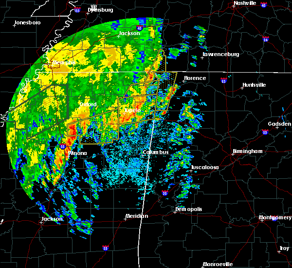 At 628 am cdt, a severe thunderstorm was located near burnsville, or near j p coleman state park, moving east at 55 mph (radar indicated). Hazards include 60 mph wind gusts. expect damage to roofs, siding, and trees At 628 am cdt, a severe thunderstorm was located near burnsville, or near j p coleman state park, moving east at 55 mph (radar indicated). Hazards include 60 mph wind gusts. expect damage to roofs, siding, and trees
|
| 4/14/2018 6:14 AM CDT |
 At 613 am cdt, a severe thunderstorm was located near decaturville, or 16 miles southeast of lexington, moving northeast at 45 mph (radar indicated). Hazards include 60 mph wind gusts. Expect damage to roofs, siding, and trees. locations impacted include, savannah, parsons, adamsville, decaturville, sardis, olive hill, morris chapel, montgomery, crump, scotts hill, saltillo, busseltown, right, phillips, haney, hinkle, pleasant grove, mount tabor, red walnut and walkertown. A tornado watch remains in effect until 800 am cdt for southwestern tennessee. At 613 am cdt, a severe thunderstorm was located near decaturville, or 16 miles southeast of lexington, moving northeast at 45 mph (radar indicated). Hazards include 60 mph wind gusts. Expect damage to roofs, siding, and trees. locations impacted include, savannah, parsons, adamsville, decaturville, sardis, olive hill, morris chapel, montgomery, crump, scotts hill, saltillo, busseltown, right, phillips, haney, hinkle, pleasant grove, mount tabor, red walnut and walkertown. A tornado watch remains in effect until 800 am cdt for southwestern tennessee.
|
| 4/14/2018 5:30 AM CDT |
 At 530 am cdt, a severe thunderstorm was located over masseyville, or 8 miles southeast of chickasaw state forest, moving northeast at 50 mph (radar indicated). Hazards include 60 mph wind gusts. expect damage to roofs, siding, and trees At 530 am cdt, a severe thunderstorm was located over masseyville, or 8 miles southeast of chickasaw state forest, moving northeast at 50 mph (radar indicated). Hazards include 60 mph wind gusts. expect damage to roofs, siding, and trees
|
| 11/18/2017 4:21 PM CST |
 The severe thunderstorm warning for hardin and southern decatur counties will expire at 430 pm cst, the storm which prompted the warning has weakened below severe limits, and has exited the warned area. therefore, the warning will be allowed to expire. however gusty winds are still possible with this thunderstorm. a severe thunderstorm watch remains in effect until 700 pm cst for western tennessee. The severe thunderstorm warning for hardin and southern decatur counties will expire at 430 pm cst, the storm which prompted the warning has weakened below severe limits, and has exited the warned area. therefore, the warning will be allowed to expire. however gusty winds are still possible with this thunderstorm. a severe thunderstorm watch remains in effect until 700 pm cst for western tennessee.
|
| 11/18/2017 3:54 PM CST |
 At 354 pm cst, a severe thunderstorm was located over adamsville, or near savannah, moving east at 65 mph (radar indicated). Hazards include 60 mph wind gusts. expect damage to roofs, siding, and trees At 354 pm cst, a severe thunderstorm was located over adamsville, or near savannah, moving east at 65 mph (radar indicated). Hazards include 60 mph wind gusts. expect damage to roofs, siding, and trees
|
| 8/31/2017 3:23 PM CDT |
 At 323 pm cdt, a severe thunderstorm capable of producing a tornado was located 9 miles northeast of olive hill, or 12 miles northwest of waynesboro, moving northwest at 40 mph (radar indicated rotation). Hazards include tornado. Flying debris will be dangerous to those caught without shelter. mobile homes will be damaged or destroyed. damage to roofs, windows, and vehicles will occur. tree damage is likely. this dangerous storm will be near, decaturville around 345 pm cdt. parsons around 355 pm cdt. Other locations impacted by this tornadic thunderstorm include perryville, gumdale, busseltown, jeannette, wilkinstown, haney, bath springs, mount tabor, garrett and beacon. At 323 pm cdt, a severe thunderstorm capable of producing a tornado was located 9 miles northeast of olive hill, or 12 miles northwest of waynesboro, moving northwest at 40 mph (radar indicated rotation). Hazards include tornado. Flying debris will be dangerous to those caught without shelter. mobile homes will be damaged or destroyed. damage to roofs, windows, and vehicles will occur. tree damage is likely. this dangerous storm will be near, decaturville around 345 pm cdt. parsons around 355 pm cdt. Other locations impacted by this tornadic thunderstorm include perryville, gumdale, busseltown, jeannette, wilkinstown, haney, bath springs, mount tabor, garrett and beacon.
|
| 6/18/2017 5:06 PM CDT |
 The severe thunderstorm warning for northwestern wayne and southwestern perry counties will expire at 515 pm cdt, the storm which prompted the warning has weakened below severe limits, and no longer poses an immediate threat to life or property. therefore the warning will be allowed to expire. to report severe weather, contact your nearest law enforcement agency. they will relay your report to the national weather service nashville. The severe thunderstorm warning for northwestern wayne and southwestern perry counties will expire at 515 pm cdt, the storm which prompted the warning has weakened below severe limits, and no longer poses an immediate threat to life or property. therefore the warning will be allowed to expire. to report severe weather, contact your nearest law enforcement agency. they will relay your report to the national weather service nashville.
|
| 6/18/2017 4:57 PM CDT |
 At 457 pm cdt, a severe thunderstorm was located 11 miles southwest of linden, or near flatwoods, moving northeast at 20 mph (radar indicated). Hazards include 60 mph wind gusts and penny size hail. Expect damage to roofs, siding, and trees. Locations impacted include, linden, clifton and flatwoods. At 457 pm cdt, a severe thunderstorm was located 11 miles southwest of linden, or near flatwoods, moving northeast at 20 mph (radar indicated). Hazards include 60 mph wind gusts and penny size hail. Expect damage to roofs, siding, and trees. Locations impacted include, linden, clifton and flatwoods.
|
| 6/18/2017 4:39 PM CDT |
 At 439 pm cdt, a severe thunderstorm was located near clifton, or 10 miles north of olive hill, moving northeast at 25 mph (radar indicated). Hazards include 60 mph wind gusts and quarter size hail. Hail damage to vehicles is expected. Expect wind damage to roofs, siding, and trees. At 439 pm cdt, a severe thunderstorm was located near clifton, or 10 miles north of olive hill, moving northeast at 25 mph (radar indicated). Hazards include 60 mph wind gusts and quarter size hail. Hail damage to vehicles is expected. Expect wind damage to roofs, siding, and trees.
|
| 5/27/2017 11:48 PM CDT |
 At 1148 pm cdt, a severe thunderstorm was located near reagan, or 13 miles east of henderson, moving east at 65 mph (radar indicated). Hazards include 70 mph wind gusts and quarter size hail. Hail damage to vehicles is expected. expect considerable tree damage. wind damage is also likely to mobile homes, roofs, and outbuildings. locations impacted include, lexington, savannah, henderson, bolivar, selmer, pickwick landing state park, natchez trace state park, chickasaw state park, natchez trace state forest, chickasaw state forest, big hill pond state park, parsons, adamsville, decaturville, sardis, silerton, pickwick dam, masseyville, reagan and bargerton. A tornado watch remains in effect until 500 am cdt for western tennessee. At 1148 pm cdt, a severe thunderstorm was located near reagan, or 13 miles east of henderson, moving east at 65 mph (radar indicated). Hazards include 70 mph wind gusts and quarter size hail. Hail damage to vehicles is expected. expect considerable tree damage. wind damage is also likely to mobile homes, roofs, and outbuildings. locations impacted include, lexington, savannah, henderson, bolivar, selmer, pickwick landing state park, natchez trace state park, chickasaw state park, natchez trace state forest, chickasaw state forest, big hill pond state park, parsons, adamsville, decaturville, sardis, silerton, pickwick dam, masseyville, reagan and bargerton. A tornado watch remains in effect until 500 am cdt for western tennessee.
|
| 5/27/2017 11:23 PM CDT |
 At 1123 pm cdt, a severe thunderstorm was located over bemis, or near jackson, moving east at 65 mph (radar indicated). Hazards include quarter size hail. damage to vehicles is expected At 1123 pm cdt, a severe thunderstorm was located over bemis, or near jackson, moving east at 65 mph (radar indicated). Hazards include quarter size hail. damage to vehicles is expected
|
| 5/27/2017 11:14 PM CDT |
 At 1114 pm cdt, a severe thunderstorm producing a tornado was located near jacks creek, or 12 miles east of henderson, moving east at 50 mph (radar indicated rotation). Hazards include tornado. Flying debris will be dangerous to those caught without shelter. mobile homes will be damaged or destroyed. damage to roofs, windows, and vehicles will occur. tree damage is likely. this dangerous storm will be near, sardis around 1125 pm cdt. Other locations impacted by this tornadic thunderstorm include thurman, saltillo, lick skillet, gumdale, montgomery, haney, hinkle, roby, bath springs and five forks. At 1114 pm cdt, a severe thunderstorm producing a tornado was located near jacks creek, or 12 miles east of henderson, moving east at 50 mph (radar indicated rotation). Hazards include tornado. Flying debris will be dangerous to those caught without shelter. mobile homes will be damaged or destroyed. damage to roofs, windows, and vehicles will occur. tree damage is likely. this dangerous storm will be near, sardis around 1125 pm cdt. Other locations impacted by this tornadic thunderstorm include thurman, saltillo, lick skillet, gumdale, montgomery, haney, hinkle, roby, bath springs and five forks.
|
| 5/27/2017 10:49 PM CDT |
 At 1049 pm cdt, a severe thunderstorm was located near bemis, or near jackson, moving east at 45 mph (radar indicated). Hazards include 60 mph wind gusts and quarter size hail. Hail damage to vehicles is expected. Expect wind damage to roofs, siding, and trees. At 1049 pm cdt, a severe thunderstorm was located near bemis, or near jackson, moving east at 45 mph (radar indicated). Hazards include 60 mph wind gusts and quarter size hail. Hail damage to vehicles is expected. Expect wind damage to roofs, siding, and trees.
|
| 3/27/2017 7:22 PM CDT |
 At 722 pm cdt, a severe thunderstorm was located near collinwood, or near waynesboro, moving east at 35 mph (radar indicated). Hazards include 60 mph wind gusts and quarter size hail. Hail damage to vehicles is expected. Expect wind damage to roofs, siding, and trees. At 722 pm cdt, a severe thunderstorm was located near collinwood, or near waynesboro, moving east at 35 mph (radar indicated). Hazards include 60 mph wind gusts and quarter size hail. Hail damage to vehicles is expected. Expect wind damage to roofs, siding, and trees.
|
| 3/27/2017 7:10 PM CDT | Ping Pong Ball sized hail reported 8 miles NNE of Clifton, TN |
| 3/27/2017 7:06 PM CDT |
 At 705 pm cdt, a severe thunderstorm capable of producing a tornado was located 8 miles southwest of waynesboro, moving east at 30 mph (radar indicated rotation). Hazards include tornado and quarter size hail. Flying debris will be dangerous to those caught without shelter. mobile homes will be damaged or destroyed. damage to roofs, windows, and vehicles will occur. tree damage is likely. This dangerous storm will be near, collinwood around 715 pm cdt. At 705 pm cdt, a severe thunderstorm capable of producing a tornado was located 8 miles southwest of waynesboro, moving east at 30 mph (radar indicated rotation). Hazards include tornado and quarter size hail. Flying debris will be dangerous to those caught without shelter. mobile homes will be damaged or destroyed. damage to roofs, windows, and vehicles will occur. tree damage is likely. This dangerous storm will be near, collinwood around 715 pm cdt.
|
| 3/27/2017 6:43 PM CDT |
 At 642 pm cdt, a severe thunderstorm capable of producing a tornado was located over olive hill, or 10 miles northeast of savannah, moving southeast at 40 mph (radar indicated rotation). Hazards include tornado and ping pong ball size hail. Flying debris will be dangerous to those caught without shelter. mobile homes will be damaged or destroyed. damage to roofs, windows, and vehicles will occur. tree damage is likely. This dangerous storm will be near, collinwood around 710 pm cdt. At 642 pm cdt, a severe thunderstorm capable of producing a tornado was located over olive hill, or 10 miles northeast of savannah, moving southeast at 40 mph (radar indicated rotation). Hazards include tornado and ping pong ball size hail. Flying debris will be dangerous to those caught without shelter. mobile homes will be damaged or destroyed. damage to roofs, windows, and vehicles will occur. tree damage is likely. This dangerous storm will be near, collinwood around 710 pm cdt.
|
| 3/27/2017 6:36 PM CDT |
 At 636 pm cdt, a severe thunderstorm producing a tornado was located near olive hill, or 8 miles northeast of savannah, moving east at 30 mph (radar indicated rotation). Hazards include tornado and baseball size hail. Flying debris will be dangerous to those caught without shelter. mobile homes will be damaged or destroyed. damage to roofs, windows, and vehicles will occur. tree damage is likely. this dangerous storm will be near, olive hill around 645 pm cdt. Other locations impacted by this tornadic thunderstorm include swift, olivehill, bucktown and cerro gordo. At 636 pm cdt, a severe thunderstorm producing a tornado was located near olive hill, or 8 miles northeast of savannah, moving east at 30 mph (radar indicated rotation). Hazards include tornado and baseball size hail. Flying debris will be dangerous to those caught without shelter. mobile homes will be damaged or destroyed. damage to roofs, windows, and vehicles will occur. tree damage is likely. this dangerous storm will be near, olive hill around 645 pm cdt. Other locations impacted by this tornadic thunderstorm include swift, olivehill, bucktown and cerro gordo.
|
| 3/27/2017 6:29 PM CDT |
 At 629 pm cdt, a severe thunderstorm was located near morris chapel, or 12 miles southeast of henderson, moving east at 35 mph (radar indicated). Hazards include golf ball size hail and 60 mph wind gusts. People and animals outdoors will be injured. expect hail damage to roofs, siding, windows, and vehicles. expect wind damage to roofs, siding, and trees. Locations impacted include, sardis, jacks creek, montgomery, scotts hill, saltillo, milledgeville, enville, thurman, lick skillet, gumdale, haney, hinkle, roby, bath springs, five forks, pleasant grove, cabo, red walnut, swift and dunbar. At 629 pm cdt, a severe thunderstorm was located near morris chapel, or 12 miles southeast of henderson, moving east at 35 mph (radar indicated). Hazards include golf ball size hail and 60 mph wind gusts. People and animals outdoors will be injured. expect hail damage to roofs, siding, windows, and vehicles. expect wind damage to roofs, siding, and trees. Locations impacted include, sardis, jacks creek, montgomery, scotts hill, saltillo, milledgeville, enville, thurman, lick skillet, gumdale, haney, hinkle, roby, bath springs, five forks, pleasant grove, cabo, red walnut, swift and dunbar.
|
| 3/27/2017 6:25 PM CDT |
 At 624 pm cdt, a severe thunderstorm producing a tornado was located near savannah, moving east at 40 mph (radar indicated rotation). Hazards include tornado and ping pong ball size hail. Flying debris will be dangerous to those caught without shelter. mobile homes will be damaged or destroyed. damage to roofs, windows, and vehicles will occur. tree damage is likely. this dangerous storm will be near, olive hill around 645 pm cdt. Other locations impacted by this tornadic thunderstorm include swift, olivehill, sibley, bucktown, cerro gordo and coffee landing. At 624 pm cdt, a severe thunderstorm producing a tornado was located near savannah, moving east at 40 mph (radar indicated rotation). Hazards include tornado and ping pong ball size hail. Flying debris will be dangerous to those caught without shelter. mobile homes will be damaged or destroyed. damage to roofs, windows, and vehicles will occur. tree damage is likely. this dangerous storm will be near, olive hill around 645 pm cdt. Other locations impacted by this tornadic thunderstorm include swift, olivehill, sibley, bucktown, cerro gordo and coffee landing.
|
| 3/27/2017 6:17 PM CDT |
 At 617 pm cdt, a severe thunderstorm producing a tornado was located near sardis, or 9 miles north of savannah, moving east at 30 mph (radar indicated rotation). Hazards include tornado and ping pong ball size hail. Flying debris will be dangerous to those caught without shelter. mobile homes will be damaged or destroyed. damage to roofs, windows, and vehicles will occur. tree damage is likely. this dangerous storm will be near, olive hill around 645 pm cdt. Other locations impacted by this tornadic thunderstorm include saltillo, five forks, right, swift, olivehill, sibley, bucktown, cerro gordo, coffee landing and hinkle. At 617 pm cdt, a severe thunderstorm producing a tornado was located near sardis, or 9 miles north of savannah, moving east at 30 mph (radar indicated rotation). Hazards include tornado and ping pong ball size hail. Flying debris will be dangerous to those caught without shelter. mobile homes will be damaged or destroyed. damage to roofs, windows, and vehicles will occur. tree damage is likely. this dangerous storm will be near, olive hill around 645 pm cdt. Other locations impacted by this tornadic thunderstorm include saltillo, five forks, right, swift, olivehill, sibley, bucktown, cerro gordo, coffee landing and hinkle.
|
| 3/27/2017 6:06 PM CDT |
 At 606 pm cdt, a severe thunderstorm producing a tornado was located near morris chapel, or 12 miles northwest of savannah, moving east at 35 mph (radar indicated rotation). Hazards include tornado and golf ball size hail. Flying debris will be dangerous to those caught without shelter. mobile homes will be damaged or destroyed. damage to roofs, windows, and vehicles will occur. tree damage is likely. this dangerous storm will be near, olive hill around 640 pm cdt. Other locations impacted by this tornadic thunderstorm include thurman, saltillo, milledgeville, right, sibley, hinkle, roby, five forks, pleasant grove and swift. At 606 pm cdt, a severe thunderstorm producing a tornado was located near morris chapel, or 12 miles northwest of savannah, moving east at 35 mph (radar indicated rotation). Hazards include tornado and golf ball size hail. Flying debris will be dangerous to those caught without shelter. mobile homes will be damaged or destroyed. damage to roofs, windows, and vehicles will occur. tree damage is likely. this dangerous storm will be near, olive hill around 640 pm cdt. Other locations impacted by this tornadic thunderstorm include thurman, saltillo, milledgeville, right, sibley, hinkle, roby, five forks, pleasant grove and swift.
|
| 3/27/2017 5:55 PM CDT |
 At 555 pm cdt, a severe thunderstorm was located near jacks creek, or 12 miles east of henderson, moving east at 40 mph (radar indicated). Hazards include golf ball size hail and 60 mph wind gusts. this storm has rotation and a tornado may form with little or no advanced warning. People and animals outdoors will be injured. expect hail damage to roofs, siding, windows, and vehicles. Expect wind damage to roofs, siding, and trees. At 555 pm cdt, a severe thunderstorm was located near jacks creek, or 12 miles east of henderson, moving east at 40 mph (radar indicated). Hazards include golf ball size hail and 60 mph wind gusts. this storm has rotation and a tornado may form with little or no advanced warning. People and animals outdoors will be injured. expect hail damage to roofs, siding, windows, and vehicles. Expect wind damage to roofs, siding, and trees.
|
| 3/27/2017 2:33 PM CDT |
 At 232 pm cdt, a severe thunderstorm was located near collinwood, or near waynesboro, moving northeast at 30 mph. another severe thunderstorm was located near lutts, moving northeast at 30 mph (radar indicated). Hazards include 60 mph wind gusts and quarter size hail. Hail damage to vehicles is expected. expect wind damage to roofs, siding, and trees. Locations impacted include, waynesboro, lutts, and collinwood. At 232 pm cdt, a severe thunderstorm was located near collinwood, or near waynesboro, moving northeast at 30 mph. another severe thunderstorm was located near lutts, moving northeast at 30 mph (radar indicated). Hazards include 60 mph wind gusts and quarter size hail. Hail damage to vehicles is expected. expect wind damage to roofs, siding, and trees. Locations impacted include, waynesboro, lutts, and collinwood.
|
| 3/27/2017 2:16 PM CDT |
 At 216 pm cdt, a severe thunderstorm was located near collinwood, or 11 miles south of waynesboro, moving northeast at 25 mph (radar indicated). Hazards include 60 mph wind gusts and quarter size hail. Hail damage to vehicles is expected. Expect wind damage to roofs, siding, and trees. At 216 pm cdt, a severe thunderstorm was located near collinwood, or 11 miles south of waynesboro, moving northeast at 25 mph (radar indicated). Hazards include 60 mph wind gusts and quarter size hail. Hail damage to vehicles is expected. Expect wind damage to roofs, siding, and trees.
|
| 3/27/2017 1:52 PM CDT |
 At 151 pm cdt, a severe thunderstorm producing a tornado was located near shiloh, or near savannah, moving northeast at 40 mph (radar indicated rotation). Hazards include tornado and golf ball size hail. Flying debris will be dangerous to those caught without shelter. mobile homes will be damaged or destroyed. damage to roofs, windows, and vehicles will occur. tree damage is likely. this dangerous storm will be near, savannah around 200 pm cdt. olive hill around 215 pm cdt. Other locations impacted by this tornadic thunderstorm include center star, maddox, hurley, hamburg, walkertown, olivehill, phillips, bucktown, pittsburg landing and childers hill. At 151 pm cdt, a severe thunderstorm producing a tornado was located near shiloh, or near savannah, moving northeast at 40 mph (radar indicated rotation). Hazards include tornado and golf ball size hail. Flying debris will be dangerous to those caught without shelter. mobile homes will be damaged or destroyed. damage to roofs, windows, and vehicles will occur. tree damage is likely. this dangerous storm will be near, savannah around 200 pm cdt. olive hill around 215 pm cdt. Other locations impacted by this tornadic thunderstorm include center star, maddox, hurley, hamburg, walkertown, olivehill, phillips, bucktown, pittsburg landing and childers hill.
|
| 3/27/2017 1:44 PM CDT |
 At 144 pm cdt, a severe thunderstorm producing a tornado was located over shiloh, or 7 miles northwest of pickwick landing state park, moving northeast at 45 mph (radar indicated rotation). Hazards include tornado and golf ball size hail. Flying debris will be dangerous to those caught without shelter. mobile homes will be damaged or destroyed. damage to roofs, windows, and vehicles will occur. tree damage is likely. this dangerous storm will be near, savannah around 155 pm cdt. olive hill around 210 pm cdt. Other locations impacted by this tornadic thunderstorm include counce, lowryville, mount vinson, damon, pebble hill, southside, hamburg, phillips, bruton branch and tulu. At 144 pm cdt, a severe thunderstorm producing a tornado was located over shiloh, or 7 miles northwest of pickwick landing state park, moving northeast at 45 mph (radar indicated rotation). Hazards include tornado and golf ball size hail. Flying debris will be dangerous to those caught without shelter. mobile homes will be damaged or destroyed. damage to roofs, windows, and vehicles will occur. tree damage is likely. this dangerous storm will be near, savannah around 155 pm cdt. olive hill around 210 pm cdt. Other locations impacted by this tornadic thunderstorm include counce, lowryville, mount vinson, damon, pebble hill, southside, hamburg, phillips, bruton branch and tulu.
|
| 3/21/2017 3:21 PM CDT |
 At 321 pm cdt, a severe thunderstorm was located 8 miles northeast of olive hill, or 9 miles west of waynesboro, moving east at 30 mph (radar indicated). Hazards include 60 mph wind gusts and half dollar size hail. Hail damage to vehicles is expected. Expect wind damage to roofs, siding, and trees. At 321 pm cdt, a severe thunderstorm was located 8 miles northeast of olive hill, or 9 miles west of waynesboro, moving east at 30 mph (radar indicated). Hazards include 60 mph wind gusts and half dollar size hail. Hail damage to vehicles is expected. Expect wind damage to roofs, siding, and trees.
|
| 3/9/2017 11:23 PM CST |
 At 1123 pm cst, a severe thunderstorm was located near waynesboro, moving east at 55 mph (radar indicated). Hazards include 60 mph wind gusts. Expect damage to roofs, siding, and trees. Locations impacted include, lawrenceburg, waynesboro, collinwood, ethridge, leoma, lutts and westpoint. At 1123 pm cst, a severe thunderstorm was located near waynesboro, moving east at 55 mph (radar indicated). Hazards include 60 mph wind gusts. Expect damage to roofs, siding, and trees. Locations impacted include, lawrenceburg, waynesboro, collinwood, ethridge, leoma, lutts and westpoint.
|
| 3/9/2017 11:11 PM CST |
 At 1110 pm cst, a severe thunderstorm was located near olive hill, or 11 miles west of waynesboro, moving east at 55 mph (radar indicated). Hazards include 60 mph wind gusts. expect damage to roofs, siding, and trees At 1110 pm cst, a severe thunderstorm was located near olive hill, or 11 miles west of waynesboro, moving east at 55 mph (radar indicated). Hazards include 60 mph wind gusts. expect damage to roofs, siding, and trees
|
| 3/9/2017 10:50 PM CST |
 At 1050 pm cst, severe thunderstorms were located along a line extending from near henderson to 6 miles east of chickasaw state park to chickasaw state forest, moving southeast at 35 mph (radar indicated). Hazards include 60 mph wind gusts and quarter size hail. Hail damage to vehicles is expected. expect wind damage to roofs, siding, and trees. Locations impacted include, savannah, henderson, selmer, chickasaw state park, adamsville, sardis, masseyville, jacks creek, olive hill, morris chapel, robertson, mcnairy, crump, bethel springs, saltillo, finger, milledgeville, enville, forty forks and rose creek. At 1050 pm cst, severe thunderstorms were located along a line extending from near henderson to 6 miles east of chickasaw state park to chickasaw state forest, moving southeast at 35 mph (radar indicated). Hazards include 60 mph wind gusts and quarter size hail. Hail damage to vehicles is expected. expect wind damage to roofs, siding, and trees. Locations impacted include, savannah, henderson, selmer, chickasaw state park, adamsville, sardis, masseyville, jacks creek, olive hill, morris chapel, robertson, mcnairy, crump, bethel springs, saltillo, finger, milledgeville, enville, forty forks and rose creek.
|
| 3/9/2017 10:34 PM CST |
 At 1034 pm cst, severe thunderstorms were located along a line extending from near sardis to near henderson to near mercer, moving east at 55 mph (radar indicated). Hazards include 60 mph wind gusts and quarter size hail. Hail damage to vehicles is expected. Expect wind damage to roofs, siding, and trees. At 1034 pm cst, severe thunderstorms were located along a line extending from near sardis to near henderson to near mercer, moving east at 55 mph (radar indicated). Hazards include 60 mph wind gusts and quarter size hail. Hail damage to vehicles is expected. Expect wind damage to roofs, siding, and trees.
|
| 2/7/2017 10:38 AM CST |
 The severe thunderstorm warning for southeastern henderson, northern hardin and southern decatur counties will expire at 1045 am cst, the storm which prompted the warning has weakened below severe limits, and no longer pose an immediate threat to life or property. therefore, the warning will be allowed to expire. The severe thunderstorm warning for southeastern henderson, northern hardin and southern decatur counties will expire at 1045 am cst, the storm which prompted the warning has weakened below severe limits, and no longer pose an immediate threat to life or property. therefore, the warning will be allowed to expire.
|
| 2/7/2017 10:31 AM CST |
 At 1031 am cst, a severe thunderstorm was located near sardis, or 13 miles north of savannah, moving east at 55 mph (radar indicated). Hazards include 60 mph wind gusts. Expect damage to roofs, siding, and trees. Locations impacted include, sardis, reagan, morris chapel, montgomery, scotts hill, saltillo, milledgeville, right, haney, hinkle, pleasant grove, red walnut, cerro gordo, thurman, lick skillet, gumdale, sibley, bath springs, five forks and largo. At 1031 am cst, a severe thunderstorm was located near sardis, or 13 miles north of savannah, moving east at 55 mph (radar indicated). Hazards include 60 mph wind gusts. Expect damage to roofs, siding, and trees. Locations impacted include, sardis, reagan, morris chapel, montgomery, scotts hill, saltillo, milledgeville, right, haney, hinkle, pleasant grove, red walnut, cerro gordo, thurman, lick skillet, gumdale, sibley, bath springs, five forks and largo.
|
| 2/7/2017 10:17 AM CST |
 At 1017 am cst, a severe thunderstorm was located near jacks creek, or 11 miles east of henderson, moving east at 55 mph (radar indicated). Hazards include 60 mph wind gusts. Expect damage to roofs, siding, and trees. Locations impacted include, adamsville, sardis, reagan, jacks creek, morris chapel, montgomery, scotts hill, saltillo, milledgeville, enville, right, haney, hinkle, roby, pleasant grove, cabo, red walnut, cerro gordo, thurman and lick skillet. At 1017 am cst, a severe thunderstorm was located near jacks creek, or 11 miles east of henderson, moving east at 55 mph (radar indicated). Hazards include 60 mph wind gusts. Expect damage to roofs, siding, and trees. Locations impacted include, adamsville, sardis, reagan, jacks creek, morris chapel, montgomery, scotts hill, saltillo, milledgeville, enville, right, haney, hinkle, roby, pleasant grove, cabo, red walnut, cerro gordo, thurman and lick skillet.
|
| 2/7/2017 10:00 AM CST |
 At 959 am cst, a severe thunderstorm was located near masseyville, or near chickasaw state park, moving east at 55 mph (radar indicated). Hazards include 60 mph wind gusts and nickel size hail. Hail damage to vehicles is expected. Expect wind damage to roofs, siding, and trees. At 959 am cst, a severe thunderstorm was located near masseyville, or near chickasaw state park, moving east at 55 mph (radar indicated). Hazards include 60 mph wind gusts and nickel size hail. Hail damage to vehicles is expected. Expect wind damage to roofs, siding, and trees.
|
| 12/17/2016 10:33 PM CST |
 At 1031 pm cst, a severe thunderstorm was located near theo, or near big hill pond state park, moving northeast at 70 mph. storm spotters reported a funnel cloud with this storm along with 59 mph measured wind gust. this storm will be capable of producing tornadoes which will be monitored closely (radar indicated). Hazards include 60 mph wind gusts. expect damage to roofs, siding, and trees At 1031 pm cst, a severe thunderstorm was located near theo, or near big hill pond state park, moving northeast at 70 mph. storm spotters reported a funnel cloud with this storm along with 59 mph measured wind gust. this storm will be capable of producing tornadoes which will be monitored closely (radar indicated). Hazards include 60 mph wind gusts. expect damage to roofs, siding, and trees
|
| 8/26/2016 5:00 PM CDT | One large tree down. reportand picture relayed by nws nashvill in hardin county TN, 7.4 miles NNE of Clifton, TN |
| 6/15/2016 4:35 PM CDT |
 The severe thunderstorm warning for decatur, northeastern hardin and southeastern benton counties will expire at 445 pm cdt, the severe thunderstorm which prompted the warning has moved out of the warned area. therefore the warning will be allowed to expire. a severe thunderstorm watch remains in effect until 900 pm cdt for western tennessee. The severe thunderstorm warning for decatur, northeastern hardin and southeastern benton counties will expire at 445 pm cdt, the severe thunderstorm which prompted the warning has moved out of the warned area. therefore the warning will be allowed to expire. a severe thunderstorm watch remains in effect until 900 pm cdt for western tennessee.
|
| 6/15/2016 4:15 PM CDT |
 At 414 pm cdt, a severe thunderstorm was located 8 miles southeast of decaturville, or 14 miles southwest of linden, moving northeast at 20 mph (radar indicated). Hazards include 60 mph wind gusts and quarter size hail. Hail damage to vehicles is expected. Expect wind damage to roofs, siding, and trees. At 414 pm cdt, a severe thunderstorm was located 8 miles southeast of decaturville, or 14 miles southwest of linden, moving northeast at 20 mph (radar indicated). Hazards include 60 mph wind gusts and quarter size hail. Hail damage to vehicles is expected. Expect wind damage to roofs, siding, and trees.
|
| 5/12/2016 12:12 PM CDT |
 At 1211 pm cdt, a severe thunderstorm was located 11 miles northwest of waynesboro, moving northeast at 35 mph (radar indicated). Hazards include 60 mph wind gusts and quarter size hail. Hail damage to vehicles is expected. Expect wind damage to roofs, siding, and trees. At 1211 pm cdt, a severe thunderstorm was located 11 miles northwest of waynesboro, moving northeast at 35 mph (radar indicated). Hazards include 60 mph wind gusts and quarter size hail. Hail damage to vehicles is expected. Expect wind damage to roofs, siding, and trees.
|
| 3/31/2016 5:10 PM CDT |
 The severe thunderstorm warning for eastern hardin county will expire at 515 pm cdt, the storm which prompted the warning has moved out of the area. therefore the warning will be allowed to expire. a tornado watch remains in effect until 1000 pm cdt for western tennessee. The severe thunderstorm warning for eastern hardin county will expire at 515 pm cdt, the storm which prompted the warning has moved out of the area. therefore the warning will be allowed to expire. a tornado watch remains in effect until 1000 pm cdt for western tennessee.
|
| 3/31/2016 4:49 PM CDT |
 At 449 pm cdt, a severe thunderstorm was located 7 miles southeast of olive hill, or 15 miles southwest of waynesboro, moving northeast at 55 mph (radar indicated). Hazards include 60 mph wind gusts and quarter size hail. Hail damage to vehicles is expected. Expect wind damage to roofs, siding, and trees. At 449 pm cdt, a severe thunderstorm was located 7 miles southeast of olive hill, or 15 miles southwest of waynesboro, moving northeast at 55 mph (radar indicated). Hazards include 60 mph wind gusts and quarter size hail. Hail damage to vehicles is expected. Expect wind damage to roofs, siding, and trees.
|
| 3/31/2016 4:43 PM CDT |
 At 443 pm cdt, a severe thunderstorm was located near walnut grove, or 7 miles northeast of pickwick landing state park, moving east at 35 mph (radar indicated). Hazards include 60 mph wind gusts and quarter size hail. Hail damage to vehicles is expected. expect wind damage to roofs, siding, and trees. locations impacted include, savannah, pickwick landing state park, adamsville, morris chapel, shiloh, olive hill, pickwick dam, crump, saltillo, red sulphur springs, olivehill, bucktown, hamburg, pittsburg landing, phillips, walkertown, cerro gordo, hurley, right and sibley. A tornado watch remains in effect until 1000 pm cdt for western tennessee. At 443 pm cdt, a severe thunderstorm was located near walnut grove, or 7 miles northeast of pickwick landing state park, moving east at 35 mph (radar indicated). Hazards include 60 mph wind gusts and quarter size hail. Hail damage to vehicles is expected. expect wind damage to roofs, siding, and trees. locations impacted include, savannah, pickwick landing state park, adamsville, morris chapel, shiloh, olive hill, pickwick dam, crump, saltillo, red sulphur springs, olivehill, bucktown, hamburg, pittsburg landing, phillips, walkertown, cerro gordo, hurley, right and sibley. A tornado watch remains in effect until 1000 pm cdt for western tennessee.
|
| 3/31/2016 4:40 PM CDT |
 At 440 pm cdt, a severe thunderstorm was located over olive hill, or 13 miles east of savannah, moving east at 55 mph (radar indicated). Hazards include 60 mph wind gusts and quarter size hail. Hail damage to vehicles is expected. Expect wind damage to roofs, siding, and trees. At 440 pm cdt, a severe thunderstorm was located over olive hill, or 13 miles east of savannah, moving east at 55 mph (radar indicated). Hazards include 60 mph wind gusts and quarter size hail. Hail damage to vehicles is expected. Expect wind damage to roofs, siding, and trees.
|
| 3/31/2016 4:36 PM CDT |
 At 436 pm cdt, a severe thunderstorm was located near pickwick landing state park, moving east at 35 mph (radar indicated). Hazards include 60 mph wind gusts and quarter size hail. Hail damage to vehicles is expected. expect wind damage to roofs, siding, and trees. locations impacted include, savannah, pickwick landing state park, adamsville, morris chapel, shiloh, olive hill, pickwick dam, crump, michie, saltillo, stantonville, red sulphur springs, olivehill, hickory flats, bucktown, hamburg, pittsburg landing, phillips, acton and mount vinson. A tornado watch remains in effect until 1000 pm cdt for western tennessee. At 436 pm cdt, a severe thunderstorm was located near pickwick landing state park, moving east at 35 mph (radar indicated). Hazards include 60 mph wind gusts and quarter size hail. Hail damage to vehicles is expected. expect wind damage to roofs, siding, and trees. locations impacted include, savannah, pickwick landing state park, adamsville, morris chapel, shiloh, olive hill, pickwick dam, crump, michie, saltillo, stantonville, red sulphur springs, olivehill, hickory flats, bucktown, hamburg, pittsburg landing, phillips, acton and mount vinson. A tornado watch remains in effect until 1000 pm cdt for western tennessee.
|
| 3/31/2016 4:27 PM CDT |
 At 427 pm cdt, a severe thunderstorm was located near pickwick dam, or near pickwick landing state park, moving east at 35 mph (radar indicated). Hazards include 60 mph wind gusts and half dollar size hail. Hail damage to vehicles is expected. expect wind damage to roofs, siding, and trees. locations impacted include, savannah, selmer, pickwick landing state park, big hill pond state park, adamsville, shiloh, olive hill, pickwick dam, morris chapel, crump, eastview, michie, guys, ramer, saltillo, stantonville, milledgeville, cypress, olivehill and old lawton. A tornado watch remains in effect until 1000 pm cdt for western tennessee. At 427 pm cdt, a severe thunderstorm was located near pickwick dam, or near pickwick landing state park, moving east at 35 mph (radar indicated). Hazards include 60 mph wind gusts and half dollar size hail. Hail damage to vehicles is expected. expect wind damage to roofs, siding, and trees. locations impacted include, savannah, selmer, pickwick landing state park, big hill pond state park, adamsville, shiloh, olive hill, pickwick dam, morris chapel, crump, eastview, michie, guys, ramer, saltillo, stantonville, milledgeville, cypress, olivehill and old lawton. A tornado watch remains in effect until 1000 pm cdt for western tennessee.
|
| 3/31/2016 4:12 PM CDT | The severe thunderstorm warning for east central chester, henderson, northern hardin, northeastern mcnairy and decatur counties will expire at 415 pm cdt, the storm which prompted the warning has moved out of the area. therefore the warning will be allowed to expire. a tornado watch remains in effect until 1000 pm cdt for western tennessee. |
| 3/31/2016 4:09 PM CDT |
 At 408 pm cdt, a severe thunderstorm was located over adamsville, or 10 miles northeast of selmer, moving east at 35 mph (radar indicated). Hazards include 60 mph wind gusts and quarter size hail. Hail damage to vehicles is expected. Expect wind damage to roofs, siding, and trees. At 408 pm cdt, a severe thunderstorm was located over adamsville, or 10 miles northeast of selmer, moving east at 35 mph (radar indicated). Hazards include 60 mph wind gusts and quarter size hail. Hail damage to vehicles is expected. Expect wind damage to roofs, siding, and trees.
|
| 3/31/2016 4:06 PM CDT |
 At 406 pm cdt, a severe thunderstorm capable of producing a tornado was located 10 miles northeast of linden, moving northeast at 55 mph (radar indicated rotation). Hazards include tornado and ping pong ball size hail. Flying debris will be dangerous to those caught without shelter. mobile homes will be damaged or destroyed. damage to roofs, windows, and vehicles will occur. tree damage is likely. This tornadic thunderstorm will remain over mainly rural areas of perry and northern wayne counties, including the following locations: mousetail landing state park, lobelville and flatwoods. At 406 pm cdt, a severe thunderstorm capable of producing a tornado was located 10 miles northeast of linden, moving northeast at 55 mph (radar indicated rotation). Hazards include tornado and ping pong ball size hail. Flying debris will be dangerous to those caught without shelter. mobile homes will be damaged or destroyed. damage to roofs, windows, and vehicles will occur. tree damage is likely. This tornadic thunderstorm will remain over mainly rural areas of perry and northern wayne counties, including the following locations: mousetail landing state park, lobelville and flatwoods.
|
| 3/31/2016 3:49 PM CDT |
 At 348 pm cdt, a severe thunderstorm capable of producing a tornado was located 7 miles southwest of linden, moving northeast at 55 mph (radar indicated rotation). Hazards include tornado and ping pong ball size hail. Flying debris will be dangerous to those caught without shelter. mobile homes will be damaged or destroyed. damage to roofs, windows, and vehicles will occur. tree damage is likely. this dangerous storm will be near, linden around 355 pm cdt. Other locations impacted by this tornadic thunderstorm include mousetail landing state park, lobelville and flatwoods. At 348 pm cdt, a severe thunderstorm capable of producing a tornado was located 7 miles southwest of linden, moving northeast at 55 mph (radar indicated rotation). Hazards include tornado and ping pong ball size hail. Flying debris will be dangerous to those caught without shelter. mobile homes will be damaged or destroyed. damage to roofs, windows, and vehicles will occur. tree damage is likely. this dangerous storm will be near, linden around 355 pm cdt. Other locations impacted by this tornadic thunderstorm include mousetail landing state park, lobelville and flatwoods.
|
| 3/31/2016 3:25 PM CDT |
 At 325 pm cdt, a severe thunderstorm was located over reagan, or 9 miles south of lexington, moving east at 45 mph (radar indicated). Hazards include 60 mph wind gusts and quarter size hail. Hail damage to vehicles is expected. Expect wind damage to roofs, siding, and trees. At 325 pm cdt, a severe thunderstorm was located over reagan, or 9 miles south of lexington, moving east at 45 mph (radar indicated). Hazards include 60 mph wind gusts and quarter size hail. Hail damage to vehicles is expected. Expect wind damage to roofs, siding, and trees.
|
| 12/25/2015 4:30 AM CST |
 At 430 am cst, a severe thunderstorm was located 10 miles south of decaturville, or 17 miles northeast of savannah, moving northeast at 55 mph (radar indicated). Hazards include 60 mph wind gusts and penny size hail. Expect damage to roofs. siding and trees. Locations impacted include, savannah, parsons, decaturville, sardis, olive hill, montgomery, crump, scotts hill, saltillo, bath springs, olivehill, bucktown, hamburg, busseltown, lick skillet, pittsburg landing, phillips, thurman, beacon and walkertown. At 430 am cst, a severe thunderstorm was located 10 miles south of decaturville, or 17 miles northeast of savannah, moving northeast at 55 mph (radar indicated). Hazards include 60 mph wind gusts and penny size hail. Expect damage to roofs. siding and trees. Locations impacted include, savannah, parsons, decaturville, sardis, olive hill, montgomery, crump, scotts hill, saltillo, bath springs, olivehill, bucktown, hamburg, busseltown, lick skillet, pittsburg landing, phillips, thurman, beacon and walkertown.
|
| 12/25/2015 4:23 AM CST |
 At 423 am cst, a severe thunderstorm was located 7 miles southeast of sardis, or 12 miles north of savannah, moving northeast at 55 mph (radar indicated). Hazards include 60 mph wind gusts and penny size hail. Expect damage to roofs. siding and trees. Locations impacted include, savannah, parsons, adamsville, decaturville, sardis, shiloh, olive hill, morris chapel, reagan, montgomery, crump, scotts hill, michie, saltillo, stantonville, milledgeville, enville, bath springs, olivehill and old lawton. At 423 am cst, a severe thunderstorm was located 7 miles southeast of sardis, or 12 miles north of savannah, moving northeast at 55 mph (radar indicated). Hazards include 60 mph wind gusts and penny size hail. Expect damage to roofs. siding and trees. Locations impacted include, savannah, parsons, adamsville, decaturville, sardis, shiloh, olive hill, morris chapel, reagan, montgomery, crump, scotts hill, michie, saltillo, stantonville, milledgeville, enville, bath springs, olivehill and old lawton.
|
| 12/25/2015 4:09 AM CST |
 At 408 am cst, a severe thunderstorm was located near morris chapel, or 10 miles northwest of savannah, moving northeast at 55 mph (radar indicated). Hazards include 60 mph wind gusts and penny size hail. Expect damage to roofs. Siding and trees. At 408 am cst, a severe thunderstorm was located near morris chapel, or 10 miles northwest of savannah, moving northeast at 55 mph (radar indicated). Hazards include 60 mph wind gusts and penny size hail. Expect damage to roofs. Siding and trees.
|
| 12/23/2015 6:09 PM CST | The tornado warning for northeastern hardin and southern decatur counties will expire at 615 pm cst, the storm which prompted the warning has moved out of the area. therefore the warning will be allowed to expire. a tornado watch remains in effect until 800 pm cst for western tennessee. |
| 12/23/2015 6:02 PM CST | At 601 pm cst, a severe thunderstorm capable of producing a tornado was located 8 miles southeast of decaturville, or 14 miles southwest of linden, moving northeast at 60 mph (radar indicated rotation). Hazards include tornado and quarter size hail. Flying debris will be dangerous to those caught without shelter. mobile homes will be damaged or destroyed. damage to roofs, windows and vehicles will occur. tree damage is likely. this dangerous storm will be near, linden around 615 pm cst. Other locations impacted by this tornadic thunderstorm include clifton and flatwoods. |
| 12/23/2015 5:53 PM CST | At 553 pm cst, a severe thunderstorm was located 11 miles north of olive hill, or 16 miles southwest of linden, moving northeast at 70 mph (radar indicated). Hazards include 60 mph wind gusts and quarter size hail. Hail damage to vehicles is expected. expect wind damage to roofs, siding and trees. locations impacted include, decaturville, sardis, montgomery, scotts hill, saltillo, hinkle, bath springs, mount lebanon, lick skillet, haney, thurman, five forks, dunbar, cerro gordo, pleasant grove, red walnut, largo, swift, perryville and gumdale. A tornado watch remains in effect until 800 pm cst for western tennessee. |
| 12/23/2015 5:52 PM CST | At 552 pm cst, a severe thunderstorm capable of producing a tornado was located near sardis, or 10 miles north of savannah, moving northeast at 65 mph (radar indicated rotation). Hazards include tornado and quarter size hail. Flying debris will be dangerous to those caught without shelter. mobile homes will be damaged or destroyed. damage to roofs, windows and vehicles will occur. tree damage is likely. this dangerous storm will be near, linden around 615 pm cst. Other locations impacted by this tornadic thunderstorm include clifton and flatwoods. |
| 12/23/2015 5:52 PM CST | At 551 pm cst, a severe thunderstorm producing a tornado was located 7 miles southeast of sardis, or 10 miles north of savannah, moving northeast at 55 mph (radar indicated rotation). Hazards include tornado. Flying debris will be dangerous to those caught without shelter. mobile homes will be damaged or destroyed. damage to roofs, windows and vehicles will occur. tree damage is likely. Locations impacted include, saltillo, thurman, bath springs, five forks, dunbar, cerro gordo, pleasant grove, swift and gumdale. |
| 12/23/2015 5:40 PM CST | At 540 pm cst, a severe thunderstorm producing a tornado was located over morris chapel, or 7 miles northwest of savannah, moving northeast at 55 mph (radar indicated rotation). Hazards include tornado. Flying debris will be dangerous to those caught without shelter. mobile homes will be damaged or destroyed. damage to roofs, windows and vehicles will occur. tree damage is likely. This tornadic thunderstorm will remain over mainly rural areas of northern hardin, northeastern mcnairy and southern decatur counties, including the following locations, right, sibley, bath springs, coffee landing, thurman, crump, five forks, dunbar, cerro gordo and pleasant grove. |
| 12/23/2015 5:31 PM CST | At 531 pm cst, a severe thunderstorm was located near adamsville, or 10 miles northeast of selmer, moving northeast at 70 mph (radar indicated). Hazards include 60 mph wind gusts and quarter size hail. Hail damage to vehicles is expected. Expect wind damage to roofs, siding and trees. |
| 7/14/2015 5:58 PM CDT | The severe thunderstorm warning for wayne county will expire at 600 pm cdt, the storm which prompted the warning has moved out of the area. therefore the warning will be allowed to expire. a severe thunderstorm watch remains in effect until 900 pm cdt for central tennessee. |
| 7/14/2015 5:43 PM CDT |
 At 543 pm cdt, a severe thunderstorm was located near collinwood, or 12 miles south of waynesboro, moving east at 40 mph (radar indicated). Hazards include 60 mph wind gusts. Expect damage to roofs. siding and trees. This severe thunderstorm will remain over mainly rural areas of wayne county, including the following locations, cypress inn, clifton and lutts. At 543 pm cdt, a severe thunderstorm was located near collinwood, or 12 miles south of waynesboro, moving east at 40 mph (radar indicated). Hazards include 60 mph wind gusts. Expect damage to roofs. siding and trees. This severe thunderstorm will remain over mainly rural areas of wayne county, including the following locations, cypress inn, clifton and lutts.
|
| 7/14/2015 5:18 PM CDT |
 At 518 pm cdt, a severe thunderstorm was located over olive hill, or 10 miles east of savannah, moving east at 40 mph (radar indicated). Hazards include 60 mph wind gusts. Expect damage to roofs. siding and trees. this severe thunderstorm will be near, collinwood around 545 pm cdt. Other locations impacted by this severe thunderstorm include cypress inn, clifton and lutts. At 518 pm cdt, a severe thunderstorm was located over olive hill, or 10 miles east of savannah, moving east at 40 mph (radar indicated). Hazards include 60 mph wind gusts. Expect damage to roofs. siding and trees. this severe thunderstorm will be near, collinwood around 545 pm cdt. Other locations impacted by this severe thunderstorm include cypress inn, clifton and lutts.
|
| 7/14/2015 5:07 PM CDT |
 At 506 pm cdt, severe thunderstorms were located along a line extending from near mifflin to near masseyville to 8 miles southwest of pocahontas, moving southeast at 55 mph (radar indicated). Hazards include 60 mph wind gusts. Expect damage to roofs. Siding and trees. At 506 pm cdt, severe thunderstorms were located along a line extending from near mifflin to near masseyville to 8 miles southwest of pocahontas, moving southeast at 55 mph (radar indicated). Hazards include 60 mph wind gusts. Expect damage to roofs. Siding and trees.
|
| 6/8/2015 6:25 PM CDT | The severe thunderstorm warning for hardin and southern decatur counties will expire at 630 pm cdt, the severe thunderstorm which prompted the warning has weakened. therefore the warning will be allowed to expire. a severe thunderstorm watch remains in effect until 700 pm cdt for western tennessee. |
| 6/8/2015 5:52 PM CDT | At 552 pm cdt, a severe thunderstorm was located near decaturville, or 17 miles southwest of linden, moving northeast at 55 mph (radar indicated). Hazards include 60 mph wind gusts and quarter size hail. Hail damage to vehicles is expected. expect wind damage to roofs, siding and trees. Locations impacted include, savannah, adamsville, sardis, morris chapel, olive hill, montgomery, crump, saltillo, milledgeville, bath springs, olivehill, bucktown, pittsburg landing, phillips, thurman, walkertown, five forks, cerro gordo, red walnut and hurley. |
| 6/8/2015 5:35 PM CDT | At 535 pm cdt, a severe thunderstorm was located near morris chapel, or 13 miles northwest of savannah, moving northeast at 55 mph (radar indicated). Hazards include 60 mph wind gusts and quarter size hail. Hail damage to vehicles is expected. Expect wind damage to roofs, siding and trees. |
| 6/8/2015 5:21 PM CDT | At 521 pm cdt, a severe thunderstorm was located 9 miles southeast of sardis, or 10 miles northeast of savannah, moving east at 20 mph (radar indicated). Hazards include 60 mph wind gusts and nickel size hail. Expect damage to roofs. siding and trees. Locations impacted include, adamsville, sardis, morris chapel, olive hill, montgomery, saltillo, milledgeville, enville, right, hinkle, sibley, bath springs, olivehill, bucktown, coffee landing, thurman, five forks, dunbar, cerro gordo and pleasant grove. |
| 6/8/2015 4:57 PM CDT | At 457 pm cdt, a severe thunderstorm was located near sardis, or 11 miles north of savannah, moving east at 20 mph (radar indicated). Hazards include 60 mph wind gusts and quarter size hail. Hail damage to vehicles is expected. Expect wind damage to roofs, siding and trees. |
| 6/8/2015 4:43 PM CDT | At 442 pm cdt, a severe thunderstorm was located 7 miles southeast of decaturville, or 12 miles southwest of linden, moving east at 10 mph (radar indicated). Hazards include 60 mph wind gusts and quarter size hail. Hail damage to vehicles is expected. expect wind damage to roofs, siding and trees. Locations impacted include, parsons, adamsville, decaturville, sardis, reagan, jacks creek, montgomery, scotts hill, saltillo, milledgeville, enville, bath springs, busseltown, lick skillet, middle fork, thurman, beacon, five forks, red walnut and largo. |
| 6/8/2015 4:11 PM CDT | At 411 pm cdt, a severe thunderstorm was located near decaturville, or 17 miles southwest of linden, moving east at 10 mph (radar indicated). Hazards include 60 mph wind gusts and quarter size hail. Hail damage to vehicles is expected. Expect wind damage to roofs, siding and trees. |
| 6/5/2014 2:08 PM CDT | A few trees were downed in clifto in wayne county TN, 0.2 miles ENE of Clifton, TN |
| 6/3/2012 7:44 PM CDT | Golf Ball sized hail reported 7.1 miles SE of Clifton, TN, golf ball sized hail in bath springs. |
| 6/3/2012 7:20 PM CDT | Ping Pong Ball sized hail reported 4.8 miles S of Clifton, TN, reported in white oak community |
| 1/1/0001 12:00 AM | 911 relayed report of trees down and power lines down in the clifton are in wayne county TN, 0.2 miles ENE of Clifton, TN |
| 1/1/0001 12:00 AM | Half Dollar sized hail reported 8 miles NNE of Clifton, TN |
Hail Maps for Clifton, TN


Connect with Interactive Hail Maps