

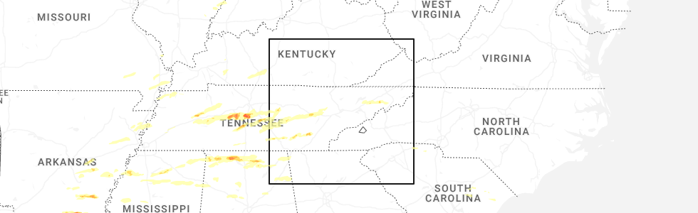
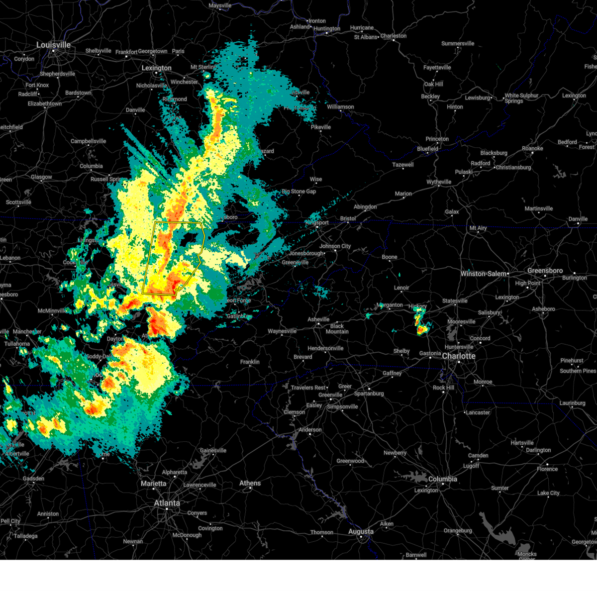
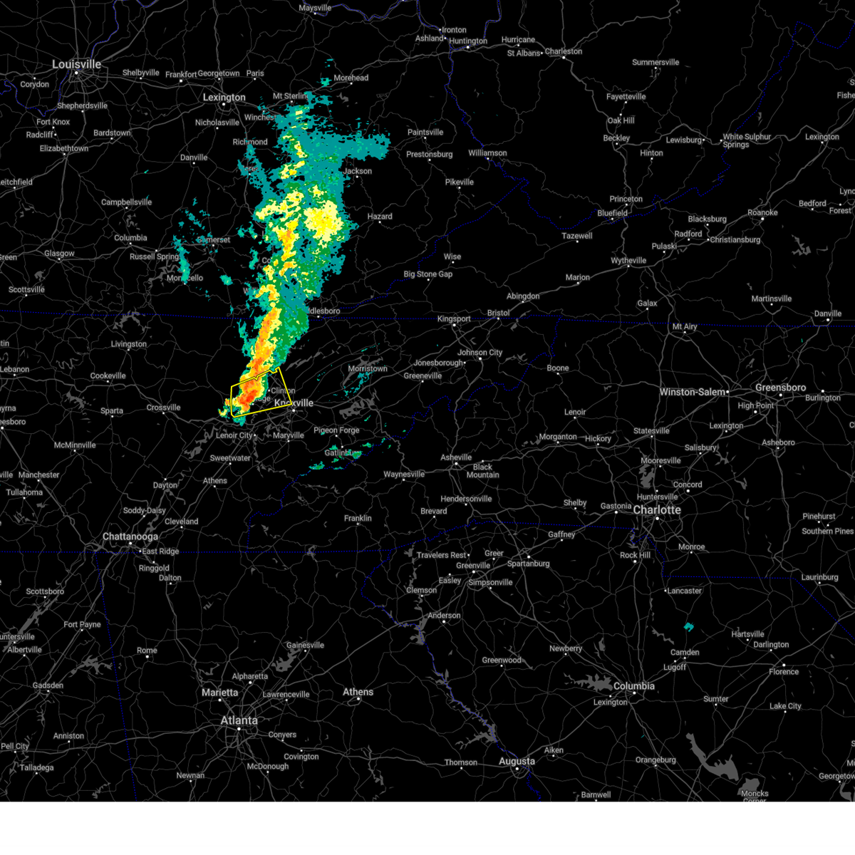
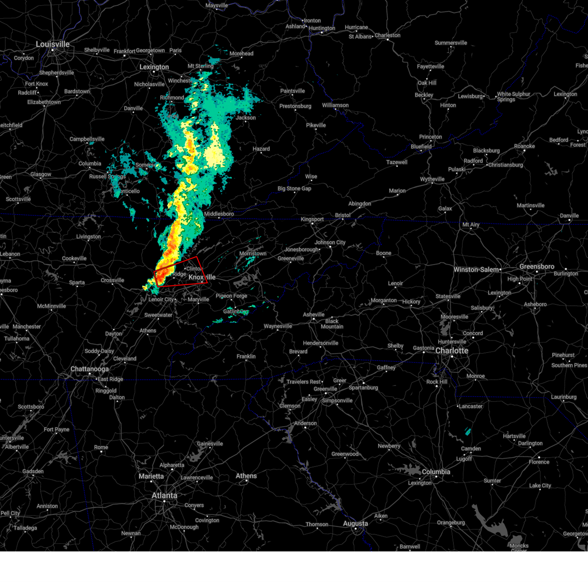
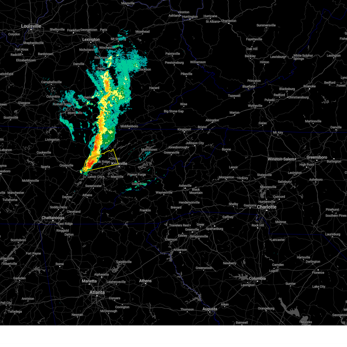
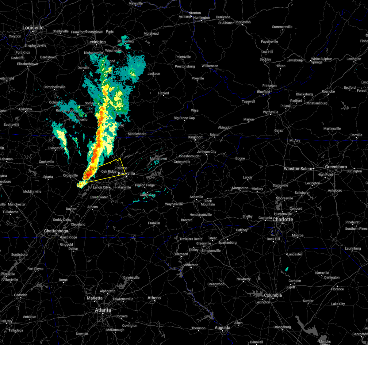
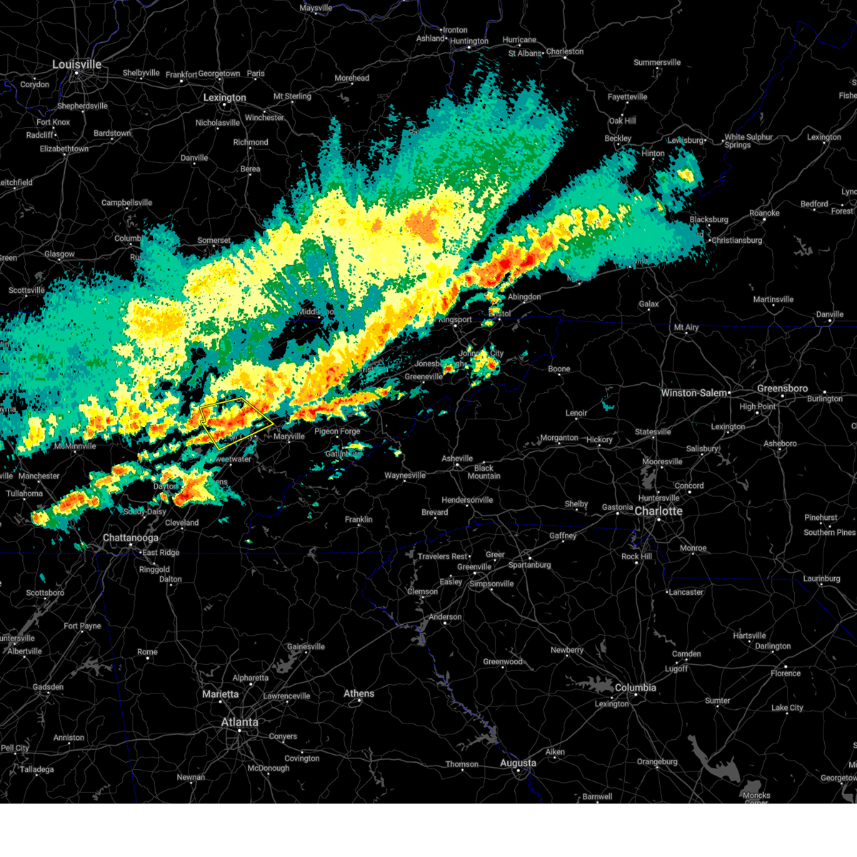
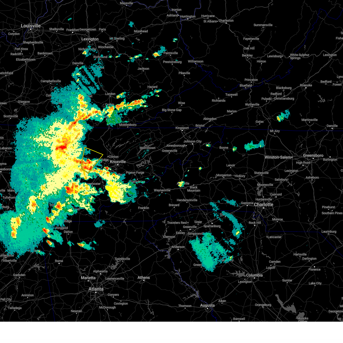
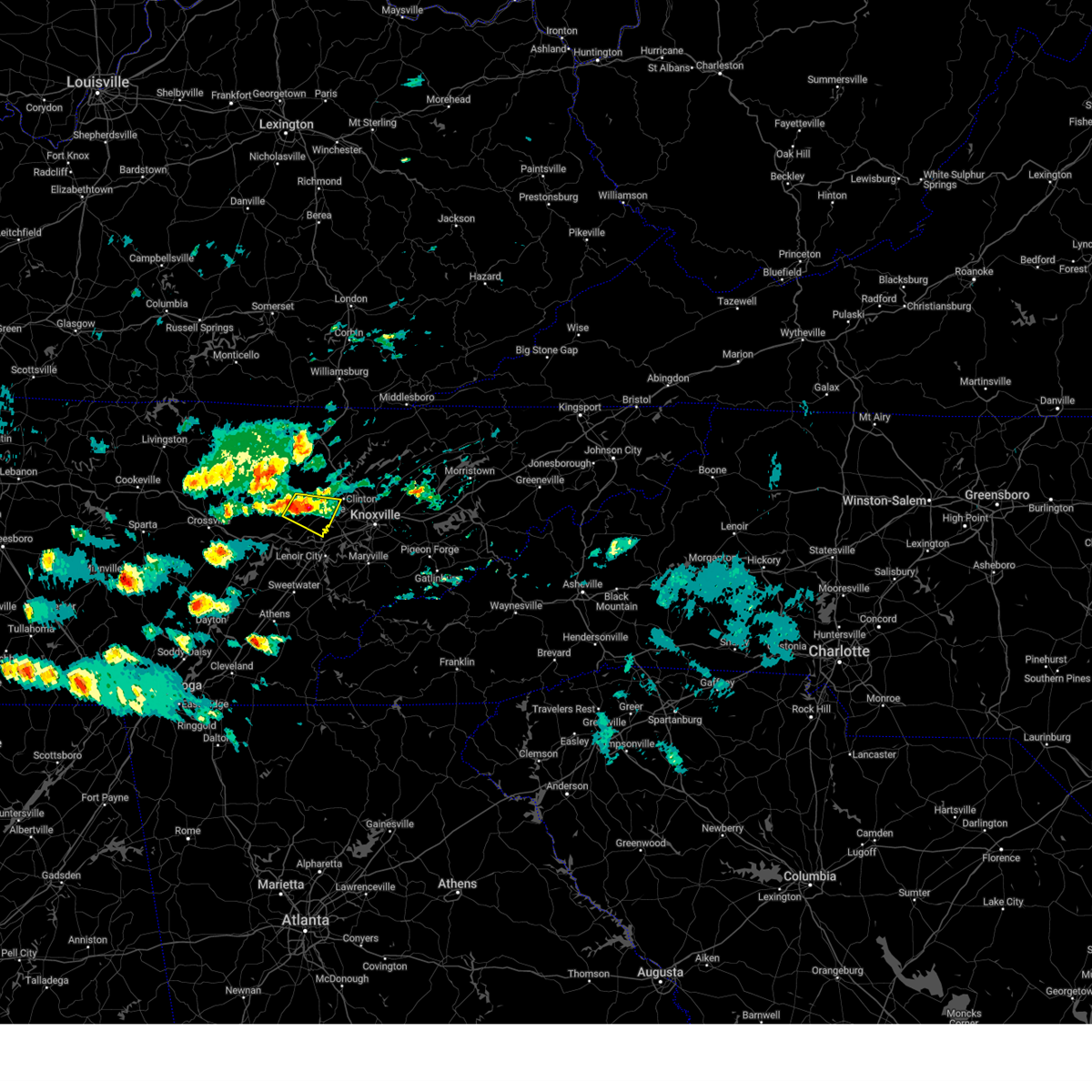
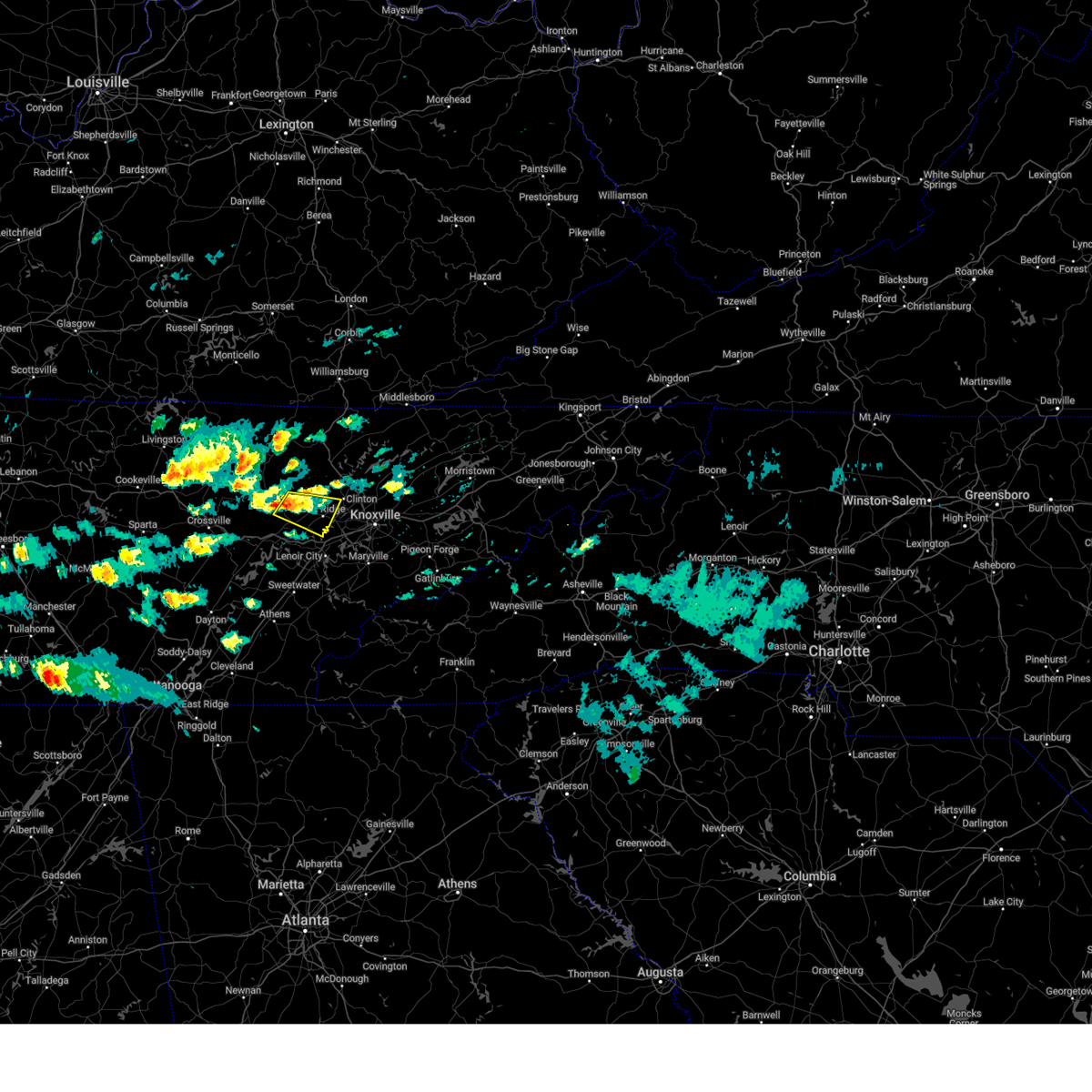
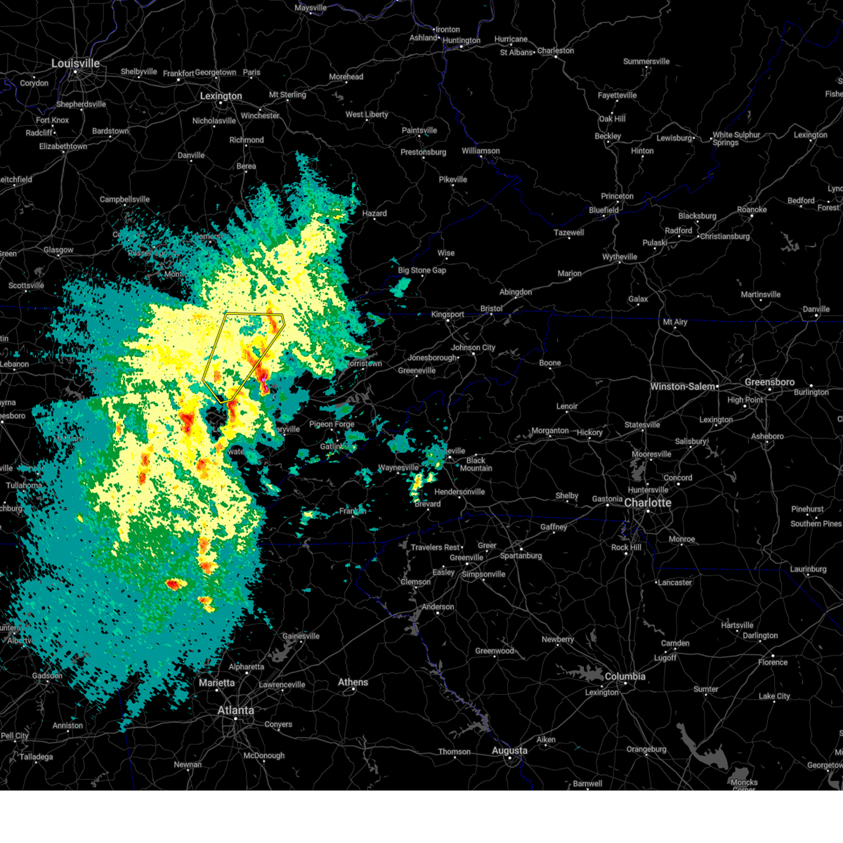
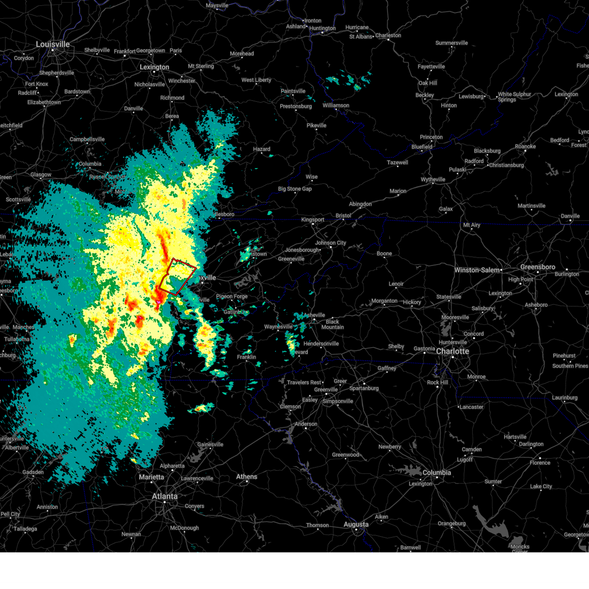
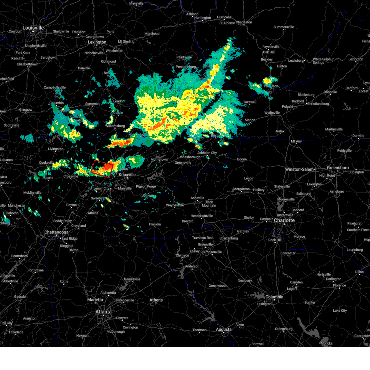
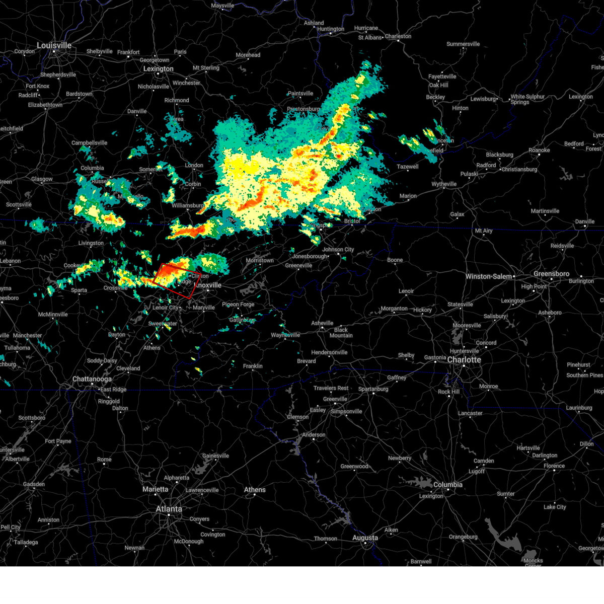
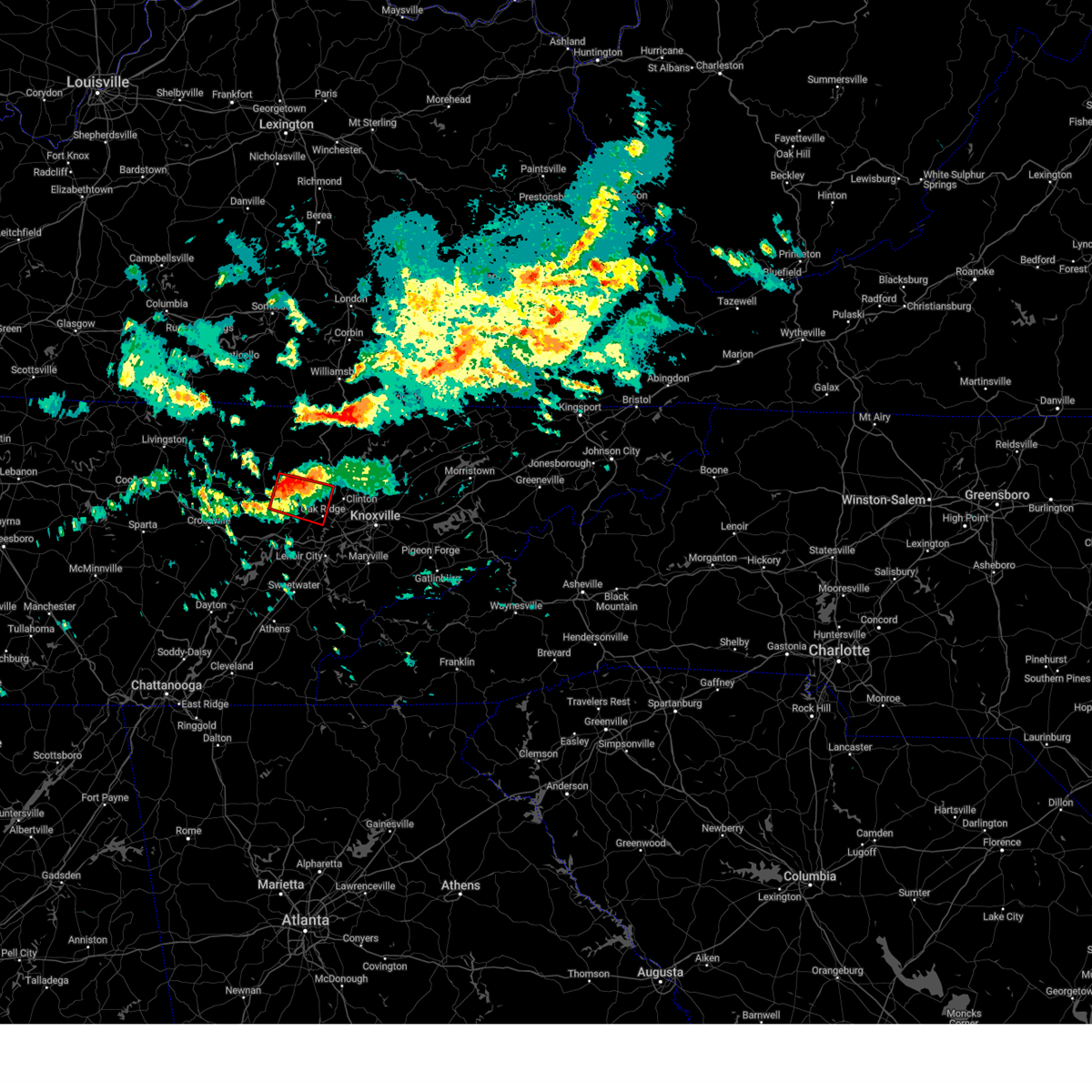
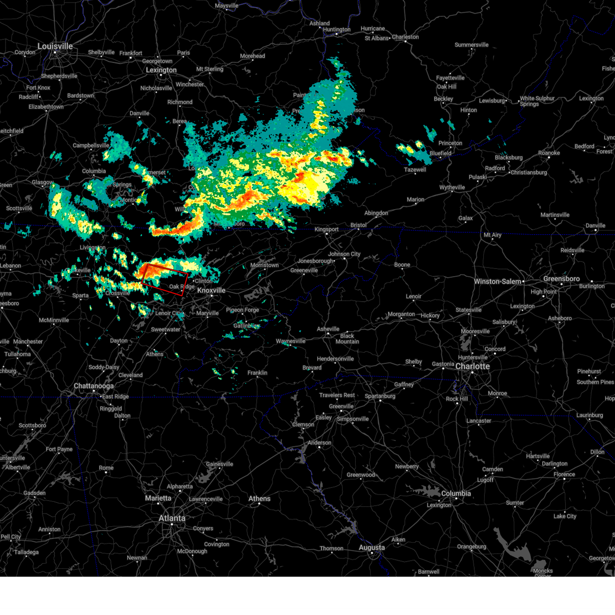
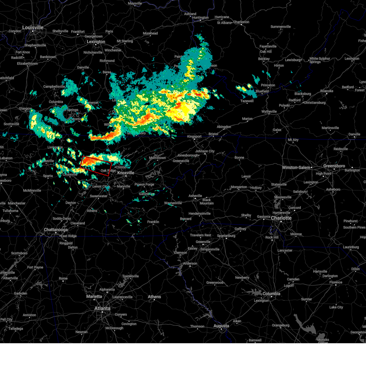
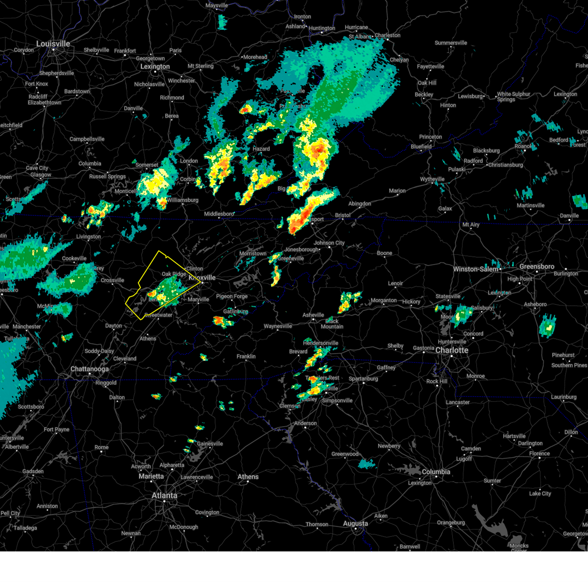
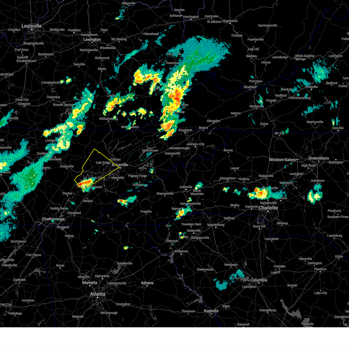
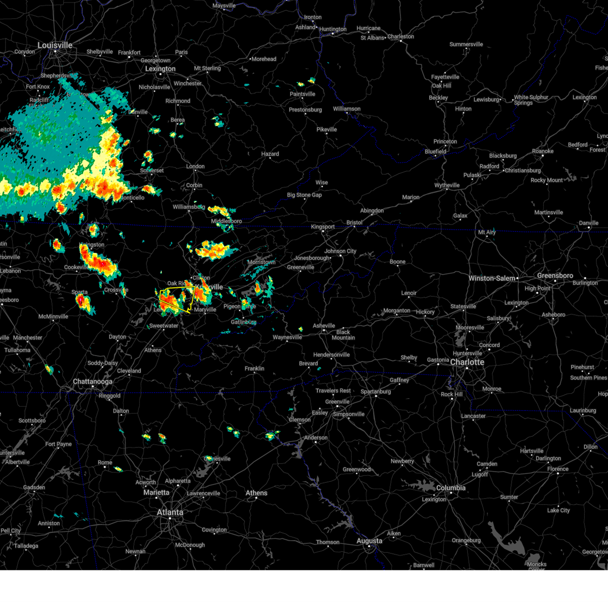
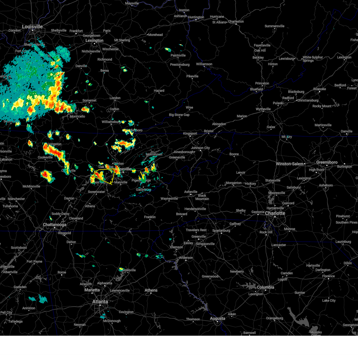
Hail Map for Coalfield, TN
The Coalfield, TN area has had 0 reports of on-the-ground hail by trained spotters, and has been under severe weather warnings 42 times during the past 12 months. Doppler radar has detected hail at or near Coalfield, TN on 58 occasions, including 6 occasions during the past year.
| Name: | Coalfield, TN |
| Where Located: | 29.2 miles W of Knoxville, TN |
| Map: | Google Map for Coalfield, TN |
| Population: | 2463 |
| Housing Units: | 1033 |
| More Info: | Search Google for Coalfield, TN |
3
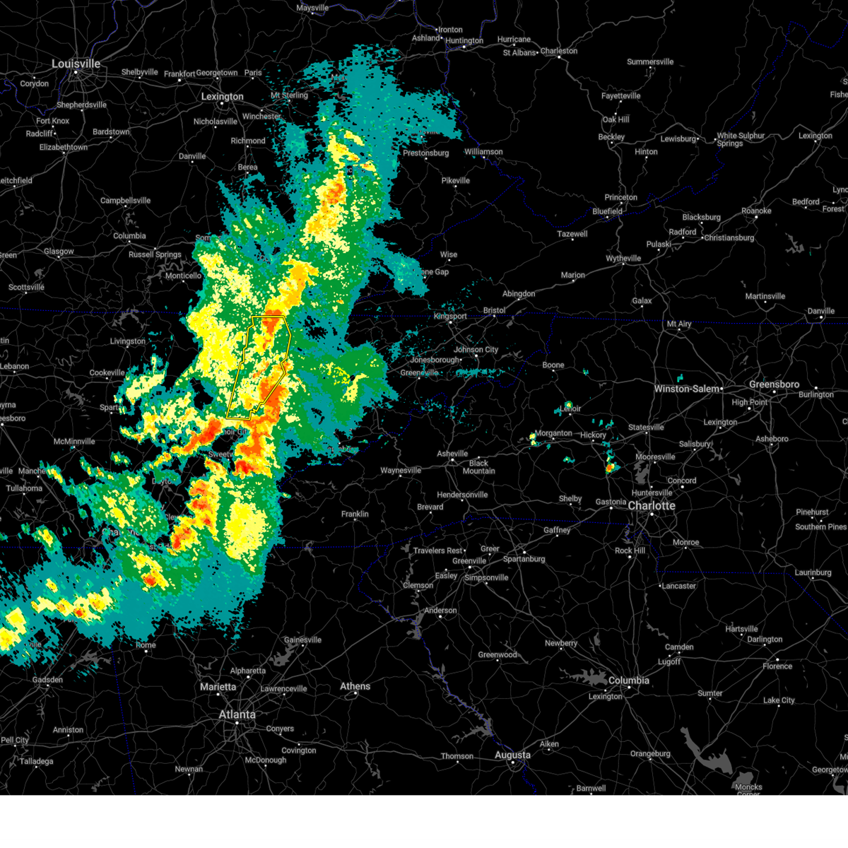
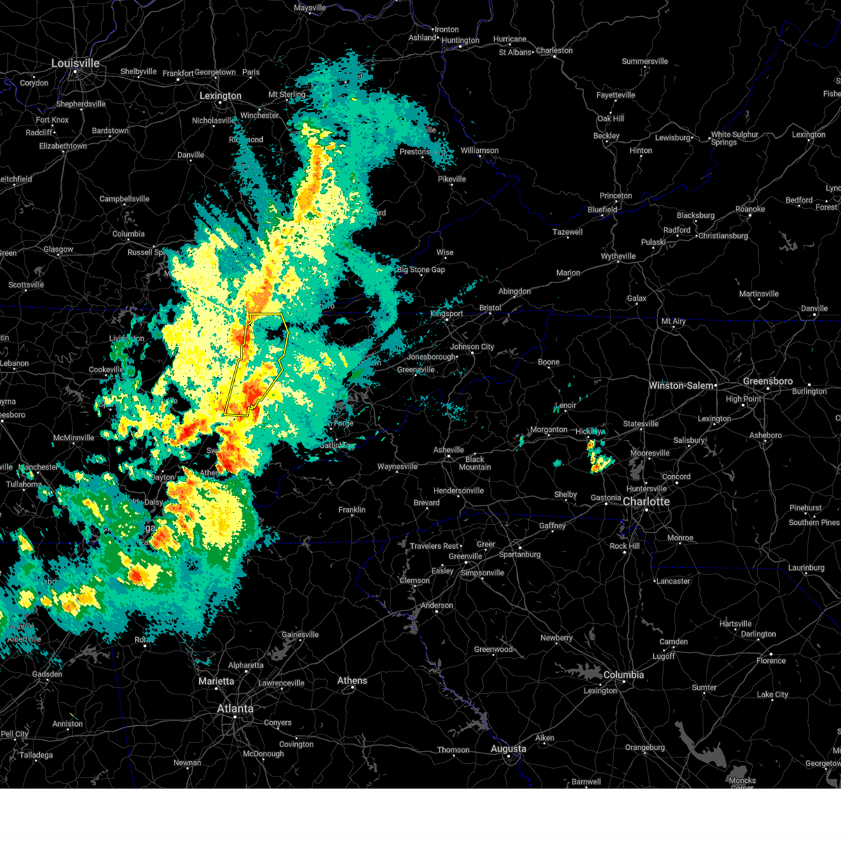
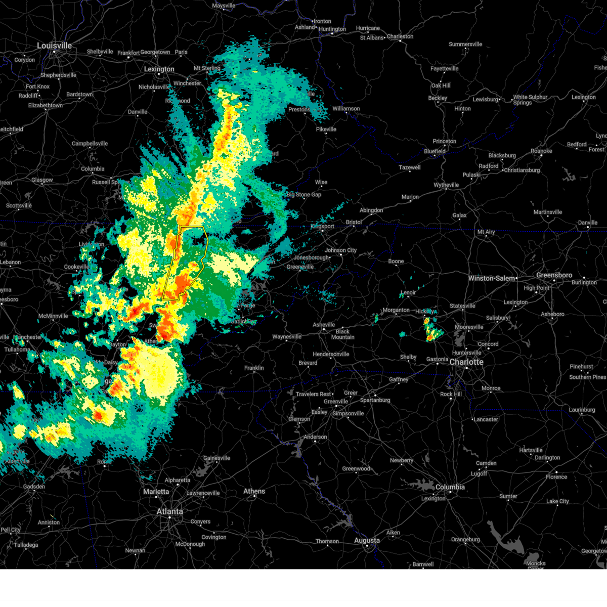
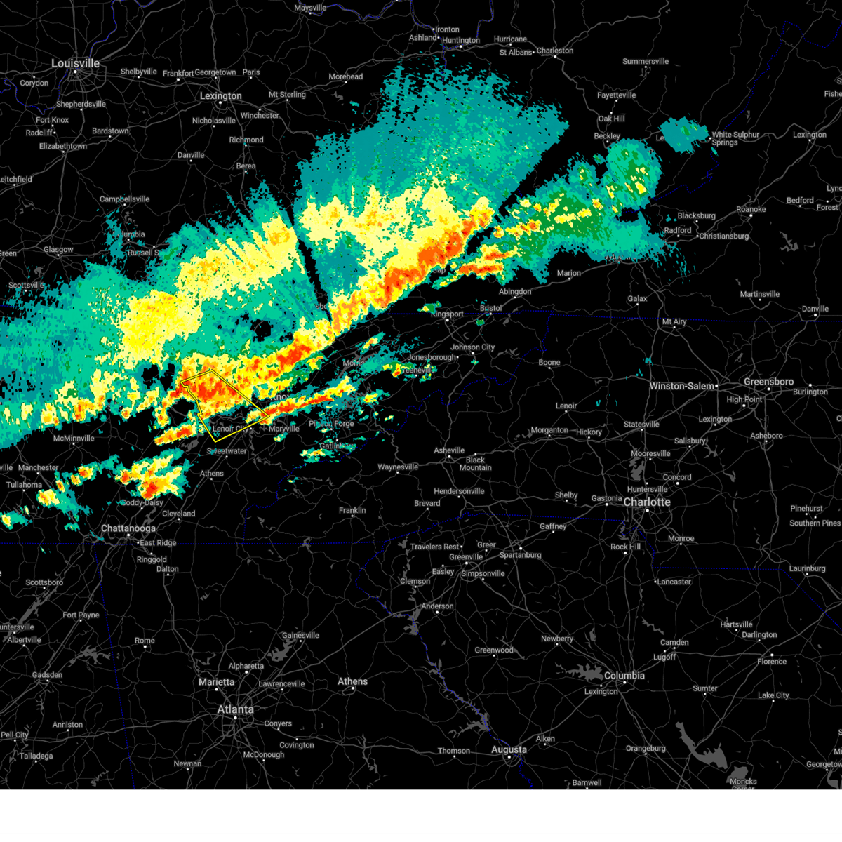
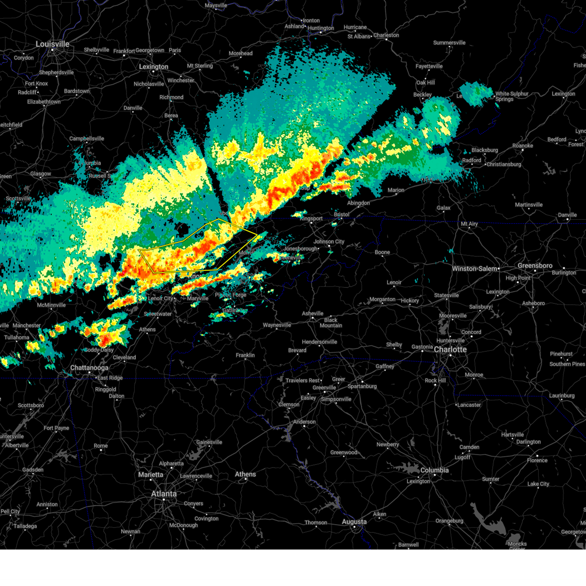
The Top Recent Hail Date for Coalfield, TN is Tuesday, May 20, 2025 (6th out of 58)
Hail and Wind Damage Spotted near Coalfield, TN
| Date / Time | Report Details |
|---|---|
| 5/20/2025 10:14 PM EDT |
 The storms which prompted the warning have moved out of the warned area. therefore, the warning will be allowed to expire. however, gusty winds are still possible with these thunderstorms. a tornado watch remains in effect until 200 am edt for east tennessee. remember, a severe thunderstorm warning still remains in effect for portions of the warned area. The storms which prompted the warning have moved out of the warned area. therefore, the warning will be allowed to expire. however, gusty winds are still possible with these thunderstorms. a tornado watch remains in effect until 200 am edt for east tennessee. remember, a severe thunderstorm warning still remains in effect for portions of the warned area.
|
| 5/20/2025 10:01 PM EDT |
 At 1000 pm edt, severe thunderstorms were located along a line extending from red ash to oak ridge, moving east at 50 mph (radar indicated). Hazards include 60 mph wind gusts and penny size hail. Expect damage to roofs, siding, and trees. locations impacted include, norris dam state park, norris, caryville, elk valley, jacksboro, andersonville, rosedale, clinton, la follette, and oliver springs. This includes interstate 75 in tennessee between mile markers 119 and 161. At 1000 pm edt, severe thunderstorms were located along a line extending from red ash to oak ridge, moving east at 50 mph (radar indicated). Hazards include 60 mph wind gusts and penny size hail. Expect damage to roofs, siding, and trees. locations impacted include, norris dam state park, norris, caryville, elk valley, jacksboro, andersonville, rosedale, clinton, la follette, and oliver springs. This includes interstate 75 in tennessee between mile markers 119 and 161.
|
| 5/20/2025 10:01 PM EDT |
 the severe thunderstorm warning has been cancelled and is no longer in effect the severe thunderstorm warning has been cancelled and is no longer in effect
|
| 5/20/2025 9:50 PM EDT |
 At 949 pm edt, severe thunderstorms were located along a line extending from near zion hill to near kingston, moving east at 50 mph (radar indicated. widespread reports of trees down across parts of the warned area). Hazards include 60 mph wind gusts and quarter size hail. Hail damage to vehicles is expected. expect wind damage to roofs, siding, and trees. locations impacted include, norris dam state park, caryville, elk valley, coalfield, huntsville, smokey junction, winfield, rosedale, oakdale, and robbins. this includes the following highways, interstate 40 in tennessee between mile markers 344 and 351. Interstate 75 in tennessee between mile markers 119 and 161. At 949 pm edt, severe thunderstorms were located along a line extending from near zion hill to near kingston, moving east at 50 mph (radar indicated. widespread reports of trees down across parts of the warned area). Hazards include 60 mph wind gusts and quarter size hail. Hail damage to vehicles is expected. expect wind damage to roofs, siding, and trees. locations impacted include, norris dam state park, caryville, elk valley, coalfield, huntsville, smokey junction, winfield, rosedale, oakdale, and robbins. this includes the following highways, interstate 40 in tennessee between mile markers 344 and 351. Interstate 75 in tennessee between mile markers 119 and 161.
|
| 5/20/2025 9:35 PM EDT |
 At 935 pm edt, severe thunderstorms were located along a line extending from near strunk to near rockwood, moving east at 45 mph (radar indicated). Hazards include 60 mph wind gusts and quarter size hail. Hail damage to vehicles is expected. expect wind damage to roofs, siding, and trees. locations impacted include, norris dam state park, rugby, caryville, high point, elk valley, coalfield, huntsville, smokey junction, winfield, and honey creek state park. this includes the following highways, interstate 40 in tennessee between mile markers 344 and 351. Interstate 75 in tennessee between mile markers 119 and 161. At 935 pm edt, severe thunderstorms were located along a line extending from near strunk to near rockwood, moving east at 45 mph (radar indicated). Hazards include 60 mph wind gusts and quarter size hail. Hail damage to vehicles is expected. expect wind damage to roofs, siding, and trees. locations impacted include, norris dam state park, rugby, caryville, high point, elk valley, coalfield, huntsville, smokey junction, winfield, and honey creek state park. this includes the following highways, interstate 40 in tennessee between mile markers 344 and 351. Interstate 75 in tennessee between mile markers 119 and 161.
|
| 5/20/2025 9:25 PM EDT |
 Svrmrx the national weather service in morristown has issued a * severe thunderstorm warning for, southeastern morgan county in east tennessee, northeastern loudon county in east tennessee, southwestern anderson county in east tennessee, knox county in east tennessee, northwestern blount county in east tennessee, northeastern roane county in east tennessee, * until 1030 pm edt. * at 925 pm edt, a severe thunderstorm was located over kingston, moving east at 45 mph (radar indicated). Hazards include 60 mph wind gusts and quarter size hail. Hail damage to vehicles is expected. Expect wind damage to roofs, siding, and trees. Svrmrx the national weather service in morristown has issued a * severe thunderstorm warning for, southeastern morgan county in east tennessee, northeastern loudon county in east tennessee, southwestern anderson county in east tennessee, knox county in east tennessee, northwestern blount county in east tennessee, northeastern roane county in east tennessee, * until 1030 pm edt. * at 925 pm edt, a severe thunderstorm was located over kingston, moving east at 45 mph (radar indicated). Hazards include 60 mph wind gusts and quarter size hail. Hail damage to vehicles is expected. Expect wind damage to roofs, siding, and trees.
|
| 5/20/2025 9:14 PM EDT |
 Svrmrx the national weather service in morristown has issued a * severe thunderstorm warning for, morgan county in east tennessee, anderson county in east tennessee, campbell county in east tennessee, northern roane county in east tennessee, scott county in east tennessee, * until 1015 pm edt. * at 913 pm edt, severe thunderstorms were located along a line extending from near mount pisgah to 6 miles west of crossville, moving east at 50 mph (radar indicated). Hazards include 60 mph wind gusts and half dollar size hail. Hail damage to vehicles is expected. Expect wind damage to roofs, siding, and trees. Svrmrx the national weather service in morristown has issued a * severe thunderstorm warning for, morgan county in east tennessee, anderson county in east tennessee, campbell county in east tennessee, northern roane county in east tennessee, scott county in east tennessee, * until 1015 pm edt. * at 913 pm edt, severe thunderstorms were located along a line extending from near mount pisgah to 6 miles west of crossville, moving east at 50 mph (radar indicated). Hazards include 60 mph wind gusts and half dollar size hail. Hail damage to vehicles is expected. Expect wind damage to roofs, siding, and trees.
|
| 5/20/2025 9:12 PM EDT |
 At 911 pm edt, a severe thunderstorm capable of producing a tornado was located over midtown, or near rockwood, moving east at 35 mph (radar indicated rotation). Hazards include tornado and half dollar size hail. Flying debris will be dangerous to those caught without shelter. mobile homes will be damaged or destroyed. damage to roofs, windows, and vehicles will occur. tree damage is likely. this dangerous storm will be near, midtown and kingston around 915 pm edt. oak ridge around 920 pm edt. other locations impacted by this tornadic thunderstorm include coalfield, oakdale, harriman, eagle furnace, pine orchard, and dearmond. This includes interstate 40 in tennessee between mile markers 341 and 359. At 911 pm edt, a severe thunderstorm capable of producing a tornado was located over midtown, or near rockwood, moving east at 35 mph (radar indicated rotation). Hazards include tornado and half dollar size hail. Flying debris will be dangerous to those caught without shelter. mobile homes will be damaged or destroyed. damage to roofs, windows, and vehicles will occur. tree damage is likely. this dangerous storm will be near, midtown and kingston around 915 pm edt. oak ridge around 920 pm edt. other locations impacted by this tornadic thunderstorm include coalfield, oakdale, harriman, eagle furnace, pine orchard, and dearmond. This includes interstate 40 in tennessee between mile markers 341 and 359.
|
| 5/20/2025 8:46 PM EDT | Tormrx the national weather service in morristown has issued a * tornado warning for, southeastern morgan county in east tennessee, northeastern rhea county in east tennessee, roane county in east tennessee, * until 945 pm edt. * at 845 pm edt, a severe thunderstorm capable of producing a tornado was located 10 miles southeast of crossville, moving east at 35 mph (radar indicated rotation). Hazards include tornado and half dollar size hail. Flying debris will be dangerous to those caught without shelter. mobile homes will be damaged or destroyed. damage to roofs, windows, and vehicles will occur. tree damage is likely. this dangerous storm will be near, rockwood around 900 pm edt. midtown around 910 pm edt. kingston around 915 pm edt. oak ridge around 925 pm edt. other locations impacted by this tornadic thunderstorm include coalfield, oakdale, harriman, eagle furnace, pine orchard, and dearmond. This includes interstate 40 in tennessee between mile markers 341 and 359. |
| 5/20/2025 3:08 PM EDT |
 At 308 pm edt, a severe thunderstorm was located near oliver springs, or near oak ridge, moving east at 35 mph (radar indicated). Hazards include 60 mph wind gusts and penny size hail. Expect damage to roofs, siding, and trees. locations impacted include, norris dam state park, norris, coalfield, andersonville, powell, clinton, petros, oliver springs, oak ridge, and rocky top. This includes interstate 75 in tennessee between mile markers 109 and 127. At 308 pm edt, a severe thunderstorm was located near oliver springs, or near oak ridge, moving east at 35 mph (radar indicated). Hazards include 60 mph wind gusts and penny size hail. Expect damage to roofs, siding, and trees. locations impacted include, norris dam state park, norris, coalfield, andersonville, powell, clinton, petros, oliver springs, oak ridge, and rocky top. This includes interstate 75 in tennessee between mile markers 109 and 127.
|
| 5/20/2025 3:00 PM EDT |
 Tormrx the national weather service in morristown has issued a * tornado warning for, southeastern morgan county in east tennessee, anderson county in east tennessee, central knox county in east tennessee, northeastern roane county in east tennessee, * until 345 pm edt. * at 259 pm edt, a severe thunderstorm capable of producing a tornado was located near oliver springs, or near oak ridge, moving east at 35 mph (radar indicated rotation). Hazards include tornado and quarter size hail. Flying debris will be dangerous to those caught without shelter. mobile homes will be damaged or destroyed. damage to roofs, windows, and vehicles will occur. tree damage is likely. this dangerous storm will be near, oliver springs and oak ridge around 305 pm edt. clinton around 320 pm edt. knoxville around 330 pm edt. other locations impacted by this tornadic thunderstorm include coalfield, andersonville, powell, halls, karns, dearmond, norris, and petros. this includes the following highways, interstate 40 in tennessee between mile markers 385 and 391. Interstate 75 in tennessee between mile markers 108 and 124. Tormrx the national weather service in morristown has issued a * tornado warning for, southeastern morgan county in east tennessee, anderson county in east tennessee, central knox county in east tennessee, northeastern roane county in east tennessee, * until 345 pm edt. * at 259 pm edt, a severe thunderstorm capable of producing a tornado was located near oliver springs, or near oak ridge, moving east at 35 mph (radar indicated rotation). Hazards include tornado and quarter size hail. Flying debris will be dangerous to those caught without shelter. mobile homes will be damaged or destroyed. damage to roofs, windows, and vehicles will occur. tree damage is likely. this dangerous storm will be near, oliver springs and oak ridge around 305 pm edt. clinton around 320 pm edt. knoxville around 330 pm edt. other locations impacted by this tornadic thunderstorm include coalfield, andersonville, powell, halls, karns, dearmond, norris, and petros. this includes the following highways, interstate 40 in tennessee between mile markers 385 and 391. Interstate 75 in tennessee between mile markers 108 and 124.
|
| 5/20/2025 2:50 PM EDT |
 At 250 pm edt, a severe thunderstorm was located 8 miles southwest of oliver springs, or 8 miles north of kingston, moving east at 35 mph (radar indicated). Hazards include 60 mph wind gusts and penny size hail. Expect damage to roofs, siding, and trees. locations impacted include, norris dam state park, norris, coalfield, andersonville, pine orchard, oakdale, clinton, oliver springs, dearmond, and rocky top. this includes the following highways, interstate 40 in tennessee between mile markers 343 and 349. Interstate 75 in tennessee between mile markers 109 and 127. At 250 pm edt, a severe thunderstorm was located 8 miles southwest of oliver springs, or 8 miles north of kingston, moving east at 35 mph (radar indicated). Hazards include 60 mph wind gusts and penny size hail. Expect damage to roofs, siding, and trees. locations impacted include, norris dam state park, norris, coalfield, andersonville, pine orchard, oakdale, clinton, oliver springs, dearmond, and rocky top. this includes the following highways, interstate 40 in tennessee between mile markers 343 and 349. Interstate 75 in tennessee between mile markers 109 and 127.
|
| 5/20/2025 2:37 PM EDT |
 Svrmrx the national weather service in morristown has issued a * severe thunderstorm warning for, southeastern morgan county in east tennessee, anderson county in east tennessee, central knox county in east tennessee, northern roane county in east tennessee, * until 330 pm edt. * at 236 pm edt, a severe thunderstorm was located near midtown, or 8 miles northeast of rockwood, moving east at 35 mph (radar indicated). Hazards include 60 mph wind gusts and penny size hail. expect damage to roofs, siding, and trees Svrmrx the national weather service in morristown has issued a * severe thunderstorm warning for, southeastern morgan county in east tennessee, anderson county in east tennessee, central knox county in east tennessee, northern roane county in east tennessee, * until 330 pm edt. * at 236 pm edt, a severe thunderstorm was located near midtown, or 8 miles northeast of rockwood, moving east at 35 mph (radar indicated). Hazards include 60 mph wind gusts and penny size hail. expect damage to roofs, siding, and trees
|
| 5/17/2025 2:32 AM EDT |
 At 232 am edt, severe thunderstorms were located along a line extending from near oak ridge to near midtown, moving southeast at 25 mph (radar indicated). Hazards include 60 mph wind gusts and nickel size hail. Expect damage to roofs, siding, and trees. locations impacted include, paint rock, coalfield, bradbury, pine orchard, lenoir city, kingston, oakdale, farragut, rockwood, and dearmond. this includes the following highways, interstate 40 in tennessee between mile markers 341 and 375. Interstate 75 in tennessee between mile markers 77 and 84. At 232 am edt, severe thunderstorms were located along a line extending from near oak ridge to near midtown, moving southeast at 25 mph (radar indicated). Hazards include 60 mph wind gusts and nickel size hail. Expect damage to roofs, siding, and trees. locations impacted include, paint rock, coalfield, bradbury, pine orchard, lenoir city, kingston, oakdale, farragut, rockwood, and dearmond. this includes the following highways, interstate 40 in tennessee between mile markers 341 and 375. Interstate 75 in tennessee between mile markers 77 and 84.
|
| 5/17/2025 2:08 AM EDT |
 Svrmrx the national weather service in morristown has issued a * severe thunderstorm warning for, southern morgan county in east tennessee, northeastern loudon county in east tennessee, southwestern anderson county in east tennessee, southwestern knox county in east tennessee, roane county in east tennessee, * until 300 am edt. * at 208 am edt, severe thunderstorms were located along a line extending from 7 miles southeast of wartburg to 6 miles northwest of rockwood, moving southeast at 25 mph (radar indicated). Hazards include 60 mph wind gusts and nickel size hail. expect damage to roofs, siding, and trees Svrmrx the national weather service in morristown has issued a * severe thunderstorm warning for, southern morgan county in east tennessee, northeastern loudon county in east tennessee, southwestern anderson county in east tennessee, southwestern knox county in east tennessee, roane county in east tennessee, * until 300 am edt. * at 208 am edt, severe thunderstorms were located along a line extending from 7 miles southeast of wartburg to 6 miles northwest of rockwood, moving southeast at 25 mph (radar indicated). Hazards include 60 mph wind gusts and nickel size hail. expect damage to roofs, siding, and trees
|
| 5/17/2025 2:05 AM EDT |
 At 205 am edt, severe thunderstorms were located along a line extending from near tazewell to 8 miles west of maynardville to 7 miles north of oliver springs, moving east at 45 mph (radar indicated). Hazards include 70 mph wind gusts and nickel size hail. Expect considerable tree damage. damage is likely to mobile homes, roofs, and outbuildings. locations impacted include, norris dam state park, luttrell, lone mountain, caryville, howard quarter, arthur, smokey junction, new tazewell, maynardville, and rosedale. This includes interstate 75 in tennessee between mile markers 114 and 139. At 205 am edt, severe thunderstorms were located along a line extending from near tazewell to 8 miles west of maynardville to 7 miles north of oliver springs, moving east at 45 mph (radar indicated). Hazards include 70 mph wind gusts and nickel size hail. Expect considerable tree damage. damage is likely to mobile homes, roofs, and outbuildings. locations impacted include, norris dam state park, luttrell, lone mountain, caryville, howard quarter, arthur, smokey junction, new tazewell, maynardville, and rosedale. This includes interstate 75 in tennessee between mile markers 114 and 139.
|
| 5/17/2025 1:39 AM EDT | Svrmrx the national weather service in morristown has issued a * severe thunderstorm warning for, central morgan county in east tennessee, claiborne county in east tennessee, anderson county in east tennessee, northeastern knox county in east tennessee, southwestern hancock county in east tennessee, campbell county in east tennessee, grainger county in east tennessee, southern scott county in east tennessee, union county in east tennessee, * until 230 am edt. * at 139 am edt, severe thunderstorms were located along a line extending from near fonde to near jacksboro to 8 miles north of wartburg, moving east at 45 mph (radar indicated). Hazards include 60 mph wind gusts and quarter size hail. Hail damage to vehicles is expected. Expect wind damage to roofs, siding, and trees. |
| 5/8/2025 8:06 PM EDT |
 Svrmrx the national weather service in morristown has issued a * severe thunderstorm warning for, southern morgan county in east tennessee, northwestern roane county in east tennessee, * until 845 pm edt. * at 806 pm edt, a severe thunderstorm was located 7 miles southeast of fairfield glade, or 7 miles northwest of rockwood, moving northeast at 35 mph (radar indicated). Hazards include 60 mph wind gusts and half dollar size hail. Hail damage to vehicles is expected. Expect wind damage to roofs, siding, and trees. Svrmrx the national weather service in morristown has issued a * severe thunderstorm warning for, southern morgan county in east tennessee, northwestern roane county in east tennessee, * until 845 pm edt. * at 806 pm edt, a severe thunderstorm was located 7 miles southeast of fairfield glade, or 7 miles northwest of rockwood, moving northeast at 35 mph (radar indicated). Hazards include 60 mph wind gusts and half dollar size hail. Hail damage to vehicles is expected. Expect wind damage to roofs, siding, and trees.
|
| 5/2/2025 5:36 PM EDT | At 536 pm edt, a severe thunderstorm was located near wartburg, moving northeast at 30 mph (radar indicated). Hazards include 60 mph wind gusts and quarter size hail. Hail damage to vehicles is expected. expect wind damage to roofs, siding, and trees. Locations impacted include, coalfield, wartburg, rosedale, frozen head state park, petros, dearmond, oliver springs, and oakdale. |
| 5/2/2025 5:21 PM EDT | At 521 pm edt, a severe thunderstorm was located near wartburg, moving northeast at 30 mph (radar indicated). Hazards include 60 mph wind gusts and penny size hail. Expect damage to roofs, siding, and trees. Locations impacted include, coalfield, wartburg, rosedale, frozen head state park, petros, dearmond, oliver springs, and oakdale. |
| 5/2/2025 5:04 PM EDT |
 Svrmrx the national weather service in morristown has issued a * severe thunderstorm warning for, southeastern morgan county in east tennessee, west central anderson county in east tennessee, northwestern roane county in east tennessee, south central scott county in east tennessee, * until 545 pm edt. * at 504 pm edt, a severe thunderstorm was located over midtown, or near rockwood, moving northeast at 30 mph (radar indicated). Hazards include 60 mph wind gusts and penny size hail. expect damage to roofs, siding, and trees Svrmrx the national weather service in morristown has issued a * severe thunderstorm warning for, southeastern morgan county in east tennessee, west central anderson county in east tennessee, northwestern roane county in east tennessee, south central scott county in east tennessee, * until 545 pm edt. * at 504 pm edt, a severe thunderstorm was located over midtown, or near rockwood, moving northeast at 30 mph (radar indicated). Hazards include 60 mph wind gusts and penny size hail. expect damage to roofs, siding, and trees
|
| 4/10/2025 5:44 PM EDT |
 the severe thunderstorm warning has been cancelled and is no longer in effect the severe thunderstorm warning has been cancelled and is no longer in effect
|
| 4/10/2025 5:33 PM EDT |
 At 533 pm edt, a severe thunderstorm was located 7 miles north of kingston, moving southeast at 30 mph (radar indicated). Hazards include 60 mph wind gusts and quarter size hail. Hail damage to vehicles is expected. expect wind damage to roofs, siding, and trees. locations impacted include, coalfield, oakdale, dearmond, oliver springs, harriman, kingston, and oak ridge. This includes interstate 40 in tennessee near mile marker 357. At 533 pm edt, a severe thunderstorm was located 7 miles north of kingston, moving southeast at 30 mph (radar indicated). Hazards include 60 mph wind gusts and quarter size hail. Hail damage to vehicles is expected. expect wind damage to roofs, siding, and trees. locations impacted include, coalfield, oakdale, dearmond, oliver springs, harriman, kingston, and oak ridge. This includes interstate 40 in tennessee near mile marker 357.
|
| 4/10/2025 5:21 PM EDT | the severe thunderstorm warning has been cancelled and is no longer in effect |
| 4/10/2025 5:14 PM EDT | Svrmrx the national weather service in morristown has issued a * severe thunderstorm warning for, southeastern morgan county in east tennessee, northeastern roane county in east tennessee, * until 600 pm edt. * at 514 pm edt, a severe thunderstorm was located near wartburg, moving southeast at 25 mph (radar indicated). Hazards include 60 mph wind gusts and quarter size hail. Hail damage to vehicles is expected. Expect wind damage to roofs, siding, and trees. |
| 4/10/2025 5:04 PM EDT |
 At 504 pm edt, a severe thunderstorm was located over oliver springs, or near oak ridge, moving east at 15 mph (radar indicated). Hazards include 60 mph wind gusts and quarter size hail. Hail damage to vehicles is expected. expect wind damage to roofs, siding, and trees. Locations impacted include, coalfield, oliver springs, oak ridge, and clinton. At 504 pm edt, a severe thunderstorm was located over oliver springs, or near oak ridge, moving east at 15 mph (radar indicated). Hazards include 60 mph wind gusts and quarter size hail. Hail damage to vehicles is expected. expect wind damage to roofs, siding, and trees. Locations impacted include, coalfield, oliver springs, oak ridge, and clinton.
|
| 4/10/2025 5:04 PM EDT |
 the severe thunderstorm warning has been cancelled and is no longer in effect the severe thunderstorm warning has been cancelled and is no longer in effect
|
| 4/10/2025 4:52 PM EDT |
 Svrmrx the national weather service in morristown has issued a * severe thunderstorm warning for, southeastern morgan county in east tennessee, southwestern anderson county in east tennessee, northeastern roane county in east tennessee, * until 545 pm edt. * at 451 pm edt, a severe thunderstorm was located near oliver springs, or 8 miles northwest of oak ridge, moving east at 15 mph (radar indicated). Hazards include 60 mph wind gusts and quarter size hail. Hail damage to vehicles is expected. Expect wind damage to roofs, siding, and trees. Svrmrx the national weather service in morristown has issued a * severe thunderstorm warning for, southeastern morgan county in east tennessee, southwestern anderson county in east tennessee, northeastern roane county in east tennessee, * until 545 pm edt. * at 451 pm edt, a severe thunderstorm was located near oliver springs, or 8 miles northwest of oak ridge, moving east at 15 mph (radar indicated). Hazards include 60 mph wind gusts and quarter size hail. Hail damage to vehicles is expected. Expect wind damage to roofs, siding, and trees.
|
| 4/10/2025 4:34 PM EDT |
 Svrmrx the national weather service in morristown has issued a * severe thunderstorm warning for, southeastern morgan county in east tennessee, southwestern anderson county in east tennessee, northeastern roane county in east tennessee, * until 530 pm edt. * at 434 pm edt, a severe thunderstorm was located 7 miles southeast of wartburg, moving east at 20 mph (radar indicated). Hazards include 60 mph wind gusts and quarter size hail. Hail damage to vehicles is expected. Expect wind damage to roofs, siding, and trees. Svrmrx the national weather service in morristown has issued a * severe thunderstorm warning for, southeastern morgan county in east tennessee, southwestern anderson county in east tennessee, northeastern roane county in east tennessee, * until 530 pm edt. * at 434 pm edt, a severe thunderstorm was located 7 miles southeast of wartburg, moving east at 20 mph (radar indicated). Hazards include 60 mph wind gusts and quarter size hail. Hail damage to vehicles is expected. Expect wind damage to roofs, siding, and trees.
|
| 3/15/2025 8:35 PM EDT |
 The storm which prompted the warning has weakened below severe limits, and has exited the warned area. therefore, the warning will be allowed to expire. however, gusty winds and heavy rain are still possible with this thunderstorm. a tornado watch remains in effect until 100 am edt for east tennessee. The storm which prompted the warning has weakened below severe limits, and has exited the warned area. therefore, the warning will be allowed to expire. however, gusty winds and heavy rain are still possible with this thunderstorm. a tornado watch remains in effect until 100 am edt for east tennessee.
|
| 3/15/2025 8:14 PM EDT | At 814 pm edt, a confirmed tornado was located over oak ridge, moving northeast at 45 mph (weather spotters confirmed tornado). Hazards include damaging tornado and quarter size hail. Flying debris will be dangerous to those caught without shelter. mobile homes will be damaged or destroyed. damage to roofs, windows, and vehicles will occur. tree damage is likely. this tornado will be near, oliver springs and oak ridge around 820 pm edt. clinton around 825 pm edt. other locations impacted by this tornadic thunderstorm include coalfield. this includes the following highways, interstate 40 in tennessee between mile markers 362 and 371. Interstate 75 in tennessee between mile markers 83 and 84, and between mile markers 116 and 118. |
| 3/15/2025 8:02 PM EDT |
 Tormrx the national weather service in morristown has issued a * tornado warning for, north central loudon county in east tennessee, central anderson county in east tennessee, northwestern knox county in east tennessee, northeastern roane county in east tennessee, * until 845 pm edt. * at 802 pm edt, a confirmed tornado was located near loudon, moving northeast at 50 mph (weather spotters confirmed tornado). Hazards include damaging tornado and quarter size hail. Flying debris will be dangerous to those caught without shelter. mobile homes will be damaged or destroyed. damage to roofs, windows, and vehicles will occur. tree damage is likely. the tornado will be near, lenoir city and oak ridge around 805 pm edt. oliver springs around 815 pm edt. clinton around 825 pm edt. other locations impacted by this tornadic thunderstorm include coalfield. this includes the following highways, interstate 40 in tennessee between mile markers 362 and 371. Interstate 75 in tennessee between mile markers 83 and 84, and between mile markers 116 and 118. Tormrx the national weather service in morristown has issued a * tornado warning for, north central loudon county in east tennessee, central anderson county in east tennessee, northwestern knox county in east tennessee, northeastern roane county in east tennessee, * until 845 pm edt. * at 802 pm edt, a confirmed tornado was located near loudon, moving northeast at 50 mph (weather spotters confirmed tornado). Hazards include damaging tornado and quarter size hail. Flying debris will be dangerous to those caught without shelter. mobile homes will be damaged or destroyed. damage to roofs, windows, and vehicles will occur. tree damage is likely. the tornado will be near, lenoir city and oak ridge around 805 pm edt. oliver springs around 815 pm edt. clinton around 825 pm edt. other locations impacted by this tornadic thunderstorm include coalfield. this includes the following highways, interstate 40 in tennessee between mile markers 362 and 371. Interstate 75 in tennessee between mile markers 83 and 84, and between mile markers 116 and 118.
|
| 3/15/2025 7:44 PM EDT | Svrmrx the national weather service in morristown has issued a * severe thunderstorm warning for, eastern morgan county in east tennessee, northwestern anderson county in east tennessee, campbell county in east tennessee, scott county in east tennessee, * until 845 pm edt. * at 744 pm edt, a severe thunderstorm was located near wartburg, moving northeast at 45 mph (radar indicated). Hazards include 60 mph wind gusts. expect damage to roofs, siding, and trees |
| 2/6/2025 8:44 PM EST |
 The tornadic thunderstorm which prompted the warning no longer has a confirmed tornado. however, it continue to show potential for a tornado so a new warning has been issued downstream. this warning will be allowed to expire to remove the confirmed tornado wording. a severe thunderstorm watch remains in effect until midnight est for east tennessee. remember, a tornado warning still remains in effect for morgan, anderson, and roane counties. The tornadic thunderstorm which prompted the warning no longer has a confirmed tornado. however, it continue to show potential for a tornado so a new warning has been issued downstream. this warning will be allowed to expire to remove the confirmed tornado wording. a severe thunderstorm watch remains in effect until midnight est for east tennessee. remember, a tornado warning still remains in effect for morgan, anderson, and roane counties.
|
| 2/6/2025 8:39 PM EST |
 Tormrx the national weather service in morristown has issued a * tornado warning for, southeastern morgan county in east tennessee, anderson county in east tennessee, northwestern knox county in east tennessee, northeastern roane county in east tennessee, southern scott county in east tennessee, * until 915 pm est. * at 839 pm est, a severe thunderstorm capable of producing a tornado was located 7 miles east of wartburg, moving east at 40 mph (radar indicated rotation). Hazards include tornado and quarter size hail. Flying debris will be dangerous to those caught without shelter. mobile homes will be damaged or destroyed. damage to roofs, windows, and vehicles will occur. tree damage is likely. this dangerous storm will be near, oliver springs around 845 pm est. oak ridge around 850 pm est. clinton around 900 pm est. other locations impacted by this tornadic thunderstorm include coalfield, rosedale, petros, karns, and frozen head state park. this includes the following highways, interstate 40 in tennessee between mile markers 373 and 376. Interstate 75 in tennessee between mile markers 116 and 118. Tormrx the national weather service in morristown has issued a * tornado warning for, southeastern morgan county in east tennessee, anderson county in east tennessee, northwestern knox county in east tennessee, northeastern roane county in east tennessee, southern scott county in east tennessee, * until 915 pm est. * at 839 pm est, a severe thunderstorm capable of producing a tornado was located 7 miles east of wartburg, moving east at 40 mph (radar indicated rotation). Hazards include tornado and quarter size hail. Flying debris will be dangerous to those caught without shelter. mobile homes will be damaged or destroyed. damage to roofs, windows, and vehicles will occur. tree damage is likely. this dangerous storm will be near, oliver springs around 845 pm est. oak ridge around 850 pm est. clinton around 900 pm est. other locations impacted by this tornadic thunderstorm include coalfield, rosedale, petros, karns, and frozen head state park. this includes the following highways, interstate 40 in tennessee between mile markers 373 and 376. Interstate 75 in tennessee between mile markers 116 and 118.
|
| 2/6/2025 8:32 PM EST |
 At 832 pm est, a confirmed tornado was located near wartburg, moving east at 55 mph (radar confirmed tornado). Hazards include damaging tornado and quarter size hail. Flying debris will be dangerous to those caught without shelter. mobile homes will be damaged or destroyed. damage to roofs, windows, and vehicles will occur. tree damage is likely. this tornado will be near, oliver springs around 840 pm est. Other locations impacted by this tornadic thunderstorm include coalfield, rosedale, frozen head state park, and petros. At 832 pm est, a confirmed tornado was located near wartburg, moving east at 55 mph (radar confirmed tornado). Hazards include damaging tornado and quarter size hail. Flying debris will be dangerous to those caught without shelter. mobile homes will be damaged or destroyed. damage to roofs, windows, and vehicles will occur. tree damage is likely. this tornado will be near, oliver springs around 840 pm est. Other locations impacted by this tornadic thunderstorm include coalfield, rosedale, frozen head state park, and petros.
|
| 2/6/2025 8:24 PM EST |
 At 823 pm est, a confirmed tornado was located near wartburg, moving east at 40 mph (radar confirmed tornado). Hazards include damaging tornado and quarter size hail. Flying debris will be dangerous to those caught without shelter. mobile homes will be damaged or destroyed. damage to roofs, windows, and vehicles will occur. tree damage is likely. this tornado will be near, wartburg around 830 pm est. Other locations impacted by this tornadic thunderstorm include coalfield, rosedale, frozen head state park, petros, and sunbright. At 823 pm est, a confirmed tornado was located near wartburg, moving east at 40 mph (radar confirmed tornado). Hazards include damaging tornado and quarter size hail. Flying debris will be dangerous to those caught without shelter. mobile homes will be damaged or destroyed. damage to roofs, windows, and vehicles will occur. tree damage is likely. this tornado will be near, wartburg around 830 pm est. Other locations impacted by this tornadic thunderstorm include coalfield, rosedale, frozen head state park, petros, and sunbright.
|
| 2/6/2025 8:19 PM EST |
 Tormrx the national weather service in morristown has issued a * tornado warning for, central morgan county in east tennessee, southwestern anderson county in east tennessee, northeastern roane county in east tennessee, south central scott county in east tennessee, * until 845 pm est. * at 819 pm est, a severe thunderstorm capable of producing a tornado was located 7 miles northwest of wartburg, moving east at 55 mph (radar indicated rotation). Hazards include tornado and quarter size hail. Flying debris will be dangerous to those caught without shelter. mobile homes will be damaged or destroyed. damage to roofs, windows, and vehicles will occur. tree damage is likely. this dangerous storm will be near, wartburg around 825 pm est. oliver springs around 840 pm est. Other locations impacted by this tornadic thunderstorm include coalfield, rosedale, frozen head state park, deerlodge, petros, and sunbright. Tormrx the national weather service in morristown has issued a * tornado warning for, central morgan county in east tennessee, southwestern anderson county in east tennessee, northeastern roane county in east tennessee, south central scott county in east tennessee, * until 845 pm est. * at 819 pm est, a severe thunderstorm capable of producing a tornado was located 7 miles northwest of wartburg, moving east at 55 mph (radar indicated rotation). Hazards include tornado and quarter size hail. Flying debris will be dangerous to those caught without shelter. mobile homes will be damaged or destroyed. damage to roofs, windows, and vehicles will occur. tree damage is likely. this dangerous storm will be near, wartburg around 825 pm est. oliver springs around 840 pm est. Other locations impacted by this tornadic thunderstorm include coalfield, rosedale, frozen head state park, deerlodge, petros, and sunbright.
|
| 9/24/2024 7:12 PM EDT |
 the severe thunderstorm warning has been cancelled and is no longer in effect the severe thunderstorm warning has been cancelled and is no longer in effect
|
| 9/24/2024 6:47 PM EDT |
 Svrmrx the national weather service in morristown has issued a * severe thunderstorm warning for, southeastern morgan county in east tennessee, northeastern rhea county in east tennessee, central loudon county in east tennessee, northeastern meigs county in east tennessee, southwestern anderson county in east tennessee, southwestern knox county in east tennessee, roane county in east tennessee, south central scott county in east tennessee, * until 730 pm edt. * at 646 pm edt, a severe thunderstorm was located 8 miles east of spring city, or 10 miles south of rockwood, moving northeast at 45 mph (radar indicated). Hazards include 60 mph wind gusts and penny size hail. expect damage to roofs, siding, and trees Svrmrx the national weather service in morristown has issued a * severe thunderstorm warning for, southeastern morgan county in east tennessee, northeastern rhea county in east tennessee, central loudon county in east tennessee, northeastern meigs county in east tennessee, southwestern anderson county in east tennessee, southwestern knox county in east tennessee, roane county in east tennessee, south central scott county in east tennessee, * until 730 pm edt. * at 646 pm edt, a severe thunderstorm was located 8 miles east of spring city, or 10 miles south of rockwood, moving northeast at 45 mph (radar indicated). Hazards include 60 mph wind gusts and penny size hail. expect damage to roofs, siding, and trees
|
| 7/30/2024 3:12 PM EDT |
 At 311 pm edt, a severe thunderstorm was located near kingston, moving east at 15 mph (radar indicated). Hazards include 60 mph wind gusts and penny size hail. Expect damage to roofs, siding, and trees. locations impacted include, knoxville, oak ridge, lenoir city, kingston, farragut, bradbury, karns, and dearmond. this includes the following highways, interstate 40 in tennessee between mile markers 356 and 376. Interstate 75 in tennessee between mile markers 80 and 84. At 311 pm edt, a severe thunderstorm was located near kingston, moving east at 15 mph (radar indicated). Hazards include 60 mph wind gusts and penny size hail. Expect damage to roofs, siding, and trees. locations impacted include, knoxville, oak ridge, lenoir city, kingston, farragut, bradbury, karns, and dearmond. this includes the following highways, interstate 40 in tennessee between mile markers 356 and 376. Interstate 75 in tennessee between mile markers 80 and 84.
|
| 7/30/2024 2:54 PM EDT |
 Svrmrx the national weather service in morristown has issued a * severe thunderstorm warning for, northeastern loudon county in east tennessee, south central anderson county in east tennessee, southwestern knox county in east tennessee, northeastern roane county in east tennessee, * until 400 pm edt. * at 254 pm edt, a severe thunderstorm was located near kingston, moving east at 20 mph (radar indicated). Hazards include 60 mph wind gusts and penny size hail. expect damage to roofs, siding, and trees Svrmrx the national weather service in morristown has issued a * severe thunderstorm warning for, northeastern loudon county in east tennessee, south central anderson county in east tennessee, southwestern knox county in east tennessee, northeastern roane county in east tennessee, * until 400 pm edt. * at 254 pm edt, a severe thunderstorm was located near kingston, moving east at 20 mph (radar indicated). Hazards include 60 mph wind gusts and penny size hail. expect damage to roofs, siding, and trees
|
| 5/27/2024 2:57 AM EDT |
 Svrmrx the national weather service in morristown has issued a * severe thunderstorm warning for, southeastern morgan county in east tennessee, southeastern claiborne county in east tennessee, anderson county in east tennessee, northern knox county in east tennessee, southeastern campbell county in east tennessee, northeastern roane county in east tennessee, union county in east tennessee, western grainger county in east tennessee, * until 345 am edt. * at 257 am edt, severe thunderstorms were located along a line extending from 9 miles north of maynardville to oliver springs, moving east at 35 mph (radar indicated). Hazards include 60 mph wind gusts and penny size hail. expect damage to roofs, siding, and trees Svrmrx the national weather service in morristown has issued a * severe thunderstorm warning for, southeastern morgan county in east tennessee, southeastern claiborne county in east tennessee, anderson county in east tennessee, northern knox county in east tennessee, southeastern campbell county in east tennessee, northeastern roane county in east tennessee, union county in east tennessee, western grainger county in east tennessee, * until 345 am edt. * at 257 am edt, severe thunderstorms were located along a line extending from 9 miles north of maynardville to oliver springs, moving east at 35 mph (radar indicated). Hazards include 60 mph wind gusts and penny size hail. expect damage to roofs, siding, and trees
|
| 5/26/2024 5:45 PM EDT |
 the severe thunderstorm warning has been cancelled and is no longer in effect the severe thunderstorm warning has been cancelled and is no longer in effect
|
| 5/26/2024 5:38 PM EDT |
 The storm which prompted the warning has moved out of the area. therefore, the warning will be allowed to expire. a tornado watch remains in effect until 700 pm edt for east tennessee. a severe thunderstorm watch remains in effect until 900 pm edt for east tennessee. remember, a severe thunderstorm warning still remains in effect for portions of knox county. The storm which prompted the warning has moved out of the area. therefore, the warning will be allowed to expire. a tornado watch remains in effect until 700 pm edt for east tennessee. a severe thunderstorm watch remains in effect until 900 pm edt for east tennessee. remember, a severe thunderstorm warning still remains in effect for portions of knox county.
|
| 5/26/2024 5:22 PM EDT |
 At 522 pm edt, a severe thunderstorm was located over oak ridge, moving east at 35 mph (radar indicated). Hazards include 60 mph wind gusts and penny size hail. Expect damage to roofs, siding, and trees. locations impacted include, knoxville, oak ridge, farragut, oliver springs, and karns. This includes interstate 40 in tennessee between mile markers 377 and 378. At 522 pm edt, a severe thunderstorm was located over oak ridge, moving east at 35 mph (radar indicated). Hazards include 60 mph wind gusts and penny size hail. Expect damage to roofs, siding, and trees. locations impacted include, knoxville, oak ridge, farragut, oliver springs, and karns. This includes interstate 40 in tennessee between mile markers 377 and 378.
|
| 5/26/2024 5:22 PM EDT |
 the severe thunderstorm warning has been cancelled and is no longer in effect the severe thunderstorm warning has been cancelled and is no longer in effect
|
| 5/26/2024 5:18 PM EDT |
 Svrmrx the national weather service in morristown has issued a * severe thunderstorm warning for, east central morgan county in east tennessee, central anderson county in east tennessee, north central knox county in east tennessee, south central campbell county in east tennessee, northeastern roane county in east tennessee, * until 600 pm edt. * at 518 pm edt, a severe thunderstorm was located over oliver springs, or 7 miles north of oak ridge, moving northeast at 35 mph (radar indicated). Hazards include 60 mph wind gusts and penny size hail. expect damage to roofs, siding, and trees Svrmrx the national weather service in morristown has issued a * severe thunderstorm warning for, east central morgan county in east tennessee, central anderson county in east tennessee, north central knox county in east tennessee, south central campbell county in east tennessee, northeastern roane county in east tennessee, * until 600 pm edt. * at 518 pm edt, a severe thunderstorm was located over oliver springs, or 7 miles north of oak ridge, moving northeast at 35 mph (radar indicated). Hazards include 60 mph wind gusts and penny size hail. expect damage to roofs, siding, and trees
|
| 5/26/2024 4:57 PM EDT |
 Svrmrx the national weather service in morristown has issued a * severe thunderstorm warning for, southeastern morgan county in east tennessee, north central loudon county in east tennessee, southwestern anderson county in east tennessee, west central knox county in east tennessee, northeastern roane county in east tennessee, * until 545 pm edt. * at 456 pm edt, a severe thunderstorm was located near kingston, moving east at 35 mph (radar indicated). Hazards include 60 mph wind gusts and penny size hail. expect damage to roofs, siding, and trees Svrmrx the national weather service in morristown has issued a * severe thunderstorm warning for, southeastern morgan county in east tennessee, north central loudon county in east tennessee, southwestern anderson county in east tennessee, west central knox county in east tennessee, northeastern roane county in east tennessee, * until 545 pm edt. * at 456 pm edt, a severe thunderstorm was located near kingston, moving east at 35 mph (radar indicated). Hazards include 60 mph wind gusts and penny size hail. expect damage to roofs, siding, and trees
|
| 5/23/2024 7:55 PM EDT |
 At 754 pm edt, severe thunderstorms were located along a line extending from near la follette to near clinton, moving east at 40 mph (radar indicated). Hazards include 60 mph wind gusts and penny size hail. Expect damage to roofs, siding, and trees. locations impacted include, knoxville, oak ridge, clinton, la follette, maynardville, oliver springs, plainview, jacksboro, jellico, and caryville. This includes interstate 75 in tennessee between mile markers 111 and 156. At 754 pm edt, severe thunderstorms were located along a line extending from near la follette to near clinton, moving east at 40 mph (radar indicated). Hazards include 60 mph wind gusts and penny size hail. Expect damage to roofs, siding, and trees. locations impacted include, knoxville, oak ridge, clinton, la follette, maynardville, oliver springs, plainview, jacksboro, jellico, and caryville. This includes interstate 75 in tennessee between mile markers 111 and 156.
|
| 5/23/2024 7:55 PM EDT |
 the severe thunderstorm warning has been cancelled and is no longer in effect the severe thunderstorm warning has been cancelled and is no longer in effect
|
| 5/23/2024 7:30 PM EDT |
 At 730 pm edt, severe thunderstorms were located along a line extending from near hollyhill to near huntsville to 6 miles south of wartburg, moving east at 35 mph (radar indicated). Hazards include 60 mph wind gusts and quarter size hail. Hail damage to vehicles is expected. expect wind damage to roofs, siding, and trees. Locations impacted include, oneida, wartburg, huntsville, helenwood, winfield, smokey junction, ketchen, norma, frozen head state park, and slick rock. At 730 pm edt, severe thunderstorms were located along a line extending from near hollyhill to near huntsville to 6 miles south of wartburg, moving east at 35 mph (radar indicated). Hazards include 60 mph wind gusts and quarter size hail. Hail damage to vehicles is expected. expect wind damage to roofs, siding, and trees. Locations impacted include, oneida, wartburg, huntsville, helenwood, winfield, smokey junction, ketchen, norma, frozen head state park, and slick rock.
|
| 5/23/2024 7:23 PM EDT |
 Svrmrx the national weather service in morristown has issued a * severe thunderstorm warning for, east central morgan county in east tennessee, western claiborne county in east tennessee, anderson county in east tennessee, northeastern knox county in east tennessee, campbell county in east tennessee, eastern scott county in east tennessee, union county in east tennessee, * until 830 pm edt. * at 723 pm edt, severe thunderstorms were located along a line extending from near huntsville to 6 miles northwest of oliver springs, moving east at 40 mph (radar indicated). Hazards include 60 mph wind gusts and nickel size hail. expect damage to roofs, siding, and trees Svrmrx the national weather service in morristown has issued a * severe thunderstorm warning for, east central morgan county in east tennessee, western claiborne county in east tennessee, anderson county in east tennessee, northeastern knox county in east tennessee, campbell county in east tennessee, eastern scott county in east tennessee, union county in east tennessee, * until 830 pm edt. * at 723 pm edt, severe thunderstorms were located along a line extending from near huntsville to 6 miles northwest of oliver springs, moving east at 40 mph (radar indicated). Hazards include 60 mph wind gusts and nickel size hail. expect damage to roofs, siding, and trees
|
| 5/23/2024 7:11 PM EDT |
 At 710 pm edt, severe thunderstorms were located along a line extending from near strunk to 6 miles southwest of huntsville to 6 miles north of rockwood, moving east at 35 mph (radar indicated). Hazards include 60 mph wind gusts and quarter size hail. Hail damage to vehicles is expected. expect wind damage to roofs, siding, and trees. Locations impacted include, oneida, wartburg, huntsville, helenwood, winfield, sunbright, oakdale, rugby, high point, and coalfield. At 710 pm edt, severe thunderstorms were located along a line extending from near strunk to 6 miles southwest of huntsville to 6 miles north of rockwood, moving east at 35 mph (radar indicated). Hazards include 60 mph wind gusts and quarter size hail. Hail damage to vehicles is expected. expect wind damage to roofs, siding, and trees. Locations impacted include, oneida, wartburg, huntsville, helenwood, winfield, sunbright, oakdale, rugby, high point, and coalfield.
|
| 5/23/2024 6:38 PM EDT |
 Svrmrx the national weather service in morristown has issued a * severe thunderstorm warning for, morgan county in east tennessee, west central anderson county in east tennessee, west central campbell county in east tennessee, scott county in east tennessee, * until 745 pm edt. * at 638 pm edt, severe thunderstorms were located along a line extending from near mount pisgah to 8 miles southeast of jamestown to near crossville, moving northeast at 20 mph (radar indicated). Hazards include 60 mph wind gusts and quarter size hail. Hail damage to vehicles is expected. Expect wind damage to roofs, siding, and trees. Svrmrx the national weather service in morristown has issued a * severe thunderstorm warning for, morgan county in east tennessee, west central anderson county in east tennessee, west central campbell county in east tennessee, scott county in east tennessee, * until 745 pm edt. * at 638 pm edt, severe thunderstorms were located along a line extending from near mount pisgah to 8 miles southeast of jamestown to near crossville, moving northeast at 20 mph (radar indicated). Hazards include 60 mph wind gusts and quarter size hail. Hail damage to vehicles is expected. Expect wind damage to roofs, siding, and trees.
|
| 5/22/2024 8:42 PM EDT |
 The storms which prompted the warning have weakened below severe limits, and no longer pose an immediate threat to life or property. therefore, the warning will be allowed to expire. however, gusty winds are still possible with these thunderstorms. The storms which prompted the warning have weakened below severe limits, and no longer pose an immediate threat to life or property. therefore, the warning will be allowed to expire. however, gusty winds are still possible with these thunderstorms.
|
| 5/22/2024 8:05 PM EDT |
 Svrmrx the national weather service in morristown has issued a * severe thunderstorm warning for, morgan county in east tennessee, northwestern anderson county in east tennessee, southwestern campbell county in east tennessee, northwestern roane county in east tennessee, southeastern scott county in east tennessee, * until 845 pm edt. * at 805 pm edt, severe thunderstorms were located along a line extending from 12 miles south of jamestown to 7 miles north of fairfield glade to crossville, moving east at 50 mph (radar indicated). Hazards include 60 mph wind gusts and penny size hail. expect damage to roofs, siding, and trees Svrmrx the national weather service in morristown has issued a * severe thunderstorm warning for, morgan county in east tennessee, northwestern anderson county in east tennessee, southwestern campbell county in east tennessee, northwestern roane county in east tennessee, southeastern scott county in east tennessee, * until 845 pm edt. * at 805 pm edt, severe thunderstorms were located along a line extending from 12 miles south of jamestown to 7 miles north of fairfield glade to crossville, moving east at 50 mph (radar indicated). Hazards include 60 mph wind gusts and penny size hail. expect damage to roofs, siding, and trees
|
| 5/8/2024 10:09 PM EDT |
 At 1008 pm edt, a severe thunderstorm was located near oak ridge, moving east at 50 mph (radar indicated). Hazards include 60 mph wind gusts and quarter size hail. Hail damage to vehicles is expected. expect wind damage to roofs, siding, and trees. locations impacted include, knoxville, oak ridge, maryville, lenoir city, alcoa, kingston, farragut, oliver springs, louisville, and rockford. this includes the following highways, interstate 40 in tennessee between mile markers 353 and 390. Interstate 75 in tennessee between mile markers 79 and 112. At 1008 pm edt, a severe thunderstorm was located near oak ridge, moving east at 50 mph (radar indicated). Hazards include 60 mph wind gusts and quarter size hail. Hail damage to vehicles is expected. expect wind damage to roofs, siding, and trees. locations impacted include, knoxville, oak ridge, maryville, lenoir city, alcoa, kingston, farragut, oliver springs, louisville, and rockford. this includes the following highways, interstate 40 in tennessee between mile markers 353 and 390. Interstate 75 in tennessee between mile markers 79 and 112.
|
| 5/8/2024 10:09 PM EDT |
 the severe thunderstorm warning has been cancelled and is no longer in effect the severe thunderstorm warning has been cancelled and is no longer in effect
|
| 5/8/2024 9:51 PM EDT |
 Svrmrx the national weather service in morristown has issued a * severe thunderstorm warning for, southeastern morgan county in east tennessee, northeastern loudon county in east tennessee, southwestern anderson county in east tennessee, southwestern knox county in east tennessee, northwestern blount county in east tennessee, roane county in east tennessee, * until 1030 pm edt. * at 951 pm edt, a severe thunderstorm was located near kingston, moving east at 50 mph (radar indicated). Hazards include 60 mph wind gusts and nickel size hail. expect damage to roofs, siding, and trees Svrmrx the national weather service in morristown has issued a * severe thunderstorm warning for, southeastern morgan county in east tennessee, northeastern loudon county in east tennessee, southwestern anderson county in east tennessee, southwestern knox county in east tennessee, northwestern blount county in east tennessee, roane county in east tennessee, * until 1030 pm edt. * at 951 pm edt, a severe thunderstorm was located near kingston, moving east at 50 mph (radar indicated). Hazards include 60 mph wind gusts and nickel size hail. expect damage to roofs, siding, and trees
|
| 5/8/2024 9:20 PM EDT |
 At 920 pm edt, a severe thunderstorm was located near wartburg, moving east at 45 mph (radar indicated). Hazards include 60 mph wind gusts and quarter size hail. Hail damage to vehicles is expected. expect wind damage to roofs, siding, and trees. Locations impacted include, wartburg, sunbright, oakdale, high point, coalfield, deerlodge, elgin, frozen head state park, slick rock, and petros. At 920 pm edt, a severe thunderstorm was located near wartburg, moving east at 45 mph (radar indicated). Hazards include 60 mph wind gusts and quarter size hail. Hail damage to vehicles is expected. expect wind damage to roofs, siding, and trees. Locations impacted include, wartburg, sunbright, oakdale, high point, coalfield, deerlodge, elgin, frozen head state park, slick rock, and petros.
|
| 5/8/2024 8:58 PM EDT |
 Svrmrx the national weather service in morristown has issued a * severe thunderstorm warning for, morgan county in east tennessee, southwestern scott county in east tennessee, * until 945 pm edt. * at 857 pm edt, a severe thunderstorm was located 12 miles northwest of fairfield glade, or 13 miles north of crossville, moving east at 45 mph (radar indicated). Hazards include 60 mph wind gusts and quarter size hail. Hail damage to vehicles is expected. Expect wind damage to roofs, siding, and trees. Svrmrx the national weather service in morristown has issued a * severe thunderstorm warning for, morgan county in east tennessee, southwestern scott county in east tennessee, * until 945 pm edt. * at 857 pm edt, a severe thunderstorm was located 12 miles northwest of fairfield glade, or 13 miles north of crossville, moving east at 45 mph (radar indicated). Hazards include 60 mph wind gusts and quarter size hail. Hail damage to vehicles is expected. Expect wind damage to roofs, siding, and trees.
|
| 8/14/2023 11:16 PM EDT |
 At 1115 pm edt, a severe thunderstorm was located near clinton, moving east at 30 mph (radar indicated). Hazards include 60 mph wind gusts and penny size hail. Expect damage to roofs, siding, and trees. locations impacted include, oak ridge, clinton, oliver springs, norris, powell, norris dam state park, andersonville, and coalfield. this includes interstate 75 in tennessee between mile markers 117 and 126. hail threat, radar indicated max hail size, 0. 75 in wind threat, radar indicated max wind gust, 60 mph. At 1115 pm edt, a severe thunderstorm was located near clinton, moving east at 30 mph (radar indicated). Hazards include 60 mph wind gusts and penny size hail. Expect damage to roofs, siding, and trees. locations impacted include, oak ridge, clinton, oliver springs, norris, powell, norris dam state park, andersonville, and coalfield. this includes interstate 75 in tennessee between mile markers 117 and 126. hail threat, radar indicated max hail size, 0. 75 in wind threat, radar indicated max wind gust, 60 mph.
|
| 8/14/2023 10:46 PM EDT |
 At 1046 pm edt, a severe thunderstorm was located over oliver springs, or near oak ridge, moving northeast at 20 mph (radar indicated). Hazards include 60 mph wind gusts and quarter size hail. Hail damage to vehicles is expected. Expect wind damage to roofs, siding, and trees. At 1046 pm edt, a severe thunderstorm was located over oliver springs, or near oak ridge, moving northeast at 20 mph (radar indicated). Hazards include 60 mph wind gusts and quarter size hail. Hail damage to vehicles is expected. Expect wind damage to roofs, siding, and trees.
|
| 8/12/2023 3:41 PM EDT |
 At 340 pm edt, severe thunderstorms were located along a line extending from near huntsville to 7 miles east of wartburg to kingston, moving east at 30 mph (radar indicated). Hazards include 60 mph wind gusts and penny size hail. Expect damage to roofs, siding, and trees. locations impacted include, oak ridge, oliver springs, harriman, coalfield, smokey junction, rosedale, robbins, dearmond, norma, and elgin. hail threat, radar indicated max hail size, 0. 75 in wind threat, radar indicated max wind gust, 60 mph. At 340 pm edt, severe thunderstorms were located along a line extending from near huntsville to 7 miles east of wartburg to kingston, moving east at 30 mph (radar indicated). Hazards include 60 mph wind gusts and penny size hail. Expect damage to roofs, siding, and trees. locations impacted include, oak ridge, oliver springs, harriman, coalfield, smokey junction, rosedale, robbins, dearmond, norma, and elgin. hail threat, radar indicated max hail size, 0. 75 in wind threat, radar indicated max wind gust, 60 mph.
|
| 8/12/2023 3:11 PM EDT |
 At 311 pm edt, severe thunderstorms were located along a line extending from 11 miles southeast of jamestown to 7 miles west of wartburg to near rockwood, moving east at 35 mph (radar indicated). Hazards include 60 mph wind gusts and nickel size hail. expect damage to roofs, siding, and trees At 311 pm edt, severe thunderstorms were located along a line extending from 11 miles southeast of jamestown to 7 miles west of wartburg to near rockwood, moving east at 35 mph (radar indicated). Hazards include 60 mph wind gusts and nickel size hail. expect damage to roofs, siding, and trees
|
| 8/12/2023 2:58 PM EDT |
 At 258 pm edt, severe thunderstorms were located along a line extending from 7 miles northwest of oliver springs to near kingston to near fairview, moving east at 35 mph (radar indicated). Hazards include 70 mph wind gusts and nickel size hail. Expect considerable tree damage. Damage is likely to mobile homes, roofs, and outbuildings. At 258 pm edt, severe thunderstorms were located along a line extending from 7 miles northwest of oliver springs to near kingston to near fairview, moving east at 35 mph (radar indicated). Hazards include 70 mph wind gusts and nickel size hail. Expect considerable tree damage. Damage is likely to mobile homes, roofs, and outbuildings.
|
| 8/12/2023 2:56 PM EDT |
 The severe thunderstorm warning for morgan, northwestern anderson, southwestern campbell and central scott counties will expire at 300 pm edt, the storms which prompted the warning have moved out of the area. therefore, the warning will be allowed to expire. a severe thunderstorm watch remains in effect until 700 pm edt for east tennessee. remember, a severe thunderstorm warning still remains in effect for eastern scott, and morgan counties until 330 pm edt. The severe thunderstorm warning for morgan, northwestern anderson, southwestern campbell and central scott counties will expire at 300 pm edt, the storms which prompted the warning have moved out of the area. therefore, the warning will be allowed to expire. a severe thunderstorm watch remains in effect until 700 pm edt for east tennessee. remember, a severe thunderstorm warning still remains in effect for eastern scott, and morgan counties until 330 pm edt.
|
| 8/12/2023 1:29 PM CDT |
 At 229 pm edt, severe thunderstorms were located along a line extending from near fairfield glade to 7 miles northwest of rockwood to near spring city, moving east at 30 mph (radar indicated). Hazards include 60 mph wind gusts and nickel size hail. expect damage to roofs, siding, and trees At 229 pm edt, severe thunderstorms were located along a line extending from near fairfield glade to 7 miles northwest of rockwood to near spring city, moving east at 30 mph (radar indicated). Hazards include 60 mph wind gusts and nickel size hail. expect damage to roofs, siding, and trees
|
| 8/12/2023 2:25 PM EDT |
 At 225 pm edt, severe thunderstorms were located along a line extending from near huntsville to 11 miles south of helenwood to near wartburg, moving east at 30 mph (radar indicated). Hazards include 70 mph wind gusts and quarter size hail. Hail damage to vehicles is expected. expect considerable tree damage. wind damage is also likely to mobile homes, roofs, and outbuildings. locations impacted include, wartburg, oliver springs, huntsville, helenwood, caryville, sunbright, rugby, high point, smokey junction, and honey creek state park. this includes interstate 75 in tennessee between mile markers 141 and 149. thunderstorm damage threat, considerable hail threat, radar indicated max hail size, 1. 00 in wind threat, radar indicated max wind gust, 70 mph. At 225 pm edt, severe thunderstorms were located along a line extending from near huntsville to 11 miles south of helenwood to near wartburg, moving east at 30 mph (radar indicated). Hazards include 70 mph wind gusts and quarter size hail. Hail damage to vehicles is expected. expect considerable tree damage. wind damage is also likely to mobile homes, roofs, and outbuildings. locations impacted include, wartburg, oliver springs, huntsville, helenwood, caryville, sunbright, rugby, high point, smokey junction, and honey creek state park. this includes interstate 75 in tennessee between mile markers 141 and 149. thunderstorm damage threat, considerable hail threat, radar indicated max hail size, 1. 00 in wind threat, radar indicated max wind gust, 70 mph.
|
| 8/12/2023 2:17 PM EDT |
 At 217 pm edt, severe thunderstorms were located along a line extending from near helenwood to 6 miles west of wartburg, moving east at 30 mph (radar indicated). Hazards include 60 mph wind gusts and quarter size hail. Hail damage to vehicles is expected. Expect wind damage to roofs, siding, and trees. At 217 pm edt, severe thunderstorms were located along a line extending from near helenwood to 6 miles west of wartburg, moving east at 30 mph (radar indicated). Hazards include 60 mph wind gusts and quarter size hail. Hail damage to vehicles is expected. Expect wind damage to roofs, siding, and trees.
|
| 8/7/2023 2:13 PM EDT |
 At 212 pm edt, a severe thunderstorm was located 7 miles northeast of farragut, or 8 miles south of clinton, moving east at 35 mph (radar indicated). Hazards include 60 mph wind gusts and quarter size hail. Hail damage to vehicles is expected. expect wind damage to roofs, siding, and trees. locations impacted include, oak ridge, lenoir city, kingston, wartburg, oliver springs, harriman, oakdale, coalfield, bradbury and rosedale. this includes interstate 40 in tennessee between mile markers 359 and 366. hail threat, radar indicated max hail size, 1. 00 in wind threat, radar indicated max wind gust, 60 mph. At 212 pm edt, a severe thunderstorm was located 7 miles northeast of farragut, or 8 miles south of clinton, moving east at 35 mph (radar indicated). Hazards include 60 mph wind gusts and quarter size hail. Hail damage to vehicles is expected. expect wind damage to roofs, siding, and trees. locations impacted include, oak ridge, lenoir city, kingston, wartburg, oliver springs, harriman, oakdale, coalfield, bradbury and rosedale. this includes interstate 40 in tennessee between mile markers 359 and 366. hail threat, radar indicated max hail size, 1. 00 in wind threat, radar indicated max wind gust, 60 mph.
|
| 8/7/2023 2:02 PM EDT |
 At 202 pm edt, a severe thunderstorm was located near farragut, or near oak ridge, moving east at 45 mph (radar indicated). Hazards include 60 mph wind gusts and quarter size hail. Hail damage to vehicles is expected. Expect wind damage to roofs, siding, and trees. At 202 pm edt, a severe thunderstorm was located near farragut, or near oak ridge, moving east at 45 mph (radar indicated). Hazards include 60 mph wind gusts and quarter size hail. Hail damage to vehicles is expected. Expect wind damage to roofs, siding, and trees.
|
| 8/7/2023 1:35 PM EDT |
 At 134 pm edt, a severe thunderstorm was located 7 miles south of wartburg, moving east at 35 mph (radar indicated). Hazards include 60 mph wind gusts and quarter size hail. Hail damage to vehicles is expected. Expect wind damage to roofs, siding, and trees. At 134 pm edt, a severe thunderstorm was located 7 miles south of wartburg, moving east at 35 mph (radar indicated). Hazards include 60 mph wind gusts and quarter size hail. Hail damage to vehicles is expected. Expect wind damage to roofs, siding, and trees.
|
| 7/29/2023 3:40 PM EDT |
 The severe thunderstorm warning for north central loudon and central roane counties will expire at 345 pm edt, the storm which prompted the warning has weakened below severe limits, and no longer poses an immediate threat to life or property. therefore, the warning will be allowed to expire. however gusty winds are still possible with this thunderstorm. remember, a severe thunderstorm warning still remains in effect for eastern roane county, and western loudon county until 4:30 pm edt. The severe thunderstorm warning for north central loudon and central roane counties will expire at 345 pm edt, the storm which prompted the warning has weakened below severe limits, and no longer poses an immediate threat to life or property. therefore, the warning will be allowed to expire. however gusty winds are still possible with this thunderstorm. remember, a severe thunderstorm warning still remains in effect for eastern roane county, and western loudon county until 4:30 pm edt.
|
| 7/29/2023 3:07 PM EDT |
 At 306 pm edt, a severe thunderstorm was located over kingston, moving east at 20 mph (radar indicated). Hazards include 60 mph wind gusts and quarter size hail. Hail damage to vehicles is expected. expect wind damage to roofs, siding, and trees. locations impacted include, oak ridge, lenoir city, kingston, loudon, midtown, harriman, bradbury and dearmond. this includes the following highways, interstate 40 in tennessee between mile markers 348 and 368. interstate 75 in tennessee between mile markers 73 and 83. hail threat, radar indicated max hail size, 1. 00 in wind threat, radar indicated max wind gust, 60 mph. At 306 pm edt, a severe thunderstorm was located over kingston, moving east at 20 mph (radar indicated). Hazards include 60 mph wind gusts and quarter size hail. Hail damage to vehicles is expected. expect wind damage to roofs, siding, and trees. locations impacted include, oak ridge, lenoir city, kingston, loudon, midtown, harriman, bradbury and dearmond. this includes the following highways, interstate 40 in tennessee between mile markers 348 and 368. interstate 75 in tennessee between mile markers 73 and 83. hail threat, radar indicated max hail size, 1. 00 in wind threat, radar indicated max wind gust, 60 mph.
|
| 7/29/2023 2:53 PM EDT |
 At 253 pm edt, a severe thunderstorm was located over midtown, or near kingston, moving east at 20 mph (radar indicated). Hazards include 60 mph wind gusts and quarter size hail. Hail damage to vehicles is expected. Expect wind damage to roofs, siding, and trees. At 253 pm edt, a severe thunderstorm was located over midtown, or near kingston, moving east at 20 mph (radar indicated). Hazards include 60 mph wind gusts and quarter size hail. Hail damage to vehicles is expected. Expect wind damage to roofs, siding, and trees.
|
| 6/26/2023 2:21 AM EDT |
 At 220 am edt, severe thunderstorms were located along a line extending from near plainview to near knoxville to near oliver springs to near wartburg, moving southeast at 40 mph (radar indicated). Hazards include 60 mph wind gusts and penny size hail. Expect damage to roofs, siding, and trees. locations impacted include, knoxville, oak ridge, clinton, maynardville, wartburg, oliver springs, plainview, halls, blaine and luttrell. this includes interstate 75 in tennessee between mile markers 108 and 121. hail threat, radar indicated max hail size, 0. 75 in wind threat, radar indicated max wind gust, 60 mph. At 220 am edt, severe thunderstorms were located along a line extending from near plainview to near knoxville to near oliver springs to near wartburg, moving southeast at 40 mph (radar indicated). Hazards include 60 mph wind gusts and penny size hail. Expect damage to roofs, siding, and trees. locations impacted include, knoxville, oak ridge, clinton, maynardville, wartburg, oliver springs, plainview, halls, blaine and luttrell. this includes interstate 75 in tennessee between mile markers 108 and 121. hail threat, radar indicated max hail size, 0. 75 in wind threat, radar indicated max wind gust, 60 mph.
|
| 6/26/2023 1:48 AM EDT |
 At 148 am edt, severe thunderstorms were located along a line extending from 7 miles east of la follette to 6 miles northeast of clinton to near oliver springs, moving southeast at 55 mph (radar indicated). Hazards include 60 mph wind gusts and penny size hail. Expect damage to roofs, siding, and trees. locations impacted include, clinton, la follette, oliver springs, jacksboro, caryville, rocky top, norris, sunbright, norris dam state park and smokey junction. this includes interstate 75 in tennessee between mile markers 118 and 142. hail threat, radar indicated max hail size, 0. 75 in wind threat, radar indicated max wind gust, 60 mph. At 148 am edt, severe thunderstorms were located along a line extending from 7 miles east of la follette to 6 miles northeast of clinton to near oliver springs, moving southeast at 55 mph (radar indicated). Hazards include 60 mph wind gusts and penny size hail. Expect damage to roofs, siding, and trees. locations impacted include, clinton, la follette, oliver springs, jacksboro, caryville, rocky top, norris, sunbright, norris dam state park and smokey junction. this includes interstate 75 in tennessee between mile markers 118 and 142. hail threat, radar indicated max hail size, 0. 75 in wind threat, radar indicated max wind gust, 60 mph.
|
| 6/26/2023 1:45 AM EDT |
 At 144 am edt, severe thunderstorms were located along a line extending from near la follette to 8 miles southwest of jacksboro to 9 miles north of wartburg to 8 miles south of jamestown, moving southeast at 40 mph (radar indicated). Hazards include 60 mph wind gusts and penny size hail. expect damage to roofs, siding, and trees At 144 am edt, severe thunderstorms were located along a line extending from near la follette to 8 miles southwest of jacksboro to 9 miles north of wartburg to 8 miles south of jamestown, moving southeast at 40 mph (radar indicated). Hazards include 60 mph wind gusts and penny size hail. expect damage to roofs, siding, and trees
|
| 6/26/2023 1:30 AM EDT |
 At 130 am edt, severe thunderstorms were located along a line extending from 9 miles southwest of helenwood to 9 miles west of jamestown, moving south at 30 mph (radar indicated). Hazards include 60 mph wind gusts and penny size hail. expect damage to roofs, siding, and trees At 130 am edt, severe thunderstorms were located along a line extending from 9 miles southwest of helenwood to 9 miles west of jamestown, moving south at 30 mph (radar indicated). Hazards include 60 mph wind gusts and penny size hail. expect damage to roofs, siding, and trees
|
| 6/26/2023 1:09 AM EDT |
 At 108 am edt, severe thunderstorms were located along a line extending from stearns to near oneida to 10 miles east of jamestown, moving southeast at 55 mph (radar indicated). Hazards include 60 mph wind gusts and penny size hail. expect damage to roofs, siding, and trees At 108 am edt, severe thunderstorms were located along a line extending from stearns to near oneida to 10 miles east of jamestown, moving southeast at 55 mph (radar indicated). Hazards include 60 mph wind gusts and penny size hail. expect damage to roofs, siding, and trees
|
| 6/11/2023 9:47 PM EDT |
 At 946 pm edt, a severe thunderstorm was located near oliver springs, or near oak ridge, moving northeast at 45 mph (radar indicated). Hazards include 60 mph wind gusts. expect damage to roofs, siding, and trees At 946 pm edt, a severe thunderstorm was located near oliver springs, or near oak ridge, moving northeast at 45 mph (radar indicated). Hazards include 60 mph wind gusts. expect damage to roofs, siding, and trees
|
| 6/11/2023 8:33 PM EDT |
 At 833 pm edt, a severe thunderstorm was located near oak ridge, moving east at 30 mph (radar indicated). Hazards include 60 mph wind gusts and quarter size hail. Hail damage to vehicles is expected. expect wind damage to roofs, siding, and trees. locations impacted include, knoxville, oak ridge, clinton, lenoir city, farragut, oliver springs, karns and coalfield. this includes the following highways, interstate 40 in tennessee between mile markers 361 and 381. Interstate 75 in tennessee between mile markers 83 and 84. At 833 pm edt, a severe thunderstorm was located near oak ridge, moving east at 30 mph (radar indicated). Hazards include 60 mph wind gusts and quarter size hail. Hail damage to vehicles is expected. expect wind damage to roofs, siding, and trees. locations impacted include, knoxville, oak ridge, clinton, lenoir city, farragut, oliver springs, karns and coalfield. this includes the following highways, interstate 40 in tennessee between mile markers 361 and 381. Interstate 75 in tennessee between mile markers 83 and 84.
|
| 6/11/2023 8:13 PM EDT |
 At 812 pm edt, a severe thunderstorm was located over kingston, moving east at 35 mph (radar indicated). Hazards include 60 mph wind gusts and quarter size hail. Hail damage to vehicles is expected. Expect wind damage to roofs, siding, and trees. At 812 pm edt, a severe thunderstorm was located over kingston, moving east at 35 mph (radar indicated). Hazards include 60 mph wind gusts and quarter size hail. Hail damage to vehicles is expected. Expect wind damage to roofs, siding, and trees.
|
| 6/11/2023 7:08 PM EDT |
 At 707 pm edt, a severe thunderstorm capable of producing a tornado was located near wartburg, moving northeast at 30 mph (radar indicated rotation). Hazards include tornado and ping pong ball size hail. Flying debris will be dangerous to those caught without shelter. mobile homes will be damaged or destroyed. damage to roofs, windows, and vehicles will occur. tree damage is likely. this dangerous storm will be near, oliver springs around 720 pm edt. clinton around 755 pm edt. other locations impacted by this tornadic thunderstorm include norris dam state park, norris, caryville, coalfield, disney, cove lake state park, andersonville, rosedale, frozen head state park and petros. This includes interstate 75 in tennessee between mile markers 117 and 137. At 707 pm edt, a severe thunderstorm capable of producing a tornado was located near wartburg, moving northeast at 30 mph (radar indicated rotation). Hazards include tornado and ping pong ball size hail. Flying debris will be dangerous to those caught without shelter. mobile homes will be damaged or destroyed. damage to roofs, windows, and vehicles will occur. tree damage is likely. this dangerous storm will be near, oliver springs around 720 pm edt. clinton around 755 pm edt. other locations impacted by this tornadic thunderstorm include norris dam state park, norris, caryville, coalfield, disney, cove lake state park, andersonville, rosedale, frozen head state park and petros. This includes interstate 75 in tennessee between mile markers 117 and 137.
|
| 6/11/2023 6:35 PM EDT |
 At 635 pm edt, a severe thunderstorm capable of producing a tornado was located 9 miles southwest of wartburg, moving northeast at 35 mph (radar indicated rotation). Hazards include tornado and quarter size hail. Flying debris will be dangerous to those caught without shelter. mobile homes will be damaged or destroyed. damage to roofs, windows, and vehicles will occur. tree damage is likely. this dangerous storm will be near, wartburg around 650 pm edt. Other locations impacted by this tornadic thunderstorm include coalfield, oakdale, frozen head state park, pine orchard and petros. At 635 pm edt, a severe thunderstorm capable of producing a tornado was located 9 miles southwest of wartburg, moving northeast at 35 mph (radar indicated rotation). Hazards include tornado and quarter size hail. Flying debris will be dangerous to those caught without shelter. mobile homes will be damaged or destroyed. damage to roofs, windows, and vehicles will occur. tree damage is likely. this dangerous storm will be near, wartburg around 650 pm edt. Other locations impacted by this tornadic thunderstorm include coalfield, oakdale, frozen head state park, pine orchard and petros.
|
| 5/16/2023 4:05 PM EDT |
 At 405 pm edt, a severe thunderstorm was located over oliver springs, or near oak ridge, moving east at 40 mph (radar indicated). Hazards include 60 mph wind gusts and quarter size hail. Hail damage to vehicles is expected. Expect wind damage to roofs, siding, and trees. At 405 pm edt, a severe thunderstorm was located over oliver springs, or near oak ridge, moving east at 40 mph (radar indicated). Hazards include 60 mph wind gusts and quarter size hail. Hail damage to vehicles is expected. Expect wind damage to roofs, siding, and trees.
|
| 3/25/2023 3:07 AM EDT |
 At 306 am edt, severe thunderstorms were located along a line extending from 10 miles northeast of wartburg to midtown, moving northeast at 60 mph (radar indicated). Hazards include 60 mph wind gusts. Expect damage to roofs, siding, and trees. locations impacted include, oak ridge, clinton, oliver springs, harriman, caryville, rocky top, norris, oakdale, norris dam state park and coalfield. this includes interstate 75 in tennessee between mile markers 119 and 134. hail threat, radar indicated max hail size, <. 75 in wind threat, radar indicated max wind gust, 60 mph. At 306 am edt, severe thunderstorms were located along a line extending from 10 miles northeast of wartburg to midtown, moving northeast at 60 mph (radar indicated). Hazards include 60 mph wind gusts. Expect damage to roofs, siding, and trees. locations impacted include, oak ridge, clinton, oliver springs, harriman, caryville, rocky top, norris, oakdale, norris dam state park and coalfield. this includes interstate 75 in tennessee between mile markers 119 and 134. hail threat, radar indicated max hail size, <. 75 in wind threat, radar indicated max wind gust, 60 mph.
|
| 3/25/2023 3:00 AM EDT |
 At 258 am edt, a severe thunderstorm was located over decatur, moving east at 45 mph (radar indicated). Hazards include 60 mph wind gusts. Expect damage to roofs, siding, and trees. locations impacted include, oak ridge, athens, dayton, kingston, sweetwater, rockwood, decatur, fairview, midtown and harriman. this includes the following highways, interstate 40 in tennessee between mile markers 342 and 358. Interstate 75 in tennessee between mile markers 43 and 65. At 258 am edt, a severe thunderstorm was located over decatur, moving east at 45 mph (radar indicated). Hazards include 60 mph wind gusts. Expect damage to roofs, siding, and trees. locations impacted include, oak ridge, athens, dayton, kingston, sweetwater, rockwood, decatur, fairview, midtown and harriman. this includes the following highways, interstate 40 in tennessee between mile markers 342 and 358. Interstate 75 in tennessee between mile markers 43 and 65.
|
| 3/25/2023 2:45 AM EDT |
 At 245 am edt, severe thunderstorms were located along a line extending from 6 miles west of wartburg to 7 miles north of spring city, moving northeast at 60 mph (radar indicated). Hazards include 60 mph wind gusts. expect damage to roofs, siding, and trees At 245 am edt, severe thunderstorms were located along a line extending from 6 miles west of wartburg to 7 miles north of spring city, moving northeast at 60 mph (radar indicated). Hazards include 60 mph wind gusts. expect damage to roofs, siding, and trees
|
| 3/25/2023 2:35 AM EDT |
 At 235 am edt/135 am cdt/, a severe thunderstorm was located 8 miles north of dayton, moving east at 45 mph (radar indicated). Hazards include 60 mph wind gusts. expect damage to roofs, siding, and trees At 235 am edt/135 am cdt/, a severe thunderstorm was located 8 miles north of dayton, moving east at 45 mph (radar indicated). Hazards include 60 mph wind gusts. expect damage to roofs, siding, and trees
|
| 3/3/2023 2:23 PM EST |
 At 223 pm est, a severe thunderstorm was located near decatur, moving northeast at 50 mph (radar indicated). Hazards include 70 mph wind gusts. Expect considerable tree damage. Damage is likely to mobile homes, roofs, and outbuildings. At 223 pm est, a severe thunderstorm was located near decatur, moving northeast at 50 mph (radar indicated). Hazards include 70 mph wind gusts. Expect considerable tree damage. Damage is likely to mobile homes, roofs, and outbuildings.
|
| 9/25/2022 5:54 PM EDT |
 The severe thunderstorm warning for east central morgan, northwestern anderson, southwestern campbell and southeastern scott counties will expire at 600 pm edt, the storm which prompted the warning has weakened below severe limits, and no longer poses an immediate threat to life or property. therefore, the warning will be allowed to expire. however small hail and gusty winds are still possible with this thunderstorm. The severe thunderstorm warning for east central morgan, northwestern anderson, southwestern campbell and southeastern scott counties will expire at 600 pm edt, the storm which prompted the warning has weakened below severe limits, and no longer poses an immediate threat to life or property. therefore, the warning will be allowed to expire. however small hail and gusty winds are still possible with this thunderstorm.
|
| 9/25/2022 5:50 PM EDT |
 At 550 pm edt, a severe thunderstorm was located 12 miles southwest of jacksboro, or 14 miles northeast of wartburg, moving southeast at 35 mph (radar indicated). Hazards include 60 mph wind gusts and quarter size hail. Hail damage to vehicles is expected. expect wind damage to roofs, siding, and trees. locations impacted include, oliver springs, rocky top, rosedale, norma, smokey junction and frozen head state park. this includes interstate 75 in tennessee between mile markers 127 and 130. hail threat, radar indicated max hail size, 1. 00 in wind threat, radar indicated max wind gust, 60 mph. At 550 pm edt, a severe thunderstorm was located 12 miles southwest of jacksboro, or 14 miles northeast of wartburg, moving southeast at 35 mph (radar indicated). Hazards include 60 mph wind gusts and quarter size hail. Hail damage to vehicles is expected. expect wind damage to roofs, siding, and trees. locations impacted include, oliver springs, rocky top, rosedale, norma, smokey junction and frozen head state park. this includes interstate 75 in tennessee between mile markers 127 and 130. hail threat, radar indicated max hail size, 1. 00 in wind threat, radar indicated max wind gust, 60 mph.
|
| 9/25/2022 5:34 PM EDT |
 At 534 pm edt, a severe thunderstorm was located 9 miles south of huntsville, or 12 miles north of wartburg, moving southeast at 35 mph (radar indicated). Hazards include 60 mph wind gusts and quarter size hail. Hail damage to vehicles is expected. Expect wind damage to roofs, siding, and trees. At 534 pm edt, a severe thunderstorm was located 9 miles south of huntsville, or 12 miles north of wartburg, moving southeast at 35 mph (radar indicated). Hazards include 60 mph wind gusts and quarter size hail. Hail damage to vehicles is expected. Expect wind damage to roofs, siding, and trees.
|
| 8/3/2022 9:49 PM EDT |
 At 949 pm edt, severe thunderstorms were located along a line extending from near maynardville to 7 miles northwest of oliver springs, moving north at 20 mph (radar indicated). Hazards include 60 mph wind gusts and nickel size hail. expect damage to roofs, siding, and trees At 949 pm edt, severe thunderstorms were located along a line extending from near maynardville to 7 miles northwest of oliver springs, moving north at 20 mph (radar indicated). Hazards include 60 mph wind gusts and nickel size hail. expect damage to roofs, siding, and trees
|
| 8/3/2022 9:16 PM EDT |
 At 916 pm edt, a severe thunderstorm was located near oak ridge, moving northwest at 20 mph (radar indicated). Hazards include 60 mph wind gusts and penny size hail. Expect damage to roofs, siding, and trees. locations impacted include, knoxville, oak ridge, clinton, alcoa, farragut, oliver springs, coalfield, bearden, karns and dearmond. this includes interstate 40 in tennessee between mile markers 372 and 384. hail threat, radar indicated max hail size, 0. 75 in wind threat, radar indicated max wind gust, 60 mph. At 916 pm edt, a severe thunderstorm was located near oak ridge, moving northwest at 20 mph (radar indicated). Hazards include 60 mph wind gusts and penny size hail. Expect damage to roofs, siding, and trees. locations impacted include, knoxville, oak ridge, clinton, alcoa, farragut, oliver springs, coalfield, bearden, karns and dearmond. this includes interstate 40 in tennessee between mile markers 372 and 384. hail threat, radar indicated max hail size, 0. 75 in wind threat, radar indicated max wind gust, 60 mph.
|
| 8/3/2022 8:42 PM EDT |
 At 842 pm edt, a severe thunderstorm was located over louisville, or near alcoa, moving northwest at 20 mph (radar indicated). Hazards include 60 mph wind gusts and quarter size hail. Hail damage to vehicles is expected. Expect wind damage to roofs, siding, and trees. At 842 pm edt, a severe thunderstorm was located over louisville, or near alcoa, moving northwest at 20 mph (radar indicated). Hazards include 60 mph wind gusts and quarter size hail. Hail damage to vehicles is expected. Expect wind damage to roofs, siding, and trees.
|
| 8/3/2022 8:32 PM EDT |
 At 832 pm edt, severe thunderstorms were located along a line extending from near kingston to 11 miles southwest of maryville, moving north at 15 mph (radar indicated). Hazards include 60 mph wind gusts and penny size hail. Expect damage to roofs, siding, and trees. locations impacted include, oak ridge, lenoir city, alcoa, kingston, loudon, farragut, louisville, midtown, harriman and greenback. this includes the following highways, interstate 40 in tennessee between mile markers 351 and 373. interstate 75 in tennessee between mile markers 72 and 84. hail threat, radar indicated max hail size, 0. 75 in wind threat, radar indicated max wind gust, 60 mph. At 832 pm edt, severe thunderstorms were located along a line extending from near kingston to 11 miles southwest of maryville, moving north at 15 mph (radar indicated). Hazards include 60 mph wind gusts and penny size hail. Expect damage to roofs, siding, and trees. locations impacted include, oak ridge, lenoir city, alcoa, kingston, loudon, farragut, louisville, midtown, harriman and greenback. this includes the following highways, interstate 40 in tennessee between mile markers 351 and 373. interstate 75 in tennessee between mile markers 72 and 84. hail threat, radar indicated max hail size, 0. 75 in wind threat, radar indicated max wind gust, 60 mph.
|
| 8/3/2022 8:12 PM EDT |
 At 811 pm edt, severe thunderstorms were located along a line extending from near loudon to 10 miles east of madisonville, moving north at 15 mph (radar indicated). Hazards include 60 mph wind gusts and nickel size hail. expect damage to roofs, siding, and trees At 811 pm edt, severe thunderstorms were located along a line extending from near loudon to 10 miles east of madisonville, moving north at 15 mph (radar indicated). Hazards include 60 mph wind gusts and nickel size hail. expect damage to roofs, siding, and trees
|
| 7/12/2022 8:27 PM EDT |
 At 826 pm edt, a severe thunderstorm was located over knoxville, moving southeast at 30 mph (radar indicated). Hazards include 60 mph wind gusts. Expect damage to roofs, siding, and trees. locations impacted include, knoxville, oak ridge, clinton, lenoir city, alcoa, farragut, oliver springs, halls, norris and coalfield. this includes the following highways, interstate 40 in tennessee between mile markers 363 and 394. interstate 75 in tennessee between mile markers 82 and 124. hail threat, radar indicated max hail size, <. 75 in wind threat, radar indicated max wind gust, 60 mph. At 826 pm edt, a severe thunderstorm was located over knoxville, moving southeast at 30 mph (radar indicated). Hazards include 60 mph wind gusts. Expect damage to roofs, siding, and trees. locations impacted include, knoxville, oak ridge, clinton, lenoir city, alcoa, farragut, oliver springs, halls, norris and coalfield. this includes the following highways, interstate 40 in tennessee between mile markers 363 and 394. interstate 75 in tennessee between mile markers 82 and 124. hail threat, radar indicated max hail size, <. 75 in wind threat, radar indicated max wind gust, 60 mph.
|
| 7/12/2022 8:05 PM EDT |
 At 804 pm edt, a severe thunderstorm was located near clinton, moving southeast at 30 mph (radar indicated). Hazards include 60 mph wind gusts. expect damage to roofs, siding, and trees At 804 pm edt, a severe thunderstorm was located near clinton, moving southeast at 30 mph (radar indicated). Hazards include 60 mph wind gusts. expect damage to roofs, siding, and trees
|
| 7/12/2022 7:31 PM EDT |
 At 730 pm edt, a severe thunderstorm was located 7 miles southeast of huntsville, or 14 miles southeast of oneida, moving southeast at 35 mph (radar indicated). Hazards include 60 mph wind gusts and quarter size hail. Hail damage to vehicles is expected. Expect wind damage to roofs, siding, and trees. At 730 pm edt, a severe thunderstorm was located 7 miles southeast of huntsville, or 14 miles southeast of oneida, moving southeast at 35 mph (radar indicated). Hazards include 60 mph wind gusts and quarter size hail. Hail damage to vehicles is expected. Expect wind damage to roofs, siding, and trees.
|
| 1/1/2022 7:48 PM EST |
 At 747 pm est, severe thunderstorms were located along a line extending from fairfield glade to 8 miles north of spring city to 14 miles south of crossville to pikeville, moving east at 50 mph (radar indicated). Hazards include 60 mph wind gusts and penny size hail. expect damage to roofs, siding, and trees At 747 pm est, severe thunderstorms were located along a line extending from fairfield glade to 8 miles north of spring city to 14 miles south of crossville to pikeville, moving east at 50 mph (radar indicated). Hazards include 60 mph wind gusts and penny size hail. expect damage to roofs, siding, and trees
|
| 8/10/2021 4:51 PM EDT |
 The severe thunderstorm warning for south central morgan and central roane counties will expire at 500 pm edt, the storm which prompted the warning has weakened below severe limits, and no longer poses an immediate threat to life or property. therefore, the warning will be allowed to expire. however gusty winds are still possible with this thunderstorm. The severe thunderstorm warning for south central morgan and central roane counties will expire at 500 pm edt, the storm which prompted the warning has weakened below severe limits, and no longer poses an immediate threat to life or property. therefore, the warning will be allowed to expire. however gusty winds are still possible with this thunderstorm.
|
| 8/10/2021 4:14 PM EDT |
 At 414 pm edt, a severe thunderstorm was located near rockwood, moving east at 20 mph (radar indicated). Hazards include 60 mph wind gusts and penny size hail. expect damage to roofs, siding, and trees At 414 pm edt, a severe thunderstorm was located near rockwood, moving east at 20 mph (radar indicated). Hazards include 60 mph wind gusts and penny size hail. expect damage to roofs, siding, and trees
|
| 8/9/2021 6:16 PM EDT |
 At 616 pm edt, a severe thunderstorm was located 7 miles north of wartburg, moving east at 20 mph (radar indicated). Hazards include 60 mph wind gusts and quarter size hail. Hail damage to vehicles is expected. expect wind damage to roofs, siding, and trees. locations impacted include, wartburg, frozen head state park, slick rock, petros, elgin and coalfield. hail threat, radar indicated max hail size, 1. 00 in wind threat, radar indicated max wind gust, 60 mph. At 616 pm edt, a severe thunderstorm was located 7 miles north of wartburg, moving east at 20 mph (radar indicated). Hazards include 60 mph wind gusts and quarter size hail. Hail damage to vehicles is expected. expect wind damage to roofs, siding, and trees. locations impacted include, wartburg, frozen head state park, slick rock, petros, elgin and coalfield. hail threat, radar indicated max hail size, 1. 00 in wind threat, radar indicated max wind gust, 60 mph.
|
| 8/9/2021 5:49 PM EDT |
 At 549 pm edt, a severe thunderstorm was located 11 miles northwest of wartburg, moving east at 20 mph (radar indicated). Hazards include 60 mph wind gusts and quarter size hail. Hail damage to vehicles is expected. Expect wind damage to roofs, siding, and trees. At 549 pm edt, a severe thunderstorm was located 11 miles northwest of wartburg, moving east at 20 mph (radar indicated). Hazards include 60 mph wind gusts and quarter size hail. Hail damage to vehicles is expected. Expect wind damage to roofs, siding, and trees.
|
| 6/21/2021 8:06 PM EDT |
 The severe thunderstorm warning for southeastern morgan and central roane counties will expire at 815 pm edt, the storm which prompted the warning has moved out of the area. therefore, the warning will be allowed to expire. The severe thunderstorm warning for southeastern morgan and central roane counties will expire at 815 pm edt, the storm which prompted the warning has moved out of the area. therefore, the warning will be allowed to expire.
|
| 6/21/2021 7:55 PM EDT |
 At 754 pm edt, a severe thunderstorm was located over oak ridge, moving east at 55 mph (radar indicated). Hazards include 60 mph wind gusts and nickel size hail. Expect damage to roofs, siding, and trees. locations impacted include, oak ridge, kingston, midtown, harriman, oakdale, coalfield, dearmond, petros and frozen head state park. This includes interstate 40 in tennessee between mile markers 351 and 358. At 754 pm edt, a severe thunderstorm was located over oak ridge, moving east at 55 mph (radar indicated). Hazards include 60 mph wind gusts and nickel size hail. Expect damage to roofs, siding, and trees. locations impacted include, oak ridge, kingston, midtown, harriman, oakdale, coalfield, dearmond, petros and frozen head state park. This includes interstate 40 in tennessee between mile markers 351 and 358.
|
| 6/21/2021 7:41 PM EDT |
 At 741 pm edt, a severe thunderstorm was located over midtown, or near rockwood, moving east at 45 mph (radar indicated). Hazards include 60 mph wind gusts and nickel size hail. expect damage to roofs, siding, and trees At 741 pm edt, a severe thunderstorm was located over midtown, or near rockwood, moving east at 45 mph (radar indicated). Hazards include 60 mph wind gusts and nickel size hail. expect damage to roofs, siding, and trees
|
| 6/21/2021 7:19 PM EDT |
 At 719 pm edt, a severe thunderstorm was located 7 miles south of fairfield glade, or 9 miles southeast of crossville, moving east at 25 mph (radar indicated). Hazards include 60 mph wind gusts and nickel size hail. expect damage to roofs, siding, and trees At 719 pm edt, a severe thunderstorm was located 7 miles south of fairfield glade, or 9 miles southeast of crossville, moving east at 25 mph (radar indicated). Hazards include 60 mph wind gusts and nickel size hail. expect damage to roofs, siding, and trees
|
| 6/21/2021 4:58 PM EDT |
 At 458 pm edt, a severe thunderstorm was located 8 miles northeast of wartburg, moving northeast at 35 mph (radar indicated). Hazards include 60 mph wind gusts and nickel size hail. Expect damage to roofs, siding, and trees. Locations impacted include, wartburg, oakdale, coalfield, frozen head state park and petros. At 458 pm edt, a severe thunderstorm was located 8 miles northeast of wartburg, moving northeast at 35 mph (radar indicated). Hazards include 60 mph wind gusts and nickel size hail. Expect damage to roofs, siding, and trees. Locations impacted include, wartburg, oakdale, coalfield, frozen head state park and petros.
|
| 6/21/2021 4:55 PM EDT |
 At 454 pm edt, a severe thunderstorm was located 7 miles east of wartburg, moving northeast at 35 mph (radar indicated). Hazards include 60 mph wind gusts and penny size hail. expect damage to roofs, siding, and trees At 454 pm edt, a severe thunderstorm was located 7 miles east of wartburg, moving northeast at 35 mph (radar indicated). Hazards include 60 mph wind gusts and penny size hail. expect damage to roofs, siding, and trees
|
| 6/21/2021 4:34 PM EDT |
 At 433 pm edt, a severe thunderstorm was located near wartburg, moving northeast at 35 mph (radar indicated). Hazards include 60 mph wind gusts and nickel size hail. Expect damage to roofs, siding, and trees. Locations impacted include, wartburg, sunbright, oakdale, coalfield, pine orchard, frozen head state park and petros. At 433 pm edt, a severe thunderstorm was located near wartburg, moving northeast at 35 mph (radar indicated). Hazards include 60 mph wind gusts and nickel size hail. Expect damage to roofs, siding, and trees. Locations impacted include, wartburg, sunbright, oakdale, coalfield, pine orchard, frozen head state park and petros.
|
| 6/21/2021 4:29 PM EDT |
 At 428 pm edt, a severe thunderstorm was located 8 miles east of fairfield glade, or 9 miles southwest of wartburg, moving northeast at 35 mph (radar indicated). Hazards include 60 mph wind gusts and nickel size hail. expect damage to roofs, siding, and trees At 428 pm edt, a severe thunderstorm was located 8 miles east of fairfield glade, or 9 miles southwest of wartburg, moving northeast at 35 mph (radar indicated). Hazards include 60 mph wind gusts and nickel size hail. expect damage to roofs, siding, and trees
|
| 5/28/2021 3:58 PM EDT |
 At 357 pm edt, a severe thunderstorm was located over oliver springs, or near oak ridge, moving east at 40 mph (radar indicated). Hazards include 60 mph wind gusts and nickel size hail. expect damage to roofs, siding, and trees At 357 pm edt, a severe thunderstorm was located over oliver springs, or near oak ridge, moving east at 40 mph (radar indicated). Hazards include 60 mph wind gusts and nickel size hail. expect damage to roofs, siding, and trees
|
| 5/4/2021 10:05 AM EDT |
 At 1004 am edt/904 am cdt/, severe thunderstorms were located along a line extending from near wartburg to rockwood to 9 miles northwest of spring city, moving east at 35 mph (radar indicated). Hazards include 60 mph wind gusts and penny size hail. Expect damage to roofs, siding, and trees. locations impacted include, oak ridge, kingston, rockwood, fairview, oliver springs, spring city, midtown, harriman, stinging fork falls state park and eagle furnace. This includes interstate 40 in tennessee between mile markers 341 and 358. At 1004 am edt/904 am cdt/, severe thunderstorms were located along a line extending from near wartburg to rockwood to 9 miles northwest of spring city, moving east at 35 mph (radar indicated). Hazards include 60 mph wind gusts and penny size hail. Expect damage to roofs, siding, and trees. locations impacted include, oak ridge, kingston, rockwood, fairview, oliver springs, spring city, midtown, harriman, stinging fork falls state park and eagle furnace. This includes interstate 40 in tennessee between mile markers 341 and 358.
|
| 5/4/2021 10:03 AM EDT |
 The national weather service in morristown has issued a * severe thunderstorm warning for. loudon county in east tennessee. southern knox county in east tennessee. southwestern anderson county in east tennessee. Northwestern blount county in east tennessee. The national weather service in morristown has issued a * severe thunderstorm warning for. loudon county in east tennessee. southern knox county in east tennessee. southwestern anderson county in east tennessee. Northwestern blount county in east tennessee.
|
| 5/4/2021 8:37 AM CDT |
 At 937 am edt/837 am cdt/, severe thunderstorms were located along a line extending from 11 miles west of wartburg to near fairfield glade to 13 miles northeast of spencer, moving east at 35 mph (radar indicated). Hazards include 60 mph wind gusts and penny size hail. expect damage to roofs, siding, and trees At 937 am edt/837 am cdt/, severe thunderstorms were located along a line extending from 11 miles west of wartburg to near fairfield glade to 13 miles northeast of spencer, moving east at 35 mph (radar indicated). Hazards include 60 mph wind gusts and penny size hail. expect damage to roofs, siding, and trees
|
| 5/4/2021 4:21 AM EDT |
 At 421 am edt, a severe thunderstorm was located near kingston, moving east at 30 mph (radar indicated). Hazards include 60 mph wind gusts and quarter size hail. Hail damage to vehicles is expected. expect wind damage to roofs, siding, and trees. Locations impacted include, oak ridge, oliver springs, harriman, oakdale, coalfield and dearmond. At 421 am edt, a severe thunderstorm was located near kingston, moving east at 30 mph (radar indicated). Hazards include 60 mph wind gusts and quarter size hail. Hail damage to vehicles is expected. expect wind damage to roofs, siding, and trees. Locations impacted include, oak ridge, oliver springs, harriman, oakdale, coalfield and dearmond.
|
| 5/4/2021 3:53 AM EDT |
 At 353 am edt, a severe thunderstorm was located near midtown, or 7 miles north of kingston, moving east at 25 mph (radar indicated). Hazards include 60 mph wind gusts and quarter size hail. Hail damage to vehicles is expected. Expect wind damage to roofs, siding, and trees. At 353 am edt, a severe thunderstorm was located near midtown, or 7 miles north of kingston, moving east at 25 mph (radar indicated). Hazards include 60 mph wind gusts and quarter size hail. Hail damage to vehicles is expected. Expect wind damage to roofs, siding, and trees.
|
| 5/4/2021 3:31 AM EDT |
 At 331 am edt, a severe thunderstorm was located near rockwood, moving east at 20 mph (radar indicated). Hazards include quarter size hail. Damage to vehicles is expected. locations impacted include, oak ridge, kingston, rockwood, midtown, harriman, oakdale, coalfield, pine orchard, petros and dearmond. This includes interstate 40 in tennessee between mile markers 341 and 358. At 331 am edt, a severe thunderstorm was located near rockwood, moving east at 20 mph (radar indicated). Hazards include quarter size hail. Damage to vehicles is expected. locations impacted include, oak ridge, kingston, rockwood, midtown, harriman, oakdale, coalfield, pine orchard, petros and dearmond. This includes interstate 40 in tennessee between mile markers 341 and 358.
|
| 5/4/2021 3:10 AM EDT |
 At 309 am edt, a severe thunderstorm was located near fairfield glade, or 8 miles northwest of rockwood, moving east at 20 mph (radar indicated). Hazards include quarter size hail. damage to vehicles is expected At 309 am edt, a severe thunderstorm was located near fairfield glade, or 8 miles northwest of rockwood, moving east at 20 mph (radar indicated). Hazards include quarter size hail. damage to vehicles is expected
|
| 7/5/2020 4:58 PM EDT |
 At 458 pm edt, a severe thunderstorm was located near oak ridge, moving northwest at 10 mph (radar indicated). Hazards include 60 mph wind gusts and penny size hail. Expect damage to roofs, siding, and trees. locations impacted include, oak ridge, kingston, bradbury and coalfield. This includes interstate 40 in tennessee between mile markers 353 and 363. At 458 pm edt, a severe thunderstorm was located near oak ridge, moving northwest at 10 mph (radar indicated). Hazards include 60 mph wind gusts and penny size hail. Expect damage to roofs, siding, and trees. locations impacted include, oak ridge, kingston, bradbury and coalfield. This includes interstate 40 in tennessee between mile markers 353 and 363.
|
| 7/5/2020 4:42 PM EDT |
 The national weather service in morristown has issued a * severe thunderstorm warning for. north central loudon county in east tennessee. south central anderson county in east tennessee. northeastern roane county in east tennessee. Until 530 pm edt. The national weather service in morristown has issued a * severe thunderstorm warning for. north central loudon county in east tennessee. south central anderson county in east tennessee. northeastern roane county in east tennessee. Until 530 pm edt.
|
| 6/22/2020 10:10 PM EDT |
 At 1009 pm edt, severe thunderstorms were located along a line extending from 7 miles northeast of wartburg to oak ridge to near lenoir city, moving northeast at 45 mph (radar indicated). Hazards include 60 mph wind gusts. Expect damage to roofs, siding, and trees. locations impacted include, knoxville, oak ridge, clinton, lenoir city, la follette, farragut, oliver springs, jacksboro, caryville and halls. this includes the following highways, interstate 40 in tennessee between mile markers 360 and 377. Interstate 75 in tennessee between mile markers 75 and 84, and between mile markers 109 and 146. At 1009 pm edt, severe thunderstorms were located along a line extending from 7 miles northeast of wartburg to oak ridge to near lenoir city, moving northeast at 45 mph (radar indicated). Hazards include 60 mph wind gusts. Expect damage to roofs, siding, and trees. locations impacted include, knoxville, oak ridge, clinton, lenoir city, la follette, farragut, oliver springs, jacksboro, caryville and halls. this includes the following highways, interstate 40 in tennessee between mile markers 360 and 377. Interstate 75 in tennessee between mile markers 75 and 84, and between mile markers 109 and 146.
|
| 6/22/2020 9:56 PM EDT |
 At 955 pm edt, severe thunderstorms were located along a line extending from near wartburg to near kingston to loudon, moving northeast at 40 mph (radar indicated). Hazards include 60 mph wind gusts. expect damage to roofs, siding, and trees At 955 pm edt, severe thunderstorms were located along a line extending from near wartburg to near kingston to loudon, moving northeast at 40 mph (radar indicated). Hazards include 60 mph wind gusts. expect damage to roofs, siding, and trees
|
| 6/22/2020 9:04 PM EDT |
 At 904 pm edt, a severe thunderstorm was located near fairview, or 9 miles south of rockwood, moving northeast at 25 mph (radar indicated). Hazards include 60 mph wind gusts and penny size hail. expect damage to roofs, siding, and trees At 904 pm edt, a severe thunderstorm was located near fairview, or 9 miles south of rockwood, moving northeast at 25 mph (radar indicated). Hazards include 60 mph wind gusts and penny size hail. expect damage to roofs, siding, and trees
|
| 5/3/2020 7:52 PM EDT |
 The severe thunderstorm warning for morgan, roane and scott counties will expire at 800 pm edt, the storms which prompted the warning have weakened below severe limits, and no longer pose an immediate threat to life or property. therefore, the warning will be allowed to expire. however gusty winds and heavy rain are still possible with these thunderstorms. a severe thunderstorm watch remains in effect until 900 pm edt for east tennessee. a severe thunderstorm watch also remains in effect until 1100 pm edt for east tennessee. The severe thunderstorm warning for morgan, roane and scott counties will expire at 800 pm edt, the storms which prompted the warning have weakened below severe limits, and no longer pose an immediate threat to life or property. therefore, the warning will be allowed to expire. however gusty winds and heavy rain are still possible with these thunderstorms. a severe thunderstorm watch remains in effect until 900 pm edt for east tennessee. a severe thunderstorm watch also remains in effect until 1100 pm edt for east tennessee.
|
| 5/3/2020 7:40 PM EDT |
 At 740 pm edt, severe thunderstorms were located along a line extending from near strunk to 10 miles south of helenwood to near rockwood, moving east at 50 mph (radar indicated). Hazards include 60 mph wind gusts. Expect damage to roofs, siding, and trees. locations impacted include, oak ridge, kingston, rockwood, loudon, oneida, wartburg, fairview, huntsville, helenwood and midtown. This includes interstate 40 in tennessee between mile markers 341 and 363. At 740 pm edt, severe thunderstorms were located along a line extending from near strunk to 10 miles south of helenwood to near rockwood, moving east at 50 mph (radar indicated). Hazards include 60 mph wind gusts. Expect damage to roofs, siding, and trees. locations impacted include, oak ridge, kingston, rockwood, loudon, oneida, wartburg, fairview, huntsville, helenwood and midtown. This includes interstate 40 in tennessee between mile markers 341 and 363.
|
| 5/3/2020 7:11 PM EDT |
 At 711 pm edt, severe thunderstorms were located along a line extending from near mount pisgah to 11 miles south of jamestown to 8 miles southwest of crossville, moving east at 50 mph (radar indicated). Hazards include 60 mph wind gusts. expect damage to roofs, siding, and trees At 711 pm edt, severe thunderstorms were located along a line extending from near mount pisgah to 11 miles south of jamestown to 8 miles southwest of crossville, moving east at 50 mph (radar indicated). Hazards include 60 mph wind gusts. expect damage to roofs, siding, and trees
|
| 4/25/2020 6:21 PM EDT |
 At 620 pm edt, a severe thunderstorm was located near oliver springs, or 11 miles north of oak ridge, moving northeast at 35 mph (radar indicated). Hazards include 60 mph wind gusts and half dollar size hail. Hail damage to vehicles is expected. expect wind damage to roofs, siding, and trees. locations impacted include, clinton, la follette, oliver springs, jacksboro, caryville, rocky top, norris, norris dam state park, coalfield and smokey junction. This includes interstate 75 in tennessee between mile markers 119 and 140. At 620 pm edt, a severe thunderstorm was located near oliver springs, or 11 miles north of oak ridge, moving northeast at 35 mph (radar indicated). Hazards include 60 mph wind gusts and half dollar size hail. Hail damage to vehicles is expected. expect wind damage to roofs, siding, and trees. locations impacted include, clinton, la follette, oliver springs, jacksboro, caryville, rocky top, norris, norris dam state park, coalfield and smokey junction. This includes interstate 75 in tennessee between mile markers 119 and 140.
|
| 4/25/2020 6:03 PM EDT |
 At 602 pm edt, a severe thunderstorm was located near wartburg, moving northeast at 35 mph (radar indicated). Hazards include 60 mph wind gusts and half dollar size hail. Hail damage to vehicles is expected. Expect wind damage to roofs, siding, and trees. At 602 pm edt, a severe thunderstorm was located near wartburg, moving northeast at 35 mph (radar indicated). Hazards include 60 mph wind gusts and half dollar size hail. Hail damage to vehicles is expected. Expect wind damage to roofs, siding, and trees.
|
| 4/25/2020 5:45 PM EDT |
 At 545 pm edt, a severe thunderstorm was located near wartburg, moving northeast at 40 mph (radar indicated). Hazards include 60 mph wind gusts and quarter size hail. Hail damage to vehicles is expected. expect wind damage to roofs, siding, and trees. Locations impacted include, wartburg, harriman, oakdale, coalfield, pine orchard, frozen head state park and petros. At 545 pm edt, a severe thunderstorm was located near wartburg, moving northeast at 40 mph (radar indicated). Hazards include 60 mph wind gusts and quarter size hail. Hail damage to vehicles is expected. expect wind damage to roofs, siding, and trees. Locations impacted include, wartburg, harriman, oakdale, coalfield, pine orchard, frozen head state park and petros.
|
| 4/25/2020 5:28 PM EDT |
 At 527 pm edt, a severe thunderstorm was located near fairfield glade, or 11 miles northwest of rockwood, moving northeast at 45 mph (radar indicated). Hazards include 60 mph wind gusts and quarter size hail. Hail damage to vehicles is expected. Expect wind damage to roofs, siding, and trees. At 527 pm edt, a severe thunderstorm was located near fairfield glade, or 11 miles northwest of rockwood, moving northeast at 45 mph (radar indicated). Hazards include 60 mph wind gusts and quarter size hail. Hail damage to vehicles is expected. Expect wind damage to roofs, siding, and trees.
|
| 3/29/2020 5:23 AM EDT |
 At 523 am edt, a severe thunderstorm was located over kingston, moving northeast at 75 mph (radar indicated). Hazards include 60 mph wind gusts and quarter size hail. Hail damage to vehicles is expected. Expect wind damage to roofs, siding, and trees. At 523 am edt, a severe thunderstorm was located over kingston, moving northeast at 75 mph (radar indicated). Hazards include 60 mph wind gusts and quarter size hail. Hail damage to vehicles is expected. Expect wind damage to roofs, siding, and trees.
|
| 3/29/2020 4:12 AM EDT |
 At 412 am edt, severe thunderstorms were located along a line extending from 9 miles south of great meadows campsites to 7 miles southwest of wartburg, moving northeast at 70 mph (radar indicated). Hazards include 70 mph wind gusts and penny size hail. Expect considerable tree damage. damage is likely to mobile homes, roofs, and outbuildings. Locations impacted include, oneida, wartburg, oliver springs, huntsville, helenwood, harriman, winfield, sunbright, oakdale and rugby. At 412 am edt, severe thunderstorms were located along a line extending from 9 miles south of great meadows campsites to 7 miles southwest of wartburg, moving northeast at 70 mph (radar indicated). Hazards include 70 mph wind gusts and penny size hail. Expect considerable tree damage. damage is likely to mobile homes, roofs, and outbuildings. Locations impacted include, oneida, wartburg, oliver springs, huntsville, helenwood, harriman, winfield, sunbright, oakdale and rugby.
|
| 3/29/2020 3:47 AM EDT |
 At 346 am edt, severe thunderstorms were located along a line extending from 8 miles north of monterey to 7 miles southwest of crossville, moving northeast at 65 mph (radar indicated). Hazards include 60 mph wind gusts and quarter size hail. Hail damage to vehicles is expected. Expect wind damage to roofs, siding, and trees. At 346 am edt, severe thunderstorms were located along a line extending from 8 miles north of monterey to 7 miles southwest of crossville, moving northeast at 65 mph (radar indicated). Hazards include 60 mph wind gusts and quarter size hail. Hail damage to vehicles is expected. Expect wind damage to roofs, siding, and trees.
|
| 3/3/2020 4:03 AM EST |
 At 402 am est, a severe thunderstorm was located near wartburg, moving east at 50 mph (radar indicated). Hazards include 60 mph wind gusts and quarter size hail. Hail damage to vehicles is expected. expect wind damage to roofs, siding, and trees. locations impacted include, oak ridge, clinton, la follette, wartburg, oliver springs, jacksboro, caryville, coalfield, smokey junction and rosedale. This includes interstate 75 in tennessee between mile markers 130 and 138. At 402 am est, a severe thunderstorm was located near wartburg, moving east at 50 mph (radar indicated). Hazards include 60 mph wind gusts and quarter size hail. Hail damage to vehicles is expected. expect wind damage to roofs, siding, and trees. locations impacted include, oak ridge, clinton, la follette, wartburg, oliver springs, jacksboro, caryville, coalfield, smokey junction and rosedale. This includes interstate 75 in tennessee between mile markers 130 and 138.
|
| 3/3/2020 3:56 AM EST |
 The tornado warning for central morgan county will expire at 400 am est, the tornado threat has diminished and the tornado warning has been cancelled. however, large hail and damaging winds remain likely and a severe thunderstorm warning remains in effect for the area. however hail and gusty winds are still possible with this thunderstorm. storms can sometimes weaken and then restrengthen, so stay tuned to local media for the latest on this storm. remember, a severe thunderstorm warning still remains in effect for morgan county. The tornado warning for central morgan county will expire at 400 am est, the tornado threat has diminished and the tornado warning has been cancelled. however, large hail and damaging winds remain likely and a severe thunderstorm warning remains in effect for the area. however hail and gusty winds are still possible with this thunderstorm. storms can sometimes weaken and then restrengthen, so stay tuned to local media for the latest on this storm. remember, a severe thunderstorm warning still remains in effect for morgan county.
|
| 3/3/2020 3:49 AM EST |
 At 349 am est, a severe thunderstorm capable of producing a tornado was located near wartburg, moving east at 50 mph (radar indicated rotation). Hazards include tornado and half dollar size hail. Flying debris will be dangerous to those caught without shelter. mobile homes will be damaged or destroyed. damage to roofs, windows, and vehicles will occur. tree damage is likely. This tornadic thunderstorm will remain over mainly rural areas of central morgan county, including the following locations, coalfield, frozen head state park, deerlodge, petros and sunbright. At 349 am est, a severe thunderstorm capable of producing a tornado was located near wartburg, moving east at 50 mph (radar indicated rotation). Hazards include tornado and half dollar size hail. Flying debris will be dangerous to those caught without shelter. mobile homes will be damaged or destroyed. damage to roofs, windows, and vehicles will occur. tree damage is likely. This tornadic thunderstorm will remain over mainly rural areas of central morgan county, including the following locations, coalfield, frozen head state park, deerlodge, petros and sunbright.
|
| 3/3/2020 3:43 AM EST |
 At 343 am est, a severe thunderstorm capable of producing a tornado was located 9 miles west of wartburg, moving east at 50 mph (radar indicated rotation). Hazards include tornado and half dollar size hail. Flying debris will be dangerous to those caught without shelter. mobile homes will be damaged or destroyed. damage to roofs, windows, and vehicles will occur. tree damage is likely. this dangerous storm will be near, wartburg around 355 am est. Other locations impacted by this tornadic thunderstorm include high point, coalfield, frozen head state park, deerlodge, petros and sunbright. At 343 am est, a severe thunderstorm capable of producing a tornado was located 9 miles west of wartburg, moving east at 50 mph (radar indicated rotation). Hazards include tornado and half dollar size hail. Flying debris will be dangerous to those caught without shelter. mobile homes will be damaged or destroyed. damage to roofs, windows, and vehicles will occur. tree damage is likely. this dangerous storm will be near, wartburg around 355 am est. Other locations impacted by this tornadic thunderstorm include high point, coalfield, frozen head state park, deerlodge, petros and sunbright.
|
| 3/3/2020 3:38 AM EST |
 At 338 am est, a severe thunderstorm was located 12 miles north of fairfield glade, or 17 miles west of wartburg, moving east at 50 mph (radar indicated). Hazards include 60 mph wind gusts and quarter size hail. Hail damage to vehicles is expected. expect wind damage to roofs, siding, and trees. locations impacted include, oak ridge, clinton, la follette, wartburg, oliver springs, jacksboro, caryville, sunbright, high point and coalfield. This includes interstate 75 in tennessee between mile markers 130 and 138. At 338 am est, a severe thunderstorm was located 12 miles north of fairfield glade, or 17 miles west of wartburg, moving east at 50 mph (radar indicated). Hazards include 60 mph wind gusts and quarter size hail. Hail damage to vehicles is expected. expect wind damage to roofs, siding, and trees. locations impacted include, oak ridge, clinton, la follette, wartburg, oliver springs, jacksboro, caryville, sunbright, high point and coalfield. This includes interstate 75 in tennessee between mile markers 130 and 138.
|
| 3/3/2020 3:35 AM EST |
 At 335 am est, a severe thunderstorm capable of producing a tornado was located 10 miles north of fairfield glade, or 16 miles northeast of crossville, moving east at 50 mph (radar indicated rotation). Hazards include tornado and half dollar size hail. Flying debris will be dangerous to those caught without shelter. mobile homes will be damaged or destroyed. damage to roofs, windows, and vehicles will occur. tree damage is likely. this dangerous storm will be near, wartburg around 355 am est. Other locations impacted by this tornadic thunderstorm include high point, coalfield, frozen head state park, deerlodge, petros and sunbright. At 335 am est, a severe thunderstorm capable of producing a tornado was located 10 miles north of fairfield glade, or 16 miles northeast of crossville, moving east at 50 mph (radar indicated rotation). Hazards include tornado and half dollar size hail. Flying debris will be dangerous to those caught without shelter. mobile homes will be damaged or destroyed. damage to roofs, windows, and vehicles will occur. tree damage is likely. this dangerous storm will be near, wartburg around 355 am est. Other locations impacted by this tornadic thunderstorm include high point, coalfield, frozen head state park, deerlodge, petros and sunbright.
|
| 3/3/2020 3:27 AM EST |
 At 326 am est, a severe thunderstorm was located 10 miles east of monterey, or 15 miles north of crossville, moving east at 50 mph (radar indicated). Hazards include 60 mph wind gusts and quarter size hail. Hail damage to vehicles is expected. Expect wind damage to roofs, siding, and trees. At 326 am est, a severe thunderstorm was located 10 miles east of monterey, or 15 miles north of crossville, moving east at 50 mph (radar indicated). Hazards include 60 mph wind gusts and quarter size hail. Hail damage to vehicles is expected. Expect wind damage to roofs, siding, and trees.
|
| 2/12/2020 9:22 PM EST |
 At 922 pm est, severe thunderstorms were located along a line extending from 7 miles west of jacksboro to near oliver springs to near fairview, moving east at 50 mph (radar indicated). Hazards include 60 mph wind gusts. expect damage to roofs, siding, and trees At 922 pm est, severe thunderstorms were located along a line extending from 7 miles west of jacksboro to near oliver springs to near fairview, moving east at 50 mph (radar indicated). Hazards include 60 mph wind gusts. expect damage to roofs, siding, and trees
|
| 2/12/2020 8:38 PM EST |
 At 838 pm est, severe thunderstorms were located along a line extending from 10 miles southeast of jamestown to crossville to 8 miles northeast of pikeville, moving east at 60 mph (radar indicated). Hazards include 60 mph wind gusts. expect damage to roofs, siding, and trees At 838 pm est, severe thunderstorms were located along a line extending from 10 miles southeast of jamestown to crossville to 8 miles northeast of pikeville, moving east at 60 mph (radar indicated). Hazards include 60 mph wind gusts. expect damage to roofs, siding, and trees
|
| 1/11/2020 4:56 PM EST |
 At 456 pm est, severe thunderstorms were located along a line extending from near strunk to farragut, moving northeast at 60 mph (radar indicated). Hazards include 70 mph wind gusts. Expect considerable tree damage. Damage is likely to mobile homes, roofs, and outbuildings. At 456 pm est, severe thunderstorms were located along a line extending from near strunk to farragut, moving northeast at 60 mph (radar indicated). Hazards include 70 mph wind gusts. Expect considerable tree damage. Damage is likely to mobile homes, roofs, and outbuildings.
|
| 1/11/2020 4:45 PM EST |
 At 443 pm est, severe thunderstorms were located along a line extending from near wartburg to near fairview, moving northeast at 70 mph (radar indicated). Hazards include 70 mph wind gusts. Expect considerable tree damage. damage is likely to mobile homes, roofs, and outbuildings. Locations impacted include, oak ridge, kingston, rockwood, wartburg, fairview, oliver springs, midtown, harriman, oakdale and paint rock. At 443 pm est, severe thunderstorms were located along a line extending from near wartburg to near fairview, moving northeast at 70 mph (radar indicated). Hazards include 70 mph wind gusts. Expect considerable tree damage. damage is likely to mobile homes, roofs, and outbuildings. Locations impacted include, oak ridge, kingston, rockwood, wartburg, fairview, oliver springs, midtown, harriman, oakdale and paint rock.
|
| 1/11/2020 4:16 PM EST |
 At 415 pm est, severe thunderstorms were located along a line extending from 10 miles south of crossville to 7 miles southeast of dayton, moving northeast at 70 mph (radar indicated). Hazards include 70 mph wind gusts. Expect considerable tree damage. Damage is likely to mobile homes, roofs, and outbuildings. At 415 pm est, severe thunderstorms were located along a line extending from 10 miles south of crossville to 7 miles southeast of dayton, moving northeast at 70 mph (radar indicated). Hazards include 70 mph wind gusts. Expect considerable tree damage. Damage is likely to mobile homes, roofs, and outbuildings.
|
| 6/28/2019 4:57 PM EDT |
 At 456 pm edt, a severe thunderstorm was located near kingston, moving west at 15 mph (radar indicated). Hazards include 60 mph wind gusts and quarter size hail. Hail damage to vehicles is expected. expect wind damage to roofs, siding, and trees. Locations impacted include, oak ridge, lenoir city, kingston, harriman, bradbury and dearmond. At 456 pm edt, a severe thunderstorm was located near kingston, moving west at 15 mph (radar indicated). Hazards include 60 mph wind gusts and quarter size hail. Hail damage to vehicles is expected. expect wind damage to roofs, siding, and trees. Locations impacted include, oak ridge, lenoir city, kingston, harriman, bradbury and dearmond.
|
| 6/28/2019 4:25 PM EDT |
 At 425 pm edt, a severe thunderstorm was located near lenoir city, moving northwest at 10 mph (radar indicated). Hazards include 60 mph wind gusts and quarter size hail. Hail damage to vehicles is expected. Expect wind damage to roofs, siding, and trees. At 425 pm edt, a severe thunderstorm was located near lenoir city, moving northwest at 10 mph (radar indicated). Hazards include 60 mph wind gusts and quarter size hail. Hail damage to vehicles is expected. Expect wind damage to roofs, siding, and trees.
|
| 6/24/2019 5:08 PM EDT |
 At 507 pm edt, severe thunderstorms were located along a line extending from near oak ridge to 6 miles northwest of charleston, moving east at 45 mph (radar indicated). Hazards include 60 mph wind gusts. expect damage to roofs, siding, and trees At 507 pm edt, severe thunderstorms were located along a line extending from near oak ridge to 6 miles northwest of charleston, moving east at 45 mph (radar indicated). Hazards include 60 mph wind gusts. expect damage to roofs, siding, and trees
|
| 6/24/2019 4:36 PM EDT |
 At 436 pm edt, severe thunderstorms were located along a line extending from 6 miles southeast of la follette to near oak ridge, moving east at 30 mph (radar indicated). Hazards include 60 mph wind gusts and penny size hail. expect damage to roofs, siding, and trees At 436 pm edt, severe thunderstorms were located along a line extending from 6 miles southeast of la follette to near oak ridge, moving east at 30 mph (radar indicated). Hazards include 60 mph wind gusts and penny size hail. expect damage to roofs, siding, and trees
|
| 6/21/2019 11:28 PM EDT |
 The severe thunderstorm warning for roane county will expire at 1130 pm edt, the storm which prompted the warning has moved out of the area. therefore, the warning will be allowed to expire. a severe thunderstorm watch remains in effect until 200 am edt for east tennessee. The severe thunderstorm warning for roane county will expire at 1130 pm edt, the storm which prompted the warning has moved out of the area. therefore, the warning will be allowed to expire. a severe thunderstorm watch remains in effect until 200 am edt for east tennessee.
|
| 6/21/2019 11:11 PM EDT |
 The severe thunderstorm warning for southern morgan and eastern scott counties will expire at 1115 pm edt, the storms which prompted the warning have moved out of the area. therefore, the warning will be allowed to expire. a severe thunderstorm watch remains in effect until 200 am edt for east tennessee. The severe thunderstorm warning for southern morgan and eastern scott counties will expire at 1115 pm edt, the storms which prompted the warning have moved out of the area. therefore, the warning will be allowed to expire. a severe thunderstorm watch remains in effect until 200 am edt for east tennessee.
|
| 6/21/2019 11:00 PM EDT |
 At 1100 pm edt, severe thunderstorms were located along a line extending from emlyn to 7 miles north of kingston, moving east at 60 mph (radar indicated). Hazards include 60 mph wind gusts. Expect damage to roofs, siding, and trees. Locations impacted include, wartburg, oliver springs, huntsville, harriman, winfield, oakdale, coalfield, smokey junction, pine orchard, ketchen, norma, frozen head state park, slick rock and petros. At 1100 pm edt, severe thunderstorms were located along a line extending from emlyn to 7 miles north of kingston, moving east at 60 mph (radar indicated). Hazards include 60 mph wind gusts. Expect damage to roofs, siding, and trees. Locations impacted include, wartburg, oliver springs, huntsville, harriman, winfield, oakdale, coalfield, smokey junction, pine orchard, ketchen, norma, frozen head state park, slick rock and petros.
|
| 6/21/2019 10:53 PM EDT |
 At 1053 pm edt, severe thunderstorms were located along a line extending from near zion hill to 6 miles south of wartburg, moving east at 60 mph (radar indicated). Hazards include 70 mph wind gusts and penny size hail. Expect considerable tree damage. Damage is likely to mobile homes, roofs, and outbuildings. At 1053 pm edt, severe thunderstorms were located along a line extending from near zion hill to 6 miles south of wartburg, moving east at 60 mph (radar indicated). Hazards include 70 mph wind gusts and penny size hail. Expect considerable tree damage. Damage is likely to mobile homes, roofs, and outbuildings.
|
| 6/21/2019 10:45 PM EDT |
 At 1045 pm edt, a severe thunderstorm was located 7 miles southwest of rockwood, moving east at 45 mph (radar indicated). Hazards include 70 mph wind gusts and penny size hail. Expect considerable tree damage. Damage is likely to mobile homes, roofs, and outbuildings. At 1045 pm edt, a severe thunderstorm was located 7 miles southwest of rockwood, moving east at 45 mph (radar indicated). Hazards include 70 mph wind gusts and penny size hail. Expect considerable tree damage. Damage is likely to mobile homes, roofs, and outbuildings.
|
| 6/21/2019 10:29 PM EDT |
 At 1016 pm edt, severe thunderstorms were located along a line extending from near steubenville to 7 miles east of monterey, moving east at 55 mph (radar indicated). Hazards include 70 mph wind gusts and nickel size hail. Expect considerable tree damage. Damage is likely to mobile homes, roofs, and outbuildings. At 1016 pm edt, severe thunderstorms were located along a line extending from near steubenville to 7 miles east of monterey, moving east at 55 mph (radar indicated). Hazards include 70 mph wind gusts and nickel size hail. Expect considerable tree damage. Damage is likely to mobile homes, roofs, and outbuildings.
|
| 6/21/2019 10:17 PM EDT |
 At 1016 pm edt, severe thunderstorms were located along a line extending from near steubenville to 7 miles east of monterey, moving east at 55 mph (radar indicated). Hazards include 70 mph wind gusts and nickel size hail. Expect considerable tree damage. Damage is likely to mobile homes, roofs, and outbuildings. At 1016 pm edt, severe thunderstorms were located along a line extending from near steubenville to 7 miles east of monterey, moving east at 55 mph (radar indicated). Hazards include 70 mph wind gusts and nickel size hail. Expect considerable tree damage. Damage is likely to mobile homes, roofs, and outbuildings.
|
| 6/20/2019 7:06 AM EDT |
 At 705 am edt, severe thunderstorms were located along a line extending from midtown to near ducktown, moving east at 50 mph (radar indicated). Hazards include 60 mph wind gusts. Expect damage to roofs, siding, and trees. Locations impacted include, oak ridge, athens, lenoir city, kingston, sweetwater, rockwood, loudon, madisonville, fairview, etowah, oliver springs, midtown, harriman, englewood, vonore, greenback, tellico plains, niota, philadelphia and mcgee carson peninsula. At 705 am edt, severe thunderstorms were located along a line extending from midtown to near ducktown, moving east at 50 mph (radar indicated). Hazards include 60 mph wind gusts. Expect damage to roofs, siding, and trees. Locations impacted include, oak ridge, athens, lenoir city, kingston, sweetwater, rockwood, loudon, madisonville, fairview, etowah, oliver springs, midtown, harriman, englewood, vonore, greenback, tellico plains, niota, philadelphia and mcgee carson peninsula.
|
| 6/20/2019 6:31 AM EDT |
 At 629 am edt, severe thunderstorms were located along a line extending from 8 miles south of crossville to near wildwood lake, moving east at 50 mph (radar indicated). Hazards include 60 mph wind gusts. expect damage to roofs, siding, and trees At 629 am edt, severe thunderstorms were located along a line extending from 8 miles south of crossville to near wildwood lake, moving east at 50 mph (radar indicated). Hazards include 60 mph wind gusts. expect damage to roofs, siding, and trees
|
| 6/19/2019 11:51 PM EDT |
 At 1150 pm edt, a severe thunderstorm was located over midtown, or near rockwood, moving east at 40 mph (radar indicated). Hazards include 60 mph wind gusts and penny size hail. expect damage to roofs, siding, and trees At 1150 pm edt, a severe thunderstorm was located over midtown, or near rockwood, moving east at 40 mph (radar indicated). Hazards include 60 mph wind gusts and penny size hail. expect damage to roofs, siding, and trees
|
| 4/14/2019 9:33 AM EDT |
 At 933 am edt, a severe thunderstorm was located near fairview, or near rockwood, moving northeast at 35 mph (radar indicated). Hazards include 60 mph wind gusts. Expect damage to roofs, siding, and trees. Locations impacted include, oak ridge, kingston, rockwood, fairview, midtown, harriman, bradbury, dearmond and coalfield. At 933 am edt, a severe thunderstorm was located near fairview, or near rockwood, moving northeast at 35 mph (radar indicated). Hazards include 60 mph wind gusts. Expect damage to roofs, siding, and trees. Locations impacted include, oak ridge, kingston, rockwood, fairview, midtown, harriman, bradbury, dearmond and coalfield.
|
| 4/14/2019 9:14 AM EDT |
 At 913 am edt, a severe thunderstorm was located over spring city, or 11 miles north of decatur, moving northeast at 35 mph (radar indicated). Hazards include 60 mph wind gusts. expect damage to roofs, siding, and trees At 913 am edt, a severe thunderstorm was located over spring city, or 11 miles north of decatur, moving northeast at 35 mph (radar indicated). Hazards include 60 mph wind gusts. expect damage to roofs, siding, and trees
|
| 8/16/2018 6:29 PM EDT |
 At 629 pm edt, a severe thunderstorm was located near kingston, moving northeast at 20 mph (radar indicated). Hazards include 60 mph wind gusts and quarter size hail. Hail damage to vehicles is expected. expect wind damage to roofs, siding, and trees. Locations impacted include, oak ridge, lenoir city, kingston, rockwood, loudon, fairview, midtown, harriman, paint rock, bradbury and dearmond. At 629 pm edt, a severe thunderstorm was located near kingston, moving northeast at 20 mph (radar indicated). Hazards include 60 mph wind gusts and quarter size hail. Hail damage to vehicles is expected. expect wind damage to roofs, siding, and trees. Locations impacted include, oak ridge, lenoir city, kingston, rockwood, loudon, fairview, midtown, harriman, paint rock, bradbury and dearmond.
|
| 8/16/2018 6:09 PM EDT |
 At 609 pm edt, a severe thunderstorm was located near fairview, or near kingston, moving northeast at 20 mph (radar indicated). Hazards include 60 mph wind gusts and quarter size hail. Hail damage to vehicles is expected. Expect wind damage to roofs, siding, and trees. At 609 pm edt, a severe thunderstorm was located near fairview, or near kingston, moving northeast at 20 mph (radar indicated). Hazards include 60 mph wind gusts and quarter size hail. Hail damage to vehicles is expected. Expect wind damage to roofs, siding, and trees.
|
| 8/8/2018 2:11 PM EDT |
 At 211 pm edt, severe thunderstorms were located along a line extending from near betsey to helenwood to near fairfield glade, moving east at 55 mph (radar indicated). Hazards include 60 mph wind gusts and penny size hail. Expect damage to roofs, siding, and trees. Locations impacted include, la follette, oneida, wartburg, oliver springs, jacksboro, huntsville, helenwood, jellico, caryville, lake city, winfield, sunbright, rugby, high point, elk valley, smokey junction, honey creek state park, rosedale, robbins and big south fork national park. At 211 pm edt, severe thunderstorms were located along a line extending from near betsey to helenwood to near fairfield glade, moving east at 55 mph (radar indicated). Hazards include 60 mph wind gusts and penny size hail. Expect damage to roofs, siding, and trees. Locations impacted include, la follette, oneida, wartburg, oliver springs, jacksboro, huntsville, helenwood, jellico, caryville, lake city, winfield, sunbright, rugby, high point, elk valley, smokey junction, honey creek state park, rosedale, robbins and big south fork national park.
|
| 8/8/2018 1:53 PM EDT |
 At 152 pm edt, severe thunderstorms were located along a line extending from near parnell to near jamestown to 8 miles north of crossville, moving east at 35 mph (radar indicated). Hazards include 60 mph wind gusts and penny size hail. expect damage to roofs, siding, and trees At 152 pm edt, severe thunderstorms were located along a line extending from near parnell to near jamestown to 8 miles north of crossville, moving east at 35 mph (radar indicated). Hazards include 60 mph wind gusts and penny size hail. expect damage to roofs, siding, and trees
|
| 7/21/2018 2:43 AM EDT |
 At 243 am edt, a severe thunderstorm was located over midtown, or near kingston, moving east at 35 mph (radar indicated). Hazards include 60 mph wind gusts and penny size hail. Expect damage to roofs, siding, and trees. locations impacted include, oak ridge, clinton, kingston, rockwood, wartburg, fairview, oliver springs, midtown, harriman, sunbright, oakdale, coalfield, bradbury, smokey junction, pine orchard, rosedale, dearmond, frozen head state park, slick rock and petros. A tornado watch remains in effect until 400 am edt for east tennessee. At 243 am edt, a severe thunderstorm was located over midtown, or near kingston, moving east at 35 mph (radar indicated). Hazards include 60 mph wind gusts and penny size hail. Expect damage to roofs, siding, and trees. locations impacted include, oak ridge, clinton, kingston, rockwood, wartburg, fairview, oliver springs, midtown, harriman, sunbright, oakdale, coalfield, bradbury, smokey junction, pine orchard, rosedale, dearmond, frozen head state park, slick rock and petros. A tornado watch remains in effect until 400 am edt for east tennessee.
|
| 7/21/2018 2:11 AM EDT |
 At 210 am edt, a severe thunderstorm was located 13 miles southeast of jamestown, moving southeast at 40 mph (radar indicated). Hazards include 60 mph wind gusts and penny size hail. expect damage to roofs, siding, and trees At 210 am edt, a severe thunderstorm was located 13 miles southeast of jamestown, moving southeast at 40 mph (radar indicated). Hazards include 60 mph wind gusts and penny size hail. expect damage to roofs, siding, and trees
|
| 7/5/2018 6:11 PM EDT |
 At 610 pm edt, a severe thunderstorm was located near wartburg, moving southwest at 5 mph (radar indicated). Hazards include 60 mph wind gusts and quarter size hail. Hail damage to vehicles is expected. Expect wind damage to roofs, siding, and trees. At 610 pm edt, a severe thunderstorm was located near wartburg, moving southwest at 5 mph (radar indicated). Hazards include 60 mph wind gusts and quarter size hail. Hail damage to vehicles is expected. Expect wind damage to roofs, siding, and trees.
|
| 7/1/2018 5:05 PM EDT |
 At 505 pm edt, a severe thunderstorm was located near farragut, or 7 miles east of oak ridge, moving northwest at 15 mph (radar indicated). Hazards include 60 mph wind gusts and penny size hail. Expect damage to roofs, siding, and trees. Locations impacted include, knoxville, oak ridge, farragut, oliver springs and karns. At 505 pm edt, a severe thunderstorm was located near farragut, or 7 miles east of oak ridge, moving northwest at 15 mph (radar indicated). Hazards include 60 mph wind gusts and penny size hail. Expect damage to roofs, siding, and trees. Locations impacted include, knoxville, oak ridge, farragut, oliver springs and karns.
|
| 7/1/2018 4:40 PM EDT |
 At 440 pm edt, a severe thunderstorm was located near louisville, or 8 miles northwest of alcoa, moving northwest at 15 mph (radar indicated). Hazards include 60 mph wind gusts and quarter size hail. Hail damage to vehicles is expected. Expect wind damage to roofs, siding, and trees. At 440 pm edt, a severe thunderstorm was located near louisville, or 8 miles northwest of alcoa, moving northwest at 15 mph (radar indicated). Hazards include 60 mph wind gusts and quarter size hail. Hail damage to vehicles is expected. Expect wind damage to roofs, siding, and trees.
|
| 6/28/2018 6:23 AM EDT |
 The severe thunderstorm warning for southeastern morgan, southwestern anderson and northeastern roane counties will expire at 630 am edt, the storm which prompted the warning has weakened below severe limits, and has exited the warned area. therefore, the warning will be allowed to expire. The severe thunderstorm warning for southeastern morgan, southwestern anderson and northeastern roane counties will expire at 630 am edt, the storm which prompted the warning has weakened below severe limits, and has exited the warned area. therefore, the warning will be allowed to expire.
|
| 6/28/2018 6:06 AM EDT |
 At 605 am edt, a severe thunderstorm was located near wartburg, moving southeast at 30 mph (radar indicated). Hazards include 60 mph wind gusts and penny size hail. Expect damage to roofs, siding, and trees. Locations impacted include, oak ridge, clinton, kingston, wartburg, oliver springs, midtown, harriman, oakdale, coalfield, bradbury, dearmond, frozen head state park and petros. At 605 am edt, a severe thunderstorm was located near wartburg, moving southeast at 30 mph (radar indicated). Hazards include 60 mph wind gusts and penny size hail. Expect damage to roofs, siding, and trees. Locations impacted include, oak ridge, clinton, kingston, wartburg, oliver springs, midtown, harriman, oakdale, coalfield, bradbury, dearmond, frozen head state park and petros.
|
| 6/28/2018 5:46 AM EDT |
 At 545 am edt, a severe thunderstorm was located near wartburg, moving southeast at 35 mph (radar indicated). Hazards include 60 mph wind gusts and penny size hail. expect damage to roofs, siding, and trees At 545 am edt, a severe thunderstorm was located near wartburg, moving southeast at 35 mph (radar indicated). Hazards include 60 mph wind gusts and penny size hail. expect damage to roofs, siding, and trees
|
| 6/27/2018 4:53 PM EDT |
 At 452 pm edt, a severe thunderstorm was located near wartburg, moving southeast at 35 mph (radar indicated). Hazards include 60 mph wind gusts and penny size hail. Expect damage to roofs, siding, and trees. Locations impacted include, wartburg, harriman, sunbright, oakdale, high point, deerlodge, frozen head state park, petros and rugby state park. At 452 pm edt, a severe thunderstorm was located near wartburg, moving southeast at 35 mph (radar indicated). Hazards include 60 mph wind gusts and penny size hail. Expect damage to roofs, siding, and trees. Locations impacted include, wartburg, harriman, sunbright, oakdale, high point, deerlodge, frozen head state park, petros and rugby state park.
|
| 6/27/2018 4:28 PM EDT |
 At 428 pm edt, a severe thunderstorm was located 9 miles south of jamestown, moving southeast at 35 mph (radar indicated). Hazards include 60 mph wind gusts and penny size hail. expect damage to roofs, siding, and trees At 428 pm edt, a severe thunderstorm was located 9 miles south of jamestown, moving southeast at 35 mph (radar indicated). Hazards include 60 mph wind gusts and penny size hail. expect damage to roofs, siding, and trees
|
| 6/26/2018 5:33 PM EDT |
 At 532 pm edt, severe thunderstorms were located along a line extending from 7 miles northeast of rockford to near lenoir city to 7 miles southwest of fairview, moving southeast at 45 mph (radar indicated). Hazards include 60 mph wind gusts and quarter size hail. Hail damage to vehicles is expected. expect wind damage to roofs, siding, and trees. Locations impacted include, knoxville, oak ridge, maryville, clinton, lenoir city, alcoa, kingston, rockwood, loudon, farragut, fairview, oliver springs, louisville, rockford, midtown, eagleton village, harriman, friendsville, philadelphia and karns. At 532 pm edt, severe thunderstorms were located along a line extending from 7 miles northeast of rockford to near lenoir city to 7 miles southwest of fairview, moving southeast at 45 mph (radar indicated). Hazards include 60 mph wind gusts and quarter size hail. Hail damage to vehicles is expected. expect wind damage to roofs, siding, and trees. Locations impacted include, knoxville, oak ridge, maryville, clinton, lenoir city, alcoa, kingston, rockwood, loudon, farragut, fairview, oliver springs, louisville, rockford, midtown, eagleton village, harriman, friendsville, philadelphia and karns.
|
| 6/26/2018 4:57 PM EDT |
 The national weather service in morristown has issued a * severe thunderstorm warning for. southeastern morgan county in east tennessee. loudon county in east tennessee. southwestern knox county in east tennessee. Anderson county in east tennessee. The national weather service in morristown has issued a * severe thunderstorm warning for. southeastern morgan county in east tennessee. loudon county in east tennessee. southwestern knox county in east tennessee. Anderson county in east tennessee.
|
| 6/26/2018 4:39 PM EDT |
 At 438 pm edt, severe thunderstorms were located along a line extending from 11 miles southwest of helenwood to 6 miles southwest of wartburg, moving southeast at 35 mph (radar indicated). Hazards include 60 mph wind gusts and quarter size hail. Hail damage to vehicles is expected. expect wind damage to roofs, siding, and trees. Locations impacted include, wartburg, oliver springs, sunbright, oakdale, coalfield, high point, pine orchard, deerlodge, frozen head state park and petros. At 438 pm edt, severe thunderstorms were located along a line extending from 11 miles southwest of helenwood to 6 miles southwest of wartburg, moving southeast at 35 mph (radar indicated). Hazards include 60 mph wind gusts and quarter size hail. Hail damage to vehicles is expected. expect wind damage to roofs, siding, and trees. Locations impacted include, wartburg, oliver springs, sunbright, oakdale, coalfield, high point, pine orchard, deerlodge, frozen head state park and petros.
|
| 6/26/2018 4:21 PM EDT |
 At 421 pm edt, severe thunderstorms were located along a line extending from 6 miles southwest of helenwood to 9 miles northeast of monterey, moving southeast at 25 mph (radar indicated). Hazards include 60 mph wind gusts and quarter size hail. Hail damage to vehicles is expected. Expect wind damage to roofs, siding, and trees. At 421 pm edt, severe thunderstorms were located along a line extending from 6 miles southwest of helenwood to 9 miles northeast of monterey, moving southeast at 25 mph (radar indicated). Hazards include 60 mph wind gusts and quarter size hail. Hail damage to vehicles is expected. Expect wind damage to roofs, siding, and trees.
|
| 6/17/2018 7:13 PM EDT |
 At 713 pm edt, a severe thunderstorm was located near wartburg, moving northwest at 10 mph (radar indicated). Hazards include 60 mph wind gusts and quarter size hail. Hail damage to vehicles is expected. expect wind damage to roofs, siding, and trees. Locations impacted include, harriman, oakdale and coalfield. At 713 pm edt, a severe thunderstorm was located near wartburg, moving northwest at 10 mph (radar indicated). Hazards include 60 mph wind gusts and quarter size hail. Hail damage to vehicles is expected. expect wind damage to roofs, siding, and trees. Locations impacted include, harriman, oakdale and coalfield.
|
| 6/17/2018 6:59 PM EDT |
 At 659 pm edt, a severe thunderstorm was located 7 miles north of midtown, or 8 miles north of kingston, and is nearly stationary (radar indicated). Hazards include 60 mph wind gusts and quarter size hail. Hail damage to vehicles is expected. Expect wind damage to roofs, siding, and trees. At 659 pm edt, a severe thunderstorm was located 7 miles north of midtown, or 8 miles north of kingston, and is nearly stationary (radar indicated). Hazards include 60 mph wind gusts and quarter size hail. Hail damage to vehicles is expected. Expect wind damage to roofs, siding, and trees.
|
| 4/4/2018 12:59 AM EDT |
 The national weather service in morristown has issued a * severe thunderstorm warning for. loudon county in east tennessee. southern anderson county in east tennessee. western knox county in east tennessee. Roane county in east tennessee. The national weather service in morristown has issued a * severe thunderstorm warning for. loudon county in east tennessee. southern anderson county in east tennessee. western knox county in east tennessee. Roane county in east tennessee.
|
| 4/4/2018 12:33 AM EDT |
 At 1232 am edt, severe thunderstorms were located along a line extending from 11 miles south of huntsville to 7 miles west of rockwood, moving east at 65 mph (radar indicated). Hazards include 60 mph wind gusts. Expect damage to roofs, siding, and trees. Locations impacted include, wartburg, oliver springs, huntsville, harriman, sunbright, oakdale, rugby, high point, coalfield, smokey junction, pine orchard, robbins, rugby state park, deerlodge, norma, elgin, frozen head state park, slick rock and petros. At 1232 am edt, severe thunderstorms were located along a line extending from 11 miles south of huntsville to 7 miles west of rockwood, moving east at 65 mph (radar indicated). Hazards include 60 mph wind gusts. Expect damage to roofs, siding, and trees. Locations impacted include, wartburg, oliver springs, huntsville, harriman, sunbright, oakdale, rugby, high point, coalfield, smokey junction, pine orchard, robbins, rugby state park, deerlodge, norma, elgin, frozen head state park, slick rock and petros.
|
| 4/4/2018 12:16 AM EDT |
 At 1216 am edt, severe thunderstorms were located along a line extending from 11 miles northeast of fairfield glade to 10 miles southwest of crossville, moving east at 45 mph (radar indicated). Hazards include 60 mph wind gusts. expect damage to roofs, siding, and trees At 1216 am edt, severe thunderstorms were located along a line extending from 11 miles northeast of fairfield glade to 10 miles southwest of crossville, moving east at 45 mph (radar indicated). Hazards include 60 mph wind gusts. expect damage to roofs, siding, and trees
|
| 7/6/2017 7:44 PM EDT |
 At 743 pm edt, severe thunderstorms were located along a line extending from near sneedville to near maynardville to 7 miles north of oliver springs, moving east at 35 mph (radar indicated). Hazards include 60 mph wind gusts. Expect damage to roofs, siding, and trees. Locations impacted include, knoxville, oak ridge, clinton, rogersville, maynardville, sneedville, rutledge, oliver springs, new tazewell, bean station, tazewell, plainview, surgoinsville, church hill, mount carmel, halls, blaine, lake city, norris and luttrell. At 743 pm edt, severe thunderstorms were located along a line extending from near sneedville to near maynardville to 7 miles north of oliver springs, moving east at 35 mph (radar indicated). Hazards include 60 mph wind gusts. Expect damage to roofs, siding, and trees. Locations impacted include, knoxville, oak ridge, clinton, rogersville, maynardville, sneedville, rutledge, oliver springs, new tazewell, bean station, tazewell, plainview, surgoinsville, church hill, mount carmel, halls, blaine, lake city, norris and luttrell.
|
| 7/6/2017 7:20 PM EDT |
 At 720 pm edt, severe thunderstorms were located along a line extending from near peepace store to near tazewell to 11 miles south of pruden to 7 miles north of wartburg, moving east at 50 mph (radar indicated). Hazards include 60 mph wind gusts and penny size hail. Expect damage to roofs, siding, and trees. Locations impacted include, la follette, wartburg, jacksboro, caryville, lake city, sunbright, high point, smokey junction, rosedale, disney, cove lake state park, deerlodge, clairfield, fincastle, royal blue, norma, frozen head state park, slick rock, petros and elgin. At 720 pm edt, severe thunderstorms were located along a line extending from near peepace store to near tazewell to 11 miles south of pruden to 7 miles north of wartburg, moving east at 50 mph (radar indicated). Hazards include 60 mph wind gusts and penny size hail. Expect damage to roofs, siding, and trees. Locations impacted include, la follette, wartburg, jacksboro, caryville, lake city, sunbright, high point, smokey junction, rosedale, disney, cove lake state park, deerlodge, clairfield, fincastle, royal blue, norma, frozen head state park, slick rock, petros and elgin.
|
| 7/6/2017 7:12 PM EDT |
 At 711 pm edt, severe thunderstorms were located along a line extending from near hutch to near la follette to 6 miles west of wartburg, moving east at 40 mph (radar indicated). Hazards include 60 mph wind gusts. expect damage to roofs, siding, and trees At 711 pm edt, severe thunderstorms were located along a line extending from near hutch to near la follette to 6 miles west of wartburg, moving east at 40 mph (radar indicated). Hazards include 60 mph wind gusts. expect damage to roofs, siding, and trees
|
| 7/6/2017 6:54 PM EDT |
 At 653 pm edt, severe thunderstorms were located along a line extending from ferndale to near wilkerson to 7 miles northwest of la follette to 15 miles south of jamestown, moving east at 50 mph (radar indicated). Hazards include 60 mph wind gusts and penny size hail. Expect damage to roofs, siding, and trees. Locations impacted include, la follette, oneida, wartburg, jacksboro, huntsville, helenwood, jellico, caryville, lake city, winfield, sunbright, rugby, high point, elk valley, smokey junction, rosedale, robbins, cove lake state park, deerlodge and ketchen. At 653 pm edt, severe thunderstorms were located along a line extending from ferndale to near wilkerson to 7 miles northwest of la follette to 15 miles south of jamestown, moving east at 50 mph (radar indicated). Hazards include 60 mph wind gusts and penny size hail. Expect damage to roofs, siding, and trees. Locations impacted include, la follette, oneida, wartburg, jacksboro, huntsville, helenwood, jellico, caryville, lake city, winfield, sunbright, rugby, high point, elk valley, smokey junction, rosedale, robbins, cove lake state park, deerlodge and ketchen.
|
| 7/6/2017 6:29 PM EDT |
 At 628 pm edt, severe thunderstorms were located along a line extending from siler to near zion hill to near helenwood to near monterey, moving east at 45 mph (radar indicated). Hazards include 60 mph wind gusts and penny size hail. expect damage to roofs, siding, and trees At 628 pm edt, severe thunderstorms were located along a line extending from siler to near zion hill to near helenwood to near monterey, moving east at 45 mph (radar indicated). Hazards include 60 mph wind gusts and penny size hail. expect damage to roofs, siding, and trees
|
| 5/30/2017 5:15 PM EDT |
 At 515 pm edt, a severe thunderstorm was located 8 miles northwest of oliver springs, or 8 miles east of wartburg, moving east at 40 mph (radar indicated). Hazards include 60 mph wind gusts and quarter size hail. Hail damage to vehicles is expected. Expect wind damage to roofs, siding, and trees. At 515 pm edt, a severe thunderstorm was located 8 miles northwest of oliver springs, or 8 miles east of wartburg, moving east at 40 mph (radar indicated). Hazards include 60 mph wind gusts and quarter size hail. Hail damage to vehicles is expected. Expect wind damage to roofs, siding, and trees.
|
| 5/27/2017 10:14 PM EDT |
 At 1013 pm edt/913 pm cdt/, severe thunderstorms were located along a line extending from near oak ridge to fairview to 9 miles east of spring city to 7 miles northeast of dayton to 7 miles northeast of dunlap to 8 miles west of gruetli-laager, moving southeast at 65 mph (radar indicated). Hazards include 70 mph wind gusts and quarter size hail. Hail damage to vehicles is expected. expect considerable tree damage. wind damage is also likely to mobile homes, roofs, and outbuildings. locations impacted include, oak ridge, dayton, kingston, rockwood, dunlap, pikeville, fairview, spring city, midtown, harriman, graysville, cartwright, mount crest, dearmond, piney falls s. p. Old washington, brayton, melvine, paint rock and bradbury. At 1013 pm edt/913 pm cdt/, severe thunderstorms were located along a line extending from near oak ridge to fairview to 9 miles east of spring city to 7 miles northeast of dayton to 7 miles northeast of dunlap to 8 miles west of gruetli-laager, moving southeast at 65 mph (radar indicated). Hazards include 70 mph wind gusts and quarter size hail. Hail damage to vehicles is expected. expect considerable tree damage. wind damage is also likely to mobile homes, roofs, and outbuildings. locations impacted include, oak ridge, dayton, kingston, rockwood, dunlap, pikeville, fairview, spring city, midtown, harriman, graysville, cartwright, mount crest, dearmond, piney falls s. p. Old washington, brayton, melvine, paint rock and bradbury.
|
| 5/27/2017 10:00 PM EDT |
 At 959 pm edt, severe thunderstorms were located along a line extending from 7 miles northeast of huntsville to 6 miles southeast of wartburg to midtown, moving east at 50 mph (radar indicated). Hazards include 70 mph wind gusts and quarter size hail. Hail damage to vehicles is expected. expect considerable tree damage. Wind damage is also likely to mobile homes, roofs, and outbuildings. At 959 pm edt, severe thunderstorms were located along a line extending from 7 miles northeast of huntsville to 6 miles southeast of wartburg to midtown, moving east at 50 mph (radar indicated). Hazards include 70 mph wind gusts and quarter size hail. Hail damage to vehicles is expected. expect considerable tree damage. Wind damage is also likely to mobile homes, roofs, and outbuildings.
|
| 5/27/2017 8:37 PM CDT |
 At 937 pm edt/837 pm cdt/, severe thunderstorms were located along a line extending from huntsville to 12 miles southwest of jamestown to near monterey to 11 miles east of sparta to near spencer to 8 miles west of mcminnville, moving southeast at 60 mph (radar indicated). Hazards include 70 mph wind gusts and quarter size hail. Hail damage to vehicles is expected. expect considerable tree damage. wind damage is also likely to mobile homes, roofs, and outbuildings. Locations impacted include, oak ridge, dayton, kingston, rockwood, dunlap, oneida, pikeville, wartburg, fairview, spring city, huntsville, midtown, helenwood, harriman, graysville, winfield, sunbright, oakdale, rugby and high point. At 937 pm edt/837 pm cdt/, severe thunderstorms were located along a line extending from huntsville to 12 miles southwest of jamestown to near monterey to 11 miles east of sparta to near spencer to 8 miles west of mcminnville, moving southeast at 60 mph (radar indicated). Hazards include 70 mph wind gusts and quarter size hail. Hail damage to vehicles is expected. expect considerable tree damage. wind damage is also likely to mobile homes, roofs, and outbuildings. Locations impacted include, oak ridge, dayton, kingston, rockwood, dunlap, oneida, pikeville, wartburg, fairview, spring city, huntsville, midtown, helenwood, harriman, graysville, winfield, sunbright, oakdale, rugby and high point.
|
| 5/27/2017 8:25 PM CDT |
 At 925 pm edt/825 pm cdt/, severe thunderstorms were located along a line extending from 7 miles south of great meadows campsites to livingston to near algood to 6 miles south of cookeville to 9 miles southeast of smithville to near woodbury, moving southeast at 55 mph (radar indicated). Hazards include 60 mph wind gusts and quarter size hail. Hail damage to vehicles is expected. Expect wind damage to roofs, siding, and trees. At 925 pm edt/825 pm cdt/, severe thunderstorms were located along a line extending from 7 miles south of great meadows campsites to livingston to near algood to 6 miles south of cookeville to 9 miles southeast of smithville to near woodbury, moving southeast at 55 mph (radar indicated). Hazards include 60 mph wind gusts and quarter size hail. Hail damage to vehicles is expected. Expect wind damage to roofs, siding, and trees.
|
| 3/1/2017 1:23 PM EST |
 At 122 pm est, a severe thunderstorm was located near rockwood, moving east at 55 mph (radar indicated). Hazards include 70 mph wind gusts and quarter size hail. Hail damage to vehicles is expected. expect considerable tree damage. Wind damage is also likely to mobile homes, roofs, and outbuildings. At 122 pm est, a severe thunderstorm was located near rockwood, moving east at 55 mph (radar indicated). Hazards include 70 mph wind gusts and quarter size hail. Hail damage to vehicles is expected. expect considerable tree damage. Wind damage is also likely to mobile homes, roofs, and outbuildings.
|
| 3/1/2017 10:55 AM EST |
 At 1054 am est, a severe thunderstorm was located near wilkerson, or 13 miles northeast of la follette, moving east at 60 mph (radar indicated). Hazards include 60 mph wind gusts and penny size hail. Expect damage to roofs, siding, and trees. locations impacted include, knoxville, oak ridge, clinton, la follette, maynardville, rutledge, oliver springs, new tazewell, tazewell, plainview, harrogate, jellico, halls, blaine, lake city, norris, luttrell, lone mountain, howard quarter and big ridge s. P At 1054 am est, a severe thunderstorm was located near wilkerson, or 13 miles northeast of la follette, moving east at 60 mph (radar indicated). Hazards include 60 mph wind gusts and penny size hail. Expect damage to roofs, siding, and trees. locations impacted include, knoxville, oak ridge, clinton, la follette, maynardville, rutledge, oliver springs, new tazewell, tazewell, plainview, harrogate, jellico, halls, blaine, lake city, norris, luttrell, lone mountain, howard quarter and big ridge s. P
|
| 3/1/2017 10:30 AM EST |
 At 1029 am est, severe thunderstorms were located along a line extending from mountain ash to near la follette to near kingston, moving east at 65 mph (radar indicated). Hazards include 60 mph wind gusts and penny size hail. expect damage to roofs, siding, and trees At 1029 am est, severe thunderstorms were located along a line extending from mountain ash to near la follette to near kingston, moving east at 65 mph (radar indicated). Hazards include 60 mph wind gusts and penny size hail. expect damage to roofs, siding, and trees
|
| 3/1/2017 10:20 AM EST |
 At 1019 am est, severe thunderstorms were located along a line extending from youngs creek to near jacksboro to near wartburg, moving east at 65 mph (radar indicated). Hazards include 70 mph wind gusts and quarter size hail. Hail damage to vehicles is expected. expect considerable tree damage. wind damage is also likely to mobile homes, roofs, and outbuildings. Locations impacted include, oak ridge, clinton, la follette, kingston, rockwood, oneida, wartburg, oliver springs, jacksboro, huntsville, helenwood, midtown, harriman, jellico, caryville, lake city, norris, winfield, sunbright and oakdale. At 1019 am est, severe thunderstorms were located along a line extending from youngs creek to near jacksboro to near wartburg, moving east at 65 mph (radar indicated). Hazards include 70 mph wind gusts and quarter size hail. Hail damage to vehicles is expected. expect considerable tree damage. wind damage is also likely to mobile homes, roofs, and outbuildings. Locations impacted include, oak ridge, clinton, la follette, kingston, rockwood, oneida, wartburg, oliver springs, jacksboro, huntsville, helenwood, midtown, harriman, jellico, caryville, lake city, norris, winfield, sunbright and oakdale.
|
| 3/1/2017 10:02 AM EST |
 At 959 am est, severe thunderstorms were located along a line extending from denney to 11 miles southwest of helenwood to fairfield glade, moving east at 65 mph (radar indicated). Hazards include 70 mph wind gusts and quarter size hail. Hail damage to vehicles is expected. expect considerable tree damage. wind damage is also likely to mobile homes, roofs, and outbuildings. Locations impacted include, oak ridge, clinton, la follette, kingston, rockwood, oneida, wartburg, oliver springs, jacksboro, huntsville, helenwood, midtown, harriman, jellico, caryville, lake city, norris, winfield, sunbright and oakdale. At 959 am est, severe thunderstorms were located along a line extending from denney to 11 miles southwest of helenwood to fairfield glade, moving east at 65 mph (radar indicated). Hazards include 70 mph wind gusts and quarter size hail. Hail damage to vehicles is expected. expect considerable tree damage. wind damage is also likely to mobile homes, roofs, and outbuildings. Locations impacted include, oak ridge, clinton, la follette, kingston, rockwood, oneida, wartburg, oliver springs, jacksboro, huntsville, helenwood, midtown, harriman, jellico, caryville, lake city, norris, winfield, sunbright and oakdale.
|
| 3/1/2017 9:37 AM EST |
 At 936 am est, severe thunderstorms were located along a line extending from near zula to 11 miles northeast of monterey to 10 miles east of sparta, moving east at 65 mph (radar indicated). Hazards include 70 mph wind gusts and quarter size hail. Hail damage to vehicles is expected. expect considerable tree damage. Wind damage is also likely to mobile homes, roofs, and outbuildings. At 936 am est, severe thunderstorms were located along a line extending from near zula to 11 miles northeast of monterey to 10 miles east of sparta, moving east at 65 mph (radar indicated). Hazards include 70 mph wind gusts and quarter size hail. Hail damage to vehicles is expected. expect considerable tree damage. Wind damage is also likely to mobile homes, roofs, and outbuildings.
|
| 11/30/2016 4:53 AM EST |
 At 453 am est, severe thunderstorms were located along a line extending from near oliver springs to near loudon to near sweetwater, moving east at 30 mph (radar indicated). Hazards include 60 mph wind gusts and penny size hail. Expect damage to roofs. siding. And trees. At 453 am est, severe thunderstorms were located along a line extending from near oliver springs to near loudon to near sweetwater, moving east at 30 mph (radar indicated). Hazards include 60 mph wind gusts and penny size hail. Expect damage to roofs. siding. And trees.
|
| 8/28/2016 6:15 PM EDT |
 At 614 pm edt, a severe thunderstorm was located near oak ridge, and is moving west at 5 mph (radar indicated). Hazards include 60 mph wind gusts and nickel size hail. Expect damage to roofs. siding. And trees. At 614 pm edt, a severe thunderstorm was located near oak ridge, and is moving west at 5 mph (radar indicated). Hazards include 60 mph wind gusts and nickel size hail. Expect damage to roofs. siding. And trees.
|
| 8/18/2016 10:10 AM EDT |
 At 1010 am edt, severe thunderstorms were located along a line extending from near kingston to near loudon to near sweetwater, moving east at 25 mph (radar indicated). Hazards include 60 mph wind gusts. Expect damage to roofs. siding. and trees. Locations impacted include, oak ridge, lenoir city, kingston, sweetwater, loudon, madisonville, oliver springs, midtown, harriman, vonore, philadelphia, dearmond, paint rock, bradbury, tellico village and coalfield. At 1010 am edt, severe thunderstorms were located along a line extending from near kingston to near loudon to near sweetwater, moving east at 25 mph (radar indicated). Hazards include 60 mph wind gusts. Expect damage to roofs. siding. and trees. Locations impacted include, oak ridge, lenoir city, kingston, sweetwater, loudon, madisonville, oliver springs, midtown, harriman, vonore, philadelphia, dearmond, paint rock, bradbury, tellico village and coalfield.
|
| 8/18/2016 9:45 AM EDT |
 At 945 am edt, severe thunderstorms were located along a line extending from near rockwood to near fairview to 8 miles west of sweetwater, moving east at 25 mph (radar indicated). Hazards include 60 mph wind gusts. Expect damage to roofs. siding. And trees. At 945 am edt, severe thunderstorms were located along a line extending from near rockwood to near fairview to 8 miles west of sweetwater, moving east at 25 mph (radar indicated). Hazards include 60 mph wind gusts. Expect damage to roofs. siding. And trees.
|
| 7/19/2016 3:13 PM EDT |
 At 313 pm edt, a severe thunderstorm was located near midtown, or 7 miles northeast of rockwood, moving southeast at 35 mph (radar indicated). Hazards include 60 mph wind gusts and quarter size hail. Hail damage to vehicles is expected. expect wind damage to roofs, siding, and trees. locations impacted include, wartburg, oliver springs, sunbright, oakdale, frozen head s. p,. coalfield, petros, slick rock, deerlodge, rugby, pine orchard, robbins, elgin and rugby s. P At 313 pm edt, a severe thunderstorm was located near midtown, or 7 miles northeast of rockwood, moving southeast at 35 mph (radar indicated). Hazards include 60 mph wind gusts and quarter size hail. Hail damage to vehicles is expected. expect wind damage to roofs, siding, and trees. locations impacted include, wartburg, oliver springs, sunbright, oakdale, frozen head s. p,. coalfield, petros, slick rock, deerlodge, rugby, pine orchard, robbins, elgin and rugby s. P
|
| 7/19/2016 2:49 PM EDT |
 At 248 pm edt, a severe thunderstorm was located 7 miles northwest of wartburg, moving south at 35 mph (radar indicated). Hazards include 60 mph wind gusts and quarter size hail. Hail damage to vehicles is expected. Expect wind damage to roofs, siding, and trees. At 248 pm edt, a severe thunderstorm was located 7 miles northwest of wartburg, moving south at 35 mph (radar indicated). Hazards include 60 mph wind gusts and quarter size hail. Hail damage to vehicles is expected. Expect wind damage to roofs, siding, and trees.
|
| 7/9/2016 12:22 AM EDT |
 At 1222 am edt, severe thunderstorms were located along a line extending from 10 miles south of helenwood to near wartburg to 7 miles northwest of midtown, moving east at 55 mph (radar indicated). Hazards include 60 mph wind gusts. Expect damage to roofs. siding. and trees. locations impacted include, kingston, rockwood, wartburg, oliver springs, midtown, helenwood, harriman, sunbright, oakdale, frozen head s. p,. Coalfield, dearmond, petros, slick rock, smokey junction, rugby, pine orchard, robbins, norma and rosedale. At 1222 am edt, severe thunderstorms were located along a line extending from 10 miles south of helenwood to near wartburg to 7 miles northwest of midtown, moving east at 55 mph (radar indicated). Hazards include 60 mph wind gusts. Expect damage to roofs. siding. and trees. locations impacted include, kingston, rockwood, wartburg, oliver springs, midtown, helenwood, harriman, sunbright, oakdale, frozen head s. p,. Coalfield, dearmond, petros, slick rock, smokey junction, rugby, pine orchard, robbins, norma and rosedale.
|
| 7/9/2016 12:03 AM EDT |
 At 1202 am edt, severe thunderstorms were located along a line extending from 8 miles east of jamestown to 11 miles west of wartburg to near fairfield glade, moving east at 55 mph (radar indicated). Hazards include 60 mph wind gusts. Expect damage to roofs. siding. And trees. At 1202 am edt, severe thunderstorms were located along a line extending from 8 miles east of jamestown to 11 miles west of wartburg to near fairfield glade, moving east at 55 mph (radar indicated). Hazards include 60 mph wind gusts. Expect damage to roofs. siding. And trees.
|
| 7/8/2016 6:30 PM EDT |
 At 629 pm edt, a severe thunderstorm was located near midtown, or near kingston, moving east at 30 mph (law enforcement). Hazards include 60 mph wind gusts. Expect damage to roofs. siding. and trees. Locations impacted include, oak ridge, kingston, rockwood, fairview, midtown, harriman, dearmond, paint rock, bradbury and coalfield. At 629 pm edt, a severe thunderstorm was located near midtown, or near kingston, moving east at 30 mph (law enforcement). Hazards include 60 mph wind gusts. Expect damage to roofs. siding. and trees. Locations impacted include, oak ridge, kingston, rockwood, fairview, midtown, harriman, dearmond, paint rock, bradbury and coalfield.
|
| 7/8/2016 6:03 PM EDT |
 At 603 pm edt, a severe thunderstorm was located near fairfield glade, or 10 miles northwest of rockwood, moving east at 30 mph (radar indicated). Hazards include 60 mph wind gusts. Expect damage to roofs. siding. And trees. At 603 pm edt, a severe thunderstorm was located near fairfield glade, or 10 miles northwest of rockwood, moving east at 30 mph (radar indicated). Hazards include 60 mph wind gusts. Expect damage to roofs. siding. And trees.
|
| 7/8/2016 5:34 PM EDT |
 At 534 pm edt, a severe thunderstorm was located near wartburg, moving southeast at 35 mph (radar indicated). Hazards include 60 mph wind gusts and quarter size hail. Hail damage to vehicles is expected. expect wind damage to roofs, siding, and trees. locations impacted include, wartburg, oliver springs, oakdale, coalfield, petros, pine orchard and frozen head s. P At 534 pm edt, a severe thunderstorm was located near wartburg, moving southeast at 35 mph (radar indicated). Hazards include 60 mph wind gusts and quarter size hail. Hail damage to vehicles is expected. expect wind damage to roofs, siding, and trees. locations impacted include, wartburg, oliver springs, oakdale, coalfield, petros, pine orchard and frozen head s. P
|
| 7/8/2016 5:23 PM EDT |
 At 523 pm edt, a severe thunderstorm was located near wartburg, moving southeast at 35 mph (radar indicated). Hazards include 60 mph wind gusts and quarter size hail. Hail damage to vehicles is expected. expect wind damage to roofs, siding, and trees. locations impacted include, wartburg, oliver springs, oakdale, coalfield, petros, pine orchard and frozen head s. P At 523 pm edt, a severe thunderstorm was located near wartburg, moving southeast at 35 mph (radar indicated). Hazards include 60 mph wind gusts and quarter size hail. Hail damage to vehicles is expected. expect wind damage to roofs, siding, and trees. locations impacted include, wartburg, oliver springs, oakdale, coalfield, petros, pine orchard and frozen head s. P
|
| 7/7/2016 6:24 PM EDT |
 At 623 pm edt, severe thunderstorms were located along a line extending from 7 miles south of lot to 7 miles southeast of jacksboro to near oliver springs, moving east at 40 mph (radar indicated). Hazards include 60 mph wind gusts and penny size hail. Expect damage to roofs. siding. and trees. Locations impacted include, knoxville, oak ridge, clinton, lenoir city, alcoa, la follette, kingston, maynardville, farragut, oliver springs, louisville, plainview, jacksboro, midtown, harriman, jellico, caryville, halls, lake city and norris. At 623 pm edt, severe thunderstorms were located along a line extending from 7 miles south of lot to 7 miles southeast of jacksboro to near oliver springs, moving east at 40 mph (radar indicated). Hazards include 60 mph wind gusts and penny size hail. Expect damage to roofs. siding. and trees. Locations impacted include, knoxville, oak ridge, clinton, lenoir city, alcoa, la follette, kingston, maynardville, farragut, oliver springs, louisville, plainview, jacksboro, midtown, harriman, jellico, caryville, halls, lake city and norris.
|
| 7/7/2016 6:13 PM EDT |
 At 612 pm edt, severe thunderstorms were located along a line extending from 6 miles southwest of zion hill to 9 miles west of jacksboro to near wartburg, moving east at 35 mph (radar indicated). Hazards include 60 mph wind gusts and penny size hail. Expect damage to roofs. siding. And trees. At 612 pm edt, severe thunderstorms were located along a line extending from 6 miles southwest of zion hill to 9 miles west of jacksboro to near wartburg, moving east at 35 mph (radar indicated). Hazards include 60 mph wind gusts and penny size hail. Expect damage to roofs. siding. And trees.
|
| 7/7/2016 6:02 PM EDT |
 At 601 pm edt, severe thunderstorms were located along a line extending from near huntsville to 11 miles west of jacksboro to 8 miles northwest of oliver springs, moving southeast at 45 mph (radar indicated). Hazards include 60 mph wind gusts and penny size hail. Expect damage to roofs. siding. and trees. locations impacted include, la follette, oneida, wartburg, oliver springs, jacksboro, huntsville, helenwood, jellico, caryville, lake city, norris, winfield, sunbright, oakdale, cove lake s. p,. frozen head s. p,. Petros, disney, high point and royal blue. At 601 pm edt, severe thunderstorms were located along a line extending from near huntsville to 11 miles west of jacksboro to 8 miles northwest of oliver springs, moving southeast at 45 mph (radar indicated). Hazards include 60 mph wind gusts and penny size hail. Expect damage to roofs. siding. and trees. locations impacted include, la follette, oneida, wartburg, oliver springs, jacksboro, huntsville, helenwood, jellico, caryville, lake city, norris, winfield, sunbright, oakdale, cove lake s. p,. frozen head s. p,. Petros, disney, high point and royal blue.
|
| 7/7/2016 5:52 PM EDT |
 At 551 pm edt, severe thunderstorms were located along a line extending from near oneida to 6 miles south of huntsville to near wartburg, moving east at 45 mph (radar indicated). Hazards include 60 mph wind gusts and penny size hail. Expect damage to roofs. siding. and trees. locations impacted include, la follette, oneida, wartburg, oliver springs, jacksboro, huntsville, helenwood, jellico, caryville, lake city, norris, winfield, sunbright, oakdale, cove lake s. p,. frozen head s. p,. Petros, disney, high point and royal blue. At 551 pm edt, severe thunderstorms were located along a line extending from near oneida to 6 miles south of huntsville to near wartburg, moving east at 45 mph (radar indicated). Hazards include 60 mph wind gusts and penny size hail. Expect damage to roofs. siding. and trees. locations impacted include, la follette, oneida, wartburg, oliver springs, jacksboro, huntsville, helenwood, jellico, caryville, lake city, norris, winfield, sunbright, oakdale, cove lake s. p,. frozen head s. p,. Petros, disney, high point and royal blue.
|
| 7/7/2016 5:34 PM EDT |
 At 534 pm edt, severe thunderstorms were located along a line extending from near great meadows campsites in the big south fork to near helenwood to 14 miles southeast of jamestown, moving east at 55 mph (radar indicated). Hazards include 60 mph wind gusts and penny size hail. Expect damage to roofs. siding. And trees. At 534 pm edt, severe thunderstorms were located along a line extending from near great meadows campsites in the big south fork to near helenwood to 14 miles southeast of jamestown, moving east at 55 mph (radar indicated). Hazards include 60 mph wind gusts and penny size hail. Expect damage to roofs. siding. And trees.
|
| 5/12/2016 1:36 PM EDT |
 At 136 pm edt, a severe thunderstorm was located near oliver springs, or 9 miles east of wartburg, moving east at 20 mph (radar indicated). Hazards include 60 mph wind gusts and quarter size hail. Hail damage to vehicles is expected. Expect wind damage to roofs, siding, and trees. At 136 pm edt, a severe thunderstorm was located near oliver springs, or 9 miles east of wartburg, moving east at 20 mph (radar indicated). Hazards include 60 mph wind gusts and quarter size hail. Hail damage to vehicles is expected. Expect wind damage to roofs, siding, and trees.
|
| 2/3/2016 4:19 AM EST |
 At 417 am est, a severe thunderstorm was located 11 miles northwest of sweetwater, moving northeast at 65 mph (radar indicated and reports of downed trees across rhea county). Hazards include 60 mph wind gusts. Expect damage to roofs. Siding and trees. At 417 am est, a severe thunderstorm was located 11 miles northwest of sweetwater, moving northeast at 65 mph (radar indicated and reports of downed trees across rhea county). Hazards include 60 mph wind gusts. Expect damage to roofs. Siding and trees.
|
| 7/18/2015 5:08 PM EDT |
 At 507 pm edt, a severe thunderstorm was located 8 miles northwest of oliver springs, or 9 miles east of wartburg, moving east at 25 mph (radar indicated). Hazards include 60 mph wind gusts and nickel size hail. Expect damage to roofs. siding and trees. Locations impacted include, oak ridge, clinton, oliver springs, harriman, dearmond, rosedale and petros. At 507 pm edt, a severe thunderstorm was located 8 miles northwest of oliver springs, or 9 miles east of wartburg, moving east at 25 mph (radar indicated). Hazards include 60 mph wind gusts and nickel size hail. Expect damage to roofs. siding and trees. Locations impacted include, oak ridge, clinton, oliver springs, harriman, dearmond, rosedale and petros.
|
| 7/18/2015 4:44 PM EDT |
 At 443 pm edt, a severe thunderstorm was located near wartburg, moving east at 25 mph (radar indicated). Hazards include 60 mph wind gusts and quarter size hail. Hail damage to vehicles is expected. Expect wind damage to roofs, siding and trees. At 443 pm edt, a severe thunderstorm was located near wartburg, moving east at 25 mph (radar indicated). Hazards include 60 mph wind gusts and quarter size hail. Hail damage to vehicles is expected. Expect wind damage to roofs, siding and trees.
|
| 7/14/2015 3:29 PM EDT |
 At 329 pm edt, a severe thunderstorm was located near midtown, or 7 miles northeast of rockwood, moving east at 30 mph (radar indicated). Hazards include quarter size hail. Damage to vehicles is expected. Locations impacted include, oak ridge, kingston, rockwood, oliver springs, midtown, harriman, oakdale, pine orchard, dearmond and bradbury. At 329 pm edt, a severe thunderstorm was located near midtown, or 7 miles northeast of rockwood, moving east at 30 mph (radar indicated). Hazards include quarter size hail. Damage to vehicles is expected. Locations impacted include, oak ridge, kingston, rockwood, oliver springs, midtown, harriman, oakdale, pine orchard, dearmond and bradbury.
|
| 7/14/2015 3:12 PM EDT |
 At 311 pm edt, a severe thunderstorm was located 7 miles northwest of rockwood, moving east at 35 mph (radar indicated). Hazards include ping pong ball size hail. People and animals outdoors will be injured. Expect damage to roofs, siding, windows and vehicles. At 311 pm edt, a severe thunderstorm was located 7 miles northwest of rockwood, moving east at 35 mph (radar indicated). Hazards include ping pong ball size hail. People and animals outdoors will be injured. Expect damage to roofs, siding, windows and vehicles.
|
| 7/14/2015 10:31 AM EDT |
 At 1030 am edt, a severe thunderstorm was located near kingston, moving southeast at 25 mph (radar indicated). Hazards include 60 mph wind gusts and quarter size hail. Hail damage to vehicles is expected. expect wind damage to roofs, siding and trees. Locations impacted include, oak ridge, kingston, rockwood, midtown, fairview, harriman, oakdale, pine orchard, dearmond, paint rock and bradbury. At 1030 am edt, a severe thunderstorm was located near kingston, moving southeast at 25 mph (radar indicated). Hazards include 60 mph wind gusts and quarter size hail. Hail damage to vehicles is expected. expect wind damage to roofs, siding and trees. Locations impacted include, oak ridge, kingston, rockwood, midtown, fairview, harriman, oakdale, pine orchard, dearmond, paint rock and bradbury.
|
| 7/14/2015 10:17 AM EDT |
 At 1016 am edt, a severe thunderstorm was located over midtown, or over kingston, moving south at 25 mph (radar indicated). Hazards include 60 mph wind gusts and quarter size hail. Hail damage to vehicles is expected. Expect wind damage to roofs, siding and trees. At 1016 am edt, a severe thunderstorm was located over midtown, or over kingston, moving south at 25 mph (radar indicated). Hazards include 60 mph wind gusts and quarter size hail. Hail damage to vehicles is expected. Expect wind damage to roofs, siding and trees.
|
| 7/7/2015 11:11 PM EDT |
 At 1111 pm edt, a severe thunderstorm was located 7 miles north of oliver springs, or 11 miles east of wartburg, moving southeast at 15 mph (radar indicated). Hazards include 60 mph wind gusts and quarter size hail. Hail damage to vehicles is expected. expect wind damage to roofs, siding and trees. Locations impacted include, oak ridge, clinton, oliver springs, rosedale and petros. At 1111 pm edt, a severe thunderstorm was located 7 miles north of oliver springs, or 11 miles east of wartburg, moving southeast at 15 mph (radar indicated). Hazards include 60 mph wind gusts and quarter size hail. Hail damage to vehicles is expected. expect wind damage to roofs, siding and trees. Locations impacted include, oak ridge, clinton, oliver springs, rosedale and petros.
|
| 7/7/2015 10:57 PM EDT |
 At 1057 pm edt, severe thunderstorms were located along a line extending from near wartburg to 12 miles north of rockwood, moving east at 40 mph (radar indicated). Hazards include 60 mph wind gusts and quarter size hail. Hail damage to vehicles is expected. Expect wind damage to roofs, siding and trees. At 1057 pm edt, severe thunderstorms were located along a line extending from near wartburg to 12 miles north of rockwood, moving east at 40 mph (radar indicated). Hazards include 60 mph wind gusts and quarter size hail. Hail damage to vehicles is expected. Expect wind damage to roofs, siding and trees.
|
| 7/7/2015 10:40 PM EDT |
 At 1039 pm edt, a severe thunderstorm was located 12 miles north of oliver springs, or 12 miles northeast of wartburg, moving southeast at 40 mph (radar indicated). Hazards include 60 mph wind gusts and quarter size hail. Hail damage to vehicles is expected. Expect wind damage to roofs, siding and trees. At 1039 pm edt, a severe thunderstorm was located 12 miles north of oliver springs, or 12 miles northeast of wartburg, moving southeast at 40 mph (radar indicated). Hazards include 60 mph wind gusts and quarter size hail. Hail damage to vehicles is expected. Expect wind damage to roofs, siding and trees.
|
| 7/7/2015 10:38 PM EDT |
 At 1037 pm edt, a severe thunderstorm was located 11 miles southwest of jacksboro, or 15 miles northeast of wartburg, moving east at 35 mph (radar indicated). Hazards include 60 mph wind gusts and quarter size hail. Hail damage to vehicles is expected. expect wind damage to roofs, siding and trees. Locations impacted include, wartburg, sunbright, elgin, slick rock, rugby, deerlodge and petros. At 1037 pm edt, a severe thunderstorm was located 11 miles southwest of jacksboro, or 15 miles northeast of wartburg, moving east at 35 mph (radar indicated). Hazards include 60 mph wind gusts and quarter size hail. Hail damage to vehicles is expected. expect wind damage to roofs, siding and trees. Locations impacted include, wartburg, sunbright, elgin, slick rock, rugby, deerlodge and petros.
|
| 7/7/2015 10:12 PM EDT |
 At 1011 pm edt, a severe thunderstorm was located 11 miles southwest of helenwood, or 11 miles north of wartburg, moving east at 40 mph (radar indicated). Hazards include 60 mph wind gusts and quarter size hail. Hail damage to vehicles is expected. Expect wind damage to roofs, siding and trees. At 1011 pm edt, a severe thunderstorm was located 11 miles southwest of helenwood, or 11 miles north of wartburg, moving east at 40 mph (radar indicated). Hazards include 60 mph wind gusts and quarter size hail. Hail damage to vehicles is expected. Expect wind damage to roofs, siding and trees.
|
| 6/30/2015 3:59 PM EDT |
 At 358 pm edt, severe thunderstorms were located along a line extending from 8 miles west of jacksboro to wartburg, moving southeast at 25 mph (radar indicated). Hazards include 60 mph wind gusts and quarter size hail. Hail damage to vehicles is expected. Expect wind damage to roofs, siding and trees. At 358 pm edt, severe thunderstorms were located along a line extending from 8 miles west of jacksboro to wartburg, moving southeast at 25 mph (radar indicated). Hazards include 60 mph wind gusts and quarter size hail. Hail damage to vehicles is expected. Expect wind damage to roofs, siding and trees.
|
| 6/30/2015 3:50 PM EDT |
 At 349 pm edt, a severe thunderstorm was located 9 miles north of wartburg, moving east to southeast at 25 mph (radar indicated). Hazards include 60 mph wind gusts and up to quarter size hail. Hail damage to vehicles is expected. expect wind damage to roofs, siding and trees. locations impacted include, wartburg, huntsville, sunbright, oakdale, frozen head s. p,. Petros, slick rock, deerlodge, smokey junction, norma, elgin, robbins and coalfield. At 349 pm edt, a severe thunderstorm was located 9 miles north of wartburg, moving east to southeast at 25 mph (radar indicated). Hazards include 60 mph wind gusts and up to quarter size hail. Hail damage to vehicles is expected. expect wind damage to roofs, siding and trees. locations impacted include, wartburg, huntsville, sunbright, oakdale, frozen head s. p,. Petros, slick rock, deerlodge, smokey junction, norma, elgin, robbins and coalfield.
|
| 6/30/2015 3:30 PM EDT |
 At 329 pm edt, a severe thunderstorm was located near helenwood, or 10 miles southwest of oneida, moving southeast at 25 mph (radar indicated). Hazards include 60 mph wind gusts and quarter size hail. Hail damage to vehicles is expected. Expect wind damage to roofs, siding and trees. At 329 pm edt, a severe thunderstorm was located near helenwood, or 10 miles southwest of oneida, moving southeast at 25 mph (radar indicated). Hazards include 60 mph wind gusts and quarter size hail. Hail damage to vehicles is expected. Expect wind damage to roofs, siding and trees.
|
| 6/30/2015 2:37 PM EDT |
 At 236 pm edt, a severe thunderstorm was located near kingston, moving east at 20 mph (radar indicated). Hazards include 60 mph wind gusts and quarter size hail. Hail damage to vehicles is expected. expect wind damage to roofs, siding and trees. locations impacted include, oak ridge, kingston, rockwood, oliver springs, midtown, fairview, harriman, oakdale, coalfield, dearmond, petros, bradbury, pine orchard and frozen head s. P At 236 pm edt, a severe thunderstorm was located near kingston, moving east at 20 mph (radar indicated). Hazards include 60 mph wind gusts and quarter size hail. Hail damage to vehicles is expected. expect wind damage to roofs, siding and trees. locations impacted include, oak ridge, kingston, rockwood, oliver springs, midtown, fairview, harriman, oakdale, coalfield, dearmond, petros, bradbury, pine orchard and frozen head s. P
|
| 6/30/2015 2:16 PM EDT |
 At 216 pm edt, a severe thunderstorm was located over midtown, or near kingston, moving northeast at 20 mph (radar indicated). Hazards include 60 mph wind gusts and quarter size hail. Hail damage to vehicles is expected. Expect wind damage to roofs, siding and trees. At 216 pm edt, a severe thunderstorm was located over midtown, or near kingston, moving northeast at 20 mph (radar indicated). Hazards include 60 mph wind gusts and quarter size hail. Hail damage to vehicles is expected. Expect wind damage to roofs, siding and trees.
|
| 6/26/2015 4:22 PM EDT | At 422 pm edt, a severe thunderstorm was located near kingston, moving northeast at 10 mph (radar indicated). Hazards include 60 mph wind gusts and penny size hail. Expect damage to roofs. Siding and trees. |
| 6/8/2015 8:08 PM EDT | At 808 pm edt, severe thunderstorms were located along a line extending from rockwood to near decatur, moving east at 40 mph (radar indicated). Hazards include 60 mph wind gusts and quarter size hail. Hail damage to vehicles is expected. Expect wind damage to roofs, siding and trees. |
| 6/1/2015 7:16 PM EDT | At 715 pm edt, a severe thunderstorm was located near oak ridge, moving east at 25 mph (radar indicated). Hazards include 60 mph wind gusts and penny size hail. Expect damage to roofs. siding and trees. Locations impacted include, knoxville, oak ridge, clinton, lenoir city, alcoa, farragut, oliver springs, bradbury, bearden, powell, karns and coalfield. |
| 6/1/2015 7:01 PM EDT | At 700 pm edt, a severe thunderstorm was located near oak ridge, moving east at 25 mph (radar indicated). Hazards include 60 mph wind gusts and penny size hail. Expect damage to roofs. Siding and trees. |
| 5/31/2015 4:04 PM EDT | At 403 pm edt, a severe thunderstorm was located near farragut, or 7 miles east of oak ridge, moving east at 25 mph (radar indicated). Hazards include 60 mph wind gusts and penny size hail. Expect damage to roofs. siding and trees. Locations impacted include, knoxville, oak ridge, clinton, lenoir city, loudon, farragut, oliver springs, louisville, halls, norris, andersonville, paulette, karns, bearden and powell. |
| 5/31/2015 3:42 PM EDT | At 341 pm edt, severe thunderstorms were located along a line extending from near oliver springs to 9 miles northeast of madisonville, moving northeast at 20 mph (radar indicated). Hazards include 60 mph wind gusts and penny size hail. Expect damage to roofs. siding and trees. These severe thunderstorms will remain over mainly rural areas of southern campbell, knox, northeastern roane, anderson, southwestern union and northeastern loudon counties. |
| 5/31/2015 3:31 PM EDT | At 331 pm edt, severe thunderstorms were located along a line extending from 9 miles northeast of wartburg to near loudon, moving northeast at 25 mph (public). Hazards include 60 mph wind gusts and quarter size hail. Hail damage to vehicles is expected. expect wind damage to roofs, siding and trees. These severe thunderstorms will remain over mainly rural areas of west central knox, roane, southwestern anderson, central loudon and southeastern morgan counties. |
| 5/31/2015 3:07 PM EDT | At 307 pm edt, a severe thunderstorm was located near kingston, moving northeast at 30 mph (public). Hazards include quarter size hail. Damage to vehicles is expected. This severe thunderstorm will remain over mainly rural areas of west central knox, roane, southwestern anderson, central loudon and southeastern morgan counties. |
| 4/25/2015 11:47 PM EDT | At 1146 pm edt, a severe thunderstorm was located near clinton, moving east at 45 mph (radar indicated). Hazards include quarter size hail and 60 mph wind gusts. Hail damage to vehicles is expected. expect wind damage to roofs, siding and trees. locations impacted include, knoxville, oak ridge, maryville, clinton, alcoa, farragut, oliver springs, louisville, rockford, eagleton village, strawberry plains, halls, townsend, wildwood, walland, maloneyville, lake forest, mascot, karns and rosedale. 1. 00in. |
| 4/25/2015 11:22 PM EDT | At 1121 pm edt, a severe thunderstorm was located 7 miles east of wartburg, moving east at 45 mph (radar indicated). Hazards include quarter size hail and 60 mph wind gusts. Hail damage to vehicles is expected. Expect wind damage to roofs, siding and trees. |
| 4/3/2015 7:54 PM EDT | The national weather service in morristown has issued a * severe thunderstorm warning for. knox county in eastern tennessee. northeastern roane county in eastern tennessee. southeastern morgan county in eastern tennessee. Northeastern loudon county in eastern tennessee. |
| 4/3/2015 7:47 PM EDT | A severe thunderstorm warning remains in effect until 800 pm edt for northeastern roane. southeastern morgan and northeastern loudon counties. at 745 pm edt. a severe thunderstorm was located 7 miles north of kingston. moving east at 50 mph. hazard. Quarter size hail and 70 mph wind gusts. |
| 4/3/2015 7:28 PM EDT | A severe thunderstorm warning remains in effect until 800 pm edt for roane. southern morgan and northeastern loudon counties. at 726 pm edt. a severe thunderstorm was located 7 miles northwest of rockwood. moving east at 50 mph. hazard. quarter size hail and 70 mph wind gusts. source. Radar indicated. |
| 4/3/2015 7:07 PM EDT | The national weather service in morristown has issued a * severe thunderstorm warning for. roane county in eastern tennessee. southern morgan county in eastern tennessee. northeastern loudon county in eastern tennessee. Until 800 pm edt. |
Hail Maps for Coalfield, TN

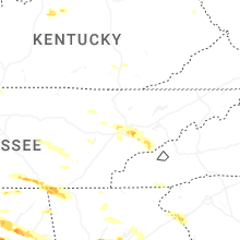
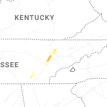
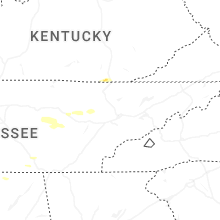


Connect with Interactive Hail Maps