

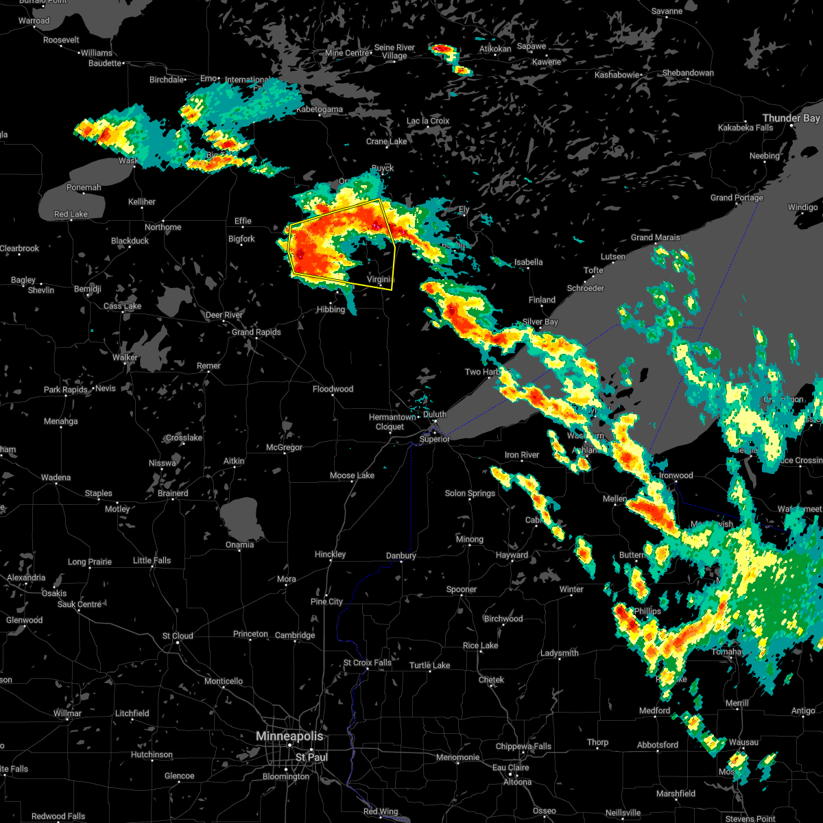
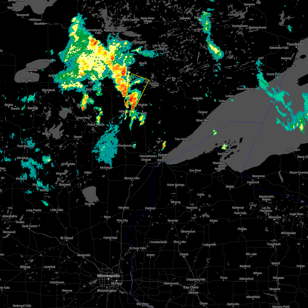
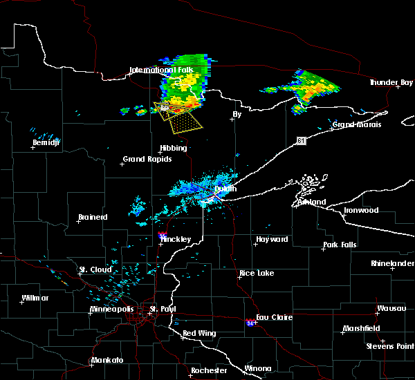
Hail Map for Cook, MN
The Cook, MN area has had 8 reports of on-the-ground hail by trained spotters, and has been under severe weather warnings 8 times during the past 12 months. Doppler radar has detected hail at or near Cook, MN on 31 occasions, including 1 occasion during the past year.
| Name: | Cook, MN |
| Where Located: | 61.9 miles SSE of International Falls, MN |
| Map: | Google Map for Cook, MN |
| Population: | 574 |
| Housing Units: | 306 |
| More Info: | Search Google for Cook, MN |
0
The Top Recent Hail Date for Cook, MN is Thursday, June 19, 2025 (20th out of 31)
Hail and Wind Damage Spotted near Cook, MN
| Date / Time | Report Details |
|---|---|
| 6/21/2025 2:36 AM CDT |
 At 235 am cdt, severe thunderstorms were located along a line extending from boundary waters canoe area wilderness to near bear head lake state park to 9 miles northwest of whiteface reservoir, moving east at 80 mph (radar indicated). Hazards include 70 mph wind gusts and penny size hail. Expect considerable tree damage. damage is likely to mobile homes, roofs, and outbuildings. Locations impacted include, hibbing, ely, lake vermilion, virginia, chisholm, eveleth, mountain iron, hoyt lakes, gilbert, aurora, babbitt, keewatin, buhl, nashwauk, biwabik, cherry, swan river, embarrass, cook, and tower. At 235 am cdt, severe thunderstorms were located along a line extending from boundary waters canoe area wilderness to near bear head lake state park to 9 miles northwest of whiteface reservoir, moving east at 80 mph (radar indicated). Hazards include 70 mph wind gusts and penny size hail. Expect considerable tree damage. damage is likely to mobile homes, roofs, and outbuildings. Locations impacted include, hibbing, ely, lake vermilion, virginia, chisholm, eveleth, mountain iron, hoyt lakes, gilbert, aurora, babbitt, keewatin, buhl, nashwauk, biwabik, cherry, swan river, embarrass, cook, and tower.
|
| 6/21/2025 2:36 AM CDT |
 the severe thunderstorm warning has been cancelled and is no longer in effect the severe thunderstorm warning has been cancelled and is no longer in effect
|
| 6/21/2025 2:18 AM CDT |
 At 217 am cdt, severe thunderstorms were located along a line extending from near buyck to 8 miles north of biwabik to 7 miles north of toivola, moving east at 80 mph (radar indicated). Hazards include 70 mph wind gusts and penny size hail. Expect considerable tree damage. damage is likely to mobile homes, roofs, and outbuildings. Locations impacted include, lake vermilion, virginia, eveleth, hoyt lakes, gilbert, aurora, biwabik, embarrass, tower, boundary waters canoe area wilderness near trout lake, babbitt, robinson, birch lake, burntside lake, ely, white iron lake, winton, fall lake, basswood lake, snowbank lake, forest center and isabella. At 217 am cdt, severe thunderstorms were located along a line extending from near buyck to 8 miles north of biwabik to 7 miles north of toivola, moving east at 80 mph (radar indicated). Hazards include 70 mph wind gusts and penny size hail. Expect considerable tree damage. damage is likely to mobile homes, roofs, and outbuildings. Locations impacted include, lake vermilion, virginia, eveleth, hoyt lakes, gilbert, aurora, biwabik, embarrass, tower, boundary waters canoe area wilderness near trout lake, babbitt, robinson, birch lake, burntside lake, ely, white iron lake, winton, fall lake, basswood lake, snowbank lake, forest center and isabella.
|
| 6/21/2025 1:55 AM CDT |
 Svrdlh the national weather service in duluth mn has issued a * severe thunderstorm warning for, eastern itasca county in north central minnesota, north central aitkin county in east central minnesota, southeastern koochiching county in north central minnesota, st. louis county in northeastern minnesota, lake county in northeastern minnesota, * until 300 am cdt. * at 155 am cdt, severe thunderstorms were located along a line extending from 9 miles north of togo to near chisholm to near warba, moving east at 80 mph (radar indicated). Hazards include 70 mph wind gusts and penny size hail. Expect considerable tree damage. damage is likely to mobile homes, roofs, and outbuildings. severe thunderstorms will be near, hibbing, chisholm, keewatin, buhl, nashwauk, meadow brook, warba, and pelican lake around 200 am cdt. mountain iron, cook, orr, and gheen around 205 am cdt. lake vermilion, virginia, eveleth, and cherry around 210 am cdt. gilbert, biwabik, and buyck around 215 am cdt. Other locations in the path of these severe thunderstorms include embarrass, tower, boundary waters canoe area wilderness near trout lake, soudan underground mine state park, hoyt lakes, aurora, babbitt, bear head lake state park, robinson, birch lake, burntside lake, ely, winton, white iron lake and fall lake. Svrdlh the national weather service in duluth mn has issued a * severe thunderstorm warning for, eastern itasca county in north central minnesota, north central aitkin county in east central minnesota, southeastern koochiching county in north central minnesota, st. louis county in northeastern minnesota, lake county in northeastern minnesota, * until 300 am cdt. * at 155 am cdt, severe thunderstorms were located along a line extending from 9 miles north of togo to near chisholm to near warba, moving east at 80 mph (radar indicated). Hazards include 70 mph wind gusts and penny size hail. Expect considerable tree damage. damage is likely to mobile homes, roofs, and outbuildings. severe thunderstorms will be near, hibbing, chisholm, keewatin, buhl, nashwauk, meadow brook, warba, and pelican lake around 200 am cdt. mountain iron, cook, orr, and gheen around 205 am cdt. lake vermilion, virginia, eveleth, and cherry around 210 am cdt. gilbert, biwabik, and buyck around 215 am cdt. Other locations in the path of these severe thunderstorms include embarrass, tower, boundary waters canoe area wilderness near trout lake, soudan underground mine state park, hoyt lakes, aurora, babbitt, bear head lake state park, robinson, birch lake, burntside lake, ely, winton, white iron lake and fall lake.
|
| 6/21/2025 12:48 AM CDT |
 the severe thunderstorm warning has been cancelled and is no longer in effect the severe thunderstorm warning has been cancelled and is no longer in effect
|
| 6/21/2025 12:48 AM CDT |
 At 1246 am cdt, severe thunderstorms were located along a line extending from near effie to near mccarthy beach state park to eveleth, moving northeast at 45 mph (radar indicated). Hazards include two inch hail and 60 mph wind gusts. People and animals outdoors will be injured. expect hail damage to roofs, siding, windows, and vehicles. expect wind damage to roofs, siding, and trees. Locations impacted include, hibbing, lake vermilion, virginia, chisholm, eveleth, mountain iron, hoyt lakes, gilbert, aurora, babbitt, keewatin, buhl, nashwauk, biwabik, cherry, embarrass, cook, marcell, bigfork, and orr. At 1246 am cdt, severe thunderstorms were located along a line extending from near effie to near mccarthy beach state park to eveleth, moving northeast at 45 mph (radar indicated). Hazards include two inch hail and 60 mph wind gusts. People and animals outdoors will be injured. expect hail damage to roofs, siding, windows, and vehicles. expect wind damage to roofs, siding, and trees. Locations impacted include, hibbing, lake vermilion, virginia, chisholm, eveleth, mountain iron, hoyt lakes, gilbert, aurora, babbitt, keewatin, buhl, nashwauk, biwabik, cherry, embarrass, cook, marcell, bigfork, and orr.
|
| 6/21/2025 12:22 AM CDT |
 At 1221 am cdt, severe thunderstorms were located along a line extending from 6 miles northeast of inger to 8 miles north of hill annex mine state park to 7 miles north of toivola, moving northeast at 45 mph (radar indicated). Hazards include tennis ball size hail and 70 mph wind gusts. People and animals outdoors will be injured. expect hail damage to roofs, siding, windows, and vehicles. expect considerable tree damage. wind damage is also likely to mobile homes, roofs, and outbuildings. Locations impacted include, hibbing, keewatin, nashwauk, marcell, chisholm, cherry, bigfork, scenic state park, mountain iron, buhl, eveleth, effie, virginia, gilbert, mccarthy beach state park, biwabik, togo, cook and meadow brook. At 1221 am cdt, severe thunderstorms were located along a line extending from 6 miles northeast of inger to 8 miles north of hill annex mine state park to 7 miles north of toivola, moving northeast at 45 mph (radar indicated). Hazards include tennis ball size hail and 70 mph wind gusts. People and animals outdoors will be injured. expect hail damage to roofs, siding, windows, and vehicles. expect considerable tree damage. wind damage is also likely to mobile homes, roofs, and outbuildings. Locations impacted include, hibbing, keewatin, nashwauk, marcell, chisholm, cherry, bigfork, scenic state park, mountain iron, buhl, eveleth, effie, virginia, gilbert, mccarthy beach state park, biwabik, togo, cook and meadow brook.
|
| 6/21/2025 12:04 AM CDT |
 Svrdlh the national weather service in duluth mn has issued a * severe thunderstorm warning for, itasca county in north central minnesota, northeastern cass county in north central minnesota, southern koochiching county in north central minnesota, southern st. louis county in northeastern minnesota, * until 100 am cdt. * at 1204 am cdt, severe thunderstorms were located along a line extending from near inger to near coleraine to 8 miles northeast of swan river, moving northeast at 45 mph (radar indicated). Hazards include golf ball size hail and 60 mph wind gusts. People and animals outdoors will be injured. expect hail damage to roofs, siding, windows, and vehicles. expect wind damage to roofs, siding, and trees. severe thunderstorms will be near, hibbing, nashwauk, taconite, inger, hill annex mine state park, and pengilly around 1210 am cdt. keewatin and marcell around 1215 am cdt. Other locations in the path of these severe thunderstorms include chisholm, cherry, bigfork, scenic state park, mountain iron, buhl, virginia, eveleth, gilbert, effie, mccarthy beach state park and togo. Svrdlh the national weather service in duluth mn has issued a * severe thunderstorm warning for, itasca county in north central minnesota, northeastern cass county in north central minnesota, southern koochiching county in north central minnesota, southern st. louis county in northeastern minnesota, * until 100 am cdt. * at 1204 am cdt, severe thunderstorms were located along a line extending from near inger to near coleraine to 8 miles northeast of swan river, moving northeast at 45 mph (radar indicated). Hazards include golf ball size hail and 60 mph wind gusts. People and animals outdoors will be injured. expect hail damage to roofs, siding, windows, and vehicles. expect wind damage to roofs, siding, and trees. severe thunderstorms will be near, hibbing, nashwauk, taconite, inger, hill annex mine state park, and pengilly around 1210 am cdt. keewatin and marcell around 1215 am cdt. Other locations in the path of these severe thunderstorms include chisholm, cherry, bigfork, scenic state park, mountain iron, buhl, virginia, eveleth, gilbert, effie, mccarthy beach state park and togo.
|
| 6/18/2024 12:36 PM CDT |
 Svrdlh the national weather service in duluth mn has issued a * severe thunderstorm warning for, southeastern itasca county in north central minnesota, west central st. louis county in northeastern minnesota, * until 115 pm cdt. * at 1236 pm cdt, severe thunderstorms were located along a line extending from 6 miles south of mccarthy beach state park to nashwauk to near gunn, moving northeast at 35 mph (radar indicated). Hazards include 60 mph wind gusts and half dollar size hail. Hail damage to vehicles is expected. expect wind damage to roofs, siding, and trees. severe thunderstorms will be near, hibbing, coleraine, keewatin, nashwauk, taconite, hill annex mine state park, and pengilly around 1240 pm cdt. chisholm around 1250 pm cdt. Other locations in the path of these severe thunderstorms include cook. Svrdlh the national weather service in duluth mn has issued a * severe thunderstorm warning for, southeastern itasca county in north central minnesota, west central st. louis county in northeastern minnesota, * until 115 pm cdt. * at 1236 pm cdt, severe thunderstorms were located along a line extending from 6 miles south of mccarthy beach state park to nashwauk to near gunn, moving northeast at 35 mph (radar indicated). Hazards include 60 mph wind gusts and half dollar size hail. Hail damage to vehicles is expected. expect wind damage to roofs, siding, and trees. severe thunderstorms will be near, hibbing, coleraine, keewatin, nashwauk, taconite, hill annex mine state park, and pengilly around 1240 pm cdt. chisholm around 1250 pm cdt. Other locations in the path of these severe thunderstorms include cook.
|
| 8/2/2022 3:50 PM CDT |
 At 349 pm cdt, a severe thunderstorm was located 11 miles north of mountain iron, or 19 miles southwest of lake vermilion, moving east at 45 mph (radar indicated). Hazards include 60 mph wind gusts and half dollar size hail. Hail damage to vehicles is expected. expect wind damage to roofs, siding, and trees. locations impacted include, virginia, mountain iron, gilbert, cook, perch lake, franklin, angora, kinney, shermans corner, side lake, snake trail, big rice lake, idington, and mcarthy beach state park. hail threat, radar indicated max hail size, 1. 25 in wind threat, radar indicated max wind gust, 60 mph. At 349 pm cdt, a severe thunderstorm was located 11 miles north of mountain iron, or 19 miles southwest of lake vermilion, moving east at 45 mph (radar indicated). Hazards include 60 mph wind gusts and half dollar size hail. Hail damage to vehicles is expected. expect wind damage to roofs, siding, and trees. locations impacted include, virginia, mountain iron, gilbert, cook, perch lake, franklin, angora, kinney, shermans corner, side lake, snake trail, big rice lake, idington, and mcarthy beach state park. hail threat, radar indicated max hail size, 1. 25 in wind threat, radar indicated max wind gust, 60 mph.
|
| 8/2/2022 3:34 PM CDT |
 At 334 pm cdt, a severe thunderstorm was located 12 miles south of meadow brook, or 19 miles north of hibbing, moving east at 45 mph (radar indicated). Hazards include 60 mph wind gusts and half dollar size hail. Hail damage to vehicles is expected. expect wind damage to roofs, siding, and trees. locations impacted include, lake vermilion, virginia, mountain iron, gilbert, cook, meadow brook, togo, perch lake, franklin, angora, kinney, linden grove, stony brook, shermans corner, side lake, snake trail, celina, big rice lake, stingy lake, and idington. hail threat, radar indicated max hail size, 1. 25 in wind threat, radar indicated max wind gust, 60 mph. At 334 pm cdt, a severe thunderstorm was located 12 miles south of meadow brook, or 19 miles north of hibbing, moving east at 45 mph (radar indicated). Hazards include 60 mph wind gusts and half dollar size hail. Hail damage to vehicles is expected. expect wind damage to roofs, siding, and trees. locations impacted include, lake vermilion, virginia, mountain iron, gilbert, cook, meadow brook, togo, perch lake, franklin, angora, kinney, linden grove, stony brook, shermans corner, side lake, snake trail, celina, big rice lake, stingy lake, and idington. hail threat, radar indicated max hail size, 1. 25 in wind threat, radar indicated max wind gust, 60 mph.
|
| 8/2/2022 3:19 PM CDT |
 At 319 pm cdt, a severe thunderstorm was located 9 miles south of togo, or 22 miles northwest of hibbing, moving east at 45 mph (radar indicated). Hazards include 60 mph wind gusts and half dollar size hail. Hail damage to vehicles is expected. Expect wind damage to roofs, siding, and trees. At 319 pm cdt, a severe thunderstorm was located 9 miles south of togo, or 22 miles northwest of hibbing, moving east at 45 mph (radar indicated). Hazards include 60 mph wind gusts and half dollar size hail. Hail damage to vehicles is expected. Expect wind damage to roofs, siding, and trees.
|
| 6/20/2022 10:27 PM CDT |
 At 1026 pm cdt, severe thunderstorms were located along a line extending from near kabetogama, to near lake vermilion, to 8 miles northeast of cotton, moving east at 45 mph (radar indicated). Hazards include 60 mph wind gusts and nickel size hail. Expect damage to roofs, siding, and trees. severe thunderstorms will be near, whiteface reservoir around 1040 pm cdt. robinson and voyageurs national park around 1045 pm cdt. other locations in the path of these severe thunderstorms include wolf lake, burntside lake, ely, winton, brimson, white iron lake, fall lake, highland lake, thomas lake near brimson, birch lake, western boundary waters canoe area wilderness and castle danger. hail threat, radar indicated max hail size, 0. 88 in wind threat, radar indicated max wind gust, 60 mph. At 1026 pm cdt, severe thunderstorms were located along a line extending from near kabetogama, to near lake vermilion, to 8 miles northeast of cotton, moving east at 45 mph (radar indicated). Hazards include 60 mph wind gusts and nickel size hail. Expect damage to roofs, siding, and trees. severe thunderstorms will be near, whiteface reservoir around 1040 pm cdt. robinson and voyageurs national park around 1045 pm cdt. other locations in the path of these severe thunderstorms include wolf lake, burntside lake, ely, winton, brimson, white iron lake, fall lake, highland lake, thomas lake near brimson, birch lake, western boundary waters canoe area wilderness and castle danger. hail threat, radar indicated max hail size, 0. 88 in wind threat, radar indicated max wind gust, 60 mph.
|
| 5/30/2022 8:15 PM CDT |
 At 814 pm cdt, severe thunderstorms were located along a line extending from 8 miles northwest of crane lake, to 7 miles east of buyck, to 11 miles southwest of tower, moving northeast at 65 mph (radar indicated. tree damage west of cook). Hazards include 60 mph wind gusts and quarter size hail. Hail damage to vehicles is expected. expect wind damage to roofs, siding, and trees. severe thunderstorms will be near, northwestern boundary waters canoe area wilderness around 830 pm cdt. Other locations in the path of these severe thunderstorms include robinson and burntside lake. At 814 pm cdt, severe thunderstorms were located along a line extending from 8 miles northwest of crane lake, to 7 miles east of buyck, to 11 miles southwest of tower, moving northeast at 65 mph (radar indicated. tree damage west of cook). Hazards include 60 mph wind gusts and quarter size hail. Hail damage to vehicles is expected. expect wind damage to roofs, siding, and trees. severe thunderstorms will be near, northwestern boundary waters canoe area wilderness around 830 pm cdt. Other locations in the path of these severe thunderstorms include robinson and burntside lake.
|
| 5/30/2022 8:07 PM CDT |
 At 806 pm cdt, severe thunderstorms were located along a line extending from 8 miles south of buyck, to near tower, to 9 miles west of embarrass, moving east at 65 mph (radar indicated. tree damage has been reported west of cook). Hazards include 60 mph wind gusts and quarter size hail. Hail damage to vehicles is expected. expect wind damage to roofs, siding, and trees. Locations impacted include, tower, embarrass, robinson, boundary waters canoe area wilderness near trout lake, babbitt, burntside lake and birch lake. At 806 pm cdt, severe thunderstorms were located along a line extending from 8 miles south of buyck, to near tower, to 9 miles west of embarrass, moving east at 65 mph (radar indicated. tree damage has been reported west of cook). Hazards include 60 mph wind gusts and quarter size hail. Hail damage to vehicles is expected. expect wind damage to roofs, siding, and trees. Locations impacted include, tower, embarrass, robinson, boundary waters canoe area wilderness near trout lake, babbitt, burntside lake and birch lake.
|
| 5/30/2022 7:44 PM CDT |
 At 744 pm cdt, severe thunderstorms were located along a line extending from near meadow brook, to 11 miles southwest of cook, to 8 miles north of buhl, moving east at 65 mph (radar indicated). Hazards include 60 mph wind gusts and quarter size hail. Hail damage to vehicles is expected. expect wind damage to roofs, siding, and trees. severe thunderstorms will be near, mountain iron, orr and gheen around 755 pm cdt. Other locations in the path of these severe thunderstorms include lake vermilion, embarrass, tower, buyck and robinson. At 744 pm cdt, severe thunderstorms were located along a line extending from near meadow brook, to 11 miles southwest of cook, to 8 miles north of buhl, moving east at 65 mph (radar indicated). Hazards include 60 mph wind gusts and quarter size hail. Hail damage to vehicles is expected. expect wind damage to roofs, siding, and trees. severe thunderstorms will be near, mountain iron, orr and gheen around 755 pm cdt. Other locations in the path of these severe thunderstorms include lake vermilion, embarrass, tower, buyck and robinson.
|
| 5/30/2022 7:42 PM CDT | Multiple trees down highway 22 and 5. time estimated by rada in st. louis county MN, 16.2 miles ENE of Cook, MN |
| 5/30/2022 7:37 PM CDT |
 At 737 pm cdt, severe thunderstorms were located along a line extending from 6 miles south of togo, to near chisholm, to near toivola, moving northeast at 60 mph (radar indicated). Hazards include 60 mph wind gusts and quarter size hail. Hail damage to vehicles is expected. expect wind damage to roofs, siding, and trees. Locations impacted include, hibbing, virginia, chisholm, eveleth, mountain iron, gilbert, keewatin, buhl, nashwauk, cherry, cook, meadow brook, perch lake, franklin, angora, kinney, linden grove, stony brook, mckinley, and iron junction. At 737 pm cdt, severe thunderstorms were located along a line extending from 6 miles south of togo, to near chisholm, to near toivola, moving northeast at 60 mph (radar indicated). Hazards include 60 mph wind gusts and quarter size hail. Hail damage to vehicles is expected. expect wind damage to roofs, siding, and trees. Locations impacted include, hibbing, virginia, chisholm, eveleth, mountain iron, gilbert, keewatin, buhl, nashwauk, cherry, cook, meadow brook, perch lake, franklin, angora, kinney, linden grove, stony brook, mckinley, and iron junction.
|
| 5/30/2022 7:23 PM CDT |
 At 723 pm cdt, severe thunderstorms were located along a line extending from 12 miles southwest of togo, to near hibbing, to 6 miles west of toivola, moving northeast at 60 mph (radar indicated). Hazards include 60 mph wind gusts and quarter size hail. Hail damage to vehicles is expected. expect wind damage to roofs, siding, and trees. Locations impacted include, chisholm, buhl, virginia, eveleth, mountain iron, meadow brook, gilbert and cook. At 723 pm cdt, severe thunderstorms were located along a line extending from 12 miles southwest of togo, to near hibbing, to 6 miles west of toivola, moving northeast at 60 mph (radar indicated). Hazards include 60 mph wind gusts and quarter size hail. Hail damage to vehicles is expected. expect wind damage to roofs, siding, and trees. Locations impacted include, chisholm, buhl, virginia, eveleth, mountain iron, meadow brook, gilbert and cook.
|
| 5/30/2022 7:09 PM CDT |
 At 709 pm cdt, severe thunderstorms were located along a line extending from 9 miles east of marcell, to nashwauk, to near swan river, moving northeast at 60 mph (radar indicated). Hazards include 70 mph wind gusts and quarter size hail. Hail damage to vehicles is expected. expect considerable tree damage. wind damage is also likely to mobile homes, roofs, and outbuildings. severe thunderstorms will be near, keewatin around 715 pm cdt. hibbing around 720 pm cdt. chisholm and toivola around 725 pm cdt. Other locations in the path of these severe thunderstorms include buhl, togo, virginia, eveleth, mountain iron, meadow brook, gilbert and cook. At 709 pm cdt, severe thunderstorms were located along a line extending from 9 miles east of marcell, to nashwauk, to near swan river, moving northeast at 60 mph (radar indicated). Hazards include 70 mph wind gusts and quarter size hail. Hail damage to vehicles is expected. expect considerable tree damage. wind damage is also likely to mobile homes, roofs, and outbuildings. severe thunderstorms will be near, keewatin around 715 pm cdt. hibbing around 720 pm cdt. chisholm and toivola around 725 pm cdt. Other locations in the path of these severe thunderstorms include buhl, togo, virginia, eveleth, mountain iron, meadow brook, gilbert and cook.
|
| 10/10/2021 3:23 PM CDT |
 At 323 pm cdt, a severe thunderstorm was located near cook, or 14 miles southwest of lake vermilion, moving north at 35 mph (radar indicated). Hazards include 60 mph wind gusts and quarter size hail. Hail damage to vehicles is expected. expect wind damage to roofs, siding, and trees. Locations impacted include, lake vermilion, mountain iron, cook, angora, shermans corner, and idington. At 323 pm cdt, a severe thunderstorm was located near cook, or 14 miles southwest of lake vermilion, moving north at 35 mph (radar indicated). Hazards include 60 mph wind gusts and quarter size hail. Hail damage to vehicles is expected. expect wind damage to roofs, siding, and trees. Locations impacted include, lake vermilion, mountain iron, cook, angora, shermans corner, and idington.
|
| 10/10/2021 3:02 PM CDT |
 At 302 pm cdt, a severe thunderstorm was located 9 miles north of buhl, or 18 miles northeast of hibbing, moving north at 35 mph (radar indicated). Hazards include 60 mph wind gusts and quarter size hail. Hail damage to vehicles is expected. Expect wind damage to roofs, siding, and trees. At 302 pm cdt, a severe thunderstorm was located 9 miles north of buhl, or 18 miles northeast of hibbing, moving north at 35 mph (radar indicated). Hazards include 60 mph wind gusts and quarter size hail. Hail damage to vehicles is expected. Expect wind damage to roofs, siding, and trees.
|
| 7/4/2020 6:16 PM CDT | Half Dollar sized hail reported 10.1 miles WSW of Cook, MN, hail accumulated on deck and was enough to shovel. largest hail was bigger than quarter...smaller than golf ball. pine cones and small branches fell from trees. delayed |
| 7/26/2019 4:53 PM CDT | Half Dollar sized hail reported 5.5 miles NW of Cook, MN |
| 7/26/2019 4:45 PM CDT |
 At 445 pm cdt, a severe thunderstorm was located near cook, or 12 miles southwest of lake vermilion, moving east at 35 mph (radar indicated). Hazards include tennis ball size hail and 60 mph wind gusts. People and animals outdoors will be injured. expect hail damage to roofs, siding, windows, and vehicles. expect wind damage to roofs, siding, and trees. Locations impacted include, lake vermilion, cook, tower, angora, shermans corner, vermillion lake reservation, trout lake, wahlsten, soudan underground mine state park, and soudan. At 445 pm cdt, a severe thunderstorm was located near cook, or 12 miles southwest of lake vermilion, moving east at 35 mph (radar indicated). Hazards include tennis ball size hail and 60 mph wind gusts. People and animals outdoors will be injured. expect hail damage to roofs, siding, windows, and vehicles. expect wind damage to roofs, siding, and trees. Locations impacted include, lake vermilion, cook, tower, angora, shermans corner, vermillion lake reservation, trout lake, wahlsten, soudan underground mine state park, and soudan.
|
| 7/26/2019 4:39 PM CDT |
 At 438 pm cdt, a severe thunderstorm was located near cook, or 13 miles southwest of lake vermilion, moving east at 35 mph (radar indicated). Hazards include two inch hail and 60 mph wind gusts. People and animals outdoors will be injured. expect hail damage to roofs, siding, windows, and vehicles. expect wind damage to roofs, siding, and trees. Locations impacted include, lake vermilion, cook, tower, angora, linden grove, shermans corner, vermillion lake reservation, trout lake, wahlsten, soudan underground mine state park, and soudan. At 438 pm cdt, a severe thunderstorm was located near cook, or 13 miles southwest of lake vermilion, moving east at 35 mph (radar indicated). Hazards include two inch hail and 60 mph wind gusts. People and animals outdoors will be injured. expect hail damage to roofs, siding, windows, and vehicles. expect wind damage to roofs, siding, and trees. Locations impacted include, lake vermilion, cook, tower, angora, linden grove, shermans corner, vermillion lake reservation, trout lake, wahlsten, soudan underground mine state park, and soudan.
|
| 7/26/2019 4:35 PM CDT |
 At 434 pm cdt, a severe thunderstorm was located near cook, or 16 miles west of lake vermilion, moving east at 35 mph (radar indicated). Hazards include golf ball size hail and 60 mph wind gusts. People and animals outdoors will be injured. expect hail damage to roofs, siding, windows, and vehicles. expect wind damage to roofs, siding, and trees. Locations impacted include, lake vermilion, cook, tower, angora, linden grove, shermans corner, vermillion lake reservation, trout lake, wahlsten, soudan underground mine state park, and soudan. At 434 pm cdt, a severe thunderstorm was located near cook, or 16 miles west of lake vermilion, moving east at 35 mph (radar indicated). Hazards include golf ball size hail and 60 mph wind gusts. People and animals outdoors will be injured. expect hail damage to roofs, siding, windows, and vehicles. expect wind damage to roofs, siding, and trees. Locations impacted include, lake vermilion, cook, tower, angora, linden grove, shermans corner, vermillion lake reservation, trout lake, wahlsten, soudan underground mine state park, and soudan.
|
| 7/26/2019 4:18 PM CDT |
 At 418 pm cdt, a severe thunderstorm was located over meadow brook, or 26 miles west of lake vermilion, moving east at 35 mph (radar indicated). Hazards include 60 mph wind gusts and quarter size hail. Hail damage to vehicles is expected. Expect wind damage to roofs, siding, and trees. At 418 pm cdt, a severe thunderstorm was located over meadow brook, or 26 miles west of lake vermilion, moving east at 35 mph (radar indicated). Hazards include 60 mph wind gusts and quarter size hail. Hail damage to vehicles is expected. Expect wind damage to roofs, siding, and trees.
|
| 6/30/2019 2:24 AM CDT |
 At 223 am cdt, severe thunderstorms were located along a line extending from 9 miles southwest of nett lake, to near togo, to 13 miles southwest of meadow brook, to 15 miles southeast of bigfork, moving east at 45 mph (radar indicated). Hazards include 60 mph wind gusts and quarter size hail. Hail damage to vehicles is expected. Expect wind damage to roofs, siding, and trees. At 223 am cdt, severe thunderstorms were located along a line extending from 9 miles southwest of nett lake, to near togo, to 13 miles southwest of meadow brook, to 15 miles southeast of bigfork, moving east at 45 mph (radar indicated). Hazards include 60 mph wind gusts and quarter size hail. Hail damage to vehicles is expected. Expect wind damage to roofs, siding, and trees.
|
| 9/12/2018 3:57 PM CDT | Quarter sized hail reported 11.8 miles SSW of Cook, MN, time estimated from radar. |
| 9/12/2018 3:38 PM CDT |
 At 338 pm cdt, a severe thunderstorm was located near meadow brook, or 23 miles west of lake vermilion, moving northeast at 40 mph. half dollar size hail was reported with this storm 2 miles east of celina (trained weather spotters). Hazards include 60 mph wind gusts and half dollar size hail. Hail damage to vehicles is expected. expect wind damage to roofs, siding, and trees. Locations impacted include, cook, orr, meadow brook, gheen, pelican lake, linden grove, and greaney. At 338 pm cdt, a severe thunderstorm was located near meadow brook, or 23 miles west of lake vermilion, moving northeast at 40 mph. half dollar size hail was reported with this storm 2 miles east of celina (trained weather spotters). Hazards include 60 mph wind gusts and half dollar size hail. Hail damage to vehicles is expected. expect wind damage to roofs, siding, and trees. Locations impacted include, cook, orr, meadow brook, gheen, pelican lake, linden grove, and greaney.
|
| 9/12/2018 3:32 PM CDT |
 At 331 pm cdt, a severe thunderstorm was located near meadow brook, or 27 miles west of lake vermilion, moving northeast at 40 mph (radar indicated). Hazards include 60 mph wind gusts and quarter size hail. Hail damage to vehicles is expected. expect wind damage to roofs, siding, and trees. Locations impacted include, cook, orr, meadow brook, gheen, pelican lake, linden grove, celina, greaney, and bois forte reservation. At 331 pm cdt, a severe thunderstorm was located near meadow brook, or 27 miles west of lake vermilion, moving northeast at 40 mph (radar indicated). Hazards include 60 mph wind gusts and quarter size hail. Hail damage to vehicles is expected. expect wind damage to roofs, siding, and trees. Locations impacted include, cook, orr, meadow brook, gheen, pelican lake, linden grove, celina, greaney, and bois forte reservation.
|
| 9/12/2018 3:30 PM CDT | Half Dollar sized hail reported 16.1 miles E of Cook, MN, hail covered the ground. |
| 9/12/2018 3:30 PM CDT | Quarter sized hail reported 16.1 miles E of Cook, MN, corrects previous hail report from 2 e celina. spotter estimated half-dollar size then measured 1 inch diameter. hail covered the ground. |
| 9/12/2018 3:23 PM CDT |
 At 322 pm cdt, a severe thunderstorm was located near togo, or 33 miles west of lake vermilion, moving northeast at 40 mph (radar indicated). Hazards include 60 mph wind gusts and quarter size hail. Hail damage to vehicles is expected. Expect wind damage to roofs, siding, and trees. At 322 pm cdt, a severe thunderstorm was located near togo, or 33 miles west of lake vermilion, moving northeast at 40 mph (radar indicated). Hazards include 60 mph wind gusts and quarter size hail. Hail damage to vehicles is expected. Expect wind damage to roofs, siding, and trees.
|
| 7/8/2018 9:10 AM CDT | Trees knocked down. time estimated by rada in st. louis county MN, 0.3 miles SSE of Cook, MN |
| 7/8/2018 9:05 AM CDT |
 At 905 am cdt, severe thunderstorms were located along a line extending from 8 miles northeast of ash lake, to near orr, to near cook, moving east at 55 mph (radar indicated). Hazards include 70 mph wind gusts and penny size hail. Expect considerable tree damage. damage is likely to mobile homes, roofs, and outbuildings. Locations impacted include, ely, lake vermilion, babbitt, cook, tower, orr, meadow brook, winton, ash lake, crane lake, gheen, burntside lake, buyck, white iron lake, robinson, pelican lake, cusson, fall lake, birch lake, and voyageurs national park. At 905 am cdt, severe thunderstorms were located along a line extending from 8 miles northeast of ash lake, to near orr, to near cook, moving east at 55 mph (radar indicated). Hazards include 70 mph wind gusts and penny size hail. Expect considerable tree damage. damage is likely to mobile homes, roofs, and outbuildings. Locations impacted include, ely, lake vermilion, babbitt, cook, tower, orr, meadow brook, winton, ash lake, crane lake, gheen, burntside lake, buyck, white iron lake, robinson, pelican lake, cusson, fall lake, birch lake, and voyageurs national park.
|
| 7/8/2018 8:56 AM CDT |
 At 856 am cdt, severe thunderstorms were located along a line extending from 6 miles north of ash lake, to pelican lake, to near meadow brook, to 6 miles east of togo, moving east at 55 mph (radar indicated). Hazards include 70 mph wind gusts and penny size hail. Expect considerable tree damage. Damage is likely to mobile homes, roofs, and outbuildings. At 856 am cdt, severe thunderstorms were located along a line extending from 6 miles north of ash lake, to pelican lake, to near meadow brook, to 6 miles east of togo, moving east at 55 mph (radar indicated). Hazards include 70 mph wind gusts and penny size hail. Expect considerable tree damage. Damage is likely to mobile homes, roofs, and outbuildings.
|
| 7/8/2018 8:37 AM CDT |
 At 837 am cdt, severe thunderstorms were located along a line extending from 15 miles west of ash lake, to near nett lake, to 6 miles southwest of pelican lake, to near togo, moving northeast at 45 mph (radar indicated). Hazards include 70 mph wind gusts and nickel size hail. Expect considerable tree damage. damage is likely to mobile homes, roofs, and outbuildings. Locations impacted include, lake vermilion, cook, nett lake, orr, meadow brook, ash lake, crane lake, gheen, buyck, pelican lake, cusson, voyageurs national park, angora, linden grove, shermans corner, greaney, black duck lake, bois forte reservation, celina, and loon lake. At 837 am cdt, severe thunderstorms were located along a line extending from 15 miles west of ash lake, to near nett lake, to 6 miles southwest of pelican lake, to near togo, moving northeast at 45 mph (radar indicated). Hazards include 70 mph wind gusts and nickel size hail. Expect considerable tree damage. damage is likely to mobile homes, roofs, and outbuildings. Locations impacted include, lake vermilion, cook, nett lake, orr, meadow brook, ash lake, crane lake, gheen, buyck, pelican lake, cusson, voyageurs national park, angora, linden grove, shermans corner, greaney, black duck lake, bois forte reservation, celina, and loon lake.
|
| 7/8/2018 8:20 AM CDT |
 At 820 am cdt, a severe thunderstorm was located 16 miles west of nett lake, or 38 miles south of international falls, moving east at 80 mph (radar indicated). Hazards include 70 mph wind gusts and penny size hail. Expect considerable tree damage. Damage is likely to mobile homes, roofs, and outbuildings. At 820 am cdt, a severe thunderstorm was located 16 miles west of nett lake, or 38 miles south of international falls, moving east at 80 mph (radar indicated). Hazards include 70 mph wind gusts and penny size hail. Expect considerable tree damage. Damage is likely to mobile homes, roofs, and outbuildings.
|
| 7/2/2018 11:37 PM CDT |
 The severe thunderstorm warning for central st. louis county will expire at 1145 pm cdt, the storm which prompted the warning has weakened below severe limits, and no longer poses an immediate threat to life or property. therefore, the warning will be allowed to expire. however small hail is still possible with this thunderstorm. The severe thunderstorm warning for central st. louis county will expire at 1145 pm cdt, the storm which prompted the warning has weakened below severe limits, and no longer poses an immediate threat to life or property. therefore, the warning will be allowed to expire. however small hail is still possible with this thunderstorm.
|
| 7/2/2018 11:24 PM CDT |
 At 1124 pm cdt, a severe thunderstorm was located near cook, or 18 miles west of lake vermilion, moving northeast at 40 mph (radar indicated). Hazards include 60 mph wind gusts and quarter size hail. Hail damage to vehicles is expected. expect wind damage to roofs, siding, and trees. Locations impacted include, lake vermilion, cook, angora, shermans corner, idington, and vermillion lake reservation. At 1124 pm cdt, a severe thunderstorm was located near cook, or 18 miles west of lake vermilion, moving northeast at 40 mph (radar indicated). Hazards include 60 mph wind gusts and quarter size hail. Hail damage to vehicles is expected. expect wind damage to roofs, siding, and trees. Locations impacted include, lake vermilion, cook, angora, shermans corner, idington, and vermillion lake reservation.
|
| 7/2/2018 11:13 PM CDT |
 At 1113 pm cdt, a severe thunderstorm was located 9 miles south of meadow brook, or 22 miles north of hibbing, moving northeast at 40 mph (radar indicated). Hazards include 60 mph wind gusts and quarter size hail. Hail damage to vehicles is expected. Expect wind damage to roofs, siding, and trees. At 1113 pm cdt, a severe thunderstorm was located 9 miles south of meadow brook, or 22 miles north of hibbing, moving northeast at 40 mph (radar indicated). Hazards include 60 mph wind gusts and quarter size hail. Hail damage to vehicles is expected. Expect wind damage to roofs, siding, and trees.
|
| 6/29/2018 8:51 AM CDT |
 At 851 am cdt, a severe thunderstorm was located near cook, or 13 miles southwest of lake vermilion, moving northeast at 60 mph (radar indicated). Hazards include 60 mph wind gusts and quarter size hail. Hail damage to vehicles is expected. Expect wind damage to roofs, siding, and trees. At 851 am cdt, a severe thunderstorm was located near cook, or 13 miles southwest of lake vermilion, moving northeast at 60 mph (radar indicated). Hazards include 60 mph wind gusts and quarter size hail. Hail damage to vehicles is expected. Expect wind damage to roofs, siding, and trees.
|
| 6/29/2018 7:24 AM CDT |
 At 722 am cdt, severe thunderstorms were located along a line extending from near crane lake, to 10 miles southeast of buyck, to near tower, to mountain iron, moving east at 70 mph. there were severe thunderstorms ahead of the main line located near embarrass and moving northeast at 45 mph (radar indicated. trained spotters reported quarter-size hail near mountain iron and a 58 mph wind gusts was reported at the cook airport with these storms). Hazards include 70 mph wind gusts and quarter size hail. Hail damage to vehicles is expected. expect considerable tree damage. wind damage is also likely to mobile homes, roofs, and outbuildings. Locations impacted include, hibbing, ely, lake vermilion, virginia, mountain iron, hoyt lakes, aurora, babbitt, biwabik, embarrass, cook, clear lake, tower, winton, crane lake, basswood lake, boundary waters canoe area wilderness near trout lake, birch lake, burntside lake, and buyck. At 722 am cdt, severe thunderstorms were located along a line extending from near crane lake, to 10 miles southeast of buyck, to near tower, to mountain iron, moving east at 70 mph. there were severe thunderstorms ahead of the main line located near embarrass and moving northeast at 45 mph (radar indicated. trained spotters reported quarter-size hail near mountain iron and a 58 mph wind gusts was reported at the cook airport with these storms). Hazards include 70 mph wind gusts and quarter size hail. Hail damage to vehicles is expected. expect considerable tree damage. wind damage is also likely to mobile homes, roofs, and outbuildings. Locations impacted include, hibbing, ely, lake vermilion, virginia, mountain iron, hoyt lakes, aurora, babbitt, biwabik, embarrass, cook, clear lake, tower, winton, crane lake, basswood lake, boundary waters canoe area wilderness near trout lake, birch lake, burntside lake, and buyck.
|
| 6/29/2018 7:18 AM CDT | Wind gust measured at awos station kcq in st. louis county MN, 1.8 miles N of Cook, MN |
| 6/29/2018 7:10 AM CDT |
 At 708 am cdt, severe thunderstorms were located along a line extending from 7 miles northeast of ash lake, to 7 miles east of gheen, to near cook, to 6 miles north of chisholm, moving east at 75 mph. there were also severe thunderstorms ahead of the main line located near cook and virginia moving northeast at 45 mph. these are very dangerous storms (radar indicated). Hazards include 80 mph wind gusts and quarter size hail. Flying debris will be dangerous to those caught without shelter. mobile homes will be heavily damaged. expect considerable damage to roofs, windows, and vehicles. Extensive tree damage and power outages are likely. At 708 am cdt, severe thunderstorms were located along a line extending from 7 miles northeast of ash lake, to 7 miles east of gheen, to near cook, to 6 miles north of chisholm, moving east at 75 mph. there were also severe thunderstorms ahead of the main line located near cook and virginia moving northeast at 45 mph. these are very dangerous storms (radar indicated). Hazards include 80 mph wind gusts and quarter size hail. Flying debris will be dangerous to those caught without shelter. mobile homes will be heavily damaged. expect considerable damage to roofs, windows, and vehicles. Extensive tree damage and power outages are likely.
|
| 6/29/2018 7:08 AM CDT | Several pine trees ripped up at the roots and knocked down near elbow lake. time estimated by rada in st. louis county MN, 10 miles S of Cook, MN |
| 6/29/2018 7:05 AM CDT |
 At 704 am cdt, severe thunderstorms were located along a line extending from 7 miles southwest of kabetogama, to near ash lake, to near gheen, to 6 miles southwest of cook, to 6 miles northwest of chisholm, moving east at 75 mph. these are very dangerous storms (radar indicated). Hazards include 80 mph wind gusts and quarter size hail. Flying debris will be dangerous to those caught without shelter. mobile homes will be heavily damaged. expect considerable damage to roofs, windows, and vehicles. extensive tree damage and power outages are likely. Locations impacted include, hibbing, lake vermilion, mountain iron, littlefork, cook, tower, marcell, bigfork, nett lake, orr, big falls, meadow brook, ash lake, kabetogama, effie, crane lake, gheen, voyageurs national park, buyck, and cusson. At 704 am cdt, severe thunderstorms were located along a line extending from 7 miles southwest of kabetogama, to near ash lake, to near gheen, to 6 miles southwest of cook, to 6 miles northwest of chisholm, moving east at 75 mph. these are very dangerous storms (radar indicated). Hazards include 80 mph wind gusts and quarter size hail. Flying debris will be dangerous to those caught without shelter. mobile homes will be heavily damaged. expect considerable damage to roofs, windows, and vehicles. extensive tree damage and power outages are likely. Locations impacted include, hibbing, lake vermilion, mountain iron, littlefork, cook, tower, marcell, bigfork, nett lake, orr, big falls, meadow brook, ash lake, kabetogama, effie, crane lake, gheen, voyageurs national park, buyck, and cusson.
|
| 6/29/2018 6:49 AM CDT |
 At 649 am cdt, severe thunderstorms were located along a line extending from 8 miles southeast of littlefork, to 12 miles west of ash lake, to 7 miles south of nett lake, to togo, to 12 miles northwest of nashwauk, moving east at 80 mph. these are very dangerous storms (radar indicated). Hazards include 80 mph wind gusts. Flying debris will be dangerous to those caught without shelter. mobile homes will be heavily damaged. expect considerable damage to roofs, windows, and vehicles. extensive tree damage and power outages are likely. Locations impacted include, hibbing, lake vermilion, mountain iron, littlefork, cook, tower, marcell, bigfork, nett lake, orr, big falls, meadow brook, ash lake, kabetogama, effie, crane lake, gheen, voyageurs national park, buyck, and cusson. At 649 am cdt, severe thunderstorms were located along a line extending from 8 miles southeast of littlefork, to 12 miles west of ash lake, to 7 miles south of nett lake, to togo, to 12 miles northwest of nashwauk, moving east at 80 mph. these are very dangerous storms (radar indicated). Hazards include 80 mph wind gusts. Flying debris will be dangerous to those caught without shelter. mobile homes will be heavily damaged. expect considerable damage to roofs, windows, and vehicles. extensive tree damage and power outages are likely. Locations impacted include, hibbing, lake vermilion, mountain iron, littlefork, cook, tower, marcell, bigfork, nett lake, orr, big falls, meadow brook, ash lake, kabetogama, effie, crane lake, gheen, voyageurs national park, buyck, and cusson.
|
| 6/29/2018 6:36 AM CDT |
 At 635 am cdt, severe thunderstorms were located along a line extending from 10 miles north of big falls, to 15 miles south of littlefork, to 18 miles northwest of togo, to 6 miles east of effie, to near bigfork, to near marcell, moving east at 80 mph. these are very dangerous storms (radar indicated). Hazards include 80 mph wind gusts. Flying debris will be dangerous to those caught without shelter. mobile homes will be heavily damaged. expect considerable damage to roofs, windows, and vehicles. extensive tree damage and power outages are likely. Locations impacted include, hibbing, international falls, lake vermilion, mountain iron, littlefork, cook, tower, marcell, bigfork, nett lake, orr, big falls, meadow brook, ash lake, kabetogama, effie, squaw lake, crane lake, gheen, and pelland. At 635 am cdt, severe thunderstorms were located along a line extending from 10 miles north of big falls, to 15 miles south of littlefork, to 18 miles northwest of togo, to 6 miles east of effie, to near bigfork, to near marcell, moving east at 80 mph. these are very dangerous storms (radar indicated). Hazards include 80 mph wind gusts. Flying debris will be dangerous to those caught without shelter. mobile homes will be heavily damaged. expect considerable damage to roofs, windows, and vehicles. extensive tree damage and power outages are likely. Locations impacted include, hibbing, international falls, lake vermilion, mountain iron, littlefork, cook, tower, marcell, bigfork, nett lake, orr, big falls, meadow brook, ash lake, kabetogama, effie, squaw lake, crane lake, gheen, and pelland.
|
| 6/29/2018 6:18 AM CDT |
 At 617 am cdt, severe thunderstorms were located along a line extending from 12 miles northeast of waskish, to near margie, to 11 miles southeast of gemmell, to oslund, to near lake winnibigoshish, moving east at 75 mph. these are very dangerous storms (radar indicated. trained spotters near kelliher and northwest of bemidji reported numerous trees down with this storm). Hazards include 80 mph wind gusts. Flying debris will be dangerous to those caught without shelter. mobile homes will be heavily damaged. expect considerable damage to roofs, windows, and vehicles. Extensive tree damage and power outages are likely. At 617 am cdt, severe thunderstorms were located along a line extending from 12 miles northeast of waskish, to near margie, to 11 miles southeast of gemmell, to oslund, to near lake winnibigoshish, moving east at 75 mph. these are very dangerous storms (radar indicated. trained spotters near kelliher and northwest of bemidji reported numerous trees down with this storm). Hazards include 80 mph wind gusts. Flying debris will be dangerous to those caught without shelter. mobile homes will be heavily damaged. expect considerable damage to roofs, windows, and vehicles. Extensive tree damage and power outages are likely.
|
| 5/29/2018 7:00 PM CDT |
 At 700 pm cdt, severe thunderstorms were located along a line extending from near gheen, to 8 miles south of lake vermilion, to aurora, moving northeast at 60 mph (radar indicated). Hazards include 60 mph wind gusts. Expect damage to roofs, siding, and trees. Locations impacted include, lake vermilion, virginia, eveleth, mountain iron, hoyt lakes, gilbert, aurora, babbitt, biwabik, embarrass, cook, tower, orr, meadow brook, ash lake, gheen, robinson, pelican lake, cusson, and birch lake. At 700 pm cdt, severe thunderstorms were located along a line extending from near gheen, to 8 miles south of lake vermilion, to aurora, moving northeast at 60 mph (radar indicated). Hazards include 60 mph wind gusts. Expect damage to roofs, siding, and trees. Locations impacted include, lake vermilion, virginia, eveleth, mountain iron, hoyt lakes, gilbert, aurora, babbitt, biwabik, embarrass, cook, tower, orr, meadow brook, ash lake, gheen, robinson, pelican lake, cusson, and birch lake.
|
| 5/29/2018 6:50 PM CDT |
 At 649 pm cdt, severe thunderstorms were located along a line extending from near meadow brook, to 11 miles north of mountain iron, to 6 miles southeast of gilbert, moving northeast at 60 mph (radar indicated). Hazards include 60 mph wind gusts. expect damage to roofs, siding, and trees At 649 pm cdt, severe thunderstorms were located along a line extending from near meadow brook, to 11 miles north of mountain iron, to 6 miles southeast of gilbert, moving northeast at 60 mph (radar indicated). Hazards include 60 mph wind gusts. expect damage to roofs, siding, and trees
|
| 7/21/2016 2:46 AM CDT |
 At 245 am cdt, severe thunderstorms were located along a line extending from near togo, to 6 miles east of big sandy lake, moving east at 60 mph. these are very dangerous storms (trained weather spotters). Hazards include 80 mph wind gusts and quarter size hail. Flying debris will be dangerous to those caught without shelter. mobile homes will be heavily damaged. expect considerable damage to roofs, windows, and vehicles. extensive tree damage and power outages are likely. these severe storms will be near, meadow brook around 250 am cdt. floodwood around 255 am cdt. cook around 300 am cdt. Other locations impacted by these severe thunderstorms include side lake, angora, celina, savanna portage state park, perch lake, split hand lake, hart lake, island, gowan and ball bluff. At 245 am cdt, severe thunderstorms were located along a line extending from near togo, to 6 miles east of big sandy lake, moving east at 60 mph. these are very dangerous storms (trained weather spotters). Hazards include 80 mph wind gusts and quarter size hail. Flying debris will be dangerous to those caught without shelter. mobile homes will be heavily damaged. expect considerable damage to roofs, windows, and vehicles. extensive tree damage and power outages are likely. these severe storms will be near, meadow brook around 250 am cdt. floodwood around 255 am cdt. cook around 300 am cdt. Other locations impacted by these severe thunderstorms include side lake, angora, celina, savanna portage state park, perch lake, split hand lake, hart lake, island, gowan and ball bluff.
|
| 7/21/2016 2:36 AM CDT |
 At 235 am cdt, severe thunderstorms were located along a line extending from near togo, to libby, moving east at 55 mph. these are very dangerous storms (trained weather spotters reported numerous trees down and winds of 70 mph or greater). Hazards include 80 mph wind gusts and quarter size hail. Flying debris will be dangerous to those caught without shelter. mobile homes will be heavily damaged. expect considerable damage to roofs, windows, and vehicles. extensive tree damage and power outages are likely. these severe storms will be near, togo around 240 am cdt. meadow brook around 250 am cdt. floodwood around 255 am cdt. cook around 300 am cdt. Other locations impacted by these severe thunderstorms include savanna portage state park, perch lake, deer lake northern itasca county, scenic state park, hart lake, gowan, bowstring, ball bluff, little swan and leetonia. At 235 am cdt, severe thunderstorms were located along a line extending from near togo, to libby, moving east at 55 mph. these are very dangerous storms (trained weather spotters reported numerous trees down and winds of 70 mph or greater). Hazards include 80 mph wind gusts and quarter size hail. Flying debris will be dangerous to those caught without shelter. mobile homes will be heavily damaged. expect considerable damage to roofs, windows, and vehicles. extensive tree damage and power outages are likely. these severe storms will be near, togo around 240 am cdt. meadow brook around 250 am cdt. floodwood around 255 am cdt. cook around 300 am cdt. Other locations impacted by these severe thunderstorms include savanna portage state park, perch lake, deer lake northern itasca county, scenic state park, hart lake, gowan, bowstring, ball bluff, little swan and leetonia.
|
| 7/21/2016 2:23 AM CDT |
 At 221 am cdt, severe thunderstorms were located along a line extending from 7 miles southeast of effie, to 7 miles southeast of swatara, moving east at 60 mph. these are very dangerous storms (trained weather spotters reported winds to 70 mph and many downed trees as these storms moved through). Hazards include 80 mph wind gusts and quarter size hail. Flying debris will be dangerous to those caught without shelter. mobile homes will be heavily damaged. expect considerable damage to roofs, windows, and vehicles. extensive tree damage and power outages are likely. these severe storms will be near, grand rapids around 230 am cdt. togo around 235 am cdt. meadow brook around 245 am cdt. floodwood around 255 am cdt. cook around 300 am cdt. Other locations impacted by these severe thunderstorms include savanna portage state park, perch lake, washburn lake, deer lake northern itasca county, scenic state park, wirt, hart lake, gowan, bowstring and ball bluff. At 221 am cdt, severe thunderstorms were located along a line extending from 7 miles southeast of effie, to 7 miles southeast of swatara, moving east at 60 mph. these are very dangerous storms (trained weather spotters reported winds to 70 mph and many downed trees as these storms moved through). Hazards include 80 mph wind gusts and quarter size hail. Flying debris will be dangerous to those caught without shelter. mobile homes will be heavily damaged. expect considerable damage to roofs, windows, and vehicles. extensive tree damage and power outages are likely. these severe storms will be near, grand rapids around 230 am cdt. togo around 235 am cdt. meadow brook around 245 am cdt. floodwood around 255 am cdt. cook around 300 am cdt. Other locations impacted by these severe thunderstorms include savanna portage state park, perch lake, washburn lake, deer lake northern itasca county, scenic state park, wirt, hart lake, gowan, bowstring and ball bluff.
|
| 7/21/2016 2:01 AM CDT |
 At 158 am cdt, severe thunderstorms were located along a line extending from 10 miles northeast of oslund, to near outing, moving east at 60 mph (emergency management. spotters reported winds up to 70 mph at moondance jam). Hazards include 70 mph wind gusts and quarter size hail. Hail damage to vehicles is expected. expect considerable tree damage. wind damage is also likely to mobile homes, roofs, and outbuildings. severe thunderstorms will be near, bigfork around 210 am cdt. effie and grand rapids around 215 am cdt. togo around 235 am cdt. floodwood around 250 am cdt. cook around 255 am cdt. mountain iron around 300 am cdt. Other locations impacted by these severe thunderstorms include savanna portage state park, perch lake, cut foot sioux lake, washburn lake, deer lake northern itasca county, scenic state park, wirt, hart lake, gowan and bowstring. At 158 am cdt, severe thunderstorms were located along a line extending from 10 miles northeast of oslund, to near outing, moving east at 60 mph (emergency management. spotters reported winds up to 70 mph at moondance jam). Hazards include 70 mph wind gusts and quarter size hail. Hail damage to vehicles is expected. expect considerable tree damage. wind damage is also likely to mobile homes, roofs, and outbuildings. severe thunderstorms will be near, bigfork around 210 am cdt. effie and grand rapids around 215 am cdt. togo around 235 am cdt. floodwood around 250 am cdt. cook around 255 am cdt. mountain iron around 300 am cdt. Other locations impacted by these severe thunderstorms include savanna portage state park, perch lake, cut foot sioux lake, washburn lake, deer lake northern itasca county, scenic state park, wirt, hart lake, gowan and bowstring.
|
| 7/5/2016 6:15 PM CDT |
 At 615 pm cdt, severe thunderstorms were located along a line extending from near togo to near nashwauk to 7 miles west of warba, moving east at 40 mph (radar indicated). Hazards include 60 mph wind gusts and penny size hail. Expect damage to roofs. siding. And trees. At 615 pm cdt, severe thunderstorms were located along a line extending from near togo to near nashwauk to 7 miles west of warba, moving east at 40 mph (radar indicated). Hazards include 60 mph wind gusts and penny size hail. Expect damage to roofs. siding. And trees.
|
| 7/5/2016 6:03 PM CDT |
 At 603 pm cdt, severe thunderstorms were located along a line extending from togo to 6 miles northwest of nashwauk to 8 miles southwest of grand rapids, moving east at 55 mph (radar indicated). Hazards include 60 mph wind gusts and penny size hail. Expect damage to roofs. siding. and trees. Locations impacted include, hibbing, grand rapids, chisholm, mountain iron, cohasset, coleraine, keewatin, buhl, nashwauk, swan river, cook, taconite, meadow brook, warba, pengilly, pokegama dam, gunn, togo, and perch lake. At 603 pm cdt, severe thunderstorms were located along a line extending from togo to 6 miles northwest of nashwauk to 8 miles southwest of grand rapids, moving east at 55 mph (radar indicated). Hazards include 60 mph wind gusts and penny size hail. Expect damage to roofs. siding. and trees. Locations impacted include, hibbing, grand rapids, chisholm, mountain iron, cohasset, coleraine, keewatin, buhl, nashwauk, swan river, cook, taconite, meadow brook, warba, pengilly, pokegama dam, gunn, togo, and perch lake.
|
| 7/5/2016 5:51 PM CDT |
 At 550 pm cdt, severe thunderstorms were located along a line extending from 9 miles west of togo to 8 miles northwest of coleraine to near remer, moving east at 60 mph (radar indicated. trees were reported blown down along with nickel size hail northwest of ball club with these storms). Hazards include 60 mph wind gusts and nickel size hail. Expect damage to roofs. siding. and trees. Locations impacted include, hibbing, grand rapids, chisholm, mountain iron, cohasset, coleraine, keewatin, buhl, nashwauk, deer river, swan river, cook, marcell, bigfork, taconite, meadow brook, warba, effie, and pengilly. At 550 pm cdt, severe thunderstorms were located along a line extending from 9 miles west of togo to 8 miles northwest of coleraine to near remer, moving east at 60 mph (radar indicated. trees were reported blown down along with nickel size hail northwest of ball club with these storms). Hazards include 60 mph wind gusts and nickel size hail. Expect damage to roofs. siding. and trees. Locations impacted include, hibbing, grand rapids, chisholm, mountain iron, cohasset, coleraine, keewatin, buhl, nashwauk, deer river, swan river, cook, marcell, bigfork, taconite, meadow brook, warba, effie, and pengilly.
|
| 7/5/2016 5:37 PM CDT |
 At 536 pm cdt, severe thunderstorms were located along a line extending from near effie to 6 miles northeast of deer river to near boy river, moving east at 55 mph (radar indicated). Hazards include 60 mph wind gusts and nickel size hail. Expect damage to roofs. siding. And trees. At 536 pm cdt, severe thunderstorms were located along a line extending from near effie to 6 miles northeast of deer river to near boy river, moving east at 55 mph (radar indicated). Hazards include 60 mph wind gusts and nickel size hail. Expect damage to roofs. siding. And trees.
|
| 6/25/2016 5:04 PM CDT |
 At 504 pm cdt, severe thunderstorms were located along a line extending from orr to near robinson, moving northeast at 55 mph (radar indicated). Hazards include 60 mph wind gusts and quarter size hail. Hail damage to vehicles is expected. expect wind damage to roofs, siding, and trees. these severe storms will be near, robinson around 510 pm cdt. ely, winton, burntside lake and fall lake around 515 pm cdt. other locations impacted by these severe thunderstorms include big moose lake, angora, celina, bear island lake, wynne lake, cummings lake, soudan underground mine state park, bear head lake state park, greaney and black duck lake. A tornado watch remains in effect until 900 pm cdt for northeastern minnesota. At 504 pm cdt, severe thunderstorms were located along a line extending from orr to near robinson, moving northeast at 55 mph (radar indicated). Hazards include 60 mph wind gusts and quarter size hail. Hail damage to vehicles is expected. expect wind damage to roofs, siding, and trees. these severe storms will be near, robinson around 510 pm cdt. ely, winton, burntside lake and fall lake around 515 pm cdt. other locations impacted by these severe thunderstorms include big moose lake, angora, celina, bear island lake, wynne lake, cummings lake, soudan underground mine state park, bear head lake state park, greaney and black duck lake. A tornado watch remains in effect until 900 pm cdt for northeastern minnesota.
|
| 6/25/2016 4:55 PM CDT |
 At 455 pm cdt, severe thunderstorms were located along a line extending from near pelican lake to 7 miles south of robinson, moving northeast at 55 mph (radar indicated). Hazards include 60 mph wind gusts and quarter size hail. Hail damage to vehicles is expected. expect wind damage to roofs, siding, and trees. these severe storms will be near, robinson around 505 pm cdt. ash lake and burntside lake around 510 pm cdt. ely, winton and fall lake around 515 pm cdt. other locations impacted by these severe thunderstorms include side lake, angora, celina, bear island lake, perch lake, greaney, black duck lake, shagawa lake, echo lake and soudan. A tornado watch remains in effect until 900 pm cdt for northeastern minnesota. At 455 pm cdt, severe thunderstorms were located along a line extending from near pelican lake to 7 miles south of robinson, moving northeast at 55 mph (radar indicated). Hazards include 60 mph wind gusts and quarter size hail. Hail damage to vehicles is expected. expect wind damage to roofs, siding, and trees. these severe storms will be near, robinson around 505 pm cdt. ash lake and burntside lake around 510 pm cdt. ely, winton and fall lake around 515 pm cdt. other locations impacted by these severe thunderstorms include side lake, angora, celina, bear island lake, perch lake, greaney, black duck lake, shagawa lake, echo lake and soudan. A tornado watch remains in effect until 900 pm cdt for northeastern minnesota.
|
| 6/25/2016 4:45 PM CDT |
 At 444 pm cdt, severe thunderstorms were located along a line extending from near meadow brook to embarrass, moving northeast at 55 mph (radar indicated). Hazards include 60 mph wind gusts and quarter size hail. Hail damage to vehicles is expected. expect wind damage to roofs, siding, and trees. these severe storms will be near, embarrass around 450 pm cdt. tower around 455 pm cdt. orr around 500 pm cdt. cusson, pelican lake and robinson around 505 pm cdt. ely, ash lake and burntside lake around 510 pm cdt. winton and fall lake around 515 pm cdt. other locations impacted by these severe thunderstorms include side lake, angora, celina, bear island lake, perch lake, greaney, black duck lake, shagawa lake, echo lake and soudan. A tornado watch remains in effect until 900 pm cdt for northeastern minnesota. At 444 pm cdt, severe thunderstorms were located along a line extending from near meadow brook to embarrass, moving northeast at 55 mph (radar indicated). Hazards include 60 mph wind gusts and quarter size hail. Hail damage to vehicles is expected. expect wind damage to roofs, siding, and trees. these severe storms will be near, embarrass around 450 pm cdt. tower around 455 pm cdt. orr around 500 pm cdt. cusson, pelican lake and robinson around 505 pm cdt. ely, ash lake and burntside lake around 510 pm cdt. winton and fall lake around 515 pm cdt. other locations impacted by these severe thunderstorms include side lake, angora, celina, bear island lake, perch lake, greaney, black duck lake, shagawa lake, echo lake and soudan. A tornado watch remains in effect until 900 pm cdt for northeastern minnesota.
|
| 6/25/2016 4:32 PM CDT |
 At 432 pm cdt, severe thunderstorms were located along a line extending from near togo to biwabik, moving northeast at 55 mph (radar indicated). Hazards include 60 mph wind gusts and quarter size hail. Hail damage to vehicles is expected. expect wind damage to roofs, siding, and trees. severe thunderstorms will be near, gilbert, aurora and biwabik around 435 pm cdt. hoyt lakes, embarrass and meadow brook around 445 pm cdt. tower around 450 pm cdt. gheen around 455 pm cdt. orr, robinson and pelican lake around 500 pm cdt. cusson around 505 pm cdt. ely, ash lake and burntside lake around 510 pm cdt. winton, fall lake and buyck around 515 pm cdt. other locations impacted by these severe thunderstorms include side lake, angora, celina, bear island lake, perch lake, greaney, black duck lake, shagawa lake, echo lake and soudan. A tornado watch remains in effect until 900 pm cdt for northeastern minnesota. At 432 pm cdt, severe thunderstorms were located along a line extending from near togo to biwabik, moving northeast at 55 mph (radar indicated). Hazards include 60 mph wind gusts and quarter size hail. Hail damage to vehicles is expected. expect wind damage to roofs, siding, and trees. severe thunderstorms will be near, gilbert, aurora and biwabik around 435 pm cdt. hoyt lakes, embarrass and meadow brook around 445 pm cdt. tower around 450 pm cdt. gheen around 455 pm cdt. orr, robinson and pelican lake around 500 pm cdt. cusson around 505 pm cdt. ely, ash lake and burntside lake around 510 pm cdt. winton, fall lake and buyck around 515 pm cdt. other locations impacted by these severe thunderstorms include side lake, angora, celina, bear island lake, perch lake, greaney, black duck lake, shagawa lake, echo lake and soudan. A tornado watch remains in effect until 900 pm cdt for northeastern minnesota.
|
| 6/25/2016 8:30 AM CDT |
 At 830 am cdt, severe thunderstorms were located along a line extending from just east of lac la croix in the boundary waters canoe area wilderness to 9 miles northeast of lake vermilion to 9 miles north of mountain iron, moving southeast at 35 mph (radar indicated). Hazards include 60 mph wind gusts. Expect damage to roofs. siding. and trees. Locations impacted include, ely, lake vermilion, mountain iron, hoyt lakes, babbitt, biwabik, embarrass, cook, tower, winton, white iron lake, fall lake, burntside lake, basswood lake, robinson, birch lake, boundary waters canoe area wilderness and bear island lake. At 830 am cdt, severe thunderstorms were located along a line extending from just east of lac la croix in the boundary waters canoe area wilderness to 9 miles northeast of lake vermilion to 9 miles north of mountain iron, moving southeast at 35 mph (radar indicated). Hazards include 60 mph wind gusts. Expect damage to roofs. siding. and trees. Locations impacted include, ely, lake vermilion, mountain iron, hoyt lakes, babbitt, biwabik, embarrass, cook, tower, winton, white iron lake, fall lake, burntside lake, basswood lake, robinson, birch lake, boundary waters canoe area wilderness and bear island lake.
|
| 6/25/2016 8:06 AM CDT |
 At 805 am cdt, severe thunderstorms were located along a line extending from 28 miles northwest of basswood lake to cook, moving southeast at 35 mph (radar indicated). Hazards include 60 mph wind gusts and nickel size hail. Expect roof and tree damage. severe thunderstorms will be near, mountain iron around 825 am cdt. biwabik around 845 am cdt. other locations impacted by these severe thunderstorms include big moose lake, angora, bear island lake, wynne lake, cummings lake, fourtown lake, soudan underground mine state park, bear head lake state park, ridge and crooked lake. Large hail. At 805 am cdt, severe thunderstorms were located along a line extending from 28 miles northwest of basswood lake to cook, moving southeast at 35 mph (radar indicated). Hazards include 60 mph wind gusts and nickel size hail. Expect roof and tree damage. severe thunderstorms will be near, mountain iron around 825 am cdt. biwabik around 845 am cdt. other locations impacted by these severe thunderstorms include big moose lake, angora, bear island lake, wynne lake, cummings lake, fourtown lake, soudan underground mine state park, bear head lake state park, ridge and crooked lake. Large hail.
|
| 8/2/2015 2:36 AM CDT |
 At 235 am cdt, severe thunderstorms were located along a line extending from 8 miles north of vermillion lake to 12 miles southeast of togo, moving southeast at 50 mph (radar indicated). Hazards include 60 mph wind gusts and penny size hail. Expect damage to roofs. siding and trees. locations impacted include, vermillion lake, virginia, chisholm, mountain iron, buhl, cook, tower, robinson, burntside lake, perch lake, angora, kinney, side lake, soudan, big rice lake, idington, west two rivers reservoir, snake trail, wahlsten and shermans corner. This includes fortune bay casino. At 235 am cdt, severe thunderstorms were located along a line extending from 8 miles north of vermillion lake to 12 miles southeast of togo, moving southeast at 50 mph (radar indicated). Hazards include 60 mph wind gusts and penny size hail. Expect damage to roofs. siding and trees. locations impacted include, vermillion lake, virginia, chisholm, mountain iron, buhl, cook, tower, robinson, burntside lake, perch lake, angora, kinney, side lake, soudan, big rice lake, idington, west two rivers reservoir, snake trail, wahlsten and shermans corner. This includes fortune bay casino.
|
| 8/2/2015 2:21 AM CDT |
 At 221 am cdt, severe thunderstorms were located along a line extending from 6 miles southwest of buyck to near togo, moving southeast at 50 mph (radar indicated). Hazards include 60 mph wind gusts and penny size hail. Expect damage to roofs. Siding and trees. At 221 am cdt, severe thunderstorms were located along a line extending from 6 miles southwest of buyck to near togo, moving southeast at 50 mph (radar indicated). Hazards include 60 mph wind gusts and penny size hail. Expect damage to roofs. Siding and trees.
|
| 6/29/2015 8:43 AM CDT |
 At 842 am cdt, a severe thunderstorm was located 7 miles east of gheen, or 37 miles west of ely, moving south at 30 mph (radar indicated). Hazards include quarter size hail...frequent lightning and 60 mph wind gusts. Hail damage to vehicles is expected. expect wind damage to roofs, siding and trees. this severe thunderstorm will be near, cook around 900 am cdt. shermans corner around 910 am cdt. angora and idington around 915 am cdt. Other locations impacted by this severe thunderstorm include vermillion lake. At 842 am cdt, a severe thunderstorm was located 7 miles east of gheen, or 37 miles west of ely, moving south at 30 mph (radar indicated). Hazards include quarter size hail...frequent lightning and 60 mph wind gusts. Hail damage to vehicles is expected. expect wind damage to roofs, siding and trees. this severe thunderstorm will be near, cook around 900 am cdt. shermans corner around 910 am cdt. angora and idington around 915 am cdt. Other locations impacted by this severe thunderstorm include vermillion lake.
|
| 9/4/2012 4:21 PM CDT | Quarter sized hail reported 3.2 miles SW of Cook, MN |
| 9/4/2012 4:21 PM CDT | Quarter sized hail reported 8 miles SW of Cook, MN |
| 9/4/2012 4:15 PM CDT | Power was out to 2500 customers from cook to ely as thunderstorms with high winds toppled trees and branches onto power line in st. louis county MN, 0.3 miles SSE of Cook, MN |
| 7/22/2012 6:05 PM CDT | Golf Ball sized hail reported 15.7 miles E of Cook, MN, mostly nickel size hail...a few large trees down. |
| 1/1/0001 12:00 AM | Trees and powerlines down in cook are in st. louis county MN, 0.3 miles SSE of Cook, MN |
| 1/1/0001 12:00 AM | Report relayed by law enforcement. damage to boat house and tree damag in st. louis county MN, 12.3 miles E of Cook, MN |
| 1/1/0001 12:00 AM | Witnessed garage roof lift into air and fall back onto walls. some damage to garage walls. boat house of unknown construction destroyed. tree damag in st. louis county MN, 12.3 miles E of Cook, MN |
| 1/1/0001 12:00 AM | Lots of trees down near the intersection of hwy 73 and hwy 22 north of side lake. delayed repor in st. louis county MN, 9.7 miles ENE of Cook, MN |
Hail Maps for Cook, MN


Connect with Interactive Hail Maps