

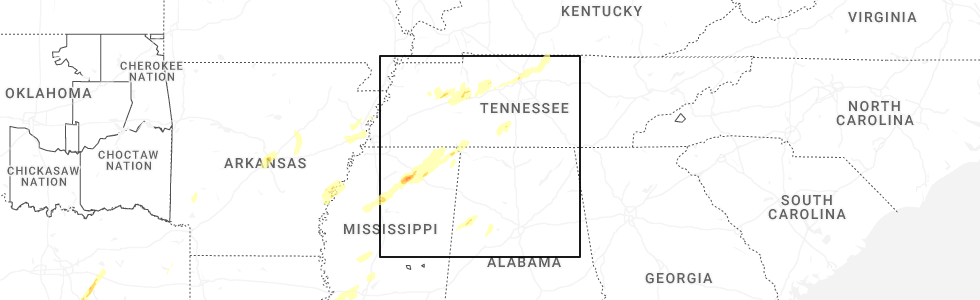
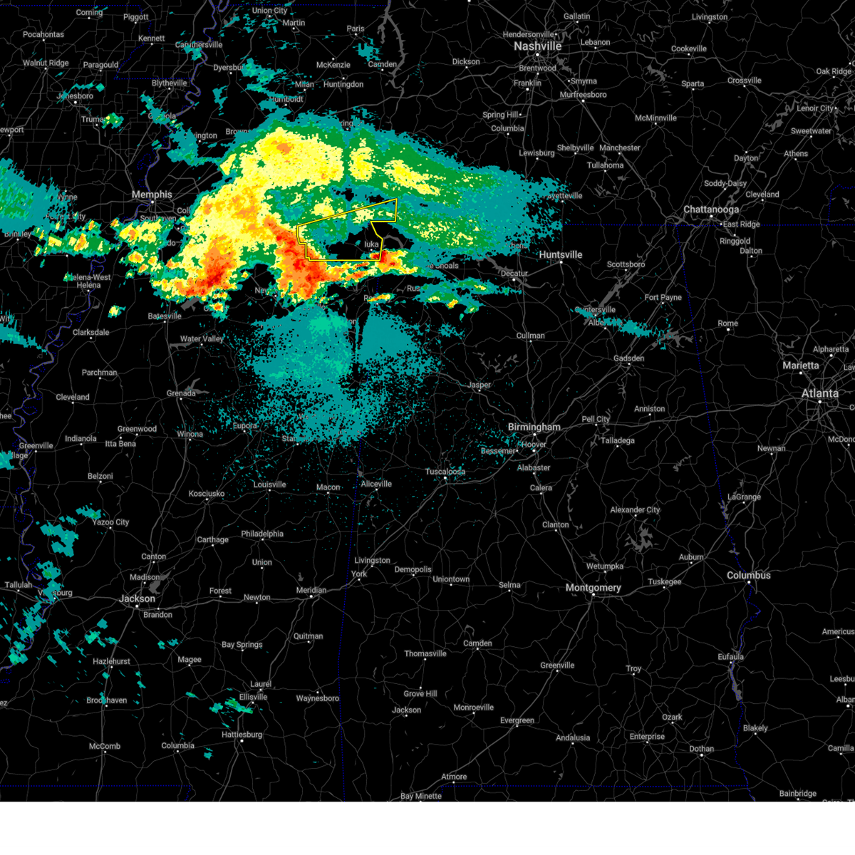
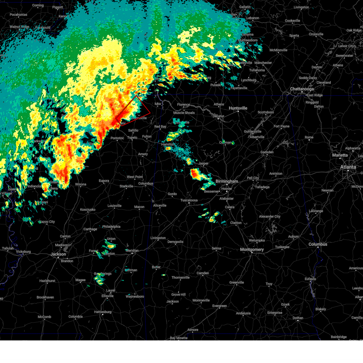
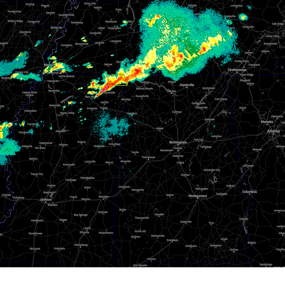
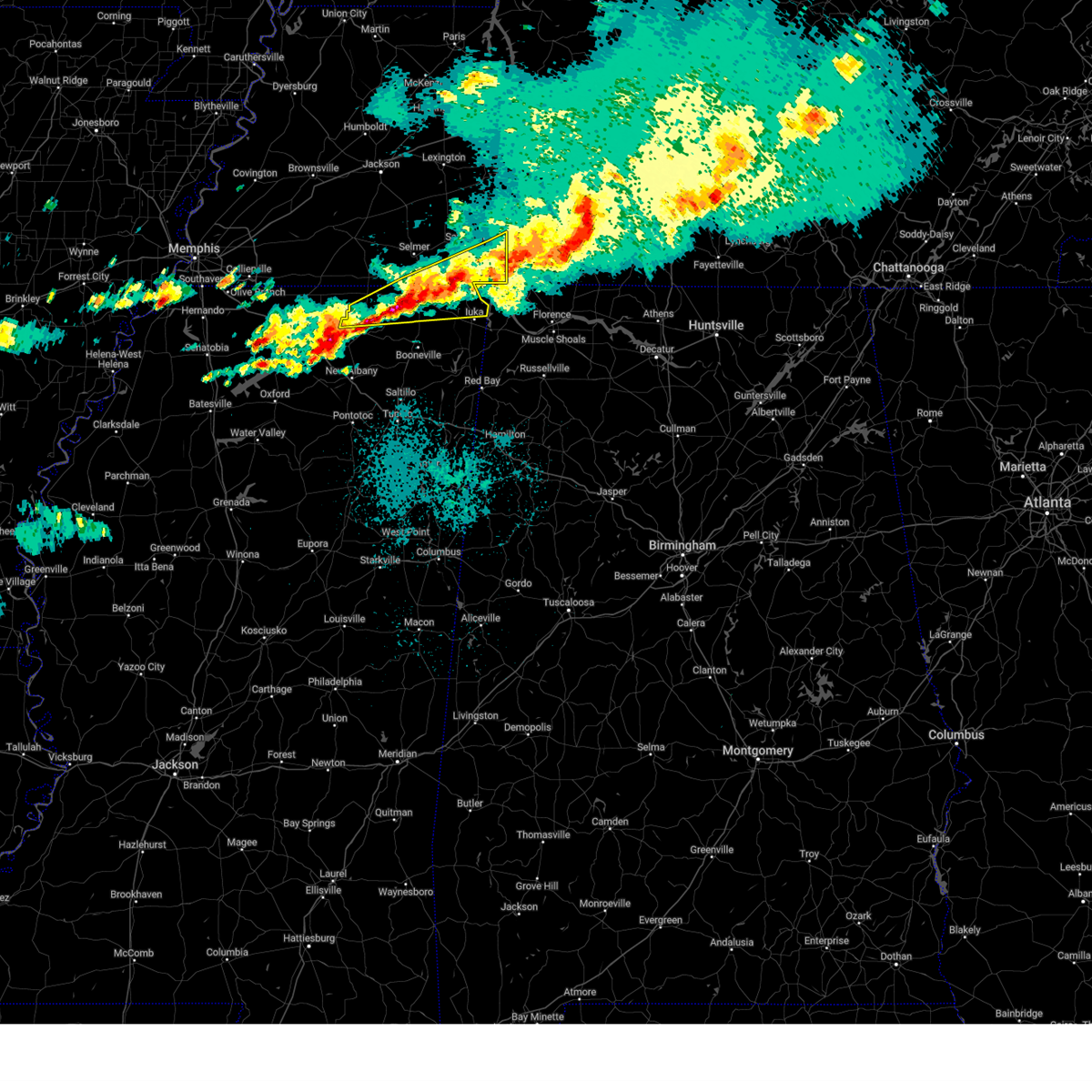
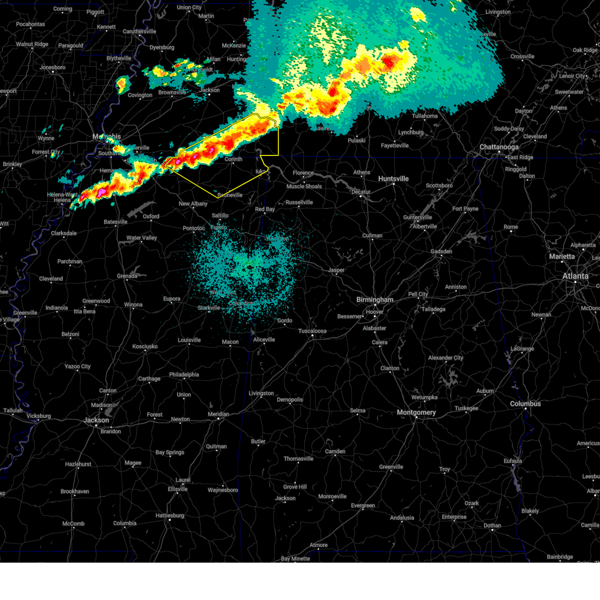
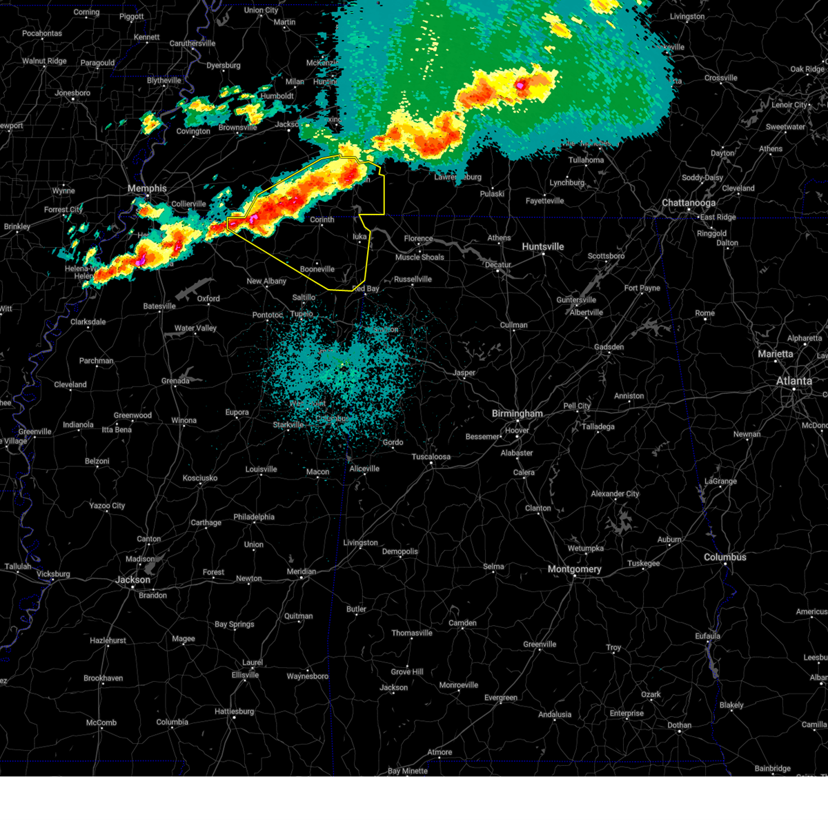
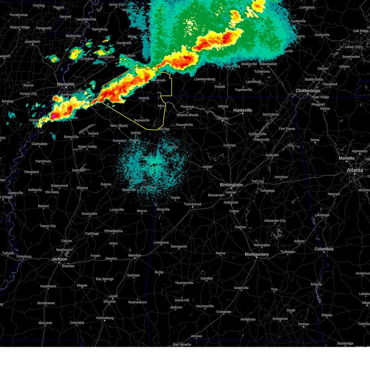
Hail Map for Corinth, MS
The Corinth, MS area has had 12 reports of on-the-ground hail by trained spotters, and has been under severe weather warnings 51 times during the past 12 months. Doppler radar has detected hail at or near Corinth, MS on 72 occasions, including 5 occasions during the past year.
| Name: | Corinth, MS |
| Where Located: | 48.4 miles W of Florence, AL |
| Map: | Google Map for Corinth, MS |
| Population: | 14573 |
| Housing Units: | 7149 |
| More Info: | Search Google for Corinth, MS |
3
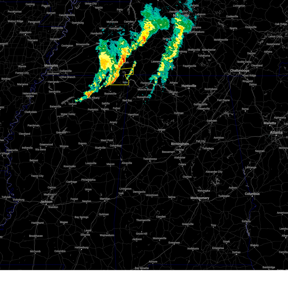
The Top Recent Hail Date for Corinth, MS is Saturday, April 5, 2025 (7th out of 72)
Hail and Wind Damage Spotted near Corinth, MS
| Date / Time | Report Details |
|---|---|
| 5/25/2025 7:34 PM CDT | the severe thunderstorm warning has been cancelled and is no longer in effect |
| 5/25/2025 7:34 PM CDT | At 734 pm cdt, severe thunderstorms were located along a line extending from near collinwood to near j p coleman state park to wheeler, moving east at 60 mph (radar indicated). Hazards include 60 mph wind gusts and quarter size hail. Hail damage to vehicles is expected. expect wind damage to roofs, siding, and trees. Locations impacted include, iuka, pickwick dam, blythe crossing, rienzi, bruton branch, thrashers, pickwick landing state park, carter branch, hazard switch, midway, petertown, neil, tishomingo, bacon springs, damon, blackland, booneville, childers hill, center star, and kendrick. |
| 5/25/2025 7:26 PM CDT | the severe thunderstorm warning has been cancelled and is no longer in effect |
| 5/25/2025 7:26 PM CDT | At 726 pm cdt, severe thunderstorms were located along a line extending from 6 miles southwest of collinwood to near j p coleman state park to 6 miles west of wheeler, moving east at 60 mph (radar indicated). Hazards include 60 mph wind gusts and quarter size hail. Hail damage to vehicles is expected. expect wind damage to roofs, siding, and trees. Locations impacted include, iuka, pickwick dam, blythe crossing, rienzi, bruton branch, thrashers, pickwick landing state park, carter branch, acton, hazard switch, hurley, walkertown, midway, petertown, corinth, neil, chambers, tishomingo, bacon springs, and kossuth. |
| 5/25/2025 7:22 PM CDT |
 At 722 pm cdt, severe thunderstorms were located along a line extending from 9 miles west of collinwood to near burnsville to 9 miles northeast of keownville, moving east at 60 mph (radar indicated). Hazards include 60 mph wind gusts and quarter size hail. Hail damage to vehicles is expected. expect wind damage to roofs, siding, and trees. Locations impacted include, iuka, murry, pickwick dam, blythe crossing, rienzi, bruton branch, thrashers, pickwick landing state park, carter branch, acton, hazard switch, hurley, walkertown, midway, petertown, corinth, neil, chambers, tishomingo, and bacon springs. At 722 pm cdt, severe thunderstorms were located along a line extending from 9 miles west of collinwood to near burnsville to 9 miles northeast of keownville, moving east at 60 mph (radar indicated). Hazards include 60 mph wind gusts and quarter size hail. Hail damage to vehicles is expected. expect wind damage to roofs, siding, and trees. Locations impacted include, iuka, murry, pickwick dam, blythe crossing, rienzi, bruton branch, thrashers, pickwick landing state park, carter branch, acton, hazard switch, hurley, walkertown, midway, petertown, corinth, neil, chambers, tishomingo, and bacon springs.
|
| 5/25/2025 7:11 PM CDT |
 At 710 pm cdt, severe thunderstorms were located along a line extending from 6 miles north of walnut grove to near glen to near keownville, moving east at 45 mph (radar indicated). Hazards include 60 mph wind gusts and quarter size hail. Hail damage to vehicles is expected. expect wind damage to roofs, siding, and trees. Locations impacted include, murry, pickwick dam, blythe crossing, bruton branch, pickwick landing state park, acton, theo, walkertown, petertown, neil, kossuth, hightown, new lawton, martin camp, savannah, caffey, crumtown, booneville, peoples, and burnsville. At 710 pm cdt, severe thunderstorms were located along a line extending from 6 miles north of walnut grove to near glen to near keownville, moving east at 45 mph (radar indicated). Hazards include 60 mph wind gusts and quarter size hail. Hail damage to vehicles is expected. expect wind damage to roofs, siding, and trees. Locations impacted include, murry, pickwick dam, blythe crossing, bruton branch, pickwick landing state park, acton, theo, walkertown, petertown, neil, kossuth, hightown, new lawton, martin camp, savannah, caffey, crumtown, booneville, peoples, and burnsville.
|
| 5/25/2025 6:49 PM CDT |
 Svrmeg the national weather service in memphis has issued a * severe thunderstorm warning for, tippah county in northeastern mississippi, tishomingo county in northeastern mississippi, southern benton county in northeastern mississippi, northern prentiss county in northeastern mississippi, alcorn county in northeastern mississippi, mcnairy county in west tennessee, southern hardin county in west tennessee, * until 745 pm cdt. * at 648 pm cdt, severe thunderstorms were located along a line extending from near shiloh to theo to 8 miles northeast of bethlehem, moving east at 55 mph (radar indicated). Hazards include 60 mph wind gusts and quarter size hail. Hail damage to vehicles is expected. Expect wind damage to roofs, siding, and trees. Svrmeg the national weather service in memphis has issued a * severe thunderstorm warning for, tippah county in northeastern mississippi, tishomingo county in northeastern mississippi, southern benton county in northeastern mississippi, northern prentiss county in northeastern mississippi, alcorn county in northeastern mississippi, mcnairy county in west tennessee, southern hardin county in west tennessee, * until 745 pm cdt. * at 648 pm cdt, severe thunderstorms were located along a line extending from near shiloh to theo to 8 miles northeast of bethlehem, moving east at 55 mph (radar indicated). Hazards include 60 mph wind gusts and quarter size hail. Hail damage to vehicles is expected. Expect wind damage to roofs, siding, and trees.
|
| 5/20/2025 9:54 AM CDT |
 Svrmeg the national weather service in memphis has issued a * severe thunderstorm warning for, northern tishomingo county in northeastern mississippi, eastern alcorn county in northeastern mississippi, southeastern mcnairy county in west tennessee, southern hardin county in west tennessee, * until 1045 am cdt. * at 954 am cdt, a severe thunderstorm was located near glen, or near corinth, moving east at 50 mph (radar indicated). Hazards include 60 mph wind gusts and nickel size hail. expect damage to roofs, siding, and trees Svrmeg the national weather service in memphis has issued a * severe thunderstorm warning for, northern tishomingo county in northeastern mississippi, eastern alcorn county in northeastern mississippi, southeastern mcnairy county in west tennessee, southern hardin county in west tennessee, * until 1045 am cdt. * at 954 am cdt, a severe thunderstorm was located near glen, or near corinth, moving east at 50 mph (radar indicated). Hazards include 60 mph wind gusts and nickel size hail. expect damage to roofs, siding, and trees
|
| 5/19/2025 1:07 AM CDT |
 The storm which prompted the warning has weakened below severe limits, and no longer poses an immediate threat to life or property. therefore, the warning will be allowed to expire. The storm which prompted the warning has weakened below severe limits, and no longer poses an immediate threat to life or property. therefore, the warning will be allowed to expire.
|
| 5/19/2025 1:01 AM CDT |
 the severe thunderstorm warning has been cancelled and is no longer in effect the severe thunderstorm warning has been cancelled and is no longer in effect
|
| 5/19/2025 1:01 AM CDT |
 At 101 am cdt, a severe thunderstorm was located near j p coleman state park, moving northeast at 55 mph (radar indicated). Hazards include 60 mph wind gusts and quarter size hail. Hail damage to vehicles is expected. expect wind damage to roofs, siding, and trees. Locations impacted include, iuka, walnut grove, oldham, doskie, j p coleman state park, pickwick dam, strickland, hamburg, pineflat, blythe crossing, wenasoga, guys, biggersville, rienzi, bruton branch, tulu, jobes, pickwick landing state park, hinkle, and glen. At 101 am cdt, a severe thunderstorm was located near j p coleman state park, moving northeast at 55 mph (radar indicated). Hazards include 60 mph wind gusts and quarter size hail. Hail damage to vehicles is expected. expect wind damage to roofs, siding, and trees. Locations impacted include, iuka, walnut grove, oldham, doskie, j p coleman state park, pickwick dam, strickland, hamburg, pineflat, blythe crossing, wenasoga, guys, biggersville, rienzi, bruton branch, tulu, jobes, pickwick landing state park, hinkle, and glen.
|
| 5/19/2025 12:26 AM CDT |
 Svrmeg the national weather service in memphis has issued a * severe thunderstorm warning for, northern tishomingo county in northeastern mississippi, northern prentiss county in northeastern mississippi, alcorn county in northeastern mississippi, southeastern mcnairy county in west tennessee, southern hardin county in west tennessee, * until 115 am cdt. * at 1226 am cdt, a severe thunderstorm was located near hinkle, or 8 miles northwest of booneville, moving northeast at 55 mph (radar indicated). Hazards include 60 mph wind gusts and quarter size hail. Hail damage to vehicles is expected. Expect wind damage to roofs, siding, and trees. Svrmeg the national weather service in memphis has issued a * severe thunderstorm warning for, northern tishomingo county in northeastern mississippi, northern prentiss county in northeastern mississippi, alcorn county in northeastern mississippi, southeastern mcnairy county in west tennessee, southern hardin county in west tennessee, * until 115 am cdt. * at 1226 am cdt, a severe thunderstorm was located near hinkle, or 8 miles northwest of booneville, moving northeast at 55 mph (radar indicated). Hazards include 60 mph wind gusts and quarter size hail. Hail damage to vehicles is expected. Expect wind damage to roofs, siding, and trees.
|
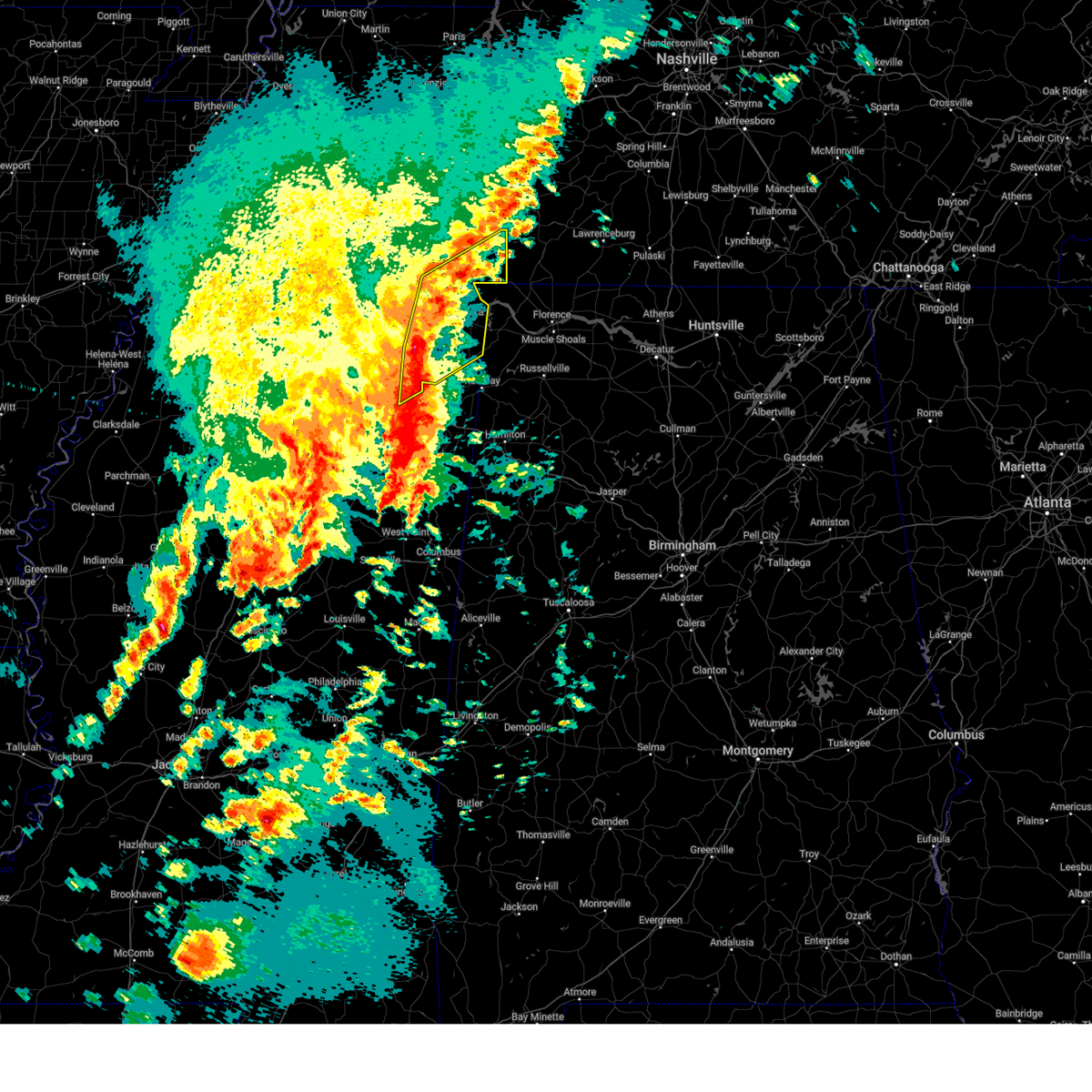
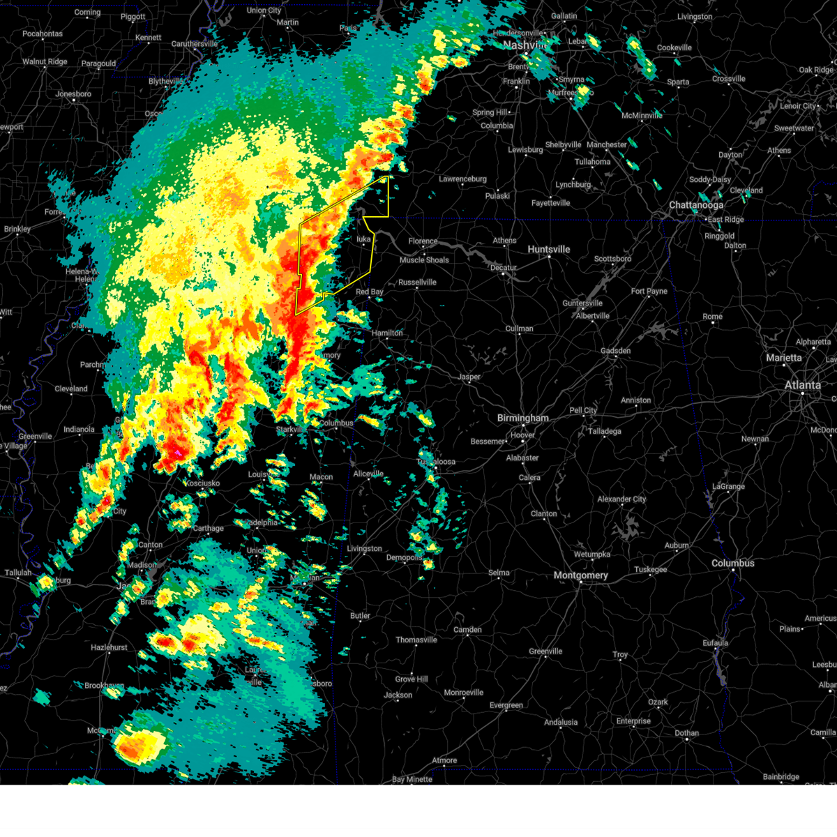
| 4/5/2025 8:02 PM CDT |
 At 802 pm cdt, a confirmed large and extremely dangerous tornado was located near pineflat, or 8 miles southwest of pickwick landing state park, moving northeast at 45 mph. this is a particularly dangerous situation. take cover now! (law enforcement confirmed tornado). Hazards include damaging tornado. You are in a life-threatening situation. flying debris may be deadly to those caught without shelter. mobile homes will be destroyed. considerable damage to homes, businesses, and vehicles is likely and complete destruction is possible. Locations impacted include, iuka, pickwick dam, blythe crossing, guys, rienzi, crump, bruton branch, thrashers, pickwick landing state park, acton, hazard switch, hurley, walkertown, corinth, chambers, bacon springs, kossuth, hightown, damon, and michie. At 802 pm cdt, a confirmed large and extremely dangerous tornado was located near pineflat, or 8 miles southwest of pickwick landing state park, moving northeast at 45 mph. this is a particularly dangerous situation. take cover now! (law enforcement confirmed tornado). Hazards include damaging tornado. You are in a life-threatening situation. flying debris may be deadly to those caught without shelter. mobile homes will be destroyed. considerable damage to homes, businesses, and vehicles is likely and complete destruction is possible. Locations impacted include, iuka, pickwick dam, blythe crossing, guys, rienzi, crump, bruton branch, thrashers, pickwick landing state park, acton, hazard switch, hurley, walkertown, corinth, chambers, bacon springs, kossuth, hightown, damon, and michie.
|
| 4/5/2025 7:57 PM CDT |
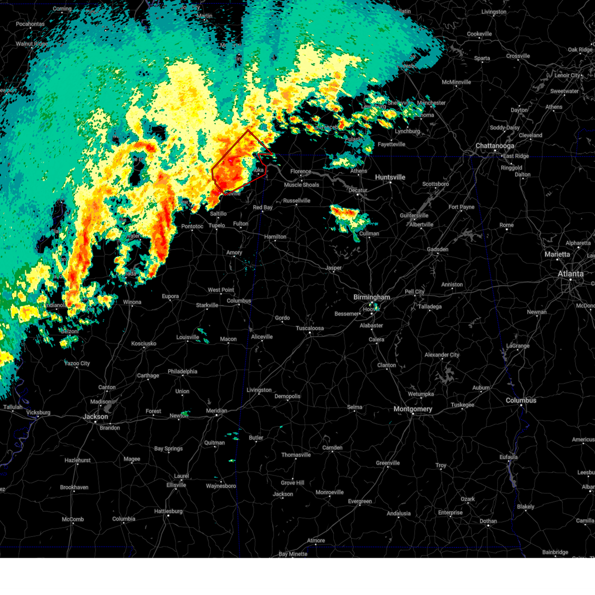 At 757 pm cdt, a severe thunderstorm capable of producing a tornado was located near corinth, moving northeast at 45 mph (radar indicated rotation). Hazards include tornado and quarter size hail. Flying debris will be dangerous to those caught without shelter. mobile homes will be damaged or destroyed. damage to roofs, windows, and vehicles will occur. tree damage is likely. Locations impacted include, iuka, pickwick dam, blythe crossing, guys, rienzi, crump, bruton branch, thrashers, pickwick landing state park, acton, hazard switch, hurley, walkertown, corinth, chambers, bacon springs, kossuth, hightown, damon, and michie. At 757 pm cdt, a severe thunderstorm capable of producing a tornado was located near corinth, moving northeast at 45 mph (radar indicated rotation). Hazards include tornado and quarter size hail. Flying debris will be dangerous to those caught without shelter. mobile homes will be damaged or destroyed. damage to roofs, windows, and vehicles will occur. tree damage is likely. Locations impacted include, iuka, pickwick dam, blythe crossing, guys, rienzi, crump, bruton branch, thrashers, pickwick landing state park, acton, hazard switch, hurley, walkertown, corinth, chambers, bacon springs, kossuth, hightown, damon, and michie.
|
| 4/5/2025 7:39 PM CDT |
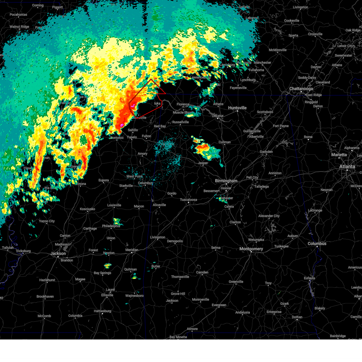 Tormeg the national weather service in memphis has issued a * tornado warning for, northern tishomingo county in northeastern mississippi, northern prentiss county in northeastern mississippi, alcorn county in northeastern mississippi, southeastern mcnairy county in west tennessee, southwestern hardin county in west tennessee, * until 830 pm cdt. * at 738 pm cdt, a large and extremely dangerous tornado was located over hinkle, or 7 miles north of booneville, moving northeast at 45 mph. this is a particularly dangerous situation. take cover now! (radar indicated rotation). Hazards include damaging tornado. You are in a life-threatening situation. flying debris may be deadly to those caught without shelter. mobile homes will be destroyed. Considerable damage to homes, businesses, and vehicles is likely and complete destruction is possible. Tormeg the national weather service in memphis has issued a * tornado warning for, northern tishomingo county in northeastern mississippi, northern prentiss county in northeastern mississippi, alcorn county in northeastern mississippi, southeastern mcnairy county in west tennessee, southwestern hardin county in west tennessee, * until 830 pm cdt. * at 738 pm cdt, a large and extremely dangerous tornado was located over hinkle, or 7 miles north of booneville, moving northeast at 45 mph. this is a particularly dangerous situation. take cover now! (radar indicated rotation). Hazards include damaging tornado. You are in a life-threatening situation. flying debris may be deadly to those caught without shelter. mobile homes will be destroyed. Considerable damage to homes, businesses, and vehicles is likely and complete destruction is possible.
|
| 4/5/2025 7:31 PM CDT |
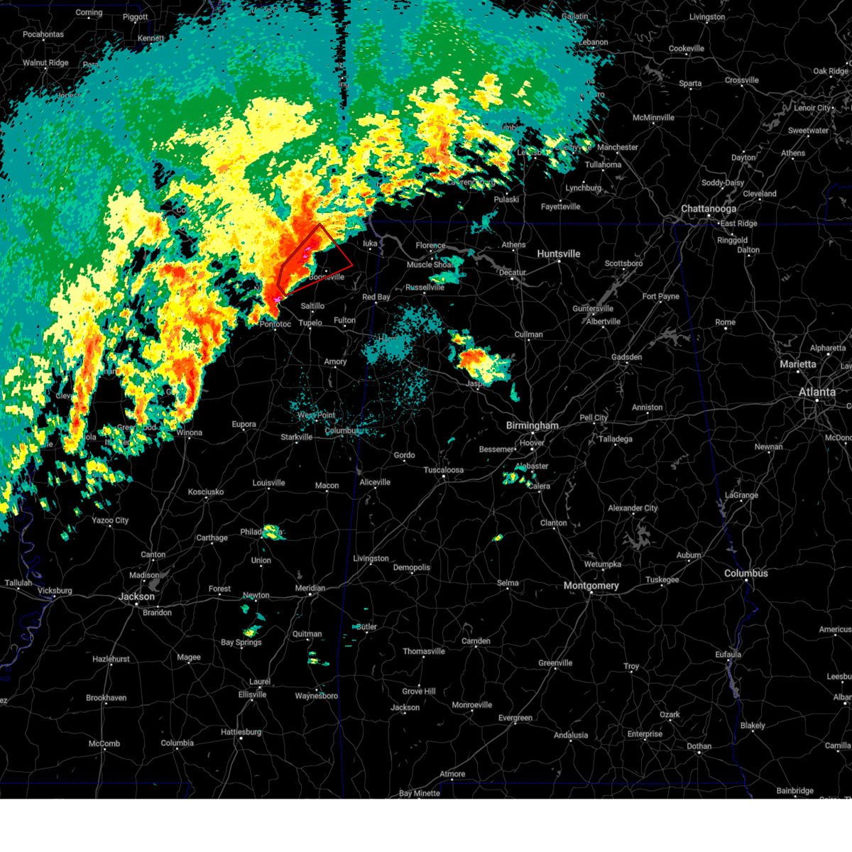 At 731 pm cdt, a confirmed large and extremely dangerous tornado was located near jumpertown, or 8 miles northwest of booneville, moving northeast at 45 mph. this is a particularly dangerous situation. take cover now! (radar confirmed tornado). Hazards include damaging tornado. You are in a life-threatening situation. flying debris may be deadly to those caught without shelter. mobile homes will be destroyed. considerable damage to homes, businesses, and vehicles is likely and complete destruction is possible. Locations impacted include, graham, collinstown, biggersville, rienzi, thrashers, gaston, hinkle, keownville, geeville, locum, kossuth, allentown, hightown, crumtown, blackland, booneville, gift, molino, clarysville, and dumas. At 731 pm cdt, a confirmed large and extremely dangerous tornado was located near jumpertown, or 8 miles northwest of booneville, moving northeast at 45 mph. this is a particularly dangerous situation. take cover now! (radar confirmed tornado). Hazards include damaging tornado. You are in a life-threatening situation. flying debris may be deadly to those caught without shelter. mobile homes will be destroyed. considerable damage to homes, businesses, and vehicles is likely and complete destruction is possible. Locations impacted include, graham, collinstown, biggersville, rienzi, thrashers, gaston, hinkle, keownville, geeville, locum, kossuth, allentown, hightown, crumtown, blackland, booneville, gift, molino, clarysville, and dumas.
|
| 4/5/2025 7:09 PM CDT |
 Tormeg the national weather service in memphis has issued a * tornado warning for, northeastern union county in northeastern mississippi, southeastern tippah county in northeastern mississippi, northern prentiss county in northeastern mississippi, alcorn county in northeastern mississippi, * until 800 pm cdt. * at 709 pm cdt, a confirmed large and extremely dangerous tornado was located near keownville, or 10 miles southeast of ripley, moving northeast at 40 mph. this is a particularly dangerous situation. take cover now! (radar confirmed tornado). Hazards include damaging tornado. You are in a life-threatening situation. flying debris may be deadly to those caught without shelter. mobile homes will be destroyed. Considerable damage to homes, businesses, and vehicles is likely and complete destruction is possible. Tormeg the national weather service in memphis has issued a * tornado warning for, northeastern union county in northeastern mississippi, southeastern tippah county in northeastern mississippi, northern prentiss county in northeastern mississippi, alcorn county in northeastern mississippi, * until 800 pm cdt. * at 709 pm cdt, a confirmed large and extremely dangerous tornado was located near keownville, or 10 miles southeast of ripley, moving northeast at 40 mph. this is a particularly dangerous situation. take cover now! (radar confirmed tornado). Hazards include damaging tornado. You are in a life-threatening situation. flying debris may be deadly to those caught without shelter. mobile homes will be destroyed. Considerable damage to homes, businesses, and vehicles is likely and complete destruction is possible.
|
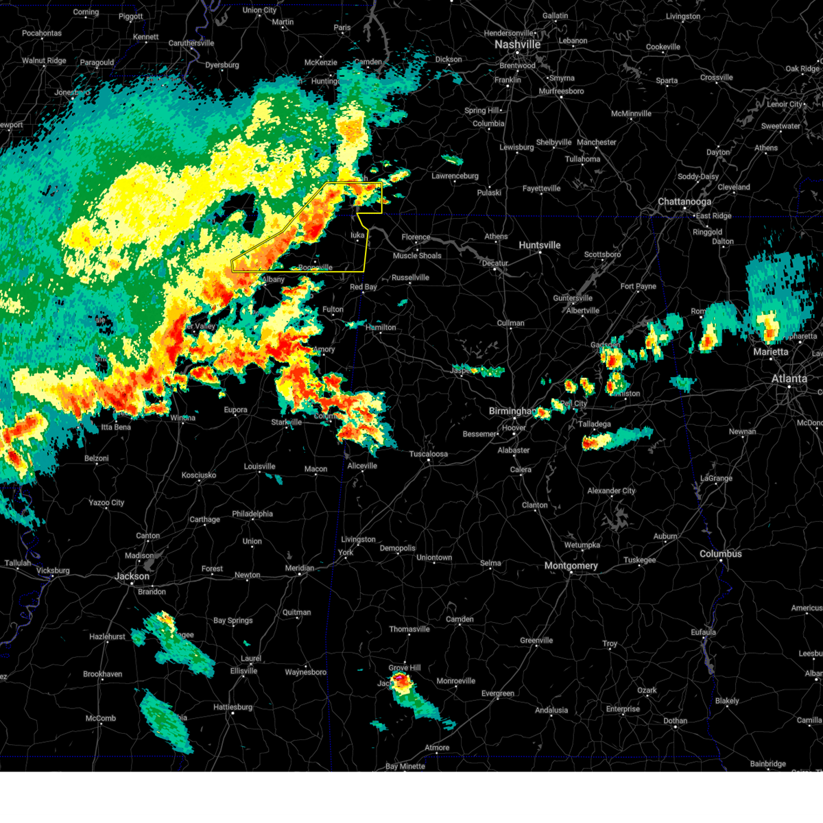
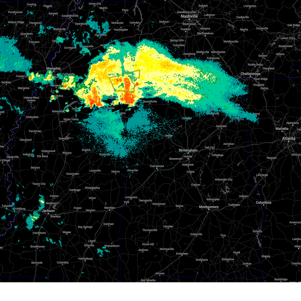
| 4/3/2025 4:53 PM CDT | At 452 pm cdt, a severe thunderstorm was located near pineflat, or 8 miles west of pickwick landing state park, moving northeast at 45 mph (radar indicated. at 450 pm cdt, hail up to two inches in diameter was reported near farmington). Hazards include two inch hail and 60 mph wind gusts. People and animals outdoors will be injured. expect hail damage to roofs, siding, windows, and vehicles. expect wind damage to roofs, siding, and trees. Locations impacted include, shiloh national military park, walnut grove, doskie, j p coleman state park, pickwick dam, hamburg, pineflat, phillips, bruton branch, tulu, pickwick landing state park, acton, hurley, walkertown, olivehill, red sulphur springs, chambers, counce, lowryville, and damon. |
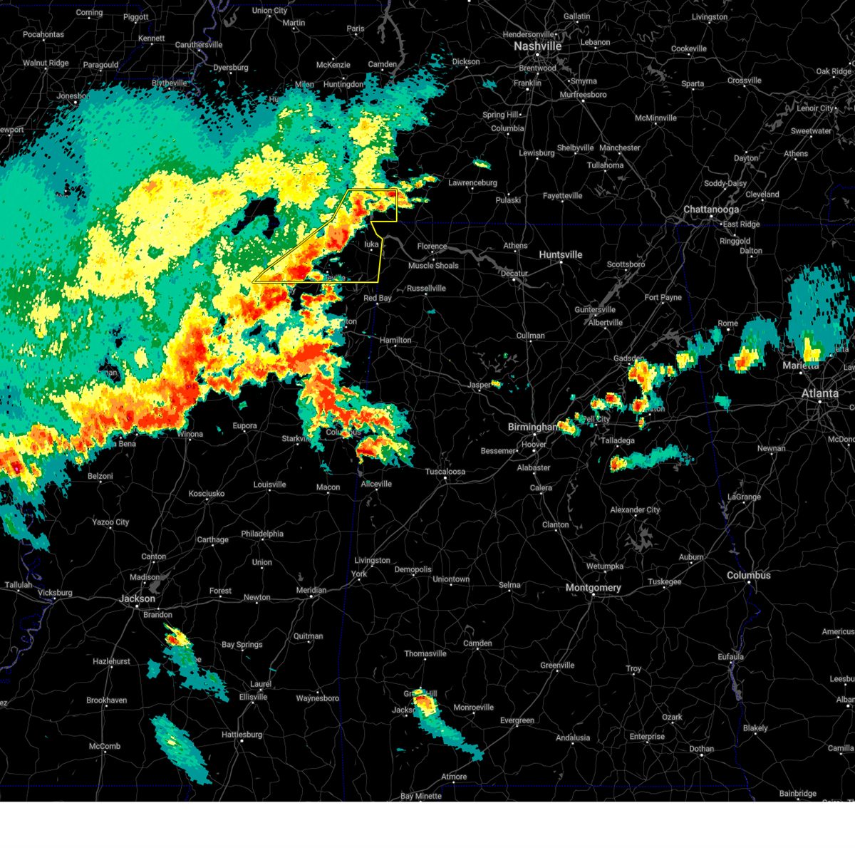
| 4/3/2025 4:51 PM CDT | Hen Egg sized hail reported 8 miles W of Corinth, MS, 2 inch hail reported east of corinth. |
| 4/3/2025 4:51 PM CDT | At 450 pm cdt, a severe thunderstorm was located 7 miles west of pineflat, or 7 miles northeast of corinth, moving northeast at 50 mph (radar indicated). Hazards include 60 mph wind gusts and quarter size hail. Hail damage to vehicles is expected. expect wind damage to roofs, siding, and trees. Locations impacted include, shiloh national military park, walnut grove, doskie, j p coleman state park, pickwick dam, hamburg, pineflat, phillips, bruton branch, tulu, pickwick landing state park, acton, hurley, walkertown, olivehill, red sulphur springs, chambers, counce, lowryville, and damon. |
| 4/3/2025 4:48 PM CDT | Tormeg the national weather service in memphis has issued a * tornado warning for, northern tishomingo county in northeastern mississippi, northeastern alcorn county in northeastern mississippi, southern hardin county in west tennessee, * until 530 pm cdt. * at 448 pm cdt, a severe thunderstorm capable of producing a tornado was located near glen, or 8 miles east of corinth, moving east at 60 mph (radar indicated rotation). Hazards include tornado and quarter size hail. Flying debris will be dangerous to those caught without shelter. mobile homes will be damaged or destroyed. damage to roofs, windows, and vehicles will occur. Tree damage is likely. |
| 4/3/2025 4:31 PM CDT | Svrmeg the national weather service in memphis has issued a * severe thunderstorm warning for, northern tishomingo county in northeastern mississippi, alcorn county in northeastern mississippi, southeastern mcnairy county in west tennessee, hardin county in west tennessee, * until 545 pm cdt. * at 431 pm cdt, a severe thunderstorm was located near theo, or 8 miles southwest of corinth, moving northeast at 45 mph (radar indicated). Hazards include 60 mph wind gusts and quarter size hail. Hail damage to vehicles is expected. Expect wind damage to roofs, siding, and trees. |
| 4/3/2025 3:23 AM CDT | Tormeg the national weather service in memphis has issued a * tornado warning for, north central tippah county in northeastern mississippi, northern alcorn county in northeastern mississippi, southeastern hardeman county in west tennessee, mcnairy county in west tennessee, southwestern hardin county in west tennessee, * until 415 am cdt. * at 322 am cdt, a severe thunderstorm capable of producing a tornado was located near pocahontas, or 7 miles southwest of big hill pond state park, moving northeast at 50 mph (radar indicated rotation). Hazards include tornado. Flying debris will be dangerous to those caught without shelter. mobile homes will be damaged or destroyed. damage to roofs, windows, and vehicles will occur. Tree damage is likely. |
| 4/3/2025 12:13 AM CDT | At 1213 am cdt, a severe thunderstorm capable of producing a tornado was located 8 miles northeast of canaan, or 15 miles west of big hill pond state park, moving northeast at 50 mph (radar indicated rotation). Hazards include tornado and ping pong ball size hail. Flying debris will be dangerous to those caught without shelter. mobile homes will be damaged or destroyed. damage to roofs, windows, and vehicles will occur. tree damage is likely. Locations impacted include, chalybeate, rose creek, selmer, pocahontas, pine top, eastview, wenasoga, guys, hickory valley, chickasaw state forest, silerton, acton, teague, bolivar, hebron, hamilton, middleton, ramer, van buren, and chewalla. |
| 4/3/2025 12:13 AM CDT | the tornado warning has been cancelled and is no longer in effect |
| 4/3/2025 12:00 AM CDT |
 Tormeg the national weather service in memphis has issued a * tornado warning for, northwestern tippah county in northeastern mississippi, northeastern benton county in northeastern mississippi, northwestern alcorn county in northeastern mississippi, southeastern fayette county in west tennessee, hardeman county in west tennessee, southern mcnairy county in west tennessee, southwestern chester county in west tennessee, * until 1245 am cdt. * at 1200 am cdt, a severe thunderstorm capable of producing a tornado was located over canaan, or 18 miles northwest of ripley, moving northeast at 50 mph (radar indicated rotation). Hazards include tornado and ping pong ball size hail. Flying debris will be dangerous to those caught without shelter. mobile homes will be damaged or destroyed. damage to roofs, windows, and vehicles will occur. Tree damage is likely. Tormeg the national weather service in memphis has issued a * tornado warning for, northwestern tippah county in northeastern mississippi, northeastern benton county in northeastern mississippi, northwestern alcorn county in northeastern mississippi, southeastern fayette county in west tennessee, hardeman county in west tennessee, southern mcnairy county in west tennessee, southwestern chester county in west tennessee, * until 1245 am cdt. * at 1200 am cdt, a severe thunderstorm capable of producing a tornado was located over canaan, or 18 miles northwest of ripley, moving northeast at 50 mph (radar indicated rotation). Hazards include tornado and ping pong ball size hail. Flying debris will be dangerous to those caught without shelter. mobile homes will be damaged or destroyed. damage to roofs, windows, and vehicles will occur. Tree damage is likely.
|
| 4/2/2025 3:58 PM CDT | At 358 pm cdt, a severe thunderstorm was located near hinkle, or 10 miles northeast of booneville, moving northeast at 55 mph (radar indicated). Hazards include 60 mph wind gusts and quarter size hail. Hail damage to vehicles is expected. expect wind damage to roofs, siding, and trees. Locations impacted include, iuka, strickland, blythe crossing, wenasoga, biggersville, rienzi, jobes, thrashers, gaston, hinkle, glen, hazard switch, walker siding, holcut, holts spur, corinth, leedy, kossuth, allentown, and hightown. |
| 4/2/2025 3:51 PM CDT | At 351 pm cdt, a severe thunderstorm was located near booneville, moving northeast at 45 mph (radar indicated). Hazards include ping pong ball size hail and 60 mph wind gusts. People and animals outdoors will be injured. expect hail damage to roofs, siding, windows, and vehicles. expect wind damage to roofs, siding, and trees. Locations impacted include, iuka, strickland, blythe crossing, wenasoga, biggersville, rienzi, jobes, thrashers, gaston, hinkle, glen, hazard switch, walker siding, holcut, hobo station, holts spur, corinth, leedy, kossuth, and allentown. |
| 4/2/2025 3:51 PM CDT | the severe thunderstorm warning has been cancelled and is no longer in effect |
| 4/2/2025 3:40 PM CDT |
 At 340 pm cdt, a severe thunderstorm was located over wheeler, or near booneville, moving northeast at 50 mph (radar indicated). Hazards include 60 mph wind gusts and half dollar size hail. Hail damage to vehicles is expected. expect wind damage to roofs, siding, and trees. Locations impacted include, iuka, graham, jericho, strickland, blythe crossing, wenasoga, biggersville, rienzi, jobes, thrashers, gaston, hinkle, glen, hazard switch, walker siding, holcut, baldwyn, geeville, locum, and midway. At 340 pm cdt, a severe thunderstorm was located over wheeler, or near booneville, moving northeast at 50 mph (radar indicated). Hazards include 60 mph wind gusts and half dollar size hail. Hail damage to vehicles is expected. expect wind damage to roofs, siding, and trees. Locations impacted include, iuka, graham, jericho, strickland, blythe crossing, wenasoga, biggersville, rienzi, jobes, thrashers, gaston, hinkle, glen, hazard switch, walker siding, holcut, baldwyn, geeville, locum, and midway.
|
| 4/2/2025 3:32 PM CDT | At 332 pm cdt, a severe thunderstorm was located near baldwyn, moving northeast at 45 mph (radar indicated). Hazards include 60 mph wind gusts and half dollar size hail. Hail damage to vehicles is expected. expect wind damage to roofs, siding, and trees. Locations impacted include, iuka, graham, jericho, strickland, blythe crossing, wenasoga, biggersville, rienzi, jobes, thrashers, gaston, hinkle, glen, hazard switch, walker siding, holcut, baldwyn, geeville, locum, and midway. |
| 4/2/2025 3:18 PM CDT |
 Svrmeg the national weather service in memphis has issued a * severe thunderstorm warning for, eastern union county in northeastern mississippi, northern lee county in northeastern mississippi, southeastern tippah county in northeastern mississippi, northern tishomingo county in northeastern mississippi, prentiss county in northeastern mississippi, alcorn county in northeastern mississippi, * until 415 pm cdt. * at 318 pm cdt, a severe thunderstorm was located near blair, or 9 miles southwest of baldwyn, moving northeast at 55 mph (radar indicated). Hazards include 60 mph wind gusts and half dollar size hail. Hail damage to vehicles is expected. Expect wind damage to roofs, siding, and trees. Svrmeg the national weather service in memphis has issued a * severe thunderstorm warning for, eastern union county in northeastern mississippi, northern lee county in northeastern mississippi, southeastern tippah county in northeastern mississippi, northern tishomingo county in northeastern mississippi, prentiss county in northeastern mississippi, alcorn county in northeastern mississippi, * until 415 pm cdt. * at 318 pm cdt, a severe thunderstorm was located near blair, or 9 miles southwest of baldwyn, moving northeast at 55 mph (radar indicated). Hazards include 60 mph wind gusts and half dollar size hail. Hail damage to vehicles is expected. Expect wind damage to roofs, siding, and trees.
|
| 3/31/2025 1:57 AM CDT |
 The storm which prompted the warning has moved out of the area. therefore, the warning will be allowed to expire. a tornado watch remains in effect until 500 am cdt for northeastern mississippi. The storm which prompted the warning has moved out of the area. therefore, the warning will be allowed to expire. a tornado watch remains in effect until 500 am cdt for northeastern mississippi.
|
| 3/31/2025 1:40 AM CDT |
 At 139 am cdt, a severe thunderstorm was located near j p coleman state park, moving east at 50 mph (radar indicated). Hazards include 60 mph wind gusts and quarter size hail. Hail damage to vehicles is expected. expect wind damage to roofs, siding, and trees. Locations impacted include, bacon springs, iuka, oldham, doskie, j p coleman state park, strickland, pineflat, blythe crossing, biggersville, jobes, hinkle, glen, hazard switch, walker siding, kendrick, burnsville, holts spur, farmington, corinth, and leedy. At 139 am cdt, a severe thunderstorm was located near j p coleman state park, moving east at 50 mph (radar indicated). Hazards include 60 mph wind gusts and quarter size hail. Hail damage to vehicles is expected. expect wind damage to roofs, siding, and trees. Locations impacted include, bacon springs, iuka, oldham, doskie, j p coleman state park, strickland, pineflat, blythe crossing, biggersville, jobes, hinkle, glen, hazard switch, walker siding, kendrick, burnsville, holts spur, farmington, corinth, and leedy.
|
| 3/31/2025 1:40 AM CDT |
 the severe thunderstorm warning has been cancelled and is no longer in effect the severe thunderstorm warning has been cancelled and is no longer in effect
|
| 3/31/2025 1:15 AM CDT | Svrmeg the national weather service in memphis has issued a * severe thunderstorm warning for, northern tishomingo county in northeastern mississippi, eastern alcorn county in northeastern mississippi, southern hardin county in west tennessee, * until 200 am cdt. * at 113 am cdt, a severe thunderstorm was located near glen, or near corinth, moving east at 50 mph (radar indicated. at 111 am, quarter sized hail was reported in pickwick, tn). Hazards include 60 mph wind gusts and quarter size hail. Hail damage to vehicles is expected. Expect wind damage to roofs, siding, and trees. |
| 3/31/2025 12:56 AM CDT |
 At 1256 am cdt, severe thunderstorms were located along a line extending from 7 miles west of lawrenceburg to near hinkle, moving east at 45 mph (radar indicated). Hazards include 60 mph wind gusts and half dollar size hail. Hail damage to vehicles is expected. expect wind damage to roofs, siding, and trees. Locations impacted include, chalybeate, pickwick dam, guys, bruton branch, pickwick landing state park, acton, hazard switch, hurley, theo, walkertown, corinth, tiplersville, chambers, bacon springs, kossuth, hightown, damon, michie, caffey, and crumtown. At 1256 am cdt, severe thunderstorms were located along a line extending from 7 miles west of lawrenceburg to near hinkle, moving east at 45 mph (radar indicated). Hazards include 60 mph wind gusts and half dollar size hail. Hail damage to vehicles is expected. expect wind damage to roofs, siding, and trees. Locations impacted include, chalybeate, pickwick dam, guys, bruton branch, pickwick landing state park, acton, hazard switch, hurley, theo, walkertown, corinth, tiplersville, chambers, bacon springs, kossuth, hightown, damon, michie, caffey, and crumtown.
|
| 3/31/2025 12:56 AM CDT |
 the severe thunderstorm warning has been cancelled and is no longer in effect the severe thunderstorm warning has been cancelled and is no longer in effect
|
| 3/31/2025 12:31 AM CDT | Svrmeg the national weather service in memphis has issued a * severe thunderstorm warning for, northern tippah county in northeastern mississippi, northern tishomingo county in northeastern mississippi, alcorn county in northeastern mississippi, southeastern hardeman county in west tennessee, southern mcnairy county in west tennessee, hardin county in west tennessee, * until 115 am cdt. * at 1231 am cdt, severe thunderstorms were located along a line extending from near waynesboro to near ripley, moving east at 45 mph (radar indicated). Hazards include 60 mph wind gusts and half dollar size hail. Hail damage to vehicles is expected. Expect wind damage to roofs, siding, and trees. |
| 3/31/2025 12:15 AM CDT | At 1215 am cdt, severe thunderstorms were located along a line extending from 6 miles southeast of olive hill to near pineflat to 6 miles north of ripley, moving southeast at 45 mph (public). Hazards include 60 mph wind gusts and quarter size hail. Hail damage to vehicles is expected. expect wind damage to roofs, siding, and trees. Locations impacted include, murry, brody, selmer, pickwick dam, crump, bruton branch, pickwick landing state park, acton, theo, walkertown, cerro gordo, rogers springs, kossuth, hightown, new lawton, martin camp, savannah, lisbon, caffey, and crumtown. |
| 3/30/2025 11:58 PM CDT |
 the severe thunderstorm warning has been cancelled and is no longer in effect the severe thunderstorm warning has been cancelled and is no longer in effect
|
| 3/30/2025 11:58 PM CDT |
 At 1157 pm cdt, severe thunderstorms were located along a line extending from 6 miles northeast of savannah to 7 miles south of selmer to near canaan, moving east at 30 mph (radar indicated). Hazards include 60 mph wind gusts and half dollar size hail. Hail damage to vehicles is expected. expect wind damage to roofs, siding, and trees. Locations impacted include, murry, brody, selmer, pickwick dam, crump, bruton branch, pickwick landing state park, acton, theo, walkertown, cerro gordo, rogers springs, kossuth, hightown, new lawton, martin camp, savannah, lisbon, caffey, and crumtown. At 1157 pm cdt, severe thunderstorms were located along a line extending from 6 miles northeast of savannah to 7 miles south of selmer to near canaan, moving east at 30 mph (radar indicated). Hazards include 60 mph wind gusts and half dollar size hail. Hail damage to vehicles is expected. expect wind damage to roofs, siding, and trees. Locations impacted include, murry, brody, selmer, pickwick dam, crump, bruton branch, pickwick landing state park, acton, theo, walkertown, cerro gordo, rogers springs, kossuth, hightown, new lawton, martin camp, savannah, lisbon, caffey, and crumtown.
|
| 3/30/2025 11:46 PM CDT |
 At 1146 pm cdt, severe thunderstorms were located along a line extending from near olive hill to near corinth to near ripley, moving southeast at 45 mph (radar indicated). Hazards include 60 mph wind gusts and half dollar size hail. Hail damage to vehicles is expected. expect wind damage to roofs, siding, and trees. Locations impacted include, murry, brody, selmer, pickwick dam, belmont, masseyville, blythe crossing, crump, bruton branch, pickwick landing state park, acton, theo, walkertown, petertown, cerro gordo, neil, rogers springs, kossuth, hightown, and hornsby. At 1146 pm cdt, severe thunderstorms were located along a line extending from near olive hill to near corinth to near ripley, moving southeast at 45 mph (radar indicated). Hazards include 60 mph wind gusts and half dollar size hail. Hail damage to vehicles is expected. expect wind damage to roofs, siding, and trees. Locations impacted include, murry, brody, selmer, pickwick dam, belmont, masseyville, blythe crossing, crump, bruton branch, pickwick landing state park, acton, theo, walkertown, petertown, cerro gordo, neil, rogers springs, kossuth, hightown, and hornsby.
|
| 3/30/2025 11:46 PM CDT |
 the severe thunderstorm warning has been cancelled and is no longer in effect the severe thunderstorm warning has been cancelled and is no longer in effect
|
| 3/30/2025 11:30 PM CDT |
 Svrmeg the national weather service in memphis has issued a * severe thunderstorm warning for, north central marshall county in northwestern mississippi, tippah county in northeastern mississippi, northern benton county in northeastern mississippi, tishomingo county in northeastern mississippi, prentiss county in northeastern mississippi, alcorn county in northeastern mississippi, southeastern fayette county in west tennessee, hardeman county in west tennessee, mcnairy county in west tennessee, hardin county in west tennessee, chester county in west tennessee, * until 1230 am cdt. * at 1130 pm cdt, severe thunderstorms were located along a line extending from near morris chapel to big hill pond state park to near gravestown, moving southeast at 45 mph (radar indicated). Hazards include 60 mph wind gusts and half dollar size hail. Hail damage to vehicles is expected. Expect wind damage to roofs, siding, and trees. Svrmeg the national weather service in memphis has issued a * severe thunderstorm warning for, north central marshall county in northwestern mississippi, tippah county in northeastern mississippi, northern benton county in northeastern mississippi, tishomingo county in northeastern mississippi, prentiss county in northeastern mississippi, alcorn county in northeastern mississippi, southeastern fayette county in west tennessee, hardeman county in west tennessee, mcnairy county in west tennessee, hardin county in west tennessee, chester county in west tennessee, * until 1230 am cdt. * at 1130 pm cdt, severe thunderstorms were located along a line extending from near morris chapel to big hill pond state park to near gravestown, moving southeast at 45 mph (radar indicated). Hazards include 60 mph wind gusts and half dollar size hail. Hail damage to vehicles is expected. Expect wind damage to roofs, siding, and trees.
|
| 3/15/2025 12:57 PM CDT |
 At 1256 pm cdt, severe thunderstorms were located along a line extending from near hinkle to near pratts friendship, moving east at 50 mph (radar indicated). Hazards include 60 mph wind gusts and half dollar size hail. Hail damage to vehicles is expected. expect wind damage to roofs, siding, and trees. Locations impacted include, iuka, pickwick dam, thrasher, blythe crossing, guys, rienzi, bruton branch, thrashers, pickwick landing state park, carter branch, acton, hazard switch, walkertown, midway, hobo station, petertown, corinth, pratts friendship, neil, and chambers. At 1256 pm cdt, severe thunderstorms were located along a line extending from near hinkle to near pratts friendship, moving east at 50 mph (radar indicated). Hazards include 60 mph wind gusts and half dollar size hail. Hail damage to vehicles is expected. expect wind damage to roofs, siding, and trees. Locations impacted include, iuka, pickwick dam, thrasher, blythe crossing, guys, rienzi, bruton branch, thrashers, pickwick landing state park, carter branch, acton, hazard switch, walkertown, midway, hobo station, petertown, corinth, pratts friendship, neil, and chambers.
|
| 3/15/2025 12:57 PM CDT |
 the severe thunderstorm warning has been cancelled and is no longer in effect the severe thunderstorm warning has been cancelled and is no longer in effect
|
| 3/15/2025 12:41 PM CDT |
 Svrmeg the national weather service in memphis has issued a * severe thunderstorm warning for, northern lee county in northeastern mississippi, southeastern tippah county in northeastern mississippi, tishomingo county in northeastern mississippi, prentiss county in northeastern mississippi, alcorn county in northeastern mississippi, southeastern mcnairy county in west tennessee, southern hardin county in west tennessee, * until 130 pm cdt. * at 1241 pm cdt, severe thunderstorms were located along a line extending from near jumpertown to near saltillo, moving northeast at 65 mph (radar indicated). Hazards include 60 mph wind gusts and half dollar size hail. Hail damage to vehicles is expected. Expect wind damage to roofs, siding, and trees. Svrmeg the national weather service in memphis has issued a * severe thunderstorm warning for, northern lee county in northeastern mississippi, southeastern tippah county in northeastern mississippi, tishomingo county in northeastern mississippi, prentiss county in northeastern mississippi, alcorn county in northeastern mississippi, southeastern mcnairy county in west tennessee, southern hardin county in west tennessee, * until 130 pm cdt. * at 1241 pm cdt, severe thunderstorms were located along a line extending from near jumpertown to near saltillo, moving northeast at 65 mph (radar indicated). Hazards include 60 mph wind gusts and half dollar size hail. Hail damage to vehicles is expected. Expect wind damage to roofs, siding, and trees.
|
| 3/15/2025 6:36 AM CDT | Svrmeg the national weather service in memphis has issued a * severe thunderstorm warning for, northeastern alcorn county in northeastern mississippi, southeastern mcnairy county in west tennessee, hardin county in west tennessee, southwestern decatur county in west tennessee, * until 715 am cdt. * at 635 am cdt, a severe thunderstorm was located near corinth, moving northeast at 45 mph (radar indicated). Hazards include 60 mph wind gusts and quarter size hail. Hail damage to vehicles is expected. Expect wind damage to roofs, siding, and trees. |
| 7/9/2024 10:29 AM CDT |
 the tornado warning has been cancelled and is no longer in effect the tornado warning has been cancelled and is no longer in effect
|
| 7/9/2024 10:17 AM CDT |
 At 1017 am cdt, a severe thunderstorm capable of producing a tornado was located over thrashers, or near booneville, moving northeast at 25 mph (radar indicated rotation). Hazards include tornado. Flying debris will be dangerous to those caught without shelter. mobile homes will be damaged or destroyed. damage to roofs, windows, and vehicles will occur. tree damage is likely. Locations impacted include, corinth, booneville, burnsville, glen, thrashers, leedy, farmington, rienzi, strickland, jobes, walker siding, holts spur, altitude, and hazard switch. At 1017 am cdt, a severe thunderstorm capable of producing a tornado was located over thrashers, or near booneville, moving northeast at 25 mph (radar indicated rotation). Hazards include tornado. Flying debris will be dangerous to those caught without shelter. mobile homes will be damaged or destroyed. damage to roofs, windows, and vehicles will occur. tree damage is likely. Locations impacted include, corinth, booneville, burnsville, glen, thrashers, leedy, farmington, rienzi, strickland, jobes, walker siding, holts spur, altitude, and hazard switch.
|
| 7/9/2024 10:02 AM CDT |
 Tormeg the national weather service in memphis has issued a * tornado warning for, west central tishomingo county in northeastern mississippi, northeastern prentiss county in northeastern mississippi, eastern alcorn county in northeastern mississippi, * until 1045 am cdt. * at 1002 am cdt, a severe thunderstorm capable of producing a tornado was located over thrashers, or near booneville, moving northeast at 30 mph (radar indicated rotation). Hazards include tornado. Flying debris will be dangerous to those caught without shelter. mobile homes will be damaged or destroyed. damage to roofs, windows, and vehicles will occur. Tree damage is likely. Tormeg the national weather service in memphis has issued a * tornado warning for, west central tishomingo county in northeastern mississippi, northeastern prentiss county in northeastern mississippi, eastern alcorn county in northeastern mississippi, * until 1045 am cdt. * at 1002 am cdt, a severe thunderstorm capable of producing a tornado was located over thrashers, or near booneville, moving northeast at 30 mph (radar indicated rotation). Hazards include tornado. Flying debris will be dangerous to those caught without shelter. mobile homes will be damaged or destroyed. damage to roofs, windows, and vehicles will occur. Tree damage is likely.
|
| 5/27/2024 2:23 AM CDT |
 The storm which prompted the warning has weakened below severe limits, and has exited the warned area. therefore, the warning will be allowed to expire. a tornado watch remains in effect until 500 am cdt for west tennessee. a tornado watch also remains in effect until 800 am cdt for northeastern mississippi. The storm which prompted the warning has weakened below severe limits, and has exited the warned area. therefore, the warning will be allowed to expire. a tornado watch remains in effect until 500 am cdt for west tennessee. a tornado watch also remains in effect until 800 am cdt for northeastern mississippi.
|
| 5/27/2024 2:12 AM CDT |
 the severe thunderstorm warning has been cancelled and is no longer in effect the severe thunderstorm warning has been cancelled and is no longer in effect
|
| 5/27/2024 2:12 AM CDT |
 At 211 am cdt, a severe thunderstorm was located over st. florian, or near florence, moving east at 80 mph (radar indicated). Hazards include 60 mph wind gusts and nickel size hail. Expect damage to roofs, siding, and trees. Locations impacted include, corinth, booneville, savannah, iuka, pickwick landing state park, j p coleman state park, tishomingo state park, adamsville, belmont, burnsville, jumpertown, glen, sardis, tishomingo, pickwick dam, thrashers, midway, morris chapel, shiloh, and walnut grove. At 211 am cdt, a severe thunderstorm was located over st. florian, or near florence, moving east at 80 mph (radar indicated). Hazards include 60 mph wind gusts and nickel size hail. Expect damage to roofs, siding, and trees. Locations impacted include, corinth, booneville, savannah, iuka, pickwick landing state park, j p coleman state park, tishomingo state park, adamsville, belmont, burnsville, jumpertown, glen, sardis, tishomingo, pickwick dam, thrashers, midway, morris chapel, shiloh, and walnut grove.
|
| 5/27/2024 1:58 AM CDT |
 the severe thunderstorm warning has been cancelled and is no longer in effect the severe thunderstorm warning has been cancelled and is no longer in effect
|
| 5/27/2024 1:58 AM CDT |
 At 158 am cdt, a severe thunderstorm was located 10 miles southeast of walnut grove, or 13 miles east of j p coleman state park, moving east at 80 mph (radar indicated). Hazards include 60 mph wind gusts and nickel size hail. Expect damage to roofs, siding, and trees. Locations impacted include, corinth, booneville, savannah, selmer, iuka, pickwick landing state park, j p coleman state park, big hill pond state park, tishomingo state park, adamsville, belmont, burnsville, jumpertown, glen, sardis, tishomingo, pickwick dam, theo, pineflat, and hinkle. At 158 am cdt, a severe thunderstorm was located 10 miles southeast of walnut grove, or 13 miles east of j p coleman state park, moving east at 80 mph (radar indicated). Hazards include 60 mph wind gusts and nickel size hail. Expect damage to roofs, siding, and trees. Locations impacted include, corinth, booneville, savannah, selmer, iuka, pickwick landing state park, j p coleman state park, big hill pond state park, tishomingo state park, adamsville, belmont, burnsville, jumpertown, glen, sardis, tishomingo, pickwick dam, theo, pineflat, and hinkle.
|
| 5/27/2024 1:49 AM CDT |
 the severe thunderstorm warning has been cancelled and is no longer in effect the severe thunderstorm warning has been cancelled and is no longer in effect
|
| 5/27/2024 1:49 AM CDT |
 At 148 am cdt, a severe thunderstorm was located near pickwick landing state park, moving east at 80 mph (radar indicated). Hazards include 70 mph wind gusts and nickel size hail. Expect considerable tree damage. damage is likely to mobile homes, roofs, and outbuildings. Locations impacted include, corinth, booneville, savannah, selmer, iuka, pickwick landing state park, j p coleman state park, big hill pond state park, tishomingo state park, adamsville, belmont, burnsville, jumpertown, glen, sardis, tishomingo, pickwick dam, theo, pocahontas, and pineflat. At 148 am cdt, a severe thunderstorm was located near pickwick landing state park, moving east at 80 mph (radar indicated). Hazards include 70 mph wind gusts and nickel size hail. Expect considerable tree damage. damage is likely to mobile homes, roofs, and outbuildings. Locations impacted include, corinth, booneville, savannah, selmer, iuka, pickwick landing state park, j p coleman state park, big hill pond state park, tishomingo state park, adamsville, belmont, burnsville, jumpertown, glen, sardis, tishomingo, pickwick dam, theo, pocahontas, and pineflat.
|
| 5/27/2024 1:26 AM CDT |
 Svrmeg the national weather service in memphis has issued a * severe thunderstorm warning for, northern tippah county in northeastern mississippi, northeastern benton county in northeastern mississippi, tishomingo county in northeastern mississippi, northern prentiss county in northeastern mississippi, alcorn county in northeastern mississippi, southeastern henderson county in west tennessee, southeastern hardeman county in west tennessee, mcnairy county in west tennessee, hardin county in west tennessee, chester county in west tennessee, southern decatur county in west tennessee, * until 230 am cdt. * at 126 am cdt, a severe thunderstorm was located near selmer, moving east at 80 mph (radar indicated). Hazards include 70 mph wind gusts and nickel size hail. Expect considerable tree damage. Damage is likely to mobile homes, roofs, and outbuildings. Svrmeg the national weather service in memphis has issued a * severe thunderstorm warning for, northern tippah county in northeastern mississippi, northeastern benton county in northeastern mississippi, tishomingo county in northeastern mississippi, northern prentiss county in northeastern mississippi, alcorn county in northeastern mississippi, southeastern henderson county in west tennessee, southeastern hardeman county in west tennessee, mcnairy county in west tennessee, hardin county in west tennessee, chester county in west tennessee, southern decatur county in west tennessee, * until 230 am cdt. * at 126 am cdt, a severe thunderstorm was located near selmer, moving east at 80 mph (radar indicated). Hazards include 70 mph wind gusts and nickel size hail. Expect considerable tree damage. Damage is likely to mobile homes, roofs, and outbuildings.
|
| 5/14/2024 3:05 PM CDT |
 the severe thunderstorm warning has been cancelled and is no longer in effect the severe thunderstorm warning has been cancelled and is no longer in effect
|
| 5/14/2024 2:44 PM CDT |
 Svrmeg the national weather service in memphis has issued a * severe thunderstorm warning for, northern tishomingo county in northeastern mississippi, northeastern alcorn county in northeastern mississippi, southeastern mcnairy county in west tennessee, southern hardin county in west tennessee, * until 330 pm cdt. * at 243 pm cdt, a severe thunderstorm was located over corinth, moving east at 35 mph (radar indicated). Hazards include 60 mph wind gusts and quarter size hail. Hail damage to vehicles is expected. Expect wind damage to roofs, siding, and trees. Svrmeg the national weather service in memphis has issued a * severe thunderstorm warning for, northern tishomingo county in northeastern mississippi, northeastern alcorn county in northeastern mississippi, southeastern mcnairy county in west tennessee, southern hardin county in west tennessee, * until 330 pm cdt. * at 243 pm cdt, a severe thunderstorm was located over corinth, moving east at 35 mph (radar indicated). Hazards include 60 mph wind gusts and quarter size hail. Hail damage to vehicles is expected. Expect wind damage to roofs, siding, and trees.
|
| 5/14/2024 2:28 PM CDT |
 the severe thunderstorm warning has been cancelled and is no longer in effect the severe thunderstorm warning has been cancelled and is no longer in effect
|
| 5/14/2024 2:28 PM CDT |
 At 228 pm cdt, a severe thunderstorm was located near theo, or near big hill pond state park, moving east at 40 mph (radar indicated). Hazards include 60 mph wind gusts and quarter size hail. Hail damage to vehicles is expected. expect wind damage to roofs, siding, and trees. Locations impacted include, corinth, big hill pond state park, theo, guys, ramer, kossuth, gift, lone pine, cypress, wenasoga, and chewalla. At 228 pm cdt, a severe thunderstorm was located near theo, or near big hill pond state park, moving east at 40 mph (radar indicated). Hazards include 60 mph wind gusts and quarter size hail. Hail damage to vehicles is expected. expect wind damage to roofs, siding, and trees. Locations impacted include, corinth, big hill pond state park, theo, guys, ramer, kossuth, gift, lone pine, cypress, wenasoga, and chewalla.
|
| 5/14/2024 2:03 PM CDT |
 Svrmeg the national weather service in memphis has issued a * severe thunderstorm warning for, northern tippah county in northeastern mississippi, northwestern alcorn county in northeastern mississippi, southeastern hardeman county in west tennessee, southwestern mcnairy county in west tennessee, * until 245 pm cdt. * at 202 pm cdt, a severe thunderstorm was located 10 miles north of ripley, moving northeast at 30 mph (radar indicated). Hazards include 60 mph wind gusts and quarter size hail. Hail damage to vehicles is expected. Expect wind damage to roofs, siding, and trees. Svrmeg the national weather service in memphis has issued a * severe thunderstorm warning for, northern tippah county in northeastern mississippi, northwestern alcorn county in northeastern mississippi, southeastern hardeman county in west tennessee, southwestern mcnairy county in west tennessee, * until 245 pm cdt. * at 202 pm cdt, a severe thunderstorm was located 10 miles north of ripley, moving northeast at 30 mph (radar indicated). Hazards include 60 mph wind gusts and quarter size hail. Hail damage to vehicles is expected. Expect wind damage to roofs, siding, and trees.
|
| 4/2/2024 7:15 PM CDT |
 The storm which prompted the warning has weakened below severe limits, and no longer poses an immediate threat to life or property. therefore, the warning has been allowed to expire. however, gusty winds are still possible with this thunderstorm. a tornado watch remains in effect until 900 pm cdt for northeastern mississippi, and west tennessee. The storm which prompted the warning has weakened below severe limits, and no longer poses an immediate threat to life or property. therefore, the warning has been allowed to expire. however, gusty winds are still possible with this thunderstorm. a tornado watch remains in effect until 900 pm cdt for northeastern mississippi, and west tennessee.
|
| 4/2/2024 6:42 PM CDT |
 At 641 pm cdt, a severe thunderstorm was located near theo, or 7 miles southwest of corinth, moving east at 45 mph (radar indicated). Hazards include 60 mph wind gusts and penny size hail. Expect damage to roofs, siding, and trees. Locations impacted include, corinth, pickwick landing state park, burnsville, glen, pickwick dam, pineflat, theo, farmington, michie, guys, kossuth, doskie, strickland, hamburg, wenasoga, biggersville, tulu, jobes, acton, and red sulphur springs. At 641 pm cdt, a severe thunderstorm was located near theo, or 7 miles southwest of corinth, moving east at 45 mph (radar indicated). Hazards include 60 mph wind gusts and penny size hail. Expect damage to roofs, siding, and trees. Locations impacted include, corinth, pickwick landing state park, burnsville, glen, pickwick dam, pineflat, theo, farmington, michie, guys, kossuth, doskie, strickland, hamburg, wenasoga, biggersville, tulu, jobes, acton, and red sulphur springs.
|
| 4/2/2024 6:42 PM CDT |
 the severe thunderstorm warning has been cancelled and is no longer in effect the severe thunderstorm warning has been cancelled and is no longer in effect
|
| 4/2/2024 6:34 PM CDT |
 Svrmeg the national weather service in memphis has issued a * severe thunderstorm warning for, northeastern tippah county in northeastern mississippi, northern tishomingo county in northeastern mississippi, alcorn county in northeastern mississippi, southeastern mcnairy county in west tennessee, southwestern hardin county in west tennessee, * until 715 pm cdt. * at 634 pm cdt, a severe thunderstorm was located near theo, or 12 miles south of big hill pond state park, moving east at 45 mph (radar indicated). Hazards include 60 mph wind gusts and quarter size hail. Hail damage to vehicles is expected. Expect wind damage to roofs, siding, and trees. Svrmeg the national weather service in memphis has issued a * severe thunderstorm warning for, northeastern tippah county in northeastern mississippi, northern tishomingo county in northeastern mississippi, alcorn county in northeastern mississippi, southeastern mcnairy county in west tennessee, southwestern hardin county in west tennessee, * until 715 pm cdt. * at 634 pm cdt, a severe thunderstorm was located near theo, or 12 miles south of big hill pond state park, moving east at 45 mph (radar indicated). Hazards include 60 mph wind gusts and quarter size hail. Hail damage to vehicles is expected. Expect wind damage to roofs, siding, and trees.
|
| 3/14/2024 7:35 PM CDT |
 Svrmeg the national weather service in memphis has issued a * severe thunderstorm warning for, southeastern henderson county in west tennessee, mcnairy county in west tennessee, hardin county in west tennessee, east central chester county in west tennessee, southern decatur county in west tennessee, * until 815 pm cdt. * at 734 pm cdt, severe thunderstorms were located along a line extending from near adamsville to near shiloh to 6 miles north of corinth, moving northeast at 50 mph (radar indicated). Hazards include 60 mph wind gusts and quarter size hail. Hail damage to vehicles is expected. Expect wind damage to roofs, siding, and trees. Svrmeg the national weather service in memphis has issued a * severe thunderstorm warning for, southeastern henderson county in west tennessee, mcnairy county in west tennessee, hardin county in west tennessee, east central chester county in west tennessee, southern decatur county in west tennessee, * until 815 pm cdt. * at 734 pm cdt, severe thunderstorms were located along a line extending from near adamsville to near shiloh to 6 miles north of corinth, moving northeast at 50 mph (radar indicated). Hazards include 60 mph wind gusts and quarter size hail. Hail damage to vehicles is expected. Expect wind damage to roofs, siding, and trees.
|
| 12/9/2023 4:38 PM CST |
 The severe thunderstorm warning for northern tippah, northwestern alcorn and southwestern mcnairy counties will expire at 445 pm cst, the storm which prompted the warning has weakened below severe limits, and no longer poses an immediate threat to life or property. therefore, the warning will be allowed to expire. a tornado watch remains in effect until 700 pm cst for northeastern mississippi, and west tennessee. The severe thunderstorm warning for northern tippah, northwestern alcorn and southwestern mcnairy counties will expire at 445 pm cst, the storm which prompted the warning has weakened below severe limits, and no longer poses an immediate threat to life or property. therefore, the warning will be allowed to expire. a tornado watch remains in effect until 700 pm cst for northeastern mississippi, and west tennessee.
|
| 12/9/2023 4:18 PM CST |
 At 418 pm cst, a severe thunderstorm was located near theo, or 8 miles southwest of big hill pond state park, moving east at 35 mph (radar indicated). Hazards include 60 mph wind gusts and quarter size hail. Hail damage to vehicles is expected. expect wind damage to roofs, siding, and trees. Locations impacted include, corinth, big hill pond state park, theo, walnut, eastview, falkner, guys, ramer, kossuth, chalybeate, allentown, wenasoga, biggersville, crumtown, jobes, brownfield, gift, lone pine, cypress, and chewalla. At 418 pm cst, a severe thunderstorm was located near theo, or 8 miles southwest of big hill pond state park, moving east at 35 mph (radar indicated). Hazards include 60 mph wind gusts and quarter size hail. Hail damage to vehicles is expected. expect wind damage to roofs, siding, and trees. Locations impacted include, corinth, big hill pond state park, theo, walnut, eastview, falkner, guys, ramer, kossuth, chalybeate, allentown, wenasoga, biggersville, crumtown, jobes, brownfield, gift, lone pine, cypress, and chewalla.
|
| 12/9/2023 4:04 PM CST |
 At 404 pm cst, a severe thunderstorm capable of producing a tornado was located 9 miles north of ripley, moving east at 35 mph (radar indicated rotation). Hazards include tornado and quarter size hail. Flying debris will be dangerous to those caught without shelter. mobile homes will be damaged or destroyed. damage to roofs, windows, and vehicles will occur. Tree damage is likely. At 404 pm cst, a severe thunderstorm capable of producing a tornado was located 9 miles north of ripley, moving east at 35 mph (radar indicated rotation). Hazards include tornado and quarter size hail. Flying debris will be dangerous to those caught without shelter. mobile homes will be damaged or destroyed. damage to roofs, windows, and vehicles will occur. Tree damage is likely.
|
| 12/9/2023 3:52 PM CST |
 At 352 pm cst, a severe thunderstorm was located near canaan, or 12 miles northwest of ripley, moving east at 35 mph (radar indicated). Hazards include 60 mph wind gusts and quarter size hail. Hail damage to vehicles is expected. Expect wind damage to roofs, siding, and trees. At 352 pm cst, a severe thunderstorm was located near canaan, or 12 miles northwest of ripley, moving east at 35 mph (radar indicated). Hazards include 60 mph wind gusts and quarter size hail. Hail damage to vehicles is expected. Expect wind damage to roofs, siding, and trees.
|
| 9/6/2023 5:47 PM CDT |
 At 547 pm cdt, a severe thunderstorm was located near glen, or 7 miles south of corinth, moving southeast at 30 mph (radar indicated). Hazards include 60 mph wind gusts and half dollar size hail. Hail damage to vehicles is expected. Expect wind damage to roofs, siding, and trees. At 547 pm cdt, a severe thunderstorm was located near glen, or 7 miles south of corinth, moving southeast at 30 mph (radar indicated). Hazards include 60 mph wind gusts and half dollar size hail. Hail damage to vehicles is expected. Expect wind damage to roofs, siding, and trees.
|
| 9/6/2023 5:42 PM CDT |
 The severe thunderstorm warning for northeastern itawamba, tishomingo, northeastern prentiss and eastern alcorn counties will expire at 545 pm cdt, the storms which prompted the warning have weakened below severe limits, and no longer pose an immediate threat to life or property. therefore, the warning will be allowed to expire. however gusty winds are still possible with these thunderstorms. a severe thunderstorm watch remains in effect until 1100 pm cdt for northeastern mississippi. The severe thunderstorm warning for northeastern itawamba, tishomingo, northeastern prentiss and eastern alcorn counties will expire at 545 pm cdt, the storms which prompted the warning have weakened below severe limits, and no longer pose an immediate threat to life or property. therefore, the warning will be allowed to expire. however gusty winds are still possible with these thunderstorms. a severe thunderstorm watch remains in effect until 1100 pm cdt for northeastern mississippi.
|
| 9/6/2023 5:40 PM CDT |
 At 538 pm cdt, severe thunderstorms were located along a line extending from leedy to 6 miles southwest of midway to near burton, moving east at 30 mph (radar indicated. at 525 pm, half dollar size hail was reported in downtown cornith). Hazards include 60 mph wind gusts and half dollar size hail. Hail damage to vehicles is expected. expect wind damage to roofs, siding, and trees. locations impacted include, corinth, booneville, iuka, tishomingo state park, belmont, burnsville, jumpertown, glen, tishomingo, thrashers, hinkle, burton, midway, leedy, farmington, rienzi, golden, paden, thrasher and dennis. hail threat, observed max hail size, 1. 25 in wind threat, radar indicated max wind gust, 60 mph. At 538 pm cdt, severe thunderstorms were located along a line extending from leedy to 6 miles southwest of midway to near burton, moving east at 30 mph (radar indicated. at 525 pm, half dollar size hail was reported in downtown cornith). Hazards include 60 mph wind gusts and half dollar size hail. Hail damage to vehicles is expected. expect wind damage to roofs, siding, and trees. locations impacted include, corinth, booneville, iuka, tishomingo state park, belmont, burnsville, jumpertown, glen, tishomingo, thrashers, hinkle, burton, midway, leedy, farmington, rienzi, golden, paden, thrasher and dennis. hail threat, observed max hail size, 1. 25 in wind threat, radar indicated max wind gust, 60 mph.
|
| 9/6/2023 5:27 PM CDT | Trees down on county road 216. time is radar estimate in alcorn county MS, 2.9 miles W of Corinth, MS |
| 9/6/2023 5:25 PM CDT | Golf Ball sized hail reported 0.7 miles NE of Corinth, MS, photo of hail up to the size of a golf ball in corinth. |
| 9/6/2023 5:25 PM CDT | Quarter sized hail reported 0.5 miles ESE of Corinth, MS, quarter-sized hail observed in downtown corinth. |
| 9/6/2023 5:24 PM CDT |
 At 523 pm cdt, severe thunderstorms were located along a line extending from near glen to near leedy to near thrashers, moving southeast at 30 mph (radar indicated). Hazards include 60 mph wind gusts and quarter size hail. Hail damage to vehicles is expected. expect wind damage to roofs, siding, and trees. locations impacted include, corinth, booneville, iuka, tishomingo state park, belmont, burnsville, jumpertown, glen, tishomingo, thrashers, hinkle, burton, midway, leedy, farmington, rienzi, golden, paden, thrasher and dennis. hail threat, radar indicated max hail size, 1. 00 in wind threat, radar indicated max wind gust, 60 mph. At 523 pm cdt, severe thunderstorms were located along a line extending from near glen to near leedy to near thrashers, moving southeast at 30 mph (radar indicated). Hazards include 60 mph wind gusts and quarter size hail. Hail damage to vehicles is expected. expect wind damage to roofs, siding, and trees. locations impacted include, corinth, booneville, iuka, tishomingo state park, belmont, burnsville, jumpertown, glen, tishomingo, thrashers, hinkle, burton, midway, leedy, farmington, rienzi, golden, paden, thrasher and dennis. hail threat, radar indicated max hail size, 1. 00 in wind threat, radar indicated max wind gust, 60 mph.
|
| 9/6/2023 5:06 PM CDT |
 At 506 pm cdt, severe thunderstorms were located along a line extending from near corinth to near hinkle to near booneville, moving southeast at 30 mph (radar indicated). Hazards include 60 mph wind gusts and penny size hail. expect damage to roofs, siding, and trees At 506 pm cdt, severe thunderstorms were located along a line extending from near corinth to near hinkle to near booneville, moving southeast at 30 mph (radar indicated). Hazards include 60 mph wind gusts and penny size hail. expect damage to roofs, siding, and trees
|
| 9/6/2023 4:55 PM CDT |
 At 455 pm cdt, a severe thunderstorm was located near pocahontas, or near big hill pond state park, moving east at 25 mph (radar indicated). Hazards include 60 mph wind gusts and quarter size hail. Hail damage to vehicles is expected. expect wind damage to roofs, siding, and trees. locations impacted include, corinth, big hill pond state park, pocahontas, theo, walnut, middleton, eastview, guys, ramer, chalybeate, wenasoga, essary springs, brownfield, gift, lone pine, cypress, chewalla and tiplersville. hail threat, radar indicated max hail size, 1. 00 in wind threat, radar indicated max wind gust, 60 mph. At 455 pm cdt, a severe thunderstorm was located near pocahontas, or near big hill pond state park, moving east at 25 mph (radar indicated). Hazards include 60 mph wind gusts and quarter size hail. Hail damage to vehicles is expected. expect wind damage to roofs, siding, and trees. locations impacted include, corinth, big hill pond state park, pocahontas, theo, walnut, middleton, eastview, guys, ramer, chalybeate, wenasoga, essary springs, brownfield, gift, lone pine, cypress, chewalla and tiplersville. hail threat, radar indicated max hail size, 1. 00 in wind threat, radar indicated max wind gust, 60 mph.
|
| 9/6/2023 4:44 PM CDT |
 At 444 pm cdt, a severe thunderstorm was located near pocahontas, or 11 miles west of big hill pond state park, moving east at 25 mph (radar indicated). Hazards include 60 mph wind gusts and quarter size hail. Hail damage to vehicles is expected. Expect wind damage to roofs, siding, and trees. At 444 pm cdt, a severe thunderstorm was located near pocahontas, or 11 miles west of big hill pond state park, moving east at 25 mph (radar indicated). Hazards include 60 mph wind gusts and quarter size hail. Hail damage to vehicles is expected. Expect wind damage to roofs, siding, and trees.
|
| 8/9/2023 2:26 PM CDT |
 The severe thunderstorm warning for northern tishomingo, northeastern alcorn, southeastern mcnairy and southern hardin counties will expire at 230 pm cdt, the storm which prompted the warning has moved out of the area. therefore, the warning will be allowed to expire. a severe thunderstorm watch remains in effect until 800 pm cdt for northeastern mississippi, and west tennessee. The severe thunderstorm warning for northern tishomingo, northeastern alcorn, southeastern mcnairy and southern hardin counties will expire at 230 pm cdt, the storm which prompted the warning has moved out of the area. therefore, the warning will be allowed to expire. a severe thunderstorm watch remains in effect until 800 pm cdt for northeastern mississippi, and west tennessee.
|
| 8/9/2023 2:13 PM CDT |
 At 212 pm cdt, a severe thunderstorm was located over pineflat, or near j p coleman state park, moving east at 45 mph (radar indicated). Hazards include 60 mph wind gusts. Expect damage to roofs, siding, and trees. locations impacted include, corinth, iuka, j p coleman state park, pickwick landing state park, burnsville, glen, walnut grove, pickwick dam, pineflat, shiloh, farmington, michie, stantonville, doskie, pebble hill, strickland, hamburg, blythe crossing, bruton branch and tulu. hail threat, radar indicated max hail size, <. 75 in wind threat, radar indicated max wind gust, 60 mph. At 212 pm cdt, a severe thunderstorm was located over pineflat, or near j p coleman state park, moving east at 45 mph (radar indicated). Hazards include 60 mph wind gusts. Expect damage to roofs, siding, and trees. locations impacted include, corinth, iuka, j p coleman state park, pickwick landing state park, burnsville, glen, walnut grove, pickwick dam, pineflat, shiloh, farmington, michie, stantonville, doskie, pebble hill, strickland, hamburg, blythe crossing, bruton branch and tulu. hail threat, radar indicated max hail size, <. 75 in wind threat, radar indicated max wind gust, 60 mph.
|
| 8/9/2023 1:52 PM CDT |
 The severe thunderstorm warning for central tippah, northeastern benton, northwestern prentiss, alcorn, southeastern hardeman and southwestern mcnairy counties will expire at 200 pm cdt, the storm which prompted the warning has moved out of the area. therefore, the warning will be allowed to expire. a severe thunderstorm watch remains in effect until 800 pm cdt for northeastern mississippi. The severe thunderstorm warning for central tippah, northeastern benton, northwestern prentiss, alcorn, southeastern hardeman and southwestern mcnairy counties will expire at 200 pm cdt, the storm which prompted the warning has moved out of the area. therefore, the warning will be allowed to expire. a severe thunderstorm watch remains in effect until 800 pm cdt for northeastern mississippi.
|
| 8/9/2023 1:51 PM CDT |
 At 149 pm cdt, a severe thunderstorm was located near corinth, moving east at 45 mph (radar indicated). Hazards include 60 mph wind gusts and nickel size hail. expect damage to roofs, siding, and trees At 149 pm cdt, a severe thunderstorm was located near corinth, moving east at 45 mph (radar indicated). Hazards include 60 mph wind gusts and nickel size hail. expect damage to roofs, siding, and trees
|
| 8/9/2023 1:48 PM CDT | Trees down throughout corinth. time is radar estimate in alcorn county MS, 0.5 miles ESE of Corinth, MS |
| 8/9/2023 1:45 PM CDT |
 At 144 pm cdt, a severe thunderstorm capable of producing a tornado was located near corinth, moving east at 35 mph (spotter reports rotating wall cloud). Hazards include tornado. Flying debris will be dangerous to those caught without shelter. mobile homes will be damaged or destroyed. damage to roofs, windows, and vehicles will occur. Tree damage is likely. At 144 pm cdt, a severe thunderstorm capable of producing a tornado was located near corinth, moving east at 35 mph (spotter reports rotating wall cloud). Hazards include tornado. Flying debris will be dangerous to those caught without shelter. mobile homes will be damaged or destroyed. damage to roofs, windows, and vehicles will occur. Tree damage is likely.
|
| 8/9/2023 1:27 PM CDT |
 At 127 pm cdt, a severe thunderstorm was located 8 miles southwest of theo, or 11 miles northeast of ripley, moving southeast at 50 mph (radar indicated). Hazards include 60 mph wind gusts. Expect damage to roofs, siding, and trees. locations impacted include, corinth, booneville, big hill pond state park, jumpertown, glen, pocahontas, hinkle, theo, farmington, walnut, middleton, falkner, rienzi, kossuth, chalybeate, strickland, collinstown, wenasoga, biggersville and jobes. hail threat, radar indicated max hail size, <. 75 in wind threat, radar indicated max wind gust, 60 mph. At 127 pm cdt, a severe thunderstorm was located 8 miles southwest of theo, or 11 miles northeast of ripley, moving southeast at 50 mph (radar indicated). Hazards include 60 mph wind gusts. Expect damage to roofs, siding, and trees. locations impacted include, corinth, booneville, big hill pond state park, jumpertown, glen, pocahontas, hinkle, theo, farmington, walnut, middleton, falkner, rienzi, kossuth, chalybeate, strickland, collinstown, wenasoga, biggersville and jobes. hail threat, radar indicated max hail size, <. 75 in wind threat, radar indicated max wind gust, 60 mph.
|
| 8/9/2023 1:09 PM CDT |
 At 109 pm cdt, a severe thunderstorm was located near canaan, or 19 miles south of bolivar, moving southeast at 50 mph (radar indicated). Hazards include 60 mph wind gusts and nickel size hail. expect damage to roofs, siding, and trees At 109 pm cdt, a severe thunderstorm was located near canaan, or 19 miles south of bolivar, moving southeast at 50 mph (radar indicated). Hazards include 60 mph wind gusts and nickel size hail. expect damage to roofs, siding, and trees
|
| 7/21/2023 3:10 PM CDT |
 At 309 pm cdt, severe thunderstorms were located along a line extending from near bemis to near selmer to near theo, moving east at 50 mph (public). Hazards include 60 mph wind gusts. Expect damage to roofs, siding, and trees. locations impacted include, jackson, corinth, lexington, savannah, henderson, selmer, pickwick landing state park, j p coleman state park, chickasaw state park, chickasaw state forest, big hill pond state park, parsons, adamsville, decaturville, sardis, silerton, pickwick dam, masseyville, reagan and theo. hail threat, radar indicated max hail size, <. 75 in wind threat, radar indicated max wind gust, 60 mph. At 309 pm cdt, severe thunderstorms were located along a line extending from near bemis to near selmer to near theo, moving east at 50 mph (public). Hazards include 60 mph wind gusts. Expect damage to roofs, siding, and trees. locations impacted include, jackson, corinth, lexington, savannah, henderson, selmer, pickwick landing state park, j p coleman state park, chickasaw state park, chickasaw state forest, big hill pond state park, parsons, adamsville, decaturville, sardis, silerton, pickwick dam, masseyville, reagan and theo. hail threat, radar indicated max hail size, <. 75 in wind threat, radar indicated max wind gust, 60 mph.
|
| 7/21/2023 2:57 PM CDT |
 At 257 pm cdt, a severe thunderstorm was located near blue mountain, or 12 miles northwest of new albany, moving east at 35 mph (radar indicated). Hazards include 60 mph wind gusts. expect damage to roofs, siding, and trees At 257 pm cdt, a severe thunderstorm was located near blue mountain, or 12 miles northwest of new albany, moving east at 35 mph (radar indicated). Hazards include 60 mph wind gusts. expect damage to roofs, siding, and trees
|
| 7/21/2023 2:54 PM CDT |
 At 253 pm cdt, severe thunderstorms were located along a line extending from 7 miles north of mercer to 8 miles south of masseyville to 7 miles southwest of pocahontas, moving east at 50 mph (public). Hazards include 60 mph wind gusts and penny size hail. expect damage to roofs, siding, and trees At 253 pm cdt, severe thunderstorms were located along a line extending from 7 miles north of mercer to 8 miles south of masseyville to 7 miles southwest of pocahontas, moving east at 50 mph (public). Hazards include 60 mph wind gusts and penny size hail. expect damage to roofs, siding, and trees
|
| 7/18/2023 7:37 PM CDT |
 The severe thunderstorm warning for northeastern pontotoc, union, itawamba, lee, tippah, northeastern monroe, southeastern benton, southern tishomingo, prentiss and alcorn counties will expire at 745 pm cdt, the storms which prompted the warning have moved out of the area. therefore, the warning will be allowed to expire. a severe thunderstorm watch remains in effect until midnight cdt for northeastern and northwestern mississippi, and west tennessee. The severe thunderstorm warning for northeastern pontotoc, union, itawamba, lee, tippah, northeastern monroe, southeastern benton, southern tishomingo, prentiss and alcorn counties will expire at 745 pm cdt, the storms which prompted the warning have moved out of the area. therefore, the warning will be allowed to expire. a severe thunderstorm watch remains in effect until midnight cdt for northeastern and northwestern mississippi, and west tennessee.
|
| 7/18/2023 7:07 PM CDT |
 The severe thunderstorm warning for northwestern union, marshall, tippah, benton, western alcorn, southeastern fayette and southern hardeman counties will expire at 715 pm cdt, the storms which prompted the warning have moved out of the area. therefore, the warning will be allowed to expire. a severe thunderstorm watch remains in effect until midnight cdt for northeastern and northwestern mississippi, and west tennessee. The severe thunderstorm warning for northwestern union, marshall, tippah, benton, western alcorn, southeastern fayette and southern hardeman counties will expire at 715 pm cdt, the storms which prompted the warning have moved out of the area. therefore, the warning will be allowed to expire. a severe thunderstorm watch remains in effect until midnight cdt for northeastern and northwestern mississippi, and west tennessee.
|
| 7/18/2023 7:06 PM CDT |
 At 706 pm cdt, severe thunderstorms were located along a line extending from near big hill pond state park to pinedale, moving southeast at 90 mph (radar indicated). Hazards include 60 mph wind gusts and penny size hail. expect damage to roofs, siding, and trees At 706 pm cdt, severe thunderstorms were located along a line extending from near big hill pond state park to pinedale, moving southeast at 90 mph (radar indicated). Hazards include 60 mph wind gusts and penny size hail. expect damage to roofs, siding, and trees
|
| 7/18/2023 6:32 PM CDT |
 At 632 pm cdt, severe thunderstorms were located along a line extending from near whiteville to near byhalia, moving southeast at 60 mph (radar indicated). Hazards include 60 mph wind gusts and penny size hail. expect damage to roofs, siding, and trees At 632 pm cdt, severe thunderstorms were located along a line extending from near whiteville to near byhalia, moving southeast at 60 mph (radar indicated). Hazards include 60 mph wind gusts and penny size hail. expect damage to roofs, siding, and trees
|
| 6/25/2023 7:53 PM CDT |
 At 753 pm cdt, a severe thunderstorm was located near ripley, moving southeast at 65 mph (radar indicated). Hazards include 70 mph wind gusts. Expect considerable tree damage. Damage is likely to mobile homes, roofs, and outbuildings. At 753 pm cdt, a severe thunderstorm was located near ripley, moving southeast at 65 mph (radar indicated). Hazards include 70 mph wind gusts. Expect considerable tree damage. Damage is likely to mobile homes, roofs, and outbuildings.
|
| 6/25/2023 7:20 PM CDT |
 At 719 pm cdt, a severe thunderstorm was located near lagrange, or 21 miles east of collierville, moving southeast at 75 mph (radar indicated). Hazards include 70 mph wind gusts. Expect considerable tree damage. Damage is likely to mobile homes, roofs, and outbuildings. At 719 pm cdt, a severe thunderstorm was located near lagrange, or 21 miles east of collierville, moving southeast at 75 mph (radar indicated). Hazards include 70 mph wind gusts. Expect considerable tree damage. Damage is likely to mobile homes, roofs, and outbuildings.
|
| 6/18/2023 10:42 PM CDT |
 The severe thunderstorm warning for northern tippah and alcorn counties will expire at 1045 pm cdt, the storm which prompted the warning has weakened below severe limits, and no longer poses an immediate threat to life or property. therefore, the warning will be allowed to expire. a tornado watch remains in effect until 100 am cdt for northeastern mississippi. The severe thunderstorm warning for northern tippah and alcorn counties will expire at 1045 pm cdt, the storm which prompted the warning has weakened below severe limits, and no longer poses an immediate threat to life or property. therefore, the warning will be allowed to expire. a tornado watch remains in effect until 100 am cdt for northeastern mississippi.
|
| 6/18/2023 10:14 PM CDT |
 At 1014 pm cdt, a severe thunderstorm was located 7 miles west of theo, or 11 miles southwest of big hill pond state park, moving east at 30 mph (radar indicated). Hazards include 60 mph wind gusts. Expect damage to roofs, siding, and trees. locations impacted include, corinth, hinkle, theo, walnut, falkner, kossuth, chalybeate, allentown, hightown, collinstown, wenasoga, biggersville, crumtown, jobes, brownfield, gift, lone pine and tiplersville. hail threat, radar indicated max hail size, <. 75 in wind threat, radar indicated max wind gust, 60 mph. At 1014 pm cdt, a severe thunderstorm was located 7 miles west of theo, or 11 miles southwest of big hill pond state park, moving east at 30 mph (radar indicated). Hazards include 60 mph wind gusts. Expect damage to roofs, siding, and trees. locations impacted include, corinth, hinkle, theo, walnut, falkner, kossuth, chalybeate, allentown, hightown, collinstown, wenasoga, biggersville, crumtown, jobes, brownfield, gift, lone pine and tiplersville. hail threat, radar indicated max hail size, <. 75 in wind threat, radar indicated max wind gust, 60 mph.
|
| 6/18/2023 9:58 PM CDT |
 At 957 pm cdt, a severe thunderstorm was located 9 miles southwest of pocahontas, or 13 miles southwest of big hill pond state park, moving east at 30 mph (radar indicated). Hazards include 60 mph wind gusts and nickel size hail. expect damage to roofs, siding, and trees At 957 pm cdt, a severe thunderstorm was located 9 miles southwest of pocahontas, or 13 miles southwest of big hill pond state park, moving east at 30 mph (radar indicated). Hazards include 60 mph wind gusts and nickel size hail. expect damage to roofs, siding, and trees
|
| 6/11/2023 6:14 PM CDT |
 At 614 pm cdt, a severe thunderstorm was located near shiloh, or 9 miles northeast of corinth, moving southeast at 35 mph (radar indicated). Hazards include 60 mph wind gusts and quarter size hail. Hail damage to vehicles is expected. Expect wind damage to roofs, siding, and trees. At 614 pm cdt, a severe thunderstorm was located near shiloh, or 9 miles northeast of corinth, moving southeast at 35 mph (radar indicated). Hazards include 60 mph wind gusts and quarter size hail. Hail damage to vehicles is expected. Expect wind damage to roofs, siding, and trees.
|
| 3/24/2023 9:21 PM CDT |
 At 920 pm cdt, a severe thunderstorm was located near etta, or near new albany, moving northeast at 60 mph (radar indicated). Hazards include 60 mph wind gusts and penny size hail. expect damage to roofs, siding, and trees At 920 pm cdt, a severe thunderstorm was located near etta, or near new albany, moving northeast at 60 mph (radar indicated). Hazards include 60 mph wind gusts and penny size hail. expect damage to roofs, siding, and trees
|
| 2/16/2023 2:13 PM CST |
 At 213 pm cst, a severe thunderstorm capable of producing a tornado was located near corinth, moving east at 40 mph (radar indicated rotation). Hazards include tornado. Flying debris will be dangerous to those caught without shelter. mobile homes will be damaged or destroyed. damage to roofs, windows, and vehicles will occur. Tree damage is likely. At 213 pm cst, a severe thunderstorm capable of producing a tornado was located near corinth, moving east at 40 mph (radar indicated rotation). Hazards include tornado. Flying debris will be dangerous to those caught without shelter. mobile homes will be damaged or destroyed. damage to roofs, windows, and vehicles will occur. Tree damage is likely.
|
| 2/16/2023 2:09 PM CST |
 At 209 pm cst, a severe thunderstorm capable of producing a tornado was located near theo, or 8 miles southwest of corinth, moving northeast at 40 mph (radar indicated rotation). Hazards include tornado. Flying debris will be dangerous to those caught without shelter. mobile homes will be damaged or destroyed. damage to roofs, windows, and vehicles will occur. tree damage is likely. Locations impacted include, corinth, glen, farmington, kossuth, allentown, hightown, strickland, biggersville and jobes. At 209 pm cst, a severe thunderstorm capable of producing a tornado was located near theo, or 8 miles southwest of corinth, moving northeast at 40 mph (radar indicated rotation). Hazards include tornado. Flying debris will be dangerous to those caught without shelter. mobile homes will be damaged or destroyed. damage to roofs, windows, and vehicles will occur. tree damage is likely. Locations impacted include, corinth, glen, farmington, kossuth, allentown, hightown, strickland, biggersville and jobes.
|
| 2/16/2023 1:53 PM CST |
 At 153 pm cst, a confirmed tornado was located 9 miles northeast of ripley, moving northeast at 40 mph (radar confirmed tornado). Hazards include damaging tornado. Flying debris will be dangerous to those caught without shelter. mobile homes will be damaged or destroyed. damage to roofs, windows, and vehicles will occur. tree damage is likely. Locations impacted include, corinth, glen, theo, farmington, kossuth, allentown, hightown, strickland, collinstown, wenasoga, biggersville, crumtown, jobes, gift and peoples. At 153 pm cst, a confirmed tornado was located 9 miles northeast of ripley, moving northeast at 40 mph (radar confirmed tornado). Hazards include damaging tornado. Flying debris will be dangerous to those caught without shelter. mobile homes will be damaged or destroyed. damage to roofs, windows, and vehicles will occur. tree damage is likely. Locations impacted include, corinth, glen, theo, farmington, kossuth, allentown, hightown, strickland, collinstown, wenasoga, biggersville, crumtown, jobes, gift and peoples.
|
| 2/16/2023 1:52 PM CST |
 At 151 pm cst, a severe thunderstorm was located near ripley, moving northeast at 40 mph (radar indicated). Hazards include 60 mph wind gusts. Expect damage to roofs, siding, and trees. Locations impacted include, corinth, ripley, blue mountain, gravestown, hinkle, theo, falkner, kossuth, chalybeate, murry, allentown, hightown, collinstown, wenasoga, biggersville, crumtown, gift, lone pine, whitten town and peoples. At 151 pm cst, a severe thunderstorm was located near ripley, moving northeast at 40 mph (radar indicated). Hazards include 60 mph wind gusts. Expect damage to roofs, siding, and trees. Locations impacted include, corinth, ripley, blue mountain, gravestown, hinkle, theo, falkner, kossuth, chalybeate, murry, allentown, hightown, collinstown, wenasoga, biggersville, crumtown, gift, lone pine, whitten town and peoples.
|
| 2/16/2023 1:42 PM CST |
 At 141 pm cst, a confirmed tornado was located over ripley, moving northeast at 40 mph (radar confirmed tornado). Hazards include damaging tornado. Flying debris will be dangerous to those caught without shelter. mobile homes will be damaged or destroyed. damage to roofs, windows, and vehicles will occur. tree damage is likely. Locations impacted include, corinth, ripley, glen, theo, farmington, kossuth, murry, allentown, hightown, strickland, collinstown, wenasoga, biggersville, crumtown, jobes, gift and peoples. At 141 pm cst, a confirmed tornado was located over ripley, moving northeast at 40 mph (radar confirmed tornado). Hazards include damaging tornado. Flying debris will be dangerous to those caught without shelter. mobile homes will be damaged or destroyed. damage to roofs, windows, and vehicles will occur. tree damage is likely. Locations impacted include, corinth, ripley, glen, theo, farmington, kossuth, murry, allentown, hightown, strickland, collinstown, wenasoga, biggersville, crumtown, jobes, gift and peoples.
|
| 2/16/2023 1:35 PM CST |
 At 135 pm cst, a severe thunderstorm capable of producing a tornado was located near gravestown, or near ripley, moving northeast at 40 mph (radar indicated rotation). Hazards include tornado. Flying debris will be dangerous to those caught without shelter. mobile homes will be damaged or destroyed. damage to roofs, windows, and vehicles will occur. Tree damage is likely. At 135 pm cst, a severe thunderstorm capable of producing a tornado was located near gravestown, or near ripley, moving northeast at 40 mph (radar indicated rotation). Hazards include tornado. Flying debris will be dangerous to those caught without shelter. mobile homes will be damaged or destroyed. damage to roofs, windows, and vehicles will occur. Tree damage is likely.
|
| 2/16/2023 1:28 PM CST |
 At 128 pm cst, a severe thunderstorm was located near gravestown, or 9 miles west of ripley, moving northeast at 40 mph (radar indicated). Hazards include 60 mph wind gusts. expect damage to roofs, siding, and trees At 128 pm cst, a severe thunderstorm was located near gravestown, or 9 miles west of ripley, moving northeast at 40 mph (radar indicated). Hazards include 60 mph wind gusts. expect damage to roofs, siding, and trees
|
| 1/3/2023 9:38 AM CST | Multiple trees down at whispering pines golf course. time is radar estimate in alcorn county MS, 7.8 miles ENE of Corinth, MS |
| 1/3/2023 9:37 AM CST |
 At 937 am cst, severe thunderstorms were located along a line extending from 6 miles northwest of hinkle to near jumpertown to near new harmony, moving east at 45 mph (radar indicated). Hazards include 60 mph wind gusts. expect damage to roofs, siding, and trees At 937 am cst, severe thunderstorms were located along a line extending from 6 miles northwest of hinkle to near jumpertown to near new harmony, moving east at 45 mph (radar indicated). Hazards include 60 mph wind gusts. expect damage to roofs, siding, and trees
|
| 7/9/2022 6:36 AM CDT |
 At 636 am cdt, a severe thunderstorm was located near glen, or 10 miles south of corinth, moving southeast at 25 mph (radar indicated). Hazards include 60 mph wind gusts. expect damage to roofs, siding, and trees At 636 am cdt, a severe thunderstorm was located near glen, or 10 miles south of corinth, moving southeast at 25 mph (radar indicated). Hazards include 60 mph wind gusts. expect damage to roofs, siding, and trees
|
| 6/17/2022 12:30 PM CDT | Large tree down in yar in alcorn county MS, 2.8 miles SW of Corinth, MS |
| 5/5/2022 5:50 PM CDT |
 At 549 pm cdt, a severe thunderstorm was located over theo, or 8 miles southeast of big hill pond state park, moving east at 30 mph (radar indicated). Hazards include 60 mph wind gusts and quarter size hail. Hail damage to vehicles is expected. expect wind damage to roofs, siding, and trees. locations impacted include, corinth, theo, eastview, guys, ramer, kossuth, allentown, hightown, caffey, collinstown, wenasoga, biggersville, crumtown, jobes, gift, lone pine, cypress and chewalla. hail threat, radar indicated max hail size, 1. 00 in wind threat, radar indicated max wind gust, 60 mph. At 549 pm cdt, a severe thunderstorm was located over theo, or 8 miles southeast of big hill pond state park, moving east at 30 mph (radar indicated). Hazards include 60 mph wind gusts and quarter size hail. Hail damage to vehicles is expected. expect wind damage to roofs, siding, and trees. locations impacted include, corinth, theo, eastview, guys, ramer, kossuth, allentown, hightown, caffey, collinstown, wenasoga, biggersville, crumtown, jobes, gift, lone pine, cypress and chewalla. hail threat, radar indicated max hail size, 1. 00 in wind threat, radar indicated max wind gust, 60 mph.
|
| 5/5/2022 5:30 PM CDT |
 At 529 pm cdt, a severe thunderstorm was located 8 miles southwest of theo, or 11 miles northeast of ripley, moving east at 30 mph (radar indicated). Hazards include 60 mph wind gusts and quarter size hail. Hail damage to vehicles is expected. expect wind damage to roofs, siding, and trees. locations impacted include, corinth, theo, walnut, eastview, falkner, guys, ramer, kossuth, chalybeate, allentown, hightown, caffey, collinstown, wenasoga, biggersville, crumtown, jobes, gift, lone pine and cypress. hail threat, radar indicated max hail size, 1. 00 in wind threat, radar indicated max wind gust, 60 mph. At 529 pm cdt, a severe thunderstorm was located 8 miles southwest of theo, or 11 miles northeast of ripley, moving east at 30 mph (radar indicated). Hazards include 60 mph wind gusts and quarter size hail. Hail damage to vehicles is expected. expect wind damage to roofs, siding, and trees. locations impacted include, corinth, theo, walnut, eastview, falkner, guys, ramer, kossuth, chalybeate, allentown, hightown, caffey, collinstown, wenasoga, biggersville, crumtown, jobes, gift, lone pine and cypress. hail threat, radar indicated max hail size, 1. 00 in wind threat, radar indicated max wind gust, 60 mph.
|
| 5/5/2022 5:11 PM CDT |
 At 511 pm cdt, a severe thunderstorm was located 7 miles northeast of gravestown, or 7 miles northwest of ripley, moving east at 30 mph (radar indicated). Hazards include 60 mph wind gusts and quarter size hail. Hail damage to vehicles is expected. Expect wind damage to roofs, siding, and trees. At 511 pm cdt, a severe thunderstorm was located 7 miles northeast of gravestown, or 7 miles northwest of ripley, moving east at 30 mph (radar indicated). Hazards include 60 mph wind gusts and quarter size hail. Hail damage to vehicles is expected. Expect wind damage to roofs, siding, and trees.
|
| 5/2/2022 4:10 PM CDT | Tree reported down on house along ms highway 2 about 1 mile south of corinth alcorn county airpor in alcorn county MS, 6 miles ENE of Corinth, MS |
| 5/2/2022 4:04 PM CDT |
 At 404 pm cdt, a severe thunderstorm was located near corinth, moving north at 30 mph (radar indicated). Hazards include quarter size hail. Damage to vehicles is expected. locations impacted include, corinth, theo, farmington, eastview, michie, guys, ramer, kossuth, allentown, caffey, wenasoga, tulu, jobes, gift, acton, chewalla and biggersville. hail threat, radar indicated max hail size, 1. 00 in wind threat, radar indicated max wind gust, <50 mph. At 404 pm cdt, a severe thunderstorm was located near corinth, moving north at 30 mph (radar indicated). Hazards include quarter size hail. Damage to vehicles is expected. locations impacted include, corinth, theo, farmington, eastview, michie, guys, ramer, kossuth, allentown, caffey, wenasoga, tulu, jobes, gift, acton, chewalla and biggersville. hail threat, radar indicated max hail size, 1. 00 in wind threat, radar indicated max wind gust, <50 mph.
|
| 5/2/2022 3:47 PM CDT |
 At 347 pm cdt, a severe thunderstorm was located near hinkle, or 8 miles northwest of booneville, moving north at 25 mph (radar indicated). Hazards include ping pong ball size hail. People and animals outdoors will be injured. Expect damage to roofs, siding, windows, and vehicles. At 347 pm cdt, a severe thunderstorm was located near hinkle, or 8 miles northwest of booneville, moving north at 25 mph (radar indicated). Hazards include ping pong ball size hail. People and animals outdoors will be injured. Expect damage to roofs, siding, windows, and vehicles.
|
| 4/13/2022 6:53 PM CDT |
 The severe thunderstorm warning for east central tippah and alcorn counties will expire at 700 pm cdt, the storm which prompted the warning has moved out of the area. therefore, the warning will be allowed to expire. a tornado watch remains in effect until 900 pm cdt for northeastern mississippi, and western tennessee. The severe thunderstorm warning for east central tippah and alcorn counties will expire at 700 pm cdt, the storm which prompted the warning has moved out of the area. therefore, the warning will be allowed to expire. a tornado watch remains in effect until 900 pm cdt for northeastern mississippi, and western tennessee.
|
| 4/13/2022 6:39 PM CDT |
 At 637 pm cdt, a severe thunderstorm was located near corinth, moving east at 55 mph. this is a destructive storm for tippah and alcorn counties! (radar indicated). Hazards include 80 mph wind gusts. Flying debris will be dangerous to those caught without shelter. mobile homes will be heavily damaged. expect considerable damage to roofs, windows, and vehicles. extensive tree damage and power outages are likely. Locations impacted include, corinth, glen, theo, farmington, kossuth, allentown, hightown, strickland, collinstown, wenasoga, biggersville, crumtown, jobes, gift, lone pine and peoples. At 637 pm cdt, a severe thunderstorm was located near corinth, moving east at 55 mph. this is a destructive storm for tippah and alcorn counties! (radar indicated). Hazards include 80 mph wind gusts. Flying debris will be dangerous to those caught without shelter. mobile homes will be heavily damaged. expect considerable damage to roofs, windows, and vehicles. extensive tree damage and power outages are likely. Locations impacted include, corinth, glen, theo, farmington, kossuth, allentown, hightown, strickland, collinstown, wenasoga, biggersville, crumtown, jobes, gift, lone pine and peoples.
|
| 4/13/2022 6:34 PM CDT |
 At 633 pm cdt, a severe thunderstorm was located over corinth, moving east at 65 mph. this is a destructive storm for extreme northeast mississippi! (radar indicated). Hazards include 80 mph wind gusts. Flying debris will be dangerous to those caught without shelter. mobile homes will be heavily damaged. expect considerable damage to roofs, windows, and vehicles. Extensive tree damage and power outages are likely. At 633 pm cdt, a severe thunderstorm was located over corinth, moving east at 65 mph. this is a destructive storm for extreme northeast mississippi! (radar indicated). Hazards include 80 mph wind gusts. Flying debris will be dangerous to those caught without shelter. mobile homes will be heavily damaged. expect considerable damage to roofs, windows, and vehicles. Extensive tree damage and power outages are likely.
|
| 4/13/2022 6:30 PM CDT | Numerous trees down across corinth. several businesses suffered roof damage and at least one gas station awning was destroye in alcorn county MS, 0.5 miles ESE of Corinth, MS |
| 4/13/2022 6:30 PM CDT | Trees and powerlines down around the cit in alcorn county MS, 1 miles SSE of Corinth, MS |
| 4/13/2022 6:25 PM CDT | Utility pole snapped along county road 60 in alcorn county MS, 8.3 miles ENE of Corinth, MS |
| 4/13/2022 6:08 PM CDT |
 At 608 pm cdt, a severe thunderstorm was located 8 miles east of canaan, or 12 miles north of ripley, moving east at 40 mph (radar indicated). Hazards include 70 mph wind gusts. Expect considerable tree damage. Damage is likely to mobile homes, roofs, and outbuildings. At 608 pm cdt, a severe thunderstorm was located 8 miles east of canaan, or 12 miles north of ripley, moving east at 40 mph (radar indicated). Hazards include 70 mph wind gusts. Expect considerable tree damage. Damage is likely to mobile homes, roofs, and outbuildings.
|
| 4/12/2022 2:25 AM CDT |
 At 225 am cdt, a severe thunderstorm was located near hinkle, or 11 miles north of booneville, moving east at 45 mph (radar indicated). Hazards include quarter size hail. damage to vehicles is possible At 225 am cdt, a severe thunderstorm was located near hinkle, or 11 miles north of booneville, moving east at 45 mph (radar indicated). Hazards include quarter size hail. damage to vehicles is possible
|
| 3/30/2022 7:41 PM CDT |
 The severe thunderstorm warning for tishomingo, eastern prentiss, eastern alcorn, southeastern mcnairy and hardin counties will expire at 745 pm cdt, the storms which prompted the warning have moved out of the area. therefore, the warning will be allowed to expire. a tornado watch remains in effect until 900 pm cdt for northeastern mississippi, and western tennessee. The severe thunderstorm warning for tishomingo, eastern prentiss, eastern alcorn, southeastern mcnairy and hardin counties will expire at 745 pm cdt, the storms which prompted the warning have moved out of the area. therefore, the warning will be allowed to expire. a tornado watch remains in effect until 900 pm cdt for northeastern mississippi, and western tennessee.
|
| 3/30/2022 7:05 PM CDT |
 At 705 pm cdt, severe thunderstorms were located along a line extending from near savannah to near burnsville to 6 miles northeast of sandy springs, moving northeast at 50 mph (radar indicated). Hazards include 60 mph wind gusts. Expect damage to roofs, siding, and trees. Locations impacted include, savannah, iuka, pickwick landing state park, j p coleman state park, tishomingo state park, adamsville, belmont, burnsville, glen, tishomingo, pickwick dam, thrashers, midway, shiloh, walnut grove, pineflat, burton, leedy, olive hill and farmington. At 705 pm cdt, severe thunderstorms were located along a line extending from near savannah to near burnsville to 6 miles northeast of sandy springs, moving northeast at 50 mph (radar indicated). Hazards include 60 mph wind gusts. Expect damage to roofs, siding, and trees. Locations impacted include, savannah, iuka, pickwick landing state park, j p coleman state park, tishomingo state park, adamsville, belmont, burnsville, glen, tishomingo, pickwick dam, thrashers, midway, shiloh, walnut grove, pineflat, burton, leedy, olive hill and farmington.
|
| 3/30/2022 6:39 PM CDT |
 At 638 pm cdt, severe thunderstorms were located along a line extending from 7 miles southwest of shiloh to thrashers to near mantachie, moving northeast at 50 mph (radar indicated). Hazards include 60 mph wind gusts. expect damage to roofs, siding, and trees At 638 pm cdt, severe thunderstorms were located along a line extending from 7 miles southwest of shiloh to thrashers to near mantachie, moving northeast at 50 mph (radar indicated). Hazards include 60 mph wind gusts. expect damage to roofs, siding, and trees
|
| 3/30/2022 6:33 PM CDT |
 At 633 pm cdt, severe thunderstorms were located along a line extending from selmer to pratts friendship, moving northeast at 55 mph (radar indicated). Hazards include 60 mph wind gusts. Expect damage to roofs, siding, and trees. Locations impacted include, corinth, booneville, selmer, baldwyn, big hill pond state park, adamsville, jumpertown, glen, thrashers, theo, hinkle, wheeler, leedy, farmington, bethel springs, eastview, michie, dumas, guys and ramer. At 633 pm cdt, severe thunderstorms were located along a line extending from selmer to pratts friendship, moving northeast at 55 mph (radar indicated). Hazards include 60 mph wind gusts. Expect damage to roofs, siding, and trees. Locations impacted include, corinth, booneville, selmer, baldwyn, big hill pond state park, adamsville, jumpertown, glen, thrashers, theo, hinkle, wheeler, leedy, farmington, bethel springs, eastview, michie, dumas, guys and ramer.
|
| 3/30/2022 6:16 PM CDT |
 At 615 pm cdt, severe thunderstorms were located along a line extending from near silerton to near keownville, moving northeast at 55 mph (radar indicated). Hazards include 60 mph wind gusts. Expect damage to roofs, siding, and trees. Locations impacted include, corinth, booneville, new albany, henderson, bolivar, ripley, selmer, baldwyn, big hill pond state park, adamsville, blue mountain, jumpertown, glen, silerton, masseyville, theo, pocahontas, hinkle, wheeler and thrashers. At 615 pm cdt, severe thunderstorms were located along a line extending from near silerton to near keownville, moving northeast at 55 mph (radar indicated). Hazards include 60 mph wind gusts. Expect damage to roofs, siding, and trees. Locations impacted include, corinth, booneville, new albany, henderson, bolivar, ripley, selmer, baldwyn, big hill pond state park, adamsville, blue mountain, jumpertown, glen, silerton, masseyville, theo, pocahontas, hinkle, wheeler and thrashers.
|
| 3/30/2022 5:59 PM CDT |
 At 559 pm cdt, severe thunderstorms were located along a line extending from 8 miles south of bolivar to new albany, moving northeast at 55 mph (radar indicated). Hazards include 60 mph wind gusts. expect damage to roofs, siding, and trees At 559 pm cdt, severe thunderstorms were located along a line extending from 8 miles south of bolivar to new albany, moving northeast at 55 mph (radar indicated). Hazards include 60 mph wind gusts. expect damage to roofs, siding, and trees
|
| 5/6/2021 4:40 PM CDT | 4 trees down near poplar road in alcorn county MS, 0.5 miles ESE of Corinth, MS |
| 4/9/2021 8:35 PM CDT |
 The severe thunderstorm warning for northwestern tishomingo, northeastern alcorn, southeastern mcnairy and southwestern hardin counties will expire at 845 pm cdt, the storm which prompted the warning has weakened below severe limits, and no longer poses an immediate threat to life or property. therefore, the warning will be allowed to expire. however heavy rain is still possible with this thunderstorm. a severe thunderstorm watch remains in effect until 1100 pm cdt for northeastern mississippi, and western tennessee. The severe thunderstorm warning for northwestern tishomingo, northeastern alcorn, southeastern mcnairy and southwestern hardin counties will expire at 845 pm cdt, the storm which prompted the warning has weakened below severe limits, and no longer poses an immediate threat to life or property. therefore, the warning will be allowed to expire. however heavy rain is still possible with this thunderstorm. a severe thunderstorm watch remains in effect until 1100 pm cdt for northeastern mississippi, and western tennessee.
|
| 4/9/2021 8:22 PM CDT |
 At 822 pm cdt, a severe thunderstorm was located over corinth, moving northeast at 20 mph (radar indicated). Hazards include two inch hail and 60 mph wind gusts. People and animals outdoors will be injured. expect hail damage to roofs, siding, windows, and vehicles. expect wind damage to roofs, siding, and trees. Locations impacted include, corinth, savannah, pickwick landing state park, adamsville, glen, pickwick dam, pineflat, morris chapel, shiloh, farmington, crump, eastview, michie, guys, stantonville, doskie, pebble hill, strickland, hamburg and wenasoga. At 822 pm cdt, a severe thunderstorm was located over corinth, moving northeast at 20 mph (radar indicated). Hazards include two inch hail and 60 mph wind gusts. People and animals outdoors will be injured. expect hail damage to roofs, siding, windows, and vehicles. expect wind damage to roofs, siding, and trees. Locations impacted include, corinth, savannah, pickwick landing state park, adamsville, glen, pickwick dam, pineflat, morris chapel, shiloh, farmington, crump, eastview, michie, guys, stantonville, doskie, pebble hill, strickland, hamburg and wenasoga.
|
| 4/9/2021 8:12 PM CDT | Quarter sized hail reported 0.5 miles ESE of Corinth, MS |
| 4/9/2021 8:01 PM CDT |
 The national weather service in memphis has issued a * severe thunderstorm warning for. northwestern tishomingo county in northeastern mississippi. alcorn county in northeastern mississippi. southeastern mcnairy county in western tennessee. Southwestern hardin county in western tennessee. The national weather service in memphis has issued a * severe thunderstorm warning for. northwestern tishomingo county in northeastern mississippi. alcorn county in northeastern mississippi. southeastern mcnairy county in western tennessee. Southwestern hardin county in western tennessee.
|
| 4/9/2021 8:01 PM CDT |
 At 801 pm cdt, a severe thunderstorm was located near hinkle, or near corinth, moving northeast at 20 mph (radar indicated). Hazards include 60 mph wind gusts and quarter size hail. Hail damage to vehicles is expected. Expect wind damage to roofs, siding, and trees. At 801 pm cdt, a severe thunderstorm was located near hinkle, or near corinth, moving northeast at 20 mph (radar indicated). Hazards include 60 mph wind gusts and quarter size hail. Hail damage to vehicles is expected. Expect wind damage to roofs, siding, and trees.
|
| 3/28/2021 1:40 AM CDT |
 The severe thunderstorm warning for tishomingo, eastern prentiss and southeastern alcorn counties will expire at 145 am cdt, the storm which prompted the warning has weakened below severe limits, and no longer poses an immediate threat to life or property. therefore, the warning will be allowed to expire. a tornado watch remains in effect until 400 am cdt for northeastern mississippi. to report severe weather, contact your nearest law enforcement agency. they will relay your report to the national weather service memphis. The severe thunderstorm warning for tishomingo, eastern prentiss and southeastern alcorn counties will expire at 145 am cdt, the storm which prompted the warning has weakened below severe limits, and no longer poses an immediate threat to life or property. therefore, the warning will be allowed to expire. a tornado watch remains in effect until 400 am cdt for northeastern mississippi. to report severe weather, contact your nearest law enforcement agency. they will relay your report to the national weather service memphis.
|
| 3/28/2021 1:32 AM CDT |
 At 132 am cdt, a severe thunderstorm was located near weston, or near hamilton, moving southeast at 45 mph (radar indicated). Hazards include 60 mph wind gusts. Expect damage to roofs, siding, and trees. Locations impacted include, corinth, booneville, iuka, j p coleman state park, tishomingo state park, burnsville, glen, tishomingo, thrashers, hinkle, burton, midway, wheeler, leedy, farmington, rienzi, paden, oldham, doskie and thrasher. At 132 am cdt, a severe thunderstorm was located near weston, or near hamilton, moving southeast at 45 mph (radar indicated). Hazards include 60 mph wind gusts. Expect damage to roofs, siding, and trees. Locations impacted include, corinth, booneville, iuka, j p coleman state park, tishomingo state park, burnsville, glen, tishomingo, thrashers, hinkle, burton, midway, wheeler, leedy, farmington, rienzi, paden, oldham, doskie and thrasher.
|
| 3/28/2021 12:56 AM CDT |
 At 1256 am cdt, a severe thunderstorm was located near sandy springs, or 7 miles north of fulton, moving southeast at 45 mph (radar indicated). Hazards include 60 mph wind gusts. expect damage to roofs, siding, and trees At 1256 am cdt, a severe thunderstorm was located near sandy springs, or 7 miles north of fulton, moving southeast at 45 mph (radar indicated). Hazards include 60 mph wind gusts. expect damage to roofs, siding, and trees
|
| 3/28/2021 12:17 AM CDT |
 At 1216 am cdt, a severe thunderstorm was located over keownville, or 9 miles northeast of new albany, moving southeast at 45 mph (radar indicated). Hazards include 60 mph wind gusts. expect damage to roofs, siding, and trees At 1216 am cdt, a severe thunderstorm was located over keownville, or 9 miles northeast of new albany, moving southeast at 45 mph (radar indicated). Hazards include 60 mph wind gusts. expect damage to roofs, siding, and trees
|
| 3/28/2021 12:12 AM CDT |
 At 1211 am cdt, doppler radar indicated a severe thunderstorm producing a tornado was located near corinth, moving east at 45 mph (radar indicated rotation). Hazards include tornado. Flying debris will be dangerous to those caught without shelter. mobile homes will be damaged or destroyed. damage to roofs, windows, and vehicles will occur. Tree damage is likely. At 1211 am cdt, doppler radar indicated a severe thunderstorm producing a tornado was located near corinth, moving east at 45 mph (radar indicated rotation). Hazards include tornado. Flying debris will be dangerous to those caught without shelter. mobile homes will be damaged or destroyed. damage to roofs, windows, and vehicles will occur. Tree damage is likely.
|
| 3/27/2021 11:58 PM CDT |
 The national weather service in memphis has issued a * tornado warning for. northeastern tippah county in northeastern mississippi. alcorn county in northeastern mississippi. southeastern mcnairy county in western tennessee. Until 1215 am cdt. The national weather service in memphis has issued a * tornado warning for. northeastern tippah county in northeastern mississippi. alcorn county in northeastern mississippi. southeastern mcnairy county in western tennessee. Until 1215 am cdt.
|
| 3/27/2021 11:58 PM CDT |
 At 1157 pm cdt, doppler radar indicated a severe thunderstorm producing a tornado was located near theo, or 12 miles south of big hill pond state park, moving east at 45 mph (radar indicated rotation). Hazards include tornado. Flying debris will be dangerous to those caught without shelter. mobile homes will be damaged or destroyed. damage to roofs, windows, and vehicles will occur. Tree damage is likely. At 1157 pm cdt, doppler radar indicated a severe thunderstorm producing a tornado was located near theo, or 12 miles south of big hill pond state park, moving east at 45 mph (radar indicated rotation). Hazards include tornado. Flying debris will be dangerous to those caught without shelter. mobile homes will be damaged or destroyed. damage to roofs, windows, and vehicles will occur. Tree damage is likely.
|
| 3/27/2021 11:54 PM CDT |
 At 1154 pm cdt, severe thunderstorms were located along a line extending from near bargerton to near hinkle, moving east at 50 mph (radar indicated). Hazards include 60 mph wind gusts. expect damage to roofs, siding, and trees At 1154 pm cdt, severe thunderstorms were located along a line extending from near bargerton to near hinkle, moving east at 50 mph (radar indicated). Hazards include 60 mph wind gusts. expect damage to roofs, siding, and trees
|
| 3/27/2021 11:33 PM CDT |
 At 1133 pm cdt, severe thunderstorms were located along a line extending from 6 miles east of canaan to near blue mountain to near cambridge, moving east at 60 mph (radar indicated). Hazards include 60 mph wind gusts. expect damage to roofs, siding, and trees At 1133 pm cdt, severe thunderstorms were located along a line extending from 6 miles east of canaan to near blue mountain to near cambridge, moving east at 60 mph (radar indicated). Hazards include 60 mph wind gusts. expect damage to roofs, siding, and trees
|
| 3/27/2021 11:28 PM CDT |
 At 1128 pm cdt, severe thunderstorms were located along a line extending from near mercer to near blue mountain, moving east at 50 mph (radar indicated). Hazards include 70 mph wind gusts. Expect considerable tree damage. damage is likely to mobile homes, roofs, and outbuildings. Locations impacted include, corinth, henderson, bolivar, selmer, chickasaw state forest, big hill pond state park, chickasaw state park, lamar, whiteville, silerton, masseyville, theo, michigan city, canaan, pocahontas, jacks creek, cloverport, robertson, mcnairy and walnut. At 1128 pm cdt, severe thunderstorms were located along a line extending from near mercer to near blue mountain, moving east at 50 mph (radar indicated). Hazards include 70 mph wind gusts. Expect considerable tree damage. damage is likely to mobile homes, roofs, and outbuildings. Locations impacted include, corinth, henderson, bolivar, selmer, chickasaw state forest, big hill pond state park, chickasaw state park, lamar, whiteville, silerton, masseyville, theo, michigan city, canaan, pocahontas, jacks creek, cloverport, robertson, mcnairy and walnut.
|
| 3/27/2021 11:09 PM CDT |
 At 1108 pm cdt, severe thunderstorms were located along a line extending from 6 miles north of dancyville to near bethlehem, moving east at 50 mph (radar indicated). Hazards include 70 mph wind gusts. Expect considerable tree damage. Damage is likely to mobile homes, roofs, and outbuildings. At 1108 pm cdt, severe thunderstorms were located along a line extending from 6 miles north of dancyville to near bethlehem, moving east at 50 mph (radar indicated). Hazards include 70 mph wind gusts. Expect considerable tree damage. Damage is likely to mobile homes, roofs, and outbuildings.
|
| 2/28/2021 8:42 PM CST |
 At 840 pm cst, severe thunderstorms were located along a line extending from near gravestown to near blue mountain to near etta, moving east at 60 mph (radar indicated). Hazards include 60 mph wind gusts and quarter size hail. Hail damage to vehicles is expected. Expect wind damage to roofs, siding, and trees. At 840 pm cst, severe thunderstorms were located along a line extending from near gravestown to near blue mountain to near etta, moving east at 60 mph (radar indicated). Hazards include 60 mph wind gusts and quarter size hail. Hail damage to vehicles is expected. Expect wind damage to roofs, siding, and trees.
|
| 8/28/2020 2:45 PM CDT | Damage to a store front and radio tower. large tree down on hom in alcorn county MS, 0.5 miles ESE of Corinth, MS |
| 7/12/2020 10:25 AM CDT |
 The severe thunderstorm warning for northern tishomingo, northeastern alcorn, southeastern mcnairy and southern hardin counties will expire at 1030 am cdt, the storm which prompted the warning has weakened below severe limits, and no longer poses an immediate threat to life or property. therefore, the warning will be allowed to expire. however gusty winds are still possible with this thunderstorm. The severe thunderstorm warning for northern tishomingo, northeastern alcorn, southeastern mcnairy and southern hardin counties will expire at 1030 am cdt, the storm which prompted the warning has weakened below severe limits, and no longer poses an immediate threat to life or property. therefore, the warning will be allowed to expire. however gusty winds are still possible with this thunderstorm.
|
| 7/12/2020 10:07 AM CDT |
 At 1007 am cdt, a severe thunderstorm was located near pineflat, or near j p coleman state park, moving south at 35 mph (radar indicated). Hazards include 60 mph wind gusts. Expect damage to roofs, siding, and trees. Locations impacted include, corinth, iuka, j p coleman state park, pickwick landing state park, burnsville, glen, walnut grove, pickwick dam, pineflat, farmington, michie, oldham, doskie, pebble hill, strickland, hamburg, blythe crossing, bruton branch, tulu and jobes. At 1007 am cdt, a severe thunderstorm was located near pineflat, or near j p coleman state park, moving south at 35 mph (radar indicated). Hazards include 60 mph wind gusts. Expect damage to roofs, siding, and trees. Locations impacted include, corinth, iuka, j p coleman state park, pickwick landing state park, burnsville, glen, walnut grove, pickwick dam, pineflat, farmington, michie, oldham, doskie, pebble hill, strickland, hamburg, blythe crossing, bruton branch, tulu and jobes.
|
| 7/12/2020 9:54 AM CDT |
 At 953 am cdt, a severe thunderstorm was located near pickwick landing state park, moving southeast at 40 mph (radar indicated). Hazards include 60 mph wind gusts. Expect damage to roofs, siding, and trees. Locations impacted include, corinth, savannah, iuka, pickwick landing state park, j p coleman state park, adamsville, burnsville, glen, pickwick dam, shiloh, walnut grove, pineflat, olive hill, farmington, crump, michie, guys, stantonville, blythe crossing and bruton branch. At 953 am cdt, a severe thunderstorm was located near pickwick landing state park, moving southeast at 40 mph (radar indicated). Hazards include 60 mph wind gusts. Expect damage to roofs, siding, and trees. Locations impacted include, corinth, savannah, iuka, pickwick landing state park, j p coleman state park, adamsville, burnsville, glen, pickwick dam, shiloh, walnut grove, pineflat, olive hill, farmington, crump, michie, guys, stantonville, blythe crossing and bruton branch.
|
| 7/12/2020 9:38 AM CDT |
 At 937 am cdt, a severe thunderstorm was located over savannah, moving southeast at 40 mph (radar indicated). Hazards include 60 mph wind gusts. expect damage to roofs, siding, and trees At 937 am cdt, a severe thunderstorm was located over savannah, moving southeast at 40 mph (radar indicated). Hazards include 60 mph wind gusts. expect damage to roofs, siding, and trees
|
| 7/1/2020 6:15 PM CDT | Power lines down on county roads 548 and 500 south of kossut in alcorn county MS, 8.7 miles ENE of Corinth, MS |
| 4/12/2020 11:33 PM CDT |
 At 1133 pm cdt, severe thunderstorms were located along a line extending from near selmer to near iuka to near vernon, moving east at 60 mph (radar indicated). Hazards include 60 mph wind gusts. Expect damage to roofs, siding, and trees. Locations impacted include, corinth, iuka, j p coleman state park, tishomingo state park, belmont, burnsville, tremont, glen, tishomingo, pineflat, fairview, burton, midway, leedy, clay, farmington, golden, paden, gattman and oldham. At 1133 pm cdt, severe thunderstorms were located along a line extending from near selmer to near iuka to near vernon, moving east at 60 mph (radar indicated). Hazards include 60 mph wind gusts. Expect damage to roofs, siding, and trees. Locations impacted include, corinth, iuka, j p coleman state park, tishomingo state park, belmont, burnsville, tremont, glen, tishomingo, pineflat, fairview, burton, midway, leedy, clay, farmington, golden, paden, gattman and oldham.
|
| 4/12/2020 11:32 PM CDT |
 At 1131 pm cdt, severe thunderstorms were located along a line extending from near mifflin to 7 miles northwest of adamsville to 6 miles east of corinth, moving northeast at 70 mph (radar indicated). Hazards include 60 mph wind gusts. Expect damage to roofs, siding, and trees. Locations impacted include, corinth, lexington, savannah, henderson, selmer, pickwick landing state park, natchez trace state forest, parsons, adamsville, decaturville, sardis, pickwick dam, masseyville, reagan, jacks creek, mifflin, morris chapel, shiloh, walnut grove and olive hill. At 1131 pm cdt, severe thunderstorms were located along a line extending from near mifflin to 7 miles northwest of adamsville to 6 miles east of corinth, moving northeast at 70 mph (radar indicated). Hazards include 60 mph wind gusts. Expect damage to roofs, siding, and trees. Locations impacted include, corinth, lexington, savannah, henderson, selmer, pickwick landing state park, natchez trace state forest, parsons, adamsville, decaturville, sardis, pickwick dam, masseyville, reagan, jacks creek, mifflin, morris chapel, shiloh, walnut grove and olive hill.
|
| 4/12/2020 10:58 PM CDT |
 At 1057 pm cdt, severe thunderstorms were located along a line extending from 6 miles southeast of somerville to 6 miles north of ripley to near trebloc, moving northeast at 75 mph (radar indicated). Hazards include 60 mph wind gusts. expect damage to roofs, siding, and trees At 1057 pm cdt, severe thunderstorms were located along a line extending from 6 miles southeast of somerville to 6 miles north of ripley to near trebloc, moving northeast at 75 mph (radar indicated). Hazards include 60 mph wind gusts. expect damage to roofs, siding, and trees
|
| 4/9/2020 1:10 AM CDT |
 The severe thunderstorm warning for northern tishomingo, northeastern alcorn, southern mcnairy and southern hardin counties will expire at 115 am cdt, the storm which prompted the warning has moved out of the area. therefore, the warning will be allowed to expire. a tornado watch remains in effect until 200 am cdt for western tennessee. The severe thunderstorm warning for northern tishomingo, northeastern alcorn, southern mcnairy and southern hardin counties will expire at 115 am cdt, the storm which prompted the warning has moved out of the area. therefore, the warning will be allowed to expire. a tornado watch remains in effect until 200 am cdt for western tennessee.
|
| 4/9/2020 12:40 AM CDT | A few shingles blown off a house in corint in alcorn county MS, 0.5 miles ESE of Corinth, MS |
| 4/9/2020 12:31 AM CDT |
 At 1230 am cdt, a severe thunderstorm was located near shiloh, or 9 miles southeast of selmer, moving southeast at 40 mph (radar indicated). Hazards include 60 mph wind gusts and quarter size hail. Hail damage to vehicles is expected. Expect wind damage to roofs, siding, and trees. At 1230 am cdt, a severe thunderstorm was located near shiloh, or 9 miles southeast of selmer, moving southeast at 40 mph (radar indicated). Hazards include 60 mph wind gusts and quarter size hail. Hail damage to vehicles is expected. Expect wind damage to roofs, siding, and trees.
|
| 4/8/2020 11:34 PM CDT |
 At 1133 pm cdt, severe thunderstorms were located along a line extending from near glen to near ripley, moving southeast at 35 mph (radar indicated). Hazards include 60 mph wind gusts. expect damage to roofs, siding, and trees At 1133 pm cdt, severe thunderstorms were located along a line extending from near glen to near ripley, moving southeast at 35 mph (radar indicated). Hazards include 60 mph wind gusts. expect damage to roofs, siding, and trees
|
| 3/3/2020 4:39 AM CST |
 At 413 am cst, a severe thunderstorm was located 9 miles northeast of ripley, moving east at 50 mph (radar indicated). Hazards include 60 mph wind gusts. Expect damage to roofs, siding, and trees. Locations impacted include, corinth, ripley, hinkle, theo, walnut, falkner, kossuth, chalybeate, murry, allentown, hightown, collinstown, wenasoga, biggersville, crumtown, brownfield, gift, lone pine, peoples and tiplersville. At 413 am cst, a severe thunderstorm was located 9 miles northeast of ripley, moving east at 50 mph (radar indicated). Hazards include 60 mph wind gusts. Expect damage to roofs, siding, and trees. Locations impacted include, corinth, ripley, hinkle, theo, walnut, falkner, kossuth, chalybeate, murry, allentown, hightown, collinstown, wenasoga, biggersville, crumtown, brownfield, gift, lone pine, peoples and tiplersville.
|
| 3/3/2020 4:14 AM CST |
 At 413 am cst, a severe thunderstorm was located 9 miles northeast of ripley, moving east at 50 mph (radar indicated). Hazards include 60 mph wind gusts. Expect damage to roofs, siding, and trees. Locations impacted include, corinth, ripley, hinkle, theo, walnut, falkner, kossuth, chalybeate, murry, allentown, hightown, collinstown, wenasoga, biggersville, crumtown, brownfield, gift, lone pine, peoples and tiplersville. At 413 am cst, a severe thunderstorm was located 9 miles northeast of ripley, moving east at 50 mph (radar indicated). Hazards include 60 mph wind gusts. Expect damage to roofs, siding, and trees. Locations impacted include, corinth, ripley, hinkle, theo, walnut, falkner, kossuth, chalybeate, murry, allentown, hightown, collinstown, wenasoga, biggersville, crumtown, brownfield, gift, lone pine, peoples and tiplersville.
|
| 3/3/2020 3:55 AM CST |
 At 354 am cst, a severe thunderstorm was located near snow lake shores, or 14 miles northwest of ripley, moving east at 50 mph (radar indicated). Hazards include 60 mph wind gusts. expect damage to roofs, siding, and trees At 354 am cst, a severe thunderstorm was located near snow lake shores, or 14 miles northwest of ripley, moving east at 50 mph (radar indicated). Hazards include 60 mph wind gusts. expect damage to roofs, siding, and trees
|
| 2/5/2020 5:02 PM CST |
 At 502 pm cst, a severe thunderstorm was located near iuka, moving east at 70 mph (radar indicated). Hazards include 60 mph wind gusts. Expect damage to roofs, siding, and trees. Locations impacted include, corinth, iuka, j p coleman state park, pickwick landing state park, tishomingo state park, burnsville, glen, tishomingo, walnut grove, pineflat, burton, midway, leedy, farmington, paden, oldham, doskie, thrasher, dennis and strickland. At 502 pm cst, a severe thunderstorm was located near iuka, moving east at 70 mph (radar indicated). Hazards include 60 mph wind gusts. Expect damage to roofs, siding, and trees. Locations impacted include, corinth, iuka, j p coleman state park, pickwick landing state park, tishomingo state park, burnsville, glen, tishomingo, walnut grove, pineflat, burton, midway, leedy, farmington, paden, oldham, doskie, thrasher, dennis and strickland.
|
| 2/5/2020 4:45 PM CST |
 At 445 pm cst, a severe thunderstorm was located over thrashers, or near booneville, moving east at 70 mph (radar indicated). Hazards include 60 mph wind gusts. expect damage to roofs, siding, and trees At 445 pm cst, a severe thunderstorm was located over thrashers, or near booneville, moving east at 70 mph (radar indicated). Hazards include 60 mph wind gusts. expect damage to roofs, siding, and trees
|
| 1/11/2020 6:59 AM CST |
 At 658 am cst, a severe thunderstorm was located over hinkle, or 9 miles north of booneville, moving east at 50 mph (radar indicated). Hazards include 60 mph wind gusts. expect damage to roofs, siding, and trees At 658 am cst, a severe thunderstorm was located over hinkle, or 9 miles north of booneville, moving east at 50 mph (radar indicated). Hazards include 60 mph wind gusts. expect damage to roofs, siding, and trees
|
| 1/11/2020 6:56 AM CST |
 The severe thunderstorm warning for mcnairy, northwestern hardin and central chester counties will expire at 700 am cst, the storm which prompted the warning has moved out of the area. therefore, the warning will be allowed to expire. however gusty winds are still possible with this thunderstorm. a tornado watch remains in effect until 1000 am cst for northeastern mississippi, and western tennessee. The severe thunderstorm warning for mcnairy, northwestern hardin and central chester counties will expire at 700 am cst, the storm which prompted the warning has moved out of the area. therefore, the warning will be allowed to expire. however gusty winds are still possible with this thunderstorm. a tornado watch remains in effect until 1000 am cst for northeastern mississippi, and western tennessee.
|
| 1/11/2020 6:42 AM CST |
 At 642 am cst, a severe thunderstorm was located near adamsville, or 7 miles northeast of selmer, moving northeast at 60 mph (radar indicated). Hazards include 60 mph wind gusts. Expect damage to roofs, siding, and trees. Locations impacted include, corinth, savannah, henderson, selmer, big hill pond state park, adamsville, masseyville, morris chapel, shiloh, jacks creek, robertson, mcnairy, crump, bethel springs, eastview, michie, guys, ramer, finger and stantonville. At 642 am cst, a severe thunderstorm was located near adamsville, or 7 miles northeast of selmer, moving northeast at 60 mph (radar indicated). Hazards include 60 mph wind gusts. Expect damage to roofs, siding, and trees. Locations impacted include, corinth, savannah, henderson, selmer, big hill pond state park, adamsville, masseyville, morris chapel, shiloh, jacks creek, robertson, mcnairy, crump, bethel springs, eastview, michie, guys, ramer, finger and stantonville.
|
| 1/11/2020 6:40 AM CST | Trees and power lines down across the county. time estimated from rada in alcorn county MS, 0.5 miles ESE of Corinth, MS |
| 1/11/2020 6:39 AM CST |
 At 638 am cst, a severe thunderstorm was located near corinth, moving east at 45 mph (radar indicated). Hazards include 60 mph wind gusts. Expect damage to roofs, siding, and trees. Locations impacted include, corinth, booneville, jumpertown, glen, thrashers, hinkle, burton, theo, farmington, dumas, rienzi, kossuth, strickland, collinstown, wenasoga, biggersville, jobes, gaston, allentown and hightown. At 638 am cst, a severe thunderstorm was located near corinth, moving east at 45 mph (radar indicated). Hazards include 60 mph wind gusts. Expect damage to roofs, siding, and trees. Locations impacted include, corinth, booneville, jumpertown, glen, thrashers, hinkle, burton, theo, farmington, dumas, rienzi, kossuth, strickland, collinstown, wenasoga, biggersville, jobes, gaston, allentown and hightown.
|
| 1/11/2020 6:30 AM CST |
 At 630 am cst, a severe thunderstorm was located near theo, or near big hill pond state park, moving northeast at 45 mph (radar indicated). Hazards include 60 mph wind gusts. Expect damage to roofs, siding, and trees. Locations impacted include, corinth, booneville, ripley, jumpertown, glen, thrashers, hinkle, burton, theo, farmington, walnut, falkner, dumas, guys, rienzi, kossuth, chalybeate, murry, strickland and collinstown. At 630 am cst, a severe thunderstorm was located near theo, or near big hill pond state park, moving northeast at 45 mph (radar indicated). Hazards include 60 mph wind gusts. Expect damage to roofs, siding, and trees. Locations impacted include, corinth, booneville, ripley, jumpertown, glen, thrashers, hinkle, burton, theo, farmington, walnut, falkner, dumas, guys, rienzi, kossuth, chalybeate, murry, strickland and collinstown.
|
| 1/11/2020 6:19 AM CST |
 At 619 am cst, a severe thunderstorm was located over pocahontas, or near big hill pond state park, moving northeast at 55 mph (radar indicated). Hazards include 60 mph wind gusts. expect damage to roofs, siding, and trees At 619 am cst, a severe thunderstorm was located over pocahontas, or near big hill pond state park, moving northeast at 55 mph (radar indicated). Hazards include 60 mph wind gusts. expect damage to roofs, siding, and trees
|
| 1/11/2020 6:09 AM CST |
 At 609 am cst, a severe thunderstorm was located 9 miles north of ripley, moving northeast at 40 mph (radar indicated). Hazards include 70 mph wind gusts. Expect considerable tree damage. Damage is likely to mobile homes, roofs, and outbuildings. At 609 am cst, a severe thunderstorm was located 9 miles north of ripley, moving northeast at 40 mph (radar indicated). Hazards include 70 mph wind gusts. Expect considerable tree damage. Damage is likely to mobile homes, roofs, and outbuildings.
|
| 10/26/2019 1:00 PM CDT | Multilpe trees down along with power lines throughout alcorn county. signs also blown dow in alcorn county MS, 0.5 miles ESE of Corinth, MS |
| 10/26/2019 12:55 PM CDT |
 At 1255 pm cdt, a severe thunderstorm was located near jacks creek, or near henderson, moving north at 60 mph (radar indicated). Hazards include 70 mph wind gusts. Expect considerable tree damage. Damage is likely to mobile homes, roofs, and outbuildings. At 1255 pm cdt, a severe thunderstorm was located near jacks creek, or near henderson, moving north at 60 mph (radar indicated). Hazards include 70 mph wind gusts. Expect considerable tree damage. Damage is likely to mobile homes, roofs, and outbuildings.
|
| 10/26/2019 12:48 PM CDT | Trees down and shingles blown off roo in alcorn county MS, 0.5 miles ESE of Corinth, MS |
| 10/26/2019 12:28 PM CDT |
 At 1227 pm cdt, a severe thunderstorm was located near selmer, moving north at 50 mph (radar indicated). Hazards include 70 mph wind gusts. Expect considerable tree damage. Damage is likely to mobile homes, roofs, and outbuildings. At 1227 pm cdt, a severe thunderstorm was located near selmer, moving north at 50 mph (radar indicated). Hazards include 70 mph wind gusts. Expect considerable tree damage. Damage is likely to mobile homes, roofs, and outbuildings.
|
| 10/26/2019 11:45 AM CDT |
 At 1145 am cdt, a severe thunderstorm was located near keownville, or 9 miles southeast of ripley, moving north at 50 mph (radar indicated). Hazards include 60 mph wind gusts. expect damage to roofs, siding, and trees At 1145 am cdt, a severe thunderstorm was located near keownville, or 9 miles southeast of ripley, moving north at 50 mph (radar indicated). Hazards include 60 mph wind gusts. expect damage to roofs, siding, and trees
|
| 8/7/2019 1:17 AM CDT |
 At 117 am cdt, a severe thunderstorm was located near jumpertown, or 9 miles northwest of booneville, moving south at 30 mph (radar indicated). Hazards include 60 mph wind gusts. Expect damage to roofs, siding, and trees. Locations impacted include, corinth, booneville, jumpertown, thrashers, hinkle, rienzi, kossuth, allentown, hightown, collinstown, biggersville, crumtown, blackland, gaston, geeville and altitude. At 117 am cdt, a severe thunderstorm was located near jumpertown, or 9 miles northwest of booneville, moving south at 30 mph (radar indicated). Hazards include 60 mph wind gusts. Expect damage to roofs, siding, and trees. Locations impacted include, corinth, booneville, jumpertown, thrashers, hinkle, rienzi, kossuth, allentown, hightown, collinstown, biggersville, crumtown, blackland, gaston, geeville and altitude.
|
| 8/7/2019 1:01 AM CDT |
 At 101 am cdt, a severe thunderstorm was located near theo, or 11 miles southwest of corinth, moving south at 30 mph (radar indicated). Hazards include 60 mph wind gusts. Expect damage to roofs, siding, and trees. Locations impacted include, corinth, booneville, jumpertown, thrashers, hinkle, theo, walnut, rienzi, kossuth, chalybeate, collinstown, wenasoga, biggersville, gaston, geeville, tiplersville, allentown, hightown, crumtown and blackland. At 101 am cdt, a severe thunderstorm was located near theo, or 11 miles southwest of corinth, moving south at 30 mph (radar indicated). Hazards include 60 mph wind gusts. Expect damage to roofs, siding, and trees. Locations impacted include, corinth, booneville, jumpertown, thrashers, hinkle, theo, walnut, rienzi, kossuth, chalybeate, collinstown, wenasoga, biggersville, gaston, geeville, tiplersville, allentown, hightown, crumtown and blackland.
|
| 8/7/2019 12:40 AM CDT |
 At 1240 am cdt, a severe thunderstorm was located near big hill pond state park, moving south at 30 mph (radar indicated). Hazards include 60 mph wind gusts. expect damage to roofs, siding, and trees At 1240 am cdt, a severe thunderstorm was located near big hill pond state park, moving south at 30 mph (radar indicated). Hazards include 60 mph wind gusts. expect damage to roofs, siding, and trees
|
| 6/22/2019 6:17 PM CDT |
 At 617 pm cdt, a severe thunderstorm was located over shiloh, or 7 miles northwest of pickwick landing state park, moving southeast at 45 mph (radar indicated). Hazards include 60 mph wind gusts. expect damage to roofs, siding, and trees At 617 pm cdt, a severe thunderstorm was located over shiloh, or 7 miles northwest of pickwick landing state park, moving southeast at 45 mph (radar indicated). Hazards include 60 mph wind gusts. expect damage to roofs, siding, and trees
|
| 3/9/2019 3:08 PM CST |
 At 308 pm cst, doppler radar indicated a severe thunderstorm producing a tornado was located near corinth, moving east at 30 mph (radar indicated rotation). Hazards include tornado and quarter size hail. Flying debris will be dangerous to those caught without shelter. mobile homes will be damaged or destroyed. damage to roofs, windows, and vehicles will occur. Tree damage is likely. At 308 pm cst, doppler radar indicated a severe thunderstorm producing a tornado was located near corinth, moving east at 30 mph (radar indicated rotation). Hazards include tornado and quarter size hail. Flying debris will be dangerous to those caught without shelter. mobile homes will be damaged or destroyed. damage to roofs, windows, and vehicles will occur. Tree damage is likely.
|
| 3/9/2019 2:50 PM CST |
 At 249 pm cst, doppler radar indicated a severe thunderstorm producing a tornado was located over theo, or near big hill pond state park, moving east at 55 mph (radar indicated rotation). Hazards include tornado and quarter size hail. Flying debris will be dangerous to those caught without shelter. mobile homes will be damaged or destroyed. damage to roofs, windows, and vehicles will occur. tree damage is likely. Locations impacted include, corinth, theo, eastview, michie, guys, ramer, stantonville, caffey, wenasoga, gift, acton, lone pine, cypress and chewalla. At 249 pm cst, doppler radar indicated a severe thunderstorm producing a tornado was located over theo, or near big hill pond state park, moving east at 55 mph (radar indicated rotation). Hazards include tornado and quarter size hail. Flying debris will be dangerous to those caught without shelter. mobile homes will be damaged or destroyed. damage to roofs, windows, and vehicles will occur. tree damage is likely. Locations impacted include, corinth, theo, eastview, michie, guys, ramer, stantonville, caffey, wenasoga, gift, acton, lone pine, cypress and chewalla.
|
| 3/9/2019 2:38 PM CST |
 At 238 pm cst, doppler radar indicated a severe thunderstorm producing a tornado was located 10 miles southwest of pocahontas, or 13 miles southwest of big hill pond state park, moving northeast at 40 mph (radar indicated rotation). Hazards include tornado and quarter size hail. Flying debris will be dangerous to those caught without shelter. mobile homes will be damaged or destroyed. damage to roofs, windows, and vehicles will occur. tree damage is likely. Locations impacted include, corinth, selmer, big hill pond state park, pocahontas, theo, walnut, eastview, michie, falkner, guys, ramer, stantonville, chalybeate, martin camp, caffey, wenasoga, essary springs, brownfield, gift and acton. At 238 pm cst, doppler radar indicated a severe thunderstorm producing a tornado was located 10 miles southwest of pocahontas, or 13 miles southwest of big hill pond state park, moving northeast at 40 mph (radar indicated rotation). Hazards include tornado and quarter size hail. Flying debris will be dangerous to those caught without shelter. mobile homes will be damaged or destroyed. damage to roofs, windows, and vehicles will occur. tree damage is likely. Locations impacted include, corinth, selmer, big hill pond state park, pocahontas, theo, walnut, eastview, michie, falkner, guys, ramer, stantonville, chalybeate, martin camp, caffey, wenasoga, essary springs, brownfield, gift and acton.
|
| 3/9/2019 2:25 PM CST |
 At 225 pm cst, doppler radar indicated a severe thunderstorm producing a tornado was located near canaan, or 11 miles northwest of ripley, moving northeast at 45 mph (radar indicated rotation). Hazards include tornado and quarter size hail. Flying debris will be dangerous to those caught without shelter. mobile homes will be damaged or destroyed. damage to roofs, windows, and vehicles will occur. Tree damage is likely. At 225 pm cst, doppler radar indicated a severe thunderstorm producing a tornado was located near canaan, or 11 miles northwest of ripley, moving northeast at 45 mph (radar indicated rotation). Hazards include tornado and quarter size hail. Flying debris will be dangerous to those caught without shelter. mobile homes will be damaged or destroyed. damage to roofs, windows, and vehicles will occur. Tree damage is likely.
|
| 3/9/2019 2:08 PM CST |
 At 208 pm cst, doppler radar indicated a severe thunderstorm producing a tornado was located 7 miles north of corinth, moving northeast at 5 mph (radar indicated rotation). Hazards include tornado and quarter size hail. Flying debris will be dangerous to those caught without shelter. mobile homes will be damaged or destroyed. damage to roofs, windows, and vehicles will occur. Tree damage is likely. At 208 pm cst, doppler radar indicated a severe thunderstorm producing a tornado was located 7 miles north of corinth, moving northeast at 5 mph (radar indicated rotation). Hazards include tornado and quarter size hail. Flying debris will be dangerous to those caught without shelter. mobile homes will be damaged or destroyed. damage to roofs, windows, and vehicles will occur. Tree damage is likely.
|
| 3/9/2019 2:00 PM CST |
 At 200 pm cst, a severe thunderstorm was located near corinth, moving northeast at 65 mph (radar indicated). Hazards include 60 mph wind gusts. expect damage to roofs, siding, and trees At 200 pm cst, a severe thunderstorm was located near corinth, moving northeast at 65 mph (radar indicated). Hazards include 60 mph wind gusts. expect damage to roofs, siding, and trees
|
| 3/9/2019 1:40 PM CST |
 At 140 pm cst, a severe thunderstorm was located 9 miles northeast of ripley, moving northeast at 50 mph (radar indicated). Hazards include 60 mph wind gusts. expect damage to roofs, siding, and trees At 140 pm cst, a severe thunderstorm was located 9 miles northeast of ripley, moving northeast at 50 mph (radar indicated). Hazards include 60 mph wind gusts. expect damage to roofs, siding, and trees
|
| 2/23/2019 4:37 PM CST |
 At 436 pm cst, doppler radar indicated a severe thunderstorm producing a tornado was located over leedy, or 10 miles southeast of corinth, moving northeast at 45 mph (radar indicated rotation). Hazards include tornado. Flying debris will be dangerous to those caught without shelter. mobile homes will be damaged or destroyed. damage to roofs, windows, and vehicles will occur. tree damage is likely. Locations impacted include, corinth, iuka, j p coleman state park, burnsville, glen, pineflat, leedy, farmington, rienzi, bacon springs, doskie, strickland, jobes, hazard switch, walker siding, kendrick and holts spur. At 436 pm cst, doppler radar indicated a severe thunderstorm producing a tornado was located over leedy, or 10 miles southeast of corinth, moving northeast at 45 mph (radar indicated rotation). Hazards include tornado. Flying debris will be dangerous to those caught without shelter. mobile homes will be damaged or destroyed. damage to roofs, windows, and vehicles will occur. tree damage is likely. Locations impacted include, corinth, iuka, j p coleman state park, burnsville, glen, pineflat, leedy, farmington, rienzi, bacon springs, doskie, strickland, jobes, hazard switch, walker siding, kendrick and holts spur.
|
| 2/23/2019 4:20 PM CST |
 At 420 pm cst, doppler radar indicated a severe thunderstorm producing a tornado was located near hinkle, or near booneville, moving northeast at 55 mph (radar indicated rotation). Hazards include tornado. Flying debris will be dangerous to those caught without shelter. mobile homes will be damaged or destroyed. damage to roofs, windows, and vehicles will occur. Tree damage is likely. At 420 pm cst, doppler radar indicated a severe thunderstorm producing a tornado was located near hinkle, or near booneville, moving northeast at 55 mph (radar indicated rotation). Hazards include tornado. Flying debris will be dangerous to those caught without shelter. mobile homes will be damaged or destroyed. damage to roofs, windows, and vehicles will occur. Tree damage is likely.
|
| 11/5/2018 9:57 PM CST |
 At 956 pm cst, doppler radar indicated a severe thunderstorm producing a tornado was located near ripley, moving east at 50 mph (radar indicated rotation). Hazards include tornado. Flying debris will be dangerous to those caught without shelter. mobile homes will be damaged or destroyed. damage to roofs, windows, and vehicles will occur. tree damage is likely. Locations impacted include, corinth, booneville, new albany, ripley, blue mountain, jumpertown, thrashers, hinkle, keownville, wheeler, myrtle, dumas, rienzi, kossuth, shari, murry, poolville, graham, old myrtle and collinstown. At 956 pm cst, doppler radar indicated a severe thunderstorm producing a tornado was located near ripley, moving east at 50 mph (radar indicated rotation). Hazards include tornado. Flying debris will be dangerous to those caught without shelter. mobile homes will be damaged or destroyed. damage to roofs, windows, and vehicles will occur. tree damage is likely. Locations impacted include, corinth, booneville, new albany, ripley, blue mountain, jumpertown, thrashers, hinkle, keownville, wheeler, myrtle, dumas, rienzi, kossuth, shari, murry, poolville, graham, old myrtle and collinstown.
|
| 11/5/2018 9:40 PM CST |
 At 940 pm cst, doppler radar indicated a severe thunderstorm producing a tornado was located near blue mountain, or 10 miles northwest of new albany, moving east at 50 mph (radar indicated rotation). Hazards include tornado. Flying debris will be dangerous to those caught without shelter. mobile homes will be damaged or destroyed. damage to roofs, windows, and vehicles will occur. Tree damage is likely. At 940 pm cst, doppler radar indicated a severe thunderstorm producing a tornado was located near blue mountain, or 10 miles northwest of new albany, moving east at 50 mph (radar indicated rotation). Hazards include tornado. Flying debris will be dangerous to those caught without shelter. mobile homes will be damaged or destroyed. damage to roofs, windows, and vehicles will occur. Tree damage is likely.
|
| 7/6/2018 1:29 PM CDT |
 At 128 pm cdt, severe thunderstorms were located along a line extending from near selmer to near pickwick landing state park, moving southwest at 20 mph (radar indicated). Hazards include 60 mph wind gusts. Expect damage to roofs, siding, and trees. Locations impacted include, corinth, selmer, iuka, pickwick landing state park, j p coleman state park, big hill pond state park, burnsville, glen, pickwick dam, shiloh, pineflat, farmington, bethel springs, eastview, michie, guys, ramer, stantonville, blythe crossing and bruton branch. At 128 pm cdt, severe thunderstorms were located along a line extending from near selmer to near pickwick landing state park, moving southwest at 20 mph (radar indicated). Hazards include 60 mph wind gusts. Expect damage to roofs, siding, and trees. Locations impacted include, corinth, selmer, iuka, pickwick landing state park, j p coleman state park, big hill pond state park, burnsville, glen, pickwick dam, shiloh, pineflat, farmington, bethel springs, eastview, michie, guys, ramer, stantonville, blythe crossing and bruton branch.
|
| 7/6/2018 1:11 PM CDT |
 At 111 pm cdt, severe thunderstorms were located along a line extending from 6 miles east of masseyville to near walnut grove, moving southwest at 20 mph (radar indicated). Hazards include 60 mph wind gusts and quarter size hail. Hail damage to vehicles is expected. Expect wind damage to roofs, siding, and trees. At 111 pm cdt, severe thunderstorms were located along a line extending from 6 miles east of masseyville to near walnut grove, moving southwest at 20 mph (radar indicated). Hazards include 60 mph wind gusts and quarter size hail. Hail damage to vehicles is expected. Expect wind damage to roofs, siding, and trees.
|
| 7/4/2018 9:44 PM CDT |
 At 944 pm cdt, a severe thunderstorm was located near shiloh, or 11 miles southeast of selmer, moving west at 40 mph (radar indicated). Hazards include 60 mph wind gusts. expect damage to roofs, siding, and trees At 944 pm cdt, a severe thunderstorm was located near shiloh, or 11 miles southeast of selmer, moving west at 40 mph (radar indicated). Hazards include 60 mph wind gusts. expect damage to roofs, siding, and trees
|
| 7/4/2018 9:28 PM CDT |
 At 928 pm cdt, a severe thunderstorm was located over pickwick dam, or over pickwick landing state park, moving west at 35 mph (radar indicated). Hazards include 60 mph wind gusts. Expect damage to roofs, siding, and trees. Locations impacted include, corinth, pickwick landing state park, walnut grove, pickwick dam, pineflat, shiloh, farmington, michie, guys, stantonville, pebble hill, hamburg, bruton branch, tulu, acton, hurley, walkertown, red sulphur springs, chambers and counce. At 928 pm cdt, a severe thunderstorm was located over pickwick dam, or over pickwick landing state park, moving west at 35 mph (radar indicated). Hazards include 60 mph wind gusts. Expect damage to roofs, siding, and trees. Locations impacted include, corinth, pickwick landing state park, walnut grove, pickwick dam, pineflat, shiloh, farmington, michie, guys, stantonville, pebble hill, hamburg, bruton branch, tulu, acton, hurley, walkertown, red sulphur springs, chambers and counce.
|
| 7/4/2018 9:26 PM CDT | Tree down on home and multiple other trees reported down. time estimated by rada in alcorn county MS, 5.7 miles ENE of Corinth, MS |
| 7/4/2018 9:20 PM CDT | Several trees reported down across alcorn count in alcorn county MS, 4.1 miles WSW of Corinth, MS |
| 7/4/2018 9:16 PM CDT |
 At 916 pm cdt, a severe thunderstorm was located 7 miles southeast of selmer, moving west at 25 mph (radar indicated). Hazards include 60 mph wind gusts. expect damage to roofs, siding, and trees At 916 pm cdt, a severe thunderstorm was located 7 miles southeast of selmer, moving west at 25 mph (radar indicated). Hazards include 60 mph wind gusts. expect damage to roofs, siding, and trees
|
| 7/4/2018 9:00 PM CDT |
 The national weather service in memphis has issued a * severe thunderstorm warning for. northwestern tishomingo county in northeastern mississippi. northeastern alcorn county in northeastern mississippi. southeastern mcnairy county in southwestern tennessee. Southern hardin county in southwestern tennessee. The national weather service in memphis has issued a * severe thunderstorm warning for. northwestern tishomingo county in northeastern mississippi. northeastern alcorn county in northeastern mississippi. southeastern mcnairy county in southwestern tennessee. Southern hardin county in southwestern tennessee.
|
| 7/4/2018 9:00 PM CDT |
 At 859 pm cdt, a severe thunderstorm was located near walnut grove, or 16 miles east of pickwick landing state park, moving west at 35 mph (radar indicated). Hazards include 60 mph wind gusts. expect damage to roofs, siding, and trees At 859 pm cdt, a severe thunderstorm was located near walnut grove, or 16 miles east of pickwick landing state park, moving west at 35 mph (radar indicated). Hazards include 60 mph wind gusts. expect damage to roofs, siding, and trees
|
| 6/28/2018 5:25 PM CDT |
 At 525 pm cdt, a severe thunderstorm was located near theo, or 7 miles southwest of corinth, moving south at 30 mph (radar indicated). Hazards include 60 mph wind gusts and quarter size hail. Hail damage to vehicles is expected. expect wind damage to roofs, siding, and trees. Locations impacted include, corinth, hinkle, theo, rienzi, kossuth, allentown, hightown, collinstown, wenasoga, biggersville, crumtown, gift and lone pine. At 525 pm cdt, a severe thunderstorm was located near theo, or 7 miles southwest of corinth, moving south at 30 mph (radar indicated). Hazards include 60 mph wind gusts and quarter size hail. Hail damage to vehicles is expected. expect wind damage to roofs, siding, and trees. Locations impacted include, corinth, hinkle, theo, rienzi, kossuth, allentown, hightown, collinstown, wenasoga, biggersville, crumtown, gift and lone pine.
|
| 6/28/2018 4:55 PM CDT |
 At 455 pm cdt, a severe thunderstorm was located over big hill pond state park, moving south at 30 mph (radar indicated). Hazards include 60 mph wind gusts and half dollar size hail. Hail damage to vehicles is expected. Expect wind damage to roofs, siding, and trees. At 455 pm cdt, a severe thunderstorm was located over big hill pond state park, moving south at 30 mph (radar indicated). Hazards include 60 mph wind gusts and half dollar size hail. Hail damage to vehicles is expected. Expect wind damage to roofs, siding, and trees.
|
| 6/23/2018 9:33 AM CDT |
 At 933 am cdt, a severe thunderstorm was located near booneville, moving east at 55 mph (radar indicated). Hazards include 60 mph wind gusts. expect damage to roofs, siding, and trees At 933 am cdt, a severe thunderstorm was located near booneville, moving east at 55 mph (radar indicated). Hazards include 60 mph wind gusts. expect damage to roofs, siding, and trees
|
| 6/21/2018 7:10 PM CDT |
 At 709 pm cdt, a severe thunderstorm was located near j p coleman state park, moving east at 55 mph (radar indicated). Hazards include 70 mph wind gusts. Expect considerable tree damage. damage is likely to mobile homes, roofs, and outbuildings. Locations impacted include, corinth, j p coleman state park, pickwick landing state park, walnut grove, pickwick dam, pineflat, farmington, michie, bacon springs, counce, lowryville, damon, doskie, southside, hamburg, pollards mill, bruton branch, childers hill, kendrick and winn springs. At 709 pm cdt, a severe thunderstorm was located near j p coleman state park, moving east at 55 mph (radar indicated). Hazards include 70 mph wind gusts. Expect considerable tree damage. damage is likely to mobile homes, roofs, and outbuildings. Locations impacted include, corinth, j p coleman state park, pickwick landing state park, walnut grove, pickwick dam, pineflat, farmington, michie, bacon springs, counce, lowryville, damon, doskie, southside, hamburg, pollards mill, bruton branch, childers hill, kendrick and winn springs.
|
| 6/21/2018 7:07 PM CDT |
 At 706 pm cdt, a severe thunderstorm was located over pineflat, or near pickwick landing state park, moving east at 55 mph (radar indicated). Hazards include 70 mph wind gusts. Expect considerable tree damage. damage is likely to mobile homes, roofs, and outbuildings. Locations impacted include, corinth, j p coleman state park, pickwick landing state park, walnut grove, pickwick dam, pineflat, shiloh, farmington, eastview, michie, guys, ramer, doskie, pebble hill, hamburg, wenasoga, bruton branch, tulu, acton and chewalla. At 706 pm cdt, a severe thunderstorm was located over pineflat, or near pickwick landing state park, moving east at 55 mph (radar indicated). Hazards include 70 mph wind gusts. Expect considerable tree damage. damage is likely to mobile homes, roofs, and outbuildings. Locations impacted include, corinth, j p coleman state park, pickwick landing state park, walnut grove, pickwick dam, pineflat, shiloh, farmington, eastview, michie, guys, ramer, doskie, pebble hill, hamburg, wenasoga, bruton branch, tulu, acton and chewalla.
|
| 6/21/2018 7:05 PM CDT |
 At 705 pm cdt, a severe thunderstorm was located over pineflat, or near pickwick landing state park, moving east at 55 mph (radar indicated). Hazards include 70 mph wind gusts. Expect considerable tree damage. damage is likely to mobile homes, roofs, and outbuildings. Locations impacted include, corinth, j p coleman state park, pickwick landing state park, walnut grove, pickwick dam, pineflat, shiloh, farmington, eastview, michie, guys, ramer, doskie, pebble hill, hamburg, wenasoga, bruton branch, tulu, acton and chewalla. At 705 pm cdt, a severe thunderstorm was located over pineflat, or near pickwick landing state park, moving east at 55 mph (radar indicated). Hazards include 70 mph wind gusts. Expect considerable tree damage. damage is likely to mobile homes, roofs, and outbuildings. Locations impacted include, corinth, j p coleman state park, pickwick landing state park, walnut grove, pickwick dam, pineflat, shiloh, farmington, eastview, michie, guys, ramer, doskie, pebble hill, hamburg, wenasoga, bruton branch, tulu, acton and chewalla.
|
| 6/21/2018 6:56 PM CDT | Several large trees uprooted in the kendrick communit in alcorn county MS, 7.1 miles WSW of Corinth, MS |
| 6/21/2018 6:53 PM CDT | Numerous trees down around the city of corint in alcorn county MS, 0.5 miles ESE of Corinth, MS |
| 6/21/2018 6:44 PM CDT |
 At 644 pm cdt, a severe thunderstorm was located 7 miles northwest of corinth, moving east at 55 mph (radar indicated). Hazards include 60 mph wind gusts. expect damage to roofs, siding, and trees At 644 pm cdt, a severe thunderstorm was located 7 miles northwest of corinth, moving east at 55 mph (radar indicated). Hazards include 60 mph wind gusts. expect damage to roofs, siding, and trees
|
| 5/16/2018 4:07 PM CDT |
 The severe thunderstorm warning for central tippah, northwestern prentiss and alcorn counties will expire at 415 pm cdt, the storm which prompted the warning has weakened below severe limits, and no longer poses an immediate threat to life or property. therefore, the warning will be allowed to expire. however small hail is still possible with this thunderstorm. The severe thunderstorm warning for central tippah, northwestern prentiss and alcorn counties will expire at 415 pm cdt, the storm which prompted the warning has weakened below severe limits, and no longer poses an immediate threat to life or property. therefore, the warning will be allowed to expire. however small hail is still possible with this thunderstorm.
|
| 5/16/2018 3:24 PM CDT |
 At 324 pm cdt, a severe thunderstorm was located over ripley, moving east at 5 mph (radar indicated). Hazards include 60 mph wind gusts and quarter size hail. Hail damage to vehicles is expected. Expect wind damage to roofs, siding, and trees. At 324 pm cdt, a severe thunderstorm was located over ripley, moving east at 5 mph (radar indicated). Hazards include 60 mph wind gusts and quarter size hail. Hail damage to vehicles is expected. Expect wind damage to roofs, siding, and trees.
|
| 4/14/2018 6:15 AM CDT |
 At 615 am cdt, a severe thunderstorm was located 9 miles northeast of walnut grove, or 15 miles southwest of waynesboro, moving east at 60 mph (radar indicated). Hazards include 60 mph wind gusts. Expect damage to roofs, siding, and trees. locations impacted include, corinth, iuka, j p coleman state park, pickwick landing state park, burnsville, glen, walnut grove, pickwick dam, pineflat, leedy, farmington, michie, doskie, strickland, hamburg, blythe crossing, bruton branch, jobes, hazard switch and walker siding. A tornado watch remains in effect until 800 am cdt for northeastern mississippi, and southwestern tennessee. At 615 am cdt, a severe thunderstorm was located 9 miles northeast of walnut grove, or 15 miles southwest of waynesboro, moving east at 60 mph (radar indicated). Hazards include 60 mph wind gusts. Expect damage to roofs, siding, and trees. locations impacted include, corinth, iuka, j p coleman state park, pickwick landing state park, burnsville, glen, walnut grove, pickwick dam, pineflat, leedy, farmington, michie, doskie, strickland, hamburg, blythe crossing, bruton branch, jobes, hazard switch and walker siding. A tornado watch remains in effect until 800 am cdt for northeastern mississippi, and southwestern tennessee.
|
| 4/14/2018 5:26 AM CDT |
 At 526 am cdt, a severe thunderstorm was located near theo, or 9 miles south of big hill pond state park, moving east at 65 mph (radar indicated). Hazards include 60 mph wind gusts. expect damage to roofs, siding, and trees At 526 am cdt, a severe thunderstorm was located near theo, or 9 miles south of big hill pond state park, moving east at 65 mph (radar indicated). Hazards include 60 mph wind gusts. expect damage to roofs, siding, and trees
|
| 3/28/2018 8:55 PM CDT |
 At 854 pm cdt, a severe thunderstorm was located over jumpertown, or near booneville, moving northeast at 30 mph (radar indicated). Hazards include 60 mph wind gusts. Expect damage to roofs, siding, and trees. Locations impacted include, corinth, booneville, jumpertown, glen, hinkle, farmington, rienzi, kossuth, allentown, hightown, strickland, collinstown, biggersville, crumtown, blackland, jobes, gaston and kendrick. At 854 pm cdt, a severe thunderstorm was located over jumpertown, or near booneville, moving northeast at 30 mph (radar indicated). Hazards include 60 mph wind gusts. Expect damage to roofs, siding, and trees. Locations impacted include, corinth, booneville, jumpertown, glen, hinkle, farmington, rienzi, kossuth, allentown, hightown, strickland, collinstown, biggersville, crumtown, blackland, jobes, gaston and kendrick.
|
| 3/28/2018 8:36 PM CDT |
 At 836 pm cdt, a severe thunderstorm was located near ripley, moving northeast at 45 mph (radar indicated). Hazards include 60 mph wind gusts. expect damage to roofs, siding, and trees At 836 pm cdt, a severe thunderstorm was located near ripley, moving northeast at 45 mph (radar indicated). Hazards include 60 mph wind gusts. expect damage to roofs, siding, and trees
|
| 3/19/2018 11:52 AM CDT |
 The severe thunderstorm warning for northern prentiss and southern alcorn counties will expire at noon cdt, the storm which prompted the warning has weakened below severe limits, and no longer pose an immediate threat to life or property. therefore, the warning will be allowed to expire. The severe thunderstorm warning for northern prentiss and southern alcorn counties will expire at noon cdt, the storm which prompted the warning has weakened below severe limits, and no longer pose an immediate threat to life or property. therefore, the warning will be allowed to expire.
|
| 3/19/2018 11:38 AM CDT |
 At 1138 am cdt, a severe thunderstorm was located over hinkle, or 9 miles southwest of corinth, moving east at 45 mph (trained weather spotters). Hazards include half dollar size hail. Damage to vehicles is expected. Locations impacted include, corinth, booneville, jumpertown, glen, thrashers, hinkle, farmington, rienzi, kossuth, allentown, hightown, strickland, collinstown, biggersville, crumtown, jobes and gaston. At 1138 am cdt, a severe thunderstorm was located over hinkle, or 9 miles southwest of corinth, moving east at 45 mph (trained weather spotters). Hazards include half dollar size hail. Damage to vehicles is expected. Locations impacted include, corinth, booneville, jumpertown, glen, thrashers, hinkle, farmington, rienzi, kossuth, allentown, hightown, strickland, collinstown, biggersville, crumtown, jobes and gaston.
|
| 3/19/2018 11:18 AM CDT |
 At 1118 am cdt, a severe thunderstorm was located near ripley, moving east at 45 mph (trained weather spotters). Hazards include half dollar size hail. Damage to vehicles is expected. Locations impacted include, corinth, booneville, ripley, blue mountain, jumpertown, glen, thrashers, hinkle, theo, farmington, falkner, rienzi, kossuth, murry, strickland, collinstown, biggersville, jobes, gaston and tiplersville. At 1118 am cdt, a severe thunderstorm was located near ripley, moving east at 45 mph (trained weather spotters). Hazards include half dollar size hail. Damage to vehicles is expected. Locations impacted include, corinth, booneville, ripley, blue mountain, jumpertown, glen, thrashers, hinkle, theo, farmington, falkner, rienzi, kossuth, murry, strickland, collinstown, biggersville, jobes, gaston and tiplersville.
|
| 3/19/2018 11:16 AM CDT |
 At 1115 am cdt, a severe thunderstorm was located near ripley, moving east at 45 mph (radar indicated). Hazards include quarter size hail. Damage to vehicles is expected. Locations impacted include, corinth, booneville, ripley, blue mountain, jumpertown, glen, thrashers, hinkle, theo, farmington, falkner, rienzi, kossuth, murry, strickland, collinstown, biggersville, jobes, gaston and tiplersville. At 1115 am cdt, a severe thunderstorm was located near ripley, moving east at 45 mph (radar indicated). Hazards include quarter size hail. Damage to vehicles is expected. Locations impacted include, corinth, booneville, ripley, blue mountain, jumpertown, glen, thrashers, hinkle, theo, farmington, falkner, rienzi, kossuth, murry, strickland, collinstown, biggersville, jobes, gaston and tiplersville.
|
| 3/19/2018 11:09 AM CDT |
 At 1108 am cdt, a severe thunderstorm was located near gravestown, or near ripley, moving east at 45 mph (radar indicated). Hazards include quarter size hail. damage to vehicles is expected At 1108 am cdt, a severe thunderstorm was located near gravestown, or near ripley, moving east at 45 mph (radar indicated). Hazards include quarter size hail. damage to vehicles is expected
|
| 2/24/2018 9:55 PM CST |
 At 954 pm cst, a severe thunderstorm producing a tornado was located near glen, or near corinth, moving northeast at 40 mph (radar indicated rotation). Hazards include tornado. Flying debris will be dangerous to those caught without shelter. mobile homes will be damaged or destroyed. damage to roofs, windows, and vehicles will occur. tree damage is likely. Locations impacted include, corinth, glen, hinkle, theo, farmington, eastview, michie, dumas, guys, kossuth, pebble hill, strickland, collinstown, wenasoga, biggersville, tulu, jobes, acton, chewalla and chambers. At 954 pm cst, a severe thunderstorm producing a tornado was located near glen, or near corinth, moving northeast at 40 mph (radar indicated rotation). Hazards include tornado. Flying debris will be dangerous to those caught without shelter. mobile homes will be damaged or destroyed. damage to roofs, windows, and vehicles will occur. tree damage is likely. Locations impacted include, corinth, glen, hinkle, theo, farmington, eastview, michie, dumas, guys, kossuth, pebble hill, strickland, collinstown, wenasoga, biggersville, tulu, jobes, acton, chewalla and chambers.
|
| 2/24/2018 9:36 PM CST |
 At 935 pm cst, a severe thunderstorm producing a tornado was located near theo, or 13 miles south of big hill pond state park, moving northeast at 60 mph (radar indicated rotation). Hazards include tornado. Flying debris will be dangerous to those caught without shelter. mobile homes will be damaged or destroyed. damage to roofs, windows, and vehicles will occur. Tree damage is likely. At 935 pm cst, a severe thunderstorm producing a tornado was located near theo, or 13 miles south of big hill pond state park, moving northeast at 60 mph (radar indicated rotation). Hazards include tornado. Flying debris will be dangerous to those caught without shelter. mobile homes will be damaged or destroyed. damage to roofs, windows, and vehicles will occur. Tree damage is likely.
|
| 12/23/2017 4:09 AM CST |
 The severe thunderstorm warning for southeastern tippah, northwestern prentiss and western alcorn counties will expire at 415 am cst, the storm which prompted the warning has weakened below severe limits, and no longer pose an immediate threat to life or property. therefore, the warning will be allowed to expire. however heavy rain is still possible with this thunderstorm. The severe thunderstorm warning for southeastern tippah, northwestern prentiss and western alcorn counties will expire at 415 am cst, the storm which prompted the warning has weakened below severe limits, and no longer pose an immediate threat to life or property. therefore, the warning will be allowed to expire. however heavy rain is still possible with this thunderstorm.
|
| 12/23/2017 3:52 AM CST |
 At 352 am cst, a severe thunderstorm was located near jumpertown, or 10 miles northwest of booneville, moving northeast at 55 mph (radar indicated). Hazards include 60 mph wind gusts. Expect damage to roofs, siding, and trees. Locations impacted include, corinth, booneville, ripley, jumpertown, hinkle, falkner, dumas, rienzi, kossuth, murry, allentown, hightown, collinstown, biggersville, crumtown, blackland, jobes, gaston, clarysville and peoples. At 352 am cst, a severe thunderstorm was located near jumpertown, or 10 miles northwest of booneville, moving northeast at 55 mph (radar indicated). Hazards include 60 mph wind gusts. Expect damage to roofs, siding, and trees. Locations impacted include, corinth, booneville, ripley, jumpertown, hinkle, falkner, dumas, rienzi, kossuth, murry, allentown, hightown, collinstown, biggersville, crumtown, blackland, jobes, gaston, clarysville and peoples.
|
| 12/23/2017 3:38 AM CST |
 At 338 am cst, a severe thunderstorm was located near ripley, moving northeast at 55 mph (radar indicated). Hazards include 60 mph wind gusts. expect damage to roofs, siding, and trees At 338 am cst, a severe thunderstorm was located near ripley, moving northeast at 55 mph (radar indicated). Hazards include 60 mph wind gusts. expect damage to roofs, siding, and trees
|
| 11/18/2017 4:10 PM CST |
 The severe thunderstorm warning for alcorn and mcnairy counties will expire at 415 pm cst, the storm which prompted the warning has moved out of the area. therefore the warning will be allowed to expire. a severe thunderstorm watch remains in effect until 700 pm cst for western tennessee. The severe thunderstorm warning for alcorn and mcnairy counties will expire at 415 pm cst, the storm which prompted the warning has moved out of the area. therefore the warning will be allowed to expire. a severe thunderstorm watch remains in effect until 700 pm cst for western tennessee.
|
| 11/18/2017 3:46 PM CST |
 At 344 pm cst, a severe thunderstorm was located near theo, or near big hill pond state park, moving northeast at 65 mph (radar indicated). Hazards include 60 mph wind gusts. Expect damage to roofs, siding, and trees. Locations impacted include, corinth, selmer, big hill pond state park, adamsville, glen, theo, farmington, eastview, michie, guys, ramer, stantonville, kossuth, pebble hill, strickland, wenasoga, tulu, jobes, old lawton and acton. At 344 pm cst, a severe thunderstorm was located near theo, or near big hill pond state park, moving northeast at 65 mph (radar indicated). Hazards include 60 mph wind gusts. Expect damage to roofs, siding, and trees. Locations impacted include, corinth, selmer, big hill pond state park, adamsville, glen, theo, farmington, eastview, michie, guys, ramer, stantonville, kossuth, pebble hill, strickland, wenasoga, tulu, jobes, old lawton and acton.
|
| 11/18/2017 3:28 PM CST |
 At 328 pm cst, a severe thunderstorm was located 10 miles north of ripley, moving northeast at 60 mph (radar indicated). Hazards include 60 mph wind gusts. expect damage to roofs, siding, and trees At 328 pm cst, a severe thunderstorm was located 10 miles north of ripley, moving northeast at 60 mph (radar indicated). Hazards include 60 mph wind gusts. expect damage to roofs, siding, and trees
|
| 8/31/2017 5:02 PM CDT |
 At 501 pm cdt, a severe thunderstorm was located near theo, or 7 miles southwest of corinth, moving north at 35 mph (radar indicated). Hazards include 60 mph wind gusts. Expect damage to roofs, siding, and trees. locations impacted include, corinth, theo, hinkle, kossuth, gift, allentown, lone pine and biggersville. A tornado watch remains in effect until 800 pm cdt for northeastern mississippi. At 501 pm cdt, a severe thunderstorm was located near theo, or 7 miles southwest of corinth, moving north at 35 mph (radar indicated). Hazards include 60 mph wind gusts. Expect damage to roofs, siding, and trees. locations impacted include, corinth, theo, hinkle, kossuth, gift, allentown, lone pine and biggersville. A tornado watch remains in effect until 800 pm cdt for northeastern mississippi.
|
| 8/31/2017 4:59 PM CDT |
 At 459 pm cdt, a severe thunderstorm was located near theo, or 8 miles southwest of corinth, moving north at 30 mph (radar indicated). Hazards include 60 mph wind gusts. expect damage to roofs, siding, and trees At 459 pm cdt, a severe thunderstorm was located near theo, or 8 miles southwest of corinth, moving north at 30 mph (radar indicated). Hazards include 60 mph wind gusts. expect damage to roofs, siding, and trees
|
| 8/31/2017 4:32 PM CDT |
 At 431 pm cdt, a severe thunderstorm was located over jumpertown, or 8 miles northwest of booneville, moving north at 65 mph (radar indicated). Hazards include 60 mph wind gusts. expect damage to roofs, siding, and trees At 431 pm cdt, a severe thunderstorm was located over jumpertown, or 8 miles northwest of booneville, moving north at 65 mph (radar indicated). Hazards include 60 mph wind gusts. expect damage to roofs, siding, and trees
|
| 8/31/2017 1:57 PM CDT |
 At 157 pm cdt, a severe thunderstorm producing a tornado was located over booneville, moving north at 25 mph. this storm has a history of producing a damaging tornado. take cover immediately! (radar indicated rotation). Hazards include tornado. Flying debris will be dangerous to those caught without shelter. mobile homes will be damaged or destroyed. damage to roofs, windows, and vehicles will occur. tree damage is likely. this dangerous storm will be near, hinkle around 210 pm cdt. theo around 235 pm cdt. Other locations impacted by this tornadic thunderstorm include gift, kossuth, allentown, hightown, lone pine, collinstown, wenasoga, biggersville, crumtown and rienzi. At 157 pm cdt, a severe thunderstorm producing a tornado was located over booneville, moving north at 25 mph. this storm has a history of producing a damaging tornado. take cover immediately! (radar indicated rotation). Hazards include tornado. Flying debris will be dangerous to those caught without shelter. mobile homes will be damaged or destroyed. damage to roofs, windows, and vehicles will occur. tree damage is likely. this dangerous storm will be near, hinkle around 210 pm cdt. theo around 235 pm cdt. Other locations impacted by this tornadic thunderstorm include gift, kossuth, allentown, hightown, lone pine, collinstown, wenasoga, biggersville, crumtown and rienzi.
|
| 5/28/2017 12:10 AM CDT |
 At 1210 am cdt, a severe thunderstorm was located 7 miles northeast of ripley, moving southeast at 40 mph (radar indicated). Hazards include 70 mph wind gusts and quarter size hail. Hail damage to vehicles is expected. expect considerable tree damage. wind damage is also likely to mobile homes, roofs, and outbuildings. locations impacted include, corinth, booneville, new albany, ripley, baldwyn, red bay, iuka, tishomingo state park, j p coleman state park, saltillo, guntown, belmont, mantachie, burnsville, blue mountain, jumpertown, glen, tishomingo, theo and new harmony. A tornado watch remains in effect until 500 am cdt for northeastern and northwestern mississippi. At 1210 am cdt, a severe thunderstorm was located 7 miles northeast of ripley, moving southeast at 40 mph (radar indicated). Hazards include 70 mph wind gusts and quarter size hail. Hail damage to vehicles is expected. expect considerable tree damage. wind damage is also likely to mobile homes, roofs, and outbuildings. locations impacted include, corinth, booneville, new albany, ripley, baldwyn, red bay, iuka, tishomingo state park, j p coleman state park, saltillo, guntown, belmont, mantachie, burnsville, blue mountain, jumpertown, glen, tishomingo, theo and new harmony. A tornado watch remains in effect until 500 am cdt for northeastern and northwestern mississippi.
|
| 5/27/2017 11:43 PM CDT |
 At 1143 pm cdt, a severe thunderstorm was located 8 miles northeast of canaan, or 15 miles west of big hill pond state park, moving southeast at 65 mph (radar indicated). Hazards include 70 mph wind gusts and quarter size hail. Hail damage to vehicles is expected. expect considerable tree damage. Wind damage is also likely to mobile homes, roofs, and outbuildings. At 1143 pm cdt, a severe thunderstorm was located 8 miles northeast of canaan, or 15 miles west of big hill pond state park, moving southeast at 65 mph (radar indicated). Hazards include 70 mph wind gusts and quarter size hail. Hail damage to vehicles is expected. expect considerable tree damage. Wind damage is also likely to mobile homes, roofs, and outbuildings.
|
| 3/27/2017 2:10 PM CDT |
 At 210 pm cdt, a confirmed tornado was located near theo, or near big hill pond state park, moving northeast at 30 mph (law enforcement confirmed tornado). Hazards include damaging tornado. Flying debris will be dangerous to those caught without shelter. mobile homes will be damaged or destroyed. damage to roofs, windows, and vehicles will occur. tree damage is likely. the tornado will be near, corinth around 230 pm cdt. shiloh around 250 pm cdt. pickwick landing state park and pickwick dam around 300 pm cdt. Other locations impacted by this tornadic thunderstorm include pebble hill, eastview, hamburg, wenasoga, guys, crump, tulu, acton, hurley and ramer. At 210 pm cdt, a confirmed tornado was located near theo, or near big hill pond state park, moving northeast at 30 mph (law enforcement confirmed tornado). Hazards include damaging tornado. Flying debris will be dangerous to those caught without shelter. mobile homes will be damaged or destroyed. damage to roofs, windows, and vehicles will occur. tree damage is likely. the tornado will be near, corinth around 230 pm cdt. shiloh around 250 pm cdt. pickwick landing state park and pickwick dam around 300 pm cdt. Other locations impacted by this tornadic thunderstorm include pebble hill, eastview, hamburg, wenasoga, guys, crump, tulu, acton, hurley and ramer.
|
| 3/27/2017 2:02 PM CDT |
 At 201 pm cdt, a severe thunderstorm producing a tornado was located over theo, or near big hill pond state park, moving northeast at 30 mph (radar indicated rotation). Hazards include tornado and quarter size hail. Flying debris will be dangerous to those caught without shelter. mobile homes will be damaged or destroyed. damage to roofs, windows, and vehicles will occur. tree damage is likely. This tornadic thunderstorm will remain over mainly rural areas of northern alcorn and southern mcnairy counties, including the following locations: pebble hill, michie, eastview, caffey, wenasoga, guys, gift, acton, lone pine and cypress. At 201 pm cdt, a severe thunderstorm producing a tornado was located over theo, or near big hill pond state park, moving northeast at 30 mph (radar indicated rotation). Hazards include tornado and quarter size hail. Flying debris will be dangerous to those caught without shelter. mobile homes will be damaged or destroyed. damage to roofs, windows, and vehicles will occur. tree damage is likely. This tornadic thunderstorm will remain over mainly rural areas of northern alcorn and southern mcnairy counties, including the following locations: pebble hill, michie, eastview, caffey, wenasoga, guys, gift, acton, lone pine and cypress.
|
| 3/27/2017 1:36 PM CDT |
 At 135 pm cdt, a severe thunderstorm producing a tornado was located 10 miles north of ripley, moving northeast at 30 mph (radar indicated rotation). Hazards include tornado and hail up to two inches in diameter. Flying debris will be dangerous to those caught without shelter. mobile homes will be damaged or destroyed. damage to roofs, windows, and vehicles will occur. tree damage is likely. this dangerous storm will be near, theo around 205 pm cdt. Other locations impacted by this tornadic thunderstorm include chalybeate, kossuth, allentown, pebble hill, michie, eastview, caffey, wenasoga, guys and crumtown. At 135 pm cdt, a severe thunderstorm producing a tornado was located 10 miles north of ripley, moving northeast at 30 mph (radar indicated rotation). Hazards include tornado and hail up to two inches in diameter. Flying debris will be dangerous to those caught without shelter. mobile homes will be damaged or destroyed. damage to roofs, windows, and vehicles will occur. tree damage is likely. this dangerous storm will be near, theo around 205 pm cdt. Other locations impacted by this tornadic thunderstorm include chalybeate, kossuth, allentown, pebble hill, michie, eastview, caffey, wenasoga, guys and crumtown.
|
| 12/17/2016 10:56 PM CST |
 At 1056 pm cst, a confirmed tornado was located near hinkle, or 7 miles southwest of corinth, moving east at 60 mph. spotter reported tree damage with a tornado near cossuth (weather spotters confirmed tornado). Hazards include damaging tornado. Flying debris will be dangerous to those caught without shelter. mobile homes will be damaged or destroyed. damage to roofs, windows, and vehicles will occur. tree damage is likely. the tornado will be near, corinth and glen around 1105 pm cst. burnsville around 1110 pm cst. pineflat around 1115 pm cst. j p coleman state park around 1120 pm cst. Other locations impacted by this tornadic thunderstorm include hazard switch, bacon springs, kossuth, jobes, kendrick, strickland, allentown, farmington, doskie and biggersville. At 1056 pm cst, a confirmed tornado was located near hinkle, or 7 miles southwest of corinth, moving east at 60 mph. spotter reported tree damage with a tornado near cossuth (weather spotters confirmed tornado). Hazards include damaging tornado. Flying debris will be dangerous to those caught without shelter. mobile homes will be damaged or destroyed. damage to roofs, windows, and vehicles will occur. tree damage is likely. the tornado will be near, corinth and glen around 1105 pm cst. burnsville around 1110 pm cst. pineflat around 1115 pm cst. j p coleman state park around 1120 pm cst. Other locations impacted by this tornadic thunderstorm include hazard switch, bacon springs, kossuth, jobes, kendrick, strickland, allentown, farmington, doskie and biggersville.
|
| 12/17/2016 10:55 PM CST |
 At 1054 pm cst, a severe thunderstorm was located near jumpertown, or 10 miles northwest of booneville, moving northeast at 70 mph. these storms have broad rotation and may produce tornadoes (radar indicated). Hazards include 70 mph wind gusts. Expect considerable tree damage. Damage is likely to mobile homes, roofs, and outbuildings. At 1054 pm cst, a severe thunderstorm was located near jumpertown, or 10 miles northwest of booneville, moving northeast at 70 mph. these storms have broad rotation and may produce tornadoes (radar indicated). Hazards include 70 mph wind gusts. Expect considerable tree damage. Damage is likely to mobile homes, roofs, and outbuildings.
|
| 12/17/2016 10:33 PM CST |
 At 1031 pm cst, a severe thunderstorm was located near theo, or near big hill pond state park, moving northeast at 70 mph. storm spotters reported a funnel cloud with this storm along with 59 mph measured wind gust. this storm will be capable of producing tornadoes which will be monitored closely (radar indicated). Hazards include 60 mph wind gusts. expect damage to roofs, siding, and trees At 1031 pm cst, a severe thunderstorm was located near theo, or near big hill pond state park, moving northeast at 70 mph. storm spotters reported a funnel cloud with this storm along with 59 mph measured wind gust. this storm will be capable of producing tornadoes which will be monitored closely (radar indicated). Hazards include 60 mph wind gusts. expect damage to roofs, siding, and trees
|
| 8/26/2016 4:36 PM CDT |
 At 436 pm cdt, a severe thunderstorm was located near pineflat, or near j p coleman state park, moving northwest at 35 mph (radar indicated). Hazards include 60 mph wind gusts and quarter size hail. Hail damage to vehicles is expected. expect wind damage to roofs, siding, and trees. Locations impacted include, corinth, savannah, iuka, pickwick landing state park, j p coleman state park, adamsville, burnsville, shiloh, walnut grove, pickwick dam, pineflat, farmington, crump, eastview, michie, guys, stantonville, lowryville, pollards mill and old lawton. At 436 pm cdt, a severe thunderstorm was located near pineflat, or near j p coleman state park, moving northwest at 35 mph (radar indicated). Hazards include 60 mph wind gusts and quarter size hail. Hail damage to vehicles is expected. expect wind damage to roofs, siding, and trees. Locations impacted include, corinth, savannah, iuka, pickwick landing state park, j p coleman state park, adamsville, burnsville, shiloh, walnut grove, pickwick dam, pineflat, farmington, crump, eastview, michie, guys, stantonville, lowryville, pollards mill and old lawton.
|
| 8/26/2016 4:26 PM CDT |
 At 425 pm cdt, a severe thunderstorm was located near iuka, moving northwest at 35 mph (radar indicated). Hazards include 60 mph wind gusts and quarter size hail. Hail damage to vehicles is expected. expect wind damage to roofs, siding, and trees. Locations impacted include, corinth, savannah, iuka, pickwick landing state park, j p coleman state park, adamsville, burnsville, glen, shiloh, walnut grove, leedy, hinkle, pickwick dam, pineflat, midway, farmington, crump, eastview, michie and guys. At 425 pm cdt, a severe thunderstorm was located near iuka, moving northwest at 35 mph (radar indicated). Hazards include 60 mph wind gusts and quarter size hail. Hail damage to vehicles is expected. expect wind damage to roofs, siding, and trees. Locations impacted include, corinth, savannah, iuka, pickwick landing state park, j p coleman state park, adamsville, burnsville, glen, shiloh, walnut grove, leedy, hinkle, pickwick dam, pineflat, midway, farmington, crump, eastview, michie and guys.
|
| 8/26/2016 4:21 PM CDT |
 At 421 pm cdt, a severe thunderstorm was located over iuka, moving northwest at 35 mph (radar indicated). Hazards include 60 mph wind gusts and quarter size hail. Hail damage to vehicles is expected. expect wind damage to roofs, siding, and trees. Locations impacted include, corinth, booneville, savannah, baldwyn, iuka, pickwick landing state park, tishomingo state park, j p coleman state park, adamsville, belmont, burnsville, jumpertown, glen, tishomingo, shiloh, walnut grove, leedy, hinkle, burton and pickwick dam. At 421 pm cdt, a severe thunderstorm was located over iuka, moving northwest at 35 mph (radar indicated). Hazards include 60 mph wind gusts and quarter size hail. Hail damage to vehicles is expected. expect wind damage to roofs, siding, and trees. Locations impacted include, corinth, booneville, savannah, baldwyn, iuka, pickwick landing state park, tishomingo state park, j p coleman state park, adamsville, belmont, burnsville, jumpertown, glen, tishomingo, shiloh, walnut grove, leedy, hinkle, burton and pickwick dam.
|
| 8/26/2016 4:08 PM CDT |
 At 408 pm cdt, a severe thunderstorm was located near cherokee, or 8 miles southeast of iuka, moving northwest at 35 mph (radar indicated). Hazards include 60 mph wind gusts and quarter size hail. Hail damage to vehicles is expected. Expect wind damage to roofs, siding, and trees. At 408 pm cdt, a severe thunderstorm was located near cherokee, or 8 miles southeast of iuka, moving northwest at 35 mph (radar indicated). Hazards include 60 mph wind gusts and quarter size hail. Hail damage to vehicles is expected. Expect wind damage to roofs, siding, and trees.
|
| 5/12/2016 3:11 PM CDT | Golf Ball sized hail reported 6 miles N of Corinth, MS, brief golfball size hail. caused damage to a vehicle. time is radar estimated. |
| 5/12/2016 3:11 PM CDT | Utility lines down on county road 300 near town of gle in alcorn county MS, 6 miles N of Corinth, MS |
| 3/31/2016 6:42 PM CDT |
 At 642 pm cdt, a severe thunderstorm was located 7 miles east of canaan, or 15 miles north of ripley, moving east at 50 mph (radar indicated). Hazards include 60 mph wind gusts and quarter size hail. Hail damage to vehicles is expected. Expect wind damage to roofs, siding, and trees. At 642 pm cdt, a severe thunderstorm was located 7 miles east of canaan, or 15 miles north of ripley, moving east at 50 mph (radar indicated). Hazards include 60 mph wind gusts and quarter size hail. Hail damage to vehicles is expected. Expect wind damage to roofs, siding, and trees.
|
| 3/31/2016 4:21 PM CDT |
 At 421 pm cdt, a severe thunderstorm was located over burnsville, or 7 miles west of iuka, moving east at 45 mph (radar indicated). Hazards include 60 mph wind gusts and half dollar size hail. Hail damage to vehicles is expected. Expect wind damage to roofs, siding, and trees. At 421 pm cdt, a severe thunderstorm was located over burnsville, or 7 miles west of iuka, moving east at 45 mph (radar indicated). Hazards include 60 mph wind gusts and half dollar size hail. Hail damage to vehicles is expected. Expect wind damage to roofs, siding, and trees.
|
| 3/27/2016 3:50 PM CDT |
 At 350 pm cdt, a severe thunderstorm was located 10 miles west of theo, or 11 miles north of ripley, moving northeast at 35 mph (radar indicated). Hazards include 60 mph wind gusts and quarter size hail. Hail damage to vehicles is expected. Expect wind damage to roofs, siding, and trees. At 350 pm cdt, a severe thunderstorm was located 10 miles west of theo, or 11 miles north of ripley, moving northeast at 35 mph (radar indicated). Hazards include 60 mph wind gusts and quarter size hail. Hail damage to vehicles is expected. Expect wind damage to roofs, siding, and trees.
|
| 12/25/2015 3:35 AM CST |
 At 335 am cst, a severe thunderstorm was located near pocahontas, or 8 miles southwest of big hill pond state park, moving northeast at 55 mph (radar indicated). Hazards include 60 mph wind gusts and penny size hail. Expect damage to roofs. siding and trees. Locations impacted include, big hill pond state park, theo, pocahontas, gravestown, walnut, middleton, falkner, ramer, kossuth, cypress, tiplersville, chalybeate, gift, brownfield, rogers springs, crumtown, chewalla, lisbon, lone pine and whitten town. At 335 am cst, a severe thunderstorm was located near pocahontas, or 8 miles southwest of big hill pond state park, moving northeast at 55 mph (radar indicated). Hazards include 60 mph wind gusts and penny size hail. Expect damage to roofs. siding and trees. Locations impacted include, big hill pond state park, theo, pocahontas, gravestown, walnut, middleton, falkner, ramer, kossuth, cypress, tiplersville, chalybeate, gift, brownfield, rogers springs, crumtown, chewalla, lisbon, lone pine and whitten town.
|
| 12/25/2015 3:21 AM CST |
 At 321 am cst, a severe thunderstorm was located near canaan, or 12 miles northwest of ripley, moving northeast at 55 mph (radar indicated). Hazards include 60 mph wind gusts and penny size hail. Expect damage to roofs. siding and trees. Locations impacted include, big hill pond state park, snow lake shores, canaan, theo, pocahontas, gravestown, walnut, middleton, ashland, falkner, ramer, kossuth, saulsbury, cypress, tiplersville, chalybeate, gift, brownfield, bethel and new canaan. At 321 am cst, a severe thunderstorm was located near canaan, or 12 miles northwest of ripley, moving northeast at 55 mph (radar indicated). Hazards include 60 mph wind gusts and penny size hail. Expect damage to roofs. siding and trees. Locations impacted include, big hill pond state park, snow lake shores, canaan, theo, pocahontas, gravestown, walnut, middleton, ashland, falkner, ramer, kossuth, saulsbury, cypress, tiplersville, chalybeate, gift, brownfield, bethel and new canaan.
|
| 12/25/2015 3:07 AM CST |
 At 307 am cst, a severe thunderstorm was located near snow lake shores, or 9 miles east of holly springs, moving northeast at 55 mph (radar indicated). Hazards include 60 mph wind gusts and penny size hail. Expect damage to roofs. Siding and trees. At 307 am cst, a severe thunderstorm was located near snow lake shores, or 9 miles east of holly springs, moving northeast at 55 mph (radar indicated). Hazards include 60 mph wind gusts and penny size hail. Expect damage to roofs. Siding and trees.
|
| 12/25/2015 3:07 AM CST |
 The national weather service in memphis has issued a * severe thunderstorm warning for. benton county in northeastern mississippi. northwestern alcorn county in northeastern mississippi. east central marshall county in northwestern mississippi. Northern tippah county in northeastern mississippi. The national weather service in memphis has issued a * severe thunderstorm warning for. benton county in northeastern mississippi. northwestern alcorn county in northeastern mississippi. east central marshall county in northwestern mississippi. Northern tippah county in northeastern mississippi.
|
| 12/23/2015 6:32 PM CST | At 632 pm cst, a severe thunderstorm producing a tornado was located over pickwick dam, or over pickwick landing state park, moving northeast at 50 mph (radar indicated rotation). Hazards include tornado and quarter size hail. Flying debris will be dangerous to those caught without shelter. mobile homes will be damaged or destroyed. damage to roofs, windows and vehicles will occur. tree damage is likely. Locations impacted include, corinth, j p coleman state park, pickwick landing state park, burnsville, glen, pineflat, walnut grove, pickwick dam, farmington, lowryville, jobes, pollards mill, kendrick, red sulphur springs, strickland, bruton branch, doskie, counce, damon and southside. |
| 12/23/2015 6:32 PM CST | At 632 pm cst, a severe thunderstorm producing a tornado was located over pickwick dam, or over pickwick landing state park, moving northeast at 50 mph (radar indicated rotation). Hazards include tornado and quarter size hail. Flying debris will be dangerous to those caught without shelter. mobile homes will be damaged or destroyed. damage to roofs, windows and vehicles will occur. tree damage is likely. Locations impacted include, corinth, j p coleman state park, pickwick landing state park, burnsville, glen, pineflat, walnut grove, pickwick dam, farmington, lowryville, jobes, pollards mill, kendrick, red sulphur springs, strickland, bruton branch, doskie, counce, damon and southside. |
| 12/23/2015 6:20 PM CST | At 619 pm cst, a severe thunderstorm producing a tornado was located near corinth, moving east at 55 mph (radar indicated rotation). Hazards include tornado and quarter size hail. Flying debris will be dangerous to those caught without shelter. mobile homes will be damaged or destroyed. damage to roofs, windows and vehicles will occur. Tree damage is likely. |
| 12/23/2015 6:20 PM CST | At 619 pm cst, a severe thunderstorm producing a tornado was located near corinth, moving east at 55 mph (radar indicated rotation). Hazards include tornado and quarter size hail. Flying debris will be dangerous to those caught without shelter. mobile homes will be damaged or destroyed. damage to roofs, windows and vehicles will occur. Tree damage is likely. |
| 12/23/2015 5:50 PM CST | At 550 pm cst, a severe thunderstorm producing a tornado was located 7 miles east of ripley, moving northeast at 50 mph. this storm has a history of producing tornadoes (radar indicated rotation). Hazards include tornado. Flying debris will be dangerous to those caught without shelter. mobile homes will be damaged or destroyed. damage to roofs, windows and vehicles will occur. Tree damage is likely. |
| 7/14/2015 5:55 PM CDT |
 At 551 pm cdt, severe thunderstorms were located along a line extending from 8 miles east of red bay to near smithville to 7 miles northeast of houston, moving southeast at 60 mph (radar indicated). Hazards include 60 mph wind gusts. Expect damage to roofs. siding and trees. Locations impacted include, tupelo, corinth, booneville, new albany, ripley, fulton, baldwyn, verona, tishomingo state park, tombigbee state park, saltillo, guntown, belmont, shannon, plantersville, mantachie, blue mountain, jumpertown, tremont and glen. At 551 pm cdt, severe thunderstorms were located along a line extending from 8 miles east of red bay to near smithville to 7 miles northeast of houston, moving southeast at 60 mph (radar indicated). Hazards include 60 mph wind gusts. Expect damage to roofs. siding and trees. Locations impacted include, tupelo, corinth, booneville, new albany, ripley, fulton, baldwyn, verona, tishomingo state park, tombigbee state park, saltillo, guntown, belmont, shannon, plantersville, mantachie, blue mountain, jumpertown, tremont and glen.
|
| 7/14/2015 5:53 PM CDT |
 At 551 pm cdt, severe thunderstorms were located along a line extending from 8 miles east of red bay to near smithville to 7 miles northeast of houston, moving southeast at 60 mph (radar indicated). Hazards include 60 mph wind gusts. Expect damage to roofs. siding and trees. Locations impacted include, tupelo, corinth, booneville, new albany, ripley, fulton, baldwyn, verona, tishomingo state park, tombigbee state park, saltillo, guntown, belmont, shannon, plantersville, mantachie, blue mountain, jumpertown, tremont and glen. At 551 pm cdt, severe thunderstorms were located along a line extending from 8 miles east of red bay to near smithville to 7 miles northeast of houston, moving southeast at 60 mph (radar indicated). Hazards include 60 mph wind gusts. Expect damage to roofs. siding and trees. Locations impacted include, tupelo, corinth, booneville, new albany, ripley, fulton, baldwyn, verona, tishomingo state park, tombigbee state park, saltillo, guntown, belmont, shannon, plantersville, mantachie, blue mountain, jumpertown, tremont and glen.
|
| 7/14/2015 5:36 PM CDT |
 At 536 pm cdt, severe thunderstorms were located along a line extending from near savannah to near hinkle, moving southeast at 45 mph (radar indicated). Hazards include 60 mph wind gusts. Expect damage to roofs. Siding and trees. At 536 pm cdt, severe thunderstorms were located along a line extending from near savannah to near hinkle, moving southeast at 45 mph (radar indicated). Hazards include 60 mph wind gusts. Expect damage to roofs. Siding and trees.
|
| 7/14/2015 5:26 PM CDT |
 At 526 pm cdt, severe thunderstorms were located along a line extending from near theo to near new albany to near oxford, moving southeast at 60 mph (radar indicated). Hazards include 60 mph wind gusts. Expect damage to roofs. Siding and trees. At 526 pm cdt, severe thunderstorms were located along a line extending from near theo to near new albany to near oxford, moving southeast at 60 mph (radar indicated). Hazards include 60 mph wind gusts. Expect damage to roofs. Siding and trees.
|
| 7/14/2015 5:07 PM CDT |
 At 506 pm cdt, severe thunderstorms were located along a line extending from near mifflin to near masseyville to 8 miles southwest of pocahontas, moving southeast at 55 mph (radar indicated). Hazards include 60 mph wind gusts. Expect damage to roofs. Siding and trees. At 506 pm cdt, severe thunderstorms were located along a line extending from near mifflin to near masseyville to 8 miles southwest of pocahontas, moving southeast at 55 mph (radar indicated). Hazards include 60 mph wind gusts. Expect damage to roofs. Siding and trees.
|
| 3/31/2015 9:30 PM CDT | The national weather service in memphis has issued a * severe thunderstorm warning for. northeastern alcorn county in northeastern mississippi. northern tishomingo county in northeastern mississippi. southeastern mcnairy county in southwestern tennessee. Until 1015 pm cdt. |
| 3/31/2015 9:30 PM CDT | The national weather service in memphis has issued a * severe thunderstorm warning for. northeastern alcorn county in northeastern mississippi. northern tishomingo county in northeastern mississippi. southeastern mcnairy county in southwestern tennessee. Until 1015 pm cdt. |
| 3/31/2015 8:25 PM CDT | The national weather service in memphis has issued a * severe thunderstorm warning for. northern tishomingo county in northeastern mississippi. southern hardin county in southwestern tennessee. southeastern mcnairy county in southwestern tennessee. Until 915 pm cdt. |
| 3/31/2015 8:25 PM CDT | The national weather service in memphis has issued a * severe thunderstorm warning for. northern tishomingo county in northeastern mississippi. southern hardin county in southwestern tennessee. southeastern mcnairy county in southwestern tennessee. Until 915 pm cdt. |
| 3/31/2015 7:39 PM CDT | The national weather service in memphis has issued a * severe thunderstorm warning for. northern tishomingo county in northeastern mississippi. southern hardin county in southwestern tennessee. southeastern mcnairy county in southwestern tennessee. Until 830 pm cdt. |
| 3/31/2015 7:39 PM CDT | The national weather service in memphis has issued a * severe thunderstorm warning for. northern tishomingo county in northeastern mississippi. southern hardin county in southwestern tennessee. southeastern mcnairy county in southwestern tennessee. Until 830 pm cdt. |
| 3/31/2015 6:54 PM CDT | The national weather service in memphis has issued a * severe thunderstorm warning for. northeastern alcorn county in northeastern mississippi. northwestern tishomingo county in northeastern mississippi. southern hardin county in southwestern tennessee. Southeastern mcnairy county in southwestern tennessee. |
| 3/31/2015 6:54 PM CDT | The national weather service in memphis has issued a * severe thunderstorm warning for. northeastern alcorn county in northeastern mississippi. northwestern tishomingo county in northeastern mississippi. southern hardin county in southwestern tennessee. Southeastern mcnairy county in southwestern tennessee. |
| 3/31/2015 6:06 PM CDT | A severe thunderstorm warning remains in effect until 630 pm cdt for northeastern alcorn. northern tishomingo. southern hardin and southeastern mcnairy counties. at 606 pm cdt. doppler radar indicated a severe thunderstorm producing large destructive hail up to tennis ball size and damaging winds in excess of 60 mph. this storm was located over pineflat. Or. |
| 3/31/2015 6:06 PM CDT | A severe thunderstorm warning remains in effect until 630 pm cdt for northeastern alcorn. northern tishomingo. southern hardin and southeastern mcnairy counties. at 606 pm cdt. doppler radar indicated a severe thunderstorm producing large destructive hail up to tennis ball size and damaging winds in excess of 60 mph. this storm was located over pineflat. Or. |
| 3/31/2015 6:00 PM CDT | A severe thunderstorm warning remains in effect until 630 pm cdt for northeastern alcorn. northern tishomingo. southern hardin and southeastern mcnairy counties. at 559 pm cdt. doppler radar indicated a severe thunderstorm producing large damaging hail up to golf ball size and damaging winds in excess of 60 mph. this storm was located over pineflat. Or near. |
| 3/31/2015 6:00 PM CDT | A severe thunderstorm warning remains in effect until 630 pm cdt for northeastern alcorn. northern tishomingo. southern hardin and southeastern mcnairy counties. at 559 pm cdt. doppler radar indicated a severe thunderstorm producing large damaging hail up to golf ball size and damaging winds in excess of 60 mph. this storm was located over pineflat. Or near. |
| 3/31/2015 5:47 PM CDT | The national weather service in memphis has issued a * severe thunderstorm warning for. northeastern alcorn county in northeastern mississippi. northern tishomingo county in northeastern mississippi. southern hardin county in southwestern tennessee. Southeastern mcnairy county in southwestern tennessee. |
| 3/31/2015 5:47 PM CDT | The national weather service in memphis has issued a * severe thunderstorm warning for. northeastern alcorn county in northeastern mississippi. northern tishomingo county in northeastern mississippi. southern hardin county in southwestern tennessee. Southeastern mcnairy county in southwestern tennessee. |
| 6/9/2014 7:50 PM CDT | Numerous trees and power lines down across southeast alcorn county. county roads 343 and 356 and 400. all between glen and jacinto communitie in alcorn county MS, 4.7 miles N of Corinth, MS |
| 6/9/2014 7:50 PM CDT | Numerous trees and power lines down across southeast alcorn county. county roads 343 and 356 and 400. all between glen and jacinto communitie in alcorn county MS, 4.7 miles N of Corinth, MS |
| 6/7/2014 7:54 PM CDT | Golf Ball sized hail reported 0.5 miles ESE of Corinth, MS |
| 6/7/2014 5:46 PM CDT | Tennis Ball sized hail reported 0.5 miles ESE of Corinth, MS, very large hail 21/2 inches in corinth |
| 6/7/2014 5:38 PM CDT | Golf Ball sized hail reported 0.5 miles ESE of Corinth, MS, hail was falling near tennessee/mississippi border. |
| 6/5/2014 4:04 PM CDT | Trees and powerlines down along north parkway in alcorn county MS, 0.5 miles ESE of Corinth, MS |
| 6/5/2014 3:50 PM CDT | Trees and powerlines down along north parkway in corinth in alcorn county MS, 0.5 miles ESE of Corinth, MS |
| 12/21/2013 8:00 PM CST | 80 mph wind measured by a storm chaser. another 68 mph wind reported near the same locatio in alcorn county MS, 0.5 miles ESE of Corinth, MS |
| 7/30/2012 11:00 PM CDT | Numerous trees and road signs down... power out in corinth and in farmington in alcorn county MS, 0.5 miles ESE of Corinth, MS |
| 6/11/2012 5:00 PM CDT | Numerous trees down across corinth and the rest of alcorn county. several trees have fallen on vehicle in alcorn county MS, 0.5 miles ESE of Corinth, MS |
| 6/3/2012 11:40 PM CDT | Large tree fell on home and fence on breckenridge street in corint in alcorn county MS, 0.5 miles ESE of Corinth, MS |
| 6/3/2012 11:40 PM CDT | Numerous trees down and power lines down across alcorn count in alcorn county MS, 0.5 miles ESE of Corinth, MS |
| 3/31/2012 8:55 PM CDT | Quarter sized hail reported 0.5 miles ESE of Corinth, MS, nickel to quarter size hail in corinth |
| 3/31/2012 8:17 PM CDT | Quarter sized hail reported 0.5 miles ESE of Corinth, MS |
| 1/1/0001 12:00 AM | Multiple buildings damaged in the city of corinth. metal siding and roofing blown off. trees also down in the cit in alcorn county MS, 0.5 miles ESE of Corinth, MS |
| 1/1/0001 12:00 AM | A few trees were down on hwy 72 in the town of corint in alcorn county MS, 0.5 miles ESE of Corinth, MS |
| 1/1/0001 12:00 AM | Storm damage reported in alcorn county MS, 0.5 miles ESE of Corinth, MS |
| 1/1/0001 12:00 AM | Quarter sized hail reported 1.1 miles E of Corinth, MS, quarter size hail at the intersection of highways 45 and 72. |
| 1/1/0001 12:00 AM | Power lines down near highway 514 and 51 in alcorn county MS, 7.2 miles NNE of Corinth, MS |
| 1/1/0001 12:00 AM | Quarter sized hail reported 0.5 miles ESE of Corinth, MS, quarter and nickel sized hail covering ground at home located at 3226 kendrick rd corinth. |
| 1/1/0001 12:00 AM | Tree reported down at the intersection of foot street and washington/polk streets in corint in alcorn county MS, 0.5 miles ESE of Corinth, MS |
Hail Maps for Corinth, MS
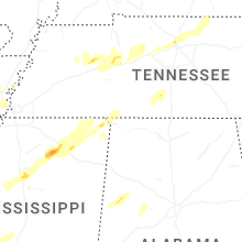


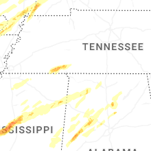


Connect with Interactive Hail Maps