

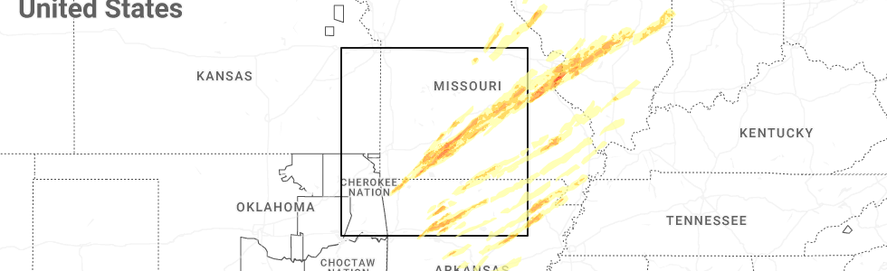
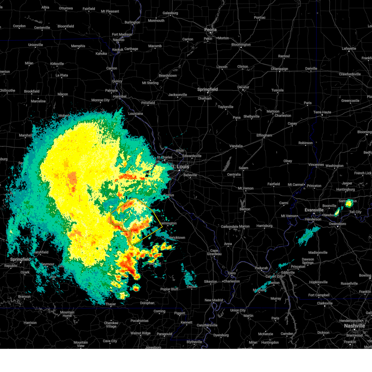
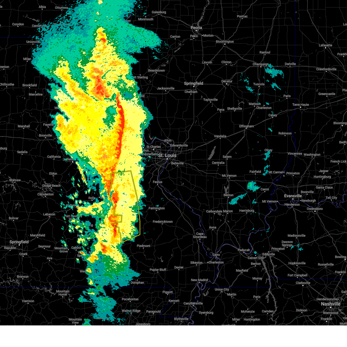
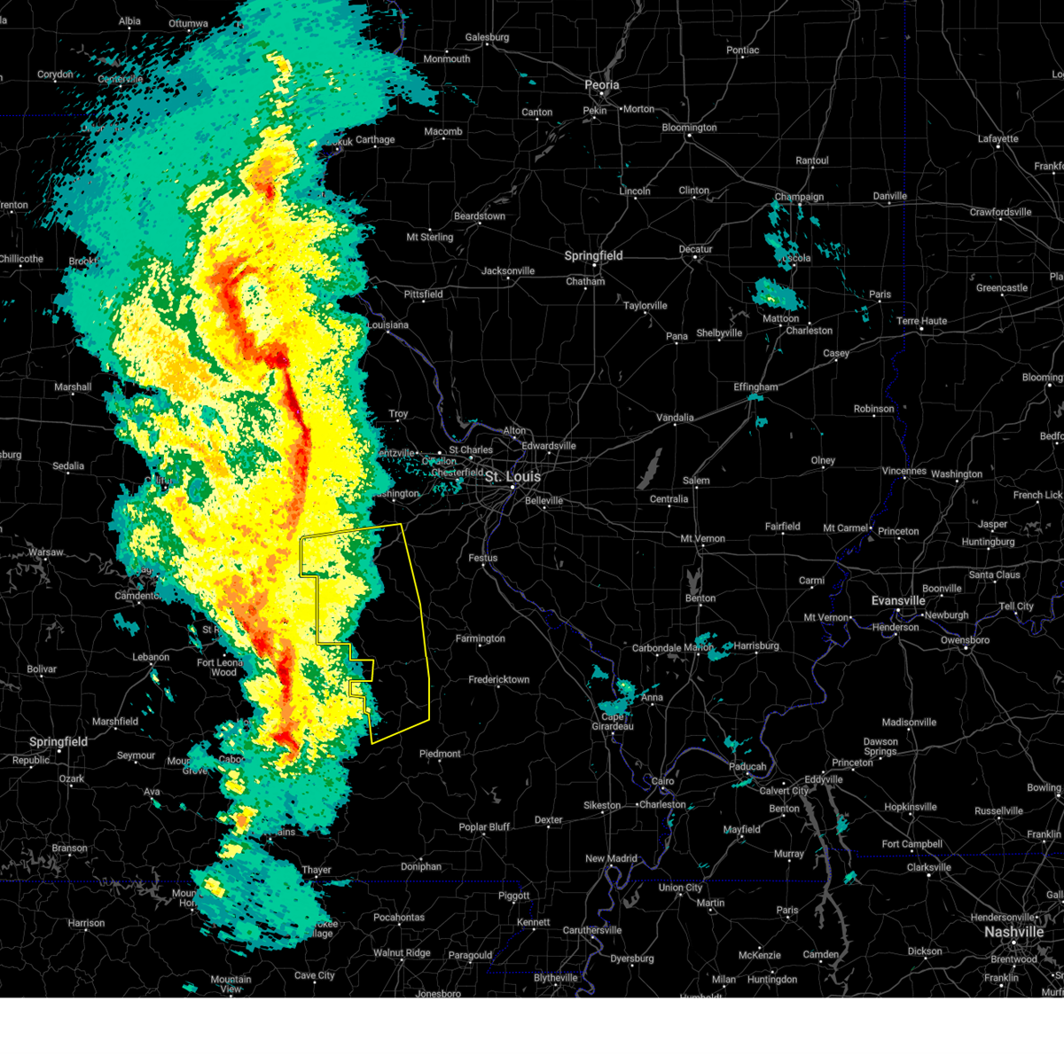
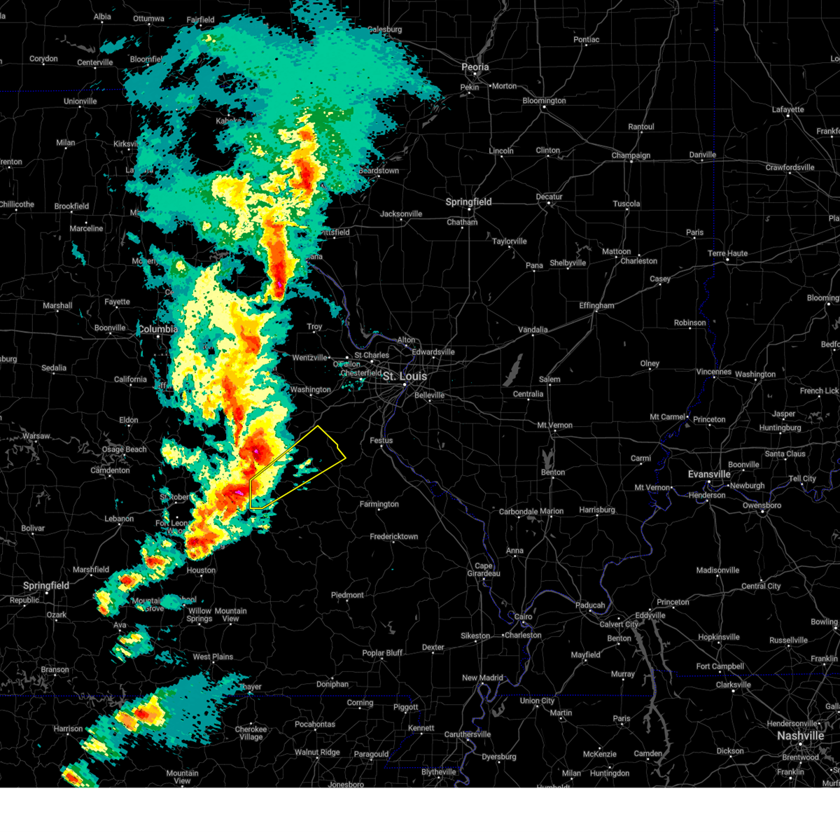
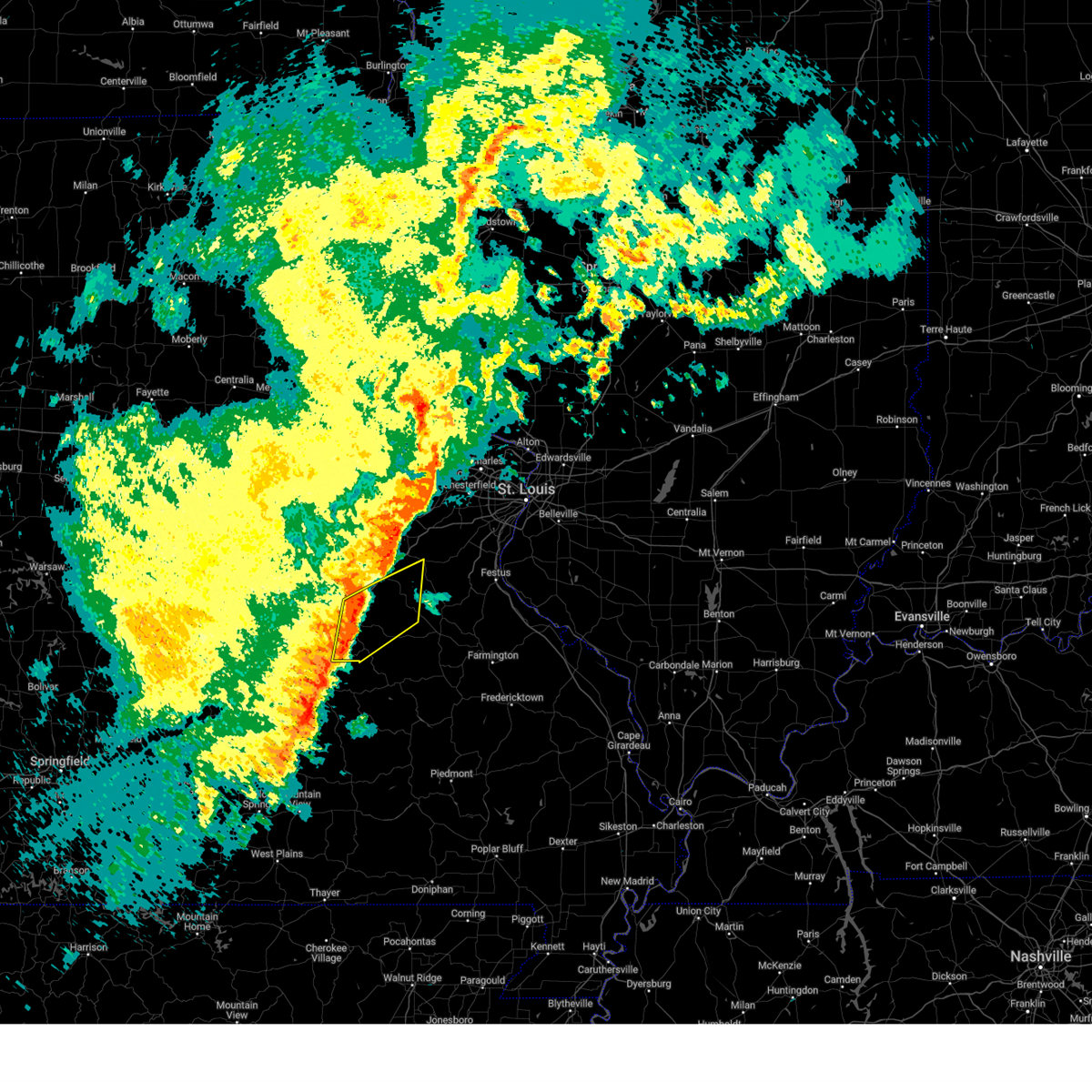
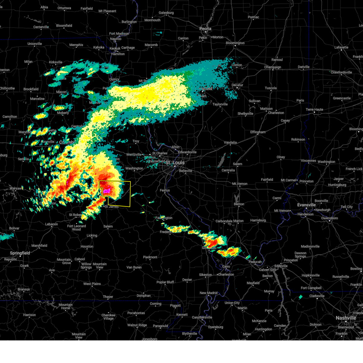
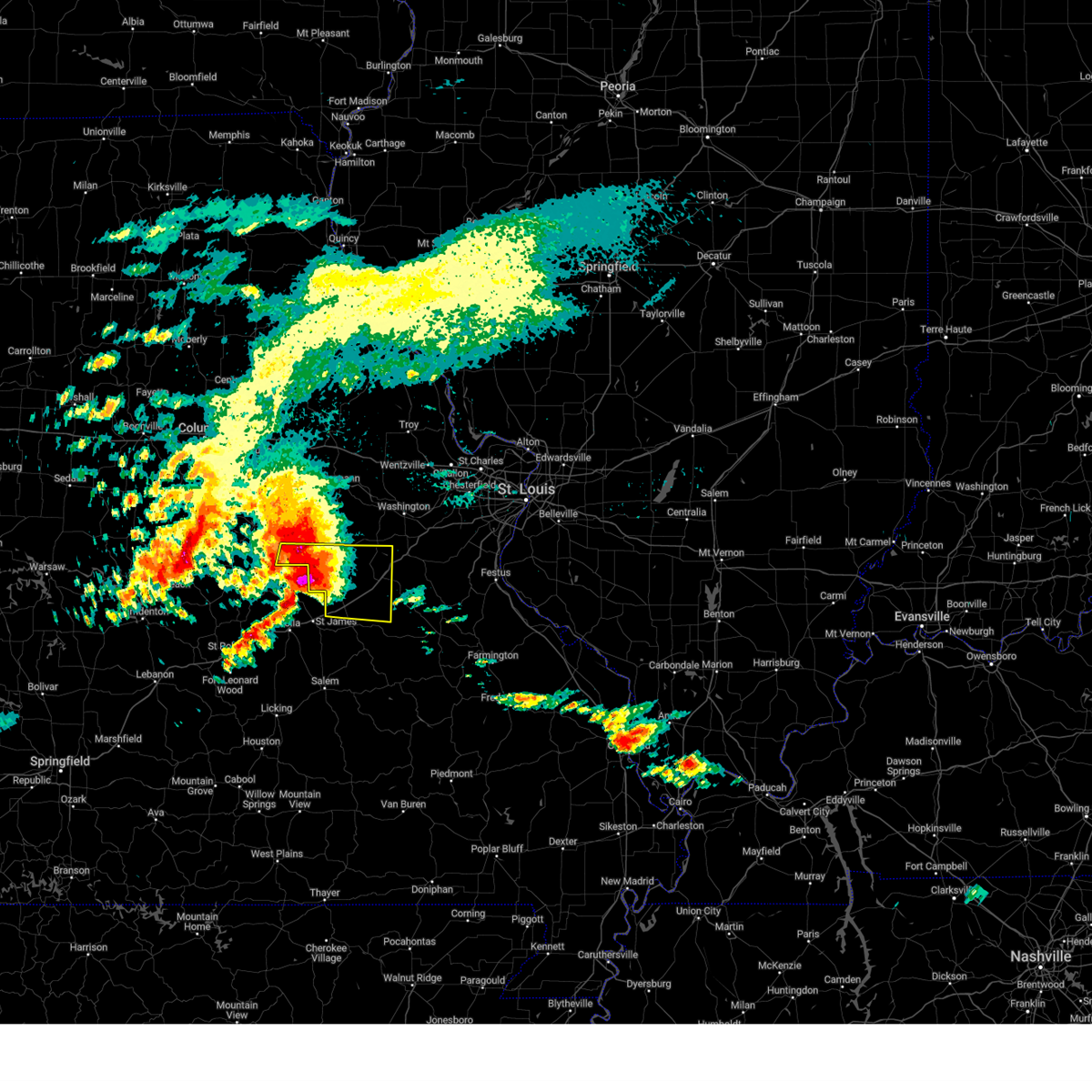
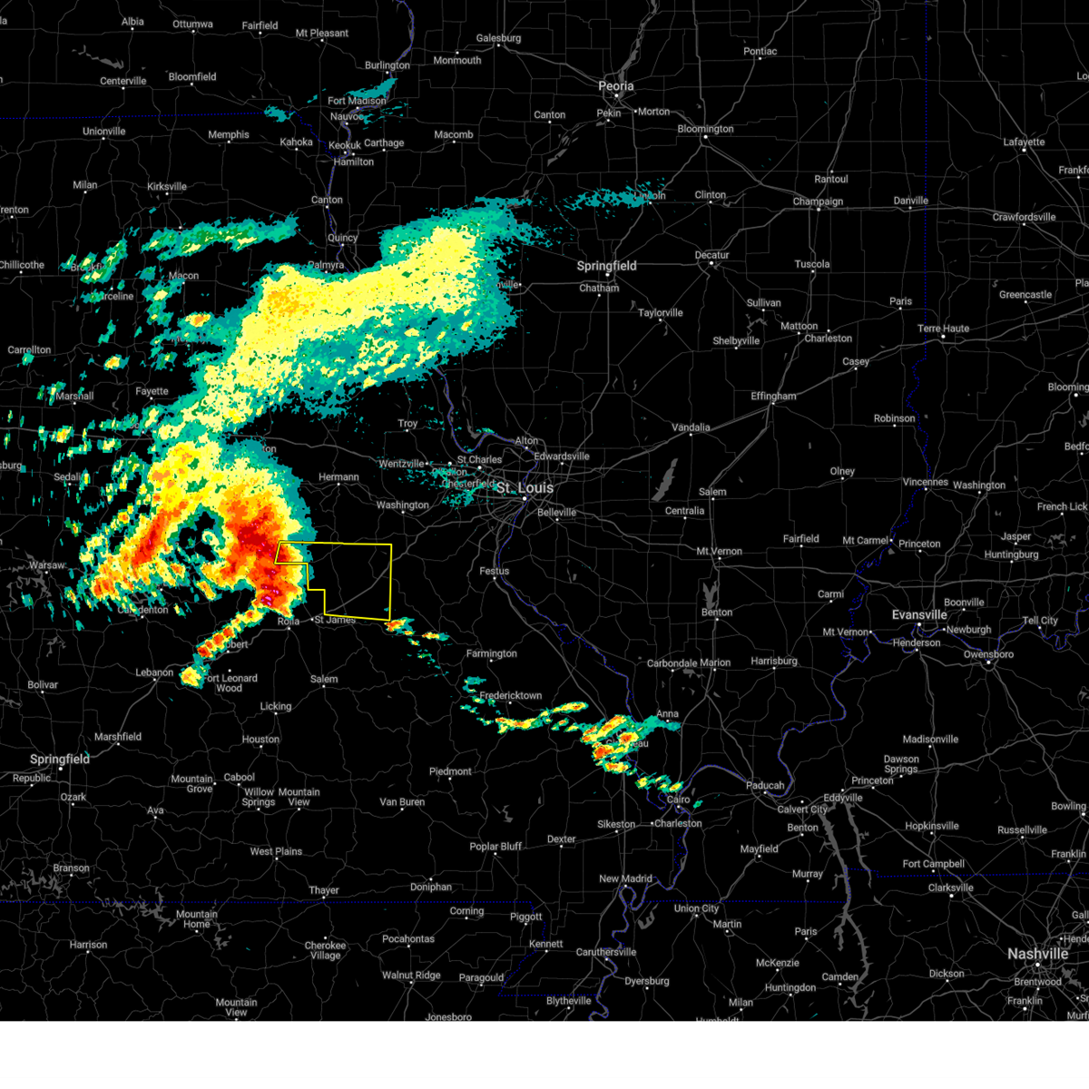
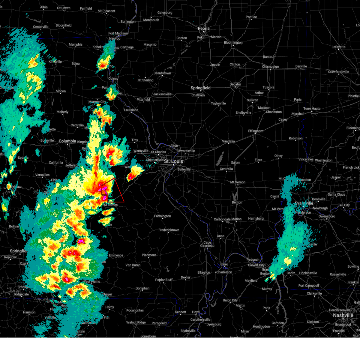
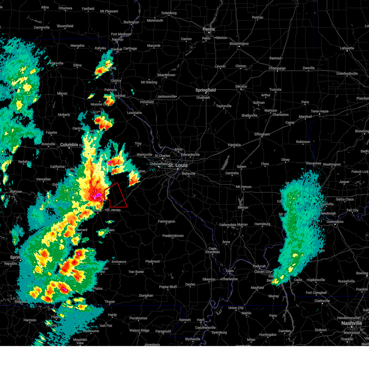
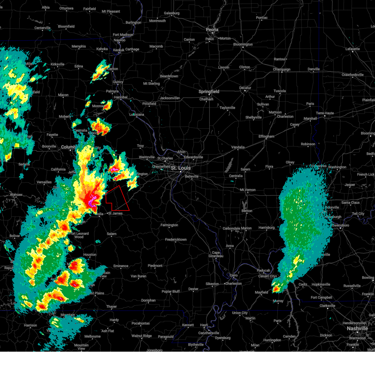
Hail Map for Cuba, MO
The Cuba, MO area has had 13 reports of on-the-ground hail by trained spotters, and has been under severe weather warnings 17 times during the past 12 months. Doppler radar has detected hail at or near Cuba, MO on 71 occasions, including 4 occasions during the past year.
| Name: | Cuba, MO |
| Where Located: | 30.4 miles NNE of Salem, MO |
| Map: | Google Map for Cuba, MO |
| Population: | 3356 |
| Housing Units: | 1542 |
| More Info: | Search Google for Cuba, MO |
3
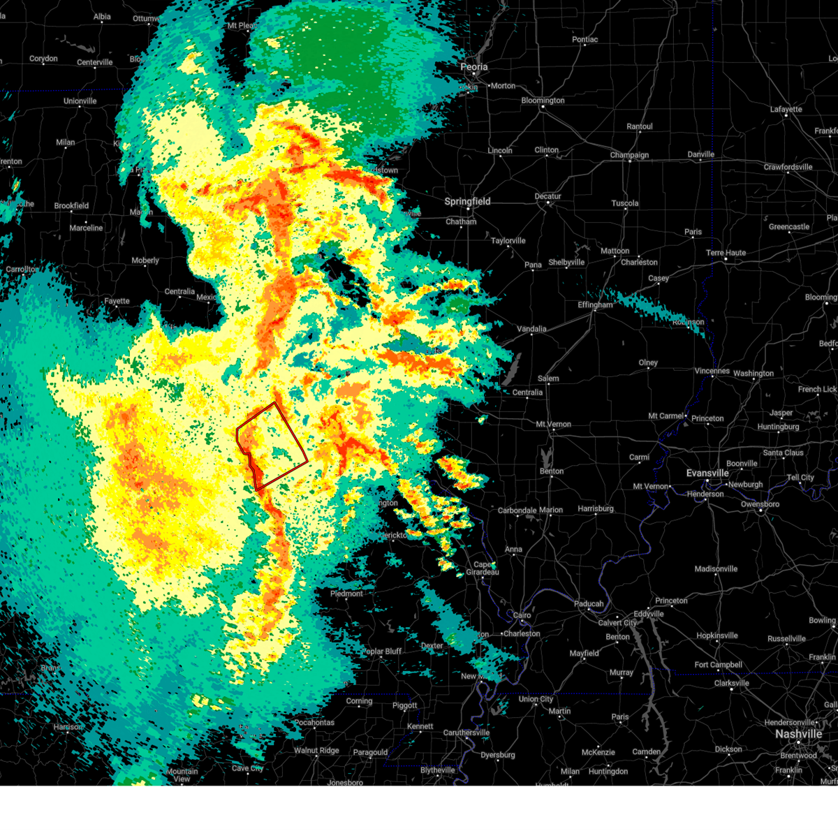
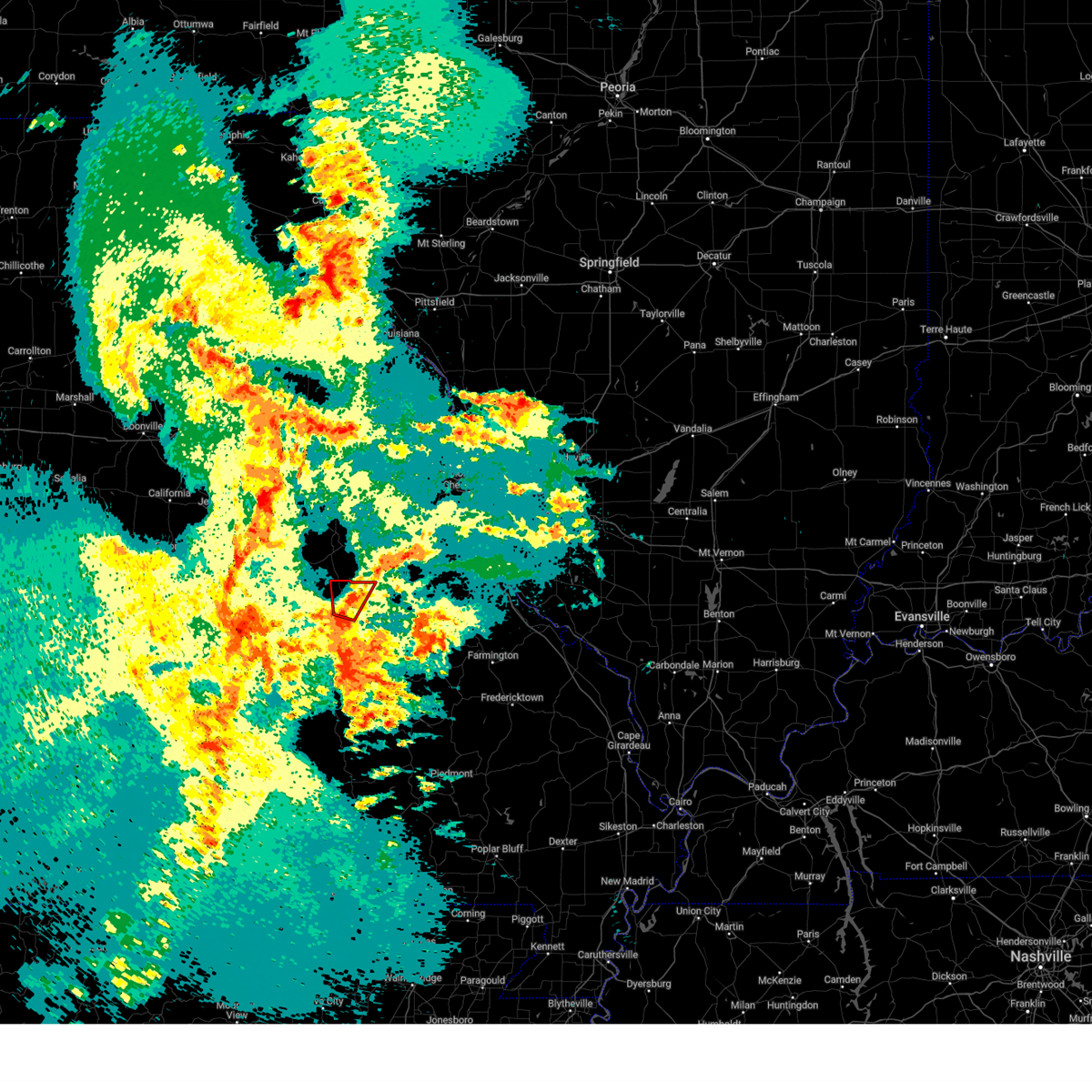
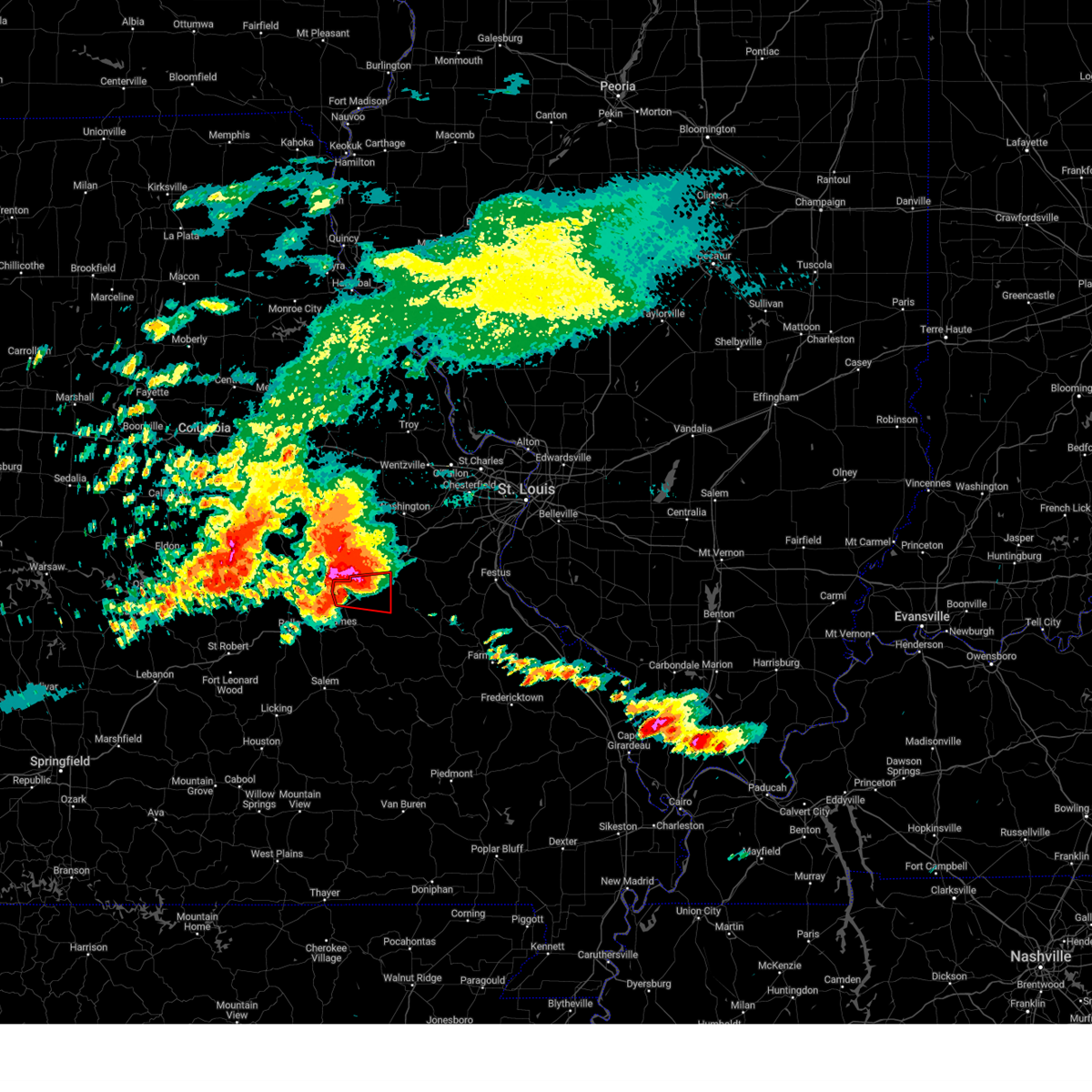
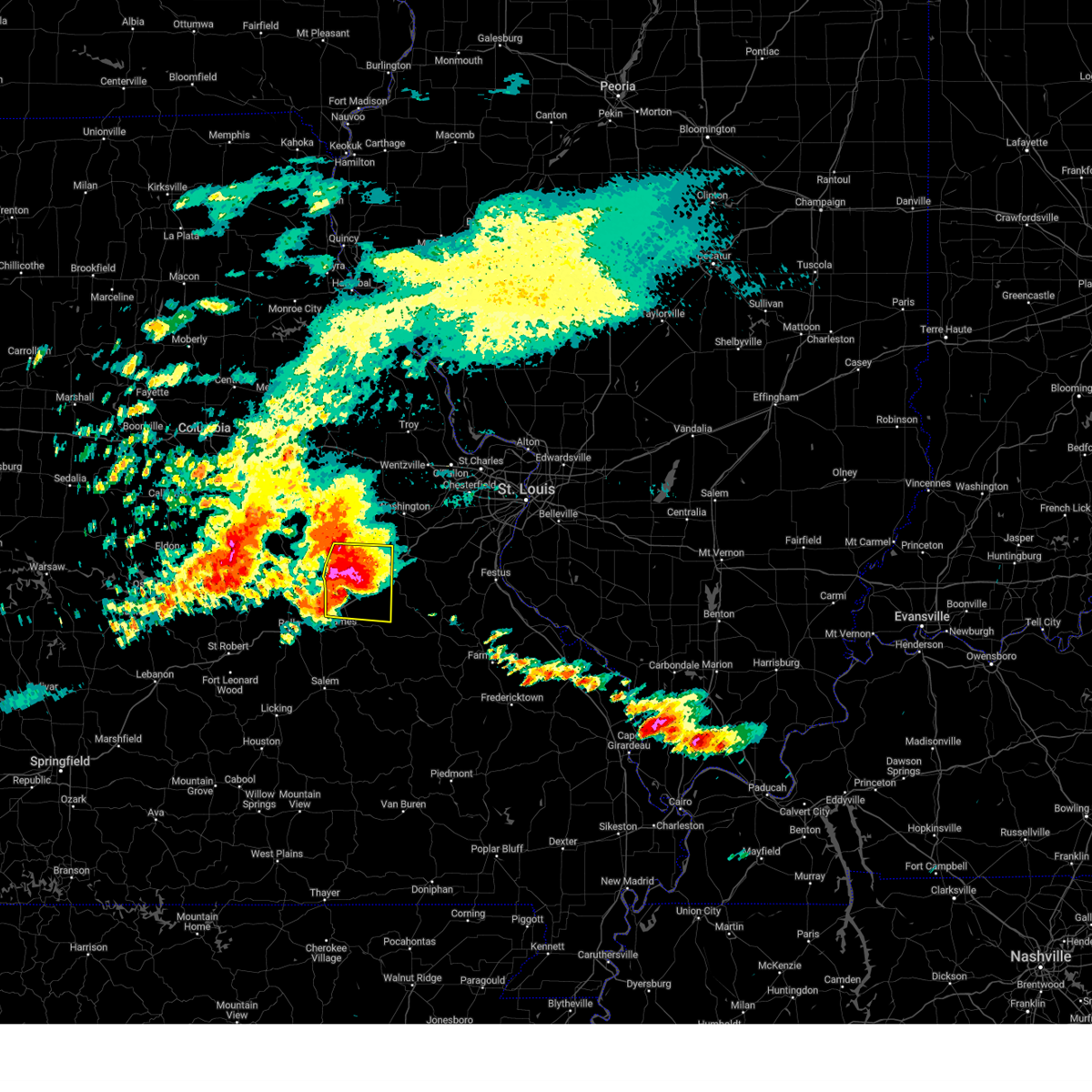
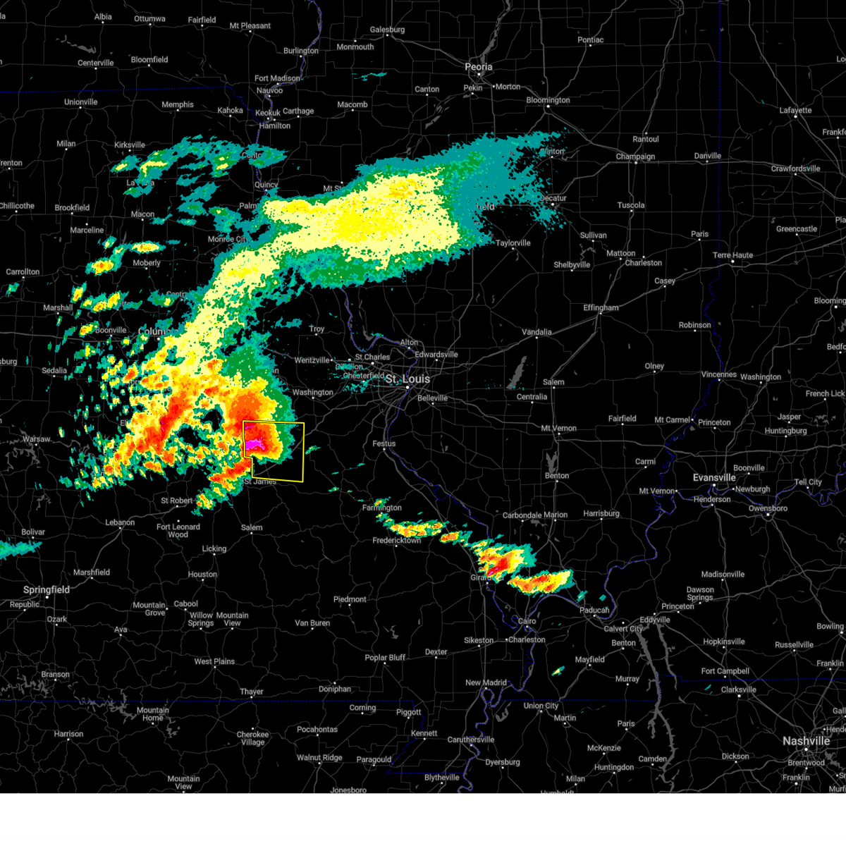
The Top Recent Hail Date for Cuba, MO is Friday, March 14, 2025 (2nd out of 71)
Hail and Wind Damage Spotted near Cuba, MO
| Date / Time | Report Details |
|---|---|
| 6/8/2025 7:25 PM CDT | Svrlsx the national weather service in st louis has issued a * severe thunderstorm warning for, central crawford county in east central missouri, * until 800 pm cdt. * at 725 pm cdt, a severe thunderstorm was located over steelville, moving east at 30 mph (radar indicated). Hazards include 60 mph wind gusts and quarter size hail. Hail damage to vehicles is expected. Expect wind damage to roofs, siding, and trees. |
| 5/19/2025 10:47 PM CDT |
 Torlsx the national weather service in st louis has issued a * tornado warning for, northern crawford county in east central missouri, southwestern franklin county in east central missouri, southern gasconade county in east central missouri, western washington county in east central missouri, * until 1130 pm cdt. * at 1047 pm cdt, severe thunderstorms capable of producing a tornado were located along a line from 6 miles south of owensville to over steelville, moving northeast at 40 mph (radar indicated rotation). Hazards include tornado. Flying debris will be dangerous to those caught without shelter. mobile homes will be damaged or destroyed. damage to roofs, windows and vehicles will occur. Tree damage is likely. Torlsx the national weather service in st louis has issued a * tornado warning for, northern crawford county in east central missouri, southwestern franklin county in east central missouri, southern gasconade county in east central missouri, western washington county in east central missouri, * until 1130 pm cdt. * at 1047 pm cdt, severe thunderstorms capable of producing a tornado were located along a line from 6 miles south of owensville to over steelville, moving northeast at 40 mph (radar indicated rotation). Hazards include tornado. Flying debris will be dangerous to those caught without shelter. mobile homes will be damaged or destroyed. damage to roofs, windows and vehicles will occur. Tree damage is likely.
|
| 5/19/2025 10:26 PM CDT |
 Svrlsx the national weather service in st louis has issued a * severe thunderstorm warning for, crawford county in east central missouri, southwestern washington county in east central missouri, western iron county in southeastern missouri, reynolds county in southeastern missouri, * until 1115 pm cdt. * at 1026 pm cdt, severe thunderstorms were located along a line from 13 miles southwest of steelville to 30 miles southwest of reynolds, or along a line from 13 miles southwest of steelville to 57 miles southwest of ironton, moving east at 45 mph (radar indicated). Hazards include 60 mph wind gusts and small hail. Expect damage to roofs, siding, and trees. other locations impacted by the severe thunderstorm include cook station, dillard, davisville, corridon, centerville, black, shirley, belgrade, lesterville and redford. This includes the following state parks, onondaga cave state park, johnsons shut-ins state park, dillard mill historic site, taum sauk mountain state park and clearwater lake recreational area. Svrlsx the national weather service in st louis has issued a * severe thunderstorm warning for, crawford county in east central missouri, southwestern washington county in east central missouri, western iron county in southeastern missouri, reynolds county in southeastern missouri, * until 1115 pm cdt. * at 1026 pm cdt, severe thunderstorms were located along a line from 13 miles southwest of steelville to 30 miles southwest of reynolds, or along a line from 13 miles southwest of steelville to 57 miles southwest of ironton, moving east at 45 mph (radar indicated). Hazards include 60 mph wind gusts and small hail. Expect damage to roofs, siding, and trees. other locations impacted by the severe thunderstorm include cook station, dillard, davisville, corridon, centerville, black, shirley, belgrade, lesterville and redford. This includes the following state parks, onondaga cave state park, johnsons shut-ins state park, dillard mill historic site, taum sauk mountain state park and clearwater lake recreational area.
|
| 5/19/2025 9:49 PM CDT |
 the tornado warning has been cancelled and is no longer in effect the tornado warning has been cancelled and is no longer in effect
|
| 5/19/2025 9:35 PM CDT |
 Torlsx the national weather service in st louis has issued a * tornado warning for, northwestern crawford county in east central missouri, * until 1015 pm cdt. * at 935 pm cdt, a severe thunderstorm capable of producing a tornado was located over cuba, moving north at 20 mph (radar indicated rotation). Hazards include tornado. Flying debris will be dangerous to those caught without shelter. mobile homes will be damaged or destroyed. damage to roofs, windows and vehicles will occur. Tree damage is likely. Torlsx the national weather service in st louis has issued a * tornado warning for, northwestern crawford county in east central missouri, * until 1015 pm cdt. * at 935 pm cdt, a severe thunderstorm capable of producing a tornado was located over cuba, moving north at 20 mph (radar indicated rotation). Hazards include tornado. Flying debris will be dangerous to those caught without shelter. mobile homes will be damaged or destroyed. damage to roofs, windows and vehicles will occur. Tree damage is likely.
|
| 5/16/2025 2:03 PM CDT |
 At 203 pm cdt, a severe thunderstorm capable of producing a tornado was located 5 miles east of steelville, moving east at 60 mph (radar indicated rotation). Hazards include tornado and quarter size hail. Flying debris will be dangerous to those caught without shelter. mobile homes will be damaged or destroyed. damage to roofs, windows and vehicles will occur. tree damage is likely. locations impacted include, cuba, steelville, bourbon, anthonies mill, leasburg and st. cloud. this includes the following state parks, onondaga cave state park. This includes interstate 44 in missouri between exits 210 and 218. At 203 pm cdt, a severe thunderstorm capable of producing a tornado was located 5 miles east of steelville, moving east at 60 mph (radar indicated rotation). Hazards include tornado and quarter size hail. Flying debris will be dangerous to those caught without shelter. mobile homes will be damaged or destroyed. damage to roofs, windows and vehicles will occur. tree damage is likely. locations impacted include, cuba, steelville, bourbon, anthonies mill, leasburg and st. cloud. this includes the following state parks, onondaga cave state park. This includes interstate 44 in missouri between exits 210 and 218.
|
| 5/16/2025 1:48 PM CDT |
 Torlsx the national weather service in st louis has issued a * tornado warning for, central crawford county in east central missouri, northwestern washington county in east central missouri, * until 230 pm cdt. * at 148 pm cdt, a severe thunderstorm capable of producing a tornado was located 10 miles southwest of steelville, moving east at 60 mph (radar indicated rotation). Hazards include tornado. Flying debris will be dangerous to those caught without shelter. mobile homes will be damaged or destroyed. damage to roofs, windows and vehicles will occur. Tree damage is likely. Torlsx the national weather service in st louis has issued a * tornado warning for, central crawford county in east central missouri, northwestern washington county in east central missouri, * until 230 pm cdt. * at 148 pm cdt, a severe thunderstorm capable of producing a tornado was located 10 miles southwest of steelville, moving east at 60 mph (radar indicated rotation). Hazards include tornado. Flying debris will be dangerous to those caught without shelter. mobile homes will be damaged or destroyed. damage to roofs, windows and vehicles will occur. Tree damage is likely.
|
| 5/16/2025 1:35 PM CDT |
 Svrlsx the national weather service in st louis has issued a * severe thunderstorm warning for, crawford county in east central missouri, southwestern franklin county in east central missouri, southern gasconade county in east central missouri, northwestern washington county in east central missouri, * until 215 pm cdt. * at 135 pm cdt, a severe thunderstorm was located 11 miles west of cuba, moving northeast at 60 mph (radar indicated). Hazards include 60 mph wind gusts and half dollar size hail. Hail damage to vehicles is expected. Expect wind damage to roofs, siding, and trees. Svrlsx the national weather service in st louis has issued a * severe thunderstorm warning for, crawford county in east central missouri, southwestern franklin county in east central missouri, southern gasconade county in east central missouri, northwestern washington county in east central missouri, * until 215 pm cdt. * at 135 pm cdt, a severe thunderstorm was located 11 miles west of cuba, moving northeast at 60 mph (radar indicated). Hazards include 60 mph wind gusts and half dollar size hail. Hail damage to vehicles is expected. Expect wind damage to roofs, siding, and trees.
|
| 4/29/2025 12:06 PM CDT |
 Svrlsx the national weather service in st louis has issued a * severe thunderstorm warning for, crawford county in east central missouri, washington county in east central missouri, northwestern iron county in southeastern missouri, north central reynolds county in southeastern missouri, west central saint francois county in southeastern missouri, * until 100 pm cdt. * at 1206 pm cdt, severe thunderstorms were located along a line from 8 miles southwest of steelville to over oates, or along a line from 8 miles southwest of steelville to 23 miles west of ironton, moving northeast at 40 mph (radar indicated). Hazards include 60 mph wind gusts and small hail. expect damage to roofs, siding, and trees Svrlsx the national weather service in st louis has issued a * severe thunderstorm warning for, crawford county in east central missouri, washington county in east central missouri, northwestern iron county in southeastern missouri, north central reynolds county in southeastern missouri, west central saint francois county in southeastern missouri, * until 100 pm cdt. * at 1206 pm cdt, severe thunderstorms were located along a line from 8 miles southwest of steelville to over oates, or along a line from 8 miles southwest of steelville to 23 miles west of ironton, moving northeast at 40 mph (radar indicated). Hazards include 60 mph wind gusts and small hail. expect damage to roofs, siding, and trees
|
| 4/20/2025 6:39 PM CDT |
 the severe thunderstorm warning has been cancelled and is no longer in effect the severe thunderstorm warning has been cancelled and is no longer in effect
|
| 4/20/2025 6:39 PM CDT |
 At 639 pm cdt, severe thunderstorms were located along a line from 6 miles north of bourbon to 5 miles southwest of oates, or along a line from 6 miles north of bourbon to 27 miles west of ironton, moving northeast at 50 mph (radar indicated). Hazards include 60 mph wind gusts and small hail. Expect damage to roofs, siding, and trees. locations impacted include, union, sullivan, st. clair, cuba, steelville, bourbon, anthonies mill, reynolds, gerald, viburnum, parkway, leasburg, miramiguoa park, courtois, bixby, cherryville, oates, centerville, st. cloud and davisville. this includes the following state parks, onondaga cave state park, johnsons shut-ins state park, dillard mill historic site, taum sauk mountain state park and meramec state park. This includes interstate 44 in missouri between exits 208 and 242. At 639 pm cdt, severe thunderstorms were located along a line from 6 miles north of bourbon to 5 miles southwest of oates, or along a line from 6 miles north of bourbon to 27 miles west of ironton, moving northeast at 50 mph (radar indicated). Hazards include 60 mph wind gusts and small hail. Expect damage to roofs, siding, and trees. locations impacted include, union, sullivan, st. clair, cuba, steelville, bourbon, anthonies mill, reynolds, gerald, viburnum, parkway, leasburg, miramiguoa park, courtois, bixby, cherryville, oates, centerville, st. cloud and davisville. this includes the following state parks, onondaga cave state park, johnsons shut-ins state park, dillard mill historic site, taum sauk mountain state park and meramec state park. This includes interstate 44 in missouri between exits 208 and 242.
|
| 4/20/2025 6:07 PM CDT |
 Svrlsx the national weather service in st louis has issued a * severe thunderstorm warning for, crawford county in east central missouri, southwestern franklin county in east central missouri, southern gasconade county in east central missouri, washington county in east central missouri, northwestern iron county in southeastern missouri, northern reynolds county in southeastern missouri, * until 700 pm cdt. * at 607 pm cdt, severe thunderstorms were located along a line from 17 miles west of cuba to 24 miles west of reynolds, or along a line from 17 miles west of cuba to 48 miles south of steelville, moving northeast at 50 mph (radar indicated). Hazards include 70 mph wind gusts and small hail. Expect considerable tree damage. Damage is likely to mobile homes, roofs, and outbuildings. Svrlsx the national weather service in st louis has issued a * severe thunderstorm warning for, crawford county in east central missouri, southwestern franklin county in east central missouri, southern gasconade county in east central missouri, washington county in east central missouri, northwestern iron county in southeastern missouri, northern reynolds county in southeastern missouri, * until 700 pm cdt. * at 607 pm cdt, severe thunderstorms were located along a line from 17 miles west of cuba to 24 miles west of reynolds, or along a line from 17 miles west of cuba to 48 miles south of steelville, moving northeast at 50 mph (radar indicated). Hazards include 70 mph wind gusts and small hail. Expect considerable tree damage. Damage is likely to mobile homes, roofs, and outbuildings.
|
| 3/14/2025 8:44 PM CDT | At 844 pm cdt, a severe thunderstorm capable of producing a tornado was located 5 miles southeast of bourbon, moving northeast at 60 mph (radar indicated rotation). Hazards include tornado. Flying debris will be dangerous to those caught without shelter. mobile homes will be damaged or destroyed. damage to roofs, windows and vehicles will occur. tree damage is likely. locations impacted include, sullivan, cuba, steelville, bourbon, anthonies mill, leasburg, miramiguoa park, st. cloud and cook station. this includes the following state parks, onondaga cave state park and meramec state park. This includes interstate 44 in missouri near exit 218. |
| 3/14/2025 8:37 PM CDT | Quarter sized hail reported 2.6 miles SW of Cuba, MO, report from mping: quarter (1.00 in.). |
| 3/14/2025 8:30 PM CDT | Quarter sized hail reported 0.4 miles SE of Cuba, MO |
| 3/14/2025 8:23 PM CDT | Quarter sized hail reported 4.6 miles E of Cuba, MO |
| 3/14/2025 8:22 PM CDT | Torlsx the national weather service in st louis has issued a * tornado warning for, central crawford county in east central missouri, south central franklin county in east central missouri, northwestern washington county in east central missouri, * until 900 pm cdt. * at 822 pm cdt, a severe thunderstorm capable of producing a tornado was located 10 miles southwest of steelville, moving northeast at 55 mph (radar indicated rotation). Hazards include tornado. Flying debris will be dangerous to those caught without shelter. mobile homes will be damaged or destroyed. damage to roofs, windows and vehicles will occur. Tree damage is likely. |
| 3/14/2025 8:13 PM CDT |
 Svrlsx the national weather service in st louis has issued a * severe thunderstorm warning for, central crawford county in east central missouri, south central franklin county in east central missouri, northern washington county in east central missouri, * until 915 pm cdt. * at 813 pm cdt, a severe thunderstorm was located 19 miles southwest of steelville, moving northeast at 55 mph (radar indicated). Hazards include golf ball size hail and 70 mph wind gusts. People and animals outdoors will be injured. expect hail damage to roofs, siding, windows, and vehicles. expect considerable tree damage. Wind damage is also likely to mobile homes, roofs, and outbuildings. Svrlsx the national weather service in st louis has issued a * severe thunderstorm warning for, central crawford county in east central missouri, south central franklin county in east central missouri, northern washington county in east central missouri, * until 915 pm cdt. * at 813 pm cdt, a severe thunderstorm was located 19 miles southwest of steelville, moving northeast at 55 mph (radar indicated). Hazards include golf ball size hail and 70 mph wind gusts. People and animals outdoors will be injured. expect hail damage to roofs, siding, windows, and vehicles. expect considerable tree damage. Wind damage is also likely to mobile homes, roofs, and outbuildings.
|
| 3/14/2025 8:07 PM CDT | Torlsx the national weather service in st louis has issued a * tornado warning for, northwestern crawford county in east central missouri, southwestern franklin county in east central missouri, southern gasconade county in east central missouri, * until 845 pm cdt. * at 807 pm cdt, a severe thunderstorm capable of producing a tornado was located 12 miles west of cuba, moving northeast at 60 mph. this storm produced a tornado in rolla, reported by the fire department (radar indicated rotation). Hazards include tornado and golf ball size hail. Flying debris will be dangerous to those caught without shelter. mobile homes will be damaged or destroyed. damage to roofs, windows and vehicles will occur. Tree damage is likely. |
| 11/4/2024 9:49 PM CST |
 Svrlsx the national weather service in st louis has issued a * severe thunderstorm warning for, crawford county in east central missouri, south central franklin county in east central missouri, northwestern washington county in east central missouri, * until 1030 pm cst. * at 949 pm cst, severe thunderstorms were located along a line from over leasburg to near cherryville, or along a line from 5 miles south of bourbon to 7 miles south of steelville, moving northeast at 35 mph (radar indicated). Hazards include 60 mph wind gusts and small hail. Expect damage to roofs, siding, and trees. this severe thunderstorm will be near, leasburg, steelville and cuba around 950 pm cst. cherryville and bourbon around 955 pm cst. other locations impacted by the severe thunderstorm include cook station and st. cloud. this includes the following state parks, onondaga cave state park and meramec state park. This includes interstate 44 in missouri between exits 208 and 218. Svrlsx the national weather service in st louis has issued a * severe thunderstorm warning for, crawford county in east central missouri, south central franklin county in east central missouri, northwestern washington county in east central missouri, * until 1030 pm cst. * at 949 pm cst, severe thunderstorms were located along a line from over leasburg to near cherryville, or along a line from 5 miles south of bourbon to 7 miles south of steelville, moving northeast at 35 mph (radar indicated). Hazards include 60 mph wind gusts and small hail. Expect damage to roofs, siding, and trees. this severe thunderstorm will be near, leasburg, steelville and cuba around 950 pm cst. cherryville and bourbon around 955 pm cst. other locations impacted by the severe thunderstorm include cook station and st. cloud. this includes the following state parks, onondaga cave state park and meramec state park. This includes interstate 44 in missouri between exits 208 and 218.
|
| 5/8/2024 4:57 PM CDT |
 At 457 pm cdt, a severe thunderstorm was located over cherryville, moving east at 40 mph (radar indicated). Hazards include ping pong ball size hail and 60 mph wind gusts. People and animals outdoors will be injured. expect hail damage to roofs, siding, windows, and vehicles. expect wind damage to roofs, siding, and trees. locations impacted include, sullivan, cuba, steelville, bourbon, leasburg, cherryville, st. cloud, dillard, cook station, and davisville. this also includes onondaga cave state park and dillard mill historic site. This includes interstate 44 in missouri between exits 214 and 218. At 457 pm cdt, a severe thunderstorm was located over cherryville, moving east at 40 mph (radar indicated). Hazards include ping pong ball size hail and 60 mph wind gusts. People and animals outdoors will be injured. expect hail damage to roofs, siding, windows, and vehicles. expect wind damage to roofs, siding, and trees. locations impacted include, sullivan, cuba, steelville, bourbon, leasburg, cherryville, st. cloud, dillard, cook station, and davisville. this also includes onondaga cave state park and dillard mill historic site. This includes interstate 44 in missouri between exits 214 and 218.
|
| 5/8/2024 4:46 PM CDT |
 At 446 pm cdt, a severe thunderstorm was located near steelville, moving east at 40 mph (law enforcement). Hazards include tennis ball size hail and 60 mph wind gusts. People and animals outdoors will be injured. expect hail damage to roofs, siding, windows, and vehicles. expect wind damage to roofs, siding, and trees. locations impacted include, sullivan, cuba, steelville, bourbon, leasburg, cherryville, st. cloud, dillard, cook station, and davisville. this also includes onondaga cave state park and dillard mill historic site. This includes interstate 44 in missouri between exits 203 and 218. At 446 pm cdt, a severe thunderstorm was located near steelville, moving east at 40 mph (law enforcement). Hazards include tennis ball size hail and 60 mph wind gusts. People and animals outdoors will be injured. expect hail damage to roofs, siding, windows, and vehicles. expect wind damage to roofs, siding, and trees. locations impacted include, sullivan, cuba, steelville, bourbon, leasburg, cherryville, st. cloud, dillard, cook station, and davisville. this also includes onondaga cave state park and dillard mill historic site. This includes interstate 44 in missouri between exits 203 and 218.
|
| 5/8/2024 4:37 PM CDT |
 At 437 pm cdt, a severe thunderstorm was located 8 miles southeast of st. james, moving east at 40 mph (law enforcement). Hazards include tennis ball size hail and 60 mph wind gusts. People and animals outdoors will be injured. expect hail damage to roofs, siding, windows, and vehicles. expect wind damage to roofs, siding, and trees. locations impacted include, sullivan, cuba, steelville, bourbon, leasburg, cherryville, st. cloud, dillard, cook station, and davisville. this also includes onondaga cave state park and dillard mill historic site. This includes interstate 44 in missouri between exits 203 and 218. At 437 pm cdt, a severe thunderstorm was located 8 miles southeast of st. james, moving east at 40 mph (law enforcement). Hazards include tennis ball size hail and 60 mph wind gusts. People and animals outdoors will be injured. expect hail damage to roofs, siding, windows, and vehicles. expect wind damage to roofs, siding, and trees. locations impacted include, sullivan, cuba, steelville, bourbon, leasburg, cherryville, st. cloud, dillard, cook station, and davisville. this also includes onondaga cave state park and dillard mill historic site. This includes interstate 44 in missouri between exits 203 and 218.
|
| 5/8/2024 4:24 PM CDT |
 Svrlsx the national weather service in st louis has issued a * severe thunderstorm warning for, crawford county in east central missouri, * until 530 pm cdt. * at 423 pm cdt, a severe thunderstorm was located near rolla, moving east at 40 mph (radar indicated). Hazards include two inch hail and 60 mph wind gusts. People and animals outdoors will be injured. expect hail damage to roofs, siding, windows, and vehicles. Expect wind damage to roofs, siding, and trees. Svrlsx the national weather service in st louis has issued a * severe thunderstorm warning for, crawford county in east central missouri, * until 530 pm cdt. * at 423 pm cdt, a severe thunderstorm was located near rolla, moving east at 40 mph (radar indicated). Hazards include two inch hail and 60 mph wind gusts. People and animals outdoors will be injured. expect hail damage to roofs, siding, windows, and vehicles. Expect wind damage to roofs, siding, and trees.
|
| 5/8/2024 11:11 AM CDT |
 At 1111 am cdt, a severe thunderstorm capable of producing a tornado was located near cuba, moving east at 40 mph (radar indicated rotation). Hazards include tornado and tennis ball size hail. Flying debris will be dangerous to those caught without shelter. mobile homes will be damaged or destroyed. damage to roofs, windows, and vehicles will occur. tree damage is likely. locations impacted include, sullivan, cuba, bourbon, leasburg, st. cloud, and oak hill. this also includes onondaga cave state park and meramec state park. This includes interstate 44 in missouri between exits 210 and 228. At 1111 am cdt, a severe thunderstorm capable of producing a tornado was located near cuba, moving east at 40 mph (radar indicated rotation). Hazards include tornado and tennis ball size hail. Flying debris will be dangerous to those caught without shelter. mobile homes will be damaged or destroyed. damage to roofs, windows, and vehicles will occur. tree damage is likely. locations impacted include, sullivan, cuba, bourbon, leasburg, st. cloud, and oak hill. this also includes onondaga cave state park and meramec state park. This includes interstate 44 in missouri between exits 210 and 228.
|
| 5/8/2024 11:09 AM CDT |
 At 1109 am cdt, a severe thunderstorm was located over bourbon, moving east at 45 mph (radar indicated). Hazards include tennis ball size hail and 60 mph wind gusts. People and animals outdoors will be injured. expect hail damage to roofs, siding, windows, and vehicles. expect wind damage to roofs, siding, and trees. locations impacted include, sullivan, cuba, owensville, bourbon, gerald, rosebud, leasburg, st. cloud, japan, stanton, oak hill, noser mill, and rosati. this also includes onondaga cave state park and meramec state park. This includes interstate 44 in missouri between exits 203 and 230. At 1109 am cdt, a severe thunderstorm was located over bourbon, moving east at 45 mph (radar indicated). Hazards include tennis ball size hail and 60 mph wind gusts. People and animals outdoors will be injured. expect hail damage to roofs, siding, windows, and vehicles. expect wind damage to roofs, siding, and trees. locations impacted include, sullivan, cuba, owensville, bourbon, gerald, rosebud, leasburg, st. cloud, japan, stanton, oak hill, noser mill, and rosati. this also includes onondaga cave state park and meramec state park. This includes interstate 44 in missouri between exits 203 and 230.
|
| 5/8/2024 11:06 AM CDT |
 At 1106 am cdt, a severe thunderstorm capable of producing a tornado was located near cuba, moving east at 25 mph (radar indicated rotation). Hazards include tornado and tennis ball size hail. Flying debris will be dangerous to those caught without shelter. mobile homes will be damaged or destroyed. damage to roofs, windows, and vehicles will occur. tree damage is likely. locations impacted include, bourbon, sullivan and oak grove. this also includes onondaga cave state park and meramec state park. This includes interstate 44 in missouri between exits 208 and 228. At 1106 am cdt, a severe thunderstorm capable of producing a tornado was located near cuba, moving east at 25 mph (radar indicated rotation). Hazards include tornado and tennis ball size hail. Flying debris will be dangerous to those caught without shelter. mobile homes will be damaged or destroyed. damage to roofs, windows, and vehicles will occur. tree damage is likely. locations impacted include, bourbon, sullivan and oak grove. this also includes onondaga cave state park and meramec state park. This includes interstate 44 in missouri between exits 208 and 228.
|
| 5/8/2024 11:06 AM CDT |
 the tornado warning has been cancelled and is no longer in effect the tornado warning has been cancelled and is no longer in effect
|
| 5/8/2024 11:02 AM CDT |
 the severe thunderstorm warning has been cancelled and is no longer in effect the severe thunderstorm warning has been cancelled and is no longer in effect
|
| 5/8/2024 11:02 AM CDT |
 At 1101 am cdt, a severe thunderstorm was located 7 miles northwest of leasburg, moving east at 45 mph (radar indicated). Hazards include tennis ball size hail and 60 mph wind gusts. People and animals outdoors will be injured. expect hail damage to roofs, siding, windows, and vehicles. expect wind damage to roofs, siding, and trees. locations impacted include, sullivan, cuba, owensville, bourbon, gerald, rosebud, leasburg, st. cloud, canaan, japan, stanton, oak hill, and rosati. this also includes onondaga cave state park and meramec state park. This includes interstate 44 in missouri between exits 203 and 230. At 1101 am cdt, a severe thunderstorm was located 7 miles northwest of leasburg, moving east at 45 mph (radar indicated). Hazards include tennis ball size hail and 60 mph wind gusts. People and animals outdoors will be injured. expect hail damage to roofs, siding, windows, and vehicles. expect wind damage to roofs, siding, and trees. locations impacted include, sullivan, cuba, owensville, bourbon, gerald, rosebud, leasburg, st. cloud, canaan, japan, stanton, oak hill, and rosati. this also includes onondaga cave state park and meramec state park. This includes interstate 44 in missouri between exits 203 and 230.
|
| 5/8/2024 10:58 AM CDT |
 Torlsx the national weather service in st louis has issued a * tornado warning for, northern crawford county in east central missouri, southwestern franklin county in east central missouri, southeastern gasconade county in east central missouri, * until 1145 am cdt. * at 1057 am cdt, a severe thunderstorm capable of producing a tornado was located near cuba, moving east at 40 mph (radar indicated rotation). Hazards include tornado and tennis ball size hail. Flying debris will be dangerous to those caught without shelter. mobile homes will be damaged or destroyed. damage to roofs, windows, and vehicles will occur. tree damage is likely. this dangerous storm will be near, cuba around 1100 am cdt. bourbon and leasburg around 1110 am cdt. this also includes onondaga cave state park and meramec state park. This includes interstate 44 in missouri between exits 208 and 228. Torlsx the national weather service in st louis has issued a * tornado warning for, northern crawford county in east central missouri, southwestern franklin county in east central missouri, southeastern gasconade county in east central missouri, * until 1145 am cdt. * at 1057 am cdt, a severe thunderstorm capable of producing a tornado was located near cuba, moving east at 40 mph (radar indicated rotation). Hazards include tornado and tennis ball size hail. Flying debris will be dangerous to those caught without shelter. mobile homes will be damaged or destroyed. damage to roofs, windows, and vehicles will occur. tree damage is likely. this dangerous storm will be near, cuba around 1100 am cdt. bourbon and leasburg around 1110 am cdt. this also includes onondaga cave state park and meramec state park. This includes interstate 44 in missouri between exits 208 and 228.
|
| 5/8/2024 10:50 AM CDT |
 At 1050 am cdt, a severe thunderstorm was located 7 miles southeast of bland, moving east at 25 mph (radar indicated). Hazards include tennis ball size hail and 60 mph wind gusts. People and animals outdoors will be injured. expect hail damage to roofs, siding, windows, and vehicles. expect wind damage to roofs, siding, and trees. locations impacted include, sullivan, cuba, owensville, bourbon, belle, gerald, bland, rosebud, leasburg, st. cloud, canaan, japan, stanton, oak hill, and rosati. this also includes onondaga cave state park and meramec state park. This includes interstate 44 in missouri between exits 203 and 230. At 1050 am cdt, a severe thunderstorm was located 7 miles southeast of bland, moving east at 25 mph (radar indicated). Hazards include tennis ball size hail and 60 mph wind gusts. People and animals outdoors will be injured. expect hail damage to roofs, siding, windows, and vehicles. expect wind damage to roofs, siding, and trees. locations impacted include, sullivan, cuba, owensville, bourbon, belle, gerald, bland, rosebud, leasburg, st. cloud, canaan, japan, stanton, oak hill, and rosati. this also includes onondaga cave state park and meramec state park. This includes interstate 44 in missouri between exits 203 and 230.
|
| 5/8/2024 10:41 AM CDT |
 At 1041 am cdt, a severe thunderstorm was located 7 miles south of bland, moving east at 40 mph (radar indicated). Hazards include golf ball size hail and 60 mph wind gusts. People and animals outdoors will be injured. expect hail damage to roofs, siding, windows, and vehicles. expect wind damage to roofs, siding, and trees. locations impacted include, sullivan, cuba, owensville, bourbon, belle, gerald, bland, rosebud, leasburg, st. cloud, canaan, japan, stanton, oak hill, and rosati. this also includes onondaga cave state park and meramec state park. This includes interstate 44 in missouri between exits 203 and 230. At 1041 am cdt, a severe thunderstorm was located 7 miles south of bland, moving east at 40 mph (radar indicated). Hazards include golf ball size hail and 60 mph wind gusts. People and animals outdoors will be injured. expect hail damage to roofs, siding, windows, and vehicles. expect wind damage to roofs, siding, and trees. locations impacted include, sullivan, cuba, owensville, bourbon, belle, gerald, bland, rosebud, leasburg, st. cloud, canaan, japan, stanton, oak hill, and rosati. this also includes onondaga cave state park and meramec state park. This includes interstate 44 in missouri between exits 203 and 230.
|
| 5/8/2024 10:25 AM CDT |
 Svrlsx the national weather service in st louis has issued a * severe thunderstorm warning for, northern crawford county in east central missouri, southwestern franklin county in east central missouri, southeastern osage county in central missouri, southern gasconade county in east central missouri, * until 1130 am cdt. * at 1025 am cdt, a severe thunderstorm was located near belle, moving east at 45 mph (radar indicated). Hazards include 60 mph wind gusts and half dollar size hail. Hail damage to vehicles is expected. Expect wind damage to roofs, siding, and trees. Svrlsx the national weather service in st louis has issued a * severe thunderstorm warning for, northern crawford county in east central missouri, southwestern franklin county in east central missouri, southeastern osage county in central missouri, southern gasconade county in east central missouri, * until 1130 am cdt. * at 1025 am cdt, a severe thunderstorm was located near belle, moving east at 45 mph (radar indicated). Hazards include 60 mph wind gusts and half dollar size hail. Hail damage to vehicles is expected. Expect wind damage to roofs, siding, and trees.
|
| 5/7/2024 3:24 AM CDT |
 the severe thunderstorm warning has been cancelled and is no longer in effect the severe thunderstorm warning has been cancelled and is no longer in effect
|
| 5/7/2024 3:24 AM CDT |
 At 324 am cdt, severe thunderstorms were located along a line extending from near swiss to near owensville to 7 miles southwest of steelville, moving northeast at 40 mph (radar indicated). Hazards include 60 mph wind gusts. Expect damage to roofs, siding, and trees. locations impacted include, cuba, hermann, gerald, rosebud, leasburg, bourbon, sullivan, new haven, beaufort, oak grove and miramiguoa park. this also includes onondaga cave state park, deutschheim historic site, and meramec state park. This includes interstate 44 in missouri between exits 203 and 230. At 324 am cdt, severe thunderstorms were located along a line extending from near swiss to near owensville to 7 miles southwest of steelville, moving northeast at 40 mph (radar indicated). Hazards include 60 mph wind gusts. Expect damage to roofs, siding, and trees. locations impacted include, cuba, hermann, gerald, rosebud, leasburg, bourbon, sullivan, new haven, beaufort, oak grove and miramiguoa park. this also includes onondaga cave state park, deutschheim historic site, and meramec state park. This includes interstate 44 in missouri between exits 203 and 230.
|
| 5/7/2024 2:59 AM CDT |
 Svrlsx the national weather service in st louis has issued a * severe thunderstorm warning for, northern crawford county in east central missouri, western franklin county in east central missouri, southeastern osage county in central missouri, gasconade county in east central missouri, * until 345 am cdt. * at 258 am cdt, severe thunderstorms were located along a line extending from near belle to 9 miles south of bland to 7 miles southeast of rolla, moving northeast at 50 mph (radar indicated). Hazards include 60 mph wind gusts. Expect damage to roofs, siding, and trees. severe thunderstorms will be near, bland around 305 am cdt. cuba, owensville, and mount sterling around 310 am cdt. other locations in the path of these severe thunderstorms include rosebud, leasburg, drake, bourbon, gerald, swiss, sullivan, beaufort and oak grove. this includes interstate 44 in missouri between exits 203 and 230. This also includes onondaga cave state park, deutschheim historic site, and meramec state park. Svrlsx the national weather service in st louis has issued a * severe thunderstorm warning for, northern crawford county in east central missouri, western franklin county in east central missouri, southeastern osage county in central missouri, gasconade county in east central missouri, * until 345 am cdt. * at 258 am cdt, severe thunderstorms were located along a line extending from near belle to 9 miles south of bland to 7 miles southeast of rolla, moving northeast at 50 mph (radar indicated). Hazards include 60 mph wind gusts. Expect damage to roofs, siding, and trees. severe thunderstorms will be near, bland around 305 am cdt. cuba, owensville, and mount sterling around 310 am cdt. other locations in the path of these severe thunderstorms include rosebud, leasburg, drake, bourbon, gerald, swiss, sullivan, beaufort and oak grove. this includes interstate 44 in missouri between exits 203 and 230. This also includes onondaga cave state park, deutschheim historic site, and meramec state park.
|
| 4/18/2024 5:26 PM CDT |
 At 526 pm cdt, severe thunderstorms were located along a line extending from bourbon to 9 miles southwest of steelville, moving east at 45 mph (trained weather spotters). Hazards include 60 mph wind gusts and quarter size hail. Hail damage to vehicles is expected. expect wind damage to roofs, siding, and trees. locations impacted include, sullivan, cuba, steelville, bourbon, leasburg, cherryville, st. cloud, cook station, and davisville. this also includes onondaga cave state park. This includes interstate 44 in missouri between exits 208 and 218. At 526 pm cdt, severe thunderstorms were located along a line extending from bourbon to 9 miles southwest of steelville, moving east at 45 mph (trained weather spotters). Hazards include 60 mph wind gusts and quarter size hail. Hail damage to vehicles is expected. expect wind damage to roofs, siding, and trees. locations impacted include, sullivan, cuba, steelville, bourbon, leasburg, cherryville, st. cloud, cook station, and davisville. this also includes onondaga cave state park. This includes interstate 44 in missouri between exits 208 and 218.
|
| 4/18/2024 5:14 PM CDT |
 At 514 pm cdt, a severe thunderstorm was located near st. james, moving east at 40 mph (trained weather spotters reported large hail and wind damage in rolla). Hazards include golf ball size hail and 60 mph wind gusts. People and animals outdoors will be injured. expect hail damage to roofs, siding, windows, and vehicles. expect wind damage to roofs, siding, and trees. locations impacted include, sullivan, cuba, steelville, bourbon, leasburg, cherryville, st. cloud, cook station, davisville, and rosati. this also includes onondaga cave state park. This includes interstate 44 in missouri between exits 203 and 218. At 514 pm cdt, a severe thunderstorm was located near st. james, moving east at 40 mph (trained weather spotters reported large hail and wind damage in rolla). Hazards include golf ball size hail and 60 mph wind gusts. People and animals outdoors will be injured. expect hail damage to roofs, siding, windows, and vehicles. expect wind damage to roofs, siding, and trees. locations impacted include, sullivan, cuba, steelville, bourbon, leasburg, cherryville, st. cloud, cook station, davisville, and rosati. this also includes onondaga cave state park. This includes interstate 44 in missouri between exits 203 and 218.
|
| 4/18/2024 5:10 PM CDT |
 At 509 pm cdt, a severe thunderstorm was located near st. james, moving east at 40 mph (trained weather spotters reported power lines down in rolla). Hazards include 60 mph wind gusts and half dollar size hail. Hail damage to vehicles is expected. expect wind damage to roofs, siding, and trees. locations impacted include, sullivan, cuba, steelville, bourbon, leasburg, cherryville, st. cloud, cook station, davisville, and rosati. this also includes onondaga cave state park. This includes interstate 44 in missouri between exits 203 and 218. At 509 pm cdt, a severe thunderstorm was located near st. james, moving east at 40 mph (trained weather spotters reported power lines down in rolla). Hazards include 60 mph wind gusts and half dollar size hail. Hail damage to vehicles is expected. expect wind damage to roofs, siding, and trees. locations impacted include, sullivan, cuba, steelville, bourbon, leasburg, cherryville, st. cloud, cook station, davisville, and rosati. this also includes onondaga cave state park. This includes interstate 44 in missouri between exits 203 and 218.
|
| 4/18/2024 5:04 PM CDT |
 Svrlsx the national weather service in st louis has issued a * severe thunderstorm warning for, crawford county in east central missouri, * until 600 pm cdt. * at 504 pm cdt, a severe thunderstorm was located near st. james, moving east at 40 mph (radar indicated). Hazards include 60 mph wind gusts and half dollar size hail. Hail damage to vehicles is expected. Expect wind damage to roofs, siding, and trees. Svrlsx the national weather service in st louis has issued a * severe thunderstorm warning for, crawford county in east central missouri, * until 600 pm cdt. * at 504 pm cdt, a severe thunderstorm was located near st. james, moving east at 40 mph (radar indicated). Hazards include 60 mph wind gusts and half dollar size hail. Hail damage to vehicles is expected. Expect wind damage to roofs, siding, and trees.
|
| 4/2/2024 1:14 AM CDT |
 the tornado warning has been cancelled and is no longer in effect the tornado warning has been cancelled and is no longer in effect
|
| 4/2/2024 1:02 AM CDT |
 Torlsx the national weather service in st louis has issued a * tornado warning for, crawford county in east central missouri, west central washington county in east central missouri, southwestern franklin county in east central missouri, * until 130 am cdt. * at 102 am cdt, a severe thunderstorm capable of producing a tornado was located near richwoods, moving east at 65 mph (radar indicated rotation). Hazards include tornado and quarter size hail. Flying debris will be dangerous to those caught without shelter. mobile homes will be damaged or destroyed. damage to roofs, windows, and vehicles will occur. tree damage is likely. this tornadic thunderstorm will remain over mainly rural areas of crawford, west central washington and southwestern franklin counties, including the following locations, st. cloud. this also includes onondaga cave state park. This includes interstate 44 in missouri between exits 203 and 228. Torlsx the national weather service in st louis has issued a * tornado warning for, crawford county in east central missouri, west central washington county in east central missouri, southwestern franklin county in east central missouri, * until 130 am cdt. * at 102 am cdt, a severe thunderstorm capable of producing a tornado was located near richwoods, moving east at 65 mph (radar indicated rotation). Hazards include tornado and quarter size hail. Flying debris will be dangerous to those caught without shelter. mobile homes will be damaged or destroyed. damage to roofs, windows, and vehicles will occur. tree damage is likely. this tornadic thunderstorm will remain over mainly rural areas of crawford, west central washington and southwestern franklin counties, including the following locations, st. cloud. this also includes onondaga cave state park. This includes interstate 44 in missouri between exits 203 and 228.
|
| 4/2/2024 12:31 AM CDT | Quarter sized hail reported 0.4 miles SE of Cuba, MO, report from mping: quarter (1.00 in.). |
| 4/2/2024 12:30 AM CDT | Quarter sized hail reported 1.9 miles SSE of Cuba, MO, mping report of quarter sized hail in cuba. |
| 4/2/2024 12:25 AM CDT |
 Svrlsx the national weather service in st louis has issued a * severe thunderstorm warning for, crawford county in east central missouri, washington county in east central missouri, * until 115 am cdt. * at 1224 am cdt, a severe thunderstorm was located 10 miles south of st. james, moving northeast at 65 mph (radar indicated). Hazards include 60 mph wind gusts and quarter size hail. Hail damage to vehicles is expected. Expect wind damage to roofs, siding, and trees. Svrlsx the national weather service in st louis has issued a * severe thunderstorm warning for, crawford county in east central missouri, washington county in east central missouri, * until 115 am cdt. * at 1224 am cdt, a severe thunderstorm was located 10 miles south of st. james, moving northeast at 65 mph (radar indicated). Hazards include 60 mph wind gusts and quarter size hail. Hail damage to vehicles is expected. Expect wind damage to roofs, siding, and trees.
|
| 4/2/2024 12:25 AM CDT |
 At 1225 am cdt, a severe squall line capable of producing both tornadoes and extensive straight line wind damage was located along a line extending from 9 miles south of bland to near cuba to 8 miles southwest of steelville, moving northeast at 55 mph (radar indicated rotation). Hazards include tornado and quarter size hail. Flying debris will be dangerous to those caught without shelter. mobile homes will be damaged or destroyed. damage to roofs, windows, and vehicles will occur. tree damage is likely. these dangerous storms will be near, cuba and steelville around 1230 am cdt. other locations in the path of these tornadic storms include bourbon, leasburg, oak grove and sullivan. this also includes onondaga cave state park and meramec state park. This includes interstate 44 in missouri between exits 203 and 230. At 1225 am cdt, a severe squall line capable of producing both tornadoes and extensive straight line wind damage was located along a line extending from 9 miles south of bland to near cuba to 8 miles southwest of steelville, moving northeast at 55 mph (radar indicated rotation). Hazards include tornado and quarter size hail. Flying debris will be dangerous to those caught without shelter. mobile homes will be damaged or destroyed. damage to roofs, windows, and vehicles will occur. tree damage is likely. these dangerous storms will be near, cuba and steelville around 1230 am cdt. other locations in the path of these tornadic storms include bourbon, leasburg, oak grove and sullivan. this also includes onondaga cave state park and meramec state park. This includes interstate 44 in missouri between exits 203 and 230.
|
| 4/2/2024 12:12 AM CDT |
 Torlsx the national weather service in st louis has issued a * tornado warning for, crawford county in east central missouri, southwestern franklin county in east central missouri, southern gasconade county in east central missouri, * until 1245 am cdt. * at 1211 am cdt, severe thunderstorms capable of producing both tornadoes and extensive straight line wind damage were located along a line extending from 8 miles north of doolittle to near rolla to 13 miles west of salem, moving east at 60 mph (radar indicated rotation). Hazards include tornado and quarter size hail. Flying debris will be dangerous to those caught without shelter. mobile homes will be damaged or destroyed. damage to roofs, windows, and vehicles will occur. tree damage is likely. these dangerous storms will be near, cuba and steelville around 1225 am cdt. other locations in the path of these tornadic storms include bourbon and leasburg. this also includes onondaga cave state park and meramec state park. This includes interstate 44 in missouri between exits 203 and 230. Torlsx the national weather service in st louis has issued a * tornado warning for, crawford county in east central missouri, southwestern franklin county in east central missouri, southern gasconade county in east central missouri, * until 1245 am cdt. * at 1211 am cdt, severe thunderstorms capable of producing both tornadoes and extensive straight line wind damage were located along a line extending from 8 miles north of doolittle to near rolla to 13 miles west of salem, moving east at 60 mph (radar indicated rotation). Hazards include tornado and quarter size hail. Flying debris will be dangerous to those caught without shelter. mobile homes will be damaged or destroyed. damage to roofs, windows, and vehicles will occur. tree damage is likely. these dangerous storms will be near, cuba and steelville around 1225 am cdt. other locations in the path of these tornadic storms include bourbon and leasburg. this also includes onondaga cave state park and meramec state park. This includes interstate 44 in missouri between exits 203 and 230.
|
| 8/2/2023 10:01 PM CDT |
 At 1001 pm cdt, severe thunderstorms were located along a line extending from near bourbon to near leasburg to near steelville to 7 miles southeast of st. james, moving east at 45 mph (radar indicated). Hazards include 60 mph wind gusts and quarter size hail. Hail damage to vehicles is expected. expect wind damage to roofs, siding, and trees. locations impacted include, sullivan, cuba, steelville, bourbon, leasburg, cherryville, st. cloud, dillard, cook station, davisville, oak hill, and rosati. this also includes onondaga cave state park and dillard mill historic site. this includes interstate 44 in missouri between exits 203 and 218. hail threat, radar indicated max hail size, 1. 00 in wind threat, radar indicated max wind gust, 60 mph. At 1001 pm cdt, severe thunderstorms were located along a line extending from near bourbon to near leasburg to near steelville to 7 miles southeast of st. james, moving east at 45 mph (radar indicated). Hazards include 60 mph wind gusts and quarter size hail. Hail damage to vehicles is expected. expect wind damage to roofs, siding, and trees. locations impacted include, sullivan, cuba, steelville, bourbon, leasburg, cherryville, st. cloud, dillard, cook station, davisville, oak hill, and rosati. this also includes onondaga cave state park and dillard mill historic site. this includes interstate 44 in missouri between exits 203 and 218. hail threat, radar indicated max hail size, 1. 00 in wind threat, radar indicated max wind gust, 60 mph.
|
| 8/2/2023 9:58 PM CDT | Several trees down over roadways in cub in crawford county MO, 0.4 miles SW of Cuba, MO |
| 8/2/2023 9:42 PM CDT |
 At 941 pm cdt, severe thunderstorms were located along a line extending from 7 miles southeast of bland to 10 miles northwest of cuba to near st. james to 7 miles northwest of rolla to 7 miles north of doolittle, moving southeast at 35 mph (radar indicated). Hazards include 60 mph wind gusts and quarter size hail. Hail damage to vehicles is expected. Expect wind damage to roofs, siding, and trees. At 941 pm cdt, severe thunderstorms were located along a line extending from 7 miles southeast of bland to 10 miles northwest of cuba to near st. james to 7 miles northwest of rolla to 7 miles north of doolittle, moving southeast at 35 mph (radar indicated). Hazards include 60 mph wind gusts and quarter size hail. Hail damage to vehicles is expected. Expect wind damage to roofs, siding, and trees.
|
| 7/17/2023 3:08 AM CDT |
 The severe thunderstorm warning for crawford and washington counties will expire at 315 am cdt, the storms which prompted the warning have weakened below severe limits, and no longer pose an immediate threat to life or property. therefore, the warning will be allowed to expire. The severe thunderstorm warning for crawford and washington counties will expire at 315 am cdt, the storms which prompted the warning have weakened below severe limits, and no longer pose an immediate threat to life or property. therefore, the warning will be allowed to expire.
|
| 7/17/2023 2:49 AM CDT |
 At 249 am cdt, severe thunderstorms were located along a line extending from leasburg to 6 miles east of richwoods, moving southeast at 35 mph (radar indicated). Hazards include 60 mph wind gusts and quarter size hail. Hail damage to vehicles is expected. expect wind damage to roofs, siding, and trees. locations impacted include, anthonies mill, old mines, potosi and mineral point. this also includes washington state park and onondaga cave state park. this includes interstate 44 in missouri between exits 208 and 218. hail threat, radar indicated max hail size, 1. 00 in wind threat, radar indicated max wind gust, 60 mph. At 249 am cdt, severe thunderstorms were located along a line extending from leasburg to 6 miles east of richwoods, moving southeast at 35 mph (radar indicated). Hazards include 60 mph wind gusts and quarter size hail. Hail damage to vehicles is expected. expect wind damage to roofs, siding, and trees. locations impacted include, anthonies mill, old mines, potosi and mineral point. this also includes washington state park and onondaga cave state park. this includes interstate 44 in missouri between exits 208 and 218. hail threat, radar indicated max hail size, 1. 00 in wind threat, radar indicated max wind gust, 60 mph.
|
| 7/17/2023 2:29 AM CDT |
 At 229 am cdt, severe thunderstorms were located along a line extending from 7 miles north of cuba to near lonedell, moving southeast at 35 mph (radar indicated). Hazards include 60 mph wind gusts and quarter size hail. Hail damage to vehicles is expected. expect wind damage to roofs, siding, and trees. severe thunderstorms will be near, sullivan, cuba, bourbon, leasburg, and richwoods around 235 am cdt. anthonies mill around 240 am cdt. other locations in the path of these severe thunderstorms include old mines. this includes interstate 44 in missouri between exits 208 and 228. this also includes washington state park, onondaga cave state park, and meramec state park. hail threat, radar indicated max hail size, 1. 00 in wind threat, radar indicated max wind gust, 60 mph. At 229 am cdt, severe thunderstorms were located along a line extending from 7 miles north of cuba to near lonedell, moving southeast at 35 mph (radar indicated). Hazards include 60 mph wind gusts and quarter size hail. Hail damage to vehicles is expected. expect wind damage to roofs, siding, and trees. severe thunderstorms will be near, sullivan, cuba, bourbon, leasburg, and richwoods around 235 am cdt. anthonies mill around 240 am cdt. other locations in the path of these severe thunderstorms include old mines. this includes interstate 44 in missouri between exits 208 and 228. this also includes washington state park, onondaga cave state park, and meramec state park. hail threat, radar indicated max hail size, 1. 00 in wind threat, radar indicated max wind gust, 60 mph.
|
| 7/12/2023 8:51 PM CDT |
 At 851 pm cdt, severe thunderstorms were located along a line extending from near old mines to 8 miles south of anthonies mill to steelville, moving southeast at 40 mph (radar indicated). Hazards include 60 mph wind gusts and quarter size hail. Hail damage to vehicles is expected. expect wind damage to roofs, siding, and trees. locations impacted include, cuba, steelville, and rosati. this includes interstate 44 in missouri near exit 203. hail threat, radar indicated max hail size, 1. 00 in wind threat, radar indicated max wind gust, 60 mph. At 851 pm cdt, severe thunderstorms were located along a line extending from near old mines to 8 miles south of anthonies mill to steelville, moving southeast at 40 mph (radar indicated). Hazards include 60 mph wind gusts and quarter size hail. Hail damage to vehicles is expected. expect wind damage to roofs, siding, and trees. locations impacted include, cuba, steelville, and rosati. this includes interstate 44 in missouri near exit 203. hail threat, radar indicated max hail size, 1. 00 in wind threat, radar indicated max wind gust, 60 mph.
|
| 7/12/2023 8:37 PM CDT |
 At 836 pm cdt, severe thunderstorms were located along a line extending from richwoods to near anthonies mill to near cuba, moving southeast at 40 mph (radar indicated). Hazards include 60 mph wind gusts and quarter size hail. Hail damage to vehicles is expected. expect wind damage to roofs, siding, and trees. locations impacted include, sullivan, cuba, steelville, bourbon, anthonies mill, leasburg, richwoods, st. cloud, oak hill, and rosati. this also includes onondaga cave state park. this includes interstate 44 in missouri between exits 203 and 218. hail threat, radar indicated max hail size, 1. 00 in wind threat, radar indicated max wind gust, 60 mph. At 836 pm cdt, severe thunderstorms were located along a line extending from richwoods to near anthonies mill to near cuba, moving southeast at 40 mph (radar indicated). Hazards include 60 mph wind gusts and quarter size hail. Hail damage to vehicles is expected. expect wind damage to roofs, siding, and trees. locations impacted include, sullivan, cuba, steelville, bourbon, anthonies mill, leasburg, richwoods, st. cloud, oak hill, and rosati. this also includes onondaga cave state park. this includes interstate 44 in missouri between exits 203 and 218. hail threat, radar indicated max hail size, 1. 00 in wind threat, radar indicated max wind gust, 60 mph.
|
| 7/12/2023 8:17 PM CDT |
 At 816 pm cdt, severe thunderstorms were located along a line extending from near parkway to near bourbon to 9 miles south of bland, moving southeast at 40 mph (radar indicated). Hazards include 60 mph wind gusts and quarter size hail. Hail damage to vehicles is expected. Expect wind damage to roofs, siding, and trees. At 816 pm cdt, severe thunderstorms were located along a line extending from near parkway to near bourbon to 9 miles south of bland, moving southeast at 40 mph (radar indicated). Hazards include 60 mph wind gusts and quarter size hail. Hail damage to vehicles is expected. Expect wind damage to roofs, siding, and trees.
|
| 7/1/2023 2:55 PM CDT |
 At 255 pm cdt, severe thunderstorms were located along a line extending from cuba to near steelville to near courtois, moving northeast at 65 mph (radar indicated). Hazards include 60 mph wind gusts and nickel size hail. Expect damage to roofs, siding, and trees. locations impacted include, sullivan, cuba, steelville, bourbon, leasburg, cherryville, st. cloud, dillard, and davisville. this also includes onondaga cave state park and dillard mill historic site. this includes interstate 44 in missouri between exits 214 and 218. hail threat, radar indicated max hail size, 0. 88 in wind threat, radar indicated max wind gust, 60 mph. At 255 pm cdt, severe thunderstorms were located along a line extending from cuba to near steelville to near courtois, moving northeast at 65 mph (radar indicated). Hazards include 60 mph wind gusts and nickel size hail. Expect damage to roofs, siding, and trees. locations impacted include, sullivan, cuba, steelville, bourbon, leasburg, cherryville, st. cloud, dillard, and davisville. this also includes onondaga cave state park and dillard mill historic site. this includes interstate 44 in missouri between exits 214 and 218. hail threat, radar indicated max hail size, 0. 88 in wind threat, radar indicated max wind gust, 60 mph.
|
| 7/1/2023 2:34 PM CDT |
 At 234 pm cdt, severe thunderstorms were located along a line extending from 8 miles southeast of rolla to 15 miles southwest of cherryville to near salem, moving northeast at 55 mph (radar indicated). Hazards include 60 mph wind gusts and penny size hail. expect damage to roofs, siding, and trees At 234 pm cdt, severe thunderstorms were located along a line extending from 8 miles southeast of rolla to 15 miles southwest of cherryville to near salem, moving northeast at 55 mph (radar indicated). Hazards include 60 mph wind gusts and penny size hail. expect damage to roofs, siding, and trees
|
| 4/15/2023 5:13 PM CDT |
 At 512 pm cdt, a severe thunderstorm was located 7 miles northwest of bourbon, moving northeast at 35 mph (radar indicated. this storm has a history of producing damaging wind). Hazards include two inch hail and 70 mph wind gusts. People and animals outdoors will be injured. expect hail damage to roofs, siding, windows, and vehicles. expect considerable tree damage. Wind damage is also likely to mobile homes, roofs, and outbuildings. At 512 pm cdt, a severe thunderstorm was located 7 miles northwest of bourbon, moving northeast at 35 mph (radar indicated. this storm has a history of producing damaging wind). Hazards include two inch hail and 70 mph wind gusts. People and animals outdoors will be injured. expect hail damage to roofs, siding, windows, and vehicles. expect considerable tree damage. Wind damage is also likely to mobile homes, roofs, and outbuildings.
|
| 4/15/2023 5:06 PM CDT | Quarter sized hail reported 0.4 miles SE of Cuba, MO, report from mping: quarter (1.00 in.). |
| 4/15/2023 4:56 PM CDT |
 At 456 pm cdt, a severe thunderstorm capable of producing a tornado was located near bland, moving northeast at 40 mph (radar indicated rotation. law enforcement also reported tennis ball sized hail in bland, missouri). Hazards include tornado and ping pong ball size hail. Flying debris will be dangerous to those caught without shelter. mobile homes will be damaged or destroyed. damage to roofs, windows, and vehicles will occur. tree damage is likely. locations impacted include, cuba, owensville, bourbon, bland, rosebud, leasburg, canaan, japan, and oak hill. this also includes onondaga cave state park. This includes interstate 44 in missouri between exits 203 and 218. At 456 pm cdt, a severe thunderstorm capable of producing a tornado was located near bland, moving northeast at 40 mph (radar indicated rotation. law enforcement also reported tennis ball sized hail in bland, missouri). Hazards include tornado and ping pong ball size hail. Flying debris will be dangerous to those caught without shelter. mobile homes will be damaged or destroyed. damage to roofs, windows, and vehicles will occur. tree damage is likely. locations impacted include, cuba, owensville, bourbon, bland, rosebud, leasburg, canaan, japan, and oak hill. this also includes onondaga cave state park. This includes interstate 44 in missouri between exits 203 and 218.
|
| 4/15/2023 4:49 PM CDT |
 At 449 pm cdt, a severe thunderstorm capable of producing a tornado was located 7 miles southeast of belle, moving northeast at 40 mph (radar indicated rotation). Hazards include tornado and ping pong ball size hail. Flying debris will be dangerous to those caught without shelter. mobile homes will be damaged or destroyed. damage to roofs, windows, and vehicles will occur. tree damage is likely. locations impacted include, cuba, owensville, bourbon, bland, rosebud, leasburg, canaan, japan, and oak hill. this also includes onondaga cave state park. This includes interstate 44 in missouri between exits 203 and 218. At 449 pm cdt, a severe thunderstorm capable of producing a tornado was located 7 miles southeast of belle, moving northeast at 40 mph (radar indicated rotation). Hazards include tornado and ping pong ball size hail. Flying debris will be dangerous to those caught without shelter. mobile homes will be damaged or destroyed. damage to roofs, windows, and vehicles will occur. tree damage is likely. locations impacted include, cuba, owensville, bourbon, bland, rosebud, leasburg, canaan, japan, and oak hill. this also includes onondaga cave state park. This includes interstate 44 in missouri between exits 203 and 218.
|
| 4/15/2023 4:36 PM CDT |
 At 436 pm cdt, a severe thunderstorm capable of producing a tornado was located 7 miles east of vienna, moving northeast at 40 mph (radar indicated rotation). Hazards include tornado and golf ball size hail. Flying debris will be dangerous to those caught without shelter. mobile homes will be damaged or destroyed. damage to roofs, windows, and vehicles will occur. Tree damage is likely. At 436 pm cdt, a severe thunderstorm capable of producing a tornado was located 7 miles east of vienna, moving northeast at 40 mph (radar indicated rotation). Hazards include tornado and golf ball size hail. Flying debris will be dangerous to those caught without shelter. mobile homes will be damaged or destroyed. damage to roofs, windows, and vehicles will occur. Tree damage is likely.
|
| 2/22/2023 12:31 PM CST |
 At 1231 pm cst, severe thunderstorms were located along a line extending from 6 miles west of sullivan to near leasburg to near cherryville, moving northeast at 45 mph (radar indicated). Hazards include 60 mph wind gusts. Expect damage to roofs, siding, and trees. locations impacted include, bourbon, sullivan, anthonies mill, miramiguoa park, courtois, st. clair and parkway. this also includes onondaga cave state park, dillard mill historic site, and meramec state park. This includes interstate 44 in missouri between exits 210 and 240. At 1231 pm cst, severe thunderstorms were located along a line extending from 6 miles west of sullivan to near leasburg to near cherryville, moving northeast at 45 mph (radar indicated). Hazards include 60 mph wind gusts. Expect damage to roofs, siding, and trees. locations impacted include, bourbon, sullivan, anthonies mill, miramiguoa park, courtois, st. clair and parkway. this also includes onondaga cave state park, dillard mill historic site, and meramec state park. This includes interstate 44 in missouri between exits 210 and 240.
|
| 2/22/2023 12:08 PM CST |
 At 1208 pm cst, severe thunderstorms were located along a line extending from 10 miles west of cuba to 6 miles southeast of st. james to near salem, moving northeast at 40 mph (radar indicated). Hazards include 60 mph wind gusts. Expect damage to roofs, siding, and trees. severe thunderstorms will be near, cuba and steelville around 1225 pm cst. other locations in the path of these severe thunderstorms include leasburg, bourbon, cherryville, oak grove, sullivan, anthonies mill, miramiguoa park, st. clair, parkway and union. this includes interstate 44 in missouri between exits 203 and 240. This also includes onondaga cave state park, dillard mill historic site, and meramec state park. At 1208 pm cst, severe thunderstorms were located along a line extending from 10 miles west of cuba to 6 miles southeast of st. james to near salem, moving northeast at 40 mph (radar indicated). Hazards include 60 mph wind gusts. Expect damage to roofs, siding, and trees. severe thunderstorms will be near, cuba and steelville around 1225 pm cst. other locations in the path of these severe thunderstorms include leasburg, bourbon, cherryville, oak grove, sullivan, anthonies mill, miramiguoa park, st. clair, parkway and union. this includes interstate 44 in missouri between exits 203 and 240. This also includes onondaga cave state park, dillard mill historic site, and meramec state park.
|
| 2/16/2023 2:56 AM CST |
 The severe thunderstorm warning for eastern crawford, northwestern iron and southwestern washington counties will expire at 300 am cst, the storms which prompted the warning have weakened below severe limits, and no longer pose an immediate threat to life or property. therefore, the warning will be allowed to expire. however small hail and gusty winds are still possible with these thunderstorms. a severe thunderstorm watch remains in effect until 500 am cst for southeastern missouri. The severe thunderstorm warning for eastern crawford, northwestern iron and southwestern washington counties will expire at 300 am cst, the storms which prompted the warning have weakened below severe limits, and no longer pose an immediate threat to life or property. therefore, the warning will be allowed to expire. however small hail and gusty winds are still possible with these thunderstorms. a severe thunderstorm watch remains in effect until 500 am cst for southeastern missouri.
|
| 2/16/2023 2:47 AM CST |
 At 247 am cst, severe thunderstorms were located along a line extending from near bourbon to near courtois to near reynolds, moving east at 55 mph (radar indicated). Hazards include 60 mph wind gusts and quarter size hail. Hail damage to vehicles is expected. expect wind damage to roofs, siding, and trees. locations impacted include, anthonies mill. this also includes onondaga cave state park and dillard mill historic site. hail threat, radar indicated max hail size, 1. 00 in wind threat, radar indicated max wind gust, 60 mph. At 247 am cst, severe thunderstorms were located along a line extending from near bourbon to near courtois to near reynolds, moving east at 55 mph (radar indicated). Hazards include 60 mph wind gusts and quarter size hail. Hail damage to vehicles is expected. expect wind damage to roofs, siding, and trees. locations impacted include, anthonies mill. this also includes onondaga cave state park and dillard mill historic site. hail threat, radar indicated max hail size, 1. 00 in wind threat, radar indicated max wind gust, 60 mph.
|
| 2/16/2023 2:30 AM CST |
 At 230 am cst, severe thunderstorms were located along a line extending from 7 miles southwest of steelville to 7 miles west of viburnum to 6 miles southwest of bunker, moving east at 55 mph (trained weather spotters). Hazards include 60 mph wind gusts and quarter size hail. Hail damage to vehicles is expected. expect wind damage to roofs, siding, and trees. these severe storms will be near, viburnum, courtois, bixby and cherryville around 240 am cst. other locations in the path of these severe thunderstorms include anthonies mill. this also includes onondaga cave state park, johnsons shut-ins state park, and dillard mill historic site. hail threat, radar indicated max hail size, 1. 00 in wind threat, observed max wind gust, 60 mph. At 230 am cst, severe thunderstorms were located along a line extending from 7 miles southwest of steelville to 7 miles west of viburnum to 6 miles southwest of bunker, moving east at 55 mph (trained weather spotters). Hazards include 60 mph wind gusts and quarter size hail. Hail damage to vehicles is expected. expect wind damage to roofs, siding, and trees. these severe storms will be near, viburnum, courtois, bixby and cherryville around 240 am cst. other locations in the path of these severe thunderstorms include anthonies mill. this also includes onondaga cave state park, johnsons shut-ins state park, and dillard mill historic site. hail threat, radar indicated max hail size, 1. 00 in wind threat, observed max wind gust, 60 mph.
|
| 2/16/2023 2:20 AM CST |
 At 219 am cst, severe thunderstorms were located along a line extending from 9 miles south of st. james to 6 miles east of salem to 12 miles north of eminence, moving east at 55 mph (radar indicated). Hazards include 60 mph wind gusts and quarter size hail. Hail damage to vehicles is expected. expect wind damage to roofs, siding, and trees. severe thunderstorms will be near, steelville, viburnum, bunker and cherryville around 235 am cst. other locations in the path of these severe thunderstorms include courtois, bixby and anthonies mill. this also includes onondaga cave state park, johnsons shut-ins state park, and dillard mill historic site. hail threat, radar indicated max hail size, 1. 00 in wind threat, radar indicated max wind gust, 60 mph. At 219 am cst, severe thunderstorms were located along a line extending from 9 miles south of st. james to 6 miles east of salem to 12 miles north of eminence, moving east at 55 mph (radar indicated). Hazards include 60 mph wind gusts and quarter size hail. Hail damage to vehicles is expected. expect wind damage to roofs, siding, and trees. severe thunderstorms will be near, steelville, viburnum, bunker and cherryville around 235 am cst. other locations in the path of these severe thunderstorms include courtois, bixby and anthonies mill. this also includes onondaga cave state park, johnsons shut-ins state park, and dillard mill historic site. hail threat, radar indicated max hail size, 1. 00 in wind threat, radar indicated max wind gust, 60 mph.
|
| 5/19/2022 3:40 PM CDT |
 At 340 pm cdt, severe thunderstorms were located along a line extending from near cuba to 7 miles east of courtois, moving northeast at 55 mph (radar indicated). Hazards include 70 mph wind gusts. Expect considerable tree damage. damage is likely to mobile homes, roofs, and outbuildings. severe thunderstorms will be near, leasburg around 350 pm cdt. bourbon around 355 pm cdt. old mines around 400 pm cdt. this includes interstate 44 in missouri between exits 203 and 214. This also includes washington state park and onondaga cave state park. At 340 pm cdt, severe thunderstorms were located along a line extending from near cuba to 7 miles east of courtois, moving northeast at 55 mph (radar indicated). Hazards include 70 mph wind gusts. Expect considerable tree damage. damage is likely to mobile homes, roofs, and outbuildings. severe thunderstorms will be near, leasburg around 350 pm cdt. bourbon around 355 pm cdt. old mines around 400 pm cdt. this includes interstate 44 in missouri between exits 203 and 214. This also includes washington state park and onondaga cave state park.
|
| 5/19/2022 3:09 PM CDT |
 At 307 pm cdt, a severe thunderstorm was located over steelville, moving northeast at 35 mph (spotters reported hail up to the size of nickels near cuba). Hazards include quarter size hail possible. Damage to vehicles is expected. this severe storm will be near, cuba around 320 pm cdt. leasburg around 325 pm cdt. bourbon around 335 pm cdt. sullivan around 345 pm cdt. other locations impacted by this severe thunderstorm include oak hill and st. cloud. This includes interstate 44 in missouri between exits 203 and 218. At 307 pm cdt, a severe thunderstorm was located over steelville, moving northeast at 35 mph (spotters reported hail up to the size of nickels near cuba). Hazards include quarter size hail possible. Damage to vehicles is expected. this severe storm will be near, cuba around 320 pm cdt. leasburg around 325 pm cdt. bourbon around 335 pm cdt. sullivan around 345 pm cdt. other locations impacted by this severe thunderstorm include oak hill and st. cloud. This includes interstate 44 in missouri between exits 203 and 218.
|
| 5/19/2022 2:55 PM CDT |
 At 254 pm cdt, a severe thunderstorm was located 8 miles west of cherryville, moving northeast at 35 mph (spotters reported peas to penny size hail near steelville). Hazards include quarter size hail. Damage to vehicles is expected. this severe storm will be near, steelville around 310 pm cdt. cuba around 320 pm cdt. bourbon and leasburg around 330 pm cdt. other locations impacted by this severe thunderstorm include oak hill, st. cloud and cook station. this also includes onondaga cave state park. This includes interstate 44 in missouri between exits 203 and 218. At 254 pm cdt, a severe thunderstorm was located 8 miles west of cherryville, moving northeast at 35 mph (spotters reported peas to penny size hail near steelville). Hazards include quarter size hail. Damage to vehicles is expected. this severe storm will be near, steelville around 310 pm cdt. cuba around 320 pm cdt. bourbon and leasburg around 330 pm cdt. other locations impacted by this severe thunderstorm include oak hill, st. cloud and cook station. this also includes onondaga cave state park. This includes interstate 44 in missouri between exits 203 and 218.
|
| 5/19/2022 2:49 PM CDT |
 At 249 pm cdt, a severe thunderstorm was located 10 miles west of cherryville, moving northeast at 35 mph (radar indicated). Hazards include quarter size hail. Damage to vehicles is expected. this severe thunderstorm will be near, steelville around 310 pm cdt. cuba around 320 pm cdt. bourbon and leasburg around 330 pm cdt. other locations impacted by this severe thunderstorm include oak hill, st. cloud and cook station. this includes interstate 44 in missouri between exits 203 and 218. this also includes onondaga cave state park. hail threat, radar indicated max hail size, 1. 00 in wind threat, radar indicated max wind gust, <50 mph. At 249 pm cdt, a severe thunderstorm was located 10 miles west of cherryville, moving northeast at 35 mph (radar indicated). Hazards include quarter size hail. Damage to vehicles is expected. this severe thunderstorm will be near, steelville around 310 pm cdt. cuba around 320 pm cdt. bourbon and leasburg around 330 pm cdt. other locations impacted by this severe thunderstorm include oak hill, st. cloud and cook station. this includes interstate 44 in missouri between exits 203 and 218. this also includes onondaga cave state park. hail threat, radar indicated max hail size, 1. 00 in wind threat, radar indicated max wind gust, <50 mph.
|
| 5/15/2022 12:55 PM CDT |
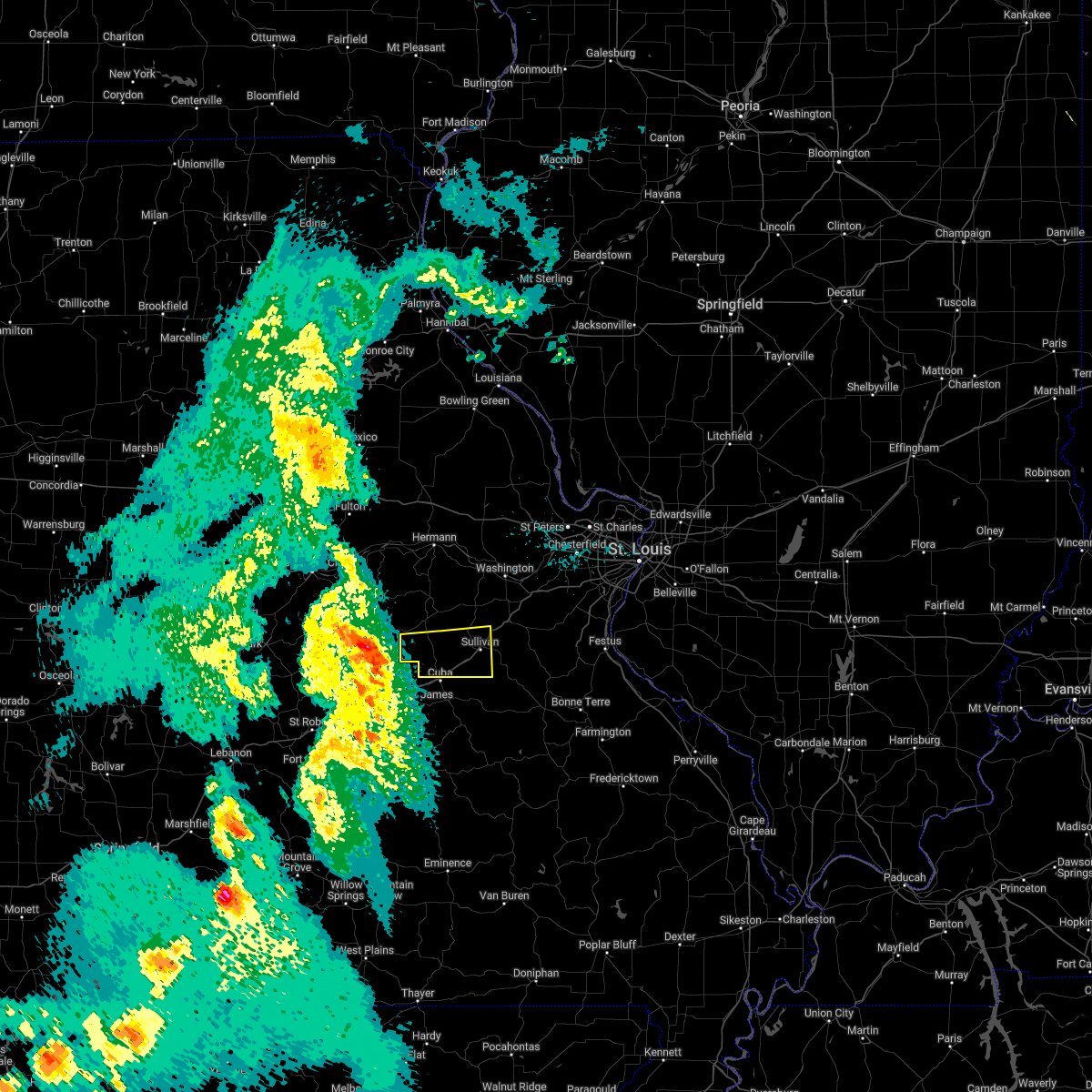 At 1254 pm cdt, a severe thunderstorm was located 7 miles south of belle, moving east at 45 mph (radar indicated). Hazards include 60 mph wind gusts and quarter size hail. Hail damage to vehicles is expected. Expect wind damage to roofs, siding, and trees. At 1254 pm cdt, a severe thunderstorm was located 7 miles south of belle, moving east at 45 mph (radar indicated). Hazards include 60 mph wind gusts and quarter size hail. Hail damage to vehicles is expected. Expect wind damage to roofs, siding, and trees.
|
| 5/13/2022 5:49 PM CDT |
 At 549 pm cdt, a severe thunderstorm was located near steelville, moving east at 10 mph (radar indicated). Hazards include 60 mph wind gusts and quarter size hail. Hail damage to vehicles is expected. expect wind damage to roofs, siding, and trees. locations impacted include, leasburg. this also includes onondaga cave state park. this includes interstate 44 in missouri between exits 208 and 210. hail threat, radar indicated max hail size, 1. 00 in wind threat, radar indicated max wind gust, 60 mph. At 549 pm cdt, a severe thunderstorm was located near steelville, moving east at 10 mph (radar indicated). Hazards include 60 mph wind gusts and quarter size hail. Hail damage to vehicles is expected. expect wind damage to roofs, siding, and trees. locations impacted include, leasburg. this also includes onondaga cave state park. this includes interstate 44 in missouri between exits 208 and 210. hail threat, radar indicated max hail size, 1. 00 in wind threat, radar indicated max wind gust, 60 mph.
|
| 5/13/2022 5:39 PM CDT |
 At 539 pm cdt, a severe thunderstorm was located near cuba, moving east at 10 mph (radar indicated). Hazards include 60 mph wind gusts and quarter size hail. Hail damage to vehicles is expected. expect wind damage to roofs, siding, and trees. this severe thunderstorm will be near, steelville around 545 pm cdt. other locations in the path of this severe thunderstorm include leasburg. this includes interstate 44 in missouri between exits 208 and 214. this also includes onondaga cave state park. hail threat, radar indicated max hail size, 1. 00 in wind threat, radar indicated max wind gust, 60 mph. At 539 pm cdt, a severe thunderstorm was located near cuba, moving east at 10 mph (radar indicated). Hazards include 60 mph wind gusts and quarter size hail. Hail damage to vehicles is expected. expect wind damage to roofs, siding, and trees. this severe thunderstorm will be near, steelville around 545 pm cdt. other locations in the path of this severe thunderstorm include leasburg. this includes interstate 44 in missouri between exits 208 and 214. this also includes onondaga cave state park. hail threat, radar indicated max hail size, 1. 00 in wind threat, radar indicated max wind gust, 60 mph.
|
| 4/11/2022 4:32 AM CDT |
 At 431 am cdt, a severe thunderstorm was located 8 miles southwest of anthonies mill, moving east at 45 mph (trained weather spotters reported one inch hail 6 miles south of steelville). Hazards include 60 mph wind gusts and quarter size hail. Hail damage to vehicles is expected. expect wind damage to roofs, siding, and trees. locations impacted include, anthonies mill. this also includes onondaga cave state park. this includes interstate 44 in missouri between exits 210 and 214. hail threat, radar indicated max hail size, 1. 00 in wind threat, radar indicated max wind gust, 60 mph. At 431 am cdt, a severe thunderstorm was located 8 miles southwest of anthonies mill, moving east at 45 mph (trained weather spotters reported one inch hail 6 miles south of steelville). Hazards include 60 mph wind gusts and quarter size hail. Hail damage to vehicles is expected. expect wind damage to roofs, siding, and trees. locations impacted include, anthonies mill. this also includes onondaga cave state park. this includes interstate 44 in missouri between exits 210 and 214. hail threat, radar indicated max hail size, 1. 00 in wind threat, radar indicated max wind gust, 60 mph.
|
| 4/11/2022 4:16 AM CDT |
 At 415 am cdt, a severe thunderstorm was located over steelville, moving east at 45 mph (radar indicated). Hazards include 60 mph wind gusts and quarter size hail. Hail damage to vehicles is expected. expect wind damage to roofs, siding, and trees. this severe thunderstorm will be near, cherryville around 420 am cdt. other locations in the path of this severe thunderstorm include anthonies mill. this includes interstate 44 in missouri between exits 203 and 218. this also includes onondaga cave state park. hail threat, radar indicated max hail size, 1. 00 in wind threat, radar indicated max wind gust, 60 mph. At 415 am cdt, a severe thunderstorm was located over steelville, moving east at 45 mph (radar indicated). Hazards include 60 mph wind gusts and quarter size hail. Hail damage to vehicles is expected. expect wind damage to roofs, siding, and trees. this severe thunderstorm will be near, cherryville around 420 am cdt. other locations in the path of this severe thunderstorm include anthonies mill. this includes interstate 44 in missouri between exits 203 and 218. this also includes onondaga cave state park. hail threat, radar indicated max hail size, 1. 00 in wind threat, radar indicated max wind gust, 60 mph.
|
| 5/27/2021 1:35 PM CDT | Storm damage reported in crawford county MO, 0.5 miles NNE of Cuba, MO |
| 5/27/2021 1:35 PM CDT | Several large trees and numerous tree limbs blown down in cub in crawford county MO, 0.5 miles NW of Cuba, MO |
| 5/27/2021 1:32 PM CDT | Storm damage reported in crawford county MO, 0.5 miles NNE of Cuba, MO |
| 5/27/2021 1:30 PM CDT | Tree uprooted... approximately 2 foot diamete in crawford county MO, 0.5 miles NW of Cuba, MO |
| 5/27/2021 1:24 PM CDT |
 At 124 pm cdt, a severe thunderstorm was located over st. james, moving east at 30 mph (radar indicated). Hazards include 60 mph wind gusts and quarter size hail. Hail damage to vehicles is expected. Expect wind damage to roofs, siding, and trees. At 124 pm cdt, a severe thunderstorm was located over st. james, moving east at 30 mph (radar indicated). Hazards include 60 mph wind gusts and quarter size hail. Hail damage to vehicles is expected. Expect wind damage to roofs, siding, and trees.
|
| 3/27/2021 5:46 PM CDT |
 At 546 pm cdt, a severe thunderstorm was located over cuba, moving northeast at 30 mph (radar indicated). Hazards include 60 mph wind gusts and quarter size hail. Hail damage to vehicles is expected. expect wind damage to roofs, siding, and trees. locations impacted include, sullivan, cuba, steelville, bourbon, anthonies mill, leasburg, richwoods and st. cloud. this also includes onondaga cave state park. This includes interstate 44 in missouri between exits 203 and 218. At 546 pm cdt, a severe thunderstorm was located over cuba, moving northeast at 30 mph (radar indicated). Hazards include 60 mph wind gusts and quarter size hail. Hail damage to vehicles is expected. expect wind damage to roofs, siding, and trees. locations impacted include, sullivan, cuba, steelville, bourbon, anthonies mill, leasburg, richwoods and st. cloud. this also includes onondaga cave state park. This includes interstate 44 in missouri between exits 203 and 218.
|
| 3/27/2021 5:36 PM CDT |
 At 536 pm cdt, a severe thunderstorm was located near cuba, moving northeast at 30 mph (radar indicated). Hazards include 60 mph wind gusts and quarter size hail. Hail damage to vehicles is expected. Expect wind damage to roofs, siding, and trees. At 536 pm cdt, a severe thunderstorm was located near cuba, moving northeast at 30 mph (radar indicated). Hazards include 60 mph wind gusts and quarter size hail. Hail damage to vehicles is expected. Expect wind damage to roofs, siding, and trees.
|
| 11/14/2020 8:38 PM CST |
 At 837 pm cst, a severe thunderstorm was located near st. james, moving east at 60 mph (radar indicated). Hazards include 60 mph wind gusts. expect damage to roofs, siding, and trees At 837 pm cst, a severe thunderstorm was located near st. james, moving east at 60 mph (radar indicated). Hazards include 60 mph wind gusts. expect damage to roofs, siding, and trees
|
| 8/31/2020 12:15 PM CDT |
 At 1215 pm cdt, severe thunderstorms were located along a line extending from near beaufort to near sullivan to steelville to 11 miles north of salem, moving southeast at 40 mph (radar indicated). Hazards include 60 mph wind gusts. Expect damage to roofs, siding, and trees. locations impacted include, union, sullivan, cuba, steelville, bourbon, gerald, leasburg, miramiguoa park, beaufort, leslie, st. cloud, noser mill, japan, stanton, lyon, oak hill and rosati. this also includes onondaga cave state park and meramec state park. This includes interstate 44 in missouri between exits 203 and 230. At 1215 pm cdt, severe thunderstorms were located along a line extending from near beaufort to near sullivan to steelville to 11 miles north of salem, moving southeast at 40 mph (radar indicated). Hazards include 60 mph wind gusts. Expect damage to roofs, siding, and trees. locations impacted include, union, sullivan, cuba, steelville, bourbon, gerald, leasburg, miramiguoa park, beaufort, leslie, st. cloud, noser mill, japan, stanton, lyon, oak hill and rosati. this also includes onondaga cave state park and meramec state park. This includes interstate 44 in missouri between exits 203 and 230.
|
| 8/31/2020 12:00 PM CDT |
 At 1159 am cdt, severe thunderstorms were located along a line extending from near new haven to near gerald to near cuba to near st. james, moving southeast at 35 mph (radar indicated). Hazards include 60 mph wind gusts. Expect damage to roofs, siding, and trees. locations impacted include, union, sullivan, cuba, owensville, steelville, bourbon, gerald, rosebud, leasburg, miramiguoa park, beaufort, leslie, st. cloud, noser mill, japan, stanton, lyon, oak hill and rosati. this also includes onondaga cave state park and meramec state park. This includes interstate 44 in missouri between exits 203 and 230. At 1159 am cdt, severe thunderstorms were located along a line extending from near new haven to near gerald to near cuba to near st. james, moving southeast at 35 mph (radar indicated). Hazards include 60 mph wind gusts. Expect damage to roofs, siding, and trees. locations impacted include, union, sullivan, cuba, owensville, steelville, bourbon, gerald, rosebud, leasburg, miramiguoa park, beaufort, leslie, st. cloud, noser mill, japan, stanton, lyon, oak hill and rosati. this also includes onondaga cave state park and meramec state park. This includes interstate 44 in missouri between exits 203 and 230.
|
| 8/31/2020 11:41 AM CDT |
 At 1141 am cdt, severe thunderstorms were located along a line extending from 7 miles west of hermann to near owensville to 7 miles southeast of belle to 8 miles northwest of rolla, moving southeast at 35 mph (radar indicated). Hazards include 60 mph wind gusts. expect damage to roofs, siding, and trees At 1141 am cdt, severe thunderstorms were located along a line extending from 7 miles west of hermann to near owensville to 7 miles southeast of belle to 8 miles northwest of rolla, moving southeast at 35 mph (radar indicated). Hazards include 60 mph wind gusts. expect damage to roofs, siding, and trees
|
| 6/27/2020 5:43 PM CDT |
 The severe thunderstorm warning for northwestern crawford and southern gasconade counties will expire at 545 pm cdt, the severe thunderstorm which prompted the warning has weakened. therefore, the warning will be allowed to expire. however small hail, gusty winds and heavy rain are still possible with this thunderstorm. The severe thunderstorm warning for northwestern crawford and southern gasconade counties will expire at 545 pm cdt, the severe thunderstorm which prompted the warning has weakened. therefore, the warning will be allowed to expire. however small hail, gusty winds and heavy rain are still possible with this thunderstorm.
|
| 6/27/2020 5:26 PM CDT |
 At 526 pm cdt, a severe thunderstorm was located 9 miles north of st. james, moving east at 25 mph (radar indicated). Hazards include 60 mph wind gusts and quarter size hail. Hail damage to vehicles is expected. expect wind damage to roofs, siding, and trees. locations impacted include, cuba, steelville, bourbon, leasburg, st. cloud, oak hill and rosati. This includes interstate 44 in missouri between exits 203 and 218. At 526 pm cdt, a severe thunderstorm was located 9 miles north of st. james, moving east at 25 mph (radar indicated). Hazards include 60 mph wind gusts and quarter size hail. Hail damage to vehicles is expected. expect wind damage to roofs, siding, and trees. locations impacted include, cuba, steelville, bourbon, leasburg, st. cloud, oak hill and rosati. This includes interstate 44 in missouri between exits 203 and 218.
|
| 6/27/2020 5:02 PM CDT |
 At 502 pm cdt, a severe thunderstorm was located 9 miles south of belle, moving east at 30 mph (radar indicated). Hazards include golf ball size hail and 60 mph wind gusts. People and animals outdoors will be injured. expect hail damage to roofs, siding, windows, and vehicles. Expect wind damage to roofs, siding, and trees. At 502 pm cdt, a severe thunderstorm was located 9 miles south of belle, moving east at 30 mph (radar indicated). Hazards include golf ball size hail and 60 mph wind gusts. People and animals outdoors will be injured. expect hail damage to roofs, siding, windows, and vehicles. Expect wind damage to roofs, siding, and trees.
|
| 5/24/2020 3:07 PM CDT | Local emd reported a 58 mph measured gust. a small shed was blown in a street and some small tree limbs were blown over as wel in crawford county MO, 0.4 miles SE of Cuba, MO |
| 10/21/2019 3:47 AM CDT |
 At 345 am cdt, severe thunderstorms were located along a line extending from 6 miles southeast of miramiguoa park to near glover, moving northeast at 65 mph (radar indicated). Hazards include 60 mph wind gusts. Expect damage to roofs, siding, and trees. locations impacted include, sullivan, cuba, potosi, bourbon, ironton, anthonies mill, pilot knob, arcadia, irondale, mineral point, annapolis, leasburg, old mines, glover, richwoods, belleview, roselle, des arc, caledonia and st. cloud. this also includes washington state park, onondaga cave state park, johnsons shut-ins state park, fort davidson historic site, elephant rocks state park, and taum sauk mountain state park. This includes interstate 44 in missouri between exits 208 and 218. At 345 am cdt, severe thunderstorms were located along a line extending from 6 miles southeast of miramiguoa park to near glover, moving northeast at 65 mph (radar indicated). Hazards include 60 mph wind gusts. Expect damage to roofs, siding, and trees. locations impacted include, sullivan, cuba, potosi, bourbon, ironton, anthonies mill, pilot knob, arcadia, irondale, mineral point, annapolis, leasburg, old mines, glover, richwoods, belleview, roselle, des arc, caledonia and st. cloud. this also includes washington state park, onondaga cave state park, johnsons shut-ins state park, fort davidson historic site, elephant rocks state park, and taum sauk mountain state park. This includes interstate 44 in missouri between exits 208 and 218.
|
| 10/21/2019 3:08 AM CDT |
 At 307 am cdt, severe thunderstorms were located along a line extending from 11 miles north of salem to near eminence, moving northeast at 65 mph (radar indicated). Hazards include 60 mph wind gusts. expect damage to roofs, siding, and trees At 307 am cdt, severe thunderstorms were located along a line extending from 11 miles north of salem to near eminence, moving northeast at 65 mph (radar indicated). Hazards include 60 mph wind gusts. expect damage to roofs, siding, and trees
|
| 8/26/2019 3:05 PM CDT |
 At 304 pm cdt, severe thunderstorms were located along a line extending from near owensville to leasburg to 6 miles southwest of cherryville, moving east at 55 mph (radar indicated). Hazards include 60 mph wind gusts. Expect damage to roofs, siding, and trees. locations impacted include, sullivan, cuba, owensville, steelville, bourbon, leasburg, cherryville, st. cloud, japan, stanton, davisville and oak hill. this also includes onondaga cave state park and meramec state park. This includes interstate 44 in missouri between exits 208 and 230. At 304 pm cdt, severe thunderstorms were located along a line extending from near owensville to leasburg to 6 miles southwest of cherryville, moving east at 55 mph (radar indicated). Hazards include 60 mph wind gusts. Expect damage to roofs, siding, and trees. locations impacted include, sullivan, cuba, owensville, steelville, bourbon, leasburg, cherryville, st. cloud, japan, stanton, davisville and oak hill. this also includes onondaga cave state park and meramec state park. This includes interstate 44 in missouri between exits 208 and 230.
|
| 8/26/2019 2:36 PM CDT |
 At 236 pm cdt, severe thunderstorms were located along a line extending from near linn to near rolla, moving east at 45 mph (radar indicated). Hazards include 60 mph wind gusts. Expect damage to roofs, siding, and trees. locations impacted include, sullivan, cuba, owensville, steelville, bourbon, gerald, bland, rosebud, leasburg, beaufort, cherryville, leslie, st. cloud, canaan, noser mill, japan, stanton, cook station, davisville and oak hill. this also includes onondaga cave state park and meramec state park. This includes interstate 44 in missouri between exits 203 and 230. At 236 pm cdt, severe thunderstorms were located along a line extending from near linn to near rolla, moving east at 45 mph (radar indicated). Hazards include 60 mph wind gusts. Expect damage to roofs, siding, and trees. locations impacted include, sullivan, cuba, owensville, steelville, bourbon, gerald, bland, rosebud, leasburg, beaufort, cherryville, leslie, st. cloud, canaan, noser mill, japan, stanton, cook station, davisville and oak hill. this also includes onondaga cave state park and meramec state park. This includes interstate 44 in missouri between exits 203 and 230.
|
| 8/26/2019 2:08 PM CDT |
 At 207 pm cdt, severe thunderstorms were located along a line extending from near westphalia to 8 miles southwest of vienna to near waynesville, moving east at 40 mph (radar indicated). Hazards include 60 mph wind gusts. expect damage to roofs, siding, and trees At 207 pm cdt, severe thunderstorms were located along a line extending from near westphalia to 8 miles southwest of vienna to near waynesville, moving east at 40 mph (radar indicated). Hazards include 60 mph wind gusts. expect damage to roofs, siding, and trees
|
| 8/20/2019 2:39 PM CDT |
 At 239 pm cdt, a severe thunderstorm was located over cuba, moving southeast at 15 mph (radar indicated). Hazards include golf ball size hail and 60 mph wind gusts. People and animals outdoors will be injured. expect hail damage to roofs, siding, windows, and vehicles. expect wind damage to roofs, siding, and trees. locations impacted include, cuba, steelville and rosati. This includes interstate 44 in missouri between exits 203 and 210. At 239 pm cdt, a severe thunderstorm was located over cuba, moving southeast at 15 mph (radar indicated). Hazards include golf ball size hail and 60 mph wind gusts. People and animals outdoors will be injured. expect hail damage to roofs, siding, windows, and vehicles. expect wind damage to roofs, siding, and trees. locations impacted include, cuba, steelville and rosati. This includes interstate 44 in missouri between exits 203 and 210.
|
| 8/20/2019 2:33 PM CDT | Large tree blown onto a church causing moderate roof and guttering damage. numerous tree limbs blown down around tow in crawford county MO, 0.5 miles NW of Cuba, MO |
| 8/20/2019 2:24 PM CDT |
 At 224 pm cdt, a severe thunderstorm was located near cuba, moving southeast at 15 mph (radar indicated). Hazards include 60 mph wind gusts and quarter size hail. Hail damage to vehicles is expected. Expect wind damage to roofs, siding, and trees. At 224 pm cdt, a severe thunderstorm was located near cuba, moving southeast at 15 mph (radar indicated). Hazards include 60 mph wind gusts and quarter size hail. Hail damage to vehicles is expected. Expect wind damage to roofs, siding, and trees.
|
| 8/13/2019 3:56 AM CDT |
 At 355 am cdt, severe thunderstorms were located along a line extending from near bland to near anthonies mill to 8 miles southwest of viburnum, moving east at 25 mph (radar indicated). Hazards include 60 mph wind gusts and quarter size hail. Hail damage to vehicles is expected. Expect wind damage to roofs, siding, and trees. At 355 am cdt, severe thunderstorms were located along a line extending from near bland to near anthonies mill to 8 miles southwest of viburnum, moving east at 25 mph (radar indicated). Hazards include 60 mph wind gusts and quarter size hail. Hail damage to vehicles is expected. Expect wind damage to roofs, siding, and trees.
|
| 8/13/2019 3:43 AM CDT |
 At 343 am cdt, a severe thunderstorm was located over steelville, moving east at 25 mph (radar indicated). Hazards include 60 mph wind gusts and quarter size hail. Hail damage to vehicles is expected. expect wind damage to roofs, siding, and trees. locations impacted include, sullivan, cuba, steelville, bourbon, anthonies mill, leasburg, cherryville, st. cloud, japan, cook station, davisville, oak hill and rosati. this also includes onondaga cave state park. This includes interstate 44 in missouri between exits 203 and 228. At 343 am cdt, a severe thunderstorm was located over steelville, moving east at 25 mph (radar indicated). Hazards include 60 mph wind gusts and quarter size hail. Hail damage to vehicles is expected. expect wind damage to roofs, siding, and trees. locations impacted include, sullivan, cuba, steelville, bourbon, anthonies mill, leasburg, cherryville, st. cloud, japan, cook station, davisville, oak hill and rosati. this also includes onondaga cave state park. This includes interstate 44 in missouri between exits 203 and 228.
|
| 8/13/2019 3:25 AM CDT |
 At 325 am cdt, a severe thunderstorm was located near cuba, moving east at 25 mph (radar indicated). Hazards include 60 mph wind gusts and quarter size hail. Hail damage to vehicles is expected. Expect wind damage to roofs, siding, and trees. At 325 am cdt, a severe thunderstorm was located near cuba, moving east at 25 mph (radar indicated). Hazards include 60 mph wind gusts and quarter size hail. Hail damage to vehicles is expected. Expect wind damage to roofs, siding, and trees.
|
| 5/21/2019 5:07 PM CDT | Small tree snapped. time estimated from rada in crawford county MO, 0.5 miles NW of Cuba, MO |
| 5/21/2019 4:42 PM CDT |
 The national weather service in st louis has issued a * severe thunderstorm warning for. crawford county in east central missouri. southwestern franklin county in east central missouri. southern gasconade county in east central missouri. Until 545 pm cdt. The national weather service in st louis has issued a * severe thunderstorm warning for. crawford county in east central missouri. southwestern franklin county in east central missouri. southern gasconade county in east central missouri. Until 545 pm cdt.
|
| 5/18/2019 7:08 PM CDT |
 The severe thunderstorm warning for western iron, crawford, reynolds, western washington, southwestern franklin and southern gasconade counties will expire at 715 pm cdt, the storms which prompted the warning have weakened below severe limits, and have exited the warned area. therefore, the warning will be allowed to expire. a severe thunderstorm watch remains in effect until midnight cdt for southeastern and east central missouri. The severe thunderstorm warning for western iron, crawford, reynolds, western washington, southwestern franklin and southern gasconade counties will expire at 715 pm cdt, the storms which prompted the warning have weakened below severe limits, and have exited the warned area. therefore, the warning will be allowed to expire. a severe thunderstorm watch remains in effect until midnight cdt for southeastern and east central missouri.
|
| 5/18/2019 6:46 PM CDT |
 At 646 pm cdt, severe thunderstorms were located along a line extending from 7 miles south of gerald to near leasburg to 7 miles northeast of courtois to near oates to near ellington, moving northeast at 40 mph (radar indicated). Hazards include 60 mph wind gusts. Expect damage to roofs, siding, and trees. locations impacted include, sullivan, cuba, steelville, bourbon, anthonies mill, reynolds, ellington, viburnum, bland, leasburg, bixby, cherryville, courtois, oates, garwood, centerville, st. cloud, canaan, corridon and black. this also includes onondaga cave state park, johnsons shut-ins state park, taum sauk mountain state park, meramec state park, and clearwater lake recreational area. This includes interstate 44 in missouri between exits 208 and 228. At 646 pm cdt, severe thunderstorms were located along a line extending from 7 miles south of gerald to near leasburg to 7 miles northeast of courtois to near oates to near ellington, moving northeast at 40 mph (radar indicated). Hazards include 60 mph wind gusts. Expect damage to roofs, siding, and trees. locations impacted include, sullivan, cuba, steelville, bourbon, anthonies mill, reynolds, ellington, viburnum, bland, leasburg, bixby, cherryville, courtois, oates, garwood, centerville, st. cloud, canaan, corridon and black. this also includes onondaga cave state park, johnsons shut-ins state park, taum sauk mountain state park, meramec state park, and clearwater lake recreational area. This includes interstate 44 in missouri between exits 208 and 228.
|
| 5/18/2019 6:26 PM CDT |
 At 624 pm cdt, severe thunderstorms were located along a line extending from 10 miles north of st. james to 6 miles southwest of cuba to near viburnum to bunker to near fremont, moving northeast at 60 mph (radar indicated). Hazards include 60 mph wind gusts and penny size hail. Expect damage to roofs, siding, and trees. locations impacted include, sullivan, cuba, steelville, bourbon, anthonies mill, reynolds, ellington, viburnum, bland, leasburg, bixby, cherryville, courtois, oates, garwood, centerville, st. cloud, canaan, corridon and black. this also includes onondaga cave state park, johnsons shut-ins state park, dillard mill historic site, taum sauk mountain state park, meramec state park, and clearwater lake recreational area. This includes interstate 44 in missouri between exits 203 and 228. At 624 pm cdt, severe thunderstorms were located along a line extending from 10 miles north of st. james to 6 miles southwest of cuba to near viburnum to bunker to near fremont, moving northeast at 60 mph (radar indicated). Hazards include 60 mph wind gusts and penny size hail. Expect damage to roofs, siding, and trees. locations impacted include, sullivan, cuba, steelville, bourbon, anthonies mill, reynolds, ellington, viburnum, bland, leasburg, bixby, cherryville, courtois, oates, garwood, centerville, st. cloud, canaan, corridon and black. this also includes onondaga cave state park, johnsons shut-ins state park, dillard mill historic site, taum sauk mountain state park, meramec state park, and clearwater lake recreational area. This includes interstate 44 in missouri between exits 203 and 228.
|
| 5/18/2019 6:10 PM CDT |
 At 609 pm cdt, severe thunderstorms were located along a line extending from near bland to 12 miles south of st. james to near salem to 6 miles west of bunker to 7 miles south of winona, moving east at 30 mph (radar indicated). Hazards include 60 mph wind gusts and penny size hail. expect damage to roofs, siding, and trees At 609 pm cdt, severe thunderstorms were located along a line extending from near bland to 12 miles south of st. james to near salem to 6 miles west of bunker to 7 miles south of winona, moving east at 30 mph (radar indicated). Hazards include 60 mph wind gusts and penny size hail. expect damage to roofs, siding, and trees
|
| 3/24/2019 5:01 PM CDT |
 At 500 pm cdt, a severe thunderstorm was located near st. james, moving east at 30 mph (trained weather spotters reported quarter size hail between st. james and rolla). Hazards include 60 mph wind gusts and quarter size hail. Hail damage to vehicles is expected. expect wind damage to roofs, siding, and trees. locations impacted include, cuba, steelville, cherryville and rosati. this also includes onondaga cave state park. This includes interstate 44 in missouri between exits 203 and 208. At 500 pm cdt, a severe thunderstorm was located near st. james, moving east at 30 mph (trained weather spotters reported quarter size hail between st. james and rolla). Hazards include 60 mph wind gusts and quarter size hail. Hail damage to vehicles is expected. expect wind damage to roofs, siding, and trees. locations impacted include, cuba, steelville, cherryville and rosati. this also includes onondaga cave state park. This includes interstate 44 in missouri between exits 203 and 208.
|
| 3/24/2019 4:54 PM CDT |
 At 454 pm cdt, a severe thunderstorm was located over st. james, moving east at 25 mph (radar indicated). Hazards include 60 mph wind gusts and quarter size hail. Hail damage to vehicles is expected. Expect wind damage to roofs, siding, and trees. At 454 pm cdt, a severe thunderstorm was located over st. james, moving east at 25 mph (radar indicated). Hazards include 60 mph wind gusts and quarter size hail. Hail damage to vehicles is expected. Expect wind damage to roofs, siding, and trees.
|
| 3/24/2019 4:15 PM CDT | Quarter sized hail reported 4.4 miles NW of Cuba, MO, hail up to the size of quarters. |
| 3/24/2019 4:04 PM CDT |
 At 404 pm cdt, a severe thunderstorm was located near cuba, moving northeast at 25 mph (radar indicated). Hazards include 60 mph wind gusts and quarter size hail. Hail damage to vehicles is expected. expect wind damage to roofs, siding, and trees. locations impacted include, cuba, steelville, bourbon, leasburg, st. cloud and rosati. this also includes onondaga cave state park. This includes interstate 44 in missouri between exits 203 and 218. At 404 pm cdt, a severe thunderstorm was located near cuba, moving northeast at 25 mph (radar indicated). Hazards include 60 mph wind gusts and quarter size hail. Hail damage to vehicles is expected. expect wind damage to roofs, siding, and trees. locations impacted include, cuba, steelville, bourbon, leasburg, st. cloud and rosati. this also includes onondaga cave state park. This includes interstate 44 in missouri between exits 203 and 218.
|
| 3/24/2019 3:43 PM CDT |
 At 343 pm cdt, a severe thunderstorm was located near st. james, moving east at 25 mph (radar indicated). Hazards include 60 mph wind gusts and quarter size hail. Hail damage to vehicles is expected. Expect wind damage to roofs, siding, and trees. At 343 pm cdt, a severe thunderstorm was located near st. james, moving east at 25 mph (radar indicated). Hazards include 60 mph wind gusts and quarter size hail. Hail damage to vehicles is expected. Expect wind damage to roofs, siding, and trees.
|
| 5/20/2018 10:11 PM CDT |
 The severe thunderstorm warning for crawford, western washington, western franklin and southeastern gasconade counties will expire at 1015 pm cdt, the storms which prompted the warning have weakened below severe limits, and no longer pose an immediate threat to life or property. therefore, the warning will be allowed to expire. however small hail, gusty winds and heavy rain are still possible with these thunderstorms. The severe thunderstorm warning for crawford, western washington, western franklin and southeastern gasconade counties will expire at 1015 pm cdt, the storms which prompted the warning have weakened below severe limits, and no longer pose an immediate threat to life or property. therefore, the warning will be allowed to expire. however small hail, gusty winds and heavy rain are still possible with these thunderstorms.
|
| 5/20/2018 9:36 PM CDT |
 At 936 pm cdt, severe thunderstorms were located along a line extending from 6 miles north of st. james to near salem, moving northeast at 65 mph (radar indicated). Hazards include 60 mph wind gusts and penny size hail. expect damage to roofs, siding, and trees At 936 pm cdt, severe thunderstorms were located along a line extending from 6 miles north of st. james to near salem, moving northeast at 65 mph (radar indicated). Hazards include 60 mph wind gusts and penny size hail. expect damage to roofs, siding, and trees
|
| 5/20/2018 8:50 PM CDT |
 At 849 pm cdt, severe thunderstorms were located along a line extending from near westphalia to near rich fountain to near belle, moving northeast at 35 mph (radar indicated). Hazards include 60 mph wind gusts. Expect damage to roofs, siding, and trees. locations impacted include, cuba, owensville, belle, bland, freeburg, rosebud, westphalia, rich fountain, meta, argyle, canaan, koeltztown and oak hill. This includes interstate 44 in missouri between exits 203 and 210. At 849 pm cdt, severe thunderstorms were located along a line extending from near westphalia to near rich fountain to near belle, moving northeast at 35 mph (radar indicated). Hazards include 60 mph wind gusts. Expect damage to roofs, siding, and trees. locations impacted include, cuba, owensville, belle, bland, freeburg, rosebud, westphalia, rich fountain, meta, argyle, canaan, koeltztown and oak hill. This includes interstate 44 in missouri between exits 203 and 210.
|
| 5/20/2018 8:24 PM CDT |
 At 824 pm cdt, severe thunderstorms were located along a line extending from 6 miles south of st. thomas to near freeburg to 8 miles south of vienna, moving east at 40 mph (radar indicated). Hazards include 60 mph wind gusts. expect damage to roofs, siding, and trees At 824 pm cdt, severe thunderstorms were located along a line extending from 6 miles south of st. thomas to near freeburg to 8 miles south of vienna, moving east at 40 mph (radar indicated). Hazards include 60 mph wind gusts. expect damage to roofs, siding, and trees
|
| 5/19/2018 2:11 PM CDT | Several large tree limbs blown down around town as well as one tree and several power line in crawford county MO, 0.5 miles NW of Cuba, MO |
| 4/13/2018 9:21 PM CDT |
 At 921 pm cdt, a severe squall line capable of producing both tornadoes and extensive straight line wind damage was located along a line extending from 7 miles northwest of leasburg to bourbon to near anthonies mill, moving northeast at 50 mph (radar indicated rotation). Hazards include tornado. Flying debris will be dangerous to those caught without shelter. mobile homes will be damaged or destroyed. damage to roofs, windows, and vehicles will occur. tree damage is likely. locations impacted include, union, sullivan, st. clair, cuba, bourbon, anthonies mill, parkway, leasburg, miramiguoa park, beaufort, lonedell, st. cloud, noser mill, japan, stanton and piney park. this also includes onondaga cave state park and meramec state park. This includes interstate 44 in missouri between exits 208 and 242. At 921 pm cdt, a severe squall line capable of producing both tornadoes and extensive straight line wind damage was located along a line extending from 7 miles northwest of leasburg to bourbon to near anthonies mill, moving northeast at 50 mph (radar indicated rotation). Hazards include tornado. Flying debris will be dangerous to those caught without shelter. mobile homes will be damaged or destroyed. damage to roofs, windows, and vehicles will occur. tree damage is likely. locations impacted include, union, sullivan, st. clair, cuba, bourbon, anthonies mill, parkway, leasburg, miramiguoa park, beaufort, lonedell, st. cloud, noser mill, japan, stanton and piney park. this also includes onondaga cave state park and meramec state park. This includes interstate 44 in missouri between exits 208 and 242.
|
| 4/13/2018 9:13 PM CDT |
 At 913 pm cdt, a severe thunderstorm capable of producing a tornado was located over leasburg, moving northeast at 40 mph (radar indicated rotation). Hazards include tornado. Flying debris will be dangerous to those caught without shelter. mobile homes will be damaged or destroyed. damage to roofs, windows, and vehicles will occur. tree damage is likely. this dangerous storm will be near, bourbon around 925 pm cdt. oak grove around 935 pm cdt. sullivan and miramiguoa park around 940 pm cdt. st. clair and parkway around 955 pm cdt. union around 1000 pm cdt. other locations impacted by this tornadic thunderstorm include noser mill, japan, st. cloud, stanton and piney park. this also includes onondaga cave state park and meramec state park. This includes interstate 44 in missouri between exits 203 and 242. At 913 pm cdt, a severe thunderstorm capable of producing a tornado was located over leasburg, moving northeast at 40 mph (radar indicated rotation). Hazards include tornado. Flying debris will be dangerous to those caught without shelter. mobile homes will be damaged or destroyed. damage to roofs, windows, and vehicles will occur. tree damage is likely. this dangerous storm will be near, bourbon around 925 pm cdt. oak grove around 935 pm cdt. sullivan and miramiguoa park around 940 pm cdt. st. clair and parkway around 955 pm cdt. union around 1000 pm cdt. other locations impacted by this tornadic thunderstorm include noser mill, japan, st. cloud, stanton and piney park. this also includes onondaga cave state park and meramec state park. This includes interstate 44 in missouri between exits 203 and 242.
|
| 4/13/2018 9:08 PM CDT |
 At 908 pm cdt, a severe thunderstorm capable of producing a tornado was located just south of cuba, moving northeast at 50 mph (radar indicated rotation). Hazards include tornado. Flying debris will be dangerous to those caught without shelter. mobile homes will be damaged or destroyed. damage to roofs, windows, and vehicles will occur. tree damage is likely. this tornadic thunderstorm will remain over mainly rural areas of northern crawford county. this also includes onondaga cave state park. This includes interstate 44 in missouri between exits 203 and 214. At 908 pm cdt, a severe thunderstorm capable of producing a tornado was located just south of cuba, moving northeast at 50 mph (radar indicated rotation). Hazards include tornado. Flying debris will be dangerous to those caught without shelter. mobile homes will be damaged or destroyed. damage to roofs, windows, and vehicles will occur. tree damage is likely. this tornadic thunderstorm will remain over mainly rural areas of northern crawford county. this also includes onondaga cave state park. This includes interstate 44 in missouri between exits 203 and 214.
|
| 4/13/2018 9:02 PM CDT |
 At 902 pm cdt, severe thunderstorms were located along a line extending from near st. james to 8 miles southwest of cherryville to 9 miles southeast of salem, moving northeast at 50 mph (radar indicated). Hazards include 70 mph wind gusts. Expect considerable tree damage. damage is likely to mobile homes, roofs, and outbuildings. locations impacted include, cuba, steelville, bourbon, leasburg, cherryville, st. cloud, dillard, cook station, davisville, oak hill and rosati. this also includes onondaga cave state park and dillard mill historic site. this includes interstate 44 in missouri between exits 203 and 218. A tornado watch remains in effect until 100 am cdt for southeastern and east central missouri. At 902 pm cdt, severe thunderstorms were located along a line extending from near st. james to 8 miles southwest of cherryville to 9 miles southeast of salem, moving northeast at 50 mph (radar indicated). Hazards include 70 mph wind gusts. Expect considerable tree damage. damage is likely to mobile homes, roofs, and outbuildings. locations impacted include, cuba, steelville, bourbon, leasburg, cherryville, st. cloud, dillard, cook station, davisville, oak hill and rosati. this also includes onondaga cave state park and dillard mill historic site. this includes interstate 44 in missouri between exits 203 and 218. A tornado watch remains in effect until 100 am cdt for southeastern and east central missouri.
|
| 4/13/2018 8:51 PM CDT |
 At 851 pm cdt, a severe thunderstorm capable of producing a tornado was located 7 miles south of st. james, moving northeast at 50 mph (radar indicated rotation). Hazards include tornado. Flying debris will be dangerous to those caught without shelter. mobile homes will be damaged or destroyed. damage to roofs, windows, and vehicles will occur. tree damage is likely. this dangerous storm will be near, steelville around 905 pm cdt. cuba around 910 pm cdt. bourbon and leasburg around 915 pm cdt. this also includes onondaga cave state park. This includes interstate 44 in missouri between exits 203 and 214. At 851 pm cdt, a severe thunderstorm capable of producing a tornado was located 7 miles south of st. james, moving northeast at 50 mph (radar indicated rotation). Hazards include tornado. Flying debris will be dangerous to those caught without shelter. mobile homes will be damaged or destroyed. damage to roofs, windows, and vehicles will occur. tree damage is likely. this dangerous storm will be near, steelville around 905 pm cdt. cuba around 910 pm cdt. bourbon and leasburg around 915 pm cdt. this also includes onondaga cave state park. This includes interstate 44 in missouri between exits 203 and 214.
|
| 4/13/2018 8:44 PM CDT |
 At 844 pm cdt, severe thunderstorms were located along a line extending from 7 miles south of rolla to near salem to 13 miles northeast of raymondville, moving northeast at 50 mph (radar indicated). Hazards include 60 mph wind gusts. expect damage to roofs, siding, and trees At 844 pm cdt, severe thunderstorms were located along a line extending from 7 miles south of rolla to near salem to 13 miles northeast of raymondville, moving northeast at 50 mph (radar indicated). Hazards include 60 mph wind gusts. expect damage to roofs, siding, and trees
|
| 5/27/2017 12:55 PM CDT |
 At 1255 pm cdt, a severe thunderstorm capable of producing a tornado was located near cuba, moving east at 25 mph (radar indicated rotation). Hazards include tornado and quarter size hail. Flying debris will be dangerous to those caught without shelter. mobile homes will be damaged or destroyed. damage to roofs, windows, and vehicles will occur. tree damage is likely. this dangerous storm will be near, cuba around 100 pm cdt. bourbon and leasburg around 115 pm cdt. this also includes onondaga cave state park. This includes interstate 44 in missouri between exits 208 and 218. At 1255 pm cdt, a severe thunderstorm capable of producing a tornado was located near cuba, moving east at 25 mph (radar indicated rotation). Hazards include tornado and quarter size hail. Flying debris will be dangerous to those caught without shelter. mobile homes will be damaged or destroyed. damage to roofs, windows, and vehicles will occur. tree damage is likely. this dangerous storm will be near, cuba around 100 pm cdt. bourbon and leasburg around 115 pm cdt. this also includes onondaga cave state park. This includes interstate 44 in missouri between exits 208 and 218.
|
| 5/27/2017 12:52 PM CDT |
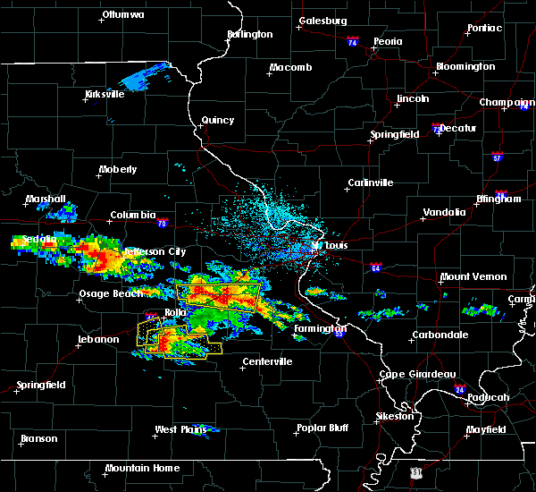 At 1251 pm cdt, severe thunderstorms were located near bourbon stretching east to near richwoods, moving east at 25 mph (radar indicated). Hazards include quarter size hail. Damage to vehicles is expected. locations impacted include, sullivan, bourbon, anthonies mill, leasburg, miramiguoa park, richwoods, lonedell, st. cloud, japan, stanton, oak hill and piney park. this also includes onondaga cave state park and meramec state park. this includes interstate 44 in missouri between exits 210 and 230. A tornado watch remains in effect until 700 pm cdt for east central missouri. At 1251 pm cdt, severe thunderstorms were located near bourbon stretching east to near richwoods, moving east at 25 mph (radar indicated). Hazards include quarter size hail. Damage to vehicles is expected. locations impacted include, sullivan, bourbon, anthonies mill, leasburg, miramiguoa park, richwoods, lonedell, st. cloud, japan, stanton, oak hill and piney park. this also includes onondaga cave state park and meramec state park. this includes interstate 44 in missouri between exits 210 and 230. A tornado watch remains in effect until 700 pm cdt for east central missouri.
|
| 5/27/2017 12:31 PM CDT |
 At 1231 pm cdt, a severe thunderstorm was located 9 miles southeast of bland, moving east at 30 mph (radar indicated). Hazards include half dollar size hail. damage to vehicles is expected At 1231 pm cdt, a severe thunderstorm was located 9 miles southeast of bland, moving east at 30 mph (radar indicated). Hazards include half dollar size hail. damage to vehicles is expected
|
| 5/19/2017 4:24 AM CDT |
 At 424 am cdt, severe thunderstorms were located along a line extending from 6 miles southeast of hermann to 8 miles southeast of anthonies mill, moving east at 60 mph (trained weather spotters). Hazards include 60 mph wind gusts. Expect damage to roofs, siding, and trees. locations impacted include, washington, union, warrenton, sullivan, st. clair, cuba, wright city, owensville, potosi, hermann, new haven, steelville, bourbon, anthonies mill, gerald, marthasville, truesdale, innsbrook, parkway and rosebud. this also includes onondaga cave state park, deutschheim historic site, and meramec state park. this includes the following highways, interstate 44 in missouri between exits 210 and 247. Interstate 70 in missouri between exits 193 and 200. At 424 am cdt, severe thunderstorms were located along a line extending from 6 miles southeast of hermann to 8 miles southeast of anthonies mill, moving east at 60 mph (trained weather spotters). Hazards include 60 mph wind gusts. Expect damage to roofs, siding, and trees. locations impacted include, washington, union, warrenton, sullivan, st. clair, cuba, wright city, owensville, potosi, hermann, new haven, steelville, bourbon, anthonies mill, gerald, marthasville, truesdale, innsbrook, parkway and rosebud. this also includes onondaga cave state park, deutschheim historic site, and meramec state park. this includes the following highways, interstate 44 in missouri between exits 210 and 247. Interstate 70 in missouri between exits 193 and 200.
|
| 5/19/2017 4:03 AM CDT |
 At 402 am cdt, severe thunderstorms were located along a line extending from near chamois to near steelville, moving east at 60 mph (trained weather spotters). Hazards include 60 mph wind gusts. expect damage to roofs, siding, and trees At 402 am cdt, severe thunderstorms were located along a line extending from near chamois to near steelville, moving east at 60 mph (trained weather spotters). Hazards include 60 mph wind gusts. expect damage to roofs, siding, and trees
|
| 4/4/2017 11:18 PM CDT |
 At 1117 pm cdt, severe thunderstorms were located along a line extending from 7 miles northwest of cuba to steelville to near cherryville to 10 miles west of viburnum, moving northeast at 45 mph (radar indicated). Hazards include 60 mph wind gusts and quarter size hail. Hail damage to vehicles is expected. expect wind damage to roofs, siding, and trees. locations impacted include, sullivan, cuba, steelville, bourbon, leasburg, cherryville, st. cloud, dillard, cook station, davisville and rosati. this also includes onondaga cave state park and dillard mill historic site. This includes interstate 44 in missouri between exits 203 and 218. At 1117 pm cdt, severe thunderstorms were located along a line extending from 7 miles northwest of cuba to steelville to near cherryville to 10 miles west of viburnum, moving northeast at 45 mph (radar indicated). Hazards include 60 mph wind gusts and quarter size hail. Hail damage to vehicles is expected. expect wind damage to roofs, siding, and trees. locations impacted include, sullivan, cuba, steelville, bourbon, leasburg, cherryville, st. cloud, dillard, cook station, davisville and rosati. this also includes onondaga cave state park and dillard mill historic site. This includes interstate 44 in missouri between exits 203 and 218.
|
| 4/4/2017 10:55 PM CDT |
 At 1054 pm cdt, severe thunderstorms were located along a line extending from 8 miles north of rolla to 14 miles south of st. james to near salem to 7 miles east of licking, moving northeast at 40 mph (radar indicated). Hazards include 60 mph wind gusts and quarter size hail. Hail damage to vehicles is expected. Expect wind damage to roofs, siding, and trees. At 1054 pm cdt, severe thunderstorms were located along a line extending from 8 miles north of rolla to 14 miles south of st. james to near salem to 7 miles east of licking, moving northeast at 40 mph (radar indicated). Hazards include 60 mph wind gusts and quarter size hail. Hail damage to vehicles is expected. Expect wind damage to roofs, siding, and trees.
|
| 3/7/2017 12:00 AM CST |
 At 1200 am cst, a severe thunderstorm was located near st. james, moving east at 55 mph (radar indicated). Hazards include 60 mph wind gusts and penny size hail. expect damage to roofs, siding, and trees At 1200 am cst, a severe thunderstorm was located near st. james, moving east at 55 mph (radar indicated). Hazards include 60 mph wind gusts and penny size hail. expect damage to roofs, siding, and trees
|
| 7/13/2016 2:53 PM CDT |
 At 252 pm cdt, severe thunderstorms were located along a line extending from near beaufort to 8 miles south of st. james, moving east at 30 mph (trained weather spotters. multiple trees and power lines down in cuba). Hazards include 60 mph wind gusts. Expect damage to roofs. siding. and trees. locations impacted include, sullivan, cuba, potosi, steelville, bourbon, anthonies mill, irondale, mineral point, leasburg, old mines, cherryville, courtois, richwoods, caledonia, st. cloud, dillard, cook station, davisville, belgrade and latty. this also includes washington state park, onondaga cave state park, and dillard mill historic site. This includes interstate 44 in missouri between exits 203 and 218. At 252 pm cdt, severe thunderstorms were located along a line extending from near beaufort to 8 miles south of st. james, moving east at 30 mph (trained weather spotters. multiple trees and power lines down in cuba). Hazards include 60 mph wind gusts. Expect damage to roofs. siding. and trees. locations impacted include, sullivan, cuba, potosi, steelville, bourbon, anthonies mill, irondale, mineral point, leasburg, old mines, cherryville, courtois, richwoods, caledonia, st. cloud, dillard, cook station, davisville, belgrade and latty. this also includes washington state park, onondaga cave state park, and dillard mill historic site. This includes interstate 44 in missouri between exits 203 and 218.
|
| 7/13/2016 2:49 PM CDT | Trees and powerlines down in crawford county MO, 0.5 miles NW of Cuba, MO |
| 7/13/2016 2:40 PM CDT | Trees and power lines down in crawford county MO, 0.5 miles NW of Cuba, MO |
| 7/13/2016 2:33 PM CDT |
 At 232 pm cdt, severe thunderstorms were located along a line extending from near rosebud to near rolla, moving east at 30 mph (radar indicated). Hazards include 60 mph wind gusts. Expect damage to roofs. siding. And trees. At 232 pm cdt, severe thunderstorms were located along a line extending from near rosebud to near rolla, moving east at 30 mph (radar indicated). Hazards include 60 mph wind gusts. Expect damage to roofs. siding. And trees.
|
| 7/7/2016 8:54 AM CDT |
 At 853 am cdt, severe thunderstorms were located along a line extending from 6 miles west of alsey to st. peters to near anthonies mill, moving east at 50 mph (radar indicated). Hazards include 60 mph wind gusts. Expect damage to roofs. siding. and trees. locations impacted include, o`fallon, st. charles, st. peters, florissant, chesterfield, wildwood, university city, ballwin, wentzville, kirkwood, maryland heights, hazelwood, webster groves, ferguson, arnold, manchester, godfrey, creve coeur, overland and clayton. this also includes babler memorial state park, washington state park, route 66 state park, onondaga cave state park, cuivre river state park, castlewood state park, mastodon historic site, sandy creek covered bridge historic site, first missouri state capitol historic site, robertsville state park, meramec state park, and pere marquette state park. this includes the following highways, interstate 44 in missouri between exits 203 and 277. interstate 55 in missouri between exits 175 and 191. Interstate 70 in missouri between exits 203 and 231. At 853 am cdt, severe thunderstorms were located along a line extending from 6 miles west of alsey to st. peters to near anthonies mill, moving east at 50 mph (radar indicated). Hazards include 60 mph wind gusts. Expect damage to roofs. siding. and trees. locations impacted include, o`fallon, st. charles, st. peters, florissant, chesterfield, wildwood, university city, ballwin, wentzville, kirkwood, maryland heights, hazelwood, webster groves, ferguson, arnold, manchester, godfrey, creve coeur, overland and clayton. this also includes babler memorial state park, washington state park, route 66 state park, onondaga cave state park, cuivre river state park, castlewood state park, mastodon historic site, sandy creek covered bridge historic site, first missouri state capitol historic site, robertsville state park, meramec state park, and pere marquette state park. this includes the following highways, interstate 44 in missouri between exits 203 and 277. interstate 55 in missouri between exits 175 and 191. Interstate 70 in missouri between exits 203 and 231.
|
| 7/7/2016 8:36 AM CDT |
 At 835 am cdt, severe thunderstorms were located along a line extending from near pittsfield to wentzville to cuba, moving east at 30 mph (radar indicated). Hazards include 60 mph wind gusts. Expect damage to roofs. siding. and trees. locations impacted include, o`fallon, st. charles, st. peters, florissant, chesterfield, wildwood, university city, ballwin, wentzville, kirkwood, maryland heights, hazelwood, webster groves, ferguson, arnold, manchester, godfrey, creve coeur, overland and clayton. this also includes babler memorial state park, washington state park, route 66 state park, onondaga cave state park, cuivre river state park, castlewood state park, mastodon historic site, sandy creek covered bridge historic site, first missouri state capitol historic site, robertsville state park, meramec state park, and pere marquette state park. this includes the following highways, interstate 44 in missouri between exits 203 and 277. interstate 55 in missouri between exits 175 and 191. Interstate 70 in missouri between exits 188 and 231. At 835 am cdt, severe thunderstorms were located along a line extending from near pittsfield to wentzville to cuba, moving east at 30 mph (radar indicated). Hazards include 60 mph wind gusts. Expect damage to roofs. siding. and trees. locations impacted include, o`fallon, st. charles, st. peters, florissant, chesterfield, wildwood, university city, ballwin, wentzville, kirkwood, maryland heights, hazelwood, webster groves, ferguson, arnold, manchester, godfrey, creve coeur, overland and clayton. this also includes babler memorial state park, washington state park, route 66 state park, onondaga cave state park, cuivre river state park, castlewood state park, mastodon historic site, sandy creek covered bridge historic site, first missouri state capitol historic site, robertsville state park, meramec state park, and pere marquette state park. this includes the following highways, interstate 44 in missouri between exits 203 and 277. interstate 55 in missouri between exits 175 and 191. Interstate 70 in missouri between exits 188 and 231.
|
| 7/7/2016 8:11 AM CDT |
 At 811 am cdt, severe thunderstorms were located along a line extending from 6 miles southwest of barry to warrenton to 8 miles southeast of owensville, moving east at 40 mph (radar indicated). Hazards include 70 mph wind gusts. Expect considerable tree damage. damage is likely to mobile homes, roofs, and outbuildings. locations impacted include, o`fallon, st. charles, st. peters, florissant, chesterfield, wildwood, university city, ballwin, wentzville, kirkwood, maryland heights, hazelwood, webster groves, ferguson, arnold, manchester, godfrey, creve coeur, overland and clayton. this also includes babler memorial state park, washington state park, route 66 state park, onondaga cave state park, deutschheim historic site, cuivre river state park, castlewood state park, mastodon historic site, sandy creek covered bridge historic site, first missouri state capitol historic site, robertsville state park, meramec state park, and pere marquette state park. this includes the following highways, interstate 44 in missouri between exits 203 and 277. interstate 55 in missouri between exits 175 and 191. Interstate 70 in missouri between exits 175 and 231. At 811 am cdt, severe thunderstorms were located along a line extending from 6 miles southwest of barry to warrenton to 8 miles southeast of owensville, moving east at 40 mph (radar indicated). Hazards include 70 mph wind gusts. Expect considerable tree damage. damage is likely to mobile homes, roofs, and outbuildings. locations impacted include, o`fallon, st. charles, st. peters, florissant, chesterfield, wildwood, university city, ballwin, wentzville, kirkwood, maryland heights, hazelwood, webster groves, ferguson, arnold, manchester, godfrey, creve coeur, overland and clayton. this also includes babler memorial state park, washington state park, route 66 state park, onondaga cave state park, deutschheim historic site, cuivre river state park, castlewood state park, mastodon historic site, sandy creek covered bridge historic site, first missouri state capitol historic site, robertsville state park, meramec state park, and pere marquette state park. this includes the following highways, interstate 44 in missouri between exits 203 and 277. interstate 55 in missouri between exits 175 and 191. Interstate 70 in missouri between exits 175 and 231.
|
| 7/7/2016 7:59 AM CDT |
 At 758 am cdt, severe thunderstorms were located along a line extending from 9 miles southeast of hannibal to jonesburg to near bland, moving east at 65 mph (radar indicated). Hazards include 70 mph wind gusts. Expect considerable tree damage. Damage is likely to mobile homes, roofs, and outbuildings. At 758 am cdt, severe thunderstorms were located along a line extending from 9 miles southeast of hannibal to jonesburg to near bland, moving east at 65 mph (radar indicated). Hazards include 70 mph wind gusts. Expect considerable tree damage. Damage is likely to mobile homes, roofs, and outbuildings.
|
| 5/11/2016 5:18 PM CDT |
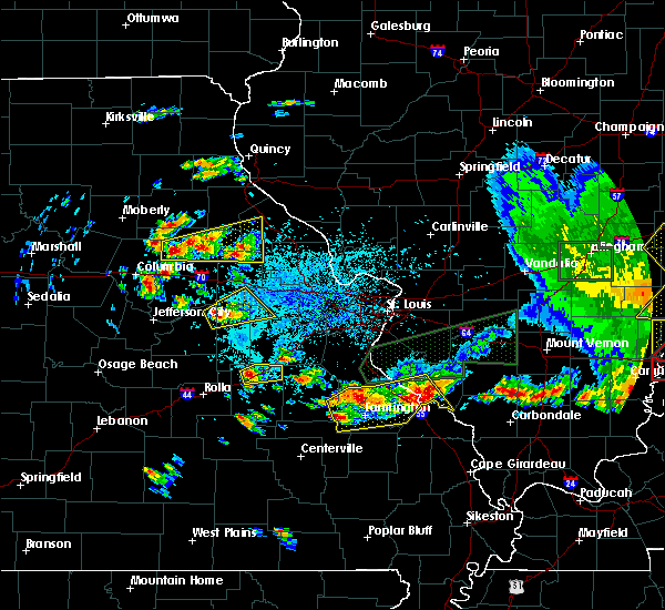 At 517 pm cdt, a severe thunderstorm was located near cuba, moving northeast at 25 mph (trained weather spotters reported half dollar size hail just north of cuba at 514 pm). Hazards include 60 mph wind gusts and half dollar size hail. Hail damage to vehicles is expected. Expect wind damage to roofs, siding, and trees. At 517 pm cdt, a severe thunderstorm was located near cuba, moving northeast at 25 mph (trained weather spotters reported half dollar size hail just north of cuba at 514 pm). Hazards include 60 mph wind gusts and half dollar size hail. Hail damage to vehicles is expected. Expect wind damage to roofs, siding, and trees.
|
| 5/11/2016 5:14 PM CDT | Half Dollar sized hail reported 1.7 miles S of Cuba, MO |
| 4/30/2016 9:01 PM CDT |
 At 900 pm cdt, a severe thunderstorm was located near anthonies mill, moving northeast at 30 mph (radar indicated). Hazards include quarter size hail. Damage to vehicles is expected. locations impacted include, cuba, potosi, steelville, bourbon, anthonies mill, viburnum, leasburg, cherryville, courtois, dillard, cook station, davisville, latty and shirley. this also includes onondaga cave state park and dillard mill historic site. This includes interstate 44 in missouri between exits 214 and 218. At 900 pm cdt, a severe thunderstorm was located near anthonies mill, moving northeast at 30 mph (radar indicated). Hazards include quarter size hail. Damage to vehicles is expected. locations impacted include, cuba, potosi, steelville, bourbon, anthonies mill, viburnum, leasburg, cherryville, courtois, dillard, cook station, davisville, latty and shirley. this also includes onondaga cave state park and dillard mill historic site. This includes interstate 44 in missouri between exits 214 and 218.
|
| 4/30/2016 8:34 PM CDT |
 At 834 pm cdt, a severe thunderstorm was located near cherryville, moving northeast at 35 mph (radar indicated). Hazards include quarter size hail. damage to vehicles is expected At 834 pm cdt, a severe thunderstorm was located near cherryville, moving northeast at 35 mph (radar indicated). Hazards include quarter size hail. damage to vehicles is expected
|
| 4/27/2016 7:23 PM CDT |
 At 723 pm cdt, a severe thunderstorm was located near steelville, moving northeast at 30 mph (radar indicated). Hazards include 60 mph wind gusts and half dollar size hail. Hail damage to vehicles is expected. Expect wind damage to roofs, siding, and trees. At 723 pm cdt, a severe thunderstorm was located near steelville, moving northeast at 30 mph (radar indicated). Hazards include 60 mph wind gusts and half dollar size hail. Hail damage to vehicles is expected. Expect wind damage to roofs, siding, and trees.
|
| 8/9/2015 6:54 PM CDT |
 At 653 pm cdt, severe thunderstorms were located along a line extending from near miramiguoa park to 9 miles east of steelville, moving east at 45 mph (radar indicated). Hazards include 60 mph wind gusts. Expect damage to roofs. siding and trees. locations impacted include, sullivan, cuba, steelville, bourbon, anthonies mill, leasburg, richwoods, st. cloud and latty. this warning also includes onondaga cave state park. This includes interstate 44 in missouri between exits 208 and 218. At 653 pm cdt, severe thunderstorms were located along a line extending from near miramiguoa park to 9 miles east of steelville, moving east at 45 mph (radar indicated). Hazards include 60 mph wind gusts. Expect damage to roofs. siding and trees. locations impacted include, sullivan, cuba, steelville, bourbon, anthonies mill, leasburg, richwoods, st. cloud and latty. this warning also includes onondaga cave state park. This includes interstate 44 in missouri between exits 208 and 218.
|
| 8/9/2015 6:50 PM CDT | Several trees down within the city limits in crawford county MO, 0.5 miles NW of Cuba, MO |
| 8/9/2015 6:38 PM CDT | Tree down blocking road at highway f and ee in crawford county MO, 7.4 miles SSE of Cuba, MO |
| 8/9/2015 6:38 PM CDT |
 At 638 pm cdt, a severe thunderstorm was located near bourbon, moving east at 40 mph (radar indicated). Hazards include 60 mph wind gusts. Expect damage to roofs. Siding and trees. At 638 pm cdt, a severe thunderstorm was located near bourbon, moving east at 40 mph (radar indicated). Hazards include 60 mph wind gusts. Expect damage to roofs. Siding and trees.
|
| 8/9/2015 6:34 PM CDT |
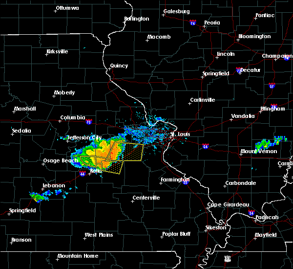 At 633 pm cdt, a severe thunderstorm was located near cuba, moving east at 40 mph (radar indicated). Hazards include 60 mph wind gusts. Expect damage to roofs. siding and trees. locations impacted include, sullivan, cuba, bourbon, leasburg, st. cloud, oak hill and rosati. this warning also includes onondaga cave state park. This includes interstate 44 in missouri between exits 203 and 218. At 633 pm cdt, a severe thunderstorm was located near cuba, moving east at 40 mph (radar indicated). Hazards include 60 mph wind gusts. Expect damage to roofs. siding and trees. locations impacted include, sullivan, cuba, bourbon, leasburg, st. cloud, oak hill and rosati. this warning also includes onondaga cave state park. This includes interstate 44 in missouri between exits 203 and 218.
|
| 8/9/2015 6:19 PM CDT |
 At 618 pm cdt, a severe thunderstorm was located near bland, moving east at 40 mph (radar indicated). Hazards include 60 mph wind gusts. Expect damage to roofs. Siding and trees. At 618 pm cdt, a severe thunderstorm was located near bland, moving east at 40 mph (radar indicated). Hazards include 60 mph wind gusts. Expect damage to roofs. Siding and trees.
|
| 4/9/2015 6:17 PM CDT | The national weather service in st louis has issued a * severe thunderstorm warning for. northern crawford county in east central missouri. southern franklin county in east central missouri. western jefferson county in east central missouri. northern st. Francois county in southeast missouri. |
| 4/8/2015 3:05 PM CDT | The national weather service in st louis has issued a * severe thunderstorm warning for. crawford county in east central missouri. southern franklin county in east central missouri. gasconade county in east central missouri. Iron county in southeast missouri. |
| 4/3/2014 8:22 PM CDT | Quarter sized hail reported 0.5 miles NW of Cuba, MO, relayed from spotter |
| 9/7/2012 5:52 PM CDT | Quarter sized hail reported 0.5 miles NW of Cuba, MO |
| 7/7/2012 7:19 PM CDT | 8 inch diameter tree down. 6 inch diameter tree limbs broken. powerlines downe in crawford county MO, 0.5 miles NW of Cuba, MO |
| 7/7/2012 6:25 PM CDT | *** 1 in crawford county MO, 0.5 miles NW of Cuba, MO |
| 7/7/2012 6:25 PM CDT | 8 inch diameter tree down. 6 inch diameter tree limbs broken. powerlines downe in crawford county MO, 0.5 miles NW of Cuba, MO |
| 7/7/2012 6:25 PM CDT | Major damage in cuba including building collapses... vehicle rollovers... and numerous power lines downed. time estimated in crawford county MO, 0.5 miles NW of Cuba, MO |
| 7/7/2012 6:25 PM CDT | Trees...tree limbs blown down. also...roof was blown off of a truck sto in crawford county MO, 0.5 miles NW of Cuba, MO |
| 7/7/2012 6:10 PM CDT | Major damage in cuba including building collapses... vehicle rollovers... and numerous power lines downed. time estimated in crawford county MO, 0.5 miles NW of Cuba, MO |
| 3/15/2012 9:35 PM CDT | Golf Ball sized hail reported 3.4 miles NNW of Cuba, MO |
| 3/15/2012 2:23 PM CDT | Quarter sized hail reported 4.6 miles E of Cuba, MO |
| 1/1/0001 12:00 AM | Power lines down in cuba...also tree limbs down over us route 1 in crawford county MO, 0.5 miles NW of Cuba, MO |
| 1/1/0001 12:00 AM | Large billboard blown over onto highway zz just southwest of town...still blocking roa in crawford county MO, 0.9 miles ENE of Cuba, MO |
| 1/1/0001 12:00 AM | Large tree uprooted and several large sheds blown over on highland drive just north of cub in crawford county MO, 1.3 miles SE of Cuba, MO |
| 1/1/0001 12:00 AM | Quarter sized hail reported 0.5 miles NW of Cuba, MO |
Hail Maps for Cuba, MO


Connect with Interactive Hail Maps