

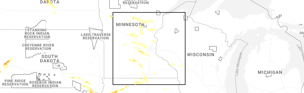
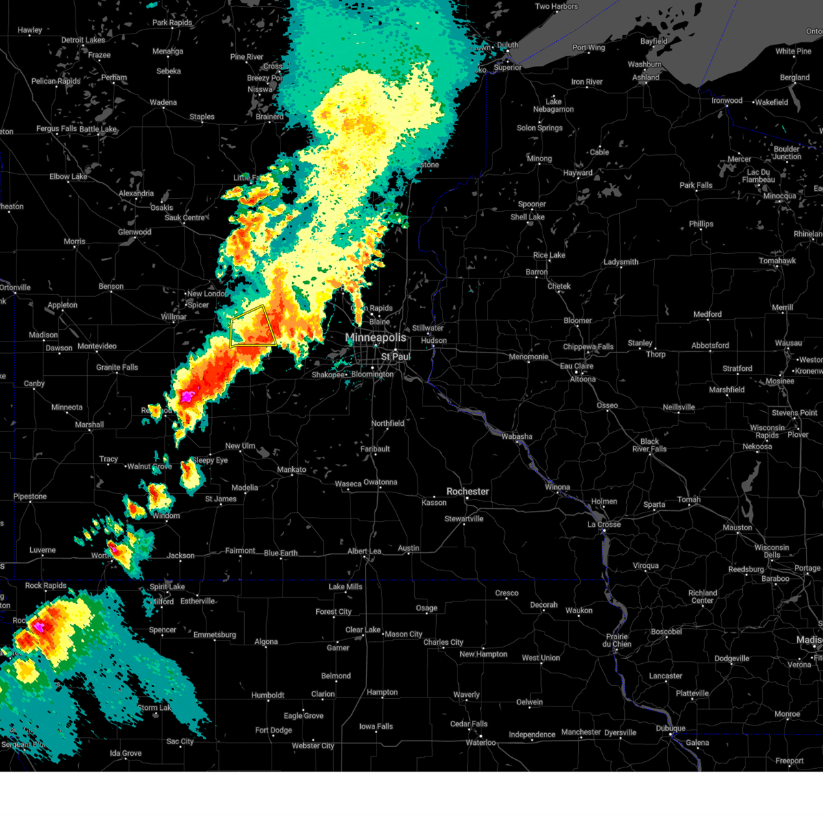
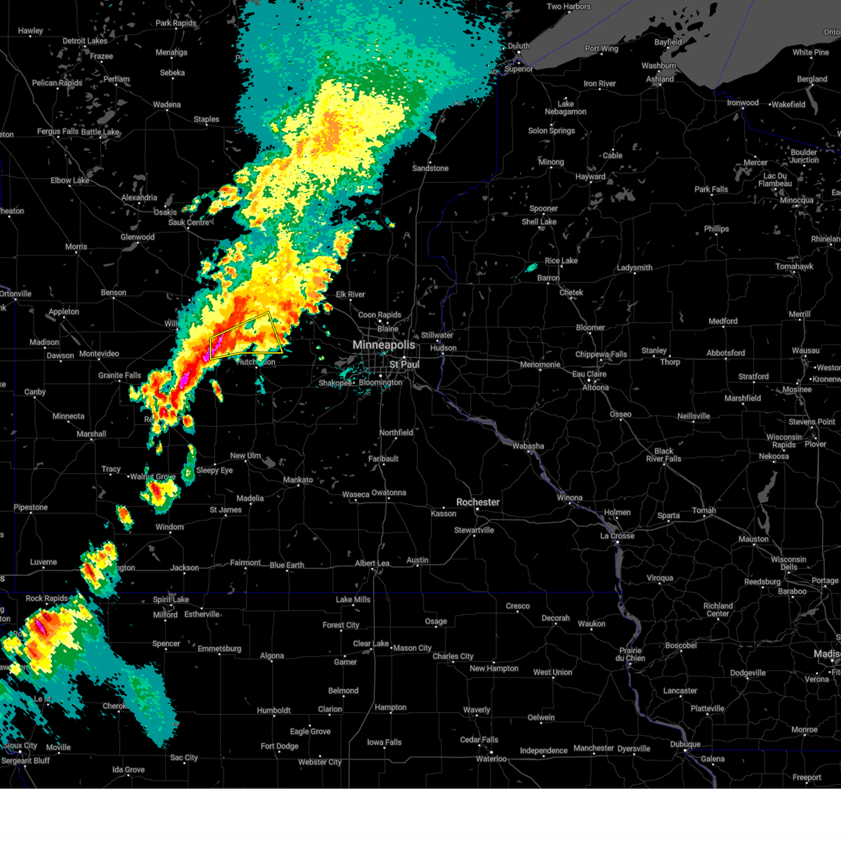
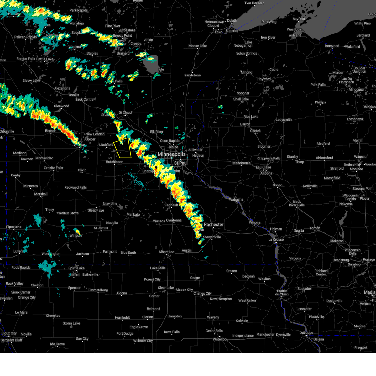
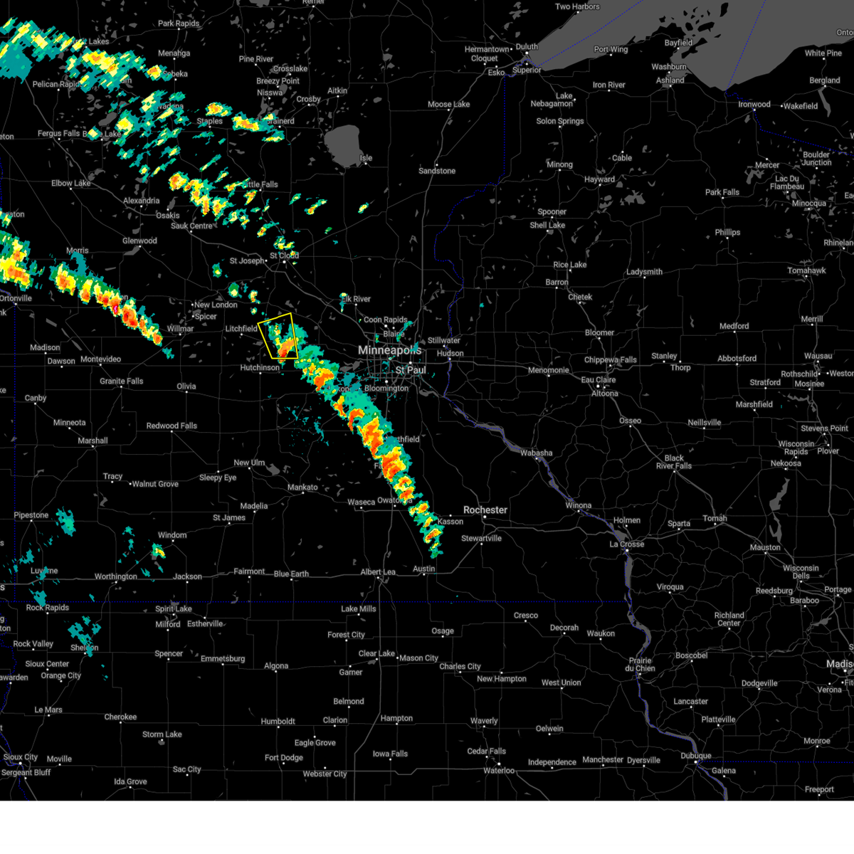
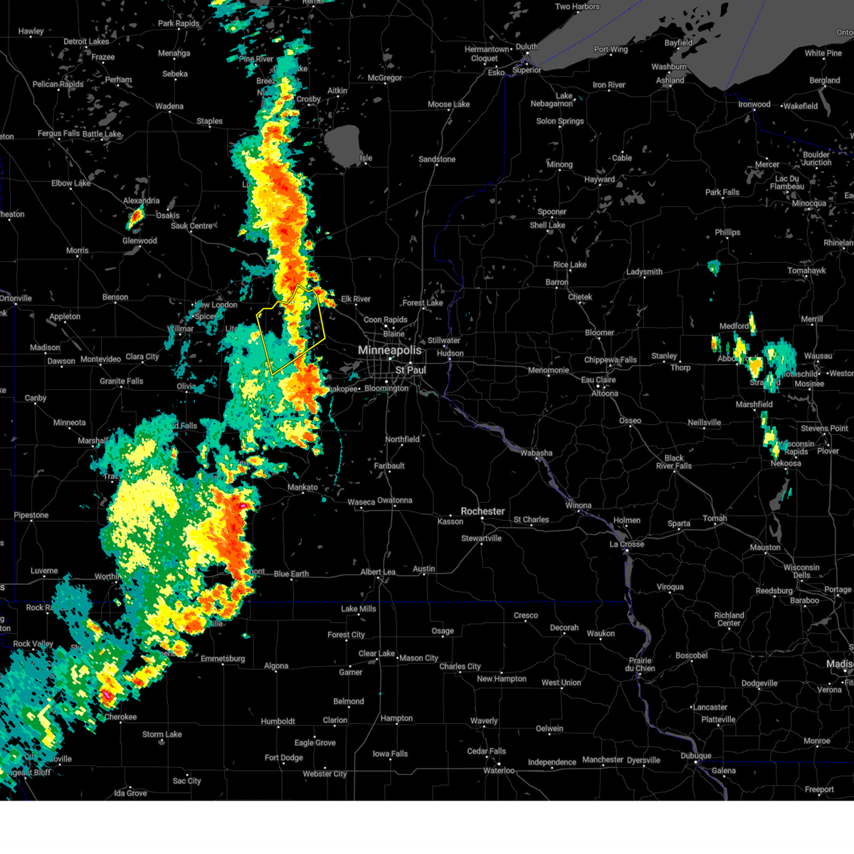
Hail Map for Dassel, MN
The Dassel, MN area has had 14 reports of on-the-ground hail by trained spotters, and has been under severe weather warnings 11 times during the past 12 months. Doppler radar has detected hail at or near Dassel, MN on 62 occasions, including 5 occasions during the past year.
| Name: | Dassel, MN |
| Where Located: | 51.8 miles W of Minneapolis, MN |
| Map: | Google Map for Dassel, MN |
| Population: | 1469 |
| Housing Units: | 620 |
| More Info: | Search Google for Dassel, MN |
0
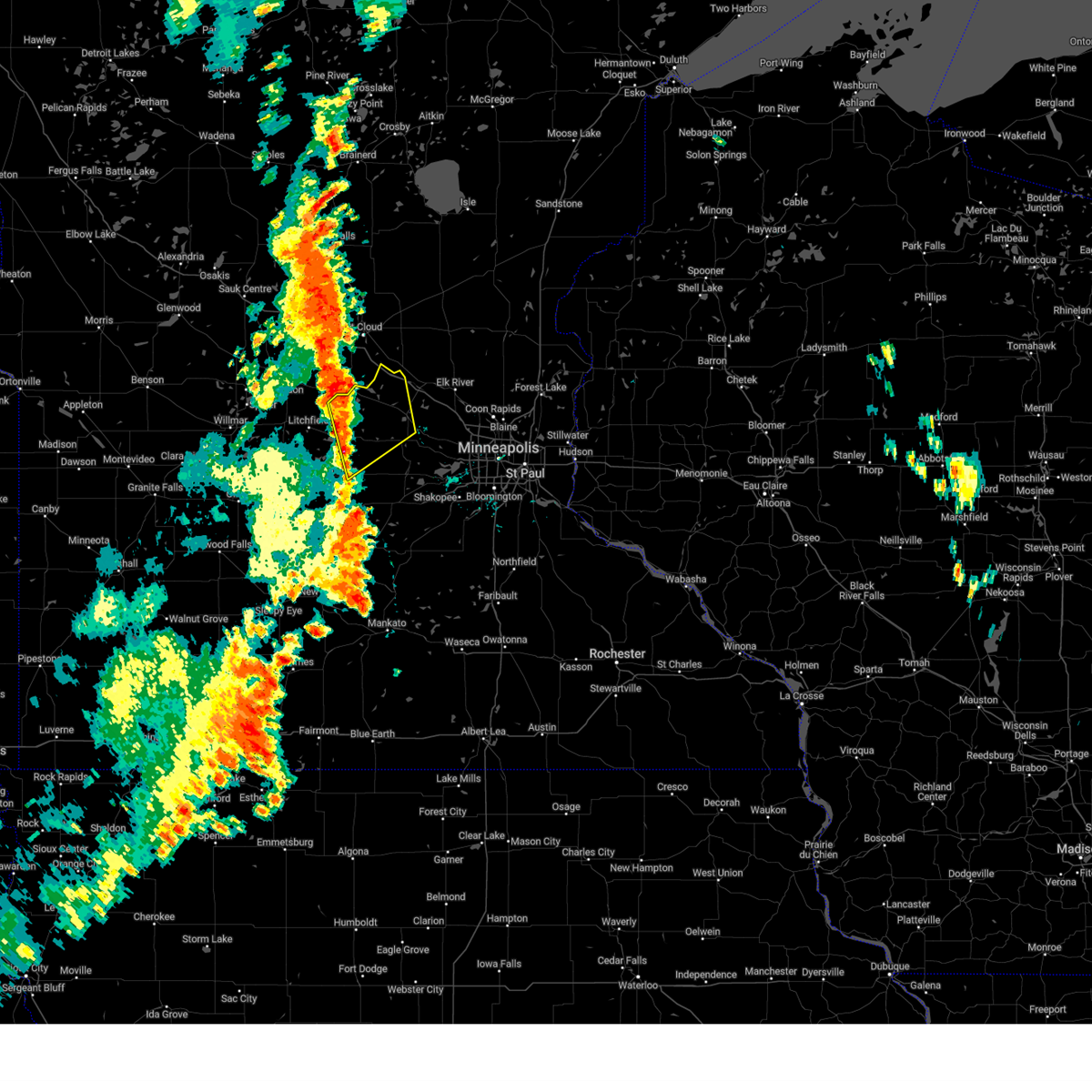
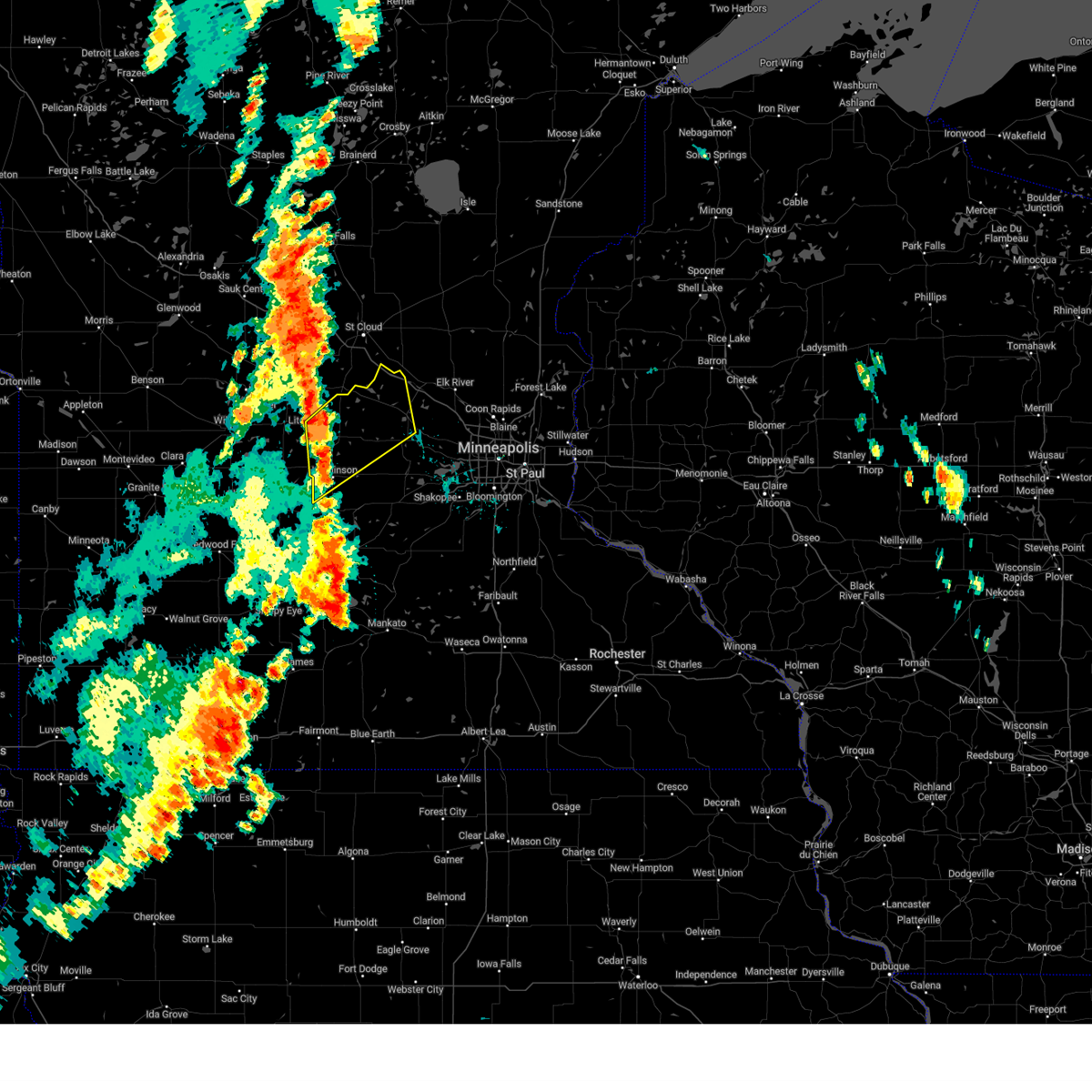
The Top Recent Hail Date for Dassel, MN is Monday, June 16, 2025 (62nd out of 62)
Hail and Wind Damage Spotted near Dassel, MN
| Date / Time | Report Details |
|---|---|
| 6/16/2025 5:32 PM CDT |
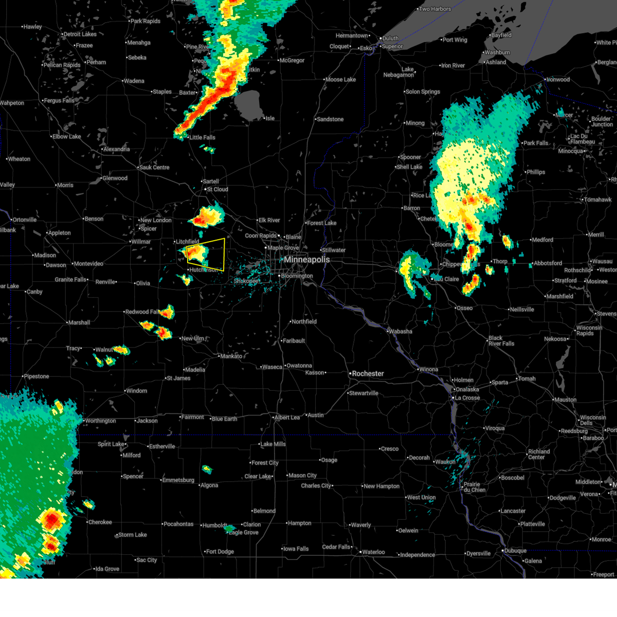
 Tormpx the national weather service in the twin cities has issued a * tornado warning for, east central meeker county in central minnesota, southwestern wright county in central minnesota, * until 600 pm cdt. * at 532 pm cdt, a severe thunderstorm capable of producing a tornado was located 5 miles southwest of cokato, or 11 miles northeast of hutchinson, moving east at 20 mph (radar indicated rotation). Hazards include tornado and half dollar size hail. Flying debris will be dangerous to those caught without shelter. mobile homes will be damaged or destroyed. damage to roofs, windows and vehicles will occur. Tree damage is likely. Tormpx the national weather service in the twin cities has issued a * tornado warning for, east central meeker county in central minnesota, southwestern wright county in central minnesota, * until 600 pm cdt. * at 532 pm cdt, a severe thunderstorm capable of producing a tornado was located 5 miles southwest of cokato, or 11 miles northeast of hutchinson, moving east at 20 mph (radar indicated rotation). Hazards include tornado and half dollar size hail. Flying debris will be dangerous to those caught without shelter. mobile homes will be damaged or destroyed. damage to roofs, windows and vehicles will occur. Tree damage is likely.
|
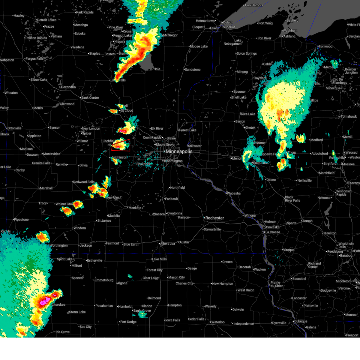
| 6/16/2025 5:25 PM CDT | Quarter sized hail reported 3.2 miles NNW of Dassel, MN, multiple reports of quarter sized hail south of dassel. |
| 6/16/2025 5:20 PM CDT |
 Svrmpx the national weather service in the twin cities has issued a * severe thunderstorm warning for, northeastern mcleod county in central minnesota, southeastern meeker county in central minnesota, southwestern wright county in central minnesota, northwestern carver county in east central minnesota, * until 600 pm cdt. * at 520 pm cdt, a severe thunderstorm was located 6 miles south of dassel, or 8 miles north of hutchinson, moving east at 25 mph (radar indicated). Hazards include 60 mph wind gusts and half dollar size hail. Hail damage to vehicles is expected. Expect wind damage to roofs, siding, and trees. Svrmpx the national weather service in the twin cities has issued a * severe thunderstorm warning for, northeastern mcleod county in central minnesota, southeastern meeker county in central minnesota, southwestern wright county in central minnesota, northwestern carver county in east central minnesota, * until 600 pm cdt. * at 520 pm cdt, a severe thunderstorm was located 6 miles south of dassel, or 8 miles north of hutchinson, moving east at 25 mph (radar indicated). Hazards include 60 mph wind gusts and half dollar size hail. Hail damage to vehicles is expected. Expect wind damage to roofs, siding, and trees.
|
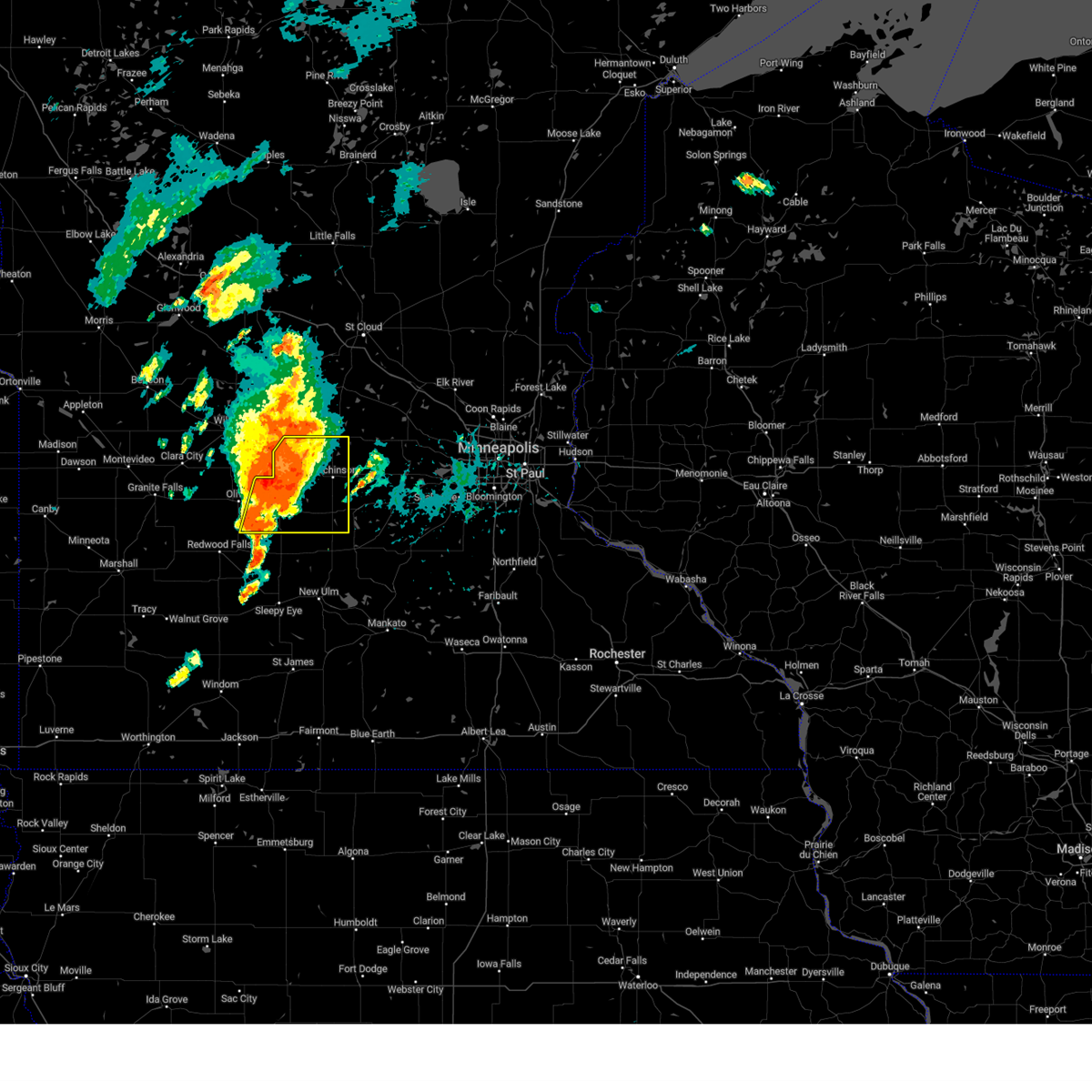
| 6/2/2025 5:38 PM CDT |
 The storm which prompted the warning has weakened below severe limits, and no longer poses an immediate threat to life or property. therefore, the warning will be allowed to expire. a severe thunderstorm watch remains in effect until 700 pm cdt for a portion of central minnesota. The storm which prompted the warning has weakened below severe limits, and no longer poses an immediate threat to life or property. therefore, the warning will be allowed to expire. a severe thunderstorm watch remains in effect until 700 pm cdt for a portion of central minnesota.
|
| 6/2/2025 5:34 PM CDT |
 At 534 pm cdt, a severe thunderstorm was located near dassel, or 12 miles north of hutchinson, moving east at 50 mph (radar indicated). Hazards include 60 mph wind gusts and small hail. Expect damage to roofs, siding, and trees. Locations impacted include, litchfield, cokato, dassel, greenleaf, darwin and litchfield airport. At 534 pm cdt, a severe thunderstorm was located near dassel, or 12 miles north of hutchinson, moving east at 50 mph (radar indicated). Hazards include 60 mph wind gusts and small hail. Expect damage to roofs, siding, and trees. Locations impacted include, litchfield, cokato, dassel, greenleaf, darwin and litchfield airport.
|
| 6/2/2025 5:16 PM CDT |
 Svrmpx the national weather service in the twin cities has issued a * severe thunderstorm warning for, central meeker county in central minnesota, southwestern wright county in central minnesota, * until 545 pm cdt. * at 516 pm cdt, a severe thunderstorm was located near cosmos, or 16 miles northwest of hutchinson, moving east at 50 mph (radar indicated). Hazards include 60 mph wind gusts and quarter size hail. Hail damage to vehicles is expected. Expect wind damage to roofs, siding, and trees. Svrmpx the national weather service in the twin cities has issued a * severe thunderstorm warning for, central meeker county in central minnesota, southwestern wright county in central minnesota, * until 545 pm cdt. * at 516 pm cdt, a severe thunderstorm was located near cosmos, or 16 miles northwest of hutchinson, moving east at 50 mph (radar indicated). Hazards include 60 mph wind gusts and quarter size hail. Hail damage to vehicles is expected. Expect wind damage to roofs, siding, and trees.
|
| 5/15/2025 1:57 PM CDT |
 The storm which prompted the warning has moved out of the area. therefore, the warning will be allowed to expire. a tornado watch remains in effect until 800 pm cdt thursday for a portion of central minnesota. The storm which prompted the warning has moved out of the area. therefore, the warning will be allowed to expire. a tornado watch remains in effect until 800 pm cdt thursday for a portion of central minnesota.
|
| 5/15/2025 1:33 PM CDT |
 Svrmpx the national weather service in the twin cities has issued a * severe thunderstorm warning for, east central meeker county in central minnesota, southwestern wright county in central minnesota, * until 200 pm cdt. * at 133 pm cdt, a severe thunderstorm was located near silver lake, or 11 miles northeast of hutchinson, moving north at 30 mph (radar indicated). Hazards include 60 mph wind gusts and quarter size hail. Hail damage to vehicles is expected. Expect wind damage to roofs, siding, and trees. Svrmpx the national weather service in the twin cities has issued a * severe thunderstorm warning for, east central meeker county in central minnesota, southwestern wright county in central minnesota, * until 200 pm cdt. * at 133 pm cdt, a severe thunderstorm was located near silver lake, or 11 miles northeast of hutchinson, moving north at 30 mph (radar indicated). Hazards include 60 mph wind gusts and quarter size hail. Hail damage to vehicles is expected. Expect wind damage to roofs, siding, and trees.
|
| 8/29/2024 3:44 PM CDT |
 The storms which prompted the warning have weakened below severe limits, and no longer pose an immediate threat to life or property. therefore, the warning will be allowed to expire. a severe thunderstorm watch remains in effect until 900 pm cdt for central minnesota. The storms which prompted the warning have weakened below severe limits, and no longer pose an immediate threat to life or property. therefore, the warning will be allowed to expire. a severe thunderstorm watch remains in effect until 900 pm cdt for central minnesota.
|
| 8/29/2024 3:23 PM CDT |
 At 323 pm cdt, severe thunderstorms were located along a line extending from near kimball to near cokato, moving east at 55 mph (radar indicated). Hazards include 60 mph wind gusts and quarter size hail. Hail damage to vehicles is expected. expect wind damage to roofs, siding, and trees. Locations impacted include, buffalo, annandale, montrose, cokato, maple lake, howard lake, clearwater, dassel, waverly, french lake, silver creek, and south haven. At 323 pm cdt, severe thunderstorms were located along a line extending from near kimball to near cokato, moving east at 55 mph (radar indicated). Hazards include 60 mph wind gusts and quarter size hail. Hail damage to vehicles is expected. expect wind damage to roofs, siding, and trees. Locations impacted include, buffalo, annandale, montrose, cokato, maple lake, howard lake, clearwater, dassel, waverly, french lake, silver creek, and south haven.
|
| 8/29/2024 3:05 PM CDT |
 Svrmpx the national weather service in the twin cities has issued a * severe thunderstorm warning for, wright county in central minnesota, eastern meeker county in central minnesota, northwestern mcleod county in central minnesota, * until 345 pm cdt. * at 304 pm cdt, severe thunderstorms were located along a line extending from litchfield to near hutchinson, moving northeast at 55 mph (radar indicated). Hazards include 60 mph wind gusts and quarter size hail. Hail damage to vehicles is expected. Expect wind damage to roofs, siding, and trees. Svrmpx the national weather service in the twin cities has issued a * severe thunderstorm warning for, wright county in central minnesota, eastern meeker county in central minnesota, northwestern mcleod county in central minnesota, * until 345 pm cdt. * at 304 pm cdt, severe thunderstorms were located along a line extending from litchfield to near hutchinson, moving northeast at 55 mph (radar indicated). Hazards include 60 mph wind gusts and quarter size hail. Hail damage to vehicles is expected. Expect wind damage to roofs, siding, and trees.
|
| 8/26/2024 5:44 PM CDT |
 Svrmpx the national weather service in the twin cities has issued a * severe thunderstorm warning for, southern meeker county in central minnesota, northwestern sibley county in central minnesota, western mcleod county in central minnesota, northeastern renville county in central minnesota, * until 630 pm cdt. * at 543 pm cdt, a severe thunderstorm was located near buffalo lake, or 10 miles southwest of hutchinson, moving east at 30 mph (radar indicated). Hazards include 60 mph wind gusts and quarter size hail. Hail damage to vehicles is expected. Expect wind damage to roofs, siding, and trees. Svrmpx the national weather service in the twin cities has issued a * severe thunderstorm warning for, southern meeker county in central minnesota, northwestern sibley county in central minnesota, western mcleod county in central minnesota, northeastern renville county in central minnesota, * until 630 pm cdt. * at 543 pm cdt, a severe thunderstorm was located near buffalo lake, or 10 miles southwest of hutchinson, moving east at 30 mph (radar indicated). Hazards include 60 mph wind gusts and quarter size hail. Hail damage to vehicles is expected. Expect wind damage to roofs, siding, and trees.
|
| 6/4/2024 4:19 PM CDT | *** 1 inj *** relayed report from sheriffs office of a shed with roof blown off and sides collapse in meeker county MN, 7 miles NNE of Dassel, MN |
| 6/4/2024 3:39 PM CDT | *** 1 inj *** corrects previous tstm wnd dmg report from 7 n hutchinson. relayed report from sheriffs office of a shed with roof blown off and sides collapse in meeker county MN, 7 miles NNE of Dassel, MN |
| 8/11/2023 4:50 PM CDT | Tea Cup sized hail reported 5.7 miles N of Dassel, MN, picture with ruler via facebook messenger. slightly larger than 3 inches. |
| 8/11/2023 4:48 PM CDT | Tea Cup sized hail reported 5.7 miles N of Dassel, MN, hail measured 3.75 inches in diameter near hwy 15. submitted photo of hail with ruler via email. damage to siding on west side of house. |
| 8/11/2023 4:37 PM CDT |
 At 436 pm cdt, a severe thunderstorm was located 7 miles north of hutchinson, moving east at 55 mph (radar indicated). Hazards include two inch hail and 70 mph wind gusts. People and animals outdoors will be injured. expect hail damage to roofs, siding, windows, and vehicles. expect considerable tree damage. wind damage is also likely to mobile homes, roofs, and outbuildings. this severe thunderstorm will be near, dassel around 445 pm cdt. cokato around 450 pm cdt. howard lake around 455 pm cdt. other locations in the path of this severe thunderstorm include montrose. thunderstorm damage threat, considerable hail threat, radar indicated max hail size, 2. 00 in wind threat, radar indicated max wind gust, 70 mph. At 436 pm cdt, a severe thunderstorm was located 7 miles north of hutchinson, moving east at 55 mph (radar indicated). Hazards include two inch hail and 70 mph wind gusts. People and animals outdoors will be injured. expect hail damage to roofs, siding, windows, and vehicles. expect considerable tree damage. wind damage is also likely to mobile homes, roofs, and outbuildings. this severe thunderstorm will be near, dassel around 445 pm cdt. cokato around 450 pm cdt. howard lake around 455 pm cdt. other locations in the path of this severe thunderstorm include montrose. thunderstorm damage threat, considerable hail threat, radar indicated max hail size, 2. 00 in wind threat, radar indicated max wind gust, 70 mph.
|
| 7/26/2023 12:25 AM CDT |
 The severe thunderstorm warning for southern meeker county will expire at 1230 am cdt, the storm which prompted the warning has weakened below severe limits, and has exited the warned area. therefore, the warning will be allowed to expire. however gusty winds are still possible with this thunderstorm. a severe thunderstorm watch remains in effect until 400 am cdt for central minnesota. The severe thunderstorm warning for southern meeker county will expire at 1230 am cdt, the storm which prompted the warning has weakened below severe limits, and has exited the warned area. therefore, the warning will be allowed to expire. however gusty winds are still possible with this thunderstorm. a severe thunderstorm watch remains in effect until 400 am cdt for central minnesota.
|
| 7/25/2023 11:52 PM CDT |
 At 1152 pm cdt, a severe thunderstorm was located over dassel, or 12 miles north of hutchinson, moving east at 50 mph (radar indicated). Hazards include 70 mph wind gusts and quarter size hail. Hail damage to vehicles is expected. expect considerable tree damage. wind damage is also likely to mobile homes, roofs, and outbuildings. locations impacted include, dassel. thunderstorm damage threat, considerable hail threat, radar indicated max hail size, 1. 00 in wind threat, radar indicated max wind gust, 70 mph. At 1152 pm cdt, a severe thunderstorm was located over dassel, or 12 miles north of hutchinson, moving east at 50 mph (radar indicated). Hazards include 70 mph wind gusts and quarter size hail. Hail damage to vehicles is expected. expect considerable tree damage. wind damage is also likely to mobile homes, roofs, and outbuildings. locations impacted include, dassel. thunderstorm damage threat, considerable hail threat, radar indicated max hail size, 1. 00 in wind threat, radar indicated max wind gust, 70 mph.
|
| 7/25/2023 11:50 PM CDT |
 At 1149 pm cdt, a severe thunderstorm was located near annandale, or 17 miles west of buffalo, moving east at 45 mph (radar indicated). Hazards include 70 mph wind gusts. Expect considerable tree damage. damage is likely to mobile homes, roofs, and outbuildings. This severe thunderstorm will remain over mainly rural areas of northern meeker and southeastern stearns counties, including the following locations, darwin, forest city, st nicholas and litchfield airport. At 1149 pm cdt, a severe thunderstorm was located near annandale, or 17 miles west of buffalo, moving east at 45 mph (radar indicated). Hazards include 70 mph wind gusts. Expect considerable tree damage. damage is likely to mobile homes, roofs, and outbuildings. This severe thunderstorm will remain over mainly rural areas of northern meeker and southeastern stearns counties, including the following locations, darwin, forest city, st nicholas and litchfield airport.
|
| 7/25/2023 11:28 PM CDT |
 At 1127 pm cdt, a severe thunderstorm was located near atwater, or 14 miles east of willmar, moving east at 40 mph (radar indicated). Hazards include 60 mph wind gusts and quarter size hail. Hail damage to vehicles is expected. expect wind damage to roofs, siding, and trees. this severe thunderstorm will be near, litchfield around 1145 pm cdt. other locations in the path of this severe thunderstorm include dassel. hail threat, radar indicated max hail size, 1. 00 in wind threat, radar indicated max wind gust, 60 mph. At 1127 pm cdt, a severe thunderstorm was located near atwater, or 14 miles east of willmar, moving east at 40 mph (radar indicated). Hazards include 60 mph wind gusts and quarter size hail. Hail damage to vehicles is expected. expect wind damage to roofs, siding, and trees. this severe thunderstorm will be near, litchfield around 1145 pm cdt. other locations in the path of this severe thunderstorm include dassel. hail threat, radar indicated max hail size, 1. 00 in wind threat, radar indicated max wind gust, 60 mph.
|
| 7/25/2023 11:05 PM CDT |
 At 1104 pm cdt, a severe thunderstorm was located near new london, or 14 miles northeast of willmar, moving east at 50 mph (radar indicated). Hazards include 60 mph wind gusts. Expect damage to roofs, siding, and trees. this severe thunderstorm will be near, paynesville around 1115 pm cdt. other locations in the path of this severe thunderstorm include watkins and kimball. hail threat, radar indicated max hail size, <. 75 in wind threat, radar indicated max wind gust, 60 mph. At 1104 pm cdt, a severe thunderstorm was located near new london, or 14 miles northeast of willmar, moving east at 50 mph (radar indicated). Hazards include 60 mph wind gusts. Expect damage to roofs, siding, and trees. this severe thunderstorm will be near, paynesville around 1115 pm cdt. other locations in the path of this severe thunderstorm include watkins and kimball. hail threat, radar indicated max hail size, <. 75 in wind threat, radar indicated max wind gust, 60 mph.
|
| 7/13/2023 8:50 PM CDT |
 The severe thunderstorm warning for northeastern meeker county will expire at 900 pm cdt, the severe thunderstorm which prompted the warning has weakened. therefore, the warning will be allowed to expire. a severe thunderstorm watch remains in effect until midnight cdt for central minnesota. The severe thunderstorm warning for northeastern meeker county will expire at 900 pm cdt, the severe thunderstorm which prompted the warning has weakened. therefore, the warning will be allowed to expire. a severe thunderstorm watch remains in effect until midnight cdt for central minnesota.
|
| 7/13/2023 8:47 PM CDT |
 At 847 pm cdt, a severe thunderstorm was located over cokato, or 15 miles west of buffalo, moving southeast at 55 mph (radar indicated). Hazards include 60 mph wind gusts and quarter size hail. Hail damage to vehicles is expected. expect wind damage to roofs, siding, and trees. locations impacted include, dassel and darwin. hail threat, radar indicated max hail size, 1. 00 in wind threat, radar indicated max wind gust, 60 mph. At 847 pm cdt, a severe thunderstorm was located over cokato, or 15 miles west of buffalo, moving southeast at 55 mph (radar indicated). Hazards include 60 mph wind gusts and quarter size hail. Hail damage to vehicles is expected. expect wind damage to roofs, siding, and trees. locations impacted include, dassel and darwin. hail threat, radar indicated max hail size, 1. 00 in wind threat, radar indicated max wind gust, 60 mph.
|
| 7/13/2023 8:32 PM CDT |
 At 832 pm cdt, a severe thunderstorm was located 7 miles south of watkins, or 22 miles north of hutchinson, moving southeast at 50 mph (radar indicated). Hazards include 60 mph wind gusts and quarter size hail. Hail damage to vehicles is expected. expect wind damage to roofs, siding, and trees. locations impacted include, dassel. hail threat, radar indicated max hail size, 1. 00 in wind threat, radar indicated max wind gust, 60 mph. At 832 pm cdt, a severe thunderstorm was located 7 miles south of watkins, or 22 miles north of hutchinson, moving southeast at 50 mph (radar indicated). Hazards include 60 mph wind gusts and quarter size hail. Hail damage to vehicles is expected. expect wind damage to roofs, siding, and trees. locations impacted include, dassel. hail threat, radar indicated max hail size, 1. 00 in wind threat, radar indicated max wind gust, 60 mph.
|
| 7/13/2023 8:13 PM CDT |
 At 813 pm cdt, a severe thunderstorm was located near paynesville, or 20 miles northeast of willmar, moving southeast at 55 mph (radar indicated). Hazards include 60 mph wind gusts and quarter size hail. Hail damage to vehicles is expected. expect wind damage to roofs, siding, and trees. this severe thunderstorm will be near, watkins around 825 pm cdt. litchfield around 830 pm cdt. other locations in the path of this severe thunderstorm include dassel. hail threat, radar indicated max hail size, 1. 00 in wind threat, radar indicated max wind gust, 60 mph. At 813 pm cdt, a severe thunderstorm was located near paynesville, or 20 miles northeast of willmar, moving southeast at 55 mph (radar indicated). Hazards include 60 mph wind gusts and quarter size hail. Hail damage to vehicles is expected. expect wind damage to roofs, siding, and trees. this severe thunderstorm will be near, watkins around 825 pm cdt. litchfield around 830 pm cdt. other locations in the path of this severe thunderstorm include dassel. hail threat, radar indicated max hail size, 1. 00 in wind threat, radar indicated max wind gust, 60 mph.
|
| 7/13/2023 7:41 PM CDT |
 The severe thunderstorm warning for west central wright and eastern meeker counties will expire at 745 pm cdt, the storm which prompted the warning has moved out of the area. therefore, the warning will be allowed to expire. however small hail, gusty winds and heavy rain are still possible with this thunderstorm. a severe thunderstorm watch remains in effect until midnight cdt for central minnesota. to report severe weather, contact your nearest law enforcement agency. they will relay your report to the national weather service the twin cities. remember, a severe thunderstorm warning still remains in effect for eastern meeker and western wright. The severe thunderstorm warning for west central wright and eastern meeker counties will expire at 745 pm cdt, the storm which prompted the warning has moved out of the area. therefore, the warning will be allowed to expire. however small hail, gusty winds and heavy rain are still possible with this thunderstorm. a severe thunderstorm watch remains in effect until midnight cdt for central minnesota. to report severe weather, contact your nearest law enforcement agency. they will relay your report to the national weather service the twin cities. remember, a severe thunderstorm warning still remains in effect for eastern meeker and western wright.
|
| 7/13/2023 7:37 PM CDT |
 At 736 pm cdt, a severe thunderstorm was located over dassel, or 15 miles north of hutchinson, moving southeast at 40 mph (trained weather spotters). Hazards include golf ball size hail and 60 mph wind gusts. People and animals outdoors will be injured. expect hail damage to roofs, siding, windows, and vehicles. expect wind damage to roofs, siding, and trees. this severe thunderstorm will be near, cokato around 740 pm cdt. howard lake around 750 pm cdt. other locations in the path of this severe thunderstorm include montrose, winsted, lester prairie, watertown and mayer. thunderstorm damage threat, considerable hail threat, observed max hail size, 1. 75 in wind threat, radar indicated max wind gust, 60 mph. At 736 pm cdt, a severe thunderstorm was located over dassel, or 15 miles north of hutchinson, moving southeast at 40 mph (trained weather spotters). Hazards include golf ball size hail and 60 mph wind gusts. People and animals outdoors will be injured. expect hail damage to roofs, siding, windows, and vehicles. expect wind damage to roofs, siding, and trees. this severe thunderstorm will be near, cokato around 740 pm cdt. howard lake around 750 pm cdt. other locations in the path of this severe thunderstorm include montrose, winsted, lester prairie, watertown and mayer. thunderstorm damage threat, considerable hail threat, observed max hail size, 1. 75 in wind threat, radar indicated max wind gust, 60 mph.
|
| 7/13/2023 7:31 PM CDT |
 At 731 pm cdt, a severe thunderstorm was located near dassel, or 16 miles north of hutchinson, moving southeast at 30 mph (radar indicated). Hazards include two inch hail and 60 mph wind gusts. People and animals outdoors will be injured. expect hail damage to roofs, siding, windows, and vehicles. expect wind damage to roofs, siding, and trees. locations impacted include, litchfield, dassel, french lake, forest city and darwin. thunderstorm damage threat, considerable hail threat, radar indicated max hail size, 2. 00 in wind threat, radar indicated max wind gust, 60 mph. At 731 pm cdt, a severe thunderstorm was located near dassel, or 16 miles north of hutchinson, moving southeast at 30 mph (radar indicated). Hazards include two inch hail and 60 mph wind gusts. People and animals outdoors will be injured. expect hail damage to roofs, siding, windows, and vehicles. expect wind damage to roofs, siding, and trees. locations impacted include, litchfield, dassel, french lake, forest city and darwin. thunderstorm damage threat, considerable hail threat, radar indicated max hail size, 2. 00 in wind threat, radar indicated max wind gust, 60 mph.
|
| 7/13/2023 7:17 PM CDT |
 At 717 pm cdt, a severe thunderstorm was located 7 miles northeast of litchfield, or 20 miles north of hutchinson, moving southeast at 35 mph (radar indicated). Hazards include two inch hail and 60 mph wind gusts. People and animals outdoors will be injured. expect hail damage to roofs, siding, windows, and vehicles. expect wind damage to roofs, siding, and trees. Locations impacted include, litchfield, annandale, dassel, french lake, forest city, darwin and litchfield airport. At 717 pm cdt, a severe thunderstorm was located 7 miles northeast of litchfield, or 20 miles north of hutchinson, moving southeast at 35 mph (radar indicated). Hazards include two inch hail and 60 mph wind gusts. People and animals outdoors will be injured. expect hail damage to roofs, siding, windows, and vehicles. expect wind damage to roofs, siding, and trees. Locations impacted include, litchfield, annandale, dassel, french lake, forest city, darwin and litchfield airport.
|
| 7/13/2023 7:07 PM CDT |
 At 707 pm cdt, a severe thunderstorm was located 6 miles south of watkins, or 23 miles north of hutchinson, moving southeast at 35 mph (radar indicated). Hazards include ping pong ball size hail and 60 mph wind gusts. People and animals outdoors will be injured. expect hail damage to roofs, siding, windows, and vehicles. expect wind damage to roofs, siding, and trees. Locations impacted include, dassel. At 707 pm cdt, a severe thunderstorm was located 6 miles south of watkins, or 23 miles north of hutchinson, moving southeast at 35 mph (radar indicated). Hazards include ping pong ball size hail and 60 mph wind gusts. People and animals outdoors will be injured. expect hail damage to roofs, siding, windows, and vehicles. expect wind damage to roofs, siding, and trees. Locations impacted include, dassel.
|
| 7/13/2023 6:57 PM CDT |
 At 657 pm cdt, a severe thunderstorm was located 7 miles west of watkins, or 25 miles northeast of willmar, moving southeast at 35 mph (radar indicated). Hazards include 60 mph wind gusts and half dollar size hail. Hail damage to vehicles is expected. expect wind damage to roofs, siding, and trees. this severe thunderstorm will be near, watkins around 705 pm cdt. litchfield around 710 pm cdt. other locations in the path of this severe thunderstorm include dassel. hail threat, radar indicated max hail size, 1. 25 in wind threat, radar indicated max wind gust, 60 mph. At 657 pm cdt, a severe thunderstorm was located 7 miles west of watkins, or 25 miles northeast of willmar, moving southeast at 35 mph (radar indicated). Hazards include 60 mph wind gusts and half dollar size hail. Hail damage to vehicles is expected. expect wind damage to roofs, siding, and trees. this severe thunderstorm will be near, watkins around 705 pm cdt. litchfield around 710 pm cdt. other locations in the path of this severe thunderstorm include dassel. hail threat, radar indicated max hail size, 1. 25 in wind threat, radar indicated max wind gust, 60 mph.
|
| 5/30/2022 6:20 PM CDT | Shed damaged. tree on vehicle. reported near lamson via twitter. photo included. time estimate in meeker county MN, 4.8 miles NNW of Dassel, MN |
| 5/30/2022 6:17 PM CDT |
 At 617 pm cdt, severe thunderstorms were located along a line extending from litchfield to near silver lake to near glencoe, moving northeast at 65 mph (radar indicated). Hazards include 60 mph wind gusts and quarter size hail. Hail damage to vehicles is expected. expect wind damage to roofs, siding, and trees. severe thunderstorms will be near, winsted and howard lake around 625 pm cdt. montrose around 630 pm cdt. other locations in the path of these severe thunderstorms include buffalo, maple lake, monticello and clearwater. hail threat, radar indicated max hail size, 1. 00 in wind threat, radar indicated max wind gust, 60 mph. At 617 pm cdt, severe thunderstorms were located along a line extending from litchfield to near silver lake to near glencoe, moving northeast at 65 mph (radar indicated). Hazards include 60 mph wind gusts and quarter size hail. Hail damage to vehicles is expected. expect wind damage to roofs, siding, and trees. severe thunderstorms will be near, winsted and howard lake around 625 pm cdt. montrose around 630 pm cdt. other locations in the path of these severe thunderstorms include buffalo, maple lake, monticello and clearwater. hail threat, radar indicated max hail size, 1. 00 in wind threat, radar indicated max wind gust, 60 mph.
|
| 5/30/2022 4:14 AM CDT |
 At 414 am cdt, severe thunderstorms were located along a line extending from 8 miles west of brooten to near dassel, moving northeast at 65 mph (radar indicated). Hazards include 70 mph wind gusts. Expect considerable tree damage. damage is likely to mobile homes, roofs, and outbuildings. severe thunderstorms will be near, cokato and dassel around 420 am cdt. annandale around 430 am cdt. other locations in the path of these severe thunderstorms include sauk centre, clearwater, becker and clear lake. thunderstorm damage threat, considerable hail threat, radar indicated max hail size, <. 75 in wind threat, radar indicated max wind gust, 70 mph. At 414 am cdt, severe thunderstorms were located along a line extending from 8 miles west of brooten to near dassel, moving northeast at 65 mph (radar indicated). Hazards include 70 mph wind gusts. Expect considerable tree damage. damage is likely to mobile homes, roofs, and outbuildings. severe thunderstorms will be near, cokato and dassel around 420 am cdt. annandale around 430 am cdt. other locations in the path of these severe thunderstorms include sauk centre, clearwater, becker and clear lake. thunderstorm damage threat, considerable hail threat, radar indicated max hail size, <. 75 in wind threat, radar indicated max wind gust, 70 mph.
|
| 5/12/2022 8:02 PM CDT |
 At 802 pm cdt, severe thunderstorms were located along a line extending from near otsego to near cologne to near belle plaine, moving east at 50 mph (radar indicated). Hazards include 60 mph wind gusts. Expect damage to roofs, siding, and trees. these severe storms will be near, elk river, st. michael, big lake and albertville around 805 pm cdt. chaska, chanhassen and otsego around 810 pm cdt. ramsey, st. francis and excelsior around 815 pm cdt. eden prairie, shakopee, andover, savage and prior lake around 820 pm cdt. burnsville, minnetonka, edina, st. louis park and hopkins around 825 pm cdt. lakeville, richfield, east bethel and msp international airport around 830 pm cdt. hail threat, radar indicated max hail size, <. 75 in wind threat, radar indicated max wind gust, 60 mph. At 802 pm cdt, severe thunderstorms were located along a line extending from near otsego to near cologne to near belle plaine, moving east at 50 mph (radar indicated). Hazards include 60 mph wind gusts. Expect damage to roofs, siding, and trees. these severe storms will be near, elk river, st. michael, big lake and albertville around 805 pm cdt. chaska, chanhassen and otsego around 810 pm cdt. ramsey, st. francis and excelsior around 815 pm cdt. eden prairie, shakopee, andover, savage and prior lake around 820 pm cdt. burnsville, minnetonka, edina, st. louis park and hopkins around 825 pm cdt. lakeville, richfield, east bethel and msp international airport around 830 pm cdt. hail threat, radar indicated max hail size, <. 75 in wind threat, radar indicated max wind gust, 60 mph.
|
| 5/12/2022 7:54 PM CDT |
 At 753 pm cdt, severe thunderstorms were located along a line extending from 9 miles south of motley to near camp ripley to 5 miles east of royalton to 5 miles south of clearwater, moving northeast at 65 mph (radar indicated). Hazards include 70 mph wind gusts. Expect considerable tree damage. damage is likely to mobile homes, roofs, and outbuildings. these severe thunderstorms will remain over mainly rural areas of western wright, eastern meeker, western benton, northwestern sherburne, southern todd, eastern stearns and southwestern morrison counties, including the following locations, mayhew, sobieski, st augusta, opole, burtrum, pleasant lake, smith lake, clotho, darwin and little falls airport. thunderstorm damage threat, considerable hail threat, radar indicated max hail size, <. 75 in wind threat, radar indicated max wind gust, 70 mph. At 753 pm cdt, severe thunderstorms were located along a line extending from 9 miles south of motley to near camp ripley to 5 miles east of royalton to 5 miles south of clearwater, moving northeast at 65 mph (radar indicated). Hazards include 70 mph wind gusts. Expect considerable tree damage. damage is likely to mobile homes, roofs, and outbuildings. these severe thunderstorms will remain over mainly rural areas of western wright, eastern meeker, western benton, northwestern sherburne, southern todd, eastern stearns and southwestern morrison counties, including the following locations, mayhew, sobieski, st augusta, opole, burtrum, pleasant lake, smith lake, clotho, darwin and little falls airport. thunderstorm damage threat, considerable hail threat, radar indicated max hail size, <. 75 in wind threat, radar indicated max wind gust, 70 mph.
|
| 5/12/2022 7:45 PM CDT |
 At 744 pm cdt, severe thunderstorms were located along a line extending from near montrose to green isle to near le sueur, moving east at 50 mph (radar indicated). Hazards include 60 mph wind gusts. Expect damage to roofs, siding, and trees. severe thunderstorms will be near, buffalo around 750 pm cdt. delano around 755 pm cdt. belle plaine, rockford and cologne around 800 pm cdt. new prague, jordan, medina, independence and maple plain around 805 pm cdt. maple grove, st. michael, otsego, rogers and corcoran around 810 pm cdt. plymouth around 815 pm cdt. minneapolis, brooklyn park, shakopee, brooklyn center and savage around 820 pm cdt. coon rapids, burnsville, fridley, columbia heights and spring lake park around 825 pm cdt. hail threat, radar indicated max hail size, <. 75 in wind threat, radar indicated max wind gust, 60 mph. At 744 pm cdt, severe thunderstorms were located along a line extending from near montrose to green isle to near le sueur, moving east at 50 mph (radar indicated). Hazards include 60 mph wind gusts. Expect damage to roofs, siding, and trees. severe thunderstorms will be near, buffalo around 750 pm cdt. delano around 755 pm cdt. belle plaine, rockford and cologne around 800 pm cdt. new prague, jordan, medina, independence and maple plain around 805 pm cdt. maple grove, st. michael, otsego, rogers and corcoran around 810 pm cdt. plymouth around 815 pm cdt. minneapolis, brooklyn park, shakopee, brooklyn center and savage around 820 pm cdt. coon rapids, burnsville, fridley, columbia heights and spring lake park around 825 pm cdt. hail threat, radar indicated max hail size, <. 75 in wind threat, radar indicated max wind gust, 60 mph.
|
| 5/12/2022 7:25 PM CDT |
 At 724 pm cdt, severe thunderstorms were located along a line extending from near long prairie to near upsala to near avon to dassel, moving northeast at 75 mph (radar indicated). Hazards include 70 mph wind gusts. Expect considerable tree damage. damage is likely to mobile homes, roofs, and outbuildings. these severe storms will be near, waite park, st. joseph, collegeville, holdingford and upsala around 730 pm cdt. sartell, annandale, browerville and flensburg around 735 pm cdt. little falls, maple lake, royalton and rice around 740 pm cdt. thunderstorm damage threat, considerable hail threat, radar indicated max hail size, <. 75 in wind threat, radar indicated max wind gust, 70 mph. At 724 pm cdt, severe thunderstorms were located along a line extending from near long prairie to near upsala to near avon to dassel, moving northeast at 75 mph (radar indicated). Hazards include 70 mph wind gusts. Expect considerable tree damage. damage is likely to mobile homes, roofs, and outbuildings. these severe storms will be near, waite park, st. joseph, collegeville, holdingford and upsala around 730 pm cdt. sartell, annandale, browerville and flensburg around 735 pm cdt. little falls, maple lake, royalton and rice around 740 pm cdt. thunderstorm damage threat, considerable hail threat, radar indicated max hail size, <. 75 in wind threat, radar indicated max wind gust, 70 mph.
|
| 5/12/2022 7:08 PM CDT |
 At 707 pm cdt, severe thunderstorms were located along a line extending from 8 miles northeast of glenwood to 8 miles northeast of belgrade to near paynesville to 6 miles south of grove city, moving northeast at 70 mph (radar indicated). Hazards include 70 mph wind gusts. Expect considerable tree damage. damage is likely to mobile homes, roofs, and outbuildings. severe thunderstorms will be near, melrose around 715 pm cdt. st. anthony, freeport and lake osakis around 720 pm cdt. collegeville, albany, avon, watkins and grey eagle around 725 pm cdt. long prairie, kimball, holdingford, upsala and swanville around 730 pm cdt. rockville, browerville, clarissa, bowlus and flensburg around 735 pm cdt. thunderstorm damage threat, considerable hail threat, radar indicated max hail size, <. 75 in wind threat, radar indicated max wind gust, 70 mph. At 707 pm cdt, severe thunderstorms were located along a line extending from 8 miles northeast of glenwood to 8 miles northeast of belgrade to near paynesville to 6 miles south of grove city, moving northeast at 70 mph (radar indicated). Hazards include 70 mph wind gusts. Expect considerable tree damage. damage is likely to mobile homes, roofs, and outbuildings. severe thunderstorms will be near, melrose around 715 pm cdt. st. anthony, freeport and lake osakis around 720 pm cdt. collegeville, albany, avon, watkins and grey eagle around 725 pm cdt. long prairie, kimball, holdingford, upsala and swanville around 730 pm cdt. rockville, browerville, clarissa, bowlus and flensburg around 735 pm cdt. thunderstorm damage threat, considerable hail threat, radar indicated max hail size, <. 75 in wind threat, radar indicated max wind gust, 70 mph.
|
| 5/11/2022 8:26 PM CDT |
 The severe thunderstorm warning for western wright, northeastern meeker and southeastern stearns counties will expire at 830 pm cdt, the storm which prompted the warning has moved out of the area. therefore, the warning will be allowed to expire. a tornado watch remains in effect until midnight cdt for central minnesota. The severe thunderstorm warning for western wright, northeastern meeker and southeastern stearns counties will expire at 830 pm cdt, the storm which prompted the warning has moved out of the area. therefore, the warning will be allowed to expire. a tornado watch remains in effect until midnight cdt for central minnesota.
|
| 5/11/2022 7:46 PM CDT |
 At 746 pm cdt, a severe thunderstorm was located near annandale, or 18 miles west of buffalo, moving northwest at 35 mph (radar indicated). Hazards include 60 mph wind gusts and quarter size hail. Hail damage to vehicles is expected. expect wind damage to roofs, siding, and trees. this severe thunderstorm will be near, kimball around 755 pm cdt. watkins around 800 pm cdt. other locations in the path of this severe thunderstorm include cold spring, rockville, waite park, richmond, st. joseph and collegeville. hail threat, radar indicated max hail size, 1. 00 in wind threat, radar indicated max wind gust, 60 mph. At 746 pm cdt, a severe thunderstorm was located near annandale, or 18 miles west of buffalo, moving northwest at 35 mph (radar indicated). Hazards include 60 mph wind gusts and quarter size hail. Hail damage to vehicles is expected. expect wind damage to roofs, siding, and trees. this severe thunderstorm will be near, kimball around 755 pm cdt. watkins around 800 pm cdt. other locations in the path of this severe thunderstorm include cold spring, rockville, waite park, richmond, st. joseph and collegeville. hail threat, radar indicated max hail size, 1. 00 in wind threat, radar indicated max wind gust, 60 mph.
|
| 5/9/2022 8:15 AM CDT |
 At 815 am cdt, severe thunderstorms were located along a line extending from 6 miles southeast of belgrade to 5 miles northwest of atwater to 5 miles southwest of dassel, moving northeast at 55 mph (radar indicated). Hazards include half dollar size hail. Damage to vehicles is expected. severe thunderstorms will be near, dassel around 820 am cdt. cokato and paynesville around 825 am cdt. annandale around 835 am cdt. albany, richmond and watkins around 840 am cdt. cold spring and avon around 845 am cdt. st. joseph, collegeville, rockville and holdingford around 850 am cdt. waite park around 855 am cdt. st. cloud around 900 am cdt. other locations impacted by these severe thunderstorms include paynesville airport, fairhaven, litchfield airport, spring hill, strout, south haven, st augusta, pleasant lake, st nicholas and smith lake. hail threat, radar indicated max hail size, 1. 25 in wind threat, radar indicated max wind gust, <50 mph. At 815 am cdt, severe thunderstorms were located along a line extending from 6 miles southeast of belgrade to 5 miles northwest of atwater to 5 miles southwest of dassel, moving northeast at 55 mph (radar indicated). Hazards include half dollar size hail. Damage to vehicles is expected. severe thunderstorms will be near, dassel around 820 am cdt. cokato and paynesville around 825 am cdt. annandale around 835 am cdt. albany, richmond and watkins around 840 am cdt. cold spring and avon around 845 am cdt. st. joseph, collegeville, rockville and holdingford around 850 am cdt. waite park around 855 am cdt. st. cloud around 900 am cdt. other locations impacted by these severe thunderstorms include paynesville airport, fairhaven, litchfield airport, spring hill, strout, south haven, st augusta, pleasant lake, st nicholas and smith lake. hail threat, radar indicated max hail size, 1. 25 in wind threat, radar indicated max wind gust, <50 mph.
|
| 9/16/2021 8:26 PM CDT |
 At 825 pm cdt, a severe thunderstorm was located near cosmos, or 12 miles west of hutchinson, moving east at 50 mph (radar indicated). Hazards include 60 mph wind gusts and half dollar size hail. Hail damage to vehicles is expected. expect wind damage to roofs, siding, and trees. locations impacted include, hutchinson and dassel. hail threat, radar indicated max hail size, 1. 25 in wind threat, radar indicated max wind gust, 60 mph. At 825 pm cdt, a severe thunderstorm was located near cosmos, or 12 miles west of hutchinson, moving east at 50 mph (radar indicated). Hazards include 60 mph wind gusts and half dollar size hail. Hail damage to vehicles is expected. expect wind damage to roofs, siding, and trees. locations impacted include, hutchinson and dassel. hail threat, radar indicated max hail size, 1. 25 in wind threat, radar indicated max wind gust, 60 mph.
|
| 9/16/2021 8:12 PM CDT |
 At 812 pm cdt, a severe thunderstorm was located 6 miles southwest of cosmos, or 20 miles west of hutchinson, moving east at 60 mph (radar indicated). Hazards include ping pong ball size hail and 60 mph wind gusts. People and animals outdoors will be injured. expect hail damage to roofs, siding, windows, and vehicles. expect wind damage to roofs, siding, and trees. this severe thunderstorm will be near, cosmos around 820 pm cdt. other locations in the path of this severe thunderstorm include hutchinson and dassel. hail threat, radar indicated max hail size, 1. 50 in wind threat, radar indicated max wind gust, 60 mph. At 812 pm cdt, a severe thunderstorm was located 6 miles southwest of cosmos, or 20 miles west of hutchinson, moving east at 60 mph (radar indicated). Hazards include ping pong ball size hail and 60 mph wind gusts. People and animals outdoors will be injured. expect hail damage to roofs, siding, windows, and vehicles. expect wind damage to roofs, siding, and trees. this severe thunderstorm will be near, cosmos around 820 pm cdt. other locations in the path of this severe thunderstorm include hutchinson and dassel. hail threat, radar indicated max hail size, 1. 50 in wind threat, radar indicated max wind gust, 60 mph.
|
| 8/24/2021 5:27 AM CDT | At 526 am cdt, a severe thunderstorm was located 6 miles southwest of dassel, or 10 miles north of hutchinson, moving southeast at 45 mph (radar indicated). Hazards include 60 mph wind gusts and quarter size hail. Hail damage to vehicles is expected. expect wind damage to roofs, siding, and trees. this severe thunderstorm will be near, dassel around 530 am cdt. hutchinson around 540 am cdt. silver lake around 545 am cdt. other locations in the path of this severe thunderstorm include winsted and lester prairie. hail threat, radar indicated max hail size, 1. 00 in wind threat, radar indicated max wind gust, 60 mph. |
| 8/24/2021 4:44 AM CDT |
 At 443 am cdt, a severe thunderstorm was located near new london, or 13 miles northeast of willmar, moving east at 55 mph (radar indicated). Hazards include 70 mph wind gusts and quarter size hail. Hail damage to vehicles is expected. expect considerable tree damage. wind damage is also likely to mobile homes, roofs, and outbuildings. this severe thunderstorm will be near, paynesville around 450 am cdt. grove city around 455 am cdt. other locations in the path of this severe thunderstorm include watkins and kimball. thunderstorm damage threat, considerable hail threat, radar indicated max hail size, 1. 00 in wind threat, observed max wind gust, 70 mph. At 443 am cdt, a severe thunderstorm was located near new london, or 13 miles northeast of willmar, moving east at 55 mph (radar indicated). Hazards include 70 mph wind gusts and quarter size hail. Hail damage to vehicles is expected. expect considerable tree damage. wind damage is also likely to mobile homes, roofs, and outbuildings. this severe thunderstorm will be near, paynesville around 450 am cdt. grove city around 455 am cdt. other locations in the path of this severe thunderstorm include watkins and kimball. thunderstorm damage threat, considerable hail threat, radar indicated max hail size, 1. 00 in wind threat, observed max wind gust, 70 mph.
|
| 4/5/2021 10:22 PM CDT |
 The severe thunderstorm warning for southwestern wright and east central meeker counties will expire at 1030 pm cdt, the severe thunderstorm which prompted the warning has weakened. therefore, the warning will be allowed to expire. The severe thunderstorm warning for southwestern wright and east central meeker counties will expire at 1030 pm cdt, the severe thunderstorm which prompted the warning has weakened. therefore, the warning will be allowed to expire.
|
| 4/5/2021 10:13 PM CDT |
 At 955 pm cdt, a severe thunderstorm was located near dassel, or 18 miles north of hutchinson, moving east at 35 mph. 1 inch hail was reported in litchfield at 9:45 pm (trained weather spotters). Hazards include 60 mph wind gusts and quarter size hail. Hail damage to vehicles is expected. expect wind damage to roofs, siding, and trees. this severe storm will be near, dassel around 1000 pm cdt. cokato around 1010 pm cdt. annandale around 1020 pm cdt. maple lake around 1030 pm cdt. Other locations impacted by this severe thunderstorm include rassat, darwin, french lake, waverly, smith lake and litchfield airport. At 955 pm cdt, a severe thunderstorm was located near dassel, or 18 miles north of hutchinson, moving east at 35 mph. 1 inch hail was reported in litchfield at 9:45 pm (trained weather spotters). Hazards include 60 mph wind gusts and quarter size hail. Hail damage to vehicles is expected. expect wind damage to roofs, siding, and trees. this severe storm will be near, dassel around 1000 pm cdt. cokato around 1010 pm cdt. annandale around 1020 pm cdt. maple lake around 1030 pm cdt. Other locations impacted by this severe thunderstorm include rassat, darwin, french lake, waverly, smith lake and litchfield airport.
|
| 4/5/2021 9:56 PM CDT |
 At 955 pm cdt, a severe thunderstorm was located near dassel, or 18 miles north of hutchinson, moving east at 35 mph. 1 inch hail was reported in litchfield at 9:45 pm (trained weather spotters). Hazards include 60 mph wind gusts and quarter size hail. Hail damage to vehicles is expected. expect wind damage to roofs, siding, and trees. this severe storm will be near, dassel around 1000 pm cdt. cokato around 1010 pm cdt. annandale around 1020 pm cdt. maple lake around 1030 pm cdt. Other locations impacted by this severe thunderstorm include rassat, darwin, french lake, waverly, smith lake and litchfield airport. At 955 pm cdt, a severe thunderstorm was located near dassel, or 18 miles north of hutchinson, moving east at 35 mph. 1 inch hail was reported in litchfield at 9:45 pm (trained weather spotters). Hazards include 60 mph wind gusts and quarter size hail. Hail damage to vehicles is expected. expect wind damage to roofs, siding, and trees. this severe storm will be near, dassel around 1000 pm cdt. cokato around 1010 pm cdt. annandale around 1020 pm cdt. maple lake around 1030 pm cdt. Other locations impacted by this severe thunderstorm include rassat, darwin, french lake, waverly, smith lake and litchfield airport.
|
| 4/5/2021 9:45 PM CDT |
 At 944 pm cdt, a severe thunderstorm was located over litchfield, or 18 miles north of hutchinson, moving east at 35 mph (radar indicated). Hazards include 60 mph wind gusts and quarter size hail. Hail damage to vehicles is expected. expect wind damage to roofs, siding, and trees. this severe thunderstorm will be near, dassel around 1000 pm cdt. cokato around 1010 pm cdt. annandale around 1020 pm cdt. maple lake around 1030 pm cdt. Other locations impacted by this severe thunderstorm include darwin, french lake, litchfield airport, rassat, forest city, smith lake and waverly. At 944 pm cdt, a severe thunderstorm was located over litchfield, or 18 miles north of hutchinson, moving east at 35 mph (radar indicated). Hazards include 60 mph wind gusts and quarter size hail. Hail damage to vehicles is expected. expect wind damage to roofs, siding, and trees. this severe thunderstorm will be near, dassel around 1000 pm cdt. cokato around 1010 pm cdt. annandale around 1020 pm cdt. maple lake around 1030 pm cdt. Other locations impacted by this severe thunderstorm include darwin, french lake, litchfield airport, rassat, forest city, smith lake and waverly.
|
| 4/5/2021 9:43 PM CDT |
 The severe thunderstorm warning for central meeker county will expire at 945 pm cdt, the severe thunderstorm which prompted the warning has remains strong and a new warning will be issued. The severe thunderstorm warning for central meeker county will expire at 945 pm cdt, the severe thunderstorm which prompted the warning has remains strong and a new warning will be issued.
|
| 4/5/2021 9:34 PM CDT |
 At 933 pm cdt, a severe thunderstorm was located over litchfield, or 20 miles north of hutchinson, moving east at 40 mph (radar indicated). Hazards include 60 mph wind gusts and quarter size hail. Hail damage to vehicles is expected. expect wind damage to roofs, siding, and trees. this severe storm will be near, dassel around 945 pm cdt. Other locations impacted by this severe thunderstorm include forest city, litchfield airport and darwin. At 933 pm cdt, a severe thunderstorm was located over litchfield, or 20 miles north of hutchinson, moving east at 40 mph (radar indicated). Hazards include 60 mph wind gusts and quarter size hail. Hail damage to vehicles is expected. expect wind damage to roofs, siding, and trees. this severe storm will be near, dassel around 945 pm cdt. Other locations impacted by this severe thunderstorm include forest city, litchfield airport and darwin.
|
| 4/5/2021 9:20 PM CDT |
 At 919 pm cdt, a severe thunderstorm was located over grove city, or 15 miles east of willmar, moving east at 40 mph (radar indicated). Hazards include 60 mph wind gusts and quarter size hail. Hail damage to vehicles is expected. expect wind damage to roofs, siding, and trees. this severe thunderstorm will be near, litchfield around 935 pm cdt. dassel around 945 pm cdt. Other locations impacted by this severe thunderstorm include forest city, litchfield airport and darwin. At 919 pm cdt, a severe thunderstorm was located over grove city, or 15 miles east of willmar, moving east at 40 mph (radar indicated). Hazards include 60 mph wind gusts and quarter size hail. Hail damage to vehicles is expected. expect wind damage to roofs, siding, and trees. this severe thunderstorm will be near, litchfield around 935 pm cdt. dassel around 945 pm cdt. Other locations impacted by this severe thunderstorm include forest city, litchfield airport and darwin.
|
| 4/5/2021 7:40 PM CDT |
 At 740 pm cdt, a severe thunderstorm was located near dassel, or 17 miles north of hutchinson, moving northeast at 35 mph (radar indicated). Hazards include 60 mph wind gusts and quarter size hail. Hail damage to vehicles is expected. expect wind damage to roofs, siding, and trees. this severe thunderstorm will be near, annandale around 755 pm cdt. maple lake around 805 pm cdt. buffalo around 810 pm cdt. monticello around 820 pm cdt. albertville around 830 pm cdt. Other locations impacted by this severe thunderstorm include enfield, buffalo airport, silver creek, french lake, rassat, hasty and smith lake. At 740 pm cdt, a severe thunderstorm was located near dassel, or 17 miles north of hutchinson, moving northeast at 35 mph (radar indicated). Hazards include 60 mph wind gusts and quarter size hail. Hail damage to vehicles is expected. expect wind damage to roofs, siding, and trees. this severe thunderstorm will be near, annandale around 755 pm cdt. maple lake around 805 pm cdt. buffalo around 810 pm cdt. monticello around 820 pm cdt. albertville around 830 pm cdt. Other locations impacted by this severe thunderstorm include enfield, buffalo airport, silver creek, french lake, rassat, hasty and smith lake.
|
| 8/24/2020 3:52 AM CDT |
 At 351 am cdt, severe thunderstorms were located along a line extending from near litchfield to near cosmos to 6 miles north of hector, moving east at 45 mph (radar indicated). Hazards include 60 mph wind gusts and quarter size hail. Hail damage to vehicles is expected. expect wind damage to roofs, siding, and trees. severe thunderstorms will be near, dassel around 400 am cdt. hutchinson and cokato around 410 am cdt. howard lake and silver lake around 420 am cdt. glencoe and winsted around 425 am cdt. lester prairie around 430 am cdt. Other locations impacted by these severe thunderstorms include greenleaf, darwin, biscay, plato, smith lake and lake marion regional park. At 351 am cdt, severe thunderstorms were located along a line extending from near litchfield to near cosmos to 6 miles north of hector, moving east at 45 mph (radar indicated). Hazards include 60 mph wind gusts and quarter size hail. Hail damage to vehicles is expected. expect wind damage to roofs, siding, and trees. severe thunderstorms will be near, dassel around 400 am cdt. hutchinson and cokato around 410 am cdt. howard lake and silver lake around 420 am cdt. glencoe and winsted around 425 am cdt. lester prairie around 430 am cdt. Other locations impacted by these severe thunderstorms include greenleaf, darwin, biscay, plato, smith lake and lake marion regional park.
|
| 8/8/2020 2:57 PM CDT |
 At 247 pm cdt, severe thunderstorms were located near hutchinson, moving east at 40 mph. these stors have a history of producing widespread damaging wind (radar indicated). Hazards include 70 mph wind gusts. Expect considerable tree damage. Damage is likely to mobile homes, roofs, and outbuildings. At 247 pm cdt, severe thunderstorms were located near hutchinson, moving east at 40 mph. these stors have a history of producing widespread damaging wind (radar indicated). Hazards include 70 mph wind gusts. Expect considerable tree damage. Damage is likely to mobile homes, roofs, and outbuildings.
|
| 8/8/2020 2:48 PM CDT |
 At 247 pm cdt, severe thunderstorms were located near hutchinson, moving east at 40 mph. these stors have a history of producing widespread damaging wind (radar indicated). Hazards include 70 mph wind gusts. Expect considerable tree damage. Damage is likely to mobile homes, roofs, and outbuildings. At 247 pm cdt, severe thunderstorms were located near hutchinson, moving east at 40 mph. these stors have a history of producing widespread damaging wind (radar indicated). Hazards include 70 mph wind gusts. Expect considerable tree damage. Damage is likely to mobile homes, roofs, and outbuildings.
|
| 9/2/2019 9:40 PM CDT |
 At 940 pm cdt, severe thunderstorms were located along a line extending from 6 miles south of milaca to near hutchinson, moving east at 60 mph (radar indicated). Hazards include 60 mph wind gusts and half dollar size hail. Hail damage to vehicles is expected. expect wind damage to roofs, siding, and trees. locations impacted include, st. Cloud, hutchinson, litchfield, becker, annandale, cokato, maple lake, clearwater, dassel, kimball, clear lake and cosmos. At 940 pm cdt, severe thunderstorms were located along a line extending from 6 miles south of milaca to near hutchinson, moving east at 60 mph (radar indicated). Hazards include 60 mph wind gusts and half dollar size hail. Hail damage to vehicles is expected. expect wind damage to roofs, siding, and trees. locations impacted include, st. Cloud, hutchinson, litchfield, becker, annandale, cokato, maple lake, clearwater, dassel, kimball, clear lake and cosmos.
|
| 9/2/2019 9:08 PM CDT |
 At 908 pm cdt, severe thunderstorms were located along a line extending from near rice to 11 miles east of prinsburg, moving east at 60 mph (radar indicated). Hazards include 60 mph wind gusts and half dollar size hail. Hail damage to vehicles is expected. Expect wind damage to roofs, siding, and trees. At 908 pm cdt, severe thunderstorms were located along a line extending from near rice to 11 miles east of prinsburg, moving east at 60 mph (radar indicated). Hazards include 60 mph wind gusts and half dollar size hail. Hail damage to vehicles is expected. Expect wind damage to roofs, siding, and trees.
|
| 6/30/2019 11:25 AM CDT |
 At 1125 am cdt, a severe thunderstorm was located near kimball, or 16 miles south of st. cloud, moving southeast at 45 mph (trained weather spotters). Hazards include 60 mph wind gusts and penny size hail. expect damage to roofs, siding, and trees At 1125 am cdt, a severe thunderstorm was located near kimball, or 16 miles south of st. cloud, moving southeast at 45 mph (trained weather spotters). Hazards include 60 mph wind gusts and penny size hail. expect damage to roofs, siding, and trees
|
| 8/3/2018 7:05 PM CDT |
 At 705 pm cdt, severe thunderstorms were located along a line extending from watkins to 6 miles west of french lake to near dassel, moving east at 45 mph (radar indicated). Hazards include 60 mph wind gusts. Expect damage to roofs, siding, and trees. These severe thunderstorms will remain over mainly rural areas of eastern meeker county, including the following locations, forest city and darwin. At 705 pm cdt, severe thunderstorms were located along a line extending from watkins to 6 miles west of french lake to near dassel, moving east at 45 mph (radar indicated). Hazards include 60 mph wind gusts. Expect damage to roofs, siding, and trees. These severe thunderstorms will remain over mainly rural areas of eastern meeker county, including the following locations, forest city and darwin.
|
| 8/3/2018 6:51 PM CDT |
 At 651 pm cdt, severe thunderstorms were located along a line extending from manannah to near litchfield airport to greenleaf, moving east at 40 mph (radar indicated). Hazards include 70 mph wind gusts. Expect considerable tree damage. damage is likely to mobile homes, roofs, and outbuildings. these severe storms will be near, dassel around 705 pm cdt. watkins around 710 pm cdt. Other locations impacted by these severe thunderstorms include manannah, greenleaf, darwin, forest city, litchfield airport and strout. At 651 pm cdt, severe thunderstorms were located along a line extending from manannah to near litchfield airport to greenleaf, moving east at 40 mph (radar indicated). Hazards include 70 mph wind gusts. Expect considerable tree damage. damage is likely to mobile homes, roofs, and outbuildings. these severe storms will be near, dassel around 705 pm cdt. watkins around 710 pm cdt. Other locations impacted by these severe thunderstorms include manannah, greenleaf, darwin, forest city, litchfield airport and strout.
|
| 8/3/2018 6:28 PM CDT |
 At 628 pm cdt, a severe thunderstorm was located near atwater, or 10 miles east of willmar, moving east at 55 mph (radar indicated). Hazards include 60 mph wind gusts. Expect damage to roofs, siding, and trees. this severe thunderstorm will be near, grove city around 635 pm cdt. litchfield around 645 pm cdt. dassel around 655 pm cdt. Other locations impacted by this severe thunderstorm include greenleaf, darwin, green lake, litchfield airport, kandiyohi, strout, hawick, manannah, lake koronis regional park and forest city. At 628 pm cdt, a severe thunderstorm was located near atwater, or 10 miles east of willmar, moving east at 55 mph (radar indicated). Hazards include 60 mph wind gusts. Expect damage to roofs, siding, and trees. this severe thunderstorm will be near, grove city around 635 pm cdt. litchfield around 645 pm cdt. dassel around 655 pm cdt. Other locations impacted by this severe thunderstorm include greenleaf, darwin, green lake, litchfield airport, kandiyohi, strout, hawick, manannah, lake koronis regional park and forest city.
|
| 8/3/2018 7:47 AM CDT |
 At 747 am cdt, a severe thunderstorm was located over litchfield airport, or 18 miles north of hutchinson, moving east at 15 mph (radar indicated). Hazards include quarter size hail. damage to vehicles is expected At 747 am cdt, a severe thunderstorm was located over litchfield airport, or 18 miles north of hutchinson, moving east at 15 mph (radar indicated). Hazards include quarter size hail. damage to vehicles is expected
|
| 6/6/2018 4:38 AM CDT |
 The severe thunderstorm warning for southwestern wright, southeastern meeker, northwestern sibley, mcleod and northeastern renville counties will expire at 445 am cdt, the storms which prompted the warning have weakened below severe limits, and no longer pose an immediate threat to life or property. therefore the warning will be allowed to expire. however wind gusts to 45mph are still possible with these thunderstorms. a severe thunderstorm watch remains in effect until 600 am cdt for central minnesota. The severe thunderstorm warning for southwestern wright, southeastern meeker, northwestern sibley, mcleod and northeastern renville counties will expire at 445 am cdt, the storms which prompted the warning have weakened below severe limits, and no longer pose an immediate threat to life or property. therefore the warning will be allowed to expire. however wind gusts to 45mph are still possible with these thunderstorms. a severe thunderstorm watch remains in effect until 600 am cdt for central minnesota.
|
| 6/6/2018 4:24 AM CDT |
 At 423 am cdt, severe thunderstorms were located along a line extending from near cokato to near silver lake to near fernando, moving east at 55 mph (radar indicated). Hazards include 60 mph wind gusts and penny size hail. Expect damage to roofs, siding, and trees. these severe storms will be near, howard lake around 430 am cdt. winsted and lester prairie around 435 am cdt. arlington around 440 am cdt. Other locations impacted by these severe thunderstorms include smith lake, sumter, greenleaf, darwin, biscay, lakeside, fernando and plato. At 423 am cdt, severe thunderstorms were located along a line extending from near cokato to near silver lake to near fernando, moving east at 55 mph (radar indicated). Hazards include 60 mph wind gusts and penny size hail. Expect damage to roofs, siding, and trees. these severe storms will be near, howard lake around 430 am cdt. winsted and lester prairie around 435 am cdt. arlington around 440 am cdt. Other locations impacted by these severe thunderstorms include smith lake, sumter, greenleaf, darwin, biscay, lakeside, fernando and plato.
|
| 6/6/2018 3:57 AM CDT |
 At 356 am cdt, severe thunderstorms were located along a line extending from near grove city to near cosmos to near franklin, moving east at 55 mph (radar indicated). Hazards include 60 mph wind gusts and penny size hail. Expect damage to roofs, siding, and trees. severe thunderstorms will be near, cosmos around 400 am cdt. litchfield around 405 am cdt. dassel around 415 am cdt. hutchinson, cokato and stewart around 420 am cdt. silver lake and brownton around 425 am cdt. Other locations impacted by these severe thunderstorms include strout, corvuso, smith lake, sumter, greenleaf, darwin, biscay and lakeside. At 356 am cdt, severe thunderstorms were located along a line extending from near grove city to near cosmos to near franklin, moving east at 55 mph (radar indicated). Hazards include 60 mph wind gusts and penny size hail. Expect damage to roofs, siding, and trees. severe thunderstorms will be near, cosmos around 400 am cdt. litchfield around 405 am cdt. dassel around 415 am cdt. hutchinson, cokato and stewart around 420 am cdt. silver lake and brownton around 425 am cdt. Other locations impacted by these severe thunderstorms include strout, corvuso, smith lake, sumter, greenleaf, darwin, biscay and lakeside.
|
| 9/20/2017 1:37 AM CDT |
 At 137 am cdt, severe thunderstorms were located along a line extending from near rockville to near forest city to near lakeside, moving northeast at 55 mph (radar indicated). Hazards include 60 mph wind gusts and nickel size hail. Expect damage to roofs, siding, and trees. severe thunderstorms will be near, dassel around 140 am cdt. kimball around 150 am cdt. st. cloud and annandale around 155 am cdt. cokato and maple lake around 200 am cdt. winsted, howard lake, clearwater and clear lake around 205 am cdt. Other locations impacted by these severe thunderstorms include enfield, silver creek, fairhaven, south haven, st augusta, smith lake, greenleaf, darwin, santiago and french lake. At 137 am cdt, severe thunderstorms were located along a line extending from near rockville to near forest city to near lakeside, moving northeast at 55 mph (radar indicated). Hazards include 60 mph wind gusts and nickel size hail. Expect damage to roofs, siding, and trees. severe thunderstorms will be near, dassel around 140 am cdt. kimball around 150 am cdt. st. cloud and annandale around 155 am cdt. cokato and maple lake around 200 am cdt. winsted, howard lake, clearwater and clear lake around 205 am cdt. Other locations impacted by these severe thunderstorms include enfield, silver creek, fairhaven, south haven, st augusta, smith lake, greenleaf, darwin, santiago and french lake.
|
| 7/4/2017 9:41 PM CDT |
 At 940 pm cdt, a severe thunderstorm was located near french lake, or 20 miles north of hutchinson, moving northeast at 20 mph (radar indicated). Hazards include 60 mph wind gusts and quarter size hail. Hail damage to vehicles is expected. expect wind damage to roofs, siding, and trees. This severe thunderstorm will remain over mainly rural areas of west central wright and northeastern meeker counties, including the following locations: french lake and south haven. At 940 pm cdt, a severe thunderstorm was located near french lake, or 20 miles north of hutchinson, moving northeast at 20 mph (radar indicated). Hazards include 60 mph wind gusts and quarter size hail. Hail damage to vehicles is expected. expect wind damage to roofs, siding, and trees. This severe thunderstorm will remain over mainly rural areas of west central wright and northeastern meeker counties, including the following locations: french lake and south haven.
|
| 7/4/2017 9:25 PM CDT |
 At 925 pm cdt, a severe thunderstorm was located over darwin, or 17 miles north of hutchinson, moving northeast at 20 mph (radar indicated). Hazards include 60 mph wind gusts and half dollar size hail. Hail damage to vehicles is expected. expect wind damage to roofs, siding, and trees. this severe thunderstorm will be near, dassel around 930 pm cdt. Other locations impacted by this severe thunderstorm include darwin, french lake, forest city and south haven. At 925 pm cdt, a severe thunderstorm was located over darwin, or 17 miles north of hutchinson, moving northeast at 20 mph (radar indicated). Hazards include 60 mph wind gusts and half dollar size hail. Hail damage to vehicles is expected. expect wind damage to roofs, siding, and trees. this severe thunderstorm will be near, dassel around 930 pm cdt. Other locations impacted by this severe thunderstorm include darwin, french lake, forest city and south haven.
|
| 6/11/2017 8:39 AM CDT | 18 inch diameter trees over highwa in meeker county MN, 5.7 miles SSW of Dassel, MN |
| 6/11/2017 8:02 AM CDT |
 At 801 am cdt, severe thunderstorms were located along a line extending from near maple lake to norwood young america, moving east at 60 mph (radar indicated). Hazards include 70 mph wind gusts and quarter size hail. Hail damage to vehicles is expected. expect considerable tree damage. wind damage is also likely to mobile homes, roofs, and outbuildings. These severe thunderstorms will remain over mainly rural areas of southwestern wright, northeastern meeker, northern sibley and mcleod counties, including the following locations: sumter, biscay, french lake, south haven, fernando, plato, glencoe airport, hutchinson airport, smith lake and new auburn. At 801 am cdt, severe thunderstorms were located along a line extending from near maple lake to norwood young america, moving east at 60 mph (radar indicated). Hazards include 70 mph wind gusts and quarter size hail. Hail damage to vehicles is expected. expect considerable tree damage. wind damage is also likely to mobile homes, roofs, and outbuildings. These severe thunderstorms will remain over mainly rural areas of southwestern wright, northeastern meeker, northern sibley and mcleod counties, including the following locations: sumter, biscay, french lake, south haven, fernando, plato, glencoe airport, hutchinson airport, smith lake and new auburn.
|
| 6/11/2017 8:00 AM CDT | Trained spotter via social medi in meeker county MN, 0.3 miles NNW of Dassel, MN |
| 6/11/2017 7:21 AM CDT |
 At 721 am cdt, severe thunderstorms were located along a line extending from atwater to 6 miles southwest of hector, moving east at 60 mph (radar indicated). Hazards include 70 mph wind gusts and quarter size hail. Hail damage to vehicles is expected. expect considerable tree damage. wind damage is also likely to mobile homes, roofs, and outbuildings. severe thunderstorms will be near, litchfield and stewart around 735 am cdt. dassel and brownton around 745 am cdt. glencoe and annandale around 755 am cdt. green isle around 800 am cdt. other locations impacted by these severe thunderstorms include litchfield airport, south haven, glencoe airport, hutchinson airport, smith lake, sumter, greenleaf, darwin, biscay and french lake. this includes the following highways, u. s. highway 12 between mile markers 99 and 126. u. s. Highway 212 between mile markers 102 and 126. At 721 am cdt, severe thunderstorms were located along a line extending from atwater to 6 miles southwest of hector, moving east at 60 mph (radar indicated). Hazards include 70 mph wind gusts and quarter size hail. Hail damage to vehicles is expected. expect considerable tree damage. wind damage is also likely to mobile homes, roofs, and outbuildings. severe thunderstorms will be near, litchfield and stewart around 735 am cdt. dassel and brownton around 745 am cdt. glencoe and annandale around 755 am cdt. green isle around 800 am cdt. other locations impacted by these severe thunderstorms include litchfield airport, south haven, glencoe airport, hutchinson airport, smith lake, sumter, greenleaf, darwin, biscay and french lake. this includes the following highways, u. s. highway 12 between mile markers 99 and 126. u. s. Highway 212 between mile markers 102 and 126.
|
| 3/6/2017 4:53 PM CST | Quarter sized hail reported 3.1 miles NW of Dassel, MN, . |
| 3/6/2017 4:42 PM CST | Quarter sized hail reported 4.6 miles NE of Dassel, MN, . |
| 3/6/2017 4:41 PM CST |
 At 440 pm cst, severe thunderstorms were located along a line extending from near darwin to near dassel to hutchinson, moving northeast at 55 mph (radar indicated). Hazards include 60 mph wind gusts and half dollar size hail. Hail damage to vehicles is expected. expect wind damage to roofs, siding, and trees. severe thunderstorms will be near, dassel around 445 pm cst. cokato around 450 pm cst. annandale and howard lake around 500 pm cst. maple lake around 505 pm cst. montrose and clearwater around 510 pm cst. buffalo and monticello around 515 pm cst. A tornado watch remains in effect until 1000 pm cst for central minnesota. At 440 pm cst, severe thunderstorms were located along a line extending from near darwin to near dassel to hutchinson, moving northeast at 55 mph (radar indicated). Hazards include 60 mph wind gusts and half dollar size hail. Hail damage to vehicles is expected. expect wind damage to roofs, siding, and trees. severe thunderstorms will be near, dassel around 445 pm cst. cokato around 450 pm cst. annandale and howard lake around 500 pm cst. maple lake around 505 pm cst. montrose and clearwater around 510 pm cst. buffalo and monticello around 515 pm cst. A tornado watch remains in effect until 1000 pm cst for central minnesota.
|
| 7/23/2016 1:46 PM CDT |
 At 146 pm cdt, a severe thunderstorm was located over greenleaf, or 11 miles northwest of hutchinson, moving east at 30 mph (radar indicated). Hazards include ping pong ball size hail and 60 mph wind gusts. People and animals outdoors will be injured. expect hail damage to roofs, siding, windows, and vehicles. expect wind damage to roofs, siding, and trees. this severe thunderstorm will be near, dassel around 210 pm cdt. cokato around 225 pm cdt. other locations impacted by this severe thunderstorm include greenleaf, darwin, cedar mills and strout. this includes u. s. Highway 12 between mile markers 107 and 120. At 146 pm cdt, a severe thunderstorm was located over greenleaf, or 11 miles northwest of hutchinson, moving east at 30 mph (radar indicated). Hazards include ping pong ball size hail and 60 mph wind gusts. People and animals outdoors will be injured. expect hail damage to roofs, siding, windows, and vehicles. expect wind damage to roofs, siding, and trees. this severe thunderstorm will be near, dassel around 210 pm cdt. cokato around 225 pm cdt. other locations impacted by this severe thunderstorm include greenleaf, darwin, cedar mills and strout. this includes u. s. Highway 12 between mile markers 107 and 120.
|
| 7/11/2016 5:32 PM CDT |
 At 532 pm cdt, a confirmed tornado was located over litchfield airport, or 20 miles north of hutchinson, moving northeast at 30 mph (public confirmed tornado). Hazards include damaging tornado and quarter size hail. Flying debris will be dangerous to those caught without shelter. mobile homes will be damaged or destroyed. damage to roofs, windows, and vehicles will occur. tree damage is likely. This tornadic thunderstorm will remain over mainly rural areas of northeastern meeker county, including the following locations: forest city, darwin and litchfield airport. At 532 pm cdt, a confirmed tornado was located over litchfield airport, or 20 miles north of hutchinson, moving northeast at 30 mph (public confirmed tornado). Hazards include damaging tornado and quarter size hail. Flying debris will be dangerous to those caught without shelter. mobile homes will be damaged or destroyed. damage to roofs, windows, and vehicles will occur. tree damage is likely. This tornadic thunderstorm will remain over mainly rural areas of northeastern meeker county, including the following locations: forest city, darwin and litchfield airport.
|
| 7/11/2016 5:21 PM CDT |
 At 521 pm cdt, a severe thunderstorm capable of producing a tornado was located near litchfield, or 17 miles northwest of hutchinson, moving northeast at 30 mph (radar indicated rotation). Hazards include tornado and quarter size hail. Flying debris will be dangerous to those caught without shelter. mobile homes will be damaged or destroyed. damage to roofs, windows, and vehicles will occur. tree damage is likely. this dangerous storm will be near, litchfield around 530 pm cdt. Other locations impacted by this tornadic thunderstorm include forest city, darwin and litchfield airport. At 521 pm cdt, a severe thunderstorm capable of producing a tornado was located near litchfield, or 17 miles northwest of hutchinson, moving northeast at 30 mph (radar indicated rotation). Hazards include tornado and quarter size hail. Flying debris will be dangerous to those caught without shelter. mobile homes will be damaged or destroyed. damage to roofs, windows, and vehicles will occur. tree damage is likely. this dangerous storm will be near, litchfield around 530 pm cdt. Other locations impacted by this tornadic thunderstorm include forest city, darwin and litchfield airport.
|
| 7/11/2016 5:13 PM CDT |
 At 512 pm cdt, a severe thunderstorm capable of producing a tornado was located over strout, or 16 miles northwest of hutchinson, moving northeast at 35 mph (radar indicated rotation). Hazards include tornado and quarter size hail. Flying debris will be dangerous to those caught without shelter. mobile homes will be damaged or destroyed. damage to roofs, windows, and vehicles will occur. tree damage is likely. this dangerous storm will be near, litchfield around 530 pm cdt. dassel around 540 pm cdt. other locations impacted by this tornadic thunderstorm include darwin, forest city, strout and litchfield airport. this includes u. s. Highway 12 between mile markers 94 and 114. At 512 pm cdt, a severe thunderstorm capable of producing a tornado was located over strout, or 16 miles northwest of hutchinson, moving northeast at 35 mph (radar indicated rotation). Hazards include tornado and quarter size hail. Flying debris will be dangerous to those caught without shelter. mobile homes will be damaged or destroyed. damage to roofs, windows, and vehicles will occur. tree damage is likely. this dangerous storm will be near, litchfield around 530 pm cdt. dassel around 540 pm cdt. other locations impacted by this tornadic thunderstorm include darwin, forest city, strout and litchfield airport. this includes u. s. Highway 12 between mile markers 94 and 114.
|
| 7/5/2016 4:53 PM CDT |
 The severe thunderstorm warning for southeastern stearns and northeastern meeker counties will expire at 500 pm cdt, the storm which prompted the warning has moved out of the area. therefore the warning will be allowed to expire. however gusty winds are still possible with this thunderstorm. a tornado watch remains in effect until 900 pm cdt for central minnesota. The severe thunderstorm warning for southeastern stearns and northeastern meeker counties will expire at 500 pm cdt, the storm which prompted the warning has moved out of the area. therefore the warning will be allowed to expire. however gusty winds are still possible with this thunderstorm. a tornado watch remains in effect until 900 pm cdt for central minnesota.
|
| 7/5/2016 4:39 PM CDT |
 At 438 pm cdt, a severe thunderstorm was located near french lake, or 18 miles west of buffalo, moving east at 35 mph. this is a very dangerous storm (public). Hazards include 80 mph wind gusts and golf ball size hail. Flying debris will be dangerous to those caught without shelter. mobile homes will be heavily damaged. expect considerable damage to roofs, windows, and vehicles. extensive tree damage and power outages are likely. this severe thunderstorm will remain over mainly rural areas of southeastern stearns and northeastern meeker counties, including the following locations: darwin, fairhaven and forest city. A tornado watch remains in effect until 900 pm cdt for central minnesota. At 438 pm cdt, a severe thunderstorm was located near french lake, or 18 miles west of buffalo, moving east at 35 mph. this is a very dangerous storm (public). Hazards include 80 mph wind gusts and golf ball size hail. Flying debris will be dangerous to those caught without shelter. mobile homes will be heavily damaged. expect considerable damage to roofs, windows, and vehicles. extensive tree damage and power outages are likely. this severe thunderstorm will remain over mainly rural areas of southeastern stearns and northeastern meeker counties, including the following locations: darwin, fairhaven and forest city. A tornado watch remains in effect until 900 pm cdt for central minnesota.
|
| 7/5/2016 4:16 PM CDT |
 At 416 pm cdt, a severe thunderstorm was located near watkins, or 25 miles southwest of st. cloud, moving east at 35 mph (public). Hazards include 70 mph wind gusts and half dollar size hail. Hail damage to vehicles is expected. expect considerable tree damage. wind damage is also likely to mobile homes, roofs, and outbuildings. this severe storm will be near, watkins around 425 pm cdt. kimball around 435 pm cdt. other locations impacted by this severe thunderstorm include darwin, fairhaven, st nicholas, forest city and litchfield airport. A tornado watch remains in effect until 900 pm cdt for central minnesota. At 416 pm cdt, a severe thunderstorm was located near watkins, or 25 miles southwest of st. cloud, moving east at 35 mph (public). Hazards include 70 mph wind gusts and half dollar size hail. Hail damage to vehicles is expected. expect considerable tree damage. wind damage is also likely to mobile homes, roofs, and outbuildings. this severe storm will be near, watkins around 425 pm cdt. kimball around 435 pm cdt. other locations impacted by this severe thunderstorm include darwin, fairhaven, st nicholas, forest city and litchfield airport. A tornado watch remains in effect until 900 pm cdt for central minnesota.
|
| 7/5/2016 4:05 PM CDT |
 At 404 pm cdt, a severe thunderstorm was located over manannah, or 22 miles northeast of willmar, moving east at 35 mph (radar indicated). Hazards include 70 mph wind gusts and half dollar size hail. Hail damage to vehicles is expected. expect considerable tree damage. wind damage is also likely to mobile homes, roofs, and outbuildings. this severe thunderstorm will be near, watkins around 425 pm cdt. kimball around 435 pm cdt. other locations impacted by this severe thunderstorm include darwin, fairhaven, st nicholas, forest city and litchfield airport. this includes u. s. highway 12 between mile markers 95 and 114. A tornado watch remains in effect until 900 pm cdt for central minnesota. At 404 pm cdt, a severe thunderstorm was located over manannah, or 22 miles northeast of willmar, moving east at 35 mph (radar indicated). Hazards include 70 mph wind gusts and half dollar size hail. Hail damage to vehicles is expected. expect considerable tree damage. wind damage is also likely to mobile homes, roofs, and outbuildings. this severe thunderstorm will be near, watkins around 425 pm cdt. kimball around 435 pm cdt. other locations impacted by this severe thunderstorm include darwin, fairhaven, st nicholas, forest city and litchfield airport. this includes u. s. highway 12 between mile markers 95 and 114. A tornado watch remains in effect until 900 pm cdt for central minnesota.
|
| 6/17/2016 3:28 PM CDT |
 The severe thunderstorm warning for southern meeker county will expire at 330 pm cdt. the storm which prompted the warning has weakened below severe limits. and no longer pose an immediate threat to life or property. therefore the warning will be allowed to expire. However small hail and heavy rain are still possible with this thunderstorm. The severe thunderstorm warning for southern meeker county will expire at 330 pm cdt. the storm which prompted the warning has weakened below severe limits. and no longer pose an immediate threat to life or property. therefore the warning will be allowed to expire. However small hail and heavy rain are still possible with this thunderstorm.
|
| 6/17/2016 3:10 PM CDT |
 At 310 pm cdt, a severe thunderstorm was located over greenleaf, or 8 miles northwest of hutchinson, moving south at 25 mph (radar indicated). Hazards include 60 mph wind gusts and quarter size hail. Hail damage to vehicles is expected. expect wind damage to roofs, siding, and trees. Locations impacted include, litchfield, dassel, cosmos, greenleaf, darwin, cedar mills, corvuso, strout and litchfield airport. At 310 pm cdt, a severe thunderstorm was located over greenleaf, or 8 miles northwest of hutchinson, moving south at 25 mph (radar indicated). Hazards include 60 mph wind gusts and quarter size hail. Hail damage to vehicles is expected. expect wind damage to roofs, siding, and trees. Locations impacted include, litchfield, dassel, cosmos, greenleaf, darwin, cedar mills, corvuso, strout and litchfield airport.
|
| 6/17/2016 2:56 PM CDT |
 At 255 pm cdt, a severe thunderstorm was located near strout, or 14 miles northwest of hutchinson, moving southeast at 20 mph (radar indicated). Hazards include 60 mph wind gusts and half dollar size hail. Hail damage to vehicles is expected. expect wind damage to roofs, siding, and trees. Locations impacted include, litchfield, dassel, grove city, cosmos, greenleaf, forest city, darwin, cedar mills, corvuso, strout and litchfield airport. At 255 pm cdt, a severe thunderstorm was located near strout, or 14 miles northwest of hutchinson, moving southeast at 20 mph (radar indicated). Hazards include 60 mph wind gusts and half dollar size hail. Hail damage to vehicles is expected. expect wind damage to roofs, siding, and trees. Locations impacted include, litchfield, dassel, grove city, cosmos, greenleaf, forest city, darwin, cedar mills, corvuso, strout and litchfield airport.
|
| 6/17/2016 2:39 PM CDT |
 At 238 pm cdt, a severe thunderstorm was located near strout, or 16 miles northwest of hutchinson, moving south at 25 mph (trained weather spotters). Hazards include golf ball size hail and 60 mph wind gusts. People and animals outdoors will be injured. expect hail damage to roofs, siding, windows, and vehicles. expect wind damage to roofs, siding, and trees. This severe thunderstorm will remain over mainly rural areas of meeker county, including the following locations: greenleaf, cedar mills, forest city, corvuso, darwin, strout and litchfield airport. At 238 pm cdt, a severe thunderstorm was located near strout, or 16 miles northwest of hutchinson, moving south at 25 mph (trained weather spotters). Hazards include golf ball size hail and 60 mph wind gusts. People and animals outdoors will be injured. expect hail damage to roofs, siding, windows, and vehicles. expect wind damage to roofs, siding, and trees. This severe thunderstorm will remain over mainly rural areas of meeker county, including the following locations: greenleaf, cedar mills, forest city, corvuso, darwin, strout and litchfield airport.
|
| 6/17/2016 2:22 PM CDT |
 At 222 pm cdt, a severe thunderstorm was located over grove city, or 20 miles east of willmar, moving south at 25 mph (radar indicated). Hazards include two inch hail and 60 mph wind gusts. People and animals outdoors will be injured. expect hail damage to roofs, siding, windows, and vehicles. expect wind damage to roofs, siding, and trees. this severe thunderstorm will be near, litchfield around 235 pm cdt. other locations impacted by this severe thunderstorm include greenleaf, cedar mills, forest city, corvuso, darwin, strout and litchfield airport. this includes u. s. Highway 12 between mile markers 89 and 114. At 222 pm cdt, a severe thunderstorm was located over grove city, or 20 miles east of willmar, moving south at 25 mph (radar indicated). Hazards include two inch hail and 60 mph wind gusts. People and animals outdoors will be injured. expect hail damage to roofs, siding, windows, and vehicles. expect wind damage to roofs, siding, and trees. this severe thunderstorm will be near, litchfield around 235 pm cdt. other locations impacted by this severe thunderstorm include greenleaf, cedar mills, forest city, corvuso, darwin, strout and litchfield airport. this includes u. s. Highway 12 between mile markers 89 and 114.
|
| 5/23/2016 5:48 PM CDT | The national weather service in the twin cities has issued a * severe thunderstorm warning for. northwestern mcleod county in central minnesota. southwestern wright county in central minnesota. southeastern meeker county in central minnesota. Until 615 pm cdt. |
| 7/17/2015 11:31 PM CDT |
 At 1131 pm cdt, severe thunderstorms were located along a line extending from st nicholas to near kimball to near lakeside, moving east at 35 mph (radar indicated). Hazards include 60 mph wind gusts. Expect damage to roofs. siding and trees. these severe storms will be near, hutchinson, annandale and kimball around 1145 pm cdt. silver lake around 1155 pm cdt. maple lake, clearwater and lester prairie around 1200 am cdt. other locations impacted by these severe thunderstorms include greenleaf, fairhaven, forest city, waverly, darwin, st augusta, rassat, smith lake, luxemburg and south haven. this includes the following highways, interstate 94 in minnesota between mile markers 173 and 182. u. s. Highway 12 between mile markers 96 and 129. At 1131 pm cdt, severe thunderstorms were located along a line extending from st nicholas to near kimball to near lakeside, moving east at 35 mph (radar indicated). Hazards include 60 mph wind gusts. Expect damage to roofs. siding and trees. these severe storms will be near, hutchinson, annandale and kimball around 1145 pm cdt. silver lake around 1155 pm cdt. maple lake, clearwater and lester prairie around 1200 am cdt. other locations impacted by these severe thunderstorms include greenleaf, fairhaven, forest city, waverly, darwin, st augusta, rassat, smith lake, luxemburg and south haven. this includes the following highways, interstate 94 in minnesota between mile markers 173 and 182. u. s. Highway 12 between mile markers 96 and 129.
|
| 7/17/2015 11:09 PM CDT |
 At 1108 pm cdt, severe thunderstorms were located along a line extending from near roscoe to near eden valley to near cosmos, moving east at 40 mph (radar indicated). Hazards include 60 mph wind gusts. Expect damage to roofs. siding and trees. severe thunderstorms will be near, eden valley around 1115 pm cdt. richmond and watkins around 1120 pm cdt. cold spring and kimball around 1130 pm cdt. rockville around 1135 pm cdt. hutchinson and annandale around 1140 pm cdt. silver lake around 1150 pm cdt. maple lake around 1155 pm cdt. clearwater and lester prairie around 1200 am cdt. other locations impacted by these severe thunderstorms include greenleaf, fairhaven, forest city, waverly, darwin, st augusta, rassat, smith lake, luxemburg and south haven. this includes the following highways, interstate 94 in minnesota between mile markers 173 and 182. u. s. Highway 12 between mile markers 93 and 129. At 1108 pm cdt, severe thunderstorms were located along a line extending from near roscoe to near eden valley to near cosmos, moving east at 40 mph (radar indicated). Hazards include 60 mph wind gusts. Expect damage to roofs. siding and trees. severe thunderstorms will be near, eden valley around 1115 pm cdt. richmond and watkins around 1120 pm cdt. cold spring and kimball around 1130 pm cdt. rockville around 1135 pm cdt. hutchinson and annandale around 1140 pm cdt. silver lake around 1150 pm cdt. maple lake around 1155 pm cdt. clearwater and lester prairie around 1200 am cdt. other locations impacted by these severe thunderstorms include greenleaf, fairhaven, forest city, waverly, darwin, st augusta, rassat, smith lake, luxemburg and south haven. this includes the following highways, interstate 94 in minnesota between mile markers 173 and 182. u. s. Highway 12 between mile markers 93 and 129.
|
| 7/12/2015 10:40 PM CDT | Tree down across road in meeker county MN, 1.9 miles S of Dassel, MN |
| 7/12/2015 9:20 PM CDT |
 At 919 pm cdt, severe thunderstorms were located along a line extending from enfield to near st nicholas, moving southeast at 25 mph (trained weather spotters reported a measured 69 mph wind gust with this line of storms). Hazards include 70 mph wind gusts and half dollar size hail. Hail damage to vehicles is expected. expect considerable tree damage. wind damage is also likely to mobile homes, roofs and outbuildings. these severe storms will be near, monticello around 925 pm cdt. big lake around 935 pm cdt. albertville around 950 pm cdt. annandale around 955 pm cdt. st. michael and otsego around 1000 pm cdt. independence and maple lake around 1010 pm cdt. buffalo, montrose and howard lake around 1015 pm cdt. other locations impacted by these severe thunderstorms include buffalo airport, pleasant lake, darwin, rassat, luxemburg, south haven, enfield, roscoe, st. martin and french lake. this includes interstate 94 in minnesota between mile markers 158 and 205. A tornado watch remains in effect until 100 am cdt for east central minnesota. At 919 pm cdt, severe thunderstorms were located along a line extending from enfield to near st nicholas, moving southeast at 25 mph (trained weather spotters reported a measured 69 mph wind gust with this line of storms). Hazards include 70 mph wind gusts and half dollar size hail. Hail damage to vehicles is expected. expect considerable tree damage. wind damage is also likely to mobile homes, roofs and outbuildings. these severe storms will be near, monticello around 925 pm cdt. big lake around 935 pm cdt. albertville around 950 pm cdt. annandale around 955 pm cdt. st. michael and otsego around 1000 pm cdt. independence and maple lake around 1010 pm cdt. buffalo, montrose and howard lake around 1015 pm cdt. other locations impacted by these severe thunderstorms include buffalo airport, pleasant lake, darwin, rassat, luxemburg, south haven, enfield, roscoe, st. martin and french lake. this includes interstate 94 in minnesota between mile markers 158 and 205. A tornado watch remains in effect until 100 am cdt for east central minnesota.
|
| 7/12/2015 8:54 PM CDT |
 At 853 pm cdt, severe thunderstorms were located along a line extending from clear lake to near richmond, moving southeast at 35 mph (trained weather spotters). Hazards include 70 mph wind gusts and half dollar size hail. Hail damage to vehicles is expected. expect considerable tree damage. wind damage is also likely to mobile homes, roofs and outbuildings. severe thunderstorms will be near, clearwater around 900 pm cdt. monticello and watkins around 915 pm cdt. big lake around 920 pm cdt. kimball around 925 pm cdt. albertville and annandale around 935 pm cdt. st. michael and otsego around 945 pm cdt. maple lake around 950 pm cdt. buffalo around 1000 pm cdt. other locations impacted by these severe thunderstorms include greenleaf, buffalo airport, pleasant lake, darwin, rassat, luxemburg, south haven, enfield, roscoe and st. martin. this includes interstate 94 in minnesota between mile markers 158 and 205. A tornado watch remains in effect until 100 am cdt for east central minnesota. At 853 pm cdt, severe thunderstorms were located along a line extending from clear lake to near richmond, moving southeast at 35 mph (trained weather spotters). Hazards include 70 mph wind gusts and half dollar size hail. Hail damage to vehicles is expected. expect considerable tree damage. wind damage is also likely to mobile homes, roofs and outbuildings. severe thunderstorms will be near, clearwater around 900 pm cdt. monticello and watkins around 915 pm cdt. big lake around 920 pm cdt. kimball around 925 pm cdt. albertville and annandale around 935 pm cdt. st. michael and otsego around 945 pm cdt. maple lake around 950 pm cdt. buffalo around 1000 pm cdt. other locations impacted by these severe thunderstorms include greenleaf, buffalo airport, pleasant lake, darwin, rassat, luxemburg, south haven, enfield, roscoe and st. martin. this includes interstate 94 in minnesota between mile markers 158 and 205. A tornado watch remains in effect until 100 am cdt for east central minnesota.
|
| 5/16/2015 7:40 PM CDT | At 739 pm cdt, a severe thunderstorm capable of producing a tornado was located over greenleaf, or 9 miles northwest of hutchinson, moving north at 20 mph toward darwin (radar indicated rotation). Hazards include tornado. Flying debris will be dangerous to those caught without shelter. mobile homes will be damaged or destroyed. damage to roofs, windows and vehicles will occur. tree damage is likely. this dangerous storm will be near, dassel around 800 pm cdt. other locations impacted by this tornadic thunderstorm include greenleaf and darwin. Radar indicated. |
| 8/6/2013 6:24 PM CDT | Quarter sized hail reported 1.9 miles S of Dassel, MN |
| 8/6/2013 6:18 PM CDT | Trees down on power line in meeker county MN, 0.3 miles NNW of Dassel, MN |
| 8/22/2012 1:22 PM CDT | Half Dollar sized hail reported 3.9 miles S of Dassel, MN |
| 8/22/2012 1:15 PM CDT | Quarter sized hail reported 6 miles S of Dassel, MN |
| 1/1/0001 12:00 AM | Quarter sized hail reported 0.3 miles NNW of Dassel, MN |
| 1/1/0001 12:00 AM | Hen Egg sized hail reported 4.4 miles N of Dassel, MN |
| 1/1/0001 12:00 AM | Hen Egg sized hail reported 2.3 miles N of Dassel, MN |
| 1/1/0001 12:00 AM | Quarter sized hail reported 0.3 miles NNW of Dassel, MN |
| 1/1/0001 12:00 AM | Quarter sized hail reported 2.3 miles NW of Dassel, MN |
| 1/1/0001 12:00 AM | Baseball sized hail reported 2.3 miles N of Dassel, MN |
Hail Maps for Dassel, MN


Connect with Interactive Hail Maps