

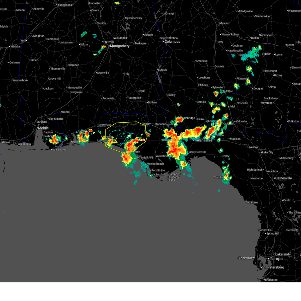
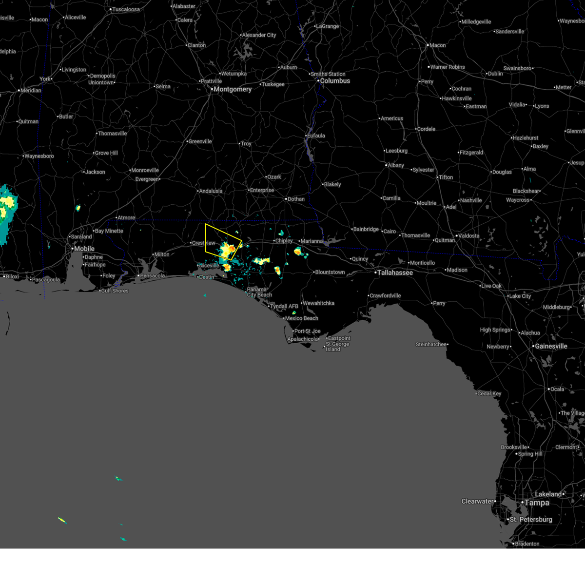
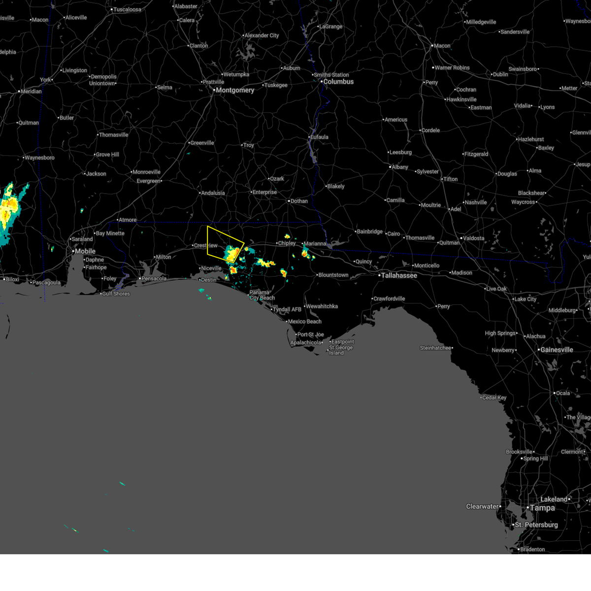
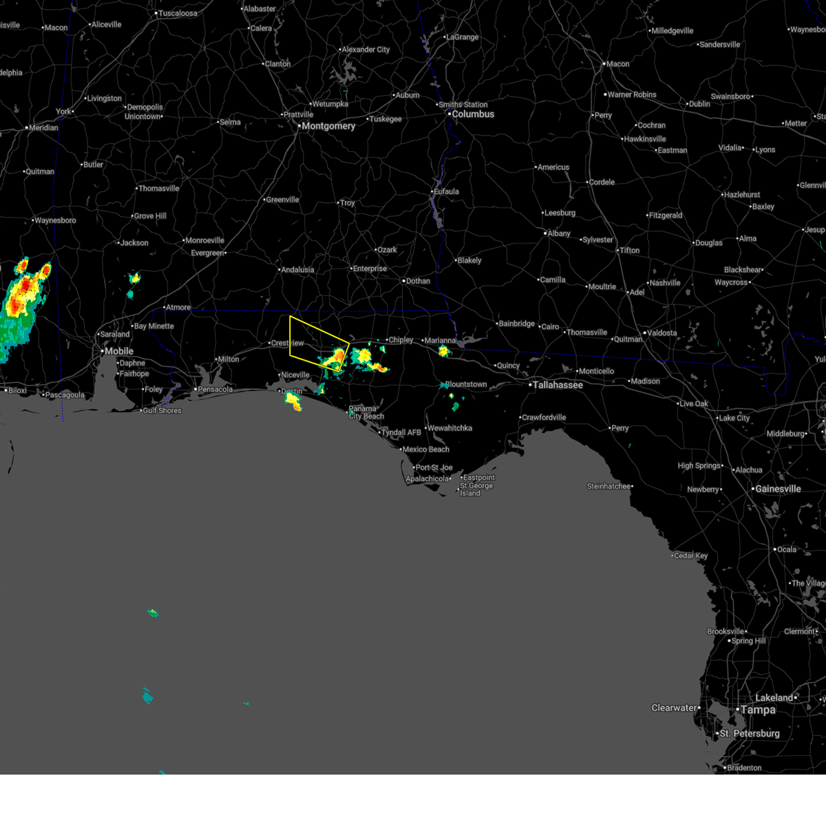
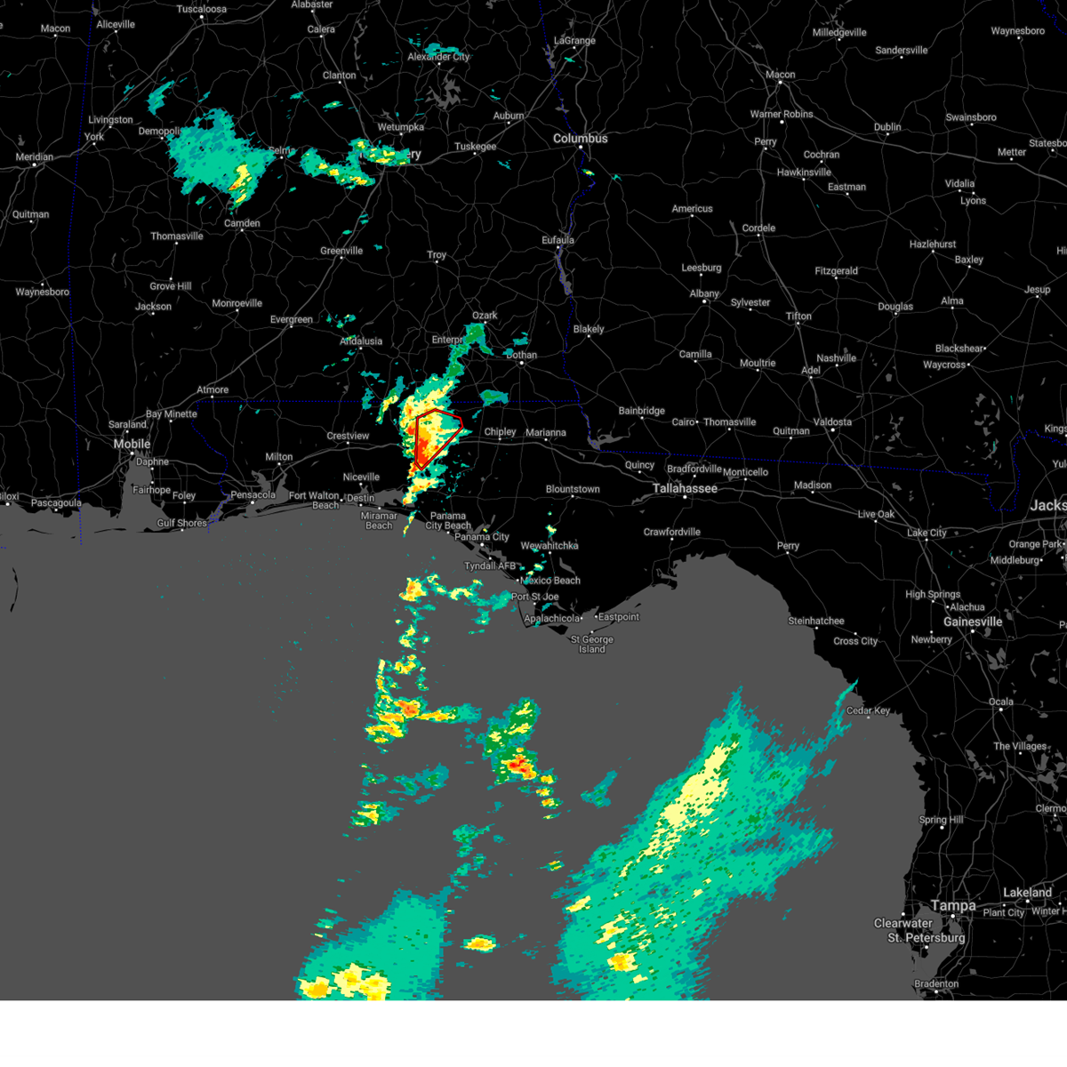
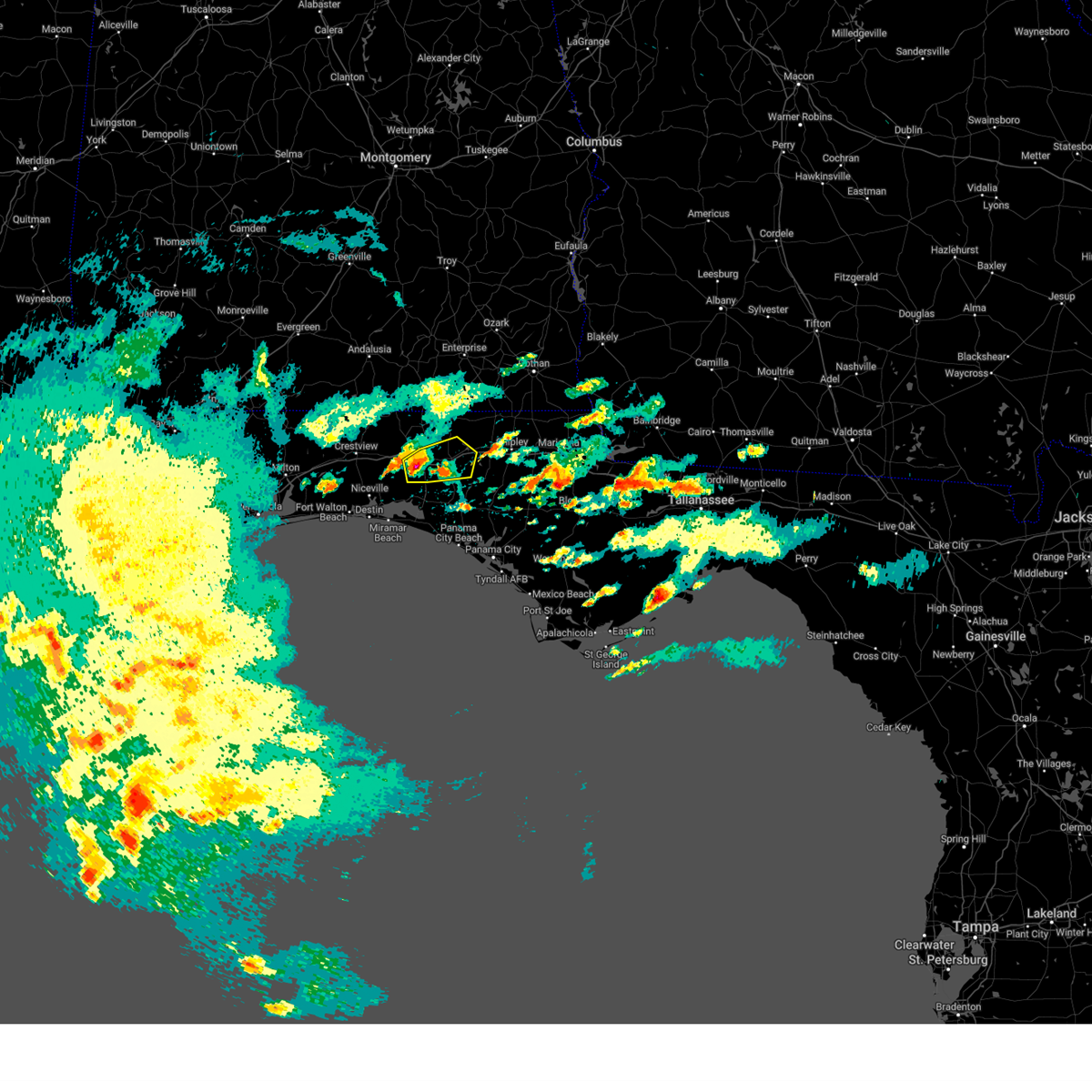
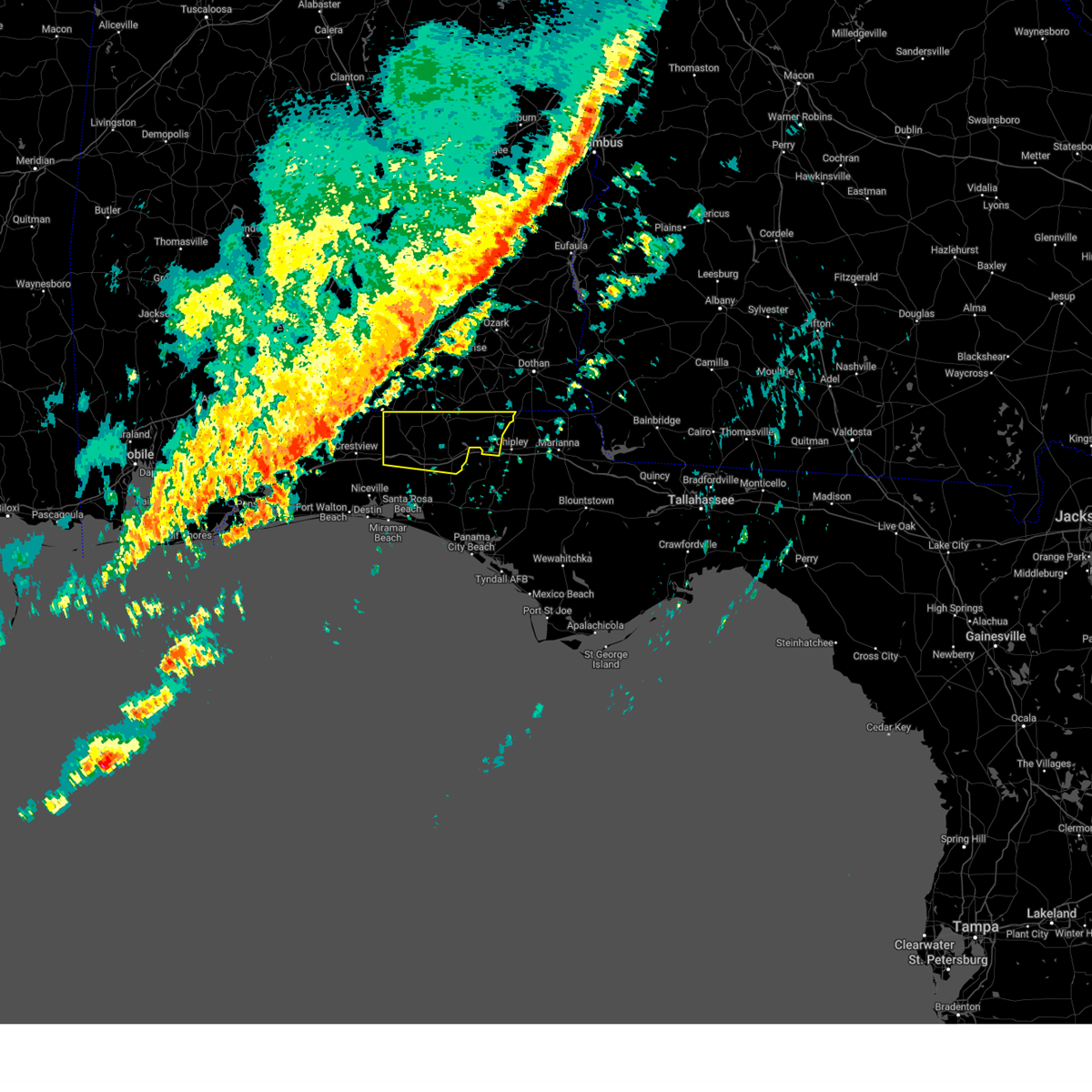
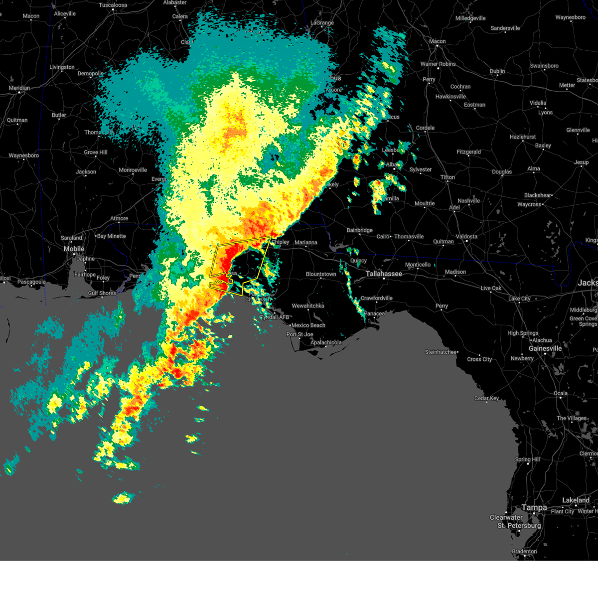
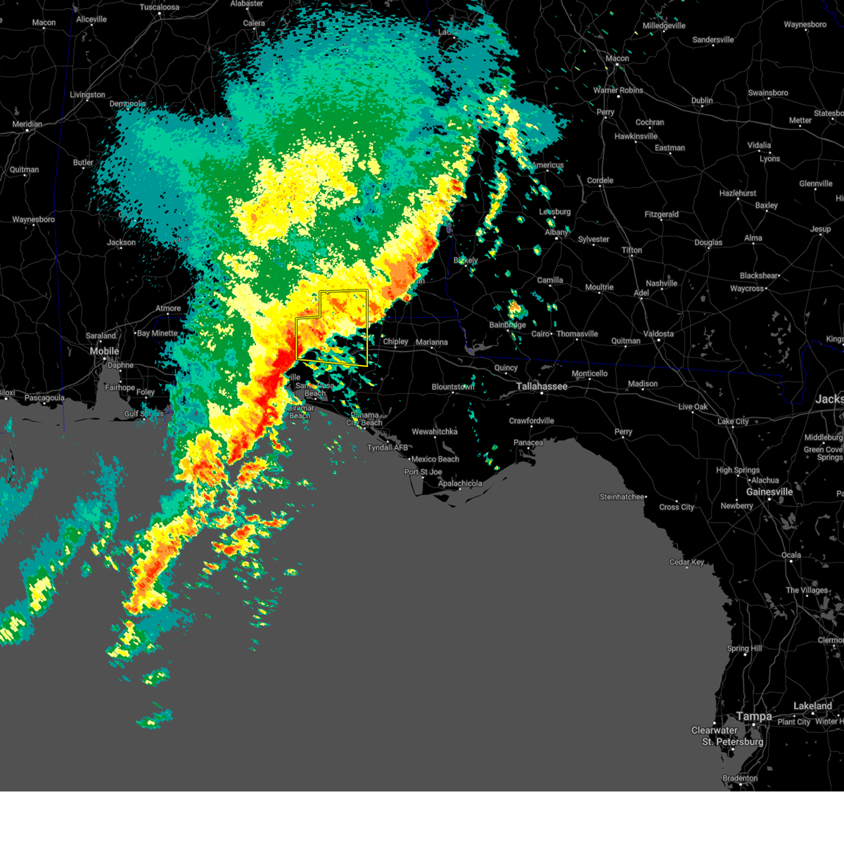
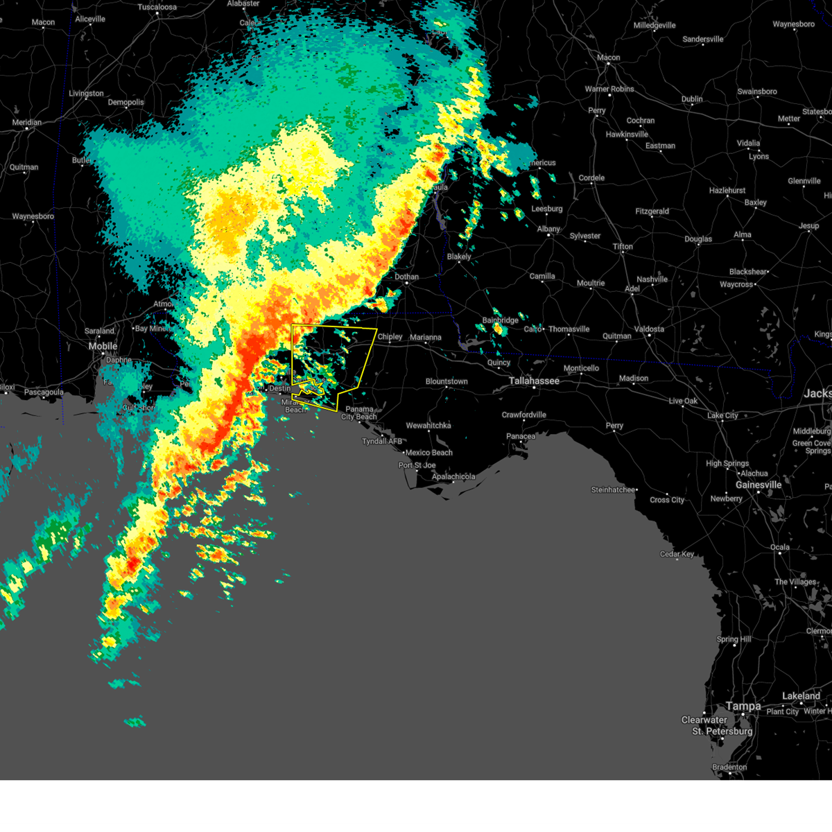
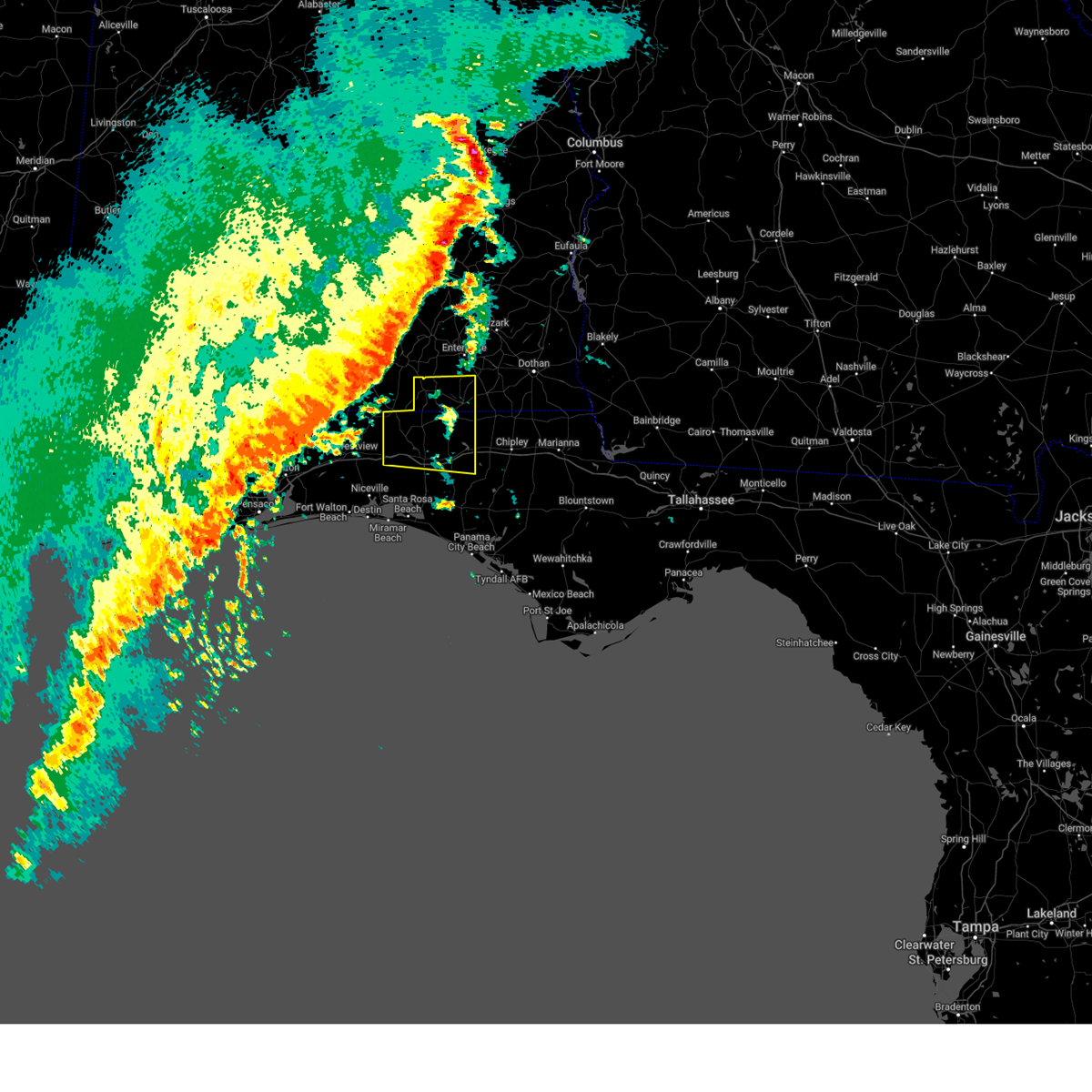
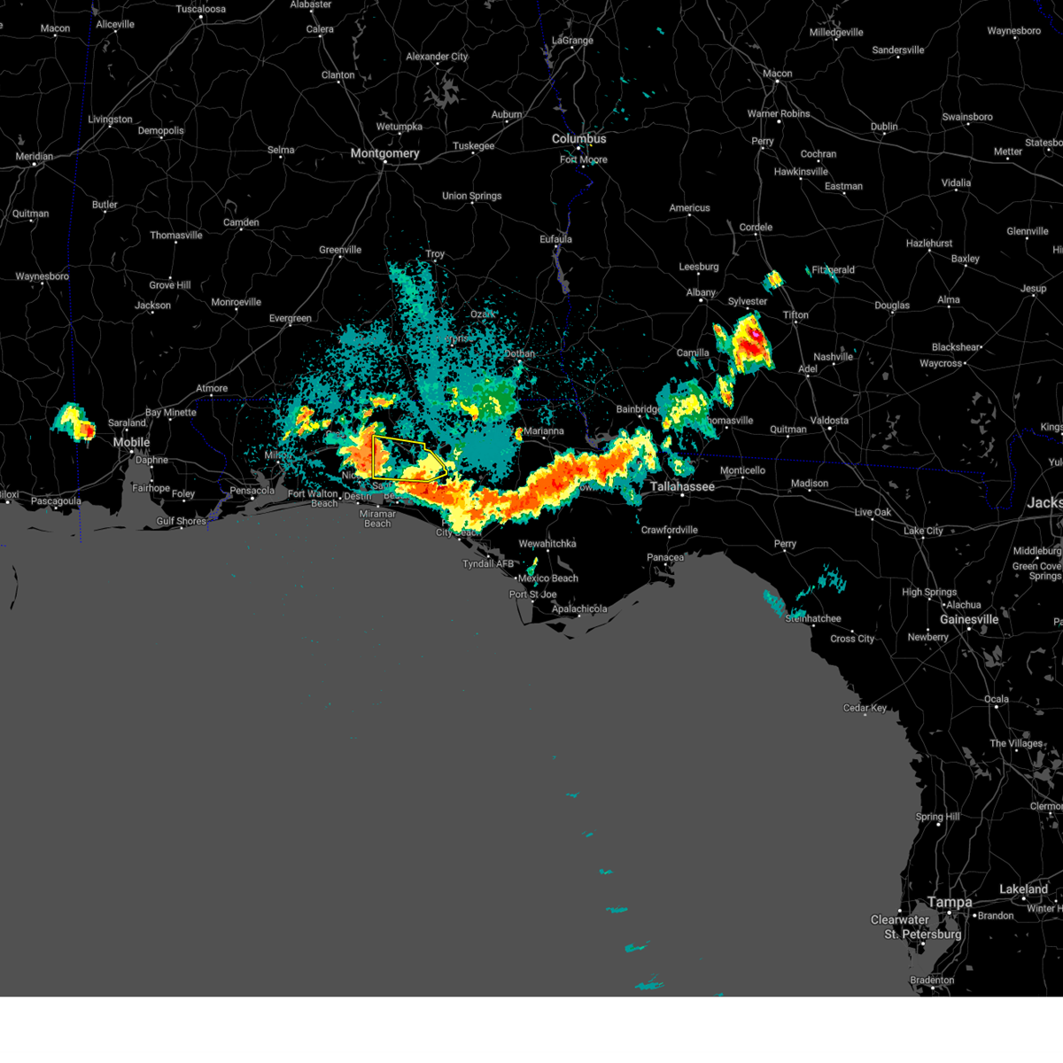
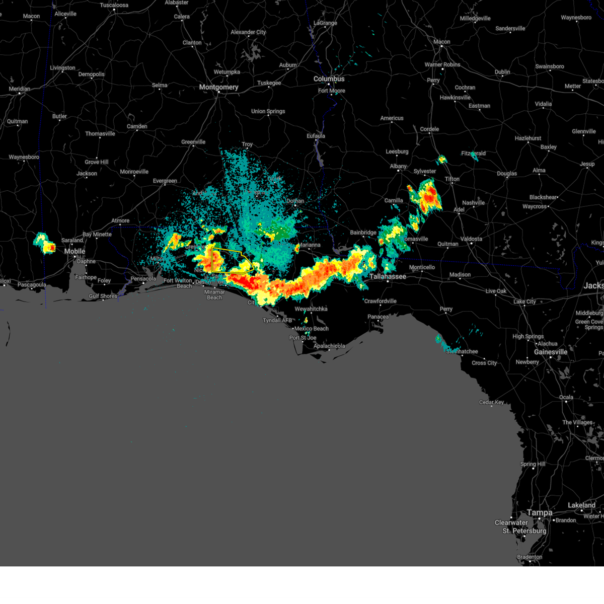
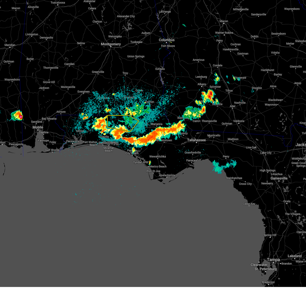
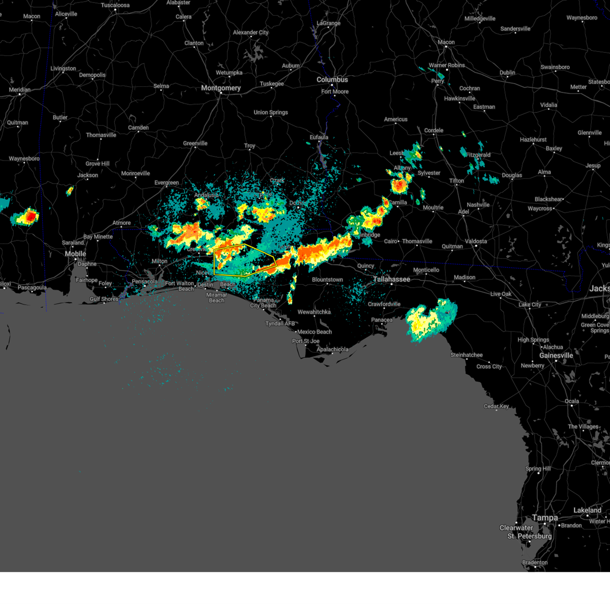
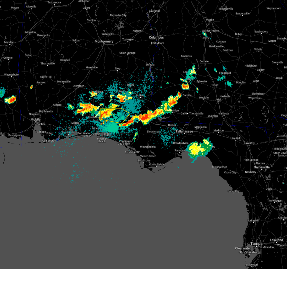
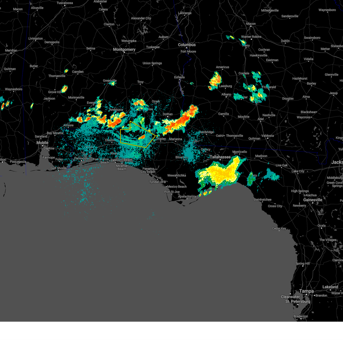
Hail Map for De Funiak Springs, FL
The De Funiak Springs, FL area has had 5 reports of on-the-ground hail by trained spotters, and has been under severe weather warnings 37 times during the past 12 months. Doppler radar has detected hail at or near De Funiak Springs, FL on 80 occasions, including 6 occasions during the past year.
| Name: | De Funiak Springs, FL |
| Where Located: | 27.3 miles NNE of Miramar Beach, FL |
| Map: | Google Map for De Funiak Springs, FL |
| Population: | 5177 |
| Housing Units: | 2713 |
| More Info: | Search Google for De Funiak Springs, FL |
4
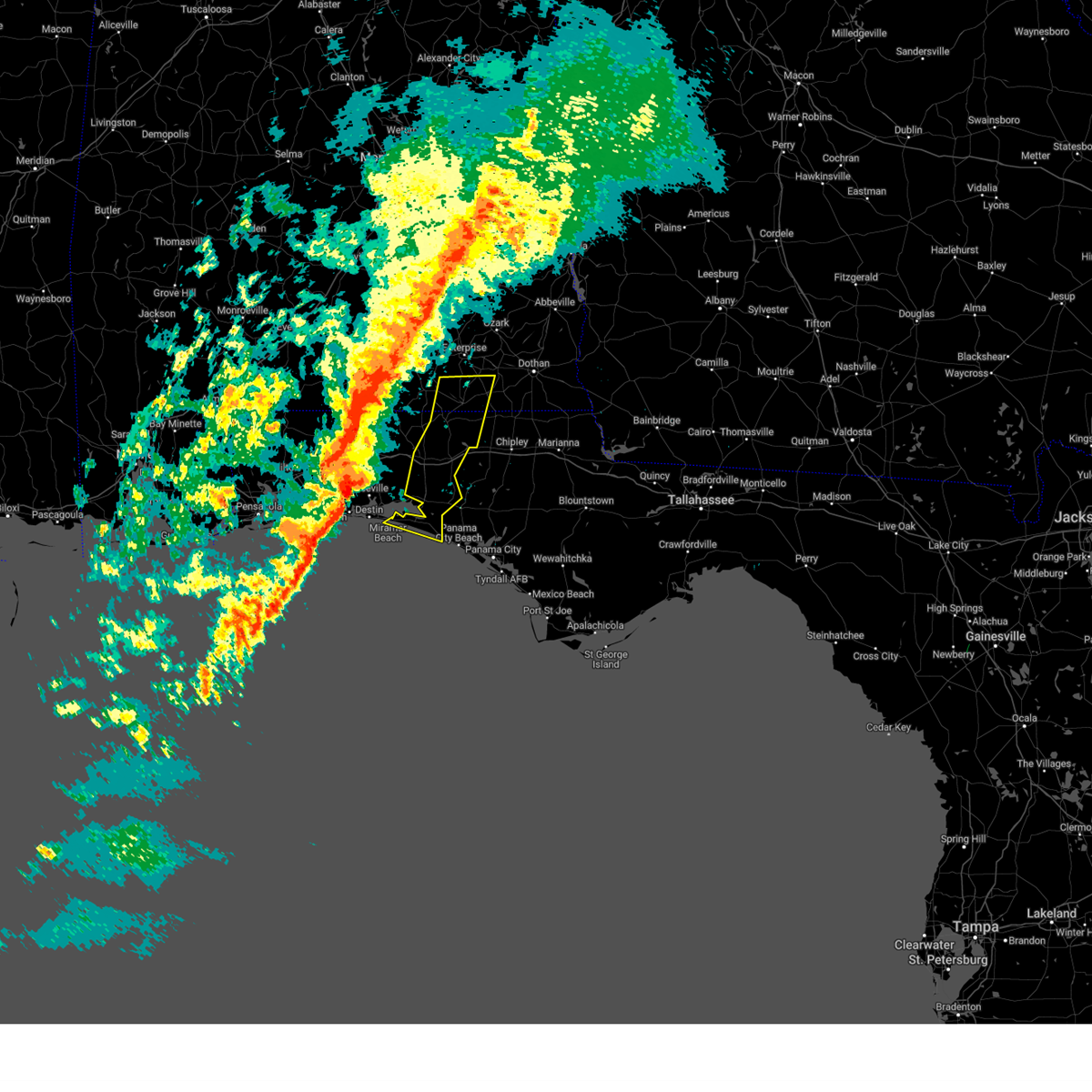
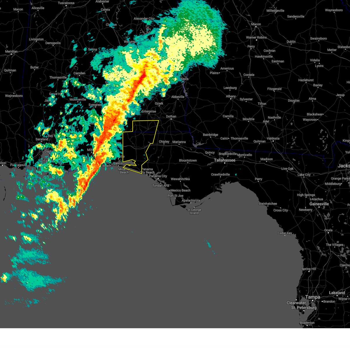
The Top Recent Hail Date for De Funiak Springs, FL is Sunday, March 9, 2025 (5th out of 80)

Hail and Wind Damage Spotted near De Funiak Springs, FL
| Date / Time | Report Details |
|---|---|
| 6/25/2025 6:47 PM CDT | At 647 pm cdt, severe thunderstorms were located along a line extending from near slocomb to 9 miles south of florala, moving northwest at 25 mph (radar indicated). Hazards include 60 mph wind gusts. Expect damage to roofs, siding, and trees. Locations impacted include, de funiak springs, geneva, dothan, hartford, taylor, slocomb, samson, eglin air force base, union, liberty, malvern, rehobeth, paxton, ponce de leon, caryville, esto, westville, coffee springs, noma, and black. |
| 6/25/2025 6:47 PM CDT | the severe thunderstorm warning has been cancelled and is no longer in effect |
| 6/25/2025 5:47 PM CDT | Svrtae the national weather service in tallahassee has issued a * severe thunderstorm warning for, geneva county in southeastern alabama, southwestern houston county in southeastern alabama, western jackson county in the panhandle of florida, northwestern bay county in the panhandle of florida, walton county in the panhandle of florida, holmes county in the panhandle of florida, washington county in the panhandle of florida, * until 715 pm cdt. * at 547 pm cdt, severe thunderstorms were located along a line extending from near cottonwood to 12 miles north of lynn haven, moving west at 15 mph (radar indicated). Hazards include 60 mph wind gusts and penny size hail. expect damage to roofs, siding, and trees |
| 6/25/2025 4:40 PM CDT |
 Svrtae the national weather service in tallahassee has issued a * severe thunderstorm warning for, northern bay county in the panhandle of florida, walton county in the panhandle of florida, southern holmes county in the panhandle of florida, washington county in the panhandle of florida, * until 615 pm cdt. * at 440 pm cdt, severe thunderstorms were located along a line extending from 9 miles southeast of vernon to 12 miles southwest of panama city beach, moving northwest at 10 mph (radar indicated). Hazards include 60 mph wind gusts and penny size hail. expect damage to roofs, siding, and trees Svrtae the national weather service in tallahassee has issued a * severe thunderstorm warning for, northern bay county in the panhandle of florida, walton county in the panhandle of florida, southern holmes county in the panhandle of florida, washington county in the panhandle of florida, * until 615 pm cdt. * at 440 pm cdt, severe thunderstorms were located along a line extending from 9 miles southeast of vernon to 12 miles southwest of panama city beach, moving northwest at 10 mph (radar indicated). Hazards include 60 mph wind gusts and penny size hail. expect damage to roofs, siding, and trees
|
| 6/24/2025 8:05 PM CDT |
 the severe thunderstorm warning has been cancelled and is no longer in effect the severe thunderstorm warning has been cancelled and is no longer in effect
|
| 6/24/2025 7:53 PM CDT |
 At 753 pm cdt, a severe thunderstorm was located over de funiak springs, moving northwest at 20 mph (radar indicated). Hazards include 60 mph wind gusts. Expect damage to roofs, siding, and trees. Locations impacted include, de funiak springs, eglin air force base, union, liberty, gordon, pond creek, oakwood hills, cluster springs, fox hill, sand hill, alpine heights, de funiak spring airport, rock hill, eucheeanna, pleasant hill, pleasant ridge, center ridge, new harmony, piney grove, and argyle. At 753 pm cdt, a severe thunderstorm was located over de funiak springs, moving northwest at 20 mph (radar indicated). Hazards include 60 mph wind gusts. Expect damage to roofs, siding, and trees. Locations impacted include, de funiak springs, eglin air force base, union, liberty, gordon, pond creek, oakwood hills, cluster springs, fox hill, sand hill, alpine heights, de funiak spring airport, rock hill, eucheeanna, pleasant hill, pleasant ridge, center ridge, new harmony, piney grove, and argyle.
|
| 6/24/2025 7:28 PM CDT |
 Svrtae the national weather service in tallahassee has issued a * severe thunderstorm warning for, central walton county in the panhandle of florida, southwestern holmes county in the panhandle of florida, * until 845 pm cdt. * at 728 pm cdt, a severe thunderstorm was located 9 miles southeast of de funiak springs, moving west at 20 mph (radar indicated). Hazards include 60 mph wind gusts. expect damage to roofs, siding, and trees Svrtae the national weather service in tallahassee has issued a * severe thunderstorm warning for, central walton county in the panhandle of florida, southwestern holmes county in the panhandle of florida, * until 845 pm cdt. * at 728 pm cdt, a severe thunderstorm was located 9 miles southeast of de funiak springs, moving west at 20 mph (radar indicated). Hazards include 60 mph wind gusts. expect damage to roofs, siding, and trees
|
| 5/10/2025 10:30 AM CDT | Numerous trees and powerlines reported down near argyl in walton county FL, 4.9 miles W of De Funiak Springs, FL |
| 5/10/2025 10:29 AM CDT |
 At 1029 am cdt, a confirmed tornado was located near de funiak springs, moving northeast at 25 mph (radar confirmed tornado). Hazards include damaging tornado. Flying debris will be dangerous to those caught without shelter. mobile homes will be damaged or destroyed. damage to roofs, windows, and vehicles will occur. tree damage is likely. this tornado will be near, de funiak springs around 1035 am cdt. Other locations impacted by this tornadic thunderstorm include douglass crossroad, leonia, barker store, cerrogordo, prosperity, gritney, arrant settlement, union, eucheeanna, and pleasant hill. At 1029 am cdt, a confirmed tornado was located near de funiak springs, moving northeast at 25 mph (radar confirmed tornado). Hazards include damaging tornado. Flying debris will be dangerous to those caught without shelter. mobile homes will be damaged or destroyed. damage to roofs, windows, and vehicles will occur. tree damage is likely. this tornado will be near, de funiak springs around 1035 am cdt. Other locations impacted by this tornadic thunderstorm include douglass crossroad, leonia, barker store, cerrogordo, prosperity, gritney, arrant settlement, union, eucheeanna, and pleasant hill.
|
| 5/10/2025 10:25 AM CDT |
 Tortae the national weather service in tallahassee has issued a * tornado warning for, northeastern walton county in the panhandle of florida, southwestern holmes county in the panhandle of florida, * until 1100 am cdt. * at 1025 am cdt, a severe thunderstorm capable of producing a tornado was located near de funiak springs, moving northeast at 25 mph (radar indicated rotation). Hazards include tornado. Flying debris will be dangerous to those caught without shelter. mobile homes will be damaged or destroyed. damage to roofs, windows, and vehicles will occur. tree damage is likely. this dangerous storm will be near, de funiak springs around 1030 am cdt. Other locations impacted by this tornadic thunderstorm include douglass crossroad, leonia, barker store, cerrogordo, prosperity, gritney, arrant settlement, union, eucheeanna, and pleasant hill. Tortae the national weather service in tallahassee has issued a * tornado warning for, northeastern walton county in the panhandle of florida, southwestern holmes county in the panhandle of florida, * until 1100 am cdt. * at 1025 am cdt, a severe thunderstorm capable of producing a tornado was located near de funiak springs, moving northeast at 25 mph (radar indicated rotation). Hazards include tornado. Flying debris will be dangerous to those caught without shelter. mobile homes will be damaged or destroyed. damage to roofs, windows, and vehicles will occur. tree damage is likely. this dangerous storm will be near, de funiak springs around 1030 am cdt. Other locations impacted by this tornadic thunderstorm include douglass crossroad, leonia, barker store, cerrogordo, prosperity, gritney, arrant settlement, union, eucheeanna, and pleasant hill.
|
| 5/10/2025 10:15 AM CDT | Numerous trees and powerlines reported down on us-331 south of i-1 in walton county FL, 3 miles N of De Funiak Springs, FL |
| 5/10/2025 10:00 AM CDT |
 Svrtae the national weather service in tallahassee has issued a * severe thunderstorm warning for, geneva county in southeastern alabama, west central bay county in the panhandle of florida, walton county in the panhandle of florida, holmes county in the panhandle of florida, western washington county in the panhandle of florida, * until 1045 am cdt. * at 1000 am cdt, severe thunderstorms were located along a line extending from near de funiak springs to 10 miles east of eglin air force base to 7 miles southeast of santa rosa beach, moving northeast at 30 mph (radar indicated). Hazards include 60 mph wind gusts and penny size hail. expect damage to roofs, siding, and trees Svrtae the national weather service in tallahassee has issued a * severe thunderstorm warning for, geneva county in southeastern alabama, west central bay county in the panhandle of florida, walton county in the panhandle of florida, holmes county in the panhandle of florida, western washington county in the panhandle of florida, * until 1045 am cdt. * at 1000 am cdt, severe thunderstorms were located along a line extending from near de funiak springs to 10 miles east of eglin air force base to 7 miles southeast of santa rosa beach, moving northeast at 30 mph (radar indicated). Hazards include 60 mph wind gusts and penny size hail. expect damage to roofs, siding, and trees
|
| 5/10/2025 9:30 AM CDT |
 Tortae the national weather service in tallahassee has issued a * tornado warning for, west central walton county in the panhandle of florida, * until 1000 am cdt. * at 930 am cdt, a severe thunderstorm capable of producing a tornado was located near eglin air force base, or 9 miles east of niceville, moving northeast at 30 mph (radar indicated rotation). Hazards include tornado. Flying debris will be dangerous to those caught without shelter. mobile homes will be damaged or destroyed. damage to roofs, windows, and vehicles will occur. tree damage is likely. this dangerous storm will be near, eglin air force base around 935 am cdt. Other locations impacted by this tornadic thunderstorm include pleasant ridge, new home, and de funiak spring airport. Tortae the national weather service in tallahassee has issued a * tornado warning for, west central walton county in the panhandle of florida, * until 1000 am cdt. * at 930 am cdt, a severe thunderstorm capable of producing a tornado was located near eglin air force base, or 9 miles east of niceville, moving northeast at 30 mph (radar indicated rotation). Hazards include tornado. Flying debris will be dangerous to those caught without shelter. mobile homes will be damaged or destroyed. damage to roofs, windows, and vehicles will occur. tree damage is likely. this dangerous storm will be near, eglin air force base around 935 am cdt. Other locations impacted by this tornadic thunderstorm include pleasant ridge, new home, and de funiak spring airport.
|
| 5/9/2025 2:01 PM CDT |
 At 201 pm cdt, a severe thunderstorm was located 7 miles east of de funiak springs, moving east at 20 mph (radar indicated). Hazards include 60 mph wind gusts and quarter size hail. Hail damage to vehicles is expected. expect wind damage to roofs, siding, and trees. Locations impacted include, eucheeanna, hinsons crossroads, caryville, douglass crossroad, westville, cerrogordo, knox hill, hickory hill, ponce de leon, argyle, and de funiak springs. At 201 pm cdt, a severe thunderstorm was located 7 miles east of de funiak springs, moving east at 20 mph (radar indicated). Hazards include 60 mph wind gusts and quarter size hail. Hail damage to vehicles is expected. expect wind damage to roofs, siding, and trees. Locations impacted include, eucheeanna, hinsons crossroads, caryville, douglass crossroad, westville, cerrogordo, knox hill, hickory hill, ponce de leon, argyle, and de funiak springs.
|
| 5/9/2025 1:38 PM CDT |
 Svrtae the national weather service in tallahassee has issued a * severe thunderstorm warning for, central walton county in the panhandle of florida, southwestern holmes county in the panhandle of florida, northwestern washington county in the panhandle of florida, * until 230 pm cdt. * at 138 pm cdt, a severe thunderstorm was located near de funiak springs, moving east at 20 mph (radar indicated). Hazards include 60 mph wind gusts and quarter size hail. Hail damage to vehicles is expected. Expect wind damage to roofs, siding, and trees. Svrtae the national weather service in tallahassee has issued a * severe thunderstorm warning for, central walton county in the panhandle of florida, southwestern holmes county in the panhandle of florida, northwestern washington county in the panhandle of florida, * until 230 pm cdt. * at 138 pm cdt, a severe thunderstorm was located near de funiak springs, moving east at 20 mph (radar indicated). Hazards include 60 mph wind gusts and quarter size hail. Hail damage to vehicles is expected. Expect wind damage to roofs, siding, and trees.
|
| 3/31/2025 12:23 PM CDT |
 At 1223 pm cdt, severe thunderstorms were located along a line extending from near slocomb to 18 miles south of santa rosa beach, moving east at 50 mph (radar indicated). Hazards include 60 mph wind gusts. Expect damage to roofs, siding, and trees. Locations impacted include, hiland park, whitehead crossroads, bradford, gulf resort beach, black, gritney, west panama city, rock hill, millers ferry, noma, pleasant ridge, knox hill, four mile village, miller crossroads, west bay, douglass crossroad, santa rosa beach, orange hill, magnolia beach, and bethlehem. At 1223 pm cdt, severe thunderstorms were located along a line extending from near slocomb to 18 miles south of santa rosa beach, moving east at 50 mph (radar indicated). Hazards include 60 mph wind gusts. Expect damage to roofs, siding, and trees. Locations impacted include, hiland park, whitehead crossroads, bradford, gulf resort beach, black, gritney, west panama city, rock hill, millers ferry, noma, pleasant ridge, knox hill, four mile village, miller crossroads, west bay, douglass crossroad, santa rosa beach, orange hill, magnolia beach, and bethlehem.
|
| 3/31/2025 11:58 AM CDT |
 Svrtae the national weather service in tallahassee has issued a * severe thunderstorm warning for, southern geneva county in southeastern alabama, southeastern houston county in southeastern alabama, western jackson county in the panhandle of florida, bay county in the panhandle of florida, northwestern calhoun county in the panhandle of florida, walton county in the panhandle of florida, holmes county in the panhandle of florida, washington county in the panhandle of florida, * until 100 pm cdt. * at 1158 am cdt, severe thunderstorms were located along a line extending from near geneva to 21 miles south of destin, moving east at 50 mph (radar indicated). Hazards include 60 mph wind gusts. expect damage to roofs, siding, and trees Svrtae the national weather service in tallahassee has issued a * severe thunderstorm warning for, southern geneva county in southeastern alabama, southeastern houston county in southeastern alabama, western jackson county in the panhandle of florida, bay county in the panhandle of florida, northwestern calhoun county in the panhandle of florida, walton county in the panhandle of florida, holmes county in the panhandle of florida, washington county in the panhandle of florida, * until 100 pm cdt. * at 1158 am cdt, severe thunderstorms were located along a line extending from near geneva to 21 miles south of destin, moving east at 50 mph (radar indicated). Hazards include 60 mph wind gusts. expect damage to roofs, siding, and trees
|
| 3/9/2025 7:36 PM CDT |
 Svrtae the national weather service in tallahassee has issued a * severe thunderstorm warning for, central walton county in the panhandle of florida, holmes county in the panhandle of florida, northern washington county in the panhandle of florida, * until 815 pm cdt. * at 736 pm cdt, a severe thunderstorm was located near eglin air force base, or 8 miles southwest of de funiak springs, moving east at 50 mph (radar indicated). Hazards include quarter size hail. damage to vehicles is expected Svrtae the national weather service in tallahassee has issued a * severe thunderstorm warning for, central walton county in the panhandle of florida, holmes county in the panhandle of florida, northern washington county in the panhandle of florida, * until 815 pm cdt. * at 736 pm cdt, a severe thunderstorm was located near eglin air force base, or 8 miles southwest of de funiak springs, moving east at 50 mph (radar indicated). Hazards include quarter size hail. damage to vehicles is expected
|
| 3/5/2025 12:23 AM CST |
 At 1223 am cst, severe thunderstorms were located along a line extending from near level plains to 6 miles south of santa rosa beach, moving east at 40 mph (radar indicated). Hazards include 60 mph wind gusts. Expect damage to roofs, siding, and trees. Locations impacted include, kellys crossroads, cerrogordo, black, blue mountain beach, gritney, seaside, rock hill, glendale, pleasant ridge, knox hill, izagora, new hope, piney grove, four mile village, miller crossroads, spears, douglass crossroad, leonia, santa rosa beach, and eunola. At 1223 am cst, severe thunderstorms were located along a line extending from near level plains to 6 miles south of santa rosa beach, moving east at 40 mph (radar indicated). Hazards include 60 mph wind gusts. Expect damage to roofs, siding, and trees. Locations impacted include, kellys crossroads, cerrogordo, black, blue mountain beach, gritney, seaside, rock hill, glendale, pleasant ridge, knox hill, izagora, new hope, piney grove, four mile village, miller crossroads, spears, douglass crossroad, leonia, santa rosa beach, and eunola.
|
| 3/5/2025 12:05 AM CST |
 At 1205 am cst, severe thunderstorms were located along a line extending from 10 miles north of samson to 6 miles south of destin, moving east at 40 mph (radar indicated). Hazards include 60 mph wind gusts. Expect damage to roofs, siding, and trees. Locations impacted include, oakwood hills, cluster springs, kellys crossroads, eglin air force base, villa tasso, cerrogordo, black, blue mountain beach, gritney, logan field municipal a/p, seaside, rock hill, glendale, pleasant ridge, knox hill, izagora, new harmony, new hope, piney grove, and four mile village. At 1205 am cst, severe thunderstorms were located along a line extending from 10 miles north of samson to 6 miles south of destin, moving east at 40 mph (radar indicated). Hazards include 60 mph wind gusts. Expect damage to roofs, siding, and trees. Locations impacted include, oakwood hills, cluster springs, kellys crossroads, eglin air force base, villa tasso, cerrogordo, black, blue mountain beach, gritney, logan field municipal a/p, seaside, rock hill, glendale, pleasant ridge, knox hill, izagora, new harmony, new hope, piney grove, and four mile village.
|
| 3/4/2025 11:16 PM CST |
 Svrtae the national weather service in tallahassee has issued a * severe thunderstorm warning for, geneva county in southeastern alabama, walton county in the panhandle of florida, holmes county in the panhandle of florida, * until 1245 am cst. * at 1116 pm cst, severe thunderstorms were located along a line extending from 10 miles south of andalusia to 12 miles southeast of pensacola beach, moving east at 40 mph (radar indicated). Hazards include 60 mph wind gusts. expect damage to roofs, siding, and trees Svrtae the national weather service in tallahassee has issued a * severe thunderstorm warning for, geneva county in southeastern alabama, walton county in the panhandle of florida, holmes county in the panhandle of florida, * until 1245 am cst. * at 1116 pm cst, severe thunderstorms were located along a line extending from 10 miles south of andalusia to 12 miles southeast of pensacola beach, moving east at 40 mph (radar indicated). Hazards include 60 mph wind gusts. expect damage to roofs, siding, and trees
|
| 2/16/2025 4:53 AM CST |
 At 453 am cst, severe thunderstorms were located along a line extending from 8 miles south of hartford to near eglin air force base, moving east at 45 mph (radar indicated). Hazards include 60 mph wind gusts. Expect damage to roofs, siding, and trees. Locations impacted include, de funiak springs, bonifay, eglin air force base, union, ponce de leon, caryville, esto, westville, noma, cerrogordo, tendil crossing, gritney, arrant settlement, de funiak spring airport, holland crossroads, pleasant ridge, center ridge, cobb crossroads, smith crossroads, and hickory hill. At 453 am cst, severe thunderstorms were located along a line extending from 8 miles south of hartford to near eglin air force base, moving east at 45 mph (radar indicated). Hazards include 60 mph wind gusts. Expect damage to roofs, siding, and trees. Locations impacted include, de funiak springs, bonifay, eglin air force base, union, ponce de leon, caryville, esto, westville, noma, cerrogordo, tendil crossing, gritney, arrant settlement, de funiak spring airport, holland crossroads, pleasant ridge, center ridge, cobb crossroads, smith crossroads, and hickory hill.
|
| 2/16/2025 4:04 AM CST |
 Svrtae the national weather service in tallahassee has issued a * severe thunderstorm warning for, northwestern bay county in the panhandle of florida, southern walton county in the panhandle of florida, central washington county in the panhandle of florida, * until 530 am cst. * at 404 am cst, severe thunderstorms were located along a line extending from crestview to gulf breeze, moving east at 60 mph (radar indicated). Hazards include 60 mph wind gusts. expect damage to roofs, siding, and trees Svrtae the national weather service in tallahassee has issued a * severe thunderstorm warning for, northwestern bay county in the panhandle of florida, southern walton county in the panhandle of florida, central washington county in the panhandle of florida, * until 530 am cst. * at 404 am cst, severe thunderstorms were located along a line extending from crestview to gulf breeze, moving east at 60 mph (radar indicated). Hazards include 60 mph wind gusts. expect damage to roofs, siding, and trees
|
| 2/16/2025 3:41 AM CST |
 Svrtae the national weather service in tallahassee has issued a * severe thunderstorm warning for, northern walton county in the panhandle of florida, holmes county in the panhandle of florida, * until 515 am cst. * at 341 am cst, severe thunderstorms were located along a line extending from 10 miles south of andalusia to pace, moving east at 45 mph (radar indicated). Hazards include 60 mph wind gusts. expect damage to roofs, siding, and trees Svrtae the national weather service in tallahassee has issued a * severe thunderstorm warning for, northern walton county in the panhandle of florida, holmes county in the panhandle of florida, * until 515 am cst. * at 341 am cst, severe thunderstorms were located along a line extending from 10 miles south of andalusia to pace, moving east at 45 mph (radar indicated). Hazards include 60 mph wind gusts. expect damage to roofs, siding, and trees
|
| 12/29/2024 3:41 AM CST |
 At 341 am cst, severe thunderstorms were located along a line extending from 9 miles east of florala to 10 miles south of destin, moving east at 40 mph (radar indicated). Hazards include 60 mph wind gusts and quarter size hail. Hail damage to vehicles is expected. expect wind damage to roofs, siding, and trees. Locations impacted include, santa rosa beach, de funiak springs, bonifay, eglin air force base, union, live oak, freeport, ponce de leon, caryville, westville, ebro, hinsons crossroads, oakwood hills, portland, whitehead crossroads, alpine heights, villa tasso, cerrogordo, blue mountain beach, and gritney. At 341 am cst, severe thunderstorms were located along a line extending from 9 miles east of florala to 10 miles south of destin, moving east at 40 mph (radar indicated). Hazards include 60 mph wind gusts and quarter size hail. Hail damage to vehicles is expected. expect wind damage to roofs, siding, and trees. Locations impacted include, santa rosa beach, de funiak springs, bonifay, eglin air force base, union, live oak, freeport, ponce de leon, caryville, westville, ebro, hinsons crossroads, oakwood hills, portland, whitehead crossroads, alpine heights, villa tasso, cerrogordo, blue mountain beach, and gritney.
|
| 12/29/2024 3:11 AM CST |
 The storms which prompted the warning have moved out of the area. therefore, the warning will be allowed to expire. however, heavy rain is still possible with these thunderstorms. a tornado watch remains in effect until 800 am cst for southeastern alabama, and the panhandle of florida. remember, a severe thunderstorm warning still remains in effect for walton and southwestern holmes county until 4:30 am cst. The storms which prompted the warning have moved out of the area. therefore, the warning will be allowed to expire. however, heavy rain is still possible with these thunderstorms. a tornado watch remains in effect until 800 am cst for southeastern alabama, and the panhandle of florida. remember, a severe thunderstorm warning still remains in effect for walton and southwestern holmes county until 4:30 am cst.
|
| 12/29/2024 2:53 AM CST |
 Svrtae the national weather service in tallahassee has issued a * severe thunderstorm warning for, walton county in the panhandle of florida, southwestern holmes county in the panhandle of florida, western washington county in the panhandle of florida, * until 430 am cst. * at 252 am cst, severe thunderstorms were located along a line extending from baker to 20 miles southeast of pensacola beach, moving east at 40 mph (radar indicated). Hazards include 60 mph wind gusts. expect damage to roofs, siding, and trees Svrtae the national weather service in tallahassee has issued a * severe thunderstorm warning for, walton county in the panhandle of florida, southwestern holmes county in the panhandle of florida, western washington county in the panhandle of florida, * until 430 am cst. * at 252 am cst, severe thunderstorms were located along a line extending from baker to 20 miles southeast of pensacola beach, moving east at 40 mph (radar indicated). Hazards include 60 mph wind gusts. expect damage to roofs, siding, and trees
|
| 12/29/2024 1:37 AM CST |
 Svrtae the national weather service in tallahassee has issued a * severe thunderstorm warning for, western geneva county in southeastern alabama, northern walton county in the panhandle of florida, western holmes county in the panhandle of florida, northwestern washington county in the panhandle of florida, * until 315 am cst. * at 137 am cst, severe thunderstorms were located along a line extending from 6 miles southeast of andalusia to 7 miles northwest of baker, moving east at 30 mph (radar indicated). Hazards include 60 mph wind gusts. expect damage to roofs, siding, and trees Svrtae the national weather service in tallahassee has issued a * severe thunderstorm warning for, western geneva county in southeastern alabama, northern walton county in the panhandle of florida, western holmes county in the panhandle of florida, northwestern washington county in the panhandle of florida, * until 315 am cst. * at 137 am cst, severe thunderstorms were located along a line extending from 6 miles southeast of andalusia to 7 miles northwest of baker, moving east at 30 mph (radar indicated). Hazards include 60 mph wind gusts. expect damage to roofs, siding, and trees
|
| 8/29/2024 5:33 PM CDT |
 the severe thunderstorm warning has been cancelled and is no longer in effect the severe thunderstorm warning has been cancelled and is no longer in effect
|
| 8/29/2024 5:23 PM CDT |
 At 523 pm cdt, a severe thunderstorm was located near de funiak springs, moving northwest at 20 mph (radar indicated). Hazards include 60 mph wind gusts. Expect damage to roofs, siding, and trees. Locations impacted include, de funiak springs, union, liberty, paxton, oakwood hills, cluster springs, gaskin, alpine heights, darlington, arrant settlement, de funiak spring airport, glendale, pleasant ridge, center ridge, new harmony, piney grove, argyle, caney creek, gordon, and fox hill. At 523 pm cdt, a severe thunderstorm was located near de funiak springs, moving northwest at 20 mph (radar indicated). Hazards include 60 mph wind gusts. Expect damage to roofs, siding, and trees. Locations impacted include, de funiak springs, union, liberty, paxton, oakwood hills, cluster springs, gaskin, alpine heights, darlington, arrant settlement, de funiak spring airport, glendale, pleasant ridge, center ridge, new harmony, piney grove, argyle, caney creek, gordon, and fox hill.
|
| 8/29/2024 4:59 PM CDT |
 Svrtae the national weather service in tallahassee has issued a * severe thunderstorm warning for, northern walton county in the panhandle of florida, western holmes county in the panhandle of florida, * until 600 pm cdt. * at 459 pm cdt, a severe thunderstorm was located 7 miles east of de funiak springs, moving northwest at 20 mph (radar indicated). Hazards include 60 mph wind gusts. expect damage to roofs, siding, and trees Svrtae the national weather service in tallahassee has issued a * severe thunderstorm warning for, northern walton county in the panhandle of florida, western holmes county in the panhandle of florida, * until 600 pm cdt. * at 459 pm cdt, a severe thunderstorm was located 7 miles east of de funiak springs, moving northwest at 20 mph (radar indicated). Hazards include 60 mph wind gusts. expect damage to roofs, siding, and trees
|
| 8/19/2024 2:11 AM CDT |
 At 211 am cdt, severe thunderstorms were located along a line extending from near de funiak springs to 9 miles west of bonifay, moving east at 20 mph (radar indicated). Hazards include 60 mph wind gusts and penny size hail. Expect damage to roofs, siding, and trees. Locations impacted include, de funiak springs, eglin air force base, freeport, oakwood hills, red bay, alpine heights, de funiak spring airport, rock hill, eucheeanna, pleasant ridge, new home, knox hill, argyle, and mossy head. At 211 am cdt, severe thunderstorms were located along a line extending from near de funiak springs to 9 miles west of bonifay, moving east at 20 mph (radar indicated). Hazards include 60 mph wind gusts and penny size hail. Expect damage to roofs, siding, and trees. Locations impacted include, de funiak springs, eglin air force base, freeport, oakwood hills, red bay, alpine heights, de funiak spring airport, rock hill, eucheeanna, pleasant ridge, new home, knox hill, argyle, and mossy head.
|
| 8/19/2024 2:11 AM CDT |
 the severe thunderstorm warning has been cancelled and is no longer in effect the severe thunderstorm warning has been cancelled and is no longer in effect
|
| 8/19/2024 1:50 AM CDT |
 The storm which prompted the warning has moved out of the area. therefore, the warning will be allowed to expire. a severe thunderstorm watch remains in effect until 300 am cdt for the panhandle of florida. to report severe weather, contact your nearest law enforcement agency. they will relay your report to the national weather service tallahassee. The storm which prompted the warning has moved out of the area. therefore, the warning will be allowed to expire. a severe thunderstorm watch remains in effect until 300 am cdt for the panhandle of florida. to report severe weather, contact your nearest law enforcement agency. they will relay your report to the national weather service tallahassee.
|
| 8/19/2024 1:30 AM CDT |
 Svrtae the national weather service in tallahassee has issued a * severe thunderstorm warning for, central walton county in the panhandle of florida, southwestern holmes county in the panhandle of florida, central washington county in the panhandle of florida, * until 230 am cdt. * at 129 am cdt, severe thunderstorms were located along a line extending from 11 miles north of eglin air force base to 7 miles northeast of de funiak springs, moving east at 20 mph (radar indicated). Hazards include 60 mph wind gusts and penny size hail. expect damage to roofs, siding, and trees Svrtae the national weather service in tallahassee has issued a * severe thunderstorm warning for, central walton county in the panhandle of florida, southwestern holmes county in the panhandle of florida, central washington county in the panhandle of florida, * until 230 am cdt. * at 129 am cdt, severe thunderstorms were located along a line extending from 11 miles north of eglin air force base to 7 miles northeast of de funiak springs, moving east at 20 mph (radar indicated). Hazards include 60 mph wind gusts and penny size hail. expect damage to roofs, siding, and trees
|
| 8/19/2024 1:23 AM CDT |
 At 123 am cdt, a severe thunderstorm was located near de funiak springs, moving southeast at 30 mph (radar indicated). Hazards include 60 mph wind gusts. Expect damage to roofs, siding, and trees. Locations impacted include, de funiak springs, eglin air force base, union, liberty, paxton, ponce de leon, caryville, westville, pond creek, oakwood hills, cluster springs, gaskin, alpine heights, cerrogordo, darlington, gritney, arrant settlement, de funiak spring airport, glendale, and center ridge. At 123 am cdt, a severe thunderstorm was located near de funiak springs, moving southeast at 30 mph (radar indicated). Hazards include 60 mph wind gusts. Expect damage to roofs, siding, and trees. Locations impacted include, de funiak springs, eglin air force base, union, liberty, paxton, ponce de leon, caryville, westville, pond creek, oakwood hills, cluster springs, gaskin, alpine heights, cerrogordo, darlington, gritney, arrant settlement, de funiak spring airport, glendale, and center ridge.
|
| 8/19/2024 1:23 AM CDT |
 the severe thunderstorm warning has been cancelled and is no longer in effect the severe thunderstorm warning has been cancelled and is no longer in effect
|
| 8/19/2024 12:37 AM CDT |
 Svrtae the national weather service in tallahassee has issued a * severe thunderstorm warning for, southwestern geneva county in southeastern alabama, northern walton county in the panhandle of florida, holmes county in the panhandle of florida, north central washington county in the panhandle of florida, * until 200 am cdt. * at 1237 am cdt, a severe thunderstorm was located near lockhart, or 7 miles northwest of florala, moving southeast at 35 mph (radar indicated). Hazards include 60 mph wind gusts. expect damage to roofs, siding, and trees Svrtae the national weather service in tallahassee has issued a * severe thunderstorm warning for, southwestern geneva county in southeastern alabama, northern walton county in the panhandle of florida, holmes county in the panhandle of florida, north central washington county in the panhandle of florida, * until 200 am cdt. * at 1237 am cdt, a severe thunderstorm was located near lockhart, or 7 miles northwest of florala, moving southeast at 35 mph (radar indicated). Hazards include 60 mph wind gusts. expect damage to roofs, siding, and trees
|
| 7/17/2024 2:16 PM CDT |
 Svrtae the national weather service in tallahassee has issued a * severe thunderstorm warning for, central walton county in the panhandle of florida, southwestern holmes county in the panhandle of florida, * until 245 pm cdt. * at 216 pm cdt, a severe thunderstorm was located near de funiak springs, moving east at 20 mph (radar indicated). Hazards include 60 mph wind gusts and penny size hail. expect damage to roofs, siding, and trees Svrtae the national weather service in tallahassee has issued a * severe thunderstorm warning for, central walton county in the panhandle of florida, southwestern holmes county in the panhandle of florida, * until 245 pm cdt. * at 216 pm cdt, a severe thunderstorm was located near de funiak springs, moving east at 20 mph (radar indicated). Hazards include 60 mph wind gusts and penny size hail. expect damage to roofs, siding, and trees
|
| 5/31/2024 3:49 PM CDT |
 the severe thunderstorm warning has been cancelled and is no longer in effect the severe thunderstorm warning has been cancelled and is no longer in effect
|
| 5/31/2024 3:35 PM CDT |
 Svrtae the national weather service in tallahassee has issued a * severe thunderstorm warning for, north central walton county in the panhandle of florida, southwestern holmes county in the panhandle of florida, * until 400 pm cdt. * at 335 pm cdt, a severe thunderstorm was located over de funiak springs, moving north at 15 mph (radar indicated). Hazards include 60 mph wind gusts and penny size hail. expect damage to roofs, siding, and trees Svrtae the national weather service in tallahassee has issued a * severe thunderstorm warning for, north central walton county in the panhandle of florida, southwestern holmes county in the panhandle of florida, * until 400 pm cdt. * at 335 pm cdt, a severe thunderstorm was located over de funiak springs, moving north at 15 mph (radar indicated). Hazards include 60 mph wind gusts and penny size hail. expect damage to roofs, siding, and trees
|
| 5/18/2024 7:46 AM CDT |
 At 746 am cdt, a severe thunderstorm was located near de funiak springs, moving northeast at 30 mph (radar indicated). Hazards include 60 mph wind gusts. Expect damage to roofs, siding, and trees. Locations impacted include, de funiak springs, eglin air force base, union, liberty, ponce de leon, cluster springs, gaskin, douglass crossroad, leonia, sand hill, alpine heights, darlington, de funiak spring airport, glendale, eucheeanna, pleasant hill, pleasant ridge, center ridge, piney grove, and argyle. At 746 am cdt, a severe thunderstorm was located near de funiak springs, moving northeast at 30 mph (radar indicated). Hazards include 60 mph wind gusts. Expect damage to roofs, siding, and trees. Locations impacted include, de funiak springs, eglin air force base, union, liberty, ponce de leon, cluster springs, gaskin, douglass crossroad, leonia, sand hill, alpine heights, darlington, de funiak spring airport, glendale, eucheeanna, pleasant hill, pleasant ridge, center ridge, piney grove, and argyle.
|
| 5/18/2024 7:18 AM CDT |
 Svrtae the national weather service in tallahassee has issued a * severe thunderstorm warning for, northern walton county in the panhandle of florida, southwestern holmes county in the panhandle of florida, * until 800 am cdt. * at 718 am cdt, a severe thunderstorm was located near eglin air force base, or 9 miles west of de funiak springs, moving northeast at 30 mph (radar indicated). Hazards include 60 mph wind gusts. expect damage to roofs, siding, and trees Svrtae the national weather service in tallahassee has issued a * severe thunderstorm warning for, northern walton county in the panhandle of florida, southwestern holmes county in the panhandle of florida, * until 800 am cdt. * at 718 am cdt, a severe thunderstorm was located near eglin air force base, or 9 miles west of de funiak springs, moving northeast at 30 mph (radar indicated). Hazards include 60 mph wind gusts. expect damage to roofs, siding, and trees
|
| 5/17/2024 5:07 PM CDT |
 Svrtae the national weather service in tallahassee has issued a * severe thunderstorm warning for, geneva county in southeastern alabama, southeastern houston county in southeastern alabama, jackson county in the panhandle of florida, northern walton county in the panhandle of florida, holmes county in the panhandle of florida, northern washington county in the panhandle of florida, * until 630 pm cdt. * at 507 pm cdt, severe thunderstorms were located along a line extending from near slocomb to 12 miles north of baker, moving east at 30 mph (radar indicated). Hazards include 60 mph wind gusts and quarter size hail. Hail damage to vehicles is expected. Expect wind damage to roofs, siding, and trees. Svrtae the national weather service in tallahassee has issued a * severe thunderstorm warning for, geneva county in southeastern alabama, southeastern houston county in southeastern alabama, jackson county in the panhandle of florida, northern walton county in the panhandle of florida, holmes county in the panhandle of florida, northern washington county in the panhandle of florida, * until 630 pm cdt. * at 507 pm cdt, severe thunderstorms were located along a line extending from near slocomb to 12 miles north of baker, moving east at 30 mph (radar indicated). Hazards include 60 mph wind gusts and quarter size hail. Hail damage to vehicles is expected. Expect wind damage to roofs, siding, and trees.
|
| 5/13/2024 11:57 AM CDT |
 Svrtae the national weather service in tallahassee has issued a * severe thunderstorm warning for, southwestern jackson county in the panhandle of florida, northwestern gulf county in the panhandle of florida, bay county in the panhandle of florida, western calhoun county in the panhandle of florida, southeastern walton county in the panhandle of florida, southern holmes county in the panhandle of florida, washington county in the panhandle of florida, * until 100 pm cdt. * at 1156 am cdt, severe thunderstorms were located along a line extending from near de funiak springs to 11 miles southeast of santa rosa beach, moving east at 45 mph (radar indicated). Hazards include 70 mph wind gusts. Expect considerable tree damage. Damage is likely to mobile homes, roofs, and outbuildings. Svrtae the national weather service in tallahassee has issued a * severe thunderstorm warning for, southwestern jackson county in the panhandle of florida, northwestern gulf county in the panhandle of florida, bay county in the panhandle of florida, western calhoun county in the panhandle of florida, southeastern walton county in the panhandle of florida, southern holmes county in the panhandle of florida, washington county in the panhandle of florida, * until 100 pm cdt. * at 1156 am cdt, severe thunderstorms were located along a line extending from near de funiak springs to 11 miles southeast of santa rosa beach, moving east at 45 mph (radar indicated). Hazards include 70 mph wind gusts. Expect considerable tree damage. Damage is likely to mobile homes, roofs, and outbuildings.
|
| 5/13/2024 11:41 AM CDT |
 At 1140 am cdt, severe thunderstorms were located along a line extending from near slocomb to 7 miles northwest of santa rosa beach, moving east at 65 mph (radar indicated). Hazards include 70 mph wind gusts. Expect considerable tree damage. damage is likely to mobile homes, roofs, and outbuildings. Locations impacted include, vernon, chipley, santa rosa beach, de funiak springs, bonifay, eglin air force base, live oak, freeport, ponce de leon, caryville, westville, ebro, oakwood hills, whitehead crossroads, villa tasso, blue mountain beach, seaside, rock hill, holmes valley, and millers ferry. At 1140 am cdt, severe thunderstorms were located along a line extending from near slocomb to 7 miles northwest of santa rosa beach, moving east at 65 mph (radar indicated). Hazards include 70 mph wind gusts. Expect considerable tree damage. damage is likely to mobile homes, roofs, and outbuildings. Locations impacted include, vernon, chipley, santa rosa beach, de funiak springs, bonifay, eglin air force base, live oak, freeport, ponce de leon, caryville, westville, ebro, oakwood hills, whitehead crossroads, villa tasso, blue mountain beach, seaside, rock hill, holmes valley, and millers ferry.
|
| 5/13/2024 10:42 AM CDT |
 Svrtae the national weather service in tallahassee has issued a * severe thunderstorm warning for, walton county in the panhandle of florida, holmes county in the panhandle of florida, central washington county in the panhandle of florida, * until noon cdt. * at 1042 am cdt, severe thunderstorms were located along a line extending from 8 miles southwest of laurel hill to near warrington, moving east at 65 mph (radar indicated). Hazards include 70 mph wind gusts. Expect considerable tree damage. Damage is likely to mobile homes, roofs, and outbuildings. Svrtae the national weather service in tallahassee has issued a * severe thunderstorm warning for, walton county in the panhandle of florida, holmes county in the panhandle of florida, central washington county in the panhandle of florida, * until noon cdt. * at 1042 am cdt, severe thunderstorms were located along a line extending from 8 miles southwest of laurel hill to near warrington, moving east at 65 mph (radar indicated). Hazards include 70 mph wind gusts. Expect considerable tree damage. Damage is likely to mobile homes, roofs, and outbuildings.
|
| 5/10/2024 5:24 AM CDT |
 The storms which prompted the warning have moved out of the area. therefore, the warning will be allowed to expire. however, gusty winds are still possible with these thunderstorms. a severe thunderstorm watch remains in effect until 800 am edt/700 am cdt/ for southeastern alabama. a severe thunderstorm watch also remains in effect until 1100 am edt/1000 am cdt/ for the panhandle of florida, and southwestern georgia. remember, a severe thunderstorm warning still remains in effect for eastern bay, liberty, and jackson counties until 6:45 am cdt. The storms which prompted the warning have moved out of the area. therefore, the warning will be allowed to expire. however, gusty winds are still possible with these thunderstorms. a severe thunderstorm watch remains in effect until 800 am edt/700 am cdt/ for southeastern alabama. a severe thunderstorm watch also remains in effect until 1100 am edt/1000 am cdt/ for the panhandle of florida, and southwestern georgia. remember, a severe thunderstorm warning still remains in effect for eastern bay, liberty, and jackson counties until 6:45 am cdt.
|
| 5/10/2024 4:36 AM CDT |
 At 435 am cdt, a severe thunderstorm capable of producing a tornado was located 7 miles south of de funiak springs, moving east at 70 mph (radar indicated rotation). Hazards include tornado. Flying debris will be dangerous to those caught without shelter. mobile homes will be damaged or destroyed. damage to roofs, windows, and vehicles will occur. tree damage is likely. This tornadic thunderstorm will remain over mainly rural areas of central walton and southwestern washington counties, including the following locations, bruce, eucheeanna, millers ferry, red bay, pleasant ridge, live oak, new home, knox hill, rock hill, and ebro. At 435 am cdt, a severe thunderstorm capable of producing a tornado was located 7 miles south of de funiak springs, moving east at 70 mph (radar indicated rotation). Hazards include tornado. Flying debris will be dangerous to those caught without shelter. mobile homes will be damaged or destroyed. damage to roofs, windows, and vehicles will occur. tree damage is likely. This tornadic thunderstorm will remain over mainly rural areas of central walton and southwestern washington counties, including the following locations, bruce, eucheeanna, millers ferry, red bay, pleasant ridge, live oak, new home, knox hill, rock hill, and ebro.
|
| 5/10/2024 4:27 AM CDT |
 At 427 am cdt, a confirmed tornado was located near eglin air force base, or 10 miles southwest of de funiak springs, moving east at 70 mph (radar confirmed tornado). Hazards include damaging tornado. Flying debris will be dangerous to those caught without shelter. mobile homes will be damaged or destroyed. damage to roofs, windows, and vehicles will occur. tree damage is likely. this tornado will be near, eglin air force base around 435 am cdt. Other locations impacted by this tornadic thunderstorm include bruce, eucheeanna, millers ferry, red bay, pleasant ridge, live oak, new home, knox hill, rock hill, and ebro. At 427 am cdt, a confirmed tornado was located near eglin air force base, or 10 miles southwest of de funiak springs, moving east at 70 mph (radar confirmed tornado). Hazards include damaging tornado. Flying debris will be dangerous to those caught without shelter. mobile homes will be damaged or destroyed. damage to roofs, windows, and vehicles will occur. tree damage is likely. this tornado will be near, eglin air force base around 435 am cdt. Other locations impacted by this tornadic thunderstorm include bruce, eucheeanna, millers ferry, red bay, pleasant ridge, live oak, new home, knox hill, rock hill, and ebro.
|
| 5/10/2024 4:25 AM CDT |
 Tortae the national weather service in tallahassee has issued a * tornado warning for, central walton county in the panhandle of florida, southwestern washington county in the panhandle of florida, * until 500 am cdt. * at 425 am cdt, a severe thunderstorm capable of producing a tornado was located near eglin air force base, or 13 miles west of de funiak springs, moving east at 70 mph (radar indicated rotation). Hazards include tornado. Flying debris will be dangerous to those caught without shelter. mobile homes will be damaged or destroyed. damage to roofs, windows, and vehicles will occur. tree damage is likely. this dangerous storm will be near, eglin air force base around 430 am cdt. Other locations impacted by this tornadic thunderstorm include bruce, eucheeanna, millers ferry, red bay, pleasant ridge, live oak, new home, knox hill, rock hill, and ebro. Tortae the national weather service in tallahassee has issued a * tornado warning for, central walton county in the panhandle of florida, southwestern washington county in the panhandle of florida, * until 500 am cdt. * at 425 am cdt, a severe thunderstorm capable of producing a tornado was located near eglin air force base, or 13 miles west of de funiak springs, moving east at 70 mph (radar indicated rotation). Hazards include tornado. Flying debris will be dangerous to those caught without shelter. mobile homes will be damaged or destroyed. damage to roofs, windows, and vehicles will occur. tree damage is likely. this dangerous storm will be near, eglin air force base around 430 am cdt. Other locations impacted by this tornadic thunderstorm include bruce, eucheeanna, millers ferry, red bay, pleasant ridge, live oak, new home, knox hill, rock hill, and ebro.
|
| 5/10/2024 4:02 AM CDT |
 Svrtae the national weather service in tallahassee has issued a * severe thunderstorm warning for, southern geneva county in southeastern alabama, southeastern houston county in southeastern alabama, jackson county in the panhandle of florida, bay county in the panhandle of florida, western calhoun county in the panhandle of florida, walton county in the panhandle of florida, holmes county in the panhandle of florida, washington county in the panhandle of florida, central seminole county in southwestern georgia, * until 630 am edt/530 am cdt/. * at 502 am edt/402 am cdt/, severe thunderstorms were located along a line extending from near river falls to 7 miles southwest of baker to near oriole beach, moving east at 75 mph (radar indicated). Hazards include 70 mph wind gusts and quarter size hail. Hail damage to vehicles is expected. expect considerable tree damage. Wind damage is also likely to mobile homes, roofs, and outbuildings. Svrtae the national weather service in tallahassee has issued a * severe thunderstorm warning for, southern geneva county in southeastern alabama, southeastern houston county in southeastern alabama, jackson county in the panhandle of florida, bay county in the panhandle of florida, western calhoun county in the panhandle of florida, walton county in the panhandle of florida, holmes county in the panhandle of florida, washington county in the panhandle of florida, central seminole county in southwestern georgia, * until 630 am edt/530 am cdt/. * at 502 am edt/402 am cdt/, severe thunderstorms were located along a line extending from near river falls to 7 miles southwest of baker to near oriole beach, moving east at 75 mph (radar indicated). Hazards include 70 mph wind gusts and quarter size hail. Hail damage to vehicles is expected. expect considerable tree damage. Wind damage is also likely to mobile homes, roofs, and outbuildings.
|
| 4/10/2024 4:28 PM CDT |
 the severe thunderstorm warning has been cancelled and is no longer in effect the severe thunderstorm warning has been cancelled and is no longer in effect
|
| 4/10/2024 4:28 PM CDT |
 At 527 pm edt/427 pm cdt/, severe thunderstorms were located along a line extending from near pinckard to 10 miles south of santa rosa beach, moving east at 20 mph (radar indicated). Hazards include 60 mph wind gusts. Expect damage to roofs, siding, and trees. Locations impacted include, panama city, lynn haven, panama city beach, callaway, daleville, cottonwood, vernon, bonifay, geneva, marianna, headland, dothan, santa rosa beach, chipley, graceville, de funiak springs, springfield, hartford, taylor, and midland city. At 527 pm edt/427 pm cdt/, severe thunderstorms were located along a line extending from near pinckard to 10 miles south of santa rosa beach, moving east at 20 mph (radar indicated). Hazards include 60 mph wind gusts. Expect damage to roofs, siding, and trees. Locations impacted include, panama city, lynn haven, panama city beach, callaway, daleville, cottonwood, vernon, bonifay, geneva, marianna, headland, dothan, santa rosa beach, chipley, graceville, de funiak springs, springfield, hartford, taylor, and midland city.
|
| 4/10/2024 3:40 PM CDT |
 Svrtae the national weather service in tallahassee has issued a * severe thunderstorm warning for, dale county in southeastern alabama, southern henry county in southeastern alabama, coffee county in southeastern alabama, geneva county in southeastern alabama, houston county in southeastern alabama, jackson county in the panhandle of florida, northwestern gulf county in the panhandle of florida, bay county in the panhandle of florida, western calhoun county in the panhandle of florida, walton county in the panhandle of florida, holmes county in the panhandle of florida, washington county in the panhandle of florida, * until 615 pm edt/515 pm cdt/. * at 440 pm edt/340 pm cdt/, severe thunderstorms were located along a line extending from 9 miles northeast of samson to 10 miles southwest of geneva to 7 miles southeast of de funiak springs to near santa rosa beach, moving northeast at 35 mph (radar indicated). Hazards include 60 mph wind gusts. expect damage to roofs, siding, and trees Svrtae the national weather service in tallahassee has issued a * severe thunderstorm warning for, dale county in southeastern alabama, southern henry county in southeastern alabama, coffee county in southeastern alabama, geneva county in southeastern alabama, houston county in southeastern alabama, jackson county in the panhandle of florida, northwestern gulf county in the panhandle of florida, bay county in the panhandle of florida, western calhoun county in the panhandle of florida, walton county in the panhandle of florida, holmes county in the panhandle of florida, washington county in the panhandle of florida, * until 615 pm edt/515 pm cdt/. * at 440 pm edt/340 pm cdt/, severe thunderstorms were located along a line extending from 9 miles northeast of samson to 10 miles southwest of geneva to 7 miles southeast of de funiak springs to near santa rosa beach, moving northeast at 35 mph (radar indicated). Hazards include 60 mph wind gusts. expect damage to roofs, siding, and trees
|
| 4/10/2024 2:23 PM CDT |
 Svrtae the national weather service in tallahassee has issued a * severe thunderstorm warning for, geneva county in southeastern alabama, bay county in the panhandle of florida, walton county in the panhandle of florida, holmes county in the panhandle of florida, washington county in the panhandle of florida, * until 345 pm cdt. * at 222 pm cdt, severe thunderstorms were located along a line extending from 15 miles southwest of river falls to 13 miles west of laurel hill to near baker to 8 miles southwest of crestview to 9 miles north of wright to 11 miles south of navarre beach, moving east at 40 mph (radar indicated). Hazards include 60 mph wind gusts. expect damage to roofs, siding, and trees Svrtae the national weather service in tallahassee has issued a * severe thunderstorm warning for, geneva county in southeastern alabama, bay county in the panhandle of florida, walton county in the panhandle of florida, holmes county in the panhandle of florida, washington county in the panhandle of florida, * until 345 pm cdt. * at 222 pm cdt, severe thunderstorms were located along a line extending from 15 miles southwest of river falls to 13 miles west of laurel hill to near baker to 8 miles southwest of crestview to 9 miles north of wright to 11 miles south of navarre beach, moving east at 40 mph (radar indicated). Hazards include 60 mph wind gusts. expect damage to roofs, siding, and trees
|
| 1/9/2024 7:25 AM CST |
 The tornado warning for central walton county will expire at 730 am cst, the storm which prompted the warning has moved out of the area. therefore, the warning will be allowed to expire. a tornado watch remains in effect until 100 pm cst for the panhandle of florida. The tornado warning for central walton county will expire at 730 am cst, the storm which prompted the warning has moved out of the area. therefore, the warning will be allowed to expire. a tornado watch remains in effect until 100 pm cst for the panhandle of florida.
|
| 1/9/2024 6:46 AM CST |
 At 646 am cst, a severe thunderstorm capable of producing a tornado was located 9 miles north of niceville, moving northeast at 50 mph (radar indicated rotation). Hazards include tornado and quarter size hail. Flying debris will be dangerous to those caught without shelter. mobile homes will be damaged or destroyed. damage to roofs, windows, and vehicles will occur. tree damage is likely. this dangerous storm will be near, eglin air force base around 650 am cst. Other locations impacted by this tornadic thunderstorm include gordon, oakwood hills, cluster springs, fox hill, gaskin, leonia, sand hill, alpine heights, darlington, and arrant settlement. At 646 am cst, a severe thunderstorm capable of producing a tornado was located 9 miles north of niceville, moving northeast at 50 mph (radar indicated rotation). Hazards include tornado and quarter size hail. Flying debris will be dangerous to those caught without shelter. mobile homes will be damaged or destroyed. damage to roofs, windows, and vehicles will occur. tree damage is likely. this dangerous storm will be near, eglin air force base around 650 am cst. Other locations impacted by this tornadic thunderstorm include gordon, oakwood hills, cluster springs, fox hill, gaskin, leonia, sand hill, alpine heights, darlington, and arrant settlement.
|
| 1/9/2024 6:43 AM CST |
 At 643 am cst, a severe thunderstorm capable of producing a tornado was located 7 miles southeast of niceville, moving northeast at 70 mph (radar indicated rotation). Hazards include tornado and quarter size hail. Flying debris will be dangerous to those caught without shelter. mobile homes will be damaged or destroyed. damage to roofs, windows, and vehicles will occur. tree damage is likely. this dangerous storm will be near, eglin air force base around 650 am cst. Other locations impacted by this tornadic thunderstorm include eucheeanna, red bay, douglass crossroad, portland, pleasant ridge, villa tasso, new home, freeport, knox hill, and argyle. At 643 am cst, a severe thunderstorm capable of producing a tornado was located 7 miles southeast of niceville, moving northeast at 70 mph (radar indicated rotation). Hazards include tornado and quarter size hail. Flying debris will be dangerous to those caught without shelter. mobile homes will be damaged or destroyed. damage to roofs, windows, and vehicles will occur. tree damage is likely. this dangerous storm will be near, eglin air force base around 650 am cst. Other locations impacted by this tornadic thunderstorm include eucheeanna, red bay, douglass crossroad, portland, pleasant ridge, villa tasso, new home, freeport, knox hill, and argyle.
|
| 1/9/2024 5:57 AM CST |
 At 556 am cst, severe thunderstorms were located along a line extending from near dozier to near navarre, moving northeast at 75 mph (radar indicated). Hazards include 70 mph wind gusts and quarter size hail. Hail damage to vehicles is expected. expect considerable tree damage. Wind damage is also likely to mobile homes, roofs, and outbuildings. At 556 am cst, severe thunderstorms were located along a line extending from near dozier to near navarre, moving northeast at 75 mph (radar indicated). Hazards include 70 mph wind gusts and quarter size hail. Hail damage to vehicles is expected. expect considerable tree damage. Wind damage is also likely to mobile homes, roofs, and outbuildings.
|
| 1/9/2024 4:37 AM CST |
 At 437 am cst, a confirmed large and extremely dangerous tornado was located 8 miles northeast of santa rosa beach, moving northeast at 50 mph. this is a particularly dangerous situation. take cover now! (radar confirmed tornado). Hazards include damaging tornado. You are in a life-threatening situation. flying debris may be deadly to those caught without shelter. mobile homes will be destroyed. considerable damage to homes, businesses, and vehicles is likely and complete destruction is possible. the tornado will be near, eglin air force base around 445 am cst. Other locations impacted by this tornadic thunderstorm include eucheeanna, hinsons crossroads, red bay, douglass crossroad, freeport, knox hill, argyle, rock hill, and ponce de leon. At 437 am cst, a confirmed large and extremely dangerous tornado was located 8 miles northeast of santa rosa beach, moving northeast at 50 mph. this is a particularly dangerous situation. take cover now! (radar confirmed tornado). Hazards include damaging tornado. You are in a life-threatening situation. flying debris may be deadly to those caught without shelter. mobile homes will be destroyed. considerable damage to homes, businesses, and vehicles is likely and complete destruction is possible. the tornado will be near, eglin air force base around 445 am cst. Other locations impacted by this tornadic thunderstorm include eucheeanna, hinsons crossroads, red bay, douglass crossroad, freeport, knox hill, argyle, rock hill, and ponce de leon.
|
| 12/10/2023 4:42 AM CST |
 The severe thunderstorm warning for southwestern walton county will expire at 445 am cst, the storm which prompted the warning has moved out of the area. therefore, the warning will be allowed to expire. however, gusty winds and heavy rain are still possible with this thunderstorm. a tornado watch remains in effect until 800 am cst for the panhandle of florida. remember, a severe thunderstorm warning still remains in effect for eastern walton county until 5:30am cst. The severe thunderstorm warning for southwestern walton county will expire at 445 am cst, the storm which prompted the warning has moved out of the area. therefore, the warning will be allowed to expire. however, gusty winds and heavy rain are still possible with this thunderstorm. a tornado watch remains in effect until 800 am cst for the panhandle of florida. remember, a severe thunderstorm warning still remains in effect for eastern walton county until 5:30am cst.
|
| 12/10/2023 4:20 AM CST |
 A severe thunderstorm warning remains in effect until 445 am cst for southwestern walton county. at 419 am cst, a severe thunderstorm was located near santa rosa beach, moving east at 40 mph. hazard. 60 mph wind gusts and nickel size hail. source. Radar indicated. A severe thunderstorm warning remains in effect until 445 am cst for southwestern walton county. at 419 am cst, a severe thunderstorm was located near santa rosa beach, moving east at 40 mph. hazard. 60 mph wind gusts and nickel size hail. source. Radar indicated.
|
| 12/10/2023 4:00 AM CST |
 At 400 am cst, a severe thunderstorm was located near destin, moving east at 40 mph (radar indicated). Hazards include 60 mph wind gusts and penny size hail. expect damage to roofs, siding, and trees At 400 am cst, a severe thunderstorm was located near destin, moving east at 40 mph (radar indicated). Hazards include 60 mph wind gusts and penny size hail. expect damage to roofs, siding, and trees
|
| 8/15/2023 8:10 PM CDT |
 At 809 pm cdt, severe thunderstorms were located along a line extending from near geneva to near baker, moving east at 15 mph (radar indicated). Hazards include 60 mph wind gusts and penny size hail. Expect damage to roofs, siding, and trees. locations impacted include, douglass crossroad. hail threat, radar indicated max hail size, 0. 75 in wind threat, radar indicated max wind gust, 60 mph. At 809 pm cdt, severe thunderstorms were located along a line extending from near geneva to near baker, moving east at 15 mph (radar indicated). Hazards include 60 mph wind gusts and penny size hail. Expect damage to roofs, siding, and trees. locations impacted include, douglass crossroad. hail threat, radar indicated max hail size, 0. 75 in wind threat, radar indicated max wind gust, 60 mph.
|
| 8/15/2023 7:46 PM CDT |
 At 745 pm cdt, severe thunderstorms were located along a line extending from near samson to near baker, moving east at 15 mph (radar indicated). Hazards include 60 mph wind gusts and penny size hail. Expect damage to roofs, siding, and trees. locations impacted include, de funiak springs, eglin air force base, union, liberty, ponce de leon, westville, pond creek, oakwood hills, cluster springs, alpine heights, cerrogordo, arrant settlement, de funiak spring airport, pleasant ridge, center ridge, hickory hill, piney grove, argyle, mossy head and fox hill. hail threat, radar indicated max hail size, 0. 75 in wind threat, radar indicated max wind gust, 60 mph. At 745 pm cdt, severe thunderstorms were located along a line extending from near samson to near baker, moving east at 15 mph (radar indicated). Hazards include 60 mph wind gusts and penny size hail. Expect damage to roofs, siding, and trees. locations impacted include, de funiak springs, eglin air force base, union, liberty, ponce de leon, westville, pond creek, oakwood hills, cluster springs, alpine heights, cerrogordo, arrant settlement, de funiak spring airport, pleasant ridge, center ridge, hickory hill, piney grove, argyle, mossy head and fox hill. hail threat, radar indicated max hail size, 0. 75 in wind threat, radar indicated max wind gust, 60 mph.
|
| 8/15/2023 7:37 PM CDT |
 At 737 pm cdt, a severe thunderstorm was located near de funiak springs, moving southeast at 35 mph (radar indicated). Hazards include 60 mph wind gusts. expect damage to roofs, siding, and trees At 737 pm cdt, a severe thunderstorm was located near de funiak springs, moving southeast at 35 mph (radar indicated). Hazards include 60 mph wind gusts. expect damage to roofs, siding, and trees
|
| 8/15/2023 7:17 PM CDT |
 At 716 pm cdt, severe thunderstorms were located along a line extending from 9 miles northeast of florala to 9 miles northeast of roeville, moving east at 15 mph (radar indicated). Hazards include 60 mph wind gusts and penny size hail. Expect damage to roofs, siding, and trees. locations impacted include, de funiak springs, eglin air force base, union, liberty, paxton, ponce de leon, westville, pond creek, oakwood hills, cluster springs, gaskin, alpine heights, cerrogordo, darlington, gritney, arrant settlement, de funiak spring airport, glendale, pleasant ridge and center ridge. hail threat, radar indicated max hail size, 0. 75 in wind threat, radar indicated max wind gust, 60 mph. At 716 pm cdt, severe thunderstorms were located along a line extending from 9 miles northeast of florala to 9 miles northeast of roeville, moving east at 15 mph (radar indicated). Hazards include 60 mph wind gusts and penny size hail. Expect damage to roofs, siding, and trees. locations impacted include, de funiak springs, eglin air force base, union, liberty, paxton, ponce de leon, westville, pond creek, oakwood hills, cluster springs, gaskin, alpine heights, cerrogordo, darlington, gritney, arrant settlement, de funiak spring airport, glendale, pleasant ridge and center ridge. hail threat, radar indicated max hail size, 0. 75 in wind threat, radar indicated max wind gust, 60 mph.
|
| 8/15/2023 6:40 PM CDT |
 At 640 pm cdt, severe thunderstorms were located along a line extending from 8 miles north of lockhart to 10 miles north of point baker, moving east at 15 mph (radar indicated). Hazards include 60 mph wind gusts and penny size hail. expect damage to roofs, siding, and trees At 640 pm cdt, severe thunderstorms were located along a line extending from 8 miles north of lockhart to 10 miles north of point baker, moving east at 15 mph (radar indicated). Hazards include 60 mph wind gusts and penny size hail. expect damage to roofs, siding, and trees
|
| 8/4/2023 6:38 PM CDT | Em sent photos of a couple trees down near wcfr station 2. time estimated by rada in walton county FL, 6.4 miles N of De Funiak Springs, FL |
| 8/4/2023 5:32 PM CDT |
 At 532 pm cdt, severe thunderstorms were located along a line extending from elba to 8 miles southeast of andalusia, moving southeast at 45 mph (radar indicated). Hazards include 60 mph wind gusts. expect damage to roofs, siding, and trees At 532 pm cdt, severe thunderstorms were located along a line extending from elba to 8 miles southeast of andalusia, moving southeast at 45 mph (radar indicated). Hazards include 60 mph wind gusts. expect damage to roofs, siding, and trees
|
| 7/30/2023 5:55 PM CDT |
 At 555 pm cdt, severe thunderstorms were located along a line extending from 7 miles northeast of de funiak springs to 6 miles northeast of bonifay, moving south at 10 mph (radar indicated). Hazards include 60 mph wind gusts. expect damage to roofs, siding, and trees At 555 pm cdt, severe thunderstorms were located along a line extending from 7 miles northeast of de funiak springs to 6 miles northeast of bonifay, moving south at 10 mph (radar indicated). Hazards include 60 mph wind gusts. expect damage to roofs, siding, and trees
|
| 7/22/2023 1:56 PM CDT |
 The severe thunderstorm warning for northeastern walton, holmes and northeastern washington counties will expire at 200 pm cdt, the storm which prompted the warning has weakened below severe limits, and no longer poses an immediate threat to life or property. therefore, the warning will be allowed to expire. however small hail, gusty winds and heavy rain are still possible with this thunderstorm. a severe thunderstorm watch remains in effect until 700 pm cdt for southeastern alabama, and the panhandle of florida. The severe thunderstorm warning for northeastern walton, holmes and northeastern washington counties will expire at 200 pm cdt, the storm which prompted the warning has weakened below severe limits, and no longer poses an immediate threat to life or property. therefore, the warning will be allowed to expire. however small hail, gusty winds and heavy rain are still possible with this thunderstorm. a severe thunderstorm watch remains in effect until 700 pm cdt for southeastern alabama, and the panhandle of florida.
|
| 7/22/2023 1:17 PM CDT |
 At 117 pm cdt, a severe thunderstorm was located 8 miles northeast of de funiak springs, moving east at 25 mph (radar indicated). Hazards include 60 mph wind gusts and penny size hail. expect damage to roofs, siding, and trees At 117 pm cdt, a severe thunderstorm was located 8 miles northeast of de funiak springs, moving east at 25 mph (radar indicated). Hazards include 60 mph wind gusts and penny size hail. expect damage to roofs, siding, and trees
|
| 7/16/2023 12:05 PM CDT |
 At 1204 pm cdt, severe thunderstorms were located along a line extending from 8 miles north of geneva to 15 miles southeast of de funiak springs, moving east at 20 mph (radar indicated). Hazards include 60 mph wind gusts. expect damage to roofs, siding, and trees At 1204 pm cdt, severe thunderstorms were located along a line extending from 8 miles north of geneva to 15 miles southeast of de funiak springs, moving east at 20 mph (radar indicated). Hazards include 60 mph wind gusts. expect damage to roofs, siding, and trees
|
| 7/15/2023 4:51 PM CDT |
 The severe thunderstorm warning for central walton, holmes and northwestern washington counties will expire at 500 pm cdt, the storms which prompted the warning have weakened below severe limits, and no longer pose an immediate threat to life or property. therefore, the warning will be allowed to expire. to report severe weather, contact your nearest law enforcement agency. they will relay your report to the national weather service tallahassee. The severe thunderstorm warning for central walton, holmes and northwestern washington counties will expire at 500 pm cdt, the storms which prompted the warning have weakened below severe limits, and no longer pose an immediate threat to life or property. therefore, the warning will be allowed to expire. to report severe weather, contact your nearest law enforcement agency. they will relay your report to the national weather service tallahassee.
|
| 7/15/2023 4:26 PM CDT |
 At 426 pm cdt, severe thunderstorms were located along a line extending from 8 miles south of hartford to near eglin air force base, moving east at 15 mph (radar indicated). Hazards include 60 mph wind gusts. Expect damage to roofs, siding, and trees. locations impacted include, de funiak springs, bonifay, eglin air force base, union, live oak, ponce de leon, caryville, esto, westville, noma, black, hinsons crossroads, oakwood hills, whitehead crossroads, alpine heights, cerrogordo, tendil crossing, gritney, de funiak spring airport and rock hill. hail threat, radar indicated max hail size, <. 75 in wind threat, radar indicated max wind gust, 60 mph. At 426 pm cdt, severe thunderstorms were located along a line extending from 8 miles south of hartford to near eglin air force base, moving east at 15 mph (radar indicated). Hazards include 60 mph wind gusts. Expect damage to roofs, siding, and trees. locations impacted include, de funiak springs, bonifay, eglin air force base, union, live oak, ponce de leon, caryville, esto, westville, noma, black, hinsons crossroads, oakwood hills, whitehead crossroads, alpine heights, cerrogordo, tendil crossing, gritney, de funiak spring airport and rock hill. hail threat, radar indicated max hail size, <. 75 in wind threat, radar indicated max wind gust, 60 mph.
|
| 7/15/2023 4:02 PM CDT |
 At 402 pm cdt, a severe thunderstorm was located near de funiak springs, moving southeast at 20 mph (radar indicated). Hazards include 60 mph wind gusts. expect damage to roofs, siding, and trees At 402 pm cdt, a severe thunderstorm was located near de funiak springs, moving southeast at 20 mph (radar indicated). Hazards include 60 mph wind gusts. expect damage to roofs, siding, and trees
|
| 7/5/2023 3:16 PM CDT | A reported transformer has fallen and a small fire has been reported near burger king... us hwy 331 in walton county FL, 0.9 miles N of De Funiak Springs, FL |
| 7/5/2023 3:15 PM CDT | Tree down in de funiak spring in walton county FL, 0.5 miles SSW of De Funiak Springs, FL |
| 7/5/2023 3:15 PM CDT | A power line and trees have been reported to have fallen down across the road in the area of 940 south 2nd street cross street of bruce avenue and hill stree in walton county FL, 0.8 miles WNW of De Funiak Springs, FL |
| 7/5/2023 2:58 PM CDT |
 At 258 pm cdt, a severe thunderstorm was located near de funiak springs, moving south at 10 mph (radar indicated). Hazards include 60 mph wind gusts and nickel size hail. expect damage to roofs, siding, and trees At 258 pm cdt, a severe thunderstorm was located near de funiak springs, moving south at 10 mph (radar indicated). Hazards include 60 mph wind gusts and nickel size hail. expect damage to roofs, siding, and trees
|
| 6/26/2023 5:09 AM CDT |
 The severe thunderstorm warning for southern walton and southwestern washington counties will expire at 515 am cdt, the storms which prompted the warning have weakened below severe limits, and no longer pose an immediate threat to life or property. therefore, the warning will be allowed to expire. The severe thunderstorm warning for southern walton and southwestern washington counties will expire at 515 am cdt, the storms which prompted the warning have weakened below severe limits, and no longer pose an immediate threat to life or property. therefore, the warning will be allowed to expire.
|
| 6/26/2023 5:00 AM CDT |
 At 500 am cdt, severe thunderstorms were located along a line extending from 8 miles east of de funiak springs to near eglin air force base to 22 miles south of mary esther, moving east at 25 mph (radar indicated). Hazards include 60 mph wind gusts. Expect damage to roofs, siding, and trees. locations impacted include, santa rosa beach, de funiak springs, eglin air force base, freeport, portland, villa tasso, blue mountain beach, seaside, rock hill, pleasant ridge, gulf pines, knox hill, bunker, grayton beach, sandestin, four mile village, red bay, inlet beach, douglass crossroad and port washington. hail threat, radar indicated max hail size, <. 75 in wind threat, radar indicated max wind gust, 60 mph. At 500 am cdt, severe thunderstorms were located along a line extending from 8 miles east of de funiak springs to near eglin air force base to 22 miles south of mary esther, moving east at 25 mph (radar indicated). Hazards include 60 mph wind gusts. Expect damage to roofs, siding, and trees. locations impacted include, santa rosa beach, de funiak springs, eglin air force base, freeport, portland, villa tasso, blue mountain beach, seaside, rock hill, pleasant ridge, gulf pines, knox hill, bunker, grayton beach, sandestin, four mile village, red bay, inlet beach, douglass crossroad and port washington. hail threat, radar indicated max hail size, <. 75 in wind threat, radar indicated max wind gust, 60 mph.
|
| 6/26/2023 4:01 AM CDT |
 At 401 am cdt, severe thunderstorms were located along a line extending from 9 miles southeast of laurel hill to 12 miles south of baker to 14 miles southeast of pensacola beach, moving east at 25 mph (radar indicated). Hazards include 60 mph wind gusts. expect damage to roofs, siding, and trees At 401 am cdt, severe thunderstorms were located along a line extending from 9 miles southeast of laurel hill to 12 miles south of baker to 14 miles southeast of pensacola beach, moving east at 25 mph (radar indicated). Hazards include 60 mph wind gusts. expect damage to roofs, siding, and trees
|
| 6/19/2023 6:44 AM CDT |
 At 643 am cdt, severe thunderstorms were located along a line extending from 11 miles east of de funiak springs to 7 miles southeast of eglin air force base, moving east at 30 mph (radar indicated). Hazards include 70 mph wind gusts and penny size hail. Expect considerable tree damage. damage is likely to mobile homes, roofs, and outbuildings. locations impacted include, vernon, chipley, santa rosa beach, de funiak springs, bonifay, eglin air force base, union, live oak, freeport, ponce de leon, caryville, wausau, westville, ebro, whitehead crossroads, villa tasso, blue mountain beach, seaside, rock hill and holmes valley. thunderstorm damage threat, considerable hail threat, radar indicated max hail size, 0. 75 in wind threat, radar indicated max wind gust, 70 mph. At 643 am cdt, severe thunderstorms were located along a line extending from 11 miles east of de funiak springs to 7 miles southeast of eglin air force base, moving east at 30 mph (radar indicated). Hazards include 70 mph wind gusts and penny size hail. Expect considerable tree damage. damage is likely to mobile homes, roofs, and outbuildings. locations impacted include, vernon, chipley, santa rosa beach, de funiak springs, bonifay, eglin air force base, union, live oak, freeport, ponce de leon, caryville, wausau, westville, ebro, whitehead crossroads, villa tasso, blue mountain beach, seaside, rock hill and holmes valley. thunderstorm damage threat, considerable hail threat, radar indicated max hail size, 0. 75 in wind threat, radar indicated max wind gust, 70 mph.
|
| 6/19/2023 6:33 AM CDT |
 At 633 am cdt, severe thunderstorms were located along a line extending from 6 miles east of de funiak springs to near eglin air force base, moving east at 30 mph (radar indicated). Hazards include 60 mph wind gusts and penny size hail. expect damage to roofs, siding, and trees At 633 am cdt, severe thunderstorms were located along a line extending from 6 miles east of de funiak springs to near eglin air force base, moving east at 30 mph (radar indicated). Hazards include 60 mph wind gusts and penny size hail. expect damage to roofs, siding, and trees
|
| 6/18/2023 1:31 PM CDT |
 At 131 pm cdt, severe thunderstorms were located along a line extending from near brantley to 6 miles southeast of andalusia to 16 miles north of baker, moving southeast at 55 mph (radar indicated). Hazards include 70 mph wind gusts. Expect considerable tree damage. Damage is likely to mobile homes, roofs, and outbuildings. At 131 pm cdt, severe thunderstorms were located along a line extending from near brantley to 6 miles southeast of andalusia to 16 miles north of baker, moving southeast at 55 mph (radar indicated). Hazards include 70 mph wind gusts. Expect considerable tree damage. Damage is likely to mobile homes, roofs, and outbuildings.
|
| 6/18/2023 12:32 PM CDT |
 At 1231 pm cdt, severe thunderstorms were located along a line extending from 12 miles west of bonifay to 16 miles southwest of vernon to 14 miles west of panama city beach, moving east at 55 mph (radar indicated). Hazards include 70 mph wind gusts and penny size hail. Expect considerable tree damage. damage is likely to mobile homes, roofs, and outbuildings. locations impacted include, panama city, lynn haven, panama city beach, vernon, santa rosa beach, de funiak springs, bonifay, eglin air force base, union, liberty, live oak, freeport, ponce de leon, caryville, westville, ebro, oakwood hills, cluster springs, whitehead crossroads and cerrogordo. thunderstorm damage threat, considerable hail threat, radar indicated max hail size, 0. 75 in wind threat, observed max wind gust, 70 mph. At 1231 pm cdt, severe thunderstorms were located along a line extending from 12 miles west of bonifay to 16 miles southwest of vernon to 14 miles west of panama city beach, moving east at 55 mph (radar indicated). Hazards include 70 mph wind gusts and penny size hail. Expect considerable tree damage. damage is likely to mobile homes, roofs, and outbuildings. locations impacted include, panama city, lynn haven, panama city beach, vernon, santa rosa beach, de funiak springs, bonifay, eglin air force base, union, liberty, live oak, freeport, ponce de leon, caryville, westville, ebro, oakwood hills, cluster springs, whitehead crossroads and cerrogordo. thunderstorm damage threat, considerable hail threat, radar indicated max hail size, 0. 75 in wind threat, observed max wind gust, 70 mph.
|
| 6/18/2023 12:14 PM CDT |
 At 1213 pm cdt, severe thunderstorms were located along a line extending from near de funiak springs to 10 miles northeast of santa rosa beach to 13 miles southeast of destin, moving east at 50 mph. these are destructive storms for walton county south of i 10 (radar indicated). Hazards include 80 mph wind gusts and nickel size hail. Flying debris will be dangerous to those caught without shelter. mobile homes will be heavily damaged. expect considerable damage to roofs, windows, and vehicles. extensive tree damage and power outages are likely. locations impacted include, panama city, lynn haven, panama city beach, vernon, santa rosa beach, de funiak springs, bonifay, eglin air force base, union, liberty, live oak, freeport, ponce de leon, caryville, westville, ebro, oakwood hills, cluster springs, whitehead crossroads and villa tasso. thunderstorm damage threat, destructive hail threat, radar indicated max hail size, 0. 88 in wind threat, observed max wind gust, 80 mph. At 1213 pm cdt, severe thunderstorms were located along a line extending from near de funiak springs to 10 miles northeast of santa rosa beach to 13 miles southeast of destin, moving east at 50 mph. these are destructive storms for walton county south of i 10 (radar indicated). Hazards include 80 mph wind gusts and nickel size hail. Flying debris will be dangerous to those caught without shelter. mobile homes will be heavily damaged. expect considerable damage to roofs, windows, and vehicles. extensive tree damage and power outages are likely. locations impacted include, panama city, lynn haven, panama city beach, vernon, santa rosa beach, de funiak springs, bonifay, eglin air force base, union, liberty, live oak, freeport, ponce de leon, caryville, westville, ebro, oakwood hills, cluster springs, whitehead crossroads and villa tasso. thunderstorm damage threat, destructive hail threat, radar indicated max hail size, 0. 88 in wind threat, observed max wind gust, 80 mph.
|
| 6/18/2023 11:54 AM CDT |
 At 1153 am cdt, severe thunderstorms were located along a line extending from 8 miles east of crestview to near niceville to 11 miles south of mary esther, moving east at 55 mph. these are destructive storms for south walton county (radar indicated). Hazards include 80 mph wind gusts and nickel size hail. Flying debris will be dangerous to those caught without shelter. mobile homes will be heavily damaged. expect considerable damage to roofs, windows, and vehicles. extensive tree damage and power outages are likely. locations impacted include, panama city, lynn haven, panama city beach, vernon, santa rosa beach, de funiak springs, bonifay, eglin air force base, union, liberty, live oak, freeport, ponce de leon, caryville, westville, ebro, oakwood hills, cluster springs, whitehead crossroads and villa tasso. thunderstorm damage threat, destructive hail threat, radar indicated max hail size, 0. 88 in wind threat, observed max wind gust, 80 mph. At 1153 am cdt, severe thunderstorms were located along a line extending from 8 miles east of crestview to near niceville to 11 miles south of mary esther, moving east at 55 mph. these are destructive storms for south walton county (radar indicated). Hazards include 80 mph wind gusts and nickel size hail. Flying debris will be dangerous to those caught without shelter. mobile homes will be heavily damaged. expect considerable damage to roofs, windows, and vehicles. extensive tree damage and power outages are likely. locations impacted include, panama city, lynn haven, panama city beach, vernon, santa rosa beach, de funiak springs, bonifay, eglin air force base, union, liberty, live oak, freeport, ponce de leon, caryville, westville, ebro, oakwood hills, cluster springs, whitehead crossroads and villa tasso. thunderstorm damage threat, destructive hail threat, radar indicated max hail size, 0. 88 in wind threat, observed max wind gust, 80 mph.
|
| 6/18/2023 11:39 AM CDT |
 At 1139 am cdt, severe thunderstorms were located along a line extending from near baker to near wright to 7 miles south of navarre beach, moving east at 55 mph (radar indicated). Hazards include 70 mph wind gusts and nickel size hail. Expect considerable tree damage. Damage is likely to mobile homes, roofs, and outbuildings. At 1139 am cdt, severe thunderstorms were located along a line extending from near baker to near wright to 7 miles south of navarre beach, moving east at 55 mph (radar indicated). Hazards include 70 mph wind gusts and nickel size hail. Expect considerable tree damage. Damage is likely to mobile homes, roofs, and outbuildings.
|
| 6/16/2023 9:32 AM CDT | Numerous trees and power lines down across walton count in walton county FL, 0.5 miles SSW of De Funiak Springs, FL |
| 6/16/2023 9:04 AM CDT |
 At 904 am cdt, severe thunderstorms were located along a line extending from near fort deposit to near baker to near pensacola beach, moving east at 65 mph (radar indicated). Hazards include 70 mph wind gusts and penny size hail. Expect considerable tree damage. Damage is likely to mobile homes, roofs, and outbuildings. At 904 am cdt, severe thunderstorms were located along a line extending from near fort deposit to near baker to near pensacola beach, moving east at 65 mph (radar indicated). Hazards include 70 mph wind gusts and penny size hail. Expect considerable tree damage. Damage is likely to mobile homes, roofs, and outbuildings.
|
| 6/15/2023 5:34 PM CDT |
 At 534 pm cdt, a severe thunderstorm was located near eglin air force base, or near de funiak springs, moving southeast at 25 mph (radar indicated). Hazards include 60 mph wind gusts and quarter size hail. Hail damage to vehicles is expected. expect wind damage to roofs, siding, and trees. locations impacted include, de funiak springs, eglin air force base, freeport, pond creek, oakwood hills, fox hill, red bay, douglass crossroad, portland, alpine heights, de funiak spring airport, rock hill, eucheeanna, pleasant ridge, new home, knox hill, argyle and mossy head. hail threat, radar indicated max hail size, 1. 00 in wind threat, radar indicated max wind gust, 60 mph. At 534 pm cdt, a severe thunderstorm was located near eglin air force base, or near de funiak springs, moving southeast at 25 mph (radar indicated). Hazards include 60 mph wind gusts and quarter size hail. Hail damage to vehicles is expected. expect wind damage to roofs, siding, and trees. locations impacted include, de funiak springs, eglin air force base, freeport, pond creek, oakwood hills, fox hill, red bay, douglass crossroad, portland, alpine heights, de funiak spring airport, rock hill, eucheeanna, pleasant ridge, new home, knox hill, argyle and mossy head. hail threat, radar indicated max hail size, 1. 00 in wind threat, radar indicated max wind gust, 60 mph.
|
| 6/15/2023 4:46 PM CDT |
 At 446 pm cdt, a severe thunderstorm was located near crestview, moving southeast at 25 mph (radar indicated). Hazards include 60 mph wind gusts and quarter size hail. Hail damage to vehicles is expected. Expect wind damage to roofs, siding, and trees. At 446 pm cdt, a severe thunderstorm was located near crestview, moving southeast at 25 mph (radar indicated). Hazards include 60 mph wind gusts and quarter size hail. Hail damage to vehicles is expected. Expect wind damage to roofs, siding, and trees.
|
| 6/15/2023 4:05 PM CDT |
 At 405 pm cdt, severe thunderstorms were located along a line extending from 9 miles east of cottonwood to 10 miles northwest of de funiak springs, moving southeast at 15 mph (radar indicated). Hazards include 60 mph wind gusts and penny size hail. Expect damage to roofs, siding, and trees. locations impacted include, cottonwood, chipley, graceville, de funiak springs, bonifay, marianna, eglin air force base, union, liberty, malone, cottondale, greenwood, paxton, ponce de leon, caryville, esto, madrid, westville, campbellton and noma. hail threat, radar indicated max hail size, 0. 75 in wind threat, radar indicated max wind gust, 60 mph. At 405 pm cdt, severe thunderstorms were located along a line extending from 9 miles east of cottonwood to 10 miles northwest of de funiak springs, moving southeast at 15 mph (radar indicated). Hazards include 60 mph wind gusts and penny size hail. Expect damage to roofs, siding, and trees. locations impacted include, cottonwood, chipley, graceville, de funiak springs, bonifay, marianna, eglin air force base, union, liberty, malone, cottondale, greenwood, paxton, ponce de leon, caryville, esto, madrid, westville, campbellton and noma. hail threat, radar indicated max hail size, 0. 75 in wind threat, radar indicated max wind gust, 60 mph.
|
| 6/15/2023 3:24 PM CDT |
 At 323 pm cdt, severe thunderstorms were located along a line extending from near cowarts to 8 miles east of florala, moving southeast at 20 mph (radar indicated). Hazards include 60 mph wind gusts and penny size hail. expect damage to roofs, siding, and trees At 323 pm cdt, severe thunderstorms were located along a line extending from near cowarts to 8 miles east of florala, moving southeast at 20 mph (radar indicated). Hazards include 60 mph wind gusts and penny size hail. expect damage to roofs, siding, and trees
|
| 6/14/2023 10:41 PM CDT |
 At 1041 pm cdt, severe thunderstorms were located along a line extending from 9 miles northwest of bonifay to near vernon to 17 miles southeast of de funiak springs, moving east at 60 mph (radar indicated). Hazards include 60 mph wind gusts and nickel size hail. Expect damage to roofs, siding, and trees. Locations impacted include, vernon, bonifay, geneva, chipley, de funiak springs, eglin air force base, bradford, union, live oak, freeport, ponce de leon, caryville, wausau, esto, westville, ebro, noma, black, kellys crossroads and whitehead crossroads. At 1041 pm cdt, severe thunderstorms were located along a line extending from 9 miles northwest of bonifay to near vernon to 17 miles southeast of de funiak springs, moving east at 60 mph (radar indicated). Hazards include 60 mph wind gusts and nickel size hail. Expect damage to roofs, siding, and trees. Locations impacted include, vernon, bonifay, geneva, chipley, de funiak springs, eglin air force base, bradford, union, live oak, freeport, ponce de leon, caryville, wausau, esto, westville, ebro, noma, black, kellys crossroads and whitehead crossroads.
|
| 6/14/2023 10:06 PM CDT | Several trees down in walton count in walton county FL, 6.7 miles S of De Funiak Springs, FL |
| 6/14/2023 9:49 PM CDT |
 At 948 pm cdt, a severe thunderstorm was located 9 miles northeast of crestview, moving east at 65 mph. this is a destructive storm for walton, holmes, and washington county! (radar indicated). Hazards include 80 mph wind gusts and quarter size hail. Flying debris will be dangerous to those caught without shelter. mobile homes will be heavily damaged. expect considerable damage to roofs, windows, and vehicles. Extensive tree damage and power outages are likely. At 948 pm cdt, a severe thunderstorm was located 9 miles northeast of crestview, moving east at 65 mph. this is a destructive storm for walton, holmes, and washington county! (radar indicated). Hazards include 80 mph wind gusts and quarter size hail. Flying debris will be dangerous to those caught without shelter. mobile homes will be heavily damaged. expect considerable damage to roofs, windows, and vehicles. Extensive tree damage and power outages are likely.
|
| 6/14/2023 9:36 PM CDT |
 At 935 pm cdt, severe thunderstorms were located along a line extending from 14 miles east of riverview to 6 miles northwest of baker to roeville, moving east at 55 mph (radar indicated). Hazards include 70 mph wind gusts and quarter size hail. Hail damage to vehicles is expected. expect considerable tree damage. Wind damage is also likely to mobile homes, roofs, and outbuildings. At 935 pm cdt, severe thunderstorms were located along a line extending from 14 miles east of riverview to 6 miles northwest of baker to roeville, moving east at 55 mph (radar indicated). Hazards include 70 mph wind gusts and quarter size hail. Hail damage to vehicles is expected. expect considerable tree damage. Wind damage is also likely to mobile homes, roofs, and outbuildings.
|
| 6/14/2023 7:52 PM CDT |
 The severe thunderstorm warning for jackson, northern walton, holmes and washington counties will expire at 800 pm cdt, the storms which prompted the warning have weakened below severe limits, and no longer pose an immediate threat to life or property. therefore, the warning will be allowed to expire. a tornado watch remains in effect until 1100 pm cdt for southeastern alabama, big bend of and the panhandle of florida, and southwestern georgia. to report severe weather, contact your nearest law enforcement agency. they will relay your report to the national weather service tallahassee. The severe thunderstorm warning for jackson, northern walton, holmes and washington counties will expire at 800 pm cdt, the storms which prompted the warning have weakened below severe limits, and no longer pose an immediate threat to life or property. therefore, the warning will be allowed to expire. a tornado watch remains in effect until 1100 pm cdt for southeastern alabama, big bend of and the panhandle of florida, and southwestern georgia. to report severe weather, contact your nearest law enforcement agency. they will relay your report to the national weather service tallahassee.
|
| 6/14/2023 6:37 PM CDT |
 At 636 pm cdt, severe thunderstorms were located along a line extending from 12 miles south of andalusia to near midland city, moving southeast at 40 mph (radar indicated). Hazards include 70 mph wind gusts. Expect considerable tree damage. Damage is likely to mobile homes, roofs, and outbuildings. At 636 pm cdt, severe thunderstorms were located along a line extending from 12 miles south of andalusia to near midland city, moving southeast at 40 mph (radar indicated). Hazards include 70 mph wind gusts. Expect considerable tree damage. Damage is likely to mobile homes, roofs, and outbuildings.
|
| 6/13/2023 5:40 PM CDT |
 The severe thunderstorm warning for central walton county will expire at 545 pm cdt, the storm which prompted the warning has weakened below severe limits, and no longer poses an immediate threat to life or property. therefore, the warning will be allowed to expire. however gusty winds are still possible with this thunderstorm. a severe thunderstorm watch remains in effect until 700 pm cdt for the panhandle of florida. The severe thunderstorm warning for central walton county will expire at 545 pm cdt, the storm which prompted the warning has weakened below severe limits, and no longer poses an immediate threat to life or property. therefore, the warning will be allowed to expire. however gusty winds are still possible with this thunderstorm. a severe thunderstorm watch remains in effect until 700 pm cdt for the panhandle of florida.
|
| 6/13/2023 5:29 PM CDT |
 At 529 pm cdt, a severe thunderstorm was located 9 miles southeast of de funiak springs, moving east at 30 mph (radar indicated). Hazards include 60 mph wind gusts and quarter size hail. Hail damage to vehicles is expected. expect wind damage to roofs, siding, and trees. locations impacted include, de funiak springs, eglin air force base, freeport, eucheeanna, pleasant ridge, new home and rock hill. hail threat, radar indicated max hail size, 1. 00 in wind threat, radar indicated max wind gust, 60 mph. At 529 pm cdt, a severe thunderstorm was located 9 miles southeast of de funiak springs, moving east at 30 mph (radar indicated). Hazards include 60 mph wind gusts and quarter size hail. Hail damage to vehicles is expected. expect wind damage to roofs, siding, and trees. locations impacted include, de funiak springs, eglin air force base, freeport, eucheeanna, pleasant ridge, new home and rock hill. hail threat, radar indicated max hail size, 1. 00 in wind threat, radar indicated max wind gust, 60 mph.
|
| 6/13/2023 4:39 PM CDT |
 At 439 pm cdt, a severe thunderstorm was located 10 miles east of crestview, moving east at 30 mph (radar indicated). Hazards include 60 mph wind gusts and quarter size hail. Hail damage to vehicles is expected. Expect wind damage to roofs, siding, and trees. At 439 pm cdt, a severe thunderstorm was located 10 miles east of crestview, moving east at 30 mph (radar indicated). Hazards include 60 mph wind gusts and quarter size hail. Hail damage to vehicles is expected. Expect wind damage to roofs, siding, and trees.
|
| 6/12/2023 7:42 AM CDT |
 At 742 am cdt, a severe thunderstorm was located 10 miles west of bonifay, moving southeast at 30 mph (radar indicated). Hazards include 60 mph wind gusts and penny size hail. Expect damage to roofs, siding, and trees. locations impacted include, vernon, de funiak springs, bonifay, live oak, ponce de leon, caryville, westville, hinsons crossroads, red bay, douglass crossroad, whitehead crossroads, holmes valley, millers ferry, five points, hulaw, knox hill, hickory hill, poplar head, argyle and johnson crossroads. hail threat, radar indicated max hail size, 0. 75 in wind threat, radar indicated max wind gust, 60 mph. At 742 am cdt, a severe thunderstorm was located 10 miles west of bonifay, moving southeast at 30 mph (radar indicated). Hazards include 60 mph wind gusts and penny size hail. Expect damage to roofs, siding, and trees. locations impacted include, vernon, de funiak springs, bonifay, live oak, ponce de leon, caryville, westville, hinsons crossroads, red bay, douglass crossroad, whitehead crossroads, holmes valley, millers ferry, five points, hulaw, knox hill, hickory hill, poplar head, argyle and johnson crossroads. hail threat, radar indicated max hail size, 0. 75 in wind threat, radar indicated max wind gust, 60 mph.
|
| 6/12/2023 7:21 AM CDT |
 At 721 am cdt, a severe thunderstorm was located 9 miles northeast of de funiak springs, moving southeast at 30 mph (radar indicated). Hazards include 60 mph wind gusts and penny size hail. expect damage to roofs, siding, and trees At 721 am cdt, a severe thunderstorm was located 9 miles northeast of de funiak springs, moving southeast at 30 mph (radar indicated). Hazards include 60 mph wind gusts and penny size hail. expect damage to roofs, siding, and trees
|
| 5/23/2023 1:51 PM CDT |
 The severe thunderstorm warning for west central walton county will expire at 200 pm cdt, the storm which prompted the warning has weakened below severe limits, and no longer poses an immediate threat to life or property. therefore, the warning will be allowed to expire. however small hail, gusty winds and heavy rain are still possible with this thunderstorm. The severe thunderstorm warning for west central walton county will expire at 200 pm cdt, the storm which prompted the warning has weakened below severe limits, and no longer poses an immediate threat to life or property. therefore, the warning will be allowed to expire. however small hail, gusty winds and heavy rain are still possible with this thunderstorm.
|
| 5/23/2023 1:34 PM CDT |
 At 133 pm cdt, a severe thunderstorm was located 7 miles north of eglin air force base, or 8 miles west of de funiak springs, moving northeast at 10 mph (radar indicated). Hazards include quarter size hail. damage to vehicles is expected At 133 pm cdt, a severe thunderstorm was located 7 miles north of eglin air force base, or 8 miles west of de funiak springs, moving northeast at 10 mph (radar indicated). Hazards include quarter size hail. damage to vehicles is expected
|
| 4/15/2023 5:24 PM CDT |
 At 524 pm cdt, severe thunderstorms were located along a line extending from 9 miles northeast of samson to 11 miles northwest of bonifay to 13 miles southwest of vernon to 8 miles west of panama city beach, moving east at 25 mph (radar indicated). Hazards include 60 mph wind gusts. expect damage to roofs, siding, and trees At 524 pm cdt, severe thunderstorms were located along a line extending from 9 miles northeast of samson to 11 miles northwest of bonifay to 13 miles southwest of vernon to 8 miles west of panama city beach, moving east at 25 mph (radar indicated). Hazards include 60 mph wind gusts. expect damage to roofs, siding, and trees
|
| 4/15/2023 5:12 PM CDT |
 At 512 pm cdt, severe thunderstorms were located along a line extending from near samson to 12 miles south of geneva to 17 miles southeast of eglin air force base to 13 miles southeast of santa rosa beach, moving east at 35 mph (radar indicated). Hazards include 60 mph wind gusts. Expect damage to roofs, siding, and trees. locations impacted include, panama city, lynn haven, panama city beach, vernon, santa rosa beach, de funiak springs, bonifay, geneva, chipley, hartford, slocomb, samson, eglin air force base, bradford, union, liberty, live oak, freeport, ponce de leon and caryville. hail threat, radar indicated max hail size, <. 75 in wind threat, observed max wind gust, 60 mph. At 512 pm cdt, severe thunderstorms were located along a line extending from near samson to 12 miles south of geneva to 17 miles southeast of eglin air force base to 13 miles southeast of santa rosa beach, moving east at 35 mph (radar indicated). Hazards include 60 mph wind gusts. Expect damage to roofs, siding, and trees. locations impacted include, panama city, lynn haven, panama city beach, vernon, santa rosa beach, de funiak springs, bonifay, geneva, chipley, hartford, slocomb, samson, eglin air force base, bradford, union, liberty, live oak, freeport, ponce de leon and caryville. hail threat, radar indicated max hail size, <. 75 in wind threat, observed max wind gust, 60 mph.
|
| 4/15/2023 4:51 PM CDT | Tree down on watson roa in walton county FL, 10.1 miles ESE of De Funiak Springs, FL |
| 4/15/2023 4:25 PM CDT |
 At 425 pm cdt, severe thunderstorms were located along a line extending from 16 miles northwest of laurel hill to near crestview to wright to 15 miles south of navarre beach, moving east at 60 mph (radar indicated). Hazards include 60 mph wind gusts and penny size hail. expect damage to roofs, siding, and trees At 425 pm cdt, severe thunderstorms were located along a line extending from 16 miles northwest of laurel hill to near crestview to wright to 15 miles south of navarre beach, moving east at 60 mph (radar indicated). Hazards include 60 mph wind gusts and penny size hail. expect damage to roofs, siding, and trees
|
| 2/9/2023 8:27 PM CST |
 At 827 pm cst, a confirmed tornado was located near de funiak springs, moving northeast at 15 mph (radar confirmed tornado). Hazards include damaging tornado. Flying debris will be dangerous to those caught without shelter. mobile homes will be damaged or destroyed. damage to roofs, windows, and vehicles will occur. tree damage is likely. Locations impacted include, de funiak springs, ponce de leon, eucheeanna, knox hill, douglass crossroad and argyle. At 827 pm cst, a confirmed tornado was located near de funiak springs, moving northeast at 15 mph (radar confirmed tornado). Hazards include damaging tornado. Flying debris will be dangerous to those caught without shelter. mobile homes will be damaged or destroyed. damage to roofs, windows, and vehicles will occur. tree damage is likely. Locations impacted include, de funiak springs, ponce de leon, eucheeanna, knox hill, douglass crossroad and argyle.
|
| 2/9/2023 8:23 PM CST |
 At 823 pm cst, a severe thunderstorm capable of producing a tornado was located near de funiak springs, moving northeast at 20 mph (radar indicated rotation). Hazards include tornado. Flying debris will be dangerous to those caught without shelter. mobile homes will be damaged or destroyed. damage to roofs, windows, and vehicles will occur. tree damage is likely. This tornadic thunderstorm will remain over mainly rural areas of east central walton and southwestern holmes counties, including the following locations, eucheeanna, knox hill, ponce de leon, douglass crossroad and argyle. At 823 pm cst, a severe thunderstorm capable of producing a tornado was located near de funiak springs, moving northeast at 20 mph (radar indicated rotation). Hazards include tornado. Flying debris will be dangerous to those caught without shelter. mobile homes will be damaged or destroyed. damage to roofs, windows, and vehicles will occur. tree damage is likely. This tornadic thunderstorm will remain over mainly rural areas of east central walton and southwestern holmes counties, including the following locations, eucheeanna, knox hill, ponce de leon, douglass crossroad and argyle.
|
| 1/25/2023 5:01 AM CST |
 At 501 am cst, severe thunderstorms were located along a line extending from near enterprise to 15 miles south of santa rosa beach, moving northeast at 40 mph (radar indicated). Hazards include 60 mph wind gusts. Expect damage to roofs, siding, and trees. Locations impacted include, panama city beach, vernon, de funiak springs, bonifay, santa rosa beach, eglin air force base, union, live oak, freeport, ponce de leon, caryville, esto, westville, ebro, noma, whitehead crossroads, cerrogordo, gulf resort beach, blue mountain beach and gritney. At 501 am cst, severe thunderstorms were located along a line extending from near enterprise to 15 miles south of santa rosa beach, moving northeast at 40 mph (radar indicated). Hazards include 60 mph wind gusts. Expect damage to roofs, siding, and trees. Locations impacted include, panama city beach, vernon, de funiak springs, bonifay, santa rosa beach, eglin air force base, union, live oak, freeport, ponce de leon, caryville, esto, westville, ebro, noma, whitehead crossroads, cerrogordo, gulf resort beach, blue mountain beach and gritney.
|
| 1/25/2023 4:42 AM CST |
 At 442 am cst, severe thunderstorms were located along a line extending from 8 miles southwest of new brockton to 22 miles south of destin, moving northeast at 45 mph (radar indicated). Hazards include 60 mph wind gusts. Expect damage to roofs, siding, and trees. Locations impacted include, panama city beach, vernon, santa rosa beach, de funiak springs, bonifay, eglin air force base, union, liberty, live oak, freeport, ponce de leon, caryville, esto, westville, ebro, noma, oakwood hills, whitehead crossroads, cerrogordo and gulf resort beach. At 442 am cst, severe thunderstorms were located along a line extending from 8 miles southwest of new brockton to 22 miles south of destin, moving northeast at 45 mph (radar indicated). Hazards include 60 mph wind gusts. Expect damage to roofs, siding, and trees. Locations impacted include, panama city beach, vernon, santa rosa beach, de funiak springs, bonifay, eglin air force base, union, liberty, live oak, freeport, ponce de leon, caryville, esto, westville, ebro, noma, oakwood hills, whitehead crossroads, cerrogordo and gulf resort beach.
|
| 1/25/2023 4:08 AM CST |
 At 407 am cst, severe thunderstorms were located along a line extending from 8 miles north of lockhart to 31 miles south of navarre beach, moving northeast at 40 mph (radar indicated). Hazards include 60 mph wind gusts. expect damage to roofs, siding, and trees At 407 am cst, severe thunderstorms were located along a line extending from 8 miles north of lockhart to 31 miles south of navarre beach, moving northeast at 40 mph (radar indicated). Hazards include 60 mph wind gusts. expect damage to roofs, siding, and trees
|
| 1/4/2023 6:45 AM CST | Two large pines reported down across bonita d in walton county FL, 6.9 miles ESE of De Funiak Springs, FL |
| 1/4/2023 6:19 AM CST |
 At 619 am cst, a severe thunderstorm was located 7 miles south of eglin air force base, or 8 miles north of santa rosa beach, moving northeast at 45 mph (radar indicated). Hazards include 60 mph wind gusts. expect damage to roofs, siding, and trees At 619 am cst, a severe thunderstorm was located 7 miles south of eglin air force base, or 8 miles north of santa rosa beach, moving northeast at 45 mph (radar indicated). Hazards include 60 mph wind gusts. expect damage to roofs, siding, and trees
|
| 12/14/2022 9:10 PM CST |
 The tornado warning for east central walton and southwestern holmes counties will expire at 915 pm cst, the storm which prompted the warning has moved out of the area. therefore, the warning will be allowed to expire. a tornado watch remains in effect until 100 am cst for the panhandle of florida. to report severe weather, contact your nearest law enforcement agency. they will relay your report to the national weather service tallahassee. The tornado warning for east central walton and southwestern holmes counties will expire at 915 pm cst, the storm which prompted the warning has moved out of the area. therefore, the warning will be allowed to expire. a tornado watch remains in effect until 100 am cst for the panhandle of florida. to report severe weather, contact your nearest law enforcement agency. they will relay your report to the national weather service tallahassee.
|
| 12/14/2022 8:55 PM CST |
 At 855 pm cst, a severe thunderstorm capable of producing a tornado was located 7 miles southeast of de funiak springs, moving northeast at 30 mph (radar indicated rotation). Hazards include tornado. Flying debris will be dangerous to those caught without shelter. mobile homes will be damaged or destroyed. damage to roofs, windows, and vehicles will occur. tree damage is likely. Locations impacted include, de funiak springs, ponce de leon, eucheeanna, knox hill, douglass crossroad and argyle. At 855 pm cst, a severe thunderstorm capable of producing a tornado was located 7 miles southeast of de funiak springs, moving northeast at 30 mph (radar indicated rotation). Hazards include tornado. Flying debris will be dangerous to those caught without shelter. mobile homes will be damaged or destroyed. damage to roofs, windows, and vehicles will occur. tree damage is likely. Locations impacted include, de funiak springs, ponce de leon, eucheeanna, knox hill, douglass crossroad and argyle.
|
| 12/14/2022 8:45 PM CST | Large power outage reported southeast of de funiak spring in walton county FL, 6.1 miles NW of De Funiak Springs, FL |
| 12/14/2022 8:44 PM CST |
 At 843 pm cst, a severe thunderstorm capable of producing a tornado was located 9 miles east of eglin air force base, or 11 miles south of de funiak springs, moving northeast at 30 mph (radar indicated rotation). Hazards include tornado. Flying debris will be dangerous to those caught without shelter. mobile homes will be damaged or destroyed. damage to roofs, windows, and vehicles will occur. tree damage is likely. This tornadic thunderstorm will remain over mainly rural areas of central walton and southwestern holmes counties, including the following locations, eucheeanna, knox hill, douglass crossroad, argyle, rock hill and ponce de leon. At 843 pm cst, a severe thunderstorm capable of producing a tornado was located 9 miles east of eglin air force base, or 11 miles south of de funiak springs, moving northeast at 30 mph (radar indicated rotation). Hazards include tornado. Flying debris will be dangerous to those caught without shelter. mobile homes will be damaged or destroyed. damage to roofs, windows, and vehicles will occur. tree damage is likely. This tornadic thunderstorm will remain over mainly rural areas of central walton and southwestern holmes counties, including the following locations, eucheeanna, knox hill, douglass crossroad, argyle, rock hill and ponce de leon.
|
| 12/14/2022 8:35 PM CST |
 At 835 pm cst, a severe thunderstorm was located 7 miles southeast of eglin air force base, or 12 miles south of de funiak springs, moving northeast at 35 mph (radar indicated). Hazards include 60 mph wind gusts and quarter size hail. Hail damage to vehicles is expected. expect wind damage to roofs, siding, and trees. Locations impacted include, eglin air force base, freeport, eucheeanna, douglass crossroad, portland, knox hill, argyle and rock hill. At 835 pm cst, a severe thunderstorm was located 7 miles southeast of eglin air force base, or 12 miles south of de funiak springs, moving northeast at 35 mph (radar indicated). Hazards include 60 mph wind gusts and quarter size hail. Hail damage to vehicles is expected. expect wind damage to roofs, siding, and trees. Locations impacted include, eglin air force base, freeport, eucheeanna, douglass crossroad, portland, knox hill, argyle and rock hill.
|
| 12/14/2022 8:05 PM CST |
 At 805 pm cst, a severe thunderstorm was located near santa rosa beach, moving northeast at 40 mph (radar indicated). Hazards include 60 mph wind gusts and quarter size hail. Hail damage to vehicles is expected. Expect wind damage to roofs, siding, and trees. At 805 pm cst, a severe thunderstorm was located near santa rosa beach, moving northeast at 40 mph (radar indicated). Hazards include 60 mph wind gusts and quarter size hail. Hail damage to vehicles is expected. Expect wind damage to roofs, siding, and trees.
|
| 11/30/2022 7:36 AM CST |
 At 735 am cst, severe thunderstorms were located along a line extending from graceville to 12 miles northeast of de funiak springs to 7 miles east of eglin air force base to near santa rosa beach to 8 miles southeast of destin, moving east at 45 mph (radar indicated). Hazards include 70 mph wind gusts. Expect considerable tree damage. damage is likely to mobile homes, roofs, and outbuildings. Locations impacted include, santa rosa beach, de funiak springs, bonifay, eglin air force base, union, live oak, freeport, ponce de leon, caryville, westville, whitehead crossroads, villa tasso, cerrogordo, blue mountain beach, gritney, seaside, rock hill, millers ferry, pleasant ridge and knox hill. At 735 am cst, severe thunderstorms were located along a line extending from graceville to 12 miles northeast of de funiak springs to 7 miles east of eglin air force base to near santa rosa beach to 8 miles southeast of destin, moving east at 45 mph (radar indicated). Hazards include 70 mph wind gusts. Expect considerable tree damage. damage is likely to mobile homes, roofs, and outbuildings. Locations impacted include, santa rosa beach, de funiak springs, bonifay, eglin air force base, union, live oak, freeport, ponce de leon, caryville, westville, whitehead crossroads, villa tasso, cerrogordo, blue mountain beach, gritney, seaside, rock hill, millers ferry, pleasant ridge and knox hill.
|
| 11/30/2022 7:13 AM CST | Trees down near spradlin road and highway 8 in walton county FL, 2.6 miles SSW of De Funiak Springs, FL |
| 11/30/2022 6:46 AM CST |
 At 646 am cst, severe thunderstorms were located along a line extending from 11 miles east of florala to near crestview to 13 miles northwest of wright to near navarre beach to near oriole beach, moving east at 45 mph (radar indicated). Hazards include 60 mph wind gusts. expect damage to roofs, siding, and trees At 646 am cst, severe thunderstorms were located along a line extending from 11 miles east of florala to near crestview to 13 miles northwest of wright to near navarre beach to near oriole beach, moving east at 45 mph (radar indicated). Hazards include 60 mph wind gusts. expect damage to roofs, siding, and trees
|
| 11/27/2022 12:20 AM CST |
 At 1220 am cst, severe thunderstorms were located along a line extending from near de funiak springs to near vernon, moving northeast at 60 mph (radar indicated). Hazards include 60 mph wind gusts. expect damage to roofs, siding, and trees At 1220 am cst, severe thunderstorms were located along a line extending from near de funiak springs to near vernon, moving northeast at 60 mph (radar indicated). Hazards include 60 mph wind gusts. expect damage to roofs, siding, and trees
|
| 8/17/2022 6:56 PM CDT |
 At 656 pm cdt, a severe thunderstorm was located 7 miles north of niceville, moving east at 30 mph (radar indicated). Hazards include 60 mph wind gusts. expect damage to roofs, siding, and trees At 656 pm cdt, a severe thunderstorm was located 7 miles north of niceville, moving east at 30 mph (radar indicated). Hazards include 60 mph wind gusts. expect damage to roofs, siding, and trees
|
| 8/10/2022 1:20 PM CDT |
 The severe thunderstorm warning for central walton county will expire at 130 pm cdt, the storm which prompted the warning has weakened below severe limits, and no longer poses an immediate threat to life or property. therefore, the warning will be allowed to expire. however gusty winds and heavy rain are still possible with this thunderstorm. The severe thunderstorm warning for central walton county will expire at 130 pm cdt, the storm which prompted the warning has weakened below severe limits, and no longer poses an immediate threat to life or property. therefore, the warning will be allowed to expire. however gusty winds and heavy rain are still possible with this thunderstorm.
|
| 8/10/2022 12:59 PM CDT |
 At 1258 pm cdt, a severe thunderstorm was located near de funiak springs, moving northwest at 15 mph (radar indicated). Hazards include 60 mph wind gusts. expect damage to roofs, siding, and trees At 1258 pm cdt, a severe thunderstorm was located near de funiak springs, moving northwest at 15 mph (radar indicated). Hazards include 60 mph wind gusts. expect damage to roofs, siding, and trees
|
| 7/20/2022 4:53 PM CDT |
 At 452 pm cdt, a severe thunderstorm was located 9 miles northwest of eglin air force base, or 10 miles northeast of niceville, moving east at 20 mph (radar indicated). Hazards include 60 mph wind gusts. expect damage to roofs, siding, and trees At 452 pm cdt, a severe thunderstorm was located 9 miles northwest of eglin air force base, or 10 miles northeast of niceville, moving east at 20 mph (radar indicated). Hazards include 60 mph wind gusts. expect damage to roofs, siding, and trees
|
| 6/28/2022 3:50 PM CDT |
 The severe thunderstorm warning for walton and holmes counties will expire at 400 pm cdt, the storms which prompted the warning have weakened below severe limits, and no longer pose an immediate threat to life or property. therefore, the warning will be allowed to expire. to report severe weather, contact your nearest law enforcement agency. they will relay your report to the national weather service tallahassee. The severe thunderstorm warning for walton and holmes counties will expire at 400 pm cdt, the storms which prompted the warning have weakened below severe limits, and no longer pose an immediate threat to life or property. therefore, the warning will be allowed to expire. to report severe weather, contact your nearest law enforcement agency. they will relay your report to the national weather service tallahassee.
|
| 6/28/2022 3:25 PM CDT |
 At 325 pm cdt, severe thunderstorms were located along a line extending from near eglin air force base to 11 miles west of bonifay, moving north at 15 mph (radar indicated). Hazards include 60 mph wind gusts. Expect damage to roofs, siding, and trees. locations impacted include, de funiak springs, eglin air force base, union, liberty, freeport, paxton, ponce de leon, caryville, westville, black, oakwood hills, cluster springs, cerrogordo, gritney, rock hill, glendale, pleasant ridge, knox hill, izagora and new harmony. hail threat, radar indicated max hail size, <. 75 in wind threat, radar indicated max wind gust, 60 mph. At 325 pm cdt, severe thunderstorms were located along a line extending from near eglin air force base to 11 miles west of bonifay, moving north at 15 mph (radar indicated). Hazards include 60 mph wind gusts. Expect damage to roofs, siding, and trees. locations impacted include, de funiak springs, eglin air force base, union, liberty, freeport, paxton, ponce de leon, caryville, westville, black, oakwood hills, cluster springs, cerrogordo, gritney, rock hill, glendale, pleasant ridge, knox hill, izagora and new harmony. hail threat, radar indicated max hail size, <. 75 in wind threat, radar indicated max wind gust, 60 mph.
|
| 6/28/2022 3:03 PM CDT |
 At 303 pm cdt, severe thunderstorms were located along a line extending from 8 miles northeast of santa rosa beach to 7 miles northwest of vernon, moving north at 15 mph (radar indicated). Hazards include 60 mph wind gusts. expect damage to roofs, siding, and trees At 303 pm cdt, severe thunderstorms were located along a line extending from 8 miles northeast of santa rosa beach to 7 miles northwest of vernon, moving north at 15 mph (radar indicated). Hazards include 60 mph wind gusts. expect damage to roofs, siding, and trees
|
| 6/14/2022 5:58 PM CDT |
 At 558 pm cdt, severe thunderstorms were located along a line extending from 7 miles southeast of glenwood to 14 miles northeast of lynn haven, moving northwest at 20 mph (radar indicated). Hazards include 60 mph wind gusts. expect damage to roofs, siding, and trees At 558 pm cdt, severe thunderstorms were located along a line extending from 7 miles southeast of glenwood to 14 miles northeast of lynn haven, moving northwest at 20 mph (radar indicated). Hazards include 60 mph wind gusts. expect damage to roofs, siding, and trees
|
| 6/10/2022 4:39 PM CDT |
 At 439 pm cdt, a severe thunderstorm was located 13 miles east of de funiak springs, moving northeast at 30 mph (radar indicated). Hazards include 60 mph wind gusts and penny size hail. Expect damage to roofs, siding, and trees. locations impacted include, de funiak springs, union, live oak, ponce de leon, caryville, westville, hinsons crossroads, cerrogordo, gritney, arrant settlement, millers ferry, center ridge, knox hill, hickory hill, izagora, new hope, argyle, red bay, douglass crossroad and barker store. hail threat, radar indicated max hail size, 0. 75 in wind threat, radar indicated max wind gust, 60 mph. At 439 pm cdt, a severe thunderstorm was located 13 miles east of de funiak springs, moving northeast at 30 mph (radar indicated). Hazards include 60 mph wind gusts and penny size hail. Expect damage to roofs, siding, and trees. locations impacted include, de funiak springs, union, live oak, ponce de leon, caryville, westville, hinsons crossroads, cerrogordo, gritney, arrant settlement, millers ferry, center ridge, knox hill, hickory hill, izagora, new hope, argyle, red bay, douglass crossroad and barker store. hail threat, radar indicated max hail size, 0. 75 in wind threat, radar indicated max wind gust, 60 mph.
|
| 6/10/2022 4:24 PM CDT |
 At 424 pm cdt, a severe thunderstorm was located over de funiak springs, moving east at 25 mph (radar indicated). Hazards include 60 mph wind gusts and penny size hail. Expect damage to roofs, siding, and trees. locations impacted include, de funiak springs, eglin air force base, union, live oak, ponce de leon, caryville, westville, hinsons crossroads, alpine heights, cerrogordo, gritney, arrant settlement, de funiak spring airport, rock hill, millers ferry, pleasant ridge, center ridge, knox hill, hickory hill and izagora. hail threat, radar indicated max hail size, 0. 75 in wind threat, radar indicated max wind gust, 60 mph. At 424 pm cdt, a severe thunderstorm was located over de funiak springs, moving east at 25 mph (radar indicated). Hazards include 60 mph wind gusts and penny size hail. Expect damage to roofs, siding, and trees. locations impacted include, de funiak springs, eglin air force base, union, live oak, ponce de leon, caryville, westville, hinsons crossroads, alpine heights, cerrogordo, gritney, arrant settlement, de funiak spring airport, rock hill, millers ferry, pleasant ridge, center ridge, knox hill, hickory hill and izagora. hail threat, radar indicated max hail size, 0. 75 in wind threat, radar indicated max wind gust, 60 mph.
|
| 6/10/2022 4:11 PM CDT |
 At 411 pm cdt, a severe thunderstorm was located over de funiak springs, moving northeast at 25 mph (radar indicated). Hazards include 60 mph wind gusts and penny size hail. expect damage to roofs, siding, and trees At 411 pm cdt, a severe thunderstorm was located over de funiak springs, moving northeast at 25 mph (radar indicated). Hazards include 60 mph wind gusts and penny size hail. expect damage to roofs, siding, and trees
|
| 6/9/2022 12:50 PM CDT |
 At 1249 pm cdt, severe thunderstorms were located along a line extending from near geneva to 12 miles southeast of laurel hill, moving southeast at 20 mph (radar indicated). Hazards include 60 mph wind gusts. Expect damage to roofs, siding, and trees. locations impacted include, de funiak springs, eglin air force base, union, liberty, oakwood hills, cluster springs, alpine heights, cerrogordo, darlington, arrant settlement, de funiak spring airport, glendale, pleasant ridge, center ridge, hickory hill, izagora, new harmony, piney grove, mossy head and caney creek. hail threat, radar indicated max hail size, <. 75 in wind threat, radar indicated max wind gust, 60 mph. At 1249 pm cdt, severe thunderstorms were located along a line extending from near geneva to 12 miles southeast of laurel hill, moving southeast at 20 mph (radar indicated). Hazards include 60 mph wind gusts. Expect damage to roofs, siding, and trees. locations impacted include, de funiak springs, eglin air force base, union, liberty, oakwood hills, cluster springs, alpine heights, cerrogordo, darlington, arrant settlement, de funiak spring airport, glendale, pleasant ridge, center ridge, hickory hill, izagora, new harmony, piney grove, mossy head and caney creek. hail threat, radar indicated max hail size, <. 75 in wind threat, radar indicated max wind gust, 60 mph.
|
| 6/9/2022 12:35 PM CDT |
 At 1234 pm cdt, severe thunderstorms were located along a line extending from 7 miles southwest of samson to 9 miles southeast of laurel hill, moving southeast at 25 mph (radar indicated). Hazards include 60 mph wind gusts. expect damage to roofs, siding, and trees At 1234 pm cdt, severe thunderstorms were located along a line extending from 7 miles southwest of samson to 9 miles southeast of laurel hill, moving southeast at 25 mph (radar indicated). Hazards include 60 mph wind gusts. expect damage to roofs, siding, and trees
|
| 6/3/2022 4:35 PM CDT | Wind damage to a home on beaver dam rd. trees down... plus small hail reporte in walton county FL, 9.6 miles ESE of De Funiak Springs, FL |
| 5/6/2022 10:16 AM CDT |
 At 1014 am cdt, a severe thunderstorm was located 11 miles southeast of de funiak springs, moving northeast at 40 mph. additional storms are moving onshore in southern walton county (radar indicated). Hazards include 60 mph wind gusts and quarter size hail. Hail damage to vehicles is expected. expect wind damage to roofs, siding, and trees. locations impacted include, santa rosa beach, eglin air force base, freeport, red bay, douglass crossroad, portland, rock hill, miramar beach, bruce, eucheeanna, gulf pines, knox hill, sandestin and four mile village. hail threat, radar indicated max hail size, 1. 00 in wind threat, radar indicated max wind gust, 60 mph. At 1014 am cdt, a severe thunderstorm was located 11 miles southeast of de funiak springs, moving northeast at 40 mph. additional storms are moving onshore in southern walton county (radar indicated). Hazards include 60 mph wind gusts and quarter size hail. Hail damage to vehicles is expected. expect wind damage to roofs, siding, and trees. locations impacted include, santa rosa beach, eglin air force base, freeport, red bay, douglass crossroad, portland, rock hill, miramar beach, bruce, eucheeanna, gulf pines, knox hill, sandestin and four mile village. hail threat, radar indicated max hail size, 1. 00 in wind threat, radar indicated max wind gust, 60 mph.
|
| 5/6/2022 9:38 AM CDT |
 At 937 am cdt, a severe thunderstorm was located near santa rosa beach, moving northeast at 45 mph (radar indicated). Hazards include 60 mph wind gusts and quarter size hail. Hail damage to vehicles is expected. Expect wind damage to roofs, siding, and trees. At 937 am cdt, a severe thunderstorm was located near santa rosa beach, moving northeast at 45 mph (radar indicated). Hazards include 60 mph wind gusts and quarter size hail. Hail damage to vehicles is expected. Expect wind damage to roofs, siding, and trees.
|
| 5/6/2022 5:47 AM CDT |
 At 546 am cdt, severe thunderstorms were located along a line extending from near rutledge to near brantley to 6 miles east of dozier to near opp to 10 miles north of lockhart to near florala to valparaiso, moving east at 45 mph (radar indicated). Hazards include 60 mph wind gusts. Expect damage to roofs, siding, and trees. locations impacted include, panama city beach, elba, santa rosa beach, de funiak springs, geneva, enterprise, fort rucker, samson, new brockton, eglin air force base, lee, union, liberty, live oak, freeport, paxton, ponce de leon, kinston, westville and ebro. hail threat, radar indicated max hail size, <. 75 in wind threat, radar indicated max wind gust, 60 mph. At 546 am cdt, severe thunderstorms were located along a line extending from near rutledge to near brantley to 6 miles east of dozier to near opp to 10 miles north of lockhart to near florala to valparaiso, moving east at 45 mph (radar indicated). Hazards include 60 mph wind gusts. Expect damage to roofs, siding, and trees. locations impacted include, panama city beach, elba, santa rosa beach, de funiak springs, geneva, enterprise, fort rucker, samson, new brockton, eglin air force base, lee, union, liberty, live oak, freeport, paxton, ponce de leon, kinston, westville and ebro. hail threat, radar indicated max hail size, <. 75 in wind threat, radar indicated max wind gust, 60 mph.
|
| 5/6/2022 5:18 AM CDT |
 At 518 am cdt, severe thunderstorms were located along a line extending from 7 miles east of georgiana to near mckenzie to near red level to 10 miles southwest of river falls to 17 miles west of lockhart to 7 miles west of laurel hill to near crestview to near navarre beach, moving east at 45 mph (radar indicated). Hazards include 70 mph wind gusts. Expect considerable tree damage. Damage is likely to mobile homes, roofs, and outbuildings. At 518 am cdt, severe thunderstorms were located along a line extending from 7 miles east of georgiana to near mckenzie to near red level to 10 miles southwest of river falls to 17 miles west of lockhart to 7 miles west of laurel hill to near crestview to near navarre beach, moving east at 45 mph (radar indicated). Hazards include 70 mph wind gusts. Expect considerable tree damage. Damage is likely to mobile homes, roofs, and outbuildings.
|
| 4/18/2022 12:40 AM CDT |
 At 1239 am cdt, severe thunderstorms were located along a line extending from 6 miles south of de funiak springs to 8 miles east of santa rosa beach to 26 miles southeast of destin, moving east at 45 mph (radar indicated). Hazards include 60 mph wind gusts. expect damage to roofs, siding, and trees At 1239 am cdt, severe thunderstorms were located along a line extending from 6 miles south of de funiak springs to 8 miles east of santa rosa beach to 26 miles southeast of destin, moving east at 45 mph (radar indicated). Hazards include 60 mph wind gusts. expect damage to roofs, siding, and trees
|
| 4/18/2022 12:11 AM CDT |
 At 1210 am cdt, severe thunderstorms were located along a line extending from near crestview to near niceville to 6 miles south of destin, moving east at 45 mph (radar indicated). Hazards include 70 mph wind gusts and penny size hail. Expect considerable tree damage. Damage is likely to mobile homes, roofs, and outbuildings. At 1210 am cdt, severe thunderstorms were located along a line extending from near crestview to near niceville to 6 miles south of destin, moving east at 45 mph (radar indicated). Hazards include 70 mph wind gusts and penny size hail. Expect considerable tree damage. Damage is likely to mobile homes, roofs, and outbuildings.
|
| 4/5/2022 1:37 PM CDT |
 At 137 pm cdt, a severe thunderstorm capable of producing a tornado was located near de funiak springs, moving east at 30 mph (radar indicated rotation). Hazards include tornado. Flying debris will be dangerous to those caught without shelter. mobile homes will be damaged or destroyed. damage to roofs, windows, and vehicles will occur. tree damage is likely. This tornadic thunderstorm will remain over mainly rural areas of east central walton and southwestern holmes counties, including the following locations, eucheeanna, red bay, douglass crossroad, westville, center ridge, knox hill, ponce de leon, argyle and caryville. At 137 pm cdt, a severe thunderstorm capable of producing a tornado was located near de funiak springs, moving east at 30 mph (radar indicated rotation). Hazards include tornado. Flying debris will be dangerous to those caught without shelter. mobile homes will be damaged or destroyed. damage to roofs, windows, and vehicles will occur. tree damage is likely. This tornadic thunderstorm will remain over mainly rural areas of east central walton and southwestern holmes counties, including the following locations, eucheeanna, red bay, douglass crossroad, westville, center ridge, knox hill, ponce de leon, argyle and caryville.
|
| 4/5/2022 1:20 PM CDT | Trees were reported down on the north side of the county in walton county FL, 10.1 miles S of De Funiak Springs, FL |
| 4/5/2022 1:18 PM CDT |
 At 118 pm cdt, severe thunderstorms were located along a line extending from 7 miles northwest of de funiak springs to 6 miles northeast of navarre beach, moving east at 45 mph (radar indicated). Hazards include 70 mph wind gusts. Expect considerable tree damage. Damage is likely to mobile homes, roofs, and outbuildings. At 118 pm cdt, severe thunderstorms were located along a line extending from 7 miles northwest of de funiak springs to 6 miles northeast of navarre beach, moving east at 45 mph (radar indicated). Hazards include 70 mph wind gusts. Expect considerable tree damage. Damage is likely to mobile homes, roofs, and outbuildings.
|
| 3/31/2022 2:37 AM CDT |
 At 237 am cdt, severe thunderstorms were located along a line extending from 8 miles south of samson to 6 miles east of destin, moving northeast at 30 mph (radar indicated). Hazards include 60 mph wind gusts. expect damage to roofs, siding, and trees At 237 am cdt, severe thunderstorms were located along a line extending from 8 miles south of samson to 6 miles east of destin, moving northeast at 30 mph (radar indicated). Hazards include 60 mph wind gusts. expect damage to roofs, siding, and trees
|
| 3/31/2022 2:27 AM CDT |
 At 227 am cdt, severe thunderstorms were located along a line extending from 9 miles south of samson to destin, moving east at 30 mph (radar indicated). Hazards include 60 mph wind gusts and penny size hail. Expect damage to roofs, siding, and trees. Locations impacted include, panama city beach, vernon, santa rosa beach, de funiak springs, bonifay, eglin air force base, union, liberty, live oak, freeport, ponce de leon, caryville, esto, westville, ebro, noma, oakwood hills, cluster springs, whitehead crossroads and villa tasso. At 227 am cdt, severe thunderstorms were located along a line extending from 9 miles south of samson to destin, moving east at 30 mph (radar indicated). Hazards include 60 mph wind gusts and penny size hail. Expect damage to roofs, siding, and trees. Locations impacted include, panama city beach, vernon, santa rosa beach, de funiak springs, bonifay, eglin air force base, union, liberty, live oak, freeport, ponce de leon, caryville, esto, westville, ebro, noma, oakwood hills, cluster springs, whitehead crossroads and villa tasso.
|
| 3/31/2022 2:05 AM CDT |
 At 205 am cdt, severe thunderstorms were located along a line extending from 10 miles east of florala to near mary esther, moving east at 35 mph (radar indicated). Hazards include 60 mph wind gusts and penny size hail. Expect damage to roofs, siding, and trees. Locations impacted include, panama city beach, vernon, santa rosa beach, de funiak springs, bonifay, eglin air force base, union, liberty, live oak, freeport, paxton, ponce de leon, caryville, esto, westville, ebro, noma, oakwood hills, whitehead crossroads and cerrogordo. At 205 am cdt, severe thunderstorms were located along a line extending from 10 miles east of florala to near mary esther, moving east at 35 mph (radar indicated). Hazards include 60 mph wind gusts and penny size hail. Expect damage to roofs, siding, and trees. Locations impacted include, panama city beach, vernon, santa rosa beach, de funiak springs, bonifay, eglin air force base, union, liberty, live oak, freeport, paxton, ponce de leon, caryville, esto, westville, ebro, noma, oakwood hills, whitehead crossroads and cerrogordo.
|
| 3/31/2022 1:16 AM CDT |
 At 115 am cdt, severe thunderstorms were located along a line extending from 17 miles southwest of river falls to near oriole beach, moving northeast at 50 mph (radar indicated). Hazards include 70 mph wind gusts and penny size hail. Expect considerable tree damage. Damage is likely to mobile homes, roofs, and outbuildings. At 115 am cdt, severe thunderstorms were located along a line extending from 17 miles southwest of river falls to near oriole beach, moving northeast at 50 mph (radar indicated). Hazards include 70 mph wind gusts and penny size hail. Expect considerable tree damage. Damage is likely to mobile homes, roofs, and outbuildings.
|
| 3/23/2022 5:03 AM CDT |
 At 502 am cdt, severe thunderstorms were located along a line extending from 6 miles south of geneva to 14 miles south of santa rosa beach, moving northeast at 55 mph (radar indicated). Hazards include 60 mph wind gusts. Expect damage to roofs, siding, and trees. Locations impacted include, panama city beach, vernon, santa rosa beach, de funiak springs, bonifay, eglin air force base, union, live oak, freeport, ponce de leon, caryville, esto, westville, ebro, noma, whitehead crossroads, cerrogordo, gulf resort beach, blue mountain beach and gritney. At 502 am cdt, severe thunderstorms were located along a line extending from 6 miles south of geneva to 14 miles south of santa rosa beach, moving northeast at 55 mph (radar indicated). Hazards include 60 mph wind gusts. Expect damage to roofs, siding, and trees. Locations impacted include, panama city beach, vernon, santa rosa beach, de funiak springs, bonifay, eglin air force base, union, live oak, freeport, ponce de leon, caryville, esto, westville, ebro, noma, whitehead crossroads, cerrogordo, gulf resort beach, blue mountain beach and gritney.
|
| 3/23/2022 4:34 AM CDT |
 At 434 am cdt, a severe thunderstorm was located 9 miles northeast of santa rosa beach, moving northeast at 25 mph (radar indicated). Hazards include 60 mph wind gusts. Expect damage to roofs, siding, and trees. Locations impacted include, panama city beach, vernon, santa rosa beach, de funiak springs, bonifay, eglin air force base, union, live oak, freeport, ponce de leon, caryville, esto, westville, ebro, noma, whitehead crossroads, cerrogordo, gulf resort beach, blue mountain beach and gritney. At 434 am cdt, a severe thunderstorm was located 9 miles northeast of santa rosa beach, moving northeast at 25 mph (radar indicated). Hazards include 60 mph wind gusts. Expect damage to roofs, siding, and trees. Locations impacted include, panama city beach, vernon, santa rosa beach, de funiak springs, bonifay, eglin air force base, union, live oak, freeport, ponce de leon, caryville, esto, westville, ebro, noma, whitehead crossroads, cerrogordo, gulf resort beach, blue mountain beach and gritney.
|
| 3/23/2022 3:53 AM CDT |
 At 353 am cdt, a severe thunderstorm was located 9 miles southwest of santa rosa beach, moving northeast at 45 mph (radar indicated). Hazards include 60 mph wind gusts. expect damage to roofs, siding, and trees At 353 am cdt, a severe thunderstorm was located 9 miles southwest of santa rosa beach, moving northeast at 45 mph (radar indicated). Hazards include 60 mph wind gusts. expect damage to roofs, siding, and trees
|
| 3/18/2022 3:52 PM CDT |
 The severe thunderstorm warning for central walton and southwestern holmes counties will expire at 400 pm cdt, the storms which prompted the warning have moved out of the area. therefore, the warning will be allowed to expire. however gusty winds and heavy rain are still possible with these thunderstorms. a tornado watch remains in effect until 600 pm cdt for the panhandle of florida. The severe thunderstorm warning for central walton and southwestern holmes counties will expire at 400 pm cdt, the storms which prompted the warning have moved out of the area. therefore, the warning will be allowed to expire. however gusty winds and heavy rain are still possible with these thunderstorms. a tornado watch remains in effect until 600 pm cdt for the panhandle of florida.
|
| 3/18/2022 3:33 PM CDT |
 At 333 pm cdt, a severe thunderstorm capable of producing a tornado was located near de funiak springs, moving east at 30 mph (radar indicated rotation). Hazards include tornado and quarter size hail. Flying debris will be dangerous to those caught without shelter. mobile homes will be damaged or destroyed. damage to roofs, windows, and vehicles will occur. tree damage is likely. This tornadic thunderstorm will remain over mainly rural areas of east central walton, southwestern holmes and northwestern washington counties, including the following locations, eucheeanna, hinsons crossroads, caryville, five points, douglass crossroad, westville, whitehead crossroads, hulaw, knox hill and ponce de leon. At 333 pm cdt, a severe thunderstorm capable of producing a tornado was located near de funiak springs, moving east at 30 mph (radar indicated rotation). Hazards include tornado and quarter size hail. Flying debris will be dangerous to those caught without shelter. mobile homes will be damaged or destroyed. damage to roofs, windows, and vehicles will occur. tree damage is likely. This tornadic thunderstorm will remain over mainly rural areas of east central walton, southwestern holmes and northwestern washington counties, including the following locations, eucheeanna, hinsons crossroads, caryville, five points, douglass crossroad, westville, whitehead crossroads, hulaw, knox hill and ponce de leon.
|
| 3/18/2022 3:06 PM CDT |
 At 306 pm cdt, severe thunderstorms were located along a line extending from near de funiak springs to near eglin air force base to near niceville, moving east at 30 mph (radar indicated). Hazards include 60 mph wind gusts and quarter size hail. Hail damage to vehicles is expected. Expect wind damage to roofs, siding, and trees. At 306 pm cdt, severe thunderstorms were located along a line extending from near de funiak springs to near eglin air force base to near niceville, moving east at 30 mph (radar indicated). Hazards include 60 mph wind gusts and quarter size hail. Hail damage to vehicles is expected. Expect wind damage to roofs, siding, and trees.
|
| 3/9/2022 4:14 AM CST |
 At 414 am cst, a severe thunderstorm capable of producing a tornado was located near de funiak springs, moving east at 40 mph (radar indicated rotation). Hazards include tornado. Flying debris will be dangerous to those caught without shelter. mobile homes will be damaged or destroyed. damage to roofs, windows, and vehicles will occur. tree damage is likely. this dangerous storm will be near, bonifay around 450 am cst. Other locations impacted by this tornadic thunderstorm include cerrogordo, tendil crossing, darlington, gritney, arrant settlement, glendale, union, holland crossroads, noma and center ridge. At 414 am cst, a severe thunderstorm capable of producing a tornado was located near de funiak springs, moving east at 40 mph (radar indicated rotation). Hazards include tornado. Flying debris will be dangerous to those caught without shelter. mobile homes will be damaged or destroyed. damage to roofs, windows, and vehicles will occur. tree damage is likely. this dangerous storm will be near, bonifay around 450 am cst. Other locations impacted by this tornadic thunderstorm include cerrogordo, tendil crossing, darlington, gritney, arrant settlement, glendale, union, holland crossroads, noma and center ridge.
|
| 1/9/2022 8:43 PM CST |
 At 842 pm cst, a severe thunderstorm was located 9 miles south of laurel hill, or 10 miles northeast of crestview, moving east at 35 mph (radar indicated). Hazards include 60 mph wind gusts and quarter size hail. Hail damage to vehicles is expected. Expect wind damage to roofs, siding, and trees. At 842 pm cst, a severe thunderstorm was located 9 miles south of laurel hill, or 10 miles northeast of crestview, moving east at 35 mph (radar indicated). Hazards include 60 mph wind gusts and quarter size hail. Hail damage to vehicles is expected. Expect wind damage to roofs, siding, and trees.
|
| 1/2/2022 1:35 PM CST |
 At 135 pm cst, severe thunderstorms were located along a line extending from 6 miles southeast of de funiak springs to near santa rosa beach, moving east at 25 mph (radar indicated). Hazards include 60 mph wind gusts. expect damage to roofs, siding, and trees At 135 pm cst, severe thunderstorms were located along a line extending from 6 miles southeast of de funiak springs to near santa rosa beach, moving east at 25 mph (radar indicated). Hazards include 60 mph wind gusts. expect damage to roofs, siding, and trees
|
| 1/2/2022 1:07 PM CST |
 At 107 pm cst, a confirmed tornado was located over de funiak springs, moving northeast at 45 mph (radar confirmed tornado). Hazards include damaging tornado. Flying debris will be dangerous to those caught without shelter. mobile homes will be damaged or destroyed. damage to roofs, windows, and vehicles will occur. tree damage is likely. This tornadic thunderstorm will remain over mainly rural areas of northeastern walton, western holmes and north central washington counties, including the following locations, caryville, douglass crossroad, westville, barker store, cerrogordo, prosperity, gritney, arrant settlement, de funiak spring airport and union. At 107 pm cst, a confirmed tornado was located over de funiak springs, moving northeast at 45 mph (radar confirmed tornado). Hazards include damaging tornado. Flying debris will be dangerous to those caught without shelter. mobile homes will be damaged or destroyed. damage to roofs, windows, and vehicles will occur. tree damage is likely. This tornadic thunderstorm will remain over mainly rural areas of northeastern walton, western holmes and north central washington counties, including the following locations, caryville, douglass crossroad, westville, barker store, cerrogordo, prosperity, gritney, arrant settlement, de funiak spring airport and union.
|
| 1/2/2022 12:56 PM CST |
 At 1256 pm cst, a severe thunderstorm capable of producing a tornado was located near de funiak springs, moving northeast at 45 mph (radar indicated rotation). Hazards include tornado. Flying debris will be dangerous to those caught without shelter. mobile homes will be damaged or destroyed. damage to roofs, windows, and vehicles will occur. tree damage is likely. this dangerous storm will be near, de funiak springs around 105 pm cst. Other locations impacted by this tornadic thunderstorm include caryville, douglass crossroad, westville, barker store, alpine heights, cerrogordo, prosperity, gritney, arrant settlement and de funiak spring airport. At 1256 pm cst, a severe thunderstorm capable of producing a tornado was located near de funiak springs, moving northeast at 45 mph (radar indicated rotation). Hazards include tornado. Flying debris will be dangerous to those caught without shelter. mobile homes will be damaged or destroyed. damage to roofs, windows, and vehicles will occur. tree damage is likely. this dangerous storm will be near, de funiak springs around 105 pm cst. Other locations impacted by this tornadic thunderstorm include caryville, douglass crossroad, westville, barker store, alpine heights, cerrogordo, prosperity, gritney, arrant settlement and de funiak spring airport.
|
| 8/29/2021 1:40 PM CDT |
 At 139 pm cdt, severe thunderstorms were located along a line extending from 12 miles southwest of santa rosa beach to 9 miles west of panama city beach to 15 miles west of tyndall air force base, moving north at 45 mph (radar indicated). Hazards include 60 mph wind gusts. expect damage to roofs, siding, and trees At 139 pm cdt, severe thunderstorms were located along a line extending from 12 miles southwest of santa rosa beach to 9 miles west of panama city beach to 15 miles west of tyndall air force base, moving north at 45 mph (radar indicated). Hazards include 60 mph wind gusts. expect damage to roofs, siding, and trees
|
| 8/20/2021 3:25 PM CDT |
 The severe thunderstorm warning for southern walton county will expire at 330 pm cdt, the storm which prompted the warning has weakened below severe limits, and no longer poses an immediate threat to life or property. therefore, the warning will be allowed to expire. however gusty winds are still possible with this thunderstorm. The severe thunderstorm warning for southern walton county will expire at 330 pm cdt, the storm which prompted the warning has weakened below severe limits, and no longer poses an immediate threat to life or property. therefore, the warning will be allowed to expire. however gusty winds are still possible with this thunderstorm.
|
| 8/20/2021 2:34 PM CDT |
 At 234 pm cdt, a severe thunderstorm was located near crestview, moving southeast at 15 mph (radar indicated). Hazards include 60 mph wind gusts. expect damage to roofs, siding, and trees At 234 pm cdt, a severe thunderstorm was located near crestview, moving southeast at 15 mph (radar indicated). Hazards include 60 mph wind gusts. expect damage to roofs, siding, and trees
|
| 8/12/2021 2:39 PM CDT |
 At 239 pm cdt, a severe thunderstorm was located 13 miles south of vernon, moving west at 20 mph (radar indicated). Hazards include 60 mph wind gusts. expect damage to roofs, siding, and trees At 239 pm cdt, a severe thunderstorm was located 13 miles south of vernon, moving west at 20 mph (radar indicated). Hazards include 60 mph wind gusts. expect damage to roofs, siding, and trees
|
| 7/28/2021 4:07 PM CDT |
 At 406 pm cdt, a severe thunderstorm was located 10 miles north of de funiak springs, moving south at 20 mph (radar indicated). Hazards include 60 mph wind gusts and penny size hail. expect damage to roofs, siding, and trees At 406 pm cdt, a severe thunderstorm was located 10 miles north of de funiak springs, moving south at 20 mph (radar indicated). Hazards include 60 mph wind gusts and penny size hail. expect damage to roofs, siding, and trees
|
| 7/15/2021 4:24 PM CDT |
 At 424 pm cdt, doppler radar indicated a line of severe thunderstorms capable of producing damaging winds in excess of 60 mph. these storms were located along a line extending from de funiak springs to 10 miles northeast of santa rosa beach, and moving northwest at 5 mph. At 424 pm cdt, doppler radar indicated a line of severe thunderstorms capable of producing damaging winds in excess of 60 mph. these storms were located along a line extending from de funiak springs to 10 miles northeast of santa rosa beach, and moving northwest at 5 mph.
|
| 7/15/2021 3:54 PM CDT |
 At 354 pm cdt, a severe thunderstorm was located 12 miles southeast of eglin air force base, or 13 miles northeast of santa rosa beach, and is nearly stationary (radar indicated). Hazards include 60 mph wind gusts. expect damage to roofs, siding, and trees At 354 pm cdt, a severe thunderstorm was located 12 miles southeast of eglin air force base, or 13 miles northeast of santa rosa beach, and is nearly stationary (radar indicated). Hazards include 60 mph wind gusts. expect damage to roofs, siding, and trees
|
| 7/15/2021 3:54 PM CDT |
 At 353 pm cdt, a severe thunderstorm was located 12 miles southeast of eglin air force base, or 13 miles northeast of santa rosa beach, and is nearly stationary (radar indicated). Hazards include 60 mph wind gusts. expect damage to roofs, siding, and trees At 353 pm cdt, a severe thunderstorm was located 12 miles southeast of eglin air force base, or 13 miles northeast of santa rosa beach, and is nearly stationary (radar indicated). Hazards include 60 mph wind gusts. expect damage to roofs, siding, and trees
|
| 7/2/2021 3:35 PM CDT |
 At 334 pm cdt, a severe thunderstorm was located over de funiak springs, moving east at 35 mph (radar indicated). Hazards include 60 mph wind gusts. expect damage to roofs, siding, and trees At 334 pm cdt, a severe thunderstorm was located over de funiak springs, moving east at 35 mph (radar indicated). Hazards include 60 mph wind gusts. expect damage to roofs, siding, and trees
|
| 6/29/2021 1:36 PM CDT |
 At 136 pm cdt, a severe thunderstorm was located near de funiak springs, moving northwest at 25 mph (radar indicated). Hazards include 60 mph wind gusts. Expect damage to roofs, siding, and trees. Locations impacted include, de funiak springs, eglin air force base, freeport, eucheeanna, portland, pleasant ridge, alpine heights, new home, de funiak spring airport and rock hill. At 136 pm cdt, a severe thunderstorm was located near de funiak springs, moving northwest at 25 mph (radar indicated). Hazards include 60 mph wind gusts. Expect damage to roofs, siding, and trees. Locations impacted include, de funiak springs, eglin air force base, freeport, eucheeanna, portland, pleasant ridge, alpine heights, new home, de funiak spring airport and rock hill.
|
| 6/29/2021 1:19 PM CDT |
 At 119 pm cdt, a severe thunderstorm was located 10 miles south of de funiak springs, moving northwest at 25 mph (radar indicated). Hazards include 60 mph wind gusts. expect damage to roofs, siding, and trees At 119 pm cdt, a severe thunderstorm was located 10 miles south of de funiak springs, moving northwest at 25 mph (radar indicated). Hazards include 60 mph wind gusts. expect damage to roofs, siding, and trees
|
| 6/19/2021 6:17 PM CDT |
 At 617 pm cdt, a severe thunderstorm was located near eglin air force base, or 10 miles north of santa rosa beach, moving northeast at 45 mph (radar indicated). Hazards include 60 mph wind gusts. expect damage to roofs, siding, and trees At 617 pm cdt, a severe thunderstorm was located near eglin air force base, or 10 miles north of santa rosa beach, moving northeast at 45 mph (radar indicated). Hazards include 60 mph wind gusts. expect damage to roofs, siding, and trees
|
| 6/19/2021 1:25 PM CDT |
 At 125 pm cdt, severe thunderstorms were located along a line extending from near de funiak springs to near vernon, moving north at 50 mph (radar indicated). Hazards include 60 mph wind gusts. expect damage to roofs, siding, and trees At 125 pm cdt, severe thunderstorms were located along a line extending from near de funiak springs to near vernon, moving north at 50 mph (radar indicated). Hazards include 60 mph wind gusts. expect damage to roofs, siding, and trees
|
| 6/19/2021 1:16 PM CDT |
 At 116 pm cdt, severe thunderstorms were located along a line extending from 16 miles north of panama city beach to near eglin air force base, moving north at 50 mph (radar indicated). Hazards include 60 mph wind gusts. Expect damage to roofs, siding, and trees. Locations impacted include, de funiak springs, eglin air force base, live oak, freeport, ebro, red bay, portland, seminole hills, rock hill, bruce, red head, eucheeanna, millers ferry, pine log, pleasant ridge, new home, knox hill and bunker. At 116 pm cdt, severe thunderstorms were located along a line extending from 16 miles north of panama city beach to near eglin air force base, moving north at 50 mph (radar indicated). Hazards include 60 mph wind gusts. Expect damage to roofs, siding, and trees. Locations impacted include, de funiak springs, eglin air force base, live oak, freeport, ebro, red bay, portland, seminole hills, rock hill, bruce, red head, eucheeanna, millers ferry, pine log, pleasant ridge, new home, knox hill and bunker.
|
| 6/19/2021 12:52 PM CDT |
 At 1251 pm cdt, severe thunderstorms were located along a line extending from 7 miles southwest of panama city beach to near santa rosa beach, moving north at 50 mph (radar indicated). Hazards include 60 mph wind gusts. expect damage to roofs, siding, and trees At 1251 pm cdt, severe thunderstorms were located along a line extending from 7 miles southwest of panama city beach to near santa rosa beach, moving north at 50 mph (radar indicated). Hazards include 60 mph wind gusts. expect damage to roofs, siding, and trees
|
| 5/12/2021 7:45 AM CDT |
 At 745 am cdt, severe thunderstorms were located along a line extending from 6 miles east of eglin air force base to near destin, moving northeast at 45 mph (radar indicated). Hazards include 60 mph wind gusts. expect damage to roofs, siding, and trees At 745 am cdt, severe thunderstorms were located along a line extending from 6 miles east of eglin air force base to near destin, moving northeast at 45 mph (radar indicated). Hazards include 60 mph wind gusts. expect damage to roofs, siding, and trees
|
| 5/12/2021 7:21 AM CDT |
 At 721 am cdt, severe thunderstorms were located along a line extending from near samson to near de funiak springs to near eglin air force base to near destin, moving east at 35 mph (radar indicated). Hazards include 60 mph wind gusts and quarter size hail. Hail damage to vehicles is expected. Expect wind damage to roofs, siding, and trees. At 721 am cdt, severe thunderstorms were located along a line extending from near samson to near de funiak springs to near eglin air force base to near destin, moving east at 35 mph (radar indicated). Hazards include 60 mph wind gusts and quarter size hail. Hail damage to vehicles is expected. Expect wind damage to roofs, siding, and trees.
|
| 5/12/2021 6:58 AM CDT |
 At 657 am cdt, severe thunderstorms were located along a line extending from 7 miles northeast of baker to near crestview to 6 miles north of wright to 12 miles south of navarre beach, moving east at 35 mph (radar indicated). Hazards include 60 mph wind gusts. expect damage to roofs, siding, and trees At 657 am cdt, severe thunderstorms were located along a line extending from 7 miles northeast of baker to near crestview to 6 miles north of wright to 12 miles south of navarre beach, moving east at 35 mph (radar indicated). Hazards include 60 mph wind gusts. expect damage to roofs, siding, and trees
|
| 5/10/2021 7:27 AM CDT |
 The severe thunderstorm warning for northwestern walton and northwestern holmes counties will expire at 730 am cdt, the storm which prompted the warning has moved out of the area. therefore, the warning will be allowed to expire. The severe thunderstorm warning for northwestern walton and northwestern holmes counties will expire at 730 am cdt, the storm which prompted the warning has moved out of the area. therefore, the warning will be allowed to expire.
|
| 5/10/2021 7:08 AM CDT |
 At 707 am cdt, a severe thunderstorm was located 10 miles north of de funiak springs, moving east at 40 mph (radar indicated). Hazards include 60 mph wind gusts. Expect damage to roofs, siding, and trees. Locations impacted include, de funiak springs, union, liberty, gordon, oakwood hills, cluster springs, fox hill, leonia, gaskin, sand hill, alpine heights, darlington, arrant settlement, de funiak spring airport, sweetgum head, royals crossroads, glendale, pleasant hill, center ridge and new harmony. At 707 am cdt, a severe thunderstorm was located 10 miles north of de funiak springs, moving east at 40 mph (radar indicated). Hazards include 60 mph wind gusts. Expect damage to roofs, siding, and trees. Locations impacted include, de funiak springs, union, liberty, gordon, oakwood hills, cluster springs, fox hill, leonia, gaskin, sand hill, alpine heights, darlington, arrant settlement, de funiak spring airport, sweetgum head, royals crossroads, glendale, pleasant hill, center ridge and new harmony.
|
| 5/10/2021 6:43 AM CDT |
 The national weather service in tallahassee has issued a * severe thunderstorm warning for. northwestern walton county in the panhandle of florida. northwestern holmes county in the panhandle of florida. until 730 am cdt. At 643 am cdt, a severe thunderstorm was located near florala,. The national weather service in tallahassee has issued a * severe thunderstorm warning for. northwestern walton county in the panhandle of florida. northwestern holmes county in the panhandle of florida. until 730 am cdt. At 643 am cdt, a severe thunderstorm was located near florala,.
|
| 5/4/2021 9:10 PM CDT | Large pine tree down on bob sikes rd near defuniak springs in walton c in walton county FL, 8.2 miles E of De Funiak Springs, FL |
| 5/4/2021 8:46 PM CDT |
 At 846 pm cdt, a severe thunderstorm was located 7 miles northwest of de funiak springs, moving east at 45 mph (radar indicated). Hazards include 60 mph wind gusts. expect damage to roofs, siding, and trees At 846 pm cdt, a severe thunderstorm was located 7 miles northwest of de funiak springs, moving east at 45 mph (radar indicated). Hazards include 60 mph wind gusts. expect damage to roofs, siding, and trees
|
| 4/24/2021 11:14 AM CDT | Trees knocked down after storm passag in walton county FL, 0.5 miles SSW of De Funiak Springs, FL |
| 4/24/2021 10:54 AM CDT |
 At 1054 am cdt, a severe thunderstorm was located 10 miles east of crestview, moving east at 60 mph (radar indicated). Hazards include 60 mph wind gusts and penny size hail. expect damage to roofs, siding, and trees At 1054 am cdt, a severe thunderstorm was located 10 miles east of crestview, moving east at 60 mph (radar indicated). Hazards include 60 mph wind gusts and penny size hail. expect damage to roofs, siding, and trees
|
| 4/24/2021 8:57 AM CDT |
 The severe thunderstorm warning for northern walton and western holmes counties will expire at 900 am cdt, the storm which prompted the warning has weakened below severe limits, and no longer poses an immediate threat to life or property. therefore, the warning will be allowed to expire. however gusty winds are still possible with this thunderstorm. a tornado watch remains in effect until 200 pm cdt for the panhandle of florida. The severe thunderstorm warning for northern walton and western holmes counties will expire at 900 am cdt, the storm which prompted the warning has weakened below severe limits, and no longer poses an immediate threat to life or property. therefore, the warning will be allowed to expire. however gusty winds are still possible with this thunderstorm. a tornado watch remains in effect until 200 pm cdt for the panhandle of florida.
|
| 4/24/2021 8:14 AM CDT |
 At 813 am cdt, a severe thunderstorm was located 7 miles northeast of crestview, moving east at 45 mph (radar indicated). Hazards include 60 mph wind gusts. expect damage to roofs, siding, and trees At 813 am cdt, a severe thunderstorm was located 7 miles northeast of crestview, moving east at 45 mph (radar indicated). Hazards include 60 mph wind gusts. expect damage to roofs, siding, and trees
|
| 4/24/2021 7:04 AM CDT |
 At 704 am cdt, severe thunderstorms were located along a line extending from near brundidge to near florala, moving east at 65 mph (radar indicated). Hazards include 70 mph wind gusts. Expect considerable tree damage. damage is likely to mobile homes, roofs, and outbuildings. Locations impacted include, daleville, elba, de funiak springs, geneva, enterprise, fort rucker, ozark, level plains, samson, newton, new brockton, ariton, eglin air force base, union, liberty, paxton, clayhatchee, coffee springs, oakwood hills and carl folsom a/p. At 704 am cdt, severe thunderstorms were located along a line extending from near brundidge to near florala, moving east at 65 mph (radar indicated). Hazards include 70 mph wind gusts. Expect considerable tree damage. damage is likely to mobile homes, roofs, and outbuildings. Locations impacted include, daleville, elba, de funiak springs, geneva, enterprise, fort rucker, ozark, level plains, samson, newton, new brockton, ariton, eglin air force base, union, liberty, paxton, clayhatchee, coffee springs, oakwood hills and carl folsom a/p.
|
| 4/24/2021 6:29 AM CDT |
 At 628 am cdt, severe thunderstorms were located along a line extending from 6 miles northwest of brantley to 9 miles southeast of riverview, moving east at 45 mph (radar indicated). Hazards include 70 mph wind gusts. Expect considerable tree damage. Damage is likely to mobile homes, roofs, and outbuildings. At 628 am cdt, severe thunderstorms were located along a line extending from 6 miles northwest of brantley to 9 miles southeast of riverview, moving east at 45 mph (radar indicated). Hazards include 70 mph wind gusts. Expect considerable tree damage. Damage is likely to mobile homes, roofs, and outbuildings.
|
| 4/10/2021 8:18 AM CDT |
 At 817 am cdt, severe thunderstorms were located along a line extending from near de funiak springs to 23 miles south of santa rosa beach, moving east at 65 mph (radar indicated). Hazards include 70 mph wind gusts. Expect considerable tree damage. damage is likely to mobile homes, roofs, and outbuildings. Locations impacted include, panama city, lynn haven, panama city beach, callaway, vernon, santa rosa beach, de funiak springs, springfield, mexico beach, hiland park, eglin air force base, tyndall air force base, live oak, parker, freeport, wausau, ebro, villa tasso, allanton and dirego park. At 817 am cdt, severe thunderstorms were located along a line extending from near de funiak springs to 23 miles south of santa rosa beach, moving east at 65 mph (radar indicated). Hazards include 70 mph wind gusts. Expect considerable tree damage. damage is likely to mobile homes, roofs, and outbuildings. Locations impacted include, panama city, lynn haven, panama city beach, callaway, vernon, santa rosa beach, de funiak springs, springfield, mexico beach, hiland park, eglin air force base, tyndall air force base, live oak, parker, freeport, wausau, ebro, villa tasso, allanton and dirego park.
|
| 4/10/2021 7:59 AM CDT |
 The national weather service in tallahassee has issued a * severe thunderstorm warning for. bay county in the panhandle of florida. southern walton county in the panhandle of florida. washington county in the panhandle of florida. Until 930 am cdt. The national weather service in tallahassee has issued a * severe thunderstorm warning for. bay county in the panhandle of florida. southern walton county in the panhandle of florida. washington county in the panhandle of florida. Until 930 am cdt.
|
| 4/10/2021 6:52 AM CDT |
 At 651 am cdt, severe thunderstorms were located along a line extending from 7 miles southwest of geneva to near santa rosa beach, moving east at 35 mph (radar indicated). Hazards include 60 mph wind gusts. Expect damage to roofs, siding, and trees. Locations impacted include, panama city beach, vernon, graceville, santa rosa beach, de funiak springs, bonifay, chipley, eglin air force base, union, liberty, live oak, freeport, ponce de leon, caryville, esto, westville, ebro, noma, black and oakwood hills. At 651 am cdt, severe thunderstorms were located along a line extending from 7 miles southwest of geneva to near santa rosa beach, moving east at 35 mph (radar indicated). Hazards include 60 mph wind gusts. Expect damage to roofs, siding, and trees. Locations impacted include, panama city beach, vernon, graceville, santa rosa beach, de funiak springs, bonifay, chipley, eglin air force base, union, liberty, live oak, freeport, ponce de leon, caryville, esto, westville, ebro, noma, black and oakwood hills.
|
| 4/10/2021 6:36 AM CDT |
 The tornado warning for northwestern walton county will expire at 645 am cdt, the tornado warning that was previously in effect has been reissued for walton county and is in effect until 7 am. please refer to that bulletin for the latest severe weather information. however gusty winds are still possible with this thunderstorm. a tornado watch remains in effect until 800 am cdt for the panhandle of florida. remember, a tornado warning still remains in effect for walton county until 7 am. The tornado warning for northwestern walton county will expire at 645 am cdt, the tornado warning that was previously in effect has been reissued for walton county and is in effect until 7 am. please refer to that bulletin for the latest severe weather information. however gusty winds are still possible with this thunderstorm. a tornado watch remains in effect until 800 am cdt for the panhandle of florida. remember, a tornado warning still remains in effect for walton county until 7 am.
|
| 4/10/2021 6:18 AM CDT |
 At 618 am cdt, a severe thunderstorm capable of producing a tornado was located 10 miles east of crestview, moving east at 45 mph (radar indicated rotation). Hazards include tornado. Flying debris will be dangerous to those caught without shelter. mobile homes will be damaged or destroyed. damage to roofs, windows, and vehicles will occur. tree damage is likely. this dangerous storm will be near, de funiak springs around 640 am cdt. Other locations impacted by this tornadic thunderstorm include pond creek, oakwood hills, cluster springs, fox hill, sand hill, alpine heights, liberty, de funiak spring airport and mossy head. At 618 am cdt, a severe thunderstorm capable of producing a tornado was located 10 miles east of crestview, moving east at 45 mph (radar indicated rotation). Hazards include tornado. Flying debris will be dangerous to those caught without shelter. mobile homes will be damaged or destroyed. damage to roofs, windows, and vehicles will occur. tree damage is likely. this dangerous storm will be near, de funiak springs around 640 am cdt. Other locations impacted by this tornadic thunderstorm include pond creek, oakwood hills, cluster springs, fox hill, sand hill, alpine heights, liberty, de funiak spring airport and mossy head.
|
| 4/10/2021 5:57 AM CDT |
 At 557 am cdt, severe thunderstorms were located along a line extending from 10 miles west of laurel hill to navarre beach, moving east at 55 mph (radar indicated). Hazards include 60 mph wind gusts. expect damage to roofs, siding, and trees At 557 am cdt, severe thunderstorms were located along a line extending from 10 miles west of laurel hill to navarre beach, moving east at 55 mph (radar indicated). Hazards include 60 mph wind gusts. expect damage to roofs, siding, and trees
|
| 3/31/2021 7:06 PM CDT |
 The severe thunderstorm warning for northern bay, walton, southwestern holmes and washington counties will expire at 715 pm cdt, the storms which prompted the warning have weakened below severe limits, and no longer pose an immediate threat to life or property. therefore, the warning will be allowed to expire. The severe thunderstorm warning for northern bay, walton, southwestern holmes and washington counties will expire at 715 pm cdt, the storms which prompted the warning have weakened below severe limits, and no longer pose an immediate threat to life or property. therefore, the warning will be allowed to expire.
|
| 3/31/2021 6:39 PM CDT |
 At 638 pm cdt, severe thunderstorms were located along a line extending from near vernon to 11 miles southeast of de funiak springs to 6 miles west of eglin air force base, moving south at 20 mph (radar indicated). Hazards include 60 mph wind gusts. expect damage to roofs, siding, and trees At 638 pm cdt, severe thunderstorms were located along a line extending from near vernon to 11 miles southeast of de funiak springs to 6 miles west of eglin air force base, moving south at 20 mph (radar indicated). Hazards include 60 mph wind gusts. expect damage to roofs, siding, and trees
|
| 3/31/2021 6:18 PM CDT |
 At 617 pm cdt, severe thunderstorms were located along a line extending from near bonifay to 6 miles east of de funiak springs to 9 miles northwest of eglin air force base, moving south at 25 mph (radar indicated). Hazards include 60 mph wind gusts. Expect damage to roofs, siding, and trees. Locations impacted include, de funiak springs, eglin air force base, union, liberty, freeport, ponce de leon, caryville, westville, hinsons crossroads, pond creek, oakwood hills, cluster springs, portland, whitehead crossroads, alpine heights, cerrogordo, darlington, gritney, arrant settlement and de funiak spring airport. At 617 pm cdt, severe thunderstorms were located along a line extending from near bonifay to 6 miles east of de funiak springs to 9 miles northwest of eglin air force base, moving south at 25 mph (radar indicated). Hazards include 60 mph wind gusts. Expect damage to roofs, siding, and trees. Locations impacted include, de funiak springs, eglin air force base, union, liberty, freeport, ponce de leon, caryville, westville, hinsons crossroads, pond creek, oakwood hills, cluster springs, portland, whitehead crossroads, alpine heights, cerrogordo, darlington, gritney, arrant settlement and de funiak spring airport.
|
| 3/31/2021 5:39 PM CDT |
 At 539 pm cdt, severe thunderstorms were located along a line extending from 10 miles south of samson to near laurel hill to near baker, moving east at 45 mph (radar indicated). Hazards include 60 mph wind gusts. expect damage to roofs, siding, and trees At 539 pm cdt, severe thunderstorms were located along a line extending from 10 miles south of samson to near laurel hill to near baker, moving east at 45 mph (radar indicated). Hazards include 60 mph wind gusts. expect damage to roofs, siding, and trees
|
| 3/18/2021 5:11 AM CDT |
 At 510 am cdt, severe thunderstorms were located along a line extending from newton to 11 miles northwest of bonifay, moving northeast at 45 mph (radar indicated). Hazards include 60 mph wind gusts. Expect damage to roofs, siding, and trees. Locations impacted include, bonifay, geneva, de funiak springs, hartford, slocomb, samson, union, malvern, ponce de leon, caryville, esto, westville, coffee springs, noma, black, kellys crossroads, whitehead crossroads, cerrogordo, gritney and logan field municipal a/p. At 510 am cdt, severe thunderstorms were located along a line extending from newton to 11 miles northwest of bonifay, moving northeast at 45 mph (radar indicated). Hazards include 60 mph wind gusts. Expect damage to roofs, siding, and trees. Locations impacted include, bonifay, geneva, de funiak springs, hartford, slocomb, samson, union, malvern, ponce de leon, caryville, esto, westville, coffee springs, noma, black, kellys crossroads, whitehead crossroads, cerrogordo, gritney and logan field municipal a/p.
|
| 3/18/2021 4:29 AM CDT |
 At 429 am cdt, severe thunderstorms were located along a line extending from near samson to near eglin air force base, moving northeast at 45 mph (radar indicated). Hazards include 60 mph wind gusts. expect damage to roofs, siding, and trees At 429 am cdt, severe thunderstorms were located along a line extending from near samson to near eglin air force base, moving northeast at 45 mph (radar indicated). Hazards include 60 mph wind gusts. expect damage to roofs, siding, and trees
|
| 2/15/2021 1:26 PM CST |
 At 126 pm cst, severe thunderstorms were located along a line extending from near florala to near santa rosa beach, moving east at 30 mph (radar indicated). Hazards include 60 mph wind gusts and quarter size hail. Hail damage to vehicles is expected. expect wind damage to roofs, siding, and trees. Locations impacted include, santa rosa beach, de funiak springs, eglin air force base, union, liberty, freeport, paxton, pond creek, oakwood hills, cluster springs, gaskin, portland, alpine heights, villa tasso, darlington, blue mountain beach, de funiak spring airport, seaside, rock hill and glendale. At 126 pm cst, severe thunderstorms were located along a line extending from near florala to near santa rosa beach, moving east at 30 mph (radar indicated). Hazards include 60 mph wind gusts and quarter size hail. Hail damage to vehicles is expected. expect wind damage to roofs, siding, and trees. Locations impacted include, santa rosa beach, de funiak springs, eglin air force base, union, liberty, freeport, paxton, pond creek, oakwood hills, cluster springs, gaskin, portland, alpine heights, villa tasso, darlington, blue mountain beach, de funiak spring airport, seaside, rock hill and glendale.
|
| 2/15/2021 12:53 PM CST |
 At 1253 pm cst, severe thunderstorms were located along a line extending from near baker to 15 miles south of mary esther, moving northeast at 80 mph (radar indicated). Hazards include 60 mph wind gusts and quarter size hail. Hail damage to vehicles is expected. Expect wind damage to roofs, siding, and trees. At 1253 pm cst, severe thunderstorms were located along a line extending from near baker to 15 miles south of mary esther, moving northeast at 80 mph (radar indicated). Hazards include 60 mph wind gusts and quarter size hail. Hail damage to vehicles is expected. Expect wind damage to roofs, siding, and trees.
|
| 8/19/2020 3:40 PM CDT |
 At 340 pm cdt, a severe thunderstorm was located near de funiak springs, moving east at 10 mph (radar indicated). Hazards include 60 mph wind gusts. expect damage to roofs, siding, and trees At 340 pm cdt, a severe thunderstorm was located near de funiak springs, moving east at 10 mph (radar indicated). Hazards include 60 mph wind gusts. expect damage to roofs, siding, and trees
|
| 8/11/2020 4:17 PM CDT |
 At 417 pm cdt, a severe thunderstorm was located near eglin air force base, or 9 miles west of de funiak springs, moving southwest at 15 mph (radar indicated). Hazards include 60 mph wind gusts. Expect damage to roofs, siding, and trees. Locations impacted include, de funiak springs, eglin air force base, liberty, gordon, pond creek, oakwood hills, cluster springs, fox hill, douglass crossroad, alpine heights, de funiak spring airport, rock hill, eucheeanna, pleasant ridge, new home, new harmony, argyle and mossy head. At 417 pm cdt, a severe thunderstorm was located near eglin air force base, or 9 miles west of de funiak springs, moving southwest at 15 mph (radar indicated). Hazards include 60 mph wind gusts. Expect damage to roofs, siding, and trees. Locations impacted include, de funiak springs, eglin air force base, liberty, gordon, pond creek, oakwood hills, cluster springs, fox hill, douglass crossroad, alpine heights, de funiak spring airport, rock hill, eucheeanna, pleasant ridge, new home, new harmony, argyle and mossy head.
|
| 8/11/2020 4:03 PM CDT |
 At 403 pm cdt, severe thunderstorms were located along a line extending from 6 miles northeast of de funiak springs to near lynn haven, moving southwest at 20 mph (radar indicated). Hazards include 60 mph wind gusts. Expect damage to roofs, siding, and trees. Locations impacted include, de funiak springs, union, live oak, ponce de leon, westville, ebro, hinsons crossroads, southport, cerrogordo, arrant settlement, camp flowers, millers ferry, bennett, youngstown, center ridge, knox hill, hickory hill, vicksburg, piney grove and argyle. At 403 pm cdt, severe thunderstorms were located along a line extending from 6 miles northeast of de funiak springs to near lynn haven, moving southwest at 20 mph (radar indicated). Hazards include 60 mph wind gusts. Expect damage to roofs, siding, and trees. Locations impacted include, de funiak springs, union, live oak, ponce de leon, westville, ebro, hinsons crossroads, southport, cerrogordo, arrant settlement, camp flowers, millers ferry, bennett, youngstown, center ridge, knox hill, hickory hill, vicksburg, piney grove and argyle.
|
| 8/11/2020 3:44 PM CDT |
 At 344 pm cdt, a severe thunderstorm was located 8 miles northeast of de funiak springs, moving west at 15 mph (radar indicated). Hazards include 60 mph wind gusts. expect damage to roofs, siding, and trees At 344 pm cdt, a severe thunderstorm was located 8 miles northeast of de funiak springs, moving west at 15 mph (radar indicated). Hazards include 60 mph wind gusts. expect damage to roofs, siding, and trees
|
| 8/11/2020 3:02 PM CDT |
 At 302 pm cdt, severe thunderstorms were located along a line extending from 7 miles north of bonifay to 20 miles northeast of lynn haven, moving southwest at 15 mph (radar indicated). Hazards include 60 mph wind gusts. expect damage to roofs, siding, and trees At 302 pm cdt, severe thunderstorms were located along a line extending from 7 miles north of bonifay to 20 miles northeast of lynn haven, moving southwest at 15 mph (radar indicated). Hazards include 60 mph wind gusts. expect damage to roofs, siding, and trees
|
| 7/26/2020 2:06 PM CDT |
 At 205 pm cdt, a severe thunderstorm was located over de funiak springs, moving northwest at 25 mph (radar indicated). Hazards include 60 mph wind gusts. expect damage to roofs, siding, and trees At 205 pm cdt, a severe thunderstorm was located over de funiak springs, moving northwest at 25 mph (radar indicated). Hazards include 60 mph wind gusts. expect damage to roofs, siding, and trees
|
| 7/22/2020 6:37 PM CDT | Tree down off east burdick avenu in walton county FL, 1.4 miles SSW of De Funiak Springs, FL |
| 7/22/2020 6:29 PM CDT |
 At 629 pm cdt, severe thunderstorms were located along a line extending from 6 miles southwest of geneva to 9 miles east of santa rosa beach, moving west at 35 mph (radar indicated). Hazards include 60 mph wind gusts. Expect damage to roofs, siding, and trees. Locations impacted include, de funiak springs, eglin air force base, union, liberty, freeport, paxton, ponce de leon, pond creek, oakwood hills, cluster springs, gaskin, portland, alpine heights, villa tasso, darlington, arrant settlement, de funiak spring airport, rock hill, glendale and pleasant ridge. At 629 pm cdt, severe thunderstorms were located along a line extending from 6 miles southwest of geneva to 9 miles east of santa rosa beach, moving west at 35 mph (radar indicated). Hazards include 60 mph wind gusts. Expect damage to roofs, siding, and trees. Locations impacted include, de funiak springs, eglin air force base, union, liberty, freeport, paxton, ponce de leon, pond creek, oakwood hills, cluster springs, gaskin, portland, alpine heights, villa tasso, darlington, arrant settlement, de funiak spring airport, rock hill, glendale and pleasant ridge.
|
| 7/22/2020 5:47 PM CDT |
 At 547 pm cdt, severe thunderstorms were located along a line extending from near graceville to near lynn haven, moving northwest at 25 mph. there are still reports of trees down with these storms coming in (radar indicated). Hazards include 60 mph wind gusts. expect damage to roofs, siding, and trees At 547 pm cdt, severe thunderstorms were located along a line extending from near graceville to near lynn haven, moving northwest at 25 mph. there are still reports of trees down with these storms coming in (radar indicated). Hazards include 60 mph wind gusts. expect damage to roofs, siding, and trees
|
| 7/12/2020 7:21 PM CDT |
 At 720 pm cdt, a severe thunderstorm was located 13 miles west of bonifay, moving southeast at 35 mph (radar indicated). Hazards include 60 mph wind gusts. Expect damage to roofs, siding, and trees. Locations impacted include, panama city, lynn haven, panama city beach, callaway, vernon, santa rosa beach, de funiak springs, bonifay, springfield, hiland park, eglin air force base, tyndall air force base, union, live oak, parker, freeport, ponce de leon, caryville, westville and ebro. At 720 pm cdt, a severe thunderstorm was located 13 miles west of bonifay, moving southeast at 35 mph (radar indicated). Hazards include 60 mph wind gusts. Expect damage to roofs, siding, and trees. Locations impacted include, panama city, lynn haven, panama city beach, callaway, vernon, santa rosa beach, de funiak springs, bonifay, springfield, hiland park, eglin air force base, tyndall air force base, union, live oak, parker, freeport, ponce de leon, caryville, westville and ebro.
|
| 7/12/2020 6:33 PM CDT |
 At 632 pm cdt, a severe thunderstorm was located near samson, or 11 miles southeast of opp, moving southeast at 35 mph (radar indicated). Hazards include 60 mph wind gusts. expect damage to roofs, siding, and trees At 632 pm cdt, a severe thunderstorm was located near samson, or 11 miles southeast of opp, moving southeast at 35 mph (radar indicated). Hazards include 60 mph wind gusts. expect damage to roofs, siding, and trees
|
| 6/23/2020 1:54 PM CDT |
 At 154 pm cdt, severe thunderstorms were located along a line extending from graceville to 6 miles south of chipley to 11 miles northwest of vernon to 9 miles south of de funiak springs to 13 miles east of eglin air force base to santa rosa beach, moving east at 30 mph (radar indicated). Hazards include 60 mph wind gusts. expect damage to roofs, siding, and trees At 154 pm cdt, severe thunderstorms were located along a line extending from graceville to 6 miles south of chipley to 11 miles northwest of vernon to 9 miles south of de funiak springs to 13 miles east of eglin air force base to santa rosa beach, moving east at 30 mph (radar indicated). Hazards include 60 mph wind gusts. expect damage to roofs, siding, and trees
|
| 6/23/2020 1:44 PM CDT | One powerline down at 1200 block of county hwy 18 in walton county FL, 8.8 miles S of De Funiak Springs, FL |
| 6/23/2020 1:07 PM CDT | Corrects previous tstm wnd dmg report from 2 sse glendale. one powerline down at 1200 block of county hwy 18 in walton county FL, 8.8 miles S of De Funiak Springs, FL |
| 5/27/2020 3:24 PM CDT |
 At 324 pm cdt, a severe thunderstorm was located 7 miles north of de funiak springs, moving northeast at 25 mph (radar indicated). Hazards include 60 mph wind gusts and penny size hail. expect damage to roofs, siding, and trees At 324 pm cdt, a severe thunderstorm was located 7 miles north of de funiak springs, moving northeast at 25 mph (radar indicated). Hazards include 60 mph wind gusts and penny size hail. expect damage to roofs, siding, and trees
|
| 5/24/2020 5:10 PM CDT | Report of tree dow in walton county FL, 0.8 miles WNW of De Funiak Springs, FL |
| 5/24/2020 5:01 PM CDT |
 At 501 pm cdt, a severe thunderstorm was located near de funiak springs, moving west at 20 mph (radar indicated). Hazards include 60 mph wind gusts and penny size hail. expect damage to roofs, siding, and trees At 501 pm cdt, a severe thunderstorm was located near de funiak springs, moving west at 20 mph (radar indicated). Hazards include 60 mph wind gusts and penny size hail. expect damage to roofs, siding, and trees
|
| 4/23/2020 3:20 PM CDT |
 At 320 pm cdt, a confirmed tornado was located 7 miles east of de funiak springs, moving east at 45 mph (radar confirmed tornado). Hazards include damaging tornado and quarter size hail. Flying debris will be dangerous to those caught without shelter. mobile homes will be damaged or destroyed. damage to roofs, windows, and vehicles will occur. tree damage is likely. this tornado will be near, vernon and bonifay around 345 pm cdt. Other locations impacted by this tornadic thunderstorm include hinsons crossroads, brock crossroad, caryville, douglass crossroad, westville, whitehead crossroads, cerrogordo, gritney, union and eucheeanna. At 320 pm cdt, a confirmed tornado was located 7 miles east of de funiak springs, moving east at 45 mph (radar confirmed tornado). Hazards include damaging tornado and quarter size hail. Flying debris will be dangerous to those caught without shelter. mobile homes will be damaged or destroyed. damage to roofs, windows, and vehicles will occur. tree damage is likely. this tornado will be near, vernon and bonifay around 345 pm cdt. Other locations impacted by this tornadic thunderstorm include hinsons crossroads, brock crossroad, caryville, douglass crossroad, westville, whitehead crossroads, cerrogordo, gritney, union and eucheeanna.
|
| 4/23/2020 3:19 PM CDT |
 At 418 pm edt/318 pm cdt/, severe thunderstorms were located along a line extending from near hartford to near santa rosa beach, moving east at 55 mph (radar indicated). Hazards include 60 mph wind gusts and quarter size hail. Hail damage to vehicles is expected. Expect wind damage to roofs, siding, and trees. At 418 pm edt/318 pm cdt/, severe thunderstorms were located along a line extending from near hartford to near santa rosa beach, moving east at 55 mph (radar indicated). Hazards include 60 mph wind gusts and quarter size hail. Hail damage to vehicles is expected. Expect wind damage to roofs, siding, and trees.
|
| 4/23/2020 3:13 PM CDT |
 At 313 pm cdt, a severe thunderstorm capable of producing a tornado was located over de funiak springs, moving east at 45 mph (radar indicated rotation). Hazards include tornado and quarter size hail. Flying debris will be dangerous to those caught without shelter. mobile homes will be damaged or destroyed. damage to roofs, windows, and vehicles will occur. tree damage is likely. this dangerous storm will be near, vernon and bonifay around 345 pm cdt. Other locations impacted by this tornadic thunderstorm include hinsons crossroads, caryville, westville, whitehead crossroads, cerrogordo, gritney, de funiak spring airport, rock hill, union and holmes valley. At 313 pm cdt, a severe thunderstorm capable of producing a tornado was located over de funiak springs, moving east at 45 mph (radar indicated rotation). Hazards include tornado and quarter size hail. Flying debris will be dangerous to those caught without shelter. mobile homes will be damaged or destroyed. damage to roofs, windows, and vehicles will occur. tree damage is likely. this dangerous storm will be near, vernon and bonifay around 345 pm cdt. Other locations impacted by this tornadic thunderstorm include hinsons crossroads, caryville, westville, whitehead crossroads, cerrogordo, gritney, de funiak spring airport, rock hill, union and holmes valley.
|
| 4/23/2020 3:12 PM CDT | Window and roof damage to 2 commercial buildings. possible tornad in walton county FL, 0.3 miles NNW of De Funiak Springs, FL |
| 4/23/2020 2:50 PM CDT |
 At 249 pm cdt, severe thunderstorms were located along a line extending from near laurel hill to near mary esther, moving east at 50 mph (radar indicated). Hazards include 60 mph wind gusts and half dollar size hail. Hail damage to vehicles is expected. Expect wind damage to roofs, siding, and trees. At 249 pm cdt, severe thunderstorms were located along a line extending from near laurel hill to near mary esther, moving east at 50 mph (radar indicated). Hazards include 60 mph wind gusts and half dollar size hail. Hail damage to vehicles is expected. Expect wind damage to roofs, siding, and trees.
|
| 4/23/2020 2:10 PM CDT |
 The severe thunderstorm warning for southwestern dale, eastern geneva, west central houston, northeastern walton, holmes and northwestern washington counties will expire at 215 pm cdt, the storms which prompted the warning have moved out of the area. therefore, the warning will be allowed to expire. however gusty winds are still possible with these thunderstorms. a tornado watch remains in effect until 300 pm cdt for southeastern alabama, and the panhandle of florida. The severe thunderstorm warning for southwestern dale, eastern geneva, west central houston, northeastern walton, holmes and northwestern washington counties will expire at 215 pm cdt, the storms which prompted the warning have moved out of the area. therefore, the warning will be allowed to expire. however gusty winds are still possible with these thunderstorms. a tornado watch remains in effect until 300 pm cdt for southeastern alabama, and the panhandle of florida.
|
| 4/23/2020 1:46 PM CDT |
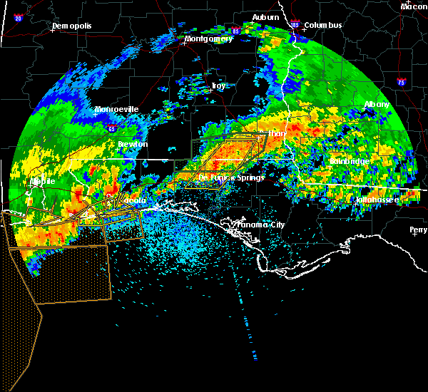 At 145 pm cdt, severe thunderstorms were located along a line extending from near hartford to 6 miles north of de funiak springs to 9 miles northwest of eglin air force base, moving east at 45 mph (radar indicated). Hazards include 60 mph wind gusts and nickel size hail. Expect damage to roofs, siding, and trees. Locations impacted include, de funiak springs, geneva, dothan, hartford, taylor, slocomb, eglin air force base, union, malvern, ponce de leon, clayhatchee, caryville, esto, westville, noma, black, kellys crossroads, cerrogordo, gritney and pleasant ridge. At 145 pm cdt, severe thunderstorms were located along a line extending from near hartford to 6 miles north of de funiak springs to 9 miles northwest of eglin air force base, moving east at 45 mph (radar indicated). Hazards include 60 mph wind gusts and nickel size hail. Expect damage to roofs, siding, and trees. Locations impacted include, de funiak springs, geneva, dothan, hartford, taylor, slocomb, eglin air force base, union, malvern, ponce de leon, clayhatchee, caryville, esto, westville, noma, black, kellys crossroads, cerrogordo, gritney and pleasant ridge.
|
| 4/23/2020 1:13 PM CDT |
 At 112 pm cdt, severe thunderstorms were located along a line extending from near samson to 10 miles north of niceville to 7 miles northwest of wright, moving northeast at 45 mph (radar indicated). Hazards include 60 mph wind gusts and nickel size hail. expect damage to roofs, siding, and trees At 112 pm cdt, severe thunderstorms were located along a line extending from near samson to 10 miles north of niceville to 7 miles northwest of wright, moving northeast at 45 mph (radar indicated). Hazards include 60 mph wind gusts and nickel size hail. expect damage to roofs, siding, and trees
|
| 4/23/2020 9:22 AM CDT |
 At 1021 am edt/921 am cdt/, severe thunderstorms were located along a line extending from daleville to 8 miles north of geneva to 7 miles south of samson to 10 miles north of de funiak springs, moving east at 50 mph (radar indicated). Hazards include 70 mph wind gusts and ping pong ball size hail. People and animals outdoors will be injured. expect hail damage to roofs, siding, windows, and vehicles. expect considerable tree damage. Wind damage is also likely to mobile homes, roofs, and outbuildings. At 1021 am edt/921 am cdt/, severe thunderstorms were located along a line extending from daleville to 8 miles north of geneva to 7 miles south of samson to 10 miles north of de funiak springs, moving east at 50 mph (radar indicated). Hazards include 70 mph wind gusts and ping pong ball size hail. People and animals outdoors will be injured. expect hail damage to roofs, siding, windows, and vehicles. expect considerable tree damage. Wind damage is also likely to mobile homes, roofs, and outbuildings.
|
| 4/20/2020 1:08 AM CDT |
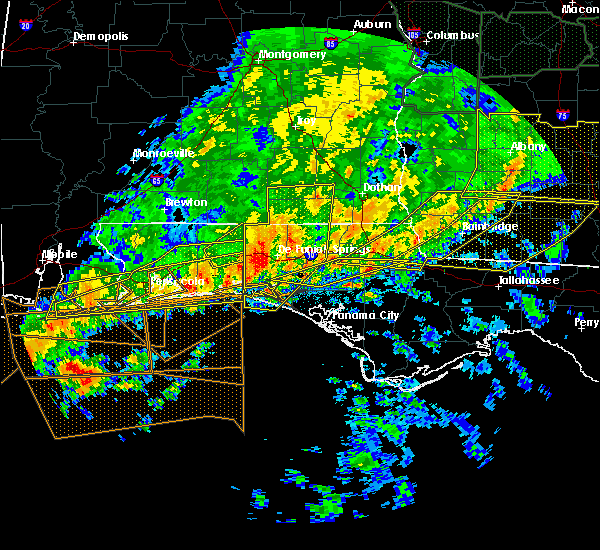 At 107 am cdt, severe thunderstorms were located along a line extending from 8 miles northwest of samson to near de funiak springs to destin, moving east at 45 mph (radar indicated). Hazards include 60 mph wind gusts and quarter size hail. Hail damage to vehicles is expected. expect wind damage to roofs, siding, and trees. Locations impacted include, santa rosa beach, de funiak springs, eglin air force base, live oak, freeport, ponce de leon, hinsons crossroads, portland, whitehead crossroads, alpine heights, villa tasso, blue mountain beach, de funiak spring airport, seaside, rock hill, millers ferry, pleasant ridge, gulf pines, knox hill and bunker. At 107 am cdt, severe thunderstorms were located along a line extending from 8 miles northwest of samson to near de funiak springs to destin, moving east at 45 mph (radar indicated). Hazards include 60 mph wind gusts and quarter size hail. Hail damage to vehicles is expected. expect wind damage to roofs, siding, and trees. Locations impacted include, santa rosa beach, de funiak springs, eglin air force base, live oak, freeport, ponce de leon, hinsons crossroads, portland, whitehead crossroads, alpine heights, villa tasso, blue mountain beach, de funiak spring airport, seaside, rock hill, millers ferry, pleasant ridge, gulf pines, knox hill and bunker.
|
| 4/20/2020 12:43 AM CDT |
 At 1243 am cdt, severe thunderstorms were located along a line extending from 7 miles southeast of andalusia to 6 miles east of crestview to near navarre beach, moving east at 45 mph (radar indicated). Hazards include 70 mph wind gusts and quarter size hail. Hail damage to vehicles is expected. expect considerable tree damage. Wind damage is also likely to mobile homes, roofs, and outbuildings. At 1243 am cdt, severe thunderstorms were located along a line extending from 7 miles southeast of andalusia to 6 miles east of crestview to near navarre beach, moving east at 45 mph (radar indicated). Hazards include 70 mph wind gusts and quarter size hail. Hail damage to vehicles is expected. expect considerable tree damage. Wind damage is also likely to mobile homes, roofs, and outbuildings.
|
| 4/19/2020 10:47 PM CDT |
 At 1046 pm cdt, severe thunderstorms were located along a line extending from near grady to 14 miles east of riverview, moving east at 45 mph (radar indicated). Hazards include 70 mph wind gusts. Expect considerable tree damage. damage is likely to mobile homes, roofs, and outbuildings. Locations impacted include, daleville, elba, de funiak springs, geneva, enterprise, fort rucker, ozark, level plains, samson, newton, new brockton, ariton, eglin air force base, lee, union, liberty, paxton, ponce de leon, clayhatchee and kinston. At 1046 pm cdt, severe thunderstorms were located along a line extending from near grady to 14 miles east of riverview, moving east at 45 mph (radar indicated). Hazards include 70 mph wind gusts. Expect considerable tree damage. damage is likely to mobile homes, roofs, and outbuildings. Locations impacted include, daleville, elba, de funiak springs, geneva, enterprise, fort rucker, ozark, level plains, samson, newton, new brockton, ariton, eglin air force base, lee, union, liberty, paxton, ponce de leon, clayhatchee and kinston.
|
| 4/19/2020 10:36 PM CDT |
 At 1036 pm cdt, severe thunderstorms were located along a line extending from lapine to 8 miles east of east brewton, moving east at 45 mph (radar indicated). Hazards include 60 mph wind gusts. expect damage to roofs, siding, and trees At 1036 pm cdt, severe thunderstorms were located along a line extending from lapine to 8 miles east of east brewton, moving east at 45 mph (radar indicated). Hazards include 60 mph wind gusts. expect damage to roofs, siding, and trees
|
| 4/13/2020 2:54 AM CDT |
 At 254 am cdt, a severe thunderstorm was located over graceville, moving east at 55 mph (radar indicated). Hazards include 60 mph wind gusts and penny size hail. Expect damage to roofs, siding, and trees. Locations impacted include, panama city beach, vernon, chipley, graceville, santa rosa beach, bonifay, eglin air force base, bradford, live oak, malone, freeport, cottondale, ponce de leon, alford, caryville, wausau, esto, westville, ebro and campbellton. At 254 am cdt, a severe thunderstorm was located over graceville, moving east at 55 mph (radar indicated). Hazards include 60 mph wind gusts and penny size hail. Expect damage to roofs, siding, and trees. Locations impacted include, panama city beach, vernon, chipley, graceville, santa rosa beach, bonifay, eglin air force base, bradford, live oak, malone, freeport, cottondale, ponce de leon, alford, caryville, wausau, esto, westville, ebro and campbellton.
|
| 4/13/2020 2:22 AM CDT |
 At 222 am cdt, a severe thunderstorm was located 11 miles northeast of de funiak springs, moving east at 55 mph (radar indicated). Hazards include 60 mph wind gusts and penny size hail. expect damage to roofs, siding, and trees At 222 am cdt, a severe thunderstorm was located 11 miles northeast of de funiak springs, moving east at 55 mph (radar indicated). Hazards include 60 mph wind gusts and penny size hail. expect damage to roofs, siding, and trees
|
| 4/13/2020 2:20 AM CDT | Report of a tree down at hwy 83/ county road 1084. also quite a few reports in defuniak spring in walton county FL, 9.4 miles S of De Funiak Springs, FL |
| 4/13/2020 2:14 AM CDT |
 At 214 am cdt, a severe thunderstorm capable of producing a tornado was located 8 miles north of de funiak springs, moving northeast at 60 mph (radar indicated rotation). Hazards include tornado. Flying debris will be dangerous to those caught without shelter. mobile homes will be damaged or destroyed. damage to roofs, windows, and vehicles will occur. tree damage is likely. This tornadic thunderstorm will remain over mainly rural areas of north central walton and northwestern holmes counties, including the following locations, cluster springs, leonia, sand hill, barker store, cerrogordo, prosperity, gritney, arrant settlement, liberty and glendale. At 214 am cdt, a severe thunderstorm capable of producing a tornado was located 8 miles north of de funiak springs, moving northeast at 60 mph (radar indicated rotation). Hazards include tornado. Flying debris will be dangerous to those caught without shelter. mobile homes will be damaged or destroyed. damage to roofs, windows, and vehicles will occur. tree damage is likely. This tornadic thunderstorm will remain over mainly rural areas of north central walton and northwestern holmes counties, including the following locations, cluster springs, leonia, sand hill, barker store, cerrogordo, prosperity, gritney, arrant settlement, liberty and glendale.
|
| 4/13/2020 1:24 AM CDT |
 At 123 am cdt, a severe thunderstorm was located 7 miles north of eglin air force base, or 10 miles west of de funiak springs, moving northeast at 45 mph (radar indicated). Hazards include 60 mph wind gusts and penny size hail. expect damage to roofs, siding, and trees At 123 am cdt, a severe thunderstorm was located 7 miles north of eglin air force base, or 10 miles west of de funiak springs, moving northeast at 45 mph (radar indicated). Hazards include 60 mph wind gusts and penny size hail. expect damage to roofs, siding, and trees
|
| 3/31/2020 12:14 PM CDT |
 At 114 pm edt/1214 pm cdt/, severe thunderstorms were located along a line extending from near taylor to 12 miles southwest of baker, moving southeast at 50 mph (radar indicated). Hazards include 60 mph wind gusts. expect damage to roofs, siding, and trees At 114 pm edt/1214 pm cdt/, severe thunderstorms were located along a line extending from near taylor to 12 miles southwest of baker, moving southeast at 50 mph (radar indicated). Hazards include 60 mph wind gusts. expect damage to roofs, siding, and trees
|
| 2/6/2020 11:22 AM CST |
 At 1122 am cst, a severe thunderstorm was located over eglin air force base, or 10 miles east of niceville, moving northeast at 60 mph (radar indicated). Hazards include 60 mph wind gusts. expect damage to roofs, siding, and trees At 1122 am cst, a severe thunderstorm was located over eglin air force base, or 10 miles east of niceville, moving northeast at 60 mph (radar indicated). Hazards include 60 mph wind gusts. expect damage to roofs, siding, and trees
|
| 2/6/2020 10:39 AM CST |
 At 1038 am cst, a severe thunderstorm was located 8 miles east of de funiak springs, moving northeast at 55 mph (radar indicated). Hazards include 60 mph wind gusts. expect damage to roofs, siding, and trees At 1038 am cst, a severe thunderstorm was located 8 miles east of de funiak springs, moving northeast at 55 mph (radar indicated). Hazards include 60 mph wind gusts. expect damage to roofs, siding, and trees
|
| 1/11/2020 4:32 PM CST |
 At 431 pm cst, severe thunderstorms were located along a line extending from 10 miles south of geneva to near santa rosa beach, moving east at 30 mph (radar indicated). Hazards include 70 mph wind gusts. Expect considerable tree damage. damage is likely to mobile homes, roofs, and outbuildings. Locations impacted include, santa rosa beach, de funiak springs, eglin air force base, union, freeport, ponce de leon, caryville, westville, portland, cerrogordo, blue mountain beach, gritney, arrant settlement, seaside, rock hill, center ridge, smith crossroads, knox hill, bunker and hickory hill. At 431 pm cst, severe thunderstorms were located along a line extending from 10 miles south of geneva to near santa rosa beach, moving east at 30 mph (radar indicated). Hazards include 70 mph wind gusts. Expect considerable tree damage. damage is likely to mobile homes, roofs, and outbuildings. Locations impacted include, santa rosa beach, de funiak springs, eglin air force base, union, freeport, ponce de leon, caryville, westville, portland, cerrogordo, blue mountain beach, gritney, arrant settlement, seaside, rock hill, center ridge, smith crossroads, knox hill, bunker and hickory hill.
|
| 1/11/2020 4:15 PM CST | Tree down at 83 institution r in walton county FL, 4.6 miles S of De Funiak Springs, FL |
| 1/11/2020 4:00 PM CST |
 At 400 pm cst, severe thunderstorms were located along a line extending from 11 miles north of de funiak springs to near destin, moving east at 25 mph (radar indicated). Hazards include 70 mph wind gusts. Expect considerable tree damage. Damage is likely to mobile homes, roofs, and outbuildings. At 400 pm cst, severe thunderstorms were located along a line extending from 11 miles north of de funiak springs to near destin, moving east at 25 mph (radar indicated). Hazards include 70 mph wind gusts. Expect considerable tree damage. Damage is likely to mobile homes, roofs, and outbuildings.
|
| 1/11/2020 3:34 PM CST |
 At 334 pm cst, severe thunderstorms were located along a line extending from near florala to near fort walton beach, moving east at 35 mph (radar indicated). Hazards include 70 mph wind gusts. Expect considerable tree damage. damage is likely to mobile homes, roofs, and outbuildings. Locations impacted include, santa rosa beach, de funiak springs, eglin air force base, union, liberty, freeport, paxton, pond creek, oakwood hills, cluster springs, gaskin, portland, alpine heights, villa tasso, darlington, blue mountain beach, de funiak spring airport, seaside, rock hill and glendale. At 334 pm cst, severe thunderstorms were located along a line extending from near florala to near fort walton beach, moving east at 35 mph (radar indicated). Hazards include 70 mph wind gusts. Expect considerable tree damage. damage is likely to mobile homes, roofs, and outbuildings. Locations impacted include, santa rosa beach, de funiak springs, eglin air force base, union, liberty, freeport, paxton, pond creek, oakwood hills, cluster springs, gaskin, portland, alpine heights, villa tasso, darlington, blue mountain beach, de funiak spring airport, seaside, rock hill and glendale.
|
| 1/11/2020 3:12 PM CST |
 At 312 pm cst, severe thunderstorms were located along a line extending from 7 miles southwest of laurel hill to near navarre beach, moving east at 35 mph (radar indicated). Hazards include 60 mph wind gusts. expect damage to roofs, siding, and trees At 312 pm cst, severe thunderstorms were located along a line extending from 7 miles southwest of laurel hill to near navarre beach, moving east at 35 mph (radar indicated). Hazards include 60 mph wind gusts. expect damage to roofs, siding, and trees
|
| 7/9/2019 5:55 PM CDT |
 The severe thunderstorm warning for southwestern geneva, northern walton and holmes counties will expire at 600 pm cdt, the storms which prompted the warning have weakened below severe limits, and no longer pose an immediate threat to life or property. therefore, the warning will be allowed to expire. however gusty winds are still possible with these thunderstorms. The severe thunderstorm warning for southwestern geneva, northern walton and holmes counties will expire at 600 pm cdt, the storms which prompted the warning have weakened below severe limits, and no longer pose an immediate threat to life or property. therefore, the warning will be allowed to expire. however gusty winds are still possible with these thunderstorms.
|
| 7/9/2019 5:29 PM CDT |
 At 529 pm cdt, doppler radar indicated a line of severe thunderstorms capable of producing damaging winds in excess of 60 mph. these storms were located along a line extending from samson to near geneva to near hartford, and moving southwest at 30 mph. At 529 pm cdt, doppler radar indicated a line of severe thunderstorms capable of producing damaging winds in excess of 60 mph. these storms were located along a line extending from samson to near geneva to near hartford, and moving southwest at 30 mph.
|
| 6/25/2019 7:13 PM CDT |
 The severe thunderstorm warning for central walton and central washington counties will expire at 715 pm cdt, the storms which prompted the warning have weakened below severe limits, and no longer pose an immediate threat to life or property. therefore, the warning will be allowed to expire. to report severe weather, contact your nearest law enforcement agency. they will relay your report to the national weather service tallahassee. The severe thunderstorm warning for central walton and central washington counties will expire at 715 pm cdt, the storms which prompted the warning have weakened below severe limits, and no longer pose an immediate threat to life or property. therefore, the warning will be allowed to expire. to report severe weather, contact your nearest law enforcement agency. they will relay your report to the national weather service tallahassee.
|
| 6/25/2019 6:56 PM CDT |
 At 656 pm cdt, severe thunderstorms were located along a line extending from near eglin air force base to bonifay, moving southeast at 20 mph (radar indicated). Hazards include 60 mph wind gusts. Expect damage to roofs, siding, and trees. Locations impacted include, vernon, de funiak springs, eglin air force base, live oak, freeport, ebro, hinsons crossroads, portland, whitehead crossroads, rock hill, holmes valley, millers ferry, pleasant ridge, knox hill, smyrna, sylvania, johnson crossroads, brock crossroad, red bay and douglass crossroad. At 656 pm cdt, severe thunderstorms were located along a line extending from near eglin air force base to bonifay, moving southeast at 20 mph (radar indicated). Hazards include 60 mph wind gusts. Expect damage to roofs, siding, and trees. Locations impacted include, vernon, de funiak springs, eglin air force base, live oak, freeport, ebro, hinsons crossroads, portland, whitehead crossroads, rock hill, holmes valley, millers ferry, pleasant ridge, knox hill, smyrna, sylvania, johnson crossroads, brock crossroad, red bay and douglass crossroad.
|
| 6/25/2019 6:30 PM CDT |
 At 630 pm cdt, severe thunderstorms were located along a line extending from 7 miles north of niceville to 9 miles northwest of bonifay, moving southeast at 20 mph (radar indicated). Hazards include 60 mph wind gusts. Expect damage to roofs, siding, and trees. Locations impacted include, vernon, de funiak springs, bonifay, eglin air force base, union, live oak, freeport, ponce de leon, caryville, westville, ebro, hinsons crossroads, oakwood hills, portland, whitehead crossroads, alpine heights, cerrogordo, gritney, arrant settlement and de funiak spring airport. At 630 pm cdt, severe thunderstorms were located along a line extending from 7 miles north of niceville to 9 miles northwest of bonifay, moving southeast at 20 mph (radar indicated). Hazards include 60 mph wind gusts. Expect damage to roofs, siding, and trees. Locations impacted include, vernon, de funiak springs, bonifay, eglin air force base, union, live oak, freeport, ponce de leon, caryville, westville, ebro, hinsons crossroads, oakwood hills, portland, whitehead crossroads, alpine heights, cerrogordo, gritney, arrant settlement and de funiak spring airport.
|
| 6/25/2019 6:09 PM CDT |
 The national weather service in tallahassee has issued a * severe thunderstorm warning for. walton county in the panhandle of florida. southern holmes county in the panhandle of florida. central washington county in the panhandle of florida. Until 715 pm cdt. The national weather service in tallahassee has issued a * severe thunderstorm warning for. walton county in the panhandle of florida. southern holmes county in the panhandle of florida. central washington county in the panhandle of florida. Until 715 pm cdt.
|
| 6/7/2019 1:59 PM CDT |
 At 158 pm cdt, a severe thunderstorm was located over eglin air force base, or 12 miles northeast of niceville, moving east at 40 mph (radar indicated). Hazards include 60 mph wind gusts. expect damage to roofs, siding, and trees At 158 pm cdt, a severe thunderstorm was located over eglin air force base, or 12 miles northeast of niceville, moving east at 40 mph (radar indicated). Hazards include 60 mph wind gusts. expect damage to roofs, siding, and trees
|
| 6/7/2019 1:31 PM CDT |
 At 131 pm cdt, a severe thunderstorm was located 9 miles southeast of crestview, moving east at 40 mph (radar indicated). Hazards include 60 mph wind gusts. expect damage to roofs, siding, and trees At 131 pm cdt, a severe thunderstorm was located 9 miles southeast of crestview, moving east at 40 mph (radar indicated). Hazards include 60 mph wind gusts. expect damage to roofs, siding, and trees
|
| 6/1/2019 1:24 PM CDT |
 At 124 pm cdt, a severe thunderstorm was located 9 miles southeast of de funiak springs, moving east at 25 mph (radar indicated). Hazards include 60 mph wind gusts. Expect damage to roofs, siding, and trees. Locations impacted include, vernon, de funiak springs, eglin air force base, live oak, freeport, ponce de leon, caryville, westville, ebro, hinsons crossroads, red bay, douglass crossroad, whitehead crossroads, rock hill, bruce, red head, eucheeanna, holmes valley, millers ferry and five points. At 124 pm cdt, a severe thunderstorm was located 9 miles southeast of de funiak springs, moving east at 25 mph (radar indicated). Hazards include 60 mph wind gusts. Expect damage to roofs, siding, and trees. Locations impacted include, vernon, de funiak springs, eglin air force base, live oak, freeport, ponce de leon, caryville, westville, ebro, hinsons crossroads, red bay, douglass crossroad, whitehead crossroads, rock hill, bruce, red head, eucheeanna, holmes valley, millers ferry and five points.
|
| 6/1/2019 1:09 PM CDT |
 The national weather service in tallahassee has issued a * severe thunderstorm warning for. central walton county in the panhandle of florida. southwestern holmes county in the panhandle of florida. western washington county in the panhandle of florida. Until 200 pm cdt. The national weather service in tallahassee has issued a * severe thunderstorm warning for. central walton county in the panhandle of florida. southwestern holmes county in the panhandle of florida. western washington county in the panhandle of florida. Until 200 pm cdt.
|
| 5/12/2019 9:58 AM CDT |
 At 958 am cdt, severe thunderstorms were located along a line extending from 7 miles south of geneva to 13 miles northwest of vernon to 7 miles southeast of destin, moving southeast at 40 mph (radar indicated). Hazards include 60 mph wind gusts. expect damage to roofs, siding, and trees At 958 am cdt, severe thunderstorms were located along a line extending from 7 miles south of geneva to 13 miles northwest of vernon to 7 miles southeast of destin, moving southeast at 40 mph (radar indicated). Hazards include 60 mph wind gusts. expect damage to roofs, siding, and trees
|
| 5/12/2019 9:10 AM CDT |
 At 909 am cdt, severe thunderstorms were located along a line extending from near laurel hill to near crestview to near pensacola beach, moving east at 45 mph (radar indicated). Hazards include 60 mph wind gusts. expect damage to roofs, siding, and trees At 909 am cdt, severe thunderstorms were located along a line extending from near laurel hill to near crestview to near pensacola beach, moving east at 45 mph (radar indicated). Hazards include 60 mph wind gusts. expect damage to roofs, siding, and trees
|
| 4/14/2019 7:55 AM CDT | Sheriffs office reports a few small trees dow in walton county FL, 0.9 miles N of De Funiak Springs, FL |
| 4/14/2019 7:51 AM CDT |
 The severe thunderstorm warning for northwestern bay, southern walton, southwestern holmes and southwestern washington counties will expire at 800 am cdt, the storms which prompted the warning have weakened. therefore, the warning will be allowed to expire. however gusty winds to 40 mph are still possible with these thunderstorms. a tornado watch remains in effect until 1000 am cdt for the panhandle of florida. The severe thunderstorm warning for northwestern bay, southern walton, southwestern holmes and southwestern washington counties will expire at 800 am cdt, the storms which prompted the warning have weakened. therefore, the warning will be allowed to expire. however gusty winds to 40 mph are still possible with these thunderstorms. a tornado watch remains in effect until 1000 am cdt for the panhandle of florida.
|
| 4/14/2019 7:42 AM CDT |
 At 742 am cdt, severe thunderstorms were located along a line extending from 7 miles south of eglin air force base to near santa rosa beach to 21 miles southeast of niceville to 16 miles southeast of destin, moving northeast at 40 mph (radar indicated). Hazards include 60 mph wind gusts. Expect damage to roofs, siding, and trees. locations impacted include, santa rosa beach, de funiak springs, eglin air force base, live oak, freeport, ponce de leon, ebro, portland, villa tasso, seminole hills, blue mountain beach, seaside, rock hill, millers ferry, pleasant ridge, gulf pines, knox hill, bunker, grayton beach and argyle. A tornado watch remains in effect until 1000 am cdt for the panhandle of florida. At 742 am cdt, severe thunderstorms were located along a line extending from 7 miles south of eglin air force base to near santa rosa beach to 21 miles southeast of niceville to 16 miles southeast of destin, moving northeast at 40 mph (radar indicated). Hazards include 60 mph wind gusts. Expect damage to roofs, siding, and trees. locations impacted include, santa rosa beach, de funiak springs, eglin air force base, live oak, freeport, ponce de leon, ebro, portland, villa tasso, seminole hills, blue mountain beach, seaside, rock hill, millers ferry, pleasant ridge, gulf pines, knox hill, bunker, grayton beach and argyle. A tornado watch remains in effect until 1000 am cdt for the panhandle of florida.
|
| 4/14/2019 7:21 AM CDT |
 At 721 am cdt, severe thunderstorms were located along a line extending from near destin to 10 miles southwest of santa rosa beach to 20 miles southeast of lake lorraine to 24 miles south of fort walton beach, moving northeast at 40 mph (radar indicated). Hazards include 60 mph wind gusts. expect damage to roofs, siding, and trees At 721 am cdt, severe thunderstorms were located along a line extending from near destin to 10 miles southwest of santa rosa beach to 20 miles southeast of lake lorraine to 24 miles south of fort walton beach, moving northeast at 40 mph (radar indicated). Hazards include 60 mph wind gusts. expect damage to roofs, siding, and trees
|
| 3/3/2019 4:45 PM CST |
 At 445 pm cst, a confirmed tornado was located near de funiak springs, moving east at 55 mph (radar confirmed tornado). Hazards include damaging tornado. Flying debris will be dangerous to those caught without shelter. mobile homes will be damaged or destroyed. damage to roofs, windows, and vehicles will occur. tree damage is likely. This tornadic thunderstorm will remain over mainly rural areas of central walton and southwestern holmes counties, including the following locations, eucheeanna, ponce de leon, douglass crossroad, argyle and westville. At 445 pm cst, a confirmed tornado was located near de funiak springs, moving east at 55 mph (radar confirmed tornado). Hazards include damaging tornado. Flying debris will be dangerous to those caught without shelter. mobile homes will be damaged or destroyed. damage to roofs, windows, and vehicles will occur. tree damage is likely. This tornadic thunderstorm will remain over mainly rural areas of central walton and southwestern holmes counties, including the following locations, eucheeanna, ponce de leon, douglass crossroad, argyle and westville.
|
| 3/3/2019 4:43 PM CST | Bob sikes road near highway 331 closed with trees over the road. debris near walmar in walton county FL, 1.9 miles ENE of De Funiak Springs, FL |
| 3/3/2019 4:40 PM CST | All i-10 eastbound lanes closed near mm 83 due to downed tree in walton county FL, 2.2 miles E of De Funiak Springs, FL |
| 3/3/2019 4:37 PM CST |
 At 437 pm cst, severe thunderstorms were located along a line extending from 9 miles south of hartford to near destin, moving east at 45 mph (radar indicated). Hazards include 60 mph wind gusts. expect damage to roofs, siding, and trees At 437 pm cst, severe thunderstorms were located along a line extending from 9 miles south of hartford to near destin, moving east at 45 mph (radar indicated). Hazards include 60 mph wind gusts. expect damage to roofs, siding, and trees
|
| 3/3/2019 4:34 PM CST |
 At 433 pm cst, a confirmed tornado was located near eglin air force base, or 7 miles southwest of de funiak springs, moving east at 55 mph (radar confirmed tornado). Hazards include damaging tornado. Flying debris will be dangerous to those caught without shelter. mobile homes will be damaged or destroyed. damage to roofs, windows, and vehicles will occur. tree damage is likely. this tornado will be near, de funiak springs around 440 pm cst. Other locations impacted by this tornadic thunderstorm include hinsons crossroads, red bay, douglass crossroad, alpine heights, live oak, de funiak spring airport, rock hill, eucheeanna, millers ferry and pleasant ridge. At 433 pm cst, a confirmed tornado was located near eglin air force base, or 7 miles southwest of de funiak springs, moving east at 55 mph (radar confirmed tornado). Hazards include damaging tornado. Flying debris will be dangerous to those caught without shelter. mobile homes will be damaged or destroyed. damage to roofs, windows, and vehicles will occur. tree damage is likely. this tornado will be near, de funiak springs around 440 pm cst. Other locations impacted by this tornadic thunderstorm include hinsons crossroads, red bay, douglass crossroad, alpine heights, live oak, de funiak spring airport, rock hill, eucheeanna, millers ferry and pleasant ridge.
|
| 3/3/2019 4:24 PM CST |
 At 423 pm cst, a severe thunderstorm capable of producing a tornado was located near eglin air force base, or 10 miles northeast of niceville, moving east at 55 mph (radar indicated rotation). Hazards include tornado. Flying debris will be dangerous to those caught without shelter. mobile homes will be damaged or destroyed. damage to roofs, windows, and vehicles will occur. tree damage is likely. this dangerous storm will be near, eglin air force base around 435 pm cst. de funiak springs around 440 pm cst. Other locations impacted by this tornadic thunderstorm include hinsons crossroads, red bay, douglass crossroad, alpine heights, live oak, de funiak spring airport, rock hill, eucheeanna, millers ferry and pleasant ridge. At 423 pm cst, a severe thunderstorm capable of producing a tornado was located near eglin air force base, or 10 miles northeast of niceville, moving east at 55 mph (radar indicated rotation). Hazards include tornado. Flying debris will be dangerous to those caught without shelter. mobile homes will be damaged or destroyed. damage to roofs, windows, and vehicles will occur. tree damage is likely. this dangerous storm will be near, eglin air force base around 435 pm cst. de funiak springs around 440 pm cst. Other locations impacted by this tornadic thunderstorm include hinsons crossroads, red bay, douglass crossroad, alpine heights, live oak, de funiak spring airport, rock hill, eucheeanna, millers ferry and pleasant ridge.
|
| 3/3/2019 4:04 PM CST |
 At 403 pm cst, severe thunderstorms were located along a line extending from near geneva to 6 miles north of wright, moving east at 40 mph (radar indicated). Hazards include 60 mph wind gusts. expect damage to roofs, siding, and trees At 403 pm cst, severe thunderstorms were located along a line extending from near geneva to 6 miles north of wright, moving east at 40 mph (radar indicated). Hazards include 60 mph wind gusts. expect damage to roofs, siding, and trees
|
| 3/3/2019 12:04 PM CST |
 At 1203 pm cst, a severe thunderstorm was located near de funiak springs, moving northeast at 35 mph (radar indicated). Hazards include 60 mph wind gusts and quarter size hail. Hail damage to vehicles is expected. Expect wind damage to roofs, siding, and trees. At 1203 pm cst, a severe thunderstorm was located near de funiak springs, moving northeast at 35 mph (radar indicated). Hazards include 60 mph wind gusts and quarter size hail. Hail damage to vehicles is expected. Expect wind damage to roofs, siding, and trees.
|
| 1/23/2019 7:33 PM CST |
 At 733 pm cst, severe thunderstorms were located along a line extending from 8 miles north of de funiak springs to 44 miles southwest of panama city beach, moving east at 35 mph (radar indicated). Hazards include 60 mph wind gusts. Expect damage to roofs, siding, and trees. Locations impacted include, panama city, lynn haven, panama city beach, callaway, vernon, chipley, de funiak springs, bonifay, santa rosa beach, springfield, hiland park, tyndall air force base, eglin air force base, bradford, live oak, parker, freeport, ponce de leon, caryville and wausau. At 733 pm cst, severe thunderstorms were located along a line extending from 8 miles north of de funiak springs to 44 miles southwest of panama city beach, moving east at 35 mph (radar indicated). Hazards include 60 mph wind gusts. Expect damage to roofs, siding, and trees. Locations impacted include, panama city, lynn haven, panama city beach, callaway, vernon, chipley, de funiak springs, bonifay, santa rosa beach, springfield, hiland park, tyndall air force base, eglin air force base, bradford, live oak, parker, freeport, ponce de leon, caryville and wausau.
|
| 1/23/2019 7:01 PM CST |
 At 700 pm cst, severe thunderstorms were located along a line extending from 12 miles east of crestview to 52 miles south of destin, moving east at 35 mph (radar indicated). Hazards include 60 mph wind gusts. expect damage to roofs, siding, and trees At 700 pm cst, severe thunderstorms were located along a line extending from 12 miles east of crestview to 52 miles south of destin, moving east at 35 mph (radar indicated). Hazards include 60 mph wind gusts. expect damage to roofs, siding, and trees
|
| 1/19/2019 5:24 PM CST |
 At 523 pm cst, severe thunderstorms were located along a line extending from 9 miles northeast of santa rosa beach to 38 miles southwest of panama city beach, moving northeast at 45 mph (radar indicated). Hazards include 60 mph wind gusts. a wind gust to 48 mph was recently measured at the panama city airport. expect damage to roofs, siding, and trees At 523 pm cst, severe thunderstorms were located along a line extending from 9 miles northeast of santa rosa beach to 38 miles southwest of panama city beach, moving northeast at 45 mph (radar indicated). Hazards include 60 mph wind gusts. a wind gust to 48 mph was recently measured at the panama city airport. expect damage to roofs, siding, and trees
|
| 12/2/2018 2:50 AM CST |
 The severe thunderstorm warning for northwestern walton and southwestern holmes counties will expire at 300 am cst, the storm which prompted the warning has weakened below severe limits, and no longer poses an immediate threat to life or property. therefore, the warning will be allowed to expire. a tornado watch remains in effect until 300 am cst for southeastern alabama. a tornado watch also remains in effect until 1000 am cst for southeastern alabama. The severe thunderstorm warning for northwestern walton and southwestern holmes counties will expire at 300 am cst, the storm which prompted the warning has weakened below severe limits, and no longer poses an immediate threat to life or property. therefore, the warning will be allowed to expire. a tornado watch remains in effect until 300 am cst for southeastern alabama. a tornado watch also remains in effect until 1000 am cst for southeastern alabama.
|
| 12/2/2018 2:20 AM CST |
 At 220 am cst, a severe thunderstorm was located 11 miles east of crestview, moving northeast at 30 mph (radar indicated). Hazards include 60 mph wind gusts. expect damage to roofs, siding, and trees At 220 am cst, a severe thunderstorm was located 11 miles east of crestview, moving northeast at 30 mph (radar indicated). Hazards include 60 mph wind gusts. expect damage to roofs, siding, and trees
|
| 9/3/2018 5:07 PM CDT |
 The severe thunderstorm warning for northwestern walton county will expire at 515 pm cdt, the storm which prompted the warning has moved out of the area. therefore, the warning will be allowed to expire. The severe thunderstorm warning for northwestern walton county will expire at 515 pm cdt, the storm which prompted the warning has moved out of the area. therefore, the warning will be allowed to expire.
|
| 9/3/2018 4:46 PM CDT |
 At 445 pm cdt, a severe thunderstorm was located near eglin air force base, or 8 miles southwest of de funiak springs, moving west at 35 mph (radar indicated). Hazards include 60 mph wind gusts. expect damage to roofs, siding, and trees At 445 pm cdt, a severe thunderstorm was located near eglin air force base, or 8 miles southwest of de funiak springs, moving west at 35 mph (radar indicated). Hazards include 60 mph wind gusts. expect damage to roofs, siding, and trees
|
| 9/2/2018 7:34 PM CDT |
 At 734 pm cdt, a severe thunderstorm was located 10 miles northwest of de funiak springs, moving northwest at 30 mph (radar indicated). Hazards include 60 mph wind gusts. expect damage to roofs, siding, and trees At 734 pm cdt, a severe thunderstorm was located 10 miles northwest of de funiak springs, moving northwest at 30 mph (radar indicated). Hazards include 60 mph wind gusts. expect damage to roofs, siding, and trees
|
| 9/2/2018 6:53 PM CDT |
 At 652 pm cdt, doppler radar indicated a severe thunderstorm capable of producing damaging winds in excess of 60 mph. this storm was located near de funiak springs, and moving northwest at 25 mph. At 652 pm cdt, doppler radar indicated a severe thunderstorm capable of producing damaging winds in excess of 60 mph. this storm was located near de funiak springs, and moving northwest at 25 mph.
|
| 8/10/2018 6:10 PM CDT |
 At 610 pm cdt, a severe thunderstorm was located 8 miles northeast of de funiak springs, moving east at 25 mph (radar indicated). Hazards include 60 mph wind gusts. expect damage to roofs, siding, and trees At 610 pm cdt, a severe thunderstorm was located 8 miles northeast of de funiak springs, moving east at 25 mph (radar indicated). Hazards include 60 mph wind gusts. expect damage to roofs, siding, and trees
|
| 7/22/2018 8:29 PM CDT |
 At 828 pm cdt, a severe thunderstorm was located 14 miles northeast of santa rosa beach, moving east at 30 mph (radar indicated). Hazards include 70 mph wind gusts and penny size hail. Expect considerable tree damage. Damage is likely to mobile homes, roofs, and outbuildings. At 828 pm cdt, a severe thunderstorm was located 14 miles northeast of santa rosa beach, moving east at 30 mph (radar indicated). Hazards include 70 mph wind gusts and penny size hail. Expect considerable tree damage. Damage is likely to mobile homes, roofs, and outbuildings.
|
| 7/22/2018 8:24 PM CDT |
 At 741 pm cdt, a severe thunderstorm was located near niceville, moving east at 30 mph (radar indicated). Hazards include 60 mph wind gusts and penny size hail. expect damage to roofs, siding, and trees At 741 pm cdt, a severe thunderstorm was located near niceville, moving east at 30 mph (radar indicated). Hazards include 60 mph wind gusts and penny size hail. expect damage to roofs, siding, and trees
|
| 7/22/2018 7:42 PM CDT |
 At 741 pm cdt, a severe thunderstorm was located near niceville, moving east at 30 mph (radar indicated). Hazards include 60 mph wind gusts and penny size hail. expect damage to roofs, siding, and trees At 741 pm cdt, a severe thunderstorm was located near niceville, moving east at 30 mph (radar indicated). Hazards include 60 mph wind gusts and penny size hail. expect damage to roofs, siding, and trees
|
| 7/22/2018 3:05 PM CDT |
 At 305 pm cdt, a severe thunderstorm was located 9 miles southeast of de funiak springs, moving southeast at 35 mph (radar indicated). Hazards include 70 mph wind gusts and quarter size hail. Hail damage to vehicles is expected. expect considerable tree damage. Wind damage is also likely to mobile homes, roofs, and outbuildings. At 305 pm cdt, a severe thunderstorm was located 9 miles southeast of de funiak springs, moving southeast at 35 mph (radar indicated). Hazards include 70 mph wind gusts and quarter size hail. Hail damage to vehicles is expected. expect considerable tree damage. Wind damage is also likely to mobile homes, roofs, and outbuildings.
|
| 7/22/2018 2:49 PM CDT |
 At 236 pm cdt, a severe thunderstorm was located 10 miles north of de funiak springs, moving southeast at 30 mph (radar indicated). Hazards include 70 mph wind gusts and ping pong ball size hail. People and animals outdoors will be injured. expect hail damage to roofs, siding, windows, and vehicles. expect considerable tree damage. Wind damage is also likely to mobile homes, roofs, and outbuildings. At 236 pm cdt, a severe thunderstorm was located 10 miles north of de funiak springs, moving southeast at 30 mph (radar indicated). Hazards include 70 mph wind gusts and ping pong ball size hail. People and animals outdoors will be injured. expect hail damage to roofs, siding, windows, and vehicles. expect considerable tree damage. Wind damage is also likely to mobile homes, roofs, and outbuildings.
|
| 7/22/2018 2:36 PM CDT |
 At 236 pm cdt, a severe thunderstorm was located 10 miles north of de funiak springs, moving southeast at 30 mph (radar indicated). Hazards include 70 mph wind gusts and ping pong ball size hail. People and animals outdoors will be injured. expect hail damage to roofs, siding, windows, and vehicles. expect considerable tree damage. Wind damage is also likely to mobile homes, roofs, and outbuildings. At 236 pm cdt, a severe thunderstorm was located 10 miles north of de funiak springs, moving southeast at 30 mph (radar indicated). Hazards include 70 mph wind gusts and ping pong ball size hail. People and animals outdoors will be injured. expect hail damage to roofs, siding, windows, and vehicles. expect considerable tree damage. Wind damage is also likely to mobile homes, roofs, and outbuildings.
|
| 7/15/2018 4:15 PM CDT |
 At 415 pm cdt, severe thunderstorms were located along a line extending from 13 miles north of eglin air force base to 6 miles east of vernon, moving southeast at 15 mph (radar indicated). Hazards include 60 mph wind gusts. expect damage to roofs, siding, and trees At 415 pm cdt, severe thunderstorms were located along a line extending from 13 miles north of eglin air force base to 6 miles east of vernon, moving southeast at 15 mph (radar indicated). Hazards include 60 mph wind gusts. expect damage to roofs, siding, and trees
|
| 6/30/2018 2:34 PM CDT |
 At 234 pm cdt, a severe thunderstorm was located near de funiak springs, moving southeast at 20 mph (radar indicated). Hazards include 60 mph wind gusts. expect damage to roofs, siding, and trees At 234 pm cdt, a severe thunderstorm was located near de funiak springs, moving southeast at 20 mph (radar indicated). Hazards include 60 mph wind gusts. expect damage to roofs, siding, and trees
|
| 6/30/2018 2:07 PM CDT |
 At 207 pm cdt, a severe thunderstorm was located 11 miles south of florala, moving south at 20 mph (radar indicated). Hazards include 60 mph wind gusts. expect damage to roofs, siding, and trees At 207 pm cdt, a severe thunderstorm was located 11 miles south of florala, moving south at 20 mph (radar indicated). Hazards include 60 mph wind gusts. expect damage to roofs, siding, and trees
|
| 6/28/2018 7:00 PM CDT | Several trees and power lines down across the count in walton county FL, 1.1 miles S of De Funiak Springs, FL |
| 4/15/2018 2:54 AM CDT |
 At 253 am cdt, a severe thunderstorm was located 14 miles east of santa rosa beach, moving northeast at 50 mph (radar indicated). Hazards include 60 mph wind gusts. Expect damage to roofs, siding, and trees. locations impacted include, panama city beach, vernon, santa rosa beach, de funiak springs, bonifay, chipley, eglin air force base, live oak, freeport, ponce de leon, caryville, westville, ebro, whitehead crossroads, gulf resort beach, blue mountain beach, west panama city, seaside, bahama beach and rock hill. A tornado watch remains in effect until 700 am cdt for the panhandle of florida. At 253 am cdt, a severe thunderstorm was located 14 miles east of santa rosa beach, moving northeast at 50 mph (radar indicated). Hazards include 60 mph wind gusts. Expect damage to roofs, siding, and trees. locations impacted include, panama city beach, vernon, santa rosa beach, de funiak springs, bonifay, chipley, eglin air force base, live oak, freeport, ponce de leon, caryville, westville, ebro, whitehead crossroads, gulf resort beach, blue mountain beach, west panama city, seaside, bahama beach and rock hill. A tornado watch remains in effect until 700 am cdt for the panhandle of florida.
|
| 4/15/2018 2:28 AM CDT |
 At 228 am cdt, a severe thunderstorm was located 7 miles southwest of santa rosa beach, moving northeast at 55 mph (radar indicated). Hazards include 60 mph wind gusts. expect damage to roofs, siding, and trees At 228 am cdt, a severe thunderstorm was located 7 miles southwest of santa rosa beach, moving northeast at 55 mph (radar indicated). Hazards include 60 mph wind gusts. expect damage to roofs, siding, and trees
|
| 8/31/2017 9:20 AM CDT | Trees and power lines down on hwy 90 e near old spanish trai in walton county FL, 4.9 miles W of De Funiak Springs, FL |
| 8/31/2017 9:03 AM CDT |
 At 903 am cdt, a severe thunderstorm was located near eglin air force base, or 8 miles southwest of de funiak springs, moving northeast at 20 mph (radar indicated). Hazards include 60 mph wind gusts. expect damage to roofs, siding, and trees At 903 am cdt, a severe thunderstorm was located near eglin air force base, or 8 miles southwest of de funiak springs, moving northeast at 20 mph (radar indicated). Hazards include 60 mph wind gusts. expect damage to roofs, siding, and trees
|
| 7/14/2017 12:28 PM CDT |
 At 1226 pm cdt, severe thunderstorms were located along a line extending from 8 miles east of eglin air force base to vernon, moving north at 15 mph (radar indicated). Hazards include 60 mph wind gusts. Expect damage to roofs, siding, and trees. Locations impacted include, vernon, de funiak springs, bonifay, eglin air force base, live oak, freeport, ponce de leon, caryville, westville, hinsons crossroads, portland, whitehead crossroads, de funiak spring airport, rock hill, holmes valley, millers ferry, pleasant ridge, knox hill, smyrna and argyle. At 1226 pm cdt, severe thunderstorms were located along a line extending from 8 miles east of eglin air force base to vernon, moving north at 15 mph (radar indicated). Hazards include 60 mph wind gusts. Expect damage to roofs, siding, and trees. Locations impacted include, vernon, de funiak springs, bonifay, eglin air force base, live oak, freeport, ponce de leon, caryville, westville, hinsons crossroads, portland, whitehead crossroads, de funiak spring airport, rock hill, holmes valley, millers ferry, pleasant ridge, knox hill, smyrna and argyle.
|
| 7/14/2017 12:03 PM CDT |
 At 1203 pm cdt, severe thunderstorms were located along a line extending from 13 miles northeast of santa rosa beach to near vernon, moving north at 20 mph (radar indicated). Hazards include 60 mph wind gusts and penny size hail. expect damage to roofs, siding, and trees At 1203 pm cdt, severe thunderstorms were located along a line extending from 13 miles northeast of santa rosa beach to near vernon, moving north at 20 mph (radar indicated). Hazards include 60 mph wind gusts and penny size hail. expect damage to roofs, siding, and trees
|
| 5/28/2017 2:34 PM CDT |
 At 233 pm cdt, a severe thunderstorm was located 9 miles southeast of florala, moving east at 30 mph (radar indicated). Hazards include 60 mph wind gusts and quarter size hail. Hail damage to vehicles is expected. Expect wind damage to roofs, siding, and trees. At 233 pm cdt, a severe thunderstorm was located 9 miles southeast of florala, moving east at 30 mph (radar indicated). Hazards include 60 mph wind gusts and quarter size hail. Hail damage to vehicles is expected. Expect wind damage to roofs, siding, and trees.
|
| 5/21/2017 12:19 AM CDT |
 At 1218 am cdt, severe thunderstorms were located along a line extending from near geneva to 12 miles east of santa rosa beach, moving east at 30 mph (radar indicated). Hazards include 60 mph wind gusts. Expect damage to roofs, siding, and trees. Locations impacted include, santa rosa beach, de funiak springs, eglin air force base, union, freeport, ponce de leon, caryville, westville, black, portland, cerrogordo, darlington, blue mountain beach, gritney, arrant settlement, de funiak spring airport, seaside, rock hill, glendale and pleasant ridge. At 1218 am cdt, severe thunderstorms were located along a line extending from near geneva to 12 miles east of santa rosa beach, moving east at 30 mph (radar indicated). Hazards include 60 mph wind gusts. Expect damage to roofs, siding, and trees. Locations impacted include, santa rosa beach, de funiak springs, eglin air force base, union, freeport, ponce de leon, caryville, westville, black, portland, cerrogordo, darlington, blue mountain beach, gritney, arrant settlement, de funiak spring airport, seaside, rock hill, glendale and pleasant ridge.
|
| 5/21/2017 12:08 AM CDT |
 At 1208 am cdt, severe thunderstorms were located along a line extending from near geneva to 10 miles east of santa rosa beach, moving east at 40 mph (radar indicated). Hazards include 70 mph wind gusts. Expect considerable tree damage. Damage is likely to mobile homes, roofs, and outbuildings. At 1208 am cdt, severe thunderstorms were located along a line extending from near geneva to 10 miles east of santa rosa beach, moving east at 40 mph (radar indicated). Hazards include 70 mph wind gusts. Expect considerable tree damage. Damage is likely to mobile homes, roofs, and outbuildings.
|
| 5/20/2017 11:56 PM CDT | Tree down on florenc in walton county FL, 1.4 miles WSW of De Funiak Springs, FL |
| 5/20/2017 11:53 PM CDT | Two reports of power lines down on florence stree in walton county FL, 1.4 miles WSW of De Funiak Springs, FL |
| 5/20/2017 11:53 PM CDT | Tree down on 18th stree in walton county FL, 0.6 miles SE of De Funiak Springs, FL |
| 5/20/2017 11:53 PM CDT | Tree down on 18th stree in walton county FL, 0.6 miles SE of De Funiak Springs, FL |
| 5/20/2017 11:39 PM CDT |
 At 1139 pm cdt, severe thunderstorms were located along a line extending from 9 miles south of samson to near santa rosa beach, moving east at 25 mph (radar indicated). Hazards include 60 mph wind gusts. expect damage to roofs, siding, and trees At 1139 pm cdt, severe thunderstorms were located along a line extending from 9 miles south of samson to near santa rosa beach, moving east at 25 mph (radar indicated). Hazards include 60 mph wind gusts. expect damage to roofs, siding, and trees
|
| 5/20/2017 10:48 PM CDT |
 At 1048 pm cdt, a severe thunderstorm was located near crestview, moving east at 40 mph (radar indicated). Hazards include 60 mph wind gusts and quarter size hail. Hail damage to vehicles is expected. Expect wind damage to roofs, siding, and trees. At 1048 pm cdt, a severe thunderstorm was located near crestview, moving east at 40 mph (radar indicated). Hazards include 60 mph wind gusts and quarter size hail. Hail damage to vehicles is expected. Expect wind damage to roofs, siding, and trees.
|
| 5/12/2017 3:55 PM CDT |
 The severe thunderstorm warning for geneva, northern walton and holmes counties will expire at 400 pm cdt, the storm which prompted the warning has weakened below severe limits, and no longer poses an immediate threat to life or property. therefore the warning will be allowed to expire. however gusty winds are still possible with these thunderstorms as they continue to move eastward. The severe thunderstorm warning for geneva, northern walton and holmes counties will expire at 400 pm cdt, the storm which prompted the warning has weakened below severe limits, and no longer poses an immediate threat to life or property. therefore the warning will be allowed to expire. however gusty winds are still possible with these thunderstorms as they continue to move eastward.
|
| 5/12/2017 3:28 PM CDT |
 At 326 pm cdt, a severe thunderstorm was located over lockhart, or near florala, moving east at 50 mph (radar indicated). Hazards include 60 mph wind gusts. Expect damage to roofs, siding, and trees. Locations impacted include, de funiak springs, geneva, hartford, samson, eglin air force base, union, liberty, paxton, ponce de leon, caryville, esto, westville, coffee springs, black, oakwood hills, cluster springs, kellys crossroads, cerrogordo, gritney and logan field municipal a/p. At 326 pm cdt, a severe thunderstorm was located over lockhart, or near florala, moving east at 50 mph (radar indicated). Hazards include 60 mph wind gusts. Expect damage to roofs, siding, and trees. Locations impacted include, de funiak springs, geneva, hartford, samson, eglin air force base, union, liberty, paxton, ponce de leon, caryville, esto, westville, coffee springs, black, oakwood hills, cluster springs, kellys crossroads, cerrogordo, gritney and logan field municipal a/p.
|
| 5/12/2017 3:21 PM CDT |
 The national weather service in tallahassee has issued a * severe thunderstorm warning for. geneva county in southeastern alabama. northern walton county in the panhandle of florida. holmes county in the panhandle of florida. Until 400 pm cdt. The national weather service in tallahassee has issued a * severe thunderstorm warning for. geneva county in southeastern alabama. northern walton county in the panhandle of florida. holmes county in the panhandle of florida. Until 400 pm cdt.
|
| 5/12/2017 3:21 PM CDT |
 At 321 pm cdt, a severe thunderstorm was located near lockhart, or near florala, moving east at 65 mph (radar indicated). Hazards include 60 mph wind gusts. expect damage to roofs, siding, and trees At 321 pm cdt, a severe thunderstorm was located near lockhart, or near florala, moving east at 65 mph (radar indicated). Hazards include 60 mph wind gusts. expect damage to roofs, siding, and trees
|
| 4/5/2017 12:03 AM CDT |
 At 1202 am cdt, a severe thunderstorm was located 7 miles northwest of de funiak springs, moving northeast at 35 mph (radar indicated). Hazards include 60 mph wind gusts and quarter size hail. Hail damage to vehicles is expected. Expect wind damage to roofs, siding, and trees. At 1202 am cdt, a severe thunderstorm was located 7 miles northwest of de funiak springs, moving northeast at 35 mph (radar indicated). Hazards include 60 mph wind gusts and quarter size hail. Hail damage to vehicles is expected. Expect wind damage to roofs, siding, and trees.
|
| 4/3/2017 10:32 AM CDT |
 At 1032 am cdt, severe thunderstorms were located along a line extending from near enterprise to 12 miles south of samson to shalimar, moving east at 40 mph (radar indicated). Hazards include 60 mph wind gusts and nickel size hail. Expect damage to roofs, siding, and trees. locations impacted include, daleville, elba, santa rosa beach, de funiak springs, geneva, enterprise, fort rucker, dothan, hartford, midland city, level plains, slocomb, samson, new brockton, pinckard, eglin air force base, lee, union, liberty and live oak. A tornado watch remains in effect until 100 pm cdt for southeastern alabama, and the panhandle of florida. At 1032 am cdt, severe thunderstorms were located along a line extending from near enterprise to 12 miles south of samson to shalimar, moving east at 40 mph (radar indicated). Hazards include 60 mph wind gusts and nickel size hail. Expect damage to roofs, siding, and trees. locations impacted include, daleville, elba, santa rosa beach, de funiak springs, geneva, enterprise, fort rucker, dothan, hartford, midland city, level plains, slocomb, samson, new brockton, pinckard, eglin air force base, lee, union, liberty and live oak. A tornado watch remains in effect until 100 pm cdt for southeastern alabama, and the panhandle of florida.
|
| 4/3/2017 9:59 AM CDT |
 At 958 am cdt, severe thunderstorms were located along a line extending from 7 miles southeast of dozier to lockhart to 7 miles west of wright, moving east at 30 mph (radar indicated). Hazards include 60 mph wind gusts and nickel size hail. expect damage to roofs, siding, and trees At 958 am cdt, severe thunderstorms were located along a line extending from 7 miles southeast of dozier to lockhart to 7 miles west of wright, moving east at 30 mph (radar indicated). Hazards include 60 mph wind gusts and nickel size hail. expect damage to roofs, siding, and trees
|
| 4/3/2017 9:01 AM CDT |
 At 900 am cdt, severe thunderstorms were located along a line extending from near luverne to 8 miles southwest of opp to 10 miles north of roeville, moving east at 30 mph (radar indicated). Hazards include 60 mph wind gusts and nickel size hail. expect damage to roofs, siding, and trees At 900 am cdt, severe thunderstorms were located along a line extending from near luverne to 8 miles southwest of opp to 10 miles north of roeville, moving east at 30 mph (radar indicated). Hazards include 60 mph wind gusts and nickel size hail. expect damage to roofs, siding, and trees
|
| 2/7/2017 3:54 PM CST |
 At 354 pm cst, a severe thunderstorm was located 7 miles north of de funiak springs, moving east at 45 mph (radar indicated). Hazards include 70 mph wind gusts. Expect considerable tree damage. damage is likely to mobile homes, roofs, and outbuildings. Locations impacted include, panama city beach, santa rosa beach, de funiak springs, eglin air force base, freeport, ponce de leon, gulf pines, villa tasso, seagrove beach, pleasant hill, piney grove, knox hill, blue mountain beach, grayton beach, douglass crossroad, oakwood hills, bruce, pleasant ridge, center ridge and argyle. At 354 pm cst, a severe thunderstorm was located 7 miles north of de funiak springs, moving east at 45 mph (radar indicated). Hazards include 70 mph wind gusts. Expect considerable tree damage. damage is likely to mobile homes, roofs, and outbuildings. Locations impacted include, panama city beach, santa rosa beach, de funiak springs, eglin air force base, freeport, ponce de leon, gulf pines, villa tasso, seagrove beach, pleasant hill, piney grove, knox hill, blue mountain beach, grayton beach, douglass crossroad, oakwood hills, bruce, pleasant ridge, center ridge and argyle.
|
| 2/7/2017 3:47 PM CST | Dispatch reports mulitiple trees and power lines down across much of walton county in walton county FL, 0.5 miles SSW of De Funiak Springs, FL |
| 2/7/2017 3:31 PM CST |
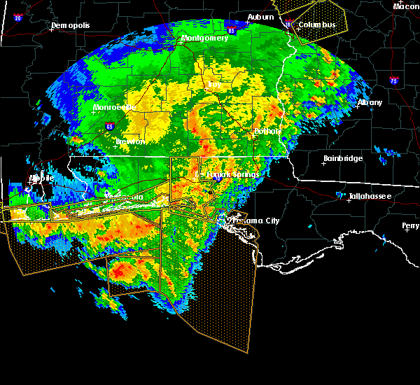 At 330 pm cst, a severe thunderstorm was located near crestview, moving east at 45 mph (radar indicated). Hazards include 60 mph wind gusts. expect damage to roofs, siding, and trees At 330 pm cst, a severe thunderstorm was located near crestview, moving east at 45 mph (radar indicated). Hazards include 60 mph wind gusts. expect damage to roofs, siding, and trees
|
| 1/22/2017 12:12 PM CST |
 At 1212 pm cst, a severe thunderstorm was located near santa rosa beach, moving northeast at 55 mph (radar indicated). Hazards include 60 mph wind gusts. expect damage to roofs, siding, and trees At 1212 pm cst, a severe thunderstorm was located near santa rosa beach, moving northeast at 55 mph (radar indicated). Hazards include 60 mph wind gusts. expect damage to roofs, siding, and trees
|
| 1/22/2017 12:00 PM CST | Multiple trees and power lines down in defuniak springs and freeport. time based on radar and operator log in walton county FL, 2 miles SE of De Funiak Springs, FL |
| 1/22/2017 11:23 AM CST |
 At 1123 am cst, severe thunderstorms were located along a line extending from near florala to wright, moving northeast at 55 mph (radar indicated). Hazards include 60 mph wind gusts and nickel size hail. expect damage to roofs, siding, and trees At 1123 am cst, severe thunderstorms were located along a line extending from near florala to wright, moving northeast at 55 mph (radar indicated). Hazards include 60 mph wind gusts and nickel size hail. expect damage to roofs, siding, and trees
|
| 1/22/2017 10:17 AM CST |
 At 1016 am cst, a severe thunderstorm was located near de funiak springs, moving northeast at 55 mph. quarter size hail has been reported in de funiak springs (radar indicated). Hazards include 60 mph wind gusts and quarter size hail. Hail damage to vehicles is expected. expect wind damage to roofs, siding, and trees. locations impacted include, geneva, de funiak springs, samson, eglin air force base, union, liberty, esto, black, somerset, barker store, baker settlement, hickory hill, pleasant hill, new hope, prosperity, sellersville, miller crossroads, arrant settlement, gaskin and pleasant ridge. A tornado watch remains in effect until 200 pm cst for southeastern alabama, and the panhandle of florida. At 1016 am cst, a severe thunderstorm was located near de funiak springs, moving northeast at 55 mph. quarter size hail has been reported in de funiak springs (radar indicated). Hazards include 60 mph wind gusts and quarter size hail. Hail damage to vehicles is expected. expect wind damage to roofs, siding, and trees. locations impacted include, geneva, de funiak springs, samson, eglin air force base, union, liberty, esto, black, somerset, barker store, baker settlement, hickory hill, pleasant hill, new hope, prosperity, sellersville, miller crossroads, arrant settlement, gaskin and pleasant ridge. A tornado watch remains in effect until 200 pm cst for southeastern alabama, and the panhandle of florida.
|
| 1/22/2017 10:10 AM CST | Quarter sized hail reported 0.5 miles SSW of De Funiak Springs, FL, photo received via email. |
| 1/22/2017 9:57 AM CST |
 At 957 am cst, a severe thunderstorm was located near eglin air force base, or 10 miles northeast of niceville, moving northeast at 55 mph (radar indicated). Hazards include 60 mph wind gusts and quarter size hail. Hail damage to vehicles is expected. Expect wind damage to roofs, siding, and trees. At 957 am cst, a severe thunderstorm was located near eglin air force base, or 10 miles northeast of niceville, moving northeast at 55 mph (radar indicated). Hazards include 60 mph wind gusts and quarter size hail. Hail damage to vehicles is expected. Expect wind damage to roofs, siding, and trees.
|
| 1/22/2017 9:37 AM CST |
 At 937 am cst, a severe thunderstorm was located over eglin afb, moving northeast at 65 mph (radar indicated). Hazards include 60 mph wind gusts and quarter size hail. Hail damage to vehicles is expected. Expect wind damage to roofs, siding, and trees. At 937 am cst, a severe thunderstorm was located over eglin afb, moving northeast at 65 mph (radar indicated). Hazards include 60 mph wind gusts and quarter size hail. Hail damage to vehicles is expected. Expect wind damage to roofs, siding, and trees.
|
| 1/22/2017 8:43 AM CST |
 The severe thunderstorm warning for holmes. walton. west central jackson and northern washington counties will expire at 845 am cst. the storm which prompted the warning has weakened below severe limits, and no longer pose an immediate threat to life or property. therefore the warning will be allowed to expire. A tornado watch remains in effect until 200 pm cst for the panhandle. The severe thunderstorm warning for holmes. walton. west central jackson and northern washington counties will expire at 845 am cst. the storm which prompted the warning has weakened below severe limits, and no longer pose an immediate threat to life or property. therefore the warning will be allowed to expire. A tornado watch remains in effect until 200 pm cst for the panhandle.
|
| 1/22/2017 8:07 AM CST |
 At 806 am cst, a severe thunderstorm was located 12 miles northeast of santa rosa beach, moving northeast at 55 mph (radar indicated). Hazards include 60 mph wind gusts and nickel size hail. expect damage to roofs, siding, and trees At 806 am cst, a severe thunderstorm was located 12 miles northeast of santa rosa beach, moving northeast at 55 mph (radar indicated). Hazards include 60 mph wind gusts and nickel size hail. expect damage to roofs, siding, and trees
|
| 1/22/2017 7:59 AM CST |
 At 759 am cst, doppler radar indicated a severe thunderstorm capable of producing damaging winds in excess of 60 mph. this storm was located near santa rosa beach, and moving northeast at 55 mph. nickel size hail may also accompany the damaging winds. At 759 am cst, doppler radar indicated a severe thunderstorm capable of producing damaging winds in excess of 60 mph. this storm was located near santa rosa beach, and moving northeast at 55 mph. nickel size hail may also accompany the damaging winds.
|
| 1/21/2017 10:31 AM CST | Tree down on powerline on spring lake r in walton county FL, 4.1 miles WSW of De Funiak Springs, FL |
| 1/21/2017 10:00 AM CST |
 At 959 am cst, severe thunderstorms were located along a line extending from near hartford to 7 miles west of santa rosa beach, moving east at 50 mph (radar indicated). Hazards include 60 mph wind gusts. expect damage to roofs, siding, and trees At 959 am cst, severe thunderstorms were located along a line extending from near hartford to 7 miles west of santa rosa beach, moving east at 50 mph (radar indicated). Hazards include 60 mph wind gusts. expect damage to roofs, siding, and trees
|
| 1/21/2017 9:19 AM CST |
 At 918 am cst, severe thunderstorms were located along a line extending from 7 miles south of opp to 7 miles southwest of laurel hill, moving east at 55 mph (radar indicated). Hazards include 60 mph wind gusts. expect damage to roofs, siding, and trees At 918 am cst, severe thunderstorms were located along a line extending from 7 miles south of opp to 7 miles southwest of laurel hill, moving east at 55 mph (radar indicated). Hazards include 60 mph wind gusts. expect damage to roofs, siding, and trees
|
| 1/2/2017 6:25 PM CST |
 At 624 pm cst, severe thunderstorms were located along a line extending from near heath to near crestview to navarre beach, moving southeast at 50 mph (radar indicated). Hazards include 70 mph wind gusts. Expect considerable tree damage. Damage is likely to mobile homes, roofs, and outbuildings. At 624 pm cst, severe thunderstorms were located along a line extending from near heath to near crestview to navarre beach, moving southeast at 50 mph (radar indicated). Hazards include 70 mph wind gusts. Expect considerable tree damage. Damage is likely to mobile homes, roofs, and outbuildings.
|
| 1/1/2017 5:54 AM CST |
 At 554 am cst, a severe thunderstorm was located over de funiak springs, moving east at 35 mph (radar indicated). Hazards include 60 mph wind gusts. Expect damage to roofs, siding, and trees. Locations impacted include, de funiak springs, union, ponce de leon, douglass crossroad, pleasant hill, pleasant ridge, piney grove, knox hill, center ridge, de funiak spring airport, eucheeanna and argyle. At 554 am cst, a severe thunderstorm was located over de funiak springs, moving east at 35 mph (radar indicated). Hazards include 60 mph wind gusts. Expect damage to roofs, siding, and trees. Locations impacted include, de funiak springs, union, ponce de leon, douglass crossroad, pleasant hill, pleasant ridge, piney grove, knox hill, center ridge, de funiak spring airport, eucheeanna and argyle.
|
| 1/1/2017 5:42 AM CST |
 At 542 am cst, a severe thunderstorm was located near de funiak springs, moving east at 35 mph (radar indicated). Hazards include 60 mph wind gusts. Expect damage to roofs, siding, and trees. Locations impacted include, de funiak springs, eglin air force base, union, ponce de leon, pleasant hill, piney grove, knox hill, alpine heights, douglass crossroad, oakwood hills, pleasant ridge, center ridge, de funiak spring airport, eucheeanna and argyle. At 542 am cst, a severe thunderstorm was located near de funiak springs, moving east at 35 mph (radar indicated). Hazards include 60 mph wind gusts. Expect damage to roofs, siding, and trees. Locations impacted include, de funiak springs, eglin air force base, union, ponce de leon, pleasant hill, piney grove, knox hill, alpine heights, douglass crossroad, oakwood hills, pleasant ridge, center ridge, de funiak spring airport, eucheeanna and argyle.
|
| 1/1/2017 5:29 AM CST |
 At 529 am cst, a severe thunderstorm was located near eglin air force base, or 12 miles west of de funiak springs, moving east at 35 mph (radar indicated). Hazards include 60 mph wind gusts. expect damage to roofs, siding, and trees At 529 am cst, a severe thunderstorm was located near eglin air force base, or 12 miles west of de funiak springs, moving east at 35 mph (radar indicated). Hazards include 60 mph wind gusts. expect damage to roofs, siding, and trees
|
| 9/12/2016 3:26 PM CDT |
 The severe thunderstorm warning for southwestern holmes and northern walton counties will expire at 330 pm cdt, the storm which prompted the warning has weakened below severe limits, and no longer pose an immediate threat to life or property. therefore, the warning will be allowed to expire. however gusty winds are still possible with this thunderstorm. The severe thunderstorm warning for southwestern holmes and northern walton counties will expire at 330 pm cdt, the storm which prompted the warning has weakened below severe limits, and no longer pose an immediate threat to life or property. therefore, the warning will be allowed to expire. however gusty winds are still possible with this thunderstorm.
|
| 9/12/2016 2:48 PM CDT |
 At 248 pm cdt, a severe thunderstorm was located near de funiak springs, moving northwest at 25 mph (radar indicated). Hazards include 60 mph wind gusts. Expect damage to roofs. siding. And trees. At 248 pm cdt, a severe thunderstorm was located near de funiak springs, moving northwest at 25 mph (radar indicated). Hazards include 60 mph wind gusts. Expect damage to roofs. siding. And trees.
|
| 8/6/2016 7:36 PM CDT |
 The severe thunderstorm warning for south central walton county will expire at 745 pm cdt, the storm which prompted the warning has weakened below severe limits. therefore, the warning will be allowed to expire. The severe thunderstorm warning for south central walton county will expire at 745 pm cdt, the storm which prompted the warning has weakened below severe limits. therefore, the warning will be allowed to expire.
|
| 8/6/2016 7:01 PM CDT |
 At 701 pm cdt, a severe thunderstorm was located 9 miles east of eglin air force base, or 12 miles south of de funiak springs, moving south at 10 mph (radar indicated). Hazards include 60 mph wind gusts. Expect damage to roofs. siding. And trees. At 701 pm cdt, a severe thunderstorm was located 9 miles east of eglin air force base, or 12 miles south of de funiak springs, moving south at 10 mph (radar indicated). Hazards include 60 mph wind gusts. Expect damage to roofs. siding. And trees.
|
| 8/1/2016 12:26 PM CDT |
 At 1225 pm cdt, a severe thunderstorm was located 9 miles east of de funiak springs, moving north at 10 mph (radar indicated). Hazards include 60 mph wind gusts and penny size hail. Expect damage to roofs. siding. And trees. At 1225 pm cdt, a severe thunderstorm was located 9 miles east of de funiak springs, moving north at 10 mph (radar indicated). Hazards include 60 mph wind gusts and penny size hail. Expect damage to roofs. siding. And trees.
|
| 6/26/2016 5:43 PM CDT | Storm damage reported in walton county FL, 6.1 miles NW of De Funiak Springs, FL |
| 6/26/2016 5:38 PM CDT |
 At 538 pm cdt, a severe thunderstorm was located near de funiak springs, moving southwest at 15 mph (radar indicated). Hazards include 60 mph wind gusts and quarter size hail. Hail damage to vehicles is expected. Expect wind damage to roofs, siding, and trees. At 538 pm cdt, a severe thunderstorm was located near de funiak springs, moving southwest at 15 mph (radar indicated). Hazards include 60 mph wind gusts and quarter size hail. Hail damage to vehicles is expected. Expect wind damage to roofs, siding, and trees.
|
| 6/17/2016 7:56 PM CDT |
 At 855 pm edt/755 pm cdt/, severe thunderstorms were located along a line extending from near graceville to 10 miles northwest of vernon to 7 miles east of postil, moving southeast at 45 mph (radar indicated). Hazards include 60 mph wind gusts and nickel size hail. Expect damage to roofs. siding. And trees. At 855 pm edt/755 pm cdt/, severe thunderstorms were located along a line extending from near graceville to 10 miles northwest of vernon to 7 miles east of postil, moving southeast at 45 mph (radar indicated). Hazards include 60 mph wind gusts and nickel size hail. Expect damage to roofs. siding. And trees.
|
| 6/17/2016 7:40 PM CDT | Trees down near walton springs road in walton county FL, 3 miles SSE of De Funiak Springs, FL |
| 6/17/2016 6:51 PM CDT |
 At 650 pm cdt, severe thunderstorms were located along a line extending from 10 miles east of opp to 8 miles north of baker, moving southeast at 45 mph (radar indicated). Hazards include 60 mph wind gusts and quarter size hail. Hail damage to vehicles is expected. Expect wind damage to roofs, siding, and trees. At 650 pm cdt, severe thunderstorms were located along a line extending from 10 miles east of opp to 8 miles north of baker, moving southeast at 45 mph (radar indicated). Hazards include 60 mph wind gusts and quarter size hail. Hail damage to vehicles is expected. Expect wind damage to roofs, siding, and trees.
|
| 3/24/2016 3:47 PM CDT |
 At 347 pm cdt, a severe thunderstorm was located 7 miles east of postil, or 7 miles east of niceville, moving east at 55 mph (radar indicated). Hazards include 60 mph wind gusts. Expect damage to roofs. siding. And trees. At 347 pm cdt, a severe thunderstorm was located 7 miles east of postil, or 7 miles east of niceville, moving east at 55 mph (radar indicated). Hazards include 60 mph wind gusts. Expect damage to roofs. siding. And trees.
|
| 3/17/2016 10:48 PM CDT |
 At 1048 pm cdt, severe thunderstorms were located along a line extending from 12 miles southwest of geneva to 6 miles northwest of santa rosa beach, moving east at 35 mph (radar indicated). Hazards include 60 mph wind gusts. Expect damage to roofs. siding. and trees. Locations impacted include, de funiak springs, santa rosa beach, eglin air force base, union, freeport, ponce de leon, caryville, westville, gulf pines, barker store, villa tasso, baker settlement, seagrove beach, hickory hill, pleasant hill, turquoise beach, prosperity, gritney, blue mountain beach and knox hill. At 1048 pm cdt, severe thunderstorms were located along a line extending from 12 miles southwest of geneva to 6 miles northwest of santa rosa beach, moving east at 35 mph (radar indicated). Hazards include 60 mph wind gusts. Expect damage to roofs. siding. and trees. Locations impacted include, de funiak springs, santa rosa beach, eglin air force base, union, freeport, ponce de leon, caryville, westville, gulf pines, barker store, villa tasso, baker settlement, seagrove beach, hickory hill, pleasant hill, turquoise beach, prosperity, gritney, blue mountain beach and knox hill.
|
| 3/17/2016 10:45 PM CDT | Tree down on sherwood road in walton county FL, 6.1 miles NNW of De Funiak Springs, FL |
| 3/17/2016 10:25 PM CDT |
 At 1024 pm cdt, severe thunderstorms were located along a line extending from 10 miles north of de funiak springs to near eglin afb, moving east at 35 mph (radar indicated). Hazards include 60 mph wind gusts. Expect damage to roofs. siding. And trees. At 1024 pm cdt, severe thunderstorms were located along a line extending from 10 miles north of de funiak springs to near eglin afb, moving east at 35 mph (radar indicated). Hazards include 60 mph wind gusts. Expect damage to roofs. siding. And trees.
|
| 3/3/2016 8:00 PM CST |
 At 800 pm cst, a severe thunderstorm was located near bonifay, moving east at 65 mph (radar indicated). Hazards include 60 mph wind gusts. Expect damage to roofs. siding. And trees. At 800 pm cst, a severe thunderstorm was located near bonifay, moving east at 65 mph (radar indicated). Hazards include 60 mph wind gusts. Expect damage to roofs. siding. And trees.
|
| 3/3/2016 7:50 PM CST |
 At 750 pm cst, severe thunderstorms were located along a line extending from 8 miles south of geneva to near eglin air force base, moving east at 45 mph (radar indicated). Hazards include 60 mph wind gusts. Expect damage to roofs. siding. and trees. Locations impacted include, de funiak springs, eglin air force base, union, liberty, ponce de leon, westville, barker store, baker settlement, hickory hill, pleasant hill, piney grove, new hope, prosperity, gritney, knox hill, pond creek, arrant settlement, douglass crossroad, oakwood hills and pleasant ridge. At 750 pm cst, severe thunderstorms were located along a line extending from 8 miles south of geneva to near eglin air force base, moving east at 45 mph (radar indicated). Hazards include 60 mph wind gusts. Expect damage to roofs. siding. and trees. Locations impacted include, de funiak springs, eglin air force base, union, liberty, ponce de leon, westville, barker store, baker settlement, hickory hill, pleasant hill, piney grove, new hope, prosperity, gritney, knox hill, pond creek, arrant settlement, douglass crossroad, oakwood hills and pleasant ridge.
|
| 3/3/2016 7:40 PM CST |
 At 740 pm cst, severe thunderstorms were located along a line extending from 7 miles southwest of geneva to 8 miles northwest of eglin air force base, moving east at 50 mph (radar indicated). Hazards include 60 mph wind gusts. Expect damage to roofs. siding. and trees. Locations impacted include, de funiak springs, eglin air force base, union, liberty, ponce de leon, westville, royals crossroads, barker store, baker settlement, hickory hill, pleasant hill, piney grove, new hope, prosperity, gritney, knox hill, pond creek, arrant settlement, douglass crossroad and gaskin. At 740 pm cst, severe thunderstorms were located along a line extending from 7 miles southwest of geneva to 8 miles northwest of eglin air force base, moving east at 50 mph (radar indicated). Hazards include 60 mph wind gusts. Expect damage to roofs. siding. and trees. Locations impacted include, de funiak springs, eglin air force base, union, liberty, ponce de leon, westville, royals crossroads, barker store, baker settlement, hickory hill, pleasant hill, piney grove, new hope, prosperity, gritney, knox hill, pond creek, arrant settlement, douglass crossroad and gaskin.
|
| 3/3/2016 7:13 PM CST |
 At 713 pm cst, a severe thunderstorm was located 7 miles northeast of crestview, moving east at 50 mph (radar indicated). Hazards include 60 mph wind gusts. Expect damage to roofs. siding. And trees. At 713 pm cst, a severe thunderstorm was located 7 miles northeast of crestview, moving east at 50 mph (radar indicated). Hazards include 60 mph wind gusts. Expect damage to roofs. siding. And trees.
|
| 2/23/2016 10:52 PM CST |
 At 1052 pm cst, severe thunderstorms were located along a line extending from 7 miles south of hartford to 11 miles south of santa rosa beach, moving east at 20 mph (radar indicated). Hazards include 60 mph wind gusts. Expect damage to roofs. Siding and trees. At 1052 pm cst, severe thunderstorms were located along a line extending from 7 miles south of hartford to 11 miles south of santa rosa beach, moving east at 20 mph (radar indicated). Hazards include 60 mph wind gusts. Expect damage to roofs. Siding and trees.
|
| 2/23/2016 10:50 PM CST |
 At 1050 pm cst, severe thunderstorms were located along a line extending from 9 miles south of hartford to near santa rosa beach, moving east at 15 mph (radar indicated). Hazards include 60 mph wind gusts. Expect damage to roofs. siding and trees. locations impacted include, bonifay, de funiak springs, eglin air force base, santa rosa beach, union, live oak, freeport, ponce de leon, caryville, esto, westville, ebro, noma, gulf pines, barker store, baker settlement, hickory hill, pleasant hill, new hope and prosperity. A tornado watch remains in effect until 300 am cst for northwest florida. At 1050 pm cst, severe thunderstorms were located along a line extending from 9 miles south of hartford to near santa rosa beach, moving east at 15 mph (radar indicated). Hazards include 60 mph wind gusts. Expect damage to roofs. siding and trees. locations impacted include, bonifay, de funiak springs, eglin air force base, santa rosa beach, union, live oak, freeport, ponce de leon, caryville, esto, westville, ebro, noma, gulf pines, barker store, baker settlement, hickory hill, pleasant hill, new hope and prosperity. A tornado watch remains in effect until 300 am cst for northwest florida.
|
| 2/23/2016 10:35 PM CST | Peak gust to 54 knots or 62 mp in walton county FL, 2 miles SE of De Funiak Springs, FL |
| 2/23/2016 10:30 PM CST | Couple reports of trees down in the defuniak springs are in walton county FL, 0.5 miles SSW of De Funiak Springs, FL |
| 2/23/2016 10:17 PM CST |
 At 1016 pm cst, severe thunderstorms were located along a line extending from near geneva to 7 miles southeast of destin, moving east at 40 mph (radar indicated). Hazards include 60 mph wind gusts and penny size hail. Expect damage to roofs. siding and trees. locations impacted include, bonifay, de funiak springs, graceville, eglin air force base, santa rosa beach, union, liberty, live oak, freeport, ponce de leon, caryville, esto, westville, ebro, noma, gulf pines, barker store, baker settlement, hickory hill and pleasant hill. A tornado watch remains in effect until 300 am cst for northwest florida. At 1016 pm cst, severe thunderstorms were located along a line extending from near geneva to 7 miles southeast of destin, moving east at 40 mph (radar indicated). Hazards include 60 mph wind gusts and penny size hail. Expect damage to roofs. siding and trees. locations impacted include, bonifay, de funiak springs, graceville, eglin air force base, santa rosa beach, union, liberty, live oak, freeport, ponce de leon, caryville, esto, westville, ebro, noma, gulf pines, barker store, baker settlement, hickory hill and pleasant hill. A tornado watch remains in effect until 300 am cst for northwest florida.
|
| 2/23/2016 10:00 PM CST |
 At 1000 pm cst, severe thunderstorms were located along a line extending from 10 miles south of samson to 8 miles south of fort walton beach, moving east at 40 mph (radar indicated). Hazards include 60 mph wind gusts and penny size hail. Expect damage to roofs. Siding and trees. At 1000 pm cst, severe thunderstorms were located along a line extending from 10 miles south of samson to 8 miles south of fort walton beach, moving east at 40 mph (radar indicated). Hazards include 60 mph wind gusts and penny size hail. Expect damage to roofs. Siding and trees.
|
| 2/23/2016 9:15 PM CST | Power lines down near highway 331 and county road 1084 in walton county FL, 9.3 miles SE of De Funiak Springs, FL |
| 2/23/2016 9:09 PM CST |
 At 909 pm cst, the national weather service has detected a line of severe thunderstorms capable of producing damaging winds in excess of 60 mph. these storms were located along a line extending from near florala to 12 miles east of de funiak springs, and moving northeast at 35 mph. additional storms in the area may also produce strong winds. At 909 pm cst, the national weather service has detected a line of severe thunderstorms capable of producing damaging winds in excess of 60 mph. these storms were located along a line extending from near florala to 12 miles east of de funiak springs, and moving northeast at 35 mph. additional storms in the area may also produce strong winds.
|
| 2/23/2016 8:57 PM CST |
 At 856 pm cst, numerous strong to severe thunderstorms were located across northern walton county, moving northeast at 35 mph (radar indicated). Hazards include 60 mph wind gusts. Expect damage to roofs. siding and trees. locations impacted include, de funiak springs, eglin air force base, union, liberty, paxton, ponce de leon, caryville, westville, royals crossroads, barker store, baker settlement, hickory hill, pleasant hill, piney grove, prosperity, gritney, knox hill, pond creek, lakewood and arrant settlement. A tornado watch remains in effect until 300 am cst for southeastern alabama and central florida. At 856 pm cst, numerous strong to severe thunderstorms were located across northern walton county, moving northeast at 35 mph (radar indicated). Hazards include 60 mph wind gusts. Expect damage to roofs. siding and trees. locations impacted include, de funiak springs, eglin air force base, union, liberty, paxton, ponce de leon, caryville, westville, royals crossroads, barker store, baker settlement, hickory hill, pleasant hill, piney grove, prosperity, gritney, knox hill, pond creek, lakewood and arrant settlement. A tornado watch remains in effect until 300 am cst for southeastern alabama and central florida.
|
| 2/23/2016 8:32 PM CST |
 At 832 pm cst, severe thunderstorms were located along a line extending from 6 miles southeast of laurel hill to 13 miles south of de funiak springs, moving northeast at 65 mph (radar indicated). Hazards include 60 mph wind gusts and penny size hail. Expect damage to roofs. Siding and trees. At 832 pm cst, severe thunderstorms were located along a line extending from 6 miles southeast of laurel hill to 13 miles south of de funiak springs, moving northeast at 65 mph (radar indicated). Hazards include 60 mph wind gusts and penny size hail. Expect damage to roofs. Siding and trees.
|
| 2/15/2016 7:03 PM CST |
 At 702 pm cst, severe thunderstorms were located along a line extending from near abbeville to santa rosa beach, moving east at 50 mph (radar indicated). Hazards include 60 mph wind gusts. Expect damage to roofs. siding and trees. locations impacted include, panama city beach, daleville, abbeville, cottonwood, vernon, de funiak springs, ozark, bonifay, headland, chipley, geneva, graceville, dothan, fort rucker, hartford, taylor, midland city, kinsey, ashford and slocomb. A tornado watch remains in effect until 900 pm cst for southeastern alabama and central florida. At 702 pm cst, severe thunderstorms were located along a line extending from near abbeville to santa rosa beach, moving east at 50 mph (radar indicated). Hazards include 60 mph wind gusts. Expect damage to roofs. siding and trees. locations impacted include, panama city beach, daleville, abbeville, cottonwood, vernon, de funiak springs, ozark, bonifay, headland, chipley, geneva, graceville, dothan, fort rucker, hartford, taylor, midland city, kinsey, ashford and slocomb. A tornado watch remains in effect until 900 pm cst for southeastern alabama and central florida.
|
| 2/15/2016 6:50 PM CST | Tree down on county road 185 near bartlett road in walton county FL, 8.8 miles S of De Funiak Springs, FL |
| 2/15/2016 6:50 PM CST |
 At 650 pm cst, severe thunderstorms were located along a line extending from 6 miles northeast of newton to near eglin air force base, moving east at 60 mph (radar indicated). Hazards include 60 mph wind gusts. Expect damage to roofs. siding and trees. locations impacted include, geneva, de funiak springs, enterprise, samson, eglin air force base, union, liberty, coffee springs, somerset, royals crossroads, villa tasso, pleasant hill, piney grove, lytle, battens crossroads, central city, sellersville, marl, gaskin and oakwood hills. A tornado watch remains in effect until 900 pm cst for southeastern alabama and central florida. At 650 pm cst, severe thunderstorms were located along a line extending from 6 miles northeast of newton to near eglin air force base, moving east at 60 mph (radar indicated). Hazards include 60 mph wind gusts. Expect damage to roofs. siding and trees. locations impacted include, geneva, de funiak springs, enterprise, samson, eglin air force base, union, liberty, coffee springs, somerset, royals crossroads, villa tasso, pleasant hill, piney grove, lytle, battens crossroads, central city, sellersville, marl, gaskin and oakwood hills. A tornado watch remains in effect until 900 pm cst for southeastern alabama and central florida.
|
| 2/15/2016 6:45 PM CST |
 At 645 pm cst, the national weather service has detected a line of severe thunderstorms capable of producing damaging winds in excess of 60 mph. these storms were located along a line extending from near blue springs state park to near destin, and moving east at 50 mph. At 645 pm cst, the national weather service has detected a line of severe thunderstorms capable of producing damaging winds in excess of 60 mph. these storms were located along a line extending from near blue springs state park to near destin, and moving east at 50 mph.
|
| 2/15/2016 6:19 PM CST |
 At 618 pm cst, severe thunderstorms were located along a line extending from 9 miles southwest of new brockton to near fort walton beach--navarre--wright, moving east at 60 mph (radar indicated). Hazards include 60 mph wind gusts. Expect damage to roofs. Siding and trees. At 618 pm cst, severe thunderstorms were located along a line extending from 9 miles southwest of new brockton to near fort walton beach--navarre--wright, moving east at 60 mph (radar indicated). Hazards include 60 mph wind gusts. Expect damage to roofs. Siding and trees.
|
| 1/22/2016 2:09 AM CST | At 209 am cst, severe thunderstorms were located along a line extending from near geneva to 7 miles east of destin, moving northeast at 30 mph (radar indicated). Hazards include 60 mph wind gusts. Expect damage to roofs. siding and trees. locations impacted include, panama city beach, vernon, bonifay, de funiak springs, eglin air force base, santa rosa beach, union, liberty, live oak, freeport, ponce de leon, caryville, esto, westville, ebro, noma, gulf pines, barker store, seminole hills and baker settlement. A tornado watch remains in effect until 500 am cst for central florida. |
| 1/22/2016 1:45 AM CST | At 145 am cst, a severe thunderstorm capable of producing a tornado was located near de funiak springs, moving northeast at 55 mph (radar indicated rotation). Hazards include tornado. Flying debris will be dangerous to those caught without shelter. mobile homes will be damaged or destroyed. damage to roofs, windows and vehicles will occur. tree damage is likely. This tornadic thunderstorm will remain over mainly rural areas of holmes and north central walton counties, including the following locations, royals crossroads, barker store, baker settlement, hickory hill, pleasant hill, piney grove, new hope, prosperity, gritney and miller crossroads. |
| 1/22/2016 1:27 AM CST | At 127 am cst, severe thunderstorms were located along a line extending from florala to 10 miles southeast of destin, moving northeast at 60 mph (radar indicated). Hazards include 60 mph wind gusts. Expect damage to roofs. siding and trees. locations impacted include, panama city beach, vernon, de funiak springs, bonifay, eglin air force base, santa rosa beach, union, liberty, live oak, freeport, paxton, ponce de leon, caryville, esto, westville, ebro, noma, seminole hills, laird and hickory hill. A tornado watch remains in effect until 500 am cst for northwest florida. |
| 1/22/2016 12:57 AM CST | At 1256 am cst, severe thunderstorms were located along a line extending from near baker to 23 miles south of navarre beach, moving northeast at 60 mph. these storms have a history of producing measured wind gusts over 60 mph (radar indicated). Hazards include 60 mph wind gusts. Expect damage to roofs. Siding and trees. |
| 1/21/2016 7:56 PM CST | At 755 pm cst, a severe thunderstorm was located near de funiak springs, moving northeast at 25 mph (radar indicated). Hazards include 60 mph wind gusts. Possible damage to roofs. Siding and trees. |
| 12/28/2015 2:45 PM CST | Large tree limb down on laird road in walton county FL, 6 miles S of De Funiak Springs, FL |
| 12/28/2015 2:34 PM CST |
 At 233 pm cst, severe thunderstorms were located along a line extending from 7 miles northwest of samson to 6 miles south of eglin air force base, moving east at 20 mph (radar indicated). Hazards include 60 mph wind gusts. Expect damage to roofs. siding and trees. locations impacted include, geneva, de funiak springs, samson, eglin air force base, union, liberty, freeport, ponce de leon, coffee springs, somerset, barker store, baker settlement, hickory hill, pleasant hill, new hope, prosperity, knox hill, sellersville, arrant settlement and douglass crossroad. A tornado watch remains in effect until 600 pm cst for southeastern alabama and northwest florida. At 233 pm cst, severe thunderstorms were located along a line extending from 7 miles northwest of samson to 6 miles south of eglin air force base, moving east at 20 mph (radar indicated). Hazards include 60 mph wind gusts. Expect damage to roofs. siding and trees. locations impacted include, geneva, de funiak springs, samson, eglin air force base, union, liberty, freeport, ponce de leon, coffee springs, somerset, barker store, baker settlement, hickory hill, pleasant hill, new hope, prosperity, knox hill, sellersville, arrant settlement and douglass crossroad. A tornado watch remains in effect until 600 pm cst for southeastern alabama and northwest florida.
|
| 12/28/2015 2:20 PM CST |
 At 220 pm cst, severe thunderstorms were located along a line extending from near onycha to 6 miles east of postil, moving east at 25 mph (radar indicated). Hazards include 60 mph wind gusts. Expect damage to roofs. siding and trees. locations impacted include, geneva, de funiak springs, samson, eglin air force base, union, liberty, freeport, paxton, ponce de leon, coffee springs, somerset, barker store, baker settlement, hickory hill, pleasant hill, new hope, prosperity, knox hill, sellersville and arrant settlement. A tornado watch remains in effect until 600 pm cst for southeastern alabama and northwest florida. At 220 pm cst, severe thunderstorms were located along a line extending from near onycha to 6 miles east of postil, moving east at 25 mph (radar indicated). Hazards include 60 mph wind gusts. Expect damage to roofs. siding and trees. locations impacted include, geneva, de funiak springs, samson, eglin air force base, union, liberty, freeport, paxton, ponce de leon, coffee springs, somerset, barker store, baker settlement, hickory hill, pleasant hill, new hope, prosperity, knox hill, sellersville and arrant settlement. A tornado watch remains in effect until 600 pm cst for southeastern alabama and northwest florida.
|
| 12/28/2015 1:40 PM CST |
 At 140 pm cst, severe thunderstorms were located along a line extending from 7 miles south of libertyville to fort walton beach, moving northeast at 20 mph (radar indicated). Hazards include 60 mph wind gusts. Expect damage to roofs. Siding and trees. At 140 pm cst, severe thunderstorms were located along a line extending from 7 miles south of libertyville to fort walton beach, moving northeast at 20 mph (radar indicated). Hazards include 60 mph wind gusts. Expect damage to roofs. Siding and trees.
|
| 12/22/2015 2:10 AM CST |
 The severe thunderstorm warning for northwestern bay, western washington, walton and southwestern holmes counties will expire at 215 am cst, the storm which prompted the warning has weakened below severe limits, and no longer pose an immediate threat to life or property. therefore the warning will be allowed to expire. to report severe weather, contact your nearest law enforcement agency. they will relay your report to the national weather service tallahassee. The severe thunderstorm warning for northwestern bay, western washington, walton and southwestern holmes counties will expire at 215 am cst, the storm which prompted the warning has weakened below severe limits, and no longer pose an immediate threat to life or property. therefore the warning will be allowed to expire. to report severe weather, contact your nearest law enforcement agency. they will relay your report to the national weather service tallahassee.
|
| 12/22/2015 1:34 AM CST |
 At 134 am cst, a severe thunderstorm was located 11 miles southeast of eglin air force base, or 11 miles northeast of santa rosa beach, moving east at 50 mph (radar indicated). Hazards include 60 mph wind gusts. Expect damage to roofs. siding and trees. Locations impacted include, panama city beach, de funiak springs, eglin air force base, santa rosa beach, live oak, freeport, ponce de leon, caryville, westville, ebro, seminole hills, laird, seagrove beach, west bay, blue mountain beach, knox hill, grayton beach, douglass crossroad, hinsons crossroads and bruce. At 134 am cst, a severe thunderstorm was located 11 miles southeast of eglin air force base, or 11 miles northeast of santa rosa beach, moving east at 50 mph (radar indicated). Hazards include 60 mph wind gusts. Expect damage to roofs. siding and trees. Locations impacted include, panama city beach, de funiak springs, eglin air force base, santa rosa beach, live oak, freeport, ponce de leon, caryville, westville, ebro, seminole hills, laird, seagrove beach, west bay, blue mountain beach, knox hill, grayton beach, douglass crossroad, hinsons crossroads and bruce.
|
| 12/22/2015 1:21 AM CST |
 At 121 am cst, a severe thunderstorm was located near eglin air force base, or 12 miles north of santa rosa beach, moving east at 50 mph (radar indicated). Hazards include 60 mph wind gusts. Expect damage to roofs. siding and trees. Locations impacted include, panama city beach, de funiak springs, eglin air force base, santa rosa beach, live oak, freeport, ponce de leon, caryville, westville, ebro, gulf pines, seminole hills, laird, turquoise beach, blue mountain beach, knox hill, grayton beach, douglass crossroad, hinsons crossroads and pleasant ridge. At 121 am cst, a severe thunderstorm was located near eglin air force base, or 12 miles north of santa rosa beach, moving east at 50 mph (radar indicated). Hazards include 60 mph wind gusts. Expect damage to roofs. siding and trees. Locations impacted include, panama city beach, de funiak springs, eglin air force base, santa rosa beach, live oak, freeport, ponce de leon, caryville, westville, ebro, gulf pines, seminole hills, laird, turquoise beach, blue mountain beach, knox hill, grayton beach, douglass crossroad, hinsons crossroads and pleasant ridge.
|
| 12/22/2015 12:57 AM CST |
 At 1257 am cst, a severe thunderstorm was located near eglin afb, moving northeast at 55 mph (radar indicated). Hazards include 60 mph wind gusts. Expect damage to roofs. Siding and trees. At 1257 am cst, a severe thunderstorm was located near eglin afb, moving northeast at 55 mph (radar indicated). Hazards include 60 mph wind gusts. Expect damage to roofs. Siding and trees.
|
| 8/7/2015 4:52 PM CDT |
 At 451 pm cdt, the national weather service has detected a severe thunderstorm capable of producing damaging winds in excess of 60 mph. this storm was located 12 miles northeast of de funiak springs, and moving southeast at 40 mph. At 451 pm cdt, the national weather service has detected a severe thunderstorm capable of producing damaging winds in excess of 60 mph. this storm was located 12 miles northeast of de funiak springs, and moving southeast at 40 mph.
|
| 8/7/2015 4:09 PM CDT |
 At 409 pm cdt, the national weather service has detected a severe thunderstorm capable of producing damaging winds in excess of 60 mph. this storm was located 7 miles northeast of florala, and moving southeast at 50 mph. At 409 pm cdt, the national weather service has detected a severe thunderstorm capable of producing damaging winds in excess of 60 mph. this storm was located 7 miles northeast of florala, and moving southeast at 50 mph.
|
| 7/29/2015 5:27 PM CDT |
 At 526 pm cdt, the national weather service has detected a line of severe thunderstorms capable of producing damaging winds in excess of 60 mph. these storms were located along a line extending from near de funiak springs to 11 miles southeast of vernon, and moving south at 5 mph. At 526 pm cdt, the national weather service has detected a line of severe thunderstorms capable of producing damaging winds in excess of 60 mph. these storms were located along a line extending from near de funiak springs to 11 miles southeast of vernon, and moving south at 5 mph.
|
| 7/23/2015 5:46 PM CDT |
 At 545 pm cdt, the national weather service has detected a severe thunderstorm capable of producing damaging winds in excess of 60 mph. this storm was located near eglin air force base, or 7 miles southwest of de funiak springs, and moving southeast at 15 mph. At 545 pm cdt, the national weather service has detected a severe thunderstorm capable of producing damaging winds in excess of 60 mph. this storm was located near eglin air force base, or 7 miles southwest of de funiak springs, and moving southeast at 15 mph.
|
| 7/23/2015 5:38 PM CDT |
 At 536 pm cdt, radar indicated quarter size hail and damaging winds in excess of 60 mph. this storm was located near de funiak springs, moving southeast at 20 mph. locations impacted include, de funiak springs, eglin air force base, union, liberty, ponce de leon, westville, hickory hill, pleasant hill, piney grove, knox hill, gritney, douglass crossroad, oakwood hills, pleasant ridge, center ridge, fox hill, argyle, cluster springs, cerrogordo and red bay. At 536 pm cdt, radar indicated quarter size hail and damaging winds in excess of 60 mph. this storm was located near de funiak springs, moving southeast at 20 mph. locations impacted include, de funiak springs, eglin air force base, union, liberty, ponce de leon, westville, hickory hill, pleasant hill, piney grove, knox hill, gritney, douglass crossroad, oakwood hills, pleasant ridge, center ridge, fox hill, argyle, cluster springs, cerrogordo and red bay.
|
| 7/23/2015 5:16 PM CDT |
 At 516 pm cdt, the national weather service has detected a severe thunderstorm capable of producing quarter size hail and damaging winds in excess of 60 mph. this storm was located near de funiak springs, and moving southeast at 20 mph. At 516 pm cdt, the national weather service has detected a severe thunderstorm capable of producing quarter size hail and damaging winds in excess of 60 mph. this storm was located near de funiak springs, and moving southeast at 20 mph.
|
| 7/21/2015 5:56 PM CDT |
 At 556 pm cdt, doppler radar indicated a line of severe thunderstorms capable of producing damaging winds in excess of 60 mph. these storms were located along a line extending from 6 miles northwest of eglin air force base to near chipley, moving southeast at 15 mph. trees have been reported down in walton county with these storms. locations impacted include, vernon, chipley, bonifay, de funiak springs, eglin air force base, bradford, ponce de leon, caryville, wausau, westville, knox hill, douglass crossroad, whitehead crossroads, hinsons crossroads, oakwood hills, pleasant ridge, orange hill, johnson crossroads, argyle and sunny hills. At 556 pm cdt, doppler radar indicated a line of severe thunderstorms capable of producing damaging winds in excess of 60 mph. these storms were located along a line extending from 6 miles northwest of eglin air force base to near chipley, moving southeast at 15 mph. trees have been reported down in walton county with these storms. locations impacted include, vernon, chipley, bonifay, de funiak springs, eglin air force base, bradford, ponce de leon, caryville, wausau, westville, knox hill, douglass crossroad, whitehead crossroads, hinsons crossroads, oakwood hills, pleasant ridge, orange hill, johnson crossroads, argyle and sunny hills.
|
| 7/21/2015 5:50 PM CDT | A few trees were downed along bob sikes roa in walton county FL, 5.8 miles E of De Funiak Springs, FL |
| 7/21/2015 5:20 PM CDT |
 At 520 pm cdt, the national weather service has detected a line of severe thunderstorms capable of producing damaging winds in excess of 60 mph. these storms were located along a line extending from 11 miles east of crestview to near chipley, and moving southeast at 20 mph. At 520 pm cdt, the national weather service has detected a line of severe thunderstorms capable of producing damaging winds in excess of 60 mph. these storms were located along a line extending from 11 miles east of crestview to near chipley, and moving southeast at 20 mph.
|
| 7/15/2015 9:11 PM CDT |
 At 911 pm cdt, the national weather service has detected a line of severe thunderstorms capable of producing damaging winds in excess of 60 mph. these storms were located along a line extending from 7 miles southwest of samson to near hartford, and moving south at 30 mph. At 911 pm cdt, the national weather service has detected a line of severe thunderstorms capable of producing damaging winds in excess of 60 mph. these storms were located along a line extending from 7 miles southwest of samson to near hartford, and moving south at 30 mph.
|
| 7/13/2015 4:10 PM CDT | Tree down along highway 83 in walton county FL, 2.6 miles SSW of De Funiak Springs, FL |
| 7/13/2015 3:57 PM CDT |
 At 357 pm cdt, doppler radar indicated a severe thunderstorm capable of producing damaging winds in excess of 60 mph. this storm was located near de funiak springs, moving east at 20 mph. locations impacted include, de funiak springs, eglin air force base, freeport, knox hill, red bay, alpine heights, new home, portland, douglass crossroad, rock hill, pleasant ridge, de funiak spring airport, eucheeanna and argyle. At 357 pm cdt, doppler radar indicated a severe thunderstorm capable of producing damaging winds in excess of 60 mph. this storm was located near de funiak springs, moving east at 20 mph. locations impacted include, de funiak springs, eglin air force base, freeport, knox hill, red bay, alpine heights, new home, portland, douglass crossroad, rock hill, pleasant ridge, de funiak spring airport, eucheeanna and argyle.
|
| 7/13/2015 3:29 PM CDT |
 At 329 pm cdt, the national weather service has detected a severe thunderstorm capable of producing damaging winds in excess of 60 mph. this storm was located over eglin air force base, or 10 miles southwest of de funiak springs, and moving east at 30 mph. At 329 pm cdt, the national weather service has detected a severe thunderstorm capable of producing damaging winds in excess of 60 mph. this storm was located over eglin air force base, or 10 miles southwest of de funiak springs, and moving east at 30 mph.
|
| 7/5/2015 9:49 AM CDT |
 At 949 am cdt, doppler radar indicated a severe thunderstorm capable of producing damaging winds in excess of 60 mph. this storm was located 11 miles south of de funiak springs, moving east at 40 mph. locations impacted include, panama city beach, bonifay, de funiak springs, santa rosa beach, eglin air force base, union, live oak, freeport, ponce de leon, caryville, westville, ebro, gulf pines, seminole hills, laird, hickory hill, pleasant hill, turquoise beach, knox hill and gritney. At 949 am cdt, doppler radar indicated a severe thunderstorm capable of producing damaging winds in excess of 60 mph. this storm was located 11 miles south of de funiak springs, moving east at 40 mph. locations impacted include, panama city beach, bonifay, de funiak springs, santa rosa beach, eglin air force base, union, live oak, freeport, ponce de leon, caryville, westville, ebro, gulf pines, seminole hills, laird, hickory hill, pleasant hill, turquoise beach, knox hill and gritney.
|
| 7/5/2015 9:22 AM CDT |
 At 922 am cdt, the national weather service has detected a severe thunderstorm capable of producing damaging winds in excess of 60 mph. this storm was located near eglin air force base, or 11 miles northeast of niceville, and moving east at 40 mph. At 922 am cdt, the national weather service has detected a severe thunderstorm capable of producing damaging winds in excess of 60 mph. this storm was located near eglin air force base, or 11 miles northeast of niceville, and moving east at 40 mph.
|
| 6/30/2015 3:19 PM CDT |
 At 319 pm cdt, emergency management reported a severe thunderstorm producing damaging winds in excess of 60 mph. this storm was located near graceville. this storm was nearly stationary. locations impacted include, vernon, bonifay, eglin air force base, live oak, ponce de leon, caryville, westville, hulaw, knox hill, red bay, new home, douglass crossroad, poplar head, rock hill, whitehead crossroads, hinsons crossroads, five points, millers ferry, johnson crossroads and eucheeanna. At 319 pm cdt, emergency management reported a severe thunderstorm producing damaging winds in excess of 60 mph. this storm was located near graceville. this storm was nearly stationary. locations impacted include, vernon, bonifay, eglin air force base, live oak, ponce de leon, caryville, westville, hulaw, knox hill, red bay, new home, douglass crossroad, poplar head, rock hill, whitehead crossroads, hinsons crossroads, five points, millers ferry, johnson crossroads and eucheeanna.
|
| 6/30/2015 3:00 PM CDT | Wires down near 23rd street and live oak in walton county FL, 0.5 miles SSW of De Funiak Springs, FL |
| 6/30/2015 2:48 PM CDT |
 At 248 pm cdt, the national weather service has detected a severe thunderstorm capable of producing damaging winds in excess of 60 mph. this storm was located 7 miles north of de funiak springs, and moving east at 45 mph. At 248 pm cdt, the national weather service has detected a severe thunderstorm capable of producing damaging winds in excess of 60 mph. this storm was located 7 miles north of de funiak springs, and moving east at 45 mph.
|
| 6/27/2015 4:45 PM CDT | Tree down on power line near adkison road and highway 280 in walton county FL, 5.7 miles NW of De Funiak Springs, FL |
| 6/27/2015 4:20 PM CDT |
 At 420 pm cdt, the national weather service has detected a line of severe thunderstorms capable of producing damaging winds in excess of 60 mph. these storms were located along a line extending from 6 miles northeast of de funiak springs to 8 miles west of eglin air force base, and moving east at 30 mph. At 420 pm cdt, the national weather service has detected a line of severe thunderstorms capable of producing damaging winds in excess of 60 mph. these storms were located along a line extending from 6 miles northeast of de funiak springs to 8 miles west of eglin air force base, and moving east at 30 mph.
|
| 6/27/2015 3:40 PM CDT |
 At 340 pm cdt, the national weather service has detected a line of severe thunderstorms capable of producing damaging winds in excess of 60 mph. these storms were located along a line extending from 6 miles south of laurel hill to near baker to near pace, and moving southeast at 35 mph. At 340 pm cdt, the national weather service has detected a line of severe thunderstorms capable of producing damaging winds in excess of 60 mph. these storms were located along a line extending from 6 miles south of laurel hill to near baker to near pace, and moving southeast at 35 mph.
|
| 6/15/2015 4:44 PM CDT |
 The national weather service in tallahassee has issued a * severe thunderstorm warning for. southwestern geneva county in southeastern alabama. northwestern walton county in the panhandle of florida. until 530 pm cdt * at 443 pm cdt. The national weather service has detected a severe. The national weather service in tallahassee has issued a * severe thunderstorm warning for. southwestern geneva county in southeastern alabama. northwestern walton county in the panhandle of florida. until 530 pm cdt * at 443 pm cdt. The national weather service has detected a severe.
|
| 6/13/2015 3:24 PM CDT |
 At 323 pm cdt, the national weather service has detected a severe thunderstorm capable of producing damaging winds in excess of 60 mph. this storm was located over de funiak springs, and moving northwest at 20 mph. At 323 pm cdt, the national weather service has detected a severe thunderstorm capable of producing damaging winds in excess of 60 mph. this storm was located over de funiak springs, and moving northwest at 20 mph.
|
| 6/13/2015 2:41 PM CDT |
 At 241 pm cdt, the national weather service has detected a severe thunderstorm capable of producing damaging winds in excess of 60 mph. this storm was located 11 miles southeast of de funiak springs, and moving northwest at 15 mph. At 241 pm cdt, the national weather service has detected a severe thunderstorm capable of producing damaging winds in excess of 60 mph. this storm was located 11 miles southeast of de funiak springs, and moving northwest at 15 mph.
|
| 6/7/2015 4:42 PM CDT | At 441 pm cdt, doppler radar indicated a severe thunderstorm capable of producing damaging winds in excess of 60 mph. this storm was located 9 miles east of eglin air force base, or 10 miles south of de funiak springs, moving west at 15 mph. locations impacted include, freeport, rock hill, eucheeanna, new home and portland. |
| 6/7/2015 4:29 PM CDT | At 427 pm cdt, the national weather service has detected a severe thunderstorm capable of producing damaging winds in excess of 60 mph. this storm was located 12 miles southeast of de funiak springs, and moving west at 15 mph. |
| 5/28/2015 2:03 PM CDT | At 203 pm cdt, the national weather service has detected a severe thunderstorm capable of producing damaging winds in excess of 60 mph. this storm was located 9 miles north of de funiak springs, and moving northwest at 20 mph. |
| 5/20/2015 8:36 PM CDT | At 834 pm cdt, local law enforcement reported a line of severe thunderstorms producing damaging winds in excess of 60 mph. these storms were located along a line extending from near graceville to 8 miles west of bonifay to 12 miles west of vernon, moving east at 45 mph. several reports of trees blown down were received from holmes county. locations impacted include, vernon, chipley, bonifay, graceville, de funiak springs, eglin air force base, union, ponce de leon, caryville, esto, westville, campbellton, noma, barker store, richter crossroads, baker settlement, hickory hill, pleasant hill, new hope and prosperity. |
| 5/20/2015 8:18 PM CDT | At 818 pm cdt, the national weather service has detected a line of severe thunderstorms capable of producing damaging winds in excess of 60 mph. these storms were located along a line extending from near geneva to near de funiak springs, and moving east at 45 mph. |
| 5/20/2015 8:14 PM CDT | At 814 pm cdt, doppler radar indicated a severe thunderstorm capable of producing damaging winds in excess of 60 mph. this storm was located 10 miles northeast of de funiak springs, moving east at 40 mph. gusty winds are also possible after the initial storms pass. locations impacted include, union, liberty, paxton, ponce de leon, royals crossroads, barker store, baker settlement, hickory hill, pleasant hill, piney grove, new hope, prosperity, lakewood, arrant settlement, gaskin, center ridge, fox hill, glendale and cluster springs. |
| 5/20/2015 7:49 PM CDT | At 748 pm cdt, the national weather service has detected a severe thunderstorm capable of producing damaging winds in excess of 60 mph. this storm was located near florala, and moving east at 40 mph. |
| 5/20/2015 7:13 PM CDT | At 713 pm cdt, doppler radar indicated a severe thunderstorm capable of producing damaging winds in excess of 60 mph. this storm was located near de funiak springs, moving southeast at 10 mph. locations impacted include, de funiak springs, eglin air force base, oakwood hills, pleasant ridge, alpine heights, de funiak spring airport and argyle. |
| 5/20/2015 6:56 PM CDT | At 655 pm cdt, the national weather service has detected a severe thunderstorm capable of producing quarter size hail and damaging winds in excess of 60 mph. this storm was located near de funiak springs, and moving southeast at 10 mph. |
| 5/19/2015 7:19 PM CDT | At 719 pm cdt, doppler radar indicated a severe thunderstorm capable of producing damaging winds in excess of 60 mph. this storm was located near de funiak springs, moving southeast at 20 mph. locations impacted include, de funiak springs, eglin air force base, liberty, sand hill, oakwood hills, pleasant ridge, fox hill, alpine heights, de funiak spring airport, argyle, cluster springs and mossy head. |
| 5/19/2015 7:07 PM CDT | At 707 pm cdt, the national weather service has detected a severe thunderstorm capable of producing damaging winds in excess of 60 mph. this storm was located 10 miles northwest of de funiak springs, and moving southeast at 20 mph. |
| 4/25/2015 5:23 PM CDT | The severe thunderstorm warning for northwestern walton county will expire at 530 pm cdt, the storm which prompted the warning has moved out of the area. therefore the warning will be allowed to expire. to report severe weather, contact your nearest law enforcement agency. they will relay your report to the national weather service tallahassee. |
| 4/25/2015 4:59 PM CDT | At 458 pm cdt, the national weather service has detected a severe thunderstorm capable of producing destructive winds in excess of 70 mph. this storm was located 11 miles north of de funiak springs, and moving east at 50 mph. |
| 4/25/2015 4:44 PM CDT | At 443 pm cdt, doppler radar indicated a line of severe thunderstorms capable of producing quarter size hail and destructive winds in excess of 70 mph. these storms were located along a line extending from near laurel hill to 12 miles southeast of de funiak springs, moving east at 55 mph. locations impacted include, de funiak springs, eglin air force base, union, liberty, freeport, paxton, villa tasso, pleasant hill, piney grove, pond creek, lakewood, gaskin, oakwood hills, pleasant ridge, center ridge, fox hill, glendale, cluster springs, argyle and gordon. |
| 4/25/2015 4:42 PM CDT | Large tree down on pipers landing road at kings lake blv in walton county FL, 6.1 miles SE of De Funiak Springs, FL |
| 4/25/2015 4:16 PM CDT | At 415 pm cdt, the national weather service has detected a line of severe thunderstorms capable of producing quarter size hail and damaging winds in excess of 60 mph. these storms were located along a line extending from 7 miles west of baker to 6 miles east of postil, and moving east at 55 mph. |
| 4/25/2015 7:21 AM CDT | At 720 am cdt, doppler radar indicated a line of severe thunderstorms capable of producing damaging winds in excess of 60 mph. these storms were located along a line extending from 6 miles southeast of geneva to 16 miles west of bonifay to near de funiak springs, moving east at 50 mph. locations impacted include, de funiak springs, eglin air force base, union, liberty, ponce de leon, caryville, esto, westville, noma, barker store, baker settlement, hickory hill, pleasant hill, piney grove, new hope, prosperity, knox hill, gritney, miller crossroads and arrant settlement. a tornado watch remains in effect until noon cdt for central florida. |
| 4/25/2015 7:17 AM CDT | Power lines down on road in de funiak springs with traffic being re-routed. relayed by wmbb-tv meteorologis in walton county FL, 0.5 miles SSW of De Funiak Springs, FL |
| 4/25/2015 6:54 AM CDT | At 654 am cdt, the national weather service has detected a line of severe thunderstorms capable of producing damaging winds in excess of 60 mph. these storms were located along a line extending from near samson to 8 miles north of eglin air force base, and moving east at 50 mph. |
| 4/25/2015 6:54 AM CDT | At 654 am cdt, the national weather service has detected a line of severe thunderstorms capable of producing damaging winds in excess of 60 mph. these storms were located along a line extending from near samson to 8 miles north of eglin air force base, and moving east at 50 mph. |
| 4/25/2015 6:46 AM CDT | At 646 am cdt, doppler radar indicated a line of severe thunderstorms capable of producing damaging winds in excess of 60 mph. these storms were located along a line extending from near samson to 9 miles east of crestview, moving east at 55 mph. locations impacted include, de funiak springs, samson, eglin air force base, union, liberty, paxton, pleasant hill, pera, piney grove, pond creek, lakewood, sellersville, marl, gaskin, weeks, oakwood hills, pleasant ridge, center ridge and fox hill. a tornado watch remains in effect until noon cdt for southeastern alabama and central florida. |
| 4/25/2015 6:46 AM CDT | At 646 am cdt, doppler radar indicated a line of severe thunderstorms capable of producing damaging winds in excess of 60 mph. these storms were located along a line extending from near samson to 9 miles east of crestview, moving east at 55 mph. locations impacted include, de funiak springs, samson, eglin air force base, union, liberty, paxton, pleasant hill, pera, piney grove, pond creek, lakewood, sellersville, marl, gaskin, weeks, oakwood hills, pleasant ridge, center ridge and fox hill. a tornado watch remains in effect until noon cdt for southeastern alabama and central florida. |
| 4/25/2015 6:37 AM CDT | At 637 am cdt, doppler radar indicated a severe thunderstorm capable of producing a tornado. this dangerous storm was located near laurel hill, or 11 miles southwest of florala, and moving east at 45 mph. |
| 4/25/2015 6:20 AM CDT | At 619 am cdt, the national weather service has detected a line of severe thunderstorms capable of producing damaging winds in excess of 60 mph. these storms were located along a line extending from 11 miles southwest of carolina to baker, and moving east at 55 mph. |
| 4/25/2015 6:20 AM CDT | At 619 am cdt, the national weather service has detected a line of severe thunderstorms capable of producing damaging winds in excess of 60 mph. these storms were located along a line extending from 11 miles southwest of carolina to baker, and moving east at 55 mph. |
| 11/23/2014 12:15 PM CST | Tree blown down in the vicinity of de funiak springs. reported to wjhg-tv facebook pag in walton county FL, 0.5 miles SSW of De Funiak Springs, FL |
| 10/14/2014 2:00 AM CDT | Lightning also struck a tree near the home. wind recorded by anemomete in walton county FL, 6.1 miles NW of De Funiak Springs, FL |
| 8/18/2014 1:37 PM CDT | Tree down on state highway 83 blocking one lane in walton county FL, 3.5 miles SSW of De Funiak Springs, FL |
| 5/25/2014 3:47 PM CDT | Golf Ball sized hail reported 5.5 miles ESE of De Funiak Springs, FL, sheriffs deputy reported golfball sized hail at the intersection of kings lake road and hwy 90. |
| 5/25/2014 3:47 PM CDT | Half Dollar sized hail reported 7.2 miles SE of De Funiak Springs, FL, hail fell for 5 to 7 minutes along county road 192. size verified by picture. |
| 4/30/2014 12:45 AM CDT | Spotter estimated wind gust of 60 mp in walton county FL, 6.1 miles NW of De Funiak Springs, FL |
| 4/30/2014 12:30 AM CDT | Spotter estimated gusts of 60 to 70 mph in the de funiak springs area with dime size hai in walton county FL, 0.5 miles SSW of De Funiak Springs, FL |
| 4/11/2013 9:30 PM CDT | Roof of workshop peeled back due to wind damage in walton county FL, 6.1 miles NW of De Funiak Springs, FL |
| 4/11/2013 9:15 PM CDT | Trees snapped or uproote in walton county FL, 0.5 miles SSW of De Funiak Springs, FL |
| 1/30/2013 3:08 PM CST | Trees down across walton count in walton county FL, 0.5 miles SSW of De Funiak Springs, FL |
| 12/25/2012 11:35 PM CST | Tree down at the intersection of kings lake rd and highway 9 in walton county FL, 5.5 miles ESE of De Funiak Springs, FL |
| 8/2/2012 3:08 PM CDT | Large tree down in the city limit in walton county FL, 1.1 miles ESE of De Funiak Springs, FL |
| 7/31/2012 8:00 AM CDT | Quarter sized hail reported 6.1 miles NW of De Funiak Springs, FL, also reported constant cloud to ground lightning and wind gust to 60 mph. will conduct damage survey after lightning subsides. |
| 6/14/2012 5:50 PM CDT | Two trees down and three small tree limbs down near red hill road in walton county. time approximate in walton county FL, 6.9 miles NNW of De Funiak Springs, FL |
| 6/11/2012 12:05 PM CDT | 2 trees down near county road 1883 and 183 in walton county FL, 12.3 miles SSW of De Funiak Springs, FL |
| 6/10/2012 1:06 PM CDT | Numerous trees down across western side of count in walton county FL, 1.6 miles N of De Funiak Springs, FL |
| 5/21/2012 6:25 PM CDT | Trees limbs and branches down greater than 2 inches in diameter. 6 inch diameter top blown off a pecan trees onto a roof. pea size hail also reporte in walton county FL, 0.5 miles SSW of De Funiak Springs, FL |
| 3/23/2012 2:08 PM CDT | Tree downed along hwy 83 near co rd 185 in walton county FL, 8 miles S of De Funiak Springs, FL |
| 1/1/0001 12:00 AM | Storm spotter estimates gust to 60 mp in walton county FL, 2 miles SE of De Funiak Springs, FL |
| 1/1/0001 12:00 AM | Large tree down across route 331 blocking southbound lan in walton county FL, 9.3 miles SE of De Funiak Springs, FL |
| 1/1/0001 12:00 AM | Trees down from a new round of storm in walton county FL, 0.5 miles SSW of De Funiak Springs, FL |
| 1/1/0001 12:00 AM | Trees down around 7140 us highway 33 in walton county FL, 9 miles SE of De Funiak Springs, FL |
| 1/1/0001 12:00 AM | Tree down on power line near 288 county highway 83a in walton county FL, 0.5 miles SSW of De Funiak Springs, FL |
| 1/1/0001 12:00 AM | Trees down around 2644 bob sikes roa in walton county FL, 2.8 miles E of De Funiak Springs, FL |
| 1/1/0001 12:00 AM | Several trees down around 6120 bob sikes roa in walton county FL, 6.4 miles E of De Funiak Springs, FL |
| 1/1/0001 12:00 AM | Tree on power line near 5687 s us 33 in walton county FL, 4.4 miles N of De Funiak Springs, FL |
| 1/1/0001 12:00 AM | Widespread tree damage in walton county FL, 2.3 miles N of De Funiak Springs, FL |
| 1/1/0001 12:00 AM | Trees down near the intersection of bond drive and cosson roa in walton county FL, 4.5 miles NE of De Funiak Springs, FL |
| 1/1/0001 12:00 AM | Trees down at the intersection of pleasant ridge and bob sikes road. time estimated by rada in walton county FL, 1.4 miles NE of De Funiak Springs, FL |
| 1/1/0001 12:00 AM | Trees down at the intersection of sherwood road and us hwy 331. time estimated by rada in walton county FL, 2.3 miles N of De Funiak Springs, FL |
| 1/1/0001 12:00 AM | Trained spotter reports wind gust around 50 mph. small tree limbs less than 2 inches thick were reported down around the eucheeanna communit in walton county FL, 6.1 miles NW of De Funiak Springs, FL |
| 1/1/0001 12:00 AM | One tree down on county highway 108 in walton county FL, 9.4 miles S of De Funiak Springs, FL |
| 1/1/0001 12:00 AM | Several trees down on lake holly circle off of route 331 nort in walton county FL, 5.2 miles SE of De Funiak Springs, FL |
| 1/1/0001 12:00 AM | Several powerlines down...one on vehicle. several rvs overturned. one tree on residence. reported along s.r. 90 in de funiak spring in walton county FL, 0.5 miles SSW of De Funiak Springs, FL |
| 1/1/0001 12:00 AM | Quarter sized hail reported 2 miles SE of De Funiak Springs, FL, quarter size hail and estimated wind gust to 50 mph |
| 1/1/0001 12:00 AM | Tree down along county highway 183b near glendale in walton county FL, 10.1 miles S of De Funiak Springs, FL |
Hail Maps for De Funiak Springs, FL
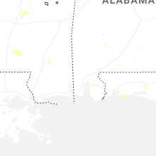
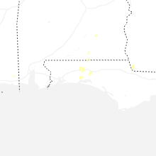
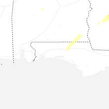
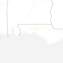
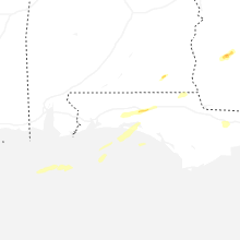


Connect with Interactive Hail Maps