

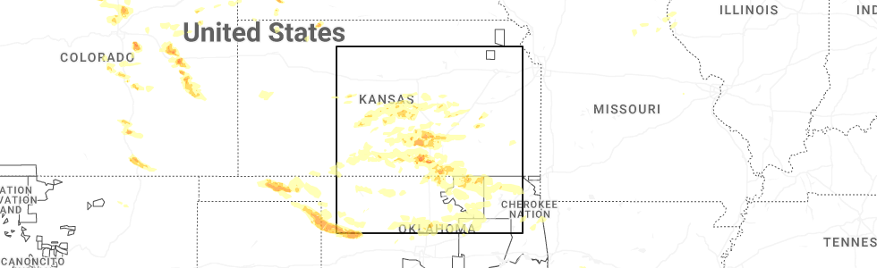
Hail Map for Delaware, OK
The Delaware, OK area has had 2 reports of on-the-ground hail by trained spotters, and has been under severe weather warnings 68 times during the past 12 months. Doppler radar has detected hail at or near Delaware, OK on 82 occasions, including 5 occasions during the past year.
| Name: | Delaware, OK |
| Where Located: | 47.5 miles NNE of Tulsa, OK |
| Map: | Google Map for Delaware, OK |
| Population: | 417 |
| Housing Units: | 188 |
| More Info: | Search Google for Delaware, OK |
1
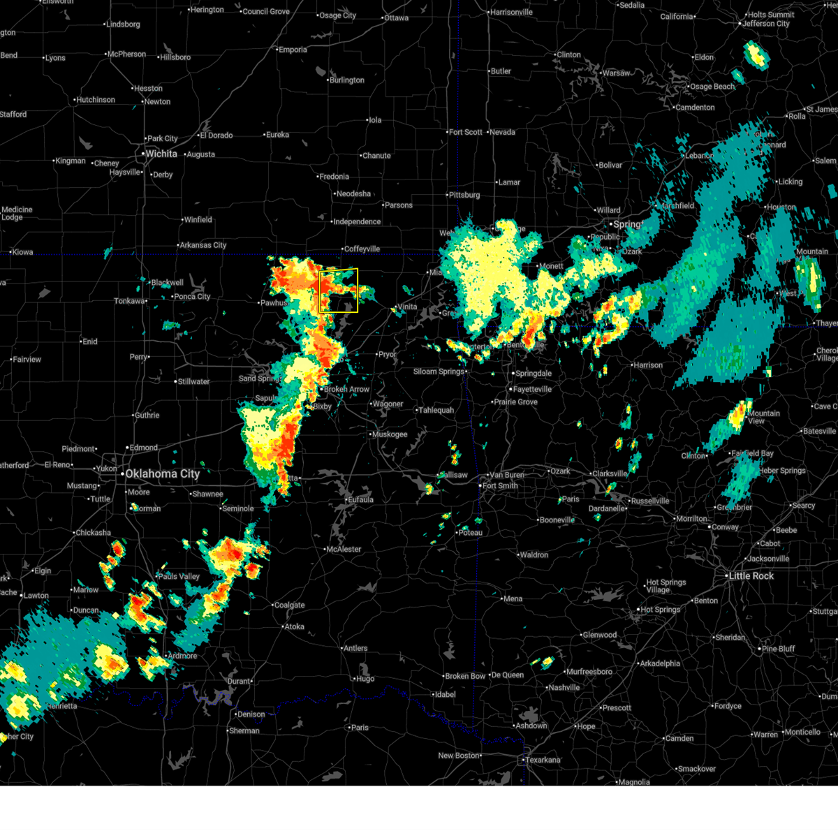
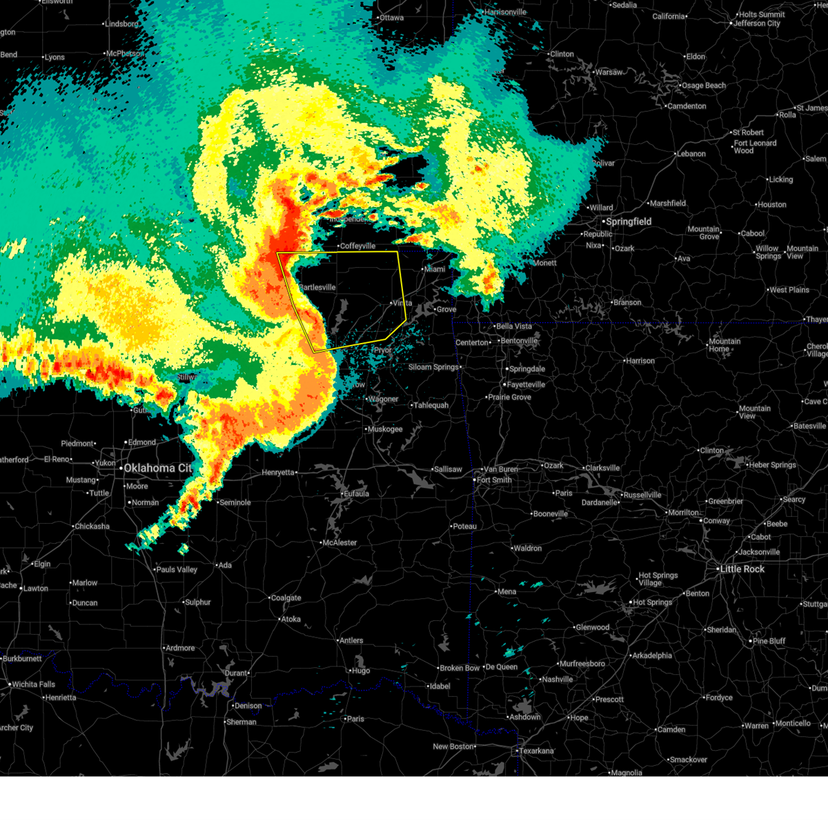
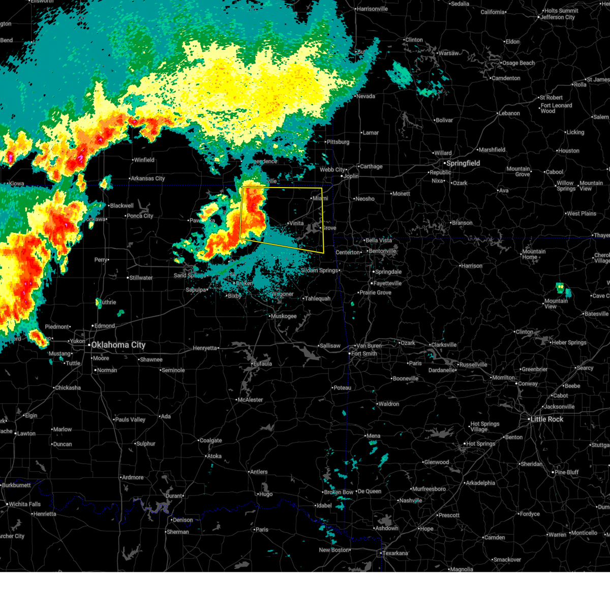
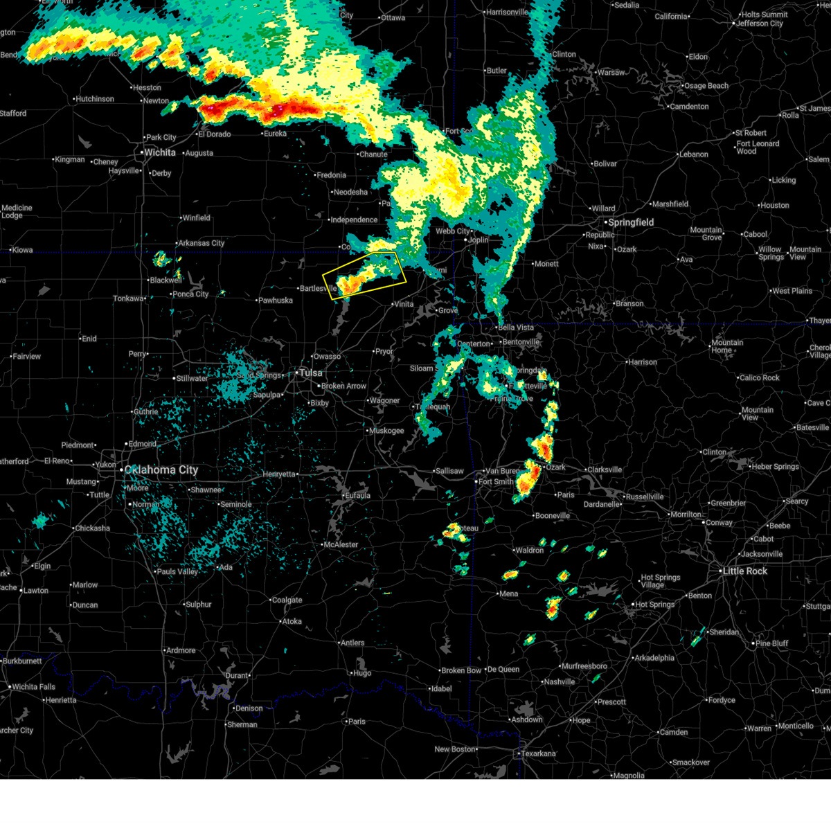
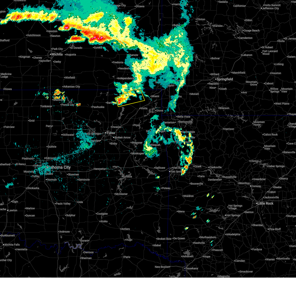
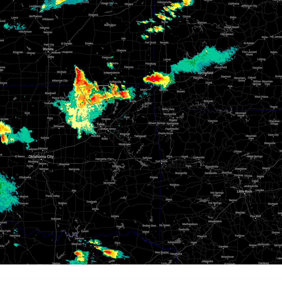
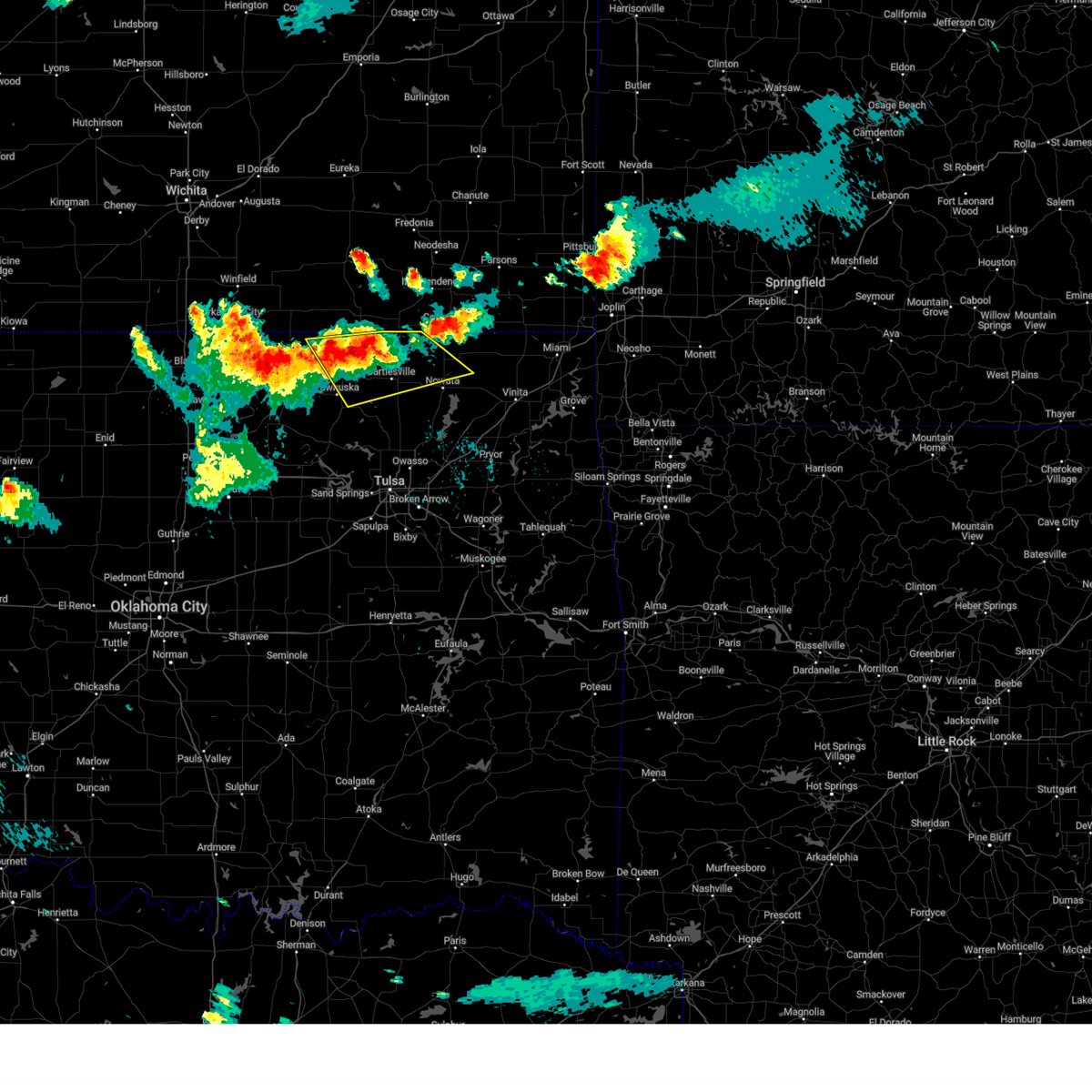
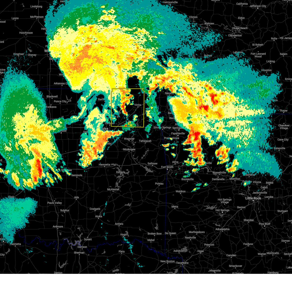
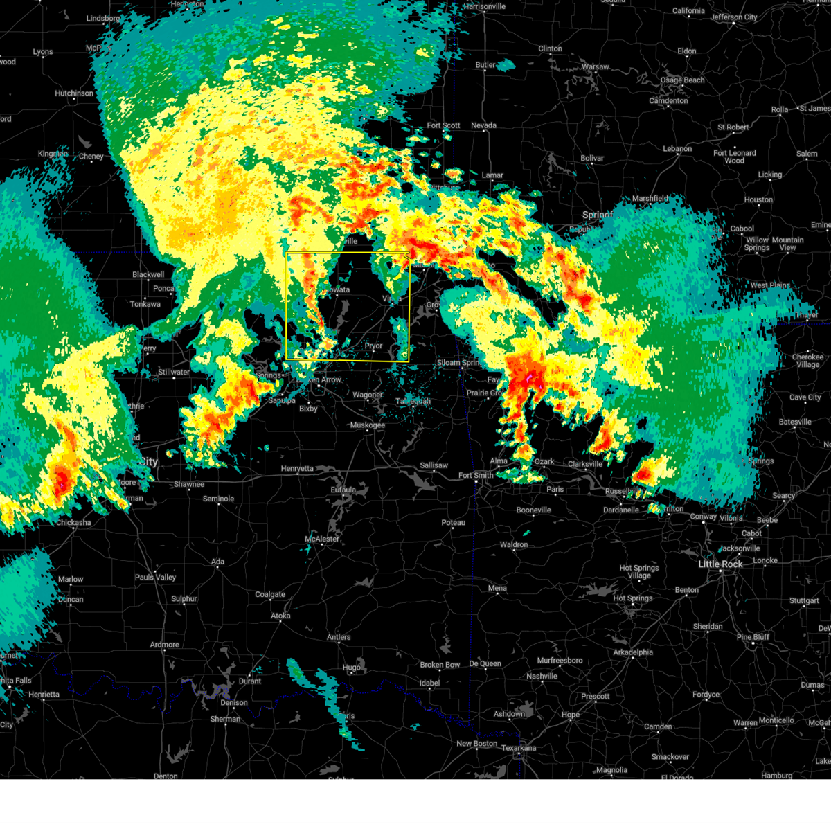
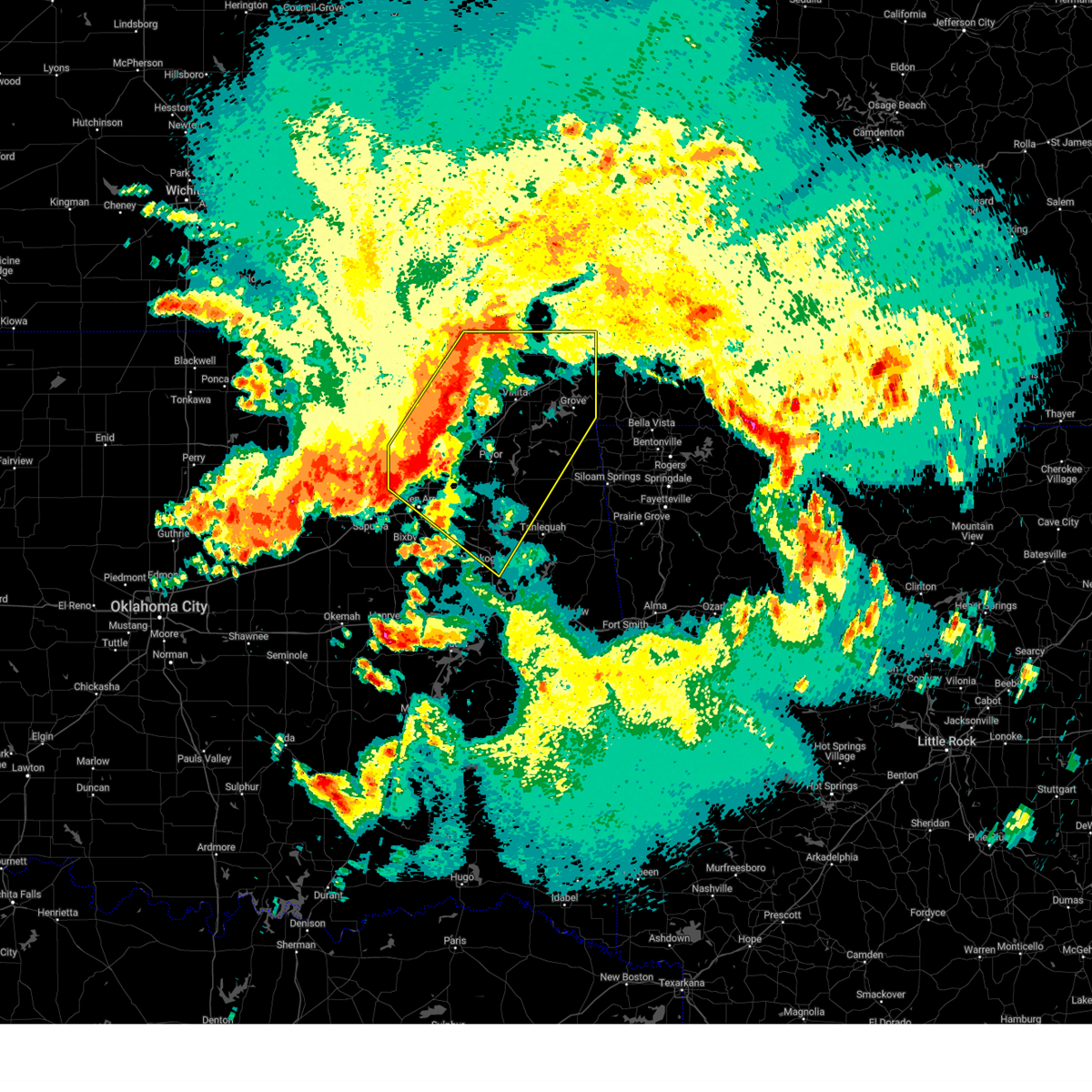
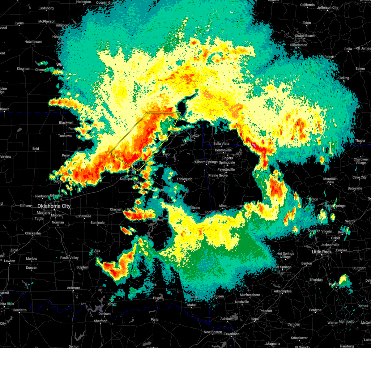
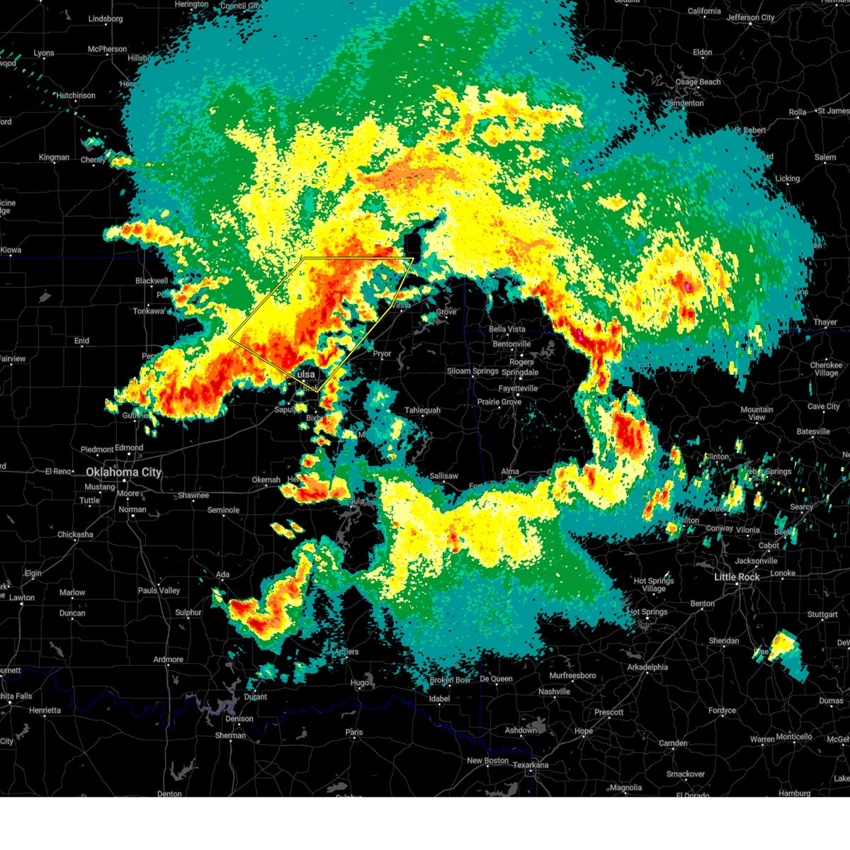
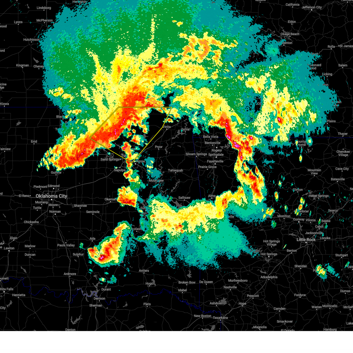
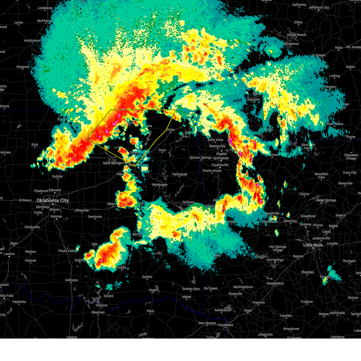
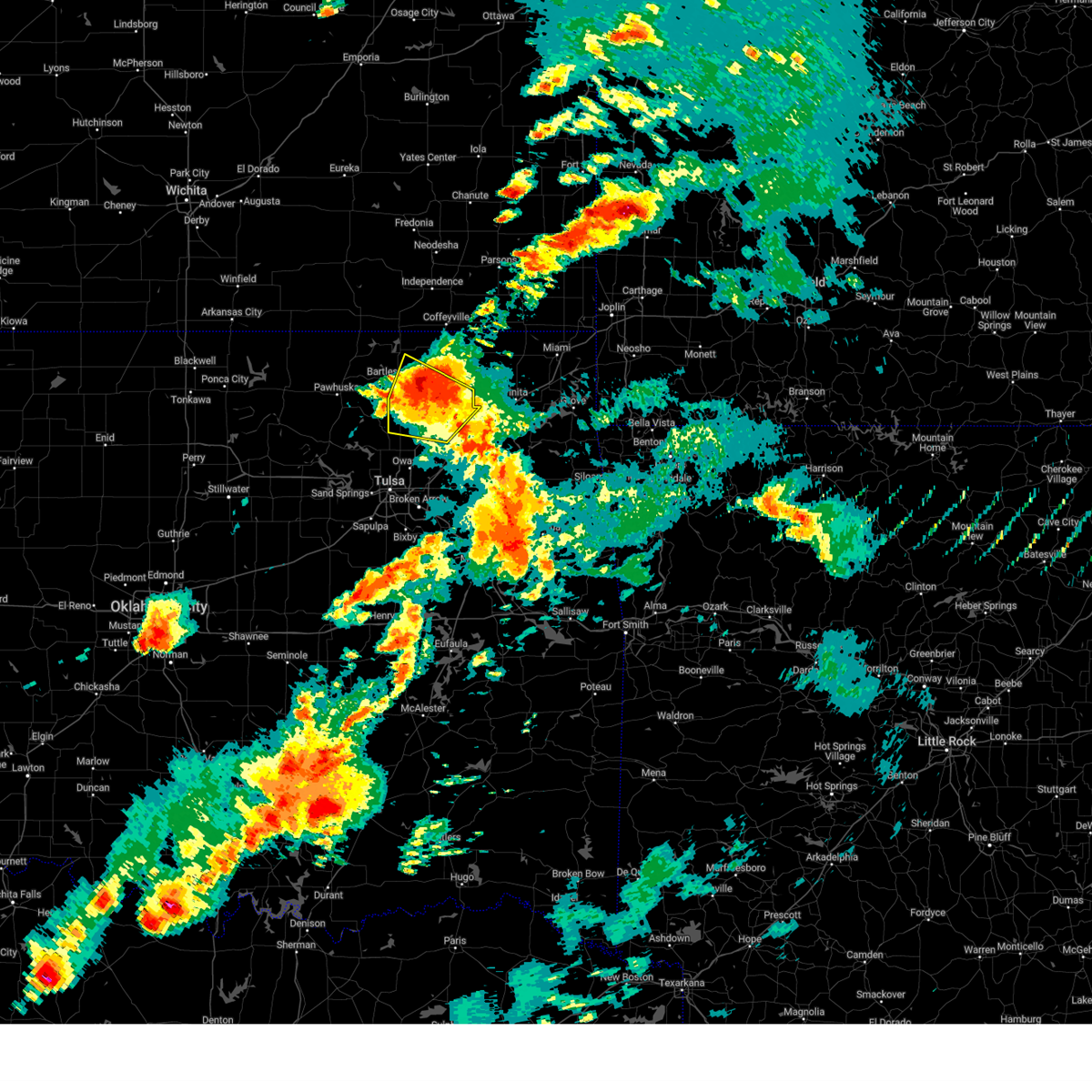
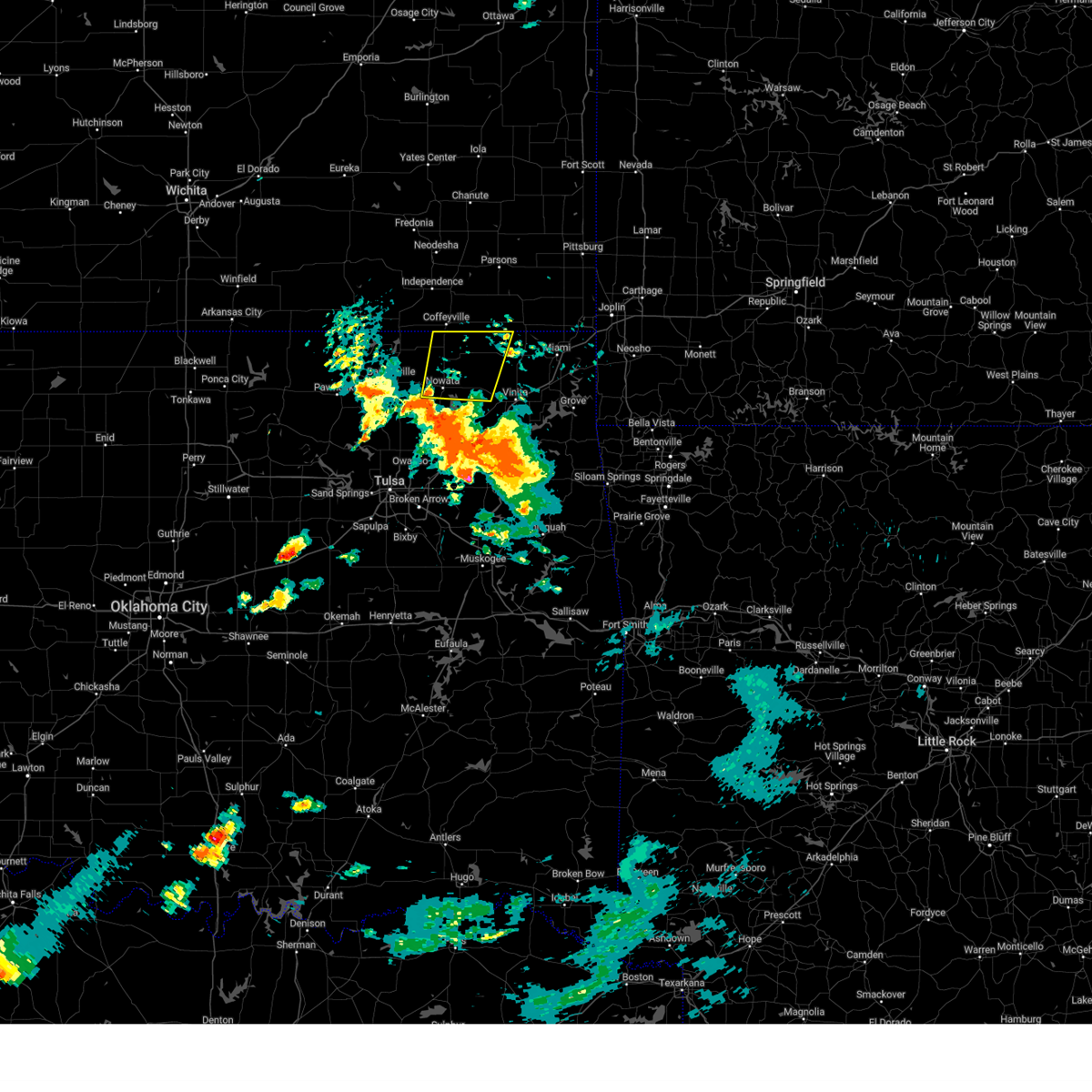
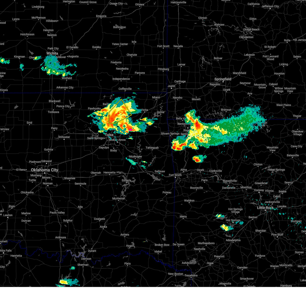
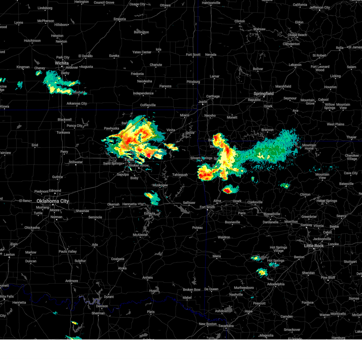
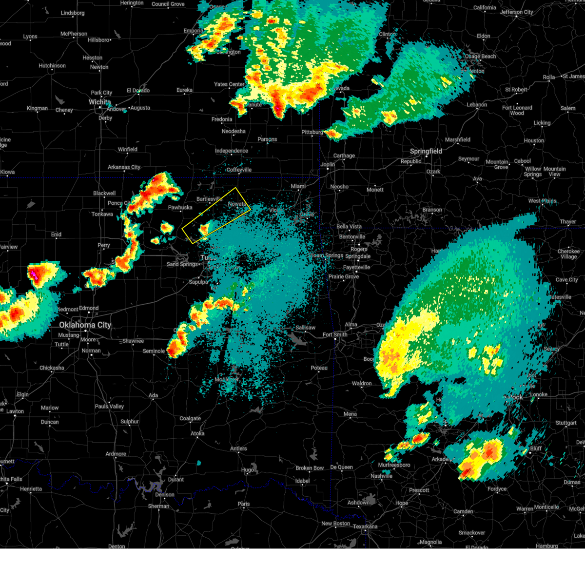
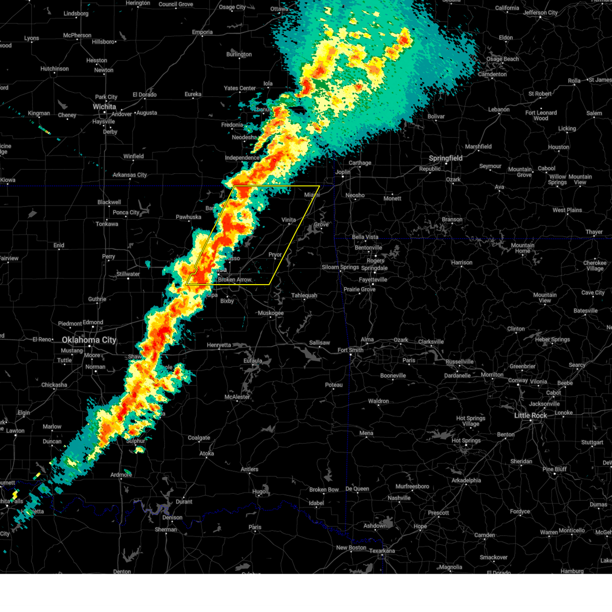
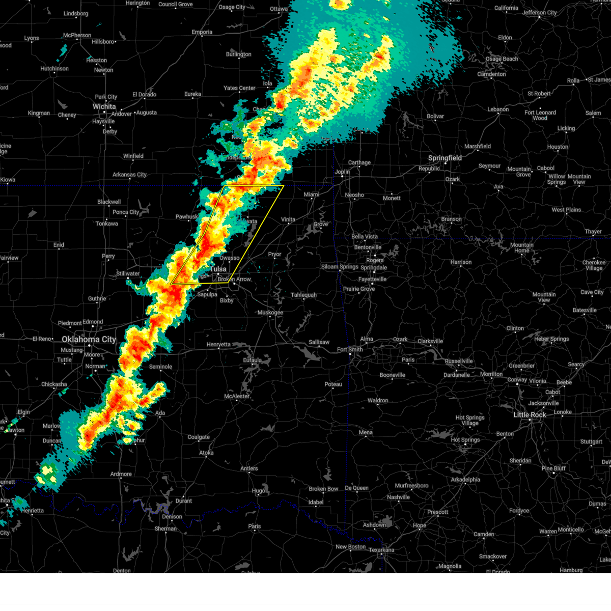
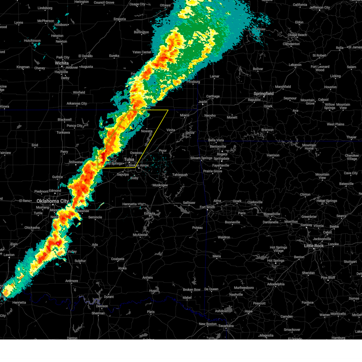
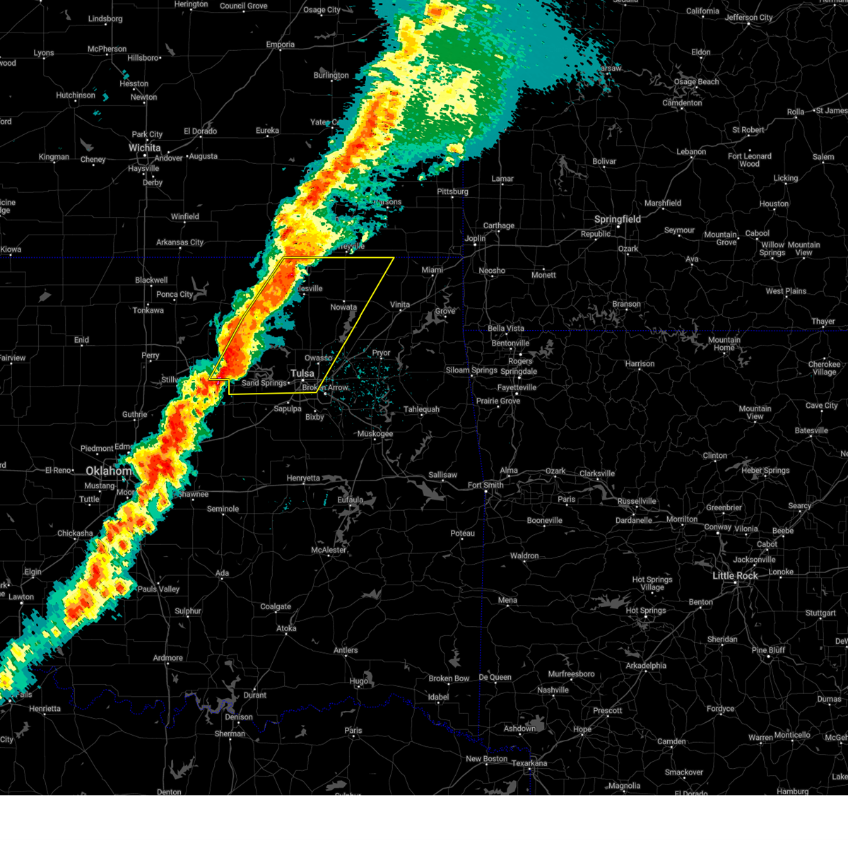
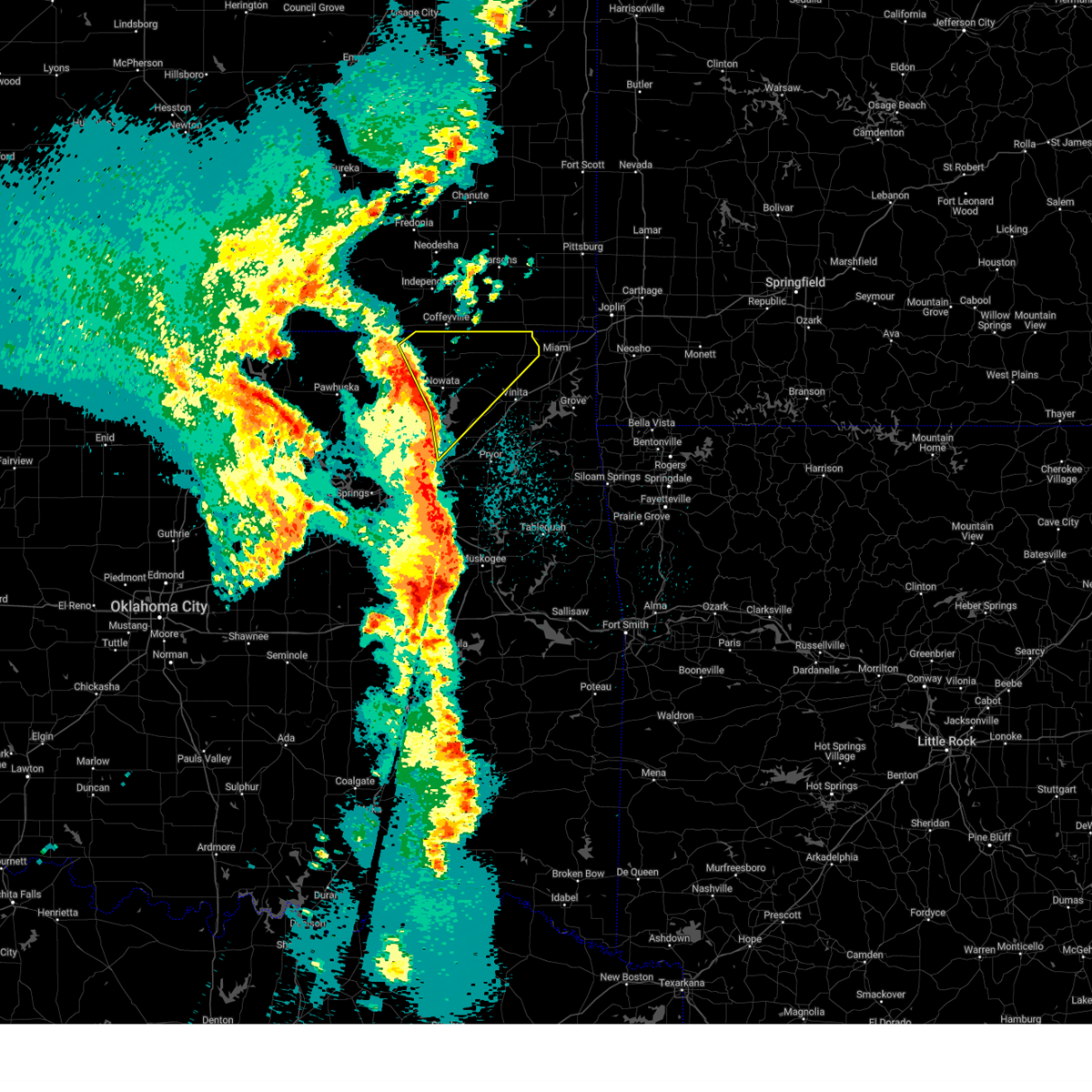
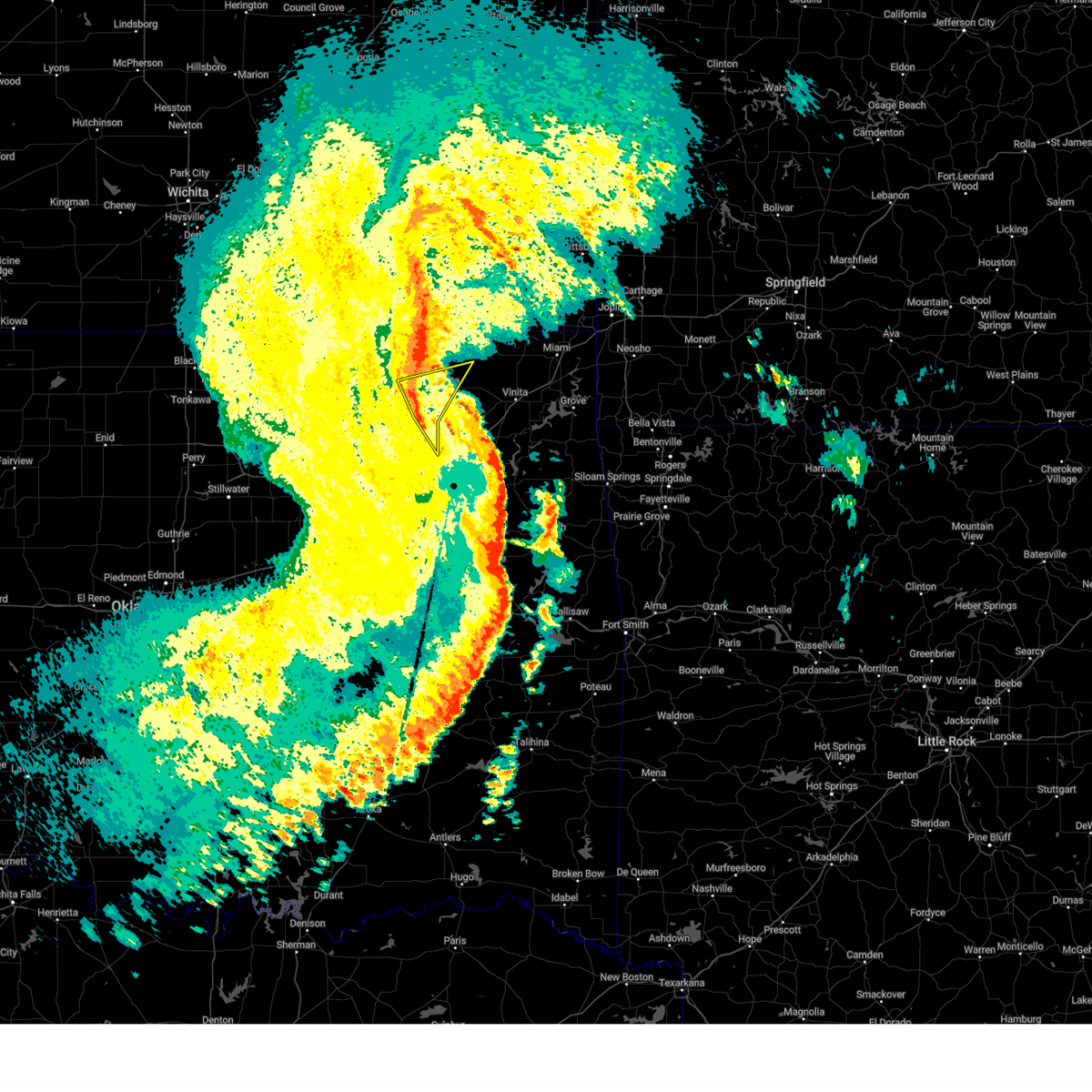
The Top Recent Hail Date for Delaware, OK is Tuesday, June 17, 2025 (10th out of 82)
Hail and Wind Damage Spotted near Delaware, OK
| Date / Time | Report Details |
|---|---|
| 6/29/2025 10:26 PM CDT |
 The storms which prompted the warning have weakened below severe limits, and no longer pose an immediate threat to life or property. therefore, the warning will be allowed to expire. however, gusty winds to 50 mph are still possible with these thunderstorms. a severe thunderstorm watch remains in effect until 1100 pm cdt for northeastern oklahoma. The storms which prompted the warning have weakened below severe limits, and no longer pose an immediate threat to life or property. therefore, the warning will be allowed to expire. however, gusty winds to 50 mph are still possible with these thunderstorms. a severe thunderstorm watch remains in effect until 1100 pm cdt for northeastern oklahoma.
|
| 6/29/2025 10:07 PM CDT |
 At 1006 pm cdt, severe thunderstorms were located along a line extending from 13 miles east of lenapah to 5 miles northwest of talala to 7 miles south of pearsonia, moving southeast at 25 mph (radar indicated). Hazards include 60 mph wind gusts. Expect damage to roofs, siding, and trees. Locations in or near the path include, barnsdall, new alluwe, bigheart, hollow, lenapah, dewey, bartlesville municipal airport, delaware, ochelata, tallant, sunset lake, osage hills state park, watova, ramona, nowata, bartlesville, talala, chelsea, avant, okesa,. At 1006 pm cdt, severe thunderstorms were located along a line extending from 13 miles east of lenapah to 5 miles northwest of talala to 7 miles south of pearsonia, moving southeast at 25 mph (radar indicated). Hazards include 60 mph wind gusts. Expect damage to roofs, siding, and trees. Locations in or near the path include, barnsdall, new alluwe, bigheart, hollow, lenapah, dewey, bartlesville municipal airport, delaware, ochelata, tallant, sunset lake, osage hills state park, watova, ramona, nowata, bartlesville, talala, chelsea, avant, okesa,.
|
| 6/29/2025 9:33 PM CDT |
 Svrtsa the national weather service in tulsa has issued a * severe thunderstorm warning for, western craig county in northeastern oklahoma, northwestern rogers county in northeastern oklahoma, northeastern osage county in northeastern oklahoma, washington county in northeastern oklahoma, nowata county in northeastern oklahoma, * until 1030 pm cdt. * at 932 pm cdt, severe thunderstorms were located along a line extending from 3 miles south of south coffeyville to 5 miles east of bartlesville to 4 miles north of shidler, moving southeast at 35 mph (radar indicated). Hazards include 60 mph wind gusts. Expect damage to roofs, siding, and trees. Locations in or near the path include, barnsdall, new alluwe, bigheart, hollow, lenapah, dewey, bartlesville municipal airport, delaware, ochelata, tallant, sunset lake, osage hills state park, watova, ramona, nowata, bartlesville, talala, chelsea, avant, okesa,. Svrtsa the national weather service in tulsa has issued a * severe thunderstorm warning for, western craig county in northeastern oklahoma, northwestern rogers county in northeastern oklahoma, northeastern osage county in northeastern oklahoma, washington county in northeastern oklahoma, nowata county in northeastern oklahoma, * until 1030 pm cdt. * at 932 pm cdt, severe thunderstorms were located along a line extending from 3 miles south of south coffeyville to 5 miles east of bartlesville to 4 miles north of shidler, moving southeast at 35 mph (radar indicated). Hazards include 60 mph wind gusts. Expect damage to roofs, siding, and trees. Locations in or near the path include, barnsdall, new alluwe, bigheart, hollow, lenapah, dewey, bartlesville municipal airport, delaware, ochelata, tallant, sunset lake, osage hills state park, watova, ramona, nowata, bartlesville, talala, chelsea, avant, okesa,.
|
| 6/27/2025 4:42 PM CDT | The storm which prompted the warning has weakened below severe limits, therefore the warning will be allowed to expire. however, gusty winds are still possible with this thunderstorm. |
| 6/27/2025 4:25 PM CDT | At 424 pm cdt, a severe thunderstorm was located near nowata, moving east at 20 mph (radar indicated). Hazards include 60 mph wind gusts and penny size hail. Expect damage to roofs, siding, and trees. Locations impacted include, nowata, delaware, new alluwe, and watova. |
| 6/27/2025 3:55 PM CDT |
 Svrtsa the national weather service in tulsa has issued a * severe thunderstorm warning for, nowata county in northeastern oklahoma, * until 445 pm cdt. * at 355 pm cdt, a severe thunderstorm was located 6 miles west of delaware, moving east at 15 mph. additional storms are strengthening in southwestern nowata county (radar indicated). Hazards include 60 mph wind gusts and quarter size hail. Hail damage to vehicles is expected. Expect wind damage to roofs, siding, and trees. Svrtsa the national weather service in tulsa has issued a * severe thunderstorm warning for, nowata county in northeastern oklahoma, * until 445 pm cdt. * at 355 pm cdt, a severe thunderstorm was located 6 miles west of delaware, moving east at 15 mph. additional storms are strengthening in southwestern nowata county (radar indicated). Hazards include 60 mph wind gusts and quarter size hail. Hail damage to vehicles is expected. Expect wind damage to roofs, siding, and trees.
|
| 6/18/2025 12:16 AM CDT |
 Svrtsa the national weather service in tulsa has issued a * severe thunderstorm warning for, craig county in northeastern oklahoma, rogers county in northeastern oklahoma, northeastern osage county in northeastern oklahoma, northwestern mayes county in northeastern oklahoma, washington county in northeastern oklahoma, nowata county in northeastern oklahoma, northeastern tulsa county in northeastern oklahoma, * until 100 am cdt. * at 1215 am cdt, severe thunderstorms were located along a line extending from 4 miles east of ochelata to 5 miles west of talala to 3 miles east of collinsville, moving east at 60 mph (radar indicated). Hazards include 60 mph wind gusts and quarter size hail. Hail damage to vehicles is expected. Expect wind damage to roofs, siding, and trees. Svrtsa the national weather service in tulsa has issued a * severe thunderstorm warning for, craig county in northeastern oklahoma, rogers county in northeastern oklahoma, northeastern osage county in northeastern oklahoma, northwestern mayes county in northeastern oklahoma, washington county in northeastern oklahoma, nowata county in northeastern oklahoma, northeastern tulsa county in northeastern oklahoma, * until 100 am cdt. * at 1215 am cdt, severe thunderstorms were located along a line extending from 4 miles east of ochelata to 5 miles west of talala to 3 miles east of collinsville, moving east at 60 mph (radar indicated). Hazards include 60 mph wind gusts and quarter size hail. Hail damage to vehicles is expected. Expect wind damage to roofs, siding, and trees.
|
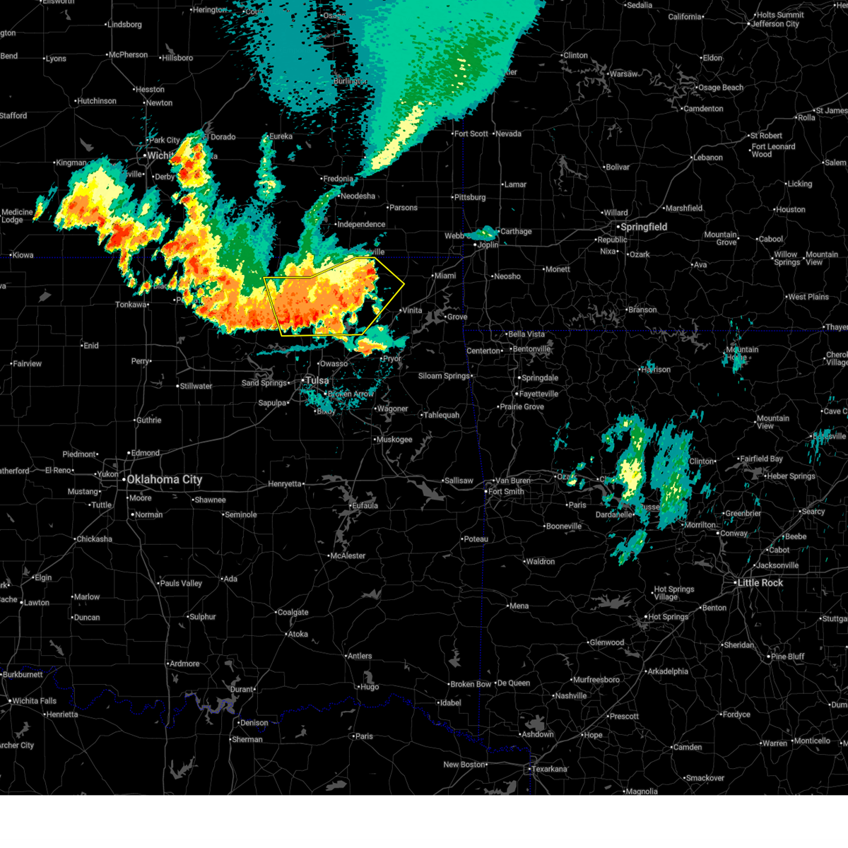
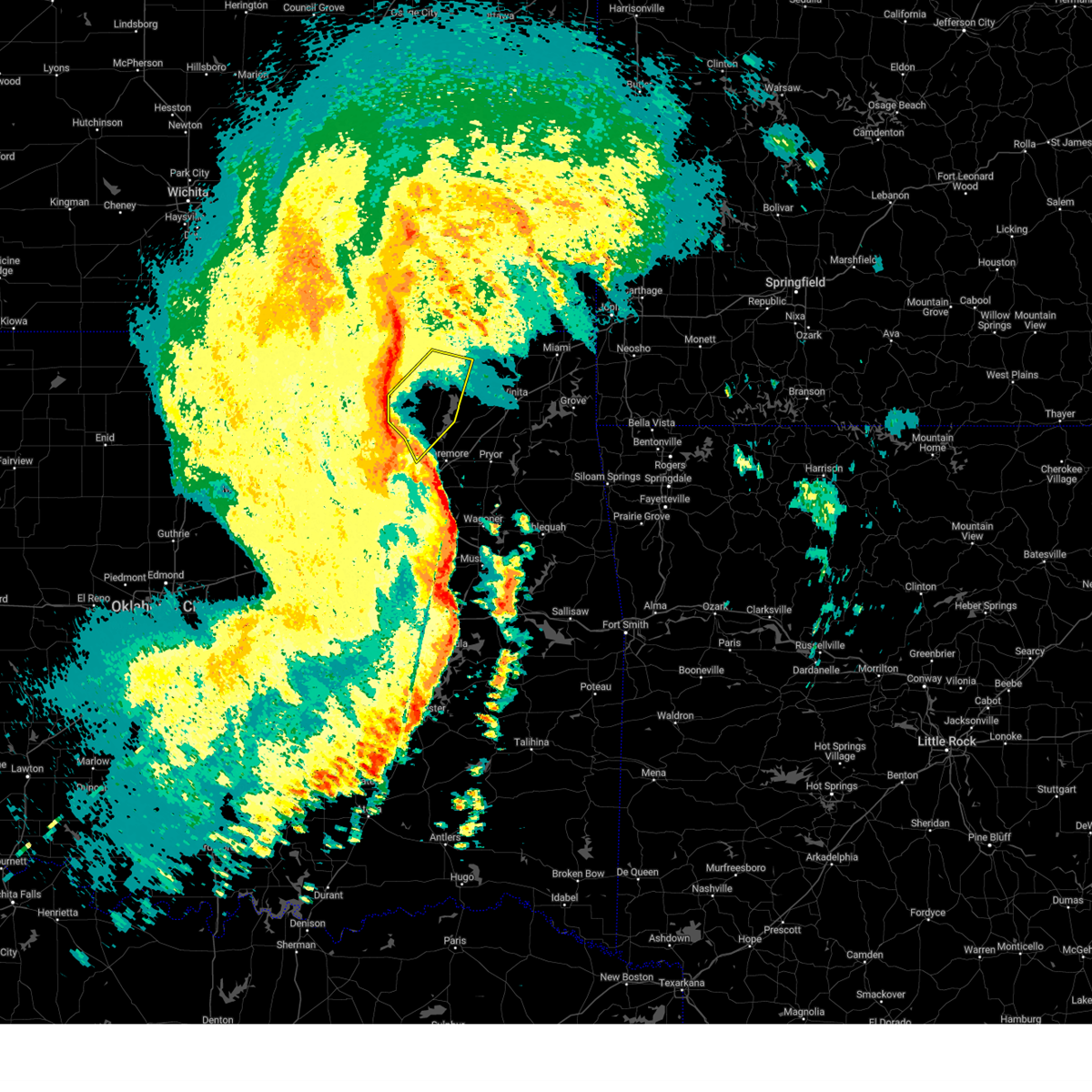
| 6/17/2025 10:07 PM CDT |
 Svrtsa the national weather service in tulsa has issued a * severe thunderstorm warning for, craig county in northeastern oklahoma, northern rogers county in northeastern oklahoma, northwestern delaware county in northeastern oklahoma, ottawa county in northeastern oklahoma, northern mayes county in northeastern oklahoma, nowata county in northeastern oklahoma, * until 1100 pm cdt. * at 1007 pm cdt, severe thunderstorms were located along a line extending from 5 miles east of lenapah to near new alluwe, moving east at 60 mph (radar indicated). Hazards include 60 mph wind gusts and quarter size hail. Hail damage to vehicles is expected. Expect wind damage to roofs, siding, and trees. Svrtsa the national weather service in tulsa has issued a * severe thunderstorm warning for, craig county in northeastern oklahoma, northern rogers county in northeastern oklahoma, northwestern delaware county in northeastern oklahoma, ottawa county in northeastern oklahoma, northern mayes county in northeastern oklahoma, nowata county in northeastern oklahoma, * until 1100 pm cdt. * at 1007 pm cdt, severe thunderstorms were located along a line extending from 5 miles east of lenapah to near new alluwe, moving east at 60 mph (radar indicated). Hazards include 60 mph wind gusts and quarter size hail. Hail damage to vehicles is expected. Expect wind damage to roofs, siding, and trees.
|
| 6/17/2025 9:58 PM CDT | the severe thunderstorm warning has been cancelled and is no longer in effect |
| 6/17/2025 9:58 PM CDT | At 958 pm cdt, severe thunderstorms were located along a line extending from 7 miles east of lenapah to 3 miles northwest of new alluwe to 5 miles west of foyil, moving east at 50 mph (radar indicated). Hazards include 70 mph wind gusts and quarter size hail. Hail damage to vehicles is expected. expect considerable tree damage. wind damage is also likely to mobile homes, roofs, and outbuildings. Locations impacted include, nowata, chelsea, oologah, delaware, foyil, lenapah, talala, new alluwe, watova, bushyhead, and centralia. |
| 6/17/2025 9:54 PM CDT | Svrtsa the national weather service in tulsa has issued a * severe thunderstorm warning for, central craig county in northeastern oklahoma, southeastern nowata county in northeastern oklahoma, * until 1045 pm cdt. * at 953 pm cdt, a severe thunderstorm was located 4 miles east of nowata, moving east at 35 mph (radar indicated). Hazards include 70 mph wind gusts and quarter size hail. Hail damage to vehicles is expected. expect considerable tree damage. Wind damage is also likely to mobile homes, roofs, and outbuildings. |
| 6/17/2025 9:39 PM CDT | At 939 pm cdt, severe thunderstorms were located along a line extending from 4 miles east of wann to 6 miles west of nowata to 4 miles east of ramona, moving east at 50 mph (radar indicated). Hazards include 70 mph wind gusts and quarter size hail. Hail damage to vehicles is expected. expect considerable tree damage. wind damage is also likely to mobile homes, roofs, and outbuildings. Locations impacted include, bartlesville, nowata, dewey, chelsea, oologah, south coffeyville, copan, ramona, ochelata, delaware, foyil, lenapah, talala, vera, wann, new alluwe, watova, bushyhead, and centralia. |
| 6/17/2025 9:39 PM CDT | the severe thunderstorm warning has been cancelled and is no longer in effect |
| 6/17/2025 9:23 PM CDT | Svrtsa the national weather service in tulsa has issued a * severe thunderstorm warning for, western craig county in northeastern oklahoma, northern rogers county in northeastern oklahoma, northeastern osage county in northeastern oklahoma, northwestern mayes county in northeastern oklahoma, washington county in northeastern oklahoma, nowata county in northeastern oklahoma, * until 1015 pm cdt. * at 923 pm cdt, severe thunderstorms were located along a line extending from 3 miles north of copan to near bartlesville to 4 miles southwest of ochelata, moving east at 50 mph (radar indicated). Hazards include 70 mph wind gusts and quarter size hail. Hail damage to vehicles is expected. expect considerable tree damage. Wind damage is also likely to mobile homes, roofs, and outbuildings. |
| 6/17/2025 12:35 PM CDT |
 the severe thunderstorm warning has been cancelled and is no longer in effect the severe thunderstorm warning has been cancelled and is no longer in effect
|
| 6/17/2025 12:18 PM CDT |
 Svrtsa the national weather service in tulsa has issued a * severe thunderstorm warning for, northern craig county in northeastern oklahoma, central nowata county in northeastern oklahoma, * until 100 pm cdt. * at 1218 pm cdt, a severe thunderstorm was located near delaware, moving east at 30 mph (radar indicated). Hazards include 60 mph wind gusts and quarter size hail. Hail damage to vehicles is expected. Expect wind damage to roofs, siding, and trees. Svrtsa the national weather service in tulsa has issued a * severe thunderstorm warning for, northern craig county in northeastern oklahoma, central nowata county in northeastern oklahoma, * until 100 pm cdt. * at 1218 pm cdt, a severe thunderstorm was located near delaware, moving east at 30 mph (radar indicated). Hazards include 60 mph wind gusts and quarter size hail. Hail damage to vehicles is expected. Expect wind damage to roofs, siding, and trees.
|
| 6/8/2025 5:34 PM CDT |
 the severe thunderstorm warning has been cancelled and is no longer in effect the severe thunderstorm warning has been cancelled and is no longer in effect
|
| 6/8/2025 5:08 PM CDT | At 508 pm cdt, severe thunderstorms were located along a line extending from 2 miles southwest of copan to near sunset lake, moving east at 35 mph (radar indicated). Hazards include 60 mph wind gusts and penny size hail. Expect damage to roofs, siding, and trees. Locations in or near the path include, bigheart, wann, wah sha she state park, lenapah, dewey, bartlesville municipal airport, hulah, delaware, sunset lake, osage hills state park, bartlesville, copan, nelagoney, okesa, pawhuska,. |
| 6/8/2025 4:48 PM CDT |
 Svrtsa the national weather service in tulsa has issued a * severe thunderstorm warning for, northeastern osage county in northeastern oklahoma, northern washington county in northeastern oklahoma, northern nowata county in northeastern oklahoma, * until 545 pm cdt. * at 448 pm cdt, severe thunderstorms were located along a line extending from 5 miles northeast of bigheart to 4 miles northeast of pearsonia, moving east at 35 mph (radar indicated). Hazards include 60 mph wind gusts and quarter size hail. Hail damage to vehicles is expected. expect wind damage to roofs, siding, and trees. Locations in or near the path include, bigheart, wann, wah sha she state park, lenapah, dewey, bartlesville municipal airport, hulah, delaware, sunset lake, osage hills state park, bartlesville, copan, nelagoney, okesa, pawhuska,. Svrtsa the national weather service in tulsa has issued a * severe thunderstorm warning for, northeastern osage county in northeastern oklahoma, northern washington county in northeastern oklahoma, northern nowata county in northeastern oklahoma, * until 545 pm cdt. * at 448 pm cdt, severe thunderstorms were located along a line extending from 5 miles northeast of bigheart to 4 miles northeast of pearsonia, moving east at 35 mph (radar indicated). Hazards include 60 mph wind gusts and quarter size hail. Hail damage to vehicles is expected. expect wind damage to roofs, siding, and trees. Locations in or near the path include, bigheart, wann, wah sha she state park, lenapah, dewey, bartlesville municipal airport, hulah, delaware, sunset lake, osage hills state park, bartlesville, copan, nelagoney, okesa, pawhuska,.
|
| 6/7/2025 4:20 AM CDT |
 At 419 am cdt, severe thunderstorms were located along a line extending from 3 miles east of south coffeyville to chelsea to 4 miles east of tiawah, moving east at 45 mph (radar indicated). Hazards include 60 mph wind gusts. Expect damage to roofs, siding, and trees. Locations in or near the path include, pensacola, wann, vinita, cherokee state park, langley, snowdale state park, disney little blue state park, watova, big cabin, strang, hoot owl, talala, chelsea, pryor creek, white oak, welch, foyil, bushyhead, new alluwe, hollow, this includes interstate 44 between mile markers 244 and 292. At 419 am cdt, severe thunderstorms were located along a line extending from 3 miles east of south coffeyville to chelsea to 4 miles east of tiawah, moving east at 45 mph (radar indicated). Hazards include 60 mph wind gusts. Expect damage to roofs, siding, and trees. Locations in or near the path include, pensacola, wann, vinita, cherokee state park, langley, snowdale state park, disney little blue state park, watova, big cabin, strang, hoot owl, talala, chelsea, pryor creek, white oak, welch, foyil, bushyhead, new alluwe, hollow, this includes interstate 44 between mile markers 244 and 292.
|
| 6/7/2025 4:20 AM CDT |
 the severe thunderstorm warning has been cancelled and is no longer in effect the severe thunderstorm warning has been cancelled and is no longer in effect
|
| 6/7/2025 3:52 AM CDT |
 Svrtsa the national weather service in tulsa has issued a * severe thunderstorm warning for, craig county in northeastern oklahoma, rogers county in northeastern oklahoma, northeastern osage county in northeastern oklahoma, mayes county in northeastern oklahoma, washington county in northeastern oklahoma, nowata county in northeastern oklahoma, northeastern tulsa county in northeastern oklahoma, * until 445 am cdt. * at 352 am cdt, severe thunderstorms were located along a line extending from 2 miles east of caney to 4 miles northwest of talala to owasso, moving east at 55 mph (radar indicated). Hazards include 60 mph wind gusts. Expect damage to roofs, siding, and trees. Locations in or near the path include, pensacola, wann, vinita, collinsville, cherokee state park, disney little blue state park, big cabin, strang, hoot owl, vera, chelsea, white oak, bushyhead, wolco, owasso, hollow, pryor, ketchum, delaware, ochelata, this includes interstate 44 between mile markers 244 and 292. Svrtsa the national weather service in tulsa has issued a * severe thunderstorm warning for, craig county in northeastern oklahoma, rogers county in northeastern oklahoma, northeastern osage county in northeastern oklahoma, mayes county in northeastern oklahoma, washington county in northeastern oklahoma, nowata county in northeastern oklahoma, northeastern tulsa county in northeastern oklahoma, * until 445 am cdt. * at 352 am cdt, severe thunderstorms were located along a line extending from 2 miles east of caney to 4 miles northwest of talala to owasso, moving east at 55 mph (radar indicated). Hazards include 60 mph wind gusts. Expect damage to roofs, siding, and trees. Locations in or near the path include, pensacola, wann, vinita, collinsville, cherokee state park, disney little blue state park, big cabin, strang, hoot owl, vera, chelsea, white oak, bushyhead, wolco, owasso, hollow, pryor, ketchum, delaware, ochelata, this includes interstate 44 between mile markers 244 and 292.
|
| 5/24/2025 5:53 AM CDT |
 Svrtsa the national weather service in tulsa has issued a * severe thunderstorm warning for, craig county in northeastern oklahoma, rogers county in northeastern oklahoma, delaware county in northeastern oklahoma, ottawa county in northeastern oklahoma, mayes county in northeastern oklahoma, southern washington county in northeastern oklahoma, nowata county in northeastern oklahoma, wagoner county in northeastern oklahoma, northwestern cherokee county in east central oklahoma, north central muskogee county in east central oklahoma, northeastern tulsa county in northeastern oklahoma, * until 645 am cdt. * at 552 am cdt, severe thunderstorms were located along a line extending from 13 miles northeast of new alluwe to 5 miles west of foyil to tulsa, moving southeast at 60 mph (trained weather spotters). Hazards include 70 mph wind gusts and nickel size hail. Expect considerable tree damage. damage is likely to mobile homes, roofs, and outbuildings. Locations in or near the path include, pensacola, jay, vinita, honey creek state park, inola, collinsville, commerce, cherokee state park, mazie, locust grove, fort gibson, disney little blue state park, okay, picher, big cabin, strang, leach, hoot owl, zena, cleora, this includes interstate 44 between mile markers 226 and 324. Svrtsa the national weather service in tulsa has issued a * severe thunderstorm warning for, craig county in northeastern oklahoma, rogers county in northeastern oklahoma, delaware county in northeastern oklahoma, ottawa county in northeastern oklahoma, mayes county in northeastern oklahoma, southern washington county in northeastern oklahoma, nowata county in northeastern oklahoma, wagoner county in northeastern oklahoma, northwestern cherokee county in east central oklahoma, north central muskogee county in east central oklahoma, northeastern tulsa county in northeastern oklahoma, * until 645 am cdt. * at 552 am cdt, severe thunderstorms were located along a line extending from 13 miles northeast of new alluwe to 5 miles west of foyil to tulsa, moving southeast at 60 mph (trained weather spotters). Hazards include 70 mph wind gusts and nickel size hail. Expect considerable tree damage. damage is likely to mobile homes, roofs, and outbuildings. Locations in or near the path include, pensacola, jay, vinita, honey creek state park, inola, collinsville, commerce, cherokee state park, mazie, locust grove, fort gibson, disney little blue state park, okay, picher, big cabin, strang, leach, hoot owl, zena, cleora, this includes interstate 44 between mile markers 226 and 324.
|
| 5/24/2025 5:50 AM CDT |
 At 550 am cdt, severe thunderstorms were located along a line extending from 9 miles north of new alluwe to turley, moving southeast at 65 mph (trained weather spotters). Hazards include 70 mph wind gusts and penny size hail. Expect considerable tree damage. damage is likely to mobile homes, roofs, and outbuildings. Locations in or near the path include, barnsdall, dewey, collinsville, sperry, skiatook, watova, ramona, vera, talala, chelsea, foyil, bushyhead, wolco, owasso, new alluwe, hollow, lenapah, south coffeyville, delaware, ochelata, this includes interstate 44 between mile markers 226 and 234. At 550 am cdt, severe thunderstorms were located along a line extending from 9 miles north of new alluwe to turley, moving southeast at 65 mph (trained weather spotters). Hazards include 70 mph wind gusts and penny size hail. Expect considerable tree damage. damage is likely to mobile homes, roofs, and outbuildings. Locations in or near the path include, barnsdall, dewey, collinsville, sperry, skiatook, watova, ramona, vera, talala, chelsea, foyil, bushyhead, wolco, owasso, new alluwe, hollow, lenapah, south coffeyville, delaware, ochelata, this includes interstate 44 between mile markers 226 and 234.
|
| 5/24/2025 5:41 AM CDT |
 At 541 am cdt, severe thunderstorms were located along a line extending from 2 miles northeast of delaware to 6 miles west of sperry, moving southeast at 65 mph (trained weather spotters). Hazards include 70 mph wind gusts and penny size hail. Expect considerable tree damage. damage is likely to mobile homes, roofs, and outbuildings. Locations in or near the path include, barnsdall, wann, dewey, bartlesville municipal airport, collinsville, tallant, sperry, pawhuska, osage hills state park, skiatook, pershing, watova, ramona, vera, talala, chelsea, nelagoney, foyil, bushyhead, wolco, this includes interstate 44 between mile markers 226 and 234. At 541 am cdt, severe thunderstorms were located along a line extending from 2 miles northeast of delaware to 6 miles west of sperry, moving southeast at 65 mph (trained weather spotters). Hazards include 70 mph wind gusts and penny size hail. Expect considerable tree damage. damage is likely to mobile homes, roofs, and outbuildings. Locations in or near the path include, barnsdall, wann, dewey, bartlesville municipal airport, collinsville, tallant, sperry, pawhuska, osage hills state park, skiatook, pershing, watova, ramona, vera, talala, chelsea, nelagoney, foyil, bushyhead, wolco, this includes interstate 44 between mile markers 226 and 234.
|
| 5/24/2025 5:27 AM CDT |
 the severe thunderstorm warning has been cancelled and is no longer in effect the severe thunderstorm warning has been cancelled and is no longer in effect
|
| 5/24/2025 5:27 AM CDT |
 At 526 am cdt, severe thunderstorms were located along a line extending from 2 miles south of wann to 4 miles southeast of hominy, moving southeast at 70 mph (radar indicated). Hazards include 70 mph wind gusts and nickel size hail. Expect considerable tree damage. damage is likely to mobile homes, roofs, and outbuildings. Locations in or near the path include, barnsdall, bigheart, wann, dewey, bartlesville municipal airport, collinsville, tallant, sperry, pawhuska, osage hills state park, skiatook, pershing, watova, ramona, vera, talala, chelsea, nelagoney, foyil, bushyhead, this includes interstate 44 between mile markers 226 and 234. At 526 am cdt, severe thunderstorms were located along a line extending from 2 miles south of wann to 4 miles southeast of hominy, moving southeast at 70 mph (radar indicated). Hazards include 70 mph wind gusts and nickel size hail. Expect considerable tree damage. damage is likely to mobile homes, roofs, and outbuildings. Locations in or near the path include, barnsdall, bigheart, wann, dewey, bartlesville municipal airport, collinsville, tallant, sperry, pawhuska, osage hills state park, skiatook, pershing, watova, ramona, vera, talala, chelsea, nelagoney, foyil, bushyhead, this includes interstate 44 between mile markers 226 and 234.
|
| 5/24/2025 5:13 AM CDT |
 Svrtsa the national weather service in tulsa has issued a * severe thunderstorm warning for, western craig county in northeastern oklahoma, northern rogers county in northeastern oklahoma, osage county in northeastern oklahoma, washington county in northeastern oklahoma, nowata county in northeastern oklahoma, north central pawnee county in northeastern oklahoma, northeastern tulsa county in northeastern oklahoma, * until 600 am cdt. * at 513 am cdt, severe thunderstorms were located along a line extending from 4 miles north of hulah to 9 miles north of blackburn, moving southeast at 65 mph (radar indicated). Hazards include 60 mph wind gusts and nickel size hail. Expect damage to roofs, siding, and trees. Locations in or near the path include, barnsdall, bigheart, wann, dewey, bartlesville municipal airport, collinsville, tallant, sperry, pawhuska, ralston, osage hills state park, skiatook, pershing, watova, ramona, vera, talala, chelsea, nelagoney, foyil, this includes interstate 44 between mile markers 226 and 233. Svrtsa the national weather service in tulsa has issued a * severe thunderstorm warning for, western craig county in northeastern oklahoma, northern rogers county in northeastern oklahoma, osage county in northeastern oklahoma, washington county in northeastern oklahoma, nowata county in northeastern oklahoma, north central pawnee county in northeastern oklahoma, northeastern tulsa county in northeastern oklahoma, * until 600 am cdt. * at 513 am cdt, severe thunderstorms were located along a line extending from 4 miles north of hulah to 9 miles north of blackburn, moving southeast at 65 mph (radar indicated). Hazards include 60 mph wind gusts and nickel size hail. Expect damage to roofs, siding, and trees. Locations in or near the path include, barnsdall, bigheart, wann, dewey, bartlesville municipal airport, collinsville, tallant, sperry, pawhuska, ralston, osage hills state park, skiatook, pershing, watova, ramona, vera, talala, chelsea, nelagoney, foyil, this includes interstate 44 between mile markers 226 and 233.
|
| 5/24/2025 1:24 AM CDT |
 Svrtsa the national weather service in tulsa has issued a * severe thunderstorm warning for, northern washington county in northeastern oklahoma, central nowata county in northeastern oklahoma, * until 215 am cdt. * at 123 am cdt, a severe thunderstorm was located 5 miles east of dewey, moving east at 25 mph (radar indicated). Hazards include 60 mph wind gusts and quarter size hail. Hail damage to vehicles is expected. expect wind damage to roofs, siding, and trees. Locations in or near the path include, wann, delaware, lenapah, copan,. Svrtsa the national weather service in tulsa has issued a * severe thunderstorm warning for, northern washington county in northeastern oklahoma, central nowata county in northeastern oklahoma, * until 215 am cdt. * at 123 am cdt, a severe thunderstorm was located 5 miles east of dewey, moving east at 25 mph (radar indicated). Hazards include 60 mph wind gusts and quarter size hail. Hail damage to vehicles is expected. expect wind damage to roofs, siding, and trees. Locations in or near the path include, wann, delaware, lenapah, copan,.
|
| 5/19/2025 4:53 PM CDT | the severe thunderstorm warning has been cancelled and is no longer in effect |
| 5/19/2025 4:53 PM CDT | At 453 pm cdt, severe thunderstorms were located along a line extending from 2 miles northeast of bartlesville municipal airport to 5 miles southeast of south coffeyville to 7 miles northeast of new alluwe, moving northeast at 60 mph (radar indicated). Hazards include 60 mph wind gusts and quarter size hail. Hail damage to vehicles is expected. expect wind damage to roofs, siding, and trees. Locations in or near the path include, new alluwe, wann, hollow, nowata, bartlesville, copan, lenapah, dewey, south coffeyville, delaware, centralia,. |
| 5/19/2025 4:44 PM CDT |
 At 443 pm cdt, severe thunderstorms were located along a line extending from ochelata to 3 miles northwest of nowata to 2 miles southeast of new alluwe, moving northeast at 50 mph (radar indicated). Hazards include 60 mph wind gusts and half dollar size hail. Hail damage to vehicles is expected. expect wind damage to roofs, siding, and trees. Locations in or near the path include, new alluwe, watova, ramona, nowata, bartlesville, vera, talala, oologah, ochelata, delaware,. At 443 pm cdt, severe thunderstorms were located along a line extending from ochelata to 3 miles northwest of nowata to 2 miles southeast of new alluwe, moving northeast at 50 mph (radar indicated). Hazards include 60 mph wind gusts and half dollar size hail. Hail damage to vehicles is expected. expect wind damage to roofs, siding, and trees. Locations in or near the path include, new alluwe, watova, ramona, nowata, bartlesville, vera, talala, oologah, ochelata, delaware,.
|
| 5/19/2025 4:44 PM CDT |
 the severe thunderstorm warning has been cancelled and is no longer in effect the severe thunderstorm warning has been cancelled and is no longer in effect
|
| 5/19/2025 4:40 PM CDT | Svrtsa the national weather service in tulsa has issued a * severe thunderstorm warning for, craig county in northeastern oklahoma, northern rogers county in northeastern oklahoma, northeastern osage county in northeastern oklahoma, northwestern mayes county in northeastern oklahoma, washington county in northeastern oklahoma, nowata county in northeastern oklahoma, * until 530 pm cdt. * at 440 pm cdt, severe thunderstorms were located along a line extending from 4 miles east of barnsdall to 2 miles northwest of nowata to 3 miles northeast of foyil, moving northeast at 40 mph (radar indicated). Hazards include 60 mph wind gusts and half dollar size hail. Hail damage to vehicles is expected. expect wind damage to roofs, siding, and trees. Locations in or near the path include, barnsdall, wann, dewey, bartlesville municipal airport, watova, ramona, vera, talala, chelsea, white oak, welch, foyil, bushyhead, wolco, new alluwe, hollow, lenapah, south coffeyville, hulah, delaware,. |
| 5/19/2025 4:25 PM CDT | the severe thunderstorm warning has been cancelled and is no longer in effect |
| 5/19/2025 4:25 PM CDT | At 424 pm cdt, a severe thunderstorm was located over oologah, moving northeast at 55 mph (radar indicated. at around 400 pm cdt, multiple hail reports from quarter to golf ball size were reported in tulsa and owasso. 64 mph winds were reported at tulsa international airport). Hazards include 70 mph wind gusts and ping pong ball size hail. People and animals outdoors will be injured. expect hail damage to roofs, siding, windows, and vehicles. expect considerable tree damage. wind damage is also likely to mobile homes, roofs, and outbuildings. Locations in or near the path include, collinsville, sperry, skiatook, watova, ramona, big cabin, vera, talala, chelsea, white oak, foyil, bushyhead, owasso, new alluwe, verdigris, ochelata, claremore, turley, tulsa international airport, nowata, this includes interstate 44 between mile markers 230 and 279. |
| 5/19/2025 4:08 PM CDT | Svrtsa the national weather service in tulsa has issued a * severe thunderstorm warning for, southwestern craig county in northeastern oklahoma, rogers county in northeastern oklahoma, southeastern osage county in northeastern oklahoma, northeastern creek county in northeastern oklahoma, northwestern mayes county in northeastern oklahoma, washington county in northeastern oklahoma, southern nowata county in northeastern oklahoma, northwestern wagoner county in northeastern oklahoma, tulsa county in northeastern oklahoma, * until 500 pm cdt. * at 407 pm cdt, a cluster of severe thunderstorms was located 3 miles northwest of catoosa, moving northeast at 55 mph. hail to ping pong ball size was observed in tulsa with these storms (radar indicated). Hazards include ping pong ball size hail and 60 mph wind gusts. People and animals outdoors will be injured. expect hail damage to roofs, siding, windows, and vehicles. expect wind damage to roofs, siding, and trees. Locations in or near the path include, sand springs, broken arrow, sapulpa, collinsville, jenks riverside airport, sperry, skiatook, watova, ramona, big cabin, vera, talala, chelsea, jenks, white oak, bixby, foyil, bushyhead, owasso, new alluwe, this includes interstate 44 between mile markers 202 and 279. |
| 5/19/2025 1:54 PM CDT |
 Svrtsa the national weather service in tulsa has issued a * severe thunderstorm warning for, northwestern craig county in northeastern oklahoma, nowata county in northeastern oklahoma, * until 230 pm cdt. * at 154 pm cdt, a severe thunderstorm was located near watova, moving northeast at 70 mph (radar indicated). Hazards include 60 mph wind gusts and half dollar size hail. Hail damage to vehicles is expected. expect wind damage to roofs, siding, and trees. Locations in or near the path include, south coffeyville, delaware, hollow, nowata, lenapah, centralia,. Svrtsa the national weather service in tulsa has issued a * severe thunderstorm warning for, northwestern craig county in northeastern oklahoma, nowata county in northeastern oklahoma, * until 230 pm cdt. * at 154 pm cdt, a severe thunderstorm was located near watova, moving northeast at 70 mph (radar indicated). Hazards include 60 mph wind gusts and half dollar size hail. Hail damage to vehicles is expected. expect wind damage to roofs, siding, and trees. Locations in or near the path include, south coffeyville, delaware, hollow, nowata, lenapah, centralia,.
|
| 5/18/2025 1:43 PM CDT |
 At 142 pm cdt, a severe thunderstorm was located near vera, moving east at 25 mph (radar indicated). Hazards include 60 mph wind gusts and quarter size hail. Hail damage to vehicles is expected. expect wind damage to roofs, siding, and trees. Locations in or near the path include, new alluwe, watova, ramona, nowata, vera, talala, delaware, ochelata,. At 142 pm cdt, a severe thunderstorm was located near vera, moving east at 25 mph (radar indicated). Hazards include 60 mph wind gusts and quarter size hail. Hail damage to vehicles is expected. expect wind damage to roofs, siding, and trees. Locations in or near the path include, new alluwe, watova, ramona, nowata, vera, talala, delaware, ochelata,.
|
| 5/18/2025 1:43 PM CDT |
 the severe thunderstorm warning has been cancelled and is no longer in effect the severe thunderstorm warning has been cancelled and is no longer in effect
|
| 5/18/2025 1:31 PM CDT |
 Svrtsa the national weather service in tulsa has issued a * severe thunderstorm warning for, northwestern rogers county in northeastern oklahoma, east central osage county in northeastern oklahoma, southern washington county in northeastern oklahoma, southwestern nowata county in northeastern oklahoma, * until 215 pm cdt. * at 130 pm cdt, a severe thunderstorm was located 3 miles east of avant, moving northeast at 30 mph (radar indicated). Hazards include 60 mph wind gusts and quarter size hail. Hail damage to vehicles is expected. expect wind damage to roofs, siding, and trees. Locations in or near the path include, barnsdall, new alluwe, delaware, ochelata, watova, ramona, nowata, vera, talala, avant, wolco, bartlesville, skiatook,. Svrtsa the national weather service in tulsa has issued a * severe thunderstorm warning for, northwestern rogers county in northeastern oklahoma, east central osage county in northeastern oklahoma, southern washington county in northeastern oklahoma, southwestern nowata county in northeastern oklahoma, * until 215 pm cdt. * at 130 pm cdt, a severe thunderstorm was located 3 miles east of avant, moving northeast at 30 mph (radar indicated). Hazards include 60 mph wind gusts and quarter size hail. Hail damage to vehicles is expected. expect wind damage to roofs, siding, and trees. Locations in or near the path include, barnsdall, new alluwe, delaware, ochelata, watova, ramona, nowata, vera, talala, avant, wolco, bartlesville, skiatook,.
|
| 5/17/2025 11:37 PM CDT |
 the severe thunderstorm warning has been cancelled and is no longer in effect the severe thunderstorm warning has been cancelled and is no longer in effect
|
| 5/17/2025 11:22 PM CDT |
 Svrtsa the national weather service in tulsa has issued a * severe thunderstorm warning for, northwestern rogers county in northeastern oklahoma, east central osage county in northeastern oklahoma, southern washington county in northeastern oklahoma, southern nowata county in northeastern oklahoma, * until 1215 am cdt. * at 1122 pm cdt, a severe thunderstorm was located 6 miles south of barnsdall, moving northeast at 45 mph (radar indicated). Hazards include quarter size hail. Damage to vehicles is expected. Locations in or near the path include, barnsdall, watova, ramona, nowata, lenapah, avant, delaware, ochelata, wolco, bartlesville,. Svrtsa the national weather service in tulsa has issued a * severe thunderstorm warning for, northwestern rogers county in northeastern oklahoma, east central osage county in northeastern oklahoma, southern washington county in northeastern oklahoma, southern nowata county in northeastern oklahoma, * until 1215 am cdt. * at 1122 pm cdt, a severe thunderstorm was located 6 miles south of barnsdall, moving northeast at 45 mph (radar indicated). Hazards include quarter size hail. Damage to vehicles is expected. Locations in or near the path include, barnsdall, watova, ramona, nowata, lenapah, avant, delaware, ochelata, wolco, bartlesville,.
|
| 4/29/2025 7:16 AM CDT |
 Svrtsa the national weather service in tulsa has issued a * severe thunderstorm warning for, craig county in northeastern oklahoma, northern rogers county in northeastern oklahoma, northwestern delaware county in northeastern oklahoma, ottawa county in northeastern oklahoma, northern mayes county in northeastern oklahoma, eastern nowata county in northeastern oklahoma, * until 800 am cdt. * at 716 am cdt, severe thunderstorms were located along a line extending from 6 miles south of edna to near oologah, moving east at 55 mph (radar indicated). Hazards include 60 mph wind gusts and quarter size hail. Hail damage to vehicles is expected. expect wind damage to roofs, siding, and trees. Locations in or near the path include, pensacola, vinita, honey creek state park, commerce, cherokee state park, bernice state park, langley, disney little blue state park, watova, picher, big cabin, strang, zena, hoot owl, cleora, chloeta, talala, peoria, chelsea, white oak, this includes interstate 44 between mile markers 259 and 324. Svrtsa the national weather service in tulsa has issued a * severe thunderstorm warning for, craig county in northeastern oklahoma, northern rogers county in northeastern oklahoma, northwestern delaware county in northeastern oklahoma, ottawa county in northeastern oklahoma, northern mayes county in northeastern oklahoma, eastern nowata county in northeastern oklahoma, * until 800 am cdt. * at 716 am cdt, severe thunderstorms were located along a line extending from 6 miles south of edna to near oologah, moving east at 55 mph (radar indicated). Hazards include 60 mph wind gusts and quarter size hail. Hail damage to vehicles is expected. expect wind damage to roofs, siding, and trees. Locations in or near the path include, pensacola, vinita, honey creek state park, commerce, cherokee state park, bernice state park, langley, disney little blue state park, watova, picher, big cabin, strang, zena, hoot owl, cleora, chloeta, talala, peoria, chelsea, white oak, this includes interstate 44 between mile markers 259 and 324.
|
| 4/29/2025 7:00 AM CDT | At 700 am cdt, severe thunderstorms were located along a line extending from 5 miles south of wann to 6 miles west of skiatook, moving east at 40 mph (radar indicated). Hazards include 60 mph wind gusts and nickel size hail. Expect damage to roofs, siding, and trees. Locations in or near the path include, barnsdall, dewey, bartlesville municipal airport, collinsville, sperry, skiatook, watova, ramona, vera, talala, foyil, wolco, owasso, new alluwe, hollow, lenapah, verdigris, delaware, ochelata, claremore, this includes interstate 44 between mile markers 238 and 248. |
| 4/29/2025 6:39 AM CDT |
 Svrtsa the national weather service in tulsa has issued a * severe thunderstorm warning for, northwestern craig county in northeastern oklahoma, rogers county in northeastern oklahoma, southeastern osage county in northeastern oklahoma, washington county in northeastern oklahoma, nowata county in northeastern oklahoma, northeastern tulsa county in northeastern oklahoma, * until 730 am cdt. * at 638 am cdt, severe thunderstorms were located along a line extending from 3 miles west of dewey to 7 miles north of walnut creek state park, moving east at 50 mph (radar indicated). Hazards include 60 mph wind gusts and quarter size hail. Hail damage to vehicles is expected. expect wind damage to roofs, siding, and trees. Locations in or near the path include, barnsdall, dewey, bartlesville municipal airport, collinsville, tallant, sperry, skiatook, pershing, watova, ramona, vera, talala, nelagoney, foyil, wolco, owasso, new alluwe, hominy, hollow, lenapah, this includes interstate 44 between mile markers 238 and 248. Svrtsa the national weather service in tulsa has issued a * severe thunderstorm warning for, northwestern craig county in northeastern oklahoma, rogers county in northeastern oklahoma, southeastern osage county in northeastern oklahoma, washington county in northeastern oklahoma, nowata county in northeastern oklahoma, northeastern tulsa county in northeastern oklahoma, * until 730 am cdt. * at 638 am cdt, severe thunderstorms were located along a line extending from 3 miles west of dewey to 7 miles north of walnut creek state park, moving east at 50 mph (radar indicated). Hazards include 60 mph wind gusts and quarter size hail. Hail damage to vehicles is expected. expect wind damage to roofs, siding, and trees. Locations in or near the path include, barnsdall, dewey, bartlesville municipal airport, collinsville, tallant, sperry, skiatook, pershing, watova, ramona, vera, talala, nelagoney, foyil, wolco, owasso, new alluwe, hominy, hollow, lenapah, this includes interstate 44 between mile markers 238 and 248.
|
| 4/2/2025 6:52 AM CDT |
 At 651 am cdt, severe thunderstorms were located along a line extending from 3 miles west of chetopa to 4 miles north of broken arrow, moving east at 60 mph (radar indicated). Hazards include 60 mph wind gusts and quarter size hail. Hail damage to vehicles is expected. expect wind damage to roofs, siding, and trees. Locations in or near the path include, sand springs, vinita, inola, collinsville, commerce, mazie, watova, picher, big cabin, talala, chouteau, pryor creek, chelsea, white oak, welch, foyil, bushyhead, owasso, new alluwe, hollow, this includes interstate 44 between mile markers 217 and 294. At 651 am cdt, severe thunderstorms were located along a line extending from 3 miles west of chetopa to 4 miles north of broken arrow, moving east at 60 mph (radar indicated). Hazards include 60 mph wind gusts and quarter size hail. Hail damage to vehicles is expected. expect wind damage to roofs, siding, and trees. Locations in or near the path include, sand springs, vinita, inola, collinsville, commerce, mazie, watova, picher, big cabin, talala, chouteau, pryor creek, chelsea, white oak, welch, foyil, bushyhead, owasso, new alluwe, hollow, this includes interstate 44 between mile markers 217 and 294.
|
| 4/2/2025 6:52 AM CDT |
 the severe thunderstorm warning has been cancelled and is no longer in effect the severe thunderstorm warning has been cancelled and is no longer in effect
|
| 4/2/2025 6:29 AM CDT |
 Svrtsa the national weather service in tulsa has issued a * severe thunderstorm warning for, craig county in northeastern oklahoma, rogers county in northeastern oklahoma, southeastern osage county in northeastern oklahoma, western ottawa county in northeastern oklahoma, northeastern creek county in northeastern oklahoma, western mayes county in northeastern oklahoma, washington county in northeastern oklahoma, nowata county in northeastern oklahoma, northwestern wagoner county in northeastern oklahoma, tulsa county in northeastern oklahoma, * until 715 am cdt. * at 628 am cdt, severe thunderstorms were located along a line extending from 6 miles east of south coffeyville to 3 miles north of sapulpa, moving east at 60 mph (radar indicated). Hazards include 60 mph wind gusts and quarter size hail. Hail damage to vehicles is expected. expect wind damage to roofs, siding, and trees. Locations in or near the path include, sand springs, wann, vinita, inola, collinsville, commerce, mazie, picher, big cabin, vera, chouteau, chelsea, white oak, bushyhead, wolco, owasso, keystone state park, hollow, pryor, delaware, this includes interstate 44 between mile markers 216 and 294. Svrtsa the national weather service in tulsa has issued a * severe thunderstorm warning for, craig county in northeastern oklahoma, rogers county in northeastern oklahoma, southeastern osage county in northeastern oklahoma, western ottawa county in northeastern oklahoma, northeastern creek county in northeastern oklahoma, western mayes county in northeastern oklahoma, washington county in northeastern oklahoma, nowata county in northeastern oklahoma, northwestern wagoner county in northeastern oklahoma, tulsa county in northeastern oklahoma, * until 715 am cdt. * at 628 am cdt, severe thunderstorms were located along a line extending from 6 miles east of south coffeyville to 3 miles north of sapulpa, moving east at 60 mph (radar indicated). Hazards include 60 mph wind gusts and quarter size hail. Hail damage to vehicles is expected. expect wind damage to roofs, siding, and trees. Locations in or near the path include, sand springs, wann, vinita, inola, collinsville, commerce, mazie, picher, big cabin, vera, chouteau, chelsea, white oak, bushyhead, wolco, owasso, keystone state park, hollow, pryor, delaware, this includes interstate 44 between mile markers 216 and 294.
|
| 4/2/2025 6:17 AM CDT |
 At 617 am cdt, severe thunderstorms were located along a line extending from near edna to 2 miles south of turley, moving east at 55 mph (radar indicated). Hazards include 60 mph wind gusts and quarter size hail. Hail damage to vehicles is expected. expect wind damage to roofs, siding, and trees. Locations in or near the path include, sand springs, wann, mannford, dewey, bartlesville municipal airport, collinsville, sperry, skiatook, watova, ramona, vera, talala, wolco, owasso, westport, new alluwe, keystone state park, walnut creek state park, lenapah, south coffeyville, this includes interstate 44 between mile markers 216 and 233. At 617 am cdt, severe thunderstorms were located along a line extending from near edna to 2 miles south of turley, moving east at 55 mph (radar indicated). Hazards include 60 mph wind gusts and quarter size hail. Hail damage to vehicles is expected. expect wind damage to roofs, siding, and trees. Locations in or near the path include, sand springs, wann, mannford, dewey, bartlesville municipal airport, collinsville, sperry, skiatook, watova, ramona, vera, talala, wolco, owasso, westport, new alluwe, keystone state park, walnut creek state park, lenapah, south coffeyville, this includes interstate 44 between mile markers 216 and 233.
|
| 4/2/2025 6:02 AM CDT |
 At 602 am cdt, severe thunderstorms were located along a line extending from 4 miles east of coffeyville to 5 miles northeast of keystone state park, moving east at 55 mph (radar indicated). Hazards include 60 mph wind gusts and quarter size hail. Hail damage to vehicles is expected. expect wind damage to roofs, siding, and trees. Locations in or near the path include, barnsdall, sand springs, wann, mannford, dewey, hallett, bartlesville municipal airport, collinsville, jennings, tallant, sperry, cleveland, osage hills state park, skiatook, pershing, watova, ramona, vera, talala, nelagoney, this includes interstate 44 between mile markers 216 and 233. At 602 am cdt, severe thunderstorms were located along a line extending from 4 miles east of coffeyville to 5 miles northeast of keystone state park, moving east at 55 mph (radar indicated). Hazards include 60 mph wind gusts and quarter size hail. Hail damage to vehicles is expected. expect wind damage to roofs, siding, and trees. Locations in or near the path include, barnsdall, sand springs, wann, mannford, dewey, hallett, bartlesville municipal airport, collinsville, jennings, tallant, sperry, cleveland, osage hills state park, skiatook, pershing, watova, ramona, vera, talala, nelagoney, this includes interstate 44 between mile markers 216 and 233.
|
| 4/2/2025 5:41 AM CDT |
 Svrtsa the national weather service in tulsa has issued a * severe thunderstorm warning for, northwestern craig county in northeastern oklahoma, northwestern rogers county in northeastern oklahoma, eastern osage county in northeastern oklahoma, northern creek county in northeastern oklahoma, washington county in northeastern oklahoma, nowata county in northeastern oklahoma, southeastern pawnee county in northeastern oklahoma, central tulsa county in northeastern oklahoma, * until 630 am cdt. * at 540 am cdt, severe thunderstorms were located along a line extending from near caney to near jennings, moving east at 55 mph (radar indicated). Hazards include 60 mph wind gusts and quarter size hail. Hail damage to vehicles is expected. expect wind damage to roofs, siding, and trees. Locations in or near the path include, barnsdall, sand springs, wann, collinsville, pawhuska, osage hills state park, vera, nelagoney, wolco, owasso, keystone state park, hominy, oilton, delaware, ochelata, sunset lake, tulsa, silver city, maramec, bartlesville, this includes interstate 44 between mile markers 216 and 233. Svrtsa the national weather service in tulsa has issued a * severe thunderstorm warning for, northwestern craig county in northeastern oklahoma, northwestern rogers county in northeastern oklahoma, eastern osage county in northeastern oklahoma, northern creek county in northeastern oklahoma, washington county in northeastern oklahoma, nowata county in northeastern oklahoma, southeastern pawnee county in northeastern oklahoma, central tulsa county in northeastern oklahoma, * until 630 am cdt. * at 540 am cdt, severe thunderstorms were located along a line extending from near caney to near jennings, moving east at 55 mph (radar indicated). Hazards include 60 mph wind gusts and quarter size hail. Hail damage to vehicles is expected. expect wind damage to roofs, siding, and trees. Locations in or near the path include, barnsdall, sand springs, wann, collinsville, pawhuska, osage hills state park, vera, nelagoney, wolco, owasso, keystone state park, hominy, oilton, delaware, ochelata, sunset lake, tulsa, silver city, maramec, bartlesville, this includes interstate 44 between mile markers 216 and 233.
|
| 3/30/2025 12:56 AM CDT |
 Svrtsa the national weather service in tulsa has issued a * severe thunderstorm warning for, craig county in northeastern oklahoma, northeastern rogers county in northeastern oklahoma, northern washington county in northeastern oklahoma, nowata county in northeastern oklahoma, * until 145 am cdt. * at 1256 am cdt, severe thunderstorms were located along a line extending from near wann to watova to 3 miles north of claremore, moving northeast at 45 mph (radar indicated). Hazards include 60 mph wind gusts and quarter size hail. Hail damage to vehicles is expected. expect wind damage to roofs, siding, and trees. Locations in or near the path include, new alluwe, wann, hollow, lenapah, south coffeyville, delaware, watova, nowata, talala, chelsea, welch, pyramid corners, bushyhead, centralia, foyil, bluejacket, copan,. Svrtsa the national weather service in tulsa has issued a * severe thunderstorm warning for, craig county in northeastern oklahoma, northeastern rogers county in northeastern oklahoma, northern washington county in northeastern oklahoma, nowata county in northeastern oklahoma, * until 145 am cdt. * at 1256 am cdt, severe thunderstorms were located along a line extending from near wann to watova to 3 miles north of claremore, moving northeast at 45 mph (radar indicated). Hazards include 60 mph wind gusts and quarter size hail. Hail damage to vehicles is expected. expect wind damage to roofs, siding, and trees. Locations in or near the path include, new alluwe, wann, hollow, lenapah, south coffeyville, delaware, watova, nowata, talala, chelsea, welch, pyramid corners, bushyhead, centralia, foyil, bluejacket, copan,.
|
| 11/3/2024 5:24 AM CST |
 The storms which prompted the warning have moved out of the warned area. therefore, the warning will be allowed to expire. The storms which prompted the warning have moved out of the warned area. therefore, the warning will be allowed to expire.
|
| 11/3/2024 5:13 AM CST |
 the severe thunderstorm warning has been cancelled and is no longer in effect the severe thunderstorm warning has been cancelled and is no longer in effect
|
| 11/3/2024 5:13 AM CST |
 At 513 am cst, severe thunderstorms were located along a line extending from 8 miles east of delaware to 5 miles east of nowata to 3 miles southeast of watova, moving northeast at 40 mph (radar indicated). Hazards include 60 mph wind gusts. Expect damage to roofs, siding, and trees. Locations in or near the path include, nowata, delaware, watova,. At 513 am cst, severe thunderstorms were located along a line extending from 8 miles east of delaware to 5 miles east of nowata to 3 miles southeast of watova, moving northeast at 40 mph (radar indicated). Hazards include 60 mph wind gusts. Expect damage to roofs, siding, and trees. Locations in or near the path include, nowata, delaware, watova,.
|
| 11/3/2024 5:06 AM CST |
 At 505 am cst, severe thunderstorms were located along a line extending from 2 miles east of delaware to 3 miles east of watova to 2 miles southeast of oologah, moving east at 45 mph (radar indicated). Hazards include 60 mph wind gusts. Expect damage to roofs, siding, and trees. Locations in or near the path include, nowata, oologah, delaware, talala, watova,. At 505 am cst, severe thunderstorms were located along a line extending from 2 miles east of delaware to 3 miles east of watova to 2 miles southeast of oologah, moving east at 45 mph (radar indicated). Hazards include 60 mph wind gusts. Expect damage to roofs, siding, and trees. Locations in or near the path include, nowata, oologah, delaware, talala, watova,.
|
| 11/3/2024 4:59 AM CST |
 the severe thunderstorm warning has been cancelled and is no longer in effect the severe thunderstorm warning has been cancelled and is no longer in effect
|
| 11/3/2024 4:59 AM CST |
 At 458 am cst, severe thunderstorms were located along a line extending from 3 miles southwest of delaware to watova to 5 miles north of claremore, moving northeast at 40 mph (radar indicated). Hazards include 60 mph wind gusts. Expect damage to roofs, siding, and trees. Locations in or near the path include, nowata, oologah, delaware, talala, watova,. At 458 am cst, severe thunderstorms were located along a line extending from 3 miles southwest of delaware to watova to 5 miles north of claremore, moving northeast at 40 mph (radar indicated). Hazards include 60 mph wind gusts. Expect damage to roofs, siding, and trees. Locations in or near the path include, nowata, oologah, delaware, talala, watova,.
|
| 11/3/2024 4:46 AM CST |
 Svrtsa the national weather service in tulsa has issued a * severe thunderstorm warning for, northwestern rogers county in northeastern oklahoma, southern washington county in northeastern oklahoma, southern nowata county in northeastern oklahoma, * until 530 am cst. * at 446 am cst, severe thunderstorms were located along a line extending from 5 miles east of bartlesville to near talala to 3 miles northwest of claremore, moving east at 50 mph (radar indicated). Hazards include 60 mph wind gusts. Expect damage to roofs, siding, and trees. Locations in or near the path include, bartlesville, nowata, oologah, delaware, talala, watova,. Svrtsa the national weather service in tulsa has issued a * severe thunderstorm warning for, northwestern rogers county in northeastern oklahoma, southern washington county in northeastern oklahoma, southern nowata county in northeastern oklahoma, * until 530 am cst. * at 446 am cst, severe thunderstorms were located along a line extending from 5 miles east of bartlesville to near talala to 3 miles northwest of claremore, moving east at 50 mph (radar indicated). Hazards include 60 mph wind gusts. Expect damage to roofs, siding, and trees. Locations in or near the path include, bartlesville, nowata, oologah, delaware, talala, watova,.
|
| 11/3/2024 4:22 AM CST |
 Svrtsa the national weather service in tulsa has issued a * severe thunderstorm warning for, northwestern rogers county in northeastern oklahoma, southern washington county in northeastern oklahoma, southern nowata county in northeastern oklahoma, northeastern tulsa county in northeastern oklahoma, * until 445 am cst. * at 422 am cst, severe thunderstorms were located along a line extending from near ochelata to near vera to 3 miles east of collinsville, moving northeast at 80 mph (radar indicated). Hazards include 60 mph wind gusts. Expect damage to roofs, siding, and trees. Locations in or near the path include, bartlesville, nowata, collinsville, oologah, ramona, ochelata, delaware, lenapah, talala, vera, watova,. Svrtsa the national weather service in tulsa has issued a * severe thunderstorm warning for, northwestern rogers county in northeastern oklahoma, southern washington county in northeastern oklahoma, southern nowata county in northeastern oklahoma, northeastern tulsa county in northeastern oklahoma, * until 445 am cst. * at 422 am cst, severe thunderstorms were located along a line extending from near ochelata to near vera to 3 miles east of collinsville, moving northeast at 80 mph (radar indicated). Hazards include 60 mph wind gusts. Expect damage to roofs, siding, and trees. Locations in or near the path include, bartlesville, nowata, collinsville, oologah, ramona, ochelata, delaware, lenapah, talala, vera, watova,.
|
| 10/30/2024 7:57 PM CDT |
 Svrtsa the national weather service in tulsa has issued a * severe thunderstorm warning for, northern washington county in northeastern oklahoma, northwestern nowata county in northeastern oklahoma, * until 845 pm cdt. * at 757 pm cdt, a severe thunderstorm was located near bartlesville, moving northeast at 40 mph (radar indicated). Hazards include 60 mph wind gusts and quarter size hail. Hail damage to vehicles is expected. expect wind damage to roofs, siding, and trees. Locations in or near the path include, bartlesville, dewey, south coffeyville, delaware, lenapah, wann,. Svrtsa the national weather service in tulsa has issued a * severe thunderstorm warning for, northern washington county in northeastern oklahoma, northwestern nowata county in northeastern oklahoma, * until 845 pm cdt. * at 757 pm cdt, a severe thunderstorm was located near bartlesville, moving northeast at 40 mph (radar indicated). Hazards include 60 mph wind gusts and quarter size hail. Hail damage to vehicles is expected. expect wind damage to roofs, siding, and trees. Locations in or near the path include, bartlesville, dewey, south coffeyville, delaware, lenapah, wann,.
|
| 7/4/2024 7:12 PM CDT |
 the severe thunderstorm warning has been cancelled and is no longer in effect the severe thunderstorm warning has been cancelled and is no longer in effect
|
| 7/4/2024 7:08 PM CDT |
 At 707 pm cdt, a severe thunderstorm was located 7 miles east of delaware, moving east at 15 mph (radar indicated). Hazards include 60 mph wind gusts and penny size hail. Expect damage to roofs, siding, and trees. Locations in or near the path include, nowata, delaware, new alluwe, centralia,. At 707 pm cdt, a severe thunderstorm was located 7 miles east of delaware, moving east at 15 mph (radar indicated). Hazards include 60 mph wind gusts and penny size hail. Expect damage to roofs, siding, and trees. Locations in or near the path include, nowata, delaware, new alluwe, centralia,.
|
| 7/4/2024 6:52 PM CDT |
 Svrtsa the national weather service in tulsa has issued a * severe thunderstorm warning for, west central craig county in northeastern oklahoma, southern nowata county in northeastern oklahoma, * until 730 pm cdt. * at 651 pm cdt, a severe thunderstorm was located 3 miles east of delaware, moving east at 15 mph (radar indicated). Hazards include 70 mph wind gusts and ping pong ball size hail. People and animals outdoors will be injured. expect hail damage to roofs, siding, windows, and vehicles. expect considerable tree damage. wind damage is also likely to mobile homes, roofs, and outbuildings. Locations in or near the path include, nowata, delaware, lenapah, new alluwe, centralia, centrailia,. Svrtsa the national weather service in tulsa has issued a * severe thunderstorm warning for, west central craig county in northeastern oklahoma, southern nowata county in northeastern oklahoma, * until 730 pm cdt. * at 651 pm cdt, a severe thunderstorm was located 3 miles east of delaware, moving east at 15 mph (radar indicated). Hazards include 70 mph wind gusts and ping pong ball size hail. People and animals outdoors will be injured. expect hail damage to roofs, siding, windows, and vehicles. expect considerable tree damage. wind damage is also likely to mobile homes, roofs, and outbuildings. Locations in or near the path include, nowata, delaware, lenapah, new alluwe, centralia, centrailia,.
|
| 7/4/2024 6:35 PM CDT |
 At 635 pm cdt, a severe thunderstorm was located over lenapah, moving east at 15 mph (radar indicated). Hazards include 70 mph wind gusts and ping pong ball size hail. People and animals outdoors will be injured. expect hail damage to roofs, siding, windows, and vehicles. expect considerable tree damage. wind damage is also likely to mobile homes, roofs, and outbuildings. Locations in or near the path include, delaware, lenapah,. At 635 pm cdt, a severe thunderstorm was located over lenapah, moving east at 15 mph (radar indicated). Hazards include 70 mph wind gusts and ping pong ball size hail. People and animals outdoors will be injured. expect hail damage to roofs, siding, windows, and vehicles. expect considerable tree damage. wind damage is also likely to mobile homes, roofs, and outbuildings. Locations in or near the path include, delaware, lenapah,.
|
| 7/4/2024 6:30 PM CDT |
 At 630 pm cdt, a severe thunderstorm was located near lenapah, moving east at 15 mph (radar indicated). Hazards include 60 mph wind gusts and quarter size hail. Hail damage to vehicles is expected. expect wind damage to roofs, siding, and trees. Locations in or near the path include, delaware, lenapah,. At 630 pm cdt, a severe thunderstorm was located near lenapah, moving east at 15 mph (radar indicated). Hazards include 60 mph wind gusts and quarter size hail. Hail damage to vehicles is expected. expect wind damage to roofs, siding, and trees. Locations in or near the path include, delaware, lenapah,.
|
| 7/4/2024 6:20 PM CDT |
 Svrtsa the national weather service in tulsa has issued a * severe thunderstorm warning for, central nowata county in northeastern oklahoma, * until 700 pm cdt. * at 620 pm cdt, a severe thunderstorm was located 5 miles west of lenapah, moving east at 15 mph (radar indicated). Hazards include 60 mph wind gusts. Expect damage to roofs, siding, and trees. Locations in or near the path include, delaware, lenapah, wann,. Svrtsa the national weather service in tulsa has issued a * severe thunderstorm warning for, central nowata county in northeastern oklahoma, * until 700 pm cdt. * at 620 pm cdt, a severe thunderstorm was located 5 miles west of lenapah, moving east at 15 mph (radar indicated). Hazards include 60 mph wind gusts. Expect damage to roofs, siding, and trees. Locations in or near the path include, delaware, lenapah, wann,.
|
| 6/29/2024 7:23 PM CDT |
 the severe thunderstorm warning has been cancelled and is no longer in effect the severe thunderstorm warning has been cancelled and is no longer in effect
|
| 6/29/2024 7:23 PM CDT |
 At 723 pm cdt, a severe thunderstorm was located over delaware, moving southeast at 30 mph (radar indicated). Hazards include 70 mph wind gusts and quarter size hail. Hail damage to vehicles is expected. expect considerable tree damage. wind damage is also likely to mobile homes, roofs, and outbuildings. Locations in or near the path include, bartlesville, nowata, dewey, south coffeyville, copan, delaware, lenapah, wann, hollow, centralia, centrailia,. At 723 pm cdt, a severe thunderstorm was located over delaware, moving southeast at 30 mph (radar indicated). Hazards include 70 mph wind gusts and quarter size hail. Hail damage to vehicles is expected. expect considerable tree damage. wind damage is also likely to mobile homes, roofs, and outbuildings. Locations in or near the path include, bartlesville, nowata, dewey, south coffeyville, copan, delaware, lenapah, wann, hollow, centralia, centrailia,.
|
| 6/29/2024 6:53 PM CDT |
 Svrtsa the national weather service in tulsa has issued a * severe thunderstorm warning for, northwestern craig county in northeastern oklahoma, northeastern osage county in northeastern oklahoma, northern washington county in northeastern oklahoma, nowata county in northeastern oklahoma, * until 745 pm cdt. * at 653 pm cdt, a severe thunderstorm was located 3 miles east of copan, moving east at 30 mph (radar indicated). Hazards include 70 mph wind gusts and half dollar size hail. Hail damage to vehicles is expected. expect considerable tree damage. wind damage is also likely to mobile homes, roofs, and outbuildings. Locations in or near the path include, bartlesville, nowata, dewey, south coffeyville, copan, delaware, lenapah, wann, hulah, wah sha she state park, hollow, centrailia, centralia,. Svrtsa the national weather service in tulsa has issued a * severe thunderstorm warning for, northwestern craig county in northeastern oklahoma, northeastern osage county in northeastern oklahoma, northern washington county in northeastern oklahoma, nowata county in northeastern oklahoma, * until 745 pm cdt. * at 653 pm cdt, a severe thunderstorm was located 3 miles east of copan, moving east at 30 mph (radar indicated). Hazards include 70 mph wind gusts and half dollar size hail. Hail damage to vehicles is expected. expect considerable tree damage. wind damage is also likely to mobile homes, roofs, and outbuildings. Locations in or near the path include, bartlesville, nowata, dewey, south coffeyville, copan, delaware, lenapah, wann, hulah, wah sha she state park, hollow, centrailia, centralia,.
|
| 6/26/2024 5:54 AM CDT |
 Svrtsa the national weather service in tulsa has issued a * severe thunderstorm warning for, northern rogers county in northeastern oklahoma, washington county in northeastern oklahoma, nowata county in northeastern oklahoma, * until 645 am cdt. * at 554 am cdt, severe thunderstorms were located along a line extending from 7 miles east of lenapah to near caney, moving south at 50 mph (radar indicated). Hazards include 60 mph wind gusts. Expect damage to roofs, siding, and trees. Locations in or near the path include, bartlesville, nowata, dewey, chelsea, oologah, copan, ramona, ochelata, delaware, foyil, lenapah, talala, vera, wann, new alluwe, watova, bushyhead,. Svrtsa the national weather service in tulsa has issued a * severe thunderstorm warning for, northern rogers county in northeastern oklahoma, washington county in northeastern oklahoma, nowata county in northeastern oklahoma, * until 645 am cdt. * at 554 am cdt, severe thunderstorms were located along a line extending from 7 miles east of lenapah to near caney, moving south at 50 mph (radar indicated). Hazards include 60 mph wind gusts. Expect damage to roofs, siding, and trees. Locations in or near the path include, bartlesville, nowata, dewey, chelsea, oologah, copan, ramona, ochelata, delaware, foyil, lenapah, talala, vera, wann, new alluwe, watova, bushyhead,.
|
| 5/26/2024 3:06 PM CDT | Hen Egg sized hail reported 6.2 miles W of Delaware, OK, report via social media. |
| 5/26/2024 1:49 AM CDT |
 Svrtsa the national weather service in tulsa has issued a * severe thunderstorm warning for, northern craig county in northeastern oklahoma, northeastern nowata county in northeastern oklahoma, * until 230 am cdt. * at 149 am cdt, a severe thunderstorm was located 5 miles southeast of south coffeyville, moving east at 35 mph (radar indicated). Hazards include two inch hail and 70 mph wind gusts. People and animals outdoors will be injured. expect hail damage to roofs, siding, windows, and vehicles. expect considerable tree damage. wind damage is also likely to mobile homes, roofs, and outbuildings. Locations in or near the path include, south coffeyville, welch, delaware, bluejacket, lenapah, hollow, pyramid corners, centralia, centrailia, this includes interstate 44 near mile marker 293. Svrtsa the national weather service in tulsa has issued a * severe thunderstorm warning for, northern craig county in northeastern oklahoma, northeastern nowata county in northeastern oklahoma, * until 230 am cdt. * at 149 am cdt, a severe thunderstorm was located 5 miles southeast of south coffeyville, moving east at 35 mph (radar indicated). Hazards include two inch hail and 70 mph wind gusts. People and animals outdoors will be injured. expect hail damage to roofs, siding, windows, and vehicles. expect considerable tree damage. wind damage is also likely to mobile homes, roofs, and outbuildings. Locations in or near the path include, south coffeyville, welch, delaware, bluejacket, lenapah, hollow, pyramid corners, centralia, centrailia, this includes interstate 44 near mile marker 293.
|
| 5/21/2024 4:32 PM CDT |
 At 432 pm cdt, a severe thunderstorm was located near delaware, moving east at 25 mph (radar indicated). Hazards include 60 mph wind gusts and quarter size hail. Hail damage to vehicles is expected. expect wind damage to roofs, siding, and trees. Locations in or near the path include, delaware, lenapah, centralia, centrailia,. At 432 pm cdt, a severe thunderstorm was located near delaware, moving east at 25 mph (radar indicated). Hazards include 60 mph wind gusts and quarter size hail. Hail damage to vehicles is expected. expect wind damage to roofs, siding, and trees. Locations in or near the path include, delaware, lenapah, centralia, centrailia,.
|
| 5/21/2024 4:32 PM CDT |
 the severe thunderstorm warning has been cancelled and is no longer in effect the severe thunderstorm warning has been cancelled and is no longer in effect
|
| 5/21/2024 4:08 PM CDT |
 Svrtsa the national weather service in tulsa has issued a * severe thunderstorm warning for, northwestern craig county in northeastern oklahoma, central washington county in northeastern oklahoma, central nowata county in northeastern oklahoma, * until 500 pm cdt. * at 408 pm cdt, a severe thunderstorm was located 5 miles east of dewey, moving east at 45 mph (radar indicated). Hazards include 60 mph wind gusts and quarter size hail. Hail damage to vehicles is expected. expect wind damage to roofs, siding, and trees. Locations in or near the path include, bartlesville, delaware, lenapah, centralia, centrailia,. Svrtsa the national weather service in tulsa has issued a * severe thunderstorm warning for, northwestern craig county in northeastern oklahoma, central washington county in northeastern oklahoma, central nowata county in northeastern oklahoma, * until 500 pm cdt. * at 408 pm cdt, a severe thunderstorm was located 5 miles east of dewey, moving east at 45 mph (radar indicated). Hazards include 60 mph wind gusts and quarter size hail. Hail damage to vehicles is expected. expect wind damage to roofs, siding, and trees. Locations in or near the path include, bartlesville, delaware, lenapah, centralia, centrailia,.
|
| 5/15/2024 9:58 PM CDT |
 the severe thunderstorm warning has been cancelled and is no longer in effect the severe thunderstorm warning has been cancelled and is no longer in effect
|
| 5/15/2024 9:58 PM CDT |
 At 958 pm cdt, severe thunderstorms were located along a line extending from 5 miles west of nowata to 3 miles northwest of oologah to 2 miles northeast of skiatook, moving southeast at 30 mph (radar indicated). Hazards include 70 mph wind gusts and ping pong ball size hail. People and animals outdoors will be injured. expect hail damage to roofs, siding, windows, and vehicles. expect considerable tree damage. wind damage is also likely to mobile homes, roofs, and outbuildings. Locations in or near the path include, nowata, skiatook, collinsville, sperry, oologah, ramona, delaware, talala, vera, watova,. At 958 pm cdt, severe thunderstorms were located along a line extending from 5 miles west of nowata to 3 miles northwest of oologah to 2 miles northeast of skiatook, moving southeast at 30 mph (radar indicated). Hazards include 70 mph wind gusts and ping pong ball size hail. People and animals outdoors will be injured. expect hail damage to roofs, siding, windows, and vehicles. expect considerable tree damage. wind damage is also likely to mobile homes, roofs, and outbuildings. Locations in or near the path include, nowata, skiatook, collinsville, sperry, oologah, ramona, delaware, talala, vera, watova,.
|
| 5/15/2024 9:41 PM CDT |
 At 940 pm cdt, severe thunderstorms were located along a line extending from 2 miles southeast of dewey to near ramona to 5 miles southwest of avant, moving east at 40 mph (radar indicated). Hazards include golf ball size hail and 70 mph wind gusts. People and animals outdoors will be injured. expect hail damage to roofs, siding, windows, and vehicles. expect considerable tree damage. wind damage is also likely to mobile homes, roofs, and outbuildings. Locations in or near the path include, bartlesville, nowata, skiatook, collinsville, dewey, barnsdall, sperry, oologah, ramona, ochelata, delaware, avant, talala, vera, bartlesville municipal airport, watova, wolco,. At 940 pm cdt, severe thunderstorms were located along a line extending from 2 miles southeast of dewey to near ramona to 5 miles southwest of avant, moving east at 40 mph (radar indicated). Hazards include golf ball size hail and 70 mph wind gusts. People and animals outdoors will be injured. expect hail damage to roofs, siding, windows, and vehicles. expect considerable tree damage. wind damage is also likely to mobile homes, roofs, and outbuildings. Locations in or near the path include, bartlesville, nowata, skiatook, collinsville, dewey, barnsdall, sperry, oologah, ramona, ochelata, delaware, avant, talala, vera, bartlesville municipal airport, watova, wolco,.
|
| 5/15/2024 9:18 PM CDT |
 Svrtsa the national weather service in tulsa has issued a * severe thunderstorm warning for, northwestern rogers county in northeastern oklahoma, east central osage county in northeastern oklahoma, washington county in northeastern oklahoma, southwestern nowata county in northeastern oklahoma, northeastern tulsa county in northeastern oklahoma, * until 1015 pm cdt. * at 917 pm cdt, severe thunderstorms were located along a line extending from 3 miles northwest of bartlesville municipal airport to 2 miles northeast of barnsdall to 5 miles south of wynona, moving east at 30 mph (radar indicated). Hazards include 70 mph wind gusts and ping pong ball size hail. People and animals outdoors will be injured. expect hail damage to roofs, siding, windows, and vehicles. expect considerable tree damage. wind damage is also likely to mobile homes, roofs, and outbuildings. Locations in or near the path include, bartlesville, nowata, skiatook, collinsville, dewey, barnsdall, sperry, oologah, ramona, ochelata, delaware, avant, talala, vera, bartlesville municipal airport, watova, okesa, tallant, wolco,. Svrtsa the national weather service in tulsa has issued a * severe thunderstorm warning for, northwestern rogers county in northeastern oklahoma, east central osage county in northeastern oklahoma, washington county in northeastern oklahoma, southwestern nowata county in northeastern oklahoma, northeastern tulsa county in northeastern oklahoma, * until 1015 pm cdt. * at 917 pm cdt, severe thunderstorms were located along a line extending from 3 miles northwest of bartlesville municipal airport to 2 miles northeast of barnsdall to 5 miles south of wynona, moving east at 30 mph (radar indicated). Hazards include 70 mph wind gusts and ping pong ball size hail. People and animals outdoors will be injured. expect hail damage to roofs, siding, windows, and vehicles. expect considerable tree damage. wind damage is also likely to mobile homes, roofs, and outbuildings. Locations in or near the path include, bartlesville, nowata, skiatook, collinsville, dewey, barnsdall, sperry, oologah, ramona, ochelata, delaware, avant, talala, vera, bartlesville municipal airport, watova, okesa, tallant, wolco,.
|
| 5/6/2024 10:30 PM CDT |
 Svrtsa the national weather service in tulsa has issued a * severe thunderstorm warning for, craig county in northeastern oklahoma, northern rogers county in northeastern oklahoma, northwestern delaware county in northeastern oklahoma, western ottawa county in northeastern oklahoma, northern mayes county in northeastern oklahoma, nowata county in northeastern oklahoma, * until 1115 pm cdt. * at 1030 pm cdt, severe thunderstorms were located along a line extending from 5 miles east of south coffeyville to 7 miles north of new alluwe to 5 miles northwest of claremore, moving east at 45 mph (radar indicated). Hazards include 60 mph wind gusts and nickel size hail. Expect damage to roofs, siding, and trees. Locations in or near the path include, claremore, miami, vinita, nowata, pryor creek, commerce, chelsea, oologah, fairland, afton, quapaw, langley, adair, welch, bernice, ketchum, spavinaw, delaware, foyil, bluejacket, this includes interstate 44 between mile markers 252 and 314. Svrtsa the national weather service in tulsa has issued a * severe thunderstorm warning for, craig county in northeastern oklahoma, northern rogers county in northeastern oklahoma, northwestern delaware county in northeastern oklahoma, western ottawa county in northeastern oklahoma, northern mayes county in northeastern oklahoma, nowata county in northeastern oklahoma, * until 1115 pm cdt. * at 1030 pm cdt, severe thunderstorms were located along a line extending from 5 miles east of south coffeyville to 7 miles north of new alluwe to 5 miles northwest of claremore, moving east at 45 mph (radar indicated). Hazards include 60 mph wind gusts and nickel size hail. Expect damage to roofs, siding, and trees. Locations in or near the path include, claremore, miami, vinita, nowata, pryor creek, commerce, chelsea, oologah, fairland, afton, quapaw, langley, adair, welch, bernice, ketchum, spavinaw, delaware, foyil, bluejacket, this includes interstate 44 between mile markers 252 and 314.
|
| 5/6/2024 10:19 PM CDT |
 At 1019 pm cdt, severe thunderstorms were located along a line extending from 5 miles northeast of wann to near nowata, moving northeast at 50 mph (radar indicated). Hazards include 60 mph wind gusts and quarter size hail. Hail damage to vehicles is expected. expect wind damage to roofs, siding, and trees. Locations in or near the path include, nowata, south coffeyville, delaware, lenapah, wann, new alluwe, watova,. At 1019 pm cdt, severe thunderstorms were located along a line extending from 5 miles northeast of wann to near nowata, moving northeast at 50 mph (radar indicated). Hazards include 60 mph wind gusts and quarter size hail. Hail damage to vehicles is expected. expect wind damage to roofs, siding, and trees. Locations in or near the path include, nowata, south coffeyville, delaware, lenapah, wann, new alluwe, watova,.
|
| 5/6/2024 10:13 PM CDT |
 Svrtsa the national weather service in tulsa has issued a * severe thunderstorm warning for, nowata county in northeastern oklahoma, * until 1045 pm cdt. * at 1013 pm cdt, severe thunderstorms were located along a line extending from 5 miles northeast of wann to 6 miles west of nowata, moving east at 55 mph (radar indicated). Hazards include 60 mph wind gusts and quarter size hail. Hail damage to vehicles is expected. expect wind damage to roofs, siding, and trees. Locations in or near the path include, nowata, south coffeyville, delaware, lenapah, wann, new alluwe, watova,. Svrtsa the national weather service in tulsa has issued a * severe thunderstorm warning for, nowata county in northeastern oklahoma, * until 1045 pm cdt. * at 1013 pm cdt, severe thunderstorms were located along a line extending from 5 miles northeast of wann to 6 miles west of nowata, moving east at 55 mph (radar indicated). Hazards include 60 mph wind gusts and quarter size hail. Hail damage to vehicles is expected. expect wind damage to roofs, siding, and trees. Locations in or near the path include, nowata, south coffeyville, delaware, lenapah, wann, new alluwe, watova,.
|
| 4/30/2024 9:56 PM CDT |
 The storms which prompted the warning have weakened below severe limits, and no longer pose an immediate threat to life or property. therefore, the warning will be allowed to expire. however, gusty winds of 40 to 50 mph are still possible with these thunderstorms. a severe thunderstorm watch remains in effect until midnight cdt for northeastern oklahoma. The storms which prompted the warning have weakened below severe limits, and no longer pose an immediate threat to life or property. therefore, the warning will be allowed to expire. however, gusty winds of 40 to 50 mph are still possible with these thunderstorms. a severe thunderstorm watch remains in effect until midnight cdt for northeastern oklahoma.
|
| 4/30/2024 9:33 PM CDT |
 At 932 pm cdt, severe thunderstorms were located along a line extending from 5 miles east of coffeyville to near lenapah to 8 miles west of delaware, moving southeast at 40 mph (radar indicated). Hazards include 60 mph wind gusts and nickel size hail. Expect damage to roofs, siding, and trees. Locations in or near the path include, nowata, south coffeyville, delaware, lenapah, wann,. At 932 pm cdt, severe thunderstorms were located along a line extending from 5 miles east of coffeyville to near lenapah to 8 miles west of delaware, moving southeast at 40 mph (radar indicated). Hazards include 60 mph wind gusts and nickel size hail. Expect damage to roofs, siding, and trees. Locations in or near the path include, nowata, south coffeyville, delaware, lenapah, wann,.
|
| 4/30/2024 9:09 PM CDT |
 Svrtsa the national weather service in tulsa has issued a * severe thunderstorm warning for, nowata county in northeastern oklahoma, * until 1000 pm cdt. * at 909 pm cdt, severe thunderstorms were located along a line extending from 6 miles northwest of dearing to 2 miles northwest of wann to 5 miles northwest of dewey, moving east at 40 mph (radar indicated). Hazards include 70 mph wind gusts and nickel size hail. Expect considerable tree damage. damage is likely to mobile homes, roofs, and outbuildings. Locations in or near the path include, nowata, south coffeyville, delaware, lenapah, wann,. Svrtsa the national weather service in tulsa has issued a * severe thunderstorm warning for, nowata county in northeastern oklahoma, * until 1000 pm cdt. * at 909 pm cdt, severe thunderstorms were located along a line extending from 6 miles northwest of dearing to 2 miles northwest of wann to 5 miles northwest of dewey, moving east at 40 mph (radar indicated). Hazards include 70 mph wind gusts and nickel size hail. Expect considerable tree damage. damage is likely to mobile homes, roofs, and outbuildings. Locations in or near the path include, nowata, south coffeyville, delaware, lenapah, wann,.
|
| 4/28/2024 12:36 AM CDT |
 At 1235 am cdt, severe thunderstorms were located along a line extending from 5 miles east of south coffeyville to 12 miles northeast of new alluwe to 5 miles northwest of adair to near inola, moving east at 45 mph (radar indicated). Hazards include 70 mph wind gusts and penny size hail. Expect considerable tree damage. damage is likely to mobile homes, roofs, and outbuildings. Locations in or near the path include, pryor, pryor creek, chouteau, chelsea, inola, locust grove, salina, adair, south coffeyville, foyil, lenapah, big cabin, new alluwe, white oak, sportsmen acres community, mazie, snowdale state park, centrailia, murphy, bushyhead, this includes interstate 44 between mile markers 252 and 281. At 1235 am cdt, severe thunderstorms were located along a line extending from 5 miles east of south coffeyville to 12 miles northeast of new alluwe to 5 miles northwest of adair to near inola, moving east at 45 mph (radar indicated). Hazards include 70 mph wind gusts and penny size hail. Expect considerable tree damage. damage is likely to mobile homes, roofs, and outbuildings. Locations in or near the path include, pryor, pryor creek, chouteau, chelsea, inola, locust grove, salina, adair, south coffeyville, foyil, lenapah, big cabin, new alluwe, white oak, sportsmen acres community, mazie, snowdale state park, centrailia, murphy, bushyhead, this includes interstate 44 between mile markers 252 and 281.
|
| 4/28/2024 12:36 AM CDT |
 the severe thunderstorm warning has been cancelled and is no longer in effect the severe thunderstorm warning has been cancelled and is no longer in effect
|
| 4/28/2024 12:08 AM CDT |
 Svrtsa the national weather service in tulsa has issued a * severe thunderstorm warning for, western craig county in northeastern oklahoma, eastern rogers county in northeastern oklahoma, northeastern osage county in northeastern oklahoma, mayes county in northeastern oklahoma, northern washington county in northeastern oklahoma, nowata county in northeastern oklahoma, * until 100 am cdt. * at 1208 am cdt, severe thunderstorms were located along a line extending from 5 miles west of hulah to 5 miles east of bartlesville to 3 miles southeast of talala to near inola, moving northeast at 35 mph (radar indicated). Hazards include 70 mph wind gusts and penny size hail. Expect considerable tree damage. damage is likely to mobile homes, roofs, and outbuildings. Locations in or near the path include, nowata, pryor, pryor creek, chouteau, chelsea, inola, locust grove, salina, adair, south coffeyville, copan, delaware, foyil, lenapah, big cabin, wann, new alluwe, white oak, hulah, sportsmen acres community, this includes interstate 44 between mile markers 252 and 281. Svrtsa the national weather service in tulsa has issued a * severe thunderstorm warning for, western craig county in northeastern oklahoma, eastern rogers county in northeastern oklahoma, northeastern osage county in northeastern oklahoma, mayes county in northeastern oklahoma, northern washington county in northeastern oklahoma, nowata county in northeastern oklahoma, * until 100 am cdt. * at 1208 am cdt, severe thunderstorms were located along a line extending from 5 miles west of hulah to 5 miles east of bartlesville to 3 miles southeast of talala to near inola, moving northeast at 35 mph (radar indicated). Hazards include 70 mph wind gusts and penny size hail. Expect considerable tree damage. damage is likely to mobile homes, roofs, and outbuildings. Locations in or near the path include, nowata, pryor, pryor creek, chouteau, chelsea, inola, locust grove, salina, adair, south coffeyville, copan, delaware, foyil, lenapah, big cabin, wann, new alluwe, white oak, hulah, sportsmen acres community, this includes interstate 44 between mile markers 252 and 281.
|
| 4/28/2024 12:02 AM CDT |
 At 1202 am cdt, severe thunderstorms were located along a line extending from 3 miles southwest of sunset lake to 4 miles north of ochelata to oologah to 4 miles southeast of verdigris, moving northeast at 55 mph (radar indicated). Hazards include 70 mph wind gusts and penny size hail. Expect considerable tree damage. damage is likely to mobile homes, roofs, and outbuildings. Locations in or near the path include, tulsa, broken arrow, bartlesville, claremore, nowata, owasso, bixby, catoosa, collinsville, verdigris, dewey, inola, oologah, copan, ramona, ochelata, delaware, foyil, talala, vera, this includes interstate 44 between mile markers 225 and 254. At 1202 am cdt, severe thunderstorms were located along a line extending from 3 miles southwest of sunset lake to 4 miles north of ochelata to oologah to 4 miles southeast of verdigris, moving northeast at 55 mph (radar indicated). Hazards include 70 mph wind gusts and penny size hail. Expect considerable tree damage. damage is likely to mobile homes, roofs, and outbuildings. Locations in or near the path include, tulsa, broken arrow, bartlesville, claremore, nowata, owasso, bixby, catoosa, collinsville, verdigris, dewey, inola, oologah, copan, ramona, ochelata, delaware, foyil, talala, vera, this includes interstate 44 between mile markers 225 and 254.
|
| 4/27/2024 11:33 PM CDT |
 Svrtsa the national weather service in tulsa has issued a * severe thunderstorm warning for, rogers county in northeastern oklahoma, northeastern osage county in northeastern oklahoma, washington county in northeastern oklahoma, southwestern nowata county in northeastern oklahoma, northwestern wagoner county in northeastern oklahoma, northeastern tulsa county in northeastern oklahoma, * until 1230 am cdt. * at 1132 pm cdt, severe thunderstorms were located along a line extending from 10 miles east of fairfax to 8 miles southwest of avant to 3 miles south of turley to near jenks, moving northeast at 45 mph (radar indicated). Hazards include 70 mph wind gusts and penny size hail. Expect considerable tree damage. damage is likely to mobile homes, roofs, and outbuildings. Locations in or near the path include, tulsa, broken arrow, bartlesville, claremore, nowata, pawhuska, owasso, bixby, skiatook, catoosa, collinsville, verdigris, dewey, inola, barnsdall, oologah, copan, ramona, wynona, ochelata, this includes interstate 44 between mile markers 224 and 254. Svrtsa the national weather service in tulsa has issued a * severe thunderstorm warning for, rogers county in northeastern oklahoma, northeastern osage county in northeastern oklahoma, washington county in northeastern oklahoma, southwestern nowata county in northeastern oklahoma, northwestern wagoner county in northeastern oklahoma, northeastern tulsa county in northeastern oklahoma, * until 1230 am cdt. * at 1132 pm cdt, severe thunderstorms were located along a line extending from 10 miles east of fairfax to 8 miles southwest of avant to 3 miles south of turley to near jenks, moving northeast at 45 mph (radar indicated). Hazards include 70 mph wind gusts and penny size hail. Expect considerable tree damage. damage is likely to mobile homes, roofs, and outbuildings. Locations in or near the path include, tulsa, broken arrow, bartlesville, claremore, nowata, pawhuska, owasso, bixby, skiatook, catoosa, collinsville, verdigris, dewey, inola, barnsdall, oologah, copan, ramona, wynona, ochelata, this includes interstate 44 between mile markers 224 and 254.
|
| 4/26/2024 5:24 PM CDT |
 The storm which prompted the warning has moved out of the area. therefore, the warning will be allowed to expire. a tornado watch remains in effect until 900 pm cdt for northeastern oklahoma. The storm which prompted the warning has moved out of the area. therefore, the warning will be allowed to expire. a tornado watch remains in effect until 900 pm cdt for northeastern oklahoma.
|
| 4/26/2024 5:02 PM CDT |
 At 502 pm cdt, a severe thunderstorm was located over delaware, moving northeast at 50 mph (radar indicated). Hazards include 60 mph wind gusts and quarter size hail. Hail damage to vehicles is expected. expect wind damage to roofs, siding, and trees. Locations in or near the path include, nowata, south coffeyville, delaware, lenapah,. At 502 pm cdt, a severe thunderstorm was located over delaware, moving northeast at 50 mph (radar indicated). Hazards include 60 mph wind gusts and quarter size hail. Hail damage to vehicles is expected. expect wind damage to roofs, siding, and trees. Locations in or near the path include, nowata, south coffeyville, delaware, lenapah,.
|
| 4/26/2024 5:02 PM CDT |
 the severe thunderstorm warning has been cancelled and is no longer in effect the severe thunderstorm warning has been cancelled and is no longer in effect
|
| 4/26/2024 4:48 PM CDT |
 Svrtsa the national weather service in tulsa has issued a * severe thunderstorm warning for, northwestern craig county in northeastern oklahoma, northwestern rogers county in northeastern oklahoma, washington county in northeastern oklahoma, nowata county in northeastern oklahoma, * until 530 pm cdt. * at 447 pm cdt, a severe thunderstorm was located 7 miles west of watova, moving northeast at 45 mph (radar indicated). Hazards include 60 mph wind gusts and quarter size hail. Hail damage to vehicles is expected. expect wind damage to roofs, siding, and trees. Locations in or near the path include, nowata, south coffeyville, delaware, lenapah, talala, wann, watova,. Svrtsa the national weather service in tulsa has issued a * severe thunderstorm warning for, northwestern craig county in northeastern oklahoma, northwestern rogers county in northeastern oklahoma, washington county in northeastern oklahoma, nowata county in northeastern oklahoma, * until 530 pm cdt. * at 447 pm cdt, a severe thunderstorm was located 7 miles west of watova, moving northeast at 45 mph (radar indicated). Hazards include 60 mph wind gusts and quarter size hail. Hail damage to vehicles is expected. expect wind damage to roofs, siding, and trees. Locations in or near the path include, nowata, south coffeyville, delaware, lenapah, talala, wann, watova,.
|
| 4/1/2024 8:27 PM CDT |
 The storm which prompted the warning has weakened, and no longer appears capable of producing a tornado. therefore, the warning will be allowed to expire. a tornado watch remains in effect until 900 pm cdt for northeastern oklahoma. The storm which prompted the warning has weakened, and no longer appears capable of producing a tornado. therefore, the warning will be allowed to expire. a tornado watch remains in effect until 900 pm cdt for northeastern oklahoma.
|
| 4/1/2024 8:15 PM CDT |
 At 815 pm cdt, a severe thunderstorm capable of producing a tornado was located over delaware, moving east at 45 mph (radar indicated rotation). Hazards include tornado. Flying debris will be dangerous to those caught without shelter. mobile homes will be damaged or destroyed. damage to roofs, windows, and vehicles will occur. tree damage is likely. Locations in or near the path include, nowata, delaware,. At 815 pm cdt, a severe thunderstorm capable of producing a tornado was located over delaware, moving east at 45 mph (radar indicated rotation). Hazards include tornado. Flying debris will be dangerous to those caught without shelter. mobile homes will be damaged or destroyed. damage to roofs, windows, and vehicles will occur. tree damage is likely. Locations in or near the path include, nowata, delaware,.
|
| 4/1/2024 8:07 PM CDT |
 At 807 pm cdt, a storm capable of producing a tornado was located 5 miles west of nowata, moving east at 50 mph (radar indicated rotation). Hazards include tornado. Flying debris will be dangerous to those caught without shelter. mobile homes will be damaged or destroyed. damage to roofs, windows, and vehicles will occur. tree damage is likely. Locations in or near the path include, nowata, delaware, new alluwe, watova,. At 807 pm cdt, a storm capable of producing a tornado was located 5 miles west of nowata, moving east at 50 mph (radar indicated rotation). Hazards include tornado. Flying debris will be dangerous to those caught without shelter. mobile homes will be damaged or destroyed. damage to roofs, windows, and vehicles will occur. tree damage is likely. Locations in or near the path include, nowata, delaware, new alluwe, watova,.
|
| 4/1/2024 8:07 PM CDT |
 the tornado warning has been cancelled and is no longer in effect the tornado warning has been cancelled and is no longer in effect
|
| 4/1/2024 7:58 PM CDT |
 Tortsa the national weather service in tulsa has issued a * tornado warning for, central washington county in northeastern oklahoma, nowata county in northeastern oklahoma, * until 830 pm cdt. * at 758 pm cdt, a severe thunderstorm with strong low level rotation that could produce a tornado at any time was located 7 miles southeast of bartlesville, moving east at 50 mph (radar indicated rotation). Hazards include tornado. Flying debris will be dangerous to those caught without shelter. mobile homes will be damaged or destroyed. damage to roofs, windows, and vehicles will occur. tree damage is likely. Locations in or near the path include, bartlesville, nowata, delaware, new alluwe, watova,. Tortsa the national weather service in tulsa has issued a * tornado warning for, central washington county in northeastern oklahoma, nowata county in northeastern oklahoma, * until 830 pm cdt. * at 758 pm cdt, a severe thunderstorm with strong low level rotation that could produce a tornado at any time was located 7 miles southeast of bartlesville, moving east at 50 mph (radar indicated rotation). Hazards include tornado. Flying debris will be dangerous to those caught without shelter. mobile homes will be damaged or destroyed. damage to roofs, windows, and vehicles will occur. tree damage is likely. Locations in or near the path include, bartlesville, nowata, delaware, new alluwe, watova,.
|
| 9/5/2023 7:22 PM CDT |
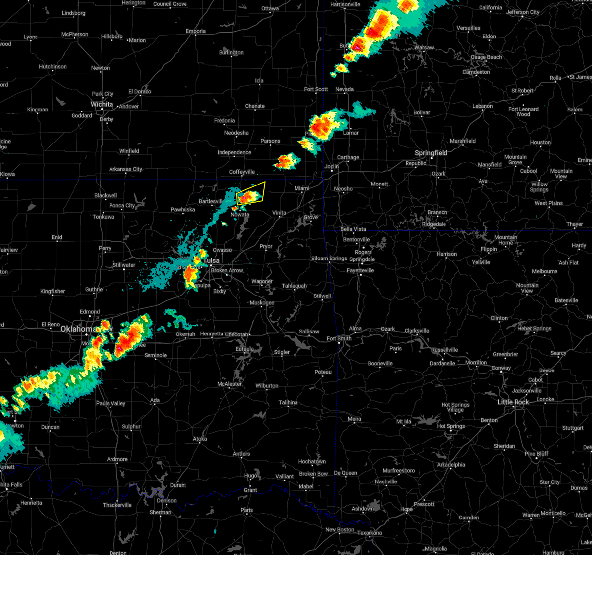 At 722 pm cdt, a severe thunderstorm was located near lenapah, moving northeast at 30 mph (radar indicated). Hazards include 60 mph wind gusts and quarter size hail. Hail damage to vehicles is expected. expect wind damage to roofs, siding, and trees. locations in or near the path include, delaware, lenapah, hail threat, radar indicated max hail size, 1. 00 in wind threat, radar indicated max wind gust, 60 mph. At 722 pm cdt, a severe thunderstorm was located near lenapah, moving northeast at 30 mph (radar indicated). Hazards include 60 mph wind gusts and quarter size hail. Hail damage to vehicles is expected. expect wind damage to roofs, siding, and trees. locations in or near the path include, delaware, lenapah, hail threat, radar indicated max hail size, 1. 00 in wind threat, radar indicated max wind gust, 60 mph.
|
| 9/5/2023 7:12 PM CDT |
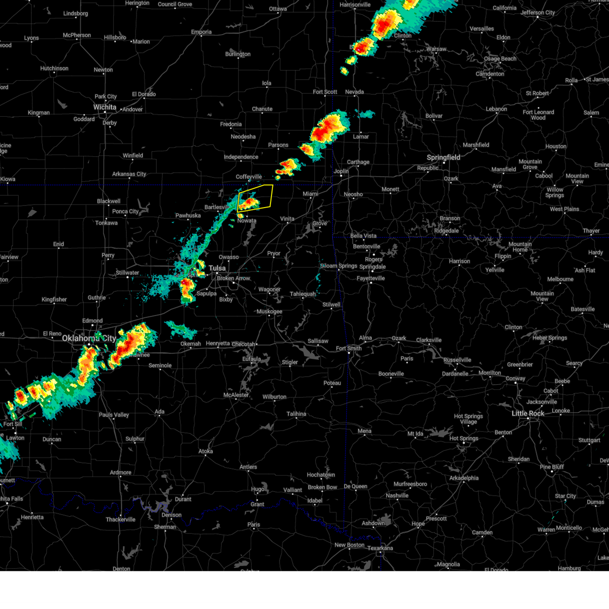 At 712 pm cdt, a severe thunderstorm was located near delaware, moving northeast at 30 mph (radar indicated). Hazards include 60 mph wind gusts and quarter size hail. Hail damage to vehicles is expected. expect wind damage to roofs, siding, and trees. locations in or near the path include, delaware, lenapah, hail threat, radar indicated max hail size, 1. 00 in wind threat, radar indicated max wind gust, 60 mph. At 712 pm cdt, a severe thunderstorm was located near delaware, moving northeast at 30 mph (radar indicated). Hazards include 60 mph wind gusts and quarter size hail. Hail damage to vehicles is expected. expect wind damage to roofs, siding, and trees. locations in or near the path include, delaware, lenapah, hail threat, radar indicated max hail size, 1. 00 in wind threat, radar indicated max wind gust, 60 mph.
|
| 8/11/2023 7:24 PM CDT |
 At 723 pm cdt, severe thunderstorms were located along a line extending from 2 miles south of nowata to 5 miles northwest of talala, moving southeast at 40 mph (radar indicated). Hazards include 60 mph wind gusts and quarter size hail. Hail damage to vehicles is expected. expect wind damage to roofs, siding, and trees. locations in or near the path include, nowata, delaware, watova, hail threat, radar indicated max hail size, 1. 00 in wind threat, radar indicated max wind gust, 60 mph. At 723 pm cdt, severe thunderstorms were located along a line extending from 2 miles south of nowata to 5 miles northwest of talala, moving southeast at 40 mph (radar indicated). Hazards include 60 mph wind gusts and quarter size hail. Hail damage to vehicles is expected. expect wind damage to roofs, siding, and trees. locations in or near the path include, nowata, delaware, watova, hail threat, radar indicated max hail size, 1. 00 in wind threat, radar indicated max wind gust, 60 mph.
|
| 8/11/2023 7:12 PM CDT |
 At 712 pm cdt, severe thunderstorms were located along a line extending from 8 miles west of delaware to 3 miles northeast of ochelata, moving east at 40 mph (radar indicated). Hazards include 60 mph wind gusts and quarter size hail. Hail damage to vehicles is expected. expect wind damage to roofs, siding, and trees. locations in or near the path include, bartlesville, nowata, dewey, delaware, watova, hail threat, radar indicated max hail size, 1. 00 in wind threat, radar indicated max wind gust, 60 mph. At 712 pm cdt, severe thunderstorms were located along a line extending from 8 miles west of delaware to 3 miles northeast of ochelata, moving east at 40 mph (radar indicated). Hazards include 60 mph wind gusts and quarter size hail. Hail damage to vehicles is expected. expect wind damage to roofs, siding, and trees. locations in or near the path include, bartlesville, nowata, dewey, delaware, watova, hail threat, radar indicated max hail size, 1. 00 in wind threat, radar indicated max wind gust, 60 mph.
|
| 8/11/2023 7:05 PM CDT |
 At 704 pm cdt, severe thunderstorms were located along a line extending from 4 miles southeast of dewey to 2 miles northwest of ochelata, moving east at 40 mph (radar indicated). Hazards include 70 mph wind gusts and quarter size hail. Hail damage to vehicles is expected. expect considerable tree damage. wind damage is also likely to mobile homes, roofs, and outbuildings. locations in or near the path include, bartlesville, nowata, dewey, delaware, watova, bartlesville municipal airport, thunderstorm damage threat, considerable hail threat, radar indicated max hail size, 1. 00 in wind threat, radar indicated max wind gust, 70 mph. At 704 pm cdt, severe thunderstorms were located along a line extending from 4 miles southeast of dewey to 2 miles northwest of ochelata, moving east at 40 mph (radar indicated). Hazards include 70 mph wind gusts and quarter size hail. Hail damage to vehicles is expected. expect considerable tree damage. wind damage is also likely to mobile homes, roofs, and outbuildings. locations in or near the path include, bartlesville, nowata, dewey, delaware, watova, bartlesville municipal airport, thunderstorm damage threat, considerable hail threat, radar indicated max hail size, 1. 00 in wind threat, radar indicated max wind gust, 70 mph.
|
| 8/11/2023 6:48 PM CDT |
 At 648 pm cdt, a severe thunderstorm was located 3 miles north of okesa, moving east at 40 mph (radar indicated). Hazards include 70 mph wind gusts and ping pong ball size hail. People and animals outdoors will be injured. expect hail damage to roofs, siding, windows, and vehicles. expect considerable tree damage. wind damage is also likely to mobile homes, roofs, and outbuildings. locations in or near the path include, bartlesville, nowata, dewey, delaware, watova, bartlesville municipal airport, thunderstorm damage threat, considerable hail threat, radar indicated max hail size, 1. 50 in wind threat, radar indicated max wind gust, 70 mph. At 648 pm cdt, a severe thunderstorm was located 3 miles north of okesa, moving east at 40 mph (radar indicated). Hazards include 70 mph wind gusts and ping pong ball size hail. People and animals outdoors will be injured. expect hail damage to roofs, siding, windows, and vehicles. expect considerable tree damage. wind damage is also likely to mobile homes, roofs, and outbuildings. locations in or near the path include, bartlesville, nowata, dewey, delaware, watova, bartlesville municipal airport, thunderstorm damage threat, considerable hail threat, radar indicated max hail size, 1. 50 in wind threat, radar indicated max wind gust, 70 mph.
|
| 8/9/2023 6:00 PM CDT |
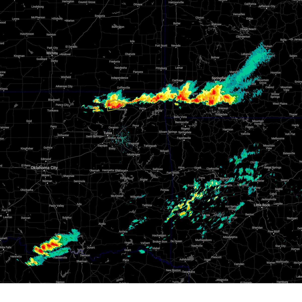 At 600 pm cdt, severe thunderstorms were located along a line extending from 3 miles northwest of nowata to 7 miles northwest of watova to bartlesville, moving east at 30 mph (radar indicated). Hazards include half dollar size hail. Damage to vehicles is expected. locations in or near the path include, bartlesville, dewey, delaware, hail threat, radar indicated max hail size, 1. 25 in wind threat, radar indicated max wind gust, <50 mph. At 600 pm cdt, severe thunderstorms were located along a line extending from 3 miles northwest of nowata to 7 miles northwest of watova to bartlesville, moving east at 30 mph (radar indicated). Hazards include half dollar size hail. Damage to vehicles is expected. locations in or near the path include, bartlesville, dewey, delaware, hail threat, radar indicated max hail size, 1. 25 in wind threat, radar indicated max wind gust, <50 mph.
|
| 8/9/2023 5:43 PM CDT |
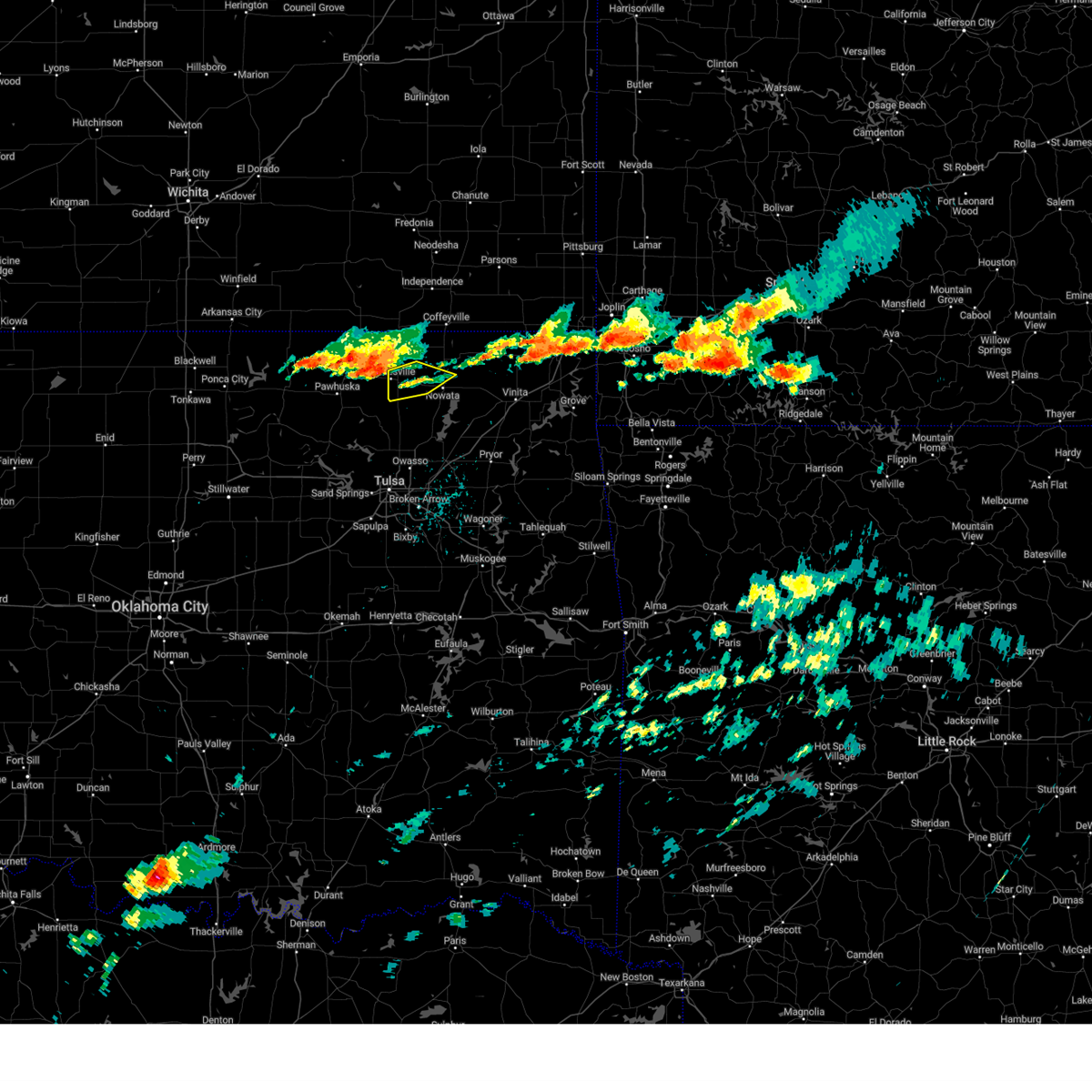 At 543 pm cdt, severe thunderstorms were located along a line extending from 5 miles east of dewey to bartlesville to near okesa, moving southeast at 20 mph (radar indicated). Hazards include 60 mph wind gusts and quarter size hail. Hail damage to vehicles is expected. expect wind damage to roofs, siding, and trees. locations in or near the path include, bartlesville, dewey, delaware, hail threat, radar indicated max hail size, 1. 00 in wind threat, radar indicated max wind gust, 60 mph. At 543 pm cdt, severe thunderstorms were located along a line extending from 5 miles east of dewey to bartlesville to near okesa, moving southeast at 20 mph (radar indicated). Hazards include 60 mph wind gusts and quarter size hail. Hail damage to vehicles is expected. expect wind damage to roofs, siding, and trees. locations in or near the path include, bartlesville, dewey, delaware, hail threat, radar indicated max hail size, 1. 00 in wind threat, radar indicated max wind gust, 60 mph.
|
| 8/5/2023 7:52 AM CDT |
 At 751 am cdt, severe thunderstorms were located along a line extending from 4 miles west of south coffeyville to 6 miles west of watova to near ramona, moving east at 40 mph (radar indicated). Hazards include 60 mph wind gusts. Expect damage to roofs, siding, and trees. locations in or near the path include, nowata, chelsea, oologah, south coffeyville, ramona, delaware, foyil, lenapah, talala, big cabin, vera, new alluwe, watova, white oak, hollow, centrailia, bushyhead, centralia, this includes interstate 44 between mile markers 264 and 279. hail threat, radar indicated max hail size, <. 75 in wind threat, radar indicated max wind gust, 60 mph. At 751 am cdt, severe thunderstorms were located along a line extending from 4 miles west of south coffeyville to 6 miles west of watova to near ramona, moving east at 40 mph (radar indicated). Hazards include 60 mph wind gusts. Expect damage to roofs, siding, and trees. locations in or near the path include, nowata, chelsea, oologah, south coffeyville, ramona, delaware, foyil, lenapah, talala, big cabin, vera, new alluwe, watova, white oak, hollow, centrailia, bushyhead, centralia, this includes interstate 44 between mile markers 264 and 279. hail threat, radar indicated max hail size, <. 75 in wind threat, radar indicated max wind gust, 60 mph.
|
| 8/5/2023 7:25 AM CDT |
 At 724 am cdt, severe thunderstorms were located along a line extending from 4 miles north of hulah to near okesa to 5 miles southwest of wynona, moving east at 40 mph (radar indicated). Hazards include 60 mph wind gusts. Expect damage to roofs, siding, and trees. locations in or near the path include, bartlesville, nowata, pawhuska, dewey, barnsdall, south coffeyville, copan, ramona, wynona, ochelata, delaware, avant, lenapah, vera, wann, bigheart, bartlesville municipal airport, osage hills state park, hulah, sunset lake, hail threat, radar indicated max hail size, <. 75 in wind threat, radar indicated max wind gust, 60 mph. At 724 am cdt, severe thunderstorms were located along a line extending from 4 miles north of hulah to near okesa to 5 miles southwest of wynona, moving east at 40 mph (radar indicated). Hazards include 60 mph wind gusts. Expect damage to roofs, siding, and trees. locations in or near the path include, bartlesville, nowata, pawhuska, dewey, barnsdall, south coffeyville, copan, ramona, wynona, ochelata, delaware, avant, lenapah, vera, wann, bigheart, bartlesville municipal airport, osage hills state park, hulah, sunset lake, hail threat, radar indicated max hail size, <. 75 in wind threat, radar indicated max wind gust, 60 mph.
|
| 7/17/2023 12:50 PM CDT |
 At 1249 pm cdt, severe thunderstorms were located along a line extending from 2 miles southwest of new alluwe to 4 miles west of vera, moving southeast at 55 mph (radar indicated). Hazards include 70 mph wind gusts and nickel size hail. Expect considerable tree damage. damage is likely to mobile homes, roofs, and outbuildings. locations in or near the path include, bartlesville, nowata, chelsea, oologah, ramona, ochelata, delaware, talala, vera, new alluwe, watova, bushyhead, thunderstorm damage threat, considerable hail threat, radar indicated max hail size, 0. 88 in wind threat, radar indicated max wind gust, 70 mph. At 1249 pm cdt, severe thunderstorms were located along a line extending from 2 miles southwest of new alluwe to 4 miles west of vera, moving southeast at 55 mph (radar indicated). Hazards include 70 mph wind gusts and nickel size hail. Expect considerable tree damage. damage is likely to mobile homes, roofs, and outbuildings. locations in or near the path include, bartlesville, nowata, chelsea, oologah, ramona, ochelata, delaware, talala, vera, new alluwe, watova, bushyhead, thunderstorm damage threat, considerable hail threat, radar indicated max hail size, 0. 88 in wind threat, radar indicated max wind gust, 70 mph.
|
| 7/17/2023 12:29 PM CDT |
 At 1229 pm cdt, severe thunderstorms were located along a line extending from near delaware to 4 miles southeast of okesa, moving southeast at 30 mph (radar indicated). Hazards include 70 mph wind gusts and nickel size hail. Expect considerable tree damage. damage is likely to mobile homes, roofs, and outbuildings. locations in or near the path include, bartlesville, nowata, dewey, chelsea, oologah, copan, ramona, ochelata, delaware, lenapah, talala, vera, wann, new alluwe, bartlesville municipal airport, watova, okesa, bushyhead, thunderstorm damage threat, considerable hail threat, radar indicated max hail size, 0. 88 in wind threat, radar indicated max wind gust, 70 mph. At 1229 pm cdt, severe thunderstorms were located along a line extending from near delaware to 4 miles southeast of okesa, moving southeast at 30 mph (radar indicated). Hazards include 70 mph wind gusts and nickel size hail. Expect considerable tree damage. damage is likely to mobile homes, roofs, and outbuildings. locations in or near the path include, bartlesville, nowata, dewey, chelsea, oologah, copan, ramona, ochelata, delaware, lenapah, talala, vera, wann, new alluwe, bartlesville municipal airport, watova, okesa, bushyhead, thunderstorm damage threat, considerable hail threat, radar indicated max hail size, 0. 88 in wind threat, radar indicated max wind gust, 70 mph.
|
| 7/17/2023 12:07 PM CDT |
 At 1207 pm cdt, severe thunderstorms were located along a line extending from 5 miles northwest of sunset lake to 2 miles northwest of dewey to 3 miles northeast of wann, moving southeast at 50 mph (radar indicated). Hazards include 70 mph wind gusts and nickel size hail. Expect considerable tree damage. damage is likely to mobile homes, roofs, and outbuildings. locations in or near the path include, bartlesville, nowata, dewey, copan, ochelata, delaware, lenapah, wann, bigheart, bartlesville municipal airport, hulah, sunset lake, osage hills state park, watova, okesa, wah sha she state park, tallant, nelagoney, thunderstorm damage threat, considerable hail threat, radar indicated max hail size, 0. 88 in wind threat, radar indicated max wind gust, 70 mph. At 1207 pm cdt, severe thunderstorms were located along a line extending from 5 miles northwest of sunset lake to 2 miles northwest of dewey to 3 miles northeast of wann, moving southeast at 50 mph (radar indicated). Hazards include 70 mph wind gusts and nickel size hail. Expect considerable tree damage. damage is likely to mobile homes, roofs, and outbuildings. locations in or near the path include, bartlesville, nowata, dewey, copan, ochelata, delaware, lenapah, wann, bigheart, bartlesville municipal airport, hulah, sunset lake, osage hills state park, watova, okesa, wah sha she state park, tallant, nelagoney, thunderstorm damage threat, considerable hail threat, radar indicated max hail size, 0. 88 in wind threat, radar indicated max wind gust, 70 mph.
|
| 7/17/2023 11:44 AM CDT |
 At 1144 am cdt, severe thunderstorms were located along a line extending from 8 miles south of cedar vale to near havana, moving south at 50 mph (radar indicated). Hazards include 70 mph wind gusts and quarter size hail. Hail damage to vehicles is expected. expect considerable tree damage. wind damage is also likely to mobile homes, roofs, and outbuildings. locations in or near the path include, bartlesville, nowata, dewey, copan, ochelata, delaware, lenapah, wann, bigheart, bartlesville municipal airport, hulah, sunset lake, osage hills state park, watova, okesa, wah sha she state park, tallant, nelagoney, thunderstorm damage threat, considerable hail threat, radar indicated max hail size, 1. 00 in wind threat, radar indicated max wind gust, 70 mph. At 1144 am cdt, severe thunderstorms were located along a line extending from 8 miles south of cedar vale to near havana, moving south at 50 mph (radar indicated). Hazards include 70 mph wind gusts and quarter size hail. Hail damage to vehicles is expected. expect considerable tree damage. wind damage is also likely to mobile homes, roofs, and outbuildings. locations in or near the path include, bartlesville, nowata, dewey, copan, ochelata, delaware, lenapah, wann, bigheart, bartlesville municipal airport, hulah, sunset lake, osage hills state park, watova, okesa, wah sha she state park, tallant, nelagoney, thunderstorm damage threat, considerable hail threat, radar indicated max hail size, 1. 00 in wind threat, radar indicated max wind gust, 70 mph.
|
| 7/14/2023 7:10 PM CDT |
 At 710 pm cdt, a severe thunderstorm was located 5 miles west of watova, moving southeast at 35 mph (radar indicated). Hazards include 60 mph wind gusts and penny size hail. Expect damage to roofs, siding, and trees. locations in or near the path include, vinita, nowata, chelsea, delaware, foyil, talala, big cabin, new alluwe, watova, white oak, bushyhead, this includes interstate 44 between mile markers 261 and 284. hail threat, radar indicated max hail size, 0. 75 in wind threat, radar indicated max wind gust, 60 mph. At 710 pm cdt, a severe thunderstorm was located 5 miles west of watova, moving southeast at 35 mph (radar indicated). Hazards include 60 mph wind gusts and penny size hail. Expect damage to roofs, siding, and trees. locations in or near the path include, vinita, nowata, chelsea, delaware, foyil, talala, big cabin, new alluwe, watova, white oak, bushyhead, this includes interstate 44 between mile markers 261 and 284. hail threat, radar indicated max hail size, 0. 75 in wind threat, radar indicated max wind gust, 60 mph.
|
| 7/14/2023 7:01 PM CDT |
 At 701 pm cdt, severe thunderstorms were located along a line extending from 3 miles northeast of seneca to 10 miles north of white oak to 8 miles east of bartlesville, moving southeast at 35 mph (radar indicated). Hazards include 60 mph wind gusts and penny size hail. Expect damage to roofs, siding, and trees. locations in or near the path include, bartlesville, miami, vinita, nowata, grove, dewey, commerce, fairland, afton, quapaw, welch, bernice, delaware, bluejacket, wyandotte, lenapah, new alluwe, bernice state park, watova, white oak, this includes interstate 44 between mile markers 280 and 323. hail threat, radar indicated max hail size, 0. 75 in wind threat, radar indicated max wind gust, 60 mph. At 701 pm cdt, severe thunderstorms were located along a line extending from 3 miles northeast of seneca to 10 miles north of white oak to 8 miles east of bartlesville, moving southeast at 35 mph (radar indicated). Hazards include 60 mph wind gusts and penny size hail. Expect damage to roofs, siding, and trees. locations in or near the path include, bartlesville, miami, vinita, nowata, grove, dewey, commerce, fairland, afton, quapaw, welch, bernice, delaware, bluejacket, wyandotte, lenapah, new alluwe, bernice state park, watova, white oak, this includes interstate 44 between mile markers 280 and 323. hail threat, radar indicated max hail size, 0. 75 in wind threat, radar indicated max wind gust, 60 mph.
|
| 7/14/2023 6:42 PM CDT |
 At 642 pm cdt, severe thunderstorms were located along a line extending from near quapaw to 9 miles west of welch to 3 miles north of dewey, moving southeast at 40 mph (radar indicated). Hazards include 60 mph wind gusts and penny size hail. Expect damage to roofs, siding, and trees. locations in or near the path include, bartlesville, miami, vinita, nowata, grove, dewey, commerce, fairland, afton, quapaw, copan, welch, bernice, delaware, bluejacket, wyandotte, lenapah, wann, new alluwe, picher, this includes interstate 44 between mile markers 280 and 323. hail threat, radar indicated max hail size, 0. 75 in wind threat, radar indicated max wind gust, 60 mph. At 642 pm cdt, severe thunderstorms were located along a line extending from near quapaw to 9 miles west of welch to 3 miles north of dewey, moving southeast at 40 mph (radar indicated). Hazards include 60 mph wind gusts and penny size hail. Expect damage to roofs, siding, and trees. locations in or near the path include, bartlesville, miami, vinita, nowata, grove, dewey, commerce, fairland, afton, quapaw, copan, welch, bernice, delaware, bluejacket, wyandotte, lenapah, wann, new alluwe, picher, this includes interstate 44 between mile markers 280 and 323. hail threat, radar indicated max hail size, 0. 75 in wind threat, radar indicated max wind gust, 60 mph.
|
| 7/14/2023 6:14 PM CDT |
 At 614 pm cdt, severe thunderstorms were located along a line extending from 3 miles northwest of west mineral to 2 miles south of dearing, moving southeast at 35 mph (radar indicated). Hazards include 60 mph wind gusts. Expect damage to roofs, siding, and trees. locations in or near the path include, bartlesville, dewey, commerce, quapaw, south coffeyville, copan, welch, delaware, lenapah, wann, picher, cardin, hollow, centrailia, centralia, hail threat, radar indicated max hail size, <. 75 in wind threat, radar indicated max wind gust, 60 mph. At 614 pm cdt, severe thunderstorms were located along a line extending from 3 miles northwest of west mineral to 2 miles south of dearing, moving southeast at 35 mph (radar indicated). Hazards include 60 mph wind gusts. Expect damage to roofs, siding, and trees. locations in or near the path include, bartlesville, dewey, commerce, quapaw, south coffeyville, copan, welch, delaware, lenapah, wann, picher, cardin, hollow, centrailia, centralia, hail threat, radar indicated max hail size, <. 75 in wind threat, radar indicated max wind gust, 60 mph.
|
| 7/14/2023 5:50 PM CDT |
 At 550 pm cdt, severe thunderstorms were located along a line extending from 3 miles east of st. paul to 6 miles south of elk city, moving southeast at 50 mph (radar indicated). Hazards include 60 mph wind gusts. Expect damage to roofs, siding, and trees. locations in or near the path include, bartlesville, dewey, commerce, quapaw, south coffeyville, copan, welch, delaware, lenapah, wann, picher, cardin, hollow, centrailia, centralia, hail threat, radar indicated max hail size, <. 75 in wind threat, radar indicated max wind gust, 60 mph. At 550 pm cdt, severe thunderstorms were located along a line extending from 3 miles east of st. paul to 6 miles south of elk city, moving southeast at 50 mph (radar indicated). Hazards include 60 mph wind gusts. Expect damage to roofs, siding, and trees. locations in or near the path include, bartlesville, dewey, commerce, quapaw, south coffeyville, copan, welch, delaware, lenapah, wann, picher, cardin, hollow, centrailia, centralia, hail threat, radar indicated max hail size, <. 75 in wind threat, radar indicated max wind gust, 60 mph.
|
| 6/28/2023 1:04 AM CDT |
 At 103 am cdt, severe thunderstorms were located along a line extending from 2 miles southwest of south coffeyville to 3 miles northwest of delaware to 2 miles southeast of ochelata, moving east at 60 mph (radar indicated). Hazards include 60 mph wind gusts and nickel size hail. Expect damage to roofs, siding, and trees. locations in or near the path include, bartlesville, nowata, pawhuska, dewey, barnsdall, oologah, south coffeyville, copan, ramona, wynona, ochelata, delaware, avant, lenapah, talala, vera, wann, bigheart, bartlesville municipal airport, osage hills state park, hail threat, radar indicated max hail size, 0. 88 in wind threat, radar indicated max wind gust, 60 mph. At 103 am cdt, severe thunderstorms were located along a line extending from 2 miles southwest of south coffeyville to 3 miles northwest of delaware to 2 miles southeast of ochelata, moving east at 60 mph (radar indicated). Hazards include 60 mph wind gusts and nickel size hail. Expect damage to roofs, siding, and trees. locations in or near the path include, bartlesville, nowata, pawhuska, dewey, barnsdall, oologah, south coffeyville, copan, ramona, wynona, ochelata, delaware, avant, lenapah, talala, vera, wann, bigheart, bartlesville municipal airport, osage hills state park, hail threat, radar indicated max hail size, 0. 88 in wind threat, radar indicated max wind gust, 60 mph.
|
| 6/28/2023 12:48 AM CDT |
 At 1247 am cdt, severe thunderstorms were located along a line extending from 3 miles south of caney to near dewey to 3 miles west of barnsdall, moving east at 60 mph (radar indicated). Hazards include 60 mph wind gusts and penny size hail. Expect damage to roofs, siding, and trees. locations in or near the path include, bartlesville, nowata, pawhuska, dewey, barnsdall, oologah, south coffeyville, copan, ramona, wynona, ochelata, delaware, avant, lenapah, talala, vera, wann, bigheart, bartlesville municipal airport, osage hills state park, hail threat, radar indicated max hail size, 0. 75 in wind threat, radar indicated max wind gust, 60 mph. At 1247 am cdt, severe thunderstorms were located along a line extending from 3 miles south of caney to near dewey to 3 miles west of barnsdall, moving east at 60 mph (radar indicated). Hazards include 60 mph wind gusts and penny size hail. Expect damage to roofs, siding, and trees. locations in or near the path include, bartlesville, nowata, pawhuska, dewey, barnsdall, oologah, south coffeyville, copan, ramona, wynona, ochelata, delaware, avant, lenapah, talala, vera, wann, bigheart, bartlesville municipal airport, osage hills state park, hail threat, radar indicated max hail size, 0. 75 in wind threat, radar indicated max wind gust, 60 mph.
|
| 6/28/2023 12:26 AM CDT |
 At 1226 am cdt, severe thunderstorms were located along a line extending from elgin to 4 miles west of bigheart to 7 miles northeast of fairfax, moving east at 60 mph (radar indicated). Hazards include 60 mph wind gusts and penny size hail. Expect damage to roofs, siding, and trees. locations in or near the path include, bartlesville, nowata, pawhuska, dewey, barnsdall, oologah, south coffeyville, copan, ramona, wynona, ochelata, delaware, avant, lenapah, talala, vera, wann, bigheart, bartlesville municipal airport, osage hills state park, hail threat, radar indicated max hail size, 0. 75 in wind threat, radar indicated max wind gust, 60 mph. At 1226 am cdt, severe thunderstorms were located along a line extending from elgin to 4 miles west of bigheart to 7 miles northeast of fairfax, moving east at 60 mph (radar indicated). Hazards include 60 mph wind gusts and penny size hail. Expect damage to roofs, siding, and trees. locations in or near the path include, bartlesville, nowata, pawhuska, dewey, barnsdall, oologah, south coffeyville, copan, ramona, wynona, ochelata, delaware, avant, lenapah, talala, vera, wann, bigheart, bartlesville municipal airport, osage hills state park, hail threat, radar indicated max hail size, 0. 75 in wind threat, radar indicated max wind gust, 60 mph.
|
| 6/18/2023 12:50 AM CDT |
 At 1249 am cdt, severe thunderstorms were located along a line extending from 4 miles east of south coffeyville to 4 miles southwest of foyil, moving east at 55 mph (radar indicated). Hazards include 70 mph wind gusts and nickel size hail. Expect considerable tree damage. damage is likely to mobile homes, roofs, and outbuildings. locations in or near the path include, bartlesville, nowata, skiatook, collinsville, chelsea, oologah, south coffeyville, ramona, delaware, foyil, lenapah, talala, vera, wann, new alluwe, watova, hollow, centrailia, bushyhead, centralia, thunderstorm damage threat, considerable hail threat, radar indicated max hail size, 0. 88 in wind threat, radar indicated max wind gust, 70 mph. At 1249 am cdt, severe thunderstorms were located along a line extending from 4 miles east of south coffeyville to 4 miles southwest of foyil, moving east at 55 mph (radar indicated). Hazards include 70 mph wind gusts and nickel size hail. Expect considerable tree damage. damage is likely to mobile homes, roofs, and outbuildings. locations in or near the path include, bartlesville, nowata, skiatook, collinsville, chelsea, oologah, south coffeyville, ramona, delaware, foyil, lenapah, talala, vera, wann, new alluwe, watova, hollow, centrailia, bushyhead, centralia, thunderstorm damage threat, considerable hail threat, radar indicated max hail size, 0. 88 in wind threat, radar indicated max wind gust, 70 mph.
|
| 6/18/2023 12:07 AM CDT |
 At 1206 am cdt, severe thunderstorms were located along a line extending from 4 miles north of hulah to 3 miles northeast of walnut creek state park, moving east at 55 mph (radar indicated). Hazards include 70 mph wind gusts and nickel size hail. Expect considerable tree damage. damage is likely to mobile homes, roofs, and outbuildings. locations in or near the path include, bartlesville, nowata, skiatook, collinsville, dewey, chelsea, barnsdall, oologah, south coffeyville, copan, ramona, ochelata, delaware, foyil, avant, lenapah, talala, vera, wann, new alluwe, thunderstorm damage threat, considerable hail threat, radar indicated max hail size, 0. 88 in wind threat, radar indicated max wind gust, 70 mph. At 1206 am cdt, severe thunderstorms were located along a line extending from 4 miles north of hulah to 3 miles northeast of walnut creek state park, moving east at 55 mph (radar indicated). Hazards include 70 mph wind gusts and nickel size hail. Expect considerable tree damage. damage is likely to mobile homes, roofs, and outbuildings. locations in or near the path include, bartlesville, nowata, skiatook, collinsville, dewey, chelsea, barnsdall, oologah, south coffeyville, copan, ramona, ochelata, delaware, foyil, avant, lenapah, talala, vera, wann, new alluwe, thunderstorm damage threat, considerable hail threat, radar indicated max hail size, 0. 88 in wind threat, radar indicated max wind gust, 70 mph.
|
| 6/14/2023 7:22 AM CDT |
 The severe thunderstorm warning for southwestern craig, northern rogers, east central osage, southern washington, southern nowata and northeastern tulsa counties will expire at 730 am cdt, the storms which prompted the warning have moved out of the area. therefore, the warning will be allowed to expire. to report severe weather, contact your nearest law enforcement agency. they will relay your report to the national weather service tulsa. The severe thunderstorm warning for southwestern craig, northern rogers, east central osage, southern washington, southern nowata and northeastern tulsa counties will expire at 730 am cdt, the storms which prompted the warning have moved out of the area. therefore, the warning will be allowed to expire. to report severe weather, contact your nearest law enforcement agency. they will relay your report to the national weather service tulsa.
|
| 6/14/2023 6:45 AM CDT |
 At 645 am cdt, severe thunderstorms were located along a line extending from 3 miles east of watova to 2 miles north of oologah to 3 miles east of skiatook, moving southeast at 45 mph (radar indicated). Hazards include 60 mph wind gusts and quarter size hail. Hail damage to vehicles is expected. expect wind damage to roofs, siding, and trees. locations in or near the path include, bartlesville, claremore, nowata, skiatook, collinsville, chelsea, oologah, ramona, ochelata, delaware, foyil, avant, talala, vera, new alluwe, watova, bushyhead, wolco, this includes interstate 44 between mile markers 245 and 251. hail threat, radar indicated max hail size, 1. 00 in wind threat, radar indicated max wind gust, 60 mph. At 645 am cdt, severe thunderstorms were located along a line extending from 3 miles east of watova to 2 miles north of oologah to 3 miles east of skiatook, moving southeast at 45 mph (radar indicated). Hazards include 60 mph wind gusts and quarter size hail. Hail damage to vehicles is expected. expect wind damage to roofs, siding, and trees. locations in or near the path include, bartlesville, claremore, nowata, skiatook, collinsville, chelsea, oologah, ramona, ochelata, delaware, foyil, avant, talala, vera, new alluwe, watova, bushyhead, wolco, this includes interstate 44 between mile markers 245 and 251. hail threat, radar indicated max hail size, 1. 00 in wind threat, radar indicated max wind gust, 60 mph.
|
| 6/14/2023 6:27 AM CDT |
 At 627 am cdt, severe thunderstorms were located along a line extending from 4 miles east of bartlesville to 2 miles southeast of ochelata to 7 miles southwest of avant, moving southeast at 30 mph (radar indicated). Hazards include 60 mph wind gusts and quarter size hail. Hail damage to vehicles is expected. expect wind damage to roofs, siding, and trees. locations in or near the path include, bartlesville, claremore, nowata, skiatook, collinsville, chelsea, oologah, ramona, ochelata, delaware, foyil, avant, talala, vera, new alluwe, watova, bushyhead, wolco, this includes interstate 44 between mile markers 245 and 251. hail threat, radar indicated max hail size, 1. 00 in wind threat, radar indicated max wind gust, 60 mph. At 627 am cdt, severe thunderstorms were located along a line extending from 4 miles east of bartlesville to 2 miles southeast of ochelata to 7 miles southwest of avant, moving southeast at 30 mph (radar indicated). Hazards include 60 mph wind gusts and quarter size hail. Hail damage to vehicles is expected. expect wind damage to roofs, siding, and trees. locations in or near the path include, bartlesville, claremore, nowata, skiatook, collinsville, chelsea, oologah, ramona, ochelata, delaware, foyil, avant, talala, vera, new alluwe, watova, bushyhead, wolco, this includes interstate 44 between mile markers 245 and 251. hail threat, radar indicated max hail size, 1. 00 in wind threat, radar indicated max wind gust, 60 mph.
|
| 6/10/2023 5:23 AM CDT |
 The severe thunderstorm warning for northwestern rogers, eastern osage, washington, western nowata and northeastern tulsa counties will expire at 530 am cdt, the storms which prompted the warning have weakened below severe limits, and no longer pose an immediate threat to life or property. therefore, the warning will be allowed to expire. however small hail, gusty winds and heavy rain are still possible with these thunderstorms. to report severe weather, contact your nearest law enforcement agency. they will relay your report to the national weather service tulsa. The severe thunderstorm warning for northwestern rogers, eastern osage, washington, western nowata and northeastern tulsa counties will expire at 530 am cdt, the storms which prompted the warning have weakened below severe limits, and no longer pose an immediate threat to life or property. therefore, the warning will be allowed to expire. however small hail, gusty winds and heavy rain are still possible with these thunderstorms. to report severe weather, contact your nearest law enforcement agency. they will relay your report to the national weather service tulsa.
|
| 6/10/2023 5:03 AM CDT |
 At 503 am cdt, severe thunderstorms were located along a line extending from 3 miles southwest of caney to 4 miles south of bartlesville municipal airport to 5 miles east of walnut creek state park, moving east at 40 mph (radar indicated). Hazards include 60 mph wind gusts and penny size hail. Expect damage to roofs, siding, and trees. locations in or near the path include, bartlesville, nowata, owasso, skiatook, collinsville, dewey, barnsdall, sperry, oologah, south coffeyville, copan, ramona, ochelata, delaware, avant, lenapah, talala, vera, wann, bartlesville municipal airport, hail threat, radar indicated max hail size, 0. 75 in wind threat, radar indicated max wind gust, 60 mph. At 503 am cdt, severe thunderstorms were located along a line extending from 3 miles southwest of caney to 4 miles south of bartlesville municipal airport to 5 miles east of walnut creek state park, moving east at 40 mph (radar indicated). Hazards include 60 mph wind gusts and penny size hail. Expect damage to roofs, siding, and trees. locations in or near the path include, bartlesville, nowata, owasso, skiatook, collinsville, dewey, barnsdall, sperry, oologah, south coffeyville, copan, ramona, ochelata, delaware, avant, lenapah, talala, vera, wann, bartlesville municipal airport, hail threat, radar indicated max hail size, 0. 75 in wind threat, radar indicated max wind gust, 60 mph.
|
| 6/10/2023 4:48 AM CDT |
 At 448 am cdt, severe thunderstorms were located along a line extending from 4 miles northwest of hulah to near okesa to 2 miles northwest of walnut creek state park, moving east at 40 mph (radar indicated). Hazards include 60 mph wind gusts and penny size hail. Expect damage to roofs, siding, and trees. locations in or near the path include, bartlesville, nowata, owasso, skiatook, collinsville, dewey, barnsdall, sperry, oologah, south coffeyville, copan, ramona, ochelata, delaware, avant, lenapah, talala, vera, wann, bartlesville municipal airport, hail threat, radar indicated max hail size, 0. 75 in wind threat, radar indicated max wind gust, 60 mph. At 448 am cdt, severe thunderstorms were located along a line extending from 4 miles northwest of hulah to near okesa to 2 miles northwest of walnut creek state park, moving east at 40 mph (radar indicated). Hazards include 60 mph wind gusts and penny size hail. Expect damage to roofs, siding, and trees. locations in or near the path include, bartlesville, nowata, owasso, skiatook, collinsville, dewey, barnsdall, sperry, oologah, south coffeyville, copan, ramona, ochelata, delaware, avant, lenapah, talala, vera, wann, bartlesville municipal airport, hail threat, radar indicated max hail size, 0. 75 in wind threat, radar indicated max wind gust, 60 mph.
|
| 5/12/2023 1:01 AM CDT |
 At 101 am cdt, a severe thunderstorm was located over delaware, moving northeast at 40 mph (radar indicated). Hazards include 60 mph wind gusts and quarter size hail. Hail damage to vehicles is expected. expect wind damage to roofs, siding, and trees. locations in or near the path include, nowata, delaware, lenapah, hail threat, radar indicated max hail size, 1. 00 in wind threat, radar indicated max wind gust, 60 mph. At 101 am cdt, a severe thunderstorm was located over delaware, moving northeast at 40 mph (radar indicated). Hazards include 60 mph wind gusts and quarter size hail. Hail damage to vehicles is expected. expect wind damage to roofs, siding, and trees. locations in or near the path include, nowata, delaware, lenapah, hail threat, radar indicated max hail size, 1. 00 in wind threat, radar indicated max wind gust, 60 mph.
|
| 5/12/2023 12:46 AM CDT |
 At 1246 am cdt, a severe thunderstorm was located 6 miles southeast of bartlesville, moving northeast at 20 mph (radar indicated). Hazards include quarter size hail. Damage to vehicles is expected. locations in or near the path include, nowata, delaware, lenapah, hail threat, radar indicated max hail size, 1. 00 in wind threat, radar indicated max wind gust, <50 mph. At 1246 am cdt, a severe thunderstorm was located 6 miles southeast of bartlesville, moving northeast at 20 mph (radar indicated). Hazards include quarter size hail. Damage to vehicles is expected. locations in or near the path include, nowata, delaware, lenapah, hail threat, radar indicated max hail size, 1. 00 in wind threat, radar indicated max wind gust, <50 mph.
|
| 9/3/2022 7:18 PM CDT |
 At 717 pm cdt, a severe thunderstorm was located over lenapah, moving south at 15 mph (radar indicated). Hazards include 60 mph wind gusts. Expect damage to roofs, siding, and trees. locations in or near the path include, nowata, delaware, lenapah, the storm has been on a weakening trend over the past 10 minutes. if this trend continues, the warning may be canceled early. hail threat, radar indicated max hail size, <. 75 in wind threat, radar indicated max wind gust, 60 mph. At 717 pm cdt, a severe thunderstorm was located over lenapah, moving south at 15 mph (radar indicated). Hazards include 60 mph wind gusts. Expect damage to roofs, siding, and trees. locations in or near the path include, nowata, delaware, lenapah, the storm has been on a weakening trend over the past 10 minutes. if this trend continues, the warning may be canceled early. hail threat, radar indicated max hail size, <. 75 in wind threat, radar indicated max wind gust, 60 mph.
|
| 9/3/2022 7:09 PM CDT |
 At 709 pm cdt, a severe thunderstorm was located near lenapah, moving south at 15 mph (radar indicated). Hazards include 60 mph wind gusts and nickel size hail. Expect damage to roofs, siding, and trees. locations in or near the path include, nowata, delaware, lenapah, hail threat, radar indicated max hail size, 0. 88 in wind threat, radar indicated max wind gust, 60 mph. At 709 pm cdt, a severe thunderstorm was located near lenapah, moving south at 15 mph (radar indicated). Hazards include 60 mph wind gusts and nickel size hail. Expect damage to roofs, siding, and trees. locations in or near the path include, nowata, delaware, lenapah, hail threat, radar indicated max hail size, 0. 88 in wind threat, radar indicated max wind gust, 60 mph.
|
| 6/11/2022 11:59 PM CDT |
 At 1158 pm cdt, a severe thunderstorm was located 5 miles northwest of delaware, moving south at 40 mph (radar indicated). Hazards include 60 mph wind gusts and half dollar size hail. Hail damage to vehicles is expected. expect wind damage to roofs, siding, and trees. locations in or near the path include, nowata, delaware, lenapah, wann, new alluwe, watova, hail threat, radar indicated max hail size, 1. 25 in wind threat, radar indicated max wind gust, 60 mph. At 1158 pm cdt, a severe thunderstorm was located 5 miles northwest of delaware, moving south at 40 mph (radar indicated). Hazards include 60 mph wind gusts and half dollar size hail. Hail damage to vehicles is expected. expect wind damage to roofs, siding, and trees. locations in or near the path include, nowata, delaware, lenapah, wann, new alluwe, watova, hail threat, radar indicated max hail size, 1. 25 in wind threat, radar indicated max wind gust, 60 mph.
|
| 6/11/2022 11:34 PM CDT |
 At 1134 pm cdt, severe thunderstorms were located along a line extending from 2 miles northeast of dearing to 3 miles south of caney, moving southeast at 45 mph (radar indicated). Hazards include golf ball size hail and 60 mph wind gusts. People and animals outdoors will be injured. expect hail damage to roofs, siding, windows, and vehicles. expect wind damage to roofs, siding, and trees. locations in or near the path include, bartlesville, nowata, dewey, south coffeyville, copan, ramona, ochelata, delaware, lenapah, wann, new alluwe, watova, thunderstorm damage threat, considerable hail threat, radar indicated max hail size, 1. 75 in wind threat, radar indicated max wind gust, 60 mph. At 1134 pm cdt, severe thunderstorms were located along a line extending from 2 miles northeast of dearing to 3 miles south of caney, moving southeast at 45 mph (radar indicated). Hazards include golf ball size hail and 60 mph wind gusts. People and animals outdoors will be injured. expect hail damage to roofs, siding, windows, and vehicles. expect wind damage to roofs, siding, and trees. locations in or near the path include, bartlesville, nowata, dewey, south coffeyville, copan, ramona, ochelata, delaware, lenapah, wann, new alluwe, watova, thunderstorm damage threat, considerable hail threat, radar indicated max hail size, 1. 75 in wind threat, radar indicated max wind gust, 60 mph.
|
| 6/11/2022 11:23 PM CDT |
 At 1123 pm cdt, severe thunderstorms were located along a line extending from 3 miles southwest of independence to 3 miles northwest of caney, moving south at 50 mph (radar indicated). Hazards include 60 mph wind gusts and quarter size hail. Hail damage to vehicles is expected. expect wind damage to roofs, siding, and trees. locations in or near the path include, bartlesville, nowata, dewey, south coffeyville, copan, ramona, ochelata, delaware, lenapah, wann, new alluwe, watova, hail threat, radar indicated max hail size, 1. 00 in wind threat, radar indicated max wind gust, 60 mph. At 1123 pm cdt, severe thunderstorms were located along a line extending from 3 miles southwest of independence to 3 miles northwest of caney, moving south at 50 mph (radar indicated). Hazards include 60 mph wind gusts and quarter size hail. Hail damage to vehicles is expected. expect wind damage to roofs, siding, and trees. locations in or near the path include, bartlesville, nowata, dewey, south coffeyville, copan, ramona, ochelata, delaware, lenapah, wann, new alluwe, watova, hail threat, radar indicated max hail size, 1. 00 in wind threat, radar indicated max wind gust, 60 mph.
|
| 5/19/2022 4:44 AM CDT |
 At 443 am cdt, severe thunderstorms were located along a line extending from 2 miles southwest of caney to 3 miles southeast of bartlesville to 3 miles north of talala, moving northeast at 60 mph (radar indicated). Hazards include 60 mph wind gusts. Expect damage to roofs, siding, and trees. locations in or near the path include, bartlesville, nowata, dewey, south coffeyville, copan, delaware, lenapah, talala, wann, watova, hail threat, radar indicated max hail size, <. 75 in wind threat, radar indicated max wind gust, 60 mph. At 443 am cdt, severe thunderstorms were located along a line extending from 2 miles southwest of caney to 3 miles southeast of bartlesville to 3 miles north of talala, moving northeast at 60 mph (radar indicated). Hazards include 60 mph wind gusts. Expect damage to roofs, siding, and trees. locations in or near the path include, bartlesville, nowata, dewey, south coffeyville, copan, delaware, lenapah, talala, wann, watova, hail threat, radar indicated max hail size, <. 75 in wind threat, radar indicated max wind gust, 60 mph.
|
| 5/19/2022 4:17 AM CDT |
 At 416 am cdt, severe thunderstorms were located along a line extending from 3 miles southwest of elgin to 4 miles northeast of pawhuska to near walnut creek state park, moving northeast at 60 mph (radar indicated). Hazards include 60 mph wind gusts. Expect damage to roofs, siding, and trees. locations in or near the path include, bartlesville, nowata, pawhuska, skiatook, dewey, barnsdall, south coffeyville, copan, ramona, wynona, ochelata, delaware, avant, westport, lenapah, talala, vera, wann, bigheart, bartlesville municipal airport, hail threat, radar indicated max hail size, <. 75 in wind threat, radar indicated max wind gust, 60 mph. At 416 am cdt, severe thunderstorms were located along a line extending from 3 miles southwest of elgin to 4 miles northeast of pawhuska to near walnut creek state park, moving northeast at 60 mph (radar indicated). Hazards include 60 mph wind gusts. Expect damage to roofs, siding, and trees. locations in or near the path include, bartlesville, nowata, pawhuska, skiatook, dewey, barnsdall, south coffeyville, copan, ramona, wynona, ochelata, delaware, avant, westport, lenapah, talala, vera, wann, bigheart, bartlesville municipal airport, hail threat, radar indicated max hail size, <. 75 in wind threat, radar indicated max wind gust, 60 mph.
|
| 5/15/2022 1:29 AM CDT |
 At 128 am cdt, severe thunderstorms were located along a line extending from 5 miles west of lenapah to 2 miles east of chelsea, moving northeast at 15 mph (radar indicated). Hazards include 60 mph wind gusts and half dollar size hail. Hail damage to vehicles is expected. expect wind damage to roofs, siding, and trees. locations in or near the path include, nowata, chelsea, south coffeyville, delaware, lenapah, new alluwe, white oak, this includes interstate 44 between mile markers 265 and 270, and between mile markers 277 and 279. hail threat, radar indicated max hail size, 1. 25 in wind threat, radar indicated max wind gust, 60 mph. At 128 am cdt, severe thunderstorms were located along a line extending from 5 miles west of lenapah to 2 miles east of chelsea, moving northeast at 15 mph (radar indicated). Hazards include 60 mph wind gusts and half dollar size hail. Hail damage to vehicles is expected. expect wind damage to roofs, siding, and trees. locations in or near the path include, nowata, chelsea, south coffeyville, delaware, lenapah, new alluwe, white oak, this includes interstate 44 between mile markers 265 and 270, and between mile markers 277 and 279. hail threat, radar indicated max hail size, 1. 25 in wind threat, radar indicated max wind gust, 60 mph.
|
| 5/15/2022 1:12 AM CDT |
 At 111 am cdt, severe thunderstorms were located along a line extending from 7 miles west of delaware to 3 miles south of chelsea, moving northeast at 10 mph (radar indicated). Hazards include 60 mph wind gusts and half dollar size hail. Hail damage to vehicles is expected. expect wind damage to roofs, siding, and trees. locations in or near the path include, nowata, chelsea, south coffeyville, delaware, lenapah, wann, new alluwe, watova, white oak, bushyhead, this includes interstate 44 between mile markers 260 and 279. hail threat, radar indicated max hail size, 1. 25 in wind threat, radar indicated max wind gust, 60 mph. At 111 am cdt, severe thunderstorms were located along a line extending from 7 miles west of delaware to 3 miles south of chelsea, moving northeast at 10 mph (radar indicated). Hazards include 60 mph wind gusts and half dollar size hail. Hail damage to vehicles is expected. expect wind damage to roofs, siding, and trees. locations in or near the path include, nowata, chelsea, south coffeyville, delaware, lenapah, wann, new alluwe, watova, white oak, bushyhead, this includes interstate 44 between mile markers 260 and 279. hail threat, radar indicated max hail size, 1. 25 in wind threat, radar indicated max wind gust, 60 mph.
|
| 5/15/2022 12:39 AM CDT |
 At 1239 am cdt, severe thunderstorms were located along a line extending from 5 miles northwest of bartlesville municipal airport to 2 miles southwest of talala, moving northeast at 15 mph (radar indicated). Hazards include 60 mph wind gusts and half dollar size hail. Hail damage to vehicles is expected. expect wind damage to roofs, siding, and trees. locations in or near the path include, bartlesville, nowata, dewey, oologah, copan, ramona, ochelata, delaware, talala, wann, new alluwe, bartlesville municipal airport, hulah, watova, okesa, osage hills state park, wah sha she state park, hail threat, radar indicated max hail size, 1. 25 in wind threat, radar indicated max wind gust, 60 mph. At 1239 am cdt, severe thunderstorms were located along a line extending from 5 miles northwest of bartlesville municipal airport to 2 miles southwest of talala, moving northeast at 15 mph (radar indicated). Hazards include 60 mph wind gusts and half dollar size hail. Hail damage to vehicles is expected. expect wind damage to roofs, siding, and trees. locations in or near the path include, bartlesville, nowata, dewey, oologah, copan, ramona, ochelata, delaware, talala, wann, new alluwe, bartlesville municipal airport, hulah, watova, okesa, osage hills state park, wah sha she state park, hail threat, radar indicated max hail size, 1. 25 in wind threat, radar indicated max wind gust, 60 mph.
|
| 5/15/2022 12:25 AM CDT |
 At 1224 am cdt, severe thunderstorms were located along a line extending from 4 miles northeast of osage hills state park to 3 miles west of oologah, moving northeast at 15 mph (radar indicated). Hazards include 60 mph wind gusts and half dollar size hail. Hail damage to vehicles is expected. expect wind damage to roofs, siding, and trees. locations in or near the path include, bartlesville, nowata, dewey, oologah, copan, ramona, ochelata, delaware, talala, wann, new alluwe, bartlesville municipal airport, hulah, watova, okesa, wah sha she state park, hail threat, radar indicated max hail size, 1. 25 in wind threat, radar indicated max wind gust, 60 mph. At 1224 am cdt, severe thunderstorms were located along a line extending from 4 miles northeast of osage hills state park to 3 miles west of oologah, moving northeast at 15 mph (radar indicated). Hazards include 60 mph wind gusts and half dollar size hail. Hail damage to vehicles is expected. expect wind damage to roofs, siding, and trees. locations in or near the path include, bartlesville, nowata, dewey, oologah, copan, ramona, ochelata, delaware, talala, wann, new alluwe, bartlesville municipal airport, hulah, watova, okesa, wah sha she state park, hail threat, radar indicated max hail size, 1. 25 in wind threat, radar indicated max wind gust, 60 mph.
|
| 5/4/2022 7:11 PM CDT |
 At 711 pm cdt, a severe thunderstorm was located 5 miles northeast of ramona, moving northeast at 40 mph (radar indicated). Hazards include quarter size hail. Damage to vehicles is expected. locations in or near the path include, bartlesville, nowata, ramona, ochelata, delaware, lenapah, talala, watova, hail threat, radar indicated max hail size, 1. 00 in wind threat, radar indicated max wind gust, <50 mph. At 711 pm cdt, a severe thunderstorm was located 5 miles northeast of ramona, moving northeast at 40 mph (radar indicated). Hazards include quarter size hail. Damage to vehicles is expected. locations in or near the path include, bartlesville, nowata, ramona, ochelata, delaware, lenapah, talala, watova, hail threat, radar indicated max hail size, 1. 00 in wind threat, radar indicated max wind gust, <50 mph.
|
| 5/4/2022 7:01 PM CDT |
 At 701 pm cdt, a severe thunderstorm was located over ramona, moving northeast at 40 mph (radar indicated). Hazards include half dollar size hail. Damage to vehicles is expected. locations in or near the path include, bartlesville, nowata, ramona, ochelata, delaware, lenapah, vera, watova, hail threat, radar indicated max hail size, 1. 25 in wind threat, radar indicated max wind gust, <50 mph. At 701 pm cdt, a severe thunderstorm was located over ramona, moving northeast at 40 mph (radar indicated). Hazards include half dollar size hail. Damage to vehicles is expected. locations in or near the path include, bartlesville, nowata, ramona, ochelata, delaware, lenapah, vera, watova, hail threat, radar indicated max hail size, 1. 25 in wind threat, radar indicated max wind gust, <50 mph.
|
| 4/30/2022 1:52 AM CDT |
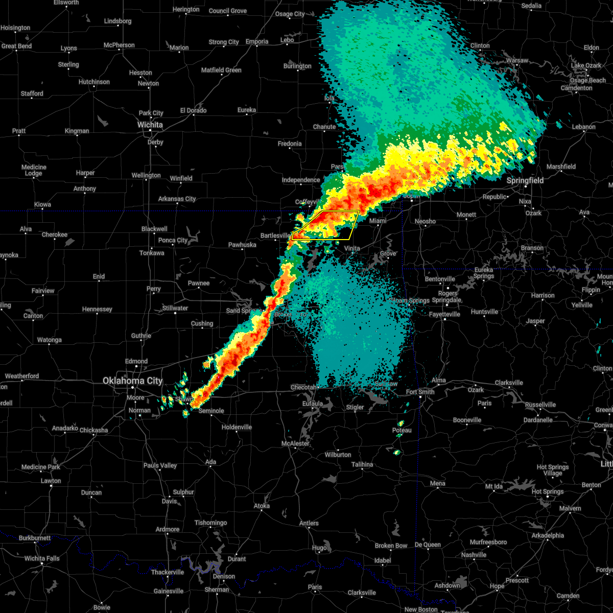 At 152 am cdt, severe thunderstorms were located along a line extending from 6 miles southwest of edna to 3 miles west of delaware, moving east at 30 mph (radar indicated). Hazards include 60 mph wind gusts and quarter size hail. Hail damage to vehicles is expected. expect wind damage to roofs, siding, and trees. locations in or near the path include, delaware, lenapah, hollow, centralia, centrailia, hail threat, radar indicated max hail size, 1. 00 in wind threat, radar indicated max wind gust, 60 mph. At 152 am cdt, severe thunderstorms were located along a line extending from 6 miles southwest of edna to 3 miles west of delaware, moving east at 30 mph (radar indicated). Hazards include 60 mph wind gusts and quarter size hail. Hail damage to vehicles is expected. expect wind damage to roofs, siding, and trees. locations in or near the path include, delaware, lenapah, hollow, centralia, centrailia, hail threat, radar indicated max hail size, 1. 00 in wind threat, radar indicated max wind gust, 60 mph.
|
| 4/30/2022 1:33 AM CDT |
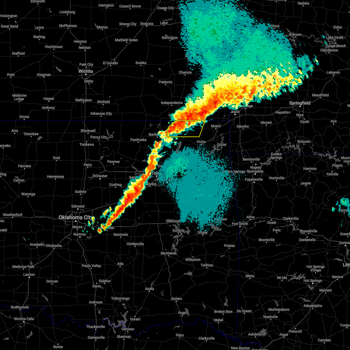 At 133 am cdt, a severe thunderstorm was located 4 miles west of lenapah, moving east at 30 mph (radar indicated). Hazards include 60 mph wind gusts and quarter size hail. Hail damage to vehicles is expected. expect wind damage to roofs, siding, and trees. locations in or near the path include, south coffeyville, delaware, lenapah, hollow, centralia, centrailia, hail threat, radar indicated max hail size, 1. 00 in wind threat, radar indicated max wind gust, 60 mph. At 133 am cdt, a severe thunderstorm was located 4 miles west of lenapah, moving east at 30 mph (radar indicated). Hazards include 60 mph wind gusts and quarter size hail. Hail damage to vehicles is expected. expect wind damage to roofs, siding, and trees. locations in or near the path include, south coffeyville, delaware, lenapah, hollow, centralia, centrailia, hail threat, radar indicated max hail size, 1. 00 in wind threat, radar indicated max wind gust, 60 mph.
|
| 4/11/2022 12:15 AM CDT |
 At 1215 am cdt, severe thunderstorms were located along a line extending from 7 miles east of south coffeyville to 2 miles west of talala to 3 miles east of keystone state park, moving east at 45 mph (radar indicated). Hazards include 60 mph wind gusts and nickel size hail. Expect damage to roofs, siding, and trees. locations in or near the path include, tulsa, broken arrow, sand springs, claremore, vinita, nowata, pryor, owasso, bixby, jenks, coweta, pryor creek, skiatook, catoosa, collinsville, verdigris, chelsea, inola, sperry, oologah, this includes interstate 44 between mile markers 216 and 289. hail threat, radar indicated max hail size, 0. 88 in wind threat, radar indicated max wind gust, 60 mph. At 1215 am cdt, severe thunderstorms were located along a line extending from 7 miles east of south coffeyville to 2 miles west of talala to 3 miles east of keystone state park, moving east at 45 mph (radar indicated). Hazards include 60 mph wind gusts and nickel size hail. Expect damage to roofs, siding, and trees. locations in or near the path include, tulsa, broken arrow, sand springs, claremore, vinita, nowata, pryor, owasso, bixby, jenks, coweta, pryor creek, skiatook, catoosa, collinsville, verdigris, chelsea, inola, sperry, oologah, this includes interstate 44 between mile markers 216 and 289. hail threat, radar indicated max hail size, 0. 88 in wind threat, radar indicated max wind gust, 60 mph.
|
| 4/11/2022 12:02 AM CDT |
 At 1202 am cdt, severe thunderstorms were located along a line extending from wann to 2 miles northeast of avant to near westport, moving east at 35 mph (radar indicated). Hazards include 60 mph wind gusts and quarter size hail. Hail damage to vehicles is expected. expect wind damage to roofs, siding, and trees. locations in or near the path include, tulsa, bartlesville, sand springs, nowata, skiatook, collinsville, dewey, barnsdall, sperry, south coffeyville, copan, ramona, ochelata, delaware, avant, westport, lenapah, talala, vera, wann, hail threat, radar indicated max hail size, 1. 00 in wind threat, radar indicated max wind gust, 60 mph. At 1202 am cdt, severe thunderstorms were located along a line extending from wann to 2 miles northeast of avant to near westport, moving east at 35 mph (radar indicated). Hazards include 60 mph wind gusts and quarter size hail. Hail damage to vehicles is expected. expect wind damage to roofs, siding, and trees. locations in or near the path include, tulsa, bartlesville, sand springs, nowata, skiatook, collinsville, dewey, barnsdall, sperry, south coffeyville, copan, ramona, ochelata, delaware, avant, westport, lenapah, talala, vera, wann, hail threat, radar indicated max hail size, 1. 00 in wind threat, radar indicated max wind gust, 60 mph.
|
| 4/10/2022 11:43 PM CDT |
 At 1142 pm cdt, severe thunderstorms were located along a line extending from 2 miles east of hulah to 4 miles west of barnsdall to near hallett, moving east at 35 mph (radar indicated). Hazards include 60 mph wind gusts and quarter size hail. Hail damage to vehicles is expected. expect wind damage to roofs, siding, and trees. locations in or near the path include, tulsa, bartlesville, sand springs, nowata, skiatook, collinsville, hominy, dewey, cleveland, barnsdall, sperry, south coffeyville, copan, ramona, wynona, ochelata, delaware, jennings, avant, westport, hail threat, radar indicated max hail size, 1. 00 in wind threat, radar indicated max wind gust, 60 mph. At 1142 pm cdt, severe thunderstorms were located along a line extending from 2 miles east of hulah to 4 miles west of barnsdall to near hallett, moving east at 35 mph (radar indicated). Hazards include 60 mph wind gusts and quarter size hail. Hail damage to vehicles is expected. expect wind damage to roofs, siding, and trees. locations in or near the path include, tulsa, bartlesville, sand springs, nowata, skiatook, collinsville, hominy, dewey, cleveland, barnsdall, sperry, south coffeyville, copan, ramona, wynona, ochelata, delaware, jennings, avant, westport, hail threat, radar indicated max hail size, 1. 00 in wind threat, radar indicated max wind gust, 60 mph.
|
| 11/10/2021 7:20 PM CST |
 At 720 pm cst, a severe thunderstorm was located near nowata, moving east at 45 mph (radar indicated). Hazards include 60 mph wind gusts. Expect damage to roofs, siding, and trees. Locations in or near the path include, nowata, delaware,. At 720 pm cst, a severe thunderstorm was located near nowata, moving east at 45 mph (radar indicated). Hazards include 60 mph wind gusts. Expect damage to roofs, siding, and trees. Locations in or near the path include, nowata, delaware,.
|
| 7/10/2021 5:28 PM CDT |
 At 528 pm cdt, severe thunderstorms were located along a line extending from 2 miles northeast of nowata to 3 miles west of watova to 2 miles northeast of ramona, moving southeast at 30 mph (radar indicated). Hazards include 70 mph wind gusts and nickel size hail. Expect considerable tree damage. damage is likely to mobile homes, roofs, and outbuildings. Locations in or near the path include, bartlesville, nowata, chelsea, oologah, ramona, ochelata, delaware, foyil, lenapah, talala, new alluwe, watova, white oak, bushyhead,. At 528 pm cdt, severe thunderstorms were located along a line extending from 2 miles northeast of nowata to 3 miles west of watova to 2 miles northeast of ramona, moving southeast at 30 mph (radar indicated). Hazards include 70 mph wind gusts and nickel size hail. Expect considerable tree damage. damage is likely to mobile homes, roofs, and outbuildings. Locations in or near the path include, bartlesville, nowata, chelsea, oologah, ramona, ochelata, delaware, foyil, lenapah, talala, new alluwe, watova, white oak, bushyhead,.
|
| 7/10/2021 5:27 PM CDT |
 At 526 pm cdt, severe thunderstorms were located along a line extending from 4 miles northeast of osage hills state park to 4 miles north of pawhuska to 4 miles east of shidler, moving east at 25 mph (radar indicated). Hazards include 60 mph wind gusts and quarter size hail. Hail damage to vehicles is expected. expect wind damage to roofs, siding, and trees. Locations in or near the path include, bartlesville, nowata, pawhuska, dewey, barnsdall, shidler, wynona, ochelata, delaware, bigheart, pearsonia, bartlesville municipal airport, sunset lake, osage hills state park, okesa, tallant, pershing, nelagoney, wolco,. At 526 pm cdt, severe thunderstorms were located along a line extending from 4 miles northeast of osage hills state park to 4 miles north of pawhuska to 4 miles east of shidler, moving east at 25 mph (radar indicated). Hazards include 60 mph wind gusts and quarter size hail. Hail damage to vehicles is expected. expect wind damage to roofs, siding, and trees. Locations in or near the path include, bartlesville, nowata, pawhuska, dewey, barnsdall, shidler, wynona, ochelata, delaware, bigheart, pearsonia, bartlesville municipal airport, sunset lake, osage hills state park, okesa, tallant, pershing, nelagoney, wolco,.
|
| 7/10/2021 5:16 PM CDT |
 At 515 pm cdt, severe thunderstorms were located along a line extending from 7 miles west of delaware to 2 miles south of bartlesville municipal airport, moving southeast at 30 mph (radar indicated). Hazards include 70 mph wind gusts and penny size hail. Expect considerable tree damage. damage is likely to mobile homes, roofs, and outbuildings. Locations in or near the path include, bartlesville, dewey, copan, delaware, lenapah, wann,. At 515 pm cdt, severe thunderstorms were located along a line extending from 7 miles west of delaware to 2 miles south of bartlesville municipal airport, moving southeast at 30 mph (radar indicated). Hazards include 70 mph wind gusts and penny size hail. Expect considerable tree damage. damage is likely to mobile homes, roofs, and outbuildings. Locations in or near the path include, bartlesville, dewey, copan, delaware, lenapah, wann,.
|
| 7/10/2021 5:09 PM CDT |
 At 509 pm cdt, severe thunderstorms were located along a line extending from 4 miles southeast of wann to 5 miles southeast of dewey to 3 miles southwest of bartlesville, moving southeast at 45 mph (radar indicated). Hazards include 70 mph wind gusts and penny size hail. Expect considerable tree damage. damage is likely to mobile homes, roofs, and outbuildings. Locations in or near the path include, bartlesville, vinita, nowata, chelsea, oologah, ramona, ochelata, delaware, foyil, lenapah, talala, new alluwe, watova, white oak, centrailia, bushyhead, centralia,. At 509 pm cdt, severe thunderstorms were located along a line extending from 4 miles southeast of wann to 5 miles southeast of dewey to 3 miles southwest of bartlesville, moving southeast at 45 mph (radar indicated). Hazards include 70 mph wind gusts and penny size hail. Expect considerable tree damage. damage is likely to mobile homes, roofs, and outbuildings. Locations in or near the path include, bartlesville, vinita, nowata, chelsea, oologah, ramona, ochelata, delaware, foyil, lenapah, talala, new alluwe, watova, white oak, centrailia, bushyhead, centralia,.
|
| 7/10/2021 4:59 PM CDT |
 At 459 pm cdt, severe thunderstorms were located along a line extending from 3 miles southeast of copan to 4 miles northeast of osage hills state park, moving east at 35 mph (radar indicated). Hazards include 60 mph wind gusts and quarter size hail. Hail damage to vehicles is expected. expect wind damage to roofs, siding, and trees. Locations in or near the path include, bartlesville, dewey, copan, delaware, lenapah, wann, bigheart, bartlesville municipal airport, hulah, sunset lake, osage hills state park, okesa, wah sha she state park,. At 459 pm cdt, severe thunderstorms were located along a line extending from 3 miles southeast of copan to 4 miles northeast of osage hills state park, moving east at 35 mph (radar indicated). Hazards include 60 mph wind gusts and quarter size hail. Hail damage to vehicles is expected. expect wind damage to roofs, siding, and trees. Locations in or near the path include, bartlesville, dewey, copan, delaware, lenapah, wann, bigheart, bartlesville municipal airport, hulah, sunset lake, osage hills state park, okesa, wah sha she state park,.
|
| 7/10/2021 4:43 PM CDT |
 At 442 pm cdt, severe thunderstorms were located along a line extending from 3 miles southwest of caney to 4 miles north of bigheart, moving southeast at 35 mph (radar indicated). Hazards include 60 mph wind gusts and quarter size hail. Hail damage to vehicles is expected. expect wind damage to roofs, siding, and trees. Locations in or near the path include, bartlesville, pawhuska, dewey, copan, delaware, lenapah, wann, bigheart, pearsonia, bartlesville municipal airport, hulah, sunset lake, osage hills state park, okesa, wah sha she state park, a 60 mph wind gust was reported at chautauqua at 429 pm. At 442 pm cdt, severe thunderstorms were located along a line extending from 3 miles southwest of caney to 4 miles north of bigheart, moving southeast at 35 mph (radar indicated). Hazards include 60 mph wind gusts and quarter size hail. Hail damage to vehicles is expected. expect wind damage to roofs, siding, and trees. Locations in or near the path include, bartlesville, pawhuska, dewey, copan, delaware, lenapah, wann, bigheart, pearsonia, bartlesville municipal airport, hulah, sunset lake, osage hills state park, okesa, wah sha she state park, a 60 mph wind gust was reported at chautauqua at 429 pm.
|
| 5/27/2021 3:49 PM CDT |
 At 348 pm cdt, severe thunderstorms were located along a line extending from 3 miles southeast of dewey to near ramona to 2 miles east of walnut creek state park, moving east at 60 mph (radar indicated). Hazards include 70 mph wind gusts and quarter size hail. Hail damage to vehicles is expected. expect considerable tree damage. wind damage is also likely to mobile homes, roofs, and outbuildings. locations in or near the path include, tulsa, bartlesville, sand springs, claremore, vinita, nowata, owasso, pryor creek, skiatook, catoosa, collinsville, verdigris, dewey, chelsea, inola, sperry, oologah, adair, ramona, ochelata, this includes interstate 44 between mile markers 237 and 284. A tornado watch remains in effect until 700 pm cdt for northeastern oklahoma. At 348 pm cdt, severe thunderstorms were located along a line extending from 3 miles southeast of dewey to near ramona to 2 miles east of walnut creek state park, moving east at 60 mph (radar indicated). Hazards include 70 mph wind gusts and quarter size hail. Hail damage to vehicles is expected. expect considerable tree damage. wind damage is also likely to mobile homes, roofs, and outbuildings. locations in or near the path include, tulsa, bartlesville, sand springs, claremore, vinita, nowata, owasso, pryor creek, skiatook, catoosa, collinsville, verdigris, dewey, chelsea, inola, sperry, oologah, adair, ramona, ochelata, this includes interstate 44 between mile markers 237 and 284. A tornado watch remains in effect until 700 pm cdt for northeastern oklahoma.
|
| 5/27/2021 3:10 PM CDT |
 At 310 pm cdt, a severe thunderstorm was located 6 miles northeast of ramona, moving east at 30 mph (trained weather spotters). Hazards include 70 mph wind gusts and ping pong ball size hail. People and animals outdoors will be injured. expect hail damage to roofs, siding, windows, and vehicles. expect considerable tree damage. wind damage is also likely to mobile homes, roofs, and outbuildings. Locations in or near the path include, bartlesville, nowata, dewey, ramona, ochelata, delaware, lenapah, talala, new alluwe, watova, a tornado watch remains in effect until 700 pm cdt for northeastern oklahoma. At 310 pm cdt, a severe thunderstorm was located 6 miles northeast of ramona, moving east at 30 mph (trained weather spotters). Hazards include 70 mph wind gusts and ping pong ball size hail. People and animals outdoors will be injured. expect hail damage to roofs, siding, windows, and vehicles. expect considerable tree damage. wind damage is also likely to mobile homes, roofs, and outbuildings. Locations in or near the path include, bartlesville, nowata, dewey, ramona, ochelata, delaware, lenapah, talala, new alluwe, watova, a tornado watch remains in effect until 700 pm cdt for northeastern oklahoma.
|
| 5/27/2021 3:01 PM CDT |
 At 259 pm cdt, a severe thunderstorm was located 3 miles east of ochelata, moving east at 30 mph (trained weather spotters. at 255 pm 64 mph wind gusts were reported in avant). Hazards include 70 mph wind gusts and ping pong ball size hail. People and animals outdoors will be injured. expect hail damage to roofs, siding, windows, and vehicles. expect considerable tree damage. wind damage is also likely to mobile homes, roofs, and outbuildings. Locations in or near the path include, bartlesville, nowata, dewey, ramona, ochelata, delaware, avant, lenapah, talala, new alluwe, bartlesville municipal airport, watova, wolco, a tornado watch remains in effect until 700 pm cdt for northeastern oklahoma. At 259 pm cdt, a severe thunderstorm was located 3 miles east of ochelata, moving east at 30 mph (trained weather spotters. at 255 pm 64 mph wind gusts were reported in avant). Hazards include 70 mph wind gusts and ping pong ball size hail. People and animals outdoors will be injured. expect hail damage to roofs, siding, windows, and vehicles. expect considerable tree damage. wind damage is also likely to mobile homes, roofs, and outbuildings. Locations in or near the path include, bartlesville, nowata, dewey, ramona, ochelata, delaware, avant, lenapah, talala, new alluwe, bartlesville municipal airport, watova, wolco, a tornado watch remains in effect until 700 pm cdt for northeastern oklahoma.
|
| 5/27/2021 2:37 PM CDT |
 At 236 pm cdt, a severe thunderstorm was located 3 miles northeast of barnsdall, moving east at 35 mph (radar indicated). Hazards include ping pong ball size hail and 60 mph wind gusts. People and animals outdoors will be injured. expect hail damage to roofs, siding, windows, and vehicles. expect wind damage to roofs, siding, and trees. Locations in or near the path include, bartlesville, nowata, dewey, barnsdall, ramona, ochelata, delaware, avant, lenapah, talala, new alluwe, bartlesville municipal airport, osage hills state park, watova, okesa, tallant, pershing, nelagoney, wolco, a tornado watch remains in effect until 700 pm cdt for northeastern oklahoma. At 236 pm cdt, a severe thunderstorm was located 3 miles northeast of barnsdall, moving east at 35 mph (radar indicated). Hazards include ping pong ball size hail and 60 mph wind gusts. People and animals outdoors will be injured. expect hail damage to roofs, siding, windows, and vehicles. expect wind damage to roofs, siding, and trees. Locations in or near the path include, bartlesville, nowata, dewey, barnsdall, ramona, ochelata, delaware, avant, lenapah, talala, new alluwe, bartlesville municipal airport, osage hills state park, watova, okesa, tallant, pershing, nelagoney, wolco, a tornado watch remains in effect until 700 pm cdt for northeastern oklahoma.
|
| 8/15/2020 8:02 PM CDT |
 At 747 pm cdt, a severe thunderstorm was located 6 miles southeast of dewey, moving south at 20 mph (radar indicated). Hazards include ping pong ball size hail and 60 mph wind gusts. People and animals outdoors will be injured. expect hail damage to roofs, siding, windows, and vehicles. expect wind damage to roofs, siding, and trees. Locations in or near the path include, bartlesville, nowata, dewey, ramona, ochelata, delaware, talala,. At 747 pm cdt, a severe thunderstorm was located 6 miles southeast of dewey, moving south at 20 mph (radar indicated). Hazards include ping pong ball size hail and 60 mph wind gusts. People and animals outdoors will be injured. expect hail damage to roofs, siding, windows, and vehicles. expect wind damage to roofs, siding, and trees. Locations in or near the path include, bartlesville, nowata, dewey, ramona, ochelata, delaware, talala,.
|
| 8/15/2020 7:47 PM CDT |
 At 747 pm cdt, a severe thunderstorm was located 6 miles southeast of dewey, moving south at 20 mph (radar indicated). Hazards include ping pong ball size hail and 60 mph wind gusts. People and animals outdoors will be injured. expect hail damage to roofs, siding, windows, and vehicles. expect wind damage to roofs, siding, and trees. Locations in or near the path include, bartlesville, nowata, dewey, ramona, ochelata, delaware, talala,. At 747 pm cdt, a severe thunderstorm was located 6 miles southeast of dewey, moving south at 20 mph (radar indicated). Hazards include ping pong ball size hail and 60 mph wind gusts. People and animals outdoors will be injured. expect hail damage to roofs, siding, windows, and vehicles. expect wind damage to roofs, siding, and trees. Locations in or near the path include, bartlesville, nowata, dewey, ramona, ochelata, delaware, talala,.
|
| 8/10/2020 4:22 PM CDT |
 The severe thunderstorm warning for northern washington and nowata counties will expire at 430 pm cdt, the storms which prompted the warning have weakened below severe limits, and no longer pose an immediate threat to life or property. therefore the warning will be allowed to expire. however small hail, gusty winds and heavy rain are still possible with these thunderstorms. The severe thunderstorm warning for northern washington and nowata counties will expire at 430 pm cdt, the storms which prompted the warning have weakened below severe limits, and no longer pose an immediate threat to life or property. therefore the warning will be allowed to expire. however small hail, gusty winds and heavy rain are still possible with these thunderstorms.
|
| 8/10/2020 3:59 PM CDT |
 At 359 pm cdt, severe thunderstorms were located along a line extending from 4 miles south of dearing to 6 miles south of wann to near bartlesville, moving east at 35 mph (radar indicated). Hazards include 60 mph wind gusts and quarter size hail. Hail damage to vehicles is expected. expect wind damage to roofs, siding, and trees. Locations in or near the path include, bartlesville, nowata, dewey, south coffeyville, copan, delaware, lenapah, wann,. At 359 pm cdt, severe thunderstorms were located along a line extending from 4 miles south of dearing to 6 miles south of wann to near bartlesville, moving east at 35 mph (radar indicated). Hazards include 60 mph wind gusts and quarter size hail. Hail damage to vehicles is expected. expect wind damage to roofs, siding, and trees. Locations in or near the path include, bartlesville, nowata, dewey, south coffeyville, copan, delaware, lenapah, wann,.
|
| 8/10/2020 3:38 PM CDT |
 At 337 pm cdt, severe thunderstorms were located along a line extending from 4 miles southwest of caney to 3 miles north of bartlesville municipal airport to near osage hills state park, moving east at 35 mph (radar indicated). Hazards include 60 mph wind gusts and penny size hail. Expect damage to roofs, siding, and trees. Locations in or near the path include, bartlesville, nowata, dewey, south coffeyville, copan, delaware, lenapah, wann, osage hills state park, bartlesville municipal airport, hulah, okesa,. At 337 pm cdt, severe thunderstorms were located along a line extending from 4 miles southwest of caney to 3 miles north of bartlesville municipal airport to near osage hills state park, moving east at 35 mph (radar indicated). Hazards include 60 mph wind gusts and penny size hail. Expect damage to roofs, siding, and trees. Locations in or near the path include, bartlesville, nowata, dewey, south coffeyville, copan, delaware, lenapah, wann, osage hills state park, bartlesville municipal airport, hulah, okesa,.
|
| 7/11/2020 8:00 PM CDT |
 At 800 pm cdt, severe thunderstorms were located along a line extending from 2 miles east of south coffeyville to near elgin, moving south at 30 mph (radar indicated). Hazards include 60 mph wind gusts and quarter size hail. Hail damage to vehicles is expected. expect wind damage to roofs, siding, and trees. Locations in or near the path include, dewey, south coffeyville, copan, delaware, lenapah, wann, bigheart, hulah, wah sha she state park,. At 800 pm cdt, severe thunderstorms were located along a line extending from 2 miles east of south coffeyville to near elgin, moving south at 30 mph (radar indicated). Hazards include 60 mph wind gusts and quarter size hail. Hail damage to vehicles is expected. expect wind damage to roofs, siding, and trees. Locations in or near the path include, dewey, south coffeyville, copan, delaware, lenapah, wann, bigheart, hulah, wah sha she state park,.
|
| 5/4/2020 3:55 PM CDT |
 The severe thunderstorm warning for central washington and southwestern nowata counties will expire at 400 pm cdt, the storms which prompted the warning have weakened below severe limits. therefore the warning will be allowed to expire. a tornado watch remains in effect until 1000 pm cdt for northeastern oklahoma. The severe thunderstorm warning for central washington and southwestern nowata counties will expire at 400 pm cdt, the storms which prompted the warning have weakened below severe limits. therefore the warning will be allowed to expire. a tornado watch remains in effect until 1000 pm cdt for northeastern oklahoma.
|
| 5/4/2020 3:50 PM CDT |
 At 349 pm cdt, severe thunderstorms were located along a line extending from 7 miles southeast of bartlesville to 2 miles southwest of delaware, moving east at 20 mph (radar indicated). Hazards include 60 mph wind gusts and quarter size hail. Hail damage to vehicles is expected. expect wind damage to roofs, siding, and trees. Locations in or near the path include, nowata, delaware, a tornado watch remains in effect until 1000 pm cdt for northeastern oklahoma. At 349 pm cdt, severe thunderstorms were located along a line extending from 7 miles southeast of bartlesville to 2 miles southwest of delaware, moving east at 20 mph (radar indicated). Hazards include 60 mph wind gusts and quarter size hail. Hail damage to vehicles is expected. expect wind damage to roofs, siding, and trees. Locations in or near the path include, nowata, delaware, a tornado watch remains in effect until 1000 pm cdt for northeastern oklahoma.
|
| 5/4/2020 3:36 PM CDT |
 At 336 pm cdt, a severe thunderstorm was located 7 miles southeast of dewey, moving northeast at 35 mph (radar indicated). Hazards include 60 mph wind gusts and quarter size hail. Hail damage to vehicles is expected. expect wind damage to roofs, siding, and trees. Locations in or near the path include, bartlesville, nowata, delaware, a tornado watch remains in effect until 1000 pm cdt for northeastern oklahoma. At 336 pm cdt, a severe thunderstorm was located 7 miles southeast of dewey, moving northeast at 35 mph (radar indicated). Hazards include 60 mph wind gusts and quarter size hail. Hail damage to vehicles is expected. expect wind damage to roofs, siding, and trees. Locations in or near the path include, bartlesville, nowata, delaware, a tornado watch remains in effect until 1000 pm cdt for northeastern oklahoma.
|
| 5/4/2020 3:28 PM CDT |
 At 328 pm cdt, severe thunderstorms were located along a line extending from 2 miles north of ramona to 5 miles southeast of bartlesville, moving east at 25 mph (radar indicated). Hazards include 60 mph wind gusts and quarter size hail. Hail damage to vehicles is expected. expect wind damage to roofs, siding, and trees. Locations in or near the path include, bartlesville, nowata, ramona, ochelata, delaware, a tornado watch remains in effect until 1000 pm cdt for northeastern oklahoma. At 328 pm cdt, severe thunderstorms were located along a line extending from 2 miles north of ramona to 5 miles southeast of bartlesville, moving east at 25 mph (radar indicated). Hazards include 60 mph wind gusts and quarter size hail. Hail damage to vehicles is expected. expect wind damage to roofs, siding, and trees. Locations in or near the path include, bartlesville, nowata, ramona, ochelata, delaware, a tornado watch remains in effect until 1000 pm cdt for northeastern oklahoma.
|
| 5/4/2020 3:05 PM CDT |
 At 304 pm cdt, severe thunderstorms were located 3 miles west of barnsdall and 3 miles southwest of bartlesville, moving east at 25 mph (radar indicated). Hazards include 60 mph wind gusts and quarter size hail. Hail damage to vehicles is expected. expect wind damage to roofs, siding, and trees. Locations in or near the path include, bartlesville, nowata, barnsdall, ramona, ochelata, delaware, tallant, wolco, a tornado watch remains in effect until 1000 pm cdt for northeastern oklahoma. At 304 pm cdt, severe thunderstorms were located 3 miles west of barnsdall and 3 miles southwest of bartlesville, moving east at 25 mph (radar indicated). Hazards include 60 mph wind gusts and quarter size hail. Hail damage to vehicles is expected. expect wind damage to roofs, siding, and trees. Locations in or near the path include, bartlesville, nowata, barnsdall, ramona, ochelata, delaware, tallant, wolco, a tornado watch remains in effect until 1000 pm cdt for northeastern oklahoma.
|
| 4/28/2020 5:29 PM CDT |
 At 529 pm cdt, severe thunderstorms were located along a line extending from 6 miles east of south coffeyville to 6 miles southeast of dewey to 4 miles northeast of barnsdall, moving southeast at 25 mph (radar indicated). Hazards include 60 mph wind gusts and quarter size hail. Hail damage to vehicles is expected. expect wind damage to roofs, siding, and trees. Locations in or near the path include, bartlesville, nowata, dewey, south coffeyville, copan, ochelata, delaware, lenapah, talala, wann, bartlesville municipal airport, osage hills state park, watova, okesa, tallant, nelagoney, a tornado watch remains in effect until 1100 pm cdt for northeastern oklahoma. At 529 pm cdt, severe thunderstorms were located along a line extending from 6 miles east of south coffeyville to 6 miles southeast of dewey to 4 miles northeast of barnsdall, moving southeast at 25 mph (radar indicated). Hazards include 60 mph wind gusts and quarter size hail. Hail damage to vehicles is expected. expect wind damage to roofs, siding, and trees. Locations in or near the path include, bartlesville, nowata, dewey, south coffeyville, copan, ochelata, delaware, lenapah, talala, wann, bartlesville municipal airport, osage hills state park, watova, okesa, tallant, nelagoney, a tornado watch remains in effect until 1100 pm cdt for northeastern oklahoma.
|
| 4/28/2020 5:19 PM CDT |
 At 519 pm cdt, severe thunderstorms were located along a line extending from 5 miles east of south coffeyville to ochelata, moving southeast at 30 mph (radar indicated). Hazards include 60 mph wind gusts and quarter size hail. Hail damage to vehicles is expected. expect wind damage to roofs, siding, and trees. Locations in or near the path include, bartlesville, nowata, chelsea, oologah, south coffeyville, welch, ramona, ochelata, delaware, foyil, bluejacket, lenapah, talala, new alluwe, watova, white oak, hollow, centrailia, pyramid corners, bushyhead, a tornado watch remains in effect until 1100 pm cdt for northeastern oklahoma. At 519 pm cdt, severe thunderstorms were located along a line extending from 5 miles east of south coffeyville to ochelata, moving southeast at 30 mph (radar indicated). Hazards include 60 mph wind gusts and quarter size hail. Hail damage to vehicles is expected. expect wind damage to roofs, siding, and trees. Locations in or near the path include, bartlesville, nowata, chelsea, oologah, south coffeyville, welch, ramona, ochelata, delaware, foyil, bluejacket, lenapah, talala, new alluwe, watova, white oak, hollow, centrailia, pyramid corners, bushyhead, a tornado watch remains in effect until 1100 pm cdt for northeastern oklahoma.
|
| 4/28/2020 4:54 PM CDT |
 At 454 pm cdt, severe thunderstorms were located along a line extending from 3 miles northeast of caney to 3 miles south of okesa, moving southeast at 30 mph (radar indicated). Hazards include ping pong ball size hail and 60 mph wind gusts. People and animals outdoors will be injured. expect hail damage to roofs, siding, windows, and vehicles. expect wind damage to roofs, siding, and trees. Locations in or near the path include, bartlesville, nowata, dewey, south coffeyville, copan, ochelata, delaware, lenapah, talala, wann, bartlesville municipal airport, hulah, osage hills state park, watova, okesa, tallant, nelagoney, a tornado watch remains in effect until 1100 pm cdt for northeastern oklahoma. At 454 pm cdt, severe thunderstorms were located along a line extending from 3 miles northeast of caney to 3 miles south of okesa, moving southeast at 30 mph (radar indicated). Hazards include ping pong ball size hail and 60 mph wind gusts. People and animals outdoors will be injured. expect hail damage to roofs, siding, windows, and vehicles. expect wind damage to roofs, siding, and trees. Locations in or near the path include, bartlesville, nowata, dewey, south coffeyville, copan, ochelata, delaware, lenapah, talala, wann, bartlesville municipal airport, hulah, osage hills state park, watova, okesa, tallant, nelagoney, a tornado watch remains in effect until 1100 pm cdt for northeastern oklahoma.
|
| 3/28/2020 6:13 AM CDT |
 At 613 am cdt, a severe thunderstorm was located 5 miles northeast of walnut creek state park, moving northeast at 55 mph (radar indicated). Hazards include 60 mph wind gusts and quarter size hail. Hail damage to vehicles is expected. expect wind damage to roofs, siding, and trees. Locations in or near the path include, bartlesville, nowata, skiatook, collinsville, dewey, chelsea, barnsdall, sperry, oologah, ramona, ochelata, delaware, avant, lenapah, talala, vera, wann, new alluwe, bartlesville municipal airport, watova,. At 613 am cdt, a severe thunderstorm was located 5 miles northeast of walnut creek state park, moving northeast at 55 mph (radar indicated). Hazards include 60 mph wind gusts and quarter size hail. Hail damage to vehicles is expected. expect wind damage to roofs, siding, and trees. Locations in or near the path include, bartlesville, nowata, skiatook, collinsville, dewey, chelsea, barnsdall, sperry, oologah, ramona, ochelata, delaware, avant, lenapah, talala, vera, wann, new alluwe, bartlesville municipal airport, watova,.
|
| 1/10/2020 1:22 PM CST |
 At 122 pm cst, a severe thunderstorm capable of producing a tornado was located 4 miles southwest of nowata, moving northeast at 45 mph (radar indicated rotation). Hazards include tornado. Flying debris will be dangerous to those caught without shelter. mobile homes will be damaged or destroyed. damage to roofs, windows, and vehicles will occur. tree damage is likely. Locations in or near the path include, nowata, south coffeyville, delaware, lenapah,. At 122 pm cst, a severe thunderstorm capable of producing a tornado was located 4 miles southwest of nowata, moving northeast at 45 mph (radar indicated rotation). Hazards include tornado. Flying debris will be dangerous to those caught without shelter. mobile homes will be damaged or destroyed. damage to roofs, windows, and vehicles will occur. tree damage is likely. Locations in or near the path include, nowata, south coffeyville, delaware, lenapah,.
|
| 1/10/2020 1:14 PM CST |
 At 114 pm cst, severe thunderstorms were located along a line extending from 6 miles west of nowata to 5 miles east of ramona, moving northeast at 70 mph (radar indicated). Hazards include 60 mph wind gusts and nickel size hail. Expect damage to roofs, siding, and trees. Locations in or near the path include, nowata, delaware, lenapah, hollow, centralia, centrailia, a tornado watch remains in effect until 600 pm cst for northeastern oklahoma. At 114 pm cst, severe thunderstorms were located along a line extending from 6 miles west of nowata to 5 miles east of ramona, moving northeast at 70 mph (radar indicated). Hazards include 60 mph wind gusts and nickel size hail. Expect damage to roofs, siding, and trees. Locations in or near the path include, nowata, delaware, lenapah, hollow, centralia, centrailia, a tornado watch remains in effect until 600 pm cst for northeastern oklahoma.
|
| 10/20/2019 10:13 PM CDT |
 At 1013 pm cdt, a severe thunderstorm was located 4 miles west of talala, moving northeast at 60 mph (radar indicated). Hazards include 60 mph wind gusts and quarter size hail. Hail damage to vehicles is expected. expect wind damage to roofs, siding, and trees. locations in or near the path include, tulsa, bartlesville, claremore, vinita, nowata, owasso, skiatook, collinsville, chelsea, oologah, ramona, ochelata, delaware, foyil, bluejacket, lenapah, talala, big cabin, vera, new alluwe, this includes interstate 44 between mile markers 264 and 291. A tornado watch remains in effect until 300 am cdt for northeastern oklahoma. At 1013 pm cdt, a severe thunderstorm was located 4 miles west of talala, moving northeast at 60 mph (radar indicated). Hazards include 60 mph wind gusts and quarter size hail. Hail damage to vehicles is expected. expect wind damage to roofs, siding, and trees. locations in or near the path include, tulsa, bartlesville, claremore, vinita, nowata, owasso, skiatook, collinsville, chelsea, oologah, ramona, ochelata, delaware, foyil, bluejacket, lenapah, talala, big cabin, vera, new alluwe, this includes interstate 44 between mile markers 264 and 291. A tornado watch remains in effect until 300 am cdt for northeastern oklahoma.
|
| 10/20/2019 9:48 PM CDT |
 At 948 pm cdt, a severe thunderstorm was located over ramona, moving northeast at 55 mph (radar indicated). Hazards include 60 mph wind gusts and quarter size hail. Hail damage to vehicles is expected. expect wind damage to roofs, siding, and trees. Locations in or near the path include, bartlesville, nowata, ramona, ochelata, delaware, avant, talala, vera, new alluwe, watova, wolco, a tornado watch remains in effect until 300 am cdt for northeastern oklahoma. At 948 pm cdt, a severe thunderstorm was located over ramona, moving northeast at 55 mph (radar indicated). Hazards include 60 mph wind gusts and quarter size hail. Hail damage to vehicles is expected. expect wind damage to roofs, siding, and trees. Locations in or near the path include, bartlesville, nowata, ramona, ochelata, delaware, avant, talala, vera, new alluwe, watova, wolco, a tornado watch remains in effect until 300 am cdt for northeastern oklahoma.
|
| 10/20/2019 9:33 PM CDT |
 At 933 pm cdt, a severe thunderstorm was located 3 miles south of avant, moving northeast at 55 mph (radar indicated). Hazards include 60 mph wind gusts and quarter size hail. Hail damage to vehicles is expected. expect wind damage to roofs, siding, and trees. Locations in or near the path include, bartlesville, nowata, ramona, ochelata, delaware, avant, talala, vera, new alluwe, watova, wolco, a tornado watch remains in effect until 300 am cdt for northeastern oklahoma. At 933 pm cdt, a severe thunderstorm was located 3 miles south of avant, moving northeast at 55 mph (radar indicated). Hazards include 60 mph wind gusts and quarter size hail. Hail damage to vehicles is expected. expect wind damage to roofs, siding, and trees. Locations in or near the path include, bartlesville, nowata, ramona, ochelata, delaware, avant, talala, vera, new alluwe, watova, wolco, a tornado watch remains in effect until 300 am cdt for northeastern oklahoma.
|
| 8/30/2019 3:20 AM CDT |
 At 320 am cdt, severe thunderstorms were located along a line extending from 6 miles southwest of chetopa to 9 miles north of new alluwe to 3 miles northwest of talala, moving southeast at 55 mph (radar indicated). Hazards include 60 mph wind gusts. Expect damage to roofs, siding, and trees. Locations in or near the path include, vinita, nowata, chelsea, oologah, welch, delaware, foyil, bluejacket, lenapah, talala, new alluwe, watova, white oak, hollow, centrailia, pyramid corners, bushyhead, centralia,. At 320 am cdt, severe thunderstorms were located along a line extending from 6 miles southwest of chetopa to 9 miles north of new alluwe to 3 miles northwest of talala, moving southeast at 55 mph (radar indicated). Hazards include 60 mph wind gusts. Expect damage to roofs, siding, and trees. Locations in or near the path include, vinita, nowata, chelsea, oologah, welch, delaware, foyil, bluejacket, lenapah, talala, new alluwe, watova, white oak, hollow, centrailia, pyramid corners, bushyhead, centralia,.
|
| 8/30/2019 2:52 AM CDT |
 The national weather service in tulsa has issued a * severe thunderstorm warning for. craig county in northeastern oklahoma. northern rogers county in northeastern oklahoma. northwestern mayes county in northeastern oklahoma. Northern washington county in northeastern oklahoma. The national weather service in tulsa has issued a * severe thunderstorm warning for. craig county in northeastern oklahoma. northern rogers county in northeastern oklahoma. northwestern mayes county in northeastern oklahoma. Northern washington county in northeastern oklahoma.
|
| 8/1/2019 2:49 AM CDT |
 The national weather service in tulsa has issued a * severe thunderstorm warning for. northern craig county in northeastern oklahoma. nowata county in northeastern oklahoma. until 345 am cdt. At 249 am cdt, a severe thunderstorm was located 4 miles east of. The national weather service in tulsa has issued a * severe thunderstorm warning for. northern craig county in northeastern oklahoma. nowata county in northeastern oklahoma. until 345 am cdt. At 249 am cdt, a severe thunderstorm was located 4 miles east of.
|
| 7/21/2019 10:47 PM CDT |
 At 1047 pm cdt, severe thunderstorms were located along a line extending from 5 miles east of nowata to 3 miles southeast of avant, moving southeast at 35 mph (radar indicated). Hazards include 60 mph wind gusts. Expect damage to roofs, siding, and trees. Locations in or near the path include, bartlesville, nowata, barnsdall, ramona, ochelata, delaware, avant, lenapah, watova, wolco,. At 1047 pm cdt, severe thunderstorms were located along a line extending from 5 miles east of nowata to 3 miles southeast of avant, moving southeast at 35 mph (radar indicated). Hazards include 60 mph wind gusts. Expect damage to roofs, siding, and trees. Locations in or near the path include, bartlesville, nowata, barnsdall, ramona, ochelata, delaware, avant, lenapah, watova, wolco,.
|
| 7/21/2019 10:32 PM CDT |
 At 1032 pm cdt, severe thunderstorms were located along a line extending from near delaware to 2 miles south of barnsdall, moving southeast at 35 mph (radar indicated). Hazards include 60 mph wind gusts. Expect damage to roofs, siding, and trees. Locations in or near the path include, bartlesville, nowata, dewey, barnsdall, ramona, wynona, ochelata, delaware, avant, lenapah, wann, bartlesville municipal airport, watova, okesa, tallant, pershing, nelagoney, wolco,. At 1032 pm cdt, severe thunderstorms were located along a line extending from near delaware to 2 miles south of barnsdall, moving southeast at 35 mph (radar indicated). Hazards include 60 mph wind gusts. Expect damage to roofs, siding, and trees. Locations in or near the path include, bartlesville, nowata, dewey, barnsdall, ramona, wynona, ochelata, delaware, avant, lenapah, wann, bartlesville municipal airport, watova, okesa, tallant, pershing, nelagoney, wolco,.
|
| 7/21/2019 10:19 PM CDT |
 At 1019 pm cdt, severe thunderstorms were located along a line extending from 5 miles south of wann to 4 miles northeast of wynona, moving southeast at 35 mph (radar indicated). Hazards include 70 mph wind gusts. Expect considerable tree damage. damage is likely to mobile homes, roofs, and outbuildings. Locations in or near the path include, bartlesville, nowata, pawhuska, dewey, barnsdall, copan, ramona, wynona, ochelata, delaware, avant, lenapah, wann, bartlesville municipal airport, osage hills state park, watova, okesa, tallant, pershing, nelagoney,. At 1019 pm cdt, severe thunderstorms were located along a line extending from 5 miles south of wann to 4 miles northeast of wynona, moving southeast at 35 mph (radar indicated). Hazards include 70 mph wind gusts. Expect considerable tree damage. damage is likely to mobile homes, roofs, and outbuildings. Locations in or near the path include, bartlesville, nowata, pawhuska, dewey, barnsdall, copan, ramona, wynona, ochelata, delaware, avant, lenapah, wann, bartlesville municipal airport, osage hills state park, watova, okesa, tallant, pershing, nelagoney,.
|
| 7/21/2019 10:09 PM CDT |
 At 1009 pm cdt, severe thunderstorms were located along a line extending from 2 miles east of copan to 2 miles south of pawhuska, moving southeast at 35 mph (radar indicated). Hazards include 60 mph wind gusts. Expect damage to roofs, siding, and trees. Locations in or near the path include, bartlesville, nowata, pawhuska, dewey, barnsdall, copan, ramona, wynona, ochelata, delaware, avant, lenapah, wann, bartlesville municipal airport, osage hills state park, watova, okesa, tallant, pershing, nelagoney,. At 1009 pm cdt, severe thunderstorms were located along a line extending from 2 miles east of copan to 2 miles south of pawhuska, moving southeast at 35 mph (radar indicated). Hazards include 60 mph wind gusts. Expect damage to roofs, siding, and trees. Locations in or near the path include, bartlesville, nowata, pawhuska, dewey, barnsdall, copan, ramona, wynona, ochelata, delaware, avant, lenapah, wann, bartlesville municipal airport, osage hills state park, watova, okesa, tallant, pershing, nelagoney,.
|
| 5/22/2019 6:31 PM CDT |
 At 630 pm cdt, a cluster of severe thunderstorms were located along a line extending from 3 miles southwest of vera to talala to 5 miles east of delaware to 9 miles south of edna, moving northeast at 55 mph (radar indicated). Hazards include 60 mph wind gusts and quarter size hail. Hail damage to vehicles is expected. expect wind damage to roofs, siding, and trees. Locations in or near the path include, nowata, skiatook, collinsville, oologah, welch, ramona, delaware, lenapah, talala, vera, new alluwe, watova, hollow, centrailia, pyramid corners, centralia, a tornado watch remains in effect until 1100 pm cdt for northeastern oklahoma. At 630 pm cdt, a cluster of severe thunderstorms were located along a line extending from 3 miles southwest of vera to talala to 5 miles east of delaware to 9 miles south of edna, moving northeast at 55 mph (radar indicated). Hazards include 60 mph wind gusts and quarter size hail. Hail damage to vehicles is expected. expect wind damage to roofs, siding, and trees. Locations in or near the path include, nowata, skiatook, collinsville, oologah, welch, ramona, delaware, lenapah, talala, vera, new alluwe, watova, hollow, centrailia, pyramid corners, centralia, a tornado watch remains in effect until 1100 pm cdt for northeastern oklahoma.
|
| 5/22/2019 6:12 PM CDT |
 At 612 pm cdt, severe thunderstorms were located along a line extending from 6 miles southwest of sperry to 2 miles west of collinsville to talala to 9 miles northwest of white oak, moving northeast at 50 mph (radar indicated). Hazards include 60 mph wind gusts and quarter size hail. Hail damage to vehicles is expected. expect wind damage to roofs, siding, and trees. Locations in or near the path include, tulsa, nowata, owasso, skiatook, collinsville, sperry, oologah, welch, ramona, delaware, lenapah, talala, vera, new alluwe, walnut creek state park, watova, turley, tulsa international airport, hollow, centrailia, a tornado watch remains in effect until 1100 pm cdt for northeastern oklahoma. At 612 pm cdt, severe thunderstorms were located along a line extending from 6 miles southwest of sperry to 2 miles west of collinsville to talala to 9 miles northwest of white oak, moving northeast at 50 mph (radar indicated). Hazards include 60 mph wind gusts and quarter size hail. Hail damage to vehicles is expected. expect wind damage to roofs, siding, and trees. Locations in or near the path include, tulsa, nowata, owasso, skiatook, collinsville, sperry, oologah, welch, ramona, delaware, lenapah, talala, vera, new alluwe, walnut creek state park, watova, turley, tulsa international airport, hollow, centrailia, a tornado watch remains in effect until 1100 pm cdt for northeastern oklahoma.
|
| 5/22/2019 5:31 PM CDT |
 At 530 pm cdt, a severe thunderstorm was located 3 miles northwest of oologah, moving northeast at 60 mph (radar indicated). Hazards include 60 mph wind gusts and quarter size hail. Hail damage to vehicles is expected. expect wind damage to roofs, siding, and trees. Locations in or near the path include, nowata, chelsea, oologah, ramona, delaware, lenapah, talala, vera, new alluwe, watova, a tornado watch remains in effect until 1100 pm cdt for northeastern oklahoma. At 530 pm cdt, a severe thunderstorm was located 3 miles northwest of oologah, moving northeast at 60 mph (radar indicated). Hazards include 60 mph wind gusts and quarter size hail. Hail damage to vehicles is expected. expect wind damage to roofs, siding, and trees. Locations in or near the path include, nowata, chelsea, oologah, ramona, delaware, lenapah, talala, vera, new alluwe, watova, a tornado watch remains in effect until 1100 pm cdt for northeastern oklahoma.
|
| 5/21/2019 7:14 AM CDT |
 At 713 am cdt, severe thunderstorms were located along a line extending from 4 miles south of south coffeyville to 2 miles northeast of chelsea to 6 miles north of wagoner, moving northeast at 60 mph (radar indicated). Hazards include 60 mph wind gusts and quarter size hail. Hail damage to vehicles is expected. expect wind damage to roofs, siding, and trees. locations in or near the path include, claremore, vinita, nowata, pryor, coweta, pryor creek, chouteau, chelsea, inola, locust grove, salina, langley, adair, south coffeyville, welch, ketchum, spavinaw, delaware, foyil, bluejacket, this includes interstate 44 between mile markers 245 and 293. A tornado watch remains in effect until noon cdt for northeastern and east central oklahoma. At 713 am cdt, severe thunderstorms were located along a line extending from 4 miles south of south coffeyville to 2 miles northeast of chelsea to 6 miles north of wagoner, moving northeast at 60 mph (radar indicated). Hazards include 60 mph wind gusts and quarter size hail. Hail damage to vehicles is expected. expect wind damage to roofs, siding, and trees. locations in or near the path include, claremore, vinita, nowata, pryor, coweta, pryor creek, chouteau, chelsea, inola, locust grove, salina, langley, adair, south coffeyville, welch, ketchum, spavinaw, delaware, foyil, bluejacket, this includes interstate 44 between mile markers 245 and 293. A tornado watch remains in effect until noon cdt for northeastern and east central oklahoma.
|
| 5/21/2019 6:53 AM CDT |
 At 653 am cdt, severe thunderstorms were located along a line extending from 7 miles southeast of bartlesville to 2 miles northwest of claremore to 2 miles east of haskell, moving northeast at 50 mph (radar indicated). Hazards include 60 mph wind gusts. Expect damage to roofs, siding, and trees. locations in or near the path include, claremore, vinita, nowata, pryor, coweta, pryor creek, chouteau, chelsea, inola, locust grove, salina, oologah, langley, adair, south coffeyville, welch, ketchum, spavinaw, delaware, foyil, this includes interstate 44 between mile markers 245 and 293. A tornado watch remains in effect until noon cdt for northeastern and east central oklahoma. At 653 am cdt, severe thunderstorms were located along a line extending from 7 miles southeast of bartlesville to 2 miles northwest of claremore to 2 miles east of haskell, moving northeast at 50 mph (radar indicated). Hazards include 60 mph wind gusts. Expect damage to roofs, siding, and trees. locations in or near the path include, claremore, vinita, nowata, pryor, coweta, pryor creek, chouteau, chelsea, inola, locust grove, salina, oologah, langley, adair, south coffeyville, welch, ketchum, spavinaw, delaware, foyil, this includes interstate 44 between mile markers 245 and 293. A tornado watch remains in effect until noon cdt for northeastern and east central oklahoma.
|
| 5/20/2019 7:31 PM CDT |
 At 731 pm cdt, severe thunderstorms were located along a line extending from 2 miles east of edna to 3 miles west of watova to 3 miles southwest of osage, moving east at 45 mph (radar indicated). Hazards include 60 mph wind gusts and quarter size hail. Hail damage to vehicles is expected. expect wind damage to roofs, siding, and trees. locations in or near the path include, tulsa, bartlesville, sand springs, nowata, pawhuska, pawnee, owasso, skiatook, collinsville, hominy, dewey, cleveland, chelsea, barnsdall, sperry, oologah, south coffeyville, copan, ramona, wynona, a tornado watch remains in effect until 1000 pm cdt for northeastern oklahoma. A tornado watch also remains in effect until 100 am cdt for northeastern oklahoma. At 731 pm cdt, severe thunderstorms were located along a line extending from 2 miles east of edna to 3 miles west of watova to 3 miles southwest of osage, moving east at 45 mph (radar indicated). Hazards include 60 mph wind gusts and quarter size hail. Hail damage to vehicles is expected. expect wind damage to roofs, siding, and trees. locations in or near the path include, tulsa, bartlesville, sand springs, nowata, pawhuska, pawnee, owasso, skiatook, collinsville, hominy, dewey, cleveland, chelsea, barnsdall, sperry, oologah, south coffeyville, copan, ramona, wynona, a tornado watch remains in effect until 1000 pm cdt for northeastern oklahoma. A tornado watch also remains in effect until 100 am cdt for northeastern oklahoma.
|
| 5/20/2019 6:57 PM CDT |
 At 657 pm cdt, severe thunderstorms were located along a line extending from 4 miles south of dearing to 2 miles east of barnsdall to 4 miles southeast of glencoe, moving east at 45 mph (radar indicated). Hazards include 60 mph wind gusts and quarter size hail. Hail damage to vehicles is expected. expect wind damage to roofs, siding, and trees. locations in or near the path include, tulsa, bartlesville, sand springs, nowata, pawhuska, pawnee, owasso, skiatook, collinsville, hominy, dewey, cleveland, chelsea, barnsdall, sperry, oologah, south coffeyville, copan, ramona, wynona, a tornado watch remains in effect until 1000 pm cdt for northeastern oklahoma. A tornado watch also remains in effect until 100 am cdt for northeastern oklahoma. At 657 pm cdt, severe thunderstorms were located along a line extending from 4 miles south of dearing to 2 miles east of barnsdall to 4 miles southeast of glencoe, moving east at 45 mph (radar indicated). Hazards include 60 mph wind gusts and quarter size hail. Hail damage to vehicles is expected. expect wind damage to roofs, siding, and trees. locations in or near the path include, tulsa, bartlesville, sand springs, nowata, pawhuska, pawnee, owasso, skiatook, collinsville, hominy, dewey, cleveland, chelsea, barnsdall, sperry, oologah, south coffeyville, copan, ramona, wynona, a tornado watch remains in effect until 1000 pm cdt for northeastern oklahoma. A tornado watch also remains in effect until 100 am cdt for northeastern oklahoma.
|
| 5/19/2019 12:16 AM CDT |
 At 1216 am cdt, severe thunderstorms were located along a line extending from 7 miles southwest of edna to 5 miles north of new alluwe to near oologah, moving east at 55 mph (radar indicated). Hazards include 60 mph wind gusts. Expect damage to roofs, siding, and trees. Locations in or near the path include, nowata, chelsea, oologah, south coffeyville, ramona, delaware, lenapah, talala, vera, new alluwe, watova, hollow, centrailia, bushyhead, centralia,. At 1216 am cdt, severe thunderstorms were located along a line extending from 7 miles southwest of edna to 5 miles north of new alluwe to near oologah, moving east at 55 mph (radar indicated). Hazards include 60 mph wind gusts. Expect damage to roofs, siding, and trees. Locations in or near the path include, nowata, chelsea, oologah, south coffeyville, ramona, delaware, lenapah, talala, vera, new alluwe, watova, hollow, centrailia, bushyhead, centralia,.
|
| 5/18/2019 11:54 PM CDT |
 At 1154 pm cdt, severe thunderstorms were located along a line extending from 2 miles southeast of tyro to 7 miles southeast of dewey to avant, moving east at 50 mph (radar indicated). Hazards include 60 mph wind gusts. Expect damage to roofs, siding, and trees. Locations in or near the path include, bartlesville, nowata, chelsea, oologah, south coffeyville, ramona, ochelata, delaware, lenapah, talala, vera, wann, new alluwe, watova, hollow, centrailia, bushyhead, centralia,. At 1154 pm cdt, severe thunderstorms were located along a line extending from 2 miles southeast of tyro to 7 miles southeast of dewey to avant, moving east at 50 mph (radar indicated). Hazards include 60 mph wind gusts. Expect damage to roofs, siding, and trees. Locations in or near the path include, bartlesville, nowata, chelsea, oologah, south coffeyville, ramona, ochelata, delaware, lenapah, talala, vera, wann, new alluwe, watova, hollow, centrailia, bushyhead, centralia,.
|
| 4/17/2019 11:23 PM CDT |
 At 1123 pm cdt, severe thunderstorms were located along a line extending from near coffeyville to 2 miles east of lenapah to 8 miles north of new alluwe, moving east at 60 mph (radar indicated). Hazards include 60 mph wind gusts and penny size hail. Expect damage to roofs, siding, and trees. Locations in or near the path include, nowata, south coffeyville, welch, delaware, bluejacket, lenapah, hollow, pyramid corners, centralia,. At 1123 pm cdt, severe thunderstorms were located along a line extending from near coffeyville to 2 miles east of lenapah to 8 miles north of new alluwe, moving east at 60 mph (radar indicated). Hazards include 60 mph wind gusts and penny size hail. Expect damage to roofs, siding, and trees. Locations in or near the path include, nowata, south coffeyville, welch, delaware, bluejacket, lenapah, hollow, pyramid corners, centralia,.
|
| 4/17/2019 11:13 PM CDT |
 At 1113 pm cdt, severe thunderstorms were located along a line extending from 4 miles southeast of tyro to 6 miles southeast of wann to 2 miles southeast of nowata, moving east at 60 mph (radar indicated). Hazards include 60 mph wind gusts and penny size hail. Expect damage to roofs, siding, and trees. Locations in or near the path include, bartlesville, nowata, south coffeyville, copan, delaware, lenapah, wann, new alluwe, watova,. At 1113 pm cdt, severe thunderstorms were located along a line extending from 4 miles southeast of tyro to 6 miles southeast of wann to 2 miles southeast of nowata, moving east at 60 mph (radar indicated). Hazards include 60 mph wind gusts and penny size hail. Expect damage to roofs, siding, and trees. Locations in or near the path include, bartlesville, nowata, south coffeyville, copan, delaware, lenapah, wann, new alluwe, watova,.
|
| 4/17/2019 11:02 PM CDT |
 At 1102 pm cdt, severe thunderstorms were located along a line extending from near havana to near dewey to 5 miles east of ramona, moving northeast at 60 mph (radar indicated). Hazards include 60 mph wind gusts and penny size hail. Expect damage to roofs, siding, and trees. Locations in or near the path include, bartlesville, nowata, dewey, south coffeyville, copan, ramona, ochelata, delaware, avant, lenapah, wann, new alluwe, bartlesville municipal airport, hulah, watova, okesa, wah sha she state park, wolco,. At 1102 pm cdt, severe thunderstorms were located along a line extending from near havana to near dewey to 5 miles east of ramona, moving northeast at 60 mph (radar indicated). Hazards include 60 mph wind gusts and penny size hail. Expect damage to roofs, siding, and trees. Locations in or near the path include, bartlesville, nowata, dewey, south coffeyville, copan, ramona, ochelata, delaware, avant, lenapah, wann, new alluwe, bartlesville municipal airport, hulah, watova, okesa, wah sha she state park, wolco,.
|
| 4/17/2019 10:44 PM CDT |
 At 1044 pm cdt, severe thunderstorms were located along a line extending from 2 miles east of elgin to 3 miles southwest of osage hills state park to 2 miles southwest of avant, moving northeast at 65 mph (radar indicated). Hazards include 70 mph wind gusts and quarter size hail. Hail damage to vehicles is expected. expect considerable tree damage. wind damage is also likely to mobile homes, roofs, and outbuildings. Locations in or near the path include, bartlesville, nowata, skiatook, dewey, barnsdall, south coffeyville, copan, ramona, ochelata, delaware, avant, lenapah, talala, vera, wann, new alluwe, elgin, bigheart, bartlesville municipal airport, osage hills state park,. At 1044 pm cdt, severe thunderstorms were located along a line extending from 2 miles east of elgin to 3 miles southwest of osage hills state park to 2 miles southwest of avant, moving northeast at 65 mph (radar indicated). Hazards include 70 mph wind gusts and quarter size hail. Hail damage to vehicles is expected. expect considerable tree damage. wind damage is also likely to mobile homes, roofs, and outbuildings. Locations in or near the path include, bartlesville, nowata, skiatook, dewey, barnsdall, south coffeyville, copan, ramona, ochelata, delaware, avant, lenapah, talala, vera, wann, new alluwe, elgin, bigheart, bartlesville municipal airport, osage hills state park,.
|
| 11/30/2018 10:01 PM CST |
 At 1001 pm cst, severe thunderstorms were located along a line extending from 2 miles south of tyro to 5 miles west of delaware to 4 miles west of watova, moving northeast at 60 mph (radar indicated). Hazards include 60 mph wind gusts and penny size hail. Expect damage to roofs, siding, and trees. Locations in or near the path include, nowata, south coffeyville, copan, delaware, lenapah, wann, hollow, centralia, centrailia, a tornado watch remains in effect until midnight cst for northeastern oklahoma. At 1001 pm cst, severe thunderstorms were located along a line extending from 2 miles south of tyro to 5 miles west of delaware to 4 miles west of watova, moving northeast at 60 mph (radar indicated). Hazards include 60 mph wind gusts and penny size hail. Expect damage to roofs, siding, and trees. Locations in or near the path include, nowata, south coffeyville, copan, delaware, lenapah, wann, hollow, centralia, centrailia, a tornado watch remains in effect until midnight cst for northeastern oklahoma.
|
| 10/9/2018 12:11 PM CDT |
 At 1210 pm cdt, severe thunderstorms were located along a line extending from 3 miles south of tyro to 4 miles north of foyil, moving northeast at 35 mph (radar indicated). Hazards include 60 mph wind gusts. Expect damage to roofs, siding, and trees. locations in or near the path include, vinita, nowata, chelsea, south coffeyville, delaware, lenapah, wann, new alluwe, white oak, hollow, centrailia, pyramid corners, centralia, bushyhead, this includes interstate 44 between mile markers 277 and 289. A tornado watch remains in effect until 200 pm cdt for northeastern oklahoma. At 1210 pm cdt, severe thunderstorms were located along a line extending from 3 miles south of tyro to 4 miles north of foyil, moving northeast at 35 mph (radar indicated). Hazards include 60 mph wind gusts. Expect damage to roofs, siding, and trees. locations in or near the path include, vinita, nowata, chelsea, south coffeyville, delaware, lenapah, wann, new alluwe, white oak, hollow, centrailia, pyramid corners, centralia, bushyhead, this includes interstate 44 between mile markers 277 and 289. A tornado watch remains in effect until 200 pm cdt for northeastern oklahoma.
|
| 10/9/2018 11:57 AM CDT |
 At 1156 am cdt, severe thunderstorms were located along a line extending from 4 miles southwest of caney to talala, moving northeast at 35 mph (radar indicated). Hazards include 60 mph wind gusts. Expect damage to roofs, siding, and trees. Locations in or near the path include, bartlesville, nowata, dewey, copan, delaware, lenapah, talala, wann, watova, a tornado watch remains in effect until 200 pm cdt for northeastern oklahoma. At 1156 am cdt, severe thunderstorms were located along a line extending from 4 miles southwest of caney to talala, moving northeast at 35 mph (radar indicated). Hazards include 60 mph wind gusts. Expect damage to roofs, siding, and trees. Locations in or near the path include, bartlesville, nowata, dewey, copan, delaware, lenapah, talala, wann, watova, a tornado watch remains in effect until 200 pm cdt for northeastern oklahoma.
|
| 10/9/2018 11:37 AM CDT |
 At 1137 am cdt, severe thunderstorms were located along a line extending from 2 miles south of chautauqua to collinsville, moving northeast at 30 mph (radar indicated). Hazards include 60 mph wind gusts. Expect damage to roofs, siding, and trees. Locations in or near the path include, bartlesville, nowata, skiatook, collinsville, dewey, copan, ramona, ochelata, delaware, lenapah, talala, vera, wann, bartlesville municipal airport, hulah, watova, wah sha she state park, a tornado watch remains in effect until 200 pm cdt for northeastern oklahoma. At 1137 am cdt, severe thunderstorms were located along a line extending from 2 miles south of chautauqua to collinsville, moving northeast at 30 mph (radar indicated). Hazards include 60 mph wind gusts. Expect damage to roofs, siding, and trees. Locations in or near the path include, bartlesville, nowata, skiatook, collinsville, dewey, copan, ramona, ochelata, delaware, lenapah, talala, vera, wann, bartlesville municipal airport, hulah, watova, wah sha she state park, a tornado watch remains in effect until 200 pm cdt for northeastern oklahoma.
|
| 8/16/2018 5:01 PM CDT |
 At 501 pm cdt, severe thunderstorms were located along a line extending from 4 miles south of wann to 5 miles southeast of lenapah, moving northeast at 35 mph (radar indicated). Hazards include 60 mph wind gusts and half dollar size hail. Hail damage to vehicles is expected. expect wind damage to roofs, siding, and trees. Locations in or near the path include, dewey, south coffeyville, copan, delaware, lenapah, wann,. At 501 pm cdt, severe thunderstorms were located along a line extending from 4 miles south of wann to 5 miles southeast of lenapah, moving northeast at 35 mph (radar indicated). Hazards include 60 mph wind gusts and half dollar size hail. Hail damage to vehicles is expected. expect wind damage to roofs, siding, and trees. Locations in or near the path include, dewey, south coffeyville, copan, delaware, lenapah, wann,.
|
| 8/16/2018 4:51 PM CDT |
 At 451 pm cdt, severe thunderstorms were located along a line extending from 3 miles east of copan to 5 miles east of lenapah, moving north at 25 mph (radar indicated). Hazards include 60 mph wind gusts and quarter size hail. Hail damage to vehicles is expected. expect wind damage to roofs, siding, and trees. Locations in or near the path include, bartlesville, dewey, south coffeyville, copan, delaware, lenapah, wann,. At 451 pm cdt, severe thunderstorms were located along a line extending from 3 miles east of copan to 5 miles east of lenapah, moving north at 25 mph (radar indicated). Hazards include 60 mph wind gusts and quarter size hail. Hail damage to vehicles is expected. expect wind damage to roofs, siding, and trees. Locations in or near the path include, bartlesville, dewey, south coffeyville, copan, delaware, lenapah, wann,.
|
| 6/26/2018 3:22 PM CDT |
 At 321 pm cdt, severe thunderstorms were located along a line extending from 3 miles northeast of watova to 6 miles northeast of ramona, moving southeast at 50 mph (radar indicated). Hazards include 60 mph wind gusts and quarter size hail. Hail damage to vehicles is expected. expect wind damage to roofs, siding, and trees. Locations in or near the path include, nowata, chelsea, oologah, ramona, ochelata, delaware, foyil, talala, new alluwe, watova, bushyhead,. At 321 pm cdt, severe thunderstorms were located along a line extending from 3 miles northeast of watova to 6 miles northeast of ramona, moving southeast at 50 mph (radar indicated). Hazards include 60 mph wind gusts and quarter size hail. Hail damage to vehicles is expected. expect wind damage to roofs, siding, and trees. Locations in or near the path include, nowata, chelsea, oologah, ramona, ochelata, delaware, foyil, talala, new alluwe, watova, bushyhead,.
|
| 6/26/2018 3:15 PM CDT |
 At 314 pm cdt, severe thunderstorms were located along a line extending from 3 miles southwest of nowata to 3 miles northeast of ochelata, moving east at 40 mph. these are very dangerous storms (radar indicated). Hazards include 80 mph wind gusts and quarter size hail. Flying debris will be dangerous to those caught without shelter. mobile homes will be heavily damaged. expect considerable damage to roofs, windows, and vehicles. extensive tree damage and power outages are likely. Locations in or near the path include, bartlesville, nowata, dewey, chelsea, oologah, copan, ramona, ochelata, delaware, foyil, talala, new alluwe, bartlesville municipal airport, osage hills state park, watova, okesa, bushyhead,. At 314 pm cdt, severe thunderstorms were located along a line extending from 3 miles southwest of nowata to 3 miles northeast of ochelata, moving east at 40 mph. these are very dangerous storms (radar indicated). Hazards include 80 mph wind gusts and quarter size hail. Flying debris will be dangerous to those caught without shelter. mobile homes will be heavily damaged. expect considerable damage to roofs, windows, and vehicles. extensive tree damage and power outages are likely. Locations in or near the path include, bartlesville, nowata, dewey, chelsea, oologah, copan, ramona, ochelata, delaware, foyil, talala, new alluwe, bartlesville municipal airport, osage hills state park, watova, okesa, bushyhead,.
|
| 6/26/2018 3:01 PM CDT |
 At 300 pm cdt, severe thunderstorms were located along a line extending from 4 miles east of dewey to 3 miles northwest of ochelata, moving southeast at 50 mph. these are very dangerous storms (radar indicated). Hazards include 80 mph wind gusts and quarter size hail. Flying debris will be dangerous to those caught without shelter. mobile homes will be heavily damaged. expect considerable damage to roofs, windows, and vehicles. extensive tree damage and power outages are likely. Locations in or near the path include, bartlesville, nowata, dewey, chelsea, oologah, copan, ramona, ochelata, delaware, foyil, talala, new alluwe, bartlesville municipal airport, osage hills state park, watova, okesa, bushyhead,. At 300 pm cdt, severe thunderstorms were located along a line extending from 4 miles east of dewey to 3 miles northwest of ochelata, moving southeast at 50 mph. these are very dangerous storms (radar indicated). Hazards include 80 mph wind gusts and quarter size hail. Flying debris will be dangerous to those caught without shelter. mobile homes will be heavily damaged. expect considerable damage to roofs, windows, and vehicles. extensive tree damage and power outages are likely. Locations in or near the path include, bartlesville, nowata, dewey, chelsea, oologah, copan, ramona, ochelata, delaware, foyil, talala, new alluwe, bartlesville municipal airport, osage hills state park, watova, okesa, bushyhead,.
|
| 6/12/2018 4:21 AM CDT |
 At 421 am cdt, severe thunderstorms were located along a line extending from 2 miles southwest of welch to 2 miles southeast of bartlesville, moving south at 45 mph (radar indicated). Hazards include 70 mph wind gusts and nickel size hail. Expect considerable tree damage. damage is likely to mobile homes, roofs, and outbuildings. Locations in or near the path include, bartlesville, vinita, nowata, dewey, chelsea, oologah, langley, adair, welch, ramona, ketchum, ochelata, delaware, foyil, bluejacket, disney, lenapah, talala, big cabin, vera, this includes interstate 44 between mile markers 265 and 293. At 421 am cdt, severe thunderstorms were located along a line extending from 2 miles southwest of welch to 2 miles southeast of bartlesville, moving south at 45 mph (radar indicated). Hazards include 70 mph wind gusts and nickel size hail. Expect considerable tree damage. damage is likely to mobile homes, roofs, and outbuildings. Locations in or near the path include, bartlesville, vinita, nowata, dewey, chelsea, oologah, langley, adair, welch, ramona, ketchum, ochelata, delaware, foyil, bluejacket, disney, lenapah, talala, big cabin, vera, this includes interstate 44 between mile markers 265 and 293.
|
| 6/12/2018 3:57 AM CDT |
 At 354 am cdt, severe thunderstorms were located along a line extending from 2 miles northeast of chetopa to 2 miles west of caney, moving south at 35 mph (radar indicated). Hazards include 70 mph wind gusts and nickel size hail. Expect considerable tree damage. damage is likely to mobile homes, roofs, and outbuildings. Locations in or near the path include, bartlesville, dewey, south coffeyville, copan, welch, delaware, lenapah, wann, hollow, centralia, centrailia,. At 354 am cdt, severe thunderstorms were located along a line extending from 2 miles northeast of chetopa to 2 miles west of caney, moving south at 35 mph (radar indicated). Hazards include 70 mph wind gusts and nickel size hail. Expect considerable tree damage. damage is likely to mobile homes, roofs, and outbuildings. Locations in or near the path include, bartlesville, dewey, south coffeyville, copan, welch, delaware, lenapah, wann, hollow, centralia, centrailia,.
|
| 6/12/2018 3:40 AM CDT |
 The national weather service in tulsa has issued a * severe thunderstorm warning for. northern craig county in northeastern oklahoma. washington county in northeastern oklahoma. nowata county in northeastern oklahoma. Until 430 am cdt. The national weather service in tulsa has issued a * severe thunderstorm warning for. northern craig county in northeastern oklahoma. washington county in northeastern oklahoma. nowata county in northeastern oklahoma. Until 430 am cdt.
|
| 5/31/2018 3:08 AM CDT |
 At 307 am cdt, severe thunderstorms were located along a line extending from 4 miles east of coffeyville to 4 miles northwest of talala, moving east at 55 mph (radar indicated). Hazards include 60 mph wind gusts and penny size hail. Expect damage to roofs, siding, and trees. Locations in or near the path include, bartlesville, nowata, dewey, south coffeyville, copan, ochelata, delaware, lenapah, wann, new alluwe, watova,. At 307 am cdt, severe thunderstorms were located along a line extending from 4 miles east of coffeyville to 4 miles northwest of talala, moving east at 55 mph (radar indicated). Hazards include 60 mph wind gusts and penny size hail. Expect damage to roofs, siding, and trees. Locations in or near the path include, bartlesville, nowata, dewey, south coffeyville, copan, ochelata, delaware, lenapah, wann, new alluwe, watova,.
|
| 5/31/2018 2:36 AM CDT |
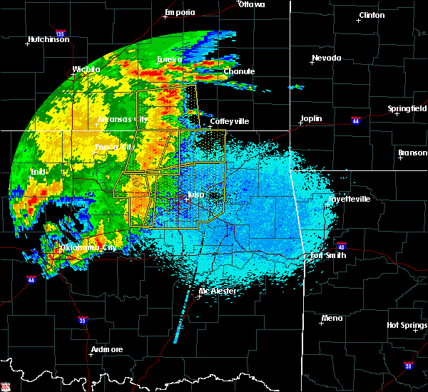 At 235 am cdt, severe thunderstorms were located along a line extending from 4 miles north of hulah to 4 miles southwest of barnsdall, moving east at 50 mph (radar indicated). Hazards include 60 mph wind gusts and penny size hail. Expect damage to roofs, siding, and trees. Locations in or near the path include, bartlesville, nowata, dewey, barnsdall, south coffeyville, copan, ochelata, delaware, lenapah, wann, new alluwe, bartlesville municipal airport, hulah, osage hills state park, watova, okesa, wah sha she state park, tallant, wolco,. At 235 am cdt, severe thunderstorms were located along a line extending from 4 miles north of hulah to 4 miles southwest of barnsdall, moving east at 50 mph (radar indicated). Hazards include 60 mph wind gusts and penny size hail. Expect damage to roofs, siding, and trees. Locations in or near the path include, bartlesville, nowata, dewey, barnsdall, south coffeyville, copan, ochelata, delaware, lenapah, wann, new alluwe, bartlesville municipal airport, hulah, osage hills state park, watova, okesa, wah sha she state park, tallant, wolco,.
|
| 5/19/2018 4:17 PM CDT | Tree limbs... 1 inch in diameter broke in nowata county OK, 3.1 miles SSW of Delaware, OK |
| 5/19/2018 4:12 PM CDT |
 At 412 pm cdt, a severe thunderstorm was located 4 miles southeast of lenapah, moving east at 45 mph (radar indicated). Hazards include 70 mph wind gusts and half dollar size hail. Hail damage to vehicles is expected. expect considerable tree damage. wind damage is also likely to mobile homes, roofs, and outbuildings. Locations in or near the path include, nowata, south coffeyville, welch, delaware, bluejacket, lenapah, hollow, pyramid corners, centralia, centrailia,. At 412 pm cdt, a severe thunderstorm was located 4 miles southeast of lenapah, moving east at 45 mph (radar indicated). Hazards include 70 mph wind gusts and half dollar size hail. Hail damage to vehicles is expected. expect considerable tree damage. wind damage is also likely to mobile homes, roofs, and outbuildings. Locations in or near the path include, nowata, south coffeyville, welch, delaware, bluejacket, lenapah, hollow, pyramid corners, centralia, centrailia,.
|
| 5/19/2018 3:59 PM CDT |
 At 358 pm cdt, a severe thunderstorm was located 6 miles west of lenapah, moving east at 45 mph (radar indicated). Hazards include golf ball size hail and 70 mph wind gusts. People and animals outdoors will be injured. expect hail damage to roofs, siding, windows, and vehicles. expect considerable tree damage. wind damage is also likely to mobile homes, roofs, and outbuildings. Locations in or near the path include, bartlesville, nowata, dewey, south coffeyville, copan, delaware, lenapah, wann,. At 358 pm cdt, a severe thunderstorm was located 6 miles west of lenapah, moving east at 45 mph (radar indicated). Hazards include golf ball size hail and 70 mph wind gusts. People and animals outdoors will be injured. expect hail damage to roofs, siding, windows, and vehicles. expect considerable tree damage. wind damage is also likely to mobile homes, roofs, and outbuildings. Locations in or near the path include, bartlesville, nowata, dewey, south coffeyville, copan, delaware, lenapah, wann,.
|
| 5/19/2018 3:47 PM CDT |
 At 347 pm cdt, a severe thunderstorm was located near dewey, moving east at 45 mph (radar indicated). Hazards include golf ball size hail and 70 mph wind gusts. People and animals outdoors will be injured. expect hail damage to roofs, siding, windows, and vehicles. expect considerable tree damage. wind damage is also likely to mobile homes, roofs, and outbuildings. Locations in or near the path include, bartlesville, nowata, dewey, south coffeyville, copan, delaware, lenapah, wann, bartlesville municipal airport, hulah, okesa, wah sha she state park,. At 347 pm cdt, a severe thunderstorm was located near dewey, moving east at 45 mph (radar indicated). Hazards include golf ball size hail and 70 mph wind gusts. People and animals outdoors will be injured. expect hail damage to roofs, siding, windows, and vehicles. expect considerable tree damage. wind damage is also likely to mobile homes, roofs, and outbuildings. Locations in or near the path include, bartlesville, nowata, dewey, south coffeyville, copan, delaware, lenapah, wann, bartlesville municipal airport, hulah, okesa, wah sha she state park,.
|
| 5/19/2018 3:34 PM CDT |
 At 334 pm cdt, a severe thunderstorm was located over bartlesville municipal airport, moving northeast at 45 mph (radar indicated). Hazards include 70 mph wind gusts and half dollar size hail. Hail damage to vehicles is expected. expect considerable tree damage. wind damage is also likely to mobile homes, roofs, and outbuildings. Locations in or near the path include, bartlesville, nowata, pawhuska, dewey, chelsea, barnsdall, south coffeyville, copan, ramona, wynona, ochelata, delaware, lenapah, wann, new alluwe, bigheart, bartlesville municipal airport, osage hills state park, watova, hulah,. At 334 pm cdt, a severe thunderstorm was located over bartlesville municipal airport, moving northeast at 45 mph (radar indicated). Hazards include 70 mph wind gusts and half dollar size hail. Hail damage to vehicles is expected. expect considerable tree damage. wind damage is also likely to mobile homes, roofs, and outbuildings. Locations in or near the path include, bartlesville, nowata, pawhuska, dewey, chelsea, barnsdall, south coffeyville, copan, ramona, wynona, ochelata, delaware, lenapah, wann, new alluwe, bigheart, bartlesville municipal airport, osage hills state park, watova, hulah,.
|
| 5/19/2018 3:15 PM CDT |
 At 315 pm cdt, a severe thunderstorm was located 4 miles east of pawhuska, moving east at 50 mph (radar indicated). Hazards include 70 mph wind gusts and half dollar size hail. Hail damage to vehicles is expected. expect considerable tree damage. wind damage is also likely to mobile homes, roofs, and outbuildings. Locations in or near the path include, bartlesville, nowata, pawhuska, dewey, chelsea, barnsdall, oologah, south coffeyville, copan, ramona, wynona, ochelata, delaware, foyil, avant, lenapah, talala, vera, wann, new alluwe,. At 315 pm cdt, a severe thunderstorm was located 4 miles east of pawhuska, moving east at 50 mph (radar indicated). Hazards include 70 mph wind gusts and half dollar size hail. Hail damage to vehicles is expected. expect considerable tree damage. wind damage is also likely to mobile homes, roofs, and outbuildings. Locations in or near the path include, bartlesville, nowata, pawhuska, dewey, chelsea, barnsdall, oologah, south coffeyville, copan, ramona, wynona, ochelata, delaware, foyil, avant, lenapah, talala, vera, wann, new alluwe,.
|
| 5/14/2018 11:23 PM CDT |
 At 1121 pm cdt, severe thunderstorms were located along a line extending from 2 miles west of south coffeyville to 4 miles northwest of delaware to near ochelata, moving east at 50 mph (radar indicated. at 1110 pm, a 59 mph wind gust was reported by the copan mesonet station 2 miles east northeast of copan). Hazards include 60 mph wind gusts and penny size hail. Expect damage to roofs, siding, and trees. Locations in or near the path include, bartlesville, nowata, dewey, chelsea, south coffeyville, copan, delaware, lenapah, wann, new alluwe, watova, white oak, hollow, centrailia, pyramid corners, centralia,. At 1121 pm cdt, severe thunderstorms were located along a line extending from 2 miles west of south coffeyville to 4 miles northwest of delaware to near ochelata, moving east at 50 mph (radar indicated. at 1110 pm, a 59 mph wind gust was reported by the copan mesonet station 2 miles east northeast of copan). Hazards include 60 mph wind gusts and penny size hail. Expect damage to roofs, siding, and trees. Locations in or near the path include, bartlesville, nowata, dewey, chelsea, south coffeyville, copan, delaware, lenapah, wann, new alluwe, watova, white oak, hollow, centrailia, pyramid corners, centralia,.
|
| 5/14/2018 11:04 PM CDT |
 At 1104 pm cdt, severe thunderstorms were located along a line extending from near caney to 4 miles southwest of copan to 2 miles southwest of okesa, moving east at 40 mph (radar indicated). Hazards include 60 mph wind gusts and penny size hail. Expect damage to roofs, siding, and trees. Locations in or near the path include, bartlesville, nowata, dewey, chelsea, south coffeyville, copan, delaware, lenapah, wann, new alluwe, watova, white oak, hollow, centrailia, pyramid corners, centralia,. At 1104 pm cdt, severe thunderstorms were located along a line extending from near caney to 4 miles southwest of copan to 2 miles southwest of okesa, moving east at 40 mph (radar indicated). Hazards include 60 mph wind gusts and penny size hail. Expect damage to roofs, siding, and trees. Locations in or near the path include, bartlesville, nowata, dewey, chelsea, south coffeyville, copan, delaware, lenapah, wann, new alluwe, watova, white oak, hollow, centrailia, pyramid corners, centralia,.
|
| 5/2/2018 11:13 PM CDT |
 At 1113 pm cdt, severe thunderstorms were located along a line extending from 2 miles west of liberty to 8 miles southwest of edna to 4 miles southeast of watova, moving northeast at 55 mph (radar indicated). Hazards include 60 mph wind gusts. Expect damage to roofs, siding, and trees. Locations in or near the path include, nowata, south coffeyville, delaware, lenapah, talala, new alluwe, watova, hollow, centralia, centrailia, a tornado watch remains in effect until 300 am cdt for northeastern oklahoma. At 1113 pm cdt, severe thunderstorms were located along a line extending from 2 miles west of liberty to 8 miles southwest of edna to 4 miles southeast of watova, moving northeast at 55 mph (radar indicated). Hazards include 60 mph wind gusts. Expect damage to roofs, siding, and trees. Locations in or near the path include, nowata, south coffeyville, delaware, lenapah, talala, new alluwe, watova, hollow, centralia, centrailia, a tornado watch remains in effect until 300 am cdt for northeastern oklahoma.
|
| 5/2/2018 10:43 PM CDT |
 At 1043 pm cdt, severe thunderstorms were located along a line extending from 2 miles north of hulah to 4 miles east of dewey to 2 miles north of skiatook, moving northeast at 55 mph (radar indicated). Hazards include 60 mph wind gusts. Expect damage to roofs, siding, and trees. Locations in or near the path include, nowata, chelsea, oologah, south coffeyville, copan, delaware, lenapah, talala, wann, new alluwe, watova, hollow, centrailia, centralia, a tornado watch remains in effect until 300 am cdt for northeastern oklahoma. At 1043 pm cdt, severe thunderstorms were located along a line extending from 2 miles north of hulah to 4 miles east of dewey to 2 miles north of skiatook, moving northeast at 55 mph (radar indicated). Hazards include 60 mph wind gusts. Expect damage to roofs, siding, and trees. Locations in or near the path include, nowata, chelsea, oologah, south coffeyville, copan, delaware, lenapah, talala, wann, new alluwe, watova, hollow, centrailia, centralia, a tornado watch remains in effect until 300 am cdt for northeastern oklahoma.
|
| 4/13/2018 4:22 PM CDT |
 At 422 pm cdt, a severe thunderstorm was located 3 miles northeast of delaware, moving northeast at 45 mph (radar indicated). Hazards include 60 mph wind gusts and quarter size hail. Hail damage to vehicles is expected. expect wind damage to roofs, siding, and trees. Locations in or near the path include, nowata, delaware, lenapah, hollow, a tornado watch remains in effect until 1000 pm cdt for northeastern oklahoma. At 422 pm cdt, a severe thunderstorm was located 3 miles northeast of delaware, moving northeast at 45 mph (radar indicated). Hazards include 60 mph wind gusts and quarter size hail. Hail damage to vehicles is expected. expect wind damage to roofs, siding, and trees. Locations in or near the path include, nowata, delaware, lenapah, hollow, a tornado watch remains in effect until 1000 pm cdt for northeastern oklahoma.
|
| 4/13/2018 4:03 PM CDT |
 At 403 pm cdt, a severe thunderstorm was located 4 miles southwest of lenapah, moving northeast at 50 mph (radar indicated). Hazards include 60 mph wind gusts and quarter size hail. Hail damage to vehicles is expected. expect wind damage to roofs, siding, and trees. Locations in or near the path include, nowata, south coffeyville, delaware, lenapah, a tornado watch remains in effect until 1000 pm cdt for northeastern oklahoma. At 403 pm cdt, a severe thunderstorm was located 4 miles southwest of lenapah, moving northeast at 50 mph (radar indicated). Hazards include 60 mph wind gusts and quarter size hail. Hail damage to vehicles is expected. expect wind damage to roofs, siding, and trees. Locations in or near the path include, nowata, south coffeyville, delaware, lenapah, a tornado watch remains in effect until 1000 pm cdt for northeastern oklahoma.
|
| 4/13/2018 3:49 PM CDT |
 At 349 pm cdt, a severe thunderstorm was located 9 miles northeast of ochelata, moving northeast at 55 mph (trained weather spotters). Hazards include 60 mph wind gusts and quarter size hail. Hail damage to vehicles is expected. expect wind damage to roofs, siding, and trees. Locations in or near the path include, bartlesville, nowata, south coffeyville, delaware, lenapah, wann, a tornado watch remains in effect until 1000 pm cdt for northeastern oklahoma. At 349 pm cdt, a severe thunderstorm was located 9 miles northeast of ochelata, moving northeast at 55 mph (trained weather spotters). Hazards include 60 mph wind gusts and quarter size hail. Hail damage to vehicles is expected. expect wind damage to roofs, siding, and trees. Locations in or near the path include, bartlesville, nowata, south coffeyville, delaware, lenapah, wann, a tornado watch remains in effect until 1000 pm cdt for northeastern oklahoma.
|
| 10/21/2017 9:40 PM CDT |
 At 939 pm cdt, a severe thunderstorm was located over watova, moving northeast at 45 mph (radar indicated). Hazards include 70 mph wind gusts and half dollar size hail. Hail damage to vehicles is expected. expect considerable tree damage. wind damage is also likely to mobile homes, roofs, and outbuildings. locations in or near the path include, bartlesville, nowata, chelsea, ramona, ochelata, delaware, lenapah, talala, big cabin, vera, new alluwe, watova, white oak, centralia, this includes interstate 44 near mile marker 276. A tornado watch remains in effect until 200 am cdt for northeastern oklahoma. At 939 pm cdt, a severe thunderstorm was located over watova, moving northeast at 45 mph (radar indicated). Hazards include 70 mph wind gusts and half dollar size hail. Hail damage to vehicles is expected. expect considerable tree damage. wind damage is also likely to mobile homes, roofs, and outbuildings. locations in or near the path include, bartlesville, nowata, chelsea, ramona, ochelata, delaware, lenapah, talala, big cabin, vera, new alluwe, watova, white oak, centralia, this includes interstate 44 near mile marker 276. A tornado watch remains in effect until 200 am cdt for northeastern oklahoma.
|
| 10/21/2017 9:26 PM CDT |
 At 926 pm cdt, a severe thunderstorm was located near ramona, moving east at 45 mph (radar indicated). Hazards include 60 mph wind gusts and half dollar size hail. Hail damage to vehicles is expected. expect wind damage to roofs, siding, and trees. locations in or near the path include, bartlesville, nowata, chelsea, ramona, ochelata, delaware, lenapah, talala, big cabin, vera, new alluwe, watova, white oak, centralia, this includes interstate 44 near mile marker 276. A tornado watch remains in effect until 200 am cdt for northeastern oklahoma. At 926 pm cdt, a severe thunderstorm was located near ramona, moving east at 45 mph (radar indicated). Hazards include 60 mph wind gusts and half dollar size hail. Hail damage to vehicles is expected. expect wind damage to roofs, siding, and trees. locations in or near the path include, bartlesville, nowata, chelsea, ramona, ochelata, delaware, lenapah, talala, big cabin, vera, new alluwe, watova, white oak, centralia, this includes interstate 44 near mile marker 276. A tornado watch remains in effect until 200 am cdt for northeastern oklahoma.
|
| 10/9/2017 6:10 PM CDT |
 At 609 pm cdt, a severe thunderstorm was located over nowata, moving northeast at 30 mph (radar indicated). Hazards include 60 mph wind gusts and quarter size hail. Hail damage to vehicles is expected. expect wind damage to roofs, siding, and trees. Locations in or near the path include, nowata, south coffeyville, delaware, lenapah, watova,. At 609 pm cdt, a severe thunderstorm was located over nowata, moving northeast at 30 mph (radar indicated). Hazards include 60 mph wind gusts and quarter size hail. Hail damage to vehicles is expected. expect wind damage to roofs, siding, and trees. Locations in or near the path include, nowata, south coffeyville, delaware, lenapah, watova,.
|
| 10/9/2017 5:55 PM CDT |
 At 554 pm cdt, a severe thunderstorm was located 3 miles west of delaware, moving northeast at 25 mph. another severe thunderstorm was located 5 miles west of watova, moving northeast at 25 mph (radar indicated). Hazards include 60 mph wind gusts and quarter size hail. Hail damage to vehicles is expected. expect wind damage to roofs, siding, and trees. Locations in or near the path include, nowata, south coffeyville, delaware, lenapah, watova,. At 554 pm cdt, a severe thunderstorm was located 3 miles west of delaware, moving northeast at 25 mph. another severe thunderstorm was located 5 miles west of watova, moving northeast at 25 mph (radar indicated). Hazards include 60 mph wind gusts and quarter size hail. Hail damage to vehicles is expected. expect wind damage to roofs, siding, and trees. Locations in or near the path include, nowata, south coffeyville, delaware, lenapah, watova,.
|
| 8/16/2017 9:38 PM CDT |
 The severe thunderstorm warning for craig, northern rogers, northern delaware, ottawa, central washington and nowata counties will expire at 945 pm cdt, the storms which prompted the warning have weakened below severe limits, and no longer pose an immediate threat to life or property. therefore the warning will be allowed to expire. however gusty winds of up to 45 mph are still possible with these thunderstorms. a severe thunderstorm watch remains in effect until midnight cdt for northeastern oklahoma. The severe thunderstorm warning for craig, northern rogers, northern delaware, ottawa, central washington and nowata counties will expire at 945 pm cdt, the storms which prompted the warning have weakened below severe limits, and no longer pose an immediate threat to life or property. therefore the warning will be allowed to expire. however gusty winds of up to 45 mph are still possible with these thunderstorms. a severe thunderstorm watch remains in effect until midnight cdt for northeastern oklahoma.
|
| 8/16/2017 9:07 PM CDT |
 At 906 pm cdt, severe thunderstorms were located along a line extending from 5 miles southeast of chetopa to 10 miles west of bluejacket to near nowata, moving east at 30 mph (radar indicated). Hazards include 60 mph wind gusts. Expect damage to roofs, siding, and trees. Locations in or near the path include, bartlesville, miami, vinita, nowata, grove, commerce, chelsea, fairland, afton, quapaw, welch, bernice, ketchum, delaware, bluejacket, wyandotte, lenapah, big cabin, treece, new alluwe, this includes interstate 44 between mile markers 273 and 324. At 906 pm cdt, severe thunderstorms were located along a line extending from 5 miles southeast of chetopa to 10 miles west of bluejacket to near nowata, moving east at 30 mph (radar indicated). Hazards include 60 mph wind gusts. Expect damage to roofs, siding, and trees. Locations in or near the path include, bartlesville, miami, vinita, nowata, grove, commerce, chelsea, fairland, afton, quapaw, welch, bernice, ketchum, delaware, bluejacket, wyandotte, lenapah, big cabin, treece, new alluwe, this includes interstate 44 between mile markers 273 and 324.
|
| 8/16/2017 8:45 PM CDT |
 At 845 pm cdt, severe thunderstorms were located along a line extending from 6 miles southeast of edna to 6 miles east of nowata to 6 miles east of ochelata, moving east at 45 mph (radar indicated). Hazards include 60 mph wind gusts. Expect damage to roofs, siding, and trees. Locations in or near the path include, bartlesville, miami, vinita, nowata, grove, commerce, chelsea, fairland, afton, quapaw, welch, bernice, ketchum, delaware, bluejacket, wyandotte, lenapah, big cabin, treece, new alluwe, this includes interstate 44 between mile markers 273 and 324. At 845 pm cdt, severe thunderstorms were located along a line extending from 6 miles southeast of edna to 6 miles east of nowata to 6 miles east of ochelata, moving east at 45 mph (radar indicated). Hazards include 60 mph wind gusts. Expect damage to roofs, siding, and trees. Locations in or near the path include, bartlesville, miami, vinita, nowata, grove, commerce, chelsea, fairland, afton, quapaw, welch, bernice, ketchum, delaware, bluejacket, wyandotte, lenapah, big cabin, treece, new alluwe, this includes interstate 44 between mile markers 273 and 324.
|
| 8/16/2017 8:13 PM CDT |
 At 813 pm cdt, severe thunderstorms were located along a line extending from 5 miles east of coffeyville to 3 miles northwest of pawhuska, moving east at 35 mph (radar indicated). Hazards include 60 mph wind gusts. Expect damage to roofs, siding, and trees. Locations in or near the path include, bartlesville, nowata, pawhuska, dewey, south coffeyville, copan, welch, delaware, lenapah, wann, new alluwe, bigheart, pearsonia, hulah, osage hills state park, watova, okesa, wah sha she state park, hollow, centrailia,. At 813 pm cdt, severe thunderstorms were located along a line extending from 5 miles east of coffeyville to 3 miles northwest of pawhuska, moving east at 35 mph (radar indicated). Hazards include 60 mph wind gusts. Expect damage to roofs, siding, and trees. Locations in or near the path include, bartlesville, nowata, pawhuska, dewey, south coffeyville, copan, welch, delaware, lenapah, wann, new alluwe, bigheart, pearsonia, hulah, osage hills state park, watova, okesa, wah sha she state park, hollow, centrailia,.
|
| 8/16/2017 7:52 PM CDT |
 At 752 pm cdt, severe thunderstorms were located along a line extending from 3 miles northwest of dearing to 4 miles southeast of shidler, moving east at 65 mph (radar indicated). Hazards include 70 mph wind gusts and nickel size hail. Expect considerable tree damage. damage is likely to mobile homes, roofs, and outbuildings. Locations in or near the path include, bartlesville, nowata, pawhuska, dewey, south coffeyville, copan, welch, delaware, lenapah, wann, new alluwe, bigheart, pearsonia, hulah, osage hills state park, watova, okesa, wah sha she state park, hollow, centrailia,. At 752 pm cdt, severe thunderstorms were located along a line extending from 3 miles northwest of dearing to 4 miles southeast of shidler, moving east at 65 mph (radar indicated). Hazards include 70 mph wind gusts and nickel size hail. Expect considerable tree damage. damage is likely to mobile homes, roofs, and outbuildings. Locations in or near the path include, bartlesville, nowata, pawhuska, dewey, south coffeyville, copan, welch, delaware, lenapah, wann, new alluwe, bigheart, pearsonia, hulah, osage hills state park, watova, okesa, wah sha she state park, hollow, centrailia,.
|
| 8/10/2017 8:19 PM CDT |
 At 819 pm cdt, a severe thunderstorm was located 3 miles east of talala, moving southeast at 30 mph (radar indicated). Hazards include 70 mph wind gusts and half dollar size hail. Hail damage to vehicles is expected. expect considerable tree damage. wind damage is also likely to mobile homes, roofs, and outbuildings. Locations in or near the path include, nowata, delaware, talala, new alluwe, watova,. At 819 pm cdt, a severe thunderstorm was located 3 miles east of talala, moving southeast at 30 mph (radar indicated). Hazards include 70 mph wind gusts and half dollar size hail. Hail damage to vehicles is expected. expect considerable tree damage. wind damage is also likely to mobile homes, roofs, and outbuildings. Locations in or near the path include, nowata, delaware, talala, new alluwe, watova,.
|
| 8/10/2017 8:04 PM CDT |
 At 803 pm cdt, a severe thunderstorm was located 3 miles west of watova, moving southeast at 35 mph. this is a very dangerous storm (radar indicated). Hazards include 80 mph wind gusts and golf ball size hail. Flying debris will be dangerous to those caught without shelter. mobile homes will be heavily damaged. expect considerable damage to roofs, windows, and vehicles. extensive tree damage and power outages are likely. Locations in or near the path include, nowata, delaware, talala, new alluwe, watova,. At 803 pm cdt, a severe thunderstorm was located 3 miles west of watova, moving southeast at 35 mph. this is a very dangerous storm (radar indicated). Hazards include 80 mph wind gusts and golf ball size hail. Flying debris will be dangerous to those caught without shelter. mobile homes will be heavily damaged. expect considerable damage to roofs, windows, and vehicles. extensive tree damage and power outages are likely. Locations in or near the path include, nowata, delaware, talala, new alluwe, watova,.
|
| 8/10/2017 7:59 PM CDT |
 At 759 pm cdt, a severe thunderstorm was located 4 miles west of nowata, moving southeast at 40 mph (trained weather spotters). Hazards include 75 mph wind gusts and half dollar size hail. Hail damage to vehicles is expected. expect considerable tree damage. wind damage is also likely to mobile homes, roofs, and outbuildings. Locations in or near the path include, nowata, delaware, talala, new alluwe, watova,. At 759 pm cdt, a severe thunderstorm was located 4 miles west of nowata, moving southeast at 40 mph (trained weather spotters). Hazards include 75 mph wind gusts and half dollar size hail. Hail damage to vehicles is expected. expect considerable tree damage. wind damage is also likely to mobile homes, roofs, and outbuildings. Locations in or near the path include, nowata, delaware, talala, new alluwe, watova,.
|
| 8/10/2017 7:48 PM CDT |
 At 747 pm cdt, a severe thunderstorm was located 8 miles west of delaware, moving southeast at 35 mph (trained weather spotters). Hazards include 70 mph wind gusts and half dollar size hail. Hail damage to vehicles is expected. expect considerable tree damage. wind damage is also likely to mobile homes, roofs, and outbuildings. Locations in or near the path include, bartlesville, nowata, dewey, delaware, talala, new alluwe, watova,. At 747 pm cdt, a severe thunderstorm was located 8 miles west of delaware, moving southeast at 35 mph (trained weather spotters). Hazards include 70 mph wind gusts and half dollar size hail. Hail damage to vehicles is expected. expect considerable tree damage. wind damage is also likely to mobile homes, roofs, and outbuildings. Locations in or near the path include, bartlesville, nowata, dewey, delaware, talala, new alluwe, watova,.
|
| 8/10/2017 7:38 PM CDT |
 At 737 pm cdt, a severe thunderstorm was located 5 miles east of dewey, moving southeast at 35 mph (trained weather spotters). Hazards include 70 mph wind gusts and quarter size hail. Hail damage to vehicles is expected. expect considerable tree damage. wind damage is also likely to mobile homes, roofs, and outbuildings. Locations in or near the path include, bartlesville, nowata, dewey, delaware, talala, wann, new alluwe, watova,. At 737 pm cdt, a severe thunderstorm was located 5 miles east of dewey, moving southeast at 35 mph (trained weather spotters). Hazards include 70 mph wind gusts and quarter size hail. Hail damage to vehicles is expected. expect considerable tree damage. wind damage is also likely to mobile homes, roofs, and outbuildings. Locations in or near the path include, bartlesville, nowata, dewey, delaware, talala, wann, new alluwe, watova,.
|
| 7/7/2017 4:39 PM CDT |
 At 438 pm cdt, a severe thunderstorm was located near delaware, moving southwest at 10 mph (radar indicated). Hazards include 60 mph wind gusts and quarter size hail. Hail damage to vehicles is expected. expect wind damage to roofs, siding, and trees. Locations in or near the path include, delaware, lenapah,. At 438 pm cdt, a severe thunderstorm was located near delaware, moving southwest at 10 mph (radar indicated). Hazards include 60 mph wind gusts and quarter size hail. Hail damage to vehicles is expected. expect wind damage to roofs, siding, and trees. Locations in or near the path include, delaware, lenapah,.
|
| 7/7/2017 4:20 PM CDT |
 At 420 pm cdt, a severe thunderstorm was located near lenapah, moving southeast at 35 mph (radar indicated). Hazards include 60 mph wind gusts and quarter size hail. Hail damage to vehicles is expected. expect wind damage to roofs, siding, and trees. Locations in or near the path include, chelsea, delaware, lenapah, big cabin, new alluwe, white oak, this includes interstate 44 between mile markers 274 and 280. At 420 pm cdt, a severe thunderstorm was located near lenapah, moving southeast at 35 mph (radar indicated). Hazards include 60 mph wind gusts and quarter size hail. Hail damage to vehicles is expected. expect wind damage to roofs, siding, and trees. Locations in or near the path include, chelsea, delaware, lenapah, big cabin, new alluwe, white oak, this includes interstate 44 between mile markers 274 and 280.
|
| 6/29/2017 11:04 PM CDT |
 At 404 am cdt, severe thunderstorms were located along a line extending from 5 miles east of south coffeyville to near delaware, moving east at 45 mph (radar indicated). Hazards include 60 mph wind gusts and quarter size hail. Hail damage to vehicles is expected. expect wind damage to roofs, siding, and trees. Locations in or near the path include, nowata, welch, delaware, bluejacket, lenapah, hollow, pyramid corners, centralia, centrailia, this includes interstate 44 between mile markers 288 and 290. At 404 am cdt, severe thunderstorms were located along a line extending from 5 miles east of south coffeyville to near delaware, moving east at 45 mph (radar indicated). Hazards include 60 mph wind gusts and quarter size hail. Hail damage to vehicles is expected. expect wind damage to roofs, siding, and trees. Locations in or near the path include, nowata, welch, delaware, bluejacket, lenapah, hollow, pyramid corners, centralia, centrailia, this includes interstate 44 between mile markers 288 and 290.
|
| 6/15/2017 10:12 PM CDT |
 At 1011 pm cdt, severe thunderstorms were located along a line extending from 4 miles southeast of bluejacket to 5 miles southeast of chelsea to 8 miles northeast of walnut creek state park, moving southeast at 45 mph (radar indicated). Hazards include 70 mph wind gusts. Expect considerable tree damage. damage is likely to mobile homes, roofs, and outbuildings. Locations in or near the path include, northwestern tulsa, bartlesville, claremore, vinita, nowata, pawhuska, owasso, skiatook, collinsville, dewey, chelsea, barnsdall, sperry, oologah, adair, welch, ramona, ketchum, wynona, ochelata, this includes interstate 44 between mile markers 260 and 292. At 1011 pm cdt, severe thunderstorms were located along a line extending from 4 miles southeast of bluejacket to 5 miles southeast of chelsea to 8 miles northeast of walnut creek state park, moving southeast at 45 mph (radar indicated). Hazards include 70 mph wind gusts. Expect considerable tree damage. damage is likely to mobile homes, roofs, and outbuildings. Locations in or near the path include, northwestern tulsa, bartlesville, claremore, vinita, nowata, pawhuska, owasso, skiatook, collinsville, dewey, chelsea, barnsdall, sperry, oologah, adair, welch, ramona, ketchum, wynona, ochelata, this includes interstate 44 between mile markers 260 and 292.
|
| 6/15/2017 9:46 PM CDT |
 At 946 pm cdt, severe thunderstorms were located along a line extending from 10 miles west of welch to 9 miles east of ochelata to 7 miles southwest of pawhuska, moving southeast at 45 mph (radar indicated). Hazards include 70 mph wind gusts and penny size hail. Expect considerable tree damage. damage is likely to mobile homes, roofs, and outbuildings. Locations in or near the path include, bartlesville, nowata, pawhuska, dewey, fairfax, barnsdall, south coffeyville, copan, shidler, wynona, ochelata, delaware, ralston, lenapah, burbank, wann, elgin, grainola, foraker, bigheart,. At 946 pm cdt, severe thunderstorms were located along a line extending from 10 miles west of welch to 9 miles east of ochelata to 7 miles southwest of pawhuska, moving southeast at 45 mph (radar indicated). Hazards include 70 mph wind gusts and penny size hail. Expect considerable tree damage. damage is likely to mobile homes, roofs, and outbuildings. Locations in or near the path include, bartlesville, nowata, pawhuska, dewey, fairfax, barnsdall, south coffeyville, copan, shidler, wynona, ochelata, delaware, ralston, lenapah, burbank, wann, elgin, grainola, foraker, bigheart,.
|
| 6/15/2017 9:40 PM CDT |
 At 939 pm cdt, severe thunderstorms were located along a line extending from 8 miles southwest of chetopa to 3 miles east of nowata to 2 miles southwest of wynona, moving southeast at 35 mph (radar indicated). Hazards include 70 mph wind gusts. Expect considerable tree damage. damage is likely to mobile homes, roofs, and outbuildings. Locations in or near the path include, northwestern tulsa, bartlesville, claremore, vinita, nowata, pawhuska, owasso, skiatook, collinsville, dewey, chelsea, barnsdall, sperry, oologah, adair, south coffeyville, copan, welch, ramona, ketchum, this includes interstate 44 between mile markers 260 and 292. At 939 pm cdt, severe thunderstorms were located along a line extending from 8 miles southwest of chetopa to 3 miles east of nowata to 2 miles southwest of wynona, moving southeast at 35 mph (radar indicated). Hazards include 70 mph wind gusts. Expect considerable tree damage. damage is likely to mobile homes, roofs, and outbuildings. Locations in or near the path include, northwestern tulsa, bartlesville, claremore, vinita, nowata, pawhuska, owasso, skiatook, collinsville, dewey, chelsea, barnsdall, sperry, oologah, adair, south coffeyville, copan, welch, ramona, ketchum, this includes interstate 44 between mile markers 260 and 292.
|
| 6/15/2017 9:18 PM CDT |
 At 917 pm cdt, severe thunderstorms were located along a line extending from 2 miles southeast of dearing to bigheart to 3 miles north of kaw lake, moving east at 40 mph (radar indicated). Hazards include 70 mph wind gusts and nickel size hail. Expect considerable tree damage. damage is likely to mobile homes, roofs, and outbuildings. Locations in or near the path include, bartlesville, nowata, pawhuska, dewey, fairfax, barnsdall, south coffeyville, copan, shidler, wynona, ochelata, delaware, ralston, lenapah, burbank, wann, elgin, grainola, foraker, bigheart,. At 917 pm cdt, severe thunderstorms were located along a line extending from 2 miles southeast of dearing to bigheart to 3 miles north of kaw lake, moving east at 40 mph (radar indicated). Hazards include 70 mph wind gusts and nickel size hail. Expect considerable tree damage. damage is likely to mobile homes, roofs, and outbuildings. Locations in or near the path include, bartlesville, nowata, pawhuska, dewey, fairfax, barnsdall, south coffeyville, copan, shidler, wynona, ochelata, delaware, ralston, lenapah, burbank, wann, elgin, grainola, foraker, bigheart,.
|
| 6/15/2017 8:53 PM CDT |
 At 852 pm cdt, severe thunderstorms were located along a line extending from 5 miles west of independence to 4 miles northwest of elgin to 4 miles southeast of arkansas city, moving south at 40 mph (radar indicated). Hazards include 70 mph wind gusts and nickel size hail. Expect considerable tree damage. damage is likely to mobile homes, roofs, and outbuildings. Locations in or near the path include, bartlesville, nowata, pawhuska, dewey, fairfax, barnsdall, south coffeyville, copan, shidler, wynona, ochelata, delaware, ralston, lenapah, burbank, wann, elgin, grainola, foraker, bigheart,. At 852 pm cdt, severe thunderstorms were located along a line extending from 5 miles west of independence to 4 miles northwest of elgin to 4 miles southeast of arkansas city, moving south at 40 mph (radar indicated). Hazards include 70 mph wind gusts and nickel size hail. Expect considerable tree damage. damage is likely to mobile homes, roofs, and outbuildings. Locations in or near the path include, bartlesville, nowata, pawhuska, dewey, fairfax, barnsdall, south coffeyville, copan, shidler, wynona, ochelata, delaware, ralston, lenapah, burbank, wann, elgin, grainola, foraker, bigheart,.
|
| 5/27/2017 7:10 PM CDT |
 At 710 pm cdt, a severe thunderstorm was located 7 miles west of watova, moving east at 45 mph (radar indicated). Hazards include 60 mph wind gusts and half dollar size hail. Hail damage to vehicles is expected. expect wind damage to roofs, siding, and trees. Locations in or near the path include, bartlesville, nowata, delaware, new alluwe, watova, a tornado watch remains in effect until midnight cdt for northeastern oklahoma. At 710 pm cdt, a severe thunderstorm was located 7 miles west of watova, moving east at 45 mph (radar indicated). Hazards include 60 mph wind gusts and half dollar size hail. Hail damage to vehicles is expected. expect wind damage to roofs, siding, and trees. Locations in or near the path include, bartlesville, nowata, delaware, new alluwe, watova, a tornado watch remains in effect until midnight cdt for northeastern oklahoma.
|
| 5/27/2017 6:58 PM CDT |
 At 658 pm cdt, a severe thunderstorm was located near copan, moving northeast at 40 mph. another severe thunderstorm was located 5 miles southeast of bartlesville, moving east at 35 mph (radar indicated). Hazards include 60 mph wind gusts and half dollar size hail. Hail damage to vehicles is expected. expect wind damage to roofs, siding, and trees. Locations in or near the path include, bartlesville, nowata, dewey, south coffeyville, copan, ochelata, delaware, lenapah, wann, new alluwe, watova, a tornado watch remains in effect until midnight cdt for northeastern oklahoma. At 658 pm cdt, a severe thunderstorm was located near copan, moving northeast at 40 mph. another severe thunderstorm was located 5 miles southeast of bartlesville, moving east at 35 mph (radar indicated). Hazards include 60 mph wind gusts and half dollar size hail. Hail damage to vehicles is expected. expect wind damage to roofs, siding, and trees. Locations in or near the path include, bartlesville, nowata, dewey, south coffeyville, copan, ochelata, delaware, lenapah, wann, new alluwe, watova, a tornado watch remains in effect until midnight cdt for northeastern oklahoma.
|
| 5/11/2017 5:30 PM CDT |
 At 530 pm cdt, a severe thunderstorm capable of producing a tornado was located 4 miles west of watova, moving northeast at 35 mph (radar indicated rotation). Hazards include tornado and quarter size hail. Flying debris will be dangerous to those caught without shelter. mobile homes will be damaged or destroyed. damage to roofs, windows, and vehicles will occur. tree damage is likely. Locations in or near the path include, nowata, delaware, new alluwe, watova,. At 530 pm cdt, a severe thunderstorm capable of producing a tornado was located 4 miles west of watova, moving northeast at 35 mph (radar indicated rotation). Hazards include tornado and quarter size hail. Flying debris will be dangerous to those caught without shelter. mobile homes will be damaged or destroyed. damage to roofs, windows, and vehicles will occur. tree damage is likely. Locations in or near the path include, nowata, delaware, new alluwe, watova,.
|
| 5/11/2017 5:24 PM CDT |
 At 524 pm cdt, a severe thunderstorm capable of producing a tornado was located 7 miles northwest of talala, moving northeast at 35 mph (radar indicated rotation). Hazards include tornado. Flying debris will be dangerous to those caught without shelter. mobile homes will be damaged or destroyed. damage to roofs, windows, and vehicles will occur. tree damage is likely. Locations in or near the path include, nowata, delaware, new alluwe, watova,. At 524 pm cdt, a severe thunderstorm capable of producing a tornado was located 7 miles northwest of talala, moving northeast at 35 mph (radar indicated rotation). Hazards include tornado. Flying debris will be dangerous to those caught without shelter. mobile homes will be damaged or destroyed. damage to roofs, windows, and vehicles will occur. tree damage is likely. Locations in or near the path include, nowata, delaware, new alluwe, watova,.
|
| 5/11/2017 2:59 PM CDT |
 At 259 pm cdt, severe thunderstorms were located along a line extending from 4 miles east of delaware to 6 miles west of bluejacket, moving northeast at 35 mph (radar indicated). Hazards include 60 mph wind gusts and quarter size hail. Hail damage to vehicles is expected. expect wind damage to roofs, siding, and trees. Locations in or near the path include, south coffeyville, welch, delaware, lenapah, hollow, pyramid corners, centralia, centrailia,. At 259 pm cdt, severe thunderstorms were located along a line extending from 4 miles east of delaware to 6 miles west of bluejacket, moving northeast at 35 mph (radar indicated). Hazards include 60 mph wind gusts and quarter size hail. Hail damage to vehicles is expected. expect wind damage to roofs, siding, and trees. Locations in or near the path include, south coffeyville, welch, delaware, lenapah, hollow, pyramid corners, centralia, centrailia,.
|
| 5/11/2017 2:41 PM CDT |
 At 240 pm cdt, severe thunderstorms were located along a line extending from near watova to 2 miles northwest of white oak, moving northeast at 35 mph (radar indicated). Hazards include 60 mph wind gusts and quarter size hail. Hail damage to vehicles is expected. expect wind damage to roofs, siding, and trees. Locations in or near the path include, nowata, south coffeyville, welch, delaware, lenapah, watova, hollow, pyramid corners, centralia, centrailia,. At 240 pm cdt, severe thunderstorms were located along a line extending from near watova to 2 miles northwest of white oak, moving northeast at 35 mph (radar indicated). Hazards include 60 mph wind gusts and quarter size hail. Hail damage to vehicles is expected. expect wind damage to roofs, siding, and trees. Locations in or near the path include, nowata, south coffeyville, welch, delaware, lenapah, watova, hollow, pyramid corners, centralia, centrailia,.
|
| 5/3/2017 2:36 AM CDT |
 At 236 am cdt, a severe thunderstorm was located over delaware, moving east at 35 mph (radar indicated). Hazards include 60 mph wind gusts and quarter size hail. Hail damage to vehicles is expected. expect wind damage to roofs, siding, and trees. Locations in or near the path include, nowata, delaware, lenapah, talala, watova,. At 236 am cdt, a severe thunderstorm was located over delaware, moving east at 35 mph (radar indicated). Hazards include 60 mph wind gusts and quarter size hail. Hail damage to vehicles is expected. expect wind damage to roofs, siding, and trees. Locations in or near the path include, nowata, delaware, lenapah, talala, watova,.
|
| 5/3/2017 2:19 AM CDT |
 At 219 am cdt, a severe thunderstorm was located 7 miles southeast of dewey, moving east at 35 mph (radar indicated). Hazards include 60 mph wind gusts and quarter size hail. Hail damage to vehicles is expected. expect wind damage to roofs, siding, and trees. Locations in or near the path include, bartlesville, nowata, dewey, ramona, delaware, lenapah, talala, watova,. At 219 am cdt, a severe thunderstorm was located 7 miles southeast of dewey, moving east at 35 mph (radar indicated). Hazards include 60 mph wind gusts and quarter size hail. Hail damage to vehicles is expected. expect wind damage to roofs, siding, and trees. Locations in or near the path include, bartlesville, nowata, dewey, ramona, delaware, lenapah, talala, watova,.
|
| 4/29/2017 5:23 AM CDT |
 At 523 am cdt, severe thunderstorms were located along a line extending from 7 miles southwest of nowata to 5 miles southeast of watova to 2 miles northeast of verdigris, moving northeast at 55 mph (radar indicated). Hazards include 70 mph wind gusts and quarter size hail. Hail damage to vehicles is expected. expect considerable tree damage. wind damage is also likely to mobile homes, roofs, and outbuildings. Locations in or near the path include, claremore, nowata, owasso, catoosa, verdigris, chelsea, oologah, delaware, foyil, lenapah, talala, big cabin, new alluwe, watova, bushyhead, this includes interstate 44 between mile markers 233 and 256, and between mile markers 260 and 276. At 523 am cdt, severe thunderstorms were located along a line extending from 7 miles southwest of nowata to 5 miles southeast of watova to 2 miles northeast of verdigris, moving northeast at 55 mph (radar indicated). Hazards include 70 mph wind gusts and quarter size hail. Hail damage to vehicles is expected. expect considerable tree damage. wind damage is also likely to mobile homes, roofs, and outbuildings. Locations in or near the path include, claremore, nowata, owasso, catoosa, verdigris, chelsea, oologah, delaware, foyil, lenapah, talala, big cabin, new alluwe, watova, bushyhead, this includes interstate 44 between mile markers 233 and 256, and between mile markers 260 and 276.
|
| 4/29/2017 5:13 AM CDT |
 At 513 am cdt, severe thunderstorms were located along a line extending from 5 miles east of ochelata to near talala to 5 miles southeast of oologah to catoosa, moving northeast at 55 mph (radar indicated). Hazards include 70 mph wind gusts and quarter size hail. Hail damage to vehicles is expected. expect considerable tree damage. wind damage is also likely to mobile homes, roofs, and outbuildings. Locations in or near the path include, northeastern tulsa, claremore, nowata, owasso, catoosa, collinsville, verdigris, chelsea, oologah, ramona, ochelata, delaware, foyil, lenapah, talala, big cabin, vera, new alluwe, watova, bushyhead, this includes interstate 44 between mile markers 232 and 256, and between mile markers 260 and 276. At 513 am cdt, severe thunderstorms were located along a line extending from 5 miles east of ochelata to near talala to 5 miles southeast of oologah to catoosa, moving northeast at 55 mph (radar indicated). Hazards include 70 mph wind gusts and quarter size hail. Hail damage to vehicles is expected. expect considerable tree damage. wind damage is also likely to mobile homes, roofs, and outbuildings. Locations in or near the path include, northeastern tulsa, claremore, nowata, owasso, catoosa, collinsville, verdigris, chelsea, oologah, ramona, ochelata, delaware, foyil, lenapah, talala, big cabin, vera, new alluwe, watova, bushyhead, this includes interstate 44 between mile markers 232 and 256, and between mile markers 260 and 276.
|
| 4/16/2017 9:22 PM CDT |
 At 922 pm cdt, a severe thunderstorm was located 4 miles west of watova, moving east at 20 mph (radar indicated). Hazards include 60 mph wind gusts and quarter size hail. Hail damage to vehicles is expected. expect wind damage to roofs, siding, and trees. Locations in or near the path include, nowata, chelsea, delaware, new alluwe, watova,. At 922 pm cdt, a severe thunderstorm was located 4 miles west of watova, moving east at 20 mph (radar indicated). Hazards include 60 mph wind gusts and quarter size hail. Hail damage to vehicles is expected. expect wind damage to roofs, siding, and trees. Locations in or near the path include, nowata, chelsea, delaware, new alluwe, watova,.
|
| 3/6/2017 9:24 PM CST |
 At 924 pm cst, severe thunderstorms were located along a line extending from 2 miles southeast of south coffeyville to 5 miles east of dewey to 3 miles southeast of barnsdall, moving east at 55 mph (radar indicated). Hazards include 70 mph wind gusts and quarter size hail. Hail damage to vehicles is expected. expect considerable tree damage. wind damage is also likely to mobile homes, roofs, and outbuildings. locations in or near the path include, bartlesville, miami, vinita, nowata, commerce, chelsea, oologah, adair, welch, ramona, ochelata, delaware, foyil, bluejacket, avant, lenapah, talala, big cabin, vera, treece, this includes interstate 44 between mile markers 264 and 294. A tornado watch remains in effect until 300 am cst for northeastern oklahoma. At 924 pm cst, severe thunderstorms were located along a line extending from 2 miles southeast of south coffeyville to 5 miles east of dewey to 3 miles southeast of barnsdall, moving east at 55 mph (radar indicated). Hazards include 70 mph wind gusts and quarter size hail. Hail damage to vehicles is expected. expect considerable tree damage. wind damage is also likely to mobile homes, roofs, and outbuildings. locations in or near the path include, bartlesville, miami, vinita, nowata, commerce, chelsea, oologah, adair, welch, ramona, ochelata, delaware, foyil, bluejacket, avant, lenapah, talala, big cabin, vera, treece, this includes interstate 44 between mile markers 264 and 294. A tornado watch remains in effect until 300 am cst for northeastern oklahoma.
|
| 3/6/2017 9:11 PM CST |
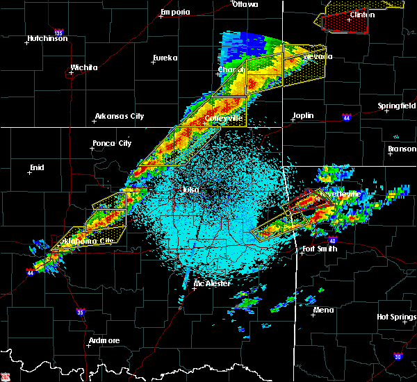 At 911 pm cst, severe thunderstorms were located along a line extending from 5 miles south of dearing to 3 miles northwest of barnsdall, moving east at 40 mph (radar indicated). Hazards include 60 mph wind gusts and quarter size hail. Hail damage to vehicles is expected. expect wind damage to roofs, siding, and trees. Locations in or near the path include, bartlesville, pawhuska, dewey, barnsdall, south coffeyville, copan, ramona, wynona, ochelata, delaware, lenapah, wann, hulah, osage hills state park, okesa, tallant, pershing, nelagoney, wolco, a tornado watch remains in effect until 300 am cst for northeastern oklahoma. At 911 pm cst, severe thunderstorms were located along a line extending from 5 miles south of dearing to 3 miles northwest of barnsdall, moving east at 40 mph (radar indicated). Hazards include 60 mph wind gusts and quarter size hail. Hail damage to vehicles is expected. expect wind damage to roofs, siding, and trees. Locations in or near the path include, bartlesville, pawhuska, dewey, barnsdall, south coffeyville, copan, ramona, wynona, ochelata, delaware, lenapah, wann, hulah, osage hills state park, okesa, tallant, pershing, nelagoney, wolco, a tornado watch remains in effect until 300 am cst for northeastern oklahoma.
|
| 3/6/2017 8:51 PM CST |
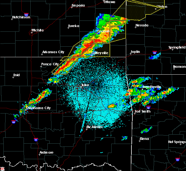 At 850 pm cst, severe thunderstorms were located along a line extending from 4 miles north of hulah to 8 miles northwest of wynona, moving east at 45 mph (radar indicated). Hazards include 60 mph wind gusts and quarter size hail. Hail damage to vehicles is expected. expect wind damage to roofs, siding, and trees. Locations in or near the path include, bartlesville, pawhuska, dewey, barnsdall, south coffeyville, copan, ramona, wynona, ochelata, delaware, lenapah, wann, hulah, osage hills state park, okesa, wah sha she state park, tallant, pershing, nelagoney, wolco, a tornado watch remains in effect until 300 am cst for northeastern oklahoma. At 850 pm cst, severe thunderstorms were located along a line extending from 4 miles north of hulah to 8 miles northwest of wynona, moving east at 45 mph (radar indicated). Hazards include 60 mph wind gusts and quarter size hail. Hail damage to vehicles is expected. expect wind damage to roofs, siding, and trees. Locations in or near the path include, bartlesville, pawhuska, dewey, barnsdall, south coffeyville, copan, ramona, wynona, ochelata, delaware, lenapah, wann, hulah, osage hills state park, okesa, wah sha she state park, tallant, pershing, nelagoney, wolco, a tornado watch remains in effect until 300 am cst for northeastern oklahoma.
|
| 5/9/2016 10:28 PM CDT |
 At 1027 pm cdt, a severe thunderstorm was located near nowata, moving east at 35 mph (radar indicated. at 1026 pm...quarter size hail was reported 5 miles west of nowata). Hazards include 60 mph wind gusts and half dollar size hail. Hail damage to vehicles is expected. expect wind damage to roofs, siding, and trees. Locations in or near the path include, nowata, chelsea, delaware, new alluwe, watova, white oak, centrailia, centralia, this includes interstate 44 between mile markers 274 and 275. At 1027 pm cdt, a severe thunderstorm was located near nowata, moving east at 35 mph (radar indicated. at 1026 pm...quarter size hail was reported 5 miles west of nowata). Hazards include 60 mph wind gusts and half dollar size hail. Hail damage to vehicles is expected. expect wind damage to roofs, siding, and trees. Locations in or near the path include, nowata, chelsea, delaware, new alluwe, watova, white oak, centrailia, centralia, this includes interstate 44 between mile markers 274 and 275.
|
| 5/9/2016 10:21 PM CDT |
 At 1020 pm cdt, a severe thunderstorm was located 6 miles west of nowata, moving east at 40 mph (radar indicated). Hazards include 60 mph wind gusts and half dollar size hail. Hail damage to vehicles is expected. expect wind damage to roofs, siding, and trees. Locations in or near the path include, nowata, chelsea, delaware, new alluwe, watova, white oak, centrailia, centralia, this includes interstate 44 between mile markers 274 and 275. At 1020 pm cdt, a severe thunderstorm was located 6 miles west of nowata, moving east at 40 mph (radar indicated). Hazards include 60 mph wind gusts and half dollar size hail. Hail damage to vehicles is expected. expect wind damage to roofs, siding, and trees. Locations in or near the path include, nowata, chelsea, delaware, new alluwe, watova, white oak, centrailia, centralia, this includes interstate 44 between mile markers 274 and 275.
|
| 4/26/2016 10:45 PM CDT |
 At 1043 pm cdt, severe thunderstorms were located along a line extending from 3 miles southeast of tyro to 2 miles southeast of lenapah to 2 miles east of talala, moving northeast at 75 mph. these are very dangerous storms (radar indicated). Hazards include 80 mph wind gusts. Flying debris will be dangerous to those caught without shelter. mobile homes will be heavily damaged. expect considerable damage to roofs, windows, and vehicles. extensive tree damage and power outages are likely. Locations in or near the path include, bartlesville, nowata, dewey, south coffeyville, copan, ramona, ochelata, delaware, lenapah, talala, vera, wann, new alluwe, watova, a tornado watch remains in effect until midnight cdt for northeastern oklahoma. At 1043 pm cdt, severe thunderstorms were located along a line extending from 3 miles southeast of tyro to 2 miles southeast of lenapah to 2 miles east of talala, moving northeast at 75 mph. these are very dangerous storms (radar indicated). Hazards include 80 mph wind gusts. Flying debris will be dangerous to those caught without shelter. mobile homes will be heavily damaged. expect considerable damage to roofs, windows, and vehicles. extensive tree damage and power outages are likely. Locations in or near the path include, bartlesville, nowata, dewey, south coffeyville, copan, ramona, ochelata, delaware, lenapah, talala, vera, wann, new alluwe, watova, a tornado watch remains in effect until midnight cdt for northeastern oklahoma.
|
| 4/26/2016 10:13 PM CDT |
 At 1013 pm cdt, severe thunderstorms were located along a line extending from near elgin to near okesa to 8 miles southwest of avant, moving northeast at 70 mph (radar indicated). Hazards include 70 mph wind gusts. Expect considerable tree damage. damage is likely to mobile homes, roofs, and outbuildings. Locations in or near the path include, bartlesville, nowata, pawhuska, skiatook, dewey, barnsdall, south coffeyville, copan, ramona, ochelata, delaware, avant, lenapah, talala, vera, wann, new alluwe, elgin, okesa, bigheart, a tornado watch remains in effect until midnight cdt for northeastern oklahoma. At 1013 pm cdt, severe thunderstorms were located along a line extending from near elgin to near okesa to 8 miles southwest of avant, moving northeast at 70 mph (radar indicated). Hazards include 70 mph wind gusts. Expect considerable tree damage. damage is likely to mobile homes, roofs, and outbuildings. Locations in or near the path include, bartlesville, nowata, pawhuska, skiatook, dewey, barnsdall, south coffeyville, copan, ramona, ochelata, delaware, avant, lenapah, talala, vera, wann, new alluwe, elgin, okesa, bigheart, a tornado watch remains in effect until midnight cdt for northeastern oklahoma.
|
| 4/10/2016 10:42 PM CDT | The severe thunderstorm warning for nowata county will expire at 1045 pm cdt, the storms which prompted the warning have weakened below severe limits, and no longer pose an immediate threat to life or property. therefore the warning will be allowed to expire. however gusty winds to 50 mph are still possible with these thunderstorms. a severe thunderstorm watch remains in effect until midnight cdt for northeastern oklahoma. |
| 4/10/2016 10:31 PM CDT |
 At 1031 pm cdt, severe thunderstorms were located along a line extending from 2 miles east of coffeyville to 4 miles northeast of lenapah to 5 miles west of nowata, moving east at 35 mph (radar indicated). Hazards include 60 mph wind gusts. Expect damage to roofs. siding. and trees. Locations in or near the path include, nowata, south coffeyville, delaware, lenapah,. At 1031 pm cdt, severe thunderstorms were located along a line extending from 2 miles east of coffeyville to 4 miles northeast of lenapah to 5 miles west of nowata, moving east at 35 mph (radar indicated). Hazards include 60 mph wind gusts. Expect damage to roofs. siding. and trees. Locations in or near the path include, nowata, south coffeyville, delaware, lenapah,.
|
| 4/10/2016 10:00 PM CDT |
 At 1000 pm cdt, severe thunderstorms were located along a line extending from 3 miles northeast of peru to 3 miles north of hulah to 3 miles northwest of osage hills state park, moving east at 60 mph (radar indicated). Hazards include 60 mph wind gusts and nickel size hail. Expect damage to roofs. siding. and trees. Locations in or near the path include, bartlesville, nowata, dewey, south coffeyville, copan, delaware, lenapah, wann,. At 1000 pm cdt, severe thunderstorms were located along a line extending from 3 miles northeast of peru to 3 miles north of hulah to 3 miles northwest of osage hills state park, moving east at 60 mph (radar indicated). Hazards include 60 mph wind gusts and nickel size hail. Expect damage to roofs. siding. and trees. Locations in or near the path include, bartlesville, nowata, dewey, south coffeyville, copan, delaware, lenapah, wann,.
|
| 4/10/2016 9:26 PM CDT | The severe thunderstorm warning for northwestern nowata county will expire at 930 pm cdt, the storm which prompted the warning has weakened below severe limits, and no longer poses an immediate threat to life or property. therefore the warning will be allowed to expire. however small hail to dime size is still possible with this thunderstorm. a severe thunderstorm watch remains in effect until midnight cdt for northeastern oklahoma. |
| 4/10/2016 9:13 PM CDT |
 At 913 pm cdt, a severe thunderstorm was located 5 miles west of lenapah, moving east at 25 mph (radar indicated). Hazards include 60 mph wind gusts and quarter size hail. Hail damage to vehicles is expected. expect wind damage to roofs, siding, and trees. Locations in or near the path include, delaware, lenapah,. At 913 pm cdt, a severe thunderstorm was located 5 miles west of lenapah, moving east at 25 mph (radar indicated). Hazards include 60 mph wind gusts and quarter size hail. Hail damage to vehicles is expected. expect wind damage to roofs, siding, and trees. Locations in or near the path include, delaware, lenapah,.
|
| 4/10/2016 9:00 PM CDT |
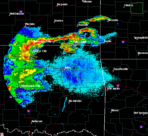 At 900 pm cdt, a severe thunderstorm was located 5 miles east of dewey, moving east at 25 mph (radar indicated). Hazards include golf ball size hail and 60 mph wind gusts. People and animals outdoors will be injured. expect hail damage to roofs, siding, windows, and vehicles. expect wind damage to roofs, siding, and trees. Locations in or near the path include, delaware, lenapah,. At 900 pm cdt, a severe thunderstorm was located 5 miles east of dewey, moving east at 25 mph (radar indicated). Hazards include golf ball size hail and 60 mph wind gusts. People and animals outdoors will be injured. expect hail damage to roofs, siding, windows, and vehicles. expect wind damage to roofs, siding, and trees. Locations in or near the path include, delaware, lenapah,.
|
| 4/10/2016 8:43 PM CDT |
 At 843 pm cdt, a severe thunderstorm was located over dewey, moving east at 35 mph (radar indicated). Hazards include golf ball size hail and 60 mph wind gusts. People and animals outdoors will be injured. expect hail damage to roofs, siding, windows, and vehicles. expect wind damage to roofs, siding, and trees. Locations in or near the path include, bartlesville, nowata, dewey, south coffeyville, copan, delaware, lenapah, wann,. At 843 pm cdt, a severe thunderstorm was located over dewey, moving east at 35 mph (radar indicated). Hazards include golf ball size hail and 60 mph wind gusts. People and animals outdoors will be injured. expect hail damage to roofs, siding, windows, and vehicles. expect wind damage to roofs, siding, and trees. Locations in or near the path include, bartlesville, nowata, dewey, south coffeyville, copan, delaware, lenapah, wann,.
|
| 3/30/2016 7:42 PM CDT |
 At 742 pm cdt, a severe thunderstorm was located 3 miles southeast of delaware, moving east at 30 mph (radar indicated). Hazards include 60 mph wind gusts and half dollar size hail. Hail damage to vehicles is expected. expect wind damage to roofs, siding, and trees. Locations in or near the path include, nowata, delaware, centralia,. At 742 pm cdt, a severe thunderstorm was located 3 miles southeast of delaware, moving east at 30 mph (radar indicated). Hazards include 60 mph wind gusts and half dollar size hail. Hail damage to vehicles is expected. expect wind damage to roofs, siding, and trees. Locations in or near the path include, nowata, delaware, centralia,.
|
| 3/30/2016 7:33 PM CDT | At 733 pm cdt, a severe thunderstorm capable of producing a tornado was located over nowata, moving northeast at 25 mph (radar indicated rotation). Hazards include tornado and quarter size hail. Flying debris will be dangerous to those caught without shelter. mobile homes will be damaged or destroyed. damage to roofs, windows, and vehicles will occur. tree damage is likely. Locations in or near the path include, nowata, delaware,. |
| 3/30/2016 7:26 PM CDT |
 At 725 pm cdt, a severe thunderstorm capable of producing a tornado was located 4 miles west of nowata, moving east at 30 mph (radar indicated rotation). Hazards include tornado and quarter size hail. Flying debris will be dangerous to those caught without shelter. mobile homes will be damaged or destroyed. damage to roofs, windows, and vehicles will occur. tree damage is likely. Locations in or near the path include, nowata, delaware,. At 725 pm cdt, a severe thunderstorm capable of producing a tornado was located 4 miles west of nowata, moving east at 30 mph (radar indicated rotation). Hazards include tornado and quarter size hail. Flying debris will be dangerous to those caught without shelter. mobile homes will be damaged or destroyed. damage to roofs, windows, and vehicles will occur. tree damage is likely. Locations in or near the path include, nowata, delaware,.
|
| 3/30/2016 7:16 PM CDT |
 At 715 pm cdt, a severe thunderstorm capable of producing a tornado was located 8 miles northwest of watova, moving east at 30 mph (radar indicated rotation). Hazards include tornado and quarter size hail. Flying debris will be dangerous to those caught without shelter. mobile homes will be damaged or destroyed. damage to roofs, windows, and vehicles will occur. tree damage is likely. Locations in or near the path include, nowata, delaware,. At 715 pm cdt, a severe thunderstorm capable of producing a tornado was located 8 miles northwest of watova, moving east at 30 mph (radar indicated rotation). Hazards include tornado and quarter size hail. Flying debris will be dangerous to those caught without shelter. mobile homes will be damaged or destroyed. damage to roofs, windows, and vehicles will occur. tree damage is likely. Locations in or near the path include, nowata, delaware,.
|
| 3/30/2016 6:54 PM CDT |
 At 653 pm cdt, a severe thunderstorm was located near ochelata, moving northeast at 50 mph (radar indicated). Hazards include 60 mph wind gusts and quarter size hail. Hail damage to vehicles is expected. expect wind damage to roofs, siding, and trees. Locations in or near the path include, bartlesville, nowata, south coffeyville, ramona, ochelata, delaware, lenapah, wann, watova,. At 653 pm cdt, a severe thunderstorm was located near ochelata, moving northeast at 50 mph (radar indicated). Hazards include 60 mph wind gusts and quarter size hail. Hail damage to vehicles is expected. expect wind damage to roofs, siding, and trees. Locations in or near the path include, bartlesville, nowata, south coffeyville, ramona, ochelata, delaware, lenapah, wann, watova,.
|
| 11/17/2015 3:36 AM CST |
 At 335 am cst, severe thunderstorms were located along a line extending from 2 miles north of wann to 6 miles northeast of ochelata to 2 miles east of keystone state park, moving northeast at 55 mph (radar indicated). Hazards include 60 mph wind gusts. Damage to roofs. siding and trees is possible. Locations in or near the path include, tulsa, bartlesville, sand springs, claremore, nowata, owasso, skiatook, catoosa, collinsville, verdigris, dewey, mannford, chelsea, inola, sperry, oologah, south coffeyville, copan, ramona, ochelata, this includes interstate 44 between mile markers 227 and 260. At 335 am cst, severe thunderstorms were located along a line extending from 2 miles north of wann to 6 miles northeast of ochelata to 2 miles east of keystone state park, moving northeast at 55 mph (radar indicated). Hazards include 60 mph wind gusts. Damage to roofs. siding and trees is possible. Locations in or near the path include, tulsa, bartlesville, sand springs, claremore, nowata, owasso, skiatook, catoosa, collinsville, verdigris, dewey, mannford, chelsea, inola, sperry, oologah, south coffeyville, copan, ramona, ochelata, this includes interstate 44 between mile markers 227 and 260.
|
| 11/17/2015 3:07 AM CST |
 At 307 am cst, severe thunderstorms were located along a line extending from 2 miles northeast of bigheart to 2 miles southwest of barnsdall to 4 miles northeast of oilton, moving northeast at 70 mph (radar indicated). Hazards include 60 mph wind gusts. Expect damage to roofs. siding and trees. Locations in or near the path include, tulsa, bartlesville, sand springs, claremore, nowata, owasso, skiatook, catoosa, collinsville, verdigris, dewey, mannford, chelsea, inola, barnsdall, sperry, oologah, south coffeyville, copan, ramona, this includes interstate 44 between mile markers 227 and 260. At 307 am cst, severe thunderstorms were located along a line extending from 2 miles northeast of bigheart to 2 miles southwest of barnsdall to 4 miles northeast of oilton, moving northeast at 70 mph (radar indicated). Hazards include 60 mph wind gusts. Expect damage to roofs. siding and trees. Locations in or near the path include, tulsa, bartlesville, sand springs, claremore, nowata, owasso, skiatook, catoosa, collinsville, verdigris, dewey, mannford, chelsea, inola, barnsdall, sperry, oologah, south coffeyville, copan, ramona, this includes interstate 44 between mile markers 227 and 260.
|
| 11/5/2015 1:27 PM CST | The severe thunderstorm warning for northwestern rogers, western nowata and southeastern washington counties will expire at 130 pm cst, the storms which prompted the warning have weakened below severe limits, and exiting the warned area. therefore the warning will be allowed to expire. however gusty winds are still possible with these thunderstorms. a tornado watch remains in effect until 800 pm cst for northeastern oklahoma. |
| 11/5/2015 1:15 PM CST |
 At 115 pm cst, severe thunderstorms were located along a line extending from 3 miles northwest of delaware to 6 miles west of watova, moving northeast at 65 mph (radar indicated). Hazards include 60 mph wind gusts and quarter size hail. Hail damage to vehicles is expected. expect wind damage to roofs, siding and trees. Locations in or near the path include, nowata, delaware, lenapah, a tornado watch remains in effect until 800 pm cst for northeastern oklahoma. At 115 pm cst, severe thunderstorms were located along a line extending from 3 miles northwest of delaware to 6 miles west of watova, moving northeast at 65 mph (radar indicated). Hazards include 60 mph wind gusts and quarter size hail. Hail damage to vehicles is expected. expect wind damage to roofs, siding and trees. Locations in or near the path include, nowata, delaware, lenapah, a tornado watch remains in effect until 800 pm cst for northeastern oklahoma.
|
| 11/5/2015 1:06 PM CST |
 A severe thunderstorm warning remains in effect until 130 pm cst for northwestern rogers. central nowata. central washington and western craig counties. at 106 pm cst. severe thunderstorms were located along a line extending from 6 miles southeast of dewey to 2 miles east of ramona. Moving northeast at 60 mph. A severe thunderstorm warning remains in effect until 130 pm cst for northwestern rogers. central nowata. central washington and western craig counties. at 106 pm cst. severe thunderstorms were located along a line extending from 6 miles southeast of dewey to 2 miles east of ramona. Moving northeast at 60 mph.
|
| 11/5/2015 12:52 PM CST |
 At 1251 pm cst, severe thunderstorms were located along a line extending from 5 miles southwest of bartlesville to near avant, moving northeast at 65 mph (radar indicated). Hazards include 60 mph wind gusts and quarter size hail. Hail damage to vehicles is expected. expect wind damage to roofs, siding and trees. Locations in or near the path include, bartlesville, nowata, south coffeyville, ramona, ochelata, delaware, avant, lenapah, wolco, a tornado watch remains in effect until 800 pm cst for northeastern oklahoma. At 1251 pm cst, severe thunderstorms were located along a line extending from 5 miles southwest of bartlesville to near avant, moving northeast at 65 mph (radar indicated). Hazards include 60 mph wind gusts and quarter size hail. Hail damage to vehicles is expected. expect wind damage to roofs, siding and trees. Locations in or near the path include, bartlesville, nowata, south coffeyville, ramona, ochelata, delaware, avant, lenapah, wolco, a tornado watch remains in effect until 800 pm cst for northeastern oklahoma.
|
| 11/5/2015 12:23 PM CST |
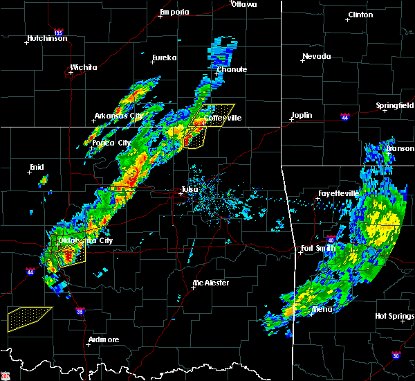 At 1214 pm cst, severe thunderstorms were located along a line extending from 2 miles west of south coffeyville to 4 miles southeast of wann to 4 miles northeast of dewey to 3 miles southeast of bartlesville, moving northeast at 50 mph (radar indicated). Hazards include 60 mph wind gusts and quarter size hail. Hail damage to vehicles is expected. expect wind damage to roofs, siding and trees. Locations in or near the path include, bartlesville, dewey, south coffeyville, delaware, lenapah, wann, a tornado watch remains in effect until 800 pm cst for northeastern oklahoma. At 1214 pm cst, severe thunderstorms were located along a line extending from 2 miles west of south coffeyville to 4 miles southeast of wann to 4 miles northeast of dewey to 3 miles southeast of bartlesville, moving northeast at 50 mph (radar indicated). Hazards include 60 mph wind gusts and quarter size hail. Hail damage to vehicles is expected. expect wind damage to roofs, siding and trees. Locations in or near the path include, bartlesville, dewey, south coffeyville, delaware, lenapah, wann, a tornado watch remains in effect until 800 pm cst for northeastern oklahoma.
|
| 11/5/2015 12:14 PM CST |
 At 1214 pm cst, severe thunderstorms were located along a line extending from 2 miles west of south coffeyville to 4 miles southeast of wann to 4 miles northeast of dewey to 3 miles southeast of bartlesville, moving northeast at 50 mph (radar indicated). Hazards include 60 mph wind gusts and quarter size hail. Hail damage to vehicles is expected. expect wind damage to roofs, siding and trees. Locations in or near the path include, bartlesville, dewey, south coffeyville, delaware, lenapah, wann, a tornado watch remains in effect until 800 pm cst for northeastern oklahoma. At 1214 pm cst, severe thunderstorms were located along a line extending from 2 miles west of south coffeyville to 4 miles southeast of wann to 4 miles northeast of dewey to 3 miles southeast of bartlesville, moving northeast at 50 mph (radar indicated). Hazards include 60 mph wind gusts and quarter size hail. Hail damage to vehicles is expected. expect wind damage to roofs, siding and trees. Locations in or near the path include, bartlesville, dewey, south coffeyville, delaware, lenapah, wann, a tornado watch remains in effect until 800 pm cst for northeastern oklahoma.
|
| 11/5/2015 12:01 PM CST |
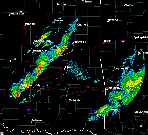 At 1201 pm cst, severe thunderstorms were located along a line extending from 2 miles southeast of copan to near dewey to 2 miles west of bartlesville to 5 miles west of ochelata, moving northeast at 35 mph (radar indicated). Hazards include 60 mph wind gusts and quarter size hail. Hail damage to vehicles is expected. expect wind damage to roofs, siding and trees. Locations in or near the path include, bartlesville, dewey, south coffeyville, copan, delaware, lenapah, wann,. At 1201 pm cst, severe thunderstorms were located along a line extending from 2 miles southeast of copan to near dewey to 2 miles west of bartlesville to 5 miles west of ochelata, moving northeast at 35 mph (radar indicated). Hazards include 60 mph wind gusts and quarter size hail. Hail damage to vehicles is expected. expect wind damage to roofs, siding and trees. Locations in or near the path include, bartlesville, dewey, south coffeyville, copan, delaware, lenapah, wann,.
|
| 11/5/2015 11:50 AM CST |
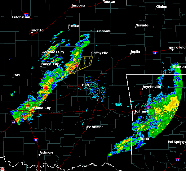 At 1150 am cst, severe thunderstorms were located along a line extending from 4 miles northwest of bartlesville to 4 miles southeast of okesa, moving northeast at 55 mph (radar indicated). Hazards include 60 mph wind gusts and half dollar size hail. Hail damage to vehicles is expected. expect wind damage to roofs, siding and trees. Locations in or near the path include, bartlesville, dewey, barnsdall, south coffeyville, copan, delaware, lenapah, wann, okesa, osage hills state park, tallant,. At 1150 am cst, severe thunderstorms were located along a line extending from 4 miles northwest of bartlesville to 4 miles southeast of okesa, moving northeast at 55 mph (radar indicated). Hazards include 60 mph wind gusts and half dollar size hail. Hail damage to vehicles is expected. expect wind damage to roofs, siding and trees. Locations in or near the path include, bartlesville, dewey, barnsdall, south coffeyville, copan, delaware, lenapah, wann, okesa, osage hills state park, tallant,.
|
| 11/5/2015 11:45 AM CST |
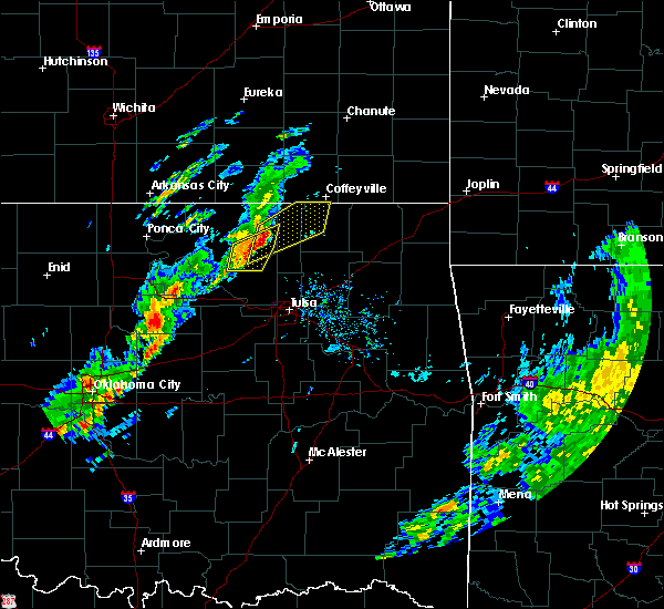 At 1144 am cst, severe thunderstorms were located along a line extending from 4 miles northeast of osage hills state park to 3 miles north of barnsdall, moving northeast at 50 mph (radar indicated). Hazards include 60 mph wind gusts and quarter size hail. Hail damage to vehicles is expected. expect wind damage to roofs, siding and trees. Locations in or near the path include, bartlesville, dewey, barnsdall, south coffeyville, copan, delaware, lenapah, wann, okesa, osage hills state park, tallant,. At 1144 am cst, severe thunderstorms were located along a line extending from 4 miles northeast of osage hills state park to 3 miles north of barnsdall, moving northeast at 50 mph (radar indicated). Hazards include 60 mph wind gusts and quarter size hail. Hail damage to vehicles is expected. expect wind damage to roofs, siding and trees. Locations in or near the path include, bartlesville, dewey, barnsdall, south coffeyville, copan, delaware, lenapah, wann, okesa, osage hills state park, tallant,.
|
| 5/23/2015 9:37 PM CDT | The severe thunderstorm warning for northern rogers and nowata counties will expire at 945 pm cdt, the line of storms which prompted the warning has weakened below severe limits, and no longer poses an immediate threat to life or property. additional severe thunderstorms are still possible, and a tornado watch remains in effect until 4 am. |
| 5/23/2015 9:27 PM CDT | At 926 pm cdt, severe thunderstorms were located along a line extending from dearing to 6 miles southeast of south coffeyville to oologah, and moving northeast at 25 mph (radar indicated). Hazards include 60 mph wind gusts. Expect damage to roofs. siding and trees. Locations in or near the path include, new alluwe. |
| 5/23/2015 9:12 PM CDT | At 910 pm cdt, severe thunderstorms were located along a line extending from tyro to lenapah to collinsville, and moving northeast at 25 mph (radar indicated). Hazards include 60 mph wind gusts. Expect damage to roofs. siding and trees. Locations in or near the path include, delaware, talala, oologah, nowata, watova, south coffeyville and new alluwe. |
| 5/23/2015 8:55 PM CDT | At 854 pm cdt, severe thunderstorms were located along a line extending from caney to 6 miles west of delaware to oologah, and moving northeast at 25 mph (radar indicated). Hazards include 60 mph wind gusts. Expect damage to roofs. siding and trees. Locations in or near the path include, talala, watova, lenapah, delaware, nowata, south coffeyville and new alluwe. |
| 5/23/2015 8:37 PM CDT | At 834 pm cdt, severe thunderstorms were located along a line extending from caney to bartlesville to vera, and moving east at 30 mph (radar indicated). Hazards include 70 mph wind gusts. Expect considerable tree damage. damage is likely to mobile homes, roofs and outbuildings. Locations in or near the path include, vera, wann, talala, delaware, watova, south coffeyville, new alluwe, lenapah and nowata. |
| 5/16/2015 11:22 PM CDT | At 1121 pm cdt, severe thunderstorms were located along a line extending from 8 miles north of hollow to 8 miles southwest of centralia to oologah, moving northeast at 55 mph. storm hazards include, quarter size hail, damaging wind gusts to 70 mph, some locations in or near the path of this storm include, new alluwe, centralia, centrailia, hollow, chelsea, pyramid corners, welch, white oak, bluejacket and vinita. this includes interstate 44 between mile markers 277 and 293. |
| 5/16/2015 11:12 PM CDT | At 1109 pm cdt, severe thunderstorms were located along a line extending from 7 miles southwest of edna to 7 miles north of new alluwe to oologah, and moving northeast at 55 mph (radar indicated). Hazards include 70 mph wind gusts and quarter size hail. Hail damage to vehicles is expected. expect considerable tree damage. wind damage is also likely to mobile homes, roofs and outbuildings. locations in or near the path include, new alluwe, centralia, centrailia, hollow, chelsea, white oak, welch, pyramid corners, vinita and bluejacket. this includes interstate 44 between mile markers 277 and 293. Possible. |
| 5/16/2015 10:51 PM CDT | At 1049 pm cdt, severe thunderstorms were located along a line extending from wann to 7 miles west of nowata to owasso, moving northeast at 45 mph. these storms have a history of producing damaging winds of 60 to 70 mph. storm hazards include, quarter size hail, damaging wind gusts to 70 mph, some locations in or near the path of this storm include, verdigris, talala, delaware, oologah, nowata, lenapah, watova, tiawah, claremore, south coffeyville, bushyhead, foyil and new alluwe. this includes interstate 44 between mile markers 231 and 257. |
| 5/16/2015 10:35 PM CDT | At 1033 pm cdt, severe thunderstorms were located along a line extending from hulah to ochelata to sand springs, and moving northeast at 45 mph (radar indicated). Hazards include 70 mph wind gusts and quarter size hail. Hail damage to vehicles is expected. expect considerable tree damage. wind damage is also likely to mobile homes, roofs and outbuildings. locations in or near the path include, ramona, dewey, tulsa, copan, tulsa international airport, vera, collinsville, owasso, wann, catoosa, verdigris, talala, lenapah, oologah, delaware, watova, nowata, claremore, south coffeyville, tiawah, bushyhead, foyil and new alluwe. this includes interstate 44 between mile markers 231 and 257. Possible. |
| 4/2/2015 9:45 PM CDT | A severe thunderstorm warning remains in effect for southern nowata county until 1015 pm cdt. at 944 pm cdt. a severe thunderstorm was located 7 miles west of delaware. and moving east at 30 mph. hazard. 60 mph wind gusts and quarter size hail. source. Radar indicated. |
| 4/2/2015 9:36 PM CDT | The national weather service in tulsa has issued a * severe thunderstorm warning for. southern nowata county in northeast oklahoma. washington county in northeast oklahoma. until 1015 pm cdt * at 934 pm cdt. a severe thunderstorm was located near dewey. And. |
| 3/25/2015 4:40 PM CDT | The national weather service in tulsa has issued a * severe thunderstorm warning for. extreme west central craig county in northeast oklahoma. nowata county in northeast oklahoma. northeastern osage county in northeast oklahoma. Washington county in northeast oklahoma. |
| 6/5/2014 11:56 PM CDT | Tennis Ball sized hail reported 5.1 miles W of Delaware, OK, reported in childers area |
| 5/1/2012 12:55 AM CDT | Tree on top of house on cherokee street in delaware. time estimated by rada in nowata county OK, 0.2 miles SSW of Delaware, OK |
Hail Maps for Delaware, OK


Connect with Interactive Hail Maps