

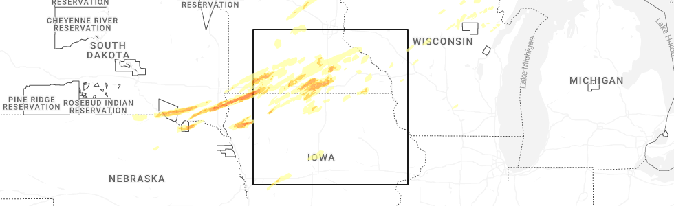
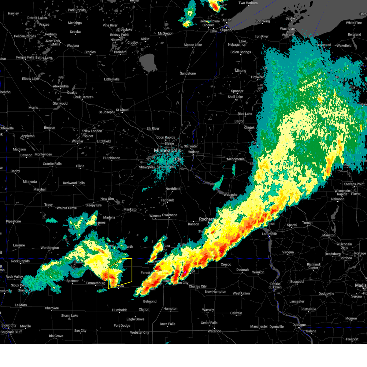
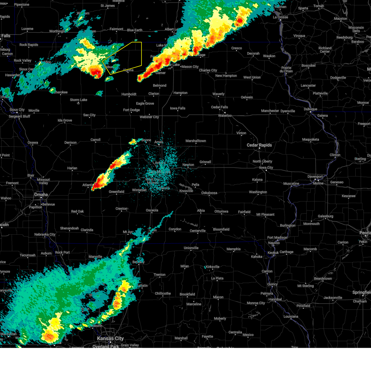
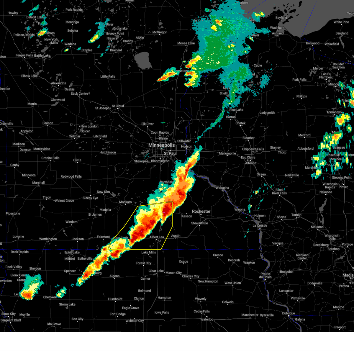
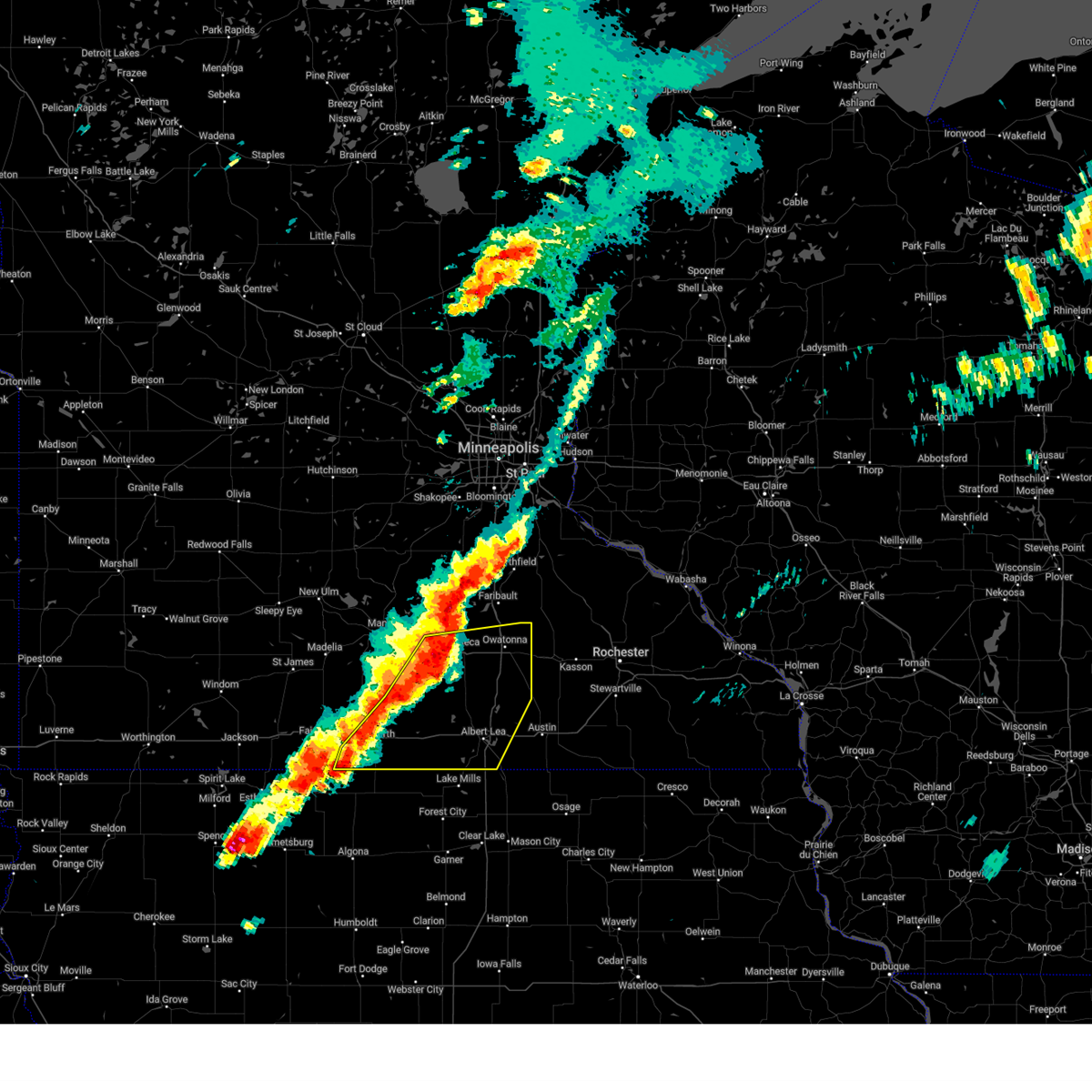
Hail Map for Elmore, MN
The Elmore, MN area has had 0 reports of on-the-ground hail by trained spotters, and has been under severe weather warnings 8 times during the past 12 months. Doppler radar has detected hail at or near Elmore, MN on 55 occasions, including 3 occasions during the past year.
| Name: | Elmore, MN |
| Where Located: | 51.1 miles WNW of Mason City, IA |
| Map: | Google Map for Elmore, MN |
| Population: | 663 |
| Housing Units: | 320 |
| More Info: | Search Google for Elmore, MN |
1
The Top Recent Hail Date for Elmore, MN is Monday, April 28, 2025 (10th out of 55)
Hail and Wind Damage Spotted near Elmore, MN
| Date / Time | Report Details |
|---|---|
| 6/20/2025 2:19 AM CDT |
 At 219 am cdt, severe thunderstorms were located along a line extending from near swea city to 5 miles southwest of dunnell, moving southeast at 40 mph (radar indicated). Hazards include 60 mph wind gusts and quarter size hail. Hail damage to vehicles is expected. expect wind damage to roofs, siding, and trees. Locations impacted include, estherville, okamanpedan lake, iowa lake, swan lake, ingham lake, high lake, union slogh, armstrong, bancroft, swea city, ringsted, lakota, wallingford, ledyard, gruver, dolliver, fort defiance state park, okamanpedan state park, wolden county park, and estherville municipal airport. At 219 am cdt, severe thunderstorms were located along a line extending from near swea city to 5 miles southwest of dunnell, moving southeast at 40 mph (radar indicated). Hazards include 60 mph wind gusts and quarter size hail. Hail damage to vehicles is expected. expect wind damage to roofs, siding, and trees. Locations impacted include, estherville, okamanpedan lake, iowa lake, swan lake, ingham lake, high lake, union slogh, armstrong, bancroft, swea city, ringsted, lakota, wallingford, ledyard, gruver, dolliver, fort defiance state park, okamanpedan state park, wolden county park, and estherville municipal airport.
|
| 6/20/2025 1:59 AM CDT |
 Svrdmx the national weather service in des moines has issued a * severe thunderstorm warning for, emmet county in northwestern iowa, northern kossuth county in north central iowa, * until 245 am cdt. * at 159 am cdt, a severe thunderstorm was located near armstrong, or 14 miles east of estherville, moving east at 35 mph (radar indicated). Hazards include 60 mph wind gusts and quarter size hail. Hail damage to vehicles is expected. Expect wind damage to roofs, siding, and trees. Svrdmx the national weather service in des moines has issued a * severe thunderstorm warning for, emmet county in northwestern iowa, northern kossuth county in north central iowa, * until 245 am cdt. * at 159 am cdt, a severe thunderstorm was located near armstrong, or 14 miles east of estherville, moving east at 35 mph (radar indicated). Hazards include 60 mph wind gusts and quarter size hail. Hail damage to vehicles is expected. Expect wind damage to roofs, siding, and trees.
|
| 4/28/2025 9:35 PM CDT |
 The storm which prompted the warning has weakened below severe limits, and no longer poses an immediate threat to life or property. therefore, the warning will be allowed to expire. however, gusty winds are still possible with this thunderstorm. a tornado watch remains in effect until 1100 pm cdt for north central iowa. The storm which prompted the warning has weakened below severe limits, and no longer poses an immediate threat to life or property. therefore, the warning will be allowed to expire. however, gusty winds are still possible with this thunderstorm. a tornado watch remains in effect until 1100 pm cdt for north central iowa.
|
| 4/28/2025 9:23 PM CDT |
 the severe thunderstorm warning has been cancelled and is no longer in effect the severe thunderstorm warning has been cancelled and is no longer in effect
|
| 4/28/2025 9:23 PM CDT |
 At 923 pm cdt, a severe thunderstorm was located over bancroft, or 15 miles north of algona, moving northeast at 65 mph (radar indicated). Hazards include 60 mph wind gusts and penny size hail. Expect damage to roofs, siding, and trees. Locations impacted include, swea city, fenton, union slogh, bancroft, ledyard, burt, titonka, lone rock, and lakota. At 923 pm cdt, a severe thunderstorm was located over bancroft, or 15 miles north of algona, moving northeast at 65 mph (radar indicated). Hazards include 60 mph wind gusts and penny size hail. Expect damage to roofs, siding, and trees. Locations impacted include, swea city, fenton, union slogh, bancroft, ledyard, burt, titonka, lone rock, and lakota.
|
| 4/28/2025 9:06 PM CDT |
 Svrdmx the national weather service in des moines has issued a * severe thunderstorm warning for, southeastern emmet county in northwestern iowa, central kossuth county in north central iowa, northeastern palo alto county in northwestern iowa, * until 945 pm cdt. * at 905 pm cdt, a severe thunderstorm was located near five island lake, or 6 miles northeast of emmetsburg, moving northeast at 65 mph (radar indicated). Hazards include 60 mph wind gusts and quarter size hail. Hail damage to vehicles is expected. Expect wind damage to roofs, siding, and trees. Svrdmx the national weather service in des moines has issued a * severe thunderstorm warning for, southeastern emmet county in northwestern iowa, central kossuth county in north central iowa, northeastern palo alto county in northwestern iowa, * until 945 pm cdt. * at 905 pm cdt, a severe thunderstorm was located near five island lake, or 6 miles northeast of emmetsburg, moving northeast at 65 mph (radar indicated). Hazards include 60 mph wind gusts and quarter size hail. Hail damage to vehicles is expected. Expect wind damage to roofs, siding, and trees.
|
| 4/28/2025 6:17 PM CDT |
 The severe thunderstorm warning that was previously in effect has been reissued for and is in effect until 700 pm cdt. please refer to those bulletins for the latest severe weather information. a tornado watch remains in effect until 800 pm cdt for a portion of south central minnesota. The severe thunderstorm warning that was previously in effect has been reissued for and is in effect until 700 pm cdt. please refer to those bulletins for the latest severe weather information. a tornado watch remains in effect until 800 pm cdt for a portion of south central minnesota.
|
| 4/28/2025 5:29 PM CDT |
 Svrmpx the national weather service in the twin cities has issued a * severe thunderstorm warning for, southeastern blue earth county in south central minnesota, faribault county in south central minnesota, freeborn county in south central minnesota, southeastern martin county in south central minnesota, steele county in south central minnesota, waseca county in south central minnesota, * until 615 pm cdt. * at 529 pm cdt, severe thunderstorms were located along a line from over waseca to near elmore, or along a line from 13 miles west of owatonna to 17 miles southeast of fairmont, moving east at 50 mph (radar indicated). Hazards include 60 mph wind gusts and half dollar size hail. Hail damage to vehicles is expected. Expect wind damage to roofs, siding, and trees. Svrmpx the national weather service in the twin cities has issued a * severe thunderstorm warning for, southeastern blue earth county in south central minnesota, faribault county in south central minnesota, freeborn county in south central minnesota, southeastern martin county in south central minnesota, steele county in south central minnesota, waseca county in south central minnesota, * until 615 pm cdt. * at 529 pm cdt, severe thunderstorms were located along a line from over waseca to near elmore, or along a line from 13 miles west of owatonna to 17 miles southeast of fairmont, moving east at 50 mph (radar indicated). Hazards include 60 mph wind gusts and half dollar size hail. Hail damage to vehicles is expected. Expect wind damage to roofs, siding, and trees.
|
| 6/18/2024 8:30 PM CDT |
 The storms which prompted the warning have weakened below severe limits, and no longer pose an immediate threat to life or property. therefore, the warning will be allowed to expire. however, gusty winds are still possible with these thunderstorms. a severe thunderstorm watch remains in effect until 1000 pm cdt for north central iowa. The storms which prompted the warning have weakened below severe limits, and no longer pose an immediate threat to life or property. therefore, the warning will be allowed to expire. however, gusty winds are still possible with these thunderstorms. a severe thunderstorm watch remains in effect until 1000 pm cdt for north central iowa.
|
| 6/18/2024 8:14 PM CDT |
 At 814 pm cdt, severe thunderstorms were located along a line extending from near rake to crystal lake to near klemme, moving northeast at 45 mph (radar indicated). Hazards include 60 mph wind gusts. Expect damage to roofs, siding, and trees. Locations impacted include, forest city, garner, britt, eagle lake, union slogh, buffalo center, kanawha, klemme, thompson, titonka, wesley, corwith, leland, lakota, crystal lake, woden, rake, goodell, duncan, and ledyard. At 814 pm cdt, severe thunderstorms were located along a line extending from near rake to crystal lake to near klemme, moving northeast at 45 mph (radar indicated). Hazards include 60 mph wind gusts. Expect damage to roofs, siding, and trees. Locations impacted include, forest city, garner, britt, eagle lake, union slogh, buffalo center, kanawha, klemme, thompson, titonka, wesley, corwith, leland, lakota, crystal lake, woden, rake, goodell, duncan, and ledyard.
|
| 6/18/2024 8:14 PM CDT |
 the severe thunderstorm warning has been cancelled and is no longer in effect the severe thunderstorm warning has been cancelled and is no longer in effect
|
| 6/18/2024 8:01 PM CDT |
 At 801 pm cdt, severe thunderstorms were located along a line extending from near ledyard to near wesley to 4 miles southwest of kanawha, moving northeast at 45 mph (radar indicated). Hazards include 60 mph wind gusts. Expect damage to roofs, siding, and trees. Locations impacted include, algona, forest city, garner, britt, eagle lake, union slogh, buffalo center, bancroft, kanawha, burt, klemme, thompson, titonka, wesley, livermore, corwith, leland, lu verne, lakota, and crystal lake. At 801 pm cdt, severe thunderstorms were located along a line extending from near ledyard to near wesley to 4 miles southwest of kanawha, moving northeast at 45 mph (radar indicated). Hazards include 60 mph wind gusts. Expect damage to roofs, siding, and trees. Locations impacted include, algona, forest city, garner, britt, eagle lake, union slogh, buffalo center, bancroft, kanawha, burt, klemme, thompson, titonka, wesley, livermore, corwith, leland, lu verne, lakota, and crystal lake.
|
| 6/18/2024 7:41 PM CDT |
 Svrdmx the national weather service in des moines has issued a * severe thunderstorm warning for, northwestern wright county in north central iowa, kossuth county in north central iowa, eastern humboldt county in north central iowa, hancock county in north central iowa, winnebago county in north central iowa, * until 830 pm cdt. * at 741 pm cdt, severe thunderstorms were located along a line extending from 5 miles east of ringsted to algona to hardy, moving northeast at 55 mph (radar indicated). Hazards include 60 mph wind gusts. expect damage to roofs, siding, and trees Svrdmx the national weather service in des moines has issued a * severe thunderstorm warning for, northwestern wright county in north central iowa, kossuth county in north central iowa, eastern humboldt county in north central iowa, hancock county in north central iowa, winnebago county in north central iowa, * until 830 pm cdt. * at 741 pm cdt, severe thunderstorms were located along a line extending from 5 miles east of ringsted to algona to hardy, moving northeast at 55 mph (radar indicated). Hazards include 60 mph wind gusts. expect damage to roofs, siding, and trees
|
| 6/17/2024 4:46 AM CDT |
 At 446 am cdt, severe thunderstorms were located along a line extending from near good thunder to near mapleton to near frost, moving east at 40 mph (radar indicated). Hazards include 60 mph wind gusts. Expect damage to roofs, siding, and trees. these severe storms will be near, mapleton, minnesota lake, and easton around 450 am cdt. pemberton around 500 am cdt. Other locations impacted by these severe thunderstorms include huntley, garden city, guckeen, and brush creek. At 446 am cdt, severe thunderstorms were located along a line extending from near good thunder to near mapleton to near frost, moving east at 40 mph (radar indicated). Hazards include 60 mph wind gusts. Expect damage to roofs, siding, and trees. these severe storms will be near, mapleton, minnesota lake, and easton around 450 am cdt. pemberton around 500 am cdt. Other locations impacted by these severe thunderstorms include huntley, garden city, guckeen, and brush creek.
|
| 6/17/2024 4:40 AM CDT |
 The storms which prompted the warning have weakened below severe limits, and no longer pose an immediate threat to life or property. therefore, the warning will be allowed to expire. however, gusty winds are still possible with these thunderstorms. a severe thunderstorm watch remains in effect until 1000 am cdt for north central iowa. The storms which prompted the warning have weakened below severe limits, and no longer pose an immediate threat to life or property. therefore, the warning will be allowed to expire. however, gusty winds are still possible with these thunderstorms. a severe thunderstorm watch remains in effect until 1000 am cdt for north central iowa.
|
| 6/17/2024 4:27 AM CDT |
 At 426 am cdt, severe thunderstorms were located along a line extending from 5 miles west of vernon center to near amboy to near elmore, moving east at 35 mph (radar indicated). Hazards include 70 mph wind gusts. Expect considerable tree damage. damage is likely to mobile homes, roofs, and outbuildings. these severe storms will be near, blue earth, amboy, vernon center, and delavan around 430 am cdt. frost around 435 am cdt. mapleton, good thunder, and easton around 440 am cdt. minnesota lake around 450 am cdt. pemberton around 500 am cdt. Other locations impacted by these severe thunderstorms include huntley, garden city, guckeen, and brush creek. At 426 am cdt, severe thunderstorms were located along a line extending from 5 miles west of vernon center to near amboy to near elmore, moving east at 35 mph (radar indicated). Hazards include 70 mph wind gusts. Expect considerable tree damage. damage is likely to mobile homes, roofs, and outbuildings. these severe storms will be near, blue earth, amboy, vernon center, and delavan around 430 am cdt. frost around 435 am cdt. mapleton, good thunder, and easton around 440 am cdt. minnesota lake around 450 am cdt. pemberton around 500 am cdt. Other locations impacted by these severe thunderstorms include huntley, garden city, guckeen, and brush creek.
|
| 6/17/2024 4:20 AM CDT |
 At 420 am cdt, severe thunderstorms were located along a line extending from near blue earth to bancroft, moving east at 35 mph (radar indicated). Hazards include 60 mph wind gusts. Expect damage to roofs, siding, and trees. Locations impacted include, union slogh, buffalo center, bancroft, swea city, burt, titonka, fenton, lakota, rake, lone rock, and ledyard. At 420 am cdt, severe thunderstorms were located along a line extending from near blue earth to bancroft, moving east at 35 mph (radar indicated). Hazards include 60 mph wind gusts. Expect damage to roofs, siding, and trees. Locations impacted include, union slogh, buffalo center, bancroft, swea city, burt, titonka, fenton, lakota, rake, lone rock, and ledyard.
|
| 6/17/2024 4:20 AM CDT |
 the severe thunderstorm warning has been cancelled and is no longer in effect the severe thunderstorm warning has been cancelled and is no longer in effect
|
| 6/17/2024 4:08 AM CDT |
 At 407 am cdt, severe thunderstorms were located along a line extending from 5 miles southeast of madelia to 6 miles northwest of winnebago to 8 miles northeast of iowa lake, moving east at 35 mph (radar indicated. at 401 am, a 67 mph wind gust was measured at fairmont airport). Hazards include 70 mph wind gusts. Expect considerable tree damage. damage is likely to mobile homes, roofs, and outbuildings. these severe storms will be near, blue earth, winnebago, amboy, and vernon center around 415 am cdt. good thunder around 420 am cdt. delavan around 425 am cdt. mapleton around 430 am cdt. easton and frost around 435 am cdt. st. clair and minnesota lake around 440 am cdt. pemberton around 445 am cdt. Other locations impacted by these severe thunderstorms include huntley, garden city, guckeen, and brush creek. At 407 am cdt, severe thunderstorms were located along a line extending from 5 miles southeast of madelia to 6 miles northwest of winnebago to 8 miles northeast of iowa lake, moving east at 35 mph (radar indicated. at 401 am, a 67 mph wind gust was measured at fairmont airport). Hazards include 70 mph wind gusts. Expect considerable tree damage. damage is likely to mobile homes, roofs, and outbuildings. these severe storms will be near, blue earth, winnebago, amboy, and vernon center around 415 am cdt. good thunder around 420 am cdt. delavan around 425 am cdt. mapleton around 430 am cdt. easton and frost around 435 am cdt. st. clair and minnesota lake around 440 am cdt. pemberton around 445 am cdt. Other locations impacted by these severe thunderstorms include huntley, garden city, guckeen, and brush creek.
|
| 6/17/2024 3:58 AM CDT |
 Svrmpx the national weather service in the twin cities has issued a * severe thunderstorm warning for, faribault county in south central minnesota, blue earth county in south central minnesota, * until 500 am cdt. * at 358 am cdt, severe thunderstorms were located along a line extending from near madelia to near truman to near iowa lake, moving east at 40 mph (radar indicated). Hazards include 60 mph wind gusts. Expect damage to roofs, siding, and trees. severe thunderstorms will be near, winnebago around 405 am cdt. amboy and vernon center around 410 am cdt. blue earth around 415 am cdt. good thunder and delavan around 420 am cdt. mapleton around 425 am cdt. other locations impacted by these severe thunderstorms include huntley, garden city, guckeen, and brush creek. this includes the following highways, interstate 90 between mile markers 113 and 134. u. s. Highway 169 between mile markers 1 and 43. Svrmpx the national weather service in the twin cities has issued a * severe thunderstorm warning for, faribault county in south central minnesota, blue earth county in south central minnesota, * until 500 am cdt. * at 358 am cdt, severe thunderstorms were located along a line extending from near madelia to near truman to near iowa lake, moving east at 40 mph (radar indicated). Hazards include 60 mph wind gusts. Expect damage to roofs, siding, and trees. severe thunderstorms will be near, winnebago around 405 am cdt. amboy and vernon center around 410 am cdt. blue earth around 415 am cdt. good thunder and delavan around 420 am cdt. mapleton around 425 am cdt. other locations impacted by these severe thunderstorms include huntley, garden city, guckeen, and brush creek. this includes the following highways, interstate 90 between mile markers 113 and 134. u. s. Highway 169 between mile markers 1 and 43.
|
| 6/17/2024 3:54 AM CDT |
 Svrdmx the national weather service in des moines has issued a * severe thunderstorm warning for, eastern emmet county in northwestern iowa, northern kossuth county in north central iowa, northwestern winnebago county in north central iowa, northeastern palo alto county in northwestern iowa, * until 445 am cdt. * at 352 am cdt, severe thunderstorms were located along a line extending from near iowa lake to 4 miles south of ringsted, moving east at 45 mph (radar indicated). Hazards include 60 mph wind gusts. expect damage to roofs, siding, and trees Svrdmx the national weather service in des moines has issued a * severe thunderstorm warning for, eastern emmet county in northwestern iowa, northern kossuth county in north central iowa, northwestern winnebago county in north central iowa, northeastern palo alto county in northwestern iowa, * until 445 am cdt. * at 352 am cdt, severe thunderstorms were located along a line extending from near iowa lake to 4 miles south of ringsted, moving east at 45 mph (radar indicated). Hazards include 60 mph wind gusts. expect damage to roofs, siding, and trees
|
| 5/24/2024 5:19 AM CDT |
 Svrdmx the national weather service in des moines has issued a * severe thunderstorm warning for, worth county in north central iowa, northern wright county in north central iowa, northern franklin county in north central iowa, kossuth county in north central iowa, northeastern humboldt county in north central iowa, hancock county in north central iowa, cerro gordo county in north central iowa, winnebago county in north central iowa, * until 615 am cdt. * at 519 am cdt, severe thunderstorms were located along a line extending from 4 miles west of elmore to near kanawha, moving east at 50 mph (radar indicated). Hazards include 60 mph wind gusts and quarter size hail. Hail damage to vehicles is expected. Expect wind damage to roofs, siding, and trees. Svrdmx the national weather service in des moines has issued a * severe thunderstorm warning for, worth county in north central iowa, northern wright county in north central iowa, northern franklin county in north central iowa, kossuth county in north central iowa, northeastern humboldt county in north central iowa, hancock county in north central iowa, cerro gordo county in north central iowa, winnebago county in north central iowa, * until 615 am cdt. * at 519 am cdt, severe thunderstorms were located along a line extending from 4 miles west of elmore to near kanawha, moving east at 50 mph (radar indicated). Hazards include 60 mph wind gusts and quarter size hail. Hail damage to vehicles is expected. Expect wind damage to roofs, siding, and trees.
|
| 5/24/2024 5:08 AM CDT |
 the severe thunderstorm warning has been cancelled and is no longer in effect the severe thunderstorm warning has been cancelled and is no longer in effect
|
| 5/24/2024 5:08 AM CDT |
 At 508 am cdt, severe thunderstorms were located along a line extending from near granada to bancroft to near lu verne, moving northeast at 55 mph (radar indicated). Hazards include 60 mph wind gusts and quarter size hail. Hail damage to vehicles is expected. expect wind damage to roofs, siding, and trees. Locations impacted include, algona, forest city, garner, clarion, dakota city, humboldt, belmond, britt, iowa lake, elm lake, union slogh, eagle lake, okamanpedan lake, armstrong, buffalo center, bancroft, kanawha, goldfield, swea city, and burt. At 508 am cdt, severe thunderstorms were located along a line extending from near granada to bancroft to near lu verne, moving northeast at 55 mph (radar indicated). Hazards include 60 mph wind gusts and quarter size hail. Hail damage to vehicles is expected. expect wind damage to roofs, siding, and trees. Locations impacted include, algona, forest city, garner, clarion, dakota city, humboldt, belmond, britt, iowa lake, elm lake, union slogh, eagle lake, okamanpedan lake, armstrong, buffalo center, bancroft, kanawha, goldfield, swea city, and burt.
|
| 5/24/2024 4:51 AM CDT |
 Svrdmx the national weather service in des moines has issued a * severe thunderstorm warning for, eastern emmet county in northwestern iowa, northwestern webster county in central iowa, eastern pocahontas county in northwestern iowa, northern wright county in north central iowa, kossuth county in north central iowa, humboldt county in north central iowa, hancock county in north central iowa, winnebago county in north central iowa, eastern palo alto county in northwestern iowa, * until 530 am cdt. * at 450 am cdt, severe thunderstorms were located along a line extending from 4 miles southeast of welcome to near fenton to near bode, moving northeast at 55 mph (radar indicated). Hazards include 60 mph wind gusts and quarter size hail. Hail damage to vehicles is expected. Expect wind damage to roofs, siding, and trees. Svrdmx the national weather service in des moines has issued a * severe thunderstorm warning for, eastern emmet county in northwestern iowa, northwestern webster county in central iowa, eastern pocahontas county in northwestern iowa, northern wright county in north central iowa, kossuth county in north central iowa, humboldt county in north central iowa, hancock county in north central iowa, winnebago county in north central iowa, eastern palo alto county in northwestern iowa, * until 530 am cdt. * at 450 am cdt, severe thunderstorms were located along a line extending from 4 miles southeast of welcome to near fenton to near bode, moving northeast at 55 mph (radar indicated). Hazards include 60 mph wind gusts and quarter size hail. Hail damage to vehicles is expected. Expect wind damage to roofs, siding, and trees.
|
| 7/10/2023 7:02 PM CDT |
 At 700 pm cdt, a severe thunderstorm was located over ledyard, or 22 miles southeast of fairmont, moving east at 30 mph (radar indicated). Hazards include 60 mph wind gusts and quarter size hail. Hail damage to vehicles is expected. expect wind damage to roofs, siding, and trees. locations impacted include, iowa lake, union slogh, okamanpedan lake, armstrong, bancroft, swea city, titonka, ringsted, fenton, lakota, lone rock, ledyard and okamanpedan state park. hail threat, radar indicated max hail size, 1. 00 in wind threat, radar indicated max wind gust, 60 mph. At 700 pm cdt, a severe thunderstorm was located over ledyard, or 22 miles southeast of fairmont, moving east at 30 mph (radar indicated). Hazards include 60 mph wind gusts and quarter size hail. Hail damage to vehicles is expected. expect wind damage to roofs, siding, and trees. locations impacted include, iowa lake, union slogh, okamanpedan lake, armstrong, bancroft, swea city, titonka, ringsted, fenton, lakota, lone rock, ledyard and okamanpedan state park. hail threat, radar indicated max hail size, 1. 00 in wind threat, radar indicated max wind gust, 60 mph.
|
| 7/10/2023 6:28 PM CDT |
 At 628 pm cdt, a severe thunderstorm was located near armstrong, or 13 miles east of estherville, moving east at 35 mph (radar indicated). Hazards include 60 mph wind gusts and half dollar size hail. Hail damage to vehicles is expected. Expect wind damage to roofs, siding, and trees. At 628 pm cdt, a severe thunderstorm was located near armstrong, or 13 miles east of estherville, moving east at 35 mph (radar indicated). Hazards include 60 mph wind gusts and half dollar size hail. Hail damage to vehicles is expected. Expect wind damage to roofs, siding, and trees.
|
| 7/5/2022 6:19 PM CDT |
 At 618 pm cdt, severe thunderstorms were located along a line extending from 6 miles north of forest city to 9 miles east of swan lake, moving northeast at 45 mph (radar indicated). Hazards include 60 mph wind gusts and penny size hail. Expect damage to roofs, siding, and trees. severe thunderstorms will be near, leland and scarville around 625 pm cdt. lake mills, rice lake, rice lake state park, lake mills municipal airport and hogsback wildlife area around 630 pm cdt. other locations in the path of these severe thunderstorms include lakota, ledyard and rake. hail threat, radar indicated max hail size, 0. 75 in wind threat, radar indicated max wind gust, 60 mph. At 618 pm cdt, severe thunderstorms were located along a line extending from 6 miles north of forest city to 9 miles east of swan lake, moving northeast at 45 mph (radar indicated). Hazards include 60 mph wind gusts and penny size hail. Expect damage to roofs, siding, and trees. severe thunderstorms will be near, leland and scarville around 625 pm cdt. lake mills, rice lake, rice lake state park, lake mills municipal airport and hogsback wildlife area around 630 pm cdt. other locations in the path of these severe thunderstorms include lakota, ledyard and rake. hail threat, radar indicated max hail size, 0. 75 in wind threat, radar indicated max wind gust, 60 mph.
|
| 5/12/2022 7:02 PM CDT |
 At 702 pm cdt, severe thunderstorms were located along a line extending from 5 miles west of hanska to ceylon, moving east at 40 mph (radar indicated). Hazards include 60 mph wind gusts. Expect damage to roofs, siding, and trees. severe thunderstorms will be near, fairmont around 710 pm cdt. courtland around 720 pm cdt. lake crystal around 730 pm cdt. elmore around 740 pm cdt. mankato around 745 pm cdt. frost around 750 pm cdt. hail threat, radar indicated max hail size, <. 75 in wind threat, radar indicated max wind gust, 60 mph. At 702 pm cdt, severe thunderstorms were located along a line extending from 5 miles west of hanska to ceylon, moving east at 40 mph (radar indicated). Hazards include 60 mph wind gusts. Expect damage to roofs, siding, and trees. severe thunderstorms will be near, fairmont around 710 pm cdt. courtland around 720 pm cdt. lake crystal around 730 pm cdt. elmore around 740 pm cdt. mankato around 745 pm cdt. frost around 750 pm cdt. hail threat, radar indicated max hail size, <. 75 in wind threat, radar indicated max wind gust, 60 mph.
|
| 5/11/2022 8:48 PM CDT |
 At 847 pm cdt, a severe thunderstorm was located near easton, or 27 miles east of fairmont, moving northeast at 45 mph (radar indicated). Hazards include 60 mph wind gusts and quarter size hail. Hail damage to vehicles is expected. expect wind damage to roofs, siding, and trees. this severe thunderstorm will be near, wells and minnesota lake around 900 pm cdt. hail threat, radar indicated max hail size, 1. 00 in wind threat, radar indicated max wind gust, 60 mph. At 847 pm cdt, a severe thunderstorm was located near easton, or 27 miles east of fairmont, moving northeast at 45 mph (radar indicated). Hazards include 60 mph wind gusts and quarter size hail. Hail damage to vehicles is expected. expect wind damage to roofs, siding, and trees. this severe thunderstorm will be near, wells and minnesota lake around 900 pm cdt. hail threat, radar indicated max hail size, 1. 00 in wind threat, radar indicated max wind gust, 60 mph.
|
| 5/11/2022 8:13 PM CDT |
 At 813 pm cdt, a severe thunderstorm was located 7 miles southeast of iowa lake, or 14 miles southeast of fairmont, moving northeast at 60 mph (radar indicated). Hazards include 60 mph wind gusts and quarter size hail. Hail damage to vehicles is expected. expect wind damage to roofs, siding, and trees. Locations impacted include, swea city and ledyard. At 813 pm cdt, a severe thunderstorm was located 7 miles southeast of iowa lake, or 14 miles southeast of fairmont, moving northeast at 60 mph (radar indicated). Hazards include 60 mph wind gusts and quarter size hail. Hail damage to vehicles is expected. expect wind damage to roofs, siding, and trees. Locations impacted include, swea city and ledyard.
|
| 5/11/2022 8:09 PM CDT |
 At 808 pm cdt, a severe thunderstorm was located over easton, or 27 miles south of mankato, moving northeast at 55 mph (radar indicated). Hazards include 60 mph wind gusts and penny size hail. Expect damage to roofs, siding, and trees. This severe thunderstorm will be near, wells and minnesota lake around 815 pm cdt. At 808 pm cdt, a severe thunderstorm was located over easton, or 27 miles south of mankato, moving northeast at 55 mph (radar indicated). Hazards include 60 mph wind gusts and penny size hail. Expect damage to roofs, siding, and trees. This severe thunderstorm will be near, wells and minnesota lake around 815 pm cdt.
|
| 5/11/2022 8:02 PM CDT |
 At 801 pm cdt, a severe thunderstorm was located 7 miles south of iowa lake, or 16 miles south of fairmont, moving northeast at 60 mph (radar indicated). Hazards include 60 mph wind gusts and quarter size hail. Hail damage to vehicles is expected. expect wind damage to roofs, siding, and trees. Locations impacted include, okamanpedan lake, iowa lake, armstrong, swea city, ringsted, ledyard, dolliver and okamanpedan state park. At 801 pm cdt, a severe thunderstorm was located 7 miles south of iowa lake, or 16 miles south of fairmont, moving northeast at 60 mph (radar indicated). Hazards include 60 mph wind gusts and quarter size hail. Hail damage to vehicles is expected. expect wind damage to roofs, siding, and trees. Locations impacted include, okamanpedan lake, iowa lake, armstrong, swea city, ringsted, ledyard, dolliver and okamanpedan state park.
|
| 5/11/2022 7:59 PM CDT |
 At 758 pm cdt, a severe thunderstorm was located near minnesota lake, or 23 miles northwest of albert lea, moving east at 55 mph (radar indicated). Hazards include 60 mph wind gusts and quarter size hail. Hail damage to vehicles is expected. expect wind damage to roofs, siding, and trees. This severe thunderstorm will remain over mainly rural areas of faribault and southeastern martin counties, including the following locations, kiester, huntley, east chain, imogene, baroda, brush creek, walters and guckeen. At 758 pm cdt, a severe thunderstorm was located near minnesota lake, or 23 miles northwest of albert lea, moving east at 55 mph (radar indicated). Hazards include 60 mph wind gusts and quarter size hail. Hail damage to vehicles is expected. expect wind damage to roofs, siding, and trees. This severe thunderstorm will remain over mainly rural areas of faribault and southeastern martin counties, including the following locations, kiester, huntley, east chain, imogene, baroda, brush creek, walters and guckeen.
|
| 5/11/2022 7:42 PM CDT |
 At 741 pm cdt, severe thunderstorms were located along a line extending from near iowa lake to 8 miles east of ingham lake to near five island lake, moving northeast at 55 mph (radar indicated). Hazards include 60 mph wind gusts and quarter size hail. Hail damage to vehicles is expected. expect wind damage to roofs, siding, and trees. severe thunderstorms will be near, iowa lake around 745 pm cdt. swea city around 755 pm cdt. Other locations in the path of these severe thunderstorms include ledyard. At 741 pm cdt, severe thunderstorms were located along a line extending from near iowa lake to 8 miles east of ingham lake to near five island lake, moving northeast at 55 mph (radar indicated). Hazards include 60 mph wind gusts and quarter size hail. Hail damage to vehicles is expected. expect wind damage to roofs, siding, and trees. severe thunderstorms will be near, iowa lake around 745 pm cdt. swea city around 755 pm cdt. Other locations in the path of these severe thunderstorms include ledyard.
|
| 5/11/2022 7:33 PM CDT |
 At 733 pm cdt, a severe thunderstorm was located near winnebago, or 13 miles northeast of fairmont, moving east at 55 mph (radar indicated). Hazards include 70 mph wind gusts and quarter size hail. Hail damage to vehicles is expected. expect considerable tree damage. wind damage is also likely to mobile homes, roofs, and outbuildings. this severe thunderstorm will be near, delavan around 745 pm cdt. Other locations in the path of this severe thunderstorm include minnesota lake, easton and wells. At 733 pm cdt, a severe thunderstorm was located near winnebago, or 13 miles northeast of fairmont, moving east at 55 mph (radar indicated). Hazards include 70 mph wind gusts and quarter size hail. Hail damage to vehicles is expected. expect considerable tree damage. wind damage is also likely to mobile homes, roofs, and outbuildings. this severe thunderstorm will be near, delavan around 745 pm cdt. Other locations in the path of this severe thunderstorm include minnesota lake, easton and wells.
|
| 4/23/2022 5:51 PM CDT |
 At 551 pm cdt, severe thunderstorms were located along a line extending from near elmore to 6 miles north of dakota city, moving northeast at 30 mph (radar indicated). Hazards include 60 mph wind gusts. Expect damage to roofs, siding, and trees. Locations impacted include, algona, dakota city, humboldt, britt, union slogh, buffalo center, bancroft, kanawha, badger, burt, thompson, titonka, wesley, livermore, corwith, bode, lu verne, lakota, crystal lake and renwick. At 551 pm cdt, severe thunderstorms were located along a line extending from near elmore to 6 miles north of dakota city, moving northeast at 30 mph (radar indicated). Hazards include 60 mph wind gusts. Expect damage to roofs, siding, and trees. Locations impacted include, algona, dakota city, humboldt, britt, union slogh, buffalo center, bancroft, kanawha, badger, burt, thompson, titonka, wesley, livermore, corwith, bode, lu verne, lakota, crystal lake and renwick.
|
| 4/23/2022 5:32 PM CDT |
 At 532 pm cdt, severe thunderstorms were located along a line extending from blue earth to 8 miles southwest of humboldt, moving northeast at 45 mph (radar indicated). Hazards include 60 mph wind gusts. Expect damage to roofs, siding, and trees. Locations impacted include, algona, dakota city, humboldt, britt, union slogh, buffalo center, west bend, bancroft, kanawha, badger, swea city, burt, whittemore, gilmore city, thompson, titonka, wesley, livermore, corwith and bode. At 532 pm cdt, severe thunderstorms were located along a line extending from blue earth to 8 miles southwest of humboldt, moving northeast at 45 mph (radar indicated). Hazards include 60 mph wind gusts. Expect damage to roofs, siding, and trees. Locations impacted include, algona, dakota city, humboldt, britt, union slogh, buffalo center, west bend, bancroft, kanawha, badger, swea city, burt, whittemore, gilmore city, thompson, titonka, wesley, livermore, corwith and bode.
|
| 4/23/2022 5:20 PM CDT |
 At 520 pm cdt, severe thunderstorms were located along a line extending from near elmore to near manson, moving northeast at 45 mph (radar indicated). Hazards include 60 mph wind gusts. Expect damage to roofs, siding, and trees. severe thunderstorms will be near, gilmore city around 535 pm cdt. dakota city, rutland, humboldt municipal airport and frank a gotch state park around 540 pm cdt. other locations in the path of these severe thunderstorms include humboldt, bode, livermore, st. joseph, hardy, lu verne, renwick, corwith, st. Benedict, wesley, sexton and hutchins. At 520 pm cdt, severe thunderstorms were located along a line extending from near elmore to near manson, moving northeast at 45 mph (radar indicated). Hazards include 60 mph wind gusts. Expect damage to roofs, siding, and trees. severe thunderstorms will be near, gilmore city around 535 pm cdt. dakota city, rutland, humboldt municipal airport and frank a gotch state park around 540 pm cdt. other locations in the path of these severe thunderstorms include humboldt, bode, livermore, st. joseph, hardy, lu verne, renwick, corwith, st. Benedict, wesley, sexton and hutchins.
|
| 4/12/2022 9:41 PM CDT |
 At 941 pm cdt, severe thunderstorms were located along a line extending from 6 miles southeast of bricelyn to 7 miles east of union slogh to 6 miles north of dakota city, moving east at 50 mph (radar indicated). Hazards include 60 mph wind gusts and quarter size hail. Hail damage to vehicles is expected. expect wind damage to roofs, siding, and trees. severe thunderstorms will be near, lake mills and rice lake around 955 pm cdt. other locations in the path of these severe thunderstorms include forest city. hail threat, radar indicated max hail size, 1. 00 in wind threat, radar indicated max wind gust, 60 mph. At 941 pm cdt, severe thunderstorms were located along a line extending from 6 miles southeast of bricelyn to 7 miles east of union slogh to 6 miles north of dakota city, moving east at 50 mph (radar indicated). Hazards include 60 mph wind gusts and quarter size hail. Hail damage to vehicles is expected. expect wind damage to roofs, siding, and trees. severe thunderstorms will be near, lake mills and rice lake around 955 pm cdt. other locations in the path of these severe thunderstorms include forest city. hail threat, radar indicated max hail size, 1. 00 in wind threat, radar indicated max wind gust, 60 mph.
|
| 4/12/2022 9:32 PM CDT |
 At 932 pm cdt, severe thunderstorms were located along a line extending from near alden to 8 miles south of elmore, moving northeast at 55 mph (radar indicated). Hazards include 60 mph wind gusts and quarter size hail. Hail damage to vehicles is expected. expect wind damage to roofs, siding, and trees. Locations impacted include, frost, bricelyn and wells. At 932 pm cdt, severe thunderstorms were located along a line extending from near alden to 8 miles south of elmore, moving northeast at 55 mph (radar indicated). Hazards include 60 mph wind gusts and quarter size hail. Hail damage to vehicles is expected. expect wind damage to roofs, siding, and trees. Locations impacted include, frost, bricelyn and wells.
|
| 4/12/2022 9:20 PM CDT |
 At 919 pm cdt, severe thunderstorms were located along a line extending from near blue earth to near frost, moving northeast at 45 mph (radar indicated). Hazards include 60 mph wind gusts and quarter size hail. Hail damage to vehicles is expected. expect wind damage to roofs, siding, and trees. these severe storms will be near, frost around 925 pm cdt. bricelyn around 930 pm cdt. delavan around 935 pm cdt. Other locations in the path of these severe thunderstorms include easton, minnesota lake and wells. At 919 pm cdt, severe thunderstorms were located along a line extending from near blue earth to near frost, moving northeast at 45 mph (radar indicated). Hazards include 60 mph wind gusts and quarter size hail. Hail damage to vehicles is expected. expect wind damage to roofs, siding, and trees. these severe storms will be near, frost around 925 pm cdt. bricelyn around 930 pm cdt. delavan around 935 pm cdt. Other locations in the path of these severe thunderstorms include easton, minnesota lake and wells.
|
| 4/12/2022 9:19 PM CDT |
 At 919 pm cdt, a severe thunderstorm was located near union slogh, or 19 miles northeast of algona, moving northeast at 35 mph (radar indicated). Hazards include 60 mph wind gusts and quarter size hail. Hail damage to vehicles is expected. expect wind damage to roofs, siding, and trees. locations impacted include, lake mills, union slogh, rice lake, buffalo center, bancroft, burt, thompson, titonka, lakota, rake, lone rock, ledyard, scarville, lake mills municipal airport, hogsback wildlife area and rice lake state park. hail threat, radar indicated max hail size, 1. 00 in wind threat, radar indicated max wind gust, 60 mph. At 919 pm cdt, a severe thunderstorm was located near union slogh, or 19 miles northeast of algona, moving northeast at 35 mph (radar indicated). Hazards include 60 mph wind gusts and quarter size hail. Hail damage to vehicles is expected. expect wind damage to roofs, siding, and trees. locations impacted include, lake mills, union slogh, rice lake, buffalo center, bancroft, burt, thompson, titonka, lakota, rake, lone rock, ledyard, scarville, lake mills municipal airport, hogsback wildlife area and rice lake state park. hail threat, radar indicated max hail size, 1. 00 in wind threat, radar indicated max wind gust, 60 mph.
|
| 4/12/2022 9:15 PM CDT |
 At 915 pm cdt, severe thunderstorms were located along a line extending from 5 miles west of blue earth to near elmore, moving northeast at 30 mph (radar indicated). Hazards include 60 mph wind gusts and quarter size hail. Hail damage to vehicles is expected. expect wind damage to roofs, siding, and trees. these severe storms will be near, frost around 925 pm cdt. other locations in the path of these severe thunderstorms include bricelyn, delavan, easton, minnesota lake and wells. hail threat, radar indicated max hail size, 1. 00 in wind threat, radar indicated max wind gust, 60 mph. At 915 pm cdt, severe thunderstorms were located along a line extending from 5 miles west of blue earth to near elmore, moving northeast at 30 mph (radar indicated). Hazards include 60 mph wind gusts and quarter size hail. Hail damage to vehicles is expected. expect wind damage to roofs, siding, and trees. these severe storms will be near, frost around 925 pm cdt. other locations in the path of these severe thunderstorms include bricelyn, delavan, easton, minnesota lake and wells. hail threat, radar indicated max hail size, 1. 00 in wind threat, radar indicated max wind gust, 60 mph.
|
| 4/12/2022 9:06 PM CDT |
 At 905 pm cdt, a severe thunderstorm was located 7 miles southeast of fairmont, moving northeast at 45 mph (radar indicated). Hazards include 60 mph wind gusts and quarter size hail. Hail damage to vehicles is expected. expect wind damage to roofs, siding, and trees. this severe thunderstorm will be near, blue earth and winnebago around 925 pm cdt. other locations in the path of this severe thunderstorm include delavan, easton, wells and minnesota lake. hail threat, radar indicated max hail size, 1. 00 in wind threat, radar indicated max wind gust, 60 mph. At 905 pm cdt, a severe thunderstorm was located 7 miles southeast of fairmont, moving northeast at 45 mph (radar indicated). Hazards include 60 mph wind gusts and quarter size hail. Hail damage to vehicles is expected. expect wind damage to roofs, siding, and trees. this severe thunderstorm will be near, blue earth and winnebago around 925 pm cdt. other locations in the path of this severe thunderstorm include delavan, easton, wells and minnesota lake. hail threat, radar indicated max hail size, 1. 00 in wind threat, radar indicated max wind gust, 60 mph.
|
| 4/12/2022 8:53 PM CDT |
 At 853 pm cdt, a severe thunderstorm was located near elmore, or 24 miles northwest of forest city, moving northeast at 50 mph (radar indicated). Hazards include 60 mph wind gusts and quarter size hail. Hail damage to vehicles is expected. expect wind damage to roofs, siding, and trees. this severe thunderstorm will remain over mainly rural areas of northern kossuth and winnebago counties, including the following locations, lake mills municipal airport, hogsback wildlife area, scarville, ledyard, burt, buffalo center, rake, lone rock, swea city and fenton. hail threat, radar indicated max hail size, 1. 00 in wind threat, radar indicated max wind gust, 60 mph. At 853 pm cdt, a severe thunderstorm was located near elmore, or 24 miles northwest of forest city, moving northeast at 50 mph (radar indicated). Hazards include 60 mph wind gusts and quarter size hail. Hail damage to vehicles is expected. expect wind damage to roofs, siding, and trees. this severe thunderstorm will remain over mainly rural areas of northern kossuth and winnebago counties, including the following locations, lake mills municipal airport, hogsback wildlife area, scarville, ledyard, burt, buffalo center, rake, lone rock, swea city and fenton. hail threat, radar indicated max hail size, 1. 00 in wind threat, radar indicated max wind gust, 60 mph.
|
| 4/12/2022 7:43 PM CDT |
 At 743 pm cdt, a severe thunderstorm was located 8 miles northwest of union slogh, or 19 miles north of algona, moving northeast at 45 mph (trained weather spotters). Hazards include 60 mph wind gusts and half dollar size hail. Hail damage to vehicles is expected. expect wind damage to roofs, siding, and trees. this severe thunderstorm will remain over mainly rural areas of northern kossuth and northwestern winnebago counties, including the following locations, swea city, bancroft, ledyard, buffalo center, rake, lone rock and lakota. hail threat, observed max hail size, 1. 25 in wind threat, radar indicated max wind gust, 60 mph. At 743 pm cdt, a severe thunderstorm was located 8 miles northwest of union slogh, or 19 miles north of algona, moving northeast at 45 mph (trained weather spotters). Hazards include 60 mph wind gusts and half dollar size hail. Hail damage to vehicles is expected. expect wind damage to roofs, siding, and trees. this severe thunderstorm will remain over mainly rural areas of northern kossuth and northwestern winnebago counties, including the following locations, swea city, bancroft, ledyard, buffalo center, rake, lone rock and lakota. hail threat, observed max hail size, 1. 25 in wind threat, radar indicated max wind gust, 60 mph.
|
| 12/15/2021 6:49 PM CST |
 At 649 pm cst, a severe thunderstorm capable of producing a tornado was located near bricelyn, or 23 miles west of albert lea, moving north at 80 mph (radar indicated rotation). Hazards include tornado. Flying debris will be dangerous to those caught without shelter. mobile homes will be damaged or destroyed. damage to roofs, windows, and vehicles will occur. tree damage is likely. Locations impacted include, rake. At 649 pm cst, a severe thunderstorm capable of producing a tornado was located near bricelyn, or 23 miles west of albert lea, moving north at 80 mph (radar indicated rotation). Hazards include tornado. Flying debris will be dangerous to those caught without shelter. mobile homes will be damaged or destroyed. damage to roofs, windows, and vehicles will occur. tree damage is likely. Locations impacted include, rake.
|
| 12/15/2021 6:34 PM CST |
 At 634 pm cst, severe thunderstorms were located along a line extending from near alden to near grundy center, moving east at 85 mph (radar indicated). Hazards include 70 mph wind gusts. Expect considerable tree damage. damage is likely to mobile homes, roofs, and outbuildings. these severe thunderstorms will remain over mainly rural areas of story, marshall, hardin, eastern wright, western franklin, northeastern kossuth, hancock, southeastern boone, eastern hamilton and winnebago counties, including the following locations, wesley, steamboat rock, ferguson, forest city municipal airport, radcliffe, bradford, maxwell, cambridge, melbourne and buffalo center. thunderstorm damage threat, considerable hail threat, radar indicated max hail size, <. 75 in wind threat, radar indicated max wind gust, 70 mph. At 634 pm cst, severe thunderstorms were located along a line extending from near alden to near grundy center, moving east at 85 mph (radar indicated). Hazards include 70 mph wind gusts. Expect considerable tree damage. damage is likely to mobile homes, roofs, and outbuildings. these severe thunderstorms will remain over mainly rural areas of story, marshall, hardin, eastern wright, western franklin, northeastern kossuth, hancock, southeastern boone, eastern hamilton and winnebago counties, including the following locations, wesley, steamboat rock, ferguson, forest city municipal airport, radcliffe, bradford, maxwell, cambridge, melbourne and buffalo center. thunderstorm damage threat, considerable hail threat, radar indicated max hail size, <. 75 in wind threat, radar indicated max wind gust, 70 mph.
|
| 12/15/2021 6:19 PM CST |
 At 619 pm cst, a severe thunderstorm capable of producing a tornado was located near algona, moving northeast at 80 mph (radar indicated rotation). Hazards include tornado. Flying debris will be dangerous to those caught without shelter. mobile homes will be damaged or destroyed. damage to roofs, windows, and vehicles will occur. tree damage is likely. This dangerous storm will be near, union slogh around 630 pm cst. At 619 pm cst, a severe thunderstorm capable of producing a tornado was located near algona, moving northeast at 80 mph (radar indicated rotation). Hazards include tornado. Flying debris will be dangerous to those caught without shelter. mobile homes will be damaged or destroyed. damage to roofs, windows, and vehicles will occur. tree damage is likely. This dangerous storm will be near, union slogh around 630 pm cst.
|
| 12/15/2021 5:52 PM CST |
 At 552 pm cst, severe thunderstorms were located along a line extending from near swan lake to near slater, moving northeast at 85 mph. these are destructive storms for portions of central and northern iowa (radar indicated). Hazards include 80 mph wind gusts. Flying debris will be dangerous to those caught without shelter. mobile homes will be heavily damaged. expect considerable damage to roofs, windows, and vehicles. extensive tree damage and power outages are likely. severe thunderstorms will be near, slater and iowa state center around 555 pm cst. ames, nevada and huxley around 600 pm cst. other locations in the path of these severe thunderstorms include state center. this includes interstate 35 between mile markers 102 and 178. thunderstorm damage threat, destructive hail threat, radar indicated max hail size, <. 75 in wind threat, radar indicated max wind gust, 80 mph. At 552 pm cst, severe thunderstorms were located along a line extending from near swan lake to near slater, moving northeast at 85 mph. these are destructive storms for portions of central and northern iowa (radar indicated). Hazards include 80 mph wind gusts. Flying debris will be dangerous to those caught without shelter. mobile homes will be heavily damaged. expect considerable damage to roofs, windows, and vehicles. extensive tree damage and power outages are likely. severe thunderstorms will be near, slater and iowa state center around 555 pm cst. ames, nevada and huxley around 600 pm cst. other locations in the path of these severe thunderstorms include state center. this includes interstate 35 between mile markers 102 and 178. thunderstorm damage threat, destructive hail threat, radar indicated max hail size, <. 75 in wind threat, radar indicated max wind gust, 80 mph.
|
| 7/14/2021 8:51 AM CDT |
 At 851 am cdt, a severe thunderstorm was located near easton, or 23 miles west of albert lea, moving northeast at 50 mph (radar indicated). Hazards include 60 mph wind gusts and penny size hail. Expect damage to roofs, siding, and trees. Locations impacted include, blue earth, wells, winnebago, minnesota lake, elmore, bricelyn, easton, frost, delavan, kiester, brush creek and walters. At 851 am cdt, a severe thunderstorm was located near easton, or 23 miles west of albert lea, moving northeast at 50 mph (radar indicated). Hazards include 60 mph wind gusts and penny size hail. Expect damage to roofs, siding, and trees. Locations impacted include, blue earth, wells, winnebago, minnesota lake, elmore, bricelyn, easton, frost, delavan, kiester, brush creek and walters.
|
| 7/14/2021 8:29 AM CDT |
 At 828 am cdt, a severe thunderstorm was located near frost, or 22 miles east of fairmont, moving northeast at 50 mph (radar indicated). Hazards include 60 mph wind gusts and penny size hail. Expect damage to roofs, siding, and trees. Locations impacted include, easton, wells and minnesota lake. At 828 am cdt, a severe thunderstorm was located near frost, or 22 miles east of fairmont, moving northeast at 50 mph (radar indicated). Hazards include 60 mph wind gusts and penny size hail. Expect damage to roofs, siding, and trees. Locations impacted include, easton, wells and minnesota lake.
|
| 7/14/2021 8:22 AM CDT |
 At 822 am cdt, a severe thunderstorm was located near elmore, or 20 miles southeast of fairmont, moving northeast at 40 mph (radar indicated). Hazards include 60 mph wind gusts. Expect damage to roofs, siding, and trees. Locations impacted include, buffalo center, swea city, lakota, rake and ledyard. At 822 am cdt, a severe thunderstorm was located near elmore, or 20 miles southeast of fairmont, moving northeast at 40 mph (radar indicated). Hazards include 60 mph wind gusts. Expect damage to roofs, siding, and trees. Locations impacted include, buffalo center, swea city, lakota, rake and ledyard.
|
| 7/14/2021 8:11 AM CDT |
 At 811 am cdt, a severe thunderstorm was located 8 miles southwest of elmore, or 17 miles southeast of fairmont, moving northeast at 50 mph (radar indicated). Hazards include 60 mph wind gusts and penny size hail. Expect damage to roofs, siding, and trees. this severe thunderstorm will be near, elmore around 820 am cdt. blue earth and frost around 825 am cdt. Other locations in the path of this severe thunderstorm include easton, delavan, wells and minnesota lake. At 811 am cdt, a severe thunderstorm was located 8 miles southwest of elmore, or 17 miles southeast of fairmont, moving northeast at 50 mph (radar indicated). Hazards include 60 mph wind gusts and penny size hail. Expect damage to roofs, siding, and trees. this severe thunderstorm will be near, elmore around 820 am cdt. blue earth and frost around 825 am cdt. Other locations in the path of this severe thunderstorm include easton, delavan, wells and minnesota lake.
|
| 7/14/2021 8:08 AM CDT |
 At 808 am cdt, a severe thunderstorm was located 10 miles northwest of union slogh, or 19 miles north of algona, moving northeast at 40 mph (radar indicated). Hazards include 60 mph wind gusts. Expect damage to roofs, siding, and trees. This severe thunderstorm will remain over mainly rural areas of northern kossuth and northwestern winnebago counties, including the following locations, bancroft, ledyard, swea city, buffalo center, rake and lakota. At 808 am cdt, a severe thunderstorm was located 10 miles northwest of union slogh, or 19 miles north of algona, moving northeast at 40 mph (radar indicated). Hazards include 60 mph wind gusts. Expect damage to roofs, siding, and trees. This severe thunderstorm will remain over mainly rural areas of northern kossuth and northwestern winnebago counties, including the following locations, bancroft, ledyard, swea city, buffalo center, rake and lakota.
|
| 9/6/2020 2:45 AM CDT |
 At 245 am cdt, a severe thunderstorm was located near elmore, or 24 miles northwest of forest city, moving southeast at 40 mph (radar indicated). Hazards include two inch hail and 60 mph wind gusts. People and animals outdoors will be injured. expect hail damage to roofs, siding, windows, and vehicles. expect wind damage to roofs, siding, and trees. Locations impacted include, forest city, lake mills, rice lake, union slogh, buffalo center, bancroft, swea city, thompson, leland, lakota, crystal lake, woden, rake, ledyard, scarville, miller, hayfield, pilot knob state park, lake mills municipal airport and forest city municipal airport. At 245 am cdt, a severe thunderstorm was located near elmore, or 24 miles northwest of forest city, moving southeast at 40 mph (radar indicated). Hazards include two inch hail and 60 mph wind gusts. People and animals outdoors will be injured. expect hail damage to roofs, siding, windows, and vehicles. expect wind damage to roofs, siding, and trees. Locations impacted include, forest city, lake mills, rice lake, union slogh, buffalo center, bancroft, swea city, thompson, leland, lakota, crystal lake, woden, rake, ledyard, scarville, miller, hayfield, pilot knob state park, lake mills municipal airport and forest city municipal airport.
|
| 9/6/2020 2:36 AM CDT |
 At 235 am cdt, a severe thunderstorm was located near elmore, or 18 miles southeast of fairmont, moving east at 50 mph. another strong storm was further east moving into winnebago county (radar indicated). Hazards include golf ball size hail and 60 mph wind gusts. People and animals outdoors will be injured. expect hail damage to roofs, siding, windows, and vehicles. expect wind damage to roofs, siding, and trees. Locations impacted include, forest city, lake mills, iowa lake, rice lake, union slogh, armstrong, buffalo center, bancroft, swea city, thompson, leland, lakota, crystal lake, woden, rake, ledyard, scarville, miller, hayfield and pilot knob state park. At 235 am cdt, a severe thunderstorm was located near elmore, or 18 miles southeast of fairmont, moving east at 50 mph. another strong storm was further east moving into winnebago county (radar indicated). Hazards include golf ball size hail and 60 mph wind gusts. People and animals outdoors will be injured. expect hail damage to roofs, siding, windows, and vehicles. expect wind damage to roofs, siding, and trees. Locations impacted include, forest city, lake mills, iowa lake, rice lake, union slogh, armstrong, buffalo center, bancroft, swea city, thompson, leland, lakota, crystal lake, woden, rake, ledyard, scarville, miller, hayfield and pilot knob state park.
|
| 9/6/2020 2:14 AM CDT |
 At 214 am cdt, a severe thunderstorm was located 7 miles southwest of elmore, or 20 miles southeast of fairmont, moving east at 35 mph (radar indicated). Hazards include 60 mph wind gusts and half dollar size hail. Hail damage to vehicles is expected. Expect wind damage to roofs, siding, and trees. At 214 am cdt, a severe thunderstorm was located 7 miles southwest of elmore, or 20 miles southeast of fairmont, moving east at 35 mph (radar indicated). Hazards include 60 mph wind gusts and half dollar size hail. Hail damage to vehicles is expected. Expect wind damage to roofs, siding, and trees.
|
| 9/6/2020 2:01 AM CDT |
 A severe thunderstorm warning remains in effect until 215 am cdt for northern kossuth. northwestern hancock and winnebago counties. at 200 am cdt, a severe thunderstorm was located 8 miles northeast of union slogh, or 21 miles west of forest city, moving east at 45 mph. hazard. 60 mph wind gusts and quarter size hail. source. Radar indicated. A severe thunderstorm warning remains in effect until 215 am cdt for northern kossuth. northwestern hancock and winnebago counties. at 200 am cdt, a severe thunderstorm was located 8 miles northeast of union slogh, or 21 miles west of forest city, moving east at 45 mph. hazard. 60 mph wind gusts and quarter size hail. source. Radar indicated.
|
| 9/6/2020 1:50 AM CDT |
 At 150 am cdt, a severe thunderstorm was located near elmore, or 22 miles southeast of fairmont, moving east at 50 mph (radar indicated). Hazards include 60 mph wind gusts and quarter size hail. Hail damage to vehicles is expected. expect wind damage to roofs, siding, and trees. Locations impacted include, iowa lake, union slogh, okamanpedan lake, armstrong, buffalo center, bancroft, swea city, thompson, titonka, ringsted, lakota, crystal lake, woden, rake, ledyard, hayfield and okamanpedan state park. At 150 am cdt, a severe thunderstorm was located near elmore, or 22 miles southeast of fairmont, moving east at 50 mph (radar indicated). Hazards include 60 mph wind gusts and quarter size hail. Hail damage to vehicles is expected. expect wind damage to roofs, siding, and trees. Locations impacted include, iowa lake, union slogh, okamanpedan lake, armstrong, buffalo center, bancroft, swea city, thompson, titonka, ringsted, lakota, crystal lake, woden, rake, ledyard, hayfield and okamanpedan state park.
|
| 9/6/2020 1:32 AM CDT |
 At 131 am cdt, a severe thunderstorm was located near iowa lake, or 13 miles south of fairmont, moving east at 50 mph (radar indicated). Hazards include 60 mph wind gusts and half dollar size hail. Hail damage to vehicles is expected. Expect wind damage to roofs, siding, and trees. At 131 am cdt, a severe thunderstorm was located near iowa lake, or 13 miles south of fairmont, moving east at 50 mph (radar indicated). Hazards include 60 mph wind gusts and half dollar size hail. Hail damage to vehicles is expected. Expect wind damage to roofs, siding, and trees.
|
| 7/11/2020 4:08 PM CDT |
 The severe thunderstorm warning for southwestern faribault and southeastern martin counties will expire at 415 pm cdt, the storm which prompted the warning has weakened below severe limits, and no longer poses an immediate threat to life or property. therefore, the warning will be allowed to expire. a severe thunderstorm watch remains in effect until 800 pm cdt for south central minnesota. The severe thunderstorm warning for southwestern faribault and southeastern martin counties will expire at 415 pm cdt, the storm which prompted the warning has weakened below severe limits, and no longer poses an immediate threat to life or property. therefore, the warning will be allowed to expire. a severe thunderstorm watch remains in effect until 800 pm cdt for south central minnesota.
|
| 7/11/2020 3:47 PM CDT |
 At 347 pm cdt, a severe thunderstorm was located near blue earth, or 11 miles east of fairmont, moving southeast at 50 mph (trained weather spotters). Hazards include 60 mph wind gusts and quarter size hail. Hail damage to vehicles is expected. expect wind damage to roofs, siding, and trees. Locations impacted include, fairmont, blue earth, elmore, granada, east chain, fairmont airport, imogene and guckeen. At 347 pm cdt, a severe thunderstorm was located near blue earth, or 11 miles east of fairmont, moving southeast at 50 mph (trained weather spotters). Hazards include 60 mph wind gusts and quarter size hail. Hail damage to vehicles is expected. expect wind damage to roofs, siding, and trees. Locations impacted include, fairmont, blue earth, elmore, granada, east chain, fairmont airport, imogene and guckeen.
|
| 7/11/2020 3:26 PM CDT |
 At 326 pm cdt, a severe thunderstorm was located near truman, or 10 miles north of fairmont, moving southeast at 50 mph (radar indicated). Hazards include 60 mph wind gusts and quarter size hail. Hail damage to vehicles is expected. Expect wind damage to roofs, siding, and trees. At 326 pm cdt, a severe thunderstorm was located near truman, or 10 miles north of fairmont, moving southeast at 50 mph (radar indicated). Hazards include 60 mph wind gusts and quarter size hail. Hail damage to vehicles is expected. Expect wind damage to roofs, siding, and trees.
|
| 7/9/2020 10:47 AM CDT |
 At 1046 am cdt, severe thunderstorms were located along a line extending from near union slogh to near britt to near clear lake, moving northeast at 20 mph (radar indicated). Hazards include 60 mph wind gusts and penny size hail. expect damage to roofs, siding, and trees At 1046 am cdt, severe thunderstorms were located along a line extending from near union slogh to near britt to near clear lake, moving northeast at 20 mph (radar indicated). Hazards include 60 mph wind gusts and penny size hail. expect damage to roofs, siding, and trees
|
| 6/21/2020 5:42 PM CDT |
 At 541 pm cdt, a severe thunderstorm was located near iowa lake, or 14 miles southeast of fairmont, moving east at 35 mph (radar indicated). Hazards include 60 mph wind gusts and penny size hail. Expect damage to roofs, siding, and trees. Locations impacted include, swea city, lakota and ledyard. At 541 pm cdt, a severe thunderstorm was located near iowa lake, or 14 miles southeast of fairmont, moving east at 35 mph (radar indicated). Hazards include 60 mph wind gusts and penny size hail. Expect damage to roofs, siding, and trees. Locations impacted include, swea city, lakota and ledyard.
|
| 6/21/2020 5:31 PM CDT |
 At 530 pm cdt, a severe thunderstorm was located near armstrong, moving east at 35 mph (public). Hazards include 60 mph wind gusts and penny size hail. expect damage to roofs, siding, and trees At 530 pm cdt, a severe thunderstorm was located near armstrong, moving east at 35 mph (public). Hazards include 60 mph wind gusts and penny size hail. expect damage to roofs, siding, and trees
|
| 6/5/2020 12:58 AM CDT |
 At 1258 am cdt, severe thunderstorms were located along a line extending from 8 miles south of elmore to silver lake, moving southeast at 30 mph (radar indicated). Hazards include 60 mph wind gusts and quarter size hail. Hail damage to vehicles is expected. expect wind damage to roofs, siding, and trees. Locations impacted include, algona, emmetsburg, swan lake, five island lake, ingham lake, high lake, lost island lake, silver lake, rush lake, union slogh, armstrong, graettinger, west bend, ruthven, bancroft, swea city, burt, whittemore, titonka and ringsted. At 1258 am cdt, severe thunderstorms were located along a line extending from 8 miles south of elmore to silver lake, moving southeast at 30 mph (radar indicated). Hazards include 60 mph wind gusts and quarter size hail. Hail damage to vehicles is expected. expect wind damage to roofs, siding, and trees. Locations impacted include, algona, emmetsburg, swan lake, five island lake, ingham lake, high lake, lost island lake, silver lake, rush lake, union slogh, armstrong, graettinger, west bend, ruthven, bancroft, swea city, burt, whittemore, titonka and ringsted.
|
| 6/5/2020 12:30 AM CDT |
 At 1230 am cdt, a severe thunderstorm was located over swan lake, or 10 miles east of estherville, moving southeast at 50 mph (radar indicated). Hazards include 60 mph wind gusts and quarter size hail. Hail damage to vehicles is expected. Expect wind damage to roofs, siding, and trees. At 1230 am cdt, a severe thunderstorm was located over swan lake, or 10 miles east of estherville, moving southeast at 50 mph (radar indicated). Hazards include 60 mph wind gusts and quarter size hail. Hail damage to vehicles is expected. Expect wind damage to roofs, siding, and trees.
|
| 6/2/2020 7:09 PM CDT |
 The severe thunderstorm warning for southeastern faribault county will expire at 715 pm cdt, the storms which prompted the warning have moved out of the area. therefore, the warning will be allowed to expire. a severe thunderstorm watch remains in effect until midnight cdt for south central minnesota. The severe thunderstorm warning for southeastern faribault county will expire at 715 pm cdt, the storms which prompted the warning have moved out of the area. therefore, the warning will be allowed to expire. a severe thunderstorm watch remains in effect until midnight cdt for south central minnesota.
|
| 6/2/2020 6:57 PM CDT |
 The severe thunderstorm warning for emmet, northern kossuth and northern palo alto counties will expire at 700 pm cdt, the storms which prompted the warning have weakened below severe limits, and no longer pose an immediate threat to life or property. therefore, the warning will be allowed to expire. however gusty winds are still possible with these thunderstorms. a severe thunderstorm watch remains in effect until midnight cdt for north central and northwestern iowa. The severe thunderstorm warning for emmet, northern kossuth and northern palo alto counties will expire at 700 pm cdt, the storms which prompted the warning have weakened below severe limits, and no longer pose an immediate threat to life or property. therefore, the warning will be allowed to expire. however gusty winds are still possible with these thunderstorms. a severe thunderstorm watch remains in effect until midnight cdt for north central and northwestern iowa.
|
| 6/2/2020 6:54 PM CDT |
 At 654 pm cdt, severe thunderstorms were located along a line extending from near new richland to near frost, moving east at 55 mph (radar indicated). Hazards include 60 mph wind gusts and quarter size hail. Hail damage to vehicles is expected. expect wind damage to roofs, siding, and trees. Locations impacted include, blue earth, elmore, frost and brush creek. At 654 pm cdt, severe thunderstorms were located along a line extending from near new richland to near frost, moving east at 55 mph (radar indicated). Hazards include 60 mph wind gusts and quarter size hail. Hail damage to vehicles is expected. expect wind damage to roofs, siding, and trees. Locations impacted include, blue earth, elmore, frost and brush creek.
|
| 6/2/2020 6:41 PM CDT |
 At 641 pm cdt, severe thunderstorms were located along a line extending from minnesota lake to near elmore, moving east at 55 mph (radar indicated). Hazards include 60 mph wind gusts and quarter size hail. Hail damage to vehicles is expected. expect wind damage to roofs, siding, and trees. Locations impacted include, blue earth, winnebago, elmore, easton, frost, delavan, granada, east chain, brush creek, huntley, imogene and guckeen. At 641 pm cdt, severe thunderstorms were located along a line extending from minnesota lake to near elmore, moving east at 55 mph (radar indicated). Hazards include 60 mph wind gusts and quarter size hail. Hail damage to vehicles is expected. expect wind damage to roofs, siding, and trees. Locations impacted include, blue earth, winnebago, elmore, easton, frost, delavan, granada, east chain, brush creek, huntley, imogene and guckeen.
|
| 6/2/2020 6:36 PM CDT |
 At 635 pm cdt, outflow from severe thunderstorms was located along a line extending from 8 miles west of union slogh to near lost island lake, moving southeast at 25 mph (observed). Hazards include 60 mph wind gusts. Expect damage to roofs, siding, and trees. Locations impacted include, estherville, emmetsburg, swan lake, five island lake, ingham lake, high lake, lost island lake, okamanpedan lake, iowa lake, union slogh, armstrong, graettinger, ruthven, bancroft, swea city, ringsted, fenton, lakota, wallingford and lone rock. At 635 pm cdt, outflow from severe thunderstorms was located along a line extending from 8 miles west of union slogh to near lost island lake, moving southeast at 25 mph (observed). Hazards include 60 mph wind gusts. Expect damage to roofs, siding, and trees. Locations impacted include, estherville, emmetsburg, swan lake, five island lake, ingham lake, high lake, lost island lake, okamanpedan lake, iowa lake, union slogh, armstrong, graettinger, ruthven, bancroft, swea city, ringsted, fenton, lakota, wallingford and lone rock.
|
| 6/2/2020 6:19 PM CDT |
 At 619 pm cdt, severe thunderstorms were located along a line extending from near amboy to iowa lake, moving east at 55 mph (radar indicated). Hazards include 60 mph wind gusts and quarter size hail. Hail damage to vehicles is expected. Expect wind damage to roofs, siding, and trees. At 619 pm cdt, severe thunderstorms were located along a line extending from near amboy to iowa lake, moving east at 55 mph (radar indicated). Hazards include 60 mph wind gusts and quarter size hail. Hail damage to vehicles is expected. Expect wind damage to roofs, siding, and trees.
|
| 6/2/2020 6:14 PM CDT |
 At 613 pm cdt, outflow from thunderstorms were located along a line extending from 9 miles southeast of iowa lake to near terril, moving southeast at 25 mph (observed). Hazards include 70 mph wind gusts. Expect considerable tree damage. Damage is likely to mobile homes, roofs, and outbuildings. At 613 pm cdt, outflow from thunderstorms were located along a line extending from 9 miles southeast of iowa lake to near terril, moving southeast at 25 mph (observed). Hazards include 70 mph wind gusts. Expect considerable tree damage. Damage is likely to mobile homes, roofs, and outbuildings.
|
| 9/24/2019 6:56 PM CDT |
 The tornado warning for northeastern kossuth county will expire at 700 pm cdt, the tornado threat has diminished and the tornado warning will be allowed to expire. however, large hail and damaging winds remain likely and a severe thunderstorm warning remains in effect for far northeastern kossuth county until 730 pm. a tornado watch remains in effect until midnight cdt for north central iowa. remember, a severe thunderstorm warning still remains in effect for far northeastern kossuth county until 730 pm. The tornado warning for northeastern kossuth county will expire at 700 pm cdt, the tornado threat has diminished and the tornado warning will be allowed to expire. however, large hail and damaging winds remain likely and a severe thunderstorm warning remains in effect for far northeastern kossuth county until 730 pm. a tornado watch remains in effect until midnight cdt for north central iowa. remember, a severe thunderstorm warning still remains in effect for far northeastern kossuth county until 730 pm.
|
| 9/24/2019 6:54 PM CDT |
 At 654 pm cdt, a severe thunderstorm was located 7 miles southeast of elmore, or 21 miles northwest of forest city, moving east at 45 mph (radar indicated). Hazards include 60 mph wind gusts and nickel size hail. expect damage to roofs, siding, and trees At 654 pm cdt, a severe thunderstorm was located 7 miles southeast of elmore, or 21 miles northwest of forest city, moving east at 45 mph (radar indicated). Hazards include 60 mph wind gusts and nickel size hail. expect damage to roofs, siding, and trees
|
| 9/24/2019 6:46 PM CDT |
 At 646 pm cdt, a severe thunderstorm capable of producing a tornado was located over elmore, or 22 miles southeast of fairmont, moving east at 45 mph (weather spotters reported a funnel cloud). Hazards include tornado and quarter size hail. Flying debris will be dangerous to those caught without shelter. mobile homes will be damaged or destroyed. damage to roofs, windows, and vehicles will occur. tree damage is likely. Locations impacted include, ledyard. At 646 pm cdt, a severe thunderstorm capable of producing a tornado was located over elmore, or 22 miles southeast of fairmont, moving east at 45 mph (weather spotters reported a funnel cloud). Hazards include tornado and quarter size hail. Flying debris will be dangerous to those caught without shelter. mobile homes will be damaged or destroyed. damage to roofs, windows, and vehicles will occur. tree damage is likely. Locations impacted include, ledyard.
|
| 9/24/2019 6:42 PM CDT |
 At 641 pm cdt, a severe thunderstorm capable of producing a tornado was located over elmore, or 21 miles southeast of fairmont, moving east at 45 mph (radar indicated rotation). Hazards include tornado and ping pong ball size hail. Flying debris will be dangerous to those caught without shelter. mobile homes will be damaged or destroyed. damage to roofs, windows, and vehicles will occur. tree damage is likely. this dangerous storm will be near, frost around 655 pm cdt. Bricelyn around 705 pm cdt. At 641 pm cdt, a severe thunderstorm capable of producing a tornado was located over elmore, or 21 miles southeast of fairmont, moving east at 45 mph (radar indicated rotation). Hazards include tornado and ping pong ball size hail. Flying debris will be dangerous to those caught without shelter. mobile homes will be damaged or destroyed. damage to roofs, windows, and vehicles will occur. tree damage is likely. this dangerous storm will be near, frost around 655 pm cdt. Bricelyn around 705 pm cdt.
|
| 9/24/2019 6:29 PM CDT |
 At 629 pm cdt, a severe thunderstorm capable of producing a tornado was located 9 miles southeast of iowa lake, or 17 miles southeast of fairmont, moving east at 45 mph (radar indicated rotation). Hazards include tornado and quarter size hail. Flying debris will be dangerous to those caught without shelter. mobile homes will be damaged or destroyed. damage to roofs, windows, and vehicles will occur. tree damage is likely. This tornadic thunderstorm will remain over mainly rural areas of northern kossuth county, including the following locations, ledyard, swea city and lakota. At 629 pm cdt, a severe thunderstorm capable of producing a tornado was located 9 miles southeast of iowa lake, or 17 miles southeast of fairmont, moving east at 45 mph (radar indicated rotation). Hazards include tornado and quarter size hail. Flying debris will be dangerous to those caught without shelter. mobile homes will be damaged or destroyed. damage to roofs, windows, and vehicles will occur. tree damage is likely. This tornadic thunderstorm will remain over mainly rural areas of northern kossuth county, including the following locations, ledyard, swea city and lakota.
|
| 8/18/2019 12:44 AM CDT |
 At 1227 am cdt, severe thunderstorms were located along a line extending from lake crystal to near good thunder to near frost, moving east at 55 mph (radar indicated). Hazards include 60 mph wind gusts and quarter size hail. Hail damage to vehicles is expected. expect wind damage to roofs, siding, and trees. locations impacted include, mankato, north mankato, blue earth, lake crystal, eagle lake, mapleton, winnebago, st. Clair, minnesota lake, elmore, good thunder and amboy. At 1227 am cdt, severe thunderstorms were located along a line extending from lake crystal to near good thunder to near frost, moving east at 55 mph (radar indicated). Hazards include 60 mph wind gusts and quarter size hail. Hail damage to vehicles is expected. expect wind damage to roofs, siding, and trees. locations impacted include, mankato, north mankato, blue earth, lake crystal, eagle lake, mapleton, winnebago, st. Clair, minnesota lake, elmore, good thunder and amboy.
|
| 8/18/2019 12:27 AM CDT |
 At 1227 am cdt, severe thunderstorms were located along a line extending from lake crystal to near good thunder to near frost, moving east at 55 mph (radar indicated). Hazards include 60 mph wind gusts and quarter size hail. Hail damage to vehicles is expected. expect wind damage to roofs, siding, and trees. locations impacted include, mankato, north mankato, blue earth, lake crystal, eagle lake, mapleton, winnebago, st. Clair, minnesota lake, elmore, good thunder and amboy. At 1227 am cdt, severe thunderstorms were located along a line extending from lake crystal to near good thunder to near frost, moving east at 55 mph (radar indicated). Hazards include 60 mph wind gusts and quarter size hail. Hail damage to vehicles is expected. expect wind damage to roofs, siding, and trees. locations impacted include, mankato, north mankato, blue earth, lake crystal, eagle lake, mapleton, winnebago, st. Clair, minnesota lake, elmore, good thunder and amboy.
|
| 8/18/2019 12:22 AM CDT |
 At 1221 am cdt, severe thunderstorms were located along a line extending from near blue earth to 9 miles southeast of iowa lake to 11 miles east of swan lake to five island lake, moving east at 50 mph (radar indicated). Hazards include 60 mph wind gusts and quarter size hail. Hail damage to vehicles is expected. expect wind damage to roofs, siding, and trees. Locations impacted include, emmetsburg, swan lake, five island lake, ingham lake, high lake, lost island lake, okamanpedan lake, iowa lake, union slogh, armstrong, graettinger, ruthven, bancroft, swea city, burt, ringsted, fenton, lakota, wallingford and lone rock. At 1221 am cdt, severe thunderstorms were located along a line extending from near blue earth to 9 miles southeast of iowa lake to 11 miles east of swan lake to five island lake, moving east at 50 mph (radar indicated). Hazards include 60 mph wind gusts and quarter size hail. Hail damage to vehicles is expected. expect wind damage to roofs, siding, and trees. Locations impacted include, emmetsburg, swan lake, five island lake, ingham lake, high lake, lost island lake, okamanpedan lake, iowa lake, union slogh, armstrong, graettinger, ruthven, bancroft, swea city, burt, ringsted, fenton, lakota, wallingford and lone rock.
|
| 8/18/2019 12:09 AM CDT |
 At 1208 am cdt, severe thunderstorms were located along a line extending from near fairmont to 6 miles southwest of iowa lake to near high lake, moving east at 50 mph (radar indicated). Hazards include 60 mph wind gusts and quarter size hail. Hail damage to vehicles is expected. expect wind damage to roofs, siding, and trees. Locations impacted include, estherville, emmetsburg, swan lake, five island lake, ingham lake, high lake, lost island lake, okamanpedan lake, iowa lake, union slogh, armstrong, graettinger, ruthven, bancroft, swea city, burt, ringsted, fenton, lakota and wallingford. At 1208 am cdt, severe thunderstorms were located along a line extending from near fairmont to 6 miles southwest of iowa lake to near high lake, moving east at 50 mph (radar indicated). Hazards include 60 mph wind gusts and quarter size hail. Hail damage to vehicles is expected. expect wind damage to roofs, siding, and trees. Locations impacted include, estherville, emmetsburg, swan lake, five island lake, ingham lake, high lake, lost island lake, okamanpedan lake, iowa lake, union slogh, armstrong, graettinger, ruthven, bancroft, swea city, burt, ringsted, fenton, lakota and wallingford.
|
| 8/18/2019 12:03 AM CDT |
 The national weather service in the twin cities has issued a * severe thunderstorm warning for. faribault county in south central minnesota. blue earth county in south central minnesota. until 100 am cdt. At 1203 am cdt, a severe thunderstorm was located over truman, or. The national weather service in the twin cities has issued a * severe thunderstorm warning for. faribault county in south central minnesota. blue earth county in south central minnesota. until 100 am cdt. At 1203 am cdt, a severe thunderstorm was located over truman, or.
|
| 8/17/2019 11:39 PM CDT |
 At 1138 pm cdt, severe thunderstorms were located along a line extending from near jackson in jackson county to near superior to near milford, moving east at 60 mph (radar indicated). Hazards include 60 mph wind gusts and quarter size hail. Hail damage to vehicles is expected. Expect wind damage to roofs, siding, and trees. At 1138 pm cdt, severe thunderstorms were located along a line extending from near jackson in jackson county to near superior to near milford, moving east at 60 mph (radar indicated). Hazards include 60 mph wind gusts and quarter size hail. Hail damage to vehicles is expected. Expect wind damage to roofs, siding, and trees.
|
| 7/20/2019 11:12 AM CDT |
 The severe thunderstorm warning for pocahontas, kossuth, northern humboldt and southeastern palo alto counties will expire at 1115 am cdt, the storms which prompted the warning have weakened below severe limits, and have exited the warned area. therefore, the warning will be allowed to expire. however gusty winds are still possible with these thunderstorms. a severe thunderstorm watch remains in effect until 400 pm cdt for north central and northwestern iowa. The severe thunderstorm warning for pocahontas, kossuth, northern humboldt and southeastern palo alto counties will expire at 1115 am cdt, the storms which prompted the warning have weakened below severe limits, and have exited the warned area. therefore, the warning will be allowed to expire. however gusty winds are still possible with these thunderstorms. a severe thunderstorm watch remains in effect until 400 pm cdt for north central and northwestern iowa.
|
| 7/20/2019 10:41 AM CDT |
 At 1041 am cdt, a line of severe thunderstorm was located 7 miles northeast of frost, or 23 miles west of albert lea, moving east at 50 mph. these thunderstorms have a history of producing wind gusts in excess of 60 mph (radar indicated). Hazards include 60 mph wind gusts. expect damage to roofs, siding, and trees At 1041 am cdt, a line of severe thunderstorm was located 7 miles northeast of frost, or 23 miles west of albert lea, moving east at 50 mph. these thunderstorms have a history of producing wind gusts in excess of 60 mph (radar indicated). Hazards include 60 mph wind gusts. expect damage to roofs, siding, and trees
|
| 7/20/2019 10:41 AM CDT |
 At 1014 am cdt, severe thunderstorms were located along a line extending from near iowa lake to 6 miles east of five island lake to near albert city, moving east at 55 mph (radar indicated. at 1001am a 64 mph wind gust was reported at the estherville airport). Hazards include 60 mph wind gusts. expect damage to roofs, siding, and trees At 1014 am cdt, severe thunderstorms were located along a line extending from near iowa lake to 6 miles east of five island lake to near albert city, moving east at 55 mph (radar indicated. at 1001am a 64 mph wind gust was reported at the estherville airport). Hazards include 60 mph wind gusts. expect damage to roofs, siding, and trees
|
| 7/20/2019 10:28 AM CDT |
 At 1027 am cdt, a severe thunderstorm was located near minnesota lake, or 20 miles southeast of mankato, moving east at 65 mph. at 1007 am a wind gust of 64 mph was measured at the fairmont airport. additionally, a trained spotter in winnebago reported wind gusts around 60 mph (radar indicated). Hazards include 60 mph wind gusts and penny size hail. Expect damage to roofs, siding, and trees. locations impacted include, mankato, fairmont, north mankato, blue earth, lake crystal, eagle lake, wells, janesville, mapleton, winnebago, madison lake and st. Clair. At 1027 am cdt, a severe thunderstorm was located near minnesota lake, or 20 miles southeast of mankato, moving east at 65 mph. at 1007 am a wind gust of 64 mph was measured at the fairmont airport. additionally, a trained spotter in winnebago reported wind gusts around 60 mph (radar indicated). Hazards include 60 mph wind gusts and penny size hail. Expect damage to roofs, siding, and trees. locations impacted include, mankato, fairmont, north mankato, blue earth, lake crystal, eagle lake, wells, janesville, mapleton, winnebago, madison lake and st. Clair.
|
| 7/20/2019 10:15 AM CDT |
 At 1014 am cdt, severe thunderstorms were located along a line extending from near iowa lake to 6 miles east of five island lake to near albert city, moving east at 55 mph (radar indicated. at 1001am a 64 mph wind gust was reported at the estherville airport). Hazards include 60 mph wind gusts. expect damage to roofs, siding, and trees At 1014 am cdt, severe thunderstorms were located along a line extending from near iowa lake to 6 miles east of five island lake to near albert city, moving east at 55 mph (radar indicated. at 1001am a 64 mph wind gust was reported at the estherville airport). Hazards include 60 mph wind gusts. expect damage to roofs, siding, and trees
|
| 7/20/2019 10:01 AM CDT |
 At 1000 am cdt, a severe thunderstorm was located near lewisville, or 21 miles north of fairmont, moving east at 65 mph (radar indicated). Hazards include 60 mph wind gusts and penny size hail. expect damage to roofs, siding, and trees At 1000 am cdt, a severe thunderstorm was located near lewisville, or 21 miles north of fairmont, moving east at 65 mph (radar indicated). Hazards include 60 mph wind gusts and penny size hail. expect damage to roofs, siding, and trees
|
| 6/20/2019 9:02 PM CDT |
 At 902 pm cdt, a severe thunderstorm was located near elmore, or 24 miles northwest of forest city, moving southeast at 20 mph (radar indicated). Hazards include 60 mph wind gusts and quarter size hail. Hail damage to vehicles is expected. expect wind damage to roofs, siding, and trees. Locations impacted include, buffalo center, lakota and rake. At 902 pm cdt, a severe thunderstorm was located near elmore, or 24 miles northwest of forest city, moving southeast at 20 mph (radar indicated). Hazards include 60 mph wind gusts and quarter size hail. Hail damage to vehicles is expected. expect wind damage to roofs, siding, and trees. Locations impacted include, buffalo center, lakota and rake.
|
| 6/20/2019 8:43 PM CDT |
 At 843 pm cdt, a severe thunderstorm was located over elmore, or 18 miles southeast of fairmont, moving southeast at 20 mph (radar indicated). Hazards include ping pong ball size hail and 60 mph wind gusts. People and animals outdoors will be injured. expect hail damage to roofs, siding, windows, and vehicles. Expect wind damage to roofs, siding, and trees. At 843 pm cdt, a severe thunderstorm was located over elmore, or 18 miles southeast of fairmont, moving southeast at 20 mph (radar indicated). Hazards include ping pong ball size hail and 60 mph wind gusts. People and animals outdoors will be injured. expect hail damage to roofs, siding, windows, and vehicles. Expect wind damage to roofs, siding, and trees.
|
| 6/20/2019 8:37 PM CDT |
 At 837 pm cdt, a severe thunderstorm was located near elmore, or 15 miles east of fairmont, moving southeast at 20 mph (radar indicated). Hazards include ping pong ball size hail and 60 mph wind gusts. People and animals outdoors will be injured. expect hail damage to roofs, siding, windows, and vehicles. expect wind damage to roofs, siding, and trees. this severe thunderstorm will be near, elmore around 855 pm cdt. this includes u. s. Highway 169 between mile markers 1 and 7. At 837 pm cdt, a severe thunderstorm was located near elmore, or 15 miles east of fairmont, moving southeast at 20 mph (radar indicated). Hazards include ping pong ball size hail and 60 mph wind gusts. People and animals outdoors will be injured. expect hail damage to roofs, siding, windows, and vehicles. expect wind damage to roofs, siding, and trees. this severe thunderstorm will be near, elmore around 855 pm cdt. this includes u. s. Highway 169 between mile markers 1 and 7.
|
| 6/4/2019 6:53 PM CDT |
 At 653 pm cdt, a severe thunderstorm was located near blue earth, or 21 miles east of fairmont, moving northeast at 55 mph (radar indicated). Hazards include 60 mph wind gusts and quarter size hail. Hail damage to vehicles is expected. expect wind damage to roofs, siding, and trees. Locations impacted include, blue earth, wells, elmore, bricelyn, easton, frost, kiester, brush creek, walters and baroda. At 653 pm cdt, a severe thunderstorm was located near blue earth, or 21 miles east of fairmont, moving northeast at 55 mph (radar indicated). Hazards include 60 mph wind gusts and quarter size hail. Hail damage to vehicles is expected. expect wind damage to roofs, siding, and trees. Locations impacted include, blue earth, wells, elmore, bricelyn, easton, frost, kiester, brush creek, walters and baroda.
|
| 6/4/2019 6:48 PM CDT |
 At 648 pm cdt, a severe thunderstorm was located near elmore, or 17 miles east of fairmont, moving northeast at 55 mph (radar indicated). Hazards include 60 mph wind gusts and quarter size hail. Hail damage to vehicles is expected. Expect wind damage to roofs, siding, and trees. At 648 pm cdt, a severe thunderstorm was located near elmore, or 17 miles east of fairmont, moving northeast at 55 mph (radar indicated). Hazards include 60 mph wind gusts and quarter size hail. Hail damage to vehicles is expected. Expect wind damage to roofs, siding, and trees.
|
| 9/20/2018 6:20 PM CDT |
 At 620 pm cdt, severe thunderstorms were located along a line extending from 6 miles northeast of frost to near britt, moving east at 60 mph (algona awos measured 55 knot wind gust). Hazards include 60 mph wind gusts. Expect damage to roofs, siding, and trees. Locations impacted include, algona, forest city, garner, lake mills, britt, emmons, eagle lake, rice lake, union slogh, buffalo center, bancroft, burt, whittemore, thompson, titonka, wesley, corwith, leland, lakota and crystal lake. At 620 pm cdt, severe thunderstorms were located along a line extending from 6 miles northeast of frost to near britt, moving east at 60 mph (algona awos measured 55 knot wind gust). Hazards include 60 mph wind gusts. Expect damage to roofs, siding, and trees. Locations impacted include, algona, forest city, garner, lake mills, britt, emmons, eagle lake, rice lake, union slogh, buffalo center, bancroft, burt, whittemore, thompson, titonka, wesley, corwith, leland, lakota and crystal lake.
|
| 9/20/2018 6:07 PM CDT |
 At 607 pm cdt, severe thunderstorms were located along a line extending from 6 miles east of lewisville to near amboy to near blue earth to near elmore, moving northeast at 65 mph. these are very dangerous storms (radar indicated). Hazards include 80 mph wind gusts. Flying debris will be dangerous to those caught without shelter. mobile homes will be heavily damaged. expect considerable damage to roofs, windows, and vehicles. extensive tree damage and power outages are likely. these severe storms will be near, mapleton and easton around 615 pm cdt. minnesota lake and good thunder around 620 pm cdt. mankato and pemberton around 625 pm cdt. eagle lake, wells, janesville, st. clair and waldorf around 630 pm cdt. madison lake around 635 pm cdt. elysian around 640 pm cdt. A tornado watch remains in effect until 1100 pm cdt for south central minnesota. At 607 pm cdt, severe thunderstorms were located along a line extending from 6 miles east of lewisville to near amboy to near blue earth to near elmore, moving northeast at 65 mph. these are very dangerous storms (radar indicated). Hazards include 80 mph wind gusts. Flying debris will be dangerous to those caught without shelter. mobile homes will be heavily damaged. expect considerable damage to roofs, windows, and vehicles. extensive tree damage and power outages are likely. these severe storms will be near, mapleton and easton around 615 pm cdt. minnesota lake and good thunder around 620 pm cdt. mankato and pemberton around 625 pm cdt. eagle lake, wells, janesville, st. clair and waldorf around 630 pm cdt. madison lake around 635 pm cdt. elysian around 640 pm cdt. A tornado watch remains in effect until 1100 pm cdt for south central minnesota.
|
| 9/20/2018 5:59 PM CDT |
 At 559 pm cdt, severe thunderstorms were located along a line extending from truman to near huntley to near ledyard, moving northeast at 70 mph. these are very dangerous storms (radar indicated). Hazards include 80 mph wind gusts. Flying debris will be dangerous to those caught without shelter. mobile homes will be heavily damaged. expect considerable damage to roofs, windows, and vehicles. extensive tree damage and power outages are likely. severe thunderstorms will be near, amboy and vernon center around 610 pm cdt. lake crystal, mapleton, good thunder and frost around 615 pm cdt. mankato, easton and delavan around 620 pm cdt. wells, st. clair, minnesota lake and pemberton around 625 pm cdt. eagle lake, janesville and madison lake around 630 pm cdt. elysian and waldorf around 635 pm cdt. other locations impacted by these severe thunderstorms include kiester, skyline, alma city, mankato airport, matawan, baroda, brush creek, walters, garden city and smiths mill. A tornado watch remains in effect until 1100 pm cdt for south central minnesota. At 559 pm cdt, severe thunderstorms were located along a line extending from truman to near huntley to near ledyard, moving northeast at 70 mph. these are very dangerous storms (radar indicated). Hazards include 80 mph wind gusts. Flying debris will be dangerous to those caught without shelter. mobile homes will be heavily damaged. expect considerable damage to roofs, windows, and vehicles. extensive tree damage and power outages are likely. severe thunderstorms will be near, amboy and vernon center around 610 pm cdt. lake crystal, mapleton, good thunder and frost around 615 pm cdt. mankato, easton and delavan around 620 pm cdt. wells, st. clair, minnesota lake and pemberton around 625 pm cdt. eagle lake, janesville and madison lake around 630 pm cdt. elysian and waldorf around 635 pm cdt. other locations impacted by these severe thunderstorms include kiester, skyline, alma city, mankato airport, matawan, baroda, brush creek, walters, garden city and smiths mill. A tornado watch remains in effect until 1100 pm cdt for south central minnesota.
|
| 9/20/2018 5:52 PM CDT |
 At 552 pm cdt, severe thunderstorms were located along a line extending from 6 miles northeast of iowa lake to 8 miles southwest of algona, moving east at 60 mph (radar indicated). Hazards include 60 mph wind gusts and penny size hail. expect damage to roofs, siding, and trees At 552 pm cdt, severe thunderstorms were located along a line extending from 6 miles northeast of iowa lake to 8 miles southwest of algona, moving east at 60 mph (radar indicated). Hazards include 60 mph wind gusts and penny size hail. expect damage to roofs, siding, and trees
|
| 8/27/2018 4:08 PM CDT |
 The severe thunderstorm warning for southwestern faribault, martin and watonwan counties will expire at 415 pm cdt, the storms which prompted the warning have moved out of the area. therefore, the warning will be allowed to expire. a severe thunderstorm watch remains in effect until 1000 pm cdt for south central minnesota. to report severe weather, contact your nearest law enforcement agency. they will relay your report to the national weather service the twin cities. The severe thunderstorm warning for southwestern faribault, martin and watonwan counties will expire at 415 pm cdt, the storms which prompted the warning have moved out of the area. therefore, the warning will be allowed to expire. a severe thunderstorm watch remains in effect until 1000 pm cdt for south central minnesota. to report severe weather, contact your nearest law enforcement agency. they will relay your report to the national weather service the twin cities.
|
| 8/27/2018 3:57 PM CDT |
 At 356 pm cdt, severe thunderstorms were located along a line extending from madelia to near winnebago, moving northeast at 55 mph (public). Hazards include 60 mph wind gusts and quarter size hail. Hail damage to vehicles is expected. expect wind damage to roofs, siding, and trees. These severe thunderstorms will remain over mainly rural areas of southwestern faribault, martin and watonwan counties, including the following locations, fairmont airport, huntley, northrop, ormsby, st james airport, granada, echols, east chain, grogan and imogene. At 356 pm cdt, severe thunderstorms were located along a line extending from madelia to near winnebago, moving northeast at 55 mph (public). Hazards include 60 mph wind gusts and quarter size hail. Hail damage to vehicles is expected. expect wind damage to roofs, siding, and trees. These severe thunderstorms will remain over mainly rural areas of southwestern faribault, martin and watonwan counties, including the following locations, fairmont airport, huntley, northrop, ormsby, st james airport, granada, echols, east chain, grogan and imogene.
|
| 8/27/2018 3:48 PM CDT |
 At 335 pm cdt, severe thunderstorms were located along a line extending from echols to near fairmont, moving northeast at 45 mph (radar indicated). Hazards include 60 mph wind gusts and quarter size hail. Hail damage to vehicles is expected. expect wind damage to roofs, siding, and trees. these severe storms will be near, lewisville around 345 pm cdt. madelia and winnebago around 355 pm cdt. Other locations impacted by these severe thunderstorms include fairmont airport, huntley, dunnell, northrop, ormsby, st james airport, granada, echols, east chain and grogan. At 335 pm cdt, severe thunderstorms were located along a line extending from echols to near fairmont, moving northeast at 45 mph (radar indicated). Hazards include 60 mph wind gusts and quarter size hail. Hail damage to vehicles is expected. expect wind damage to roofs, siding, and trees. these severe storms will be near, lewisville around 345 pm cdt. madelia and winnebago around 355 pm cdt. Other locations impacted by these severe thunderstorms include fairmont airport, huntley, dunnell, northrop, ormsby, st james airport, granada, echols, east chain and grogan.
|
| 8/27/2018 3:35 PM CDT |
 At 335 pm cdt, severe thunderstorms were located along a line extending from echols to near fairmont, moving northeast at 45 mph (radar indicated). Hazards include 60 mph wind gusts and quarter size hail. Hail damage to vehicles is expected. expect wind damage to roofs, siding, and trees. these severe storms will be near, lewisville around 345 pm cdt. madelia and winnebago around 355 pm cdt. Other locations impacted by these severe thunderstorms include fairmont airport, huntley, dunnell, northrop, ormsby, st james airport, granada, echols, east chain and grogan. At 335 pm cdt, severe thunderstorms were located along a line extending from echols to near fairmont, moving northeast at 45 mph (radar indicated). Hazards include 60 mph wind gusts and quarter size hail. Hail damage to vehicles is expected. expect wind damage to roofs, siding, and trees. these severe storms will be near, lewisville around 345 pm cdt. madelia and winnebago around 355 pm cdt. Other locations impacted by these severe thunderstorms include fairmont airport, huntley, dunnell, northrop, ormsby, st james airport, granada, echols, east chain and grogan.
|
| 8/27/2018 3:17 PM CDT |
 At 316 pm cdt, severe thunderstorms were located along a line extending from near bergen to near estherville municipal airport, moving northeast at 40 mph (radar indicated). Hazards include 60 mph wind gusts and quarter size hail. Hail damage to vehicles is expected. expect wind damage to roofs, siding, and trees. severe thunderstorms will be near, trimont and ceylon around 330 pm cdt. fairmont around 340 pm cdt. st. james around 350 pm cdt. lewisville around 400 pm cdt. blue earth, madelia and winnebago around 410 pm cdt. other locations impacted by these severe thunderstorms include fairmont airport, huntley, dunnell, northrop, ormsby, st james airport, granada, echols, east chain and grogan. this includes the following highways, interstate 90 between mile markers 82 and 119. u. s. Highway 169 between mile markers 1 and 9. At 316 pm cdt, severe thunderstorms were located along a line extending from near bergen to near estherville municipal airport, moving northeast at 40 mph (radar indicated). Hazards include 60 mph wind gusts and quarter size hail. Hail damage to vehicles is expected. expect wind damage to roofs, siding, and trees. severe thunderstorms will be near, trimont and ceylon around 330 pm cdt. fairmont around 340 pm cdt. st. james around 350 pm cdt. lewisville around 400 pm cdt. blue earth, madelia and winnebago around 410 pm cdt. other locations impacted by these severe thunderstorms include fairmont airport, huntley, dunnell, northrop, ormsby, st james airport, granada, echols, east chain and grogan. this includes the following highways, interstate 90 between mile markers 82 and 119. u. s. Highway 169 between mile markers 1 and 9.
|
| 8/24/2018 5:02 PM CDT |
 At 448 pm cdt, a severe thunderstorm was located 9 miles southwest of elmore, or 17 miles southeast of fairmont, moving east at 30 mph (radar indicated). Hazards include half dollar size hail. damage to vehicles is expected At 448 pm cdt, a severe thunderstorm was located 9 miles southwest of elmore, or 17 miles southeast of fairmont, moving east at 30 mph (radar indicated). Hazards include half dollar size hail. damage to vehicles is expected
|
| 8/24/2018 4:48 PM CDT |
 At 448 pm cdt, a severe thunderstorm was located 9 miles southwest of elmore, or 17 miles southeast of fairmont, moving east at 30 mph (radar indicated). Hazards include half dollar size hail. damage to vehicles is expected At 448 pm cdt, a severe thunderstorm was located 9 miles southwest of elmore, or 17 miles southeast of fairmont, moving east at 30 mph (radar indicated). Hazards include half dollar size hail. damage to vehicles is expected
|
| 7/25/2018 6:10 PM CDT |
 At 610 pm cdt, a severe thunderstorm was located 8 miles west of lake mills, or 9 miles north of forest city, moving southeast at 35 mph (radar indicated). Hazards include 60 mph wind gusts and quarter size hail. Hail damage to vehicles is expected. expect wind damage to roofs, siding, and trees. Locations impacted include, lake mills, rice lake, buffalo center, thompson, leland, rake, scarville, lake mills municipal airport, hogsback wildlife area and rice lake state park. At 610 pm cdt, a severe thunderstorm was located 8 miles west of lake mills, or 9 miles north of forest city, moving southeast at 35 mph (radar indicated). Hazards include 60 mph wind gusts and quarter size hail. Hail damage to vehicles is expected. expect wind damage to roofs, siding, and trees. Locations impacted include, lake mills, rice lake, buffalo center, thompson, leland, rake, scarville, lake mills municipal airport, hogsback wildlife area and rice lake state park.
|
| 7/25/2018 5:50 PM CDT |
 At 550 pm cdt, a severe thunderstorm was located near frost, or 25 miles northwest of forest city, moving southeast at 40 mph (emergency management). Hazards include 60 mph wind gusts and half dollar size hail. Hail damage to vehicles is expected. expect wind damage to roofs, siding, and trees. Locations impacted include, elmore, bricelyn and frost. At 550 pm cdt, a severe thunderstorm was located near frost, or 25 miles northwest of forest city, moving southeast at 40 mph (emergency management). Hazards include 60 mph wind gusts and half dollar size hail. Hail damage to vehicles is expected. expect wind damage to roofs, siding, and trees. Locations impacted include, elmore, bricelyn and frost.
|
| 7/25/2018 5:44 PM CDT |
 At 543 pm cdt, a severe thunderstorm was located near frost, or 24 miles northwest of forest city, moving southeast at 35 mph (radar indicated). Hazards include 60 mph wind gusts and half dollar size hail. Hail damage to vehicles is expected. Expect wind damage to roofs, siding, and trees. At 543 pm cdt, a severe thunderstorm was located near frost, or 24 miles northwest of forest city, moving southeast at 35 mph (radar indicated). Hazards include 60 mph wind gusts and half dollar size hail. Hail damage to vehicles is expected. Expect wind damage to roofs, siding, and trees.
|
| 7/25/2018 5:34 PM CDT |
 At 534 pm cdt, a severe thunderstorm was located over blue earth, or 18 miles east of fairmont, moving southeast at 40 mph (emergency management). Hazards include tennis ball size hail and 60 mph wind gusts. People and animals outdoors will be injured. expect hail damage to roofs, siding, windows, and vehicles. Expect wind damage to roofs, siding, and trees. At 534 pm cdt, a severe thunderstorm was located over blue earth, or 18 miles east of fairmont, moving southeast at 40 mph (emergency management). Hazards include tennis ball size hail and 60 mph wind gusts. People and animals outdoors will be injured. expect hail damage to roofs, siding, windows, and vehicles. Expect wind damage to roofs, siding, and trees.
|
| 8/21/2017 2:02 PM CDT |
 At 202 pm cdt, a severe thunderstorm was located 10 miles east of five island lake, or 11 miles east of emmetsburg, moving east at 45 mph (radar indicated). Hazards include 60 mph wind gusts. expect damage to roofs, siding, and trees At 202 pm cdt, a severe thunderstorm was located 10 miles east of five island lake, or 11 miles east of emmetsburg, moving east at 45 mph (radar indicated). Hazards include 60 mph wind gusts. expect damage to roofs, siding, and trees
|
| 7/19/2017 4:26 PM CDT |
 The severe thunderstorm warning for southwestern faribault county will expire at 430 pm cdt, the storm which prompted the warning has moved out of the area. therefore the warning will be allowed to expire. a severe thunderstorm watch remains in effect until 600 pm cdt for south central minnesota. The severe thunderstorm warning for southwestern faribault county will expire at 430 pm cdt, the storm which prompted the warning has moved out of the area. therefore the warning will be allowed to expire. a severe thunderstorm watch remains in effect until 600 pm cdt for south central minnesota.
|
| 7/19/2017 4:23 PM CDT |
 The severe thunderstorm warning for northern kossuth county will expire at 430 pm cdt, the storm which prompted the warning has moved out of the area. therefore the warning will be allowed to expire. however gusty winds are still possible with this thunderstorm. a severe thunderstorm watch remains in effect until 600 pm cdt for north central iowa. to report severe weather, contact your nearest law enforcement agency. they will relay your report to the national weather service des moines. remember, a separate severe thunderstorm warning remains in effect for northeastern kossuth county. The severe thunderstorm warning for northern kossuth county will expire at 430 pm cdt, the storm which prompted the warning has moved out of the area. therefore the warning will be allowed to expire. however gusty winds are still possible with this thunderstorm. a severe thunderstorm watch remains in effect until 600 pm cdt for north central iowa. to report severe weather, contact your nearest law enforcement agency. they will relay your report to the national weather service des moines. remember, a separate severe thunderstorm warning remains in effect for northeastern kossuth county.
|
| 7/19/2017 4:15 PM CDT |
 At 415 pm cdt, severe thunderstorms were located along a line extending from 7 miles southwest of mansfield to 11 miles northwest of forest city to union slogh, moving east at 60 mph (radar indicated). Hazards include 60 mph wind gusts and penny size hail. Expect damage to roofs, siding, and trees. Locations impacted include, forest city, lake mills, union slogh, rice lake, buffalo center, bancroft, swea city, burt, thompson, titonka, leland, lakota, crystal lake, woden, rake, lone rock, ledyard, scarville, miller and hayfield. At 415 pm cdt, severe thunderstorms were located along a line extending from 7 miles southwest of mansfield to 11 miles northwest of forest city to union slogh, moving east at 60 mph (radar indicated). Hazards include 60 mph wind gusts and penny size hail. Expect damage to roofs, siding, and trees. Locations impacted include, forest city, lake mills, union slogh, rice lake, buffalo center, bancroft, swea city, burt, thompson, titonka, leland, lakota, crystal lake, woden, rake, lone rock, ledyard, scarville, miller and hayfield.
|
| 7/19/2017 4:12 PM CDT |
 At 412 pm cdt, a severe thunderstorm was located over rake, or 21 miles northwest of forest city, moving east at 50 mph (radar indicated). Hazards include 60 mph wind gusts and quarter size hail. Hail damage to vehicles is expected. expect wind damage to roofs, siding, and trees. This severe thunderstorm will remain over mainly rural areas of southwestern faribault county. At 412 pm cdt, a severe thunderstorm was located over rake, or 21 miles northwest of forest city, moving east at 50 mph (radar indicated). Hazards include 60 mph wind gusts and quarter size hail. Hail damage to vehicles is expected. expect wind damage to roofs, siding, and trees. This severe thunderstorm will remain over mainly rural areas of southwestern faribault county.
|
| 7/19/2017 4:07 PM CDT |
 At 407 pm cdt, a severe thunderstorm was located 9 miles southwest of elmore, or 20 miles southeast of fairmont, moving east at 45 mph (radar indicated). Hazards include 60 mph wind gusts and quarter size hail. Hail damage to vehicles is expected. expect wind damage to roofs, siding, and trees. Locations impacted include, swea city and ledyard. At 407 pm cdt, a severe thunderstorm was located 9 miles southwest of elmore, or 20 miles southeast of fairmont, moving east at 45 mph (radar indicated). Hazards include 60 mph wind gusts and quarter size hail. Hail damage to vehicles is expected. expect wind damage to roofs, siding, and trees. Locations impacted include, swea city and ledyard.
|
| 7/19/2017 4:00 PM CDT |
 At 400 pm cdt, severe thunderstorms were located along a line extending from near bricelyn to 6 miles south of elmore to 11 miles northwest of union slogh, moving east at 60 mph (radar indicated). Hazards include 60 mph wind gusts and quarter size hail. Hail damage to vehicles is expected. Expect wind damage to roofs, siding, and trees. At 400 pm cdt, severe thunderstorms were located along a line extending from near bricelyn to 6 miles south of elmore to 11 miles northwest of union slogh, moving east at 60 mph (radar indicated). Hazards include 60 mph wind gusts and quarter size hail. Hail damage to vehicles is expected. Expect wind damage to roofs, siding, and trees.
|
| 7/19/2017 3:53 PM CDT |
 At 353 pm cdt, a severe thunderstorm was located near iowa lake, or 12 miles south of fairmont, moving southeast at 40 mph (radar indicated). Hazards include 60 mph wind gusts and quarter size hail. Hail damage to vehicles is expected. expect wind damage to roofs, siding, and trees. Locations impacted include, okamanpedan lake, iowa lake, armstrong, swea city, ringsted, ledyard, dolliver and okamanpedan state park. At 353 pm cdt, a severe thunderstorm was located near iowa lake, or 12 miles south of fairmont, moving southeast at 40 mph (radar indicated). Hazards include 60 mph wind gusts and quarter size hail. Hail damage to vehicles is expected. expect wind damage to roofs, siding, and trees. Locations impacted include, okamanpedan lake, iowa lake, armstrong, swea city, ringsted, ledyard, dolliver and okamanpedan state park.
|
| 7/19/2017 3:50 PM CDT |
 At 350 pm cdt, a severe thunderstorm was located near east chain, or 11 miles southeast of fairmont, moving east at 50 mph (radar indicated). Hazards include 60 mph wind gusts and quarter size hail. Hail damage to vehicles is expected. expect wind damage to roofs, siding, and trees. this severe thunderstorm will be near, elmore around 405 pm cdt. Other locations impacted by this severe thunderstorm include wilbert and east chain. At 350 pm cdt, a severe thunderstorm was located near east chain, or 11 miles southeast of fairmont, moving east at 50 mph (radar indicated). Hazards include 60 mph wind gusts and quarter size hail. Hail damage to vehicles is expected. expect wind damage to roofs, siding, and trees. this severe thunderstorm will be near, elmore around 405 pm cdt. Other locations impacted by this severe thunderstorm include wilbert and east chain.
|
| 7/19/2017 3:46 PM CDT |
 The national weather service in des moines has issued a * severe thunderstorm warning for. eastern emmet county in northwestern iowa. northern kossuth county in north central iowa. until 430 pm cdt. At 346 pm cdt, a severe thunderstorm was located over iowa lake, or. The national weather service in des moines has issued a * severe thunderstorm warning for. eastern emmet county in northwestern iowa. northern kossuth county in north central iowa. until 430 pm cdt. At 346 pm cdt, a severe thunderstorm was located over iowa lake, or.
|
| 7/10/2017 1:01 AM CDT |
 At 101 am cdt, severe thunderstorms were located along a line extending from near kensett to near ventura to woden, moving southeast at 80 mph (radar indicated). Hazards include 60 mph wind gusts and quarter size hail. Hail damage to vehicles is expected. expect wind damage to roofs, siding, and trees. locations impacted include, elmore, emmons, bricelyn, mansfield, twin lakes, conger and kiester. A tornado watch remains in effect until 200 am cdt for south central minnesota. At 101 am cdt, severe thunderstorms were located along a line extending from near kensett to near ventura to woden, moving southeast at 80 mph (radar indicated). Hazards include 60 mph wind gusts and quarter size hail. Hail damage to vehicles is expected. expect wind damage to roofs, siding, and trees. locations impacted include, elmore, emmons, bricelyn, mansfield, twin lakes, conger and kiester. A tornado watch remains in effect until 200 am cdt for south central minnesota.
|
| 7/10/2017 12:59 AM CDT |
 At 1259 am cdt, a severe thunderstorm was located 10 miles southeast of elmore, or 19 miles northwest of forest city, moving southeast at 45 mph (radar indicated). Hazards include ping pong ball size hail and 60 mph wind gusts. People and animals outdoors will be injured. expect hail damage to roofs, siding, windows, and vehicles. expect wind damage to roofs, siding, and trees. Locations impacted include, forest city, union slogh, buffalo center, thompson, titonka, leland, lakota, crystal lake, woden, rake, ledyard, miller, hayfield and forest city municipal airport. At 1259 am cdt, a severe thunderstorm was located 10 miles southeast of elmore, or 19 miles northwest of forest city, moving southeast at 45 mph (radar indicated). Hazards include ping pong ball size hail and 60 mph wind gusts. People and animals outdoors will be injured. expect hail damage to roofs, siding, windows, and vehicles. expect wind damage to roofs, siding, and trees. Locations impacted include, forest city, union slogh, buffalo center, thompson, titonka, leland, lakota, crystal lake, woden, rake, ledyard, miller, hayfield and forest city municipal airport.
|
| 7/10/2017 12:46 AM CDT |
 At 1246 am cdt, a severe thunderstorm was located over elmore, or 21 miles southeast of fairmont, moving southeast at 45 mph (radar indicated). Hazards include 60 mph wind gusts and quarter size hail. Hail damage to vehicles is expected. Expect wind damage to roofs, siding, and trees. At 1246 am cdt, a severe thunderstorm was located over elmore, or 21 miles southeast of fairmont, moving southeast at 45 mph (radar indicated). Hazards include 60 mph wind gusts and quarter size hail. Hail damage to vehicles is expected. Expect wind damage to roofs, siding, and trees.
|
| 7/10/2017 12:45 AM CDT |
 At 1244 am cdt, severe thunderstorms were located along a line extending from near albert lea airport to near scarville to elmore, moving southeast at 80 mph (radar indicated). Hazards include 60 mph wind gusts and quarter size hail. Hail damage to vehicles is expected. expect wind damage to roofs, siding, and trees. these severe thunderstorms will remain over mainly rural areas of western freeborn and faribault counties, including the following locations: walters, kiester, baroda, guckeen and brush creek. this includes the following highways, interstate 35 between mile markers 1 and 3. interstate 90 between mile markers 113 and 152. u. s. highway 169 between mile markers 1 and 13. A tornado watch remains in effect until 100 am cdt for south central minnesota. At 1244 am cdt, severe thunderstorms were located along a line extending from near albert lea airport to near scarville to elmore, moving southeast at 80 mph (radar indicated). Hazards include 60 mph wind gusts and quarter size hail. Hail damage to vehicles is expected. expect wind damage to roofs, siding, and trees. these severe thunderstorms will remain over mainly rural areas of western freeborn and faribault counties, including the following locations: walters, kiester, baroda, guckeen and brush creek. this includes the following highways, interstate 35 between mile markers 1 and 3. interstate 90 between mile markers 113 and 152. u. s. highway 169 between mile markers 1 and 13. A tornado watch remains in effect until 100 am cdt for south central minnesota.
|
| 6/16/2017 3:54 PM CDT |
 The severe thunderstorm warning for southwestern faribault, eastern martin and southeastern watonwan counties will expire at 400 pm cdt, the storm which prompted the warning has moved out of the area. therefore the warning will be allowed to expire. a severe thunderstorm watch remains in effect until 1000 pm cdt for south central minnesota. The severe thunderstorm warning for southwestern faribault, eastern martin and southeastern watonwan counties will expire at 400 pm cdt, the storm which prompted the warning has moved out of the area. therefore the warning will be allowed to expire. a severe thunderstorm watch remains in effect until 1000 pm cdt for south central minnesota.
|
| 6/16/2017 3:30 PM CDT |
 At 330 pm cdt, a severe thunderstorm was located near south branch, or 12 miles northwest of fairmont, moving east at 30 mph (radar indicated). Hazards include golf ball size hail and 60 mph wind gusts. People and animals outdoors will be injured. expect hail damage to roofs, siding, windows, and vehicles. expect wind damage to roofs, siding, and trees. this severe storm will be near, truman around 345 pm cdt. lewisville around 350 pm cdt. Other locations impacted by this severe thunderstorm include fairmont airport, huntley, east chain, imogene, northrop, granada and guckeen. At 330 pm cdt, a severe thunderstorm was located near south branch, or 12 miles northwest of fairmont, moving east at 30 mph (radar indicated). Hazards include golf ball size hail and 60 mph wind gusts. People and animals outdoors will be injured. expect hail damage to roofs, siding, windows, and vehicles. expect wind damage to roofs, siding, and trees. this severe storm will be near, truman around 345 pm cdt. lewisville around 350 pm cdt. Other locations impacted by this severe thunderstorm include fairmont airport, huntley, east chain, imogene, northrop, granada and guckeen.
|
| 6/16/2017 3:21 PM CDT |
 At 321 pm cdt, severe thunderstorms were located along a line extending from trimont to near fairmont, moving northeast at 30 mph (radar indicated). Hazards include 60 mph wind gusts and half dollar size hail. Hail damage to vehicles is expected. expect wind damage to roofs, siding, and trees. severe thunderstorms will be near, fairmont around 325 pm cdt. truman around 350 pm cdt. lewisville around 355 pm cdt. blue earth around 400 pm cdt. other locations impacted by these severe thunderstorms include fairmont airport, huntley, east chain, imogene, foxlake, northrop, granada and guckeen. this includes the following highways, interstate 90 between mile markers 92 and 120. u. s. Highway 169 between mile markers 1 and 14. At 321 pm cdt, severe thunderstorms were located along a line extending from trimont to near fairmont, moving northeast at 30 mph (radar indicated). Hazards include 60 mph wind gusts and half dollar size hail. Hail damage to vehicles is expected. expect wind damage to roofs, siding, and trees. severe thunderstorms will be near, fairmont around 325 pm cdt. truman around 350 pm cdt. lewisville around 355 pm cdt. blue earth around 400 pm cdt. other locations impacted by these severe thunderstorms include fairmont airport, huntley, east chain, imogene, foxlake, northrop, granada and guckeen. this includes the following highways, interstate 90 between mile markers 92 and 120. u. s. Highway 169 between mile markers 1 and 14.
|
| 6/12/2017 12:27 PM CDT |
 The severe thunderstorm warning for eastern emmet. northwestern kossuth and northern palo alto counties will expire at 1230 pm cdt. the storm which prompted the warning has weakened below severe limits, and no longer poses an immediate threat to life or property. therefore the warning will be allowed to expire. However small hail and gusty winds are still possible with this thunderstorm. The severe thunderstorm warning for eastern emmet. northwestern kossuth and northern palo alto counties will expire at 1230 pm cdt. the storm which prompted the warning has weakened below severe limits, and no longer poses an immediate threat to life or property. therefore the warning will be allowed to expire. However small hail and gusty winds are still possible with this thunderstorm.
|
| 6/12/2017 12:07 PM CDT |
 A severe thunderstorm warning remains in effect until 1230 pm cdt for eastern emmet. northwestern kossuth and northern palo alto counties. at 1206 pm cdt, a severe thunderstorm was located near iowa lake, or 10 miles southeast of fairmont, moving northeast at 45 mph. hazard. 60 mph wind gusts and quarter size hail. A severe thunderstorm warning remains in effect until 1230 pm cdt for eastern emmet. northwestern kossuth and northern palo alto counties. at 1206 pm cdt, a severe thunderstorm was located near iowa lake, or 10 miles southeast of fairmont, moving northeast at 45 mph. hazard. 60 mph wind gusts and quarter size hail.
|
| 6/12/2017 12:07 PM CDT |
 At 1206 pm cdt, a severe thunderstorm was located near iowa lake, or 10 miles southeast of fairmont, moving northeast at 45 mph (radar indicated). Hazards include 60 mph wind gusts and quarter size hail. Hail damage to vehicles is expected. expect wind damage to roofs, siding, and trees. Locations impacted include, okamanpedan lake, iowa lake, swan lake, ingham lake, armstrong, swea city, ringsted, gruver, dolliver, okamanpedan state park and estherville municipal airport. At 1206 pm cdt, a severe thunderstorm was located near iowa lake, or 10 miles southeast of fairmont, moving northeast at 45 mph (radar indicated). Hazards include 60 mph wind gusts and quarter size hail. Hail damage to vehicles is expected. expect wind damage to roofs, siding, and trees. Locations impacted include, okamanpedan lake, iowa lake, swan lake, ingham lake, armstrong, swea city, ringsted, gruver, dolliver, okamanpedan state park and estherville municipal airport.
|
| 6/12/2017 11:43 AM CDT |
 At 1143 am cdt, a severe thunderstorm was located near swan lake, or 13 miles east of estherville, moving northeast at 45 mph (radar indicated). Hazards include 60 mph wind gusts and quarter size hail. Hail damage to vehicles is expected. expect wind damage to roofs, siding, and trees. Locations impacted include, estherville, okamanpedan lake, iowa lake, swan lake, ingham lake, high lake, five island lake, armstrong, graettinger, swea city, ringsted, wallingford, gruver, dolliver, okamanpedan state park, wolden county park and estherville municipal airport. At 1143 am cdt, a severe thunderstorm was located near swan lake, or 13 miles east of estherville, moving northeast at 45 mph (radar indicated). Hazards include 60 mph wind gusts and quarter size hail. Hail damage to vehicles is expected. expect wind damage to roofs, siding, and trees. Locations impacted include, estherville, okamanpedan lake, iowa lake, swan lake, ingham lake, high lake, five island lake, armstrong, graettinger, swea city, ringsted, wallingford, gruver, dolliver, okamanpedan state park, wolden county park and estherville municipal airport.
|
| 6/12/2017 11:23 AM CDT |
 At 1122 am cdt, a severe thunderstorm was located near lost island lake, or 8 miles northwest of emmetsburg, moving northeast at 45 mph (radar indicated). Hazards include 60 mph wind gusts and quarter size hail. Hail damage to vehicles is expected. Expect wind damage to roofs, siding, and trees. At 1122 am cdt, a severe thunderstorm was located near lost island lake, or 8 miles northwest of emmetsburg, moving northeast at 45 mph (radar indicated). Hazards include 60 mph wind gusts and quarter size hail. Hail damage to vehicles is expected. Expect wind damage to roofs, siding, and trees.
|
| 5/17/2017 5:53 PM CDT |
 At 553 pm cdt, severe thunderstorms were located along a line extending from near rockwell to 6 miles southeast of garner to near britt, moving north at 50 mph (radar indicated). Hazards include 60 mph wind gusts. expect damage to roofs, siding, and trees At 553 pm cdt, severe thunderstorms were located along a line extending from near rockwell to 6 miles southeast of garner to near britt, moving north at 50 mph (radar indicated). Hazards include 60 mph wind gusts. expect damage to roofs, siding, and trees
|
| 5/17/2017 4:37 PM CDT |
 At 437 pm cdt, a severe thunderstorm was located 7 miles south of elmore, or 23 miles north of algona, moving north at 50 mph (radar indicated). Hazards include 60 mph wind gusts and nickel size hail. Expect damage to roofs, siding, and trees. locations impacted include, lakota and ledyard. A tornado watch remains in effect until 700 pm cdt for north central iowa. At 437 pm cdt, a severe thunderstorm was located 7 miles south of elmore, or 23 miles north of algona, moving north at 50 mph (radar indicated). Hazards include 60 mph wind gusts and nickel size hail. Expect damage to roofs, siding, and trees. locations impacted include, lakota and ledyard. A tornado watch remains in effect until 700 pm cdt for north central iowa.
|
| 5/17/2017 4:26 PM CDT |
 At 426 pm cdt, a severe thunderstorm was located over union slough, or 15 miles northeast of algona, moving north at 50 mph (radar indicated). Hazards include 60 mph wind gusts and quarter size hail. Hail damage to vehicles is expected. Expect wind damage to roofs, siding, and trees. At 426 pm cdt, a severe thunderstorm was located over union slough, or 15 miles northeast of algona, moving north at 50 mph (radar indicated). Hazards include 60 mph wind gusts and quarter size hail. Hail damage to vehicles is expected. Expect wind damage to roofs, siding, and trees.
|
| 5/16/2017 10:11 PM CDT |
 The severe thunderstorm warning for western worth, northeastern kossuth, northern hancock and winnebago counties will expire at 1015 pm cdt, the storm which prompted the warning has weakened below severe limits, and has exited the warned area. therefore, the warning will be allowed to expire. however gusty winds are still possible with this thunderstorm. a severe thunderstorm watch remains in effect until 300 am cdt for north central iowa. The severe thunderstorm warning for western worth, northeastern kossuth, northern hancock and winnebago counties will expire at 1015 pm cdt, the storm which prompted the warning has weakened below severe limits, and has exited the warned area. therefore, the warning will be allowed to expire. however gusty winds are still possible with this thunderstorm. a severe thunderstorm watch remains in effect until 300 am cdt for north central iowa.
|
| 5/16/2017 9:52 PM CDT |
 At 952 pm cdt, a severe thunderstorm was located over emmons, or 12 miles southwest of albert lea, moving northeast at 40 mph (trained weather spotters). Hazards include 70 mph wind gusts and quarter size hail. Hail damage to vehicles is expected. expect considerable tree damage. wind damage is also likely to mobile homes, roofs, and outbuildings. locations impacted include, forest city, lake mills, britt, emmons, union slough, eagle lake, rice lake, buffalo center, thompson, titonka, wesley, leland, lakota, crystal lake, woden, rake, joice, ledyard, scarville and miller. This includes interstate 35 between mile markers 211 and 218. At 952 pm cdt, a severe thunderstorm was located over emmons, or 12 miles southwest of albert lea, moving northeast at 40 mph (trained weather spotters). Hazards include 70 mph wind gusts and quarter size hail. Hail damage to vehicles is expected. expect considerable tree damage. wind damage is also likely to mobile homes, roofs, and outbuildings. locations impacted include, forest city, lake mills, britt, emmons, union slough, eagle lake, rice lake, buffalo center, thompson, titonka, wesley, leland, lakota, crystal lake, woden, rake, joice, ledyard, scarville and miller. This includes interstate 35 between mile markers 211 and 218.
|
| 5/16/2017 9:30 PM CDT |
 At 930 pm cdt, a severe thunderstorm was located near forest city, moving northeast at 40 mph (trained weather spotters). Hazards include 70 mph wind gusts and half dollar size hail. Hail damage to vehicles is expected. expect considerable tree damage. wind damage is also likely to mobile homes, roofs, and outbuildings. locations impacted include, algona, forest city, lake mills, britt, emmons, union slough, eagle lake, rice lake, buffalo center, bancroft, burt, thompson, titonka, wesley, leland, lakota, crystal lake, woden, rake and joice. This includes interstate 35 between mile markers 211 and 218. At 930 pm cdt, a severe thunderstorm was located near forest city, moving northeast at 40 mph (trained weather spotters). Hazards include 70 mph wind gusts and half dollar size hail. Hail damage to vehicles is expected. expect considerable tree damage. wind damage is also likely to mobile homes, roofs, and outbuildings. locations impacted include, algona, forest city, lake mills, britt, emmons, union slough, eagle lake, rice lake, buffalo center, bancroft, burt, thompson, titonka, wesley, leland, lakota, crystal lake, woden, rake and joice. This includes interstate 35 between mile markers 211 and 218.
|
| 5/16/2017 9:19 PM CDT |
 At 919 pm cdt, a severe thunderstorm was located 7 miles west of forest city, moving northeast at 40 mph (trained weather spotters). Hazards include 60 mph wind gusts and half dollar size hail. Hail damage to vehicles is expected. Expect wind damage to roofs, siding, and trees. At 919 pm cdt, a severe thunderstorm was located 7 miles west of forest city, moving northeast at 40 mph (trained weather spotters). Hazards include 60 mph wind gusts and half dollar size hail. Hail damage to vehicles is expected. Expect wind damage to roofs, siding, and trees.
|
| 3/6/2017 5:14 PM CST |
 At 514 pm cst, a severe thunderstorm was located 10 miles northwest of forest city, moving northeast at 60 mph (radar indicated). Hazards include 60 mph wind gusts and half dollar size hail. Hail damage to vehicles is expected. expect wind damage to roofs, siding, and trees. locations impacted include, algona, forest city, dakota city, humboldt, eagle grove, lake mills, britt, smith pool, eagle lake, rice lake, buffalo center, bancroft, kanawha, goldfield, badger, burt, thompson, titonka, wesley and livermore. A tornado watch remains in effect until 1000 pm cst for central and north central iowa. At 514 pm cst, a severe thunderstorm was located 10 miles northwest of forest city, moving northeast at 60 mph (radar indicated). Hazards include 60 mph wind gusts and half dollar size hail. Hail damage to vehicles is expected. expect wind damage to roofs, siding, and trees. locations impacted include, algona, forest city, dakota city, humboldt, eagle grove, lake mills, britt, smith pool, eagle lake, rice lake, buffalo center, bancroft, kanawha, goldfield, badger, burt, thompson, titonka, wesley and livermore. A tornado watch remains in effect until 1000 pm cst for central and north central iowa.
|
| 3/6/2017 5:10 PM CST |
 At 510 pm cst, a severe thunderstorm was located 7 miles south of bricelyn, or 17 miles northwest of forest city, moving northeast at 45 mph (emergency management. at 505 pm quarter sized hail was reported near buffalo center). Hazards include quarter size hail. Damage to vehicles is expected. locations impacted include, buffalo center, thompson, lakota, rake and scarville. A tornado watch remains in effect until 1000 pm cst for north central iowa. At 510 pm cst, a severe thunderstorm was located 7 miles south of bricelyn, or 17 miles northwest of forest city, moving northeast at 45 mph (emergency management. at 505 pm quarter sized hail was reported near buffalo center). Hazards include quarter size hail. Damage to vehicles is expected. locations impacted include, buffalo center, thompson, lakota, rake and scarville. A tornado watch remains in effect until 1000 pm cst for north central iowa.
|
| 3/6/2017 4:58 PM CST |
 At 457 pm cst, a severe thunderstorm was located near eagle grove, or 10 miles east of dakota city. a second severe storm was located near wesley. both storms were moving north at 70 mph (radar indicated. these storms have a history of producing golfball sized hail). Hazards include golf ball size hail and 60 mph wind gusts. People and animals outdoors will be injured. expect hail damage to roofs, siding, windows, and vehicles. Expect wind damage to roofs, siding, and trees. At 457 pm cst, a severe thunderstorm was located near eagle grove, or 10 miles east of dakota city. a second severe storm was located near wesley. both storms were moving north at 70 mph (radar indicated. these storms have a history of producing golfball sized hail). Hazards include golf ball size hail and 60 mph wind gusts. People and animals outdoors will be injured. expect hail damage to roofs, siding, windows, and vehicles. Expect wind damage to roofs, siding, and trees.
|
| 3/6/2017 4:54 PM CST |
 At 454 pm cst, a severe thunderstorm was located 8 miles southeast of elmore, or 19 miles northwest of forest city, moving northeast at 65 mph (radar indicated). Hazards include ping pong ball size hail and 60 mph wind gusts. People and animals outdoors will be injured. expect hail damage to roofs, siding, windows, and vehicles. expect wind damage to roofs, siding, and trees. locations impacted include, buffalo center, thompson, lakota, rake and scarville. A tornado watch remains in effect until 1000 pm cst for north central iowa. At 454 pm cst, a severe thunderstorm was located 8 miles southeast of elmore, or 19 miles northwest of forest city, moving northeast at 65 mph (radar indicated). Hazards include ping pong ball size hail and 60 mph wind gusts. People and animals outdoors will be injured. expect hail damage to roofs, siding, windows, and vehicles. expect wind damage to roofs, siding, and trees. locations impacted include, buffalo center, thompson, lakota, rake and scarville. A tornado watch remains in effect until 1000 pm cst for north central iowa.
|
| 3/6/2017 4:47 PM CST |
 At 447 pm cst, a severe thunderstorm was located near elmore, or 24 miles southeast of fairmont, moving northeast at 45 mph (radar indicated). Hazards include 60 mph wind gusts and quarter size hail. Hail damage to vehicles is expected. Expect wind damage to roofs, siding, and trees. At 447 pm cst, a severe thunderstorm was located near elmore, or 24 miles southeast of fairmont, moving northeast at 45 mph (radar indicated). Hazards include 60 mph wind gusts and quarter size hail. Hail damage to vehicles is expected. Expect wind damage to roofs, siding, and trees.
|
| 3/6/2017 4:43 PM CST |
 At 443 pm cst, a severe thunderstorm was located over elmore, or 22 miles southeast of fairmont, moving northeast at 65 mph (radar indicated). Hazards include 60 mph wind gusts and quarter size hail. Hail damage to vehicles is expected. Expect wind damage to roofs, siding, and trees. At 443 pm cst, a severe thunderstorm was located over elmore, or 22 miles southeast of fairmont, moving northeast at 65 mph (radar indicated). Hazards include 60 mph wind gusts and quarter size hail. Hail damage to vehicles is expected. Expect wind damage to roofs, siding, and trees.
|
| 3/6/2017 4:33 PM CST |
 At 432 pm cst, a severe thunderstorm capable of producing a tornado was located 9 miles southeast of iowa lake, or 18 miles south of fairmont, moving northeast at 60 mph (radar indicated rotation). Hazards include tornado and ping pong ball size hail. Flying debris will be dangerous to those caught without shelter. mobile homes will be damaged or destroyed. damage to roofs, windows, and vehicles will occur. tree damage is likely. Locations impacted include, iowa lake, armstrong, swea city and ledyard. At 432 pm cst, a severe thunderstorm capable of producing a tornado was located 9 miles southeast of iowa lake, or 18 miles south of fairmont, moving northeast at 60 mph (radar indicated rotation). Hazards include tornado and ping pong ball size hail. Flying debris will be dangerous to those caught without shelter. mobile homes will be damaged or destroyed. damage to roofs, windows, and vehicles will occur. tree damage is likely. Locations impacted include, iowa lake, armstrong, swea city and ledyard.
|
| 3/6/2017 4:32 PM CST |
 At 432 pm cst, a severe thunderstorm was located over swea city, or 19 miles southeast of fairmont, moving northeast at 55 mph (radar indicated). Hazards include 60 mph wind gusts and half dollar size hail. Hail damage to vehicles is expected. expect wind damage to roofs, siding, and trees. this severe thunderstorm will be near, elmore around 445 pm cst. blue earth and frost around 455 pm cst. easton and delavan around 505 pm cst. wells around 510 pm cst. minnesota lake around 515 pm cst. other locations impacted by this severe thunderstorm include baroda and brush creek. A tornado watch remains in effect until 1000 pm cst for south central minnesota. At 432 pm cst, a severe thunderstorm was located over swea city, or 19 miles southeast of fairmont, moving northeast at 55 mph (radar indicated). Hazards include 60 mph wind gusts and half dollar size hail. Hail damage to vehicles is expected. expect wind damage to roofs, siding, and trees. this severe thunderstorm will be near, elmore around 445 pm cst. blue earth and frost around 455 pm cst. easton and delavan around 505 pm cst. wells around 510 pm cst. minnesota lake around 515 pm cst. other locations impacted by this severe thunderstorm include baroda and brush creek. A tornado watch remains in effect until 1000 pm cst for south central minnesota.
|
| 3/6/2017 4:21 PM CST |
 At 421 pm cst, a severe thunderstorm capable of producing a tornado was located 13 miles northeast of five island lake, or 15 miles northeast of emmetsburg, moving northeast at 50 mph (radar indicated rotation). Hazards include tornado and ping pong ball size hail. Flying debris will be dangerous to those caught without shelter. mobile homes will be damaged or destroyed. damage to roofs, windows, and vehicles will occur. tree damage is likely. Locations impacted include, iowa lake, armstrong, swea city, ringsted, fenton and ledyard. At 421 pm cst, a severe thunderstorm capable of producing a tornado was located 13 miles northeast of five island lake, or 15 miles northeast of emmetsburg, moving northeast at 50 mph (radar indicated rotation). Hazards include tornado and ping pong ball size hail. Flying debris will be dangerous to those caught without shelter. mobile homes will be damaged or destroyed. damage to roofs, windows, and vehicles will occur. tree damage is likely. Locations impacted include, iowa lake, armstrong, swea city, ringsted, fenton and ledyard.
|
| 3/6/2017 4:13 PM CST |
 At 413 pm cst, a severe thunderstorm capable of producing a tornado was located near five island lake, or 8 miles northeast of emmetsburg, moving northeast at 60 mph (radar indicated rotation). Hazards include tornado and ping pong ball size hail. Flying debris will be dangerous to those caught without shelter. mobile homes will be damaged or destroyed. damage to roofs, windows, and vehicles will occur. tree damage is likely. This tornadic thunderstorm will remain over mainly rural areas of eastern emmet, northwestern kossuth and northeastern palo alto counties, including the following locations: armstrong, swea city, ledyard, fenton and ringsted. At 413 pm cst, a severe thunderstorm capable of producing a tornado was located near five island lake, or 8 miles northeast of emmetsburg, moving northeast at 60 mph (radar indicated rotation). Hazards include tornado and ping pong ball size hail. Flying debris will be dangerous to those caught without shelter. mobile homes will be damaged or destroyed. damage to roofs, windows, and vehicles will occur. tree damage is likely. This tornadic thunderstorm will remain over mainly rural areas of eastern emmet, northwestern kossuth and northeastern palo alto counties, including the following locations: armstrong, swea city, ledyard, fenton and ringsted.
|
| 3/6/2017 4:04 PM CST |
 At 403 pm cst, a severe thunderstorm was located near emmetsburg, moving northeast at 45 mph (radar indicated). Hazards include 60 mph wind gusts and quarter size hail. Hail damage to vehicles is expected. Expect wind damage to roofs, siding, and trees. At 403 pm cst, a severe thunderstorm was located near emmetsburg, moving northeast at 45 mph (radar indicated). Hazards include 60 mph wind gusts and quarter size hail. Hail damage to vehicles is expected. Expect wind damage to roofs, siding, and trees.
|
| 7/17/2016 1:37 AM CDT |
 At 137 am cdt, a severe thunderstorm was located near iowa lake, or 14 miles south of fairmont, moving east at 40 mph (radar indicated). Hazards include 60 mph wind gusts and quarter size hail. Hail damage to vehicles is expected. Expect wind damage to roofs, siding, and trees. At 137 am cdt, a severe thunderstorm was located near iowa lake, or 14 miles south of fairmont, moving east at 40 mph (radar indicated). Hazards include 60 mph wind gusts and quarter size hail. Hail damage to vehicles is expected. Expect wind damage to roofs, siding, and trees.
|
| 6/21/2016 11:58 PM CDT | The severe thunderstorm warning for northeastern hancock, winnebago, northeastern kossuth, southwestern worth and cerro gordo counties will expire at midnight cdt, the storms which prompted the warning have weakened below severe limits, and no longer pose an immediate threat to life or property. therefore, the warning will be allowed to expire. however small hail to nickel size and heavy rain are still possible with these thunderstorms. a severe thunderstorm watch remains in effect until 700 am cdt for north central and northwestern iowa. |
| 6/21/2016 11:40 PM CDT |
 At 1140 pm cdt, severe thunderstorms were located along a line extending from 8 miles southeast of elmore to near marble rock, moving east at 35 mph (radar indicated). Hazards include quarter size hail. Damage to vehicles is expected. Locations impacted include, mason city, forest city, nora springs, rockwell, clear lake, mason city municipal airport, buffalo center, ventura, thompson, fertile, leland, lakota, crystal lake, hanlontown, rake, rock falls, ledyard, miller, dougherty and hayfield. At 1140 pm cdt, severe thunderstorms were located along a line extending from 8 miles southeast of elmore to near marble rock, moving east at 35 mph (radar indicated). Hazards include quarter size hail. Damage to vehicles is expected. Locations impacted include, mason city, forest city, nora springs, rockwell, clear lake, mason city municipal airport, buffalo center, ventura, thompson, fertile, leland, lakota, crystal lake, hanlontown, rake, rock falls, ledyard, miller, dougherty and hayfield.
|
| 6/21/2016 11:20 PM CDT |
 At 1120 pm cdt, severe thunderstorms were located along a line extending from near elmore to near rockford, moving southeast at 40 mph (radar indicated). Hazards include quarter size hail. damage to vehicles is expected At 1120 pm cdt, severe thunderstorms were located along a line extending from near elmore to near rockford, moving southeast at 40 mph (radar indicated). Hazards include quarter size hail. damage to vehicles is expected
|
| 5/26/2016 1:41 AM CDT |
 At 140 am cdt, severe thunderstorms were located along a line extending from 3 miles west of frost to 3 miles north of algona, moving east at 35 mph (radar indicated). Hazards include 60 mph wind gusts and penny size hail. Expect damage to roofs. siding. And trees. At 140 am cdt, severe thunderstorms were located along a line extending from 3 miles west of frost to 3 miles north of algona, moving east at 35 mph (radar indicated). Hazards include 60 mph wind gusts and penny size hail. Expect damage to roofs. siding. And trees.
|
| 5/26/2016 1:18 AM CDT |
 At 117 am cdt, severe thunderstorms were located along a line extending from 8 miles east of iowa lake to 13 miles southeast of emmetsburg, moving east at 45 mph (trained weather spotters. at 1256 am...estherville asos measured 77 mph wind gusts. at 105 am, law enforcement reported several 3 to 5 inch tree limbs down in estherville). Hazards include 60 mph wind gusts and nickel size hail. Expect damage to roofs. siding. and trees. Locations impacted include, algona, emmetsburg, five island lake, ingham lake, iowa lake, smith pool, high lake, swan lake, armstrong, graettinger, west bend, bancroft, swea city, burt, whittemore, titonka, ringsted, fenton, mallard and lu verne. At 117 am cdt, severe thunderstorms were located along a line extending from 8 miles east of iowa lake to 13 miles southeast of emmetsburg, moving east at 45 mph (trained weather spotters. at 1256 am...estherville asos measured 77 mph wind gusts. at 105 am, law enforcement reported several 3 to 5 inch tree limbs down in estherville). Hazards include 60 mph wind gusts and nickel size hail. Expect damage to roofs. siding. and trees. Locations impacted include, algona, emmetsburg, five island lake, ingham lake, iowa lake, smith pool, high lake, swan lake, armstrong, graettinger, west bend, bancroft, swea city, burt, whittemore, titonka, ringsted, fenton, mallard and lu verne.
|
| 5/26/2016 1:00 AM CDT |
 At 1259 am cdt, severe thunderstorms were located along a line extending from 3 miles southwest of ceylon to 7 miles east of rush lake, moving east at 50 mph (radar indicated. at 1252 am cdt the estherville asos reported 65 mph winds). Hazards include 60 mph wind gusts. Expect damage to roofs. siding. And trees. At 1259 am cdt, severe thunderstorms were located along a line extending from 3 miles southwest of ceylon to 7 miles east of rush lake, moving east at 50 mph (radar indicated. at 1252 am cdt the estherville asos reported 65 mph winds). Hazards include 60 mph wind gusts. Expect damage to roofs. siding. And trees.
|
| 5/26/2016 12:07 AM CDT |
 The severe thunderstorm warning for southeastern martin and southwestern faribault counties will expire at 1215 am cdt, the storms which prompted the warning have weakened below severe limits, and no longer pose an immediate threat to life or property. therefore the warning will be allowed to expire. to report severe weather, contact your nearest law enforcement agency. they will relay your report to the national weather service the twin cities. The severe thunderstorm warning for southeastern martin and southwestern faribault counties will expire at 1215 am cdt, the storms which prompted the warning have weakened below severe limits, and no longer pose an immediate threat to life or property. therefore the warning will be allowed to expire. to report severe weather, contact your nearest law enforcement agency. they will relay your report to the national weather service the twin cities.
|
| 5/25/2016 11:48 PM CDT |
 At 1148 pm cdt, severe thunderstorms were located along a line extending from near blue earth to near east chain, moving east at 20 mph (radar indicated). Hazards include quarter size hail. Damage to vehicles is expected. these severe storms will be near, blue earth and frost around 1155 pm cdt. Elmore around 1215 am cdt. At 1148 pm cdt, severe thunderstorms were located along a line extending from near blue earth to near east chain, moving east at 20 mph (radar indicated). Hazards include quarter size hail. Damage to vehicles is expected. these severe storms will be near, blue earth and frost around 1155 pm cdt. Elmore around 1215 am cdt.
|
| 5/25/2016 11:20 PM CDT |
 At 1119 pm cdt, a severe thunderstorm was located over east chain, or 9 miles southeast of fairmont, moving east at 25 mph (radar indicated). Hazards include half dollar size hail. Damage to vehicles is expected. this severe thunderstorm will be near, elmore around 1140 pm cdt. blue earth around 1150 pm cdt. frost around 1205 am cdt. other locations impacted by this severe thunderstorm include guckeen, imogene, huntley, east chain and granada. this includes the following highways, interstate 90 between mile markers 106 and 129. u. s. Highway 169 between mile markers 1 and 23. At 1119 pm cdt, a severe thunderstorm was located over east chain, or 9 miles southeast of fairmont, moving east at 25 mph (radar indicated). Hazards include half dollar size hail. Damage to vehicles is expected. this severe thunderstorm will be near, elmore around 1140 pm cdt. blue earth around 1150 pm cdt. frost around 1205 am cdt. other locations impacted by this severe thunderstorm include guckeen, imogene, huntley, east chain and granada. this includes the following highways, interstate 90 between mile markers 106 and 129. u. s. Highway 169 between mile markers 1 and 23.
|
| 7/18/2015 1:56 AM CDT |
 At 156 am cdt, a severe thunderstorm was located 12 miles northwest of forest city, moving northeast at 35 mph (radar indicated). Hazards include 60 mph wind gusts and quarter size hail. Hail damage to vehicles is expected. expect wind damage to roofs, siding and trees. Locations impacted include, buffalo center, thompson, leland, lakota, rake and ledyard. At 156 am cdt, a severe thunderstorm was located 12 miles northwest of forest city, moving northeast at 35 mph (radar indicated). Hazards include 60 mph wind gusts and quarter size hail. Hail damage to vehicles is expected. expect wind damage to roofs, siding and trees. Locations impacted include, buffalo center, thompson, leland, lakota, rake and ledyard.
|
| 7/18/2015 1:47 AM CDT |
 At 146 am cdt, a severe thunderstorm was located 10 miles northeast of smith pool, or 15 miles west of forest city, moving northeast at 35 mph (radar indicated). Hazards include 60 mph wind gusts and quarter size hail. Hail damage to vehicles is expected. expect wind damage to roofs, siding and trees. Locations impacted include, smith pool, buffalo center, bancroft, swea city, thompson, titonka, leland, lakota, rake and ledyard. At 146 am cdt, a severe thunderstorm was located 10 miles northeast of smith pool, or 15 miles west of forest city, moving northeast at 35 mph (radar indicated). Hazards include 60 mph wind gusts and quarter size hail. Hail damage to vehicles is expected. expect wind damage to roofs, siding and trees. Locations impacted include, smith pool, buffalo center, bancroft, swea city, thompson, titonka, leland, lakota, rake and ledyard.
|
| 7/18/2015 1:31 AM CDT |
 At 130 am cdt, a severe thunderstorm was located near smith pool, or 11 miles northeast of algona, moving northeast at 35 mph (radar indicated). Hazards include 60 mph wind gusts and quarter size hail. Hail damage to vehicles is expected. Expect wind damage to roofs, siding and trees. At 130 am cdt, a severe thunderstorm was located near smith pool, or 11 miles northeast of algona, moving northeast at 35 mph (radar indicated). Hazards include 60 mph wind gusts and quarter size hail. Hail damage to vehicles is expected. Expect wind damage to roofs, siding and trees.
|
| 6/22/2015 6:43 AM CDT |
 At 642 am cdt, severe thunderstorms were located along a line extending from 9 miles south of blue earth to 9 miles northeast of pocahontas to 4 miles west of sac city, moving east at 60 mph (emergency management). Hazards include 60 mph wind gusts and penny size hail. Expect damage to roofs. Siding and trees. At 642 am cdt, severe thunderstorms were located along a line extending from 9 miles south of blue earth to 9 miles northeast of pocahontas to 4 miles west of sac city, moving east at 60 mph (emergency management). Hazards include 60 mph wind gusts and penny size hail. Expect damage to roofs. Siding and trees.
|
| 6/22/2015 6:28 AM CDT |
 At 628 am cdt, severe thunderstorms were located along a line extending from 15 miles southeast of blue earth to 6 miles south of smith pool to 13 miles southwest of algona, moving east at 60 mph (trained weather spotters). Hazards include 60 mph wind gusts. Expect damage to roofs. siding and trees. Locations impacted include, estherville, algona, emmetsburg, pocahontas, dakota city, humboldt, laurens, iowa lake, swan lake, smith pool, ingham lake, okamanpedan lake, lost island lake, five island lake, high lake, silver lake, rush lake, armstrong, graettinger and west bend. At 628 am cdt, severe thunderstorms were located along a line extending from 15 miles southeast of blue earth to 6 miles south of smith pool to 13 miles southwest of algona, moving east at 60 mph (trained weather spotters). Hazards include 60 mph wind gusts. Expect damage to roofs. siding and trees. Locations impacted include, estherville, algona, emmetsburg, pocahontas, dakota city, humboldt, laurens, iowa lake, swan lake, smith pool, ingham lake, okamanpedan lake, lost island lake, five island lake, high lake, silver lake, rush lake, armstrong, graettinger and west bend.
|
| 6/22/2015 6:21 AM CDT |
 At 620 am cdt, severe thunderstorms were located along a line extending from near rush river to near mapleton to frost, moving east at 70 mph (radar indicated). Hazards include 70 mph wind gusts and quarter size hail. Hail damage to vehicles is expected. expect considerable tree damage. wind damage is also likely to mobile homes, roofs and outbuildings. locations impacted include, mankato, albert lea, new ulm, north mankato, st. peter, waseca, blue earth, montgomery, lake crystal, le center, eagle lake and wells. This includes interstate 90 between mile markers 108 and 156. At 620 am cdt, severe thunderstorms were located along a line extending from near rush river to near mapleton to frost, moving east at 70 mph (radar indicated). Hazards include 70 mph wind gusts and quarter size hail. Hail damage to vehicles is expected. expect considerable tree damage. wind damage is also likely to mobile homes, roofs and outbuildings. locations impacted include, mankato, albert lea, new ulm, north mankato, st. peter, waseca, blue earth, montgomery, lake crystal, le center, eagle lake and wells. This includes interstate 90 between mile markers 108 and 156.
|
| 6/22/2015 6:00 AM CDT |
 At 559 am cdt, severe thunderstorms were located along a line extending from near lafayette to near lewisville to near east chain, moving east at 70 mph (radar indicated). Hazards include 70 mph wind gusts and quarter size hail. Hail damage to vehicles is expected. expect considerable tree damage. wind damage is also likely to mobile homes, roofs and outbuildings. severe thunderstorms will be near, amboy and vernon center around 605 am cdt. blue earth, elmore and good thunder around 610 am cdt. mapleton and frost around 615 am cdt. minnesota lake and bricelyn around 620 am cdt. pemberton around 625 am cdt. le center, mansfield and waldorf around 630 am cdt. waseca, montgomery, new richland, alden and emmons around 635 am cdt. albert lea and twin lakes around 640 am cdt. other locations impacted by these severe thunderstorms include norseland, klossner, matawan, alma city, kilkenny, brush creek, guckeen, greenland, east chain and lake jefferson. This includes interstate 90 between mile markers 108 and 156. At 559 am cdt, severe thunderstorms were located along a line extending from near lafayette to near lewisville to near east chain, moving east at 70 mph (radar indicated). Hazards include 70 mph wind gusts and quarter size hail. Hail damage to vehicles is expected. expect considerable tree damage. wind damage is also likely to mobile homes, roofs and outbuildings. severe thunderstorms will be near, amboy and vernon center around 605 am cdt. blue earth, elmore and good thunder around 610 am cdt. mapleton and frost around 615 am cdt. minnesota lake and bricelyn around 620 am cdt. pemberton around 625 am cdt. le center, mansfield and waldorf around 630 am cdt. waseca, montgomery, new richland, alden and emmons around 635 am cdt. albert lea and twin lakes around 640 am cdt. other locations impacted by these severe thunderstorms include norseland, klossner, matawan, alma city, kilkenny, brush creek, guckeen, greenland, east chain and lake jefferson. This includes interstate 90 between mile markers 108 and 156.
|
| 6/22/2015 5:58 AM CDT |
 At 558 am cdt, severe thunderstorms were located along a line extending from 3 miles west of iowa lake to 3 miles northwest of five island lake to near webb, moving east at 60 mph (radar indicated). Hazards include 70 mph wind gusts. Expect considerable tree damage. Damage is likely to mobile homes, roofs and outbuildings. At 558 am cdt, severe thunderstorms were located along a line extending from 3 miles west of iowa lake to 3 miles northwest of five island lake to near webb, moving east at 60 mph (radar indicated). Hazards include 70 mph wind gusts. Expect considerable tree damage. Damage is likely to mobile homes, roofs and outbuildings.
|
| 6/22/2015 5:32 AM CDT |
 At 532 am cdt, a severe thunderstorm was located over smith pool, or 14 miles north of algona, moving northeast at 60 mph (radar indicated). Hazards include 60 mph wind gusts and quarter size hail. Hail damage to vehicles is expected. Expect wind damage to roofs, siding and trees. At 532 am cdt, a severe thunderstorm was located over smith pool, or 14 miles north of algona, moving northeast at 60 mph (radar indicated). Hazards include 60 mph wind gusts and quarter size hail. Hail damage to vehicles is expected. Expect wind damage to roofs, siding and trees.
|
| 6/21/2013 8:15 AM CDT | Numerous trees and large branches down in town and surrounding farm in faribault county MN, 0.5 miles NNE of Elmore, MN |
Hail Maps for Elmore, MN
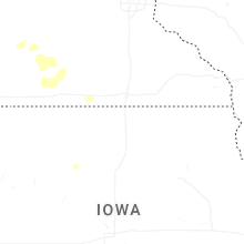

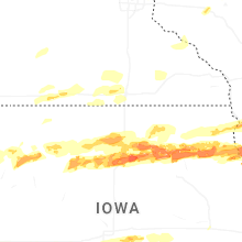


Connect with Interactive Hail Maps