

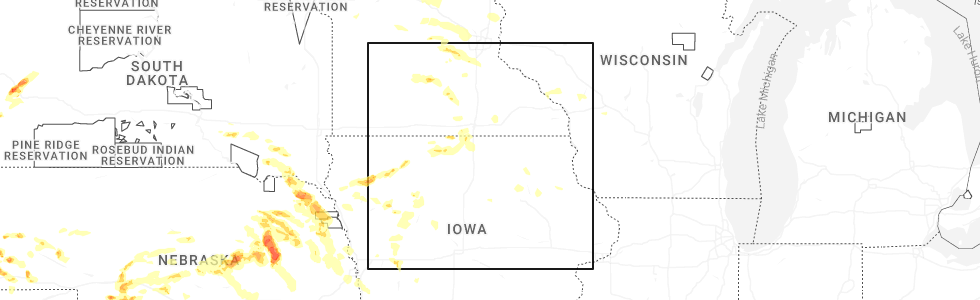
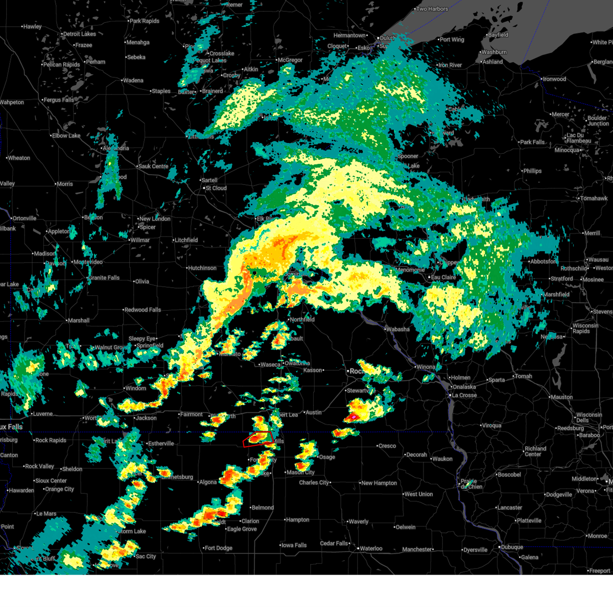
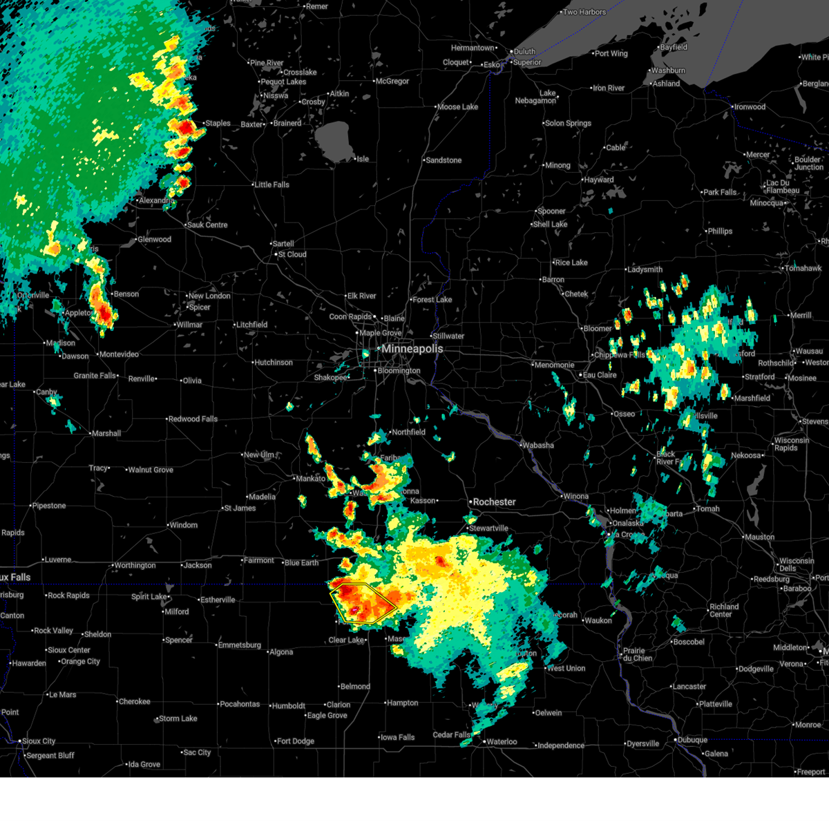
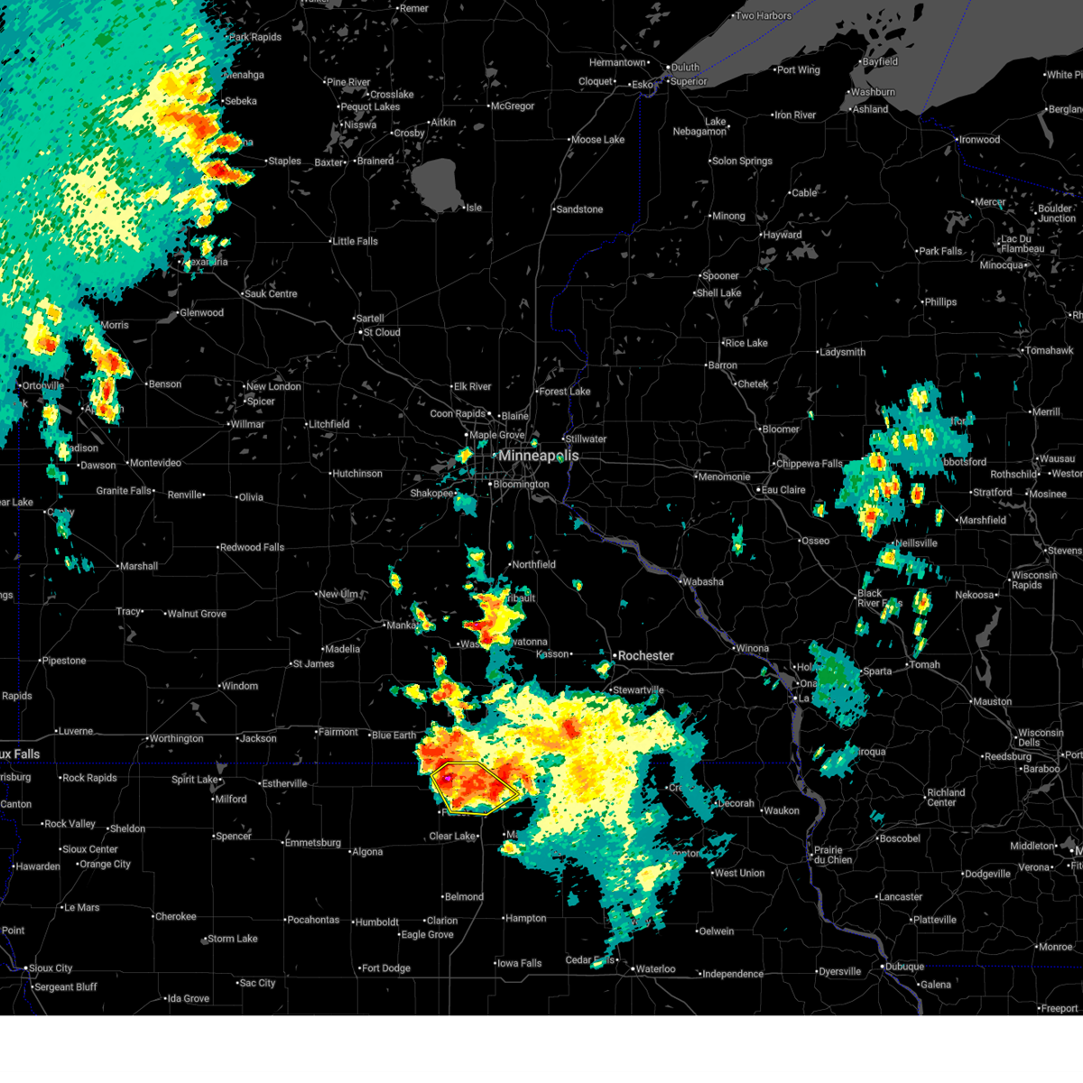
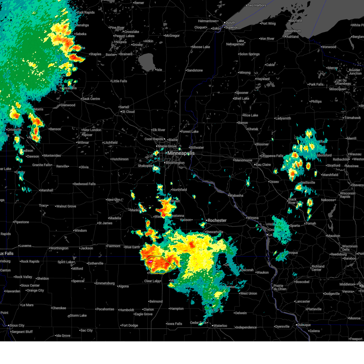
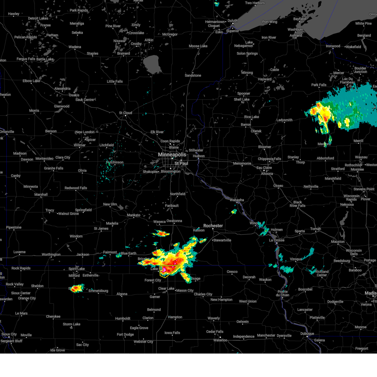
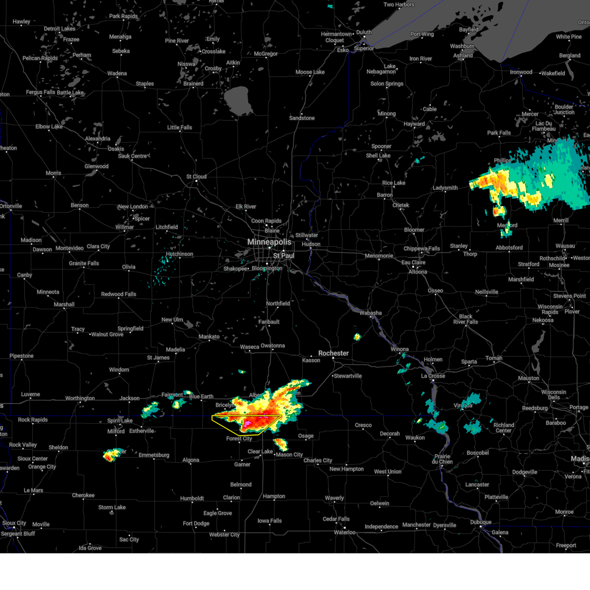
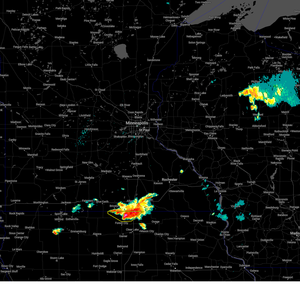
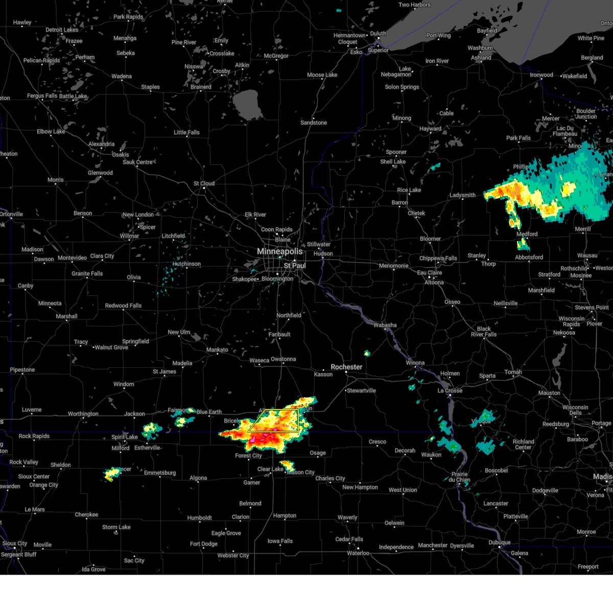
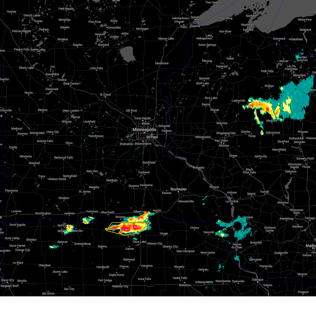
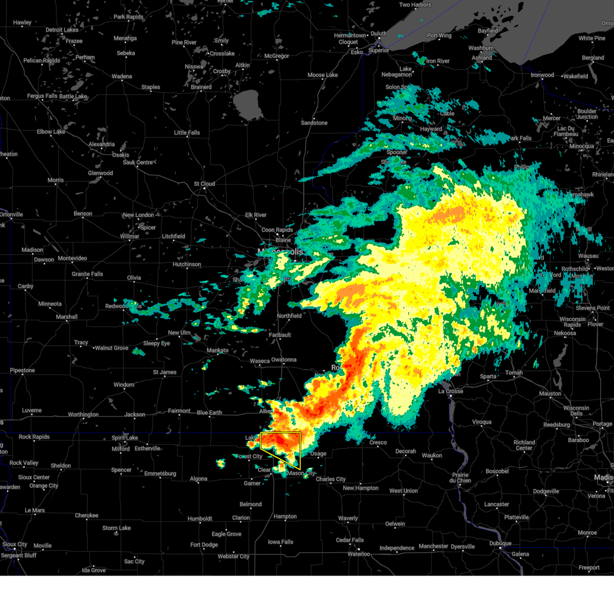
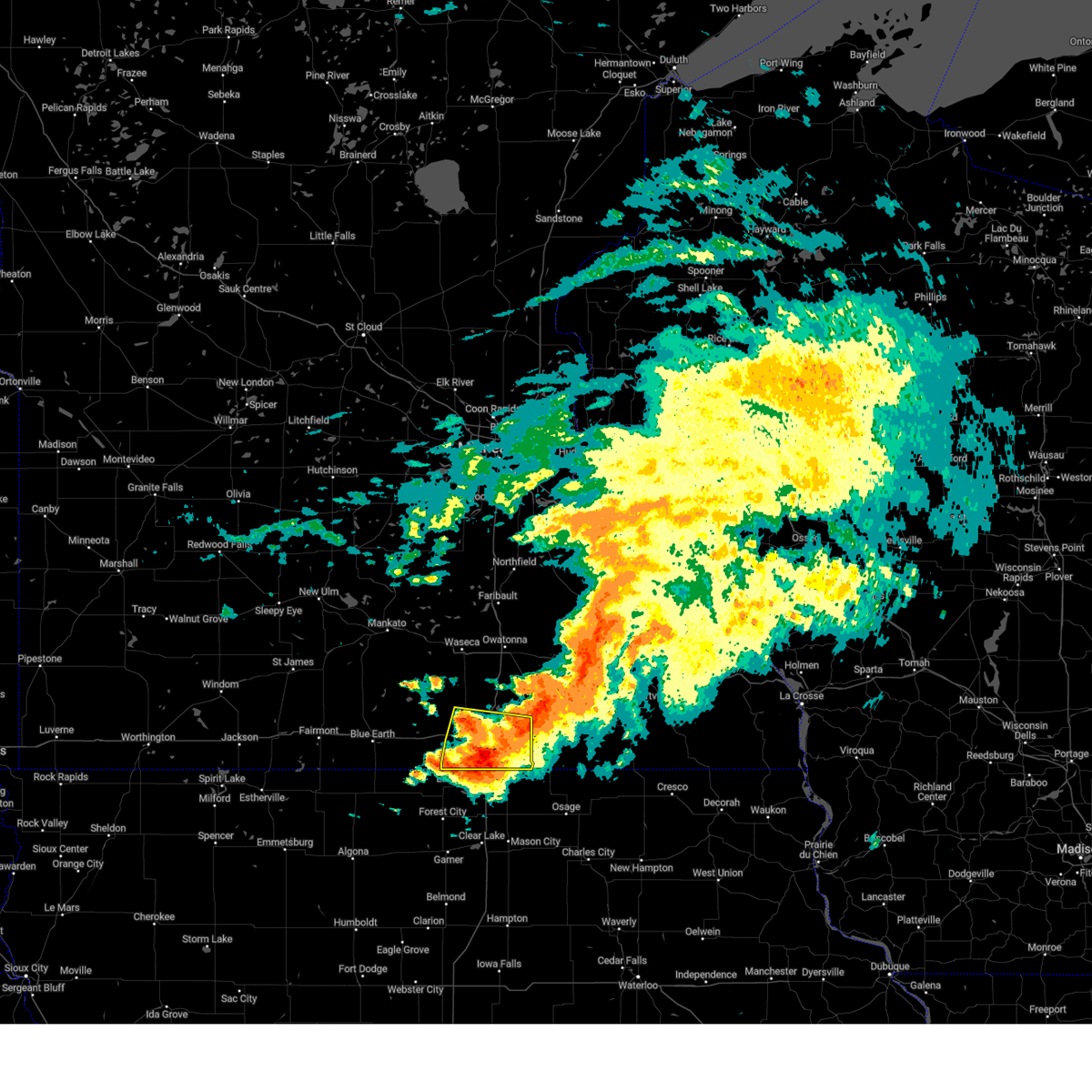
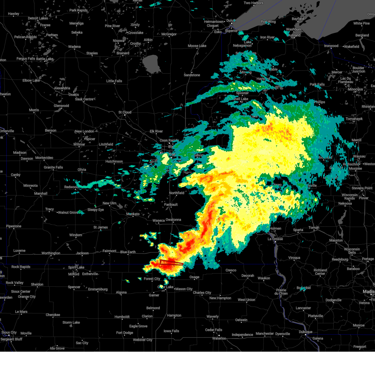
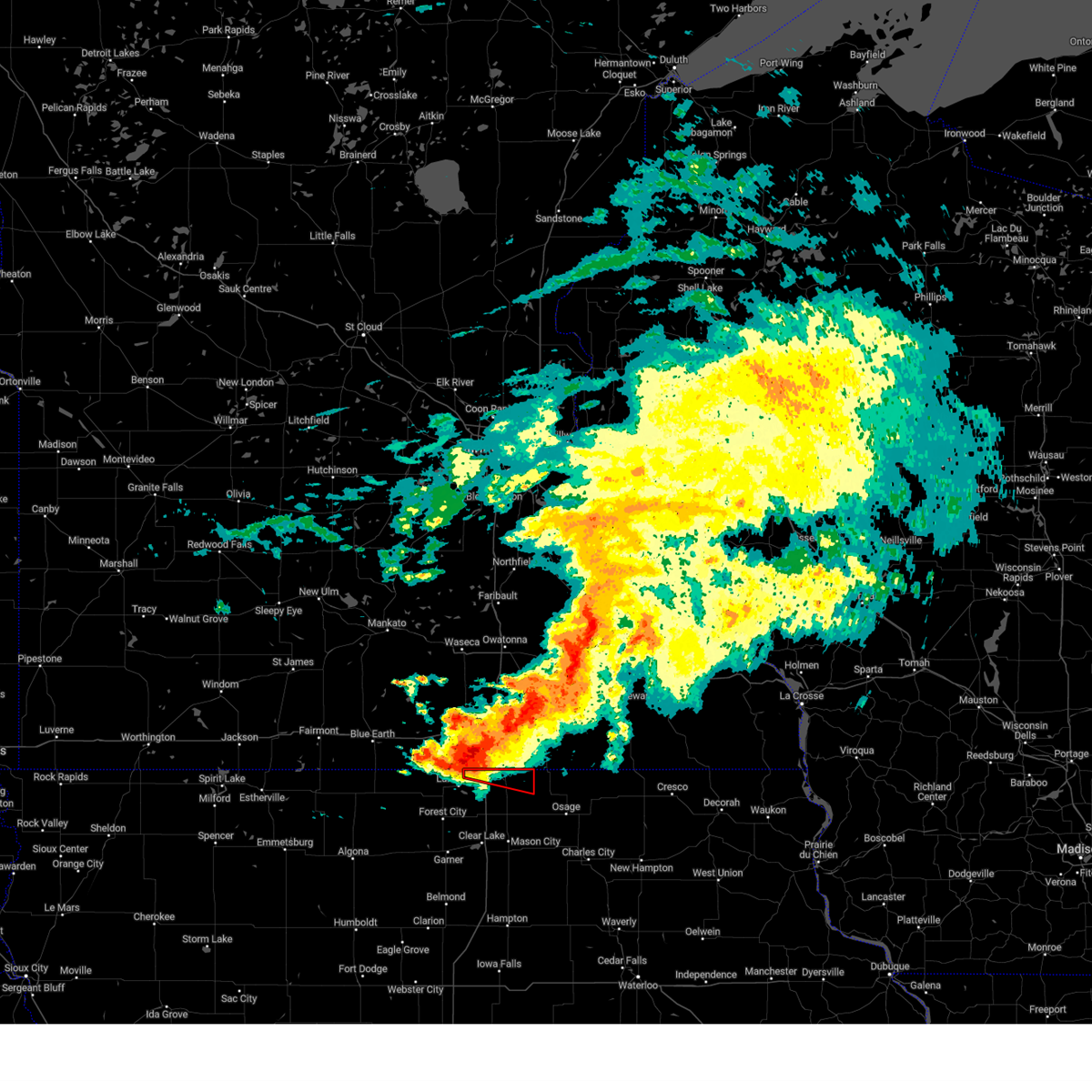
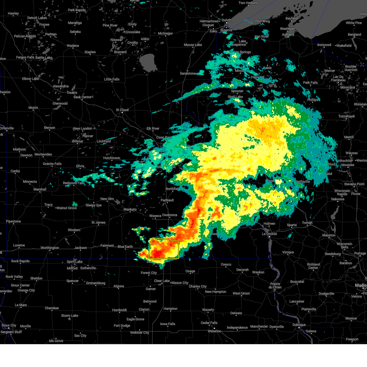
Hail Map for Emmons, MN
The Emmons, MN area has had 2 reports of on-the-ground hail by trained spotters, and has been under severe weather warnings 41 times during the past 12 months. Doppler radar has detected hail at or near Emmons, MN on 65 occasions, including 6 occasions during the past year.
| Name: | Emmons, MN |
| Where Located: | 28.8 miles NNW of Mason City, IA |
| Map: | Google Map for Emmons, MN |
| Population: | 391 |
| Housing Units: | 190 |
| More Info: | Search Google for Emmons, MN |
1
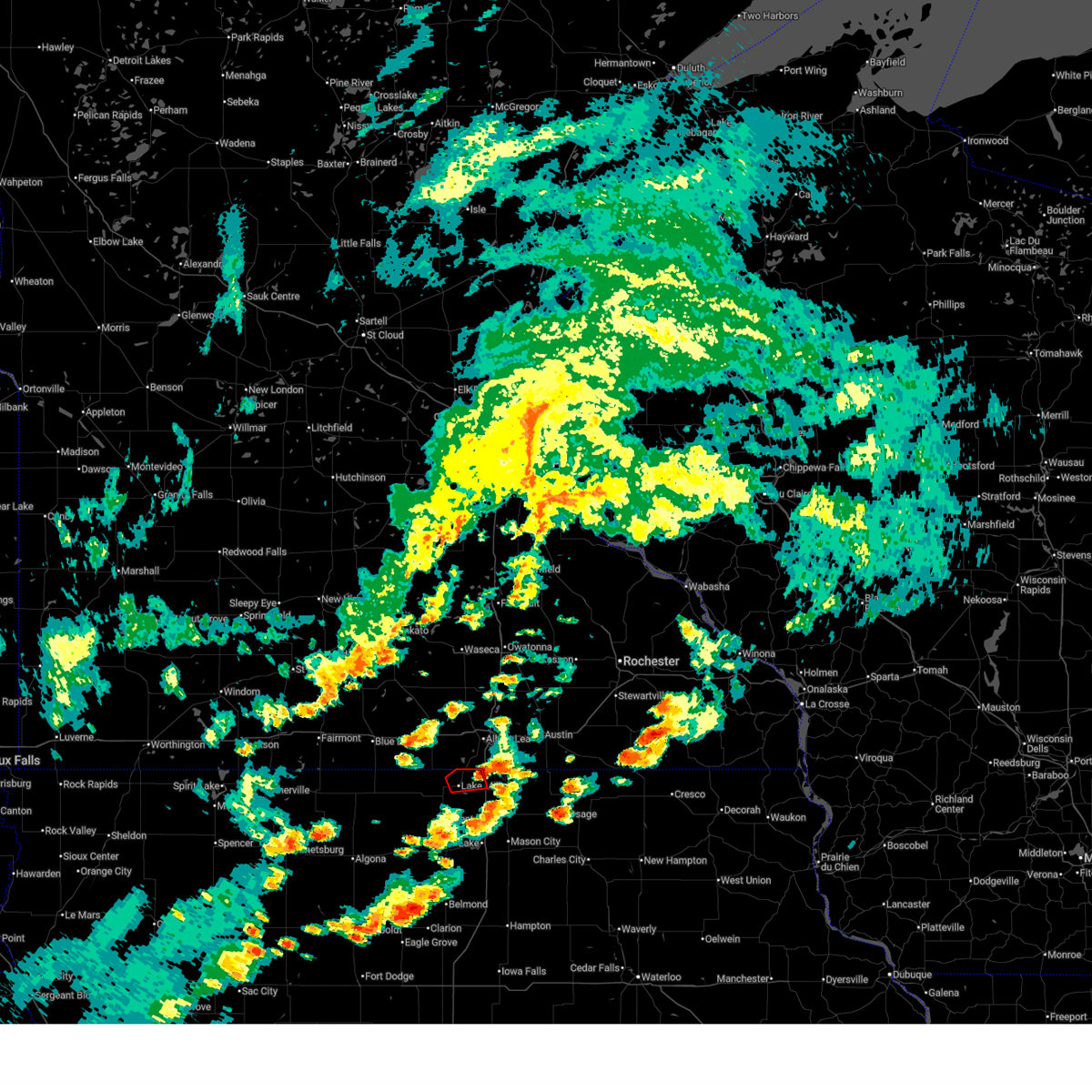
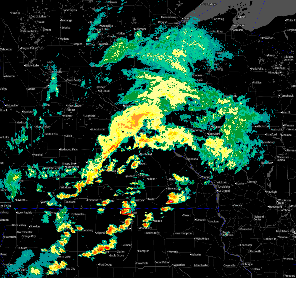
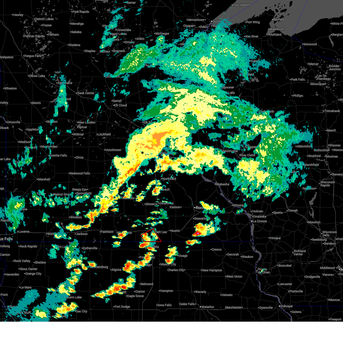
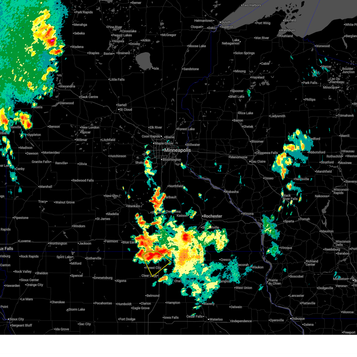
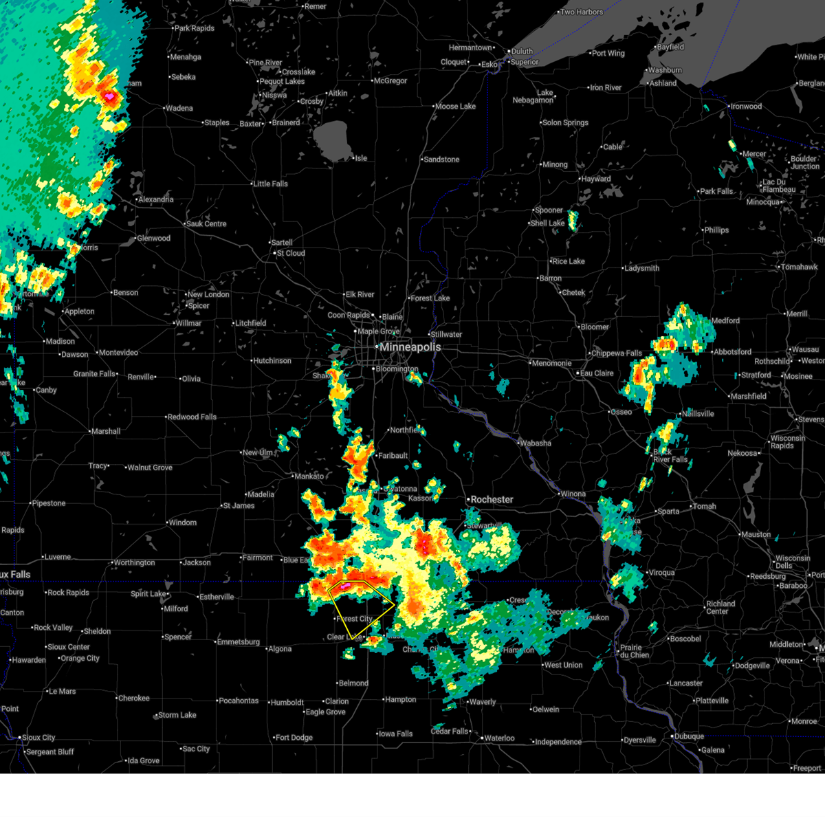
The Top Recent Hail Date for Emmons, MN is Monday, June 16, 2025 (18th out of 65)
Hail and Wind Damage Spotted near Emmons, MN
| Date / Time | Report Details |
|---|---|
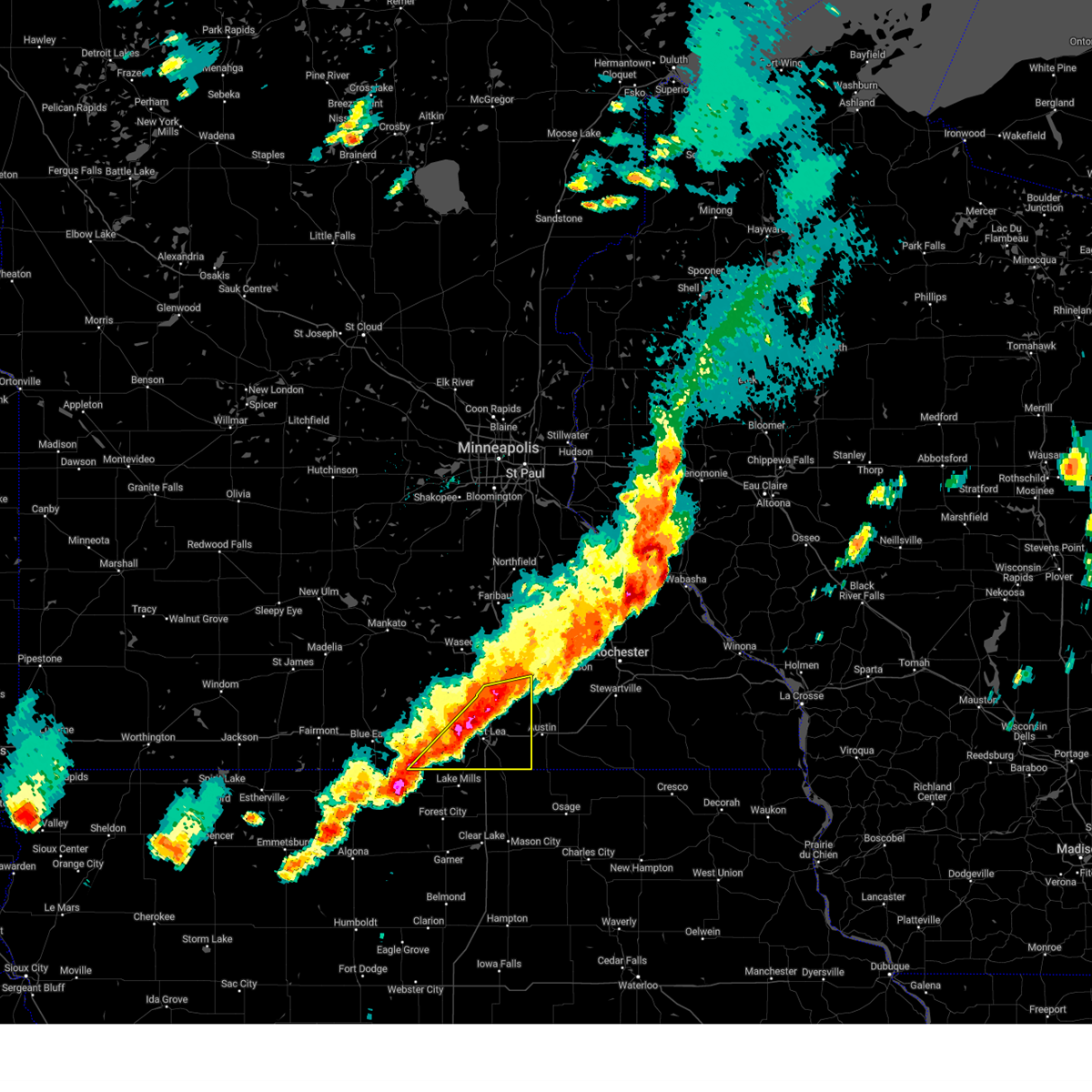
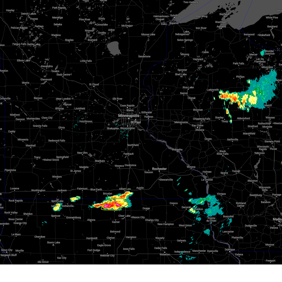
| 6/25/2025 4:17 PM CDT |
 the tornado warning has been cancelled and is no longer in effect the tornado warning has been cancelled and is no longer in effect
|
| 6/25/2025 4:06 PM CDT |
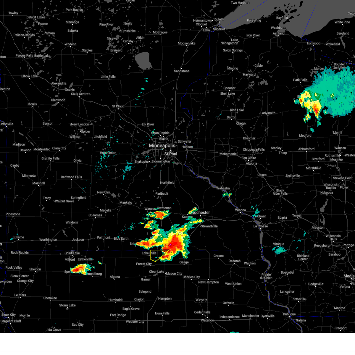
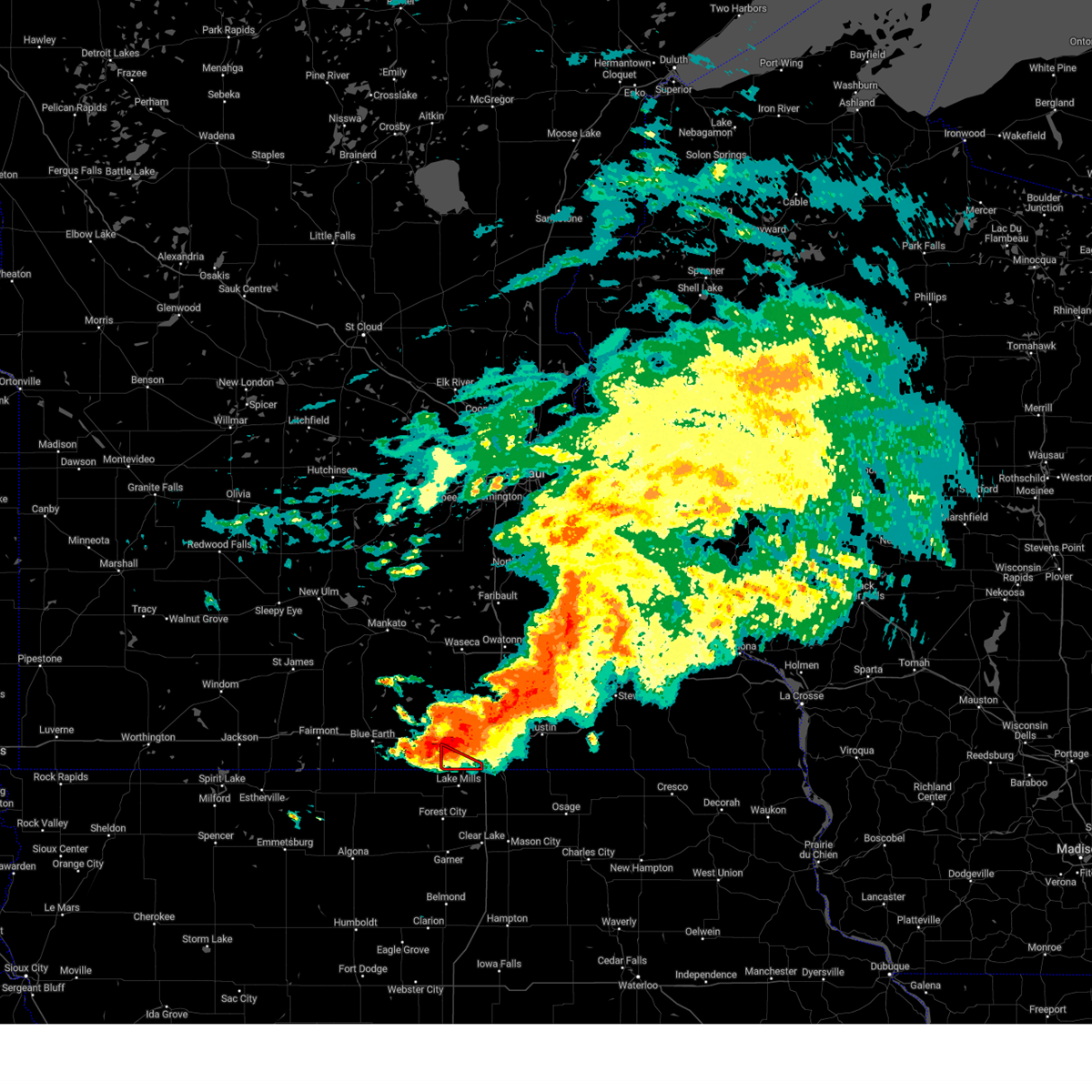
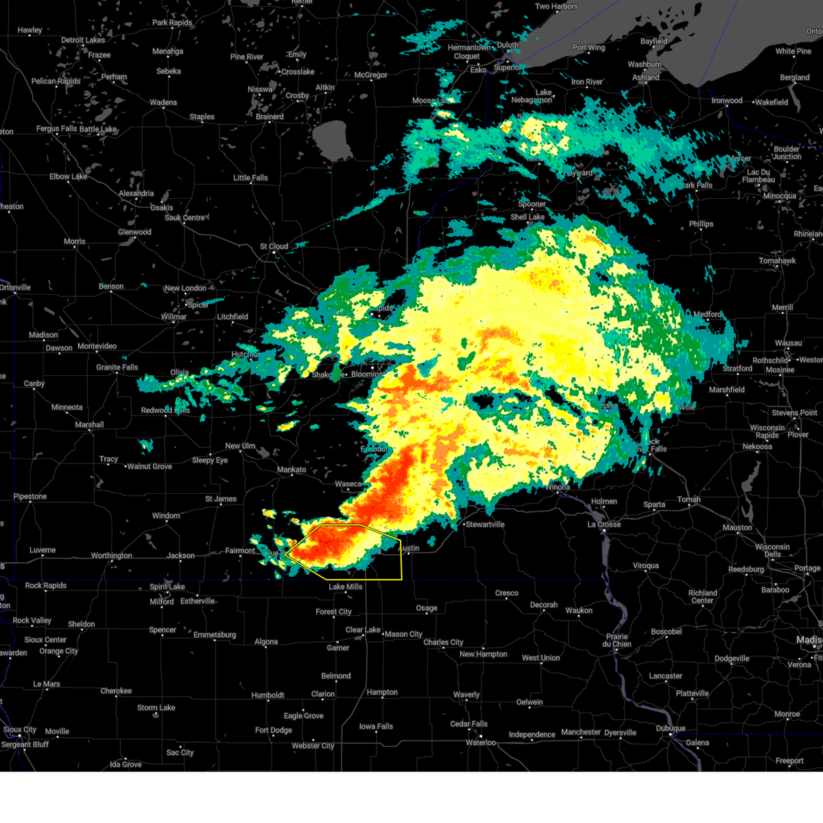
 At 405 pm cdt, a severe thunderstorm capable of producing a tornado was located over lake mills, or 12 miles northeast of forest city, moving east at 25 mph (radar indicated rotation). Hazards include tornado. Flying debris will be dangerous to those caught without shelter. mobile homes will be damaged or destroyed. damage to roofs, windows, and vehicles will occur. tree damage is likely. this dangerous storm will be near, lake mills, rice lake, rice lake state park, and lake mills municipal airport around 410 pm cdt. other locations impacted by this tornadic thunderstorm include hogsback wildlife area, lake mills municipal airport, and rice lake state park. This includes interstate 35 near mile marker 213. At 405 pm cdt, a severe thunderstorm capable of producing a tornado was located over lake mills, or 12 miles northeast of forest city, moving east at 25 mph (radar indicated rotation). Hazards include tornado. Flying debris will be dangerous to those caught without shelter. mobile homes will be damaged or destroyed. damage to roofs, windows, and vehicles will occur. tree damage is likely. this dangerous storm will be near, lake mills, rice lake, rice lake state park, and lake mills municipal airport around 410 pm cdt. other locations impacted by this tornadic thunderstorm include hogsback wildlife area, lake mills municipal airport, and rice lake state park. This includes interstate 35 near mile marker 213.
|
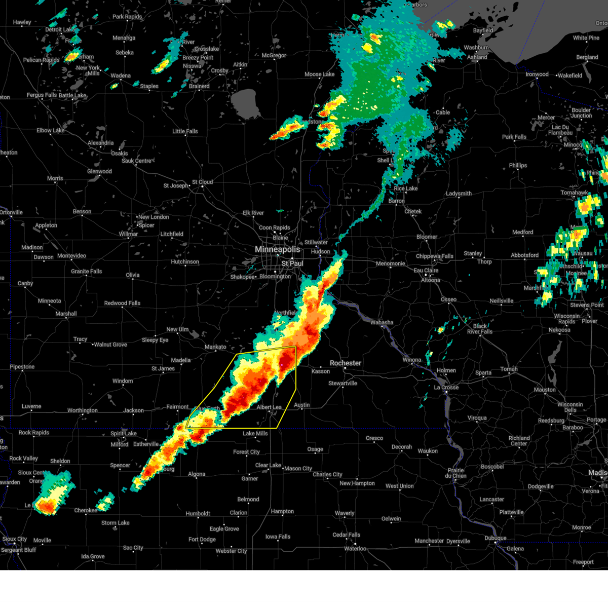
| 6/25/2025 3:57 PM CDT |
 Tormpx the national weather service in the twin cities has issued a * tornado warning for, southwestern freeborn county in south central minnesota, * until 415 pm cdt. * at 357 pm cdt, a severe thunderstorm capable of producing a tornado was located over emmons, or 9 miles southwest of albert lea, moving northeast at 35 mph (radar indicated rotation). Hazards include tornado. Flying debris will be dangerous to those caught without shelter. mobile homes will be damaged or destroyed. damage to roofs, windows and vehicles will occur. Tree damage is likely. Tormpx the national weather service in the twin cities has issued a * tornado warning for, southwestern freeborn county in south central minnesota, * until 415 pm cdt. * at 357 pm cdt, a severe thunderstorm capable of producing a tornado was located over emmons, or 9 miles southwest of albert lea, moving northeast at 35 mph (radar indicated rotation). Hazards include tornado. Flying debris will be dangerous to those caught without shelter. mobile homes will be damaged or destroyed. damage to roofs, windows and vehicles will occur. Tree damage is likely.
|
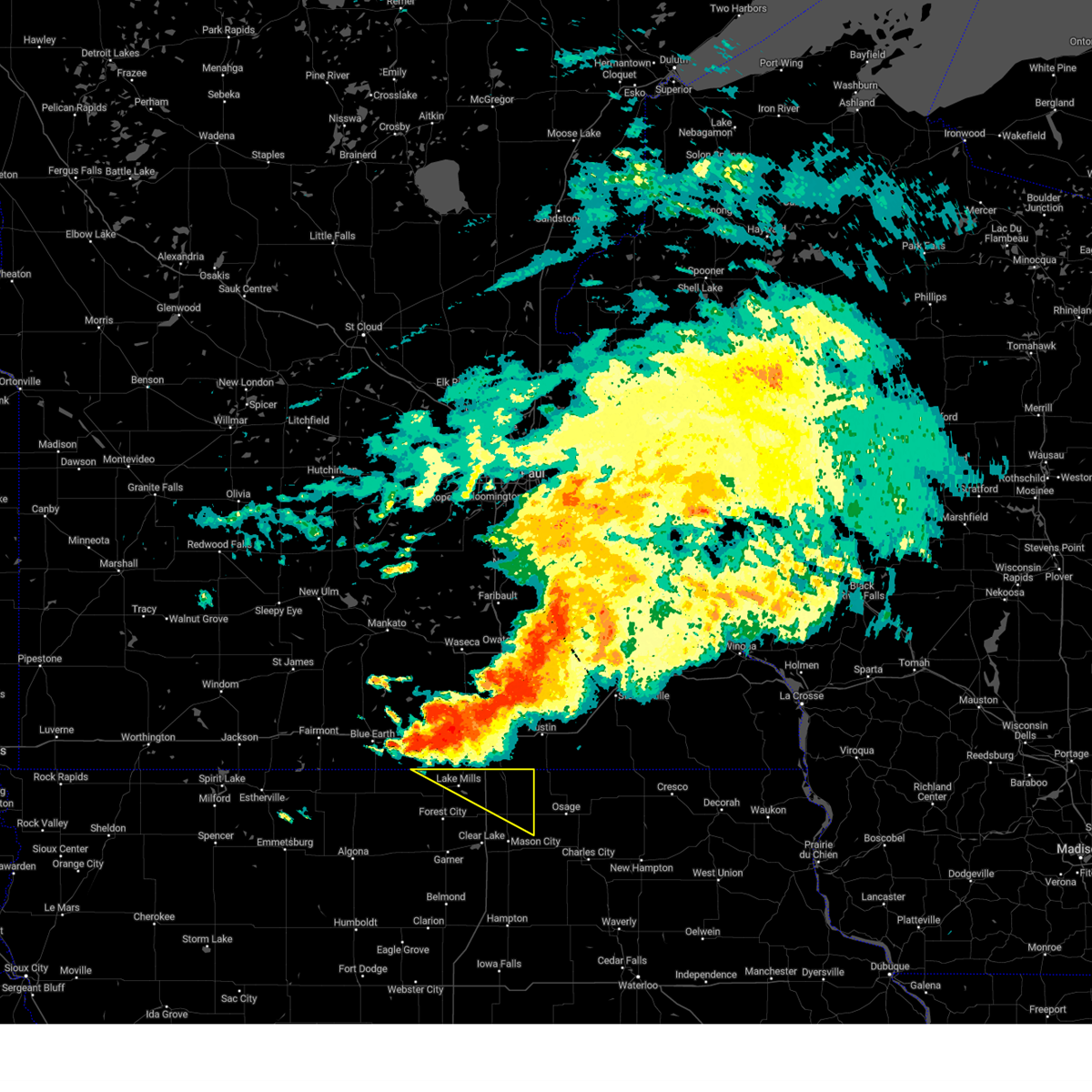
| 6/25/2025 3:57 PM CDT |
 Tordmx the national weather service in des moines has issued a * tornado warning for, northwestern worth county in north central iowa, northeastern winnebago county in north central iowa, * until 445 pm cdt. * at 357 pm cdt, a severe thunderstorm capable of producing a tornado was located near lake mills, or 10 miles north of forest city, moving east at 25 mph (radar indicated rotation). Hazards include tornado. Flying debris will be dangerous to those caught without shelter. mobile homes will be damaged or destroyed. damage to roofs, windows, and vehicles will occur. tree damage is likely. this dangerous storm will be near, lake mills, rice lake, rice lake state park, lake mills municipal airport, and hogsback wildlife area around 400 pm cdt. other locations impacted by this tornadic thunderstorm include hogsback wildlife area, lake mills municipal airport, and rice lake state park. This includes interstate 35 near mile marker 213. Tordmx the national weather service in des moines has issued a * tornado warning for, northwestern worth county in north central iowa, northeastern winnebago county in north central iowa, * until 445 pm cdt. * at 357 pm cdt, a severe thunderstorm capable of producing a tornado was located near lake mills, or 10 miles north of forest city, moving east at 25 mph (radar indicated rotation). Hazards include tornado. Flying debris will be dangerous to those caught without shelter. mobile homes will be damaged or destroyed. damage to roofs, windows, and vehicles will occur. tree damage is likely. this dangerous storm will be near, lake mills, rice lake, rice lake state park, lake mills municipal airport, and hogsback wildlife area around 400 pm cdt. other locations impacted by this tornadic thunderstorm include hogsback wildlife area, lake mills municipal airport, and rice lake state park. This includes interstate 35 near mile marker 213.
|
| 6/25/2025 3:55 PM CDT | The storm which prompted the warning has moved out of the area. therefore, the warning will be allowed to expire. a tornado watch remains in effect until 1000 pm cdt wednesday for a portion of south central minnesota. |
| 6/25/2025 3:46 PM CDT | Tormpx the national weather service in the twin cities has issued a * tornado warning for, freeborn county in south central minnesota, southwestern steele county in south central minnesota, southeastern waseca county in south central minnesota, * until 400 pm cdt. * at 346 pm cdt, a confirmed tornado was located near hartland, or 8 miles northwest of albert lea, moving northeast at 35 mph (law enforcement confirmed tornado). Hazards include damaging tornado. Flying debris will be dangerous to those caught without shelter. mobile homes will be damaged or destroyed. damage to roofs, windows and vehicles will occur. Tree damage is likely. |
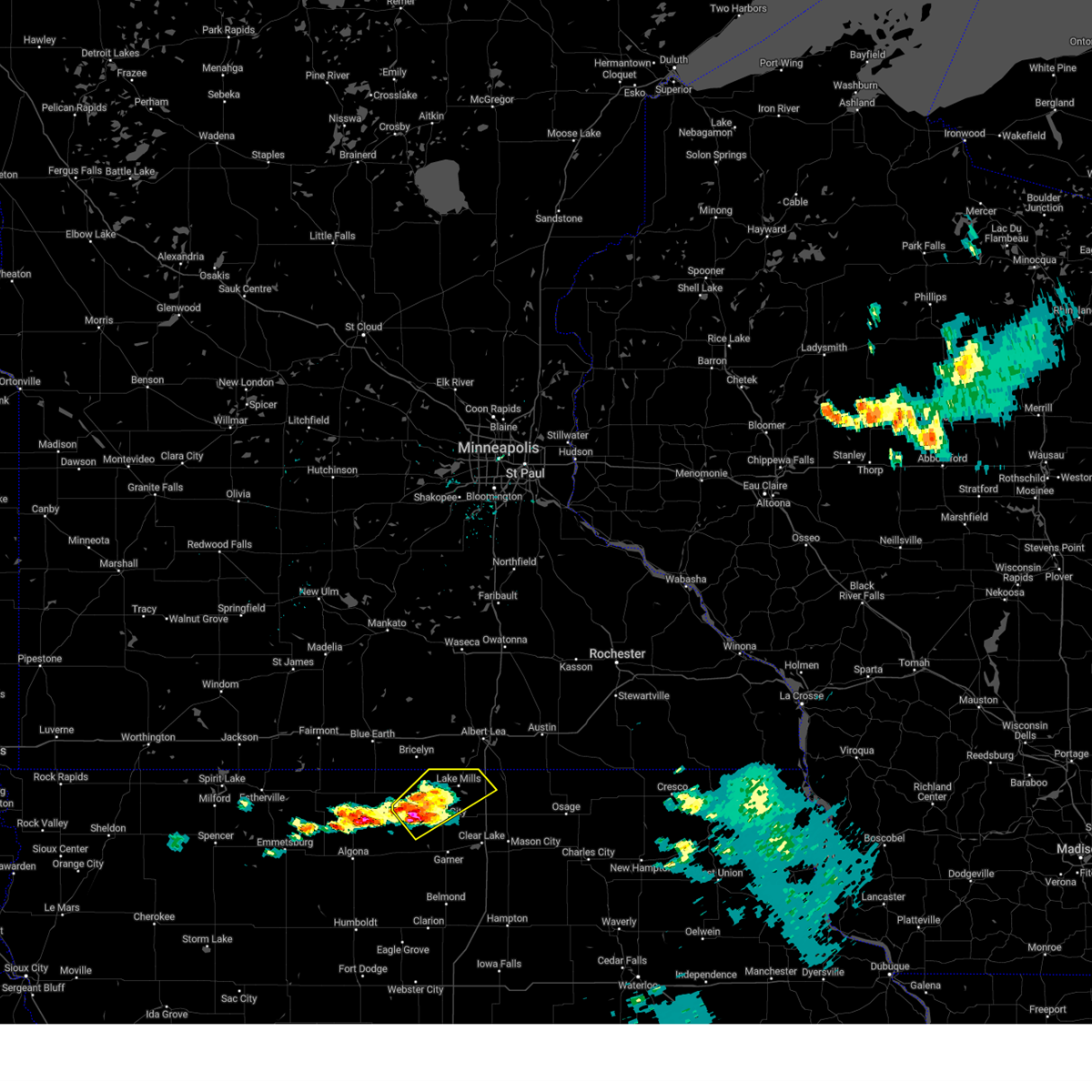
| 6/16/2025 8:15 AM CDT |
 The storm which prompted the warning has weakened below severe limits, and no longer poses an immediate threat to life or property. therefore, the warning has been allowed to expire. The storm which prompted the warning has weakened below severe limits, and no longer poses an immediate threat to life or property. therefore, the warning has been allowed to expire.
|
| 6/16/2025 8:01 AM CDT |
 the severe thunderstorm warning has been cancelled and is no longer in effect the severe thunderstorm warning has been cancelled and is no longer in effect
|
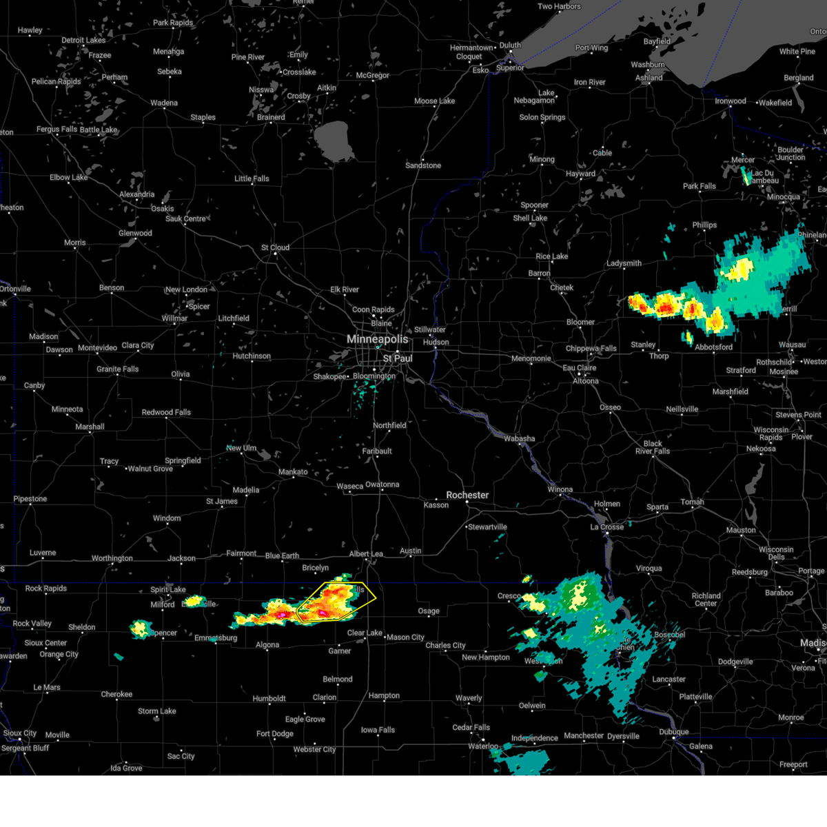
| 6/16/2025 8:01 AM CDT |
 At 800 am cdt, a severe thunderstorm was located over mansfield, or 14 miles southwest of albert lea, moving southeast at 20 mph (radar indicated). Hazards include 60 mph wind gusts and quarter size hail. Hail damage to vehicles is expected. expect wind damage to roofs, siding, and trees. locations impacted include, lake mills, emmons, rice lake, fertile, kensett, hanlontown, joice, scarville, lake mills municipal airport, hogsback wildlife area, and rice lake state park. This includes interstate 35 between mile markers 203 and 217. At 800 am cdt, a severe thunderstorm was located over mansfield, or 14 miles southwest of albert lea, moving southeast at 20 mph (radar indicated). Hazards include 60 mph wind gusts and quarter size hail. Hail damage to vehicles is expected. expect wind damage to roofs, siding, and trees. locations impacted include, lake mills, emmons, rice lake, fertile, kensett, hanlontown, joice, scarville, lake mills municipal airport, hogsback wildlife area, and rice lake state park. This includes interstate 35 between mile markers 203 and 217.
|
| 6/16/2025 7:36 AM CDT |
 At 735 am cdt, a severe thunderstorm was located over hogsback wildlife area, or 14 miles north of forest city, moving southeast at 20 mph (radar indicated). Hazards include 60 mph wind gusts and quarter size hail. Hail damage to vehicles is expected. expect wind damage to roofs, siding, and trees. locations impacted include, lake mills, manly, emmons, rice lake, ventura, fertile, kensett, hanlontown, joice, scarville, pilot knob state park, lake mills municipal airport, hogsback wildlife area, and rice lake state park. This includes interstate 35 between mile markers 200 and 217. At 735 am cdt, a severe thunderstorm was located over hogsback wildlife area, or 14 miles north of forest city, moving southeast at 20 mph (radar indicated). Hazards include 60 mph wind gusts and quarter size hail. Hail damage to vehicles is expected. expect wind damage to roofs, siding, and trees. locations impacted include, lake mills, manly, emmons, rice lake, ventura, fertile, kensett, hanlontown, joice, scarville, pilot knob state park, lake mills municipal airport, hogsback wildlife area, and rice lake state park. This includes interstate 35 between mile markers 200 and 217.
|
| 6/16/2025 7:26 AM CDT |
 Svrdmx the national weather service in des moines has issued a * severe thunderstorm warning for, southwestern worth county in north central iowa, northeastern hancock county in north central iowa, northwestern cerro gordo county in north central iowa, eastern winnebago county in north central iowa, * until 815 am cdt. * at 725 am cdt, a severe thunderstorm was located over lake mills, or 13 miles northeast of forest city, moving southeast at 20 mph (radar indicated). Hazards include 60 mph wind gusts and quarter size hail. Hail damage to vehicles is expected. Expect wind damage to roofs, siding, and trees. Svrdmx the national weather service in des moines has issued a * severe thunderstorm warning for, southwestern worth county in north central iowa, northeastern hancock county in north central iowa, northwestern cerro gordo county in north central iowa, eastern winnebago county in north central iowa, * until 815 am cdt. * at 725 am cdt, a severe thunderstorm was located over lake mills, or 13 miles northeast of forest city, moving southeast at 20 mph (radar indicated). Hazards include 60 mph wind gusts and quarter size hail. Hail damage to vehicles is expected. Expect wind damage to roofs, siding, and trees.
|
| 4/28/2025 7:27 PM CDT | The storms which prompted the warning have weakened below severe limits, and have exited the warned area. therefore, the warning will be allowed to expire. however, small hail and gusty winds are still possible with these thunderstorms. to report severe weather, contact your nearest law enforcement agency. they will send your report to the national weather service office. a tornado watch remains in effect until 1100 pm cdt for a portion of south central minnesota. |
| 4/28/2025 6:56 PM CDT |
 Svrmpx the national weather service in the twin cities has issued a * severe thunderstorm warning for, southeastern faribault county in south central minnesota, freeborn county in south central minnesota, southern steele county in south central minnesota, * until 730 pm cdt. * at 656 pm cdt, severe thunderstorms were located along a line from 6 miles northeast of blooming prairie to near mansfield, or along a line from 16 miles southeast of owatonna to 16 miles southwest of albert lea, moving east at 45 mph (radar indicated). Hazards include 60 mph wind gusts and half dollar size hail. Hail damage to vehicles is expected. Expect wind damage to roofs, siding, and trees. Svrmpx the national weather service in the twin cities has issued a * severe thunderstorm warning for, southeastern faribault county in south central minnesota, freeborn county in south central minnesota, southern steele county in south central minnesota, * until 730 pm cdt. * at 656 pm cdt, severe thunderstorms were located along a line from 6 miles northeast of blooming prairie to near mansfield, or along a line from 16 miles southeast of owatonna to 16 miles southwest of albert lea, moving east at 45 mph (radar indicated). Hazards include 60 mph wind gusts and half dollar size hail. Hail damage to vehicles is expected. Expect wind damage to roofs, siding, and trees.
|
| 4/28/2025 6:17 PM CDT |
 The severe thunderstorm warning that was previously in effect has been reissued for and is in effect until 700 pm cdt. please refer to those bulletins for the latest severe weather information. a tornado watch remains in effect until 800 pm cdt for a portion of south central minnesota. The severe thunderstorm warning that was previously in effect has been reissued for and is in effect until 700 pm cdt. please refer to those bulletins for the latest severe weather information. a tornado watch remains in effect until 800 pm cdt for a portion of south central minnesota.
|
| 4/28/2025 5:29 PM CDT |
 Svrmpx the national weather service in the twin cities has issued a * severe thunderstorm warning for, southeastern blue earth county in south central minnesota, faribault county in south central minnesota, freeborn county in south central minnesota, southeastern martin county in south central minnesota, steele county in south central minnesota, waseca county in south central minnesota, * until 615 pm cdt. * at 529 pm cdt, severe thunderstorms were located along a line from over waseca to near elmore, or along a line from 13 miles west of owatonna to 17 miles southeast of fairmont, moving east at 50 mph (radar indicated). Hazards include 60 mph wind gusts and half dollar size hail. Hail damage to vehicles is expected. Expect wind damage to roofs, siding, and trees. Svrmpx the national weather service in the twin cities has issued a * severe thunderstorm warning for, southeastern blue earth county in south central minnesota, faribault county in south central minnesota, freeborn county in south central minnesota, southeastern martin county in south central minnesota, steele county in south central minnesota, waseca county in south central minnesota, * until 615 pm cdt. * at 529 pm cdt, severe thunderstorms were located along a line from over waseca to near elmore, or along a line from 13 miles west of owatonna to 17 miles southeast of fairmont, moving east at 50 mph (radar indicated). Hazards include 60 mph wind gusts and half dollar size hail. Hail damage to vehicles is expected. Expect wind damage to roofs, siding, and trees.
|
| 3/14/2025 7:24 PM CDT |
 At 722 pm cdt, severe thunderstorms were located along a line extending from near crystal lake to near dougherty to near hudson, moving north at 60 mph (trained weather spotters. at 720pm, a trained spotter reported a wind gust of 71mph in grundy center). Hazards include 70 mph wind gusts. Expect considerable tree damage. damage is likely to mobile homes, roofs, and outbuildings. locations impacted include, clarksville, lake mills municipal airport, mcintosh woods state park, forest city municipal airport, plainfield, grafton, waterloo, george wyth state park, buffalo center, mason city, readlyn, eagle lake state park, kensett, ventura, evansdale, thompson, dike, cedar falls, hayfield, and janesville. this includes the following highways, interstate 35 between mile markers 177 and 218. Interstate 380 between mile markers 57 and 73. At 722 pm cdt, severe thunderstorms were located along a line extending from near crystal lake to near dougherty to near hudson, moving north at 60 mph (trained weather spotters. at 720pm, a trained spotter reported a wind gust of 71mph in grundy center). Hazards include 70 mph wind gusts. Expect considerable tree damage. damage is likely to mobile homes, roofs, and outbuildings. locations impacted include, clarksville, lake mills municipal airport, mcintosh woods state park, forest city municipal airport, plainfield, grafton, waterloo, george wyth state park, buffalo center, mason city, readlyn, eagle lake state park, kensett, ventura, evansdale, thompson, dike, cedar falls, hayfield, and janesville. this includes the following highways, interstate 35 between mile markers 177 and 218. Interstate 380 between mile markers 57 and 73.
|
| 3/14/2025 7:11 PM CDT |
 Svrdmx the national weather service in des moines has issued a * severe thunderstorm warning for, black hawk county in northeastern iowa, worth county in north central iowa, bremer county in northeastern iowa, northeastern franklin county in north central iowa, northern hancock county in north central iowa, northeastern grundy county in central iowa, butler county in north central iowa, cerro gordo county in north central iowa, winnebago county in north central iowa, * until 815 pm cdt. * at 710 pm cdt, severe thunderstorms were located along a line extending from near eagle lake state park to aredale to 6 miles north of tf clark state park, moving northeast at 45 mph (radar indicated). Hazards include 60 mph wind gusts. expect damage to roofs, siding, and trees Svrdmx the national weather service in des moines has issued a * severe thunderstorm warning for, black hawk county in northeastern iowa, worth county in north central iowa, bremer county in northeastern iowa, northeastern franklin county in north central iowa, northern hancock county in north central iowa, northeastern grundy county in central iowa, butler county in north central iowa, cerro gordo county in north central iowa, winnebago county in north central iowa, * until 815 pm cdt. * at 710 pm cdt, severe thunderstorms were located along a line extending from near eagle lake state park to aredale to 6 miles north of tf clark state park, moving northeast at 45 mph (radar indicated). Hazards include 60 mph wind gusts. expect damage to roofs, siding, and trees
|
| 9/19/2024 3:16 PM CDT |
 The storm which prompted the warning has weakened below severe limits, and has exited the warned area. therefore, the warning has been allowed to expire. a severe thunderstorm watch remains in effect until 1000 pm cdt for north central iowa. The storm which prompted the warning has weakened below severe limits, and has exited the warned area. therefore, the warning has been allowed to expire. a severe thunderstorm watch remains in effect until 1000 pm cdt for north central iowa.
|
| 9/19/2024 3:00 PM CDT |
 At 300 pm cdt, a severe thunderstorm was located near glenville, or 8 miles north of northwood, moving northeast at 40 mph (radar indicated). Hazards include 60 mph wind gusts and half dollar size hail. Hail damage to vehicles is expected. expect wind damage to roofs, siding, and trees. Locations impacted include, glenville, emmons, london, hayward, myrtle, and myre big island state park. At 300 pm cdt, a severe thunderstorm was located near glenville, or 8 miles north of northwood, moving northeast at 40 mph (radar indicated). Hazards include 60 mph wind gusts and half dollar size hail. Hail damage to vehicles is expected. expect wind damage to roofs, siding, and trees. Locations impacted include, glenville, emmons, london, hayward, myrtle, and myre big island state park.
|
| 9/19/2024 2:59 PM CDT |
 At 258 pm cdt, a severe thunderstorm was located 5 miles northeast of rice lake state park, or 9 miles west of northwood, moving east at 45 mph (broadcast media reported quarter sized hail in lake mills at 250 pm cdt). Hazards include 60 mph wind gusts and half dollar size hail. Hail damage to vehicles is expected. expect wind damage to roofs, siding, and trees. locations impacted include, northwood, emmons, rice lake, joice, rice lake state park, and northwood municipal. This includes interstate 35 between mile markers 210 and 218. At 258 pm cdt, a severe thunderstorm was located 5 miles northeast of rice lake state park, or 9 miles west of northwood, moving east at 45 mph (broadcast media reported quarter sized hail in lake mills at 250 pm cdt). Hazards include 60 mph wind gusts and half dollar size hail. Hail damage to vehicles is expected. expect wind damage to roofs, siding, and trees. locations impacted include, northwood, emmons, rice lake, joice, rice lake state park, and northwood municipal. This includes interstate 35 between mile markers 210 and 218.
|
| 9/19/2024 2:59 PM CDT |
 the severe thunderstorm warning has been cancelled and is no longer in effect the severe thunderstorm warning has been cancelled and is no longer in effect
|
| 9/19/2024 2:46 PM CDT |
 the severe thunderstorm warning has been cancelled and is no longer in effect the severe thunderstorm warning has been cancelled and is no longer in effect
|
| 9/19/2024 2:46 PM CDT |
 At 244 pm cdt, a severe thunderstorm was located over hogsback wildlife area, or 12 miles north of forest city, moving northeast at 30 mph (broadcast media reported quarter sized hail in lake mills). Hazards include 60 mph wind gusts and half dollar size hail. Hail damage to vehicles is expected. expect wind damage to roofs, siding, and trees. locations impacted include, northwood, lake mills, emmons, rice lake, thompson, leland, rake, joice, scarville, lake mills municipal airport, hogsback wildlife area, rice lake state park, and northwood municipal. This includes interstate 35 between mile markers 210 and 218. At 244 pm cdt, a severe thunderstorm was located over hogsback wildlife area, or 12 miles north of forest city, moving northeast at 30 mph (broadcast media reported quarter sized hail in lake mills). Hazards include 60 mph wind gusts and half dollar size hail. Hail damage to vehicles is expected. expect wind damage to roofs, siding, and trees. locations impacted include, northwood, lake mills, emmons, rice lake, thompson, leland, rake, joice, scarville, lake mills municipal airport, hogsback wildlife area, rice lake state park, and northwood municipal. This includes interstate 35 between mile markers 210 and 218.
|
| 9/19/2024 2:43 PM CDT |
 Svrmpx the national weather service in the twin cities has issued a * severe thunderstorm warning for, southern freeborn county in south central minnesota, * until 315 pm cdt. * at 242 pm cdt, a severe thunderstorm was located near glenville, or 7 miles northwest of northwood, moving northeast at 35 mph (radar indicated). Hazards include 60 mph wind gusts and half dollar size hail. Hail damage to vehicles is expected. Expect wind damage to roofs, siding, and trees. Svrmpx the national weather service in the twin cities has issued a * severe thunderstorm warning for, southern freeborn county in south central minnesota, * until 315 pm cdt. * at 242 pm cdt, a severe thunderstorm was located near glenville, or 7 miles northwest of northwood, moving northeast at 35 mph (radar indicated). Hazards include 60 mph wind gusts and half dollar size hail. Hail damage to vehicles is expected. Expect wind damage to roofs, siding, and trees.
|
| 9/19/2024 2:28 PM CDT |
 Svrdmx the national weather service in des moines has issued a * severe thunderstorm warning for, northwestern worth county in north central iowa, northeastern kossuth county in north central iowa, winnebago county in north central iowa, * until 315 pm cdt. * at 227 pm cdt, severe thunderstorms were located along a line extending from 6 miles northeast of joice to near thompson to near lakota, moving northeast at 30 mph (radar indicated). Hazards include 60 mph wind gusts and half dollar size hail. Hail damage to vehicles is expected. Expect wind damage to roofs, siding, and trees. Svrdmx the national weather service in des moines has issued a * severe thunderstorm warning for, northwestern worth county in north central iowa, northeastern kossuth county in north central iowa, winnebago county in north central iowa, * until 315 pm cdt. * at 227 pm cdt, severe thunderstorms were located along a line extending from 6 miles northeast of joice to near thompson to near lakota, moving northeast at 30 mph (radar indicated). Hazards include 60 mph wind gusts and half dollar size hail. Hail damage to vehicles is expected. Expect wind damage to roofs, siding, and trees.
|
| 9/19/2024 2:18 PM CDT |
 At 217 pm cdt, a severe thunderstorm was located over hogsback wildlife area, or 14 miles north of forest city, moving northeast at 35 mph (radar indicated). Hazards include 60 mph wind gusts and half dollar size hail. Hail damage to vehicles is expected. expect wind damage to roofs, siding, and trees. locations impacted include, lake mills, emmons, rice lake, thompson, leland, joice, scarville, lake mills municipal airport, hogsback wildlife area, and rice lake state park. This includes interstate 35 between mile markers 211 and 215. At 217 pm cdt, a severe thunderstorm was located over hogsback wildlife area, or 14 miles north of forest city, moving northeast at 35 mph (radar indicated). Hazards include 60 mph wind gusts and half dollar size hail. Hail damage to vehicles is expected. expect wind damage to roofs, siding, and trees. locations impacted include, lake mills, emmons, rice lake, thompson, leland, joice, scarville, lake mills municipal airport, hogsback wildlife area, and rice lake state park. This includes interstate 35 between mile markers 211 and 215.
|
| 9/19/2024 1:57 PM CDT |
 At 156 pm cdt, a severe thunderstorm was located near thompson, or 6 miles northwest of forest city, moving northeast at 30 mph (radar indicated). Hazards include 60 mph wind gusts and half dollar size hail. Hail damage to vehicles is expected. expect wind damage to roofs, siding, and trees. locations impacted include, forest city, lake mills, emmons, rice lake, thompson, leland, joice, scarville, lake mills municipal airport, hogsback wildlife area, and rice lake state park. This includes interstate 35 between mile markers 211 and 215. At 156 pm cdt, a severe thunderstorm was located near thompson, or 6 miles northwest of forest city, moving northeast at 30 mph (radar indicated). Hazards include 60 mph wind gusts and half dollar size hail. Hail damage to vehicles is expected. expect wind damage to roofs, siding, and trees. locations impacted include, forest city, lake mills, emmons, rice lake, thompson, leland, joice, scarville, lake mills municipal airport, hogsback wildlife area, and rice lake state park. This includes interstate 35 between mile markers 211 and 215.
|
| 9/19/2024 1:57 PM CDT |
 the severe thunderstorm warning has been cancelled and is no longer in effect the severe thunderstorm warning has been cancelled and is no longer in effect
|
| 9/19/2024 1:45 PM CDT |
 Svrdmx the national weather service in des moines has issued a * severe thunderstorm warning for, northwestern worth county in north central iowa, north central hancock county in north central iowa, winnebago county in north central iowa, * until 230 pm cdt. * at 145 pm cdt, a severe thunderstorm was located near crystal lake, or 9 miles west of forest city, moving northeast at 35 mph (radar indicated). Hazards include 60 mph wind gusts and half dollar size hail. Hail damage to vehicles is expected. Expect wind damage to roofs, siding, and trees. Svrdmx the national weather service in des moines has issued a * severe thunderstorm warning for, northwestern worth county in north central iowa, north central hancock county in north central iowa, winnebago county in north central iowa, * until 230 pm cdt. * at 145 pm cdt, a severe thunderstorm was located near crystal lake, or 9 miles west of forest city, moving northeast at 35 mph (radar indicated). Hazards include 60 mph wind gusts and half dollar size hail. Hail damage to vehicles is expected. Expect wind damage to roofs, siding, and trees.
|
| 8/5/2024 8:21 PM CDT |
 The storm which prompted the warning has moved out of the area. therefore, the warning will be allowed to expire. a tornado watch remains in effect until midnight cdt for south central minnesota. to report severe weather, contact your nearest law enforcement agency. they will relay your report to the national weather service the twin cities. The storm which prompted the warning has moved out of the area. therefore, the warning will be allowed to expire. a tornado watch remains in effect until midnight cdt for south central minnesota. to report severe weather, contact your nearest law enforcement agency. they will relay your report to the national weather service the twin cities.
|
| 8/5/2024 8:21 PM CDT |
 At 820 pm cdt, a severe thunderstorm was located near carpenter, or 6 miles east of northwood, moving east at 40 mph (radar indicated). Hazards include 60 mph wind gusts and quarter size hail. Hail damage to vehicles is expected. expect wind damage to roofs, siding, and trees. locations impacted include, northwood, manly, emmons, rice lake, plymouth, kensett, grafton, joice, rock falls, bolan, northwood municipal, and rice lake state park. This includes interstate 35 between mile markers 205 and 218. At 820 pm cdt, a severe thunderstorm was located near carpenter, or 6 miles east of northwood, moving east at 40 mph (radar indicated). Hazards include 60 mph wind gusts and quarter size hail. Hail damage to vehicles is expected. expect wind damage to roofs, siding, and trees. locations impacted include, northwood, manly, emmons, rice lake, plymouth, kensett, grafton, joice, rock falls, bolan, northwood municipal, and rice lake state park. This includes interstate 35 between mile markers 205 and 218.
|
| 8/5/2024 8:21 PM CDT |
 the severe thunderstorm warning has been cancelled and is no longer in effect the severe thunderstorm warning has been cancelled and is no longer in effect
|
| 8/5/2024 8:06 PM CDT |
 The storm which prompted the warning has weakened below severe limits, and no longer poses an immediate threat to life or property. therefore, the warning will be allowed to expire. however, gusty winds and heavy rain are still possible with this thunderstorm. a tornado watch remains in effect until midnight cdt for south central minnesota. to report severe weather, contact your nearest law enforcement agency. they will relay your report to the national weather service the twin cities. remember, a tornado warning still remains in effect for far southern freeborn county until 830 pm cdt. The storm which prompted the warning has weakened below severe limits, and no longer poses an immediate threat to life or property. therefore, the warning will be allowed to expire. however, gusty winds and heavy rain are still possible with this thunderstorm. a tornado watch remains in effect until midnight cdt for south central minnesota. to report severe weather, contact your nearest law enforcement agency. they will relay your report to the national weather service the twin cities. remember, a tornado warning still remains in effect for far southern freeborn county until 830 pm cdt.
|
| 8/5/2024 8:03 PM CDT |
 Tormpx the national weather service in the twin cities has issued a * tornado warning for, southeastern freeborn county in south central minnesota, * until 830 pm cdt. * at 802 pm cdt, a confirmed tornado was located over twin lakes, or 9 miles south of albert lea, moving east at 25 mph (weather spotters confirmed tornado). Hazards include damaging tornado. Flying debris will be dangerous to those caught without shelter. mobile homes will be damaged or destroyed. damage to roofs, windows, and vehicles will occur. tree damage is likely. This tornadic thunderstorm will remain over mainly rural areas of southeastern freeborn county. Tormpx the national weather service in the twin cities has issued a * tornado warning for, southeastern freeborn county in south central minnesota, * until 830 pm cdt. * at 802 pm cdt, a confirmed tornado was located over twin lakes, or 9 miles south of albert lea, moving east at 25 mph (weather spotters confirmed tornado). Hazards include damaging tornado. Flying debris will be dangerous to those caught without shelter. mobile homes will be damaged or destroyed. damage to roofs, windows, and vehicles will occur. tree damage is likely. This tornadic thunderstorm will remain over mainly rural areas of southeastern freeborn county.
|
| 8/5/2024 7:59 PM CDT |
 At 759 pm cdt, a severe thunderstorm capable of producing a tornado was located over emmons, or 12 miles southwest of albert lea, moving southeast at 25 mph (radar indicated rotation). Hazards include tornado. Flying debris will be dangerous to those caught without shelter. mobile homes will be damaged or destroyed. damage to roofs, windows, and vehicles will occur. tree damage is likely. This dangerous storm will be near, emmons around 805 pm cdt. At 759 pm cdt, a severe thunderstorm capable of producing a tornado was located over emmons, or 12 miles southwest of albert lea, moving southeast at 25 mph (radar indicated rotation). Hazards include tornado. Flying debris will be dangerous to those caught without shelter. mobile homes will be damaged or destroyed. damage to roofs, windows, and vehicles will occur. tree damage is likely. This dangerous storm will be near, emmons around 805 pm cdt.
|
| 8/5/2024 7:57 PM CDT |
 Tordmx the national weather service in des moines has issued a * tornado warning for, northern worth county in north central iowa, * until 830 pm cdt. * at 756 pm cdt, a severe thunderstorm capable of producing a tornado was located near mansfield, or 12 miles southwest of albert lea, moving east at 45 mph (radar indicated rotation). Hazards include tornado. Flying debris will be dangerous to those caught without shelter. mobile homes will be damaged or destroyed. damage to roofs, windows, and vehicles will occur. tree damage is likely. this dangerous storm will be near, emmons around 800 pm cdt. northwood around 815 pm cdt. northwood municipal around 820 pm cdt. other locations impacted by this tornadic thunderstorm include northwood municipal. This includes interstate 35 between mile markers 215 and 218. Tordmx the national weather service in des moines has issued a * tornado warning for, northern worth county in north central iowa, * until 830 pm cdt. * at 756 pm cdt, a severe thunderstorm capable of producing a tornado was located near mansfield, or 12 miles southwest of albert lea, moving east at 45 mph (radar indicated rotation). Hazards include tornado. Flying debris will be dangerous to those caught without shelter. mobile homes will be damaged or destroyed. damage to roofs, windows, and vehicles will occur. tree damage is likely. this dangerous storm will be near, emmons around 800 pm cdt. northwood around 815 pm cdt. northwood municipal around 820 pm cdt. other locations impacted by this tornadic thunderstorm include northwood municipal. This includes interstate 35 between mile markers 215 and 218.
|
| 8/5/2024 7:54 PM CDT |
 the severe thunderstorm warning has been cancelled and is no longer in effect the severe thunderstorm warning has been cancelled and is no longer in effect
|
| 8/5/2024 7:54 PM CDT |
 At 754 pm cdt, a severe thunderstorm was located over twin lakes, or near albert lea, moving east at 30 mph (radar indicated). Hazards include 60 mph wind gusts and nickel size hail. Expect damage to roofs, siding, and trees. Locations impacted include, albert lea, clarks grove, alden, glenville, emmons, london, hollandale, freeborn, hayward, mansfield, twin lakes, and conger. At 754 pm cdt, a severe thunderstorm was located over twin lakes, or near albert lea, moving east at 30 mph (radar indicated). Hazards include 60 mph wind gusts and nickel size hail. Expect damage to roofs, siding, and trees. Locations impacted include, albert lea, clarks grove, alden, glenville, emmons, london, hollandale, freeborn, hayward, mansfield, twin lakes, and conger.
|
| 8/5/2024 7:44 PM CDT |
 Tormpx the national weather service in the twin cities has issued a * tornado warning for, southwestern freeborn county in south central minnesota, * until 815 pm cdt. * at 744 pm cdt, a severe thunderstorm capable of producing a tornado was located over mansfield, or 14 miles southwest of albert lea, moving southeast at 25 mph (radar indicated rotation). Hazards include tornado. Flying debris will be dangerous to those caught without shelter. mobile homes will be damaged or destroyed. damage to roofs, windows, and vehicles will occur. tree damage is likely. This dangerous storm will be near, emmons around 755 pm cdt. Tormpx the national weather service in the twin cities has issued a * tornado warning for, southwestern freeborn county in south central minnesota, * until 815 pm cdt. * at 744 pm cdt, a severe thunderstorm capable of producing a tornado was located over mansfield, or 14 miles southwest of albert lea, moving southeast at 25 mph (radar indicated rotation). Hazards include tornado. Flying debris will be dangerous to those caught without shelter. mobile homes will be damaged or destroyed. damage to roofs, windows, and vehicles will occur. tree damage is likely. This dangerous storm will be near, emmons around 755 pm cdt.
|
| 8/5/2024 7:37 PM CDT |
 Svrdmx the national weather service in des moines has issued a * severe thunderstorm warning for, worth county in north central iowa, northeastern cerro gordo county in north central iowa, northeastern winnebago county in north central iowa, * until 830 pm cdt. * at 737 pm cdt, a severe thunderstorm was located over mansfield, or 14 miles west of albert lea, moving east at 40 mph (radar indicated). Hazards include 60 mph wind gusts and quarter size hail. Hail damage to vehicles is expected. Expect wind damage to roofs, siding, and trees. Svrdmx the national weather service in des moines has issued a * severe thunderstorm warning for, worth county in north central iowa, northeastern cerro gordo county in north central iowa, northeastern winnebago county in north central iowa, * until 830 pm cdt. * at 737 pm cdt, a severe thunderstorm was located over mansfield, or 14 miles west of albert lea, moving east at 40 mph (radar indicated). Hazards include 60 mph wind gusts and quarter size hail. Hail damage to vehicles is expected. Expect wind damage to roofs, siding, and trees.
|
| 8/5/2024 7:23 PM CDT |
 Svrmpx the national weather service in the twin cities has issued a * severe thunderstorm warning for, freeborn county in south central minnesota, eastern faribault county in south central minnesota, * until 815 pm cdt. * at 722 pm cdt, a severe thunderstorm was located near wells, or 17 miles west of albert lea, moving east at 30 mph (radar indicated). Hazards include 60 mph wind gusts and nickel size hail. expect damage to roofs, siding, and trees Svrmpx the national weather service in the twin cities has issued a * severe thunderstorm warning for, freeborn county in south central minnesota, eastern faribault county in south central minnesota, * until 815 pm cdt. * at 722 pm cdt, a severe thunderstorm was located near wells, or 17 miles west of albert lea, moving east at 30 mph (radar indicated). Hazards include 60 mph wind gusts and nickel size hail. expect damage to roofs, siding, and trees
|
| 6/17/2024 5:32 AM CDT |
 the severe thunderstorm warning has been cancelled and is no longer in effect the severe thunderstorm warning has been cancelled and is no longer in effect
|
| 6/17/2024 5:20 AM CDT |
 At 520 am cdt, severe thunderstorms were located along a line extending from near conger to leland, moving northeast at 45 mph (radar indicated). Hazards include 60 mph wind gusts. Expect damage to roofs, siding, and trees. locations impacted include, forest city, lake mills, emmons, rice lake, fertile, leland, joice, scarville, lake mills municipal airport, hogsback wildlife area, and rice lake state park. This includes interstate 35 near mile marker 218. At 520 am cdt, severe thunderstorms were located along a line extending from near conger to leland, moving northeast at 45 mph (radar indicated). Hazards include 60 mph wind gusts. Expect damage to roofs, siding, and trees. locations impacted include, forest city, lake mills, emmons, rice lake, fertile, leland, joice, scarville, lake mills municipal airport, hogsback wildlife area, and rice lake state park. This includes interstate 35 near mile marker 218.
|
| 6/17/2024 5:18 AM CDT |
 At 518 am cdt, severe thunderstorms were located along a line extending from near janesville to hartland to near emmons, moving east at 35 mph (radar indicated). Hazards include 60 mph wind gusts. Expect damage to roofs, siding, and trees. Locations impacted include, albert lea, waseca, wells, janesville, new richland, alden, emmons, hartland, freeborn, mansfield, waldorf, and twin lakes. At 518 am cdt, severe thunderstorms were located along a line extending from near janesville to hartland to near emmons, moving east at 35 mph (radar indicated). Hazards include 60 mph wind gusts. Expect damage to roofs, siding, and trees. Locations impacted include, albert lea, waseca, wells, janesville, new richland, alden, emmons, hartland, freeborn, mansfield, waldorf, and twin lakes.
|
| 6/17/2024 5:18 AM CDT |
 the severe thunderstorm warning has been cancelled and is no longer in effect the severe thunderstorm warning has been cancelled and is no longer in effect
|
| 6/17/2024 5:10 AM CDT |
 At 509 am cdt, severe thunderstorms were located along a line extending from near pemberton to near freeborn to near mansfield, moving east at 35 mph (radar indicated). Hazards include 60 mph wind gusts. Expect damage to roofs, siding, and trees. locations impacted include, albert lea, waseca, wells, janesville, new richland, st. Clair, minnesota lake, alden, emmons, bricelyn, hartland, and freeborn. At 509 am cdt, severe thunderstorms were located along a line extending from near pemberton to near freeborn to near mansfield, moving east at 35 mph (radar indicated). Hazards include 60 mph wind gusts. Expect damage to roofs, siding, and trees. locations impacted include, albert lea, waseca, wells, janesville, new richland, st. Clair, minnesota lake, alden, emmons, bricelyn, hartland, and freeborn.
|
| 6/17/2024 4:53 AM CDT |
 Svrdmx the national weather service in des moines has issued a * severe thunderstorm warning for, western worth county in north central iowa, winnebago county in north central iowa, * until 545 am cdt. * at 452 am cdt, severe thunderstorms were located along a line extending from near walters to thompson, moving east at 50 mph (radar indicated). Hazards include 60 mph wind gusts. expect damage to roofs, siding, and trees Svrdmx the national weather service in des moines has issued a * severe thunderstorm warning for, western worth county in north central iowa, winnebago county in north central iowa, * until 545 am cdt. * at 452 am cdt, severe thunderstorms were located along a line extending from near walters to thompson, moving east at 50 mph (radar indicated). Hazards include 60 mph wind gusts. expect damage to roofs, siding, and trees
|
| 6/17/2024 4:51 AM CDT |
 Svrmpx the national weather service in the twin cities has issued a * severe thunderstorm warning for, western freeborn county in south central minnesota, eastern faribault county in south central minnesota, southeastern blue earth county in south central minnesota, waseca county in south central minnesota, * until 545 am cdt. * at 450 am cdt, severe thunderstorms were located along a line extending from near good thunder to easton to near bricelyn, moving east at 30 mph (radar indicated). Hazards include 60 mph wind gusts. expect damage to roofs, siding, and trees Svrmpx the national weather service in the twin cities has issued a * severe thunderstorm warning for, western freeborn county in south central minnesota, eastern faribault county in south central minnesota, southeastern blue earth county in south central minnesota, waseca county in south central minnesota, * until 545 am cdt. * at 450 am cdt, severe thunderstorms were located along a line extending from near good thunder to easton to near bricelyn, moving east at 30 mph (radar indicated). Hazards include 60 mph wind gusts. expect damage to roofs, siding, and trees
|
| 5/24/2024 6:07 AM CDT |
 Svrdmx the national weather service in des moines has issued a * severe thunderstorm warning for, worth county in north central iowa, cerro gordo county in north central iowa, * until 630 am cdt. * at 606 am cdt, severe thunderstorms were located along a line extending from near twin lakes to dougherty, moving east at 45 mph (public). Hazards include 70 mph wind gusts and quarter size hail. Hail damage to vehicles is expected. expect considerable tree damage. Wind damage is also likely to mobile homes, roofs, and outbuildings. Svrdmx the national weather service in des moines has issued a * severe thunderstorm warning for, worth county in north central iowa, cerro gordo county in north central iowa, * until 630 am cdt. * at 606 am cdt, severe thunderstorms were located along a line extending from near twin lakes to dougherty, moving east at 45 mph (public). Hazards include 70 mph wind gusts and quarter size hail. Hail damage to vehicles is expected. expect considerable tree damage. Wind damage is also likely to mobile homes, roofs, and outbuildings.
|
| 5/24/2024 6:00 AM CDT |
 the severe thunderstorm warning has been cancelled and is no longer in effect the severe thunderstorm warning has been cancelled and is no longer in effect
|
| 5/24/2024 6:00 AM CDT |
 At 559 am cdt, severe thunderstorms were located along a line extending from near alden to near burchinal, moving east at 50 mph (public). Hazards include 70 mph wind gusts and quarter size hail. Hail damage to vehicles is expected. expect considerable tree damage. wind damage is also likely to mobile homes, roofs, and outbuildings. locations impacted include, mason city, northwood, lake mills, manly, sheffield, rockwell, emmons, clear lake, mason city municipal airport, rice lake, ventura, thornton, plymouth, fertile, kensett, grafton, hanlontown, joice, swaledale, and rock falls. This includes interstate 35 between mile markers 177 and 218. At 559 am cdt, severe thunderstorms were located along a line extending from near alden to near burchinal, moving east at 50 mph (public). Hazards include 70 mph wind gusts and quarter size hail. Hail damage to vehicles is expected. expect considerable tree damage. wind damage is also likely to mobile homes, roofs, and outbuildings. locations impacted include, mason city, northwood, lake mills, manly, sheffield, rockwell, emmons, clear lake, mason city municipal airport, rice lake, ventura, thornton, plymouth, fertile, kensett, grafton, hanlontown, joice, swaledale, and rock falls. This includes interstate 35 between mile markers 177 and 218.
|
| 5/24/2024 5:47 AM CDT |
 At 547 am cdt, severe thunderstorms were located along a line extending from near bricelyn to 4 miles northwest of thornton, moving east at 50 mph (radar indicated). Hazards include 60 mph wind gusts and penny size hail. Expect damage to roofs, siding, and trees. locations impacted include, mason city, forest city, garner, northwood, belmond, lake mills, manly, sheffield, rockwell, emmons, clear lake, eagle lake, mason city municipal airport, rice lake, ventura, klemme, thompson, thornton, plymouth, and fertile. This includes interstate 35 between mile markers 175 and 218. At 547 am cdt, severe thunderstorms were located along a line extending from near bricelyn to 4 miles northwest of thornton, moving east at 50 mph (radar indicated). Hazards include 60 mph wind gusts and penny size hail. Expect damage to roofs, siding, and trees. locations impacted include, mason city, forest city, garner, northwood, belmond, lake mills, manly, sheffield, rockwell, emmons, clear lake, eagle lake, mason city municipal airport, rice lake, ventura, klemme, thompson, thornton, plymouth, and fertile. This includes interstate 35 between mile markers 175 and 218.
|
| 5/24/2024 5:42 AM CDT |
 At 542 am cdt, severe thunderstorms were located along a line extending from near bricelyn to near meservey, moving east at 50 mph (radar indicated). Hazards include 60 mph wind gusts and penny size hail. Expect damage to roofs, siding, and trees. locations impacted include, mason city, forest city, garner, northwood, belmond, lake mills, manly, sheffield, rockwell, emmons, clear lake, eagle lake, mason city municipal airport, rice lake, ventura, klemme, thompson, thornton, plymouth, and fertile. This includes interstate 35 between mile markers 175 and 218. At 542 am cdt, severe thunderstorms were located along a line extending from near bricelyn to near meservey, moving east at 50 mph (radar indicated). Hazards include 60 mph wind gusts and penny size hail. Expect damage to roofs, siding, and trees. locations impacted include, mason city, forest city, garner, northwood, belmond, lake mills, manly, sheffield, rockwell, emmons, clear lake, eagle lake, mason city municipal airport, rice lake, ventura, klemme, thompson, thornton, plymouth, and fertile. This includes interstate 35 between mile markers 175 and 218.
|
| 5/24/2024 5:42 AM CDT |
 the severe thunderstorm warning has been cancelled and is no longer in effect the severe thunderstorm warning has been cancelled and is no longer in effect
|
| 5/24/2024 5:19 AM CDT |
 Svrdmx the national weather service in des moines has issued a * severe thunderstorm warning for, worth county in north central iowa, northern wright county in north central iowa, northern franklin county in north central iowa, kossuth county in north central iowa, northeastern humboldt county in north central iowa, hancock county in north central iowa, cerro gordo county in north central iowa, winnebago county in north central iowa, * until 615 am cdt. * at 519 am cdt, severe thunderstorms were located along a line extending from 4 miles west of elmore to near kanawha, moving east at 50 mph (radar indicated). Hazards include 60 mph wind gusts and quarter size hail. Hail damage to vehicles is expected. Expect wind damage to roofs, siding, and trees. Svrdmx the national weather service in des moines has issued a * severe thunderstorm warning for, worth county in north central iowa, northern wright county in north central iowa, northern franklin county in north central iowa, kossuth county in north central iowa, northeastern humboldt county in north central iowa, hancock county in north central iowa, cerro gordo county in north central iowa, winnebago county in north central iowa, * until 615 am cdt. * at 519 am cdt, severe thunderstorms were located along a line extending from 4 miles west of elmore to near kanawha, moving east at 50 mph (radar indicated). Hazards include 60 mph wind gusts and quarter size hail. Hail damage to vehicles is expected. Expect wind damage to roofs, siding, and trees.
|
| 5/21/2024 4:58 PM CDT |
 The storms which prompted the warning have moved out of the area. therefore, the warning will be allowed to expire. however, gusty winds are still possible with these thunderstorms. a tornado watch remains in effect until 900 pm cdt for north central iowa. The storms which prompted the warning have moved out of the area. therefore, the warning will be allowed to expire. however, gusty winds are still possible with these thunderstorms. a tornado watch remains in effect until 900 pm cdt for north central iowa.
|
| 5/21/2024 4:49 PM CDT |
 the severe thunderstorm warning has been cancelled and is no longer in effect the severe thunderstorm warning has been cancelled and is no longer in effect
|
| 5/21/2024 4:49 PM CDT |
 At 448 pm cdt, a severe thunderstorm was located near new richland, or 14 miles southwest of owatonna, moving northeast at 35 mph (radar indicated). Hazards include 60 mph wind gusts. Expect damage to roofs, siding, and trees. Locations impacted include, albert lea, new richland, clarks grove, ellendale, alden, geneva, emmons, hartland, freeborn, mansfield, twin lakes, and conger. At 448 pm cdt, a severe thunderstorm was located near new richland, or 14 miles southwest of owatonna, moving northeast at 35 mph (radar indicated). Hazards include 60 mph wind gusts. Expect damage to roofs, siding, and trees. Locations impacted include, albert lea, new richland, clarks grove, ellendale, alden, geneva, emmons, hartland, freeborn, mansfield, twin lakes, and conger.
|
| 5/21/2024 4:28 PM CDT |
 the severe thunderstorm warning has been cancelled and is no longer in effect the severe thunderstorm warning has been cancelled and is no longer in effect
|
| 5/21/2024 4:28 PM CDT |
 At 427 pm cdt, severe thunderstorms were located along a line extending from 4 miles northwest of walters to near forest city municipal airport, moving northeast at 40 mph (radar indicated. public weather stations in northern winnebago county have been recording wind gusts of 40 to 50 mph). Hazards include 60 mph wind gusts and penny size hail. Expect damage to roofs, siding, and trees. Locations impacted include, forest city, lake mills, emmons, rice lake, buffalo center, thompson, leland, crystal lake, woden, rake, joice, scarville, pilot knob state park, lake mills municipal airport, forest city municipal airport, hogsback wildlife area, and rice lake state park. At 427 pm cdt, severe thunderstorms were located along a line extending from 4 miles northwest of walters to near forest city municipal airport, moving northeast at 40 mph (radar indicated. public weather stations in northern winnebago county have been recording wind gusts of 40 to 50 mph). Hazards include 60 mph wind gusts and penny size hail. Expect damage to roofs, siding, and trees. Locations impacted include, forest city, lake mills, emmons, rice lake, buffalo center, thompson, leland, crystal lake, woden, rake, joice, scarville, pilot knob state park, lake mills municipal airport, forest city municipal airport, hogsback wildlife area, and rice lake state park.
|
| 5/21/2024 4:17 PM CDT |
 Svrmpx the national weather service in the twin cities has issued a * severe thunderstorm warning for, freeborn county in south central minnesota, eastern faribault county in south central minnesota, southwestern steele county in south central minnesota, southern waseca county in south central minnesota, * until 500 pm cdt. * at 417 pm cdt, a severe thunderstorm was located near wells, or 15 miles west of albert lea, moving northeast at 35 mph (radar indicated). Hazards include 60 mph wind gusts. expect damage to roofs, siding, and trees Svrmpx the national weather service in the twin cities has issued a * severe thunderstorm warning for, freeborn county in south central minnesota, eastern faribault county in south central minnesota, southwestern steele county in south central minnesota, southern waseca county in south central minnesota, * until 500 pm cdt. * at 417 pm cdt, a severe thunderstorm was located near wells, or 15 miles west of albert lea, moving northeast at 35 mph (radar indicated). Hazards include 60 mph wind gusts. expect damage to roofs, siding, and trees
|
| 5/21/2024 4:11 PM CDT |
 Svrdmx the national weather service in des moines has issued a * severe thunderstorm warning for, western worth county in north central iowa, northeastern kossuth county in north central iowa, northwestern hancock county in north central iowa, winnebago county in north central iowa, * until 500 pm cdt. * at 410 pm cdt, severe thunderstorms were located along a line extending from near frost to 4 miles northwest of hutchins, moving northeast at 40 mph (radar indicated. near 4pm, algona airport reported a 70 mph wind gust). Hazards include 60 mph wind gusts and penny size hail. expect damage to roofs, siding, and trees Svrdmx the national weather service in des moines has issued a * severe thunderstorm warning for, western worth county in north central iowa, northeastern kossuth county in north central iowa, northwestern hancock county in north central iowa, winnebago county in north central iowa, * until 500 pm cdt. * at 410 pm cdt, severe thunderstorms were located along a line extending from near frost to 4 miles northwest of hutchins, moving northeast at 40 mph (radar indicated. near 4pm, algona airport reported a 70 mph wind gust). Hazards include 60 mph wind gusts and penny size hail. expect damage to roofs, siding, and trees
|
| 5/20/2024 9:52 PM CDT |
 the severe thunderstorm warning has been cancelled and is no longer in effect the severe thunderstorm warning has been cancelled and is no longer in effect
|
| 5/20/2024 9:30 PM CDT |
 Svrdmx the national weather service in des moines has issued a * severe thunderstorm warning for, northwestern worth county in north central iowa, north central hancock county in north central iowa, winnebago county in north central iowa, * until 1015 pm cdt. * at 929 pm cdt, a severe thunderstorm was located over scarville, or 14 miles north of forest city, moving northeast at 10 mph (radar indicated). Hazards include quarter size hail. damage to vehicles is expected Svrdmx the national weather service in des moines has issued a * severe thunderstorm warning for, northwestern worth county in north central iowa, north central hancock county in north central iowa, winnebago county in north central iowa, * until 1015 pm cdt. * at 929 pm cdt, a severe thunderstorm was located over scarville, or 14 miles north of forest city, moving northeast at 10 mph (radar indicated). Hazards include quarter size hail. damage to vehicles is expected
|
| 8/11/2023 7:35 PM CDT |
 At 735 pm cdt, a severe thunderstorm was located over conger, or 6 miles southwest of albert lea, moving east at 60 mph (radar indicated). Hazards include 60 mph wind gusts and half dollar size hail. Hail damage to vehicles is expected. expect wind damage to roofs, siding, and trees. this severe storm will be near, albert lea around 740 pm cdt. glenville and hayward around 745 pm cdt. other locations in the path of this severe thunderstorm include london. hail threat, radar indicated max hail size, 1. 25 in wind threat, radar indicated max wind gust, 60 mph. At 735 pm cdt, a severe thunderstorm was located over conger, or 6 miles southwest of albert lea, moving east at 60 mph (radar indicated). Hazards include 60 mph wind gusts and half dollar size hail. Hail damage to vehicles is expected. expect wind damage to roofs, siding, and trees. this severe storm will be near, albert lea around 740 pm cdt. glenville and hayward around 745 pm cdt. other locations in the path of this severe thunderstorm include london. hail threat, radar indicated max hail size, 1. 25 in wind threat, radar indicated max wind gust, 60 mph.
|
| 8/11/2023 7:27 PM CDT |
 At 727 pm cdt, a severe thunderstorm was located over mansfield, or 14 miles west of albert lea, moving east at 60 mph (radar indicated). Hazards include 60 mph wind gusts and half dollar size hail. Hail damage to vehicles is expected. expect wind damage to roofs, siding, and trees. this severe thunderstorm will be near, emmons around 735 pm cdt. albert lea and twin lakes around 740 pm cdt. glenville around 745 pm cdt. other locations in the path of this severe thunderstorm include hayward and london. hail threat, radar indicated max hail size, 1. 25 in wind threat, radar indicated max wind gust, 60 mph. At 727 pm cdt, a severe thunderstorm was located over mansfield, or 14 miles west of albert lea, moving east at 60 mph (radar indicated). Hazards include 60 mph wind gusts and half dollar size hail. Hail damage to vehicles is expected. expect wind damage to roofs, siding, and trees. this severe thunderstorm will be near, emmons around 735 pm cdt. albert lea and twin lakes around 740 pm cdt. glenville around 745 pm cdt. other locations in the path of this severe thunderstorm include hayward and london. hail threat, radar indicated max hail size, 1. 25 in wind threat, radar indicated max wind gust, 60 mph.
|
| 7/31/2022 8:33 PM CDT |
 At 833 pm cdt, a severe thunderstorm was located over twin lakes, or 6 miles south of albert lea, moving southeast at 35 mph (radar indicated). Hazards include 60 mph wind gusts and quarter size hail. Hail damage to vehicles is expected. expect wind damage to roofs, siding, and trees. This severe thunderstorm will remain over mainly rural areas of southwestern freeborn county, including the following locations, albert lea airport. At 833 pm cdt, a severe thunderstorm was located over twin lakes, or 6 miles south of albert lea, moving southeast at 35 mph (radar indicated). Hazards include 60 mph wind gusts and quarter size hail. Hail damage to vehicles is expected. expect wind damage to roofs, siding, and trees. This severe thunderstorm will remain over mainly rural areas of southwestern freeborn county, including the following locations, albert lea airport.
|
| 7/31/2022 8:03 PM CDT |
 At 803 pm cdt, a severe thunderstorm was located near wells, or 17 miles west of albert lea, moving southeast at 35 mph (radar indicated). Hazards include 60 mph wind gusts and quarter size hail. Hail damage to vehicles is expected. expect wind damage to roofs, siding, and trees. this severe thunderstorm will be near, alden around 815 pm cdt. mansfield and conger around 820 pm cdt. Other locations in the path of this severe thunderstorm include albert lea, emmons and twin lakes. At 803 pm cdt, a severe thunderstorm was located near wells, or 17 miles west of albert lea, moving southeast at 35 mph (radar indicated). Hazards include 60 mph wind gusts and quarter size hail. Hail damage to vehicles is expected. expect wind damage to roofs, siding, and trees. this severe thunderstorm will be near, alden around 815 pm cdt. mansfield and conger around 820 pm cdt. Other locations in the path of this severe thunderstorm include albert lea, emmons and twin lakes.
|
| 7/23/2022 2:16 PM CDT |
 At 216 pm cdt, a severe thunderstorm was located over lake mills, or 10 miles north of forest city, moving east at 30 mph (radar indicated). Hazards include golf ball size hail and 60 mph wind gusts. People and animals outdoors will be injured. expect hail damage to roofs, siding, windows, and vehicles. expect wind damage to roofs, siding, and trees. this severe storm will be near, rice lake, lake mills municipal airport and rice lake state park around 220 pm cdt. emmons and joice around 225 pm cdt. other locations in the path of this severe thunderstorm include kensett, northwood, northwood municipal, bolan and carpenter. thunderstorm damage threat, considerable hail threat, radar indicated max hail size, 1. 75 in wind threat, radar indicated max wind gust, 60 mph. At 216 pm cdt, a severe thunderstorm was located over lake mills, or 10 miles north of forest city, moving east at 30 mph (radar indicated). Hazards include golf ball size hail and 60 mph wind gusts. People and animals outdoors will be injured. expect hail damage to roofs, siding, windows, and vehicles. expect wind damage to roofs, siding, and trees. this severe storm will be near, rice lake, lake mills municipal airport and rice lake state park around 220 pm cdt. emmons and joice around 225 pm cdt. other locations in the path of this severe thunderstorm include kensett, northwood, northwood municipal, bolan and carpenter. thunderstorm damage threat, considerable hail threat, radar indicated max hail size, 1. 75 in wind threat, radar indicated max wind gust, 60 mph.
|
| 7/23/2022 2:07 PM CDT |
 At 207 pm cdt, a severe thunderstorm was located near lake mills, or 9 miles north of forest city, moving east at 30 mph (radar indicated). Hazards include 60 mph wind gusts and quarter size hail. Hail damage to vehicles is expected. expect wind damage to roofs, siding, and trees. this severe thunderstorm will be near, scarville around 210 pm cdt. lake mills and hogsback wildlife area around 215 pm cdt. rice lake, lake mills municipal airport and rice lake state park around 220 pm cdt. emmons and joice around 225 pm cdt. other locations in the path of this severe thunderstorm include northwood, kensett, northwood municipal, bolan and carpenter. this includes interstate 35 between mile markers 204 and 218. hail threat, radar indicated max hail size, 1. 00 in wind threat, radar indicated max wind gust, 60 mph. At 207 pm cdt, a severe thunderstorm was located near lake mills, or 9 miles north of forest city, moving east at 30 mph (radar indicated). Hazards include 60 mph wind gusts and quarter size hail. Hail damage to vehicles is expected. expect wind damage to roofs, siding, and trees. this severe thunderstorm will be near, scarville around 210 pm cdt. lake mills and hogsback wildlife area around 215 pm cdt. rice lake, lake mills municipal airport and rice lake state park around 220 pm cdt. emmons and joice around 225 pm cdt. other locations in the path of this severe thunderstorm include northwood, kensett, northwood municipal, bolan and carpenter. this includes interstate 35 between mile markers 204 and 218. hail threat, radar indicated max hail size, 1. 00 in wind threat, radar indicated max wind gust, 60 mph.
|
| 7/23/2022 1:21 PM CDT |
 At 120 pm cdt, severe thunderstorms were located along a line extending from near blooming prairie to near hollandale to near twin lakes, moving southeast at 30 mph (radar indicated). Hazards include 60 mph wind gusts and half dollar size hail. Hail damage to vehicles is expected. expect wind damage to roofs, siding, and trees. these severe storms will be near, hollandale around 125 pm cdt. Other locations in the path of these severe thunderstorms include blooming prairie, glenville and hayward. At 120 pm cdt, severe thunderstorms were located along a line extending from near blooming prairie to near hollandale to near twin lakes, moving southeast at 30 mph (radar indicated). Hazards include 60 mph wind gusts and half dollar size hail. Hail damage to vehicles is expected. expect wind damage to roofs, siding, and trees. these severe storms will be near, hollandale around 125 pm cdt. Other locations in the path of these severe thunderstorms include blooming prairie, glenville and hayward.
|
| 7/23/2022 1:05 PM CDT |
 At 105 pm cdt, severe thunderstorms were located along a line extending from 5 miles north of ellendale to near clarks grove to near conger, moving southeast at 30 mph (radar indicated). Hazards include 60 mph wind gusts and quarter size hail. Hail damage to vehicles is expected. expect wind damage to roofs, siding, and trees. severe thunderstorms will be near, clarks grove, geneva, emmons and twin lakes around 115 pm cdt. hollandale around 125 pm cdt. other locations in the path of these severe thunderstorms include blooming prairie, glenville, hayward and london. hail threat, radar indicated max hail size, 1. 00 in wind threat, radar indicated max wind gust, 60 mph. At 105 pm cdt, severe thunderstorms were located along a line extending from 5 miles north of ellendale to near clarks grove to near conger, moving southeast at 30 mph (radar indicated). Hazards include 60 mph wind gusts and quarter size hail. Hail damage to vehicles is expected. expect wind damage to roofs, siding, and trees. severe thunderstorms will be near, clarks grove, geneva, emmons and twin lakes around 115 pm cdt. hollandale around 125 pm cdt. other locations in the path of these severe thunderstorms include blooming prairie, glenville, hayward and london. hail threat, radar indicated max hail size, 1. 00 in wind threat, radar indicated max wind gust, 60 mph.
|
| 7/5/2022 7:13 PM CDT |
 At 713 pm cdt, severe thunderstorms were located along a line extending from lyle to 7 miles southwest of st. ansgar to 10 miles west of rockwell, moving east at 50 mph (radar indicated). Hazards include 60 mph wind gusts. Expect damage to roofs, siding, and trees. locations impacted include, mason city, garner, northwood, lake mills, manly, rockwell, emmons, clear lake, mason city municipal airport, rice lake, ventura, klemme, thornton, plymouth, fertile, kensett, meservey, grafton, hanlontown and joice. hail threat, radar indicated max hail size, <. 75 in wind threat, radar indicated max wind gust, 60 mph. At 713 pm cdt, severe thunderstorms were located along a line extending from lyle to 7 miles southwest of st. ansgar to 10 miles west of rockwell, moving east at 50 mph (radar indicated). Hazards include 60 mph wind gusts. Expect damage to roofs, siding, and trees. locations impacted include, mason city, garner, northwood, lake mills, manly, rockwell, emmons, clear lake, mason city municipal airport, rice lake, ventura, klemme, thornton, plymouth, fertile, kensett, meservey, grafton, hanlontown and joice. hail threat, radar indicated max hail size, <. 75 in wind threat, radar indicated max wind gust, 60 mph.
|
| 7/5/2022 7:12 PM CDT |
 At 711 pm cdt, severe thunderstorms were located along a line extending from near elmore to 8 miles east of forest city, moving north at 40 mph (radar indicated). Hazards include 60 mph wind gusts. expect damage to roofs, siding, and trees At 711 pm cdt, severe thunderstorms were located along a line extending from near elmore to 8 miles east of forest city, moving north at 40 mph (radar indicated). Hazards include 60 mph wind gusts. expect damage to roofs, siding, and trees
|
| 7/5/2022 7:10 PM CDT |
 At 709 pm cdt, a severe thunderstorm was located over conger, or 8 miles west of albert lea, moving east at 30 mph (radar indicated). Hazards include 60 mph wind gusts. Expect damage to roofs, siding, and trees. this severe thunderstorm will be near, twin lakes around 720 pm cdt. albert lea around 725 pm cdt. other locations in the path of this severe thunderstorm include glenville and hayward. hail threat, radar indicated max hail size, <. 75 in wind threat, radar indicated max wind gust, 60 mph. At 709 pm cdt, a severe thunderstorm was located over conger, or 8 miles west of albert lea, moving east at 30 mph (radar indicated). Hazards include 60 mph wind gusts. Expect damage to roofs, siding, and trees. this severe thunderstorm will be near, twin lakes around 720 pm cdt. albert lea around 725 pm cdt. other locations in the path of this severe thunderstorm include glenville and hayward. hail threat, radar indicated max hail size, <. 75 in wind threat, radar indicated max wind gust, 60 mph.
|
| 7/5/2022 6:39 PM CDT |
 At 639 pm cdt, severe thunderstorms were located along a line extending from lake mills to near forest city to 14 miles northwest of clarion, moving east at 50 mph (radar indicated). Hazards include 60 mph wind gusts. expect damage to roofs, siding, and trees At 639 pm cdt, severe thunderstorms were located along a line extending from lake mills to near forest city to 14 miles northwest of clarion, moving east at 50 mph (radar indicated). Hazards include 60 mph wind gusts. expect damage to roofs, siding, and trees
|
| 6/13/2022 8:47 AM CDT |
 At 846 am cdt, a severe thunderstorm was located near clear lake, or 8 miles northeast of garner, moving northeast at 40 mph (radar indicated). Hazards include 60 mph wind gusts and quarter size hail. Hail damage to vehicles is expected. expect wind damage to roofs, siding, and trees. locations impacted include, mason city municipal airport, fertile, hanlontown, manly, kensett, northwood, grafton, bolan and northwood municipal. hail threat, radar indicated max hail size, 1. 00 in wind threat, radar indicated max wind gust, 60 mph. At 846 am cdt, a severe thunderstorm was located near clear lake, or 8 miles northeast of garner, moving northeast at 40 mph (radar indicated). Hazards include 60 mph wind gusts and quarter size hail. Hail damage to vehicles is expected. expect wind damage to roofs, siding, and trees. locations impacted include, mason city municipal airport, fertile, hanlontown, manly, kensett, northwood, grafton, bolan and northwood municipal. hail threat, radar indicated max hail size, 1. 00 in wind threat, radar indicated max wind gust, 60 mph.
|
| 6/13/2022 8:26 AM CDT |
 At 825 am cdt, a severe thunderstorm was located near garner, moving northeast at 40 mph (radar indicated). Hazards include golf ball size hail and 60 mph wind gusts. People and animals outdoors will be injured. expect hail damage to roofs, siding, windows, and vehicles. expect wind damage to roofs, siding, and trees. this severe thunderstorm will be near, garner and hayfield around 835 am cdt. miller around 840 am cdt. ventura, mcintosh woods state park and clear lake state park around 845 am cdt. other locations in the path of this severe thunderstorm include clear lake, pilot knob state park, mason city municipal airport, fertile, hanlontown, manly and kensett. this includes interstate 35 between mile markers 178 and 218. thunderstorm damage threat, considerable hail threat, radar indicated max hail size, 1. 75 in wind threat, radar indicated max wind gust, 60 mph. At 825 am cdt, a severe thunderstorm was located near garner, moving northeast at 40 mph (radar indicated). Hazards include golf ball size hail and 60 mph wind gusts. People and animals outdoors will be injured. expect hail damage to roofs, siding, windows, and vehicles. expect wind damage to roofs, siding, and trees. this severe thunderstorm will be near, garner and hayfield around 835 am cdt. miller around 840 am cdt. ventura, mcintosh woods state park and clear lake state park around 845 am cdt. other locations in the path of this severe thunderstorm include clear lake, pilot knob state park, mason city municipal airport, fertile, hanlontown, manly and kensett. this includes interstate 35 between mile markers 178 and 218. thunderstorm damage threat, considerable hail threat, radar indicated max hail size, 1. 75 in wind threat, radar indicated max wind gust, 60 mph.
|
| 5/19/2022 11:54 AM CDT |
 At 1153 am cdt, a severe thunderstorm was located near emmons, or 7 miles west of northwood, moving east at 30 mph (radar indicated). Hazards include two inch hail and 60 mph wind gusts. People and animals outdoors will be injured. expect hail damage to roofs, siding, windows, and vehicles. Expect wind damage to roofs, siding, and trees. At 1153 am cdt, a severe thunderstorm was located near emmons, or 7 miles west of northwood, moving east at 30 mph (radar indicated). Hazards include two inch hail and 60 mph wind gusts. People and animals outdoors will be injured. expect hail damage to roofs, siding, windows, and vehicles. Expect wind damage to roofs, siding, and trees.
|
| 5/19/2022 11:46 AM CDT | Quarter sized hail reported 0.8 miles NNE of Emmons, MN |
| 5/19/2022 11:42 AM CDT |
 At 1141 am cdt, a severe thunderstorm was located over emmons, or 10 miles south of albert lea, moving east at 45 mph (radar indicated). Hazards include golf ball size hail and 60 mph wind gusts. People and animals outdoors will be injured. expect hail damage to roofs, siding, windows, and vehicles. locations impacted include, glenville, hayward and london. thunderstorm damage threat, considerable hail threat, radar indicated max hail size, 1. 75 in wind threat, radar indicated max wind gust, 60 mph. At 1141 am cdt, a severe thunderstorm was located over emmons, or 10 miles south of albert lea, moving east at 45 mph (radar indicated). Hazards include golf ball size hail and 60 mph wind gusts. People and animals outdoors will be injured. expect hail damage to roofs, siding, windows, and vehicles. locations impacted include, glenville, hayward and london. thunderstorm damage threat, considerable hail threat, radar indicated max hail size, 1. 75 in wind threat, radar indicated max wind gust, 60 mph.
|
| 5/19/2022 11:41 AM CDT | Hen Egg sized hail reported 0.1 miles WNW of Emmons, MN, four hail stones between golf ball and two inch sized based on estimate with time estimated based on radar. |
| 5/19/2022 11:41 AM CDT |
 At 1141 am cdt, a severe thunderstorm was located over emmons, or 13 miles southwest of albert lea, moving east at 35 mph (radar indicated). Hazards include golf ball size hail. People and animals outdoors will be injured. expect damage to roofs, siding, windows, and vehicles. locations impacted include, lake mills, emmons, scarville and hogsback wildlife area. thunderstorm damage threat, considerable hail threat, radar indicated max hail size, 1. 75 in wind threat, radar indicated max wind gust, <50 mph. At 1141 am cdt, a severe thunderstorm was located over emmons, or 13 miles southwest of albert lea, moving east at 35 mph (radar indicated). Hazards include golf ball size hail. People and animals outdoors will be injured. expect damage to roofs, siding, windows, and vehicles. locations impacted include, lake mills, emmons, scarville and hogsback wildlife area. thunderstorm damage threat, considerable hail threat, radar indicated max hail size, 1. 75 in wind threat, radar indicated max wind gust, <50 mph.
|
| 5/19/2022 11:34 AM CDT |
 At 1134 am cdt, a severe thunderstorm was located near emmons, or 13 miles southwest of albert lea, moving east at 45 mph (radar indicated). Hazards include 60 mph wind gusts and quarter size hail. Hail damage to vehicles is expected. expect wind damage to roofs, siding, and trees. this severe thunderstorm will be near, twin lakes around 1145 am cdt. other locations in the path of this severe thunderstorm include glenville, hayward and london. hail threat, radar indicated max hail size, 1. 00 in wind threat, radar indicated max wind gust, 60 mph. At 1134 am cdt, a severe thunderstorm was located near emmons, or 13 miles southwest of albert lea, moving east at 45 mph (radar indicated). Hazards include 60 mph wind gusts and quarter size hail. Hail damage to vehicles is expected. expect wind damage to roofs, siding, and trees. this severe thunderstorm will be near, twin lakes around 1145 am cdt. other locations in the path of this severe thunderstorm include glenville, hayward and london. hail threat, radar indicated max hail size, 1. 00 in wind threat, radar indicated max wind gust, 60 mph.
|
| 5/19/2022 11:24 AM CDT |
 At 1123 am cdt, a severe thunderstorm was located 7 miles south of mansfield, or 15 miles north of forest city, moving east at 50 mph (radar indicated). Hazards include quarter size hail. Damage to vehicles is expected. locations impacted include, lake mills, emmons, thompson, scarville and hogsback wildlife area. hail threat, radar indicated max hail size, 1. 00 in wind threat, radar indicated max wind gust, <50 mph. At 1123 am cdt, a severe thunderstorm was located 7 miles south of mansfield, or 15 miles north of forest city, moving east at 50 mph (radar indicated). Hazards include quarter size hail. Damage to vehicles is expected. locations impacted include, lake mills, emmons, thompson, scarville and hogsback wildlife area. hail threat, radar indicated max hail size, 1. 00 in wind threat, radar indicated max wind gust, <50 mph.
|
| 5/19/2022 11:09 AM CDT |
 At 1108 am cdt, a severe thunderstorm was located near bricelyn, or 20 miles northwest of forest city, moving northeast at 55 mph (radar indicated). Hazards include 60 mph wind gusts and quarter size hail. Hail damage to vehicles is expected. Expect wind damage to roofs, siding, and trees. At 1108 am cdt, a severe thunderstorm was located near bricelyn, or 20 miles northwest of forest city, moving northeast at 55 mph (radar indicated). Hazards include 60 mph wind gusts and quarter size hail. Hail damage to vehicles is expected. Expect wind damage to roofs, siding, and trees.
|
| 5/11/2022 8:37 PM CDT | At 837 pm cdt, a severe thunderstorm was located near clarks grove, or 9 miles north of albert lea, moving east at 35 mph (radar indicated). Hazards include 70 mph wind gusts and quarter size hail. Hail damage to vehicles is expected. expect considerable tree damage. wind damage is also likely to mobile homes, roofs, and outbuildings. this severe thunderstorm will be near, geneva around 850 pm cdt. Hollandale around 855 pm cdt. |
| 4/23/2022 7:00 PM CDT |
 At 659 pm cdt, severe thunderstorms were located along a line extending from near mansfield to 6 miles northwest of clear lake, moving northeast at 60 mph (radar indicated. also, at 655pm..a 59 mph wind gust was observed at the forest city airport). Hazards include 60 mph wind gusts. expect damage to roofs, siding, and trees At 659 pm cdt, severe thunderstorms were located along a line extending from near mansfield to 6 miles northwest of clear lake, moving northeast at 60 mph (radar indicated. also, at 655pm..a 59 mph wind gust was observed at the forest city airport). Hazards include 60 mph wind gusts. expect damage to roofs, siding, and trees
|
| 4/12/2022 10:20 PM CDT |
 At 1020 pm cdt, a severe thunderstorm was located over mason city municipal airport, or 8 miles west of mason city, moving northeast at 65 mph (radar indicated). Hazards include 60 mph wind gusts and penny size hail. Expect damage to roofs, siding, and trees. this severe thunderstorm will be near, mason city around 1025 pm cdt. manly around 1030 pm cdt. this includes interstate 35 between mile markers 191 and 218. hail threat, radar indicated max hail size, 0. 75 in wind threat, radar indicated max wind gust, 60 mph. At 1020 pm cdt, a severe thunderstorm was located over mason city municipal airport, or 8 miles west of mason city, moving northeast at 65 mph (radar indicated). Hazards include 60 mph wind gusts and penny size hail. Expect damage to roofs, siding, and trees. this severe thunderstorm will be near, mason city around 1025 pm cdt. manly around 1030 pm cdt. this includes interstate 35 between mile markers 191 and 218. hail threat, radar indicated max hail size, 0. 75 in wind threat, radar indicated max wind gust, 60 mph.
|
| 4/12/2022 10:16 PM CDT |
 At 1016 pm cdt, severe thunderstorms were located along a line extending from near ellendale to albert lea to near twin lakes, moving east at 35 mph (radar indicated). Hazards include 60 mph wind gusts and quarter size hail. Hail damage to vehicles is expected. expect wind damage to roofs, siding, and trees. locations impacted include, albert lea, blooming prairie, clarks grove, ellendale, glenville, geneva, emmons, london, hollandale, hayward, twin lakes and myrtle. hail threat, radar indicated max hail size, 1. 00 in wind threat, radar indicated max wind gust, 60 mph. At 1016 pm cdt, severe thunderstorms were located along a line extending from near ellendale to albert lea to near twin lakes, moving east at 35 mph (radar indicated). Hazards include 60 mph wind gusts and quarter size hail. Hail damage to vehicles is expected. expect wind damage to roofs, siding, and trees. locations impacted include, albert lea, blooming prairie, clarks grove, ellendale, glenville, geneva, emmons, london, hollandale, hayward, twin lakes and myrtle. hail threat, radar indicated max hail size, 1. 00 in wind threat, radar indicated max wind gust, 60 mph.
|
| 4/12/2022 10:00 PM CDT |
 At 959 pm cdt, severe thunderstorms were located along a line extending from near hartland to near mansfield, moving northeast at 40 mph (radar indicated). Hazards include 60 mph wind gusts and quarter size hail. Hail damage to vehicles is expected. expect wind damage to roofs, siding, and trees. locations impacted include, albert lea, blooming prairie, new richland, clarks grove, ellendale, alden, glenville, geneva, emmons, hartland, london and hollandale. hail threat, radar indicated max hail size, 1. 00 in wind threat, radar indicated max wind gust, 60 mph. At 959 pm cdt, severe thunderstorms were located along a line extending from near hartland to near mansfield, moving northeast at 40 mph (radar indicated). Hazards include 60 mph wind gusts and quarter size hail. Hail damage to vehicles is expected. expect wind damage to roofs, siding, and trees. locations impacted include, albert lea, blooming prairie, new richland, clarks grove, ellendale, alden, glenville, geneva, emmons, hartland, london and hollandale. hail threat, radar indicated max hail size, 1. 00 in wind threat, radar indicated max wind gust, 60 mph.
|
| 4/12/2022 9:43 PM CDT |
 At 942 pm cdt, a severe thunderstorm was located near manly, or 11 miles southeast of northwood, moving northeast at 60 mph (radar indicated). Hazards include 60 mph wind gusts and quarter size hail. Hail damage to vehicles is expected. expect wind damage to roofs, siding, and trees. this severe thunderstorm will remain over mainly rural areas of worth and northern cerro gordo counties, including the following locations, joice, portland, mcintosh woods state park, plymouth, grafton, fertile, hanlontown, clear lake state park, kensett and northwood municipal. hail threat, radar indicated max hail size, 1. 00 in wind threat, radar indicated max wind gust, 60 mph. At 942 pm cdt, a severe thunderstorm was located near manly, or 11 miles southeast of northwood, moving northeast at 60 mph (radar indicated). Hazards include 60 mph wind gusts and quarter size hail. Hail damage to vehicles is expected. expect wind damage to roofs, siding, and trees. this severe thunderstorm will remain over mainly rural areas of worth and northern cerro gordo counties, including the following locations, joice, portland, mcintosh woods state park, plymouth, grafton, fertile, hanlontown, clear lake state park, kensett and northwood municipal. hail threat, radar indicated max hail size, 1. 00 in wind threat, radar indicated max wind gust, 60 mph.
|
| 4/12/2022 9:42 PM CDT |
 At 942 pm cdt, severe thunderstorms were located along a line extending from near freeborn to near bricelyn, moving northeast at 35 mph (radar indicated). Hazards include 60 mph wind gusts and quarter size hail. Hail damage to vehicles is expected. Expect wind damage to roofs, siding, and trees. At 942 pm cdt, severe thunderstorms were located along a line extending from near freeborn to near bricelyn, moving northeast at 35 mph (radar indicated). Hazards include 60 mph wind gusts and quarter size hail. Hail damage to vehicles is expected. Expect wind damage to roofs, siding, and trees.
|
| 4/12/2022 9:22 PM CDT |
 At 922 pm cdt, a severe thunderstorm was located over clear lake, or 10 miles east of garner, moving northeast at 60 mph (radar indicated). Hazards include 60 mph wind gusts and quarter size hail. Hail damage to vehicles is expected. expect wind damage to roofs, siding, and trees. this severe thunderstorm will be near, mason city municipal airport around 930 pm cdt. mason city around 935 pm cdt. manly around 940 pm cdt. this includes interstate 35 between mile markers 181 and 218. hail threat, radar indicated max hail size, 1. 00 in wind threat, radar indicated max wind gust, 60 mph. At 922 pm cdt, a severe thunderstorm was located over clear lake, or 10 miles east of garner, moving northeast at 60 mph (radar indicated). Hazards include 60 mph wind gusts and quarter size hail. Hail damage to vehicles is expected. expect wind damage to roofs, siding, and trees. this severe thunderstorm will be near, mason city municipal airport around 930 pm cdt. mason city around 935 pm cdt. manly around 940 pm cdt. this includes interstate 35 between mile markers 181 and 218. hail threat, radar indicated max hail size, 1. 00 in wind threat, radar indicated max wind gust, 60 mph.
|
| 4/12/2022 7:53 PM CDT |
 At 752 pm cdt, a severe thunderstorm was located 9 miles northwest of forest city, moving northeast at 50 mph (radar indicated). Hazards include 60 mph wind gusts and quarter size hail. Hail damage to vehicles is expected. expect wind damage to roofs, siding, and trees. locations impacted include, forest city, lake mills, emmons, rice lake, thompson, leland, crystal lake, woden, joice, scarville, lake mills municipal airport, hogsback wildlife area and rice lake state park. hail threat, radar indicated max hail size, 1. 00 in wind threat, radar indicated max wind gust, 60 mph. At 752 pm cdt, a severe thunderstorm was located 9 miles northwest of forest city, moving northeast at 50 mph (radar indicated). Hazards include 60 mph wind gusts and quarter size hail. Hail damage to vehicles is expected. expect wind damage to roofs, siding, and trees. locations impacted include, forest city, lake mills, emmons, rice lake, thompson, leland, crystal lake, woden, joice, scarville, lake mills municipal airport, hogsback wildlife area and rice lake state park. hail threat, radar indicated max hail size, 1. 00 in wind threat, radar indicated max wind gust, 60 mph.
|
| 4/12/2022 7:41 PM CDT |
 At 741 pm cdt, a severe thunderstorm was located 10 miles east of union slogh, or 15 miles west of forest city, moving northeast at 45 mph (radar indicated). Hazards include golf ball size hail and 60 mph wind gusts. People and animals outdoors will be injured. expect hail damage to roofs, siding, windows, and vehicles. Expect wind damage to roofs, siding, and trees. At 741 pm cdt, a severe thunderstorm was located 10 miles east of union slogh, or 15 miles west of forest city, moving northeast at 45 mph (radar indicated). Hazards include golf ball size hail and 60 mph wind gusts. People and animals outdoors will be injured. expect hail damage to roofs, siding, windows, and vehicles. Expect wind damage to roofs, siding, and trees.
|
| 12/15/2021 6:30 PM CST |
 At 629 pm cst, severe thunderstorms were located along a line extending from near easton to 9 miles north of grinnell, moving northeast at 110 mph (radar indicated). Hazards include 70 mph wind gusts. Expect considerable tree damage. damage is likely to mobile homes, roofs, and outbuildings. severe thunderstorms will be near, toledo and tama around 635 pm cst. dysart around 645 pm cst. this includes the following highways, interstate 35 between mile markers 178 and 218. interstate 380 between mile markers 56 and 73. thunderstorm damage threat, considerable hail threat, radar indicated max hail size, <. 75 in wind threat, radar indicated max wind gust, 70 mph. At 629 pm cst, severe thunderstorms were located along a line extending from near easton to 9 miles north of grinnell, moving northeast at 110 mph (radar indicated). Hazards include 70 mph wind gusts. Expect considerable tree damage. damage is likely to mobile homes, roofs, and outbuildings. severe thunderstorms will be near, toledo and tama around 635 pm cst. dysart around 645 pm cst. this includes the following highways, interstate 35 between mile markers 178 and 218. interstate 380 between mile markers 56 and 73. thunderstorm damage threat, considerable hail threat, radar indicated max hail size, <. 75 in wind threat, radar indicated max wind gust, 70 mph.
|
| 7/14/2021 9:09 AM CDT |
 The severe thunderstorm warning for freeborn county will expire at 915 am cdt, the storm which prompted the warning has weakened below severe limits, and has exited the warned area. therefore, the warning will be allowed to expire. however gusty winds and heavy rain are still possible with this thunderstorm. a severe thunderstorm watch remains in effect until 300 pm cdt for south central minnesota. The severe thunderstorm warning for freeborn county will expire at 915 am cdt, the storm which prompted the warning has weakened below severe limits, and has exited the warned area. therefore, the warning will be allowed to expire. however gusty winds and heavy rain are still possible with this thunderstorm. a severe thunderstorm watch remains in effect until 300 pm cdt for south central minnesota.
|
| 7/14/2021 9:04 AM CDT |
 At 904 am cdt, severe thunderstorms were located along a line extending from near twin lakes to near mason city, moving northeast at 40 mph (radar indicated). Hazards include 60 mph wind gusts. Expect damage to roofs, siding, and trees. these severe thunderstorms will remain over mainly rural areas of worth, northeastern hancock, northern cerro gordo and eastern winnebago counties, including the following locations, joice, pilot knob state park, lake mills municipal airport, mcintosh woods state park, hogsback wildlife area, plymouth, scarville, grafton, fertile and hanlontown. This includes interstate 35 between mile markers 194 and 218. At 904 am cdt, severe thunderstorms were located along a line extending from near twin lakes to near mason city, moving northeast at 40 mph (radar indicated). Hazards include 60 mph wind gusts. Expect damage to roofs, siding, and trees. these severe thunderstorms will remain over mainly rural areas of worth, northeastern hancock, northern cerro gordo and eastern winnebago counties, including the following locations, joice, pilot knob state park, lake mills municipal airport, mcintosh woods state park, hogsback wildlife area, plymouth, scarville, grafton, fertile and hanlontown. This includes interstate 35 between mile markers 194 and 218.
|
| 7/14/2021 8:43 AM CDT |
 At 843 am cdt, severe thunderstorms were located along a line extending from near mansfield to near clear lake, moving northeast at 40 mph (radar indicated). Hazards include 60 mph wind gusts. Expect damage to roofs, siding, and trees. severe thunderstorms will be near, emmons and mason city municipal airport around 855 am cdt. other locations in the path of these severe thunderstorms include mason city and manly. This includes interstate 35 between mile markers 194 and 218. At 843 am cdt, severe thunderstorms were located along a line extending from near mansfield to near clear lake, moving northeast at 40 mph (radar indicated). Hazards include 60 mph wind gusts. Expect damage to roofs, siding, and trees. severe thunderstorms will be near, emmons and mason city municipal airport around 855 am cdt. other locations in the path of these severe thunderstorms include mason city and manly. This includes interstate 35 between mile markers 194 and 218.
|
| 7/14/2021 8:42 AM CDT |
 At 841 am cdt, a severe thunderstorm was located near mansfield, or 16 miles southwest of albert lea, moving northeast at 50 mph (radar indicated). Hazards include 60 mph wind gusts and penny size hail. Expect damage to roofs, siding, and trees. this severe thunderstorm will be near, mansfield around 845 am cdt. conger around 850 am cdt. alden around 855 am cdt. Albert lea and freeborn around 900 am cdt. At 841 am cdt, a severe thunderstorm was located near mansfield, or 16 miles southwest of albert lea, moving northeast at 50 mph (radar indicated). Hazards include 60 mph wind gusts and penny size hail. Expect damage to roofs, siding, and trees. this severe thunderstorm will be near, mansfield around 845 am cdt. conger around 850 am cdt. alden around 855 am cdt. Albert lea and freeborn around 900 am cdt.
|
| 10/12/2020 2:39 AM CDT |
 At 238 am cdt, severe thunderstorms were located along a line extending from near lake mills to 8 miles west of rockwell, moving east at 45 mph (radar indicated). Hazards include 60 mph wind gusts. Expect damage to roofs, siding, and trees. Locations impacted include, mason city, forest city, garner, northwood, lake mills, britt, manly, rockwell, emmons, clear lake, eagle lake, mason city municipal airport, rice lake, ventura, kanawha, klemme, thompson, thornton, plymouth and fertile. At 238 am cdt, severe thunderstorms were located along a line extending from near lake mills to 8 miles west of rockwell, moving east at 45 mph (radar indicated). Hazards include 60 mph wind gusts. Expect damage to roofs, siding, and trees. Locations impacted include, mason city, forest city, garner, northwood, lake mills, britt, manly, rockwell, emmons, clear lake, eagle lake, mason city municipal airport, rice lake, ventura, kanawha, klemme, thompson, thornton, plymouth and fertile.
|
| 10/12/2020 2:11 AM CDT |
 At 210 am cdt, severe thunderstorms were located along a line extending from near bricelyn to 10 miles west of belmond, moving east at 45 mph (asos reports at mason city airport). Hazards include 65 mph wind gusts. expect damage to roofs, siding, and trees At 210 am cdt, severe thunderstorms were located along a line extending from near bricelyn to 10 miles west of belmond, moving east at 45 mph (asos reports at mason city airport). Hazards include 65 mph wind gusts. expect damage to roofs, siding, and trees
|
| 7/11/2020 4:43 PM CDT |
 At 443 pm cdt, a severe thunderstorm was located over northwood, moving southeast at 50 mph (radar indicated). Hazards include 60 mph wind gusts and nickel size hail. Expect damage to roofs, siding, and trees. Locations impacted include, emmons, mansfield and twin lakes. At 443 pm cdt, a severe thunderstorm was located over northwood, moving southeast at 50 mph (radar indicated). Hazards include 60 mph wind gusts and nickel size hail. Expect damage to roofs, siding, and trees. Locations impacted include, emmons, mansfield and twin lakes.
|
| 7/11/2020 4:35 PM CDT |
 At 435 pm cdt, a severe thunderstorm was located near twin lakes, or 7 miles northwest of northwood, moving southeast at 50 mph (radar indicated). Hazards include 60 mph wind gusts and nickel size hail. expect damage to roofs, siding, and trees At 435 pm cdt, a severe thunderstorm was located near twin lakes, or 7 miles northwest of northwood, moving southeast at 50 mph (radar indicated). Hazards include 60 mph wind gusts and nickel size hail. expect damage to roofs, siding, and trees
|
| 7/9/2020 12:14 PM CDT |
 At 1213 pm cdt, severe thunderstorms were located along a line extending from near rice lake to near manly to near rockford, moving north at 30 mph (radar indicated). Hazards include 60 mph wind gusts. Expect damage to roofs, siding, and trees. locations impacted include, mason city, northwood, nora springs, manly, rockwell, emmons, clear lake, mason city municipal airport, rice lake, ventura, plymouth, fertile, kensett, grafton, hanlontown, joice, swaledale, rock falls, dougherty and burchinal. This includes interstate 35 between mile markers 184 and 218. At 1213 pm cdt, severe thunderstorms were located along a line extending from near rice lake to near manly to near rockford, moving north at 30 mph (radar indicated). Hazards include 60 mph wind gusts. Expect damage to roofs, siding, and trees. locations impacted include, mason city, northwood, nora springs, manly, rockwell, emmons, clear lake, mason city municipal airport, rice lake, ventura, plymouth, fertile, kensett, grafton, hanlontown, joice, swaledale, rock falls, dougherty and burchinal. This includes interstate 35 between mile markers 184 and 218.
|
| 7/9/2020 11:59 AM CDT |
 At 1141 am cdt, severe thunderstorms were located along a line extending from near garner to near mason city municipal airport to near sheffield, moving northeast at 35 mph (radar indicated). Hazards include 60 mph wind gusts. expect damage to roofs, siding, and trees At 1141 am cdt, severe thunderstorms were located along a line extending from near garner to near mason city municipal airport to near sheffield, moving northeast at 35 mph (radar indicated). Hazards include 60 mph wind gusts. expect damage to roofs, siding, and trees
|
| 7/9/2020 11:42 AM CDT |
 At 1141 am cdt, severe thunderstorms were located along a line extending from near garner to near mason city municipal airport to near sheffield, moving northeast at 35 mph (radar indicated). Hazards include 60 mph wind gusts. expect damage to roofs, siding, and trees At 1141 am cdt, severe thunderstorms were located along a line extending from near garner to near mason city municipal airport to near sheffield, moving northeast at 35 mph (radar indicated). Hazards include 60 mph wind gusts. expect damage to roofs, siding, and trees
|
| 7/9/2020 11:28 AM CDT |
 At 1127 am cdt, severe thunderstorms were located along a line extending from 9 miles northwest of britt to near garner to near clear lake, moving northeast at 15 mph (radar indicated). Hazards include 60 mph wind gusts and penny size hail. Expect damage to roofs, siding, and trees. locations impacted include, forest city, garner, lake mills, britt, emmons, clear lake, eagle lake, rice lake, buffalo center, ventura, thompson, fertile, leland, kensett, crystal lake, woden, hanlontown, rake, joice and duncan. This includes interstate 35 between mile markers 198 and 215. At 1127 am cdt, severe thunderstorms were located along a line extending from 9 miles northwest of britt to near garner to near clear lake, moving northeast at 15 mph (radar indicated). Hazards include 60 mph wind gusts and penny size hail. Expect damage to roofs, siding, and trees. locations impacted include, forest city, garner, lake mills, britt, emmons, clear lake, eagle lake, rice lake, buffalo center, ventura, thompson, fertile, leland, kensett, crystal lake, woden, hanlontown, rake, joice and duncan. This includes interstate 35 between mile markers 198 and 215.
|
| 7/9/2020 10:47 AM CDT |
 At 1046 am cdt, severe thunderstorms were located along a line extending from near union slogh to near britt to near clear lake, moving northeast at 20 mph (radar indicated). Hazards include 60 mph wind gusts and penny size hail. expect damage to roofs, siding, and trees At 1046 am cdt, severe thunderstorms were located along a line extending from near union slogh to near britt to near clear lake, moving northeast at 20 mph (radar indicated). Hazards include 60 mph wind gusts and penny size hail. expect damage to roofs, siding, and trees
|
| 6/18/2020 7:38 PM CDT |
 The severe thunderstorm warning for northwestern worth and eastern winnebago counties will expire at 745 pm cdt, the storms which prompted the warning have weakened below severe limits, and no longer pose an immediate threat to life or property. therefore, the warning will be allowed to expire. however small hail, gusty winds and heavy rain are still possible with any thunderstorm. to report severe weather, contact your nearest law enforcement agency. they will relay your report to the national weather service des moines. The severe thunderstorm warning for northwestern worth and eastern winnebago counties will expire at 745 pm cdt, the storms which prompted the warning have weakened below severe limits, and no longer pose an immediate threat to life or property. therefore, the warning will be allowed to expire. however small hail, gusty winds and heavy rain are still possible with any thunderstorm. to report severe weather, contact your nearest law enforcement agency. they will relay your report to the national weather service des moines.
|
| 6/18/2020 7:29 PM CDT |
 At 727 pm cdt, severe thunderstorms were located along a line extending from near conger to lake mills to forest city, moving northeast at 30 mph (radar indicated). Hazards include 60 mph wind gusts and quarter size hail. Hail damage to vehicles is expected. expect wind damage to roofs, siding, and trees. locations impacted include, lake mills, emmons, rice lake, leland, joice, scarville, lake mills municipal airport, hogsback wildlife area and rice lake state park. This includes interstate 35 between mile markers 207 and 218. At 727 pm cdt, severe thunderstorms were located along a line extending from near conger to lake mills to forest city, moving northeast at 30 mph (radar indicated). Hazards include 60 mph wind gusts and quarter size hail. Hail damage to vehicles is expected. expect wind damage to roofs, siding, and trees. locations impacted include, lake mills, emmons, rice lake, leland, joice, scarville, lake mills municipal airport, hogsback wildlife area and rice lake state park. This includes interstate 35 between mile markers 207 and 218.
|
| 6/18/2020 7:14 PM CDT |
 At 713 pm cdt, severe thunderstorms were located along a line extending from bricelyn to 7 miles northwest of forest city to 7 miles northwest of eagle lake, moving northeast at 30 mph (radar indicated). Hazards include 60 mph wind gusts and quarter size hail. Hail damage to vehicles is expected. expect wind damage to roofs, siding, and trees. locations impacted include, forest city, lake mills, emmons, rice lake, buffalo center, thompson, leland, crystal lake, woden, rake, joice, scarville, lake mills municipal airport, hogsback wildlife area and rice lake state park. This includes interstate 35 between mile markers 207 and 218. At 713 pm cdt, severe thunderstorms were located along a line extending from bricelyn to 7 miles northwest of forest city to 7 miles northwest of eagle lake, moving northeast at 30 mph (radar indicated). Hazards include 60 mph wind gusts and quarter size hail. Hail damage to vehicles is expected. expect wind damage to roofs, siding, and trees. locations impacted include, forest city, lake mills, emmons, rice lake, buffalo center, thompson, leland, crystal lake, woden, rake, joice, scarville, lake mills municipal airport, hogsback wildlife area and rice lake state park. This includes interstate 35 between mile markers 207 and 218.
|
| 6/18/2020 6:55 PM CDT |
 At 655 pm cdt, severe thunderstorms were located along a line extending from near frost to 12 miles east of union slogh to 10 miles west of britt, moving northeast at 30 mph (radar indicated). Hazards include 60 mph wind gusts and quarter size hail. Hail damage to vehicles is expected. Expect wind damage to roofs, siding, and trees. At 655 pm cdt, severe thunderstorms were located along a line extending from near frost to 12 miles east of union slogh to 10 miles west of britt, moving northeast at 30 mph (radar indicated). Hazards include 60 mph wind gusts and quarter size hail. Hail damage to vehicles is expected. Expect wind damage to roofs, siding, and trees.
|
| 6/2/2020 7:17 PM CDT |
 At 716 pm cdt, a severe thunderstorm was located over glenville, or 7 miles southeast of albert lea, moving east at 45 mph (radar indicated). Hazards include 60 mph wind gusts and quarter size hail. Hail damage to vehicles is expected. expect wind damage to roofs, siding, and trees. Locations impacted include, albert lea, alden, glenville, emmons, london, hayward, twin lakes, conger and myrtle. At 716 pm cdt, a severe thunderstorm was located over glenville, or 7 miles southeast of albert lea, moving east at 45 mph (radar indicated). Hazards include 60 mph wind gusts and quarter size hail. Hail damage to vehicles is expected. expect wind damage to roofs, siding, and trees. Locations impacted include, albert lea, alden, glenville, emmons, london, hayward, twin lakes, conger and myrtle.
|
| 6/2/2020 6:59 PM CDT |
 At 659 pm cdt, outflow from severe thunderstorms located along a line extending from st. ansgar to 11 miles northwest of forest city, moving southeast at 25 mph (observed). Hazards include 60 mph wind gusts. Expect damage to roofs, siding, and trees. locations impacted include, forest city, northwood, lake mills, manly, emmons, rice lake, buffalo center, thompson, plymouth, fertile, leland, kensett, grafton, hanlontown, rake, joice, scarville, bolan, lake mills municipal airport and hogsback wildlife area. This includes interstate 35 between mile markers 203 and 218. At 659 pm cdt, outflow from severe thunderstorms located along a line extending from st. ansgar to 11 miles northwest of forest city, moving southeast at 25 mph (observed). Hazards include 60 mph wind gusts. Expect damage to roofs, siding, and trees. locations impacted include, forest city, northwood, lake mills, manly, emmons, rice lake, buffalo center, thompson, plymouth, fertile, leland, kensett, grafton, hanlontown, rake, joice, scarville, bolan, lake mills municipal airport and hogsback wildlife area. This includes interstate 35 between mile markers 203 and 218.
|
| 6/2/2020 6:33 PM CDT |
 At 633 pm cdt, outflow from severe thunderstorms was located along a line extending from near lyle to 7 miles south of frost, moving southeast at 30 mph (observed). Hazards include 60 mph wind gusts. expect damage to roofs, siding, and trees At 633 pm cdt, outflow from severe thunderstorms was located along a line extending from near lyle to 7 miles south of frost, moving southeast at 30 mph (observed). Hazards include 60 mph wind gusts. expect damage to roofs, siding, and trees
|
| 6/2/2020 6:32 PM CDT |
 At 631 pm cdt, a severe thunderstorm was located over twin lakes, or 8 miles south of albert lea, moving east at 35 mph (trained weather spotters). Hazards include 60 mph wind gusts and quarter size hail. Hail damage to vehicles is expected. Expect wind damage to roofs, siding, and trees. At 631 pm cdt, a severe thunderstorm was located over twin lakes, or 8 miles south of albert lea, moving east at 35 mph (trained weather spotters). Hazards include 60 mph wind gusts and quarter size hail. Hail damage to vehicles is expected. Expect wind damage to roofs, siding, and trees.
|
| 8/18/2019 12:39 AM CDT |
 At 1239 am cdt, a severe thunderstorm was located over wells, or 21 miles west of albert lea, moving east at 55 mph (trained weather spotters large branches down). Hazards include 60 mph wind gusts. Expect damage to roofs, siding, and trees. this severe thunderstorm will be near, alden and freeborn around 1250 am cdt. hartland around 1255 am cdt. albert lea around 100 am cdt. clarks grove around 105 am cdt. other locations impacted by this severe thunderstorm include walters, manchester, kiester, albert lea airport, matawan and baroda. this includes the following highways, interstate 35 between mile markers 1 and 21. Interstate 90 between mile markers 137 and 160. At 1239 am cdt, a severe thunderstorm was located over wells, or 21 miles west of albert lea, moving east at 55 mph (trained weather spotters large branches down). Hazards include 60 mph wind gusts. Expect damage to roofs, siding, and trees. this severe thunderstorm will be near, alden and freeborn around 1250 am cdt. hartland around 1255 am cdt. albert lea around 100 am cdt. clarks grove around 105 am cdt. other locations impacted by this severe thunderstorm include walters, manchester, kiester, albert lea airport, matawan and baroda. this includes the following highways, interstate 35 between mile markers 1 and 21. Interstate 90 between mile markers 137 and 160.
|
| 7/20/2019 11:36 AM CDT |
 The severe thunderstorm warning for eastern freeborn county will expire at 1145 am cdt, the storm which prompted the warning has moved out of the area. therefore, the warning will be allowed to expire. a severe thunderstorm watch remains in effect until 400 pm cdt for south central minnesota. The severe thunderstorm warning for eastern freeborn county will expire at 1145 am cdt, the storm which prompted the warning has moved out of the area. therefore, the warning will be allowed to expire. a severe thunderstorm watch remains in effect until 400 pm cdt for south central minnesota.
|
| 7/20/2019 11:28 AM CDT |
 At 1127 am cdt, severe thunderstorms were located along a line extending from st. ansgar to near sheffield, moving east at 60 mph (radar indicated. at 1120am 61 mph winds were reported at the mason city airport). Hazards include 60 mph wind gusts. Expect damage to roofs, siding, and trees. locations impacted include, mason city, northwood, manly, rockwell, emmons, clear lake, mason city municipal airport, rice lake, ventura, thornton, plymouth, fertile, kensett, meservey, grafton, hanlontown, joice, swaledale, rock falls and dougherty. This includes interstate 35 between mile markers 178 and 218. At 1127 am cdt, severe thunderstorms were located along a line extending from st. ansgar to near sheffield, moving east at 60 mph (radar indicated. at 1120am 61 mph winds were reported at the mason city airport). Hazards include 60 mph wind gusts. Expect damage to roofs, siding, and trees. locations impacted include, mason city, northwood, manly, rockwell, emmons, clear lake, mason city municipal airport, rice lake, ventura, thornton, plymouth, fertile, kensett, meservey, grafton, hanlontown, joice, swaledale, rock falls and dougherty. This includes interstate 35 between mile markers 178 and 218.
|
| 7/20/2019 11:17 AM CDT |
 At 1117 am cdt, a line of severe thunderstorms was located over hayward, or near albert lea, moving east at 50 mph. this line has a history of producing wind damage and gusts over 60 mph (trained weather spotters). Hazards include 60 mph wind gusts. Expect damage to roofs, siding, and trees. Locations impacted include, albert lea, clarks grove, glenville, geneva, emmons, london, hollandale, hayward, twin lakes, myrtle and albert lea airport. At 1117 am cdt, a line of severe thunderstorms was located over hayward, or near albert lea, moving east at 50 mph. this line has a history of producing wind damage and gusts over 60 mph (trained weather spotters). Hazards include 60 mph wind gusts. Expect damage to roofs, siding, and trees. Locations impacted include, albert lea, clarks grove, glenville, geneva, emmons, london, hollandale, hayward, twin lakes, myrtle and albert lea airport.
|
| 7/20/2019 11:04 AM CDT |
 At 1104 am cdt, severe thunderstorms were located along a line extending from near glenville to 8 miles northwest of belmond, moving east at 85 mph (radar indicated. at around 1100am tree damage and 60 mph winds were reported in forest city). Hazards include 60 mph wind gusts. expect damage to roofs, siding, and trees At 1104 am cdt, severe thunderstorms were located along a line extending from near glenville to 8 miles northwest of belmond, moving east at 85 mph (radar indicated. at around 1100am tree damage and 60 mph winds were reported in forest city). Hazards include 60 mph wind gusts. expect damage to roofs, siding, and trees
|
| 7/20/2019 10:41 AM CDT |
 At 1041 am cdt, a line of severe thunderstorm was located 7 miles northeast of frost, or 23 miles west of albert lea, moving east at 50 mph. these thunderstorms have a history of producing wind gusts in excess of 60 mph (radar indicated). Hazards include 60 mph wind gusts. expect damage to roofs, siding, and trees At 1041 am cdt, a line of severe thunderstorm was located 7 miles northeast of frost, or 23 miles west of albert lea, moving east at 50 mph. these thunderstorms have a history of producing wind gusts in excess of 60 mph (radar indicated). Hazards include 60 mph wind gusts. expect damage to roofs, siding, and trees
|
| 6/27/2019 11:23 AM CDT |
 At 1122 am cdt, a severe thunderstorm was located near rice lake, or 12 miles west of northwood, moving east at 20 mph (radar indicated). Hazards include quarter size hail. damage to vehicles is expected At 1122 am cdt, a severe thunderstorm was located near rice lake, or 12 miles west of northwood, moving east at 20 mph (radar indicated). Hazards include quarter size hail. damage to vehicles is expected
|
| 9/20/2018 6:52 PM CDT |
 At 651 pm cdt, severe thunderstorms were located along a line extending from near castle rock to near northfield to ruskin to near owatonna to ellendale, moving northeast at 75 mph (law enforcement). Hazards include 70 mph wind gusts. Expect considerable tree damage. damage is likely to mobile homes, roofs, and outbuildings. these severe storms will be near, northfield around 655 pm cdt. nerstrand around 700 pm cdt. other locations impacted by these severe thunderstorms include albert lea airport, lemond, myrtle, bridgewater, owatonna airport, clinton falls, merton, ruskin, faribault airport and manchester. A tornado watch remains in effect until 1100 pm cdt for south central and east central minnesota. At 651 pm cdt, severe thunderstorms were located along a line extending from near castle rock to near northfield to ruskin to near owatonna to ellendale, moving northeast at 75 mph (law enforcement). Hazards include 70 mph wind gusts. Expect considerable tree damage. damage is likely to mobile homes, roofs, and outbuildings. these severe storms will be near, northfield around 655 pm cdt. nerstrand around 700 pm cdt. other locations impacted by these severe thunderstorms include albert lea airport, lemond, myrtle, bridgewater, owatonna airport, clinton falls, merton, ruskin, faribault airport and manchester. A tornado watch remains in effect until 1100 pm cdt for south central and east central minnesota.
|
| 9/20/2018 6:28 PM CDT |
 At 628 pm cdt, severe thunderstorms were located along a line extending from near bricelyn to 9 miles southeast of algona, moving east at 45 mph (radar indicated). Hazards include 60 mph wind gusts. expect damage to roofs, siding, and trees At 628 pm cdt, severe thunderstorms were located along a line extending from near bricelyn to 9 miles southeast of algona, moving east at 45 mph (radar indicated). Hazards include 60 mph wind gusts. expect damage to roofs, siding, and trees
|
| 9/20/2018 6:23 PM CDT |
 At 623 pm cdt, severe thunderstorms were located along a line extending from near lake jefferson to near janesville to near waldorf to near wells to near bricelyn, moving northeast at 75 mph (radar indicated). Hazards include 70 mph wind gusts. Expect considerable tree damage. damage is likely to mobile homes, roofs, and outbuildings. severe thunderstorms will be near, waterville and elysian around 630 pm cdt. waseca, montgomery, new richland, morristown and warsaw around 635 pm cdt. faribault and lonsdale around 640 pm cdt. webster, medford and clarks grove around 645 pm cdt. northfield, dundas, ellendale and geneva around 650 pm cdt. owatonna around 655 pm cdt. nerstrand around 700 pm cdt. A tornado watch remains in effect until 1100 pm cdt for south central and east central minnesota. At 623 pm cdt, severe thunderstorms were located along a line extending from near lake jefferson to near janesville to near waldorf to near wells to near bricelyn, moving northeast at 75 mph (radar indicated). Hazards include 70 mph wind gusts. Expect considerable tree damage. damage is likely to mobile homes, roofs, and outbuildings. severe thunderstorms will be near, waterville and elysian around 630 pm cdt. waseca, montgomery, new richland, morristown and warsaw around 635 pm cdt. faribault and lonsdale around 640 pm cdt. webster, medford and clarks grove around 645 pm cdt. northfield, dundas, ellendale and geneva around 650 pm cdt. owatonna around 655 pm cdt. nerstrand around 700 pm cdt. A tornado watch remains in effect until 1100 pm cdt for south central and east central minnesota.
|
| 9/20/2018 6:20 PM CDT |
 At 620 pm cdt, severe thunderstorms were located along a line extending from 6 miles northeast of frost to near britt, moving east at 60 mph (algona awos measured 55 knot wind gust). Hazards include 60 mph wind gusts. Expect damage to roofs, siding, and trees. Locations impacted include, algona, forest city, garner, lake mills, britt, emmons, eagle lake, rice lake, union slogh, buffalo center, bancroft, burt, whittemore, thompson, titonka, wesley, corwith, leland, lakota and crystal lake. At 620 pm cdt, severe thunderstorms were located along a line extending from 6 miles northeast of frost to near britt, moving east at 60 mph (algona awos measured 55 knot wind gust). Hazards include 60 mph wind gusts. Expect damage to roofs, siding, and trees. Locations impacted include, algona, forest city, garner, lake mills, britt, emmons, eagle lake, rice lake, union slogh, buffalo center, bancroft, burt, whittemore, thompson, titonka, wesley, corwith, leland, lakota and crystal lake.
|
| 9/20/2018 5:52 PM CDT |
 At 552 pm cdt, severe thunderstorms were located along a line extending from 6 miles northeast of iowa lake to 8 miles southwest of algona, moving east at 60 mph (radar indicated). Hazards include 60 mph wind gusts and penny size hail. expect damage to roofs, siding, and trees At 552 pm cdt, severe thunderstorms were located along a line extending from 6 miles northeast of iowa lake to 8 miles southwest of algona, moving east at 60 mph (radar indicated). Hazards include 60 mph wind gusts and penny size hail. expect damage to roofs, siding, and trees
|
| 9/4/2018 5:55 PM CDT |
 At 554 pm cdt, a severe thunderstorm was located near emmons, or 9 miles west of northwood, moving northeast at 30 mph (radar indicated). Hazards include 60 mph wind gusts and penny size hail. expect damage to roofs, siding, and trees At 554 pm cdt, a severe thunderstorm was located near emmons, or 9 miles west of northwood, moving northeast at 30 mph (radar indicated). Hazards include 60 mph wind gusts and penny size hail. expect damage to roofs, siding, and trees
|
| 8/27/2018 5:26 PM CDT |
 At 524 pm cdt, a severe thunderstorm was located over rice lake, or 12 miles west of northwood, moving northeast at 40 mph (radar indicated). Hazards include 60 mph wind gusts. Expect damage to roofs, siding, and trees. locations impacted include, forest city, northwood, lake mills, emmons, rice lake, fertile, leland, joice, hogsback wildlife area, rice lake state park and pilot knob state park. This includes interstate 35 between mile markers 209 and 218. At 524 pm cdt, a severe thunderstorm was located over rice lake, or 12 miles west of northwood, moving northeast at 40 mph (radar indicated). Hazards include 60 mph wind gusts. Expect damage to roofs, siding, and trees. locations impacted include, forest city, northwood, lake mills, emmons, rice lake, fertile, leland, joice, hogsback wildlife area, rice lake state park and pilot knob state park. This includes interstate 35 between mile markers 209 and 218.
|
| 8/27/2018 5:23 PM CDT |
 The severe thunderstorm warning for freeborn and steele counties will expire at 530 pm cdt, the storms which prompted the warning have moved out of the area. therefore, the warning will be allowed to expire. a severe thunderstorm watch remains in effect until 1000 pm cdt for south central minnesota. to report severe weather, contact your nearest law enforcement agency. they will relay your report to the national weather service the twin cities. The severe thunderstorm warning for freeborn and steele counties will expire at 530 pm cdt, the storms which prompted the warning have moved out of the area. therefore, the warning will be allowed to expire. a severe thunderstorm watch remains in effect until 1000 pm cdt for south central minnesota. to report severe weather, contact your nearest law enforcement agency. they will relay your report to the national weather service the twin cities.
|
| 8/27/2018 5:14 PM CDT |
 At 513 pm cdt, a severe thunderstorm was located near lake mills, or 7 miles north of forest city, moving northeast at 50 mph (radar indicated). Hazards include 60 mph wind gusts. expect damage to roofs, siding, and trees At 513 pm cdt, a severe thunderstorm was located near lake mills, or 7 miles north of forest city, moving northeast at 50 mph (radar indicated). Hazards include 60 mph wind gusts. expect damage to roofs, siding, and trees
|
| 8/27/2018 5:13 PM CDT |
 At 512 pm cdt, severe thunderstorms were located along a line extending from near merton to near steele center to hollandale, moving northeast at 50 mph (radar indicated). Hazards include 60 mph wind gusts. Expect damage to roofs, siding, and trees. These severe thunderstorms will remain over mainly rural areas of freeborn and steele counties, including the following locations, clinton falls, albert lea airport, merton, myrtle, manchester, steele center, bixby, owatonna airport and moland. At 512 pm cdt, severe thunderstorms were located along a line extending from near merton to near steele center to hollandale, moving northeast at 50 mph (radar indicated). Hazards include 60 mph wind gusts. Expect damage to roofs, siding, and trees. These severe thunderstorms will remain over mainly rural areas of freeborn and steele counties, including the following locations, clinton falls, albert lea airport, merton, myrtle, manchester, steele center, bixby, owatonna airport and moland.
|
| 8/27/2018 5:00 PM CDT |
 At 500 pm cdt, severe thunderstorms were located along a line extending from near lemond to near hope to albert lea airport, moving northeast at 45 mph (radar indicated). Hazards include 60 mph wind gusts. Expect damage to roofs, siding, and trees. these severe storms will be near, owatonna and medford around 510 pm cdt. geneva and hollandale around 515 pm cdt. blooming prairie around 525 pm cdt. Other locations impacted by these severe thunderstorms include clinton falls, albert lea airport, lemond, merton, myrtle, manchester, steele center, bixby, deerfield and owatonna airport. At 500 pm cdt, severe thunderstorms were located along a line extending from near lemond to near hope to albert lea airport, moving northeast at 45 mph (radar indicated). Hazards include 60 mph wind gusts. Expect damage to roofs, siding, and trees. these severe storms will be near, owatonna and medford around 510 pm cdt. geneva and hollandale around 515 pm cdt. blooming prairie around 525 pm cdt. Other locations impacted by these severe thunderstorms include clinton falls, albert lea airport, lemond, merton, myrtle, manchester, steele center, bixby, deerfield and owatonna airport.
|
| 8/27/2018 4:52 PM CDT |
 At 452 pm cdt, severe thunderstorms were located along a line extending from near waseca airport to new richland to alden, moving northeast at 50 mph (radar indicated). Hazards include 60 mph wind gusts. Expect damage to roofs, siding, and trees. these severe storms will be near, waseca and new richland around 455 pm cdt. albert lea and ellendale around 505 pm cdt. clarks grove and hayward around 510 pm cdt. owatonna, medford, geneva and hollandale around 515 pm cdt. blooming prairie around 530 pm cdt. Other locations impacted by these severe thunderstorms include waseca airport, albert lea airport, lemond, myrtle, owatonna airport, clinton falls, merton, manchester, steele center and otisco. At 452 pm cdt, severe thunderstorms were located along a line extending from near waseca airport to new richland to alden, moving northeast at 50 mph (radar indicated). Hazards include 60 mph wind gusts. Expect damage to roofs, siding, and trees. these severe storms will be near, waseca and new richland around 455 pm cdt. albert lea and ellendale around 505 pm cdt. clarks grove and hayward around 510 pm cdt. owatonna, medford, geneva and hollandale around 515 pm cdt. blooming prairie around 530 pm cdt. Other locations impacted by these severe thunderstorms include waseca airport, albert lea airport, lemond, myrtle, owatonna airport, clinton falls, merton, manchester, steele center and otisco.
|
| 8/27/2018 4:42 PM CDT |
 At 442 pm cdt, severe thunderstorms were located along a line extending from near otisco to matawan to walters, moving northeast at 50 mph (radar indicated). Hazards include 60 mph wind gusts. Expect damage to roofs, siding, and trees. severe thunderstorms will be near, freeborn around 445 pm cdt. waseca, new richland and hartland around 450 pm cdt. albert lea and ellendale around 500 pm cdt. owatonna, medford, clarks grove and hayward around 510 pm cdt. geneva and hollandale around 515 pm cdt. Blooming prairie around 530 pm cdt. At 442 pm cdt, severe thunderstorms were located along a line extending from near otisco to matawan to walters, moving northeast at 50 mph (radar indicated). Hazards include 60 mph wind gusts. Expect damage to roofs, siding, and trees. severe thunderstorms will be near, freeborn around 445 pm cdt. waseca, new richland and hartland around 450 pm cdt. albert lea and ellendale around 500 pm cdt. owatonna, medford, clarks grove and hayward around 510 pm cdt. geneva and hollandale around 515 pm cdt. Blooming prairie around 530 pm cdt.
|
| 7/25/2018 4:54 PM CDT |
 At 453 pm cdt, a severe thunderstorm was located near lake mills, or 8 miles north of forest city, moving east at 45 mph (radar indicated). Hazards include 60 mph wind gusts and half dollar size hail. Hail damage to vehicles is expected. expect wind damage to roofs, siding, and trees. Locations impacted include, lake mills, emmons, rice lake, thompson, leland, joice, scarville, lake mills municipal airport, hogsback wildlife area and rice lake state park. At 453 pm cdt, a severe thunderstorm was located near lake mills, or 8 miles north of forest city, moving east at 45 mph (radar indicated). Hazards include 60 mph wind gusts and half dollar size hail. Hail damage to vehicles is expected. expect wind damage to roofs, siding, and trees. Locations impacted include, lake mills, emmons, rice lake, thompson, leland, joice, scarville, lake mills municipal airport, hogsback wildlife area and rice lake state park.
|
| 7/25/2018 4:39 PM CDT |
 At 439 pm cdt, a severe thunderstorm was located 7 miles southwest of bricelyn, or 18 miles northwest of forest city, moving east at 30 mph (radar indicated). Hazards include 60 mph wind gusts and quarter size hail. Hail damage to vehicles is expected. Expect wind damage to roofs, siding, and trees. At 439 pm cdt, a severe thunderstorm was located 7 miles southwest of bricelyn, or 18 miles northwest of forest city, moving east at 30 mph (radar indicated). Hazards include 60 mph wind gusts and quarter size hail. Hail damage to vehicles is expected. Expect wind damage to roofs, siding, and trees.
|
| 5/28/2018 6:42 PM CDT |
 At 642 pm cdt, a severe thunderstorm was located near glenville, or 8 miles southeast of albert lea, moving north at 25 mph (radar indicated). Hazards include 60 mph wind gusts and quarter size hail. Hail damage to vehicles is expected. expect wind damage to roofs, siding, and trees. this severe storm will be near, hayward around 650 pm cdt. Other locations impacted by this severe thunderstorm include myrtle and albert lea airport. At 642 pm cdt, a severe thunderstorm was located near glenville, or 8 miles southeast of albert lea, moving north at 25 mph (radar indicated). Hazards include 60 mph wind gusts and quarter size hail. Hail damage to vehicles is expected. expect wind damage to roofs, siding, and trees. this severe storm will be near, hayward around 650 pm cdt. Other locations impacted by this severe thunderstorm include myrtle and albert lea airport.
|
| 5/28/2018 6:29 PM CDT |
 At 629 pm cdt, a severe thunderstorm was located near northwood, moving north at 20 mph (trained weather spotters). Hazards include 70 mph wind gusts and quarter size hail. Hail damage to vehicles is expected. expect considerable tree damage. wind damage is also likely to mobile homes, roofs, and outbuildings. locations impacted include, mason city, northwood, lake mills, nora springs, manly, emmons, rice lake, plymouth, fertile, kensett, grafton, hanlontown, joice, rock falls, bolan, lake mills municipal airport, hogsback wildlife area, northwood municipal and rice lake state park. This includes interstate 35 between mile markers 198 and 218. At 629 pm cdt, a severe thunderstorm was located near northwood, moving north at 20 mph (trained weather spotters). Hazards include 70 mph wind gusts and quarter size hail. Hail damage to vehicles is expected. expect considerable tree damage. wind damage is also likely to mobile homes, roofs, and outbuildings. locations impacted include, mason city, northwood, lake mills, nora springs, manly, emmons, rice lake, plymouth, fertile, kensett, grafton, hanlontown, joice, rock falls, bolan, lake mills municipal airport, hogsback wildlife area, northwood municipal and rice lake state park. This includes interstate 35 between mile markers 198 and 218.
|
| 5/28/2018 6:13 PM CDT |
 At 613 pm cdt, a severe thunderstorm was located over northwood, moving north at 25 mph (radar indicated). Hazards include 60 mph wind gusts and quarter size hail. Hail damage to vehicles is expected. expect wind damage to roofs, siding, and trees. this severe thunderstorm will be near, glenville around 635 pm cdt. london around 640 pm cdt. hayward around 650 pm cdt. other locations impacted by this severe thunderstorm include myrtle and albert lea airport. this includes the following highways, interstate 35 between mile markers 1 and 14. Interstate 90 between mile markers 152 and 173. At 613 pm cdt, a severe thunderstorm was located over northwood, moving north at 25 mph (radar indicated). Hazards include 60 mph wind gusts and quarter size hail. Hail damage to vehicles is expected. expect wind damage to roofs, siding, and trees. this severe thunderstorm will be near, glenville around 635 pm cdt. london around 640 pm cdt. hayward around 650 pm cdt. other locations impacted by this severe thunderstorm include myrtle and albert lea airport. this includes the following highways, interstate 35 between mile markers 1 and 14. Interstate 90 between mile markers 152 and 173.
|
| 5/28/2018 6:02 PM CDT |
 At 540 pm cdt, a severe thunderstorm was located near clear lake, or 8 miles southwest of mason city, moving north at 20 mph (trained weather spotters). Hazards include 70 mph wind gusts and half dollar size hail. Hail damage to vehicles is expected. expect considerable tree damage. Wind damage is also likely to mobile homes, roofs, and outbuildings. At 540 pm cdt, a severe thunderstorm was located near clear lake, or 8 miles southwest of mason city, moving north at 20 mph (trained weather spotters). Hazards include 70 mph wind gusts and half dollar size hail. Hail damage to vehicles is expected. expect considerable tree damage. Wind damage is also likely to mobile homes, roofs, and outbuildings.
|
| 5/28/2018 5:41 PM CDT |
 At 540 pm cdt, a severe thunderstorm was located near clear lake, or 8 miles southwest of mason city, moving north at 20 mph (trained weather spotters). Hazards include 70 mph wind gusts and half dollar size hail. Hail damage to vehicles is expected. expect considerable tree damage. Wind damage is also likely to mobile homes, roofs, and outbuildings. At 540 pm cdt, a severe thunderstorm was located near clear lake, or 8 miles southwest of mason city, moving north at 20 mph (trained weather spotters). Hazards include 70 mph wind gusts and half dollar size hail. Hail damage to vehicles is expected. expect considerable tree damage. Wind damage is also likely to mobile homes, roofs, and outbuildings.
|
| 5/25/2018 4:53 PM CDT |
 The severe thunderstorm warning for northwestern worth and northeastern winnebago counties will expire at 500 pm cdt, the storm which prompted the warning has weakened below severe limits, and no longer poses an immediate threat to life or property. therefore, the warning will be allowed to expire. however gusty winds are still possible with this thunderstorm. to report severe weather, contact your nearest law enforcement agency. they will relay your report to the national weather service des moines. The severe thunderstorm warning for northwestern worth and northeastern winnebago counties will expire at 500 pm cdt, the storm which prompted the warning has weakened below severe limits, and no longer poses an immediate threat to life or property. therefore, the warning will be allowed to expire. however gusty winds are still possible with this thunderstorm. to report severe weather, contact your nearest law enforcement agency. they will relay your report to the national weather service des moines.
|
| 5/25/2018 4:51 PM CDT |
 The severe thunderstorm warning for southwestern freeborn county will expire at 500 pm cdt, the storm which prompted the warning has moved out of the area. therefore the warning will be allowed to expire. The severe thunderstorm warning for southwestern freeborn county will expire at 500 pm cdt, the storm which prompted the warning has moved out of the area. therefore the warning will be allowed to expire.
|
| 5/25/2018 4:38 PM CDT |
 At 437 pm cdt, a severe thunderstorm was located near emmons, or 13 miles west of northwood, moving southeast at 15 mph (radar indicated). Hazards include 60 mph wind gusts and quarter size hail. Hail damage to vehicles is expected. expect wind damage to roofs, siding, and trees. locations impacted include, northwood, lake mills, emmons, rice lake, scarville, lake mills municipal airport, hogsback wildlife area, northwood municipal and rice lake state park. This includes interstate 35 between mile markers 212 and 218. At 437 pm cdt, a severe thunderstorm was located near emmons, or 13 miles west of northwood, moving southeast at 15 mph (radar indicated). Hazards include 60 mph wind gusts and quarter size hail. Hail damage to vehicles is expected. expect wind damage to roofs, siding, and trees. locations impacted include, northwood, lake mills, emmons, rice lake, scarville, lake mills municipal airport, hogsback wildlife area, northwood municipal and rice lake state park. This includes interstate 35 between mile markers 212 and 218.
|
| 5/25/2018 4:36 PM CDT |
 At 436 pm cdt, a severe thunderstorm was located near emmons, or 13 miles southwest of albert lea, moving south at 15 mph (radar indicated). Hazards include 60 mph wind gusts and quarter size hail. Hail damage to vehicles is expected. expect wind damage to roofs, siding, and trees. Locations impacted include, emmons and twin lakes. At 436 pm cdt, a severe thunderstorm was located near emmons, or 13 miles southwest of albert lea, moving south at 15 mph (radar indicated). Hazards include 60 mph wind gusts and quarter size hail. Hail damage to vehicles is expected. expect wind damage to roofs, siding, and trees. Locations impacted include, emmons and twin lakes.
|
| 5/25/2018 4:30 PM CDT |
 At 429 pm cdt, a severe thunderstorm was located over emmons, or 13 miles southwest of albert lea, moving southeast at 15 mph (radar indicated). Hazards include 60 mph wind gusts and quarter size hail. Hail damage to vehicles is expected. expect wind damage to roofs, siding, and trees. locations impacted include, northwood, lake mills, emmons, rice lake, carpenter, scarville, lake mills municipal airport, hogsback wildlife area, northwood municipal and rice lake state park. This includes interstate 35 between mile markers 212 and 218. At 429 pm cdt, a severe thunderstorm was located over emmons, or 13 miles southwest of albert lea, moving southeast at 15 mph (radar indicated). Hazards include 60 mph wind gusts and quarter size hail. Hail damage to vehicles is expected. expect wind damage to roofs, siding, and trees. locations impacted include, northwood, lake mills, emmons, rice lake, carpenter, scarville, lake mills municipal airport, hogsback wildlife area, northwood municipal and rice lake state park. This includes interstate 35 between mile markers 212 and 218.
|
| 5/25/2018 4:24 PM CDT |
 At 423 pm cdt, a severe thunderstorm was located near mansfield, or 13 miles southwest of albert lea, moving south at 20 mph (radar indicated). Hazards include 60 mph wind gusts and quarter size hail. Hail damage to vehicles is expected. expect wind damage to roofs, siding, and trees. This severe thunderstorm will remain over mainly rural areas of southeastern faribault and southwestern freeborn counties, including the following locations: walters and kiester. At 423 pm cdt, a severe thunderstorm was located near mansfield, or 13 miles southwest of albert lea, moving south at 20 mph (radar indicated). Hazards include 60 mph wind gusts and quarter size hail. Hail damage to vehicles is expected. expect wind damage to roofs, siding, and trees. This severe thunderstorm will remain over mainly rural areas of southeastern faribault and southwestern freeborn counties, including the following locations: walters and kiester.
|
| 5/25/2018 4:11 PM CDT |
 At 410 pm cdt, a severe thunderstorm was located near emmons, or 12 miles southwest of albert lea, moving southeast at 15 mph (radar indicated). Hazards include 60 mph wind gusts and quarter size hail. Hail damage to vehicles is expected. Expect wind damage to roofs, siding, and trees. At 410 pm cdt, a severe thunderstorm was located near emmons, or 12 miles southwest of albert lea, moving southeast at 15 mph (radar indicated). Hazards include 60 mph wind gusts and quarter size hail. Hail damage to vehicles is expected. Expect wind damage to roofs, siding, and trees.
|
| 5/1/2018 6:08 PM CDT |
 The severe thunderstorm warning for northern worth and northeastern winnebago counties will expire at 615 pm cdt, the storm which prompted the warning has weakened below severe limits, and has exited the warned area. therefore, the warning will be allowed to expire. however small hail and heavy rain are still possible with this thunderstorm. a severe thunderstorm watch remains in effect until 200 am cdt for north central iowa. The severe thunderstorm warning for northern worth and northeastern winnebago counties will expire at 615 pm cdt, the storm which prompted the warning has weakened below severe limits, and has exited the warned area. therefore, the warning will be allowed to expire. however small hail and heavy rain are still possible with this thunderstorm. a severe thunderstorm watch remains in effect until 200 am cdt for north central iowa.
|
| 5/1/2018 5:31 PM CDT |
 At 531 pm cdt, a severe thunderstorm was located over lake mills, or 13 miles northeast of forest city, moving northeast at 30 mph (radar indicated). Hazards include 60 mph wind gusts and half dollar size hail. Hail damage to vehicles is expected. Expect wind damage to roofs, siding, and trees. At 531 pm cdt, a severe thunderstorm was located over lake mills, or 13 miles northeast of forest city, moving northeast at 30 mph (radar indicated). Hazards include 60 mph wind gusts and half dollar size hail. Hail damage to vehicles is expected. Expect wind damage to roofs, siding, and trees.
|
| 9/4/2017 6:32 PM CDT |
 At 631 pm cdt, severe thunderstorms were located along a line extending from near i 90 exit 175 to albert lea to near brush creek, moving southeast at 45 mph (radar indicated. scattered reports of damaged power poles were reported earlier in owatonna). Hazards include 60 mph wind gusts. Expect damage to roofs, siding, and trees. these severe storms will be near, hayward around 635 pm cdt. twin lakes around 640 pm cdt. glenville, london and mansfield around 645 pm cdt. Other locations impacted by these severe thunderstorms include kiester, albert lea airport, myrtle, baroda, brush creek, walters and manchester. At 631 pm cdt, severe thunderstorms were located along a line extending from near i 90 exit 175 to albert lea to near brush creek, moving southeast at 45 mph (radar indicated. scattered reports of damaged power poles were reported earlier in owatonna). Hazards include 60 mph wind gusts. Expect damage to roofs, siding, and trees. these severe storms will be near, hayward around 635 pm cdt. twin lakes around 640 pm cdt. glenville, london and mansfield around 645 pm cdt. Other locations impacted by these severe thunderstorms include kiester, albert lea airport, myrtle, baroda, brush creek, walters and manchester.
|
| 9/4/2017 6:20 PM CDT |
 At 620 pm cdt, severe thunderstorms were located along a line extending from blooming prairie to near clarks grove to wells, moving southeast at 45 mph (radar indicated). Hazards include 60 mph wind gusts. Expect damage to roofs, siding, and trees. severe thunderstorms will be near, albert lea around 625 pm cdt. hollandale around 630 pm cdt. hayward, mansfield and conger around 635 pm cdt. glenville around 640 pm cdt. emmons, london and twin lakes around 645 pm cdt. Other locations impacted by these severe thunderstorms include kiester, albert lea airport, myrtle, baroda, brush creek, walters and manchester. At 620 pm cdt, severe thunderstorms were located along a line extending from blooming prairie to near clarks grove to wells, moving southeast at 45 mph (radar indicated). Hazards include 60 mph wind gusts. Expect damage to roofs, siding, and trees. severe thunderstorms will be near, albert lea around 625 pm cdt. hollandale around 630 pm cdt. hayward, mansfield and conger around 635 pm cdt. glenville around 640 pm cdt. emmons, london and twin lakes around 645 pm cdt. Other locations impacted by these severe thunderstorms include kiester, albert lea airport, myrtle, baroda, brush creek, walters and manchester.
|
| 7/19/2017 4:41 PM CDT |
 The severe thunderstorm warning for freeborn, southeastern faribault and steele counties will expire at 445 pm cdt, the storms which prompted the warning have moved out of the area. therefore the warning will be allowed to expire. a severe thunderstorm watch remains in effect until 600 pm cdt for south central minnesota. remember, a severe thunderstorm warning still remains in effect for southeast freeborn county until 500 pm. The severe thunderstorm warning for freeborn, southeastern faribault and steele counties will expire at 445 pm cdt, the storms which prompted the warning have moved out of the area. therefore the warning will be allowed to expire. a severe thunderstorm watch remains in effect until 600 pm cdt for south central minnesota. remember, a severe thunderstorm warning still remains in effect for southeast freeborn county until 500 pm.
|
| 7/19/2017 4:38 PM CDT |
 At 436 pm cdt, severe thunderstorms were located along a line extending from near northwood to near mason city municipal airport to near eagle lake, moving southeast at 60 mph (trained weather spotters. at 435 pm...a 66 mph wind gust was reported at the forest city airport. other reports of downed trees and powerlines have occurred over winnebago and hancock counties). Hazards include 70 mph wind gusts and penny size hail. Expect considerable tree damage. damage is likely to mobile homes, roofs, and outbuildings. locations impacted include, mason city, forest city, garner, northwood, lake mills, britt, nora springs, manly, rockwell, emmons, clear lake, eagle lake, mason city municipal airport, rice lake, ventura, klemme, thompson, thornton, plymouth and fertile. This includes interstate 35 between mile markers 178 and 218. At 436 pm cdt, severe thunderstorms were located along a line extending from near northwood to near mason city municipal airport to near eagle lake, moving southeast at 60 mph (trained weather spotters. at 435 pm...a 66 mph wind gust was reported at the forest city airport. other reports of downed trees and powerlines have occurred over winnebago and hancock counties). Hazards include 70 mph wind gusts and penny size hail. Expect considerable tree damage. damage is likely to mobile homes, roofs, and outbuildings. locations impacted include, mason city, forest city, garner, northwood, lake mills, britt, nora springs, manly, rockwell, emmons, clear lake, eagle lake, mason city municipal airport, rice lake, ventura, klemme, thompson, thornton, plymouth and fertile. This includes interstate 35 between mile markers 178 and 218.
|
| 7/19/2017 4:34 PM CDT |
 At 433 pm cdt, severe thunderstorms were located along a line extending from near northwood to 7 miles east of forest city to eagle lake, moving southeast at 50 mph (radar indicated. at 415pm cdt...trained weather spotters reported a large tree uprooted in thompson). Hazards include 70 mph wind gusts and penny size hail. Expect considerable tree damage. damage is likely to mobile homes, roofs, and outbuildings. locations impacted include, mason city, forest city, garner, northwood, lake mills, britt, nora springs, manly, rockwell, emmons, clear lake, eagle lake, mason city municipal airport, rice lake, ventura, klemme, thompson, thornton, plymouth and fertile. This includes interstate 35 between mile markers 178 and 218. At 433 pm cdt, severe thunderstorms were located along a line extending from near northwood to 7 miles east of forest city to eagle lake, moving southeast at 50 mph (radar indicated. at 415pm cdt...trained weather spotters reported a large tree uprooted in thompson). Hazards include 70 mph wind gusts and penny size hail. Expect considerable tree damage. damage is likely to mobile homes, roofs, and outbuildings. locations impacted include, mason city, forest city, garner, northwood, lake mills, britt, nora springs, manly, rockwell, emmons, clear lake, eagle lake, mason city municipal airport, rice lake, ventura, klemme, thompson, thornton, plymouth and fertile. This includes interstate 35 between mile markers 178 and 218.
|
| 7/19/2017 4:27 PM CDT |
 At 427 pm cdt, severe thunderstorms were located along a line extending from near kenyon to near claremont to hayward to near emmons, moving east at 55 mph (radar indicated). Hazards include 60 mph wind gusts and penny size hail. Expect damage to roofs, siding, and trees. these severe storms will be near, london around 445 pm cdt. Other locations impacted by these severe thunderstorms include albert lea airport, lemond, myrtle, owatonna airport, clinton falls, kiester, merton, walters, manchester and steele center. At 427 pm cdt, severe thunderstorms were located along a line extending from near kenyon to near claremont to hayward to near emmons, moving east at 55 mph (radar indicated). Hazards include 60 mph wind gusts and penny size hail. Expect damage to roofs, siding, and trees. these severe storms will be near, london around 445 pm cdt. Other locations impacted by these severe thunderstorms include albert lea airport, lemond, myrtle, owatonna airport, clinton falls, kiester, merton, walters, manchester and steele center.
|
| 7/19/2017 4:19 PM CDT |
 At 419 pm cdt, severe thunderstorms were located along a line extending from near mansfield to 7 miles northwest of forest city to 6 miles east of union slogh, moving southeast at 55 mph (radar indicated). Hazards include 60 mph wind gusts and penny size hail. expect damage to roofs, siding, and trees At 419 pm cdt, severe thunderstorms were located along a line extending from near mansfield to 7 miles northwest of forest city to 6 miles east of union slogh, moving southeast at 55 mph (radar indicated). Hazards include 60 mph wind gusts and penny size hail. expect damage to roofs, siding, and trees
|
| 7/19/2017 4:06 PM CDT |
 At 405 pm cdt, severe thunderstorms were located along a line extending from warsaw to near lemond to alden to near bricelyn, moving east at 55 mph (radar indicated). Hazards include 60 mph wind gusts and penny size hail. Expect damage to roofs, siding, and trees. severe thunderstorms will be near, owatonna, albert lea and medford around 415 pm cdt. clarks grove around 420 pm cdt. emmons, hollandale, hayward and twin lakes around 425 pm cdt. glenville around 435 pm cdt. London around 445 pm cdt. At 405 pm cdt, severe thunderstorms were located along a line extending from warsaw to near lemond to alden to near bricelyn, moving east at 55 mph (radar indicated). Hazards include 60 mph wind gusts and penny size hail. Expect damage to roofs, siding, and trees. severe thunderstorms will be near, owatonna, albert lea and medford around 415 pm cdt. clarks grove around 420 pm cdt. emmons, hollandale, hayward and twin lakes around 425 pm cdt. glenville around 435 pm cdt. London around 445 pm cdt.
|
| 7/10/2017 1:26 AM CDT |
 The severe thunderstorm warning for western worth, northeastern hancock, northern cerro gordo and eastern winnebago counties will expire at 130 am cdt, the storm which prompted the warning has weakened below severe limits, and has exited the warned area. therefore, the warning will be allowed to expire. however gusty winds are still possible with this thunderstorm. a severe thunderstorm watch remains in effect until 300 am cdt for north central iowa. The severe thunderstorm warning for western worth, northeastern hancock, northern cerro gordo and eastern winnebago counties will expire at 130 am cdt, the storm which prompted the warning has weakened below severe limits, and has exited the warned area. therefore, the warning will be allowed to expire. however gusty winds are still possible with this thunderstorm. a severe thunderstorm watch remains in effect until 300 am cdt for north central iowa.
|
| 7/10/2017 1:11 AM CDT |
 At 111 am cdt, a severe thunderstorm was located near rice lake, or 11 miles southwest of northwood, moving southeast at 50 mph (radar indicated). Hazards include 60 mph wind gusts and penny size hail. Expect damage to roofs, siding, and trees. locations impacted include, mason city, lake mills, manly, emmons, mason city municipal airport, rice lake, clear lake, ventura, plymouth, fertile, kensett, hanlontown, joice, rock falls, scarville, portland, lake mills municipal airport, mcintosh woods state park, hogsback wildlife area and clear lake state park. This includes interstate 35 between mile markers 192 and 218. At 111 am cdt, a severe thunderstorm was located near rice lake, or 11 miles southwest of northwood, moving southeast at 50 mph (radar indicated). Hazards include 60 mph wind gusts and penny size hail. Expect damage to roofs, siding, and trees. locations impacted include, mason city, lake mills, manly, emmons, mason city municipal airport, rice lake, clear lake, ventura, plymouth, fertile, kensett, hanlontown, joice, rock falls, scarville, portland, lake mills municipal airport, mcintosh woods state park, hogsback wildlife area and clear lake state park. This includes interstate 35 between mile markers 192 and 218.
|
| 7/10/2017 1:01 AM CDT |
 At 101 am cdt, severe thunderstorms were located along a line extending from near kensett to near ventura to woden, moving southeast at 80 mph (radar indicated). Hazards include 60 mph wind gusts and quarter size hail. Hail damage to vehicles is expected. expect wind damage to roofs, siding, and trees. locations impacted include, elmore, emmons, bricelyn, mansfield, twin lakes, conger and kiester. A tornado watch remains in effect until 200 am cdt for south central minnesota. At 101 am cdt, severe thunderstorms were located along a line extending from near kensett to near ventura to woden, moving southeast at 80 mph (radar indicated). Hazards include 60 mph wind gusts and quarter size hail. Hail damage to vehicles is expected. expect wind damage to roofs, siding, and trees. locations impacted include, elmore, emmons, bricelyn, mansfield, twin lakes, conger and kiester. A tornado watch remains in effect until 200 am cdt for south central minnesota.
|
| 7/10/2017 12:50 AM CDT |
 At 1250 am cdt, a severe thunderstorm was located near mansfield, or 16 miles north of forest city, moving southeast at 60 mph (radar indicated). Hazards include 60 mph wind gusts and penny size hail. expect damage to roofs, siding, and trees At 1250 am cdt, a severe thunderstorm was located near mansfield, or 16 miles north of forest city, moving southeast at 60 mph (radar indicated). Hazards include 60 mph wind gusts and penny size hail. expect damage to roofs, siding, and trees
|
| 7/10/2017 12:45 AM CDT |
 At 1244 am cdt, severe thunderstorms were located along a line extending from near albert lea airport to near scarville to elmore, moving southeast at 80 mph (radar indicated). Hazards include 60 mph wind gusts and quarter size hail. Hail damage to vehicles is expected. expect wind damage to roofs, siding, and trees. these severe thunderstorms will remain over mainly rural areas of western freeborn and faribault counties, including the following locations: walters, kiester, baroda, guckeen and brush creek. this includes the following highways, interstate 35 between mile markers 1 and 3. interstate 90 between mile markers 113 and 152. u. s. highway 169 between mile markers 1 and 13. A tornado watch remains in effect until 100 am cdt for south central minnesota. At 1244 am cdt, severe thunderstorms were located along a line extending from near albert lea airport to near scarville to elmore, moving southeast at 80 mph (radar indicated). Hazards include 60 mph wind gusts and quarter size hail. Hail damage to vehicles is expected. expect wind damage to roofs, siding, and trees. these severe thunderstorms will remain over mainly rural areas of western freeborn and faribault counties, including the following locations: walters, kiester, baroda, guckeen and brush creek. this includes the following highways, interstate 35 between mile markers 1 and 3. interstate 90 between mile markers 113 and 152. u. s. highway 169 between mile markers 1 and 13. A tornado watch remains in effect until 100 am cdt for south central minnesota.
|
| 7/10/2017 12:12 AM CDT |
 The severe thunderstorm warning for worth and northeastern winnebago counties will expire at 1215 am cdt, the storm which prompted the warning has weakened below severe limits, and has exited the warned area. therefore, the warning will be allowed to expire. however gusty winds and heavy rain are still possible with this thunderstorm. a severe thunderstorm watch remains in effect until 300 am cdt for north central iowa. to report severe weather, contact your nearest law enforcement agency. they will relay your report to the national weather service des moines. The severe thunderstorm warning for worth and northeastern winnebago counties will expire at 1215 am cdt, the storm which prompted the warning has weakened below severe limits, and has exited the warned area. therefore, the warning will be allowed to expire. however gusty winds and heavy rain are still possible with this thunderstorm. a severe thunderstorm watch remains in effect until 300 am cdt for north central iowa. to report severe weather, contact your nearest law enforcement agency. they will relay your report to the national weather service des moines.
|
| 7/9/2017 11:57 PM CDT |
 At 1157 pm cdt, the leading edge of a severe thunderstorm was located near st. ansgar, or 11 miles west of osage, moving southeast at 45 mph (radar indicated). Hazards include 60 mph wind gusts and penny size hail. Expect damage to roofs, siding, and trees. locations impacted include, northwood, lake mills, manly, emmons, rice lake, fertile, kensett, grafton, hanlontown, joice, bolan, lake mills municipal airport, northwood municipal and rice lake state park. This includes interstate 35 between mile markers 203 and 218. At 1157 pm cdt, the leading edge of a severe thunderstorm was located near st. ansgar, or 11 miles west of osage, moving southeast at 45 mph (radar indicated). Hazards include 60 mph wind gusts and penny size hail. Expect damage to roofs, siding, and trees. locations impacted include, northwood, lake mills, manly, emmons, rice lake, fertile, kensett, grafton, hanlontown, joice, bolan, lake mills municipal airport, northwood municipal and rice lake state park. This includes interstate 35 between mile markers 203 and 218.
|
| 7/9/2017 11:25 PM CDT |
 The national weather service in des moines has issued a * severe thunderstorm warning for. worth county in north central iowa. eastern winnebago county in north central iowa. until 1215 am cdt. At 1125 pm cdt, a severe thunderstorm was located near northwood,. The national weather service in des moines has issued a * severe thunderstorm warning for. worth county in north central iowa. eastern winnebago county in north central iowa. until 1215 am cdt. At 1125 pm cdt, a severe thunderstorm was located near northwood,.
|
| 7/9/2017 11:17 PM CDT |
 At 1116 pm cdt, severe thunderstorms were located along a line extending from near hollandale to near mansfield to near brush creek, moving south at 25 mph (radar indicated). Hazards include 60 mph wind gusts and quarter size hail. Hail damage to vehicles is expected. expect wind damage to roofs, siding, and trees. severe thunderstorms will be near, conger around 1120 pm cdt. mansfield around 1125 pm cdt. hayward around 1130 pm cdt. emmons around 1135 pm cdt. glenville around 1140 pm cdt. london around 1145 pm cdt. other locations impacted by these severe thunderstorms include walters, kiester, and myrtle. A tornado watch remains in effect until 100 am cdt for south central minnesota. At 1116 pm cdt, severe thunderstorms were located along a line extending from near hollandale to near mansfield to near brush creek, moving south at 25 mph (radar indicated). Hazards include 60 mph wind gusts and quarter size hail. Hail damage to vehicles is expected. expect wind damage to roofs, siding, and trees. severe thunderstorms will be near, conger around 1120 pm cdt. mansfield around 1125 pm cdt. hayward around 1130 pm cdt. emmons around 1135 pm cdt. glenville around 1140 pm cdt. london around 1145 pm cdt. other locations impacted by these severe thunderstorms include walters, kiester, and myrtle. A tornado watch remains in effect until 100 am cdt for south central minnesota.
|
| 6/29/2017 4:16 PM CDT |
 At 916 pm cdt, severe thunderstorms were located along a line extending from near twin lakes to near mason city municipal airport, moving east at 45 mph (radar indicated). Hazards include 60 mph wind gusts. expect damage to roofs, siding, and trees At 916 pm cdt, severe thunderstorms were located along a line extending from near twin lakes to near mason city municipal airport, moving east at 45 mph (radar indicated). Hazards include 60 mph wind gusts. expect damage to roofs, siding, and trees
|
| 5/17/2017 5:53 PM CDT |
 At 553 pm cdt, severe thunderstorms were located along a line extending from near rockwell to 6 miles southeast of garner to near britt, moving north at 50 mph (radar indicated). Hazards include 60 mph wind gusts. expect damage to roofs, siding, and trees At 553 pm cdt, severe thunderstorms were located along a line extending from near rockwell to 6 miles southeast of garner to near britt, moving north at 50 mph (radar indicated). Hazards include 60 mph wind gusts. expect damage to roofs, siding, and trees
|
| 5/17/2017 2:44 PM CDT |
 At 244 pm cdt, a severe thunderstorm was located over twin lakes, or 9 miles south of albert lea, moving north at 35 mph (radar indicated). Hazards include 60 mph wind gusts and quarter size hail. Hail damage to vehicles is expected. expect wind damage to roofs, siding, and trees. this severe thunderstorm will be near, albert lea around 300 pm cdt. other locations impacted by this severe thunderstorm include manchester and albert lea airport. this includes the following highways, interstate 35 between mile markers 1 and 17. Interstate 90 between mile markers 150 and 160. At 244 pm cdt, a severe thunderstorm was located over twin lakes, or 9 miles south of albert lea, moving north at 35 mph (radar indicated). Hazards include 60 mph wind gusts and quarter size hail. Hail damage to vehicles is expected. expect wind damage to roofs, siding, and trees. this severe thunderstorm will be near, albert lea around 300 pm cdt. other locations impacted by this severe thunderstorm include manchester and albert lea airport. this includes the following highways, interstate 35 between mile markers 1 and 17. Interstate 90 between mile markers 150 and 160.
|
| 5/16/2017 10:11 PM CDT |
 The severe thunderstorm warning for western worth, northeastern kossuth, northern hancock and winnebago counties will expire at 1015 pm cdt, the storm which prompted the warning has weakened below severe limits, and has exited the warned area. therefore, the warning will be allowed to expire. however gusty winds are still possible with this thunderstorm. a severe thunderstorm watch remains in effect until 300 am cdt for north central iowa. The severe thunderstorm warning for western worth, northeastern kossuth, northern hancock and winnebago counties will expire at 1015 pm cdt, the storm which prompted the warning has weakened below severe limits, and has exited the warned area. therefore, the warning will be allowed to expire. however gusty winds are still possible with this thunderstorm. a severe thunderstorm watch remains in effect until 300 am cdt for north central iowa.
|
| 5/16/2017 9:52 PM CDT |
 At 952 pm cdt, a severe thunderstorm was located over emmons, or 12 miles southwest of albert lea, moving northeast at 40 mph (trained weather spotters). Hazards include 70 mph wind gusts and quarter size hail. Hail damage to vehicles is expected. expect considerable tree damage. wind damage is also likely to mobile homes, roofs, and outbuildings. locations impacted include, forest city, lake mills, britt, emmons, union slough, eagle lake, rice lake, buffalo center, thompson, titonka, wesley, leland, lakota, crystal lake, woden, rake, joice, ledyard, scarville and miller. This includes interstate 35 between mile markers 211 and 218. At 952 pm cdt, a severe thunderstorm was located over emmons, or 12 miles southwest of albert lea, moving northeast at 40 mph (trained weather spotters). Hazards include 70 mph wind gusts and quarter size hail. Hail damage to vehicles is expected. expect considerable tree damage. wind damage is also likely to mobile homes, roofs, and outbuildings. locations impacted include, forest city, lake mills, britt, emmons, union slough, eagle lake, rice lake, buffalo center, thompson, titonka, wesley, leland, lakota, crystal lake, woden, rake, joice, ledyard, scarville and miller. This includes interstate 35 between mile markers 211 and 218.
|
| 5/16/2017 9:42 PM CDT |
 At 942 pm cdt, a severe thunderstorm was located over lake mills, or 12 miles north of forest city, moving north at 40 mph (radar indicated). Hazards include ping pong ball size hail and 60 mph wind gusts. People and animals outdoors will be injured. expect hail damage to roofs, siding, windows, and vehicles. Expect wind damage to roofs, siding, and trees. At 942 pm cdt, a severe thunderstorm was located over lake mills, or 12 miles north of forest city, moving north at 40 mph (radar indicated). Hazards include ping pong ball size hail and 60 mph wind gusts. People and animals outdoors will be injured. expect hail damage to roofs, siding, windows, and vehicles. Expect wind damage to roofs, siding, and trees.
|
| 5/16/2017 9:30 PM CDT |
 At 930 pm cdt, a severe thunderstorm was located near forest city, moving northeast at 40 mph (trained weather spotters). Hazards include 70 mph wind gusts and half dollar size hail. Hail damage to vehicles is expected. expect considerable tree damage. wind damage is also likely to mobile homes, roofs, and outbuildings. locations impacted include, algona, forest city, lake mills, britt, emmons, union slough, eagle lake, rice lake, buffalo center, bancroft, burt, thompson, titonka, wesley, leland, lakota, crystal lake, woden, rake and joice. This includes interstate 35 between mile markers 211 and 218. At 930 pm cdt, a severe thunderstorm was located near forest city, moving northeast at 40 mph (trained weather spotters). Hazards include 70 mph wind gusts and half dollar size hail. Hail damage to vehicles is expected. expect considerable tree damage. wind damage is also likely to mobile homes, roofs, and outbuildings. locations impacted include, algona, forest city, lake mills, britt, emmons, union slough, eagle lake, rice lake, buffalo center, bancroft, burt, thompson, titonka, wesley, leland, lakota, crystal lake, woden, rake and joice. This includes interstate 35 between mile markers 211 and 218.
|
| 5/16/2017 9:19 PM CDT |
 At 919 pm cdt, a severe thunderstorm was located 7 miles west of forest city, moving northeast at 40 mph (trained weather spotters). Hazards include 60 mph wind gusts and half dollar size hail. Hail damage to vehicles is expected. Expect wind damage to roofs, siding, and trees. At 919 pm cdt, a severe thunderstorm was located 7 miles west of forest city, moving northeast at 40 mph (trained weather spotters). Hazards include 60 mph wind gusts and half dollar size hail. Hail damage to vehicles is expected. Expect wind damage to roofs, siding, and trees.
|
| 3/6/2017 5:09 PM CST |
 At 508 pm cst, severe thunderstorms were located along a line extending from near minnesota lake to near brush creek to kiester, moving northeast at 50 mph (radar indicated). Hazards include 60 mph wind gusts and half dollar size hail. Hail damage to vehicles is expected. expect wind damage to roofs, siding, and trees. severe thunderstorms will be near, emmons and conger around 520 pm cst. alden, freeborn, waldorf and twin lakes around 525 pm cst. albert lea, new richland and hartland around 530 pm cst. waseca, clarks grove, ellendale and hayward around 540 pm cst. geneva and hollandale around 545 pm cst. A tornado watch remains in effect until 1000 pm cst for south central minnesota. At 508 pm cst, severe thunderstorms were located along a line extending from near minnesota lake to near brush creek to kiester, moving northeast at 50 mph (radar indicated). Hazards include 60 mph wind gusts and half dollar size hail. Hail damage to vehicles is expected. expect wind damage to roofs, siding, and trees. severe thunderstorms will be near, emmons and conger around 520 pm cst. alden, freeborn, waldorf and twin lakes around 525 pm cst. albert lea, new richland and hartland around 530 pm cst. waseca, clarks grove, ellendale and hayward around 540 pm cst. geneva and hollandale around 545 pm cst. A tornado watch remains in effect until 1000 pm cst for south central minnesota.
|
| 9/21/2016 11:21 PM CDT |
 At 1120 pm cdt, severe thunderstorms were located along a line extending from near i 90 exit 175 to baroda, moving southeast at 25 mph (radar indicated). Hazards include 70 mph wind gusts. Expect considerable tree damage. damage is likely to mobile homes, roofs, and outbuildings. severe thunderstorms will be near, hollandale around 1125 pm cdt. london around 1145 pm cdt. emmons and twin lakes around 1200 am cdt. other locations impacted by these severe thunderstorms include myrtle, matawan, albert lea airport and manchester. this includes the following highways, interstate 35 between mile markers 1 and 25. Interstate 90 between mile markers 143 and 173. At 1120 pm cdt, severe thunderstorms were located along a line extending from near i 90 exit 175 to baroda, moving southeast at 25 mph (radar indicated). Hazards include 70 mph wind gusts. Expect considerable tree damage. damage is likely to mobile homes, roofs, and outbuildings. severe thunderstorms will be near, hollandale around 1125 pm cdt. london around 1145 pm cdt. emmons and twin lakes around 1200 am cdt. other locations impacted by these severe thunderstorms include myrtle, matawan, albert lea airport and manchester. this includes the following highways, interstate 35 between mile markers 1 and 25. Interstate 90 between mile markers 143 and 173.
|
| 8/18/2016 5:12 PM CDT |
 The severe thunderstorm warning for southern freeborn county will expire at 515 pm cdt, the storm which prompted the warning has moved out of the area. therefore the warning will be allowed to expire. a severe thunderstorm watch remains in effect until 900 pm cdt for south central minnesota. to report severe weather, contact your nearest law enforcement agency. they will relay your report to the national weather service in the twin cities. The severe thunderstorm warning for southern freeborn county will expire at 515 pm cdt, the storm which prompted the warning has moved out of the area. therefore the warning will be allowed to expire. a severe thunderstorm watch remains in effect until 900 pm cdt for south central minnesota. to report severe weather, contact your nearest law enforcement agency. they will relay your report to the national weather service in the twin cities.
|
| 8/18/2016 4:45 PM CDT |
 At 444 pm cdt, a severe thunderstorm was located over glenville, or near albert lea, moving southeast at 40 mph (radar indicated). Hazards include 60 mph wind gusts and penny size hail. Expect damage to roofs. siding. And trees. At 444 pm cdt, a severe thunderstorm was located over glenville, or near albert lea, moving southeast at 40 mph (radar indicated). Hazards include 60 mph wind gusts and penny size hail. Expect damage to roofs. siding. And trees.
|
| 6/14/2016 5:27 PM CDT |
 The severe thunderstorm warning for western steele. northeastern waseca. central freeborn and southeastern le sueur counties will expire at 530 pm cdt. the storms which prompted the warning have weakened below severe limits. and have exited the warned area. Therefore the warning will be allowed to expire. The severe thunderstorm warning for western steele. northeastern waseca. central freeborn and southeastern le sueur counties will expire at 530 pm cdt. the storms which prompted the warning have weakened below severe limits. and have exited the warned area. Therefore the warning will be allowed to expire.
|
| 6/14/2016 5:18 PM CDT |
 At 518 pm cdt, severe thunderstorms were located along a line extending from near deerfield to ellendale to near twin lakes, moving east at 25 mph (radar indicated). Hazards include 60 mph wind gusts. Expect damage to roofs. siding. and trees. locations impacted include, albert lea, waseca, waterville, new richland, clarks grove, ellendale, elysian, glenville, emmons, hartland, twin lakes and lemond. A tornado watch remains in effect until 1000 pm cdt for south central minnesota. At 518 pm cdt, severe thunderstorms were located along a line extending from near deerfield to ellendale to near twin lakes, moving east at 25 mph (radar indicated). Hazards include 60 mph wind gusts. Expect damage to roofs. siding. and trees. locations impacted include, albert lea, waseca, waterville, new richland, clarks grove, ellendale, elysian, glenville, emmons, hartland, twin lakes and lemond. A tornado watch remains in effect until 1000 pm cdt for south central minnesota.
|
| 6/14/2016 4:33 PM CDT |
 At 433 pm cdt, severe thunderstorms were located along a line extending from near smiths mill to near minnesota lake to near kiester, moving east at 30 mph (radar indicated). Hazards include 60 mph wind gusts. Expect damage to roofs. siding. and trees. severe thunderstorms will be near, janesville around 440 pm cdt. freeborn and waldorf around 445 pm cdt. elysian around 450 pm cdt. waseca, emmons and hartland around 455 pm cdt. waterville, new richland, alden and conger around 500 pm cdt. other locations impacted by these severe thunderstorms include kiester, lemond, walters, matawan, smiths mill, baroda, albert lea airport, alma city, waseca airport and greenland. A tornado watch remains in effect until 1000 pm cdt for south central minnesota. At 433 pm cdt, severe thunderstorms were located along a line extending from near smiths mill to near minnesota lake to near kiester, moving east at 30 mph (radar indicated). Hazards include 60 mph wind gusts. Expect damage to roofs. siding. and trees. severe thunderstorms will be near, janesville around 440 pm cdt. freeborn and waldorf around 445 pm cdt. elysian around 450 pm cdt. waseca, emmons and hartland around 455 pm cdt. waterville, new richland, alden and conger around 500 pm cdt. other locations impacted by these severe thunderstorms include kiester, lemond, walters, matawan, smiths mill, baroda, albert lea airport, alma city, waseca airport and greenland. A tornado watch remains in effect until 1000 pm cdt for south central minnesota.
|
| 6/14/2016 10:33 AM CDT |
 At 433 pm cdt, severe thunderstorms were located along a line extending from near smiths mill to near minnesota lake to near kiester, moving east at 30 mph (radar indicated). Hazards include 60 mph wind gusts. Expect damage to roofs. siding. and trees. severe thunderstorms will be near, janesville around 440 pm cdt. freeborn and waldorf around 445 pm cdt. elysian around 450 pm cdt. waseca, emmons and hartland around 455 pm cdt. waterville, new richland, alden and conger around 500 pm cdt. other locations impacted by these severe thunderstorms include kiester, lemond, walters, matawan, smiths mill, baroda, albert lea airport, alma city, waseca airport and greenland. A tornado watch remains in effect until 1000 pm cdt for south central minnesota. At 433 pm cdt, severe thunderstorms were located along a line extending from near smiths mill to near minnesota lake to near kiester, moving east at 30 mph (radar indicated). Hazards include 60 mph wind gusts. Expect damage to roofs. siding. and trees. severe thunderstorms will be near, janesville around 440 pm cdt. freeborn and waldorf around 445 pm cdt. elysian around 450 pm cdt. waseca, emmons and hartland around 455 pm cdt. waterville, new richland, alden and conger around 500 pm cdt. other locations impacted by these severe thunderstorms include kiester, lemond, walters, matawan, smiths mill, baroda, albert lea airport, alma city, waseca airport and greenland. A tornado watch remains in effect until 1000 pm cdt for south central minnesota.
|
| 7/24/2015 7:52 AM CDT |
 The severe thunderstorm warning for southeastern faribault and southern freeborn counties will expire at 800 am cdt, the storms which prompted the warning have moved out of the area. therefore the warning will be allowed to expire. however heavy rain is still occurring with these thunderstorms. The severe thunderstorm warning for southeastern faribault and southern freeborn counties will expire at 800 am cdt, the storms which prompted the warning have moved out of the area. therefore the warning will be allowed to expire. however heavy rain is still occurring with these thunderstorms.
|
| 7/24/2015 7:38 AM CDT |
 At 737 am cdt, severe thunderstorms were located along a line extending from near lyle to near thompson, moving south at 40 mph (radar indicated). Hazards include 60 mph wind gusts. Expect damage to roofs. siding and trees. these severe thunderstorms will remain over mainly rural areas of southeastern faribault and southern freeborn counties, including the following locations, myrtle and kiester. This includes interstate 35 between mile markers 1 and 6. At 737 am cdt, severe thunderstorms were located along a line extending from near lyle to near thompson, moving south at 40 mph (radar indicated). Hazards include 60 mph wind gusts. Expect damage to roofs. siding and trees. these severe thunderstorms will remain over mainly rural areas of southeastern faribault and southern freeborn counties, including the following locations, myrtle and kiester. This includes interstate 35 between mile markers 1 and 6.
|
| 7/24/2015 7:26 AM CDT |
 At 725 am cdt, severe thunderstorms were located along a line extending from austin to near bricelyn, moving south at 40 mph (trained weather spotters reported tree damage with this storm when it was near ellendale). Hazards include 60 mph wind gusts. Expect damage to roofs. siding and trees. these severe storms will be near, london around 735 am cdt. other locations impacted by these severe thunderstorms include myrtle, kiester, walters, albert lea airport and brush creek. this includes the following highways, interstate 35 between mile markers 1 and 15. Interstate 90 between mile markers 130 and 173. At 725 am cdt, severe thunderstorms were located along a line extending from austin to near bricelyn, moving south at 40 mph (trained weather spotters reported tree damage with this storm when it was near ellendale). Hazards include 60 mph wind gusts. Expect damage to roofs. siding and trees. these severe storms will be near, london around 735 am cdt. other locations impacted by these severe thunderstorms include myrtle, kiester, walters, albert lea airport and brush creek. this includes the following highways, interstate 35 between mile markers 1 and 15. Interstate 90 between mile markers 130 and 173.
|
| 7/24/2015 7:11 AM CDT |
 At 709 am cdt, severe thunderstorms were located along a line extending from near brookside campground to near frost, moving south at 40 mph (trained weather spotters reported tree damage near ellendale with this storm). Hazards include 60 mph wind gusts. Expect damage to roofs. siding and trees. severe thunderstorms will be near, london around 730 am cdt. other locations impacted by these severe thunderstorms include myrtle, kiester, walters, baroda, albert lea airport, manchester and brush creek. this includes the following highways, interstate 35 between mile markers 1 and 21. Interstate 90 between mile markers 130 and 173. At 709 am cdt, severe thunderstorms were located along a line extending from near brookside campground to near frost, moving south at 40 mph (trained weather spotters reported tree damage near ellendale with this storm). Hazards include 60 mph wind gusts. Expect damage to roofs. siding and trees. severe thunderstorms will be near, london around 730 am cdt. other locations impacted by these severe thunderstorms include myrtle, kiester, walters, baroda, albert lea airport, manchester and brush creek. this includes the following highways, interstate 35 between mile markers 1 and 21. Interstate 90 between mile markers 130 and 173.
|
| 7/18/2015 2:29 AM CDT |
 At 229 am cdt, a severe thunderstorm was located near northwood, moving east at 45 mph (radar indicated). Hazards include 60 mph wind gusts and quarter size hail. Hail damage to vehicles is expected. expect wind damage to roofs, siding and trees. locations impacted include, northwood, emmons, rice lake, kensett, joice, carpenter, bolan, rice lake state park and northwood municipal. This includes interstate 35 between mile markers 208 and 218. At 229 am cdt, a severe thunderstorm was located near northwood, moving east at 45 mph (radar indicated). Hazards include 60 mph wind gusts and quarter size hail. Hail damage to vehicles is expected. expect wind damage to roofs, siding and trees. locations impacted include, northwood, emmons, rice lake, kensett, joice, carpenter, bolan, rice lake state park and northwood municipal. This includes interstate 35 between mile markers 208 and 218.
|
| 7/18/2015 2:10 AM CDT |
 At 210 am cdt, a severe thunderstorm was located near lake mills, or 15 miles north of forest city, moving east at 60 mph (radar indicated). Hazards include 60 mph wind gusts and quarter size hail. Hail damage to vehicles is expected. Expect wind damage to roofs, siding and trees. At 210 am cdt, a severe thunderstorm was located near lake mills, or 15 miles north of forest city, moving east at 60 mph (radar indicated). Hazards include 60 mph wind gusts and quarter size hail. Hail damage to vehicles is expected. Expect wind damage to roofs, siding and trees.
|
| 6/22/2015 6:31 AM CDT |
 At 631 am cdt, severe thunderstorms were located along a line extending from st thomas to near waldorf to near mansfield, moving east at 70 mph (radar indicated). Hazards include 70 mph wind gusts and quarter size hail. Hail damage to vehicles is expected. expect considerable tree damage. Wind damage is also likely to mobile homes, roofs and outbuildings. At 631 am cdt, severe thunderstorms were located along a line extending from st thomas to near waldorf to near mansfield, moving east at 70 mph (radar indicated). Hazards include 70 mph wind gusts and quarter size hail. Hail damage to vehicles is expected. expect considerable tree damage. Wind damage is also likely to mobile homes, roofs and outbuildings.
|
| 6/22/2015 6:21 AM CDT |
 At 620 am cdt, severe thunderstorms were located along a line extending from near rush river to near mapleton to frost, moving east at 70 mph (radar indicated). Hazards include 70 mph wind gusts and quarter size hail. Hail damage to vehicles is expected. expect considerable tree damage. wind damage is also likely to mobile homes, roofs and outbuildings. locations impacted include, mankato, albert lea, new ulm, north mankato, st. peter, waseca, blue earth, montgomery, lake crystal, le center, eagle lake and wells. This includes interstate 90 between mile markers 108 and 156. At 620 am cdt, severe thunderstorms were located along a line extending from near rush river to near mapleton to frost, moving east at 70 mph (radar indicated). Hazards include 70 mph wind gusts and quarter size hail. Hail damage to vehicles is expected. expect considerable tree damage. wind damage is also likely to mobile homes, roofs and outbuildings. locations impacted include, mankato, albert lea, new ulm, north mankato, st. peter, waseca, blue earth, montgomery, lake crystal, le center, eagle lake and wells. This includes interstate 90 between mile markers 108 and 156.
|
| 6/22/2015 6:00 AM CDT |
 At 559 am cdt, severe thunderstorms were located along a line extending from near lafayette to near lewisville to near east chain, moving east at 70 mph (radar indicated). Hazards include 70 mph wind gusts and quarter size hail. Hail damage to vehicles is expected. expect considerable tree damage. wind damage is also likely to mobile homes, roofs and outbuildings. severe thunderstorms will be near, amboy and vernon center around 605 am cdt. blue earth, elmore and good thunder around 610 am cdt. mapleton and frost around 615 am cdt. minnesota lake and bricelyn around 620 am cdt. pemberton around 625 am cdt. le center, mansfield and waldorf around 630 am cdt. waseca, montgomery, new richland, alden and emmons around 635 am cdt. albert lea and twin lakes around 640 am cdt. other locations impacted by these severe thunderstorms include norseland, klossner, matawan, alma city, kilkenny, brush creek, guckeen, greenland, east chain and lake jefferson. This includes interstate 90 between mile markers 108 and 156. At 559 am cdt, severe thunderstorms were located along a line extending from near lafayette to near lewisville to near east chain, moving east at 70 mph (radar indicated). Hazards include 70 mph wind gusts and quarter size hail. Hail damage to vehicles is expected. expect considerable tree damage. wind damage is also likely to mobile homes, roofs and outbuildings. severe thunderstorms will be near, amboy and vernon center around 605 am cdt. blue earth, elmore and good thunder around 610 am cdt. mapleton and frost around 615 am cdt. minnesota lake and bricelyn around 620 am cdt. pemberton around 625 am cdt. le center, mansfield and waldorf around 630 am cdt. waseca, montgomery, new richland, alden and emmons around 635 am cdt. albert lea and twin lakes around 640 am cdt. other locations impacted by these severe thunderstorms include norseland, klossner, matawan, alma city, kilkenny, brush creek, guckeen, greenland, east chain and lake jefferson. This includes interstate 90 between mile markers 108 and 156.
|
| 6/22/2015 5:59 AM CDT |
 At 559 am cdt, a severe thunderstorm was located near forest city, moving east at 55 mph (radar indicated). Hazards include 60 mph wind gusts and half dollar size hail. Hail damage to vehicles is expected. Expect wind damage to roofs, siding and trees. At 559 am cdt, a severe thunderstorm was located near forest city, moving east at 55 mph (radar indicated). Hazards include 60 mph wind gusts and half dollar size hail. Hail damage to vehicles is expected. Expect wind damage to roofs, siding and trees.
|
| 5/3/2015 7:11 PM CDT | At 711 pm cdt, a severe thunderstorm was located 4 miles southwest of rice lake, or 7 miles northeast of forest city, moving east at 25 mph (radar indicated). Hazards include 60 mph wind gusts and quarter size hail. Hail damage to vehicles is expected. expect wind damage to roofs, siding and trees. locations impacted include, lake mills, rice lake, thompson, leland, rake, joice, scarville, hogsback wildlife area, rice lake state park and lake mills municipal airport. this includes interstate 35 between mile markers 215 and 218. 1. 00in. |
| 5/3/2015 7:04 PM CDT | At 703 pm cdt, severe thunderstorms were located along a line extending from near county roads 6 and 9 to scarville, moving east at 30 mph (radar indicated). Hazards include 60 mph wind gusts and half dollar size hail. Hail damage to vehicles is expected. expect wind damage to roofs, siding and trees. locations impacted include, albert lea, clarks grove, alden, glenville, emmons, london, hollandale, hayward, mansfield, twin lakes, conger and manchester. 1. 25in. |
| 5/3/2015 6:43 PM CDT | At 643 pm cdt, a severe thunderstorm was located 10 miles west of lake mills, or 11 miles northwest of forest city, moving east at 30 mph (radar indicated). Hazards include 60 mph wind gusts and quarter size hail. Hail damage to vehicles is expected. Expect wind damage to roofs, siding and trees. |
| 5/3/2015 6:39 PM CDT | At 638 pm cdt, severe thunderstorms were located along a line extending from blooming prairie to near rake, moving east at 30 mph (radar indicated). Hazards include 60 mph wind gusts and half dollar size hail. Hail damage to vehicles is expected. expect wind damage to roofs, siding and trees. locations impacted include, albert lea, clarks grove, alden, glenville, emmons, bricelyn, london, hollandale, hayward, mansfield, twin lakes and conger. 1. 25in. |
| 5/3/2015 6:19 PM CDT | At 619 pm cdt, severe thunderstorms were located along a line extending from near alden to near bricelyn, moving east at 20 mph (radar indicated). Hazards include 60 mph wind gusts and half dollar size hail. Hail damage to vehicles is expected. Expect wind damage to roofs, siding and trees. |
| 6/16/2014 6:30 PM CDT | Mobile anemometer in freeborn county MN, 0.1 miles WNW of Emmons, MN |
| 5/4/2012 6:11 PM CDT | Storm damage reported in worth county IA, 2.1 miles N of Emmons, MN |
| 5/4/2012 6:11 PM CDT | Storm damage reported in worth county IA, 2.1 miles NNE of Emmons, MN |
| 1/1/0001 12:00 AM | Some damage to trees and powerlines in freeborn county MN, 0.1 miles WNW of Emmons, MN |
Hail Maps for Emmons, MN
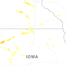

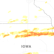


Connect with Interactive Hail Maps