

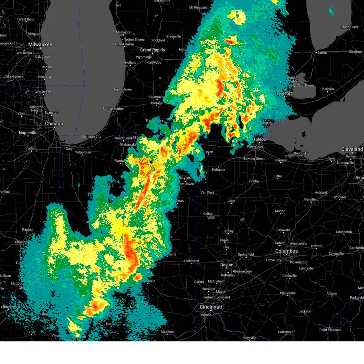
Hail Map for Etna Green, IN
The Etna Green, IN area has had 1 report of on-the-ground hail by trained spotters, and has been under severe weather warnings 26 times during the past 12 months. Doppler radar has detected hail at or near Etna Green, IN on 44 occasions, including 3 occasions during the past year.
| Name: | Etna Green, IN |
| Where Located: | 51.2 miles WNW of Fort Wayne, IN |
| Map: | Google Map for Etna Green, IN |
| Population: | 586 |
| Housing Units: | 245 |
| More Info: | Search Google for Etna Green, IN |
1
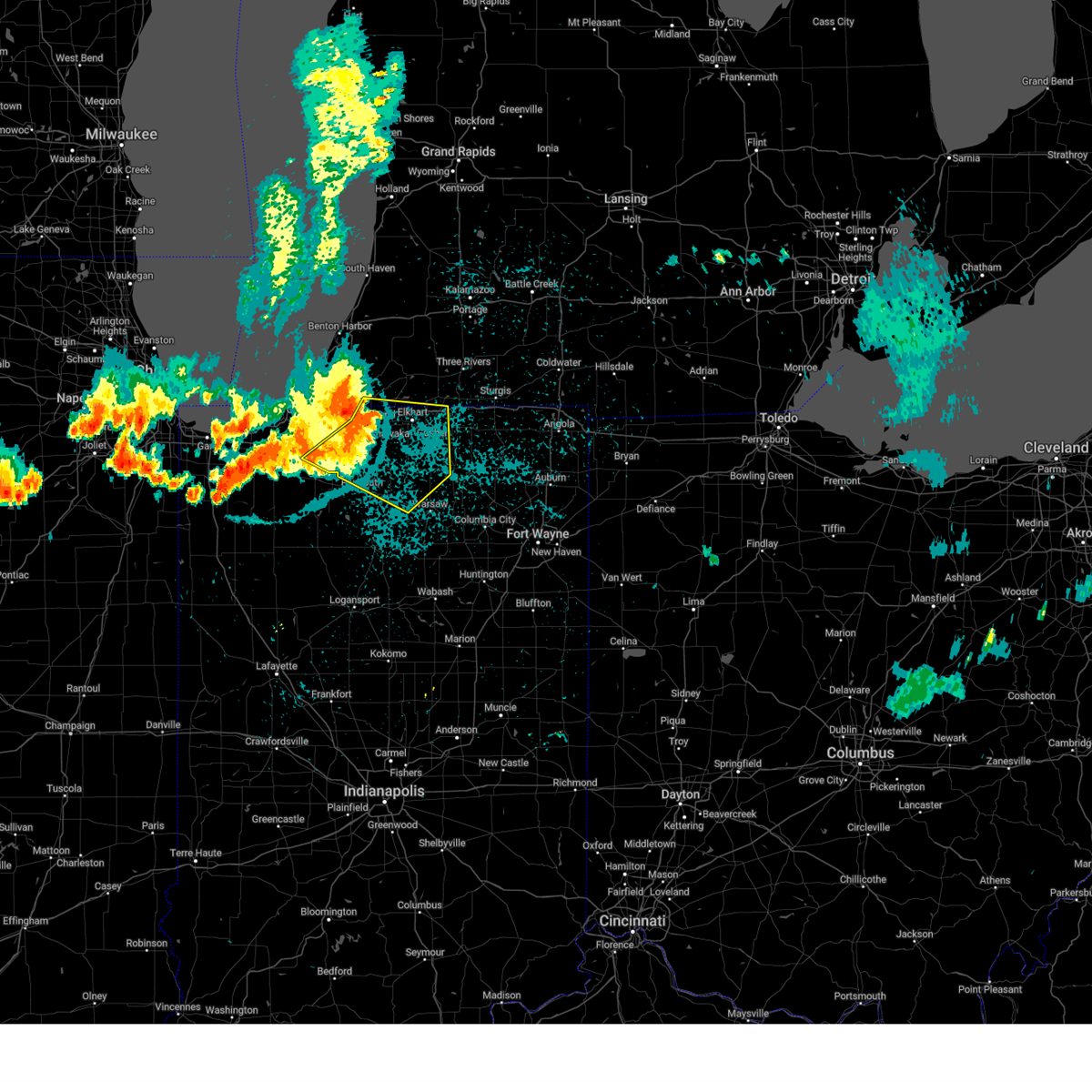
The Top Recent Hail Date for Etna Green, IN is Friday, June 27, 2025 (19th out of 44)
Hail and Wind Damage Spotted near Etna Green, IN
| Date / Time | Report Details |
|---|---|
| 6/27/2025 2:59 PM EDT |
 Svriwx the national weather service in northern indiana has issued a * severe thunderstorm warning for, northwestern kosciusko county in north central indiana, * until 330 pm edt. * at 259 pm edt, a severe thunderstorm was located near bourbon, or 7 miles west of warsaw, moving northeast at 35 mph (radar indicated). Hazards include 60 mph wind gusts and quarter size hail. Hail damage to vehicles is expected. Expect wind damage to roofs, siding, and trees. Svriwx the national weather service in northern indiana has issued a * severe thunderstorm warning for, northwestern kosciusko county in north central indiana, * until 330 pm edt. * at 259 pm edt, a severe thunderstorm was located near bourbon, or 7 miles west of warsaw, moving northeast at 35 mph (radar indicated). Hazards include 60 mph wind gusts and quarter size hail. Hail damage to vehicles is expected. Expect wind damage to roofs, siding, and trees.
|
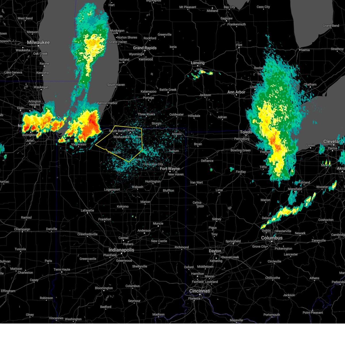
| 6/18/2025 4:26 PM EDT | Svriwx the national weather service in northern indiana has issued a * severe thunderstorm warning for, southern elkhart county in north central indiana, noble county in northeastern indiana, whitley county in northeastern indiana, kosciusko county in north central indiana, southern lagrange county in northeastern indiana, * until 500 pm edt. * at 425 pm edt, severe thunderstorms were located along a line extending from near nappanee to warsaw to near north manchester, moving northeast at 65 mph (radar indicated). Hazards include 70 mph wind gusts. Expect considerable tree damage. Damage is likely to mobile homes, roofs, and outbuildings. |
| 6/18/2025 4:20 PM EDT |
 the severe thunderstorm warning has been cancelled and is no longer in effect the severe thunderstorm warning has been cancelled and is no longer in effect
|
| 6/18/2025 4:20 PM EDT |
 At 420 pm edt, severe thunderstorms were located along a line extending from near bourbon to near warsaw to near akron, moving northeast at 70 mph (radar indicated). Hazards include 70 mph wind gusts. Expect considerable tree damage. damage is likely to mobile homes, roofs, and outbuildings. Locations impacted include, warsaw, nappanee, rochester, north manchester, winona lake, syracuse, bourbon, milford, akron, north webster, pierceton, mentone, tippecanoe, silver lake, etna green, leesburg, denver, roann, claypool, and macy. At 420 pm edt, severe thunderstorms were located along a line extending from near bourbon to near warsaw to near akron, moving northeast at 70 mph (radar indicated). Hazards include 70 mph wind gusts. Expect considerable tree damage. damage is likely to mobile homes, roofs, and outbuildings. Locations impacted include, warsaw, nappanee, rochester, north manchester, winona lake, syracuse, bourbon, milford, akron, north webster, pierceton, mentone, tippecanoe, silver lake, etna green, leesburg, denver, roann, claypool, and macy.
|
| 6/18/2025 4:01 PM EDT |
 Svriwx the national weather service in northern indiana has issued a * severe thunderstorm warning for, northern wabash county in north central indiana, fulton county in north central indiana, kosciusko county in north central indiana, northeastern cass county in north central indiana, northwestern miami county in north central indiana, southern marshall county in north central indiana, * until 445 pm edt. * at 401 pm edt, severe thunderstorms were located along a line extending from near culver to rochester to near mexico, moving northeast at 70 mph (radar indicated). Hazards include 70 mph wind gusts. Expect considerable tree damage. Damage is likely to mobile homes, roofs, and outbuildings. Svriwx the national weather service in northern indiana has issued a * severe thunderstorm warning for, northern wabash county in north central indiana, fulton county in north central indiana, kosciusko county in north central indiana, northeastern cass county in north central indiana, northwestern miami county in north central indiana, southern marshall county in north central indiana, * until 445 pm edt. * at 401 pm edt, severe thunderstorms were located along a line extending from near culver to rochester to near mexico, moving northeast at 70 mph (radar indicated). Hazards include 70 mph wind gusts. Expect considerable tree damage. Damage is likely to mobile homes, roofs, and outbuildings.
|
| 5/16/2025 7:29 PM EDT | Svriwx the national weather service in northern indiana has issued a * severe thunderstorm warning for, whitley county in northeastern indiana, northern huntington county in northeastern indiana, kosciusko county in north central indiana, southeastern marshall county in north central indiana, * until 815 pm edt. * at 729 pm edt, showers and embedded thunderstorms with strong winds were located along a line extending from near mentone to 6 miles east of akron to near wabash, moving northeast at 50 mph (radar indicated). Hazards include 60 mph wind gusts. expect damage to roofs, siding, and trees |
| 4/2/2025 9:40 PM EDT | The storms which prompted the warning have moved out of the area. therefore, the warning will be allowed to expire. a tornado watch remains in effect until 1100 pm edt for north central and northeastern indiana. |
| 4/2/2025 9:30 PM EDT |
 At 930 pm edt, severe thunderstorms were located along a line extending from near pierceton to near bremen, moving northeast at 70 mph (radar indicated). Hazards include 70 mph wind gusts. Expect considerable tree damage. damage is likely to mobile homes, roofs, and outbuildings. Locations impacted include, etna green, big barbee lake, little chapman lake, oswego, ridinger lake, monoquet, warsaw, hoffman lake, leesburg, atwood, hastings, irish lake, sechrist lake, big chapman lake, winona lake, clunette, bourbon, wooster, nappanee, and bremen. At 930 pm edt, severe thunderstorms were located along a line extending from near pierceton to near bremen, moving northeast at 70 mph (radar indicated). Hazards include 70 mph wind gusts. Expect considerable tree damage. damage is likely to mobile homes, roofs, and outbuildings. Locations impacted include, etna green, big barbee lake, little chapman lake, oswego, ridinger lake, monoquet, warsaw, hoffman lake, leesburg, atwood, hastings, irish lake, sechrist lake, big chapman lake, winona lake, clunette, bourbon, wooster, nappanee, and bremen.
|
| 4/2/2025 9:30 PM EDT |
 the severe thunderstorm warning has been cancelled and is no longer in effect the severe thunderstorm warning has been cancelled and is no longer in effect
|
| 4/2/2025 9:19 PM EDT | At 919 pm edt, severe thunderstorms were located along a line extending from 6 miles northeast of akron to near argos, moving northeast at 65 mph (radar indicated). Hazards include 70 mph wind gusts. Expect considerable tree damage. damage is likely to mobile homes, roofs, and outbuildings. Locations impacted include, akron, etna green, big barbee lake, ridinger lake, monoquet, hoffman lake, leesburg, atwood, irish lake, argos, beaver dam lake, tippecanoe, winona lake, old tip town, sevastopol, tiosa, beaver dam, bourbon, burket, and talma. |
| 4/2/2025 9:10 PM EDT |
 Svriwx the national weather service in northern indiana has issued a * severe thunderstorm warning for, northern fulton county in north central indiana, kosciusko county in north central indiana, southeastern marshall county in north central indiana, * until 945 pm edt. * at 910 pm edt, severe thunderstorms were located along a line extending from near akron to near culver, moving northeast at 70 mph (radar indicated). Hazards include 60 mph wind gusts. expect damage to roofs, siding, and trees Svriwx the national weather service in northern indiana has issued a * severe thunderstorm warning for, northern fulton county in north central indiana, kosciusko county in north central indiana, southeastern marshall county in north central indiana, * until 945 pm edt. * at 910 pm edt, severe thunderstorms were located along a line extending from near akron to near culver, moving northeast at 70 mph (radar indicated). Hazards include 60 mph wind gusts. expect damage to roofs, siding, and trees
|
| 4/2/2025 8:35 PM EDT | the severe thunderstorm warning has been cancelled and is no longer in effect |
| 4/2/2025 8:13 PM EDT |
 the tornado warning has been cancelled and is no longer in effect the tornado warning has been cancelled and is no longer in effect
|
| 4/2/2025 8:09 PM EDT | Powerlines down on sr19 near 600 north. time estimated via rada in kosciusko county IN, 3.1 miles S of Etna Green, IN |
| 4/2/2025 8:08 PM EDT |
 the severe thunderstorm warning has been cancelled and is no longer in effect the severe thunderstorm warning has been cancelled and is no longer in effect
|
| 4/2/2025 8:08 PM EDT |
 At 807 pm edt, severe thunderstorms were located along a line extending from osceola to near bourbon to near rochester, moving east at 60 mph (radar indicated). Hazards include 70 mph wind gusts and half dollar size hail. Hail damage to vehicles is expected. expect considerable tree damage. wind damage is also likely to mobile homes, roofs, and outbuildings. locations impacted include, etna green, hoffman lake, atwood, osceola, elkhart, tippecanoe, lake wawasee, bristol, locke, syracuse, tiosa, middlebury, talma, little chapman lake, warsaw, inwood, new paris, southwest, dunlap, and clunette. This includes interstate 80 in indiana between mile markers 94 and 104. At 807 pm edt, severe thunderstorms were located along a line extending from osceola to near bourbon to near rochester, moving east at 60 mph (radar indicated). Hazards include 70 mph wind gusts and half dollar size hail. Hail damage to vehicles is expected. expect considerable tree damage. wind damage is also likely to mobile homes, roofs, and outbuildings. locations impacted include, etna green, hoffman lake, atwood, osceola, elkhart, tippecanoe, lake wawasee, bristol, locke, syracuse, tiosa, middlebury, talma, little chapman lake, warsaw, inwood, new paris, southwest, dunlap, and clunette. This includes interstate 80 in indiana between mile markers 94 and 104.
|
| 4/2/2025 8:00 PM EDT |
 At 800 pm edt, a severe thunderstorm capable of producing a tornado was located near argos, or 7 miles southeast of plymouth, moving east at 60 mph (radar indicated rotation). Hazards include tornado and quarter size hail. Flying debris will be dangerous to those caught without shelter. mobile homes will be damaged or destroyed. damage to roofs, windows, and vehicles will occur. tree damage is likely. Locations impacted include, etna green, argos, hoffman lake, bourbon, and inwood. At 800 pm edt, a severe thunderstorm capable of producing a tornado was located near argos, or 7 miles southeast of plymouth, moving east at 60 mph (radar indicated rotation). Hazards include tornado and quarter size hail. Flying debris will be dangerous to those caught without shelter. mobile homes will be damaged or destroyed. damage to roofs, windows, and vehicles will occur. tree damage is likely. Locations impacted include, etna green, argos, hoffman lake, bourbon, and inwood.
|
| 4/2/2025 7:52 PM EDT | Toriwx the national weather service in northern indiana has issued a * tornado warning for, northwestern kosciusko county in north central indiana, southern marshall county in north central indiana, * until 830 pm edt. * at 752 pm edt, a severe thunderstorm capable of producing a tornado was located near argos, or 7 miles south of plymouth, moving northeast at 70 mph (radar indicated rotation). Hazards include tornado and quarter size hail. Flying debris will be dangerous to those caught without shelter. mobile homes will be damaged or destroyed. damage to roofs, windows, and vehicles will occur. Tree damage is likely. |
| 4/2/2025 7:44 PM EDT | Svriwx the national weather service in northern indiana has issued a * severe thunderstorm warning for, elkhart county in north central indiana, st. joseph county in north central indiana, northwestern fulton county in north central indiana, northeastern pulaski county in northwestern indiana, northern kosciusko county in north central indiana, eastern starke county in northwestern indiana, marshall county in north central indiana, east central la porte county in northwestern indiana, * until 900 pm edt/800 pm cdt/. * at 744 pm edt/644 pm cdt/, severe thunderstorms were located along a line extending from near kingsford heights to near culver to near winamac, moving northeast at 60 mph (radar indicated). Hazards include 70 mph wind gusts and half dollar size hail. Hail damage to vehicles is expected. expect considerable tree damage. Wind damage is also likely to mobile homes, roofs, and outbuildings. |
| 3/30/2025 4:50 PM EDT | the severe thunderstorm warning has been cancelled and is no longer in effect |
| 3/30/2025 4:50 PM EDT | At 450 pm edt, severe thunderstorms were located along a line extending from near nappanee to near peru, moving northeast at 65 mph (radar indicated). Hazards include 70 mph wind gusts and nickel size hail. Expect considerable tree damage. damage is likely to mobile homes, roofs, and outbuildings. locations impacted include, mcnatts, honeyville, atwood, la fontaine, macy, tri-lakes, locke, syracuse, bippus, luther, nead, bowerstown, little chapman lake, warsaw, james lake, goose lake, knapp lake, jalapa, new paris, and loon lake. This includes interstate 69 in indiana between mile markers 266 and 293. |
| 3/30/2025 4:33 PM EDT |
 Svriwx the national weather service in northern indiana has issued a * severe thunderstorm warning for, southern elkhart county in north central indiana, wabash county in north central indiana, noble county in northeastern indiana, northern grant county in central indiana, whitley county in northeastern indiana, huntington county in northeastern indiana, kosciusko county in north central indiana, cass county in north central indiana, southwestern lagrange county in northeastern indiana, fulton county in north central indiana, western wells county in northeastern indiana, miami county in north central indiana, marshall county in north central indiana, * until 530 pm edt. * at 433 pm edt, severe thunderstorms were located along a line extending from plymouth to near walton, moving northeast at 65 mph (radar indicated). Hazards include 70 mph wind gusts and nickel size hail. Expect considerable tree damage. Damage is likely to mobile homes, roofs, and outbuildings. Svriwx the national weather service in northern indiana has issued a * severe thunderstorm warning for, southern elkhart county in north central indiana, wabash county in north central indiana, noble county in northeastern indiana, northern grant county in central indiana, whitley county in northeastern indiana, huntington county in northeastern indiana, kosciusko county in north central indiana, cass county in north central indiana, southwestern lagrange county in northeastern indiana, fulton county in north central indiana, western wells county in northeastern indiana, miami county in north central indiana, marshall county in north central indiana, * until 530 pm edt. * at 433 pm edt, severe thunderstorms were located along a line extending from plymouth to near walton, moving northeast at 65 mph (radar indicated). Hazards include 70 mph wind gusts and nickel size hail. Expect considerable tree damage. Damage is likely to mobile homes, roofs, and outbuildings.
|
| 3/19/2025 8:06 PM EDT |
 Svriwx the national weather service in northern indiana has issued a * severe thunderstorm warning for, northwestern wabash county in north central indiana, central fulton county in north central indiana, western kosciusko county in north central indiana, northeastern cass county in north central indiana, northwestern miami county in north central indiana, southeastern marshall county in north central indiana, * until 845 pm edt. * at 805 pm edt, severe thunderstorms were located along a line extending from near rochester to 7 miles southwest of akron to near grissom afb, moving northeast at 70 mph. at 8 pm edt, power poles were reported down near the logansport airport by emergency management officials (radar indicated). Hazards include 60 mph wind gusts and nickel size hail. expect damage to roofs, siding, and trees Svriwx the national weather service in northern indiana has issued a * severe thunderstorm warning for, northwestern wabash county in north central indiana, central fulton county in north central indiana, western kosciusko county in north central indiana, northeastern cass county in north central indiana, northwestern miami county in north central indiana, southeastern marshall county in north central indiana, * until 845 pm edt. * at 805 pm edt, severe thunderstorms were located along a line extending from near rochester to 7 miles southwest of akron to near grissom afb, moving northeast at 70 mph. at 8 pm edt, power poles were reported down near the logansport airport by emergency management officials (radar indicated). Hazards include 60 mph wind gusts and nickel size hail. expect damage to roofs, siding, and trees
|
| 3/15/2025 3:56 AM EDT | The storms which prompted the warning have weakened below severe limits, and no longer pose an immediate threat to life or property. therefore, the warning will be allowed to expire. however, gusty winds are still possible with these thunderstorms. a severe thunderstorm watch remains in effect until 900 am edt/800 am cdt/ for north central and northwestern indiana. to report severe weather, contact your nearest law enforcement agency. they will relay your report to the national weather service northern indiana. |
| 3/15/2025 3:37 AM EDT | Svriwx the national weather service in northern indiana has issued a * severe thunderstorm warning for, southwestern elkhart county in north central indiana, southeastern st. joseph county in north central indiana, fulton county in north central indiana, eastern pulaski county in northwestern indiana, kosciusko county in north central indiana, northwestern miami county in north central indiana, southeastern starke county in northwestern indiana, marshall county in north central indiana, * until 400 am edt/300 am cdt/. * at 337 am edt/237 am cdt/, severe thunderstorms were located along a line extending from culver to 8 miles northwest of rochester to royal center, moving northeast at 60 mph (radar indicated). Hazards include 60 mph wind gusts. expect damage to roofs, siding, and trees |
| 8/27/2024 9:49 PM EDT |
 At 949 pm edt/849 pm cdt/, severe thunderstorms were located along a line extending from roseland to near lakeville to near koontz lake, moving southeast at 35 mph. strong outflow winds will also precede this line of severe thunderstorms (radar indicated). Hazards include 60 mph wind gusts. Expect damage to roofs, siding, and trees. locations impacted include, south bend, elkhart, mishawaka, goshen, plymouth, nappanee, bremen, syracuse, gulivoire park, granger, dunlap, simonton lake, osceola, walkerton, north liberty, bourbon, wakarusa, bristol, milford, and lakeville. This includes interstate 80 in indiana between mile markers 72 and 104. At 949 pm edt/849 pm cdt/, severe thunderstorms were located along a line extending from roseland to near lakeville to near koontz lake, moving southeast at 35 mph. strong outflow winds will also precede this line of severe thunderstorms (radar indicated). Hazards include 60 mph wind gusts. Expect damage to roofs, siding, and trees. locations impacted include, south bend, elkhart, mishawaka, goshen, plymouth, nappanee, bremen, syracuse, gulivoire park, granger, dunlap, simonton lake, osceola, walkerton, north liberty, bourbon, wakarusa, bristol, milford, and lakeville. This includes interstate 80 in indiana between mile markers 72 and 104.
|
| 8/27/2024 9:21 PM EDT |
 Svriwx the national weather service in northern indiana has issued a * severe thunderstorm warning for, elkhart county in north central indiana, st. joseph county in north central indiana, northwestern kosciusko county in north central indiana, northern marshall county in north central indiana, east central la porte county in northwestern indiana, southwestern cass county in southwestern michigan, southeastern berrien county in southwestern michigan, * until 1000 pm edt/900 pm cdt/. * at 921 pm edt/821 pm cdt/, severe thunderstorms were located along a line extending from near three oaks to new carlisle to near la porte, moving southeast at 55 mph (radar indicated). Hazards include 70 mph wind gusts. Expect considerable tree damage. Damage is likely to mobile homes, roofs, and outbuildings. Svriwx the national weather service in northern indiana has issued a * severe thunderstorm warning for, elkhart county in north central indiana, st. joseph county in north central indiana, northwestern kosciusko county in north central indiana, northern marshall county in north central indiana, east central la porte county in northwestern indiana, southwestern cass county in southwestern michigan, southeastern berrien county in southwestern michigan, * until 1000 pm edt/900 pm cdt/. * at 921 pm edt/821 pm cdt/, severe thunderstorms were located along a line extending from near three oaks to new carlisle to near la porte, moving southeast at 55 mph (radar indicated). Hazards include 70 mph wind gusts. Expect considerable tree damage. Damage is likely to mobile homes, roofs, and outbuildings.
|
| 7/16/2024 12:20 AM EDT |
 At 1220 am edt, a severe squall line capable of producing both tornadoes and extensive straight line wind damage was located along a line extending from near cassopolis to near dunlap to near goshen to near warsaw, moving east at 60 mph (radar indicated rotation). Hazards include tornado. Flying debris will be dangerous to those caught without shelter. mobile homes will be damaged or destroyed. damage to roofs, windows, and vehicles will occur. tree damage is likely. these dangerous storms will be near, elkhart around 1225 am edt. other locations impacted by these tornadic storms include etna green, hoffman lake, atwood, adamsville, hastings, palestine, jimtown, southwest, foraker, and tippecanoe. This includes interstate 80 in indiana between mile markers 82 and 96. At 1220 am edt, a severe squall line capable of producing both tornadoes and extensive straight line wind damage was located along a line extending from near cassopolis to near dunlap to near goshen to near warsaw, moving east at 60 mph (radar indicated rotation). Hazards include tornado. Flying debris will be dangerous to those caught without shelter. mobile homes will be damaged or destroyed. damage to roofs, windows, and vehicles will occur. tree damage is likely. these dangerous storms will be near, elkhart around 1225 am edt. other locations impacted by these tornadic storms include etna green, hoffman lake, atwood, adamsville, hastings, palestine, jimtown, southwest, foraker, and tippecanoe. This includes interstate 80 in indiana between mile markers 82 and 96.
|
| 7/16/2024 12:20 AM EDT |
 the tornado warning has been cancelled and is no longer in effect the tornado warning has been cancelled and is no longer in effect
|
| 7/16/2024 12:13 AM EDT |
 At 1213 am edt, a severe squall line capable of producing both tornadoes and extensive straight line wind damage was located along a line extending from near edwardsburg to near osceola to wakarusa to near mentone, moving east at 60 mph (radar indicated rotation). Hazards include tornado and 70 mph wind gusts. Flying debris will be dangerous to those caught without shelter. mobile homes will be damaged or destroyed. damage to roofs, windows, and vehicles will occur. tree damage is likely. these dangerous storms will be near, elkhart, goshen, dunlap, and simonton lake around 1220 am edt. other locations impacted by these tornadic storms include etna green, hoffman lake, indian village, inwood, atwood, adamsville, hastings, bertrand, woodland, and palestine. This includes interstate 80 in indiana between mile markers 70 and 96. At 1213 am edt, a severe squall line capable of producing both tornadoes and extensive straight line wind damage was located along a line extending from near edwardsburg to near osceola to wakarusa to near mentone, moving east at 60 mph (radar indicated rotation). Hazards include tornado and 70 mph wind gusts. Flying debris will be dangerous to those caught without shelter. mobile homes will be damaged or destroyed. damage to roofs, windows, and vehicles will occur. tree damage is likely. these dangerous storms will be near, elkhart, goshen, dunlap, and simonton lake around 1220 am edt. other locations impacted by these tornadic storms include etna green, hoffman lake, indian village, inwood, atwood, adamsville, hastings, bertrand, woodland, and palestine. This includes interstate 80 in indiana between mile markers 70 and 96.
|
| 7/15/2024 11:59 PM EDT |
 At 1158 pm edt, a severe squall line capable of producing both tornadoes and extensive straight line wind damage was located along a line extending from near buchanan to near gulivoire park to near lakeville to near argos, moving east at 65 mph (radar indicated rotation). Hazards include tornado and 70 mph wind gusts. Flying debris will be dangerous to those caught without shelter. mobile homes will be damaged or destroyed. damage to roofs, windows, and vehicles will occur. tree damage is likely. these dangerous storms will be near, south bend, mishawaka, niles, nappanee, bremen, georgetown, granger, gulivoire park, osceola, and bourbon around 1205 am edt. elkhart and simonton lake around 1210 am edt. goshen and dunlap around 1215 am edt. other locations impacted by these tornadic storms include etna green, hoffman lake, atwood, teegarden, adamsville, bertrand, chain-o-lakes, crumstown, tyner, and woodland. This includes interstate 80 in indiana between mile markers 67 and 96. At 1158 pm edt, a severe squall line capable of producing both tornadoes and extensive straight line wind damage was located along a line extending from near buchanan to near gulivoire park to near lakeville to near argos, moving east at 65 mph (radar indicated rotation). Hazards include tornado and 70 mph wind gusts. Flying debris will be dangerous to those caught without shelter. mobile homes will be damaged or destroyed. damage to roofs, windows, and vehicles will occur. tree damage is likely. these dangerous storms will be near, south bend, mishawaka, niles, nappanee, bremen, georgetown, granger, gulivoire park, osceola, and bourbon around 1205 am edt. elkhart and simonton lake around 1210 am edt. goshen and dunlap around 1215 am edt. other locations impacted by these tornadic storms include etna green, hoffman lake, atwood, teegarden, adamsville, bertrand, chain-o-lakes, crumstown, tyner, and woodland. This includes interstate 80 in indiana between mile markers 67 and 96.
|
| 7/15/2024 11:35 PM EDT |
 Toriwx the national weather service in northern indiana has issued a * tornado warning for, western elkhart county in north central indiana, st. joseph county in north central indiana, northwestern kosciusko county in north central indiana, marshall county in north central indiana, southwestern cass county in southwestern michigan, southeastern berrien county in southwestern michigan, * until 1230 am edt. * at 1134 pm edt, severe thunderstorms capable of producing both tornadoes and extensive straight line wind damage were located along a line extending from near trail creek to near kingsford heights to 7 miles east of wanatah to north judson, moving east at 60 mph. wind gusts up to 80 mph and isolated tornadoes are possible with this line of thunderstorms! (radar indicated rotation). Hazards include tornado. Flying debris will be dangerous to those caught without shelter. mobile homes will be damaged or destroyed. damage to roofs, windows, and vehicles will occur. tree damage is likely. these dangerous storms will be near, plymouth, north liberty, and culver around 1150 pm edt. south bend, niles, buchanan, and lakeville around 1155 pm edt. mishawaka, bremen, georgetown, granger, gulivoire park, argos, and roseland around 1200 am edt. osceola, bourbon, wakarusa, and edwardsburg around 1205 am edt. elkhart, nappanee, and simonton lake around 1210 am edt. goshen and dunlap around 1215 am edt. other locations impacted by these tornadic storms include etna green, hoffman lake, atwood, teegarden, adamsville, bertrand, chain-o-lakes, crumstown, tyner, and woodland. This includes interstate 80 in indiana between mile markers 67 and 96. Toriwx the national weather service in northern indiana has issued a * tornado warning for, western elkhart county in north central indiana, st. joseph county in north central indiana, northwestern kosciusko county in north central indiana, marshall county in north central indiana, southwestern cass county in southwestern michigan, southeastern berrien county in southwestern michigan, * until 1230 am edt. * at 1134 pm edt, severe thunderstorms capable of producing both tornadoes and extensive straight line wind damage were located along a line extending from near trail creek to near kingsford heights to 7 miles east of wanatah to north judson, moving east at 60 mph. wind gusts up to 80 mph and isolated tornadoes are possible with this line of thunderstorms! (radar indicated rotation). Hazards include tornado. Flying debris will be dangerous to those caught without shelter. mobile homes will be damaged or destroyed. damage to roofs, windows, and vehicles will occur. tree damage is likely. these dangerous storms will be near, plymouth, north liberty, and culver around 1150 pm edt. south bend, niles, buchanan, and lakeville around 1155 pm edt. mishawaka, bremen, georgetown, granger, gulivoire park, argos, and roseland around 1200 am edt. osceola, bourbon, wakarusa, and edwardsburg around 1205 am edt. elkhart, nappanee, and simonton lake around 1210 am edt. goshen and dunlap around 1215 am edt. other locations impacted by these tornadic storms include etna green, hoffman lake, atwood, teegarden, adamsville, bertrand, chain-o-lakes, crumstown, tyner, and woodland. This includes interstate 80 in indiana between mile markers 67 and 96.
|
| 7/29/2023 1:26 AM EDT |
 At 126 am edt, severe thunderstorms were located along a line extending from near north liberty to near culver, moving east at 50 mph (radar indicated). Hazards include 70 mph wind gusts. Expect considerable tree damage. Damage is likely to mobile homes, roofs, and outbuildings. At 126 am edt, severe thunderstorms were located along a line extending from near north liberty to near culver, moving east at 50 mph (radar indicated). Hazards include 70 mph wind gusts. Expect considerable tree damage. Damage is likely to mobile homes, roofs, and outbuildings.
|
| 7/28/2023 11:59 PM EDT |
 At 1159 pm edt, a severe thunderstorm was located over bourbon, or 11 miles west of warsaw, moving east at 20 mph (radar indicated). Hazards include 60 mph wind gusts and half dollar size hail. Hail damage to vehicles is expected. Expect wind damage to roofs, siding, and trees. At 1159 pm edt, a severe thunderstorm was located over bourbon, or 11 miles west of warsaw, moving east at 20 mph (radar indicated). Hazards include 60 mph wind gusts and half dollar size hail. Hail damage to vehicles is expected. Expect wind damage to roofs, siding, and trees.
|
| 7/28/2023 9:41 PM EDT |
 The severe thunderstorm warning for central kosciusko county will expire at 945 pm edt, the storm which prompted the warning has weakened below severe limits, and no longer poses an immediate threat to life or property. therefore, the warning will be allowed to expire. however, small hail, gusty winds and heavy rain are still possible with this thunderstorm. additional intensification is possible with this cell. The severe thunderstorm warning for central kosciusko county will expire at 945 pm edt, the storm which prompted the warning has weakened below severe limits, and no longer poses an immediate threat to life or property. therefore, the warning will be allowed to expire. however, small hail, gusty winds and heavy rain are still possible with this thunderstorm. additional intensification is possible with this cell.
|
| 7/28/2023 9:34 PM EDT |
 At 933 pm edt, a severe thunderstorm was located over warsaw, moving east at 20 mph (radar indicated). Hazards include 60 mph wind gusts and quarter size hail. Hail damage to vehicles is expected. expect wind damage to roofs, siding, and trees. Locations impacted include, warsaw, winona lake, mentone, etna green, burket, little chapman lake, monoquet, hoffman lake, big chapman lake, atwood, and palestine. At 933 pm edt, a severe thunderstorm was located over warsaw, moving east at 20 mph (radar indicated). Hazards include 60 mph wind gusts and quarter size hail. Hail damage to vehicles is expected. expect wind damage to roofs, siding, and trees. Locations impacted include, warsaw, winona lake, mentone, etna green, burket, little chapman lake, monoquet, hoffman lake, big chapman lake, atwood, and palestine.
|
| 7/28/2023 9:01 PM EDT |
 At 900 pm edt, a severe thunderstorm was located near mentone, or 10 miles west of warsaw, moving east at 20 mph (radar indicated). Hazards include 60 mph wind gusts and quarter size hail. Hail damage to vehicles is expected. Expect wind damage to roofs, siding, and trees. At 900 pm edt, a severe thunderstorm was located near mentone, or 10 miles west of warsaw, moving east at 20 mph (radar indicated). Hazards include 60 mph wind gusts and quarter size hail. Hail damage to vehicles is expected. Expect wind damage to roofs, siding, and trees.
|
| 6/25/2023 3:53 PM EDT |
 At 353 pm edt, a severe thunderstorm was located near warsaw, moving northeast at 60 mph (public). Hazards include 60 mph wind gusts and half dollar size hail. Hail damage to vehicles is expected. expect wind damage to roofs, siding, and trees. locations impacted include, warsaw, winona lake, mentone, silver lake, etna green, leesburg, claypool, burket, sidney, monoquet, hoffman lake, atwood, palestine, beaver dam lake, packerton, sevastopol, clunette and beaver dam. hail threat, radar indicated max hail size, 1. 25 in wind threat, radar indicated max wind gust, 60 mph. At 353 pm edt, a severe thunderstorm was located near warsaw, moving northeast at 60 mph (public). Hazards include 60 mph wind gusts and half dollar size hail. Hail damage to vehicles is expected. expect wind damage to roofs, siding, and trees. locations impacted include, warsaw, winona lake, mentone, silver lake, etna green, leesburg, claypool, burket, sidney, monoquet, hoffman lake, atwood, palestine, beaver dam lake, packerton, sevastopol, clunette and beaver dam. hail threat, radar indicated max hail size, 1. 25 in wind threat, radar indicated max wind gust, 60 mph.
|
| 6/25/2023 3:28 PM EDT |
 At 328 pm edt, a severe thunderstorm was located near bourbon, or 10 miles south of nappanee, moving east at 40 mph (radar indicated). Hazards include two inch hail and 70 mph wind gusts. People and animals outdoors will be injured. expect hail damage to roofs, siding, windows, and vehicles. expect considerable tree damage. wind damage is also likely to mobile homes, roofs, and outbuildings. this severe storm will be near, winona lake and milford around 345 pm edt. warsaw around 350 pm edt. north webster and pierceton around 355 pm edt. Other locations impacted by this severe thunderstorm include etna green, big barbee lake, little chapman lake, oswego, ridinger lake, monoquet, hoffman lake, leesburg, inwood and atwood. At 328 pm edt, a severe thunderstorm was located near bourbon, or 10 miles south of nappanee, moving east at 40 mph (radar indicated). Hazards include two inch hail and 70 mph wind gusts. People and animals outdoors will be injured. expect hail damage to roofs, siding, windows, and vehicles. expect considerable tree damage. wind damage is also likely to mobile homes, roofs, and outbuildings. this severe storm will be near, winona lake and milford around 345 pm edt. warsaw around 350 pm edt. north webster and pierceton around 355 pm edt. Other locations impacted by this severe thunderstorm include etna green, big barbee lake, little chapman lake, oswego, ridinger lake, monoquet, hoffman lake, leesburg, inwood and atwood.
|
| 6/25/2023 3:23 PM EDT |
 At 322 pm edt, severe thunderstorms were located along a line extending from near dunlap to near nappanee to 8 miles northeast of bourbon, moving east at 40 mph. these are destructive storms for southern elkhart and northern kosciusko county (radar indicated). Hazards include 80 mph wind gusts and quarter size hail. Flying debris will be dangerous to those caught without shelter. mobile homes will be heavily damaged. expect considerable damage to roofs, windows, and vehicles. Extensive tree damage and power outages are likely. At 322 pm edt, severe thunderstorms were located along a line extending from near dunlap to near nappanee to 8 miles northeast of bourbon, moving east at 40 mph. these are destructive storms for southern elkhart and northern kosciusko county (radar indicated). Hazards include 80 mph wind gusts and quarter size hail. Flying debris will be dangerous to those caught without shelter. mobile homes will be heavily damaged. expect considerable damage to roofs, windows, and vehicles. Extensive tree damage and power outages are likely.
|
| 6/25/2023 3:22 PM EDT |
 At 321 pm edt, a severe thunderstorm was located near rochester, moving east at 30 mph. a 62 mph gust report was received near rochester (public). Hazards include 60 mph wind gusts and half dollar size hail. Hail damage to vehicles is expected. expect wind damage to roofs, siding, and trees. locations impacted include, warsaw, rochester, winona lake, mentone, walnut, tippecanoe, silver lake, etna green, leesburg, claypool, burket, sidney, monoquet, hoffman lake, atwood, beaver dam lake, old tip town, sevastopol, tiosa and beaver dam. hail threat, radar indicated max hail size, 1. 25 in wind threat, radar indicated max wind gust, 60 mph. At 321 pm edt, a severe thunderstorm was located near rochester, moving east at 30 mph. a 62 mph gust report was received near rochester (public). Hazards include 60 mph wind gusts and half dollar size hail. Hail damage to vehicles is expected. expect wind damage to roofs, siding, and trees. locations impacted include, warsaw, rochester, winona lake, mentone, walnut, tippecanoe, silver lake, etna green, leesburg, claypool, burket, sidney, monoquet, hoffman lake, atwood, beaver dam lake, old tip town, sevastopol, tiosa and beaver dam. hail threat, radar indicated max hail size, 1. 25 in wind threat, radar indicated max wind gust, 60 mph.
|
| 6/25/2023 3:09 PM EDT |
 At 308 pm edt, a severe thunderstorm was located over rochester, moving east at 30 mph (radar indicated). Hazards include 60 mph wind gusts and half dollar size hail. Hail damage to vehicles is expected. Expect wind damage to roofs, siding, and trees. At 308 pm edt, a severe thunderstorm was located over rochester, moving east at 30 mph (radar indicated). Hazards include 60 mph wind gusts and half dollar size hail. Hail damage to vehicles is expected. Expect wind damage to roofs, siding, and trees.
|
| 6/25/2023 3:05 PM EDT |
 At 305 pm edt, a severe thunderstorm was located over plymouth, moving east at 45 mph (radar indicated). Hazards include tennis ball size hail and 70 mph wind gusts. People and animals outdoors will be injured. expect hail damage to roofs, siding, windows, and vehicles. expect considerable tree damage. wind damage is also likely to mobile homes, roofs, and outbuildings. this severe thunderstorm will be near, bourbon around 320 pm edt. warsaw, winona lake and milford around 340 pm edt. north webster and pierceton around 350 pm edt. Other locations impacted by this severe thunderstorm include etna green, big barbee lake, ridinger lake, monoquet, hoffman lake, leesburg, atwood, irish lake, hibbard and tippecanoe. At 305 pm edt, a severe thunderstorm was located over plymouth, moving east at 45 mph (radar indicated). Hazards include tennis ball size hail and 70 mph wind gusts. People and animals outdoors will be injured. expect hail damage to roofs, siding, windows, and vehicles. expect considerable tree damage. wind damage is also likely to mobile homes, roofs, and outbuildings. this severe thunderstorm will be near, bourbon around 320 pm edt. warsaw, winona lake and milford around 340 pm edt. north webster and pierceton around 350 pm edt. Other locations impacted by this severe thunderstorm include etna green, big barbee lake, ridinger lake, monoquet, hoffman lake, leesburg, atwood, irish lake, hibbard and tippecanoe.
|
| 4/5/2023 11:07 AM EDT |
 At 1106 am edt, severe thunderstorms were located along a line extending from near westwood to near edwardsburg to near lakeville, moving east at 50 mph (radar indicated). Hazards include 60 mph wind gusts and penny size hail. Expect damage to roofs, siding, and trees. locations impacted include, south bend, elkhart, mishawaka, goshen, warsaw, plymouth, three rivers, nappanee, winona lake, bremen, syracuse, gulivoire park, granger, dunlap, simonton lake, middlebury, osceola, constantine, bourbon and cassopolis. this includes interstate 80 in indiana between mile markers 79 and 111. hail threat, radar indicated max hail size, 0. 75 in wind threat, radar indicated max wind gust, 60 mph. At 1106 am edt, severe thunderstorms were located along a line extending from near westwood to near edwardsburg to near lakeville, moving east at 50 mph (radar indicated). Hazards include 60 mph wind gusts and penny size hail. Expect damage to roofs, siding, and trees. locations impacted include, south bend, elkhart, mishawaka, goshen, warsaw, plymouth, three rivers, nappanee, winona lake, bremen, syracuse, gulivoire park, granger, dunlap, simonton lake, middlebury, osceola, constantine, bourbon and cassopolis. this includes interstate 80 in indiana between mile markers 79 and 111. hail threat, radar indicated max hail size, 0. 75 in wind threat, radar indicated max wind gust, 60 mph.
|
| 4/5/2023 10:54 AM EDT |
 At 1054 am edt/954 am cdt/, severe thunderstorms were located along a line extending from near mattawan to near niles to koontz lake, moving east at 50 mph (radar indicated). Hazards include 60 mph wind gusts and penny size hail. Expect damage to roofs, siding, and trees. locations impacted include, elkhart, simonton lake, cassopolis, lakeville, bremen, wakarusa, white pigeon, three rivers, constantine, dunlap, new paris, goshen, middlebury and millersburg. this includes interstate 80 in indiana between mile markers 74 and 111. hail threat, radar indicated max hail size, 0. 75 in wind threat, radar indicated max wind gust, 60 mph. At 1054 am edt/954 am cdt/, severe thunderstorms were located along a line extending from near mattawan to near niles to koontz lake, moving east at 50 mph (radar indicated). Hazards include 60 mph wind gusts and penny size hail. Expect damage to roofs, siding, and trees. locations impacted include, elkhart, simonton lake, cassopolis, lakeville, bremen, wakarusa, white pigeon, three rivers, constantine, dunlap, new paris, goshen, middlebury and millersburg. this includes interstate 80 in indiana between mile markers 74 and 111. hail threat, radar indicated max hail size, 0. 75 in wind threat, radar indicated max wind gust, 60 mph.
|
| 4/5/2023 10:36 AM EDT |
 At 1035 am edt/935 am cdt/, severe thunderstorms were located along a line extending from near hartford to new carlisle to 7 miles east of la crosse, moving east at 50 mph (radar indicated). Hazards include 60 mph wind gusts and penny size hail. Expect damage to roofs, siding, and trees. severe thunderstorms will be near, south bend around 1045 am edt. georgetown and roseland around 1050 am edt. mishawaka, niles, walkerton and koontz lake around 1055 am edt. other locations in the path of these severe thunderstorms include plymouth, granger, north liberty, edwardsburg, elkhart, simonton lake, cassopolis, lakeville, bremen, nappanee, wakarusa and white pigeon. this includes interstate 80 in indiana between mile markers 72 and 111. hail threat, radar indicated max hail size, 0. 75 in wind threat, radar indicated max wind gust, 60 mph. At 1035 am edt/935 am cdt/, severe thunderstorms were located along a line extending from near hartford to new carlisle to 7 miles east of la crosse, moving east at 50 mph (radar indicated). Hazards include 60 mph wind gusts and penny size hail. Expect damage to roofs, siding, and trees. severe thunderstorms will be near, south bend around 1045 am edt. georgetown and roseland around 1050 am edt. mishawaka, niles, walkerton and koontz lake around 1055 am edt. other locations in the path of these severe thunderstorms include plymouth, granger, north liberty, edwardsburg, elkhart, simonton lake, cassopolis, lakeville, bremen, nappanee, wakarusa and white pigeon. this includes interstate 80 in indiana between mile markers 72 and 111. hail threat, radar indicated max hail size, 0. 75 in wind threat, radar indicated max wind gust, 60 mph.
|
| 3/22/2023 6:00 PM EDT |
 At 600 pm edt/500 pm cdt/, a severe thunderstorm was located near culver, or 7 miles southwest of plymouth, moving east at 60 mph (radar indicated). Hazards include quarter size hail. Damage to vehicles is expected. locations impacted include, plymouth, bourbon, argos, culver, walnut, tippecanoe, oak grove, ober, inwood, twin lakes, rutland, burr oak, maxinkuckee, hibbard, old tip town, donaldson, grovertown, ora, winona and bass lake. hail threat, radar indicated max hail size, 1. 00 in wind threat, radar indicated max wind gust, <50 mph. At 600 pm edt/500 pm cdt/, a severe thunderstorm was located near culver, or 7 miles southwest of plymouth, moving east at 60 mph (radar indicated). Hazards include quarter size hail. Damage to vehicles is expected. locations impacted include, plymouth, bourbon, argos, culver, walnut, tippecanoe, oak grove, ober, inwood, twin lakes, rutland, burr oak, maxinkuckee, hibbard, old tip town, donaldson, grovertown, ora, winona and bass lake. hail threat, radar indicated max hail size, 1. 00 in wind threat, radar indicated max wind gust, <50 mph.
|
| 3/22/2023 4:45 PM CDT |
 At 545 pm edt/445 pm cdt/, a severe thunderstorm was located near north judson, or near knox, moving east at 60 mph (radar indicated). Hazards include quarter size hail. damage to vehicles is expected At 545 pm edt/445 pm cdt/, a severe thunderstorm was located near north judson, or near knox, moving east at 60 mph (radar indicated). Hazards include quarter size hail. damage to vehicles is expected
|
| 9/21/2022 8:52 AM EDT |
 At 852 am edt, a severe thunderstorm was located near bourbon, or 9 miles west of warsaw, moving southeast at 40 mph (radar indicated). Hazards include 60 mph wind gusts and penny size hail. expect damage to roofs, siding, and trees At 852 am edt, a severe thunderstorm was located near bourbon, or 9 miles west of warsaw, moving southeast at 40 mph (radar indicated). Hazards include 60 mph wind gusts and penny size hail. expect damage to roofs, siding, and trees
|
| 8/29/2022 3:49 PM EDT |
 At 349 pm edt, severe thunderstorms were located along a line extending from near nappanee to near argos, moving east at 55 mph (radar indicated). Hazards include 60 mph wind gusts. expect damage to roofs, siding, and trees At 349 pm edt, severe thunderstorms were located along a line extending from near nappanee to near argos, moving east at 55 mph (radar indicated). Hazards include 60 mph wind gusts. expect damage to roofs, siding, and trees
|
| 8/3/2022 5:23 PM EDT |
 At 522 pm edt, severe thunderstorms were located along a line extending from near osceola to near argos, moving east at 30 mph (radar indicated). Hazards include 60 mph wind gusts. expect damage to roofs, siding, and trees At 522 pm edt, severe thunderstorms were located along a line extending from near osceola to near argos, moving east at 30 mph (radar indicated). Hazards include 60 mph wind gusts. expect damage to roofs, siding, and trees
|
| 7/23/2022 7:16 AM EDT |
 At 716 am edt, severe thunderstorms were located along a line extending from near middlebury to near bourbon, moving east at 45 mph (radar indicated). Hazards include 70 mph wind gusts. Expect considerable tree damage. Damage is likely to mobile homes, roofs, and outbuildings. At 716 am edt, severe thunderstorms were located along a line extending from near middlebury to near bourbon, moving east at 45 mph (radar indicated). Hazards include 70 mph wind gusts. Expect considerable tree damage. Damage is likely to mobile homes, roofs, and outbuildings.
|
| 7/5/2022 9:00 AM EDT | Trees branches of 1-3 inches in diameter snapped along us-30 near crazy joes fireworks. time estimated from rada in kosciusko county IN, 2.3 miles W of Etna Green, IN |
| 8/12/2021 6:43 AM EDT |
 At 643 am edt, a severe thunderstorm was located near mentone, or near warsaw, moving northeast at 55 mph (radar indicated). Hazards include 70 mph wind gusts. Expect considerable tree damage. damage is likely to mobile homes, roofs, and outbuildings. locations impacted include, warsaw, winona lake, pierceton and north webster. thunderstorm damage threat, considerable hail threat, radar indicated max hail size, <. 75 in wind threat, radar indicated max wind gust, 70 mph. At 643 am edt, a severe thunderstorm was located near mentone, or near warsaw, moving northeast at 55 mph (radar indicated). Hazards include 70 mph wind gusts. Expect considerable tree damage. damage is likely to mobile homes, roofs, and outbuildings. locations impacted include, warsaw, winona lake, pierceton and north webster. thunderstorm damage threat, considerable hail threat, radar indicated max hail size, <. 75 in wind threat, radar indicated max wind gust, 70 mph.
|
| 8/12/2021 6:21 AM EDT |
 At 620 am edt, a severe thunderstorm was located 7 miles southeast of culver, or 9 miles northwest of rochester, moving northeast at 65 mph (radar indicated). Hazards include 70 mph wind gusts. Expect considerable tree damage. damage is likely to mobile homes, roofs, and outbuildings. this severe thunderstorm will be near, rochester around 625 am edt. argos around 630 am edt. mentone around 635 am edt. other locations in the path of this severe thunderstorm include warsaw, winona lake, pierceton and north webster. thunderstorm damage threat, considerable hail threat, radar indicated max hail size, <. 75 in wind threat, radar indicated max wind gust, 70 mph. At 620 am edt, a severe thunderstorm was located 7 miles southeast of culver, or 9 miles northwest of rochester, moving northeast at 65 mph (radar indicated). Hazards include 70 mph wind gusts. Expect considerable tree damage. damage is likely to mobile homes, roofs, and outbuildings. this severe thunderstorm will be near, rochester around 625 am edt. argos around 630 am edt. mentone around 635 am edt. other locations in the path of this severe thunderstorm include warsaw, winona lake, pierceton and north webster. thunderstorm damage threat, considerable hail threat, radar indicated max hail size, <. 75 in wind threat, radar indicated max wind gust, 70 mph.
|
| 8/11/2021 1:17 PM EDT |
 At 117 pm edt, severe thunderstorms were located along a line extending from syracuse to near north webster to near winona lake, moving east at 50 mph (radar indicated). Hazards include 60 mph wind gusts and penny size hail. Expect damage to roofs, siding, and trees. locations impacted include, goshen, warsaw, nappanee, winona lake, syracuse, milford, north webster, pierceton, mentone, new paris, benton, locke, etna green, leesburg, big barbee lake, monoquet, hoffman lake, atwood, irish lake and foraker. hail threat, radar indicated max hail size, 0. 75 in wind threat, radar indicated max wind gust, 60 mph. At 117 pm edt, severe thunderstorms were located along a line extending from syracuse to near north webster to near winona lake, moving east at 50 mph (radar indicated). Hazards include 60 mph wind gusts and penny size hail. Expect damage to roofs, siding, and trees. locations impacted include, goshen, warsaw, nappanee, winona lake, syracuse, milford, north webster, pierceton, mentone, new paris, benton, locke, etna green, leesburg, big barbee lake, monoquet, hoffman lake, atwood, irish lake and foraker. hail threat, radar indicated max hail size, 0. 75 in wind threat, radar indicated max wind gust, 60 mph.
|
| 8/11/2021 12:47 PM EDT |
 At 1247 pm edt, severe thunderstorms were located along a line extending from 6 miles west of bremen to near plymouth to argos, moving east at 40 mph (radar indicated). Hazards include 60 mph wind gusts and penny size hail. expect damage to roofs, siding, and trees At 1247 pm edt, severe thunderstorms were located along a line extending from 6 miles west of bremen to near plymouth to argos, moving east at 40 mph (radar indicated). Hazards include 60 mph wind gusts and penny size hail. expect damage to roofs, siding, and trees
|
| 8/11/2021 12:30 PM EDT |
 At 1229 pm edt, a severe thunderstorm was located near bourbon, or 10 miles south of nappanee, moving east at 25 mph (radar indicated). Hazards include 60 mph wind gusts. Expect damage to roofs, siding, and trees. locations impacted include, warsaw, nappanee, winona lake, etna green, leesburg, monoquet, hoffman lake, atwood, clunette, gravelton and hastings. hail threat, radar indicated max hail size, <. 75 in wind threat, radar indicated max wind gust, 60 mph. At 1229 pm edt, a severe thunderstorm was located near bourbon, or 10 miles south of nappanee, moving east at 25 mph (radar indicated). Hazards include 60 mph wind gusts. Expect damage to roofs, siding, and trees. locations impacted include, warsaw, nappanee, winona lake, etna green, leesburg, monoquet, hoffman lake, atwood, clunette, gravelton and hastings. hail threat, radar indicated max hail size, <. 75 in wind threat, radar indicated max wind gust, 60 mph.
|
| 8/11/2021 12:16 PM EDT |
 At 1216 pm edt, a severe thunderstorm was located over bourbon, or 7 miles southeast of plymouth, moving east at 25 mph (radar indicated). Hazards include 60 mph wind gusts and penny size hail. expect damage to roofs, siding, and trees At 1216 pm edt, a severe thunderstorm was located over bourbon, or 7 miles southeast of plymouth, moving east at 25 mph (radar indicated). Hazards include 60 mph wind gusts and penny size hail. expect damage to roofs, siding, and trees
|
| 8/10/2021 11:59 PM EDT |
 At 1159 pm edt, a severe thunderstorm was located over rochester, moving east at 30 mph (radar indicated). Hazards include 60 mph wind gusts and penny size hail. Expect damage to roofs, siding, and trees. locations impacted include, warsaw, rochester, argos, akron, mentone, walnut, tippecanoe, etna green, macy, burket, hoffman lake, atwood, nyena lake, athens, palestine, beaver dam lake, old tip town, sevastopol, tiosa and beaver dam. hail threat, radar indicated max hail size, 0. 75 in wind threat, radar indicated max wind gust, 60 mph. At 1159 pm edt, a severe thunderstorm was located over rochester, moving east at 30 mph (radar indicated). Hazards include 60 mph wind gusts and penny size hail. Expect damage to roofs, siding, and trees. locations impacted include, warsaw, rochester, argos, akron, mentone, walnut, tippecanoe, etna green, macy, burket, hoffman lake, atwood, nyena lake, athens, palestine, beaver dam lake, old tip town, sevastopol, tiosa and beaver dam. hail threat, radar indicated max hail size, 0. 75 in wind threat, radar indicated max wind gust, 60 mph.
|
| 8/10/2021 11:41 PM EDT |
 At 1140 pm edt, a severe thunderstorm was located 7 miles west of rochester, moving east at 35 mph (radar indicated). Hazards include 60 mph wind gusts and penny size hail. expect damage to roofs, siding, and trees At 1140 pm edt, a severe thunderstorm was located 7 miles west of rochester, moving east at 35 mph (radar indicated). Hazards include 60 mph wind gusts and penny size hail. expect damage to roofs, siding, and trees
|
| 7/24/2021 8:14 PM EDT |
 At 813 pm edt, severe thunderstorms were located along a line extending from near goshen to near bourbon, moving southeast at 35 mph (radar indicated). Hazards include 60 mph wind gusts. Expect damage to roofs, siding, and trees. Locations impacted include, goshen, warsaw, nappanee, syracuse, middlebury, bourbon, wakarusa, milford, north webster, millersburg, new paris, benton, locke, etna green, leesburg, big barbee lake, monoquet, hoffman lake, atwood and irish lake. At 813 pm edt, severe thunderstorms were located along a line extending from near goshen to near bourbon, moving southeast at 35 mph (radar indicated). Hazards include 60 mph wind gusts. Expect damage to roofs, siding, and trees. Locations impacted include, goshen, warsaw, nappanee, syracuse, middlebury, bourbon, wakarusa, milford, north webster, millersburg, new paris, benton, locke, etna green, leesburg, big barbee lake, monoquet, hoffman lake, atwood and irish lake.
|
| 7/24/2021 7:49 PM EDT |
 At 748 pm edt, severe thunderstorms were located along a line extending from near elkhart to near walkerton, moving southeast at 35 mph (radar indicated). Hazards include 60 mph wind gusts. expect damage to roofs, siding, and trees At 748 pm edt, severe thunderstorms were located along a line extending from near elkhart to near walkerton, moving southeast at 35 mph (radar indicated). Hazards include 60 mph wind gusts. expect damage to roofs, siding, and trees
|
| 7/24/2021 7:48 PM EDT |
 At 748 pm edt, severe thunderstorms were located along a line extending from near elkhart to near walkerton, moving southeast at 35 mph (radar indicated). Hazards include 60 mph wind gusts. expect damage to roofs, siding, and trees At 748 pm edt, severe thunderstorms were located along a line extending from near elkhart to near walkerton, moving southeast at 35 mph (radar indicated). Hazards include 60 mph wind gusts. expect damage to roofs, siding, and trees
|
| 7/7/2021 7:46 PM EDT |
 At 745 pm edt, a severe thunderstorm was located near argos, or near plymouth, moving east at 35 mph (radar indicated). Hazards include 60 mph wind gusts and quarter size hail. Hail damage to vehicles is expected. expect wind damage to roofs, siding, and trees. Locations impacted include, plymouth, bourbon, argos, culver, walnut, tippecanoe, leiters ford, twin lakes, inwood, rutland, burr oak, maxinkuckee, hibbard, delong, old tip town, donaldson, tiosa and talma. At 745 pm edt, a severe thunderstorm was located near argos, or near plymouth, moving east at 35 mph (radar indicated). Hazards include 60 mph wind gusts and quarter size hail. Hail damage to vehicles is expected. expect wind damage to roofs, siding, and trees. Locations impacted include, plymouth, bourbon, argos, culver, walnut, tippecanoe, leiters ford, twin lakes, inwood, rutland, burr oak, maxinkuckee, hibbard, delong, old tip town, donaldson, tiosa and talma.
|
| 7/7/2021 7:26 PM EDT |
 At 725 pm edt/625 pm cdt/, a severe thunderstorm was located near culver, or 7 miles southeast of knox, moving east at 40 mph (radar indicated). Hazards include 60 mph wind gusts and quarter size hail. Hail damage to vehicles is expected. Expect wind damage to roofs, siding, and trees. At 725 pm edt/625 pm cdt/, a severe thunderstorm was located near culver, or 7 miles southeast of knox, moving east at 40 mph (radar indicated). Hazards include 60 mph wind gusts and quarter size hail. Hail damage to vehicles is expected. Expect wind damage to roofs, siding, and trees.
|
| 6/20/2021 6:49 PM EDT |
 At 649 pm edt, a severe thunderstorm was located over bourbon, or 9 miles southeast of plymouth, moving northeast at 30 mph (radar indicated). Hazards include ping pong ball size hail and 60 mph wind gusts. People and animals outdoors will be injured. expect hail damage to roofs, siding, windows, and vehicles. expect wind damage to roofs, siding, and trees. this severe storm will be near, nappanee around 725 pm edt. milford around 730 pm edt. Other locations impacted by this severe thunderstorm include etna green, oswego, monoquet, hoffman lake, leesburg, inwood, atwood, hastings, tippecanoe and old tip town. At 649 pm edt, a severe thunderstorm was located over bourbon, or 9 miles southeast of plymouth, moving northeast at 30 mph (radar indicated). Hazards include ping pong ball size hail and 60 mph wind gusts. People and animals outdoors will be injured. expect hail damage to roofs, siding, windows, and vehicles. expect wind damage to roofs, siding, and trees. this severe storm will be near, nappanee around 725 pm edt. milford around 730 pm edt. Other locations impacted by this severe thunderstorm include etna green, oswego, monoquet, hoffman lake, leesburg, inwood, atwood, hastings, tippecanoe and old tip town.
|
| 6/20/2021 6:39 PM EDT |
 At 638 pm edt, a severe thunderstorm was located over argos, or 10 miles southeast of plymouth, moving northeast at 35 mph (radar indicated). Hazards include ping pong ball size hail and 60 mph wind gusts. People and animals outdoors will be injured. expect hail damage to roofs, siding, windows, and vehicles. expect wind damage to roofs, siding, and trees. this severe thunderstorm will be near, bourbon around 655 pm edt. nappanee around 715 pm edt. milford around 720 pm edt. Other locations impacted by this severe thunderstorm include etna green, oswego, monoquet, hoffman lake, leesburg, inwood, atwood, hastings, walnut and tippecanoe. At 638 pm edt, a severe thunderstorm was located over argos, or 10 miles southeast of plymouth, moving northeast at 35 mph (radar indicated). Hazards include ping pong ball size hail and 60 mph wind gusts. People and animals outdoors will be injured. expect hail damage to roofs, siding, windows, and vehicles. expect wind damage to roofs, siding, and trees. this severe thunderstorm will be near, bourbon around 655 pm edt. nappanee around 715 pm edt. milford around 720 pm edt. Other locations impacted by this severe thunderstorm include etna green, oswego, monoquet, hoffman lake, leesburg, inwood, atwood, hastings, walnut and tippecanoe.
|
| 8/10/2020 6:47 PM EDT |
 At 647 pm edt, severe thunderstorms were located along a line extending from near marcellus to elkhart to nappanee to near warsaw, moving east at 45 mph. these are very dangerous storms (radar indicated). Hazards include 80 mph wind gusts and quarter size hail. Flying debris will be dangerous to those caught without shelter. mobile homes will be heavily damaged. expect considerable damage to roofs, windows, and vehicles. extensive tree damage and power outages are likely. these severe storms will be near, marcellus around 650 pm edt. warsaw, winona lake, bristol and milford around 655 pm edt. goshen, three rivers and new paris around 700 pm edt. syracuse, middlebury, north webster, pierceton and millersburg around 705 pm edt. centreville around 710 pm edt. columbia city, ligonier and topeka around 715 pm edt. tri-lakes around 720 pm edt. sturgis, lagrange, albion and colon around 725 pm edt. Other locations impacted by these severe thunderstorms include honeyville, nottawa, atwood, juno lake, fishers lake, diamond lake, corey lake, howe, locke and wakelee. At 647 pm edt, severe thunderstorms were located along a line extending from near marcellus to elkhart to nappanee to near warsaw, moving east at 45 mph. these are very dangerous storms (radar indicated). Hazards include 80 mph wind gusts and quarter size hail. Flying debris will be dangerous to those caught without shelter. mobile homes will be heavily damaged. expect considerable damage to roofs, windows, and vehicles. extensive tree damage and power outages are likely. these severe storms will be near, marcellus around 650 pm edt. warsaw, winona lake, bristol and milford around 655 pm edt. goshen, three rivers and new paris around 700 pm edt. syracuse, middlebury, north webster, pierceton and millersburg around 705 pm edt. centreville around 710 pm edt. columbia city, ligonier and topeka around 715 pm edt. tri-lakes around 720 pm edt. sturgis, lagrange, albion and colon around 725 pm edt. Other locations impacted by these severe thunderstorms include honeyville, nottawa, atwood, juno lake, fishers lake, diamond lake, corey lake, howe, locke and wakelee.
|
| 8/10/2020 6:38 PM EDT |
 At 637 pm edt, a severe thunderstorm capable of producing a tornado was located near nappanee, moving east at 60 mph (radar indicated rotation). Hazards include tornado and quarter size hail. Flying debris will be dangerous to those caught without shelter. mobile homes will be damaged or destroyed. damage to roofs, windows, and vehicles will occur. tree damage is likely. this dangerous storm will be near, milford around 645 pm edt. warsaw and syracuse around 650 pm edt. north webster around 655 pm edt. Other locations impacted by this tornadic thunderstorm include etna green, big barbee lake, ridinger lake, monoquet, hoffman lake, leesburg, atwood, big lake, irish lake and lake wawasee. At 637 pm edt, a severe thunderstorm capable of producing a tornado was located near nappanee, moving east at 60 mph (radar indicated rotation). Hazards include tornado and quarter size hail. Flying debris will be dangerous to those caught without shelter. mobile homes will be damaged or destroyed. damage to roofs, windows, and vehicles will occur. tree damage is likely. this dangerous storm will be near, milford around 645 pm edt. warsaw and syracuse around 650 pm edt. north webster around 655 pm edt. Other locations impacted by this tornadic thunderstorm include etna green, big barbee lake, ridinger lake, monoquet, hoffman lake, leesburg, atwood, big lake, irish lake and lake wawasee.
|
| 8/10/2020 6:24 PM EDT |
 At 623 pm edt, severe thunderstorms were located along a line extending from near dowagiac to near south bend to near plymouth to argos, moving east at 45 mph. these are very dangerous storms (radar indicated). Hazards include 80 mph wind gusts and quarter size hail. Flying debris will be dangerous to those caught without shelter. mobile homes will be heavily damaged. expect considerable damage to roofs, windows, and vehicles. extensive tree damage and power outages are likely. severe thunderstorms will be near, mishawaka and dowagiac around 630 pm edt. bremen, granger, bourbon and cassopolis around 635 pm edt. osceola and mentone around 640 pm edt. elkhart, simonton lake, wakarusa and marcellus around 645 pm edt. nappanee and dunlap around 650 pm edt. warsaw, winona lake, bristol, milford and new paris around 655 pm edt. goshen, three rivers, syracuse and pierceton around 700 pm edt. middlebury, centreville, north webster and millersburg around 705 pm edt. This includes interstate 80 in indiana between mile markers 73 and 124. At 623 pm edt, severe thunderstorms were located along a line extending from near dowagiac to near south bend to near plymouth to argos, moving east at 45 mph. these are very dangerous storms (radar indicated). Hazards include 80 mph wind gusts and quarter size hail. Flying debris will be dangerous to those caught without shelter. mobile homes will be heavily damaged. expect considerable damage to roofs, windows, and vehicles. extensive tree damage and power outages are likely. severe thunderstorms will be near, mishawaka and dowagiac around 630 pm edt. bremen, granger, bourbon and cassopolis around 635 pm edt. osceola and mentone around 640 pm edt. elkhart, simonton lake, wakarusa and marcellus around 645 pm edt. nappanee and dunlap around 650 pm edt. warsaw, winona lake, bristol, milford and new paris around 655 pm edt. goshen, three rivers, syracuse and pierceton around 700 pm edt. middlebury, centreville, north webster and millersburg around 705 pm edt. This includes interstate 80 in indiana between mile markers 73 and 124.
|
| 6/26/2020 10:58 PM EDT |
 At 1056 pm edt, a severe thunderstorm was located over warsaw, moving east at 50 mph (radar indicated). Hazards include 70 mph wind gusts. Expect considerable tree damage. damage is likely to mobile homes, roofs, and outbuildings. Locations impacted include, warsaw, winona lake, north webster, pierceton, mentone, etna green, leesburg, claypool, burket, sidney, big barbee lake, ridinger lake, monoquet, hoffman lake, atwood, irish lake, beaver dam lake, sevastopol, beaver dam and little chapman lake. At 1056 pm edt, a severe thunderstorm was located over warsaw, moving east at 50 mph (radar indicated). Hazards include 70 mph wind gusts. Expect considerable tree damage. damage is likely to mobile homes, roofs, and outbuildings. Locations impacted include, warsaw, winona lake, north webster, pierceton, mentone, etna green, leesburg, claypool, burket, sidney, big barbee lake, ridinger lake, monoquet, hoffman lake, atwood, irish lake, beaver dam lake, sevastopol, beaver dam and little chapman lake.
|
| 6/26/2020 10:45 PM EDT |
 At 1044 pm edt, a severe thunderstorm was located over bourbon, or 10 miles south of bremen, moving east at 70 mph (radar indicated). Hazards include 70 mph wind gusts. Expect considerable tree damage. damage is likely to mobile homes, roofs, and outbuildings. Locations impacted include, warsaw, plymouth, winona lake, walkerton, bourbon, argos, culver, north webster, pierceton, mentone, koontz lake, walnut, tippecanoe, etna green, leesburg, claypool, burket, sidney, hoffman lake and atwood. At 1044 pm edt, a severe thunderstorm was located over bourbon, or 10 miles south of bremen, moving east at 70 mph (radar indicated). Hazards include 70 mph wind gusts. Expect considerable tree damage. damage is likely to mobile homes, roofs, and outbuildings. Locations impacted include, warsaw, plymouth, winona lake, walkerton, bourbon, argos, culver, north webster, pierceton, mentone, koontz lake, walnut, tippecanoe, etna green, leesburg, claypool, burket, sidney, hoffman lake and atwood.
|
| 6/26/2020 10:23 PM EDT |
 At 1023 pm edt/923 pm cdt/, a severe thunderstorm was located over hamlet, or near knox, moving east at 70 mph (radar indicated). Hazards include 70 mph wind gusts. Expect considerable tree damage. Damage is likely to mobile homes, roofs, and outbuildings. At 1023 pm edt/923 pm cdt/, a severe thunderstorm was located over hamlet, or near knox, moving east at 70 mph (radar indicated). Hazards include 70 mph wind gusts. Expect considerable tree damage. Damage is likely to mobile homes, roofs, and outbuildings.
|
| 6/10/2020 12:48 PM EDT |
 At 1248 pm edt, a severe thunderstorm was located over bourbon, or 8 miles southeast of bremen, moving north at 65 mph (radar indicated). Hazards include 70 mph wind gusts and nickel size hail. Expect considerable tree damage. damage is likely to mobile homes, roofs, and outbuildings. this severe storm will be near, nappanee around 100 pm edt. wakarusa around 105 pm edt. Other locations impacted by this severe thunderstorm include locke, etna green, southwest, foraker, old tip town and gravelton. At 1248 pm edt, a severe thunderstorm was located over bourbon, or 8 miles southeast of bremen, moving north at 65 mph (radar indicated). Hazards include 70 mph wind gusts and nickel size hail. Expect considerable tree damage. damage is likely to mobile homes, roofs, and outbuildings. this severe storm will be near, nappanee around 100 pm edt. wakarusa around 105 pm edt. Other locations impacted by this severe thunderstorm include locke, etna green, southwest, foraker, old tip town and gravelton.
|
| 6/10/2020 12:40 PM EDT |
 At 1240 pm edt, a severe thunderstorm was located near argos, or 10 miles north of rochester, moving north at 65 mph (radar indicated). Hazards include 70 mph wind gusts and nickel size hail. Expect considerable tree damage. damage is likely to mobile homes, roofs, and outbuildings. this severe thunderstorm will be near, bourbon around 1245 pm edt. bremen around 1255 pm edt. nappanee around 100 pm edt. wakarusa around 105 pm edt. Other locations impacted by this severe thunderstorm include etna green, southwest, foraker, walnut, tippecanoe, inwood, old tip town, gravelton, locke and tiosa. At 1240 pm edt, a severe thunderstorm was located near argos, or 10 miles north of rochester, moving north at 65 mph (radar indicated). Hazards include 70 mph wind gusts and nickel size hail. Expect considerable tree damage. damage is likely to mobile homes, roofs, and outbuildings. this severe thunderstorm will be near, bourbon around 1245 pm edt. bremen around 1255 pm edt. nappanee around 100 pm edt. wakarusa around 105 pm edt. Other locations impacted by this severe thunderstorm include etna green, southwest, foraker, walnut, tippecanoe, inwood, old tip town, gravelton, locke and tiosa.
|
| 5/28/2020 9:10 PM EDT |
 The severe thunderstorm warning for north central fulton, northwestern kosciusko and southeastern marshall counties will expire at 915 pm edt, the storm which prompted the warning has weakened below severe limits, and no longer poses an immediate threat to life or property. therefore, the warning will be allowed to expire. however heavy rain is still possible with this thunderstorm. The severe thunderstorm warning for north central fulton, northwestern kosciusko and southeastern marshall counties will expire at 915 pm edt, the storm which prompted the warning has weakened below severe limits, and no longer poses an immediate threat to life or property. therefore, the warning will be allowed to expire. however heavy rain is still possible with this thunderstorm.
|
| 5/28/2020 8:46 PM EDT |
 At 846 pm edt, a severe thunderstorm was located near mentone, or 8 miles northeast of rochester, moving northeast at 30 mph (radar indicated). Hazards include 60 mph wind gusts. expect damage to roofs, siding, and trees At 846 pm edt, a severe thunderstorm was located near mentone, or 8 miles northeast of rochester, moving northeast at 30 mph (radar indicated). Hazards include 60 mph wind gusts. expect damage to roofs, siding, and trees
|
| 9/12/2019 5:26 PM EDT |
 At 526 pm edt, a severe thunderstorm was located near nappanee, moving north at 10 mph (radar indicated). Hazards include 60 mph wind gusts and quarter size hail. Hail damage to vehicles is expected. expect wind damage to roofs, siding, and trees. Locations impacted include, nappanee, bremen, bourbon, wakarusa, locke, etna green, southwest, foraker, hoffman lake, gravelton, hastings and wyatt. At 526 pm edt, a severe thunderstorm was located near nappanee, moving north at 10 mph (radar indicated). Hazards include 60 mph wind gusts and quarter size hail. Hail damage to vehicles is expected. expect wind damage to roofs, siding, and trees. Locations impacted include, nappanee, bremen, bourbon, wakarusa, locke, etna green, southwest, foraker, hoffman lake, gravelton, hastings and wyatt.
|
| 9/12/2019 5:11 PM EDT |
 At 511 pm edt, a severe thunderstorm was located near bourbon, or 8 miles southwest of nappanee, moving north at 10 mph (radar indicated). Hazards include 60 mph wind gusts and nickel size hail. expect damage to roofs, siding, and trees At 511 pm edt, a severe thunderstorm was located near bourbon, or 8 miles southwest of nappanee, moving north at 10 mph (radar indicated). Hazards include 60 mph wind gusts and nickel size hail. expect damage to roofs, siding, and trees
|
| 5/23/2019 4:37 AM EDT |
 At 436 am edt, severe thunderstorms were located along a line extending from near warsaw to 6 miles northwest of north manchester to 11 miles east of frankfort, moving east at 65 mph (radar indicated). Hazards include 60 mph wind gusts. Expect damage to roofs, siding, and trees. Locations impacted include, marion, logansport, huntington, warsaw, peru, wabash, columbia city, rochester, north manchester, winona lake, tri-lakes, grissom afb, south whitley, sweetser, akron, andrews, walton, pierceton, mentone and swayzee. At 436 am edt, severe thunderstorms were located along a line extending from near warsaw to 6 miles northwest of north manchester to 11 miles east of frankfort, moving east at 65 mph (radar indicated). Hazards include 60 mph wind gusts. Expect damage to roofs, siding, and trees. Locations impacted include, marion, logansport, huntington, warsaw, peru, wabash, columbia city, rochester, north manchester, winona lake, tri-lakes, grissom afb, south whitley, sweetser, akron, andrews, walton, pierceton, mentone and swayzee.
|
| 5/23/2019 4:09 AM EDT |
 At 407 am edt, severe thunderstorms were located along a line extending from near culver to 9 miles northeast of royal center to 8 miles north of crawfordsville, moving east at 65 mph (radar indicated). Hazards include 70 mph wind gusts. Expect considerable tree damage. Damage is likely to mobile homes, roofs, and outbuildings. At 407 am edt, severe thunderstorms were located along a line extending from near culver to 9 miles northeast of royal center to 8 miles north of crawfordsville, moving east at 65 mph (radar indicated). Hazards include 70 mph wind gusts. Expect considerable tree damage. Damage is likely to mobile homes, roofs, and outbuildings.
|
| 7/20/2018 2:14 PM EDT |
 At 214 pm edt, severe thunderstorms were located along a line extending from near milford to warsaw to akron, moving east at 35 mph (radar indicated). Hazards include 60 mph wind gusts and penny size hail. Expect damage to roofs, siding, and trees. locations impacted include, warsaw, winona lake, syracuse, akron, north webster, pierceton, mentone, etna green, leesburg, claypool, burket, sidney, big barbee lake, ridinger lake, monoquet, hoffman lake, atwood, irish lake, beaver dam lake and lake wawasee. A tornado watch remains in effect until 600 pm edt for north central and northeastern indiana. At 214 pm edt, severe thunderstorms were located along a line extending from near milford to warsaw to akron, moving east at 35 mph (radar indicated). Hazards include 60 mph wind gusts and penny size hail. Expect damage to roofs, siding, and trees. locations impacted include, warsaw, winona lake, syracuse, akron, north webster, pierceton, mentone, etna green, leesburg, claypool, burket, sidney, big barbee lake, ridinger lake, monoquet, hoffman lake, atwood, irish lake, beaver dam lake and lake wawasee. A tornado watch remains in effect until 600 pm edt for north central and northeastern indiana.
|
| 7/20/2018 2:06 PM EDT | Tree limbs down... barn damage... grain bin damaged and corn flattened down. time estimated from rada in kosciusko county IN, 0.4 miles SE of Etna Green, IN |
| 7/20/2018 1:57 PM EDT |
 At 156 pm edt, severe thunderstorms were located along a line extending from near bourbon to near mentone to 6 miles south of rochester, moving east at 35 mph (radar indicated). Hazards include 60 mph wind gusts and nickel size hail. expect damage to roofs, siding, and trees At 156 pm edt, severe thunderstorms were located along a line extending from near bourbon to near mentone to 6 miles south of rochester, moving east at 35 mph (radar indicated). Hazards include 60 mph wind gusts and nickel size hail. expect damage to roofs, siding, and trees
|
| 5/2/2018 9:10 PM EDT |
 The severe thunderstorm warning for western kosciusko county will expire at 915 pm edt, the warning for southwestern kosciusko county will expire at 915 pm edt. a severe thunderstorm warning remains in effect for much of the remainder of kosciusko county until 930 pm edt. stay alert for heavy rain and gsty winds. The severe thunderstorm warning for western kosciusko county will expire at 915 pm edt, the warning for southwestern kosciusko county will expire at 915 pm edt. a severe thunderstorm warning remains in effect for much of the remainder of kosciusko county until 930 pm edt. stay alert for heavy rain and gsty winds.
|
| 5/2/2018 8:55 PM EDT |
 At 854 pm edt, a severe thunderstorm was located 7 miles east of bourbon, or 7 miles northwest of warsaw, moving east at 25 mph (radar indicated). Hazards include 60 mph wind gusts. Expect damage to roofs, siding, and trees. Locations impacted include, warsaw, mentone, hoffman lake, clunette and palestine. At 854 pm edt, a severe thunderstorm was located 7 miles east of bourbon, or 7 miles northwest of warsaw, moving east at 25 mph (radar indicated). Hazards include 60 mph wind gusts. Expect damage to roofs, siding, and trees. Locations impacted include, warsaw, mentone, hoffman lake, clunette and palestine.
|
| 5/2/2018 8:33 PM EDT |
 At 832 pm edt, a severe thunderstorm was located near bourbon, or 9 miles southeast of plymouth, moving east at 25 mph (radar indicated). Hazards include 60 mph wind gusts. expect damage to roofs, siding, and trees At 832 pm edt, a severe thunderstorm was located near bourbon, or 9 miles southeast of plymouth, moving east at 25 mph (radar indicated). Hazards include 60 mph wind gusts. expect damage to roofs, siding, and trees
|
| 7/13/2017 1:32 AM EDT |
 At 132 am edt, a severe thunderstorm was located near bourbon, or 10 miles northwest of warsaw, moving east at 35 mph (radar indicated). Hazards include 60 mph wind gusts. expect damage to roofs, siding, and trees At 132 am edt, a severe thunderstorm was located near bourbon, or 10 miles northwest of warsaw, moving east at 35 mph (radar indicated). Hazards include 60 mph wind gusts. expect damage to roofs, siding, and trees
|
| 7/10/2017 9:51 AM EDT |
 The severe thunderstorm warning for southwestern elkhart, western whitley, kosciusko and northeastern marshall counties will expire at 1000 am edt, the storms which prompted the warning have weakened below severe limits, and no longer pose an immediate threat to life or property. therefore the warning will be allowed to expire. however gusty winds and heavy rain are still possible with these thunderstorms. very high rainfall rates have been observed with these thunderstorms that will lead to minor flooding. The severe thunderstorm warning for southwestern elkhart, western whitley, kosciusko and northeastern marshall counties will expire at 1000 am edt, the storms which prompted the warning have weakened below severe limits, and no longer pose an immediate threat to life or property. therefore the warning will be allowed to expire. however gusty winds and heavy rain are still possible with these thunderstorms. very high rainfall rates have been observed with these thunderstorms that will lead to minor flooding.
|
| 7/10/2017 9:35 AM EDT |
 At 935 am edt, severe thunderstorms were located along a line extending from near wakarusa to near milford to near winona lake to near akron, moving east at 55 mph (radar indicated). Hazards include 60 mph wind gusts. Expect damage to roofs, siding, and trees. Locations impacted include, warsaw, nappanee, winona lake, bremen, syracuse, south whitley, milford, north webster, pierceton, new paris, locke, etna green, leesburg, claypool, larwill, burket, sidney, big barbee lake, ridinger lake and monoquet. At 935 am edt, severe thunderstorms were located along a line extending from near wakarusa to near milford to near winona lake to near akron, moving east at 55 mph (radar indicated). Hazards include 60 mph wind gusts. Expect damage to roofs, siding, and trees. Locations impacted include, warsaw, nappanee, winona lake, bremen, syracuse, south whitley, milford, north webster, pierceton, new paris, locke, etna green, leesburg, claypool, larwill, burket, sidney, big barbee lake, ridinger lake and monoquet.
|
| 7/10/2017 9:20 AM EDT |
 At 920 am edt, severe thunderstorms were located along a line extending from near lakeville to near mentone to near rochester, moving east at 50 mph (radar indicated). Hazards include 60 mph wind gusts and penny size hail. expect damage to roofs, siding, and trees At 920 am edt, severe thunderstorms were located along a line extending from near lakeville to near mentone to near rochester, moving east at 50 mph (radar indicated). Hazards include 60 mph wind gusts and penny size hail. expect damage to roofs, siding, and trees
|
| 7/7/2017 11:31 AM EDT |
 At 1130 am edt, a severe thunderstorm was located near mentone, or 9 miles west of warsaw, moving southeast at 55 mph (radar indicated). Hazards include 60 mph wind gusts and nickel size hail. Expect damage to roofs, siding, and trees. Locations impacted include, plymouth, rochester, bremen, bourbon, argos, culver, walnut, tippecanoe, la paz, twin lakes, inwood, rutland, burr oak, maxinkuckee, athens, tyner, hibbard, old tip town, donaldson and linkville. At 1130 am edt, a severe thunderstorm was located near mentone, or 9 miles west of warsaw, moving southeast at 55 mph (radar indicated). Hazards include 60 mph wind gusts and nickel size hail. Expect damage to roofs, siding, and trees. Locations impacted include, plymouth, rochester, bremen, bourbon, argos, culver, walnut, tippecanoe, la paz, twin lakes, inwood, rutland, burr oak, maxinkuckee, athens, tyner, hibbard, old tip town, donaldson and linkville.
|
| 7/7/2017 11:27 AM EDT |
 At 1126 am edt, a severe thunderstorm was located over bourbon, or 9 miles southeast of bremen, moving east at 55 mph (radar indicated). Hazards include 60 mph wind gusts and nickel size hail. expect damage to roofs, siding, and trees At 1126 am edt, a severe thunderstorm was located over bourbon, or 9 miles southeast of bremen, moving east at 55 mph (radar indicated). Hazards include 60 mph wind gusts and nickel size hail. expect damage to roofs, siding, and trees
|
| 7/7/2017 11:06 AM EDT |
 At 1105 am edt/1005 am cdt/, a severe thunderstorm was located near koontz lake, or near plymouth, moving southeast at 50 mph (radar indicated). Hazards include 60 mph wind gusts and nickel size hail. expect damage to roofs, siding, and trees At 1105 am edt/1005 am cdt/, a severe thunderstorm was located near koontz lake, or near plymouth, moving southeast at 50 mph (radar indicated). Hazards include 60 mph wind gusts and nickel size hail. expect damage to roofs, siding, and trees
|
| 7/7/2017 9:15 AM EDT | Large tree limbs down 8 to 12 inches in diameter highway 19 and county road 800 in kosciusko county IN, 5.2 miles S of Etna Green, IN |
| 7/7/2017 9:11 AM EDT |
 At 911 am edt, severe thunderstorms were located along a line extending from near milford to 6 miles southeast of nappanee to mentone, moving southeast at 35 mph (radar indicated). Hazards include 60 mph wind gusts and quarter size hail. Hail damage to vehicles is expected. Expect wind damage to roofs, siding, and trees. At 911 am edt, severe thunderstorms were located along a line extending from near milford to 6 miles southeast of nappanee to mentone, moving southeast at 35 mph (radar indicated). Hazards include 60 mph wind gusts and quarter size hail. Hail damage to vehicles is expected. Expect wind damage to roofs, siding, and trees.
|
| 6/14/2017 6:31 PM EDT |
 At 630 pm edt, a severe thunderstorm was located near argos, or 7 miles southeast of plymouth, moving northeast at 20 mph (radar indicated). Hazards include 60 mph wind gusts and quarter size hail. Hail damage to vehicles is expected. Expect wind damage to roofs, siding, and trees. At 630 pm edt, a severe thunderstorm was located near argos, or 7 miles southeast of plymouth, moving northeast at 20 mph (radar indicated). Hazards include 60 mph wind gusts and quarter size hail. Hail damage to vehicles is expected. Expect wind damage to roofs, siding, and trees.
|
| 6/4/2017 6:01 PM EDT |
 At 559 pm edt, a severe thunderstorm was located near atwood, moving east at 30 mph (radar indicated). Hazards include 60 mph wind gusts and quarter size hail. Hail damage to vehicles is expected. expect wind damage to roofs, siding, and trees. Locations impacted include, warsaw, winona lake, north webster, pierceton, mentone, etna green, leesburg, claypool, burket, sidney, big barbee lake, little chapman lake, oswego, monoquet, hoffman lake, atwood, james lake, irish lake, palestine and sechrist lake. At 559 pm edt, a severe thunderstorm was located near atwood, moving east at 30 mph (radar indicated). Hazards include 60 mph wind gusts and quarter size hail. Hail damage to vehicles is expected. expect wind damage to roofs, siding, and trees. Locations impacted include, warsaw, winona lake, north webster, pierceton, mentone, etna green, leesburg, claypool, burket, sidney, big barbee lake, little chapman lake, oswego, monoquet, hoffman lake, atwood, james lake, irish lake, palestine and sechrist lake.
|
| 6/4/2017 5:44 PM EDT |
 At 544 pm edt, a severe thunderstorm was located near bourbon, or 10 miles west of warsaw, moving east at 30 mph (radar indicated). Hazards include 60 mph wind gusts and quarter size hail. Hail damage to vehicles is expected. Expect wind damage to roofs, siding, and trees. At 544 pm edt, a severe thunderstorm was located near bourbon, or 10 miles west of warsaw, moving east at 30 mph (radar indicated). Hazards include 60 mph wind gusts and quarter size hail. Hail damage to vehicles is expected. Expect wind damage to roofs, siding, and trees.
|
| 3/1/2017 1:59 AM EST |
 At 158 am est/1258 am cst/, a severe thunderstorm was located over argos, or 9 miles south of plymouth, moving northeast at 70 mph (radar indicated). Hazards include 70 mph wind gusts and quarter size hail. Hail damage to vehicles is expected. expect considerable tree damage. wind damage is also likely to mobile homes, roofs, and outbuildings. locations impacted include, warsaw, plymouth, rochester, winona lake, winamac, bourbon, argos, culver, mentone, walnut, tippecanoe, kewanna, etna green, monterey, burket, leiters ford, hoffman lake, atwood, delong and old tip town. A tornado watch remains in effect until 700 am est/600 am cst/ for north central and northwestern indiana. At 158 am est/1258 am cst/, a severe thunderstorm was located over argos, or 9 miles south of plymouth, moving northeast at 70 mph (radar indicated). Hazards include 70 mph wind gusts and quarter size hail. Hail damage to vehicles is expected. expect considerable tree damage. wind damage is also likely to mobile homes, roofs, and outbuildings. locations impacted include, warsaw, plymouth, rochester, winona lake, winamac, bourbon, argos, culver, mentone, walnut, tippecanoe, kewanna, etna green, monterey, burket, leiters ford, hoffman lake, atwood, delong and old tip town. A tornado watch remains in effect until 700 am est/600 am cst/ for north central and northwestern indiana.
|
| 3/1/2017 1:43 AM EST |
 At 142 am est/1242 am cst/, a severe thunderstorm was located over winamac, moving northeast at 70 mph (radar indicated). Hazards include 70 mph wind gusts and quarter size hail. Hail damage to vehicles is expected. expect considerable tree damage. Wind damage is also likely to mobile homes, roofs, and outbuildings. At 142 am est/1242 am cst/, a severe thunderstorm was located over winamac, moving northeast at 70 mph (radar indicated). Hazards include 70 mph wind gusts and quarter size hail. Hail damage to vehicles is expected. expect considerable tree damage. Wind damage is also likely to mobile homes, roofs, and outbuildings.
|
| 11/18/2016 5:38 PM EST |
 At 538 pm est, severe thunderstorms were located along a line extending from near nappanee to 7 miles northwest of warsaw to near mentone, moving northeast at 70 mph. multiple reports of wind damage have been reported in fulton county (radar indicated). Hazards include 70 mph wind gusts. Expect considerable tree damage. damage is likely to mobile homes, roofs, and outbuildings. these severe storms will be near, milford around 545 pm est. syracuse and pierceton around 550 pm est. north webster around 555 pm est. Other locations impacted by these severe thunderstorms include big barbee lake, atwood, oakwood park, packerton, etna green, liberty mills, disko, sevastopol, laketon and dewart lake. At 538 pm est, severe thunderstorms were located along a line extending from near nappanee to 7 miles northwest of warsaw to near mentone, moving northeast at 70 mph. multiple reports of wind damage have been reported in fulton county (radar indicated). Hazards include 70 mph wind gusts. Expect considerable tree damage. damage is likely to mobile homes, roofs, and outbuildings. these severe storms will be near, milford around 545 pm est. syracuse and pierceton around 550 pm est. north webster around 555 pm est. Other locations impacted by these severe thunderstorms include big barbee lake, atwood, oakwood park, packerton, etna green, liberty mills, disko, sevastopol, laketon and dewart lake.
|
| 11/18/2016 5:37 PM EST | *** 1 inj *** report of tree down on vehicle with one person injure in kosciusko county IN, 0.4 miles SE of Etna Green, IN |
| 11/18/2016 5:13 PM EST |
 At 512 pm est, severe thunderstorms were located along a line extending from near culver to 10 miles east of winamac to near royal center, moving northeast at 75 mph (radar indicated). Hazards include 70 mph wind gusts. Expect considerable tree damage. damage is likely to mobile homes, roofs, and outbuildings. severe thunderstorms will be near, rochester and argos around 525 pm est. bourbon and akron around 530 pm est. mentone around 535 pm est. warsaw, winona lake, syracuse, milford and pierceton around 545 pm est. north webster around 550 pm est. Other locations impacted by these severe thunderstorms include oakwood park, liberty mills, disko, laketon, dewart lake, lake wawasee, palestine, tiosa, beaver dam lake and oswego. At 512 pm est, severe thunderstorms were located along a line extending from near culver to 10 miles east of winamac to near royal center, moving northeast at 75 mph (radar indicated). Hazards include 70 mph wind gusts. Expect considerable tree damage. damage is likely to mobile homes, roofs, and outbuildings. severe thunderstorms will be near, rochester and argos around 525 pm est. bourbon and akron around 530 pm est. mentone around 535 pm est. warsaw, winona lake, syracuse, milford and pierceton around 545 pm est. north webster around 550 pm est. Other locations impacted by these severe thunderstorms include oakwood park, liberty mills, disko, laketon, dewart lake, lake wawasee, palestine, tiosa, beaver dam lake and oswego.
|
| 7/12/2016 6:09 PM EDT |
 At 609 pm edt, a severe thunderstorm was located near mentone, or 12 miles northeast of rochester, moving northeast at 30 mph (radar indicated). Hazards include 60 mph wind gusts. Expect damage to roofs. Siding and trees. At 609 pm edt, a severe thunderstorm was located near mentone, or 12 miles northeast of rochester, moving northeast at 30 mph (radar indicated). Hazards include 60 mph wind gusts. Expect damage to roofs. Siding and trees.
|
| 6/22/2016 11:34 PM EDT |
 At 1133 pm edt, severe thunderstorms were located along a line extending from near nappanee to near culver, moving southeast at 50 mph (radar indicated). Hazards include 60 mph wind gusts. Expect damage to roofs. siding and trees. severe thunderstorms will be near, rochester, winona lake and mentone around 1150 pm edt. warsaw around 1155 pm edt. akron and pierceton around 1200 am edt. other locations impacted by these severe thunderstorms include big barbee lake, atwood, packerton, leiters ford, athens, burr oak, etna green, sevastopol, old tip town and james lake. A tornado watch remains in effect until 500 am edt for northern indiana. At 1133 pm edt, severe thunderstorms were located along a line extending from near nappanee to near culver, moving southeast at 50 mph (radar indicated). Hazards include 60 mph wind gusts. Expect damage to roofs. siding and trees. severe thunderstorms will be near, rochester, winona lake and mentone around 1150 pm edt. warsaw around 1155 pm edt. akron and pierceton around 1200 am edt. other locations impacted by these severe thunderstorms include big barbee lake, atwood, packerton, leiters ford, athens, burr oak, etna green, sevastopol, old tip town and james lake. A tornado watch remains in effect until 500 am edt for northern indiana.
|
| 8/3/2015 1:10 AM EDT |
 At 110 am edt, severe thunderstorms were located along a line extending from 7 miles east of bourbon to near plymouth, moving south at 35 mph (radar indicated). Hazards include 60 mph wind gusts and penny size hail. Expect damage to roofs. siding and trees. Locations impacted include, warsaw, plymouth, nappanee, winona lake, bremen, walkerton, bourbon, argos, milford, culver, mentone, koontz lake, locke, walnut, tippecanoe, etna green, la paz, leesburg, little chapman lake and old tip town. At 110 am edt, severe thunderstorms were located along a line extending from 7 miles east of bourbon to near plymouth, moving south at 35 mph (radar indicated). Hazards include 60 mph wind gusts and penny size hail. Expect damage to roofs. siding and trees. Locations impacted include, warsaw, plymouth, nappanee, winona lake, bremen, walkerton, bourbon, argos, milford, culver, mentone, koontz lake, locke, walnut, tippecanoe, etna green, la paz, leesburg, little chapman lake and old tip town.
|
| 8/3/2015 12:40 AM EDT |
 At 1239 am edt, severe thunderstorms were located along a line extending from near nappanee to walkerton, moving south at 50 mph (radar indicated). Hazards include 60 mph wind gusts and penny size hail. Expect damage to roofs. Siding and trees. At 1239 am edt, severe thunderstorms were located along a line extending from near nappanee to walkerton, moving south at 50 mph (radar indicated). Hazards include 60 mph wind gusts and penny size hail. Expect damage to roofs. Siding and trees.
|
| 7/18/2015 7:18 PM EDT |
 At 717 pm edt, severe thunderstorms were located along a line extending from 6 miles southwest of milford to near mentone to near akron, moving east at 45 mph (radar indicated). Hazards include 60 mph wind gusts. Expect damage to roofs. siding and trees. locations impacted include, warsaw, plymouth, rochester, winona lake, bourbon, argos, culver, mentone, walnut, tippecanoe, etna green, leesburg, claypool, burket, leiters ford, lake bruce, old tip town, hibbard, maxinkuckee and tiosa. A tornado watch remains in effect until midnight edt for northwestern indiana. At 717 pm edt, severe thunderstorms were located along a line extending from 6 miles southwest of milford to near mentone to near akron, moving east at 45 mph (radar indicated). Hazards include 60 mph wind gusts. Expect damage to roofs. siding and trees. locations impacted include, warsaw, plymouth, rochester, winona lake, bourbon, argos, culver, mentone, walnut, tippecanoe, etna green, leesburg, claypool, burket, leiters ford, lake bruce, old tip town, hibbard, maxinkuckee and tiosa. A tornado watch remains in effect until midnight edt for northwestern indiana.
|
| 7/18/2015 6:56 PM EDT |
 At 656 pm edt, severe thunderstorms were located along a line extending from plymouth to near argos to 9 miles south of culver, moving east at 30 mph (radar indicated). Hazards include 60 mph wind gusts. Expect damage to roofs. Siding and trees. At 656 pm edt, severe thunderstorms were located along a line extending from plymouth to near argos to 9 miles south of culver, moving east at 30 mph (radar indicated). Hazards include 60 mph wind gusts. Expect damage to roofs. Siding and trees.
|
| 6/10/2015 9:59 PM EDT |
 A severe thunderstorm warning remains in effect until 1015 pm edt for central kosciusko county. at 958 pm edt. a severe thunderstorm was located 7 miles east of bourbon. or 7 miles northwest of warsaw. moving east at 30 mph. hazard. 60 mph wind gusts and quarter size hail. source. Radar indicated. A severe thunderstorm warning remains in effect until 1015 pm edt for central kosciusko county. at 958 pm edt. a severe thunderstorm was located 7 miles east of bourbon. or 7 miles northwest of warsaw. moving east at 30 mph. hazard. 60 mph wind gusts and quarter size hail. source. Radar indicated.
|
| 6/10/2015 9:36 PM EDT |
 At 935 pm edt, a severe thunderstorm was located near bourbon, or 7 miles east of plymouth, moving east at 30 mph (radar indicated). Hazards include 60 mph wind gusts and quarter size hail. Hail damage to vehicles is expected. expect wind damage to roofs, siding and trees. this severe thunderstorm will be near, bourbon around 945 pm edt. warsaw around 1010 pm edt. winona lake, north webster and pierceton around 1015 pm edt. Other locations impacted by this severe thunderstorm include leesburg, little chapman lake, tippecanoe lake, sechrist lake, james lake, monoquet, inwood, hoffman lake, atwood and old tip town. At 935 pm edt, a severe thunderstorm was located near bourbon, or 7 miles east of plymouth, moving east at 30 mph (radar indicated). Hazards include 60 mph wind gusts and quarter size hail. Hail damage to vehicles is expected. expect wind damage to roofs, siding and trees. this severe thunderstorm will be near, bourbon around 945 pm edt. warsaw around 1010 pm edt. winona lake, north webster and pierceton around 1015 pm edt. Other locations impacted by this severe thunderstorm include leesburg, little chapman lake, tippecanoe lake, sechrist lake, james lake, monoquet, inwood, hoffman lake, atwood and old tip town.
|
| 6/8/2015 6:27 PM EDT | At 625 pm edt, severe thunderstorms were located along a line extending from bremen to bourbon, and moving southeast at 30 mph (radar indicated). Hazards include 60 mph wind gusts and penny size hail. Expect damage to roofs. siding and trees. Locations impacted include, bourbon, milford, etna green, gravelton, hastings, hoffman lake, clunette and atwood. |
| 6/8/2015 6:11 PM EDT | At 610 pm edt, severe thunderstorms were located along a line extending from lakeville to plymouth, and moving southeast at 30 mph (radar indicated). Hazards include quarter size hail and 60 mph wind gusts. Hail damage to vehicles is expected. Expect wind damage to roofs, siding and trees. |
| 9/5/2014 6:08 PM EDT | Trees reported down between 750 and 800 w on old us 30 in kosciusko county IN, 3 miles WNW of Etna Green, IN |
| 9/5/2014 5:50 PM EDT | Quarter sized hail reported 0.4 miles SE of Etna Green, IN |
| 6/27/2013 8:15 PM EDT | Two trees down in the road near the atwood fire station in kosciusko county IN, 3.5 miles WNW of Etna Green, IN |
Hail Maps for Etna Green, IN


Connect with Interactive Hail Maps