

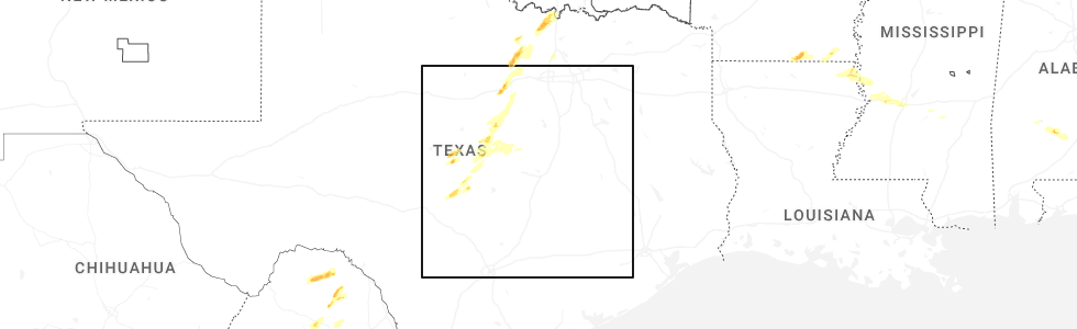
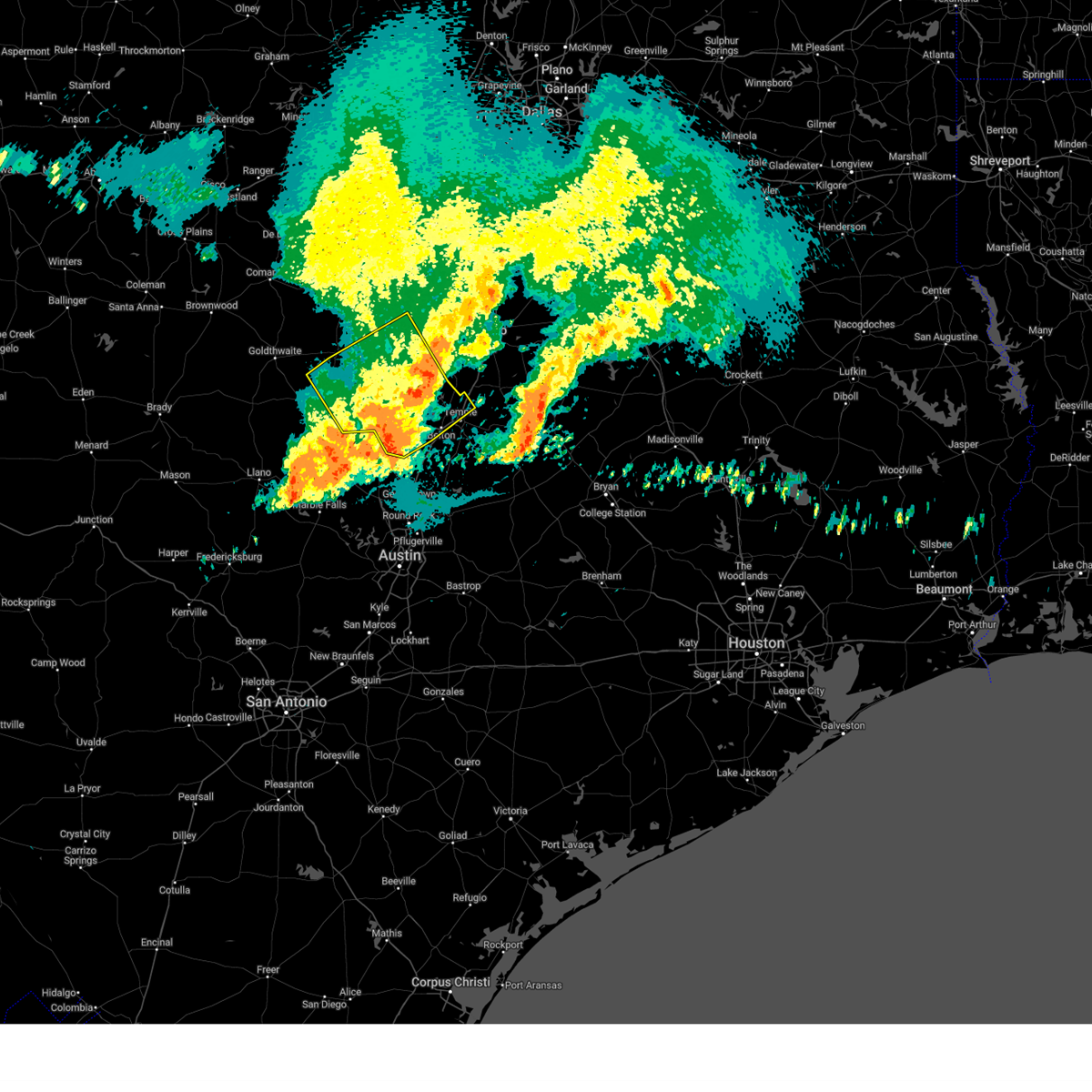
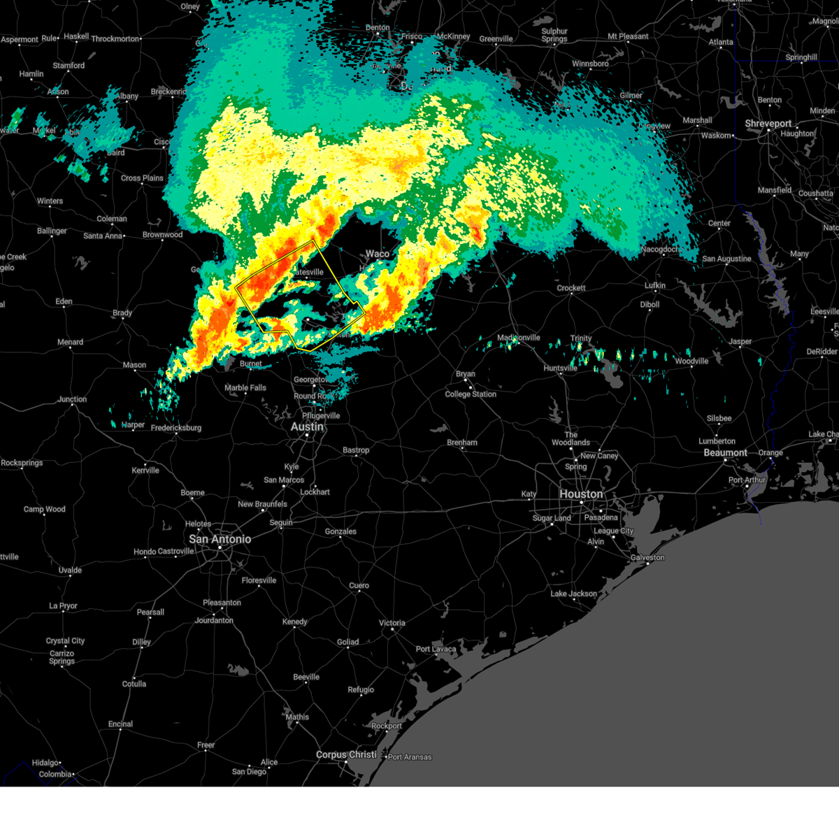
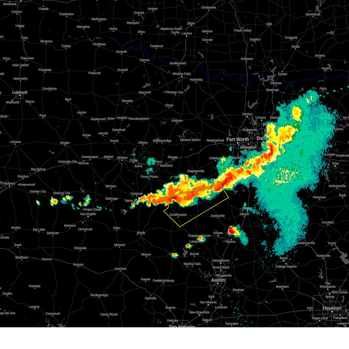
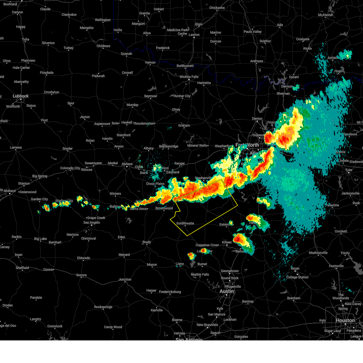
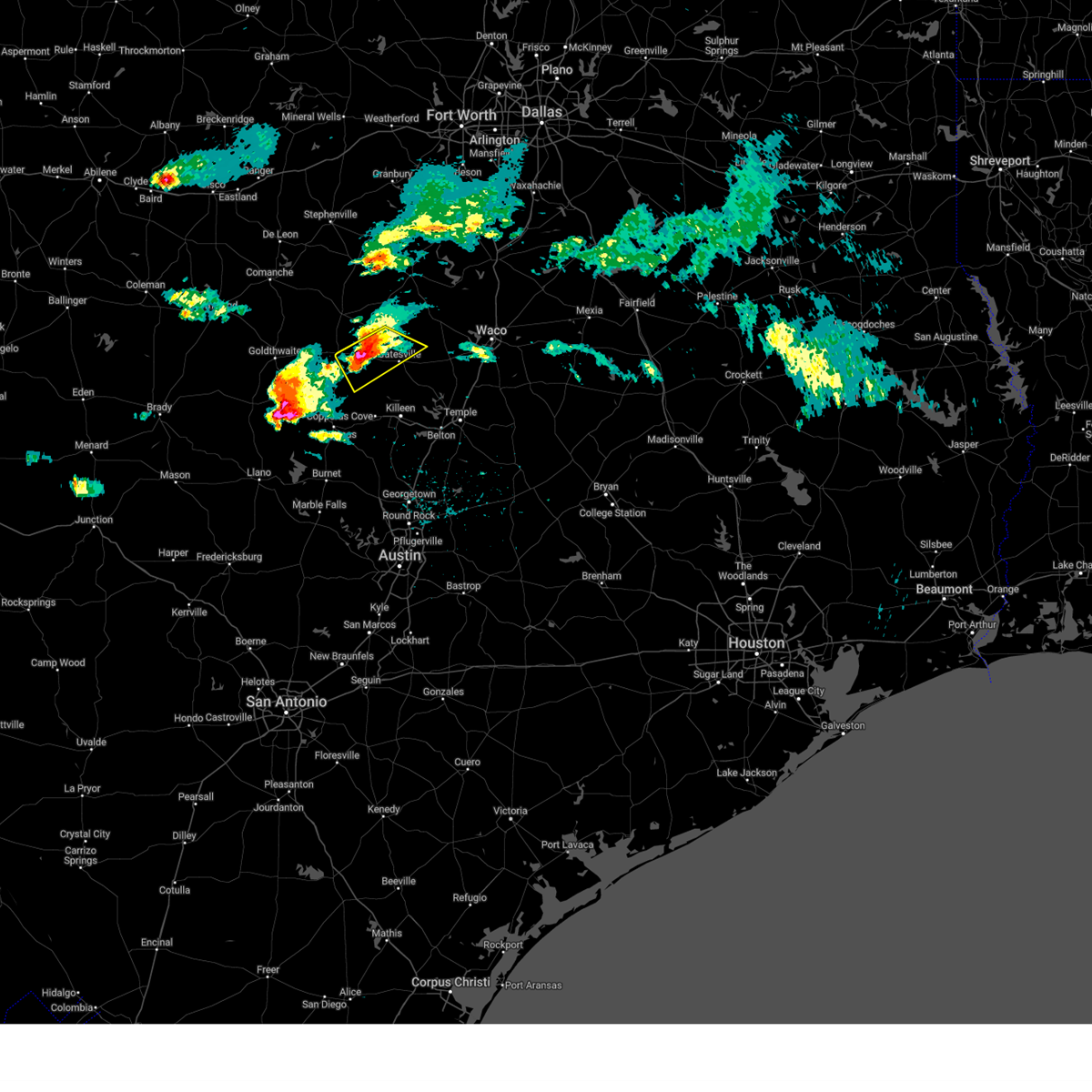
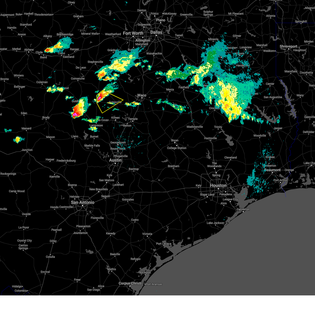
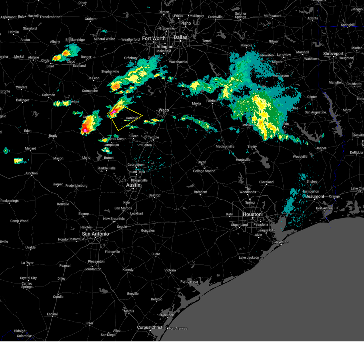
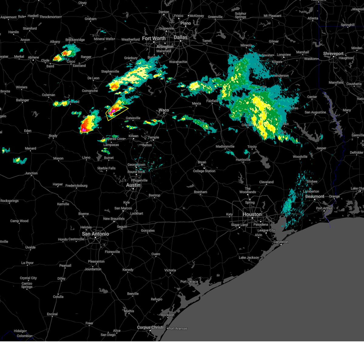
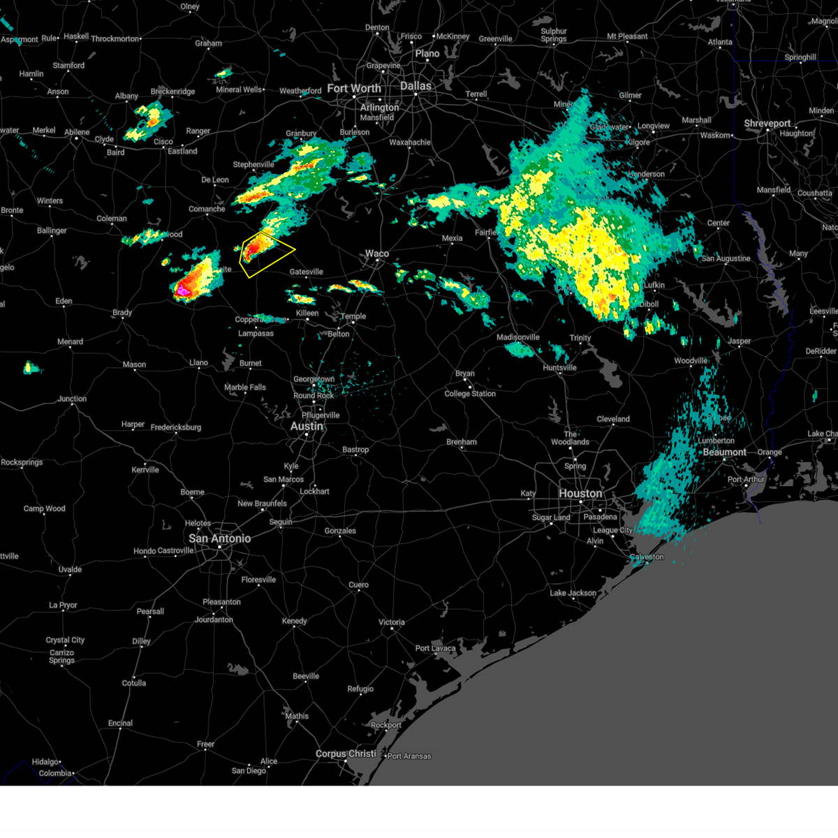
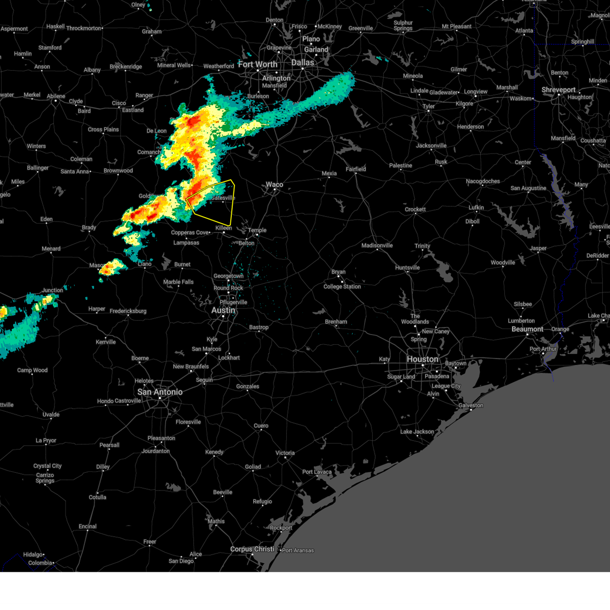
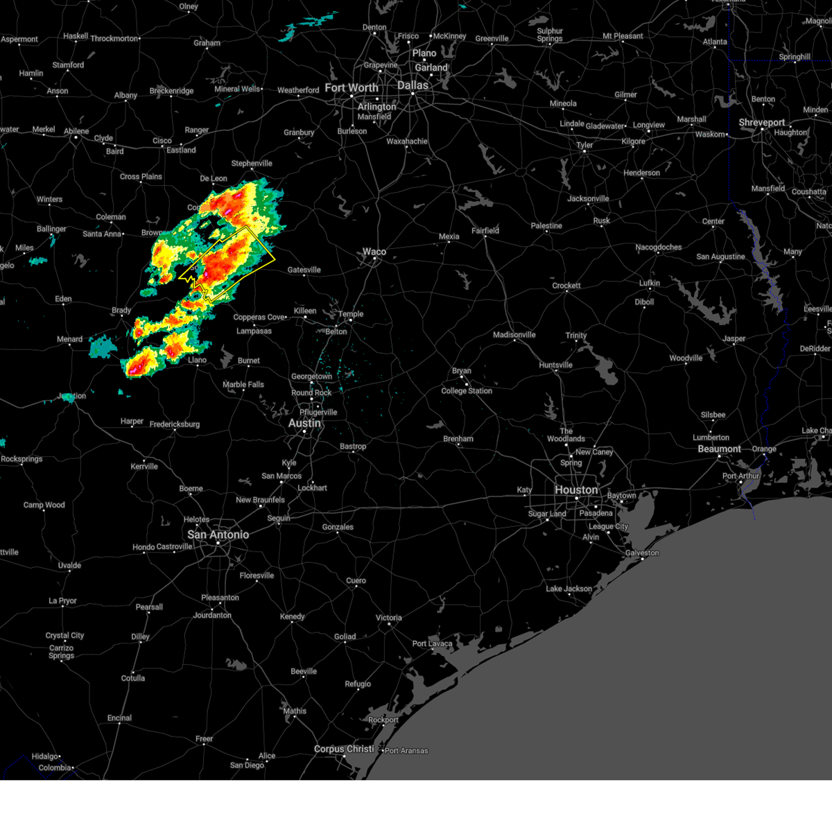
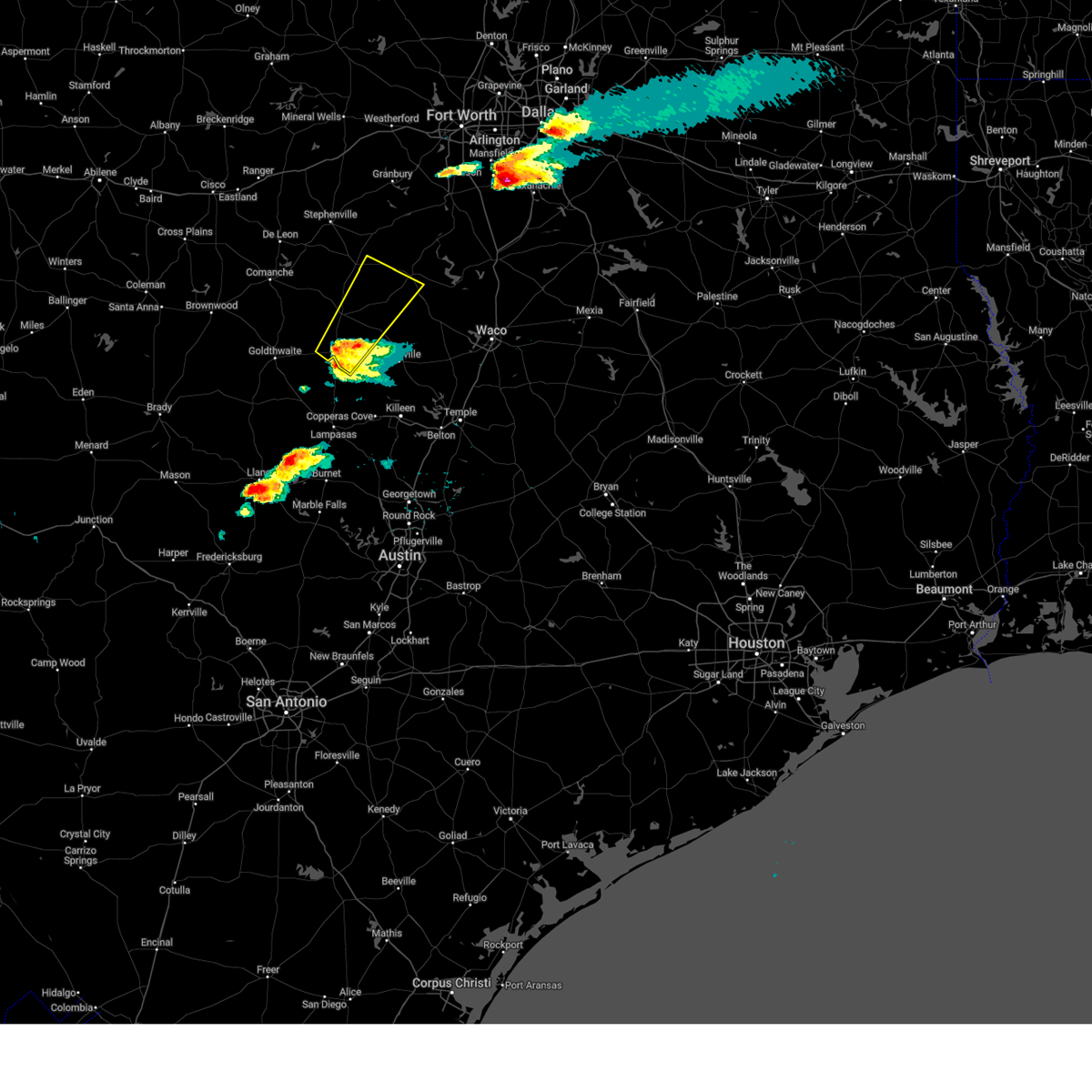
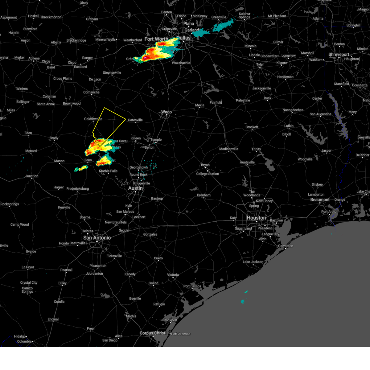
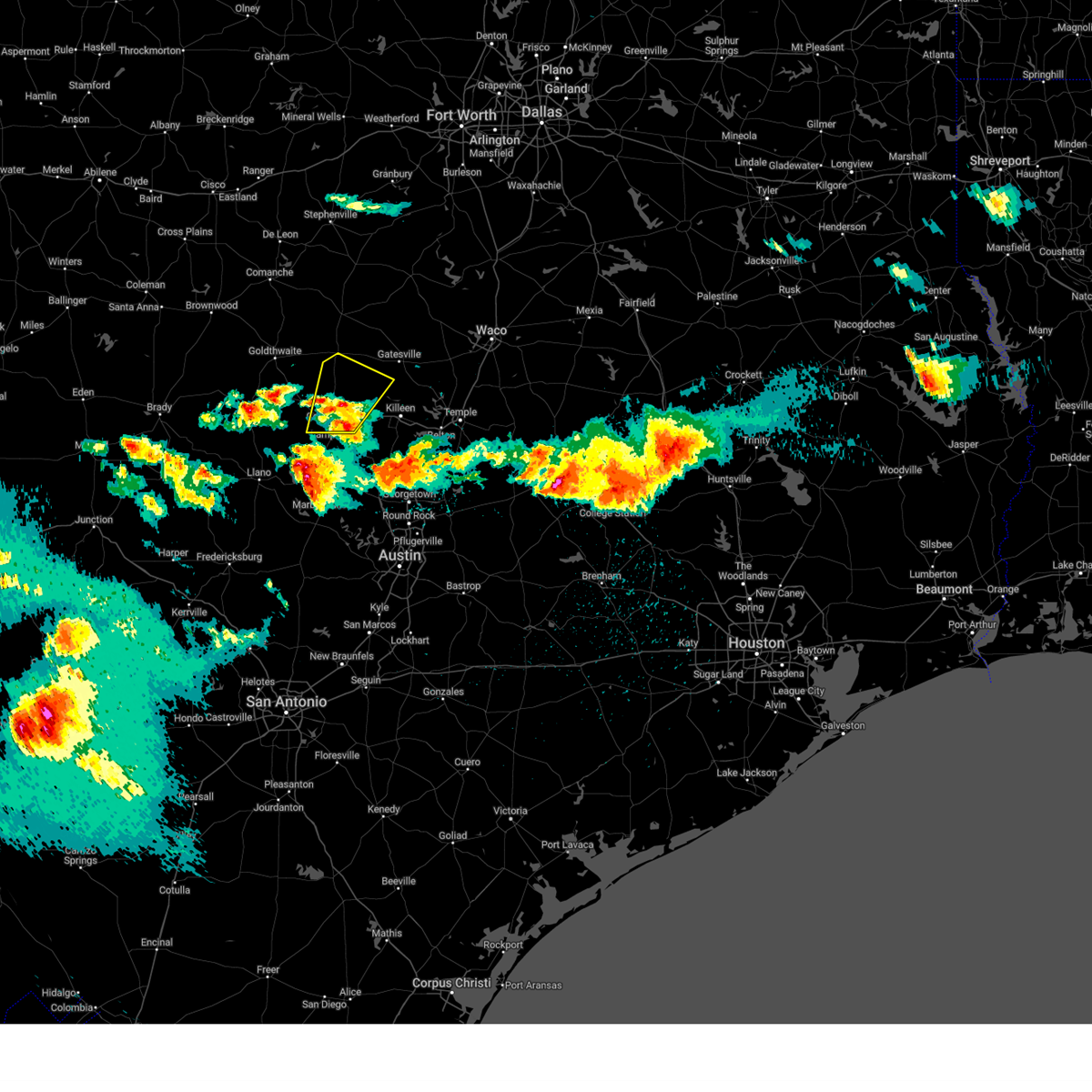
Hail Map for Evant, TX
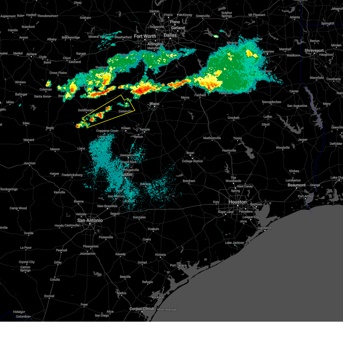
The Evant, TX area has had 20 reports of on-the-ground hail by trained spotters, and has been under severe weather warnings 36 times during the past 12 months. Doppler radar has detected hail at or near Evant, TX on 70 occasions, including 4 occasions during the past year.
| Name: | Evant, TX |
| Where Located: | 35.2 miles NW of Killeen, TX |
| Map: | Google Map for Evant, TX |
| Population: | 426 |
| Housing Units: | 199 |
| More Info: | Search Google for Evant, TX |
1
The Top Recent Hail Date for Evant, TX is Saturday, May 17, 2025 (19th out of 70)
Hail and Wind Damage Spotted near Evant, TX
| Date / Time | Report Details |
|---|---|
| 6/10/2025 8:06 AM CDT |
 At 805 am cdt, a severe thunderstorm was located near hamilton, moving east at 35 mph (radar indicated). Hazards include 60 mph wind gusts and quarter size hail. Hail damage to vehicles is expected. expect wind damage to roofs, siding, and trees. this severe storm will be near, hamilton around 810 am cdt. Other locations impacted by this severe thunderstorm include pancake, shive, moline, izoro, purmela, adamsville, whiteway, aleman, indian gap, and arnett. At 805 am cdt, a severe thunderstorm was located near hamilton, moving east at 35 mph (radar indicated). Hazards include 60 mph wind gusts and quarter size hail. Hail damage to vehicles is expected. expect wind damage to roofs, siding, and trees. this severe storm will be near, hamilton around 810 am cdt. Other locations impacted by this severe thunderstorm include pancake, shive, moline, izoro, purmela, adamsville, whiteway, aleman, indian gap, and arnett.
|
| 6/10/2025 8:06 AM CDT |
 the severe thunderstorm warning has been cancelled and is no longer in effect the severe thunderstorm warning has been cancelled and is no longer in effect
|
| 6/10/2025 7:47 AM CDT |
 Svrfwd the national weather service in fort worth has issued a * severe thunderstorm warning for, hamilton county in central texas, western coryell county in central texas, central lampasas county in central texas, mills county in central texas, south central comanche county in central texas, * until 830 am cdt. * at 746 am cdt, a severe thunderstorm was located 13 miles south of gustine, or 16 miles west of hamilton, moving east at 50 mph (radar indicated). Hazards include 60 mph wind gusts and quarter size hail. Hail damage to vehicles is expected. expect wind damage to roofs, siding, and trees. this severe thunderstorm will be near, hamilton around 800 am cdt. Other locations impacted by this severe thunderstorm include pancake, shive, moline, izoro, bozar, adamsville, whiteway, levita, center city, and south purmela. Svrfwd the national weather service in fort worth has issued a * severe thunderstorm warning for, hamilton county in central texas, western coryell county in central texas, central lampasas county in central texas, mills county in central texas, south central comanche county in central texas, * until 830 am cdt. * at 746 am cdt, a severe thunderstorm was located 13 miles south of gustine, or 16 miles west of hamilton, moving east at 50 mph (radar indicated). Hazards include 60 mph wind gusts and quarter size hail. Hail damage to vehicles is expected. expect wind damage to roofs, siding, and trees. this severe thunderstorm will be near, hamilton around 800 am cdt. Other locations impacted by this severe thunderstorm include pancake, shive, moline, izoro, bozar, adamsville, whiteway, levita, center city, and south purmela.
|
| 6/9/2025 4:03 AM CDT |
 the severe thunderstorm warning has been cancelled and is no longer in effect the severe thunderstorm warning has been cancelled and is no longer in effect
|
| 6/9/2025 3:37 AM CDT |
 Svrfwd the national weather service in fort worth has issued a * severe thunderstorm warning for, coryell county in central texas, eastern lampasas county in central texas, central bell county in central texas, * until 430 am cdt. * at 336 am cdt, severe thunderstorms were located along a line extending from 7 miles south of clifton to 9 miles west of gatesville to 11 miles north of lampasas, moving southeast at 50 mph (radar indicated). Hazards include 60 mph wind gusts and nickel size hail. expect damage to roofs, siding, and trees Svrfwd the national weather service in fort worth has issued a * severe thunderstorm warning for, coryell county in central texas, eastern lampasas county in central texas, central bell county in central texas, * until 430 am cdt. * at 336 am cdt, severe thunderstorms were located along a line extending from 7 miles south of clifton to 9 miles west of gatesville to 11 miles north of lampasas, moving southeast at 50 mph (radar indicated). Hazards include 60 mph wind gusts and nickel size hail. expect damage to roofs, siding, and trees
|
| 6/4/2025 12:04 AM CDT |
 At 1204 am cdt, severe thunderstorms were located along a line extending from meridian to near zephyr, moving southeast at 30 mph (radar indicated). Hazards include 60 mph wind gusts and quarter size hail. Hail damage to vehicles is expected. expect wind damage to roofs, siding, and trees. Locations impacted include, shive, goldthwaite, meridian state park, olin, bozar, whiteway, iredell, center city, energy, star, democrat, hamilton, gentrys mill, carlton, gustine, lamkin, mullin, cranfills gap, clifton, and priddy. At 1204 am cdt, severe thunderstorms were located along a line extending from meridian to near zephyr, moving southeast at 30 mph (radar indicated). Hazards include 60 mph wind gusts and quarter size hail. Hail damage to vehicles is expected. expect wind damage to roofs, siding, and trees. Locations impacted include, shive, goldthwaite, meridian state park, olin, bozar, whiteway, iredell, center city, energy, star, democrat, hamilton, gentrys mill, carlton, gustine, lamkin, mullin, cranfills gap, clifton, and priddy.
|
| 6/4/2025 12:04 AM CDT |
 the severe thunderstorm warning has been cancelled and is no longer in effect the severe thunderstorm warning has been cancelled and is no longer in effect
|
| 6/3/2025 11:28 PM CDT |
 Svrfwd the national weather service in fort worth has issued a * severe thunderstorm warning for, southwestern somervell county in north central texas, hamilton county in central texas, southeastern erath county in north central texas, western bosque county in central texas, mills county in central texas, southern comanche county in central texas, * until 1245 am cdt. * at 1128 pm cdt, severe thunderstorms were located along a line extending from iredell to near early, moving southeast at 20 mph (radar indicated). Hazards include 60 mph wind gusts and quarter size hail. Hail damage to vehicles is expected. Expect wind damage to roofs, siding, and trees. Svrfwd the national weather service in fort worth has issued a * severe thunderstorm warning for, southwestern somervell county in north central texas, hamilton county in central texas, southeastern erath county in north central texas, western bosque county in central texas, mills county in central texas, southern comanche county in central texas, * until 1245 am cdt. * at 1128 pm cdt, severe thunderstorms were located along a line extending from iredell to near early, moving southeast at 20 mph (radar indicated). Hazards include 60 mph wind gusts and quarter size hail. Hail damage to vehicles is expected. Expect wind damage to roofs, siding, and trees.
|
| 5/28/2025 4:12 PM CDT |
 At 411 pm cdt, a severe thunderstorm was located 10 miles east of evant, or 15 miles west of gatesville, moving southeast at 15 mph (radar indicated). Hazards include golf ball size hail and 65 mph wind gusts. People and animals outdoors will be injured. expect hail damage to roofs, siding, windows, and vehicles. expect wind damage to roofs, siding, and trees. Locations impacted include, purmela, arnett, levita, pearl, south purmela, king, bee house, evant, ireland, gatesville, osage, coryell city, pancake, jonesboro, and south mountain. At 411 pm cdt, a severe thunderstorm was located 10 miles east of evant, or 15 miles west of gatesville, moving southeast at 15 mph (radar indicated). Hazards include golf ball size hail and 65 mph wind gusts. People and animals outdoors will be injured. expect hail damage to roofs, siding, windows, and vehicles. expect wind damage to roofs, siding, and trees. Locations impacted include, purmela, arnett, levita, pearl, south purmela, king, bee house, evant, ireland, gatesville, osage, coryell city, pancake, jonesboro, and south mountain.
|
| 5/28/2025 4:12 PM CDT |
 the severe thunderstorm warning has been cancelled and is no longer in effect the severe thunderstorm warning has been cancelled and is no longer in effect
|
| 5/28/2025 3:50 PM CDT |
 At 350 pm cdt, a severe thunderstorm was located just northeast of evant, or 12 miles south of hamilton, moving southeast at 15 mph (radar indicated). Hazards include two inch hail and 60 mph wind gusts. People and animals outdoors will be injured. expect hail damage to roofs, siding, windows, and vehicles. expect wind damage to roofs, siding, and trees. Locations impacted include, purmela, whiteway, aleman, arnett, levita, pearl, south purmela, king, bee house, evant, jonesboro, ireland, gatesville, pancake, osage, coryell city, and south mountain. At 350 pm cdt, a severe thunderstorm was located just northeast of evant, or 12 miles south of hamilton, moving southeast at 15 mph (radar indicated). Hazards include two inch hail and 60 mph wind gusts. People and animals outdoors will be injured. expect hail damage to roofs, siding, windows, and vehicles. expect wind damage to roofs, siding, and trees. Locations impacted include, purmela, whiteway, aleman, arnett, levita, pearl, south purmela, king, bee house, evant, jonesboro, ireland, gatesville, pancake, osage, coryell city, and south mountain.
|
| 5/28/2025 3:40 PM CDT | Ping Pong Ball sized hail reported 0.2 miles SSE of Evant, TX |
| 5/28/2025 3:40 PM CDT |
 Svrfwd the national weather service in fort worth has issued a * severe thunderstorm warning for, southeastern hamilton county in central texas, northern coryell county in central texas, * until 445 pm cdt. * at 339 pm cdt, a severe thunderstorm was located just north of evant, or 10 miles south of hamilton, moving southeast at 15 mph (radar indicated). Hazards include baseball size hail and 60 mph wind gusts. People and animals outdoors will be severely injured. expect shattered windows, extensive damage to roofs, siding, and vehicles. This severe thunderstorm will remain over mainly rural areas of southeastern hamilton and northern coryell counties, including the following locations, purmela, whiteway, aleman, arnett, levita, pearl, south purmela, king, bee house, and jonesboro. Svrfwd the national weather service in fort worth has issued a * severe thunderstorm warning for, southeastern hamilton county in central texas, northern coryell county in central texas, * until 445 pm cdt. * at 339 pm cdt, a severe thunderstorm was located just north of evant, or 10 miles south of hamilton, moving southeast at 15 mph (radar indicated). Hazards include baseball size hail and 60 mph wind gusts. People and animals outdoors will be severely injured. expect shattered windows, extensive damage to roofs, siding, and vehicles. This severe thunderstorm will remain over mainly rural areas of southeastern hamilton and northern coryell counties, including the following locations, purmela, whiteway, aleman, arnett, levita, pearl, south purmela, king, bee house, and jonesboro.
|
| 5/28/2025 3:36 PM CDT |
 At 335 pm cdt, a severe thunderstorm was located near evant, or 9 miles south of hamilton, moving southeast at 15 mph. this is a destructive storm for areas along highway 281 between hamilton and evant (radar indicated). Hazards include baseball size hail and 60 mph wind gusts. People and animals outdoors will be severely injured. expect shattered windows, extensive damage to roofs, siding, and vehicles. Locations impacted include, shive, whiteway, aleman, evant, jonesboro, and hamilton. At 335 pm cdt, a severe thunderstorm was located near evant, or 9 miles south of hamilton, moving southeast at 15 mph. this is a destructive storm for areas along highway 281 between hamilton and evant (radar indicated). Hazards include baseball size hail and 60 mph wind gusts. People and animals outdoors will be severely injured. expect shattered windows, extensive damage to roofs, siding, and vehicles. Locations impacted include, shive, whiteway, aleman, evant, jonesboro, and hamilton.
|
| 5/28/2025 3:24 PM CDT |
 At 324 pm cdt, a severe thunderstorm was located 8 miles southwest of hamilton, moving southeast at 15 mph (radar indicated). Hazards include ping pong ball size hail and 60 mph wind gusts. People and animals outdoors will be injured. expect hail damage to roofs, siding, windows, and vehicles. expect wind damage to roofs, siding, and trees. This severe thunderstorm will remain over mainly rural areas of southern hamilton county, including the following locations, shive, whiteway, aleman, and jonesboro. At 324 pm cdt, a severe thunderstorm was located 8 miles southwest of hamilton, moving southeast at 15 mph (radar indicated). Hazards include ping pong ball size hail and 60 mph wind gusts. People and animals outdoors will be injured. expect hail damage to roofs, siding, windows, and vehicles. expect wind damage to roofs, siding, and trees. This severe thunderstorm will remain over mainly rural areas of southern hamilton county, including the following locations, shive, whiteway, aleman, and jonesboro.
|
| 5/28/2025 3:03 PM CDT |
 At 303 pm cdt, a severe thunderstorm was located 8 miles west of hamilton, moving southeast at 15 mph (radar indicated). Hazards include 60 mph wind gusts and half dollar size hail. Hail damage to vehicles is expected. expect wind damage to roofs, siding, and trees. this severe storm will be near, hamilton around 315 pm cdt. Other locations impacted by this severe thunderstorm include shive, pottsville, gentrys mill, whiteway, aleman, pecan wells, and jonesboro. At 303 pm cdt, a severe thunderstorm was located 8 miles west of hamilton, moving southeast at 15 mph (radar indicated). Hazards include 60 mph wind gusts and half dollar size hail. Hail damage to vehicles is expected. expect wind damage to roofs, siding, and trees. this severe storm will be near, hamilton around 315 pm cdt. Other locations impacted by this severe thunderstorm include shive, pottsville, gentrys mill, whiteway, aleman, pecan wells, and jonesboro.
|
| 5/28/2025 2:51 PM CDT |
 Svrfwd the national weather service in fort worth has issued a * severe thunderstorm warning for, southern hamilton county in central texas, * until 345 pm cdt. * at 251 pm cdt, a severe thunderstorm was located 10 miles west of hamilton, moving southeast at 15 mph (radar indicated). Hazards include 60 mph wind gusts and half dollar size hail. Hail damage to vehicles is expected. expect wind damage to roofs, siding, and trees. this severe thunderstorm will be near, hamilton around 315 pm cdt. Other locations impacted by this severe thunderstorm include shive, pottsville, gentrys mill, whiteway, aleman, pecan wells, indian gap, and jonesboro. Svrfwd the national weather service in fort worth has issued a * severe thunderstorm warning for, southern hamilton county in central texas, * until 345 pm cdt. * at 251 pm cdt, a severe thunderstorm was located 10 miles west of hamilton, moving southeast at 15 mph (radar indicated). Hazards include 60 mph wind gusts and half dollar size hail. Hail damage to vehicles is expected. expect wind damage to roofs, siding, and trees. this severe thunderstorm will be near, hamilton around 315 pm cdt. Other locations impacted by this severe thunderstorm include shive, pottsville, gentrys mill, whiteway, aleman, pecan wells, indian gap, and jonesboro.
|
| 5/17/2025 4:39 PM CDT |
 The storms which prompted the warning have weakened below severe limits. therefore the warning will be allowed to expire. however small hail and heavy rain are still possible with these thunderstorms. a severe thunderstorm watch remains in effect until 1000 pm cdt for central texas. The storms which prompted the warning have weakened below severe limits. therefore the warning will be allowed to expire. however small hail and heavy rain are still possible with these thunderstorms. a severe thunderstorm watch remains in effect until 1000 pm cdt for central texas.
|
| 5/17/2025 4:24 PM CDT |
 Svrfwd the national weather service in fort worth has issued a * severe thunderstorm warning for, coryell county in central texas, * until 515 pm cdt. * at 424 pm cdt, a severe thunderstorm was located near evant, or 18 miles south of hamilton, moving east at 35 mph (radar indicated). Hazards include 60 mph wind gusts and quarter size hail. Hail damage to vehicles is expected. expect wind damage to roofs, siding, and trees. this severe thunderstorm will be near, gatesville around 450 pm cdt. fort gates around 500 pm cdt. Other locations impacted by this severe thunderstorm include pancake, coryell city, south mountain, purmela, arnett, levita, pearl, south purmela, king, and bee house. Svrfwd the national weather service in fort worth has issued a * severe thunderstorm warning for, coryell county in central texas, * until 515 pm cdt. * at 424 pm cdt, a severe thunderstorm was located near evant, or 18 miles south of hamilton, moving east at 35 mph (radar indicated). Hazards include 60 mph wind gusts and quarter size hail. Hail damage to vehicles is expected. expect wind damage to roofs, siding, and trees. this severe thunderstorm will be near, gatesville around 450 pm cdt. fort gates around 500 pm cdt. Other locations impacted by this severe thunderstorm include pancake, coryell city, south mountain, purmela, arnett, levita, pearl, south purmela, king, and bee house.
|
| 5/17/2025 4:15 PM CDT |
 At 415 pm cdt, severe thunderstorms were located along a line extending from near evant to 9 miles south of goldthwaite, moving east at 30 mph (radar indicated). Hazards include 60 mph wind gusts and half dollar size hail. Hail damage to vehicles is expected. expect wind damage to roofs, siding, and trees. these severe storms will be near, evant around 420 pm cdt. Other locations impacted by these severe thunderstorms include star, shive, and center city. At 415 pm cdt, severe thunderstorms were located along a line extending from near evant to 9 miles south of goldthwaite, moving east at 30 mph (radar indicated). Hazards include 60 mph wind gusts and half dollar size hail. Hail damage to vehicles is expected. expect wind damage to roofs, siding, and trees. these severe storms will be near, evant around 420 pm cdt. Other locations impacted by these severe thunderstorms include star, shive, and center city.
|
| 5/17/2025 3:40 PM CDT |
 Svrfwd the national weather service in fort worth has issued a * severe thunderstorm warning for, southwestern hamilton county in central texas, mills county in central texas, * until 445 pm cdt. * at 340 pm cdt, a severe thunderstorm was located over goldthwaite, or 19 miles northeast of san saba, moving northeast at 25 mph (radar indicated). Hazards include 60 mph wind gusts and half dollar size hail. Hail damage to vehicles is expected. expect wind damage to roofs, siding, and trees. this severe thunderstorm will be near, goldthwaite around 345 pm cdt. Other locations impacted by this severe thunderstorm include shive, center city, star, pottsville, bozar, priddy, pecan wells, indian gap, and caradan. Svrfwd the national weather service in fort worth has issued a * severe thunderstorm warning for, southwestern hamilton county in central texas, mills county in central texas, * until 445 pm cdt. * at 340 pm cdt, a severe thunderstorm was located over goldthwaite, or 19 miles northeast of san saba, moving northeast at 25 mph (radar indicated). Hazards include 60 mph wind gusts and half dollar size hail. Hail damage to vehicles is expected. expect wind damage to roofs, siding, and trees. this severe thunderstorm will be near, goldthwaite around 345 pm cdt. Other locations impacted by this severe thunderstorm include shive, center city, star, pottsville, bozar, priddy, pecan wells, indian gap, and caradan.
|
| 5/16/2025 7:12 PM CDT |
 Svrfwd the national weather service in fort worth has issued a * severe thunderstorm warning for, hamilton county in central texas, northwestern coryell county in central texas, southwestern bosque county in central texas, * until 815 pm cdt. * at 712 pm cdt, a severe thunderstorm was located over evant, or 13 miles south of hamilton, moving northeast at 35 mph (radar indicated). Hazards include 60 mph wind gusts and quarter size hail. Hail damage to vehicles is expected. expect wind damage to roofs, siding, and trees. this severe thunderstorm will be near, cranfills gap around 750 pm cdt. Other locations impacted by this severe thunderstorm include pearl, south purmela, bee house, jonesboro, ireland, purmela, whiteway, aleman, fairy, and norse. Svrfwd the national weather service in fort worth has issued a * severe thunderstorm warning for, hamilton county in central texas, northwestern coryell county in central texas, southwestern bosque county in central texas, * until 815 pm cdt. * at 712 pm cdt, a severe thunderstorm was located over evant, or 13 miles south of hamilton, moving northeast at 35 mph (radar indicated). Hazards include 60 mph wind gusts and quarter size hail. Hail damage to vehicles is expected. expect wind damage to roofs, siding, and trees. this severe thunderstorm will be near, cranfills gap around 750 pm cdt. Other locations impacted by this severe thunderstorm include pearl, south purmela, bee house, jonesboro, ireland, purmela, whiteway, aleman, fairy, and norse.
|
| 5/16/2025 7:05 PM CDT | At 705 pm cdt, a severe thunderstorm was located near evant, or 21 miles south of hamilton, moving northeast at 30 mph (radar indicated). Hazards include 60 mph wind gusts and quarter size hail. Hail damage to vehicles is expected. expect wind damage to roofs, siding, and trees. Locations impacted include, pearl, shive, moline, south purmela, bee house, evant, star, purmela, and adamsville. |
| 5/16/2025 6:49 PM CDT | Half Dollar sized hail reported 5.3 miles N of Evant, TX, photo of quarter to half dollar hail. |
| 5/16/2025 6:37 PM CDT | At 637 pm cdt, a severe thunderstorm was located near lometa, or 17 miles northwest of lampasas, moving northeast at 35 mph (radar indicated). Hazards include ping pong ball size hail and 60 mph wind gusts. People and animals outdoors will be injured. expect hail damage to roofs, siding, windows, and vehicles. expect wind damage to roofs, siding, and trees. Locations impacted include, shive, moline, purmela, adamsville, pearl, center city, south purmela, bee house, evant, star, lometa, pecan wells, and pottsville. |
| 5/16/2025 6:17 PM CDT |
 At 616 pm cdt, a severe thunderstorm was located over bend, or 13 miles east of san saba, moving northeast at 40 mph (radar indicated). Hazards include golf ball size hail and 60 mph wind gusts. People and animals outdoors will be injured. expect hail damage to roofs, siding, windows, and vehicles. expect wind damage to roofs, siding, and trees. Locations impacted include, shive, moline, purmela, adamsville, pearl, center city, south purmela, bee house, evant, star, lometa, nix, pecan wells, pottsville, and colorado bend state park. At 616 pm cdt, a severe thunderstorm was located over bend, or 13 miles east of san saba, moving northeast at 40 mph (radar indicated). Hazards include golf ball size hail and 60 mph wind gusts. People and animals outdoors will be injured. expect hail damage to roofs, siding, windows, and vehicles. expect wind damage to roofs, siding, and trees. Locations impacted include, shive, moline, purmela, adamsville, pearl, center city, south purmela, bee house, evant, star, lometa, nix, pecan wells, pottsville, and colorado bend state park.
|
| 5/16/2025 6:11 PM CDT | Svrfwd the national weather service in fort worth has issued a * severe thunderstorm warning for, southwestern hamilton county in central texas, west central coryell county in central texas, western lampasas county in central texas, southeastern mills county in central texas, * until 715 pm cdt. * at 610 pm cdt, a severe thunderstorm was located over chappel, or 12 miles southeast of san saba, moving northeast at 40 mph (radar indicated). Hazards include 60 mph wind gusts and half dollar size hail. Hail damage to vehicles is expected. Expect wind damage to roofs, siding, and trees. |
| 5/1/2025 6:57 PM CDT |
 the severe thunderstorm warning has been cancelled and is no longer in effect the severe thunderstorm warning has been cancelled and is no longer in effect
|
| 5/1/2025 6:39 PM CDT |
 Svrfwd the national weather service in fort worth has issued a * severe thunderstorm warning for, southwestern coryell county in central texas, lampasas county in central texas, * until 730 pm cdt. * at 639 pm cdt, a severe thunderstorm was located over lampasas, moving northeast at 35 mph (radar indicated). Hazards include 60 mph wind gusts and half dollar size hail. Hail damage to vehicles is expected. expect wind damage to roofs, siding, and trees. this severe thunderstorm will be near, lampasas around 645 pm cdt. Other locations impacted by this severe thunderstorm include pearl, king, bee house, topsey, izoro, rumley, adamsville, and pidcoke. Svrfwd the national weather service in fort worth has issued a * severe thunderstorm warning for, southwestern coryell county in central texas, lampasas county in central texas, * until 730 pm cdt. * at 639 pm cdt, a severe thunderstorm was located over lampasas, moving northeast at 35 mph (radar indicated). Hazards include 60 mph wind gusts and half dollar size hail. Hail damage to vehicles is expected. expect wind damage to roofs, siding, and trees. this severe thunderstorm will be near, lampasas around 645 pm cdt. Other locations impacted by this severe thunderstorm include pearl, king, bee house, topsey, izoro, rumley, adamsville, and pidcoke.
|
| 3/30/2025 6:30 AM CDT |
 the severe thunderstorm warning has been cancelled and is no longer in effect the severe thunderstorm warning has been cancelled and is no longer in effect
|
| 3/30/2025 6:16 AM CDT |
 the severe thunderstorm warning has been cancelled and is no longer in effect the severe thunderstorm warning has been cancelled and is no longer in effect
|
| 3/30/2025 6:16 AM CDT |
 At 616 am cdt, a severe thunderstorm was located 8 miles southeast of evant, or 17 miles west of gatesville, moving east at 45 mph (radar indicated). Hazards include quarter size hail. Damage to vehicles is possible. this severe storm will be near, gatesville around 630 am cdt. Other locations impacted by this severe thunderstorm include pancake, coryell city, purmela, arnett, levita, hurst springs, pearl, south purmela, king, and bee house. At 616 am cdt, a severe thunderstorm was located 8 miles southeast of evant, or 17 miles west of gatesville, moving east at 45 mph (radar indicated). Hazards include quarter size hail. Damage to vehicles is possible. this severe storm will be near, gatesville around 630 am cdt. Other locations impacted by this severe thunderstorm include pancake, coryell city, purmela, arnett, levita, hurst springs, pearl, south purmela, king, and bee house.
|
| 3/30/2025 6:01 AM CDT |
 Svrfwd the national weather service in fort worth has issued a * severe thunderstorm warning for, southeastern hamilton county in central texas, northern coryell county in central texas, northwestern lampasas county in central texas, southeastern mills county in central texas, * until 700 am cdt. * at 600 am cdt, severe thunderstorms were located along a line extending from near evant to san saba, moving east at 40 mph (radar indicated). Hazards include quarter size hail. Damage to vehicles is possible. severe thunderstorms will be near, evant around 605 am cdt. Other locations impacted by these severe thunderstorms include pancake, moline, coryell city, purmela, adamsville, whiteway, aleman, arnett, levita, and hurst springs. Svrfwd the national weather service in fort worth has issued a * severe thunderstorm warning for, southeastern hamilton county in central texas, northern coryell county in central texas, northwestern lampasas county in central texas, southeastern mills county in central texas, * until 700 am cdt. * at 600 am cdt, severe thunderstorms were located along a line extending from near evant to san saba, moving east at 40 mph (radar indicated). Hazards include quarter size hail. Damage to vehicles is possible. severe thunderstorms will be near, evant around 605 am cdt. Other locations impacted by these severe thunderstorms include pancake, moline, coryell city, purmela, adamsville, whiteway, aleman, arnett, levita, and hurst springs.
|
| 3/4/2025 5:42 AM CST |
 The storms which prompted the warning have weakened below severe limits, and have exited the warned area. therefore the warning will be allowed to expire. a tornado watch remains in effect until 1100 am cst for central texas. The storms which prompted the warning have weakened below severe limits, and have exited the warned area. therefore the warning will be allowed to expire. a tornado watch remains in effect until 1100 am cst for central texas.
|
| 3/4/2025 5:06 AM CST |
 At 505 am cst, severe thunderstorms were located along a line extending from 14 miles northwest of evant to 11 miles northeast of bend to near colorado bend state park, moving east at 55 mph (radar indicated). Hazards include 60 mph wind gusts and quarter size hail. Hail damage to vehicles is expected. expect wind damage to roofs, siding, and trees. these severe storms will be near, lampasas and evant around 515 am cst. hamilton around 520 am cst. copperas cove and kempner around 530 am cst. Other locations impacted by these severe thunderstorms include shive, moline, izoro, rumley, purmela, adamsville, whiteway, aleman, pearl, and center city. At 505 am cst, severe thunderstorms were located along a line extending from 14 miles northwest of evant to 11 miles northeast of bend to near colorado bend state park, moving east at 55 mph (radar indicated). Hazards include 60 mph wind gusts and quarter size hail. Hail damage to vehicles is expected. expect wind damage to roofs, siding, and trees. these severe storms will be near, lampasas and evant around 515 am cst. hamilton around 520 am cst. copperas cove and kempner around 530 am cst. Other locations impacted by these severe thunderstorms include shive, moline, izoro, rumley, purmela, adamsville, whiteway, aleman, pearl, and center city.
|
| 3/4/2025 4:38 AM CST |
 Svrfwd the national weather service in fort worth has issued a * severe thunderstorm warning for, southwestern hamilton county in central texas, western coryell county in central texas, lampasas county in central texas, mills county in central texas, * until 545 am cst. * at 438 am cst, severe thunderstorms were located along a line extending from 8 miles southwest of mullin to near cherokee, moving east at 50 mph (radar indicated). Hazards include 60 mph wind gusts and quarter size hail. Hail damage to vehicles is expected. expect wind damage to roofs, siding, and trees. severe thunderstorms will be near, goldthwaite around 445 am cst. bend around 450 am cst. colorado bend state park around 455 am cst. lampasas and evant around 515 am cst. copperas cove and kempner around 530 am cst. Other locations impacted by these severe thunderstorms include regency, shive, moline, izoro, rumley, bozar, purmela, adamsville, whiteway, and aleman. Svrfwd the national weather service in fort worth has issued a * severe thunderstorm warning for, southwestern hamilton county in central texas, western coryell county in central texas, lampasas county in central texas, mills county in central texas, * until 545 am cst. * at 438 am cst, severe thunderstorms were located along a line extending from 8 miles southwest of mullin to near cherokee, moving east at 50 mph (radar indicated). Hazards include 60 mph wind gusts and quarter size hail. Hail damage to vehicles is expected. expect wind damage to roofs, siding, and trees. severe thunderstorms will be near, goldthwaite around 445 am cst. bend around 450 am cst. colorado bend state park around 455 am cst. lampasas and evant around 515 am cst. copperas cove and kempner around 530 am cst. Other locations impacted by these severe thunderstorms include regency, shive, moline, izoro, rumley, bozar, purmela, adamsville, whiteway, and aleman.
|
| 7/21/2024 1:54 PM CDT |
 the severe thunderstorm warning has been cancelled and is no longer in effect the severe thunderstorm warning has been cancelled and is no longer in effect
|
| 7/21/2024 1:35 PM CDT |
 Svrfwd the national weather service in fort worth has issued a * severe thunderstorm warning for, southwestern hamilton county in central texas, * until 215 pm cdt. * at 134 pm cdt, a severe thunderstorm was located 7 miles southwest of hamilton, moving southeast at 15 mph (radar indicated). Hazards include 60 mph wind gusts and quarter size hail. Hail damage to vehicles is expected. Expect wind damage to roofs, siding, and trees. Svrfwd the national weather service in fort worth has issued a * severe thunderstorm warning for, southwestern hamilton county in central texas, * until 215 pm cdt. * at 134 pm cdt, a severe thunderstorm was located 7 miles southwest of hamilton, moving southeast at 15 mph (radar indicated). Hazards include 60 mph wind gusts and quarter size hail. Hail damage to vehicles is expected. Expect wind damage to roofs, siding, and trees.
|
| 5/31/2024 2:46 AM CDT |
 Svrfwd the national weather service in fort worth has issued a * severe thunderstorm warning for, eastern hamilton county in central texas, western mclennan county in central texas, coryell county in central texas, lampasas county in central texas, bosque county in central texas, bell county in central texas, southwestern hill county in central texas, southeastern mills county in central texas, * until 330 am cdt. * at 245 am cdt, severe thunderstorms were located along a line extending from 6 miles northeast of hico to near evant to 7 miles east of san saba, moving southeast at 50 mph (radar indicated). Hazards include 65 mph wind gusts and nickel size hail. Expect damage to roofs, siding, and trees. severe thunderstorms will be near, iredell around 250 am cdt. cranfills gap around 255 am cdt. gatesville, lampasas, meridian, and meridian state park around 300 am cdt. fort gates around 305 am cdt. copperas cove, clifton, fort cavazos, and kempner around 310 am cdt. killeen, valley mills, and belton lake around 315 am cdt. harker heights, mcgregor, laguna park, crawford, and mother neff state park around 320 am cdt. nolanville and morgan's point resort around 325 am cdt. other locations impacted by these severe thunderstorms include pancake, moline, whitson, rock creek, moffat, oglesby, adamsville, whiteway, levita, and meadow grove. This includes interstate 35 between mile markers 285 and 312, and between mile markers 315 and 321. Svrfwd the national weather service in fort worth has issued a * severe thunderstorm warning for, eastern hamilton county in central texas, western mclennan county in central texas, coryell county in central texas, lampasas county in central texas, bosque county in central texas, bell county in central texas, southwestern hill county in central texas, southeastern mills county in central texas, * until 330 am cdt. * at 245 am cdt, severe thunderstorms were located along a line extending from 6 miles northeast of hico to near evant to 7 miles east of san saba, moving southeast at 50 mph (radar indicated). Hazards include 65 mph wind gusts and nickel size hail. Expect damage to roofs, siding, and trees. severe thunderstorms will be near, iredell around 250 am cdt. cranfills gap around 255 am cdt. gatesville, lampasas, meridian, and meridian state park around 300 am cdt. fort gates around 305 am cdt. copperas cove, clifton, fort cavazos, and kempner around 310 am cdt. killeen, valley mills, and belton lake around 315 am cdt. harker heights, mcgregor, laguna park, crawford, and mother neff state park around 320 am cdt. nolanville and morgan's point resort around 325 am cdt. other locations impacted by these severe thunderstorms include pancake, moline, whitson, rock creek, moffat, oglesby, adamsville, whiteway, levita, and meadow grove. This includes interstate 35 between mile markers 285 and 312, and between mile markers 315 and 321.
|
| 5/31/2024 2:42 AM CDT | Storm damage reported in hamilton county TX, 1.6 miles S of Evant, TX |
| 5/31/2024 2:42 AM CDT |
 the severe thunderstorm warning has been cancelled and is no longer in effect the severe thunderstorm warning has been cancelled and is no longer in effect
|
| 5/31/2024 2:42 AM CDT |
 At 241 am cdt, severe thunderstorms were located along a line extending from 11 miles east of stephenville to near evant to 7 miles north of san saba, moving east at 50 mph (radar indicated). Hazards include 60 mph wind gusts and nickel size hail. Expect damage to roofs, siding, and trees. these severe storms will be near, hamilton, hico, and evant around 245 am cdt. iredell around 250 am cdt. Other locations impacted by these severe thunderstorms include shive, alexander, moline, clairette, izoro, olin, adamsville, whiteway, duffau, and center city. At 241 am cdt, severe thunderstorms were located along a line extending from 11 miles east of stephenville to near evant to 7 miles north of san saba, moving east at 50 mph (radar indicated). Hazards include 60 mph wind gusts and nickel size hail. Expect damage to roofs, siding, and trees. these severe storms will be near, hamilton, hico, and evant around 245 am cdt. iredell around 250 am cdt. Other locations impacted by these severe thunderstorms include shive, alexander, moline, clairette, izoro, olin, adamsville, whiteway, duffau, and center city.
|
| 5/31/2024 2:18 AM CDT |
 Svrfwd the national weather service in fort worth has issued a * severe thunderstorm warning for, hamilton county in central texas, southern erath county in north central texas, northwestern coryell county in central texas, central lampasas county in central texas, northwestern bosque county in central texas, mills county in central texas, southeastern comanche county in central texas, * until 300 am cdt. * at 218 am cdt, severe thunderstorms were located along a line extending from near stephenville to near goldthwaite to near mercury, moving southeast at 35 mph (radar indicated). Hazards include 60 mph wind gusts and nickel size hail. Expect damage to roofs, siding, and trees. severe thunderstorms will be near, goldthwaite around 225 am cdt. hico around 240 am cdt. hamilton around 245 am cdt. Other locations impacted by these severe thunderstorms include shive, alexander, moline, clairette, izoro, olin, harbin, bozar, adamsville, and whiteway. Svrfwd the national weather service in fort worth has issued a * severe thunderstorm warning for, hamilton county in central texas, southern erath county in north central texas, northwestern coryell county in central texas, central lampasas county in central texas, northwestern bosque county in central texas, mills county in central texas, southeastern comanche county in central texas, * until 300 am cdt. * at 218 am cdt, severe thunderstorms were located along a line extending from near stephenville to near goldthwaite to near mercury, moving southeast at 35 mph (radar indicated). Hazards include 60 mph wind gusts and nickel size hail. Expect damage to roofs, siding, and trees. severe thunderstorms will be near, goldthwaite around 225 am cdt. hico around 240 am cdt. hamilton around 245 am cdt. Other locations impacted by these severe thunderstorms include shive, alexander, moline, clairette, izoro, olin, harbin, bozar, adamsville, and whiteway.
|
| 5/30/2024 11:38 PM CDT |
 The storm which prompted the warning has weakened below severe limits. therefore the warning will be allowed to expire. however small hail, gusty winds and heavy rain are still possible with this thunderstorm. The storm which prompted the warning has weakened below severe limits. therefore the warning will be allowed to expire. however small hail, gusty winds and heavy rain are still possible with this thunderstorm.
|
| 5/30/2024 11:24 PM CDT |
 the severe thunderstorm warning has been cancelled and is no longer in effect the severe thunderstorm warning has been cancelled and is no longer in effect
|
| 5/30/2024 11:24 PM CDT |
 At 1124 pm cdt, a severe thunderstorm was located 12 miles northwest of evant, or 12 miles southwest of hamilton, moving east at 40 mph (radar indicated). Hazards include 60 mph wind gusts and quarter size hail. Hail damage to vehicles is expected. expect wind damage to roofs, siding, and trees. Locations impacted include, hamilton, evant, shive, purmela, whiteway, aleman, indian gap, pearl, south purmela, bee house, ireland, pottsville, and pecan wells. At 1124 pm cdt, a severe thunderstorm was located 12 miles northwest of evant, or 12 miles southwest of hamilton, moving east at 40 mph (radar indicated). Hazards include 60 mph wind gusts and quarter size hail. Hail damage to vehicles is expected. expect wind damage to roofs, siding, and trees. Locations impacted include, hamilton, evant, shive, purmela, whiteway, aleman, indian gap, pearl, south purmela, bee house, ireland, pottsville, and pecan wells.
|
| 5/30/2024 11:02 PM CDT |
 Svrfwd the national weather service in fort worth has issued a * severe thunderstorm warning for, southern hamilton county in central texas, northwestern coryell county in central texas, northeastern mills county in central texas, * until 1145 pm cdt. * at 1101 pm cdt, a severe thunderstorm was located 9 miles northeast of mullin, or 17 miles south of comanche, moving east at 40 mph (radar indicated). Hazards include 60 mph wind gusts and half dollar size hail. Hail damage to vehicles is expected. expect wind damage to roofs, siding, and trees. This severe thunderstorm will remain over mainly rural areas of southern hamilton, northwestern coryell and northeastern mills counties, including the following locations, shive, priddy, purmela, whiteway, aleman, indian gap, pearl, south purmela, bee house, and ireland. Svrfwd the national weather service in fort worth has issued a * severe thunderstorm warning for, southern hamilton county in central texas, northwestern coryell county in central texas, northeastern mills county in central texas, * until 1145 pm cdt. * at 1101 pm cdt, a severe thunderstorm was located 9 miles northeast of mullin, or 17 miles south of comanche, moving east at 40 mph (radar indicated). Hazards include 60 mph wind gusts and half dollar size hail. Hail damage to vehicles is expected. expect wind damage to roofs, siding, and trees. This severe thunderstorm will remain over mainly rural areas of southern hamilton, northwestern coryell and northeastern mills counties, including the following locations, shive, priddy, purmela, whiteway, aleman, indian gap, pearl, south purmela, bee house, and ireland.
|
| 5/27/2024 7:16 PM CDT |
 the severe thunderstorm warning has been cancelled and is no longer in effect the severe thunderstorm warning has been cancelled and is no longer in effect
|
| 5/27/2024 7:02 PM CDT |
 At 702 pm cdt, a severe thunderstorm was located 11 miles east of goldthwaite, or 22 miles southwest of hamilton, moving east at 40 mph (radar indicated). Hazards include golf ball size hail and 60 mph wind gusts. People and animals outdoors will be injured. expect hail damage to roofs, siding, windows, and vehicles. expect wind damage to roofs, siding, and trees. this severe storm will be near, evant around 720 pm cdt. Other locations impacted by this severe thunderstorm include shive, moline, center city, star, pottsville, pecan wells, and caradan. At 702 pm cdt, a severe thunderstorm was located 11 miles east of goldthwaite, or 22 miles southwest of hamilton, moving east at 40 mph (radar indicated). Hazards include golf ball size hail and 60 mph wind gusts. People and animals outdoors will be injured. expect hail damage to roofs, siding, windows, and vehicles. expect wind damage to roofs, siding, and trees. this severe storm will be near, evant around 720 pm cdt. Other locations impacted by this severe thunderstorm include shive, moline, center city, star, pottsville, pecan wells, and caradan.
|
| 5/27/2024 6:49 PM CDT |
 Svrfwd the national weather service in fort worth has issued a * severe thunderstorm warning for, southwestern hamilton county in central texas, west central coryell county in central texas, north central lampasas county in central texas, eastern mills county in central texas, * until 745 pm cdt. * at 649 pm cdt, a severe thunderstorm was located near goldthwaite, or 18 miles northeast of san saba, moving northeast at 30 mph (radar indicated). Hazards include golf ball size hail and 60 mph wind gusts. People and animals outdoors will be injured. expect hail damage to roofs, siding, windows, and vehicles. expect wind damage to roofs, siding, and trees. this severe thunderstorm will be near, evant around 735 pm cdt. Other locations impacted by this severe thunderstorm include shive, moline, center city, star, pottsville, bozar, pecan wells, and caradan. Svrfwd the national weather service in fort worth has issued a * severe thunderstorm warning for, southwestern hamilton county in central texas, west central coryell county in central texas, north central lampasas county in central texas, eastern mills county in central texas, * until 745 pm cdt. * at 649 pm cdt, a severe thunderstorm was located near goldthwaite, or 18 miles northeast of san saba, moving northeast at 30 mph (radar indicated). Hazards include golf ball size hail and 60 mph wind gusts. People and animals outdoors will be injured. expect hail damage to roofs, siding, windows, and vehicles. expect wind damage to roofs, siding, and trees. this severe thunderstorm will be near, evant around 735 pm cdt. Other locations impacted by this severe thunderstorm include shive, moline, center city, star, pottsville, bozar, pecan wells, and caradan.
|
| 5/23/2024 12:57 PM CDT |
 At 1257 pm cdt, a severe thunderstorm was located 12 miles southeast of evant, or 14 miles west of gatesville, moving east at 35 mph (radar indicated). Hazards include 60 mph wind gusts and half dollar size hail. Hail damage to vehicles is expected. expect wind damage to roofs, siding, and trees. Locations impacted include, evant, arnett, pearl, south purmela, king, bee house, purmela, and pidcoke. At 1257 pm cdt, a severe thunderstorm was located 12 miles southeast of evant, or 14 miles west of gatesville, moving east at 35 mph (radar indicated). Hazards include 60 mph wind gusts and half dollar size hail. Hail damage to vehicles is expected. expect wind damage to roofs, siding, and trees. Locations impacted include, evant, arnett, pearl, south purmela, king, bee house, purmela, and pidcoke.
|
| 5/23/2024 12:57 PM CDT |
 the severe thunderstorm warning has been cancelled and is no longer in effect the severe thunderstorm warning has been cancelled and is no longer in effect
|
| 5/23/2024 12:49 PM CDT |
 the severe thunderstorm warning has been cancelled and is no longer in effect the severe thunderstorm warning has been cancelled and is no longer in effect
|
| 5/23/2024 12:49 PM CDT |
 At 1249 pm cdt, a severe thunderstorm was located near evant, or 21 miles west of gatesville, moving east at 35 mph (radar indicated). Hazards include 60 mph wind gusts and half dollar size hail. Hail damage to vehicles is expected. expect wind damage to roofs, siding, and trees. Locations impacted include, evant, arnett, pearl, south purmela, king, bee house, izoro, purmela, adamsville, pidcoke, and topsey. At 1249 pm cdt, a severe thunderstorm was located near evant, or 21 miles west of gatesville, moving east at 35 mph (radar indicated). Hazards include 60 mph wind gusts and half dollar size hail. Hail damage to vehicles is expected. expect wind damage to roofs, siding, and trees. Locations impacted include, evant, arnett, pearl, south purmela, king, bee house, izoro, purmela, adamsville, pidcoke, and topsey.
|
| 5/23/2024 12:42 PM CDT |
 At 1242 pm cdt, a severe thunderstorm was located 7 miles south of evant, or 21 miles north of lampasas, moving east at 35 mph (radar indicated). Hazards include 60 mph wind gusts and half dollar size hail. Hail damage to vehicles is expected. expect wind damage to roofs, siding, and trees. Locations impacted include, copperas cove, evant, arnett, pearl, south purmela, king, bee house, topsey, izoro, purmela, adamsville, and pidcoke. At 1242 pm cdt, a severe thunderstorm was located 7 miles south of evant, or 21 miles north of lampasas, moving east at 35 mph (radar indicated). Hazards include 60 mph wind gusts and half dollar size hail. Hail damage to vehicles is expected. expect wind damage to roofs, siding, and trees. Locations impacted include, copperas cove, evant, arnett, pearl, south purmela, king, bee house, topsey, izoro, purmela, adamsville, and pidcoke.
|
| 5/23/2024 12:29 PM CDT |
 Svrfwd the national weather service in fort worth has issued a * severe thunderstorm warning for, south central hamilton county in central texas, southwestern coryell county in central texas, central lampasas county in central texas, southeastern mills county in central texas, * until 115 pm cdt. * at 1229 pm cdt, a severe thunderstorm was located 11 miles southwest of evant, or 21 miles north of lampasas, moving east at 35 mph (radar indicated). Hazards include 60 mph wind gusts and half dollar size hail. Hail damage to vehicles is expected. expect wind damage to roofs, siding, and trees. This severe thunderstorm will remain over mainly rural areas of south central hamilton, southwestern coryell, central lampasas and southeastern mills counties, including the following locations, pearl, moline, south purmela, king, bee house, star, topsey, izoro, purmela, and adamsville. Svrfwd the national weather service in fort worth has issued a * severe thunderstorm warning for, south central hamilton county in central texas, southwestern coryell county in central texas, central lampasas county in central texas, southeastern mills county in central texas, * until 115 pm cdt. * at 1229 pm cdt, a severe thunderstorm was located 11 miles southwest of evant, or 21 miles north of lampasas, moving east at 35 mph (radar indicated). Hazards include 60 mph wind gusts and half dollar size hail. Hail damage to vehicles is expected. expect wind damage to roofs, siding, and trees. This severe thunderstorm will remain over mainly rural areas of south central hamilton, southwestern coryell, central lampasas and southeastern mills counties, including the following locations, pearl, moline, south purmela, king, bee house, star, topsey, izoro, purmela, and adamsville.
|
| 5/23/2024 12:14 PM CDT |
 At 1214 pm cdt, a severe thunderstorm was located near gatesville, moving east at 30 mph (radar indicated). Hazards include 60 mph wind gusts and quarter size hail. Hail damage to vehicles is expected. expect wind damage to roofs, siding, and trees. this severe storm will be near, gatesville and fort gates around 1220 pm cdt. Other locations impacted by this severe thunderstorm include pancake, whitson, coryell city, south mountain, oglesby, purmela, leon junction, arnett, levita, and pearl. At 1214 pm cdt, a severe thunderstorm was located near gatesville, moving east at 30 mph (radar indicated). Hazards include 60 mph wind gusts and quarter size hail. Hail damage to vehicles is expected. expect wind damage to roofs, siding, and trees. this severe storm will be near, gatesville and fort gates around 1220 pm cdt. Other locations impacted by this severe thunderstorm include pancake, whitson, coryell city, south mountain, oglesby, purmela, leon junction, arnett, levita, and pearl.
|
| 5/23/2024 11:47 AM CDT |
 Svrfwd the national weather service in fort worth has issued a * severe thunderstorm warning for, southeastern hamilton county in central texas, coryell county in central texas, * until 1230 pm cdt. * at 1147 am cdt, a severe thunderstorm was located 9 miles east of evant, or 15 miles west of gatesville, moving east at 40 mph (radar indicated). Hazards include 60 mph wind gusts and half dollar size hail. Hail damage to vehicles is expected. expect wind damage to roofs, siding, and trees. this severe thunderstorm will be near, gatesville around 1200 pm cdt. fort gates around 1210 pm cdt. mcgregor around 1225 pm cdt. Other locations impacted by this severe thunderstorm include pancake, whitson, coryell city, south mountain, oglesby, purmela, leon junction, arnett, levita, and pearl. Svrfwd the national weather service in fort worth has issued a * severe thunderstorm warning for, southeastern hamilton county in central texas, coryell county in central texas, * until 1230 pm cdt. * at 1147 am cdt, a severe thunderstorm was located 9 miles east of evant, or 15 miles west of gatesville, moving east at 40 mph (radar indicated). Hazards include 60 mph wind gusts and half dollar size hail. Hail damage to vehicles is expected. expect wind damage to roofs, siding, and trees. this severe thunderstorm will be near, gatesville around 1200 pm cdt. fort gates around 1210 pm cdt. mcgregor around 1225 pm cdt. Other locations impacted by this severe thunderstorm include pancake, whitson, coryell city, south mountain, oglesby, purmela, leon junction, arnett, levita, and pearl.
|
| 5/22/2024 5:47 PM CDT |
 the severe thunderstorm warning has been cancelled and is no longer in effect the severe thunderstorm warning has been cancelled and is no longer in effect
|
| 5/22/2024 5:47 PM CDT |
 At 547 pm cdt, a severe thunderstorm was located near fort gates, or near gatesville, moving east at 35 mph (radar indicated). Hazards include two inch hail and 70 mph wind gusts. People and animals outdoors will be injured. expect hail damage to roofs, siding, windows, and vehicles. expect considerable tree damage. wind damage is also likely to mobile homes, roofs, and outbuildings. this severe storm will be near, gatesville and fort gates around 550 pm cdt. Other locations impacted by this severe thunderstorm include pancake, coryell city, izoro, south mountain, rumley, purmela, adamsville, arnett, levita, and pearl. At 547 pm cdt, a severe thunderstorm was located near fort gates, or near gatesville, moving east at 35 mph (radar indicated). Hazards include two inch hail and 70 mph wind gusts. People and animals outdoors will be injured. expect hail damage to roofs, siding, windows, and vehicles. expect considerable tree damage. wind damage is also likely to mobile homes, roofs, and outbuildings. this severe storm will be near, gatesville and fort gates around 550 pm cdt. Other locations impacted by this severe thunderstorm include pancake, coryell city, izoro, south mountain, rumley, purmela, adamsville, arnett, levita, and pearl.
|
| 5/22/2024 5:19 PM CDT |
 At 518 pm cdt, a severe thunderstorm was located near evant, or 20 miles west of gatesville, moving east at 45 mph (radar indicated). Hazards include two inch hail and 70 mph wind gusts. People and animals outdoors will be injured. expect hail damage to roofs, siding, windows, and vehicles. expect considerable tree damage. wind damage is also likely to mobile homes, roofs, and outbuildings. this severe storm will be near, gatesville around 545 pm cdt. Other locations impacted by this severe thunderstorm include pancake, shive, moline, izoro, adamsville, whiteway, levita, center city, south purmela, and king. At 518 pm cdt, a severe thunderstorm was located near evant, or 20 miles west of gatesville, moving east at 45 mph (radar indicated). Hazards include two inch hail and 70 mph wind gusts. People and animals outdoors will be injured. expect hail damage to roofs, siding, windows, and vehicles. expect considerable tree damage. wind damage is also likely to mobile homes, roofs, and outbuildings. this severe storm will be near, gatesville around 545 pm cdt. Other locations impacted by this severe thunderstorm include pancake, shive, moline, izoro, adamsville, whiteway, levita, center city, south purmela, and king.
|
| 5/22/2024 5:02 PM CDT |
 Svrfwd the national weather service in fort worth has issued a * severe thunderstorm warning for, southern hamilton county in central texas, coryell county in central texas, lampasas county in central texas, mills county in central texas, * until 600 pm cdt. * at 501 pm cdt, a severe thunderstorm was located near evant, or 12 miles south of hamilton, moving east at 35 mph (radar indicated). Hazards include ping pong ball size hail and 60 mph wind gusts. People and animals outdoors will be injured. expect hail damage to roofs, siding, windows, and vehicles. expect wind damage to roofs, siding, and trees. this severe thunderstorm will be near, evant around 505 pm cdt. gatesville around 540 pm cdt. Other locations impacted by this severe thunderstorm include pancake, shive, moline, izoro, bozar, adamsville, whiteway, levita, center city, and south purmela. Svrfwd the national weather service in fort worth has issued a * severe thunderstorm warning for, southern hamilton county in central texas, coryell county in central texas, lampasas county in central texas, mills county in central texas, * until 600 pm cdt. * at 501 pm cdt, a severe thunderstorm was located near evant, or 12 miles south of hamilton, moving east at 35 mph (radar indicated). Hazards include ping pong ball size hail and 60 mph wind gusts. People and animals outdoors will be injured. expect hail damage to roofs, siding, windows, and vehicles. expect wind damage to roofs, siding, and trees. this severe thunderstorm will be near, evant around 505 pm cdt. gatesville around 540 pm cdt. Other locations impacted by this severe thunderstorm include pancake, shive, moline, izoro, bozar, adamsville, whiteway, levita, center city, and south purmela.
|
| 5/22/2024 4:40 PM CDT |
 At 439 pm cdt, a severe thunderstorm was located 11 miles northeast of goldthwaite, or 20 miles southwest of hamilton, moving east at 35 mph (radar indicated). Hazards include 60 mph wind gusts and quarter size hail. Hail damage to vehicles is expected. expect wind damage to roofs, siding, and trees. This severe thunderstorm will remain over mainly rural areas of southwestern hamilton and mills counties, including the following locations, regency, shive, center city, star, democrat, pottsville, bozar, priddy, pecan wells, and indian gap. At 439 pm cdt, a severe thunderstorm was located 11 miles northeast of goldthwaite, or 20 miles southwest of hamilton, moving east at 35 mph (radar indicated). Hazards include 60 mph wind gusts and quarter size hail. Hail damage to vehicles is expected. expect wind damage to roofs, siding, and trees. This severe thunderstorm will remain over mainly rural areas of southwestern hamilton and mills counties, including the following locations, regency, shive, center city, star, democrat, pottsville, bozar, priddy, pecan wells, and indian gap.
|
| 5/22/2024 4:40 PM CDT |
 the severe thunderstorm warning has been cancelled and is no longer in effect the severe thunderstorm warning has been cancelled and is no longer in effect
|
| 5/22/2024 4:20 PM CDT | Quarter sized hail reported 3.1 miles SSE of Evant, TX, 1 in hail. |
| 5/22/2024 4:00 PM CDT |
 Svrfwd the national weather service in fort worth has issued a * severe thunderstorm warning for, southwestern hamilton county in central texas, mills county in central texas, southeastern comanche county in central texas, * until 500 pm cdt. * at 359 pm cdt, a severe thunderstorm was located 8 miles west of mullin, or 17 miles southeast of brownwood, moving east at 40 mph (radar indicated). Hazards include 60 mph wind gusts and quarter size hail. Hail damage to vehicles is expected. expect wind damage to roofs, siding, and trees. this severe thunderstorm will be near, mullin around 405 pm cdt. hamilton around 455 pm cdt. Other locations impacted by this severe thunderstorm include regency, shive, bozar, priddy, indian gap, center city, energy, star, democrat, and pottsville. Svrfwd the national weather service in fort worth has issued a * severe thunderstorm warning for, southwestern hamilton county in central texas, mills county in central texas, southeastern comanche county in central texas, * until 500 pm cdt. * at 359 pm cdt, a severe thunderstorm was located 8 miles west of mullin, or 17 miles southeast of brownwood, moving east at 40 mph (radar indicated). Hazards include 60 mph wind gusts and quarter size hail. Hail damage to vehicles is expected. expect wind damage to roofs, siding, and trees. this severe thunderstorm will be near, mullin around 405 pm cdt. hamilton around 455 pm cdt. Other locations impacted by this severe thunderstorm include regency, shive, bozar, priddy, indian gap, center city, energy, star, democrat, and pottsville.
|
| 5/21/2024 10:20 PM CDT |
 the severe thunderstorm warning has been cancelled and is no longer in effect the severe thunderstorm warning has been cancelled and is no longer in effect
|
| 5/21/2024 9:56 PM CDT |
 Svrfwd the national weather service in fort worth has issued a * severe thunderstorm warning for, southern hamilton county in central texas, northwestern coryell county in central texas, northeastern lampasas county in central texas, northeastern mills county in central texas, * until 1115 pm cdt. * at 955 pm cdt, a severe thunderstorm was located 11 miles northeast of goldthwaite, or 20 miles southwest of hamilton, moving east at 25 mph (radar indicated). Hazards include 60 mph wind gusts and quarter size hail. Hail damage to vehicles is expected. expect wind damage to roofs, siding, and trees. this severe thunderstorm will be near, evant around 1025 pm cdt. Other locations impacted by this severe thunderstorm include shive, moline, izoro, purmela, aleman, indian gap, pearl, center city, south purmela, and bee house. Svrfwd the national weather service in fort worth has issued a * severe thunderstorm warning for, southern hamilton county in central texas, northwestern coryell county in central texas, northeastern lampasas county in central texas, northeastern mills county in central texas, * until 1115 pm cdt. * at 955 pm cdt, a severe thunderstorm was located 11 miles northeast of goldthwaite, or 20 miles southwest of hamilton, moving east at 25 mph (radar indicated). Hazards include 60 mph wind gusts and quarter size hail. Hail damage to vehicles is expected. expect wind damage to roofs, siding, and trees. this severe thunderstorm will be near, evant around 1025 pm cdt. Other locations impacted by this severe thunderstorm include shive, moline, izoro, purmela, aleman, indian gap, pearl, center city, south purmela, and bee house.
|
| 5/16/2024 1:05 PM CDT |
 Svrfwd the national weather service in fort worth has issued a * severe thunderstorm warning for, central coryell county in central texas, northeastern lampasas county in central texas, * until 130 pm cdt. * at 105 pm cdt, severe thunderstorms were located along a line extending from near evant to 13 miles northwest of copperas cove to 6 miles northwest of kempner, moving east at 45 mph (radar indicated). Hazards include 60 mph wind gusts and half dollar size hail. Hail damage to vehicles is expected. Expect wind damage to roofs, siding, and trees. Svrfwd the national weather service in fort worth has issued a * severe thunderstorm warning for, central coryell county in central texas, northeastern lampasas county in central texas, * until 130 pm cdt. * at 105 pm cdt, severe thunderstorms were located along a line extending from near evant to 13 miles northwest of copperas cove to 6 miles northwest of kempner, moving east at 45 mph (radar indicated). Hazards include 60 mph wind gusts and half dollar size hail. Hail damage to vehicles is expected. Expect wind damage to roofs, siding, and trees.
|
| 5/16/2024 12:52 PM CDT |
 At 1251 pm cdt, severe thunderstorms were located along a line extending from 7 miles northwest of evant to 20 miles east of goldthwaite to 8 miles northwest of lampasas, moving east at 35 mph (radar indicated). Hazards include 60 mph wind gusts and quarter size hail. Hail damage to vehicles is expected. expect wind damage to roofs, siding, and trees. Locations impacted include, lampasas, evant, lometa, pearl, moline, center city, bee house, star, izoro, rumley, adamsville, and pecan wells. At 1251 pm cdt, severe thunderstorms were located along a line extending from 7 miles northwest of evant to 20 miles east of goldthwaite to 8 miles northwest of lampasas, moving east at 35 mph (radar indicated). Hazards include 60 mph wind gusts and quarter size hail. Hail damage to vehicles is expected. expect wind damage to roofs, siding, and trees. Locations impacted include, lampasas, evant, lometa, pearl, moline, center city, bee house, star, izoro, rumley, adamsville, and pecan wells.
|
| 5/16/2024 12:28 PM CDT |
 Svrfwd the national weather service in fort worth has issued a * severe thunderstorm warning for, southwestern hamilton county in central texas, west central coryell county in central texas, lampasas county in central texas, eastern mills county in central texas, * until 115 pm cdt. * at 1228 pm cdt, severe thunderstorms were located along a line extending from 10 miles east of mullin to 7 miles southeast of goldthwaite to 6 miles north of bend, moving east at 35 mph (radar indicated). Hazards include 60 mph wind gusts and quarter size hail. Hail damage to vehicles is expected. Expect wind damage to roofs, siding, and trees. Svrfwd the national weather service in fort worth has issued a * severe thunderstorm warning for, southwestern hamilton county in central texas, west central coryell county in central texas, lampasas county in central texas, eastern mills county in central texas, * until 115 pm cdt. * at 1228 pm cdt, severe thunderstorms were located along a line extending from 10 miles east of mullin to 7 miles southeast of goldthwaite to 6 miles north of bend, moving east at 35 mph (radar indicated). Hazards include 60 mph wind gusts and quarter size hail. Hail damage to vehicles is expected. Expect wind damage to roofs, siding, and trees.
|
| 5/11/2024 6:29 PM CDT | Ping Pong Ball sized hail reported 10.6 miles W of Evant, TX, ping pong ball size hail in and around arnett... tx. |
| 5/11/2024 6:22 PM CDT |
 At 622 pm cdt, a severe thunderstorm was located near evant, or 18 miles south of hamilton, moving east at 45 mph (radar indicated). Hazards include ping pong ball size hail. People and animals outdoors will be injured. expect damage to roofs, siding, windows, and vehicles. This severe thunderstorm will remain over mainly rural areas of southeastern hamilton, western coryell and northeastern lampasas counties, including the following locations, pearl, south purmela, king, bee house, topsey, ireland, izoro, purmela, arnett, and levita. At 622 pm cdt, a severe thunderstorm was located near evant, or 18 miles south of hamilton, moving east at 45 mph (radar indicated). Hazards include ping pong ball size hail. People and animals outdoors will be injured. expect damage to roofs, siding, windows, and vehicles. This severe thunderstorm will remain over mainly rural areas of southeastern hamilton, western coryell and northeastern lampasas counties, including the following locations, pearl, south purmela, king, bee house, topsey, ireland, izoro, purmela, arnett, and levita.
|
| 5/11/2024 6:22 PM CDT |
 the severe thunderstorm warning has been cancelled and is no longer in effect the severe thunderstorm warning has been cancelled and is no longer in effect
|
| 5/11/2024 5:56 PM CDT |
 Svrfwd the national weather service in fort worth has issued a * severe thunderstorm warning for, southern hamilton county in central texas, western coryell county in central texas, northeastern lampasas county in central texas, northeastern mills county in central texas, * until 630 pm cdt. * at 556 pm cdt, a severe thunderstorm was located 9 miles east of goldthwaite, or 23 miles southwest of hamilton, moving east at 45 mph (radar indicated). Hazards include ping pong ball size hail. People and animals outdoors will be injured. expect damage to roofs, siding, windows, and vehicles. this severe thunderstorm will be near, evant around 610 pm cdt. Other locations impacted by this severe thunderstorm include moline, izoro, purmela, adamsville, arnett, levita, pearl, center city, south purmela, and king. Svrfwd the national weather service in fort worth has issued a * severe thunderstorm warning for, southern hamilton county in central texas, western coryell county in central texas, northeastern lampasas county in central texas, northeastern mills county in central texas, * until 630 pm cdt. * at 556 pm cdt, a severe thunderstorm was located 9 miles east of goldthwaite, or 23 miles southwest of hamilton, moving east at 45 mph (radar indicated). Hazards include ping pong ball size hail. People and animals outdoors will be injured. expect damage to roofs, siding, windows, and vehicles. this severe thunderstorm will be near, evant around 610 pm cdt. Other locations impacted by this severe thunderstorm include moline, izoro, purmela, adamsville, arnett, levita, pearl, center city, south purmela, and king.
|
| 5/4/2024 7:59 PM CDT |
 Svrfwd the national weather service in fort worth has issued a * severe thunderstorm warning for, hamilton county in central texas, southeastern comanche county in central texas, * until 900 pm cdt. * at 758 pm cdt, a severe thunderstorm was located 7 miles northwest of evant, or 12 miles southwest of hamilton, moving north at 20 mph (radar indicated). Hazards include 60 mph wind gusts and half dollar size hail. Hail damage to vehicles is expected. expect wind damage to roofs, siding, and trees. This severe thunderstorm will remain over mainly rural areas of hamilton and southeastern comanche counties, including the following locations, shive, lamkin, energy, pottsville, gentrys mill, pecan wells, aleman, indian gap, fairy, and olin. Svrfwd the national weather service in fort worth has issued a * severe thunderstorm warning for, hamilton county in central texas, southeastern comanche county in central texas, * until 900 pm cdt. * at 758 pm cdt, a severe thunderstorm was located 7 miles northwest of evant, or 12 miles southwest of hamilton, moving north at 20 mph (radar indicated). Hazards include 60 mph wind gusts and half dollar size hail. Hail damage to vehicles is expected. expect wind damage to roofs, siding, and trees. This severe thunderstorm will remain over mainly rural areas of hamilton and southeastern comanche counties, including the following locations, shive, lamkin, energy, pottsville, gentrys mill, pecan wells, aleman, indian gap, fairy, and olin.
|
| 4/26/2024 11:18 AM CDT |
 Svrfwd the national weather service in fort worth has issued a * severe thunderstorm warning for, southeastern hamilton county in central texas, northwestern coryell county in central texas, southwestern bosque county in central texas, * until 1145 am cdt. * at 1118 am cdt, a severe thunderstorm was located 8 miles northeast of evant, or 9 miles southeast of hamilton, moving northeast at 40 mph (radar indicated). Hazards include 60 mph wind gusts and quarter size hail. Hail damage to vehicles is expected. expect wind damage to roofs, siding, and trees. This severe thunderstorm will remain over mainly rural areas of southeastern hamilton, northwestern coryell and southwestern bosque counties, including the following locations, whiteway, aleman, jonesboro, and ireland. Svrfwd the national weather service in fort worth has issued a * severe thunderstorm warning for, southeastern hamilton county in central texas, northwestern coryell county in central texas, southwestern bosque county in central texas, * until 1145 am cdt. * at 1118 am cdt, a severe thunderstorm was located 8 miles northeast of evant, or 9 miles southeast of hamilton, moving northeast at 40 mph (radar indicated). Hazards include 60 mph wind gusts and quarter size hail. Hail damage to vehicles is expected. expect wind damage to roofs, siding, and trees. This severe thunderstorm will remain over mainly rural areas of southeastern hamilton, northwestern coryell and southwestern bosque counties, including the following locations, whiteway, aleman, jonesboro, and ireland.
|
| 4/18/2024 5:38 PM CDT |
 The storm which prompted the warning has moved out of the area. therefore the warning will be allowed to expire. this storm is still severe and will move into mills county southwest of evant. a severe thunderstorm watch remains in effect until 1100 pm cdt for central texas. The storm which prompted the warning has moved out of the area. therefore the warning will be allowed to expire. this storm is still severe and will move into mills county southwest of evant. a severe thunderstorm watch remains in effect until 1100 pm cdt for central texas.
|
| 4/18/2024 5:18 PM CDT |
 At 518 pm cdt, a severe thunderstorm was located 11 miles northwest of evant, or 16 miles southwest of hamilton, moving south at 20 mph (radar indicated). Hazards include two inch hail and 65 mph wind gusts. People and animals outdoors will be injured. expect hail damage to roofs, siding, windows, and vehicles. expect wind damage to roofs, siding, and trees. Locations impacted include, hamilton, evant, shive, pottsville, pecan wells, aleman, and ireland. At 518 pm cdt, a severe thunderstorm was located 11 miles northwest of evant, or 16 miles southwest of hamilton, moving south at 20 mph (radar indicated). Hazards include two inch hail and 65 mph wind gusts. People and animals outdoors will be injured. expect hail damage to roofs, siding, windows, and vehicles. expect wind damage to roofs, siding, and trees. Locations impacted include, hamilton, evant, shive, pottsville, pecan wells, aleman, and ireland.
|
| 4/18/2024 4:54 PM CDT |
 At 454 pm cdt, a severe thunderstorm was located 9 miles southwest of hamilton, moving southeast at 15 mph (radar indicated). Hazards include two inch hail and 65 mph wind gusts. People and animals outdoors will be injured. expect hail damage to roofs, siding, windows, and vehicles. expect wind damage to roofs, siding, and trees. This severe thunderstorm will remain over mainly rural areas of hamilton county, including the following locations, shive, pottsville, gentrys mill, whiteway, pecan wells, aleman, indian gap, and ireland. At 454 pm cdt, a severe thunderstorm was located 9 miles southwest of hamilton, moving southeast at 15 mph (radar indicated). Hazards include two inch hail and 65 mph wind gusts. People and animals outdoors will be injured. expect hail damage to roofs, siding, windows, and vehicles. expect wind damage to roofs, siding, and trees. This severe thunderstorm will remain over mainly rural areas of hamilton county, including the following locations, shive, pottsville, gentrys mill, whiteway, pecan wells, aleman, indian gap, and ireland.
|
| 4/18/2024 4:42 PM CDT |
 Svrfwd the national weather service in fort worth has issued a * severe thunderstorm warning for, hamilton county in central texas, * until 545 pm cdt. * at 442 pm cdt, a severe thunderstorm was located 8 miles west of hamilton, moving east at 20 mph (radar indicated). Hazards include ping pong ball size hail and 60 mph wind gusts. People and animals outdoors will be injured. expect hail damage to roofs, siding, windows, and vehicles. expect wind damage to roofs, siding, and trees. this severe thunderstorm will be near, hamilton around 455 pm cdt. Other locations impacted by this severe thunderstorm include shive, pottsville, gentrys mill, whiteway, pecan wells, aleman, indian gap, and ireland. Svrfwd the national weather service in fort worth has issued a * severe thunderstorm warning for, hamilton county in central texas, * until 545 pm cdt. * at 442 pm cdt, a severe thunderstorm was located 8 miles west of hamilton, moving east at 20 mph (radar indicated). Hazards include ping pong ball size hail and 60 mph wind gusts. People and animals outdoors will be injured. expect hail damage to roofs, siding, windows, and vehicles. expect wind damage to roofs, siding, and trees. this severe thunderstorm will be near, hamilton around 455 pm cdt. Other locations impacted by this severe thunderstorm include shive, pottsville, gentrys mill, whiteway, pecan wells, aleman, indian gap, and ireland.
|
| 4/9/2024 12:22 PM CDT |
 At 1221 pm cdt, a severe thunderstorm was located near evant, or 15 miles south of hamilton, moving northeast at 30 mph (radar indicated). Hazards include ping pong ball size hail. People and animals outdoors will be injured. expect damage to roofs, siding, windows, and vehicles. This severe thunderstorm will remain over mainly rural areas of central hamilton and northwestern coryell counties, including the following locations, pearl, south purmela, bee house, jonesboro, ireland, purmela, whiteway, aleman, and levita. At 1221 pm cdt, a severe thunderstorm was located near evant, or 15 miles south of hamilton, moving northeast at 30 mph (radar indicated). Hazards include ping pong ball size hail. People and animals outdoors will be injured. expect damage to roofs, siding, windows, and vehicles. This severe thunderstorm will remain over mainly rural areas of central hamilton and northwestern coryell counties, including the following locations, pearl, south purmela, bee house, jonesboro, ireland, purmela, whiteway, aleman, and levita.
|
| 4/9/2024 12:22 PM CDT |
 the severe thunderstorm warning has been cancelled and is no longer in effect the severe thunderstorm warning has been cancelled and is no longer in effect
|
| 4/9/2024 12:10 PM CDT |
 Svrfwd the national weather service in fort worth has issued a * severe thunderstorm warning for, central hamilton county in central texas, northwestern coryell county in central texas, north central lampasas county in central texas, * until 115 pm cdt. * at 1209 pm cdt, a severe thunderstorm was located near evant, or 20 miles south of hamilton, moving northeast at 30 mph (radar indicated). Hazards include half dollar size hail. Damage to vehicles is possible. this severe thunderstorm will be near, evant around 1215 pm cdt. Other locations impacted by this severe thunderstorm include pearl, south purmela, bee house, jonesboro, ireland, purmela, whiteway, aleman, levita, and adamsville. Svrfwd the national weather service in fort worth has issued a * severe thunderstorm warning for, central hamilton county in central texas, northwestern coryell county in central texas, north central lampasas county in central texas, * until 115 pm cdt. * at 1209 pm cdt, a severe thunderstorm was located near evant, or 20 miles south of hamilton, moving northeast at 30 mph (radar indicated). Hazards include half dollar size hail. Damage to vehicles is possible. this severe thunderstorm will be near, evant around 1215 pm cdt. Other locations impacted by this severe thunderstorm include pearl, south purmela, bee house, jonesboro, ireland, purmela, whiteway, aleman, levita, and adamsville.
|
| 4/1/2024 8:20 PM CDT |
 the severe thunderstorm warning has been cancelled and is no longer in effect the severe thunderstorm warning has been cancelled and is no longer in effect
|
| 4/1/2024 8:20 PM CDT |
 At 820 pm cdt, a severe thunderstorm was located 11 miles northwest of gatesville, moving east at 50 mph (radar indicated). Hazards include 60 mph wind gusts and quarter size hail. Hail damage to vehicles is expected. expect wind damage to roofs, siding, and trees. Locations impacted include, gatesville, evant, fort gates, south mountain, arnett, hurst springs, pancake, purmela, whiteway, levita, pearl, south purmela, king, bee house, jonesboro, ireland, and turnersville. At 820 pm cdt, a severe thunderstorm was located 11 miles northwest of gatesville, moving east at 50 mph (radar indicated). Hazards include 60 mph wind gusts and quarter size hail. Hail damage to vehicles is expected. expect wind damage to roofs, siding, and trees. Locations impacted include, gatesville, evant, fort gates, south mountain, arnett, hurst springs, pancake, purmela, whiteway, levita, pearl, south purmela, king, bee house, jonesboro, ireland, and turnersville.
|
| 4/1/2024 7:47 PM CDT |
 Svrfwd the national weather service in fort worth has issued a * severe thunderstorm warning for, hamilton county in central texas, northwestern coryell county in central texas, north central lampasas county in central texas, northeastern mills county in central texas, * until 830 pm cdt. * at 747 pm cdt, a severe thunderstorm was located 10 miles east of goldthwaite, moving east at 45 mph (radar indicated). Hazards include 60 mph wind gusts and half dollar size hail. Hail damage to vehicles is expected. expect wind damage to roofs, siding, and trees. this severe thunderstorm will be near, evant around 800 pm cdt. Other locations impacted by this severe thunderstorm include pancake, shive, moline, south mountain, purmela, whiteway, aleman, indian gap, arnett, and levita. Svrfwd the national weather service in fort worth has issued a * severe thunderstorm warning for, hamilton county in central texas, northwestern coryell county in central texas, north central lampasas county in central texas, northeastern mills county in central texas, * until 830 pm cdt. * at 747 pm cdt, a severe thunderstorm was located 10 miles east of goldthwaite, moving east at 45 mph (radar indicated). Hazards include 60 mph wind gusts and half dollar size hail. Hail damage to vehicles is expected. expect wind damage to roofs, siding, and trees. this severe thunderstorm will be near, evant around 800 pm cdt. Other locations impacted by this severe thunderstorm include pancake, shive, moline, south mountain, purmela, whiteway, aleman, indian gap, arnett, and levita.
|
| 2/11/2024 2:49 AM CST |
 At 248 am cst, a severe thunderstorm was located near priddy, moving east at 50 mph (radar indicated). Hazards include quarter size hail. Damage to vehicles is possible. this severe thunderstorm will be near, hamilton around 310 am cst. cranfills gap around 335 am cst. other locations impacted by this severe thunderstorm include pancake, shive, lamkin, olin, bozar, priddy, purmela, whiteway, aleman, and indian gap. hail threat, radar indicated max hail size, 1. 00 in wind threat, radar indicated max wind gust, <50 mph. At 248 am cst, a severe thunderstorm was located near priddy, moving east at 50 mph (radar indicated). Hazards include quarter size hail. Damage to vehicles is possible. this severe thunderstorm will be near, hamilton around 310 am cst. cranfills gap around 335 am cst. other locations impacted by this severe thunderstorm include pancake, shive, lamkin, olin, bozar, priddy, purmela, whiteway, aleman, and indian gap. hail threat, radar indicated max hail size, 1. 00 in wind threat, radar indicated max wind gust, <50 mph.
|
| 6/17/2023 11:55 PM CDT |
 The severe thunderstorm warning for south central hamilton, north central lampasas and east central mills counties will expire at midnight cdt, the storm which prompted the warning has weakened below severe limits. therefore the warning will be allowed to expire. The severe thunderstorm warning for south central hamilton, north central lampasas and east central mills counties will expire at midnight cdt, the storm which prompted the warning has weakened below severe limits. therefore the warning will be allowed to expire.
|
| 6/17/2023 11:40 PM CDT |
 At 1140 pm cdt, a severe thunderstorm was located 12 miles southwest of evant, or 24 miles northwest of lampasas, moving east at 25 mph (public). Hazards include 60 mph wind gusts and half dollar size hail. Hail damage to vehicles is expected. expect wind damage to roofs, siding, and trees. locations impacted include, evant, moline, center city and star. hail threat, observed max hail size, 1. 25 in wind threat, radar indicated max wind gust, 60 mph. At 1140 pm cdt, a severe thunderstorm was located 12 miles southwest of evant, or 24 miles northwest of lampasas, moving east at 25 mph (public). Hazards include 60 mph wind gusts and half dollar size hail. Hail damage to vehicles is expected. expect wind damage to roofs, siding, and trees. locations impacted include, evant, moline, center city and star. hail threat, observed max hail size, 1. 25 in wind threat, radar indicated max wind gust, 60 mph.
|
| 6/17/2023 11:16 PM CDT |
 At 1115 pm cdt, a severe thunderstorm was located near goldthwaite, or 20 miles northeast of san saba, moving southeast at 20 mph (public). Hazards include two inch hail and 65 mph wind gusts. People and animals outdoors will be injured. expect hail damage to roofs, siding, windows, and vehicles. expect wind damage to roofs, siding, and trees. locations impacted include, goldthwaite, evant, moline, center city, star, bozar and caradan. thunderstorm damage threat, considerable hail threat, observed max hail size, 2. 00 in wind threat, radar indicated max wind gust, 65 mph. At 1115 pm cdt, a severe thunderstorm was located near goldthwaite, or 20 miles northeast of san saba, moving southeast at 20 mph (public). Hazards include two inch hail and 65 mph wind gusts. People and animals outdoors will be injured. expect hail damage to roofs, siding, windows, and vehicles. expect wind damage to roofs, siding, and trees. locations impacted include, goldthwaite, evant, moline, center city, star, bozar and caradan. thunderstorm damage threat, considerable hail threat, observed max hail size, 2. 00 in wind threat, radar indicated max wind gust, 65 mph.
|
| 6/17/2023 10:59 PM CDT |
 At 1058 pm cdt, a severe thunderstorm was located over goldthwaite, or 20 miles northeast of san saba, moving southeast at 25 mph (radar indicated). Hazards include ping pong ball size hail and 65 mph wind gusts. People and animals outdoors will be injured. expect hail damage to roofs, siding, windows, and vehicles. Expect wind damage to roofs, siding, and trees. At 1058 pm cdt, a severe thunderstorm was located over goldthwaite, or 20 miles northeast of san saba, moving southeast at 25 mph (radar indicated). Hazards include ping pong ball size hail and 65 mph wind gusts. People and animals outdoors will be injured. expect hail damage to roofs, siding, windows, and vehicles. Expect wind damage to roofs, siding, and trees.
|
| 5/19/2023 9:45 PM CDT |
 At 945 pm cdt, a severe thunderstorm was located 7 miles southeast of hamilton, moving southeast at 30 mph (radar indicated). Hazards include 60 mph wind gusts and quarter size hail. Hail damage to vehicles is expected. Expect wind damage to roofs, siding, and trees. At 945 pm cdt, a severe thunderstorm was located 7 miles southeast of hamilton, moving southeast at 30 mph (radar indicated). Hazards include 60 mph wind gusts and quarter size hail. Hail damage to vehicles is expected. Expect wind damage to roofs, siding, and trees.
|
| 5/5/2023 6:03 PM CDT |
 At 602 pm cdt, a severe thunderstorm was located 12 miles northeast of goldthwaite, or 20 miles west of hamilton, moving northeast at 25 mph (radar indicated). Hazards include 60 mph wind gusts and quarter size hail. Hail damage to vehicles is expected. Expect wind damage to roofs, siding, and trees. At 602 pm cdt, a severe thunderstorm was located 12 miles northeast of goldthwaite, or 20 miles west of hamilton, moving northeast at 25 mph (radar indicated). Hazards include 60 mph wind gusts and quarter size hail. Hail damage to vehicles is expected. Expect wind damage to roofs, siding, and trees.
|
| 5/4/2023 9:23 PM CDT |
 At 923 pm cdt, a severe thunderstorm was located 8 miles southwest of evant, or 22 miles southwest of hamilton, moving east at 40 mph (radar indicated). Hazards include ping pong ball size hail and 60 mph wind gusts. People and animals outdoors will be injured. expect hail damage to roofs, siding, windows, and vehicles. Expect wind damage to roofs, siding, and trees. At 923 pm cdt, a severe thunderstorm was located 8 miles southwest of evant, or 22 miles southwest of hamilton, moving east at 40 mph (radar indicated). Hazards include ping pong ball size hail and 60 mph wind gusts. People and animals outdoors will be injured. expect hail damage to roofs, siding, windows, and vehicles. Expect wind damage to roofs, siding, and trees.
|
| 5/4/2023 9:18 PM CDT |
 At 918 pm cdt, a severe thunderstorm was located 10 miles west of evant, or 21 miles southwest of hamilton, moving east at 40 mph (radar indicated). Hazards include ping pong ball size hail and 60 mph wind gusts. People and animals outdoors will be injured. expect hail damage to roofs, siding, windows, and vehicles. expect wind damage to roofs, siding, and trees. locations impacted include, evant, moline, center city, bee house and star. hail threat, radar indicated max hail size, 1. 50 in wind threat, radar indicated max wind gust, 60 mph. At 918 pm cdt, a severe thunderstorm was located 10 miles west of evant, or 21 miles southwest of hamilton, moving east at 40 mph (radar indicated). Hazards include ping pong ball size hail and 60 mph wind gusts. People and animals outdoors will be injured. expect hail damage to roofs, siding, windows, and vehicles. expect wind damage to roofs, siding, and trees. locations impacted include, evant, moline, center city, bee house and star. hail threat, radar indicated max hail size, 1. 50 in wind threat, radar indicated max wind gust, 60 mph.
|
| 5/4/2023 8:59 PM CDT |
 At 858 pm cdt, a severe thunderstorm was located near goldthwaite, or 23 miles northeast of san saba, moving east at 35 mph (radar indicated). Hazards include ping pong ball size hail and 60 mph wind gusts. People and animals outdoors will be injured. expect hail damage to roofs, siding, windows, and vehicles. expect wind damage to roofs, siding, and trees. locations impacted include, goldthwaite, evant, moline, center city, bee house, star, bozar, pecan wells and caradan. hail threat, radar indicated max hail size, 1. 50 in wind threat, radar indicated max wind gust, 60 mph. At 858 pm cdt, a severe thunderstorm was located near goldthwaite, or 23 miles northeast of san saba, moving east at 35 mph (radar indicated). Hazards include ping pong ball size hail and 60 mph wind gusts. People and animals outdoors will be injured. expect hail damage to roofs, siding, windows, and vehicles. expect wind damage to roofs, siding, and trees. locations impacted include, goldthwaite, evant, moline, center city, bee house, star, bozar, pecan wells and caradan. hail threat, radar indicated max hail size, 1. 50 in wind threat, radar indicated max wind gust, 60 mph.
|
| 5/4/2023 8:44 PM CDT |
 At 843 pm cdt, a severe thunderstorm was located near goldthwaite, or 22 miles north of san saba, moving east at 45 mph (radar indicated). Hazards include ping pong ball size hail and 60 mph wind gusts. People and animals outdoors will be injured. expect hail damage to roofs, siding, windows, and vehicles. Expect wind damage to roofs, siding, and trees. At 843 pm cdt, a severe thunderstorm was located near goldthwaite, or 22 miles north of san saba, moving east at 45 mph (radar indicated). Hazards include ping pong ball size hail and 60 mph wind gusts. People and animals outdoors will be injured. expect hail damage to roofs, siding, windows, and vehicles. Expect wind damage to roofs, siding, and trees.
|
| 4/28/2023 2:36 PM CDT |
 At 235 pm cdt, a severe thunderstorm was located 13 miles southeast of hamilton, moving east at 40 mph. this is a destructive storm for gatesville and oglesby (radar indicated). Hazards include baseball size hail and 60 mph wind gusts. People and animals outdoors will be severely injured. expect shattered windows, extensive damage to roofs, siding, and vehicles. locations impacted include, gatesville, mcgregor, crawford, evant, fort gates, oglesby, south mountain, whitson, osage, arnett, pancake, coryell city, purmela, whiteway, aleman, levita, south purmela, jonesboro, ireland and turnersville. thunderstorm damage threat, destructive hail threat, observed max hail size, 2. 75 in wind threat, radar indicated max wind gust, 60 mph. At 235 pm cdt, a severe thunderstorm was located 13 miles southeast of hamilton, moving east at 40 mph. this is a destructive storm for gatesville and oglesby (radar indicated). Hazards include baseball size hail and 60 mph wind gusts. People and animals outdoors will be severely injured. expect shattered windows, extensive damage to roofs, siding, and vehicles. locations impacted include, gatesville, mcgregor, crawford, evant, fort gates, oglesby, south mountain, whitson, osage, arnett, pancake, coryell city, purmela, whiteway, aleman, levita, south purmela, jonesboro, ireland and turnersville. thunderstorm damage threat, destructive hail threat, observed max hail size, 2. 75 in wind threat, radar indicated max wind gust, 60 mph.
|
| 4/28/2023 2:30 PM CDT |
 At 229 pm cdt, a severe thunderstorm was located 10 miles southeast of hamilton, moving east at 40 mph. this is a destructive storm for gatesville and oglesby (radar indicated). Hazards include baseball size hail and 60 mph wind gusts. People and animals outdoors will be severely injured. expect shattered windows, extensive damage to roofs, siding, and vehicles. locations impacted include, gatesville, mcgregor, hamilton, valley mills, crawford, evant, fort gates, oglesby, south mountain, whitson, osage, arnett, hurst springs, pancake, coryell city, purmela, whiteway, aleman, levita and south purmela. thunderstorm damage threat, destructive hail threat, observed max hail size, 2. 75 in wind threat, radar indicated max wind gust, 60 mph. At 229 pm cdt, a severe thunderstorm was located 10 miles southeast of hamilton, moving east at 40 mph. this is a destructive storm for gatesville and oglesby (radar indicated). Hazards include baseball size hail and 60 mph wind gusts. People and animals outdoors will be severely injured. expect shattered windows, extensive damage to roofs, siding, and vehicles. locations impacted include, gatesville, mcgregor, hamilton, valley mills, crawford, evant, fort gates, oglesby, south mountain, whitson, osage, arnett, hurst springs, pancake, coryell city, purmela, whiteway, aleman, levita and south purmela. thunderstorm damage threat, destructive hail threat, observed max hail size, 2. 75 in wind threat, radar indicated max wind gust, 60 mph.
|
| 4/28/2023 2:27 PM CDT |
 At 226 pm cdt, a severe thunderstorm was located 8 miles southeast of hamilton, moving east at 40 mph (radar indicated). Hazards include ping pong ball size hail and 60 mph wind gusts. People and animals outdoors will be injured. expect hail damage to roofs, siding, windows, and vehicles. Expect wind damage to roofs, siding, and trees. At 226 pm cdt, a severe thunderstorm was located 8 miles southeast of hamilton, moving east at 40 mph (radar indicated). Hazards include ping pong ball size hail and 60 mph wind gusts. People and animals outdoors will be injured. expect hail damage to roofs, siding, windows, and vehicles. Expect wind damage to roofs, siding, and trees.
|
| 4/28/2023 2:25 PM CDT |
 At 225 pm cdt, a severe thunderstorm was located 7 miles west of evant, or 18 miles southwest of hamilton, moving east at 35 mph (radar indicated). Hazards include 60 mph wind gusts and quarter size hail. Hail damage to vehicles is expected. expect wind damage to roofs, siding, and trees. locations impacted include, evant, pearl, moline, center city, south purmela, bee house, star, ireland, izoro, purmela, adamsville and pecan wells. hail threat, radar indicated max hail size, 1. 00 in wind threat, radar indicated max wind gust, 60 mph. At 225 pm cdt, a severe thunderstorm was located 7 miles west of evant, or 18 miles southwest of hamilton, moving east at 35 mph (radar indicated). Hazards include 60 mph wind gusts and quarter size hail. Hail damage to vehicles is expected. expect wind damage to roofs, siding, and trees. locations impacted include, evant, pearl, moline, center city, south purmela, bee house, star, ireland, izoro, purmela, adamsville and pecan wells. hail threat, radar indicated max hail size, 1. 00 in wind threat, radar indicated max wind gust, 60 mph.
|
| 4/28/2023 2:24 PM CDT | Quarter sized hail reported 1.6 miles S of Evant, TX, ham radio spotter reports quarter-sized hail 2 miles north of evant. |
| 4/28/2023 2:17 PM CDT |
 At 216 pm cdt, a severe thunderstorm capable of producing a tornado was located near evant, or 12 miles south of hamilton, moving southeast at 35 mph (radar indicated rotation). Hazards include tornado and two inch hail. Flying debris will be dangerous to those caught without shelter. mobile homes will be damaged or destroyed. damage to roofs, windows, and vehicles will occur. tree damage is likely. This tornadic thunderstorm will remain over mainly rural areas of southeastern hamilton and northwestern coryell counties, including the following locations, purmela, south purmela, aleman and ireland. At 216 pm cdt, a severe thunderstorm capable of producing a tornado was located near evant, or 12 miles south of hamilton, moving southeast at 35 mph (radar indicated rotation). Hazards include tornado and two inch hail. Flying debris will be dangerous to those caught without shelter. mobile homes will be damaged or destroyed. damage to roofs, windows, and vehicles will occur. tree damage is likely. This tornadic thunderstorm will remain over mainly rural areas of southeastern hamilton and northwestern coryell counties, including the following locations, purmela, south purmela, aleman and ireland.
|
| 4/28/2023 1:59 PM CDT |
 At 159 pm cdt, a severe thunderstorm capable of producing a tornado was located 10 miles southwest of hamilton, moving east at 25 mph (radar indicated rotation). Hazards include tornado and hail up to two inches in diameter. Flying debris will be dangerous to those caught without shelter. mobile homes will be damaged or destroyed. damage to roofs, windows, and vehicles will occur. tree damage is likely. this dangerous storm will be near, evant around 220 pm cdt. Other locations impacted by this tornadic thunderstorm include purmela, shive, south purmela, whiteway, aleman and ireland. At 159 pm cdt, a severe thunderstorm capable of producing a tornado was located 10 miles southwest of hamilton, moving east at 25 mph (radar indicated rotation). Hazards include tornado and hail up to two inches in diameter. Flying debris will be dangerous to those caught without shelter. mobile homes will be damaged or destroyed. damage to roofs, windows, and vehicles will occur. tree damage is likely. this dangerous storm will be near, evant around 220 pm cdt. Other locations impacted by this tornadic thunderstorm include purmela, shive, south purmela, whiteway, aleman and ireland.
|
| 4/28/2023 1:52 PM CDT |
 At 151 pm cdt, a severe thunderstorm was located over goldthwaite, or 19 miles north of san saba, moving east at 35 mph (radar indicated). Hazards include 60 mph wind gusts and half dollar size hail. Hail damage to vehicles is expected. Expect wind damage to roofs, siding, and trees. At 151 pm cdt, a severe thunderstorm was located over goldthwaite, or 19 miles north of san saba, moving east at 35 mph (radar indicated). Hazards include 60 mph wind gusts and half dollar size hail. Hail damage to vehicles is expected. Expect wind damage to roofs, siding, and trees.
|
| 4/26/2023 7:08 PM CDT | Golf Ball sized hail reported 4.9 miles NNE of Evant, TX |
| 4/26/2023 7:06 PM CDT |
 At 706 pm cdt, a severe thunderstorm was located near evant, or 19 miles south of hamilton, moving east at 30 mph (radar indicated). Hazards include two inch hail and 60 mph wind gusts. People and animals outdoors will be injured. expect hail damage to roofs, siding, windows, and vehicles. Expect wind damage to roofs, siding, and trees. At 706 pm cdt, a severe thunderstorm was located near evant, or 19 miles south of hamilton, moving east at 30 mph (radar indicated). Hazards include two inch hail and 60 mph wind gusts. People and animals outdoors will be injured. expect hail damage to roofs, siding, windows, and vehicles. Expect wind damage to roofs, siding, and trees.
|
| 4/2/2023 6:18 PM CDT |
 At 617 pm cdt, a severe thunderstorm was located 8 miles south of evant, or 20 miles north of lampasas, moving east at 35 mph (radar indicated). Hazards include 60 mph wind gusts and quarter size hail. Hail damage to vehicles is expected. expect wind damage to roofs, siding, and trees. locations impacted include, evant, arnett, pearl, moline, bee house, king, izoro, adamsville and pidcoke. hail threat, radar indicated max hail size, 1. 00 in wind threat, radar indicated max wind gust, 60 mph. At 617 pm cdt, a severe thunderstorm was located 8 miles south of evant, or 20 miles north of lampasas, moving east at 35 mph (radar indicated). Hazards include 60 mph wind gusts and quarter size hail. Hail damage to vehicles is expected. expect wind damage to roofs, siding, and trees. locations impacted include, evant, arnett, pearl, moline, bee house, king, izoro, adamsville and pidcoke. hail threat, radar indicated max hail size, 1. 00 in wind threat, radar indicated max wind gust, 60 mph.
|
| 4/2/2023 5:57 PM CDT |
 At 556 pm cdt, a severe thunderstorm was located 11 miles east of goldthwaite, or 24 miles northeast of san saba, moving east at 35 mph (radar indicated). Hazards include 60 mph wind gusts and quarter size hail. Hail damage to vehicles is expected. Expect wind damage to roofs, siding, and trees. At 556 pm cdt, a severe thunderstorm was located 11 miles east of goldthwaite, or 24 miles northeast of san saba, moving east at 35 mph (radar indicated). Hazards include 60 mph wind gusts and quarter size hail. Hail damage to vehicles is expected. Expect wind damage to roofs, siding, and trees.
|
| 3/16/2023 5:05 PM CDT |
 At 504 pm cdt, a severe thunderstorm was located near evant, or 22 miles south of hamilton, moving east at 40 mph (radar indicated). Hazards include ping pong ball size hail and 60 mph wind gusts. People and animals outdoors will be injured. expect hail damage to roofs, siding, windows, and vehicles. expect wind damage to roofs, siding, and trees. locations impacted include, evant, arnett, pancake, purmela, whiteway, aleman, levita, pearl, south purmela, bee house, jonesboro, ireland, turnersville and adamsville. hail threat, radar indicated max hail size, 1. 50 in wind threat, radar indicated max wind gust, 60 mph. At 504 pm cdt, a severe thunderstorm was located near evant, or 22 miles south of hamilton, moving east at 40 mph (radar indicated). Hazards include ping pong ball size hail and 60 mph wind gusts. People and animals outdoors will be injured. expect hail damage to roofs, siding, windows, and vehicles. expect wind damage to roofs, siding, and trees. locations impacted include, evant, arnett, pancake, purmela, whiteway, aleman, levita, pearl, south purmela, bee house, jonesboro, ireland, turnersville and adamsville. hail threat, radar indicated max hail size, 1. 50 in wind threat, radar indicated max wind gust, 60 mph.
|
| 3/16/2023 4:50 PM CDT |
 At 450 pm cdt, a severe thunderstorm was located 12 miles southwest of evant, or 21 miles north of lampasas, moving northeast at 45 mph (radar indicated). Hazards include ping pong ball size hail and 60 mph wind gusts. People and animals outdoors will be injured. expect hail damage to roofs, siding, windows, and vehicles. Expect wind damage to roofs, siding, and trees. At 450 pm cdt, a severe thunderstorm was located 12 miles southwest of evant, or 21 miles north of lampasas, moving northeast at 45 mph (radar indicated). Hazards include ping pong ball size hail and 60 mph wind gusts. People and animals outdoors will be injured. expect hail damage to roofs, siding, windows, and vehicles. Expect wind damage to roofs, siding, and trees.
|
| 3/2/2023 6:25 PM CST |
 At 625 pm cst, severe thunderstorms were located along a line extending from 10 miles southeast of hamilton to 6 miles southwest of lampasas, moving east at 45 mph (radar indicated). Hazards include 60 mph wind gusts and penny size hail. expect damage to roofs, siding, and trees At 625 pm cst, severe thunderstorms were located along a line extending from 10 miles southeast of hamilton to 6 miles southwest of lampasas, moving east at 45 mph (radar indicated). Hazards include 60 mph wind gusts and penny size hail. expect damage to roofs, siding, and trees
|
| 3/2/2023 5:50 PM CST |
 At 550 pm cst, severe thunderstorms were located along a line extending from 7 miles east of proctor lake to near goldthwaite, moving east at 40 mph (radar indicated). Hazards include 60 mph wind gusts and penny size hail. expect damage to roofs, siding, and trees At 550 pm cst, severe thunderstorms were located along a line extending from 7 miles east of proctor lake to near goldthwaite, moving east at 40 mph (radar indicated). Hazards include 60 mph wind gusts and penny size hail. expect damage to roofs, siding, and trees
|
| 5/24/2022 7:48 PM CDT |
 At 747 pm cdt, severe thunderstorms were located along a line extending from near hamilton to near evant to 17 miles east of goldthwaite, moving east at 40 mph (radar indicated). Hazards include 60 mph wind gusts. Expect damage to roofs, siding, and trees. the gust front will be near, gatesville around 820 pm cdt. fort gates around 825 pm cdt. other locations impacted by these severe thunderstorms include south mountain. hail threat, radar indicated max hail size, <. 75 in wind threat, radar indicated max wind gust, 60 mph. At 747 pm cdt, severe thunderstorms were located along a line extending from near hamilton to near evant to 17 miles east of goldthwaite, moving east at 40 mph (radar indicated). Hazards include 60 mph wind gusts. Expect damage to roofs, siding, and trees. the gust front will be near, gatesville around 820 pm cdt. fort gates around 825 pm cdt. other locations impacted by these severe thunderstorms include south mountain. hail threat, radar indicated max hail size, <. 75 in wind threat, radar indicated max wind gust, 60 mph.
|
| 5/21/2022 6:06 PM CDT |
 At 605 pm cdt, a severe thunderstorm was located near evant, or 20 miles west of gatesville, moving east at 15 mph (radar indicated). Hazards include 60 mph wind gusts and quarter size hail. Hail damage to vehicles is expected. expect wind damage to roofs, siding, and trees. locations impacted include, evant. hail threat, radar indicated max hail size, 1. 00 in wind threat, radar indicated max wind gust, 60 mph. At 605 pm cdt, a severe thunderstorm was located near evant, or 20 miles west of gatesville, moving east at 15 mph (radar indicated). Hazards include 60 mph wind gusts and quarter size hail. Hail damage to vehicles is expected. expect wind damage to roofs, siding, and trees. locations impacted include, evant. hail threat, radar indicated max hail size, 1. 00 in wind threat, radar indicated max wind gust, 60 mph.
|
| 5/21/2022 5:43 PM CDT |
 At 543 pm cdt, a severe thunderstorm was located 5 miles southwest of evant, or 20 miles north of lampasas, moving east at 15 mph (radar indicated). Hazards include 60 mph wind gusts and quarter size hail. Hail damage to vehicles is expected. Expect wind damage to roofs, siding, and trees. At 543 pm cdt, a severe thunderstorm was located 5 miles southwest of evant, or 20 miles north of lampasas, moving east at 15 mph (radar indicated). Hazards include 60 mph wind gusts and quarter size hail. Hail damage to vehicles is expected. Expect wind damage to roofs, siding, and trees.
|
| 5/21/2022 5:32 PM CDT |
 At 531 pm cdt, a severe thunderstorm was located 5 miles southeast of hamilton, moving northeast at 10 mph (radar indicated). Hazards include 60 mph wind gusts and quarter size hail. Hail damage to vehicles is expected. expect wind damage to roofs, siding, and trees. locations impacted include, whiteway and fm 1602 east of hamilton. hail threat, radar indicated max hail size, 1. 00 in wind threat, radar indicated max wind gust, 60 mph. At 531 pm cdt, a severe thunderstorm was located 5 miles southeast of hamilton, moving northeast at 10 mph (radar indicated). Hazards include 60 mph wind gusts and quarter size hail. Hail damage to vehicles is expected. expect wind damage to roofs, siding, and trees. locations impacted include, whiteway and fm 1602 east of hamilton. hail threat, radar indicated max hail size, 1. 00 in wind threat, radar indicated max wind gust, 60 mph.
|
| 5/21/2022 5:14 PM CDT |
 At 513 pm cdt, a cluster of severe thunderstorms was located from near pecan wells to just south of hamilton to near cranfills gap, moving northeast at 10 mph (radar indicated). Hazards include 60 mph wind gusts and half dollar size hail. Hail damage to vehicles is expected. expect wind damage to roofs, siding, and trees. locations impacted include, pecan wells, whiteway, hamilton, and cranfills gap. hail threat, radar indicated max hail size, 1. 25 in wind threat, radar indicated max wind gust, 60 mph. At 513 pm cdt, a cluster of severe thunderstorms was located from near pecan wells to just south of hamilton to near cranfills gap, moving northeast at 10 mph (radar indicated). Hazards include 60 mph wind gusts and half dollar size hail. Hail damage to vehicles is expected. expect wind damage to roofs, siding, and trees. locations impacted include, pecan wells, whiteway, hamilton, and cranfills gap. hail threat, radar indicated max hail size, 1. 25 in wind threat, radar indicated max wind gust, 60 mph.
|
| 5/21/2022 4:45 PM CDT |
 At 443 pm cdt, several severe thunderstorms area located across the county. these are moving northeast at 10 mph (radar indicated). Hazards include 60 mph wind gusts and half dollar size hail. Hail damage to vehicles is expected. Expect wind damage to roofs, siding, and trees. At 443 pm cdt, several severe thunderstorms area located across the county. these are moving northeast at 10 mph (radar indicated). Hazards include 60 mph wind gusts and half dollar size hail. Hail damage to vehicles is expected. Expect wind damage to roofs, siding, and trees.
|
| 4/12/2022 4:44 PM CDT |
 At 442 pm cdt, a severe thunderstorm was located near pidcoke, moving northeast at 25 mph. ping pong ball size hail was reported with this storm in izoro (radar indicated). Hazards include 60 mph wind gusts and half dollar size hail. Hail damage to vehicles is expected. expect wind damage to roofs, siding, and trees. locations impacted include, gatesville, mcgregor, evant, fort gates, mother neff state park, oglesby and south mountain. hail threat, observed max hail size, 1. 25 in wind threat, radar indicated max wind gust, 60 mph. At 442 pm cdt, a severe thunderstorm was located near pidcoke, moving northeast at 25 mph. ping pong ball size hail was reported with this storm in izoro (radar indicated). Hazards include 60 mph wind gusts and half dollar size hail. Hail damage to vehicles is expected. expect wind damage to roofs, siding, and trees. locations impacted include, gatesville, mcgregor, evant, fort gates, mother neff state park, oglesby and south mountain. hail threat, observed max hail size, 1. 25 in wind threat, radar indicated max wind gust, 60 mph.
|
| 4/12/2022 4:23 PM CDT |
 At 423 pm cdt, a severe thunderstorm was located near center city, moving east at 30 mph (radar indicated). Hazards include 60 mph wind gusts and quarter size hail. Hail damage to vehicles is expected. expect wind damage to roofs, siding, and trees. locations impacted include, hamilton and evant. hail threat, radar indicated max hail size, 1. 00 in wind threat, radar indicated max wind gust, 60 mph. At 423 pm cdt, a severe thunderstorm was located near center city, moving east at 30 mph (radar indicated). Hazards include 60 mph wind gusts and quarter size hail. Hail damage to vehicles is expected. expect wind damage to roofs, siding, and trees. locations impacted include, hamilton and evant. hail threat, radar indicated max hail size, 1. 00 in wind threat, radar indicated max wind gust, 60 mph.
|
| 4/12/2022 4:11 PM CDT |
 At 410 pm cdt, a severe thunderstorm was located 8 miles west of pidcoke, moving northeast at 30 mph (radar indicated). Hazards include 60 mph wind gusts and quarter size hail. Hail damage to vehicles is expected. Expect wind damage to roofs, siding, and trees. At 410 pm cdt, a severe thunderstorm was located 8 miles west of pidcoke, moving northeast at 30 mph (radar indicated). Hazards include 60 mph wind gusts and quarter size hail. Hail damage to vehicles is expected. Expect wind damage to roofs, siding, and trees.
|
| 4/12/2022 3:57 PM CDT |
 At 355 pm cdt, severe thunderstorms were located over goldthwaite and 4 miles south of pottsville, both moving east at 25 mph (radar indicated). Hazards include 60 mph wind gusts and quarter size hail. Hail damage to vehicles is expected. expect wind damage to roofs, siding, and trees. locations impacted include, hamilton, goldthwaite, evant, center city, star, pottsville, castor, and mullin. hail threat, radar indicated max hail size, 1. 00 in wind threat, radar indicated max wind gust, 60 mph. At 355 pm cdt, severe thunderstorms were located over goldthwaite and 4 miles south of pottsville, both moving east at 25 mph (radar indicated). Hazards include 60 mph wind gusts and quarter size hail. Hail damage to vehicles is expected. expect wind damage to roofs, siding, and trees. locations impacted include, hamilton, goldthwaite, evant, center city, star, pottsville, castor, and mullin. hail threat, radar indicated max hail size, 1. 00 in wind threat, radar indicated max wind gust, 60 mph.
|
| 4/12/2022 3:41 PM CDT |
 At 340 pm cdt, a severe thunderstorm was located 7 miles west of goldthwaite, moving east at 35 mph (radar indicated). Hazards include 60 mph wind gusts and quarter size hail. Hail damage to vehicles is expected. Expect wind damage to roofs, siding, and trees. At 340 pm cdt, a severe thunderstorm was located 7 miles west of goldthwaite, moving east at 35 mph (radar indicated). Hazards include 60 mph wind gusts and quarter size hail. Hail damage to vehicles is expected. Expect wind damage to roofs, siding, and trees.
|
| 3/21/2022 5:38 PM CDT |
 At 537 pm cdt, a severe thunderstorm was located 10 miles southeast of hamilton, moving northeast at 60 mph (radar indicated). Hazards include 60 mph wind gusts and half dollar size hail. Hail damage to vehicles is expected. expect wind damage to roofs, siding, and trees. locations impacted include, copperas cove, gatesville, hamilton, hico, kempner, evant, iredell, cranfills gap and meridian state park. hail threat, radar indicated max hail size, 1. 25 in wind threat, radar indicated max wind gust, 60 mph. At 537 pm cdt, a severe thunderstorm was located 10 miles southeast of hamilton, moving northeast at 60 mph (radar indicated). Hazards include 60 mph wind gusts and half dollar size hail. Hail damage to vehicles is expected. expect wind damage to roofs, siding, and trees. locations impacted include, copperas cove, gatesville, hamilton, hico, kempner, evant, iredell, cranfills gap and meridian state park. hail threat, radar indicated max hail size, 1. 25 in wind threat, radar indicated max wind gust, 60 mph.
|
| 3/21/2022 5:10 PM CDT |
 At 509 pm cdt, a cluster of severe thunderstorms was located from lampasas to just south of hamilton, moving northeast at 60 mph (radar indicated). Hazards include 60 mph wind gusts and half dollar size hail. Hail damage to vehicles is expected. Expect wind damage to roofs, siding, and trees. At 509 pm cdt, a cluster of severe thunderstorms was located from lampasas to just south of hamilton, moving northeast at 60 mph (radar indicated). Hazards include 60 mph wind gusts and half dollar size hail. Hail damage to vehicles is expected. Expect wind damage to roofs, siding, and trees.
|
| 10/10/2021 8:23 PM CDT |
 At 822 pm cdt, severe thunderstorms were located along a line extending from 6 miles southeast of gordon to 7 miles north of gustine to near skeeterville, moving east at 45 mph (radar indicated). Hazards include 60 mph wind gusts and quarter size hail. Hail damage to vehicles is expected. Expect wind damage to roofs, siding, and trees. At 822 pm cdt, severe thunderstorms were located along a line extending from 6 miles southeast of gordon to 7 miles north of gustine to near skeeterville, moving east at 45 mph (radar indicated). Hazards include 60 mph wind gusts and quarter size hail. Hail damage to vehicles is expected. Expect wind damage to roofs, siding, and trees.
|
| 6/14/2021 5:54 PM CDT |
 The severe thunderstorm warning for central hamilton county will expire at 600 pm cdt, the storm which prompted the warning has weakened below severe limits. therefore the warning will be allowed to expire. however gusty winds are still possible with this thunderstorm. The severe thunderstorm warning for central hamilton county will expire at 600 pm cdt, the storm which prompted the warning has weakened below severe limits. therefore the warning will be allowed to expire. however gusty winds are still possible with this thunderstorm.
|
| 6/14/2021 5:09 PM CDT |
 At 508 pm cdt, a severe thunderstorm was located near hamilton, moving southwest at 20 mph (radar indicated). Hazards include 60 mph wind gusts and quarter size hail. Hail damage to vehicles is expected. Expect wind damage to roofs, siding, and trees. At 508 pm cdt, a severe thunderstorm was located near hamilton, moving southwest at 20 mph (radar indicated). Hazards include 60 mph wind gusts and quarter size hail. Hail damage to vehicles is expected. Expect wind damage to roofs, siding, and trees.
|
| 5/28/2021 2:36 PM CDT |
 At 233 pm cdt, a severe thunderstorm was located 10 miles southwest of gatesville or a 3 miles northeast of pidcoke, moving southeast at 25 mph (broadcast media reported quarter size hail near the community of arnett. radar still supports quarter size hail). Hazards include 60 mph wind gusts and quarter size hail. Hail damage to vehicles is expected. expect wind damage to roofs, siding, and trees. Locations impacted include, gatesville, flat, leon junction, fort hood, evant and fort gates. At 233 pm cdt, a severe thunderstorm was located 10 miles southwest of gatesville or a 3 miles northeast of pidcoke, moving southeast at 25 mph (broadcast media reported quarter size hail near the community of arnett. radar still supports quarter size hail). Hazards include 60 mph wind gusts and quarter size hail. Hail damage to vehicles is expected. expect wind damage to roofs, siding, and trees. Locations impacted include, gatesville, flat, leon junction, fort hood, evant and fort gates.
|
| 5/28/2021 2:10 PM CDT |
 At 209 pm cdt, a severe thunderstorm was located 13 miles west of gatesville, moving southeast at 25 mph (radar indicated). Hazards include 60 mph wind gusts and quarter size hail. Hail damage to vehicles is expected. expect wind damage to roofs, siding, and trees. Locations impacted include, copperas cove, gatesville, fort hood, evant and fort gates. At 209 pm cdt, a severe thunderstorm was located 13 miles west of gatesville, moving southeast at 25 mph (radar indicated). Hazards include 60 mph wind gusts and quarter size hail. Hail damage to vehicles is expected. expect wind damage to roofs, siding, and trees. Locations impacted include, copperas cove, gatesville, fort hood, evant and fort gates.
|
| 5/28/2021 2:09 PM CDT |
 The severe thunderstorm warning for southwestern hamilton county will expire at 215 pm cdt, the storm which prompted the warning has moved out of the area. therefore the warning will be allowed to expire. however gusty winds and heavy rain are still possible with this thunderstorm. a severe thunderstorm watch remains in effect until 700 pm cdt for central texas. The severe thunderstorm warning for southwestern hamilton county will expire at 215 pm cdt, the storm which prompted the warning has moved out of the area. therefore the warning will be allowed to expire. however gusty winds and heavy rain are still possible with this thunderstorm. a severe thunderstorm watch remains in effect until 700 pm cdt for central texas.
|
| 5/28/2021 1:54 PM CDT |
 At 153 pm cdt, a severe thunderstorm was located near evant, or 20 miles west of gatesville, moving southeast at 25 mph (radar indicated). Hazards include 65 mph wind gusts and half dollar size hail. Hail damage to vehicles is expected. expect wind damage to roofs, siding, and trees. Locations impacted include, copperas cove, gatesville, fort hood, evant and fort gates. At 153 pm cdt, a severe thunderstorm was located near evant, or 20 miles west of gatesville, moving southeast at 25 mph (radar indicated). Hazards include 65 mph wind gusts and half dollar size hail. Hail damage to vehicles is expected. expect wind damage to roofs, siding, and trees. Locations impacted include, copperas cove, gatesville, fort hood, evant and fort gates.
|
| 5/28/2021 1:43 PM CDT |
 The national weather service in fort worth has issued a * severe thunderstorm warning for. southwestern hamilton county in central texas. until 215 pm cdt. At 143 pm cdt, a severe thunderstorm was located over evant, or 15 miles south of hamilton, moving southeast at 25 mph. The national weather service in fort worth has issued a * severe thunderstorm warning for. southwestern hamilton county in central texas. until 215 pm cdt. At 143 pm cdt, a severe thunderstorm was located over evant, or 15 miles south of hamilton, moving southeast at 25 mph.
|
| 5/28/2021 1:32 PM CDT |
 At 132 pm cdt, a severe thunderstorm was located over evant, or 15 miles south of hamilton, moving southeast at 25 mph (radar indicated). Hazards include 65 mph wind gusts and half dollar size hail. Hail damage to vehicles is expected. expect wind damage to roofs, siding, and trees. Locations impacted include, evant. At 132 pm cdt, a severe thunderstorm was located over evant, or 15 miles south of hamilton, moving southeast at 25 mph (radar indicated). Hazards include 65 mph wind gusts and half dollar size hail. Hail damage to vehicles is expected. expect wind damage to roofs, siding, and trees. Locations impacted include, evant.
|
| 5/28/2021 1:26 PM CDT |
 At 126 pm cdt, a severe thunderstorm was located over evant, or 15 miles south of hamilton, moving southeast at 25 mph (radar indicated). Hazards include 65 mph wind gusts and half dollar size hail. Hail damage to vehicles is expected. Expect wind damage to roofs, siding, and trees. At 126 pm cdt, a severe thunderstorm was located over evant, or 15 miles south of hamilton, moving southeast at 25 mph (radar indicated). Hazards include 65 mph wind gusts and half dollar size hail. Hail damage to vehicles is expected. Expect wind damage to roofs, siding, and trees.
|
| 5/28/2021 1:12 PM CDT |
 At 110 pm cdt, a severe thunderstorm was located over pottsville, moving southeast at 25 mph (radar indicated). Hazards include ping pong ball size hail and 65 mph wind gusts. People and animals outdoors will be injured. expect hail damage to roofs, siding, windows, and vehicles. expect wind damage to roofs, siding, and trees. Locations impacted include, pottsville, springdale, highway 281 south of hamilton. At 110 pm cdt, a severe thunderstorm was located over pottsville, moving southeast at 25 mph (radar indicated). Hazards include ping pong ball size hail and 65 mph wind gusts. People and animals outdoors will be injured. expect hail damage to roofs, siding, windows, and vehicles. expect wind damage to roofs, siding, and trees. Locations impacted include, pottsville, springdale, highway 281 south of hamilton.
|
| 5/28/2021 12:47 PM CDT |
 At 1247 pm cdt, a severe thunderstorm was located 10 miles south of gustine, or 15 miles southeast of comanche, moving southeast at 25 mph (radar indicated). Hazards include 60 mph wind gusts and half dollar size hail. Hail damage to vehicles is expected. Expect wind damage to roofs, siding, and trees. At 1247 pm cdt, a severe thunderstorm was located 10 miles south of gustine, or 15 miles southeast of comanche, moving southeast at 25 mph (radar indicated). Hazards include 60 mph wind gusts and half dollar size hail. Hail damage to vehicles is expected. Expect wind damage to roofs, siding, and trees.
|
| 3/24/2021 6:23 PM CDT |
 At 602 pm cdt, a severe thunderstorm capable of producing a tornado was located 9 miles west of evant, or 18 miles southwest of hamilton, moving east at 25 mph (radar indicated rotation). Hazards include tornado and ping pong ball size hail. Flying debris will be dangerous to those caught without shelter. mobile homes will be damaged or destroyed. damage to roofs, windows, and vehicles will occur. tree damage is likely. This dangerous storm will be near, evant around 625 pm cdt. At 602 pm cdt, a severe thunderstorm capable of producing a tornado was located 9 miles west of evant, or 18 miles southwest of hamilton, moving east at 25 mph (radar indicated rotation). Hazards include tornado and ping pong ball size hail. Flying debris will be dangerous to those caught without shelter. mobile homes will be damaged or destroyed. damage to roofs, windows, and vehicles will occur. tree damage is likely. This dangerous storm will be near, evant around 625 pm cdt.
|
| 3/24/2021 6:05 PM CDT |
 At 605 pm cdt, a severe thunderstorm was located 10 miles northwest of evant, or 14 miles southwest of hamilton, moving northeast at 25 mph (radar indicated). Hazards include ping pong ball size hail and 60 mph wind gusts. People and animals outdoors will be injured. expect hail damage to roofs, siding, windows, and vehicles. expect wind damage to roofs, siding, and trees. locations impacted include, hamilton and evant. A tornado watch remains in effect until 1000 pm cdt for central texas. At 605 pm cdt, a severe thunderstorm was located 10 miles northwest of evant, or 14 miles southwest of hamilton, moving northeast at 25 mph (radar indicated). Hazards include ping pong ball size hail and 60 mph wind gusts. People and animals outdoors will be injured. expect hail damage to roofs, siding, windows, and vehicles. expect wind damage to roofs, siding, and trees. locations impacted include, hamilton and evant. A tornado watch remains in effect until 1000 pm cdt for central texas.
|
| 3/24/2021 6:02 PM CDT |
 At 602 pm cdt, a severe thunderstorm capable of producing a tornado was located 9 miles west of evant, or 18 miles southwest of hamilton, moving east at 25 mph (radar indicated rotation). Hazards include tornado and ping pong ball size hail. Flying debris will be dangerous to those caught without shelter. mobile homes will be damaged or destroyed. damage to roofs, windows, and vehicles will occur. tree damage is likely. This dangerous storm will be near, evant around 625 pm cdt. At 602 pm cdt, a severe thunderstorm capable of producing a tornado was located 9 miles west of evant, or 18 miles southwest of hamilton, moving east at 25 mph (radar indicated rotation). Hazards include tornado and ping pong ball size hail. Flying debris will be dangerous to those caught without shelter. mobile homes will be damaged or destroyed. damage to roofs, windows, and vehicles will occur. tree damage is likely. This dangerous storm will be near, evant around 625 pm cdt.
|
| 3/24/2021 5:45 PM CDT |
 At 545 pm cdt, a severe thunderstorm capable of producing a tornado was located 9 miles east of goldthwaite, or 24 miles southwest of hamilton, moving east at 25 mph (radar indicated rotation). Hazards include tornado and golf ball size hail. Flying debris will be dangerous to those caught without shelter. mobile homes will be damaged or destroyed. damage to roofs, windows, and vehicles will occur. tree damage is likely. This dangerous storm will be near, evant around 625 pm cdt. At 545 pm cdt, a severe thunderstorm capable of producing a tornado was located 9 miles east of goldthwaite, or 24 miles southwest of hamilton, moving east at 25 mph (radar indicated rotation). Hazards include tornado and golf ball size hail. Flying debris will be dangerous to those caught without shelter. mobile homes will be damaged or destroyed. damage to roofs, windows, and vehicles will occur. tree damage is likely. This dangerous storm will be near, evant around 625 pm cdt.
|
| 3/24/2021 5:43 PM CDT |
 At 543 pm cdt, a severe thunderstorm was located 9 miles east of goldthwaite, or 22 miles southwest of hamilton, moving east at 25 mph (radar indicated). Hazards include golf ball size hail and 60 mph wind gusts. People and animals outdoors will be injured. expect hail damage to roofs, siding, windows, and vehicles. Expect wind damage to roofs, siding, and trees. At 543 pm cdt, a severe thunderstorm was located 9 miles east of goldthwaite, or 22 miles southwest of hamilton, moving east at 25 mph (radar indicated). Hazards include golf ball size hail and 60 mph wind gusts. People and animals outdoors will be injured. expect hail damage to roofs, siding, windows, and vehicles. Expect wind damage to roofs, siding, and trees.
|
| 4/29/2020 3:34 AM CDT |
 At 334 am cdt, severe thunderstorms were located along a line extending from near evant to near mullin, moving south at 30 mph (radar indicated). Hazards include 60 mph wind gusts and quarter size hail. Hail damage to vehicles is expected. Expect wind damage to roofs, siding, and trees. At 334 am cdt, severe thunderstorms were located along a line extending from near evant to near mullin, moving south at 30 mph (radar indicated). Hazards include 60 mph wind gusts and quarter size hail. Hail damage to vehicles is expected. Expect wind damage to roofs, siding, and trees.
|
| 4/29/2020 3:25 AM CDT |
 At 324 am cdt, severe thunderstorms were located along a line extending from near gatesville to evant to priddy, moving southeast at 30 mph (radar indicated). Hazards include 65 mph wind gusts and quarter size hail. Hail damage to vehicles is expected. expect wind damage to roofs, siding, and trees. Locations impacted include, gatesville, mcgregor, hamilton, evant, fort gates, oglesby and south mountain. At 324 am cdt, severe thunderstorms were located along a line extending from near gatesville to evant to priddy, moving southeast at 30 mph (radar indicated). Hazards include 65 mph wind gusts and quarter size hail. Hail damage to vehicles is expected. expect wind damage to roofs, siding, and trees. Locations impacted include, gatesville, mcgregor, hamilton, evant, fort gates, oglesby and south mountain.
|
| 4/29/2020 2:44 AM CDT |
 At 243 am cdt, severe thunderstorms were located along a line extending from comanche to hamilton to cranfills gap, moving south at 20 mph (radar indicated). Hazards include 65 mph wind gusts and half dollar size hail. Hail damage to vehicles is expected. Expect wind damage to roofs, siding, and trees. At 243 am cdt, severe thunderstorms were located along a line extending from comanche to hamilton to cranfills gap, moving south at 20 mph (radar indicated). Hazards include 65 mph wind gusts and half dollar size hail. Hail damage to vehicles is expected. Expect wind damage to roofs, siding, and trees.
|
| 1/10/2020 5:11 PM CST |
 At 509 pm cst, multiple severe thunderstorms were ongoing. one was between in hamilton county, between hico and cranfills gap. another was near evant. and a third was in western lampasas county. all of the storms were moving northeast at 30 mph (radar indicated). Hazards include 60 mph wind gusts and half dollar size hail. Hail damage to vehicles is expected. expect wind damage to roofs, siding, and trees. A tornado watch remains in effect until 9 pm. At 509 pm cst, multiple severe thunderstorms were ongoing. one was between in hamilton county, between hico and cranfills gap. another was near evant. and a third was in western lampasas county. all of the storms were moving northeast at 30 mph (radar indicated). Hazards include 60 mph wind gusts and half dollar size hail. Hail damage to vehicles is expected. expect wind damage to roofs, siding, and trees. A tornado watch remains in effect until 9 pm.
|
| 1/10/2020 4:45 PM CST |
 At 445 pm cst, severe thunderstorms were located along a line extending from 8 miles southeast of hico to 6 miles southwest of evant, moving east at 10 mph (radar indicated). Hazards include 60 mph wind gusts and quarter size hail. Hail damage to vehicles is expected. Expect wind damage to roofs, siding, and trees. At 445 pm cst, severe thunderstorms were located along a line extending from 8 miles southeast of hico to 6 miles southwest of evant, moving east at 10 mph (radar indicated). Hazards include 60 mph wind gusts and quarter size hail. Hail damage to vehicles is expected. Expect wind damage to roofs, siding, and trees.
|
| 1/10/2020 4:06 PM CST |
 At 405 pm cst, a severe thunderstorm was located 10 miles southeast of goldthwaite, or 22 miles northeast of san saba, moving northeast at 45 mph (radar indicated). Hazards include 60 mph wind gusts and quarter size hail. Hail damage to vehicles is expected. Expect wind damage to roofs, siding, and trees. At 405 pm cst, a severe thunderstorm was located 10 miles southeast of goldthwaite, or 22 miles northeast of san saba, moving northeast at 45 mph (radar indicated). Hazards include 60 mph wind gusts and quarter size hail. Hail damage to vehicles is expected. Expect wind damage to roofs, siding, and trees.
|
| 10/21/2019 1:42 AM CDT |
 At 142 am cdt, a severe thunderstorm was located just east of hamilton, moving east at 30 mph (radar indicated). Hazards include 60 mph wind gusts. Expect damage to roofs, siding, and trees. locations impacted include, clifton, hamilton, meridian, evant, iredell, cranfills gap, meridian state park, walnut springs and morgan. A tornado watch remains in effect until 200 am cdt for central texas. At 142 am cdt, a severe thunderstorm was located just east of hamilton, moving east at 30 mph (radar indicated). Hazards include 60 mph wind gusts. Expect damage to roofs, siding, and trees. locations impacted include, clifton, hamilton, meridian, evant, iredell, cranfills gap, meridian state park, walnut springs and morgan. A tornado watch remains in effect until 200 am cdt for central texas.
|
| 10/21/2019 1:15 AM CDT |
 At 115 am cdt, a severe thunderstorm was located near hamilton, moving east at 45 mph (radar indicated). Hazards include 60 mph wind gusts. Expect damage to roofs, siding, and trees. locations impacted include, clifton, hamilton, meridian, hico, evant, iredell, cranfills gap, meridian state park, walnut springs and morgan. A tornado watch remains in effect until 200 am cdt for central and north central texas. At 115 am cdt, a severe thunderstorm was located near hamilton, moving east at 45 mph (radar indicated). Hazards include 60 mph wind gusts. Expect damage to roofs, siding, and trees. locations impacted include, clifton, hamilton, meridian, hico, evant, iredell, cranfills gap, meridian state park, walnut springs and morgan. A tornado watch remains in effect until 200 am cdt for central and north central texas.
|
| 10/21/2019 1:01 AM CDT |
 At 101 am cdt, a severe thunderstorm was located bteween hamilton and gustine, moving east at 45 mph (radar indicated). Hazards include 60 mph wind gusts. expect damage to roofs, siding, and trees At 101 am cdt, a severe thunderstorm was located bteween hamilton and gustine, moving east at 45 mph (radar indicated). Hazards include 60 mph wind gusts. expect damage to roofs, siding, and trees
|
| 6/9/2019 5:10 PM CDT |
 At 508 pm cdt, a severe thunderstorm was located 11 miles northwest of copperas cove, moving south at 40 mph (radar indicated). Hazards include golf ball size hail and 70 mph wind gusts. People and animals outdoors will be injured. expect hail damage to roofs, siding, windows, and vehicles. expect considerable tree damage. wind damage is also likely to mobile homes, roofs, and outbuildings. Locations impacted include, copperas cove, gatesville, lampasas, fort hood, kempner, evant, fort gates and south mountain. At 508 pm cdt, a severe thunderstorm was located 11 miles northwest of copperas cove, moving south at 40 mph (radar indicated). Hazards include golf ball size hail and 70 mph wind gusts. People and animals outdoors will be injured. expect hail damage to roofs, siding, windows, and vehicles. expect considerable tree damage. wind damage is also likely to mobile homes, roofs, and outbuildings. Locations impacted include, copperas cove, gatesville, lampasas, fort hood, kempner, evant, fort gates and south mountain.
|
| 6/9/2019 4:43 PM CDT |
 At 443 pm cdt, a severe thunderstorm was located near evant, or 13 miles south of hamilton, moving south at 40 mph (trained weather spotters). Hazards include golf ball size hail and 70 mph wind gusts. People and animals outdoors will be injured. expect hail damage to roofs, siding, windows, and vehicles. expect considerable tree damage. Wind damage is also likely to mobile homes, roofs, and outbuildings. At 443 pm cdt, a severe thunderstorm was located near evant, or 13 miles south of hamilton, moving south at 40 mph (trained weather spotters). Hazards include golf ball size hail and 70 mph wind gusts. People and animals outdoors will be injured. expect hail damage to roofs, siding, windows, and vehicles. expect considerable tree damage. Wind damage is also likely to mobile homes, roofs, and outbuildings.
|
| 5/8/2019 10:38 AM CDT |
 At 1037 am cdt, severe thunderstorms were located along a line extending from 8 miles northwest of evant to 19 miles northwest of kempner to 8 miles southwest of lampasas, moving east at 35 mph (radar indicated). Hazards include 60 mph wind gusts. Expect damage to roofs, siding, and trees. Locations impacted include, copperas cove, gatesville, lampasas, fort hood, kempner, evant, fort gates and south mountain. At 1037 am cdt, severe thunderstorms were located along a line extending from 8 miles northwest of evant to 19 miles northwest of kempner to 8 miles southwest of lampasas, moving east at 35 mph (radar indicated). Hazards include 60 mph wind gusts. Expect damage to roofs, siding, and trees. Locations impacted include, copperas cove, gatesville, lampasas, fort hood, kempner, evant, fort gates and south mountain.
|
| 5/8/2019 10:15 AM CDT |
 At 1014 am cdt, severe thunderstorms were located along a line extending from 7 miles northeast of goldthwaite to 15 miles northeast of bend to near chappel, moving east at 35 mph (radar indicated). Hazards include 60 mph wind gusts. expect damage to roofs, siding, and trees At 1014 am cdt, severe thunderstorms were located along a line extending from 7 miles northeast of goldthwaite to 15 miles northeast of bend to near chappel, moving east at 35 mph (radar indicated). Hazards include 60 mph wind gusts. expect damage to roofs, siding, and trees
|
| 5/2/2019 2:18 PM CDT |
 At 218 pm cdt, a severe thunderstorm was located 7 miles northeast of goldthwaite, or 24 miles south of comanche, moving east at 20 mph (radar indicated). Hazards include quarter size hail. damage to vehicles is possible At 218 pm cdt, a severe thunderstorm was located 7 miles northeast of goldthwaite, or 24 miles south of comanche, moving east at 20 mph (radar indicated). Hazards include quarter size hail. damage to vehicles is possible
|
| 4/18/2019 12:05 AM CDT |
 The severe thunderstorm warning for coryell and bell counties will expire at 1215 am cdt, the storms which prompted the warning have weakened below severe limits. therefore the warning will be allowed to expire. however gusty winds are still possible with these thunderstorms. a severe thunderstorm watch remains in effect until 200 am cdt for central texas. The severe thunderstorm warning for coryell and bell counties will expire at 1215 am cdt, the storms which prompted the warning have weakened below severe limits. therefore the warning will be allowed to expire. however gusty winds are still possible with these thunderstorms. a severe thunderstorm watch remains in effect until 200 am cdt for central texas.
|
| 4/17/2019 11:15 PM CDT |
 At 1114 pm cdt, severe thunderstorms were located along a line extending from evant to copperas cove, moving east at 35 mph (radar indicated). Hazards include 60 mph wind gusts. expect damage to roofs, siding, and trees At 1114 pm cdt, severe thunderstorms were located along a line extending from evant to copperas cove, moving east at 35 mph (radar indicated). Hazards include 60 mph wind gusts. expect damage to roofs, siding, and trees
|
| 4/17/2019 10:54 PM CDT |
 At 1053 pm cdt, a severe thunderstorm was located 9 miles south of evant, or 18 miles north of lampasas, moving east at 45 mph (radar indicated). Hazards include 60 mph wind gusts and quarter size hail. Hail damage to vehicles is expected. expect wind damage to roofs, siding, and trees. Locations impacted include, copperas cove, lampasas, kempner, evant and lometa. At 1053 pm cdt, a severe thunderstorm was located 9 miles south of evant, or 18 miles north of lampasas, moving east at 45 mph (radar indicated). Hazards include 60 mph wind gusts and quarter size hail. Hail damage to vehicles is expected. expect wind damage to roofs, siding, and trees. Locations impacted include, copperas cove, lampasas, kempner, evant and lometa.
|
| 4/17/2019 10:09 PM CDT |
 At 1009 pm cdt, a severe thunderstorm was located near san saba, moving east at 45 mph (radar indicated). Hazards include 60 mph wind gusts and quarter size hail. Hail damage to vehicles is expected. Expect wind damage to roofs, siding, and trees. At 1009 pm cdt, a severe thunderstorm was located near san saba, moving east at 45 mph (radar indicated). Hazards include 60 mph wind gusts and quarter size hail. Hail damage to vehicles is expected. Expect wind damage to roofs, siding, and trees.
|
| 4/17/2019 8:41 PM CDT |
 At 841 pm cdt, a severe thunderstorm was located near goldthwaite, or 18 miles north of san saba, moving east at 40 mph (radar indicated). Hazards include ping pong ball size hail and 60 mph wind gusts. People and animals outdoors will be injured. expect hail damage to roofs, siding, windows, and vehicles. Expect wind damage to roofs, siding, and trees. At 841 pm cdt, a severe thunderstorm was located near goldthwaite, or 18 miles north of san saba, moving east at 40 mph (radar indicated). Hazards include ping pong ball size hail and 60 mph wind gusts. People and animals outdoors will be injured. expect hail damage to roofs, siding, windows, and vehicles. Expect wind damage to roofs, siding, and trees.
|
| 3/13/2019 3:38 AM CDT |
 At 337 am cdt, severe thunderstorms were located along a line extending from near dublin to goldthwaite, moving east at 50 mph (radar indicated). Hazards include 60 mph wind gusts. expect damage to roofs, siding, and trees At 337 am cdt, severe thunderstorms were located along a line extending from near dublin to goldthwaite, moving east at 50 mph (radar indicated). Hazards include 60 mph wind gusts. expect damage to roofs, siding, and trees
|
| 5/15/2018 4:35 PM CDT |
 At 433 pm cdt, a severe thunderstorm was located 9 miles southeast of evant, or 18 miles northwest of copperas cove, moving south at 20 mph (public reported golf ball size hail in evant. radar continues to support golf ball size hail and 70 mph wind gusts). Hazards include golf ball size hail and 70 mph wind gusts. People and animals outdoors will be injured. expect hail damage to roofs, siding, windows, and vehicles. expect considerable tree damage. wind damage is also likely to mobile homes, roofs, and outbuildings. Locations impacted include, evant. At 433 pm cdt, a severe thunderstorm was located 9 miles southeast of evant, or 18 miles northwest of copperas cove, moving south at 20 mph (public reported golf ball size hail in evant. radar continues to support golf ball size hail and 70 mph wind gusts). Hazards include golf ball size hail and 70 mph wind gusts. People and animals outdoors will be injured. expect hail damage to roofs, siding, windows, and vehicles. expect considerable tree damage. wind damage is also likely to mobile homes, roofs, and outbuildings. Locations impacted include, evant.
|
| 5/15/2018 4:15 PM CDT | Delayed report: multilple trees down 1 mile west of evant along hwy 8 in coryell county TX, 0.8 miles NE of Evant, TX |
| 5/15/2018 4:10 PM CDT | Public reports two garage doors blown in due to strong wind in hamilton county TX, 4.3 miles ESE of Evant, TX |
| 5/15/2018 4:10 PM CDT | Golf Ball sized hail reported 4.3 miles ESE of Evant, TX, golf ball sized hail reported near us-84 just west of evant. |
| 5/15/2018 4:09 PM CDT |
 At 351 pm cdt, a severe thunderstorm was located 7 miles northeast of evant, or 9 miles south of hamilton, moving south at 20 mph (radar indicated). Hazards include 65 mph wind gusts and half dollar size hail. Hail damage to vehicles is expected. Expect wind damage to roofs, siding, and trees. At 351 pm cdt, a severe thunderstorm was located 7 miles northeast of evant, or 9 miles south of hamilton, moving south at 20 mph (radar indicated). Hazards include 65 mph wind gusts and half dollar size hail. Hail damage to vehicles is expected. Expect wind damage to roofs, siding, and trees.
|
| 5/15/2018 4:00 PM CDT | Powerlines and tree limbs down in hamilton county TX, 2.9 miles SE of Evant, TX |
| 5/15/2018 3:52 PM CDT |
 At 351 pm cdt, a severe thunderstorm was located 7 miles northeast of evant, or 9 miles south of hamilton, moving south at 20 mph (radar indicated). Hazards include 65 mph wind gusts and half dollar size hail. Hail damage to vehicles is expected. Expect wind damage to roofs, siding, and trees. At 351 pm cdt, a severe thunderstorm was located 7 miles northeast of evant, or 9 miles south of hamilton, moving south at 20 mph (radar indicated). Hazards include 65 mph wind gusts and half dollar size hail. Hail damage to vehicles is expected. Expect wind damage to roofs, siding, and trees.
|
| 5/15/2018 3:17 PM CDT |
 At 317 pm cdt, a severe thunderstorm was located north of hamilton, moving southeast at 20 mph (radar indicated). Hazards include 65 mph wind gusts and half dollar size hail. Hail damage to vehicles is expected. Expect wind damage to roofs, siding, and trees. At 317 pm cdt, a severe thunderstorm was located north of hamilton, moving southeast at 20 mph (radar indicated). Hazards include 65 mph wind gusts and half dollar size hail. Hail damage to vehicles is expected. Expect wind damage to roofs, siding, and trees.
|
| 4/13/2018 6:30 PM CDT | Quarter sized hail reported 9.4 miles W of Evant, TX |
| 4/13/2018 6:22 PM CDT |
 At 621 pm cdt, severe thunderstorms were located along a line extending from near meridian state park to 10 miles northeast of evant to 16 miles southeast of goldthwaite, moving east at 20 mph (radar indicated). Hazards include 70 mph wind gusts and quarter size hail. Hail damage to vehicles is expected. expect considerable tree damage. wind damage is also likely to mobile homes, roofs, and outbuildings. locations impacted include, hamilton, meridian, evant, iredell, cranfills gap, meridian state park, lometa and walnut springs. A tornado watch remains in effect until 1000 pm cdt for central texas. At 621 pm cdt, severe thunderstorms were located along a line extending from near meridian state park to 10 miles northeast of evant to 16 miles southeast of goldthwaite, moving east at 20 mph (radar indicated). Hazards include 70 mph wind gusts and quarter size hail. Hail damage to vehicles is expected. expect considerable tree damage. wind damage is also likely to mobile homes, roofs, and outbuildings. locations impacted include, hamilton, meridian, evant, iredell, cranfills gap, meridian state park, lometa and walnut springs. A tornado watch remains in effect until 1000 pm cdt for central texas.
|
| 4/13/2018 6:08 PM CDT |
 At 605 pm cdt, severe thunderstorms were located along a line extending from near cranfills gap to 6 miles northeast of evant to 12 miles southeast of goldthwaite, moving east at 20 mph (trained weather spotters reported quarter size hail just south of hamilton). Hazards include 65 mph wind gusts and quarter size hail. Hail damage to vehicles is expected. expect wind damage to roofs, siding, and trees. locations impacted include, hamilton, meridian, hico, evant, iredell, cranfills gap, meridian state park, lometa and walnut springs. A tornado watch remains in effect until 1000 pm cdt for central texas. At 605 pm cdt, severe thunderstorms were located along a line extending from near cranfills gap to 6 miles northeast of evant to 12 miles southeast of goldthwaite, moving east at 20 mph (trained weather spotters reported quarter size hail just south of hamilton). Hazards include 65 mph wind gusts and quarter size hail. Hail damage to vehicles is expected. expect wind damage to roofs, siding, and trees. locations impacted include, hamilton, meridian, hico, evant, iredell, cranfills gap, meridian state park, lometa and walnut springs. A tornado watch remains in effect until 1000 pm cdt for central texas.
|
| 4/13/2018 5:46 PM CDT |
 At 545 pm cdt, severe thunderstorms were located along a line extending from 9 miles southeast of hico to 6 miles northwest of evant to 6 miles south of goldthwaite, moving east at 20 mph (radar indicated). Hazards include 65 mph wind gusts and quarter size hail. Hail damage to vehicles is expected. Expect wind damage to roofs, siding, and trees. At 545 pm cdt, severe thunderstorms were located along a line extending from 9 miles southeast of hico to 6 miles northwest of evant to 6 miles south of goldthwaite, moving east at 20 mph (radar indicated). Hazards include 65 mph wind gusts and quarter size hail. Hail damage to vehicles is expected. Expect wind damage to roofs, siding, and trees.
|
| 5/19/2017 7:00 PM CDT | Golf Ball sized hail reported 10.6 miles W of Evant, TX |
| 5/18/2017 11:08 PM CDT |
 At 1107 pm cdt, a severe thunderstorm was located 11 miles west of hamilton, moving east at 20 mph (radar indicated). Hazards include 60 mph wind gusts and quarter size hail. Hail damage to vehicles is expected. expect wind damage to roofs, siding, and trees. locations impacted include, hamilton and evant. A tornado watch remains in effect until midnight cdt for central texas. At 1107 pm cdt, a severe thunderstorm was located 11 miles west of hamilton, moving east at 20 mph (radar indicated). Hazards include 60 mph wind gusts and quarter size hail. Hail damage to vehicles is expected. expect wind damage to roofs, siding, and trees. locations impacted include, hamilton and evant. A tornado watch remains in effect until midnight cdt for central texas.
|
| 5/18/2017 10:56 PM CDT |
 At 1055 pm cdt, a severe thunderstorm was located 9 miles south of gustine, or 14 miles west of hamilton, moving southeast at 25 mph (radar indicated). Hazards include 65 mph wind gusts and quarter size hail. Hail damage to vehicles is expected. Expect wind damage to roofs, siding, and trees. At 1055 pm cdt, a severe thunderstorm was located 9 miles south of gustine, or 14 miles west of hamilton, moving southeast at 25 mph (radar indicated). Hazards include 65 mph wind gusts and quarter size hail. Hail damage to vehicles is expected. Expect wind damage to roofs, siding, and trees.
|
| 4/2/2017 6:40 AM CDT |
 At 640 am cdt, a severe thunderstorm was located near lampasas, moving north at 20 mph (radar indicated). Hazards include quarter size hail. Damage to vehicles is possible. this severe storm will be near, evant around 730 am cdt. A tornado watch remains in effect until 100 pm cdt for central texas. At 640 am cdt, a severe thunderstorm was located near lampasas, moving north at 20 mph (radar indicated). Hazards include quarter size hail. Damage to vehicles is possible. this severe storm will be near, evant around 730 am cdt. A tornado watch remains in effect until 100 pm cdt for central texas.
|
| 4/2/2017 6:26 AM CDT |
 At 626 am cdt, a severe thunderstorm was located near lampasas, moving north at 25 mph (radar indicated). Hazards include 60 mph wind gusts and half dollar size hail. Hail damage to vehicles is expected. expect wind damage to roofs, siding, and trees. this severe thunderstorm will be near, evant around 730 am cdt. A tornado watch remains in effect until 100 pm cdt for central texas. At 626 am cdt, a severe thunderstorm was located near lampasas, moving north at 25 mph (radar indicated). Hazards include 60 mph wind gusts and half dollar size hail. Hail damage to vehicles is expected. expect wind damage to roofs, siding, and trees. this severe thunderstorm will be near, evant around 730 am cdt. A tornado watch remains in effect until 100 pm cdt for central texas.
|
| 3/26/2017 9:04 PM CDT |
 At 903 pm cdt, a severe thunderstorm was located 13 miles west of gatesville, moving east at 45 mph (radar indicated). Hazards include 60 mph wind gusts and quarter size hail. Hail damage to vehicles is expected. expect wind damage to roofs, siding, and trees. Locations impacted include, evant, and moline. At 903 pm cdt, a severe thunderstorm was located 13 miles west of gatesville, moving east at 45 mph (radar indicated). Hazards include 60 mph wind gusts and quarter size hail. Hail damage to vehicles is expected. expect wind damage to roofs, siding, and trees. Locations impacted include, evant, and moline.
|
| 3/26/2017 8:43 PM CDT |
 At 842 pm cdt, a severe thunderstorm was located 8 miles south of evant, or 20 miles north of lampasas, moving east at 45 mph (broadcast media reported quarter sized hail 11 miles east of goldthwaite around 8:35 pm). Hazards include 65 mph wind gusts and half dollar size hail. Hail damage to vehicles is expected. expect wind damage to roofs, siding, and trees. This severe thunderstorm will remain over mainly rural areas of southwestern hamilton, northwestern coryell, north central lampasas and east central mills counties. At 842 pm cdt, a severe thunderstorm was located 8 miles south of evant, or 20 miles north of lampasas, moving east at 45 mph (broadcast media reported quarter sized hail 11 miles east of goldthwaite around 8:35 pm). Hazards include 65 mph wind gusts and half dollar size hail. Hail damage to vehicles is expected. expect wind damage to roofs, siding, and trees. This severe thunderstorm will remain over mainly rural areas of southwestern hamilton, northwestern coryell, north central lampasas and east central mills counties.
|
| 3/26/2017 8:31 PM CDT |
 At 829 pm cdt, a severe thunderstorm was located 13 miles east of goldthwaite, or 25 miles northwest of lampasas, moving east at 30 mph (radar indicated). Hazards include 65 mph wind gusts and half dollar size hail. evant, moline. Hail damage to vehicles is expected. expect wind damage to roofs, siding, and trees. Locations impacted include, evant, moline, scallorn and star. At 829 pm cdt, a severe thunderstorm was located 13 miles east of goldthwaite, or 25 miles northwest of lampasas, moving east at 30 mph (radar indicated). Hazards include 65 mph wind gusts and half dollar size hail. evant, moline. Hail damage to vehicles is expected. expect wind damage to roofs, siding, and trees. Locations impacted include, evant, moline, scallorn and star.
|
| 3/26/2017 7:55 PM CDT |
 At 755 pm cdt, a severe thunderstorm was located 10 miles east of goldthwaite, or 24 miles southwest of hamilton, moving east at 45 mph (radar indicated). Hazards include 60 mph wind gusts and quarter size hail. Hail damage to vehicles is expected. Expect wind damage to roofs, siding, and trees. At 755 pm cdt, a severe thunderstorm was located 10 miles east of goldthwaite, or 24 miles southwest of hamilton, moving east at 45 mph (radar indicated). Hazards include 60 mph wind gusts and quarter size hail. Hail damage to vehicles is expected. Expect wind damage to roofs, siding, and trees.
|
| 1/2/2017 3:34 AM CST |
 At 333 am cst, severe thunderstorms were located along a line extending from 7 miles east of dublin to near hamilton to 8 miles northwest of kempner, moving east at 50 mph (radar indicated. at 330 am...winds exceeding 70 mph were reported near hamilton). Hazards include 70 mph wind gusts and quarter size hail. Hail damage to vehicles is expected. expect considerable tree damage. wind damage is also likely to mobile homes, roofs, and outbuildings. severe thunderstorms will be near, cranfills gap around 350 am cst. meridian state park and fort gates around 400 am cst. clifton, meridian and dinosaur valley state park around 405 am cst. glen rose around 410 am cst. mother neff state park around 415 am cst. mcgregor and moody around 425 am cst. Other locations impacted by these severe thunderstorms include morgan, walnut springs, oglesby, south mountain and gholson. At 333 am cst, severe thunderstorms were located along a line extending from 7 miles east of dublin to near hamilton to 8 miles northwest of kempner, moving east at 50 mph (radar indicated. at 330 am...winds exceeding 70 mph were reported near hamilton). Hazards include 70 mph wind gusts and quarter size hail. Hail damage to vehicles is expected. expect considerable tree damage. wind damage is also likely to mobile homes, roofs, and outbuildings. severe thunderstorms will be near, cranfills gap around 350 am cst. meridian state park and fort gates around 400 am cst. clifton, meridian and dinosaur valley state park around 405 am cst. glen rose around 410 am cst. mother neff state park around 415 am cst. mcgregor and moody around 425 am cst. Other locations impacted by these severe thunderstorms include morgan, walnut springs, oglesby, south mountain and gholson.
|
| 5/10/2016 7:26 PM CDT |
 The severe thunderstorm warning for central lampasas and central coryell counties will expire at 730 pm cdt, the storms which prompted the warning have weakened below severe limits. therefore the warning will be allowed to expire. however gusty winds are still possible with these thunderstorms. a severe thunderstorm watch remains in effect until 1000 pm cdt for central texas. The severe thunderstorm warning for central lampasas and central coryell counties will expire at 730 pm cdt, the storms which prompted the warning have weakened below severe limits. therefore the warning will be allowed to expire. however gusty winds are still possible with these thunderstorms. a severe thunderstorm watch remains in effect until 1000 pm cdt for central texas.
|
| 5/10/2016 6:58 PM CDT |
 At 657 pm cdt, severe thunderstorms were located along a line extending from near meridian state park to 9 miles southeast of cranfills gap, moving east at 35 mph (radar indicated). Hazards include 60 mph wind gusts and half dollar size hail. Hail damage to vehicles is expected. expect wind damage to roofs, siding, and trees. these severe storms will be near, clifton around 705 pm cdt. Valley mills around 725 pm cdt. At 657 pm cdt, severe thunderstorms were located along a line extending from near meridian state park to 9 miles southeast of cranfills gap, moving east at 35 mph (radar indicated). Hazards include 60 mph wind gusts and half dollar size hail. Hail damage to vehicles is expected. expect wind damage to roofs, siding, and trees. these severe storms will be near, clifton around 705 pm cdt. Valley mills around 725 pm cdt.
|
| 5/10/2016 6:45 PM CDT |
 At 644 pm cdt, severe thunderstorms were located along a line extending from 12 miles southeast of hamilton to 8 miles southwest of evant, moving east at 25 mph (radar indicated). Hazards include 60 mph wind gusts and quarter size hail. Hail damage to vehicles is expected. expect wind damage to roofs, siding, and trees. Locations impacted include, gatesville, evant, fort gates, lometa and south mountain. At 644 pm cdt, severe thunderstorms were located along a line extending from 12 miles southeast of hamilton to 8 miles southwest of evant, moving east at 25 mph (radar indicated). Hazards include 60 mph wind gusts and quarter size hail. Hail damage to vehicles is expected. expect wind damage to roofs, siding, and trees. Locations impacted include, gatesville, evant, fort gates, lometa and south mountain.
|
| 5/10/2016 6:38 PM CDT |
 At 638 pm cdt, a severe thunderstorm was located near hamilton, moving east at 50 mph (radar indicated). Hazards include 60 mph wind gusts and half dollar size hail. Hail damage to vehicles is expected. expect wind damage to roofs, siding, and trees. Locations impacted include, hamilton and evant. At 638 pm cdt, a severe thunderstorm was located near hamilton, moving east at 50 mph (radar indicated). Hazards include 60 mph wind gusts and half dollar size hail. Hail damage to vehicles is expected. expect wind damage to roofs, siding, and trees. Locations impacted include, hamilton and evant.
|
| 5/10/2016 6:37 PM CDT |
 At 636 pm cdt, a severe thunderstorm was located near cranfills gap, or 10 miles east of hamilton, moving east at 25 mph (radar indicated). Hazards include 60 mph wind gusts and half dollar size hail. Hail damage to vehicles is expected. expect wind damage to roofs, siding, and trees. this severe thunderstorm will be near, cranfills gap around 650 pm cdt. meridian state park around 715 pm cdt. clifton around 730 pm cdt. Other locations impacted by this severe thunderstorm include morgan. At 636 pm cdt, a severe thunderstorm was located near cranfills gap, or 10 miles east of hamilton, moving east at 25 mph (radar indicated). Hazards include 60 mph wind gusts and half dollar size hail. Hail damage to vehicles is expected. expect wind damage to roofs, siding, and trees. this severe thunderstorm will be near, cranfills gap around 650 pm cdt. meridian state park around 715 pm cdt. clifton around 730 pm cdt. Other locations impacted by this severe thunderstorm include morgan.
|
| 5/10/2016 6:27 PM CDT |
 At 626 pm cdt, a severe thunderstorm was located over evant, or 15 miles south of hamilton, moving east at 20 mph (radar indicated). Hazards include 60 mph wind gusts and half dollar size hail. Hail damage to vehicles is expected. Expect wind damage to roofs, siding, and trees. At 626 pm cdt, a severe thunderstorm was located over evant, or 15 miles south of hamilton, moving east at 20 mph (radar indicated). Hazards include 60 mph wind gusts and half dollar size hail. Hail damage to vehicles is expected. Expect wind damage to roofs, siding, and trees.
|
| 5/10/2016 6:10 PM CDT |
 At 608 pm cdt, severe thunderstorms were located along a line extending from 12 miles northwest of evant to mullin, moving east at 15 mph (radar indicated. spotters have reported large hail and damaging winds near pottsville). Hazards include hen egg size hail and 65 mph wind gusts. People and animals outdoors will be injured. expect hail damage to roofs, siding, windows, and vehicles. expect wind damage to roofs, siding, and trees. Locations impacted include, hamilton, goldthwaite, evant and mullin. At 608 pm cdt, severe thunderstorms were located along a line extending from 12 miles northwest of evant to mullin, moving east at 15 mph (radar indicated. spotters have reported large hail and damaging winds near pottsville). Hazards include hen egg size hail and 65 mph wind gusts. People and animals outdoors will be injured. expect hail damage to roofs, siding, windows, and vehicles. expect wind damage to roofs, siding, and trees. Locations impacted include, hamilton, goldthwaite, evant and mullin.
|
| 5/10/2016 5:40 PM CDT |
 At 539 pm cdt, a severe thunderstorm was located just south of priddy , or 20 miles southeast of comanche, moving northeast at 20 mph (radar indicated). Hazards include hen egg size hail and 65 mph wind gusts. People and animals outdoors will be injured. expect hail damage to roofs, siding, windows, and vehicles. Expect wind damage to roofs, siding, and trees. At 539 pm cdt, a severe thunderstorm was located just south of priddy , or 20 miles southeast of comanche, moving northeast at 20 mph (radar indicated). Hazards include hen egg size hail and 65 mph wind gusts. People and animals outdoors will be injured. expect hail damage to roofs, siding, windows, and vehicles. Expect wind damage to roofs, siding, and trees.
|
| 4/29/2016 7:42 PM CDT |
 At 742 pm cdt, a severe thunderstorm was located 7 miles west of lampasas, moving northeast at 15 mph (radar indicated). Hazards include golf ball size hail and 60 mph wind gusts. People and animals outdoors will be injured. expect hail damage to roofs, siding, windows, and vehicles. expect wind damage to roofs, siding, and trees. this severe storm will be near, lampasas around 810 pm cdt. other locations impacted by this severe thunderstorm include lometa. A tornado watch remains in effect until 1000 pm cdt for central texas. At 742 pm cdt, a severe thunderstorm was located 7 miles west of lampasas, moving northeast at 15 mph (radar indicated). Hazards include golf ball size hail and 60 mph wind gusts. People and animals outdoors will be injured. expect hail damage to roofs, siding, windows, and vehicles. expect wind damage to roofs, siding, and trees. this severe storm will be near, lampasas around 810 pm cdt. other locations impacted by this severe thunderstorm include lometa. A tornado watch remains in effect until 1000 pm cdt for central texas.
|
| 4/29/2016 7:23 PM CDT |
 At 723 pm cdt, severe thunderstorms were located along a line extending from 6 miles west of blum to near hamilton, moving east at 15 mph (radar indicated). Hazards include 60 mph wind gusts and quarter size hail. Hail damage to vehicles is expected. expect wind damage to roofs, siding, and trees. these severe thunderstorms will remain over mainly rural areas of central bosque and hamilton counties, including the following locations: walnut springs and morgan. A tornado watch remains in effect until 1000 pm cdt for central texas. At 723 pm cdt, severe thunderstorms were located along a line extending from 6 miles west of blum to near hamilton, moving east at 15 mph (radar indicated). Hazards include 60 mph wind gusts and quarter size hail. Hail damage to vehicles is expected. expect wind damage to roofs, siding, and trees. these severe thunderstorms will remain over mainly rural areas of central bosque and hamilton counties, including the following locations: walnut springs and morgan. A tornado watch remains in effect until 1000 pm cdt for central texas.
|
| 4/29/2016 7:11 PM CDT |
 At 710 pm cdt, a severe thunderstorm was located 9 miles northeast of tow, or 12 miles west of lampasas, moving northeast at 40 mph (radar indicated). Hazards include 60 mph wind gusts and half dollar size hail. Hail damage to vehicles is expected. expect wind damage to roofs, siding, and trees. this severe thunderstorm will be near, lampasas around 730 pm cdt. other locations impacted by this severe thunderstorm include lometa. A tornado watch remains in effect until 1000 pm cdt for central texas. At 710 pm cdt, a severe thunderstorm was located 9 miles northeast of tow, or 12 miles west of lampasas, moving northeast at 40 mph (radar indicated). Hazards include 60 mph wind gusts and half dollar size hail. Hail damage to vehicles is expected. expect wind damage to roofs, siding, and trees. this severe thunderstorm will be near, lampasas around 730 pm cdt. other locations impacted by this severe thunderstorm include lometa. A tornado watch remains in effect until 1000 pm cdt for central texas.
|
| 4/29/2016 6:59 PM CDT |
 At 658 pm cdt, a line of severe thunderstorms was located along a line extending from 10 miles north of meridian to near hamilton, moving northeast at 25 mph (radar indicated). Hazards include 60 mph wind gusts and quarter size hail. Hail damage to vehicles is expected. expect wind damage to roofs, siding, and trees. severe thunderstorms will be near, cranfills gap around 745 pm cdt. meridian state park around 800 pm cdt. other locations impacted by these severe thunderstorms include walnut springs and morgan. A tornado watch remains in effect until 1000 pm cdt for central texas. At 658 pm cdt, a line of severe thunderstorms was located along a line extending from 10 miles north of meridian to near hamilton, moving northeast at 25 mph (radar indicated). Hazards include 60 mph wind gusts and quarter size hail. Hail damage to vehicles is expected. expect wind damage to roofs, siding, and trees. severe thunderstorms will be near, cranfills gap around 745 pm cdt. meridian state park around 800 pm cdt. other locations impacted by these severe thunderstorms include walnut springs and morgan. A tornado watch remains in effect until 1000 pm cdt for central texas.
|
| 4/26/2016 11:59 PM CDT |
 At 1157 pm cdt, severe thunderstorms were located along a line extending from near south mountain to 6 miles east of fort gates to 9 miles south of gatesville to near kempner, moving east at 55 mph (radar indicated). Hazards include 60 mph wind gusts. Expect damage to roofs. siding. and trees. these severe storms will be near, mcgregor and mother neff state park around 1215 am cdt. Other locations impacted by these severe thunderstorms include oglesby and south mountain. At 1157 pm cdt, severe thunderstorms were located along a line extending from near south mountain to 6 miles east of fort gates to 9 miles south of gatesville to near kempner, moving east at 55 mph (radar indicated). Hazards include 60 mph wind gusts. Expect damage to roofs. siding. and trees. these severe storms will be near, mcgregor and mother neff state park around 1215 am cdt. Other locations impacted by these severe thunderstorms include oglesby and south mountain.
|
| 4/26/2016 11:15 PM CDT |
 At 1115 pm cdt, severe thunderstorms were located along a line extending from 6 miles northwest of evant to 22 miles east of goldthwaite to 17 miles northwest of lampasas to 8 miles northeast of bend, moving east at 55 mph (radar indicated). Hazards include 65 mph wind gusts. Expect damage to roofs. siding. and trees. severe thunderstorms will be near, evant around 1120 pm cdt. lampasas around 1130 pm cdt. copperas cove, gatesville and fort gates around 1150 pm cdt. fort hood around 1155 pm cdt. mcgregor and mother neff state park around 1210 am cdt. other locations impacted by these severe thunderstorms include oglesby and south mountain. A tornado watch remains in effect until midnight cdt for central texas. At 1115 pm cdt, severe thunderstorms were located along a line extending from 6 miles northwest of evant to 22 miles east of goldthwaite to 17 miles northwest of lampasas to 8 miles northeast of bend, moving east at 55 mph (radar indicated). Hazards include 65 mph wind gusts. Expect damage to roofs. siding. and trees. severe thunderstorms will be near, evant around 1120 pm cdt. lampasas around 1130 pm cdt. copperas cove, gatesville and fort gates around 1150 pm cdt. fort hood around 1155 pm cdt. mcgregor and mother neff state park around 1210 am cdt. other locations impacted by these severe thunderstorms include oglesby and south mountain. A tornado watch remains in effect until midnight cdt for central texas.
|
| 4/17/2016 7:27 AM CDT |
 At 727 am cdt, a severe thunderstorm capable of producing a tornado was located 7 miles northeast of bend, or 16 miles east of san saba, moving northeast at 25 mph (radar indicated rotation). Hazards include tornado. Flying debris will be dangerous to those caught without shelter. mobile homes will be damaged or destroyed. damage to roofs, windows, and vehicles will occur. tree damage is likely. This tornadic thunderstorm will remain over mainly rural areas of western lampasas, south central hamilton, west central coryell and southeastern mills counties, including the following locations: lometa. At 727 am cdt, a severe thunderstorm capable of producing a tornado was located 7 miles northeast of bend, or 16 miles east of san saba, moving northeast at 25 mph (radar indicated rotation). Hazards include tornado. Flying debris will be dangerous to those caught without shelter. mobile homes will be damaged or destroyed. damage to roofs, windows, and vehicles will occur. tree damage is likely. This tornadic thunderstorm will remain over mainly rural areas of western lampasas, south central hamilton, west central coryell and southeastern mills counties, including the following locations: lometa.
|
| 3/8/2016 5:35 PM CST | Half Dollar sized hail reported 12.4 miles WSW of Evant, TX, quarter to half dollar size hail in ireland. |
| 3/8/2016 5:29 PM CST |
 At 527 pm cst, a severe thunderstorm was located 8 miles northeast of evant, or 15 miles southeast of hamilton, moving northeast at 25 mph (radar indicated). Hazards include golf ball size hail and 60 mph wind gusts. People and animals outdoors will be injured. expect hail damage to roofs, siding, windows, and vehicles. expect wind damage to roofs, siding, and trees. locations impacted include, ireland. jonesboro. Pancake. At 527 pm cst, a severe thunderstorm was located 8 miles northeast of evant, or 15 miles southeast of hamilton, moving northeast at 25 mph (radar indicated). Hazards include golf ball size hail and 60 mph wind gusts. People and animals outdoors will be injured. expect hail damage to roofs, siding, windows, and vehicles. expect wind damage to roofs, siding, and trees. locations impacted include, ireland. jonesboro. Pancake.
|
| 3/8/2016 5:13 PM CST |
 At 513 pm cst, a severe thunderstorm was located over evant, or 15 miles south of hamilton, moving northeast at 20 mph (radar indicated). Hazards include golf ball size hail and 60 mph wind gusts. People and animals outdoors will be injured. expect hail damage to roofs, siding, windows, and vehicles. expect wind damage to roofs, siding, and trees. This severe thunderstorm will remain over mainly rural areas of central hamilton and northwestern coryell counties. At 513 pm cst, a severe thunderstorm was located over evant, or 15 miles south of hamilton, moving northeast at 20 mph (radar indicated). Hazards include golf ball size hail and 60 mph wind gusts. People and animals outdoors will be injured. expect hail damage to roofs, siding, windows, and vehicles. expect wind damage to roofs, siding, and trees. This severe thunderstorm will remain over mainly rural areas of central hamilton and northwestern coryell counties.
|
| 3/8/2016 5:09 PM CST | Golf Ball sized hail reported 7.3 miles NNE of Evant, TX, spotter report of golfball size hail 5 miles ssw of evant... tx |
| 3/8/2016 4:53 PM CST |
 At 453 pm cst, a severe thunderstorm was located near evant, or 20 miles south of hamilton, moving northeast at 25 mph (radar indicated). Hazards include ping pong ball size hail and 60 mph wind gusts. People and animals outdoors will be injured. expect hail damage to roofs, siding, windows, and vehicles. expect wind damage to roofs, siding, and trees. this severe thunderstorm will be near, evant around 505 pm cst. Cranfills gap around 600 pm cst. At 453 pm cst, a severe thunderstorm was located near evant, or 20 miles south of hamilton, moving northeast at 25 mph (radar indicated). Hazards include ping pong ball size hail and 60 mph wind gusts. People and animals outdoors will be injured. expect hail damage to roofs, siding, windows, and vehicles. expect wind damage to roofs, siding, and trees. this severe thunderstorm will be near, evant around 505 pm cst. Cranfills gap around 600 pm cst.
|
| 12/13/2015 12:52 AM CST |
 At 1251 am cst, a severe thunderstorm was located 8 miles west of lampasas, moving northeast at 60 mph (radar indicated). Hazards include 60 mph wind gusts. Expect damage to roofs. Siding and trees. At 1251 am cst, a severe thunderstorm was located 8 miles west of lampasas, moving northeast at 60 mph (radar indicated). Hazards include 60 mph wind gusts. Expect damage to roofs. Siding and trees.
|
| 6/29/2015 8:39 PM CDT | The severe thunderstorm warning for southwestern hamilton, west central coryell, northeastern lampasas and northeastern mills counties will expire at 845 pm cdt, the storm which prompted the warning has weakened below severe limits, and no longer poses an immediate threat to life or property. therefore the warning will be allowed to expire. |
| 6/29/2015 8:13 PM CDT |
 At 812 pm cdt, a severe thunderstorm was located near evant, or 18 miles south of hamilton, moving southwest at 10 mph (radar indicated). Hazards include 60 mph wind gusts and penny size hail. Expect damage to roofs. siding and trees. Locations impacted include, evant. At 812 pm cdt, a severe thunderstorm was located near evant, or 18 miles south of hamilton, moving southwest at 10 mph (radar indicated). Hazards include 60 mph wind gusts and penny size hail. Expect damage to roofs. siding and trees. Locations impacted include, evant.
|
| 6/29/2015 7:48 PM CDT |
 At 747 pm cdt, a severe thunderstorm was located near evant, or 11 miles south of hamilton, moving southwest at 15 mph (radar indicated). Hazards include 70 mph wind gusts and half dollar size hail. Hail damage to vehicles is expected. expect considerable tree damage. Wind damage is also likely to mobile homes, roofs and outbuildings. At 747 pm cdt, a severe thunderstorm was located near evant, or 11 miles south of hamilton, moving southwest at 15 mph (radar indicated). Hazards include 70 mph wind gusts and half dollar size hail. Hail damage to vehicles is expected. expect considerable tree damage. Wind damage is also likely to mobile homes, roofs and outbuildings.
|
| 5/28/2015 11:35 PM CDT | At 1135 pm cdt, a severe thunderstorm was located 12 miles north of copperas cove, moving east at 50 mph (radar indicated). Hazards include 60 mph wind gusts and penny size hail. Expect damage to roofs. siding and trees. Locations impacted include, copperas cove, gatesville, mcgregor, fort hood, kempner, evant, mother neff state park, fort gates, oglesby and south mountain. |
| 5/28/2015 11:28 PM CDT | Trees down near pearl in coryell county TX, 7 miles NW of Evant, TX |
| 5/28/2015 11:19 PM CDT | At 1118 pm cdt, a severe thunderstorm was located 9 miles south of evant, or 19 miles north of lampasas, moving east at 50 mph (radar indicated). Hazards include 60 mph wind gusts and penny size hail. Expect damage to roofs. Siding and trees. |
| 5/28/2015 10:35 PM CDT | At 1035 pm cdt, a severe thunderstorm was located near goldthwaite, or 16 miles north of san saba, moving east at 50 mph (radar indicated). Hazards include 60 mph wind gusts and penny size hail. Expect damage to roofs. Siding and trees. |
| 5/27/2015 12:13 AM CDT | The severe thunderstorm warning for southwestern hill, southeastern hamilton, eastern bosque, central coryell and northwestern mclennan counties will expire at 1215 am cdt, the storms which prompted the warning have weakened below severe limits, therefore the warning will be allowed to expire. however gusty winds and heavy rain are still possible with these thunderstorms. flooding of area creeks and streams will be possible. a severe thunderstorm watch remains in effect until 500 am cdt for north central texas. |
| 5/27/2015 12:06 AM CDT | At 1206 am cdt, severe thunderstorms were located along a line extending from near lake whitney state park to near crawford to 11 miles east of evant, moving southeast at 20 mph (radar indicated). Hazards include 60 mph wind gusts and nickel size hail. Expect damage to roofs. siding and trees. these severe storms will be near, crawford around 1215 am cdt. other locations impacted by these severe thunderstorms include abbott, gholson, aquilla and south mountain. This includes interstate 35 between mile markers 352 and 369. |
| 5/26/2015 11:49 PM CDT | At 1148 pm cdt, severe thunderstorms were located along a line extending from near lake whitney state park to 8 miles southwest of valley mills to 8 miles east of evant, moving southeast at 45 mph (radar indicated). Hazards include 60 mph wind gusts and nickel size hail. Expect damage to roofs. siding and trees. these severe storms will be near, whitney and lake whitney state park around 1155 pm cdt. crawford around 1200 am cdt. gatesville around 1210 am cdt. west and fort gates around 1215 am cdt. other locations impacted by these severe thunderstorms include morgan, abbott, gholson, aquilla and south mountain. This includes interstate 35 between mile markers 352 and 369. |
| 5/26/2015 11:22 PM CDT | At 1120 pm cdt, severe thunderstorms were located along a line extending from near meridian to near cranfills gap to southwest of hamilton, moving east at 30 mph (radar indicated). Hazards include 65 mph wind gusts and nickel size hail. Expect damage to roofs. siding and trees. severe thunderstorms will be near, meridian around 1125 pm cdt. evant around 1140 pm cdt. whitney and lake whitney state park around 1155 pm cdt. valley mills around 1205 am cdt. gatesville and crawford around 1215 am cdt. Other locations impacted by these severe thunderstorms include morgan, abbott, gholson, walnut springs, aquilla and south mountain. |
| 5/25/2015 2:25 PM CDT | At 224 pm cdt, a severe thunderstorm was located near cranfills gap, or 14 miles east of hamilton, moving northeast at 55 mph (radar indicated). Hazards include 70 mph wind gusts. Expect considerable tree damage. damage is likely to mobile homes, roofs and outbuildings. locations impacted include, gatesville, hamilton, hico, evant and cranfills gap. A tornado watch remains in effect until 600 pm cdt for central texas. |
| 5/25/2015 1:58 PM CDT | At 157 pm cdt, a severe thunderstorm was located 9 miles northwest of evant, or 11 miles southwest of hamilton, moving northeast at 55 mph. a tornado warning also remains in effect for eastern lampasas and western coryell counties for a separate thunderstorm (radar indicated). Hazards include 60 mph wind gusts. Expect damage to roofs. Siding and trees. |
| 5/10/2015 3:42 PM CDT | At 341 pm cdt, a severe thunderstorm was located 7 miles northwest of evant, or 13 miles southwest of hamilton, moving east at 40 mph (radar indicated). Hazards include 60 mph wind gusts and half dollar size hail. Hail damage to vehicles is expected. Expect wind damage to roofs, siding and trees. |
| 5/10/2015 3:39 PM CDT | At 339 pm cdt, a severe thunderstorm was located near evant, or 12 miles southwest of hamilton, moving east at 40 mph (radar indicated). Hazards include 60 mph wind gusts and half dollar size hail. Hail damage to vehicles is expected. expect wind damage to roofs, siding and trees. locations impacted include, evant. a tornado watch remains in effect until 900 pm cdt for central texas. 1. 25in. |
| 5/10/2015 3:20 PM CDT | At 320 pm cdt, a severe thunderstorm was located 11 miles east of goldthwaite, or 24 miles northeast of san saba, moving east at 35 mph (radar indicated). Hazards include 60 mph wind gusts and half dollar size hail. Hail damage to vehicles is expected. expect wind damage to roofs, siding and trees. locations impacted include, goldthwaite and evant. a tornado watch remains in effect until 900 pm cdt for central texas. 1. 25in. |
| 5/10/2015 2:55 PM CDT | At 254 pm cdt, a severe thunderstorm was located 8 miles south of goldthwaite, or 11 miles northeast of san saba, moving northeast at 35 mph (radar indicated). Hazards include 60 mph wind gusts and half dollar size hail. Hail damage to vehicles is expected. Expect wind damage to roofs, siding and trees. |
| 5/7/2015 11:28 PM CDT | At 1127 pm cdt, a severe thunderstorm was located 12 miles south of gustine, or 17 miles southeast of comanche, moving southeast at 20 mph (radar indicated). Hazards include ping pong ball size hail and 60 mph wind gusts. People and animals outdoors will be injured. expect hail damage to roofs, siding, windows and vehicles. Expect wind damage to roofs, siding and trees. |
| 4/18/2015 6:22 PM CDT | At 622 pm cdt, severe thunderstorms were located along a line extending from near hico to 9 miles east of hamilton to evant, moving east at 40 mph (radar indicated). Hazards include 60 mph wind gusts and quarter size hail. Expect wind damage to roofs. siding and trees. locations impacted include, hamilton, hico and evant. 1. 00in. |
| 4/18/2015 5:49 PM CDT | At 548 pm cdt, severe thunderstorms were located along a line extending from gustine to 8 miles northeast of san saba, moving east at 30 mph (radar indicated). Hazards include 60 mph wind gusts and quarter size hail. Expect wind damage to roofs. Siding and trees. |
| 4/16/2015 2:23 PM CDT | At 222 pm cdt, a severe thunderstorm was located 12 miles northwest of gatesville, moving northeast at 40 mph (radar indicated). Hazards include ping pong ball size hail and 60 mph wind gusts. People and animals outdoors will be injured. expect hail damage to roofs, siding, windows and vehicles. expect wind damage to roofs, siding and trees. locations impacted include, evant. 1. 50in. |
| 4/16/2015 2:15 PM CDT | Quarter sized hail reported 0.7 miles NW of Evant, TX, dime to quarter size hail with heavy rain in evant |
| 4/16/2015 2:15 PM CDT | At 215 pm cdt, a severe thunderstorm was located near evant, or 16 miles south of hamilton, moving northeast at 20 mph (radar indicated). Hazards include ping pong ball size hail and 60 mph wind gusts. People and animals outdoors will be injured. expect hail damage to roofs, siding, windows and vehicles. Expect wind damage to roofs, siding and trees. |
| 4/16/2015 2:08 PM CDT | At 208 pm cdt, a severe thunderstorm was located near evant, or 17 miles south of hamilton, moving northeast at 25 mph (radar indicated). Hazards include ping pong ball size hail and 60 mph wind gusts. People and animals outdoors will be injured. expect hail damage to roofs, siding, windows and vehicles. expect wind damage to roofs, siding and trees. locations impacted include, evant. 1. 50in. |
| 4/16/2015 1:50 PM CDT | The national weather service in fort worth has issued a * severe thunderstorm warning for. southwestern hamilton county in north central texas. central lampasas county in north central texas. eastern mills county in north central texas. West central coryell county in north central texas. |
| 4/16/2015 7:50 AM CDT | At 148 pm cdt, a severe thunderstorm was located 14 miles southwest of evant, or 18 miles north of lampasas, moving northeast at 40 mph. another severe thunderstorm as located 13 miles to the east of lometa and was also moving northeast at 40 mph (radar indicated). Hazards include 60 mph wind gusts and half dollar size hail. Hail damage to vehicles is expected. Expect wind damage to roofs, siding and trees. |
| 6/12/2014 7:03 PM CDT | Ping Pong Ball sized hail reported 7 miles NW of Evant, TX, on fm1690 |
| 6/12/2014 6:27 PM CDT | Ping Pong Ball sized hail reported 0.7 miles NW of Evant, TX |
| 6/12/2014 6:25 PM CDT | Hen Egg sized hail reported 0.7 miles NW of Evant, TX |
| 6/12/2014 6:21 PM CDT | Quarter sized hail reported 0.7 miles NW of Evant, TX |
| 5/20/2013 11:23 PM CDT | Quarter sized hail reported 0.7 miles NW of Evant, TX, nickel to quarter sized hail reported 12 miles east of evant. |
| 5/20/2013 11:18 PM CDT | Golf Ball sized hail reported 9.4 miles W of Evant, TX, golfball sized hail reported 9 miles east of evant |
| 5/15/2013 8:05 PM CDT | Golf Ball sized hail reported 6.7 miles SSW of Evant, TX |
| 1/1/0001 12:00 AM | Damage to roofs in evant...possible tornado time estimated in hamilton county TX, 0.5 miles N of Evant, TX |
| 1/1/0001 12:00 AM | Quarter sized hail reported 0.5 miles N of Evant, TX |
Hail Maps for Evant, TX
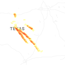
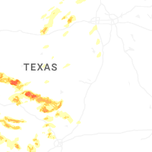
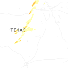


Connect with Interactive Hail Maps