

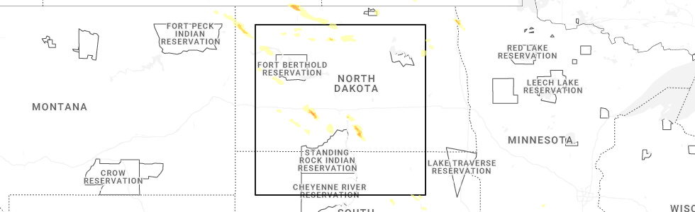
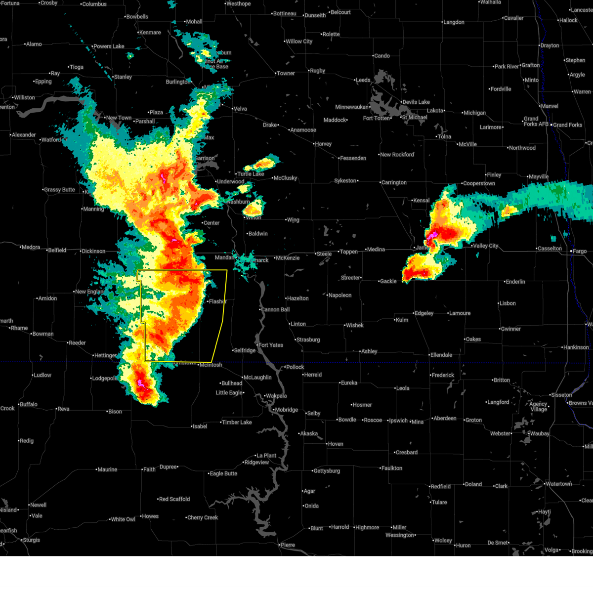
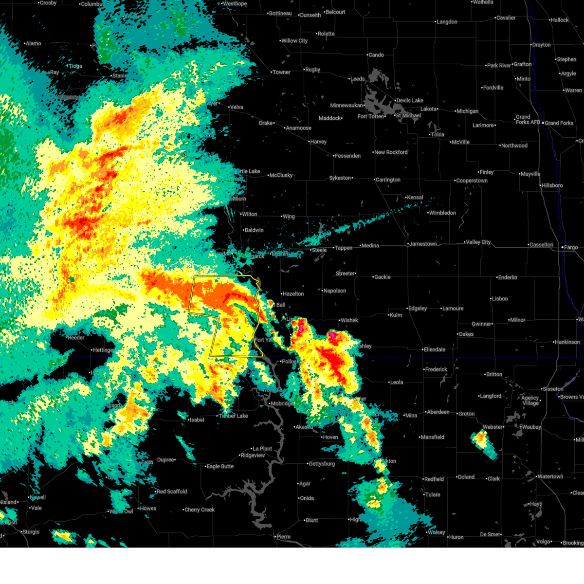
Hail Map for Flasher, ND
The Flasher, ND area has had 10 reports of on-the-ground hail by trained spotters, and has been under severe weather warnings 16 times during the past 12 months. Doppler radar has detected hail at or near Flasher, ND on 46 occasions, including 2 occasions during the past year.
| Name: | Flasher, ND |
| Where Located: | 32.7 miles SW of Bismarck, ND |
| Map: | Google Map for Flasher, ND |
| Population: | 232 |
| Housing Units: | 135 |
| More Info: | Search Google for Flasher, ND |
0
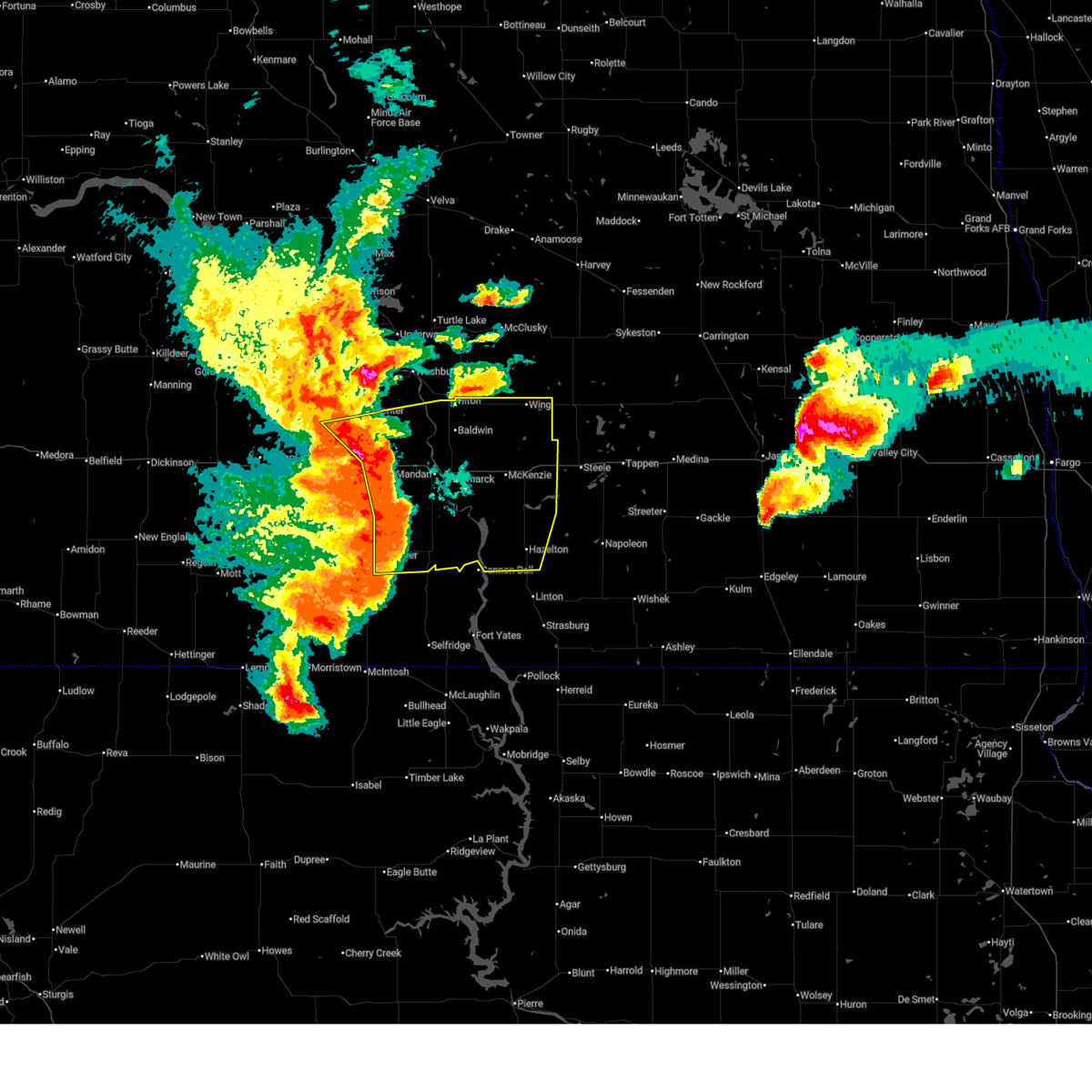
The Top Recent Hail Date for Flasher, ND is Wednesday, June 18, 2025 (33rd out of 46)
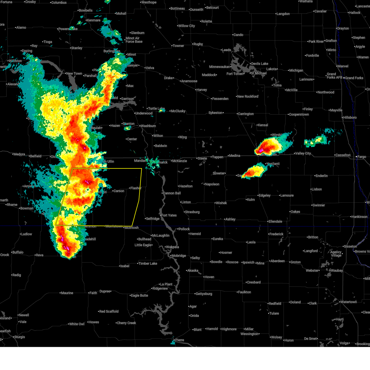
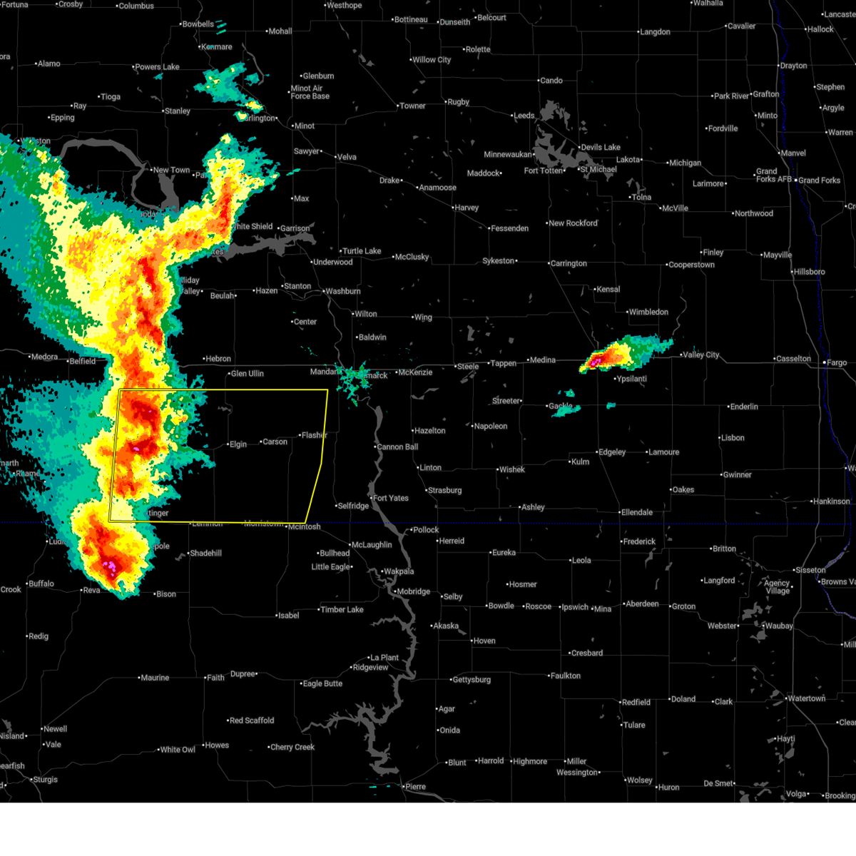
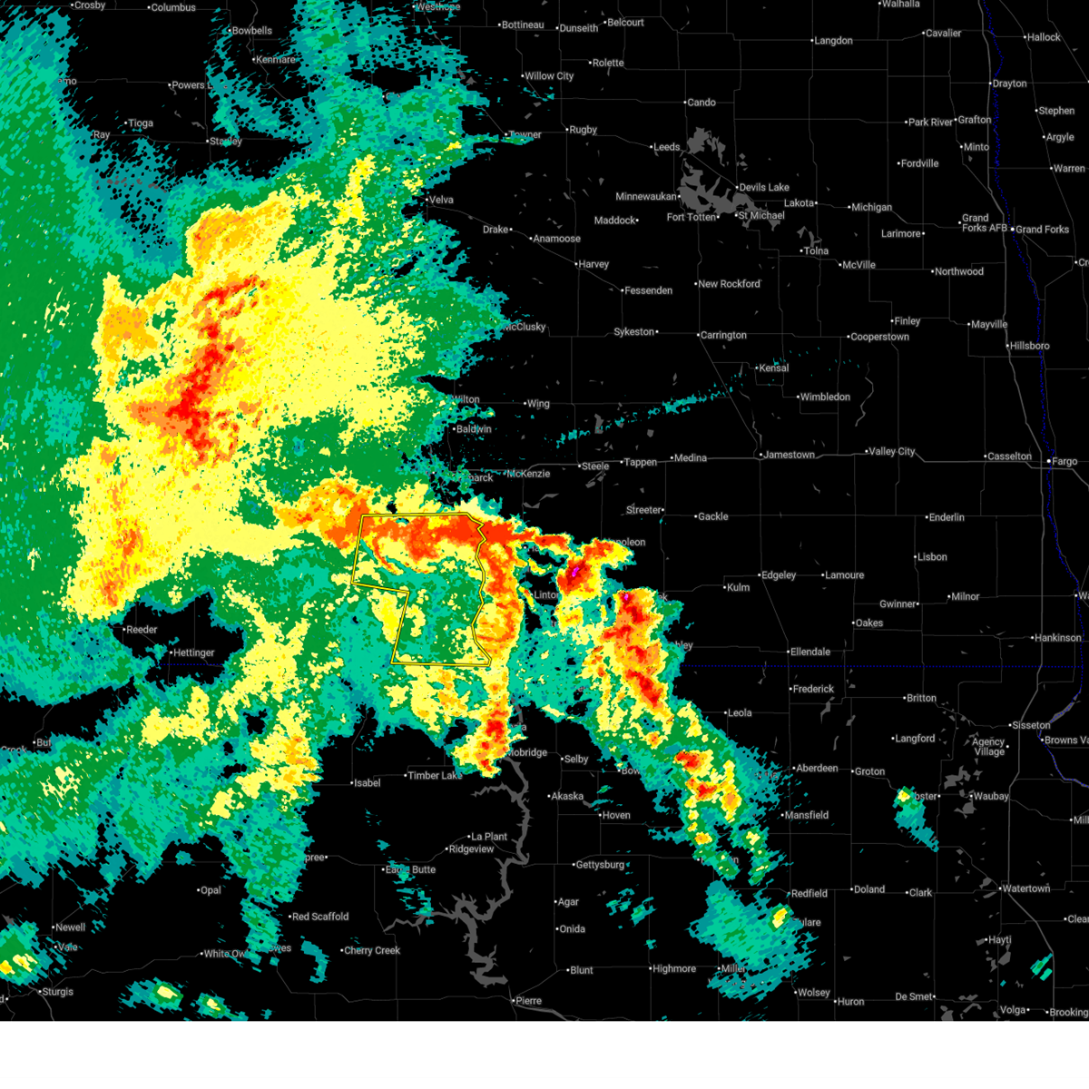
Hail and Wind Damage Spotted near Flasher, ND
| Date / Time | Report Details |
|---|---|
| 6/20/2025 9:23 PM CDT |
 At 922 pm cdt, severe thunderstorms were located along a line extending from wilton to 11 miles south of regan to 8 miles southeast of menoken to 6 miles northeast of cannon ball, moving east at 70 mph. these are destructive storms for south central north dakota, including bismarck and mandan (radar indicated). Hazards include 80 mph wind gusts and quarter size hail. Flying debris will be dangerous to those caught without shelter. mobile homes will be heavily damaged. expect considerable damage to roofs, windows, and vehicles. extensive tree damage and power outages are likely. locations impacted include, bismarck, mandan, lincoln, wilton, hazelton, flasher, menoken, wing, sterling, regan, st. Anthony, driscoll, judson, mckenzie, baldwin, hazelton recreation area, university of mary, huff, crown butte lake, and moffit. At 922 pm cdt, severe thunderstorms were located along a line extending from wilton to 11 miles south of regan to 8 miles southeast of menoken to 6 miles northeast of cannon ball, moving east at 70 mph. these are destructive storms for south central north dakota, including bismarck and mandan (radar indicated). Hazards include 80 mph wind gusts and quarter size hail. Flying debris will be dangerous to those caught without shelter. mobile homes will be heavily damaged. expect considerable damage to roofs, windows, and vehicles. extensive tree damage and power outages are likely. locations impacted include, bismarck, mandan, lincoln, wilton, hazelton, flasher, menoken, wing, sterling, regan, st. Anthony, driscoll, judson, mckenzie, baldwin, hazelton recreation area, university of mary, huff, crown butte lake, and moffit.
|
| 6/20/2025 9:10 PM CDT |
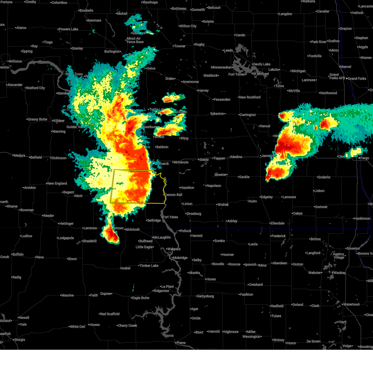 The storms which prompted the warning have weakened below severe limits, and no longer pose an immediate threat to life or property. therefore, the warning will be allowed to expire. however, gusty winds are still possible with these thunderstorms. a tornado watch remains in effect until 300 am cdt/200 am mdt/ for south central north dakota. a severe thunderstorm watch remains in effect until 1000 pm cdt/900 pm mdt/ for south central north dakota. The storms which prompted the warning have weakened below severe limits, and no longer pose an immediate threat to life or property. therefore, the warning will be allowed to expire. however, gusty winds are still possible with these thunderstorms. a tornado watch remains in effect until 300 am cdt/200 am mdt/ for south central north dakota. a severe thunderstorm watch remains in effect until 1000 pm cdt/900 pm mdt/ for south central north dakota.
|
| 6/20/2025 8:58 PM CDT |
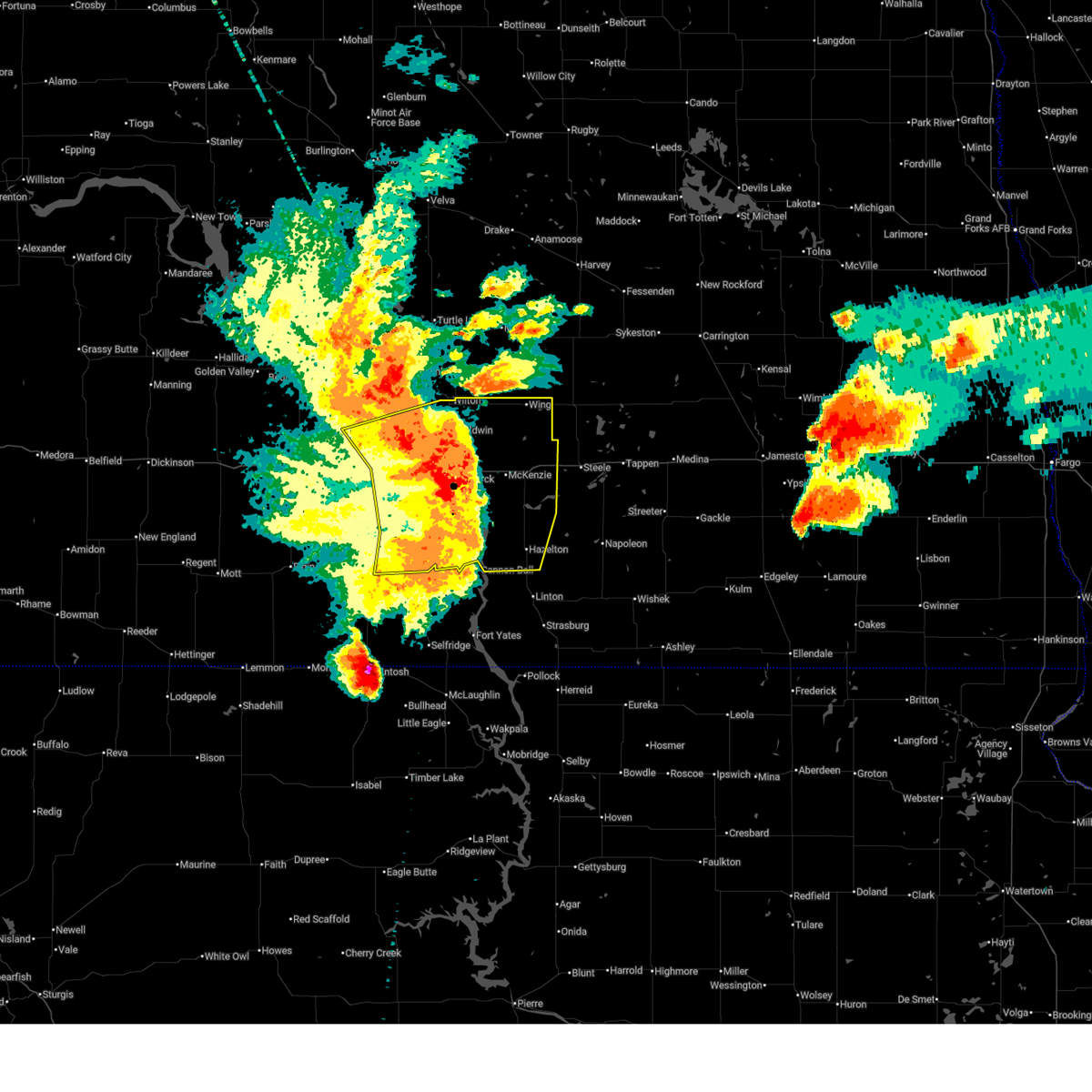
 Svrbis the national weather service in bismarck has issued a * severe thunderstorm warning for, burleigh county in south central north dakota, morton county in south central north dakota, southern oliver county in south central north dakota, northwestern emmons county in south central north dakota, * until 1000 pm cdt. * at 857 pm cdt, severe thunderstorms were located along a line extending from near center to 13 miles northwest of mandan to near st. anthony to 9 miles west of solen, moving east at 70 mph. these are destructive storms for south central north dakota, including bismarck and mandan (radar indicated). Hazards include 80 mph wind gusts and quarter size hail. Flying debris will be dangerous to those caught without shelter. mobile homes will be heavily damaged. expect considerable damage to roofs, windows, and vehicles. Extensive tree damage and power outages are likely. Svrbis the national weather service in bismarck has issued a * severe thunderstorm warning for, burleigh county in south central north dakota, morton county in south central north dakota, southern oliver county in south central north dakota, northwestern emmons county in south central north dakota, * until 1000 pm cdt. * at 857 pm cdt, severe thunderstorms were located along a line extending from near center to 13 miles northwest of mandan to near st. anthony to 9 miles west of solen, moving east at 70 mph. these are destructive storms for south central north dakota, including bismarck and mandan (radar indicated). Hazards include 80 mph wind gusts and quarter size hail. Flying debris will be dangerous to those caught without shelter. mobile homes will be heavily damaged. expect considerable damage to roofs, windows, and vehicles. Extensive tree damage and power outages are likely.
|
| 6/20/2025 8:55 PM CDT |
 At 855 pm cdt/755 pm mdt/, severe thunderstorms were located along a line extending from 7 miles west of st. anthony to 6 miles north of shields, moving east at 65 mph. these are destructive storms (trained weather spotters). Hazards include 90 mph wind gusts. You are in a life-threatening situation. flying debris may be deadly to those caught without shelter. mobile homes will be heavily damaged or destroyed. homes and businesses will have substantial roof and window damage. expect extensive tree damage and power outages. locations impacted include, carson, flasher, almont, solen, cannon ball, st. anthony, prairie knights resort, lark, raleigh, breien, hazelton recreation area, stumpf state natural area, huff, st. Gertrude, fort rice, and standing rock. At 855 pm cdt/755 pm mdt/, severe thunderstorms were located along a line extending from 7 miles west of st. anthony to 6 miles north of shields, moving east at 65 mph. these are destructive storms (trained weather spotters). Hazards include 90 mph wind gusts. You are in a life-threatening situation. flying debris may be deadly to those caught without shelter. mobile homes will be heavily damaged or destroyed. homes and businesses will have substantial roof and window damage. expect extensive tree damage and power outages. locations impacted include, carson, flasher, almont, solen, cannon ball, st. anthony, prairie knights resort, lark, raleigh, breien, hazelton recreation area, stumpf state natural area, huff, st. Gertrude, fort rice, and standing rock.
|
| 6/20/2025 8:48 PM CDT |
 Svrbis the national weather service in bismarck has issued a * severe thunderstorm warning for, northeastern sioux county in south central north dakota, southeastern morton county in south central north dakota, northeastern grant county in south central north dakota, * until 915 pm cdt/815 pm mdt/. * at 847 pm cdt/747 pm mdt/, severe thunderstorms were located along a line extending from 15 miles west of st. anthony to 10 miles southwest of flasher, moving east at 65 mph. these are destructive storms! (trained weather spotters). Hazards include 90 mph wind gusts. You are in a life-threatening situation. flying debris may be deadly to those caught without shelter. mobile homes will be heavily damaged or destroyed. homes and businesses will have substantial roof and window damage. Expect extensive tree damage and power outages. Svrbis the national weather service in bismarck has issued a * severe thunderstorm warning for, northeastern sioux county in south central north dakota, southeastern morton county in south central north dakota, northeastern grant county in south central north dakota, * until 915 pm cdt/815 pm mdt/. * at 847 pm cdt/747 pm mdt/, severe thunderstorms were located along a line extending from 15 miles west of st. anthony to 10 miles southwest of flasher, moving east at 65 mph. these are destructive storms! (trained weather spotters). Hazards include 90 mph wind gusts. You are in a life-threatening situation. flying debris may be deadly to those caught without shelter. mobile homes will be heavily damaged or destroyed. homes and businesses will have substantial roof and window damage. Expect extensive tree damage and power outages.
|
| 6/20/2025 7:43 PM MDT |
 At 843 pm cdt/743 pm mdt/, severe thunderstorms were located along a line extending from near almont to 15 miles south of new salem to morristown, moving east at 60 mph (radar indicated). Hazards include 70 mph wind gusts and nickel size hail. Expect considerable tree damage. damage is likely to mobile homes, roofs, and outbuildings. locations impacted include, elgin, carson, flasher, new leipzig, almont, heart butte dam, shields, lark, raleigh, leith, heil, st. Gertrude, porcupine, standing rock, and northwestern standing rock nation. At 843 pm cdt/743 pm mdt/, severe thunderstorms were located along a line extending from near almont to 15 miles south of new salem to morristown, moving east at 60 mph (radar indicated). Hazards include 70 mph wind gusts and nickel size hail. Expect considerable tree damage. damage is likely to mobile homes, roofs, and outbuildings. locations impacted include, elgin, carson, flasher, new leipzig, almont, heart butte dam, shields, lark, raleigh, leith, heil, st. Gertrude, porcupine, standing rock, and northwestern standing rock nation.
|
| 6/20/2025 7:43 PM MDT |
 the severe thunderstorm warning has been cancelled and is no longer in effect the severe thunderstorm warning has been cancelled and is no longer in effect
|
| 6/20/2025 7:40 PM MDT | 10 meter measured wind gust ndawn carson 9en in grant county ND, 6.6 miles E of Flasher, ND |
| 6/20/2025 7:20 PM MDT |
 At 819 pm cdt/719 pm mdt/, severe thunderstorms were located along a line extending from 6 miles southwest of glen ullin to 4 miles west of heart butte dam to lemmon, moving east at 60 mph (radar indicated). Hazards include 70 mph wind gusts and quarter size hail. Hail damage to vehicles is expected. expect considerable tree damage. wind damage is also likely to mobile homes, roofs, and outbuildings. locations impacted include, hettinger, mott, elgin, carson, flasher, new leipzig, almont, haynes, heart butte dam, shields, north lemmon, burt, lark, raleigh, leith, heil, bentley, st. Gertrude, porcupine, and standing rock. At 819 pm cdt/719 pm mdt/, severe thunderstorms were located along a line extending from 6 miles southwest of glen ullin to 4 miles west of heart butte dam to lemmon, moving east at 60 mph (radar indicated). Hazards include 70 mph wind gusts and quarter size hail. Hail damage to vehicles is expected. expect considerable tree damage. wind damage is also likely to mobile homes, roofs, and outbuildings. locations impacted include, hettinger, mott, elgin, carson, flasher, new leipzig, almont, haynes, heart butte dam, shields, north lemmon, burt, lark, raleigh, leith, heil, bentley, st. Gertrude, porcupine, and standing rock.
|
| 6/20/2025 7:03 PM MDT |
 Svrbis the national weather service in bismarck has issued a * severe thunderstorm warning for, southwestern sioux county in south central north dakota, hettinger county in southwestern north dakota, central morton county in south central north dakota, southeastern stark county in southwestern north dakota, grant county in south central north dakota, adams county in southwestern north dakota, * until 900 pm cdt/800 pm mdt/. * at 803 pm cdt/703 pm mdt/, severe thunderstorms were located along a line extending from 11 miles south of richardton to 15 miles north of mott to near haynes, moving east at 60 mph (radar indicated). Hazards include 70 mph wind gusts and quarter size hail. Hail damage to vehicles is expected. expect considerable tree damage. Wind damage is also likely to mobile homes, roofs, and outbuildings. Svrbis the national weather service in bismarck has issued a * severe thunderstorm warning for, southwestern sioux county in south central north dakota, hettinger county in southwestern north dakota, central morton county in south central north dakota, southeastern stark county in southwestern north dakota, grant county in south central north dakota, adams county in southwestern north dakota, * until 900 pm cdt/800 pm mdt/. * at 803 pm cdt/703 pm mdt/, severe thunderstorms were located along a line extending from 11 miles south of richardton to 15 miles north of mott to near haynes, moving east at 60 mph (radar indicated). Hazards include 70 mph wind gusts and quarter size hail. Hail damage to vehicles is expected. expect considerable tree damage. Wind damage is also likely to mobile homes, roofs, and outbuildings.
|
| 6/16/2025 3:15 AM CDT |
 The storms which prompted the warning have weakened below severe limits. therefore, the warning will be allowed to expire. a severe thunderstorm watch remains in effect until 500 am cdt/400 am mdt/ for south central north dakota. The storms which prompted the warning have weakened below severe limits. therefore, the warning will be allowed to expire. a severe thunderstorm watch remains in effect until 500 am cdt/400 am mdt/ for south central north dakota.
|
| 6/16/2025 2:52 AM CDT |
 At 251 am cdt/151 am mdt/, severe thunderstorms were located along a line extending from 5 miles northwest of flasher to 4 miles northwest of solen to prairie knights resort, moving northeast at 55 mph (radar indicated). Hazards include 60 mph wind gusts and nickel size hail. Expect damage to roofs, siding, and trees. locations impacted include, flasher, fort yates, selfridge, solen, cannon ball, st. Anthony, prairie knights resort, lark, raleigh, breien, hazelton recreation area, stumpf state natural area, huff, fort rice, standing rock, and standing rock nation. At 251 am cdt/151 am mdt/, severe thunderstorms were located along a line extending from 5 miles northwest of flasher to 4 miles northwest of solen to prairie knights resort, moving northeast at 55 mph (radar indicated). Hazards include 60 mph wind gusts and nickel size hail. Expect damage to roofs, siding, and trees. locations impacted include, flasher, fort yates, selfridge, solen, cannon ball, st. Anthony, prairie knights resort, lark, raleigh, breien, hazelton recreation area, stumpf state natural area, huff, fort rice, standing rock, and standing rock nation.
|
| 6/16/2025 2:34 AM CDT |
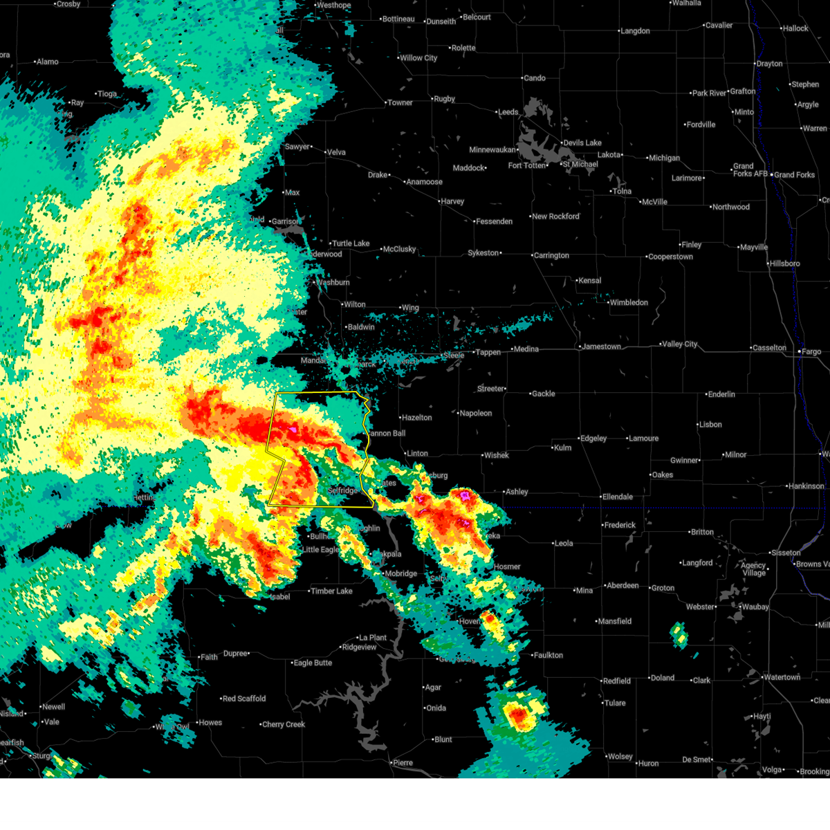 At 234 am cdt/134 am mdt/, severe thunderstorms were located along a line extending from near flasher to 6 miles northwest of selfridge to walker, moving east at 55 mph (radar indicated). Hazards include 70 mph wind gusts and quarter size hail. Hail damage to vehicles is expected. expect considerable tree damage. wind damage is also likely to mobile homes, roofs, and outbuildings. locations impacted include, flasher, fort yates, selfridge, solen, cannon ball, st. anthony, prairie knights resort, shields, lark, raleigh, breien, hazelton recreation area, stumpf state natural area, huff, st. Gertrude, fort rice, porcupine, standing rock, and standing rock nation. At 234 am cdt/134 am mdt/, severe thunderstorms were located along a line extending from near flasher to 6 miles northwest of selfridge to walker, moving east at 55 mph (radar indicated). Hazards include 70 mph wind gusts and quarter size hail. Hail damage to vehicles is expected. expect considerable tree damage. wind damage is also likely to mobile homes, roofs, and outbuildings. locations impacted include, flasher, fort yates, selfridge, solen, cannon ball, st. anthony, prairie knights resort, shields, lark, raleigh, breien, hazelton recreation area, stumpf state natural area, huff, st. Gertrude, fort rice, porcupine, standing rock, and standing rock nation.
|
| 6/16/2025 2:18 AM CDT |
 Svrbis the national weather service in bismarck has issued a * severe thunderstorm warning for, sioux county in south central north dakota, southeastern morton county in south central north dakota, eastern grant county in south central north dakota, * until 315 am cdt/215 am mdt/. * at 217 am cdt/117 am mdt/, severe thunderstorms were located along a line extending from 5 miles northeast of carson to 10 miles west of shields to near mcintosh, moving east at 50 mph (radar indicated). Hazards include 70 mph wind gusts and ping pong ball size hail. People and animals outdoors will be injured. expect hail damage to roofs, siding, windows, and vehicles. expect considerable tree damage. Wind damage is also likely to mobile homes, roofs, and outbuildings. Svrbis the national weather service in bismarck has issued a * severe thunderstorm warning for, sioux county in south central north dakota, southeastern morton county in south central north dakota, eastern grant county in south central north dakota, * until 315 am cdt/215 am mdt/. * at 217 am cdt/117 am mdt/, severe thunderstorms were located along a line extending from 5 miles northeast of carson to 10 miles west of shields to near mcintosh, moving east at 50 mph (radar indicated). Hazards include 70 mph wind gusts and ping pong ball size hail. People and animals outdoors will be injured. expect hail damage to roofs, siding, windows, and vehicles. expect considerable tree damage. Wind damage is also likely to mobile homes, roofs, and outbuildings.
|
| 7/29/2024 6:36 PM MDT |
 At 735 pm cdt/635 pm mdt/, a severe thunderstorm was located over shields, or 34 miles north of bullhead, moving northeast at 40 mph (radar indicated). Hazards include 60 mph wind gusts and penny size hail. Expect damage to roofs, siding, and trees. locations impacted include, flasher, selfridge, shields, raleigh, st. Gertrude, porcupine, standing rock, and standing rock nation. At 735 pm cdt/635 pm mdt/, a severe thunderstorm was located over shields, or 34 miles north of bullhead, moving northeast at 40 mph (radar indicated). Hazards include 60 mph wind gusts and penny size hail. Expect damage to roofs, siding, and trees. locations impacted include, flasher, selfridge, shields, raleigh, st. Gertrude, porcupine, standing rock, and standing rock nation.
|
| 7/29/2024 6:13 PM MDT |
 Svrbis the national weather service in bismarck has issued a * severe thunderstorm warning for, southeastern sioux county in south central north dakota, south central morton county in south central north dakota, southeastern grant county in south central north dakota, * until 800 pm cdt/700 pm mdt/. * at 712 pm cdt/612 pm mdt/, a severe thunderstorm was located 15 miles west of shields, or 34 miles northwest of bullhead, moving northeast at 40 mph (radar indicated). Hazards include 60 mph wind gusts and nickel size hail. expect damage to roofs, siding, and trees Svrbis the national weather service in bismarck has issued a * severe thunderstorm warning for, southeastern sioux county in south central north dakota, south central morton county in south central north dakota, southeastern grant county in south central north dakota, * until 800 pm cdt/700 pm mdt/. * at 712 pm cdt/612 pm mdt/, a severe thunderstorm was located 15 miles west of shields, or 34 miles northwest of bullhead, moving northeast at 40 mph (radar indicated). Hazards include 60 mph wind gusts and nickel size hail. expect damage to roofs, siding, and trees
|
| 7/27/2024 8:06 PM MDT | This is the ndawn station 9 ene carson... nd. 10 meter peak gus in grant county ND, 6.6 miles E of Flasher, ND |
| 7/27/2024 7:15 PM MDT | Also had 1 inch diameter hail... and a lot of hail between a half inch and one inch diameter. had about a half inch of rain. event lasted about 5 minutes until 820 p in grant county ND, 11.5 miles SSE of Flasher, ND |
| 7/27/2024 8:11 PM CDT |
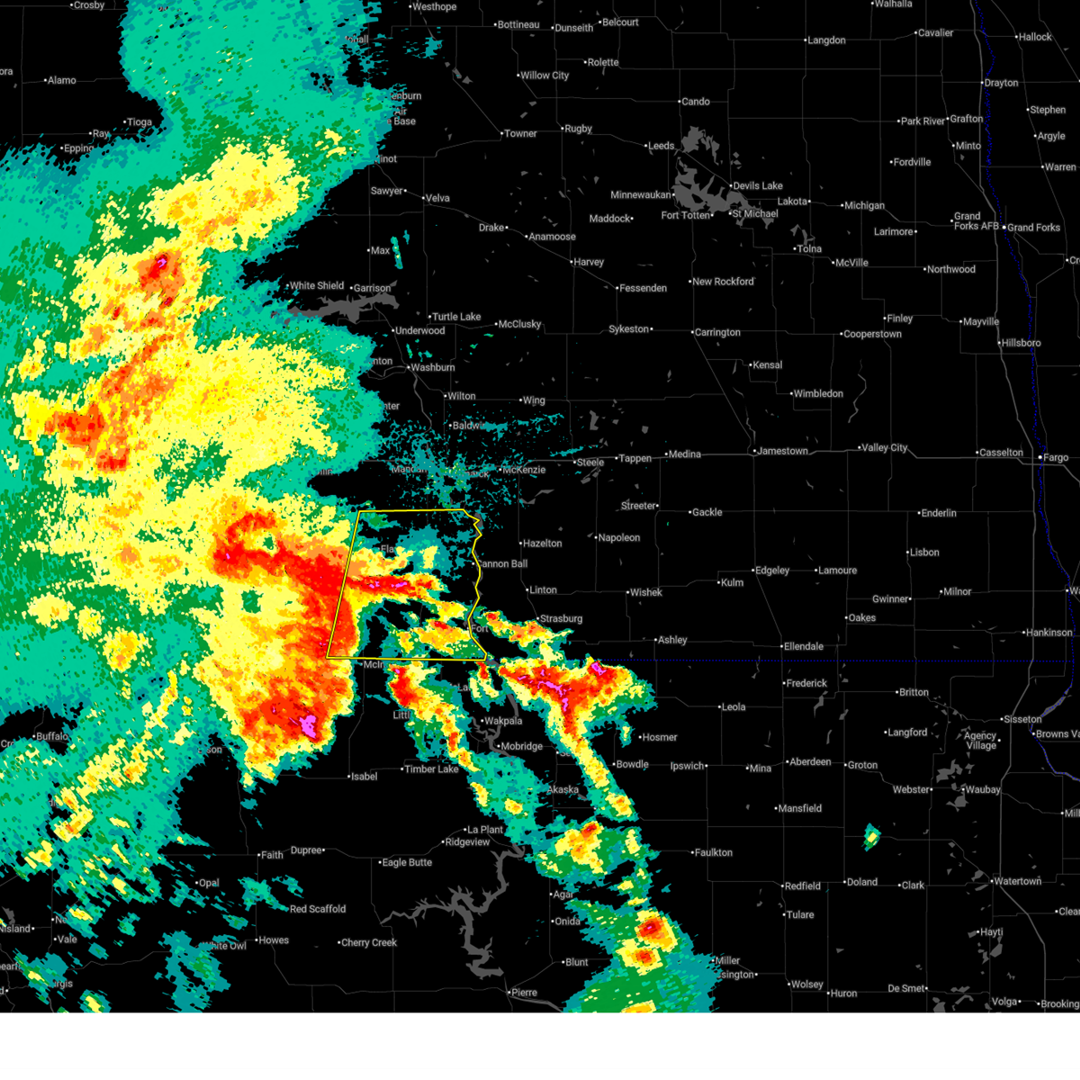
 Svrbis the national weather service in bismarck has issued a * severe thunderstorm warning for, central morton county in south central north dakota, north central grant county in south central north dakota, * until 900 pm cdt/800 pm mdt/. * at 811 pm cdt/711 pm mdt/, a severe thunderstorm was located 8 miles northwest of flasher, or 26 miles southwest of mandan, moving northeast at 30 mph (radar indicated). Hazards include ping pong ball size hail and 60 mph wind gusts. People and animals outdoors will be injured. expect hail damage to roofs, siding, windows, and vehicles. Expect wind damage to roofs, siding, and trees. Svrbis the national weather service in bismarck has issued a * severe thunderstorm warning for, central morton county in south central north dakota, north central grant county in south central north dakota, * until 900 pm cdt/800 pm mdt/. * at 811 pm cdt/711 pm mdt/, a severe thunderstorm was located 8 miles northwest of flasher, or 26 miles southwest of mandan, moving northeast at 30 mph (radar indicated). Hazards include ping pong ball size hail and 60 mph wind gusts. People and animals outdoors will be injured. expect hail damage to roofs, siding, windows, and vehicles. Expect wind damage to roofs, siding, and trees.
|
| 5/17/2024 5:49 PM MDT |
 At 648 pm cdt/548 pm mdt/, severe thunderstorms were located along a line extending from 5 miles southeast of flasher to 12 miles north of mcintosh to 4 miles west of keldron, south dakota, moving east at 40 mph (radar indicated). Hazards include 60 mph wind gusts and quarter size hail. Hail damage to vehicles is expected. expect wind damage to roofs, siding, and trees. locations impacted include, lemmon, flasher, morristown, north lemmon, shields, thunder hawk, raleigh, leith, st. Gertrude, porcupine, standing rock, and northwestern standing rock nation. At 648 pm cdt/548 pm mdt/, severe thunderstorms were located along a line extending from 5 miles southeast of flasher to 12 miles north of mcintosh to 4 miles west of keldron, south dakota, moving east at 40 mph (radar indicated). Hazards include 60 mph wind gusts and quarter size hail. Hail damage to vehicles is expected. expect wind damage to roofs, siding, and trees. locations impacted include, lemmon, flasher, morristown, north lemmon, shields, thunder hawk, raleigh, leith, st. Gertrude, porcupine, standing rock, and northwestern standing rock nation.
|
| 5/17/2024 5:26 PM MDT |
 Svrbis the national weather service in bismarck has issued a * severe thunderstorm warning for, western sioux county in south central north dakota, south central morton county in south central north dakota, southern grant county in south central north dakota, eastern adams county in southwestern north dakota, * until 730 pm cdt/630 pm mdt/. * at 625 pm cdt/525 pm mdt/, severe thunderstorms were located along a line extending from 7 miles southeast of carson to 8 miles north of morristown to lemmon, moving northeast at 40 mph (radar indicated). Hazards include 60 mph wind gusts and quarter size hail. Hail damage to vehicles is expected. Expect wind damage to roofs, siding, and trees. Svrbis the national weather service in bismarck has issued a * severe thunderstorm warning for, western sioux county in south central north dakota, south central morton county in south central north dakota, southern grant county in south central north dakota, eastern adams county in southwestern north dakota, * until 730 pm cdt/630 pm mdt/. * at 625 pm cdt/525 pm mdt/, severe thunderstorms were located along a line extending from 7 miles southeast of carson to 8 miles north of morristown to lemmon, moving northeast at 40 mph (radar indicated). Hazards include 60 mph wind gusts and quarter size hail. Hail damage to vehicles is expected. Expect wind damage to roofs, siding, and trees.
|
| 9/4/2023 8:37 PM CDT |
 At 836 pm cdt/736 pm mdt/, severe thunderstorms were located along a line extending from near new salem to 9 miles northwest of mandan to near menoken to 6 miles north of linton, moving northeast at 65 mph (radar indicated). Hazards include 70 mph wind gusts and quarter size hail. Hail damage to vehicles is expected. expect considerable tree damage. wind damage is also likely to mobile homes, roofs, and outbuildings. these severe storms will be near, hazelton and sterling around 840 pm cdt. braddock around 845 pm cdt. other locations impacted by these severe thunderstorms include double ditch indian village, mckenzie, temvik, baldwin, hazelton recreation area, university of mary, stumpf state natural area, huff, price and fort rice. thunderstorm damage threat, considerable hail threat, radar indicated max hail size, 1. 00 in wind threat, radar indicated max wind gust, 70 mph. At 836 pm cdt/736 pm mdt/, severe thunderstorms were located along a line extending from near new salem to 9 miles northwest of mandan to near menoken to 6 miles north of linton, moving northeast at 65 mph (radar indicated). Hazards include 70 mph wind gusts and quarter size hail. Hail damage to vehicles is expected. expect considerable tree damage. wind damage is also likely to mobile homes, roofs, and outbuildings. these severe storms will be near, hazelton and sterling around 840 pm cdt. braddock around 845 pm cdt. other locations impacted by these severe thunderstorms include double ditch indian village, mckenzie, temvik, baldwin, hazelton recreation area, university of mary, stumpf state natural area, huff, price and fort rice. thunderstorm damage threat, considerable hail threat, radar indicated max hail size, 1. 00 in wind threat, radar indicated max wind gust, 70 mph.
|
| 9/4/2023 8:22 PM CDT |
 At 820 pm cdt/720 pm mdt/, severe thunderstorms were located along a line extending from 6 miles northeast of heart butte dam to 5 miles west of mandan to 12 miles southeast of lincoln to 7 miles southwest of linton, moving northeast at 50 mph (radar indicated). Hazards include 70 mph wind gusts and quarter size hail. Hail damage to vehicles is expected. expect considerable tree damage. wind damage is also likely to mobile homes, roofs, and outbuildings. these severe storms will be near, bismarck, mandan, linton, lincoln, new salem and almont around 825 pm cdt. hazelton and menoken around 830 pm cdt. sterling around 840 pm cdt. braddock around 845 pm cdt. other locations impacted by these severe thunderstorms include temvik, hazelton recreation area, university of mary, huff, crown butte lake, moffit, fish creek dam, beaver bay recreation area, lake harmon and mcdowell dam recreation area. thunderstorm damage threat, considerable hail threat, radar indicated max hail size, 1. 00 in wind threat, radar indicated max wind gust, 70 mph. At 820 pm cdt/720 pm mdt/, severe thunderstorms were located along a line extending from 6 miles northeast of heart butte dam to 5 miles west of mandan to 12 miles southeast of lincoln to 7 miles southwest of linton, moving northeast at 50 mph (radar indicated). Hazards include 70 mph wind gusts and quarter size hail. Hail damage to vehicles is expected. expect considerable tree damage. wind damage is also likely to mobile homes, roofs, and outbuildings. these severe storms will be near, bismarck, mandan, linton, lincoln, new salem and almont around 825 pm cdt. hazelton and menoken around 830 pm cdt. sterling around 840 pm cdt. braddock around 845 pm cdt. other locations impacted by these severe thunderstorms include temvik, hazelton recreation area, university of mary, huff, crown butte lake, moffit, fish creek dam, beaver bay recreation area, lake harmon and mcdowell dam recreation area. thunderstorm damage threat, considerable hail threat, radar indicated max hail size, 1. 00 in wind threat, radar indicated max wind gust, 70 mph.
|
| 9/4/2023 8:07 PM CDT | Davis site observation... private weather sit in morton county ND, 0.1 miles SW of Flasher, ND |
| 9/4/2023 8:06 PM CDT |
 At 804 pm cdt/704 pm mdt/, severe thunderstorms were located along a line extending from 7 miles southwest of heart butte dam to 13 miles north of flasher to near solen to 6 miles southeast of fort yates, moving north at 45 mph (radar indicated). Hazards include 70 mph wind gusts. Expect considerable tree damage. damage is likely to mobile homes, roofs, and outbuildings. severe thunderstorms will be near, almont, cannon ball, st. anthony and prairie knights resort around 810 pm cdt. heart butte dam around 710 pm mdt. bismarck, mandan and new salem around 820 pm cdt. lincoln around 825 pm cdt. menoken around 835 pm cdt. hazelton around 840 pm cdt. other locations impacted by these severe thunderstorms include temvik, hazelton recreation area, university of mary, huff, st. gertrude, crown butte lake, standing rock, moffit, fish creek dam and beaver bay recreation area. thunderstorm damage threat, considerable hail threat, radar indicated max hail size, <. 75 in wind threat, radar indicated max wind gust, 70 mph. At 804 pm cdt/704 pm mdt/, severe thunderstorms were located along a line extending from 7 miles southwest of heart butte dam to 13 miles north of flasher to near solen to 6 miles southeast of fort yates, moving north at 45 mph (radar indicated). Hazards include 70 mph wind gusts. Expect considerable tree damage. damage is likely to mobile homes, roofs, and outbuildings. severe thunderstorms will be near, almont, cannon ball, st. anthony and prairie knights resort around 810 pm cdt. heart butte dam around 710 pm mdt. bismarck, mandan and new salem around 820 pm cdt. lincoln around 825 pm cdt. menoken around 835 pm cdt. hazelton around 840 pm cdt. other locations impacted by these severe thunderstorms include temvik, hazelton recreation area, university of mary, huff, st. gertrude, crown butte lake, standing rock, moffit, fish creek dam and beaver bay recreation area. thunderstorm damage threat, considerable hail threat, radar indicated max hail size, <. 75 in wind threat, radar indicated max wind gust, 70 mph.
|
| 9/4/2023 7:00 PM MDT | Ndawn station carson 9en in grant county ND, 6.6 miles E of Flasher, ND |
| 9/4/2023 6:53 PM MDT |
 At 750 pm cdt/650 pm mdt/, severe thunderstorms were located along a line extending from 6 miles east of heart butte dam to 4 miles north of flasher to near fort yates, moving northeast at 50 mph (radar indicated). Hazards include 70 mph wind gusts and nickel size hail. Expect considerable tree damage. damage is likely to mobile homes, roofs, and outbuildings. these severe storms will be near, solen and prairie knights resort around 755 pm cdt. almont and st. anthony around 800 pm cdt. cannon ball around 805 pm cdt. other locations impacted by these severe thunderstorms include heil, raleigh, breien, burt, lark, bentley, st. gertrude, porcupine, standing rock and leith. thunderstorm damage threat, considerable hail threat, radar indicated max hail size, 0. 88 in wind threat, radar indicated max wind gust, 70 mph. At 750 pm cdt/650 pm mdt/, severe thunderstorms were located along a line extending from 6 miles east of heart butte dam to 4 miles north of flasher to near fort yates, moving northeast at 50 mph (radar indicated). Hazards include 70 mph wind gusts and nickel size hail. Expect considerable tree damage. damage is likely to mobile homes, roofs, and outbuildings. these severe storms will be near, solen and prairie knights resort around 755 pm cdt. almont and st. anthony around 800 pm cdt. cannon ball around 805 pm cdt. other locations impacted by these severe thunderstorms include heil, raleigh, breien, burt, lark, bentley, st. gertrude, porcupine, standing rock and leith. thunderstorm damage threat, considerable hail threat, radar indicated max hail size, 0. 88 in wind threat, radar indicated max wind gust, 70 mph.
|
| 9/4/2023 6:21 PM MDT |
 At 721 pm cdt/621 pm mdt/, severe thunderstorms were located along a line extending from 4 miles west of new leipzig to 7 miles south of carson to walker, moving northeast at 50 mph (radar indicated). Hazards include 70 mph wind gusts and quarter size hail. Hail damage to vehicles is expected. expect considerable tree damage. wind damage is also likely to mobile homes, roofs, and outbuildings. severe thunderstorms will be near, elgin, carson and new leipzig around 625 pm mdt. selfridge around 730 pm cdt. shields around 630 pm mdt. flasher around 735 pm cdt. heart butte dam around 640 pm mdt. fort yates around 745 pm cdt. solen around 750 pm cdt. almont and prairie knights resort around 755 pm cdt. cannon ball and st. anthony around 800 pm cdt. other locations impacted by these severe thunderstorms include heil, raleigh, breien, burt, lark, bentley, st. gertrude, porcupine, standing rock and leith. thunderstorm damage threat, considerable hail threat, radar indicated max hail size, 1. 00 in wind threat, radar indicated max wind gust, 70 mph. At 721 pm cdt/621 pm mdt/, severe thunderstorms were located along a line extending from 4 miles west of new leipzig to 7 miles south of carson to walker, moving northeast at 50 mph (radar indicated). Hazards include 70 mph wind gusts and quarter size hail. Hail damage to vehicles is expected. expect considerable tree damage. wind damage is also likely to mobile homes, roofs, and outbuildings. severe thunderstorms will be near, elgin, carson and new leipzig around 625 pm mdt. selfridge around 730 pm cdt. shields around 630 pm mdt. flasher around 735 pm cdt. heart butte dam around 640 pm mdt. fort yates around 745 pm cdt. solen around 750 pm cdt. almont and prairie knights resort around 755 pm cdt. cannon ball and st. anthony around 800 pm cdt. other locations impacted by these severe thunderstorms include heil, raleigh, breien, burt, lark, bentley, st. gertrude, porcupine, standing rock and leith. thunderstorm damage threat, considerable hail threat, radar indicated max hail size, 1. 00 in wind threat, radar indicated max wind gust, 70 mph.
|
| 8/1/2023 11:10 PM CDT |
 At 1110 pm cdt/1010 pm mdt/, severe thunderstorms were located along a line extending from 4 miles west of flasher to 8 miles east of carson to 11 miles west of shields, moving east at 30 mph (radar indicated). Hazards include 60 mph wind gusts and penny size hail. Expect damage to roofs, siding, and trees. these severe storms will be near, flasher around 1120 pm cdt. shields around 1030 pm mdt. other locations impacted by these severe thunderstorms include st. gertrude, raleigh, porcupine, breien, standing rock and lark. hail threat, radar indicated max hail size, 0. 75 in wind threat, radar indicated max wind gust, 60 mph. At 1110 pm cdt/1010 pm mdt/, severe thunderstorms were located along a line extending from 4 miles west of flasher to 8 miles east of carson to 11 miles west of shields, moving east at 30 mph (radar indicated). Hazards include 60 mph wind gusts and penny size hail. Expect damage to roofs, siding, and trees. these severe storms will be near, flasher around 1120 pm cdt. shields around 1030 pm mdt. other locations impacted by these severe thunderstorms include st. gertrude, raleigh, porcupine, breien, standing rock and lark. hail threat, radar indicated max hail size, 0. 75 in wind threat, radar indicated max wind gust, 60 mph.
|
| 8/1/2023 9:53 PM MDT |
 At 1052 pm cdt/952 pm mdt/, severe thunderstorms were located along a line extending from 11 miles west of flasher to carson, moving east at 25 mph (radar indicated). Hazards include 60 mph wind gusts and penny size hail. Expect damage to roofs, siding, and trees. these severe storms will be near, flasher around 1120 pm cdt. shields around 1035 pm mdt. other locations impacted by these severe thunderstorms include st. gertrude, raleigh, porcupine, breien, standing rock and lark. hail threat, radar indicated max hail size, 0. 75 in wind threat, radar indicated max wind gust, 60 mph. At 1052 pm cdt/952 pm mdt/, severe thunderstorms were located along a line extending from 11 miles west of flasher to carson, moving east at 25 mph (radar indicated). Hazards include 60 mph wind gusts and penny size hail. Expect damage to roofs, siding, and trees. these severe storms will be near, flasher around 1120 pm cdt. shields around 1035 pm mdt. other locations impacted by these severe thunderstorms include st. gertrude, raleigh, porcupine, breien, standing rock and lark. hail threat, radar indicated max hail size, 0. 75 in wind threat, radar indicated max wind gust, 60 mph.
|
| 8/1/2023 9:42 PM MDT |
 At 1041 pm cdt/941 pm mdt/, severe thunderstorms were located along a line extending from 10 miles east of heart butte dam to near carson to 8 miles southeast of elgin, moving east at 30 mph (radar indicated). Hazards include 60 mph wind gusts and penny size hail. Expect damage to roofs, siding, and trees. these severe storms will be near, carson around 945 pm mdt. flasher around 1120 pm cdt. shields around 1040 pm mdt. other locations impacted by these severe thunderstorms include heil, st. gertrude, raleigh, porcupine, breien, standing rock, leith and lark. hail threat, radar indicated max hail size, 0. 75 in wind threat, radar indicated max wind gust, 60 mph. At 1041 pm cdt/941 pm mdt/, severe thunderstorms were located along a line extending from 10 miles east of heart butte dam to near carson to 8 miles southeast of elgin, moving east at 30 mph (radar indicated). Hazards include 60 mph wind gusts and penny size hail. Expect damage to roofs, siding, and trees. these severe storms will be near, carson around 945 pm mdt. flasher around 1120 pm cdt. shields around 1040 pm mdt. other locations impacted by these severe thunderstorms include heil, st. gertrude, raleigh, porcupine, breien, standing rock, leith and lark. hail threat, radar indicated max hail size, 0. 75 in wind threat, radar indicated max wind gust, 60 mph.
|
| 8/1/2023 9:24 PM MDT |
 At 1023 pm cdt/923 pm mdt/, severe thunderstorms were located along a line extending from near heart butte dam to 6 miles northeast of elgin to near new leipzig, moving east at 30 mph (radar indicated). Hazards include 60 mph wind gusts and penny size hail. Expect damage to roofs, siding, and trees. severe thunderstorms will be near, carson around 940 pm mdt. flasher around 1115 pm cdt. shields around 1040 pm mdt. other locations impacted by these severe thunderstorms include heil, st. gertrude, raleigh, porcupine, breien, standing rock, leith and lark. hail threat, radar indicated max hail size, 0. 75 in wind threat, radar indicated max wind gust, 60 mph. At 1023 pm cdt/923 pm mdt/, severe thunderstorms were located along a line extending from near heart butte dam to 6 miles northeast of elgin to near new leipzig, moving east at 30 mph (radar indicated). Hazards include 60 mph wind gusts and penny size hail. Expect damage to roofs, siding, and trees. severe thunderstorms will be near, carson around 940 pm mdt. flasher around 1115 pm cdt. shields around 1040 pm mdt. other locations impacted by these severe thunderstorms include heil, st. gertrude, raleigh, porcupine, breien, standing rock, leith and lark. hail threat, radar indicated max hail size, 0. 75 in wind threat, radar indicated max wind gust, 60 mph.
|
| 7/30/2023 5:58 AM MDT |
 The severe thunderstorm warning for south central morton and central grant counties will expire at 700 am cdt/600 am mdt/, the storm which prompted the warning has weakened below severe limits, and no longer poses an immediate threat to life or property. therefore, the warning will be allowed to expire. however nickel size hail is still possible with this thunderstorm. The severe thunderstorm warning for south central morton and central grant counties will expire at 700 am cdt/600 am mdt/, the storm which prompted the warning has weakened below severe limits, and no longer poses an immediate threat to life or property. therefore, the warning will be allowed to expire. however nickel size hail is still possible with this thunderstorm.
|
| 7/30/2023 5:47 AM MDT |
 At 647 am cdt/547 am mdt/, a severe thunderstorm was located near carson, or 39 miles southwest of mandan, moving southeast at 30 mph (radar indicated). Hazards include quarter size hail. Damage to vehicles is expected. this severe thunderstorm will remain over mainly rural areas of south central morton and central grant counties, including the following locations, breien, leith, lark, heil, st. gertrude and raleigh. hail threat, radar indicated max hail size, 1. 00 in wind threat, radar indicated max wind gust, <50 mph. At 647 am cdt/547 am mdt/, a severe thunderstorm was located near carson, or 39 miles southwest of mandan, moving southeast at 30 mph (radar indicated). Hazards include quarter size hail. Damage to vehicles is expected. this severe thunderstorm will remain over mainly rural areas of south central morton and central grant counties, including the following locations, breien, leith, lark, heil, st. gertrude and raleigh. hail threat, radar indicated max hail size, 1. 00 in wind threat, radar indicated max wind gust, <50 mph.
|
| 7/30/2023 5:25 AM MDT |
 At 624 am cdt/524 am mdt/, a severe thunderstorm was located 5 miles northwest of carson, or 41 miles southwest of mandan, moving southeast at 55 mph (radar indicated). Hazards include two inch hail. People and animals outdoors will be injured. expect damage to roofs, siding, windows, and vehicles. this severe storm will be near, carson around 630 am cdt. other locations impacted by this severe thunderstorm include breien, leith, lark, heil, st. gertrude and raleigh. thunderstorm damage threat, considerable hail threat, radar indicated max hail size, 2. 00 in wind threat, radar indicated max wind gust, <50 mph. At 624 am cdt/524 am mdt/, a severe thunderstorm was located 5 miles northwest of carson, or 41 miles southwest of mandan, moving southeast at 55 mph (radar indicated). Hazards include two inch hail. People and animals outdoors will be injured. expect damage to roofs, siding, windows, and vehicles. this severe storm will be near, carson around 630 am cdt. other locations impacted by this severe thunderstorm include breien, leith, lark, heil, st. gertrude and raleigh. thunderstorm damage threat, considerable hail threat, radar indicated max hail size, 2. 00 in wind threat, radar indicated max wind gust, <50 mph.
|
| 7/30/2023 5:18 AM MDT |
 At 617 am cdt/517 am mdt/, a severe thunderstorm was located near heart butte dam, or 44 miles southwest of mandan, moving southeast at 55 mph (radar indicated). Hazards include ping pong ball size hail. People and animals outdoors will be injured. expect damage to roofs, siding, windows, and vehicles. this severe storm will be near, carson around 630 am cdt. other locations impacted by this severe thunderstorm include breien, leith, lark, heil, st. gertrude and raleigh. hail threat, radar indicated max hail size, 1. 50 in wind threat, radar indicated max wind gust, <50 mph. At 617 am cdt/517 am mdt/, a severe thunderstorm was located near heart butte dam, or 44 miles southwest of mandan, moving southeast at 55 mph (radar indicated). Hazards include ping pong ball size hail. People and animals outdoors will be injured. expect damage to roofs, siding, windows, and vehicles. this severe storm will be near, carson around 630 am cdt. other locations impacted by this severe thunderstorm include breien, leith, lark, heil, st. gertrude and raleigh. hail threat, radar indicated max hail size, 1. 50 in wind threat, radar indicated max wind gust, <50 mph.
|
| 7/30/2023 5:11 AM MDT |
 At 610 am cdt/510 am mdt/, a severe thunderstorm was located over heart butte dam, or 44 miles south of beulah, moving southeast at 55 mph (radar indicated). Hazards include quarter size hail. Damage to vehicles is expected. this severe thunderstorm will be near, carson around 630 am cdt. other locations impacted by this severe thunderstorm include breien, leith, lark, heil, st. gertrude and raleigh. hail threat, radar indicated max hail size, 1. 00 in wind threat, radar indicated max wind gust, <50 mph. At 610 am cdt/510 am mdt/, a severe thunderstorm was located over heart butte dam, or 44 miles south of beulah, moving southeast at 55 mph (radar indicated). Hazards include quarter size hail. Damage to vehicles is expected. this severe thunderstorm will be near, carson around 630 am cdt. other locations impacted by this severe thunderstorm include breien, leith, lark, heil, st. gertrude and raleigh. hail threat, radar indicated max hail size, 1. 00 in wind threat, radar indicated max wind gust, <50 mph.
|
| 7/26/2023 4:53 PM CDT |
 At 452 pm cdt/352 pm mdt/, a severe thunderstorm was located 8 miles northwest of solen, or 27 miles south of bismarck, moving northeast at 35 mph (radar indicated). Hazards include 70 mph wind gusts and ping pong ball size hail. People and animals outdoors will be injured. expect hail damage to roofs, siding, windows, and vehicles. expect considerable tree damage. wind damage is also likely to mobile homes, roofs, and outbuildings. this severe thunderstorm will be near, st. anthony around 510 pm cdt. other locations impacted by this severe thunderstorm include breien, fort rice, stumpf state natural area, huff and standing rock. thunderstorm damage threat, considerable hail threat, radar indicated max hail size, 1. 50 in wind threat, radar indicated max wind gust, 70 mph. At 452 pm cdt/352 pm mdt/, a severe thunderstorm was located 8 miles northwest of solen, or 27 miles south of bismarck, moving northeast at 35 mph (radar indicated). Hazards include 70 mph wind gusts and ping pong ball size hail. People and animals outdoors will be injured. expect hail damage to roofs, siding, windows, and vehicles. expect considerable tree damage. wind damage is also likely to mobile homes, roofs, and outbuildings. this severe thunderstorm will be near, st. anthony around 510 pm cdt. other locations impacted by this severe thunderstorm include breien, fort rice, stumpf state natural area, huff and standing rock. thunderstorm damage threat, considerable hail threat, radar indicated max hail size, 1. 50 in wind threat, radar indicated max wind gust, 70 mph.
|
| 6/20/2023 6:45 PM CDT |
 At 645 pm cdt/545 pm mdt/, a severe thunderstorm was located 8 miles west of solen, or 30 miles south of bismarck, moving north at 30 mph (radar indicated). Hazards include 60 mph wind gusts and quarter size hail. Hail damage to vehicles is expected. expect wind damage to roofs, siding, and trees. this severe thunderstorm will remain over mainly rural areas of northeastern sioux, southeastern morton and eastern grant counties, including the following locations, breien and standing rock. hail threat, radar indicated max hail size, 1. 00 in wind threat, radar indicated max wind gust, 60 mph. At 645 pm cdt/545 pm mdt/, a severe thunderstorm was located 8 miles west of solen, or 30 miles south of bismarck, moving north at 30 mph (radar indicated). Hazards include 60 mph wind gusts and quarter size hail. Hail damage to vehicles is expected. expect wind damage to roofs, siding, and trees. this severe thunderstorm will remain over mainly rural areas of northeastern sioux, southeastern morton and eastern grant counties, including the following locations, breien and standing rock. hail threat, radar indicated max hail size, 1. 00 in wind threat, radar indicated max wind gust, 60 mph.
|
| 6/20/2023 6:30 PM CDT |
 At 629 pm cdt/529 pm mdt/, a severe thunderstorm was located 7 miles northeast of shields, or 33 miles north of mclaughlin, moving north at 30 mph (radar indicated). Hazards include 60 mph wind gusts and quarter size hail. Hail damage to vehicles is expected. expect wind damage to roofs, siding, and trees. this severe thunderstorm will be near, flasher around 700 pm cdt. other locations impacted by this severe thunderstorm include breien and standing rock. hail threat, radar indicated max hail size, 1. 00 in wind threat, radar indicated max wind gust, 60 mph. At 629 pm cdt/529 pm mdt/, a severe thunderstorm was located 7 miles northeast of shields, or 33 miles north of mclaughlin, moving north at 30 mph (radar indicated). Hazards include 60 mph wind gusts and quarter size hail. Hail damage to vehicles is expected. expect wind damage to roofs, siding, and trees. this severe thunderstorm will be near, flasher around 700 pm cdt. other locations impacted by this severe thunderstorm include breien and standing rock. hail threat, radar indicated max hail size, 1. 00 in wind threat, radar indicated max wind gust, 60 mph.
|
| 7/23/2022 2:48 AM MDT |
 At 348 am cdt/248 am mdt/, a severe thunderstorm was located near shields, or 20 miles northwest of selfridge, moving east at 40 mph (radar indicated). Hazards include golf ball size hail and 60 mph wind gusts. People and animals outdoors will be injured. expect hail damage to roofs, siding, windows, and vehicles. expect wind damage to roofs, siding, and trees. this severe thunderstorm will remain over mainly rural areas of northeastern sioux, southeastern morton and east central grant counties, including the following locations, breien, leith, raleigh, st. gertrude, and porcupine. thunderstorm damage threat, considerable hail threat, radar indicated max hail size, 1. 75 in wind threat, radar indicated max wind gust, 60 mph. At 348 am cdt/248 am mdt/, a severe thunderstorm was located near shields, or 20 miles northwest of selfridge, moving east at 40 mph (radar indicated). Hazards include golf ball size hail and 60 mph wind gusts. People and animals outdoors will be injured. expect hail damage to roofs, siding, windows, and vehicles. expect wind damage to roofs, siding, and trees. this severe thunderstorm will remain over mainly rural areas of northeastern sioux, southeastern morton and east central grant counties, including the following locations, breien, leith, raleigh, st. gertrude, and porcupine. thunderstorm damage threat, considerable hail threat, radar indicated max hail size, 1. 75 in wind threat, radar indicated max wind gust, 60 mph.
|
| 7/23/2022 2:32 AM MDT |
 At 332 am cdt/232 am mdt/, a severe thunderstorm was located 11 miles southeast of carson, or 23 miles east of elgin, moving east at 40 mph (radar indicated). Hazards include 60 mph wind gusts and half dollar size hail. Hail damage to vehicles is expected. expect wind damage to roofs, siding, and trees. this severe thunderstorm will be near, shields around 250 am mdt. other locations in the path of this severe thunderstorm include solen. hail threat, radar indicated max hail size, 1. 25 in wind threat, radar indicated max wind gust, 60 mph. At 332 am cdt/232 am mdt/, a severe thunderstorm was located 11 miles southeast of carson, or 23 miles east of elgin, moving east at 40 mph (radar indicated). Hazards include 60 mph wind gusts and half dollar size hail. Hail damage to vehicles is expected. expect wind damage to roofs, siding, and trees. this severe thunderstorm will be near, shields around 250 am mdt. other locations in the path of this severe thunderstorm include solen. hail threat, radar indicated max hail size, 1. 25 in wind threat, radar indicated max wind gust, 60 mph.
|
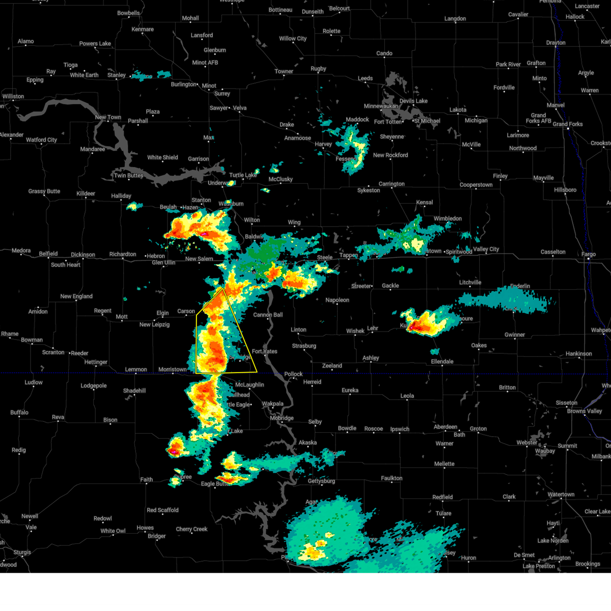
| 7/21/2022 5:42 PM CDT | Ping Pong Ball sized hail reported 13 miles SSW of Flasher, ND, social media reported ping pong sized hail in picture. |
| 7/10/2022 4:56 AM CDT |
 At 455 am cdt/355 am mdt/, severe thunderstorms were located along a line extending from 9 miles northwest of regan to 4 miles south of mandan to 9 miles east of flasher, moving east at 40 mph (radar indicated). Hazards include 70 mph wind gusts and ping pong ball size hail. People and animals outdoors will be injured. expect hail damage to roofs, siding, windows, and vehicles. expect considerable tree damage. wind damage is also likely to mobile homes, roofs, and outbuildings. these severe storms will be near, bismarck and regan around 505 am cdt. lincoln around 510 am cdt. mcdowell dam recreation area around 515 am cdt. menoken around 520 am cdt. sterling around 535 am cdt. other locations impacted by these severe thunderstorms include double ditch indian village, mckenzie, new johns lake, baldwin, hensler, fort clark, hazelton recreation area, university of mary, huff and nelson lake. thunderstorm damage threat, considerable hail threat, observed max hail size, 1. 50 in wind threat, observed max wind gust, 70 mph. At 455 am cdt/355 am mdt/, severe thunderstorms were located along a line extending from 9 miles northwest of regan to 4 miles south of mandan to 9 miles east of flasher, moving east at 40 mph (radar indicated). Hazards include 70 mph wind gusts and ping pong ball size hail. People and animals outdoors will be injured. expect hail damage to roofs, siding, windows, and vehicles. expect considerable tree damage. wind damage is also likely to mobile homes, roofs, and outbuildings. these severe storms will be near, bismarck and regan around 505 am cdt. lincoln around 510 am cdt. mcdowell dam recreation area around 515 am cdt. menoken around 520 am cdt. sterling around 535 am cdt. other locations impacted by these severe thunderstorms include double ditch indian village, mckenzie, new johns lake, baldwin, hensler, fort clark, hazelton recreation area, university of mary, huff and nelson lake. thunderstorm damage threat, considerable hail threat, observed max hail size, 1. 50 in wind threat, observed max wind gust, 70 mph.
|
| 7/10/2022 4:25 AM CDT |
 At 424 am cdt/324 am mdt/, severe thunderstorms were located along a line extending from 5 miles southwest of stanton to 8 miles northeast of new salem to 8 miles north of carson, moving east at 55 mph (public). Hazards include golf ball size hail and 70 mph wind gusts. People and animals outdoors will be injured. expect hail damage to roofs, siding, windows, and vehicles. expect considerable tree damage. wind damage is also likely to mobile homes, roofs, and outbuildings. severe thunderstorms will be near, mandan and flasher around 440 am cdt. washburn around 445 am cdt. bismarck around 450 am cdt. st. anthony around 455 am cdt. wilton around 500 am cdt. menoken around 505 am cdt. sterling and regan around 515 am cdt. other locations impacted by these severe thunderstorms include mckenzie, new johns lake, baldwin, hensler, fort clark, huff and nelson lake. thunderstorm damage threat, considerable hail threat, observed max hail size, 1. 75 in wind threat, observed max wind gust, 70 mph. At 424 am cdt/324 am mdt/, severe thunderstorms were located along a line extending from 5 miles southwest of stanton to 8 miles northeast of new salem to 8 miles north of carson, moving east at 55 mph (public). Hazards include golf ball size hail and 70 mph wind gusts. People and animals outdoors will be injured. expect hail damage to roofs, siding, windows, and vehicles. expect considerable tree damage. wind damage is also likely to mobile homes, roofs, and outbuildings. severe thunderstorms will be near, mandan and flasher around 440 am cdt. washburn around 445 am cdt. bismarck around 450 am cdt. st. anthony around 455 am cdt. wilton around 500 am cdt. menoken around 505 am cdt. sterling and regan around 515 am cdt. other locations impacted by these severe thunderstorms include mckenzie, new johns lake, baldwin, hensler, fort clark, huff and nelson lake. thunderstorm damage threat, considerable hail threat, observed max hail size, 1. 75 in wind threat, observed max wind gust, 70 mph.
|
| 7/4/2022 1:06 AM MDT |
 At 206 am cdt/106 am mdt/, severe thunderstorms were located along a line extending from 9 miles north of new salem to 5 miles southeast of flasher to near mcintosh, moving east at 45 mph (radar indicated). Hazards include 60 mph wind gusts. Expect damage to roofs, siding, and trees. these severe thunderstorms will remain over mainly rural areas of central sioux, morton and central grant counties, including the following locations, raleigh, st. gertrude, sweet briar lake, porcupine, crown butte lake, breien, lark and judson. hail threat, radar indicated max hail size, <. 75 in wind threat, radar indicated max wind gust, 60 mph. At 206 am cdt/106 am mdt/, severe thunderstorms were located along a line extending from 9 miles north of new salem to 5 miles southeast of flasher to near mcintosh, moving east at 45 mph (radar indicated). Hazards include 60 mph wind gusts. Expect damage to roofs, siding, and trees. these severe thunderstorms will remain over mainly rural areas of central sioux, morton and central grant counties, including the following locations, raleigh, st. gertrude, sweet briar lake, porcupine, crown butte lake, breien, lark and judson. hail threat, radar indicated max hail size, <. 75 in wind threat, radar indicated max wind gust, 60 mph.
|
| 7/4/2022 12:40 AM MDT |
 At 139 am cdt/1239 am mdt/, severe thunderstorms were located along a line extending from 12 miles northeast of glen ullin to near carson to keldron, moving east at 45 mph (radar indicated). Hazards include 60 mph wind gusts. Expect damage to roofs, siding, and trees. severe thunderstorms will be near, new salem around 155 am cdt. flasher around 200 am cdt. other locations impacted by these severe thunderstorms include heil, raleigh, st. gertrude, sweet briar lake, porcupine, crown butte lake, breien, leith, lark and judson. hail threat, radar indicated max hail size, <. 75 in wind threat, radar indicated max wind gust, 60 mph. At 139 am cdt/1239 am mdt/, severe thunderstorms were located along a line extending from 12 miles northeast of glen ullin to near carson to keldron, moving east at 45 mph (radar indicated). Hazards include 60 mph wind gusts. Expect damage to roofs, siding, and trees. severe thunderstorms will be near, new salem around 155 am cdt. flasher around 200 am cdt. other locations impacted by these severe thunderstorms include heil, raleigh, st. gertrude, sweet briar lake, porcupine, crown butte lake, breien, leith, lark and judson. hail threat, radar indicated max hail size, <. 75 in wind threat, radar indicated max wind gust, 60 mph.
|
| 6/19/2022 11:52 PM MDT |
 The severe thunderstorm warning for south central morton and southeastern grant counties will expire at 100 am cdt/midnight mdt/, the storm which prompted the warning has weakened below severe limits, and no longer poses an immediate threat to life or property. therefore, the warning will be allowed to expire. however small hail and gusty winds are still possible with this thunderstorm. a severe thunderstorm watch remains in effect until 200 am cdt/100 am mdt/ for south central north dakota. The severe thunderstorm warning for south central morton and southeastern grant counties will expire at 100 am cdt/midnight mdt/, the storm which prompted the warning has weakened below severe limits, and no longer poses an immediate threat to life or property. therefore, the warning will be allowed to expire. however small hail and gusty winds are still possible with this thunderstorm. a severe thunderstorm watch remains in effect until 200 am cdt/100 am mdt/ for south central north dakota.
|
| 6/19/2022 11:38 PM MDT |
 At 1237 am cdt/1137 pm mdt/, a severe thunderstorm was located 6 miles southeast of flasher, or 25 miles northwest of selfridge, moving northeast at 25 mph (radar indicated). Hazards include golf ball size hail and 60 mph wind gusts. People and animals outdoors will be injured. expect hail damage to roofs, siding, windows, and vehicles. expect wind damage to roofs, siding, and trees. locations impacted include, flasher, shields, raleigh and st. gertrude. thunderstorm damage threat, considerable hail threat, radar indicated max hail size, 1. 75 in wind threat, radar indicated max wind gust, 60 mph. At 1237 am cdt/1137 pm mdt/, a severe thunderstorm was located 6 miles southeast of flasher, or 25 miles northwest of selfridge, moving northeast at 25 mph (radar indicated). Hazards include golf ball size hail and 60 mph wind gusts. People and animals outdoors will be injured. expect hail damage to roofs, siding, windows, and vehicles. expect wind damage to roofs, siding, and trees. locations impacted include, flasher, shields, raleigh and st. gertrude. thunderstorm damage threat, considerable hail threat, radar indicated max hail size, 1. 75 in wind threat, radar indicated max wind gust, 60 mph.
|
| 6/19/2022 11:15 PM MDT |
 At 1215 am cdt/1115 pm mdt/, a severe thunderstorm was located 8 miles west of shields, or 24 miles northwest of selfridge, moving northeast at 25 mph (radar indicated). Hazards include tennis ball size hail and 60 mph wind gusts. People and animals outdoors will be injured. expect hail damage to roofs, siding, windows, and vehicles. expect wind damage to roofs, siding, and trees. locations impacted include, flasher, shields, raleigh and st. gertrude. thunderstorm damage threat, considerable hail threat, radar indicated max hail size, 2. 50 in wind threat, radar indicated max wind gust, 60 mph. At 1215 am cdt/1115 pm mdt/, a severe thunderstorm was located 8 miles west of shields, or 24 miles northwest of selfridge, moving northeast at 25 mph (radar indicated). Hazards include tennis ball size hail and 60 mph wind gusts. People and animals outdoors will be injured. expect hail damage to roofs, siding, windows, and vehicles. expect wind damage to roofs, siding, and trees. locations impacted include, flasher, shields, raleigh and st. gertrude. thunderstorm damage threat, considerable hail threat, radar indicated max hail size, 2. 50 in wind threat, radar indicated max wind gust, 60 mph.
|
| 6/19/2022 10:53 PM MDT |
 At 1153 pm cdt/1053 pm mdt/, a severe thunderstorm was located 14 miles west of shields, or 25 miles west of selfridge, moving northeast at 25 mph (radar indicated). Hazards include 60 mph wind gusts and quarter size hail. Hail damage to vehicles is expected. Expect wind damage to roofs, siding, and trees. At 1153 pm cdt/1053 pm mdt/, a severe thunderstorm was located 14 miles west of shields, or 25 miles west of selfridge, moving northeast at 25 mph (radar indicated). Hazards include 60 mph wind gusts and quarter size hail. Hail damage to vehicles is expected. Expect wind damage to roofs, siding, and trees.
|
| 8/30/2021 6:21 PM CDT |
 At 620 pm cdt/520 pm mdt/, a severe thunderstorm was located 9 miles west of solen, or 24 miles north of selfridge, moving southeast at 20 mph (radar indicated). Hazards include golf ball size hail and 60 mph wind gusts. People and animals outdoors will be injured. expect hail damage to roofs, siding, windows, and vehicles. expect wind damage to roofs, siding, and trees. locations impacted include, solen and breien. thunderstorm damage threat, considerable hail threat, radar indicated max hail size, 1. 75 in wind threat, radar indicated max wind gust, 60 mph. At 620 pm cdt/520 pm mdt/, a severe thunderstorm was located 9 miles west of solen, or 24 miles north of selfridge, moving southeast at 20 mph (radar indicated). Hazards include golf ball size hail and 60 mph wind gusts. People and animals outdoors will be injured. expect hail damage to roofs, siding, windows, and vehicles. expect wind damage to roofs, siding, and trees. locations impacted include, solen and breien. thunderstorm damage threat, considerable hail threat, radar indicated max hail size, 1. 75 in wind threat, radar indicated max wind gust, 60 mph.
|
| 8/30/2021 6:02 PM CDT |
 At 601 pm cdt/501 pm mdt/, a severe thunderstorm was located 5 miles northeast of flasher, or 25 miles southwest of mandan, moving southeast at 15 mph. this is a destructive storm for the flasher and breien areas (radar indicated). Hazards include baseball size hail and 60 mph wind gusts. People and animals outdoors will be severely injured. Expect shattered windows, extensive damage to roofs, siding, and vehicles. At 601 pm cdt/501 pm mdt/, a severe thunderstorm was located 5 miles northeast of flasher, or 25 miles southwest of mandan, moving southeast at 15 mph. this is a destructive storm for the flasher and breien areas (radar indicated). Hazards include baseball size hail and 60 mph wind gusts. People and animals outdoors will be severely injured. Expect shattered windows, extensive damage to roofs, siding, and vehicles.
|
| 8/30/2021 5:56 PM CDT | Social media report of semi blown over on highway 21 east of flasher at 556 pm cdt. incident verified by dispatch. location estimated based on radar data at time of rep in morton county ND, 5.4 miles W of Flasher, ND |
| 8/30/2021 5:38 PM CDT |
 At 538 pm cdt/438 pm mdt/, a severe thunderstorm was located near flasher, or 25 miles southwest of mandan, moving south at 10 mph. this is a destructive storm for the flasher area (radar indicated). Hazards include baseball size hail and 60 mph wind gusts. People and animals outdoors will be severely injured. expect shattered windows, extensive damage to roofs, siding, and vehicles. locations impacted include, flasher. thunderstorm damage threat, destructive hail threat, radar indicated max hail size, 2. 75 in wind threat, radar indicated max wind gust, 60 mph. At 538 pm cdt/438 pm mdt/, a severe thunderstorm was located near flasher, or 25 miles southwest of mandan, moving south at 10 mph. this is a destructive storm for the flasher area (radar indicated). Hazards include baseball size hail and 60 mph wind gusts. People and animals outdoors will be severely injured. expect shattered windows, extensive damage to roofs, siding, and vehicles. locations impacted include, flasher. thunderstorm damage threat, destructive hail threat, radar indicated max hail size, 2. 75 in wind threat, radar indicated max wind gust, 60 mph.
|
| 8/30/2021 5:34 PM CDT | Golf Ball sized hail reported 3.5 miles S of Flasher, ND, photo relayed through broadcast media. time estimated from radar. |
| 8/30/2021 5:26 PM CDT |
 At 525 pm cdt/425 pm mdt/, a severe thunderstorm was located 6 miles north of flasher, or 24 miles southwest of mandan, moving southeast at 10 mph (radar indicated). Hazards include two inch hail and 60 mph wind gusts. People and animals outdoors will be injured. expect hail damage to roofs, siding, windows, and vehicles. expect wind damage to roofs, siding, and trees. locations impacted include, flasher, lark, and raleigh. thunderstorm damage threat, considerable hail threat, radar indicated max hail size, 2. 00 in wind threat, radar indicated max wind gust, 60 mph. At 525 pm cdt/425 pm mdt/, a severe thunderstorm was located 6 miles north of flasher, or 24 miles southwest of mandan, moving southeast at 10 mph (radar indicated). Hazards include two inch hail and 60 mph wind gusts. People and animals outdoors will be injured. expect hail damage to roofs, siding, windows, and vehicles. expect wind damage to roofs, siding, and trees. locations impacted include, flasher, lark, and raleigh. thunderstorm damage threat, considerable hail threat, radar indicated max hail size, 2. 00 in wind threat, radar indicated max wind gust, 60 mph.
|
| 8/30/2021 5:00 PM CDT |
 At 500 pm cdt/400 pm mdt/, a severe thunderstorm was located 7 miles south of fish creek dam, or 23 miles southwest of mandan, moving southeast at 5 mph (radar indicated). Hazards include two inch hail and 60 mph wind gusts. People and animals outdoors will be injured. expect hail damage to roofs, siding, windows, and vehicles. Expect wind damage to roofs, siding, and trees. At 500 pm cdt/400 pm mdt/, a severe thunderstorm was located 7 miles south of fish creek dam, or 23 miles southwest of mandan, moving southeast at 5 mph (radar indicated). Hazards include two inch hail and 60 mph wind gusts. People and animals outdoors will be injured. expect hail damage to roofs, siding, windows, and vehicles. Expect wind damage to roofs, siding, and trees.
|
| 8/30/2021 3:51 PM MDT | Hen Egg sized hail reported 11.7 miles SSE of Flasher, ND, report from mping: hen egg (2.00 in.). |
| 8/23/2021 11:47 PM MDT |
 At 1247 am cdt/1147 pm mdt/, severe thunderstorms were located along a line extending from near carson to 8 miles southeast of flasher, moving northeast at 20 mph (radar indicated). Hazards include quarter size hail. Damage to vehicles is expected. these severe thunderstorms will remain over mainly rural areas of south central morton and east central grant counties, including the following locations, raleigh. hail threat, radar indicated max hail size, 1. 00 in wind threat, radar indicated max wind gust, <50 mph. At 1247 am cdt/1147 pm mdt/, severe thunderstorms were located along a line extending from near carson to 8 miles southeast of flasher, moving northeast at 20 mph (radar indicated). Hazards include quarter size hail. Damage to vehicles is expected. these severe thunderstorms will remain over mainly rural areas of south central morton and east central grant counties, including the following locations, raleigh. hail threat, radar indicated max hail size, 1. 00 in wind threat, radar indicated max wind gust, <50 mph.
|
| 8/23/2021 11:29 PM MDT |
 At 1228 am cdt/1128 pm mdt/, a severe thunderstorm was located 9 miles southeast of carson, or 21 miles east of elgin, moving northeast at 20 mph (radar indicated). Hazards include quarter size hail. Damage to vehicles is expected. this severe storm will be near, flasher around 100 am cdt. other locations impacted by this severe thunderstorm include st. gertrude, raleigh, and leith. hail threat, radar indicated max hail size, 1. 00 in wind threat, radar indicated max wind gust, <50 mph. At 1228 am cdt/1128 pm mdt/, a severe thunderstorm was located 9 miles southeast of carson, or 21 miles east of elgin, moving northeast at 20 mph (radar indicated). Hazards include quarter size hail. Damage to vehicles is expected. this severe storm will be near, flasher around 100 am cdt. other locations impacted by this severe thunderstorm include st. gertrude, raleigh, and leith. hail threat, radar indicated max hail size, 1. 00 in wind threat, radar indicated max wind gust, <50 mph.
|
| 8/23/2021 11:14 PM MDT |
 At 1214 am cdt/1114 pm mdt/, a severe thunderstorm was located 10 miles southeast of carson, or 19 miles southeast of elgin, moving northeast at 20 mph (radar indicated). Hazards include half dollar size hail. Damage to vehicles is expected. this severe thunderstorm will be near, flasher around 100 am cdt. other locations impacted by this severe thunderstorm include st. gertrude, raleigh and leith. hail threat, radar indicated max hail size, 1. 25 in wind threat, radar indicated max wind gust, <50 mph. At 1214 am cdt/1114 pm mdt/, a severe thunderstorm was located 10 miles southeast of carson, or 19 miles southeast of elgin, moving northeast at 20 mph (radar indicated). Hazards include half dollar size hail. Damage to vehicles is expected. this severe thunderstorm will be near, flasher around 100 am cdt. other locations impacted by this severe thunderstorm include st. gertrude, raleigh and leith. hail threat, radar indicated max hail size, 1. 25 in wind threat, radar indicated max wind gust, <50 mph.
|
| 6/11/2021 1:42 AM CDT |
 At 131 am cdt/1231 am mdt/, severe thunderstorms were located along a line extending from 4 miles southwest of st. anthony to 4 miles southeast of walker, moving east at 30 mph (radar indicated). Hazards include 70 mph wind gusts and penny size hail. Expect considerable tree damage. damage is likely to mobile homes, roofs, and outbuildings. locations impacted include, fort yates, selfridge, flasher, solen, cannon ball, st. anthony, fish creek dam, shields, prairie knights resort, raleigh, breien, hazelton recreation area, huff, st. Gertrude, fort rice, porcupine, cattail recreation area and beaver bay recreation area. At 131 am cdt/1231 am mdt/, severe thunderstorms were located along a line extending from 4 miles southwest of st. anthony to 4 miles southeast of walker, moving east at 30 mph (radar indicated). Hazards include 70 mph wind gusts and penny size hail. Expect considerable tree damage. damage is likely to mobile homes, roofs, and outbuildings. locations impacted include, fort yates, selfridge, flasher, solen, cannon ball, st. anthony, fish creek dam, shields, prairie knights resort, raleigh, breien, hazelton recreation area, huff, st. Gertrude, fort rice, porcupine, cattail recreation area and beaver bay recreation area.
|
| 6/11/2021 1:31 AM CDT |
 At 131 am cdt/1231 am mdt/, severe thunderstorms were located along a line extending from 4 miles southwest of st. anthony to 4 miles southeast of walker, moving east at 30 mph (radar indicated). Hazards include 70 mph wind gusts and penny size hail. Expect considerable tree damage. damage is likely to mobile homes, roofs, and outbuildings. locations impacted include, fort yates, selfridge, flasher, solen, cannon ball, st. anthony, fish creek dam, shields, prairie knights resort, raleigh, breien, hazelton recreation area, huff, st. Gertrude, fort rice, porcupine, cattail recreation area and beaver bay recreation area. At 131 am cdt/1231 am mdt/, severe thunderstorms were located along a line extending from 4 miles southwest of st. anthony to 4 miles southeast of walker, moving east at 30 mph (radar indicated). Hazards include 70 mph wind gusts and penny size hail. Expect considerable tree damage. damage is likely to mobile homes, roofs, and outbuildings. locations impacted include, fort yates, selfridge, flasher, solen, cannon ball, st. anthony, fish creek dam, shields, prairie knights resort, raleigh, breien, hazelton recreation area, huff, st. Gertrude, fort rice, porcupine, cattail recreation area and beaver bay recreation area.
|
| 6/11/2021 12:12 AM MDT |
 The severe thunderstorm warning for western sioux, central morton and grant counties will expire at 115 am cdt/1215 am mdt/, the storms which prompted the warning have moved out of the area. therefore, the warning will be allowed to expire. however gusty winds are still possible behind these thunderstorms. a severe thunderstorm watch remains in effect until 300 am cdt/200 am mdt/ for south central north dakota. The severe thunderstorm warning for western sioux, central morton and grant counties will expire at 115 am cdt/1215 am mdt/, the storms which prompted the warning have moved out of the area. therefore, the warning will be allowed to expire. however gusty winds are still possible behind these thunderstorms. a severe thunderstorm watch remains in effect until 300 am cdt/200 am mdt/ for south central north dakota.
|
| 6/11/2021 1:11 AM CDT |
 At 111 am cdt/1211 am mdt/, severe thunderstorms were located along a line extending from 8 miles south of fish creek dam to 4 miles west of walker, moving east at 30 mph (radar indicated). Hazards include 70 mph wind gusts and penny size hail. Expect considerable tree damage. Damage is likely to mobile homes, roofs, and outbuildings. At 111 am cdt/1211 am mdt/, severe thunderstorms were located along a line extending from 8 miles south of fish creek dam to 4 miles west of walker, moving east at 30 mph (radar indicated). Hazards include 70 mph wind gusts and penny size hail. Expect considerable tree damage. Damage is likely to mobile homes, roofs, and outbuildings.
|
| 6/10/2021 11:58 PM MDT |
 At 1258 am cdt/1158 pm mdt/, severe thunderstorms were located along a line extending from 4 miles northwest of almont to near flasher to near watauga, moving east at 20 mph (radar indicated). Hazards include 70 mph wind gusts and quarter size hail. Hail damage to vehicles is expected. expect considerable tree damage. wind damage is also likely to mobile homes, roofs, and outbuildings. locations impacted include, carson, flasher, fish creek dam, shields, judson, lark, raleigh, leith, heil, st. Gertrude and porcupine. At 1258 am cdt/1158 pm mdt/, severe thunderstorms were located along a line extending from 4 miles northwest of almont to near flasher to near watauga, moving east at 20 mph (radar indicated). Hazards include 70 mph wind gusts and quarter size hail. Hail damage to vehicles is expected. expect considerable tree damage. wind damage is also likely to mobile homes, roofs, and outbuildings. locations impacted include, carson, flasher, fish creek dam, shields, judson, lark, raleigh, leith, heil, st. Gertrude and porcupine.
|
| 6/10/2021 11:42 PM MDT |
 At 1242 am cdt/1142 pm mdt/, severe thunderstorms were located along a line extending from 7 miles southeast of glen ullin to 7 miles east of carson to near morristown, moving east at 20 mph (radar indicated). Hazards include 70 mph wind gusts and quarter size hail. Hail damage to vehicles is expected. expect considerable tree damage. wind damage is also likely to mobile homes, roofs, and outbuildings. Locations impacted include, almont, flasher, new salem and fish creek dam. At 1242 am cdt/1142 pm mdt/, severe thunderstorms were located along a line extending from 7 miles southeast of glen ullin to 7 miles east of carson to near morristown, moving east at 20 mph (radar indicated). Hazards include 70 mph wind gusts and quarter size hail. Hail damage to vehicles is expected. expect considerable tree damage. wind damage is also likely to mobile homes, roofs, and outbuildings. Locations impacted include, almont, flasher, new salem and fish creek dam.
|
| 6/10/2021 11:21 PM MDT |
 At 1221 am cdt/1121 pm mdt/, severe thunderstorms were located along a line extending from 6 miles south of glen ullin to carson to keldron, moving east at 20 mph (radar indicated). Hazards include 70 mph wind gusts and nickel size hail. Expect considerable tree damage. damage is likely to mobile homes, roofs, and outbuildings. severe thunderstorms will be near, carson around 1125 pm mdt. Other locations in the path of these severe thunderstorms include flasher, almont and new salem. At 1221 am cdt/1121 pm mdt/, severe thunderstorms were located along a line extending from 6 miles south of glen ullin to carson to keldron, moving east at 20 mph (radar indicated). Hazards include 70 mph wind gusts and nickel size hail. Expect considerable tree damage. damage is likely to mobile homes, roofs, and outbuildings. severe thunderstorms will be near, carson around 1125 pm mdt. Other locations in the path of these severe thunderstorms include flasher, almont and new salem.
|
| 6/9/2021 12:27 AM MDT |
 The severe thunderstorm warning for southwestern sioux, south central morton and grant counties will expire at 130 am cdt/1230 am mdt/, the storm which prompted the warning has weakened below severe limits. therefore, the warning will be allowed to expire. however gusty winds are still possible with this thunderstorm. The severe thunderstorm warning for southwestern sioux, south central morton and grant counties will expire at 130 am cdt/1230 am mdt/, the storm which prompted the warning has weakened below severe limits. therefore, the warning will be allowed to expire. however gusty winds are still possible with this thunderstorm.
|
| 6/9/2021 12:09 AM MDT |
 At 109 am cdt/1209 am mdt/, a severe thunderstorm was located 5 miles south of carson, or 15 miles east of elgin, moving northeast at 40 mph (radar indicated). Hazards include 60 mph wind gusts. Expect damage to roofs, siding, and trees. locations impacted include, elgin, carson, flasher, heart butte dam, lark, raleigh, leith, heil and st. Gertrude. At 109 am cdt/1209 am mdt/, a severe thunderstorm was located 5 miles south of carson, or 15 miles east of elgin, moving northeast at 40 mph (radar indicated). Hazards include 60 mph wind gusts. Expect damage to roofs, siding, and trees. locations impacted include, elgin, carson, flasher, heart butte dam, lark, raleigh, leith, heil and st. Gertrude.
|
| 6/8/2021 11:43 PM MDT |
 At 1243 am cdt/1143 pm mdt/, a severe thunderstorm was located 14 miles south of carson, or 15 miles southeast of elgin, moving northeast at 45 mph (radar indicated). Hazards include 60 mph wind gusts. expect damage to roofs, siding, and trees At 1243 am cdt/1143 pm mdt/, a severe thunderstorm was located 14 miles south of carson, or 15 miles southeast of elgin, moving northeast at 45 mph (radar indicated). Hazards include 60 mph wind gusts. expect damage to roofs, siding, and trees
|
| 6/8/2021 3:02 PM MDT |
 At 400 pm cdt/300 pm mdt/, severe thunderstorms were located in an area from around raleigh to st. gertrude and up to elgin, and are nearly stationary (radar indicated). Hazards include 60 mph wind gusts and quarter size hail. Hail damage to vehicles is expected. expect wind damage to roofs, siding, and trees. this severe thunderstorm will remain over mainly rural areas of south central morton and grant counties, including the following locations, leith, lark, heil, st. Gertrude and raleigh. At 400 pm cdt/300 pm mdt/, severe thunderstorms were located in an area from around raleigh to st. gertrude and up to elgin, and are nearly stationary (radar indicated). Hazards include 60 mph wind gusts and quarter size hail. Hail damage to vehicles is expected. expect wind damage to roofs, siding, and trees. this severe thunderstorm will remain over mainly rural areas of south central morton and grant counties, including the following locations, leith, lark, heil, st. Gertrude and raleigh.
|
| 6/8/2021 2:45 PM MDT |
 At 344 pm cdt/244 pm mdt/, severe thunderstorms were located along a line extending from 7 miles east of carson to 7 miles southeast of flasher, and are nearly stationary (radar indicated). Hazards include 60 mph wind gusts and half dollar size hail. Hail damage to vehicles is expected. expect wind damage to roofs, siding, and trees. This severe thunderstorm will be near, elgin around 255 pm mdt. At 344 pm cdt/244 pm mdt/, severe thunderstorms were located along a line extending from 7 miles east of carson to 7 miles southeast of flasher, and are nearly stationary (radar indicated). Hazards include 60 mph wind gusts and half dollar size hail. Hail damage to vehicles is expected. expect wind damage to roofs, siding, and trees. This severe thunderstorm will be near, elgin around 255 pm mdt.
|
| 6/8/2021 2:15 PM MDT |
 At 315 pm cdt/215 pm mdt/, severe thunderstorms were located along a line extending from 10 miles south of elgin to 8 miles north of shields, moving north at 10 mph (radar indicated). Hazards include 60 mph wind gusts and half dollar size hail. Hail damage to vehicles is expected. expect wind damage to roofs, siding, and trees. locations impacted include, elgin, carson, flasher, new leipzig, heart butte dam, shields, lark, raleigh, leith, heil, st. Gertrude, and breien. At 315 pm cdt/215 pm mdt/, severe thunderstorms were located along a line extending from 10 miles south of elgin to 8 miles north of shields, moving north at 10 mph (radar indicated). Hazards include 60 mph wind gusts and half dollar size hail. Hail damage to vehicles is expected. expect wind damage to roofs, siding, and trees. locations impacted include, elgin, carson, flasher, new leipzig, heart butte dam, shields, lark, raleigh, leith, heil, st. Gertrude, and breien.
|
| 6/8/2021 1:59 PM MDT |
 At 258 pm cdt/158 pm mdt/, severe thunderstorms were located along a line extending from 8 miles southeast of carson to 7 miles north of shields, and are nearly stationary (radar indicated). Hazards include ping pong ball size hail and 60 mph wind gusts. People and animals outdoors will be injured. expect hail damage to roofs, siding, windows, and vehicles. expect wind damage to roofs, siding, and trees. locations impacted include, carson, flasher, shields, lark, raleigh, leith, heil, st. Gertrude, and breien. At 258 pm cdt/158 pm mdt/, severe thunderstorms were located along a line extending from 8 miles southeast of carson to 7 miles north of shields, and are nearly stationary (radar indicated). Hazards include ping pong ball size hail and 60 mph wind gusts. People and animals outdoors will be injured. expect hail damage to roofs, siding, windows, and vehicles. expect wind damage to roofs, siding, and trees. locations impacted include, carson, flasher, shields, lark, raleigh, leith, heil, st. Gertrude, and breien.
|
| 6/8/2021 1:43 PM MDT |
 At 242 pm cdt/142 pm mdt/, severe thunderstorms were located along a line extending from 7 miles east of carson to 7 miles southeast of flasher, and are nearly stationary (radar indicated). Hazards include 60 mph wind gusts and half dollar size hail. Hail damage to vehicles is expected. Expect wind damage to roofs, siding, and trees. At 242 pm cdt/142 pm mdt/, severe thunderstorms were located along a line extending from 7 miles east of carson to 7 miles southeast of flasher, and are nearly stationary (radar indicated). Hazards include 60 mph wind gusts and half dollar size hail. Hail damage to vehicles is expected. Expect wind damage to roofs, siding, and trees.
|
| 6/8/2021 2:24 PM CDT |
 At 224 pm cdt/124 pm mdt/, severe thunderstorms were located along a line extending from 4 miles southeast of flasher to 4 miles north of solen, moving northwest at 10 mph (radar indicated). Hazards include 60 mph wind gusts and quarter size hail. Hail damage to vehicles is expected. expect wind damage to roofs, siding, and trees. Locations impacted include, flasher, solen, cannon ball, shields, prairie knights resort, fort rice, porcupine, breien, hazelton recreation area, and huff. At 224 pm cdt/124 pm mdt/, severe thunderstorms were located along a line extending from 4 miles southeast of flasher to 4 miles north of solen, moving northwest at 10 mph (radar indicated). Hazards include 60 mph wind gusts and quarter size hail. Hail damage to vehicles is expected. expect wind damage to roofs, siding, and trees. Locations impacted include, flasher, solen, cannon ball, shields, prairie knights resort, fort rice, porcupine, breien, hazelton recreation area, and huff.
|
| 6/8/2021 2:05 PM CDT |
 At 205 pm cdt/105 pm mdt/, severe thunderstorms were located along a line extending from 8 miles north of shields to 4 miles northeast of solen, moving north at 10 mph (radar indicated). Hazards include 60 mph wind gusts and quarter size hail. Hail damage to vehicles is expected. expect wind damage to roofs, siding, and trees. Locations impacted include, shields, flasher, breien, and solen. At 205 pm cdt/105 pm mdt/, severe thunderstorms were located along a line extending from 8 miles north of shields to 4 miles northeast of solen, moving north at 10 mph (radar indicated). Hazards include 60 mph wind gusts and quarter size hail. Hail damage to vehicles is expected. expect wind damage to roofs, siding, and trees. Locations impacted include, shields, flasher, breien, and solen.
|
| 6/8/2021 1:45 PM CDT |
 At 145 pm cdt/1245 pm mdt/, severe thunderstorms were located along a line extending from 6 miles northeast of shields to 4 miles west of cannon ball, moving north at 10 mph (radar indicated). Hazards include 60 mph wind gusts and half dollar size hail. Hail damage to vehicles is expected. expect wind damage to roofs, siding, and trees. severe thunderstorms will be near, solen around 155 pm cdt. Other locations in the path of these severe thunderstorms include flasher. At 145 pm cdt/1245 pm mdt/, severe thunderstorms were located along a line extending from 6 miles northeast of shields to 4 miles west of cannon ball, moving north at 10 mph (radar indicated). Hazards include 60 mph wind gusts and half dollar size hail. Hail damage to vehicles is expected. expect wind damage to roofs, siding, and trees. severe thunderstorms will be near, solen around 155 pm cdt. Other locations in the path of these severe thunderstorms include flasher.
|
| 8/14/2020 5:35 AM CDT |
 At 535 am cdt/435 am mdt/, severe thunderstorms were located along a line extending from 5 miles west of flasher to 7 miles west of solen to 9 miles southwest of prairie knights resort, moving northeast at 55 mph (radar indicated). Hazards include 70 mph wind gusts and half dollar size hail. Hail damage to vehicles is expected. expect considerable tree damage. wind damage is also likely to mobile homes, roofs, and outbuildings. these severe storms will be near, solen and prairie knights resort around 545 am cdt. cannon ball around 555 am cdt. other locations impacted by these severe thunderstorms include breien, lark, st. Gertrude, raleigh, and porcupine. At 535 am cdt/435 am mdt/, severe thunderstorms were located along a line extending from 5 miles west of flasher to 7 miles west of solen to 9 miles southwest of prairie knights resort, moving northeast at 55 mph (radar indicated). Hazards include 70 mph wind gusts and half dollar size hail. Hail damage to vehicles is expected. expect considerable tree damage. wind damage is also likely to mobile homes, roofs, and outbuildings. these severe storms will be near, solen and prairie knights resort around 545 am cdt. cannon ball around 555 am cdt. other locations impacted by these severe thunderstorms include breien, lark, st. Gertrude, raleigh, and porcupine.
|
| 8/14/2020 4:19 AM MDT |
 At 518 am cdt/418 am mdt/, severe thunderstorms were located along a line extending from carson to 4 miles northwest of shields to 8 miles northwest of selfridge, moving northeast at 60 mph (radar indicated). Hazards include 70 mph wind gusts and half dollar size hail. Hail damage to vehicles is expected. expect considerable tree damage. wind damage is also likely to mobile homes, roofs, and outbuildings. these severe storms will be near, flasher around 535 am cdt. solen and prairie knights resort around 540 am cdt. cannon ball around 545 am cdt. other locations impacted by these severe thunderstorms include heil, st. Gertrude, raleigh, porcupine, breien, leith, and lark. At 518 am cdt/418 am mdt/, severe thunderstorms were located along a line extending from carson to 4 miles northwest of shields to 8 miles northwest of selfridge, moving northeast at 60 mph (radar indicated). Hazards include 70 mph wind gusts and half dollar size hail. Hail damage to vehicles is expected. expect considerable tree damage. wind damage is also likely to mobile homes, roofs, and outbuildings. these severe storms will be near, flasher around 535 am cdt. solen and prairie knights resort around 540 am cdt. cannon ball around 545 am cdt. other locations impacted by these severe thunderstorms include heil, st. Gertrude, raleigh, porcupine, breien, leith, and lark.
|
| 8/14/2020 4:02 AM MDT |
 At 502 am cdt/402 am mdt/, severe thunderstorms were located along a line extending from 4 miles south of new leipzig to 10 miles north of watauga, moving northeast at 55 mph (radar indicated). Hazards include 70 mph wind gusts and half dollar size hail. Hail damage to vehicles is expected. expect considerable tree damage. wind damage is also likely to mobile homes, roofs, and outbuildings. severe thunderstorms will be near, carson and shields around 425 am mdt. flasher around 540 am cdt. solen around 545 am cdt. prairie knights resort around 550 am cdt. cannon ball around 555 am cdt. other locations impacted by these severe thunderstorms include heil, st. Gertrude, raleigh, porcupine, breien, leith and lark. At 502 am cdt/402 am mdt/, severe thunderstorms were located along a line extending from 4 miles south of new leipzig to 10 miles north of watauga, moving northeast at 55 mph (radar indicated). Hazards include 70 mph wind gusts and half dollar size hail. Hail damage to vehicles is expected. expect considerable tree damage. wind damage is also likely to mobile homes, roofs, and outbuildings. severe thunderstorms will be near, carson and shields around 425 am mdt. flasher around 540 am cdt. solen around 545 am cdt. prairie knights resort around 550 am cdt. cannon ball around 555 am cdt. other locations impacted by these severe thunderstorms include heil, st. Gertrude, raleigh, porcupine, breien, leith and lark.
|
| 8/7/2020 9:30 PM CDT |
 At 929 pm cdt, a severe thunderstorm was located just southwest of flasher, or 28 miles east of elgin, moving east at 30 mph (radar indicated). Hazards include 60 mph wind gusts and quarter size hail. Hail damage to vehicles is expected. expect wind damage to roofs, siding, and trees. locations impacted include, breien. The earlier storm north of flasher has weakened. At 929 pm cdt, a severe thunderstorm was located just southwest of flasher, or 28 miles east of elgin, moving east at 30 mph (radar indicated). Hazards include 60 mph wind gusts and quarter size hail. Hail damage to vehicles is expected. expect wind damage to roofs, siding, and trees. locations impacted include, breien. The earlier storm north of flasher has weakened.
|
| 8/7/2020 9:08 PM CDT |
 At 908 pm cdt, a severe thunderstorm was located 6 miles northeast of flasher, or 23 miles southwest of mandan, moving southeast at 15 mph (radar indicated). Hazards include 60 mph wind gusts and quarter size hail. Hail damage to vehicles is expected. expect wind damage to roofs, siding, and trees. locations impacted include, flasher, st. Anthony and breien. At 908 pm cdt, a severe thunderstorm was located 6 miles northeast of flasher, or 23 miles southwest of mandan, moving southeast at 15 mph (radar indicated). Hazards include 60 mph wind gusts and quarter size hail. Hail damage to vehicles is expected. expect wind damage to roofs, siding, and trees. locations impacted include, flasher, st. Anthony and breien.
|
| 8/7/2020 8:53 PM CDT |
 At 853 pm cdt, a severe thunderstorm was located 7 miles north of flasher, or 22 miles southwest of mandan, moving southeast at 15 mph (radar indicated). Hazards include 60 mph wind gusts and quarter size hail. Hail damage to vehicles is expected. expect wind damage to roofs, siding, and trees. This severe thunderstorm will remain over mainly rural areas of southeastern morton county, including the following locations, breien. At 853 pm cdt, a severe thunderstorm was located 7 miles north of flasher, or 22 miles southwest of mandan, moving southeast at 15 mph (radar indicated). Hazards include 60 mph wind gusts and quarter size hail. Hail damage to vehicles is expected. expect wind damage to roofs, siding, and trees. This severe thunderstorm will remain over mainly rural areas of southeastern morton county, including the following locations, breien.
|
| 7/7/2020 11:28 PM CDT |
 At 1128 pm cdt/1028 pm mdt/, severe thunderstorms were located along a line extending from 6 miles north of hazen bay recreation area to 6 miles west of washburn to 4 miles west of lake harmon to 4 miles southwest of flasher, moving northeast at 60 mph. these are very dangerous storms (radar indicated). Hazards include 80 mph wind gusts and quarter size hail. Flying debris will be dangerous to those caught without shelter. mobile homes will be heavily damaged. expect considerable damage to roofs, windows, and vehicles. extensive tree damage and power outages are likely. these severe storms will be near, mandan, washburn and lake harmon around 1135 pm cdt. bismarck around 1140 pm cdt. st. anthony around 1150 pm cdt. benedict and regan around 1200 am cdt. Other locations impacted by these severe thunderstorms include double ditch indian village, heil, new johns lake, baldwin, breien, hensler, lark, emmet, fort clark and university of mary. At 1128 pm cdt/1028 pm mdt/, severe thunderstorms were located along a line extending from 6 miles north of hazen bay recreation area to 6 miles west of washburn to 4 miles west of lake harmon to 4 miles southwest of flasher, moving northeast at 60 mph. these are very dangerous storms (radar indicated). Hazards include 80 mph wind gusts and quarter size hail. Flying debris will be dangerous to those caught without shelter. mobile homes will be heavily damaged. expect considerable damage to roofs, windows, and vehicles. extensive tree damage and power outages are likely. these severe storms will be near, mandan, washburn and lake harmon around 1135 pm cdt. bismarck around 1140 pm cdt. st. anthony around 1150 pm cdt. benedict and regan around 1200 am cdt. Other locations impacted by these severe thunderstorms include double ditch indian village, heil, new johns lake, baldwin, breien, hensler, lark, emmet, fort clark and university of mary.
|
| 7/7/2020 11:06 PM CDT |
 At 1105 pm cdt/1005 pm mdt/, severe thunderstorms were located along a line extending from 8 miles south of indian hills recreation area to 8 miles south of hazen to near new salem to elgin, moving northeast at 55 mph. these are very dangerous storms (radar indicated). Hazards include 80 mph wind gusts and quarter size hail. Flying debris will be dangerous to those caught without shelter. mobile homes will be heavily damaged. expect considerable damage to roofs, windows, and vehicles. extensive tree damage and power outages are likely. severe thunderstorms will be near, new salem and hannover around 1110 pm cdt. stanton, carson and beulah bay recreation area around 1120 pm cdt. mandan around 1130 pm cdt. washburn and lake harmon around 1135 pm cdt. fort stevenson state park around 1140 pm cdt. garrison around 1145 pm cdt. wilton and turtle lake around 1150 pm cdt. benedict, regan and st. anthony around 1200 am cdt. Other locations impacted by these severe thunderstorms include double ditch indian village, heil, raleigh, new johns lake, baldwin, breien, hensler, lark, emmet and fort clark. At 1105 pm cdt/1005 pm mdt/, severe thunderstorms were located along a line extending from 8 miles south of indian hills recreation area to 8 miles south of hazen to near new salem to elgin, moving northeast at 55 mph. these are very dangerous storms (radar indicated). Hazards include 80 mph wind gusts and quarter size hail. Flying debris will be dangerous to those caught without shelter. mobile homes will be heavily damaged. expect considerable damage to roofs, windows, and vehicles. extensive tree damage and power outages are likely. severe thunderstorms will be near, new salem and hannover around 1110 pm cdt. stanton, carson and beulah bay recreation area around 1120 pm cdt. mandan around 1130 pm cdt. washburn and lake harmon around 1135 pm cdt. fort stevenson state park around 1140 pm cdt. garrison around 1145 pm cdt. wilton and turtle lake around 1150 pm cdt. benedict, regan and st. anthony around 1200 am cdt. Other locations impacted by these severe thunderstorms include double ditch indian village, heil, raleigh, new johns lake, baldwin, breien, hensler, lark, emmet and fort clark.
|
| 7/5/2020 5:45 PM CDT | Quarter sized hail reported 7.8 miles WSW of Flasher, ND |
| 7/5/2020 5:31 PM CDT |
 At 531 pm cdt/431 pm mdt/, a severe thunderstorm was located 5 miles east of flasher, or 26 miles southwest of mandan, moving east at 30 mph (radar indicated). Hazards include 60 mph wind gusts and quarter size hail. Hail damage to vehicles is expected. expect wind damage to roofs, siding, and trees. Locations impacted include, flasher. At 531 pm cdt/431 pm mdt/, a severe thunderstorm was located 5 miles east of flasher, or 26 miles southwest of mandan, moving east at 30 mph (radar indicated). Hazards include 60 mph wind gusts and quarter size hail. Hail damage to vehicles is expected. expect wind damage to roofs, siding, and trees. Locations impacted include, flasher.
|
| 7/5/2020 5:21 PM CDT |
 At 521 pm cdt/421 pm mdt/, a severe thunderstorm was located over flasher, or 28 miles east of elgin, moving east at 30 mph (radar indicated). Hazards include 60 mph wind gusts and half dollar size hail. Hail damage to vehicles is expected. expect wind damage to roofs, siding, and trees. This severe thunderstorm will remain over mainly rural areas of southeastern morton and northeastern grant counties, including the following locations, raleigh and lark. At 521 pm cdt/421 pm mdt/, a severe thunderstorm was located over flasher, or 28 miles east of elgin, moving east at 30 mph (radar indicated). Hazards include 60 mph wind gusts and half dollar size hail. Hail damage to vehicles is expected. expect wind damage to roofs, siding, and trees. This severe thunderstorm will remain over mainly rural areas of southeastern morton and northeastern grant counties, including the following locations, raleigh and lark.
|
| 7/5/2020 5:12 PM CDT |
 At 512 pm cdt/412 pm mdt/, a severe thunderstorm was located 5 miles west of flasher, or 24 miles east of elgin, moving east at 35 mph (radar indicated). Hazards include two inch hail and 60 mph wind gusts. People and animals outdoors will be injured. expect hail damage to roofs, siding, windows, and vehicles. expect wind damage to roofs, siding, and trees. this severe storm will be near, flasher around 525 pm cdt. Other locations impacted by this severe thunderstorm include raleigh and lark. At 512 pm cdt/412 pm mdt/, a severe thunderstorm was located 5 miles west of flasher, or 24 miles east of elgin, moving east at 35 mph (radar indicated). Hazards include two inch hail and 60 mph wind gusts. People and animals outdoors will be injured. expect hail damage to roofs, siding, windows, and vehicles. expect wind damage to roofs, siding, and trees. this severe storm will be near, flasher around 525 pm cdt. Other locations impacted by this severe thunderstorm include raleigh and lark.
|
| 7/5/2020 5:01 PM CDT |
 At 501 pm cdt/401 pm mdt/, a severe thunderstorm was located 7 miles northeast of carson, or 19 miles east of elgin, moving east at 35 mph. this is a very dangerous storm (radar indicated). Hazards include three inch hail and 70 mph wind gusts. People and animals outdoors will be severely injured. expect shattered windows, extensive damage to roofs, siding, and vehicles. this severe storm will be near, flasher around 520 pm cdt. other locations impacted by this severe thunderstorm include st. Gertrude, raleigh and lark. At 501 pm cdt/401 pm mdt/, a severe thunderstorm was located 7 miles northeast of carson, or 19 miles east of elgin, moving east at 35 mph. this is a very dangerous storm (radar indicated). Hazards include three inch hail and 70 mph wind gusts. People and animals outdoors will be severely injured. expect shattered windows, extensive damage to roofs, siding, and vehicles. this severe storm will be near, flasher around 520 pm cdt. other locations impacted by this severe thunderstorm include st. Gertrude, raleigh and lark.
|
| 7/5/2020 4:47 PM CDT |
 At 447 pm cdt/347 pm mdt/, a severe thunderstorm was located 6 miles northwest of carson, or 11 miles northeast of elgin, moving east at 40 mph. this is a very dangerous storm (radar indicated). Hazards include three inch hail and 70 mph wind gusts. People and animals outdoors will be severely injured. expect shattered windows, extensive damage to roofs, siding, and vehicles. this severe storm will be near, carson around 355 pm mdt. flasher around 520 pm cdt. other locations impacted by this severe thunderstorm include st. Gertrude, raleigh and lark. At 447 pm cdt/347 pm mdt/, a severe thunderstorm was located 6 miles northwest of carson, or 11 miles northeast of elgin, moving east at 40 mph. this is a very dangerous storm (radar indicated). Hazards include three inch hail and 70 mph wind gusts. People and animals outdoors will be severely injured. expect shattered windows, extensive damage to roofs, siding, and vehicles. this severe storm will be near, carson around 355 pm mdt. flasher around 520 pm cdt. other locations impacted by this severe thunderstorm include st. Gertrude, raleigh and lark.
|
| 7/5/2020 4:39 PM CDT |
 At 438 pm cdt/338 pm mdt/, a severe thunderstorm was located 6 miles southeast of heart butte dam, or 8 miles northeast of elgin, moving east at 45 mph. this is a very dangerous storm (radar indicated). Hazards include baseball size hail and 70 mph wind gusts. People and animals outdoors will be severely injured. expect shattered windows, extensive damage to roofs, siding, and vehicles. this severe thunderstorm will be near, carson around 350 pm mdt. flasher around 515 pm cdt. other locations impacted by this severe thunderstorm include leith, lark, heil, st. Gertrude and raleigh. At 438 pm cdt/338 pm mdt/, a severe thunderstorm was located 6 miles southeast of heart butte dam, or 8 miles northeast of elgin, moving east at 45 mph. this is a very dangerous storm (radar indicated). Hazards include baseball size hail and 70 mph wind gusts. People and animals outdoors will be severely injured. expect shattered windows, extensive damage to roofs, siding, and vehicles. this severe thunderstorm will be near, carson around 350 pm mdt. flasher around 515 pm cdt. other locations impacted by this severe thunderstorm include leith, lark, heil, st. Gertrude and raleigh.
|
| 6/28/2020 8:05 PM CDT | Quarter sized hail reported 6.3 miles W of Flasher, ND |
| 6/7/2020 11:26 PM MDT | Delayed report of thunderstorm wind damage. a roof was blown off a house. also report of a piece of a metal swing driven 10 inches into the ground around 75 yards away in grant county ND, 5.5 miles NE of Flasher, ND |
| 6/6/2020 10:57 PM CDT |
 At 1056 pm cdt/956 pm mdt/, severe thunderstorms were located along a line extending from 6 miles southwest of new salem to 8 miles north of flasher to 9 miles northeast of shields, moving northeast at 50 mph (radar indicated). Hazards include 60 mph wind gusts. Expect damage to roofs, siding, and trees. these severe storms will be near, solen and st. anthony around 1110 pm cdt. other locations impacted by these severe thunderstorms include heil, st. Gertrude, raleigh, sweet briar lake, porcupine, breien, leith, lark and judson. At 1056 pm cdt/956 pm mdt/, severe thunderstorms were located along a line extending from 6 miles southwest of new salem to 8 miles north of flasher to 9 miles northeast of shields, moving northeast at 50 mph (radar indicated). Hazards include 60 mph wind gusts. Expect damage to roofs, siding, and trees. these severe storms will be near, solen and st. anthony around 1110 pm cdt. other locations impacted by these severe thunderstorms include heil, st. Gertrude, raleigh, sweet briar lake, porcupine, breien, leith, lark and judson.
|
| 6/6/2020 9:39 PM MDT |
 At 1039 pm cdt/939 pm mdt/, severe thunderstorms were located along a line extending from 7 miles north of heart butte dam to 6 miles northeast of carson to 6 miles west of shields, moving northeast at 45 mph (radar indicated). Hazards include 60 mph wind gusts. Expect damage to roofs, siding, and trees. these severe storms will be near, shields around 945 pm mdt. flasher around 950 pm mdt. new salem and fish creek dam around 1105 pm cdt. solen around 1110 pm cdt. st. anthony around 1120 pm cdt. other locations impacted by these severe thunderstorms include heil, st. Gertrude, raleigh, sweet briar lake, porcupine, breien, leith, lark and judson. At 1039 pm cdt/939 pm mdt/, severe thunderstorms were located along a line extending from 7 miles north of heart butte dam to 6 miles northeast of carson to 6 miles west of shields, moving northeast at 45 mph (radar indicated). Hazards include 60 mph wind gusts. Expect damage to roofs, siding, and trees. these severe storms will be near, shields around 945 pm mdt. flasher around 950 pm mdt. new salem and fish creek dam around 1105 pm cdt. solen around 1110 pm cdt. st. anthony around 1120 pm cdt. other locations impacted by these severe thunderstorms include heil, st. Gertrude, raleigh, sweet briar lake, porcupine, breien, leith, lark and judson.
|
| 6/6/2020 9:24 PM MDT |
 At 1021 pm cdt/921 pm mdt/, severe thunderstorms were located along a line extending from 9 miles west of heart butte dam to 5 miles southwest of carson to 12 miles north of watauga, moving northeast at 60 mph (radar indicated). Hazards include 70 mph wind gusts. Expect considerable tree damage. damage is likely to mobile homes, roofs, and outbuildings. severe thunderstorms will be near, carson around 925 pm mdt. heart butte dam around 930 pm mdt. glen ullin, flasher and shields around 940 pm mdt. almont around 945 pm mdt. new salem and fish creek dam around 1055 pm cdt. solen around 1100 pm cdt. other locations impacted by these severe thunderstorms include heil, st. Gertrude, raleigh, sweet briar lake, porcupine, breien, leith, lark and judson. At 1021 pm cdt/921 pm mdt/, severe thunderstorms were located along a line extending from 9 miles west of heart butte dam to 5 miles southwest of carson to 12 miles north of watauga, moving northeast at 60 mph (radar indicated). Hazards include 70 mph wind gusts. Expect considerable tree damage. damage is likely to mobile homes, roofs, and outbuildings. severe thunderstorms will be near, carson around 925 pm mdt. heart butte dam around 930 pm mdt. glen ullin, flasher and shields around 940 pm mdt. almont around 945 pm mdt. new salem and fish creek dam around 1055 pm cdt. solen around 1100 pm cdt. other locations impacted by these severe thunderstorms include heil, st. Gertrude, raleigh, sweet briar lake, porcupine, breien, leith, lark and judson.
|
| 3/4/2020 2:56 PM MST |
 The severe thunderstorm warning for eastern hettinger, morton, southeastern stark and grant counties will expire at 400 pm cst/300 pm mst/, the storms which prompted the warning have weakened below severe limits. therefore, the warning will be allowed to expire. however, strong and gusty winds are still possible with this line of showers. wind gusts of 50 to 55 mph are likely until 6 pm cst across south central north dakota. The severe thunderstorm warning for eastern hettinger, morton, southeastern stark and grant counties will expire at 400 pm cst/300 pm mst/, the storms which prompted the warning have weakened below severe limits. therefore, the warning will be allowed to expire. however, strong and gusty winds are still possible with this line of showers. wind gusts of 50 to 55 mph are likely until 6 pm cst across south central north dakota.
|
| 3/4/2020 2:32 PM MST |
 At 331 pm cst/231 pm mst/, severe thunderstorms were located along a line extending from 7 miles east of glen ullin to near new leipzig, moving east at 75 mph (radar indicated). Hazards include 70 mph wind gusts. Expect considerable tree damage. damage is likely to mobile homes, roofs, and outbuildings. these severe storms will be near, new salem and almont around 240 pm mst. fish creek dam around 250 pm mst. mandan around 400 pm cst. other locations impacted by these severe thunderstorms include heil, st. Gertrude, raleigh, sweet briar lake, crown butte lake, burt, leith, lark, bentley and judson. At 331 pm cst/231 pm mst/, severe thunderstorms were located along a line extending from 7 miles east of glen ullin to near new leipzig, moving east at 75 mph (radar indicated). Hazards include 70 mph wind gusts. Expect considerable tree damage. damage is likely to mobile homes, roofs, and outbuildings. these severe storms will be near, new salem and almont around 240 pm mst. fish creek dam around 250 pm mst. mandan around 400 pm cst. other locations impacted by these severe thunderstorms include heil, st. Gertrude, raleigh, sweet briar lake, crown butte lake, burt, leith, lark, bentley and judson.
|
| 3/4/2020 2:12 PM MST |
 At 311 pm cst/211 pm mst/, severe thunderstorms were located along a line extending from 4 miles southwest of hebron to 5 miles southeast of regent, moving east at 75 mph (radar indicated). Hazards include 70 mph wind gusts. Expect considerable tree damage. damage is likely to mobile homes, roofs, and outbuildings. severe thunderstorms will be near, hebron around 215 pm mst. glen ullin around 225 pm mst. new leipzig around 230 pm mst. new salem and almont around 235 pm mst. fish creek dam around 245 pm mst. other locations impacted by these severe thunderstorms include heil, st. Gertrude, raleigh, sweet briar lake, crown butte lake, burt, leith, lark, bentley and judson. At 311 pm cst/211 pm mst/, severe thunderstorms were located along a line extending from 4 miles southwest of hebron to 5 miles southeast of regent, moving east at 75 mph (radar indicated). Hazards include 70 mph wind gusts. Expect considerable tree damage. damage is likely to mobile homes, roofs, and outbuildings. severe thunderstorms will be near, hebron around 215 pm mst. glen ullin around 225 pm mst. new leipzig around 230 pm mst. new salem and almont around 235 pm mst. fish creek dam around 245 pm mst. other locations impacted by these severe thunderstorms include heil, st. Gertrude, raleigh, sweet briar lake, crown butte lake, burt, leith, lark, bentley and judson.
|
| 7/15/2019 3:27 AM CDT |
 The severe thunderstorm warning for northeastern sioux, southeastern mclean, burleigh, morton, oliver and northwestern emmons counties will expire at 330 am cdt, the storms which prompted the warning have weakened below severe limits, and no longer pose an immediate threat to life or property. therefore, the warning will be allowed to expire. however gusty winds are still possible with these thunderstorms. The severe thunderstorm warning for northeastern sioux, southeastern mclean, burleigh, morton, oliver and northwestern emmons counties will expire at 330 am cdt, the storms which prompted the warning have weakened below severe limits, and no longer pose an immediate threat to life or property. therefore, the warning will be allowed to expire. however gusty winds are still possible with these thunderstorms.
|
| 7/15/2019 3:12 AM CDT |
 At 312 am cdt, severe thunderstorms were located along a line extending from 7 miles northwest of regan to near menoken to cannon ball, moving east at 50 mph (radar indicated). Hazards include 60 mph wind gusts. Expect damage to roofs, siding, and trees. these severe storms will be near, menoken and regan around 315 am cdt. sterling around 325 am cdt. hazelton and wing around 330 am cdt. Other locations impacted by these severe thunderstorms include double ditch indian village, mckenzie, temvik, baldwin, breien, hensler, fort clark, hazelton recreation area, university of mary and huff. At 312 am cdt, severe thunderstorms were located along a line extending from 7 miles northwest of regan to near menoken to cannon ball, moving east at 50 mph (radar indicated). Hazards include 60 mph wind gusts. Expect damage to roofs, siding, and trees. these severe storms will be near, menoken and regan around 315 am cdt. sterling around 325 am cdt. hazelton and wing around 330 am cdt. Other locations impacted by these severe thunderstorms include double ditch indian village, mckenzie, temvik, baldwin, breien, hensler, fort clark, hazelton recreation area, university of mary and huff.
|
| 7/15/2019 2:48 AM CDT |
 At 248 am cdt/148 am mdt/, severe thunderstorms were located along a line extending from near cross ranch state park to 4 miles southwest of mandan to 10 miles west of solen, moving east at 45 mph (radar indicated). Hazards include 70 mph wind gusts and penny size hail. Expect considerable tree damage. damage is likely to mobile homes, roofs, and outbuildings. these severe storms will be near, bismarck and wilton around 300 am cdt. lincoln, solen and mcdowell dam recreation area around 305 am cdt. menoken and cannon ball around 315 am cdt. regan around 320 am cdt. hazelton, wing and sterling around 330 am cdt. Other locations impacted by these severe thunderstorms include double ditch indian village, heil, raleigh, mckenzie, temvik, baldwin, breien, hensler, lark and fort clark. At 248 am cdt/148 am mdt/, severe thunderstorms were located along a line extending from near cross ranch state park to 4 miles southwest of mandan to 10 miles west of solen, moving east at 45 mph (radar indicated). Hazards include 70 mph wind gusts and penny size hail. Expect considerable tree damage. damage is likely to mobile homes, roofs, and outbuildings. these severe storms will be near, bismarck and wilton around 300 am cdt. lincoln, solen and mcdowell dam recreation area around 305 am cdt. menoken and cannon ball around 315 am cdt. regan around 320 am cdt. hazelton, wing and sterling around 330 am cdt. Other locations impacted by these severe thunderstorms include double ditch indian village, heil, raleigh, mckenzie, temvik, baldwin, breien, hensler, lark and fort clark.
|
| 7/15/2019 2:27 AM CDT |
 The national weather service in bismarck has issued a * severe thunderstorm warning for. northeastern sioux county in south central north dakota. southeastern mclean county in south central north dakota. burleigh county in south central north dakota. Morton county in south central north dakota. The national weather service in bismarck has issued a * severe thunderstorm warning for. northeastern sioux county in south central north dakota. southeastern mclean county in south central north dakota. burleigh county in south central north dakota. Morton county in south central north dakota.
|
| 7/15/2019 2:05 AM CDT |
 At 203 am cdt/103 am mdt/, severe thunderstorms were located along a line extending from near beulah bay recreation area to 11 miles northeast of glen ullin to 13 miles north of morristown, moving east at 50 mph (radar indicated. at 202 am cdt a wind gust of 64 mph occurred at the glen ullin airport). Hazards include 70 mph wind gusts and quarter size hail. Hail damage to vehicles is expected. expect considerable tree damage. wind damage is also likely to mobile homes, roofs, and outbuildings. these severe storms will be near, new salem around 215 am cdt. other locations impacted by these severe thunderstorms include heil, st. Gertrude, raleigh, sweet briar lake, crown butte lake, leith, lark, fort clark, judson and nelson lake. At 203 am cdt/103 am mdt/, severe thunderstorms were located along a line extending from near beulah bay recreation area to 11 miles northeast of glen ullin to 13 miles north of morristown, moving east at 50 mph (radar indicated. at 202 am cdt a wind gust of 64 mph occurred at the glen ullin airport). Hazards include 70 mph wind gusts and quarter size hail. Hail damage to vehicles is expected. expect considerable tree damage. wind damage is also likely to mobile homes, roofs, and outbuildings. these severe storms will be near, new salem around 215 am cdt. other locations impacted by these severe thunderstorms include heil, st. Gertrude, raleigh, sweet briar lake, crown butte lake, leith, lark, fort clark, judson and nelson lake.
|
| 7/15/2019 1:39 AM CDT |
 At 138 am cdt/1238 am mdt/, severe thunderstorms were located along a line extending from 9 miles southeast of mckenzie bay recreation area to near hebron to 12 miles north of north lemmon, moving east at 50 mph (radar indicated). Hazards include 70 mph wind gusts and quarter size hail. Hail damage to vehicles is expected. expect considerable tree damage. wind damage is also likely to mobile homes, roofs, and outbuildings. these severe storms will be near, glen ullin around 150 am cdt. new salem around 215 am cdt. other locations impacted by these severe thunderstorms include heil, st. Gertrude, raleigh, sweet briar lake, crown butte lake, leith, lark, fort clark, judson and nelson lake. At 138 am cdt/1238 am mdt/, severe thunderstorms were located along a line extending from 9 miles southeast of mckenzie bay recreation area to near hebron to 12 miles north of north lemmon, moving east at 50 mph (radar indicated). Hazards include 70 mph wind gusts and quarter size hail. Hail damage to vehicles is expected. expect considerable tree damage. wind damage is also likely to mobile homes, roofs, and outbuildings. these severe storms will be near, glen ullin around 150 am cdt. new salem around 215 am cdt. other locations impacted by these severe thunderstorms include heil, st. Gertrude, raleigh, sweet briar lake, crown butte lake, leith, lark, fort clark, judson and nelson lake.
|
| 7/15/2019 1:34 AM CDT |
 At 133 am cdt/1233 am mdt/, severe thunderstorms were located along a line extending from 6 miles south of mckenzie bay recreation area to 5 miles west of hebron to 13 miles north of north lemmon, moving east at 50 mph (radar indicated). Hazards include 70 mph wind gusts. Expect considerable tree damage. damage is likely to mobile homes, roofs, and outbuildings. severe thunderstorms will be near, hebron around 1240 am mdt. glen ullin around 150 am cdt. new salem around 215 am cdt. other locations impacted by these severe thunderstorms include heil, st. Gertrude, raleigh, sweet briar lake, crown butte lake, leith, lark, fort clark, judson and nelson lake. At 133 am cdt/1233 am mdt/, severe thunderstorms were located along a line extending from 6 miles south of mckenzie bay recreation area to 5 miles west of hebron to 13 miles north of north lemmon, moving east at 50 mph (radar indicated). Hazards include 70 mph wind gusts. Expect considerable tree damage. damage is likely to mobile homes, roofs, and outbuildings. severe thunderstorms will be near, hebron around 1240 am mdt. glen ullin around 150 am cdt. new salem around 215 am cdt. other locations impacted by these severe thunderstorms include heil, st. Gertrude, raleigh, sweet briar lake, crown butte lake, leith, lark, fort clark, judson and nelson lake.
|
| 7/8/2019 6:11 PM CDT |
 At 611 pm cdt/511 pm mdt/, severe thunderstorms were located along a line extending from 4 miles west of sterling to 8 miles southeast of flasher, moving east at 10 mph (radar indicated). Hazards include 60 mph wind gusts and half dollar size hail. Hail damage to vehicles is expected. expect wind damage to roofs, siding, and trees. these severe storms will be near, menoken around 615 pm cdt. sterling around 635 pm cdt. Other locations impacted by these severe thunderstorms include driscoll, raleigh, mckenzie, fort rice, breien, moffit, hazelton recreation area, university of mary and huff. At 611 pm cdt/511 pm mdt/, severe thunderstorms were located along a line extending from 4 miles west of sterling to 8 miles southeast of flasher, moving east at 10 mph (radar indicated). Hazards include 60 mph wind gusts and half dollar size hail. Hail damage to vehicles is expected. expect wind damage to roofs, siding, and trees. these severe storms will be near, menoken around 615 pm cdt. sterling around 635 pm cdt. Other locations impacted by these severe thunderstorms include driscoll, raleigh, mckenzie, fort rice, breien, moffit, hazelton recreation area, university of mary and huff.
|
| 7/8/2019 5:44 PM CDT |
 At 544 pm cdt/444 pm mdt/, severe thunderstorms were located along a line extending from near menoken to 5 miles south of flasher, moving east at 10 mph (radar indicated). Hazards include 60 mph wind gusts and half dollar size hail. Hail damage to vehicles is expected. expect wind damage to roofs, siding, and trees. severe thunderstorms will be near, menoken around 550 pm cdt. sterling around 635 pm cdt. Other locations impacted by these severe thunderstorms include driscoll, raleigh, mckenzie, fort rice, breien, moffit, hazelton recreation area, university of mary and huff. At 544 pm cdt/444 pm mdt/, severe thunderstorms were located along a line extending from near menoken to 5 miles south of flasher, moving east at 10 mph (radar indicated). Hazards include 60 mph wind gusts and half dollar size hail. Hail damage to vehicles is expected. expect wind damage to roofs, siding, and trees. severe thunderstorms will be near, menoken around 550 pm cdt. sterling around 635 pm cdt. Other locations impacted by these severe thunderstorms include driscoll, raleigh, mckenzie, fort rice, breien, moffit, hazelton recreation area, university of mary and huff.
|
| 7/2/2019 9:51 PM CDT |
 At 951 pm cdt/851 pm mdt/, a severe thunderstorm was located 6 miles southeast of flasher, or 25 miles northwest of selfridge, moving northeast at 35 mph (radar indicated). Hazards include 70 mph wind gusts. Expect considerable tree damage. damage is likely to mobile homes, roofs, and outbuildings. This severe thunderstorm will remain over mainly rural areas of southeastern morton and east central grant counties, including the following locations, raleigh and breien. At 951 pm cdt/851 pm mdt/, a severe thunderstorm was located 6 miles southeast of flasher, or 25 miles northwest of selfridge, moving northeast at 35 mph (radar indicated). Hazards include 70 mph wind gusts. Expect considerable tree damage. damage is likely to mobile homes, roofs, and outbuildings. This severe thunderstorm will remain over mainly rural areas of southeastern morton and east central grant counties, including the following locations, raleigh and breien.
|
| 7/2/2019 9:41 PM CDT |
 At 941 pm cdt/841 pm mdt/, a severe thunderstorm was located 8 miles south of flasher, or 24 miles northwest of selfridge, moving northeast at 35 mph (radar indicated). Hazards include 70 mph wind gusts. Expect considerable tree damage. damage is likely to mobile homes, roofs, and outbuildings. this severe thunderstorm will be near, flasher around 850 pm mdt. Other locations impacted by this severe thunderstorm include raleigh and breien. At 941 pm cdt/841 pm mdt/, a severe thunderstorm was located 8 miles south of flasher, or 24 miles northwest of selfridge, moving northeast at 35 mph (radar indicated). Hazards include 70 mph wind gusts. Expect considerable tree damage. damage is likely to mobile homes, roofs, and outbuildings. this severe thunderstorm will be near, flasher around 850 pm mdt. Other locations impacted by this severe thunderstorm include raleigh and breien.
|
| 6/29/2019 8:48 PM CDT |
 At 848 pm cdt, a severe thunderstorm was located near flasher, or 25 miles southwest of mandan, moving east at 30 mph (trained weather spotters). Hazards include 70 mph wind gusts and ping pong ball size hail. People and animals outdoors will be injured. expect hail damage to roofs, siding, windows, and vehicles. expect considerable tree damage. wind damage is also likely to mobile homes, roofs, and outbuildings. this severe storm will be near, st. Anthony around 915 pm cdt. At 848 pm cdt, a severe thunderstorm was located near flasher, or 25 miles southwest of mandan, moving east at 30 mph (trained weather spotters). Hazards include 70 mph wind gusts and ping pong ball size hail. People and animals outdoors will be injured. expect hail damage to roofs, siding, windows, and vehicles. expect considerable tree damage. wind damage is also likely to mobile homes, roofs, and outbuildings. this severe storm will be near, st. Anthony around 915 pm cdt.
|
| 6/29/2019 7:41 PM MDT | Ping Pong Ball sized hail reported 11.6 miles SE of Flasher, ND |
| 6/29/2019 8:33 PM CDT |
 The national weather service in bismarck has issued a * severe thunderstorm warning for. southeastern morton county in south central north dakota. until 930 pm cdt. At 833 pm cdt, a severe thunderstorm was located near flasher, or 26 miles east of elgin, moving east at 30 mph. The national weather service in bismarck has issued a * severe thunderstorm warning for. southeastern morton county in south central north dakota. until 930 pm cdt. At 833 pm cdt, a severe thunderstorm was located near flasher, or 26 miles east of elgin, moving east at 30 mph.
|
| 6/28/2019 7:54 AM CDT |
 At 753 am cdt, a severe thunderstorm was located 7 miles west of st. anthony, or 17 miles southwest of mandan, moving east at 35 mph (radar indicated). Hazards include 60 mph wind gusts and quarter size hail. Hail damage to vehicles is expected. expect wind damage to roofs, siding, and trees. this severe thunderstorm will be near, st. anthony around 805 am cdt. cannon ball around 835 am cdt. Other locations impacted by this severe thunderstorm include breien, hazelton recreation area, fort rice, beaver bay recreation area and huff. At 753 am cdt, a severe thunderstorm was located 7 miles west of st. anthony, or 17 miles southwest of mandan, moving east at 35 mph (radar indicated). Hazards include 60 mph wind gusts and quarter size hail. Hail damage to vehicles is expected. expect wind damage to roofs, siding, and trees. this severe thunderstorm will be near, st. anthony around 805 am cdt. cannon ball around 835 am cdt. Other locations impacted by this severe thunderstorm include breien, hazelton recreation area, fort rice, beaver bay recreation area and huff.
|
| 8/23/2018 8:35 PM CDT |
 At 835 pm cdt/735 pm mdt/, a severe thunderstorm was located 9 miles west of solen, or 25 miles north of selfridge, and is nearly stationary (radar indicated). Hazards include quarter size hail. Damage to vehicles is expected. This severe thunderstorm will remain over mainly rural areas of southeastern morton and eastern grant counties, including the following locations, breien. At 835 pm cdt/735 pm mdt/, a severe thunderstorm was located 9 miles west of solen, or 25 miles north of selfridge, and is nearly stationary (radar indicated). Hazards include quarter size hail. Damage to vehicles is expected. This severe thunderstorm will remain over mainly rural areas of southeastern morton and eastern grant counties, including the following locations, breien.
|
| 8/23/2018 8:13 PM CDT |
 At 813 pm cdt/713 pm mdt/, a severe thunderstorm was located 10 miles west of solen, or 26 miles north of selfridge, moving southwest at 15 mph (radar indicated). Hazards include quarter size hail. Damage to vehicles is expected. this severe thunderstorm will be near, flasher around 845 pm cdt. Other locations impacted by this severe thunderstorm include breien and raleigh. At 813 pm cdt/713 pm mdt/, a severe thunderstorm was located 10 miles west of solen, or 26 miles north of selfridge, moving southwest at 15 mph (radar indicated). Hazards include quarter size hail. Damage to vehicles is expected. this severe thunderstorm will be near, flasher around 845 pm cdt. Other locations impacted by this severe thunderstorm include breien and raleigh.
|
| 7/14/2018 8:00 PM CDT | Cluster of large branches down on the roa in morton county ND, 11.1 miles SW of Flasher, ND |
| 7/14/2018 7:45 PM CDT |
 At 744 pm cdt/644 pm mdt/, a severe thunderstorm was located 6 miles southeast of flasher, or 26 miles north of selfridge, moving east at 40 mph (radar indicated). Hazards include ping pong ball size hail. People and animals outdoors will be injured. expect damage to roofs, siding, windows, and vehicles. this severe thunderstorm will be near, solen around 810 pm cdt. Other locations impacted by this severe thunderstorm include breien. At 744 pm cdt/644 pm mdt/, a severe thunderstorm was located 6 miles southeast of flasher, or 26 miles north of selfridge, moving east at 40 mph (radar indicated). Hazards include ping pong ball size hail. People and animals outdoors will be injured. expect damage to roofs, siding, windows, and vehicles. this severe thunderstorm will be near, solen around 810 pm cdt. Other locations impacted by this severe thunderstorm include breien.
|
| 7/3/2018 11:54 PM CDT |
 At 1153 pm cdt, severe thunderstorms were located along a line extending from 7 miles south of wilton to bismarck to 9 miles northeast of shields, moving northeast at 45 mph (trained weather spotters. 60 mph wind gusts were reported near crown butte lake). Hazards include 60 mph wind gusts and nickel size hail. Expect damage to roofs, siding, and trees. these severe storms will be near, bismarck and lincoln around 1200 am cdt. mcdowell dam recreation area around 1205 am cdt. menoken around 1210 am cdt. wing around 1225 am cdt. Other locations impacted by these severe thunderstorms include double ditch indian village, fort rice, baldwin, crown butte lake, breien, fort abraham lincoln state park, university of mary and huff. At 1153 pm cdt, severe thunderstorms were located along a line extending from 7 miles south of wilton to bismarck to 9 miles northeast of shields, moving northeast at 45 mph (trained weather spotters. 60 mph wind gusts were reported near crown butte lake). Hazards include 60 mph wind gusts and nickel size hail. Expect damage to roofs, siding, and trees. these severe storms will be near, bismarck and lincoln around 1200 am cdt. mcdowell dam recreation area around 1205 am cdt. menoken around 1210 am cdt. wing around 1225 am cdt. Other locations impacted by these severe thunderstorms include double ditch indian village, fort rice, baldwin, crown butte lake, breien, fort abraham lincoln state park, university of mary and huff.
|
| 7/3/2018 10:41 PM MDT |
 At 1141 pm cdt/1041 pm mdt/, severe thunderstorms were located along a line extending from 9 miles south of cross ranch state park to 10 miles northeast of mcintosh, moving northeast at 35 mph (radar indicated). Hazards include 60 mph wind gusts and quarter size hail. Hail damage to vehicles is expected. expect wind damage to roofs, siding, and trees. locations impacted include, new salem, carson, flasher, fish creek dam, judson, lark, raleigh, st. Gertrude, sweet briar lake and crown butte lake. At 1141 pm cdt/1041 pm mdt/, severe thunderstorms were located along a line extending from 9 miles south of cross ranch state park to 10 miles northeast of mcintosh, moving northeast at 35 mph (radar indicated). Hazards include 60 mph wind gusts and quarter size hail. Hail damage to vehicles is expected. expect wind damage to roofs, siding, and trees. locations impacted include, new salem, carson, flasher, fish creek dam, judson, lark, raleigh, st. Gertrude, sweet briar lake and crown butte lake.
|
| 7/3/2018 11:35 PM CDT |
 At 1134 pm cdt, severe thunderstorms were located along a line extending from near lake harmon to 8 miles northwest of st. anthony to 11 miles west of shields, moving northeast at 40 mph (radar indicated). Hazards include 60 mph wind gusts and quarter size hail. Hail damage to vehicles is expected. expect wind damage to roofs, siding, and trees. severe thunderstorms will be near, mandan, lake harmon and st. anthony around 1140 pm cdt. flasher around 1150 pm cdt. bismarck and lincoln around 1200 am cdt. menoken around 1210 am cdt. wing around 1225 am cdt. Other locations impacted by these severe thunderstorms include double ditch indian village, fort rice, baldwin, crown butte lake, breien, fort abraham lincoln state park, university of mary and huff. At 1134 pm cdt, severe thunderstorms were located along a line extending from near lake harmon to 8 miles northwest of st. anthony to 11 miles west of shields, moving northeast at 40 mph (radar indicated). Hazards include 60 mph wind gusts and quarter size hail. Hail damage to vehicles is expected. expect wind damage to roofs, siding, and trees. severe thunderstorms will be near, mandan, lake harmon and st. anthony around 1140 pm cdt. flasher around 1150 pm cdt. bismarck and lincoln around 1200 am cdt. menoken around 1210 am cdt. wing around 1225 am cdt. Other locations impacted by these severe thunderstorms include double ditch indian village, fort rice, baldwin, crown butte lake, breien, fort abraham lincoln state park, university of mary and huff.
|
| 7/3/2018 10:15 PM MDT |
 At 1114 pm cdt/1014 pm mdt/, severe thunderstorms were located along a line extending from 8 miles south of center to near watauga, moving northeast at 30 mph (trained weather spotters. quarter size hail was reported 5 miles west of carson). Hazards include 60 mph wind gusts and quarter size hail. Hail damage to vehicles is expected. expect wind damage to roofs, siding, and trees. locations impacted include, new salem, carson, flasher, almont, fish creek dam, judson, lark, raleigh, leith, heil, st. Gertrude, sweet briar lake and crown butte lake. At 1114 pm cdt/1014 pm mdt/, severe thunderstorms were located along a line extending from 8 miles south of center to near watauga, moving northeast at 30 mph (trained weather spotters. quarter size hail was reported 5 miles west of carson). Hazards include 60 mph wind gusts and quarter size hail. Hail damage to vehicles is expected. expect wind damage to roofs, siding, and trees. locations impacted include, new salem, carson, flasher, almont, fish creek dam, judson, lark, raleigh, leith, heil, st. Gertrude, sweet briar lake and crown butte lake.
|
| 7/3/2018 9:55 PM MDT |
 At 1055 pm cdt/955 pm mdt/, severe thunderstorms were located along a line extending from 9 miles south of center to keldron, moving northeast at 30 mph (radar indicated). Hazards include 60 mph wind gusts and quarter size hail. Hail damage to vehicles is expected. expect wind damage to roofs, siding, and trees. these severe thunderstorms will remain over mainly rural areas of southwestern sioux, western morton and grant counties, including the following locations, heil, st. Gertrude, raleigh, sweet briar lake, crown butte lake, leith, lark and judson. At 1055 pm cdt/955 pm mdt/, severe thunderstorms were located along a line extending from 9 miles south of center to keldron, moving northeast at 30 mph (radar indicated). Hazards include 60 mph wind gusts and quarter size hail. Hail damage to vehicles is expected. expect wind damage to roofs, siding, and trees. these severe thunderstorms will remain over mainly rural areas of southwestern sioux, western morton and grant counties, including the following locations, heil, st. Gertrude, raleigh, sweet briar lake, crown butte lake, leith, lark and judson.
|
| 7/3/2018 4:43 AM CDT |
 At 442 am cdt/342 am mdt/, severe thunderstorms were located along a line extending from near lake harmon to 9 miles south of st. anthony to near mcintosh, moving east at 55 mph. these are very dangerous storms (radar indicated). Hazards include 80 mph wind gusts and quarter size hail. Flying debris will be dangerous to those caught without shelter. mobile homes will be heavily damaged. expect considerable damage to roofs, windows, and vehicles. extensive tree damage and power outages are likely. locations impacted include, bismarck, mandan, selfridge, lincoln, new salem, carson, flasher, menoken, almont, solen, cannon ball, st. anthony, fish creek dam, shields, prairie knights resort, lake harmon, mcdowell dam recreation area, judson, mckenzie and lark. Very heavy rain will cause street flooding in bismarck and mandan. At 442 am cdt/342 am mdt/, severe thunderstorms were located along a line extending from near lake harmon to 9 miles south of st. anthony to near mcintosh, moving east at 55 mph. these are very dangerous storms (radar indicated). Hazards include 80 mph wind gusts and quarter size hail. Flying debris will be dangerous to those caught without shelter. mobile homes will be heavily damaged. expect considerable damage to roofs, windows, and vehicles. extensive tree damage and power outages are likely. locations impacted include, bismarck, mandan, selfridge, lincoln, new salem, carson, flasher, menoken, almont, solen, cannon ball, st. anthony, fish creek dam, shields, prairie knights resort, lake harmon, mcdowell dam recreation area, judson, mckenzie and lark. Very heavy rain will cause street flooding in bismarck and mandan.
|
| 7/3/2018 3:12 AM MDT |
 The national weather service in bismarck has issued a * severe thunderstorm warning for. sioux county in south central north dakota. southwestern burleigh county in south central north dakota. morton county in south central north dakota. Grant county in south central north dakota. The national weather service in bismarck has issued a * severe thunderstorm warning for. sioux county in south central north dakota. southwestern burleigh county in south central north dakota. morton county in south central north dakota. Grant county in south central north dakota.
|
| 6/29/2018 1:14 AM CDT |
 At 114 am cdt/1214 am mdt/, severe thunderstorms were located along a line extending from near st. anthony to 6 miles northwest of shields to 10 miles north of keldron, moving southeast at 60 mph (radar indicated). Hazards include 60 mph wind gusts. Expect damage to roofs, siding, and trees. severe thunderstorms will be near, shields and st. anthony around 1220 am mdt. cannon ball around 140 am cdt. fort yates around 145 am cdt. hazelton around 150 am cdt. westfield around 205 am cdt. hague around 215 am cdt. other locations impacted by these severe thunderstorms include raleigh, temvik, breien, lark, kintyre, hazelton recreation area, hull, huff, st. Gertrude and fort rice. At 114 am cdt/1214 am mdt/, severe thunderstorms were located along a line extending from near st. anthony to 6 miles northwest of shields to 10 miles north of keldron, moving southeast at 60 mph (radar indicated). Hazards include 60 mph wind gusts. Expect damage to roofs, siding, and trees. severe thunderstorms will be near, shields and st. anthony around 1220 am mdt. cannon ball around 140 am cdt. fort yates around 145 am cdt. hazelton around 150 am cdt. westfield around 205 am cdt. hague around 215 am cdt. other locations impacted by these severe thunderstorms include raleigh, temvik, breien, lark, kintyre, hazelton recreation area, hull, huff, st. Gertrude and fort rice.
|
| 6/28/2018 11:48 PM MDT |
 At 1246 am cdt/1146 pm mdt/, severe thunderstorms were located along a line extending from 4 miles east of glen ullin to near new leipzig to near white butte, moving east at 55 mph (radar indicated). Hazards include 70 mph wind gusts and quarter size hail. Hail damage to vehicles is expected. expect considerable tree damage. wind damage is also likely to mobile homes, roofs, and outbuildings. these severe storms will be near, elgin around 1150 pm mdt. carson and almont around 1200 am mdt. morristown and fish creek dam around 1215 am mdt. other locations impacted by these severe thunderstorms include heil, st. Gertrude, raleigh, burt, leith, lark and bentley. At 1246 am cdt/1146 pm mdt/, severe thunderstorms were located along a line extending from 4 miles east of glen ullin to near new leipzig to near white butte, moving east at 55 mph (radar indicated). Hazards include 70 mph wind gusts and quarter size hail. Hail damage to vehicles is expected. expect considerable tree damage. wind damage is also likely to mobile homes, roofs, and outbuildings. these severe storms will be near, elgin around 1150 pm mdt. carson and almont around 1200 am mdt. morristown and fish creek dam around 1215 am mdt. other locations impacted by these severe thunderstorms include heil, st. Gertrude, raleigh, burt, leith, lark and bentley.
|
| 6/28/2018 11:17 PM MDT |
 At 1215 am cdt/1115 pm mdt/, severe thunderstorms were located along a line extending from near richardton to 5 miles west of mott to 11 miles south of reeder, moving east at 55 mph (radar indicated). Hazards include 70 mph wind gusts and quarter size hail. Hail damage to vehicles is expected. expect considerable tree damage. wind damage is also likely to mobile homes, roofs, and outbuildings. severe thunderstorms will be near, mott around 1125 pm mdt. hettinger and haynes around 1135 pm mdt. glen ullin and new leipzig around 1140 pm mdt. elgin around 1145 pm mdt. north lemmon around 1155 pm mdt. Carson around 1200 am mdt. At 1215 am cdt/1115 pm mdt/, severe thunderstorms were located along a line extending from near richardton to 5 miles west of mott to 11 miles south of reeder, moving east at 55 mph (radar indicated). Hazards include 70 mph wind gusts and quarter size hail. Hail damage to vehicles is expected. expect considerable tree damage. wind damage is also likely to mobile homes, roofs, and outbuildings. severe thunderstorms will be near, mott around 1125 pm mdt. hettinger and haynes around 1135 pm mdt. glen ullin and new leipzig around 1140 pm mdt. elgin around 1145 pm mdt. north lemmon around 1155 pm mdt. Carson around 1200 am mdt.
|
| 6/1/2018 6:11 PM MDT |
 The severe thunderstorm warning for south central morton and eastern grant counties will expire at 715 pm cdt/615 pm mdt/, the storm which prompted the warning has weakened below severe limits. therefore, the warning will be allowed to expire. small hail and gusty winds are still possible with this storm. a tornado watch remains in effect until 1100 pm cdt/1000 pm mdt/ for south central north dakota. The severe thunderstorm warning for south central morton and eastern grant counties will expire at 715 pm cdt/615 pm mdt/, the storm which prompted the warning has weakened below severe limits. therefore, the warning will be allowed to expire. small hail and gusty winds are still possible with this storm. a tornado watch remains in effect until 1100 pm cdt/1000 pm mdt/ for south central north dakota.
|
| 6/1/2018 5:50 PM MDT |
 At 650 pm cdt/550 pm mdt/, a severe thunderstorm was located 7 miles southwest of flasher, or 23 miles east of elgin, moving north at 30 mph (radar indicated). Hazards include ping pong ball size hail and 60 mph wind gusts. People and animals outdoors will be injured. expect hail damage to roofs, siding, windows, and vehicles. expect wind damage to roofs, siding, and trees. locations impacted include, flasher, lark, raleigh and st. gertrude. A tornado watch remains in effect until 1100 pm cdt/1000 pm mdt/ for south central north dakota. At 650 pm cdt/550 pm mdt/, a severe thunderstorm was located 7 miles southwest of flasher, or 23 miles east of elgin, moving north at 30 mph (radar indicated). Hazards include ping pong ball size hail and 60 mph wind gusts. People and animals outdoors will be injured. expect hail damage to roofs, siding, windows, and vehicles. expect wind damage to roofs, siding, and trees. locations impacted include, flasher, lark, raleigh and st. gertrude. A tornado watch remains in effect until 1100 pm cdt/1000 pm mdt/ for south central north dakota.
|
| 6/1/2018 5:38 PM MDT |
 At 638 pm cdt/538 pm mdt/, a severe thunderstorm was located 11 miles southeast of carson, or 22 miles east of elgin, moving northeast at 25 mph (radar indicated). Hazards include ping pong ball size hail and 60 mph wind gusts. People and animals outdoors will be injured. expect hail damage to roofs, siding, windows, and vehicles. expect wind damage to roofs, siding, and trees. locations impacted include, flasher, lark, raleigh and st. gertrude. A tornado watch remains in effect until 1100 pm cdt/1000 pm mdt/ for south central north dakota. At 638 pm cdt/538 pm mdt/, a severe thunderstorm was located 11 miles southeast of carson, or 22 miles east of elgin, moving northeast at 25 mph (radar indicated). Hazards include ping pong ball size hail and 60 mph wind gusts. People and animals outdoors will be injured. expect hail damage to roofs, siding, windows, and vehicles. expect wind damage to roofs, siding, and trees. locations impacted include, flasher, lark, raleigh and st. gertrude. A tornado watch remains in effect until 1100 pm cdt/1000 pm mdt/ for south central north dakota.
|
| 6/1/2018 5:14 PM MDT |
 At 614 pm cdt/514 pm mdt/, a severe thunderstorm was located 16 miles north of watauga, or 22 miles southeast of elgin, moving north at 30 mph (radar indicated). Hazards include ping pong ball size hail and 60 mph wind gusts. People and animals outdoors will be injured. expect hail damage to roofs, siding, windows, and vehicles. Expect wind damage to roofs, siding, and trees. At 614 pm cdt/514 pm mdt/, a severe thunderstorm was located 16 miles north of watauga, or 22 miles southeast of elgin, moving north at 30 mph (radar indicated). Hazards include ping pong ball size hail and 60 mph wind gusts. People and animals outdoors will be injured. expect hail damage to roofs, siding, windows, and vehicles. Expect wind damage to roofs, siding, and trees.
|
| 5/31/2018 7:23 PM MDT |
 At 822 pm cdt/722 pm mdt/, a severe thunderstorm was located 5 miles northeast of carson, or 16 miles east of elgin, moving northeast at 35 mph (radar indicated). Hazards include 60 mph wind gusts and quarter size hail. Hail damage to vehicles is expected. expect wind damage to roofs, siding, and trees. this severe storm will be near, flasher around 845 pm cdt. Other locations impacted by this severe thunderstorm include leith, lark, heil and raleigh. At 822 pm cdt/722 pm mdt/, a severe thunderstorm was located 5 miles northeast of carson, or 16 miles east of elgin, moving northeast at 35 mph (radar indicated). Hazards include 60 mph wind gusts and quarter size hail. Hail damage to vehicles is expected. expect wind damage to roofs, siding, and trees. this severe storm will be near, flasher around 845 pm cdt. Other locations impacted by this severe thunderstorm include leith, lark, heil and raleigh.
|
| 5/31/2018 7:06 PM MDT |
 At 805 pm cdt/705 pm mdt/, a severe thunderstorm was located 8 miles northwest of carson, or 8 miles northeast of elgin, moving east at 20 mph (radar indicated). Hazards include 60 mph wind gusts and quarter size hail. Hail damage to vehicles is expected. expect wind damage to roofs, siding, and trees. this severe storm will be near, carson around 720 pm mdt. Other locations impacted by this severe thunderstorm include leith, lark, heil and raleigh. At 805 pm cdt/705 pm mdt/, a severe thunderstorm was located 8 miles northwest of carson, or 8 miles northeast of elgin, moving east at 20 mph (radar indicated). Hazards include 60 mph wind gusts and quarter size hail. Hail damage to vehicles is expected. expect wind damage to roofs, siding, and trees. this severe storm will be near, carson around 720 pm mdt. Other locations impacted by this severe thunderstorm include leith, lark, heil and raleigh.
|
| 5/31/2018 6:42 PM MDT |
 The national weather service in bismarck has issued a * severe thunderstorm warning for. south central morton county in south central north dakota. central grant county in south central north dakota. until 845 pm cdt/745 pm mdt/. At 742 pm cdt/642 pm mdt/, a severe thunderstorm was located near. The national weather service in bismarck has issued a * severe thunderstorm warning for. south central morton county in south central north dakota. central grant county in south central north dakota. until 845 pm cdt/745 pm mdt/. At 742 pm cdt/642 pm mdt/, a severe thunderstorm was located near.
|
| 5/7/2018 5:18 PM MDT |
 At 617 pm cdt/517 pm mdt/, a severe thunderstorm was located 7 miles east of carson, or 20 miles east of elgin, moving east at 10 mph (radar indicated). Hazards include 60 mph wind gusts and quarter size hail. Hail damage to vehicles is expected. expect wind damage to roofs, siding, and trees. locations impacted include, carson, flasher, lark, raleigh and st. gertrude. This storm has a history of producing quarter size hail in carson. At 617 pm cdt/517 pm mdt/, a severe thunderstorm was located 7 miles east of carson, or 20 miles east of elgin, moving east at 10 mph (radar indicated). Hazards include 60 mph wind gusts and quarter size hail. Hail damage to vehicles is expected. expect wind damage to roofs, siding, and trees. locations impacted include, carson, flasher, lark, raleigh and st. gertrude. This storm has a history of producing quarter size hail in carson.
|
| 5/7/2018 5:10 PM MDT |
 At 609 pm cdt/509 pm mdt/, a severe thunderstorm was located 6 miles east of carson, or 19 miles east of elgin, moving east at 10 mph (emergency management). Hazards include quarter size hail and wind gusts to 60 mph. Hail damage to vehicles is expected. expect wind damage to roofs, siding, and trees. this severe thunderstorm will be near, flasher around 550 pm mdt. other locations impacted by this severe thunderstorm include leith, lark, st. Gertrude and raleigh. At 609 pm cdt/509 pm mdt/, a severe thunderstorm was located 6 miles east of carson, or 19 miles east of elgin, moving east at 10 mph (emergency management). Hazards include quarter size hail and wind gusts to 60 mph. Hail damage to vehicles is expected. expect wind damage to roofs, siding, and trees. this severe thunderstorm will be near, flasher around 550 pm mdt. other locations impacted by this severe thunderstorm include leith, lark, st. Gertrude and raleigh.
|
| 8/12/2017 5:13 PM MDT |
 At 613 pm cdt/513 pm mdt/, a severe thunderstorm was located near shields, or 19 miles northwest of selfridge, moving southeast at 20 mph. this is a very dangerous storm (trained spotter reports baseball sized hail). Hazards include baseball size hail and 60 mph wind gusts. People and animals outdoors will be severely injured. expect shattered windows, extensive damage to roofs, siding, and vehicles. this severe storm will be near, shields around 525 pm mdt. other locations impacted by this severe thunderstorm include raleigh, st. Gertrude and lark. At 613 pm cdt/513 pm mdt/, a severe thunderstorm was located near shields, or 19 miles northwest of selfridge, moving southeast at 20 mph. this is a very dangerous storm (trained spotter reports baseball sized hail). Hazards include baseball size hail and 60 mph wind gusts. People and animals outdoors will be severely injured. expect shattered windows, extensive damage to roofs, siding, and vehicles. this severe storm will be near, shields around 525 pm mdt. other locations impacted by this severe thunderstorm include raleigh, st. Gertrude and lark.
|
| 8/12/2017 4:56 PM MDT |
 At 556 pm cdt/456 pm mdt/, a severe thunderstorm was located 9 miles northwest of shields, or 25 miles northwest of selfridge, moving southeast at 20 mph (radar indicated). Hazards include ping pong ball size hail and 60 mph wind gusts. People and animals outdoors will be injured. expect hail damage to roofs, siding, windows, and vehicles. expect wind damage to roofs, siding, and trees. this severe storm will be near, shields around 525 pm mdt. other locations impacted by this severe thunderstorm include raleigh, st. Gertrude and lark. At 556 pm cdt/456 pm mdt/, a severe thunderstorm was located 9 miles northwest of shields, or 25 miles northwest of selfridge, moving southeast at 20 mph (radar indicated). Hazards include ping pong ball size hail and 60 mph wind gusts. People and animals outdoors will be injured. expect hail damage to roofs, siding, windows, and vehicles. expect wind damage to roofs, siding, and trees. this severe storm will be near, shields around 525 pm mdt. other locations impacted by this severe thunderstorm include raleigh, st. Gertrude and lark.
|
| 8/12/2017 4:36 PM MDT |
 At 536 pm cdt/436 pm mdt/, a severe thunderstorm was located 7 miles southwest of flasher, or 24 miles east of elgin, moving southeast at 20 mph (radar indicated). Hazards include ping pong ball size hail and 60 mph wind gusts. People and animals outdoors will be injured. expect hail damage to roofs, siding, windows, and vehicles. expect wind damage to roofs, siding, and trees. this severe thunderstorm will be near, flasher around 440 pm mdt. shields around 520 pm mdt. other locations impacted by this severe thunderstorm include raleigh, st. Gertrude and lark. At 536 pm cdt/436 pm mdt/, a severe thunderstorm was located 7 miles southwest of flasher, or 24 miles east of elgin, moving southeast at 20 mph (radar indicated). Hazards include ping pong ball size hail and 60 mph wind gusts. People and animals outdoors will be injured. expect hail damage to roofs, siding, windows, and vehicles. expect wind damage to roofs, siding, and trees. this severe thunderstorm will be near, flasher around 440 pm mdt. shields around 520 pm mdt. other locations impacted by this severe thunderstorm include raleigh, st. Gertrude and lark.
|
| 7/20/2017 7:12 PM MDT |
 The severe thunderstorm warning for central sioux, central morton, grant and southeastern adams counties will expire at 815 pm cdt/715 pm mdt/, the storms which prompted the warning have weakened below severe limits, and no longer pose an immediate threat to life or property. therefore, the warning will be allowed to expire. however gusty winds and heavy rain are still possible with these thunderstorms. a severe thunderstorm watch remains in effect until 1100 pm cdt/1000 pm mdt/ for south central and southwestern north dakota. The severe thunderstorm warning for central sioux, central morton, grant and southeastern adams counties will expire at 815 pm cdt/715 pm mdt/, the storms which prompted the warning have weakened below severe limits, and no longer pose an immediate threat to life or property. therefore, the warning will be allowed to expire. however gusty winds and heavy rain are still possible with these thunderstorms. a severe thunderstorm watch remains in effect until 1100 pm cdt/1000 pm mdt/ for south central and southwestern north dakota.
|
| 7/20/2017 6:46 PM MDT |
 At 745 pm cdt/645 pm mdt/, severe thunderstorms were located along a line extending from heart butte dam to 8 miles southeast of elgin to near thunder hawk, moving east at 55 mph (radar indicated). Hazards include 60 mph wind gusts and quarter size hail. Hail damage to vehicles is expected. expect wind damage to roofs, siding, and trees. locations impacted include, elgin, carson, flasher, new leipzig, haynes, heart butte dam, st. anthony, shields, lark, raleigh, leith, heil, breien, st. Gertrude and porcupine. At 745 pm cdt/645 pm mdt/, severe thunderstorms were located along a line extending from heart butte dam to 8 miles southeast of elgin to near thunder hawk, moving east at 55 mph (radar indicated). Hazards include 60 mph wind gusts and quarter size hail. Hail damage to vehicles is expected. expect wind damage to roofs, siding, and trees. locations impacted include, elgin, carson, flasher, new leipzig, haynes, heart butte dam, st. anthony, shields, lark, raleigh, leith, heil, breien, st. Gertrude and porcupine.
|
| 7/20/2017 6:17 PM MDT |
 At 716 pm cdt/616 pm mdt/, severe thunderstorms were located along a line extending from 17 miles west of heart butte dam to 8 miles east of mott to 5 miles southwest of hettinger, moving east at 55 mph (radar indicated). Hazards include 70 mph wind gusts and quarter size hail. Hail damage to vehicles is expected. expect considerable tree damage. Wind damage is also likely to mobile homes, roofs, and outbuildings. At 716 pm cdt/616 pm mdt/, severe thunderstorms were located along a line extending from 17 miles west of heart butte dam to 8 miles east of mott to 5 miles southwest of hettinger, moving east at 55 mph (radar indicated). Hazards include 70 mph wind gusts and quarter size hail. Hail damage to vehicles is expected. expect considerable tree damage. Wind damage is also likely to mobile homes, roofs, and outbuildings.
|
| 7/19/2017 9:21 AM MDT |
 At 1021 am cdt/921 am mdt/, a severe thunderstorm was located over carson, or 11 miles east of elgin, moving east at 70 mph (trained weather spotters). Hazards include 60 mph wind gusts and quarter size hail. Hail damage to vehicles is expected. expect wind damage to roofs, siding, and trees. locations impacted include, elgin, carson, flasher, heart butte dam, lark, raleigh, leith, heil and st. Gertrude. At 1021 am cdt/921 am mdt/, a severe thunderstorm was located over carson, or 11 miles east of elgin, moving east at 70 mph (trained weather spotters). Hazards include 60 mph wind gusts and quarter size hail. Hail damage to vehicles is expected. expect wind damage to roofs, siding, and trees. locations impacted include, elgin, carson, flasher, heart butte dam, lark, raleigh, leith, heil and st. Gertrude.
|
| 7/19/2017 9:13 AM MDT |
 At 1013 am cdt/913 am mdt/, a severe thunderstorm was located 6 miles south of heart butte dam, or 7 miles north of elgin, moving east at 55 mph (trained weather spotters). Hazards include 60 mph wind gusts and quarter size hail. Hail damage to vehicles is expected. expect wind damage to roofs, siding, and trees. locations impacted include, elgin, carson, flasher, new leipzig, almont, heart butte dam, fish creek dam, lark, raleigh, leith, heil and st. Gertrude. At 1013 am cdt/913 am mdt/, a severe thunderstorm was located 6 miles south of heart butte dam, or 7 miles north of elgin, moving east at 55 mph (trained weather spotters). Hazards include 60 mph wind gusts and quarter size hail. Hail damage to vehicles is expected. expect wind damage to roofs, siding, and trees. locations impacted include, elgin, carson, flasher, new leipzig, almont, heart butte dam, fish creek dam, lark, raleigh, leith, heil and st. Gertrude.
|
| 7/19/2017 9:01 AM MDT |
 At 1001 am cdt/901 am mdt/, severe thunderstorms were located along a line extending from near new salem to 7 miles east of heart butte dam to 13 miles northwest of new leipzig, moving east at 60 mph (trained weather spotters). Hazards include 60 mph wind gusts and quarter size hail. Hail damage to vehicles is expected. expect wind damage to roofs, siding, and trees. locations impacted include, glen ullin, elgin, new salem, carson, flasher, new leipzig, almont, heart butte dam, fish creek dam, judson, lark, raleigh, leith, heil, st. Gertrude and sweet briar lake. At 1001 am cdt/901 am mdt/, severe thunderstorms were located along a line extending from near new salem to 7 miles east of heart butte dam to 13 miles northwest of new leipzig, moving east at 60 mph (trained weather spotters). Hazards include 60 mph wind gusts and quarter size hail. Hail damage to vehicles is expected. expect wind damage to roofs, siding, and trees. locations impacted include, glen ullin, elgin, new salem, carson, flasher, new leipzig, almont, heart butte dam, fish creek dam, judson, lark, raleigh, leith, heil, st. Gertrude and sweet briar lake.
|
| 7/19/2017 8:44 AM MDT |
 At 944 am cdt/844 am mdt/, severe thunderstorms were located along a line extending from 9 miles north of glen ullin to 12 miles south of hebron to 14 miles southeast of gladstone, moving east at 50 mph (radar indicated). Hazards include 60 mph wind gusts and quarter size hail. Hail damage to vehicles is expected. expect wind damage to roofs, siding, and trees. locations impacted include, glen ullin, elgin, new salem, hebron, carson, flasher, new leipzig, almont, heart butte dam, fish creek dam, judson, lark, raleigh, leith, heil, lefor, st. Gertrude and sweet briar lake. At 944 am cdt/844 am mdt/, severe thunderstorms were located along a line extending from 9 miles north of glen ullin to 12 miles south of hebron to 14 miles southeast of gladstone, moving east at 50 mph (radar indicated). Hazards include 60 mph wind gusts and quarter size hail. Hail damage to vehicles is expected. expect wind damage to roofs, siding, and trees. locations impacted include, glen ullin, elgin, new salem, hebron, carson, flasher, new leipzig, almont, heart butte dam, fish creek dam, judson, lark, raleigh, leith, heil, lefor, st. Gertrude and sweet briar lake.
|
| 7/19/2017 8:30 AM MDT |
 At 930 am cdt/830 am mdt/, severe thunderstorms were located along a line extending from 4 miles northwest of hebron to 10 miles south of richardton to 6 miles east of new england, moving east at 70 mph (radar indicated). Hazards include 60 mph wind gusts and quarter size hail. Hail damage to vehicles is expected. expect wind damage to roofs, siding, and trees. severe thunderstorms will be near, hebron around 835 am mdt. glen ullin around 845 am mdt. heart butte dam around 850 am mdt. almont around 855 am mdt. new salem around 900 am mdt. elgin and new leipzig around 905 am mdt. fish creek dam around 910 am mdt. flasher around 915 am mdt. other locations impacted by these severe thunderstorms include heil, raleigh, st. Gertrude, sweet briar lake, leith, lark, lefor, judson and burt. At 930 am cdt/830 am mdt/, severe thunderstorms were located along a line extending from 4 miles northwest of hebron to 10 miles south of richardton to 6 miles east of new england, moving east at 70 mph (radar indicated). Hazards include 60 mph wind gusts and quarter size hail. Hail damage to vehicles is expected. expect wind damage to roofs, siding, and trees. severe thunderstorms will be near, hebron around 835 am mdt. glen ullin around 845 am mdt. heart butte dam around 850 am mdt. almont around 855 am mdt. new salem around 900 am mdt. elgin and new leipzig around 905 am mdt. fish creek dam around 910 am mdt. flasher around 915 am mdt. other locations impacted by these severe thunderstorms include heil, raleigh, st. Gertrude, sweet briar lake, leith, lark, lefor, judson and burt.
|
| 7/5/2017 4:26 PM MDT |
 At 526 pm cdt/426 pm mdt/, severe thunderstorms were located along a line extending from 7 miles southwest of fish creek dam to 4 miles southeast of morristown, moving east at 35 mph (radar indicated). Hazards include 60 mph wind gusts and half dollar size hail. Hail damage to vehicles is expected. expect wind damage to roofs, siding, and trees. these severe thunderstorms will remain over mainly rural areas of southwestern sioux, south central morton and southeastern grant counties, including the following locations: leith, lark, heil, raleigh and st. Gertrude. At 526 pm cdt/426 pm mdt/, severe thunderstorms were located along a line extending from 7 miles southwest of fish creek dam to 4 miles southeast of morristown, moving east at 35 mph (radar indicated). Hazards include 60 mph wind gusts and half dollar size hail. Hail damage to vehicles is expected. expect wind damage to roofs, siding, and trees. these severe thunderstorms will remain over mainly rural areas of southwestern sioux, south central morton and southeastern grant counties, including the following locations: leith, lark, heil, raleigh and st. Gertrude.
|
| 7/5/2017 4:20 PM MDT |
 At 520 pm cdt/420 pm mdt/, severe thunderstorms were located along a line extending from 7 miles southeast of almont to near morristown, moving east at 35 mph (radar indicated). Hazards include 60 mph wind gusts and half dollar size hail. Hail damage to vehicles is expected. expect wind damage to roofs, siding, and trees. these severe storms will be near, fish creek dam around 430 pm mdt. other locations impacted by these severe thunderstorms include leith, lark, heil, raleigh and st. Gertrude. At 520 pm cdt/420 pm mdt/, severe thunderstorms were located along a line extending from 7 miles southeast of almont to near morristown, moving east at 35 mph (radar indicated). Hazards include 60 mph wind gusts and half dollar size hail. Hail damage to vehicles is expected. expect wind damage to roofs, siding, and trees. these severe storms will be near, fish creek dam around 430 pm mdt. other locations impacted by these severe thunderstorms include leith, lark, heil, raleigh and st. Gertrude.
|
| 7/5/2017 4:12 PM MDT |
 At 511 pm cdt/411 pm mdt/, severe thunderstorms were located along a line extending from 4 miles south of almont to keldron, moving east at 35 mph (radar indicated). Hazards include 60 mph wind gusts and half dollar size hail. Hail damage to vehicles is expected. expect wind damage to roofs, siding, and trees. these severe storms will be near, almont around 415 pm mdt. fish creek dam around 430 pm mdt. other locations impacted by these severe thunderstorms include leith, lark, heil, raleigh and st. Gertrude. At 511 pm cdt/411 pm mdt/, severe thunderstorms were located along a line extending from 4 miles south of almont to keldron, moving east at 35 mph (radar indicated). Hazards include 60 mph wind gusts and half dollar size hail. Hail damage to vehicles is expected. expect wind damage to roofs, siding, and trees. these severe storms will be near, almont around 415 pm mdt. fish creek dam around 430 pm mdt. other locations impacted by these severe thunderstorms include leith, lark, heil, raleigh and st. Gertrude.
|
| 7/5/2017 3:40 PM MDT |
 At 439 pm cdt/339 pm mdt/, severe thunderstorms were located along a line extending from 7 miles south of glen ullin to near north lemmon, moving east at 35 mph (radar indicated). Hazards include ping pong ball size hail and 60 mph wind gusts. People and animals outdoors will be injured. expect hail damage to roofs, siding, windows, and vehicles. expect wind damage to roofs, siding, and trees. severe thunderstorms will be near, heart butte dam around 350 pm mdt. almont around 410 pm mdt. fish creek dam around 430 pm mdt. other locations impacted by these severe thunderstorms include leith, lark, heil, raleigh, st. Gertrude and bentley. At 439 pm cdt/339 pm mdt/, severe thunderstorms were located along a line extending from 7 miles south of glen ullin to near north lemmon, moving east at 35 mph (radar indicated). Hazards include ping pong ball size hail and 60 mph wind gusts. People and animals outdoors will be injured. expect hail damage to roofs, siding, windows, and vehicles. expect wind damage to roofs, siding, and trees. severe thunderstorms will be near, heart butte dam around 350 pm mdt. almont around 410 pm mdt. fish creek dam around 430 pm mdt. other locations impacted by these severe thunderstorms include leith, lark, heil, raleigh, st. Gertrude and bentley.
|
| 6/27/2017 3:14 PM CDT |
 At 814 pm cdt/714 pm mdt/, severe thunderstorms were located along a line extending from 8 miles east of new salem to near fish creek dam to flasher, moving east at 30 mph (radar indicated). Hazards include 60 mph wind gusts and quarter size hail. Hail damage to vehicles is expected. expect wind damage to roofs, siding, and trees. These severe thunderstorms will remain over mainly rural areas of central morton and north central grant counties, including the following locations: judson. At 814 pm cdt/714 pm mdt/, severe thunderstorms were located along a line extending from 8 miles east of new salem to near fish creek dam to flasher, moving east at 30 mph (radar indicated). Hazards include 60 mph wind gusts and quarter size hail. Hail damage to vehicles is expected. expect wind damage to roofs, siding, and trees. These severe thunderstorms will remain over mainly rural areas of central morton and north central grant counties, including the following locations: judson.
|
| 6/27/2017 3:02 PM CDT |
 At 802 pm cdt/702 pm mdt/, severe thunderstorms were located along a line extending from new salem to 7 miles southwest of fish creek dam to 7 miles west of flasher, moving east at 25 mph (radar indicated). Hazards include 60 mph wind gusts and quarter size hail. Hail damage to vehicles is expected. expect wind damage to roofs, siding, and trees. these severe storms will be near, fish creek dam around 815 pm cdt. flasher around 820 pm cdt. Other locations impacted by these severe thunderstorms include lark. At 802 pm cdt/702 pm mdt/, severe thunderstorms were located along a line extending from new salem to 7 miles southwest of fish creek dam to 7 miles west of flasher, moving east at 25 mph (radar indicated). Hazards include 60 mph wind gusts and quarter size hail. Hail damage to vehicles is expected. expect wind damage to roofs, siding, and trees. these severe storms will be near, fish creek dam around 815 pm cdt. flasher around 820 pm cdt. Other locations impacted by these severe thunderstorms include lark.
|
| 6/27/2017 2:50 PM CDT |
 At 750 pm cdt/650 pm mdt/, severe thunderstorms were located along a line extending from near almont to 5 miles northeast of carson, moving east at 25 mph (radar indicated). Hazards include 60 mph wind gusts and quarter size hail. Hail damage to vehicles is expected. expect wind damage to roofs, siding, and trees. severe thunderstorms will be near, fish creek dam around 815 pm cdt. flasher around 820 pm cdt. Other locations impacted by these severe thunderstorms include lark. At 750 pm cdt/650 pm mdt/, severe thunderstorms were located along a line extending from near almont to 5 miles northeast of carson, moving east at 25 mph (radar indicated). Hazards include 60 mph wind gusts and quarter size hail. Hail damage to vehicles is expected. expect wind damage to roofs, siding, and trees. severe thunderstorms will be near, fish creek dam around 815 pm cdt. flasher around 820 pm cdt. Other locations impacted by these severe thunderstorms include lark.
|
| 9/7/2016 1:14 PM CDT |
 At 114 pm cdt/1214 pm mdt/, severe thunderstorms were located along a line extending from 4 miles north of new salem to 7 miles southwest of fish creek dam to 7 miles southeast of carson, moving northeast at 30 mph (radar indicated). Hazards include 60 mph wind gusts and quarter size hail. Hail damage to vehicles is expected. expect wind damage to roofs, siding, and trees. these severe storms will be near, new salem around 120 pm cdt. fish creek dam around 130 pm cdt. flasher around 140 pm cdt. Other locations impacted by these severe thunderstorms include lark, sweet briar lake, raleigh, judson, crown butte lake and leith. At 114 pm cdt/1214 pm mdt/, severe thunderstorms were located along a line extending from 4 miles north of new salem to 7 miles southwest of fish creek dam to 7 miles southeast of carson, moving northeast at 30 mph (radar indicated). Hazards include 60 mph wind gusts and quarter size hail. Hail damage to vehicles is expected. expect wind damage to roofs, siding, and trees. these severe storms will be near, new salem around 120 pm cdt. fish creek dam around 130 pm cdt. flasher around 140 pm cdt. Other locations impacted by these severe thunderstorms include lark, sweet briar lake, raleigh, judson, crown butte lake and leith.
|
| 9/7/2016 11:57 AM MDT |
 At 1257 pm cdt/1157 am mdt/, severe thunderstorms were located along a line extending from 5 miles west of new salem to 10 miles southeast of almont to near carson, moving northeast at 40 mph (radar indicated). Hazards include 60 mph wind gusts and quarter size hail. Hail damage to vehicles is expected. expect wind damage to roofs, siding, and trees. these severe storms will be near, new salem around 105 pm cdt. fish creek dam around 115 pm cdt. flasher around 125 pm cdt. st. anthony around 145 pm cdt. Other locations impacted by these severe thunderstorms include sweet briar lake, raleigh, judson, heil, crown butte lake, leith and lark. At 1257 pm cdt/1157 am mdt/, severe thunderstorms were located along a line extending from 5 miles west of new salem to 10 miles southeast of almont to near carson, moving northeast at 40 mph (radar indicated). Hazards include 60 mph wind gusts and quarter size hail. Hail damage to vehicles is expected. expect wind damage to roofs, siding, and trees. these severe storms will be near, new salem around 105 pm cdt. fish creek dam around 115 pm cdt. flasher around 125 pm cdt. st. anthony around 145 pm cdt. Other locations impacted by these severe thunderstorms include sweet briar lake, raleigh, judson, heil, crown butte lake, leith and lark.
|
| 9/7/2016 11:44 AM MDT |
 At 1244 pm cdt/1144 am mdt/, severe thunderstorms were located along a line extending from 7 miles east of glen ullin to 8 miles north of carson to 9 miles southeast of elgin, moving northeast at 40 mph (radar indicated). Hazards include 60 mph wind gusts and quarter size hail. Hail damage to vehicles is expected. expect wind damage to roofs, siding, and trees. severe thunderstorms will be near, new salem around 105 pm cdt. fish creek dam around 115 pm cdt. flasher around 120 pm cdt. st. anthony around 145 pm cdt. Other locations impacted by these severe thunderstorms include sweet briar lake, raleigh, judson, heil, crown butte lake, leith and lark. At 1244 pm cdt/1144 am mdt/, severe thunderstorms were located along a line extending from 7 miles east of glen ullin to 8 miles north of carson to 9 miles southeast of elgin, moving northeast at 40 mph (radar indicated). Hazards include 60 mph wind gusts and quarter size hail. Hail damage to vehicles is expected. expect wind damage to roofs, siding, and trees. severe thunderstorms will be near, new salem around 105 pm cdt. fish creek dam around 115 pm cdt. flasher around 120 pm cdt. st. anthony around 145 pm cdt. Other locations impacted by these severe thunderstorms include sweet briar lake, raleigh, judson, heil, crown butte lake, leith and lark.
|
| 7/26/2016 6:06 PM MDT |
 At 705 pm cdt/605 pm mdt/, a severe thunderstorm was located 8 miles northeast of shields, or 19 miles north of selfridge, moving southeast at 20 mph (radar indicated). Hazards include 60 mph wind gusts and quarter size hail. Hail damage to vehicles is expected. expect wind damage to roofs, siding, and trees. locations impacted include, flasher, solen, shields, raleigh, porcupine, breien and st. Gertrude. At 705 pm cdt/605 pm mdt/, a severe thunderstorm was located 8 miles northeast of shields, or 19 miles north of selfridge, moving southeast at 20 mph (radar indicated). Hazards include 60 mph wind gusts and quarter size hail. Hail damage to vehicles is expected. expect wind damage to roofs, siding, and trees. locations impacted include, flasher, solen, shields, raleigh, porcupine, breien and st. Gertrude.
|
| 7/26/2016 6:38 PM CDT |
 At 637 pm cdt/537 pm mdt/, a severe thunderstorm was located over flasher, or 29 miles northwest of selfridge, moving southeast at 15 mph (trained weather spotters at 625 pm cdt reported ping pong ball sized hail in flasher). Hazards include ping pong ball size hail and 60 mph wind gusts. People and animals outdoors will be injured. expect hail damage to roofs, siding, windows, and vehicles. expect wind damage to roofs, siding, and trees. locations impacted include, flasher, solen, shields, lark, raleigh, porcupine, breien and st. Gertrude. At 637 pm cdt/537 pm mdt/, a severe thunderstorm was located over flasher, or 29 miles northwest of selfridge, moving southeast at 15 mph (trained weather spotters at 625 pm cdt reported ping pong ball sized hail in flasher). Hazards include ping pong ball size hail and 60 mph wind gusts. People and animals outdoors will be injured. expect hail damage to roofs, siding, windows, and vehicles. expect wind damage to roofs, siding, and trees. locations impacted include, flasher, solen, shields, lark, raleigh, porcupine, breien and st. Gertrude.
|
| 7/26/2016 6:26 PM CDT | Golf Ball sized hail reported 0.8 miles S of Flasher, ND, passed on via broadcast media. |
| 7/26/2016 6:25 PM CDT | Ping Pong Ball sized hail reported 0.8 miles S of Flasher, ND |
| 7/26/2016 6:24 PM CDT |
 At 623 pm cdt/523 pm mdt/, a severe thunderstorm was located over flasher, or 28 miles east of elgin, moving southeast at 15 mph (radar indicated). Hazards include 60 mph wind gusts and half dollar size hail. Hail damage to vehicles is expected. Expect wind damage to roofs, siding, and trees. At 623 pm cdt/523 pm mdt/, a severe thunderstorm was located over flasher, or 28 miles east of elgin, moving southeast at 15 mph (radar indicated). Hazards include 60 mph wind gusts and half dollar size hail. Hail damage to vehicles is expected. Expect wind damage to roofs, siding, and trees.
|
| 7/22/2016 6:07 PM CDT |
 At 605 pm cdt/505 pm mdt/, a severe thunderstorm was located 9 miles west of prairie knights resort, or 14 miles northwest of fort yates, moving northeast at 15 mph (radar indicated). Hazards include 60 mph wind gusts and half dollar size hail. Hail damage to vehicles is expected. expect wind damage to roofs, siding, and trees. locations impacted include, fort yates, selfridge, flasher, solen, cannon ball, shields, prairie knights resort, raleigh, cattail recreation area, porcupine, breien, st. Gertrude and beaver bay recreation area. At 605 pm cdt/505 pm mdt/, a severe thunderstorm was located 9 miles west of prairie knights resort, or 14 miles northwest of fort yates, moving northeast at 15 mph (radar indicated). Hazards include 60 mph wind gusts and half dollar size hail. Hail damage to vehicles is expected. expect wind damage to roofs, siding, and trees. locations impacted include, fort yates, selfridge, flasher, solen, cannon ball, shields, prairie knights resort, raleigh, cattail recreation area, porcupine, breien, st. Gertrude and beaver bay recreation area.
|
| 7/22/2016 5:46 PM CDT |
 At 545 pm cdt/445 pm mdt/, a severe thunderstorm was located 9 miles north of selfridge, moving northeast at 15 mph (radar indicated). Hazards include 60 mph wind gusts and half dollar size hail. Hail damage to vehicles is expected. expect wind damage to roofs, siding, and trees. locations impacted include, fort yates, selfridge, flasher, solen, cannon ball, shields, prairie knights resort, raleigh, cattail recreation area, porcupine, breien, st. Gertrude and beaver bay recreation area. At 545 pm cdt/445 pm mdt/, a severe thunderstorm was located 9 miles north of selfridge, moving northeast at 15 mph (radar indicated). Hazards include 60 mph wind gusts and half dollar size hail. Hail damage to vehicles is expected. expect wind damage to roofs, siding, and trees. locations impacted include, fort yates, selfridge, flasher, solen, cannon ball, shields, prairie knights resort, raleigh, cattail recreation area, porcupine, breien, st. Gertrude and beaver bay recreation area.
|
| 7/22/2016 5:32 PM CDT |
 At 532 pm cdt/432 pm mdt/, a severe thunderstorm was located 5 miles north of selfridge, moving northeast at 15 mph (radar indicated). Hazards include 60 mph wind gusts and half dollar size hail. Hail damage to vehicles is expected. expect wind damage to roofs, siding, and trees. this severe thunderstorm will be near, solen and prairie knights resort around 630 pm cdt. other locations impacted by this severe thunderstorm include cattail recreation area, porcupine, raleigh, breien, st. Gertrude and beaver bay recreation area. At 532 pm cdt/432 pm mdt/, a severe thunderstorm was located 5 miles north of selfridge, moving northeast at 15 mph (radar indicated). Hazards include 60 mph wind gusts and half dollar size hail. Hail damage to vehicles is expected. expect wind damage to roofs, siding, and trees. this severe thunderstorm will be near, solen and prairie knights resort around 630 pm cdt. other locations impacted by this severe thunderstorm include cattail recreation area, porcupine, raleigh, breien, st. Gertrude and beaver bay recreation area.
|
| 7/16/2016 9:38 AM CDT |
 At 938 am cdt/838 am mdt/, a severe thunderstorm was located 8 miles south of fish creek dam, or 21 miles southwest of mandan, moving northeast at 30 mph (public reported quarter size hail 5 miles northwest of lark). Hazards include quarter size hail. Damage to vehicles is expected. Locations impacted include, flasher and fish creek dam. At 938 am cdt/838 am mdt/, a severe thunderstorm was located 8 miles south of fish creek dam, or 21 miles southwest of mandan, moving northeast at 30 mph (public reported quarter size hail 5 miles northwest of lark). Hazards include quarter size hail. Damage to vehicles is expected. Locations impacted include, flasher and fish creek dam.
|
| 7/16/2016 9:32 AM CDT |
 At 930 am cdt/830 am mdt/, a severe thunderstorm was located 8 miles north of flasher, or 25 miles southwest of mandan, moving northeast at 30 mph (public reported quarter size hail 5 miles northwest of lark). Hazards include quarter size hail. Damage to vehicles is expected. locations impacted include, flasher, fish creek dam, lark and raleigh. torrential rainfall is occurring with this storm, and may lead to minor flooding. Do not drive your vehicle through flooded roadways. At 930 am cdt/830 am mdt/, a severe thunderstorm was located 8 miles north of flasher, or 25 miles southwest of mandan, moving northeast at 30 mph (public reported quarter size hail 5 miles northwest of lark). Hazards include quarter size hail. Damage to vehicles is expected. locations impacted include, flasher, fish creek dam, lark and raleigh. torrential rainfall is occurring with this storm, and may lead to minor flooding. Do not drive your vehicle through flooded roadways.
|
| 7/16/2016 9:25 AM CDT |
 At 924 am cdt/824 am mdt/, a severe thunderstorm was located 8 miles northwest of flasher, or 25 miles northeast of elgin, moving northeast at 30 mph (radar indicated). Hazards include golf ball size hail. People and animals outdoors will be injured. expect damage to roofs, siding, windows, and vehicles. locations impacted include, flasher, fish creek dam, lark and raleigh. torrential rainfall is occurring with this storm, and may lead to minor flooding on roads and culverts. Do not drive your vehicle through flooded roadways. At 924 am cdt/824 am mdt/, a severe thunderstorm was located 8 miles northwest of flasher, or 25 miles northeast of elgin, moving northeast at 30 mph (radar indicated). Hazards include golf ball size hail. People and animals outdoors will be injured. expect damage to roofs, siding, windows, and vehicles. locations impacted include, flasher, fish creek dam, lark and raleigh. torrential rainfall is occurring with this storm, and may lead to minor flooding on roads and culverts. Do not drive your vehicle through flooded roadways.
|
| 7/16/2016 9:19 AM CDT |
 At 918 am cdt/818 am mdt/, a severe thunderstorm was located 9 miles northwest of flasher, or 22 miles east of elgin, moving northeast at 30 mph (radar indicated). Hazards include golf ball size hail. People and animals outdoors will be injured. expect damage to roofs, siding, windows, and vehicles. torrential rainfall is occurring with this storm, and may lead to minor flooding of roads and culverts. do not drive your vehicle through flooded roadways. This severe thunderstorm will remain over mainly rural areas of northeastern grant and central morton counties, including the following locations: lark. At 918 am cdt/818 am mdt/, a severe thunderstorm was located 9 miles northwest of flasher, or 22 miles east of elgin, moving northeast at 30 mph (radar indicated). Hazards include golf ball size hail. People and animals outdoors will be injured. expect damage to roofs, siding, windows, and vehicles. torrential rainfall is occurring with this storm, and may lead to minor flooding of roads and culverts. do not drive your vehicle through flooded roadways. This severe thunderstorm will remain over mainly rural areas of northeastern grant and central morton counties, including the following locations: lark.
|
| 7/16/2016 9:12 AM CDT |
 At 912 am cdt/812 am mdt/, a severe thunderstorm was located 6 miles northeast of carson, or 18 miles east of elgin, moving northeast at 30 mph (radar indicated). Hazards include quarter size hail. Damage to vehicles is expected. this severe thunderstorm will be near, flasher around 830 am mdt. Other locations impacted by this severe thunderstorm include lark. At 912 am cdt/812 am mdt/, a severe thunderstorm was located 6 miles northeast of carson, or 18 miles east of elgin, moving northeast at 30 mph (radar indicated). Hazards include quarter size hail. Damage to vehicles is expected. this severe thunderstorm will be near, flasher around 830 am mdt. Other locations impacted by this severe thunderstorm include lark.
|
| 7/11/2016 12:33 AM MDT |
 At 133 am cdt/1233 am mdt/, a severe thunderstorm was located 8 miles west of flasher, or 22 miles east of elgin, moving north at 35 mph (radar indicated). Hazards include 60 mph wind gusts and quarter size hail. Hail damage to vehicles is expected. expect wind damage to roofs, siding, and trees. Locations impacted include, carson, flasher, almont, fish creek dam, lark, leith and heil. At 133 am cdt/1233 am mdt/, a severe thunderstorm was located 8 miles west of flasher, or 22 miles east of elgin, moving north at 35 mph (radar indicated). Hazards include 60 mph wind gusts and quarter size hail. Hail damage to vehicles is expected. expect wind damage to roofs, siding, and trees. Locations impacted include, carson, flasher, almont, fish creek dam, lark, leith and heil.
|
| 7/11/2016 12:16 AM MDT |
 At 115 am cdt/1215 am mdt/, a severe thunderstorm was located near elgin, moving northeast at 50 mph (radar indicated). Hazards include 60 mph wind gusts and quarter size hail. Hail damage to vehicles is expected. expect wind damage to roofs, siding, and trees. Locations impacted include, elgin, carson, flasher, new leipzig, almont, fish creek dam, heart butte dam, judson, lark, leith and heil. At 115 am cdt/1215 am mdt/, a severe thunderstorm was located near elgin, moving northeast at 50 mph (radar indicated). Hazards include 60 mph wind gusts and quarter size hail. Hail damage to vehicles is expected. expect wind damage to roofs, siding, and trees. Locations impacted include, elgin, carson, flasher, new leipzig, almont, fish creek dam, heart butte dam, judson, lark, leith and heil.
|
| 7/11/2016 12:04 AM MDT |
 At 103 am cdt/1203 am mdt/, a severe thunderstorm was located near new leipzig, or 6 miles west of elgin, moving northeast at 50 mph (radar indicated). Hazards include golf ball size hail and 60 mph wind gusts. People and animals outdoors will be injured. expect hail damage to roofs, siding, windows, and vehicles. Expect wind damage to roofs, siding, and trees. At 103 am cdt/1203 am mdt/, a severe thunderstorm was located near new leipzig, or 6 miles west of elgin, moving northeast at 50 mph (radar indicated). Hazards include golf ball size hail and 60 mph wind gusts. People and animals outdoors will be injured. expect hail damage to roofs, siding, windows, and vehicles. Expect wind damage to roofs, siding, and trees.
|
| 7/10/2016 8:56 PM CDT |
 At 855 pm cdt/755 pm mdt/, severe thunderstorms were located along a line extending from 11 miles east of lake harmon to 9 miles northwest of walker, moving east at 40 mph (radar indicated). Hazards include 70 mph wind gusts and quarter size hail. Hail damage to vehicles is expected. expect considerable tree damage. wind damage is also likely to mobile homes, roofs, and outbuildings. these severe storms will be near, selfridge around 915 pm cdt. fort yates around 930 pm cdt. Other locations impacted by these severe thunderstorms include cattail recreation area, porcupine, fort rice, crown butte lake, beaver bay recreation area, double ditch indian village, moffit and fort abraham lincoln state park. At 855 pm cdt/755 pm mdt/, severe thunderstorms were located along a line extending from 11 miles east of lake harmon to 9 miles northwest of walker, moving east at 40 mph (radar indicated). Hazards include 70 mph wind gusts and quarter size hail. Hail damage to vehicles is expected. expect considerable tree damage. wind damage is also likely to mobile homes, roofs, and outbuildings. these severe storms will be near, selfridge around 915 pm cdt. fort yates around 930 pm cdt. Other locations impacted by these severe thunderstorms include cattail recreation area, porcupine, fort rice, crown butte lake, beaver bay recreation area, double ditch indian village, moffit and fort abraham lincoln state park.
|
| 7/10/2016 8:28 PM CDT |
 At 826 pm cdt/726 pm mdt/, severe thunderstorms were located along a line extending from 7 miles west of lake harmon to 5 miles north of watauga, moving east at 40 mph (radar indicated). Hazards include 60 mph wind gusts and quarter size hail. Hail damage to vehicles is expected. expect wind damage to roofs, siding, and trees. severe thunderstorms will be near, mandan and lake harmon around 835 pm cdt. selfridge around 915 pm cdt. fort yates around 930 pm cdt. other locations impacted by these severe thunderstorms include cattail recreation area, porcupine, sweet briar lake, fort rice, raleigh, judson, driscoll, crown butte lake, lark and beaver bay recreation area. torrential rain is occurring with these storms, and may lead to flooding of streets, creeks, and culverts. Do not drive your vehicle through flooded roadways. At 826 pm cdt/726 pm mdt/, severe thunderstorms were located along a line extending from 7 miles west of lake harmon to 5 miles north of watauga, moving east at 40 mph (radar indicated). Hazards include 60 mph wind gusts and quarter size hail. Hail damage to vehicles is expected. expect wind damage to roofs, siding, and trees. severe thunderstorms will be near, mandan and lake harmon around 835 pm cdt. selfridge around 915 pm cdt. fort yates around 930 pm cdt. other locations impacted by these severe thunderstorms include cattail recreation area, porcupine, sweet briar lake, fort rice, raleigh, judson, driscoll, crown butte lake, lark and beaver bay recreation area. torrential rain is occurring with these storms, and may lead to flooding of streets, creeks, and culverts. Do not drive your vehicle through flooded roadways.
|
| 7/10/2016 7:16 PM MDT |
 At 815 pm cdt/715 pm mdt/, severe thunderstorms were located along a line extending from 10 miles south of center to near morristown, moving east at 50 mph (trained weather spotters). Hazards include 70 mph wind gusts and half dollar size hail. Hail damage to vehicles is expected. expect considerable tree damage. wind damage is also likely to mobile homes, roofs, and outbuildings. locations impacted include, glen ullin, elgin, new salem, hebron, carson, flasher, new leipzig, almont, fish creek dam, shields, heart butte dam, judson, lark, raleigh, leith, porcupine, sweet briar lake, crown butte lake, heil and st. Gertrude. At 815 pm cdt/715 pm mdt/, severe thunderstorms were located along a line extending from 10 miles south of center to near morristown, moving east at 50 mph (trained weather spotters). Hazards include 70 mph wind gusts and half dollar size hail. Hail damage to vehicles is expected. expect considerable tree damage. wind damage is also likely to mobile homes, roofs, and outbuildings. locations impacted include, glen ullin, elgin, new salem, hebron, carson, flasher, new leipzig, almont, fish creek dam, shields, heart butte dam, judson, lark, raleigh, leith, porcupine, sweet briar lake, crown butte lake, heil and st. Gertrude.
|
| 7/10/2016 6:54 PM MDT |
 At 753 pm cdt/653 pm mdt/, severe thunderstorms were located along a line extending from 10 miles northwest of new salem to 5 miles southwest of watauga, moving east at 60 mph (trained weather spotters). Hazards include 70 mph wind gusts and half dollar size hail. Hail damage to vehicles is expected. expect considerable tree damage. wind damage is also likely to mobile homes, roofs, and outbuildings. locations impacted include, glen ullin, mott, elgin, new salem, hebron, carson, flasher, new leipzig, almont, fish creek dam, shields, heart butte dam, judson, burt, lark, raleigh, leith, porcupine, sweet briar lake and crown butte lake. torrential rain is occurring with these storms, and may lead to flooding on streets, creeks, and culverts. Do not drive your vehicle through flooded roadways. At 753 pm cdt/653 pm mdt/, severe thunderstorms were located along a line extending from 10 miles northwest of new salem to 5 miles southwest of watauga, moving east at 60 mph (trained weather spotters). Hazards include 70 mph wind gusts and half dollar size hail. Hail damage to vehicles is expected. expect considerable tree damage. wind damage is also likely to mobile homes, roofs, and outbuildings. locations impacted include, glen ullin, mott, elgin, new salem, hebron, carson, flasher, new leipzig, almont, fish creek dam, shields, heart butte dam, judson, burt, lark, raleigh, leith, porcupine, sweet briar lake and crown butte lake. torrential rain is occurring with these storms, and may lead to flooding on streets, creeks, and culverts. Do not drive your vehicle through flooded roadways.
|
| 7/10/2016 6:32 PM MDT |
 At 729 pm cdt/629 pm mdt/, severe thunderstorms were located along a line extending from 4 miles north of hebron to near lemmon, moving east at 60 mph. these are very dangerous storms. get inside now if you are in their path. get away from windows! these storms have a long history of producing very large hail and damaging wind. minor flooding of streets, ditches, and creeks is expected (trained weather spotters). Hazards include 80 mph wind gusts and golf ball size hail. Flying debris will be dangerous to those caught without shelter. mobile homes will be heavily damaged. expect considerable damage to roofs, windows, and vehicles. Extensive tree damage and power outages are likely. At 729 pm cdt/629 pm mdt/, severe thunderstorms were located along a line extending from 4 miles north of hebron to near lemmon, moving east at 60 mph. these are very dangerous storms. get inside now if you are in their path. get away from windows! these storms have a long history of producing very large hail and damaging wind. minor flooding of streets, ditches, and creeks is expected (trained weather spotters). Hazards include 80 mph wind gusts and golf ball size hail. Flying debris will be dangerous to those caught without shelter. mobile homes will be heavily damaged. expect considerable damage to roofs, windows, and vehicles. Extensive tree damage and power outages are likely.
|
| 7/9/2016 8:15 PM MDT |
 At 915 pm cdt/815 pm mdt/, a severe thunderstorm was located 6 miles west of shields, or 22 miles northwest of selfridge, moving northeast at 25 mph (radar indicated). Hazards include 60 mph wind gusts and half dollar size hail. Hail damage to vehicles is expected. expect wind damage to roofs, siding, and trees. locations impacted include, flasher, shields, raleigh, porcupine, breien and st. Gertrude. At 915 pm cdt/815 pm mdt/, a severe thunderstorm was located 6 miles west of shields, or 22 miles northwest of selfridge, moving northeast at 25 mph (radar indicated). Hazards include 60 mph wind gusts and half dollar size hail. Hail damage to vehicles is expected. expect wind damage to roofs, siding, and trees. locations impacted include, flasher, shields, raleigh, porcupine, breien and st. Gertrude.
|
| 7/9/2016 8:00 PM MDT |
 At 859 pm cdt/759 pm mdt/, a severe thunderstorm was located 11 miles west of shields, or 23 miles northwest of selfridge, moving northeast at 25 mph (trained weather spotters). Hazards include ping pong ball size hail and 60 mph wind gusts. People and animals outdoors will be injured. expect hail damage to roofs, siding, windows, and vehicles. Expect wind damage to roofs, siding, and trees. At 859 pm cdt/759 pm mdt/, a severe thunderstorm was located 11 miles west of shields, or 23 miles northwest of selfridge, moving northeast at 25 mph (trained weather spotters). Hazards include ping pong ball size hail and 60 mph wind gusts. People and animals outdoors will be injured. expect hail damage to roofs, siding, windows, and vehicles. Expect wind damage to roofs, siding, and trees.
|
| 7/9/2016 7:42 AM CDT |
 At 741 am cdt, a severe thunderstorm was located 9 miles southwest of st. anthony, or 23 miles south of mandan, moving northeast at 35 mph (radar indicated). Hazards include 60 mph wind gusts and quarter size hail. Hail damage to vehicles is expected. expect wind damage to roofs, siding, and trees. this severe storm will be near, st. anthony around 800 am cdt. Other locations impacted by this severe thunderstorm include breien. At 741 am cdt, a severe thunderstorm was located 9 miles southwest of st. anthony, or 23 miles south of mandan, moving northeast at 35 mph (radar indicated). Hazards include 60 mph wind gusts and quarter size hail. Hail damage to vehicles is expected. expect wind damage to roofs, siding, and trees. this severe storm will be near, st. anthony around 800 am cdt. Other locations impacted by this severe thunderstorm include breien.
|
| 7/9/2016 7:23 AM CDT |
 At 722 am cdt/622 am mdt/, a severe thunderstorm was located over flasher, or 29 miles east of elgin, moving northeast at 35 mph (radar indicated). Hazards include 60 mph wind gusts and quarter size hail. Hail damage to vehicles is expected. expect wind damage to roofs, siding, and trees. this severe thunderstorm will be near, flasher around 730 am cdt. st. anthony around 800 am cdt. Other locations impacted by this severe thunderstorm include breien, lark and raleigh. At 722 am cdt/622 am mdt/, a severe thunderstorm was located over flasher, or 29 miles east of elgin, moving northeast at 35 mph (radar indicated). Hazards include 60 mph wind gusts and quarter size hail. Hail damage to vehicles is expected. expect wind damage to roofs, siding, and trees. this severe thunderstorm will be near, flasher around 730 am cdt. st. anthony around 800 am cdt. Other locations impacted by this severe thunderstorm include breien, lark and raleigh.
|
| 7/6/2016 9:28 PM CDT |
 The severe thunderstorm warning for southeastern grant, sioux, western emmons and southeastern morton counties will expire at 930 pm cdt/830 pm mdt/, the storms which prompted the warning have weakened below severe limits, and no longer pose an immediate threat to life or property. therefore the warning will be allowed to expire. however gusty winds to 55 mph are still possible with these thunderstorms. a severe thunderstorm watch remains in effect until 1000 pm cdt/900 pm mdt/ for south central north dakota. The severe thunderstorm warning for southeastern grant, sioux, western emmons and southeastern morton counties will expire at 930 pm cdt/830 pm mdt/, the storms which prompted the warning have weakened below severe limits, and no longer pose an immediate threat to life or property. therefore the warning will be allowed to expire. however gusty winds to 55 mph are still possible with these thunderstorms. a severe thunderstorm watch remains in effect until 1000 pm cdt/900 pm mdt/ for south central north dakota.
|
| 7/6/2016 9:02 PM CDT |
 At 900 pm cdt/800 pm mdt/, severe thunderstorms were located along a line extending from 6 miles north of solen to 4 miles southwest of prairie knights resort to 4 miles south of selfridge, moving east at 40 mph (trained weather spotters). Hazards include 60 mph wind gusts. Expect damage to roofs. siding. and trees. locations impacted include, linton, fort yates, selfridge, hazelton, flasher, solen, cannon ball, prairie knights resort, shields, and st. Anthony. At 900 pm cdt/800 pm mdt/, severe thunderstorms were located along a line extending from 6 miles north of solen to 4 miles southwest of prairie knights resort to 4 miles south of selfridge, moving east at 40 mph (trained weather spotters). Hazards include 60 mph wind gusts. Expect damage to roofs. siding. and trees. locations impacted include, linton, fort yates, selfridge, hazelton, flasher, solen, cannon ball, prairie knights resort, shields, and st. Anthony.
|
| 7/6/2016 8:42 PM CDT |
 At 841 pm cdt/741 pm mdt/, severe thunderstorms were located along a line extending from 7 miles east of flasher to 8 miles east of shields to 7 miles northwest of walker, moving east at 40 mph (trained weather spotters). Hazards include 60 mph wind gusts. Expect damage to roofs. siding. and trees. locations impacted include, linton, fort yates, selfridge, hazelton, flasher, solen, cannon ball, prairie knights resort, shields, st. Anthony, lark, and raleigh. At 841 pm cdt/741 pm mdt/, severe thunderstorms were located along a line extending from 7 miles east of flasher to 8 miles east of shields to 7 miles northwest of walker, moving east at 40 mph (trained weather spotters). Hazards include 60 mph wind gusts. Expect damage to roofs. siding. and trees. locations impacted include, linton, fort yates, selfridge, hazelton, flasher, solen, cannon ball, prairie knights resort, shields, st. Anthony, lark, and raleigh.
|
| 7/6/2016 8:28 PM CDT |
 At 826 pm cdt/726 pm mdt/, severe thunderstorms were located along a line extending from near flasher to shields to 5 miles north of mcintosh, moving east at 45 mph (trained weather spotters). Hazards include 60 mph wind gusts. Expect damage to roofs. siding. and trees. severe thunderstorms will be near, shields around 730 pm mdt. selfridge and solen around 855 pm cdt. prairie knights resort around 900 pm cdt. cannon ball around 910 pm cdt. linton and hazelton around 925 pm cdt. Other locations impacted by these severe thunderstorms include cattail recreation area, porcupine, fort rice, raleigh, breien, hazelton recreation area and huff. At 826 pm cdt/726 pm mdt/, severe thunderstorms were located along a line extending from near flasher to shields to 5 miles north of mcintosh, moving east at 45 mph (trained weather spotters). Hazards include 60 mph wind gusts. Expect damage to roofs. siding. and trees. severe thunderstorms will be near, shields around 730 pm mdt. selfridge and solen around 855 pm cdt. prairie knights resort around 900 pm cdt. cannon ball around 910 pm cdt. linton and hazelton around 925 pm cdt. Other locations impacted by these severe thunderstorms include cattail recreation area, porcupine, fort rice, raleigh, breien, hazelton recreation area and huff.
|
| 7/6/2016 6:59 PM MDT |
 At 756 pm cdt/656 pm mdt/, severe thunderstorms were located along a line extending from 10 miles north of carson to 19 miles north of watauga to 5 miles south of keldron, moving southeast at 45 mph (trained weather spotters). Hazards include 60 mph wind gusts. Expect damage to roofs. siding. and trees. Locations impacted include, elgin, fort yates, selfridge, carson, flasher, new leipzig, solen, morristown and cannon ball. At 756 pm cdt/656 pm mdt/, severe thunderstorms were located along a line extending from 10 miles north of carson to 19 miles north of watauga to 5 miles south of keldron, moving southeast at 45 mph (trained weather spotters). Hazards include 60 mph wind gusts. Expect damage to roofs. siding. and trees. Locations impacted include, elgin, fort yates, selfridge, carson, flasher, new leipzig, solen, morristown and cannon ball.
|
| 7/6/2016 6:39 PM MDT |
 At 739 pm cdt/639 pm mdt/, severe thunderstorms were located along a line extending from heart butte dam to 10 miles southeast of elgin to near thunder hawk, moving southeast at 45 mph (radar indicated). Hazards include 70 mph wind gusts and penny size hail. Expect considerable tree damage. damage is likely to mobile homes, roofs, and outbuildings. these severe storms will be near, morristown around 655 pm mdt. carson around 700 pm mdt. flasher around 820 pm cdt. selfridge around 830 pm cdt. other locations impacted by these severe thunderstorms include porcupine, raleigh, breien, heil, leith, lark and st. Gertrude. At 739 pm cdt/639 pm mdt/, severe thunderstorms were located along a line extending from heart butte dam to 10 miles southeast of elgin to near thunder hawk, moving southeast at 45 mph (radar indicated). Hazards include 70 mph wind gusts and penny size hail. Expect considerable tree damage. damage is likely to mobile homes, roofs, and outbuildings. these severe storms will be near, morristown around 655 pm mdt. carson around 700 pm mdt. flasher around 820 pm cdt. selfridge around 830 pm cdt. other locations impacted by these severe thunderstorms include porcupine, raleigh, breien, heil, leith, lark and st. Gertrude.
|
| 7/6/2016 6:26 PM MDT |
 At 726 pm cdt/626 pm mdt/, severe thunderstorms were located along a line extending from 8 miles northwest of heart butte dam to 5 miles southeast of new leipzig to north lemmon, moving southeast at 45 mph (radar indicated). Hazards include 70 mph wind gusts and penny size hail. Expect considerable tree damage. damage is likely to mobile homes, roofs, and outbuildings. severe thunderstorms will be near, thunder hawk around 640 pm mdt. carson and morristown around 655 pm mdt. flasher around 820 pm cdt. selfridge around 830 pm cdt. other locations impacted by these severe thunderstorms include porcupine, raleigh, breien, heil, leith, lark and st. Gertrude. At 726 pm cdt/626 pm mdt/, severe thunderstorms were located along a line extending from 8 miles northwest of heart butte dam to 5 miles southeast of new leipzig to north lemmon, moving southeast at 45 mph (radar indicated). Hazards include 70 mph wind gusts and penny size hail. Expect considerable tree damage. damage is likely to mobile homes, roofs, and outbuildings. severe thunderstorms will be near, thunder hawk around 640 pm mdt. carson and morristown around 655 pm mdt. flasher around 820 pm cdt. selfridge around 830 pm cdt. other locations impacted by these severe thunderstorms include porcupine, raleigh, breien, heil, leith, lark and st. Gertrude.
|
| 7/6/2016 6:11 PM MDT |
 At 710 pm cdt/610 pm mdt/, severe thunderstorms were located along a line extending from 12 miles southwest of glen ullin to 9 miles southwest of new leipzig to haynes, moving east at 45 mph (trained weather spotters). Hazards include 70 mph wind gusts and penny size hail. Expect considerable tree damage. damage is likely to mobile homes, roofs, and outbuildings. these severe storms will be near, new leipzig around 620 pm mdt. heart butte dam around 625 pm mdt. Other locations impacted by these severe thunderstorms include burt, porcupine, raleigh, bucyrus, havelock, lark and leith. At 710 pm cdt/610 pm mdt/, severe thunderstorms were located along a line extending from 12 miles southwest of glen ullin to 9 miles southwest of new leipzig to haynes, moving east at 45 mph (trained weather spotters). Hazards include 70 mph wind gusts and penny size hail. Expect considerable tree damage. damage is likely to mobile homes, roofs, and outbuildings. these severe storms will be near, new leipzig around 620 pm mdt. heart butte dam around 625 pm mdt. Other locations impacted by these severe thunderstorms include burt, porcupine, raleigh, bucyrus, havelock, lark and leith.
|
| 7/6/2016 5:56 PM MDT |
 At 655 pm cdt/555 pm mdt/, severe thunderstorms were located along a line extending from 9 miles south of richardton to 7 miles southeast of mott to near haynes, moving east at 50 mph (trained weather spotters). Hazards include 70 mph wind gusts and nickel size hail. Expect considerable tree damage. damage is likely to mobile homes, roofs, and outbuildings. these severe storms will be near, new leipzig around 605 pm mdt. heart butte dam around 625 pm mdt. Other locations impacted by these severe thunderstorms include burt, porcupine, raleigh, bucyrus, havelock, lark and leith. At 655 pm cdt/555 pm mdt/, severe thunderstorms were located along a line extending from 9 miles south of richardton to 7 miles southeast of mott to near haynes, moving east at 50 mph (trained weather spotters). Hazards include 70 mph wind gusts and nickel size hail. Expect considerable tree damage. damage is likely to mobile homes, roofs, and outbuildings. these severe storms will be near, new leipzig around 605 pm mdt. heart butte dam around 625 pm mdt. Other locations impacted by these severe thunderstorms include burt, porcupine, raleigh, bucyrus, havelock, lark and leith.
|
| 7/6/2016 5:39 PM MDT |
 At 638 pm cdt/538 pm mdt/, severe thunderstorms were located along a line extending from 7 miles south of gladstone to 5 miles southwest of mott to hettinger, moving east at 60 mph (radar indicated). Hazards include 70 mph wind gusts and penny size hail. Expect considerable tree damage. damage is likely to mobile homes, roofs, and outbuildings. severe thunderstorms will be near, mott around 545 pm mdt. new leipzig around 600 pm mdt. heart butte dam around 615 pm mdt. almont around 625 pm mdt. Other locations impacted by these severe thunderstorms include burt, porcupine, raleigh, bucyrus, havelock, lark, leith, lefor and heil. At 638 pm cdt/538 pm mdt/, severe thunderstorms were located along a line extending from 7 miles south of gladstone to 5 miles southwest of mott to hettinger, moving east at 60 mph (radar indicated). Hazards include 70 mph wind gusts and penny size hail. Expect considerable tree damage. damage is likely to mobile homes, roofs, and outbuildings. severe thunderstorms will be near, mott around 545 pm mdt. new leipzig around 600 pm mdt. heart butte dam around 615 pm mdt. almont around 625 pm mdt. Other locations impacted by these severe thunderstorms include burt, porcupine, raleigh, bucyrus, havelock, lark, leith, lefor and heil.
|
| 6/17/2016 4:01 AM CDT | Quarter sized hail reported 4.5 miles SSW of Flasher, ND |
| 6/17/2016 3:48 AM CDT | At 347 am cdt/247 am mdt/, severe thunderstorms were located along a line extending from 8 miles south of hannover to 5 miles south of fish creek dam to 7 miles southeast of carson, moving east at 55 mph (trained weather spotters. at 341 am cdt...70 mph wind gusts were estimated 2 miles west of flasher). Hazards include 70 mph wind gusts and half dollar size hail. Hail damage to vehicles is expected. expect considerable tree damage. wind damage is also likely to mobile homes, roofs, and outbuildings. these severe storms will be near, fish creek dam around 350 am cdt. st. anthony around 405 am cdt. other locations impacted by these severe thunderstorms include sweet briar lake, raleigh, judson, nelson lake, heil, crown butte lake, leith, lark and st. Gertrude. |
| 6/17/2016 3:41 AM CDT | Measured 68 mph with a hand held anemometer. stronger gusts experienced but not measured. off duty nws employe in morton county ND, 2 miles ESE of Flasher, ND |
| 6/17/2016 3:28 AM CDT | At 327 am cdt/227 am mdt/, severe thunderstorms were located along a line extending from 10 miles north of glen ullin to 8 miles southwest of almont to 7 miles southeast of new leipzig, moving east at 45 mph (radar indicated). Hazards include 70 mph wind gusts and half dollar size hail. Hail damage to vehicles is expected. expect considerable tree damage. wind damage is also likely to mobile homes, roofs, and outbuildings. severe thunderstorms will be near, almont around 235 am mdt. new salem and fish creek dam around 250 am mdt. st. anthony around 415 am cdt. other locations impacted by these severe thunderstorms include sweet briar lake, raleigh, judson, nelson lake, heil, crown butte lake, leith, lark and st. Gertrude. |
| 6/17/2016 2:32 AM CDT | At 231 am cdt, a severe thunderstorm was located 6 miles northeast of flasher, or 24 miles southwest of mandan, moving east at 25 mph (radar indicated). Hazards include 60 mph wind gusts and quarter size hail. Hail damage to vehicles is expected. expect wind damage to roofs, siding, and trees. Locations impacted include, flasher. |
| 6/17/2016 2:26 AM CDT | At 226 am cdt/126 am mdt/, a severe thunderstorm was located 5 miles north of flasher, or 25 miles southwest of mandan, moving east at 30 mph (radar indicated). Hazards include 60 mph wind gusts and quarter size hail. Hail damage to vehicles is expected. expect wind damage to roofs, siding, and trees. This severe thunderstorm will remain over mainly rural areas of north central grant and central morton counties. |
| 6/17/2016 1:11 AM MDT |
 At 210 am cdt/110 am mdt/, a severe thunderstorm was located 10 miles northwest of flasher, or 22 miles northeast of elgin, moving east at 25 mph (radar indicated). Hazards include 60 mph wind gusts and half dollar size hail. Hail damage to vehicles is expected. expect wind damage to roofs, siding, and trees. this severe storm will be near, flasher around 230 am cdt. Other locations impacted by this severe thunderstorm include lark. At 210 am cdt/110 am mdt/, a severe thunderstorm was located 10 miles northwest of flasher, or 22 miles northeast of elgin, moving east at 25 mph (radar indicated). Hazards include 60 mph wind gusts and half dollar size hail. Hail damage to vehicles is expected. expect wind damage to roofs, siding, and trees. this severe storm will be near, flasher around 230 am cdt. Other locations impacted by this severe thunderstorm include lark.
|
| 6/17/2016 12:58 AM MDT |
 At 157 am cdt/1257 am mdt/, a severe thunderstorm was located 8 miles north of carson, or 16 miles northeast of elgin, moving east at 25 mph (radar indicated). Hazards include 60 mph wind gusts and half dollar size hail. Hail damage to vehicles is expected. expect wind damage to roofs, siding, and trees. this severe thunderstorm will be near, flasher around 240 am cdt. Other locations impacted by this severe thunderstorm include lark. At 157 am cdt/1257 am mdt/, a severe thunderstorm was located 8 miles north of carson, or 16 miles northeast of elgin, moving east at 25 mph (radar indicated). Hazards include 60 mph wind gusts and half dollar size hail. Hail damage to vehicles is expected. expect wind damage to roofs, siding, and trees. this severe thunderstorm will be near, flasher around 240 am cdt. Other locations impacted by this severe thunderstorm include lark.
|
| 6/16/2016 10:33 PM CDT |
 At 1033 pm cdt/933 pm mdt/, a severe thunderstorm was located 8 miles southeast of flasher, or 24 miles north of selfridge, moving northeast at 15 mph (radar indicated). Hazards include golf ball size hail and 60 mph wind gusts. People and animals outdoors will be injured. expect hail damage to roofs, siding, windows, and vehicles. expect wind damage to roofs, siding, and trees. this severe thunderstorm will be near, st. anthony around 1130 pm cdt. Other locations impacted by this severe thunderstorm include breien. At 1033 pm cdt/933 pm mdt/, a severe thunderstorm was located 8 miles southeast of flasher, or 24 miles north of selfridge, moving northeast at 15 mph (radar indicated). Hazards include golf ball size hail and 60 mph wind gusts. People and animals outdoors will be injured. expect hail damage to roofs, siding, windows, and vehicles. expect wind damage to roofs, siding, and trees. this severe thunderstorm will be near, st. anthony around 1130 pm cdt. Other locations impacted by this severe thunderstorm include breien.
|
| 6/16/2016 10:13 PM CDT |
 At 1013 pm cdt/913 pm mdt/, a severe thunderstorm was located 9 miles east of flasher, or 26 miles south of mandan, moving east at 10 mph (radar indicated). Hazards include golf ball size hail and 70 mph wind gusts. People and animals outdoors will be injured. expect hail damage to roofs, siding, windows, and vehicles. expect considerable tree damage. wind damage is also likely to mobile homes, roofs, and outbuildings. Locations impacted include, flasher, solen and breien. At 1013 pm cdt/913 pm mdt/, a severe thunderstorm was located 9 miles east of flasher, or 26 miles south of mandan, moving east at 10 mph (radar indicated). Hazards include golf ball size hail and 70 mph wind gusts. People and animals outdoors will be injured. expect hail damage to roofs, siding, windows, and vehicles. expect considerable tree damage. wind damage is also likely to mobile homes, roofs, and outbuildings. Locations impacted include, flasher, solen and breien.
|
| 6/16/2016 9:56 PM CDT |
 At 956 pm cdt/856 pm mdt/, a severe thunderstorm was located 7 miles east of flasher, or 27 miles south of mandan, moving northeast at 20 mph (radar indicated). Hazards include golf ball size hail and 70 mph wind gusts. People and animals outdoors will be injured. expect hail damage to roofs, siding, windows, and vehicles. expect considerable tree damage. wind damage is also likely to mobile homes, roofs, and outbuildings. Locations impacted include, flasher, solen, raleigh and breien. At 956 pm cdt/856 pm mdt/, a severe thunderstorm was located 7 miles east of flasher, or 27 miles south of mandan, moving northeast at 20 mph (radar indicated). Hazards include golf ball size hail and 70 mph wind gusts. People and animals outdoors will be injured. expect hail damage to roofs, siding, windows, and vehicles. expect considerable tree damage. wind damage is also likely to mobile homes, roofs, and outbuildings. Locations impacted include, flasher, solen, raleigh and breien.
|
| 6/16/2016 9:42 PM CDT |
 At 942 pm cdt/842 pm mdt/, a severe thunderstorm was located near flasher, or 28 miles north of selfridge, moving east at 10 mph (radar indicated). Hazards include 60 mph wind gusts and quarter size hail. Hail damage to vehicles is expected. expect wind damage to roofs, siding, and trees. This severe thunderstorm will remain over mainly rural areas of east central grant and southeastern morton counties, including the following locations: breien and raleigh. At 942 pm cdt/842 pm mdt/, a severe thunderstorm was located near flasher, or 28 miles north of selfridge, moving east at 10 mph (radar indicated). Hazards include 60 mph wind gusts and quarter size hail. Hail damage to vehicles is expected. expect wind damage to roofs, siding, and trees. This severe thunderstorm will remain over mainly rural areas of east central grant and southeastern morton counties, including the following locations: breien and raleigh.
|
| 6/16/2016 8:47 PM CDT |
 At 847 pm cdt, a severe thunderstorm was located over flasher, or 27 miles east of elgin, moving northeast at 20 mph (radar indicated). Hazards include 60 mph wind gusts and quarter size hail. Hail damage to vehicles is expected. expect wind damage to roofs, siding, and trees. this severe thunderstorm will be near, st. Anthony around 945 pm cdt. At 847 pm cdt, a severe thunderstorm was located over flasher, or 27 miles east of elgin, moving northeast at 20 mph (radar indicated). Hazards include 60 mph wind gusts and quarter size hail. Hail damage to vehicles is expected. expect wind damage to roofs, siding, and trees. this severe thunderstorm will be near, st. Anthony around 945 pm cdt.
|
| 7/27/2015 10:27 PM CDT |
 At 1026 pm cdt /926 pm mdt/, severe thunderstorms were located along a line extending from 10 miles south of center to near st. anthony to 4 miles northeast of kenel, moving east at 40 mph (radar indicated). Hazards include 60 mph wind gusts. Expect damage to roofs. Siding and trees. At 1026 pm cdt /926 pm mdt/, severe thunderstorms were located along a line extending from 10 miles south of center to near st. anthony to 4 miles northeast of kenel, moving east at 40 mph (radar indicated). Hazards include 60 mph wind gusts. Expect damage to roofs. Siding and trees.
|
| 7/27/2015 10:03 PM CDT |
 At 1000 pm cdt /900 pm mdt/, severe thunderstorms were located along a line extending from 12 miles northeast of glen ullin to 5 miles northwest of fish creek dam to near flasher to 4 miles northwest of selfridge, moving northeast at 50 mph (trained weather spotters. at 955 pm cdt /855 pm mdt...60 mph winds were reported at heart butte dam). Hazards include 60 mph wind gusts and penny size hail. Expect damage to roofs. siding and trees. locations impacted include, mandan, glen ullin, elgin, selfridge, new salem, hebron, carson, flasher, almont, solen, cannon ball, shields, st. Anthony, heart butte dam, prairie knights resort, fish creek dam, lake harmon, judson, lark and raleigh. At 1000 pm cdt /900 pm mdt/, severe thunderstorms were located along a line extending from 12 miles northeast of glen ullin to 5 miles northwest of fish creek dam to near flasher to 4 miles northwest of selfridge, moving northeast at 50 mph (trained weather spotters. at 955 pm cdt /855 pm mdt...60 mph winds were reported at heart butte dam). Hazards include 60 mph wind gusts and penny size hail. Expect damage to roofs. siding and trees. locations impacted include, mandan, glen ullin, elgin, selfridge, new salem, hebron, carson, flasher, almont, solen, cannon ball, shields, st. Anthony, heart butte dam, prairie knights resort, fish creek dam, lake harmon, judson, lark and raleigh.
|
| 7/27/2015 9:39 PM CDT |
 At 937 pm cdt /837 pm mdt/, severe thunderstorms were located along a line extending from 5 miles west of glen ullin to 7 miles southwest of almont to 8 miles southeast of carson to 6 miles northeast of mcintosh, moving northeast at 60 mph (radar indicated). Hazards include 60 mph wind gusts and penny size hail. Expect damage to roofs. Siding and trees. At 937 pm cdt /837 pm mdt/, severe thunderstorms were located along a line extending from 5 miles west of glen ullin to 7 miles southwest of almont to 8 miles southeast of carson to 6 miles northeast of mcintosh, moving northeast at 60 mph (radar indicated). Hazards include 60 mph wind gusts and penny size hail. Expect damage to roofs. Siding and trees.
|
| 3/28/2015 8:19 PM CDT | A severe thunderstorm warning remains in effect for sioux. southeastern morton. eastern grant and western emmons counties until 845 pm cdt/745 pm mdt/. at 817 pm cdt/717 pm mdt/. severe thunderstorms were located along a line extending from st. anthony to 14 miles southwest of selfridge. Moving east at 60 mph. |
| 3/28/2015 7:58 PM CDT | The national weather service in bismarck has issued a * severe thunderstorm warning for. western emmons county in south central north dakota. grant county in south central north dakota. southern morton county in south central north dakota. Sioux county in south central north dakota. |
| 5/17/2013 9:53 PM MDT | Storm damage reported in grant county ND, 9.8 miles SE of Flasher, ND |
| 6/6/2012 5:17 PM MDT | Ping Pong Ball sized hail reported 10.5 miles ENE of Flasher, ND, hail ongoing at time of call. hail started at 617 pm cdt. |
Hail Maps for Flasher, ND


Connect with Interactive Hail Maps