

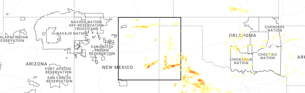
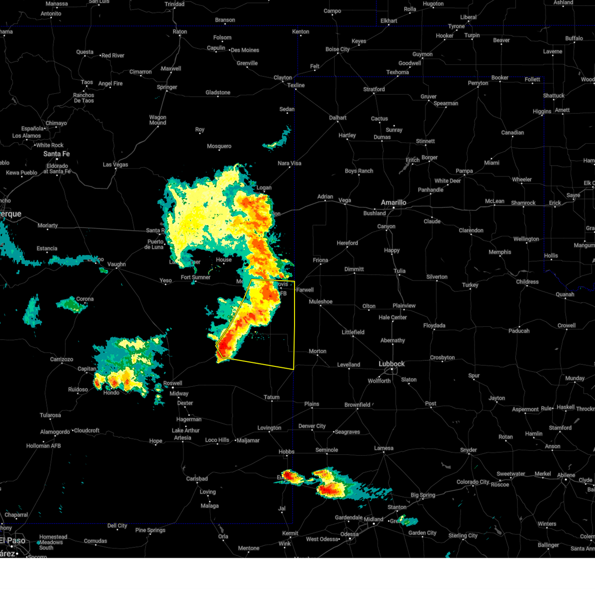
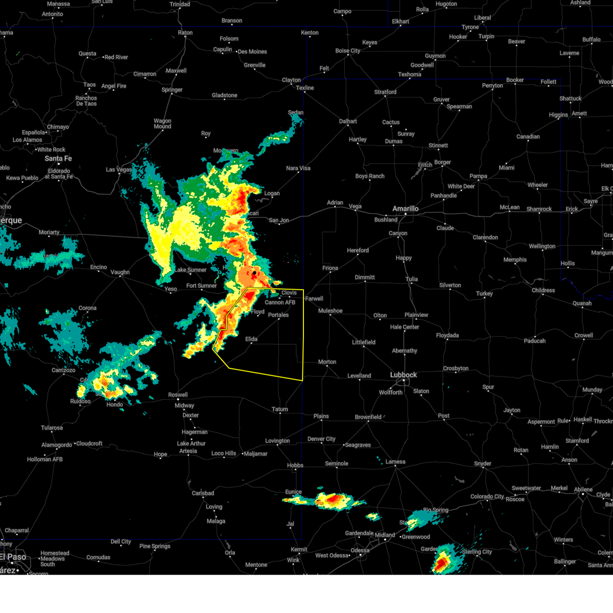
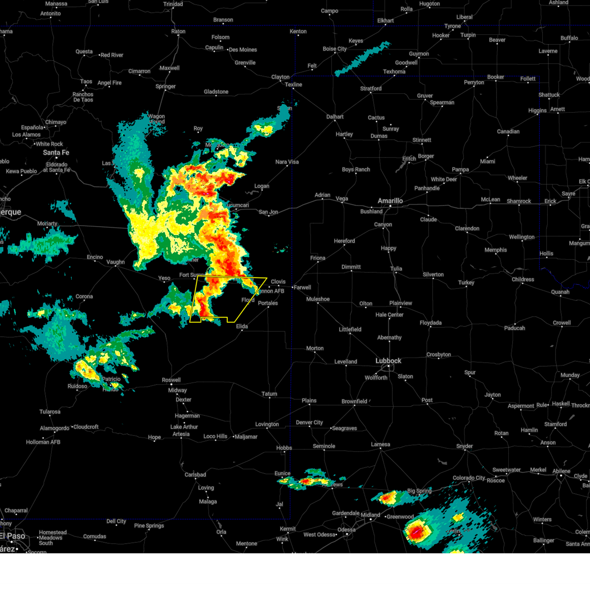
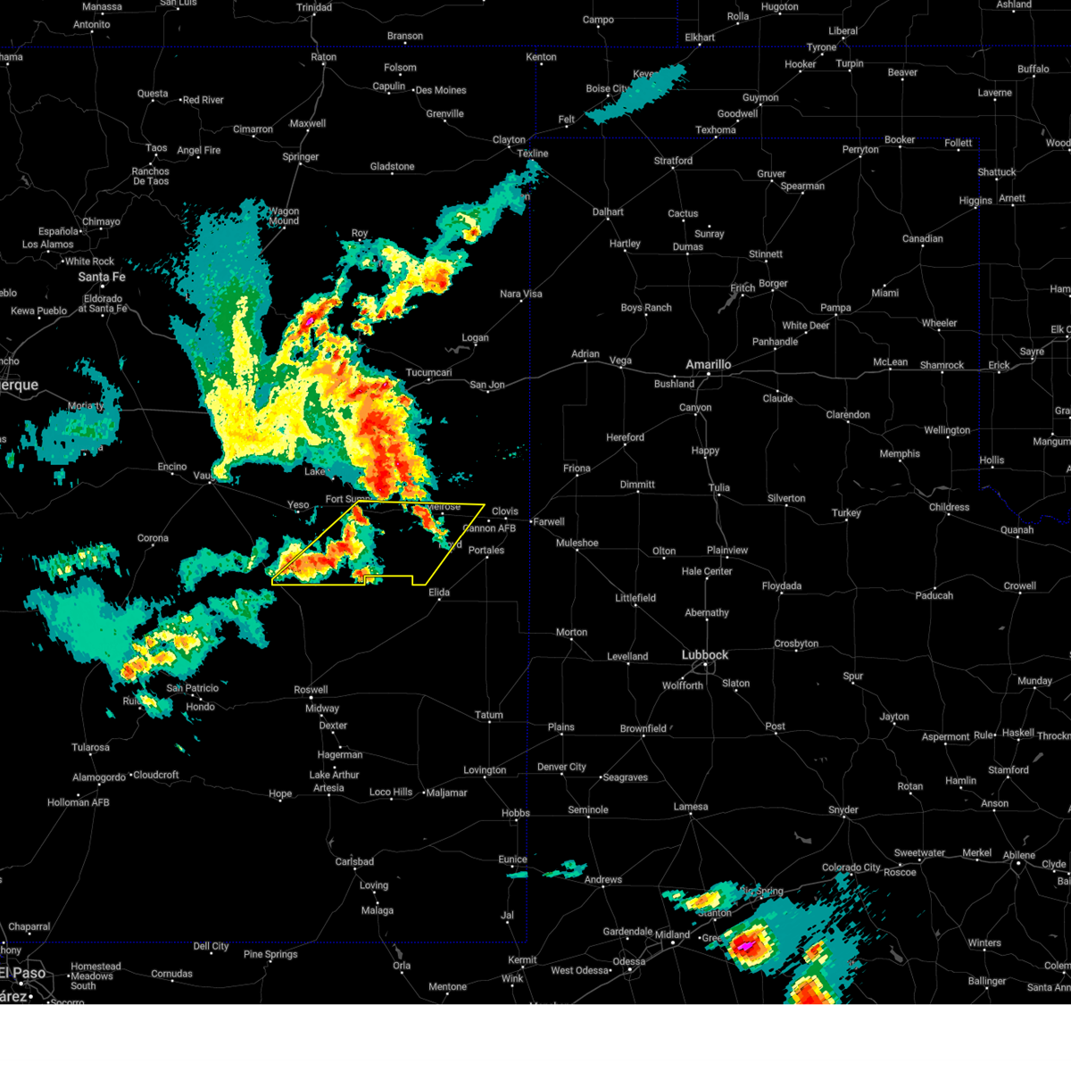
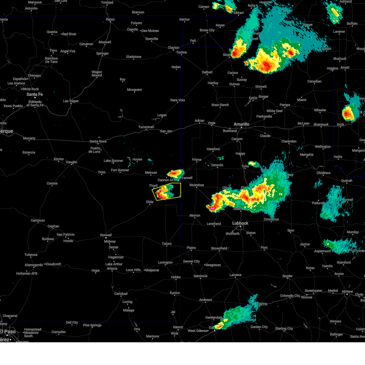
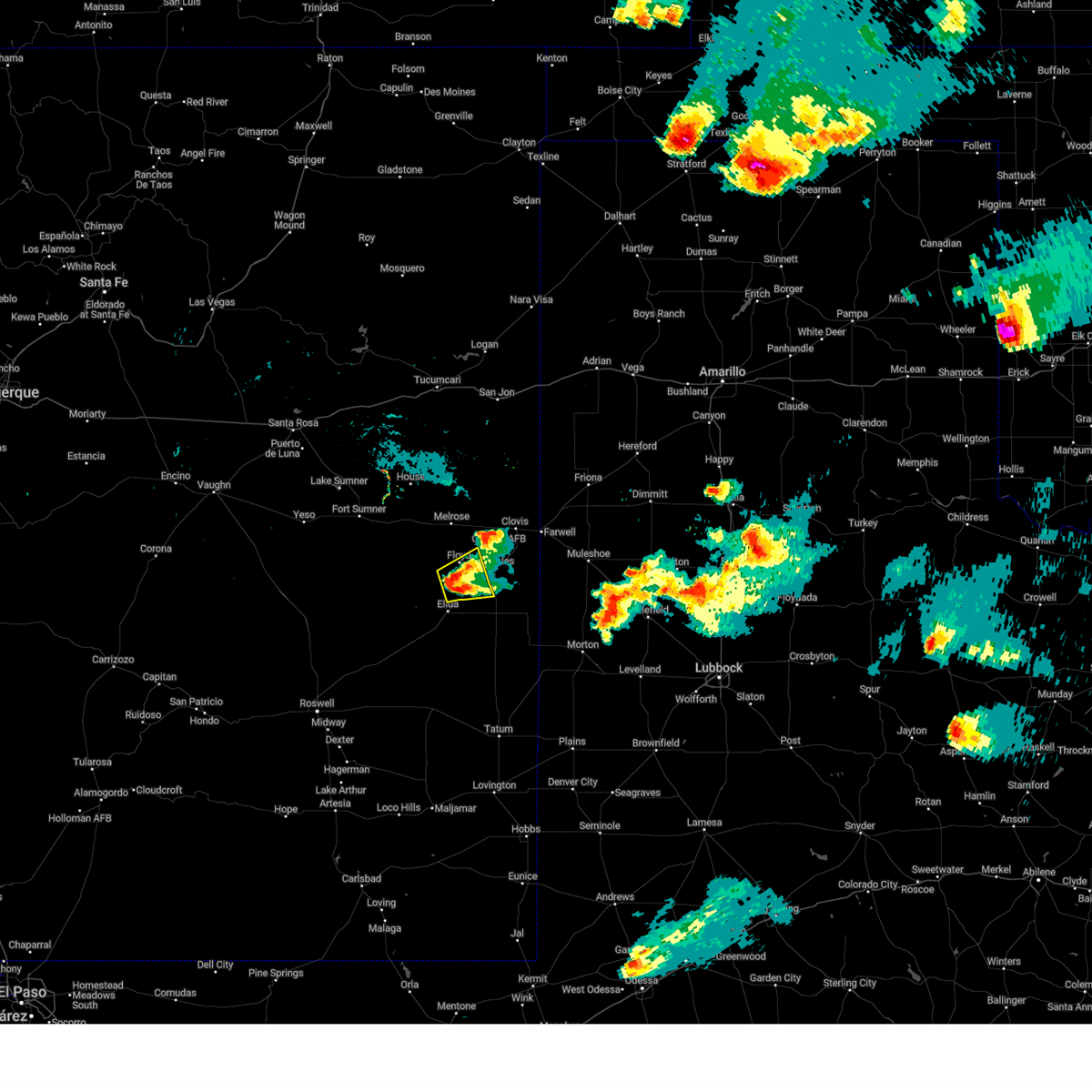
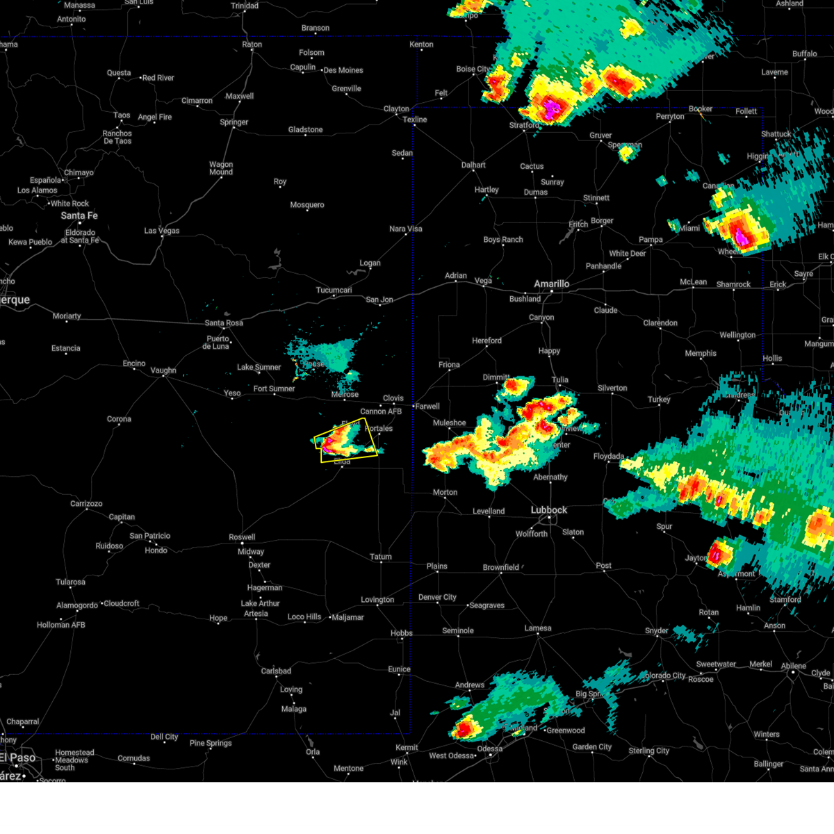
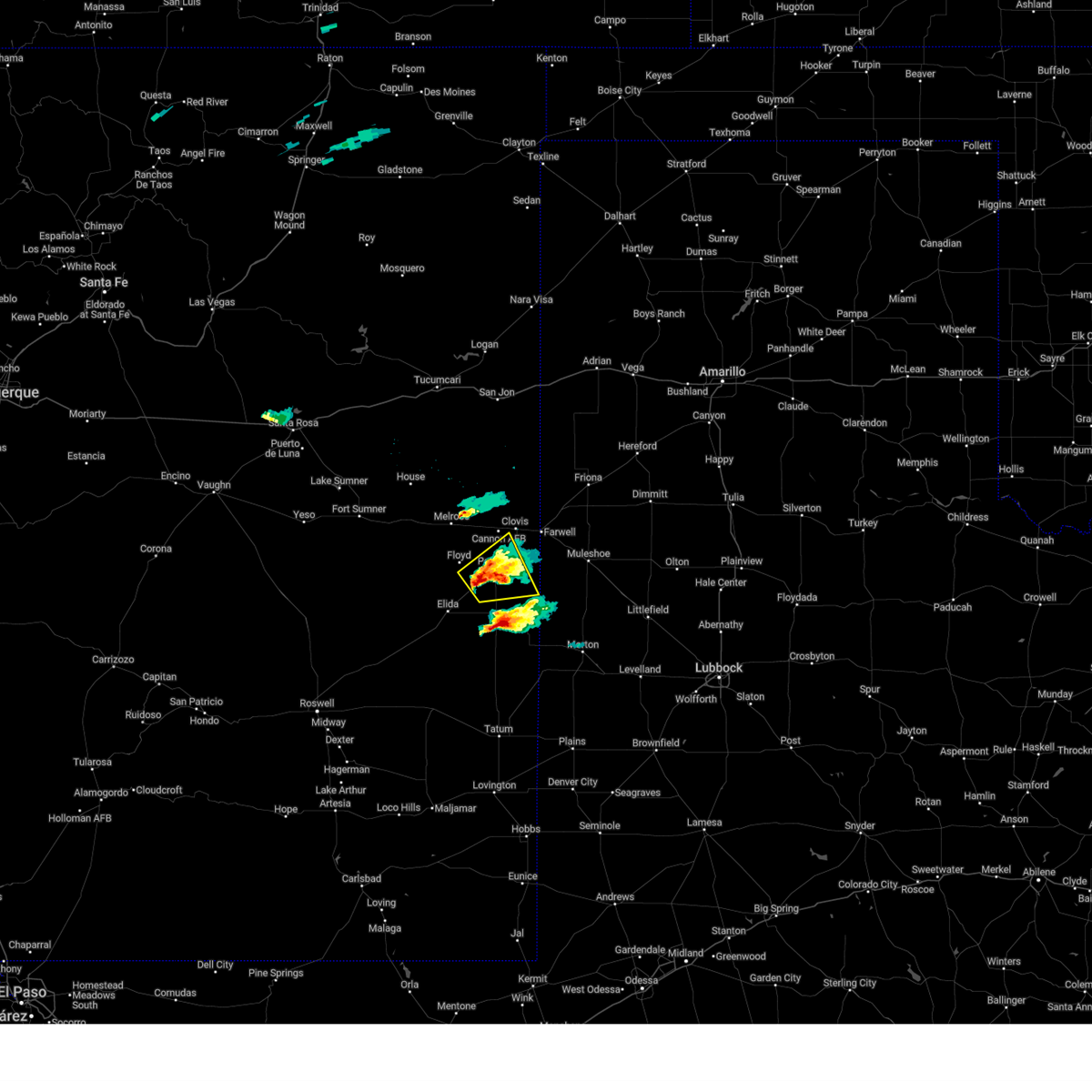
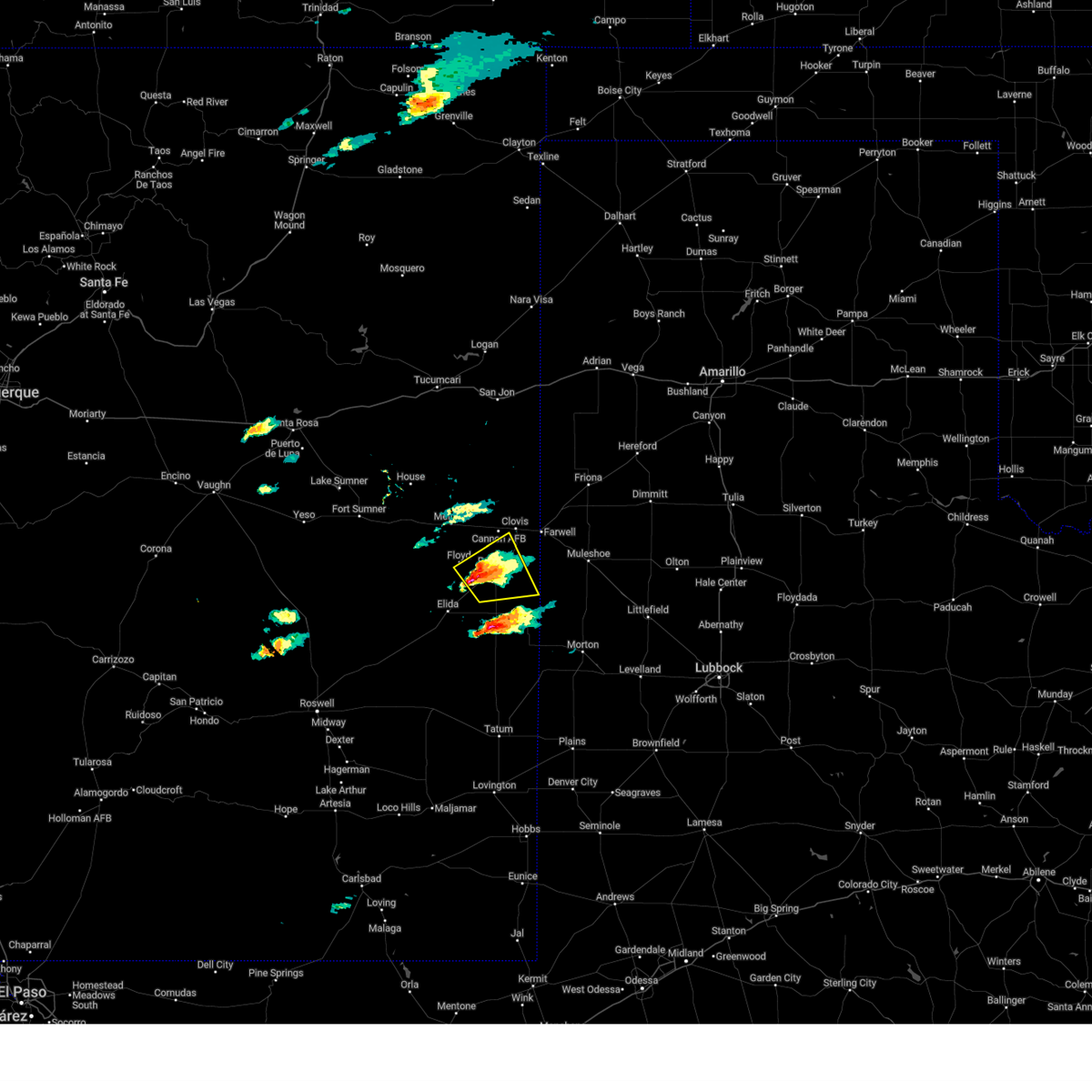
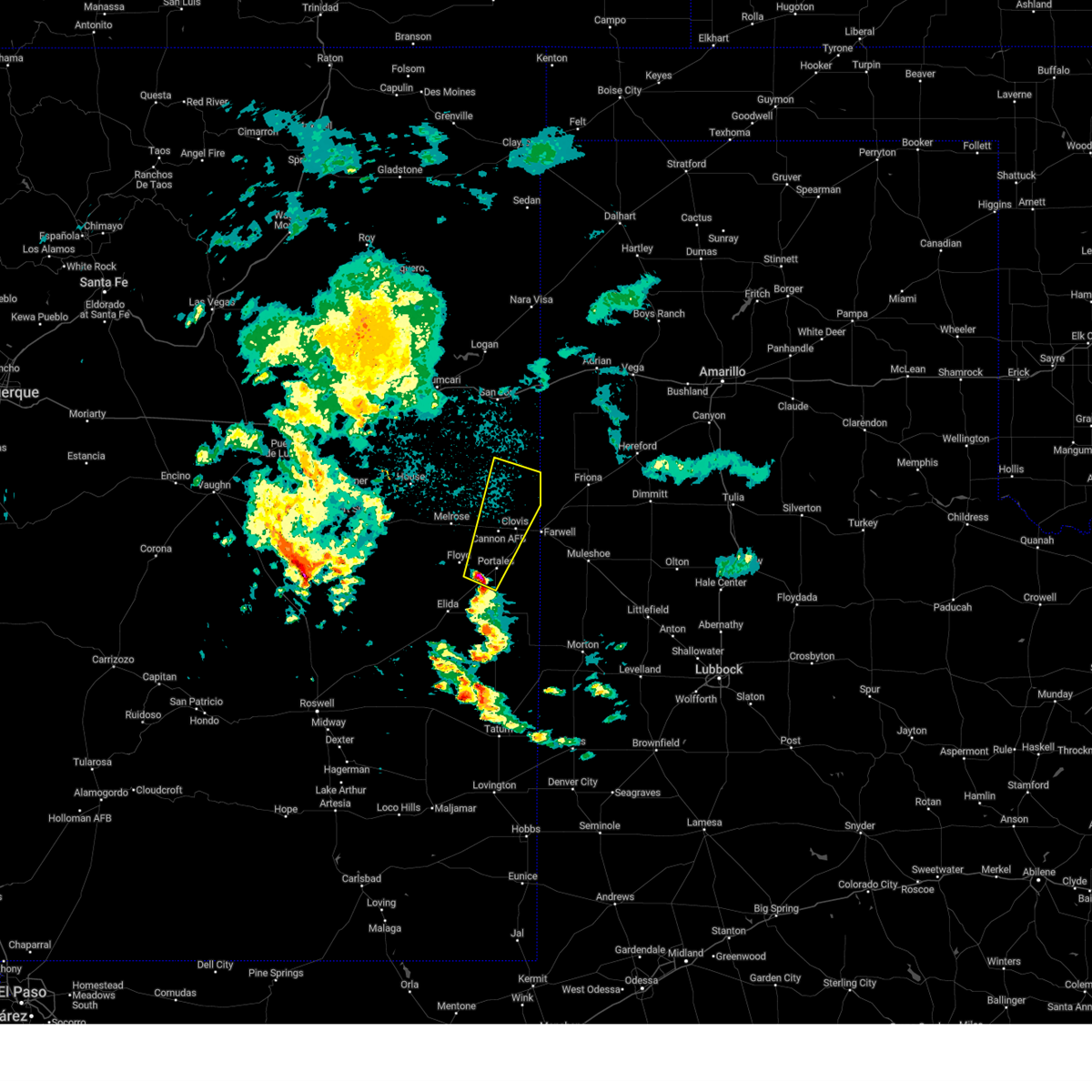
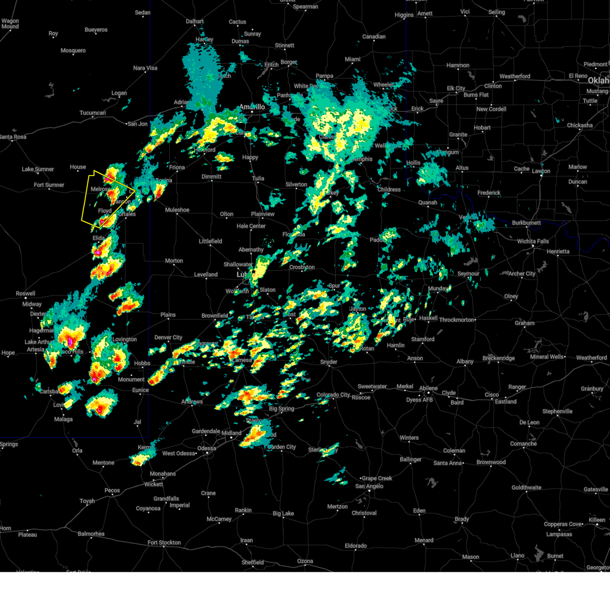
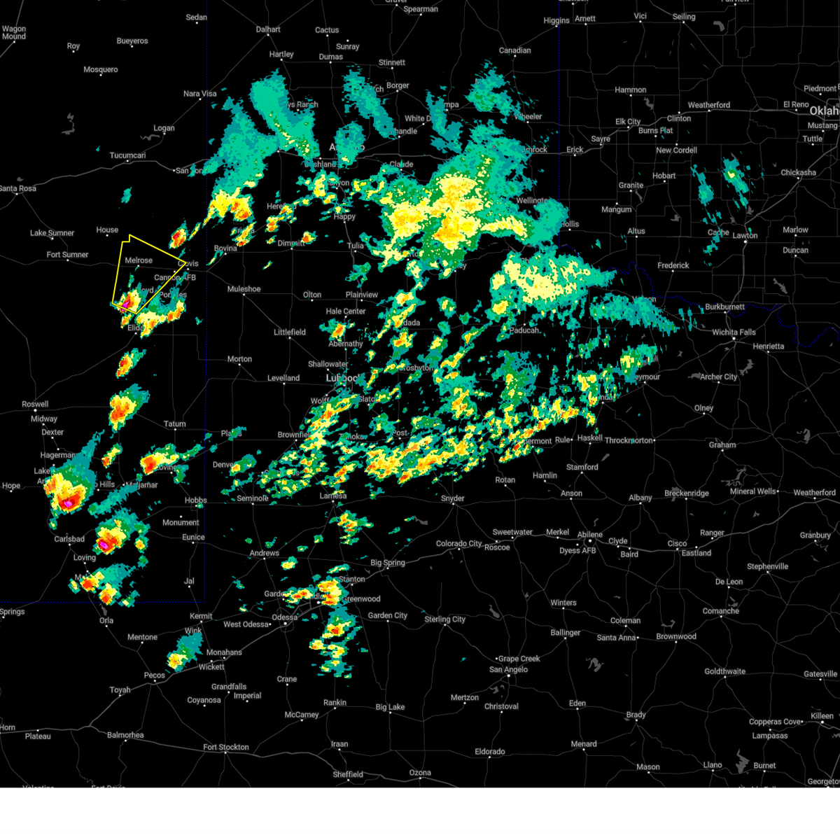
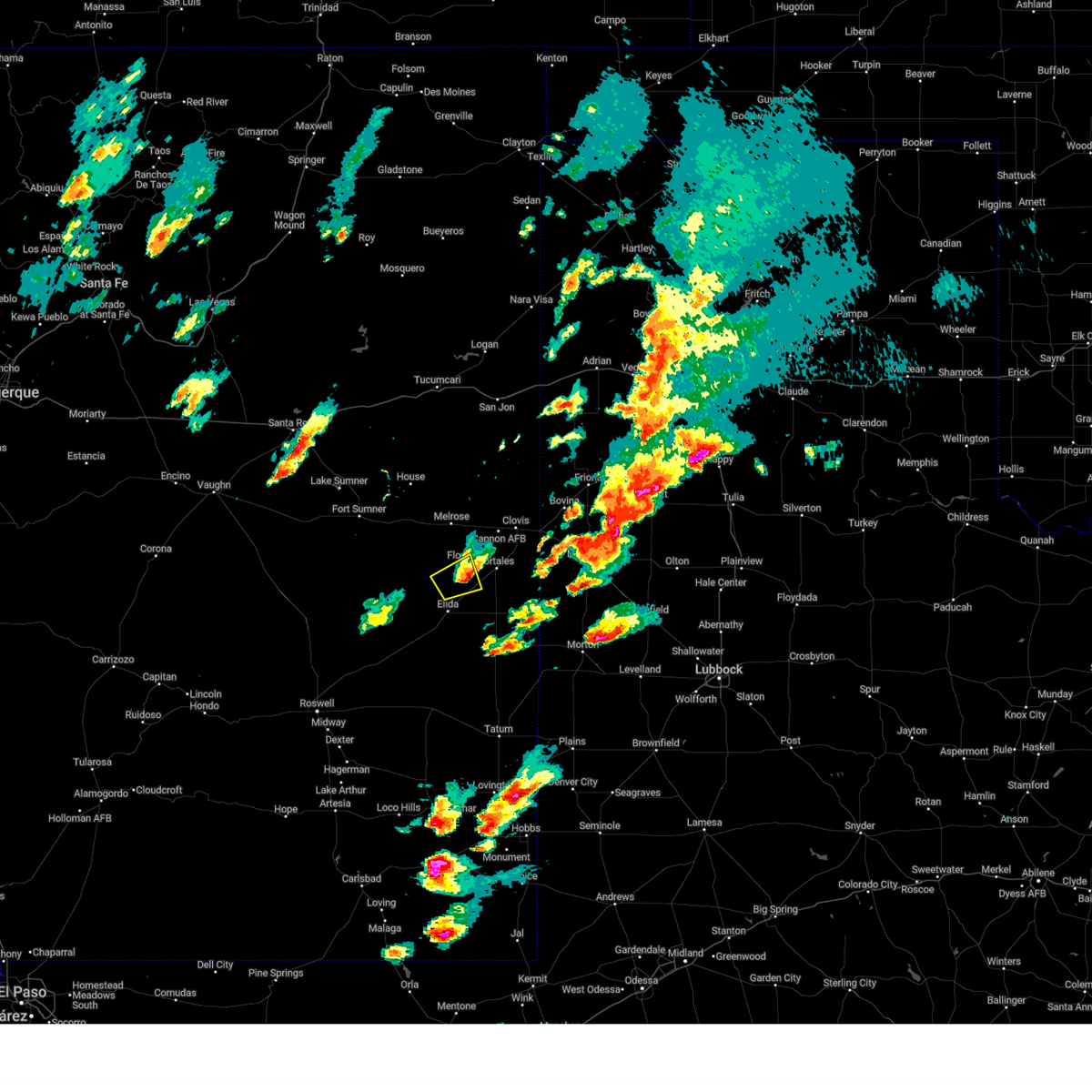
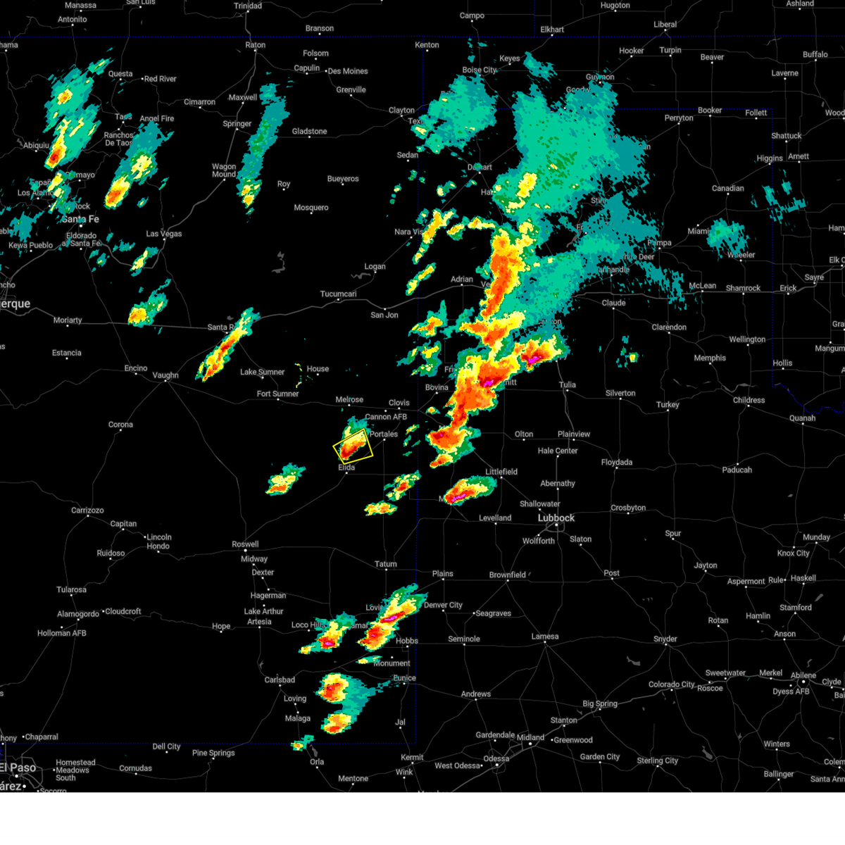
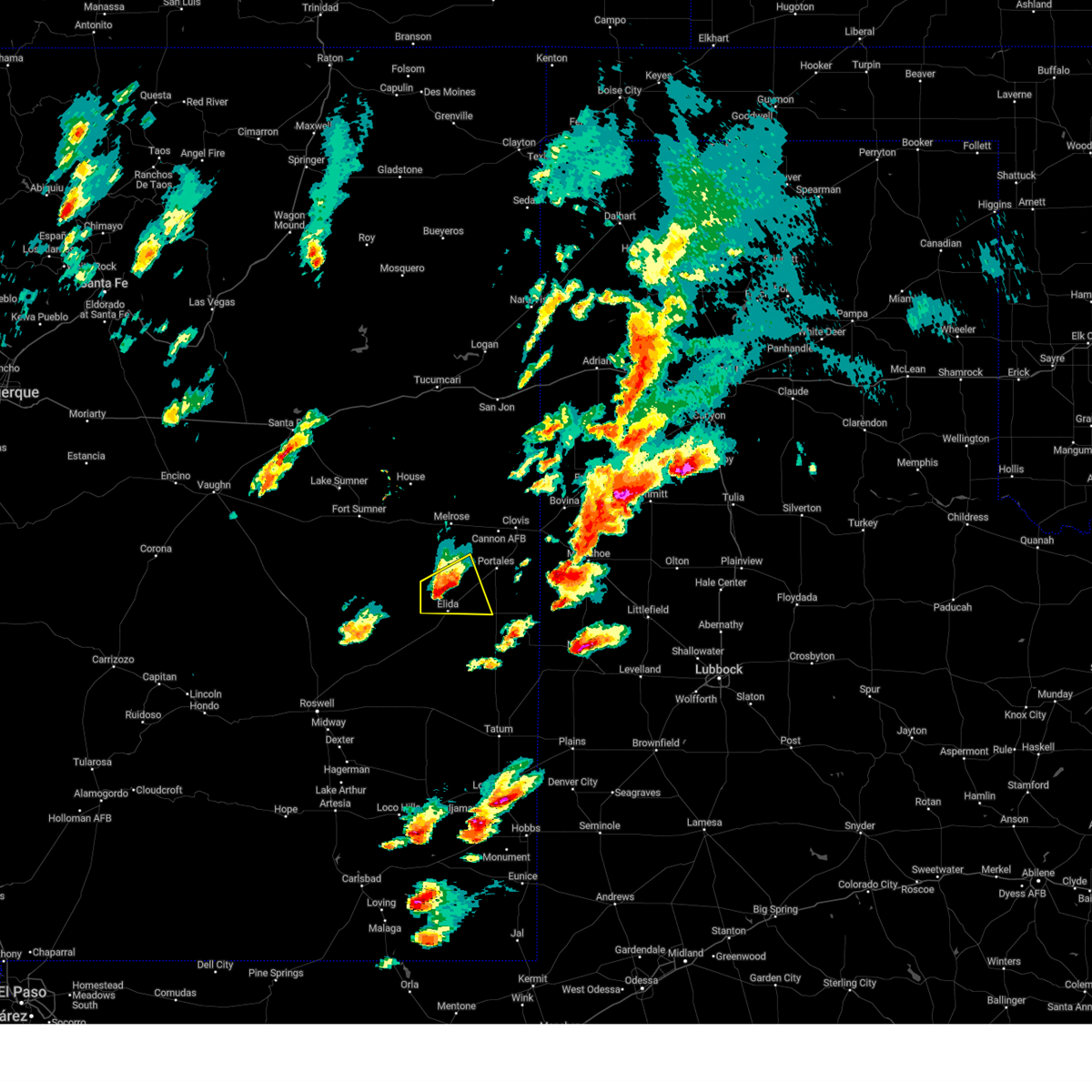
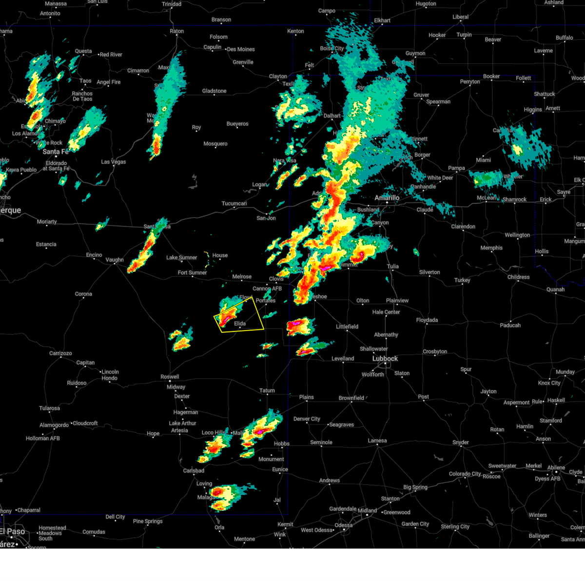
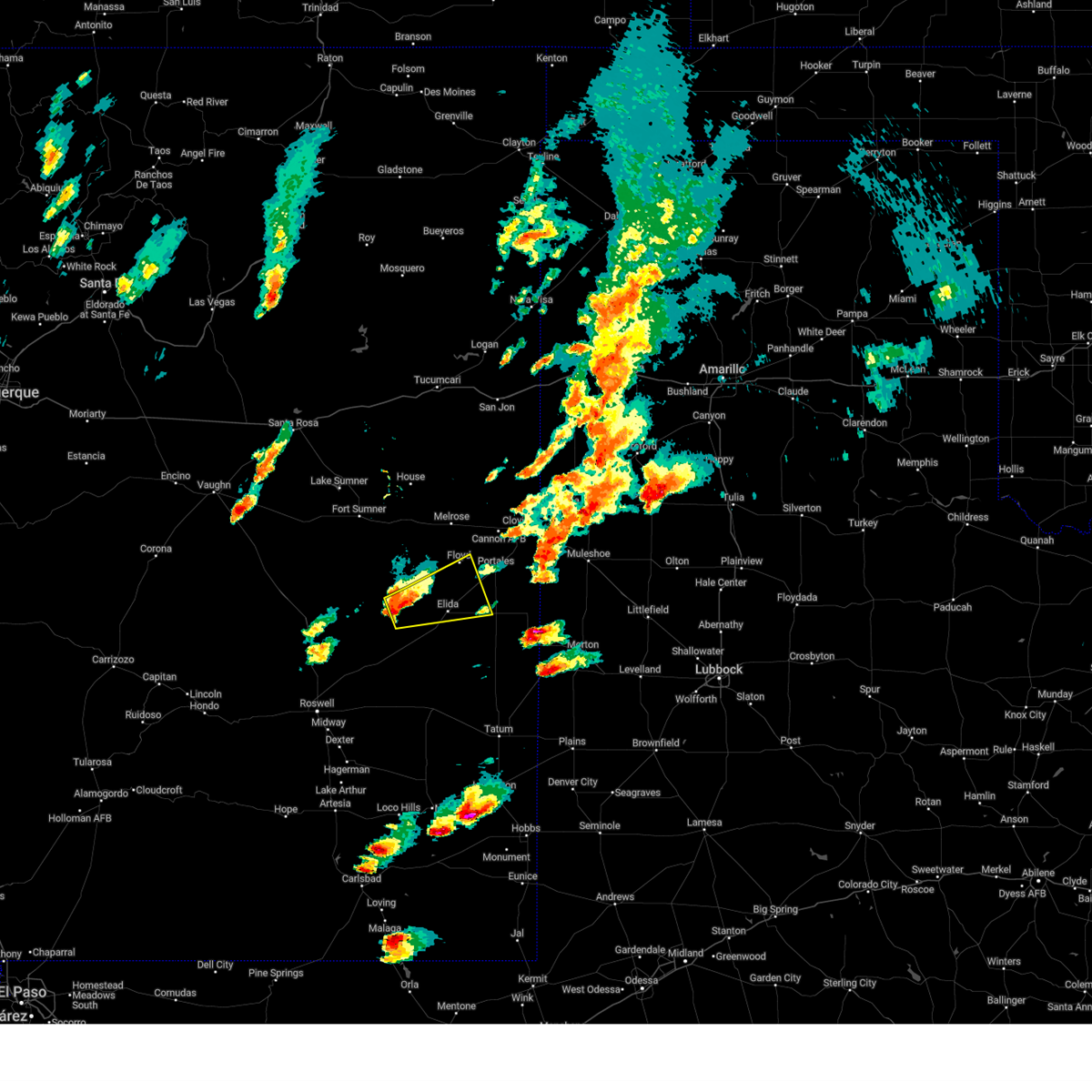
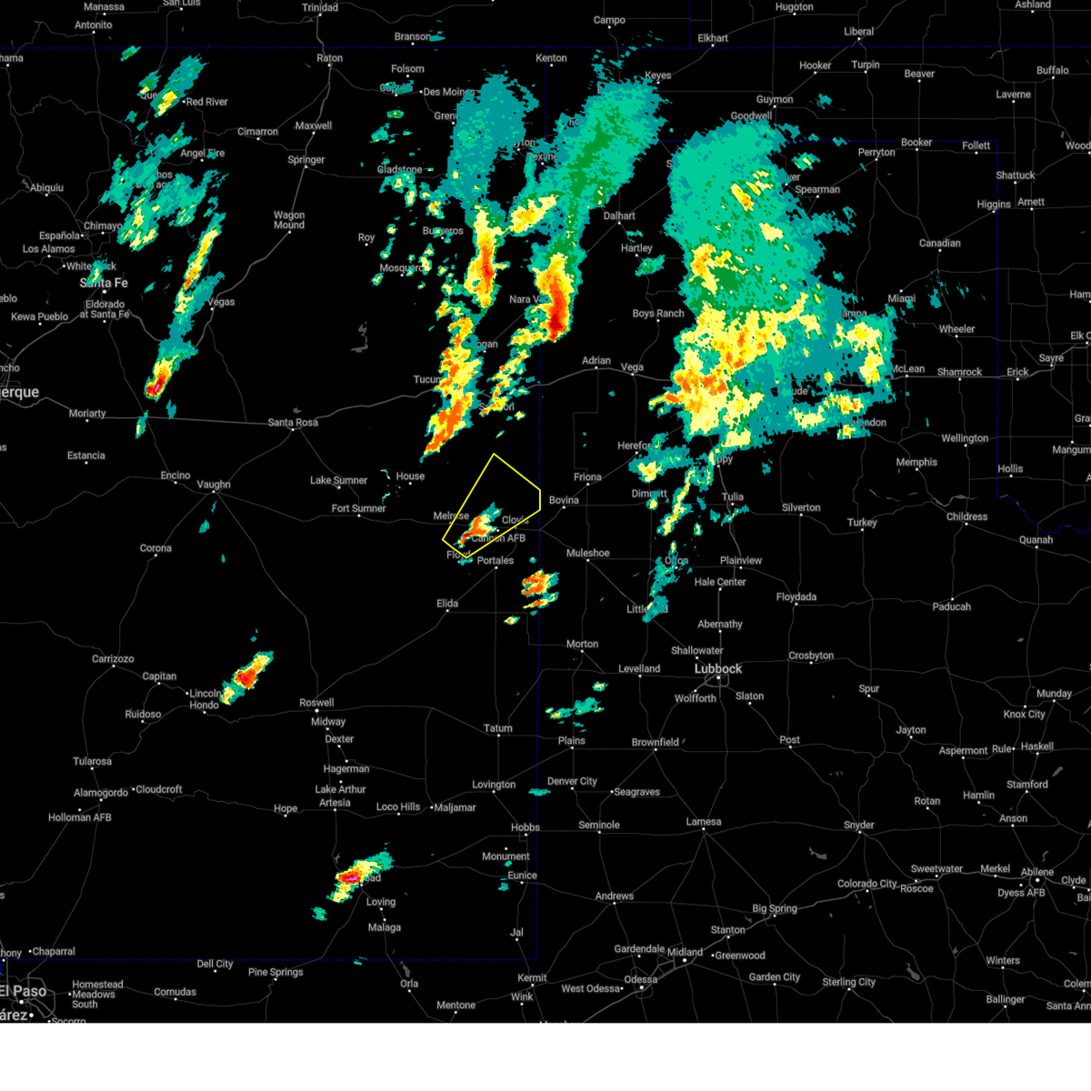
Hail Map for Floyd, NM
The Floyd, NM area has had 8 reports of on-the-ground hail by trained spotters, and has been under severe weather warnings 42 times during the past 12 months. Doppler radar has detected hail at or near Floyd, NM on 86 occasions, including 8 occasions during the past year.
| Name: | Floyd, NM |
| Where Located: | 66.3 miles S of Tucumcari, NM |
| Map: | Google Map for Floyd, NM |
| Population: | 133 |
| Housing Units: | 51 |
| More Info: | Search Google for Floyd, NM |
1
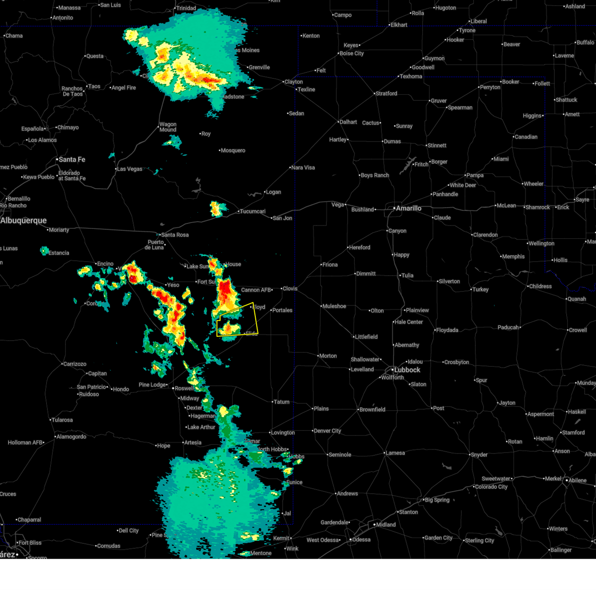
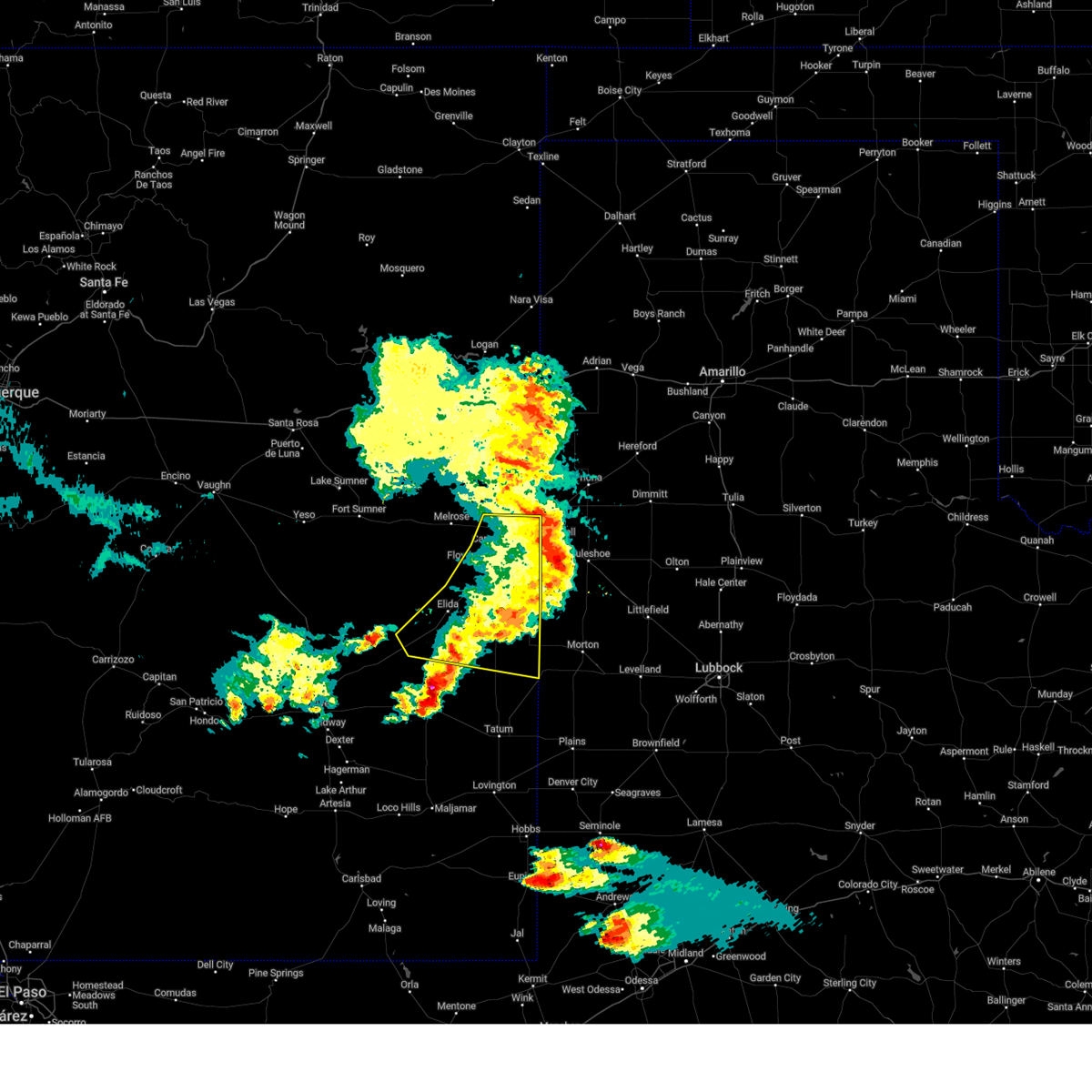
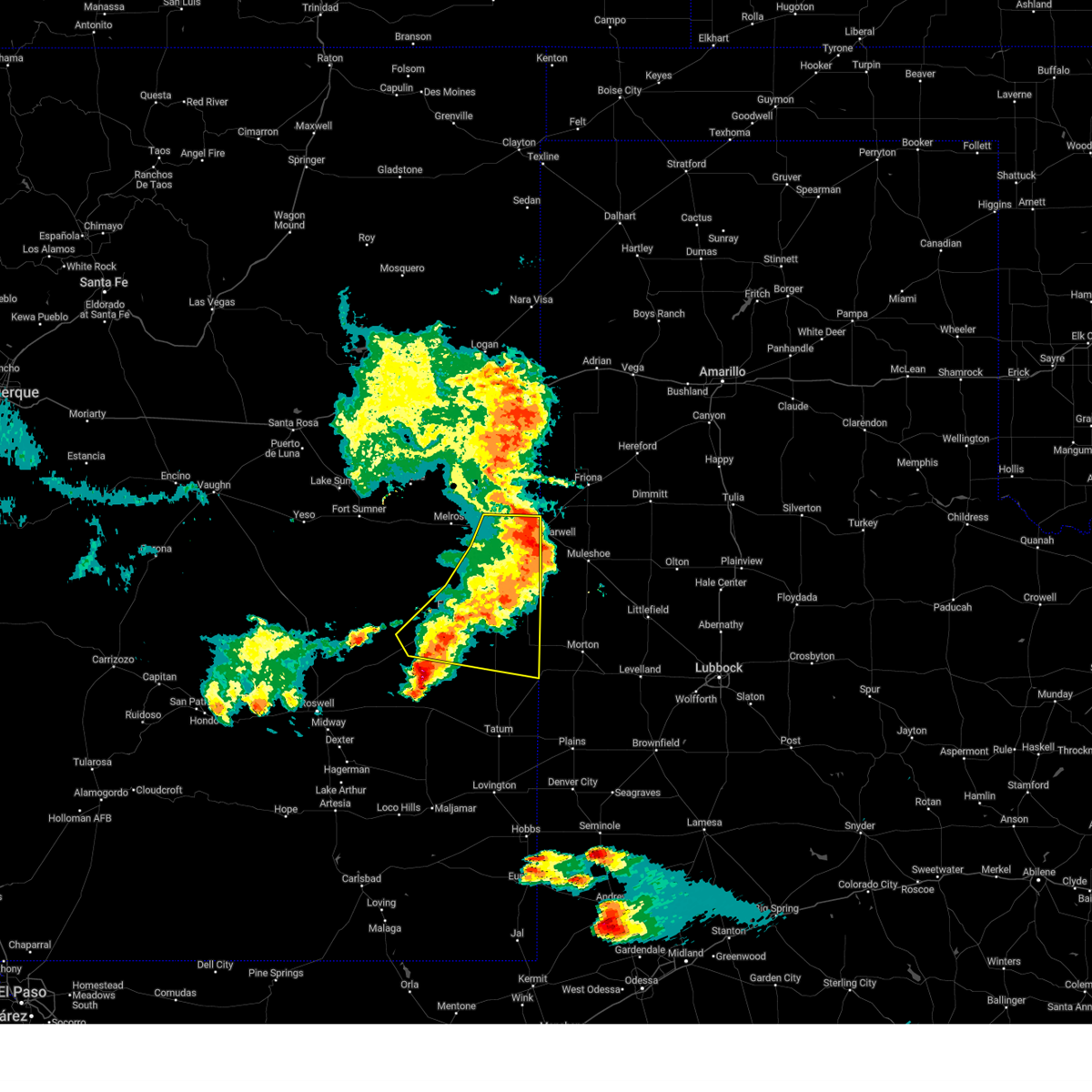
The Top Recent Hail Date for Floyd, NM is Sunday, May 25, 2025 (9th out of 86)
Hail and Wind Damage Spotted near Floyd, NM
| Date / Time | Report Details |
|---|---|
| 6/15/2025 7:30 PM MDT | The melrose range mesonet station observed a 70 mph wind gust from nearby collapsing thunderstorm in roosevelt county NM, 11.5 miles ESE of Floyd, NM |
| 6/15/2025 6:13 PM MDT |
 the severe thunderstorm warning has been cancelled and is no longer in effect the severe thunderstorm warning has been cancelled and is no longer in effect
|
| 6/15/2025 5:45 PM MDT | Svrabq the national weather service in albuquerque has issued a * severe thunderstorm warning for, west central roosevelt county in east central new mexico, northern chaves county in southeastern new mexico, * until 630 pm mdt. * at 545 pm mdt, a severe thunderstorm was located 14 miles north of kenna, or 30 miles west of portales, moving east at 25 mph (radar indicated). Hazards include 60 mph wind gusts and quarter size hail. Hail damage to vehicles is expected. Expect wind damage to roofs, siding, and trees. |
| 6/9/2025 9:13 PM MDT |
 The storms which prompted the warning have weakened below severe limits, and no longer pose an immediate threat to life or property. therefore, the warning will be allowed to expire. however, small hail, gusty winds, and heavy rain are still possible with these thunderstorms. a severe thunderstorm watch remains in effect until 1000 pm mdt for portions of east central and southeast new mexico. The storms which prompted the warning have weakened below severe limits, and no longer pose an immediate threat to life or property. therefore, the warning will be allowed to expire. however, small hail, gusty winds, and heavy rain are still possible with these thunderstorms. a severe thunderstorm watch remains in effect until 1000 pm mdt for portions of east central and southeast new mexico.
|
| 6/9/2025 8:59 PM MDT |
 At 859 pm mdt, severe thunderstorms were located along a line from 10 miles northeast of texico to 14 miles west of milnesand, moving east at 45 mph (radar indicated). Hazards include 60 mph wind gusts and quarter size hail. Hail damage to vehicles is expected. expect wind damage to roofs, siding, and trees. locations impacted include, clovis, portales, texico, elida, dora, causey, pep, oasis state park, arch and lingo. This includes highway 60 between mile markers 374 and 397. At 859 pm mdt, severe thunderstorms were located along a line from 10 miles northeast of texico to 14 miles west of milnesand, moving east at 45 mph (radar indicated). Hazards include 60 mph wind gusts and quarter size hail. Hail damage to vehicles is expected. expect wind damage to roofs, siding, and trees. locations impacted include, clovis, portales, texico, elida, dora, causey, pep, oasis state park, arch and lingo. This includes highway 60 between mile markers 374 and 397.
|
| 6/9/2025 8:28 PM MDT |
 At 828 pm mdt, severe thunderstorms were located along a line from over clovis to 8 miles southeast of elida, moving east at 45 mph (trained spotters reported). Hazards include 70 mph wind gusts and quarter size hail. Hail damage to vehicles is expected. expect considerable tree damage. wind damage is also likely to mobile homes, roofs, and outbuildings. locations impacted include, clovis, portales, texico, elida, dora, causey, pep, oasis state park, arch and cannon air force base. This includes highway 60 between mile markers 366 and 397. At 828 pm mdt, severe thunderstorms were located along a line from over clovis to 8 miles southeast of elida, moving east at 45 mph (trained spotters reported). Hazards include 70 mph wind gusts and quarter size hail. Hail damage to vehicles is expected. expect considerable tree damage. wind damage is also likely to mobile homes, roofs, and outbuildings. locations impacted include, clovis, portales, texico, elida, dora, causey, pep, oasis state park, arch and cannon air force base. This includes highway 60 between mile markers 366 and 397.
|
| 6/9/2025 7:58 PM MDT |
 Svrabq the national weather service in albuquerque has issued a * severe thunderstorm warning for, southern curry county in east central new mexico, roosevelt county in east central new mexico, northeastern chaves county in southeastern new mexico, * until 915 pm mdt. * at 758 pm mdt, severe thunderstorms were located along a line from near melrose to 14 miles north of elkins, moving east at 45 mph (trained spotters reported). Hazards include 60 mph wind gusts and quarter size hail. Hail damage to vehicles is expected. Expect wind damage to roofs, siding, and trees. Svrabq the national weather service in albuquerque has issued a * severe thunderstorm warning for, southern curry county in east central new mexico, roosevelt county in east central new mexico, northeastern chaves county in southeastern new mexico, * until 915 pm mdt. * at 758 pm mdt, severe thunderstorms were located along a line from near melrose to 14 miles north of elkins, moving east at 45 mph (trained spotters reported). Hazards include 60 mph wind gusts and quarter size hail. Hail damage to vehicles is expected. Expect wind damage to roofs, siding, and trees.
|
| 6/9/2025 7:52 PM MDT |
 At 752 pm mdt, severe thunderstorms were located along a line from near melrose to 23 miles south of taiban, moving east at 25 mph (trained spotters reported). Hazards include 60 mph wind gusts and quarter size hail. Hail damage to vehicles is expected. expect wind damage to roofs, siding, and trees. locations impacted include, melrose, tolar, saint vrain and floyd. This includes highway 60 between mile markers 344 and 375. At 752 pm mdt, severe thunderstorms were located along a line from near melrose to 23 miles south of taiban, moving east at 25 mph (trained spotters reported). Hazards include 60 mph wind gusts and quarter size hail. Hail damage to vehicles is expected. expect wind damage to roofs, siding, and trees. locations impacted include, melrose, tolar, saint vrain and floyd. This includes highway 60 between mile markers 344 and 375.
|
| 6/9/2025 7:34 PM MDT |
 At 734 pm mdt, severe thunderstorms were located along a line from near tolar to 25 miles south of taiban, moving east at 25 mph (radar indicated). Hazards include 60 mph wind gusts and quarter size hail. Hail damage to vehicles is expected. expect wind damage to roofs, siding, and trees. locations impacted include, melrose, tolar, taiban, saint vrain and floyd. This includes highway 60 between mile markers 330 and 375. At 734 pm mdt, severe thunderstorms were located along a line from near tolar to 25 miles south of taiban, moving east at 25 mph (radar indicated). Hazards include 60 mph wind gusts and quarter size hail. Hail damage to vehicles is expected. expect wind damage to roofs, siding, and trees. locations impacted include, melrose, tolar, taiban, saint vrain and floyd. This includes highway 60 between mile markers 330 and 375.
|
| 6/9/2025 7:12 PM MDT |
 Svrabq the national weather service in albuquerque has issued a * severe thunderstorm warning for, southwestern curry county in east central new mexico, southeastern de baca county in east central new mexico, northwestern roosevelt county in east central new mexico, * until 800 pm mdt. * at 712 pm mdt, severe thunderstorms were located along a line from 6 miles northwest of taiban to 10 miles northeast of mesa, moving east at 25 mph (radar indicated). Hazards include 60 mph wind gusts and quarter size hail. Hail damage to vehicles is expected. Expect wind damage to roofs, siding, and trees. Svrabq the national weather service in albuquerque has issued a * severe thunderstorm warning for, southwestern curry county in east central new mexico, southeastern de baca county in east central new mexico, northwestern roosevelt county in east central new mexico, * until 800 pm mdt. * at 712 pm mdt, severe thunderstorms were located along a line from 6 miles northwest of taiban to 10 miles northeast of mesa, moving east at 25 mph (radar indicated). Hazards include 60 mph wind gusts and quarter size hail. Hail damage to vehicles is expected. Expect wind damage to roofs, siding, and trees.
|
| 6/6/2025 11:04 PM MDT |
 At 1104 pm mdt, a severe thunderstorm was located 6 miles southwest of portales, moving east at 25 mph (radar indicated). Hazards include golf ball size hail and 60 mph wind gusts. People and animals outdoors will be injured. expect hail damage to roofs, siding, windows, and vehicles. expect wind damage to roofs, siding, and trees. Locations impacted include, portales, oasis state park, arch and floyd. At 1104 pm mdt, a severe thunderstorm was located 6 miles southwest of portales, moving east at 25 mph (radar indicated). Hazards include golf ball size hail and 60 mph wind gusts. People and animals outdoors will be injured. expect hail damage to roofs, siding, windows, and vehicles. expect wind damage to roofs, siding, and trees. Locations impacted include, portales, oasis state park, arch and floyd.
|
| 6/6/2025 10:57 PM MDT |
 The severe thunderstorm warning that was previously in effect has been reissued for roosevelt county and is in effect until 1145 pm mdt. please refer to that bulletin for the latest severe weather information. The severe thunderstorm warning that was previously in effect has been reissued for roosevelt county and is in effect until 1145 pm mdt. please refer to that bulletin for the latest severe weather information.
|
| 6/6/2025 10:56 PM MDT |
 Svrabq the national weather service in albuquerque has issued a * severe thunderstorm warning for, east central roosevelt county in east central new mexico, * until 1145 pm mdt. * at 1056 pm mdt, a severe thunderstorm was located 8 miles southwest of portales, moving east at 25 mph (radar indicated). Hazards include 60 mph wind gusts and half dollar size hail. Hail damage to vehicles is expected. Expect wind damage to roofs, siding, and trees. Svrabq the national weather service in albuquerque has issued a * severe thunderstorm warning for, east central roosevelt county in east central new mexico, * until 1145 pm mdt. * at 1056 pm mdt, a severe thunderstorm was located 8 miles southwest of portales, moving east at 25 mph (radar indicated). Hazards include 60 mph wind gusts and half dollar size hail. Hail damage to vehicles is expected. Expect wind damage to roofs, siding, and trees.
|
| 6/6/2025 10:40 PM MDT |
 At 1040 pm mdt, a severe thunderstorm was located 11 miles west of portales, moving east at 25 mph (radar indicated). Hazards include 60 mph wind gusts and quarter size hail. Hail damage to vehicles is expected. expect wind damage to roofs, siding, and trees. Locations impacted include, portales and floyd. At 1040 pm mdt, a severe thunderstorm was located 11 miles west of portales, moving east at 25 mph (radar indicated). Hazards include 60 mph wind gusts and quarter size hail. Hail damage to vehicles is expected. expect wind damage to roofs, siding, and trees. Locations impacted include, portales and floyd.
|
| 6/6/2025 10:15 PM MDT | At 1015 pm mdt, a severe thunderstorm was located 11 miles northwest of elida, or 22 miles west of portales, moving east at 25 mph (radar indicated). Hazards include ping pong ball size hail and 60 mph wind gusts. People and animals outdoors will be injured. expect hail damage to roofs, siding, windows, and vehicles. expect wind damage to roofs, siding, and trees. Locations impacted include, portales and floyd. |
| 6/6/2025 10:08 PM MDT |
 Svrabq the national weather service in albuquerque has issued a * severe thunderstorm warning for, west central roosevelt county in east central new mexico, * until 1100 pm mdt. * at 1008 pm mdt, a severe thunderstorm was located 13 miles northwest of elida, or 26 miles west of portales, moving east at 25 mph (radar indicated). Hazards include 60 mph wind gusts and quarter size hail. Hail damage to vehicles is expected. Expect wind damage to roofs, siding, and trees. Svrabq the national weather service in albuquerque has issued a * severe thunderstorm warning for, west central roosevelt county in east central new mexico, * until 1100 pm mdt. * at 1008 pm mdt, a severe thunderstorm was located 13 miles northwest of elida, or 26 miles west of portales, moving east at 25 mph (radar indicated). Hazards include 60 mph wind gusts and quarter size hail. Hail damage to vehicles is expected. Expect wind damage to roofs, siding, and trees.
|
| 6/5/2025 3:13 PM MDT |
 At 313 pm mdt, a severe thunderstorm was located 7 miles south of portales, moving east at 25 mph (radar indicated). Hazards include 60 mph wind gusts and half dollar size hail. Hail damage to vehicles is expected. expect wind damage to roofs, siding, and trees. Locations impacted include, portales, oasis state park, arch and floyd. At 313 pm mdt, a severe thunderstorm was located 7 miles south of portales, moving east at 25 mph (radar indicated). Hazards include 60 mph wind gusts and half dollar size hail. Hail damage to vehicles is expected. expect wind damage to roofs, siding, and trees. Locations impacted include, portales, oasis state park, arch and floyd.
|
| 6/5/2025 3:10 PM MDT |
 At 310 pm mdt, a severe thunderstorm was located near portales, moving east at 25 mph (radar indicated). Hazards include 60 mph wind gusts and half dollar size hail. Hail damage to vehicles is expected. expect wind damage to roofs, siding, and trees. Locations impacted include, portales, oasis state park, arch and floyd. At 310 pm mdt, a severe thunderstorm was located near portales, moving east at 25 mph (radar indicated). Hazards include 60 mph wind gusts and half dollar size hail. Hail damage to vehicles is expected. expect wind damage to roofs, siding, and trees. Locations impacted include, portales, oasis state park, arch and floyd.
|
| 6/5/2025 2:58 PM MDT | At 258 pm mdt, a severe thunderstorm was located 5 miles southwest of portales, moving east at 20 mph (radar indicated). Hazards include 60 mph wind gusts and quarter size hail. Hail damage to vehicles is expected. expect wind damage to roofs, siding, and trees. Locations impacted include, portales, oasis state park, arch and floyd. |
| 6/5/2025 2:47 PM MDT | Svrabq the national weather service in albuquerque has issued a * severe thunderstorm warning for, south central curry county in east central new mexico, central roosevelt county in east central new mexico, * until 345 pm mdt. * at 247 pm mdt, a severe thunderstorm was located 9 miles southwest of portales, moving east at 20 mph (radar indicated). Hazards include ping pong ball size hail and 60 mph wind gusts. People and animals outdoors will be injured. expect hail damage to roofs, siding, windows, and vehicles. Expect wind damage to roofs, siding, and trees. |
| 5/25/2025 5:49 PM MDT | Svrabq the national weather service in albuquerque has issued a * severe thunderstorm warning for, south central curry county in east central new mexico, central roosevelt county in east central new mexico, * until 630 pm mdt. * at 549 pm mdt, a severe thunderstorm was located 6 miles northwest of oasis state park, or 10 miles northwest of portales, moving northeast at 15 mph (radar indicated). Hazards include 60 mph wind gusts and quarter size hail. Hail damage to vehicles is expected. Expect wind damage to roofs, siding, and trees. |
| 5/25/2025 5:42 PM MDT |
 The storm which prompted the tornado warning has weakened below severe limits, and the observed tornado has roped out. therefore, the warning will be allowed to expire. however, small hail and gusty winds are still possible with this thunderstorm. a severe thunderstorm watch remains in effect until 1200 am mdt monday for a portion of east central new mexico. The storm which prompted the tornado warning has weakened below severe limits, and the observed tornado has roped out. therefore, the warning will be allowed to expire. however, small hail and gusty winds are still possible with this thunderstorm. a severe thunderstorm watch remains in effect until 1200 am mdt monday for a portion of east central new mexico.
|
| 5/25/2025 5:36 PM MDT | At 536 pm mdt, a confirmed tornado was located 10 miles west of portales, moving northeast at 20 mph (weather spotters confirmed tornado). Hazards include damaging tornado and half dollar size hail. Flying debris will be dangerous to those caught without shelter. mobile homes will be damaged or destroyed. damage to roofs, windows and vehicles will occur. tree damage is likely. Locations impacted include, oasis state park and floyd. |
| 5/25/2025 5:27 PM MDT | The severe thunderstorm warning that was previously in effect has been upgraded to a tornado warning. please refer to that bulletin for the latest information on this dangerous weather situation. a severe thunderstorm watch remains in effect until 1200 am mdt monday for a portion of east central new mexico. |
| 5/25/2025 5:25 PM MDT | At 525 pm mdt, a spotter and broadcast meteorologists confirmed a tornado was located near floyd 12 miles west of portales, moving northeast at 25 mph (weather spotters confirmed tornado). Hazards include damaging tornado and half dollar size hail. Flying debris will be dangerous to those caught without shelter. mobile homes will be damaged or destroyed. damage to roofs, windows and vehicles will occur. tree damage is likely. Locations impacted include, oasis state park and floyd. |
| 5/25/2025 5:17 PM MDT | Torabq the national weather service in albuquerque has issued a * tornado warning for, south central curry county in east central new mexico, central roosevelt county in east central new mexico, * until 545 pm mdt. * at 517 pm mdt, a severe thunderstorm capable of producing a tornado was located 14 miles west of portales, moving northeast at 25 mph (weather spotters reported funnel cloud). Hazards include tornado and half dollar size hail. Flying debris will be dangerous to those caught without shelter. mobile homes will be damaged or destroyed. damage to roofs, windows and vehicles will occur. Tree damage is likely. |
| 5/25/2025 5:12 PM MDT | At 512 pm mdt, a severe thunderstorm was located 13 miles south of melrose, or 16 miles west of portales, moving northeast at 20 mph (radar indicated). Hazards include ping pong ball size hail and 60 mph wind gusts. People and animals outdoors will be injured. expect hail damage to roofs, siding, windows, and vehicles. expect wind damage to roofs, siding, and trees. Locations impacted include, floyd. |
| 5/25/2025 4:51 PM MDT |
 At 451 pm mdt, a severe thunderstorm was located 18 miles south of melrose, or 22 miles west of portales, moving northeast at 15 mph (radar indicated). Hazards include ping pong ball size hail and 60 mph wind gusts. People and animals outdoors will be injured. expect hail damage to roofs, siding, windows, and vehicles. expect wind damage to roofs, siding, and trees. Locations impacted include, floyd. At 451 pm mdt, a severe thunderstorm was located 18 miles south of melrose, or 22 miles west of portales, moving northeast at 15 mph (radar indicated). Hazards include ping pong ball size hail and 60 mph wind gusts. People and animals outdoors will be injured. expect hail damage to roofs, siding, windows, and vehicles. expect wind damage to roofs, siding, and trees. Locations impacted include, floyd.
|
| 5/25/2025 4:38 PM MDT |
 At 438 pm mdt, a severe thunderstorm was located 17 miles northwest of elida, or 25 miles west of portales, moving northeast at 15 mph (radar indicated). Hazards include tennis ball size hail and 60 mph wind gusts. People and animals outdoors will be injured. expect hail damage to roofs, siding, windows, and vehicles. expect wind damage to roofs, siding, and trees. Locations impacted include, floyd. At 438 pm mdt, a severe thunderstorm was located 17 miles northwest of elida, or 25 miles west of portales, moving northeast at 15 mph (radar indicated). Hazards include tennis ball size hail and 60 mph wind gusts. People and animals outdoors will be injured. expect hail damage to roofs, siding, windows, and vehicles. expect wind damage to roofs, siding, and trees. Locations impacted include, floyd.
|
| 5/25/2025 4:31 PM MDT | Svrabq the national weather service in albuquerque has issued a * severe thunderstorm warning for, southwestern curry county in east central new mexico, west central roosevelt county in east central new mexico, * until 530 pm mdt. * at 431 pm mdt, a severe thunderstorm was located 15 miles northwest of elida, or 27 miles west of portales, moving northeast at 15 mph (radar indicated). Hazards include 60 mph wind gusts and half dollar size hail. Hail damage to vehicles is expected. Expect wind damage to roofs, siding, and trees. |
| 5/5/2025 2:26 AM MDT |
 Svrabq the national weather service in albuquerque has issued a * severe thunderstorm warning for, southeastern curry county in east central new mexico, central roosevelt county in east central new mexico, * until 315 am mdt. * at 226 am mdt, a severe thunderstorm was located near portales, moving north at 45 mph (radar indicated). Hazards include 60 mph wind gusts and quarter size hail. Hail damage to vehicles is expected. Expect wind damage to roofs, siding, and trees. Svrabq the national weather service in albuquerque has issued a * severe thunderstorm warning for, southeastern curry county in east central new mexico, central roosevelt county in east central new mexico, * until 315 am mdt. * at 226 am mdt, a severe thunderstorm was located near portales, moving north at 45 mph (radar indicated). Hazards include 60 mph wind gusts and quarter size hail. Hail damage to vehicles is expected. Expect wind damage to roofs, siding, and trees.
|
| 11/2/2024 2:12 PM MDT |
 The storm which prompted the warning has weakened below severe limits, and no longer poses an immediate threat to life or property. therefore, the warning will be allowed to expire. however, small hail and gusty winds are still possible with this thunderstorm. The storm which prompted the warning has weakened below severe limits, and no longer poses an immediate threat to life or property. therefore, the warning will be allowed to expire. however, small hail and gusty winds are still possible with this thunderstorm.
|
| 11/2/2024 1:29 PM MDT |
 Svrabq the national weather service in albuquerque has issued a * severe thunderstorm warning for, southwestern curry county in east central new mexico, northwestern roosevelt county in east central new mexico, * until 215 pm mdt. * at 129 pm mdt, a severe thunderstorm was located 17 miles north of elida, or 21 miles west of portales, moving north at 40 mph (radar indicated). Hazards include two inch hail and 70 mph wind gusts. People and animals outdoors will be injured. expect hail damage to roofs, siding, windows, and vehicles. expect considerable tree damage. Wind damage is also likely to mobile homes, roofs, and outbuildings. Svrabq the national weather service in albuquerque has issued a * severe thunderstorm warning for, southwestern curry county in east central new mexico, northwestern roosevelt county in east central new mexico, * until 215 pm mdt. * at 129 pm mdt, a severe thunderstorm was located 17 miles north of elida, or 21 miles west of portales, moving north at 40 mph (radar indicated). Hazards include two inch hail and 70 mph wind gusts. People and animals outdoors will be injured. expect hail damage to roofs, siding, windows, and vehicles. expect considerable tree damage. Wind damage is also likely to mobile homes, roofs, and outbuildings.
|
| 11/2/2024 12:56 AM MDT | the severe thunderstorm warning has been cancelled and is no longer in effect |
| 11/2/2024 12:52 AM MDT | At 1252 am mdt, a severe thunderstorm was located 7 miles east of elida, or 18 miles southwest of portales, moving northeast at 20 mph (radar indicated). Hazards include 60 mph wind gusts and quarter size hail. Hail damage to vehicles is expected. expect wind damage to roofs, siding, and trees. Locations impacted include, portales, elida and floyd. |
| 11/2/2024 12:35 AM MDT | Svrabq the national weather service in albuquerque has issued a * severe thunderstorm warning for, central roosevelt county in east central new mexico, * until 115 am mdt. * at 1235 am mdt, a severe thunderstorm was located over elida, or 23 miles southwest of portales, moving northeast at 25 mph (radar indicated). Hazards include ping pong ball size hail and 60 mph wind gusts. People and animals outdoors will be injured. expect hail damage to roofs, siding, windows, and vehicles. Expect wind damage to roofs, siding, and trees. |
| 9/21/2024 5:27 PM MDT |
 The storm which prompted the warning has weakened below severe limits, and no longer poses an immediate threat to life or property. therefore, the warning will be allowed to expire. however, small hail, gusty winds, and heavy rain are still possible with this thunderstorm. a severe thunderstorm watch remains in effect until 1000 pm mdt for a portion of east central new mexico. The storm which prompted the warning has weakened below severe limits, and no longer poses an immediate threat to life or property. therefore, the warning will be allowed to expire. however, small hail, gusty winds, and heavy rain are still possible with this thunderstorm. a severe thunderstorm watch remains in effect until 1000 pm mdt for a portion of east central new mexico.
|
| 9/21/2024 5:19 PM MDT |
 At 519 pm mdt, a severe thunderstorm was located 12 miles north of elida, or 14 miles west of portales, moving northeast at 40 mph (radar indicated). Hazards include 60 mph wind gusts and quarter size hail. Hail damage to vehicles is expected. expect wind damage to roofs, siding, and trees. Locations impacted include, floyd. At 519 pm mdt, a severe thunderstorm was located 12 miles north of elida, or 14 miles west of portales, moving northeast at 40 mph (radar indicated). Hazards include 60 mph wind gusts and quarter size hail. Hail damage to vehicles is expected. expect wind damage to roofs, siding, and trees. Locations impacted include, floyd.
|
| 9/21/2024 5:07 PM MDT |
 the severe thunderstorm warning has been cancelled and is no longer in effect the severe thunderstorm warning has been cancelled and is no longer in effect
|
| 9/21/2024 5:07 PM MDT |
 At 507 pm mdt, a severe thunderstorm was located 8 miles northwest of elida, or 22 miles southwest of portales, moving northeast at 40 mph (radar indicated). Hazards include 60 mph wind gusts and quarter size hail. Hail damage to vehicles is expected. expect wind damage to roofs, siding, and trees. Locations impacted include, elida, dora and floyd. At 507 pm mdt, a severe thunderstorm was located 8 miles northwest of elida, or 22 miles southwest of portales, moving northeast at 40 mph (radar indicated). Hazards include 60 mph wind gusts and quarter size hail. Hail damage to vehicles is expected. expect wind damage to roofs, siding, and trees. Locations impacted include, elida, dora and floyd.
|
| 9/21/2024 4:59 PM MDT |
 At 459 pm mdt, a severe thunderstorm was located 11 miles north of kenna, or 29 miles southwest of portales, moving east at 35 mph (radar indicated). Hazards include 60 mph wind gusts and quarter size hail. Hail damage to vehicles is expected. expect wind damage to roofs, siding, and trees. Locations impacted include, elida, dora and floyd. At 459 pm mdt, a severe thunderstorm was located 11 miles north of kenna, or 29 miles southwest of portales, moving east at 35 mph (radar indicated). Hazards include 60 mph wind gusts and quarter size hail. Hail damage to vehicles is expected. expect wind damage to roofs, siding, and trees. Locations impacted include, elida, dora and floyd.
|
| 9/21/2024 4:43 PM MDT |
 Svrabq the national weather service in albuquerque has issued a * severe thunderstorm warning for, west central roosevelt county in east central new mexico, northeastern chaves county in southeastern new mexico, * until 530 pm mdt. * at 443 pm mdt, a severe thunderstorm was located 14 miles northwest of kenna, or 39 miles southwest of portales, moving east at 35 mph (radar indicated). Hazards include 60 mph wind gusts and quarter size hail. Hail damage to vehicles is expected. Expect wind damage to roofs, siding, and trees. Svrabq the national weather service in albuquerque has issued a * severe thunderstorm warning for, west central roosevelt county in east central new mexico, northeastern chaves county in southeastern new mexico, * until 530 pm mdt. * at 443 pm mdt, a severe thunderstorm was located 14 miles northwest of kenna, or 39 miles southwest of portales, moving east at 35 mph (radar indicated). Hazards include 60 mph wind gusts and quarter size hail. Hail damage to vehicles is expected. Expect wind damage to roofs, siding, and trees.
|
| 9/21/2024 2:43 PM MDT |
 Svrabq the national weather service in albuquerque has issued a * severe thunderstorm warning for, southern curry county in east central new mexico, central roosevelt county in east central new mexico, * until 330 pm mdt. * at 243 pm mdt, a severe thunderstorm was located near saint vrain, or 16 miles northwest of portales, moving northeast at 40 mph (radar indicated). Hazards include 60 mph wind gusts and quarter size hail. Hail damage to vehicles is expected. Expect wind damage to roofs, siding, and trees. Svrabq the national weather service in albuquerque has issued a * severe thunderstorm warning for, southern curry county in east central new mexico, central roosevelt county in east central new mexico, * until 330 pm mdt. * at 243 pm mdt, a severe thunderstorm was located near saint vrain, or 16 miles northwest of portales, moving northeast at 40 mph (radar indicated). Hazards include 60 mph wind gusts and quarter size hail. Hail damage to vehicles is expected. Expect wind damage to roofs, siding, and trees.
|
| 8/2/2024 5:20 PM MDT | Awos station k4mr 12 se tola in roosevelt county NM, 16.3 miles ESE of Floyd, NM |
| 6/14/2024 5:42 PM MDT |
 At 542 pm mdt, severe thunderstorms were located along a line extending from 11 miles southeast of glenrio to near oasis state park, moving northeast at 15 mph (radar indicated). Hazards include 60 mph wind gusts and nickel size hail. Expect damage to roofs, siding, and trees. Locations impacted include, clovis, portales, melrose, elida, grady, saint vrain, ranchvale, oasis state park, cannon air force base, and broadview. At 542 pm mdt, severe thunderstorms were located along a line extending from 11 miles southeast of glenrio to near oasis state park, moving northeast at 15 mph (radar indicated). Hazards include 60 mph wind gusts and nickel size hail. Expect damage to roofs, siding, and trees. Locations impacted include, clovis, portales, melrose, elida, grady, saint vrain, ranchvale, oasis state park, cannon air force base, and broadview.
|
| 6/14/2024 5:11 PM MDT |
 Svrabq the national weather service in albuquerque has issued a * severe thunderstorm warning for, northwestern roosevelt county in east central new mexico, southeastern quay county in east central new mexico, curry county in east central new mexico, * until 615 pm mdt. * at 511 pm mdt, severe thunderstorms were located along a line extending from 8 miles north of broadview to 14 miles north of elida, moving northeast at 15 mph (radar indicated). Hazards include 60 mph wind gusts and nickel size hail. expect damage to roofs, siding, and trees Svrabq the national weather service in albuquerque has issued a * severe thunderstorm warning for, northwestern roosevelt county in east central new mexico, southeastern quay county in east central new mexico, curry county in east central new mexico, * until 615 pm mdt. * at 511 pm mdt, severe thunderstorms were located along a line extending from 8 miles north of broadview to 14 miles north of elida, moving northeast at 15 mph (radar indicated). Hazards include 60 mph wind gusts and nickel size hail. expect damage to roofs, siding, and trees
|
| 5/31/2024 7:25 PM MDT |
 The storms which prompted the warning have weakened below severe limits, and no longer pose an immediate threat to life or property. therefore, the warning will be allowed to expire. however, gusty winds and heavy rain are still possible with these thunderstorms. a severe thunderstorm watch remains in effect until 1000 pm mdt for east central new mexico. The storms which prompted the warning have weakened below severe limits, and no longer pose an immediate threat to life or property. therefore, the warning will be allowed to expire. however, gusty winds and heavy rain are still possible with these thunderstorms. a severe thunderstorm watch remains in effect until 1000 pm mdt for east central new mexico.
|
| 5/31/2024 7:09 PM MDT |
 At 708 pm mdt, severe thunderstorms were located along a line extending from 8 miles west of bovina to 8 miles south of melrose, moving southeast at 35 mph (radar indicated). Hazards include 60 mph wind gusts and quarter size hail. Hail damage to vehicles is expected. expect wind damage to roofs, siding, and trees. Locations impacted include, clovis, portales, farwell, texico, melrose, grady, saint vrain, ranchvale, oasis state park, and cannon air force base. At 708 pm mdt, severe thunderstorms were located along a line extending from 8 miles west of bovina to 8 miles south of melrose, moving southeast at 35 mph (radar indicated). Hazards include 60 mph wind gusts and quarter size hail. Hail damage to vehicles is expected. expect wind damage to roofs, siding, and trees. Locations impacted include, clovis, portales, farwell, texico, melrose, grady, saint vrain, ranchvale, oasis state park, and cannon air force base.
|
| 5/31/2024 7:09 PM MDT |
 the severe thunderstorm warning has been cancelled and is no longer in effect the severe thunderstorm warning has been cancelled and is no longer in effect
|
| 5/31/2024 7:08 PM MDT |
 Svrabq the national weather service in albuquerque has issued a * severe thunderstorm warning for, west central roosevelt county in east central new mexico, * until 730 pm mdt. * at 708 pm mdt, a severe thunderstorm was located 8 miles northwest of elida, or 26 miles southwest of portales, moving east at 15 mph (radar indicated). Hazards include 60 mph wind gusts and half dollar size hail. Hail damage to vehicles is expected. Expect wind damage to roofs, siding, and trees. Svrabq the national weather service in albuquerque has issued a * severe thunderstorm warning for, west central roosevelt county in east central new mexico, * until 730 pm mdt. * at 708 pm mdt, a severe thunderstorm was located 8 miles northwest of elida, or 26 miles southwest of portales, moving east at 15 mph (radar indicated). Hazards include 60 mph wind gusts and half dollar size hail. Hail damage to vehicles is expected. Expect wind damage to roofs, siding, and trees.
|
| 5/31/2024 6:35 PM MDT |
 Svrabq the national weather service in albuquerque has issued a * severe thunderstorm warning for, northern roosevelt county in east central new mexico, northeastern de baca county in east central new mexico, southeastern quay county in east central new mexico, curry county in east central new mexico, * until 730 pm mdt. * at 635 pm mdt, severe thunderstorms were located along a line extending from near wheatland to 6 miles northeast of tolar, moving southeast at 40 mph (radar indicated). Hazards include 60 mph wind gusts and quarter size hail. Hail damage to vehicles is expected. Expect wind damage to roofs, siding, and trees. Svrabq the national weather service in albuquerque has issued a * severe thunderstorm warning for, northern roosevelt county in east central new mexico, northeastern de baca county in east central new mexico, southeastern quay county in east central new mexico, curry county in east central new mexico, * until 730 pm mdt. * at 635 pm mdt, severe thunderstorms were located along a line extending from near wheatland to 6 miles northeast of tolar, moving southeast at 40 mph (radar indicated). Hazards include 60 mph wind gusts and quarter size hail. Hail damage to vehicles is expected. Expect wind damage to roofs, siding, and trees.
|
| 5/31/2024 5:54 PM MDT |
 At 554 pm mdt, a severe thunderstorm was located 10 miles southwest of portales, moving south at 10 mph (radar indicated). Hazards include tennis ball size hail and 70 mph wind gusts. People and animals outdoors will be injured. expect hail damage to roofs, siding, windows, and vehicles. expect considerable tree damage. wind damage is also likely to mobile homes, roofs, and outbuildings. Locations impacted include, portales and floyd. At 554 pm mdt, a severe thunderstorm was located 10 miles southwest of portales, moving south at 10 mph (radar indicated). Hazards include tennis ball size hail and 70 mph wind gusts. People and animals outdoors will be injured. expect hail damage to roofs, siding, windows, and vehicles. expect considerable tree damage. wind damage is also likely to mobile homes, roofs, and outbuildings. Locations impacted include, portales and floyd.
|
| 5/31/2024 5:50 PM MDT | Quarter sized hail reported 7.3 miles NNE of Floyd, NM, spotter reported lots of penny to quarter size hail. |
| 5/31/2024 5:40 PM MDT |
 Svrabq the national weather service in albuquerque has issued a * severe thunderstorm warning for, central roosevelt county in east central new mexico, * until 645 pm mdt. * at 540 pm mdt, a severe thunderstorm was located 7 miles southwest of portales, moving southeast at 10 mph (radar indicated). Hazards include tennis ball size hail and 70 mph wind gusts. People and animals outdoors will be injured. expect hail damage to roofs, siding, windows, and vehicles. expect considerable tree damage. Wind damage is also likely to mobile homes, roofs, and outbuildings. Svrabq the national weather service in albuquerque has issued a * severe thunderstorm warning for, central roosevelt county in east central new mexico, * until 645 pm mdt. * at 540 pm mdt, a severe thunderstorm was located 7 miles southwest of portales, moving southeast at 10 mph (radar indicated). Hazards include tennis ball size hail and 70 mph wind gusts. People and animals outdoors will be injured. expect hail damage to roofs, siding, windows, and vehicles. expect considerable tree damage. Wind damage is also likely to mobile homes, roofs, and outbuildings.
|
| 5/31/2024 5:18 PM MDT |
 At 517 pm mdt, a severe thunderstorm was located near melrose, or 19 miles northwest of portales, moving east at 10 mph (radar indicated). Hazards include two inch hail and 60 mph wind gusts. People and animals outdoors will be injured. expect hail damage to roofs, siding, windows, and vehicles. expect wind damage to roofs, siding, and trees. Locations impacted include, melrose, saint vrain, and floyd. At 517 pm mdt, a severe thunderstorm was located near melrose, or 19 miles northwest of portales, moving east at 10 mph (radar indicated). Hazards include two inch hail and 60 mph wind gusts. People and animals outdoors will be injured. expect hail damage to roofs, siding, windows, and vehicles. expect wind damage to roofs, siding, and trees. Locations impacted include, melrose, saint vrain, and floyd.
|
| 5/31/2024 5:00 PM MDT |
 Svrabq the national weather service in albuquerque has issued a * severe thunderstorm warning for, central roosevelt county in east central new mexico, southwestern curry county in east central new mexico, * until 545 pm mdt. * at 500 pm mdt, a severe thunderstorm was located near melrose, or 21 miles northwest of portales, moving east at 10 mph (radar indicated). Hazards include 60 mph wind gusts and half dollar size hail. Hail damage to vehicles is expected. Expect wind damage to roofs, siding, and trees. Svrabq the national weather service in albuquerque has issued a * severe thunderstorm warning for, central roosevelt county in east central new mexico, southwestern curry county in east central new mexico, * until 545 pm mdt. * at 500 pm mdt, a severe thunderstorm was located near melrose, or 21 miles northwest of portales, moving east at 10 mph (radar indicated). Hazards include 60 mph wind gusts and half dollar size hail. Hail damage to vehicles is expected. Expect wind damage to roofs, siding, and trees.
|
| 5/31/2024 4:36 PM MDT |
 At 436 pm mdt, a severe thunderstorm was located 8 miles southwest of melrose, or 26 miles northwest of portales, moving east at 10 mph (radar indicated). Hazards include golf ball size hail and 70 mph wind gusts. People and animals outdoors will be injured. expect hail damage to roofs, siding, windows, and vehicles. expect considerable tree damage. wind damage is also likely to mobile homes, roofs, and outbuildings. Locations impacted include, melrose, saint vrain, and floyd. At 436 pm mdt, a severe thunderstorm was located 8 miles southwest of melrose, or 26 miles northwest of portales, moving east at 10 mph (radar indicated). Hazards include golf ball size hail and 70 mph wind gusts. People and animals outdoors will be injured. expect hail damage to roofs, siding, windows, and vehicles. expect considerable tree damage. wind damage is also likely to mobile homes, roofs, and outbuildings. Locations impacted include, melrose, saint vrain, and floyd.
|
| 5/31/2024 4:17 PM MDT |
 Svrabq the national weather service in albuquerque has issued a * severe thunderstorm warning for, northwestern roosevelt county in east central new mexico, southwestern curry county in east central new mexico, * until 500 pm mdt. * at 417 pm mdt, a severe thunderstorm was located near melrose, or 20 miles northwest of portales, and is nearly stationary (radar indicated). Hazards include 60 mph wind gusts and half dollar size hail. Hail damage to vehicles is expected. Expect wind damage to roofs, siding, and trees. Svrabq the national weather service in albuquerque has issued a * severe thunderstorm warning for, northwestern roosevelt county in east central new mexico, southwestern curry county in east central new mexico, * until 500 pm mdt. * at 417 pm mdt, a severe thunderstorm was located near melrose, or 20 miles northwest of portales, and is nearly stationary (radar indicated). Hazards include 60 mph wind gusts and half dollar size hail. Hail damage to vehicles is expected. Expect wind damage to roofs, siding, and trees.
|
| 5/28/2024 10:19 PM MDT |
 At 1018 pm mdt, severe thunderstorms were located along a line extending from near clovis to near cannon air force base to 6 miles west of oasis state park, moving south at 25 mph (radar indicated). Hazards include 70 mph wind gusts and ping pong ball size hail. People and animals outdoors will be injured. expect hail damage to roofs, siding, windows, and vehicles. expect considerable tree damage. wind damage is also likely to mobile homes, roofs, and outbuildings. Locations impacted include, clovis, portales, farwell, texico, saint vrain, cannon air force base, ranchvale, oasis state park, floyd, and portair. At 1018 pm mdt, severe thunderstorms were located along a line extending from near clovis to near cannon air force base to 6 miles west of oasis state park, moving south at 25 mph (radar indicated). Hazards include 70 mph wind gusts and ping pong ball size hail. People and animals outdoors will be injured. expect hail damage to roofs, siding, windows, and vehicles. expect considerable tree damage. wind damage is also likely to mobile homes, roofs, and outbuildings. Locations impacted include, clovis, portales, farwell, texico, saint vrain, cannon air force base, ranchvale, oasis state park, floyd, and portair.
|
| 5/28/2024 9:53 PM MDT |
 Svrabq the national weather service in albuquerque has issued a * severe thunderstorm warning for, central roosevelt county in east central new mexico, southern curry county in east central new mexico, * until 1045 pm mdt. * at 952 pm mdt, severe thunderstorms were located along a line extending from 11 miles north of clovis to near saint vrain, moving south at 25 mph (radar indicated). Hazards include 70 mph wind gusts and ping pong ball size hail. People and animals outdoors will be injured. expect hail damage to roofs, siding, windows, and vehicles. expect considerable tree damage. Wind damage is also likely to mobile homes, roofs, and outbuildings. Svrabq the national weather service in albuquerque has issued a * severe thunderstorm warning for, central roosevelt county in east central new mexico, southern curry county in east central new mexico, * until 1045 pm mdt. * at 952 pm mdt, severe thunderstorms were located along a line extending from 11 miles north of clovis to near saint vrain, moving south at 25 mph (radar indicated). Hazards include 70 mph wind gusts and ping pong ball size hail. People and animals outdoors will be injured. expect hail damage to roofs, siding, windows, and vehicles. expect considerable tree damage. Wind damage is also likely to mobile homes, roofs, and outbuildings.
|
| 12/23/2023 1:49 PM MST |
 At 149 pm mst, severe thunderstorms were located along a line extending from near logan to dora, moving northeast at 45 mph (radar indicated). Hazards include 60 mph wind gusts and penny size hail. expect damage to roofs, siding, and trees At 149 pm mst, severe thunderstorms were located along a line extending from near logan to dora, moving northeast at 45 mph (radar indicated). Hazards include 60 mph wind gusts and penny size hail. expect damage to roofs, siding, and trees
|
| 12/23/2023 1:33 PM MST |
 At 133 pm mst, severe thunderstorms were located along a line extending from 7 miles northeast of tucumcari to 8 miles west of pep, moving northeast at 45 mph (radar indicated). Hazards include 60 mph wind gusts and penny size hail. expect damage to roofs, siding, and trees At 133 pm mst, severe thunderstorms were located along a line extending from 7 miles northeast of tucumcari to 8 miles west of pep, moving northeast at 45 mph (radar indicated). Hazards include 60 mph wind gusts and penny size hail. expect damage to roofs, siding, and trees
|
| 10/2/2023 5:32 PM MDT |
 At 532 pm mdt, a severe thunderstorm was located over portales, moving northeast at 25 mph (radar indicated). Hazards include 60 mph wind gusts and quarter size hail. Hail damage to vehicles is expected. expect wind damage to roofs, siding, and trees. locations impacted include, clovis, portales, floyd, cannon air force base, ranchvale, oasis state park, portair, and pleasant hill. This includes highway 60 between mile markers 377 and 395. At 532 pm mdt, a severe thunderstorm was located over portales, moving northeast at 25 mph (radar indicated). Hazards include 60 mph wind gusts and quarter size hail. Hail damage to vehicles is expected. expect wind damage to roofs, siding, and trees. locations impacted include, clovis, portales, floyd, cannon air force base, ranchvale, oasis state park, portair, and pleasant hill. This includes highway 60 between mile markers 377 and 395.
|
| 10/2/2023 5:20 PM MDT |
 At 520 pm mdt, a severe thunderstorm was located near portales, moving north at 30 mph (radar indicated). Hazards include 60 mph wind gusts and quarter size hail. Hail damage to vehicles is expected. Expect wind damage to roofs, siding, and trees. At 520 pm mdt, a severe thunderstorm was located near portales, moving north at 30 mph (radar indicated). Hazards include 60 mph wind gusts and quarter size hail. Hail damage to vehicles is expected. Expect wind damage to roofs, siding, and trees.
|
| 10/2/2023 3:11 PM MDT |
 At 311 pm mdt, severe thunderstorms were located along a line extending from 10 miles west of elida to near kenna, moving northeast at 30 mph (radar indicated). Hazards include 60 mph wind gusts and quarter size hail. Hail damage to vehicles is expected. Expect wind damage to roofs, siding, and trees. At 311 pm mdt, severe thunderstorms were located along a line extending from 10 miles west of elida to near kenna, moving northeast at 30 mph (radar indicated). Hazards include 60 mph wind gusts and quarter size hail. Hail damage to vehicles is expected. Expect wind damage to roofs, siding, and trees.
|
| 9/14/2023 9:56 PM MDT |
 The severe thunderstorm warning for northwestern roosevelt and southwestern curry counties will expire at 1000 pm mdt, the storm which prompted the warning has weakened below severe limits, and no longer poses an immediate threat to life or property. therefore, the warning will be allowed to expire. however, gusty winds and heavy rain are still possible with this thunderstorm. The severe thunderstorm warning for northwestern roosevelt and southwestern curry counties will expire at 1000 pm mdt, the storm which prompted the warning has weakened below severe limits, and no longer poses an immediate threat to life or property. therefore, the warning will be allowed to expire. however, gusty winds and heavy rain are still possible with this thunderstorm.
|
| 9/14/2023 9:47 PM MDT |
 At 947 pm mdt, a severe thunderstorm was located 11 miles southeast of tolar, or 25 miles southeast of fort sumner, moving northeast at 20 mph (radar indicated). Hazards include 60 mph wind gusts. Expect damage to roofs, siding, and trees. locations impacted include, floyd. this includes highway 60 between mile markers 353 and 361. hail threat, radar indicated max hail size, <. 75 in wind threat, radar indicated max wind gust, 60 mph. At 947 pm mdt, a severe thunderstorm was located 11 miles southeast of tolar, or 25 miles southeast of fort sumner, moving northeast at 20 mph (radar indicated). Hazards include 60 mph wind gusts. Expect damage to roofs, siding, and trees. locations impacted include, floyd. this includes highway 60 between mile markers 353 and 361. hail threat, radar indicated max hail size, <. 75 in wind threat, radar indicated max wind gust, 60 mph.
|
| 9/14/2023 9:22 PM MDT |
 At 922 pm mdt, a severe thunderstorm was located 13 miles south of taiban, or 22 miles southeast of fort sumner, moving northeast at 20 mph (radar indicated). Hazards include 60 mph wind gusts and quarter size hail. Hail damage to vehicles is expected. Expect wind damage to roofs, siding, and trees. At 922 pm mdt, a severe thunderstorm was located 13 miles south of taiban, or 22 miles southeast of fort sumner, moving northeast at 20 mph (radar indicated). Hazards include 60 mph wind gusts and quarter size hail. Hail damage to vehicles is expected. Expect wind damage to roofs, siding, and trees.
|
| 8/28/2023 8:51 PM MDT |
 The severe thunderstorm warning for central roosevelt, northern chaves and southwestern curry counties will expire at 900 pm mdt, the storm which prompted the warning has weakened below severe limits, and no longer poses an immediate threat to life or property. therefore, the warning will be allowed to expire. however, gusty winds are still possible with this thunderstorm. The severe thunderstorm warning for central roosevelt, northern chaves and southwestern curry counties will expire at 900 pm mdt, the storm which prompted the warning has weakened below severe limits, and no longer poses an immediate threat to life or property. therefore, the warning will be allowed to expire. however, gusty winds are still possible with this thunderstorm.
|
| 8/28/2023 8:40 PM MDT |
 At 840 pm mdt, a severe thunderstorm was located 11 miles south of melrose, or 17 miles west of portales, moving south at 25 mph (radar indicated). Hazards include 60 mph wind gusts. Expect damage to roofs, siding, and trees. locations impacted include, portales, floyd and oasis state park. hail threat, radar indicated max hail size, <. 75 in wind threat, radar indicated max wind gust, 60 mph. At 840 pm mdt, a severe thunderstorm was located 11 miles south of melrose, or 17 miles west of portales, moving south at 25 mph (radar indicated). Hazards include 60 mph wind gusts. Expect damage to roofs, siding, and trees. locations impacted include, portales, floyd and oasis state park. hail threat, radar indicated max hail size, <. 75 in wind threat, radar indicated max wind gust, 60 mph.
|
| 8/28/2023 8:14 PM MDT |
 At 814 pm mdt, a severe thunderstorm was located over melrose, or 23 miles northwest of portales, moving south at 25 mph (radar indicated). Hazards include 60 mph wind gusts and penny size hail. expect damage to roofs, siding, and trees At 814 pm mdt, a severe thunderstorm was located over melrose, or 23 miles northwest of portales, moving south at 25 mph (radar indicated). Hazards include 60 mph wind gusts and penny size hail. expect damage to roofs, siding, and trees
|
| 8/7/2023 4:54 PM MDT |
 At 454 pm mdt, a severe thunderstorm was located near taiban, or 8 miles east of fort sumner, moving east at 45 mph (radar indicated). Hazards include 70 mph wind gusts and penny size hail. Expect considerable tree damage. Damage is likely to mobile homes, roofs, and outbuildings. At 454 pm mdt, a severe thunderstorm was located near taiban, or 8 miles east of fort sumner, moving east at 45 mph (radar indicated). Hazards include 70 mph wind gusts and penny size hail. Expect considerable tree damage. Damage is likely to mobile homes, roofs, and outbuildings.
|
| 7/21/2023 9:43 PM MDT |
 The severe thunderstorm warning for west central roosevelt county will expire at 945 pm mdt, the storm which prompted the warning has weakened below severe limits, and no longer poses an immediate threat to life or property. therefore, the warning will be allowed to expire. however gusty winds are still possible with this thunderstorm. The severe thunderstorm warning for west central roosevelt county will expire at 945 pm mdt, the storm which prompted the warning has weakened below severe limits, and no longer poses an immediate threat to life or property. therefore, the warning will be allowed to expire. however gusty winds are still possible with this thunderstorm.
|
| 7/21/2023 9:15 PM MDT |
 At 914 pm mdt, a severe thunderstorm was located 14 miles southwest of melrose, or 23 miles west of portales, moving southeast at 25 mph (radar indicated). Hazards include 70 mph wind gusts and quarter size hail. Hail damage to vehicles is expected. expect considerable tree damage. wind damage is also likely to mobile homes, roofs, and outbuildings. locations impacted include, floyd. thunderstorm damage threat, considerable hail threat, radar indicated max hail size, 1. 00 in wind threat, radar indicated max wind gust, 70 mph. At 914 pm mdt, a severe thunderstorm was located 14 miles southwest of melrose, or 23 miles west of portales, moving southeast at 25 mph (radar indicated). Hazards include 70 mph wind gusts and quarter size hail. Hail damage to vehicles is expected. expect considerable tree damage. wind damage is also likely to mobile homes, roofs, and outbuildings. locations impacted include, floyd. thunderstorm damage threat, considerable hail threat, radar indicated max hail size, 1. 00 in wind threat, radar indicated max wind gust, 70 mph.
|
| 7/21/2023 8:57 PM MDT |
 At 857 pm mdt, a severe thunderstorm was located 10 miles southeast of tolar, or 26 miles east of fort sumner, moving southeast at 25 mph (radar indicated). Hazards include 60 mph wind gusts and quarter size hail. Hail damage to vehicles is expected. Expect wind damage to roofs, siding, and trees. At 857 pm mdt, a severe thunderstorm was located 10 miles southeast of tolar, or 26 miles east of fort sumner, moving southeast at 25 mph (radar indicated). Hazards include 60 mph wind gusts and quarter size hail. Hail damage to vehicles is expected. Expect wind damage to roofs, siding, and trees.
|
| 7/15/2023 8:39 PM MDT |
 At 838 pm mdt, a severe thunderstorm was located 14 miles west of house, or 17 miles north of fort sumner, moving southeast at 15 mph (radar indicated). Hazards include ping pong ball size hail and 60 mph wind gusts. People and animals outdoors will be injured. expect hail damage to roofs, siding, windows, and vehicles. expect wind damage to roofs, siding, and trees. locations impacted include, fort sumner, melrose, floyd, house, ragland, tolar, taiban, forrest and mcalister. This includes highway 60 between mile markers 327 and 367. At 838 pm mdt, a severe thunderstorm was located 14 miles west of house, or 17 miles north of fort sumner, moving southeast at 15 mph (radar indicated). Hazards include ping pong ball size hail and 60 mph wind gusts. People and animals outdoors will be injured. expect hail damage to roofs, siding, windows, and vehicles. expect wind damage to roofs, siding, and trees. locations impacted include, fort sumner, melrose, floyd, house, ragland, tolar, taiban, forrest and mcalister. This includes highway 60 between mile markers 327 and 367.
|
| 7/15/2023 8:11 PM MDT |
 At 810 pm mdt, severe thunderstorms were located along a line extending from 9 miles south of cuervo to 8 miles west of house, moving southeast at 20 mph (radar indicated). Hazards include ping pong ball size hail and 60 mph wind gusts. People and animals outdoors will be injured. expect hail damage to roofs, siding, windows, and vehicles. Expect wind damage to roofs, siding, and trees. At 810 pm mdt, severe thunderstorms were located along a line extending from 9 miles south of cuervo to 8 miles west of house, moving southeast at 20 mph (radar indicated). Hazards include ping pong ball size hail and 60 mph wind gusts. People and animals outdoors will be injured. expect hail damage to roofs, siding, windows, and vehicles. Expect wind damage to roofs, siding, and trees.
|
| 7/7/2023 2:27 PM MDT | Awos station k4mr 12 se tola in roosevelt county NM, 16.3 miles ESE of Floyd, NM |
| 6/20/2023 5:36 PM MDT |
 The severe thunderstorm warning for east central roosevelt and south central curry counties will expire at 545 pm mdt, the severe thunderstorm which prompted the warning has weakened. therefore, the warning will be allowed to expire. however gusty winds are still possible with this dry thunderstorm. The severe thunderstorm warning for east central roosevelt and south central curry counties will expire at 545 pm mdt, the severe thunderstorm which prompted the warning has weakened. therefore, the warning will be allowed to expire. however gusty winds are still possible with this dry thunderstorm.
|
| 6/20/2023 5:25 PM MDT |
 At 524 pm mdt, a severe thunderstorm was located near saint vrain, or 13 miles west of clovis, moving east at 35 mph (radar indicated). Hazards include 60 mph wind gusts. Expect damage to roofs, siding, and trees. locations impacted include, floyd, saint vrain, cannon air force base, ranchvale, oasis state park and portair. this includes highway 60 between mile markers 369 and 383. hail threat, radar indicated max hail size, <. 75 in wind threat, radar indicated max wind gust, 60 mph. At 524 pm mdt, a severe thunderstorm was located near saint vrain, or 13 miles west of clovis, moving east at 35 mph (radar indicated). Hazards include 60 mph wind gusts. Expect damage to roofs, siding, and trees. locations impacted include, floyd, saint vrain, cannon air force base, ranchvale, oasis state park and portair. this includes highway 60 between mile markers 369 and 383. hail threat, radar indicated max hail size, <. 75 in wind threat, radar indicated max wind gust, 60 mph.
|
| 6/20/2023 5:08 PM MDT |
 At 507 pm mdt, a severe thunderstorm was located 7 miles south of melrose, or 16 miles northwest of portales, moving east at 35 mph (radar indicated). Hazards include 60 mph wind gusts and localized blowing dust. expect damage to roofs, siding, and trees At 507 pm mdt, a severe thunderstorm was located 7 miles south of melrose, or 16 miles northwest of portales, moving east at 35 mph (radar indicated). Hazards include 60 mph wind gusts and localized blowing dust. expect damage to roofs, siding, and trees
|
| 5/31/2023 11:29 PM MDT |
 At 1128 pm mdt, a severe thunderstorm was located 7 miles southeast of melrose, or 16 miles northwest of portales, moving east at 25 mph (radar indicated). Hazards include ping pong ball size hail and 60 mph wind gusts. People and animals outdoors will be injured. expect hail damage to roofs, siding, windows, and vehicles. expect wind damage to roofs, siding, and trees. locations impacted include, melrose, floyd, saint vrain and oasis state park. this includes highway 60 between mile markers 359 and 378. hail threat, radar indicated max hail size, 1. 50 in wind threat, radar indicated max wind gust, 60 mph. At 1128 pm mdt, a severe thunderstorm was located 7 miles southeast of melrose, or 16 miles northwest of portales, moving east at 25 mph (radar indicated). Hazards include ping pong ball size hail and 60 mph wind gusts. People and animals outdoors will be injured. expect hail damage to roofs, siding, windows, and vehicles. expect wind damage to roofs, siding, and trees. locations impacted include, melrose, floyd, saint vrain and oasis state park. this includes highway 60 between mile markers 359 and 378. hail threat, radar indicated max hail size, 1. 50 in wind threat, radar indicated max wind gust, 60 mph.
|
| 5/31/2023 11:00 PM MDT |
 At 1100 pm mdt, a severe thunderstorm was located 10 miles southwest of melrose, or 22 miles west of portales, moving east at 30 mph (radar indicated). Hazards include ping pong ball size hail and 60 mph wind gusts. People and animals outdoors will be injured. expect hail damage to roofs, siding, windows, and vehicles. Expect wind damage to roofs, siding, and trees. At 1100 pm mdt, a severe thunderstorm was located 10 miles southwest of melrose, or 22 miles west of portales, moving east at 30 mph (radar indicated). Hazards include ping pong ball size hail and 60 mph wind gusts. People and animals outdoors will be injured. expect hail damage to roofs, siding, windows, and vehicles. Expect wind damage to roofs, siding, and trees.
|
| 5/31/2023 10:51 PM MDT |
 The severe thunderstorm warning for northwestern roosevelt, eastern de baca, southwestern quay and southwestern curry counties will expire at 1100 pm mdt, the storm which prompted the warning has weakened below severe limits, and no longer poses an immediate threat to life or property. therefore, the warning will be allowed to expire. however small hail is still possible with this thunderstorm. The severe thunderstorm warning for northwestern roosevelt, eastern de baca, southwestern quay and southwestern curry counties will expire at 1100 pm mdt, the storm which prompted the warning has weakened below severe limits, and no longer poses an immediate threat to life or property. therefore, the warning will be allowed to expire. however small hail is still possible with this thunderstorm.
|
| 5/31/2023 10:22 PM MDT |
 At 1022 pm mdt, a severe thunderstorm was located 12 miles south of taiban, or 20 miles southeast of fort sumner, moving northeast at 30 mph (radar indicated). Hazards include 60 mph wind gusts and half dollar size hail. Hail damage to vehicles is expected. expect wind damage to roofs, siding, and trees. locations impacted include, fort sumner, floyd, house, tolar and taiban. this includes highway 60 between mile markers 317 and 360. hail threat, radar indicated max hail size, 1. 25 in wind threat, radar indicated max wind gust, 60 mph. At 1022 pm mdt, a severe thunderstorm was located 12 miles south of taiban, or 20 miles southeast of fort sumner, moving northeast at 30 mph (radar indicated). Hazards include 60 mph wind gusts and half dollar size hail. Hail damage to vehicles is expected. expect wind damage to roofs, siding, and trees. locations impacted include, fort sumner, floyd, house, tolar and taiban. this includes highway 60 between mile markers 317 and 360. hail threat, radar indicated max hail size, 1. 25 in wind threat, radar indicated max wind gust, 60 mph.
|
| 5/31/2023 9:58 PM MDT |
 At 958 pm mdt, a severe thunderstorm was located 19 miles southwest of taiban, or 20 miles south of fort sumner, moving northeast at 25 mph (radar indicated). Hazards include 60 mph wind gusts and half dollar size hail. Hail damage to vehicles is expected. Expect wind damage to roofs, siding, and trees. At 958 pm mdt, a severe thunderstorm was located 19 miles southwest of taiban, or 20 miles south of fort sumner, moving northeast at 25 mph (radar indicated). Hazards include 60 mph wind gusts and half dollar size hail. Hail damage to vehicles is expected. Expect wind damage to roofs, siding, and trees.
|
| 5/28/2023 6:47 PM MDT |
 At 647 pm mdt, a severe thunderstorm was located over portales, moving east at 25 mph (radar indicated). Hazards include 60 mph wind gusts and quarter size hail. Hail damage to vehicles is expected. Expect wind damage to roofs, siding, and trees. At 647 pm mdt, a severe thunderstorm was located over portales, moving east at 25 mph (radar indicated). Hazards include 60 mph wind gusts and quarter size hail. Hail damage to vehicles is expected. Expect wind damage to roofs, siding, and trees.
|
| 5/24/2023 11:38 PM MDT |
 At 1137 pm mdt, severe thunderstorms were located along a line extending from 23 miles south of taiban to 6 miles southeast of causey, moving east at 15 mph (radar indicated). Hazards include two inch hail and 70 mph wind gusts. People and animals outdoors will be injured. expect hail damage to roofs, siding, windows, and vehicles. expect considerable tree damage. wind damage is also likely to mobile homes, roofs, and outbuildings. locations impacted include, portales, elida, dora, floyd, causey, kenna, lingo, arch, pep and oasis state park. thunderstorm damage threat, considerable hail threat, radar indicated max hail size, 2. 00 in wind threat, radar indicated max wind gust, 70 mph. At 1137 pm mdt, severe thunderstorms were located along a line extending from 23 miles south of taiban to 6 miles southeast of causey, moving east at 15 mph (radar indicated). Hazards include two inch hail and 70 mph wind gusts. People and animals outdoors will be injured. expect hail damage to roofs, siding, windows, and vehicles. expect considerable tree damage. wind damage is also likely to mobile homes, roofs, and outbuildings. locations impacted include, portales, elida, dora, floyd, causey, kenna, lingo, arch, pep and oasis state park. thunderstorm damage threat, considerable hail threat, radar indicated max hail size, 2. 00 in wind threat, radar indicated max wind gust, 70 mph.
|
| 5/24/2023 11:14 PM MDT |
 At 1114 pm mdt, severe thunderstorms were located along a line extending from 21 miles southwest of taiban to near causey, moving southeast at 15 mph (radar indicated). Hazards include golf ball size hail and 60 mph wind gusts. People and animals outdoors will be injured. expect hail damage to roofs, siding, windows, and vehicles. Expect wind damage to roofs, siding, and trees. At 1114 pm mdt, severe thunderstorms were located along a line extending from 21 miles southwest of taiban to near causey, moving southeast at 15 mph (radar indicated). Hazards include golf ball size hail and 60 mph wind gusts. People and animals outdoors will be injured. expect hail damage to roofs, siding, windows, and vehicles. Expect wind damage to roofs, siding, and trees.
|
| 5/24/2023 10:50 PM MDT |
 At 1049 pm mdt, a severe thunderstorm was located 11 miles north of elida, or 14 miles west of portales, moving southeast at 20 mph. this is a destructive storm for u.s. highway 70 between elida and portales (radar indicated). Hazards include three inch hail and 70 mph wind gusts. People and animals outdoors will be severely injured. expect shattered windows, extensive damage to roofs, siding, and vehicles. locations impacted include, portales, fort sumner, melrose, elida, floyd, saint vrain, tolar and taiban. this includes highway 60 between mile markers 325 and 376. thunderstorm damage threat, destructive hail threat, radar indicated max hail size, 3. 00 in wind threat, radar indicated max wind gust, 70 mph. At 1049 pm mdt, a severe thunderstorm was located 11 miles north of elida, or 14 miles west of portales, moving southeast at 20 mph. this is a destructive storm for u.s. highway 70 between elida and portales (radar indicated). Hazards include three inch hail and 70 mph wind gusts. People and animals outdoors will be severely injured. expect shattered windows, extensive damage to roofs, siding, and vehicles. locations impacted include, portales, fort sumner, melrose, elida, floyd, saint vrain, tolar and taiban. this includes highway 60 between mile markers 325 and 376. thunderstorm damage threat, destructive hail threat, radar indicated max hail size, 3. 00 in wind threat, radar indicated max wind gust, 70 mph.
|
| 5/24/2023 10:36 PM MDT |
 At 1035 pm mdt, a severe thunderstorm was located 12 miles north of elida, or 15 miles west of portales, moving southeast at 25 mph (radar indicated). Hazards include ping pong ball size hail and 60 mph wind gusts. People and animals outdoors will be injured. expect hail damage to roofs, siding, windows, and vehicles. expect wind damage to roofs, siding, and trees. locations impacted include, portales, fort sumner, melrose, elida, floyd, saint vrain, tolar and taiban. this includes highway 60 between mile markers 325 and 376. hail threat, radar indicated max hail size, 1. 50 in wind threat, radar indicated max wind gust, 60 mph. At 1035 pm mdt, a severe thunderstorm was located 12 miles north of elida, or 15 miles west of portales, moving southeast at 25 mph (radar indicated). Hazards include ping pong ball size hail and 60 mph wind gusts. People and animals outdoors will be injured. expect hail damage to roofs, siding, windows, and vehicles. expect wind damage to roofs, siding, and trees. locations impacted include, portales, fort sumner, melrose, elida, floyd, saint vrain, tolar and taiban. this includes highway 60 between mile markers 325 and 376. hail threat, radar indicated max hail size, 1. 50 in wind threat, radar indicated max wind gust, 60 mph.
|
| 5/24/2023 10:13 PM MDT |
 At 1013 pm mdt, a severe thunderstorm was located 17 miles southwest of melrose, or 24 miles west of portales, moving southeast at 15 mph (radar indicated). Hazards include two inch hail and 70 mph wind gusts. People and animals outdoors will be injured. expect hail damage to roofs, siding, windows, and vehicles. expect considerable tree damage. Wind damage is also likely to mobile homes, roofs, and outbuildings. At 1013 pm mdt, a severe thunderstorm was located 17 miles southwest of melrose, or 24 miles west of portales, moving southeast at 15 mph (radar indicated). Hazards include two inch hail and 70 mph wind gusts. People and animals outdoors will be injured. expect hail damage to roofs, siding, windows, and vehicles. expect considerable tree damage. Wind damage is also likely to mobile homes, roofs, and outbuildings.
|
| 5/24/2023 10:05 PM MDT |
 At 1004 pm mdt, a severe thunderstorm was located 12 miles southeast of tolar, or 27 miles west of portales, moving east at 15 mph (radar indicated). Hazards include two inch hail and 60 mph wind gusts. People and animals outdoors will be injured. expect hail damage to roofs, siding, windows, and vehicles. expect wind damage to roofs, siding, and trees. locations impacted include, fort sumner, floyd, dora, tolar and taiban. this includes highway 60 between mile markers 330 and 353, and near mile marker 355. thunderstorm damage threat, considerable hail threat, radar indicated max hail size, 2. 00 in wind threat, radar indicated max wind gust, 60 mph. At 1004 pm mdt, a severe thunderstorm was located 12 miles southeast of tolar, or 27 miles west of portales, moving east at 15 mph (radar indicated). Hazards include two inch hail and 60 mph wind gusts. People and animals outdoors will be injured. expect hail damage to roofs, siding, windows, and vehicles. expect wind damage to roofs, siding, and trees. locations impacted include, fort sumner, floyd, dora, tolar and taiban. this includes highway 60 between mile markers 330 and 353, and near mile marker 355. thunderstorm damage threat, considerable hail threat, radar indicated max hail size, 2. 00 in wind threat, radar indicated max wind gust, 60 mph.
|
| 5/24/2023 9:50 PM MDT |
 At 950 pm mdt, a severe thunderstorm was located near arch, or near portales, moving southeast at 15 mph (emergency management). Hazards include ping pong ball size hail and 60 mph wind gusts. People and animals outdoors will be injured. expect hail damage to roofs, siding, windows, and vehicles. expect wind damage to roofs, siding, and trees. locations impacted include, clovis, portales, farwell, texico, melrose, floyd, saint vrain, ranchvale, arch and oasis state park. this includes highway 60 between mile markers 354 and 397. hail threat, radar indicated max hail size, 1. 50 in wind threat, radar indicated max wind gust, 60 mph. At 950 pm mdt, a severe thunderstorm was located near arch, or near portales, moving southeast at 15 mph (emergency management). Hazards include ping pong ball size hail and 60 mph wind gusts. People and animals outdoors will be injured. expect hail damage to roofs, siding, windows, and vehicles. expect wind damage to roofs, siding, and trees. locations impacted include, clovis, portales, farwell, texico, melrose, floyd, saint vrain, ranchvale, arch and oasis state park. this includes highway 60 between mile markers 354 and 397. hail threat, radar indicated max hail size, 1. 50 in wind threat, radar indicated max wind gust, 60 mph.
|
| 5/24/2023 9:49 PM MDT |
 At 949 pm mdt, a severe thunderstorm was located 10 miles south of tolar, or 23 miles southeast of fort sumner, moving east at 20 mph (radar indicated). Hazards include ping pong ball size hail and 60 mph wind gusts. People and animals outdoors will be injured. expect hail damage to roofs, siding, windows, and vehicles. Expect wind damage to roofs, siding, and trees. At 949 pm mdt, a severe thunderstorm was located 10 miles south of tolar, or 23 miles southeast of fort sumner, moving east at 20 mph (radar indicated). Hazards include ping pong ball size hail and 60 mph wind gusts. People and animals outdoors will be injured. expect hail damage to roofs, siding, windows, and vehicles. Expect wind damage to roofs, siding, and trees.
|
| 5/24/2023 9:42 PM MDT |
 At 942 pm mdt, a severe thunderstorm was located near portales, moving east at 20 mph (radar indicated). Hazards include 60 mph wind gusts and half dollar size hail. Hail damage to vehicles is expected. expect wind damage to roofs, siding, and trees. locations impacted include, clovis, portales, farwell, texico, melrose, floyd, saint vrain, ranchvale, arch and oasis state park. this includes highway 60 between mile markers 354 and 397. hail threat, radar indicated max hail size, 1. 25 in wind threat, radar indicated max wind gust, 60 mph. At 942 pm mdt, a severe thunderstorm was located near portales, moving east at 20 mph (radar indicated). Hazards include 60 mph wind gusts and half dollar size hail. Hail damage to vehicles is expected. expect wind damage to roofs, siding, and trees. locations impacted include, clovis, portales, farwell, texico, melrose, floyd, saint vrain, ranchvale, arch and oasis state park. this includes highway 60 between mile markers 354 and 397. hail threat, radar indicated max hail size, 1. 25 in wind threat, radar indicated max wind gust, 60 mph.
|
| 5/24/2023 9:14 PM MDT |
 At 914 pm mdt, a severe thunderstorm was located near saint vrain, or 18 miles west of clovis, moving southeast at 15 mph (radar indicated). Hazards include 70 mph wind gusts and ping pong ball size hail. People and animals outdoors will be injured. expect hail damage to roofs, siding, windows, and vehicles. expect considerable tree damage. Wind damage is also likely to mobile homes, roofs, and outbuildings. At 914 pm mdt, a severe thunderstorm was located near saint vrain, or 18 miles west of clovis, moving southeast at 15 mph (radar indicated). Hazards include 70 mph wind gusts and ping pong ball size hail. People and animals outdoors will be injured. expect hail damage to roofs, siding, windows, and vehicles. expect considerable tree damage. Wind damage is also likely to mobile homes, roofs, and outbuildings.
|
| 5/24/2023 8:45 PM MDT |
 At 843 pm mdt, a severe thunderstorm was located 8 miles southeast of arch, or 19 miles southeast of portales, moving south at 40 mph. this is a destructive storm for southeast curry (trained weather spotters). Hazards include 80 mph wind gusts and golf ball size hail. Flying debris will be dangerous to those caught without shelter. mobile homes will be heavily damaged. expect considerable damage to roofs, windows, and vehicles. extensive tree damage and power outages are likely. locations impacted include, clovis, portales, farwell, texico, dora, floyd, causey, saint vrain, ranchvale and arch. This includes highway 60 between mile markers 369 and 397. At 843 pm mdt, a severe thunderstorm was located 8 miles southeast of arch, or 19 miles southeast of portales, moving south at 40 mph. this is a destructive storm for southeast curry (trained weather spotters). Hazards include 80 mph wind gusts and golf ball size hail. Flying debris will be dangerous to those caught without shelter. mobile homes will be heavily damaged. expect considerable damage to roofs, windows, and vehicles. extensive tree damage and power outages are likely. locations impacted include, clovis, portales, farwell, texico, dora, floyd, causey, saint vrain, ranchvale and arch. This includes highway 60 between mile markers 369 and 397.
|
| 5/24/2023 8:05 PM MDT |
 At 805 pm mdt, a severe thunderstorm was located near clovis, moving south at 40 mph. this is a destructive storm for clovis and portales (trained weather spotters). Hazards include 80 mph wind gusts and two inch hail. Flying debris will be dangerous to those caught without shelter. mobile homes will be heavily damaged. expect considerable damage to roofs, windows, and vehicles. Extensive tree damage and power outages are likely. At 805 pm mdt, a severe thunderstorm was located near clovis, moving south at 40 mph. this is a destructive storm for clovis and portales (trained weather spotters). Hazards include 80 mph wind gusts and two inch hail. Flying debris will be dangerous to those caught without shelter. mobile homes will be heavily damaged. expect considerable damage to roofs, windows, and vehicles. Extensive tree damage and power outages are likely.
|
| 8/4/2022 4:58 PM MDT |
 At 456 pm mdt, a severe thunderstorm was located near saint vrain, or 20 miles west of clovis, moving north at 10 mph (radar indicated). Hazards include 60 mph wind gusts and penny size hail. Expect damage to roofs, siding, and trees. locations impacted include, portales, melrose, floyd, saint vrain, cannon air force base, oasis state park and portair. this includes highway 60 between mile markers 359 and 383. hail threat, radar indicated max hail size, 0. 75 in wind threat, radar indicated max wind gust, 60 mph. At 456 pm mdt, a severe thunderstorm was located near saint vrain, or 20 miles west of clovis, moving north at 10 mph (radar indicated). Hazards include 60 mph wind gusts and penny size hail. Expect damage to roofs, siding, and trees. locations impacted include, portales, melrose, floyd, saint vrain, cannon air force base, oasis state park and portair. this includes highway 60 between mile markers 359 and 383. hail threat, radar indicated max hail size, 0. 75 in wind threat, radar indicated max wind gust, 60 mph.
|
| 8/4/2022 4:40 PM MDT |
 At 439 pm mdt, a severe thunderstorm was located near saint vrain, or 17 miles northwest of portales, moving north at 15 mph (radar indicated). Hazards include 60 mph wind gusts and penny size hail. expect damage to roofs, siding, and trees At 439 pm mdt, a severe thunderstorm was located near saint vrain, or 17 miles northwest of portales, moving north at 15 mph (radar indicated). Hazards include 60 mph wind gusts and penny size hail. expect damage to roofs, siding, and trees
|
| 8/4/2022 4:20 PM MDT |
 At 419 pm mdt, a severe thunderstorm was located 14 miles north of elida, or 17 miles west of portales, moving northwest at 10 mph (radar indicated). Hazards include 60 mph wind gusts and quarter size hail. Hail damage to vehicles is expected. expect wind damage to roofs, siding, and trees. locations impacted include, floyd. hail threat, radar indicated max hail size, 1. 00 in wind threat, radar indicated max wind gust, 60 mph. At 419 pm mdt, a severe thunderstorm was located 14 miles north of elida, or 17 miles west of portales, moving northwest at 10 mph (radar indicated). Hazards include 60 mph wind gusts and quarter size hail. Hail damage to vehicles is expected. expect wind damage to roofs, siding, and trees. locations impacted include, floyd. hail threat, radar indicated max hail size, 1. 00 in wind threat, radar indicated max wind gust, 60 mph.
|
| 8/4/2022 4:00 PM MDT |
 At 400 pm mdt, a severe thunderstorm was located 11 miles north of elida, or 16 miles west of portales, moving northwest at 10 mph (radar indicated). Hazards include 60 mph wind gusts and quarter size hail. Hail damage to vehicles is expected. Expect wind damage to roofs, siding, and trees. At 400 pm mdt, a severe thunderstorm was located 11 miles north of elida, or 16 miles west of portales, moving northwest at 10 mph (radar indicated). Hazards include 60 mph wind gusts and quarter size hail. Hail damage to vehicles is expected. Expect wind damage to roofs, siding, and trees.
|
| 5/24/2022 12:14 AM MDT |
 At 1214 am mdt, severe thunderstorms were located along a line extending from 9 miles northwest of dora to 7 miles northeast of causey, moving east at 20 mph (radar indicated). Hazards include 60 mph wind gusts and quarter size hail. Hail damage to vehicles is expected. Expect wind damage to roofs, siding, and trees. At 1214 am mdt, severe thunderstorms were located along a line extending from 9 miles northwest of dora to 7 miles northeast of causey, moving east at 20 mph (radar indicated). Hazards include 60 mph wind gusts and quarter size hail. Hail damage to vehicles is expected. Expect wind damage to roofs, siding, and trees.
|
| 10/1/2021 4:01 PM MDT |
 At 401 pm mdt, a severe thunderstorm was located 7 miles southeast of tolar, or 22 miles east of fort sumner, moving east at 30 mph (radar indicated). Hazards include 60 mph wind gusts and quarter size hail. Hail damage to vehicles is expected. expect wind damage to roofs, siding, and trees. locations impacted include, melrose, floyd, tolar and taiban. this includes highway 60 between mile markers 340 and 366. hail threat, radar indicated max hail size, 1. 00 in wind threat, radar indicated max wind gust, 60 mph. At 401 pm mdt, a severe thunderstorm was located 7 miles southeast of tolar, or 22 miles east of fort sumner, moving east at 30 mph (radar indicated). Hazards include 60 mph wind gusts and quarter size hail. Hail damage to vehicles is expected. expect wind damage to roofs, siding, and trees. locations impacted include, melrose, floyd, tolar and taiban. this includes highway 60 between mile markers 340 and 366. hail threat, radar indicated max hail size, 1. 00 in wind threat, radar indicated max wind gust, 60 mph.
|
| 10/1/2021 3:44 PM MDT |
 At 344 pm mdt, a severe thunderstorm was located near taiban, or 15 miles southeast of fort sumner, moving east at 30 mph (radar indicated). Hazards include 60 mph wind gusts and quarter size hail. Hail damage to vehicles is expected. Expect wind damage to roofs, siding, and trees. At 344 pm mdt, a severe thunderstorm was located near taiban, or 15 miles southeast of fort sumner, moving east at 30 mph (radar indicated). Hazards include 60 mph wind gusts and quarter size hail. Hail damage to vehicles is expected. Expect wind damage to roofs, siding, and trees.
|
| 7/26/2021 2:22 PM MDT |
 The severe thunderstorm warning for central roosevelt and south central curry counties will expire at 230 pm mdt, the storm which prompted the warning has weakened below severe limits, and no longer poses an immediate threat to life or property. therefore, the warning will be allowed to expire. however small hail, gusty winds and heavy rain are still possible with this thunderstorm. The severe thunderstorm warning for central roosevelt and south central curry counties will expire at 230 pm mdt, the storm which prompted the warning has weakened below severe limits, and no longer poses an immediate threat to life or property. therefore, the warning will be allowed to expire. however small hail, gusty winds and heavy rain are still possible with this thunderstorm.
|
| 7/26/2021 1:57 PM MDT |
 At 157 pm mdt, a severe thunderstorm was located near oasis state park, or near portales, moving northeast at 15 mph (radar indicated). Hazards include 60 mph wind gusts and quarter size hail. Hail damage to vehicles is expected. Expect wind damage to roofs, siding, and trees. At 157 pm mdt, a severe thunderstorm was located near oasis state park, or near portales, moving northeast at 15 mph (radar indicated). Hazards include 60 mph wind gusts and quarter size hail. Hail damage to vehicles is expected. Expect wind damage to roofs, siding, and trees.
|
| 7/5/2021 9:24 AM MDT | Small tree limbs generally less than 1 inch diameter knocked dow in roosevelt county NM, 3.3 miles ENE of Floyd, NM |
| 7/5/2021 12:24 AM MDT |
 At 1223 am mdt, severe thunderstorms were located along a line extending from 19 miles south of fort sumner to 9 miles north of elida to near west camp, moving south at 35 mph (radar indicated). Hazards include 70 mph wind gusts. Expect considerable tree damage. Damage is likely to mobile homes, roofs, and outbuildings. At 1223 am mdt, severe thunderstorms were located along a line extending from 19 miles south of fort sumner to 9 miles north of elida to near west camp, moving south at 35 mph (radar indicated). Hazards include 70 mph wind gusts. Expect considerable tree damage. Damage is likely to mobile homes, roofs, and outbuildings.
|
| 7/5/2021 12:16 AM MDT |
 At 1216 am mdt, severe thunderstorms were located along a line extending from 14 miles south of taiban to 16 miles north of elida to near farwell, moving south at 40 mph. these are very dangerous storms (radar indicated). Hazards include 70 to 80 mph wind gusts. Flying debris will be dangerous to those caught without shelter. mobile homes will be heavily damaged. expect considerable damage to roofs, windows, and vehicles. extensive tree damage and power outages are likely. locations impacted include, clovis, portales, texico, melrose, floyd, saint vrain, ranchvale, arch, oasis state park and taiban. This includes highway 60 between mile markers 336 and 397. At 1216 am mdt, severe thunderstorms were located along a line extending from 14 miles south of taiban to 16 miles north of elida to near farwell, moving south at 40 mph. these are very dangerous storms (radar indicated). Hazards include 70 to 80 mph wind gusts. Flying debris will be dangerous to those caught without shelter. mobile homes will be heavily damaged. expect considerable damage to roofs, windows, and vehicles. extensive tree damage and power outages are likely. locations impacted include, clovis, portales, texico, melrose, floyd, saint vrain, ranchvale, arch, oasis state park and taiban. This includes highway 60 between mile markers 336 and 397.
|
| 7/4/2021 11:52 PM MDT |
 At 1150 pm mdt, severe thunderstorms were located along a line extending from near taiban to near melrose to 10 miles southwest of rhea, moving south at 40 mph (radar indicated). Hazards include 70 mph wind gusts. Expect considerable tree damage. damage is likely to mobile homes, roofs, and outbuildings. locations impacted include, clovis, portales, texico, melrose, floyd, grady, house, saint vrain, ranchvale and arch. This includes highway 60 between mile markers 336 and 397. At 1150 pm mdt, severe thunderstorms were located along a line extending from near taiban to near melrose to 10 miles southwest of rhea, moving south at 40 mph (radar indicated). Hazards include 70 mph wind gusts. Expect considerable tree damage. damage is likely to mobile homes, roofs, and outbuildings. locations impacted include, clovis, portales, texico, melrose, floyd, grady, house, saint vrain, ranchvale and arch. This includes highway 60 between mile markers 336 and 397.
|
| 7/4/2021 11:30 PM MDT |
 At 1129 pm mdt, severe thunderstorms were located along a line extending from 10 miles west of house to 11 miles north of melrose to 7 miles southeast of bellview, moving south at 40 mph (radar indicated). Hazards include 70 mph wind gusts. Expect considerable tree damage. Damage is likely to mobile homes, roofs, and outbuildings. At 1129 pm mdt, severe thunderstorms were located along a line extending from 10 miles west of house to 11 miles north of melrose to 7 miles southeast of bellview, moving south at 40 mph (radar indicated). Hazards include 70 mph wind gusts. Expect considerable tree damage. Damage is likely to mobile homes, roofs, and outbuildings.
|
| 7/4/2021 9:17 PM MDT |
 At 917 pm mdt, severe thunderstorms were located along a line extending from near melrose to 7 miles north of farwell, moving southwest at 20 mph (spotter and radar indicated). Hazards include 70 mph wind gusts and quarter size hail. Hail damage to vehicles is expected. expect considerable tree damage. Wind damage is also likely to mobile homes, roofs, and outbuildings. At 917 pm mdt, severe thunderstorms were located along a line extending from near melrose to 7 miles north of farwell, moving southwest at 20 mph (spotter and radar indicated). Hazards include 70 mph wind gusts and quarter size hail. Hail damage to vehicles is expected. expect considerable tree damage. Wind damage is also likely to mobile homes, roofs, and outbuildings.
|
| 7/4/2021 8:51 PM MDT |
 At 850 pm mdt, a severe thunderstorm was located near ranchvale, or 13 miles northwest of clovis, moving southwest at 30 mph (spotter and radar indicated). Hazards include 70 mph wind gusts and quarter size hail. Hail damage to vehicles is expected. expect considerable tree damage. Wind damage is also likely to mobile homes, roofs, and outbuildings. At 850 pm mdt, a severe thunderstorm was located near ranchvale, or 13 miles northwest of clovis, moving southwest at 30 mph (spotter and radar indicated). Hazards include 70 mph wind gusts and quarter size hail. Hail damage to vehicles is expected. expect considerable tree damage. Wind damage is also likely to mobile homes, roofs, and outbuildings.
|
| 6/26/2021 6:07 PM MDT |
 At 606 pm mdt, severe thunderstorms were located along a line extending from near rhea to 8 miles north of farwell to 7 miles southeast of clovis to 8 miles east of portales to 8 miles southwest of arch to near dora, moving southeast at 35 mph. cannon air force base reported a wind gust of 61 mph at 555 pm mdt (radar indicated). Hazards include 60 mph wind gusts and penny size hail. Expect damage to roofs, siding, and trees. locations impacted include, clovis, portales, texico, dora, floyd, causey, ranchvale, arch, oasis state park and cannon air force base. This includes highway 60 between mile markers 377 and 397. At 606 pm mdt, severe thunderstorms were located along a line extending from near rhea to 8 miles north of farwell to 7 miles southeast of clovis to 8 miles east of portales to 8 miles southwest of arch to near dora, moving southeast at 35 mph. cannon air force base reported a wind gust of 61 mph at 555 pm mdt (radar indicated). Hazards include 60 mph wind gusts and penny size hail. Expect damage to roofs, siding, and trees. locations impacted include, clovis, portales, texico, dora, floyd, causey, ranchvale, arch, oasis state park and cannon air force base. This includes highway 60 between mile markers 377 and 397.
|
| 6/26/2021 5:43 PM MDT |
 At 543 pm mdt, severe thunderstorms were located along a line extending from near bellview to 10 miles northeast of ranchvale to near cannon air force base to near oasis state park to 6 miles south of portales to 6 miles west of dora, moving southeast at 35 mph (radar indicated). Hazards include 70 mph wind gusts and penny size hail. Expect considerable tree damage. Damage is likely to mobile homes, roofs, and outbuildings. At 543 pm mdt, severe thunderstorms were located along a line extending from near bellview to 10 miles northeast of ranchvale to near cannon air force base to near oasis state park to 6 miles south of portales to 6 miles west of dora, moving southeast at 35 mph (radar indicated). Hazards include 70 mph wind gusts and penny size hail. Expect considerable tree damage. Damage is likely to mobile homes, roofs, and outbuildings.
|
| 6/26/2021 5:34 PM MDT |
 At 534 pm mdt, severe thunderstorms were located along a line extending from near ranchvale to near cannon air force base to 6 miles southwest of portales, moving east at 40 mph. this line of outflow winds and storms will be approaching the clovis area (radar indicated). Hazards include 70 mph wind gusts. Expect considerable tree damage. damage is likely to mobile homes, roofs, and outbuildings. locations impacted include, portales, melrose, floyd, saint vrain, cannon air force base, arch and oasis state park. This includes highway 60 between mile markers 358 and 379. At 534 pm mdt, severe thunderstorms were located along a line extending from near ranchvale to near cannon air force base to 6 miles southwest of portales, moving east at 40 mph. this line of outflow winds and storms will be approaching the clovis area (radar indicated). Hazards include 70 mph wind gusts. Expect considerable tree damage. damage is likely to mobile homes, roofs, and outbuildings. locations impacted include, portales, melrose, floyd, saint vrain, cannon air force base, arch and oasis state park. This includes highway 60 between mile markers 358 and 379.
|
| 6/26/2021 5:08 PM MDT |
 At 508 pm mdt, severe thunderstorms were located along a line extending from 9 miles northwest of saint vrain to near melrose, moving east at 40 mph (radar indicated). Hazards include 70 mph wind gusts. Expect considerable tree damage. Damage is likely to mobile homes, roofs, and outbuildings. At 508 pm mdt, severe thunderstorms were located along a line extending from 9 miles northwest of saint vrain to near melrose, moving east at 40 mph (radar indicated). Hazards include 70 mph wind gusts. Expect considerable tree damage. Damage is likely to mobile homes, roofs, and outbuildings.
|
| 6/12/2021 9:52 PM MDT |
 The severe thunderstorm warning for roosevelt, northeastern chaves and southeastern curry counties will expire at 1000 pm mdt, the storms which prompted the warning have weakened below severe limits, and no longer pose an immediate threat to life or property. therefore, the warning will be allowed to expire. however heavy rain is still possible with these thunderstorms. a severe thunderstorm watch remains in effect until 1000 pm mdt for southeastern and east central new mexico. The severe thunderstorm warning for roosevelt, northeastern chaves and southeastern curry counties will expire at 1000 pm mdt, the storms which prompted the warning have weakened below severe limits, and no longer pose an immediate threat to life or property. therefore, the warning will be allowed to expire. however heavy rain is still possible with these thunderstorms. a severe thunderstorm watch remains in effect until 1000 pm mdt for southeastern and east central new mexico.
|
| 6/12/2021 9:24 PM MDT |
 At 923 pm mdt, severe thunderstorms were located along a line extending from near cannon air force base to near dora to 12 miles south of kenna, moving southeast at 30 mph (radar indicated). Hazards include 60 mph wind gusts and half dollar size hail. Hail damage to vehicles is expected. Expect wind damage to roofs, siding, and trees. At 923 pm mdt, severe thunderstorms were located along a line extending from near cannon air force base to near dora to 12 miles south of kenna, moving southeast at 30 mph (radar indicated). Hazards include 60 mph wind gusts and half dollar size hail. Hail damage to vehicles is expected. Expect wind damage to roofs, siding, and trees.
|
| 6/12/2021 8:35 PM MDT |
 At 835 pm mdt, severe thunderstorms were located along a line extending from near melrose to 12 miles north of elida to 8 miles north of elkins, moving southeast at 30 mph (radar indicated). Hazards include 60 mph wind gusts and half dollar size hail. Hail damage to vehicles is expected. Expect wind damage to roofs, siding, and trees. At 835 pm mdt, severe thunderstorms were located along a line extending from near melrose to 12 miles north of elida to 8 miles north of elkins, moving southeast at 30 mph (radar indicated). Hazards include 60 mph wind gusts and half dollar size hail. Hail damage to vehicles is expected. Expect wind damage to roofs, siding, and trees.
|
| 6/6/2021 6:56 PM MDT |
 At 655 pm mdt, severe winds from decaying thunderstorms were located along a line extending from 6 miles southeast of bellview to near portales, moving east at 30 mph (radar indicated). Hazards include 60 mph wind gusts. Expect damage to roofs, siding, and trees. locations impacted include, clovis, portales, texico, floyd, cannon air force base, ranchvale, arch, oasis state park, portair and pleasant hill. This includes highway 60 between mile markers 376 and 397. At 655 pm mdt, severe winds from decaying thunderstorms were located along a line extending from 6 miles southeast of bellview to near portales, moving east at 30 mph (radar indicated). Hazards include 60 mph wind gusts. Expect damage to roofs, siding, and trees. locations impacted include, clovis, portales, texico, floyd, cannon air force base, ranchvale, arch, oasis state park, portair and pleasant hill. This includes highway 60 between mile markers 376 and 397.
|
| 6/6/2021 6:36 PM MDT |
 At 635 pm mdt, severe wind gusts from decaying thunderstorms were located along a line extending from near broadview to 9 miles southwest of portales, moving east at 30 mph (radar indicated). Hazards include 60 mph wind gusts. expect damage to roofs, siding, and trees At 635 pm mdt, severe wind gusts from decaying thunderstorms were located along a line extending from near broadview to 9 miles southwest of portales, moving east at 30 mph (radar indicated). Hazards include 60 mph wind gusts. expect damage to roofs, siding, and trees
|
| 6/2/2021 6:54 PM MDT |
 At 654 pm mdt, a severe thunderstorm was located over clovis, moving southeast at 20 mph (radar indicated). Hazards include 60 mph wind gusts and quarter size hail. Hail damage to vehicles is expected. expect wind damage to roofs, siding, and trees. locations impacted include, clovis, portales, melrose, floyd, saint vrain, cannon air force base, ranchvale, oasis state park and portair. This includes highway 60 between mile markers 363 and 395. At 654 pm mdt, a severe thunderstorm was located over clovis, moving southeast at 20 mph (radar indicated). Hazards include 60 mph wind gusts and quarter size hail. Hail damage to vehicles is expected. expect wind damage to roofs, siding, and trees. locations impacted include, clovis, portales, melrose, floyd, saint vrain, cannon air force base, ranchvale, oasis state park and portair. This includes highway 60 between mile markers 363 and 395.
|
| 6/2/2021 6:24 PM MDT |
 At 624 pm mdt, a severe thunderstorm was located near saint vrain, or 14 miles northwest of clovis, moving southeast at 15 mph (radar indicated). Hazards include 60 mph wind gusts and half dollar size hail. Hail damage to vehicles is expected. Expect wind damage to roofs, siding, and trees. At 624 pm mdt, a severe thunderstorm was located near saint vrain, or 14 miles northwest of clovis, moving southeast at 15 mph (radar indicated). Hazards include 60 mph wind gusts and half dollar size hail. Hail damage to vehicles is expected. Expect wind damage to roofs, siding, and trees.
|
| 6/1/2021 11:16 PM MDT |
 At 1116 pm mdt, severe thunderstorms were located along a line extending from near saint vrain to 14 miles north of elida, moving southeast at 25 mph (radar indicated). Hazards include 60 mph wind gusts. expect damage to roofs, siding, and trees At 1116 pm mdt, severe thunderstorms were located along a line extending from near saint vrain to 14 miles north of elida, moving southeast at 25 mph (radar indicated). Hazards include 60 mph wind gusts. expect damage to roofs, siding, and trees
|
| 5/28/2021 6:43 PM MDT |
 The national weather service in albuquerque has issued a * severe thunderstorm warning for. roosevelt county in east central new mexico. northeastern chaves county in southeastern new mexico. southeastern curry county in east central new mexico. Until 745 pm mdt. The national weather service in albuquerque has issued a * severe thunderstorm warning for. roosevelt county in east central new mexico. northeastern chaves county in southeastern new mexico. southeastern curry county in east central new mexico. Until 745 pm mdt.
|
| 5/28/2021 6:18 PM MDT |
 At 618 pm mdt, severe thunderstorms were located along a line extending from 6 miles south of grady to 11 miles southwest of melrose to 22 miles south of taiban, moving southeast at 30 mph (radar indicated). Hazards include 60 mph wind gusts and quarter size hail. Hail damage to vehicles is expected. expect wind damage to roofs, siding, and trees. locations impacted include, clovis, portales, melrose, floyd, grady, saint vrain, cannon air force base, ranchvale, oasis state park and portair. This includes highway 60 between mile markers 355 and 393. At 618 pm mdt, severe thunderstorms were located along a line extending from 6 miles south of grady to 11 miles southwest of melrose to 22 miles south of taiban, moving southeast at 30 mph (radar indicated). Hazards include 60 mph wind gusts and quarter size hail. Hail damage to vehicles is expected. expect wind damage to roofs, siding, and trees. locations impacted include, clovis, portales, melrose, floyd, grady, saint vrain, cannon air force base, ranchvale, oasis state park and portair. This includes highway 60 between mile markers 355 and 393.
|
| 5/28/2021 5:50 PM MDT |
 At 549 pm mdt, severe thunderstorms were located along a line extending from near wheatland to near tolar to 13 miles south of fort sumner, moving southeast at 30 mph (radar indicated). Hazards include 60 mph wind gusts and quarter size hail. Hail damage to vehicles is expected. Expect wind damage to roofs, siding, and trees. At 549 pm mdt, severe thunderstorms were located along a line extending from near wheatland to near tolar to 13 miles south of fort sumner, moving southeast at 30 mph (radar indicated). Hazards include 60 mph wind gusts and quarter size hail. Hail damage to vehicles is expected. Expect wind damage to roofs, siding, and trees.
|
| 5/21/2021 7:47 PM MDT |
 At 746 pm mdt, a severe thunderstorm was located over portales, moving northeast at 45 mph (radar indicated). Hazards include 70 mph wind gusts. Expect considerable tree damage. Damage is likely to mobile homes, roofs, and outbuildings. At 746 pm mdt, a severe thunderstorm was located over portales, moving northeast at 45 mph (radar indicated). Hazards include 70 mph wind gusts. Expect considerable tree damage. Damage is likely to mobile homes, roofs, and outbuildings.
|
| 5/18/2021 2:53 PM MDT |
 The severe thunderstorm warning for central roosevelt and southwestern curry counties will expire at 300 pm mdt, the storm which prompted the warning has weakened below severe limits, and no longer poses an immediate threat to life or property. therefore, the warning will be allowed to expire. however small hail and gusty winds are still possible with this thunderstorm. The severe thunderstorm warning for central roosevelt and southwestern curry counties will expire at 300 pm mdt, the storm which prompted the warning has weakened below severe limits, and no longer poses an immediate threat to life or property. therefore, the warning will be allowed to expire. however small hail and gusty winds are still possible with this thunderstorm.
|
| 5/18/2021 2:41 PM MDT |
 At 240 pm mdt, a severe thunderstorm was located 12 miles west of portales, moving northeast at 10 mph (radar indicated). Hazards include 60 mph wind gusts and quarter size hail. Hail damage to vehicles is expected. expect wind damage to roofs, siding, and trees. Locations impacted include, portales and floyd. At 240 pm mdt, a severe thunderstorm was located 12 miles west of portales, moving northeast at 10 mph (radar indicated). Hazards include 60 mph wind gusts and quarter size hail. Hail damage to vehicles is expected. expect wind damage to roofs, siding, and trees. Locations impacted include, portales and floyd.
|
| 5/18/2021 2:16 PM MDT |
 At 215 pm mdt, a severe thunderstorm was located 14 miles west of portales, moving northeast at 10 mph (radar indicated). Hazards include 60 mph wind gusts and quarter size hail. Hail damage to vehicles is expected. Expect wind damage to roofs, siding, and trees. At 215 pm mdt, a severe thunderstorm was located 14 miles west of portales, moving northeast at 10 mph (radar indicated). Hazards include 60 mph wind gusts and quarter size hail. Hail damage to vehicles is expected. Expect wind damage to roofs, siding, and trees.
|
| 5/15/2021 5:13 PM MDT |
 At 513 pm mdt, a severe thunderstorm was located near portales, and is nearly stationary (radar indicated). Hazards include 60 mph wind gusts and quarter size hail. Hail damage to vehicles is expected. Expect wind damage to roofs, siding, and trees. At 513 pm mdt, a severe thunderstorm was located near portales, and is nearly stationary (radar indicated). Hazards include 60 mph wind gusts and quarter size hail. Hail damage to vehicles is expected. Expect wind damage to roofs, siding, and trees.
|
| 5/15/2021 5:08 PM MDT |
 At 504 pm mdt, a severe thunderstorm was located near portales, and is nearly stationary (radar indicated). Hazards include 60 mph wind gusts and quarter size hail. Hail damage to vehicles is expected. expect wind damage to roofs, siding, and trees. Locations impacted include, portales, floyd, arch and oasis state park. At 504 pm mdt, a severe thunderstorm was located near portales, and is nearly stationary (radar indicated). Hazards include 60 mph wind gusts and quarter size hail. Hail damage to vehicles is expected. expect wind damage to roofs, siding, and trees. Locations impacted include, portales, floyd, arch and oasis state park.
|
| 5/15/2021 4:28 PM MDT |
 At 427 pm mdt, a severe thunderstorm was located over portales, and is nearly stationary (radar indicated). Hazards include 60 mph wind gusts and half dollar size hail. Hail damage to vehicles is expected. Expect wind damage to roofs, siding, and trees. At 427 pm mdt, a severe thunderstorm was located over portales, and is nearly stationary (radar indicated). Hazards include 60 mph wind gusts and half dollar size hail. Hail damage to vehicles is expected. Expect wind damage to roofs, siding, and trees.
|
| 5/15/2021 4:09 PM MDT |
 At 408 pm mdt, a severe thunderstorm was located near oasis state park, or near portales and was nearly stationary (radar indicated). Hazards include ping pong ball size hail and 60 mph wind gusts. People and animals outdoors will be injured. expect hail damage to roofs, siding, windows, and vehicles. expect wind damage to roofs, siding, and trees. locations impacted include, portales, floyd, arch and oasis state park. This includes highway 60 between mile markers 392 and 393. At 408 pm mdt, a severe thunderstorm was located near oasis state park, or near portales and was nearly stationary (radar indicated). Hazards include ping pong ball size hail and 60 mph wind gusts. People and animals outdoors will be injured. expect hail damage to roofs, siding, windows, and vehicles. expect wind damage to roofs, siding, and trees. locations impacted include, portales, floyd, arch and oasis state park. This includes highway 60 between mile markers 392 and 393.
|
| 5/15/2021 3:32 PM MDT |
 At 332 pm mdt, a severe thunderstorm was located over portales, moving east at 10 mph (radar indicated). Hazards include 60 mph wind gusts and half dollar size hail. Hail damage to vehicles is expected. Expect wind damage to roofs, siding, and trees. At 332 pm mdt, a severe thunderstorm was located over portales, moving east at 10 mph (radar indicated). Hazards include 60 mph wind gusts and half dollar size hail. Hail damage to vehicles is expected. Expect wind damage to roofs, siding, and trees.
|
| 9/1/2020 4:32 PM MDT |
 At 432 pm mdt, severe thunderstorms were located along a line extending from near quay to 11 miles east of ragland to 9 miles west of oasis state park to near elida, moving northeast at 45 mph (radar indicated). Hazards include 60 mph wind gusts. Expect damage to roofs, siding, and trees. locations impacted include, clovis, portales, melrose, san jon, elida, dora, floyd, grady, house and saint vrain. this includes the following highways, interstate 40 between mile markers 350 and 359. Highway 60 between mile markers 351 and 391. At 432 pm mdt, severe thunderstorms were located along a line extending from near quay to 11 miles east of ragland to 9 miles west of oasis state park to near elida, moving northeast at 45 mph (radar indicated). Hazards include 60 mph wind gusts. Expect damage to roofs, siding, and trees. locations impacted include, clovis, portales, melrose, san jon, elida, dora, floyd, grady, house and saint vrain. this includes the following highways, interstate 40 between mile markers 350 and 359. Highway 60 between mile markers 351 and 391.
|
| 9/1/2020 4:04 PM MDT |
 At 403 pm mdt, severe thunderstorms were located along a line extending from 15 miles west of ragland to near house to 13 miles northwest of elida to near elkins, moving northeast at 45 mph. this line of storms has a history of producing wind damage in fort sumner (radar indicated). Hazards include 60 mph wind gusts. expect damage to roofs, siding, and trees At 403 pm mdt, severe thunderstorms were located along a line extending from 15 miles west of ragland to near house to 13 miles northwest of elida to near elkins, moving northeast at 45 mph. this line of storms has a history of producing wind damage in fort sumner (radar indicated). Hazards include 60 mph wind gusts. expect damage to roofs, siding, and trees
|
| 8/21/2020 8:03 PM MDT |
 At 803 pm mdt, a severe thunderstorm was located 11 miles southwest of portales, moving southwest at 25 mph (radar indicated). Hazards include 60 mph wind gusts and quarter size hail. Hail damage to vehicles is expected. expect wind damage to roofs, siding, and trees. Locations impacted include, portales and floyd. At 803 pm mdt, a severe thunderstorm was located 11 miles southwest of portales, moving southwest at 25 mph (radar indicated). Hazards include 60 mph wind gusts and quarter size hail. Hail damage to vehicles is expected. expect wind damage to roofs, siding, and trees. Locations impacted include, portales and floyd.
|
| 8/21/2020 7:47 PM MDT |
 At 747 pm mdt, a severe thunderstorm was located 7 miles west of portales, moving southwest at 25 mph (radar indicated). Hazards include 60 mph wind gusts and quarter size hail. Hail damage to vehicles is expected. Expect wind damage to roofs, siding, and trees. At 747 pm mdt, a severe thunderstorm was located 7 miles west of portales, moving southwest at 25 mph (radar indicated). Hazards include 60 mph wind gusts and quarter size hail. Hail damage to vehicles is expected. Expect wind damage to roofs, siding, and trees.
|
| 8/21/2020 7:30 PM MDT |
 At 730 pm mdt, a severe thunderstorm was located near oasis state park, or near portales, moving southwest at 35 mph (radar indicated). Hazards include 60 mph wind gusts and half dollar size hail. Hail damage to vehicles is expected. expect wind damage to roofs, siding, and trees. Locations impacted include, portales, floyd, oasis state park and cannon air force base. At 730 pm mdt, a severe thunderstorm was located near oasis state park, or near portales, moving southwest at 35 mph (radar indicated). Hazards include 60 mph wind gusts and half dollar size hail. Hail damage to vehicles is expected. expect wind damage to roofs, siding, and trees. Locations impacted include, portales, floyd, oasis state park and cannon air force base.
|
| 8/21/2020 7:17 PM MDT |
 At 716 pm mdt, a severe thunderstorm was located near cannon air force base, or 10 miles west of clovis, moving southwest at 35 mph (radar indicated). Hazards include 60 mph wind gusts and half dollar size hail. Hail damage to vehicles is expected. Expect wind damage to roofs, siding, and trees. At 716 pm mdt, a severe thunderstorm was located near cannon air force base, or 10 miles west of clovis, moving southwest at 35 mph (radar indicated). Hazards include 60 mph wind gusts and half dollar size hail. Hail damage to vehicles is expected. Expect wind damage to roofs, siding, and trees.
|
| 7/15/2020 6:23 PM MDT |
 At 622 pm mdt, severe thunderstorms were located along a line extending from 11 miles northwest of house to near melrose, moving northeast at 25 mph (radar indicated). Hazards include 70 mph wind gusts and penny size hail. Expect considerable tree damage. damage is likely to mobile homes, roofs, and outbuildings. locations impacted include, quay, melrose, floyd, house, saint vrain, ragland, ranchvale, taiban, tolar and cannon air force base. This includes highway 60 between mile markers 340 and 383. At 622 pm mdt, severe thunderstorms were located along a line extending from 11 miles northwest of house to near melrose, moving northeast at 25 mph (radar indicated). Hazards include 70 mph wind gusts and penny size hail. Expect considerable tree damage. damage is likely to mobile homes, roofs, and outbuildings. locations impacted include, quay, melrose, floyd, house, saint vrain, ragland, ranchvale, taiban, tolar and cannon air force base. This includes highway 60 between mile markers 340 and 383.
|
| 7/15/2020 5:59 PM MDT |
 The national weather service in albuquerque has issued a * severe thunderstorm warning for. northwestern roosevelt county in east central new mexico. northeastern de baca county in east central new mexico. southwestern quay county in east central new mexico. Southwestern curry county in east central new mexico. The national weather service in albuquerque has issued a * severe thunderstorm warning for. northwestern roosevelt county in east central new mexico. northeastern de baca county in east central new mexico. southwestern quay county in east central new mexico. Southwestern curry county in east central new mexico.
|
| 7/15/2020 5:47 PM MDT |
 At 546 pm mdt, severe thunderstorms were located along a line extending from 6 miles southwest of house to 11 miles south of melrose, moving northeast at 30 mph (radar indicated). Hazards include 60 mph wind gusts and penny size hail. Expect damage to roofs, siding, and trees. locations impacted include, fort sumner, melrose, floyd, house, saint vrain, tolar, oasis state park, taiban and mcalister. This includes highway 60 between mile markers 330 and 372. At 546 pm mdt, severe thunderstorms were located along a line extending from 6 miles southwest of house to 11 miles south of melrose, moving northeast at 30 mph (radar indicated). Hazards include 60 mph wind gusts and penny size hail. Expect damage to roofs, siding, and trees. locations impacted include, fort sumner, melrose, floyd, house, saint vrain, tolar, oasis state park, taiban and mcalister. This includes highway 60 between mile markers 330 and 372.
|
| 7/15/2020 5:17 PM MDT |
 At 516 pm mdt, severe thunderstorms were located along a line extending from near fort sumner to 17 miles northwest of elida, moving northeast at 30 mph (radar indicated). Hazards include 60 mph wind gusts and penny size hail. expect damage to roofs, siding, and trees At 516 pm mdt, severe thunderstorms were located along a line extending from near fort sumner to 17 miles northwest of elida, moving northeast at 30 mph (radar indicated). Hazards include 60 mph wind gusts and penny size hail. expect damage to roofs, siding, and trees
|
| 6/23/2020 8:58 PM MDT |
 The severe thunderstorm warning for east central roosevelt and curry counties will expire at 900 pm mdt, the storm which prompted the warning is weakening and beginning to exit the warned area. therefore, the warning will be allowed to expire. however, small hail, gusty winds and heavy rain will still be possible with this and other nearby thunderstorms over the next several minutes. The severe thunderstorm warning for east central roosevelt and curry counties will expire at 900 pm mdt, the storm which prompted the warning is weakening and beginning to exit the warned area. therefore, the warning will be allowed to expire. however, small hail, gusty winds and heavy rain will still be possible with this and other nearby thunderstorms over the next several minutes.
|
| 6/23/2020 8:39 PM MDT |
 At 838 pm mdt, a severe thunderstorm was located near clovis, moving southeast at 30 mph (radar indicated). Hazards include 60 mph wind gusts. Expect damage to roofs, siding, and trees. locations impacted include, clovis, portales, texico, floyd, saint vrain, cannon air force base, ranchvale, broadview, oasis state park and portair. This includes highway 60 between mile markers 369 and 397. At 838 pm mdt, a severe thunderstorm was located near clovis, moving southeast at 30 mph (radar indicated). Hazards include 60 mph wind gusts. Expect damage to roofs, siding, and trees. locations impacted include, clovis, portales, texico, floyd, saint vrain, cannon air force base, ranchvale, broadview, oasis state park and portair. This includes highway 60 between mile markers 369 and 397.
|
| 6/23/2020 8:12 PM MDT |
 At 810 pm mdt, a severe thunderstorm was located 8 miles north of ranchvale, or 15 miles northwest of clovis, moving southeast at 30 mph (radar indicated). Hazards include 60 mph wind gusts. penny sized hail. expect damage to roofs, siding, and trees At 810 pm mdt, a severe thunderstorm was located 8 miles north of ranchvale, or 15 miles northwest of clovis, moving southeast at 30 mph (radar indicated). Hazards include 60 mph wind gusts. penny sized hail. expect damage to roofs, siding, and trees
|
| 6/23/2020 7:51 PM MDT |
 At 751 pm mdt, a severe thunderstorm was located 7 miles north of saint vrain, or 17 miles northwest of clovis, moving southeast at 40 mph (radar indicated). Hazards include 60 mph wind gusts. Expect damage to roofs, siding, and trees. locations impacted include, clovis, melrose, floyd, saint vrain, cannon air force base, ranchvale and portair. This includes highway 60 between mile markers 364 and 390. At 751 pm mdt, a severe thunderstorm was located 7 miles north of saint vrain, or 17 miles northwest of clovis, moving southeast at 40 mph (radar indicated). Hazards include 60 mph wind gusts. Expect damage to roofs, siding, and trees. locations impacted include, clovis, melrose, floyd, saint vrain, cannon air force base, ranchvale and portair. This includes highway 60 between mile markers 364 and 390.
|
| 6/23/2020 7:32 PM MDT |
 At 731 pm mdt, a severe thunderstorm was located 12 miles southeast of ragland, or 29 miles northwest of clovis, moving southeast at 40 mph (radar indicated). Hazards include 60 mph wind gusts. expect damage to roofs, siding, and trees At 731 pm mdt, a severe thunderstorm was located 12 miles southeast of ragland, or 29 miles northwest of clovis, moving southeast at 40 mph (radar indicated). Hazards include 60 mph wind gusts. expect damage to roofs, siding, and trees
|
| 6/22/2020 7:26 PM MDT |
 At 725 pm mdt, a severe thunderstorm was located over saint vrain, or 16 miles west of clovis, moving southeast at 20 mph (radar indicated). Hazards include ping pong ball size hail and 60 mph wind gusts. People and animals outdoors will be injured. expect hail damage to roofs, siding, windows, and vehicles. expect wind damage to roofs, siding, and trees. locations impacted include, clovis, texico, melrose, floyd, saint vrain, cannon air force base, ranchvale, oasis state park and portair. This includes highway 60 between mile markers 361 and 397. At 725 pm mdt, a severe thunderstorm was located over saint vrain, or 16 miles west of clovis, moving southeast at 20 mph (radar indicated). Hazards include ping pong ball size hail and 60 mph wind gusts. People and animals outdoors will be injured. expect hail damage to roofs, siding, windows, and vehicles. expect wind damage to roofs, siding, and trees. locations impacted include, clovis, texico, melrose, floyd, saint vrain, cannon air force base, ranchvale, oasis state park and portair. This includes highway 60 between mile markers 361 and 397.
|
| 6/22/2020 6:57 PM MDT |
 The national weather service in albuquerque has issued a * severe thunderstorm warning for. northern roosevelt county in east central new mexico. south central quay county in east central new mexico. curry county in east central new mexico. Until 800 pm mdt. The national weather service in albuquerque has issued a * severe thunderstorm warning for. northern roosevelt county in east central new mexico. south central quay county in east central new mexico. curry county in east central new mexico. Until 800 pm mdt.
|
| 8/23/2019 9:25 PM MDT |
 The severe thunderstorm warning for northwestern roosevelt and southwestern curry counties will expire at 930 pm mdt, the storm which prompted the warning has weakened below severe limits, and no longer poses an immediate threat to life or property. therefore the warning will be allowed to expire. however gusty winds are still possible with this thunderstorm. The severe thunderstorm warning for northwestern roosevelt and southwestern curry counties will expire at 930 pm mdt, the storm which prompted the warning has weakened below severe limits, and no longer poses an immediate threat to life or property. therefore the warning will be allowed to expire. however gusty winds are still possible with this thunderstorm.
|
| 8/23/2019 9:03 PM MDT |
 At 903 pm mdt, a severe thunderstorm was located 12 miles southwest of melrose, or 26 miles west of portales, moving east at 25 mph (radar indicated). Hazards include 70 mph wind gusts and nickel size hail. Expect considerable tree damage. Damage is likely to mobile homes, roofs, and outbuildings. At 903 pm mdt, a severe thunderstorm was located 12 miles southwest of melrose, or 26 miles west of portales, moving east at 25 mph (radar indicated). Hazards include 70 mph wind gusts and nickel size hail. Expect considerable tree damage. Damage is likely to mobile homes, roofs, and outbuildings.
|
| 8/23/2019 8:58 PM MDT | K4mr awo in roosevelt county NM, 16.3 miles ESE of Floyd, NM |
| 8/14/2019 6:58 AM MDT |
 At 657 am mdt, a severe thunderstorm was located near melrose, or 20 miles northwest of portales, moving southeast at 20 mph (radar indicated). Hazards include 60 mph wind gusts and quarter size hail. Hail damage to vehicles is expected. expect wind damage to roofs, siding, and trees. Locations impacted include, melrose, floyd, saint vrain, cannon air force base, ranchvale and portair. At 657 am mdt, a severe thunderstorm was located near melrose, or 20 miles northwest of portales, moving southeast at 20 mph (radar indicated). Hazards include 60 mph wind gusts and quarter size hail. Hail damage to vehicles is expected. expect wind damage to roofs, siding, and trees. Locations impacted include, melrose, floyd, saint vrain, cannon air force base, ranchvale and portair.
|
| 8/14/2019 6:56 AM MDT |
 At 656 am mdt, a severe thunderstorm was located near melrose, or 17 miles northwest of portales, moving southeast at 25 mph (radar indicated). Hazards include 60 mph wind gusts and quarter size hail. Hail damage to vehicles is expected. Expect wind damage to roofs, siding, and trees. At 656 am mdt, a severe thunderstorm was located near melrose, or 17 miles northwest of portales, moving southeast at 25 mph (radar indicated). Hazards include 60 mph wind gusts and quarter size hail. Hail damage to vehicles is expected. Expect wind damage to roofs, siding, and trees.
|
| 8/14/2019 6:32 AM MDT |
 At 631 am mdt, a severe thunderstorm was located near melrose, or 27 miles west of clovis, moving southeast at 20 mph (radar indicated). Hazards include 60 mph wind gusts and quarter size hail. Hail damage to vehicles is expected. expect wind damage to roofs, siding, and trees. Locations impacted include, melrose, floyd, saint vrain, tolar, cannon air force base, ranchvale and portair. At 631 am mdt, a severe thunderstorm was located near melrose, or 27 miles west of clovis, moving southeast at 20 mph (radar indicated). Hazards include 60 mph wind gusts and quarter size hail. Hail damage to vehicles is expected. expect wind damage to roofs, siding, and trees. Locations impacted include, melrose, floyd, saint vrain, tolar, cannon air force base, ranchvale and portair.
|
| 8/14/2019 6:09 AM MDT |
 At 609 am mdt, a severe thunderstorm was located 9 miles east of house, or 29 miles east of fort sumner, moving southeast at 20 mph (radar indicated). Hazards include 60 mph wind gusts and quarter size hail. Hail damage to vehicles is expected. Expect wind damage to roofs, siding, and trees. At 609 am mdt, a severe thunderstorm was located 9 miles east of house, or 29 miles east of fort sumner, moving southeast at 20 mph (radar indicated). Hazards include 60 mph wind gusts and quarter size hail. Hail damage to vehicles is expected. Expect wind damage to roofs, siding, and trees.
|
| 6/27/2019 8:42 PM MDT |
 At 840 pm mdt, damaging winds from an outflow boundary were located along a line extending from near portales to near elida to near kenna, moving southeast at 45 mph (radar indicated). Hazards include 70 mph wind gusts. Expect considerable tree damage. damage is likely to mobile homes, roofs, and outbuildings. crosswinds along u. s. highway 70 from portales to kenna will create dangerous travel conditions. Locations impacted include, portales, elida, dora, floyd, kenna, arch, oasis state park and rogers. At 840 pm mdt, damaging winds from an outflow boundary were located along a line extending from near portales to near elida to near kenna, moving southeast at 45 mph (radar indicated). Hazards include 70 mph wind gusts. Expect considerable tree damage. damage is likely to mobile homes, roofs, and outbuildings. crosswinds along u. s. highway 70 from portales to kenna will create dangerous travel conditions. Locations impacted include, portales, elida, dora, floyd, kenna, arch, oasis state park and rogers.
|
| 6/27/2019 8:27 PM MDT |
 At 825 pm mdt, severe thunderstorms were located along a line extending from 6 miles west of portales to 6 miles north of elida to 10 miles northwest of kenna, moving southeast at 40 mph (radar indicated). Hazards include 60 mph wind gusts. Expect damage to roofs, siding, and trees. dangerous crosswinds will produce dangerous travel conditions along u. s. Highway 70 from portales to kenna. At 825 pm mdt, severe thunderstorms were located along a line extending from 6 miles west of portales to 6 miles north of elida to 10 miles northwest of kenna, moving southeast at 40 mph (radar indicated). Hazards include 60 mph wind gusts. Expect damage to roofs, siding, and trees. dangerous crosswinds will produce dangerous travel conditions along u. s. Highway 70 from portales to kenna.
|
| 6/1/2019 7:14 PM MDT | Melrose range raw in roosevelt county NM, 16.3 miles ESE of Floyd, NM |
| 5/26/2019 7:26 PM MDT |
 The severe thunderstorm warning for southeastern roosevelt, eastern chaves and southeastern curry counties will expire at 730 pm mdt, the storms which prompted the warning have weakened below severe limits, and no longer pose an immediate threat to life or property. therefore the warning will be allowed to expire. however small hail is still possible with these thunderstorms. a severe thunderstorm watch remains in effect until 900 pm mdt for east central new mexico. remember, a tornado warning remains in effect for southern roosevelt county until 800 pm mdt. The severe thunderstorm warning for southeastern roosevelt, eastern chaves and southeastern curry counties will expire at 730 pm mdt, the storms which prompted the warning have weakened below severe limits, and no longer pose an immediate threat to life or property. therefore the warning will be allowed to expire. however small hail is still possible with these thunderstorms. a severe thunderstorm watch remains in effect until 900 pm mdt for east central new mexico. remember, a tornado warning remains in effect for southern roosevelt county until 800 pm mdt.
|
| 5/26/2019 7:09 PM MDT |
 At 709 pm mdt, severe thunderstorms were located along a line extending from near bootleg to 13 miles west of milnesand, moving east at 35 mph. these are very dangerous storms (radar indicated). Hazards include three inch hail and 70 mph wind gusts. People and animals outdoors will be severely injured. expect shattered windows, extensive damage to roofs, siding, and vehicles. Locations impacted include, clovis, portales, farwell, texico, elida, dora, causey, ranchvale, arch and oasis state park. At 709 pm mdt, severe thunderstorms were located along a line extending from near bootleg to 13 miles west of milnesand, moving east at 35 mph. these are very dangerous storms (radar indicated). Hazards include three inch hail and 70 mph wind gusts. People and animals outdoors will be severely injured. expect shattered windows, extensive damage to roofs, siding, and vehicles. Locations impacted include, clovis, portales, farwell, texico, elida, dora, causey, ranchvale, arch and oasis state park.
|
| 5/26/2019 6:49 PM MDT |
 At 648 pm mdt, severe thunderstorms were located along a line extending from near bellview to 6 miles south of kenna, moving east at 35 mph (radar indicated). Hazards include 70 mph wind gusts and quarter size hail. Hail damage to vehicles is expected. expect considerable tree damage. Wind damage is also likely to mobile homes, roofs, and outbuildings. At 648 pm mdt, severe thunderstorms were located along a line extending from near bellview to 6 miles south of kenna, moving east at 35 mph (radar indicated). Hazards include 70 mph wind gusts and quarter size hail. Hail damage to vehicles is expected. expect considerable tree damage. Wind damage is also likely to mobile homes, roofs, and outbuildings.
|
| 5/26/2019 6:31 PM MDT |
 At 630 pm mdt, severe thunderstorms were located along a line extending from broadview to 6 miles southwest of portales, moving east at 40 mph (radar indicated). Hazards include 60 mph wind gusts and quarter size hail. Hail damage to vehicles is expected. expect wind damage to roofs, siding, and trees. locations impacted include, clovis, portales, farwell, texico, melrose, floyd, grady, saint vrain, ranchvale and oasis state park. A tornado watch remains in effect until 900 pm mdt for east central new mexico. At 630 pm mdt, severe thunderstorms were located along a line extending from broadview to 6 miles southwest of portales, moving east at 40 mph (radar indicated). Hazards include 60 mph wind gusts and quarter size hail. Hail damage to vehicles is expected. expect wind damage to roofs, siding, and trees. locations impacted include, clovis, portales, farwell, texico, melrose, floyd, grady, saint vrain, ranchvale and oasis state park. A tornado watch remains in effect until 900 pm mdt for east central new mexico.
|
| 5/26/2019 5:46 PM MDT |
 At 546 pm mdt, severe thunderstorms were located along a line extending from 9 miles southeast of ragland to 18 miles northwest of elida, moving northeast at 50 mph (radar indicated). Hazards include 60 mph wind gusts and half dollar size hail. Hail damage to vehicles is expected. Expect wind damage to roofs, siding, and trees. At 546 pm mdt, severe thunderstorms were located along a line extending from 9 miles southeast of ragland to 18 miles northwest of elida, moving northeast at 50 mph (radar indicated). Hazards include 60 mph wind gusts and half dollar size hail. Hail damage to vehicles is expected. Expect wind damage to roofs, siding, and trees.
|
| 8/8/2018 1:46 AM MDT | K4mr awo in roosevelt county NM, 16.3 miles ESE of Floyd, NM |
| 5/19/2018 11:20 PM MDT |
 The severe thunderstorm warning for east central roosevelt and south central curry counties will expire at 1130 pm mdt, the storm which prompted the warning has weakened below severe limits, and has exited the warned area. therefore the warning will be allowed to expire. however small hail is still possible with this thunderstorm. The severe thunderstorm warning for east central roosevelt and south central curry counties will expire at 1130 pm mdt, the storm which prompted the warning has weakened below severe limits, and has exited the warned area. therefore the warning will be allowed to expire. however small hail is still possible with this thunderstorm.
|
| 5/19/2018 10:45 PM MDT |
 At 1045 pm mdt, a severe thunderstorm was located near oasis state park, or 7 miles northwest of portales, moving east at 30 mph (radar indicated). Hazards include 60 mph wind gusts and quarter size hail. Hail damage to vehicles is expected. Expect wind damage to roofs, siding, and trees. At 1045 pm mdt, a severe thunderstorm was located near oasis state park, or 7 miles northwest of portales, moving east at 30 mph (radar indicated). Hazards include 60 mph wind gusts and quarter size hail. Hail damage to vehicles is expected. Expect wind damage to roofs, siding, and trees.
|
| 5/19/2018 10:12 PM MDT |
 At 1012 pm mdt, a severe thunderstorm was located 11 miles southwest of melrose, or 26 miles west of portales, moving east at 5 mph (radar indicated). Hazards include ping pong ball size hail and 60 mph wind gusts. People and animals outdoors will be injured. expect hail damage to roofs, siding, windows, and vehicles. expect wind damage to roofs, siding, and trees. Locations impacted include, melrose. At 1012 pm mdt, a severe thunderstorm was located 11 miles southwest of melrose, or 26 miles west of portales, moving east at 5 mph (radar indicated). Hazards include ping pong ball size hail and 60 mph wind gusts. People and animals outdoors will be injured. expect hail damage to roofs, siding, windows, and vehicles. expect wind damage to roofs, siding, and trees. Locations impacted include, melrose.
|
| 5/19/2018 9:55 PM MDT |
 At 954 pm mdt, a severe thunderstorm was located 11 miles southeast of tolar, or 26 miles southeast of fort sumner, moving east at 10 mph (radar indicated). Hazards include ping pong ball size hail and 60 mph wind gusts. People and animals outdoors will be injured. expect hail damage to roofs, siding, windows, and vehicles. Expect wind damage to roofs, siding, and trees. At 954 pm mdt, a severe thunderstorm was located 11 miles southeast of tolar, or 26 miles southeast of fort sumner, moving east at 10 mph (radar indicated). Hazards include ping pong ball size hail and 60 mph wind gusts. People and animals outdoors will be injured. expect hail damage to roofs, siding, windows, and vehicles. Expect wind damage to roofs, siding, and trees.
|
| 8/3/2017 6:45 PM MDT | K4mr awo in roosevelt county NM, 16.3 miles ESE of Floyd, NM |
| 7/30/2017 4:08 PM MDT |
 At 407 pm mdt, a severe thunderstorm was located near cannon air force base, or 8 miles west of clovis, moving northeast at 25 mph (trained weather spotters). Hazards include 70 mph wind gusts and quarter size hail. Hail damage to vehicles is expected. expect considerable tree damage. wind damage is also likely to mobile homes, roofs, and outbuildings. Locations impacted include, clovis, portales, floyd, saint vrain, cannon air force base, ranchvale, oasis state park, portair and pleasant hill. At 407 pm mdt, a severe thunderstorm was located near cannon air force base, or 8 miles west of clovis, moving northeast at 25 mph (trained weather spotters). Hazards include 70 mph wind gusts and quarter size hail. Hail damage to vehicles is expected. expect considerable tree damage. wind damage is also likely to mobile homes, roofs, and outbuildings. Locations impacted include, clovis, portales, floyd, saint vrain, cannon air force base, ranchvale, oasis state park, portair and pleasant hill.
|
| 7/30/2017 3:58 PM MDT |
 At 357 pm mdt, a severe thunderstorm was located near saint vrain, or 11 miles north of portales, moving northeast at 35 mph (trained weather spotters). Hazards include 70 mph wind gusts and nickel size hail. Expect considerable tree damage. damage is likely to mobile homes, roofs, and outbuildings. Locations impacted include, clovis, portales, floyd, saint vrain, cannon air force base, ranchvale, oasis state park, portair and pleasant hill. At 357 pm mdt, a severe thunderstorm was located near saint vrain, or 11 miles north of portales, moving northeast at 35 mph (trained weather spotters). Hazards include 70 mph wind gusts and nickel size hail. Expect considerable tree damage. damage is likely to mobile homes, roofs, and outbuildings. Locations impacted include, clovis, portales, floyd, saint vrain, cannon air force base, ranchvale, oasis state park, portair and pleasant hill.
|
| 7/30/2017 3:45 PM MDT |
 At 345 pm mdt, a severe thunderstorm was located 8 miles west of oasis state park, or 9 miles northwest of portales, moving northeast at 35 mph (radar indicated). Hazards include 60 mph wind gusts and quarter size hail. Hail damage to vehicles is expected. Expect wind damage to roofs, siding, and trees. At 345 pm mdt, a severe thunderstorm was located 8 miles west of oasis state park, or 9 miles northwest of portales, moving northeast at 35 mph (radar indicated). Hazards include 60 mph wind gusts and quarter size hail. Hail damage to vehicles is expected. Expect wind damage to roofs, siding, and trees.
|
| 7/22/2017 5:54 PM MDT |
 The severe thunderstorm warning for central roosevelt and south central curry counties will expire at 600 pm mdt, the severe thunderstorm which prompted the warning for cannon afb has weakened and moved south of the air force base. therefore the warning will be allowed to expire. the severe thunderstorm warning for melrose bombing range remains in effect until 630 pm mdt. The severe thunderstorm warning for central roosevelt and south central curry counties will expire at 600 pm mdt, the severe thunderstorm which prompted the warning for cannon afb has weakened and moved south of the air force base. therefore the warning will be allowed to expire. the severe thunderstorm warning for melrose bombing range remains in effect until 630 pm mdt.
|
| 7/22/2017 5:24 PM MDT |
 At 511 pm mdt, a severe thunderstorm was located near cannon air force base, or 9 miles west of clovis, moving southwest at 15 mph (radar indicated). Hazards include 60 mph wind gusts and quarter size hail. Hail damage to vehicles is expected. Expect wind damage to roofs, siding, and trees. At 511 pm mdt, a severe thunderstorm was located near cannon air force base, or 9 miles west of clovis, moving southwest at 15 mph (radar indicated). Hazards include 60 mph wind gusts and quarter size hail. Hail damage to vehicles is expected. Expect wind damage to roofs, siding, and trees.
|
| 7/22/2017 5:11 PM MDT |
 The national weather service in albuquerque has issued a * severe thunderstorm warning for. central roosevelt county in east central new mexico. south central curry county in east central new mexico. until 600 pm mdt. At 511 pm mdt, a severe thunderstorm was located near cannon air. The national weather service in albuquerque has issued a * severe thunderstorm warning for. central roosevelt county in east central new mexico. south central curry county in east central new mexico. until 600 pm mdt. At 511 pm mdt, a severe thunderstorm was located near cannon air.
|
| 7/1/2017 10:25 PM MDT |
 The severe thunderstorm warning for east central roosevelt and southeastern curry counties will expire at 1030 pm mdt, the storm which prompted the warning has weakened below severe limits, and no longer pose an immediate threat to life or property. therefore the warning will be allowed to expire. however gusty winds are still possible with this thunderstorm. The severe thunderstorm warning for east central roosevelt and southeastern curry counties will expire at 1030 pm mdt, the storm which prompted the warning has weakened below severe limits, and no longer pose an immediate threat to life or property. therefore the warning will be allowed to expire. however gusty winds are still possible with this thunderstorm.
|
| 7/1/2017 10:07 PM MDT |
 At 1007 pm mdt, a severe thunderstorm was located near arch, or 11 miles southeast of portales, moving southeast at 25 mph (radar indicated). Hazards include 70 mph wind gusts and nickel size hail. Expect considerable tree damage. damage is likely to mobile homes, roofs, and outbuildings. Locations impacted include, clovis, portales, texico, floyd, causey, saint vrain, ranchvale, arch, oasis state park and cannon air force base. At 1007 pm mdt, a severe thunderstorm was located near arch, or 11 miles southeast of portales, moving southeast at 25 mph (radar indicated). Hazards include 70 mph wind gusts and nickel size hail. Expect considerable tree damage. damage is likely to mobile homes, roofs, and outbuildings. Locations impacted include, clovis, portales, texico, floyd, causey, saint vrain, ranchvale, arch, oasis state park and cannon air force base.
|
| 7/1/2017 9:46 PM MDT |
 At 946 pm mdt, a severe thunderstorm was located near oasis state park, or 7 miles northwest of portales, moving southeast at 25 mph (radar indicated). Hazards include 70 mph wind gusts. Expect considerable tree damage. Damage is likely to mobile homes, roofs, and outbuildings. At 946 pm mdt, a severe thunderstorm was located near oasis state park, or 7 miles northwest of portales, moving southeast at 25 mph (radar indicated). Hazards include 70 mph wind gusts. Expect considerable tree damage. Damage is likely to mobile homes, roofs, and outbuildings.
|
| 7/1/2017 7:57 PM MDT |
 At 757 pm mdt, a severe thunderstorm was located 8 miles south of melrose, or 19 miles northwest of portales, moving northeast at 15 mph (radar indicated). Hazards include 60 mph wind gusts and quarter size hail. Hail damage to vehicles is expected. Expect wind damage to roofs, siding, and trees. At 757 pm mdt, a severe thunderstorm was located 8 miles south of melrose, or 19 miles northwest of portales, moving northeast at 15 mph (radar indicated). Hazards include 60 mph wind gusts and quarter size hail. Hail damage to vehicles is expected. Expect wind damage to roofs, siding, and trees.
|
| 7/1/2017 7:17 PM MDT |
 At 717 pm mdt, a severe thunderstorm was located 13 miles south of melrose, or 21 miles west of portales, moving northeast at 10 mph (radar indicated). Hazards include 60 mph wind gusts and quarter size hail. Hail damage to vehicles is expected. Expect wind damage to roofs, siding, and trees. At 717 pm mdt, a severe thunderstorm was located 13 miles south of melrose, or 21 miles west of portales, moving northeast at 10 mph (radar indicated). Hazards include 60 mph wind gusts and quarter size hail. Hail damage to vehicles is expected. Expect wind damage to roofs, siding, and trees.
|
| 6/30/2017 10:29 PM MDT |
 At 1029 pm mdt, a severe thunderstorm was located 10 miles northwest of dora, or 13 miles southwest of portales, moving southeast at 35 mph (radar indicated). Hazards include 70 mph wind gusts and ping pong ball size hail. People and animals outdoors will be injured. expect hail damage to roofs, siding, windows, and vehicles. expect considerable tree damage. Wind damage is also likely to mobile homes, roofs, and outbuildings. At 1029 pm mdt, a severe thunderstorm was located 10 miles northwest of dora, or 13 miles southwest of portales, moving southeast at 35 mph (radar indicated). Hazards include 70 mph wind gusts and ping pong ball size hail. People and animals outdoors will be injured. expect hail damage to roofs, siding, windows, and vehicles. expect considerable tree damage. Wind damage is also likely to mobile homes, roofs, and outbuildings.
|
| 6/30/2017 10:11 PM MDT |
 At 1011 pm mdt, a severe thunderstorm was located 11 miles west of portales, moving southeast at 40 mph. this is a very dangerous storm (radar indicated). Hazards include 80 mph wind gusts and two inch hail. Flying debris will be dangerous to those caught without shelter. mobile homes will be heavily damaged. expect considerable damage to roofs, windows, and vehicles. extensive tree damage and power outages are likely. Locations impacted include, portales, elida, floyd and oasis state park. At 1011 pm mdt, a severe thunderstorm was located 11 miles west of portales, moving southeast at 40 mph. this is a very dangerous storm (radar indicated). Hazards include 80 mph wind gusts and two inch hail. Flying debris will be dangerous to those caught without shelter. mobile homes will be heavily damaged. expect considerable damage to roofs, windows, and vehicles. extensive tree damage and power outages are likely. Locations impacted include, portales, elida, floyd and oasis state park.
|
| 6/30/2017 10:07 PM MDT | Baseball sized hail reported 4.2 miles E of Floyd, NM |
| 6/30/2017 10:01 PM MDT |
 At 1000 pm mdt, a severe thunderstorm was located 16 miles south of melrose, or 16 miles west of portales, moving southeast at 35 mph (radar indicated). Hazards include 70 mph wind gusts and ping pong ball size hail. People and animals outdoors will be injured. expect hail damage to roofs, siding, windows, and vehicles. expect considerable tree damage. wind damage is also likely to mobile homes, roofs, and outbuildings. Locations impacted include, portales, elida, floyd and oasis state park. At 1000 pm mdt, a severe thunderstorm was located 16 miles south of melrose, or 16 miles west of portales, moving southeast at 35 mph (radar indicated). Hazards include 70 mph wind gusts and ping pong ball size hail. People and animals outdoors will be injured. expect hail damage to roofs, siding, windows, and vehicles. expect considerable tree damage. wind damage is also likely to mobile homes, roofs, and outbuildings. Locations impacted include, portales, elida, floyd and oasis state park.
|
| 6/30/2017 10:00 PM MDT | Storm damage reported in roosevelt county NM, 11.4 miles ESE of Floyd, NM |
| 6/30/2017 9:47 PM MDT | K4mr awo in roosevelt county NM, 16.3 miles ESE of Floyd, NM |
| 6/30/2017 9:40 PM MDT |
 At 940 pm mdt, a severe thunderstorm was located 12 miles southwest of melrose, or 26 miles west of portales, moving southeast at 45 mph (radar indicated). Hazards include 60 mph wind gusts and half dollar size hail. Hail damage to vehicles is expected. Expect wind damage to roofs, siding, and trees. At 940 pm mdt, a severe thunderstorm was located 12 miles southwest of melrose, or 26 miles west of portales, moving southeast at 45 mph (radar indicated). Hazards include 60 mph wind gusts and half dollar size hail. Hail damage to vehicles is expected. Expect wind damage to roofs, siding, and trees.
|
| 5/10/2017 1:50 AM MDT |
 The severe thunderstorm warning for southeastern roosevelt county will expire at 200 am mdt, the storms which prompted the warning have weakened below severe limits, and no longer pose an immediate threat to life or property. therefore the warning will be allowed to expire. however heavy rain is still possible with these thunderstorms. a severe thunderstorm watch remains in effect until 600 am mdt for southeastern and east central new mexico. The severe thunderstorm warning for southeastern roosevelt county will expire at 200 am mdt, the storms which prompted the warning have weakened below severe limits, and no longer pose an immediate threat to life or property. therefore the warning will be allowed to expire. however heavy rain is still possible with these thunderstorms. a severe thunderstorm watch remains in effect until 600 am mdt for southeastern and east central new mexico.
|
| 5/10/2017 1:29 AM MDT |
 At 128 am mdt, severe thunderstorms were located along a line extending from near arch to 10 miles north of causey, moving northeast at 40 mph (radar indicated). Hazards include 60 mph wind gusts. Expect damage to roofs, siding, and trees. Locations impacted include, portales, elida, dora, floyd, causey, arch, pep, oasis state park and rogers. At 128 am mdt, severe thunderstorms were located along a line extending from near arch to 10 miles north of causey, moving northeast at 40 mph (radar indicated). Hazards include 60 mph wind gusts. Expect damage to roofs, siding, and trees. Locations impacted include, portales, elida, dora, floyd, causey, arch, pep, oasis state park and rogers.
|
| 5/10/2017 1:16 AM MDT |
 At 115 am mdt, severe thunderstorms were located along a line extending from 6 miles northeast of elida to 7 miles south of arch, moving north at 35 mph (radar indicated). Hazards include 60 mph wind gusts. expect damage to roofs, siding, and trees At 115 am mdt, severe thunderstorms were located along a line extending from 6 miles northeast of elida to 7 miles south of arch, moving north at 35 mph (radar indicated). Hazards include 60 mph wind gusts. expect damage to roofs, siding, and trees
|
| 5/10/2017 12:13 AM MDT |
 The severe thunderstorm warning for east central roosevelt and southeastern curry counties will expire at 1215 am mdt. the storm which prompted the warning has weakened below severe limits, and no longer pose an immediate threat to life or property. therefore the warning will be allowed to expire. However heavy rain and pockets of small hail are still possible with this thunderstorm. The severe thunderstorm warning for east central roosevelt and southeastern curry counties will expire at 1215 am mdt. the storm which prompted the warning has weakened below severe limits, and no longer pose an immediate threat to life or property. therefore the warning will be allowed to expire. However heavy rain and pockets of small hail are still possible with this thunderstorm.
|
| 5/9/2017 11:50 PM MDT |
 At 1150 pm mdt, a severe thunderstorm was located over oasis state park, or near portales, moving northeast at 35 mph (radar indicated). Hazards include 60 mph wind gusts and half dollar size hail. Hail damage to vehicles is expected. expect wind damage to roofs, siding, and trees. Locations impacted include, clovis, portales, floyd, cannon air force base, ranchvale, oasis state park and portair. At 1150 pm mdt, a severe thunderstorm was located over oasis state park, or near portales, moving northeast at 35 mph (radar indicated). Hazards include 60 mph wind gusts and half dollar size hail. Hail damage to vehicles is expected. expect wind damage to roofs, siding, and trees. Locations impacted include, clovis, portales, floyd, cannon air force base, ranchvale, oasis state park and portair.
|
| 5/9/2017 11:29 PM MDT |
 At 1129 pm mdt, a severe thunderstorm was located 11 miles southwest of portales, moving northeast at 35 mph (radar indicated). Hazards include ping pong ball size hail and 60 mph wind gusts. People and animals outdoors will be injured. expect hail damage to roofs, siding, windows, and vehicles. Expect wind damage to roofs, siding, and trees. At 1129 pm mdt, a severe thunderstorm was located 11 miles southwest of portales, moving northeast at 35 mph (radar indicated). Hazards include ping pong ball size hail and 60 mph wind gusts. People and animals outdoors will be injured. expect hail damage to roofs, siding, windows, and vehicles. Expect wind damage to roofs, siding, and trees.
|
| 5/9/2017 11:14 PM MDT |
 At 1114 pm mdt, a severe thunderstorm was located near elida, or 20 miles southwest of portales, moving northeast at 30 mph (radar indicated). Hazards include 60 mph wind gusts and quarter size hail. Hail damage to vehicles is expected. expect wind damage to roofs, siding, and trees. Locations impacted include, portales, elida and floyd. At 1114 pm mdt, a severe thunderstorm was located near elida, or 20 miles southwest of portales, moving northeast at 30 mph (radar indicated). Hazards include 60 mph wind gusts and quarter size hail. Hail damage to vehicles is expected. expect wind damage to roofs, siding, and trees. Locations impacted include, portales, elida and floyd.
|
| 5/9/2017 10:44 PM MDT |
 At 1043 pm mdt, a severe thunderstorm was located near kenna, or 36 miles southwest of portales, moving northeast at 30 mph (radar indicated). Hazards include 60 mph wind gusts and quarter size hail. Hail damage to vehicles is expected. Expect wind damage to roofs, siding, and trees. At 1043 pm mdt, a severe thunderstorm was located near kenna, or 36 miles southwest of portales, moving northeast at 30 mph (radar indicated). Hazards include 60 mph wind gusts and quarter size hail. Hail damage to vehicles is expected. Expect wind damage to roofs, siding, and trees.
|
| 5/9/2017 6:31 PM MDT |
 At 631 pm mdt, a severe thunderstorm was located near kenna, or 33 miles southwest of portales, moving north at 45 mph (radar indicated). Hazards include 70 mph wind gusts and half dollar size hail. Hail damage to vehicles is expected. expect considerable tree damage. wind damage is also likely to mobile homes, roofs, and outbuildings. locations impacted include, elida, floyd and kenna. A tornado watch remains in effect until 1000 pm mdt for southeastern and east central new mexico. At 631 pm mdt, a severe thunderstorm was located near kenna, or 33 miles southwest of portales, moving north at 45 mph (radar indicated). Hazards include 70 mph wind gusts and half dollar size hail. Hail damage to vehicles is expected. expect considerable tree damage. wind damage is also likely to mobile homes, roofs, and outbuildings. locations impacted include, elida, floyd and kenna. A tornado watch remains in effect until 1000 pm mdt for southeastern and east central new mexico.
|
| 5/9/2017 6:17 PM MDT |
 At 617 pm mdt, a severe thunderstorm was located near kenna, or 40 miles southwest of portales, moving north at 45 mph (radar indicated). Hazards include 70 mph wind gusts and half dollar size hail. Hail damage to vehicles is expected. expect considerable tree damage. wind damage is also likely to mobile homes, roofs, and outbuildings. locations impacted include, elida, floyd and kenna. A tornado watch remains in effect until 1000 pm mdt for southeastern and east central new mexico. At 617 pm mdt, a severe thunderstorm was located near kenna, or 40 miles southwest of portales, moving north at 45 mph (radar indicated). Hazards include 70 mph wind gusts and half dollar size hail. Hail damage to vehicles is expected. expect considerable tree damage. wind damage is also likely to mobile homes, roofs, and outbuildings. locations impacted include, elida, floyd and kenna. A tornado watch remains in effect until 1000 pm mdt for southeastern and east central new mexico.
|
| 5/9/2017 6:10 PM MDT |
 At 610 pm mdt, a severe thunderstorm was located 11 miles east of elkins, or 42 miles northwest of tatum, moving north at 45 mph (radar indicated). Hazards include 70 mph wind gusts and ping pong ball size hail. People and animals outdoors will be injured. expect hail damage to roofs, siding, windows, and vehicles. expect considerable tree damage. Wind damage is also likely to mobile homes, roofs, and outbuildings. At 610 pm mdt, a severe thunderstorm was located 11 miles east of elkins, or 42 miles northwest of tatum, moving north at 45 mph (radar indicated). Hazards include 70 mph wind gusts and ping pong ball size hail. People and animals outdoors will be injured. expect hail damage to roofs, siding, windows, and vehicles. expect considerable tree damage. Wind damage is also likely to mobile homes, roofs, and outbuildings.
|
| 5/9/2017 4:56 PM MDT |
 At 456 pm mdt, a severe thunderstorm capable of producing a tornado was located 12 miles west of oasis state park, or 13 miles west of portales, moving northeast at 35 mph (radar indicated rotation). Hazards include tornado and ping pong ball size hail. Flying debris will be dangerous to those caught without shelter. mobile homes will be damaged or destroyed. damage to roofs, windows, and vehicles will occur. tree damage is likely. This tornadic thunderstorm will remain over mainly rural areas of central roosevelt and southwestern curry counties. At 456 pm mdt, a severe thunderstorm capable of producing a tornado was located 12 miles west of oasis state park, or 13 miles west of portales, moving northeast at 35 mph (radar indicated rotation). Hazards include tornado and ping pong ball size hail. Flying debris will be dangerous to those caught without shelter. mobile homes will be damaged or destroyed. damage to roofs, windows, and vehicles will occur. tree damage is likely. This tornadic thunderstorm will remain over mainly rural areas of central roosevelt and southwestern curry counties.
|
| 5/9/2017 4:39 PM MDT |
 At 438 pm mdt, a severe thunderstorm capable of producing a tornado was located 12 miles north of elida, or 18 miles west of portales, moving north at 25 mph (radar indicated rotation). Hazards include tornado and ping pong ball size hail. Flying debris will be dangerous to those caught without shelter. mobile homes will be damaged or destroyed. damage to roofs, windows, and vehicles will occur. tree damage is likely. This dangerous storm will be near, floyd around 505 pm mdt. At 438 pm mdt, a severe thunderstorm capable of producing a tornado was located 12 miles north of elida, or 18 miles west of portales, moving north at 25 mph (radar indicated rotation). Hazards include tornado and ping pong ball size hail. Flying debris will be dangerous to those caught without shelter. mobile homes will be damaged or destroyed. damage to roofs, windows, and vehicles will occur. tree damage is likely. This dangerous storm will be near, floyd around 505 pm mdt.
|
| 5/9/2017 4:18 PM MDT |
 At 418 pm mdt, a severe thunderstorm was located 9 miles north of elida, or 20 miles west of portales, moving northeast at 30 mph (radar indicated). Hazards include ping pong ball size hail and 60 mph wind gusts. People and animals outdoors will be injured. expect hail damage to roofs, siding, windows, and vehicles. expect wind damage to roofs, siding, and trees. locations impacted include, portales, melrose, elida, floyd, saint vrain, oasis state park and cannon air force base. A tornado watch remains in effect until 1000 pm mdt for southeastern and east central new mexico. At 418 pm mdt, a severe thunderstorm was located 9 miles north of elida, or 20 miles west of portales, moving northeast at 30 mph (radar indicated). Hazards include ping pong ball size hail and 60 mph wind gusts. People and animals outdoors will be injured. expect hail damage to roofs, siding, windows, and vehicles. expect wind damage to roofs, siding, and trees. locations impacted include, portales, melrose, elida, floyd, saint vrain, oasis state park and cannon air force base. A tornado watch remains in effect until 1000 pm mdt for southeastern and east central new mexico.
|
| 5/9/2017 4:17 PM MDT |
 At 417 pm mdt, a severe thunderstorm was located 13 miles north of elida, or 18 miles west of portales, moving northeast at 45 mph (radar indicated). Hazards include ping pong ball size hail and 60 mph wind gusts. People and animals outdoors will be injured. expect hail damage to roofs, siding, windows, and vehicles. expect wind damage to roofs, siding, and trees. locations impacted include, clovis, portales, melrose, elida, floyd, saint vrain, cannon air force base, kenna, oasis state park and portair. A tornado watch remains in effect until 1000 pm mdt for southeastern and east central new mexico. At 417 pm mdt, a severe thunderstorm was located 13 miles north of elida, or 18 miles west of portales, moving northeast at 45 mph (radar indicated). Hazards include ping pong ball size hail and 60 mph wind gusts. People and animals outdoors will be injured. expect hail damage to roofs, siding, windows, and vehicles. expect wind damage to roofs, siding, and trees. locations impacted include, clovis, portales, melrose, elida, floyd, saint vrain, cannon air force base, kenna, oasis state park and portair. A tornado watch remains in effect until 1000 pm mdt for southeastern and east central new mexico.
|
| 5/9/2017 4:05 PM MDT |
 At 405 pm mdt, a severe thunderstorm was located 7 miles northwest of elida, or 25 miles southwest of portales, moving northeast at 40 mph (radar indicated). Hazards include ping pong ball size hail and 60 mph wind gusts. People and animals outdoors will be injured. expect hail damage to roofs, siding, windows, and vehicles. expect wind damage to roofs, siding, and trees. locations impacted include, clovis, portales, melrose, elida, floyd, saint vrain, cannon air force base, kenna, oasis state park and portair. A tornado watch remains in effect until 1000 pm mdt for southeastern and east central new mexico. At 405 pm mdt, a severe thunderstorm was located 7 miles northwest of elida, or 25 miles southwest of portales, moving northeast at 40 mph (radar indicated). Hazards include ping pong ball size hail and 60 mph wind gusts. People and animals outdoors will be injured. expect hail damage to roofs, siding, windows, and vehicles. expect wind damage to roofs, siding, and trees. locations impacted include, clovis, portales, melrose, elida, floyd, saint vrain, cannon air force base, kenna, oasis state park and portair. A tornado watch remains in effect until 1000 pm mdt for southeastern and east central new mexico.
|
| 5/9/2017 3:50 PM MDT |
 At 350 pm mdt, a severe thunderstorm was located near kenna, or 35 miles southwest of portales, moving northeast at 40 mph (radar indicated). Hazards include 60 mph wind gusts and half dollar size hail. Hail damage to vehicles is expected. Expect wind damage to roofs, siding, and trees. At 350 pm mdt, a severe thunderstorm was located near kenna, or 35 miles southwest of portales, moving northeast at 40 mph (radar indicated). Hazards include 60 mph wind gusts and half dollar size hail. Hail damage to vehicles is expected. Expect wind damage to roofs, siding, and trees.
|
| 9/15/2016 1:32 AM MDT |
 At 131 am mdt, a severe thunderstorm was located near saint vrain, or 13 miles northwest of portales, moving east at 15 mph (radar indicated). Hazards include 60 mph wind gusts and half dollar size hail. Hail damage to vehicles is expected. expect wind damage to roofs, siding, and trees. Locations impacted include, oasis state park and cannon air force base. At 131 am mdt, a severe thunderstorm was located near saint vrain, or 13 miles northwest of portales, moving east at 15 mph (radar indicated). Hazards include 60 mph wind gusts and half dollar size hail. Hail damage to vehicles is expected. expect wind damage to roofs, siding, and trees. Locations impacted include, oasis state park and cannon air force base.
|
| 9/15/2016 1:13 AM MDT |
 At 113 am mdt, a severe thunderstorm was located 7 miles southwest of saint vrain, or 15 miles northwest of portales, moving east at 20 mph (radar indicated). Hazards include 60 mph wind gusts and half dollar size hail. Hail damage to vehicles is expected. Expect wind damage to roofs, siding, and trees. At 113 am mdt, a severe thunderstorm was located 7 miles southwest of saint vrain, or 15 miles northwest of portales, moving east at 20 mph (radar indicated). Hazards include 60 mph wind gusts and half dollar size hail. Hail damage to vehicles is expected. Expect wind damage to roofs, siding, and trees.
|
| 10/21/2015 10:17 AM MDT | Golf Ball sized hail reported 15.8 miles ESE of Floyd, NM |
| 10/21/2015 9:57 AM MDT |
 At 957 am mdt, a severe thunderstorm was located 10 miles south of tolar, or 20 miles southeast of fort sumner, moving northeast at 50 mph (radar indicated). Hazards include ping pong size hail and 60 mph wind gusts. People and animals outdoors will be injured. expect hail damage to roofs, siding, windows and vehicles. Expect wind damage to roofs, siding and trees. At 957 am mdt, a severe thunderstorm was located 10 miles south of tolar, or 20 miles southeast of fort sumner, moving northeast at 50 mph (radar indicated). Hazards include ping pong size hail and 60 mph wind gusts. People and animals outdoors will be injured. expect hail damage to roofs, siding, windows and vehicles. Expect wind damage to roofs, siding and trees.
|
| 10/20/2015 5:30 PM MDT |
 At 529 pm mdt, a severe thunderstorm was located 9 miles northeast of elida, or 15 miles southwest of portales, moving northeast at 25 mph (radar indicated). Hazards include 60 mph wind gusts and quarter size hail. Hail damage to vehicles is expected. expect wind damage to roofs, siding and trees. This severe thunderstorm will remain over mainly rural areas of central roosevelt county, including the following locations, floyd. At 529 pm mdt, a severe thunderstorm was located 9 miles northeast of elida, or 15 miles southwest of portales, moving northeast at 25 mph (radar indicated). Hazards include 60 mph wind gusts and quarter size hail. Hail damage to vehicles is expected. expect wind damage to roofs, siding and trees. This severe thunderstorm will remain over mainly rural areas of central roosevelt county, including the following locations, floyd.
|
| 10/20/2015 5:02 PM MDT |
 At 502 pm mdt, a severe thunderstorm was located near elida, or 26 miles southwest of portales, moving northeast at 25 mph (radar indicated). Hazards include quarter size hail and 60 mph wind gusts. Hail damage to vehicles is expected. expect wind damage to roofs, siding and trees. this severe thunderstorm will be near, elida around 510 pm mdt. Other locations impacted by this severe thunderstorm include floyd. At 502 pm mdt, a severe thunderstorm was located near elida, or 26 miles southwest of portales, moving northeast at 25 mph (radar indicated). Hazards include quarter size hail and 60 mph wind gusts. Hail damage to vehicles is expected. expect wind damage to roofs, siding and trees. this severe thunderstorm will be near, elida around 510 pm mdt. Other locations impacted by this severe thunderstorm include floyd.
|
| 10/7/2015 3:19 PM MDT |
 At 318 pm mdt, a severe thunderstorm was located 13 miles southeast of tolar, or 27 miles southeast of fort sumner, moving northeast at 20 mph (radar indicated). Hazards include 60 mph wind gusts and quarter size hail. Hail damage to vehicles is expected. expect wind damage to roofs, siding and trees. Locations impacted include, floyd. At 318 pm mdt, a severe thunderstorm was located 13 miles southeast of tolar, or 27 miles southeast of fort sumner, moving northeast at 20 mph (radar indicated). Hazards include 60 mph wind gusts and quarter size hail. Hail damage to vehicles is expected. expect wind damage to roofs, siding and trees. Locations impacted include, floyd.
|
| 10/7/2015 2:58 PM MDT |
 At 257 pm mdt, a severe thunderstorm was located 18 miles south of taiban, or 26 miles southeast of fort sumner, moving northeast at 20 mph (radar indicated). Hazards include quarter size hail and 60 mph wind gusts. Hail damage to vehicles is expected. Expect wind damage to roofs, siding and trees. At 257 pm mdt, a severe thunderstorm was located 18 miles south of taiban, or 26 miles southeast of fort sumner, moving northeast at 20 mph (radar indicated). Hazards include quarter size hail and 60 mph wind gusts. Hail damage to vehicles is expected. Expect wind damage to roofs, siding and trees.
|
| 6/13/2015 5:42 PM MDT | The severe thunderstorm warning for southern curry, northeastern chaves and roosevelt counties will expire at 545 pm mdt, the severe thunderstorm which prompted the warning has weakened. therefore the warning will be allowed to expire. a severe thunderstorm watch remains in effect until 900 pm mdt for southeastern new mexico. |
| 6/13/2015 5:30 PM MDT |
 At 529 pm mdt, a severe thunderstorm was located near kenna, or 38 miles southwest of portales, moving northeast at 45 mph (radar indicated). Hazards include 60 mph wind gusts and quarter size hail. Hail damage to vehicles is expected. expect wind damage to roofs, siding and trees. locations impacted include, clovis, portales, farwell, texico, melrose, elida, dora, causey, oasis state park and saint vrain. Other locations affected include grulla national wildlife refuge. At 529 pm mdt, a severe thunderstorm was located near kenna, or 38 miles southwest of portales, moving northeast at 45 mph (radar indicated). Hazards include 60 mph wind gusts and quarter size hail. Hail damage to vehicles is expected. expect wind damage to roofs, siding and trees. locations impacted include, clovis, portales, farwell, texico, melrose, elida, dora, causey, oasis state park and saint vrain. Other locations affected include grulla national wildlife refuge.
|
| 6/13/2015 5:07 PM MDT |
 The severe thunderstorm warning for central roosevelt county will expire at 515 pm mdt, the storm which prompted the warning has moved out of the area. therefore the warning will be allowed to expire. a severe thunderstorm watch remains in effect until 900 pm mdt for east central new mexico. The severe thunderstorm warning for central roosevelt county will expire at 515 pm mdt, the storm which prompted the warning has moved out of the area. therefore the warning will be allowed to expire. a severe thunderstorm watch remains in effect until 900 pm mdt for east central new mexico.
|
| 6/13/2015 5:07 PM MDT |
 At 506 pm mdt, severe thunderstorms were located along a line extending from 5 miles northeast of saint vrain to 6 miles northwest of oasis state park to 10 miles north of elida to 5 miles southwest of kenna, moving east at 35 mph (radar indicated). Hazards include 60 mph wind gusts and penny size hail. Expect damage to roofs. Siding and trees. At 506 pm mdt, severe thunderstorms were located along a line extending from 5 miles northeast of saint vrain to 6 miles northwest of oasis state park to 10 miles north of elida to 5 miles southwest of kenna, moving east at 35 mph (radar indicated). Hazards include 60 mph wind gusts and penny size hail. Expect damage to roofs. Siding and trees.
|
| 6/13/2015 4:48 PM MDT |
 At 448 pm mdt, a severe thunderstorm was located 6 miles northeast of elida, or 18 miles southwest of portales, moving north at 25 mph (radar indicated). Hazards include 60 mph wind gusts and quarter size hail. Hail damage to vehicles is expected. expect wind damage to roofs, siding and trees. Locations impacted include, portales and floyd. At 448 pm mdt, a severe thunderstorm was located 6 miles northeast of elida, or 18 miles southwest of portales, moving north at 25 mph (radar indicated). Hazards include 60 mph wind gusts and quarter size hail. Hail damage to vehicles is expected. expect wind damage to roofs, siding and trees. Locations impacted include, portales and floyd.
|
| 6/13/2015 4:24 PM MDT |
 At 424 pm mdt, a severe thunderstorm was located near elida, or 27 miles southwest of portales, moving north at 25 mph (radar indicated). Hazards include quarter size hail and 60 mph wind gusts. Hail damage to vehicles is expected. Expect wind damage to roofs, siding and trees. At 424 pm mdt, a severe thunderstorm was located near elida, or 27 miles southwest of portales, moving north at 25 mph (radar indicated). Hazards include quarter size hail and 60 mph wind gusts. Hail damage to vehicles is expected. Expect wind damage to roofs, siding and trees.
|
| 6/13/2015 3:46 PM MDT |
 At 346 pm mdt, a severe thunderstorm was located 12 miles south of melrose, or 20 miles west of portales, moving east at 20 mph (radar indicated). Hazards include quarter size hail and 60 mph wind gusts. Hail damage to vehicles is expected. Expect wind damage to roofs, siding and trees. At 346 pm mdt, a severe thunderstorm was located 12 miles south of melrose, or 20 miles west of portales, moving east at 20 mph (radar indicated). Hazards include quarter size hail and 60 mph wind gusts. Hail damage to vehicles is expected. Expect wind damage to roofs, siding and trees.
|
| 6/13/2015 3:31 PM MDT |
 A severe thunderstorm warning remains in effect until 415 pm mdt for southwestern curry and northwestern roosevelt counties. at 331 pm mdt. a severe thunderstorm was located 7 miles southwest of melrose. or 23 miles northwest of portales. moving east at 15 mph. hazard. 60 mph wind gusts and quarter size hail. A severe thunderstorm warning remains in effect until 415 pm mdt for southwestern curry and northwestern roosevelt counties. at 331 pm mdt. a severe thunderstorm was located 7 miles southwest of melrose. or 23 miles northwest of portales. moving east at 15 mph. hazard. 60 mph wind gusts and quarter size hail.
|
| 6/13/2015 3:18 PM MDT |
 At 318 pm mdt, a severe thunderstorm was located 8 miles southwest of melrose, or 25 miles northwest of portales, moving east at 15 mph (radar indicated). Hazards include quarter size hail and 60 mph wind gusts. Hail damage to vehicles is expected. Expect wind damage to roofs, siding and trees. At 318 pm mdt, a severe thunderstorm was located 8 miles southwest of melrose, or 25 miles northwest of portales, moving east at 15 mph (radar indicated). Hazards include quarter size hail and 60 mph wind gusts. Hail damage to vehicles is expected. Expect wind damage to roofs, siding and trees.
|
| 5/29/2015 6:54 PM MDT | The severe thunderstorm warning for southwestern curry and central roosevelt counties will expire at 700 pm mdt, the storm which prompted the warning has weakened below severe limits, and no longer pose an immediate threat to life or property. therefore the warning will be allowed to expire. however small. |
| 5/29/2015 6:18 PM MDT | At 618 pm mdt, a severe thunderstorm was located 9 miles southwest of saint vrain, or 14 miles northwest of portales, moving southeast at 25 mph (radar indicated). Hazards include golf ball size hail and 70 mph wind gusts. People and animals outdoors will be injured. expect hail damage to roofs, siding, windows and vehicles. expect considerable tree damage. wind damage is also likely to mobile homes, roofs and outbuildings. Locations impacted include, melrose, cannon air force base, oasis state park, saint vrain, floyd and portair. |
| 5/29/2015 6:00 PM MDT | At 600 pm mdt, a severe thunderstorm was located over melrose, or 21 miles northwest of portales, moving southeast at 40 mph (radar indicated). Hazards include half dollar size hail and 60 mph wind gusts. Hail damage to vehicles is expected. Expect wind damage to roofs, siding and trees. |
| 5/9/2015 2:41 AM MDT | At 236 am mdt, a severe thunderstorm was located 9 miles southwest of portales, and moving northeast at 35 mph (radar indicated). Hazards include 60 mph wind gusts and quarter size hail. Hail damage to vehicles is expected. expect wind damage to roofs, siding and trees. locations impacted include, portales, oasis state park and floyd. 1. 00in. |
| 5/9/2015 2:29 AM MDT | At 224 am mdt, a severe thunderstorm was located 11 miles northeast of elida, and moving northeast at 40 mph (radar indicated). Hazards include 60 mph wind gusts and quarter size hail. Hail damage to vehicles is expected. expect wind damage to roofs, siding and trees. locations impacted include, portales, oasis state park and floyd. 1. 00in. |
| 5/9/2015 2:08 AM MDT | At 200 am mdt, a severe thunderstorm was located 6 miles south of elida, and moving northeast at 40 mph (radar indicated). Hazards include 60 mph wind gusts and quarter size hail. Hail damage to vehicles is expected. Expect wind damage to roofs, siding and trees. |
| 6/7/2013 8:30 PM MDT | Sections of fence blown down on propert in roosevelt county NM, 2 miles ENE of Floyd, NM |
| 6/5/2013 7:23 PM MDT | Storm damage reported in roosevelt county NM, 6.8 miles ENE of Floyd, NM |
| 5/6/2013 6:35 PM MDT | Quarter sized hail reported 6.8 miles ENE of Floyd, NM, lots of small hail covering the ground. hail up to 1 inch in diameter. |
| 5/6/2013 6:00 PM MDT | Quarter sized hail reported 9 miles ENE of Floyd, NM, average hail size one half inch. hail lasted 15 minutes. |
| 7/4/2012 7:30 PM MDT | 2 power poles downed and irrigation units overturned in roosevelt county NM, 3.3 miles ESE of Floyd, NM |
| 6/12/2012 9:10 PM MDT | Softball sized hail reported 5.6 miles S of Floyd, NM, broke skylights out of the roof |
| 6/12/2012 9:08 PM MDT | Tennis Ball sized hail reported 5.6 miles S of Floyd, NM |
| 1/1/0001 12:00 AM | Quarter sized hail reported 9 miles ENE of Floyd, NM, quarter size hail |
Hail Maps for Floyd, NM
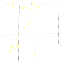
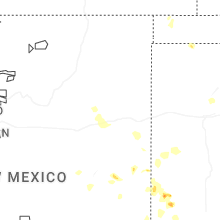
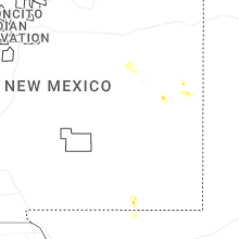


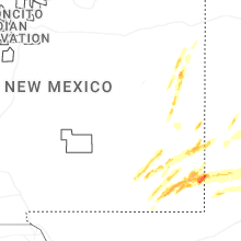


Connect with Interactive Hail Maps