

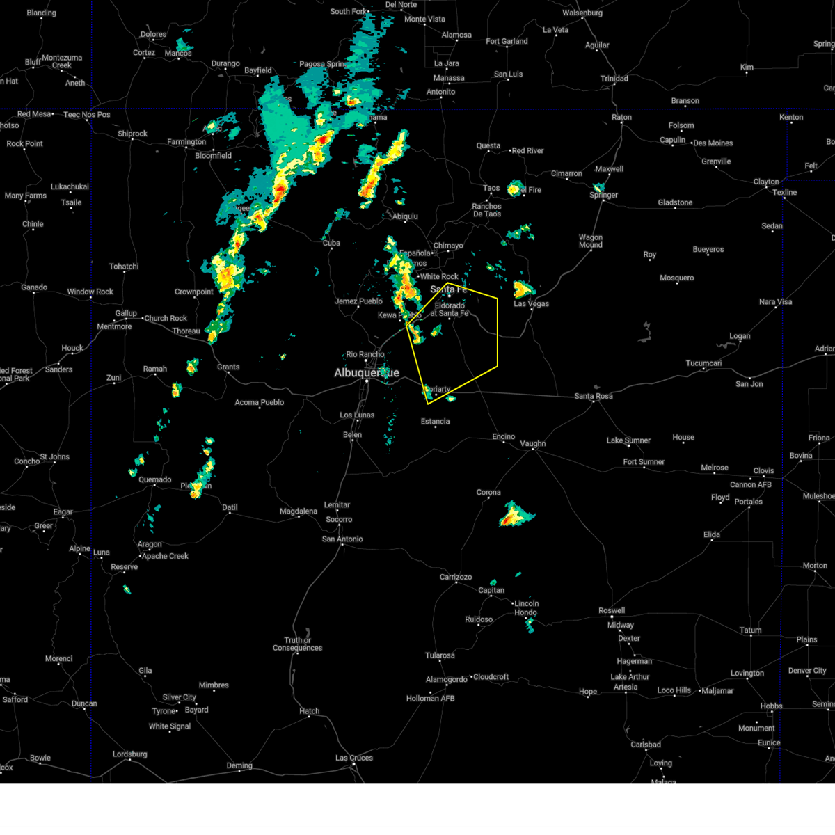
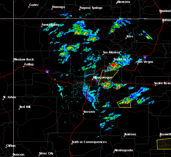
Hail Map for Galisteo, NM
The Galisteo, NM area has had 0 reports of on-the-ground hail by trained spotters, and has been under severe weather warnings 11 times during the past 12 months. Doppler radar has detected hail at or near Galisteo, NM on 17 occasions, including 1 occasion during the past year.
| Name: | Galisteo, NM |
| Where Located: | 44.6 miles ENE of Albuquerque, NM |
| Map: | Google Map for Galisteo, NM |
| Population: | 253 |
| Housing Units: | 160 |
| More Info: | Search Google for Galisteo, NM |
0
The Top Recent Hail Date for Galisteo, NM is Monday, June 9, 2025 (17th out of 17)
Hail and Wind Damage Spotted near Galisteo, NM
| Date / Time | Report Details |
|---|---|
| 6/9/2025 4:22 PM MDT |
 At 422 pm mdt, a severe thunderstorm was located near galisteo, or 21 miles south of santa fe, moving southeast at 15 mph (radar indicated). Hazards include 60 mph wind gusts and quarter size hail. Hail damage to vehicles is expected. expect wind damage to roofs, siding, and trees. locations impacted include, galisteo. This includes highway 285 between mile markers 275 and 283. At 422 pm mdt, a severe thunderstorm was located near galisteo, or 21 miles south of santa fe, moving southeast at 15 mph (radar indicated). Hazards include 60 mph wind gusts and quarter size hail. Hail damage to vehicles is expected. expect wind damage to roofs, siding, and trees. locations impacted include, galisteo. This includes highway 285 between mile markers 275 and 283.
|
| 6/9/2025 4:01 PM MDT |
 At 401 pm mdt, a severe thunderstorm was located near galisteo, or 18 miles south of santa fe, moving southeast at 15 mph (radar indicated). Hazards include 60 mph wind gusts and quarter size hail. Hail damage to vehicles is expected. expect wind damage to roofs, siding, and trees. locations impacted include, eldorado at santa fe, galisteo, lamy, los cerrillos and cerrillos hills state park. This includes highway 285 between mile markers 275 and 285. At 401 pm mdt, a severe thunderstorm was located near galisteo, or 18 miles south of santa fe, moving southeast at 15 mph (radar indicated). Hazards include 60 mph wind gusts and quarter size hail. Hail damage to vehicles is expected. expect wind damage to roofs, siding, and trees. locations impacted include, eldorado at santa fe, galisteo, lamy, los cerrillos and cerrillos hills state park. This includes highway 285 between mile markers 275 and 285.
|
| 6/9/2025 3:44 PM MDT | Svrabq the national weather service in albuquerque has issued a * severe thunderstorm warning for, southern santa fe county in north central new mexico, * until 430 pm mdt. * at 344 pm mdt, a severe thunderstorm was located near cerrillos hills state park, or 17 miles south of santa fe, moving southeast at 10 mph (radar indicated). Hazards include 60 mph wind gusts and quarter size hail. Hail damage to vehicles is expected. Expect wind damage to roofs, siding, and trees. |
| 5/4/2025 9:55 PM MDT |
 the severe thunderstorm warning has been cancelled and is no longer in effect the severe thunderstorm warning has been cancelled and is no longer in effect
|
| 5/4/2025 9:49 PM MDT |
 At 949 pm mdt, a severe thunderstorm was located near golden, or 19 miles north of moriarty, moving north at 15 mph (radar indicated). Hazards include quarter size hail. Damage to vehicles is expected. locations impacted include, galisteo, stanley and madrid. This includes highway 285 between mile markers 277 and 278. At 949 pm mdt, a severe thunderstorm was located near golden, or 19 miles north of moriarty, moving north at 15 mph (radar indicated). Hazards include quarter size hail. Damage to vehicles is expected. locations impacted include, galisteo, stanley and madrid. This includes highway 285 between mile markers 277 and 278.
|
| 5/4/2025 9:33 PM MDT |
 the severe thunderstorm warning has been cancelled and is no longer in effect the severe thunderstorm warning has been cancelled and is no longer in effect
|
| 5/4/2025 9:33 PM MDT |
 At 933 pm mdt, a severe thunderstorm was located near cedar grove, or 15 miles northwest of moriarty, moving north at 15 mph (radar indicated). Hazards include half dollar size hail. Damage to vehicles is expected. locations impacted include, edgewood, stanley, cedar grove, galisteo and madrid. This includes highway 285 between mile markers 274 and 278. At 933 pm mdt, a severe thunderstorm was located near cedar grove, or 15 miles northwest of moriarty, moving north at 15 mph (radar indicated). Hazards include half dollar size hail. Damage to vehicles is expected. locations impacted include, edgewood, stanley, cedar grove, galisteo and madrid. This includes highway 285 between mile markers 274 and 278.
|
| 5/4/2025 9:14 PM MDT |
 Svrabq the national weather service in albuquerque has issued a * severe thunderstorm warning for, bernalillo county in central new mexico, north central torrance county in central new mexico, southern santa fe county in north central new mexico, * until 1015 pm mdt. * at 914 pm mdt, a severe thunderstorm was located near cedar grove, or 12 miles northwest of moriarty, moving north at 15 mph (trained spotters reported quarter sized hail near edgewood). Hazards include half dollar size hail. damage to vehicles is expected Svrabq the national weather service in albuquerque has issued a * severe thunderstorm warning for, bernalillo county in central new mexico, north central torrance county in central new mexico, southern santa fe county in north central new mexico, * until 1015 pm mdt. * at 914 pm mdt, a severe thunderstorm was located near cedar grove, or 12 miles northwest of moriarty, moving north at 15 mph (trained spotters reported quarter sized hail near edgewood). Hazards include half dollar size hail. damage to vehicles is expected
|
| 9/17/2024 12:15 PM MDT |
 the severe thunderstorm warning has been cancelled and is no longer in effect the severe thunderstorm warning has been cancelled and is no longer in effect
|
| 9/17/2024 12:15 PM MDT |
 At 1214 pm mdt, severe thunderstorms were located along a line extending from near la cienega to near stanley, moving northeast at 45 mph (radar indicated). Hazards include 60 mph wind gusts. Expect damage to roofs, siding, and trees. locations impacted include, santa fe, eldorado at santa fe, pecos, cerrillos hills state park, canada de los alamos, lamy, glorieta, rowe, upper colonias, and stanley. this includes the following highways, interstate 25 between mile markers 269 and 318. highway 285 between mile markers 257 and 290. State road 63 between mile markers 0 and 16. At 1214 pm mdt, severe thunderstorms were located along a line extending from near la cienega to near stanley, moving northeast at 45 mph (radar indicated). Hazards include 60 mph wind gusts. Expect damage to roofs, siding, and trees. locations impacted include, santa fe, eldorado at santa fe, pecos, cerrillos hills state park, canada de los alamos, lamy, glorieta, rowe, upper colonias, and stanley. this includes the following highways, interstate 25 between mile markers 269 and 318. highway 285 between mile markers 257 and 290. State road 63 between mile markers 0 and 16.
|
| 9/17/2024 11:59 AM MDT |
 Svrabq the national weather service in albuquerque has issued a * severe thunderstorm warning for, west central san miguel county in northeastern new mexico, eastern sandoval county in north central new mexico, santa fe county in north central new mexico, north central torrance county in central new mexico, * until 100 pm mdt. * at 1158 am mdt, severe thunderstorms were located along a line extending from near madrid to 6 miles west of moriarty, moving northeast at 45 mph (radar indicated). Hazards include 60 mph wind gusts. expect damage to roofs, siding, and trees Svrabq the national weather service in albuquerque has issued a * severe thunderstorm warning for, west central san miguel county in northeastern new mexico, eastern sandoval county in north central new mexico, santa fe county in north central new mexico, north central torrance county in central new mexico, * until 100 pm mdt. * at 1158 am mdt, severe thunderstorms were located along a line extending from near madrid to 6 miles west of moriarty, moving northeast at 45 mph (radar indicated). Hazards include 60 mph wind gusts. expect damage to roofs, siding, and trees
|
| 6/14/2024 6:37 PM MDT |
 At 636 pm mdt, a severe thunderstorm was located near santa fe, moving northeast at 40 mph (radar indicated). Hazards include 60 mph wind gusts. Expect damage to roofs, siding, and trees. Locations impacted include, santa fe, los alamos, white rock, pojoaque, eldorado at santa fe, cerrillos hills state park, canada de los alamos, glorieta, frijoles, and bandelier national monument. At 636 pm mdt, a severe thunderstorm was located near santa fe, moving northeast at 40 mph (radar indicated). Hazards include 60 mph wind gusts. Expect damage to roofs, siding, and trees. Locations impacted include, santa fe, los alamos, white rock, pojoaque, eldorado at santa fe, cerrillos hills state park, canada de los alamos, glorieta, frijoles, and bandelier national monument.
|
| 6/14/2024 5:50 PM MDT |
 Svrabq the national weather service in albuquerque has issued a * severe thunderstorm warning for, southeastern los alamos county in north central new mexico, east central sandoval county in north central new mexico, central santa fe county in north central new mexico, * until 645 pm mdt. * at 550 pm mdt, a severe thunderstorm was located over san felipe pueblo, or 10 miles northeast of bernalillo, moving east at 55 mph (radar indicated). Hazards include 60 mph wind gusts. expect damage to roofs, siding, and trees Svrabq the national weather service in albuquerque has issued a * severe thunderstorm warning for, southeastern los alamos county in north central new mexico, east central sandoval county in north central new mexico, central santa fe county in north central new mexico, * until 645 pm mdt. * at 550 pm mdt, a severe thunderstorm was located over san felipe pueblo, or 10 miles northeast of bernalillo, moving east at 55 mph (radar indicated). Hazards include 60 mph wind gusts. expect damage to roofs, siding, and trees
|
| 5/11/2024 2:52 PM MDT |
 The storm which prompted the warning has moved out of the area. therefore, the warning will be allowed to expire. remember, a severe thunderstorm warning remains in effect for southern santa fe county. The storm which prompted the warning has moved out of the area. therefore, the warning will be allowed to expire. remember, a severe thunderstorm warning remains in effect for southern santa fe county.
|
| 5/11/2024 2:48 PM MDT |
 At 247 pm mdt, a severe thunderstorm was located near galisteo, or 21 miles south of santa fe, moving east at 25 mph (radar indicated). Hazards include 60 mph wind gusts and quarter size hail. Hail damage to vehicles is expected. expect wind damage to roofs, siding, and trees. locations impacted include, eldorado at santa fe, pecos, galisteo, rowe, lamy, and glorieta. This includes state road 63 between mile markers 0 and 5 and glorieta pass along i-25. At 247 pm mdt, a severe thunderstorm was located near galisteo, or 21 miles south of santa fe, moving east at 25 mph (radar indicated). Hazards include 60 mph wind gusts and quarter size hail. Hail damage to vehicles is expected. expect wind damage to roofs, siding, and trees. locations impacted include, eldorado at santa fe, pecos, galisteo, rowe, lamy, and glorieta. This includes state road 63 between mile markers 0 and 5 and glorieta pass along i-25.
|
| 5/11/2024 2:31 PM MDT |
 Svrabq the national weather service in albuquerque has issued a * severe thunderstorm warning for, west central san miguel county in northeastern new mexico, central santa fe county in north central new mexico, * until 330 pm mdt. * at 229 pm mdt, a severe thunderstorm was located near galisteo, or 22 miles north of moriarty, moving east at 25 mph (radar indicated). Hazards include ping pong ball size hail and 60 mph wind gusts. People and animals outdoors will be injured. expect hail damage to roofs, siding, windows, and vehicles. Expect wind damage to roofs, siding, and trees. Svrabq the national weather service in albuquerque has issued a * severe thunderstorm warning for, west central san miguel county in northeastern new mexico, central santa fe county in north central new mexico, * until 330 pm mdt. * at 229 pm mdt, a severe thunderstorm was located near galisteo, or 22 miles north of moriarty, moving east at 25 mph (radar indicated). Hazards include ping pong ball size hail and 60 mph wind gusts. People and animals outdoors will be injured. expect hail damage to roofs, siding, windows, and vehicles. Expect wind damage to roofs, siding, and trees.
|
| 5/11/2024 2:19 PM MDT |
 At 218 pm mdt, a severe thunderstorm was located 7 miles southwest of galisteo, or 20 miles north of moriarty, moving east at 30 mph (radar indicated). Hazards include ping pong ball size hail and 60 mph wind gusts. People and animals outdoors will be injured. expect hail damage to roofs, siding, windows, and vehicles. expect wind damage to roofs, siding, and trees. Locations impacted include, eldorado at santa fe, galisteo, and madrid. At 218 pm mdt, a severe thunderstorm was located 7 miles southwest of galisteo, or 20 miles north of moriarty, moving east at 30 mph (radar indicated). Hazards include ping pong ball size hail and 60 mph wind gusts. People and animals outdoors will be injured. expect hail damage to roofs, siding, windows, and vehicles. expect wind damage to roofs, siding, and trees. Locations impacted include, eldorado at santa fe, galisteo, and madrid.
|
| 5/11/2024 2:19 PM MDT |
 the severe thunderstorm warning has been cancelled and is no longer in effect the severe thunderstorm warning has been cancelled and is no longer in effect
|
| 5/11/2024 1:57 PM MDT |
 Svrabq the national weather service in albuquerque has issued a * severe thunderstorm warning for, southeastern sandoval county in north central new mexico, southern santa fe county in north central new mexico, bernalillo county in central new mexico, * until 300 pm mdt. * at 156 pm mdt, a severe thunderstorm was located over golden, or 17 miles east of bernalillo, moving northeast at 20 mph (radar indicated). Hazards include ping pong ball size hail and 60 mph wind gusts. People and animals outdoors will be injured. expect hail damage to roofs, siding, windows, and vehicles. Expect wind damage to roofs, siding, and trees. Svrabq the national weather service in albuquerque has issued a * severe thunderstorm warning for, southeastern sandoval county in north central new mexico, southern santa fe county in north central new mexico, bernalillo county in central new mexico, * until 300 pm mdt. * at 156 pm mdt, a severe thunderstorm was located over golden, or 17 miles east of bernalillo, moving northeast at 20 mph (radar indicated). Hazards include ping pong ball size hail and 60 mph wind gusts. People and animals outdoors will be injured. expect hail damage to roofs, siding, windows, and vehicles. Expect wind damage to roofs, siding, and trees.
|
| 5/22/2021 12:45 PM MDT |
 At 1245 pm mdt, a severe thunderstorm was located near galisteo, or 20 miles south of santa fe, moving north at 30 mph (radar indicated). Hazards include 60 mph wind gusts and quarter size hail. Hail damage to vehicles is expected. expect wind damage to roofs, siding, and trees. locations impacted include, eastern santa fe, eldorado at santa fe, pecos, canada de los alamos, lamy, glorieta, rowe and galisteo. this includes the following highways, interstate 25 between mile markers 284 and 310. Highway 285 between mile markers 273 and 290. At 1245 pm mdt, a severe thunderstorm was located near galisteo, or 20 miles south of santa fe, moving north at 30 mph (radar indicated). Hazards include 60 mph wind gusts and quarter size hail. Hail damage to vehicles is expected. expect wind damage to roofs, siding, and trees. locations impacted include, eastern santa fe, eldorado at santa fe, pecos, canada de los alamos, lamy, glorieta, rowe and galisteo. this includes the following highways, interstate 25 between mile markers 284 and 310. Highway 285 between mile markers 273 and 290.
|
| 5/22/2021 12:30 PM MDT |
 At 1230 pm mdt, a severe thunderstorm was located 8 miles southeast of galisteo, or 22 miles northeast of moriarty, moving north at 30 mph (radar indicated). Hazards include 60 mph wind gusts and quarter size hail. Hail damage to vehicles is expected. Expect wind damage to roofs, siding, and trees. At 1230 pm mdt, a severe thunderstorm was located 8 miles southeast of galisteo, or 22 miles northeast of moriarty, moving north at 30 mph (radar indicated). Hazards include 60 mph wind gusts and quarter size hail. Hail damage to vehicles is expected. Expect wind damage to roofs, siding, and trees.
|
| 5/17/2021 2:14 PM MDT |
 At 213 pm mdt, a severe thunderstorm was located near eldorado at santa fe, or 13 miles south of santa fe, moving north at 10 mph (radar indicated). Hazards include 60 mph wind gusts and quarter size hail. Hail damage to vehicles is expected. Expect wind damage to roofs, siding, and trees. At 213 pm mdt, a severe thunderstorm was located near eldorado at santa fe, or 13 miles south of santa fe, moving north at 10 mph (radar indicated). Hazards include 60 mph wind gusts and quarter size hail. Hail damage to vehicles is expected. Expect wind damage to roofs, siding, and trees.
|
| 5/17/2021 1:13 PM MDT |
 At 113 pm mdt, a severe thunderstorm was located near los cerrillos, or 13 miles south of santa fe, moving north at 10 mph (radar indicated). Hazards include 60 mph wind gusts and quarter size hail. Hail damage to vehicles is expected. Expect wind damage to roofs, siding, and trees. At 113 pm mdt, a severe thunderstorm was located near los cerrillos, or 13 miles south of santa fe, moving north at 10 mph (radar indicated). Hazards include 60 mph wind gusts and quarter size hail. Hail damage to vehicles is expected. Expect wind damage to roofs, siding, and trees.
|
| 5/17/2021 1:01 PM MDT |
 At 100 pm mdt, a severe thunderstorm was located near los cerrillos, or 16 miles south of santa fe, and is nearly stationary (radar indicated). Hazards include 60 mph wind gusts and quarter size hail. Hail damage to vehicles is expected. expect wind damage to roofs, siding, and trees. locations impacted include, southern santa fe, eldorado at santa fe, cerrillos hills state park, la cienega, galisteo, los cerrillos, madrid, lamy and canada de los alamos. this includes the following highways, interstate 25 between mile markers 268 and 290. Highway 285 between mile markers 284 and 290. At 100 pm mdt, a severe thunderstorm was located near los cerrillos, or 16 miles south of santa fe, and is nearly stationary (radar indicated). Hazards include 60 mph wind gusts and quarter size hail. Hail damage to vehicles is expected. expect wind damage to roofs, siding, and trees. locations impacted include, southern santa fe, eldorado at santa fe, cerrillos hills state park, la cienega, galisteo, los cerrillos, madrid, lamy and canada de los alamos. this includes the following highways, interstate 25 between mile markers 268 and 290. Highway 285 between mile markers 284 and 290.
|
| 5/17/2021 12:16 PM MDT |
 At 1215 pm mdt, a severe thunderstorm was located near los cerrillos, or 17 miles south of santa fe, moving north at 10 mph (radar indicated). Hazards include 60 mph wind gusts and quarter size hail. Hail damage to vehicles is expected. Expect wind damage to roofs, siding, and trees. At 1215 pm mdt, a severe thunderstorm was located near los cerrillos, or 17 miles south of santa fe, moving north at 10 mph (radar indicated). Hazards include 60 mph wind gusts and quarter size hail. Hail damage to vehicles is expected. Expect wind damage to roofs, siding, and trees.
|
| 6/23/2020 3:05 PM MDT |
 At 305 pm mdt, a severe thunderstorm was located near cerrillos hills state park, or 21 miles southwest of santa fe, moving southeast at 20 mph (radar indicated). Hazards include 60 mph wind gusts and quarter size hail. Hail damage to vehicles is expected. expect wind damage to roofs, siding, and trees. locations impacted include, santo domingo pueblo, cerrillos hills state park, madrid, kewa pueblo, galisteo, los cerrillos, la bajada, golden, domingo and la cienega. This includes interstate 25 between mile markers 257 and 271. At 305 pm mdt, a severe thunderstorm was located near cerrillos hills state park, or 21 miles southwest of santa fe, moving southeast at 20 mph (radar indicated). Hazards include 60 mph wind gusts and quarter size hail. Hail damage to vehicles is expected. expect wind damage to roofs, siding, and trees. locations impacted include, santo domingo pueblo, cerrillos hills state park, madrid, kewa pueblo, galisteo, los cerrillos, la bajada, golden, domingo and la cienega. This includes interstate 25 between mile markers 257 and 271.
|
| 6/23/2020 2:42 PM MDT |
 At 241 pm mdt, a severe thunderstorm was located near cochiti pueblo, or 21 miles west of santa fe, moving southeast at 20 mph (radar indicated). Hazards include 60 mph wind gusts and quarter size hail. Hail damage to vehicles is expected. Expect wind damage to roofs, siding, and trees. At 241 pm mdt, a severe thunderstorm was located near cochiti pueblo, or 21 miles west of santa fe, moving southeast at 20 mph (radar indicated). Hazards include 60 mph wind gusts and quarter size hail. Hail damage to vehicles is expected. Expect wind damage to roofs, siding, and trees.
|
| 6/2/2019 5:10 PM MDT |
 The severe thunderstorm warning for southeastern sandoval, southern santa fe, bernalillo and northwestern torrance counties will expire at 515 pm mdt, the storm which prompted the warning has weakened below severe limits, and has exited the warned area. therefore the warning will be allowed to expire. however gusty winds and heavy rain are still possible with this thunderstorm. a severe thunderstorm watch remains in effect until 800 pm mdt for central and north central new mexico. to report severe weather, contact your nearest law enforcement agency. they will relay your report to the national weather service albuquerque. The severe thunderstorm warning for southeastern sandoval, southern santa fe, bernalillo and northwestern torrance counties will expire at 515 pm mdt, the storm which prompted the warning has weakened below severe limits, and has exited the warned area. therefore the warning will be allowed to expire. however gusty winds and heavy rain are still possible with this thunderstorm. a severe thunderstorm watch remains in effect until 800 pm mdt for central and north central new mexico. to report severe weather, contact your nearest law enforcement agency. they will relay your report to the national weather service albuquerque.
|
| 6/2/2019 4:34 PM MDT |
 At 433 pm mdt, a severe thunderstorm was located over sedillo, or 15 miles northwest of moriarty, moving north at 30 mph (radar indicated). Hazards include ping pong ball size hail and 60 mph wind gusts. People and animals outdoors will be injured. expect hail damage to roofs, siding, windows, and vehicles. expect wind damage to roofs, siding, and trees. locations impacted include, edgewood, tijeras, cedar crest, madrid, cedar grove, sedillo, sandia park, galisteo, golden and cedro. this includes the following highways, interstate 40 between mile markers 175 and 192. Highway 285 between mile markers 276 and 279. At 433 pm mdt, a severe thunderstorm was located over sedillo, or 15 miles northwest of moriarty, moving north at 30 mph (radar indicated). Hazards include ping pong ball size hail and 60 mph wind gusts. People and animals outdoors will be injured. expect hail damage to roofs, siding, windows, and vehicles. expect wind damage to roofs, siding, and trees. locations impacted include, edgewood, tijeras, cedar crest, madrid, cedar grove, sedillo, sandia park, galisteo, golden and cedro. this includes the following highways, interstate 40 between mile markers 175 and 192. Highway 285 between mile markers 276 and 279.
|
| 6/2/2019 4:20 PM MDT |
 At 420 pm mdt, a severe thunderstorm was located near escabosa, or 13 miles west of moriarty, moving north at 30 mph (radar indicated). Hazards include 60 mph wind gusts and quarter size hail. Hail damage to vehicles is expected. Expect wind damage to roofs, siding, and trees. At 420 pm mdt, a severe thunderstorm was located near escabosa, or 13 miles west of moriarty, moving north at 30 mph (radar indicated). Hazards include 60 mph wind gusts and quarter size hail. Hail damage to vehicles is expected. Expect wind damage to roofs, siding, and trees.
|
| 7/31/2018 7:28 PM MDT |
 At 728 pm mdt, a severe thunderstorm was located near upper colonias, or 18 miles west of las vegas, moving southwest at 30 mph (radar indicated). Hazards include 60 mph wind gusts and quarter size hail. Hail damage to vehicles is expected. Expect wind damage to roofs, siding, and trees. At 728 pm mdt, a severe thunderstorm was located near upper colonias, or 18 miles west of las vegas, moving southwest at 30 mph (radar indicated). Hazards include 60 mph wind gusts and quarter size hail. Hail damage to vehicles is expected. Expect wind damage to roofs, siding, and trees.
|
| 5/21/2018 4:25 PM MDT |
 The severe thunderstorm warning for southern santa fe and north central torrance counties will expire at 430 pm mdt, the storms which prompted the warning have weakened below severe limits, and no longer pose an immediate threat to life or property. therefore the warning will be allowed to expire. a severe thunderstorm watch remains in effect until 700 pm mdt for central and north central new mexico. The severe thunderstorm warning for southern santa fe and north central torrance counties will expire at 430 pm mdt, the storms which prompted the warning have weakened below severe limits, and no longer pose an immediate threat to life or property. therefore the warning will be allowed to expire. a severe thunderstorm watch remains in effect until 700 pm mdt for central and north central new mexico.
|
| 5/21/2018 3:57 PM MDT |
 At 357 pm mdt, severe thunderstorms were located along a line extending from near stanley to 7 miles east of moriarty, moving northeast at 25 mph (radar indicated). Hazards include 60 mph wind gusts and quarter size hail. Hail damage to vehicles is expected. expect wind damage to roofs, siding, and trees. locations impacted include, moriarty, cerrillos hills state park, stanley, galisteo, los cerrillos, madrid and cedar grove. this includes the following highways, interstate 40 between mile markers 198 and 212. Highway 285 between mile markers 258 and 267. At 357 pm mdt, severe thunderstorms were located along a line extending from near stanley to 7 miles east of moriarty, moving northeast at 25 mph (radar indicated). Hazards include 60 mph wind gusts and quarter size hail. Hail damage to vehicles is expected. expect wind damage to roofs, siding, and trees. locations impacted include, moriarty, cerrillos hills state park, stanley, galisteo, los cerrillos, madrid and cedar grove. this includes the following highways, interstate 40 between mile markers 198 and 212. Highway 285 between mile markers 258 and 267.
|
| 5/21/2018 3:29 PM MDT |
 At 329 pm mdt, severe thunderstorms were located along a line extending from near cedar grove to near mcintosh, moving north at 20 mph (radar indicated). Hazards include 60 mph wind gusts and half dollar size hail. Hail damage to vehicles is expected. Expect wind damage to roofs, siding, and trees. At 329 pm mdt, severe thunderstorms were located along a line extending from near cedar grove to near mcintosh, moving north at 20 mph (radar indicated). Hazards include 60 mph wind gusts and half dollar size hail. Hail damage to vehicles is expected. Expect wind damage to roofs, siding, and trees.
|
| 10/4/2017 6:52 PM MDT |
 At 652 pm mdt, a severe thunderstorm was located over lamy, or 16 miles south of santa fe, moving northeast at 20 mph (radar indicated). Hazards include 60 mph wind gusts and quarter size hail. Hail damage to vehicles is expected. expect wind damage to roofs, siding, and trees. locations impacted include, eldorado at santa fe, pecos, canada de los alamos, lamy, glorieta, galisteo, rowe and south san ysidro. this includes the following highways, interstate 25 between mile markers 288 and 318. Highway 285 between mile markers 275 and 290. At 652 pm mdt, a severe thunderstorm was located over lamy, or 16 miles south of santa fe, moving northeast at 20 mph (radar indicated). Hazards include 60 mph wind gusts and quarter size hail. Hail damage to vehicles is expected. expect wind damage to roofs, siding, and trees. locations impacted include, eldorado at santa fe, pecos, canada de los alamos, lamy, glorieta, galisteo, rowe and south san ysidro. this includes the following highways, interstate 25 between mile markers 288 and 318. Highway 285 between mile markers 275 and 290.
|
| 10/4/2017 6:25 PM MDT |
 The national weather service in albuquerque has issued a * severe thunderstorm warning for. west central san miguel county in northeastern new mexico. east central santa fe county in north central new mexico. until 715 pm mdt. At 625 pm mdt, a severe thunderstorm was located over galisteo, or. The national weather service in albuquerque has issued a * severe thunderstorm warning for. west central san miguel county in northeastern new mexico. east central santa fe county in north central new mexico. until 715 pm mdt. At 625 pm mdt, a severe thunderstorm was located over galisteo, or.
|
| 7/1/2017 5:44 PM MDT |
 At 540 pm mdt, a severe thunderstorm was located over lamy, or 16 miles south of santa fe, moving east at 25 mph (radar indicated). Hazards include 60 mph wind gusts and quarter size hail. Hail damage to vehicles is expected. Expect wind damage to roofs, siding, and trees. At 540 pm mdt, a severe thunderstorm was located over lamy, or 16 miles south of santa fe, moving east at 25 mph (radar indicated). Hazards include 60 mph wind gusts and quarter size hail. Hail damage to vehicles is expected. Expect wind damage to roofs, siding, and trees.
|
| 7/1/2017 5:40 PM MDT |
 At 540 pm mdt, a severe thunderstorm was located near lamy, or 16 miles south of santa fe, moving east at 25 mph (radar indicated). Hazards include 60 mph wind gusts and quarter size hail. Hail damage to vehicles is expected. Expect wind damage to roofs, siding, and trees. At 540 pm mdt, a severe thunderstorm was located near lamy, or 16 miles south of santa fe, moving east at 25 mph (radar indicated). Hazards include 60 mph wind gusts and quarter size hail. Hail damage to vehicles is expected. Expect wind damage to roofs, siding, and trees.
|
| 7/1/2017 5:07 PM MDT |
 At 507 pm mdt, a severe thunderstorm was located near los cerrillos, or 20 miles south of santa fe, moving east at 10 mph (radar indicated). Hazards include 60 mph wind gusts and quarter size hail. Hail damage to vehicles is expected. Expect wind damage to roofs, siding, and trees. At 507 pm mdt, a severe thunderstorm was located near los cerrillos, or 20 miles south of santa fe, moving east at 10 mph (radar indicated). Hazards include 60 mph wind gusts and quarter size hail. Hail damage to vehicles is expected. Expect wind damage to roofs, siding, and trees.
|
| 6/6/2016 4:52 PM MDT |
 At 452 pm mdt, a severe thunderstorm was located over galisteo, or 19 miles south of santa fe, moving south at 10 mph (radar indicated). Hazards include quarter size hail and 60 mph wind gusts. Hail damage to vehicles is expected. Expect wind damage to roofs, siding, and trees. At 452 pm mdt, a severe thunderstorm was located over galisteo, or 19 miles south of santa fe, moving south at 10 mph (radar indicated). Hazards include quarter size hail and 60 mph wind gusts. Hail damage to vehicles is expected. Expect wind damage to roofs, siding, and trees.
|
| 7/8/2015 2:40 PM MDT |
 At 239 pm mdt, a severe thunderstorm was located near santa fe, moving southeast at 20 mph (radar indicated). Hazards include quarter size hail and 60 mph wind gusts. Hail damage to vehicles is expected. Expect wind damage to roofs, siding and trees. At 239 pm mdt, a severe thunderstorm was located near santa fe, moving southeast at 20 mph (radar indicated). Hazards include quarter size hail and 60 mph wind gusts. Hail damage to vehicles is expected. Expect wind damage to roofs, siding and trees.
|
| 6/26/2015 6:49 PM MDT | At 648 pm mdt, a severe thunderstorm was located over lamy, or 14 miles south of santa fe, moving south at 15 mph (radar indicated). Hazards include quarter size hail and 60 mph wind gusts. Hail damage to vehicles is expected. Expect wind damage to roofs, siding and trees. |
Hail Maps for Galisteo, NM


Connect with Interactive Hail Maps