

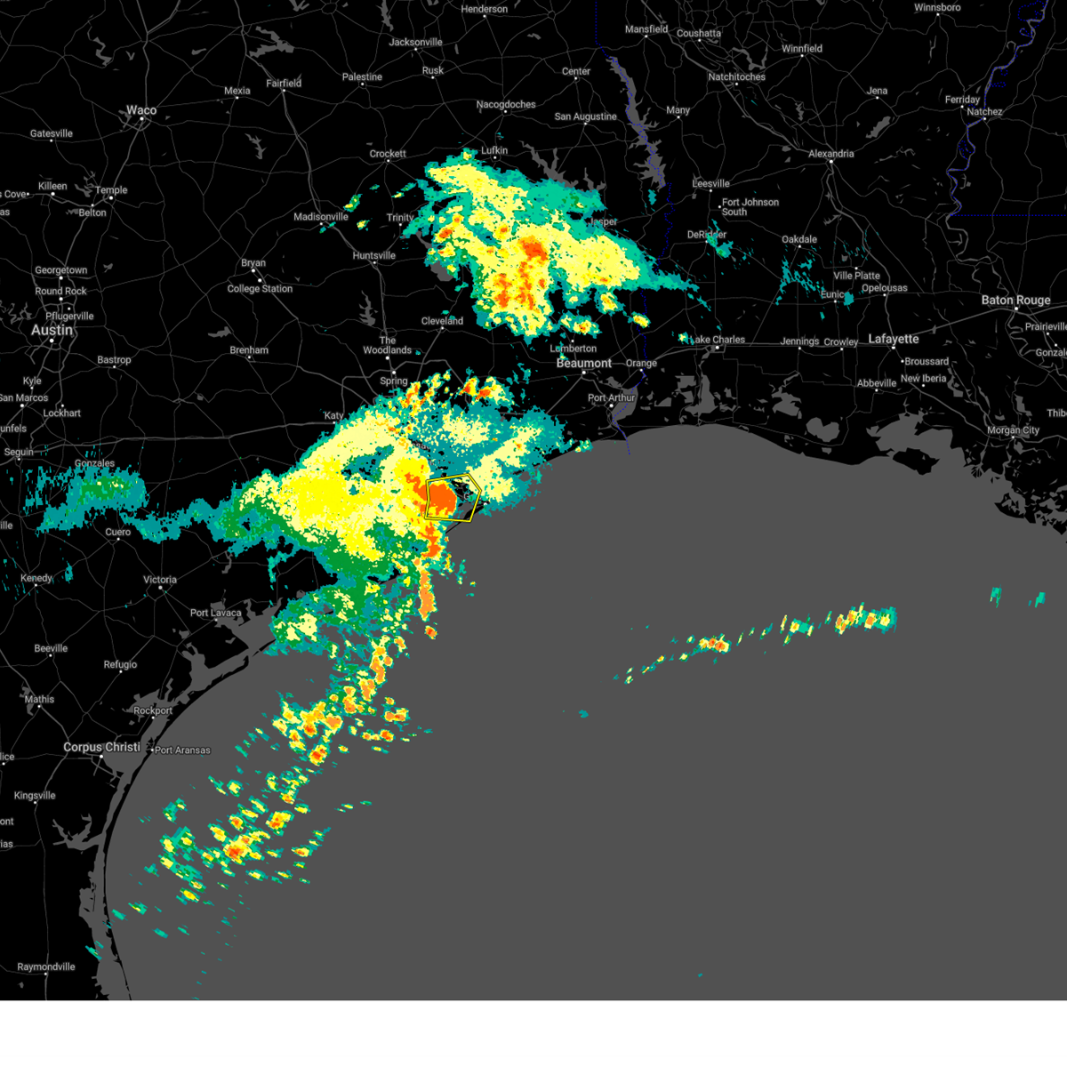
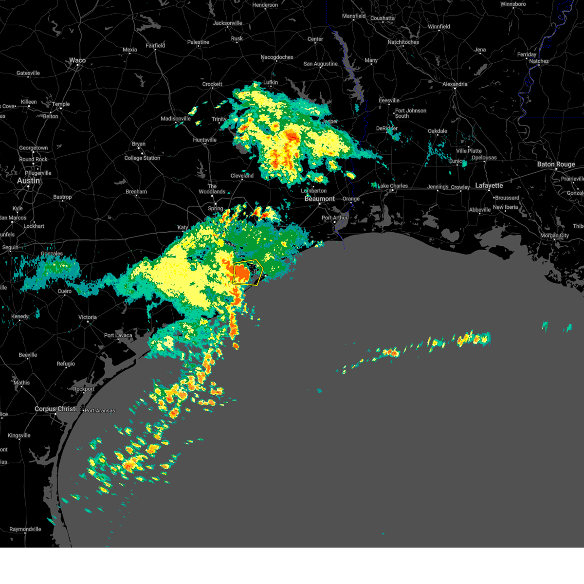
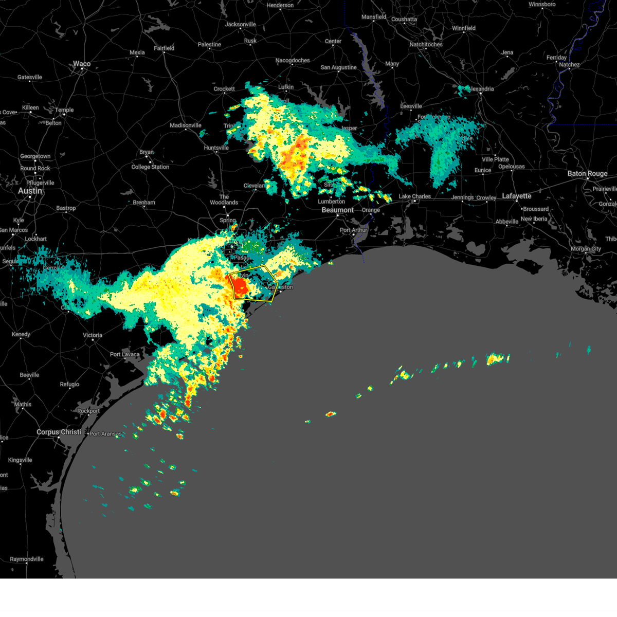
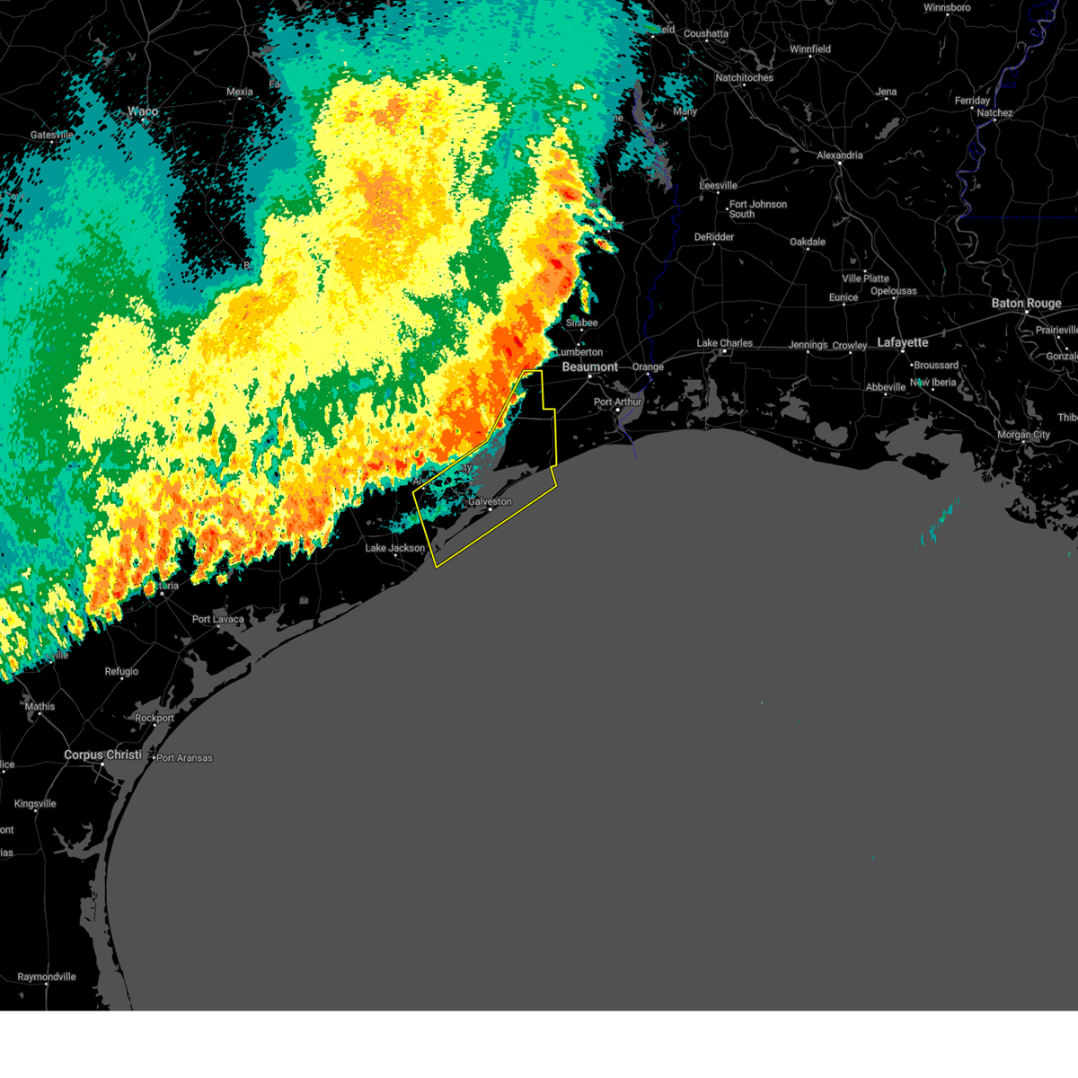
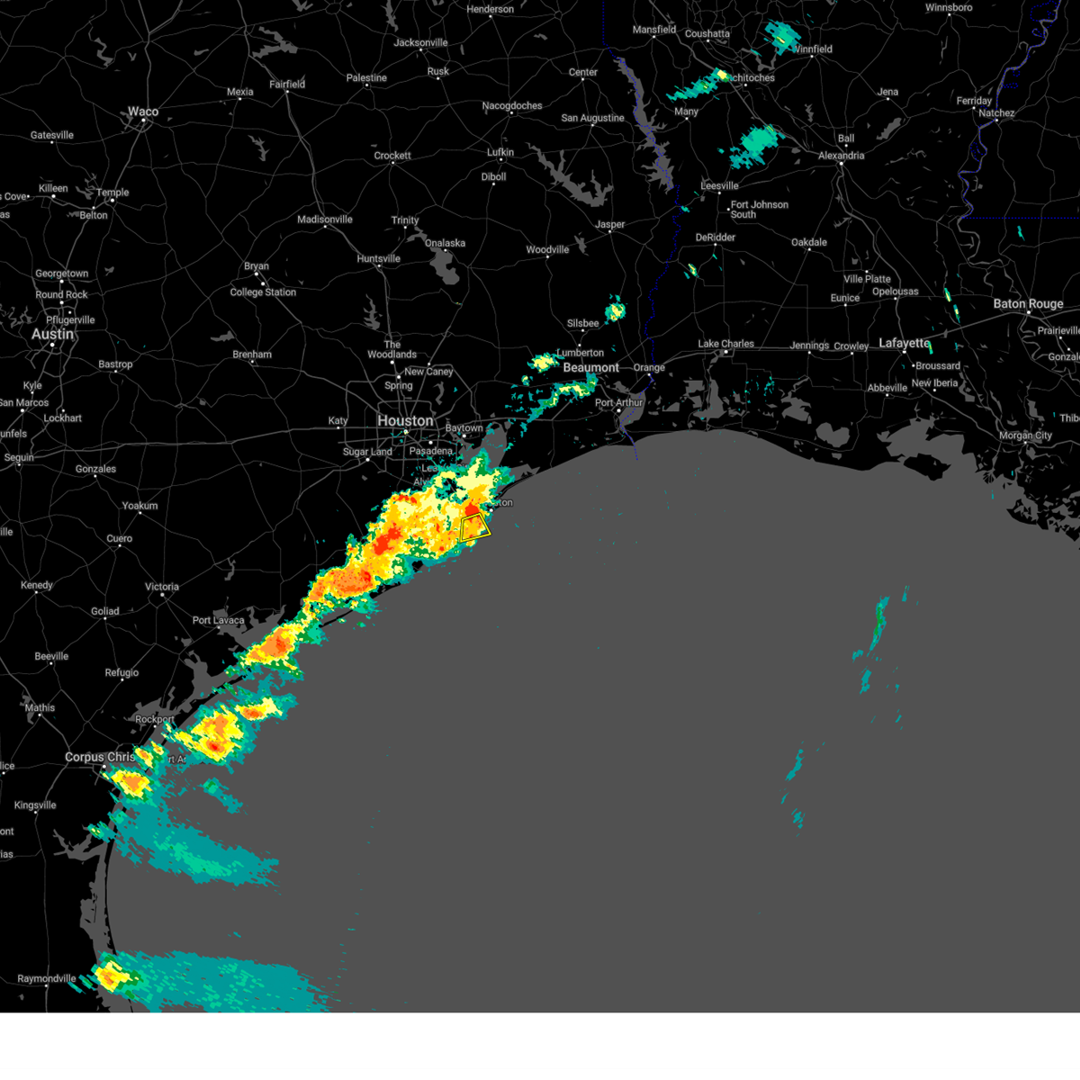
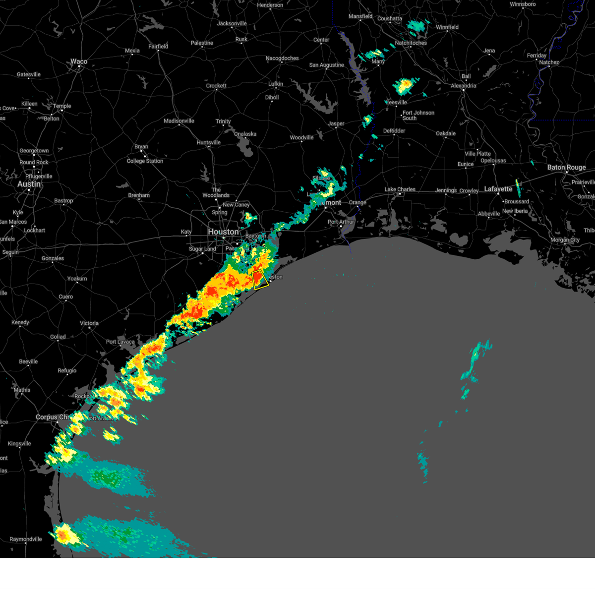
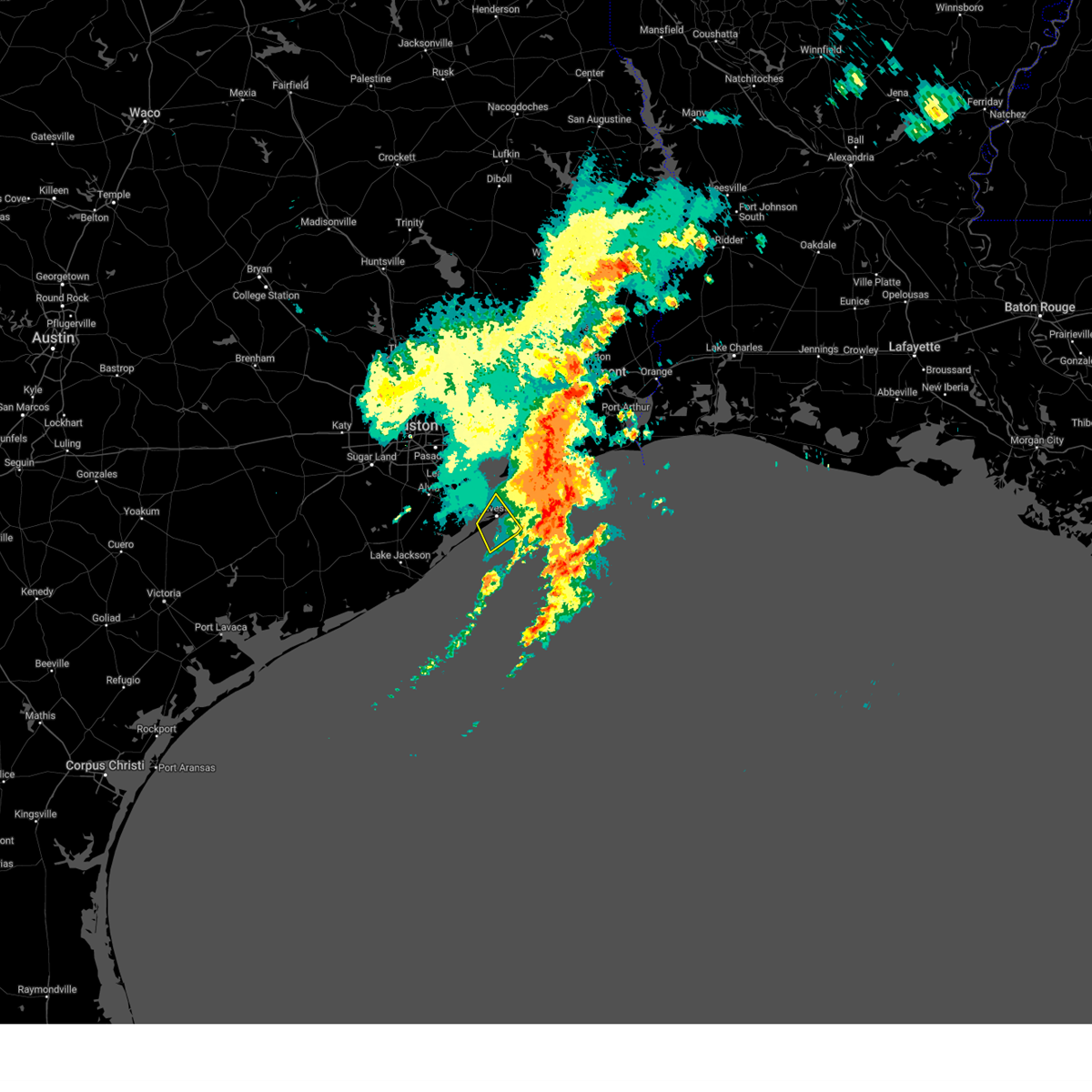
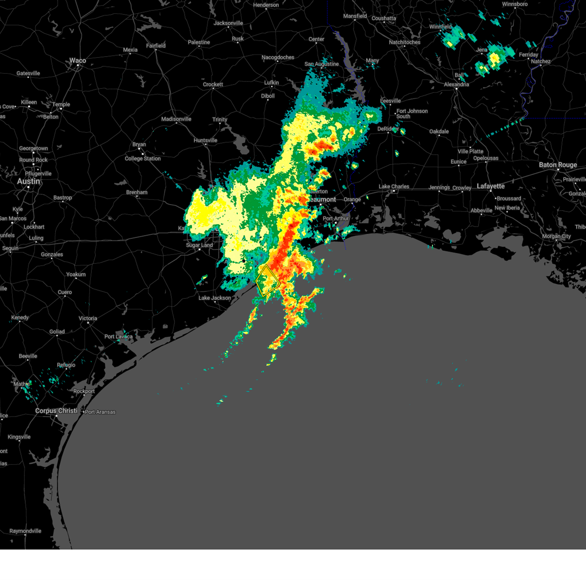
Hail Map for Galveston, TX
The Galveston, TX area has had 4 reports of on-the-ground hail by trained spotters, and has been under severe weather warnings 14 times during the past 12 months. Doppler radar has detected hail at or near Galveston, TX on 48 occasions, including 2 occasions during the past year.
| Name: | Galveston, TX |
| Where Located: | 46.1 miles SE of Houston, TX |
| Map: | Google Map for Galveston, TX |
| Population: | 47743 |
| Housing Units: | 32368 |
| More Info: | Search Google for Galveston, TX |
1
The Top Recent Hail Date for Galveston, TX is Friday, May 2, 2025 (20th out of 48)
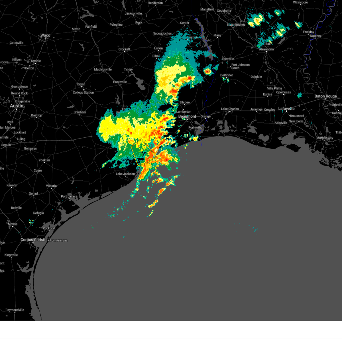
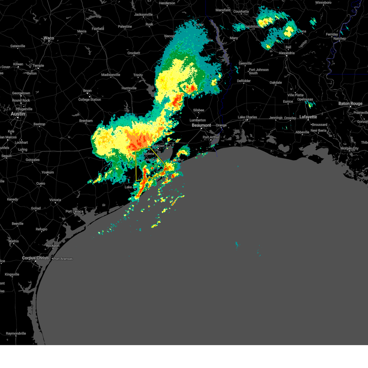
Hail and Wind Damage Spotted near Galveston, TX
| Date / Time | Report Details |
|---|---|
| 5/30/2025 11:20 AM CDT |
 At 1119 am cdt, severe thunderstorms were located along a line extending from near dickinson to la marque to near jamaica beach, moving east at 35 mph (radar indicated). Hazards include 60 mph wind gusts. Expect damage to roofs, siding, and trees. Locations impacted include, southern league city, galveston causeway, galveston island west end, texas city, dickinson, la marque, santa fe, hitchcock, bayou vista, tiki island, galveston state park, offatts bayou, san leon, and galveston island east end. At 1119 am cdt, severe thunderstorms were located along a line extending from near dickinson to la marque to near jamaica beach, moving east at 35 mph (radar indicated). Hazards include 60 mph wind gusts. Expect damage to roofs, siding, and trees. Locations impacted include, southern league city, galveston causeway, galveston island west end, texas city, dickinson, la marque, santa fe, hitchcock, bayou vista, tiki island, galveston state park, offatts bayou, san leon, and galveston island east end.
|
| 5/30/2025 11:20 AM CDT |
 the severe thunderstorm warning has been cancelled and is no longer in effect the severe thunderstorm warning has been cancelled and is no longer in effect
|
| 5/30/2025 10:59 AM CDT |
 Svrhgx the national weather service in league city has issued a * severe thunderstorm warning for, galveston county in southeastern texas, northeastern brazoria county in southeastern texas, southeastern harris county in southeastern texas, * until 1130 am cdt. * at 1059 am cdt, severe thunderstorms were located along a line extending from near alvin to near hillcrest to near liverpool, moving east at 30 mph (radar indicated). Hazards include 60 mph wind gusts. expect damage to roofs, siding, and trees Svrhgx the national weather service in league city has issued a * severe thunderstorm warning for, galveston county in southeastern texas, northeastern brazoria county in southeastern texas, southeastern harris county in southeastern texas, * until 1130 am cdt. * at 1059 am cdt, severe thunderstorms were located along a line extending from near alvin to near hillcrest to near liverpool, moving east at 30 mph (radar indicated). Hazards include 60 mph wind gusts. expect damage to roofs, siding, and trees
|
| 5/27/2025 1:20 AM CDT |
 Svrhgx the national weather service in league city has issued a * severe thunderstorm warning for, galveston county in southeastern texas, chambers county in southeastern texas, northeastern brazoria county in southeastern texas, southeastern liberty county in southeastern texas, southeastern harris county in southeastern texas, * until 215 am cdt. * at 119 am cdt, severe thunderstorms were located along a line extending from near devers to near alvin, moving east southeast at around 40 mph (radar indicated). Hazards include 60 mph wind gusts. expect damage to roofs, siding, and trees Svrhgx the national weather service in league city has issued a * severe thunderstorm warning for, galveston county in southeastern texas, chambers county in southeastern texas, northeastern brazoria county in southeastern texas, southeastern liberty county in southeastern texas, southeastern harris county in southeastern texas, * until 215 am cdt. * at 119 am cdt, severe thunderstorms were located along a line extending from near devers to near alvin, moving east southeast at around 40 mph (radar indicated). Hazards include 60 mph wind gusts. expect damage to roofs, siding, and trees
|
| 4/21/2025 10:46 AM CDT |
 Svrhgx the national weather service in league city has issued a * severe thunderstorm warning for, south central galveston county in southeastern texas, * until 1100 am cdt. * at 1046 am cdt, a severe thunderstorm was located over galveston state park, or over galveston island west end, moving south at 30 mph (radar indicated). Hazards include 60 mph wind gusts. expect damage to roofs, siding, and trees Svrhgx the national weather service in league city has issued a * severe thunderstorm warning for, south central galveston county in southeastern texas, * until 1100 am cdt. * at 1046 am cdt, a severe thunderstorm was located over galveston state park, or over galveston island west end, moving south at 30 mph (radar indicated). Hazards include 60 mph wind gusts. expect damage to roofs, siding, and trees
|
| 4/21/2025 10:23 AM CDT |
 Svrhgx the national weather service in league city has issued a * severe thunderstorm warning for, central galveston county in southeastern texas, * until 1100 am cdt. * at 1023 am cdt, a severe thunderstorm was located over la marque, moving south at 20 mph (radar indicated). Hazards include 60 mph wind gusts. expect damage to roofs, siding, and trees Svrhgx the national weather service in league city has issued a * severe thunderstorm warning for, central galveston county in southeastern texas, * until 1100 am cdt. * at 1023 am cdt, a severe thunderstorm was located over la marque, moving south at 20 mph (radar indicated). Hazards include 60 mph wind gusts. expect damage to roofs, siding, and trees
|
| 3/24/2025 3:56 AM CDT |
 The storm which prompted the warning is now moving out of the area. therefore, the warning will be allowed to expire. The storm which prompted the warning is now moving out of the area. therefore, the warning will be allowed to expire.
|
| 3/24/2025 3:54 AM CDT |
 The storms which prompted the warning have weakened below severe limits, and have exited the warned area. therefore, the warning will be allowed to expire. The storms which prompted the warning have weakened below severe limits, and have exited the warned area. therefore, the warning will be allowed to expire.
|
| 3/24/2025 3:48 AM CDT | Buoy station gnjt2 galveston bay entrance... north jetty reported 70 mph wind gus in gmz355 county TX, 13.4 miles SW of Galveston, TX |
| 3/24/2025 3:46 AM CDT |
 the severe thunderstorm warning has been cancelled and is no longer in effect the severe thunderstorm warning has been cancelled and is no longer in effect
|
| 3/24/2025 3:46 AM CDT |
 At 346 am cdt, severe thunderstorms were located along a line extending from 6 miles south of galveston island east end to near galveston state park to near san luis pass, moving south at 60 mph (radar indicated). Hazards include 60 mph wind gusts. Expect damage to roofs, siding, and trees. Locations impacted include, pelican island, galveston causeway, galveston pleasure pier, galveston island east end, schlitterbahn, scholes field, the strand, port bolivar, moody gardens, offatts bayou, galveston pier 21, and galveston island west end. At 346 am cdt, severe thunderstorms were located along a line extending from 6 miles south of galveston island east end to near galveston state park to near san luis pass, moving south at 60 mph (radar indicated). Hazards include 60 mph wind gusts. Expect damage to roofs, siding, and trees. Locations impacted include, pelican island, galveston causeway, galveston pleasure pier, galveston island east end, schlitterbahn, scholes field, the strand, port bolivar, moody gardens, offatts bayou, galveston pier 21, and galveston island west end.
|
| 3/24/2025 3:33 AM CDT |
 Svrhgx the national weather service in league city has issued a * severe thunderstorm warning for, northeastern galveston county in southeastern texas, southeastern chambers county in southeastern texas, * until 400 am cdt. * at 333 am cdt, a severe thunderstorm was located 7 miles north of bolivar peninsula, or 17 miles southeast of beach city, moving east at 30 mph (radar indicated). Hazards include 60 mph wind gusts and penny size hail. expect damage to roofs, siding, and trees Svrhgx the national weather service in league city has issued a * severe thunderstorm warning for, northeastern galveston county in southeastern texas, southeastern chambers county in southeastern texas, * until 400 am cdt. * at 333 am cdt, a severe thunderstorm was located 7 miles north of bolivar peninsula, or 17 miles southeast of beach city, moving east at 30 mph (radar indicated). Hazards include 60 mph wind gusts and penny size hail. expect damage to roofs, siding, and trees
|
| 3/24/2025 3:29 AM CDT |
 Svrhgx the national weather service in league city has issued a * severe thunderstorm warning for, southwestern galveston county in southeastern texas, east central brazoria county in southeastern texas, * until 400 am cdt. * at 329 am cdt, severe thunderstorms were located along a line extending from near texas city to la marque to near santa fe, moving south at 60 mph (radar indicated). Hazards include 60 mph wind gusts. expect damage to roofs, siding, and trees Svrhgx the national weather service in league city has issued a * severe thunderstorm warning for, southwestern galveston county in southeastern texas, east central brazoria county in southeastern texas, * until 400 am cdt. * at 329 am cdt, severe thunderstorms were located along a line extending from near texas city to la marque to near santa fe, moving south at 60 mph (radar indicated). Hazards include 60 mph wind gusts. expect damage to roofs, siding, and trees
|
| 3/24/2025 3:21 AM CDT |
 At 320 am cdt, severe thunderstorms were located along a line extending from kemah to near friendswood to near iowa colony, moving southeast at 50 mph (radar indicated). Hazards include 60 mph wind gusts. Expect damage to roofs, siding, and trees. Locations impacted include, san leon, dickinson, clear lake shores, kemah, pasadena, texas city, ellington field, la porte, deer park, clear lake, hillcrest, seabrook, friendswood, the johnson space center, bacliff, league city, nassau bay, hitchcock, bayou vista, and webster. At 320 am cdt, severe thunderstorms were located along a line extending from kemah to near friendswood to near iowa colony, moving southeast at 50 mph (radar indicated). Hazards include 60 mph wind gusts. Expect damage to roofs, siding, and trees. Locations impacted include, san leon, dickinson, clear lake shores, kemah, pasadena, texas city, ellington field, la porte, deer park, clear lake, hillcrest, seabrook, friendswood, the johnson space center, bacliff, league city, nassau bay, hitchcock, bayou vista, and webster.
|
| 3/24/2025 3:05 AM CDT |
 Svrhgx the national weather service in league city has issued a * severe thunderstorm warning for, galveston county in southeastern texas, northeastern brazoria county in southeastern texas, southeastern harris county in southeastern texas, * until 330 am cdt. * at 304 am cdt, severe thunderstorms were located along a line extending from deer park to greater hobby area to fort bend houston, moving southeast at 40 mph (radar indicated). Hazards include 60 mph wind gusts. expect damage to roofs, siding, and trees Svrhgx the national weather service in league city has issued a * severe thunderstorm warning for, galveston county in southeastern texas, northeastern brazoria county in southeastern texas, southeastern harris county in southeastern texas, * until 330 am cdt. * at 304 am cdt, severe thunderstorms were located along a line extending from deer park to greater hobby area to fort bend houston, moving southeast at 40 mph (radar indicated). Hazards include 60 mph wind gusts. expect damage to roofs, siding, and trees
|
| 6/19/2024 11:07 AM CDT |
 Svrhgx the national weather service in league city has issued a * severe thunderstorm warning for, southwestern galveston county in southeastern texas, east central brazoria county in southeastern texas, * until 1115 am cdt. * at 1106 am cdt, a severe thunderstorm capable of producing a waterspout was located near jamaica beach, or near galveston island west end, moving west at 35 mph (radar indicated). Hazards include 60 mph wind gusts. expect damage to roofs, siding, and trees Svrhgx the national weather service in league city has issued a * severe thunderstorm warning for, southwestern galveston county in southeastern texas, east central brazoria county in southeastern texas, * until 1115 am cdt. * at 1106 am cdt, a severe thunderstorm capable of producing a waterspout was located near jamaica beach, or near galveston island west end, moving west at 35 mph (radar indicated). Hazards include 60 mph wind gusts. expect damage to roofs, siding, and trees
|
| 6/5/2024 11:25 AM CDT |
 The storms which prompted the warning have weakened below severe limits, and no longer pose an immediate threat to life or property. therefore, the warning will be allowed to expire. however, gusty winds are still possible with these thunderstorms. The storms which prompted the warning have weakened below severe limits, and no longer pose an immediate threat to life or property. therefore, the warning will be allowed to expire. however, gusty winds are still possible with these thunderstorms.
|
| 6/5/2024 11:05 AM CDT | Avenue n mesonet site measured another strong wind gust to 59 mp in galveston county TX, 3.9 miles SW of Galveston, TX |
| 6/5/2024 10:54 AM CDT |
 Svrhgx the national weather service in league city has issued a * severe thunderstorm warning for, northwestern galveston county in southeastern texas, southeastern brazoria county in southeastern texas, * until 1130 am cdt. * at 1053 am cdt, severe thunderstorms were located along a line extending from 13 miles southeast of galveston pleasure pier to near galveston state park to near jamaica beach, moving south at 35 mph. a mesonet site on galveston island measured a 63 mph wind gust from the outflow of these storms (radar indicated and sensor reported). Hazards include 60 mph wind gusts. expect damage to roofs, siding, and trees Svrhgx the national weather service in league city has issued a * severe thunderstorm warning for, northwestern galveston county in southeastern texas, southeastern brazoria county in southeastern texas, * until 1130 am cdt. * at 1053 am cdt, severe thunderstorms were located along a line extending from 13 miles southeast of galveston pleasure pier to near galveston state park to near jamaica beach, moving south at 35 mph. a mesonet site on galveston island measured a 63 mph wind gust from the outflow of these storms (radar indicated and sensor reported). Hazards include 60 mph wind gusts. expect damage to roofs, siding, and trees
|
| 6/5/2024 10:50 AM CDT | Avenue n mesonet site measured a 63 mph wind gus in galveston county TX, 3.9 miles SW of Galveston, TX |
| 6/1/2024 12:01 PM CDT |
 the severe thunderstorm warning has been cancelled and is no longer in effect the severe thunderstorm warning has been cancelled and is no longer in effect
|
| 6/1/2024 11:54 AM CDT |
 The storm which prompted the warning has weakened below severe limits, and has exited the warned area. therefore, the warning will be allowed to expire. however, gusty winds are still possible with this thunderstorm. a severe thunderstorm watch remains in effect until 600 pm cdt for southeastern texas. remember, a severe thunderstorm warning still remains in effect for portions of brazoria county, mainly near the coastline. The storm which prompted the warning has weakened below severe limits, and has exited the warned area. therefore, the warning will be allowed to expire. however, gusty winds are still possible with this thunderstorm. a severe thunderstorm watch remains in effect until 600 pm cdt for southeastern texas. remember, a severe thunderstorm warning still remains in effect for portions of brazoria county, mainly near the coastline.
|
| 6/1/2024 11:33 AM CDT |
 Svrhgx the national weather service in league city has issued a * severe thunderstorm warning for, southwestern galveston county in southeastern texas, southeastern brazoria county in southeastern texas, * until 1230 pm cdt. * at 1132 am cdt, a severe thunderstorm was located 7 miles northeast of oyster creek, or 9 miles north of surfside beach, moving northeast at 5 mph. a landspout has been observed with this storm by the local emergency manager, as well as members of the public (radar indicated). Hazards include 60 mph wind gusts and quarter size hail. Hail damage to vehicles is expected. Expect wind damage to roofs, siding, and trees. Svrhgx the national weather service in league city has issued a * severe thunderstorm warning for, southwestern galveston county in southeastern texas, southeastern brazoria county in southeastern texas, * until 1230 pm cdt. * at 1132 am cdt, a severe thunderstorm was located 7 miles northeast of oyster creek, or 9 miles north of surfside beach, moving northeast at 5 mph. a landspout has been observed with this storm by the local emergency manager, as well as members of the public (radar indicated). Hazards include 60 mph wind gusts and quarter size hail. Hail damage to vehicles is expected. Expect wind damage to roofs, siding, and trees.
|
| 6/1/2024 11:15 AM CDT |
 At 1114 am cdt, a severe thunderstorm was located over northern freeport, moving south at 5 mph. a landspout has been observed with this storm by the local emergency manager, as well as members of the public (radar indicated). Hazards include 60 mph wind gusts and quarter size hail. Hail damage to vehicles is expected. expect wind damage to roofs, siding, and trees. Locations impacted include, galveston island west end, lake jackson, angleton, freeport, clute, surfside beach, richwood, brazoria, jones creek, oyster creek, holiday lakes, bailey's prairie, and san luis pass. At 1114 am cdt, a severe thunderstorm was located over northern freeport, moving south at 5 mph. a landspout has been observed with this storm by the local emergency manager, as well as members of the public (radar indicated). Hazards include 60 mph wind gusts and quarter size hail. Hail damage to vehicles is expected. expect wind damage to roofs, siding, and trees. Locations impacted include, galveston island west end, lake jackson, angleton, freeport, clute, surfside beach, richwood, brazoria, jones creek, oyster creek, holiday lakes, bailey's prairie, and san luis pass.
|
| 6/1/2024 10:57 AM CDT |
 Svrhgx the national weather service in league city has issued a * severe thunderstorm warning for, southwestern galveston county in southeastern texas, southeastern brazoria county in southeastern texas, * until noon cdt. * at 1055 am cdt, a severe thunderstorm was located over oyster creek, or near freeport, moving south at 5 mph. a landspout has been observed with this storm by the local emergency manager, as well as members of the public (radar indicated). Hazards include 60 mph wind gusts and penny size hail. expect damage to roofs, siding, and trees Svrhgx the national weather service in league city has issued a * severe thunderstorm warning for, southwestern galveston county in southeastern texas, southeastern brazoria county in southeastern texas, * until noon cdt. * at 1055 am cdt, a severe thunderstorm was located over oyster creek, or near freeport, moving south at 5 mph. a landspout has been observed with this storm by the local emergency manager, as well as members of the public (radar indicated). Hazards include 60 mph wind gusts and penny size hail. expect damage to roofs, siding, and trees
|
| 5/31/2024 8:12 AM CDT |
 Svrhgx the national weather service in league city has issued a * severe thunderstorm warning for, central galveston county in southeastern texas, east central brazoria county in southeastern texas, * until 845 am cdt. * at 811 am cdt, severe thunderstorms were located along a line extending from crystal beach to near san luis pass, moving east at 30 mph (radar indicated). Hazards include 60 mph wind gusts and nickel size hail. expect damage to roofs, siding, and trees Svrhgx the national weather service in league city has issued a * severe thunderstorm warning for, central galveston county in southeastern texas, east central brazoria county in southeastern texas, * until 845 am cdt. * at 811 am cdt, severe thunderstorms were located along a line extending from crystal beach to near san luis pass, moving east at 30 mph (radar indicated). Hazards include 60 mph wind gusts and nickel size hail. expect damage to roofs, siding, and trees
|
| 5/31/2024 7:57 AM CDT |
 At 757 am cdt, severe thunderstorms were located along a line extending from smith point to 6 miles southeast of danbury, moving east at 25 mph (radar indicated). Hazards include 70 mph wind gusts and nickel size hail. Expect considerable tree damage. damage is likely to mobile homes, roofs, and outbuildings. Locations impacted include, galveston causeway, galveston island west end, texas city, northern lake jackson, angleton, dickinson, la marque, santa fe, hitchcock, galveston pier 21, danbury, bayou vista, jamaica beach, tiki island, san leon, scholes field, port bolivar, offatts bayou, galveston pleasure pier, and pelican island. At 757 am cdt, severe thunderstorms were located along a line extending from smith point to 6 miles southeast of danbury, moving east at 25 mph (radar indicated). Hazards include 70 mph wind gusts and nickel size hail. Expect considerable tree damage. damage is likely to mobile homes, roofs, and outbuildings. Locations impacted include, galveston causeway, galveston island west end, texas city, northern lake jackson, angleton, dickinson, la marque, santa fe, hitchcock, galveston pier 21, danbury, bayou vista, jamaica beach, tiki island, san leon, scholes field, port bolivar, offatts bayou, galveston pleasure pier, and pelican island.
|
| 5/31/2024 7:47 AM CDT |
 Svrhgx the national weather service in league city has issued a * severe thunderstorm warning for, galveston county in southeastern texas, east central brazoria county in southeastern texas, south central chambers county in southeastern texas, * until 815 am cdt. * at 746 am cdt, severe thunderstorms were located along a line extending from near smith point to near angleton, moving east at 25 mph (radar indicated). Hazards include 60 mph wind gusts and nickel size hail. expect damage to roofs, siding, and trees Svrhgx the national weather service in league city has issued a * severe thunderstorm warning for, galveston county in southeastern texas, east central brazoria county in southeastern texas, south central chambers county in southeastern texas, * until 815 am cdt. * at 746 am cdt, severe thunderstorms were located along a line extending from near smith point to near angleton, moving east at 25 mph (radar indicated). Hazards include 60 mph wind gusts and nickel size hail. expect damage to roofs, siding, and trees
|
| 5/28/2024 3:05 PM CDT | The kgls (scholes field) asos in galveston recorded a gust of 62 mph (54 knots) as a line of strong thunderstorms moved through the are in galveston county TX, 2.5 miles SW of Galveston, TX |
| 5/28/2024 3:01 PM CDT | Mesonet station gvct2 galveston causewa in gmz335 county TX, 4.3 miles S of Galveston, TX |
| 5/28/2024 2:43 PM CDT |
 Svrhgx the national weather service in league city has issued a * severe thunderstorm warning for, southwestern galveston county in southeastern texas, southeastern brazoria county in southeastern texas, * until 330 pm cdt. * at 242 pm cdt, severe thunderstorms were located along a line extending from bayou vista to 7 miles west of jamaica beach to near angleton, moving south at 30 mph (radar indicated). Hazards include 60 mph wind gusts and nickel size hail. expect damage to roofs, siding, and trees Svrhgx the national weather service in league city has issued a * severe thunderstorm warning for, southwestern galveston county in southeastern texas, southeastern brazoria county in southeastern texas, * until 330 pm cdt. * at 242 pm cdt, severe thunderstorms were located along a line extending from bayou vista to 7 miles west of jamaica beach to near angleton, moving south at 30 mph (radar indicated). Hazards include 60 mph wind gusts and nickel size hail. expect damage to roofs, siding, and trees
|
| 5/28/2024 1:55 PM CDT |
 Svrhgx the national weather service in league city has issued a * severe thunderstorm warning for, galveston county in southeastern texas, east central fort bend county in southeastern texas, northeastern brazoria county in southeastern texas, western chambers county in southeastern texas, south central liberty county in southeastern texas, southeastern harris county in southeastern texas, * until 245 pm cdt. * at 155 pm cdt, severe thunderstorms were located along a line extending from beach city to near shoreacres to pearland, moving southeast at 35 mph (radar indicated). Hazards include 70 mph wind gusts and quarter size hail. Hail damage to vehicles is expected. expect considerable tree damage. Wind damage is also likely to mobile homes, roofs, and outbuildings. Svrhgx the national weather service in league city has issued a * severe thunderstorm warning for, galveston county in southeastern texas, east central fort bend county in southeastern texas, northeastern brazoria county in southeastern texas, western chambers county in southeastern texas, south central liberty county in southeastern texas, southeastern harris county in southeastern texas, * until 245 pm cdt. * at 155 pm cdt, severe thunderstorms were located along a line extending from beach city to near shoreacres to pearland, moving southeast at 35 mph (radar indicated). Hazards include 70 mph wind gusts and quarter size hail. Hail damage to vehicles is expected. expect considerable tree damage. Wind damage is also likely to mobile homes, roofs, and outbuildings.
|
| 5/13/2024 5:19 PM CDT |
 At 518 pm cdt, severe thunderstorms were located along a line extending from 10 miles east of galveston pleasure pier to 12 miles southeast of galveston island east end to 16 miles southeast of galveston state park, moving east at 55 mph (radar indicated). Hazards include 60 mph wind gusts. Expect damage to roofs, siding, and trees. Locations impacted include, galveston pier 21, pelican island, rollover pass, galveston pleasure pier, galveston island east end, bolivar peninsula, crystal beach, the strand, port bolivar, and offatts bayou. At 518 pm cdt, severe thunderstorms were located along a line extending from 10 miles east of galveston pleasure pier to 12 miles southeast of galveston island east end to 16 miles southeast of galveston state park, moving east at 55 mph (radar indicated). Hazards include 60 mph wind gusts. Expect damage to roofs, siding, and trees. Locations impacted include, galveston pier 21, pelican island, rollover pass, galveston pleasure pier, galveston island east end, bolivar peninsula, crystal beach, the strand, port bolivar, and offatts bayou.
|
| 5/13/2024 5:18 PM CDT | Buoy station gnjt2 galveston bay entrance... north jetty... in gmz355 county TX, 13.4 miles SW of Galveston, TX |
| 5/13/2024 5:10 PM CDT |
 At 510 pm cdt, severe thunderstorms were located along a line extending from near galveston pleasure pier to 6 miles south of galveston island east end to 10 miles south of galveston state park, moving east at 55 mph (radar indicated). Hazards include 60 mph wind gusts. Expect damage to roofs, siding, and trees. Locations impacted include, galveston island west end, galveston causeway, texas city, la marque, hitchcock, galveston pier 21, bayou vista, jamaica beach, tiki island, pelican island, galveston state park, crystal beach, schlitterbahn, scholes field, the strand, port bolivar, offatts bayou, rollover pass, galveston pleasure pier, and galveston island east end. At 510 pm cdt, severe thunderstorms were located along a line extending from near galveston pleasure pier to 6 miles south of galveston island east end to 10 miles south of galveston state park, moving east at 55 mph (radar indicated). Hazards include 60 mph wind gusts. Expect damage to roofs, siding, and trees. Locations impacted include, galveston island west end, galveston causeway, texas city, la marque, hitchcock, galveston pier 21, bayou vista, jamaica beach, tiki island, pelican island, galveston state park, crystal beach, schlitterbahn, scholes field, the strand, port bolivar, offatts bayou, rollover pass, galveston pleasure pier, and galveston island east end.
|
| 5/13/2024 5:10 PM CDT |
 the severe thunderstorm warning has been cancelled and is no longer in effect the severe thunderstorm warning has been cancelled and is no longer in effect
|
| 5/13/2024 5:00 PM CDT |
 Svrhgx the national weather service in league city has issued a * severe thunderstorm warning for, central galveston county in southeastern texas, eastern brazoria county in southeastern texas, * until 530 pm cdt. * at 500 pm cdt, severe thunderstorms were located along a line extending from galveston causeway to near galveston state park to 6 miles east of san luis pass, moving east at 50 mph (radar indicated). Hazards include 60 mph wind gusts. expect damage to roofs, siding, and trees Svrhgx the national weather service in league city has issued a * severe thunderstorm warning for, central galveston county in southeastern texas, eastern brazoria county in southeastern texas, * until 530 pm cdt. * at 500 pm cdt, severe thunderstorms were located along a line extending from galveston causeway to near galveston state park to 6 miles east of san luis pass, moving east at 50 mph (radar indicated). Hazards include 60 mph wind gusts. expect damage to roofs, siding, and trees
|
| 5/13/2024 4:40 PM CDT |
 The storm which prompted the warning has weakened below severe limits, and no longer poses an immediate threat to life or property. therefore, the warning will be allowed to expire. however, small hail and gusty winds are still possible with this thunderstorm. a severe thunderstorm watch remains in effect until 800 pm cdt for southeastern texas. The storm which prompted the warning has weakened below severe limits, and no longer poses an immediate threat to life or property. therefore, the warning will be allowed to expire. however, small hail and gusty winds are still possible with this thunderstorm. a severe thunderstorm watch remains in effect until 800 pm cdt for southeastern texas.
|
| 5/13/2024 4:36 PM CDT |
 The storm which prompted the warning has moved out of the area. therefore, the warning will be allowed to expire. however, small hail, gusty winds and heavy rain are still possible with this thunderstorm. a severe thunderstorm watch remains in effect until 800 pm cdt for southeastern texas. The storm which prompted the warning has moved out of the area. therefore, the warning will be allowed to expire. however, small hail, gusty winds and heavy rain are still possible with this thunderstorm. a severe thunderstorm watch remains in effect until 800 pm cdt for southeastern texas.
|
| 5/13/2024 4:32 PM CDT |
 At 432 pm cdt, a severe thunderstorm was located 8 miles south of crystal beach, or 10 miles east of galveston pier 21, moving east at 40 mph (radar indicated). Hazards include 60 mph wind gusts and quarter size hail. Hail damage to vehicles is expected. expect wind damage to roofs, siding, and trees. Locations impacted include, bolivar peninsula. At 432 pm cdt, a severe thunderstorm was located 8 miles south of crystal beach, or 10 miles east of galveston pier 21, moving east at 40 mph (radar indicated). Hazards include 60 mph wind gusts and quarter size hail. Hail damage to vehicles is expected. expect wind damage to roofs, siding, and trees. Locations impacted include, bolivar peninsula.
|
| 5/13/2024 4:22 PM CDT |
 At 421 pm cdt, a severe thunderstorm was located near galveston pier 21, moving east at 40 mph (radar indicated). Hazards include 60 mph wind gusts and quarter size hail. Hail damage to vehicles is expected. expect wind damage to roofs, siding, and trees. Locations impacted include, galveston pier 21, pelican island, galveston pleasure pier, galveston island east end, the strand, port bolivar, and bolivar peninsula. At 421 pm cdt, a severe thunderstorm was located near galveston pier 21, moving east at 40 mph (radar indicated). Hazards include 60 mph wind gusts and quarter size hail. Hail damage to vehicles is expected. expect wind damage to roofs, siding, and trees. Locations impacted include, galveston pier 21, pelican island, galveston pleasure pier, galveston island east end, the strand, port bolivar, and bolivar peninsula.
|
| 5/13/2024 4:21 PM CDT |
 At 421 pm cdt, a severe thunderstorm was located 8 miles north of san luis pass, or 9 miles southwest of hitchcock, moving northeast at 35 mph (radar indicated). Hazards include quarter size hail. Damage to vehicles is expected. Locations impacted include, galveston island west end, santa fe, hitchcock, and jamaica beach. At 421 pm cdt, a severe thunderstorm was located 8 miles north of san luis pass, or 9 miles southwest of hitchcock, moving northeast at 35 mph (radar indicated). Hazards include quarter size hail. Damage to vehicles is expected. Locations impacted include, galveston island west end, santa fe, hitchcock, and jamaica beach.
|
| 5/13/2024 4:15 PM CDT |
 Svrhgx the national weather service in league city has issued a * severe thunderstorm warning for, central galveston county in southeastern texas, * until 445 pm cdt. * at 415 pm cdt, a severe thunderstorm was located over the strand, or over galveston pier 21, moving east at 40 mph (radar indicated). Hazards include 60 mph wind gusts and quarter size hail. Hail damage to vehicles is expected. Expect wind damage to roofs, siding, and trees. Svrhgx the national weather service in league city has issued a * severe thunderstorm warning for, central galveston county in southeastern texas, * until 445 pm cdt. * at 415 pm cdt, a severe thunderstorm was located over the strand, or over galveston pier 21, moving east at 40 mph (radar indicated). Hazards include 60 mph wind gusts and quarter size hail. Hail damage to vehicles is expected. Expect wind damage to roofs, siding, and trees.
|
| 5/13/2024 4:12 PM CDT |
 Svrhgx the national weather service in league city has issued a * severe thunderstorm warning for, southwestern galveston county in southeastern texas, east central brazoria county in southeastern texas, * until 445 pm cdt. * at 411 pm cdt, a severe thunderstorm was located 8 miles northwest of san luis pass, or 11 miles east of angleton, moving northeast at 35 mph (radar indicated). Hazards include quarter size hail. damage to vehicles is expected Svrhgx the national weather service in league city has issued a * severe thunderstorm warning for, southwestern galveston county in southeastern texas, east central brazoria county in southeastern texas, * until 445 pm cdt. * at 411 pm cdt, a severe thunderstorm was located 8 miles northwest of san luis pass, or 11 miles east of angleton, moving northeast at 35 mph (radar indicated). Hazards include quarter size hail. damage to vehicles is expected
|
| 4/29/2024 5:43 AM CDT |
 The storm which prompted the warning has moved out of the area. therefore, the warning will be allowed to expire. however, gusty winds are still possible with nearby thunderstorms. The storm which prompted the warning has moved out of the area. therefore, the warning will be allowed to expire. however, gusty winds are still possible with nearby thunderstorms.
|
| 4/29/2024 5:32 AM CDT |
 Svrhgx the national weather service in league city has issued a * severe thunderstorm warning for, central galveston county in southeastern texas, * until 545 am cdt. * at 531 am cdt, a severe thunderstorm was located over bayou vista, or near galveston causeway, moving southeast at 15 mph (radar indicated). Hazards include 70 mph wind gusts and penny size hail. Expect considerable tree damage. Damage is likely to mobile homes, roofs, and outbuildings. Svrhgx the national weather service in league city has issued a * severe thunderstorm warning for, central galveston county in southeastern texas, * until 545 am cdt. * at 531 am cdt, a severe thunderstorm was located over bayou vista, or near galveston causeway, moving southeast at 15 mph (radar indicated). Hazards include 70 mph wind gusts and penny size hail. Expect considerable tree damage. Damage is likely to mobile homes, roofs, and outbuildings.
|
| 3/17/2024 4:36 AM CDT |
 Svrhgx the national weather service in league city has issued a * severe thunderstorm warning for, northeastern galveston county in southeastern texas, southeastern chambers county in southeastern texas, * until 500 am cdt. * at 436 am cdt, a severe thunderstorm was located near bolivar peninsula, or 17 miles east of galveston pier 21, moving north at 35 mph (radar indicated). Hazards include 60 mph wind gusts and quarter size hail. Hail damage to vehicles is expected. Expect wind damage to roofs, siding, and trees. Svrhgx the national weather service in league city has issued a * severe thunderstorm warning for, northeastern galveston county in southeastern texas, southeastern chambers county in southeastern texas, * until 500 am cdt. * at 436 am cdt, a severe thunderstorm was located near bolivar peninsula, or 17 miles east of galveston pier 21, moving north at 35 mph (radar indicated). Hazards include 60 mph wind gusts and quarter size hail. Hail damage to vehicles is expected. Expect wind damage to roofs, siding, and trees.
|
| 3/15/2024 6:44 PM CDT |
 Svrhgx the national weather service in league city has issued a * severe thunderstorm warning for, southwestern galveston county in southeastern texas, southeastern brazoria county in southeastern texas, * until 715 pm cdt. * at 644 pm cdt, a severe thunderstorm was located 8 miles northwest of san luis pass, or 12 miles east of angleton, moving southeast at 30 mph (radar indicated). Hazards include golf ball size hail and 70 mph wind gusts. People and animals outdoors will be injured. expect hail damage to roofs, siding, windows, and vehicles. expect considerable tree damage. Wind damage is also likely to mobile homes, roofs, and outbuildings. Svrhgx the national weather service in league city has issued a * severe thunderstorm warning for, southwestern galveston county in southeastern texas, southeastern brazoria county in southeastern texas, * until 715 pm cdt. * at 644 pm cdt, a severe thunderstorm was located 8 miles northwest of san luis pass, or 12 miles east of angleton, moving southeast at 30 mph (radar indicated). Hazards include golf ball size hail and 70 mph wind gusts. People and animals outdoors will be injured. expect hail damage to roofs, siding, windows, and vehicles. expect considerable tree damage. Wind damage is also likely to mobile homes, roofs, and outbuildings.
|
| 3/15/2024 6:38 PM CDT |
 At 637 pm cdt, a severe thunderstorm was located near san luis pass, or 12 miles northeast of surfside beach, moving southeast at 30 mph (public). Hazards include golf ball size hail and 70 mph wind gusts. People and animals outdoors will be injured. expect hail damage to roofs, siding, windows, and vehicles. expect considerable tree damage. wind damage is also likely to mobile homes, roofs, and outbuildings. Locations impacted include, galveston island west end, southern lake jackson, angleton, freeport, clute, surfside beach, richwood, jones creek, danbury, oyster creek, northeastern bailey's prairie, and san luis pass. At 637 pm cdt, a severe thunderstorm was located near san luis pass, or 12 miles northeast of surfside beach, moving southeast at 30 mph (public). Hazards include golf ball size hail and 70 mph wind gusts. People and animals outdoors will be injured. expect hail damage to roofs, siding, windows, and vehicles. expect considerable tree damage. wind damage is also likely to mobile homes, roofs, and outbuildings. Locations impacted include, galveston island west end, southern lake jackson, angleton, freeport, clute, surfside beach, richwood, jones creek, danbury, oyster creek, northeastern bailey's prairie, and san luis pass.
|
| 3/15/2024 6:26 PM CDT |
 the severe thunderstorm warning has been cancelled and is no longer in effect the severe thunderstorm warning has been cancelled and is no longer in effect
|
| 3/15/2024 6:26 PM CDT |
 At 625 pm cdt, a severe thunderstorm was located near danbury, or 7 miles east of angleton, moving southeast at 30 mph (radar indicated). Hazards include two inch hail and 70 mph wind gusts. People and animals outdoors will be injured. expect hail damage to roofs, siding, windows, and vehicles. expect considerable tree damage. wind damage is also likely to mobile homes, roofs, and outbuildings. Locations impacted include, galveston island west end, lake jackson, angleton, freeport, clute, surfside beach, richwood, brazoria, jones creek, danbury, oyster creek, holiday lakes, bailey's prairie, bonney, and san luis pass. At 625 pm cdt, a severe thunderstorm was located near danbury, or 7 miles east of angleton, moving southeast at 30 mph (radar indicated). Hazards include two inch hail and 70 mph wind gusts. People and animals outdoors will be injured. expect hail damage to roofs, siding, windows, and vehicles. expect considerable tree damage. wind damage is also likely to mobile homes, roofs, and outbuildings. Locations impacted include, galveston island west end, lake jackson, angleton, freeport, clute, surfside beach, richwood, brazoria, jones creek, danbury, oyster creek, holiday lakes, bailey's prairie, bonney, and san luis pass.
|
| 3/15/2024 6:04 PM CDT |
 Svrhgx the national weather service in league city has issued a * severe thunderstorm warning for, southern galveston county in southeastern texas, southeastern fort bend county in southeastern texas, southern brazoria county in southeastern texas, * until 645 pm cdt. * at 603 pm cdt, a severe thunderstorm was located near holiday lakes, or near angleton, moving southeast at 30 mph (radar indicated). Hazards include two inch hail and 70 mph wind gusts. People and animals outdoors will be injured. expect hail damage to roofs, siding, windows, and vehicles. expect considerable tree damage. Wind damage is also likely to mobile homes, roofs, and outbuildings. Svrhgx the national weather service in league city has issued a * severe thunderstorm warning for, southern galveston county in southeastern texas, southeastern fort bend county in southeastern texas, southern brazoria county in southeastern texas, * until 645 pm cdt. * at 603 pm cdt, a severe thunderstorm was located near holiday lakes, or near angleton, moving southeast at 30 mph (radar indicated). Hazards include two inch hail and 70 mph wind gusts. People and animals outdoors will be injured. expect hail damage to roofs, siding, windows, and vehicles. expect considerable tree damage. Wind damage is also likely to mobile homes, roofs, and outbuildings.
|
| 10/5/2023 10:20 AM CDT |
 The severe thunderstorm warning for southern galveston, southeastern brazoria and central matagorda counties will expire at 1030 am cdt, the storms which prompted the warning have moved out of the area. therefore, the warning will be allowed to expire. however, gusty winds are still possible with these thunderstorms. The severe thunderstorm warning for southern galveston, southeastern brazoria and central matagorda counties will expire at 1030 am cdt, the storms which prompted the warning have moved out of the area. therefore, the warning will be allowed to expire. however, gusty winds are still possible with these thunderstorms.
|
| 10/5/2023 9:59 AM CDT |
 At 959 am cdt, severe thunderstorms were located along a line extending from near san luis pass to 10 miles southeast of sargent to 15 miles south of palacios, moving southeast at 30 mph (radar indicated). Hazards include 60 mph wind gusts. expect damage to roofs, siding, and trees At 959 am cdt, severe thunderstorms were located along a line extending from near san luis pass to 10 miles southeast of sargent to 15 miles south of palacios, moving southeast at 30 mph (radar indicated). Hazards include 60 mph wind gusts. expect damage to roofs, siding, and trees
|
| 10/5/2023 9:51 AM CDT |
 At 950 am cdt, severe thunderstorms were located along a line extending from 10 miles south of galveston state park to 17 miles south of freeport to 6 miles southeast of schicke point, moving southeast at 35 mph (radar indicated). Hazards include 70 mph wind gusts. Expect considerable tree damage. damage is likely to mobile homes, roofs, and outbuildings. locations impacted include, galveston island west end, matagorda, lake jackson, freeport, clute, hitchcock, palacios, surfside beach, south texas nuclear plant, richwood, brazoria, jones creek, oyster creek, jamaica beach, galveston state park, sargent, san luis pass, and wadsworth. thunderstorm damage threat, considerable hail threat, radar indicated max hail size, <. 75 in wind threat, observed max wind gust, 70 mph. At 950 am cdt, severe thunderstorms were located along a line extending from 10 miles south of galveston state park to 17 miles south of freeport to 6 miles southeast of schicke point, moving southeast at 35 mph (radar indicated). Hazards include 70 mph wind gusts. Expect considerable tree damage. damage is likely to mobile homes, roofs, and outbuildings. locations impacted include, galveston island west end, matagorda, lake jackson, freeport, clute, hitchcock, palacios, surfside beach, south texas nuclear plant, richwood, brazoria, jones creek, oyster creek, jamaica beach, galveston state park, sargent, san luis pass, and wadsworth. thunderstorm damage threat, considerable hail threat, radar indicated max hail size, <. 75 in wind threat, observed max wind gust, 70 mph.
|
| 10/5/2023 9:37 AM CDT |
 At 936 am cdt, severe thunderstorms were located along a line extending from near jamaica beach to 11 miles southeast of sargent to schicke point, moving southeast at 35 mph. palacios reported a wind gust of 75 mph at 929 am cdt (radar indicated). Hazards include 70 mph wind gusts. Expect considerable tree damage. Damage is likely to mobile homes, roofs, and outbuildings. At 936 am cdt, severe thunderstorms were located along a line extending from near jamaica beach to 11 miles southeast of sargent to schicke point, moving southeast at 35 mph. palacios reported a wind gust of 75 mph at 929 am cdt (radar indicated). Hazards include 70 mph wind gusts. Expect considerable tree damage. Damage is likely to mobile homes, roofs, and outbuildings.
|
| 9/25/2023 7:52 PM CDT |
 The severe thunderstorm warning for northeastern galveston county will expire at 800 pm cdt, the storm which prompted the warning has moved out of the area. therefore, the warning will be allowed to expire. The severe thunderstorm warning for northeastern galveston county will expire at 800 pm cdt, the storm which prompted the warning has moved out of the area. therefore, the warning will be allowed to expire.
|
| 9/25/2023 7:48 PM CDT | Marine thunderstorm wind gust occurred at the galveston north jett in gmz355 county TX, 13.4 miles SW of Galveston, TX |
| 9/25/2023 7:30 PM CDT |
 At 728 pm cdt, a severe thunderstorm was located near port bolivar, or 9 miles north of galveston pier 21, moving southeast at 20 mph (radar indicated). Hazards include 60 mph wind gusts. expect damage to roofs, siding, and trees At 728 pm cdt, a severe thunderstorm was located near port bolivar, or 9 miles north of galveston pier 21, moving southeast at 20 mph (radar indicated). Hazards include 60 mph wind gusts. expect damage to roofs, siding, and trees
|
| 6/21/2023 9:52 PM CDT |
 At 951 pm cdt, severe thunderstorms were located along a line extending from near smith point to santa fe to 6 miles west of holiday lakes, moving south at 40 mph (radar indicated). Hazards include 60 mph wind gusts. expect damage to roofs, siding, and trees At 951 pm cdt, severe thunderstorms were located along a line extending from near smith point to santa fe to 6 miles west of holiday lakes, moving south at 40 mph (radar indicated). Hazards include 60 mph wind gusts. expect damage to roofs, siding, and trees
|
| 6/10/2023 10:09 PM CDT |
 At 1009 pm cdt, severe thunderstorms were located along a line extending from pasadena to near kemah boardwalk to near smith point to 8 miles northeast of high island, moving southeast at 40 mph (radar indicated). Hazards include 60 mph wind gusts. expect damage to roofs, siding, and trees At 1009 pm cdt, severe thunderstorms were located along a line extending from pasadena to near kemah boardwalk to near smith point to 8 miles northeast of high island, moving southeast at 40 mph (radar indicated). Hazards include 60 mph wind gusts. expect damage to roofs, siding, and trees
|
| 6/8/2023 7:39 PM CDT |
 The severe thunderstorm warning for southwestern galveston, east central brazoria and southwestern chambers counties will expire at 745 pm cdt, the strong winds associated with the storm which prompted the warning have moved out of the area. therefore, the warning will be allowed to expire. The severe thunderstorm warning for southwestern galveston, east central brazoria and southwestern chambers counties will expire at 745 pm cdt, the strong winds associated with the storm which prompted the warning have moved out of the area. therefore, the warning will be allowed to expire.
|
| 6/8/2023 7:20 PM CDT | Kgls asos measured 61 mph wind gus in galveston county TX, 3 miles SW of Galveston, TX |
| 6/8/2023 7:17 PM CDT |
 At 717 pm cdt, a severe thunderstorm was located over galveston causeway, moving southeast at 25 mph (radar indicated). Hazards include 60 mph wind gusts and quarter size hail. Hail damage to vehicles is expected. Expect wind damage to roofs, siding, and trees. At 717 pm cdt, a severe thunderstorm was located over galveston causeway, moving southeast at 25 mph (radar indicated). Hazards include 60 mph wind gusts and quarter size hail. Hail damage to vehicles is expected. Expect wind damage to roofs, siding, and trees.
|
| 6/8/2023 6:41 PM CDT |
 At 640 pm cdt, a severe thunderstorm was located over bacliff, or near dickinson, moving southeast at 35 mph (radar indicated). Hazards include ping pong ball size hail and 60 mph wind gusts. People and animals outdoors will be injured. expect hail damage to roofs, siding, windows, and vehicles. Expect wind damage to roofs, siding, and trees. At 640 pm cdt, a severe thunderstorm was located over bacliff, or near dickinson, moving southeast at 35 mph (radar indicated). Hazards include ping pong ball size hail and 60 mph wind gusts. People and animals outdoors will be injured. expect hail damage to roofs, siding, windows, and vehicles. Expect wind damage to roofs, siding, and trees.
|
| 6/4/2023 3:28 AM CDT |
 The severe thunderstorm warning for central galveston county will expire at 330 am cdt, the storms which prompted the warning have weakened and moved out of the area. therefore, the warning will be allowed to expire. The severe thunderstorm warning for central galveston county will expire at 330 am cdt, the storms which prompted the warning have weakened and moved out of the area. therefore, the warning will be allowed to expire.
|
| 6/4/2023 3:12 AM CDT |
 At 311 am cdt, severe thunderstorms were located along a line extending from crystal beach to 7 miles southeast of port bolivar to 10 miles south of galveston pleasure pier to 13 miles southeast of jamaica beach to 13 miles southeast of surfside beach, moving southeast at 25 mph (radar indicated). Hazards include 60 mph wind gusts. Expect damage to roofs, siding, and trees. locations impacted include, galveston causeway, galveston island west end, galveston pier 21, pelican island, crystal beach, scholes field, schlitterbahn, the strand, port bolivar, offatts bayou, galveston pleasure pier, bolivar peninsula and moody gardens. hail threat, radar indicated max hail size, <. 75 in wind threat, radar indicated max wind gust, 60 mph. At 311 am cdt, severe thunderstorms were located along a line extending from crystal beach to 7 miles southeast of port bolivar to 10 miles south of galveston pleasure pier to 13 miles southeast of jamaica beach to 13 miles southeast of surfside beach, moving southeast at 25 mph (radar indicated). Hazards include 60 mph wind gusts. Expect damage to roofs, siding, and trees. locations impacted include, galveston causeway, galveston island west end, galveston pier 21, pelican island, crystal beach, scholes field, schlitterbahn, the strand, port bolivar, offatts bayou, galveston pleasure pier, bolivar peninsula and moody gardens. hail threat, radar indicated max hail size, <. 75 in wind threat, radar indicated max wind gust, 60 mph.
|
| 6/4/2023 2:26 AM CDT |
 At 225 am cdt, severe thunderstorms were located along a line extending from 7 miles northwest of smith point to near san leon to near bayou vista to 6 miles north of san luis pass to oyster creek, moving southeast at 25 mph (radar indicated). Hazards include 60 mph wind gusts. expect damage to roofs, siding, and trees At 225 am cdt, severe thunderstorms were located along a line extending from 7 miles northwest of smith point to near san leon to near bayou vista to 6 miles north of san luis pass to oyster creek, moving southeast at 25 mph (radar indicated). Hazards include 60 mph wind gusts. expect damage to roofs, siding, and trees
|
| 5/10/2023 6:29 AM CDT |
 At 628 am cdt, severe thunderstorms were located along a line extending from pearland to 16 miles southeast of surfside beach, moving east at 20 mph (radar indicated). Hazards include 60 mph wind gusts. expect damage to roofs, siding, and trees At 628 am cdt, severe thunderstorms were located along a line extending from pearland to 16 miles southeast of surfside beach, moving east at 20 mph (radar indicated). Hazards include 60 mph wind gusts. expect damage to roofs, siding, and trees
|
| 4/21/2023 12:55 AM CDT | Quarter sized hail reported 8 miles SW of Galveston, TX, quarter sized hail was observed near the intersection of 20th street and market street. |
| 1/24/2023 3:15 PM CST |
 At 314 pm cst, severe thunderstorms were located along a line extending from 9 miles northeast of smith point to near port bolivar to near galveston island west end, moving east at 25 mph (radar indicated). Hazards include 60 mph wind gusts. expect damage to roofs, siding, and trees At 314 pm cst, severe thunderstorms were located along a line extending from 9 miles northeast of smith point to near port bolivar to near galveston island west end, moving east at 25 mph (radar indicated). Hazards include 60 mph wind gusts. expect damage to roofs, siding, and trees
|
| 1/24/2023 2:00 PM CST |
 At 159 pm cst, a line of severe thunderstorms were located along a line extending from arcola to holiday lakes to near sweeny, moving east at 50 mph (radar indicated). Hazards include 60 mph wind gusts. expect damage to roofs, siding, and trees At 159 pm cst, a line of severe thunderstorms were located along a line extending from arcola to holiday lakes to near sweeny, moving east at 50 mph (radar indicated). Hazards include 60 mph wind gusts. expect damage to roofs, siding, and trees
|
| 12/29/2022 10:26 PM CST |
 The severe thunderstorm warning for northeastern galveston and southeastern chambers counties will expire at 1030 pm cst, the storm which prompted the warning has moved out of the area. therefore, the warning will be allowed to expire. remember, a severe thunderstorm warning still remains in effect for portions of galveston and chambers county. The severe thunderstorm warning for northeastern galveston and southeastern chambers counties will expire at 1030 pm cst, the storm which prompted the warning has moved out of the area. therefore, the warning will be allowed to expire. remember, a severe thunderstorm warning still remains in effect for portions of galveston and chambers county.
|
| 12/29/2022 10:10 PM CST |
 At 1009 pm cst, a severe thunderstorm was located near crystal beach, or 8 miles northeast of galveston pier 21, moving north at 20 mph (radar indicated). Hazards include 60 mph wind gusts. expect damage to roofs, siding, and trees At 1009 pm cst, a severe thunderstorm was located near crystal beach, or 8 miles northeast of galveston pier 21, moving north at 20 mph (radar indicated). Hazards include 60 mph wind gusts. expect damage to roofs, siding, and trees
|
| 12/29/2022 9:55 PM CST |
 At 954 pm cst, a severe thunderstorm capable of producing a tornado was located off the coast and southwest of the galveston pleasure pier, moving northeast at 15 mph (radar indicated rotation). Hazards include tornado. Flying debris will be dangerous to those caught without shelter. mobile homes will be damaged or destroyed. damage to roofs, windows, and vehicles will occur. tree damage is likely. This dangerous storm will be near, port bolivar around 1005 pm cst. At 954 pm cst, a severe thunderstorm capable of producing a tornado was located off the coast and southwest of the galveston pleasure pier, moving northeast at 15 mph (radar indicated rotation). Hazards include tornado. Flying debris will be dangerous to those caught without shelter. mobile homes will be damaged or destroyed. damage to roofs, windows, and vehicles will occur. tree damage is likely. This dangerous storm will be near, port bolivar around 1005 pm cst.
|
| 12/29/2022 9:42 PM CST |
 At 941 pm cst, a severe thunderstorm capable of producing a tornado was located off the coast south of galveston pleasure pier, moving northeast at 15 mph (radar indicated rotation). Hazards include tornado. Flying debris will be dangerous to those caught without shelter. mobile homes will be damaged or destroyed. damage to roofs, windows, and vehicles will occur. tree damage is likely. this dangerous storm will be near, galveston pleasure pier and the strand around 950 pm cst. galveston pier 21 around 955 pm cst. pelican island around 1000 pm cst. Port bolivar around 1010 pm cst. At 941 pm cst, a severe thunderstorm capable of producing a tornado was located off the coast south of galveston pleasure pier, moving northeast at 15 mph (radar indicated rotation). Hazards include tornado. Flying debris will be dangerous to those caught without shelter. mobile homes will be damaged or destroyed. damage to roofs, windows, and vehicles will occur. tree damage is likely. this dangerous storm will be near, galveston pleasure pier and the strand around 950 pm cst. galveston pier 21 around 955 pm cst. pelican island around 1000 pm cst. Port bolivar around 1010 pm cst.
|
| 11/24/2022 6:12 PM CST |
 The severe thunderstorm warning for northeastern galveston county will expire at 615 pm cst, the strongest portion of the storms which prompted the warning have moved out into the gulf where a special marine warning remains in effect. therefore, the severe thunderstorm warning will be allowed to expire. gusty winds are still possible with these thunderstorms. The severe thunderstorm warning for northeastern galveston county will expire at 615 pm cst, the strongest portion of the storms which prompted the warning have moved out into the gulf where a special marine warning remains in effect. therefore, the severe thunderstorm warning will be allowed to expire. gusty winds are still possible with these thunderstorms.
|
| 11/24/2022 6:00 PM CST |
 At 600 pm cst, severe thunderstorms were located along a line extending from 6 miles northwest of port bolivar to near galveston pier 21 to near galveston pleasure pier, moving east at 20 mph (radar indicated). Hazards include 60 mph wind gusts. Expect damage to roofs, siding, and trees. locations impacted include, port bolivar, bolivar peninsula and crystal beach. hail threat, radar indicated max hail size, <. 75 in wind threat, radar indicated max wind gust, 60 mph. At 600 pm cst, severe thunderstorms were located along a line extending from 6 miles northwest of port bolivar to near galveston pier 21 to near galveston pleasure pier, moving east at 20 mph (radar indicated). Hazards include 60 mph wind gusts. Expect damage to roofs, siding, and trees. locations impacted include, port bolivar, bolivar peninsula and crystal beach. hail threat, radar indicated max hail size, <. 75 in wind threat, radar indicated max wind gust, 60 mph.
|
| 11/24/2022 5:50 PM CST |
 At 548 pm cst, severe thunderstorms were located along a line extending from 6 miles southeast of san leon to galveston pier 21 to near schlitterbahn, moving east at 20 mph. a wind gust to 61 mph was observed at scholes field in association with this storm (radar indicated). Hazards include 60 mph wind gusts. expect damage to roofs, siding, and trees At 548 pm cst, severe thunderstorms were located along a line extending from 6 miles southeast of san leon to galveston pier 21 to near schlitterbahn, moving east at 20 mph. a wind gust to 61 mph was observed at scholes field in association with this storm (radar indicated). Hazards include 60 mph wind gusts. expect damage to roofs, siding, and trees
|
| 11/24/2022 5:32 PM CST | Asos station kgls galvesto in galveston county TX, 2.7 miles SSW of Galveston, TX |
| 11/14/2022 4:53 PM CST |
 At 451 pm cst, a severe thunderstorm capable of producing a tornado was located over san luis pass, or 9 miles southwest of galveston island west end, moving northeast at 15 mph. the storm is currently taking a track just off the coast of the west end of galveston island. strong, damaging winds remain a possibility over land (radar indicated rotation). Hazards include tornado. Flying debris will be dangerous to those caught without shelter. mobile homes will be damaged or destroyed. damage to roofs, windows, and vehicles will occur. tree damage is likely. Locations impacted include, galveston island west end and san luis pass. At 451 pm cst, a severe thunderstorm capable of producing a tornado was located over san luis pass, or 9 miles southwest of galveston island west end, moving northeast at 15 mph. the storm is currently taking a track just off the coast of the west end of galveston island. strong, damaging winds remain a possibility over land (radar indicated rotation). Hazards include tornado. Flying debris will be dangerous to those caught without shelter. mobile homes will be damaged or destroyed. damage to roofs, windows, and vehicles will occur. tree damage is likely. Locations impacted include, galveston island west end and san luis pass.
|
| 11/14/2022 4:38 PM CST |
 At 438 pm cst, a severe thunderstorm capable of producing a tornado was located over san luis pass, or 12 miles northeast of surfside beach, moving northeast at 20 mph (radar indicated rotation). Hazards include tornado. Flying debris will be dangerous to those caught without shelter. mobile homes will be damaged or destroyed. damage to roofs, windows, and vehicles will occur. tree damage is likely. This tornadic thunderstorm will remain over mainly rural areas of southwestern galveston and east central brazoria counties. At 438 pm cst, a severe thunderstorm capable of producing a tornado was located over san luis pass, or 12 miles northeast of surfside beach, moving northeast at 20 mph (radar indicated rotation). Hazards include tornado. Flying debris will be dangerous to those caught without shelter. mobile homes will be damaged or destroyed. damage to roofs, windows, and vehicles will occur. tree damage is likely. This tornadic thunderstorm will remain over mainly rural areas of southwestern galveston and east central brazoria counties.
|
| 11/14/2022 4:22 PM CST |
 At 422 pm cst, a severe thunderstorm was located near san luis pass, or 8 miles northeast of surfside beach, moving northeast at 25 mph (radar indicated). Hazards include 60 mph wind gusts. expect damage to roofs, siding, and trees At 422 pm cst, a severe thunderstorm was located near san luis pass, or 8 miles northeast of surfside beach, moving northeast at 25 mph (radar indicated). Hazards include 60 mph wind gusts. expect damage to roofs, siding, and trees
|
| 5/24/2022 10:15 AM CDT | Palm tree blown down on texas clipper roa in galveston county TX, 6.7 miles SW of Galveston, TX |
| 5/24/2022 10:10 AM CDT |
 At 1010 am cdt, severe thunderstorms was located near league city, moving north at 45 mph (radar indicated). Hazards include 60 mph wind gusts. expect damage to roofs, siding, and trees At 1010 am cdt, severe thunderstorms was located near league city, moving north at 45 mph (radar indicated). Hazards include 60 mph wind gusts. expect damage to roofs, siding, and trees
|
| 5/24/2022 9:58 AM CDT |
 At 958 am cdt, a severe thunderstorm was located near liverpool, or near santa fe, moving north at 50 mph (radar indicated). Hazards include 60 mph wind gusts. expect damage to roofs, siding, and trees At 958 am cdt, a severe thunderstorm was located near liverpool, or near santa fe, moving north at 50 mph (radar indicated). Hazards include 60 mph wind gusts. expect damage to roofs, siding, and trees
|
| 5/24/2022 9:49 AM CDT |
 At 948 am cdt, a severe thunderstorm was located near jamaica beach, or near galveston island west end, moving north at 40 mph (radar indicated). Hazards include 60 mph wind gusts. expect damage to roofs, siding, and trees At 948 am cdt, a severe thunderstorm was located near jamaica beach, or near galveston island west end, moving north at 40 mph (radar indicated). Hazards include 60 mph wind gusts. expect damage to roofs, siding, and trees
|
| 5/24/2022 9:42 AM CDT |
 At 941 am cdt, a severe thunderstorm was located near richwood, or near clute, moving north at 40 mph (radar indicated). Hazards include 60 mph wind gusts. Expect damage to roofs, siding, and trees. locations impacted include, galveston island west end, lake jackson, angleton, freeport, clute, hitchcock, surfside beach, richwood, brazoria, jones creek, danbury, oyster creek, bailey`s prairie, san luis pass and eastern wild peach village. hail threat, radar indicated max hail size, <. 75 in wind threat, radar indicated max wind gust, 60 mph. At 941 am cdt, a severe thunderstorm was located near richwood, or near clute, moving north at 40 mph (radar indicated). Hazards include 60 mph wind gusts. Expect damage to roofs, siding, and trees. locations impacted include, galveston island west end, lake jackson, angleton, freeport, clute, hitchcock, surfside beach, richwood, brazoria, jones creek, danbury, oyster creek, bailey`s prairie, san luis pass and eastern wild peach village. hail threat, radar indicated max hail size, <. 75 in wind threat, radar indicated max wind gust, 60 mph.
|
| 5/24/2022 9:27 AM CDT |
 At 927 am cdt, a severe thunderstorm was located over freeport, moving north at 40 mph (radar indicated). Hazards include 60 mph wind gusts. expect damage to roofs, siding, and trees At 927 am cdt, a severe thunderstorm was located over freeport, moving north at 40 mph (radar indicated). Hazards include 60 mph wind gusts. expect damage to roofs, siding, and trees
|
| 9/29/2021 5:11 AM CDT |
 At 510 am cdt, a severe thunderstorm was located over bayou vista, or near hitchcock, moving east at 30 mph (radar indicated). Hazards include 60 mph wind gusts. expect damage to roofs, siding, and trees At 510 am cdt, a severe thunderstorm was located over bayou vista, or near hitchcock, moving east at 30 mph (radar indicated). Hazards include 60 mph wind gusts. expect damage to roofs, siding, and trees
|
| 6/15/2021 7:38 PM CDT |
 At 738 pm cdt, severe thunderstorms were located along a line extending from league city to galveston causeway to 19 miles southeast of galveston pleasure pier, moving southwest at 30 mph (radar indicated). Hazards include 60 mph wind gusts. Expect damage to roofs, siding, and trees. Locations impacted include, league city, galveston island west end, galveston causeway, texas city, southern friendswood, dickinson, la marque, santa fe, webster, hitchcock, kemah, nassau bay, bayou vista, clear lake shores, jamaica beach, tiki island, galveston state park, schlitterbahn, scholes field and offatts bayou. At 738 pm cdt, severe thunderstorms were located along a line extending from league city to galveston causeway to 19 miles southeast of galveston pleasure pier, moving southwest at 30 mph (radar indicated). Hazards include 60 mph wind gusts. Expect damage to roofs, siding, and trees. Locations impacted include, league city, galveston island west end, galveston causeway, texas city, southern friendswood, dickinson, la marque, santa fe, webster, hitchcock, kemah, nassau bay, bayou vista, clear lake shores, jamaica beach, tiki island, galveston state park, schlitterbahn, scholes field and offatts bayou.
|
| 6/15/2021 7:12 PM CDT | Buoy station gnjt2 galveston bay entrance... north jetty... in gmz355 county TX, 13.4 miles SW of Galveston, TX |
| 6/15/2021 7:09 PM CDT | Galveston fishing pie in galveston county TX, 2.7 miles WSW of Galveston, TX |
| 6/15/2021 7:02 PM CDT |
 At 700 pm cdt, severe thunderstorms were located along a line extending from near baytown to crystal beach. movement was southwest at 30 mph. strong outflow winds can be expected in advance of the main line of storms as well (radar indicated). Hazards include 60 mph wind gusts. expect damage to roofs, siding, and trees At 700 pm cdt, severe thunderstorms were located along a line extending from near baytown to crystal beach. movement was southwest at 30 mph. strong outflow winds can be expected in advance of the main line of storms as well (radar indicated). Hazards include 60 mph wind gusts. expect damage to roofs, siding, and trees
|
| 4/23/2021 11:59 PM CDT | Weatherflow station at galveston fishing pie in gmz355 county TX, 2.7 miles WSW of Galveston, TX |
| 1/6/2021 6:45 PM CST |
 At 644 pm cst, a severe thunderstorm was located 16 miles east of high island, or 17 miles southwest of sabine pass, moving east at 50 mph (radar indicated). Hazards include 60 mph wind gusts and quarter size hail. Hail damage to vehicles is expected. expect wind damage to roofs, siding, and trees. Locations impacted include, galveston causeway, galveston island west end, texas city, southeastern lake jackson, la marque, freeport, clute, hitchcock, surfside beach, galveston pier 21, richwood, jones creek, bayou vista, oyster creek, jamaica beach, tiki island, high island, scholes field, port bolivar and offatts bayou. At 644 pm cst, a severe thunderstorm was located 16 miles east of high island, or 17 miles southwest of sabine pass, moving east at 50 mph (radar indicated). Hazards include 60 mph wind gusts and quarter size hail. Hail damage to vehicles is expected. expect wind damage to roofs, siding, and trees. Locations impacted include, galveston causeway, galveston island west end, texas city, southeastern lake jackson, la marque, freeport, clute, hitchcock, surfside beach, galveston pier 21, richwood, jones creek, bayou vista, oyster creek, jamaica beach, tiki island, high island, scholes field, port bolivar and offatts bayou.
|
| 1/6/2021 6:16 PM CST |
 At 616 pm cst, a severe thunderstorm was located over san leon, or 7 miles northeast of texas city, moving east at 50 mph (radar indicated). Hazards include 60 mph wind gusts and quarter size hail. Hail damage to vehicles is expected. Expect wind damage to roofs, siding, and trees. At 616 pm cst, a severe thunderstorm was located over san leon, or 7 miles northeast of texas city, moving east at 50 mph (radar indicated). Hazards include 60 mph wind gusts and quarter size hail. Hail damage to vehicles is expected. Expect wind damage to roofs, siding, and trees.
|
| 9/21/2020 1:23 PM CDT |
 The tornado warning for galveston county will expire at 130 pm cdt, the storm which prompted the warning has weakened below severe limits, and no longer appears capable of producing a tornado. therefore, the warning will be allowed to expire. The tornado warning for galveston county will expire at 130 pm cdt, the storm which prompted the warning has weakened below severe limits, and no longer appears capable of producing a tornado. therefore, the warning will be allowed to expire.
|
| 9/21/2020 1:04 PM CDT |
 At 104 pm cdt, a severe thunderstorm capable of producing a tornado was located over port bolivar, moving west at 25 mph (radar indicated rotation). Hazards include tornado. Flying debris will be dangerous to those caught without shelter. mobile homes will be damaged or destroyed. damage to roofs, windows, and vehicles will occur. tree damage is likely. This dangerous storm will be near, texas city around 135 pm cdt. At 104 pm cdt, a severe thunderstorm capable of producing a tornado was located over port bolivar, moving west at 25 mph (radar indicated rotation). Hazards include tornado. Flying debris will be dangerous to those caught without shelter. mobile homes will be damaged or destroyed. damage to roofs, windows, and vehicles will occur. tree damage is likely. This dangerous storm will be near, texas city around 135 pm cdt.
|
| 9/21/2020 12:52 PM CDT |
 At 1251 pm cdt, a severe thunderstorm capable of producing a tornado was located 8 miles southeast of port bolivar, or 8 miles east of galveston pier 21, moving west at 25 mph (radar indicated rotation). Hazards include tornado. Flying debris will be dangerous to those caught without shelter. mobile homes will be damaged or destroyed. damage to roofs, windows, and vehicles will occur. tree damage is likely. This dangerous storm will be near, port bolivar and pelican island around 115 pm cdt. At 1251 pm cdt, a severe thunderstorm capable of producing a tornado was located 8 miles southeast of port bolivar, or 8 miles east of galveston pier 21, moving west at 25 mph (radar indicated rotation). Hazards include tornado. Flying debris will be dangerous to those caught without shelter. mobile homes will be damaged or destroyed. damage to roofs, windows, and vehicles will occur. tree damage is likely. This dangerous storm will be near, port bolivar and pelican island around 115 pm cdt.
|
| 5/28/2020 3:16 PM CDT |
 At 315 pm cdt, a severe thunderstorm was located near texas city, moving southeast at 10 mph (radar indicated). Hazards include 60 mph wind gusts and quarter size hail. Hail damage to vehicles is expected. Expect wind damage to roofs, siding, and trees. At 315 pm cdt, a severe thunderstorm was located near texas city, moving southeast at 10 mph (radar indicated). Hazards include 60 mph wind gusts and quarter size hail. Hail damage to vehicles is expected. Expect wind damage to roofs, siding, and trees.
|
| 5/28/2020 3:11 PM CDT |
 At 308 pm cdt, a severe thunderstorm capable of producing a tornado was located near the texas city dike, moving southeast at 10 mph. this storm has shown signs of weakening, and if this trend continues the tornado warning will be allowed to expire. a severe thunderstorm warning remains in effect until 330 pm cdt (radar indicated rotation). Hazards include tornado and quarter size hail. Flying debris will be dangerous to those caught without shelter. mobile homes will be damaged or destroyed. damage to roofs, windows, and vehicles will occur. tree damage is likely. This possibly tornadic thunderstorm will remain over mainly rural areas of central galveston county. At 308 pm cdt, a severe thunderstorm capable of producing a tornado was located near the texas city dike, moving southeast at 10 mph. this storm has shown signs of weakening, and if this trend continues the tornado warning will be allowed to expire. a severe thunderstorm warning remains in effect until 330 pm cdt (radar indicated rotation). Hazards include tornado and quarter size hail. Flying debris will be dangerous to those caught without shelter. mobile homes will be damaged or destroyed. damage to roofs, windows, and vehicles will occur. tree damage is likely. This possibly tornadic thunderstorm will remain over mainly rural areas of central galveston county.
|
| 5/28/2020 2:51 PM CDT |
 At 250 pm cdt, a severe thunderstorm capable of producing a tornado was located near the texas city dike, moving south at 10 mph (radar indicated rotation). Hazards include tornado and quarter size hail. Flying debris will be dangerous to those caught without shelter. mobile homes will be damaged or destroyed. damage to roofs, windows, and vehicles will occur. tree damage is likely. This dangerous storm will be near, texas city dike at 255 pm cdt pelican island around 305 pm cdt. At 250 pm cdt, a severe thunderstorm capable of producing a tornado was located near the texas city dike, moving south at 10 mph (radar indicated rotation). Hazards include tornado and quarter size hail. Flying debris will be dangerous to those caught without shelter. mobile homes will be damaged or destroyed. damage to roofs, windows, and vehicles will occur. tree damage is likely. This dangerous storm will be near, texas city dike at 255 pm cdt pelican island around 305 pm cdt.
|
| 5/28/2020 2:44 PM CDT |
 At 242 pm cdt, a severe thunderstorm was located between port bolivar and texas city, moving southeast at 10 mph. this storm is likely producing a waterspout, and a tornado warning might be needed if this moves toward land (radar indicated). Hazards include 60 mph wind gusts and quarter size hail. Hail damage to vehicles is expected. Expect wind damage to roofs, siding, and trees. At 242 pm cdt, a severe thunderstorm was located between port bolivar and texas city, moving southeast at 10 mph. this storm is likely producing a waterspout, and a tornado warning might be needed if this moves toward land (radar indicated). Hazards include 60 mph wind gusts and quarter size hail. Hail damage to vehicles is expected. Expect wind damage to roofs, siding, and trees.
|
| 5/27/2020 5:45 PM CDT | Wind gust was measured at the harborside weatherflow sit in galveston county TX, 4.2 miles SSW of Galveston, TX |
| 5/27/2020 5:42 PM CDT | Wind gust was measured at scholes field airport aso in galveston county TX, 2.5 miles SW of Galveston, TX |
| 5/27/2020 5:06 PM CDT |
 At 505 pm cdt, severe thunderstorms were located along a line extending from near nome to beach city to clear lake to pearland to near thompsons, moving east southeast at 50 mph (radar indicated). Hazards include 70 mph wind gusts. Expect considerable tree damage. Damage is likely to mobile homes, roofs, and outbuildings. At 505 pm cdt, severe thunderstorms were located along a line extending from near nome to beach city to clear lake to pearland to near thompsons, moving east southeast at 50 mph (radar indicated). Hazards include 70 mph wind gusts. Expect considerable tree damage. Damage is likely to mobile homes, roofs, and outbuildings.
|
| 5/16/2020 5:00 AM CDT | 42035 measured wind gust to 58 mp in gmz355 county TX, 29.9 miles W of Galveston, TX |
| 4/29/2020 6:11 AM CDT |
 The severe thunderstorm warning for central galveston, southeastern brazoria and southeastern chambers counties will expire at 615 am cdt, the strongest winds from these storms which prompted the warning have moved out of the area. therefore, the warning will be allowed to expire. however small hail, gusty winds and heavy rain are still possible with remaining thunderstorms. a severe thunderstorm watch remains in effect until 900 am cdt for southeastern texas. The severe thunderstorm warning for central galveston, southeastern brazoria and southeastern chambers counties will expire at 615 am cdt, the strongest winds from these storms which prompted the warning have moved out of the area. therefore, the warning will be allowed to expire. however small hail, gusty winds and heavy rain are still possible with remaining thunderstorms. a severe thunderstorm watch remains in effect until 900 am cdt for southeastern texas.
|
| 4/29/2020 5:56 AM CDT |
 At 555 am cdt, severe thunderstorms were located along a line extending from near bolivar peninsula to near galveston pleasure pier to near san luis pass to 6 miles northeast of oyster creek, moving southeast at 50 mph (trained weather spotters have reported gusts and damage to trees with these storms.). Hazards include 60 mph wind gusts and penny size hail. expect damage to trees At 555 am cdt, severe thunderstorms were located along a line extending from near bolivar peninsula to near galveston pleasure pier to near san luis pass to 6 miles northeast of oyster creek, moving southeast at 50 mph (trained weather spotters have reported gusts and damage to trees with these storms.). Hazards include 60 mph wind gusts and penny size hail. expect damage to trees
|
| 4/29/2020 5:51 AM CDT |
 At 550 am cdt, severe thunderstorms were located along a line extending from near bolivar peninsula to near hitchcock to angleton to 9 miles west of west columbia, moving south at 45 mph (trained weather spotters have reported wind gusts to 60 mph with these storms. there have also been reports of wind damage to trees). Hazards include 60 mph wind gusts and penny size hail. Expect damage to trees. Locations impacted include, league city, galveston causeway, galveston island west end, texas city, southern friendswood, lake jackson, alvin, angleton, dickinson, la marque, santa fe, freeport, clute, webster, hitchcock, southeastern manvel, west columbia, kemah, surfside beach and galveston pier 21. At 550 am cdt, severe thunderstorms were located along a line extending from near bolivar peninsula to near hitchcock to angleton to 9 miles west of west columbia, moving south at 45 mph (trained weather spotters have reported wind gusts to 60 mph with these storms. there have also been reports of wind damage to trees). Hazards include 60 mph wind gusts and penny size hail. Expect damage to trees. Locations impacted include, league city, galveston causeway, galveston island west end, texas city, southern friendswood, lake jackson, alvin, angleton, dickinson, la marque, santa fe, freeport, clute, webster, hitchcock, southeastern manvel, west columbia, kemah, surfside beach and galveston pier 21.
|
| 4/29/2020 5:41 AM CDT |
 At 540 am cdt, severe thunderstorms continnued with a gust front located along a line extending from near bolivar peninsula to near santa fe to near bonney to 8 miles south of needville, moving south at 45 mph (trained weather spotters have reported gusts to 60 mph in this line of storms. small hail was observed at the nws houston/galveston office). Hazards include 60 mph wind gusts and penny size hail. Expect damage to trees. Locations impacted include, southeastern pasadena, pearland, league city, southeastern baytown, galveston causeway, galveston island west end, texas city, friendswood, la porte, lake jackson, alvin, angleton, dickinson, la marque, santa fe, freeport, seabrook, clute, webster and hitchcock. At 540 am cdt, severe thunderstorms continnued with a gust front located along a line extending from near bolivar peninsula to near santa fe to near bonney to 8 miles south of needville, moving south at 45 mph (trained weather spotters have reported gusts to 60 mph in this line of storms. small hail was observed at the nws houston/galveston office). Hazards include 60 mph wind gusts and penny size hail. Expect damage to trees. Locations impacted include, southeastern pasadena, pearland, league city, southeastern baytown, galveston causeway, galveston island west end, texas city, friendswood, la porte, lake jackson, alvin, angleton, dickinson, la marque, santa fe, freeport, seabrook, clute, webster and hitchcock.
|
| 4/29/2020 5:29 AM CDT |
 At 528 am cdt, severe thunderstorms continued with a gust front located along a line extending from near stowell to near san leon to near alvin to near brazos bend state park to near east bernard, moving south at 45 mph (radar indicated. this line of storms has a history of producing measured gusts over 50 mph and small hail). Hazards include 60 mph wind gusts and penny size hail. Expect damage to roofs, siding, and trees. Locations impacted include, pasadena, pearland, league city, sugar land, baytown, missouri city, galveston causeway, galveston island west end, texas city, friendswood, la porte, deer park, rosenberg, lake jackson, alvin, angleton, dickinson, stafford, south houston and bellaire. At 528 am cdt, severe thunderstorms continued with a gust front located along a line extending from near stowell to near san leon to near alvin to near brazos bend state park to near east bernard, moving south at 45 mph (radar indicated. this line of storms has a history of producing measured gusts over 50 mph and small hail). Hazards include 60 mph wind gusts and penny size hail. Expect damage to roofs, siding, and trees. Locations impacted include, pasadena, pearland, league city, sugar land, baytown, missouri city, galveston causeway, galveston island west end, texas city, friendswood, la porte, deer park, rosenberg, lake jackson, alvin, angleton, dickinson, stafford, south houston and bellaire.
|
| 4/29/2020 5:18 AM CDT |
 At 516 am cdt, severe thunderstorms were located along a line extending from near winnie to near shoreacres to near pearland to thompsons to near wallis, moving south at 45 mph (radar indicated. this storm has produced a gust to 56 mph at hobby airport, along with reports of small hail). Hazards include 60 mph wind gusts and penny size hail. Expect damage to roofs, siding, and trees. Locations impacted include, pasadena, pearland, league city, sugar land, baytown, missouri city, galveston island west end, galveston causeway, texas city, friendswood, la porte, deer park, rosenberg, lake jackson, alvin, angleton, dickinson, stafford, south houston and bellaire. At 516 am cdt, severe thunderstorms were located along a line extending from near winnie to near shoreacres to near pearland to thompsons to near wallis, moving south at 45 mph (radar indicated. this storm has produced a gust to 56 mph at hobby airport, along with reports of small hail). Hazards include 60 mph wind gusts and penny size hail. Expect damage to roofs, siding, and trees. Locations impacted include, pasadena, pearland, league city, sugar land, baytown, missouri city, galveston island west end, galveston causeway, texas city, friendswood, la porte, deer park, rosenberg, lake jackson, alvin, angleton, dickinson, stafford, south houston and bellaire.
|
| 4/29/2020 4:59 AM CDT |
 The national weather service in league city has issued a * severe thunderstorm warning for. eastern austin county in southeastern texas. galveston county in southeastern texas. fort bend county in southeastern texas. Brazoria county in southeastern texas. The national weather service in league city has issued a * severe thunderstorm warning for. eastern austin county in southeastern texas. galveston county in southeastern texas. fort bend county in southeastern texas. Brazoria county in southeastern texas.
|
| 4/19/2020 3:59 PM CDT |
 The national weather service in league city has issued a * severe thunderstorm warning for. northeastern galveston county in southeastern texas. until 430 pm cdt. At 358 pm cdt, a severe thunderstorm was located near crystal beach, or 11 miles northeast of galveston pier 21, moving east at. The national weather service in league city has issued a * severe thunderstorm warning for. northeastern galveston county in southeastern texas. until 430 pm cdt. At 358 pm cdt, a severe thunderstorm was located near crystal beach, or 11 miles northeast of galveston pier 21, moving east at.
|
| 4/19/2020 2:54 PM CDT |
 At 252 pm cdt, a cluster of severe thunderstorms was centered near liverpool, or 12 miles northeast of angleton, moving east at 40 mph (radar indicated). Hazards include 60 mph wind gusts and quarter size hail. Hail damage to vehicles is possible. Wind damage to roofs, siding, and trees is possible. At 252 pm cdt, a cluster of severe thunderstorms was centered near liverpool, or 12 miles northeast of angleton, moving east at 40 mph (radar indicated). Hazards include 60 mph wind gusts and quarter size hail. Hail damage to vehicles is possible. Wind damage to roofs, siding, and trees is possible.
|
| 1/11/2020 1:56 AM CST |
 The severe thunderstorm warning for central galveston and eastern chambers counties will expire at 200 am cst, the storms which prompted the warning are moving out of the area. therefore, the warning will be allowed to expire. to report severe weather, contact your nearest law enforcement agency. they will relay your report to the national weather service league city. The severe thunderstorm warning for central galveston and eastern chambers counties will expire at 200 am cst, the storms which prompted the warning are moving out of the area. therefore, the warning will be allowed to expire. to report severe weather, contact your nearest law enforcement agency. they will relay your report to the national weather service league city.
|
| 1/11/2020 1:44 AM CST |
 At 143 am cst, severe thunderstorms were located along a line extending from near china to 6 miles north of gilchrist to 7 miles south of scholes field to 12 miles southeast of san luis pass, moving east at 35 mph (radar indicated). Hazards include 60 mph wind gusts. Expect damage to roofs, siding, and trees. Locations impacted include, galveston island west end, galveston causeway, galveston pier 21, jamaica beach, pelican island, galveston state park, crystal beach, high island, schlitterbahn, scholes field, the strand, port bolivar, offatts bayou, gilchrist, rollover pass, galveston pleasure pier, bolivar peninsula, stowell, moody gardens and winnie. At 143 am cst, severe thunderstorms were located along a line extending from near china to 6 miles north of gilchrist to 7 miles south of scholes field to 12 miles southeast of san luis pass, moving east at 35 mph (radar indicated). Hazards include 60 mph wind gusts. Expect damage to roofs, siding, and trees. Locations impacted include, galveston island west end, galveston causeway, galveston pier 21, jamaica beach, pelican island, galveston state park, crystal beach, high island, schlitterbahn, scholes field, the strand, port bolivar, offatts bayou, gilchrist, rollover pass, galveston pleasure pier, bolivar peninsula, stowell, moody gardens and winnie.
|
| 1/11/2020 1:29 AM CST |
 At 128 am cst, severe thunderstorms were located along a line extending from near nome to 8 miles north of bolivar peninsula to near jamaica beach to 8 miles east of surfside beach, moving east at 75 mph (radar indicated). Hazards include 60 mph wind gusts. Expect damage to roofs, siding, and trees. Locations impacted include, galveston causeway, galveston island west end, texas city, la marque, hitchcock, surfside beach, galveston pier 21, anahuac, bayou vista, jamaica beach, tiki island, devers, high island, scholes field, port bolivar, offatts bayou, galveston pleasure pier, pelican island, galveston state park and crystal beach. At 128 am cst, severe thunderstorms were located along a line extending from near nome to 8 miles north of bolivar peninsula to near jamaica beach to 8 miles east of surfside beach, moving east at 75 mph (radar indicated). Hazards include 60 mph wind gusts. Expect damage to roofs, siding, and trees. Locations impacted include, galveston causeway, galveston island west end, texas city, la marque, hitchcock, surfside beach, galveston pier 21, anahuac, bayou vista, jamaica beach, tiki island, devers, high island, scholes field, port bolivar, offatts bayou, galveston pleasure pier, pelican island, galveston state park and crystal beach.
|
| 1/11/2020 1:11 AM CST |
 At 110 am cst, severe thunderstorms were located along a line extending from near saratoga to near anahuac to near san luis pass to 17 miles south of freeport, moving east at 35 mph (radar indicated). Hazards include 60 mph wind gusts. expect damage to roofs, siding, and trees At 110 am cst, severe thunderstorms were located along a line extending from near saratoga to near anahuac to near san luis pass to 17 miles south of freeport, moving east at 35 mph (radar indicated). Hazards include 60 mph wind gusts. expect damage to roofs, siding, and trees
|
| 1/11/2020 1:09 AM CST |
 The tornado warning for west central galveston county will expire at 115 am cst, the storm which prompted the warning has weakened below severe limits, and no longer appears capable of producing a tornado. therefore, the warning will be allowed to expire. however gusty winds are still possible with this thunderstorm. a tornado watch remains in effect until 400 am cst for southeastern texas. The tornado warning for west central galveston county will expire at 115 am cst, the storm which prompted the warning has weakened below severe limits, and no longer appears capable of producing a tornado. therefore, the warning will be allowed to expire. however gusty winds are still possible with this thunderstorm. a tornado watch remains in effect until 400 am cst for southeastern texas.
|
| 1/11/2020 1:01 AM CST |
 At 100 am cst, a severe thunderstorm capable of producing a tornado was located near santa fe, moving east at 40 mph (radar indicated rotation). Hazards include tornado. Flying debris will be dangerous to those caught without shelter. mobile homes will be damaged or destroyed. damage to roofs, windows, and vehicles will occur. tree damage is likely. this dangerous storm will be near, la marque around 105 am cst. bayou vista around 110 am cst. Galveston causeway and tiki island around 115 am cst. At 100 am cst, a severe thunderstorm capable of producing a tornado was located near santa fe, moving east at 40 mph (radar indicated rotation). Hazards include tornado. Flying debris will be dangerous to those caught without shelter. mobile homes will be damaged or destroyed. damage to roofs, windows, and vehicles will occur. tree damage is likely. this dangerous storm will be near, la marque around 105 am cst. bayou vista around 110 am cst. Galveston causeway and tiki island around 115 am cst.
|
| 1/11/2020 12:50 AM CST |
 At 1250 am cst, a severe thunderstorm capable of producing a tornado was located near santa fe, moving east at 40 mph (radar indicated rotation). Hazards include tornado. Flying debris will be dangerous to those caught without shelter. mobile homes will be damaged or destroyed. damage to roofs, windows, and vehicles will occur. tree damage is likely. this dangerous storm will be near, santa fe around 1255 am cst. la marque and hitchcock around 100 am cst. bayou vista and tiki island around 110 am cst. Galveston causeway around 115 am cst. At 1250 am cst, a severe thunderstorm capable of producing a tornado was located near santa fe, moving east at 40 mph (radar indicated rotation). Hazards include tornado. Flying debris will be dangerous to those caught without shelter. mobile homes will be damaged or destroyed. damage to roofs, windows, and vehicles will occur. tree damage is likely. this dangerous storm will be near, santa fe around 1255 am cst. la marque and hitchcock around 100 am cst. bayou vista and tiki island around 110 am cst. Galveston causeway around 115 am cst.
|
| 7/11/2019 5:24 PM CDT |
 At 456 pm cdt, a severe thunderstorm was located over bolivar peninsula, or 17 miles northeast of galveston pier 21, moving southwest at 10 mph. a report of a 55 mph gust was reported at crab lake at 4:53 pm (radar indicated). Hazards include 60 mph wind gusts. expect damage to roofs, siding, and trees At 456 pm cdt, a severe thunderstorm was located over bolivar peninsula, or 17 miles northeast of galveston pier 21, moving southwest at 10 mph. a report of a 55 mph gust was reported at crab lake at 4:53 pm (radar indicated). Hazards include 60 mph wind gusts. expect damage to roofs, siding, and trees
|
| 7/11/2019 4:57 PM CDT |
 The national weather service in league city has issued a * severe thunderstorm warning for. northeastern galveston county in southeastern texas. until 530 pm cdt. At 456 pm cdt, a severe thunderstorm was located over bolivar peninsula, or 17 miles northeast of galveston pier 21, moving. The national weather service in league city has issued a * severe thunderstorm warning for. northeastern galveston county in southeastern texas. until 530 pm cdt. At 456 pm cdt, a severe thunderstorm was located over bolivar peninsula, or 17 miles northeast of galveston pier 21, moving.
|
| 6/25/2019 8:22 AM CDT |
 At 821 am cdt, a severe thunderstorm was located near port bolivar, or 7 miles north of galveston pier 21, moving east at 20 mph (radar indicated). Hazards include 60 mph wind gusts. expect damage to roofs, siding, and trees At 821 am cdt, a severe thunderstorm was located near port bolivar, or 7 miles north of galveston pier 21, moving east at 20 mph (radar indicated). Hazards include 60 mph wind gusts. expect damage to roofs, siding, and trees
|
| 6/5/2019 1:39 PM CDT |
 At 138 pm cdt, a severe thunderstorm capable of producing a tornado was located over galveston state park, or 7 miles south of hitchcock, moving northwest at 25 mph (radar indicated rotation). Hazards include tornado. Flying debris will be dangerous to those caught without shelter. mobile homes will be damaged or destroyed. damage to roofs, windows, and vehicles will occur. tree damage is likely. this dangerous storm will be near, hitchcock around 205 pm cdt. la marque around 210 pm cdt. Santa fe around 215 pm cdt. At 138 pm cdt, a severe thunderstorm capable of producing a tornado was located over galveston state park, or 7 miles south of hitchcock, moving northwest at 25 mph (radar indicated rotation). Hazards include tornado. Flying debris will be dangerous to those caught without shelter. mobile homes will be damaged or destroyed. damage to roofs, windows, and vehicles will occur. tree damage is likely. this dangerous storm will be near, hitchcock around 205 pm cdt. la marque around 210 pm cdt. Santa fe around 215 pm cdt.
|
| 5/10/2019 12:45 AM CDT |
 At 1244 am cdt, severe thunderstorms were located along a line extending from 6 miles south of jamaica beach to 16 miles south of matagorda, moving east at 60 mph. dime size hail was reported in lake jackson (radar indicated). Hazards include 60 mph wind gusts and quarter size hail. Hail damage to vehicles is expected. Expect wind damage to roofs, siding, and trees. At 1244 am cdt, severe thunderstorms were located along a line extending from 6 miles south of jamaica beach to 16 miles south of matagorda, moving east at 60 mph. dime size hail was reported in lake jackson (radar indicated). Hazards include 60 mph wind gusts and quarter size hail. Hail damage to vehicles is expected. Expect wind damage to roofs, siding, and trees.
|
| 5/10/2019 12:21 AM CDT |
 At 1221 am cdt, severe thunderstorms were located along a line extending from 8 miles southeast of galveston state park to 6 miles south of la belle, moving east at 30 mph. another severe thunderstorm was located near san luis pass that could produce large hail (radar indicated). Hazards include 60 mph wind gusts and quarter size hail. Hail damage to vehicles is expected. expect wind damage to roofs, siding, and trees. Locations impacted include, galveston causeway, galveston island west end, texas city, la marque, hitchcock, galveston pier 21, bayou vista, jamaica beach, tiki island, high island, scholes field, port bolivar, offatts bayou, galveston pleasure pier, pelican island, galveston state park, crystal beach, schlitterbahn, the strand and smith point. At 1221 am cdt, severe thunderstorms were located along a line extending from 8 miles southeast of galveston state park to 6 miles south of la belle, moving east at 30 mph. another severe thunderstorm was located near san luis pass that could produce large hail (radar indicated). Hazards include 60 mph wind gusts and quarter size hail. Hail damage to vehicles is expected. expect wind damage to roofs, siding, and trees. Locations impacted include, galveston causeway, galveston island west end, texas city, la marque, hitchcock, galveston pier 21, bayou vista, jamaica beach, tiki island, high island, scholes field, port bolivar, offatts bayou, galveston pleasure pier, pelican island, galveston state park, crystal beach, schlitterbahn, the strand and smith point.
|
| 5/9/2019 11:56 PM CDT |
 At 1155 pm cdt, severe thunderstorms were located along a line extending from near jamaica beach to winnie, moving east at 30 mph (radar indicated). Hazards include 60 mph wind gusts and quarter size hail. Hail damage to vehicles is expected. Expect wind damage to roofs, siding, and trees. At 1155 pm cdt, severe thunderstorms were located along a line extending from near jamaica beach to winnie, moving east at 30 mph (radar indicated). Hazards include 60 mph wind gusts and quarter size hail. Hail damage to vehicles is expected. Expect wind damage to roofs, siding, and trees.
|
| 5/9/2019 11:33 PM CDT |
 At 1133 pm cdt, a severe thunderstorm capable of producing a tornado was located over tiki island, or near galveston causeway, moving southeast at 25 mph (radar indicated rotation). Hazards include tornado. Flying debris will be dangerous to those caught without shelter. mobile homes will be damaged or destroyed. damage to roofs, windows, and vehicles will occur. tree damage is likely. this dangerous storm will be near, galveston causeway, schlitterbahn, moody gardens, offatts bayou and pelican island around 1140 pm cdt. Galveston pier 21, scholes field, galveston pleasure pier and the strand around 1145 pm cdt. At 1133 pm cdt, a severe thunderstorm capable of producing a tornado was located over tiki island, or near galveston causeway, moving southeast at 25 mph (radar indicated rotation). Hazards include tornado. Flying debris will be dangerous to those caught without shelter. mobile homes will be damaged or destroyed. damage to roofs, windows, and vehicles will occur. tree damage is likely. this dangerous storm will be near, galveston causeway, schlitterbahn, moody gardens, offatts bayou and pelican island around 1140 pm cdt. Galveston pier 21, scholes field, galveston pleasure pier and the strand around 1145 pm cdt.
|
| 5/9/2019 11:22 PM CDT |
 At 1122 pm cdt, a severe thunderstorm capable of producing a tornado was located over bayou vista, or over la marque, moving southeast at 25 mph (radar indicated rotation). Hazards include tornado. Flying debris will be dangerous to those caught without shelter. mobile homes will be damaged or destroyed. damage to roofs, windows, and vehicles will occur. tree damage is likely. this dangerous storm will be near, bayou vista around 1125 pm cdt. tiki island around 1135 pm cdt. galveston causeway and offatts bayou around 1140 pm cdt. Galveston pier 21, scholes field, schlitterbahn, moody gardens, galveston pleasure pier, the strand and pelican island around 1145 pm cdt. At 1122 pm cdt, a severe thunderstorm capable of producing a tornado was located over bayou vista, or over la marque, moving southeast at 25 mph (radar indicated rotation). Hazards include tornado. Flying debris will be dangerous to those caught without shelter. mobile homes will be damaged or destroyed. damage to roofs, windows, and vehicles will occur. tree damage is likely. this dangerous storm will be near, bayou vista around 1125 pm cdt. tiki island around 1135 pm cdt. galveston causeway and offatts bayou around 1140 pm cdt. Galveston pier 21, scholes field, schlitterbahn, moody gardens, galveston pleasure pier, the strand and pelican island around 1145 pm cdt.
|
| 5/9/2019 11:10 PM CDT |
 At 1110 pm cdt, a line of severe thunderstorms was centered near smith point, or 10 miles south of beach city, moving east at 45 mph (radar indicated). Hazards include ping pong ball size hail and 60 mph wind gusts. People and animals outdoors will be injured. expect hail damage to roofs, siding, windows, and vehicles. Expect wind damage to roofs, siding, and trees. At 1110 pm cdt, a line of severe thunderstorms was centered near smith point, or 10 miles south of beach city, moving east at 45 mph (radar indicated). Hazards include ping pong ball size hail and 60 mph wind gusts. People and animals outdoors will be injured. expect hail damage to roofs, siding, windows, and vehicles. Expect wind damage to roofs, siding, and trees.
|
| 5/9/2019 10:54 PM CDT |
 At 1052 pm cdt, a line of severe thunderstorms was centered near cove, or near beach city, moving east at 35 mph. there are three areas where the largest is currently located, near clear lake, 5 to 10 miles southwest of alvin, and 5 miles northeast of baytown (radar indicated). Hazards include golf ball size hail and 60 mph wind gusts. People and animals outdoors will be injured. expect hail damage to roofs, siding, windows, and vehicles. expect wind damage to roofs, siding, and trees. Locations impacted include, pasadena, eastern pearland, league city, baytown, texas city, friendswood, la porte, deer park, alvin, dickinson, south houston, la marque, santa fe, seabrook, webster, liberty, dayton, hitchcock, southeastern manvel and beach city. At 1052 pm cdt, a line of severe thunderstorms was centered near cove, or near beach city, moving east at 35 mph. there are three areas where the largest is currently located, near clear lake, 5 to 10 miles southwest of alvin, and 5 miles northeast of baytown (radar indicated). Hazards include golf ball size hail and 60 mph wind gusts. People and animals outdoors will be injured. expect hail damage to roofs, siding, windows, and vehicles. expect wind damage to roofs, siding, and trees. Locations impacted include, pasadena, eastern pearland, league city, baytown, texas city, friendswood, la porte, deer park, alvin, dickinson, south houston, la marque, santa fe, seabrook, webster, liberty, dayton, hitchcock, southeastern manvel and beach city.
|
| 5/9/2019 10:43 PM CDT |
 At 1041 pm cdt, a line of severe thunderstorms was centered near baytown, moving east at 35 mph (radar indicated). Hazards include 60 mph wind gusts and quarter size hail. Hail damage to vehicles is possible. Expect wind damage to roofs, siding, and trees. At 1041 pm cdt, a line of severe thunderstorms was centered near baytown, moving east at 35 mph (radar indicated). Hazards include 60 mph wind gusts and quarter size hail. Hail damage to vehicles is possible. Expect wind damage to roofs, siding, and trees.
|
| 5/4/2019 2:41 AM CDT |
 A severe thunderstorm warning remains in effect until 300 am cdt for galveston. northeastern brazoria and southeastern harris counties. at 241 am cdt, a severe thunderstorm was located over southeastern clear lake, moving east at 25 mph. hazard. 60 mph wind gusts. A severe thunderstorm warning remains in effect until 300 am cdt for galveston. northeastern brazoria and southeastern harris counties. at 241 am cdt, a severe thunderstorm was located over southeastern clear lake, moving east at 25 mph. hazard. 60 mph wind gusts.
|
| 5/4/2019 2:18 AM CDT |
 At 217 am cdt, a severe thunderstorm was located over pearland, moving east at 25 mph (radar indicated). Hazards include 60 mph wind gusts. expect damage to roofs, siding, and trees At 217 am cdt, a severe thunderstorm was located over pearland, moving east at 25 mph (radar indicated). Hazards include 60 mph wind gusts. expect damage to roofs, siding, and trees
|
| 4/7/2019 1:27 PM CDT |
 At 126 pm cdt, severe thunderstorms were located along a line extending from near huntsville to anahuac, moving northeast at 55 mph. some of the storms show weak rotation and funnel clouds could be possible. weak tornadoes could form with little to no warning (radar indicated). Hazards include 60 mph wind gusts and pea size hail. Expect damage to roofs, siding, and trees. Locations impacted include, pasadena, northeastern league city, baytown, conroe, galveston causeway, galveston island west end, texas city, huntsville, la porte, deer park, dickinson, humble, la marque, seabrook, galena park, jacinto city, webster, liberty, cleveland and dayton. At 126 pm cdt, severe thunderstorms were located along a line extending from near huntsville to anahuac, moving northeast at 55 mph. some of the storms show weak rotation and funnel clouds could be possible. weak tornadoes could form with little to no warning (radar indicated). Hazards include 60 mph wind gusts and pea size hail. Expect damage to roofs, siding, and trees. Locations impacted include, pasadena, northeastern league city, baytown, conroe, galveston causeway, galveston island west end, texas city, huntsville, la porte, deer park, dickinson, humble, la marque, seabrook, galena park, jacinto city, webster, liberty, cleveland and dayton.
|
| 4/7/2019 12:58 PM CDT |
 At 1258 pm cdt, severe thunderstorms were located along a line extending from 6 miles northwest of montgomery to 6 miles east of texas city, moving north at 45 mph. pea size hail has been reported with these storms. some of the storms show weak rotation and funnel clouds could be possible. weak tornadoes could form with little to no warning (radar indicated). Hazards include 60 mph wind gusts and penny size hail. expect damage to roofs, siding, and trees At 1258 pm cdt, severe thunderstorms were located along a line extending from 6 miles northwest of montgomery to 6 miles east of texas city, moving north at 45 mph. pea size hail has been reported with these storms. some of the storms show weak rotation and funnel clouds could be possible. weak tornadoes could form with little to no warning (radar indicated). Hazards include 60 mph wind gusts and penny size hail. expect damage to roofs, siding, and trees
|
| 4/7/2019 12:53 PM CDT | Measured at weatherflow site xgpr in galveston county TX, 2.7 miles WSW of Galveston, TX |
| 4/7/2019 12:51 PM CDT |
 At 1250 pm cdt, severe thunderstorms were located along a line extending from near lake conroe dam to near deer park, moving northeast at 50 mph. pea size hail has been reported with these storms. some of the storms show weak rotation and funnel clouds could be possible. weak tornadoes could form with little to no warning (radar indicated). Hazards include 60 mph wind gusts and penny size hail. Expect damage to roofs, siding, and trees. Locations impacted include, pasadena, pearland, league city, western baytown, missouri city, conroe, galveston island west end, galveston causeway, texas city, friendswood, la porte, deer park, alvin, dickinson, stafford, south houston, bellaire, humble, west university place and la marque. At 1250 pm cdt, severe thunderstorms were located along a line extending from near lake conroe dam to near deer park, moving northeast at 50 mph. pea size hail has been reported with these storms. some of the storms show weak rotation and funnel clouds could be possible. weak tornadoes could form with little to no warning (radar indicated). Hazards include 60 mph wind gusts and penny size hail. Expect damage to roofs, siding, and trees. Locations impacted include, pasadena, pearland, league city, western baytown, missouri city, conroe, galveston island west end, galveston causeway, texas city, friendswood, la porte, deer park, alvin, dickinson, stafford, south houston, bellaire, humble, west university place and la marque.
|
| 4/7/2019 12:35 PM CDT |
 At 1235 pm cdt, severe thunderstorms were located along a line extending from pinehurst to friendswood, moving northeast at 50 mph. pea size hail has been reported with these storms. some of the storms show weak rotation and funnel clouds could be possible. weak tornadoes could form with little to no warning (radar indicated). Hazards include 60 mph wind gusts and penny size hail. expect damage to roofs, siding, and trees At 1235 pm cdt, severe thunderstorms were located along a line extending from pinehurst to friendswood, moving northeast at 50 mph. pea size hail has been reported with these storms. some of the storms show weak rotation and funnel clouds could be possible. weak tornadoes could form with little to no warning (radar indicated). Hazards include 60 mph wind gusts and penny size hail. expect damage to roofs, siding, and trees
|
| 4/7/2019 12:04 PM CDT |
 At 1204 pm cdt, severe thunderstorms were located along a line extending from 6 miles northwest of katy to near danbury, moving northeast at 55 mph (radar indicated). Hazards include 60 mph wind gusts. expect damage to roofs, siding, and trees At 1204 pm cdt, severe thunderstorms were located along a line extending from 6 miles northwest of katy to near danbury, moving northeast at 55 mph (radar indicated). Hazards include 60 mph wind gusts. expect damage to roofs, siding, and trees
|
| 1/19/2019 4:13 AM CST |
 At 413 am cst, a severe thunderstorm was located near port bolivar, or near galveston pier 21, moving east at 50 mph (radar indicated). Hazards include 60 mph wind gusts. expect damage to roofs, siding, and trees At 413 am cst, a severe thunderstorm was located near port bolivar, or near galveston pier 21, moving east at 50 mph (radar indicated). Hazards include 60 mph wind gusts. expect damage to roofs, siding, and trees
|
| 1/19/2019 3:53 AM CST |
 At 350 am cst, a severe thunderstorm was located near santa fe, moving east at 50 mph (radar indicated). Hazards include 60 mph wind gusts. expect damage to roofs, siding, and trees At 350 am cst, a severe thunderstorm was located near santa fe, moving east at 50 mph (radar indicated). Hazards include 60 mph wind gusts. expect damage to roofs, siding, and trees
|
| 10/31/2018 11:06 PM CDT |
 The severe thunderstorm warning for central galveston county will expire at 1115 pm cdt, the storm which prompted the warning has weakened below severe limits, and no longer poses an immediate threat to life or property. therefore, the warning will be allowed to expire. however gusty winds and heavy rain are still possible with this thunderstorm. a tornado watch remains in effect until midnight cdt for southeastern texas. The severe thunderstorm warning for central galveston county will expire at 1115 pm cdt, the storm which prompted the warning has weakened below severe limits, and no longer poses an immediate threat to life or property. therefore, the warning will be allowed to expire. however gusty winds and heavy rain are still possible with this thunderstorm. a tornado watch remains in effect until midnight cdt for southeastern texas.
|
| 10/31/2018 10:44 PM CDT |
 At 1044 pm cdt, a severe thunderstorm was located over schlitterbahn, or near galveston causeway, moving southeast at 30 mph (radar indicated). Hazards include 60 mph wind gusts. expect damage to roofs, siding, and trees At 1044 pm cdt, a severe thunderstorm was located over schlitterbahn, or near galveston causeway, moving southeast at 30 mph (radar indicated). Hazards include 60 mph wind gusts. expect damage to roofs, siding, and trees
|
| 10/31/2018 10:16 PM CDT |
 At 1016 pm cdt, a severe thunderstorm was located over la marque, moving southeast at 30 mph (radar indicated). Hazards include 60 mph wind gusts. expect damage to roofs, siding, and trees At 1016 pm cdt, a severe thunderstorm was located over la marque, moving southeast at 30 mph (radar indicated). Hazards include 60 mph wind gusts. expect damage to roofs, siding, and trees
|
| 7/3/2018 9:24 PM CDT | Gnjt2 nos observation in gmz355 county TX, 12.5 miles SW of Galveston, TX |
| 7/3/2018 9:01 PM CDT |
 At 901 pm cdt, a severe thunderstorm was located near tiki island, or near hitchcock, moving south at 25 mph (radar indicated). Hazards include 60 mph wind gusts. expect damage to roofs, siding, and trees At 901 pm cdt, a severe thunderstorm was located near tiki island, or near hitchcock, moving south at 25 mph (radar indicated). Hazards include 60 mph wind gusts. expect damage to roofs, siding, and trees
|
| 3/29/2018 3:27 AM CDT |
 At 311 am cdt, a severe thunderstorm capable of producing a tornado was located over tiki island, or 7 miles southeast of hitchcock, moving east at 50 mph (radar indicated rotation). Hazards include tornado. Flying debris will be dangerous to those caught without shelter. mobile homes will be damaged or destroyed. damage to roofs, windows, and vehicles will occur. tree damage is likely. this dangerous storm will be near, galveston island west end, scholes field, schlitterbahn, moody gardens and offatts bayou around 315 am cdt. Galveston pleasure pier around 320 am cdt. At 311 am cdt, a severe thunderstorm capable of producing a tornado was located over tiki island, or 7 miles southeast of hitchcock, moving east at 50 mph (radar indicated rotation). Hazards include tornado. Flying debris will be dangerous to those caught without shelter. mobile homes will be damaged or destroyed. damage to roofs, windows, and vehicles will occur. tree damage is likely. this dangerous storm will be near, galveston island west end, scholes field, schlitterbahn, moody gardens and offatts bayou around 315 am cdt. Galveston pleasure pier around 320 am cdt.
|
| 3/29/2018 3:12 AM CDT |
 At 311 am cdt, a severe thunderstorm capable of producing a tornado was located over tiki island, or 7 miles southeast of hitchcock, moving east at 50 mph (radar indicated rotation). Hazards include tornado. Flying debris will be dangerous to those caught without shelter. mobile homes will be damaged or destroyed. damage to roofs, windows, and vehicles will occur. tree damage is likely. this dangerous storm will be near, galveston island west end, scholes field, schlitterbahn, moody gardens and offatts bayou around 315 am cdt. Galveston pleasure pier around 320 am cdt. At 311 am cdt, a severe thunderstorm capable of producing a tornado was located over tiki island, or 7 miles southeast of hitchcock, moving east at 50 mph (radar indicated rotation). Hazards include tornado. Flying debris will be dangerous to those caught without shelter. mobile homes will be damaged or destroyed. damage to roofs, windows, and vehicles will occur. tree damage is likely. this dangerous storm will be near, galveston island west end, scholes field, schlitterbahn, moody gardens and offatts bayou around 315 am cdt. Galveston pleasure pier around 320 am cdt.
|
| 3/29/2018 2:53 AM CDT |
 At 253 am cdt, severe thunderstorms were located along a line extending from shoreacres to 6 miles east of sargent, moving east at 30 mph (radar indicated). Hazards include 60 mph wind gusts and possible brief tornadoes. expect damage to roofs, siding, and trees At 253 am cdt, severe thunderstorms were located along a line extending from shoreacres to 6 miles east of sargent, moving east at 30 mph (radar indicated). Hazards include 60 mph wind gusts and possible brief tornadoes. expect damage to roofs, siding, and trees
|
| 3/29/2018 2:28 AM CDT |
 At 227 am cdt, severe thunderstorms were located along a line extending from greater hobby area to near matagorda, moving east at 45 mph. brief tornadoes may be possible along the leading edge of this line (radar indicated). Hazards include 60 mph wind gusts and nickel size hail. expect damage to roofs, siding, and trees At 227 am cdt, severe thunderstorms were located along a line extending from greater hobby area to near matagorda, moving east at 45 mph. brief tornadoes may be possible along the leading edge of this line (radar indicated). Hazards include 60 mph wind gusts and nickel size hail. expect damage to roofs, siding, and trees
|
| 10/22/2017 9:55 AM CDT | Platform kxih northeast wind 38 knots gusting to 55 knot in gmz355 county TX, 19.4 miles WNW of Galveston, TX |
| 8/28/2017 9:58 PM CDT |
 At 958 pm cdt, a severe thunderstorm capable of producing a tornado was located near crystal beach, or 11 miles northeast of galveston pier 21, moving west at 35 mph (radar indicated rotation). Hazards include tornado. Flying debris will be dangerous to those caught without shelter. mobile homes will be damaged or destroyed. damage to roofs, windows, and vehicles will occur. Tree damage is likely. At 958 pm cdt, a severe thunderstorm capable of producing a tornado was located near crystal beach, or 11 miles northeast of galveston pier 21, moving west at 35 mph (radar indicated rotation). Hazards include tornado. Flying debris will be dangerous to those caught without shelter. mobile homes will be damaged or destroyed. damage to roofs, windows, and vehicles will occur. Tree damage is likely.
|
| 8/28/2017 8:21 PM CDT |
 At 820 pm cdt, a severe thunderstorm capable of producing a tornado was located near crystal beach, or 11 miles northeast of galveston pier 21, moving west at 25 mph (radar indicated rotation). Hazards include tornado. Flying debris will be dangerous to those caught without shelter. mobile homes will be damaged or destroyed. damage to roofs, windows, and vehicles will occur. Tree damage is likely. At 820 pm cdt, a severe thunderstorm capable of producing a tornado was located near crystal beach, or 11 miles northeast of galveston pier 21, moving west at 25 mph (radar indicated rotation). Hazards include tornado. Flying debris will be dangerous to those caught without shelter. mobile homes will be damaged or destroyed. damage to roofs, windows, and vehicles will occur. Tree damage is likely.
|
| 8/27/2017 1:58 AM CDT |
 At 158 am cdt, a severe thunderstorm capable of producing a tornado was located near jamaica beach, or 8 miles south of hitchcock, moving north at 10 mph (radar indicated rotation). Hazards include tornado. Flying debris will be dangerous to those caught without shelter. mobile homes will be damaged or destroyed. damage to roofs, windows, and vehicles will occur. Tree damage is likely. At 158 am cdt, a severe thunderstorm capable of producing a tornado was located near jamaica beach, or 8 miles south of hitchcock, moving north at 10 mph (radar indicated rotation). Hazards include tornado. Flying debris will be dangerous to those caught without shelter. mobile homes will be damaged or destroyed. damage to roofs, windows, and vehicles will occur. Tree damage is likely.
|
| 8/25/2017 11:50 PM CDT |
 At 1150 pm cdt, a severe thunderstorm capable of producing a tornado was located near san luis pass, or 14 miles southwest of hitchcock, moving northwest at 35 mph (radar indicated rotation). Hazards include tornado. Flying debris will be dangerous to those caught without shelter. mobile homes will be damaged or destroyed. damage to roofs, windows, and vehicles will occur. Tree damage is likely. At 1150 pm cdt, a severe thunderstorm capable of producing a tornado was located near san luis pass, or 14 miles southwest of hitchcock, moving northwest at 35 mph (radar indicated rotation). Hazards include tornado. Flying debris will be dangerous to those caught without shelter. mobile homes will be damaged or destroyed. damage to roofs, windows, and vehicles will occur. Tree damage is likely.
|
| 8/25/2017 9:40 PM CDT |
 At 940 pm cdt, a severe thunderstorm capable of producing a tornado was located near jamaica beach, or 14 miles south of hitchcock, moving northwest at 35 mph (radar indicated rotation). Hazards include tornado. Flying debris will be dangerous to those caught without shelter. mobile homes will be damaged or destroyed. damage to roofs, windows, and vehicles will occur. Tree damage is likely. At 940 pm cdt, a severe thunderstorm capable of producing a tornado was located near jamaica beach, or 14 miles south of hitchcock, moving northwest at 35 mph (radar indicated rotation). Hazards include tornado. Flying debris will be dangerous to those caught without shelter. mobile homes will be damaged or destroyed. damage to roofs, windows, and vehicles will occur. Tree damage is likely.
|
| 8/25/2017 9:33 PM CDT |
 At 933 pm cdt, a severe thunderstorm capable of producing a tornado was located 9 miles southeast of jamaica beach, or 17 miles southwest of galveston causeway, moving northwest at 30 mph (radar indicated rotation. * this tornadic thunderstorm will remain over mainly rural areas of southern galveston county). Hazards include tornado. At 933 pm cdt, a severe thunderstorm capable of producing a tornado was located 9 miles southeast of jamaica beach, or 17 miles southwest of galveston causeway, moving northwest at 30 mph (radar indicated rotation. * this tornadic thunderstorm will remain over mainly rural areas of southern galveston county). Hazards include tornado.
|
| 8/25/2017 8:33 PM CDT |
 At 833 pm cdt, a severe thunderstorm capable of producing a tornado was located near san luis pass, or 11 miles east of surfside beach, moving northwest at 35 mph (radar indicated rotation). Hazards include tornado. Flying debris will be dangerous to those caught without shelter. mobile homes will be damaged or destroyed. damage to roofs, windows, and vehicles will occur. Tree damage is likely. At 833 pm cdt, a severe thunderstorm capable of producing a tornado was located near san luis pass, or 11 miles east of surfside beach, moving northwest at 35 mph (radar indicated rotation). Hazards include tornado. Flying debris will be dangerous to those caught without shelter. mobile homes will be damaged or destroyed. damage to roofs, windows, and vehicles will occur. Tree damage is likely.
|
| 8/25/2017 7:45 PM CDT |
 At 745 pm cdt, a severe thunderstorm capable of producing a tornado was located 11 miles east of san luis pass, or 20 miles south of hitchcock, moving northwest at 40 mph (radar indicated rotation). Hazards include tornado. Flying debris will be dangerous to those caught without shelter. mobile homes will be damaged or destroyed. damage to roofs, windows, and vehicles will occur. Tree damage is likely. At 745 pm cdt, a severe thunderstorm capable of producing a tornado was located 11 miles east of san luis pass, or 20 miles south of hitchcock, moving northwest at 40 mph (radar indicated rotation). Hazards include tornado. Flying debris will be dangerous to those caught without shelter. mobile homes will be damaged or destroyed. damage to roofs, windows, and vehicles will occur. Tree damage is likely.
|
| 8/25/2017 7:03 PM CDT |
 At 703 pm cdt, a severe thunderstorm capable of producing a tornado was located near san luis pass, or 12 miles north of surfside beach, moving northwest at 35 mph (radar indicated rotation). Hazards include tornado. Flying debris will be dangerous to those caught without shelter. mobile homes will be damaged or destroyed. damage to roofs, windows, and vehicles will occur. tree damage is likely. This tornadic thunderstorm will remain over mainly rural areas of east central brazoria county. At 703 pm cdt, a severe thunderstorm capable of producing a tornado was located near san luis pass, or 12 miles north of surfside beach, moving northwest at 35 mph (radar indicated rotation). Hazards include tornado. Flying debris will be dangerous to those caught without shelter. mobile homes will be damaged or destroyed. damage to roofs, windows, and vehicles will occur. tree damage is likely. This tornadic thunderstorm will remain over mainly rural areas of east central brazoria county.
|
| 8/25/2017 6:53 PM CDT |
 At 653 pm cdt, a severe thunderstorm capable of producing a tornado was located over san luis pass, or 12 miles northeast of surfside beach, moving northwest at 35 mph (radar indicated rotation). Hazards include tornado. Flying debris will be dangerous to those caught without shelter. mobile homes will be damaged or destroyed. damage to roofs, windows, and vehicles will occur. Tree damage is likely. At 653 pm cdt, a severe thunderstorm capable of producing a tornado was located over san luis pass, or 12 miles northeast of surfside beach, moving northwest at 35 mph (radar indicated rotation). Hazards include tornado. Flying debris will be dangerous to those caught without shelter. mobile homes will be damaged or destroyed. damage to roofs, windows, and vehicles will occur. Tree damage is likely.
|
| 8/25/2017 6:39 PM CDT |
 At 638 pm cdt, a severe thunderstorm capable of producing a tornado was located over galveston state park, or 9 miles south of hitchcock, moving west at 40 mph (radar indicated rotation). Hazards include tornado. Flying debris will be dangerous to those caught without shelter. mobile homes will be damaged or destroyed. damage to roofs, windows, and vehicles will occur. Tree damage is likely. At 638 pm cdt, a severe thunderstorm capable of producing a tornado was located over galveston state park, or 9 miles south of hitchcock, moving west at 40 mph (radar indicated rotation). Hazards include tornado. Flying debris will be dangerous to those caught without shelter. mobile homes will be damaged or destroyed. damage to roofs, windows, and vehicles will occur. Tree damage is likely.
|
| 8/25/2017 4:09 PM CDT |
 The tornado warning for northwestern galveston county will expire at 415 pm cdt, the storm which prompted the warning has moved out of the area. therefore the warning will be allowed to expire. a tornado watch remains in effect until 200 am cdt for southeastern texas. remember, a tornado warning still remains in effect for western galveston county until 430 pm. The tornado warning for northwestern galveston county will expire at 415 pm cdt, the storm which prompted the warning has moved out of the area. therefore the warning will be allowed to expire. a tornado watch remains in effect until 200 am cdt for southeastern texas. remember, a tornado warning still remains in effect for western galveston county until 430 pm.
|
| 8/25/2017 4:02 PM CDT |
 At 359 pm cdt, a confirmed tornado was located over bayou vista, or near la marque, moving northwest at 35 mph. weather spotters reported a tornado on broadway and seawall that had done damage to a mcdonald`s sign at 347 pm cdt (weather spotters confirmed tornado). Hazards include damaging tornado. Flying debris will be dangerous to those caught without shelter. mobile homes will be damaged or destroyed. damage to roofs, windows, and vehicles will occur. tree damage is likely. Locations impacted include, galveston island west end, galveston causeway, texas city, la marque, hitchcock, galveston pier 21, bayou vista, tiki island, pelican island, schlitterbahn, scholes field, the strand, offatts bayou, galveston pleasure pier, moody gardens and san leon. At 359 pm cdt, a confirmed tornado was located over bayou vista, or near la marque, moving northwest at 35 mph. weather spotters reported a tornado on broadway and seawall that had done damage to a mcdonald`s sign at 347 pm cdt (weather spotters confirmed tornado). Hazards include damaging tornado. Flying debris will be dangerous to those caught without shelter. mobile homes will be damaged or destroyed. damage to roofs, windows, and vehicles will occur. tree damage is likely. Locations impacted include, galveston island west end, galveston causeway, texas city, la marque, hitchcock, galveston pier 21, bayou vista, tiki island, pelican island, schlitterbahn, scholes field, the strand, offatts bayou, galveston pleasure pier, moody gardens and san leon.
|
| 8/25/2017 3:51 PM CDT |
 At 351 pm cdt, a severe thunderstorm capable of producing a tornado was located over offatts bayou, or near galveston causeway, moving northwest at 35 mph (radar indicated rotation). Hazards include tornado. Flying debris will be dangerous to those caught without shelter. mobile homes will be damaged or destroyed. damage to roofs, windows, and vehicles will occur. tree damage is likely. Locations impacted include, galveston island west end, galveston causeway, texas city, la marque, hitchcock, galveston pier 21, bayou vista, tiki island, pelican island, schlitterbahn, scholes field, the strand, offatts bayou, galveston pleasure pier, moody gardens and san leon. At 351 pm cdt, a severe thunderstorm capable of producing a tornado was located over offatts bayou, or near galveston causeway, moving northwest at 35 mph (radar indicated rotation). Hazards include tornado. Flying debris will be dangerous to those caught without shelter. mobile homes will be damaged or destroyed. damage to roofs, windows, and vehicles will occur. tree damage is likely. Locations impacted include, galveston island west end, galveston causeway, texas city, la marque, hitchcock, galveston pier 21, bayou vista, tiki island, pelican island, schlitterbahn, scholes field, the strand, offatts bayou, galveston pleasure pier, moody gardens and san leon.
|
| 8/25/2017 3:42 PM CDT |
 At 341 pm cdt, a severe thunderstorm capable of producing a tornado was located over galveston pleasure pier moving northwest at 35 mph (radar indicated rotation). Hazards include tornado. Flying debris will be dangerous to those caught without shelter. mobile homes will be damaged or destroyed. damage to roofs, windows, and vehicles will occur. Tree damage is likely. At 341 pm cdt, a severe thunderstorm capable of producing a tornado was located over galveston pleasure pier moving northwest at 35 mph (radar indicated rotation). Hazards include tornado. Flying debris will be dangerous to those caught without shelter. mobile homes will be damaged or destroyed. damage to roofs, windows, and vehicles will occur. Tree damage is likely.
|
| 8/25/2017 2:46 PM CDT |
 At 246 pm cdt, a severe thunderstorm capable of producing a tornado was located over tiki island, or near hitchcock, moving west at 35 mph (radar indicated rotation). Hazards include tornado. Flying debris will be dangerous to those caught without shelter. mobile homes will be damaged or destroyed. damage to roofs, windows, and vehicles will occur. tree damage is likely. Locations impacted include, galveston island west end, la marque, hitchcock, tiki island and offatts bayou. At 246 pm cdt, a severe thunderstorm capable of producing a tornado was located over tiki island, or near hitchcock, moving west at 35 mph (radar indicated rotation). Hazards include tornado. Flying debris will be dangerous to those caught without shelter. mobile homes will be damaged or destroyed. damage to roofs, windows, and vehicles will occur. tree damage is likely. Locations impacted include, galveston island west end, la marque, hitchcock, tiki island and offatts bayou.
|
| 8/25/2017 2:41 PM CDT |
 At 241 pm cdt, a severe thunderstorm capable of producing a tornado was located over scholes field, or 7 miles southwest of galveston causeway, moving west at 35 mph (radar indicated rotation). Hazards include tornado. Flying debris will be dangerous to those caught without shelter. mobile homes will be damaged or destroyed. damage to roofs, windows, and vehicles will occur. Tree damage is likely. At 241 pm cdt, a severe thunderstorm capable of producing a tornado was located over scholes field, or 7 miles southwest of galveston causeway, moving west at 35 mph (radar indicated rotation). Hazards include tornado. Flying debris will be dangerous to those caught without shelter. mobile homes will be damaged or destroyed. damage to roofs, windows, and vehicles will occur. Tree damage is likely.
|
| 8/25/2017 2:37 PM CDT |
 At 236 pm cdt, a severe thunderstorm capable of producing a tornado was located over bayou vista, or near la marque, moving west at 30 mph (radar indicated rotation). Hazards include tornado. Flying debris will be dangerous to those caught without shelter. mobile homes will be damaged or destroyed. damage to roofs, windows, and vehicles will occur. tree damage is likely. Locations impacted include, galveston causeway, texas city, la marque, hitchcock, bayou vista, tiki island and pelican island. At 236 pm cdt, a severe thunderstorm capable of producing a tornado was located over bayou vista, or near la marque, moving west at 30 mph (radar indicated rotation). Hazards include tornado. Flying debris will be dangerous to those caught without shelter. mobile homes will be damaged or destroyed. damage to roofs, windows, and vehicles will occur. tree damage is likely. Locations impacted include, galveston causeway, texas city, la marque, hitchcock, bayou vista, tiki island and pelican island.
|
| 8/25/2017 2:26 PM CDT |
 At 226 pm cdt, a severe thunderstorm capable of producing a tornado was located over pelican island, or near galveston pier 21, moving west at 30 mph (radar indicated rotation). Hazards include tornado. Flying debris will be dangerous to those caught without shelter. mobile homes will be damaged or destroyed. damage to roofs, windows, and vehicles will occur. tree damage is likely. Locations impacted include, galveston causeway, texas city, la marque, hitchcock, galveston pier 21, bayou vista, tiki island, pelican island, the strand, offatts bayou, galveston pleasure pier, moody gardens and scholes field. At 226 pm cdt, a severe thunderstorm capable of producing a tornado was located over pelican island, or near galveston pier 21, moving west at 30 mph (radar indicated rotation). Hazards include tornado. Flying debris will be dangerous to those caught without shelter. mobile homes will be damaged or destroyed. damage to roofs, windows, and vehicles will occur. tree damage is likely. Locations impacted include, galveston causeway, texas city, la marque, hitchcock, galveston pier 21, bayou vista, tiki island, pelican island, the strand, offatts bayou, galveston pleasure pier, moody gardens and scholes field.
|
| 8/25/2017 2:14 PM CDT |
 At 212 pm cdt, a severe thunderstorm capable of producing a tornado was located near galveston pleasure pier moving west at 30 mph (radar indicated rotation). Hazards include tornado. Flying debris will be dangerous to those caught without shelter. mobile homes will be damaged or destroyed. damage to roofs, windows, and vehicles will occur. Tree damage is likely. At 212 pm cdt, a severe thunderstorm capable of producing a tornado was located near galveston pleasure pier moving west at 30 mph (radar indicated rotation). Hazards include tornado. Flying debris will be dangerous to those caught without shelter. mobile homes will be damaged or destroyed. damage to roofs, windows, and vehicles will occur. Tree damage is likely.
|
| 8/25/2017 1:48 PM CDT |
 At 147 pm cdt, a severe thunderstorm capable of producing a tornado was located just south of galveston island, moving northwest at 35 mph (radar indicated rotation). Hazards include tornado. Flying debris will be dangerous to those caught without shelter. mobile homes will be damaged or destroyed. damage to roofs, windows, and vehicles will occur. Tree damage is likely. At 147 pm cdt, a severe thunderstorm capable of producing a tornado was located just south of galveston island, moving northwest at 35 mph (radar indicated rotation). Hazards include tornado. Flying debris will be dangerous to those caught without shelter. mobile homes will be damaged or destroyed. damage to roofs, windows, and vehicles will occur. Tree damage is likely.
|
| 5/23/2017 8:43 PM CDT |
 At 842 pm cdt, a severe thunderstorm was located near smith point, or 8 miles northeast of texas city, moving east at 45 mph (radar indicated). Hazards include 60 mph wind gusts. Expect damage to roofs, siding, and trees. Locations impacted include, southeastern pasadena, league city, southern baytown, galveston causeway, galveston island west end, texas city, friendswood, la porte, deer park, alvin, dickinson, la marque, santa fe, eastern freeport, seabrook, webster, hitchcock, beach city, kemah and surfside beach. At 842 pm cdt, a severe thunderstorm was located near smith point, or 8 miles northeast of texas city, moving east at 45 mph (radar indicated). Hazards include 60 mph wind gusts. Expect damage to roofs, siding, and trees. Locations impacted include, southeastern pasadena, league city, southern baytown, galveston causeway, galveston island west end, texas city, friendswood, la porte, deer park, alvin, dickinson, la marque, santa fe, eastern freeport, seabrook, webster, hitchcock, beach city, kemah and surfside beach.
|
| 5/23/2017 8:24 PM CDT |
 At 823 pm cdt, a severe thunderstorm was located over dickinson, moving east at 45 mph (radar indicated). Hazards include 60 mph wind gusts and penny size hail. expect damage to roofs, siding, and trees At 823 pm cdt, a severe thunderstorm was located over dickinson, moving east at 45 mph (radar indicated). Hazards include 60 mph wind gusts and penny size hail. expect damage to roofs, siding, and trees
|
| 5/23/2017 8:07 PM CDT |
 At 807 pm cdt, a severe thunderstorm was located near friendswood, moving east at 45 mph. the core of the strongest winds is moving on a path towards friendswood, alvin, and league city (radar indicated). Hazards include 60 mph wind gusts and nickel size hail. expect damage to roofs, siding, and trees At 807 pm cdt, a severe thunderstorm was located near friendswood, moving east at 45 mph. the core of the strongest winds is moving on a path towards friendswood, alvin, and league city (radar indicated). Hazards include 60 mph wind gusts and nickel size hail. expect damage to roofs, siding, and trees
|
| 5/22/2017 12:07 PM CDT |
 At 1205 pm cdt, a severe thunderstorm capable of producing a tornado was located over offatts bayou, or near galveston causeway, moving northeast at 10 mph (radar indicated rotation). Hazards include tornado. Flying debris will be dangerous to those caught without shelter. mobile homes will be damaged or destroyed. damage to roofs, windows, and vehicles will occur. tree damage is likely. Locations impacted include, galveston causeway, galveston island west end, texas city, galveston pier 21, tiki island, pelican island, galveston pleasure pier, scholes field, schlitterbahn, the strand, offatts bayou and moody gardens. At 1205 pm cdt, a severe thunderstorm capable of producing a tornado was located over offatts bayou, or near galveston causeway, moving northeast at 10 mph (radar indicated rotation). Hazards include tornado. Flying debris will be dangerous to those caught without shelter. mobile homes will be damaged or destroyed. damage to roofs, windows, and vehicles will occur. tree damage is likely. Locations impacted include, galveston causeway, galveston island west end, texas city, galveston pier 21, tiki island, pelican island, galveston pleasure pier, scholes field, schlitterbahn, the strand, offatts bayou and moody gardens.
|
| 5/22/2017 11:41 AM CDT |
 At 1140 am cdt, a severe thunderstorm capable of producing a tornado was located near tiki island, or 7 miles southeast of hitchcock, moving northeast at 10 mph (radar indicated rotation). Hazards include tornado. Flying debris will be dangerous to those caught without shelter. mobile homes will be damaged or destroyed. damage to roofs, windows, and vehicles will occur. Tree damage is likely. At 1140 am cdt, a severe thunderstorm capable of producing a tornado was located near tiki island, or 7 miles southeast of hitchcock, moving northeast at 10 mph (radar indicated rotation). Hazards include tornado. Flying debris will be dangerous to those caught without shelter. mobile homes will be damaged or destroyed. damage to roofs, windows, and vehicles will occur. Tree damage is likely.
|
| 5/22/2017 11:34 AM CDT |
 At 1133 am cdt, a severe thunderstorm capable of producing a tornado was located near galveston state park, or 7 miles southeast of hitchcock, moving northeast at 15 mph (radar indicated rotation). Hazards include tornado. Flying debris will be dangerous to those caught without shelter. mobile homes will be damaged or destroyed. damage to roofs, windows, and vehicles will occur. tree damage is likely. Locations impacted include, galveston causeway, galveston island west end, texas city, la marque, hitchcock, bayou vista, tiki island, schlitterbahn, scholes field, moody gardens, offatts bayou and galveston state park. At 1133 am cdt, a severe thunderstorm capable of producing a tornado was located near galveston state park, or 7 miles southeast of hitchcock, moving northeast at 15 mph (radar indicated rotation). Hazards include tornado. Flying debris will be dangerous to those caught without shelter. mobile homes will be damaged or destroyed. damage to roofs, windows, and vehicles will occur. tree damage is likely. Locations impacted include, galveston causeway, galveston island west end, texas city, la marque, hitchcock, bayou vista, tiki island, schlitterbahn, scholes field, moody gardens, offatts bayou and galveston state park.
|
| 5/22/2017 11:20 AM CDT |
 At 1120 am cdt, a severe thunderstorm capable of producing a tornado was located over galveston state park, or 8 miles south of hitchcock, moving northeast at 15 mph (radar indicated rotation). Hazards include tornado. Flying debris will be dangerous to those caught without shelter. mobile homes will be damaged or destroyed. damage to roofs, windows, and vehicles will occur. Tree damage is likely. At 1120 am cdt, a severe thunderstorm capable of producing a tornado was located over galveston state park, or 8 miles south of hitchcock, moving northeast at 15 mph (radar indicated rotation). Hazards include tornado. Flying debris will be dangerous to those caught without shelter. mobile homes will be damaged or destroyed. damage to roofs, windows, and vehicles will occur. Tree damage is likely.
|
| 5/22/2017 10:58 AM CDT |
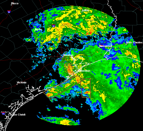 At 1058 am cdt, severe thunderstorms were located along a line extending from santa fe to near jamaica beach, moving east at 15 mph (radar indicated). Hazards include 60 mph wind gusts. expect damage to roofs, siding, and trees At 1058 am cdt, severe thunderstorms were located along a line extending from santa fe to near jamaica beach, moving east at 15 mph (radar indicated). Hazards include 60 mph wind gusts. expect damage to roofs, siding, and trees
|
| 5/22/2017 10:55 AM CDT |
 At 1055 am cdt, severe thunderstorms were located along a line extending from league city to 6 miles south of jamaica beach, moving northeast at 20 mph (radar indicated). Hazards include 60 mph wind gusts. Expect damage to roofs, siding, and trees. Locations impacted include, southeastern pearland, league city, texas city, friendswood, alvin, dickinson, la marque, santa fe, webster, hitchcock, eastern manvel, nassau bay, hillcrest and san luis pass. At 1055 am cdt, severe thunderstorms were located along a line extending from league city to 6 miles south of jamaica beach, moving northeast at 20 mph (radar indicated). Hazards include 60 mph wind gusts. Expect damage to roofs, siding, and trees. Locations impacted include, southeastern pearland, league city, texas city, friendswood, alvin, dickinson, la marque, santa fe, webster, hitchcock, eastern manvel, nassau bay, hillcrest and san luis pass.
|
| 5/22/2017 10:28 AM CDT |
 At 1027 am cdt, severe thunderstorms were located along a line extending from near liverpool to 6 miles south of san luis pass, moving north at 15 mph. a brief tornado may be possible with these storms (radar indicated). Hazards include 60 mph wind gusts. expect damage to roofs, siding, and trees At 1027 am cdt, severe thunderstorms were located along a line extending from near liverpool to 6 miles south of san luis pass, moving north at 15 mph. a brief tornado may be possible with these storms (radar indicated). Hazards include 60 mph wind gusts. expect damage to roofs, siding, and trees
|
| 2/14/2017 10:54 AM CST |
 At 1053 am cst, severe thunderstorms were located along a line extending from 7 miles east of smith point to near crystal beach to 8 miles east of galveston pleasure pier, moving east northeast at 50 mph (radar indicated). Hazards include 60 mph wind gusts. Expect damage to roofs, siding, and trees. locations impacted include, high island, gilchrist, bolivar peninsula, port bolivar, rollover pass and crystal beach. A tornado watch remains in effect until 100 pm cst for southeastern texas. At 1053 am cst, severe thunderstorms were located along a line extending from 7 miles east of smith point to near crystal beach to 8 miles east of galveston pleasure pier, moving east northeast at 50 mph (radar indicated). Hazards include 60 mph wind gusts. Expect damage to roofs, siding, and trees. locations impacted include, high island, gilchrist, bolivar peninsula, port bolivar, rollover pass and crystal beach. A tornado watch remains in effect until 100 pm cst for southeastern texas.
|
| 2/14/2017 10:52 AM CST |
 The severe thunderstorm warning for southeastern liberty, northeastern galveston, chambers and southeastern polk counties will expire at 1100 am cst, the storms which prompted the warning have weakened below severe limits, and no longer pose an immediate threat to life or property. therefore the warning will be allowed to expire. however gusty winds are still possible with these thunderstorms. a tornado watch remains in effect until 100 pm cst for southeastern texas. The severe thunderstorm warning for southeastern liberty, northeastern galveston, chambers and southeastern polk counties will expire at 1100 am cst, the storms which prompted the warning have weakened below severe limits, and no longer pose an immediate threat to life or property. therefore the warning will be allowed to expire. however gusty winds are still possible with these thunderstorms. a tornado watch remains in effect until 100 pm cst for southeastern texas.
|
| 2/14/2017 10:39 AM CST |
 At 1038 am cst, severe thunderstorms were located along a line extending from 6 miles west of warren to near smith point, moving northeast at 35 mph (radar indicated). Hazards include 60 mph wind gusts. Expect damage to roofs, siding, and trees. locations impacted include, anahuac, daisetta, devers, high island, bolivar peninsula, crystal beach, gilchrist, rollover pass, smith point, stowell, winnie, oak island, wallisville and hankamer. A tornado watch remains in effect until 100 pm cst for southeastern texas. At 1038 am cst, severe thunderstorms were located along a line extending from 6 miles west of warren to near smith point, moving northeast at 35 mph (radar indicated). Hazards include 60 mph wind gusts. Expect damage to roofs, siding, and trees. locations impacted include, anahuac, daisetta, devers, high island, bolivar peninsula, crystal beach, gilchrist, rollover pass, smith point, stowell, winnie, oak island, wallisville and hankamer. A tornado watch remains in effect until 100 pm cst for southeastern texas.
|
| 2/14/2017 10:22 AM CST |
 The tornado warning for southwestern galveston and east central brazoria counties will expire at 1030 am cst, the tornado threat has diminished and the tornado warning has been cancelled. however, damaging winds remain likely and a severe thunderstorm warning remains in effect for the area. a tornado watch remains in effect until 100 pm cst for southeastern texas. The tornado warning for southwestern galveston and east central brazoria counties will expire at 1030 am cst, the tornado threat has diminished and the tornado warning has been cancelled. however, damaging winds remain likely and a severe thunderstorm warning remains in effect for the area. a tornado watch remains in effect until 100 pm cst for southeastern texas.
|
| 2/14/2017 10:22 AM CST |
 At 1021 am cst, severe thunderstorms were located along a line extending from tiki island to near galveston state park to 12 miles southeast of san luis pass, moving northeast at 50 mph (radar indicated). Hazards include 60 mph wind gusts. expect damage to roofs, siding, and trees At 1021 am cst, severe thunderstorms were located along a line extending from tiki island to near galveston state park to 12 miles southeast of san luis pass, moving northeast at 50 mph (radar indicated). Hazards include 60 mph wind gusts. expect damage to roofs, siding, and trees
|
| 2/14/2017 10:07 AM CST |
 At 1007 am cst, a severe thunderstorm capable of producing a tornado was located near jamaica beach, or 11 miles south of hitchcock, moving northeast at 35 mph (radar indicated rotation). Hazards include tornado. Flying debris will be dangerous to those caught without shelter. mobile homes will be damaged or destroyed. damage to roofs, windows, and vehicles will occur. tree damage is likely. Locations impacted include, galveston island west end, galveston causeway, texas city, la marque, hitchcock, bayou vista, jamaica beach, tiki island, galveston pleasure pier, schlitterbahn, galveston state park, scholes field, moody gardens, offatts bayou and pelican island. At 1007 am cst, a severe thunderstorm capable of producing a tornado was located near jamaica beach, or 11 miles south of hitchcock, moving northeast at 35 mph (radar indicated rotation). Hazards include tornado. Flying debris will be dangerous to those caught without shelter. mobile homes will be damaged or destroyed. damage to roofs, windows, and vehicles will occur. tree damage is likely. Locations impacted include, galveston island west end, galveston causeway, texas city, la marque, hitchcock, bayou vista, jamaica beach, tiki island, galveston pleasure pier, schlitterbahn, galveston state park, scholes field, moody gardens, offatts bayou and pelican island.
|
| 2/14/2017 9:57 AM CST |
 At 956 am cst, severe thunderstorms were located along a line extending from 10 miles southeast of shepherd to hitchcock, moving northeast at 35 mph (radar indicated). Hazards include 60 mph wind gusts. expect damage to roofs, siding, and trees At 956 am cst, severe thunderstorms were located along a line extending from 10 miles southeast of shepherd to hitchcock, moving northeast at 35 mph (radar indicated). Hazards include 60 mph wind gusts. expect damage to roofs, siding, and trees
|
| 2/14/2017 9:56 AM CST |
 At 956 am cst, a severe thunderstorm capable of producing a tornado was located over san luis pass, or 12 miles northeast of surfside beach, moving northeast at 35 mph (radar indicated rotation). Hazards include tornado. Flying debris will be dangerous to those caught without shelter. mobile homes will be damaged or destroyed. damage to roofs, windows, and vehicles will occur. Tree damage is likely. At 956 am cst, a severe thunderstorm capable of producing a tornado was located over san luis pass, or 12 miles northeast of surfside beach, moving northeast at 35 mph (radar indicated rotation). Hazards include tornado. Flying debris will be dangerous to those caught without shelter. mobile homes will be damaged or destroyed. damage to roofs, windows, and vehicles will occur. Tree damage is likely.
|
| 2/14/2017 9:24 AM CST |
 At 924 am cst, a severe thunderstorm capable of producing a tornado was located near angleton, moving east at 35 mph (radar indicated rotation). Hazards include tornado. Flying debris will be dangerous to those caught without shelter. mobile homes will be damaged or destroyed. damage to roofs, windows, and vehicles will occur. Tree damage is likely. At 924 am cst, a severe thunderstorm capable of producing a tornado was located near angleton, moving east at 35 mph (radar indicated rotation). Hazards include tornado. Flying debris will be dangerous to those caught without shelter. mobile homes will be damaged or destroyed. damage to roofs, windows, and vehicles will occur. Tree damage is likely.
|
| 2/14/2017 9:21 AM CST |
 At 920 am cst, severe thunderstorms were located along a line extending from near danbury to near freeport to 9 miles southeast of sargent, moving east at 50 mph (radar indicated). Hazards include 60 mph wind gusts. expect damage to roofs, siding, and trees At 920 am cst, severe thunderstorms were located along a line extending from near danbury to near freeport to 9 miles southeast of sargent, moving east at 50 mph (radar indicated). Hazards include 60 mph wind gusts. expect damage to roofs, siding, and trees
|
| 2/14/2017 8:56 AM CST |
 At 856 am cst, severe thunderstorms were located along a line extending from near porter heights to golfcrest / bellfort / reveille to near iowa colony, moving east at 60 mph (radar indicated). Hazards include 60 mph wind gusts. expect damage to roofs, siding, and trees At 856 am cst, severe thunderstorms were located along a line extending from near porter heights to golfcrest / bellfort / reveille to near iowa colony, moving east at 60 mph (radar indicated). Hazards include 60 mph wind gusts. expect damage to roofs, siding, and trees
|
| 2/14/2017 8:45 AM CST |
 At 844 am cst, a severe thunderstorm was located near brazoria, or near sweeny, moving east at 50 mph (radar indicated). Hazards include 60 mph wind gusts. expect damage to roofs, siding, and trees At 844 am cst, a severe thunderstorm was located near brazoria, or near sweeny, moving east at 50 mph (radar indicated). Hazards include 60 mph wind gusts. expect damage to roofs, siding, and trees
|
| 7/17/2016 8:50 AM CDT |
 At 846 am cdt, the parent cell responsible for the waterspout that moved onshore to produce a tornado is now located near the galveston causeway moving north around 15 mph. no additional reports have been received with this cell, but the warning will be allowed to continue until 9 am (weather spotters confirmed waterspout moving onshore). Hazards include tornado. Flying debris will be dangerous to those caught without shelter. mobile homes will be damaged or destroyed. damage to roofs, windows, and vehicles will occur. tree damage is likely. Locations impacted include, galveston causeway, galveston island west end, texas city, la marque, hitchcock, bayou vista, tiki island, schlitterbahn, scholes field, moody gardens, offatts bayou and pelican island. At 846 am cdt, the parent cell responsible for the waterspout that moved onshore to produce a tornado is now located near the galveston causeway moving north around 15 mph. no additional reports have been received with this cell, but the warning will be allowed to continue until 9 am (weather spotters confirmed waterspout moving onshore). Hazards include tornado. Flying debris will be dangerous to those caught without shelter. mobile homes will be damaged or destroyed. damage to roofs, windows, and vehicles will occur. tree damage is likely. Locations impacted include, galveston causeway, galveston island west end, texas city, la marque, hitchcock, bayou vista, tiki island, schlitterbahn, scholes field, moody gardens, offatts bayou and pelican island.
|
| 7/17/2016 8:26 AM CDT |
 At 824 am cdt, a waterspout is about to move onto galveston island between 61st street and 91st street. all persons should exit the beach and take shelter in a sturdy structure. waterspouts can produce damaging winds (radar indicated rotation. spotter confirmation of waterspout). Hazards include tornado. Flying debris will be dangerous to those caught without shelter. mobile homes will be damaged or destroyed. damage to roofs, windows, and vehicles will occur. Tree damage is likely. At 824 am cdt, a waterspout is about to move onto galveston island between 61st street and 91st street. all persons should exit the beach and take shelter in a sturdy structure. waterspouts can produce damaging winds (radar indicated rotation. spotter confirmation of waterspout). Hazards include tornado. Flying debris will be dangerous to those caught without shelter. mobile homes will be damaged or destroyed. damage to roofs, windows, and vehicles will occur. Tree damage is likely.
|
| 6/18/2016 7:30 PM CDT | High island 179a in gmz355 county TX, 22.9 miles W of Galveston, TX |
| 5/21/2016 3:58 PM CDT | The national weather service in league city has issued a * severe thunderstorm warning for. coastal galveston county in southeastern texas. coastal brazoria county in southeastern texas. until 445 pm cdt * at 358 pm cdt. A severe thunderstorm was located near surfside. |
| 5/2/2016 1:27 AM CDT |
 At 126 am cdt, a severe thunderstorm was located over port bolivar, or near galveston pier 21, moving northeast at 10 mph (radar indicated). Hazards include quarter size hail. Damage to vehicles is expected. Locations impacted include, crystal beach, port bolivar and bolivar peninsula. At 126 am cdt, a severe thunderstorm was located over port bolivar, or near galveston pier 21, moving northeast at 10 mph (radar indicated). Hazards include quarter size hail. Damage to vehicles is expected. Locations impacted include, crystal beach, port bolivar and bolivar peninsula.
|
| 5/2/2016 1:12 AM CDT |
 At 111 am cdt, a severe thunderstorm was located over galveston pier 21, moving northeast at 10 mph (radar indicated). Hazards include quarter size hail. damage to vehicles is expected At 111 am cdt, a severe thunderstorm was located over galveston pier 21, moving northeast at 10 mph (radar indicated). Hazards include quarter size hail. damage to vehicles is expected
|
| 5/2/2016 1:03 AM CDT |
 At 103 am cdt, a severe thunderstorm was located over galveston pier 21, moving northeast at 10 mph (radar indicated). Hazards include quarter size hail. Damage to vehicles is expected. Locations impacted include, galveston island west end, galveston causeway, texas city, la marque, hitchcock, galveston pier 21, bayou vista, tiki island, galveston pleasure pier, pelican island, schlitterbahn, the strand, scholes field, moody gardens, port bolivar, offatts bayou and bolivar peninsula. At 103 am cdt, a severe thunderstorm was located over galveston pier 21, moving northeast at 10 mph (radar indicated). Hazards include quarter size hail. Damage to vehicles is expected. Locations impacted include, galveston island west end, galveston causeway, texas city, la marque, hitchcock, galveston pier 21, bayou vista, tiki island, galveston pleasure pier, pelican island, schlitterbahn, the strand, scholes field, moody gardens, port bolivar, offatts bayou and bolivar peninsula.
|
| 5/2/2016 1:00 AM CDT | Quarter sized hail reported 0.5 miles NNW of Galveston, TX, quarter sized hail at 67th and heards lane in galveston |
| 5/2/2016 12:50 AM CDT |
 At 1250 am cdt, a severe thunderstorm was located over offatts bayou, or near galveston island west end, moving north at 10 mph (radar indicated). Hazards include quarter size hail. damage to vehicles is expected At 1250 am cdt, a severe thunderstorm was located over offatts bayou, or near galveston island west end, moving north at 10 mph (radar indicated). Hazards include quarter size hail. damage to vehicles is expected
|
| 4/27/2016 6:08 AM CDT |
 At 608 am cdt, severe thunderstorms were located along a line extending from near port bolivar to 6 miles west of san luis pass, moving southeast at 40 mph (radar indicated). Hazards include 60 mph wind gusts. Expect damage to roofs. siding. And trees. At 608 am cdt, severe thunderstorms were located along a line extending from near port bolivar to 6 miles west of san luis pass, moving southeast at 40 mph (radar indicated). Hazards include 60 mph wind gusts. Expect damage to roofs. siding. And trees.
|
| 4/27/2016 5:18 AM CDT |
 At 518 am cdt, severe thunderstorms were located along a line extending from lake houston dam to south park to near first colony, moving southeast at 40 mph (radar indicated). Hazards include 60 mph wind gusts. Expect damage to roofs. siding. And trees. At 518 am cdt, severe thunderstorms were located along a line extending from lake houston dam to south park to near first colony, moving southeast at 40 mph (radar indicated). Hazards include 60 mph wind gusts. Expect damage to roofs. siding. And trees.
|
| 4/13/2016 2:27 AM CDT |
 At 224 am cdt, severe thunderstorms were located along a line extending from old river-winfree to league city to near danbury to near bay city, moving southeast at 40 mph (radar indicated). Hazards include 60 mph wind gusts and quarter size hail. Hail damage to vehicles is expected. Expect wind damage to roofs, siding, and trees. At 224 am cdt, severe thunderstorms were located along a line extending from old river-winfree to league city to near danbury to near bay city, moving southeast at 40 mph (radar indicated). Hazards include 60 mph wind gusts and quarter size hail. Hail damage to vehicles is expected. Expect wind damage to roofs, siding, and trees.
|
| 2/23/2016 7:17 AM CST |
 At 716 am cst, a severe thunderstorm capable of producing a tornado was located over hitchcock, moving northeast at 45 mph (radar indicated rotation). Hazards include tornado. Flying debris will be dangerous to those caught without shelter. mobile homes will be damaged or destroyed. damage to roofs, windows, and vehicles will occur. tree damage is likely. This dangerous storm will be near, bayou vista and tiki island around 725 am cst. At 716 am cst, a severe thunderstorm capable of producing a tornado was located over hitchcock, moving northeast at 45 mph (radar indicated rotation). Hazards include tornado. Flying debris will be dangerous to those caught without shelter. mobile homes will be damaged or destroyed. damage to roofs, windows, and vehicles will occur. tree damage is likely. This dangerous storm will be near, bayou vista and tiki island around 725 am cst.
|
| 12/13/2015 9:19 AM CST | Wind gust was measured at galveston scholes field aso in galveston county TX, 3 miles SW of Galveston, TX |
| 10/24/2015 2:22 PM CDT |
 The tornado warning for east central brazoria and southwestern galveston counties will expire at 230 pm cdt, the storm which prompted the warning has weakened below severe limits, and no longer appears capable of producing a tornado. therefore the warning will be allowed to expire. The tornado warning for east central brazoria and southwestern galveston counties will expire at 230 pm cdt, the storm which prompted the warning has weakened below severe limits, and no longer appears capable of producing a tornado. therefore the warning will be allowed to expire.
|
| 10/24/2015 2:06 PM CDT |
 At 204 pm cdt, a severe thunderstorm capable of producing a tornado was located over west galveston bay near jamaica beach, or 8 miles south of hitchcock, moving northwest at 15 mph (radar indicated rotation). Hazards include tornado. Flying debris will be dangerous to those caught without shelter. mobile homes will be damaged or destroyed. damage to roofs, windows and vehicles will occur. tree damage is likely. This dangerous storm will be near, areas west of hitchcock around 230 pm cdt. At 204 pm cdt, a severe thunderstorm capable of producing a tornado was located over west galveston bay near jamaica beach, or 8 miles south of hitchcock, moving northwest at 15 mph (radar indicated rotation). Hazards include tornado. Flying debris will be dangerous to those caught without shelter. mobile homes will be damaged or destroyed. damage to roofs, windows and vehicles will occur. tree damage is likely. This dangerous storm will be near, areas west of hitchcock around 230 pm cdt.
|
| 10/24/2015 1:50 PM CDT |
 At 148 pm cdt, a severe thunderstorm capable of producing a tornado was located just offshore of jamaica beach, moving northwest at 15 mph (radar indicated rotation). Hazards include tornado. Flying debris will be dangerous to those caught without shelter. mobile homes will be damaged or destroyed. damage to roofs, windows and vehicles will occur. tree damage is likely. this dangerous storm will be near, jamaica beach around 155 pm cdt. Radar indicated a waterspout approaching the west end of galveston island. At 148 pm cdt, a severe thunderstorm capable of producing a tornado was located just offshore of jamaica beach, moving northwest at 15 mph (radar indicated rotation). Hazards include tornado. Flying debris will be dangerous to those caught without shelter. mobile homes will be damaged or destroyed. damage to roofs, windows and vehicles will occur. tree damage is likely. this dangerous storm will be near, jamaica beach around 155 pm cdt. Radar indicated a waterspout approaching the west end of galveston island.
|
| 5/24/2015 6:08 AM CDT | At 608 am cdt, doppler radar indicated a line of severe thunderstorms capable of producing damaging winds in excess of 60 mph. these storms were located along a line extending from near thompsons to near bonney to 6 miles south of danbury to near quintana to 20 miles south of surfside beach, and moving northeast at 50 mph. |
| 4/26/2015 7:24 PM CDT | At 724 pm cdt, doppler radar indicated a severe thunderstorm capable of producing quarter size hail and damaging winds in excess of 60 mph. this storm was located over hillcrest, or over alvin, and moving east at 30 mph. |
| 4/25/2015 8:55 AM CDT | Golf Ball sized hail reported 5.3 miles SW of Galveston, TX, golf ball sized hail reported by public at heards lane and 68th street on galveston island. |
| 4/25/2015 8:23 AM CDT | At 823 am cdt, doppler radar indicated a line of severe thunderstorms capable of producing quarter size hail and damaging winds in excess of 60 mph. these storms were located along a line extending from webster to 7 miles northwest of san luis pass to near jones creek, and moving east at 50 mph. |
| 4/25/2015 8:13 AM CDT | At 813 am cdt, doppler radar indicated a severe thunderstorm capable of producing quarter size hail and damaging winds in excess of 60 mph. this storm was located over richwood, or over lake jackson, and moving east at 40 mph. |
| 4/17/2015 9:50 PM CDT | Wind gust measured at buoy 4203 in gmz355 county TX, 29.2 miles W of Galveston, TX |
| 4/17/2015 8:43 PM CDT | At 840 pm cdt, doppler radar indicated a line of severe thunderstorms capable of producing destructive winds in excess of 70 mph. these storms were located along a line extending from near sheldon to near smith point to 14 miles south of galveston pleasure pier, and moving east at 45 mph. houston hobby airport reported a wind gust of 61 mph at 829 pm. |
| 4/17/2015 8:01 PM CDT | At 800 pm cdt, doppler radar indicated a line of severe thunderstorms capable of producing large damaging hail up to two inches in diameter and destructive winds in excess of 75 mph. these storms were located along a line extending from gulfton to san luis pass to near jones creek, and moving east at 55 mph. |
| 4/17/2015 7:53 PM CDT | At 752 pm cdt, doppler radar indicated a line of severe thunderstorms capable of producing destructive winds in excess of 75 mph. these storms were located along a line extending from near four corners to near liverpool to near freeport, moving east at 45 mph. locations impacted include, pasadena, pearland, league city, sugar land, missouri city, galveston island west end, texas city, friendswood, la porte, deer park, lake jackson, alvin, angleton, dickinson, stafford, south houston, bellaire, west university place, la marque and santa fe. a tornado watch remains in effect until 200 am cdt for southeastern texas. |
| 4/17/2015 7:37 PM CDT | At 735 pm cdt, doppler radar indicated a line of severe thunderstorms capable of producing damaging winds in excess of 60 mph. these storms were located along a line extending from mission bend to bonney to near brazoria, and moving east at 40 mph. |
| 5/27/2014 9:39 AM CDT | Power lines down and sagging. power pole down at 51st and ave in galveston county TX, 5.3 miles SW of Galveston, TX |
| 5/27/2014 8:30 AM CDT | Power lines down and sagging. power pole down at 51st and ave in galveston county TX, 5.3 miles SW of Galveston, TX |
| 6/2/2013 8:40 AM CDT | Wind gust measured at scholes fiel in galveston county TX, 0.5 miles NNW of Galveston, TX |
| 5/11/2013 12:12 AM CDT | Golf Ball sized hail reported 6.2 miles ENE of Galveston, TX, hail damaged vehicles |
| 12/20/2012 3:45 AM CST | Galveston north jetty report of 37 knot sustained winds with a 53 knot wind gus in gmz355 county TX, 13 miles SW of Galveston, TX |
| 5/11/2012 2:30 AM CDT | Powerlines reported blown down between west end of galveston island into downtown galveston island per police dep in galveston county TX, 7.1 miles SW of Galveston, TX |
| 4/20/2012 4:45 PM CDT | 78 mph wind gust recorded at moody garden in galveston county TX, 3.4 miles SW of Galveston, TX |
Hail Maps for Galveston, TX


Connect with Interactive Hail Maps