

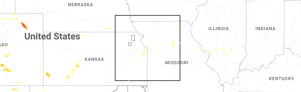
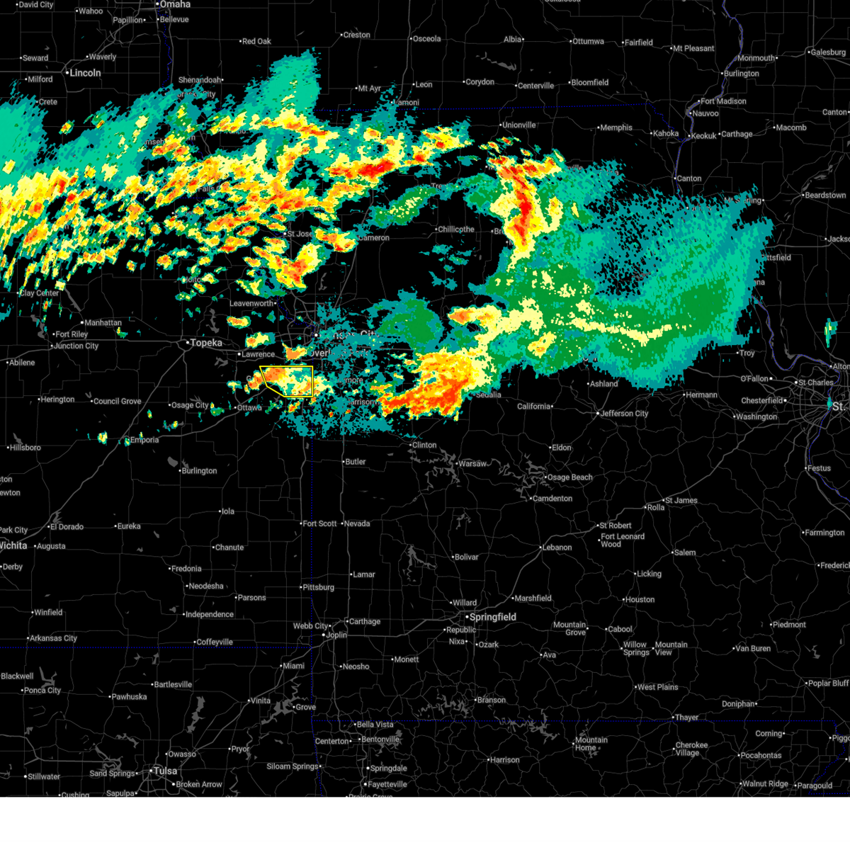
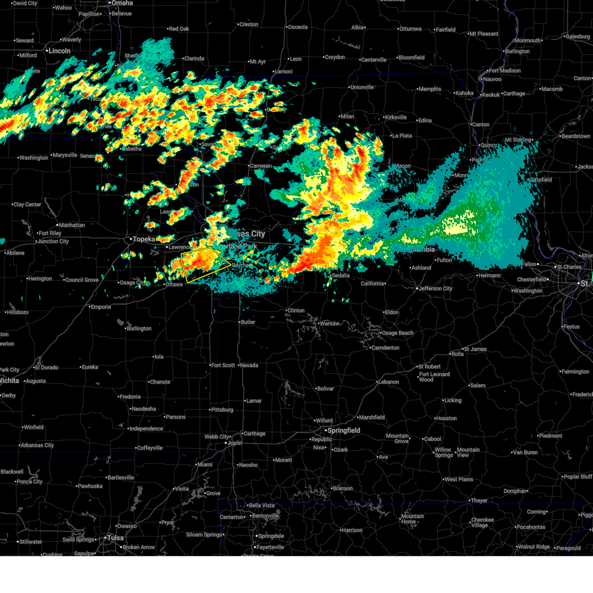
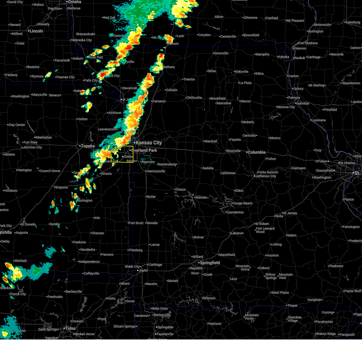
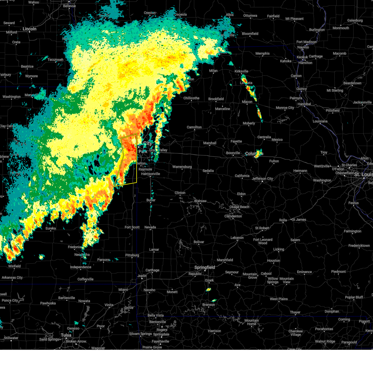
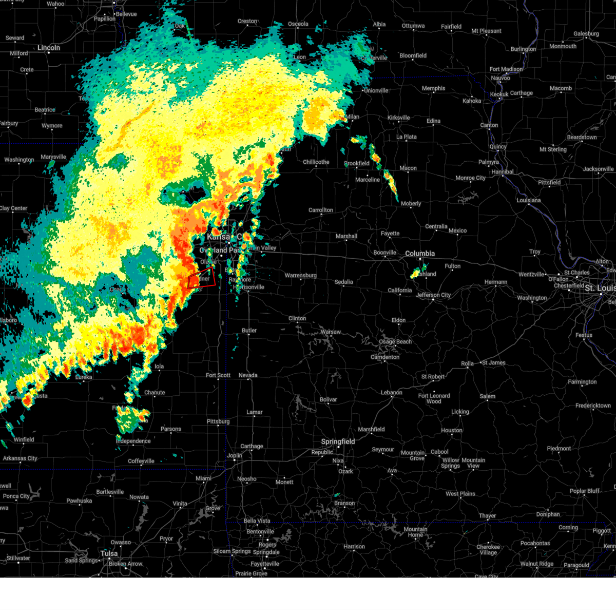
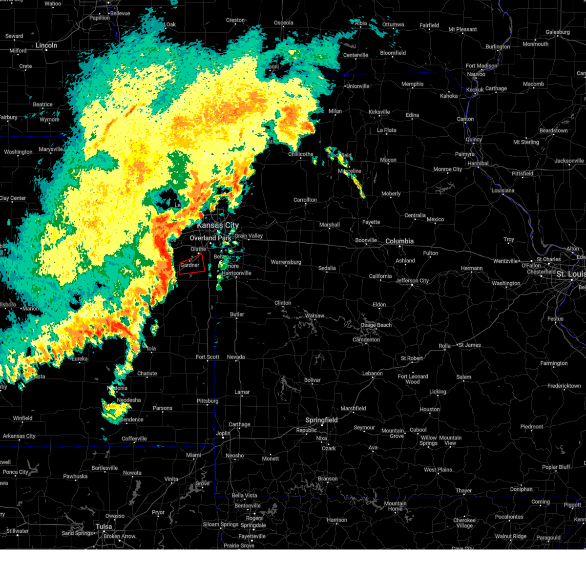
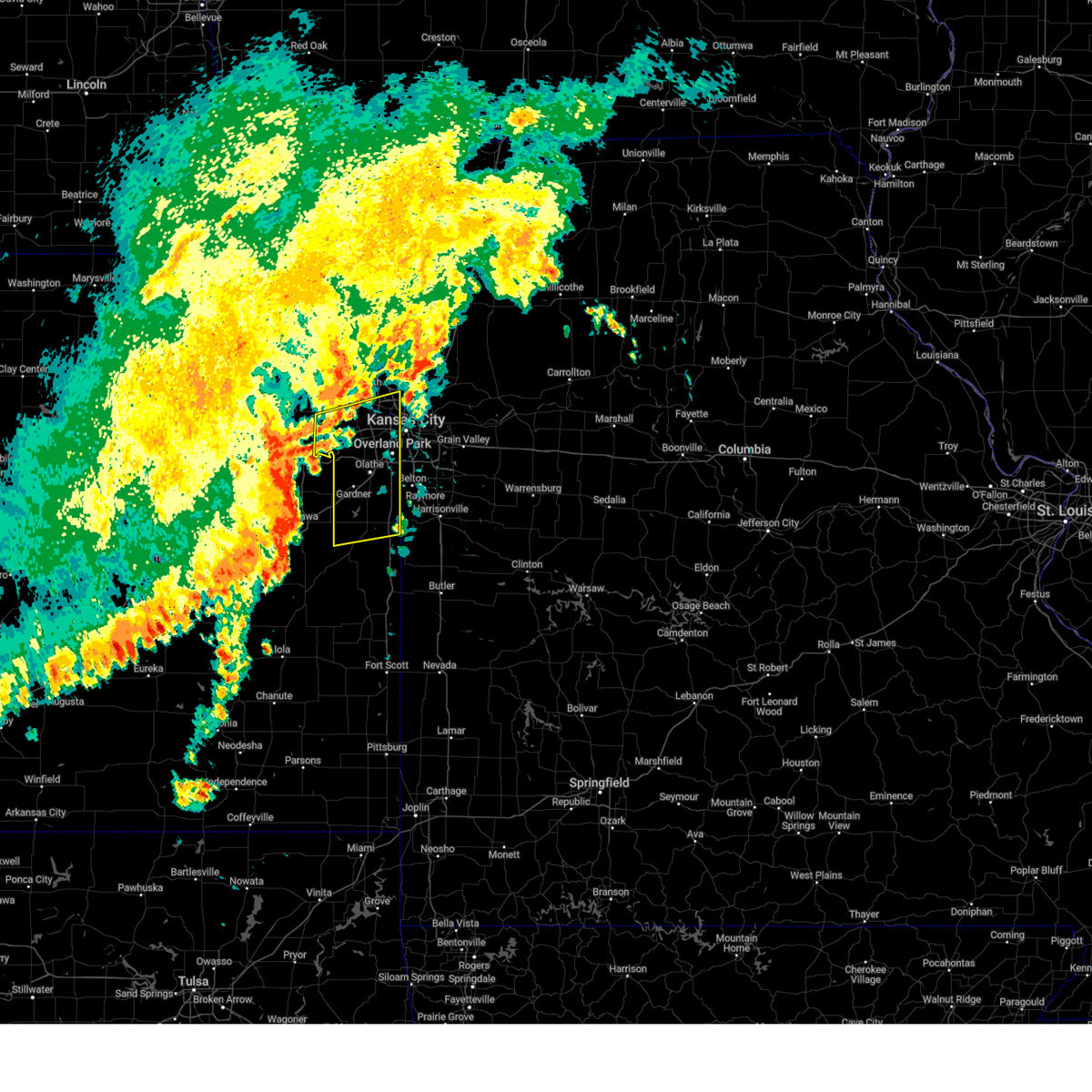
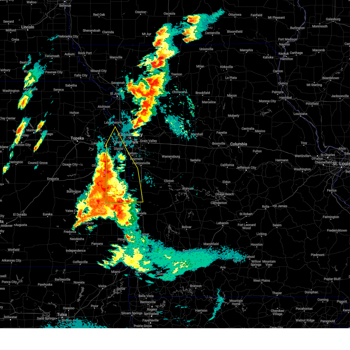
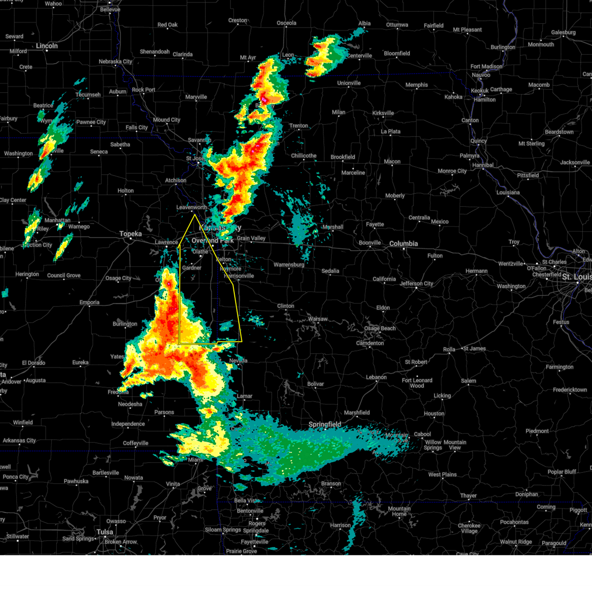
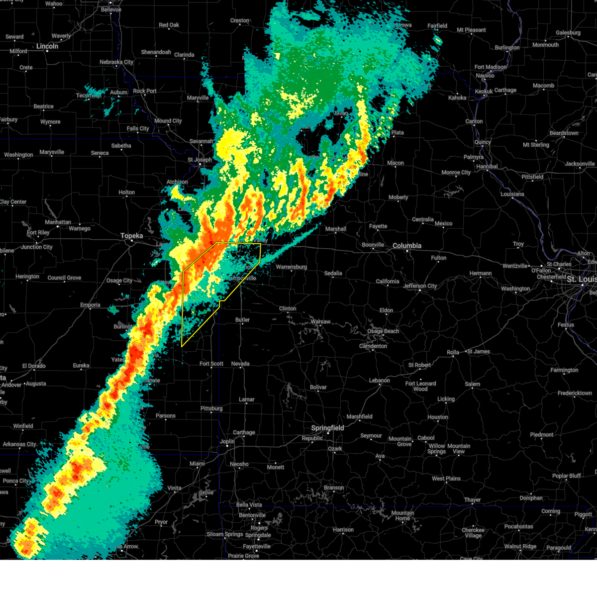
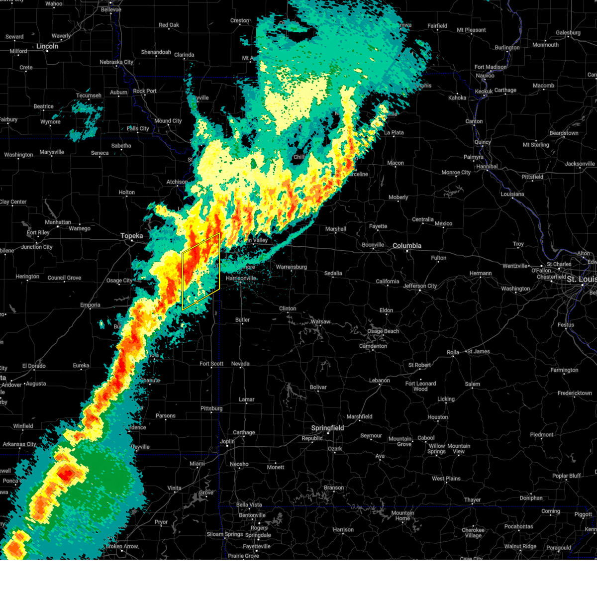
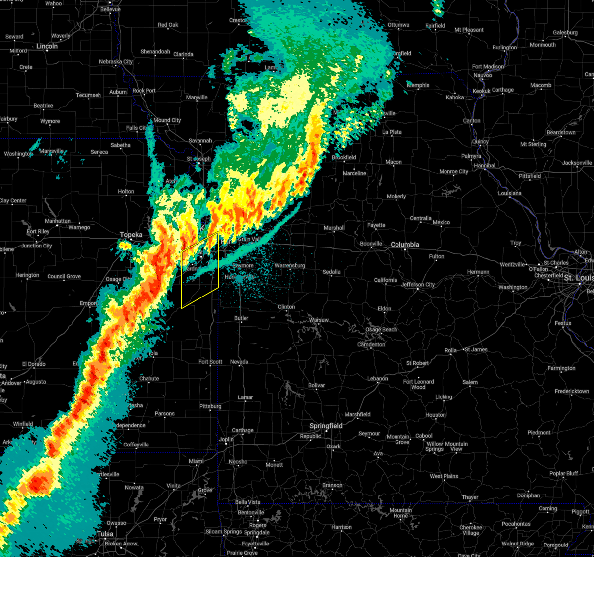
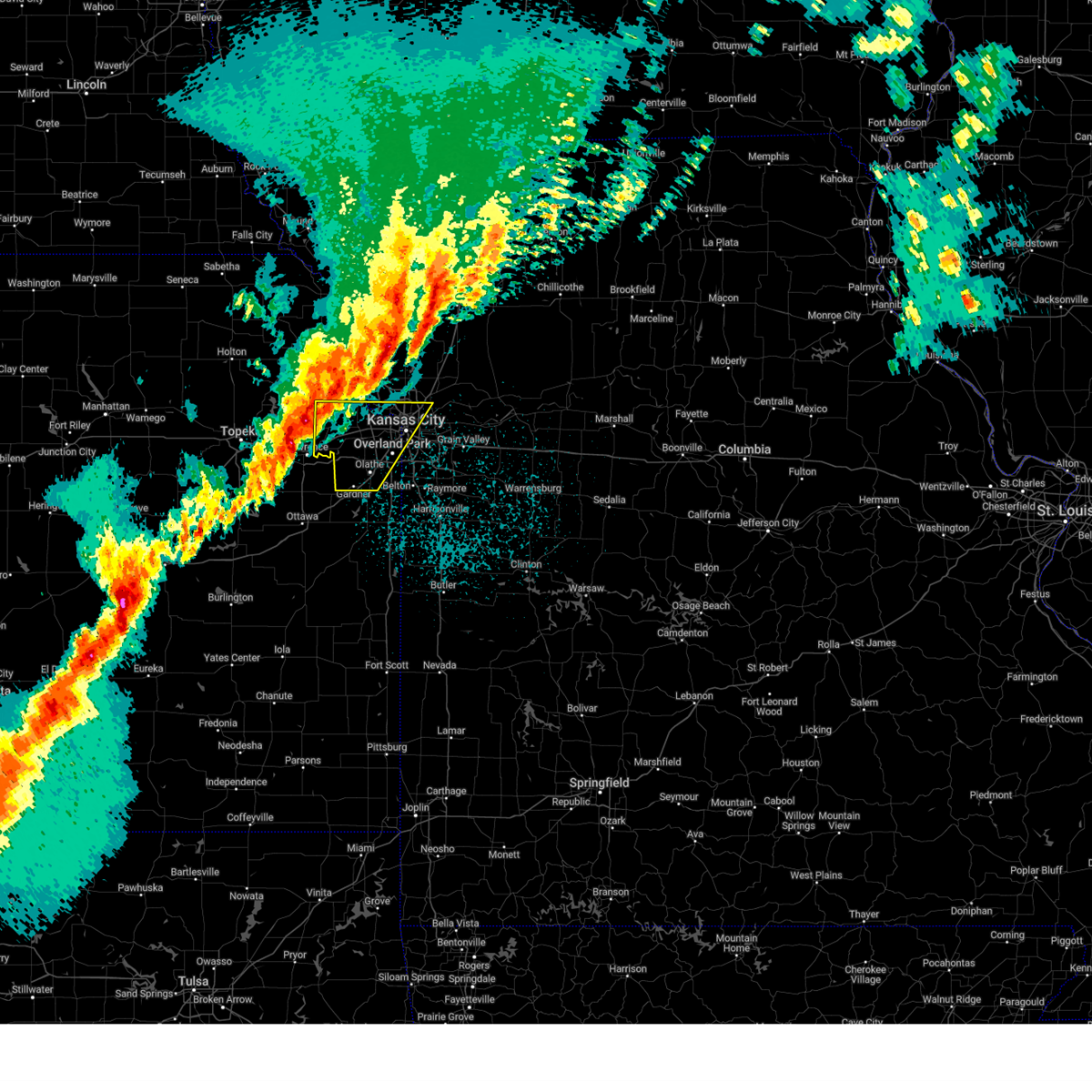
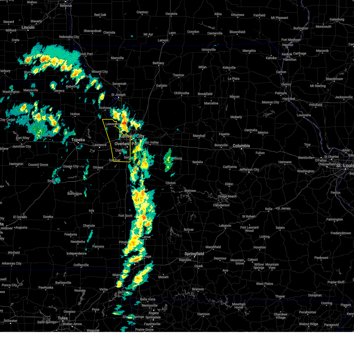
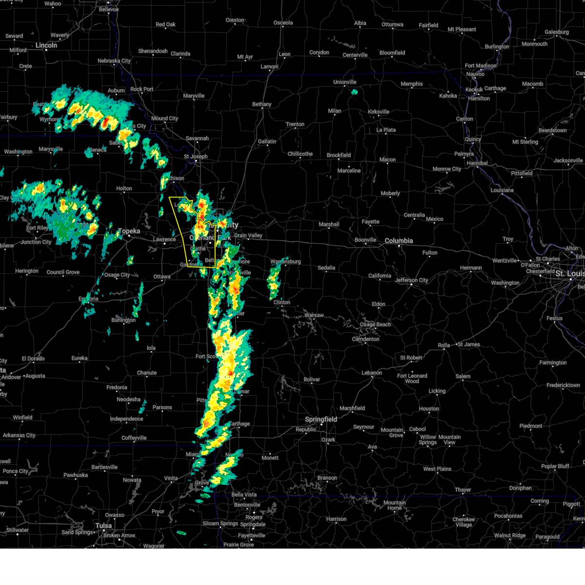
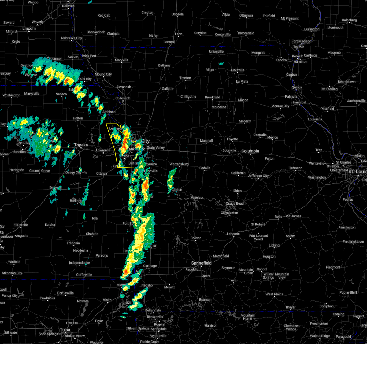
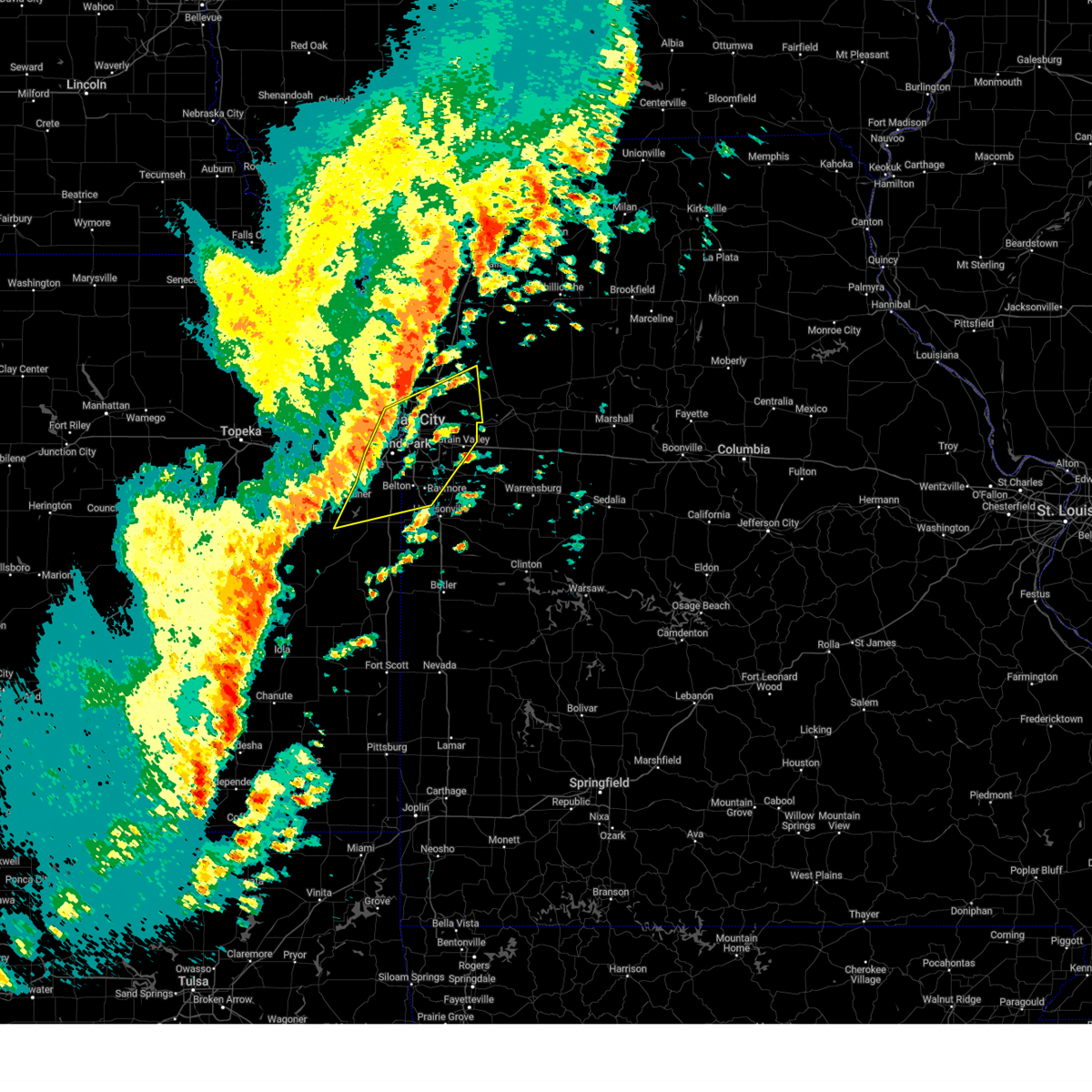
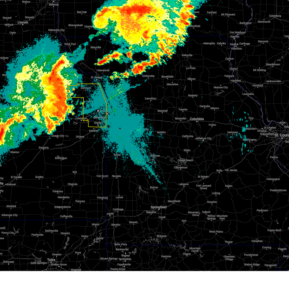
Hail Map for Gardner, KS
The Gardner, KS area has had 4 reports of on-the-ground hail by trained spotters, and has been under severe weather warnings 35 times during the past 12 months. Doppler radar has detected hail at or near Gardner, KS on 90 occasions, including 4 occasions during the past year.
| Name: | Gardner, KS |
| Where Located: | 27 miles SW of Kansas City, MO |
| Map: | Google Map for Gardner, KS |
| Population: | 19123 |
| Housing Units: | 7300 |
| More Info: | Search Google for Gardner, KS |
1
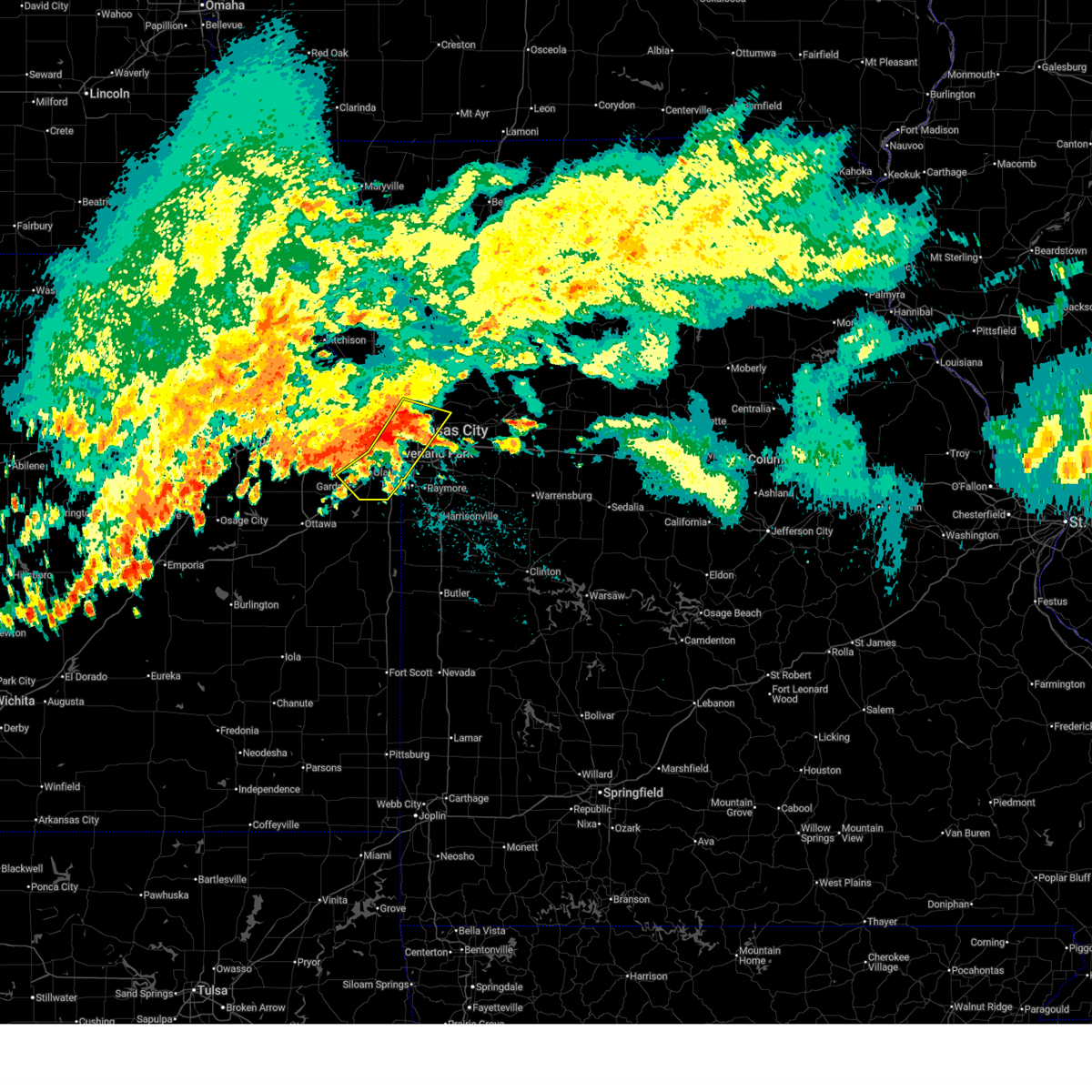
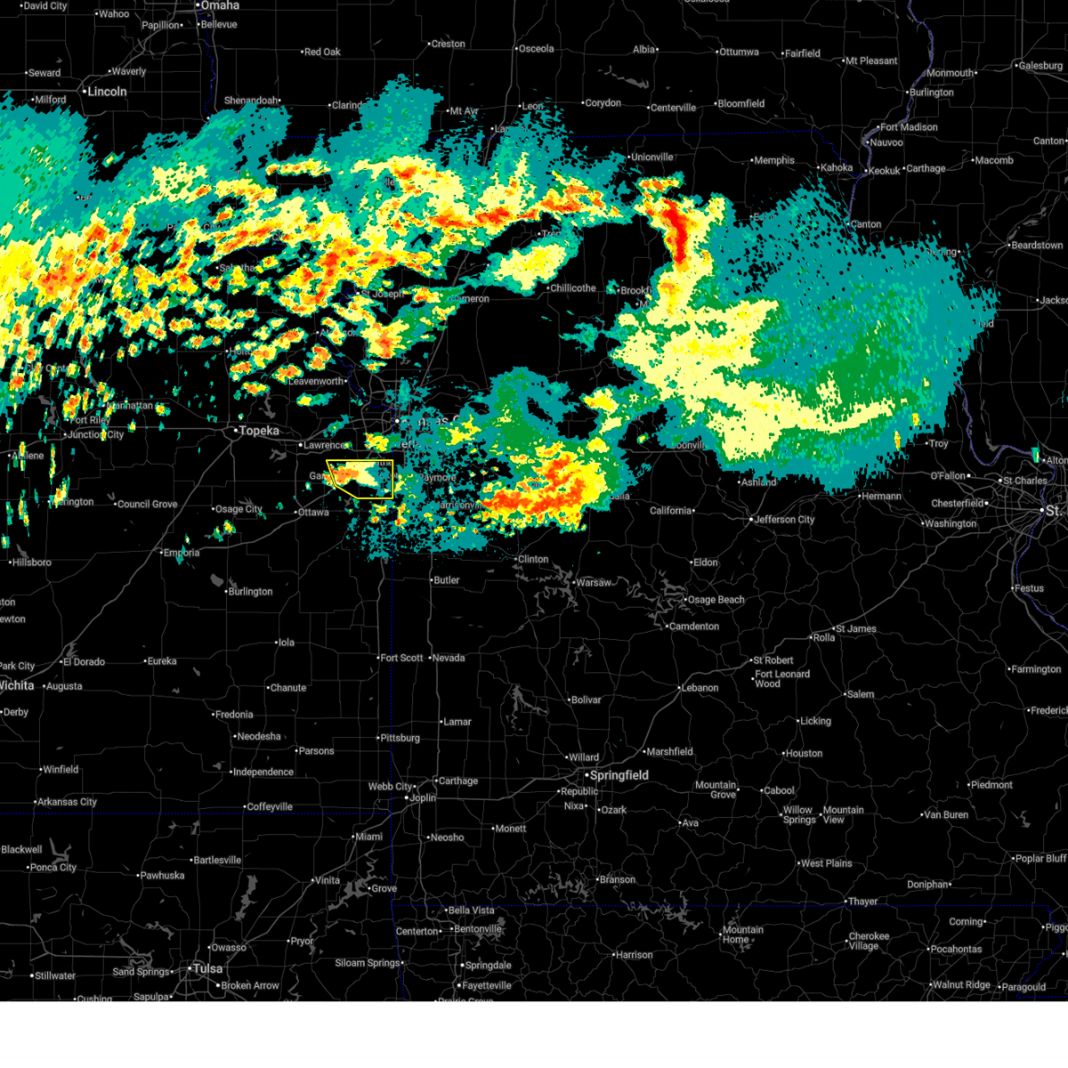
The Top Recent Hail Date for Gardner, KS is Wednesday, July 16, 2025 (21st out of 90)
Hail and Wind Damage Spotted near Gardner, KS
| Date / Time | Report Details |
|---|---|
| 7/17/2025 3:09 AM CDT |
 Svreax the national weather service in pleasant hill has issued a * severe thunderstorm warning for, northeastern miami county in east central kansas, southeastern johnson county in east central kansas, northwestern cass county in west central missouri, south central clay county in west central missouri, southwestern ray county in west central missouri, west central lafayette county in west central missouri, jackson county in west central missouri, * until 400 am cdt. * at 309 am cdt, severe thunderstorms were located along a line extending from near levasy to near prairie village to near gardner, moving east at 30 mph (radar indicated). Hazards include 60 mph wind gusts. expect damage to roofs, siding, and trees Svreax the national weather service in pleasant hill has issued a * severe thunderstorm warning for, northeastern miami county in east central kansas, southeastern johnson county in east central kansas, northwestern cass county in west central missouri, south central clay county in west central missouri, southwestern ray county in west central missouri, west central lafayette county in west central missouri, jackson county in west central missouri, * until 400 am cdt. * at 309 am cdt, severe thunderstorms were located along a line extending from near levasy to near prairie village to near gardner, moving east at 30 mph (radar indicated). Hazards include 60 mph wind gusts. expect damage to roofs, siding, and trees
|
| 7/17/2025 2:39 AM CDT |
 Svreax the national weather service in pleasant hill has issued a * severe thunderstorm warning for, eastern wyandotte county in northeastern kansas, johnson county in east central kansas, southwestern clay county in west central missouri, southeastern platte county in west central missouri, northwestern jackson county in west central missouri, * until 330 am cdt. * at 239 am cdt, severe thunderstorms were located along a line extending from lake quivira to lenexa to olathe, moving southeast at 15 mph (radar indicated). Hazards include 60 mph wind gusts. expect damage to roofs, siding, and trees Svreax the national weather service in pleasant hill has issued a * severe thunderstorm warning for, eastern wyandotte county in northeastern kansas, johnson county in east central kansas, southwestern clay county in west central missouri, southeastern platte county in west central missouri, northwestern jackson county in west central missouri, * until 330 am cdt. * at 239 am cdt, severe thunderstorms were located along a line extending from lake quivira to lenexa to olathe, moving southeast at 15 mph (radar indicated). Hazards include 60 mph wind gusts. expect damage to roofs, siding, and trees
|
| 7/17/2025 12:28 AM CDT |
 The storm which prompted the warning has weakened below severe limits, and no longer poses an immediate threat to life or property. therefore, the warning will be allowed to expire. however, gusty winds are still possible with this thunderstorm. The storm which prompted the warning has weakened below severe limits, and no longer poses an immediate threat to life or property. therefore, the warning will be allowed to expire. however, gusty winds are still possible with this thunderstorm.
|
| 7/17/2025 12:11 AM CDT |
 At 1211 am cdt, a severe thunderstorm was located over cleveland, or near louisburg, moving southeast at 10 mph (radar indicated). Hazards include 60 mph wind gusts. Expect damage to roofs, siding, and trees. locations impacted include, overland park, olathe, leawood, gardner, spring hill, edgerton, stanley, bucyrus, clare, and stillwell. This includes interstate 35 in kansas between mile markers 204 and 217. At 1211 am cdt, a severe thunderstorm was located over cleveland, or near louisburg, moving southeast at 10 mph (radar indicated). Hazards include 60 mph wind gusts. Expect damage to roofs, siding, and trees. locations impacted include, overland park, olathe, leawood, gardner, spring hill, edgerton, stanley, bucyrus, clare, and stillwell. This includes interstate 35 in kansas between mile markers 204 and 217.
|
| 7/16/2025 11:43 PM CDT |
 Svreax the national weather service in pleasant hill has issued a * severe thunderstorm warning for, northeastern miami county in east central kansas, johnson county in east central kansas, * until 1230 am cdt. * at 1142 pm cdt, a severe thunderstorm was located near cleveland, or near spring hill, moving southeast at 10 mph (radar indicated). Hazards include 60 mph wind gusts. expect damage to roofs, siding, and trees Svreax the national weather service in pleasant hill has issued a * severe thunderstorm warning for, northeastern miami county in east central kansas, johnson county in east central kansas, * until 1230 am cdt. * at 1142 pm cdt, a severe thunderstorm was located near cleveland, or near spring hill, moving southeast at 10 mph (radar indicated). Hazards include 60 mph wind gusts. expect damage to roofs, siding, and trees
|
| 7/16/2025 11:20 PM CDT |
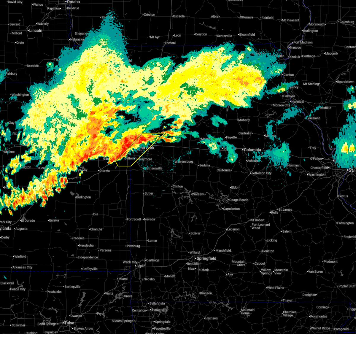
 At 1119 pm cdt, a severe thunderstorm was located over spring hill, moving southeast at 10 mph (kixd asos reported a 76 mph wind gust at 1102pm). Hazards include 70 mph wind gusts. Expect considerable tree damage. damage is likely to mobile homes, roofs, and outbuildings. locations impacted include, overland park, olathe, lenexa, leawood, grandview, belton, raymore, gardner, spring hill, edgerton, bucyrus, clare, lackmans, stillwell, and stanley. this includes the following highways, interstate 35 in kansas between mile markers 202 and 224. interstate 435 between mile markers 0 and 2, and between mile markers 78 and 83. Interstate 49 between mile markers 173 and 177. At 1119 pm cdt, a severe thunderstorm was located over spring hill, moving southeast at 10 mph (kixd asos reported a 76 mph wind gust at 1102pm). Hazards include 70 mph wind gusts. Expect considerable tree damage. damage is likely to mobile homes, roofs, and outbuildings. locations impacted include, overland park, olathe, lenexa, leawood, grandview, belton, raymore, gardner, spring hill, edgerton, bucyrus, clare, lackmans, stillwell, and stanley. this includes the following highways, interstate 35 in kansas between mile markers 202 and 224. interstate 435 between mile markers 0 and 2, and between mile markers 78 and 83. Interstate 49 between mile markers 173 and 177.
|
| 7/16/2025 11:02 PM CDT | Storm damage reported in johnson county KS, 2.2 miles WSW of Gardner, KS |
| 7/16/2025 11:02 PM CDT |
 Svreax the national weather service in pleasant hill has issued a * severe thunderstorm warning for, northwestern miami county in east central kansas, johnson county in east central kansas, northwestern cass county in west central missouri, southwestern jackson county in west central missouri, * until 1145 pm cdt. * at 1101 pm cdt, a severe thunderstorm was located near spring hill, moving southeast at 30 mph (automated weather station). Hazards include 70 mph wind gusts. Expect considerable tree damage. Damage is likely to mobile homes, roofs, and outbuildings. Svreax the national weather service in pleasant hill has issued a * severe thunderstorm warning for, northwestern miami county in east central kansas, johnson county in east central kansas, northwestern cass county in west central missouri, southwestern jackson county in west central missouri, * until 1145 pm cdt. * at 1101 pm cdt, a severe thunderstorm was located near spring hill, moving southeast at 30 mph (automated weather station). Hazards include 70 mph wind gusts. Expect considerable tree damage. Damage is likely to mobile homes, roofs, and outbuildings.
|
| 7/16/2025 10:55 PM CDT | Storm damage reported in johnson county KS, 2.2 miles WSW of Gardner, KS |
| 6/26/2025 6:17 PM CDT | The storm which prompted the warning has moved out of the area. therefore, the warning has been allowed to expire. a severe thunderstorm watch remains in effect until 900 pm cdt for northeastern kansas. to report severe weather, contact your nearest law enforcement agency. they will relay your report to the national weather service pleasant hill. |
| 6/26/2025 5:31 PM CDT |
 Svreax the national weather service in pleasant hill has issued a * severe thunderstorm warning for, johnson county in east central kansas, * until 615 pm cdt. * at 531 pm cdt, a severe thunderstorm was located near de soto, moving northeast at 35 mph (radar indicated). Hazards include 60 mph wind gusts. expect damage to roofs, siding, and trees Svreax the national weather service in pleasant hill has issued a * severe thunderstorm warning for, johnson county in east central kansas, * until 615 pm cdt. * at 531 pm cdt, a severe thunderstorm was located near de soto, moving northeast at 35 mph (radar indicated). Hazards include 60 mph wind gusts. expect damage to roofs, siding, and trees
|
| 6/3/2025 2:22 PM CDT |
 At 221 pm cdt, severe thunderstorms were located along a line extending from tracy to near prairie village to near edgerton, moving northeast at 45 mph (public). Hazards include 70 mph wind gusts and nickel size hail. Expect considerable tree damage. damage is likely to mobile homes, roofs, and outbuildings. locations impacted include, overland park, olathe, shawnee, lenexa, leawood, prairie village, gardner, lansing, merriam, mission, bonner springs, paola, parkville, spring hill, osawatomie, edwardsville, louisburg, fairway, mission hills, and riverside. this includes the following highways, interstate 70 in kansas between mile markers 410 and 422. interstate 35 in kansas between mile markers 206 and 234. interstate 29 between mile markers 5 and 11. interstate 635 between mile markers 0 and 11. interstate 435 between mile markers 0 and 25, and between mile markers 76 and 83. Kansas turnpike between mile markers 224 and 226. At 221 pm cdt, severe thunderstorms were located along a line extending from tracy to near prairie village to near edgerton, moving northeast at 45 mph (public). Hazards include 70 mph wind gusts and nickel size hail. Expect considerable tree damage. damage is likely to mobile homes, roofs, and outbuildings. locations impacted include, overland park, olathe, shawnee, lenexa, leawood, prairie village, gardner, lansing, merriam, mission, bonner springs, paola, parkville, spring hill, osawatomie, edwardsville, louisburg, fairway, mission hills, and riverside. this includes the following highways, interstate 70 in kansas between mile markers 410 and 422. interstate 35 in kansas between mile markers 206 and 234. interstate 29 between mile markers 5 and 11. interstate 635 between mile markers 0 and 11. interstate 435 between mile markers 0 and 25, and between mile markers 76 and 83. Kansas turnpike between mile markers 224 and 226.
|
| 6/3/2025 2:01 PM CDT |
 The tornado threat has diminished and the tornado warning has been cancelled. however, damaging winds remain likely and a severe thunderstorm warning remains in effect for the area. however, heavy rain is still possible with this thunderstorm. a tornado watch remains in effect until 800 pm cdt for east central kansas. The tornado threat has diminished and the tornado warning has been cancelled. however, damaging winds remain likely and a severe thunderstorm warning remains in effect for the area. however, heavy rain is still possible with this thunderstorm. a tornado watch remains in effect until 800 pm cdt for east central kansas.
|
| 6/3/2025 1:55 PM CDT |
 At 154 pm cdt, severe thunderstorms were located along a line extending from near tonganoxie to near gardner to near princeton, moving northeast at 45 mph (radar indicated). Hazards include 70 mph wind gusts and nickel size hail. Expect considerable tree damage. damage is likely to mobile homes, roofs, and outbuildings. locations impacted include, overland park, olathe, shawnee, lenexa, leawood, prairie village, gardner, lansing, merriam, mission, bonner springs, de soto, paola, parkville, spring hill, tonganoxie, basehor, osawatomie, edwardsville, and louisburg. this includes the following highways, interstate 70 in kansas between mile markers 410 and 422. interstate 35 in kansas between mile markers 200 and 234. interstate 29 between mile markers 5 and 11. interstate 635 between mile markers 0 and 11. interstate 435 between mile markers 0 and 25, and between mile markers 76 and 83. Kansas turnpike between mile markers 206 and 226. At 154 pm cdt, severe thunderstorms were located along a line extending from near tonganoxie to near gardner to near princeton, moving northeast at 45 mph (radar indicated). Hazards include 70 mph wind gusts and nickel size hail. Expect considerable tree damage. damage is likely to mobile homes, roofs, and outbuildings. locations impacted include, overland park, olathe, shawnee, lenexa, leawood, prairie village, gardner, lansing, merriam, mission, bonner springs, de soto, paola, parkville, spring hill, tonganoxie, basehor, osawatomie, edwardsville, and louisburg. this includes the following highways, interstate 70 in kansas between mile markers 410 and 422. interstate 35 in kansas between mile markers 200 and 234. interstate 29 between mile markers 5 and 11. interstate 635 between mile markers 0 and 11. interstate 435 between mile markers 0 and 25, and between mile markers 76 and 83. Kansas turnpike between mile markers 206 and 226.
|
| 6/3/2025 1:45 PM CDT |
 Toreax the national weather service in pleasant hill has issued a * tornado warning for, northwestern miami county in east central kansas, southwestern johnson county in east central kansas, * until 200 pm cdt. * at 145 pm cdt, a severe thunderstorm capable of producing a tornado was located over edgerton, moving east at 40 mph (radar indicated rotation). Hazards include tornado. Flying debris will be dangerous to those caught without shelter. mobile homes will be damaged or destroyed. damage to roofs, windows, and vehicles will occur. Tree damage is likely. Toreax the national weather service in pleasant hill has issued a * tornado warning for, northwestern miami county in east central kansas, southwestern johnson county in east central kansas, * until 200 pm cdt. * at 145 pm cdt, a severe thunderstorm capable of producing a tornado was located over edgerton, moving east at 40 mph (radar indicated rotation). Hazards include tornado. Flying debris will be dangerous to those caught without shelter. mobile homes will be damaged or destroyed. damage to roofs, windows, and vehicles will occur. Tree damage is likely.
|
| 6/3/2025 1:40 PM CDT |
 At 140 pm cdt, severe thunderstorms were located along a line extending from near tonganoxie to near wellsville to near richmond, moving northeast at 45 mph (radar indicated). Hazards include 70 mph wind gusts and nickel size hail. Expect considerable tree damage. damage is likely to mobile homes, roofs, and outbuildings. locations impacted include, overland park, olathe, shawnee, lenexa, leawood, prairie village, gardner, lansing, merriam, mission, bonner springs, de soto, paola, parkville, spring hill, tonganoxie, basehor, osawatomie, edwardsville, and louisburg. this includes the following highways, interstate 70 in kansas between mile markers 410 and 422. interstate 35 in kansas between mile markers 200 and 234. interstate 29 between mile markers 5 and 11. interstate 635 between mile markers 0 and 11. interstate 435 between mile markers 0 and 25, and between mile markers 76 and 83. Kansas turnpike between mile markers 206 and 226. At 140 pm cdt, severe thunderstorms were located along a line extending from near tonganoxie to near wellsville to near richmond, moving northeast at 45 mph (radar indicated). Hazards include 70 mph wind gusts and nickel size hail. Expect considerable tree damage. damage is likely to mobile homes, roofs, and outbuildings. locations impacted include, overland park, olathe, shawnee, lenexa, leawood, prairie village, gardner, lansing, merriam, mission, bonner springs, de soto, paola, parkville, spring hill, tonganoxie, basehor, osawatomie, edwardsville, and louisburg. this includes the following highways, interstate 70 in kansas between mile markers 410 and 422. interstate 35 in kansas between mile markers 200 and 234. interstate 29 between mile markers 5 and 11. interstate 635 between mile markers 0 and 11. interstate 435 between mile markers 0 and 25, and between mile markers 76 and 83. Kansas turnpike between mile markers 206 and 226.
|
| 6/3/2025 1:32 PM CDT |
 Svreax the national weather service in pleasant hill has issued a * severe thunderstorm warning for, wyandotte county in northeastern kansas, northern miami county in east central kansas, southern leavenworth county in northeastern kansas, johnson county in east central kansas, southeastern platte county in west central missouri, * until 230 pm cdt. * at 131 pm cdt, severe thunderstorms were located along a line extending from near williamstown to 6 miles south of baldwin city to near harris, moving northeast at 45 mph (radar indicated). Hazards include 60 mph wind gusts and nickel size hail. expect damage to roofs, siding, and trees Svreax the national weather service in pleasant hill has issued a * severe thunderstorm warning for, wyandotte county in northeastern kansas, northern miami county in east central kansas, southern leavenworth county in northeastern kansas, johnson county in east central kansas, southeastern platte county in west central missouri, * until 230 pm cdt. * at 131 pm cdt, severe thunderstorms were located along a line extending from near williamstown to 6 miles south of baldwin city to near harris, moving northeast at 45 mph (radar indicated). Hazards include 60 mph wind gusts and nickel size hail. expect damage to roofs, siding, and trees
|
| 5/19/2025 4:13 PM CDT |
 The storms which prompted the warning have weakened below severe limits, and no longer pose an immediate threat to life or property. therefore, the warning will be allowed to expire. however, gusty winds and heavy rain are still possible with these thunderstorms. a tornado watch remains in effect until 900 pm cdt for northeastern and east central kansas, and west central missouri. The storms which prompted the warning have weakened below severe limits, and no longer pose an immediate threat to life or property. therefore, the warning will be allowed to expire. however, gusty winds and heavy rain are still possible with these thunderstorms. a tornado watch remains in effect until 900 pm cdt for northeastern and east central kansas, and west central missouri.
|
| 5/19/2025 4:10 PM CDT | Private weather senso in johnson county KS, 4.9 miles NNW of Gardner, KS |
| 5/19/2025 3:52 PM CDT | At 352 pm cdt, severe thunderstorms were located along a line extending from near bonner springs to near olathe to near linn valley to near hume, moving northeast at 55 mph (radar indicated). Hazards include 60 mph wind gusts and quarter size hail. Hail damage to vehicles is expected. expect wind damage to roofs, siding, and trees. locations impacted include, overland park, olathe, shawnee, lenexa, leavenworth, leawood, gardner, lansing, bonner springs, de soto, paola, spring hill, basehor, osawatomie, edwardsville, louisburg, butler, edgerton, rich hill, and pleasanton. this includes the following highways, interstate 70 in kansas between mile markers 410 and 413. interstate 35 in kansas between mile markers 200 and 226. interstate 435 between mile markers 0 and 16, and between mile markers 79 and 83. kansas turnpike between mile markers 216 and 226. Interstate 49 between mile markers 119 and 134. |
| 5/19/2025 3:34 PM CDT |
 At 334 pm cdt, severe thunderstorms were located along a line extending from near edgerton to near osawatomie to near prescott to near fort scott, moving northeast at 60 mph (radar indicated). Hazards include ping pong ball size hail and 60 mph wind gusts. People and animals outdoors will be injured. expect hail damage to roofs, siding, windows, and vehicles. expect wind damage to roofs, siding, and trees. locations impacted include, overland park, olathe, shawnee, lenexa, leavenworth, leawood, gardner, lansing, bonner springs, de soto, paola, spring hill, basehor, osawatomie, edwardsville, louisburg, butler, edgerton, rich hill, and pleasanton. this includes the following highways, interstate 70 in kansas between mile markers 410 and 413. interstate 35 in kansas between mile markers 200 and 226. interstate 435 between mile markers 0 and 16, and between mile markers 79 and 83. kansas turnpike between mile markers 216 and 226. Interstate 49 between mile markers 119 and 134. At 334 pm cdt, severe thunderstorms were located along a line extending from near edgerton to near osawatomie to near prescott to near fort scott, moving northeast at 60 mph (radar indicated). Hazards include ping pong ball size hail and 60 mph wind gusts. People and animals outdoors will be injured. expect hail damage to roofs, siding, windows, and vehicles. expect wind damage to roofs, siding, and trees. locations impacted include, overland park, olathe, shawnee, lenexa, leavenworth, leawood, gardner, lansing, bonner springs, de soto, paola, spring hill, basehor, osawatomie, edwardsville, louisburg, butler, edgerton, rich hill, and pleasanton. this includes the following highways, interstate 70 in kansas between mile markers 410 and 413. interstate 35 in kansas between mile markers 200 and 226. interstate 435 between mile markers 0 and 16, and between mile markers 79 and 83. kansas turnpike between mile markers 216 and 226. Interstate 49 between mile markers 119 and 134.
|
| 5/19/2025 3:21 PM CDT |
 Svreax the national weather service in pleasant hill has issued a * severe thunderstorm warning for, western wyandotte county in northeastern kansas, miami county in east central kansas, linn county in east central kansas, southeastern leavenworth county in northeastern kansas, johnson county in east central kansas, western cass county in west central missouri, western bates county in west central missouri, * until 415 pm cdt. * at 321 pm cdt, severe thunderstorms were located along a line extending from near ottawa to greeley to 6 miles north of redfield to 7 miles east of hepler, moving northeast at 55 mph (radar indicated). Hazards include ping pong ball size hail and 60 mph wind gusts. People and animals outdoors will be injured. expect hail damage to roofs, siding, windows, and vehicles. Expect wind damage to roofs, siding, and trees. Svreax the national weather service in pleasant hill has issued a * severe thunderstorm warning for, western wyandotte county in northeastern kansas, miami county in east central kansas, linn county in east central kansas, southeastern leavenworth county in northeastern kansas, johnson county in east central kansas, western cass county in west central missouri, western bates county in west central missouri, * until 415 pm cdt. * at 321 pm cdt, severe thunderstorms were located along a line extending from near ottawa to greeley to 6 miles north of redfield to 7 miles east of hepler, moving northeast at 55 mph (radar indicated). Hazards include ping pong ball size hail and 60 mph wind gusts. People and animals outdoors will be injured. expect hail damage to roofs, siding, windows, and vehicles. Expect wind damage to roofs, siding, and trees.
|
| 4/2/2025 5:25 AM CDT |
 Svreax the national weather service in pleasant hill has issued a * severe thunderstorm warning for, miami county in east central kansas, northwestern linn county in east central kansas, southern johnson county in east central kansas, western cass county in west central missouri, southern jackson county in west central missouri, * until 615 am cdt. * at 524 am cdt, severe thunderstorms were located along a line extending from near grandview to near paola to greeley, moving east at 35 mph (radar indicated). Hazards include 60 mph wind gusts. expect damage to roofs, siding, and trees Svreax the national weather service in pleasant hill has issued a * severe thunderstorm warning for, miami county in east central kansas, northwestern linn county in east central kansas, southern johnson county in east central kansas, western cass county in west central missouri, southern jackson county in west central missouri, * until 615 am cdt. * at 524 am cdt, severe thunderstorms were located along a line extending from near grandview to near paola to greeley, moving east at 35 mph (radar indicated). Hazards include 60 mph wind gusts. expect damage to roofs, siding, and trees
|
| 4/2/2025 5:12 AM CDT |
 At 512 am cdt, severe thunderstorms were located along a line extending from olathe to near edgerton to near rantoul, moving northeast at 55 mph (radar indicated). Hazards include 60 mph wind gusts. Expect damage to roofs, siding, and trees. locations impacted include, overland park, roeland park, olathe, spring hill, merriam, clare, lenexa, lackmans, stillwell, westwood, stanley, wagstaff, leawood, edgerton, mission hills, mission, fairway, hillsdale, paola, and mission woods. this includes the following highways, interstate 70 in missouri near mile marker 0. interstate 70 in kansas between mile markers 420 and 423. interstate 35 in kansas between mile markers 200 and 234. interstate 635 between mile markers 0 and 3. Interstate 435 between mile markers 0 and 8, and between mile markers 76 and 83. At 512 am cdt, severe thunderstorms were located along a line extending from olathe to near edgerton to near rantoul, moving northeast at 55 mph (radar indicated). Hazards include 60 mph wind gusts. Expect damage to roofs, siding, and trees. locations impacted include, overland park, roeland park, olathe, spring hill, merriam, clare, lenexa, lackmans, stillwell, westwood, stanley, wagstaff, leawood, edgerton, mission hills, mission, fairway, hillsdale, paola, and mission woods. this includes the following highways, interstate 70 in missouri near mile marker 0. interstate 70 in kansas between mile markers 420 and 423. interstate 35 in kansas between mile markers 200 and 234. interstate 635 between mile markers 0 and 3. Interstate 435 between mile markers 0 and 8, and between mile markers 76 and 83.
|
| 4/2/2025 4:52 AM CDT |
 Svreax the national weather service in pleasant hill has issued a * severe thunderstorm warning for, southeastern wyandotte county in northeastern kansas, miami county in east central kansas, johnson county in east central kansas, * until 530 am cdt. * at 451 am cdt, severe thunderstorms were located along a line extending from baldwin city to near ottawa to 6 miles east of new strawn, moving east at 55 mph (radar indicated). Hazards include 60 mph wind gusts. expect damage to roofs, siding, and trees Svreax the national weather service in pleasant hill has issued a * severe thunderstorm warning for, southeastern wyandotte county in northeastern kansas, miami county in east central kansas, johnson county in east central kansas, * until 530 am cdt. * at 451 am cdt, severe thunderstorms were located along a line extending from baldwin city to near ottawa to 6 miles east of new strawn, moving east at 55 mph (radar indicated). Hazards include 60 mph wind gusts. expect damage to roofs, siding, and trees
|
| 4/2/2025 3:41 AM CDT |
 Svreax the national weather service in pleasant hill has issued a * severe thunderstorm warning for, wyandotte county in northeastern kansas, leavenworth county in northeastern kansas, johnson county in east central kansas, southwestern clay county in west central missouri, southeastern platte county in west central missouri, northwestern jackson county in west central missouri, * until 415 am cdt. * at 340 am cdt, severe thunderstorms were located along a line extending from near mclouth to near williamstown to near clinton, moving east at 50 mph (radar indicated). Hazards include 60 mph wind gusts. expect damage to roofs, siding, and trees Svreax the national weather service in pleasant hill has issued a * severe thunderstorm warning for, wyandotte county in northeastern kansas, leavenworth county in northeastern kansas, johnson county in east central kansas, southwestern clay county in west central missouri, southeastern platte county in west central missouri, northwestern jackson county in west central missouri, * until 415 am cdt. * at 340 am cdt, severe thunderstorms were located along a line extending from near mclouth to near williamstown to near clinton, moving east at 50 mph (radar indicated). Hazards include 60 mph wind gusts. expect damage to roofs, siding, and trees
|
| 3/14/2025 3:24 PM CDT |
 The storms which prompted the warning have moved out of the area. therefore, the warning will be allowed to expire. however, very gusty winds are expected. a severe thunderstorm watch remains in effect until 700 pm cdt for northeastern and east central kansas, and west central missouri. The storms which prompted the warning have moved out of the area. therefore, the warning will be allowed to expire. however, very gusty winds are expected. a severe thunderstorm watch remains in effect until 700 pm cdt for northeastern and east central kansas, and west central missouri.
|
| 3/14/2025 3:19 PM CDT |
 At 319 pm cdt, severe thunderstorms were located along a line extending from weston to lake waukomis to near lee's summit, moving north at 55 mph (public reported a 70 mph gust in piper, kansas). Hazards include 70 mph wind gusts and nickel size hail. Expect considerable tree damage. damage is likely to mobile homes, roofs, and outbuildings. locations impacted include, overland park, roeland park, fort leavenworth, olathe, kansas city kansas, spring hill, merriam, clare, pomeroy, lenexa, lackmans, bonner springs, stillwell, westwood, muncie, edwardsville, stanley, leawood, maywood, and leavenworth. this includes the following highways, interstate 70 in missouri near mile marker 0. interstate 70 in kansas between mile markers 410 and 423. interstate 35 in kansas between mile markers 206 and 234. interstate 635 between mile markers 0 and 8. interstate 435 between mile markers 0 and 20, and between mile markers 76 and 83. Kansas turnpike between mile markers 216 and 226. At 319 pm cdt, severe thunderstorms were located along a line extending from weston to lake waukomis to near lee's summit, moving north at 55 mph (public reported a 70 mph gust in piper, kansas). Hazards include 70 mph wind gusts and nickel size hail. Expect considerable tree damage. damage is likely to mobile homes, roofs, and outbuildings. locations impacted include, overland park, roeland park, fort leavenworth, olathe, kansas city kansas, spring hill, merriam, clare, pomeroy, lenexa, lackmans, bonner springs, stillwell, westwood, muncie, edwardsville, stanley, leawood, maywood, and leavenworth. this includes the following highways, interstate 70 in missouri near mile marker 0. interstate 70 in kansas between mile markers 410 and 423. interstate 35 in kansas between mile markers 206 and 234. interstate 635 between mile markers 0 and 8. interstate 435 between mile markers 0 and 20, and between mile markers 76 and 83. Kansas turnpike between mile markers 216 and 226.
|
| 3/14/2025 3:12 PM CDT |
 At 312 pm cdt, severe thunderstorms were located along a line extending from near leavenworth to riverside to near grandview, moving north at 55 mph (public). Hazards include 70 mph wind gusts and nickel size hail. Expect considerable tree damage. damage is likely to mobile homes, roofs, and outbuildings. locations impacted include, overland park, roeland park, fort leavenworth, olathe, kansas city kansas, spring hill, merriam, clare, pomeroy, lenexa, lackmans, bonner springs, stillwell, westwood, muncie, edwardsville, stanley, leawood, maywood, and leavenworth. this includes the following highways, interstate 70 in missouri near mile marker 0. interstate 70 in kansas between mile markers 410 and 423. interstate 35 in kansas between mile markers 206 and 234. interstate 635 between mile markers 0 and 8. interstate 435 between mile markers 0 and 20, and between mile markers 76 and 83. Kansas turnpike between mile markers 216 and 226. At 312 pm cdt, severe thunderstorms were located along a line extending from near leavenworth to riverside to near grandview, moving north at 55 mph (public). Hazards include 70 mph wind gusts and nickel size hail. Expect considerable tree damage. damage is likely to mobile homes, roofs, and outbuildings. locations impacted include, overland park, roeland park, fort leavenworth, olathe, kansas city kansas, spring hill, merriam, clare, pomeroy, lenexa, lackmans, bonner springs, stillwell, westwood, muncie, edwardsville, stanley, leawood, maywood, and leavenworth. this includes the following highways, interstate 70 in missouri near mile marker 0. interstate 70 in kansas between mile markers 410 and 423. interstate 35 in kansas between mile markers 206 and 234. interstate 635 between mile markers 0 and 8. interstate 435 between mile markers 0 and 20, and between mile markers 76 and 83. Kansas turnpike between mile markers 216 and 226.
|
| 3/14/2025 2:55 PM CDT |
 At 253 pm cdt, severe thunderstorms were located along a line extending from near tonganoxie to near merriam to cleveland, moving north at 55 mph (public reported 60 mph wind gusts with these storms). Hazards include 70 mph wind gusts and nickel size hail. Expect considerable tree damage. damage is likely to mobile homes, roofs, and outbuildings. locations impacted include, overland park, roeland park, fort leavenworth, olathe, kansas city kansas, spring hill, merriam, clare, pomeroy, lenexa, lackmans, bonner springs, stillwell, westwood, muncie, edwardsville, linwood, stanley, leawood, and maywood. this includes the following highways, interstate 70 in missouri near mile marker 0. interstate 70 in kansas between mile markers 410 and 423. interstate 35 in kansas between mile markers 202 and 234. interstate 635 between mile markers 0 and 8. interstate 435 between mile markers 0 and 20, and between mile markers 76 and 83. Kansas turnpike between mile markers 206 and 226. At 253 pm cdt, severe thunderstorms were located along a line extending from near tonganoxie to near merriam to cleveland, moving north at 55 mph (public reported 60 mph wind gusts with these storms). Hazards include 70 mph wind gusts and nickel size hail. Expect considerable tree damage. damage is likely to mobile homes, roofs, and outbuildings. locations impacted include, overland park, roeland park, fort leavenworth, olathe, kansas city kansas, spring hill, merriam, clare, pomeroy, lenexa, lackmans, bonner springs, stillwell, westwood, muncie, edwardsville, linwood, stanley, leawood, and maywood. this includes the following highways, interstate 70 in missouri near mile marker 0. interstate 70 in kansas between mile markers 410 and 423. interstate 35 in kansas between mile markers 202 and 234. interstate 635 between mile markers 0 and 8. interstate 435 between mile markers 0 and 20, and between mile markers 76 and 83. Kansas turnpike between mile markers 206 and 226.
|
| 3/14/2025 2:44 PM CDT |
 Svreax the national weather service in pleasant hill has issued a * severe thunderstorm warning for, wyandotte county in northeastern kansas, leavenworth county in northeastern kansas, johnson county in east central kansas, * until 330 pm cdt. * at 244 pm cdt, severe thunderstorms were located along a line extending from tonganoxie to olathe to near louisburg, moving northeast at 55 mph (radar indicated). Hazards include 70 mph wind gusts and nickel size hail. Expect considerable tree damage. Damage is likely to mobile homes, roofs, and outbuildings. Svreax the national weather service in pleasant hill has issued a * severe thunderstorm warning for, wyandotte county in northeastern kansas, leavenworth county in northeastern kansas, johnson county in east central kansas, * until 330 pm cdt. * at 244 pm cdt, severe thunderstorms were located along a line extending from tonganoxie to olathe to near louisburg, moving northeast at 55 mph (radar indicated). Hazards include 70 mph wind gusts and nickel size hail. Expect considerable tree damage. Damage is likely to mobile homes, roofs, and outbuildings.
|
| 10/30/2024 7:51 PM CDT |
 At 751 pm cdt, severe thunderstorms were located along a line extending from near missouri city to near independence to near spring hill, moving northeast at 65 mph (radar indicated). Hazards include 60 mph wind gusts. Expect damage to roofs, siding, and trees. locations impacted include, kansas city, overland park, olathe, independence, lee's summit, shawnee, blue springs, lenexa, leawood, raytown, liberty, gladstone, grandview, belton, prairie village, raymore, gardner, grain valley, excelsior springs, and merriam. this includes the following highways, interstate 70 in missouri between mile markers 0 and 28. interstate 70 in kansas between mile markers 414 and 423. interstate 35 in missouri between mile markers 0 and 22. interstate 35 in kansas between mile markers 206 and 235. interstate 29 between mile markers 0 and 7. interstate 635 between mile markers 0 and 12. interstate 470 between mile markers 0 and 16. Interstate 435 between mile markers 0 and 10, and between mile markers 46 and 83. At 751 pm cdt, severe thunderstorms were located along a line extending from near missouri city to near independence to near spring hill, moving northeast at 65 mph (radar indicated). Hazards include 60 mph wind gusts. Expect damage to roofs, siding, and trees. locations impacted include, kansas city, overland park, olathe, independence, lee's summit, shawnee, blue springs, lenexa, leawood, raytown, liberty, gladstone, grandview, belton, prairie village, raymore, gardner, grain valley, excelsior springs, and merriam. this includes the following highways, interstate 70 in missouri between mile markers 0 and 28. interstate 70 in kansas between mile markers 414 and 423. interstate 35 in missouri between mile markers 0 and 22. interstate 35 in kansas between mile markers 206 and 235. interstate 29 between mile markers 0 and 7. interstate 635 between mile markers 0 and 12. interstate 470 between mile markers 0 and 16. Interstate 435 between mile markers 0 and 10, and between mile markers 46 and 83.
|
| 10/30/2024 7:37 PM CDT |
 Svreax the national weather service in pleasant hill has issued a * severe thunderstorm warning for, eastern wyandotte county in northeastern kansas, northern miami county in east central kansas, johnson county in east central kansas, northwestern cass county in west central missouri, central clay county in west central missouri, southwestern ray county in west central missouri, southeastern platte county in west central missouri, jackson county in west central missouri, * until 800 pm cdt. * at 736 pm cdt, severe thunderstorms were located along a line extending from near parkville to near overland park to near wellsville, moving northeast at 60 mph (radar indicated). Hazards include 60 mph wind gusts and penny size hail. expect damage to roofs, siding, and trees Svreax the national weather service in pleasant hill has issued a * severe thunderstorm warning for, eastern wyandotte county in northeastern kansas, northern miami county in east central kansas, johnson county in east central kansas, northwestern cass county in west central missouri, central clay county in west central missouri, southwestern ray county in west central missouri, southeastern platte county in west central missouri, jackson county in west central missouri, * until 800 pm cdt. * at 736 pm cdt, severe thunderstorms were located along a line extending from near parkville to near overland park to near wellsville, moving northeast at 60 mph (radar indicated). Hazards include 60 mph wind gusts and penny size hail. expect damage to roofs, siding, and trees
|
| 8/27/2024 6:29 PM CDT |
 Svreax the national weather service in pleasant hill has issued a * severe thunderstorm warning for, southwestern johnson county in east central kansas, * until 700 pm cdt. * at 629 pm cdt, a severe thunderstorm was located near gardner, moving northeast at 5 mph (radar indicated). Hazards include 60 mph wind gusts and quarter size hail. Hail damage to vehicles is expected. Expect wind damage to roofs, siding, and trees. Svreax the national weather service in pleasant hill has issued a * severe thunderstorm warning for, southwestern johnson county in east central kansas, * until 700 pm cdt. * at 629 pm cdt, a severe thunderstorm was located near gardner, moving northeast at 5 mph (radar indicated). Hazards include 60 mph wind gusts and quarter size hail. Hail damage to vehicles is expected. Expect wind damage to roofs, siding, and trees.
|
| 7/31/2024 11:04 PM CDT |
 Svreax the national weather service in pleasant hill has issued a * severe thunderstorm warning for, eastern wyandotte county in northeastern kansas, northern miami county in east central kansas, johnson county in east central kansas, cass county in west central missouri, clay county in west central missouri, ray county in west central missouri, lafayette county in west central missouri, southeastern platte county in west central missouri, jackson county in west central missouri, johnson county in west central missouri, * until 1145 pm cdt. * at 1103 pm cdt, severe thunderstorms were located along a line extending from near plattsburg to near independence to near grandview, moving east at 50 mph (radar indicated). Hazards include 60 mph wind gusts. expect damage to roofs, siding, and trees Svreax the national weather service in pleasant hill has issued a * severe thunderstorm warning for, eastern wyandotte county in northeastern kansas, northern miami county in east central kansas, johnson county in east central kansas, cass county in west central missouri, clay county in west central missouri, ray county in west central missouri, lafayette county in west central missouri, southeastern platte county in west central missouri, jackson county in west central missouri, johnson county in west central missouri, * until 1145 pm cdt. * at 1103 pm cdt, severe thunderstorms were located along a line extending from near plattsburg to near independence to near grandview, moving east at 50 mph (radar indicated). Hazards include 60 mph wind gusts. expect damage to roofs, siding, and trees
|
| 7/31/2024 10:22 PM CDT |
 Svreax the national weather service in pleasant hill has issued a * severe thunderstorm warning for, leavenworth county in northeastern kansas, central atchison county in northeastern kansas, wyandotte county in northeastern kansas, northeastern miami county in east central kansas, doniphan county in northeastern kansas, johnson county in east central kansas, buchanan county in northwestern missouri, southeastern holt county in northwestern missouri, southern andrew county in northwestern missouri, western jackson county in west central missouri, northwestern cass county in west central missouri, clinton county in northwestern missouri, clay county in west central missouri, west central ray county in west central missouri, platte county in west central missouri, western dekalb county in northwestern missouri, * until 1115 pm cdt. * at 1022 pm cdt, severe thunderstorms were located along a line extending from 7 miles northwest of rushville to near lansing to near lawrence, moving east at 55 mph (radar indicated). Hazards include 70 mph wind gusts. Expect considerable tree damage. Damage is likely to mobile homes, roofs, and outbuildings. Svreax the national weather service in pleasant hill has issued a * severe thunderstorm warning for, leavenworth county in northeastern kansas, central atchison county in northeastern kansas, wyandotte county in northeastern kansas, northeastern miami county in east central kansas, doniphan county in northeastern kansas, johnson county in east central kansas, buchanan county in northwestern missouri, southeastern holt county in northwestern missouri, southern andrew county in northwestern missouri, western jackson county in west central missouri, northwestern cass county in west central missouri, clinton county in northwestern missouri, clay county in west central missouri, west central ray county in west central missouri, platte county in west central missouri, western dekalb county in northwestern missouri, * until 1115 pm cdt. * at 1022 pm cdt, severe thunderstorms were located along a line extending from 7 miles northwest of rushville to near lansing to near lawrence, moving east at 55 mph (radar indicated). Hazards include 70 mph wind gusts. Expect considerable tree damage. Damage is likely to mobile homes, roofs, and outbuildings.
|
| 7/31/2024 10:10 PM CDT |
 At 1010 pm cdt, a severe thunderstorm was located near lewis and clark village, or 7 miles west of weston, moving east at 55 mph (radar indicated). Hazards include 70 mph wind gusts. Expect considerable tree damage. damage is likely to mobile homes, roofs, and outbuildings. locations impacted include, overland park, olathe, shawnee, lenexa, leavenworth, leawood, prairie village, lansing, atchison, merriam, mission, bonner springs, de soto, parkville, tonganoxie, platte city, basehor, edwardsville, fairway, and mission hills. this includes the following highways, interstate 70 in missouri near mile marker 0. interstate 70 in kansas between mile markers 410 and 423. interstate 35 in kansas between mile markers 215 and 234. interstate 29 between mile markers 4 and 40. interstate 635 between mile markers 0 and 12. interstate 435 between mile markers 0 and 38, and between mile markers 76 and 83. Kansas turnpike between mile markers 206 and 226. At 1010 pm cdt, a severe thunderstorm was located near lewis and clark village, or 7 miles west of weston, moving east at 55 mph (radar indicated). Hazards include 70 mph wind gusts. Expect considerable tree damage. damage is likely to mobile homes, roofs, and outbuildings. locations impacted include, overland park, olathe, shawnee, lenexa, leavenworth, leawood, prairie village, lansing, atchison, merriam, mission, bonner springs, de soto, parkville, tonganoxie, platte city, basehor, edwardsville, fairway, and mission hills. this includes the following highways, interstate 70 in missouri near mile marker 0. interstate 70 in kansas between mile markers 410 and 423. interstate 35 in kansas between mile markers 215 and 234. interstate 29 between mile markers 4 and 40. interstate 635 between mile markers 0 and 12. interstate 435 between mile markers 0 and 38, and between mile markers 76 and 83. Kansas turnpike between mile markers 206 and 226.
|
| 7/31/2024 9:41 PM CDT |
 Svreax the national weather service in pleasant hill has issued a * severe thunderstorm warning for, wyandotte county in northeastern kansas, southwestern doniphan county in northeastern kansas, leavenworth county in northeastern kansas, johnson county in east central kansas, atchison county in northeastern kansas, southwestern buchanan county in northwestern missouri, platte county in west central missouri, * until 1030 pm cdt. * at 941 pm cdt, a severe thunderstorm was located near denison, or 7 miles northwest of valley falls, moving east at 55 mph (radar indicated). Hazards include 60 mph wind gusts. expect damage to roofs, siding, and trees Svreax the national weather service in pleasant hill has issued a * severe thunderstorm warning for, wyandotte county in northeastern kansas, southwestern doniphan county in northeastern kansas, leavenworth county in northeastern kansas, johnson county in east central kansas, atchison county in northeastern kansas, southwestern buchanan county in northwestern missouri, platte county in west central missouri, * until 1030 pm cdt. * at 941 pm cdt, a severe thunderstorm was located near denison, or 7 miles northwest of valley falls, moving east at 55 mph (radar indicated). Hazards include 60 mph wind gusts. expect damage to roofs, siding, and trees
|
| 7/16/2024 8:20 AM CDT |
 Svreax the national weather service in pleasant hill has issued a * severe thunderstorm warning for, wyandotte county in northeastern kansas, southern leavenworth county in northeastern kansas, johnson county in east central kansas, northwestern cass county in west central missouri, southern clay county in west central missouri, southeastern platte county in west central missouri, jackson county in west central missouri, * until 900 am cdt. * at 820 am cdt, severe thunderstorms were located along a line extending from lake waukomis to riverside to near lake quivira to near lenexa, moving southeast at 30 mph (radar indicated). Hazards include 70 mph wind gusts. Expect considerable tree damage. Damage is likely to mobile homes, roofs, and outbuildings. Svreax the national weather service in pleasant hill has issued a * severe thunderstorm warning for, wyandotte county in northeastern kansas, southern leavenworth county in northeastern kansas, johnson county in east central kansas, northwestern cass county in west central missouri, southern clay county in west central missouri, southeastern platte county in west central missouri, jackson county in west central missouri, * until 900 am cdt. * at 820 am cdt, severe thunderstorms were located along a line extending from lake waukomis to riverside to near lake quivira to near lenexa, moving southeast at 30 mph (radar indicated). Hazards include 70 mph wind gusts. Expect considerable tree damage. Damage is likely to mobile homes, roofs, and outbuildings.
|
| 7/16/2024 8:05 AM CDT |
 At 805 am cdt, severe thunderstorms were located along a line extending from near platte city to near lansing to basehor to near linwood to near eudora, moving east at 30 mph (radar indicated). Hazards include 70 mph wind gusts and penny size hail. Expect considerable tree damage. damage is likely to mobile homes, roofs, and outbuildings. locations impacted include, overland park, olathe, shawnee, lenexa, leavenworth, leawood, prairie village, gardner, lansing, merriam, mission, bonner springs, de soto, parkville, tonganoxie, platte city, basehor, edwardsville, fairway, and mission hills. this includes the following highways, interstate 70 in missouri near mile marker 0. interstate 70 in kansas between mile markers 410 and 423. interstate 35 in kansas between mile markers 212 and 234. interstate 29 between mile markers 3 and 23. interstate 635 between mile markers 0 and 12. interstate 435 between mile markers 0 and 39, and between mile markers 76 and 83. Kansas turnpike between mile markers 206 and 226. At 805 am cdt, severe thunderstorms were located along a line extending from near platte city to near lansing to basehor to near linwood to near eudora, moving east at 30 mph (radar indicated). Hazards include 70 mph wind gusts and penny size hail. Expect considerable tree damage. damage is likely to mobile homes, roofs, and outbuildings. locations impacted include, overland park, olathe, shawnee, lenexa, leavenworth, leawood, prairie village, gardner, lansing, merriam, mission, bonner springs, de soto, parkville, tonganoxie, platte city, basehor, edwardsville, fairway, and mission hills. this includes the following highways, interstate 70 in missouri near mile marker 0. interstate 70 in kansas between mile markers 410 and 423. interstate 35 in kansas between mile markers 212 and 234. interstate 29 between mile markers 3 and 23. interstate 635 between mile markers 0 and 12. interstate 435 between mile markers 0 and 39, and between mile markers 76 and 83. Kansas turnpike between mile markers 206 and 226.
|
| 7/16/2024 7:37 AM CDT |
 Svreax the national weather service in pleasant hill has issued a * severe thunderstorm warning for, wyandotte county in northeastern kansas, leavenworth county in northeastern kansas, johnson county in east central kansas, southeastern platte county in west central missouri, * until 830 am cdt. * at 737 am cdt, severe thunderstorms were located along a line extending from near mclouth to near williamstown to lecompton to clinton lake, moving east at 45 mph (radar indicated). Hazards include 70 mph wind gusts and nickel size hail. Expect considerable tree damage. Damage is likely to mobile homes, roofs, and outbuildings. Svreax the national weather service in pleasant hill has issued a * severe thunderstorm warning for, wyandotte county in northeastern kansas, leavenworth county in northeastern kansas, johnson county in east central kansas, southeastern platte county in west central missouri, * until 830 am cdt. * at 737 am cdt, severe thunderstorms were located along a line extending from near mclouth to near williamstown to lecompton to clinton lake, moving east at 45 mph (radar indicated). Hazards include 70 mph wind gusts and nickel size hail. Expect considerable tree damage. Damage is likely to mobile homes, roofs, and outbuildings.
|
| 6/28/2024 9:50 PM CDT |
 Svreax the national weather service in pleasant hill has issued a * severe thunderstorm warning for, northern miami county in east central kansas, southern johnson county in east central kansas, northwestern cass county in west central missouri, * until 1015 pm cdt. * at 950 pm cdt, a severe thunderstorm was located near spring hill, moving east at 30 mph (radar indicated). Hazards include 60 mph wind gusts. expect damage to roofs, siding, and trees Svreax the national weather service in pleasant hill has issued a * severe thunderstorm warning for, northern miami county in east central kansas, southern johnson county in east central kansas, northwestern cass county in west central missouri, * until 1015 pm cdt. * at 950 pm cdt, a severe thunderstorm was located near spring hill, moving east at 30 mph (radar indicated). Hazards include 60 mph wind gusts. expect damage to roofs, siding, and trees
|
| 6/26/2024 4:25 AM CDT |
 At 424 am cdt, severe thunderstorms were located along a line extending from near leawood to 8 miles west of belton to near spring hill to near osawatomie, moving southeast at 55 mph (radar indicated). Hazards include 60 mph wind gusts. Expect damage to roofs, siding, and trees. locations impacted include, kansas city, overland park, olathe, lee's summit, shawnee, lenexa, leawood, raytown, grandview, belton, prairie village, raymore, gardner, merriam, harrisonville, mission, pleasant hill, paola, spring hill, and greenwood. this includes the following highways, interstate 35 in kansas between mile markers 210 and 230. interstate 635 near mile marker 0. interstate 470 between mile markers 0 and 11. Interstate 435 between mile markers 0 and 2, and between mile markers 67 and 83. At 424 am cdt, severe thunderstorms were located along a line extending from near leawood to 8 miles west of belton to near spring hill to near osawatomie, moving southeast at 55 mph (radar indicated). Hazards include 60 mph wind gusts. Expect damage to roofs, siding, and trees. locations impacted include, kansas city, overland park, olathe, lee's summit, shawnee, lenexa, leawood, raytown, grandview, belton, prairie village, raymore, gardner, merriam, harrisonville, mission, pleasant hill, paola, spring hill, and greenwood. this includes the following highways, interstate 35 in kansas between mile markers 210 and 230. interstate 635 near mile marker 0. interstate 470 between mile markers 0 and 11. Interstate 435 between mile markers 0 and 2, and between mile markers 67 and 83.
|
| 6/26/2024 4:12 AM CDT |
 Svreax the national weather service in pleasant hill has issued a * severe thunderstorm warning for, miami county in east central kansas, northeastern linn county in east central kansas, johnson county in east central kansas, cass county in west central missouri, northwestern bates county in west central missouri, southern jackson county in west central missouri, * until 500 am cdt. * at 412 am cdt, severe thunderstorms were located along a line extending from shawnee to near olathe to near edgerton to near wellsville, moving southeast at 50 mph (radar indicated). Hazards include 60 mph wind gusts. expect damage to roofs, siding, and trees Svreax the national weather service in pleasant hill has issued a * severe thunderstorm warning for, miami county in east central kansas, northeastern linn county in east central kansas, johnson county in east central kansas, cass county in west central missouri, northwestern bates county in west central missouri, southern jackson county in west central missouri, * until 500 am cdt. * at 412 am cdt, severe thunderstorms were located along a line extending from shawnee to near olathe to near edgerton to near wellsville, moving southeast at 50 mph (radar indicated). Hazards include 60 mph wind gusts. expect damage to roofs, siding, and trees
|
| 6/26/2024 2:57 AM CDT |
 The storms which prompted the warning have weakened below severe limits, and no longer pose an immediate threat to life or property. therefore, the warning will be allowed to expire. however, gusty winds and heavy rain are still possible with these thunderstorms. a severe thunderstorm watch remains in effect until 700 am cdt for northeastern and east central kansas, and north central and west central missouri. The storms which prompted the warning have weakened below severe limits, and no longer pose an immediate threat to life or property. therefore, the warning will be allowed to expire. however, gusty winds and heavy rain are still possible with these thunderstorms. a severe thunderstorm watch remains in effect until 700 am cdt for northeastern and east central kansas, and north central and west central missouri.
|
| 6/26/2024 2:48 AM CDT |
 At 247 am cdt, severe thunderstorms were located along a line extending from near warrensburg to near lake winnebago to near gardner, moving south at 30 mph. there is a gust front ahead of the main area of thunderstorms and wind gusts of 50 mph have been occurring along and behind that gust front (radar indicated). Hazards include 60 mph wind gusts. Expect damage to roofs, siding, and trees. locations impacted include, kansas city, overland park, olathe, independence, lee's summit, shawnee, blue springs, lenexa, leavenworth, leawood, raytown, liberty, gladstone, grandview, belton, prairie village, raymore, gardner, warrensburg, and grain valley. this includes the following highways, interstate 70 in missouri between mile markers 0 and 49. interstate 70 in kansas between mile markers 410 and 423. interstate 35 in missouri between mile markers 0 and 16. interstate 35 in kansas between mile markers 200 and 235. interstate 29 between mile markers 0 and 10. interstate 635 between mile markers 0 and 12. interstate 470 between mile markers 0 and 16. interstate 435 between mile markers 0 and 26, and between mile markers 48 and 83. Kansas turnpike between mile markers 215 and 226. At 247 am cdt, severe thunderstorms were located along a line extending from near warrensburg to near lake winnebago to near gardner, moving south at 30 mph. there is a gust front ahead of the main area of thunderstorms and wind gusts of 50 mph have been occurring along and behind that gust front (radar indicated). Hazards include 60 mph wind gusts. Expect damage to roofs, siding, and trees. locations impacted include, kansas city, overland park, olathe, independence, lee's summit, shawnee, blue springs, lenexa, leavenworth, leawood, raytown, liberty, gladstone, grandview, belton, prairie village, raymore, gardner, warrensburg, and grain valley. this includes the following highways, interstate 70 in missouri between mile markers 0 and 49. interstate 70 in kansas between mile markers 410 and 423. interstate 35 in missouri between mile markers 0 and 16. interstate 35 in kansas between mile markers 200 and 235. interstate 29 between mile markers 0 and 10. interstate 635 between mile markers 0 and 12. interstate 470 between mile markers 0 and 16. interstate 435 between mile markers 0 and 26, and between mile markers 48 and 83. Kansas turnpike between mile markers 215 and 226.
|
| 6/26/2024 2:22 AM CDT |
 Svreax the national weather service in pleasant hill has issued a * severe thunderstorm warning for, wyandotte county in northeastern kansas, northern miami county in east central kansas, central leavenworth county in northeastern kansas, johnson county in east central kansas, cass county in west central missouri, southern clay county in west central missouri, southern ray county in west central missouri, western lafayette county in west central missouri, southeastern platte county in west central missouri, jackson county in west central missouri, johnson county in west central missouri, * until 300 am cdt. * at 221 am cdt, severe thunderstorms were located along a line extending from near mayview to near independence to near lansing, moving south at 50 mph (radar indicated). Hazards include 60 mph wind gusts. expect damage to roofs, siding, and trees Svreax the national weather service in pleasant hill has issued a * severe thunderstorm warning for, wyandotte county in northeastern kansas, northern miami county in east central kansas, central leavenworth county in northeastern kansas, johnson county in east central kansas, cass county in west central missouri, southern clay county in west central missouri, southern ray county in west central missouri, western lafayette county in west central missouri, southeastern platte county in west central missouri, jackson county in west central missouri, johnson county in west central missouri, * until 300 am cdt. * at 221 am cdt, severe thunderstorms were located along a line extending from near mayview to near independence to near lansing, moving south at 50 mph (radar indicated). Hazards include 60 mph wind gusts. expect damage to roofs, siding, and trees
|
| 5/25/2024 10:59 PM CDT |
 Svreax the national weather service in pleasant hill has issued a * severe thunderstorm warning for, eastern wyandotte county in northeastern kansas, johnson county in east central kansas, northwestern jackson county in west central missouri, * until 1130 pm cdt. * at 1059 pm cdt, a severe thunderstorm was located near olathe, moving northeast at 45 mph (radar indicated). Hazards include 60 mph wind gusts. expect damage to roofs, siding, and trees Svreax the national weather service in pleasant hill has issued a * severe thunderstorm warning for, eastern wyandotte county in northeastern kansas, johnson county in east central kansas, northwestern jackson county in west central missouri, * until 1130 pm cdt. * at 1059 pm cdt, a severe thunderstorm was located near olathe, moving northeast at 45 mph (radar indicated). Hazards include 60 mph wind gusts. expect damage to roofs, siding, and trees
|
| 5/25/2024 10:43 PM CDT | Storm damage reported in johnson county KS, 2.2 miles WSW of Gardner, KS |
| 5/19/2024 10:23 PM CDT | Social media report of trees and limbs down and property damage on 183rd street. time estimated from rada in johnson county KS, 1.7 miles NW of Gardner, KS |
| 5/19/2024 10:20 PM CDT | Substantial damage to an apartment complex... with several trees down and roof and shingle damage. time estimated from rada in johnson county KS, 2.1 miles N of Gardner, KS |
| 5/19/2024 10:01 PM CDT |
 Svreax the national weather service in pleasant hill has issued a * severe thunderstorm warning for, miami county in east central kansas, linn county in east central kansas, johnson county in east central kansas, * until 1045 pm cdt. * at 1001 pm cdt, severe thunderstorms were located along a line extending from near pleasant grove to near greeley to kincaid, moving east at 55 mph (radar indicated). Hazards include 60 mph wind gusts and quarter size hail. Hail damage to vehicles is expected. Expect wind damage to roofs, siding, and trees. Svreax the national weather service in pleasant hill has issued a * severe thunderstorm warning for, miami county in east central kansas, linn county in east central kansas, johnson county in east central kansas, * until 1045 pm cdt. * at 1001 pm cdt, severe thunderstorms were located along a line extending from near pleasant grove to near greeley to kincaid, moving east at 55 mph (radar indicated). Hazards include 60 mph wind gusts and quarter size hail. Hail damage to vehicles is expected. Expect wind damage to roofs, siding, and trees.
|
| 5/6/2024 11:15 PM CDT |
 The storms which prompted the warning have moved out of the area. therefore, the warning has been allowed to expire. however, heavy rain is still possible with these thunderstorms. a tornado watch remains in effect until 400 am cdt for northeastern and east central kansas, and northwestern and west central missouri. to report severe weather, contact your nearest law enforcement agency. they will relay your report to the national weather service pleasant hill. The storms which prompted the warning have moved out of the area. therefore, the warning has been allowed to expire. however, heavy rain is still possible with these thunderstorms. a tornado watch remains in effect until 400 am cdt for northeastern and east central kansas, and northwestern and west central missouri. to report severe weather, contact your nearest law enforcement agency. they will relay your report to the national weather service pleasant hill.
|
| 5/6/2024 10:33 PM CDT |
 At 1033 pm cdt, severe thunderstorms were located along a line extending from camden point to near edgerton, moving northeast at 40 mph (radar indicated). Hazards include 60 mph wind gusts and penny size hail. Expect damage to roofs, siding, and trees. locations impacted include, overland park, olathe, shawnee, lenexa, leavenworth, leawood, prairie village, gardner, lansing, merriam, mission, bonner springs, de soto, parkville, spring hill, tonganoxie, platte city, basehor, edwardsville, and fairway. this includes the following highways, interstate 70 in missouri near mile marker 0. interstate 70 in kansas between mile markers 410 and 423. interstate 35 in missouri near mile marker 0. interstate 35 in kansas between mile markers 202 and 235. interstate 29 between mile markers 4 and 24. interstate 635 between mile markers 0 and 12. interstate 435 between mile markers 0 and 39, and between mile markers 76 and 83. Kansas turnpike between mile markers 206 and 226. At 1033 pm cdt, severe thunderstorms were located along a line extending from camden point to near edgerton, moving northeast at 40 mph (radar indicated). Hazards include 60 mph wind gusts and penny size hail. Expect damage to roofs, siding, and trees. locations impacted include, overland park, olathe, shawnee, lenexa, leavenworth, leawood, prairie village, gardner, lansing, merriam, mission, bonner springs, de soto, parkville, spring hill, tonganoxie, platte city, basehor, edwardsville, and fairway. this includes the following highways, interstate 70 in missouri near mile marker 0. interstate 70 in kansas between mile markers 410 and 423. interstate 35 in missouri near mile marker 0. interstate 35 in kansas between mile markers 202 and 235. interstate 29 between mile markers 4 and 24. interstate 635 between mile markers 0 and 12. interstate 435 between mile markers 0 and 39, and between mile markers 76 and 83. Kansas turnpike between mile markers 206 and 226.
|
| 5/6/2024 10:13 PM CDT |
 Svreax the national weather service in pleasant hill has issued a * severe thunderstorm warning for, wyandotte county in northeastern kansas, leavenworth county in northeastern kansas, johnson county in east central kansas, platte county in west central missouri, * until 1115 pm cdt. * at 1013 pm cdt, severe thunderstorms were located along a line extending from platte city to near ottawa, moving northeast at 50 mph (radar indicated). Hazards include 60 mph wind gusts and penny size hail. expect damage to roofs, siding, and trees Svreax the national weather service in pleasant hill has issued a * severe thunderstorm warning for, wyandotte county in northeastern kansas, leavenworth county in northeastern kansas, johnson county in east central kansas, platte county in west central missouri, * until 1115 pm cdt. * at 1013 pm cdt, severe thunderstorms were located along a line extending from platte city to near ottawa, moving northeast at 50 mph (radar indicated). Hazards include 60 mph wind gusts and penny size hail. expect damage to roofs, siding, and trees
|
| 4/30/2024 7:50 PM CDT |
 At 749 pm cdt, severe thunderstorms were located along a line extending from near lansing to near de soto, moving east at 40 mph (emergency management. a 56 mph wind gust was observed at 99th and leavenworth road at 745 pm). Hazards include 60 mph wind gusts and quarter size hail. Hail damage to vehicles is expected. expect wind damage to roofs, siding, and trees. locations impacted include, kansas city, overland park, olathe, independence, shawnee, lenexa, leawood, liberty, gladstone, grandview, prairie village, gardner, lansing, merriam, mission, smithville, bonner springs, de soto, parkville, and tonganoxie. this includes the following highways, interstate 70 in missouri between mile markers 0 and 8. interstate 70 in kansas between mile markers 410 and 423. interstate 35 in missouri between mile markers 0 and 18. interstate 35 in kansas between mile markers 215 and 235. interstate 29 between mile markers 0 and 13. interstate 635 between mile markers 0 and 12. interstate 470 between mile markers 0 and 2. interstate 435 between mile markers 0 and 26, and between mile markers 35 and 83. Kansas turnpike between mile markers 206 and 226. At 749 pm cdt, severe thunderstorms were located along a line extending from near lansing to near de soto, moving east at 40 mph (emergency management. a 56 mph wind gust was observed at 99th and leavenworth road at 745 pm). Hazards include 60 mph wind gusts and quarter size hail. Hail damage to vehicles is expected. expect wind damage to roofs, siding, and trees. locations impacted include, kansas city, overland park, olathe, independence, shawnee, lenexa, leawood, liberty, gladstone, grandview, prairie village, gardner, lansing, merriam, mission, smithville, bonner springs, de soto, parkville, and tonganoxie. this includes the following highways, interstate 70 in missouri between mile markers 0 and 8. interstate 70 in kansas between mile markers 410 and 423. interstate 35 in missouri between mile markers 0 and 18. interstate 35 in kansas between mile markers 215 and 235. interstate 29 between mile markers 0 and 13. interstate 635 between mile markers 0 and 12. interstate 470 between mile markers 0 and 2. interstate 435 between mile markers 0 and 26, and between mile markers 35 and 83. Kansas turnpike between mile markers 206 and 226.
|
| 4/30/2024 7:38 PM CDT |
 Svreax the national weather service in pleasant hill has issued a * severe thunderstorm warning for, wyandotte county in northeastern kansas, southern leavenworth county in northeastern kansas, johnson county in east central kansas, western clay county in west central missouri, southeastern platte county in west central missouri, western jackson county in west central missouri, * until 830 pm cdt. * at 737 pm cdt, severe thunderstorms were located along a line extending from near lansing to near eudora, moving east at 40 mph (public). Hazards include 60 mph wind gusts and quarter size hail. Hail damage to vehicles is expected. Expect wind damage to roofs, siding, and trees. Svreax the national weather service in pleasant hill has issued a * severe thunderstorm warning for, wyandotte county in northeastern kansas, southern leavenworth county in northeastern kansas, johnson county in east central kansas, western clay county in west central missouri, southeastern platte county in west central missouri, western jackson county in west central missouri, * until 830 pm cdt. * at 737 pm cdt, severe thunderstorms were located along a line extending from near lansing to near eudora, moving east at 40 mph (public). Hazards include 60 mph wind gusts and quarter size hail. Hail damage to vehicles is expected. Expect wind damage to roofs, siding, and trees.
|
| 4/16/2024 9:54 AM CDT |
 Svreax the national weather service in pleasant hill has issued a * severe thunderstorm warning for, wyandotte county in northeastern kansas, northeastern miami county in east central kansas, johnson county in east central kansas, northwestern cass county in west central missouri, southeastern clinton county in northwestern missouri, clay county in west central missouri, southeastern platte county in west central missouri, western jackson county in west central missouri, * until 1045 am cdt. * at 954 am cdt, severe thunderstorms were located along a line extending from houston lake to near paola, moving northeast at 55 mph (radar indicated). Hazards include 60 mph wind gusts. expect damage to roofs, siding, and trees Svreax the national weather service in pleasant hill has issued a * severe thunderstorm warning for, wyandotte county in northeastern kansas, northeastern miami county in east central kansas, johnson county in east central kansas, northwestern cass county in west central missouri, southeastern clinton county in northwestern missouri, clay county in west central missouri, southeastern platte county in west central missouri, western jackson county in west central missouri, * until 1045 am cdt. * at 954 am cdt, severe thunderstorms were located along a line extending from houston lake to near paola, moving northeast at 55 mph (radar indicated). Hazards include 60 mph wind gusts. expect damage to roofs, siding, and trees
|
| 3/14/2024 2:33 AM CDT |
 Svreax the national weather service in pleasant hill has issued a * severe thunderstorm warning for, miami county in east central kansas, linn county in east central kansas, johnson county in east central kansas, * until 300 am cdt. * at 232 am cdt, severe thunderstorms were located along a line extending from near wellsville to rantoul to near richmond to near greeley to 6 miles southeast of garnett to near lone elm, moving northeast at 45 mph (radar indicated). Hazards include 60 mph wind gusts and quarter size hail. Hail damage to vehicles is expected. Expect wind damage to roofs, siding, and trees. Svreax the national weather service in pleasant hill has issued a * severe thunderstorm warning for, miami county in east central kansas, linn county in east central kansas, johnson county in east central kansas, * until 300 am cdt. * at 232 am cdt, severe thunderstorms were located along a line extending from near wellsville to rantoul to near richmond to near greeley to 6 miles southeast of garnett to near lone elm, moving northeast at 45 mph (radar indicated). Hazards include 60 mph wind gusts and quarter size hail. Hail damage to vehicles is expected. Expect wind damage to roofs, siding, and trees.
|
| 3/13/2024 7:11 PM CDT |
 Svreax the national weather service in pleasant hill has issued a * severe thunderstorm warning for, wyandotte county in northeastern kansas, southern leavenworth county in northeastern kansas, northwestern johnson county in east central kansas, * until 800 pm cdt. * at 710 pm cdt, a severe thunderstorm was located near de soto, moving northeast at 30 mph (radar indicated). Hazards include 60 mph wind gusts and half dollar size hail. Hail damage to vehicles is expected. Expect wind damage to roofs, siding, and trees. Svreax the national weather service in pleasant hill has issued a * severe thunderstorm warning for, wyandotte county in northeastern kansas, southern leavenworth county in northeastern kansas, northwestern johnson county in east central kansas, * until 800 pm cdt. * at 710 pm cdt, a severe thunderstorm was located near de soto, moving northeast at 30 mph (radar indicated). Hazards include 60 mph wind gusts and half dollar size hail. Hail damage to vehicles is expected. Expect wind damage to roofs, siding, and trees.
|
| 9/23/2023 3:59 PM CDT |
 At 359 pm cdt, a severe thunderstorm was located near spring hill, moving northeast at 40 mph (radar indicated). Hazards include quarter size hail. damage to vehicles is expected At 359 pm cdt, a severe thunderstorm was located near spring hill, moving northeast at 40 mph (radar indicated). Hazards include quarter size hail. damage to vehicles is expected
|
| 9/23/2023 10:34 AM CDT |
 At 1034 am cdt, a severe thunderstorm was located over lake quivira, moving northeast at 20 mph (radar indicated). Hazards include 60 mph wind gusts and half dollar size hail. Hail damage to vehicles is expected. expect wind damage to roofs, siding, and trees. locations impacted include, kansas city, overland park, olathe, independence, shawnee, lenexa, leawood, raytown, gladstone, prairie village, gardner, merriam, mission, bonner springs, de soto, parkville, basehor, edwardsville, north kansas city and fairway. this includes the following highways, interstate 70 in missouri between mile markers 0 and 10. interstate 70 in kansas between mile markers 410 and 423. interstate 35 in missouri between mile markers 0 and 10. interstate 35 in kansas between mile markers 219 and 235. interstate 29 between mile markers 0 and 7. interstate 635 between mile markers 0 and 12. interstate 435 between mile markers 0 and 18, near mile marker 20, between mile markers 56 and 66, and between mile markers 80 and 83. kansas turnpike between mile markers 223 and 226. hail threat, radar indicated max hail size, 1. 25 in wind threat, radar indicated max wind gust, 60 mph. At 1034 am cdt, a severe thunderstorm was located over lake quivira, moving northeast at 20 mph (radar indicated). Hazards include 60 mph wind gusts and half dollar size hail. Hail damage to vehicles is expected. expect wind damage to roofs, siding, and trees. locations impacted include, kansas city, overland park, olathe, independence, shawnee, lenexa, leawood, raytown, gladstone, prairie village, gardner, merriam, mission, bonner springs, de soto, parkville, basehor, edwardsville, north kansas city and fairway. this includes the following highways, interstate 70 in missouri between mile markers 0 and 10. interstate 70 in kansas between mile markers 410 and 423. interstate 35 in missouri between mile markers 0 and 10. interstate 35 in kansas between mile markers 219 and 235. interstate 29 between mile markers 0 and 7. interstate 635 between mile markers 0 and 12. interstate 435 between mile markers 0 and 18, near mile marker 20, between mile markers 56 and 66, and between mile markers 80 and 83. kansas turnpike between mile markers 223 and 226. hail threat, radar indicated max hail size, 1. 25 in wind threat, radar indicated max wind gust, 60 mph.
|
| 9/23/2023 10:31 AM CDT |
 At 1031 am cdt, a severe thunderstorm was located over lake quivira, moving northeast at 20 mph (radar indicated). Hazards include 60 mph wind gusts and half dollar size hail. Hail damage to vehicles is expected. Expect wind damage to roofs, siding, and trees. At 1031 am cdt, a severe thunderstorm was located over lake quivira, moving northeast at 20 mph (radar indicated). Hazards include 60 mph wind gusts and half dollar size hail. Hail damage to vehicles is expected. Expect wind damage to roofs, siding, and trees.
|
| 9/23/2023 9:26 AM CDT |
 The severe thunderstorm warning for north central miami and southwestern johnson counties will expire at 930 am cdt, the storm which prompted the warning has weakened below severe limits, and no longer poses an immediate threat to life or property. therefore, the warning will be allowed to expire. however small hail is still possible with this thunderstorm. The severe thunderstorm warning for north central miami and southwestern johnson counties will expire at 930 am cdt, the storm which prompted the warning has weakened below severe limits, and no longer poses an immediate threat to life or property. therefore, the warning will be allowed to expire. however small hail is still possible with this thunderstorm.
|
| 9/23/2023 9:18 AM CDT |
 At 918 am cdt, a severe thunderstorm was located over gardner, moving northeast at 15 mph (radar indicated). Hazards include 60 mph wind gusts and half dollar size hail. Hail damage to vehicles is expected. expect wind damage to roofs, siding, and trees. locations impacted include, olathe, gardner, spring hill, edgerton and clare. this includes interstate 35 in kansas between mile markers 203 and 214. hail threat, radar indicated max hail size, 1. 25 in wind threat, radar indicated max wind gust, 60 mph. At 918 am cdt, a severe thunderstorm was located over gardner, moving northeast at 15 mph (radar indicated). Hazards include 60 mph wind gusts and half dollar size hail. Hail damage to vehicles is expected. expect wind damage to roofs, siding, and trees. locations impacted include, olathe, gardner, spring hill, edgerton and clare. this includes interstate 35 in kansas between mile markers 203 and 214. hail threat, radar indicated max hail size, 1. 25 in wind threat, radar indicated max wind gust, 60 mph.
|
| 9/23/2023 9:13 AM CDT | Ping Pong Ball sized hail reported 2.8 miles N of Gardner, KS |
| 9/23/2023 9:10 AM CDT |
 At 909 am cdt, a severe thunderstorm was located over edgerton, moving northeast at 15 mph (trained weather spotters). Hazards include ping pong ball size hail and 60 mph wind gusts. People and animals outdoors will be injured. expect hail damage to roofs, siding, windows, and vehicles. expect wind damage to roofs, siding, and trees. locations impacted include, olathe, gardner, spring hill, edgerton and clare. this includes interstate 35 in kansas between mile markers 201 and 214. hail threat, radar indicated max hail size, 1. 50 in wind threat, radar indicated max wind gust, 60 mph. At 909 am cdt, a severe thunderstorm was located over edgerton, moving northeast at 15 mph (trained weather spotters). Hazards include ping pong ball size hail and 60 mph wind gusts. People and animals outdoors will be injured. expect hail damage to roofs, siding, windows, and vehicles. expect wind damage to roofs, siding, and trees. locations impacted include, olathe, gardner, spring hill, edgerton and clare. this includes interstate 35 in kansas between mile markers 201 and 214. hail threat, radar indicated max hail size, 1. 50 in wind threat, radar indicated max wind gust, 60 mph.
|
| 9/23/2023 9:03 AM CDT |
 At 903 am cdt, a severe thunderstorm was located over edgerton, moving northeast at 15 mph (trained weather spotters). Hazards include 60 mph wind gusts and half dollar size hail. Hail damage to vehicles is expected. expect wind damage to roofs, siding, and trees. locations impacted include, olathe, gardner, spring hill, edgerton and clare. this includes interstate 35 in kansas between mile markers 201 and 214. hail threat, radar indicated max hail size, 1. 25 in wind threat, radar indicated max wind gust, 60 mph. At 903 am cdt, a severe thunderstorm was located over edgerton, moving northeast at 15 mph (trained weather spotters). Hazards include 60 mph wind gusts and half dollar size hail. Hail damage to vehicles is expected. expect wind damage to roofs, siding, and trees. locations impacted include, olathe, gardner, spring hill, edgerton and clare. this includes interstate 35 in kansas between mile markers 201 and 214. hail threat, radar indicated max hail size, 1. 25 in wind threat, radar indicated max wind gust, 60 mph.
|
| 9/23/2023 8:54 AM CDT |
 At 854 am cdt, a severe thunderstorm was located over edgerton, moving northeast at 15 mph (radar indicated). Hazards include half dollar size hail. Damage to vehicles is expected. locations impacted include, olathe, gardner, spring hill, edgerton and clare. this includes interstate 35 in kansas between mile markers 200 and 214. hail threat, radar indicated max hail size, 1. 25 in wind threat, radar indicated max wind gust, <50 mph. At 854 am cdt, a severe thunderstorm was located over edgerton, moving northeast at 15 mph (radar indicated). Hazards include half dollar size hail. Damage to vehicles is expected. locations impacted include, olathe, gardner, spring hill, edgerton and clare. this includes interstate 35 in kansas between mile markers 200 and 214. hail threat, radar indicated max hail size, 1. 25 in wind threat, radar indicated max wind gust, <50 mph.
|
| 9/23/2023 8:44 AM CDT |
 At 843 am cdt, a severe thunderstorm was located over wellsville, or near edgerton, moving northeast at 15 mph (radar indicated). Hazards include quarter size hail. damage to vehicles is expected At 843 am cdt, a severe thunderstorm was located over wellsville, or near edgerton, moving northeast at 15 mph (radar indicated). Hazards include quarter size hail. damage to vehicles is expected
|
| 7/30/2023 8:54 PM CDT |
 At 853 pm cdt, severe thunderstorms were located along a line extending from near grain valley to raymore to 6 miles west of cleveland, moving southeast at 45 mph (radar indicated). Hazards include 70 mph wind gusts. Expect considerable tree damage. damage is likely to mobile homes, roofs, and outbuildings. locations impacted include, kansas city, overland park, olathe, independence, lee`s summit, shawnee, blue springs, lenexa, leawood, raytown, grandview, belton, prairie village, raymore, gardner, warrensburg, grain valley, merriam, harrisonville and mission. this includes the following highways, interstate 70 in missouri between mile markers 6 and 58. interstate 35 in kansas between mile markers 204 and 228. interstate 470 between mile markers 0 and 16. interstate 435 between mile markers 0 and 4, and between mile markers 60 and 83. thunderstorm damage threat, considerable hail threat, radar indicated max hail size, <. 75 in wind threat, radar indicated max wind gust, 70 mph. At 853 pm cdt, severe thunderstorms were located along a line extending from near grain valley to raymore to 6 miles west of cleveland, moving southeast at 45 mph (radar indicated). Hazards include 70 mph wind gusts. Expect considerable tree damage. damage is likely to mobile homes, roofs, and outbuildings. locations impacted include, kansas city, overland park, olathe, independence, lee`s summit, shawnee, blue springs, lenexa, leawood, raytown, grandview, belton, prairie village, raymore, gardner, warrensburg, grain valley, merriam, harrisonville and mission. this includes the following highways, interstate 70 in missouri between mile markers 6 and 58. interstate 35 in kansas between mile markers 204 and 228. interstate 470 between mile markers 0 and 16. interstate 435 between mile markers 0 and 4, and between mile markers 60 and 83. thunderstorm damage threat, considerable hail threat, radar indicated max hail size, <. 75 in wind threat, radar indicated max wind gust, 70 mph.
|
| 7/30/2023 8:23 PM CDT |
 At 823 pm cdt, severe thunderstorms were located along a line extending from near missouri city to near lake quivira to de soto, moving southeast at 45 mph (radar indicated). Hazards include 70 mph wind gusts. Expect considerable tree damage. Damage is likely to mobile homes, roofs, and outbuildings. At 823 pm cdt, severe thunderstorms were located along a line extending from near missouri city to near lake quivira to de soto, moving southeast at 45 mph (radar indicated). Hazards include 70 mph wind gusts. Expect considerable tree damage. Damage is likely to mobile homes, roofs, and outbuildings.
|
| 7/14/2023 3:40 PM CDT |
 At 340 pm cdt, severe thunderstorms were located along a line extending from near lansing to near overland park to 6 miles southeast of edgerton, moving east at 45 mph (radar indicated). Hazards include 70 mph wind gusts and quarter size hail. Hail damage to vehicles is expected. expect considerable tree damage. Wind damage is also likely to mobile homes, roofs, and outbuildings. At 340 pm cdt, severe thunderstorms were located along a line extending from near lansing to near overland park to 6 miles southeast of edgerton, moving east at 45 mph (radar indicated). Hazards include 70 mph wind gusts and quarter size hail. Hail damage to vehicles is expected. expect considerable tree damage. Wind damage is also likely to mobile homes, roofs, and outbuildings.
|
| 7/14/2023 3:23 PM CDT |
 At 323 pm cdt, severe thunderstorms were located along a line extending from 6 miles east of mclouth to near de soto to near wellsville, moving southeast at 35 mph (radar indicated). Hazards include 70 mph wind gusts and quarter size hail. Hail damage to vehicles is expected. expect considerable tree damage. wind damage is also likely to mobile homes, roofs, and outbuildings. locations impacted include, overland park, olathe, shawnee, lenexa, leavenworth, gardner, lansing, bonner springs, de soto, paola, spring hill, tonganoxie, basehor, edwardsville, edgerton, lake quivira, kansas city, linwood, reno and fairmount. this includes the following highways, interstate 70 in kansas between mile markers 410 and 413. interstate 35 in kansas between mile markers 200 and 225. interstate 435 between mile markers 0 and 18, and between mile markers 81 and 83. kansas turnpike between mile markers 206 and 226. thunderstorm damage threat, considerable hail threat, radar indicated max hail size, 1. 00 in wind threat, radar indicated max wind gust, 70 mph. At 323 pm cdt, severe thunderstorms were located along a line extending from 6 miles east of mclouth to near de soto to near wellsville, moving southeast at 35 mph (radar indicated). Hazards include 70 mph wind gusts and quarter size hail. Hail damage to vehicles is expected. expect considerable tree damage. wind damage is also likely to mobile homes, roofs, and outbuildings. locations impacted include, overland park, olathe, shawnee, lenexa, leavenworth, gardner, lansing, bonner springs, de soto, paola, spring hill, tonganoxie, basehor, edwardsville, edgerton, lake quivira, kansas city, linwood, reno and fairmount. this includes the following highways, interstate 70 in kansas between mile markers 410 and 413. interstate 35 in kansas between mile markers 200 and 225. interstate 435 between mile markers 0 and 18, and between mile markers 81 and 83. kansas turnpike between mile markers 206 and 226. thunderstorm damage threat, considerable hail threat, radar indicated max hail size, 1. 00 in wind threat, radar indicated max wind gust, 70 mph.
|
| 7/14/2023 3:12 PM CDT |
 At 311 pm cdt, severe thunderstorms were located along a line extending from near winchester to near linwood to near baldwin city, moving east at 30 mph (radar indicated). Hazards include 60 mph wind gusts and quarter size hail. Hail damage to vehicles is expected. Expect wind damage to roofs, siding, and trees. At 311 pm cdt, severe thunderstorms were located along a line extending from near winchester to near linwood to near baldwin city, moving east at 30 mph (radar indicated). Hazards include 60 mph wind gusts and quarter size hail. Hail damage to vehicles is expected. Expect wind damage to roofs, siding, and trees.
|
| 7/14/2023 2:53 PM CDT |
 At 251 pm cdt, severe thunderstorms were located along a line extending from near valley falls to williamstown to richland, moving southeast at 40 mph (radar indicated. 70 to 80 mph wind has been reported in jefferson county kansas). Hazards include 70 mph wind gusts and quarter size hail. Hail damage to vehicles is expected. expect considerable tree damage. wind damage is also likely to mobile homes, roofs, and outbuildings. locations impacted include, olathe, shawnee, lenexa, bonner springs, de soto, tonganoxie, basehor, edgerton, linwood, easton, reno, clearview city, lowemont and jarbalo. this includes kansas turnpike between mile markers 206 and 223. thunderstorm damage threat, considerable hail threat, radar indicated max hail size, 1. 00 in wind threat, observed max wind gust, 70 mph. At 251 pm cdt, severe thunderstorms were located along a line extending from near valley falls to williamstown to richland, moving southeast at 40 mph (radar indicated. 70 to 80 mph wind has been reported in jefferson county kansas). Hazards include 70 mph wind gusts and quarter size hail. Hail damage to vehicles is expected. expect considerable tree damage. wind damage is also likely to mobile homes, roofs, and outbuildings. locations impacted include, olathe, shawnee, lenexa, bonner springs, de soto, tonganoxie, basehor, edgerton, linwood, easton, reno, clearview city, lowemont and jarbalo. this includes kansas turnpike between mile markers 206 and 223. thunderstorm damage threat, considerable hail threat, radar indicated max hail size, 1. 00 in wind threat, observed max wind gust, 70 mph.
|
| 7/14/2023 2:34 PM CDT |
 At 233 pm cdt, severe thunderstorms were located along a line extending from near holton to near perry lake to near auburn, moving east at 40 mph (radar indicated). Hazards include 70 mph wind gusts and quarter size hail. Hail damage to vehicles is expected. expect considerable tree damage. Wind damage is also likely to mobile homes, roofs, and outbuildings. At 233 pm cdt, severe thunderstorms were located along a line extending from near holton to near perry lake to near auburn, moving east at 40 mph (radar indicated). Hazards include 70 mph wind gusts and quarter size hail. Hail damage to vehicles is expected. expect considerable tree damage. Wind damage is also likely to mobile homes, roofs, and outbuildings.
|
| 7/5/2023 12:36 AM CDT |
 At 1236 am cdt, severe thunderstorms were located along a line extending from near platte city to near edgerton, moving east at 30 mph (radar indicated). Hazards include 60 mph wind gusts. Expect damage to roofs, siding, and trees. locations impacted include, overland park, olathe, shawnee, lenexa, leavenworth, leawood, prairie village, gardner, lansing, merriam, mission, smithville, bonner springs, de soto, parkville, spring hill, platte city, basehor, edwardsville and fairway. this includes the following highways, interstate 70 in missouri near mile marker 0. interstate 70 in kansas between mile markers 410 and 423. interstate 35 in kansas between mile markers 200 and 234. interstate 29 between mile markers 3 and 23. interstate 635 between mile markers 0 and 12. interstate 435 between mile markers 0 and 39, and between mile markers 76 and 83. kansas turnpike between mile markers 217 and 226. hail threat, radar indicated max hail size, <. 75 in wind threat, radar indicated max wind gust, 60 mph. At 1236 am cdt, severe thunderstorms were located along a line extending from near platte city to near edgerton, moving east at 30 mph (radar indicated). Hazards include 60 mph wind gusts. Expect damage to roofs, siding, and trees. locations impacted include, overland park, olathe, shawnee, lenexa, leavenworth, leawood, prairie village, gardner, lansing, merriam, mission, smithville, bonner springs, de soto, parkville, spring hill, platte city, basehor, edwardsville and fairway. this includes the following highways, interstate 70 in missouri near mile marker 0. interstate 70 in kansas between mile markers 410 and 423. interstate 35 in kansas between mile markers 200 and 234. interstate 29 between mile markers 3 and 23. interstate 635 between mile markers 0 and 12. interstate 435 between mile markers 0 and 39, and between mile markers 76 and 83. kansas turnpike between mile markers 217 and 226. hail threat, radar indicated max hail size, <. 75 in wind threat, radar indicated max wind gust, 60 mph.
|
| 7/5/2023 12:08 AM CDT |
 At 1207 am cdt, severe thunderstorms were located along a line extending from near weston to near wellsville, moving east at 30 mph (radar indicated). Hazards include 60 mph wind gusts. expect damage to roofs, siding, and trees At 1207 am cdt, severe thunderstorms were located along a line extending from near weston to near wellsville, moving east at 30 mph (radar indicated). Hazards include 60 mph wind gusts. expect damage to roofs, siding, and trees
|
| 6/5/2023 3:57 PM CDT |
 The severe thunderstorm warning for central johnson county will expire at 400 pm cdt, the storm which prompted the warning has weakened below severe limits, and no longer poses an immediate threat to life or property. therefore, the warning will be allowed to expire. however small hail and gusty winds are still possible with this thunderstorm. The severe thunderstorm warning for central johnson county will expire at 400 pm cdt, the storm which prompted the warning has weakened below severe limits, and no longer poses an immediate threat to life or property. therefore, the warning will be allowed to expire. however small hail and gusty winds are still possible with this thunderstorm.
|
| 6/5/2023 3:46 PM CDT |
 At 346 pm cdt, a severe thunderstorm was located over olathe, moving northeast at 10 mph (emergency management). Hazards include 60 mph wind gusts and quarter size hail. Hail damage to vehicles is expected. expect wind damage to roofs, siding, and trees. locations impacted include, overland park, olathe, shawnee, lenexa, prairie village, gardner, de soto, spring hill, clare and lackmans. this includes the following highways, interstate 35 in kansas between mile markers 207 and 225. interstate 435 between mile markers 0 and 4, and between mile markers 78 and 83. hail threat, radar indicated max hail size, 1. 00 in wind threat, radar indicated max wind gust, 60 mph. At 346 pm cdt, a severe thunderstorm was located over olathe, moving northeast at 10 mph (emergency management). Hazards include 60 mph wind gusts and quarter size hail. Hail damage to vehicles is expected. expect wind damage to roofs, siding, and trees. locations impacted include, overland park, olathe, shawnee, lenexa, prairie village, gardner, de soto, spring hill, clare and lackmans. this includes the following highways, interstate 35 in kansas between mile markers 207 and 225. interstate 435 between mile markers 0 and 4, and between mile markers 78 and 83. hail threat, radar indicated max hail size, 1. 00 in wind threat, radar indicated max wind gust, 60 mph.
|
| 6/5/2023 3:33 PM CDT | At 333 pm cdt, a severe thunderstorm was located over olathe, moving northeast at 10 mph (radar indicated). Hazards include 60 mph wind gusts and quarter size hail. Hail damage to vehicles is expected. Expect wind damage to roofs, siding, and trees. |
| 6/5/2023 3:22 PM CDT | Corrects previous tstm wnd gst report from 1 ne gardne in johnson county KS, 1 miles W of Gardner, KS |
| 5/9/2023 5:40 PM CDT |
 At 540 pm cdt, severe thunderstorms were located along a line extending from near gardner to near louisburg to 6 miles west of drexel to la cygne to 6 miles northwest of pleasanton to 6 miles south of mound city, moving east at 35 mph (trained weather spotters). Hazards include 70 mph wind gusts and quarter size hail. Hail damage to vehicles is expected. expect considerable tree damage. wind damage is also likely to mobile homes, roofs, and outbuildings. locations impacted include, overland park, olathe, gardner, paola, spring hill, osawatomie, louisburg, edgerton, pleasanton, la cygne, mound city, linn valley, parker, blue mound, prescott, fontana, hillsdale, chiles, clare and bucyrus. this includes interstate 35 in kansas between mile markers 200 and 212. thunderstorm damage threat, considerable hail threat, radar indicated max hail size, 1. 00 in wind threat, radar indicated max wind gust, 70 mph. At 540 pm cdt, severe thunderstorms were located along a line extending from near gardner to near louisburg to 6 miles west of drexel to la cygne to 6 miles northwest of pleasanton to 6 miles south of mound city, moving east at 35 mph (trained weather spotters). Hazards include 70 mph wind gusts and quarter size hail. Hail damage to vehicles is expected. expect considerable tree damage. wind damage is also likely to mobile homes, roofs, and outbuildings. locations impacted include, overland park, olathe, gardner, paola, spring hill, osawatomie, louisburg, edgerton, pleasanton, la cygne, mound city, linn valley, parker, blue mound, prescott, fontana, hillsdale, chiles, clare and bucyrus. this includes interstate 35 in kansas between mile markers 200 and 212. thunderstorm damage threat, considerable hail threat, radar indicated max hail size, 1. 00 in wind threat, radar indicated max wind gust, 70 mph.
|
| 5/9/2023 5:24 PM CDT |
 At 524 pm cdt, severe thunderstorms were located along a line extending from near edgerton to 6 miles northwest of paola to near osawatomie to near parker to 10 miles northwest of mound city to blue mound, moving east at 40 mph (trained weather spotters). Hazards include 70 mph wind gusts and quarter size hail. Hail damage to vehicles is expected. expect considerable tree damage. wind damage is also likely to mobile homes, roofs, and outbuildings. locations impacted include, overland park, olathe, gardner, paola, spring hill, osawatomie, louisburg, edgerton, pleasanton, la cygne, mound city, linn valley, parker, blue mound, prescott, fontana, hillsdale, chiles, clare and bucyrus. this includes interstate 35 in kansas between mile markers 200 and 216. thunderstorm damage threat, considerable hail threat, radar indicated max hail size, 1. 00 in wind threat, radar indicated max wind gust, 70 mph. At 524 pm cdt, severe thunderstorms were located along a line extending from near edgerton to 6 miles northwest of paola to near osawatomie to near parker to 10 miles northwest of mound city to blue mound, moving east at 40 mph (trained weather spotters). Hazards include 70 mph wind gusts and quarter size hail. Hail damage to vehicles is expected. expect considerable tree damage. wind damage is also likely to mobile homes, roofs, and outbuildings. locations impacted include, overland park, olathe, gardner, paola, spring hill, osawatomie, louisburg, edgerton, pleasanton, la cygne, mound city, linn valley, parker, blue mound, prescott, fontana, hillsdale, chiles, clare and bucyrus. this includes interstate 35 in kansas between mile markers 200 and 216. thunderstorm damage threat, considerable hail threat, radar indicated max hail size, 1. 00 in wind threat, radar indicated max wind gust, 70 mph.
|
| 5/9/2023 5:18 PM CDT |
 At 517 pm cdt, severe thunderstorms were located along a line extending from vinland to near wellsville to near rantoul to lane to greeley to near kincaid to near neosho falls, moving east at 30 mph (trained weather spotters). Hazards include 70 mph wind gusts and quarter size hail. Hail damage to vehicles is expected. expect considerable tree damage. wind damage is also likely to mobile homes, roofs, and outbuildings. locations impacted include, overland park, olathe, gardner, paola, spring hill, osawatomie, louisburg, edgerton, pleasanton, la cygne, mound city, linn valley, parker, blue mound, prescott, fontana, hillsdale, chiles, clare and bucyrus. this includes interstate 35 in kansas between mile markers 200 and 218. thunderstorm damage threat, considerable hail threat, radar indicated max hail size, 1. 00 in wind threat, radar indicated max wind gust, 70 mph. At 517 pm cdt, severe thunderstorms were located along a line extending from vinland to near wellsville to near rantoul to lane to greeley to near kincaid to near neosho falls, moving east at 30 mph (trained weather spotters). Hazards include 70 mph wind gusts and quarter size hail. Hail damage to vehicles is expected. expect considerable tree damage. wind damage is also likely to mobile homes, roofs, and outbuildings. locations impacted include, overland park, olathe, gardner, paola, spring hill, osawatomie, louisburg, edgerton, pleasanton, la cygne, mound city, linn valley, parker, blue mound, prescott, fontana, hillsdale, chiles, clare and bucyrus. this includes interstate 35 in kansas between mile markers 200 and 218. thunderstorm damage threat, considerable hail threat, radar indicated max hail size, 1. 00 in wind threat, radar indicated max wind gust, 70 mph.
|
| 5/9/2023 4:54 PM CDT |
 At 454 pm cdt, severe thunderstorms were located along a line extending from near lone star to near centropolis to near richmond to near westphalia to near le roy, moving east at 35 mph (trained weather spotters). Hazards include 60 mph wind gusts and quarter size hail. Hail damage to vehicles is expected. Expect wind damage to roofs, siding, and trees. At 454 pm cdt, severe thunderstorms were located along a line extending from near lone star to near centropolis to near richmond to near westphalia to near le roy, moving east at 35 mph (trained weather spotters). Hazards include 60 mph wind gusts and quarter size hail. Hail damage to vehicles is expected. Expect wind damage to roofs, siding, and trees.
|
| 4/20/2023 3:27 AM CDT |
 The severe thunderstorm warning for western johnson county will expire at 330 am cdt, the storm which prompted the warning has weakened below severe limits, and no longer poses an immediate threat to life or property. therefore, the warning will be allowed to expire. however gusty winds and heavy rain are still possible with this thunderstorm. a severe thunderstorm watch remains in effect until 600 am cdt for northeastern and east central kansas. The severe thunderstorm warning for western johnson county will expire at 330 am cdt, the storm which prompted the warning has weakened below severe limits, and no longer poses an immediate threat to life or property. therefore, the warning will be allowed to expire. however gusty winds and heavy rain are still possible with this thunderstorm. a severe thunderstorm watch remains in effect until 600 am cdt for northeastern and east central kansas.
|
| 4/20/2023 3:20 AM CDT |
 At 320 am cdt, a severe thunderstorm was located near gardner, moving northeast at 45 mph (radar indicated). Hazards include 60 mph wind gusts and quarter size hail. Hail damage to vehicles is expected. expect wind damage to roofs, siding, and trees. locations impacted include, olathe, shawnee, lenexa, gardner, de soto, clare and clearview city. this includes interstate 35 in kansas between mile markers 208 and 217. hail threat, radar indicated max hail size, 1. 00 in wind threat, radar indicated max wind gust, 60 mph. At 320 am cdt, a severe thunderstorm was located near gardner, moving northeast at 45 mph (radar indicated). Hazards include 60 mph wind gusts and quarter size hail. Hail damage to vehicles is expected. expect wind damage to roofs, siding, and trees. locations impacted include, olathe, shawnee, lenexa, gardner, de soto, clare and clearview city. this includes interstate 35 in kansas between mile markers 208 and 217. hail threat, radar indicated max hail size, 1. 00 in wind threat, radar indicated max wind gust, 60 mph.
|
| 4/20/2023 3:04 AM CDT |
 At 303 am cdt, a severe thunderstorm was located over wellsville, or near edgerton, moving northeast at 40 mph (radar indicated). Hazards include 60 mph wind gusts and quarter size hail. Hail damage to vehicles is expected. Expect wind damage to roofs, siding, and trees. At 303 am cdt, a severe thunderstorm was located over wellsville, or near edgerton, moving northeast at 40 mph (radar indicated). Hazards include 60 mph wind gusts and quarter size hail. Hail damage to vehicles is expected. Expect wind damage to roofs, siding, and trees.
|
| 2/27/2023 2:20 AM CST | Storm damage reported in johnson county KS, 2.2 miles WSW of Gardner, KS |
| 6/21/2022 10:42 PM CDT |
 At 1041 pm cdt, a severe thunderstorm was located near grandview, moving east at 40 mph (radar indicated). Hazards include 60 mph wind gusts. expect damage to roofs, siding, and trees At 1041 pm cdt, a severe thunderstorm was located near grandview, moving east at 40 mph (radar indicated). Hazards include 60 mph wind gusts. expect damage to roofs, siding, and trees
|
| 5/17/2022 10:47 PM CDT |
 At 1046 pm cdt, severe thunderstorms were located along a line extending from near perry to near williamstown to lawrence to near vinland to near pleasant grove to near baldwin city to near centropolis to near pomona lake, moving east at 40 mph (radar indicated). Hazards include 60 mph wind gusts and penny size hail. expect damage to roofs, siding, and trees At 1046 pm cdt, severe thunderstorms were located along a line extending from near perry to near williamstown to lawrence to near vinland to near pleasant grove to near baldwin city to near centropolis to near pomona lake, moving east at 40 mph (radar indicated). Hazards include 60 mph wind gusts and penny size hail. expect damage to roofs, siding, and trees
|
| 5/15/2022 8:11 AM CDT |
 At 810 am cdt, severe thunderstorms were located along a line extending from near kansas city to near overland park to paola, moving southeast at 50 mph (trained weather spotters). Hazards include 60 mph wind gusts and nickel size hail. expect damage to roofs, siding, and trees At 810 am cdt, severe thunderstorms were located along a line extending from near kansas city to near overland park to paola, moving southeast at 50 mph (trained weather spotters). Hazards include 60 mph wind gusts and nickel size hail. expect damage to roofs, siding, and trees
|
| 5/15/2022 8:02 AM CDT | Report from mping: 1-inch tree limbs broken; shingles blown of in johnson county KS, 2.1 miles NW of Gardner, KS |
| 5/15/2022 7:54 AM CDT |
 At 754 am cdt, severe thunderstorms were located along a line extending from near lansing to near edgerton to ottawa, moving southeast at 50 mph (radar indicated). Hazards include 60 mph wind gusts and quarter size hail. Hail damage to vehicles is expected. expect wind damage to roofs, siding, and trees. locations impacted include, overland park, olathe, shawnee, lenexa, leavenworth, leawood, prairie village, gardner, lansing, merriam, mission, bonner springs, de soto, parkville, spring hill, tonganoxie, basehor, edwardsville, fairway and mission hills. this includes the following highways, interstate 70 in missouri near mile marker 0. interstate 70 in kansas between mile markers 410 and 423. interstate 35 in missouri near mile marker 0. interstate 35 in kansas between mile markers 202 and 235. interstate 635 between mile markers 0 and 8. interstate 435 between mile markers 0 and 20, and between mile markers 75 and 83. kansas turnpike between mile markers 206 and 226. hail threat, radar indicated max hail size, 1. 00 in wind threat, radar indicated max wind gust, 60 mph. At 754 am cdt, severe thunderstorms were located along a line extending from near lansing to near edgerton to ottawa, moving southeast at 50 mph (radar indicated). Hazards include 60 mph wind gusts and quarter size hail. Hail damage to vehicles is expected. expect wind damage to roofs, siding, and trees. locations impacted include, overland park, olathe, shawnee, lenexa, leavenworth, leawood, prairie village, gardner, lansing, merriam, mission, bonner springs, de soto, parkville, spring hill, tonganoxie, basehor, edwardsville, fairway and mission hills. this includes the following highways, interstate 70 in missouri near mile marker 0. interstate 70 in kansas between mile markers 410 and 423. interstate 35 in missouri near mile marker 0. interstate 35 in kansas between mile markers 202 and 235. interstate 635 between mile markers 0 and 8. interstate 435 between mile markers 0 and 20, and between mile markers 75 and 83. kansas turnpike between mile markers 206 and 226. hail threat, radar indicated max hail size, 1. 00 in wind threat, radar indicated max wind gust, 60 mph.
|
| 5/15/2022 7:29 AM CDT |
 At 728 am cdt, severe thunderstorms were located along a line extending from easton to lawrence to near overbrook, moving southeast at 50 mph (radar indicated). Hazards include 60 mph wind gusts and quarter size hail. Hail damage to vehicles is expected. Expect wind damage to roofs, siding, and trees. At 728 am cdt, severe thunderstorms were located along a line extending from easton to lawrence to near overbrook, moving southeast at 50 mph (radar indicated). Hazards include 60 mph wind gusts and quarter size hail. Hail damage to vehicles is expected. Expect wind damage to roofs, siding, and trees.
|
| 4/29/2022 10:26 PM CDT |
 At 1026 pm cdt, severe thunderstorms were located along a line extending from near ferrelview to shawnee to near edgerton, moving east at 45 mph (radar indicated). Hazards include 60 mph wind gusts and quarter size hail. Hail damage to vehicles is expected. expect wind damage to roofs, siding, and trees. locations impacted include, kansas city, overland park, olathe, independence, lee`s summit, shawnee, lenexa, leavenworth, leawood, raytown, liberty, gladstone, grandview, belton, prairie village, raymore, gardner, lansing, merriam and mission. this includes the following highways, interstate 70 in missouri between mile markers 0 and 13. interstate 70 in kansas between mile markers 410 and 423. interstate 35 in missouri between mile markers 0 and 27. interstate 35 in kansas between mile markers 200 and 235. interstate 29 between mile markers 0 and 23. interstate 635 between mile markers 0 and 12. interstate 470 between mile markers 0 and 8. interstate 435 between mile markers 0 and 83. kansas turnpike between mile markers 216 and 226. hail threat, radar indicated max hail size, 1. 00 in wind threat, radar indicated max wind gust, 60 mph. At 1026 pm cdt, severe thunderstorms were located along a line extending from near ferrelview to shawnee to near edgerton, moving east at 45 mph (radar indicated). Hazards include 60 mph wind gusts and quarter size hail. Hail damage to vehicles is expected. expect wind damage to roofs, siding, and trees. locations impacted include, kansas city, overland park, olathe, independence, lee`s summit, shawnee, lenexa, leavenworth, leawood, raytown, liberty, gladstone, grandview, belton, prairie village, raymore, gardner, lansing, merriam and mission. this includes the following highways, interstate 70 in missouri between mile markers 0 and 13. interstate 70 in kansas between mile markers 410 and 423. interstate 35 in missouri between mile markers 0 and 27. interstate 35 in kansas between mile markers 200 and 235. interstate 29 between mile markers 0 and 23. interstate 635 between mile markers 0 and 12. interstate 470 between mile markers 0 and 8. interstate 435 between mile markers 0 and 83. kansas turnpike between mile markers 216 and 226. hail threat, radar indicated max hail size, 1. 00 in wind threat, radar indicated max wind gust, 60 mph.
|
| 4/29/2022 9:58 PM CDT |
 At 957 pm cdt, severe thunderstorms were located along a line extending from 6 miles northeast of mclouth to near lawrence to near pomona, moving east at 45 mph (radar indicated). Hazards include 60 mph wind gusts and quarter size hail. Hail damage to vehicles is expected. Expect wind damage to roofs, siding, and trees. At 957 pm cdt, severe thunderstorms were located along a line extending from 6 miles northeast of mclouth to near lawrence to near pomona, moving east at 45 mph (radar indicated). Hazards include 60 mph wind gusts and quarter size hail. Hail damage to vehicles is expected. Expect wind damage to roofs, siding, and trees.
|
| 8/20/2021 11:28 PM CDT |
 The severe thunderstorm warning for wyandotte, johnson, northwestern cass, southwestern clay, southeastern platte and western jackson counties will expire at 1130 pm cdt, the storm which prompted the warning has weakened below severe limits, and has exited the warned area. therefore, the warning will be allowed to expire. however small hail, gusty winds and heavy rain are still possible with this thunderstorm. a severe thunderstorm watch remains in effect until 200 am cdt for northeastern and east central kansas, and west central missouri. The severe thunderstorm warning for wyandotte, johnson, northwestern cass, southwestern clay, southeastern platte and western jackson counties will expire at 1130 pm cdt, the storm which prompted the warning has weakened below severe limits, and has exited the warned area. therefore, the warning will be allowed to expire. however small hail, gusty winds and heavy rain are still possible with this thunderstorm. a severe thunderstorm watch remains in effect until 200 am cdt for northeastern and east central kansas, and west central missouri.
|
| 8/20/2021 11:10 PM CDT |
 At 1109 pm cdt, a severe thunderstorm was located near raytown, moving east at 50 mph (radar indicated). Hazards include 60 mph wind gusts and penny size hail. Expect damage to roofs, siding, and trees. locations impacted include, kansas city, overland park, olathe, independence, lee`s summit, shawnee, lenexa, leawood, raytown, liberty, gladstone, grandview, belton, prairie village, raymore, gardner, merriam, mission, bonner springs and de soto. this includes the following highways, interstate 70 in missouri between mile markers 0 and 17. interstate 70 in kansas between mile markers 410 and 423. interstate 35 in missouri between mile markers 0 and 12. interstate 35 in kansas between mile markers 209 and 235. interstate 29 between mile markers 0 and 6. interstate 635 between mile markers 0 and 12. interstate 470 between mile markers 0 and 9, and between mile markers 13 and 16. interstate 435 between mile markers 0 and 15, and between mile markers 52 and 83. kansas turnpike near mile marker 226. hail threat, radar indicated max hail size, 0. 75 in wind threat, radar indicated max wind gust, 60 mph. At 1109 pm cdt, a severe thunderstorm was located near raytown, moving east at 50 mph (radar indicated). Hazards include 60 mph wind gusts and penny size hail. Expect damage to roofs, siding, and trees. locations impacted include, kansas city, overland park, olathe, independence, lee`s summit, shawnee, lenexa, leawood, raytown, liberty, gladstone, grandview, belton, prairie village, raymore, gardner, merriam, mission, bonner springs and de soto. this includes the following highways, interstate 70 in missouri between mile markers 0 and 17. interstate 70 in kansas between mile markers 410 and 423. interstate 35 in missouri between mile markers 0 and 12. interstate 35 in kansas between mile markers 209 and 235. interstate 29 between mile markers 0 and 6. interstate 635 between mile markers 0 and 12. interstate 470 between mile markers 0 and 9, and between mile markers 13 and 16. interstate 435 between mile markers 0 and 15, and between mile markers 52 and 83. kansas turnpike near mile marker 226. hail threat, radar indicated max hail size, 0. 75 in wind threat, radar indicated max wind gust, 60 mph.
|
| 8/20/2021 10:58 PM CDT |
 At 1058 pm cdt, a severe thunderstorm was located near kansas city kansas, moving east at 50 mph (radar indicated). Hazards include 70 mph wind gusts and penny size hail. Expect considerable tree damage. damage is likely to mobile homes, roofs, and outbuildings. locations impacted include, kansas city, overland park, olathe, independence, lee`s summit, shawnee, lenexa, leawood, raytown, liberty, gladstone, grandview, belton, prairie village, raymore, gardner, merriam, mission, bonner springs and de soto. this includes the following highways, interstate 70 in missouri between mile markers 0 and 17. interstate 70 in kansas between mile markers 410 and 423. interstate 35 in missouri between mile markers 0 and 16. interstate 35 in kansas between mile markers 209 and 235. interstate 29 between mile markers 0 and 10. interstate 635 between mile markers 0 and 12. interstate 470 between mile markers 0 and 9, and between mile markers 13 and 16. interstate 435 between mile markers 0 and 24, between mile markers 39 and 42, and between mile markers 46 and 83. kansas turnpike between mile markers 219 and 226. thunderstorm damage threat, considerable hail threat, radar indicated max hail size, 0. 75 in wind threat, radar indicated max wind gust, 70 mph. At 1058 pm cdt, a severe thunderstorm was located near kansas city kansas, moving east at 50 mph (radar indicated). Hazards include 70 mph wind gusts and penny size hail. Expect considerable tree damage. damage is likely to mobile homes, roofs, and outbuildings. locations impacted include, kansas city, overland park, olathe, independence, lee`s summit, shawnee, lenexa, leawood, raytown, liberty, gladstone, grandview, belton, prairie village, raymore, gardner, merriam, mission, bonner springs and de soto. this includes the following highways, interstate 70 in missouri between mile markers 0 and 17. interstate 70 in kansas between mile markers 410 and 423. interstate 35 in missouri between mile markers 0 and 16. interstate 35 in kansas between mile markers 209 and 235. interstate 29 between mile markers 0 and 10. interstate 635 between mile markers 0 and 12. interstate 470 between mile markers 0 and 9, and between mile markers 13 and 16. interstate 435 between mile markers 0 and 24, between mile markers 39 and 42, and between mile markers 46 and 83. kansas turnpike between mile markers 219 and 226. thunderstorm damage threat, considerable hail threat, radar indicated max hail size, 0. 75 in wind threat, radar indicated max wind gust, 70 mph.
|
| 8/20/2021 10:44 PM CDT |
 At 1044 pm cdt, a severe thunderstorm was located near linwood, or near tonganoxie, moving east at 50 mph (radar indicated). Hazards include 60 mph wind gusts and penny size hail. expect damage to roofs, siding, and trees At 1044 pm cdt, a severe thunderstorm was located near linwood, or near tonganoxie, moving east at 50 mph (radar indicated). Hazards include 60 mph wind gusts and penny size hail. expect damage to roofs, siding, and trees
|
| 8/12/2021 9:06 PM CDT |
 At 905 pm cdt, a severe thunderstorm was located near olathe, moving east at 30 mph (radar indicated). Hazards include quarter size hail. damage to vehicles is expected At 905 pm cdt, a severe thunderstorm was located near olathe, moving east at 30 mph (radar indicated). Hazards include quarter size hail. damage to vehicles is expected
|
| 8/12/2021 5:18 PM CDT |
 At 517 pm cdt, a severe thunderstorm was located near olathe, moving east at 25 mph (radar indicated). Hazards include 60 mph wind gusts and quarter size hail. Hail damage to vehicles is expected. Expect wind damage to roofs, siding, and trees. At 517 pm cdt, a severe thunderstorm was located near olathe, moving east at 25 mph (radar indicated). Hazards include 60 mph wind gusts and quarter size hail. Hail damage to vehicles is expected. Expect wind damage to roofs, siding, and trees.
|
| 7/10/2021 7:42 PM CDT |
 The severe thunderstorm warning for southwestern leavenworth and western johnson counties will expire at 745 pm cdt, the storm which prompted the warning has weakened below severe limits, and no longer poses an immediate threat to life or property. therefore, the warning will be allowed to expire. however gusty winds are still possible with this thunderstorm. a severe thunderstorm watch remains in effect until 1000 pm cdt for northeastern and east central kansas. The severe thunderstorm warning for southwestern leavenworth and western johnson counties will expire at 745 pm cdt, the storm which prompted the warning has weakened below severe limits, and no longer poses an immediate threat to life or property. therefore, the warning will be allowed to expire. however gusty winds are still possible with this thunderstorm. a severe thunderstorm watch remains in effect until 1000 pm cdt for northeastern and east central kansas.
|
| 7/10/2021 7:17 PM CDT |
 At 717 pm cdt, a severe thunderstorm was located near eudora, or near lawrence, moving east at 40 mph (radar indicated). Hazards include 60 mph wind gusts and quarter size hail. Hail damage to vehicles is expected. Expect wind damage to roofs, siding, and trees. At 717 pm cdt, a severe thunderstorm was located near eudora, or near lawrence, moving east at 40 mph (radar indicated). Hazards include 60 mph wind gusts and quarter size hail. Hail damage to vehicles is expected. Expect wind damage to roofs, siding, and trees.
|
| 7/10/2021 2:52 AM CDT |
 At 252 am cdt, severe thunderstorms were located along a line extending from near smithville to near kansas city to near lone star, moving east at 55 mph (radar indicated). Hazards include 60 mph wind gusts. Expect damage to roofs, siding, and trees. Locations impacted include, kansas city, overland park, olathe, independence, shawnee, lenexa, leawood, raytown, liberty, gladstone, prairie village, gardner, merriam, mission, bonner springs, de soto, parkville, spring hill, edwardsville and north kansas city. At 252 am cdt, severe thunderstorms were located along a line extending from near smithville to near kansas city to near lone star, moving east at 55 mph (radar indicated). Hazards include 60 mph wind gusts. Expect damage to roofs, siding, and trees. Locations impacted include, kansas city, overland park, olathe, independence, shawnee, lenexa, leawood, raytown, liberty, gladstone, prairie village, gardner, merriam, mission, bonner springs, de soto, parkville, spring hill, edwardsville and north kansas city.
|
| 7/10/2021 2:09 AM CDT |
 At 209 am cdt, severe thunderstorms were located along a line extending from near easton to near perry to near dover, moving east at 55 mph (radar indicated). Hazards include 60 mph wind gusts. expect damage to roofs, siding, and trees At 209 am cdt, severe thunderstorms were located along a line extending from near easton to near perry to near dover, moving east at 55 mph (radar indicated). Hazards include 60 mph wind gusts. expect damage to roofs, siding, and trees
|
| 6/11/2021 3:59 PM CDT |
 At 359 pm cdt, a severe thunderstorm was located near leawood, moving southeast at 30 mph (radar indicated). Hazards include 60 mph wind gusts and half dollar size hail. Hail damage to vehicles is expected. expect wind damage to roofs, siding, and trees. this severe thunderstorm will be near, belton around 405 pm cdt. raymore around 410 pm cdt. other locations in the path of this severe thunderstorm include lake winnebago, peculiar and lake annette. this includes the following highways, interstate 70 in missouri between mile markers 0 and 10. interstate 70 in kansas between mile markers 416 and 423. interstate 35 in missouri between mile markers 0 and 7. interstate 35 in kansas between mile markers 211 and 235. interstate 635 between mile markers 0 and 8. interstate 470 between mile markers 0 and 4. Interstate 435 between mile markers 0 and 8, and between mile markers 55 and 83. At 359 pm cdt, a severe thunderstorm was located near leawood, moving southeast at 30 mph (radar indicated). Hazards include 60 mph wind gusts and half dollar size hail. Hail damage to vehicles is expected. expect wind damage to roofs, siding, and trees. this severe thunderstorm will be near, belton around 405 pm cdt. raymore around 410 pm cdt. other locations in the path of this severe thunderstorm include lake winnebago, peculiar and lake annette. this includes the following highways, interstate 70 in missouri between mile markers 0 and 10. interstate 70 in kansas between mile markers 416 and 423. interstate 35 in missouri between mile markers 0 and 7. interstate 35 in kansas between mile markers 211 and 235. interstate 635 between mile markers 0 and 8. interstate 470 between mile markers 0 and 4. Interstate 435 between mile markers 0 and 8, and between mile markers 55 and 83.
|
| 6/11/2021 3:31 PM CDT |
 At 331 pm cdt, severe thunderstorms were located along a line extending from near kearney to lenexa, moving east at 35 mph (radar indicated). Hazards include 70 mph wind gusts and half dollar size hail. Hail damage to vehicles is expected. expect considerable tree damage. wind damage is also likely to mobile homes, roofs, and outbuildings. Locations impacted include, kearney, holt, prairie village, excelsior springs, fairway, mission hills, lawson, countryside, leawood and grandview. At 331 pm cdt, severe thunderstorms were located along a line extending from near kearney to lenexa, moving east at 35 mph (radar indicated). Hazards include 70 mph wind gusts and half dollar size hail. Hail damage to vehicles is expected. expect considerable tree damage. wind damage is also likely to mobile homes, roofs, and outbuildings. Locations impacted include, kearney, holt, prairie village, excelsior springs, fairway, mission hills, lawson, countryside, leawood and grandview.
|
| 6/11/2021 2:52 PM CDT |
 At 252 pm cdt, severe thunderstorms were located along a line extending from near dearborn to 6 miles southwest of tonganoxie, moving east at 35 mph (radar indicated). Hazards include 70 mph wind gusts and quarter size hail. Hail damage to vehicles is expected. expect considerable tree damage. wind damage is also likely to mobile homes, roofs, and outbuildings. severe thunderstorms will be near, camden point around 300 pm cdt. de soto and trimble around 310 pm cdt. other locations in the path of these severe thunderstorms include smithville, olathe, shawnee, lenexa, kearney, lake quivira, holt, merriam, mission, countryside, prairie village, excelsior springs and lawson. this includes the following highways, interstate 70 in missouri between mile markers 0 and 10. interstate 70 in kansas between mile markers 410 and 423. interstate 35 in missouri between mile markers 0 and 32. interstate 35 in kansas between mile markers 202 and 235. interstate 29 between mile markers 0 and 24. interstate 635 between mile markers 0 and 12. interstate 470 near mile marker 0. interstate 435 between mile markers 0 and 83. Kansas turnpike between mile markers 206 and 226. At 252 pm cdt, severe thunderstorms were located along a line extending from near dearborn to 6 miles southwest of tonganoxie, moving east at 35 mph (radar indicated). Hazards include 70 mph wind gusts and quarter size hail. Hail damage to vehicles is expected. expect considerable tree damage. wind damage is also likely to mobile homes, roofs, and outbuildings. severe thunderstorms will be near, camden point around 300 pm cdt. de soto and trimble around 310 pm cdt. other locations in the path of these severe thunderstorms include smithville, olathe, shawnee, lenexa, kearney, lake quivira, holt, merriam, mission, countryside, prairie village, excelsior springs and lawson. this includes the following highways, interstate 70 in missouri between mile markers 0 and 10. interstate 70 in kansas between mile markers 410 and 423. interstate 35 in missouri between mile markers 0 and 32. interstate 35 in kansas between mile markers 202 and 235. interstate 29 between mile markers 0 and 24. interstate 635 between mile markers 0 and 12. interstate 470 near mile marker 0. interstate 435 between mile markers 0 and 83. Kansas turnpike between mile markers 206 and 226.
|
| 3/15/2021 3:46 PM CDT |
 At 346 pm cdt, a severe thunderstorm was located near spring hill, moving northeast at 15 mph (radar indicated). Hazards include 60 mph wind gusts and quarter size hail. Hail damage to vehicles is expected. Expect wind damage to roofs, siding, and trees. At 346 pm cdt, a severe thunderstorm was located near spring hill, moving northeast at 15 mph (radar indicated). Hazards include 60 mph wind gusts and quarter size hail. Hail damage to vehicles is expected. Expect wind damage to roofs, siding, and trees.
|
| 9/27/2020 11:51 AM CDT |
 At 1151 am cdt, a severe thunderstorm was located over leawood, moving east at 30 mph (radar indicated). Hazards include 60 mph wind gusts and penny size hail. expect damage to roofs, siding, and trees At 1151 am cdt, a severe thunderstorm was located over leawood, moving east at 30 mph (radar indicated). Hazards include 60 mph wind gusts and penny size hail. expect damage to roofs, siding, and trees
|
| 8/31/2020 8:50 AM CDT |
 At 850 am cdt, a severe thunderstorm was located over peculiar, moving southeast at 50 mph (radar indicated). Hazards include 60 mph wind gusts and penny size hail. Expect damage to roofs, siding, and trees. Locations impacted include, overland park, olathe, lee`s summit, leawood, grandview, belton, raymore, gardner, harrisonville, pleasant hill, spring hill, greenwood, peculiar, louisburg, lake lotawana, lake winnebago, drexel, cleveland, freeman and east lynne. At 850 am cdt, a severe thunderstorm was located over peculiar, moving southeast at 50 mph (radar indicated). Hazards include 60 mph wind gusts and penny size hail. Expect damage to roofs, siding, and trees. Locations impacted include, overland park, olathe, lee`s summit, leawood, grandview, belton, raymore, gardner, harrisonville, pleasant hill, spring hill, greenwood, peculiar, louisburg, lake lotawana, lake winnebago, drexel, cleveland, freeman and east lynne.
|
| 8/31/2020 8:23 AM CDT |
 At 823 am cdt, a severe thunderstorm was located over overland park, moving southeast at 50 mph (radar indicated). Hazards include 60 mph wind gusts and penny size hail. expect damage to roofs, siding, and trees At 823 am cdt, a severe thunderstorm was located over overland park, moving southeast at 50 mph (radar indicated). Hazards include 60 mph wind gusts and penny size hail. expect damage to roofs, siding, and trees
|
| 8/31/2020 8:23 AM CDT |
 The national weather service in pleasant hill has issued a * severe thunderstorm warning for. eastern miami county in east central kansas. johnson county in east central kansas. cass county in west central missouri. Southwestern jackson county in west central missouri. The national weather service in pleasant hill has issued a * severe thunderstorm warning for. eastern miami county in east central kansas. johnson county in east central kansas. cass county in west central missouri. Southwestern jackson county in west central missouri.
|
| 6/27/2020 3:08 AM CDT |
 At 307 am cdt, a severe thunderstorm was located over countryside, or over mission, moving southeast at 15 mph (radar indicated). Hazards include 60 mph wind gusts. expect damage to roofs, siding, and trees At 307 am cdt, a severe thunderstorm was located over countryside, or over mission, moving southeast at 15 mph (radar indicated). Hazards include 60 mph wind gusts. expect damage to roofs, siding, and trees
|
| 6/27/2020 2:35 AM CDT |
 At 234 am cdt, a severe thunderstorm was located near lansing, moving southeast at 60 mph (radar indicated). Hazards include 60 mph wind gusts and quarter size hail. Hail damage to vehicles is expected. Expect wind damage to roofs, siding, and trees. At 234 am cdt, a severe thunderstorm was located near lansing, moving southeast at 60 mph (radar indicated). Hazards include 60 mph wind gusts and quarter size hail. Hail damage to vehicles is expected. Expect wind damage to roofs, siding, and trees.
|
| 6/5/2020 3:23 AM CDT |
 The national weather service in pleasant hill has issued a * severe thunderstorm warning for. southwestern wyandotte county in northeastern kansas. miami county in east central kansas. northern linn county in east central kansas. Johnson county in east central kansas. The national weather service in pleasant hill has issued a * severe thunderstorm warning for. southwestern wyandotte county in northeastern kansas. miami county in east central kansas. northern linn county in east central kansas. Johnson county in east central kansas.
|
| 6/5/2020 2:51 AM CDT |
 At 251 am cdt, severe thunderstorms were located along a line extending from near mclouth to near pleasant grove to near pomona lake, moving southeast at 50 mph (radar indicated). Hazards include 60 mph wind gusts and nickel size hail. expect damage to roofs, siding, and trees At 251 am cdt, severe thunderstorms were located along a line extending from near mclouth to near pleasant grove to near pomona lake, moving southeast at 50 mph (radar indicated). Hazards include 60 mph wind gusts and nickel size hail. expect damage to roofs, siding, and trees
|
| 6/4/2020 2:21 AM CDT |
 At 221 am cdt, severe thunderstorms were located along a line extending from raymore to near lane, moving southeast at 40 mph (radar indicated). Hazards include 60 mph wind gusts and nickel size hail. expect damage to roofs, siding, and trees At 221 am cdt, severe thunderstorms were located along a line extending from raymore to near lane, moving southeast at 40 mph (radar indicated). Hazards include 60 mph wind gusts and nickel size hail. expect damage to roofs, siding, and trees
|
| 6/4/2020 1:43 AM CDT |
 At 143 am cdt, a severe thunderstorm was located over linwood, or over de soto, moving southeast at 60 mph (radar indicated). Hazards include 60 mph wind gusts and nickel size hail. expect damage to roofs, siding, and trees At 143 am cdt, a severe thunderstorm was located over linwood, or over de soto, moving southeast at 60 mph (radar indicated). Hazards include 60 mph wind gusts and nickel size hail. expect damage to roofs, siding, and trees
|
| 5/4/2020 11:15 AM CDT |
 At 1114 am cdt, severe thunderstorms were located along a line extending from vinland to near princeton to 7 miles northwest of westphalia, moving east at 35 mph. there have been numerous reports of 70 to 80 mph winds and structure damage in eastern kansas from this storm (trained weather spotters). Hazards include 70 mph wind gusts. Expect considerable tree damage. damage is likely to mobile homes, roofs, and outbuildings. Locations impacted include, olathe, gardner, paola, spring hill, osawatomie, edgerton, parker, fontana, hillsdale, wagstaff, clare and beagle. At 1114 am cdt, severe thunderstorms were located along a line extending from vinland to near princeton to 7 miles northwest of westphalia, moving east at 35 mph. there have been numerous reports of 70 to 80 mph winds and structure damage in eastern kansas from this storm (trained weather spotters). Hazards include 70 mph wind gusts. Expect considerable tree damage. damage is likely to mobile homes, roofs, and outbuildings. Locations impacted include, olathe, gardner, paola, spring hill, osawatomie, edgerton, parker, fontana, hillsdale, wagstaff, clare and beagle.
|
| 5/4/2020 11:09 AM CDT |
 At 1108 am cdt, severe thunderstorms were located along a line extending from pleasant grove to near princeton to near new strawn, moving east at 35 mph (radar indicated). Hazards include 60 mph wind gusts. expect damage to roofs, siding, and trees At 1108 am cdt, severe thunderstorms were located along a line extending from pleasant grove to near princeton to near new strawn, moving east at 35 mph (radar indicated). Hazards include 60 mph wind gusts. expect damage to roofs, siding, and trees
|
| 3/27/2020 1:30 AM CDT |
 At 130 am cdt, a severe thunderstorm was located 7 miles southeast of olathe, moving east at 55 mph (radar indicated). Hazards include quarter size hail. Damage to vehicles is expected. Locations impacted include, kansas city, overland park, olathe, lee`s summit, shawnee, lenexa, leawood, raytown, grandview, belton, prairie village, raymore, gardner, spring hill, peculiar, cleveland, lake annette, unity village, clare and lackmans. At 130 am cdt, a severe thunderstorm was located 7 miles southeast of olathe, moving east at 55 mph (radar indicated). Hazards include quarter size hail. Damage to vehicles is expected. Locations impacted include, kansas city, overland park, olathe, lee`s summit, shawnee, lenexa, leawood, raytown, grandview, belton, prairie village, raymore, gardner, spring hill, peculiar, cleveland, lake annette, unity village, clare and lackmans.
|
| 3/27/2020 1:17 AM CDT |
 At 117 am cdt, a severe thunderstorm was located near gardner, moving east at 60 mph (radar indicated). Hazards include quarter size hail. damage to vehicles is expected At 117 am cdt, a severe thunderstorm was located near gardner, moving east at 60 mph (radar indicated). Hazards include quarter size hail. damage to vehicles is expected
|
| 9/27/2019 9:01 PM CDT |
 At 901 pm cdt, a severe thunderstorm was located near de soto, moving east at 30 mph (radar indicated). Hazards include golf ball size hail and 60 mph wind gusts. People and animals outdoors will be injured. expect hail damage to roofs, siding, windows, and vehicles. expect wind damage to roofs, siding, and trees. Locations impacted include, olathe, shawnee, lenexa, gardner, bonner springs, de soto, edwardsville, linwood, clare, lackmans, holliday and clearview city. At 901 pm cdt, a severe thunderstorm was located near de soto, moving east at 30 mph (radar indicated). Hazards include golf ball size hail and 60 mph wind gusts. People and animals outdoors will be injured. expect hail damage to roofs, siding, windows, and vehicles. expect wind damage to roofs, siding, and trees. Locations impacted include, olathe, shawnee, lenexa, gardner, bonner springs, de soto, edwardsville, linwood, clare, lackmans, holliday and clearview city.
|
| 9/27/2019 8:32 PM CDT |
 At 832 pm cdt, a severe thunderstorm was located near vinland, or near lawrence, moving east at 30 mph (radar indicated). Hazards include two inch hail and 60 mph wind gusts. People and animals outdoors will be injured. expect hail damage to roofs, siding, windows, and vehicles. Expect wind damage to roofs, siding, and trees. At 832 pm cdt, a severe thunderstorm was located near vinland, or near lawrence, moving east at 30 mph (radar indicated). Hazards include two inch hail and 60 mph wind gusts. People and animals outdoors will be injured. expect hail damage to roofs, siding, windows, and vehicles. Expect wind damage to roofs, siding, and trees.
|
| 8/26/2019 11:19 AM CDT |
 At 1119 am cdt, a severe thunderstorm was located near cleveland, or 8 miles southwest of belton, moving southeast at 45 mph (trained weather spotters). Hazards include 70 mph wind gusts. Expect considerable tree damage. damage is likely to mobile homes, roofs, and outbuildings. Locations impacted include, overland park, olathe, shawnee, lenexa, leawood, prairie village, gardner, merriam, mission, spring hill, mission hills, edgerton, countryside, hillsdale, chiles, bucyrus, clare, lackmans, stillwell and stanley. At 1119 am cdt, a severe thunderstorm was located near cleveland, or 8 miles southwest of belton, moving southeast at 45 mph (trained weather spotters). Hazards include 70 mph wind gusts. Expect considerable tree damage. damage is likely to mobile homes, roofs, and outbuildings. Locations impacted include, overland park, olathe, shawnee, lenexa, leawood, prairie village, gardner, merriam, mission, spring hill, mission hills, edgerton, countryside, hillsdale, chiles, bucyrus, clare, lackmans, stillwell and stanley.
|
| 8/26/2019 10:54 AM CDT |
 At 1054 am cdt, a severe thunderstorm was located near de soto, moving southeast at 45 mph (radar indicated). Hazards include 60 mph wind gusts. expect damage to roofs, siding, and trees At 1054 am cdt, a severe thunderstorm was located near de soto, moving southeast at 45 mph (radar indicated). Hazards include 60 mph wind gusts. expect damage to roofs, siding, and trees
|
| 8/18/2019 3:24 AM CDT |
 At 247 am cdt, a severe thunderstorm was located over olathe, moving northeast at 25 mph (radar indicated). Hazards include 60 mph wind gusts and nickel size hail. expect damage to roofs, siding, and trees At 247 am cdt, a severe thunderstorm was located over olathe, moving northeast at 25 mph (radar indicated). Hazards include 60 mph wind gusts and nickel size hail. expect damage to roofs, siding, and trees
|
| 8/18/2019 3:14 AM CDT |
 At 314 am cdt, a severe thunderstorm was located over lenexa, moving northeast at 25 mph (radar indicated). Hazards include 60 mph wind gusts and penny size hail. Expect damage to roofs, siding, and trees. Locations impacted include, overland park, olathe, shawnee, lenexa, leawood, prairie village, gardner, merriam, mission, bonner springs, de soto, parkville, basehor, edwardsville, fairway, mission hills, riverside, weatherby lake, westwood and lake quivira. At 314 am cdt, a severe thunderstorm was located over lenexa, moving northeast at 25 mph (radar indicated). Hazards include 60 mph wind gusts and penny size hail. Expect damage to roofs, siding, and trees. Locations impacted include, overland park, olathe, shawnee, lenexa, leawood, prairie village, gardner, merriam, mission, bonner springs, de soto, parkville, basehor, edwardsville, fairway, mission hills, riverside, weatherby lake, westwood and lake quivira.
|
| 8/18/2019 2:47 AM CDT |
 The national weather service in pleasant hill has issued a * severe thunderstorm warning for. wyandotte county in northeastern kansas. southeastern leavenworth county in northeastern kansas. johnson county in east central kansas. Southeastern platte county in west central missouri. The national weather service in pleasant hill has issued a * severe thunderstorm warning for. wyandotte county in northeastern kansas. southeastern leavenworth county in northeastern kansas. johnson county in east central kansas. Southeastern platte county in west central missouri.
|
| 8/17/2019 3:33 AM CDT | 59 mph wind gust at kix in johnson county KS, 1.6 miles W of Gardner, KS |
| 8/17/2019 3:26 AM CDT |
 At 325 am cdt, severe thunderstorms were located along a line extending from near eudora to near rantoul to williamsburg, moving southeast at 40 mph (radar indicated). Hazards include 60 mph wind gusts and quarter size hail. Hail damage to vehicles is expected. Expect wind damage to roofs, siding, and trees. At 325 am cdt, severe thunderstorms were located along a line extending from near eudora to near rantoul to williamsburg, moving southeast at 40 mph (radar indicated). Hazards include 60 mph wind gusts and quarter size hail. Hail damage to vehicles is expected. Expect wind damage to roofs, siding, and trees.
|
| 8/17/2019 3:18 AM CDT |
 At 318 am cdt, severe thunderstorms were located along a line extending from near eudora to near ottawa to near williamsburg, moving southeast at 40 mph (trained weather spotters). Hazards include 60 mph wind gusts and quarter size hail. Hail damage to vehicles is expected. expect wind damage to roofs, siding, and trees. Locations impacted include, olathe, gardner, de soto, tonganoxie, edgerton, linwood, reno and clearview city. At 318 am cdt, severe thunderstorms were located along a line extending from near eudora to near ottawa to near williamsburg, moving southeast at 40 mph (trained weather spotters). Hazards include 60 mph wind gusts and quarter size hail. Hail damage to vehicles is expected. expect wind damage to roofs, siding, and trees. Locations impacted include, olathe, gardner, de soto, tonganoxie, edgerton, linwood, reno and clearview city.
|
| 8/17/2019 2:55 AM CDT |
 At 254 am cdt, severe thunderstorms were located along a line extending from near mclouth to lawrence to near richland, moving southeast at 40 mph (trained weather spotters). Hazards include 70 mph wind gusts and quarter size hail. Hail damage to vehicles is expected. expect considerable tree damage. wind damage is also likely to mobile homes, roofs, and outbuildings. Locations impacted include, olathe, gardner, lansing, bonner springs, de soto, tonganoxie, basehor, edgerton, linwood, reno, fairmount, clearview city and jarbalo. At 254 am cdt, severe thunderstorms were located along a line extending from near mclouth to lawrence to near richland, moving southeast at 40 mph (trained weather spotters). Hazards include 70 mph wind gusts and quarter size hail. Hail damage to vehicles is expected. expect considerable tree damage. wind damage is also likely to mobile homes, roofs, and outbuildings. Locations impacted include, olathe, gardner, lansing, bonner springs, de soto, tonganoxie, basehor, edgerton, linwood, reno, fairmount, clearview city and jarbalo.
|
| 8/17/2019 2:49 AM CDT |
 At 248 am cdt, severe thunderstorms were located along a line extending from near oskaloosa to near lawrence to near richland, moving southeast at 40 mph (radar indicated). Hazards include 60 mph wind gusts and quarter size hail. Hail damage to vehicles is expected. Expect wind damage to roofs, siding, and trees. At 248 am cdt, severe thunderstorms were located along a line extending from near oskaloosa to near lawrence to near richland, moving southeast at 40 mph (radar indicated). Hazards include 60 mph wind gusts and quarter size hail. Hail damage to vehicles is expected. Expect wind damage to roofs, siding, and trees.
|
| 7/10/2019 9:16 AM CDT |
 At 916 am cdt, severe thunderstorms were located along a line extending from trimble to near raytown to near cleveland, moving east at 45 mph (radar indicated). Hazards include 60 mph wind gusts and quarter size hail. Hail damage to vehicles is expected. expect wind damage to roofs, siding, and trees. Locations impacted include, kansas city, overland park, olathe, independence, lee`s summit, shawnee, blue springs, lenexa, leawood, raytown, liberty, gladstone, grandview, belton, prairie village, raymore, gardner, grain valley, lansing and excelsior springs. At 916 am cdt, severe thunderstorms were located along a line extending from trimble to near raytown to near cleveland, moving east at 45 mph (radar indicated). Hazards include 60 mph wind gusts and quarter size hail. Hail damage to vehicles is expected. expect wind damage to roofs, siding, and trees. Locations impacted include, kansas city, overland park, olathe, independence, lee`s summit, shawnee, blue springs, lenexa, leawood, raytown, liberty, gladstone, grandview, belton, prairie village, raymore, gardner, grain valley, lansing and excelsior springs.
|
| 7/10/2019 9:02 AM CDT |
 At 901 am cdt, severe thunderstorms were located along a line extending from edgerton to near kansas city to near spring hill, moving east at 50 mph (radar indicated). Hazards include 60 mph wind gusts and penny size hail. expect damage to roofs, siding, and trees At 901 am cdt, severe thunderstorms were located along a line extending from edgerton to near kansas city to near spring hill, moving east at 50 mph (radar indicated). Hazards include 60 mph wind gusts and penny size hail. expect damage to roofs, siding, and trees
|
| 6/21/2019 9:57 AM CDT |
 At 957 am cdt, a severe thunderstorm was located over lake quivira, moving east at 60 mph (radar indicated). Hazards include 60 mph wind gusts. expect damage to roofs, siding, and trees At 957 am cdt, a severe thunderstorm was located over lake quivira, moving east at 60 mph (radar indicated). Hazards include 60 mph wind gusts. expect damage to roofs, siding, and trees
|
| 6/21/2019 9:41 AM CDT |
 At 940 am cdt, a severe thunderstorm was located near vinland, or near baldwin city, moving east at 55 mph (radar indicated). Hazards include 60 mph wind gusts. expect damage to roofs, siding, and trees At 940 am cdt, a severe thunderstorm was located near vinland, or near baldwin city, moving east at 55 mph (radar indicated). Hazards include 60 mph wind gusts. expect damage to roofs, siding, and trees
|
| 5/24/2019 7:33 PM CDT |
 At 733 pm cdt, a severe thunderstorm was located 7 miles west of grandview, moving east at 40 mph (radar indicated). Hazards include 60 mph wind gusts. Expect damage to roofs, siding, and trees. Locations impacted include, kansas city, overland park, olathe, independence, lee`s summit, shawnee, lenexa, leawood, raytown, grandview, belton, prairie village, raymore, gardner, merriam, harrisonville, mission, de soto, spring hill and greenwood. At 733 pm cdt, a severe thunderstorm was located 7 miles west of grandview, moving east at 40 mph (radar indicated). Hazards include 60 mph wind gusts. Expect damage to roofs, siding, and trees. Locations impacted include, kansas city, overland park, olathe, independence, lee`s summit, shawnee, lenexa, leawood, raytown, grandview, belton, prairie village, raymore, gardner, merriam, harrisonville, mission, de soto, spring hill and greenwood.
|
| 5/24/2019 7:16 PM CDT |
 At 716 pm cdt, a severe thunderstorm was located near gardner, moving east at 40 mph (radar indicated). Hazards include 60 mph wind gusts. expect damage to roofs, siding, and trees At 716 pm cdt, a severe thunderstorm was located near gardner, moving east at 40 mph (radar indicated). Hazards include 60 mph wind gusts. expect damage to roofs, siding, and trees
|
| 4/17/2019 9:59 PM CDT |
 At 959 pm cdt, severe thunderstorms were located along a line extending from near edgerton to 6 miles northeast of rantoul to lane to near greeley, moving northeast at 25 mph (radar indicated). Hazards include 60 mph wind gusts and quarter size hail. Hail damage to vehicles is expected. Expect wind damage to roofs, siding, and trees. At 959 pm cdt, severe thunderstorms were located along a line extending from near edgerton to 6 miles northeast of rantoul to lane to near greeley, moving northeast at 25 mph (radar indicated). Hazards include 60 mph wind gusts and quarter size hail. Hail damage to vehicles is expected. Expect wind damage to roofs, siding, and trees.
|
| 4/17/2019 9:00 PM CDT |
 At 859 pm cdt, severe thunderstorms were located along a line extending from near wellsville to near princeton to near williamsburg, moving northeast at 30 mph (radar indicated). Hazards include 60 mph wind gusts and quarter size hail. Hail damage to vehicles is expected. Expect wind damage to roofs, siding, and trees. At 859 pm cdt, severe thunderstorms were located along a line extending from near wellsville to near princeton to near williamsburg, moving northeast at 30 mph (radar indicated). Hazards include 60 mph wind gusts and quarter size hail. Hail damage to vehicles is expected. Expect wind damage to roofs, siding, and trees.
|
| 7/19/2018 3:30 PM CDT |
 At 329 pm cdt, severe thunderstorms were located along a line extending from near valley falls to ozawkie to lecompton to near lyndon, moving east at 55 mph (radar indicated). Hazards include 70 mph wind gusts and quarter size hail. Hail damage to vehicles is expected. expect considerable tree damage. Wind damage is also likely to mobile homes, roofs, and outbuildings. At 329 pm cdt, severe thunderstorms were located along a line extending from near valley falls to ozawkie to lecompton to near lyndon, moving east at 55 mph (radar indicated). Hazards include 70 mph wind gusts and quarter size hail. Hail damage to vehicles is expected. expect considerable tree damage. Wind damage is also likely to mobile homes, roofs, and outbuildings.
|
| 6/30/2018 10:07 PM CDT |
 At 1007 pm cdt, a severe thunderstorm was located near williamstown, or 8 miles south of oskaloosa, moving northeast at 50 mph (radar indicated). Hazards include 60 mph wind gusts. expect damage to roofs, siding, and trees At 1007 pm cdt, a severe thunderstorm was located near williamstown, or 8 miles south of oskaloosa, moving northeast at 50 mph (radar indicated). Hazards include 60 mph wind gusts. expect damage to roofs, siding, and trees
|
| 6/30/2018 7:59 PM CDT |
 At 758 pm cdt, a severe thunderstorm was located near eudora, or near de soto, moving northeast at 15 mph (radar indicated). Hazards include 60 mph wind gusts and quarter size hail. Hail damage to vehicles is expected. expect wind damage to roofs, siding, and trees. locations impacted include, olathe, shawnee, lenexa, leavenworth, lansing, bonner springs, de soto, tonganoxie, basehor, edwardsville, kansas city, linwood, reno, fairmount, wolcott, clearview city, maywood and piper. this includes the following highways, interstate 70 in kansas between mile markers 410 and 411. interstate 435 between mile markers 13 and 19. Kansas turnpike between mile markers 209 and 226. At 758 pm cdt, a severe thunderstorm was located near eudora, or near de soto, moving northeast at 15 mph (radar indicated). Hazards include 60 mph wind gusts and quarter size hail. Hail damage to vehicles is expected. expect wind damage to roofs, siding, and trees. locations impacted include, olathe, shawnee, lenexa, leavenworth, lansing, bonner springs, de soto, tonganoxie, basehor, edwardsville, kansas city, linwood, reno, fairmount, wolcott, clearview city, maywood and piper. this includes the following highways, interstate 70 in kansas between mile markers 410 and 411. interstate 435 between mile markers 13 and 19. Kansas turnpike between mile markers 209 and 226.
|
| 6/30/2018 7:08 PM CDT |
 At 707 pm cdt, severe thunderstorms were located along a line extending from near lewis and clark village to baldwin city, moving northeast at 15 mph (radar indicated). Hazards include 60 mph wind gusts and quarter size hail. Hail damage to vehicles is expected. Expect wind damage to roofs, siding, and trees. At 707 pm cdt, severe thunderstorms were located along a line extending from near lewis and clark village to baldwin city, moving northeast at 15 mph (radar indicated). Hazards include 60 mph wind gusts and quarter size hail. Hail damage to vehicles is expected. Expect wind damage to roofs, siding, and trees.
|
| 6/26/2018 1:04 PM CDT |
 At 104 pm cdt, a severe thunderstorm was located over leawood, moving east at 45 mph (law enforcement). Hazards include 60 mph wind gusts and quarter size hail. Hail damage to vehicles is expected. expect wind damage to roofs, siding, and trees. locations impacted include, overland park, olathe, shawnee, lenexa, leawood, prairie village, merriam, mission, fairway, mission hills, westwood, lake quivira, westwood hills, mission woods, countryside, roeland park, clare, lackmans and stanley. this includes the following highways, interstate 35 in kansas between mile markers 212 and 230. interstate 635 near mile marker 0. Interstate 435 between mile markers 0 and 7, and between mile markers 76 and 83. At 104 pm cdt, a severe thunderstorm was located over leawood, moving east at 45 mph (law enforcement). Hazards include 60 mph wind gusts and quarter size hail. Hail damage to vehicles is expected. expect wind damage to roofs, siding, and trees. locations impacted include, overland park, olathe, shawnee, lenexa, leawood, prairie village, merriam, mission, fairway, mission hills, westwood, lake quivira, westwood hills, mission woods, countryside, roeland park, clare, lackmans and stanley. this includes the following highways, interstate 35 in kansas between mile markers 212 and 230. interstate 635 near mile marker 0. Interstate 435 between mile markers 0 and 7, and between mile markers 76 and 83.
|
| 6/26/2018 12:49 PM CDT |
 At 1249 pm cdt, a severe thunderstorm was located over shawnee, moving east at 55 mph (radar indicated). Hazards include 60 mph wind gusts and quarter size hail. Hail damage to vehicles is expected. expect wind damage to roofs, siding, and trees. locations impacted include, kansas city, overland park, olathe, shawnee, lenexa, leawood, prairie village, gardner, merriam, mission, bonner springs, de soto, edwardsville, fairway, mission hills, westwood, lake quivira, kansas city kansas, westwood hills and mission woods. this includes the following highways, interstate 70 in missouri near mile marker 0. interstate 70 in kansas between mile markers 417 and 423. interstate 35 in missouri near mile marker 0. interstate 35 in kansas between mile markers 212 and 235. interstate 635 between mile markers 0 and 5. Interstate 435 between mile markers 0 and 11, and between mile markers 75 and 83. At 1249 pm cdt, a severe thunderstorm was located over shawnee, moving east at 55 mph (radar indicated). Hazards include 60 mph wind gusts and quarter size hail. Hail damage to vehicles is expected. expect wind damage to roofs, siding, and trees. locations impacted include, kansas city, overland park, olathe, shawnee, lenexa, leawood, prairie village, gardner, merriam, mission, bonner springs, de soto, edwardsville, fairway, mission hills, westwood, lake quivira, kansas city kansas, westwood hills and mission woods. this includes the following highways, interstate 70 in missouri near mile marker 0. interstate 70 in kansas between mile markers 417 and 423. interstate 35 in missouri near mile marker 0. interstate 35 in kansas between mile markers 212 and 235. interstate 635 between mile markers 0 and 5. Interstate 435 between mile markers 0 and 11, and between mile markers 75 and 83.
|
| 6/26/2018 12:36 PM CDT |
 At 1236 pm cdt, a severe thunderstorm was located over linwood, or near de soto, moving east at 45 mph (radar indicated). Hazards include 60 mph wind gusts and quarter size hail. Hail damage to vehicles is expected. Expect wind damage to roofs, siding, and trees. At 1236 pm cdt, a severe thunderstorm was located over linwood, or near de soto, moving east at 45 mph (radar indicated). Hazards include 60 mph wind gusts and quarter size hail. Hail damage to vehicles is expected. Expect wind damage to roofs, siding, and trees.
|
| 6/12/2018 12:54 AM CDT |
 At 1254 am cdt, severe thunderstorms were located along a line extending from near osawatomie to near paola to near spring hill, moving southeast at 25 mph (radar indicated). Hazards include 60 mph wind gusts and quarter size hail. Hail damage to vehicles is expected. expect wind damage to roofs, siding, and trees. locations impacted include, overland park, olathe, gardner, paola, spring hill, osawatomie, louisburg, edgerton, la cygne, drexel, linn valley, cleveland, parker, fontana, west line, merwin, hillsdale, chiles, bucyrus and clare. This includes interstate 35 in kansas between mile markers 200 and 214. At 1254 am cdt, severe thunderstorms were located along a line extending from near osawatomie to near paola to near spring hill, moving southeast at 25 mph (radar indicated). Hazards include 60 mph wind gusts and quarter size hail. Hail damage to vehicles is expected. expect wind damage to roofs, siding, and trees. locations impacted include, overland park, olathe, gardner, paola, spring hill, osawatomie, louisburg, edgerton, la cygne, drexel, linn valley, cleveland, parker, fontana, west line, merwin, hillsdale, chiles, bucyrus and clare. This includes interstate 35 in kansas between mile markers 200 and 214.
|
| 6/12/2018 12:42 AM CDT |
 At 1241 am cdt, severe thunderstorms were located along a line extending from near wellsville to near gardner, moving southeast at 45 mph (radar indicated). Hazards include 60 mph wind gusts and quarter size hail. Hail damage to vehicles is expected. Expect wind damage to roofs, siding, and trees. At 1241 am cdt, severe thunderstorms were located along a line extending from near wellsville to near gardner, moving southeast at 45 mph (radar indicated). Hazards include 60 mph wind gusts and quarter size hail. Hail damage to vehicles is expected. Expect wind damage to roofs, siding, and trees.
|
| 6/12/2018 12:27 AM CDT |
 At 1227 am cdt, severe thunderstorms were located along a line extending from near baldwin city to near olathe to near lenexa, moving southeast at 30 mph (radar indicated). Hazards include 60 mph wind gusts and quarter size hail. Hail damage to vehicles is expected. expect wind damage to roofs, siding, and trees. locations impacted include, overland park, olathe, shawnee, lenexa, leawood, prairie village, gardner, merriam, mission, bonner springs, de soto, paola, spring hill, edwardsville, louisburg, fairway, mission hills, edgerton, westwood and lake quivira. this includes the following highways, interstate 70 in missouri near mile marker 0. interstate 70 in kansas between mile markers 413 and 423. interstate 35 in kansas between mile markers 200 and 234. interstate 635 between mile markers 0 and 6. interstate 435 between mile markers 0 and 12, and between mile markers 75 and 83. Kansas turnpike between mile markers 206 and 207. At 1227 am cdt, severe thunderstorms were located along a line extending from near baldwin city to near olathe to near lenexa, moving southeast at 30 mph (radar indicated). Hazards include 60 mph wind gusts and quarter size hail. Hail damage to vehicles is expected. expect wind damage to roofs, siding, and trees. locations impacted include, overland park, olathe, shawnee, lenexa, leawood, prairie village, gardner, merriam, mission, bonner springs, de soto, paola, spring hill, edwardsville, louisburg, fairway, mission hills, edgerton, westwood and lake quivira. this includes the following highways, interstate 70 in missouri near mile marker 0. interstate 70 in kansas between mile markers 413 and 423. interstate 35 in kansas between mile markers 200 and 234. interstate 635 between mile markers 0 and 6. interstate 435 between mile markers 0 and 12, and between mile markers 75 and 83. Kansas turnpike between mile markers 206 and 207.
|
| 6/12/2018 12:12 AM CDT |
 At 1212 am cdt, severe thunderstorms were located along a line extending from lawrence to north kansas city, moving south at 35 mph (radar indicated). Hazards include 60 mph wind gusts and quarter size hail. Hail damage to vehicles is expected. Expect wind damage to roofs, siding, and trees. At 1212 am cdt, severe thunderstorms were located along a line extending from lawrence to north kansas city, moving south at 35 mph (radar indicated). Hazards include 60 mph wind gusts and quarter size hail. Hail damage to vehicles is expected. Expect wind damage to roofs, siding, and trees.
|
| 6/11/2018 11:45 PM CDT |
 At 1145 pm cdt, severe thunderstorms were located along a line extending from near ferrelview to near williamstown, moving south at 35 mph (radar indicated). Hazards include 60 mph wind gusts and quarter size hail. Hail damage to vehicles is expected. Expect wind damage to roofs, siding, and trees. At 1145 pm cdt, severe thunderstorms were located along a line extending from near ferrelview to near williamstown, moving south at 35 mph (radar indicated). Hazards include 60 mph wind gusts and quarter size hail. Hail damage to vehicles is expected. Expect wind damage to roofs, siding, and trees.
|
| 6/2/2018 5:07 AM CDT |
 At 506 am cdt, a severe thunderstorm was located over mission, moving east at 40 mph (measured wind gust). Hazards include 70 mph wind gusts and penny size hail. Expect considerable tree damage. damage is likely to mobile homes, roofs, and outbuildings. Locations impacted include, kansas city, overland park, olathe, independence, shawnee, lenexa, leawood, raytown, liberty, gladstone, grandview, belton, prairie village, raymore, gardner, lansing, merriam, mission, smithville and bonner springs. At 506 am cdt, a severe thunderstorm was located over mission, moving east at 40 mph (measured wind gust). Hazards include 70 mph wind gusts and penny size hail. Expect considerable tree damage. damage is likely to mobile homes, roofs, and outbuildings. Locations impacted include, kansas city, overland park, olathe, independence, shawnee, lenexa, leawood, raytown, liberty, gladstone, grandview, belton, prairie village, raymore, gardner, lansing, merriam, mission, smithville and bonner springs.
|
| 6/2/2018 4:47 AM CDT |
 At 447 am cdt, a severe thunderstorm was located over bonner springs, moving east at 40 mph (radar indicated). Hazards include 60 mph wind gusts and quarter size hail. Hail damage to vehicles is expected. Expect wind damage to roofs, siding, and trees. At 447 am cdt, a severe thunderstorm was located over bonner springs, moving east at 40 mph (radar indicated). Hazards include 60 mph wind gusts and quarter size hail. Hail damage to vehicles is expected. Expect wind damage to roofs, siding, and trees.
|
| 5/2/2018 8:56 PM CDT |
 At 856 pm cdt, a severe thunderstorm capable of producing a tornado was located near gardner, moving east at 55 mph (radar indicated rotation). Hazards include tornado and quarter size hail. Flying debris will be dangerous to those caught without shelter. mobile homes will be damaged or destroyed. damage to roofs, windows, and vehicles will occur. tree damage is likely. locations impacted include, overland park, olathe, gardner, spring hill and clare. This includes interstate 35 in kansas between mile markers 204 and 215. At 856 pm cdt, a severe thunderstorm capable of producing a tornado was located near gardner, moving east at 55 mph (radar indicated rotation). Hazards include tornado and quarter size hail. Flying debris will be dangerous to those caught without shelter. mobile homes will be damaged or destroyed. damage to roofs, windows, and vehicles will occur. tree damage is likely. locations impacted include, overland park, olathe, gardner, spring hill and clare. This includes interstate 35 in kansas between mile markers 204 and 215.
|
| 5/2/2018 8:46 PM CDT |
 At 845 pm cdt, a severe thunderstorm capable of producing a tornado was located over wellsville, or near edgerton, moving east at 50 mph (radar indicated rotation). Hazards include tornado and quarter size hail. Flying debris will be dangerous to those caught without shelter. mobile homes will be damaged or destroyed. damage to roofs, windows, and vehicles will occur. Tree damage is likely. At 845 pm cdt, a severe thunderstorm capable of producing a tornado was located over wellsville, or near edgerton, moving east at 50 mph (radar indicated rotation). Hazards include tornado and quarter size hail. Flying debris will be dangerous to those caught without shelter. mobile homes will be damaged or destroyed. damage to roofs, windows, and vehicles will occur. Tree damage is likely.
|
| 5/2/2018 8:41 PM CDT |
 At 834 pm cdt, severe thunderstorms were located along a line extending from near centropolis to princeton to near garnett to colony, moving east at 50 mph (trained weather spotters). Hazards include ping pong ball size hail and 60 mph wind gusts. People and animals outdoors will be injured. expect hail damage to roofs, siding, windows, and vehicles. Expect wind damage to roofs, siding, and trees. At 834 pm cdt, severe thunderstorms were located along a line extending from near centropolis to princeton to near garnett to colony, moving east at 50 mph (trained weather spotters). Hazards include ping pong ball size hail and 60 mph wind gusts. People and animals outdoors will be injured. expect hail damage to roofs, siding, windows, and vehicles. Expect wind damage to roofs, siding, and trees.
|
| 5/2/2018 8:35 PM CDT |
 At 834 pm cdt, severe thunderstorms were located along a line extending from near centropolis to princeton to near garnett to colony, moving east at 50 mph (trained weather spotters). Hazards include ping pong ball size hail and 60 mph wind gusts. People and animals outdoors will be injured. expect hail damage to roofs, siding, windows, and vehicles. Expect wind damage to roofs, siding, and trees. At 834 pm cdt, severe thunderstorms were located along a line extending from near centropolis to princeton to near garnett to colony, moving east at 50 mph (trained weather spotters). Hazards include ping pong ball size hail and 60 mph wind gusts. People and animals outdoors will be injured. expect hail damage to roofs, siding, windows, and vehicles. Expect wind damage to roofs, siding, and trees.
|
| 4/13/2018 7:01 PM CDT |
 At 701 pm cdt, a severe thunderstorm was located near olathe, moving northeast at 45 mph (trained weather spotters). Hazards include 60 mph wind gusts and half dollar size hail. Hail damage to vehicles is expected. expect wind damage to roofs, siding, and trees. locations impacted include, overland park, olathe, shawnee, lenexa, leawood, prairie village, gardner, merriam, mission, bonner springs, de soto, edwardsville, fairway, mission hills, westwood, lake quivira, kansas city, westwood hills, mission woods and countryside. this includes the following highways, interstate 70 in kansas between mile markers 410 and 415. interstate 35 in kansas between mile markers 209 and 234. interstate 635 between mile markers 0 and 3. interstate 470 near mile marker 0. interstate 435 between mile markers 0 and 14, and between mile markers 72 and 83. kansas turnpike near mile marker 226. A tornado watch remains in effect until 900 pm cdt for northeastern and east central kansas, and west central missouri. At 701 pm cdt, a severe thunderstorm was located near olathe, moving northeast at 45 mph (trained weather spotters). Hazards include 60 mph wind gusts and half dollar size hail. Hail damage to vehicles is expected. expect wind damage to roofs, siding, and trees. locations impacted include, overland park, olathe, shawnee, lenexa, leawood, prairie village, gardner, merriam, mission, bonner springs, de soto, edwardsville, fairway, mission hills, westwood, lake quivira, kansas city, westwood hills, mission woods and countryside. this includes the following highways, interstate 70 in kansas between mile markers 410 and 415. interstate 35 in kansas between mile markers 209 and 234. interstate 635 between mile markers 0 and 3. interstate 470 near mile marker 0. interstate 435 between mile markers 0 and 14, and between mile markers 72 and 83. kansas turnpike near mile marker 226. A tornado watch remains in effect until 900 pm cdt for northeastern and east central kansas, and west central missouri.
|
| 4/13/2018 6:55 PM CDT | Quarter sized hail reported 2.6 miles ESE of Gardner, KS, relayed to johnson co. em from spotter. |
| 4/13/2018 6:49 PM CDT |
 At 649 pm cdt, a severe thunderstorm was located over edgerton, moving northeast at 40 mph (radar indicated). Hazards include 60 mph wind gusts and half dollar size hail. Hail damage to vehicles is expected. Expect wind damage to roofs, siding, and trees. At 649 pm cdt, a severe thunderstorm was located over edgerton, moving northeast at 40 mph (radar indicated). Hazards include 60 mph wind gusts and half dollar size hail. Hail damage to vehicles is expected. Expect wind damage to roofs, siding, and trees.
|
| 4/13/2018 5:47 PM CDT |
 At 547 pm cdt, a severe thunderstorm was located near olathe, moving northeast at 50 mph (trained weather spotters). Hazards include golf ball size hail and 60 mph wind gusts. People and animals outdoors will be injured. expect hail damage to roofs, siding, windows, and vehicles. expect wind damage to roofs, siding, and trees. locations impacted include, overland park, olathe, shawnee, lenexa, leawood, belton, prairie village, gardner, merriam, mission, bonner springs, de soto, spring hill, edwardsville, fairway, mission hills, edgerton, lake quivira, kansas city and countryside. this includes the following highways, interstate 35 in kansas between mile markers 200 and 232. interstate 635 between mile markers 0 and 1. interstate 435 between mile markers 0 and 10, and between mile markers 75 and 83. A tornado watch remains in effect until 900 pm cdt for northeastern and east central kansas, and west central missouri. At 547 pm cdt, a severe thunderstorm was located near olathe, moving northeast at 50 mph (trained weather spotters). Hazards include golf ball size hail and 60 mph wind gusts. People and animals outdoors will be injured. expect hail damage to roofs, siding, windows, and vehicles. expect wind damage to roofs, siding, and trees. locations impacted include, overland park, olathe, shawnee, lenexa, leawood, belton, prairie village, gardner, merriam, mission, bonner springs, de soto, spring hill, edwardsville, fairway, mission hills, edgerton, lake quivira, kansas city and countryside. this includes the following highways, interstate 35 in kansas between mile markers 200 and 232. interstate 635 between mile markers 0 and 1. interstate 435 between mile markers 0 and 10, and between mile markers 75 and 83. A tornado watch remains in effect until 900 pm cdt for northeastern and east central kansas, and west central missouri.
|
| 4/13/2018 5:38 PM CDT |
 At 538 pm cdt, a severe thunderstorm was located near gardner, moving northeast at 45 mph (trained weather spotters). Hazards include golf ball size hail and 60 mph wind gusts. People and animals outdoors will be injured. expect hail damage to roofs, siding, windows, and vehicles. expect wind damage to roofs, siding, and trees. locations impacted include, overland park, olathe, shawnee, lenexa, leawood, belton, prairie village, gardner, merriam, mission, bonner springs, de soto, spring hill, edwardsville, fairway, mission hills, edgerton, lake quivira, kansas city and linwood. this includes the following highways, interstate 35 in kansas between mile markers 200 and 232. interstate 635 between mile markers 0 and 1. interstate 435 between mile markers 0 and 10, and between mile markers 75 and 83. kansas turnpike between mile markers 218 and 222. A tornado watch remains in effect until 900 pm cdt for northeastern and east central kansas, and west central missouri. At 538 pm cdt, a severe thunderstorm was located near gardner, moving northeast at 45 mph (trained weather spotters). Hazards include golf ball size hail and 60 mph wind gusts. People and animals outdoors will be injured. expect hail damage to roofs, siding, windows, and vehicles. expect wind damage to roofs, siding, and trees. locations impacted include, overland park, olathe, shawnee, lenexa, leawood, belton, prairie village, gardner, merriam, mission, bonner springs, de soto, spring hill, edwardsville, fairway, mission hills, edgerton, lake quivira, kansas city and linwood. this includes the following highways, interstate 35 in kansas between mile markers 200 and 232. interstate 635 between mile markers 0 and 1. interstate 435 between mile markers 0 and 10, and between mile markers 75 and 83. kansas turnpike between mile markers 218 and 222. A tornado watch remains in effect until 900 pm cdt for northeastern and east central kansas, and west central missouri.
|
| 4/13/2018 5:18 PM CDT |
 At 517 pm cdt, a severe thunderstorm was located near rantoul, or 8 miles east of ottawa, moving northeast at 50 mph (radar indicated). Hazards include golf ball size hail and 60 mph wind gusts. People and animals outdoors will be injured. expect hail damage to roofs, siding, windows, and vehicles. Expect wind damage to roofs, siding, and trees. At 517 pm cdt, a severe thunderstorm was located near rantoul, or 8 miles east of ottawa, moving northeast at 50 mph (radar indicated). Hazards include golf ball size hail and 60 mph wind gusts. People and animals outdoors will be injured. expect hail damage to roofs, siding, windows, and vehicles. Expect wind damage to roofs, siding, and trees.
|
| 4/13/2018 4:57 PM CDT |
 At 457 pm cdt, a severe thunderstorm was located near wellsville, or near edgerton, moving northeast at 45 mph (public). Hazards include 60 mph wind gusts and half dollar size hail. Hail damage to vehicles is expected. expect wind damage to roofs, siding, and trees. locations impacted include, overland park, olathe, shawnee, lenexa, gardner, de soto, spring hill, edgerton, linwood, clare, lackmans and clearview city. this includes the following highways, interstate 35 in kansas between mile markers 200 and 221. interstate 435 between mile markers 1 and 2. kansas turnpike near mile marker 217. A tornado watch remains in effect until 900 pm cdt for northeastern and east central kansas. At 457 pm cdt, a severe thunderstorm was located near wellsville, or near edgerton, moving northeast at 45 mph (public). Hazards include 60 mph wind gusts and half dollar size hail. Hail damage to vehicles is expected. expect wind damage to roofs, siding, and trees. locations impacted include, overland park, olathe, shawnee, lenexa, gardner, de soto, spring hill, edgerton, linwood, clare, lackmans and clearview city. this includes the following highways, interstate 35 in kansas between mile markers 200 and 221. interstate 435 between mile markers 1 and 2. kansas turnpike near mile marker 217. A tornado watch remains in effect until 900 pm cdt for northeastern and east central kansas.
|
| 4/13/2018 4:42 PM CDT |
 At 442 pm cdt, a severe thunderstorm was located near ottawa, moving northeast at 45 mph (radar indicated). Hazards include 60 mph wind gusts and half dollar size hail. Hail damage to vehicles is expected. Expect wind damage to roofs, siding, and trees. At 442 pm cdt, a severe thunderstorm was located near ottawa, moving northeast at 45 mph (radar indicated). Hazards include 60 mph wind gusts and half dollar size hail. Hail damage to vehicles is expected. Expect wind damage to roofs, siding, and trees.
|
| 10/14/2017 5:58 PM CDT |
 At 556 pm cdt, severe thunderstorms were located along a line extending from near olathe to near spring hill to near osawatomie, moving east at 45 mph (radar indicated). Hazards include golf ball size hail and 60 mph wind gusts. People and animals outdoors will be injured. expect hail damage to roofs, siding, windows, and vehicles. expect wind damage to roofs, siding, and trees. locations impacted include, kansas city, overland park, olathe, lenexa, leawood, grandview, belton, prairie village, raymore, gardner, paola, spring hill, osawatomie, louisburg, mission hills, linn valley, cleveland, fontana, west line and clare. the best chance for golfball sized hail will be in southern miami county, near beagle, fontana, and new lancaster. this includes the following highways, interstate 35 in kansas between mile markers 206 and 224. interstate 435 between mile markers 0 and 1, and between mile markers 73 and 83. A tornado watch remains in effect until 100 am cdt for east central kansas, and west central missouri. At 556 pm cdt, severe thunderstorms were located along a line extending from near olathe to near spring hill to near osawatomie, moving east at 45 mph (radar indicated). Hazards include golf ball size hail and 60 mph wind gusts. People and animals outdoors will be injured. expect hail damage to roofs, siding, windows, and vehicles. expect wind damage to roofs, siding, and trees. locations impacted include, kansas city, overland park, olathe, lenexa, leawood, grandview, belton, prairie village, raymore, gardner, paola, spring hill, osawatomie, louisburg, mission hills, linn valley, cleveland, fontana, west line and clare. the best chance for golfball sized hail will be in southern miami county, near beagle, fontana, and new lancaster. this includes the following highways, interstate 35 in kansas between mile markers 206 and 224. interstate 435 between mile markers 0 and 1, and between mile markers 73 and 83. A tornado watch remains in effect until 100 am cdt for east central kansas, and west central missouri.
|
| 10/14/2017 5:29 PM CDT |
 At 529 pm cdt, severe thunderstorms were located along a line extending from wellsville to 7 miles north of rantoul to near richmond, moving east at 45 mph (radar indicated). Hazards include 60 mph wind gusts and quarter size hail. Hail damage to vehicles is expected. Expect wind damage to roofs, siding, and trees. At 529 pm cdt, severe thunderstorms were located along a line extending from wellsville to 7 miles north of rantoul to near richmond, moving east at 45 mph (radar indicated). Hazards include 60 mph wind gusts and quarter size hail. Hail damage to vehicles is expected. Expect wind damage to roofs, siding, and trees.
|
| 8/21/2017 10:22 PM CDT |
 At 1022 pm cdt, a severe thunderstorm was located near wellsville, or near baldwin city, moving east at 40 mph (radar indicated). Hazards include 60 mph wind gusts. expect damage to roofs, siding, and trees At 1022 pm cdt, a severe thunderstorm was located near wellsville, or near baldwin city, moving east at 40 mph (radar indicated). Hazards include 60 mph wind gusts. expect damage to roofs, siding, and trees
|
| 7/22/2017 9:34 PM CDT |
 At 934 pm cdt, a severe thunderstorm was located near gardner, moving east at 20 mph (radar indicated). Hazards include 60 mph wind gusts and nickel size hail. expect damage to roofs, siding, and trees At 934 pm cdt, a severe thunderstorm was located near gardner, moving east at 20 mph (radar indicated). Hazards include 60 mph wind gusts and nickel size hail. expect damage to roofs, siding, and trees
|
| 6/17/2017 9:10 PM CDT |
 At 910 pm cdt, severe thunderstorms were located along a line extending from near merriam to near lenexa to near spring hill, moving east at 40 mph (radar indicated). Hazards include 70 mph wind gusts. Expect considerable tree damage. damage is likely to mobile homes, roofs, and outbuildings. Locations impacted include, overland park, olathe, shawnee, lenexa, leawood, prairie village, gardner, merriam, mission, bonner springs, de soto, spring hill, edwardsville, fairway, mission hills, edgerton, westwood, lake quivira, kansas city and westwood hills. At 910 pm cdt, severe thunderstorms were located along a line extending from near merriam to near lenexa to near spring hill, moving east at 40 mph (radar indicated). Hazards include 70 mph wind gusts. Expect considerable tree damage. damage is likely to mobile homes, roofs, and outbuildings. Locations impacted include, overland park, olathe, shawnee, lenexa, leawood, prairie village, gardner, merriam, mission, bonner springs, de soto, spring hill, edwardsville, fairway, mission hills, edgerton, westwood, lake quivira, kansas city and westwood hills.
|
| 6/17/2017 8:56 PM CDT |
 At 854 pm cdt, severe thunderstorms were located along a line extending from bonner springs to near de soto to near edgerton, moving east at 50 mph. at 853 pm cdt a 68 mph wind gust was recorded in de soto (radar indicated). Hazards include 70 mph wind gusts. Expect considerable tree damage. damage is likely to mobile homes, roofs, and outbuildings. Locations impacted include, overland park, olathe, shawnee, lenexa, leawood, prairie village, gardner, merriam, mission, bonner springs, de soto, spring hill, tonganoxie, basehor, edwardsville, fairway, mission hills, edgerton, westwood and lake quivira. At 854 pm cdt, severe thunderstorms were located along a line extending from bonner springs to near de soto to near edgerton, moving east at 50 mph. at 853 pm cdt a 68 mph wind gust was recorded in de soto (radar indicated). Hazards include 70 mph wind gusts. Expect considerable tree damage. damage is likely to mobile homes, roofs, and outbuildings. Locations impacted include, overland park, olathe, shawnee, lenexa, leawood, prairie village, gardner, merriam, mission, bonner springs, de soto, spring hill, tonganoxie, basehor, edwardsville, fairway, mission hills, edgerton, westwood and lake quivira.
|
| 6/17/2017 8:45 PM CDT |
 At 845 pm cdt, severe thunderstorms were located along a line extending from near tonganoxie to near edgerton, moving east at 30 mph (radar indicated). Hazards include 60 mph wind gusts. expect damage to roofs, siding, and trees At 845 pm cdt, severe thunderstorms were located along a line extending from near tonganoxie to near edgerton, moving east at 30 mph (radar indicated). Hazards include 60 mph wind gusts. expect damage to roofs, siding, and trees
|
| 6/17/2017 7:09 AM CDT |
 At 708 am cdt, a severe thunderstorm was located near olathe, moving southeast at 25 mph (radar indicated). Hazards include quarter size hail. Damage to vehicles is expected. locations impacted include, overland park, olathe, lenexa, leawood, spring hill, louisburg, stanley, bucyrus, chiles, lackmans and stillwell. This includes interstate 35 in kansas between mile markers 212 and 221. At 708 am cdt, a severe thunderstorm was located near olathe, moving southeast at 25 mph (radar indicated). Hazards include quarter size hail. Damage to vehicles is expected. locations impacted include, overland park, olathe, lenexa, leawood, spring hill, louisburg, stanley, bucyrus, chiles, lackmans and stillwell. This includes interstate 35 in kansas between mile markers 212 and 221.
|
| 6/17/2017 6:56 AM CDT |
 At 656 am cdt, a severe thunderstorm was located over olathe, moving southeast at 25 mph (radar indicated). Hazards include quarter size hail. damage to vehicles is expected At 656 am cdt, a severe thunderstorm was located over olathe, moving southeast at 25 mph (radar indicated). Hazards include quarter size hail. damage to vehicles is expected
|
| 6/17/2017 6:11 AM CDT |
 The severe thunderstorm warning for western miami and southwestern johnson counties will expire at 615 am cdt, the storm which prompted the warning has weakened below severe limits, and no longer poses an immediate threat to life or property. therefore the warning will be allowed to expire. however small hail up to nickel size is still possible with this thunderstorm. The severe thunderstorm warning for western miami and southwestern johnson counties will expire at 615 am cdt, the storm which prompted the warning has weakened below severe limits, and no longer poses an immediate threat to life or property. therefore the warning will be allowed to expire. however small hail up to nickel size is still possible with this thunderstorm.
|
| 6/17/2017 5:35 AM CDT |
 At 534 am cdt, a severe thunderstorm was located near baldwin city, moving southeast at 35 mph (radar indicated). Hazards include half dollar size hail. damage to vehicles is expected At 534 am cdt, a severe thunderstorm was located near baldwin city, moving southeast at 35 mph (radar indicated). Hazards include half dollar size hail. damage to vehicles is expected
|
| 6/17/2017 1:10 AM CDT |
 At 110 am cdt, severe thunderstorms were located along a line extending from grain valley to near pleasant hill to near spring hill, moving southeast at 45 mph (radar indicated). Hazards include 60 mph wind gusts. expect damage to roofs, siding, and trees At 110 am cdt, severe thunderstorms were located along a line extending from grain valley to near pleasant hill to near spring hill, moving southeast at 45 mph (radar indicated). Hazards include 60 mph wind gusts. expect damage to roofs, siding, and trees
|
| 6/17/2017 1:05 AM CDT | Ixd reported 54 knot in johnson county KS, 2.2 miles WSW of Gardner, KS |
| 6/17/2017 1:04 AM CDT | Ixd reported 50 knot in johnson county KS, 2.2 miles WSW of Gardner, KS |
| 6/17/2017 1:00 AM CDT |
 At 100 am cdt, severe thunderstorms were located along a line extending from near lee`s summit to lake winnebago to near spring hill, moving southeast at 60 mph (radar indicated). Hazards include 60 mph wind gusts. Expect damage to roofs, siding, and trees. Locations impacted include, kansas city, overland park, olathe, independence, lee`s summit, shawnee, lenexa, leawood, raytown, grandview, belton, prairie village, raymore, gardner, merriam, harrisonville, mission, pleasant hill, bonner springs and de soto. At 100 am cdt, severe thunderstorms were located along a line extending from near lee`s summit to lake winnebago to near spring hill, moving southeast at 60 mph (radar indicated). Hazards include 60 mph wind gusts. Expect damage to roofs, siding, and trees. Locations impacted include, kansas city, overland park, olathe, independence, lee`s summit, shawnee, lenexa, leawood, raytown, grandview, belton, prairie village, raymore, gardner, merriam, harrisonville, mission, pleasant hill, bonner springs and de soto.
|
| 6/17/2017 12:49 AM CDT |
 At 1248 am cdt, severe thunderstorms were located along a line extending from near raytown to grandview to near gardner, moving southeast at 60 mph (radar indicated). Hazards include 70 mph wind gusts. Expect considerable tree damage. damage is likely to mobile homes, roofs, and outbuildings. Locations impacted include, kansas city, overland park, olathe, independence, lee`s summit, shawnee, lenexa, leawood, raytown, grandview, belton, prairie village, raymore, gardner, merriam, harrisonville, mission, pleasant hill, bonner springs and de soto. At 1248 am cdt, severe thunderstorms were located along a line extending from near raytown to grandview to near gardner, moving southeast at 60 mph (radar indicated). Hazards include 70 mph wind gusts. Expect considerable tree damage. damage is likely to mobile homes, roofs, and outbuildings. Locations impacted include, kansas city, overland park, olathe, independence, lee`s summit, shawnee, lenexa, leawood, raytown, grandview, belton, prairie village, raymore, gardner, merriam, harrisonville, mission, pleasant hill, bonner springs and de soto.
|
| 6/17/2017 12:28 AM CDT |
 At 1227 am cdt, a severe thunderstorm was located near kansas city kansas, or near lake quivira, moving southeast at 60 mph. this is a very dangerous storm (radar indicated). Hazards include 85 mph wind gusts. Flying debris will be dangerous to those caught without shelter. mobile homes will be heavily damaged. expect considerable damage to roofs, windows, and vehicles. Extensive tree damage and power outages are likely. At 1227 am cdt, a severe thunderstorm was located near kansas city kansas, or near lake quivira, moving southeast at 60 mph. this is a very dangerous storm (radar indicated). Hazards include 85 mph wind gusts. Flying debris will be dangerous to those caught without shelter. mobile homes will be heavily damaged. expect considerable damage to roofs, windows, and vehicles. Extensive tree damage and power outages are likely.
|
| 6/17/2017 12:27 AM CDT |
 At 1224 am cdt, a severe thunderstorm was located over kansas city, or near lake quivira, moving southeast at 60 mph. this is a very dangerous storm (radar indicated). Hazards include 80 mph wind gusts. Flying debris will be dangerous to those caught without shelter. mobile homes will be heavily damaged. expect considerable damage to roofs, windows, and vehicles. extensive tree damage and power outages are likely. Locations impacted include, kansas city, overland park, olathe, independence, lee`s summit, shawnee, blue springs, lenexa, leavenworth, leawood, raytown, gladstone, prairie village, gardner, grain valley, lansing, merriam, mission, bonner springs and de soto. At 1224 am cdt, a severe thunderstorm was located over kansas city, or near lake quivira, moving southeast at 60 mph. this is a very dangerous storm (radar indicated). Hazards include 80 mph wind gusts. Flying debris will be dangerous to those caught without shelter. mobile homes will be heavily damaged. expect considerable damage to roofs, windows, and vehicles. extensive tree damage and power outages are likely. Locations impacted include, kansas city, overland park, olathe, independence, lee`s summit, shawnee, blue springs, lenexa, leavenworth, leawood, raytown, gladstone, prairie village, gardner, grain valley, lansing, merriam, mission, bonner springs and de soto.
|
| 6/17/2017 12:07 AM CDT |
 At 1207 am cdt, severe thunderstorms were located along a line extending from near tonganoxie to near leavenworth, moving southeast at 40 mph (radar indicated). Hazards include 70 mph wind gusts. Expect considerable tree damage. damage is likely to mobile homes, roofs, and outbuildings. Locations impacted include, kansas city, overland park, olathe, independence, lee`s summit, shawnee, blue springs, lenexa, leavenworth, leawood, raytown, gladstone, prairie village, gardner, grain valley, lansing, merriam, mission, bonner springs and de soto. At 1207 am cdt, severe thunderstorms were located along a line extending from near tonganoxie to near leavenworth, moving southeast at 40 mph (radar indicated). Hazards include 70 mph wind gusts. Expect considerable tree damage. damage is likely to mobile homes, roofs, and outbuildings. Locations impacted include, kansas city, overland park, olathe, independence, lee`s summit, shawnee, blue springs, lenexa, leavenworth, leawood, raytown, gladstone, prairie village, gardner, grain valley, lansing, merriam, mission, bonner springs and de soto.
|
| 6/16/2017 11:45 PM CDT |
 At 1144 pm cdt, severe thunderstorms were located along a line extending from near nortonville to near weston, moving southeast at 40 mph (radar indicated). Hazards include 70 mph wind gusts. Expect considerable tree damage. Damage is likely to mobile homes, roofs, and outbuildings. At 1144 pm cdt, severe thunderstorms were located along a line extending from near nortonville to near weston, moving southeast at 40 mph (radar indicated). Hazards include 70 mph wind gusts. Expect considerable tree damage. Damage is likely to mobile homes, roofs, and outbuildings.
|
| 5/31/2017 1:17 PM CDT |
 At 117 pm cdt, a severe thunderstorm was located near paola, moving southeast at 20 mph (trained weather spotters). Hazards include ping pong ball size hail and 60 mph wind gusts. People and animals outdoors will be injured. expect hail damage to roofs, siding, windows, and vehicles. expect wind damage to roofs, siding, and trees. locations impacted include, gardner, paola, spring hill, louisburg, edgerton, hillsdale, wagstaff, bucyrus, chiles, clare and stillwell. This includes interstate 35 in kansas between mile markers 203 and 212. At 117 pm cdt, a severe thunderstorm was located near paola, moving southeast at 20 mph (trained weather spotters). Hazards include ping pong ball size hail and 60 mph wind gusts. People and animals outdoors will be injured. expect hail damage to roofs, siding, windows, and vehicles. expect wind damage to roofs, siding, and trees. locations impacted include, gardner, paola, spring hill, louisburg, edgerton, hillsdale, wagstaff, bucyrus, chiles, clare and stillwell. This includes interstate 35 in kansas between mile markers 203 and 212.
|
| 5/31/2017 1:07 PM CDT |
 At 106 pm cdt, a severe thunderstorm was located near edgerton, moving southeast at 25 mph (radar indicated). Hazards include ping pong ball size hail and 60 mph wind gusts. People and animals outdoors will be injured. expect hail damage to roofs, siding, windows, and vehicles. Expect wind damage to roofs, siding, and trees. At 106 pm cdt, a severe thunderstorm was located near edgerton, moving southeast at 25 mph (radar indicated). Hazards include ping pong ball size hail and 60 mph wind gusts. People and animals outdoors will be injured. expect hail damage to roofs, siding, windows, and vehicles. Expect wind damage to roofs, siding, and trees.
|
| 5/31/2017 12:48 PM CDT |
 At 1247 pm cdt, a severe thunderstorm was located near baldwin city, moving southeast at 20 mph (radar indicated). Hazards include 60 mph wind gusts and half dollar size hail. Hail damage to vehicles is expected. Expect wind damage to roofs, siding, and trees. At 1247 pm cdt, a severe thunderstorm was located near baldwin city, moving southeast at 20 mph (radar indicated). Hazards include 60 mph wind gusts and half dollar size hail. Hail damage to vehicles is expected. Expect wind damage to roofs, siding, and trees.
|
| 5/30/2017 6:29 PM CDT |
 At 627 pm cdt, a severe thunderstorm was located near gardner, moving southeast at 35 mph. another storm was located west of stillwell also moving southeast at 35 mph (radar indicated). Hazards include 60 mph wind gusts and quarter size hail. Hail damage to vehicles is expected. Expect wind damage to roofs, siding, and trees. At 627 pm cdt, a severe thunderstorm was located near gardner, moving southeast at 35 mph. another storm was located west of stillwell also moving southeast at 35 mph (radar indicated). Hazards include 60 mph wind gusts and quarter size hail. Hail damage to vehicles is expected. Expect wind damage to roofs, siding, and trees.
|
| 5/30/2017 6:03 PM CDT |
 At 602 pm cdt, a severe thunderstorm was located near olathe, moving southeast at 30 mph (radar indicated). Hazards include 60 mph wind gusts and quarter size hail. Hail damage to vehicles is expected. Expect wind damage to roofs, siding, and trees. At 602 pm cdt, a severe thunderstorm was located near olathe, moving southeast at 30 mph (radar indicated). Hazards include 60 mph wind gusts and quarter size hail. Hail damage to vehicles is expected. Expect wind damage to roofs, siding, and trees.
|
| 5/27/2017 11:50 AM CDT | Large limbs down in johnson county KS, 0.7 miles N of Gardner, KS |
| 5/27/2017 11:46 AM CDT |
 At 1146 am cdt, a severe thunderstorm was located near gardner, moving east at 35 mph (radar indicated). Hazards include 60 mph wind gusts and half dollar size hail. Hail damage to vehicles is expected. Expect wind damage to roofs, siding, and trees. At 1146 am cdt, a severe thunderstorm was located near gardner, moving east at 35 mph (radar indicated). Hazards include 60 mph wind gusts and half dollar size hail. Hail damage to vehicles is expected. Expect wind damage to roofs, siding, and trees.
|
| 5/18/2017 10:08 PM CDT |
 At 1007 pm cdt, severe thunderstorms were located along a line extending from near shawnee to near olathe to 6 miles northeast of spring hill, moving east at 45 mph. 78 mph winds were recorded in de soto. these are very dangerous storms (radar indicated). Hazards include 80 mph wind gusts. Flying debris will be dangerous to those caught without shelter. mobile homes will be heavily damaged. expect considerable damage to roofs, windows, and vehicles. extensive tree damage and power outages are likely. locations impacted include, overland park, olathe, shawnee, lenexa, leawood, prairie village, gardner, merriam, mission, de soto, spring hill, fairway, mission hills, edgerton, westwood, lake quivira, westwood hills, mission woods, countryside and roeland park. this includes the following highways, interstate 35 in kansas between mile markers 202 and 232. interstate 635 near mile marker 0. Interstate 435 between mile markers 0 and 6, and between mile markers 76 and 83. At 1007 pm cdt, severe thunderstorms were located along a line extending from near shawnee to near olathe to 6 miles northeast of spring hill, moving east at 45 mph. 78 mph winds were recorded in de soto. these are very dangerous storms (radar indicated). Hazards include 80 mph wind gusts. Flying debris will be dangerous to those caught without shelter. mobile homes will be heavily damaged. expect considerable damage to roofs, windows, and vehicles. extensive tree damage and power outages are likely. locations impacted include, overland park, olathe, shawnee, lenexa, leawood, prairie village, gardner, merriam, mission, de soto, spring hill, fairway, mission hills, edgerton, westwood, lake quivira, westwood hills, mission woods, countryside and roeland park. this includes the following highways, interstate 35 in kansas between mile markers 202 and 232. interstate 635 near mile marker 0. Interstate 435 between mile markers 0 and 6, and between mile markers 76 and 83.
|
| 5/18/2017 10:07 PM CDT | Measured at kixd new century airport in johnson county KS, 2.2 miles WSW of Gardner, KS |
| 5/18/2017 9:53 PM CDT |
 At 952 pm cdt, a severe thunderstorm was located over gardner, moving east at 45 mph (radar indicated). Hazards include 70 mph wind gusts. Expect considerable tree damage. damage is likely to mobile homes, roofs, and outbuildings. locations impacted include, overland park, olathe, shawnee, lenexa, leawood, prairie village, gardner, merriam, mission, de soto, spring hill, fairway, mission hills, edgerton, westwood, lake quivira, westwood hills, mission woods, countryside and roeland park. this includes the following highways, interstate 35 in kansas between mile markers 200 and 232. interstate 635 near mile marker 0. Interstate 435 between mile markers 0 and 6, and between mile markers 76 and 83. At 952 pm cdt, a severe thunderstorm was located over gardner, moving east at 45 mph (radar indicated). Hazards include 70 mph wind gusts. Expect considerable tree damage. damage is likely to mobile homes, roofs, and outbuildings. locations impacted include, overland park, olathe, shawnee, lenexa, leawood, prairie village, gardner, merriam, mission, de soto, spring hill, fairway, mission hills, edgerton, westwood, lake quivira, westwood hills, mission woods, countryside and roeland park. this includes the following highways, interstate 35 in kansas between mile markers 200 and 232. interstate 635 near mile marker 0. Interstate 435 between mile markers 0 and 6, and between mile markers 76 and 83.
|
| 5/18/2017 9:41 PM CDT |
 At 941 pm cdt, a severe thunderstorm was located over vinland, or near baldwin city, moving east at 45 mph (radar indicated). Hazards include 60 mph wind gusts. expect damage to roofs, siding, and trees At 941 pm cdt, a severe thunderstorm was located over vinland, or near baldwin city, moving east at 45 mph (radar indicated). Hazards include 60 mph wind gusts. expect damage to roofs, siding, and trees
|
| 5/18/2017 8:19 PM CDT |
 At 819 pm cdt, a severe thunderstorm was located over gardner, moving north at 30 mph (radar indicated). Hazards include 60 mph wind gusts and half dollar size hail. Hail damage to vehicles is expected. Expect wind damage to roofs, siding, and trees. At 819 pm cdt, a severe thunderstorm was located over gardner, moving north at 30 mph (radar indicated). Hazards include 60 mph wind gusts and half dollar size hail. Hail damage to vehicles is expected. Expect wind damage to roofs, siding, and trees.
|
| 5/10/2017 1:54 PM CDT |
 At 153 pm cdt, a severe thunderstorm was located near spring hill, moving northeast at 55 mph (radar indicated). Hazards include 60 mph wind gusts. Expect damage to roofs, siding, and trees. locations impacted include, kansas city, overland park, olathe, lenexa, leawood, grandview, belton, prairie village, raymore, gardner, merriam, mission, spring hill, peculiar, fairway, mission hills, edgerton, westwood, cleveland and westwood hills. this includes the following highways, interstate 35 in kansas between mile markers 203 and 227. interstate 470 between mile markers 0 and 1. Interstate 435 between mile markers 0 and 2, and between mile markers 71 and 83. At 153 pm cdt, a severe thunderstorm was located near spring hill, moving northeast at 55 mph (radar indicated). Hazards include 60 mph wind gusts. Expect damage to roofs, siding, and trees. locations impacted include, kansas city, overland park, olathe, lenexa, leawood, grandview, belton, prairie village, raymore, gardner, merriam, mission, spring hill, peculiar, fairway, mission hills, edgerton, westwood, cleveland and westwood hills. this includes the following highways, interstate 35 in kansas between mile markers 203 and 227. interstate 470 between mile markers 0 and 1. Interstate 435 between mile markers 0 and 2, and between mile markers 71 and 83.
|
| 5/10/2017 1:42 PM CDT |
 At 142 pm cdt, a severe thunderstorm was located near spring hill, moving northeast at 55 mph (radar indicated). Hazards include 60 mph wind gusts. expect damage to roofs, siding, and trees At 142 pm cdt, a severe thunderstorm was located near spring hill, moving northeast at 55 mph (radar indicated). Hazards include 60 mph wind gusts. expect damage to roofs, siding, and trees
|
| 3/29/2017 5:22 PM CDT |
 At 522 pm cdt, a severe thunderstorm was located over olathe, moving northeast at 55 mph (radar indicated). Hazards include 60 mph wind gusts and quarter size hail. Hail damage to vehicles is expected. Expect wind damage to roofs, siding, and trees. At 522 pm cdt, a severe thunderstorm was located over olathe, moving northeast at 55 mph (radar indicated). Hazards include 60 mph wind gusts and quarter size hail. Hail damage to vehicles is expected. Expect wind damage to roofs, siding, and trees.
|
| 3/29/2017 4:51 PM CDT |
 At 450 pm cdt, a severe thunderstorm was located over gardner, moving northeast at 55 mph (radar indicated). Hazards include 60 mph wind gusts and quarter size hail. Hail damage to vehicles is expected. Expect wind damage to roofs, siding, and trees. At 450 pm cdt, a severe thunderstorm was located over gardner, moving northeast at 55 mph (radar indicated). Hazards include 60 mph wind gusts and quarter size hail. Hail damage to vehicles is expected. Expect wind damage to roofs, siding, and trees.
|
| 3/9/2017 12:41 PM CST |
 At 1241 pm cst, a severe thunderstorm was located near edgerton, moving east at 40 mph (radar indicated). Hazards include quarter size hail. damage to vehicles is expected At 1241 pm cst, a severe thunderstorm was located near edgerton, moving east at 40 mph (radar indicated). Hazards include quarter size hail. damage to vehicles is expected
|
| 3/6/2017 7:40 PM CST | Kixd measured 57 knot gus in johnson county KS, 2.2 miles WSW of Gardner, KS |
| 3/6/2017 7:36 PM CST |
 At 736 pm cst, a severe thunderstorm was located over eudora, or 8 miles southwest of de soto, moving east at 35 mph (radar indicated). Hazards include 60 mph wind gusts and quarter size hail. Hail damage to vehicles is expected. Expect wind damage to roofs, siding, and trees. At 736 pm cst, a severe thunderstorm was located over eudora, or 8 miles southwest of de soto, moving east at 35 mph (radar indicated). Hazards include 60 mph wind gusts and quarter size hail. Hail damage to vehicles is expected. Expect wind damage to roofs, siding, and trees.
|
| 11/2/2016 8:14 PM CDT |
 At 814 pm cdt, a severe thunderstorm was located near de soto, moving east at 35 mph (radar indicated). Hazards include 60 mph wind gusts and quarter size hail. Hail damage to vehicles is expected. Expect wind damage to roofs, siding, and trees. At 814 pm cdt, a severe thunderstorm was located near de soto, moving east at 35 mph (radar indicated). Hazards include 60 mph wind gusts and quarter size hail. Hail damage to vehicles is expected. Expect wind damage to roofs, siding, and trees.
|
| 9/9/2016 9:50 PM CDT |
 At 949 pm cdt, a severe thunderstorm was located near olathe, moving southeast at 40 mph (trained spotters). Hazards include 60 mph wind gusts. Expect damage to roofs. siding. and trees. locations impacted include, kansas city, overland park, olathe, shawnee, lenexa, leawood, grandview, belton, prairie village, merriam, spring hill, clare, stanley, stillwell and lackmans. this includes the following highways, interstate 35 in kansas between mile markers 212 and 227. interstate 470 between mile markers 0 and 1. Interstate 435 between mile markers 0 and 7, and between mile markers 71 and 83. At 949 pm cdt, a severe thunderstorm was located near olathe, moving southeast at 40 mph (trained spotters). Hazards include 60 mph wind gusts. Expect damage to roofs. siding. and trees. locations impacted include, kansas city, overland park, olathe, shawnee, lenexa, leawood, grandview, belton, prairie village, merriam, spring hill, clare, stanley, stillwell and lackmans. this includes the following highways, interstate 35 in kansas between mile markers 212 and 227. interstate 470 between mile markers 0 and 1. Interstate 435 between mile markers 0 and 7, and between mile markers 71 and 83.
|
| 9/9/2016 9:37 PM CDT |
 At 937 pm cdt, a severe thunderstorm was located over shawnee, moving east at 25 mph (radar indicated). Hazards include 60 mph wind gusts. Expect damage to roofs. siding. And trees. At 937 pm cdt, a severe thunderstorm was located over shawnee, moving east at 25 mph (radar indicated). Hazards include 60 mph wind gusts. Expect damage to roofs. siding. And trees.
|
| 8/24/2016 8:33 PM CDT |
 At 831 pm cdt, severe thunderstorms were located along a line extending from 6 miles east of ottawa to 7 miles south of wellsville to rantoul, moving northeast at 40 mph. these are very dangerous storms (radar indicated. at 8 pm strong damaging wind of 80 mph was reported near harris ks). Hazards include 90 mph wind gusts and quarter size hail. You are in a life-threatening situation. flying debris may be deadly to those caught without shelter. mobile homes will be heavily damaged or destroyed. homes and businesses will have substantial roof and window damage. Expect extensive tree damage and power outages. At 831 pm cdt, severe thunderstorms were located along a line extending from 6 miles east of ottawa to 7 miles south of wellsville to rantoul, moving northeast at 40 mph. these are very dangerous storms (radar indicated. at 8 pm strong damaging wind of 80 mph was reported near harris ks). Hazards include 90 mph wind gusts and quarter size hail. You are in a life-threatening situation. flying debris may be deadly to those caught without shelter. mobile homes will be heavily damaged or destroyed. homes and businesses will have substantial roof and window damage. Expect extensive tree damage and power outages.
|
| 8/24/2016 7:55 PM CDT |
 At 754 pm cdt, a severe thunderstorm was located over de soto, moving east at 20 mph (radar indicated). Hazards include 60 mph wind gusts and quarter size hail. Hail damage to vehicles is expected. Expect wind damage to roofs, siding, and trees. At 754 pm cdt, a severe thunderstorm was located over de soto, moving east at 20 mph (radar indicated). Hazards include 60 mph wind gusts and quarter size hail. Hail damage to vehicles is expected. Expect wind damage to roofs, siding, and trees.
|
| 8/24/2016 7:40 PM CDT |
 At 740 pm cdt, a severe thunderstorm was located near olathe, moving northeast at 30 mph (radar indicated). Hazards include 70 mph wind gusts and ping pong ball size hail. People and animals outdoors will be injured. expect hail damage to roofs, siding, windows, and vehicles. expect considerable tree damage. Wind damage is also likely to mobile homes, roofs, and outbuildings. At 740 pm cdt, a severe thunderstorm was located near olathe, moving northeast at 30 mph (radar indicated). Hazards include 70 mph wind gusts and ping pong ball size hail. People and animals outdoors will be injured. expect hail damage to roofs, siding, windows, and vehicles. expect considerable tree damage. Wind damage is also likely to mobile homes, roofs, and outbuildings.
|
| 8/24/2016 7:12 PM CDT |
 At 711 pm cdt, a severe thunderstorm was located near spring hill, moving northeast at 55 mph (radar indicated). Hazards include 60 mph wind gusts and quarter size hail. Hail damage to vehicles is expected. Expect wind damage to roofs, siding, and trees. At 711 pm cdt, a severe thunderstorm was located near spring hill, moving northeast at 55 mph (radar indicated). Hazards include 60 mph wind gusts and quarter size hail. Hail damage to vehicles is expected. Expect wind damage to roofs, siding, and trees.
|
| 8/19/2016 8:09 PM CDT |
 At 808 pm cdt, severe thunderstorms were located along a line extending from near ottawa to greeley to near lone elm, moving east at 35 mph (radar indicated). Hazards include 60 mph wind gusts. Expect damage to roofs. siding. And trees. At 808 pm cdt, severe thunderstorms were located along a line extending from near ottawa to greeley to near lone elm, moving east at 35 mph (radar indicated). Hazards include 60 mph wind gusts. Expect damage to roofs. siding. And trees.
|
| 8/19/2016 7:58 PM CDT |
 At 758 pm cdt, severe thunderstorms were located along a line extending from 7 miles west of lansing to near bonner springs to near gardner, moving east at 35 mph (radar indicated). Hazards include 60 mph wind gusts. Expect damage to roofs. siding. And trees. At 758 pm cdt, severe thunderstorms were located along a line extending from 7 miles west of lansing to near bonner springs to near gardner, moving east at 35 mph (radar indicated). Hazards include 60 mph wind gusts. Expect damage to roofs. siding. And trees.
|
| 7/13/2016 10:44 AM CDT |
 At 1043 am cdt, severe thunderstorms were located along a line extending from near rushville to near weatherby lake to near edgerton, moving east at 30 mph (radar indicated). Hazards include 60 mph wind gusts and nickel size hail. Expect damage to roofs. siding. and trees. locations impacted include, olathe, st. joseph, shawnee, lenexa, leavenworth, gardner, lansing, atchison, bonner springs, de soto, parkville, tonganoxie, platte city, basehor, edwardsville, weatherby lake, weston, lake quivira, kansas city and dearborn. this includes the following highways, interstate 70 in kansas between mile markers 410 and 415. interstate 35 in kansas between mile markers 211 and 216. interstate 29 between mile markers 11 and 35. interstate 435 between mile markers 2 and 34. interstate 229 near mile marker 3. Kansas turnpike between mile markers 215 and 226. At 1043 am cdt, severe thunderstorms were located along a line extending from near rushville to near weatherby lake to near edgerton, moving east at 30 mph (radar indicated). Hazards include 60 mph wind gusts and nickel size hail. Expect damage to roofs. siding. and trees. locations impacted include, olathe, st. joseph, shawnee, lenexa, leavenworth, gardner, lansing, atchison, bonner springs, de soto, parkville, tonganoxie, platte city, basehor, edwardsville, weatherby lake, weston, lake quivira, kansas city and dearborn. this includes the following highways, interstate 70 in kansas between mile markers 410 and 415. interstate 35 in kansas between mile markers 211 and 216. interstate 29 between mile markers 11 and 35. interstate 435 between mile markers 2 and 34. interstate 229 near mile marker 3. Kansas turnpike between mile markers 215 and 226.
|
| 7/12/2016 5:10 AM CDT |
 At 510 am cdt, severe thunderstorms were located along a line extending from lansing to near eudora, moving east at 50 mph (radar indicated). Hazards include 60 mph wind gusts. Expect damage to roofs. siding. And trees. At 510 am cdt, severe thunderstorms were located along a line extending from lansing to near eudora, moving east at 50 mph (radar indicated). Hazards include 60 mph wind gusts. Expect damage to roofs. siding. And trees.
|
| 7/7/2016 5:15 AM CDT |
 At 515 am cdt, severe thunderstorms were located along a line extending from grain valley to raymore to near wellsville, moving south at 45 mph (radar indicated). Hazards include 60 mph wind gusts. Expect damage to roofs. siding. and trees. locations impacted include, kansas city, overland park, olathe, independence, lee`s summit, blue springs, lenexa, leawood, raytown, grandview, belton, prairie village, raymore, gardner, grain valley, harrisonville, pleasant hill, oak grove, de soto and paola. this includes the following highways, interstate 70 in missouri between mile markers 11 and 41. interstate 35 in kansas between mile markers 200 and 224. interstate 470 between mile markers 0 and 16. Interstate 435 between mile markers 0 and 3, and between mile markers 66 and 83. At 515 am cdt, severe thunderstorms were located along a line extending from grain valley to raymore to near wellsville, moving south at 45 mph (radar indicated). Hazards include 60 mph wind gusts. Expect damage to roofs. siding. and trees. locations impacted include, kansas city, overland park, olathe, independence, lee`s summit, blue springs, lenexa, leawood, raytown, grandview, belton, prairie village, raymore, gardner, grain valley, harrisonville, pleasant hill, oak grove, de soto and paola. this includes the following highways, interstate 70 in missouri between mile markers 11 and 41. interstate 35 in kansas between mile markers 200 and 224. interstate 470 between mile markers 0 and 16. Interstate 435 between mile markers 0 and 3, and between mile markers 66 and 83.
|
| 7/7/2016 5:00 AM CDT |
 At 500 am cdt, severe thunderstorms were located along a line extending from near independence to near leawood to 6 miles south of eudora, moving south at 55 mph (radar indicated). Hazards include 60 mph wind gusts. Expect damage to roofs. siding. And trees. At 500 am cdt, severe thunderstorms were located along a line extending from near independence to near leawood to 6 miles south of eudora, moving south at 55 mph (radar indicated). Hazards include 60 mph wind gusts. Expect damage to roofs. siding. And trees.
|
| 7/7/2016 4:48 AM CDT |
 At 448 am cdt, severe thunderstorms were located along a line extending from near kearney to gladstone to bonner springs, moving southeast at 65 mph (radar indicated). Hazards include 60 mph wind gusts. Expect damage to roofs. siding. and trees. locations impacted include, kansas city, overland park, olathe, independence, lee`s summit, shawnee, blue springs, lenexa, leawood, raytown, liberty, gladstone, grandview, prairie village, grain valley, lansing, merriam, mission, smithville and oak grove. this includes the following highways, interstate 70 in missouri between mile markers 0 and 29. interstate 70 in kansas between mile markers 410 and 423. interstate 35 in missouri between mile markers 0 and 24. interstate 35 in kansas between mile markers 212 and 235. interstate 29 between mile markers 0 and 17. interstate 635 between mile markers 0 and 12. interstate 470 between mile markers 0 and 16. interstate 435 between mile markers 0 and 83. Kansas turnpike between mile markers 222 and 226. At 448 am cdt, severe thunderstorms were located along a line extending from near kearney to gladstone to bonner springs, moving southeast at 65 mph (radar indicated). Hazards include 60 mph wind gusts. Expect damage to roofs. siding. and trees. locations impacted include, kansas city, overland park, olathe, independence, lee`s summit, shawnee, blue springs, lenexa, leawood, raytown, liberty, gladstone, grandview, prairie village, grain valley, lansing, merriam, mission, smithville and oak grove. this includes the following highways, interstate 70 in missouri between mile markers 0 and 29. interstate 70 in kansas between mile markers 410 and 423. interstate 35 in missouri between mile markers 0 and 24. interstate 35 in kansas between mile markers 212 and 235. interstate 29 between mile markers 0 and 17. interstate 635 between mile markers 0 and 12. interstate 470 between mile markers 0 and 16. interstate 435 between mile markers 0 and 83. Kansas turnpike between mile markers 222 and 226.
|
| 7/7/2016 4:33 AM CDT |
 At 433 am cdt, severe thunderstorms were located along a line extending from trimble to ferrelview to near lansing, moving southeast at 65 mph (radar indicated). Hazards include 60 mph wind gusts. Expect damage to roofs. siding. And trees. At 433 am cdt, severe thunderstorms were located along a line extending from trimble to ferrelview to near lansing, moving southeast at 65 mph (radar indicated). Hazards include 60 mph wind gusts. Expect damage to roofs. siding. And trees.
|
| 6/26/2016 5:20 PM CDT |
 At 520 pm cdt, a severe thunderstorm was located near gardner, and is nearly stationary (radar indicated). Hazards include golf ball size hail and 60 mph wind gusts. People and animals outdoors will be injured. expect hail damage to roofs, siding, windows, and vehicles. expect wind damage to roofs, siding, and trees. locations impacted include, olathe, lenexa, gardner, de soto, clearview city and clare. This includes interstate 35 in kansas between mile markers 211 and 213. At 520 pm cdt, a severe thunderstorm was located near gardner, and is nearly stationary (radar indicated). Hazards include golf ball size hail and 60 mph wind gusts. People and animals outdoors will be injured. expect hail damage to roofs, siding, windows, and vehicles. expect wind damage to roofs, siding, and trees. locations impacted include, olathe, lenexa, gardner, de soto, clearview city and clare. This includes interstate 35 in kansas between mile markers 211 and 213.
|
| 6/26/2016 5:12 PM CDT |
 At 512 pm cdt, a severe thunderstorm was located near gardner, and is nearly stationary (radar indicated). Hazards include golf ball size hail and 60 mph wind gusts. People and animals outdoors will be injured. expect hail damage to roofs, siding, windows, and vehicles. expect wind damage to roofs, siding, and trees. locations impacted include, olathe, lenexa, gardner, de soto, edgerton, clearview city and clare. This includes interstate 35 in kansas between mile markers 202 and 213. At 512 pm cdt, a severe thunderstorm was located near gardner, and is nearly stationary (radar indicated). Hazards include golf ball size hail and 60 mph wind gusts. People and animals outdoors will be injured. expect hail damage to roofs, siding, windows, and vehicles. expect wind damage to roofs, siding, and trees. locations impacted include, olathe, lenexa, gardner, de soto, edgerton, clearview city and clare. This includes interstate 35 in kansas between mile markers 202 and 213.
|
| 6/26/2016 5:01 PM CDT |
 At 501 pm cdt, a severe thunderstorm was located near gardner, moving northeast at 5 mph (radar indicated). Hazards include 60 mph wind gusts and quarter size hail. Hail damage to vehicles is expected. Expect wind damage to roofs, siding, and trees. At 501 pm cdt, a severe thunderstorm was located near gardner, moving northeast at 5 mph (radar indicated). Hazards include 60 mph wind gusts and quarter size hail. Hail damage to vehicles is expected. Expect wind damage to roofs, siding, and trees.
|
| 5/30/2016 1:45 PM CDT | 40x80 barn destroyed...power poles down...and 8 to 10 inch tree limbs down. possible microburst. time estimated...report came into dispatch at 1400 local tim in johnson county KS, 4.1 miles ENE of Gardner, KS |
| 4/26/2016 10:14 PM CDT |
 At 1013 pm cdt, a severe thunderstorm was located near paola, moving northeast at 45 mph. this replaces the previous warning (radar indicated). Hazards include ping pong ball size hail and 60 mph wind gusts. People and animals outdoors will be injured. expect hail damage to roofs, siding, windows, and vehicles. Expect wind damage to roofs, siding, and trees. At 1013 pm cdt, a severe thunderstorm was located near paola, moving northeast at 45 mph. this replaces the previous warning (radar indicated). Hazards include ping pong ball size hail and 60 mph wind gusts. People and animals outdoors will be injured. expect hail damage to roofs, siding, windows, and vehicles. Expect wind damage to roofs, siding, and trees.
|
| 4/26/2016 9:44 PM CDT |
 At 942 pm cdt, a severe thunderstorm was located near princeton, or 8 miles south of ottawa, moving northeast at 55 mph. winds were reported at 75 mph in ottawa at 940 pm. this is a very dangerous storm (radar indicated). Hazards include 80 mph wind gusts and quarter size hail. Flying debris will be dangerous to those caught without shelter. mobile homes will be heavily damaged. expect considerable damage to roofs, windows, and vehicles. Extensive tree damage and power outages are likely. At 942 pm cdt, a severe thunderstorm was located near princeton, or 8 miles south of ottawa, moving northeast at 55 mph. winds were reported at 75 mph in ottawa at 940 pm. this is a very dangerous storm (radar indicated). Hazards include 80 mph wind gusts and quarter size hail. Flying debris will be dangerous to those caught without shelter. mobile homes will be heavily damaged. expect considerable damage to roofs, windows, and vehicles. Extensive tree damage and power outages are likely.
|
| 9/10/2015 10:18 PM CDT |
 At 1018 pm cdt, severe thunderstorms were located along a line extending from near spring hill to near paola to near fontana to near parker to near lone elm, moving east at 45 mph (radar indicated). Hazards include 70 mph wind gusts. Expect considerable tree damage. damage is likely to mobile homes, roofs and outbuildings. locations impacted include, olathe, belton, raymore, gardner, harrisonville, pleasant hill, paola, spring hill, peculiar, osawatomie, louisburg, butler, adrian, edgerton, pleasanton, la cygne, mound city, archie, lake winnebago and drexel. This includes interstate 35 in kansas between mile markers 200 and 213. At 1018 pm cdt, severe thunderstorms were located along a line extending from near spring hill to near paola to near fontana to near parker to near lone elm, moving east at 45 mph (radar indicated). Hazards include 70 mph wind gusts. Expect considerable tree damage. damage is likely to mobile homes, roofs and outbuildings. locations impacted include, olathe, belton, raymore, gardner, harrisonville, pleasant hill, paola, spring hill, peculiar, osawatomie, louisburg, butler, adrian, edgerton, pleasanton, la cygne, mound city, archie, lake winnebago and drexel. This includes interstate 35 in kansas between mile markers 200 and 213.
|
| 9/10/2015 10:06 PM CDT |
 At 1005 pm cdt, severe thunderstorms were located along a line extending from near edgerton to near osawatomie to near lane to 7 miles southwest of parker to near colony, moving east at 45 mph (radar indicated). Hazards include 70 mph wind gusts and nickel size hail. Expect considerable tree damage. damage is likely to mobile homes, roofs and outbuildings. locations impacted include, olathe, belton, raymore, gardner, harrisonville, pleasant hill, paola, spring hill, peculiar, osawatomie, louisburg, butler, adrian, edgerton, pleasanton, la cygne, mound city, archie, lake winnebago and drexel. This includes interstate 35 in kansas between mile markers 200 and 213. At 1005 pm cdt, severe thunderstorms were located along a line extending from near edgerton to near osawatomie to near lane to 7 miles southwest of parker to near colony, moving east at 45 mph (radar indicated). Hazards include 70 mph wind gusts and nickel size hail. Expect considerable tree damage. damage is likely to mobile homes, roofs and outbuildings. locations impacted include, olathe, belton, raymore, gardner, harrisonville, pleasant hill, paola, spring hill, peculiar, osawatomie, louisburg, butler, adrian, edgerton, pleasanton, la cygne, mound city, archie, lake winnebago and drexel. This includes interstate 35 in kansas between mile markers 200 and 213.
|
| 9/10/2015 9:51 PM CDT |
 At 950 pm cdt, severe thunderstorms were located along a line extending from near baldwin city to near rantoul to richmond to near garnett to near le roy, moving east at 45 mph (radar indicated). Hazards include 70 mph wind gusts and quarter size hail. Hail damage to vehicles is expected. expect considerable tree damage. Wind damage is also likely to mobile homes, roofs and outbuildings. At 950 pm cdt, severe thunderstorms were located along a line extending from near baldwin city to near rantoul to richmond to near garnett to near le roy, moving east at 45 mph (radar indicated). Hazards include 70 mph wind gusts and quarter size hail. Hail damage to vehicles is expected. expect considerable tree damage. Wind damage is also likely to mobile homes, roofs and outbuildings.
|
| 9/10/2015 8:24 PM CDT |
 At 824 pm cdt, a severe thunderstorm was located near gardner, and is nearly stationary (radar indicated). Hazards include 60 mph wind gusts and half dollar size hail. Hail damage to vehicles is expected. expect wind damage to roofs, siding and trees. locations impacted include, overland park, olathe, lenexa, gardner, clare and lackmans. this includes the following highways, interstate 35 in kansas between mile markers 209 and 222. Interstate 435 near mile marker 82. At 824 pm cdt, a severe thunderstorm was located near gardner, and is nearly stationary (radar indicated). Hazards include 60 mph wind gusts and half dollar size hail. Hail damage to vehicles is expected. expect wind damage to roofs, siding and trees. locations impacted include, overland park, olathe, lenexa, gardner, clare and lackmans. this includes the following highways, interstate 35 in kansas between mile markers 209 and 222. Interstate 435 near mile marker 82.
|
| 9/10/2015 8:17 PM CDT |
 At 815 pm cdt, a severe thunderstorm was located near gardner, moving east at 5 mph (radar indicated. additionally... storm chasers reported half dollar size hail 5 miles west of olathe). Hazards include 60 mph wind gusts and half dollar size hail. Hail damage to vehicles is expected. expect wind damage to roofs, siding and trees. locations impacted include, overland park, olathe, lenexa, gardner, spring hill, edgerton, clare, stillwell, stanley and lackmans. this includes the following highways, interstate 35 in kansas between mile markers 202 and 222. Interstate 435 near mile marker 0, and between mile markers 80 and 83. At 815 pm cdt, a severe thunderstorm was located near gardner, moving east at 5 mph (radar indicated. additionally... storm chasers reported half dollar size hail 5 miles west of olathe). Hazards include 60 mph wind gusts and half dollar size hail. Hail damage to vehicles is expected. expect wind damage to roofs, siding and trees. locations impacted include, overland park, olathe, lenexa, gardner, spring hill, edgerton, clare, stillwell, stanley and lackmans. this includes the following highways, interstate 35 in kansas between mile markers 202 and 222. Interstate 435 near mile marker 0, and between mile markers 80 and 83.
|
| 9/10/2015 7:55 PM CDT |
 At 754 pm cdt, a severe thunderstorm was located near olathe, and is nearly stationary (radar indicated). Hazards include 60 mph wind gusts and quarter size hail. Hail damage to vehicles is expected. Expect wind damage to roofs, siding and trees. At 754 pm cdt, a severe thunderstorm was located near olathe, and is nearly stationary (radar indicated). Hazards include 60 mph wind gusts and quarter size hail. Hail damage to vehicles is expected. Expect wind damage to roofs, siding and trees.
|
| 9/10/2015 5:28 AM CDT |
 At 527 am cdt, a severe thunderstorm was located near spring hill, moving southeast at 40 mph (radar indicated). Hazards include 60 mph wind gusts and penny size hail. Expect damage to roofs. Siding and trees. At 527 am cdt, a severe thunderstorm was located near spring hill, moving southeast at 40 mph (radar indicated). Hazards include 60 mph wind gusts and penny size hail. Expect damage to roofs. Siding and trees.
|
| 7/25/2015 3:31 PM CDT |
 At 330 pm cdt, a severe thunderstorm was located near linwood, or near tonganoxie, moving east at 10 mph (radar indicated). Hazards include 60 mph wind gusts and half dollar size hail. Hail damage to vehicles is expected. Expect wind damage to roofs, siding and trees. At 330 pm cdt, a severe thunderstorm was located near linwood, or near tonganoxie, moving east at 10 mph (radar indicated). Hazards include 60 mph wind gusts and half dollar size hail. Hail damage to vehicles is expected. Expect wind damage to roofs, siding and trees.
|
| 7/15/2015 8:58 AM CDT |
 At 858 am cdt, a severe thunderstorm was located over spring hill, moving east at 30 mph (radar indicated). Hazards include 60 mph wind gusts and nickel size hail. Expect damage to roofs. Siding and trees. At 858 am cdt, a severe thunderstorm was located over spring hill, moving east at 30 mph (radar indicated). Hazards include 60 mph wind gusts and nickel size hail. Expect damage to roofs. Siding and trees.
|
| 7/15/2015 8:43 AM CDT |
 At 843 am cdt, severe thunderstorms were located along a line extending from near gardner to near osawatomie, moving east at 35 mph (radar indicated). Hazards include 60 mph wind gusts and nickel size hail. Expect damage to roofs. siding and trees. locations impacted include, overland park, olathe, leawood, gardner, spring hill, louisburg, edgerton, clare, chiles, bucyrus, hillsdale, stanley, stillwell and wagstaff. This includes interstate 35 in kansas between mile markers 200 and 217. At 843 am cdt, severe thunderstorms were located along a line extending from near gardner to near osawatomie, moving east at 35 mph (radar indicated). Hazards include 60 mph wind gusts and nickel size hail. Expect damage to roofs. siding and trees. locations impacted include, overland park, olathe, leawood, gardner, spring hill, louisburg, edgerton, clare, chiles, bucyrus, hillsdale, stanley, stillwell and wagstaff. This includes interstate 35 in kansas between mile markers 200 and 217.
|
| 7/15/2015 8:37 AM CDT |
 At 836 am cdt, severe thunderstorms were located along a line extending from near eudora to rantoul, moving east at 35 mph (radar indicated). Hazards include 60 mph wind gusts and nickel size hail. Expect damage to roofs. siding and trees. locations impacted include, overland park, olathe, leawood, gardner, paola, spring hill, osawatomie, louisburg, edgerton, drexel, clare, chiles, bucyrus, hillsdale, stanley, stillwell and wagstaff. This includes interstate 35 in kansas between mile markers 200 and 217. At 836 am cdt, severe thunderstorms were located along a line extending from near eudora to rantoul, moving east at 35 mph (radar indicated). Hazards include 60 mph wind gusts and nickel size hail. Expect damage to roofs. siding and trees. locations impacted include, overland park, olathe, leawood, gardner, paola, spring hill, osawatomie, louisburg, edgerton, drexel, clare, chiles, bucyrus, hillsdale, stanley, stillwell and wagstaff. This includes interstate 35 in kansas between mile markers 200 and 217.
|
| 7/15/2015 8:23 AM CDT |
 At 822 am cdt, severe thunderstorms were located along a line extending from near eudora to rantoul, moving east at 35 mph (radar indicated). Hazards include 60 mph wind gusts and nickel size hail. Expect damage to roofs. Siding and trees. At 822 am cdt, severe thunderstorms were located along a line extending from near eudora to rantoul, moving east at 35 mph (radar indicated). Hazards include 60 mph wind gusts and nickel size hail. Expect damage to roofs. Siding and trees.
|
| 7/6/2015 5:42 PM CDT |
 At 542 pm cdt, a severe thunderstorm capable of producing a tornado was located over spring hill, moving east at 45 mph (radar indicated rotation). Hazards include tornado. Flying debris will be dangerous to those caught without shelter. mobile homes will be damaged or destroyed. damage to roofs, windows and vehicles will occur. tree damage is likely. this dangerous storm will be near, overland park and louisburg around 550 pm cdt. This includes interstate 35 between mile markers 205 and 206. At 542 pm cdt, a severe thunderstorm capable of producing a tornado was located over spring hill, moving east at 45 mph (radar indicated rotation). Hazards include tornado. Flying debris will be dangerous to those caught without shelter. mobile homes will be damaged or destroyed. damage to roofs, windows and vehicles will occur. tree damage is likely. this dangerous storm will be near, overland park and louisburg around 550 pm cdt. This includes interstate 35 between mile markers 205 and 206.
|
| 7/6/2015 5:36 PM CDT |
 At 536 pm cdt, a severe thunderstorm capable of producing a tornado was located over olathe, moving east at 40 mph (radar indicated rotation). Hazards include tornado. Flying debris will be dangerous to those caught without shelter. mobile homes will be damaged or destroyed. damage to roofs, windows and vehicles will occur. tree damage is likely. this dangerous storm will be near, lenexa around 540 pm cdt. overland park around 545 pm cdt. prairie village, mission and countryside around 550 pm cdt. leawood around 555 pm cdt. Grandview and raymore around 600 pm cdt. At 536 pm cdt, a severe thunderstorm capable of producing a tornado was located over olathe, moving east at 40 mph (radar indicated rotation). Hazards include tornado. Flying debris will be dangerous to those caught without shelter. mobile homes will be damaged or destroyed. damage to roofs, windows and vehicles will occur. tree damage is likely. this dangerous storm will be near, lenexa around 540 pm cdt. overland park around 545 pm cdt. prairie village, mission and countryside around 550 pm cdt. leawood around 555 pm cdt. Grandview and raymore around 600 pm cdt.
|
| 7/6/2015 5:29 PM CDT |
 At 529 pm cdt, a severe thunderstorm capable of producing a tornado was located over edgerton, moving east at 40 mph (radar indicated rotation). Hazards include tornado. Flying debris will be dangerous to those caught without shelter. mobile homes will be damaged or destroyed. damage to roofs, windows and vehicles will occur. tree damage is likely. this dangerous storm will be near, spring hill around 540 pm cdt. overland park and louisburg around 550 pm cdt. This includes interstate 35 between mile markers 199 and 206. At 529 pm cdt, a severe thunderstorm capable of producing a tornado was located over edgerton, moving east at 40 mph (radar indicated rotation). Hazards include tornado. Flying debris will be dangerous to those caught without shelter. mobile homes will be damaged or destroyed. damage to roofs, windows and vehicles will occur. tree damage is likely. this dangerous storm will be near, spring hill around 540 pm cdt. overland park and louisburg around 550 pm cdt. This includes interstate 35 between mile markers 199 and 206.
|
| 7/6/2015 5:15 PM CDT |
 At 515 pm cdt, a severe thunderstorm capable of producing a tornado was located over eudora, moving east at 40 mph (radar indicated rotation). Hazards include tornado. Flying debris will be dangerous to those caught without shelter. mobile homes will be damaged or destroyed. damage to roofs, windows and vehicles will occur. tree damage is likely. this dangerous storm will be near, de soto around 520 pm cdt. olathe, shawnee and lenexa around 530 pm cdt. This includes kansas turnpike between mile markers 206 and 209. At 515 pm cdt, a severe thunderstorm capable of producing a tornado was located over eudora, moving east at 40 mph (radar indicated rotation). Hazards include tornado. Flying debris will be dangerous to those caught without shelter. mobile homes will be damaged or destroyed. damage to roofs, windows and vehicles will occur. tree damage is likely. this dangerous storm will be near, de soto around 520 pm cdt. olathe, shawnee and lenexa around 530 pm cdt. This includes kansas turnpike between mile markers 206 and 209.
|
| 6/26/2015 2:08 AM CDT |
 At 205 am cdt, severe thunderstorms were located along a line extending from levasy to lone jack to cleveland, and moving southeast at 55 mph. * these storms have a history of producing widespread wind damage and wind gusts up to 80 mph. these are very dangerous storms! (radar indicated). Hazards include 80 mph wind gusts. Flying debris will be dangerous to those caught without shelter. mobile homes will be heavily damaged. expect considerable damage to roofs, windows and vehicles. Extensive tree damage and power outages are likely. At 205 am cdt, severe thunderstorms were located along a line extending from levasy to lone jack to cleveland, and moving southeast at 55 mph. * these storms have a history of producing widespread wind damage and wind gusts up to 80 mph. these are very dangerous storms! (radar indicated). Hazards include 80 mph wind gusts. Flying debris will be dangerous to those caught without shelter. mobile homes will be heavily damaged. expect considerable damage to roofs, windows and vehicles. Extensive tree damage and power outages are likely.
|
| 6/26/2015 1:56 AM CDT |
 A severe thunderstorm warning remains in effect for southeastern johnson county in east central kansas, and southern ray, western lafayette, jackson, clay and northwestern cass counties in west central missouri until 230 am cdt, wind gusts to 80 mph and widespread tree damage have been reported across the kansas city metro. at 152 am cdt, severe thunderstorms were located along a line extending from sibley to raytown to 6 miles northeast of spring hill, and moving southeast at 45 mph. these are very dangerous storms! (radar indicated). Hazards include 80 mph wind gusts. Flying debris will be dangerous to those caught without shelter. mobile homes will be heavily damaged. expect considerable damage to roofs, windows and vehicles. extensive tree damage and power outages are likely. Locations impacted include, lee`s summit, belton, grain valley, lake lotawana, greenwood, richmond, raymore, oak grove, peculiar, pleasant hill, orrick, levasy, lake winnebago, henrietta, lone jack, wellington, stillwell, fleming, tarsney lakes and napoleon. A severe thunderstorm warning remains in effect for southeastern johnson county in east central kansas, and southern ray, western lafayette, jackson, clay and northwestern cass counties in west central missouri until 230 am cdt, wind gusts to 80 mph and widespread tree damage have been reported across the kansas city metro. at 152 am cdt, severe thunderstorms were located along a line extending from sibley to raytown to 6 miles northeast of spring hill, and moving southeast at 45 mph. these are very dangerous storms! (radar indicated). Hazards include 80 mph wind gusts. Flying debris will be dangerous to those caught without shelter. mobile homes will be heavily damaged. expect considerable damage to roofs, windows and vehicles. extensive tree damage and power outages are likely. Locations impacted include, lee`s summit, belton, grain valley, lake lotawana, greenwood, richmond, raymore, oak grove, peculiar, pleasant hill, orrick, levasy, lake winnebago, henrietta, lone jack, wellington, stillwell, fleming, tarsney lakes and napoleon.
|
| 6/26/2015 1:43 AM CDT |
 At 141 am cdt, severe thunderstorms were located along a line extending from excelsior springs to sugar creek to olathe, and moving southeast at 25 mph. these are very dangerous storms (radar indicated). Hazards include 80 mph wind gusts and quarter size hail. Flying debris will be dangerous to those caught without shelter. mobile homes will be heavily damaged. expect considerable damage to roofs, windows and vehicles. Extensive tree damage and power outages are likely. At 141 am cdt, severe thunderstorms were located along a line extending from excelsior springs to sugar creek to olathe, and moving southeast at 25 mph. these are very dangerous storms (radar indicated). Hazards include 80 mph wind gusts and quarter size hail. Flying debris will be dangerous to those caught without shelter. mobile homes will be heavily damaged. expect considerable damage to roofs, windows and vehicles. Extensive tree damage and power outages are likely.
|
| 5/16/2015 11:06 PM CDT | At 1104 pm cdt, severe thunderstorms were located along a line extending from lansing to lake quivira to spring hill, and moving northeast at 50 mph (radar indicated). Hazards include 60 mph wind gusts. Expect damage to roofs. Siding and trees. |
| 5/16/2015 11:06 PM CDT | At 1104 pm cdt, severe thunderstorms were located along a line extending from lansing to lake quivira to spring hill, and moving northeast at 50 mph (radar indicated). Hazards include 60 mph wind gusts. Expect damage to roofs. Siding and trees. |
| 5/16/2015 7:17 PM CDT | At 716 pm cdt, severe thunderstorms were located along a line extending from nortonville to mclouth to vinland, and moving northeast at 35 mph (radar indicated). Hazards include 60 mph wind gusts and penny size hail. Expect damage to roofs. siding and trees. locations impacted include, tonganoxie, gardner, de soto, olathe, atchison, leavenworth, basehor, weston, lansing, bonner springs, platte city, edwardsville, shawnee, lake quivira, easton, linwood, rushville, tracy, camden point and reno. this will impact the following interstates, i-70 in kansas between mile markers 410 and 416. i-35 in kansas between mile markers 208 and 221. i-435 loop from mile markers 1 to 34 to 83. i-29 between mile markers 14 and 30. 0. 75in. |
| 5/16/2015 7:17 PM CDT | At 716 pm cdt, severe thunderstorms were located along a line extending from nortonville to mclouth to vinland, and moving northeast at 35 mph (radar indicated). Hazards include 60 mph wind gusts and penny size hail. Expect damage to roofs. siding and trees. locations impacted include, tonganoxie, gardner, de soto, olathe, atchison, leavenworth, basehor, weston, lansing, bonner springs, platte city, edwardsville, shawnee, lake quivira, easton, linwood, rushville, tracy, camden point and reno. this will impact the following interstates, i-70 in kansas between mile markers 410 and 416. i-35 in kansas between mile markers 208 and 221. i-435 loop from mile markers 1 to 34 to 83. i-29 between mile markers 14 and 30. 0. 75in. |
| 5/16/2015 7:01 PM CDT | At 659 pm cdt, severe thunderstorms were located along a line extending from 5 miles southeast of valley falls to 6 miles west of tonganoxie to 5 miles southwest of baldwin city, and moving northeast at 50 mph (radar indicated). Hazards include 60 mph wind gusts and nickel size hail. Expect damage to roofs. Siding and trees. |
| 5/16/2015 7:01 PM CDT | At 659 pm cdt, severe thunderstorms were located along a line extending from 5 miles southeast of valley falls to 6 miles west of tonganoxie to 5 miles southwest of baldwin city, and moving northeast at 50 mph (radar indicated). Hazards include 60 mph wind gusts and nickel size hail. Expect damage to roofs. Siding and trees. |
| 10/1/2014 11:44 PM CDT | Quarter sized hail reported 0.7 miles N of Gardner, KS, 2 reports of quarter-sized hail |
| 7/7/2014 11:02 PM CDT | Repeated 55-65 mph winds in johnson county KS, 0.7 miles N of Gardner, KS |
| 9/1/2013 7:24 AM CDT | 71 mph wind gust recorded by asos in johnson county KS, 1.7 miles WSW of Gardner, KS |
| 9/1/2013 7:24 AM CDT | 10 inch diameter tree limb blown down in gardner cemetery...report from twitter...time estimated in johnson county KS, 0.7 miles N of Gardner, KS |
| 5/19/2013 7:18 PM CDT | Storm damage reported in johnson county KS, 1.3 miles NW of Gardner, KS |
| 1/1/0001 12:00 AM | Measured at ix in johnson county KS, 2.2 miles WSW of Gardner, KS |
| 1/1/0001 12:00 AM | Storm damage reported in johnson county KS, 1 miles W of Gardner, KS |
| 1/1/0001 12:00 AM | Measured at olathe new centrury airport ixd in johnson county KS, 1.7 miles WSW of Gardner, KS |
| 1/1/0001 12:00 AM | Quarter sized hail reported 0.7 miles N of Gardner, KS |
Hail Maps for Gardner, KS
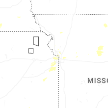
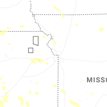


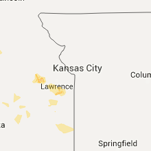


Connect with Interactive Hail Maps