

Hail Map for Garfield, WA
The Garfield, WA area has had 0 reports of on-the-ground hail by trained spotters, and has been under severe weather warnings 5 times during the past 12 months. Doppler radar has detected hail at or near Garfield, WA on 2 occasions.
| Name: | Garfield, WA |
| Where Located: | 46.7 miles SSE of Spokane, WA |
| Map: | Google Map for Garfield, WA |
| Population: | 597 |
| Housing Units: | 311 |
| More Info: | Search Google for Garfield, WA |
5
The Top Recent Hail Date for Garfield, WA is Wednesday, July 23, 2014 (1st out of 2)

Hail and Wind Damage Spotted near Garfield, WA
| Date / Time | Report Details |
|---|---|
| 9/25/2024 4:28 PM PDT |
 the severe thunderstorm warning has been cancelled and is no longer in effect the severe thunderstorm warning has been cancelled and is no longer in effect
|
| 9/25/2024 4:28 PM PDT |
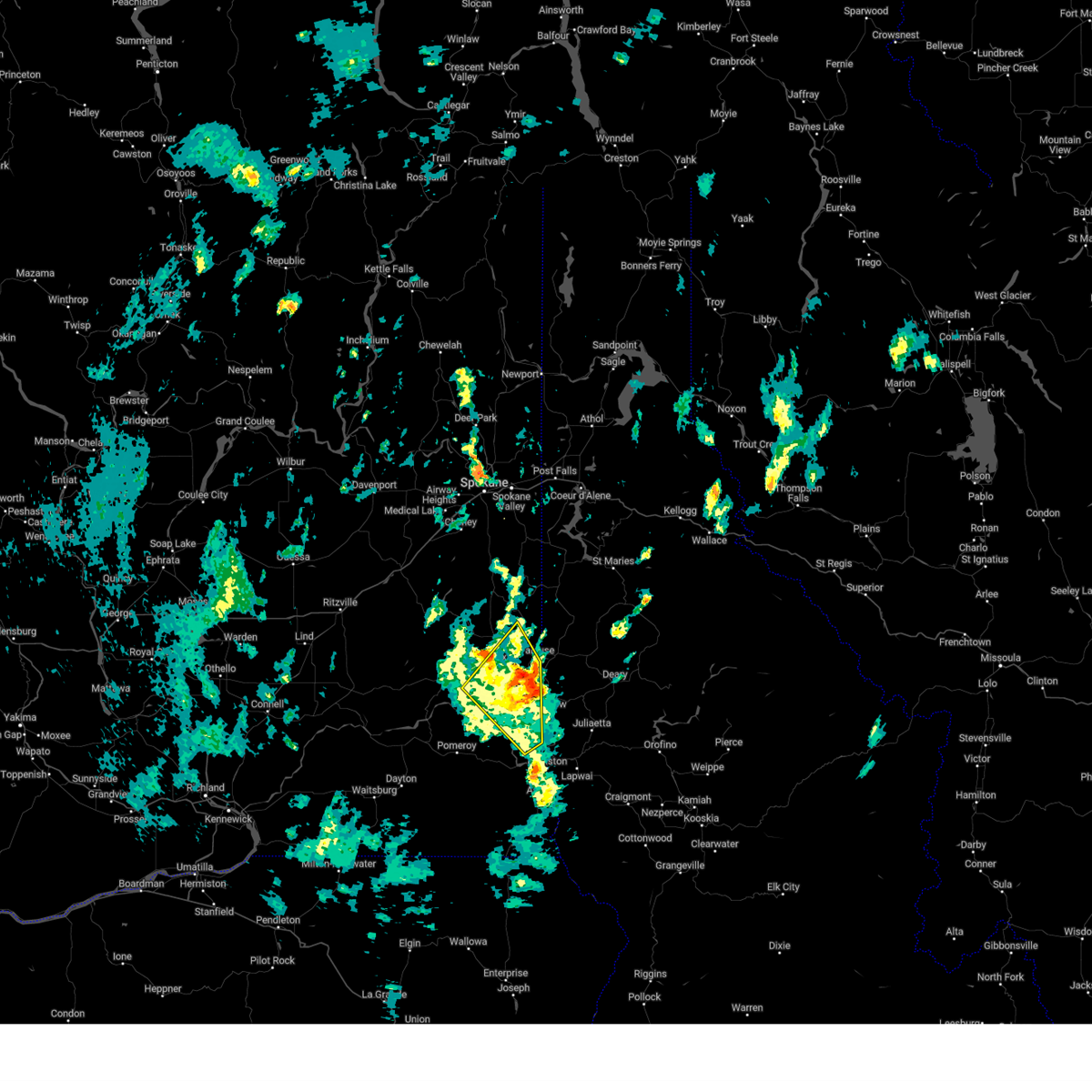
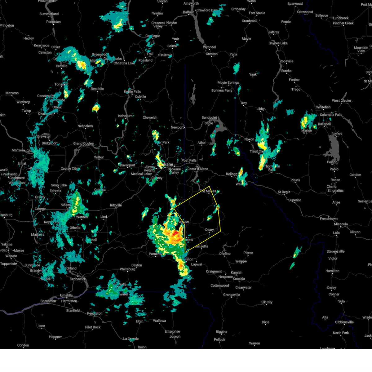
 At 427 pm pdt, a severe thunderstorm was located over moscow, moving northeast at 40 mph (radar indicated). Hazards include 60 mph wind gusts and penny size hail. Expect damage to roofs, siding, and trees. locations impacted include, pullman, colfax, palouse, garfield, albion, colton, uniontown, wawawai, and almota. this includes u. s. Highway 195 in washington between mile markers 3 and 44. At 427 pm pdt, a severe thunderstorm was located over moscow, moving northeast at 40 mph (radar indicated). Hazards include 60 mph wind gusts and penny size hail. Expect damage to roofs, siding, and trees. locations impacted include, pullman, colfax, palouse, garfield, albion, colton, uniontown, wawawai, and almota. this includes u. s. Highway 195 in washington between mile markers 3 and 44.
|
| 9/25/2024 4:27 PM PDT |
 At 426 pm pdt, a severe thunderstorm was located near nine mile falls, or 9 miles north of spokane, and is nearly stationary (radar indicated). Hazards include 70 mph wind gusts and penny size hail. Expect considerable tree damage. damage is likely to mobile homes, roofs, and outbuildings. locations impacted include, moscow, st. maries, troy, potlatch, deary, bovill, parkline, garfield, oakesdale, onaway, farmington, tensed, emida, princeton, belmont, sanders, joel, santa, harvard, and helmer. this includes u. s. Highway 95 in idaho between mile markers 332 and 389. At 426 pm pdt, a severe thunderstorm was located near nine mile falls, or 9 miles north of spokane, and is nearly stationary (radar indicated). Hazards include 70 mph wind gusts and penny size hail. Expect considerable tree damage. damage is likely to mobile homes, roofs, and outbuildings. locations impacted include, moscow, st. maries, troy, potlatch, deary, bovill, parkline, garfield, oakesdale, onaway, farmington, tensed, emida, princeton, belmont, sanders, joel, santa, harvard, and helmer. this includes u. s. Highway 95 in idaho between mile markers 332 and 389.
|
| 9/25/2024 4:17 PM PDT |
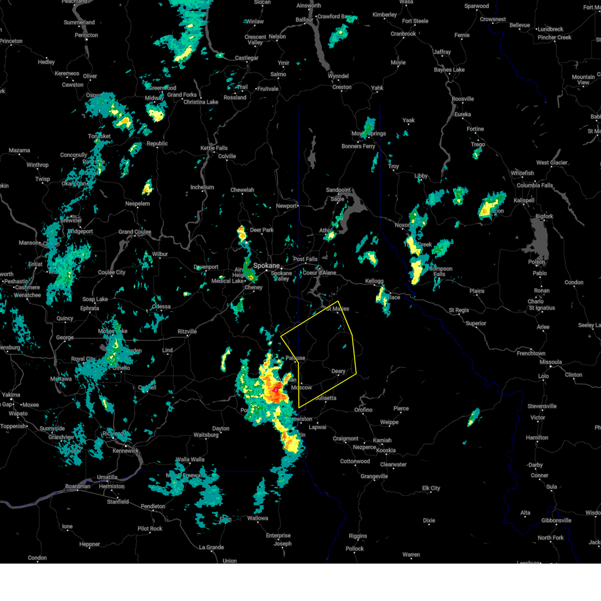 Svrotx the national weather service in spokane has issued a * severe thunderstorm warning for, latah county in the panhandle of idaho, northwestern nez perce county in north central idaho, benewah county in the panhandle of idaho, southern kootenai county in the panhandle of idaho, eastern whitman county in eastern washington, * until 515 pm pdt. * at 416 pm pdt, a severe thunderstorm was located over pullman, moving northeast at 45 mph (radar indicated). Hazards include 60 mph wind gusts and penny size hail. areas of blowing dust is also likely reducing visibility to 1/4 mile at times. expect damage to roofs, siding, and trees Svrotx the national weather service in spokane has issued a * severe thunderstorm warning for, latah county in the panhandle of idaho, northwestern nez perce county in north central idaho, benewah county in the panhandle of idaho, southern kootenai county in the panhandle of idaho, eastern whitman county in eastern washington, * until 515 pm pdt. * at 416 pm pdt, a severe thunderstorm was located over pullman, moving northeast at 45 mph (radar indicated). Hazards include 60 mph wind gusts and penny size hail. areas of blowing dust is also likely reducing visibility to 1/4 mile at times. expect damage to roofs, siding, and trees
|
| 9/25/2024 3:41 PM PDT |
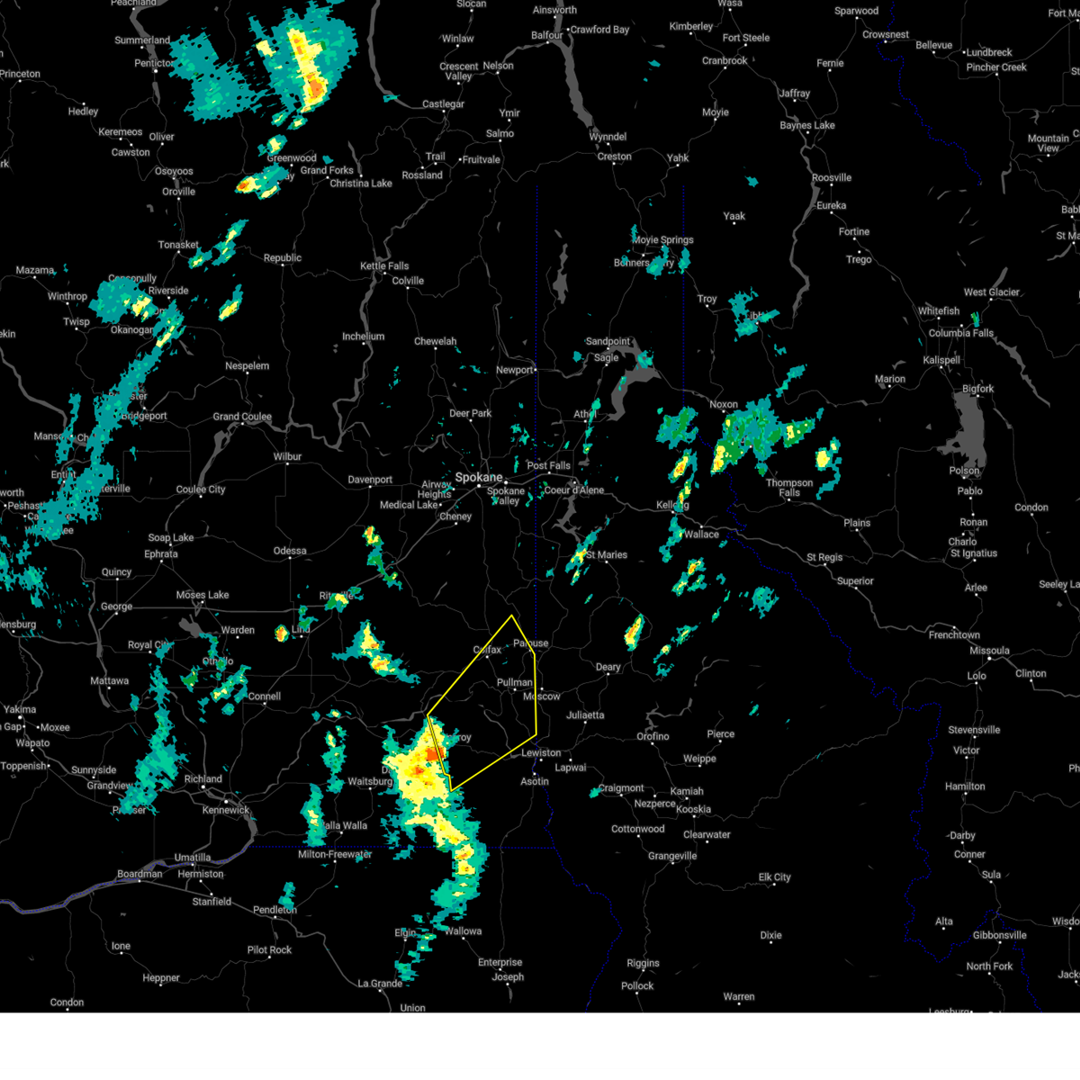 Svrotx the national weather service in spokane has issued a * severe thunderstorm warning for, garfield county in southeastern washington, southeastern whitman county in eastern washington, northwestern asotin county in southeastern washington, * until 445 pm pdt. * at 340 pm pdt, a severe thunderstorm was located near pomeroy, or 23 miles west of clarkston, moving northeast at 40 mph (radar indicated). Hazards include 60 mph wind gusts and penny size hail. expect damage to roofs, siding, and trees Svrotx the national weather service in spokane has issued a * severe thunderstorm warning for, garfield county in southeastern washington, southeastern whitman county in eastern washington, northwestern asotin county in southeastern washington, * until 445 pm pdt. * at 340 pm pdt, a severe thunderstorm was located near pomeroy, or 23 miles west of clarkston, moving northeast at 40 mph (radar indicated). Hazards include 60 mph wind gusts and penny size hail. expect damage to roofs, siding, and trees
|
| 8/11/2022 4:08 PM PDT |
 At 408 pm pdt, a severe thunderstorm was located near colfax, or 13 miles north of pullman, moving northeast at 40 mph (radar indicated). Hazards include 60 mph wind gusts and quarter size hail. Hail damage to vehicles is expected. expect wind damage to roofs, siding, and trees. locations impacted include, colfax, garfield, albion, oakesdale, farmington and belmont. hail threat, radar indicated max hail size, 1. 00 in wind threat, radar indicated max wind gust, 60 mph. At 408 pm pdt, a severe thunderstorm was located near colfax, or 13 miles north of pullman, moving northeast at 40 mph (radar indicated). Hazards include 60 mph wind gusts and quarter size hail. Hail damage to vehicles is expected. expect wind damage to roofs, siding, and trees. locations impacted include, colfax, garfield, albion, oakesdale, farmington and belmont. hail threat, radar indicated max hail size, 1. 00 in wind threat, radar indicated max wind gust, 60 mph.
|
| 8/11/2022 3:54 PM PDT |
 At 354 pm pdt, a severe thunderstorm was located near colfax, or 10 miles northwest of pullman, moving northeast at 40 mph (radar indicated). Hazards include 60 mph wind gusts and quarter size hail. Hail damage to vehicles is expected. Expect wind damage to roofs, siding, and trees. At 354 pm pdt, a severe thunderstorm was located near colfax, or 10 miles northwest of pullman, moving northeast at 40 mph (radar indicated). Hazards include 60 mph wind gusts and quarter size hail. Hail damage to vehicles is expected. Expect wind damage to roofs, siding, and trees.
|
| 8/10/2019 5:10 PM PDT |
 The severe thunderstorm warning for northwestern latah and eastern whitman counties will expire at 515 pm pdt, the storm which prompted the warning has moved out of the area. therefore, the warning will be allowed to expire. The severe thunderstorm warning for northwestern latah and eastern whitman counties will expire at 515 pm pdt, the storm which prompted the warning has moved out of the area. therefore, the warning will be allowed to expire.
|
| 8/10/2019 4:32 PM PDT |
 At 432 pm pdt, a severe thunderstorm was located near potlatch, or 12 miles north of moscow, and is nearly stationary (radar indicated). Hazards include quarter size hail. damage to vehicles is expected At 432 pm pdt, a severe thunderstorm was located near potlatch, or 12 miles north of moscow, and is nearly stationary (radar indicated). Hazards include quarter size hail. damage to vehicles is expected
|
Hail Maps for Garfield, WA


Connect with Interactive Hail Maps