

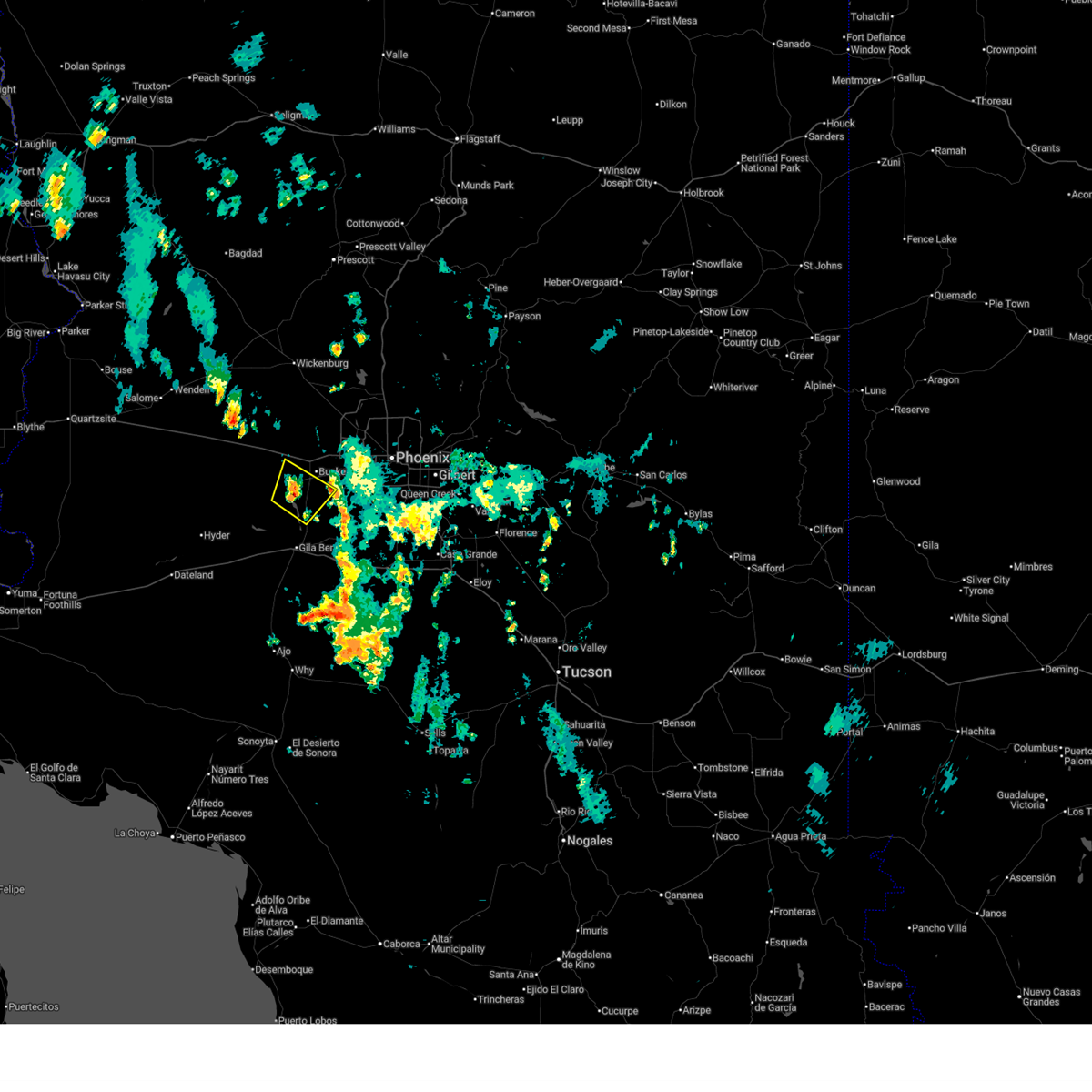
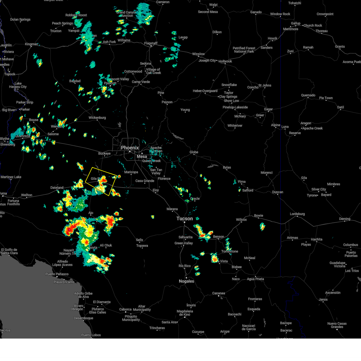
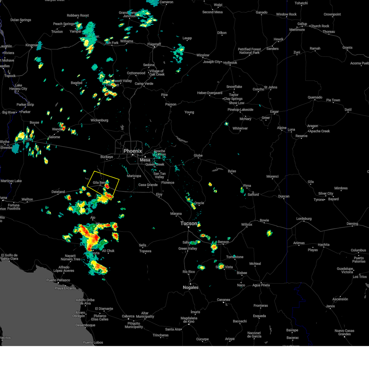
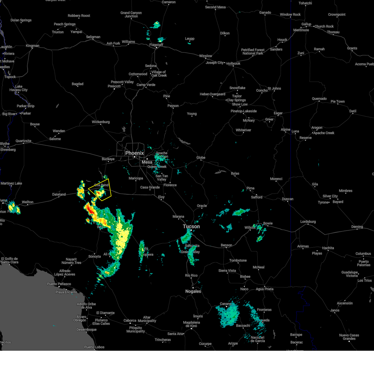
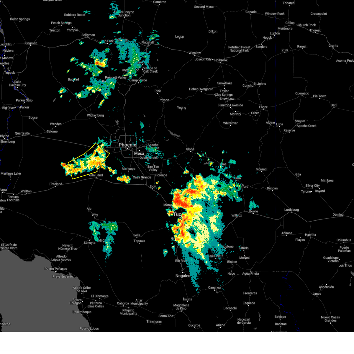
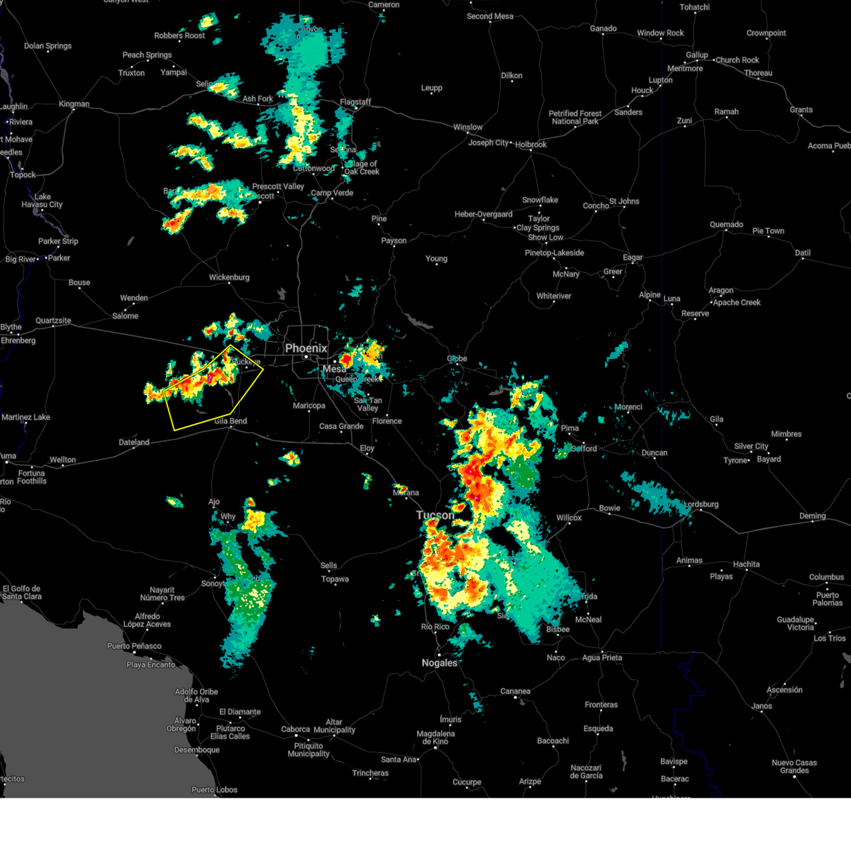
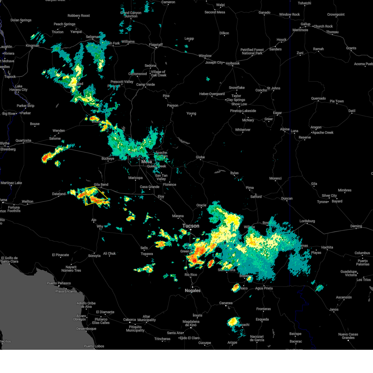
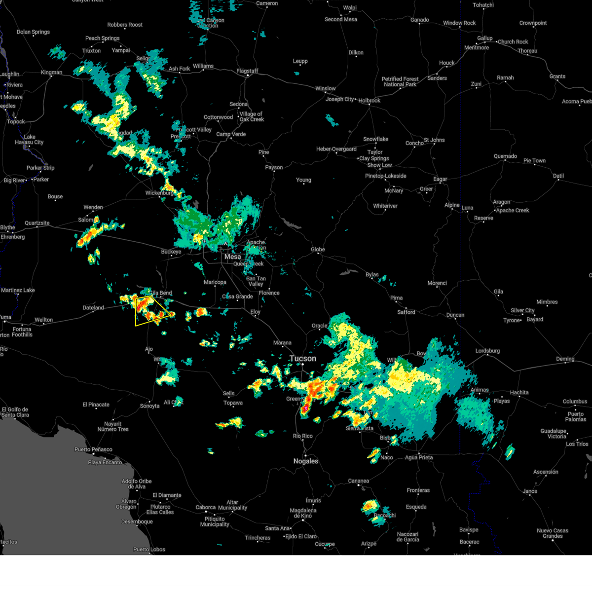
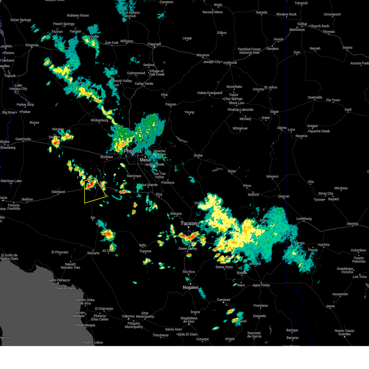
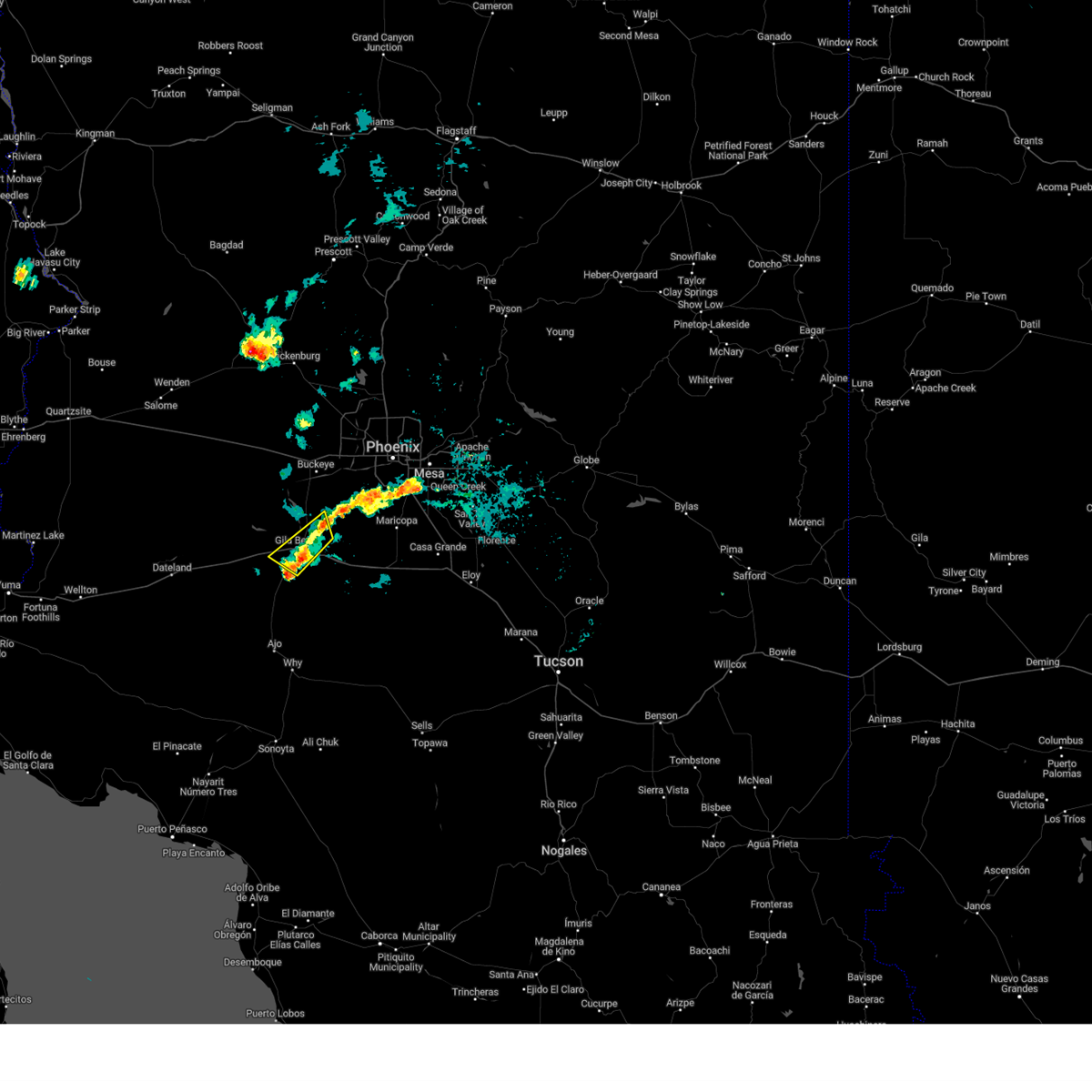
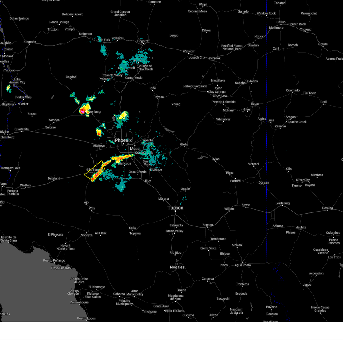
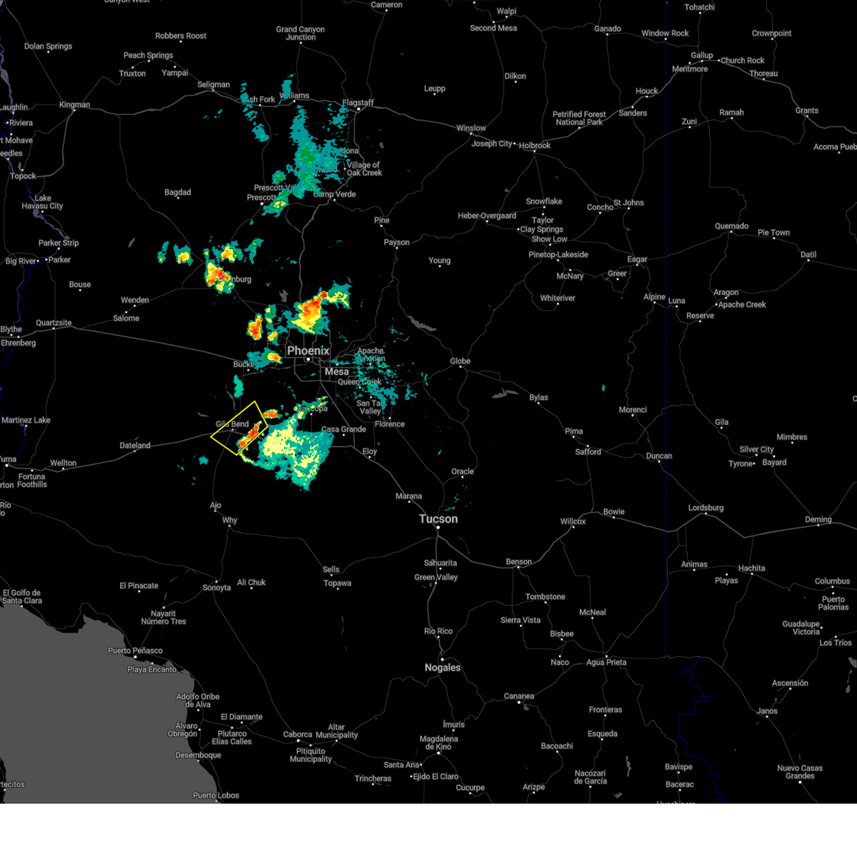
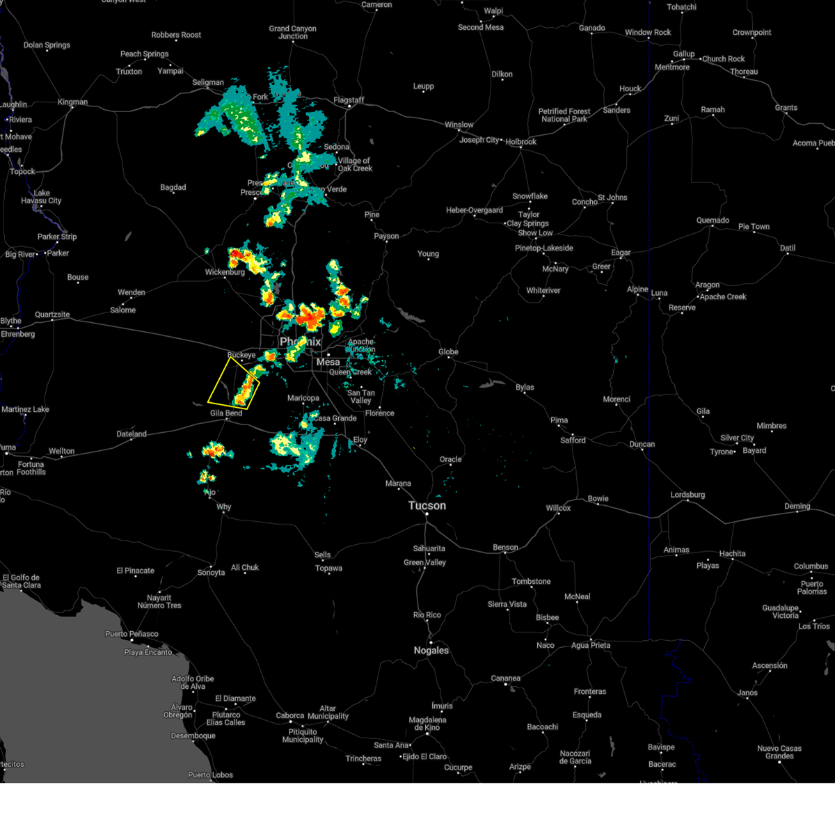
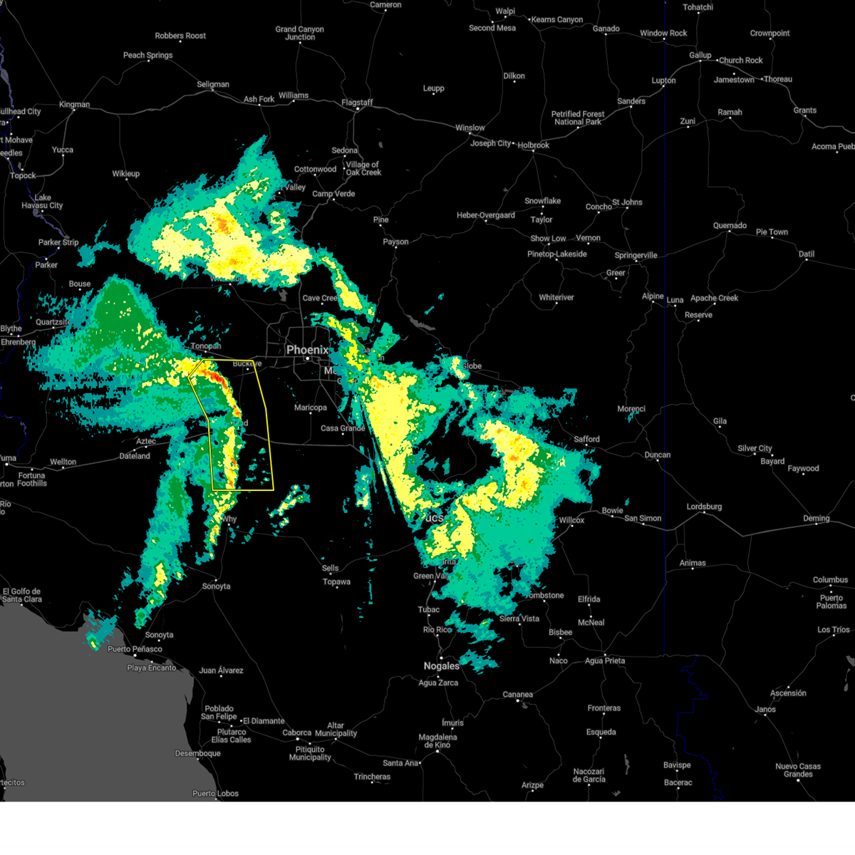
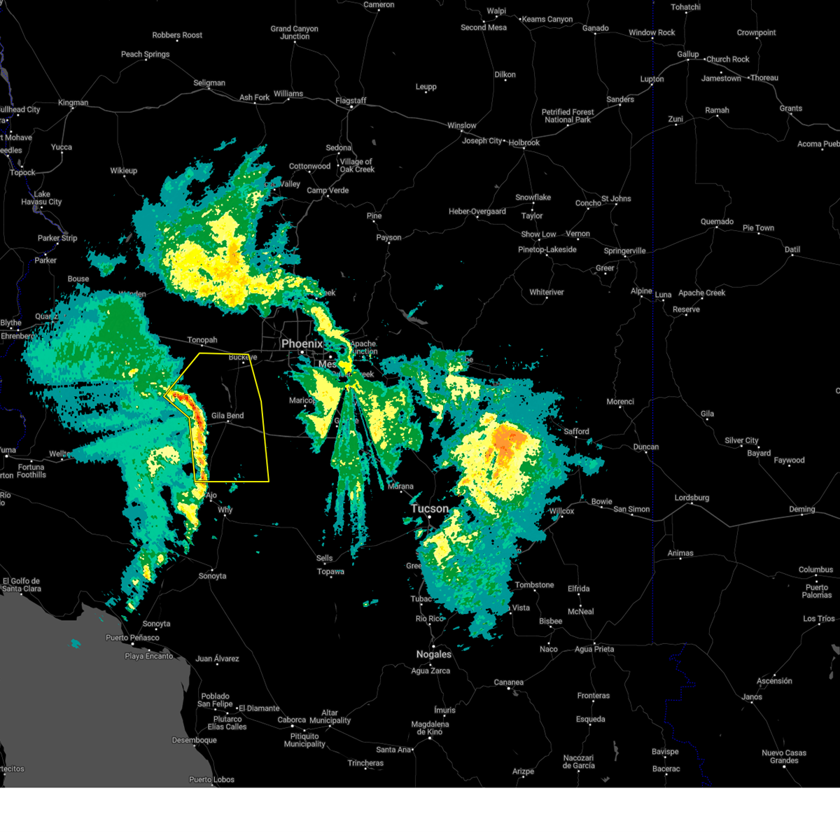
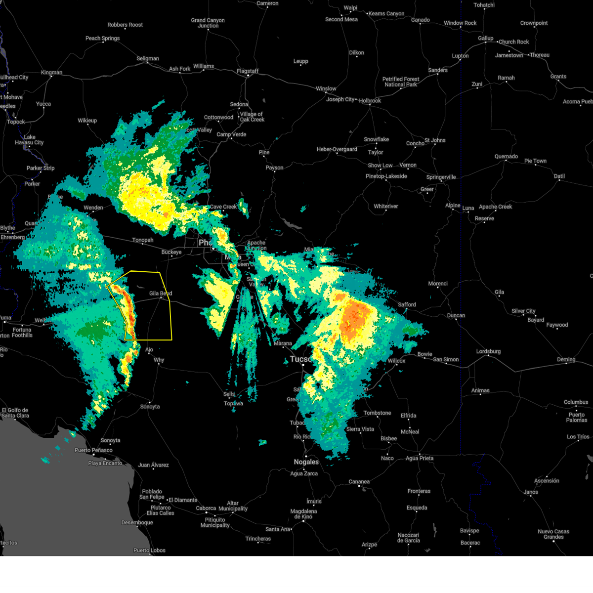
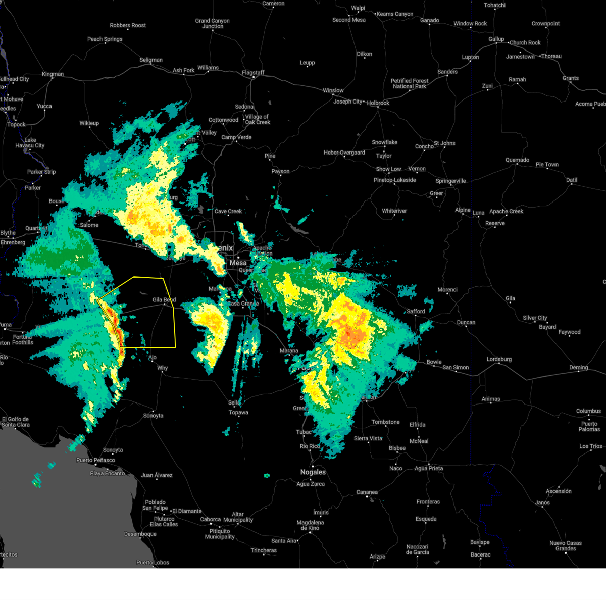
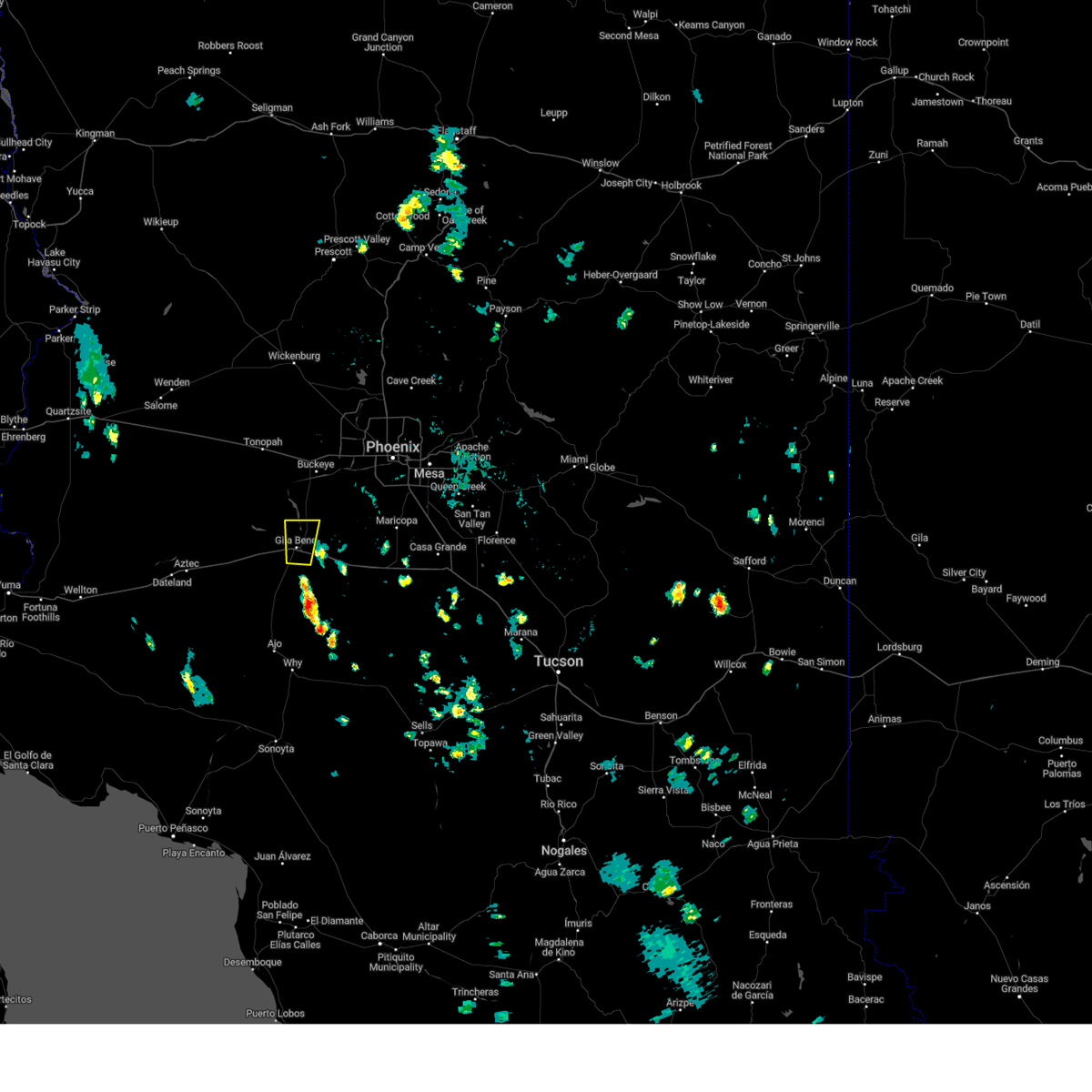
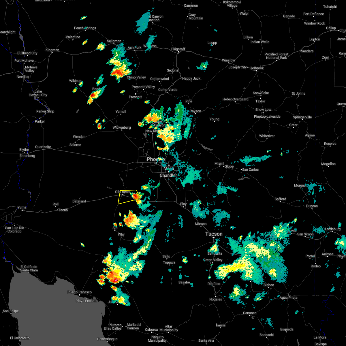
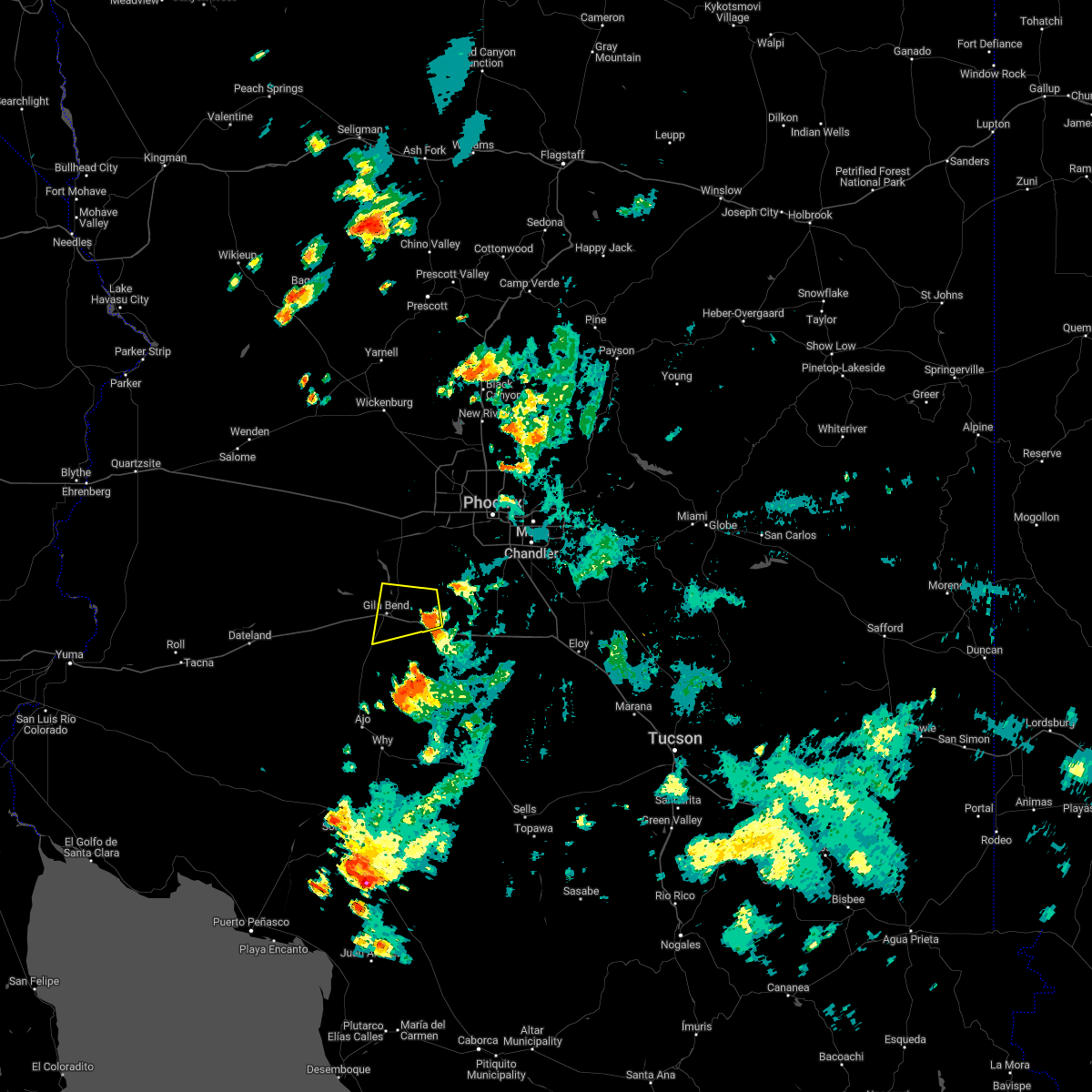
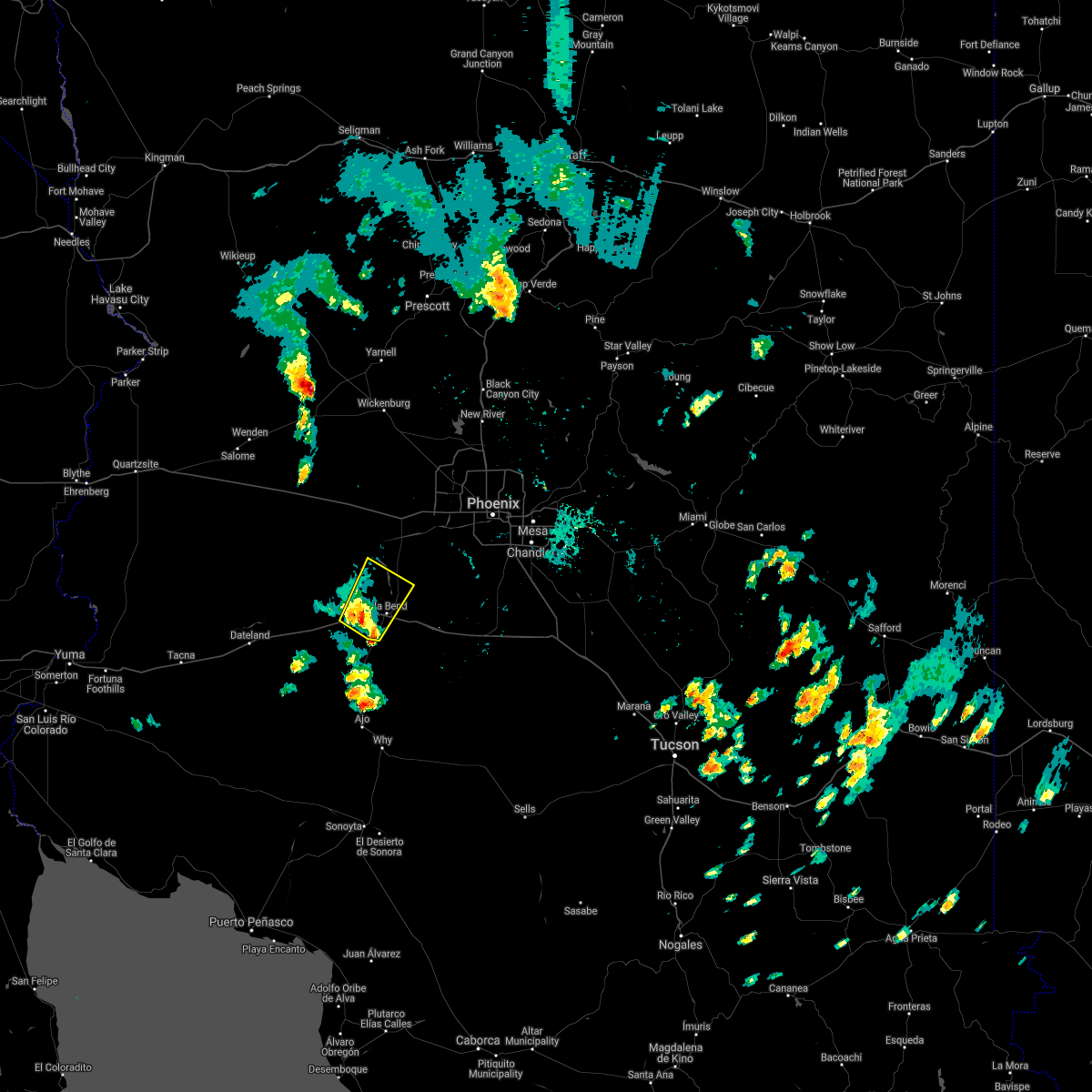
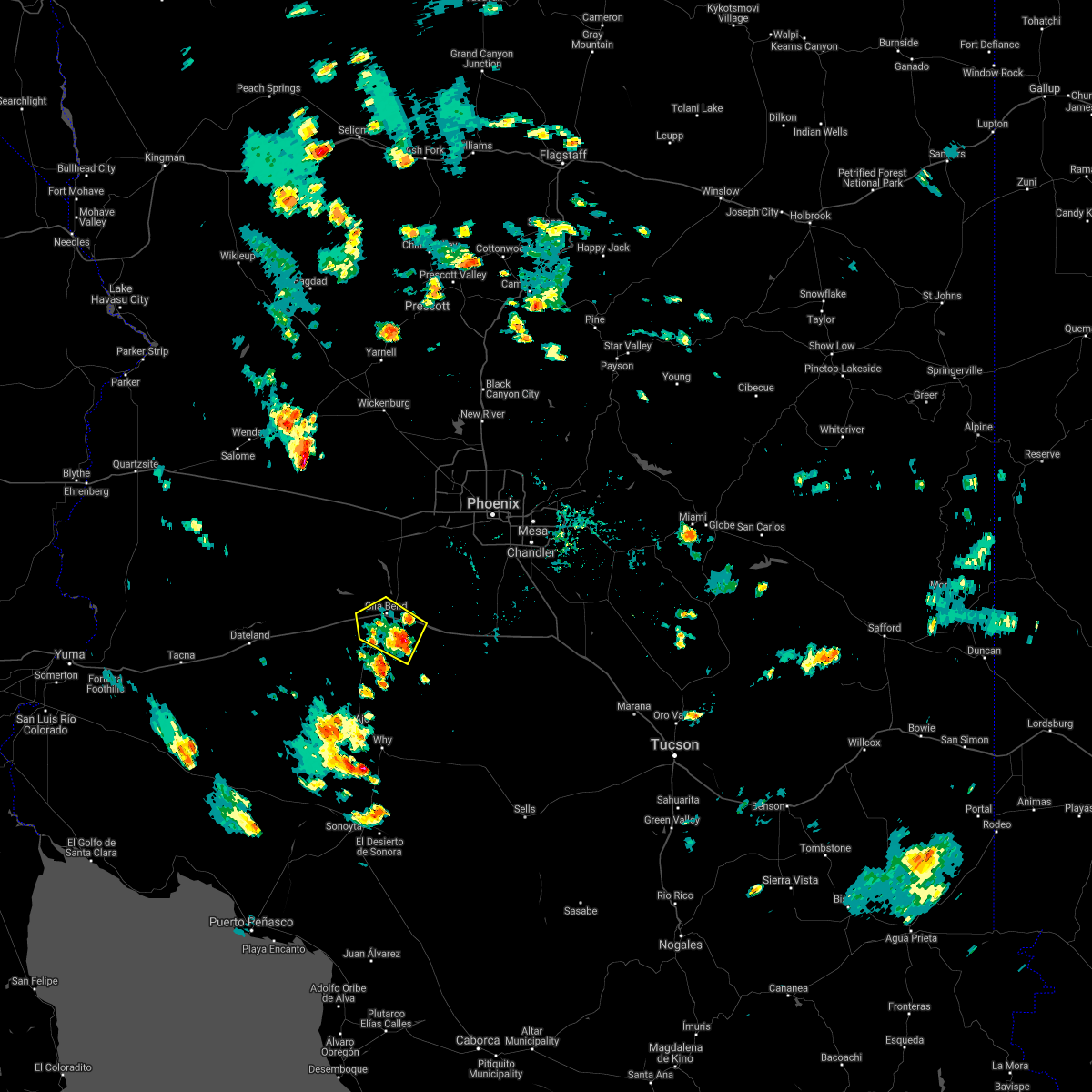
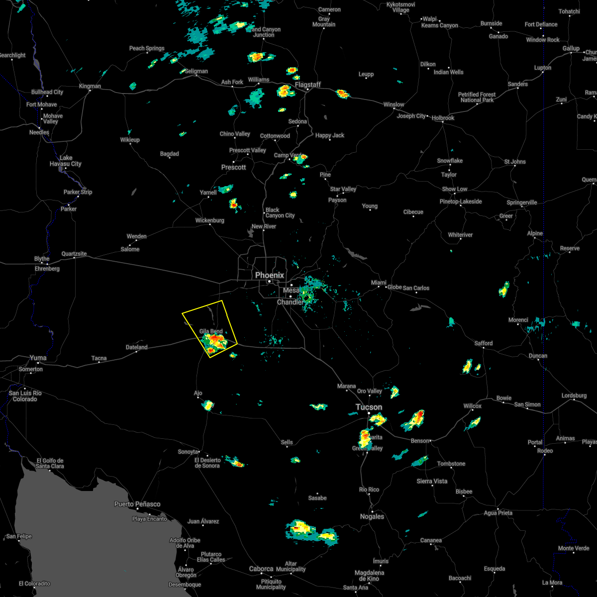
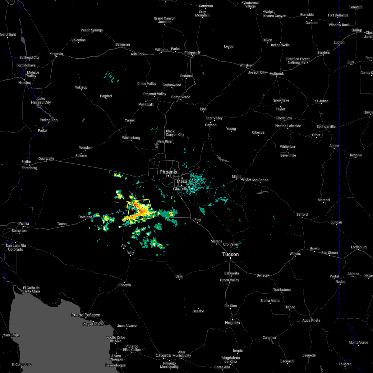
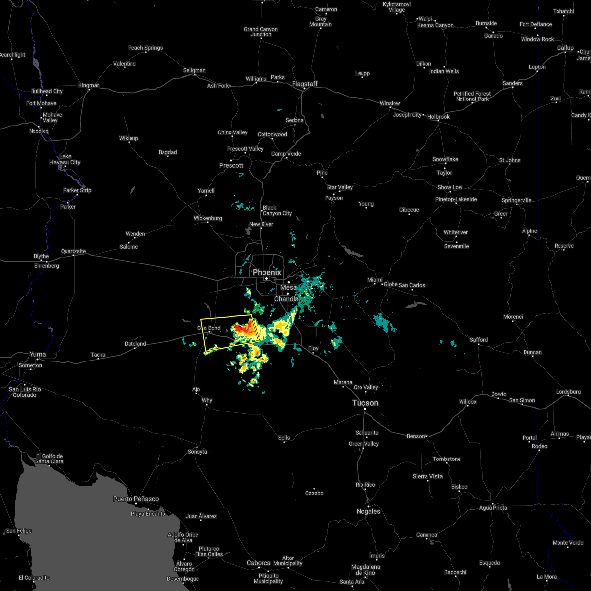
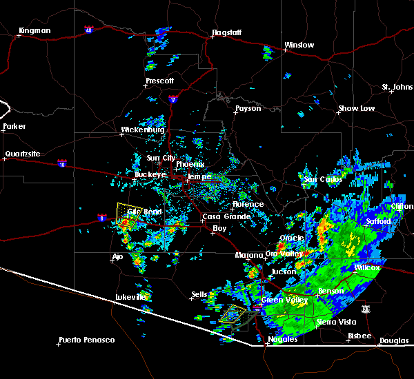
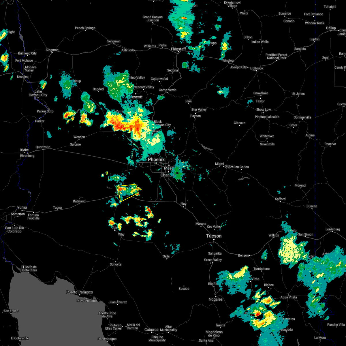
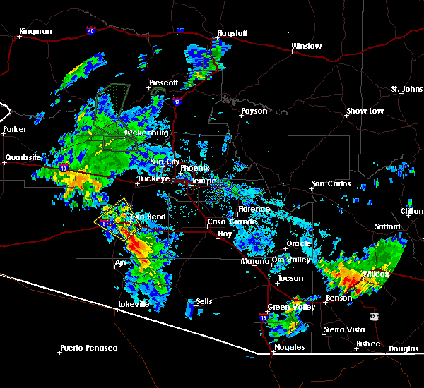
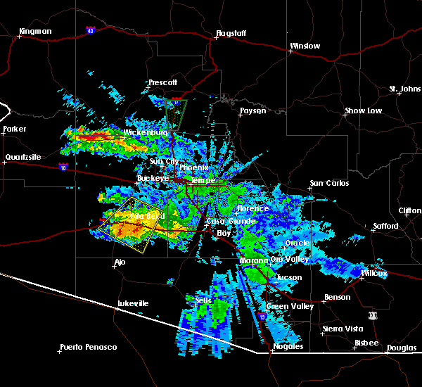
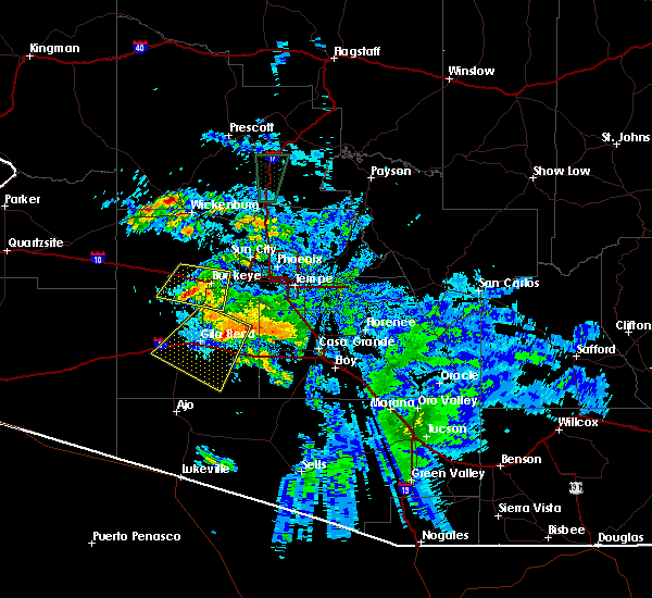
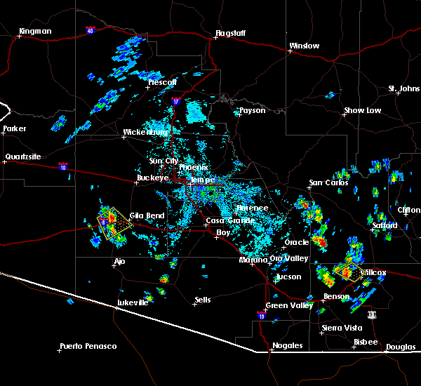
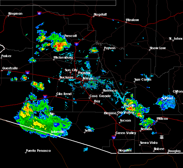
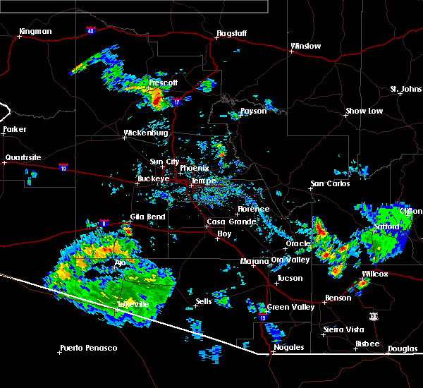
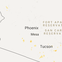
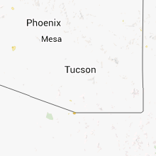
Hail Map for Gila Bend, AZ
The Gila Bend, AZ area has had 0 reports of on-the-ground hail by trained spotters, and has been under severe weather warnings 11 times during the past 12 months. Doppler radar has detected hail at or near Gila Bend, AZ on 23 occasions, including 2 occasions during the past year.
| Name: | Gila Bend, AZ |
| Where Located: | 48.2 miles SW of Phoenix, AZ |
| Map: | Google Map for Gila Bend, AZ |
| Population: | 1922 |
| Housing Units: | 943 |
| More Info: | Search Google for Gila Bend, AZ |
2
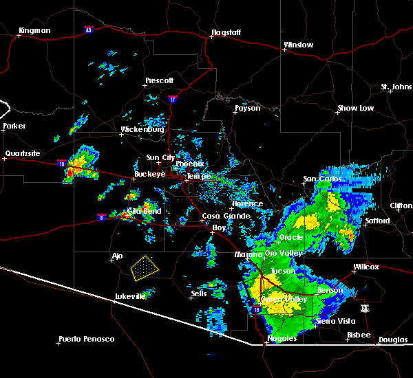
The Top Recent Hail Date for Gila Bend, AZ is Sunday, July 21, 2024 (8th out of 23)

Hail and Wind Damage Spotted near Gila Bend, AZ
| Date / Time | Report Details |
|---|---|
| 7/2/2025 7:21 PM MST |
 Svrpsr the national weather service in phoenix has issued a * severe thunderstorm warning for, maricopa county in south central arizona, * until 800 pm mst. * at 721 pm mst, a severe thunderstorm was located over painted rock dam, or 19 miles south of buckeye, and is nearly stationary (radar indicated). Hazards include 60 mph wind gusts and penny size hail. expect damage to roofs, siding, and trees Svrpsr the national weather service in phoenix has issued a * severe thunderstorm warning for, maricopa county in south central arizona, * until 800 pm mst. * at 721 pm mst, a severe thunderstorm was located over painted rock dam, or 19 miles south of buckeye, and is nearly stationary (radar indicated). Hazards include 60 mph wind gusts and penny size hail. expect damage to roofs, siding, and trees
|
| 8/10/2024 1:51 PM MST |
 At 151 pm mst, a severe thunderstorm was located over bosque, or near gila bend, and is nearly stationary (radar indicated). Hazards include 60 mph wind gusts. Expect damage to roofs, siding, and trees. locations impacted include, gila bend, estrella, gila bend auxiliary field, bosque, cotton center, and sonoran national monument. this includes the following highways, az interstate 8 between mile markers 104 and 134. az route 238 between mile markers 1 and 26. Az route 85 between mile markers 1 and 8, and between mile markers 119 and 133. At 151 pm mst, a severe thunderstorm was located over bosque, or near gila bend, and is nearly stationary (radar indicated). Hazards include 60 mph wind gusts. Expect damage to roofs, siding, and trees. locations impacted include, gila bend, estrella, gila bend auxiliary field, bosque, cotton center, and sonoran national monument. this includes the following highways, az interstate 8 between mile markers 104 and 134. az route 238 between mile markers 1 and 26. Az route 85 between mile markers 1 and 8, and between mile markers 119 and 133.
|
| 8/10/2024 1:28 PM MST |
 Svrpsr the national weather service in phoenix has issued a * severe thunderstorm warning for, maricopa county in south central arizona, * until 215 pm mst. * at 128 pm mst, a severe thunderstorm was located over bosque, or 8 miles east of gila bend, and is nearly stationary (radar indicated). Hazards include 60 mph wind gusts. expect damage to roofs, siding, and trees Svrpsr the national weather service in phoenix has issued a * severe thunderstorm warning for, maricopa county in south central arizona, * until 215 pm mst. * at 128 pm mst, a severe thunderstorm was located over bosque, or 8 miles east of gila bend, and is nearly stationary (radar indicated). Hazards include 60 mph wind gusts. expect damage to roofs, siding, and trees
|
| 7/31/2024 5:21 PM MST |
 The storm which prompted the warning has weakened below severe limits, and no longer poses an immediate threat to life or property. therefore, the warning will be allowed to expire. The storm which prompted the warning has weakened below severe limits, and no longer poses an immediate threat to life or property. therefore, the warning will be allowed to expire.
|
| 7/31/2024 5:02 PM MST | At 502 pm mst, a severe thunderstorm was located over gila bend auxiliary field, or near gila bend, moving northwest at 15 mph (radar indicated). Hazards include 60 mph wind gusts. Expect damage to roofs, siding, and trees. locations impacted include, gila bend, gila bend auxiliary field, and bosque. this includes the following highways, az interstate 8 between mile markers 103 and 126. az route 238 between mile markers 1 and 7. Az route 85 between mile markers 1 and 11, and between mile markers 119 and 129. |
| 7/31/2024 4:50 PM MST | Svrpsr the national weather service in phoenix has issued a * severe thunderstorm warning for, maricopa county in south central arizona, * until 530 pm mst. * at 450 pm mst, a severe thunderstorm was located near gila bend auxiliary field, or 7 miles south of gila bend, moving northwest at 10 mph (radar indicated). Hazards include 60 mph wind gusts. expect damage to roofs, siding, and trees |
| 7/31/2024 4:48 PM MST | Awos station kgxf gila ben in maricopa county AZ, 9.2 miles N of Gila Bend, AZ |
| 7/25/2024 7:26 PM MST |
 The storms which prompted the warning have weakened below severe limits, and have exited the warned area. therefore, the warning will be allowed to expire. however, gusty winds and heavy rain are still possible with these thunderstorms. The storms which prompted the warning have weakened below severe limits, and have exited the warned area. therefore, the warning will be allowed to expire. however, gusty winds and heavy rain are still possible with these thunderstorms.
|
| 7/25/2024 6:43 PM MST |
 Svrpsr the national weather service in phoenix has issued a * severe thunderstorm warning for, maricopa county in south central arizona, * until 730 pm mst. * at 643 pm mst, severe thunderstorms were located along a line extending from 6 miles east of wintersburg to 7 miles west of painted rock dam to near sundad, moving southeast at 15 mph (radar indicated). Hazards include 60 mph wind gusts and penny size hail. expect damage to roofs, siding, and trees Svrpsr the national weather service in phoenix has issued a * severe thunderstorm warning for, maricopa county in south central arizona, * until 730 pm mst. * at 643 pm mst, severe thunderstorms were located along a line extending from 6 miles east of wintersburg to 7 miles west of painted rock dam to near sundad, moving southeast at 15 mph (radar indicated). Hazards include 60 mph wind gusts and penny size hail. expect damage to roofs, siding, and trees
|
| 7/21/2024 6:29 PM MST |
 The storm which prompted the warning has weakened below severe limits, and no longer poses an immediate threat to life or property. therefore, the warning will be allowed to expire. a severe thunderstorm watch remains in effect until 800 pm mst for south central arizona. remember, a severe thunderstorm warning still remains in effect for southern maricopa county until 630 pm mst. The storm which prompted the warning has weakened below severe limits, and no longer poses an immediate threat to life or property. therefore, the warning will be allowed to expire. a severe thunderstorm watch remains in effect until 800 pm mst for south central arizona. remember, a severe thunderstorm warning still remains in effect for southern maricopa county until 630 pm mst.
|
| 7/21/2024 6:11 PM MST |
 At 611 pm mst, a severe thunderstorm was located 8 miles southwest of gila bend auxiliary field, or 10 miles southwest of gila bend, moving south at 20 mph (radar indicated). Hazards include 60 mph wind gusts and penny size hail. Expect damage to roofs, siding, and trees. this severe thunderstorm will remain over mainly rural areas of maricopa county. this includes the following highways, az interstate 8 between mile markers 99 and 111. Az route 85 between mile markers 5 and 19. At 611 pm mst, a severe thunderstorm was located 8 miles southwest of gila bend auxiliary field, or 10 miles southwest of gila bend, moving south at 20 mph (radar indicated). Hazards include 60 mph wind gusts and penny size hail. Expect damage to roofs, siding, and trees. this severe thunderstorm will remain over mainly rural areas of maricopa county. this includes the following highways, az interstate 8 between mile markers 99 and 111. Az route 85 between mile markers 5 and 19.
|
| 7/21/2024 5:53 PM MST | ***delayed report*** mesonet station azm19 10.6 w gila bend (azmet in maricopa county AZ, 11.7 miles ENE of Gila Bend, AZ |
| 7/21/2024 5:49 PM MST |
 Svrpsr the national weather service in phoenix has issued a * severe thunderstorm warning for, maricopa county in south central arizona, * until 630 pm mst. * at 549 pm mst, a severe thunderstorm was located 9 miles west of gila bend, moving south at 20 mph (radar indicated). Hazards include 60 mph wind gusts and penny size hail. expect damage to roofs, siding, and trees Svrpsr the national weather service in phoenix has issued a * severe thunderstorm warning for, maricopa county in south central arizona, * until 630 pm mst. * at 549 pm mst, a severe thunderstorm was located 9 miles west of gila bend, moving south at 20 mph (radar indicated). Hazards include 60 mph wind gusts and penny size hail. expect damage to roofs, siding, and trees
|
| 7/14/2024 10:57 PM MST |
 The storm which prompted the warning has weakened below severe limits, and no longer poses an immediate threat to life or property. therefore, the warning will be allowed to expire. The storm which prompted the warning has weakened below severe limits, and no longer poses an immediate threat to life or property. therefore, the warning will be allowed to expire.
|
| 7/14/2024 10:42 PM MST |
 At 1042 pm mst, a severe thunderstorm was located over bosque, or near gila bend, moving northwest at 10 mph (radar indicated). Hazards include 60 mph wind gusts and penny size hail. Expect damage to roofs, siding, and trees. locations impacted include, gila bend, gila bend auxiliary field, bosque, and sonoran national monument. this includes the following highways, az interstate 8 between mile markers 108 and 125. az route 238 between mile markers 1 and 13. Az route 85 between mile markers 1 and 9, and between mile markers 119 and 129. At 1042 pm mst, a severe thunderstorm was located over bosque, or near gila bend, moving northwest at 10 mph (radar indicated). Hazards include 60 mph wind gusts and penny size hail. Expect damage to roofs, siding, and trees. locations impacted include, gila bend, gila bend auxiliary field, bosque, and sonoran national monument. this includes the following highways, az interstate 8 between mile markers 108 and 125. az route 238 between mile markers 1 and 13. Az route 85 between mile markers 1 and 9, and between mile markers 119 and 129.
|
| 7/14/2024 10:19 PM MST |
 Svrpsr the national weather service in phoenix has issued a * severe thunderstorm warning for, maricopa county in south central arizona, * until 1100 pm mst. * at 1019 pm mst, a severe thunderstorm was located near bosque, or 9 miles east of gila bend, moving northwest at 10 mph (radar indicated). Hazards include 60 mph wind gusts and penny size hail. expect damage to roofs, siding, and trees Svrpsr the national weather service in phoenix has issued a * severe thunderstorm warning for, maricopa county in south central arizona, * until 1100 pm mst. * at 1019 pm mst, a severe thunderstorm was located near bosque, or 9 miles east of gila bend, moving northwest at 10 mph (radar indicated). Hazards include 60 mph wind gusts and penny size hail. expect damage to roofs, siding, and trees
|
| 7/14/2024 9:36 PM MST |
 Svrpsr the national weather service in phoenix has issued a * severe thunderstorm warning for, maricopa county in south central arizona, * until 1015 pm mst. * at 936 pm mst, a severe thunderstorm was located 8 miles northeast of cotton center, or 15 miles southwest of goodyear, moving northwest at 10 mph (radar indicated). Hazards include 60 mph wind gusts and penny size hail. expect damage to roofs, siding, and trees Svrpsr the national weather service in phoenix has issued a * severe thunderstorm warning for, maricopa county in south central arizona, * until 1015 pm mst. * at 936 pm mst, a severe thunderstorm was located 8 miles northeast of cotton center, or 15 miles southwest of goodyear, moving northwest at 10 mph (radar indicated). Hazards include 60 mph wind gusts and penny size hail. expect damage to roofs, siding, and trees
|
| 12/22/2023 6:24 PM MST |
 At 624 pm mst, severe thunderstorms were located along a line extending from palo verde nuclear generation station to near painted rock dam to near sonoran national monument to 10 miles southeast of gila bend auxiliary field, moving northeast at 45 mph (radar indicated). Hazards include 60 mph wind gusts. Expect damage to roofs, siding, and trees. locations impacted include, buckeye, gila bend, palo verde, painted rock dam, gila bend auxiliary field, bosque, cotton center, sonoran national monument, palo verde nuclear generation station, wintersburg, hassayampa, and arlington. this includes the following highways, az interstate 10 between mile markers 112 and 114. az interstate 8 between mile markers 106 and 135. Az route 238 between mile markers 1 and 17. At 624 pm mst, severe thunderstorms were located along a line extending from palo verde nuclear generation station to near painted rock dam to near sonoran national monument to 10 miles southeast of gila bend auxiliary field, moving northeast at 45 mph (radar indicated). Hazards include 60 mph wind gusts. Expect damage to roofs, siding, and trees. locations impacted include, buckeye, gila bend, palo verde, painted rock dam, gila bend auxiliary field, bosque, cotton center, sonoran national monument, palo verde nuclear generation station, wintersburg, hassayampa, and arlington. this includes the following highways, az interstate 10 between mile markers 112 and 114. az interstate 8 between mile markers 106 and 135. Az route 238 between mile markers 1 and 17.
|
| 12/22/2023 6:00 PM MST | At the oatman raws statio in maricopa county AZ, 24.6 miles E of Gila Bend, AZ |
| 12/22/2023 5:54 PM MST |
 At 553 pm mst, severe thunderstorms were located along a line extending from near sundad to 16 miles northwest of gila bend to 11 miles west of gila bend auxiliary field to 15 miles north of ajo, moving northeast at 45 mph (radar indicated). Hazards include 60 mph wind gusts. expect damage to roofs, siding, and trees At 553 pm mst, severe thunderstorms were located along a line extending from near sundad to 16 miles northwest of gila bend to 11 miles west of gila bend auxiliary field to 15 miles north of ajo, moving northeast at 45 mph (radar indicated). Hazards include 60 mph wind gusts. expect damage to roofs, siding, and trees
|
| 12/22/2023 5:40 PM MST |
 At 540 pm mst, severe thunderstorms were located along a line extending from 7 miles south of sundad to 8 miles northeast of sentinel to 20 miles southwest of gila bend auxiliary field to 12 miles northwest of ajo, moving northeast at 45 mph (radar indicated). Hazards include 60 mph wind gusts. Expect damage to roofs, siding, and trees. locations impacted include, gila bend, gila bend auxiliary field, sentinel, and hyder. this includes the following highways, az interstate 8 between mile markers 86 and 123. az route 238 between mile markers 1 and 3. az route 85 between mile markers 1 and 125. hail threat, radar indicated max hail size, <. 75 in wind threat, radar indicated max wind gust, 60 mph. At 540 pm mst, severe thunderstorms were located along a line extending from 7 miles south of sundad to 8 miles northeast of sentinel to 20 miles southwest of gila bend auxiliary field to 12 miles northwest of ajo, moving northeast at 45 mph (radar indicated). Hazards include 60 mph wind gusts. Expect damage to roofs, siding, and trees. locations impacted include, gila bend, gila bend auxiliary field, sentinel, and hyder. this includes the following highways, az interstate 8 between mile markers 86 and 123. az route 238 between mile markers 1 and 3. az route 85 between mile markers 1 and 125. hail threat, radar indicated max hail size, <. 75 in wind threat, radar indicated max wind gust, 60 mph.
|
| 12/22/2023 5:21 PM MST |
 At 521 pm mst, severe thunderstorms were located along a line extending from near paloma to near sentinel to 24 miles southeast of dateland to 18 miles west of ajo, moving northeast at 40 mph (radar indicated). Hazards include 60 mph wind gusts. expect damage to roofs, siding, and trees At 521 pm mst, severe thunderstorms were located along a line extending from near paloma to near sentinel to 24 miles southeast of dateland to 18 miles west of ajo, moving northeast at 40 mph (radar indicated). Hazards include 60 mph wind gusts. expect damage to roofs, siding, and trees
|
| 8/17/2023 5:18 PM MST |
 At 517 pm mst, a severe thunderstorm was located over gila bend, moving north at 15 mph. at 515 pm, the gila bend air force auxiliary field reported a wind gust of 70 mph (trained weather spotters). Hazards include 60 mph wind gusts. expect damage to roofs, siding, and trees At 517 pm mst, a severe thunderstorm was located over gila bend, moving north at 15 mph. at 515 pm, the gila bend air force auxiliary field reported a wind gust of 70 mph (trained weather spotters). Hazards include 60 mph wind gusts. expect damage to roofs, siding, and trees
|
| 8/17/2023 5:05 PM MST | Storm damage reported in maricopa county AZ, 7.9 miles N of Gila Bend, AZ |
| 10/15/2022 10:35 PM MST |
 The severe thunderstorm warning for maricopa county will expire at 1045 pm mst, the storm which prompted the warning has weakened below severe limits, and no longer poses an immediate threat to life or property. therefore, the warning will be allowed to expire. however gusty winds and heavy rain are still possible with this thunderstorm. The severe thunderstorm warning for maricopa county will expire at 1045 pm mst, the storm which prompted the warning has weakened below severe limits, and no longer poses an immediate threat to life or property. therefore, the warning will be allowed to expire. however gusty winds and heavy rain are still possible with this thunderstorm.
|
| 10/15/2022 10:00 PM MST |
 At 1000 pm mst, a severe thunderstorm was located 9 miles southwest of estrella mountain ranch, or 12 miles southwest of goodyear, moving northwest at 25 mph (radar indicated). Hazards include ping pong ball size hail and 60 mph wind gusts. People and animals outdoors will be injured. expect hail damage to roofs, siding, windows, and vehicles. Expect wind damage to roofs, siding, and trees. At 1000 pm mst, a severe thunderstorm was located 9 miles southwest of estrella mountain ranch, or 12 miles southwest of goodyear, moving northwest at 25 mph (radar indicated). Hazards include ping pong ball size hail and 60 mph wind gusts. People and animals outdoors will be injured. expect hail damage to roofs, siding, windows, and vehicles. Expect wind damage to roofs, siding, and trees.
|
| 8/23/2022 5:54 PM MST | At 554 pm mst, a severe thunderstorm was located near bosque, or 9 miles northeast of gila bend, and is nearly stationary (radar indicated). Hazards include 60 mph wind gusts. expect damage to roofs, siding, and trees |
| 8/19/2022 5:35 PM MST |
 At 534 pm mst, a severe thunderstorm was located over bosque, or near gila bend, moving west at 10 mph (radar indicated). Hazards include 60 mph wind gusts and penny size hail. Expect damage to roofs, siding, and trees. locations impacted include, gila bend, gila bend auxiliary field and bosque. this includes the following highways, az interstate 8 between mile markers 114 and 131. az route 238 between mile markers 1 and 9. hail threat, radar indicated max hail size, 0. 75 in wind threat, radar indicated max wind gust, 60 mph. At 534 pm mst, a severe thunderstorm was located over bosque, or near gila bend, moving west at 10 mph (radar indicated). Hazards include 60 mph wind gusts and penny size hail. Expect damage to roofs, siding, and trees. locations impacted include, gila bend, gila bend auxiliary field and bosque. this includes the following highways, az interstate 8 between mile markers 114 and 131. az route 238 between mile markers 1 and 9. hail threat, radar indicated max hail size, 0. 75 in wind threat, radar indicated max wind gust, 60 mph.
|
| 8/19/2022 5:21 PM MST |
 At 521 pm mst, a severe thunderstorm was located near bosque, or 9 miles east of gila bend, moving west at 10 mph (radar indicated). Hazards include 60 mph wind gusts and penny size hail. Expect damage to roofs, siding, and trees. locations impacted include, gila bend, gila bend auxiliary field, bosque and sonoran national monument. this includes the following highways, az interstate 8 between mile markers 114 and 134. az route 238 between mile markers 1 and 16. az route 85 between mile markers 1 and 11, and between mile markers 119 and 125. hail threat, radar indicated max hail size, 0. 75 in wind threat, radar indicated max wind gust, 60 mph. At 521 pm mst, a severe thunderstorm was located near bosque, or 9 miles east of gila bend, moving west at 10 mph (radar indicated). Hazards include 60 mph wind gusts and penny size hail. Expect damage to roofs, siding, and trees. locations impacted include, gila bend, gila bend auxiliary field, bosque and sonoran national monument. this includes the following highways, az interstate 8 between mile markers 114 and 134. az route 238 between mile markers 1 and 16. az route 85 between mile markers 1 and 11, and between mile markers 119 and 125. hail threat, radar indicated max hail size, 0. 75 in wind threat, radar indicated max wind gust, 60 mph.
|
| 8/19/2022 5:13 PM MST |
 At 513 pm mst, a severe thunderstorm was located near sonoran national monument, or 10 miles east of gila bend, moving west at 10 mph (radar indicated). Hazards include 60 mph wind gusts and penny size hail. expect damage to roofs, siding, and trees At 513 pm mst, a severe thunderstorm was located near sonoran national monument, or 10 miles east of gila bend, moving west at 10 mph (radar indicated). Hazards include 60 mph wind gusts and penny size hail. expect damage to roofs, siding, and trees
|
| 8/14/2022 4:28 PM MST |
 At 428 pm mst, a severe thunderstorm was located 9 miles south of estrella mountain ranch, or 14 miles southeast of buckeye, and is nearly stationary (radar indicated). Hazards include 60 mph wind gusts and penny size hail. Expect damage to roofs, siding, and trees. locations impacted include, phoenix, avondale, goodyear, buckeye, tolleson, cashion, estrella, litchfield park, palo verde, perryville, liberty, phoenix international raceway, estrella sailport, sonoran national monument and estrella mountain park. this includes the following highways, az interstate 10 between mile markers 111 and 138. az route 101 between mile markers 2 and 3. az route 238 between mile markers 12 and 39. hail threat, radar indicated max hail size, 0. 75 in wind threat, radar indicated max wind gust, 60 mph. At 428 pm mst, a severe thunderstorm was located 9 miles south of estrella mountain ranch, or 14 miles southeast of buckeye, and is nearly stationary (radar indicated). Hazards include 60 mph wind gusts and penny size hail. Expect damage to roofs, siding, and trees. locations impacted include, phoenix, avondale, goodyear, buckeye, tolleson, cashion, estrella, litchfield park, palo verde, perryville, liberty, phoenix international raceway, estrella sailport, sonoran national monument and estrella mountain park. this includes the following highways, az interstate 10 between mile markers 111 and 138. az route 101 between mile markers 2 and 3. az route 238 between mile markers 12 and 39. hail threat, radar indicated max hail size, 0. 75 in wind threat, radar indicated max wind gust, 60 mph.
|
| 8/14/2022 4:13 PM MST |
 At 413 pm mst, a severe thunderstorm was located 9 miles south of estrella mountain ranch, or 14 miles southeast of buckeye, and is nearly stationary (radar indicated). Hazards include 60 mph wind gusts and penny size hail. expect damage to roofs, siding, and trees At 413 pm mst, a severe thunderstorm was located 9 miles south of estrella mountain ranch, or 14 miles southeast of buckeye, and is nearly stationary (radar indicated). Hazards include 60 mph wind gusts and penny size hail. expect damage to roofs, siding, and trees
|
| 10/5/2021 4:41 PM MST |
 At 441 pm mst, a severe thunderstorm was located near cotton center, or 9 miles northeast of gila bend, moving northeast at 20 mph (radar indicated). Hazards include 60 mph wind gusts and half dollar size hail. Hail damage to vehicles is expected. Expect wind damage to roofs, siding, and trees. At 441 pm mst, a severe thunderstorm was located near cotton center, or 9 miles northeast of gila bend, moving northeast at 20 mph (radar indicated). Hazards include 60 mph wind gusts and half dollar size hail. Hail damage to vehicles is expected. Expect wind damage to roofs, siding, and trees.
|
| 10/5/2021 4:29 PM MST |
 At 429 pm mst, a severe thunderstorm was located over gila bend, moving northeast at 25 mph (radar indicated). Hazards include 60 mph wind gusts and half dollar size hail. Hail damage to vehicles is expected. expect wind damage to roofs, siding, and trees. locations impacted include, gila bend and cotton center. this includes the following highways, az interstate 8 between mile markers 113 and 119. az route 238 between mile markers 1 and 2. Az route 85 between mile markers 1 and 3, and between mile markers 119 and 134. At 429 pm mst, a severe thunderstorm was located over gila bend, moving northeast at 25 mph (radar indicated). Hazards include 60 mph wind gusts and half dollar size hail. Hail damage to vehicles is expected. expect wind damage to roofs, siding, and trees. locations impacted include, gila bend and cotton center. this includes the following highways, az interstate 8 between mile markers 113 and 119. az route 238 between mile markers 1 and 2. Az route 85 between mile markers 1 and 3, and between mile markers 119 and 134.
|
| 10/5/2021 4:06 PM MST |
 At 405 pm mst, a severe thunderstorm was located 7 miles northwest of gila bend auxiliary field, or 9 miles west of gila bend, moving northeast at 25 mph (radar indicated). Hazards include 60 mph wind gusts and quarter size hail. Hail damage to vehicles is expected. Expect wind damage to roofs, siding, and trees. At 405 pm mst, a severe thunderstorm was located 7 miles northwest of gila bend auxiliary field, or 9 miles west of gila bend, moving northeast at 25 mph (radar indicated). Hazards include 60 mph wind gusts and quarter size hail. Hail damage to vehicles is expected. Expect wind damage to roofs, siding, and trees.
|
| 8/17/2021 12:09 AM MST |
 At 1209 am mst, severe thunderstorms were located along a line extending from near palo verde nuclear generation station to near cotton center to near gila bend to 9 miles southwest of big horn to near kaka, moving southwest at 35 mph (radar indicated). Hazards include 60 mph wind gusts. Expect damage to roofs, siding, and trees. locations impacted include, avondale, goodyear, buckeye, gila bend, maricopa, estrella, palo verde, big horn, cotton center, liberty, estrella sailport, estrella mountain park, palo verde nuclear generation station, estrella mountain ranch and bosque. this includes the following highways, az interstate 8 between mile markers 100 and 173. az route 238 between mile markers 1 and 41. az route 85 between mile markers 1 and 16, and between mile markers 119 and 153. hail threat, radar indicated max hail size, <. 75 in wind threat, radar indicated max wind gust, 60 mph. At 1209 am mst, severe thunderstorms were located along a line extending from near palo verde nuclear generation station to near cotton center to near gila bend to 9 miles southwest of big horn to near kaka, moving southwest at 35 mph (radar indicated). Hazards include 60 mph wind gusts. Expect damage to roofs, siding, and trees. locations impacted include, avondale, goodyear, buckeye, gila bend, maricopa, estrella, palo verde, big horn, cotton center, liberty, estrella sailport, estrella mountain park, palo verde nuclear generation station, estrella mountain ranch and bosque. this includes the following highways, az interstate 8 between mile markers 100 and 173. az route 238 between mile markers 1 and 41. az route 85 between mile markers 1 and 16, and between mile markers 119 and 153. hail threat, radar indicated max hail size, <. 75 in wind threat, radar indicated max wind gust, 60 mph.
|
| 8/16/2021 11:41 PM MST |
 At 1140 pm mst, severe thunderstorms were located along a line extending from near white tank mountain park to near palo verde to 10 miles northeast of cotton center to near estrella to 11 miles west of chui-chu, moving southwest at 35 mph (radar indicated). Hazards include 70 mph wind gusts and nickel size hail. Expect considerable tree damage. Damage is likely to mobile homes, roofs, and outbuildings. At 1140 pm mst, severe thunderstorms were located along a line extending from near white tank mountain park to near palo verde to 10 miles northeast of cotton center to near estrella to 11 miles west of chui-chu, moving southwest at 35 mph (radar indicated). Hazards include 70 mph wind gusts and nickel size hail. Expect considerable tree damage. Damage is likely to mobile homes, roofs, and outbuildings.
|
| 8/11/2021 6:14 PM MST | Mesonet station magl 3.8 ne gila bend (az alert in maricopa county AZ, 2.5 miles WNW of Gila Bend, AZ |
| 8/11/2021 6:09 PM MST |
 At 609 pm mst, a severe thunderstorm was located 7 miles northwest of estrella sailport, or 17 miles south of laveen, moving northeast at 15 mph (radar indicated). Hazards include 60 mph wind gusts. Expect damage to roofs, siding, and trees. locations impacted include, maricopa, estrella, estrella sailport, sonoran national monument, rainbow valley, ak-chin village and mobile. this includes the following highways, az route 238 between mile markers 9 and 42. Az route 347 between mile markers 168 and 172. At 609 pm mst, a severe thunderstorm was located 7 miles northwest of estrella sailport, or 17 miles south of laveen, moving northeast at 15 mph (radar indicated). Hazards include 60 mph wind gusts. Expect damage to roofs, siding, and trees. locations impacted include, maricopa, estrella, estrella sailport, sonoran national monument, rainbow valley, ak-chin village and mobile. this includes the following highways, az route 238 between mile markers 9 and 42. Az route 347 between mile markers 168 and 172.
|
| 8/11/2021 5:56 PM MST |
 At 555 pm mst, a severe thunderstorm was located 8 miles northwest of estrella sailport, or 19 miles south of avondale, moving northeast at 15 mph (radar indicated). Hazards include 60 mph wind gusts and nickel size hail. Expect damage to roofs, siding, and trees. locations impacted include, south avondale, south goodyear, gila bend, city of maricopa, rainbow valley, ak-chin village and mobile. this includes the following highways, az interstate 8 between mile markers 116 and 133. az route 238 between mile markers 1 and 42. Az route 85 between mile markers 2 and 5, and between mile markers 119 and 130. At 555 pm mst, a severe thunderstorm was located 8 miles northwest of estrella sailport, or 19 miles south of avondale, moving northeast at 15 mph (radar indicated). Hazards include 60 mph wind gusts and nickel size hail. Expect damage to roofs, siding, and trees. locations impacted include, south avondale, south goodyear, gila bend, city of maricopa, rainbow valley, ak-chin village and mobile. this includes the following highways, az interstate 8 between mile markers 116 and 133. az route 238 between mile markers 1 and 42. Az route 85 between mile markers 2 and 5, and between mile markers 119 and 130.
|
| 8/11/2021 5:30 PM MST |
 At 529 pm mst, a severe thunderstorm was located near estrella, or 19 miles northeast of gila bend, moving northeast at 15 mph (radar indicated). Hazards include 60 mph wind gusts and nickel size hail. expect damage to roofs, siding, and trees At 529 pm mst, a severe thunderstorm was located near estrella, or 19 miles northeast of gila bend, moving northeast at 15 mph (radar indicated). Hazards include 60 mph wind gusts and nickel size hail. expect damage to roofs, siding, and trees
|
| 7/29/2021 2:24 PM MST |
 At 224 pm mst, a severe thunderstorm was located near gila bend auxiliary field, or 8 miles south of gila bend, moving west at 5 mph (radar indicated). Hazards include 60 mph wind gusts and quarter size hail. Hail damage to vehicles is expected. expect wind damage to roofs, siding, and trees. locations impacted include, gila bend, gila bend auxiliary field and bosque. this includes the following highways, az interstate 8 between mile markers 107 and 131. az route 238 between mile markers 1 and 5. Az route 85 between mile markers 1 and 12, and between mile markers 119 and 124. At 224 pm mst, a severe thunderstorm was located near gila bend auxiliary field, or 8 miles south of gila bend, moving west at 5 mph (radar indicated). Hazards include 60 mph wind gusts and quarter size hail. Hail damage to vehicles is expected. expect wind damage to roofs, siding, and trees. locations impacted include, gila bend, gila bend auxiliary field and bosque. this includes the following highways, az interstate 8 between mile markers 107 and 131. az route 238 between mile markers 1 and 5. Az route 85 between mile markers 1 and 12, and between mile markers 119 and 124.
|
| 7/29/2021 1:53 PM MST |
 At 153 pm mst, a severe thunderstorm was located 7 miles southeast of gila bend auxiliary field, or 10 miles south of gila bend, moving west at 5 mph (radar indicated). Hazards include 60 mph wind gusts and quarter size hail. Hail damage to vehicles is expected. expect wind damage to roofs, siding, and trees. locations impacted include, gila bend, gila bend auxiliary field and bosque. this includes the following highways, az interstate 8 between mile markers 107 and 131. az route 238 between mile markers 1 and 5. Az route 85 between mile markers 1 and 12, and between mile markers 119 and 124. At 153 pm mst, a severe thunderstorm was located 7 miles southeast of gila bend auxiliary field, or 10 miles south of gila bend, moving west at 5 mph (radar indicated). Hazards include 60 mph wind gusts and quarter size hail. Hail damage to vehicles is expected. expect wind damage to roofs, siding, and trees. locations impacted include, gila bend, gila bend auxiliary field and bosque. this includes the following highways, az interstate 8 between mile markers 107 and 131. az route 238 between mile markers 1 and 5. Az route 85 between mile markers 1 and 12, and between mile markers 119 and 124.
|
| 7/29/2021 1:42 PM MST |
 At 142 pm mst, a severe thunderstorm was located 7 miles southeast of gila bend auxiliary field, or 10 miles south of gila bend, moving west at 5 mph (radar indicated). Hazards include 60 mph wind gusts and quarter size hail. Hail damage to vehicles is expected. Expect wind damage to roofs, siding, and trees. At 142 pm mst, a severe thunderstorm was located 7 miles southeast of gila bend auxiliary field, or 10 miles south of gila bend, moving west at 5 mph (radar indicated). Hazards include 60 mph wind gusts and quarter size hail. Hail damage to vehicles is expected. Expect wind damage to roofs, siding, and trees.
|
| 7/22/2021 3:58 PM MST |
 At 357 pm mst, a severe thunderstorm was located over gila bend, moving northwest at 20 mph (radar indicated). Hazards include 60 mph wind gusts. expect damage to roofs, siding, and trees At 357 pm mst, a severe thunderstorm was located over gila bend, moving northwest at 20 mph (radar indicated). Hazards include 60 mph wind gusts. expect damage to roofs, siding, and trees
|
| 7/10/2021 9:29 PM MST |
 At 928 pm mst, the leading edge of strong outflow winds from strong thunderstorms was located along a line extending from near cotton center to near gila bend auxiliary field to 13 miles southwest of big horn, moving west at 40 mph (radar indicated). Hazards include 60 mph wind gusts. Expect damage to roofs, siding, and trees. locations impacted include, gila bend, maricopa, estrella, freeman, big horn, gila bend auxiliary field, bosque, estrella sailport, sonoran national monument, stanfield, ak-chin village and mobile. this includes the following highways, az interstate 8 between mile markers 100 and 168. az route 238 between mile markers 1 and 44. Az route 85 between mile markers 1 and 24, and between mile markers 119 and 127. At 928 pm mst, the leading edge of strong outflow winds from strong thunderstorms was located along a line extending from near cotton center to near gila bend auxiliary field to 13 miles southwest of big horn, moving west at 40 mph (radar indicated). Hazards include 60 mph wind gusts. Expect damage to roofs, siding, and trees. locations impacted include, gila bend, maricopa, estrella, freeman, big horn, gila bend auxiliary field, bosque, estrella sailport, sonoran national monument, stanfield, ak-chin village and mobile. this includes the following highways, az interstate 8 between mile markers 100 and 168. az route 238 between mile markers 1 and 44. Az route 85 between mile markers 1 and 24, and between mile markers 119 and 127.
|
| 7/10/2021 9:00 PM MST |
 At 859 pm mst, the leading edge of strong outflow winds from strong thunderstorms were located along a line extending from 10 miles south of estrella mountain ranch to estrella to freeman, moving west at 40 mph (radar indicated). Hazards include 60 mph wind gusts. expect damage to roofs, siding, and trees At 859 pm mst, the leading edge of strong outflow winds from strong thunderstorms were located along a line extending from 10 miles south of estrella mountain ranch to estrella to freeman, moving west at 40 mph (radar indicated). Hazards include 60 mph wind gusts. expect damage to roofs, siding, and trees
|
| 7/9/2021 11:55 PM MST |
 The severe thunderstorm warning for maricopa county will expire at midnight mst, the storm which prompted the warning has weakened below severe limits, and no longer poses an immediate threat to life or property. therefore, the warning will be allowed to expire. however gusty winds are still possible with this thunderstorm. The severe thunderstorm warning for maricopa county will expire at midnight mst, the storm which prompted the warning has weakened below severe limits, and no longer poses an immediate threat to life or property. therefore, the warning will be allowed to expire. however gusty winds are still possible with this thunderstorm.
|
| 7/9/2021 11:49 PM MST |
 At 1148 pm mst, a severe thunderstorm was located over bosque, or near gila bend, moving west at 25 mph (radar indicated). Hazards include 60 mph wind gusts. Expect damage to roofs, siding, and trees. locations impacted include, gila bend, estrella, gila bend auxiliary field, bosque, sonoran national monument and big horn. this includes the following highways, az interstate 8 between mile markers 113 and 139. az route 238 between mile markers 1 and 19. Az route 85 between mile markers 1 and 7, and between mile markers 119 and 130. At 1148 pm mst, a severe thunderstorm was located over bosque, or near gila bend, moving west at 25 mph (radar indicated). Hazards include 60 mph wind gusts. Expect damage to roofs, siding, and trees. locations impacted include, gila bend, estrella, gila bend auxiliary field, bosque, sonoran national monument and big horn. this includes the following highways, az interstate 8 between mile markers 113 and 139. az route 238 between mile markers 1 and 19. Az route 85 between mile markers 1 and 7, and between mile markers 119 and 130.
|
| 7/9/2021 11:22 PM MST |
 At 1122 pm mst, a severe thunderstorm was located over estrella, or 17 miles east of gila bend, moving west at 25 mph (radar indicated). Hazards include 60 mph wind gusts. expect damage to roofs, siding, and trees At 1122 pm mst, a severe thunderstorm was located over estrella, or 17 miles east of gila bend, moving west at 25 mph (radar indicated). Hazards include 60 mph wind gusts. expect damage to roofs, siding, and trees
|
| 7/9/2021 10:44 PM MST |
 At 1044 pm mst, severe thunderstorms were located along a line extending from 8 miles south of south mountain park to near maricopa to 11 miles west of casa grande, moving west at 55 mph (radar indicated). Hazards include 60 mph wind gusts. expect damage to roofs, siding, and trees At 1044 pm mst, severe thunderstorms were located along a line extending from 8 miles south of south mountain park to near maricopa to 11 miles west of casa grande, moving west at 55 mph (radar indicated). Hazards include 60 mph wind gusts. expect damage to roofs, siding, and trees
|
| 9/16/2019 7:19 PM MST |
 The national weather service in phoenix has issued a * severe thunderstorm warning for. maricopa county in south central arizona. until 800 pm mst. At 719 pm mst, severe thunderstorms were located along a line extending from near buckeye to 6 miles south of palo verde to near. The national weather service in phoenix has issued a * severe thunderstorm warning for. maricopa county in south central arizona. until 800 pm mst. At 719 pm mst, severe thunderstorms were located along a line extending from near buckeye to 6 miles south of palo verde to near.
|
| 9/16/2019 7:03 PM MST |
 At 641 pm mst, a severe thunderstorm was located over gila bend, moving northeast at 20 mph (radar indicated). Hazards include 60 mph wind gusts and nickel size hail. expect damage to roofs, siding, and trees At 641 pm mst, a severe thunderstorm was located over gila bend, moving northeast at 20 mph (radar indicated). Hazards include 60 mph wind gusts and nickel size hail. expect damage to roofs, siding, and trees
|
| 9/16/2019 6:41 PM MST |
 The national weather service in phoenix has issued a * severe thunderstorm warning for. maricopa county in south central arizona. until 715 pm mst. At 641 pm mst, a severe thunderstorm was located over gila bend, moving northeast at 20 mph. The national weather service in phoenix has issued a * severe thunderstorm warning for. maricopa county in south central arizona. until 715 pm mst. At 641 pm mst, a severe thunderstorm was located over gila bend, moving northeast at 20 mph.
|
| 9/1/2019 7:29 PM MST |
 The national weather service in phoenix has issued a * severe thunderstorm warning for. southeastern la paz county in west central arizona. northeastern yuma county in southwestern arizona. maricopa county in south central arizona. Until 815 pm mst. The national weather service in phoenix has issued a * severe thunderstorm warning for. southeastern la paz county in west central arizona. northeastern yuma county in southwestern arizona. maricopa county in south central arizona. Until 815 pm mst.
|
| 9/1/2019 7:04 PM MST |
 At 703 pm mst, a severe thunderstorm was located near gila bend, moving northwest at 20 mph (radar indicated). Hazards include 70 mph wind gusts and quarter size hail. Hail damage to vehicles is expected. expect considerable tree damage. wind damage is also likely to mobile homes, roofs, and outbuildings. locations impacted include, buckeye, gila bend, estrella, freeman, big horn, gila bend auxiliary field, bosque, cotton center and sonoran national monument. this includes the following highways, az interstate 8 between mile markers 102 and 148. az route 238 between mile markers 1 and 28. Az route 85 between mile markers 1 and 16, and between mile markers 119 and 140. At 703 pm mst, a severe thunderstorm was located near gila bend, moving northwest at 20 mph (radar indicated). Hazards include 70 mph wind gusts and quarter size hail. Hail damage to vehicles is expected. expect considerable tree damage. wind damage is also likely to mobile homes, roofs, and outbuildings. locations impacted include, buckeye, gila bend, estrella, freeman, big horn, gila bend auxiliary field, bosque, cotton center and sonoran national monument. this includes the following highways, az interstate 8 between mile markers 102 and 148. az route 238 between mile markers 1 and 28. Az route 85 between mile markers 1 and 16, and between mile markers 119 and 140.
|
| 9/1/2019 6:51 PM MST | Storm damage reported in maricopa county AZ, 8.6 miles N of Gila Bend, AZ |
| 9/1/2019 6:44 PM MST |
 At 644 pm mst, a severe thunderstorm was located near bosque, or 9 miles southeast of gila bend, moving northwest at 20 mph (radar indicated). Hazards include 70 mph wind gusts and half dollar size hail. Hail damage to vehicles is expected. expect considerable tree damage. wind damage is also likely to mobile homes, roofs, and outbuildings. locations impacted include, buckeye, gila bend, estrella, freeman, big horn, gila bend auxiliary field, bosque, cotton center, sonoran national monument and mobile. this includes the following highways, az interstate 8 between mile markers 98 and 148. az route 238 between mile markers 1 and 34. Az route 85 between mile markers 1 and 24, and between mile markers 119 and 140. At 644 pm mst, a severe thunderstorm was located near bosque, or 9 miles southeast of gila bend, moving northwest at 20 mph (radar indicated). Hazards include 70 mph wind gusts and half dollar size hail. Hail damage to vehicles is expected. expect considerable tree damage. wind damage is also likely to mobile homes, roofs, and outbuildings. locations impacted include, buckeye, gila bend, estrella, freeman, big horn, gila bend auxiliary field, bosque, cotton center, sonoran national monument and mobile. this includes the following highways, az interstate 8 between mile markers 98 and 148. az route 238 between mile markers 1 and 34. Az route 85 between mile markers 1 and 24, and between mile markers 119 and 140.
|
| 9/1/2019 6:39 PM MST | Storm damage reported in maricopa county AZ, 8.6 miles N of Gila Bend, AZ |
| 9/1/2019 6:15 PM MST |
 At 615 pm mst, a severe thunderstorm was located 7 miles west of big horn, or 11 miles southeast of gila bend, moving northwest at 20 mph (radar indicated). Hazards include 70 mph wind gusts and ping pong ball size hail. People and animals outdoors will be injured. expect hail damage to roofs, siding, windows, and vehicles. expect considerable tree damage. wind damage is also likely to mobile homes, roofs, and outbuildings. locations impacted include, buckeye, gila bend, maricopa, estrella, big horn, bosque, cotton center, freeman, gila bend auxiliary field, estrella sailport, sonoran national monument, mobile and ak-chin village. this includes the following highways, az interstate 8 between mile markers 98 and 152. az route 238 between mile markers 1 and 44. Az route 85 between mile markers 1 and 28, and between mile markers 119 and 140. At 615 pm mst, a severe thunderstorm was located 7 miles west of big horn, or 11 miles southeast of gila bend, moving northwest at 20 mph (radar indicated). Hazards include 70 mph wind gusts and ping pong ball size hail. People and animals outdoors will be injured. expect hail damage to roofs, siding, windows, and vehicles. expect considerable tree damage. wind damage is also likely to mobile homes, roofs, and outbuildings. locations impacted include, buckeye, gila bend, maricopa, estrella, big horn, bosque, cotton center, freeman, gila bend auxiliary field, estrella sailport, sonoran national monument, mobile and ak-chin village. this includes the following highways, az interstate 8 between mile markers 98 and 152. az route 238 between mile markers 1 and 44. Az route 85 between mile markers 1 and 28, and between mile markers 119 and 140.
|
| 9/1/2019 5:56 PM MST |
 At 555 pm mst, an area of severe thunderstorms was located over big horn, or 18 miles southeast of gila bend, moving northwest at 20 mph. additional severe storms will be developing along interstate 8 and near gila bend in the next 30 to 45 minutes (radar indicated). Hazards include 60 mph wind gusts. expect damage to roofs, siding, and trees At 555 pm mst, an area of severe thunderstorms was located over big horn, or 18 miles southeast of gila bend, moving northwest at 20 mph. additional severe storms will be developing along interstate 8 and near gila bend in the next 30 to 45 minutes (radar indicated). Hazards include 60 mph wind gusts. expect damage to roofs, siding, and trees
|
| 8/23/2017 3:57 PM MST |
 At 355 pm mst, a severe thunderstorm was just west of gila bend, moving north at 10 mph (radar indicated). Hazards include 60 mph wind gusts. Expect damage to roofs, siding, and trees. Locations impacted include, gila bend, gila bend auxiliary field, bosque and cotton center. At 355 pm mst, a severe thunderstorm was just west of gila bend, moving north at 10 mph (radar indicated). Hazards include 60 mph wind gusts. Expect damage to roofs, siding, and trees. Locations impacted include, gila bend, gila bend auxiliary field, bosque and cotton center.
|
| 8/23/2017 3:37 PM MST |
 At 337 pm mst, a severe thunderstorm was located over gila bend, moving north at 10 mph (radar indicated). Hazards include 60 mph wind gusts. expect damage to roofs, siding, and trees At 337 pm mst, a severe thunderstorm was located over gila bend, moving north at 10 mph (radar indicated). Hazards include 60 mph wind gusts. expect damage to roofs, siding, and trees
|
| 7/18/2017 6:28 PM MST |
 The severe thunderstorm warning for maricopa county will expire at 630 pm mst, the storm which prompted the warning has weakened below severe limits, and has exited the warned area. therefore, the warning will be allowed to expire. The severe thunderstorm warning for maricopa county will expire at 630 pm mst, the storm which prompted the warning has weakened below severe limits, and has exited the warned area. therefore, the warning will be allowed to expire.
|
| 7/18/2017 6:06 PM MST |
 The national weather service in phoenix has issued a * severe thunderstorm warning for. maricopa county in south central arizona. Until 630 pm mst * at 606 pm mst, a severe thunderstorm was located over bosque, or near gila bend, moving west at 15 mph. The national weather service in phoenix has issued a * severe thunderstorm warning for. maricopa county in south central arizona. Until 630 pm mst * at 606 pm mst, a severe thunderstorm was located over bosque, or near gila bend, moving west at 15 mph.
|
| 7/15/2017 8:05 PM MST |
 At 805 pm mst, a severe thunderstorm was located over gila bend auxiliary field, or over gila bend, moving northwest at 40 mph (radar indicated). Hazards include 60 mph wind gusts and quarter size hail. Hail damage to vehicles is expected. Expect wind damage to roofs, siding, and trees. At 805 pm mst, a severe thunderstorm was located over gila bend auxiliary field, or over gila bend, moving northwest at 40 mph (radar indicated). Hazards include 60 mph wind gusts and quarter size hail. Hail damage to vehicles is expected. Expect wind damage to roofs, siding, and trees.
|
| 7/15/2017 7:58 PM MST | Storm damage reported in maricopa county AZ, 8.5 miles N of Gila Bend, AZ |
| 7/29/2016 9:59 PM MST |
 At 957 pm mst, doppler radar indicated a severe thunderstorm capable of producing destructive winds in excess of 80 mph. this storm was located 16 miles southwest of gila bend auxiliary field, or 21 miles southwest of gila bend, and moving southwest at 40 mph. nickel size hail may also accompany the damaging winds. this storm has a history of producing over 85 mph winds. heavy rainfall is also occurring throughout parts of this storm. travel along interstate 8 and state route 85 will be affected by portions of the storm into the evening. At 957 pm mst, doppler radar indicated a severe thunderstorm capable of producing destructive winds in excess of 80 mph. this storm was located 16 miles southwest of gila bend auxiliary field, or 21 miles southwest of gila bend, and moving southwest at 40 mph. nickel size hail may also accompany the damaging winds. this storm has a history of producing over 85 mph winds. heavy rainfall is also occurring throughout parts of this storm. travel along interstate 8 and state route 85 will be affected by portions of the storm into the evening.
|
| 7/29/2016 9:48 PM MST |
 At 947 pm mst, doppler radar indicated a severe thunderstorm capable of producing quarter size hail and destructive winds in excess of 80 mph. this storm was located 9 miles southeast of gila bend auxiliary field, or 12 miles south of gila bend, moving southwest at 30 mph. the gila bend auxiliary field measured a wind gusts in excess of 85 mph. locations impacted include, buckeye, gila bend, estrella, big horn, gila bend auxiliary field, cotton center, bosque and sonoran national monument. At 947 pm mst, doppler radar indicated a severe thunderstorm capable of producing quarter size hail and destructive winds in excess of 80 mph. this storm was located 9 miles southeast of gila bend auxiliary field, or 12 miles south of gila bend, moving southwest at 30 mph. the gila bend auxiliary field measured a wind gusts in excess of 85 mph. locations impacted include, buckeye, gila bend, estrella, big horn, gila bend auxiliary field, cotton center, bosque and sonoran national monument.
|
| 7/29/2016 9:43 PM MST | Gila bend af aux field reported wind gusts of 89 mph. in maricopa county AZ, 7.9 miles N of Gila Bend, AZ |
| 7/29/2016 9:16 PM MST |
 At 915 pm mst, doppler radar indicated a severe thunderstorm capable of producing destructive winds in excess of 70 mph. this storm was located over sonoran national monument, or 9 miles east of gila bend, and moving southwest at 30 mph. nickel size hail may also accompany the damaging winds along with blowing dust and reduced visibilities below one-half mile. At 915 pm mst, doppler radar indicated a severe thunderstorm capable of producing destructive winds in excess of 70 mph. this storm was located over sonoran national monument, or 9 miles east of gila bend, and moving southwest at 30 mph. nickel size hail may also accompany the damaging winds along with blowing dust and reduced visibilities below one-half mile.
|
| 7/1/2016 7:14 PM MST | Gila bend af (kgxf) station reported wind gusts of 58 mp in maricopa county AZ, 7.2 miles N of Gila Bend, AZ |
| 7/1/2016 6:31 PM MST |
 At 631 pm mst, doppler radar indicated a line of severe thunderstorms capable of producing damaging winds in excess of 60 mph. these storms were located along a line extending from goodyear to 10 miles northwest of gila bend auxiliary field, and moving southeast at 15 mph. penny size hail may also accompany the damaging winds. At 631 pm mst, doppler radar indicated a line of severe thunderstorms capable of producing damaging winds in excess of 60 mph. these storms were located along a line extending from goodyear to 10 miles northwest of gila bend auxiliary field, and moving southeast at 15 mph. penny size hail may also accompany the damaging winds.
|
| 7/1/2016 6:00 PM MST |
 At 600 pm mst, doppler radar indicated a line of severe thunderstorms capable of producing quarter size hail and damaging winds in excess of 60 mph. these storms were located along a line extending from near white tank mountain park to 8 miles west of painted rock dam, and moving southeast at 10 mph. At 600 pm mst, doppler radar indicated a line of severe thunderstorms capable of producing quarter size hail and damaging winds in excess of 60 mph. these storms were located along a line extending from near white tank mountain park to 8 miles west of painted rock dam, and moving southeast at 10 mph.
|
| 10/16/2015 1:10 PM MST | Gust of 54kts reported at the airpor in maricopa county AZ, 4.2 miles NW of Gila Bend, AZ |
| 10/16/2015 1:01 PM MST | Gust of 54kts reported at the airpor in maricopa county AZ, 4.2 miles NW of Gila Bend, AZ |
| 8/30/2015 6:46 PM MST | Power lines snapped and power outag in maricopa county AZ, 4.1 miles NNW of Gila Bend, AZ |
| 8/11/2015 4:10 PM MST |
 A severe thunderstorm warning remains in effect until 430 pm mst for southwestern maricopa county, the severe thunderstorm warning for the area 5 to 10 miles west and northwest of gila bend, including portions of interstate 8 remains in effect until 430 pm. at 406 pm mst, doppler radar detected powerful thunderstorms 8 miles west northwest of gila bend likely producing wind gusts to 60 mph and 1 inch sized hailstones. thunderstorms were moving northwest at 10 mph toward painted rock dam. A severe thunderstorm warning remains in effect until 430 pm mst for southwestern maricopa county, the severe thunderstorm warning for the area 5 to 10 miles west and northwest of gila bend, including portions of interstate 8 remains in effect until 430 pm. at 406 pm mst, doppler radar detected powerful thunderstorms 8 miles west northwest of gila bend likely producing wind gusts to 60 mph and 1 inch sized hailstones. thunderstorms were moving northwest at 10 mph toward painted rock dam.
|
| 8/11/2015 3:54 PM MST |
 At 353 pm mst, doppler radar indicated a severe thunderstorm capable of producing damaging winds in excess of 60 mph. this storm was located 12 miles northwest of gila bend auxiliary field, or 13 miles west of gila bend, and moving west at 10 mph. At 353 pm mst, doppler radar indicated a severe thunderstorm capable of producing damaging winds in excess of 60 mph. this storm was located 12 miles northwest of gila bend auxiliary field, or 13 miles west of gila bend, and moving west at 10 mph.
|
| 6/28/2015 6:26 PM MST |
 The severe thunderstorm warning for southwestern maricopa county will expire at 630 pm mst, the storm which prompted the warning across the gila bend area has moved west out of the area. therefore the warning will be allowed to expire. however gusty winds are still possible with this thunderstorm as it continues to move westward into yuma county. remember, a severe thunderstorm warning still remains in effect for yuma county including dateland, mohawk, and locations along interstate 8. The severe thunderstorm warning for southwestern maricopa county will expire at 630 pm mst, the storm which prompted the warning across the gila bend area has moved west out of the area. therefore the warning will be allowed to expire. however gusty winds are still possible with this thunderstorm as it continues to move westward into yuma county. remember, a severe thunderstorm warning still remains in effect for yuma county including dateland, mohawk, and locations along interstate 8.
|
| 6/28/2015 5:38 PM MST |
 At 537 pm mst, doppler radar indicated a severe thunderstorm capable of producing quarter size hail and destructive winds in excess of 70 mph. this storm was located near gila bend auxiliary field, and moving west at 15 mph. At 537 pm mst, doppler radar indicated a severe thunderstorm capable of producing quarter size hail and destructive winds in excess of 70 mph. this storm was located near gila bend auxiliary field, and moving west at 15 mph.
|
| 6/28/2015 5:18 PM MST | Kgxf asos gust to 64mph. 3/4 mile bd in maricopa county AZ, 7.9 miles N of Gila Bend, AZ |
| 5/9/2012 6:15 PM MST | Tree downed that blocked traffic on pima rd and highway 85. construction debris from interstate 8 and bypass 85 route strewn around. most of the town of gila bend witho in maricopa county AZ, 4.1 miles NNW of Gila Bend, AZ |
| 1/1/0001 12:00 AM | Oatman raws. hourly observation posted at 2052 local tim in maricopa county AZ, 24 miles E of Gila Bend, AZ |
| 1/1/0001 12:00 AM | Storm damage reported in maricopa county AZ, 3.8 miles NW of Gila Bend, AZ |
Hail Maps for Gila Bend, AZ


Connect with Interactive Hail Maps