

Hail Map for Grapeland, TX
The Grapeland, TX area has had 15 reports of on-the-ground hail by trained spotters, and has been under severe weather warnings 11 times during the past 12 months. Doppler radar has detected hail at or near Grapeland, TX on 58 occasions, including 4 occasions during the past year.
| Name: | Grapeland, TX |
| Where Located: | 46 miles WNW of Lufkin, TX |
| Map: | Google Map for Grapeland, TX |
| Population: | 1489 |
| Housing Units: | 786 |
| More Info: | Search Google for Grapeland, TX |
1
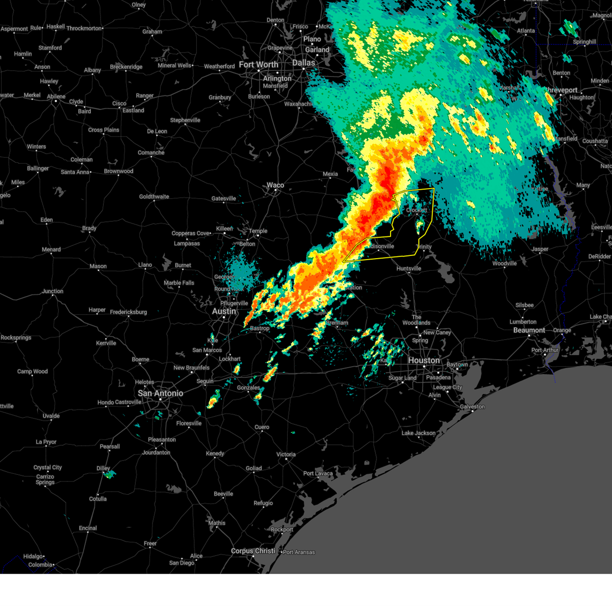
The Top Recent Hail Date for Grapeland, TX is Wednesday, April 30, 2025 (16th out of 58)

Hail and Wind Damage Spotted near Grapeland, TX
| Date / Time | Report Details |
|---|---|
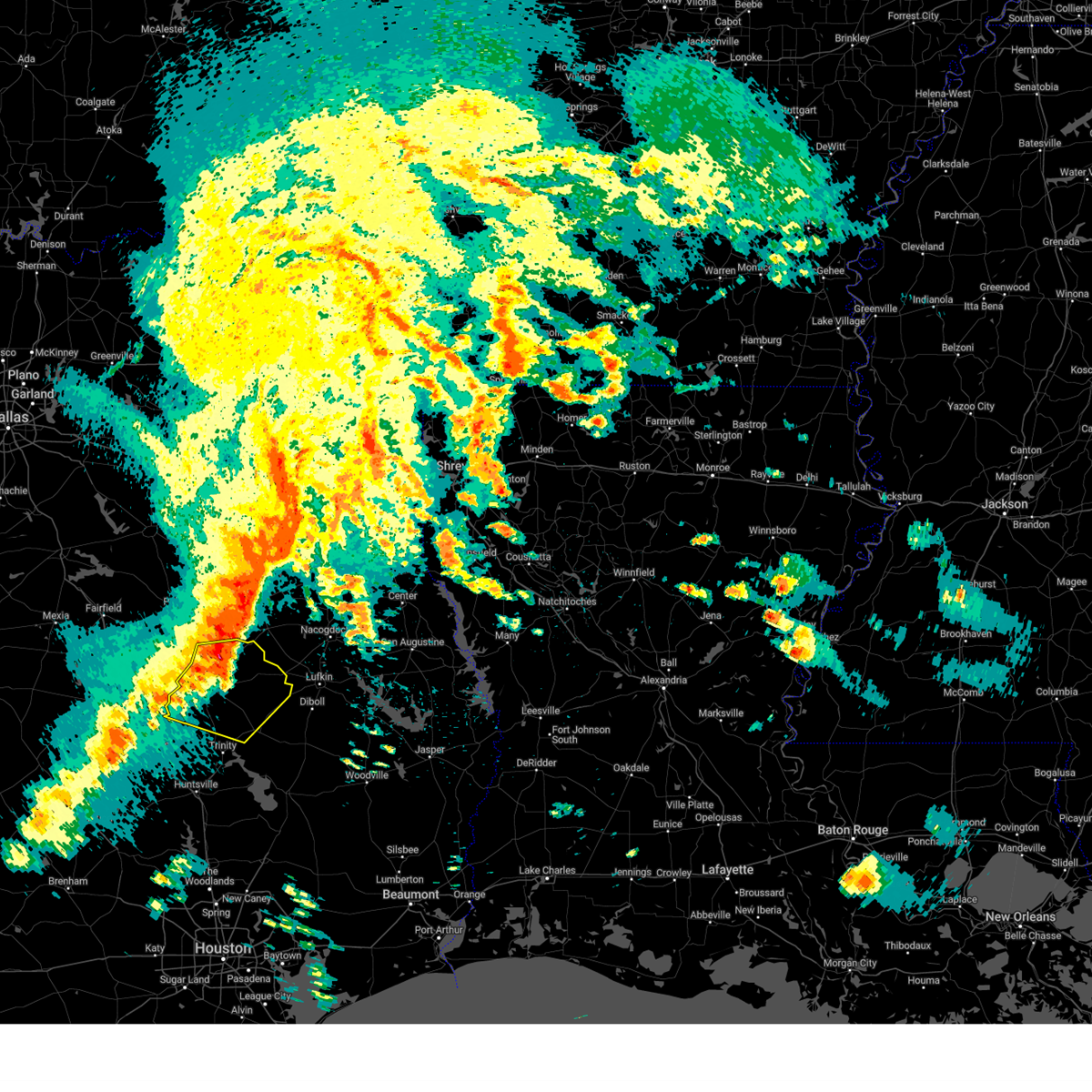
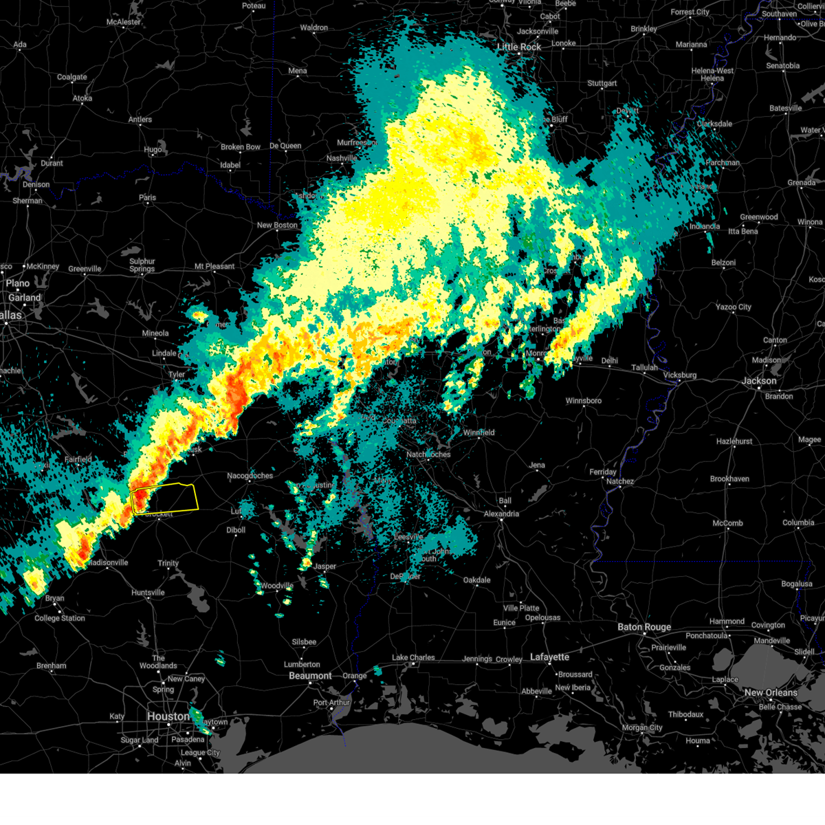
| 5/6/2025 3:14 PM CDT | Svrhgx the national weather service in league city has issued a * severe thunderstorm warning for, northern trinity county in southeastern texas, central houston county in southeastern texas, * until 345 pm cdt. * at 313 pm cdt, severe thunderstorms were located along a line extending from near kennard to 11 miles southeast of crockett to near lovelady, moving east at 50 mph (radar indicated). Hazards include 60 mph wind gusts and quarter size hail. Hail damage to vehicles is expected. Expect wind damage to roofs, siding, and trees. |
| 5/6/2025 2:21 PM CDT |
 Svrhgx the national weather service in league city has issued a * severe thunderstorm warning for, central trinity county in southeastern texas, houston county in southeastern texas, northeastern walker county in southeastern texas, * until 245 pm cdt. * at 221 pm cdt, severe thunderstorms were located along a line extending from 8 miles west of morrill to 6 miles east of crockett to near austonio, moving east at 40 mph (radar indicated). Hazards include 60 mph wind gusts and penny size hail. expect damage to roofs, siding, and trees Svrhgx the national weather service in league city has issued a * severe thunderstorm warning for, central trinity county in southeastern texas, houston county in southeastern texas, northeastern walker county in southeastern texas, * until 245 pm cdt. * at 221 pm cdt, severe thunderstorms were located along a line extending from 8 miles west of morrill to 6 miles east of crockett to near austonio, moving east at 40 mph (radar indicated). Hazards include 60 mph wind gusts and penny size hail. expect damage to roofs, siding, and trees
|
| 5/6/2025 2:09 PM CDT | At 209 pm cdt, severe thunderstorms were located along a line extending from near elkhart to near austonio to near madisonville, moving east at 35 mph (radar indicated). Hazards include 60 mph wind gusts and penny size hail. Expect damage to roofs, siding, and trees. Locations impacted include, crockett, austonio, grapeland, lovelady, and latexo. |
| 5/6/2025 2:09 PM CDT | the severe thunderstorm warning has been cancelled and is no longer in effect |
| 5/6/2025 1:44 PM CDT |
 Svrhgx the national weather service in league city has issued a * severe thunderstorm warning for, northeastern brazos county in southeastern texas, houston county in southeastern texas, madison county in southeastern texas, northwestern walker county in southeastern texas, * until 230 pm cdt. * at 144 pm cdt, severe thunderstorms were located along a line extending from 15 miles southwest of elkhart to near fort boggy state park to 11 miles northeast of kurten, moving east at 35 mph (radar indicated). Hazards include 60 mph wind gusts and penny size hail. expect damage to roofs, siding, and trees Svrhgx the national weather service in league city has issued a * severe thunderstorm warning for, northeastern brazos county in southeastern texas, houston county in southeastern texas, madison county in southeastern texas, northwestern walker county in southeastern texas, * until 230 pm cdt. * at 144 pm cdt, severe thunderstorms were located along a line extending from 15 miles southwest of elkhart to near fort boggy state park to 11 miles northeast of kurten, moving east at 35 mph (radar indicated). Hazards include 60 mph wind gusts and penny size hail. expect damage to roofs, siding, and trees
|
| 5/6/2025 1:24 PM CDT |
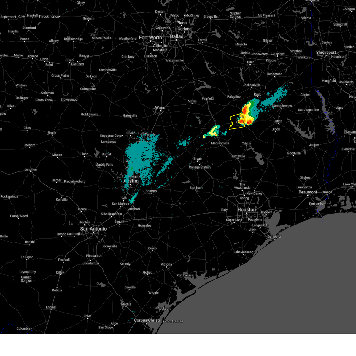
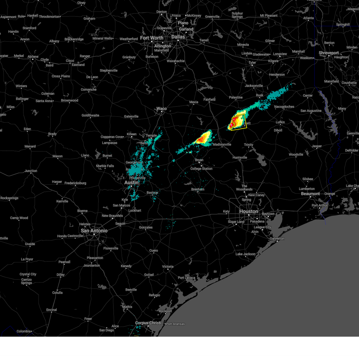
 Torhgx the national weather service in league city has issued a * tornado warning for, northwestern houston county in southeastern texas, * until 200 pm cdt. * at 123 pm cdt, a severe thunderstorm capable of producing a tornado was located 7 miles north of centerville, or 24 miles northwest of austonio, moving northeast at 45 mph (radar indicated rotation). Hazards include tornado. Flying debris will be dangerous to those caught without shelter. mobile homes will be damaged or destroyed. damage to roofs, windows, and vehicles will occur. tree damage is likely. This dangerous storm will be near, grapeland around 150 pm cdt. Torhgx the national weather service in league city has issued a * tornado warning for, northwestern houston county in southeastern texas, * until 200 pm cdt. * at 123 pm cdt, a severe thunderstorm capable of producing a tornado was located 7 miles north of centerville, or 24 miles northwest of austonio, moving northeast at 45 mph (radar indicated rotation). Hazards include tornado. Flying debris will be dangerous to those caught without shelter. mobile homes will be damaged or destroyed. damage to roofs, windows, and vehicles will occur. tree damage is likely. This dangerous storm will be near, grapeland around 150 pm cdt.
|
| 5/2/2025 4:42 PM CDT | Svrhgx the national weather service in league city has issued a * severe thunderstorm warning for, northern grimes county in southeastern texas, northeastern brazos county in southeastern texas, western houston county in southeastern texas, madison county in southeastern texas, northwestern walker county in southeastern texas, * until 530 pm cdt. * at 442 pm cdt, severe thunderstorms were located along a line extending from 6 miles southeast of fairfield lake state park to near buffalo to 10 miles southwest of fort boggy state park to 10 miles southeast of camp creek lake to 6 miles north of kurten, moving southeast at 30 mph (radar indicated). Hazards include 60 mph wind gusts and half dollar size hail. Hail damage to vehicles is expected. Expect wind damage to roofs, siding, and trees. |
| 4/30/2025 10:05 PM CDT |
 At 1005 pm cdt, a severe thunderstorm was located near grapeland, or 13 miles north of crockett, moving east at 30 mph (radar indicated). Hazards include 60 mph wind gusts and half dollar size hail. Hail damage to vehicles is expected. expect wind damage to roofs, siding, and trees. Locations impacted include, grapeland, latexo, weches, and mound city. At 1005 pm cdt, a severe thunderstorm was located near grapeland, or 13 miles north of crockett, moving east at 30 mph (radar indicated). Hazards include 60 mph wind gusts and half dollar size hail. Hail damage to vehicles is expected. expect wind damage to roofs, siding, and trees. Locations impacted include, grapeland, latexo, weches, and mound city.
|
| 4/30/2025 9:46 PM CDT |
 Svrhgx the national weather service in league city has issued a * severe thunderstorm warning for, northern houston county in southeastern texas, * until 1030 pm cdt. * at 946 pm cdt, a severe thunderstorm was located near grapeland, or 12 miles northwest of crockett, moving east at 30 mph (radar indicated). Hazards include 60 mph wind gusts and quarter size hail. Hail damage to vehicles is expected. Expect wind damage to roofs, siding, and trees. Svrhgx the national weather service in league city has issued a * severe thunderstorm warning for, northern houston county in southeastern texas, * until 1030 pm cdt. * at 946 pm cdt, a severe thunderstorm was located near grapeland, or 12 miles northwest of crockett, moving east at 30 mph (radar indicated). Hazards include 60 mph wind gusts and quarter size hail. Hail damage to vehicles is expected. Expect wind damage to roofs, siding, and trees.
|
| 3/14/2025 8:45 PM CDT |
 the severe thunderstorm warning has been cancelled and is no longer in effect the severe thunderstorm warning has been cancelled and is no longer in effect
|
| 3/14/2025 8:30 PM CDT | Quarter sized hail reported 0.7 miles E of Grapeland, TX, houston county emergency manager reported quarter size hail west of grapeland. |
| 3/14/2025 8:25 PM CDT |
 Svrhgx the national weather service in league city has issued a * severe thunderstorm warning for, northwestern houston county in southeastern texas, * until 900 pm cdt. * at 824 pm cdt, a severe thunderstorm was located 9 miles north of austonio, moving east at 30 mph (radar indicated). Hazards include 60 mph wind gusts and quarter size hail. Hail damage to vehicles is expected. Expect wind damage to roofs, siding, and trees. Svrhgx the national weather service in league city has issued a * severe thunderstorm warning for, northwestern houston county in southeastern texas, * until 900 pm cdt. * at 824 pm cdt, a severe thunderstorm was located 9 miles north of austonio, moving east at 30 mph (radar indicated). Hazards include 60 mph wind gusts and quarter size hail. Hail damage to vehicles is expected. Expect wind damage to roofs, siding, and trees.
|
| 3/4/2025 8:15 AM CST | Sh 294 was closed near the cherokee county line due to five large downed trees. time estimated via rada in anderson county TX, 14.6 miles SW of Grapeland, TX |
| 5/31/2024 6:14 AM CDT |
 At 613 am cdt, severe thunderstorms were located along a line extending from 7 miles northeast of huntsville to 7 miles southeast of columbus, moving southeast at 40 mph (radar indicated). Hazards include 60 mph wind gusts and penny size hail. Expect damage to roofs, siding, and trees. Locations impacted include, huntsville, brenham, tomball, navasota, crockett, sealy, hempstead, prairie view, bellville, columbus, pinehurst, austonio, washington, shelby, hockley, trinity, waller, grapeland, magnolia, and new waverly. At 613 am cdt, severe thunderstorms were located along a line extending from 7 miles northeast of huntsville to 7 miles southeast of columbus, moving southeast at 40 mph (radar indicated). Hazards include 60 mph wind gusts and penny size hail. Expect damage to roofs, siding, and trees. Locations impacted include, huntsville, brenham, tomball, navasota, crockett, sealy, hempstead, prairie view, bellville, columbus, pinehurst, austonio, washington, shelby, hockley, trinity, waller, grapeland, magnolia, and new waverly.
|
| 5/31/2024 5:58 AM CDT |
 Svrhgx the national weather service in league city has issued a * severe thunderstorm warning for, southwestern trinity county in southeastern texas, northeastern colorado county in southeastern texas, austin county in southeastern texas, grimes county in southeastern texas, southeastern brazos county in southeastern texas, washington county in southeastern texas, western montgomery county in southeastern texas, houston county in southeastern texas, eastern madison county in southeastern texas, waller county in southeastern texas, walker county in southeastern texas, northwestern harris county in southeastern texas, * until 645 am cdt. * at 557 am cdt, severe thunderstorms were located along a line extending from 7 miles west of riverside to 6 miles north of columbus, moving southeast at around 40 mph (radar indicated). Hazards include 60 mph wind gusts and penny size hail. expect damage to roofs, siding, and trees Svrhgx the national weather service in league city has issued a * severe thunderstorm warning for, southwestern trinity county in southeastern texas, northeastern colorado county in southeastern texas, austin county in southeastern texas, grimes county in southeastern texas, southeastern brazos county in southeastern texas, washington county in southeastern texas, western montgomery county in southeastern texas, houston county in southeastern texas, eastern madison county in southeastern texas, waller county in southeastern texas, walker county in southeastern texas, northwestern harris county in southeastern texas, * until 645 am cdt. * at 557 am cdt, severe thunderstorms were located along a line extending from 7 miles west of riverside to 6 miles north of columbus, moving southeast at around 40 mph (radar indicated). Hazards include 60 mph wind gusts and penny size hail. expect damage to roofs, siding, and trees
|
| 5/31/2024 5:36 AM CDT |
 Svrhgx the national weather service in league city has issued a * severe thunderstorm warning for, grimes county in southeastern texas, southeastern brazos county in southeastern texas, northwestern montgomery county in southeastern texas, western houston county in southeastern texas, madison county in southeastern texas, western walker county in southeastern texas, * until 600 am cdt. * at 535 am cdt, severe thunderstorms were located along a line extending from 8 miles southwest of elkhart to near navasota, moving east at 40 mph (radar indicated). Hazards include 60 mph wind gusts and penny size hail. expect damage to roofs, siding, and trees Svrhgx the national weather service in league city has issued a * severe thunderstorm warning for, grimes county in southeastern texas, southeastern brazos county in southeastern texas, northwestern montgomery county in southeastern texas, western houston county in southeastern texas, madison county in southeastern texas, western walker county in southeastern texas, * until 600 am cdt. * at 535 am cdt, severe thunderstorms were located along a line extending from 8 miles southwest of elkhart to near navasota, moving east at 40 mph (radar indicated). Hazards include 60 mph wind gusts and penny size hail. expect damage to roofs, siding, and trees
|
| 5/28/2024 11:52 AM CDT |
 The storms which prompted the warning have weakened below severe limits, and have exited the warned area. therefore, the warning will be allowed to expire. however, small hail is still possible with these thunderstorms. a severe thunderstorm watch remains in effect until 600 pm cdt for southeastern texas. remember, a severe thunderstorm warning still remains in effect for eastern madison and southwestern houston counties. The storms which prompted the warning have weakened below severe limits, and have exited the warned area. therefore, the warning will be allowed to expire. however, small hail is still possible with these thunderstorms. a severe thunderstorm watch remains in effect until 600 pm cdt for southeastern texas. remember, a severe thunderstorm warning still remains in effect for eastern madison and southwestern houston counties.
|
| 5/28/2024 10:57 AM CDT |
 Svrhgx the national weather service in league city has issued a * severe thunderstorm warning for, houston county in southeastern texas, northeastern madison county in southeastern texas, * until noon cdt. * at 1057 am cdt, a cluster of severe thunderstorms were located along a line extending from near palestine to near buffalo, moving southeast at 35 mph (radar indicated). Hazards include 60 mph wind gusts and quarter size hail. Hail damage to vehicles is expected. Expect wind damage to roofs, siding, and trees. Svrhgx the national weather service in league city has issued a * severe thunderstorm warning for, houston county in southeastern texas, northeastern madison county in southeastern texas, * until noon cdt. * at 1057 am cdt, a cluster of severe thunderstorms were located along a line extending from near palestine to near buffalo, moving southeast at 35 mph (radar indicated). Hazards include 60 mph wind gusts and quarter size hail. Hail damage to vehicles is expected. Expect wind damage to roofs, siding, and trees.
|
| 5/22/2024 9:35 PM CDT |
 The storms which prompted the warning have weakened below severe limits, and no longer pose an immediate threat to life or property. therefore, the warning will be allowed to expire. however, gusty winds are still possible with these thunderstorms. a tornado watch remains in effect until midnight cdt for southeastern texas. to report severe weather, contact your nearest law enforcement agency. they will relay your report to the national weather service league city. The storms which prompted the warning have weakened below severe limits, and no longer pose an immediate threat to life or property. therefore, the warning will be allowed to expire. however, gusty winds are still possible with these thunderstorms. a tornado watch remains in effect until midnight cdt for southeastern texas. to report severe weather, contact your nearest law enforcement agency. they will relay your report to the national weather service league city.
|
| 5/22/2024 9:00 PM CDT | County dispatch reports of several trees down near grapeland due to strong winds from thunderstorm in houston county TX, 0.7 miles SW of Grapeland, TX |
| 5/22/2024 8:57 PM CDT |
 Svrhgx the national weather service in league city has issued a * severe thunderstorm warning for, trinity county in southeastern texas, houston county in southeastern texas, northeastern madison county in southeastern texas, northeastern walker county in southeastern texas, * until 945 pm cdt. * at 856 pm cdt, severe thunderstorms were located along a line extending from 11 miles south of maydelle to 8 miles northwest of huntsville, moving east at 45 mph (radar indicated). Hazards include 60 mph wind gusts and quarter size hail. Hail damage to vehicles is expected. Expect wind damage to roofs, siding, and trees. Svrhgx the national weather service in league city has issued a * severe thunderstorm warning for, trinity county in southeastern texas, houston county in southeastern texas, northeastern madison county in southeastern texas, northeastern walker county in southeastern texas, * until 945 pm cdt. * at 856 pm cdt, severe thunderstorms were located along a line extending from 11 miles south of maydelle to 8 miles northwest of huntsville, moving east at 45 mph (radar indicated). Hazards include 60 mph wind gusts and quarter size hail. Hail damage to vehicles is expected. Expect wind damage to roofs, siding, and trees.
|
| 5/22/2024 8:30 PM CDT |
 At 829 pm cdt, severe thunderstorms were located along a line extending from 8 miles southwest of palestine to 9 miles southeast of madisonville, moving east at 45 mph (radar indicated). Hazards include 70 mph wind gusts and quarter size hail. Hail damage to vehicles is expected. expect considerable tree damage. wind damage is also likely to mobile homes, roofs, and outbuildings. Locations impacted include, northern huntsville, crockett, madisonville, austonio, trinity, grapeland, lovelady, riverside, bedias, latexo, normangee, iola, crabbs prairie, north zulch, and mound city. At 829 pm cdt, severe thunderstorms were located along a line extending from 8 miles southwest of palestine to 9 miles southeast of madisonville, moving east at 45 mph (radar indicated). Hazards include 70 mph wind gusts and quarter size hail. Hail damage to vehicles is expected. expect considerable tree damage. wind damage is also likely to mobile homes, roofs, and outbuildings. Locations impacted include, northern huntsville, crockett, madisonville, austonio, trinity, grapeland, lovelady, riverside, bedias, latexo, normangee, iola, crabbs prairie, north zulch, and mound city.
|
| 5/22/2024 8:30 PM CDT |
 the severe thunderstorm warning has been cancelled and is no longer in effect the severe thunderstorm warning has been cancelled and is no longer in effect
|
| 5/22/2024 7:58 PM CDT |
 Svrhgx the national weather service in league city has issued a * severe thunderstorm warning for, southwestern trinity county in southeastern texas, northern grimes county in southeastern texas, northeastern brazos county in southeastern texas, houston county in southeastern texas, madison county in southeastern texas, central walker county in southeastern texas, * until 900 pm cdt. * at 756 pm cdt, severe thunderstorms were located along a line extending from near fairfield to 6 miles northeast of kurten, moving east at 45 mph (radar indicated). Hazards include 70 mph wind gusts and quarter size hail. Hail damage to vehicles is expected. expect considerable tree damage. Wind damage is also likely to mobile homes, roofs, and outbuildings. Svrhgx the national weather service in league city has issued a * severe thunderstorm warning for, southwestern trinity county in southeastern texas, northern grimes county in southeastern texas, northeastern brazos county in southeastern texas, houston county in southeastern texas, madison county in southeastern texas, central walker county in southeastern texas, * until 900 pm cdt. * at 756 pm cdt, severe thunderstorms were located along a line extending from near fairfield to 6 miles northeast of kurten, moving east at 45 mph (radar indicated). Hazards include 70 mph wind gusts and quarter size hail. Hail damage to vehicles is expected. expect considerable tree damage. Wind damage is also likely to mobile homes, roofs, and outbuildings.
|
| 5/3/2024 3:52 AM CDT |
 Svrhgx the national weather service in league city has issued a * severe thunderstorm warning for, trinity county in southeastern texas, northwestern san jacinto county in southeastern texas, houston county in southeastern texas, northeastern madison county in southeastern texas, northwestern polk county in southeastern texas, northern walker county in southeastern texas, * until 430 am cdt. * at 352 am cdt, severe thunderstorms were located along a line extending from 8 miles northeast of grapeland to 13 miles west of riverside, moving east at 30 mph (radar indicated). Hazards include 60 mph wind gusts and quarter size hail. Hail damage to vehicles is expected. Expect wind damage to roofs, siding, and trees. Svrhgx the national weather service in league city has issued a * severe thunderstorm warning for, trinity county in southeastern texas, northwestern san jacinto county in southeastern texas, houston county in southeastern texas, northeastern madison county in southeastern texas, northwestern polk county in southeastern texas, northern walker county in southeastern texas, * until 430 am cdt. * at 352 am cdt, severe thunderstorms were located along a line extending from 8 miles northeast of grapeland to 13 miles west of riverside, moving east at 30 mph (radar indicated). Hazards include 60 mph wind gusts and quarter size hail. Hail damage to vehicles is expected. Expect wind damage to roofs, siding, and trees.
|
| 5/3/2024 3:15 AM CDT |
 Svrhgx the national weather service in league city has issued a * severe thunderstorm warning for, west central trinity county in southeastern texas, houston county in southeastern texas, madison county in southeastern texas, northern walker county in southeastern texas, * until 400 am cdt. * at 314 am cdt, severe thunderstorms were located along a line extending from 8 miles west of elkhart to near madisonville, moving east at 35 mph (radar indicated). Hazards include 60 mph wind gusts and quarter size hail. Hail damage to vehicles is expected. Expect wind damage to roofs, siding, and trees. Svrhgx the national weather service in league city has issued a * severe thunderstorm warning for, west central trinity county in southeastern texas, houston county in southeastern texas, madison county in southeastern texas, northern walker county in southeastern texas, * until 400 am cdt. * at 314 am cdt, severe thunderstorms were located along a line extending from 8 miles west of elkhart to near madisonville, moving east at 35 mph (radar indicated). Hazards include 60 mph wind gusts and quarter size hail. Hail damage to vehicles is expected. Expect wind damage to roofs, siding, and trees.
|
| 4/28/2024 6:39 PM CDT |
 the tornado warning has been cancelled and is no longer in effect the tornado warning has been cancelled and is no longer in effect
|
| 4/28/2024 6:38 PM CDT |
 Svrhgx the national weather service in league city has issued a * severe thunderstorm warning for, northeastern houston county in southeastern texas, * until 730 pm cdt. * at 637 pm cdt, a severe thunderstorm was located over grapeland, or 13 miles north of crockett, moving east at 30 mph (radar indicated). Hazards include 60 mph wind gusts and penny size hail. expect damage to roofs, siding, and trees Svrhgx the national weather service in league city has issued a * severe thunderstorm warning for, northeastern houston county in southeastern texas, * until 730 pm cdt. * at 637 pm cdt, a severe thunderstorm was located over grapeland, or 13 miles north of crockett, moving east at 30 mph (radar indicated). Hazards include 60 mph wind gusts and penny size hail. expect damage to roofs, siding, and trees
|
| 4/28/2024 6:27 PM CDT |
 At 627 pm cdt, a severe thunderstorm capable of producing a tornado was located 7 miles northeast of grapeland, or 16 miles north of crockett, moving northeast at 35 mph (radar indicated rotation). Hazards include tornado and quarter size hail. Flying debris will be dangerous to those caught without shelter. mobile homes will be damaged or destroyed. damage to roofs, windows, and vehicles will occur. tree damage is likely. This tornadic thunderstorm will remain over mainly rural areas of northwestern houston county, including the following locations, weches and mound city. At 627 pm cdt, a severe thunderstorm capable of producing a tornado was located 7 miles northeast of grapeland, or 16 miles north of crockett, moving northeast at 35 mph (radar indicated rotation). Hazards include tornado and quarter size hail. Flying debris will be dangerous to those caught without shelter. mobile homes will be damaged or destroyed. damage to roofs, windows, and vehicles will occur. tree damage is likely. This tornadic thunderstorm will remain over mainly rural areas of northwestern houston county, including the following locations, weches and mound city.
|
| 4/28/2024 6:10 PM CDT |
 Torhgx the national weather service in league city has issued a * tornado warning for, northwestern houston county in southeastern texas, * until 700 pm cdt. * at 609 pm cdt, a severe thunderstorm capable of producing a tornado was located near grapeland, or 12 miles northwest of crockett, moving northeast at 35 mph (radar indicated rotation). Hazards include tornado and ping pong ball size hail. Flying debris will be dangerous to those caught without shelter. mobile homes will be damaged or destroyed. damage to roofs, windows, and vehicles will occur. tree damage is likely. this dangerous storm will be near, grapeland and latexo around 615 pm cdt. Other locations impacted by this tornadic thunderstorm include weches and mound city. Torhgx the national weather service in league city has issued a * tornado warning for, northwestern houston county in southeastern texas, * until 700 pm cdt. * at 609 pm cdt, a severe thunderstorm capable of producing a tornado was located near grapeland, or 12 miles northwest of crockett, moving northeast at 35 mph (radar indicated rotation). Hazards include tornado and ping pong ball size hail. Flying debris will be dangerous to those caught without shelter. mobile homes will be damaged or destroyed. damage to roofs, windows, and vehicles will occur. tree damage is likely. this dangerous storm will be near, grapeland and latexo around 615 pm cdt. Other locations impacted by this tornadic thunderstorm include weches and mound city.
|
| 4/28/2024 5:46 PM CDT |
 At 546 pm cdt, a severe thunderstorm capable of producing a tornado was located near latexo, or 8 miles northwest of crockett, moving east at 30 mph (radar indicated rotation). Hazards include tornado and ping pong ball size hail. Flying debris will be dangerous to those caught without shelter. mobile homes will be damaged or destroyed. damage to roofs, windows, and vehicles will occur. tree damage is likely. this dangerous storm will be near, grapeland and latexo around 550 pm cdt. Other locations impacted by this tornadic thunderstorm include mound city. At 546 pm cdt, a severe thunderstorm capable of producing a tornado was located near latexo, or 8 miles northwest of crockett, moving east at 30 mph (radar indicated rotation). Hazards include tornado and ping pong ball size hail. Flying debris will be dangerous to those caught without shelter. mobile homes will be damaged or destroyed. damage to roofs, windows, and vehicles will occur. tree damage is likely. this dangerous storm will be near, grapeland and latexo around 550 pm cdt. Other locations impacted by this tornadic thunderstorm include mound city.
|
| 4/28/2024 5:23 PM CDT |
 Torhgx the national weather service in league city has issued a * tornado warning for, northwestern houston county in southeastern texas, * until 615 pm cdt. * at 522 pm cdt, a severe thunderstorm capable of producing a tornado was located 11 miles east of centerville, or 12 miles northwest of austonio, moving east at 30 mph (radar indicated rotation). Hazards include tornado and quarter size hail. Flying debris will be dangerous to those caught without shelter. mobile homes will be damaged or destroyed. damage to roofs, windows, and vehicles will occur. tree damage is likely. this dangerous storm will be near, latexo around 545 pm cdt. grapeland around 550 pm cdt. Other locations impacted by this tornadic thunderstorm include mound city. Torhgx the national weather service in league city has issued a * tornado warning for, northwestern houston county in southeastern texas, * until 615 pm cdt. * at 522 pm cdt, a severe thunderstorm capable of producing a tornado was located 11 miles east of centerville, or 12 miles northwest of austonio, moving east at 30 mph (radar indicated rotation). Hazards include tornado and quarter size hail. Flying debris will be dangerous to those caught without shelter. mobile homes will be damaged or destroyed. damage to roofs, windows, and vehicles will occur. tree damage is likely. this dangerous storm will be near, latexo around 545 pm cdt. grapeland around 550 pm cdt. Other locations impacted by this tornadic thunderstorm include mound city.
|
| 3/5/2024 4:05 AM CST |
 The storm which prompted the warning has weakened below severe limits, and no longer poses an immediate threat to life or property. therefore, the warning will be allowed to expire. however, small hail is still possible with this thunderstorm. The storm which prompted the warning has weakened below severe limits, and no longer poses an immediate threat to life or property. therefore, the warning will be allowed to expire. however, small hail is still possible with this thunderstorm.
|
| 3/5/2024 3:49 AM CST |
 At 348 am cst, a severe thunderstorm was located 8 miles west of grapeland, or 16 miles northwest of crockett, moving east at 20 mph (radar indicated). Hazards include quarter size hail. Damage to vehicles is expected. Locations impacted include, grapeland and latexo. At 348 am cst, a severe thunderstorm was located 8 miles west of grapeland, or 16 miles northwest of crockett, moving east at 20 mph (radar indicated). Hazards include quarter size hail. Damage to vehicles is expected. Locations impacted include, grapeland and latexo.
|
| 3/5/2024 3:31 AM CST |
 Svrhgx the national weather service in league city has issued a * severe thunderstorm warning for, northwestern houston county in southeastern texas, * until 415 am cst. * at 330 am cst, a severe thunderstorm was located 13 miles southwest of elkhart, or 19 miles northwest of crockett, moving east at 20 mph (radar indicated). Hazards include quarter size hail. damage to vehicles is expected Svrhgx the national weather service in league city has issued a * severe thunderstorm warning for, northwestern houston county in southeastern texas, * until 415 am cst. * at 330 am cst, a severe thunderstorm was located 13 miles southwest of elkhart, or 19 miles northwest of crockett, moving east at 20 mph (radar indicated). Hazards include quarter size hail. damage to vehicles is expected
|
| 2/11/2024 7:34 AM CST |
 At 734 am cst, severe thunderstorms were located along a line extending from near elkhart to 7 miles west of grapeland to 13 miles west of latexo, moving east at 45 mph (radar indicated). Hazards include 60 mph wind gusts and quarter size hail. Hail damage to vehicles is expected. Expect wind damage to roofs, siding, and trees. At 734 am cst, severe thunderstorms were located along a line extending from near elkhart to 7 miles west of grapeland to 13 miles west of latexo, moving east at 45 mph (radar indicated). Hazards include 60 mph wind gusts and quarter size hail. Hail damage to vehicles is expected. Expect wind damage to roofs, siding, and trees.
|
| 6/10/2023 6:57 PM CDT |
 The severe thunderstorm warning for houston county will expire at 700 pm cdt, the storms which prompted the warning have weakened below severe limits, and no longer pose an immediate threat to life or property. therefore, the warning will be allowed to expire. however small hail, gusty winds and heavy rain are still possible with these thunderstorms. a severe thunderstorm watch remains in effect until 1000 pm cdt for southeastern texas. The severe thunderstorm warning for houston county will expire at 700 pm cdt, the storms which prompted the warning have weakened below severe limits, and no longer pose an immediate threat to life or property. therefore, the warning will be allowed to expire. however small hail, gusty winds and heavy rain are still possible with these thunderstorms. a severe thunderstorm watch remains in effect until 1000 pm cdt for southeastern texas.
|
| 6/10/2023 6:45 PM CDT | Trees down in the latexo are in houston county TX, 7 miles N of Grapeland, TX |
| 6/10/2023 6:36 PM CDT | Trees down in the grapeland are in houston county TX, 0.2 miles NE of Grapeland, TX |
| 6/10/2023 6:29 PM CDT |
 At 628 pm cdt, severe thunderstorms were located along a line extending from 13 miles south of maydelle to near grapeland to 12 miles north of austonio, moving southeast at 30 mph (radar indicated). Hazards include 60 mph wind gusts and penny size hail. expect damage to roofs, siding, and trees At 628 pm cdt, severe thunderstorms were located along a line extending from 13 miles south of maydelle to near grapeland to 12 miles north of austonio, moving southeast at 30 mph (radar indicated). Hazards include 60 mph wind gusts and penny size hail. expect damage to roofs, siding, and trees
|
| 6/10/2023 6:13 PM CDT |
 At 612 pm cdt, severe thunderstorms were located along a line extending from 9 miles east of elkhart to near grapeland to 14 miles west of latexo, moving east at 35 mph (radar indicated. at 555 pm cdt, a gust of 63 mph was reported in palestine). Hazards include 60 mph wind gusts and quarter size hail. Hail damage to vehicles is expected. expect wind damage to roofs, siding, and trees. locations impacted include, crockett, grapeland, latexo, weches and mound city. hail threat, radar indicated max hail size, 1. 00 in wind threat, observed max wind gust, 60 mph. At 612 pm cdt, severe thunderstorms were located along a line extending from 9 miles east of elkhart to near grapeland to 14 miles west of latexo, moving east at 35 mph (radar indicated. at 555 pm cdt, a gust of 63 mph was reported in palestine). Hazards include 60 mph wind gusts and quarter size hail. Hail damage to vehicles is expected. expect wind damage to roofs, siding, and trees. locations impacted include, crockett, grapeland, latexo, weches and mound city. hail threat, radar indicated max hail size, 1. 00 in wind threat, observed max wind gust, 60 mph.
|
| 6/10/2023 5:50 PM CDT |
 At 550 pm cdt, severe thunderstorms were located along a line extending from near palestine to 6 miles west of elkhart to 12 miles northeast of buffalo, moving southeast at 35 mph (radar indicated). Hazards include 60 mph wind gusts and half dollar size hail. Hail damage to vehicles is expected. Expect wind damage to roofs, siding, and trees. At 550 pm cdt, severe thunderstorms were located along a line extending from near palestine to 6 miles west of elkhart to 12 miles northeast of buffalo, moving southeast at 35 mph (radar indicated). Hazards include 60 mph wind gusts and half dollar size hail. Hail damage to vehicles is expected. Expect wind damage to roofs, siding, and trees.
|
| 4/26/2023 8:58 PM CDT |
 At 858 pm cdt, a severe thunderstorm was located 8 miles west of crockett, moving east at 40 mph (radar indicated). Hazards include ping pong ball size hail and 60 mph wind gusts. People and animals outdoors will be injured. expect hail damage to roofs, siding, windows, and vehicles. Expect wind damage to roofs, siding, and trees. At 858 pm cdt, a severe thunderstorm was located 8 miles west of crockett, moving east at 40 mph (radar indicated). Hazards include ping pong ball size hail and 60 mph wind gusts. People and animals outdoors will be injured. expect hail damage to roofs, siding, windows, and vehicles. Expect wind damage to roofs, siding, and trees.
|
| 4/26/2023 8:33 PM CDT |
 At 833 pm cdt, a severe thunderstorm was located 15 miles northwest of austonio, moving east at 40 mph (radar indicated). Hazards include 60 mph wind gusts and half dollar size hail. Hail damage to vehicles is expected. Expect wind damage to roofs, siding, and trees. At 833 pm cdt, a severe thunderstorm was located 15 miles northwest of austonio, moving east at 40 mph (radar indicated). Hazards include 60 mph wind gusts and half dollar size hail. Hail damage to vehicles is expected. Expect wind damage to roofs, siding, and trees.
|
| 4/2/2023 7:06 PM CDT |
 At 704 pm cdt, a severe thunderstorm with a history of producing a tornado was located 9 miles southwest of elkhart, or 15 miles south of palestine, moving east at 35 mph (radar indicated rotation). Hazards include tornado. Flying debris will be dangerous to those caught without shelter. mobile homes will be damaged or destroyed. damage to roofs, windows, and vehicles will occur. tree damage is likely. This dangerous storm will be near, grapeland around 725 pm cdt. At 704 pm cdt, a severe thunderstorm with a history of producing a tornado was located 9 miles southwest of elkhart, or 15 miles south of palestine, moving east at 35 mph (radar indicated rotation). Hazards include tornado. Flying debris will be dangerous to those caught without shelter. mobile homes will be damaged or destroyed. damage to roofs, windows, and vehicles will occur. tree damage is likely. This dangerous storm will be near, grapeland around 725 pm cdt.
|
| 4/2/2023 6:45 PM CDT |
 At 644 pm cdt, a severe thunderstorm with a history of producing a tornado was located 10 miles east of buffalo, or 21 miles southeast of fairfield, moving east at 35 mph (radar indicated rotation). Hazards include tornado. Flying debris will be dangerous to those caught without shelter. mobile homes will be damaged or destroyed. damage to roofs, windows, and vehicles will occur. tree damage is likely. This dangerous storm will be near, grapeland around 715 pm cdt. At 644 pm cdt, a severe thunderstorm with a history of producing a tornado was located 10 miles east of buffalo, or 21 miles southeast of fairfield, moving east at 35 mph (radar indicated rotation). Hazards include tornado. Flying debris will be dangerous to those caught without shelter. mobile homes will be damaged or destroyed. damage to roofs, windows, and vehicles will occur. tree damage is likely. This dangerous storm will be near, grapeland around 715 pm cdt.
|
| 3/2/2023 10:11 PM CST |
 The severe thunderstorm warning for western trinity, houston and madison counties will expire at 1015 pm cst, the storms which prompted the warning have moved out of portions of the area. therefore, the warning will be allowed to expire. however gusty winds are still possible with these thunderstorms. a severe thunderstorm watch remains in effect until midnight cst for southeastern texas. remember, a severe thunderstorm warning still remains in effect for portions of madison, walker, northwestern san jacinto, houston and trinity counties. The severe thunderstorm warning for western trinity, houston and madison counties will expire at 1015 pm cst, the storms which prompted the warning have moved out of portions of the area. therefore, the warning will be allowed to expire. however gusty winds are still possible with these thunderstorms. a severe thunderstorm watch remains in effect until midnight cst for southeastern texas. remember, a severe thunderstorm warning still remains in effect for portions of madison, walker, northwestern san jacinto, houston and trinity counties.
|
| 3/2/2023 10:04 PM CST |
 At 1003 pm cst, severe thunderstorms were located along a line extending from 10 miles south of maydelle to 8 miles east of latexo to 15 miles east of madisonville, moving northeast at 45 mph (radar indicated). Hazards include 60 mph wind gusts and penny size hail. expect damage to roofs, siding, and trees At 1003 pm cst, severe thunderstorms were located along a line extending from 10 miles south of maydelle to 8 miles east of latexo to 15 miles east of madisonville, moving northeast at 45 mph (radar indicated). Hazards include 60 mph wind gusts and penny size hail. expect damage to roofs, siding, and trees
|
| 3/2/2023 9:25 PM CST |
 At 924 pm cst, severe thunderstorms were located along a line extending from 10 miles southeast of fairfield to 10 miles northeast of centerville to 10 miles northwest of bedias, moving northeast at 55 mph (radar indicated). Hazards include 60 mph wind gusts. expect damage to roofs, siding, and trees At 924 pm cst, severe thunderstorms were located along a line extending from 10 miles southeast of fairfield to 10 miles northeast of centerville to 10 miles northwest of bedias, moving northeast at 55 mph (radar indicated). Hazards include 60 mph wind gusts. expect damage to roofs, siding, and trees
|
| 12/13/2022 4:50 PM CST |
 At 449 pm cst, a severe thunderstorm was located near austonio, moving northeast at 30 mph (radar indicated). Hazards include 60 mph wind gusts and penny size hail. expect damage to roofs, siding, and trees At 449 pm cst, a severe thunderstorm was located near austonio, moving northeast at 30 mph (radar indicated). Hazards include 60 mph wind gusts and penny size hail. expect damage to roofs, siding, and trees
|
| 12/13/2022 2:41 PM CST |
 At 241 pm cst, a severe thunderstorm was located over morrill, or 15 miles south of rusk, moving northeast at 40 mph (radar indicated). Hazards include 60 mph wind gusts and penny size hail. Expect damage to roofs, siding, and trees. Locations impacted include, grapeland, kennard and weches. At 241 pm cst, a severe thunderstorm was located over morrill, or 15 miles south of rusk, moving northeast at 40 mph (radar indicated). Hazards include 60 mph wind gusts and penny size hail. Expect damage to roofs, siding, and trees. Locations impacted include, grapeland, kennard and weches.
|
| 12/13/2022 2:23 PM CST |
 At 222 pm cst, a severe thunderstorm was located near kennard, or 16 miles northeast of crockett, moving northeast at 40 mph (radar indicated). Hazards include quarter size hail. damage to vehicles is expected At 222 pm cst, a severe thunderstorm was located near kennard, or 16 miles northeast of crockett, moving northeast at 40 mph (radar indicated). Hazards include quarter size hail. damage to vehicles is expected
|
| 4/30/2022 7:53 PM CDT |
 At 753 pm cdt, severe thunderstorms were located along a line extending from 9 miles southwest of grapeland to 6 miles west of crockett, moving east at 10 mph (radar indicated). Hazards include quarter size hail. damage to vehicles is expected At 753 pm cdt, severe thunderstorms were located along a line extending from 9 miles southwest of grapeland to 6 miles west of crockett, moving east at 10 mph (radar indicated). Hazards include quarter size hail. damage to vehicles is expected
|
| 4/30/2022 7:01 PM CDT |
 At 701 pm cdt, a severe thunderstorm was located near grapeland, or 14 miles northwest of crockett, moving east at 30 mph (radar indicated). Hazards include quarter size hail. damage to vehicles is expected At 701 pm cdt, a severe thunderstorm was located near grapeland, or 14 miles northwest of crockett, moving east at 30 mph (radar indicated). Hazards include quarter size hail. damage to vehicles is expected
|
| 4/12/2022 11:22 PM CDT |
 The severe thunderstorm warning for northeastern houston county will expire at 1130 pm cdt, the storm which prompted the warning has weakened below severe limits, and has exited the warned area. therefore, the warning will be allowed to expire. a tornado watch remains in effect until 200 am cdt for southeastern texas. The severe thunderstorm warning for northeastern houston county will expire at 1130 pm cdt, the storm which prompted the warning has weakened below severe limits, and has exited the warned area. therefore, the warning will be allowed to expire. a tornado watch remains in effect until 200 am cdt for southeastern texas.
|
| 4/12/2022 10:43 PM CDT |
 At 1042 pm cdt, a severe thunderstorm was located near latexo, or 7 miles northeast of crockett, moving northeast at 35 mph (radar indicated). Hazards include 60 mph wind gusts. expect damage to roofs, siding, and trees At 1042 pm cdt, a severe thunderstorm was located near latexo, or 7 miles northeast of crockett, moving northeast at 35 mph (radar indicated). Hazards include 60 mph wind gusts. expect damage to roofs, siding, and trees
|
| 4/12/2022 10:39 PM CDT |
 At 1039 pm cdt, a severe thunderstorm was located near morrill, or 17 miles south of rusk, moving northeast at 35 mph (radar indicated). Hazards include 60 mph wind gusts. Expect damage to roofs, siding, and trees. locations impacted include, crockett, grapeland, latexo and weches. hail threat, radar indicated max hail size, <. 75 in wind threat, radar indicated max wind gust, 60 mph. At 1039 pm cdt, a severe thunderstorm was located near morrill, or 17 miles south of rusk, moving northeast at 35 mph (radar indicated). Hazards include 60 mph wind gusts. Expect damage to roofs, siding, and trees. locations impacted include, crockett, grapeland, latexo and weches. hail threat, radar indicated max hail size, <. 75 in wind threat, radar indicated max wind gust, 60 mph.
|
| 4/12/2022 10:15 PM CDT |
 At 1014 pm cdt, a severe thunderstorm was located near latexo, or near crockett, moving northeast at 40 mph (radar indicated). Hazards include 60 mph wind gusts. expect damage to roofs, siding, and trees At 1014 pm cdt, a severe thunderstorm was located near latexo, or near crockett, moving northeast at 40 mph (radar indicated). Hazards include 60 mph wind gusts. expect damage to roofs, siding, and trees
|
| 4/12/2022 8:21 PM CDT |
 At 819 pm cdt, a severe thunderstorm was located 14 miles northeast of centerville, or 16 miles northwest of austonio, moving northeast at 35 mph (radar indicated). Hazards include 60 mph wind gusts. expect damage to roofs, siding, and trees At 819 pm cdt, a severe thunderstorm was located 14 miles northeast of centerville, or 16 miles northwest of austonio, moving northeast at 35 mph (radar indicated). Hazards include 60 mph wind gusts. expect damage to roofs, siding, and trees
|
| 3/21/2022 10:51 PM CDT |
 At 1050 pm cdt, a severe thunderstorm capable of producing a tornado was located 8 miles east of grapeland, or 14 miles northeast of crockett, moving northeast at 40 mph (radar indicated rotation. this tornadic thunderstorm has a history of producing tornadoes). Hazards include tornado and quarter size hail. Flying debris will be dangerous to those caught without shelter. mobile homes will be damaged or destroyed. damage to roofs, windows, and vehicles will occur. tree damage is likely. This tornadic thunderstorm will remain over mainly rural areas of northeastern houston county, including the following locations, weches. At 1050 pm cdt, a severe thunderstorm capable of producing a tornado was located 8 miles east of grapeland, or 14 miles northeast of crockett, moving northeast at 40 mph (radar indicated rotation. this tornadic thunderstorm has a history of producing tornadoes). Hazards include tornado and quarter size hail. Flying debris will be dangerous to those caught without shelter. mobile homes will be damaged or destroyed. damage to roofs, windows, and vehicles will occur. tree damage is likely. This tornadic thunderstorm will remain over mainly rural areas of northeastern houston county, including the following locations, weches.
|
| 3/21/2022 10:34 PM CDT |
 At 1032 pm cdt, a confirmed large and extremely dangerous tornado was located near crockett, moving northeast at 40 mph. this is a particularly dangerous situation. take cover now! (weather spotters confirmed tornado. at 1027 pm cdt, a tornado was reported just southwest of crockett. residents in crockett and latexo should take cover now!). Hazards include damaging tornado. You are in a life-threatening situation. flying debris may be deadly to those caught without shelter. mobile homes will be destroyed. considerable damage to homes, businesses, and vehicles is likely and complete destruction is possible. The tornado will be near, crockett and latexo around 1035 pm cdt. At 1032 pm cdt, a confirmed large and extremely dangerous tornado was located near crockett, moving northeast at 40 mph. this is a particularly dangerous situation. take cover now! (weather spotters confirmed tornado. at 1027 pm cdt, a tornado was reported just southwest of crockett. residents in crockett and latexo should take cover now!). Hazards include damaging tornado. You are in a life-threatening situation. flying debris may be deadly to those caught without shelter. mobile homes will be destroyed. considerable damage to homes, businesses, and vehicles is likely and complete destruction is possible. The tornado will be near, crockett and latexo around 1035 pm cdt.
|
| 3/21/2022 10:23 PM CDT | At 1021 pm cdt, a confirmed large and extremely dangerous tornado was located near austonio, moving northeast at 40 mph. this is a particularly dangerous situation. take cover now! (weather spotters confirmed tornado. at 1013 pm cdt, a tornado was reported 1 mile southwest of austonio. residents in crockett and latexo should take cover now!). Hazards include damaging tornado. You are in a life-threatening situation. flying debris may be deadly to those caught without shelter. mobile homes will be destroyed. considerable damage to homes, businesses, and vehicles is likely and complete destruction is possible. the tornado will be near, crockett around 1040 pm cdt. Latexo around 1045 pm cdt. |
| 3/21/2022 10:18 PM CDT | At 1016 pm cdt, a confirmed tornado was located over austonio, moving northeast at 40 mph (weather spotters confirmed tornado. at 1013 pm cdt, a tornado was reported 1 mile southwest of austonio. residents in crockett should take cover now!). Hazards include damaging tornado and quarter size hail. Flying debris will be dangerous to those caught without shelter. mobile homes will be damaged or destroyed. damage to roofs, windows, and vehicles will occur. tree damage is likely. The tornado will be near, crockett and latexo around 1040 pm cdt. |
| 8/18/2021 3:32 PM CDT |
 At 331 pm cdt, a severe thunderstorm was located near lovelady, or 7 miles east of austonio, moving north at 30 mph (radar indicated). Hazards include 60 mph wind gusts. expect damage to roofs, siding, and trees At 331 pm cdt, a severe thunderstorm was located near lovelady, or 7 miles east of austonio, moving north at 30 mph (radar indicated). Hazards include 60 mph wind gusts. expect damage to roofs, siding, and trees
|
| 5/9/2021 7:08 PM CDT |
 The severe thunderstorm warning for northwestern houston county will expire at 715 pm cdt, the storm which prompted the warning has weakened below severe limits, and no longer poses an immediate threat to life or property. therefore, the warning will be allowed to expire. however small hail is still possible with this thunderstorm. a severe thunderstorm watch remains in effect until 1000 pm cdt for southeastern texas. The severe thunderstorm warning for northwestern houston county will expire at 715 pm cdt, the storm which prompted the warning has weakened below severe limits, and no longer poses an immediate threat to life or property. therefore, the warning will be allowed to expire. however small hail is still possible with this thunderstorm. a severe thunderstorm watch remains in effect until 1000 pm cdt for southeastern texas.
|
| 5/9/2021 6:50 PM CDT |
 At 649 pm cdt, a severe thunderstorm was located near latexo, or 8 miles northwest of crockett, moving east at 30 mph (radar indicated). Hazards include golf ball size hail. People and animals outdoors will be injured. expect damage to roofs, siding, windows, and vehicles. Locations impacted include, crockett, grapeland and latexo. At 649 pm cdt, a severe thunderstorm was located near latexo, or 8 miles northwest of crockett, moving east at 30 mph (radar indicated). Hazards include golf ball size hail. People and animals outdoors will be injured. expect damage to roofs, siding, windows, and vehicles. Locations impacted include, crockett, grapeland and latexo.
|
| 5/9/2021 6:29 PM CDT |
 At 628 pm cdt, a severe thunderstorm was located 13 miles west of grapeland, or 16 miles northwest of crockett, moving east at 30 mph (radar indicated). Hazards include golf ball size hail. People and animals outdoors will be injured. Expect damage to roofs, siding, windows, and vehicles. At 628 pm cdt, a severe thunderstorm was located 13 miles west of grapeland, or 16 miles northwest of crockett, moving east at 30 mph (radar indicated). Hazards include golf ball size hail. People and animals outdoors will be injured. Expect damage to roofs, siding, windows, and vehicles.
|
| 5/9/2021 6:21 PM CDT |
 At 620 pm cdt, a severe thunderstorm was located 15 miles west of grapeland, or 17 miles north of austonio, moving east at 35 mph. the severe thunderstorm warning will likely be extended in time (radar indicated). Hazards include 60 mph wind gusts and half dollar size hail. Hail damage to vehicles is expected. expect wind damage to roofs, siding, and trees. Locations impacted include, crockett, grapeland and latexo. At 620 pm cdt, a severe thunderstorm was located 15 miles west of grapeland, or 17 miles north of austonio, moving east at 35 mph. the severe thunderstorm warning will likely be extended in time (radar indicated). Hazards include 60 mph wind gusts and half dollar size hail. Hail damage to vehicles is expected. expect wind damage to roofs, siding, and trees. Locations impacted include, crockett, grapeland and latexo.
|
| 5/9/2021 6:06 PM CDT |
 At 606 pm cdt, a severe thunderstorm was located 13 miles east of buffalo, or 22 miles southwest of palestine, moving east at 40 mph (radar indicated). Hazards include quarter size hail. damage to vehicles is expected At 606 pm cdt, a severe thunderstorm was located 13 miles east of buffalo, or 22 miles southwest of palestine, moving east at 40 mph (radar indicated). Hazards include quarter size hail. damage to vehicles is expected
|
| 4/9/2021 10:29 PM CDT |
 At 1027 pm cdt, a severe thunderstorm was located over elkhart, or 11 miles southeast of palestine, moving southeast at 30 mph. this severe thunderstorm has a history of producing hail up to quarter size (radar indicated). Hazards include 60 mph wind gusts and quarter size hail. Hail damage to vehicles is expected. Expect wind damage to roofs, siding, and trees. At 1027 pm cdt, a severe thunderstorm was located over elkhart, or 11 miles southeast of palestine, moving southeast at 30 mph. this severe thunderstorm has a history of producing hail up to quarter size (radar indicated). Hazards include 60 mph wind gusts and quarter size hail. Hail damage to vehicles is expected. Expect wind damage to roofs, siding, and trees.
|
| 4/29/2020 2:14 AM CDT | Powerline blown down on cr 1710 near percill in houston county TX, 6.1 miles SW of Grapeland, TX |
| 4/29/2020 2:12 AM CDT | Tree down on fm 228 northeast of grapelan in houston county TX, 1.3 miles SSW of Grapeland, TX |
| 4/29/2020 1:32 AM CDT |
 At 131 am cdt, severe thunderstorms were located along a line extending from 6 miles west of fairfield to near palestine to near new salem, moving south at 30 mph (radar indicated). Hazards include 60 mph wind gusts and quarter size hail. Hail damage to vehicles is expected. Expect wind damage to roofs, siding, and trees. At 131 am cdt, severe thunderstorms were located along a line extending from 6 miles west of fairfield to near palestine to near new salem, moving south at 30 mph (radar indicated). Hazards include 60 mph wind gusts and quarter size hail. Hail damage to vehicles is expected. Expect wind damage to roofs, siding, and trees.
|
| 4/24/2020 8:09 PM CDT | Quarter sized hail reported 0.7 miles SW of Grapeland, TX, report from mping: quarter (1.00 in.). |
| 4/22/2020 3:13 PM CDT |
 The severe thunderstorm warning for northeastern houston county will expire at 315 pm cdt, the storm which prompted the warning has moved out of the area. therefore, the warning will be allowed to expire. however hail, gusty winds and heavy rain are still possible with this thunderstorm as it travels through northeastern houston county. a tornado warning is still in effect through 315 pm! a tornado watch remains in effect until 500 pm cdt for southeastern texas. to report severe weather, contact your nearest law enforcement agency. they will relay your report to the national weather service league city. The severe thunderstorm warning for northeastern houston county will expire at 315 pm cdt, the storm which prompted the warning has moved out of the area. therefore, the warning will be allowed to expire. however hail, gusty winds and heavy rain are still possible with this thunderstorm as it travels through northeastern houston county. a tornado warning is still in effect through 315 pm! a tornado watch remains in effect until 500 pm cdt for southeastern texas. to report severe weather, contact your nearest law enforcement agency. they will relay your report to the national weather service league city.
|
| 4/22/2020 2:59 PM CDT |
 At 257 pm cdt, a severe thunderstorm was located 9 miles west of morrill, or 16 miles south of rusk, moving northeast at 50 mph. this storm is directly heading towards the town of weches. if in the weches area, take cover now! (radar indicated). Hazards include two inch hail and 70 mph wind gusts. People and animals outdoors will be injured. expect hail damage to roofs, siding, windows, and vehicles. expect considerable tree damage. wind damage is also likely to mobile homes, roofs, and outbuildings. Locations impacted include, grapeland, latexo and weches. At 257 pm cdt, a severe thunderstorm was located 9 miles west of morrill, or 16 miles south of rusk, moving northeast at 50 mph. this storm is directly heading towards the town of weches. if in the weches area, take cover now! (radar indicated). Hazards include two inch hail and 70 mph wind gusts. People and animals outdoors will be injured. expect hail damage to roofs, siding, windows, and vehicles. expect considerable tree damage. wind damage is also likely to mobile homes, roofs, and outbuildings. Locations impacted include, grapeland, latexo and weches.
|
| 4/22/2020 2:48 PM CDT | Sporadic tree damage throughout the grapeland are in houston county TX, 0.7 miles SW of Grapeland, TX |
| 4/22/2020 2:45 PM CDT |
 At 244 pm cdt, a severe thunderstorm was located near grapeland, or 12 miles north of crockett, moving northeast at 50 mph (radar indicated). Hazards include 60 mph wind gusts and half dollar size hail. Hail damage to vehicles is expected. Expect wind damage to roofs, siding, and trees. At 244 pm cdt, a severe thunderstorm was located near grapeland, or 12 miles north of crockett, moving northeast at 50 mph (radar indicated). Hazards include 60 mph wind gusts and half dollar size hail. Hail damage to vehicles is expected. Expect wind damage to roofs, siding, and trees.
|
| 4/22/2020 2:40 PM CDT | Powerline down and also a lot of hail (unknown size) in the grapeland are in houston county TX, 0.7 miles SW of Grapeland, TX |
| 4/22/2020 2:39 PM CDT | Golf Ball sized hail reported 0.6 miles SSE of Grapeland, TX |
| 4/22/2020 2:25 PM CDT |
 At 225 pm cdt, a severe thunderstorm capable of producing a tornado was located 10 miles southwest of elkhart, or 18 miles south of palestine, moving northeast at 55 mph (radar indicated rotation). Hazards include tornado and quarter size hail. Flying debris will be dangerous to those caught without shelter. mobile homes will be damaged or destroyed. damage to roofs, windows, and vehicles will occur. tree damage is likely. This dangerous storm will be near, grapeland around 235 pm cdt. At 225 pm cdt, a severe thunderstorm capable of producing a tornado was located 10 miles southwest of elkhart, or 18 miles south of palestine, moving northeast at 55 mph (radar indicated rotation). Hazards include tornado and quarter size hail. Flying debris will be dangerous to those caught without shelter. mobile homes will be damaged or destroyed. damage to roofs, windows, and vehicles will occur. tree damage is likely. This dangerous storm will be near, grapeland around 235 pm cdt.
|
| 4/22/2020 2:19 PM CDT |
 At 219 pm cdt, a severe thunderstorm was located 12 miles southwest of elkhart, or 18 miles south of palestine, moving northeast at 55 mph (radar indicated). Hazards include 60 mph wind gusts and quarter size hail. Hail damage to vehicles is expected. Expect wind damage to roofs, siding, and trees. At 219 pm cdt, a severe thunderstorm was located 12 miles southwest of elkhart, or 18 miles south of palestine, moving northeast at 55 mph (radar indicated). Hazards include 60 mph wind gusts and quarter size hail. Hail damage to vehicles is expected. Expect wind damage to roofs, siding, and trees.
|
| 5/18/2019 11:27 PM CDT |
 At 1126 pm cdt, a severe thunderstorm was located near crockett, moving east at 45 mph (radar indicated). Hazards include 60 mph wind gusts and penny size hail. Expect damage to roofs, siding, and trees. Locations impacted include, crockett, kennard, latexo and weches. At 1126 pm cdt, a severe thunderstorm was located near crockett, moving east at 45 mph (radar indicated). Hazards include 60 mph wind gusts and penny size hail. Expect damage to roofs, siding, and trees. Locations impacted include, crockett, kennard, latexo and weches.
|
| 5/18/2019 10:58 PM CDT |
 At 1057 pm cdt, a severe thunderstorm was located 10 miles west of latexo, or 11 miles north of austonio, moving east at 40 mph (radar indicated). Hazards include 60 mph wind gusts and nickel size hail. expect damage to roofs, siding, and trees At 1057 pm cdt, a severe thunderstorm was located 10 miles west of latexo, or 11 miles north of austonio, moving east at 40 mph (radar indicated). Hazards include 60 mph wind gusts and nickel size hail. expect damage to roofs, siding, and trees
|
| 5/18/2019 10:27 PM CDT |
 The severe thunderstorm warning for northern houston county will expire at 1030 pm cdt, the storm which prompted the warning has weakened below severe limits, and no longer poses an immediate threat to life or property. therefore, the warning will be allowed to expire. however small hail, gusty winds and heavy rain are still possible with this thunderstorm. a tornado watch remains in effect until 400 am cdt for southeastern texas. The severe thunderstorm warning for northern houston county will expire at 1030 pm cdt, the storm which prompted the warning has weakened below severe limits, and no longer poses an immediate threat to life or property. therefore, the warning will be allowed to expire. however small hail, gusty winds and heavy rain are still possible with this thunderstorm. a tornado watch remains in effect until 400 am cdt for southeastern texas.
|
| 5/18/2019 10:11 PM CDT |
 At 1011 pm cdt, a severe thunderstorm was located over grapeland, or 12 miles north of crockett, moving east at 50 mph (radar indicated). Hazards include 60 mph wind gusts and nickel size hail. Expect damage to roofs, siding, and trees. Locations impacted include, grapeland and weches. At 1011 pm cdt, a severe thunderstorm was located over grapeland, or 12 miles north of crockett, moving east at 50 mph (radar indicated). Hazards include 60 mph wind gusts and nickel size hail. Expect damage to roofs, siding, and trees. Locations impacted include, grapeland and weches.
|
| 5/18/2019 9:45 PM CDT |
 At 945 pm cdt, a severe thunderstorm was located 8 miles west of grapeland, or 15 miles northwest of crockett, moving east at 40 mph (radar indicated). Hazards include 60 mph wind gusts and nickel size hail. expect damage to roofs, siding, and trees At 945 pm cdt, a severe thunderstorm was located 8 miles west of grapeland, or 15 miles northwest of crockett, moving east at 40 mph (radar indicated). Hazards include 60 mph wind gusts and nickel size hail. expect damage to roofs, siding, and trees
|
| 5/18/2019 8:39 PM CDT |
 At 839 pm cdt, a severe thunderstorm was located over grapeland, or 13 miles north of crockett, moving east at 15 mph (radar indicated). Hazards include 60 mph wind gusts and quarter size hail. Hail damage to vehicles is expected. expect wind damage to roofs, siding, and trees. Locations impacted include, grapeland and weches. At 839 pm cdt, a severe thunderstorm was located over grapeland, or 13 miles north of crockett, moving east at 15 mph (radar indicated). Hazards include 60 mph wind gusts and quarter size hail. Hail damage to vehicles is expected. expect wind damage to roofs, siding, and trees. Locations impacted include, grapeland and weches.
|
| 5/18/2019 8:17 PM CDT |
 At 813 pm cdt, a severe thunderstorm was located 10 miles west of grapeland, or 15 miles northwest of crockett, moving east at 35 mph (radar indicated). Hazards include 60 mph wind gusts and quarter size hail. Hail damage to vehicles is possible. Expect wind damage to roofs, siding, and trees. At 813 pm cdt, a severe thunderstorm was located 10 miles west of grapeland, or 15 miles northwest of crockett, moving east at 35 mph (radar indicated). Hazards include 60 mph wind gusts and quarter size hail. Hail damage to vehicles is possible. Expect wind damage to roofs, siding, and trees.
|
| 5/2/2019 4:40 AM CDT | Houston county dispatch received reports of trees down near 20513 highway 21 in houston county TX, 15.7 miles WSW of Grapeland, TX |
| 4/18/2019 2:51 AM CDT |
 At 250 am cdt, severe thunderstorms were located along a line extending from 6 miles northeast of grapeland to near lovelady, moving east at 35 mph. this line of storms has intensified and in addition to strong damaging winds, large hail will also be possible (radar indicated). Hazards include 60 mph wind gusts and quarter size hail. Hail damage to vehicles is expected. expect wind damage to roofs, siding, and trees. Locations impacted include, crockett, austonio, grapeland, kennard, latexo, weches and pennington. At 250 am cdt, severe thunderstorms were located along a line extending from 6 miles northeast of grapeland to near lovelady, moving east at 35 mph. this line of storms has intensified and in addition to strong damaging winds, large hail will also be possible (radar indicated). Hazards include 60 mph wind gusts and quarter size hail. Hail damage to vehicles is expected. expect wind damage to roofs, siding, and trees. Locations impacted include, crockett, austonio, grapeland, kennard, latexo, weches and pennington.
|
| 4/18/2019 2:42 AM CDT |
 At 241 am cdt, severe thunderstorms were located along a line extending from near grapeland to near austonio, moving east at 35 mph (radar indicated). Hazards include 60 mph wind gusts. expect damage to roofs, siding, and trees At 241 am cdt, severe thunderstorms were located along a line extending from near grapeland to near austonio, moving east at 35 mph (radar indicated). Hazards include 60 mph wind gusts. expect damage to roofs, siding, and trees
|
| 4/18/2019 2:02 AM CDT |
 At 202 am cdt, severe thunderstorms were located along a line extending from 11 miles northeast of buffalo to 11 miles northeast of centerville to 6 miles north of madisonville, moving east at 50 mph (radar indicated). Hazards include 60 mph wind gusts and penny size hail. expect damage to roofs, siding, and trees At 202 am cdt, severe thunderstorms were located along a line extending from 11 miles northeast of buffalo to 11 miles northeast of centerville to 6 miles north of madisonville, moving east at 50 mph (radar indicated). Hazards include 60 mph wind gusts and penny size hail. expect damage to roofs, siding, and trees
|
| 4/13/2019 1:18 PM CDT |
 At 118 pm cdt, a severe thunderstorm was located near lovelady, or 12 miles south of crockett, moving northeast at 50 mph (radar indicated). Hazards include 60 mph wind gusts and quarter size hail. Hail damage to vehicles is expected. Expect wind damage to roofs, siding, and trees. At 118 pm cdt, a severe thunderstorm was located near lovelady, or 12 miles south of crockett, moving northeast at 50 mph (radar indicated). Hazards include 60 mph wind gusts and quarter size hail. Hail damage to vehicles is expected. Expect wind damage to roofs, siding, and trees.
|
| 4/7/2019 2:32 PM CDT |
 At 232 pm cdt, severe thunderstorms were located along a line extending from near latexo to near diboll, moving north at 45 mph (radar indicated). Hazards include 60 mph wind gusts and pea size hail. Expect damage to roofs, siding, and trees. Locations impacted include, crockett, austonio, apple springs, corrigan, grapeland, groveton, lovelady, kennard, latexo, seven oaks, alabama-coushatta reservation, leggett, pennington, moscow, weches and centralia. At 232 pm cdt, severe thunderstorms were located along a line extending from near latexo to near diboll, moving north at 45 mph (radar indicated). Hazards include 60 mph wind gusts and pea size hail. Expect damage to roofs, siding, and trees. Locations impacted include, crockett, austonio, apple springs, corrigan, grapeland, groveton, lovelady, kennard, latexo, seven oaks, alabama-coushatta reservation, leggett, pennington, moscow, weches and centralia.
|
| 4/7/2019 2:01 PM CDT |
 At 200 pm cdt, severe thunderstorms were located along a line extending from near lovelady to near alabama-coushatta reservation, moving north at 35 mph (radar indicated). Hazards include 60 mph wind gusts and pea size hail. expect damage to roofs, siding, and trees At 200 pm cdt, severe thunderstorms were located along a line extending from near lovelady to near alabama-coushatta reservation, moving north at 35 mph (radar indicated). Hazards include 60 mph wind gusts and pea size hail. expect damage to roofs, siding, and trees
|
| 4/6/2019 7:30 PM CDT |
 At 730 pm cdt, a severe thunderstorm was located over crockett, moving northeast at 35 mph (radar indicated). Hazards include tennis ball size hail. People and animals outdoors will be injured. expect damage to roofs, siding, windows, and vehicles. locations impacted include, crockett, kennard and latexo. A tornado watch remains in effect until 1000 pm cdt for southeastern texas. At 730 pm cdt, a severe thunderstorm was located over crockett, moving northeast at 35 mph (radar indicated). Hazards include tennis ball size hail. People and animals outdoors will be injured. expect damage to roofs, siding, windows, and vehicles. locations impacted include, crockett, kennard and latexo. A tornado watch remains in effect until 1000 pm cdt for southeastern texas.
|
| 4/6/2019 6:59 PM CDT |
 At 658 pm cdt, two severe thunderstorms were located over or just to the west of austonio, both moving northeast at 35 mph. these are very dangerous storms (radar indicated). Hazards include hail up to baseball size. People and animals outdoors will be severely injured. Expect shattered windows, extensive damage to roofs, siding, and vehicles. At 658 pm cdt, two severe thunderstorms were located over or just to the west of austonio, both moving northeast at 35 mph. these are very dangerous storms (radar indicated). Hazards include hail up to baseball size. People and animals outdoors will be severely injured. Expect shattered windows, extensive damage to roofs, siding, and vehicles.
|
| 4/6/2019 6:11 PM CDT | Baseball sized hail reported 0.2 miles NE of Grapeland, TX |
| 4/6/2019 6:10 PM CDT | Quarter sized hail reported 5.9 miles SSE of Grapeland, TX |
| 4/6/2019 6:10 PM CDT | Softball sized hail reported 0.2 miles NE of Grapeland, TX, multiple reports of softball size hail. |
| 4/6/2019 5:55 PM CDT |
 At 555 pm cdt, a severe thunderstorm capable of producing a tornado was located over grapeland, or 12 miles north of crockett, moving northeast at 45 mph (radar indicated rotation). Hazards include tornado and up to tennis ball size hail. Flying debris will be dangerous to those caught without shelter. mobile homes will be damaged or destroyed. damage to roofs, windows, and vehicles will occur. tree damage is likely. This tornadic thunderstorm will remain over mainly rural areas of northwestern houston county, including the following locations, weches. At 555 pm cdt, a severe thunderstorm capable of producing a tornado was located over grapeland, or 12 miles north of crockett, moving northeast at 45 mph (radar indicated rotation). Hazards include tornado and up to tennis ball size hail. Flying debris will be dangerous to those caught without shelter. mobile homes will be damaged or destroyed. damage to roofs, windows, and vehicles will occur. tree damage is likely. This tornadic thunderstorm will remain over mainly rural areas of northwestern houston county, including the following locations, weches.
|
| 4/6/2019 5:39 PM CDT |
 At 539 pm cdt, a severe thunderstorm was located 11 miles west of grapeland, or 16 miles northwest of crockett, moving northeast at 25 mph. this is a very dangerous storm (radar indicated). Hazards include hail up to baseball size hail. People and animals outdoors will be severely injured. Expect shattered windows, extensive damage to roofs, siding, and vehicles. At 539 pm cdt, a severe thunderstorm was located 11 miles west of grapeland, or 16 miles northwest of crockett, moving northeast at 25 mph. this is a very dangerous storm (radar indicated). Hazards include hail up to baseball size hail. People and animals outdoors will be severely injured. Expect shattered windows, extensive damage to roofs, siding, and vehicles.
|
| 3/14/2019 3:41 AM CDT |
 At 341 am cdt, a severe thunderstorm was located near latexo, or 8 miles northeast of crockett, moving east at 45 mph (radar indicated). Hazards include 60 mph wind gusts and penny size hail. Expect damage to roofs, siding, and trees. Locations impacted include, crockett, grapeland, kennard, latexo and weches. At 341 am cdt, a severe thunderstorm was located near latexo, or 8 miles northeast of crockett, moving east at 45 mph (radar indicated). Hazards include 60 mph wind gusts and penny size hail. Expect damage to roofs, siding, and trees. Locations impacted include, crockett, grapeland, kennard, latexo and weches.
|
| 3/14/2019 3:23 AM CDT |
 At 323 am cdt, a severe thunderstorm was located 9 miles west of latexo, or 11 miles northwest of crockett, moving east at 45 mph (radar indicated). Hazards include 60 mph wind gusts and penny size hail. expect damage to roofs, siding, and trees At 323 am cdt, a severe thunderstorm was located 9 miles west of latexo, or 11 miles northwest of crockett, moving east at 45 mph (radar indicated). Hazards include 60 mph wind gusts and penny size hail. expect damage to roofs, siding, and trees
|
| 12/27/2018 1:40 AM CST |
 At 139 am cst, severe thunderstorms were located along a line extending from 7 miles northeast of grapeland to near lovelady, moving northeast at 50 mph (radar indicated. this storm has a history of downing trees in brazos and madison counties). Hazards include 60 mph wind gusts and penny size hail. Expect damage to roofs, siding, and trees. locations impacted include, crockett, grapeland, lovelady, kennard, latexo and weches. A tornado watch remains in effect until 400 am cst for southeastern texas. At 139 am cst, severe thunderstorms were located along a line extending from 7 miles northeast of grapeland to near lovelady, moving northeast at 50 mph (radar indicated. this storm has a history of downing trees in brazos and madison counties). Hazards include 60 mph wind gusts and penny size hail. Expect damage to roofs, siding, and trees. locations impacted include, crockett, grapeland, lovelady, kennard, latexo and weches. A tornado watch remains in effect until 400 am cst for southeastern texas.
|
| 12/27/2018 1:21 AM CST |
 At 121 am cst, severe thunderstorms were located along a line extending from 6 miles southwest of grapeland to 13 miles southwest of lovelady, moving northeast at 50 mph (law enforcement). Hazards include 60 mph wind gusts and penny size hail. expect damage to roofs, siding, and trees At 121 am cst, severe thunderstorms were located along a line extending from 6 miles southwest of grapeland to 13 miles southwest of lovelady, moving northeast at 50 mph (law enforcement). Hazards include 60 mph wind gusts and penny size hail. expect damage to roofs, siding, and trees
|
| 12/26/2018 9:45 PM CST | Quarter sized hail reported 5 miles SE of Grapeland, TX |
| 10/13/2018 6:07 PM CDT |
 At 607 pm cdt, a severe thunderstorm was located near grapeland, or 14 miles north of crockett, moving east at 35 mph (radar indicated). Hazards include 60 mph wind gusts and quarter size hail. Hail damage to vehicles is expected. Expect wind damage to roofs, siding, and trees. At 607 pm cdt, a severe thunderstorm was located near grapeland, or 14 miles north of crockett, moving east at 35 mph (radar indicated). Hazards include 60 mph wind gusts and quarter size hail. Hail damage to vehicles is expected. Expect wind damage to roofs, siding, and trees.
|
| 7/5/2018 6:56 PM CDT |
 At 655 pm cdt, a severe thunderstorm was located near grapeland, or 9 miles north of crockett, moving southwest at 30 mph (radar indicated). Hazards include 60 mph wind gusts and penny size hail. expect damage to roofs, siding, and trees At 655 pm cdt, a severe thunderstorm was located near grapeland, or 9 miles north of crockett, moving southwest at 30 mph (radar indicated). Hazards include 60 mph wind gusts and penny size hail. expect damage to roofs, siding, and trees
|
| 5/28/2017 7:11 PM CDT |
 At 711 pm cdt, severe thunderstorms were located along a line extending from 7 miles southwest of forest to 9 miles west of latexo, moving southeast at 15 mph (radar indicated). Hazards include 60 mph wind gusts and quarter size hail. Hail damage to vehicles is expected. expect wind damage to roofs, siding, and trees. Locations impacted include, crockett, grapeland, kennard, latexo and weches. At 711 pm cdt, severe thunderstorms were located along a line extending from 7 miles southwest of forest to 9 miles west of latexo, moving southeast at 15 mph (radar indicated). Hazards include 60 mph wind gusts and quarter size hail. Hail damage to vehicles is expected. expect wind damage to roofs, siding, and trees. Locations impacted include, crockett, grapeland, kennard, latexo and weches.
|
| 5/28/2017 6:42 PM CDT |
 At 641 pm cdt, severe thunderstorms were located along a line extending from near morrill to 7 miles southwest of crockett, moving east at 35 mph (radar indicated). Hazards include 60 mph wind gusts and quarter size hail. Hail damage to vehicles is expected. Expect wind damage to roofs, siding, and trees. At 641 pm cdt, severe thunderstorms were located along a line extending from near morrill to 7 miles southwest of crockett, moving east at 35 mph (radar indicated). Hazards include 60 mph wind gusts and quarter size hail. Hail damage to vehicles is expected. Expect wind damage to roofs, siding, and trees.
|
| 5/28/2017 6:12 PM CDT |
 At 612 pm cdt, a severe thunderstorm was located 10 miles north of kennard, or 17 miles northeast of crockett, moving east at 20 mph (radar indicated). Hazards include 60 mph wind gusts and quarter size hail. Hail damage to vehicles is expected. expect wind damage to roofs, siding, and trees. Locations impacted include, crockett, grapeland, kennard, latexo and weches. At 612 pm cdt, a severe thunderstorm was located 10 miles north of kennard, or 17 miles northeast of crockett, moving east at 20 mph (radar indicated). Hazards include 60 mph wind gusts and quarter size hail. Hail damage to vehicles is expected. expect wind damage to roofs, siding, and trees. Locations impacted include, crockett, grapeland, kennard, latexo and weches.
|
| 5/28/2017 5:53 PM CDT |
 At 553 pm cdt, a severe thunderstorm was located 9 miles northwest of kennard, or 16 miles northeast of crockett, moving east at 55 mph (radar indicated). Hazards include 60 mph wind gusts and quarter size hail. Hail damage to vehicles is expected. Expect wind damage to roofs, siding, and trees. At 553 pm cdt, a severe thunderstorm was located 9 miles northwest of kennard, or 16 miles northeast of crockett, moving east at 55 mph (radar indicated). Hazards include 60 mph wind gusts and quarter size hail. Hail damage to vehicles is expected. Expect wind damage to roofs, siding, and trees.
|
| 5/23/2017 5:01 PM CDT | Quarter sized hail reported 6.1 miles SW of Grapeland, TX, quarter size hail near percilla. |
| 5/23/2017 4:46 PM CDT |
 At 445 pm cdt, a severe thunderstorm was located near grapeland, or 13 miles north of crockett, moving southeast at 50 mph (radar indicated). Hazards include 60 mph wind gusts and quarter size hail. Hail damage to vehicles is expected. expect wind damage to roofs, siding, and trees. Locations impacted include, grapeland, kennard and weches. At 445 pm cdt, a severe thunderstorm was located near grapeland, or 13 miles north of crockett, moving southeast at 50 mph (radar indicated). Hazards include 60 mph wind gusts and quarter size hail. Hail damage to vehicles is expected. expect wind damage to roofs, siding, and trees. Locations impacted include, grapeland, kennard and weches.
|
| 5/23/2017 4:44 PM CDT | Quarter sized hail reported 4.3 miles SW of Grapeland, TX, quarter size hail reported on county road 1705 |
| 5/23/2017 4:27 PM CDT |
 At 426 pm cdt, a severe thunderstorm was located near elkhart, or 13 miles south of palestine, moving east at 55 mph (radar indicated). Hazards include 60 mph wind gusts and quarter size hail. Hail damage to vehicles is expected. Expect wind damage to roofs, siding, and trees. At 426 pm cdt, a severe thunderstorm was located near elkhart, or 13 miles south of palestine, moving east at 55 mph (radar indicated). Hazards include 60 mph wind gusts and quarter size hail. Hail damage to vehicles is expected. Expect wind damage to roofs, siding, and trees.
|
| 5/21/2017 6:08 AM CDT |
 The severe thunderstorm warning for northwestern houston county will expire at 615 am cdt, the storm which prompted the warning has moved out of the area. therefore the warning will be allowed to expire. The severe thunderstorm warning for northwestern houston county will expire at 615 am cdt, the storm which prompted the warning has moved out of the area. therefore the warning will be allowed to expire.
|
| 5/21/2017 5:27 AM CDT |
 At 527 am cdt, a severe thunderstorm was located 7 miles west of grapeland, or 13 miles northwest of crockett, moving northeast at 20 mph (radar indicated). Hazards include half dollar size hail. damage to vehicles is expected At 527 am cdt, a severe thunderstorm was located 7 miles west of grapeland, or 13 miles northwest of crockett, moving northeast at 20 mph (radar indicated). Hazards include half dollar size hail. damage to vehicles is expected
|
| 5/11/2017 7:39 PM CDT |
 At 739 pm cdt, a severe thunderstorm was located near latexo, or near crockett, moving east at 30 mph (radar indicated). Hazards include 60 mph wind gusts and nickel size hail. Expect damage to roofs, siding, and trees. Locations impacted include, crockett, grapeland, kennard, latexo and weches. At 739 pm cdt, a severe thunderstorm was located near latexo, or near crockett, moving east at 30 mph (radar indicated). Hazards include 60 mph wind gusts and nickel size hail. Expect damage to roofs, siding, and trees. Locations impacted include, crockett, grapeland, kennard, latexo and weches.
|
| 5/11/2017 7:04 PM CDT |
 At 703 pm cdt, a severe thunderstorm was located 12 miles northwest of austonio, moving east at 40 mph (radar indicated). Hazards include quarter size hail. damage to vehicles is expected At 703 pm cdt, a severe thunderstorm was located 12 miles northwest of austonio, moving east at 40 mph (radar indicated). Hazards include quarter size hail. damage to vehicles is expected
|
| 5/3/2017 4:55 PM CDT |
 At 455 pm cdt, cluster of severe thunderstorms were located near kennard, or 11 miles east of crockett, moving east at 35 mph (radar indicated). Hazards include 60 mph wind gusts and quarter size hail. Hail damage to vehicles is expected. Expect wind damage to roofs, siding, and trees. At 455 pm cdt, cluster of severe thunderstorms were located near kennard, or 11 miles east of crockett, moving east at 35 mph (radar indicated). Hazards include 60 mph wind gusts and quarter size hail. Hail damage to vehicles is expected. Expect wind damage to roofs, siding, and trees.
|
| 5/3/2017 4:19 PM CDT |
 At 418 pm cdt, a severe thunderstorm was located 8 miles east of buffalo, or 20 miles southeast of fairfield, moving east at 55 mph (radar indicated). Hazards include ping pong ball size hail and 60 mph wind gusts. People and animals outdoors will be injured. expect hail damage to roofs, siding, windows, and vehicles. Expect wind damage to roofs, siding, and trees. At 418 pm cdt, a severe thunderstorm was located 8 miles east of buffalo, or 20 miles southeast of fairfield, moving east at 55 mph (radar indicated). Hazards include ping pong ball size hail and 60 mph wind gusts. People and animals outdoors will be injured. expect hail damage to roofs, siding, windows, and vehicles. Expect wind damage to roofs, siding, and trees.
|
| 4/26/2017 3:27 PM CDT |
 At 327 pm cdt, a severe thunderstorm was located over latexo, or near crockett, moving east at 45 mph (radar indicated). Hazards include 60 mph wind gusts and quarter size hail. Hail damage to vehicles is expected. expect wind damage to roofs, siding, and trees. Locations impacted include, crockett, grapeland, kennard, latexo and weches. At 327 pm cdt, a severe thunderstorm was located over latexo, or near crockett, moving east at 45 mph (radar indicated). Hazards include 60 mph wind gusts and quarter size hail. Hail damage to vehicles is expected. expect wind damage to roofs, siding, and trees. Locations impacted include, crockett, grapeland, kennard, latexo and weches.
|
| 4/26/2017 3:16 PM CDT |
 At 316 pm cdt, a severe thunderstorm was located near latexo, or 7 miles west of crockett, moving east at 45 mph (radar indicated). Hazards include 60 mph wind gusts and quarter size hail. Hail damage to vehicles is expected. Expect wind damage to roofs, siding, and trees. At 316 pm cdt, a severe thunderstorm was located near latexo, or 7 miles west of crockett, moving east at 45 mph (radar indicated). Hazards include 60 mph wind gusts and quarter size hail. Hail damage to vehicles is expected. Expect wind damage to roofs, siding, and trees.
|
| 4/2/2017 11:11 AM CDT | At 1111 am cdt, a severe thunderstorm capable of producing a tornado was located over crockett, moving north at 25 mph. a storm spotter reported a funnel cloud southeast of crockett (radar indicated rotation). Hazards include tornado and quarter size hail. Flying debris will be dangerous to those caught without shelter. mobile homes will be damaged or destroyed. damage to roofs, windows, and vehicles will occur. Tree damage is likely. |
| 3/10/2017 7:28 PM CST |
 At 727 pm cst, a severe thunderstorm was located over grapeland, or 12 miles north of crockett, moving northwest at 35 mph (radar indicated). Hazards include 60 mph wind gusts and quarter size hail. Hail damage to vehicles is expected. Expect wind damage to roofs, siding, and trees. At 727 pm cst, a severe thunderstorm was located over grapeland, or 12 miles north of crockett, moving northwest at 35 mph (radar indicated). Hazards include 60 mph wind gusts and quarter size hail. Hail damage to vehicles is expected. Expect wind damage to roofs, siding, and trees.
|
| 3/10/2017 7:14 PM CST |
 At 713 pm cst, a severe thunderstorm was located near grapeland, or 10 miles north of crockett, moving northwest at 25 mph (radar indicated). Hazards include quarter size hail. Damage to vehicles is expected. Locations impacted include, houston county lake, grapeland and latexo. At 713 pm cst, a severe thunderstorm was located near grapeland, or 10 miles north of crockett, moving northwest at 25 mph (radar indicated). Hazards include quarter size hail. Damage to vehicles is expected. Locations impacted include, houston county lake, grapeland and latexo.
|
| 3/10/2017 6:58 PM CST |
 At 656 pm cst, a severe thunderstorm was located 8 miles west of kennard, or 10 miles northeast of crockett, moving northwest at 25 mph. another severe thunderstorm was located 1 mile east of grapeland, moving northwest at 25 mph (radar indicated). Hazards include quarter size hail. Damage to vehicles is expected. Locations impacted include, crockett, grapeland, kennard and latexo. At 656 pm cst, a severe thunderstorm was located 8 miles west of kennard, or 10 miles northeast of crockett, moving northwest at 25 mph. another severe thunderstorm was located 1 mile east of grapeland, moving northwest at 25 mph (radar indicated). Hazards include quarter size hail. Damage to vehicles is expected. Locations impacted include, crockett, grapeland, kennard and latexo.
|
| 3/10/2017 6:55 PM CST |
 At 654 pm cst, a severe thunderstorm was located 7 miles west of kennard, or 10 miles northeast of crockett, moving northwest at 25 mph (radar indicated). Hazards include quarter size hail. damage to vehicles is expected At 654 pm cst, a severe thunderstorm was located 7 miles west of kennard, or 10 miles northeast of crockett, moving northwest at 25 mph (radar indicated). Hazards include quarter size hail. damage to vehicles is expected
|
| 3/10/2017 6:33 PM CST |
 At 632 pm cst, a severe thunderstorm was located over kennard, or 14 miles east of crockett, moving northwest at 25 mph (radar indicated). Hazards include quarter size hail. damage to vehicles is expected At 632 pm cst, a severe thunderstorm was located over kennard, or 14 miles east of crockett, moving northwest at 25 mph (radar indicated). Hazards include quarter size hail. damage to vehicles is expected
|
| 1/2/2017 6:59 AM CST |
 At 658 am cst, severe thunderstorms were located along a line extending from 8 miles southwest of maydelle to 15 miles east of madisonville, moving east at 35 mph (radar indicated). Hazards include 60 mph wind gusts. expect damage to roofs, siding, and trees At 658 am cst, severe thunderstorms were located along a line extending from 8 miles southwest of maydelle to 15 miles east of madisonville, moving east at 35 mph (radar indicated). Hazards include 60 mph wind gusts. expect damage to roofs, siding, and trees
|
| 1/2/2017 6:47 AM CST | Houston co sheriffs office reports a tree down on fm 227 near hwy 21 e in houston county TX, 13.7 miles W of Grapeland, TX |
| 5/25/2015 6:41 PM CDT | At 640 pm cdt, doppler radar indicated a severe thunderstorm capable of producing damaging winds in excess of 60 mph. this storm was located near austonio, and moving northeast at 55 mph. |
| 5/25/2015 5:40 PM CDT | At 538 pm cdt, doppler radar indicated a line of severe thunderstorms capable of producing damaging winds in excess of 60 mph. these storms were located along a line extending from 15 miles east of buffalo to 9 miles east of centerville, moving east at 35 mph. locations impacted include, crockett, austonio, grapeland, lovelady, kennard, latexo, weches, and houston county lake. the line of storms will be entering into the northwestern portions of houston county by 545 pm cdt. a tornado watch remains in effect until 1000 pm cdt for southeastern texas. |
| 5/25/2015 5:26 PM CDT | At 525 pm cdt, doppler radar indicated a line of severe thunderstorms capable of producing damaging winds in excess of 60 mph. these storms were located along a line extending from 7 miles southeast of buffalo to near centerville, moving northeast at 55 mph. locations impacted include, crockett, austonio, grapeland, lovelady, kennard, latexo, weches, and houston county lake. a tornado watch remains in effect until 1000 pm cdt for southeastern texas. |
| 5/25/2015 5:11 PM CDT | At 510 pm cdt, doppler radar indicated a line of severe thunderstorms capable of producing damaging winds in excess of 60 mph. these storms were located along a line extending from 12 miles southwest of buffalo to 10 miles southwest of centerville, moving northeast at 55 mph. locations impacted include, crockett, madisonville, austonio, grapeland, lovelady, kennard, latexo, midway, normangee, weches, and houston county lake. a tornado watch remains in effect until 1000 pm cdt for southeastern texas. |
| 5/25/2015 4:51 PM CDT | At 450 pm cdt, doppler radar indicated a line of severe thunderstorms capable of producing damaging winds in excess of 60 mph. these storms were located along a line extending from 15 miles east of bremond to 8 miles east of franklin, and moving northeast at 55 mph. |
| 4/27/2015 4:35 AM CDT | Trees down in houston county TX, 0.2 miles NE of Grapeland, TX |
| 4/27/2015 3:44 AM CDT | At 343 am cdt, doppler radar indicated a severe thunderstorm capable of producing damaging winds in excess of 60 mph. this storm was located near grapeland, or 14 miles northwest of crockett, and moving northeast at 30 mph. nickel size hail may also accompany the damaging winds. |
| 4/14/2014 7:00 AM CDT | Trained storm spotter reported wind gusts of 60mph east side of grapelan in houston county TX, 0.2 miles NE of Grapeland, TX |
| 6/6/2013 3:12 PM CDT | Quarter sized hail reported 1.3 miles S of Grapeland, TX, quarter size hail reported in the northern city limits of grapeland. |
| 6/6/2013 3:09 PM CDT | Pea size hail and trees down near grapelan in houston county TX, 2.5 miles E of Grapeland, TX |
| 6/6/2013 3:06 PM CDT | Quarter sized hail reported 1 miles W of Grapeland, TX, nickle to quarter size hail with wind gusts to 55 mph at spivey road. |
| 1/1/0001 12:00 AM | 2 metal sheds with roof damage and trees down in houston county TX, 7.7 miles WSW of Grapeland, TX |
| 1/1/0001 12:00 AM | Quarter sized hail reported 0.2 miles NE of Grapeland, TX, quarter size hail in grapeland. |
| 1/1/0001 12:00 AM | Golf Ball sized hail reported 1 miles W of Grapeland, TX, lots of nickel sized hail with a few hail stones as large as golf balls. |
| 1/1/0001 12:00 AM | Quarter sized hail reported 1 miles W of Grapeland, TX, nickle to quarter sized hail reported. |
| 1/1/0001 12:00 AM | Quarter sized hail reported 1.3 miles S of Grapeland, TX |
Hail Maps for Grapeland, TX


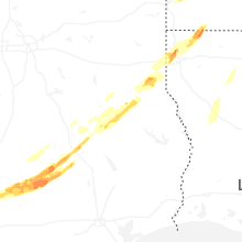


Connect with Interactive Hail Maps